|
APPENDIX No: 1 - Previous Report to Council dated 13 April 2012 |
|
Item No: GB.1 |
Ordinary Meeting of Council
TO BE HELD ON Tuesday, 26 June 2012 AT 7.00pm
Level 3 Council Chambers
Agenda
** ** ** ** ** **
NOTE: For Full Details, See Council’s Website –
www.kmc.nsw.gov.au under the link to business papers
DECLARATIONS OF INTEREST
Confirmation of Reports to be Considered in Closed Meeting
Address the Council
NOTE: Persons who address the Council should be aware that their address will be tape recorded.
Documents Circulated to Councillors
CONFIRMATION OF MINUTEs
Minutes of Ordinary Meeting of Council 10
File: S02131
Meeting held 12 June 2012
Minutes numbered 143 to 162
minutes from the Mayor
MM.1 VALE William Henry "Harry" Oliver 33
File: S04813
On behalf of Ku-ring-gai Council, I would like to pay tribute to the life of former Lindfield resident Harry Oliver, who sadly passed away on the 31st of May at the age of 92.
Harry was a prominent member of our community and was involved in many organisations including St David’s Uniting Church at Lindfield, Hornsby RSL Club, Killara Bowling Club and the Wolseley & Treatts Roads Residents’ Action Group.
Harry, the eldest of seven children, enlisted for World War II in 1940 and served in the Citizen Military Forces and the Australian Imperial Force.
He was a member of the 18th and 30th Australian Infantry Battalions, serving in Papua New Guinea. His war service was recognised with medals including the 1939-45 Star, the Pacific Star and the Australian Service Medal.
On returning from the war, Harry was instrumental in founding Hornsby RSL Club and was the oldest surviving founding board member. As a proud war veteran, he never missed an Anzac Day march.
A life-long elder of St David’s Uniting Church, Harry served in several roles including Church Secretary and as a member of the Church Property Committee.
He was also an active member of the Wolseley & Treatts Roads Residents’ Action Group, helping to campaign for the retention of low density development in Lindfield and the protection of built and natural heritage.
Harry worked his entire career with miller and foodstuff firm Clifford Love and Co, makers of the famous Uncle Toby’s Oats.
His role was to source and buy ingredients such as maize. As a licensed pilot, he was one of the few employees to have both a company plane and a company car. He started at the bottom and worked his way up through the company, retiring in 1983.
Harry’s service to agriculture was recognised with a major award putting him in a similar league to iconic Australian agronomist William Farrer.
Harry had three children – Lyn, Gaye and Gary – and was married for 69 years to Noelene, who passed away last year. He remained in the Lindfield family home until illness necessitated a move to a nursing home in Willoughby.
He remained active in his later years. At the age of 86, he did the Sydney Harbour Bridge climb, a symbolic event considering he walked across the bridge as a child when it opened in 1932.
On behalf of Ku-ring-gai Council, I would like to pay tribute to the life of Harry Oliver and express our sincere condolences to his extended family. He was a truly inspiring member of our community who will be sorely missed by many.
MM.2 Queen's Birthday Honours 2012 35
File: S02767
I am pleased to inform you that 10 Ku-ring-gai citizens, through their outstanding achievements and services to the community, have been awarded 2012 Queen’s Birthday Honours.
We are very proud to have these dedicated and talented Australians as members of the Ku-ring-gai community.
I would like to read to you the names of these special Ku-ring-gai citizens and, on behalf of Council, congratulate them on their excellent contributions to Australian society.
Kevin Callinan of St Ives, for service to the Ku-ring-gai community through the Historical Society, the Ku-ring-gai Community Shed and St Ives Progress Association.
Peter Pickles of Killara, for service to the communtiy through the establishment of student leadership training programs, pastoral care for Members of Parliament, contributions to Australia’s international aid programs and philanthropic support for medical research.
Lancelot Lightfoot of Wahroonga, for service to the container shipping industry, to the development and promotion of Australia’s international trade networks and as a supporter of the welfare of merchant mariners, and to the community.
James Millar of Gordon, for service to business and commerce through executive roles with a range of organisations, and to the community through leadership and fundraising support for social welfare, cancer research and education.
Robert Jansen of Killara, for service to medical research and education domestically and overseas as an academic, clinician and author, particularly in the field of human reproductive genetics and in-vitro fertilisation.
Alanna Nobbs of Pymble, for service to education in the fields of ancient history and the classics as an educator, and through leadership roles in professional organisations, in particular, the Society for the Study of Early Christianity.
Richard Nott of West Pymble, for service to the banking and insurance industries, and to the community through the Australia-Britain Society.
Clifford Cowdroy of Lindfield, for service to remote education through the Bush Children’s Education Foundation of NSW.
Margaret Leong of St Ives, for service to youth as the co-founder and inaugural president of the Nova Youth Orchestra.
Eric Palmer of Pymble, for service to people with disabilities, particularly through the scouting movement and volunteer at the Northern Area Recreational Association.
On behalf of Council, I congratulate all these award winners on their outstanding achievements.
Ku-ring-gai should be proud that it has so many citizens being recognised at the highest levels for their selfless dedication, commitment and contribution to local, national and international communities.
Petitions
GENERAL BUSINESS
i. The Mayor to invite Councillors to nominate any item(s) on the Agenda that they wish to have a site inspection.
ii. The Mayor to invite Councillors to nominate any item(s) on the Agenda that they wish to adopt in accordance with the officer’s recommendation allowing for minor changes without debate.
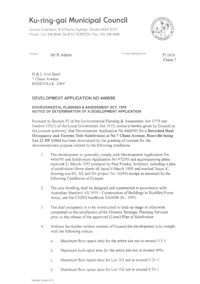
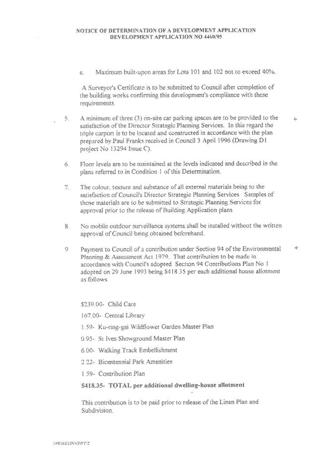
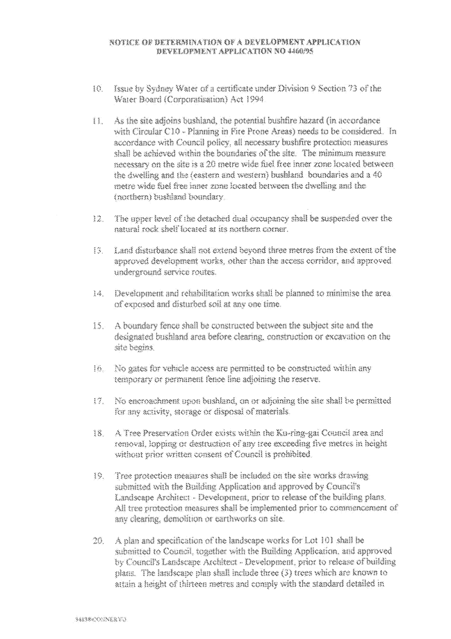
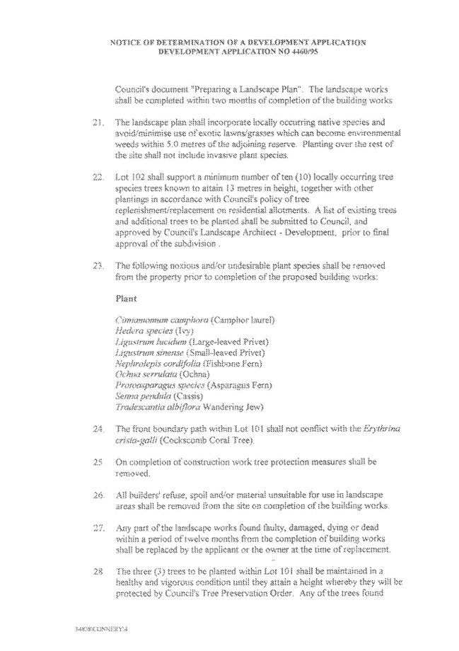
GB.1 7 Chase Avenue, Roseville Chase - Encroachment on Managed Land 37
File: S08422
To respond to questions raised at the Council site inspection and for Council to consider its position in relation to existing encroachments on Crown Land under the care, control and management of Council adjacent to 7 Chase Avenue, Roseville Chase.
Recommendation:
That Council write to the Minister of Planning and Infrastructure, as owner of the subject land, seeking written advice of his intention as regards the continued unauthorised use of the land, and advising that if his advice is not received within six weeks, Council will take such further action as may be appropriate in relation to the matter in accordance with Council’s obligations as manager and relevant policies.
GB.2 Lease to KOPWA Ltd - "Arrunga" Units - 259 to 261 Pacific Highway, Lindfield 74
File: S07470
For Council to consider the granting of a lease to KOPWA Ltd (formerly Ku-ring-gai Old People's Welfare Association) for the premises located at 259–261 Pacific Highway, Lindfield, being the 14 Arrunga Aged Care Self Contained Units (the Premises).
Recommendation:
That Council grant a lease to KOPWA on the conditions outlined in this report for a term of 5 years, plus two options to renew for 5 years each, giving a total term of 15 years.
GB.3 Marian Street Theatre, 2 Marian Street Killara - Management Options 81
File: S08766
For Council to consider management options following negotiations for a licence with Marian Street Theatre for Young People Inc. (MSTYP) for the premises located at 2 Marian Street, Killara, being Marian Street Theatre (the Premises).
Recommendation:
That Council not accept the offer Marian Street Theatre for Young People Inc to be the licensed Head User for the Marian Street Theatre, and that staff further explore options for a management structure that is financially sustainable to ensure the viability of the theatre.
GB.4 Investment Report as at 31 May 2012 104
File: S05273
To present to Council investment allocations and returns on investments for May 2012.
Recommendation:
That the summary of investments and performance for May 2012 be received and noted and that the Certificate of the Responsible Accounting Officer be noted and the report adopted.
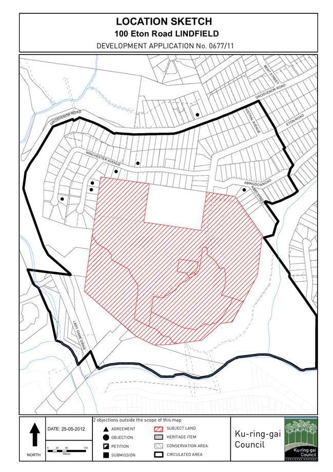
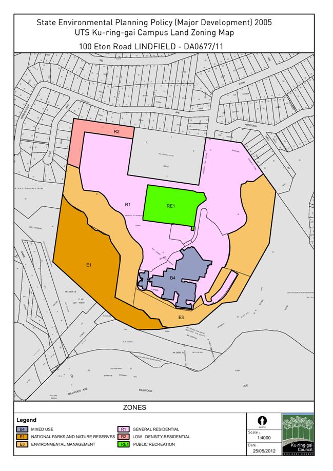
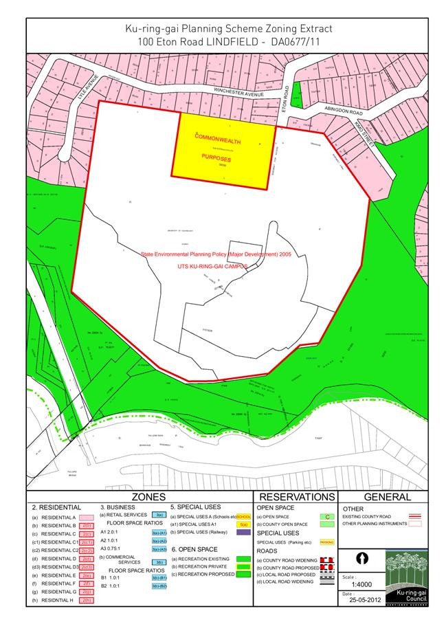
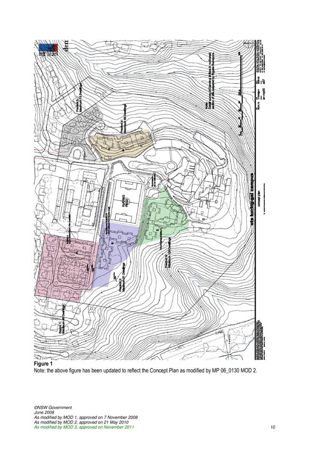
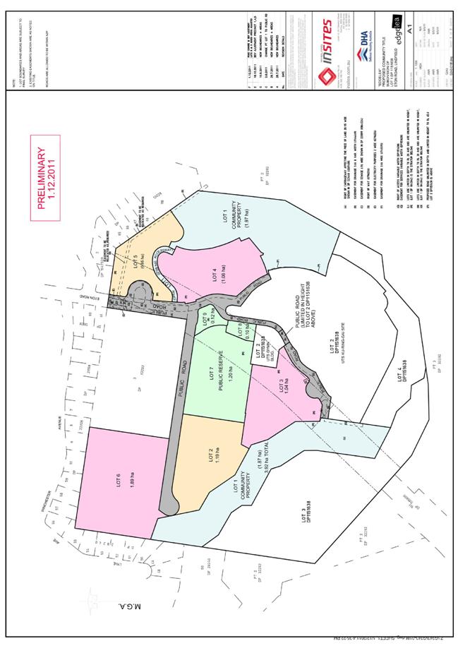
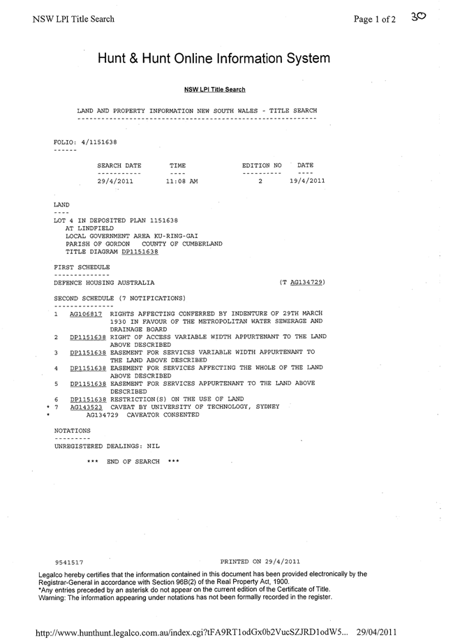
GB.5 100 Eton Road, Lindfield - Subdivision to Create 7 Lots for Development envisaged under Part 3A Concept Approval MP06-0130, Construction of Roads, Ancillary Site Works and new Sporting Oval - Voluntary Planning Agreement for Edgelea 121
File: DA0677/11
Ward: Roseville
Applicant: Defence Housing Australia
Owner: Defence Housing Australia
Subdivision of land and preparation works for development envisaged under MP06-0130.
Recommendation:
Approval.
GB.6 33 Marian Street, Killara - Torrens Title Subdivision of Heritage Item 265
File: DA0061/12
Ward: Gordon
Applicant: Mr Joseph Shek
Owner: Mr JY Shek and Mrs HYC Shek
To determine
Development Application No DA0061/12 for the Torrens title subdivision of
33 Marian Street, Killara.
Recommendation:
Refusal.
GB.7 Compliance Audit of Recently Completed Developments 296
File: CY00133/4
To report on an audit of three recently completed residential flat developments to determine the number and type of non-compliances detected.
Recommendation:
That the report on the findings of the development compliance audit 2011 be received and noted.
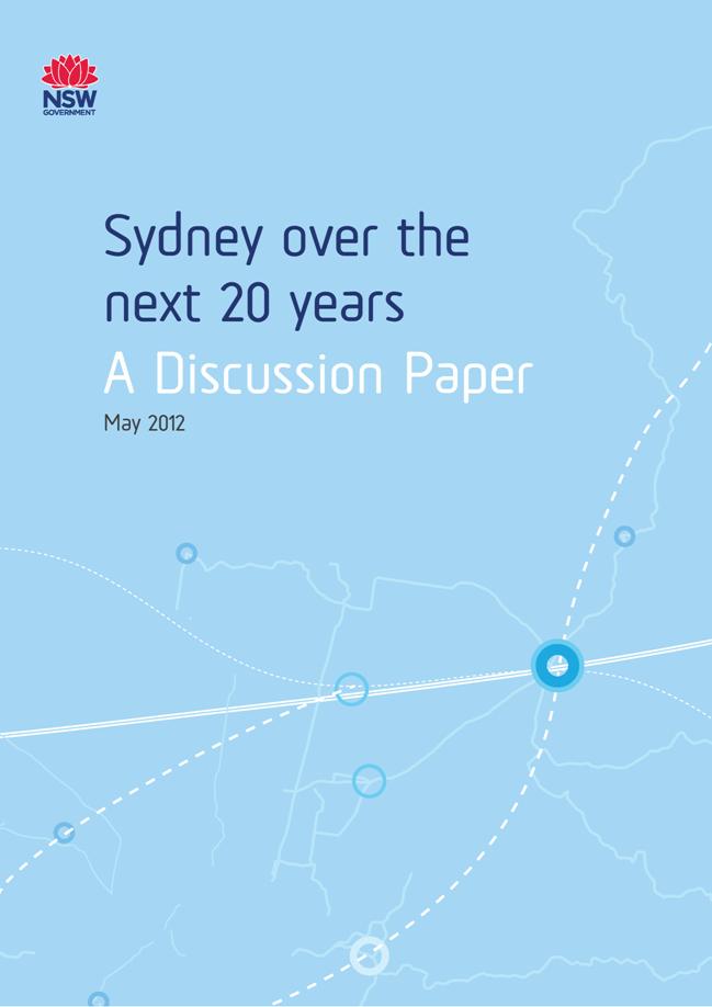
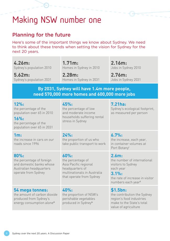
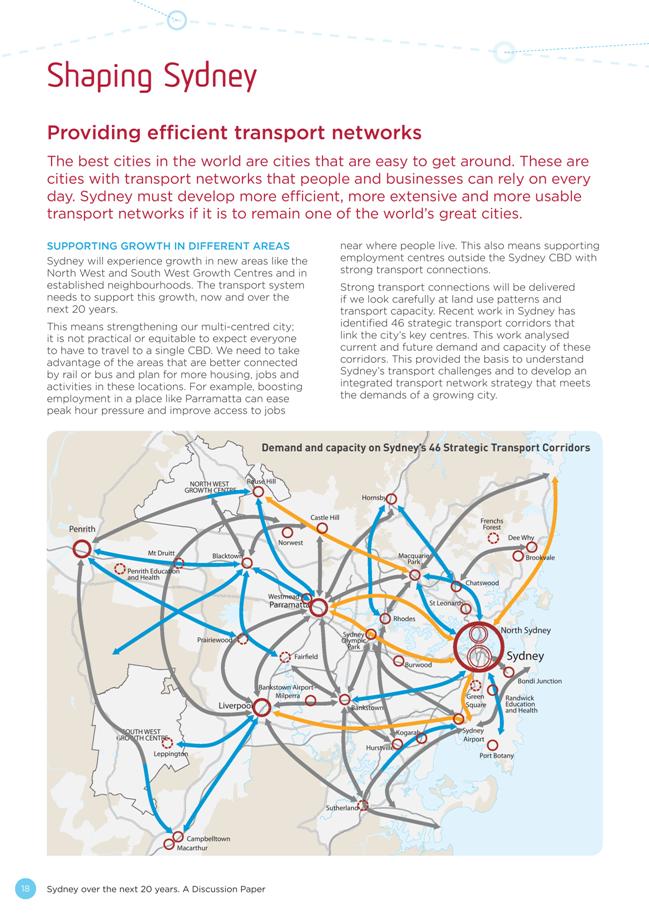
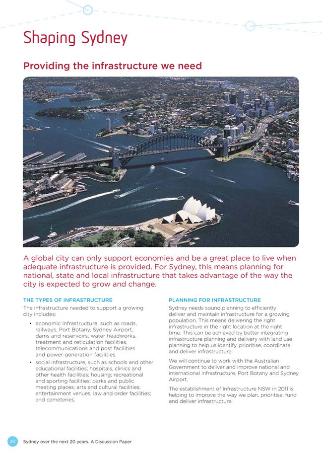
GB.8 Council Submission: Sydney Over the next 20 years - Discussion Paper NSW Department of Planning & Infrastructure 320
File: CY00349/2
To have Council consider a submission on the Discussion Paper “Sydney Over the next 20 years”.
Recommendation:
That a submission to the NSW Department of Planning & Infrastructure be prepared based on the key points identified in this report.
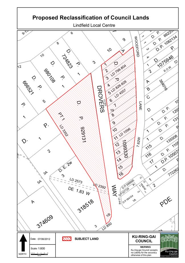
GB.9 Council Car Park - Woodford Lane, Lindfield - Reclassification 364
File: CY00349/2
To have Council consider the reclassification of Council Car Park – Woodford Lane, Lindfield to Operational land.
Recommendation:
That Council prepare a Planning Proposal to reclassify the site from Community land to Operational land and that a further report be brought back to Council regarding the future divestment following the reclassification process.
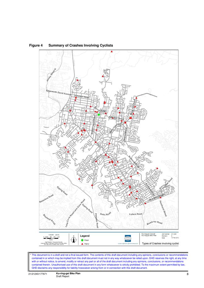
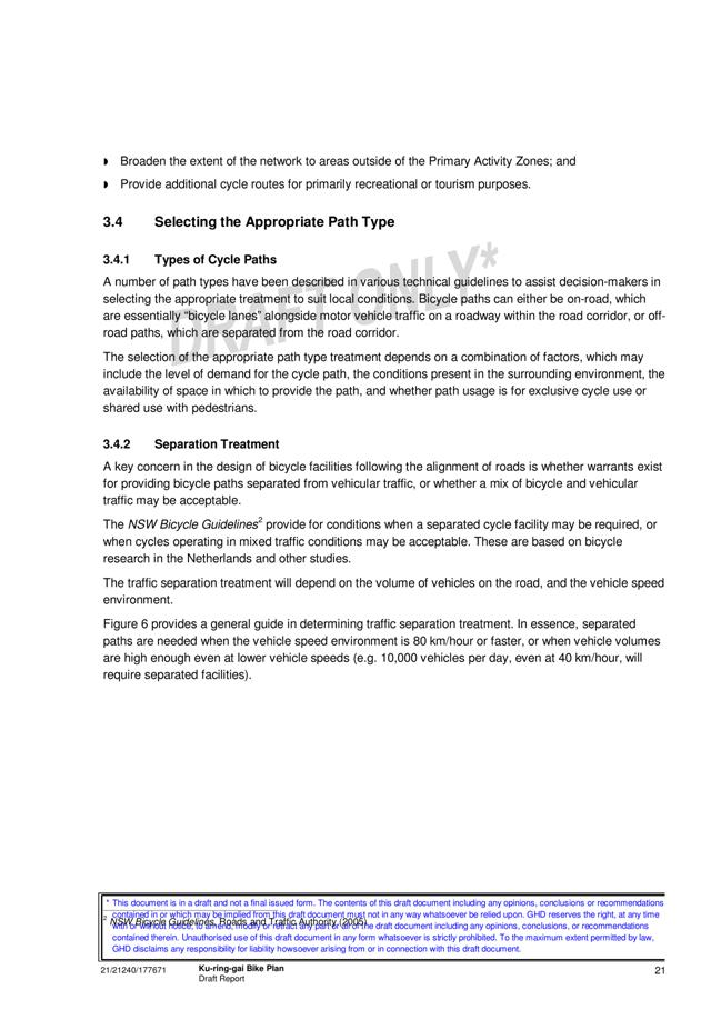
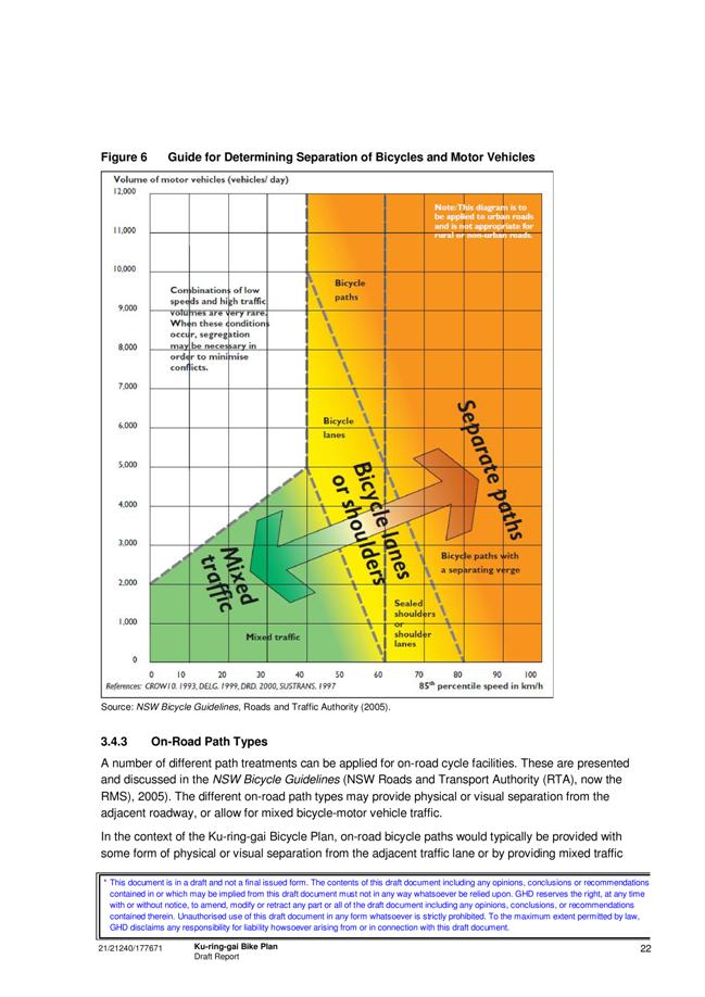
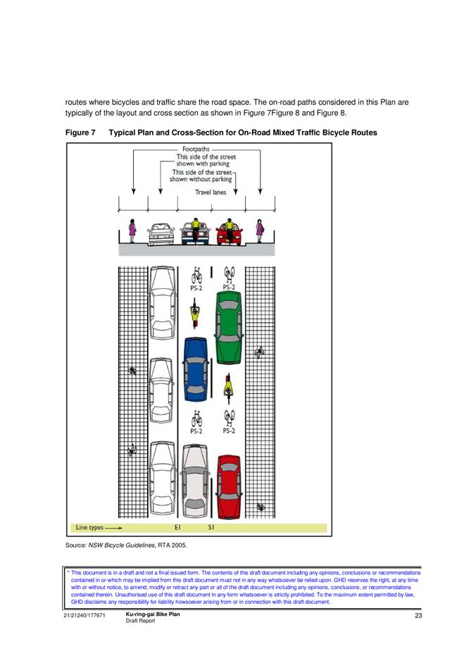
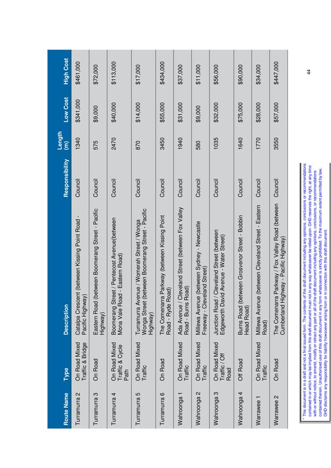
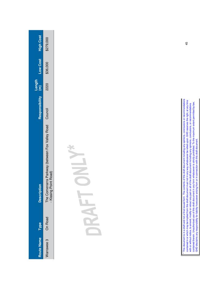
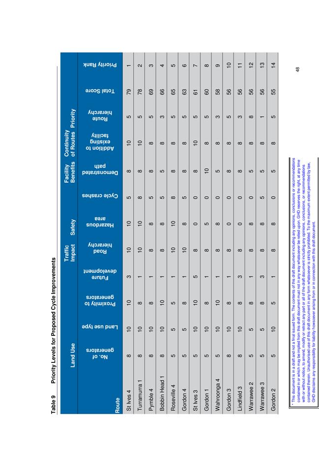
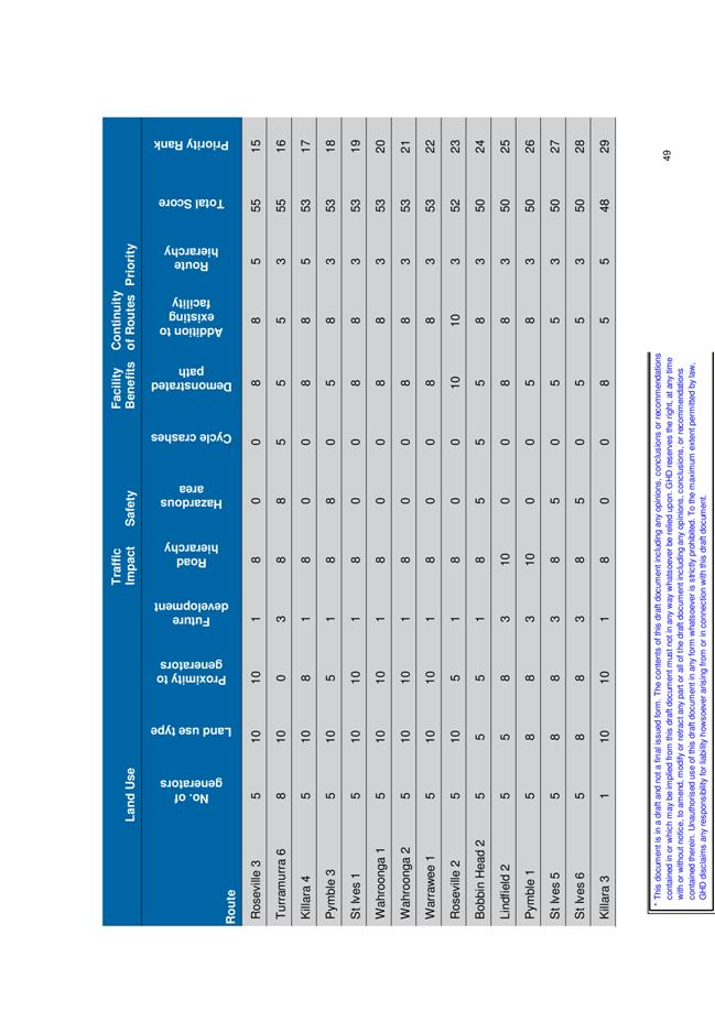
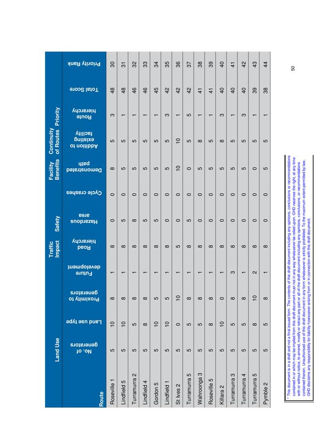
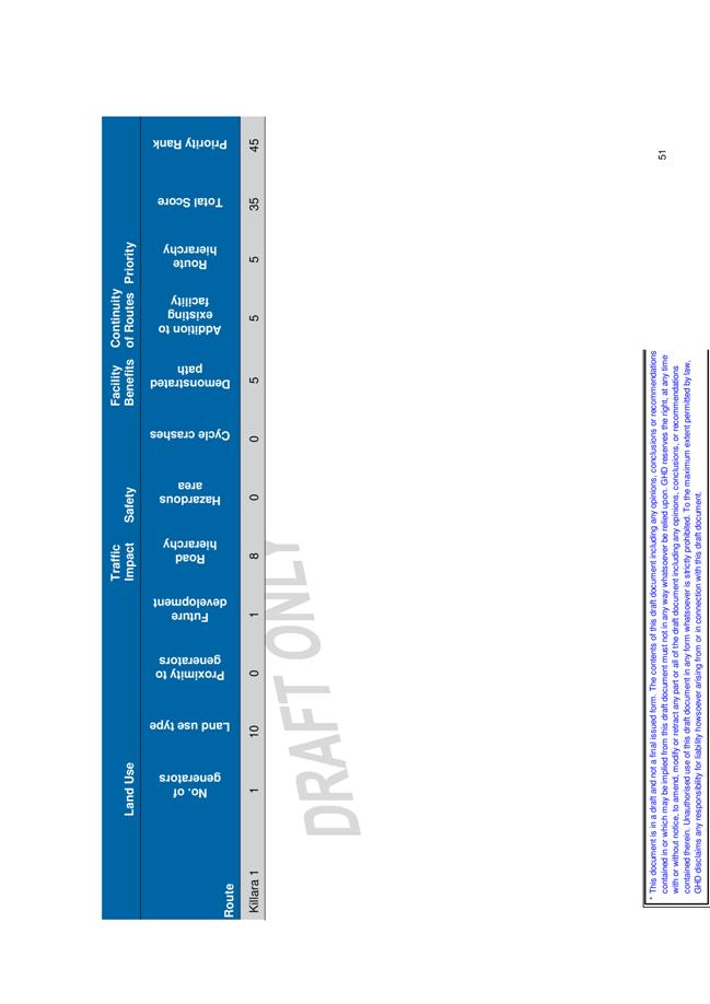
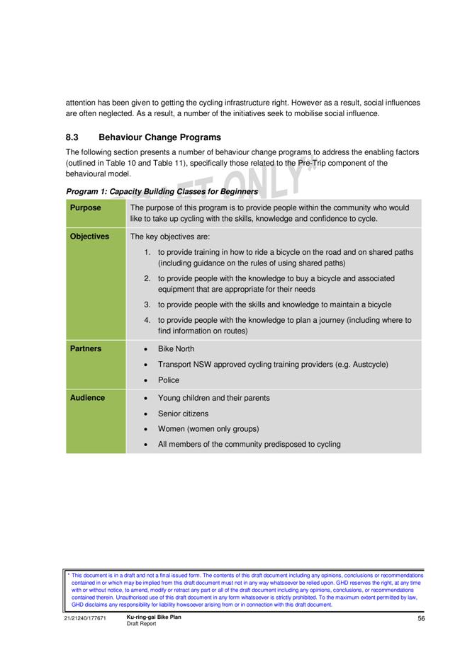
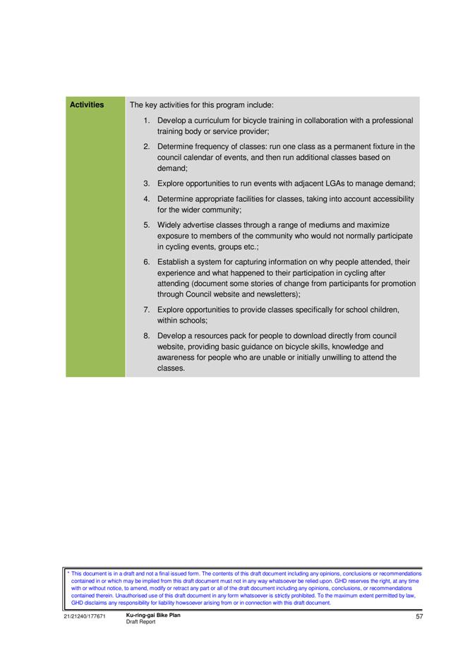
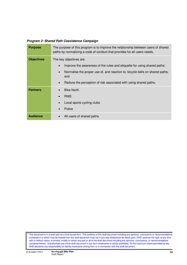
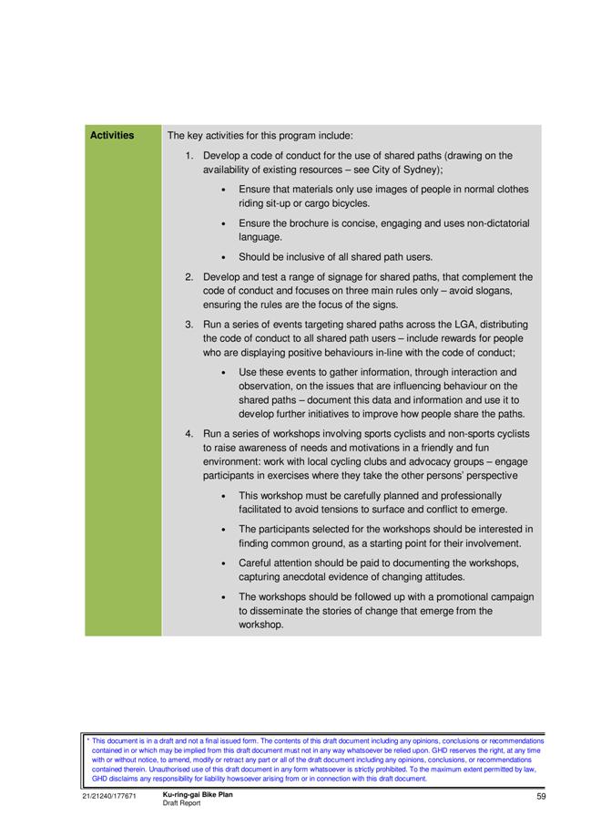
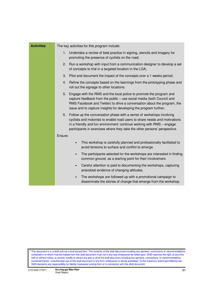
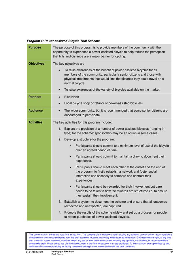
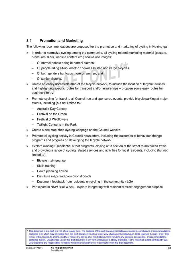
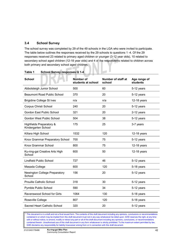
GB.10 Ku-ring-gai Bicycle Plan 370
File: S02777
To have Council consider the draft Ku-ring-gai Bicycle Plan for formal public exhibition.
Recommendation:
That the draft Ku-ring-gai Bicycle Plan be placed on formal public exhibition for a minimum of 28 days and a report be brought back to Council at the conclusion of the exhibition period.
GB.11 Delivery Program and Operational Plan 2012-2013 - Post Exhibition 510
File: FY00382/4
For Council to adopt the revised Delivery Program and draft Operational Plan 2012-2013, incorporating the budget, capital works program and fees and charges for 2012/2013.
Recommendation:
That Council adopt the Delivery Program and draft Operational Plan 2012-2013, incorporating the Budget, Capital Works Program and Fees and Charges for 2012-2013.
GB.12 Tender T54/2012 - Scheduled Maintenance of Mechanical Services - Various Buildings 525
File: S09277/2
For Council to consider the tender received for scheduled maintenance of Mechanical Services Various Buildings and appoint the preferred tenderer.
Recommendation:
That Council accepts the preferred tender from Hayden Engineering Pty Ltd for the Scheduled Maintenance of Mechanical Services Various Buildings.
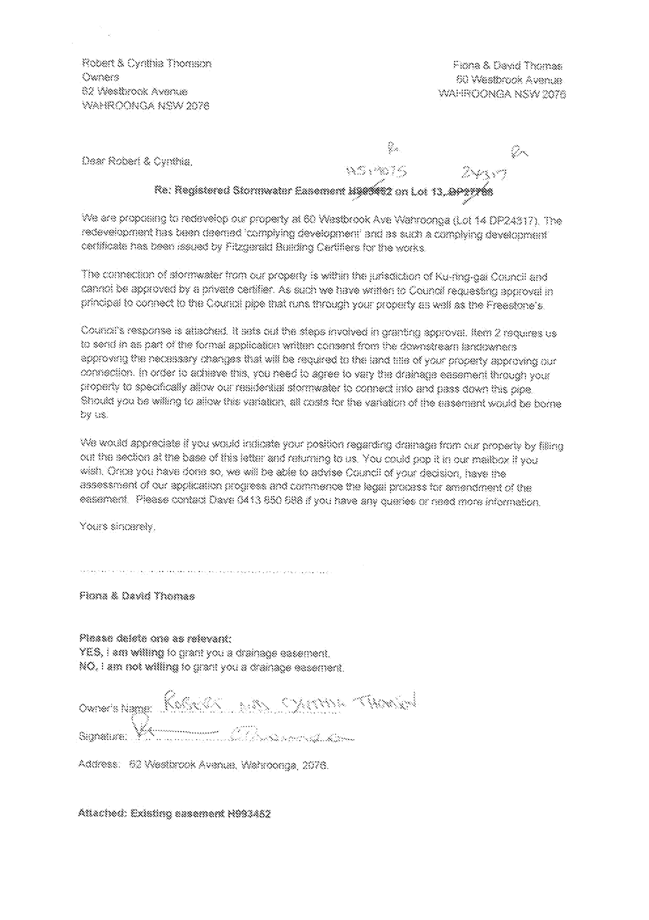
GB.13 60 Westbrook Avenue, Wahroonga - Amendment of Terms of Drainage Easement over Downstream Property 529
File: PCDC0369/11
Recommendation:
That the proposal be approved subject to the conditions given in the recommendation.
GB.14 Open Space Reference Committee - Meeting held on 21 May 2012 536
File: S07618
To advise Council of the notes from the Open Space Reference Committee meeting held on 21 May 2012.
Recommendation:
That the notes from the Open Space Reference Committee meeting of 21 May 2012 be received and noted.
Extra Reports Circulated to Meeting
Motions of which due Notice has been given
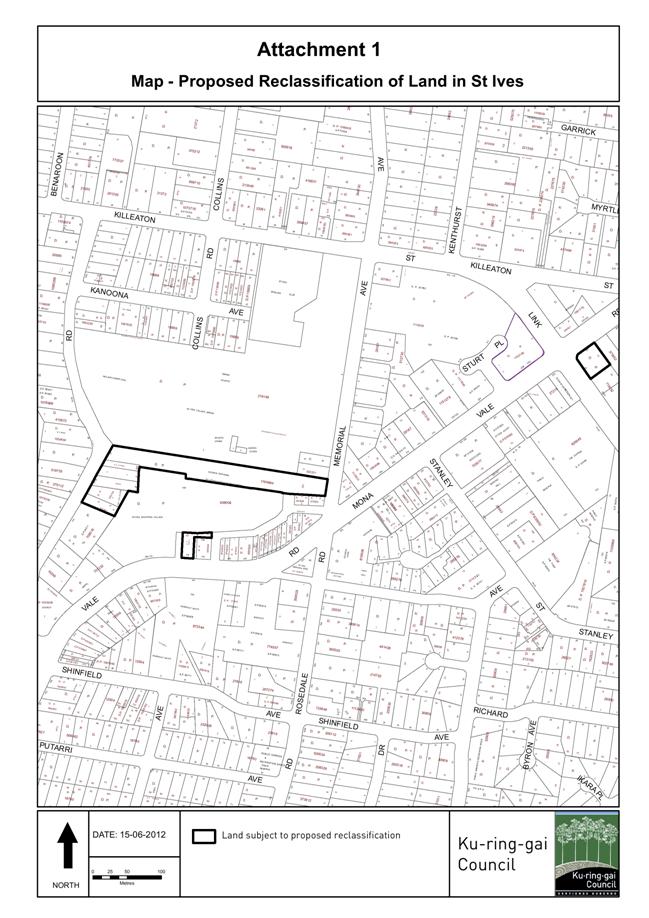
NM.1 Proposed Reclassification of Council Land, St Ives 545
File: S09318
Notice of Motion from Councillor Rakesh Duncombe dated 15 June 2012
The draft Ku-ring-gai Local Environmental Plan (Local Centres) 2012 now has been given a gateway determination by the Department of Planning & Infrastructure and the draft plan is now on formal exhibition until 18 June 2012. It is noted at this stage there are no proposed reclassification of Council-owned land in the Draft Plan.
On 8 May 2012, Council considered the Delivery Program and draft Operational Plan 2012-2013 incorporating the Budget and Capital Works Program. The program includes a special loan proposed for the purchase of a Council new operational building of $23.8M.
Council is a strategic land holder within the St Ives precinct. Reclassification of Council’s land (see map - Proposed Reclassification of Land in St Ives) from community to operational will assist in the first steps of Council both achieving its objectives under both the Delivery Program and draft Operational Plan 2012-2013 and attaining the significant public benefit which could arise from the inclusion of Council’s landholdings within the St Ives precinct within the planning and redevelopment process.
I therefore move:
"A. That Council adopts the following sites for the purpose of reclassification from community to operational land status in an amendment to the Draft Ku-ring-gai Local Environmental Plan (Local Centres) 2012;
1. Council Car Park - known as 176 Mona Vale Road, St Ives being Lot 103 DP627012 & Lot 105 DP629388.
2. St Ives Village Green Parade and St Ives Library, Early Childhood Centre and Neighbourhood Centre St Ives Lot 201 in DP 1164994.
3. Council’s car park known as 11-21 Cowan Road, St Ives being:
· Lot 200 in DP 1164994,
· Lot A in DP336206,
· Lot B in DP336206,
· Lot 1 DP504794,
· Lot A DP321567,
4. Occasional Child Care Centre - known as 261 Mona Vale Road, St Ives being Lot 31 DP719052."
BUSINESS WITHOUT NOTICE – SUBJECT TO CLAUSE 241 OF GENERAL REGULATIONS
Questions Without Notice
Inspections Committee – SETTING OF TIME, DATE AND RENDEZVOUS
** ** ** ** ** **
|
Present: |
The Mayor, Councillor J Anderson (Chairperson) (Roseville Ward) Councillors S Holland & E Malicki (Comenarra Ward) Councillors E Keays & C Szatow (Gordon Ward) Councillors T Hall & C Hardwick (St Ives Ward) Councillors I Cross & D McDonald (Wahroonga Ward) |
|
|
|
|
Staff Present: |
General Manager (John McKee) Acting Director Corporate (Tino Caltabiano) Director Development & Regulation (Michael Miocic) Director Operations (Greg Piconi) Director Community (Janice Bevan) Minutes Secretary (Kim Thomas) |
The Meeting commenced at 7.00pm
The Mayor offered the Prayer
|
143 |
Apologies
File: S02194
Councillor Rakesh Duncombe tendered an apology for non-attendance [family reasons] and requested leave of absence.
|
|
|
Resolved:
(Moved: Councillors Keays/McDonald)
That the apology by Councillor Duncombe be accepted and leave of absence granted.
CARRIED UNANIMOUSLY
|
DECLARATIONS OF INTEREST
The Mayor adverted to the necessity for Councillors and staff to declare a Pecuniary Interest/Conflict of Interest in any item on the Business Paper.
No Interest was declared.
|
144 |
CONFIRMATION OF REPORTS TO BE CONSIDERED IN CLOSED MEETING
File: S02499
|
|
|
Resolved:
(Moved: Councillors Keays/Malicki)
A. That in accordance with the provisions of Section 10 of the Local Government Act 1993, all officers’ reports be released to the press and public, with the exception of the following Confidential report and its respective attachments:
C.1 Acquisition of Land - St Ives
B. That in accordance with the provisions of Section 10 of the Local Government Act 1993, all officers’ reports be released to the press and public, with the exception of the confidential attachment to the following General Business report:
GB.1 Contractual Conditions of Senior Staff
For the Resolution: The Mayor, Councillor J Anderson, Councillors Holland, Keays, Malicki, McDonald, Szatow and Cross
Against the Resolution: Councillors Hardwick and Hall
|
DOCUMENTS CIRCULATED TO COUNCILLORS
The Mayor adverted to the documents circulated in the Councillors’ papers and advised that the following matters would be dealt with at the appropriate time during the meeting:
|
Late Items: |
Refer PT.1 - Petition - Request for a Footpath from Grayling Road through Burrows Grove to Our Lady of Perpetual Succour Primary School - (Eighty-Six [86] Signatures) |
|
Memorandums: |
Refer GB.6 -
Consideration of the Concept Design Plan for the new Bruce Avenue Park, Killara - Memorandum
by Manager Urban and Heritage Planning dated 12 June 2012 regarding an
attached late submission received by Council on |
|
Councillors Information: |
Support for the Aged - Memorandum by Director Community dated 5 June 2012 and attachment to Councillors ONLY in answer to a Question Without Notice raised at the Ordinary Meeting of Council held 22 May 2012. |
CONFIRMATION OF MINUTEs
|
145 |
Minutes of Ordinary Meeting of Council
File: S02131
|
|
|
Meeting held 22 May 2012 Minutes numbered 124 to 142
|
|
|
Resolved:
(Moved: Councillors Szatow/McDonald)
That Minutes numbered 124 to 142 circulated to Councillors were taken as read and confirmed as an accurate record of the proceedings of the Meeting.
CARRIED UNANIMOUSLY
|
minutes from the Mayor
|
146 |
Relocation of HMS Sirius Sculpture - Portsmouth, England
File: S03603 Vide: MM.1
|
|
|
I was recently contacted by Stephen Bailey, Head of Cultural Services from the City of Portsmouth, England about the relocation of the HMS Sirius sculpture.
An exact replica of the sculpture currently situated in Bicentennial Park, West Pymble, the HMS Sirius was sent to Portsmouth where the First Fleet set sail to Australia in 1787. It was a gift from the people of Australia given by the Municipality of Ku-ring-gai and supported by the City of Sydney. It was presented to the citizens of Portsmouth on 13 May 1991.
Ku-ring-gai Council commissioned Victor Cusack to design and build the bronze HMS Sirius sculpture, which was completed in 1988.
Mr Bailey wrote to inform me the sculpture has been relocated to a prime new spot next to the harbour entrance at Gunwharf Quays.
The lovely sculpture was previously in the main shopping arcade in the centre of Portsmouth, but they felt that location was not showing the work in the most suitable environment or informed position.
As a key part of the recognition of the role Portsmouth played as the departure point for the First Fleet on 13 May 1787, the City of Portsmouth felt it would be more appropriate if the work was moved nearer to the entrance to the harbour, one side of which still has a very similar outlook to that which our ancestors would have seen 225 years ago.
Gunwharf Quays has very kindly agreed to host the sculpture and are currently fabricating a new base to enable the work to be displayed at its best.
Alderman Syd Rapson, who was the Lord Mayor of Portsmouth at the time of the original unveiling in 1991 and the Chair of the Portsmouth branch of the Britain Australia Society, Mr Brian Hall have also been involved.
On 18 May I attended a meeting of the Arthur Phillip Chapter of the Fellowship of First Fleeters held at the Old Gordon School meeting rooms. Chapter members, especially those who have previously visited Portsmouth, thoroughly supported the new location for the sculpture.
Sculpture Victor Cusack, who is due to visit England, intends to inspect the relocated work on 5 September.
Victor Cusack was present in Portsmouth for the original unveiling of his work twenty years ago. Coincidentally, he will be in England later this year and arrangements have now been made for him to inspect the relocated sculpture on 5 September.
I am very pleased this important sculpture has been given a fitting home and would like to thank the City of Portsmouth and all involved in the sculpture’s relocation.
|
|
|
Resolved:
A. That a letter be sent to Mr Bailey advising of Council’s full support for the relocation of the sculpture to Gunwharf Quays.
B. That a letter from Council be given to Mr Cusack to personally deliver to Portsmouth to mark the occasion of his visit to the relocated sculpture
CARRIED UNANIMOUSLY
|
|
147 |
National Disability Insurance Scheme - NDIS
File: S02119 Vide: MM.2
|
|
|
In November I brought Council’s attention to the announcement by the Productivity Commission’s report for the Federal Government into an Australian Government funded Disability Care and Support Scheme (a.k.a. “a National Disability Insurance Scheme – NDIS”).
As part of its report the Commission said “The current disability support system is underfunded, unfair, fragmented, and inefficient. It gives people with a disability little choice, no certainty of access to appropriate supports and little scope to participate in the community”.
It was noted that a significant number of people in Ku-ring-gai have much to gain from the proposed NDIS. According to the latest ABS Census data, Ku-ring-gai has close to 3000 residents who indicated they required assistance in their day to day activities because of a disability, long-term health condition, or old age.
The following recommendation was carried unanimously:
That Council show its official support for the establishment of a “National Disability Insurance Scheme” by promoting the campaign through Council’s website and relevant newsletters, and through the issuing of a media release to this effect.
That the Mayor on behalf of Council make representations to all relevant Commonwealth and State Ministers and Members of Parliament urging their support for the National Disability Insurance Scheme.
I am pleased to report that the Federal Treasurer announced in the recent budget that the Government has committed $1.0 billion over four years for the first stage of the National Disability Insurance Scheme (NDIS), to be established in up to four locations from 2013–14. The locations will be determined through negotiations between the Australian Government and the states and territories. In its first year, the NDIS will provide care and support for up to 10,000 people with significant and permanent disability. This will increase to 20,000 people from 2014–15.
I can also report, at its latest meeting, the NSROC board supported a motion by Willoughby Council to show support for the NDIS by writing to the Prime Minister and Federal Opposition Leader urging the introduction be expedited as a matter of urgency.
|
|
|
Resolved:
That Council write to the Prime Minister Julia Gillard, the Federal Opposition Leader Tony Abbott and our local Federal MP Paul Fletcher congratulating them on their support for the legislation and reinforcing the need evident within our local community.
CARRIED UNANIMOUSLY
|
|
148 |
Home and Community Care Services in Ku-ring-gai
File: S02119 Vide: MM.3
|
|||||||||||||||||||||
|
|
I have been approached by a number of residents recently about the dire state of Home and Community Care services in the Ku-ring-gai region. Home and Community Care services assist frail older people to remain independently in their own home for as long as possible and thereby reducing the likelihood of premature admission to a residential facility.
The aged care sector is undergoing significant changes at present with the responsibility for funding of Home and Community Care programs moving from the NSW Department of Ageing Disability and Home Care to the Commonwealth Department of Health and Ageing (DoHA). From July 2012 the Commonwealth will assume full funding and operational responsibility for aged care services. I feel that there is not enough funding for these support services for residents in the Ku-ring-gai region. Apart from long waiting lists (if you are lucky enough to be on one), Ku-ring-gai has the highest proportion (with the exception of Hunters Hill) of its population over 65 years in the Sydney Metropolitan Area.
In exploring this issue, I have become very concerned about the inequitable funding across the region for HACC services. There is an expressed need for a linen service from people unable to change and launder their own bed sheets, pillow cases etc. Unfortunately the Ku-ring-gai area does not have access to a dedicated service. I have discovered that in Northern Sydney there are only 3 stand alone linen services. As an alternative to a linen service, eligible residents may be able to have their linen changed if they are in receipt of a HACC service, specifically domestic assistance. Generally the maximum service they are able to access is 2 hours per fortnight. Currently there are no vacancies for domestic assistance anywhere in Ku-ring-gai and waiting lists have been closed since January 2012. This is unacceptable for the many residents in need.
Transport is another area of great concern for those wishing to stay living independently in their own homes. Getting to and from medical appointments or being able to do your own shopping or keeping up social contacts are essential activities and are the foundation of being able to remain living independently in the community. The Hornsby Ku-ring-gai Community Transport organisation based in Turramurra provides a terrific transport service to local residents including bus, individual cars and a subsidised taxi service. Recently they placed a ceiling on the subsidised taxi trips of 300km per annum and only for medical appointments. Since its inception in 2008 the total passenger trips have increased from 893 to an expected 40,000 in this year. This alone demonstrates the incredible demand for this service and the importance it plays in helping the more vulnerable members of our community.
Clients who need more complex care can be referred for assessment to the Aged Care Assessment Team (ACAT) at Hornsby Hospital. Following this assessment they may be eligible for a Community Aged Care Package (CACP) or an Extended Aged Care at Home Package (EACH). These packages typically provide registered nursing care, personal care, transport or home help etc. Discussions with the Aged Care Assessment Team Manager for this region highlighted that the turn over on the waiting lists for both Community Aged Care Packages and Extended Aged Care at Home Packages is extremely slow. The vacancy rates are averaging only 1 per month so the majority of applicants either go into care or make alternative arrangements.
The following table provides an indicative numbers on waiting lists and the average period before a client will get a package:
The demand for home support services is certain to increase due to our ageing population and policies at both State and Commonwealth Government level encouraging ageing in place. Demand for services is currently outstripping supply in a number of services areas and likely to continue in the future. Council needs to take a proactive stance and lobby our local members of parliament and relevant government departments to address the issue of undersupply of services critical to the wellbeing of our residents.
|
|||||||||||||||||||||
|
|
Resolved:
A. That Council write to the Commonwealth Department of Health and Ageing and the New South Wales Department of Ageing Disability and Home Care outlining the inequities of funding for this region, and request that additional funding be considered in any funding allocation rounds.
B. That Council write to the local State and Commonwealth Members of Parliament seeking their support for increased funding for home support services in Ku-ring-gai and Northern Sydney services network.
C. That this matter be placed on the agenda of the next Northern Sydney Regions of Councils (NSROC) conference focussing on Whole of Region Ageing Strategy for discussion and possible joint action.
CARRIED UNANIMOUSLY
|
PETITIONS
|
149 |
Petition - Request for a Footpath from Grayling Road through Burrows Grove to Our Lady of Perpetual Succour Primary School - (Eighty-Six [86] Signatures)
File: 88/05498/01 Vide: PT.1
|
|
|
"We, the undersigned members of the OLPS (Our Lady of Perpetual Succour), West Pymble community, support the petition to Ku-ring-gai Council for a footpath from Grayling Road through Burrows Grove to our school gate. This is needed to:
* provide a safe and clean journey to and from OLPS. * care for the environment of Burrows Grove."
|
|
|
Resolved:
(Moved: Councillors Malicki/McDonald)
That the petition be received and referred to the appropriate Officer of Council for attention.
CARRIED UNANIMOUSLY |
Recommendations from Committee
|
150 |
Minutes of Ku-ring-gai Traffic Committee
File: CY00022/4 Vide RC.1
|
|
|
Meeting held 1 December 2011 Minutes numbered KTC17 to KTC19
|
|
|
Resolved:
(Moved: Councillors Keays/Hall)
A. That Minutes numbered KTC17 to KTC19, as printed, be adopted with the exception of Item No. 5 under General Discussion - Long Term On-Street Parking of Non-Resident Vehicles.
CARRIED UNANIMOUSLY
B. That Item No. 5 under General Discussion – Long Term On-Street Parking of Non Resident Vehicles from the Minutes, as printed, be adopted.
For the Resolution: The Mayor, Councillor J Anderson, Councillors Hardwick, Holland, Keays, Malicki, McDonald, Szatow and Cross
Against the Resolution: Councillor Hall
|
GENERAL BUSINESS
|
151 |
Contractual Conditions of Senior Staff
File: S03271 Vide: GB.1
|
|
|
To report to Council on the contractual conditions of senior staff in accordance with Section 339 of the Local Government Act 1993.
|
|
|
Resolved:
(Moved: Councillor Malicki/Councillor Szatow)
That Council receive and note the report.
CARRIED UNANIMOUSLY |
|
152 |
8 Telegraph Road, Pymble - Demolition of Existing In-ground Pool and Construction of New In-ground Pool
File: DA0032/10 Vide: GB.3
|
||||||||||||||||||||||||||||
|
|
Demolition of existing in-ground pool and construction of a new in-ground pool
|
||||||||||||||||||||||||||||
|
|
Resolved:
(Moved: Councillors Malicki/Szatow)
THAT Council, as the consent authority, is of the opinion that the objection under State Environmental Planning Policy No. 1 – Development Standards to clause 60(2) of the Ku-ring-gai Planning Scheme Ordinance is well founded. The Council is also of the opinion that strict compliance with the development standard is unreasonable and unnecessary in the circumstances of this case.
AND
THAT Council, as the consent authority, being satisfied that the objection under SEPP No. 1 is well founded and also being of the opinion that the granting of consent to DA0121/12 is consistent with the aims of the Policy, grant development consent to DA0121/12 for Demolition of existing in-ground pool and construction of a new in-ground pool on land at No. 8 Telegraph Road Pymble for a period of two (2) years from the date of the Notice of Determination, subject to the following conditions:
Conditions that identify approved plans:
1. Approved architectural plans and documentation (new development)
The development must be carried out in accordance with work shown in colour on the following plans and documentation listed below and endorsed with Council’s stamp, except where amended by other conditions of this consent.
Reason: To ensure that the development is in accordance with the determination.
2. Inconsistency between documents
In the event of any inconsistency between conditions of this consent and the drawings/documents referred to above, the conditions of this consent prevail.
Reason: To ensure that the development is in accordance with the determination.
Conditions to be satisfied prior to demolition, excavation or construction:
3. Road opening permit
The opening of any footway, roadway, road shoulder or any part of the road reserve shall not be carried out without a road opening permit being obtained from Council (upon payment of the required fee) beforehand.
Reason: Statutory requirement (Roads Act 1993 Section 138) and to maintain the integrity of Council’s infrastructure.
4. Notice of commencement
At least 48 hours prior to the commencement of any development (including demolition, excavation, shoring or underpinning works), a notice of commencement of building or subdivision work form and appointment of the principal certifying authority form shall be submitted to Council.
Reason: Statutory requirement.
5. Notification of builder’s details
Prior to the commencement of any development or excavation works, the Principal Certifying Authority shall be notified in writing of the name and contractor licence number of the owner/builder intending to carry out the approved works.
Reason: Statutory requirement.
Conditions to be satisfied prior to the issue of the construction certificate:
6. Amendments to approved landscape plan
Prior to the issue of a Construction Certificate, the Principal Certifying Authority shall be satisfied that the approved landscape plans, listed below and endorsed with Council’s stamp, have been amended in accordance with the requirements of this condition as well as other conditions of this consent:
The above landscape plan(s) shall be amended in the following ways:
· Show 2 canopy replenishment trees, 1 of which shall be a locally occurring native species selected from the Blue Gum High Forest Critically Endangered Ecological Community final determination species list, across the site’s street frontage.
· Show proposed planting within the new garden area adjacent to the driveway.
Prior to the issue of the Construction Certificate, the Principal Certifying Authority shall be satisfied that the landscape plan has been amended are required by this condition.
Note: An amended plan, prepared by a landscape architect or qualified landscape designer shall be submitted to the Certifying Authority.
Reason: To ensure adequate landscaping of the site.
7. Long service levy
In accordance with Section 109F(i) of the Environmental Planning and Assessment Act a Construction Certificate shall not be issued until any long service levy payable under Section 34 of the Building and Construction Industry Long Service Payments Act 1986 (or where such levy is payable by instalments, the first instalment of the levy) has been paid. Council is authorised to accept payment. Where payment has been made elsewhere, proof of payment is to be provided to Council.
Reason: Statutory requirement.
8. Builder’s indemnity insurance
The applicant, builder, developer or person who does the work on this development, must arrange builder’s indemnity insurance and submit the certificate of insurance in accordance with the requirements of Part 6 of the Home Building Act 1989 to the Certifying Authority for endorsement of the plans accompanying the Construction Certificate.
It is the responsibility of the applicant, builder or developer to arrange the builder's indemnity insurance for residential building work over the value of $20,000. The builder's indemnity insurance does not apply to commercial or industrial building work or to residential work valued at less than $20,000, nor to work undertaken by persons holding an owner/builder's permit issued by the Department of Fair Trading (unless the owner/builder's property is sold within 7 years of the commencement of the work).
Reason: Statutory requirement.
Conditions to be satisfied prior to the issue of the construction certificate or prior to demolition, excavation or construction (whichever comes first):
9. Infrastructure restorations fee
To ensure that damage to Council Property as a result of construction activity is rectified in a timely matter:
a) All work or activity taken in furtherance of the development the subject of this approval must be undertaken in a manner to avoid damage to Council Property and must not jeopardise the safety of any person using or occupying the adjacent public areas.
b) The applicant, builder, developer or any person acting in reliance on this approval shall be responsible for making good any damage to Council Property, and for the removal from Council Property of any waste bin, building materials, sediment, silt, or any other material or article.
c) The Infrastructure Restoration Fee must be paid to the Council by the applicant prior to both the issue of the Construction Certificate and the commencement of any earthworks or construction.
d) In consideration of payment of the Infrastructure Restorations Fee, Council will undertake such inspections of Council Property as Council considers necessary and also undertake, on behalf of the applicant, such restoration work to Council Property, if any, that Council considers necessary as a consequence of the development. The provision of such restoration work by the Council does not absolve any person of the responsibilities contained in (a) to (b) above. Restoration work to be undertaken by the Council referred to in this condition is limited to work that can be undertaken by Council at a cost of not more than the Infrastructure Restorations Fee payable pursuant to this condition.
e) In this condition:
“Council Property” includes any road, footway, footpath paving, kerbing, guttering, crossings, street furniture, seats, letter bins, trees, shrubs, lawns, mounds, bushland, and similar structures or features on any road or public road within the meaning of the Local Government Act 1993 (NSW) or any public place; and
“Infrastructure Restoration Fee” means the Infrastructure Restorations Fee calculated in accordance with the Schedule of Fees & Charges adopted by Council as at the date of payment and the cost of any inspections required by the Council of Council Property associated with this condition.
Reason: To maintain public infrastructure.
Conditions to be satisfied during the demolition, excavation and construction phases:
10. Prescribed conditions
The applicant shall comply with any relevant prescribed conditions of development consent under clause 98 of the Environmental Planning and Assessment Regulation. For the purposes of section 80A (11) of the Environmental Planning and Assessment Act, the following conditions are prescribed in relation to a development consent for development that involves any building work:
· The work must be carried out in accordance with the requirements of the Building Code of Australia · In the case of residential building work for which the Home Building Act 1989 requires there to be a contract of insurance in force in accordance with Part 6 of that Act, that such a contract of insurance is in force before any works commence.
Reason: Statutory requirement.
11. Hours of work
Demolition, excavation, construction work and deliveries of building material and equipment must not take place outside the hours of 7.00am to 5.00pm Monday to Friday and 8.00am to 12 noon Saturday. No work and no deliveries are to take place on Sundays and public holidays.
Excavation or removal of any materials using machinery of any kind, including compressors and jack hammers, must be limited to between 7.30am and 5.00pm Monday to Friday, with a respite break of 45 minutes between 12 noon 1.00pm.
Where it is necessary for works to occur outside of these hours (ie) placement of concrete for large floor areas on large residential/commercial developments or where building processes require the use of oversized trucks and/or cranes that are restricted by the RTA from travelling during daylight hours to deliver, erect or remove machinery, tower cranes, pre-cast panels, beams, tanks or service equipment to or from the site, approval for such activities will be subject to the issue of an "outside of hours works permit" from Council as well as notification of the surrounding properties likely to be affected by the proposed works.
Note: Failure to obtain a permit to work outside of the approved hours will result in on the spot fines being issued.
Reason: To ensure reasonable standards of amenity for occupants of neighbouring properties.
12. Approved plans to be on site
A copy of all approved and certified plans, specifications and documents incorporating conditions of consent and certification (including the Construction Certificate if required for the work) shall be kept on site at all times during the demolition, excavation and construction phases and must be readily available to any officer of Council or the Principal Certifying Authority.
Reason: To ensure that the development is in accordance with the determination.
13. Use of road or footpath
During excavation, demolition and construction phases, no building materials, plant or the like are to be stored on the road or footpath without written approval being obtained from Council beforehand. The pathway shall be kept in a clean, tidy and safe condition during building operations. Council reserves the right, without notice, to rectify any such breach and to charge the cost against the applicant/owner/builder, as the case may be.
Reason: To ensure safety and amenity of the area.
14. Toilet facilities
During excavation, demolition and construction phases, toilet facilities are to be provided, on the work site, at the rate of one toilet for every 20 persons or part of 20 persons employed at the site.
Reason: Statutory requirement.
15. Recycling of building material (general)
During demolition and construction, the Principal Certifying Authority shall be satisfied that building materials suitable for recycling have been forwarded to an appropriate registered business dealing in recycling of materials. Materials to be recycled must be kept in good order.
Reason: To facilitate recycling of materials.
16. Construction signage
All construction signs must comply with the following requirements:
· are not to cover any mechanical ventilation inlet or outlet vent · are not illuminated, self-illuminated or flashing at any time · are located wholly within a property where construction is being undertaken · refer only to the business(es) undertaking the construction and/or the site at which the construction is being undertaken · are restricted to one such sign per property · do not exceed 2.5m2 · are removed within 14 days of the completion of all construction works
Reason: To ensure compliance with Council's controls regarding signage.
17. Road reserve safety
All public footways and roadways fronting and adjacent to the site must be maintained in a safe condition at all times during the course of the development works. Construction materials must not be stored in the road reserve. A safe pedestrian circulation route and a pavement/route free of trip hazards must be maintained at all times on or adjacent to any public access ways fronting the construction site. Where public infrastructure is damaged, repair works must be carried out when and as directed by Council officers. Where pedestrian circulation is diverted on to the roadway or verge areas, clear directional signage and protective barricades must be installed in accordance with AS1742-3 (1996) “Traffic Control Devices for Work on Roads”. If pedestrian circulation is not satisfactorily maintained across the site frontage, and action is not taken promptly to rectify the defects, Council may undertake proceedings to stop work.
Reason: To ensure safe public footways and roadways during construction.
18. Services
Where required, the adjustment or inclusion of any new utility service facilities must be carried out by the applicant and in accordance with the requirements of the relevant utility authority. These works shall be at no cost to Council. It is the applicants’ full responsibility to make contact with the relevant utility authorities to ascertain the impacts of the proposal upon utility services (including water, phone, gas and the like). Council accepts no responsibility for any matter arising from its approval to this application involving any influence upon utility services provided by another authority.
Reason: Provision of utility services.
19. Erosion control
Temporary sediment and erosion control and measures are to be installed prior to the commencement of any works on the site. These measures must be maintained in working order during construction works up to completion. All sediment traps must be cleared on a regular basis and after each major storm and/or as directed by the Principal Certifying Authority and Council officers.
Reason: To protect the environment from erosion and sedimentation.
20. Drainage to existing system
Stormwater runoff from all new impervious areas and subsoil drainage systems shall be piped to the existing site drainage system. The installation of new drainage components must be completed by a licensed contractor in accordance with AS3500.3 (Plumbing Code) and the BCA. No stormwater runoff is to be placed into the Sydney Water sewer system. If an illegal sewer connection is found during construction, the drainage system must be rectified to the satisfaction of Council and Sydney Water.
Reason: To protect the environment.
21. Approved tree works
Approval is given for the following works to be undertaken to trees on the site:
Removal or pruning of any other tree on the site is not approved, excluding species exempt under Council’s Tree Preservation Order.
Reason: To ensure that the development is in accordance with the determination.
22. No storage of materials beneath trees
No activities, storage or disposal of materials shall take place beneath the canopy of any tree protected under Council's Tree Preservation Order at any time.
Reason: To protect existing trees.
23. Removal of refuse
All builders' refuse, spoil and/or material unsuitable for use in landscape areas shall be removed from the site on completion of the building works.
Reason: To protect the environment.
24. Canopy replenishment trees to be planted
The 2 canopy replenishment trees to be planted shall be maintained in a healthy and vigorous condition until they attain a height of 5.0 metres whereby they will be protected by Council’s Tree Preservation Order. Any of the trees found faulty, damaged, dying or dead shall be replaced with the same species.
Reason: To maintain the treed character of the area.
25. On site retention of waste dockets
All demolition, excavation and construction waste dockets are to be retained on site, or at suitable location, in order to confirm which facility received materials generated from the site for recycling or disposal.
· Each docket is to be an official receipt from a facility authorised to accept the material type, for disposal or processing. · This information is to be made available at the request of an Authorised Officer of Council.
Reason: To protect the environment.
Conditions to be satisfied prior to the issue of an Occupation Certificate:
26. Compliance with BASIX Certificate
Prior to the issue of an Occupation Certificate, the Principal Certifying Authority shall be satisfied that all commitments listed in BASIX Certificate No. A136558 have been complied with.
Reason: Statutory requirement.
27. Completion of landscape works
Prior to the release of the Occupation Certificate, the Principal Certifying Authority is to be satisfied that all landscape works, including the removal of all noxious and/or environmental weed species, have been undertaken in accordance with the approved plan(s) and conditions of consent.
Reason: To ensure that the landscape works are consistent with the development consent.
28. Infrastructure repair
Prior to issue of the Occupation Certificate, the Principal Certifying Authority must be satisfied that any damaged public infrastructure caused as a result of construction works (including damage caused by, but not limited to, delivery vehicles, waste collection, contractors, sub contractors, concrete vehicles) is fully repaired to the satisfaction of Council Development Engineer and at no cost to Council.
Reason: To protect public infrastructure.
29. Swimming pool (part 1)
Prior to the issue of the Occupation Certificate, the Principal Certifying Authority shall be satisfied that:
C1 1. Access to the pool/spa shall be restricted by a child resistant barrier in accordance with the regulations prescribed in the Swimming Pools Act, 1992:
(a) The pool shall not be filled with water or be allowed to collect stormwater until the child resistant barrier is installed; and (b) The barrier is to conform to the requirements of AS 1926-1 2007 Fences and Gates for Private Swimming Pools.
Reason: To ensure the safety of children.
2. Any mechanical equipment associated with the swimming pool and/or spa pool shall be located in a sound-attenuating enclosure and positioned as shown on th approved plans. The Principal Certifying Authority shall be satisfied that the sound levels associated with the swimming pool/spa filtration system and associated mechanical equipment do not exceed 5dB(A) above the background noise level at the boundaries of the site.
Reason: To protect the amenity of surrounding properties.
30. Pool overflow to sewer
Prior to issue of the Occupation Certificate a high level overflow pipe is to be provided from the back of the skimmer box to the filter backwash line discharging to the sewer. This line must not directly vent the receiving Sydney Water sewer. This requirement is to collect stormwater overflow from the swimming pool surface only. A certificate from the installer, indicating compliance with this condition, must be submitted to the Principal Certifying Authority prior to issue of the Occupation Certificate.
Reason: To provide satisfactory drainage.
Conditions to be satisfied at all times:
31. Swimming pool (part 2)
At all times:
1. Access to the swimming pool must be restricted by fencing or other measures as required by the Swimming Pools Act 1992. 2. Noise levels associated with spa/pool pumping units shall not exceed 5dB(A) at the boundaries of the site. 3. Devices or structures used for heating swimming pool water must not be placed where they are visible from a public place. 4. For the purpose of health and amenity, the disposal of backwash and/or the emptying of a swimming pool into a reserve, watercourse, easement or storm water drainage system is prohibited. These waters are to discharge via a permanent drainage line into Sydney Water's sewer in accordance with Australian Standard AS3500.2 section 10.9. Permission is to be obtained from Sydney Water prior to the emptying of any pool to the sewer. 5. Lighting from the swimming pool and other communal facilities shall not detrimentally impact the amenity of other premises and adjacent dwellings.
Reason: Health and amenity.
CARRIED UNANIMOUSLY |
||||||||||||||||||||||||||||
|
153 |
Wahroonga Park Precinct Draft Landscape Masterplan
File: S04480 Vide: GB.4
|
|
|
To seek Council's approval to place the Wahroonga Park Precinct draft Landscape Masterplan (encompassing Wahroonga Park, McKenzie Park and 78 Coonabarra Road) on public exhibition.
|
|
|
Resolved:
(Moved: Councillors Malicki/McDonald)
A. That Council place the Wahroonga Park Precinct draft Landscape Masterplan on public exhibition for a minimum of 28 days including an exhibition and information session to be held in Wahroonga Park on a suitable weekend to enable community dialogue with Council staff.
B. That the amended plan incorporating community comment be reported back to Council for consideration.
CARRIED UNANIMOUSLY |
|
154 |
NSW Local Government Aboriginal Network Conference 2012
File: S02414 Vide: GB.2
|
|
|
To advise Council of the NSW Local Government Aboriginal Network Conference 2012.
|
|
|
Resolved:
(Moved: Councillors Hall/Malicki)
That the report be received and noted.
For the Resolution: The Mayor, Councillor J Anderson, Councillors Hardwick, Holland, Keays, Malicki, McDonald, Szatow and Hall
Against the Resolution: Councillor Cross
|
|
155 |
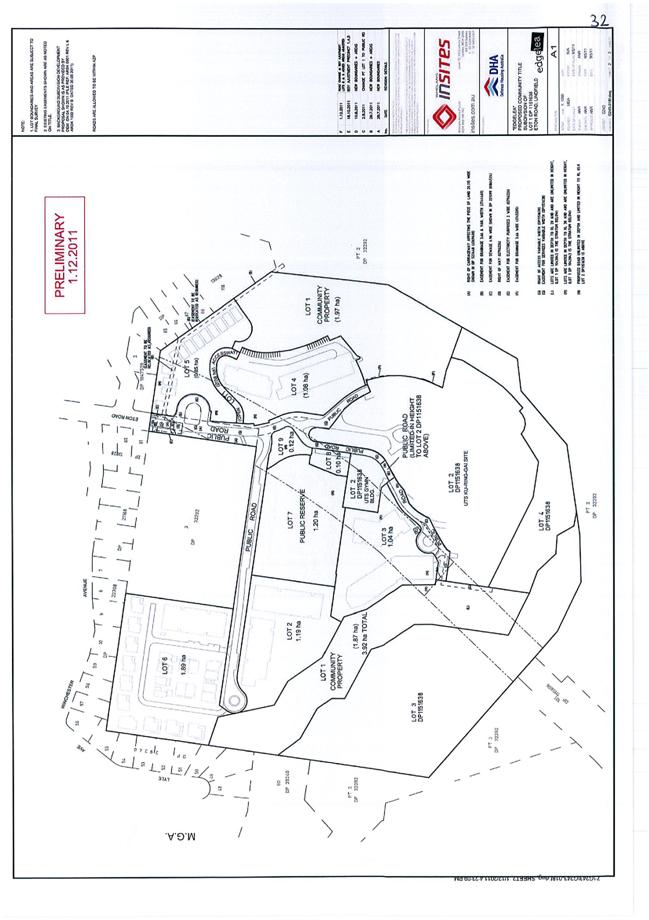
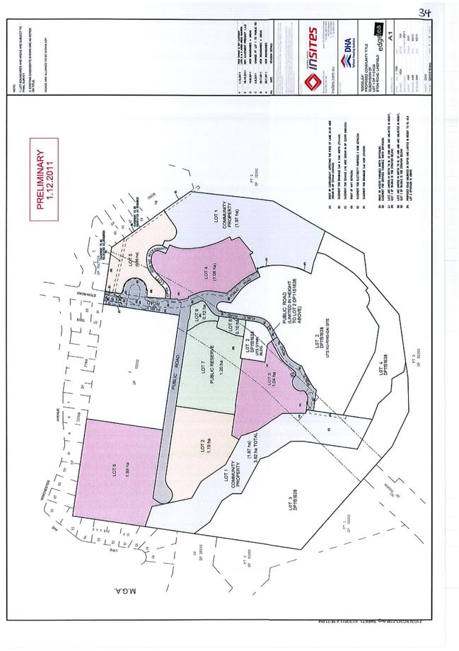
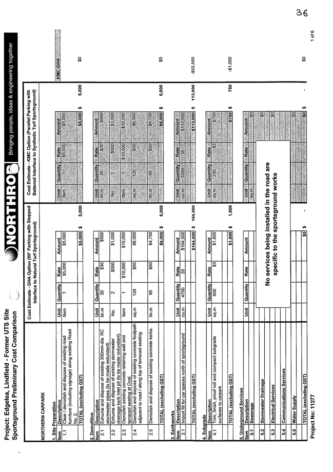
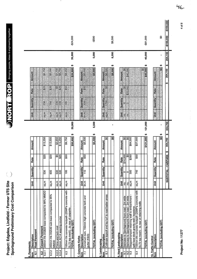
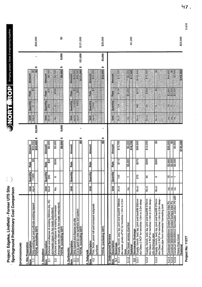
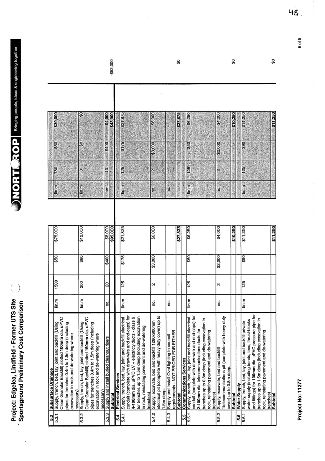
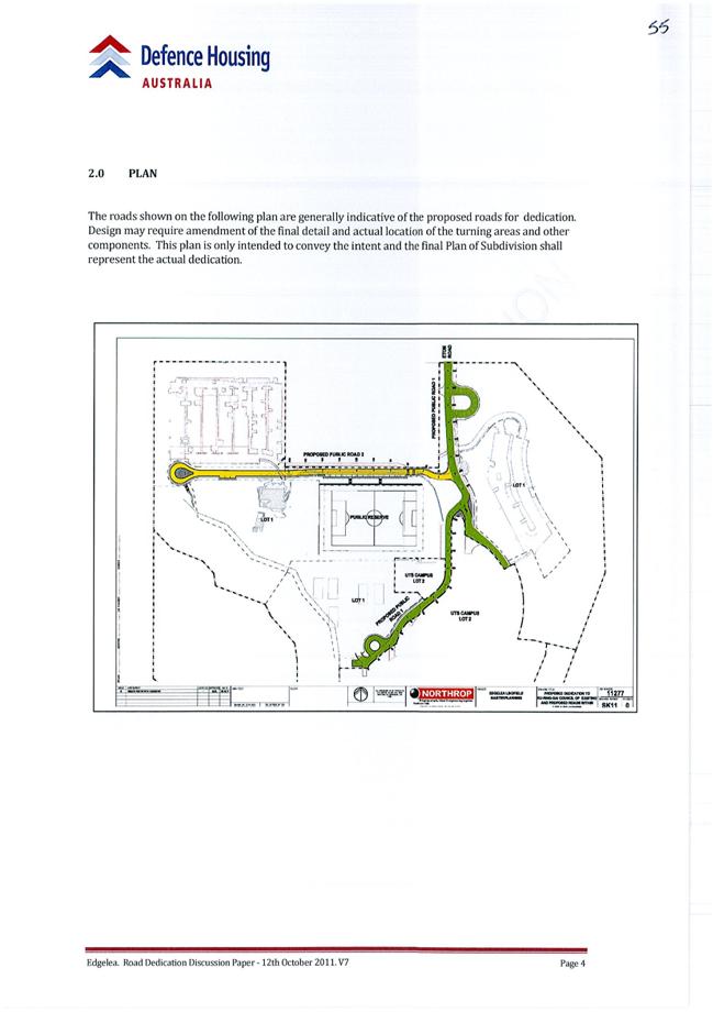
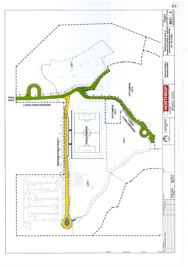
Edgelea Urban Design Guidelines
File: DA0677/11 Vide: GB.5
|
|
|
To have Council consider Urban Design Guidelines for the future development of Edgelea within the former UTS Ku-ring-gai Campus in Lindfield.
|
|
|
Resolved:
(Moved: Councillors Malicki/Cross)
A. That Council approve the final Edgelea Urban Design Guidelines subject to the following amendments:
1. Part 2 Building siting/layout - Add the following control within the site layout sections for all 3 building types:
“Buildings must not be located on or within a drainage depression, easement, or piped drainage system.”
2. Part 2.1.1 – Building Siting - Add an additional objective:
“To maintain views to and from the main campus building”
3. Part 2.1.3 – Building setbacks and site coverage - Under Encroachments amend Control 3 to:
“3 Ground floor private terraces/courtyards may encroach into the setback areas with a minimum setback of:
i) 4m to the site boundary where the minimum setback is 6m; ii) 6m to the site boundary where the minimum setback is 8-10m.”
4. Part 2.1.13.3 – Ground Floor Apartments - Incorporate a diagram the same as or similar to figure Part 3C.15 –1 in the former Ku-ring-gai (Town Centres) DCP
5. Parts 2.2 Small lot housing and 2.3 Dwelling House - All references in Part 2 to ‘soft landscaping’ are to be changed to ‘landscaped area’.
6. Part 3.2 – Earthworks and Slope:
Amend control 4 to read:
“For any dwelling house or small lot dwelling, excavation within the building footprint must not exceed 1.0m depth relative to ground level (existing), fill must not exceed 0.9m relative to ground level, with a maximum level difference across the building footprint of 1.8m.”
B. Incorporate
a diagram the same as or similar to Figure Part 4.3 –1 in the former
CARRIED UNANIMOUSLY
|
|
156 |
Consideration of the Concept Design Plan for the new Bruce Avenue Park, Killara
File: S08975 Vide: GB.6
|
|
|
To seek Council's endorsement of the concept design plan for the new park on Bruce Avenue, Killara.
|
|
|
Resolved:
(Moved: Councillors Keays/Szatow)
A. That Council endorse the final design concept plan for the new park on Bruce Avenue, Killara, as the basis on which staff prepare construction documentation including plans, details and sections and specifications; and tender documentation with the following amendments:
· the inclusion of a barbeque located centrally in the park near the proposed picnic shelter. · an on-street disabled access car park on Bruce Avenue adjoining the main entry. · an indented on-street disabled access car space on Bruce Avenue adjoining the entry on the north-eastern side of the park. · a reduction to the width of the main path from 3 to 2 metres (except at main entry where wider path is needed for service vehicle access). ·
increased width of garden area along the south-west park
boundary from · deciduous tree planting along the south-west park boundary, rather than evergreen, to maximise solar access to adjoining properties. · a tall hedge planted along the south-west park boundary for a screen to protect the neighbours privacy.
B. That Council commence a competition for the naming of the new park.
For the Resolution: The Mayor, Councillor J Anderson, Councillors Hardwick, Holland, Keays, Malicki, McDonald, Szatow and Cross
Against the Resolution: Councillor Hall
|
|
157 |
Draft Development Control Plan No. 58 - Council Land South Turramurra
File: S08281 Vide: GB.7
|
|
|
To have Council adopt for exhibition the draft Ku-ring-gai Development Control Plan South Turramurra Corridor No. 58.
|
|
|
Resolved:
(Moved: Councillors Malicki/Cross)
A. That Council adopt the draft Ku-ring-gai Development Control Plan South Turramurra Corridor No. 58 for the purpose of public exhibition.
1. That under 1.5 Purpose and Objectives of the Plan, Point (d) be replaced with:
1.5 (d) to encourage and support sustainable urban design parameters such as cross flow ventilation, solar access and alignment, building materials, alternative power sources and maximum opportunities for water reuse.
2. That under 3.4 Street Network, Public Open Space and Access “Objectives”, Point (a) to read:
To provide a safe and functional street network with appropriate vehicular and pedestrian access.
B. That the draft Ku-ring-gai Development Control Plan South Turramurra No. 58 be placed on public exhibition in accordance with the Environmental Planning & Assessment Regulation 2000 for a period of 28 days.
C. That a report be brought back to Council at the end of the exhibition period.
D. That a new section be added prior to exhibition. This is to be an advisory section, “encouraging and supporting” the sustainable features included in the PDA.
CARRIED UNANIMOUSLY
|
|
158 |
Amendments to Parks Generic Plan of Management
File: S06604/2 Vide: GB.8
|
|
|
For Council to amend the Parks Generic Plan of Management with the inclusion of properties acquired for parks since the plan of management was adopted by Council in 2005.
|
|
|
Resolved:
(Moved: Councillors McDonald/Malicki)
A. That
Council amend the Parks Generic Plan of Management to include the
B. That Council amend the Action Plan section of the Parks Generic Plan of Management to give the General Manager authority to automatically amend the Plan of Management to include any properties acquired in the future for use as a park where they are classified as Community Land at the time of acquisition.
CARRIED UNANIMOUSLY
|
QUESTIONS WITHOUT NOTICE
|
159 |
Lot 1 Water Street, Wahroonga - Fencing
File: S06476 Vide: QN.1
|
|
|
Question Without Notice from Councillor Duncan McDonald
Would the staff please review the current effectiveness and safety of the fencing in front of Baduu Reserve, Wahroonga Street, Wahroonga?
Answer by the General Manager
Happy to get staff to review that.
|
|
160 |
Reporting on Council's approved Major Projects
File: FY00382/4 Vide: QN.2
|
|
|
Question Without Notice from Councillor Tony Hall
Is it true under the Division of Local Government's 2010 Capital Expenditure Guidelines, with Council projects in excess of $10M (ex GST), inter alia, must be reported on, in all aspects of the project, quarterly?
With the major projects of the West Pymble Aquatic Centre, the NTRA playing fields and the Council's new depot, why has the General Manager not reported progress on these major projects? Can this requirement be undertaken prior to the September Council elections please?
Answer by Director Strategy and Environment
It is my understanding that all of those projects were approved by Council before that requirement came in.
|
|
161 |
Northern ERUV - St Ives Appeal
File: S08841 Vide: QN.3
|
|
|
Question Without Notice from Councillor Tony Hall
I refer to the report in the Jewish News of 7 June 2012 that the legal costs in defence of the appeal against Council's refusal of the Northern Eruv Inc. Roads application has now reached $125,261. Will the Mayor consider a review of the further 56A Appeal with the aim of saving the residents of Ku-ring-gai having to foot yet more legal costs in the matter?
Answer by the Mayor
Well, that will have to be done by a Notice of Motion not a personal review by myself so you can launch that at a further Council Meeting if you wish to.
|
Council resolved
itself into Closed Meeting
with the Press and Public Excluded to deal with the following item
after a Motion moved by Councillors McDonald and Hardwick
was CARRIED UNANIMOUSLY
|
162 |
Acquisition of Land - St Ives
File: S09321 Vide: C.1
|
|
|
In accordance with the Local Government Act 1993 and the Local Government (General) Regulation 2005, in the opinion of the General Manager, the following business is of a kind as referred to in section 10A(2)(c), of the Act, and should be dealt with in a part of the meeting closed to the public.
Section 10A(2)(c) of the Act permits the meeting to be closed to the public in respect of information that would, if disclosed, confer a commercial advantage on a person with whom the Council is conducting (or proposes to conduct) business.
The matter is classified confidential because it deals with the proposed acquisition and/or disposal of property.
It is not in the public interest to release this information as it would prejudice Council’s ability to acquire and/or dispose of the property on appropriate terms and conditions.
Report by Director Strategy & Environment dated 17 May 2012
|
|
|
Resolved:
(Moved: Councillors Hall/Hardwick)
A. That Council resolve to acquire the properties in St Ives for local open space and proceed as outlined in the report.
B. That the chief petitioner be notified of the purchase at the earliest opportunity.
CARRIED UNANIMOUSLY
|
Council resolved
to return to Open Council
after a Motion moved by Councillors Cross and Szatow
was CARRIED UNANIMOUSLY
The General Manager adverted to the consideration of the matter referred to in the Minute numbered 162, and to the resolution contained in such Minute.
The Meeting closed at 8.20pm
The Minutes of the Ordinary Meeting of Council held on 12 June 2012 (Pages 1 - 24) were confirmed as a full and accurate record of proceedings on 26 June 2012.
__________________________ __________________________
General Manager Mayor / Chairperson
|
Ordinary Meeting of Council - 26 June 2012 |
MM.1 / 33 |
|
|
|
|
Item MM.1 |
S04813 |
|
|
18 June 2012 |
Mayoral Minute
VALE William Henry "Harry" Oliver
On behalf of Ku-ring-gai Council, I would like to pay tribute to the life of former Lindfield resident Harry Oliver, who sadly passed away on the 31st of May at the age of 92.
Harry was a prominent member of our community and was involved in many organisations including St David’s Uniting Church at Lindfield, Hornsby RSL Club, Killara Bowling Club and the Wolseley & Treatts Roads Residents’ Action Group.
Harry, the eldest of seven children, enlisted for World War II in 1940 and served in the Citizen Military Forces and the Australian Imperial Force.
He was a member of the 18th and 30th Australian Infantry Battalions, serving in Papua New Guinea. His war service was recognised with medals including the 1939-45 Star, the Pacific Star and the Australian Service Medal.
On returning from the war, Harry was instrumental in founding Hornsby RSL Club and was the oldest surviving founding board member. As a proud war veteran, he never missed an Anzac Day march.
A life-long elder of St David’s Uniting Church, Harry served in several roles including Church Secretary and as a member of the Church Property Committee.
He was also an active member of the Wolseley & Treatts Roads Residents’ Action Group, helping to campaign for the retention of low density development in Lindfield and the protection of built and natural heritage.
Harry worked his entire career with miller and foodstuff firm Clifford Love and Co, makers of the famous Uncle Toby’s Oats.
His role was to source and buy ingredients such as maize. As a licensed pilot, he was one of the few employees to have both a company plane and a company car. He started at the bottom and worked his way up through the company, retiring in 1983.
Harry’s service to agriculture was recognised with a major award putting him in a similar league to iconic Australian agronomist William Farrer.
Harry had three children – Lyn, Gaye and Gary – and was married for 69 years to Noelene, who passed away last year. He remained in the Lindfield family home until illness necessitated a move to a nursing home in Willoughby.
He remained active in his later years. At the age of 86, he did the Sydney Harbour Bridge climb, a symbolic event considering he walked across the bridge as a child when it opened in 1932.
On behalf of Ku-ring-gai Council, I would like to pay tribute to the life of Harry Oliver and express our sincere condolences to his extended family. He was a truly inspiring member of our community who will be sorely missed by many.
|
A. That this Mayoral Minute be received and noted.
B. That we stand for a minute’s silence to honour the life of Harry Oliver.
C. That the Mayor write to Harry’s family enclosing a copy of the Mayoral Minute.
|
|
Jennifer Anderson Mayor |
|
|
Ordinary Meeting of Council - 26 June 2012 |
MM.2 / 35 |
|
|
|
|
Item MM.2 |
S02767 |
|
|
18 June 2012 |
Mayoral Minute
Queen's Birthday Honours 2012
I am pleased to inform you that 10 Ku-ring-gai citizens, through their outstanding achievements and services to the community, have been awarded 2012 Queen’s Birthday Honours.
We are very proud to have these dedicated and talented Australians as members of the Ku-ring-gai community.
I would like to read to you the names of these special Ku-ring-gai citizens and, on behalf of Council, congratulate them on their excellent contributions to Australian society.
Kevin Callinan of St Ives, for service to the Ku-ring-gai community through the Historical Society, the Ku-ring-gai Community Shed and St Ives Progress Association.
Peter Pickles of Killara, for service to the communtiy through the establishment of student leadership training programs, pastoral care for Members of Parliament, contributions to Australia’s international aid programs and philanthropic support for medical research.
Lancelot Lightfoot of Wahroonga, for service to the container shipping industry, to the development and promotion of Australia’s international trade networks and as a supporter of the welfare of merchant mariners, and to the community.
James Millar of Gordon, for service to business and commerce through executive roles with a range of organisations, and to the community through leadership and fundraising support for social welfare, cancer research and education.
Robert Jansen of Killara, for service to medical research and education domestically and overseas as an academic, clinician and author, particularly in the field of human reproductive genetics and in-vitro fertilisation.
Alanna Nobbs of Pymble, for service to education in the fields of ancient history and the classics as an educator, and through leadership roles in professional organisations, in particular, the Society for the Study of Early Christianity.
Richard Nott of West Pymble, for service to the banking and insurance industries, and to the community through the Australia-Britain Society.
Clifford Cowdroy of Lindfield, for service to remote education through the Bush Children’s Education Foundation of NSW.
Margaret Leong of St Ives, for service to youth as the co-founder and inaugural president of the Nova Youth Orchestra.
Eric Palmer of Pymble, for service to people with disabilities, particularly through the scouting movement and volunteer at the Northern Area Recreational Association.
On behalf of Council, I congratulate all these award winners on their outstanding achievements.
Ku-ring-gai should be proud that it has so many citizens being recognised at the highest levels for their selfless dedication, commitment and contribution to local, national and international communities.
|
A. That Council acknowledge the outstanding contribution made by these recipients of 2012 Australia Day Honours to the Ku-ring-gai community and to the well-being of our society.
B. That the Mayor, on behalf of Council, write to the recipients to congratulate them.
|
|
Jennifer Anderson Mayor |
|
|
Ordinary Meeting of Council - 26 June 2012 |
GB.1 / 37 |
|
|
|
|
Item GB.1 |
S08422 |
|
|
22 May 2012 |
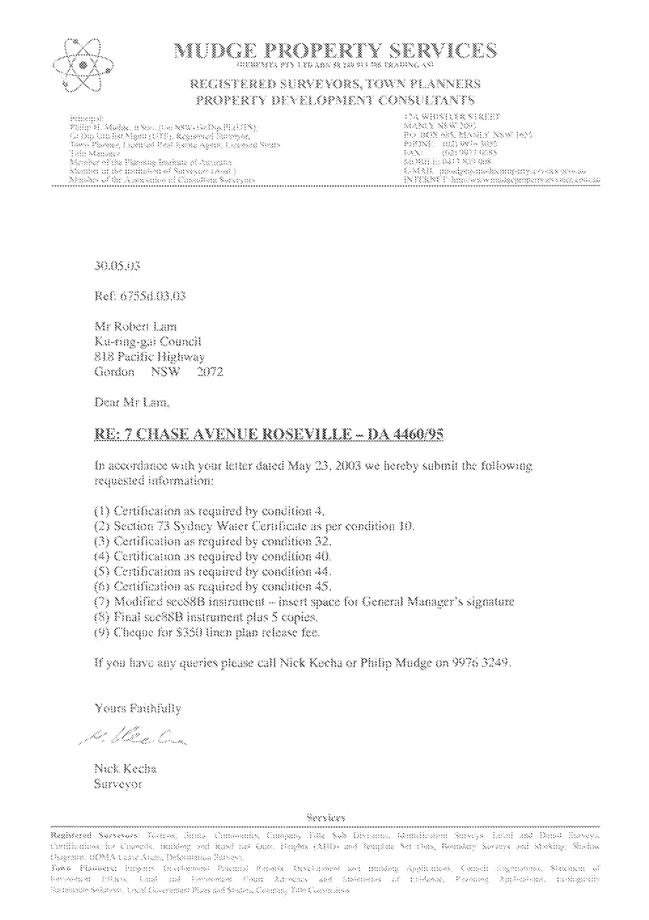
7 Chase Avenue, Roseville Chase - Encroachment on Managed Land
EXECUTIVE SUMMARY
Purpose of Report
To respond to questions raised at the Council site inspection and for Council to consider its position in relation to existing encroachments on Crown Land under the care, control and management of Council adjacent to 7 Chase Avenue, Roseville Chase.
Background
Council considered a report at its Meeting on 24 April 2012 (Attachment A1).
A site inspection was conducted on 5 May 2012. The meeting was attended by the Mayor, Councillor Anderson and Councillors Malicki (Deputy Mayor), Cross, Szatow, McDonald and Duncombe. The inspection commenced at 9.10am and concluded at 9.45am (Attachment A2).
Comments
The following questions were asked at the site inspection:
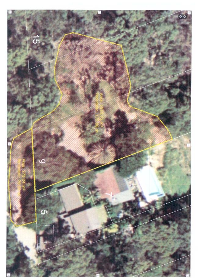
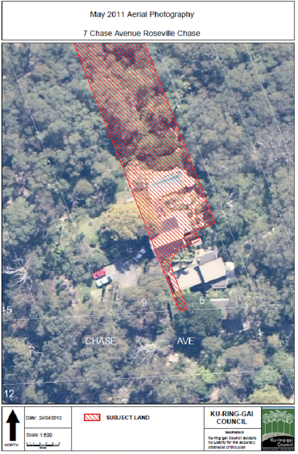
a) Identify the total area of crown land (in square metres) that is currently being utilised by the adjoining owners.
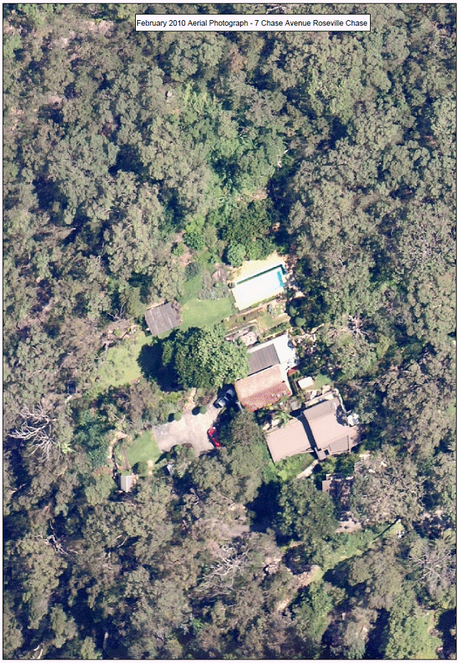
The area of crown land currently used by the adjoining owners is estimated to be 1,523 m2. The part of the land used as the basis of the estimate is indicated in the map forming Attachment A3.
b) Identify the approximate year that the driveway (on crown land) was concreted.
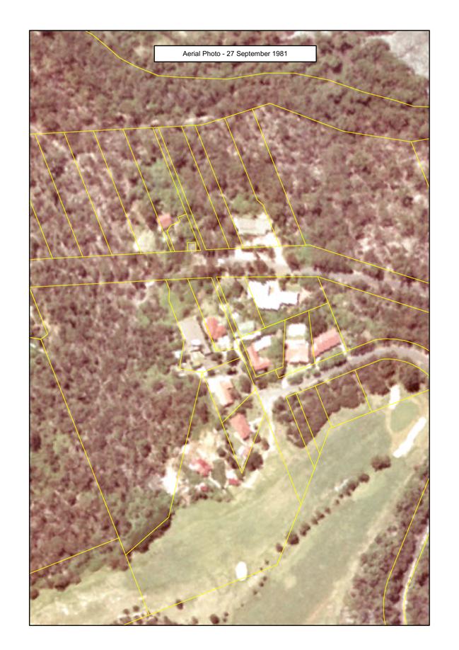
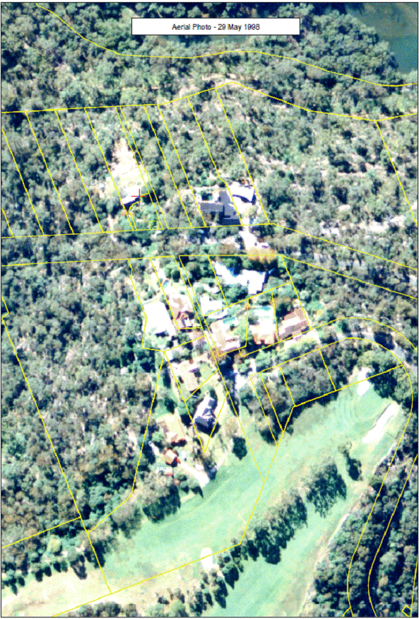
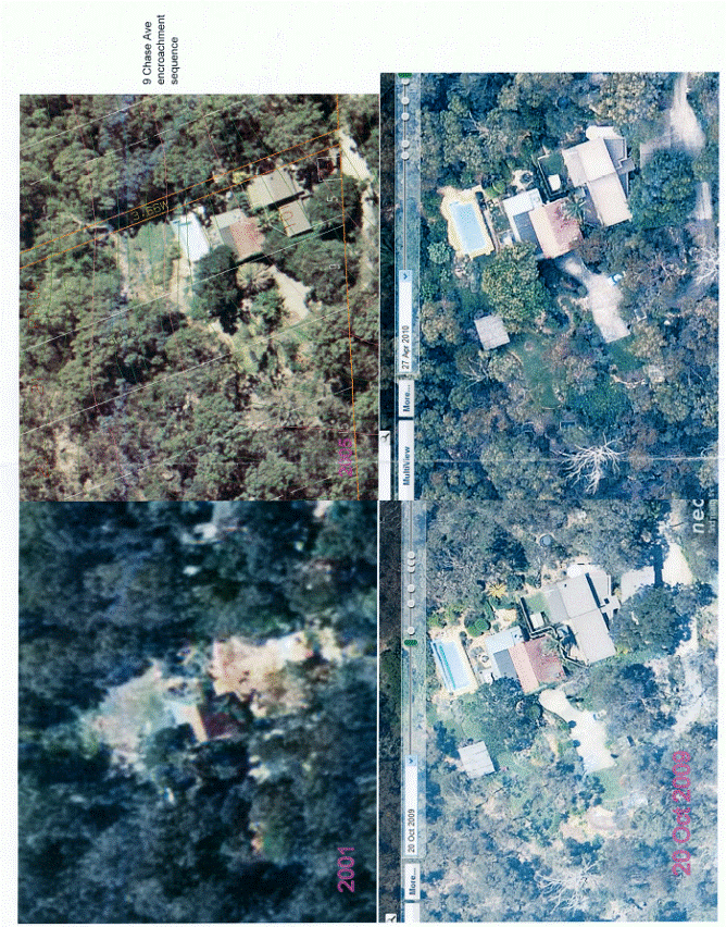
The concrete driveway appears to date from between 2001 and 2005.
From aerial photography records (Attachments A4 to A8 inclusive), the concreted driveway does not appear to have been in place in 2001 but is apparent in 2005. Earlier aerial photos from show no concrete driveway and no track or dirt driveway are obvious. It is possible there may have been a dirt access way but it is not very clear from the 2001 aerial photo. Observations of the condition of the driveway are consistent with the driveway concrete being relatively recent. Council has no other record or reference to a driveway or track before 2005.
c) Outline how Council finalised the subdivision approval without the pathway being provided?
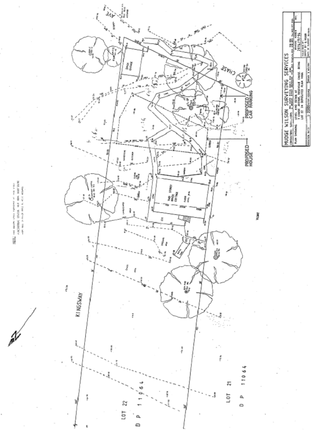
Prior to the approval of DA4460/95, parking provision for 7 Chase Avenue existed near the south-eastern corner of the site adjoining the road and access to the house was by means of pedestrian paths to the house. This is apparent from the site plan provided in support of the application for DA4460/95 (Attachment A9). As part of the works proposed in DA4460/95, the existing paths, which passed through the location for the new dwelling house, were to be removed and replaced with a new path and steps, to be located on the western boundary with the area of an access handle for the proposed rear lot.
Condition 32 of the consent to Development Application 4460/95 (Attachment A10) provided:
All site works are to be fully supervised by a suitably qualified Consultant Civil Engineer, or by such other person as may be approved by Council’s Director Engineering Services. On completion of all works, the Consultant is to supply certification that all of the works have been constructed strictly in accordance with Council’s specification, and the approved drawings, and that any variations have been approved by Council’s Director Engineering Services, as shown on the Works-as-Executed drawings.
The new pathway was part of the works required to be supervised and certified pursuant to Condition 32.
On 6 February 2000, an application for an Occupation Certificate was made to Council by the applicants, supported by a “certificate” signed by Mrs Louise von Sperl, stating:
We require to move into the above address as we need to vacate the other home for rental.
The work which remains will be completed on or before May 31st 2001. [emphasis supplied] (Attachment A11)
The Applicant’s surveyor provided written certification to Council as required by Condition 32 on 30 May 2003 (Attachment A12).
Also on 30 May 2003, the applicant’s surveyor advised Council:
We hereby certify that it is not necessary to create a right of way for pedestrian access as there is an existing battleaxe handle running along the eastern [sic] boundary about 1.m wide which can be used as access for the lower property. [emphasis supplied] (Attachment A13)
The final plans of subdivision were approved for release on 30 June 2003.
d) Identify the approximate age of the vegetation planted on the crown land.
Based on aerial photography records, most planting and clearing on site appears to have occurred in the period 2005 to 2009. Aerial photographs from 2001 and earlier indicate that most vegetation on site was native species such as eucalypts, however there were some non-indigenous plants apparent on site at that time, in particular, there are non-indigenous trees and palms close to the house and perhaps one several metres into the bush to the west of the house. The lawn and landscaped areas is not apparent on the 2001 aerial photos but some are obvious in the 2005 photo, with the maximum extent apparent by 2009. On-site observations are consistent with most of the plants, landscaping and sheds etc being quite recent additions. The vegetable patch had very recent plants growing, such as pumpkins which are annual plants, when inspected in 2010. The pencil pines observed at that time around the woodshed/clothes lines are quite young and obviously planted within the last few years.
e) Obtain a full copy of the dual occupancy/subdivision approval with associated conditions and attach these documents/clarify the recommendations in the next report to Council.
The notice of determination and conditions in DA 4460/95 is reproduced as Attachment A10.
f) Attach to the next report to Council, notes from any on-site meeting attended by Mr McKee and Mr Miocic.
The General Manager and Director Development and Regulation have jointly inspected the site, however there has been no “on-site meeting” and therefore no notes taken.
g) Identify any exit strategies for existing residents in the event of a bushfire together with any liabilities for Council in this regard.
The means of entry/exit from 7 Chase Avenue, both prior to and after the development approved in DA4460/95, is via pedestrian path and/or steps. The replacement path and steps proposed in DA4460/95 remain outstanding works.
The applicant owners are responsible and liable for completion of the works. Council has statutory power to enforce the consent and thereby require completion of the works, however the exercise of such power is discretionary.
h) Confirm that only the driveway is the subject of any proposed future easement.
Council has not been provided with any precise description of the nature and terms of any proposed future easement, however Council is aware of a request by solicitors on behalf of the owners of 7 Chase Avenue, Roseville Chase to the Office of Strategic Lands on
8 October 2010 as follows:
Our clients seek an easement for vehicular and pedestrian access to ingress or egress their property.
Further they seek a right to park outside our clients’ front door.
They would be prepared to agree to a reasonable term for them to maintain the driveway and the adjacent grassed open space near their front door.
Due to the special circumstances of this case, in that Ku-ring-gai Council approved the DA which “land locked” our clients’ property, we do not suggest that any compensation be payable to the state authority in this particular case.
In relation to the last-quoted paragraph, it should be noted that 7 Chase Avenue is not “land locked”. It is battle-axe shaped with provision for pedestrian access as proposed by the applicants (who remain the current owners of 7 Chase Avenue).
i) Confirm the situation with respect to bushfire, having regard to the existing approvals together with any changes in bushfire planning regulations.
Responsibility of the applicants in relation to bushfire hazard is set out in Condition 11 of DA4460/95, which states:
As the site adjoins bushland, the potential bushfire hazard (in accordance with Circular C10 – Planning in Fire Prone Areas) needs to be considered. In accordance with Council policy, all necessary bushfire protection measures shall be achieved within the boundaries of the site. The minimum measure necessary on the site is a 20 metre wide fuel free inner zone located between the dwelling and the (eastern and western) bushland boundaries and a 40 metre wide fuel free inner zone located between the dwelling and the (northern) bushland boundary.
Hence, DA4460/11 requires all necessary bushfire protection measures to be achieved by the applicants within the boundaries of the site.
Observations of the encroached area have noted the introduced planting of flammable plant species, including Leighton Green Cypress, dumping of dead vegetation and cuttings, and the storage of materials including gas bottles, which have an adverse impact on fire risk.
j) Identify all Crown land in Ku-ring-gai under the care and management of Council and comment on whether Council has a responsibility to provide/maintain asset protection zones on those parcels which are bushfire prone.
Crown land recorded in Council’s records as being under the care control or management of Council is listed in Attachment A14. (Note: This lists only land recorded as being owned by the Crown and does not include any land held by National Parks or other State Government Departments)
Section 63 of the Rural Fires Act 1997 in respect to management of land provides:
63 Duties of public authorities and owners and occupiers of land to prevent bush fires
(1) It is the duty of a public authority to take the notified steps (if any) and any other practicable steps to prevent the occurrence of bush fires on, and to minimise the danger of the spread of a bush fire on or from:
(a) any land vested in or under its control or management, or
(b) any highway, road, street, land or thoroughfare, the maintenance of which is charged on the authority.
(2) It is the duty of the owner or occupier of land to take the notified steps (if any) and any other practicable steps to prevent the occurrence of bush fires on, and to minimise the danger of the spread of bush fires on or from, that land.
(3) A public authority or owner or occupier is liable for the costs incurred by it in performing the duty imposed by this section.
(4) The Bush Fire Co-ordinating Committee may advise a person on whom a duty is imposed by this section of any steps (whether or not included in a bush fire risk management plan) that are necessary for the proper performance of the duty.
(5) In this section:
notified steps means:
(a) any steps that the Bush Fire Co-ordinating Committee advises a person to take under subsection (4), or
(b) any steps that are included in a bush fire risk management plan applying to the land.
This section makes reference to notified steps being (b) steps included in a bush fire risk management plan. This plan sets out the responsibilities that land managers must meet in relation to bushfire management and risk reduction inclusive of hazard reduction burns, asset protection zone maintenance and community education. Council’s responsibilities to manage bushfire risk within this area can continue to be met by Council as required by the plan.
k) Provide details of the original site that was purchased by the current owners (including any deposited plan/title information) together with any other circumstances at that time that would have served to remind the purchasers that they would have been bound to comply with the development consent and its associated conditions.
Council’s records indicate that 7 Chase Avenue, Roseville Chase was acquired by the current owners on 26 March 1993. Development Application 4460/05 for construction of a second dwelling and subdivision was lodged with Council in 1995. The consent (including conditions) was issued and notified to the current owners.
Internal Consultation
Staff from Corporate and Strategy and Environment departments have assisted in the preparation of this report.
Summary
Council considered a report at its Meeting on 24 April 2012 and deferred consideration of the matter pending a site inspection, which was conducted on 5 May 2012. Questions asked at the site inspection are addressed in this report.
|
That Council write to the Minister of Planning and Infrastructure, as owner of the subject land, seeking written advice of his intention as regards the continued unauthorised use of the land, and advising that if his advice is not received within six weeks, Council will take such further action as may be appropriate in relation to the matter in accordance with Council’s obligations as manager and relevant policies.
|
|
Jamie Taylor Corporate Lawyer |
Michael Miocic Director Development & Regulation |
|
John McKee General Manager |
|
|
A1View |
Previous Report to Council dated 13 April 2012 |
|
2012/136546 |
|
|
|
A2View |
Notes of Site Inspection on 5 May 2012 |
|
2012/136453 |
|
|
A3View |
Map - Calculation of Area of Encroachment |
|
2012/135340 |
|
|
A4View |
Aerial photograph - September 1981 |
|
2012/137502 |
|
|
A5View |
Aerial photograph - May 1998 |
|
2012/137515 |
|
|
A6View |
Aerial photographs - 2001, 2005, 2009, 2010 |
|
2012/149786 |
|
|
A7View |
Aerial photograph - February 2010 |
|
2012/149778 |
|
|
A8View |
Aerial photograph - May 2011 |
|
2012/149782 |
|
|
A9View |
Site Plan of 7 Chase Avenue, Roseville Chase from DA4460/95 |
|
2012/147757 |
|
|
A10View |
Notice of Determination of Development Application 4460/95 |
|
2012/135091 |
|
|
A11View |
Letter by Louise von Sperl dated 6 February 2000 provided in support of application for Occupation Certificate for 7 Chase Avenue, Roseville Chase |
|
2012/147704 |
|
|
A12View |
Certification letter by Mudge Property Services dated 30 May 2003 |
|
2012/135971 |
|
|
A13View |
Further certification letter by Mudge Property Services dated 30 May 2003 |
|
2012/147710 |
|
|
A14View |
Crown land under care control and management of Council as at 1 June 2012 |
|
2012/136613 |
|
APPENDIX No: 11 - Letter by Louise von Sperl dated 6 February 2000 provided in support of application for Occupation Certificate for 7 Chase Avenue, Roseville Chase |
|
Item No: GB.1 |
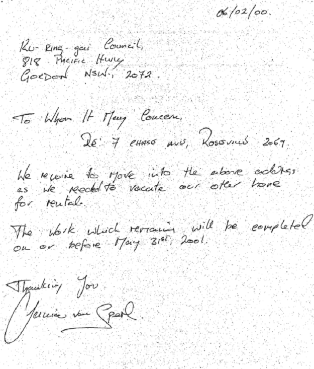
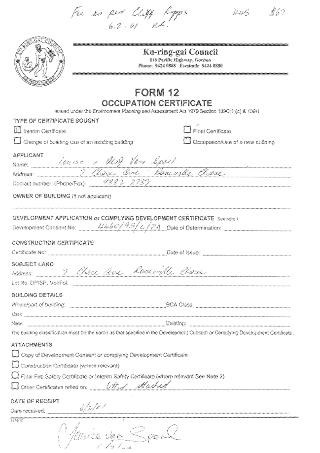
|
APPENDIX No: 13 - Further certification letter by Mudge Property Services dated 30 May 2003 |
|
Item No: GB.1 |
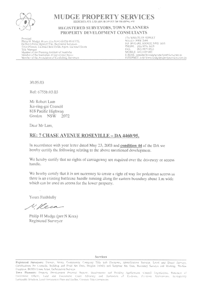
|
APPENDIX No: 14 - Crown land under care control and management of Council as at 1 June 2012 |
|
Item No: GB.1 |
|
Ordinary Meeting of Council - 26 June 2012 |
GB.2 / 74 |
|
|
|
|
Item GB.2 |
S07470 |
|
|
2 April 2012 |
Lease to KOPWA Ltd - "Arrunga" Units -
259 - 261 Pacific Highway, Lindfield
EXECUTIVE SUMMARY
|
purpose of report: |
For Council to consider the granting of a lease to KOPWA Ltd (formerly Ku-ring-gai Old People's Welfare Association) for the premises located at 259–261 Pacific Highway, Lindfield, being the 14 Arrunga Aged Care Self Contained Units (the Premises). |
|
|
|
|
background: |
KOPWA has occupied the Premises for the past 50 years under a peppercorn lease. This arrangement expired in April 2012. The KOPWA lease is now holding over pending a decision of Council. |
|
|
|
|
comments: |
KOPWA Ltd has been assessed as a “community service frontline” under the eligibility for a rental rebate according to Council’s Policy for the Management of Community and Recreation Land and Facilities adopted 10 November 2009. A community service frontline is a community service that meets community needs clearly identified in the Community Plan. |
|
|
|
|
recommendation: |
That Council grant a lease to KOPWA on the conditions outlined in this report for a term of 5 years, plus two options to renew for 5 years each, giving a total term of 15 years. |
Purpose of Report
For Council to consider the granting of a lease to KOPWA Ltd (formerly Ku-ring-gai Old People's Welfare Association) for the premises located at 259–261 Pacific Highway, Lindfield, being the 14 Arrunga Aged Care Self Contained Units (the Premises).
Background
Council is the owner of Lots 1, 2 and 3 DP 212617. Lot 3 DP 212617 contains the 14 Arrunga Aged Care Self Contained Units and Lot 2 DP 212617 contains the Lindfield Seniors Centre. Both Lots 1 and 2 DP 212617 are located at 259–261 Pacific Highway, Lindfield - Lot 2 fronting the Pacific Highway and Lot 3 at the rear of Lot 2. The land is zoned Special Uses 5(a) (Municipal Purposes) and classified as Community Land. Refer to the location sketch attached in Attachment A1.
The site at 259–271 Pacific Highway Lindfield comprises the Lindfield Library, the Lindfield Seniors Centre, 14 Arrunga Aged Care Self Contained Units and the Seniors Resource Centre. Council acquired the site by resumption from the Coleman family in 1948. The site is of heritage interest as it contains a well that was used by the previous owners. The well is protected under the NSW Heritage Act 1977.
The Lindfield Library was developed in 1954, the Seniors Centre constructed in 1962, followed by the 14 Arrunga Aged Care Self Contained Units in 1963. The Seniors Resource Centre was converted from the Lindfield Baby Health Centre in 1991.
From its opening in 1962 until 1997, the Seniors Centre was managed by KOPWA Ltd. In 1997 the Ku-ring-gai Seniors Centre’s Committee was established and has been responsible ever since for the management and operation of the Seniors Centre and the Seniors Resource Centre.
Since 1962, KOPWA Ltd has been in continuous occupation of Lot 3 on which they constructed the 14 Arrunga Aged Care Self Contained Units and have paid a peppercorn rent. Legal access to Lot 3 has been provided by a twenty foot wide Right of Carriageway (ROC) over the adjacent Lot 1. This ROC expires on the expiry of the lease over Lot 3. Council has constructed an asphalt driveway on Lot 1 and established eight two hour time limited car parking spaces over the south eastern section of the ROC. KOPWA has also been issued at no cost car parking permits over five of these car parking spaces adjacent to the age care units. These car parking permits are currently due to expire on 31 July 2012. All rents and car parking fees received from the Arrunga units tenants have been paid to KOPWA Ltd. The 14 Arrunga Aged Care Self Contained Units have been fully maintained by KOPWA Ltd.
The current lease is between KOPWA Ltd and Council for Lot 3 on which KOPWA constructed the 14 Arrunga Aged Care Self Contained Units and the associated right of carriageway over Lot 1. It is proposed to redefine the location and size of the ROC to avoid conflict between KOPWA’s access rights and the established car parking spaces. The current lease does not cover the 5 car parking spaces currently available to Arrunga tenants therefore it is proposed to enter into a separate licence agreement with KOPWA for these car parking spaces on expiry of the current permits.
Clause (h) of the KOPWA's lease which expired on 30 April 2012 transferred the ownership of the building containing the 14 Arrunga Aged Care Self Contained Units to Council on the expiry of the lease. The building is currently 50 years old and is likely to be reaching the end of its economic life. It is proposed that the new lease acknowledges that the ownership of the building remains with KOPWA and that KOPWA remains responsible for all building maintenance (including any structural repairs) and any required building upgrade works. KOPWA will also remain responsible for any demolition works required at the end of any future lease.
KOPWA Ltd:
· Provides the care and accommodation for the older members in the Ku-ring-gai LGA;
· Is a stand alone, not for profit, non-sectarian, non-political community organisation, independent of any church and any form of government;
· Owns and manages 80 self care units under the NSW Retirement Villages Act 1999 specifically for older members of the community who are not well placed to own a property in their latter years;
In addition to the Premises, KOPWA Ltd also manages the following two blocks of units in Lindfield and one in Roseville offering comfortable, modest long-term accommodation:
1. Kalinda Units - Address: 466 Pacific Highway, Lindfield;
2. KIAH Self Care Units - Address: 16 Treatts Road, Lindfield; and
3. Lindfield Gardens - Address: 2 Ulmarra Place, East Lindfield.
Comments
Council has offered to KOPWA Ltd an initial Offer to Lease. While negotiations between KOPWA and Council have been ongoing for some time, and a number of meetings have been held between KOPWA , Council staff, the General Manager and Councillors, KOPWA has advised Council that Council’s offer will now go to their next Board meeting on 20 June 2012 – unfortunately this meeting will occur after the drafting of this report, so some amendments may be necessary, depending on the outcome of this report.
The current lease is between KOPWA Ltd and Council for Lot 3 on which KOPWA constructed the 14 Arrunga Aged Care Self Contained Units and the associated right of carriageway over Lot 1. It is proposed to renew this lease. The current lease does not cover the 5 car parking spaces currently available to Arrunga tenants, therefore it is proposed to enter into a separate licence agreement with KOPWA for these car parking spaces on expiry of the current permits.
Governance Matters
Section 36 of the Local Government Act 1993 requires a specific Plan of Management (POM) for Community Land. Council’s Lindfield Library Plan of Management, adopted on 3 September 2002, is consistent with the requirements for a specific POM.
The Lindfield Library POM expressly authorises Council to consider, when approving the granting of any lease, that Council takes into consideration the specific use authorised by the POM namely, “General Community Use”. KOPWA Ltd has a proven ability to operate a facility that achieves the “General Community Use” specific use authorised by the POM.
The Premises have been and will continue to be operated by KOPWA Ltd which fully complies with the POM.
The proposed lease for five (5) years plus two further options to renew for five (5) years each, giving a total term of 15 years, fully complies with the Lindfield Library Site POM and Council’s Policy for Management of Community and Recreation Land and Facilities (the Policy).
Risk Management
KOPWA Ltd is to procure its own insurances, together with $20 million Public Liability. KOPWA Ltd is to fully indemnify Council against personal and property damage on the Premises. Evidence of currency is to be supplied annually to Council.
Financial Considerations
KOPWA Ltd currently pays a peppercorn rental.
In accordance with the Policy, KOPWA Ltd has been assessed to receive a 90% rebate. This has been determined as within the category of community service frontline, under the eligibility for a rental rebate under the Policy. A community service frontline is a community service that meets community needs clearly identified in the Community Plan.
A new independent valuation of the Premises was undertaken by Corporeal Valuations Pty Ltd (the Valuation). Refer to Confidential Attachment A2. The Valuation valued the Premises’ market rental as follows:
Full Lease Fee
Year One $98,280.00
Less 90% Rebate $88,452.00
Annual Year One
Lease Fee $9,828.00 (excl GST)
Yearly reviews are calculated by a fixed step of 4% for the term of the lease. A market rental review, including a review of the current rebate assessment, will apply at the commencement of each of the five options’ periods.
KOPWA Ltd is responsible for all building maintenance (including any structural repairs) and any required building upgrade works.
In accordance with the Policy and the Offer to Lease, KOPWA Ltd is also obliged to pay Council’s legal costs, estimated to $1,500 plus GST and the one-off $230 discounted ‘frontline community service’ administration fee to Council, for administrative costs incurred associated with the preparation of the lease.
KOPWA Ltd has, during the period of its occupation, met their responsibilities as a Lessee and has complied with the conditions of the Lease.
Social Considerations
KOPWA Ltd has been providing a valuable community service since in the Ku-ring-gai LGA since 1963 - a key component of providing this community service is the security of tenure.
With security of tenure for another 15 years, KOPWA Ltd will continue its occupation of its current site on Council’s land with no disruption to this valuable community service.
However, should Council require the site in the future, special termination provisions will be included in the lease which will ensure Council and KOPWA engage in negotiations to ensure the ongoing provision of adequate age care services similar to those currently offered by KOPWA.
Environmental Considerations
Under the lease terms and conditions, KOPWA Ltd is to provide Council with evidence of environmental compliance on an annual basis.
Council’s Lindfield Library Site Plan of Management, adopted on 3 September 2002, (the Plan), incorporates the KOPWA Ltd site. Under clause 2.7 of the Plan the proposed lease is recognised as a permitted activity. Accordingly, the proposed lease is authorised in accordance with the Plan and the principles of the Local Government Act 1993 and in particular the management of community lands.
Community Consultation
No consultation is required for this process prior to Council resolution. Once Council resolves to grant the proposed lease, public notification of Council’s intention to grant the lease in accordance with s 47 (1) a of the Local Government Act 1993 will occur.
Internal Consultation
Strategy and Corporate officers have been consulted in the writing of this report.
Summary
KOPWA Ltd has occupied the Premises since1962. KOPWA Ltd would like to formalise its continued usage by entering into a new five year lease with two five year options, giving a total term of 15 years. The information provided to Council by KOPWA Ltd shows KOPWA Ltd’s compliance with Council’s requirements to lease.
KOPWA Ltd has also shown that it is able to undertake its
obligations to Council under the terms of the proposed lease, ensuring the long
term provision of this valuable service to the community of
Ku-ring-gai.
|
A. That a lease be granted to KOPWA Ltd for a period of five years with two options to renew for further five years each giving a total term of 15 years.
B. That the lease be granted on the terms outlined in the report.
C. That this approval is subject to the public notice provisions under section 47 of the Local Government Act 1993 and that Council advertise and publish the said public notice.
D. That the Mayor and the General Manager be authorised to execute and sign all necessary documents.
E. That the Council Seal be affixed to the lease agreements.
|
|
Guy McDonald Leasing and Contracts Officer |
Mark Taylor Manager Community & Recreation Services |
|
Janice Bevan Director Community |
|
|
A1View |
Location sketch of "Arrunga" units at 259 - 261 Pacific Highway Lindfield |
|
2011/250050 |
|
|
|
Corporeal Market Rental Valuation Report |
|
Confidential |
|
APPENDIX No: 1 - Location sketch of "Arrunga" units at 259 - 261 Pacific Highway Lindfield |
|
Item No: GB.2 |
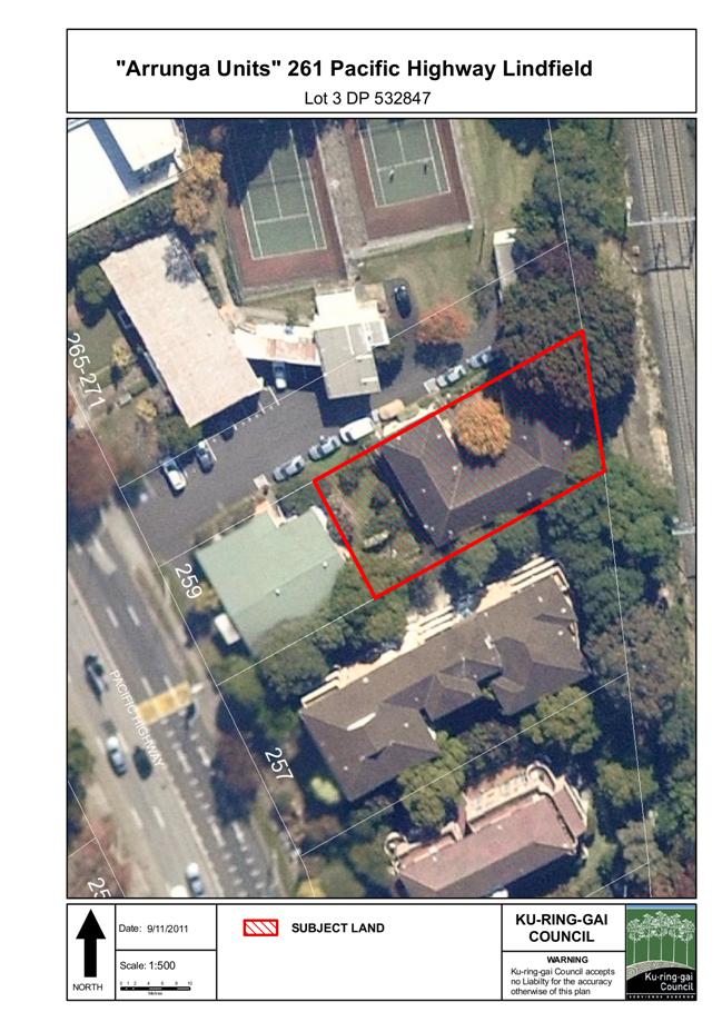
|
Ordinary Meeting of Council - 26 June 2012 |
GB.3 / 81 |
|
|
|
|
Item GB.3 |
S08766 |
|
|
30 May 2012 |
Marian StReet Theatre, 2 Marian Street, Killara - Management Options
EXECUTIVE SUMMARY
|
purpose of report: |
For Council to consider management options following negotiations for a licence with Marian Street Theatre for Young People Inc. (MSTYP) for the premises located at 2 Marian Street, Killara, being Marian Street Theatre (the Premises). |
|
|
|
|
background: |
An Expressions of Interest (EOI) was commenced on 2 June 2011 to attract a Head Tenant for the Premises. Following a resolution of Council, the EOI was required to seek a Head User to occupy and manage the Premises, ensure MSTYP had a designated space, and to ensure the theatre remained a multi-purpose centre for a wide range of users in the community. |
|
|
|
|
comments: |
The EOI process attracted only one applicant – MSTYP. Council staff have engaged in lengthy negotiations with MSTYP in an attempt to develop a model that will best meet both the requirements of the Council resolution and Council’s policy for the management of community facilities. To date, an agreement in accordance with Council’s policies and plans has not been reached. At a recent meeting between the General Manager, staff and MSTYP representatives, it was decided to put the matter to Council for consideration, with the points of difference to be included in the report. |
|
|
|
|
recommendation: |
That Council not accept the offer Marian Street Theatre for Young People Inc to be the licensed Head User for the Marian Street Theatre, and that staff further explore options for a management structure that is financially sustainable to ensure the viability of the theatre.
|
Purpose of Report
For Council to consider management options following negotiations for a licence with Marian Street Theatre for Young People Inc. (MSTYP) for the premises located at 2 Marian Street, Killara, being Marian Street Theatre (the Premises).
Background
Council is the owner of Lot A DP329637 which is located at 2 Marian Street, Killara. The land is zoned Special Uses 5(a) (Municipal Purposes) and classified as Community Land.
The site at 2 Marian Street Killara comprises the Marian Street Theatre. The original building was built in 1906. Council purchased the building in 1931 and use continued as a Memorial Hall known as the Killara Soldiers Memorial Hall. The current Marian Street Theatre was established in 1965.
From 1965 until 2001, Marian Street Theatre was occupied by Marian Street Theatre Ltd. On 24 December 2001 the Marian Street Theatre Ltd lease was assigned to MSTYP.
MSTYP has continued in occupation of the premises for many years as a user group under historical terms and conditions.
Council’s resolution of 29 July 2008
Since Council’s resolution of 29 July 2008, Council and MSTYP have been working together to remediate compliance issues to ensure the theatre can operate as intended, generally at Council’s cost. These works were completed by March 2010 when the theatre was officially reopened.
Outstanding from the 29 July 2008 resolution was that upon the recommencement of performances at Marian Street Theatre Council commences a fresh EOI process to confirm whether a prospective lessee could be sought and to ensure that the MSTYP continues to have a designated space within the Theatre. The resolution from 29 July 2008, in part, required:
D. That upon recommencement of performances at MST, Council commences a fresh EOI process based on undertaking a series of building maintenance works to ascertain whether a prospective lessee is obtainable and that ensures that MSTYP continues to have a designated space within the theatre
Expression of Interest
An Expression of Interest (EOI) was prepared to attract a Head Tenant - this was commenced on 2 June 2011.
The EOI specifically sought an organisation to enter into a Head User occupation taking a management role, ensuring the MSTYP had a designated space, and the theatre remain a multi-purpose centre for a wide range of users in the community:
Council is inviting Expressions of Interest (EOI) from suitably qualified organisations to enter into a rental occupancy agreement as Head User for the occupation of the Marian Street Theatre (MST). It is envisaged that a Head User would take on the management role for their principle activity whilst also ensuring that the theatre remains a multi purpose centre for a wide range of users in the community.
All proposed users must comply with the current Development Approval and the Plan of Management.
In the EOI submissions a number of criteria were included in assessment:
· Compatibility with existing users of the site;
· Ability to comply with the requirements of the relevant Plan of Management and zoning for the site;
· The financial structure which the applicant wished to pursue and how it would be implemented and advantages offered by the proposed approach; and
· The projected financial performance of the structure being proposed.
The successful applicant would utilise the theatre and comply with Council’s relevant leasing policy, being Council’s Policy for the Management of Community and Recreation Land and Facilities.
As a broad guide, the following general restrictions applied to the EOI:
· Rent will be assessed by a market valuation undertaken by an independent valuer, with such rent being reviewed annually in accordance with a fixed step value.
· The maximum length of the rental occupancy agreement will be for five (5) years.
· Rent may be adjusted subject to the level of capital investment required to make the building fit for purpose.
The EOI was advertised in the Sydney Morning Herald and on Tenderlink. Only one submission was received. This was from the current occupier of the building, Marian Street Theatre for Young People (MSTYP).
In their submission, MSTYP offered to be the Head Lessee of the premises, however MSTYP did not offer any rent or contributions to building maintenance or upgrade works. MSTYP is willing to allow access to the downstairs area for community or school groups as a source of revenue, however this was conditional, (4 days per week 9.00am – 3.30pm only), and MSTYP claimed they also required this space for their activities. Additionally MSTYP made reference to the additional staffing costs in providing this service/space to the community.
Under the MSTYP proposal Council would be obliged to undertake all ongoing repairs, maintenance and all building upgrade costs with no return from MSTYP.
Council’s resolution of 19 July 2011
Council did not accept the MSTYP’s EOI following the report of 19 July 2011. Rather, Council considered that further negotiations with MSTYP may provide the opportunity for a tenancy consistent with Council’s Policy for the Management of Community and Recreation Land and Facilities. Council, in part, resolved:
· That Council staff be authorised to negotiate with the Marian Street Theatre for Young People a new rental agreement for a period of ten years in accordance with Council’s Policy for the Management of Community Land and Facilities and Adopted Fees and Charges 2011/2012.
· That a further report be brought to Council following the conclusion of negotiations with the Marian Street Theatre for Young People.
Negotiations under Policy
Council’s Leasing Officer commenced negotiations with Board Members and staff of MSTYP as per the resolution.
An independent Market Valuation was undertaken by Mark Greenhalgh of Corporeal Property Valuers and Consultants.
Given this unique property, the valuer’s brief was to consider equivalent or similar community theatres throughout the Sydney metropolitan area, taking into consideration current conditions and restrictions on the use of the properties, in accordance with the DA and the Plan of Management. Council therefore requested a market rental valuation of the premises with the use restrictions as described above, and another without the use restrictions.
The valuer noted:
· Market evidence – assessed a range of operating theatres in Sydney.
· Theatres tend to be owner occupied.
· MST - Commercial kitchen and bar not operational, air conditioning system may need upgrading.
· MST - Seating capacity 300 seats
The valuer assessed the market rent at $60,000 p.a. given the current restrictions and $90,000 p.a. without the DA restrictions.
Under the Policy an Offer to Licence was made on 4 November 2011. Based on the valuation, Council’s offer included:
· MSTYP to pay a rental amount as assessed under the policy ($6,000 p.a.)
· Invoiced annually
· MSTYP to pay all service outgoings and building maintenance and services
· Council responsible for major structure maintenance
· Comply with Development Approval
· MSTYP to make theatre and downstairs function areas available for community use (MSTYP to keep income)
· Term of 5 years
Despite initial positive negotiations, the above offer to licence was not accepted by MSTYP.
In summary, the overall differences between the MSTYP offer and Council proposal are:
· MSTYP is seeking a lease rather than a licence agreement.
· MSTYP is seeking 10 year agreement rather than 5 years.
· MSTYP requests Council to continue paying all outgoings, except telephone and electricity.
· MSTYP requests Council to continue paying for all building maintenance and capital improvements.
· MSTYP wanted exclusive use, however MSTYP has now agreed to limited community use
Further negotiations took place with the General Manager, staff and representatives of MSTYP with meetings in March 2012 and May 2012, in order to progress the matter. Following the last meeting it was agreed that various options be put to Council for consideration.
Copies of MSTYP requests are attached (Attachments 1 and 2)
Comments
A new agreement or management framework is urgently required as MSTYP has been holding over under the old agreement for over 10 years, and a month to month holdover does not project a clear future for the facility, nor does it provide a forward plan for either Council or the tenant.
Council’s recent capital investment of over $700,000 has resulted in the theatre being upgraded to a standard suitable for performances, and in December 2009 through to May 2010 the theatre underwent a major building upgrade to satisfy the DA 0185/09 conditions. This upgrade primarily focused on Fire Safety, Disabled Access and BCA compliance issues. Further acoustic work was undertaken throughout 2011 to permit performances until 9:30pm from Sunday to Thursday and until 10.00pm Friday to Saturday, the DA permits use up to11.00pm if compliant.
The EOI required a Head User to take on the management role for their principle activity whilst also ensuring that the theatre remains a multi purpose centre for a wide range of users in the community, however with the restrictions in the Development Approval, Plan of Management and operations of MSTYP for most of the core times, it was difficult to attract a willing Head User other than MSTYP.
As MSTYP was the only offer received from the EOI, it is therefore considered the success of the negotiations should be judged on the ability of MSTYP to comply with the EOI conditions, plus the Policies and Plans as a Head User.
Position of MSTYP
Basis of MSTYP submission:
· MSTYP is a small not-for-profit organisation with only one full-time staff member
· Use of the upstairs theatre is constrained by the long seasons of MSTYP shows, since it can be occupied by only one show at a time
· Any heavier use of the theatre would necessitate employing at least one additional person for both administrative and technical support of other clients. MSTYP considers this would need to be paid for either by Council, or by charges made to the potential users.
· MSTYP uses Marian Street Theatre to originate productions, rather than as a venue where productions are brought in, as is Parramatta’s Riverside Theatres and Glen Street Theatre.
· These other theatres are venues for hire, which necessitates a staff not for production, as with MSTYP, but to source and service productions for the space, needing specialised staff to find appropriate productions, devise a program and provide services from publicity to technical expertise, a costly operation which is heavily subsidised by those other Councils.
· The theatre’s lighting rig and console and some sound equipment is owned by MSTYP. Any other user of the auditorium would need to make suitable arrangements with MSTYP if they wished to use this equipment, which is valuable and technically complex. However, while the lighting and sound set-up is adequate for children’s theatre performances, it is not considered of the standard required for a professional theatre production. Additional lights and associated equipment would be required by a professional company.
MSTYP’s preferred model of a lease would have merit if the group could ensure compliance with the intent of the Plan of Management which stipulates wide access for the community. In particular, the POM also includes use of the theatre for casual hirers.
In MSTYP submission the use of the Theatre would be highly limited, according to MSTYP:
MSTYP uses the auditorium for three children’s theatre productions per year, together with occasional performances for its youth theatre group. Each children’s theatre production runs for 10 Saturdays at 1.00pm and 10 weekdays during the school holidays, typically at 10.00am and 1.00pm. Rehearsals for these productions run throughout the year.
Any external group wishing to use the auditorium would need to make arrangements to accommodate MSTYP’s commitments, taking into account its scheduled use of the auditorium for approximately 40 weeks during the year (including time for building stage sets and for rehearsals).
The access to downstairs areas may be more flexible, according to MSTYP:
Similar, but less severe, limitations apply to the use of the downstairs facility. The downstairs space is flexible and could be used by community groups that have modest requirements for technical and management support.
The downstairs area is currently used by MSTYP for classes on some mornings, most afternoons and evenings of the week, on Saturdays and some Sundays, and two weeks of every school holidays.
MSTYP could facilitate access to the downstairs area during the week by a limited number of casual users within its existing resources.
Current hirers include of this space have included:
· Actors Forum – 4 bookings per year – staged readings
· Sydney Puppet Theatre
· Shakespeare’s Mothers – small community theatre group
· Filming – for example in March the Grandmothers hired the Theatre for a few days and generated $4,000 in income for MSTYP and Council $1,690 in filming approval fees.
It is not clear under the current arrangements, however, who has the rights to fees and charges generated from the hire of the MST by external parties. Depending on the outcome of the agreed arrangements the income would fall to either Council or MSTYP.
Possible uses for the downstairs community space/function area at Marian Street Theatre:
Meeting space is in heavy demand throughout Ku-ring-gai, and staff continually receive requests for community space similar to that at the Marian Street Theatre.
Based on existing activities and functions that are currently conducted in Council facilities and community meeting rooms, staff have provided the following examples of possible uses for the downstairs community space at the Marian Street Theatre:
· Cooking classes - Cooking classes could be held in the downstairs kitchen. The kitchen does need some refurbishment but potentially could be used by for senior programs.
· Yoga/ Pilates classes
· Community Meeting Rooms - meeting rooms in Ku-ring-gai are charged at $25.00p/hr for permanent commercial hirers. For example, just 1 Yoga class and 1 Pilates class per week would generate $500 per term, or $2,000 per year.
· Book club or other casual hirer -Potential income $20.00p/hr
· Literary lunch / talk - Glen St Theatre holds literary lunches once every few months and charge $49.00 per head including a 2 course meal. At present sale of food and beverages is limited to the sale of pre-packaged food and non-alcoholic beverages prior to and at intervals during performances. If food was not available, a literary talk would still be popular.
· Rehearsal space for choir, orchestra, theatre in education - meeting rooms are charged at $20.00p/hr casual community rate and $13.50 permanent community rate. Currently the Ku-ring-gai Philharmonic Orchestra pays $577.50 per half year for hire of the Ku-ring-gai Town Hall for rehearsal space. The downstairs area and/or theatre auditorium at Marian Street Theatre would be very suitable for the KPO as they could use the space for both rehearsal and performances. Other examples include Rock n Soul Choir, which pays $549.00 per half year and the Ku-ring-gai Youth Orchestra which pays $767.50 per half year – income potential from these three hirers alone could be $3,788.00.
· Floor shows and craft and art exhibitions
Possible uses for theatre auditorium:
The current practice with MSTYP is that props are left on stage during rehearsals and performances. With most other theatre companies however, the shows only have access to the actual theatre during the production week, and at most a week before a performance opens.
If MSTYP were to make more efficient use of the downstairs area and configured the theatre in a more “Production” mode there could be significant time made available for other paid hire and community use of this space.
If MSTYP wish to use the stage for rehearsals it would be ideal if props were removed and stored backstage so the stage can be used by other user groups. The introduction of a venue manager would assist in this role, as the organisational aspect of this recommendation was raised as a difficulty by MSTYP.
If this matter were addressed, the theatre could be used for a range of activities such as:
· Author talks
· Film festivals
· Jazz/ music festivals
· Orchestra concerts
· Choir concerts
· Dance concerts
· School concerts
· Theatre in Education Performances (schools could come to the theatre during school time)
· Comedy nights
· Cabaret
· Independent theatre
· Information sessions/ workshops
· Speech days
· Staged readings
Council’s Community Facilities Officer has also identified the following Ku-ring-gai arts/cultural groups that may make use of the Theatre and/or the downstairs community space on a permanent or casual basis:
· Ku-ring-gai Philharmonic Orchestra
· Ku-ring-gai Youth Orchestra
· Rock ‘n Soul Choir
· Roseville Tappers
· Van Loon Dance Academy
· Helen O’Grady Drama Academy
· Merry Makers
· Ku-ring-gai Seniors (monthly concerts during the day)
· Australia Silent Film Festival
· Codgers
· Grewel Goblin
· RAPA
· Class Act Theatre
It was also noted that the theatre has a considerable amount of material stored in areas that could be better utilised if this material was organised more efficiently. Council officers consider that the removal or stock take of old and redundant fittings, props and equipment would keep the backstage area clear and also ensure compliance with Work Health and Safety requirements.
In order to further assess the offer of MSTYP Council officers reviewed a range of other Theatre Management structures in Sydney – generally similar to Marian Street in that they were smaller theatres and/or Council managed.
Glen Street Theatre is a business unit of Warringah Council employing 12 permanent staff and is a subscription based model with 8,000 subscribers. Council provides funding but receives return from ticket sales and other hires. Council sets a minimum of 12 weeks community use per year. The Theatre has 400 seats and is well located next to a park and shopping centre but lacks public transport access. Last financial year the Theatre made a small 0.5% return with income of $2,842,000.
Bondi Pavilion was formerly Council hired venue. In 2010 a licence agreement was established with Tamarama Rock Surfers an adult production company for 3 years with a 2 year option. Waverley Council provided $70,000 one-off establishment funding. The Tamarama Rock Surfers have use of the theatre for 60% of the year with 40% usage designated to external hire and community use.
Darlinghurst Theatre Company leases Darlinghurst Theatre from City of Sydney. The current rent is $36,500 p.a. The theatre has only 111 seats and runs its own productions and co-productions.
Council owned Theatre Management and Funding
|
Theatre |
Owner |
Management |
Seats |
Layout |
Types of Booking & Frequency |
Current Funding/ Sponsorship |
|
Glen Street Theatre, Belrose |
Warringah Council |
Council Business Unit |
400 |
Seats
configured in a slight fan-shape |
16 weeks
of Glen St presented shows, 4 weeks commercial hirers, 13 weeks of community
based hirers, 4 weeks of maintenance and facility upgrades, |
Funding and income to Warringah Council |
|
Bondi Pavilion, Bondi Beach |
Waverley Council |
3 year (plus 2 year option) Licence to Tamarama Rock Surfers |
230 |
End on mode seating, flat floor performance space |
60%
self-produced or co-productions |
One-off establishment funding from Waverley Council Income from external hire |
|
Darlinghurst Theatre, Darlinghurst |
City of Sydney |
Leased to Darlinghurst Theatre Company |
111 |
End on mode seating, flat floor performance space |
100% self-produced or co-productions |
ticket sales |
|
Marian Street Theatre |
Ku-ring-gai Council |
MSTYP Holding over |
300 |
Elevated rows |
Self productions – young people’s theatre |
Ticket sales drama classes, sponsorship, Council maintains building and pays outgoings |
Other children’s theatre companies include Monkey Baa which recently won a tender to occupy the Lend Lease Darling Quarter Theatre for 5 years provided free of rent as a development requirement for the site. Monkey Baa produce 4 of their productions per year but must make the theatre available to other suitable users at other times.
Australian Theatre for Young People (ATYP) is based at the Wharf Theatre and run classes and their own productions.
EOI Negotiations and Licence Offer
At the conclusion of negotiations there was some progress between MSTYP and Council however, no agreement could be reached in accordance with the intent of Council’s resolutions or policies, or the Marian Street POM. Given these crucial considerations, MSTYP’s offer can not be an acceptable model to recommend for the future management of the Marian Street Theatre.
In summary, options for the Marian Street Theatre are:
1. Offer from Council in accordance with Policy, POM and Resolution of Council
· MSTYP pays rent $6,000 pa (90% rebate)
· 5 year licence – no options
· Comply with DA
· MSTYP to pay all outgoings
· Council would continue to maintain – roof, major structures, car park etc
· MSTYP would be responsible for minor maintenance – e.g. security, internal painting, minor plumbing and air conditioning
· MSTYP to ensure multi-share arrangements with the community (income to MSTYP)
Council officers also offered an alternate position where, in return for Council continuing to maintain the building, the arrangements for casual and permanent hire of the Theatre could be co-ordinated by Councils booking system and staff, with Council to receive income.
To consider this model, the MSTYP wanted the downstairs area to be first securely isolated from the theatre and administration area that they currently occupy.
The costs to do this upgrade, in order to provide the necessary security and access upgrades, would be approximately $83,000. This would include new doors, security system upgrade to separate areas, locks and window upgrades.
MSTYP were clear that they wanted to maintain exclusive occupation of the theatre under such a scenario, however limited use could be made if the stage was not required.
2. Offer from MSTYP (Current position)
· MSTYP to pay rent $6,000 per annum (3% increase p.a.)
· 5 year lease agreement with a 5 year option
· Council pays all outgoings except electricity and telephone and basic maintenance (approx $41,000 p.a.)
· MSTYP to have exclusive occupancy and use of the upstairs theatre
· Council to divide and secure the premises to permit use of the downstairs area and upstairs toilets (separate from theatre at a cost of approx $83,000)
· Council to manage all downstairs external hire with Council to receive income from hire, however availability of downstairs space to be limited to 4 days per week 9.00am - 3.30pm, with MSTYP to have priority use of downstairs at no extra cost
· Council to spend $250,000 on renovations and upgrades over 3 years, timing not to interfere with MSTYP operations and performances
3. Alternative Management Model A – Performance Based Proposal
A Performance Based agreement would provide incentive and flexibility for MSTYP to actively seek external partners resulting in increased income and additional community usage of the theatre. Council costs would also be addressed. This model has been successful in other theatres along with sporting and entertainment venues.
· MSTYP pays Council $6,000 p.a.
· MSTYP pays all outgoings (telephone, electricity, land rates, trade waste, water rates, security, cleaning, etc approx $41,000 p.a.)
· Council is responsible for all maintenance costs (approx $40,000 p.a.)
· A Performance Agreement is developed between Council and MSTYP to ensure additional use of both the theatre and the downstairs community space. The incentive being to encourage MSTYP to hire the theatre for other activities e.g., film nights, plays, filming, while generating revenue
· Income from the hire of the theatre and the community space could therefore be used to pay for the operation and maintenance of the theatre.
If, for example, the agreed performance target is $46,000, Council’s costs for maintenance, plus rent would be covered. If MSTYP exceeded the target, the excess amount could then be shared between Council and MSTYP according to an agreed formula. (e.g. income between $46,000 and $60,000 may be split 50%, with a sliding scale as the income increases, and all income over say $70,000/$80,000 could possibly go directly to MSTYP)
If, however, MSTYP did not achieve the set target, the shortfall would be required to be made up by MSTYP. (However, MSTYP may decide to include an increase in ticket sales or sponsorship etc into the agreement to supplement income from the hire of the theatre and community space)
4. Alternative Management Model B – Council in Direct Management Role
Council to review alternative management options rather than providing a head lease to MSTYP – eg Council could become the venue manager for the Marian Street Theatre, with a licence agreement developed with MSTYP for the administration and storage areas required by MSTYP
The Venue Manager would manage all bookings for the theatre and the community space with income from hire of these venues to cover operational and maintenance costs. Council would be responsible for maintenance and capital improvements and Council would be responsible for all outgoings that are not included in the licence agreement with MSTYP.
5. Council not to accept offer for a 10 year head lease from MSTYP
As no agreement has been reached under the Policy Council can refuse to accept the offer. Council may wish to consider alternatives such as a fresh EOI with no restrictions.
Governance Matters
Section 36 of the Local Government Act 1993, as amended (1998) requires a specific Plan of Management (POM) for Community Land. Council’s Marian Street Theatre Site Plan of Management, adopted in August 2002, is consistent with the requirements for a specific POM.
The Marian Street Theatre Site POM expressly authorises Council to consider, when approving the granting of any lease and/or licence, that Council takes into consideration the specific use authorised by the POM namely “General Community Use”.
The POM permits the following uses at Marian Street Theatre:
· A multi purpose centre for all community members.
· Plays and dramas for children and young people.
· Casual hirers for education and recreation/ leisure activities
· Performances by professional groups
· Casual dining, light lunches and coffee shops.
MSTYP has a proven ability to operate a facility that achieves the “Plays and dramas for children and young people” use permitted by the POM. However, MSTYP has been rather reluctant during negotiations to accept an arrangement that will see the premises operate as a “multi purpose centre for all community members” or “casual hirers for education and recreation/ leisure activities”
Lease versus Licence
MSTYP has requested a lease agreement rather than a licence agreement.
Under Council lease arrangements Council divests its day to day interest in the land/facility and the lessee generally takes on full responsibility for the management of the entire facility, including all maintenance and outgoings. The lessee also generates its own income to finance operations (e.g. Golf Bowling and Clubs).
Under a licence agreement however, the tenant is only generally responsible for the specific area of use and hours of permitted occupation according to the licence. Council generally maintains the asset, but has flexibility to ensure wider community use and to generate income through additional casual and permanent hire.
Council’s Valuer and further investigations by officers could not find a comparable formal lease arrangement where any Council would commit to a lease to include the majority of maintenance and outgoings for 10 years, with knowledge that income potential is restricted, as proposed by MSTYP.
Additionally, Council’s legal advice recommends a Licence rather than a Lease because:
· A Lease grants exclusive occupancy of the Premises – that exclusivity distinguishes a Lease from a Licence. As Council contemplated in the resolution made on 19/07/11 that MSTFYP will make the Premises available for use by other community groups outside the times and days of MSTYP’s usage with Council to make the arrangements, this is inconsistent with the nature of a Lease.
· MSTFYP will be granted a Licence which limits MSTFYP use of the Premises to the times, days and for the purposes outlined in the Special Conditions, the DA and the Plan of Management.
· The Council’s Policy for the Management of Community Land and Facilities (the Policy) prohibits subleasing. This prohibition rules out any Lease to MSTFYP. This is because a leasing arrangement of the whole of the Premises is the only way that MSTYP could permit other occupancies by way of a sublease.
· That leaves Council with occupancy of the Theatre at times when MSTYP is not licensed to use it and Council may, of course, enter into agreements with others by way of hiring or licence agreements.
· Any requirements contemplated in the Conditions, the DA and/or the POM can be accommodated in such a Licence Agreement.
Risk Management
There are known and manageable risks in Council entering into a long term agreements for a Community theatre.
For Council the major risks are:
1. Council’s ability to maintain the asset to theatre production standards
2. Council’s commitment to a 10 year capital and reactive maintenance program for an ageing asset
3. The failure to generate income from casual and external hirers
Financial Considerations
The operation of a Community Theatre with significant DA conditions, especially those that restrict income potential, will restrict Council’s ability to offset operational expenses. However comparable theatres in Sydney that are directly run by Councils, have demonstrated the ability to cover operational costs – some make substantial profits. The key being that the use of the theatre includes a percentage of usage derived from activities and external hire that complement the primary use of the theatre.
MSTYP currently pays no rental and occupies the theatre under an assignment and holdover provisions of the 2002 lease. However enough income is generated to enable MSTYP to pay some outgoings including electricity, cleaning, telephone, wages and all operational costs associated with productions - MSTYP has demonstrated that income from ticket sales, drama fees, sale of food and donations cover the costs to run the Children’s Theatre business.
Council’s building maintenance obligations will vary but currently consist of $41,000 p.a. in operational costs and basic reactive maintenance program (repairs). Capital upgrades are additional costs. Council also contributes approximately $40,000 p.a. for other outgoings including trade waste, land and water rates etc.
Valuation
A new independent valuation of the Premises was undertaken by Corporeal Valuations Pty Ltd to assess the market rent for the Theatre (the Valuation).
In accordance with the Policy, MSTYP has been assessed to receive a 90% rebate. This has been determined within the category of community service frontline, under the eligibility for a rental rebate under the Policy. A community service frontline is a service that clearly meets community needs identified in the Community Plan, such as the development needs of children.
Refer to Confidential Attachment 3 The Valuation valued the Premises’ market rental as follows:
Full Lease Fee
Year One $60,000.00
Less 90% Rebate $54,000.00
Annual Year One
Lease Fee $6,000.00 (excl GST)
Return and Costs
The complexity of the actual costs over the licence period depends on the actual works undertaken by Council. An indicative assessment of the 5 year income and expenses is detailed in the below table. However the actual outcome will vary depending on the level of subsidised use to MSTYP and casual and permanent and external hire undertaken.
Council’s offer to MSTYP in accordance with Council’s policy would provide the best return for Council given the majority of the maintenance costs would be borne by MSTYP as Head Licensee. Under this offer MSTYP would receive income from casual and other hirers to support their operations and would be responsible for seeking the additional income.
Council’s revised offer of managing casual hirers of downstairs community room is limited by the availability downstairs community space to the times MSTYP has offered (4 days per week 9.00am – 3.30pm only) and given the limited range of times would affect the level of income, an estimate would be between $6,000 p.a. on low occupancy, and up to $25,000 p.a. on higher occupancy. Without the MSTYP’s restrictions on the available times however, there is potential for this amount to be significantly increased.
Accepting the MSTYP offer would result in a continuing cost to council over the next 5 years a total of approx $321,000 for the ongoing reactive maintenance, outgoings, including capital works of $258,000 as currently identified.
5 year income/cost scenario
|
|
Year |
Income |
Outgoings |
Nett position to Council |
|
Council’s original offer to MSTYP |
Year 5 |
274,475 |
306,693 |
-32,217 |
|
(assume MSTYP to pay outgoings, casual hire income to MSTYP) |
|
|
|
|
|
|
|
|
|
|
|
Offer from MSTYP |
Year 5 |
154,906 |
475,955 |
-321,049 |
|
(assume limited casual downstairs, rent from MSTYP, capital and operation costs by Council) |
|
|
|
|
The Expected Capital costs for the Marian Street Theatre over next 5 years have been estimated as:
|
Year |
Item |
Capital Costs |
Costs |
|
2011/12 |
Security Upgrade |
New doors, security upgrade, locks on theatre doors, windows |
$83,000.00 |
|
2012/13 |
Painting |
External Painting of Building |
$35,000.00 |
|
2013/14 |
HVAC (AIR CON) |
Replacement of AHU's |
$70,000.00 |
|
2014/15 |
Roof |
Replacement of roof and insulation over sound wave board |
$70,000.00 |
|
|
|
total |
$258,000.00 |
The expected operational and reactive costs under all models for the building:
|
Year |
Electrical
|
Water (+5%) |
Waste |
Fire
safety |
Cleaning |
Security |
Pest |
A/C service |
External Cleaning/ Carpark |
TOTAL |
|
2011/12 |
11986 |
3696 |
2209 |
7695 |
6231 |
2100 |
1200 |
5000 |
3600 |
43717 |
|
2012/13 |
13185 |
3881 |
2275 |
7926 |
6418 |
2163 |
1236 |
5150 |
3708 |
45941 |
|
2013/14 |
14503 |
4075 |
2343 |
8164 |
6610 |
2228 |
1273 |
5305 |
3819 |
48320 |
|
2014/15 |
15953 |
4279 |
2414 |
8409 |
6808 |
2295 |
1311 |
5464 |
3934 |
50866 |
|
2015/16 |
16432 |
4493 |
2486 |
8661 |
7013 |
2364 |
1351 |
5628 |
4052 |
52478 |
|
5 years |
72059 |
20423 |
11727 |
40 855 |
33 079 |
11 149 |
6371 |
26 546 |
19 113 |
241,321 |
Note: MSTYP currently pay electrical costs.
Social Considerations
Community Theatre/ Children’s Theatre plays an important role in providing the community with a diverse and exciting range of community services. Indeed there are similar theatres provided by a number of local government bodies across Sydney.
As a venue, the Marian Street Theatre has a long tradition of providing drama services to the community. For some 11 years the premises has been occupied by MSTYP. The MSTYP holds three productions per year and is a centre for training youth in all facets of the theatre industry. MSTYP attracts 18,000 audience members per year, and last year it provided drama classes for 230 children. MSTYP also enjoys the support of 40 volunteers.
MSTYP has further objectives (from MSTYP’s website):
· To extend the range of theatre productions available to children.
· To take productions to Children's Festivals in Australia and overseas, using professional actors and skilled young performers.
· To create Theatre for Young People of a type and quality that can tour to Youth Festivals in Australia and worldwide.
· To create a Theatre-in-Education company employing professional actors.
· To develop partnerships with government and community organizations, providing a place for people and organizations to collaborate in the making of theatre for young people.
· To create further employment opportunities in children's theatre for professional artists.
· To extend the learning opportunities for young performers involved in children's theatre.
Currently, Marian Street Theatre is serving its specific target market well, however it is not managed, nor functioning as a multi-purpose venue as described in the POM. There is certainly potential for the theatre to be better utilised by additional community and cultural groups which would result in an even more vibrant and exciting theatre experience for a broader section of the Ku-ring-gai community.
Environmental Considerations
Any theatre will have both positive and negative impacts on the adjoining area. Currently the theatre is very tightly controlled through the development consent and associated documents.
This report does not seek to change the current Development Conditions.
Community Consultation
No consultation is required for this process prior to Council resolution. If, however Council resolves to grant a licence, public notification of Council’s intention to grant the licence in accordance with s 47 (1)a of the Local Government Act 1993 would occur.
Internal Consultation
Operations and Corporate officers have been consulted in the writing of this report in relation to the finance and the building maintenance and service arrangements.
Summary
On 24 December 2001 Marian Street Theatre Ltd lease was assigned to MSTYP.
MSTYP has continued in occupation of the premises for many years as a user group under historical terms and conditions. Since Council’s 2008 resolution, Council and the MSTYP have been working together to remediate compliance issues to ensure the theatre can operate.
Outstanding from the 29 July 2008 resolution was that upon the recommencement of performances at Marian Street Theatre Council commences a fresh EOI process to confirm whether a prospective lessee could be sought and to ensure that the MSTYP continues to have a designated space within the Theatre.
The EOI envisaged that a Head User could take on the management role for their principle activity whilst also ensuring that the theatre remains a multi purpose centre for a wide range of users in the community however the restrictions in the Development approval, Plan of Management and operations of MSTYP for most of the core times it was difficult to attract a willing Head User.
As MSTYP was the only offer received from the EOI. The success of the negotiations should be judged on the ability of MSTYP to comply with the EOI and the Policy as a Head User.
At the conclusion of negotiations there was some progress, however no agreement was reached in accordance with Council’s policy, Council’s resolution or the Marian Street POM – considering this factor, the MSTYP’s offer is therefore not an acceptable model for management of the Marian Street Theatre.
In summary, and to enable Council to determine a way forward, the following alternatives have been presented:
1. Council Offer in accordance with Council’s Policy
· MSTYP to pay Council $6,000 p.a. (90% rebate on valuation with 3% increase p.a.)
· 5 year licence
· MSTYP to pay all outgoings (telephone, electricity, land rates, trade waste, water rates, security, cleaning, etc approx $41,000 p.a.)
· Theatre and community space to be made available for community use with MSTYP receiving a share of income from community hire
· During negotiations Council staff offered to manage the community bookings because MSTYP did not have available resources, however this offer was not agreed upon because MSTYP preferred to maintain full control of the facility.
2. MSTYP Offer as per EOI (plus further discussions)
· MSTYP to pay Council $6,000 p.a.(10 year lease with 3% increase p.a.)
· Council to pay all outgoings except telephone and electricity (approx $41,000 p.a.)
· Council responsible for all maintenance costs (approx $40,000 p.a.)
· Council responsible for all capital improvements
· MSTYP to have exclusive use of the theatre
· Shared use of the community space between 9.00am and 3.30pm 4 days per week only, with Council staff to manage all bookings
· Council to keep income from hire of shared space (available 9.00am and 3.30pm 4 days per week only with MSTYP to have first option on space)
· POM would need to be rewritten and exhibited before any agreement could be executed because the MSTYP’s offer would be contrary to the current POM
· Council would be committing to this agreement for 10 years, including all maintenance and capital costs
3. Alternative Management Model A – Performance Based Proposal
· MSTYP pays $6,000 p.a. rent to Council
· MSTYP pays all outgoings (telephone, electricity, land rates, trade waste, water rates, security, cleaning, etc approx $41,000 p.a.)
· Council is responsible for all maintenance costs (approx $40,000 p.a.)
· A Performance Agreement is developed between Council and MSTYP to ensure additional use of both the theatre and the community space. The incentive being to encourage MSTYP to hire the theatre for other community activities e.g., film nights, plays, filming, while generating revenue - income from the hire of the theatre and the community space could therefore be used to pay for the operation and maintenance of the theatre.
· If, for example, the agreed performance target is $50,000, Council’s costs for maintenance, plus rent would be covered. If MSTYP exceeded the target, the excess amount could then be shared between Council and MSTYP according to an agreed formula. (e.g. income between $50,000 and $60,000 may be split 50%, with a sliding scale as the income increases, and all income over say $70,000/$80,000 could possibly go directly to MSTYP)
· If MSTYP did not achieve the target amount, however, the shortfall would be made up by MSTYP. (However, MSTYP may decide to include an increase in ticket sales or sponsorship etc into the agreement to supplement income from the hire of the theatre and community space)
4. Alternative Management Model B – Council in Direct Management Role
· Council to review alternative management options rather than providing a Head Lease to MSTYP – e.g. Council would become the venue manager for the Marian Street Theatre, with a licence agreement developed with MSTYP for the administration and storage areas that are required by MSTYP
· The Venue Manager would manage all bookings for the theatre and the community space with income from hire of these venues to cover operational and maintenance costs
· Council would be responsible for maintenance and capital improvements
· Council would be responsible for all outgoings that are not included in the licence agreement with MSTYP
5. Council not accept the EOI for a 10 year lease with MSTYP according to MSTYP’s offer, and a new EOI , without restrictions be developed
· Council would not accept the EOI offer with MSTYP because agreement has not been reached in accordance with to Council’s resolution, Council’s policy or Council’s POM.
· A new EOI without restrictions could be considered by Council.
Given the importance of a management structure for the facility, it is considered Council should support the ongoing use by MSTYP in an appropriate form. However a lease to MSTYP under MSTYP’s offer would limit community use and would place significant financial burden on Council for a 10 year period.
It is therefore recommended to progress a direct management model that would ensure the ongoing use of the theatre by MSTYP but with a focus on reducing Council’s operational liability, and allowing increased community use of the facility, with venue management a crucial component of the arrangement.
It is estimated that six to twelve months are required to determine and finalise the new management procedures for the theatre including finalisation of negotiations with MSTYP.
In order to provide certainty of tenure and the continued operation of the community services provided by MSTYP it is proposed to offer MSTYP a twelve month licence for selective areas of the Marian Street theatre building. The areas covered by the licence will be subject to further negotiations with MSTYP.
|
A. That Council not accept the EOI and proposed alternative leasing arrangements as offered by Marian Street Theatre for Young People Inc to be the licensed Head User for the Marian Street Theatre.
B. That Council’s Director Community, Economic Development Manager and relevant staff conduct a review of alternative Direct Management models for the Marian Street Theatre, ensuring the facility is accessible to the wider community and financially viable for Council.
C. That a report come to Council recommending alternative Direct Management models.
D. That the recommended Direct Management model support MSTYP at the Marian Street Theatre within a financially sustainable model.
E. That Marian Street Theatre for Young People Inc enters a 12 month temporary licence agreement with Council from July 2012 to hire the Marian Street Theatre at a rate of $6,000pa.
|
|
Mark Taylor Manager Community & Recreation Services |
Janice Bevan Director Community |
|
A1View |
Letter from MSTYP March 2012 |
|
2012/149877 |
|
|
|
A2View |
Letter from MSTYP May 2012 |
|
2012/149880 |
|
|
Valuation Report Marian Street Theatre |
|
Confidential |
|
Ordinary Meeting of Council - 26 June 2012 |
GB.4 / 104 |
|
|
|
|
Item GB.4 |
S05273 |
|
|
6 June 2012 |
Investment Report as at 31 May 2012
EXECUTIVE SUMMARY
|
purpose of report: |
To present to Council investment allocations and returns on investments for May 2012. |
|
|
|
|
background: |
Council’s investments are reported monthly to Council in accordance with the Local Government Act 1993, the Local Government (General) Regulation 2005 and Council’s Investment Policy. |
|
|
|
|
comments: |
The Reserve Bank of Australia (RBA) decreased the official cash rate by 50 bps to 3.75% in May 2012. |
|
|
|
|
recommendation: |
That the summary of investments and performance for May 2012 be received and noted and that the Certificate of the Responsible Accounting Officer be noted and the report adopted. |
Purpose of Report
To present to Council investment allocations and returns on investments for May 2012.
Background
Council’s investments are reported monthly to Council in accordance with the Local Government Act 1993, the Local Government (General) Regulation 2005 and Council’s Investment Policy.
Comments
During the month of May, Council had a net cash inflow of $3,624,201 and a net investment gain (interest and capital) of $385,844. The net cash inflow was mainly due to the fourth instalment of rates income.
Council’s total investment portfolio at the end of May 2012 is $96,788,446. This compares to an opening balance of $107,291,329 as at 1 July 2011, a decrease of $10,502,883.
In May 2012, the significant creditor payments were:
· Taylor Construction Group Pty Ltd - $2,347,231(New Depot Project)
· Veolia Environmental Services - $938,283 (Waste Services)
· Downer EDI Works Pty Ltd - $732,689 (Capital Works/Roads Projects)
PERFORMANCE MEASUREMENT
Council’s investment portfolio is monitored and assessed based on the following criteria:
§ Management of General Fund Bank Balance
The aim is to keep the general fund bank balance as low as possible and hence maximise the amount invested on a daily basis.
§ Cash
11am Cash Rate is used and currently applies to the Westpac Business Cheque Plus Account and AMP Business Easy Saver Account.
§ Funds Performance against the UBS Bank Bill Index
This measures the annualised yield (net of fees and charges) for Council’s portfolio, except for cash and the New South Wales Treasury Corporation Long Term Growth Facility. The weighted average return for the remaining portfolio of funds is compared to the industry benchmark of the UBS Bank Bill Index.
§ Allocation of Surplus Funds
This represents the mix or allocation of surplus funds in appropriate investments that maximise returns and minimise risk.
Management of General Fund Bank Balance
During May, Council had a net inflow of funds of $3,624,201.
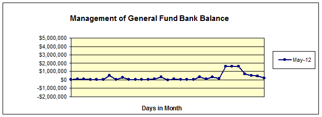
Investment Portfolio
Council’s investment portfolio consists of the following types of investments:
1. Floating Rate Notes (FRN)
FRNs are a contractual obligation whereby the issuer has an obligation to pay the investor an interest coupon payment which is based on a margin above bank bill. The risk to the investor is the ability of the issuer to meet the obligation.
The following investments are classified as FRNs
ANZ sub-debt A- purchased 18/12/07 at discount
Bendigo Bank A- purchased 9/11/07 at par
ANZ sub-debt A- purchased 17/1/08 at par
HSBC Bank AA- purchased 14/3/08 at par
Royal Bank of Scotland (Australia Branch) purchased 27/08/10 at par
senior-debt A
These FRNs are all sub-debt or senior debt which means that they are guaranteed by the bank that issues them with sub-debt notes rated a notch lower than the bank itself. The reason for this is that the hierarchy for payments of debt in event of default is:
1. Covered Bonds
2. Term Deposits
3. Senior Debt
4. Subordinated Debt
5. Hybrids
6. Preference shares
7. Equity holders
In the case of default, the purchaser of subordinated debt is not paid until the senior debt holders are paid in full. Subordinated debt is therefore more risky than senior debt.
These types of investment are classified as Held to Maturity assets and they are therefore measured at amortised cost using the effective interest method in accordance with AASB139: Financial Instruments: Recognition and Measurement.
In terms of reporting, these investments are shown at their purchase price which is then adjusted up or down each month in accordance with the amortisation of the discount or premium. The effect of this is to show the investment at face value at maturity.
2. Fixed Interest Notes, Term Deposits, Transferable Deposits and Bonds
Fixed interest notes and term deposits pay a fixed amount of interest on a regular basis until their maturity date. The following investments are held by Council:
Investec Bank Term Deposit BBB purchased 03/09/08 at par
Westpac Bank Term Deposit (5 Year) AA- purchased 12/01/10 at par
St George Bank Term Deposit (3 Year) AA- purchased 18/02/10 at par
Commonwealth Bank Term Deposit (3 Year) AA- purchased 05/03/10 at par
Bank of Queensland Term Deposit (3 Year) BBB purchased 31/05/10 at par
Suncorp Bank Term Deposit (3 Year) A+ purchased 04/06/10 at par
Rural Bank Term Deposit (2 Year) A- purchased 16/06/10 at par
St George Bank Term Deposit (3 Year) AA- purchased 28/06/10 at par
Suncorp Bank Term Deposit (3 Year) A+ purchased 03/08/10 at par
Suncorp Bank Term Deposit (3 Year) A+ purchased 04/08/10 at par
AMP Bank Business Easy Saver Account (at-call) A purchased 30/12/10 at par
AMP Bank Term Deposit (5 Year) A purchased 01/03/11 at par
Bendigo Bank Lindfield Branch (1 Year) A- purchased 06/06/11 at par
Community First Credit Union Term Deposit (1 Year) purchased 17/07/11 at par
AAA
AMP Bank Term Deposit (1 Year) A purchased 14/09/11 at par
AMP Bank Term Deposit (1 Year) A purchased 14/09/11 at par
Rural Bank Term Deposit (1 Year) A- purchased 30/09/11 at par
Bank of Queensland Term Deposit (5 Months) BBB purchased 25/01/12 at par
Suncorp Bank Term Deposit (5 Months) A+ purchased 27/01/12 at par
National Australia Bank Term Deposit (5 Months) AA- purchased 27/01/12 at par
Bendigo Bank Turramurra Branch (6 Months) A- purchased 01/03/12 at par
RaboDirect Term Deposit (6 Months) AA purchased 12/03/12 at par
As with FRNs, these investments are shown at purchase price with the discount or premium amortised over the period to maturity.
A Transferable Certificate of Deposit is a bank deposit (ie fixed interest) that may be transferred from one party to another. Council has four transferable deposits.
ANZ Transferable Deposits AA- purchased 22/04/08 at par
Deutsche Bank Transferable Certificates of purchased 04/09/09 at discount
Deposit A+
Bank of Queensland Senior Transferable Deposits purchased 06/12/10 at par
BBB
Commonwealth Bank Floating Rate Transferable purchased 02/08/11 at par
Certificates of Deposit AA-
A bank bond is a debt security, in which the authorised bank owes the holders a debt and is obliged to repay the principal and interest (the coupon) at a later date, termed maturity.
Council has two bank bonds with senior debt obligations:
Commonwealth Bank Retail Bond AA- purchased 24/12/10 at par
Bendigo Bank Retail Bond A- purchased 15/03/11 at par
Commonwealth Bank Retail Bond Series 1 AA- purchased 20/03/12 at discount
3. Collateralised Debt Obligations (CDO)
The following investment is classified as a CDO:
Maple Hill 11 CCC- (downgraded from purchased 30/08/07 at par
AA by S&P)
(Please refer to comments on Individual Investment Performance section for details.)
A CDO is a structured financial product whose returns are linked to the performance of a portfolio of debt obligations. It is split into tranches, whereby the riskiest or lowest tranche, the “equity tranche”, receives the highest returns. Higher rated tranches offer protection against the risk of capital loss, but at proportionately diminishing returns.
These investments are also classified as held to maturity assets and are therefore measured at amortised cost using the effective interest method in accordance with AASB 139: Financial Instruments: Recognition and Measurement. The investment is reported in the same manner as FRNs.
4. Constant Proportion Debt Obligations (CPDO)
The following investment is classified as a CPDO:
Royal Bank of Scotland Principal Protected CPDO A purchased 18/10/06 at par
This is an investment whose returns are based on trading credit default swap (CDS) contracts. A CDS is a contract between two parties where one agrees to accept the risk that a company will default on its loan repayment obligations in return for payment of a fee. Only contracts on investment grade organisations in the CDX (US) and ITraxx (Europe) indices are permissible.
5. Growth Investment
The following investment was purchased on the basis of an anticipated growth in asset value rather than returns being based on an interest coupon, it has been classified as a Growth Investment.
KRGC TCorp LTGF unrated purchased 20/03/2008 at par
This investment is valued at fair value where the capital gain is credited to the Income Statement and a capital loss is debited to the Income Statement. This is a fund managed by the NSW Treasury Corporation which invests in a range of Australian shares 31%, international shares 31%, bonds, listed property and cash 38%. The return is based on the fund’s unit price at month end supplied by the fund. There is no principal guarantee with this fund and it is unrated.
Cash Performance against the 11am Cash Rate

The weighted average return for Cash year to date was 4.38% compared to the benchmark 11am Cash Rate of 3.82%.
Funds Performance against the UBS Bank Bill Index

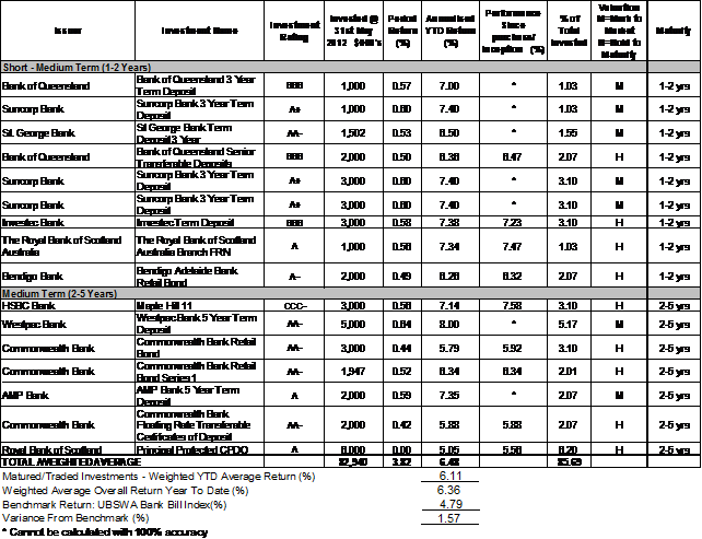
The weighted average return for the total portfolio (except Cash & TCorp) year to date was 6.36% compared to the benchmark of the UBSWA Bank Bill Index of 4.79%.
NSW Treasury Corp against the Long Term Growth Facility Trust

The return for TCorp year to date was 2.69% compared to the benchmark Long Term Growth Facility Trust of -0.93%.
Comments on Individual Investment Performance
In the month of May, the following investment has matured.
Fixed Interest Notes:
· Westpac Bank Subordinated Note FRN AA- $1,000,000 at 6.75% coupon rate for 4 Years & 3 Months
NSW Treasury Corporation: The investment in the NSW TCorp Long Term Growth Facility is an approved investment under the updated Minister's Order. The Facility is designed to give investors exposure to, and the returns from, a diversified pool of growth assets i.e. shares and listed property along with a cash component.
The investment was made in October 2006. This is a fund managed by the NSW Treasury Corporation which invests in a range of Australian shares 31%, international shares 31%, bonds, listed property and cash 38%. The fund’s annualised return is 2.69% and 0.13% since purchase.
Returns from the Facility in recent times have been hard hit by volatile global markets, returns across short time frames have been poor but over the longer term they have generally outperformed capital secure products.
The investment in the Facility does provide some useful diversification to Council's portfolio and has excellent liquidity should the funds be needed quickly.
Royal Bank of Scotland Principal Protected CPDO: This is an investment whose returns are based on trading credit default swap (CDS) contracts. Only contracts on investment grade organisations in the CDX (US) and ITraxx (Europe) indices are permissible. The risk to Council is that if enough of the companies default on their loan payment obligations, Council’s regular payments of interest would be reduced or cease. In the event of this occurring (cash-out event), the note reverts to a risk free bond investment to guarantee principal on maturity.
On 20 December 2011, Council received a notice of “Strategy Unwind Event” from RBS Morgans Ltd for Council’s Principal Protected CPDO ($6,000,000) issued by the Royal Bank of Scotland (RBS).
Under the terms of the unwind event the bank has advised that the security has ceased to pay interest effective immediately, this includes the coupon otherwise scheduled to be paid on 20 December 2011. The Security remains capital guaranteed with the principal amount of $6,000,000 being repaid at the maturity date on 5 September 2016 by RBS, which is rated A by S&P.
On 23 March 2012, Council received $172,666.67 from the Royal Bank of Scotland, being Council’s share of the cash deposit value held by the bank, which was one component of the overall transaction at the time of the restructure, to be used for coupons. This transaction does not impact the principal amount of $6,000,000 being repaid at maturity. As a result of Council receiving this payment, if Council holds the investment till maturity, Council would now achieve a 3.2% return, compared to an average benchmark of 5.74% since 2006.
As there is no active broad based market for trading this type of security, its value is mathematically determined as the present value of the future cash flow ($6M in September 2016), discounted at a rate the particular buyer believes will compensate for risk.
Council would only sell the investment if it was thought that we could achieve better returns than a potential buyer or if there was a belief that the Royal Bank of Scotland is likely to default before maturity in 2016. On that basis the recommendation of staff is, at this stage, to hold the investment to maturity (at 3.2%).
Council will continue to monitor the investment closely and sell it if a better return on re-investing the proceeds can be achieved.
On 22 May 2012, Council resolved “That the Acting Director Corporate report back on the outcome of Council’s decision of 20 March 2012 to consider legal proceedings against the Royal Bank of Scotland”
At the time of preparing this report Council had not received any legal advice.
CDOs: The risk of losing principal in a CDO is based on the number of defaults in the portfolio of debt obligations combined with weighting of the entity in the portfolio and the recovery rate of the entities that default. The following information is provided for Council’s remaining CDO:
Maple Hill II
As a result of the global financial market crisis, in particular the collapse of Lehman Brothers, and the release of S&P CDO Evaluator 5.0 (a set of analytical tools that evaluates an entire CDO transaction), Maple Hill II was downgraded to CCC - from AA by S&P.
· Losses absorbed: 2.77%
· Losses remaining: 2.77%
· Recovery: Floating
· Portfolio: 139 (unequal weight)
· Credit events to date: 6 (Lehman Brothers, Fannie Mae, Freddie Mac, Idearc, CIT Group & PMI)
· Credit events supported: 11.5 average sized, assuming average 33% recovery
· Credit events remaining: 6 average sized, assuming average 33% recovery. The note can withstand 5% of the portfolio defaulting, after allowing for recoveries.
· Maturity: 20 December 2014
There was no credit event in Council’s CDO during the month.
Allocation of funds
The following charts show the allocations of Council’s investment funds by various categories:
1) Credit Rating: Actual level of investment compared to proportion permitted by policy.
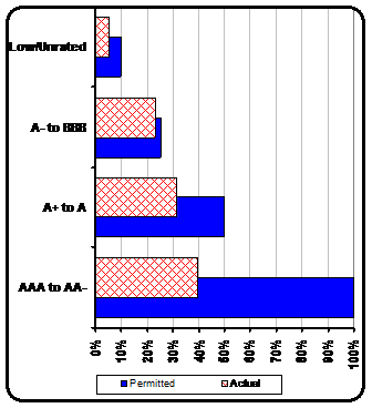
Investment Rating - Proportion
|
AAA to AA- |
39.77% |
|
A+ to A |
31.81% |
|
A- to BBB |
23.24% |
|
Less than BBB |
5.18% |
2) Proportional Split of Investments by Investment Institution: Actual portion of investments by investment institutions.
Council’s Investment Policy requires that the maximum proportion of its portfolio invested with any individual financial institution is 25%.
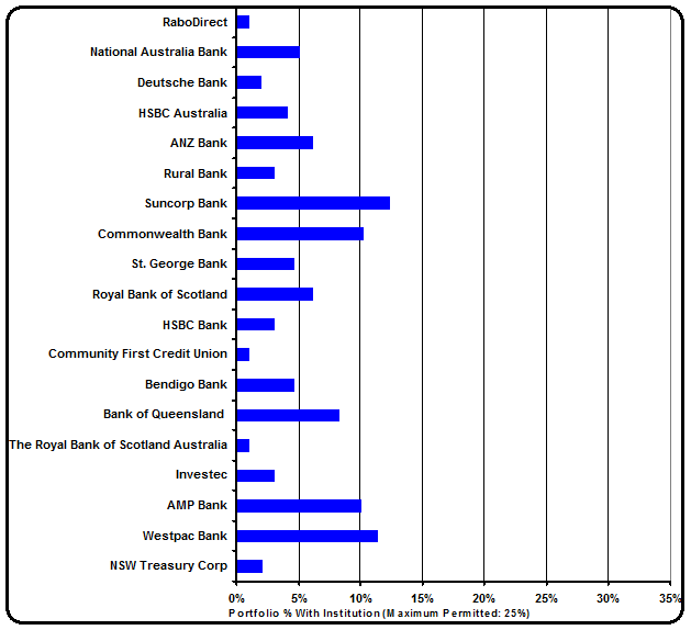
3) Investment type and YTD return: Actual proportion of investments by type and year to date return.
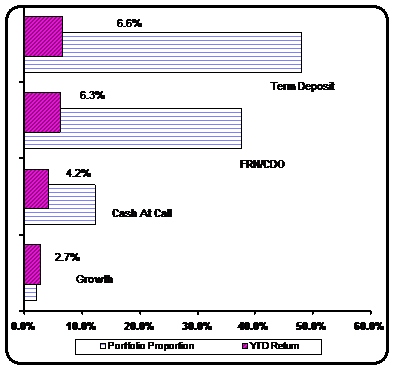
4) Duration: Strategic allocation of investments by duration.
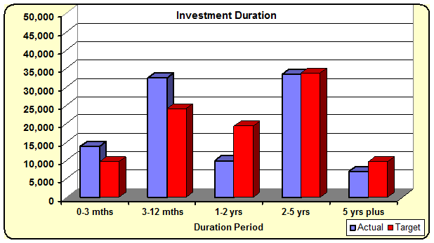
Cumulative Investment Return
The following table shows Council’s total return on investments for May and financial year to date, split into capital and interest components and compared to budget:

At the end of May 2012, the net return on investment totalled $5,807,000 against a revised budget of $5,790,000 giving a positive variance for the year of $17,000.
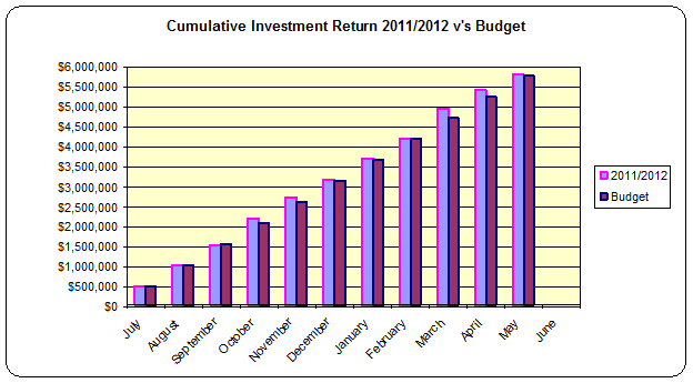
Total Investment Portfolio
The following chart compares the year to date investment portfolio balances for 2011/2012.
During May 2012 Council’s investment portfolio increased by $3,624,201.
Some key points in relation to investments and associated markets during May are:
International Market
· Europe was again the dominant news producer with investors focussed on the deterioration in their anticipated growth figures, downgrades across the financial sector, and elections throwing up further uncertainty. Data out of Europe showed the dual impacts of slackening growth figures with the PMI (Purchasing Managers Index) at the weakest level since 2009 coupled with Euro-wide unemployment coming in at 10.9%. The market focussed on the stress seen in the Spanish banking system and various bailout plans put into place.
· Data out of the U.S was weak on balance with employment data coming in below estimates combined with lower growth recorded over the first quarter at 2.2% p.a. (estimated at 2.5%). In contrast the US consumer was quite resilient with data for March again positive after a good February.
· As mentioned last month China remains a concern as well with industrial production and retail sales coming in at levels lower than market expectations. In addition imports for April showed just a 0.3% p.a. increase with hopes that further efforts to stimulate the economy will be put in place. China is growing as the really big worry for both the local economy and the global one with GDP data released coming in at weaker levels than expected. The World Bank cut their estimate for Chinese 2012 growth largely as a result of reduced export demand.
Domestic Market
· The cash rate was dropped by 50 basis points to 3.75% in early May. In addition the RBA has just announced a further cut to 3.50% on the 5th of June. The RBA cited a combination of weaker than expected domestic conditions, moderating inflation and the aim of reducing lending rates in the economy. The major banks continue to pass on only part of the drops in official rates as funding pressures allow them some justification for increasing their margins.
· Unemployment data also produced a positive set of numbers which saw the unemployment rate drop below 5% down to 4.9% (last month at 5.2%) with the economy producing over 15,000 new jobs in April whilst the participation rate fell to 65.2%.
· The Australian dollar was considerably weaker against most currencies with a large drop seen against the USD. Chinese growth worries and severe market risk aversion were the reasons most often cited to explain the move which saw the rate move from 1.043 to 0.973 USD.
Governance Matters
Council’s investments are made in accordance with the Local Government Act (1993), the Local Government (General) Regulation 2005 and Council’s Investment Policy which was adopted by Council on 20 April 2010.
Section 212 of the Local Government (General) Regulation 2005 states:
(1) The responsible accounting officer of a council:
(a) must provide the council with a written report (setting out details of all money that the council has invested under section 625 of the Act) to be presented:
(i) if only one ordinary meeting of the council is held in a month, at that meeting, or
(ii) if more than one such meeting is held in a month, at whichever of those meetings the council by resolution determines, and
(b) must include in the report a certificate as to whether or not the investment has been made in accordance with the Act, the regulations and the council’s investment policies.
(2) The report must be made up to the last day of the month immediately preceding the meeting.
Risk Management
The risk associated with investing Council funds is the loss of income and/or assets from investment failure and/or poor investment performance. The level of risk with Council’s new investments is considered low, as investments are made only in a form of investment notified by order of the Minister for Local Government and Council’s adopted Investment Policy, which as a consequence of the Minister’s Order, is considered conservative. Also, all investments are made with consideration of advice from Council’s appointed investment advisor, Denison Financial Advisory.
Financial Considerations
The revised budget for interest on investments for 2011/2012 is $6,316,000. Of this amount approximately $4,278,000 is restricted for the benefit of future expenditure relating to developers’ contributions, $1,234,000 transferred to the internally restricted Infrastructure & Facility Reserve, and the remainder of $804,000 is available for operations.
At the end of May 2012, the net return on investment totalled $5,807,000 against a revised budget of $5,790,000 giving a positive variance for the year of $17,000.
Social Considerations
Not applicable.
Environmental Considerations
Not applicable.
Community Consultation
None undertaken or required.
Internal Consultation
None undertaken or required.
Certification - Responsible Accounting Officer
I hereby certify that the investments listed in the attached report have been made in accordance with Section 625 of the Local Government Act 1993, clause 212 of the Local Government General Regulation 2005 and Council’s Investment Policy which was adopted by Council on 20 April 2010.
Summary
As at 31 May 2012:
Ø Council’s total investment portfolio is $96,788,446. This compares to an opening balance of $107,291,329 as at 1 July 2011, a decrease of $10,502,883.
Ø Council’s year to date net return on investments (interest and capital) totals $5,807,000. This compares to the year to date revised budget of $5,790,000, giving a positive variance of $17,000.
Ø The weighted average return for Cash year to date was 4.38% compared to the benchmark 11am Cash Rate of 3.82%.
Ø The weighted average return for the total portfolio (except Cash & TCorp) year to date was 6.36% compared to the benchmark of the UBSWA Bank Bill Index of 4.79%.
Ø The weighted average return for TCorp year to date was 2.69% compared to the benchmark Long Term Growth Facility Trust of -0.93%.
|
A. That the summary of investments and performance for May 2012 be received and noted.
B. That the Certificate of the Responsible Accounting Officer be noted and the report adopted.
|
|
Tino Caltabiano Acting Director Corporate |
Angela Apostol Acting Manager Finance |
|
Tony Ly Financial Accounting Officer |
|
|
Ordinary Meeting of Council - 26 June 2012 |
GB.5 / 121 |
|
|
|
|
Item GB.5 |
DA0677/11 |
|
|
10 January 2012 |
development application
Summary Sheet
|
Report title: |
100 Eton Road,
Lindfield - Subdivision to Create |
|
ITEM/AGENDA NO: |
GB.5 |
|
Application No: |
DA0677/11 |
|
Property Details: |
100 Eton Road, Lindfield Lot & DP No: Lot 1 DP 1151638; Lot 4 DP 1151638 Site area (m2): 13.86ha Zoning: E3 – Environmental Management; R1 General Residential; R2 Low Density Residential; RE1 Public Recreation Estimated Cost of Works: $5.6 Million |
|
Ward: |
|
|
Proposal/Purpose: |
Subdivision of land and preparation works for development envisaged under MP06-0130. |
|
Type of Consent: |
Integrated – RFS. S100B |
|
Applicant: |
Defence Housing Australia |
|
Owner: |
Defence Housing Australia |
|
Date Lodged: |
9 December 2011 |
|
Recommendation: |
Approval. |
Purpose of Report
This matter is reported to Council as the application involves subdivision of the site for future residential development as well as dedication of land and roads to Council (consistent with the associated concept approval). The applicant also seeks endorsement of a Voluntary Planning Agreement (VPA), which requires Council’s formal resolution before the proposal can proceed.
Executive Summary
In 2008, the NSW Minister for Planning under the now repealed Part 3A of the Environmental Planning and Assessment Act 1979 granted consent for a Concept plan that facilitated redevelopment of the UTS Ku-ring-gai Campus for medium density residential development of up to 345 dwellings in the form of apartments, attached dwellings (townhouses) and detached single dwellings.
The application now before Council represents the first stage of the development envisaged under the Concept plan. The subdivision will involve the creation of 7 allotments for the purpose of residential development as well as allocating portions of the site that are to be set aside for environmental protection and public recreation. Additional works also involve the construction (and upgrading) of roads which will service the development, a new soccer field and community facility. The subdivision works will also permit the preliminary management of bushland on site for the purposes of providing Asset Protection Zones (APZ) for the forthcoming residential development and occupation.
The Part 3A Concept Approval required the applicant to provide Council with documentation that addressed numerous planning and environmental impacts. The documentation included a series of management plans, Urban Design Guidelines, Voluntary Planning Agreement as well as documentation demonstrating that relevant commitments under the Concept Approval had been satisfied.
The associated Voluntary Planning Agreement (VPA) addresses the dedication of a soccer field, and roads to Council and the delivery of a community facility.
Future development applications will be made to Council for the residential portion of the development on site known as ‘Edgelea’. This development will be consistent with the scheme approved under the Part 3A Concept Approval and the comprehensive Urban Design Guidelines (UDG’s) as approved by Council at its meeting of 12 June 2012.
The proposed development is assessed as being satisfactory for the site and is generally consistent with the Part 3A Concept Approval as required.
History
Site
In 1967, work began on the initial stages of what is today UTS Ku-ring-gai. Following construction in several stages, the site reached its current capacity and configuration in the mid 1980’s.
After failed rezoning attempts in the early parts of the 2000’s, the Minister for Planning announced on the 12 December 2005 that the NSW Department of Planning would consider the subject site as a state significant site and on 14 June 2007 declared a Major Project under the now repealed Part 3A of the EP&A Act for the site’s redevelopment. A Concept plan for the site’s redevelopment was subsequently lodged. On 11 June 2008, the Minister for Planning approved Concept plan MP06_0130 and at this time also gazetted amendments to Schedule 3 of SEPP (Major Development) 2005 which established the necessary planning framework for the redevelopment of the UTS Ku-ring-gai site.
The Concept Approval (Annexure B) has undergone 4 modifications, with these modifications mostly addressing mistakes and errors within the Concept Approval’s conditions. Although the second and third modifications to the Concept Approval addressed errors, it also changed to a degree the approved concept, including the reconfiguration of Precincts 2 & 3, facilitated the retention of the University’s gym and footbridge and also included the realignment of zone boundaries to improve the future configuration of the development. The changes also included amendments to SEPP (Major Development) 2005 to enable demolition and subdivision on site that had otherwise been overlooked by the Department. The most recent modification considered by the Department redistributed dwelling yields throughout the site as well as re-align building footprints to be consistent with the Urban Design Guidelines.
To that end, the Concept Approval currently consents to the following:
· Retention and adaptive reuse of the main campus building for either an educational or commercial use, subject to separate approval.
· Provision of a 9,800sqm soccer field and 300sqm of community space to be dedicated to Ku-ring-gai Council.
· Dedication of 34,570sqm of bushland to the NSW National Parks and Wildlife Service.
· New residential development ranging from detached single dwellings to 5 storey residential flat buildings for a maximum of 345 dwellings. The ratio of this is broken down into 10 single lot dwellings, 25 integrated dwellings (or townhouses) and 310 apartments.
· A street and pedestrian network that extends and integrates with the existing streets and footpaths.
· Asset protection zones for bushfire management.
The application currently before Council is derived from the development scheme within the Concept Approval. As the Minister’s Approval is for a concept only, the detail necessary to successfully realise a large scale brown field development of this capacity necessitates a series of further development applications, which Council will have the delegation to determine under the provisions of the Concept Approval and SEPP (Major Development) 2005.
The proposed development as a requirement of the Part 3A Concept Approval includes a Voluntary Planning Agreement (VPA).
An assessment of the subject Development Application against the Concept Approval is provided further within this report.
Pre-DA
A formal Pre-DA consultation was held between Council officers, Defence Housing Australia (DHA) and its representatives on 23 August 2011 to discuss the proposed subdivision and actioning of the associated Concept Approval.
Major issues raised in the Pre-DA included:
· amount of road within the subdivision to be dedicated to Council
· amount of landscaped land to be dedicated Council
· actioning the Concept Approval
As detailed within this report and attachments, the applicant has responded to the matters raised in the Pre-DA minutes, noting that the extent of dedication to Council has been addressed within the associated Voluntary Planning Agreement (VPA).
DA History
9 December 2011 Application Lodged
21 December 2011 Application referred to internal and external bodies
11 January 2012 Preliminary assessment meeting held with applicant
13 January 2012 to 14 February 2012 Application notified
24 January 2012 Request for additional information letter sent to applicant
16 February 2012 Meeting held between Council staff and applicant to resolve outstanding matters
24 February 2012 Additional information provided to Council
24 April 2012 RFS concurrence to bushfire management plan issued, provided to Council on 8 May 2012
8 May 2012 Council seeks concurrence in respect of bushfire management from Department of Planning & Infrastructure
29 May 2012 Department of Planning & Infrastructure issue concurrence to revise bushfire management plan
The Site
Site Description
|
Visual character study category: |
Post 1968 |
|
Easements/rights of way: |
Yes – various drainage easements and rights of way |
|
Heritage Item: |
Yes – Local |
|
Heritage conservation area: |
No |
|
In the vicinity of a heritage item: |
No |
|
Bush fire prone land: |
Yes |
|
Endangered species: |
Yes – Darwina biflora; Red Crowned Toadlet |
|
Urban bushland: |
Yes |
|
Contaminated land: |
No |
The subject site is known as 100 Eton Road, Lindfield (comprising Lot 1 and Lot 4 DP 1151638), known commonly as UTS Ku-ring-gai. The University still occupies and operates from this site.
The UTS Ku-ring-gai campus is a 20.8ha parcel of land which is bounded by the Lane Cove National Park to the east, south and west and residential development in the suburb of Lindfield to the north.
The portion of the site being redeveloped is the northern section of the site, with the existing University buildings to remain.
The resultant developable portion of the site is 13.68ha and includes bushland which surrounds the UTS campus buildings, car parking areas dedicated to the campus, sporting facilities (including oval and tennis courts), a childcare centre as well as associated internal roads.
The site is located within the catchments of College, Sugarbag and Blue Gum Creeks, which are tributaries of the Lane Cove River, flowing into Sydney Harbour. Topographically the already developed portions of the site are on sandstone plateaus, which fall away to steep, heavily vegetated gullies. Vegetation communities vary with the topography and aspect of the site and include vegetation communities of Heath-leaved Banksia / Scribbly Gum closed bushland; Sydney Red Gum Forest; Sydney Red Gum / Sydney Peppermint Forest / Red Bloodwood Open Forrest. These communities support known threatened species including Darwina biflora, Pseudophyrne australis – Red crowned toadlet and Ninox strenua – Powerful owl.
The developable portion of the site has been broken up into a series of land zonings under the Major Development SEPP to facilitate its redevelopment. Attachment A highlights the various zones established by the SEPP, as well as the sites spatial setting.
Surrounding Development
The UTS Ku-ring-gai site is located on the periphery of the Ku-ring-gai Local Government Area and is bounded, with the exception of the northern part of the site, by the Lane Cove National Park. The land to the north of the site accommodates low density residential development located along Winchester, Lyle and Kimo Streets. In addition, Film Australia has a site (101 Eton Road) which sits in the middle of the UTS site effectively segmenting the north into two blocks. Historically, surrounding development has been undertaken to respond to the varying topography of the surrounding area. The below aerial photograph (Figure 1) highlights surrounding development patterns within the vicinity of the UTS Ku-ring-gai site.
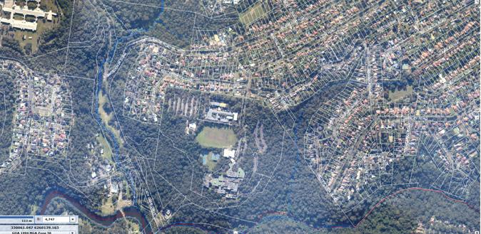
Figure 1
The Proposal
Consent is sought for the following works
· subdivision to create:
- 5 Torrens title lots for future residential development. These lots range in size from 0.85ha to 1.89ha and are consistent in location with the areas foreshadowed to be developed in the Concept Approval
- 3 community lots, 2 being APZ’s for bushfire, 1 being for a managed community of Darwina biflora. These lots range in size from 0.12ha to 3.92ha
- 2 lots to be dedicated to Council, 1 comprising the soccer field, the other for the community centre. The size of these lots is consistent with the areas established by the Concept Approval
- dedication to Council of 2 public roads (shown on the draft subdivision plan Annexure D as Road ‘1’ and ‘2’), consistent with the terms of the Concept Approval
· partial demolition of existing improvements to accommodate the proposed roads and the soccer field
· partial clearing of the site to facilitate the intended works
· servicing of the lots being created with necessary utility services such as water, telephone, gas electricity
· upgrading and construction of roadways, including landscaping of footways and curtliage around the proposed soccer field
· construction of a new soccer field in accordance with the terms of the VPA and Concept Approval. This soccer field is in a similar location to that of the University’s current sporting oval, albeit smaller in area (9800m2).
University:
The assessment report prepared by the then Department of Planning (now the Department of Planning and Infrastructure) which considered the Concept Approval for the re-development of the UTS Ku-ring-gai site, dealt with the issue of the future use of the university campus buildings. The report considered the issue, with the effective outcome being that the use of the university at the time of redevelopment would cease, with the future adaptive re-use of the buildings to be considered as part of a future ‘project application’ to the Department.
No approval (or for that matter application) for the adaptive re-use of the university buildings has been granted nor has the ongoing operation of the university on a smaller parcel of land been considered. As the Concept Approval has now been taken up and activated, the university should cease operations, as the take-up of the Concept Approval removes a significant portion of the university’s car parking (approximately 300 spaces).
Should the university continue to operate, it would require further consent which would require the University to address all the associated impacts with the inclusion of such a use.
Consultation
Community
In accordance with Development Control Plan No. 56, owners of surrounding properties were given notice of the application. In response, submissions from the following were received:
1. Andrew Sweeny, 85 Grosvenor Road Lindfield
2. John Ridley, 42 Winchester Avenue Lindfield
3. John & Helen Hortle, 8 Lyle Avenue Lindfield
4. Tara Hammon & Anthony Ritchie, 29 Blaxland Road Killara
5. F R & D G Pettit, 60 Abingdon Road Roseville
6. Joyce Porter, 20 Lylie Avenue Lindfield
7. Vicki Cleaves, 188 Lomas Lane Nulkaba
8. Victor Chan, 22 Winchester Avenue Lindfield
9. Graeme Reid, 23 Winchester Avenue Lindfield
The submissions raised the following concerns:
The Part 3A application envisaged a variety of residential development that have the social characteristics consistent with the surrounding residential areas. The concentration of 50% defence housing that is turned over every 2 years like a military base, was not contemplated and is high in needs (much like social housing). The social consequence of this should be further investigated.
The occupation of future dwellings by defence personnel does not demand any greater level of services than private housing. Likewise, the turn-over of residents within the proposed development is not something that can be controlled, be it privately owned or dedicated for occupation by defence personnel. The site will not have any military base classification.
A 20m wide landscaping buffer between proposed Lot 6 and the properties fronting Winchester Avenue should be provided to maintain the open outlook that these properties have enjoyed for many years.
This matter is covered within the Urban Design Guidelines approved by Council on 12 June 2012. This application deals with subdivision only and is not for the construction of dwellings.
The Astroturf pitch is a valuable community asset, however the scheme makes no allowance for supporting other users including general recreation, walkers and off leash areas for dogs.
Astroturf provides for all weather use. It is noted that the Concept Approval requires the provision of a soccer field, rather than an area for solely for passive recreation.
Lot 5 is inappropriate for residential development and it would have been better to utilise part of Lot 1 for additional housing and leave lot 5 as community property.
The plan of subdivision is derived from the development scheme approved under the Concept Approval. Lot 1 is to be dedicated (as required) as an APZ. No residential development can occur within this area. Lot 5 is to be a residential lot and is shown within the Concept Approval as area to be developed for detached housing.
The Statement of Environmental Effects concludes that the development will not result in an adverse environmental impact, however the attempt made to compensate for the loss of native habitat is poor.
It is acknowledged that the development will result in a loss of native habitat, however, the Part 3A assessment extensively considered this issue, with the site’s redevelopment found to have an acceptable impact. The conditions of the Concept Approval required the submission of detailed reports that deal with the management of natural flora and fauna. These reports satisfy the various impacts generated by the development, noting the parameters for management were set by the then NSW Department of Environment and Climate Change and Commonwealth Department of the Environment, Water, Heritage and the Arts.
The traffic analysis provides no assessment of the impacts on the intersection of Shirley Road and Pacific Highway.
The RTA (now RMS) within the Concept Approval’s conditions (Condition B10) established the requirements for further modelling and investigation with respect to traffic impact upon the local road network which surrounds the UTS Ku-ring-gai site. Modelling of the additional traffic impact as a consequence of the development approved under the Concept Approval has been undertaken with the input of the RMS. This impact assessment was found by the RMS to be acceptable and consistent with the initial Part 3A assessment.
An additional road needs to be constructed through the development to reduce traffic flow on local roads and for bushfire evacuation.
Such an access road was considered as part of the Concept Plan assessment and at that time was found to be counter-productive as it would likely produce increased traffic flows along Eton and Grosvenor Roads in providing an alternate ‘rat run’ between the Pacific Highway and Lady Game Drive. In the case of bushfire, an alternate exit road was not assessed as being necessary.
Houses backing onto Winchester Avenue within Lot 6 should be limited in height to single storey.
This matter is dealt with in the Urban Design Guidelines, which allows two storey development throughout Precinct 1 (which shares a boundary with the properties on Winchester Avenue). This scale of development is consistent with the scale of development envisaged as part of the Concept Approval.
With Killara high school already bursting at the seams, why would consideration be given to demolishing the University when it could be used as a high school.
The future use of the UTS Ku-ring-gai campus buildings is a matter for UTS Ku-ring-gai to decide. Any use of those buildings will require Development Consent, as required by the Concept Approval.
Council is aware of the fires that swept through the area in the 1990’s. Many houses were lost in Winchester Avenue and the fire brigade had trouble accessing our road. Another road into the development is necessary for bushfire safety.
The development was referred to the RFS, who are satisfied that one access road is sufficient for fire fighting purposes, as other strategies (such as the APZ’s) are to be implemented. This road (which is an extension of Eton Road) varies in width between 8.2m and 9.5m, which is wide enough for access of emergency vehicles.
The arboriculture impact appraisal did not include Precinct 1 (or Lot 6). The removal of native vegetation will have a significant impact upon the amenity of surrounding properties.
The Landscape Management Plan required by the Concept Approval deals with the issue of tree removal, the underlying theme of which is to retain the bushland character of the site. The Concept Approval always envisaged the removal of some vegetation on the site to facilitate the sites’ redevelopment.
There is a lack of parking for the soccer field
Car parking for the soccer field has been provided in accordance with the requirements of the Concept Approval. 30 spaces are required by the Concept plan, and a total of 31 are provided in this proposal.
The DA form specifies the subdivision of the site into 10 lots whilst Council’s notification form notes 7 lots.
Council’s notification letter did in fact specify the subdivision of the site …into 7 lots for development envisaged under MP06_130….. The rationale behind this is 5 lots are for the residential development of the site, 1 lot is associated with the soccer field and the other lot is land for the future community facility. The resulting areas are the required APZ’s and an area set aside for a retained community of Darwina Biflora, both requirements (and conditions) of the Concept Approval. In this respect, Council’s notification of the proposed development accurately reflects the intended form of subdivision.
Within Council
Engineering:
The application was referred to Council’s Development Engineer. The following comments were provided:
Comment from Council’s Development Engineer, has been limited to stormwater matters, as roads and infrastructure provisions have been considered and dealt with by Council’s Operations Department.
In the case of proposed Lot 6, a need exists for the entire lot to have a gravity feed stormwater drainage system to the public drainage system. It will be necessary for the northern half of Lot 6 to drain through other properties to Winchester Avenue, which necessitates the procurement of an easement to drain stormwater over a downstream property on the high side of Winchester Avenue.
The need for an easement has been flagged with DHA, who have entered into discussions with the downstream property owners to obtain such an easement. It will be necessary (Condition 83) that the easement be obtained and registered as part of the subdivision process.
Landscaping:
The application was referred to Council’s Landscape Assessment Officer. The following comments were provided:
Site characteristics
The site is located on the plateau at the end of a sandstone spur. The land falls from the plateau as moderate to steep slopes. The site adjoins Lane Cove National Park to the east, south and west. The site supports mostly locally occurring trees and is mapped as Sydney Sandstone Ridgetop Woodland.
Tree impacts
A tree report, prepared by Naturally Trees dated 12/12/11, has been submitted with the application. Tree numbers within this assessment refer to this report.
Trees to be removed
The proposal requires the removal of 64 trees. The trees are removed for the works generated by the subdivision at the junction of Road 1 and Road 2 and at the southern end of Road 1 and the western end of Road 2.
Trees to be retained
A further 104 significant trees could be ‘potentially’ adversely affected due to construction encroachment within the TPZ’s. Special tree protection measures are recommended for the following trees:
Trees 114, 115, 116, 365, 366, 366, 367, 368, 405 to 440, 449, 672, 987, 988 and 1000.
Threatened Species- Darwinia biflora
Tree protection fencing north of the intersection of Road 1 and Road 2 is to include the area to be fenced for Darwinia biflora in accordance with Threatened Species Management Plan prepared by ERM.
Landscape plan
Roads 1 and 2
To preserve the bushland character, the proposal includes landscape treatment along proposed roads of locally occurring tree and shrub plantings.
To preserve existing vegetation as per Tree Management Plan, Section 2c (la2402/a02, DEM, 8/12/11) is to be amended to indicate the top of wall height of the proposed rock cutting or stone wall proposed along the northern side of Road 2, between chainage 200 and 275, is to set to retain existing levels (Condition 5).
Soccer field
A 1:4 graded bank is proposed along the northern side of the soccer field. Two staircases will provide access from Road 2 to the soccer field.
Landscape plans to include proposed concrete headwall stormwater outlets with scour protection to southern end of Road 1 (Stormwater Utilities Coordination Plan, C5.02/1, Northrop, 16/11/11 (Condition 5).
Environmental Site Management Plan
The plan highlighting principles for Construction Management, DWG DA02 rev 1 prepared by Northrop Engineers, dated 05/08/11, is considered unsatisfactory for the following reasons:
1. The plan should refer to all proposed works including, road construction and associated landscaping works, laying of sports field and associated construction, as well as the associated landscaping and car parking works, and service installation.
2. The plan is to be provided at a legible scale.
3. The environment site management plan is to be prepared in accordance with Council’s DA guide, including proposed tree protection as per the arborist recommendation, location of temporary truck access, site offices, parking, and material handling areas.
4. This plan is to be prepared prior to the issue of a Construction certificate (Condition 4)
Bushfire – Tree and vegetation removal
The APZs approved as part of the Concept Approval will require vegetation clearance and tree removal to support the proposed development. The vegetation prescriptions for the asset protection zone as outlined in the Bushfire Management Plan are as follows,
1. Existing larger trees (at least 200 mm in diameter measured at chest height) can remain within the APZ provided that:
(a) No part of their canopy occurs within 2 m of any building (this also applies to significant habitat trees where necessary);
(b) Canopies are discontinuous, i.e., canopies are separated by at least 2 m;
(c) They are smoothed barked species or, if rough barked, are maintained free of hanging bark and other ladder fuels; and
(d) Low branches holding fine fuel (i.e. leaves and twigs of <6mm in diameter) are pruned to 2 m from the ground.
2. Trees are to be hand-removed leaving stumps cut at ground level and where accessible, stumps are to be reduced down to just below soil level. Stumps of all species that have the capability of resprouting are to be treated with an appropriate herbicide immediately after the cut is made;
3. Smaller trees (i.e. less than 200 mm in diameter), shrubs, fallen trees and tree-limbs and stumps are to be removed and continuously suppressed;
4. All shrubs and tree saplings are to be removed off-site or mulched, but all native grasses within the Site are to remain in-situ wherever possible; and
5. A minimal ground fuel is to be maintained to include either mown grass or bare ground or less than 3 tonnes per hectare of fine fuel (i.e. material of <6 mm in diameter).
The Tree Assets report submitted with the original application, stated that ‘the APZ will include areas containing a high percentage of identified valuable tree assets, however, as has been outlined in the discussion, this does not mean that the APZ needs to be cleared of all or even most trees.’ Tree Assets Report, Biodesign, October 2007.
It is recommended that the management of the Asset Protection Zone be undertaken with careful collaboration between an arborist, ecologist and a bushfire consultant to ensure the maximum number of trees be retained within the constraints imposed. Selection of trees for retention should consider the environmental values of the trees including habitat and soil stabilisation. The basis for this is covered within Condition 14.
Stormwater Plan
The proposal includes three (3) concrete headwall stormwater outlets.
· southern end of Road 1 (Stormwater and Utilities Coordination Plan, C5.02/1, Northrop, 16/11/11). This is an upgrade of an existing stormwater outlet.
· western end of Road 2 (Stormwater and Utilities Coordination Plan, C5.03/1, Northrop, 16/11/11). This is an upgrade of an existing stormwater outlet.
· south-west corner of the proposed playing field (Stormwater and Utilities Coordination Plan, C5.04/1, Northrop, 16/11/11). The south-west of the playing field is within the planted retaining wall that is required to be preserved as part of the Landscape Management Plan (Figure 4). This has been discussed with the Development Engineer and a condition to relocate the headwall beyond the retaining wall is to be included in the consent (Condition 5).
Ecology:
Council’s Ecological Assessment Officer has considered the proposed subdivision, as well as the associated management plans from the Concept Approval. In the case of the identified areas of Darwina Biflora and habitat for the red-crowned toadlet, the management and protection practices proposed are assessed as being satisfactory and consistent with the framework established as part of the Major Project assessment.
Heritage:
The application was referred to Council’s Heritage Advisor. The following comments were provided:
Heritage Impact Statement (HIS)
A well considered HIS has been submitted with the application. It is prepared by an experienced heritage consultant and satisfies the guideline for a HIS prepared by the NSW Heritage Council.
The HIS concludes that there will be no adverse impacts on the heritage significance of the heritage listed educational buildings at UTS Ku-ring-gai.
Comments
The curtilage of the heritage item can be considered to be a “reduced curtilage” as it is smaller than the existing lot. The proposed subdivision includes the heritage item within Lot 2. Proposed Lot 2 is larger than the curtilage of the heritage item so it would facilitate protection of the item and allow additional land around it to form a setting to the item. The only work to be carried out on the heritage listed building is an upgrade to the roadway that cuts between the main UTS building complex and the gymnasium. The work to this part of the road mainly involves re-surfacing and does not involve any change to the rock cuttings, landscaping or concrete wall that defines the eastern side of the gymnasium. This work is essentially maintenance and would have no impact on the item.
The actual subdivision should not have any impact on the heritage significance of the listed item – the UTS buildings. Future fences that could be constructed on the boundaries may have some impact, although no fences are proposed at this stage. Arguments about how much of the site is of heritage significance and whether the curtilage taken as the footprint of the buildings is adequate are not a relevant issue in this application. Those decisions have already been made.
Associated infrastructure works involving road works, drainage and sewage works will have no impact on the listed item.
Construction of a soccer field on the existing oval would be complimentary to the existing use of the land and would allow future community use to occur. There is no impact to the listed item from this work.
Future buildings on the proposed subdivided lots may have impact on the listed buildings, but this can not be assessed at this stage.
Conclusions and recommendations
The proposed application would have no adverse impacts on the listed UTS buildings on the site and no heritage objections are raised.
Property Services:
Council’s Property Services section considered the proposed development, particularly with regard to the soccer filed and community facility which will come under their control and management once these works are completed and dedicated to Council. The majority of these matters are considered satisfactory and addressed in the VPA.
Operations:
Council’s Operations Department considered the proposed development and provided comment in relation to the proposed dedication of roads and stormwater infrastructure within the development to Council and the dedication and construction of the soccer field.
The majority of these matters, including the timing of dedications, standard of construction of the dedications to Council and the funding arrangements for these dedications, are detailed within the VPA.
In support of the terms of the VPA, Council’s Operations Department, as custodians of the dedications to Council, recommended conditions to be included within the determination notice (should Council resolve to enter into the VPA and approve the DA), that ensure the appropriate standard of construction, as well as inspection provisions. These are included as conditions in the recommendation Condition’s 15, 18, 20, 57, 58, 59, 61, 62, 63, 64, 65 & 68.
Urban Planning:
Council’s Urban Planning section has been involved with the development, primarily with the preparation of the Urban Design Guidelines.
The UDG’s are a requirement of the Concept Approval and will be the primary document used to inform the built elements of the redevelopment of the UTS site. In accordance with the requirements of the Concept Approval, Council considered and approved the UDG’s at its meeting of 12 June 2012. The subdivision and associated works proposed as part of this application are considered to be consistent with the controls of the UDG’s.
Outside Council
Rural Fire Service (RFS)
As the development involves subdivision on bushfire prone land, the development is integrated development pursuant of S.100B of the Rural Fires Act 1997. The following response was received from the RFS:
Asset Protection Zones
The intent of measures is to provide sufficient space and maintain reduced fuel loads so as to ensure radiant heat levels of buildings are below critical limits and to prevent direct flame contact with a building. To achieve this, the following conditions shall apply:
1. At the issue of subdivision certificate and in perpetuity, or at any time prior to this, the landowner shall implement the required Asset Protection Zone and landscape management works in accordance with Planning for Bushfire Protection 2006 and the NSW Rural Fire Service’s document Standards for asset protection zones. The asset protection zones shall consist of an Inner Protection Area (IPA) and Outer Protection Area (OPA). In accordance with table A2.7 of ‘Planning for Bushfire Protection 2006’. The IPA requirement shall be excluded from conservation areas.
Water and Utilities
The intent of measures is to provide adequate services of water for the protection of buildings during and after the passage of a bush fire, and to locate gas and electricity so as not to contribute to the risk of fire to a building. To achieve this, the following conditions shall apply:
2. Water, electricity and gas are to comply with section 4.1.3 of 'Planning for Bush Fire Protection 2006'.
Access
The intent of measures for public roads is to provide safe operational access to structures and water supply for emergency services, while residents are seeking to evacuate from an area. To achieve this, the following conditions shall apply:
3. Public road access shall comply with section 4.1.3 (1) of 'Planning for Bush Fire Protection 2006'.
These requirements are included in Condition 55.
Statutory Provisions
State Environmental Planning Policies
State Environmental Planning Policy No. 19- Urban Bushland
The provisions of SEPP 19 require consideration of the impact of development, where development adjoins a bushland reserve for public open space purposes, as is the case in this instance.
In accordance with SEPP 19 (clause 9), the consent authority must not grant consent on land unless it has taken into account:
(c) the need to retain any bushland on the land,
(d) the effect of the proposed development on bushland zoned or reserved for public open space purposes and, in particular, on the erosion of soils, the siltation of streams and waterways and the spread of weeds and exotic plants within the bushland, and
(e) any other matters which, in the opinion of the approving or consent authority, are relevant to the protection and preservation of bushland zoned, or reserved for public open space purposes
The bushland areas on site are for the purposes of SEPP 19 urban bushland areas.
The Concept Approval assessment and its accompanying conditions placed an important emphasis upon the retention of bushland on site, which required the preparation and implementation of detailed landscape, threatened species, weed, vegetation and bushfire management plans. Having these plans in place for perpetuity will ensure the integrity of the remaining bushland which will adjoin the Edgelea development once completed. In this regard, the development is assessed as satisfying the matters for consideration called up by SEPP 19.
State Environmental Planning Policy No. 55 - Remediation of Land
The provisions of SEPP 55 require consideration of the potential for a site to be contaminated.
In accordance with SEPP 55 (clause 7), the consent authority must not grant consent on land unless,
(a) it has considered whether the land is contaminated, and
(b) if the land is contaminated, it is satisfied that the land is suitable in its contaminated state (or will be suitable, after remediation) for the purpose for which the development is proposed to be carried out, and
(c) if the land requires remediation to be made suitable for the purpose for which the development is proposed to be carried out, it is satisfied that the land will be remediated before the land is used for that purpose.
The matter of soil contamination on the site was dealt with in a preliminary way as part of the Concept Approval assessment. The Concept Approval was supported by a limited Phase 1 assessment which identified the potential for soil contamination, the origin of which would likely be from the Film Australia site, as well as pesticides and fertilisers from the maintenance of the University’s sporting oval. In response to this, the Statement of Commitments (Annexure C) detailed the terms for a Phase 2 contamination report, to be provided with the first application for development of this site in accordance with the Concept Approval.
In response to the Statement of Commitments, the applicant submitted a Phase 2 contamination report that comprehensively investigates the Edgelea site for contamination, with special regard given to the potential ‘hot spots’ near the Film Australia site and the existing sports oval.
The contamination report provided to Council concludes that the developable portion of the UTS Ku-ring-gai site is not contaminated, with soil readings for contaminants being below the most conservative of thresholds for residential use. The proposed mix of high and low density residential development to be associated with the Edgelea development is therefore acceptable with respect to soil contamination.
In this regard, the proposed development is satisfactory with respect to the considerations of SEPP 55 and no further investigation or remediation is considered warranted in this regard.
State Environmental Planning Policy (Sydney Harbour Catchment) 2005
Matters for consideration under SEPP 2005 include biodiversity, ecology and environmental protection, public access to and scenic qualities of foreshores and waterways, maintenance of views, control of boat facilities and maintenance of a working harbour. The proposal is in close proximity to and in view of the Lane Cove river however, adequate measures have been incorporated into the Concept Approval to ensure that the ecological and biodiversity values of the site are protected and that the scenic quality of the site when viewed from the river is maintained. This includes the protection of significant vegetation upon the site and carefully considered placement of built form.
State Environmental Planning Policy (Major Development) 2005
In its declaration as a Major Project and issue of a Concept Approval, the redevelopment of the UTS Ku-ring-gai was also supported by a series of controls and zoning pursuant of SEPP (Major Development) 2005. At the time, the site was declared a State Significant Site.
Schedule 3, Part 30 of the SEPP deals specifically with the UTS Ku-ring-gai site, establishing a series of controls for this site. The relevant Clauses of Part 30 which apply are:
1 Land to which Part applies
This part applies to the land identified on the Land Application Map, referred to in this Part as the UTS Ku-ring-gai Campus Site.
3 Consent Authority
The consent authority for development on land in the UTS Ku-ring-gai Campus site, other than development that is a transitional Part 3A project, is the Council.
13A – Subdivision-consent requirements
Land within the UTS Ku-ring-gai Campus site maybe subdivided, but only with consent
Notes
1. if a subdivision is specified as exempt development in an applicable environmental planning instrument, such as state environmental planning policy (exempt and complying development codes) 2008, the Act enables it to be carried out without development consent.
2. part 6 of state environmental planning policy (exempt and complying development codes) 2008 provides that strata subdivision of a building in certain circumstances is complying development.
13B - Demolition requires Development Consent
The demolition of a building or work on land within the UTS Ku-ring-gai Campus site maybe carried out only with development consent.
Note. If the demolition of a building or work is identified in an applicable environmental planning instrument such as state environment planning policy (exempt and complying development) 2008, as exempt development, the Act enables it to be carried out without development consent.
With regard to the applicable sections of the SEPP, the works proposed in the application before Council are consistent with the considerations and applicable controls, with the proposed subdivision and demolition to be subject of Development Consent. It is noted that future applications for the residential development of the site will have a greater emphasis with respect to the SEPP and its controls.
SEPP (Infrastructure) 2007
The UTS Ku-ring-gai site is burdened below ground by a land dedication for the Epping to Chatswood rail line. This rail line is contained within a tunnel that extends up to 90 metres below the surface of the site.
Clause 86 of the Infrastructure SEPP requires that where development is proposed within 25 metres (horizontally) of the rail corridor (which is the case in this instance), if excavation associated with the development is to extend 2 metres below ground level, the development is to be referred to Railcorp for its consideration and concurrence.
Works associated with the subdivision does not involve excavation below ground level of more than 2m within 25 metres of the rail corridor. In this respect, the development does not trigger referral to Railcorp under the SEPP.
Further, the development is otherwise satisfactory with regard to the considerations prompted by the SEPP.
Concept Approval MP06_130
The function of the Concept Approval is to give in-principle approval for the redevelopment of the UTS Ku-ring-gai site. This approval gives the developer certainty with regards to the redevelopment potential of the site, what portions of the site are developable and what further work needs to be done to realise the development envisaged under the Concept Approval.
The Concept Approval requires that the final composition of the development be generally consistent with the terms of the Concept Approval as well as the preparation of specific management plans and further studies, the timing of which is dependant on the delivery of the development.
The subdivision of the site at this time essentially prepares the site for development consistent with the Concept Approval, however as it is the first stage of the development, certain conditions of the Concept Approval are to be satisfied with, or prior to the first development application. In this regard, the following conditions of the Concept Approval are relevant:
A1. Development Description
(1) Except as modified by this Consent, Concept Plan approval is granted only to the carrying out of development solely within the Concept Plan area as described in the document titled Preferred Project Report and Statement of Commitments UTS Ku-ring-gai Campus Lindfield, SEPP Major Projects and Concept Plan Volumes 1 and 2 dated February 2008 and prepared by JBA Planning Consultants and DEM Architects.
The proposed subdivision and ancillary site works (which includes roads, public open space, partial demolition and services) are the preliminary foundations for the development envisaged under the Concept Approval. This application is considered to be in accordance with the terms of Condition A1.
A2. Development in Accordance with Plans and Documentation
(1) Except as modified by this approval, the development shall generally be in accordance with the following plans and documentation (including any appendices therein):
(a) Preferred Project Report and Statement of Commitments UTS Ku-ring-gai Campus Lindfield, SEPP Major Projects and Concept Plan Volumes 1 and 2 dated February 2008 and prepared by JBA Planning Consultants and DEM Architects;
(b) Modification report by JBA Urban Planning Consultants dated February 2010 and its revised appendices, including University of Technology Sydney Ku-ring-gai Campus State Significant Site Amendment Concept Plan, DEM, April 2010, letter from JBA Urban Planning Consultants dated 24 March 2010 and its attachments; and
(c) Modification report by JBA Urban Planning Consultants dated 26 July 2011 and its appendices.
The content of the application made to Council has been considered against the plans and associated documentation listed within Condition A2. Of particular note is satisfaction of the proposed development (and application) with the matters specified within the Statement of Commitments. Council‘s assessment of the development against the relevant sections of the Statement of Commitments is provided in Annexure C.
B1. Urban Design Guidelines
(1) The Design Guidelines referred to on page 2 of the revised Statement of Commitments are to have regard to DCP 55 Railway/Pacific Highway Corridor St Ives Centre adopted by Council on 14 December 2004 and DCP 38 Residential Design Manual adopted by Council on 20 December 2001;
(2) The Urban Design Guidelines must be approved by Council before the first Development Application can be determined.
The Urban Design Guidelines prepared by the proponent satisfy the Statement of Commitments and have appropriate regard to DCP 55 and 38, as required by Condition B1(1). These guidelines were considered and approved by Council on 12 June 2012, as required by Condition B1(2).
B2. Landscaping
(1) The Landscape Management Plan referred to on page 5 of the revised Statement of Commitments is to be integrated with the urban design guidelines referred to in B1(1) of this Consent and is to demonstrate:
(a) maintenance of the bushland setting of the site;
(b) heavy landscaping between the access road and proposed adjoining development; and
(c) heavy landscaping between the existing main building and any future development on its northern side.
(2) The plan referred to in B2(1) is to be provided to or with the first application of development on the Site.
The Landscape Management Plan was integrated with the Urban Design Guidelines and provides detail as to the maintenance of the bushland setting, as well as the provision of heavy landscaping as required by Condition B2(1). It is specifically noted that the requirements for landscaping have been considered within the Bushfire Management Plan and that a balance has been achieved between the retention of significant landscaping and the safety of people and property. Condition B2 is taken to be satisfied in this regard.
B7. Stormwater Management
(1) The Concept Plan is modified such that the Stormwater Management Plan referred to on page 6 of the revised Statement of Commitments is:
(a) integrated with the Threatened Species Management Plan referred to on page 3 of the revised Statement of Commitments; and
(b) revised in accordance with any modification undertaken as part of this consent
(2) The plan referred to in B7(1) of this Consent is to be provided prior to the first application for development on the Site.
As required by Condition B7, a Stormwater Management Plan was prepared which supports the Threatened Species Management Plan, ensuring that the development’s stormwater system does not impact or compromise the identified threatened species communities on site. Council’s Development Engineer’s and its Operations Division considers that the Statement of Commitments is satisfied and the plan is integrated with the Threatened Species Management Plan. The requirements of Condition B7 are considered to be satisfied.
B8. Bushfire Protection
(1) The Concept Plan is to be modified in consultation with Rural Fire Service to include:
(a) an appropriately located and sized turning circle;
(b) an appropriately located staging area for emergency vehicles;
(c) the provision of a reservoir of 50,000 Litres central to the Site entrance; and
(d) the detailed Fire/Emergency Evacuation Plan referred to on page 7 of the revised Statement of Commitments.
(2) The modifications referred to in B7(1) of this consent are to be undertaken prior to the lodgement of the first application for development on the site.
(3) The Bushfire Management Plan referred to on page 7 of the revised Statement of Commitments is to address the management of existing vegetation islands and is to be prepared to the satisfaction of the NSW Rural Fire Service.
The proponent has provided Council with a Bushfire Management Plan (BFMP) which deals with changes to the Concept Plan (as required by Condition B8(1)), as well as the requirements for bushfire within the Statement of Commitments.
The RFS in response to the wording Condition B8(3) have considered the BFMP and stated within correspondence dated 24 April 2012 that it ‘….raises no concerns with the bushfire management plan….’
The BFMP gives regard to the Statement of Commitments but crucially seeks to depart from some of the requirements listed within it. These departures essentially seek to manage bushfire in a different way to that envisaged as part of the Concept Approval. This is mainly due to the changes in how land should be managed to mitigate bushfire as required by Planning for Bushfire Protection 2006, which occurred after the Concept Approval was issued by the then Department of Planning.
Council officers sought assurance from the Department of Planning that this variation was in accordance with the commitments and Concept Approval. In reviewing the management plans prepared by DHA and the advice of the RFS, the DoPI confirmed that the management of bushfire proposed ….satisfies the intent for the Condition of Approval for bushfire management and the conservation of flora and fauna species…..
Given the endorsement of the DoPI in respect of bushfire management, Condition B8 is taken to be satisfied.
B9. Flora and Fauna
(1) The Concept Plan is modified to the extent that the Threatened Species Management Plan referred to on page 3 of the revised Statement of Commitments shall include the following:
(a) the erection of permanent signage to avoid inadvertent impacts to Darwina biflora populations in consultation with the DECC:
(b) a translocation plan for Darwina biflora prepared in accordance with the Darwina biflora Recovery Plan 2006 by DECC; and
(c) an overlay protecting Darwina biflora prepared to the satisfaction of the Director General of DECC.
(2) The Vegetation Management Plan referred to on page 4 of the revised Statement of Commitments shall be registered on title through a positive covenant and shall detail responsibility for each action and shall include on-going measures.
(3) The Vegetation Management Plan in (2) shall be provided prior to or with the first application or submission on the site, whichever comes first.
The Threatened Species Management Plan has been updated to include the additional items specified by the Statement of Commitments, as well as the matters covered within Condition B9(1) (a) – (c). This plan has been considered by Council’s Ecological Assessment Officer and found acceptable in the context in which it has been prepared.
The registration on title of the Vegetation Management Plan (as required by Condition B9(2)), is required by Condition 80 and will form part of the documents and restrictions associated with the subdivision.
B10. Traffic, Transport and Parking
(1) A TMAP is to be prepared, in consultation with the RTA, in accordance with Ministry of Transport Guidelines, prior to or with the lodgement of an application for any future works on the site.
(2) The Proponent must, in consultation with the RTA undertake further modelling in order to improve phasing efficiencies to benefit local traffic prior to the lodgement of an application for the development of habitable space on the site.
A Transport Management Action Plan (TMAP) has been provided to Council in accordance with the Condition. Evidence has been provided by the applicant which demonstrates that the plan has been prepared in consultation with the RMS (RTA). It is noted that future applications for the construction of dwellings on the subject site will need to be accompanied by a further report which deals with the improved efficiency of traffic lights within the local area. The information provided to Council is considered to satisfy the requirements of Condition B10.
B11. Staging, Construction and Demolition
(1) The Staging Plan referred to on page 1 of the revised Statement of Commitments is to apply to the Concept Plan and is to detail bulk earthworks proposed.
(2) A Construction Management Plan must be submitted prior to or with an application for the first development on the Site to the satisfaction of Council and is to:
(a) be integrated with the Threatened Species Management Plan referred to on page 3 of the revised Statement of Commitments; and integrated with the Staging Plan referred to in B11(1) of this consent.
As required by Condition B11, Council has been provided with a staging plan referred to within the Statement of Commitments. The plan includes the necessary provisions as required by the Statement of Commitments. In addition, the plan has been adequately integrated within the Threatened Species Management Plan.
The Staging Plan is therefore assessed as satisfying the necessary controls of Condition B11.
B13. Contributions
(1) The Proponent shall enter into arrangements for the transfer of that land identified in the additional commitments provided by the Proponent by letter dated 13 May 2008 in accordance with those commitments, including:
(a) a minimum 9,800sqm of land for an adult sized soccer field and curtilage to Council;
(b) 300sqm for a community facility to Council is to be located in the Zone RE1 Public Recreation within the site as agreed with Council; and
(c) land zoned E1 to DECC
Note: these items will be in lieu of s.94 Contributions in future applications
(2) The land identified in B13(1)(a),(b) and (c) above is to be transferred to the State or Council (as indicated above) at no cost to Council.
(3) Arrangements for the transfer of land identified in:
(a) B13(1)(a) is to occur in accordance with the provisions in the Voluntary Planning Agreement between the landowner and Council;
(b) B13(1)(b) is to occur in accordance with the provisions in the Voluntary Planning Agreement between the landowner and the Council; and
(c) B13(1)(c) is to occur prior to or with the first application for development on the site.
(4) Internal roads must be dedicated to Council, in the event that Council are unwilling to accept this dedication, a positive covenant must be placed on the title of that land to allow public access.
(5) The dedication referred to in (4) above shall not apply to the internal roads associated with the curtilage of the existing educational establishment, if used for continual educational purposes, as reflected in documentation referred to in condition A2(1)(b) Part A, Schedule 2 of this approval.
The VPA associated with this development principally covers the matters to be satisfied by Condition B13.
Schedule 2A, Clause 1.1 of the VPA, details the transfer of land envisaged by Condition B13(1)(a) & (b), satisfying the requirements of the condition that are associated with Council. In the case of B13(1)(c), this is a matter for the applicant and the DECC, and has already been effected when the subdivision of the UTS campus buildings from the rest of the site (readying it for development) was registered in February 2011, through a subdivision approved under the Concept Approval, that was managed by the DoPI.
Further, the VPA ensures that the transfer of land to Council is done at no cost to Council, as well as ensuring the transfer within the required time frame, satisfying the terms of Condition B13(2) & (3).
In respect of Condition B13(4), Council has agreed to accept the dedication of the main internal roads, with each Lot being created within the subdivision that will involve future development, being accessible via a public road.
Condition B13(5) is unrelated to this application.
The proposal is taken to satisfy the terms of Condition 13 of the Concept Approval.
B14. Dedication and Management of Roads
(1) The proponent is to dedicate, in accordance with any Council requirements, the road entrance to the Site from the end of the public road to the sports oval and car parking area and bus stop to allow for public access.
(2) The dedication referred to in (1) shall be undertaken in accordance with the provision in the Voluntary Planning Agreement between the landowner and the Council.
The plan of subdivision provided to Council deals with the matter, nominating the two main roads within the site (including the entry road leading up to and beyond the soccer field) as being public roads, under Council’s ownership and responsibility, which is consistent with the provisions of B14(1). Further, the VPA contains provisions for the time of the dedication of the roads to Council as well as the condition of the roads at the time of dedication, per Condition B14(2).
In addition to this, the VPA also includes a monetary payment to Council for the ongoing maintenance of the roadways.
The dedication and management of roads within the Edgelea development have been appropriated in accordance with the terms of Condition B14.
B15. Plans and Guidelines
(1) Unless otherwise stated in this Consent, all plans and guidelines referred to in the revised Statement of Commitments are to be provided to Council to the Council’s satisfaction with any dispute to be decided by the Director General of the Department of Planning.
With regard to the above Condition, Council as required has considered and assessed the submission of the required plans and guidelines. As detailed elsewhere within this report, the required submissions are satisfactory.
B17. Voluntary Planning Agreement
(1) in the event that the Voluntary Planning Agreement does not transpire, the applicable timing for contributions to Council, at no further cost to Council, will be as follows:
(a) Delivery of the soccer field and dedication of roads to Council upon the registration of the first plan of subdivision for the site; and
(b) Delivery of the community facility within four (4) years of registration of the first plan of subdivision for the site.
Prior to the lodgement of the application, the proponent DHA and Council (within the terms of Condition B13 and B17), negotiated a VPA (Annexure E). The VPA addressed the dedication of the soccer field, and roads to Council and the delivery of the community facility.
Council at its meeting of 13 December 2011, considered a report concerning the VPA associated with this development and site, and at that meeting resolved to exhibit the VPA (in accordance with the requirements of the EP&A Act). The VPA was exhibited during the notification and advertising process of this DA.
Provided Council resolves to formally enter into the Voluntary Planning Agreement, the terms of Condition B17 are satisfied.
DRAFT VOLUNTRAY PLANNING AGREEMENT (VPA)
Planning agreements were introduced into NSW in 2005 with amendments to the Environmental Planning and Assessment Act. The changes to the Act were in recognition of the negotiation and agreement between planning authorities and developers that delivered public benefit as a consequence of new development, which prior to 2005 were unregulated and often occurred without the involvement of all interested or affected stakeholders.
Subdivision 2 of Division 6 of Part 4 (Sections 93F to 93L) of the Act sets out the statutory system of planning agreements in NSW.
Section 93F(1) provides that a planning agreement is a voluntary agreement between a planning authority (which in this case is Council) and a developer (which in this case is DHA), whereby the developer agrees to under take works or make development contributions towards a public purpose.
Public purpose is defined under the Act to include the provision of, or the recoupment of the cost of providing public amenities and public services, affordable housing, transport or other infrastructure. It also includes the funding of recurrent expenditure relating to such things as the monitoring of the planning impacts of development and the conservation or enhancement of the natural environment.
Importantly, Section 93(F) precludes a planning agreement from imposing an obligation on a planning authority to grant development consent or exercise a function under the Act in relation to a change to an environmental planning instrument. Section 93F(5) provides that a contribution normally payable as a consequence of development maybe reduced or waived where a planning agreement has been negotiated. Supplementing the provisions of Act is Council’s Policy for Voluntary Planning Agreements which was adopted in 2008. This policy establishes the framework for the consideration and preparation of Voluntary Planning Agreements within the Ku-ring-gai LGA. The Voluntary Planning Agreement being considered by Council has been prepared in accordance with Council’s policy.
Furthermore, legislative requirements ensure that all Planning Agreements must be publicly advertised, and submissions from the public must be considered but, more importantly, planning agreements must be voluntary, hence the more familiar terminology of Voluntary Planning Agreement (VPA).
The VPA associated with this development provides for:
· the construction of the soccer field and timing for its dedication to Council
· the construction of the community facility and timing for its dedication to Council
· minimum standard of construction of roads that are to be dedicated to Council at the time of hand over
· monetary contribution to Council for the maintenance of roads to be dedicated to it
· mechanisms for the dedication to Council for environmental lands (those areas of the site identified to contain the identified threatened species Darwina biflora)
Formal approval to enter into and exhibit the Planning Agreement & Explanatory Note can only be given by Council and a planning agreement cannot impose an obligation on Council to grant development consent. This is further detailed in clause 3.4 of Council’s adopted the Planning Agreement Policy 2008.
At the Ordinary meeting of Council on 13 December 2011, Council resolved;
A. That public notice of the draft Planning Agreement and Explanatory Note be given, and a copy of those documents be made available for inspection, in accordance with section 93G of the Environmental Planning and Assessment Act 1979.
B. That the public notice for the draft Planning Agreement and Explanatory Note be given contemporaneously with any other public notice that is required to be given for the Development Application for a period of not less than 28 days.
C. That in accordance with section 55(3)(i) of the Local Government Act,1993, Council not call tenders for the sports field and associated amenities because of extenuating circumstances and an unavailability of tenderers, consequently a satisfactory result would not be achieved by inviting tenders.
Reason
Because DHA is the registered proprietor of the land and the only entity with the benefit of the Concept Approval, DHA is the only entity that can carry out the appropriate works to provide the facilities and that if the Council did not contribute to those works, the facilities would not be completed and would not be functional to the standard desired by the Council.
D. That the General Manager be given delegated authority to negotiate any terms of the Planning Agreement with DHA that do not or will not affect the value of the contributions to be made under that agreement to protect Council’s interests.
E. That a further report be submitted to Council following the public exhibition period.
In accordance with the above resolution the draft Planning Agreement was placed on public exhibition concurrently with the Development Application for a period of 30 days to allow for the extended notification requirements at the end of the year.
No submissions or enquiries were received a result of the notification.
It is therefore proposed that Council agrees to enter into the VPA as exhibited to the value of the contributions made under that agreement.
Policy Provisions (DCPs, Council policies, strategies and management plans)
DCP 47 – Water Management
The proposed subdivision works involve the provision of and upgrading of the sites trunk stormwater systems. Works proposed include the servicing of each proposed Lot with the necessary stormwater infrastructure to support its intended future development as well as upgrading the drainage associated with the road network.
The framework for the design and implementation of the site’s stormwater provisions are established and managed through the Concept Approval’s requirement for a stormwater management plan. Council’s Development Engineer considers the plan to be satisfactory and in accordance with the applicable terms.
The site’s stormwater system and management plans were prepared and designed with regard to DCP 47 and are generally consistent with the controls for stormwater within the Ku-ring-gai LGA.
Subdivision Code
The allotments created by this application are consistent with the scope of development that is envisaged under the Concept Approval. The allotment boundaries proposed reflect the different development precincts established under the Concept Approval.
The allotments being created as part of the subdivision are a mixture of Torrens and Community title allotments. The Community title allotments proposed are those parcels of land which are to be retained and managed as areas of bushland, including the APZ and retained portion of Darwina biflora.
The remaining allotments that are created (supporting the residential development onsite as well as the soccer field and community centre) all have frontages to a public road, negating the need for access handles or rights of way. The areas of these allotments range from 0.10ha to 1.89ha’s, satisfying the minimum size requirements specified by the code.
Similarly, the environmental considerations prompted by Council’s Subdivision Code have been dealt with extensively within the Major Project Assessment, with the protection and enhancement of the environmentally sensitive areas of the site covered in the many associated management plans.
It is noted that the subdivision works necessitate the removal of 64 trees covered by Council’s Tree Preservation Order. Council’s Landscape Assessment Officer considers the removal of the trees, as being satisfactory. This is due to the overarching Concept Approval for the site. The removal of the trees is also consistent with the Landscape, Threatened Species and Weed Management Plans for the site.
The public reserve requirements of Council’s Subdivision Code are otherwise dealt with via the required 9,800sqm soccer field, as it provides for publically accessible recreation space that is encouraged by the code.
The development satisfies the requirements of Council’s Subdivision Code.
Section 94 Plan
Unlike other subdivisions considered by Council, this subdivision or for that matter the entire development does not attract a contribution pursuant of Council’s S94 plan, as the requirements for such are dealt with via Condition B13 of the Concept Approval and the associated Voluntary Planning Agreement (discussed elsewhere in this report). Condition B13 of Concept Approval MP06_0130 states:
…..B13. Contributions
(6) The proponent shall enter into arrangements for the transfer of that land identified in the additional commitments provided by the Proponent by letter dated 13 May 2008 in accordance with those commitments, including:
(a) a minimum 9,800sqm of land for an adult soccer field and curtilage to Council;
(b) 300sqm for a community facility to Council to be located in the Zone RE1 Public Recreation within the site as agreed with Council, and;
(c) land zoned E1 to the DECC
Note: These items will be in lieu of s.94 contributions in future applications……
(3) Arrangements for the transfer of land identified in:
(a) B13(1)(a) is to occur in accordance with the provisions of the Voluntary Planning Agreement between the landowner and the Council;
(b) B13(b) is to occur in accordance with the provisions in the Voluntary Planning Agreement between the landowner and the Council…..
Pursuant to the terms of Condition B13, the appropriate transfer to Council of the required lands has been covered within the associated Voluntary Planning Agreement. Therefore, the application is assessed as being satisfactory with regard to the matters prompted by Council’s S94 plan.
Likely Impacts
The proposed development will have an acceptable impact upon the surrounding social, economic, natural and built environments. Notwithstanding this, an overarching consent for the redevelopment of the site for up 345 dwellings is in place for this site.
Suitability of the Site
Given the existence of the prevailing Concept Approval for the site’s redevelopment, the site is assessed as being suitable for the subdivision and ancillary works proposed.
Public Interest
Approval of the application is considered to be in the in the public interest.
Conclusion
Having regard to the provisions of section 79C of the Environmental Planning and Assessment Act 1979, the proposed development is considered to be satisfactory. Therefore, it is recommended that Council resolve to enter into the Voluntary Planning Agreement and grant consent to the development application, subject to the recommended conditions of consent.
|
A. That Council resolve to enter into the Planning Agreement with DHA for the Edgelea development, as specified within Annexure E.
B. That the Council grant delegation to the General Manager and Mayor to execute the Planning Agreement, under Common Seal.
C. That Council grant Development Consent to DA0677/11 for the subdivision of 100 Eton Road , Lindfield into 7 lots for development envisaged under Concept Approval MP06_0130, and lots for public facilities and asset protection zones, and for the construction of roads, ancillary site works and new soccer field, subject to the following conditions:
Conditions that identify approved plans:
1. Approved architectural plans and documentation
The development must be carried out in accordance with the following plans and documentation listed below and endorsed with Council’s stamp, except where amended by other conditions of this consent:
Reason: To ensure that the development is in accordance with the determination.
2. Inconsistency between documents
In the event of any inconsistency between conditions of this consent and the drawings/documents referred to above, the conditions of this consent prevail.
Reason: To ensure that the development is in accordance with the determination.
3. No demolition of extra fabric
Demolition of the existing buildings shall be limited to that documented on the approved plans (by way of notation). No approval is given or implied for removal and/or rebuilding of any portion of the existing building network which is shown to be retained.
Reason: To ensure compliance with the development consent.
Conditions to be satisfied prior to the issue of the construction certificate:
4. Amendments to environmental site management plan
Prior to the issue of a Construction Certificate, the Principal Certifying Authority shall be satisfied that the approved plans, listed below and endorsed with Council’s stamp, have been amended in accordance with the requirements of this condition as well as other conditions of this consent:
The following changes are required to the Environmental Site Management Plan:
1. The plan of the site is to be provided at a legible scale. 2. The plan is to refer to all proposed works within the above development application including, road construction and associated landscape works, laying field construction and associated parking and landscape works, and services installation. 3. The environmental site management plan is to be prepared in accordance with Council’s DA Guide including proposed tree protection as per arborist recommendation, location of temporary truck access, site offices, parking, and material handling areas. 4. The approval of this application will enable the requirements of an asset protection zone
Prior to the issue of the Construction Certificate, the Principal Certifying Authority shall be satisfied that the environmental site management plan has been submitted as required by this condition.
Note: A site management plan shall be submitted to the Certifying Authority.
Reason: To ensure that the development is in accordance with the determination.
5. Amendments to approved landscape plans
Prior to the issue of a Construction Certificate, the Principal Certifying Authority shall be satisfied that the approved landscape plans, listed below and endorsed with Council’s stamp, have been amended in accordance with the requirements of this condition as well as other conditions of this consent:
The following changes are required to the Landscape Plan:
1. To preserve existing vegetation as per Tree Management Plan, Section 2c (la2402/a02, DEM, 8/12/11) is to be amended to indicate the top of wall height of the proposed rock cutting or stone wall proposed along the northern side of Road 2, between chainage 200 and 275. The top of wall level is to ensure retention of existing ground levels in the vicinity of existing vegetation that is shown to be retained.
2. Landscape plans are to include proposed concrete headwall stormwater outlets with scour protection to southern end of Road 1(Stormwater and Utilities Coordination Plan, C5.02/1, Northrop, 16/11/11).
Prior to the issue of the Construction Certificate, the Principal Certifying Authority shall be satisfied that the landscape plan has been amended are required by this condition.
Note: An amended plan, prepared by a landscape architect or qualified landscape designer shall be submitted to the Certifying Authority.
Reason: To ensure adequate landscaping of the site
6. Long service levy
In accordance with Section 109F(i) of the Environmental Planning and Assessment Act a Construction Certificate shall not be issued until any long service levy payable under Section 34 of the Building and Construction Industry Long Service Payments Act 1986 (or where such levy is payable by instalments, the first instalment of the levy) has been paid. Council is authorised to accept payment. Where payment has been made elsewhere, proof of payment is to be provided to Council.
Reason: Statutory requirement.
7. Excavation for services
Prior to the issue of the Construction Certificate, the Principal Certifying Authority shall be satisfied that no proposed underground services (i.e.: water, sewerage, drainage, gas or other service) unless previously approved by conditions of consent, are located beneath the canopy of any tree protected under Council’s Tree Preservation Order, located on the subject allotment and adjoining allotments.
Note: A plan detailing the routes of these services and trees protected under the Tree Preservation Order shall be submitted to the Principal Certifying Authority.
Reason: To ensure the protection of trees.
8. Utility provider requirements
Prior to issue of the Construction Certificate, the applicant must make contact with all relevant utility providers whose services will be impacted upon by the development. A written copy of the requirements of each provider, as determined necessary by the Certifying Authority, must be obtained. All utility services or appropriate conduits for the same must be provided by the developer in accordance with the specifications of the utility providers.
Reason: To ensure compliance with the requirements of relevant utility providers.
9. Structural stability
Prior to the issue of a Construction Certificate, a report prepared by a structural engineer in respect of the condition of the supporting structure for the suspended portion of Road 1 (known as the bus turn around bay) shall be provided to Council. Where the structure is identified to not be structurally sound, it shall be upgraded to Council’s satisfaction (with the extent of works to be determined in consultation with Council). Where upgrade / rectification works are necessary, details of these works shall be provided to the Principal Certifying Authority.
Reason: Public interest.
10. Road lighting
The applicant is to provide a road lighting plan for the development with due consideration given to all areas operating characteristics, proposed traffic management devices and intersection including all works within the road reserve and adjoining public spaces. The lighting plan shall be designed in accordance with Australian Standards AS/NZS 1158 - Road Lighting. On completion of the road lighting design plans, the plans and a schedule of annual charges shall be forwarded to Council's for their acceptance of the ongoing maintenance and charges. These plans shall include a statement by the designer certifying that the design meets all requirements of AS/NZS 1158. The Construction Certificate for development shall not be issued prior to Council providing this letter of acceptance, unless otherwise agreed to by Council. This letter of acceptance and approved plan shall then by submitted to Ausgrid for their approval and certification for connection to their public lighting network.
Reason: Public safety.
11. Sporting field surface
The surface of the sporting felid shall be designed to satisfy AS 3541.1-1988 Synthetic sporting surfaces - General principles and FIFA 1-star accreditation. Detailed plans and specifications shall be provided to, and meet the satisfaction of Council’s Sports and Recreation Planner prior to the issue of a Construction Certificate.
Reason: To ensure a high standard of public asset.
12. Easements
Prior to the issue of any Construction Certificate and to the satisfaction of Council, a plan shall be provided detailing the location of easements necessary for any services (including stormwater) which traverse over proposed allotment boundaries. Easements shall be sized in accordance with Council’s DCP No. 47.
Reason: Orderly development of land.
13. Stormwater
The applicant shall submit full hydraulic design documentation for the required interallotment drainage system from the subject property to the approved point of discharge to the public drainage system in Winchester Avenue. Plans are to be prepared by a suitably qualified and experienced consulting civil/hydraulic engineer in accordance with Council’s Water Management DCP 47 (available on Council’s website and at Customer Services) and the Plumbing and Drainage Code (AS3500). New pipes within the downstream easement drainage system must be sized to have adequate capacity to carry design flow rates, or detention system overflows where detention systems are to be provided, from the subject property.
The following details must be included:
· plan view of interallotment system to scale showing dimensions, location and reduced levels of all pits, grates, pipe inverts, flushing facilities and exact point of discharge · the contributing catchment calculations and supporting pipe sizing information · longitudinal section showing existing ground levels and proposed pipe invert levels, grades and flow capacities · surrounding survey detail including all trees within seven (7) metres of the proposed drainage system · means to preserve the root systems of trees within seven (7) metres of the drainage system
Reason: To ensure adequate provision is made for stormwater drainage from the site in a proper manner that protects adjoining properties.
14. Asset Protection Zones
Prior to the issue of a Construction Certificate and to the satisfaction of Council, a plan shall be provided to Council detailing the extent of vegetation clearing within the APZ’s. This plan is to clearly detail what trees are to be retained and what trees are to be removed. The plan is to also include the relevant information as required by the second last dot point of the Bushfire section within the Statement of Commitments, referenced in Condition A2(1)(b) of MP06_0130.
Reason: Requirement of Concept Approval.
15. Bus turn-around bay
Prior to the issue of any Construction Certificate for residential development on lot 5 or the Subdivision Certificate for the further subdivision of Lot 5 the undercroft area of the bus turn around bay associated with Road 1 is to be painted grey, with the extent of painting ensuring that all existing graffiti is not visible. These works are to be at the sole expense of the developer undertaking the works and are to be undertaken to Council’s satisfaction.
Reason: Public benefit.
16. Stormwater system
The outlet pipe draining the soccer oval at the south western corner is to discharge at the bottom of the rock wall that retains the soccer oval. Drainage plans subject of the Construction Certificate shall be amended in this regard, with the final design to be submitted to and approved by the certifying authority.
Reason: To minimise environmental impact.
17. Voluntary planning agreement
Prior to the issue of any Construction Certificate the Voluntary Planning Agreement between Ku-ring-gai Council and Defence Housing Australia titled ‘Voluntary Planning Agreement for Edgelea’ is to be executed and implemented in accordance with the timetable and terms set within the document.
Reason: Statutory requirement.
18. Pavement design
Pavement design for the new roads (and upgraded roads) shall be prepared in accordance with the Austroads publication ‘Guide to Pavement Technology – Part 2 Pavement Structural Design. Where the design relates to a road that is to be dedicated to Council, the design shall be submitted to Council and approved by Council Asset Engineer, prior to the issue of a Construction Certificate.
These plans shall include the removal of Tree No. 914 abutting and overhanging the bus turn-around bay.
Reason: To ensure an appropriate standard of Construction.
Conditions to be satisfied prior to the issue of the construction certificate or prior to demolition, excavation or construction (whichever comes first):
19. Infrastructure restorations fee
To ensure that damage to Council Property as a result of construction activity is rectified in a timely matter:
a) All work or activity taken in furtherance of the development the subject of this approval must be undertaken in a manner to avoid damage to Council Property and must not jeopardise the safety of any person using or occupying the adjacent public areas.
b) The applicant, builder, developer or any person acting in reliance on this approval shall be responsible for making good any damage to Council Property, and for the removal from Council Property of any waste bin, building materials, sediment, silt, or any other material or article.
c) The Infrastructure Restoration Fee must be paid to the Council by the applicant prior to both the issue of the Construction Certificate and the commencement of any earthworks or construction.
d) In consideration of payment of the Infrastructure Restorations Fee, Council will undertake such inspections of Council Property as Council considers necessary and also undertake, on behalf of the applicant, such restoration work to Council Property, if any, that Council considers necessary as a consequence of the development. The provision of such restoration work by the Council does not absolve any person of the responsibilities contained in (a) to (b) above. Restoration work to be undertaken by the Council referred to in this condition is limited to work that can be undertaken by Council at a cost of not more than the Infrastructure Restorations Fee payable pursuant to this condition.
e) In this condition:
“Council Property” includes any road, footway, footpath paving, kerbing, guttering, crossings, street furniture, seats, letter bins, trees, shrubs, lawns, mounds, bushland, and similar structures or features on any road or public road within the meaning of the Local Government Act 1993 (NSW) or any public place; and
“Infrastructure Restoration Fee” means the Infrastructure Restorations Fee calculated in accordance with the Schedule of Fees & Charges adopted by Council as at the date of payment and the cost of any inspections required by the Council of Council Property associated with this condition.
Reason: To maintain public infrastructure.
20. Traffic management
Prior to the issue of any Construction Certificate for this development, the applicant must obtain approval from Council for a Site, Pedestrian and Traffic Management Plan. This Plan must address the measures that will be implemented for the protection of adjoining properties, pedestrian safety and traffic management and other requirements as specified below.
A PRIVATE CERTIFIER CANNOT APPROVE YOUR SITE, PEDESTRIAN & TRAFFIC MANAGEMENT PLAN
This plan shall include details of the following:
a) Proposed ingress and egress points for vehicles to and from the construction site; b) Proposed protection of pedestrians, adjacent to the constructions site; c) Proposed hoardings, scaffolding and/or fencing to secure the construction site; d) Proposed pedestrian management whilst vehicles are entering/exiting the construction site; e) Proposed measures to be implemented for the protection of all public roads and footway areas surrounding the construction site from building activities, crossings by heavy equipment, plant and materials delivery and static load from cranes, concrete pumps and the like; f) Proposed method of loading and unloading excavation machines, building material, construction materials and waste containers during the construction period; g) Proposed traffic control measures such as advanced warning signs, barricades, warning lights, after hours contact numbers etc are required to be displayed and shall be in accordance with Council's and the NSW Roads and Maritime Service requirements and AS1742.3. h) Proposed method of support of any excavation, adjacent to adjoining buildings or the public road. The proposed method of support is to be certified by a Civil Engineer with National Professional Engineering Registration (NPER) in the construction of civil works. i) Proposed measures to be implemented in order to ensure that no soil/excavated material is transported on wheels or tracks of vehicles or plant and deposited on the public road. j) Proposed measures for protection of the environment including procedures to control environmental impacts of work e.g. sediment control, proper removal, disposal or recycling of waste materials, protection of vegetation and control/prevention of pollution i.e. water, air noise, land pollution.
The approved Site, Pedestrian and Traffic Management Plan is to be implemented prior to the commencement of any works on the construction site. The applicant will be required to pay for inspections by Council Officers in accordance with Council's adopted fees and charges.
It is the responsibility of the applicant to contact the RMS to determine whether the works will require a Road Occupancy Licence from the RMS. More information can at http://www.rta.nsw.gov.au/trafficinformation/downloads/road_occupancy_manual.pdf or searching for ‘road occupancy’ on the RMS website or contacting Planned Incident Unit (PIU) Phone: 8396 1513 Fax: 8396 1530.
Conditions to be satisfied prior to demolition, excavation or construction:
21. Road opening permit
The opening of any footway, roadway, road shoulder or any part of the road reserve shall not be carried out without a road opening permit being obtained from Council (upon payment of the required fee) beforehand.
Reason: Statutory requirement (Roads Act 1993 Section 138) and to maintain the integrity of Council’s infrastructure.
22. Notice of commencement
At least 48 hours prior to the commencement of any development (including demolition, excavation, shoring or underpinning works), a notice of commencement of building or subdivision work form and appointment of the principal certifying authority form shall be submitted to Council.
Reason: Statutory requirement.
23. Notification of contractor’s details
Prior to the commencement of any development or excavation works, the Principal Certifying Authority shall be notified in writing of the name and contractor licence number of the contractor intending to carry out the approved works.
Reason: Statutory requirement.
24. Erosion and drainage management
Earthworks and/or demolition of any existing buildings shall not commence until an erosion and sediment control plan is submitted to and approved by the Principal Certifying Authority. The plan shall comply with the guidelines set out in the NSW Department of Housing manual "Managing Urban Stormwater: Soils and Construction" certificate. Erosion and sediment control works shall be implemented in accordance with the erosion and sediment control plan.
Reason: To preserve and enhance the natural environment.
25. Tree protection fencing
To preserve the following tree/s, no work shall commence until the area beneath their canopy is fenced off as per following Tree Management Plans to prevent any activities, storage or the disposal of materials within the fenced area. The fence/s shall be maintained intact until the completion of all demolition/building work on site.
The tree protection fencing shall be constructed of galvanised pipe at 2.4 metre spacing’s and connected by securely attached chain mesh fencing to a minimum height of 1.8 metres in height prior to work commencing.
Reason : To protect existing trees during construction phase.
26. Statement of compliance with Australian Standards
The demolition work shall comply with the provisions of Australian Standard AS2601: 2001 The Demolition of Structures. The work plans required by AS2601: 2001 shall be accompanied by a written statement from a suitably qualified person that the proposal contained in the work plan complies with the safety requirements of the Standard. The work plan and the statement of compliance shall be submitted to the satisfaction of the Principal Certifying Authority prior to the commencement of any works.
Reason: To ensure compliance with the Australian Standards.
27. Site notice
A site notice shall be erected on the site prior to any work commencing and shall be displayed throughout the works period.
The site notice must:
· be prominently displayed at the boundaries of the site for the purposes of informing the public that unauthorised entry to the site is not permitted · display project details including, but not limited to the details of the builder, Principal Certifying Authority and structural engineer · be durable and weatherproof · display the approved hours of work, the name of the site/project manager, the responsible managing company (if any), its address and 24 hour contact phone number for any inquiries, including construction/noise complaint are to be displayed on the site notice · be mounted at eye level on the perimeter hoardings/fencing and is to state that unauthorised entry to the site is not permitted
Reason: To ensure public safety and public information.
28. Tree fencing inspection
Upon installation of the required tree protection measures, an inspection of the site by the Principal Certifying Authority is required to verify that tree protection measures comply with all relevant conditions.
Reason: To protect existing trees during the construction phase.
Conditions to be satisfied during the demolition, excavation and construction phases:
29. Prescribed conditions
The applicant shall comply with any relevant prescribed conditions of development consent under clause 98 of the Environmental Planning and Assessment Regulation. For the purposes of section 80A (11) of the Environmental Planning and Assessment Act, the following conditions are prescribed in relation to a development consent for development that involves any building work:
· The work must be carried out in accordance with the requirements of the Building Code of Australia. · In the case of residential building work for which the Home Building Act 1989 requires there to be a contract of insurance in force in accordance with Part 6 of that Act, that such a contract of insurance is in force before any works commence.
Reason: Statutory requirement.
30. Hours of work
Demolition, excavation, construction work and deliveries of building material and equipment must not take place outside the hours of 7.00am to 5.00pm Monday to Friday and 8.00am to 12 noon Saturday. No work and no deliveries are to take place on Sundays and public holidays.
Excavation or removal of any materials using machinery of any kind, including compressors and jack hammers, must be limited to between 7.30am and 5.00pm Monday to Friday, with a respite break of 45 minutes between 12 noon 1.00pm.
Where it is necessary for works to occur outside of these hours (i.e.) placement of concrete for large floor areas on large residential/commercial developments or where building processes require the use of oversized trucks and/or cranes that are restricted by the RMS from travelling during daylight hours to deliver, erect or remove machinery, tower cranes, pre-cast panels, beams, tanks or service equipment to or from the site, approval for such activities will be subject to the issue of an "outside of hours works permit" from Council as well as notification of the surrounding properties likely to be affected by the proposed works.
Note: Failure to obtain a permit to work outside of the approved hours will result in on the spot fines being issued.
Reason: To ensure reasonable standards of amenity for occupants of neighbouring properties.
31. Temporary irrigation
Temporary irrigation within the Tree Protection Fencing is to be provided. Irrigation volumes are to be determined by the Project Arborist.
Reason: To protect trees to be retained on site.
32. Demolition of existing site structures
To preserve the health and condition of existing trees to be retained, all demolition of existing building and landscape structures including tree removal, are to be undertaken within the access restricted to the existing driveways and building platforms and in accordance with Section 2, Appendix 6 and Appendix 7, Arboricultural Impact Appraisal and Method Statement, Naturally Trees, 12/12/11. Where vehicular access is required across existing soft landscape area, temporary ground protection capable of supporting the vehicles is to be constructed in accordance with Section 4.5.3, AS4970-2009 Protection of trees on development sites.
Reason: To protect trees to be retained on site.
33. Approved plans to be on site
A copy of all approved and certified plans, specifications and documents incorporating conditions of consent and certification (including the Construction Certificate if required for the work) shall be kept on site at all times during the demolition, excavation and construction phases and must be readily available to any officer of Council or the Principal Certifying Authority.
Reason: To ensure that the development is in accordance with the determination.
34. Construction noise
During excavation, demolition and construction phases, noise generated from the site shall be controlled in accordance with the recommendations of the approved noise and vibration management plan.
Reason: To ensure reasonable standards of amenity to neighbouring properties.
35. Dust control
During excavation, demolition and construction, adequate measures shall be taken to prevent dust from affecting the amenity of the neighbourhood. The following measures must be adopted:
· physical barriers shall be erected at right angles to the prevailing wind direction or shall be placed around or over dust sources to prevent wind or activity from generating dust · earthworks and scheduling activities shall be managed to coincide with the next stage of development to minimise the amount of time the site is left cut or exposed · all materials shall be stored or stockpiled at the best locations · the ground surface should be dampened slightly to prevent dust from becoming airborne but should not be wet to the extent that run-off occurs · all vehicles carrying spoil or rubble to or from the site shall at all times be covered to prevent the escape of dust · all equipment wheels shall be washed before exiting the site using manual or automated sprayers and drive-through washing bays · gates shall be closed between vehicle movements and shall be fitted with shade cloth · cleaning of footpaths and roadways shall be carried out daily
Reason: To protect the environment and amenity of surrounding properties.
36. Guarding excavations
All excavation, demolition and construction works shall be properly guarded and protected with hoardings or fencing to prevent them from being dangerous to life and property.
Reason: To ensure public safety.
37. Toilet facilities
During excavation, demolition and construction phases, toilet facilities are to be provided, on the work site, at the rate of one toilet for every 20 persons or part of 20 persons employed at the site.
Reason: Statutory requirement.
38. Protection of public places
If the work involved in the erection, demolition or construction of the development is likely to cause pedestrian or vehicular traffic in a public place to be obstructed or rendered inconvenient, or building involves the enclosure of a public place, a hoarding or fence must be erected between the work site and the public place.
If necessary, a hoarding is to be erected, sufficient to prevent any substance from, or in connection with, the work falling into the public place.
The work site must be kept lit between sunset and sunrise if it is likely to be hazardous to persons in the public place.
Any hoarding, fence or awning is to be removed when the work has been completed.
Reason: To protect public places.
39. Recycling of building material
During demolition and construction, the Principal Certifying Authority shall be satisfied that building materials suitable for recycling have been forwarded to an appropriate registered business dealing in recycling of materials. Materials to be recycled must be kept in good order.
Reason: To facilitate recycling of materials.
40. Construction signage
All construction signs must comply with the following requirements:
· are not to cover any mechanical ventilation inlet or outlet vent · are not illuminated, self-illuminated or flashing at any time · are located wholly within a property where construction is being undertaken · refer only to the business(es) undertaking the construction and/or the site at which the construction is being undertaken · are restricted to one such sign per property · do not exceed 2.5m2 · are removed within 14 days of the completion of all construction works
Reason: To ensure compliance with Council's controls regarding signage.
41. Road reserve safety
All public footways and roadways fronting and adjacent to the site must be maintained in a safe condition at all times during the course of the development works. Construction materials must not be stored in the road reserve. A safe pedestrian circulation route and a pavement/route free of trip hazards must be maintained at all times on or adjacent to any public access ways fronting the construction site. Where public infrastructure is damaged, repair works must be carried out when and as directed by Council officers. Where pedestrian circulation is diverted on to the roadway or verge areas, clear directional signage and protective barricades must be installed in accordance with AS1742-3 (1996) “Traffic Control Devices for Work on Roads”. If pedestrian circulation is not satisfactorily maintained across the site frontage, and action is not taken promptly to rectify the defects, Council may undertake proceedings to stop work.
Reason: To ensure safe public footways and roadways during construction.
42. Services
Where required, the adjustment or inclusion of any new utility service facilities must be carried out by the applicant and in accordance with the requirements of the relevant utility authority. These works shall be at no cost to Council. It is the applicants’ full responsibility to make contact with the relevant utility authorities to ascertain the impacts of the proposal upon utility services (including water, phone, gas and the like). Council accepts no responsibility for any matter arising from its approval to this application involving any influence upon utility services provided by another authority.
Reason: Provision of utility services.
43. Sydney Water Section 73 Compliance Certificate
The applicant must obtain a Section 73 Compliance Certificate under the Sydney Water Act 1994. An application must be made through an authorised Water Servicing CoOrdinator. The applicant is to refer to “Your Business” section of Sydney Water’s web site at www.sydneywater.com.au then the “e-develop” icon or telephone 13 20 92. Following application a “Notice of Requirements” will detail water and sewer extensions to be built and charges to be paid. Please make early contact with the CoOrdinator, since building of water/sewer extensions can be time consuming and may impact on other services and building, driveway or landscape design.
Reason: Statutory requirement.
44. Arborist’s report
The trees to be retained shall be inspected, monitored and treated by a Project Arborist who must be a qualified (AQF) Level 5 arborist in accordance with AS4970-2009 Protection of trees on development sites. Regular inspections and documentation from the Project Arborist to the Principal Certifying Authority are required including at the following times or phases of work. All monitoring shall be recorded and provided to the Principal Certifying Authority prior to completion of the works.
Reason: To ensure protection of existing trees.
45. Stockpiling of top soil
Top soil shall be stripped from areas to be developed and stock-piled within the site. Stock-piled topsoil must be located outside drainage lines and tree canopies and be protected from run-on water by suitably positioned diversion banks. Where the period of storage will exceed fourteen (14) days, stock-piles are to be seeded or sprayed with an appropriate emulsion solution to minimise particle movement.
Reason: To protect the environment.
46. Canopy/root pruning
Canopy and/or root pruning of the following tree(s) which is necessary to accommodate the approved building works shall be undertaken by an experienced AQF level 3 Arborist under the supervision of the Project Arborist and in accordance with the reduction pruning clause of AS4373-2007. All other branches are to be tied back and protected during construction, under the supervision of a qualified arborist.
Reason: To protect the environment.
47. Treatment of tree roots
If tree roots are required to be severed for the purposes of constructing the approved works, they shall be cut cleanly by hand, by an experienced Arborist/Horticulturist with a minimum qualification of Horticulture Certificate or Tree Surgery Certificate. All pruning works shall be undertaken as specified in Australian Standard 4373-2007 – Pruning of Amenity Trees.
Reason: To protect existing trees.
48. Excavation near trees
No mechanical excavation shall be undertaken within the specified radius of the trunk(s) of the following tree(s) until root pruning by hand along the perimeter line of such works is completed:
Reason: To protect existing trees.
49. Hand excavation
All excavation (excluding that associated with road construction) within the specified radius of the trunk(s) of the following tree(s) shall be hand dug under the supervision of the Project Arborist.
Reason: To protect existing trees.
50. No storage of materials beneath trees
No activities, storage or disposal of materials shall take place beneath the canopy of any tree protected under Council's Tree Preservation Order at any time.
Reason: To protect existing trees.
51. Removal of refuse
All builders' refuse, spoil and/or material unsuitable for use in landscape areas shall be removed from the site on completion of the building works.
Reason: To protect the environment.
52. Canopy replenishment trees to be planted
The canopy replenishment trees to be planted shall be maintained in a healthy and vigorous condition until they attain a height of 5.0 metres whereby they will be protected by Council’s Tree Preservation Order. Any of the trees found faulty, damaged, dying or dead shall be replaced with the same species.
Reason: To maintain the treed character of the area.
53. On site retention of waste dockets
All demolition, excavation and construction waste dockets are to be retained on site, or at suitable location, in order to confirm which facility received materials generated from the site for recycling or disposal.
· Each docket is to be an official receipt from a facility authorised to accept the material type, for disposal or processing. · This information is to be made available at the request of an Authorised Officer of Council.
Reason: To protect the environment.
54. DECC requirements
All works subject of this consent is to be undertaken in accordance with the ‘Guidelines for Developments Adjoining Department of Environment and Conservation Land’ by DECC dated August 2006.
Reason: Requirement of Concept Approval.
55. Rural Fire Services conditions – S.100B
Asset Protection Zones
The intent of measures is to provide sufficient space and maintain reduced fuel loads so as to ensure radiant heat levels of buildings are below critical limits and to prevent direct flame contact with a building. To achieve this, the following conditions shall apply:
1. At the issue of the subdivision certificate and in perpetuity, or at any time prior to this, the landowner shall implement the required Asset Protection Zone and landscape management works in accordance with Planning for Bushfire Protection 2006 and the NSW Rural Fire Service’s document Standards for asset protection zones. The asset protection zones shall consist of an Inner Protection Area (IPA) and Outer Protection Area (OPA) in accordance with table A2.7 of ‘Planning for Bushfire Protection 2006’. The IPA requirement shall be excluded from conservation areas.
Water and utilities
The intent of measures is to provide adequate services of water for the protection of buildings during and after the passage of a bushfire, and to locate gas and electricity so as not to contribute to the risk of fire to a building. To achieve this, the following conditions shall apply:
2. Water, electricity and gas are to comply with section 4.1.3 of ‘Planning for Bushfire Protection 2006.
Access
The intent of measures for public roads is to provide safe operational access to structures and water supply for emergency services, while residents are seeking to evacuate from an area. To achieve this, the following conditions shall apply:
3. Public road access shall comply with section 4.1.3(1) of ‘Planning for Bushfire Protection 2006’.
56. Cut and Fill
Cut and fill across the allotments being created should be balanced. Where additional fill is necessary, this fill shall be Virgin Excavated Material (VEM). Documentation supporting this for the importation of any soil to the site shall be provided to the Principal Certifying Authority.
Reason: Requirement of Concept Approval.
57. Survey marks
The applicant must not remove, damage, destroy, displace, obliterate or deface any survey mark unless authorised to do so by the Surveyor-General and is to comply with Section 24(1) of the Surveying Act 2002. Further details are contained in Surveyor General’s Direction No 11. More information can be found at http://www.lpma.nsw.gov.au/__data/assets/pdf_file/0008/25946/section11.pdf or by searching on the Lands Department website through the tags 'Survey & Maps', 'SCIMS Online', 'Survey Mark Status' to get a copy of the document. For the purpose of this clause ‘survey mark’ means a mark that is in a form or style declared by the regulations to be the form or style for a survey mark under the Surveying Act 2002.
Reason: Public interest.
58. Construction Standards
All construction and restoration work shall be carried out in accordance with the approved plans (including any amendments shown in red) and with Council’s General Specification for Construction of Road Works and Drainage Works and to the satisfaction of Council's Development Engineer.
Any inspections carried out by Council do not relieve the applicant or the Applicant’s Engineer/Surveyor of their responsibility to ensure works are carried out in accordance with these approved plans and with Council’s Specification for Road Works and Drainage Work.
Reason: Public benefit.
59. Council assets
Any disturbed or damaged areas adjacent to the public land or roadway shall be restored or landscaped to the satisfaction of Council’s Director Operations. Full cost to be borne by the developer. The total cost of all construction and restoration work shall be borne by the applicant.
That prior to construction of the building, fencing or suitable alternative be installed around the easement perimeter to prevent loading by heavy construction machinery on the area directly above the pipelines at no cost to Council.
Reason: To ensure a high standard of Council asset.
60. Insurances
The applicant or the applicant’s contractor shall ensure that there is adequate Worker’s Compensation policy in force for the staff carrying out the work, and shall supply a copy of such policy to Council prior to the commencement of work.
The applicant must indemnify Council against all loss of or damage to the property of others and injury or death to any persons which may arise out of or in consequence of the carrying out of the work and against all claims, demands, proceedings, costs, charges and expenses whatsoever in respect thereof or in relation thereto. In this regard, the applicant shall take out a public liability policy during the currency of the works in the sum of not less than $20,000,000 and to be endorsed with Ku-ring-gai Council as principal, and keep such policy in force at the applicant’s own expense. A certificate from the applicant’s insurers to this effect is to be lodged with Council before any work is commenced. The amount of Common Law liability shall be unlimited.
Reason: Public interest.
61. Design requirements
This approval does not confer any responsibility upon Council with respect to the accuracy of the design for which responsibility fully rests with the designing engineer.
This approval does not confer any responsibility upon Council with respect to the design meeting requirements of AS1428.
Reason: Disability Discrimination Act requirement.
62. Road safety
Lighting, fencing, traffic flagging and advance warning signs and other measures shall be provided in accordance with the RMS’s “Traffic Control at Work Sites Version 4”, SAA’s “Field Guide for Traffic Control at Works on Roads – Part 1” and AS 1742.3 “Manual of uniform traffic control devices, Part 3, Traffic control devices for works on roads” and the approved Traffic Control Plan for these works. Traffic movement in both directions and vehicular access to private properties is to be maintained at all times.
Reason: Public safety.
63. Necessary Council inspections – engineering
Council’s Development Engineer is to undertake an inspection of the works which will be dedicated to Council or come under Council control at the time of subdivision. The applicant or their engineer is to give Council’s Development Engineer at least 48 hours notice of a need for inspection of the following stages:
a) After excavation and prior to pipe laying commencing. b) Pipes laid and jointed, prior to backfilling. c) Pits formed prior to pouring. d) Road, excavated to sub grade and sub grade compacted. e) Road, base placed and compacted, prior to laying asphalt. f) Prior to any concrete pours. g) All works completed and restoration complete. h) Before commencement and at agreed times during piling works.
Reason: To ensure a high standard of public asset.
64. Construction requirements
Joins to existing asphalt to be at least 300 mm overlap of edge of excavation below asphalt. See Council’s drawing 2004-010.
Reason: To ensure a high standard of public asset.
65. Completion of construction
A Consulting Civil Engineer’s Certificate is to be
supplied to Council on completion of all works which is to certify that all
works have been carried out in accordance with the approved plans and with
Council’s “General Specification for Road Works and Drainage Works”. Reason: To ensure a high standard of public asset.
66. Inspections by Sports and Recreation Planner
The following inspections during construction shall be undertaken by Council’s Sports and Recreation Planner (or his/her nominated representative) for the soccer field:
· At completion of the sub-grade, to check size, levels, gradients and strength. This is to validate the design of the sub-base (thickness, etc). · At completion of the construction of the drainage system, to ensure that all connections have been made and that the correct falls have been made in pipe work and that the pipe work is free of blockage. · At completion of the base to check that level and thickness requirements have been met and that the materials supplied are as per tender, e.g. crushed rock, concrete, etc. · At completion of the shock pad to check thickness, if this is part of the final design. · At completion of the carpet surface to ensure consistency of infill depth across the pitch. Also to ratify lines, dimensions, etc. · At completion of any natural turf surrounds or associated landscaped areas. · At completion of the chain wire fencing, if installed.
A minimum of 48 hours notice shall be given for necessary inspections. The Subdivision Certificate shall not be issued until Council has provided the developer with written conformation that the completed works are to their satisfaction, in anticipation of hand over and dedication.
Reason: To ensure a high standard of public asset.
67. Works-as-executed drawings
Works-as-Executed drawings of the competed works are to be provided to Council’s Development Engineer immediately upon completion of works. To be prepared by a registered surveyor.
Reason: To ensure works are constructed as designed.
68. Drainage assets
That after the building construction on site and drainage in the road are completed, an inspection of the pipeline by closed circuit TV or suitable alternative be undertaken to verify the structural integrity of pipelines by the applicant at no cost to council. Prior to the issue of any occupation certificate(s), the applicant is to obtain written acceptance from Council of the pipeline and the inspection report.
Reason: To ensure works are constructed as designed.
69. Aboriginal Land Council
All works associated with the subdivision shall be done with the supervision of the Metropolitan Local Aboriginal Land Council. In the event that any archaeological findings are unearthed, works are to stop immediately and they are to be referred to the NSW Heritage Office.
Reason: To ensure compliance with the Concept Approval.
70. Demolition / excavation requirements
Any demolition / removal of Polychlorinated Biphenylis (PCB’s) and asbestos containing material is to be removed in accordance with current NSW EPA waste classification and disposal guidelines, as well as Workcover occupational health and safety procedures. They shall also accord with the applicable Australian Standards.
Reason: To ensure compliance with the Concept Approval.
71. Cut and fill
Any fill required to be brought onto the site is to be certified as Virgin Excavated Material (VEM). Certification of any such fill is to be provided to the PCA.
Reason: To ensure compliance with the Concept Approval.
72. EPBC approval
The development and any associated works are to be undertaken in accordance with Environment Protection and Biodiversity Conservation Act 1999 (cth) approval for a Controlled Action (EPBC 2008/4083).
Reason: To ensure compliance with the Concept Approval.
Conditions to be satisfied prior to the issue of a Subdivision certificate:
73. Completion of landscape works
Prior to the release of the Subdivision Certificate, the Principal Certifying Authority is to be satisfied that all landscape works, including the removal of all noxious and/or environmental weed species, have been undertaken in accordance with the approved plan(s) and conditions of consent.
Reason: To ensure that the landscape works are consistent with the development consent.
74. Completion of tree works
Prior to the release of the Occupation Certificate, the Principal Certifying Authority is to be satisfied that all tree works, including pruning in accordance with AS4373-2007 or remediation works in accordance with AS4370-2009, have been undertaken in accordance with the approved plan(s) and conditions of consent.
Reason: To ensure that the tree works are consistent with the development consent.
75. Sydney Water Section 73 Compliance Certificate
Prior to release of the linen plan/issue of the subdivision certificate, the Section 73 Sydney Water compliance certificate which refers to the subdivision application must be obtained and submitted to the Council.
Reason: Statutory requirement.
76. Requirements of public authorities for connection to services
Prior to the issue of the Subdivision Certificate, the Principal Certifying Authority shall be satisfied that the applicant has complied with the requirements of any public authorities (e.g. Energy Australia, Sydney Water, Telstra Australia, AGL, etc) in regard to the connection, relocation and/or adjustment of the services affected by the proposed subdivision. All costs related to the relocation, adjustment or support of services is the responsibility of the applicant.
Note: Details of compliance with the requirements of any relevant public authorities are to be submitted to the Principal Certifying Authority.
Reason: To ensure that services are available to the allotments of land.
77. Infrastructure repair – subdivision works
Prior to issue of the Subdivision Certificate, any infrastructure within the road reserve along the frontage of the subject site or within close proximity, which has been damaged as a result of subdivision works, must be fully repaired to the satisfaction of Council’s Development Engineer and at no cost to Council.
Reason: To protect public infrastructure.
78. Provision of services
Prior to issue of the Subdivision Certificate, separate underground electricity, gas and phone or appropriate conduits for the same, must be provided to each allotment to the satisfaction of the utility provider. A suitably qualified and experienced engineer or surveyor is to provide certification that all new lots have ready underground access to the services of electricity, gas and phone. Alternatively, a letter from the relevant supply authorities stating the same may be submitted to satisfy this condition.
Reason: Access to public utilities.
79. Issue of Subdivision Certificate
The Subdivision Certificate must not be issued until all conditions of development consent have been satisfied and a Final Certificate of Compliance has been issued by the Principal Certifying Authority. The Subdivision Certificate shall not be issued until the standard of asset to be dedicated to Council as part of the subdivision process is to Council’s satisfaction.
Reason: To ensure that the development is completed prior to transfer of responsibility for the site and development to another person.
80. Submission of 88b instrument
Prior to the issue of the Subdivision Certificate, the applicant must submit an original instrument under Section 88B of the Conveyancing Act with the plan of subdivision, plus six (6) copies to Council. Ku-ring-gai Council must be named as the authority whose consent is required to release, vary or modify the burdens. The instrument is to include the following terms:
In accordance with Condition B9(2) of MP06_0130, the plan of subdivision shall be accompanied by a written instrument burdening each lot being created as part of the subdivision with the Vegetation Management Plan, prepared by ERM, Report No. 0137046_VMP_Final, dated 8 December 2011. This written instrument shall detail the responsibility of each action by the owners of the new lots required by the VMP.
Reason: To create all required easements, rights-of-carriageway, positive covenants, restrictions-on-use or other burdens/benefits as may be required.
81. Submission of plans of subdivision
For endorsement of the subdivision certificate, the applicant shall submit an original plan of subdivision plus 6 copies, suitable for endorsement by Council. The following details must be submitted with the plan of subdivision and its copies:
a) the endorsement fee current at the time of lodgement b) the 88B instrument plus 6 copies c) all surveyor’s and/or consulting engineers’ certification(s) required under this subdivision consent d) The Section 73 (Sydney Water) Compliance Certificate for the subdivision. e) proof that an easement benefiting lot 6 over properties fronting Winchester Avenue has been secured f) relevant Council approvals for the intended dedication’s to Council.
Council will check the consent conditions on the subdivision. Failure to submit the required information will delay endorsement of the linen plan and may require payment of rechecking fees. Plans and copies of subdivision must not be folded. Council will not accept bonds in lieu of completing subdivision works.
Reason: Statutory requirement.
82. General easement/R.O.W. provision and certification
Prior to issue of the Subdivision Certificate, a registered surveyor is to provide details to Council that all physical structures are fully contained within the proposed allotments or will be fully covered by the proposed burdens upon registration of the final plan of subdivision. Alternatively, where the surveyor is of the opinion that creation of burdens and benefits is not required, then proof to this effect must be submitted to the Principal Certifying Authority.
Reason: To ensure that all physical structures are fully contained within the proposed allotments or will be fully covered by the proposed burdens upon registration of the final plan of subdivision.
83. Easement draining Lot 6
Prior to the issue of a Subdivision Certificate, documentary evidence shall be provided to Council that demonstrates than an easement to drain stormwater (benefiting Lot 6) has been obtained over properties facing Winchester Avenue, Lindfield. This easement shall be clearly documented on the plan of subdivision.
Reason: Orderly development of land.
84. Bus stop
Prior to the issue of the Subdivision Certificate, the existing bus stop shall be cleaned, painted (with the existing colours) and made good (with the repair of any visible damage). The Subdivision Certificate shall not be issued until the upgrade to the bus stop is to Council’s satisfaction.
Reason: To ensure a high standard of public asset.
Conditions to be satisfied at all times:
85. Encroachment over burdens
At all times for the life of the approved development, no part of any structure shall encroach over any easement and no loadings shall be imposed to utilities within any easement unless approved by the owner(s) appurtenant to the burden.
This development consent does not set aside or affect in any way the exercise of any rights-at-law which may be conferred upon any parties by the existence and/or terms of the grant of any easements or rights-of-carriageway on or over the subject lot(s). It is the applicant’s full responsibility to ensure that any rights-at-law are investigated and upheld. Council accepts no responsibility whatsoever, at any time, for any claim for any matter or thing arising from its approval to this application involving any encroachment or other influence upon any easement or right-of-carriageway.
The applicant’s attention is directed to the rights of persons benefited by any easement or right-of-carriageway concerning the entry and breaking up of a structure approved by this consent. In the event that such a structure causes damage, blockage or other thing requiring maintenance to infrastructure within the easement or right-of-carriageway, or access is required to carry out maintenance, Council accepts no responsibility in this regard.
Reason: To ensure compliance with the development consent. |
|||||||||||||||||||||||||||||||||||||||||||||||||||||||||||||||||||||||||||||||||||||||||||||||||||||||||||||||||||||||||||||||||||||||||||||||||||||||||||||||||||||
|
Adam Richardson Executive Assessment Officer |
Richard Kinninmont Team Leader- Development Assessment - Central |
|
Corrie Swanepoel Manager Development Assessment Services |
Michael Miocic Director Development & Regulation |
|
A1View |
Location sketch and Zoning extract |
|
2012/149860 |
|
|
|
A2View |
Minister's Concept Approval |
|
2012/147981 |
|
|
A3View |
Assessment against Statement of Commitments |
|
2012/012832 |
|
|
A4View |
Draft subdivision plan |
|
2012/148084 |
|
|
A5View |
Voluntary Planning Agreement for Edgelea - Part 1 |
|
2012/146565 |
|
|
A6View |
Voluntary Planning Agreement for Edgelea - Part 2 |
|
2012/146568 |
|
|
A7View |
Voluntary Planning Agreement for Edgelea - Part 3 |
|
2012/146569 |
|
|
A8View |
Voluntary Planning Agreement for Edgelea - Part 4 |
|
2012/146571 |
|
|
A9View |
Voluntary Planning Agreement for Edgelea - Part 5 |
|
2012/146572 |
|
|
A10View |
Voluntary Planning Agreement for Edgelea - Part 6 |
|
2012/146573 |
|
APPENDIX No: 3 - Assessment against Statement of Commitments |
|
Item No: GB.5 |
|
Assessment Statement of Commitments |
Response |
Satisfactory |
|
|
1.1 |
Planning Agreements. A Voluntary Planning Agreement (VPA) will be negotiated that addresses the current plans to offset section 94 contributions by the provision of the soccer field and the community space which can accommodate a child care centre. |
DHA and Ku-ring-gai Council have agreed to terms and prepared a draft Voluntary Planning Agreement. |
Y |
|
1.2 |
Ecological Sustainable Development Any proposed dwellings within the site will comply with BASIX requirements for water conservation and thermal and energy efficiency. |
The DA currently before Council does not seek approval for any dwellings, BASIX will be a matter for future applications. |
N/A |
|
Staging Consideration will need to be given to the staging and delivery of the development of the Concept Plan. The staging of the development components will need to have regard to: § Minimisation of construction impacts upon adjoining properties; § Protection of existing public benefits and access; § Construction access; and § Timing of infrastructure provision. A detailed project staging plan will be submitted with the first project application. |
The Concept Staging Plan has been provided to Council. The staging plan includes the necessary strategies to minimise the construction impacts upon adjoining properties, the protection of existing public benefits and access, requirements for construction access and the delivery for the necessary infrastructure, as demanded by the progressive roll out of the development. This staging plan has been provided with the first application. |
Y |
|
|
Built Form § Floor to ceiling heights will be limited to 3.5 metres. § Urban design guidelines will be developed for single lots, integrated lots, and residential flat buildings prior to the first stage of development, to be outlined in the project staging plan to be submitted with the first project application. |
The DA does not seek approval for any buildings or single / integrated lots. |
N/A |
|
|
1.3 |
Contamination § A hazardous material audit which will include sampling and identification of asbestos and Polychlorinated Biphenyls (PCBs) will be completed to determine the extent and integrity of the hazardous building materials which exist on the site; § Any demolition/removal of Polychlorinated Biphenyls (PCBs) and asbestos containing material will be conducted in accordance with current NSW EPA waste classification and disposal guidelines, and WorkCover occupation health and safety procedures: § At the project or development application stage, a limited and targeted Phase 2 intrusive contamination assessment at the northern property boundary will be undertaken to assess whether any contamination, from potentials sources identified on the Film Australia site, has migrated onto the UTS property. This would involve the drilling and collection of soil samples as the installation of ground water wells. In addition, limited surface soil sampling will be conducted across the sports oval and any other sporting fields which may have been treated with organochlorine/ organophosphate pesticides. The results of Phase 2 soil and groundwater investigation will be assessed against the relevant land use criteria stated by NSW EPA, NEPM and ANZECC guidelines. If concentrations of contaminants exceed the relevant land use guideline a remedial action plan will be developed, with remediation and validation works completed in accordance with NSW EPA guidelines, CLM Act (1997) and SEPP 55. |
A hazardous material audit has been provided to Council. This audit covers the relevant matters prescribed by the Statement of Commitments.
This matter will be covered within the conditions of consent associated with the subdivision.
A targeted Phase 2 contamination assessment was undertaken on the areas identified in the Phase 1 assessment. The results of the testing showed that no further investigation and / or remediation is required for the soil or groundwater areas, as the soil conditions on site are acceptable for residential occupation, including low density residential. |
Y |
|
1.4 |
Flora and Fauna Flora and Fauna Indirect impacts on bushland such as weeds, feral and domestic animals and fire will be managed by the implementation of management plans and strategies including: § A Threatened Species Management Plan that will address: o Feral and domestic management strategies to minimise habitats post construction for feral animals and restrictions and controls for domestic cats and dogs o Retention of areas of native vegetation and habitat for threatened flora and fauna within the site, including retention of D. biflora plants and habitat; o Fencing and flagging of all D. biflora plants to be retained within the development area. A minimum of two D.biflora habitats will be retained to the east and west of the village green. Any D.biflora habitats located in the APZ will be managed accordingly ; o Translocation of soil and seeds from D.biflora habitat where this will be impacted by the development area. Translocation will be detailed within a plan prior to any works beginning on the site; o A monitoring program will be developed to ensure the viability of the D.biflora and determine the success of translocation of seeds § A Weed Management Plan will be prepared as part of project applications to link into storm water control strategies. § An Erosion and Sedimentation Control Plan will be developed to address both the construction phase and subdivision phase to ensure erosion and sedimentation controls will be put in place prior to any works beginning to ensure that any potential increase in runoff from removal of vegetation or leaf litter does not impact on downstream or off-site environments and development does not contribute to environmental damage of the waterways, bushland or air quality § A Vegetation Management Plan for the site that will address: o Retention and protection of trees, particularly hollow bearing trees within the development area where possible; o Retention of existing understorey vegetation within landscaped areas. These pockets will be rehabilitated as required to remove exotic species and enhance native shrubs and ground covers; o Pre-clearance surveys will be conducted by ecologists to ensure all fauna are removed prior to clearance and ecologists on site during all vegetation clearance activities to capture any displaced fauna; o Harvesting of seed banks for the purposes of on-site regeneration. Greening Australia would be consulted regarding the best way to salvage soil seeds and canopy held seeds. These could be used in landscaping or regeneration of disturbed bushland areas adjacent to developed areas. o All riparian corridors will be protected and maintained o The Red Crowned Toadlet breeding habitat and surrounding habitat will be protected and managed o Fencing during construction of all areas of native vegetation that will not be removed for development, as protection from machinery and personnel; § Before future residents move in, information packages detailing the environmental sensitivity of the site including information on the threatened species and habitats will be provided to ensure greater awareness and involvement. § In addition, no activities will be undertaken within DECC land. § All non-APZ bushland on the site, south west of the 50 metre APZ will be dedicated to DECC with their approval, and will be initiated with the approval of the first Project or Development Application. |
Threatened Species Management Plan, Weed Management Plan, Erosion and Sedimentation Control Plan, Vegetation Management Plan has been submitted to Council. The translocation plan for the Darwina biflora has been submitted to Council. This plan included details concerning translocation of soil and seeds and well as details concerning the implementation of a monitoring program, measuring its success.
The weed management plan has been successfully integrated with the stormwater plan.
An erosion and sedimentation control plan has been provided to Council and details mechanisms for the management of runoff during construction works.
The submitted vegetation management plan includes details for the retention of vegetation that does not create inconsistencies with the bushfire management. It also deals, as required with the loss of habitat and harvesting of seed and the like during construction, as well as necessary mitigation measures. All non-APZ bushland have already been dedicated to the DECCW as required. |
Y |
|
1.5 |
Trees A Landscape Management Plan for the site that will address: § Retention or replacement of planting around the oval § Long term preservation and maintenance of tree assets § Retention and maintenance of planting along the entry road from Eton Road § Retention of the planted retaining wall between the existing oval and tennis courts retained. |
The landscape management plan provided to Council includes details for the management and retention of trees within the Edgelea site. The works which comprise this application seek removal for approx. 7 trees, however these losses will be mitigated through the planting of 103 new trees. It is noted that the implementation of the planting scheme within the landscape management plan does not inhibit the ability of the bushfire plan, nor does it comprise the site to be managed as an IPA. |
Y |
|
1.6 |
Infrastructure § A comprehensive infrastructure delivery plan will be prepared to ensure that the site can be adequately serviced with all utility services including gas, electricity, water, sewer and telecommunications, etc. The Plan will demonstrate that: o Sewer infrastructure will be augmented to service the new development o Gas, Power and Potable water will be augmented where required to meet the requirements of new development § A comprehensive stormwater management plan will be prepared which addresses o Water flow; o Water quality; o Water catchments; o Water conservation; o Water retention; and o Water treatment and re-use. § Above ground swales are to be constructed and vegetated with native species and indigenous flora conserved wherever possible § Water detention areas are to be provided within the development area § Cut and fill will be balanced across the site, any fill that is required will be clean fill |
An Infrastructure Delivery Plan has been provided to Council, this plan provides for sufficient detail that establishes the mechanisms for the delivery of services to the development, with these services being installed prior to the issue of the subdivision certificate by Council. Conditions to this effect are reinforced within the draft conditions of consent.
A Stormwater Management Plan has been provided to Council, this plan has been assessed by Council’s development engineers. The submitted plan satisfies the requirements of the Concept Approval and the Statement of Commitments.
Noted. Covered within the draft conditions of consent for the subdivision. Noted. Covered within the draft conditions of consent for the subdivision. Noted. Covered within the draft conditions of consent for the subdivision. |
Y |
|
1.7 |
Bushfire § All development on the site will be carried out in accordance with the Planning for Bushfire guidelines. § An APZ to be incorporated and maintained, as per the requirements of the Planning for Bushfire Protection Guidelines 2006, and the recommendations of the consultant report prepared by Barry Eadie Consulting; § An APZ of a minimum width of 50 metre will be maintained between the south-east edge of the existing building and the north-west edge of the site; § An APZ of a minimum width of 60 metres is to be maintain to the east of the residential development, to the north east of the site. § Detailed management practices will be outlined in a Bushfire Management Plan including management practices within the APZ prior to occupation of the site § Detailed Fire Emergency/ Evacuation plan will be developed prior to occupation of the site § The existing fire trail will be upgraded to meet Planning for Bushfire Protection Guidelines 2006 and will be extended to connect with proposed residential development to the NW to provide adequate access for fire fighting and management procedures § Prior to any clearance for the Asset Protection Zone (APZ) and fire trail creation, a survey will be conducted to identify any hollow bearing trees or trees considered to provide important fauna habitat. Such trees will be flagged and locations recorded with a GPS and mapped. These trees will be avoided. § Small shrubs and ground cover to 50cm will be retained within the APZ. Large shrubs can be retained in vegetation clumps where they will not result in fore spreading to tree canopies; § Rocky outcrops and rock will be avoided by the fire trail. No rock will be removed from the APZ or fire trail areas; and § Wooden bridges will be built over the drainage lines for construction of the fire trail so that these environments are not disturbed § Significant trees will be retained within the development area where possible and all trees will be retained in the APZ. § All D.biflora will be flagged and locations recoded with a GPS and protected. A map and works plan will then be devised prior to any vegetation clearance or modification for the APZ creation. Areas within the APZ where soil seed banks or plants could be translocated will also be investigated and identified prior to any works beginning; § Construction of all buildings will be Level 3 construction |
A Bushfire Management Plan has been provided to Council. This report has also been provided to the RFS, who have accepted the plan.
The submitted plan however is not strictly consistent with the commitments listed in the adjoining column. This is due in part to changes in Planning for Bushfire 2006, and in part to an alternate strategy for the management of bushfire on the Edgelea site.
Council has referred the situation to the Director-General of the Department of Planning and Infrastructure for their concurrence. The Department confirmed by correspondence dated 28 May 2012 that bushfire management was consistent with the Concept Approval and associated statement of commitments. |
Y |
|
1.8 |
Transport § A minimum of 320 car-parking spaces to be retained for the adaptive re-use of the existing building. § Car-parking for the reuse of the existing building will be fully assessed in the future Project Application; § Retention of existing access and bus turnaround loop to ensure public transport services are retained § A Sustainable Transport Plan will be prepared at the Project (or Development) Application Stage which examines methods to promote the use of non-motorised and public transport to access the site for the reuse of the main campus building. This could include the development of Transport Behavioural Program to be distributed to future residents to encourage objectives outlined in the Sustainable Transport Plan. |
The existing building is not located within the Edgelea site. It is therefore the responsibility of UTS (or the body responsible for the use of the existing buildings) to provide the necessary car parking for the future adaptive re-use of the existing building should it occur. The car parking for the reuse of the building will be assessed as part of the Development Application for the use of the building. It is noted that the statement of commitments do not envisage a situation whereby the University continues to operate while it surplus areas are redeveloped in accordance with the Concept Approval. The existing access and bus turnaround loop have been retained within the site. This area is to be dedicated to Council as part of the road dedications and will continue to serve as a public transport hub for the locality. The TMAP has been provided to Council as required. This plan has been prepared in consultation with the RTA (evidence provided to Council to support this). It has been viewed by Council’s strategic traffic engineer and assessed as meeting the requirements of the Statement of Commitments. |
N/A
Y |
|
1.9 |
Heritage § A copy of UTS Kuring-Gai, Rezoning Application Indigenous Heritage Issues Report prepared by Jo McDonald Cultural Heritage Management Pty Ltd will be made available to Metropolitan Local Aboriginal Land Council and three copies to Cultural Heritage Division of the Sydney Zone of the Department of Environment and Climate Change. § The Metropolitan Local Aboriginal Land Council will be requested to monitor surface works during initial construction phase and promoted the adaptive reuse of the main building is to respect the architectural integrity and quality and not adversely effect the significance of the building including retention of external materials § Any future use of the building is to be in accordance with the Heritage Impact Assessment, as well as the Conservation Strategy for the site, prepared by Graham Brooks and Associates, heritage consultants. § Original light fittings will be retained and upgraded § Planter boxes on roof terraces will be recovered and maintained, where possible § Interim heritage listing of the Site to be progressed. § Further recognise the architectural and heritage values of main campus of UTS complex on the National Trust Register. § Any archaeological findings will be referred to Heritage Office.
|
Copies of the UTS Ku-ring-gai, Rezoning Application Indigenous Heritage Issues Report prepared by Jo McDonald Cultural Heritage Management Pty Ltd have been provided to the Local Aboriginal land Council and the DECC. Evidence has been provided to Council which demonstrates that the required documentation has been provided.
The proposed application does not seek approval for the construction of any buildings. Noted. The existing UTS buildings are not located within the subject site.
Noted. |
Y |
|
1.10 |
Geotechnical § A detailed geotechnical investigation will be submitted with the first Project Application. |
A detailed geotechnical investigation has been provided to Council. The investigation concludes that the site is suitable for the proposed redevelopment but recommends further detailed studies be done for the future residential development. The proposed application for subdivision and early works does not necessitate the need for any further detailed geotechnical investigations. |
Y |
|
1.11 |
Community Facilities § A full-size adult soccer field that is capable of accommodating either two junior cricket fields or two junior soccer fields will be provided and dedicated to Council. § Use
of the playing field will be consistent with other playing fields in the § Council will be responsible for the maintenance of the playing field to the current standard and provision of appropriate facilities. |
A full sized adult soccer field is to be dedicated to Council. The management for this is covered by the VPA. The felid has been designed in consultation with Council’s Strategy & Environment Division, with the surface and configuration being to the satisfaction of Council. |
Y |
|
Ordinary Meeting of Council - 26 June 2012 |
GB.6 / 265 |
|
|
|
|
Item GB.6 |
DA0061/12 |
|
|
31 May 2012 |
development application
Summary Sheet
|
Report title: |
33 Marian Street, Killara - Torrens Title Subdivision of Heritage Item |
|
ITEM/AGENDA NO: |
GB.6 |
|
Application No: |
DA0061/12 |
|
Property Details: |
33 Marian Street, Killara Lot & DP No: Lot 39 DP 3263, Lot C DP 328483 Site area (m2): 2,423m2 Zoning: Residential 2(b) |
|
Ward: |
Gordon |
|
Proposal/Purpose: |
Torrens title subdivision of existing lot into two lots |
|
Type of Consent: |
Local |
|
Applicant: |
Mr Joseph Shek |
|
Owner: |
Mr JY Shek and Mrs HYC Shek |
|
Date Lodged: |
6 March 2012 |
|
Recommendation: |
Refusal. |
Purpose of Report
To determine Development Application No DA0061/12 for the Torrens title subdivision of 33 Marian Street, Killara.
The application is required to be determined by full Council in accordance with the requirements of
the Department of Planning. Council’s attention is directed to the attached Planning Circular
PS08-014 from the NSW Department of Planning which requires all development applications
which involve a variation greater than 10% under the provisions of SEPP No 1 to be determined by
full Council.
Executive Summary
The site has an area of 2,423m2 and contains a heritage listed dwelling that was designed by Walter Burley Griffin and Eric Nicholls. The dwelling was constructed in 1933 and is known as Allan Cameron House. The application seeks approval for the subdivision of the site into two allotments. Proposed Lot 1 is a battleaxe allotment at the rear of the site with a total area of 1263.9m2, an access corridor with a width of 1 metre and length of 40.5 metres. To facilitate vehicular access to this lot it is proposed to construct a new driveway on the south-western side of the existing heritage item within proposed Lot 2 and register a right of carriageway over the driveway benefitting Lot 1. Proposed lot 2 is to contain the existing heritage listed dwelling, swimming pool and dressing room. This lot has a 29.175 metres frontage to Marian Street and an area of 1159.2m2.
The proposal does not comply with the development standards of the KPSO for access corridor width and built-upon area. The proposed access corridor has a width of 1 metre and the KSPO requires a minimum width of 4.6 metres. The SEPP 1 objection to the development standard for access corridor width is not well founded. The built-upon area for proposed lot 2 is 63.77% and the maximum permitted built-upon area is 60%. The applicant has not submitted a SEPP 1 objection to the development standard for built-upon area because they have made an error in their built-upon area calculation and are of the belief that the built-upon area is less than 60%. In the absence of a SEPP 1 objection to the development standard, the development cannot be lawfully approved.
The application includes the removal of a garden bed to the south-west of the heritage item, removal of sandstone flagging and stairs, removal of trees and the construction of a driveway and detention tank. The subject application does not include the construction of a dwelling on proposed Lot 1, however the potential impacts of a new dwelling on proposed lot 1 have been considered by Council staff in their assessment of the application. The relationship of the heritage listed dwelling to its gardens is an important component of the heritage significance of the site. The proposed works will have a significant impact on the landscape character of the site due to the removal of garden beds and the construction of a driveway and retaining walls.
The future construction of a dwelling on proposed Lot 1 would significantly alter the outlook from the rooms at the rear of the heritage item in a manner that is inconsistent with the heritage values of the site. The proposed driveway has a setback of 1.27 metres from the south-western wall of the heritage item. Vehicle noise and headlights and would significantly compromise the privacy and amenity of the bedrooms which are situated in close proximity to the driveway. The development would have an unacceptable impact on the heritage values and amenity of the heritage item.
History
Site
On 5 July 1990 a Building Application for repairs, interior refurbishment and new roofing was approved by Council.
Pre-DA consultation
There was no pre-DA consultation.
The Site
Site description
The site is legally described as Lot 39 in DP 3263 & Lot C in DP 328483, and is known as 33 Marian Street, Killara. The site has an area of 2,423m2, is irregular in shape and has a frontage to Marian Street of 30.175m. The site is located on the northern side of the western end of Marian Street and backs onto Regimental Park. The site contains a heritage listed dwelling known as Cameron House. Cameron House was first listed as a heritage item in 1987. The building is recognised as a 20th century building of significance by the Royal Australian Institute of Architects. The building is recognised as one of the works of Walter Burley Griffin by the National Trust of Australia and the Walter Burley Griffin Society.
Cameron House was designed in the early 1930’s by Walter Burley Griffin and Eric Nicholls. The original floor plan of the house shows four bedrooms, study, maid’s room, two bathrooms, loggia, lounge room, kitchen and laundry. There is a subfloor level on the western side of the house which contains a garage. The house has a generous setback from the western boundary of 4.57m and a setback of 1.6m from the eastern boundary. The house features a semi-circular bay window which projects forward of the main façade. To each side of the bay window are two brick parapets which project above the ridge line. Other features of note include projecting fascias and sills which create strong horizontal lines and deeply recessed vertically proportioned windows.
The western side of the property adjacent to the side boundary is burdened by a 4.57m wide easement for a water main. The site falls to the street and the main floor level of the dwelling is elevated above the street level. The garden at the rear of the dwelling is divided into two levels. The lower level has an area of approximately 400m2 and contains an inground swimming pool and dressing room with a pebblecrete surround. The upper level has an area of approximately 1200m2 and is elevated approximately 2m above the lower level and contains a tennis court, weatherboard shed and several raised garden beds. The tennis court is situated on the western side of the allotment. The western side of the tennis court adjoins the eastern side boundary of a battleaxe allotment known as 27A Marian Street.
Surrounding development
The surrounding properties on the western end of Marian Street are residential in character with the majority of buildings being one and two storey dwellings. Several properties on the southern side of Marian Street are zoned Residential 2(d3). All the allotments which are zoned Residential 2(d3) contain residential flat buildings with a height of five to six storeys. Marian Street Theatre and Selkirk Park are located on the eastern end of the southern side of Marian Street. Also found on the eastern end of Marian Street, but on the northern side, are two local shops and a block of flats which dates from the 1930’s. The northern side of Marian Street is located inside draft Heritage Conservation Area C24.
The Proposal
The application proposes subdivision of the site into two allotments, demolition of outbuildings and removal of trees, as follows:
· proposed Lot 1 is a battleaxe allotment at the rear of the site with a total area of 1263.9m2 (1223.4m2 exclusive of access corridor). Access to the site is via a new driveway on the south-western side of the existing heritage item. The driveway has a width of 3 metres and it is proposed to register a 3.14 metres wide right of carriageway over Lot 2 to allow the use of the driveway for access to Lot 1.
· proposed Lot 2 measures 1159.4m2 and contains the existing heritage listed dwelling, swimming pool and dressing room.
· demolition of weatherboard shed in the north-western corner of the site stone garden wall on western side of existing driveway, steps to the western side of the dwelling and stone paving between the western wall of the dwelling and the western side boundary
· removal of seven trees of which three are exempt from the Tree Preservation Order
· construction of driveway, retaining walls, stormwater pipes and on site detention tank
Consultation
Community
In accordance with Development Control Plan No. 56, owners of surrounding properties were given notice of the application. In response, one submission was received as follows.
The Walter Burley Griffin Society
The submission raised the following issues:
For the following reasons the proposed development will have a negative impact on the heritage values of Cameron House:
· The siting, design, construction and long-term maintenance of the driveway along the access handle to the rear lot would strip all significant vegetation from the western end of the subject site.
· The proposed driveway will require the removal of the original brick retaining fence / gatepost at the western end of the Marian Street frontage and its associated planter, replacing these Griffin-designed elements with a widened expanse of driveway, significantly and irreversibly impacting on the presentation of the heritage item to the public domain.
· Removal of the curved, sandstone-walled planter, together with its associated vegetation and its replacement with a widened expanse of paving and utilitarian driveway along the western boundary of the subject site, would remove the western part of Griffin’s landscape frame, and significantly diminish the harmonious composition of the Cameron House as seen from Marian Street.
For the following reasons the development will have a negative impact on the amenity of Cameron House:
· The proposed driveway is within a metre of the house. The proposed driveway will have noise and lighting impacts, and reduce privacy.
· Construction of the retaining walls on both sides of the driveway will leave no provision for even the most minimal screen planting to mitigate the visual impact of passing vehicles. No noise attenuation would be possible at all. The privacy of the bedrooms and bathroom at the western end of the house would be significantly compromised.
· The proposed boundary between Lots 1 & 2 aligns with the original stone wall to the tennis court, leaving no opportunity for significant plantings to screen the pool and north-facing entertainment area from a new house constructed on proposed lot 1.
· A new house constructed at the rear (elevated) part of the site, which could be two-storeys high, would overlook and overbear the principal family spaces of the Cameron House.
The impact of the proposed development on the heritage value of Cameron House and on the amenity of the existing dwelling is unacceptable and warrants refusal of the application.
Within Council
Heritage
Council's Heritage Advisor has commented on the proposal as follows:
Heritage status
The property is listed as a heritage item in Schedule 7 of the KPSO Clause 61 E of the KPSO requires Council to consider the extent to which the proposed development would affect the heritage significance of the item and any stylistic or horticultural features of its setting.
The site is within the vicinity of items at No 39 Marian Street and No 1 Caithness Street. Clause 61 E of the KPSO requires Council to consider the effects of the proposed development on the nearby heritage items and their setting.
The site is within a draft HCA – LEP 218, Area C 24. The draft LEP was exhibited in January 2012.
Site visit
A site visit was made in March 2012. The site was inspected externally from the street, from the adjoining reserve and from within the garden of the property.
The house and gardens appeared to be highly intact. The only apparent change to the house was infilling a doorway on the east side which appeared to be a laundry. There appears to be a small area of render next to the main entrance door that is not consistent with the early photographs and two sympathetic styled lights installed to each side. The Griffin designed entrance gate to the driveway has been removed but the gate to the pedestrian entry still exists. The original garage door has been replaced. There is a recent security door added to the front door and some security screens installed behind the windows, but they generally follow the glazing pattern and are not visually obvious or intrusive.
The garden layout is fairly consistent with the Griffin drawing and the plantings are now mature. However, the tennis court is set in line with the triangular lot boundary not in line with the house as shown on the Griffin landscape plan. The tennis court has been resurfaced with asphalt at an unknown period and an in-ground pool and pool room constructed between the house and the tennis court. The timber shed at the rear of the site was dilapidated and did not appear to be part of the Griffin design although it is shown on the 1943 aerial photograph.
Heritage Impact Statement (HIS)
A HIS was submitted with the application. The report contains a physical description of the property, a discussion on the significance of the property, a brief history of Killara and the subject site and information on the architect Griffin & Nichols. It contains early plans of the house and gardens, early photographs and describes the proposed works.
The heritage impact statement has been prepared with reference to the standard questions in the Heritage Council guidelines and concludes that the proposed subdivision does not adversely affect the identified heritage significance of the property in any substantial way. It states that the principal setting of the house to the street will be retained and the access drive will have limited and acceptable visual impact on the setting. It claims the existing stone retaining wall across the site forms a natural division of the site, allows for retention of the functional rear yard and there is no reason why future development (on the proposed lot) can not be achieved successfully. The HIS includes several attachments, including magazine articles, about the house and garden shortly after it was built.
Comment on Statement of Significance
The NSW Heritage Council guideline – Statements of Heritage Impact advises that the minimum heritage documentation requirement for a subdivision application is a statement of significance for a local item and a CMP for a state item.
The Statement of Significance in the applicants’ HIS has not been prepared in accordance with the Heritage Council criteria in “Assessing heritage significance” dated 2001. The applicants’ report is mainly a discussion on the significance of the item and claims that its principal significance is the innovative design character of the house adopted by Griffin and Nicholls. It acknowledged that the house was built in an upper middle class suburban area outside of the Castlecrag bushland context. It goes on to discuss the design of the façade and its connection to the North American Prairie School and states that Griffin was unsatisfied with the design and considered the house to be ostentatious. It does not comment on the significance of the garden or undertake a comparative analysis of the item.
A HIS should include a statement of significance and then assess the impact of the proposed works on that significance. The discussion of significance in the applicant’s report does not comment on the significance of the garden which is documented to be a Griffin design and mainly relies upon maintaining the visual setting from the street. This approach is flawed and does not fully consider the significance of the place.
Comments
The documentary and physical evidence clearly demonstrates that the house and the garden were designed as an integrated whole by the highly acclaimed architect Walter Burley Griffin and his partner Nichols and that the property remains largely intact today.
It is evident that the house was planned close to its eastern boundary to allow a broad frontage and to avoid an easement for a water main which runs along the western side of the land. The house is set back 12 to 16m in line with the side boundaries and predominant setbacks in the street which allows sufficient room for a garden area directly behind the house, a tennis court and extended garden area. The front garden area features an elegant circular stone paved entry, with a pedestrian entry on the east and a vehicular entry on the west. The rear garden has been partially terraced, with a stone retaining wall running roughly east-west across the site to provide a level platform for the tennis court and a level garden directly behind the house.
From the Griffin landscape plan and perspective drawing, it is evident that the house was designed with garden areas framing it and this garden is now mature. The front garden design included the road reserve and featured rock gardens and steps. However, only the stone steps in the road reserve now exist.
From the Griffin landscape drawing, it is clear that the tennis court is not directly in line with the house but is angled to line up with the side boundary of the lot which includes a separate small triangular parcel. This may have been a variation made during construction or an early change but at this stage further research would need to be made to fully understand the reasons for the departure from the Griffin design. The 1943 aerial photograph shows the angled orientation of the tennis court. The article, dated 1935, from “Decoration and Glass” notes:
“…a main feature of this lovely suburban home is the huge landscape window in the living room which looks to the well-planned garden and tennis court at the rear of the house”…..this sheer surface of glass enables those within to sit in comfort and watch the proceedings outside on the lawns and tennis court. We could overlook every other feature of this house yet find full appreciation of its practicability in this one window, for the architecture of the gardens has been planned to match the window and so a beautifully natural picture is presented at every hour of the day.”
The large window overlooking the tennis court still exists but an in-ground pool (C1960s) has been constructed between the house and the tennis court. The circular stair and stone paving between the tennis court and the house has been removed but the stone retaining wall and the rock garden has survived. Some of the stone flagging behind the house has been replaced with pebblecrete and pebblecrete has been used as the pool coping. There is also a small, relatively discrete pool room constructed adjoining the stone retaining wall adjacent to the tennis court. Although these changes have resulted in some modification to the garden scheme, the basic relationship of the house to the tennis court and its extended garden remains. The pool reflects a later change to the place and has limited effects on the primary design or layout of the garden.
As proposed, the subdivision would allow the house to be retained in a reduced setting. From the street, the house would still be read as a distinctive Griffin facade but the proposed driveway and retaining walls would require removal of the existing garden area at the south western side of the driveway and alterations to the existing ground levels. The proposed driveway is 300mm from the western (side) boundary and a retaining wall is included within the 300mm width. This would effectively result in a very limited area for plantings to be established between the boundary and the driveway. The existing planting along the western façade of the house would be affected by the change in levels and additional paving and retaining wall. As the house has a large eaves overhang, there would be limited ability for plantings along this facade.
The proposed works would result in a strong visual focus on the vehicular entrance which conflicts with the integrity of the design. The Griffin perspective of the house demonstrates how the driveway was designed to be a minor and discrete element in the landscape setting of the house. The new driveway would result in considerable impact on the existing setting of the house, its landscape integrity and its principal presentation to the public realm.
The HIS has taken a contrary view and states that:
“The proposal does not impact on any public perception of the heritage site and does not affect the principal surviving original setting of the house. The access driveway follows the alignment of the drainage easement and existing paned (paved?) pathways and allows for retention of the existing planting against the house and a narrow garden against the boundary fence”.
Currently, the tennis court and rear elevation of the house can be viewed by the public from the adjoining reserve atop the water reserve. With subdivision and future development on the proposed lot, this relationship to the public realm would be lost. This issue has not been considered in the HIS which only comments on the setting of the house to Marian Street.
As proposed, the application indicates a conceptual building footprint for a future house on the new lot. It suggests a 5m setback from the proposed boundary, which relates to the top of the existing stone retaining wall. This would provide a setback from the rear of the existing house of 17 to 18m. While this appears to be relative generous for a dwelling in a suburban context, it does not consider the significance of the house which was designed with a tennis court and extended garden. Furthermore, it is most likely that a two storey house would be constructed on the new lot which would impact on the silhouette of the house against the skyline and reduce its aesthetic significance and principal presentation to Marian Street.
With regard to the proposed curtilage around the house, the HIS takes the view that:
“The curtilage proposed is defined by the natural change in topography of the site and is strongly defined by the existing pool and retaining wall structures of the rear of the house. This maintains what has historically been the outlook from the principal rooms to the rear of the garden and does not affect the appearance of the item from the public domain.
As noted in my referral, the evidence is that house and garden, including the tennis court was designed as an integral composition. The retaining wall that runs roughly east-west across the site is part of the garden layout and not a natural change in the topography of the site. The topography of the site has been altered to accommodate the tennis court and garden area directly behind the house. The historical outlook from the house is to the tennis court as noted in the article dated 1935:
“…a main feature of this lovely suburban home is the huge landscape window in the living room which looks to the well-planned garden and tennis court at the rear of the house”…..
The intrusion of the in-ground pool has not diminished this relationship. The proposed subdivision is detrimental to the curtilage which is essential for retaining and interpreting the significance of the item.
It is generally considered that the proposed subdivision would not have unacceptable impacts on the nearby heritage items because they are physically and visually separated from the subject site.
The proposed works would affect the draft HCA 24. The subdivision of the current site relates to the subdivision of the MacGillivray Grant by Edwards as the Springdale Estate for residential development in the late nineteenth century and re-subdivided in the early twentieth century. The lot retains its width and depth, characteristic of the large lots established in Killara with its residential subdivision. Although the draft HCA precinct has some later subdivision and later development, the lot pattern is relatively intact. A draft DCP has not been prepared but the recommendations in the consultants’ report include a number of management recommendations. The following recommendations are relevant to this application:
· Protect subdivision pattern
· Retain the late nineteenth and early twentieth century subdivision patterns
· Retain the block width characteristics of an area
· Require a curtilage assessment as part of sites within the HCA, with particular emphasis on the potential impact of subdivision on garden settings.
Of the above recommendations, the proposed driveway and removal of vegetation would alter the block width character of the site. Subdivision would also affect the garden setting of the item which was planned with a tennis court and extended garden areas. Future development on the proposed lot may also affect the existing silhouette of the item against the skyline and detrimentally affect the significance of the draft HCA.
Conclusions and recommendations
Subdivision of the property is not supported on heritage grounds for the following reasons:
· Detrimental impact on the heritage significance, setting and horticultural features of the item.
· Detrimental impact on the curtilage of the property. The existing lot is the minimum area essential for retaining and interpreting the significance of the item which includes the house, tennis court and extended garden. All these elements are relatively intact and were designed by the acclaimed architect Walter Burley Griffin.
· The proposed subdivision has detrimental impact on the heritage significance of the draft Heritage Conservation Area (C24 in draft LEP 218).
· The applicant has not adequately assessed the significance of the item against the criteria established by the NSW Heritage Council. Thus the heritage impact assessment in the application is flawed and does not demonstrate that the item would not be adversely affected by the proposed subdivision.
Landscaping
Council's Landscape and Tree Assessment Officer commented on the proposal as follows:
Site characteristics
The site (2423m2) rises to the rear north-west boundary. The property is subject to a local heritage listing under the KPSO. The site is also located within the Marian Street Conservation Area under the DLEP No. 218. The site backs onto Regimental Park. The site consists of 2 lots that make up the listing which include a house, tennis court, pool and substantial landscaped garden. Located on a south facing slope, the house is oriented to Marian Street and to the north-west. There is an approximately 2m change in level between the tennis court and the pool.
Tree impacts
An arborist report, prepared by Earthscape Horticultural Services dated March 2012, has been submitted with the application. Tree numbers refer to this report. The following abbreviations have been used to describe the size of existing trees in metres: height (H), canopy spread(S), diameter at breast height (DBH), diameter immediately above root buttress (D), tree protection zone (TPZ) and structural root zone (SRZ).
Trees to be removed
Tree 7/ Stenocarpus sinuatus (Firewheel Tree) 7H. This tree is located on the western boundary of the front setback. The tree is to be removed for the driveway.
Tree 9/ Magnolia lillifolia (Tulip Magnolia) 4H. This tree is located within the rock garden along the western boundary of the tennis court. The tree is to be removed for the driveway.
Tree 11/ Brachychiton acerifolius (Illawarra Flame Tree) 15H. This mature tree is located on the western boundary of the rear yard. The tree has been crown-lifted to 6 metres.
Tree 17/ Syagrus romansoffianum (Cocus Palm) 8H. This tree is located on the western boundary of the rear yard. The tree is to be removed for the driveway.
Tree 18/ Olea europaea subsp. africana (African Olive) 5H. This tree is growing adjacent the existing timber shed. The tree is self-sown and is possibly damaging the fabric of the shed. Its removal is supported.
Tree 19/ Ulmus parvifolia (Chinese Elm) 12H. This mature tree is located on the north-west boundary of the rear yard. The tree has been crown-lifted to 6 metres.
Trees to be retained
Tree 10/ Syzygium paniculatum (Brush Cherry) TPZ 13.2. This mature tree is located on the western boundary of the rear yard. The tree has been crown-lifted to 6 metres. This tree would have been an original planting on the lot. The extent of impacts cannot be assessed as no driveway levels have been proposed. There is a further encroachment from the proposed rainwater tank.
Tree 12/ Syzygium paniculatum (Brush Cherry) TPZ 12.0. This mature tree is located on the western boundary of the rear yard. The tree has been crown-lifted to 6 metres. This tree would have been an original planting on the lot. The proposed driveway will encroach within 14% of the tree protection zone. The extent of impacts cannot be assessed as no driveway levels have been proposed
Heritage landscape
The plans for the house and grounds were prepared by Walter Burley Griffin and Eric Nicholls following the site being purchased by the owner Alan Cumming Cameron in November 1932. The large house, built in 1933, was set carefully on the site, with sufficient frontage to provide an impressive landscape streetscape outlook and a generous garden with tennis court at the rear (Figure 10, Heritage Impact Statement, NBRS, 2012). The house was set back from the western boundary to provide a garden outlook for the bedrooms and study and to link the front to the rear yard. The original plans show the design of the driveway, circular front path, rear paved area and pergola as well as lawns, garden beds, service yard and vegetable garden. The early photographs show the circular steps were constructed in association with the stone retaining wall. The steps were demolished in the 1960s to make room for the pool.
The ‘raised tennis court’ was built at approximately the same time as the house as it can be seen in the photographs taken by the architect soon after construction and is described in a magazine article in Decoration and Glass from September 1, 1935 (Appendix A, Heritage Impact Statement, NBRS, 2012). The 1935 article also describes the ‘flagged pathways and rock garden’ as part of the garden style and that the ‘architecture of the garden has been planned to match the window’. Geometric rock garden beds seen in the 1933 photographs are still evident today along the western side of the tennis court.
Impacts on heritage setting
The proposed works for the driveway will
require the removal of the stone wall to widen the western side of the driveway
and the excavation and removal of the stone path, steps and garden along the
western elevation of the residence. The Heritage Impact Statement relies on the
retention of the existing planting against the house and a narrow garden
against the boundary fence. Sufficient information to demonstrate the retention
of this planting has not been provided.
Significant views to and from the heritage item
1. View from Marian Street from the south-west corner of the property
This view was illustrated in the presentation drawing of house by Marion Mahoney Griffin (Figure 6, Heritage Impact Statement, NBRS, 2012). A photograph from a similar view was taken soon after completion of the house (Figure 14, Heritage Impact Statement, NBRS, 2012). The demolition of the existing sandstone retaining wall and the widening of the existing driveway to allow for rear property access along the western boundary, will adversely impact this view.
2. View from living room to rear garden
This view of ‘lawns and tennis court’ is photographed and described as providing ‘a beautiful natural picture’ in the magazine article in Decoration and Glass from September 1, 1935 (Appendix A, Heritage Impact Statement, NBRS, 2012). The view still takes in the immediate foreground, the tennis court and the trees beyond along the western boundary. The later addition of the 1960s pool does not detract from this overall outlook. The Heritage Impact Statement states that the area to be subdivided is separated visually and physically from the house as a result of the topography and the construction of the later pool and dressing room’. The ‘topography’ of the elevated tennis court was part of the original Griffin design and the rear garden has a direct visual link from along the western boundary of the residence. The proposed line of subdivision and indicative location of the house and proposed rainwater tank fails to consider the visual curtilage of the heritage item.
Stormwater plan
The proposed rainwater tank location has not been considered in the heritage impact statement.
Other issues and comments
Drawing inconsistencies and inaccuracies
The TPZ area of encroachment is incorrect. The TPZ of 10 metres shown on the site plan to Tree 10 is inconsistent with the TPZ of 13.2 metres provided in the arborist report.
CONCLUSION
The proposal is not supported for the following reasons,
1. Adverse impact on the heritage significance of the item
– Adverse impact on heritage views from Marian Street at the driveway entrance and also between the main rooms of the house and the tennis court.
– Demolition of driveway stonework, steps, gardens and sandstone flagged paving along western boundary.
– Demolition of tennis court and associated rock gardens
2. Adverse impacts on following significant trees of proposed works
Tree 10/ Syzygium paniculatum (Brush Cherry) located on the western boundary of the rear yard.
Tree 12/ Syzygium paniculatum (Brush Cherry) located on the western boundary of the rear yard.
3. Insufficient information
Inadequate Heritage Impact Statement and assessment of significance
It is required for any proposal that would encroach upon a large portion of the garden of an heritage item, that a detailed analysis of the landscape setting and garden and all elements within the setting be undertaken by a suitably qualified heritage landscape consultant. An assessment of significance is to be undertaken in accordance with the NSW Heritage Manual (NSW Heritage Council) in accordance with Council’s DA Guide.
The report is to grade the garden components and include the following,
· Specific garden areas and elements are to be identified and their contribution to the heritage value graded in accordance with known criteria
· An analysis of the impact of the proposal on the garden setting in relation to the residence and the site’s overall heritage significance.
· A conservation policy or recommendations for the garden as part of the analysis.
Inadequate driveway design
The proposed plans provide insufficient information as to the design and construction of the proposed driveway, to demonstrate the retention of existing gardens in accordance with the Heritage Impact Statement or the retention of existing trees in accordance with the arborist report.
Drawing inconsistencies and inaccuracies
Site Plan is to be amended to include the following:
· Tree numbers in accordance with the arborist report
· The TPZ area of encroachment is incorrect. The TPZ of 10 metres shown on the site plan to Tree 10 is inconsistent with the TPZ of 13.2 dimension provided in the arborist report.
· The proposed rainwater tank location has not been considered in the Heritage Impact Statement.
Engineering
Council's Development Engineer commented on the proposal as follows:
The following comments are made with regards to engineering and stormwater issues for the proposed Torrens Title Subdivision. Preliminary boundaries and including concept building footprint have been shown on the working plans for the Torrens title subdivision. Construction of a new dwelling on lot 1 is not proposed under this DA.
Stormwater disposal
A stormwater concept plan has been submitted to show a 26 cu.m below ground integrated detention and retention tank located within proposed Lot 1. The overflow from the storage system is conveyed within the access handle to the street kerb and gutter which is acceptable. An arborists’ report has been prepared and is to be read in conjunction with the concept stormwater plan prepared by Civil & Structural Engineering Design Services Pty Ltd. The report suggests that trenching for the proposed stormwater drainage system will result in a minor, non-permanent incursion to the root zone and will not result in any adverse impact when constructed to the arborists recommendations.
Full hydraulic design details including a BASIX Certificate will be required for the DA relating to the new dwelling.
A 5000L rainwater tank for the existing dwelling is required as per Council’s Water Management DCP No.47. No details have been shown on the working plans and will need to be shown as part of this DA.
It is not clear which works are proposed for subdivision stage. The OSD tank is not required at this stage. This should be clarified on the plan.
Site access
A Traffic & Parking Assessment report has been prepared by Varga Traffic Planning Pty Ltd Ref 11336, dated 1 March 2012.
The proposed subdivision makes provision for a new vehicular access driveway and new carparking facilities for the new residential allotment.
Vehicular access to the new car parking facilities is to be provided via a new right-of-carriageway to be located along the western property boundary which will connect to the existing driveway crossover. A longsection has been submitted by the architect that shows a maximum grade of 12.5% grading into natural grade levels to preserve the roots within the specified tree protection zone. The driveway gradients and including the swept turning paths for vehicles to leave the site in a forward direction for the subsequent construction of the new dwelling at the rear comply with Australian Standards AS2890.1:2004. No passing bay is required as the length of driveway is less than 40m.
The access handle along the western side of the existing boundary has an overall width of 4.14m with a driveway pavement width of 3.0m which is a departure of the minimum width of 4.6m as per the provisions of the Ku-ring-gai Planning Scheme Ordinance (KPSO). A SEPP 1 objection has been submitted for the non compliance to the development standard.
The justification provided by the traffic engineer considers that the 3.0m driveway width is adequate to serve two residential allotments and in terms of vehicle and pedestrian safety. Other factors that were considered and supported was the retention of existing driveway, removal of mature trees is avoided and not result in kerb side parking.
The driveway width whilst not compliant with the KPSO will satisfy the requirements of the Australian Standards 2890.1:2004.
Subdivision – Torrens title
Stormwater disposal (interallotment drainage) and vehicular access to the main body of Lot 1 is required to be constructed under this application.
Recommendations
The proposed subdivision application cannot be fully assessed until the following information has been submitted:
1. The terms for ‘Easement for Water Main’ that exist on title may contradict the provision of providing a proposed right of carriageway for Lot 1.
2. Show the minimum 5000 litres rainwater tank for any dwelling to be retained on the newly created lot as required under Section 6.4 of Council’s Water Management DCP No.47.
3. In order for the stormwater plans to be stamped for approval, clarification is required that the detention/retention system is to be constructed as part of this application and has been considered in the Heritage Impact Statement.
Statutory Provisions
State Environmental Planning Policies
State Environmental Planning Policy No. 1 – Development Standards
Clause 58B(3)(b)(iii) of the KPSO states that the access corridor for a battleaxe allotment must have a minimum width of 4.6 metres. The applicant claims that the access corridor has a width of 4.14 metres and has submitted a SEPP 1 objection in support of the variation to the development standard. The assessing officer disagrees with the methodology that the applicant has used to calculate the width of the access corridor. The assessing officer is of the opinion that the access corridor can only include land that is part of the battleaxe allotment and therefore the width of access corridor is 1 metre not 4.14 metres.
Clause 60C of the KPSO limits the built-upon area of land on which a dwelling house is erected to a maximum of 60% of the site area. The proposed development will result in the built-upon area of proposed lot 2 exceeding 60% of the site area. A SEPP No. 1 objection to the development standard was not submitted with the application. In the absence of a SEPP 1 objection, the application cannot be lawfully approved.
State Environmental Planning Policy No. 55 – Remediation of Land
The provisions of SEPP 55 require Council to consider the potential for a site to be contaminated. The subject site has a history of residential use and as such, it is unlikely to contain any contamination and further investigation is not warranted in this case
Sydney Regional Environmental Planning Policy (Sydney Harbour Catchment) 2005
Matters for consideration under SREP 2005 include biodiversity, ecology and environmental protection, public access to and scenic qualities of foreshores and waterways, maintenance of views, control of boat facilities and maintenance of a working harbour. The proposal is not in close proximity to, or within view, of a waterway or wetland and is considered satisfactory
Local Content
Ku-ring-gai Planning Scheme Ordinance
Part A: Development standards
|
Development standard |
Proposed |
Complies |
|
Allotment Dimensions |
|
|
|
Site area: Lot 1 = 1170m2 (min) Lot 2 = 836m2 (min) |
Lot 1 = 1223.4m2 Lot 2 = 1159.4 m2 |
YES YES |
|
Site width: Lot 1 = N/A Lot 2 = 12.2m (min) |
Lot 1 = N/A Lot 2 = 29m |
N/A YES |
|
Access handle width Lot 1 = 4.6m Lot 2 = N/A |
Lot 1 = 1m Lot 2 = N/A |
NO N/A |
|
Built upon areas 60%(max) |
Lot 1 = 46.98% (574.79m2) Lot 2 = 63.77% (739.4m2) |
YES NO |
Access handle width
Clause 58B(3)(b)(iii) states:
as to a hatchet-shaped (battleaxe) lot – has an area of not less than 1170 square metres exclusive of the access corridor, which access corridor is to have a width of not less than 4.6 metres,
The KPSO requires that an access corridor have a minimum width of 4.6 metres and that the area of a battleaxe allotment be not less than 1170m2 exclusive of the access corridor. The Statement of Environmental Effects states that the access corridor has a width of 4.14m, this being the combined width of the proposed 3.14m wide right of carriageway over proposed Lot 2 and the 1m wide access corridor that is part of proposed Lot 1. It is not agreed that the area of an access corridor can include land that is not part of the battleaxe allotment to which it relates. The term access corridor is not defined in the KPSO, however it is clear from the wording of cl.58B(3)(b)(iii), which states that the minimum area for a battleaxe allotment is exclusive of the area occupied by the access corridor, that the access corridor must be part of the allotment.
The Statement of Environmental Effects contains contradictory information which exposes the deficiencies in the interpretation of the term ‘access corridor’. On page 17 of the Statement of Environmental Effects, the area of proposed Lot 1 is identified as 1,223m2 and the width of the access corridor is identified as 4.14m. Drawing No. SK02 states that the area of proposed Lot 1 exclusive of the access handle is 1,223.4m2 and that the access handle has an area of 40.5m2. If the access corridor does have width of 4.14m, the area of the access corridor is 190.44m2 not 40.5m2, and the area of proposed Lot 1, exclusive of the access corridor, is 1,073.43m2 not 1,223m2. If the area of proposed Lot 1 is 1,073.43m2, then a SEPP 1 objection to the development standard for the minimum size of a battleaxe allotment is required because the allotment would be undersized.
A SEPP 1 objection to the development standard for access corridor width has been submitted. The contents of the SEPP 1 objection are reproduced below:
Introduction
This objection is made pursuant to the provisions of Clause 6 of State Environmental Planning Policy No.1 (SEPP No.1). This SEPP 1 objection has been structured in accordance with the approach adopted by the Court in Winten Property Group v North Sydney Council [2001] NSWLEC 46 at [26] as well as more recently in Wehbe v Pittwater Council [2007] NSW LEC 827.
In this regard it is requested Council support a variation with respect to compliance with the required access handle width provisions contained within Clause 58B(3)(b)(iii) of the Ku-ring-gai Planning Scheme Ordinance (KPSO).
Clause 58B(3)(b)(iii) requires that:
“as to a hatchet-shaped (battleaxe) lot – has an area of not less than
1170 square metres exclusive of the access corridor, which access
corridor is to have a width of not less than 4.6 metres,”
The existing driveway will be used as a driveway for both of the proposed allotments. It is considered that the single driveway which has an overall width of 4.14m and a pavement width of 3.0m is adequate to serve two resident allotments. This arrangement will also achieve the following planning outcomes:
• No additional fragmented frontage and single entry - since the two residential allotments will share the existing driveway, there would be minimal changes to the frontage
• As such, it will not result in an adverse impact to the existing streetscape or kerb side parking.
• Removal of mature trees is avoided
• The retention of the existing driveway is encouraged by the heritage impact statement.
In view of the above planning outcome, although the subject does not comply with the minimum access handle requirements prescribed in 58B 3(b)(iii) of the KPSO, it is considered that the proposed access arrangement will adequately service the site and will satisfy the requirements of Australian Standard 2890.4.2004. This view is supported by the traffic compliance statement prepared by R Varga Traffic Planning as submitted with the Development Application.
Is the control to be varied a development standard
It is considered that the subject control is a development standard as defined by Section 4 of the Environmental Planning and Assessment Act.
The definition of “development standards” is contained at Section 4(1) of the Environmental Planning and Assessment Act 1979 and it is my opinion that the subject control is compliant with this definition.
Clause 58B is considered to contain development standards as it fixes minimum requirements for the subdivision of residential land, including the required width of access handles.
What is the underlying object or purpose of the development standard
There is no identified objective for the requirement that battleaxe blocks must have access handles of a width in excess to the requirements of the relevant Australian Standard. However some guidance is provided by clause 4.5.5 of Council’s DCP No 38 which provides that:
• Vehicle movement to and from the site should be designed to reduce potential conflict with street traffic and pedestrians and to optimise safety.
• Access arrangement should retain the heritage significance of heritage items and their settings and the heritage significance of conservation areas.
Schedule 9 of the KPSO also provides for the aims and objections for residential zones and it is assessed that the proposed development will result in a development outcome consistent with these aims and objectives.
Is compliance with the development standard consistent with the aim of SEPP No. 1
The aim of SEPP No.1 is to:
Provide flexibility in the application of planning controls operating by virtue of development standards in circumstances where strict compliance with those standards would, in any particular case, be unreasonable or unnecessary or tend to hinder the attainment of the objects specified in Section 5(a)(i) and (ii) of the Act.
In this regard the objects of Section 5(a)(i) and (ii) of the Act are:
(a) To encourage
(i) The proper management, development and conservation of natural and artificial resources, including agricultural land, natural areas, forests, minerals, water, cities, towns and villages for the purpose of promoting the social and economic welfare of the community and a better environment;
(ii) The promotion and co-ordination of the orderly and economic use and development of land;
The non-compliance with the development standard in this instance would not hinder the attainment of the above planning objectives.
Whether compliance with the development standard is unreasonable or unnecessary in the circumstances of the case.
The variation is minor and non compliance will not create an unsafe environment. The variation is supported by the applicants heritage advisor in terms of the retention of the existing driveway and the applicants Traffic Engineer in terms of vehicle and pedestrian safety. The resultant development will not be inconsistent with boundary development.
Is the objection well founded.
It is concluded that strict compliance with the requirements of clause 58(3)(b)iii would be unreasonable and or unnecessary in the circumstance of this case particularly given the recommendations the applicants heritage advisor and the absence of any detrimental impacts directly attributes to this aspect of the development.
It is my opinion that there are no detrimental impacts arising from the minor variation to compliance with the access handle width standard and the underlying objective of providing an appropriate and safe access is satisfied by the proposal.
SEPP 1 CONSIDERATION
Clause 58 of the KPSO restricts the width of an access corridor to a minimum of 4.6 metres. The access corridor for proposed Lot 1 has a width of 1 metre.
whether the control a development standard
As the KPSO is a statutory planning instrument, the access corridor width control is a development standard as defined under Section 4 of the Environmental Planning & Assessment Act, 1979.
the underlying objectives or purpose behind the standard
There are no specifically stated purposes or objectives expressed in Clause 58 of the KPSO. It is considered that setting minimum standards for the width of access corridors is intended to ensure that access corridors are of sufficient width for practical vehicle access and the provision of landscaping that is consistent with the characteristics of the area as identified in schedule 9.
whether compliance with the development standard is consistent with the aims of the policy and, in particular, whether compliance with the development standard hinders the attainment of the objectives specified under Section 5(A)(i), (ii), (iii) and (iv) of the Environmental Planning and Assessment Act 1979
The aim of SEPP 1 is to:
Provide flexibility in the application of planning controls operating by virtue of development standards in circumstances where strict compliance with those standards would, in any particular case, be unreasonable or unnecessary or tend to hinder the attainment of the objects specified in Section 5(a) (i) and (ii) of the Act.
In this regard, the objectives of Section 5(a)(i) and (ii) of the Act are:
(a) To encourage:
1. the proper management, development and conservation of natural and artificial resources, including agricultural land, natural areas, forests, minerals, water, cities, towns and villages for the purpose of promoting the social and economic welfare of the community and a better environment;
2. the promotion and co-ordination of the orderly and economic use and development of land.
In assessing a SEPP 1 objection, it is essential to compare a proposal that complies with the standard with a proposal that does not. In this respect, it is observed that the western wall of the dwelling has a setback of 4.57 metres from the side boundary and the eaves a setback of 3.57 metres. Setting aside the practical issues of achieving compliance with fire separation requirements of the Building Code of Australia, the proposal cannot comply with the development standard because there is simply not enough space between the side boundary and the side wall to accommodate a 4.6 metres wide access corridor. The outcome of applying flexibility to the application of a development standard would be to permit a development that is unacceptable in terms of heritage impact. A development which is unacceptable in terms of environmental planning outcomes cannot be considered to represent the proper management of artificial resources or orderly development. Compliance with the development standard would ensure that the site was not subdivided and that the heritage listed dwelling and its grounds remained in a similar state to when it was constructed in 1933.
whether compliance with the development standard is unreasonable or unnecessary in the circumstances of the case
The subject site is not located in a zone where the planning controls promote redevelopment or increased density. The subject site is heritage listed and the subdivision, which would only be permissible by virtue of a SEPP 1 objection being upheld by Council, would have a detrimental impact on the heritage values of the site. In this instance compliance with the development standard is not unreasonable, as compliance ensures that the heritage values of the site are maintained.
whether the objection is well founded
The SEPP 1 objection is not well founded as it is based on a incorrect interpretation of the term access corridor and supporting the SEPP 1 objection would allow for a type of development that would have a detrimental impact on the heritage values of the heritage listed dwelling.
whether non-compliance with the development standard raises any matter of significance for State or regional environmental planning
The development application relates to a heritage item of local significance. There are no matters of significance for State or regional environmental planning.
whether there is public benefit of maintaining the planning controls adopted by the environmental planning instrument.
The development standard for the width of access corridors has a sound town planning basis and is consistent with the development outcomes promoted by the Ku-ring-gai Planning Scheme Ordinance. There is public benefit in maintaining the planning control.
Built-upon area:
The KPSO specifies a maximum Built-upon Area of 60% of the site area. The building footprint plan submitted with the application shows the layout of the proposed subdivision and the built upon area calculations. The built-upon area calculations for proposed Lot 2 do not include the eaves overhang of the dwelling and the retaining wall on the north-eastern side of the proposed driveway. These structures occupy an area of 46.2m2. The built-upon area for proposed Lot 2 is 63.77% (739.4m2). A SEPP 1 objection in support of the variation to the development standard for built-upon area was not submitted with the application.
Part B: Aims and objectives for residential zones:
The development is unsatisfactory having regard to the aims and objectives for residential development as outlined in Schedule 9:
· The proposal will not maintain or enhance the amenity and environmental character of the residential area.
· The proposal will prevent the establishment of screening vegetation on the western side of the heritage item and is incompatible with the landscaped character of the area.
· The proposed vehicular access arrangement for proposed Lot 1 does not maintain or encourage replacement of tree cover to ensure the predominant landscape quality of the Ku-ring-gai Municipality is maintained and enhanced.
· An insufficient proportion of proposed Lot 2 is available for soft landscaping as evidenced by the failure to comply with the development standard for built-upon area.
Part C: Heritage /conservation areas:
The impact of the proposed development on the heritage item has been assessed by Council’s Heritage Advisor and has been found to be unacceptable for the following reasons:
· Detrimental impact on the heritage significance, setting and horticultural features of the item.
· Detrimental impact on the curtilage of the property. The existing lot is the minimum area essential for retaining and interpreting the significance of the item which includes the house, tennis court and extended garden. All these elements are relatively intact and were designed by the acclaimed architect Walter Burley Griffin.
Draft – Heritage Conservation Area
The site is included under Draft Ku-Ring-Gai Local Environmental Plan 218 in Heritage Conservation Area C24 (Marian Street Conservation Area). Draft LEP 218 seeks to replace existing heritage conservation clauses in the KPSO with clauses from the Standard LEP Template. The draft LEP also seeks to include in schedule 7 of the KPSO a list of new Heritage Conservation Areas.
The provisions of Section 79C(1)(a)(ii) of the Environmental Planning and Assessment Act 1979 (the Act) require an assessment to take into account:
the provisions of any proposed instrument that is or has been the subject of public consultation under this Act and that has been notified to the consent authority (unless the Director-General has notified the consent authority that the making of the proposed instrument has been deferred indefinitely or has not been approved).
Draft LEP 218 was placed on public exhibition on 27 January 2012. The property was not included within a Heritage Conservation under the previous LEP (Town Centres) 2010 which was found to be invalid by the Land and Environment Court in June 2011.
The Planning Proposal for Draft LEP 218 contains the following description of the Marian Street Conservation Area.
The Marian Street Heritage Conservation Area is of high local historic and aesthetic
significance as a good and largely intact residential precinct characterised by streetscapes of good, high quality examples of single detached houses from the Federation, Inter-war and Post-war periods. The built context is enhanced by large garden settings, wide street proportions, street plantings and remnant and planted native trees; elements which are synonymous with the Ku-ring-gai area. The early grant boundaries, estates and subdivision pattern significantly remain visible in the current layout and pattern of development and late 19th and early to mid 20th century building stock retains a high level of integrity. The early development is also overlayed by later land subdivisions and some consolidation and later development which reflect changes in the wider rail and road networks and ongoing evolution of the local and wider area. Despite these changes the area significantly retains part of the original vision for the area with emphasis on residential, recreational and cultural development.
The provisions of the Draft LEP 218 are relevant considerations. Any such assessment must consider the degree of weight placed upon such provisions and whether the implementation of the draft LEP is certain and imminent. It must also consider the effect of any savings provisions contained within the instrument.
The provisions for Heritage Conservation Areas in draft LEP 218 have been considered by Council’s Heritage Advisor in his assessment of the application. Council’s Heritage Advisor is of the opinion that the proposal is unacceptable having regard to the impacts on the existing heritage item and the draft heritage conservation area.
Policy Provisions (DCPs, Council policies, strategies and management plans)
Development Control Plan No. 38 - Ku-ring-gai Residential Design Manual
|
Development Control |
Proposed |
Complies |
|
4.1 Streetscape: |
||
|
Building setbacks (s.4.1.3) |
|
|
|
Side setback: Ground floor: 3.5m(min)
|
3.5m
|
YES
|
|
Rear setback: 10.12m(min)
|
12.1m |
YES |
|
4.2 Building form: |
||
|
Built-upon area (s.4.2.7) 52% (602.8m2) (max)
|
63.77% (739.4m2) |
NO |
|
4.3 Open space & landscaping: |
||
|
Soft landscaping area (4.3.3) 48% (556.5m2) (min)
|
36.23% (420m2) |
NO |
|
Landscaping cut & fill (4.3.7) |
|
|
|
max cut or fill 500mm relative to natural ground |
Cut to a maximum depth of 690mm |
NO |
|
no cut & fill within 2m of boundary
|
Cut within 1m of boundary |
NO |
|
Useable open space (s.4.3.8) Min depth 5m and min area 50m2
|
Depth >5m Area >50m2
|
YES YES |
|
4.4 Privacy & security: |
||
|
See discussion below. |
||
|
4.5 Access & parking: |
||
|
Driveway width (s.4.5.6) 3.5m (max.)
|
2.8m |
YES |
|
Access arrangements should retain the significance of heritage items and their setting and the heritage significance of conservation areas |
Significant impact on the heritage values of the heritage item through the removal of existing landscaping and the introduction of a driveway. |
NO |
4.4 Privacy & security:
In a battleaxe allotment situation, the access corridor is part of the battleaxe allotment and a fence is usually constructed along both sides of the access corridor. The enclosure of the access corridor with fencing reduces the impact of vehicle movements associated with the battleaxe allotment on the visual and acoustic privacy of the primary allotment. In the proposed design the access corridor is only 1m wide and the driveway is located inside the primary allotment with a setback of a mere 1.27m from the south-western wall of the dwelling which contains five windows. The plan provides no opportunities for significant screen planting between the edge of the driveway and the wall of the heritage item or any physical barrier which would reduce noise or overlooking. The headlights of cars travelling down the driveway would shine directly into the rooms at the rear of the dwelling. The failure to provide an access corridor of sufficient width prevents the implementation of measures that would reduce the impacts of the new driveway on the amenity of the existing dwelling. The proposal fails to satisfy the objectives of part 4.4.
Development Control Plan 40 – Construction and Demolition Waste Management
The estimated costs of works for the development is $40,000 and includes tree removal, demolition, excavation and the construction of a driveway and stormwater detention tank. The waste management plan required by DCP 40 was not submitted with the application.
Development Control Plan 47 – Water Management
The provisions of Part 6.4 of DCP 47 require that a 5,000 litres rainwater tank be provided for any dwelling to be retained on a newly created lot. A rainwater tank for the existing dwelling has not been provided.
Section 94 Plan
If the application were approved, section 94 contributions would be payable.
Subdivision Code
The provisions of the Subdivision Code generally reflect the subdivision requirements of the KPSO. Where there is an inconsistency between the provisions in the Subdivision Code and the KPSO the requirements of the KPSO prevail. In this respect, the Subdivision Code allows an access corridor for one allotment to have a width of 4.57 metres whilst the KPSO requires a minimum width of 4.6 metres. The proposed access corridor has a width of 1m and does not comply with the requirements of the Subdivision Code or the KPSO.
Likely Impacts
The likely impacts of the development are unacceptable and refusal of the application is recommended.
Suitability of the Site
The site is not considered to be suitable for the proposed development as it fails to comply with the development standards access corridor width and built-upon area and will have a negative impact on the heritage values of the heritage item and draft heritage conservation area.
Public Interest
The approval of an application which is contrary to the requirements of the planning controls would not be in the public interest.
Conclusion
Having regard to the provisions of section 79C of the Environmental Planning and Assessment Act 1979, the proposed development is considered to be unsatisfactory. Therefore, it is recommended that the application be refused.
|
THAT Council, as the consent authority, refuse development consent to Development Application No. 0061/12 for Torrens title subdivision of an existing lot into two lots on land at 33 Marian Street Killara, for the following reasons:
1. The development is contrary to the aims and objectives for residential zones as outlined in Schedule 9 of the Ku-ring-gai Planning Scheme Ordinance.
Particulars
i. The proposal will not maintain or enhance the amenity and environmental character of the residential area. ii. The proposal will prevent the establishment of screening vegetation on the western side of the heritage item and is incompatible with the landscaped character of the area. iii. The proposed vehicular access arrangement for proposed lot 1 does not maintain or encourage replacement of tree cover to ensure the predominant landscape quality of the Ku-ring-gai Municipality is maintained and enhanced. iv. An insufficient proportion of proposed Lot 2 is available for soft landscaping as evidenced by the failure to comply with the development standard for built-upon area.
3. The development does not comply with the development standard for built-upon area contained within cl.60C(2) of the Ku-ring-gai Planning Scheme Ordinance. A SEPP 1 objection to the development standard for built-upon area was not submitted with the development application.
Particulars
i. The building footprint calculations on drawing No. SK02 fail to include the areas occupied by eaves overhangs and retaining walls. ii. Eaves overhangs are an integral part of a building and must be included as built-upon area. iii. Retaining walls are built structures and must be included as built-upon area. iv. The built-upon area for proposed Lot 2 is 63.77% which does not comply with the maximum built-upon area development standard of 60%.
4. The development does not comply with the development standard for access corridor width contained within cl.58B(3)(b)(iii) of the Ku-ring-gai Planning Scheme Ordinance. The SEPP 1 objection to the development standard for access corridor width is not well founded because it is based on a misunderstanding of the meaning of the term ‘access corridor’.
Particulars
i. The SEPP 1 objection states that the access corridor has a width of 4.14m, in truth, the access corridor has a width of 1m. ii. The wording of cl.58(3)(b)(iii) makes it clear that an access corridor must be part of the battleaxe allotment. An access corridor cannot be part of another allotment. iii. If an access corridor can be part of another allotment, the area of proposed lot 1 is 1,073.43m2, which does not satisfy the minimum battleaxe allotment area standard of 1170m2. A SEPP 1 objection to the development standard for the minimum area of a battleaxe allotment was not submitted with the application.
5. The proposed development is contrary to the requirements of cl. 61D(2) of the Ku-ring-gai Planning Scheme Ordinance.
Particulars
i. The proposed development will have a negative impact of the heritage significance of the heritage item.
6. The proposed development is inconsistent with the requirements of DCP 38 – The Ku-ring-gai Residential Design Manual.
Particulars
i. In contravention of the requirements of part 4.4, the proposed driveway would have an unacceptable impact on the visual and acoustic privacy of Cameron House. ii. In contravention of the requirements of part 4.5.5, the proposed access arrangements for the battleaxe allotment will have an unacceptable impact on the heritage values of Cameron House. iii. In contravention of the requirements of part 4.3.7, the proposal included excavation to a depth of 670mm within 2m of the side boundary. The proposal has an unacceptable impact on the ability of the site to sustain landscaping which maintains or enhances the character of the area.
7. The proposed development is inconsistent with the requirements of DCP 40 – Construction and Demolition Waste Management
Particulars
i. In contravention of the requirements in part 3.2 a waste management plan was not submitted with the application.
8. The proposed development is inconsistent with the requirements of DCP 47 – Water Management
Particulars
i. In contravention of the requirements in part 6.4, a rainwater tank has not been provided for the existing dwelling.
9. The proposed development is inconsistent with the requirements of Draft LEP 218.
Particulars
i. The proposed development will have an adverse impact on the heritage significance of the draft Marian Street Conservation Area.
|
|
Jonathan Goodwill Development Assessment Officer |
Shaun Garland Team Leader Development Assessment South |
|
Corrie Swanepoel Manager Development Assessment Services |
Michael Miocic Director Development & Regulation |
|
A1View |
Location Sketch |
|
2012/146871 |
|
|
|
A2View |
Zoning Extract |
|
2012/146872 |
|
|
A3View |
Site Plan |
|
2012/138553 |
|
|
A4View |
Department of Planning Circular PS08-014 |
|
2012/138064 |
|
Ordinary Meeting of Council - 26 June 2012 |
GB.7 / 296 |
|
|
|
|
Item GB.7 |
CY00133/4 |
|
|
22 March 2012 |
Compliance Audit of Recently Completed Developments
EXECUTIVE SUMMARY
|
purpose of report: |
To report on an audit of three recently completed residential flat developments to determine the number and type of non-compliances detected. |
|
|
|
|
background: |
Council at its meeting held 13 October 2009, resolved that an annual report be provided to Council, detailing results of a sample of compliance audits on recently constructed residential flat buildings. This is the third report in the series. This report provides the audit findings of three recently completed residential flat developments to determine the level of compliance at the completion of construction. |
|
|
|
|
comments: |
The built form of all developments was generally found to be consistent with the consent. One building was found to have non-compliances within the landscape area in respect of fencing, access and a shed erected to house fire fighting equipment. |
|
|
|
|
recommendation: |
That the report on the findings of the development compliance audit 2011 be received and noted. |
Purpose of Report
To report on an audit of three recently completed residential flat developments to determine the number and type of non-compliances detected.
Background
A sample audit of three recently completed residential flat developments within the Ku-ring gai Local Government area was undertaken to establish the number and type of typical non-compliances found at the time of completion.
The audits were undertaken on three separate residential flat developments consisting of:
1. a development of 2 x 5 storey buildings comprising 58 units with basement car parking;
2. a development of 4 x 5 storey buildings comprising 41 units with basement car parking; and
3. a development of 1 x 5 storey building comprising 23 units with basement car parking
The three developments were all privately certified.
|
Development type |
Address |
Certified by |
|
Residential flat building comprising 2 x 5 storey blocks with 58 units and basement car parking |
7-15 Milray Street Lindfield |
Anthony Protas Consulting Pty Ltd |
|
Residential flat building comprising 4 x 5 storey blocks with 41 units and basement car parking |
1-3 Eulbertie Avenue Warrawee |
Local Norwest |
|
Residential flat building comprising 1 x 5 storey block with 23 units and basement car parking |
9-15 Kings Avenue Roseville |
Dix Gardener Pty Ltd |
Comments
Standard auditing criteria were established prior to inspections being undertaken. The criteria provide a common basis upon which to compare the developments for the purpose of the compliance audit.
The criteria common to each audit, included checks against the following considerations:
- whether a construction certificate was issued and a copy held by Council on file with associated documentation;
- whether amended plans have been provided to Council/PCA as required by conditions of development consent (ie) landscape plans, hydraulic plans etc;
- whether the development has been constructed in accordance with the approved plans;
- whether the works are in accordance with the schedule of external finishes;
- whether the completed landscaping is in accordance with approved plans, including required retention of trees;
- whether stormwater disposal measures have been implemented as approved and whether the system is functional;
- whether reconstruction of footpaths, roadways and vehicular crossings has been undertaken;
- whether all conditions of consent required to be observed prior to issue of the final occupation certificate have been complied with;
- whether all other conditions of consent have been complied with;
- whether there were any unauthorised works observed during the inspection’
- whether waste management facilities have been provided in accordance with the consent; and
- whether visitor parking has been provided and appropriately signposted.
FINDINGS
Full details showing the results of the individual audit are annexed to this report.
In summary, the findings are as follows:
7-15 Milray Avenue Lindfield
The built form, external finishes, stormwater controls and landscaping for the development were consistent with the consent.
There were no instances of non-compliance or unauthorised works noted during the inspection of the development.
1-3 Eulbertie Avenue Warrawee
The built form, and stormwater controls for the development were consistent with the consent.
The areas of non-compliance observed were:
1. The front fence to the Pacific Highway was not setback as required by the consent and is constructed of a different material to that which was approved.
ACTION: The matter was referred to the Development Assessment Officers for consideration of whether to retain the fence or require strict compliance. It was determined that the lightweight, open style fence constructed on the boundary was a better solution than the approved masonry wall. The open style of the fence erected on the front boundary allows for the vegetation to show through and further softens the streetscape presentation.
2. A shed structure containing fire fighting equipment was erected at the north-western corner of the site, fronting Eulbertie Avenue.
ACTION: Council’s officers served an Order under the provisions of the Environmental Planning and Assessment Act 1979, to remove the structure. In response to this, the applicant lodged a Section 96 modification application. This application was refused and the applicant has lodged appeals in the Land and Environment Court against the refusal of the modification application and the Order. The matters were addressed at a Section 34 Conference on 26 April 2012, when it was disclosed that the size of the shed had been reduced and there was agreement to allow the shed to remain subject to it being further modified and the provision of additional landscaping.
3. The disabled access from the Pacific Highway pedestrian entry had not been constructed.
ACTION: Council’s officers served a notice of intention to serve an order. Representations were received from the builder’s solicitor that the works were undertaken as per the Construction Certificate plans and certified by the Access Consultant. After arranging a site meeting with the legal counsel representing the developer and presenting the defects in the documentation, the legal counsel advised that he would instruct his client to undertake the works in accordance with the consent. Given this is a serious oversight by the certifier and the Access Consultant, a complaint has been lodged with the Building Professionals Board.
The disabled access ramp has since been constructed in accordance with the consent.
4. The landscaping had been undertaken generally in accordance with the approved landscape plan, however several plants had failed.
ACTION: The Landscape Compliance Officer liaised with the developer to have the failed plant stock replaced.
9-15 Kings Avenue Roseville
The built form, external finishes, stormwater controls and landscaping for the development were consistent with the consent.
There were no instances of non-compliance or unauthorised works noted during the inspection of the development.
Governance Matters
There are no matters to be considered.
Risk Management
There are no risk management issues arising from this report or its recommendations
Financial Considerations
There are no costs associated with the audit other than staff time diverted from other duties.
The following resources and processes have been identified in undertaking audits on residential flat buildings.
The Development Compliance Officer is responsible for:
1. Collating approved development application plans and conditions of consent. Reviewing the conditions to identify specific conditions that would require changes to the plans for Construction certificate documentation, any reports or certification required to be submitted prior to commencement of work, prior to issue of the Construction Certificate and prior to the issue of the Occupation Certificate. (3 hours)
2. Reviewing all S96 (Modification) approvals (conditions and plans) and comparing to the original DA documentation. Making up a complete set of approved plans and conditions (1-2 hours, subject to the number and detail of modifications lodged).
3. Review of Construction Certificate plans to determine that they are consistent with DA/Modification plans and any alterations required by conditions of consent. (2 hours)
4. Conducting an inspection of the site with the approved plans and schedule of finishes and conditions of consent to determine the level of compliance. (external built form/ schedule of finishes/ garbage areas/ carpark). Inspection of immediate public areas such as roadways, footpaths, kerb and gutter for any damage caused during development. (2 hours)
5. Conducting a search of Council’s electronic records system (TRIM) to locate reports and certificates earlier identified from the conditions of consent that were required to be submitted prior to the commencement of work, prior to the issue of the Construction Certificate and prior to the issue of the Occupation Certificate. (1 hour)
6. Preparation of audit documentation and Notices of Intention to serve an order (1 hour)
7. Where non-compliances are detected, informing the developer of the discrepancy, serving a Notice of Intention to serve an order and following through to enforce compliance with the consent.(Time taken is subject to an on site inspection with developer)
8. Re-inspection of areas of concern where additional work/rectification works are required. (Time taken is subject to the level of compliance and number of re-inspection required)
The Landscape Compliance Officer is responsible for:
1. Collating approved landscape plans forming part of the development consent and any associated documentation including landscape condition. (1 hour)
2. Checking the landscape documentation submitted with the Construction Certificate against the approved landscape plan and conditions of consent for consistency. (1 hour)
3. Inspection of the landscape works for compliance with the approved plans and conditions of consent. (2.5 hours)
4. Preparation of a report to the Development Compliance Officer. (1 hour)
5. Where non-compliances are detected, informing the developer of the discrepancies and advising the Development Compliance Officer to include such in the Notice of Intention to serve an order. (Time taken subject to an on site inspection with developer)
6. Re-inspection of landscape works where additional work/rectification works are required. (Time taken dependant upon level of compliance and number of re-inspections)
The construction of residential flat developments within the Ku-ring gai local government area are overseen by private certifiers who are responsible for ensuring that a development progresses and is completed in accordance with the development consent.
It is the experience of the Compliance Officers to date that the main issues of non-compliance occur during the construction phase and it is at this time that the Compliance Officers address the issues so as to bring about compliance with the development consent or have the work cease until a modification application is considered by Council.
Social Considerations
The omission of the construction of the disabled ramp to the residential flat building at
1-3 Eulbertie Avenue Warrawee had the potential to significantly impact on persons with disabilities whether they be residents of the development or visitors.
Environmental Considerations
Since completion of the developments, the landscaping has generally been maintained and is now making a positive contribution to the landscape character of the area.
Community Consultation
The auditing of these completed developments does not require consultation with the public.
Internal Consultation
The Development Compliance Officers liaised with the Development Assessment Engineers and Landscape Compliance Officers in the preparation and delivery of this report.
Summary
The development at 7-15 Milray Street Lindfield demonstrated full compliance with the development consent at the time of the audit was undertaken.
The development at 1-3 Eulbertie Avenue Warrawee is subject to court proceedings in relation to the shed and orders for the disabled access.
The development at 9-15 Kings Avenue Roseville demonstrated full compliance with the development consent at the time of the audit was undertaken.
|
That the report is received and the findings of the sample development compliance audit 2012 be received and noted.
|
|
Thomas Cooper Team Leader - Compliance, Health & Building |
Anne Seaton Manager Regulation & Compliance |
|
Michael Miocic Director Development & Regulation |
|
|
A1View |
Audit Reports and photographs |
|
2012/054897 |
|
|
Item No: GB.7 |
RESIDENTIAL FLAT DEVELOPMENTS AUDIT REPORTS AND PHOTOGRAPHS
1-3 EULBERTIE AVENUE WARRAWEE
|
AUDIT TYPE: Residential Flat Building |
|
|
|
AUDIT DATE: June 2011 |
|
|
|
PROPERTY ADDRESS: 1-3 Eulbertie Avenue, Warrawee |
|
|
|
WARD: Wahroonga |
|
|
|
DEVELOPMENT APPLICATION NUMBER: DA0920/08 – Demolition of Existing dwellings and construction of a residential flat building (41 units) DA0089/10 – Strata subdivision 1 lot into 41 lots |
|
|
|
APPROVAL DATE: DA0920/08 - 25 February 2009 DA0089/10- 6 May 2010 |
|
|
|
APPLICANT: Rupel Pty Ltd |
|
|
|
OWNER: The owners of Strata Plan 84015 c/o O’Connors Strata & Property Specialists Pty Ltd |
|
|
|
CONSTRUCTION CERTIFICATE ISSUE DATE: Stage 1 – 23 October 2009 – Early works, bulk excavation, basement shoring a & associated site works. Stage 2 – 19 March 2010 – Remaining works. Stage 3 – 20 May 2010 – Matters resolved by Defire alternate solutions report |
|
|
|
PRINCIPAL CERTIFYING AUTHORITY: Local – Andrew Dean |
|
|
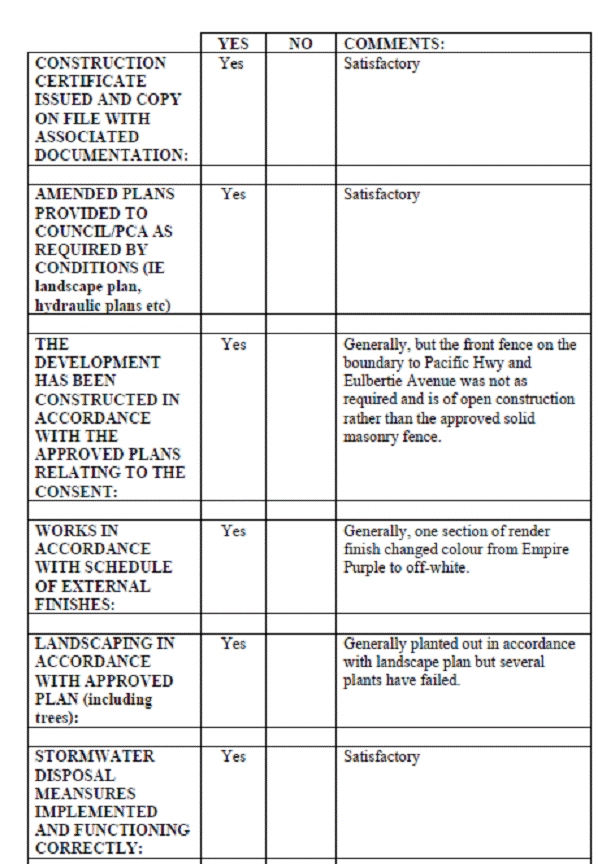
![]()
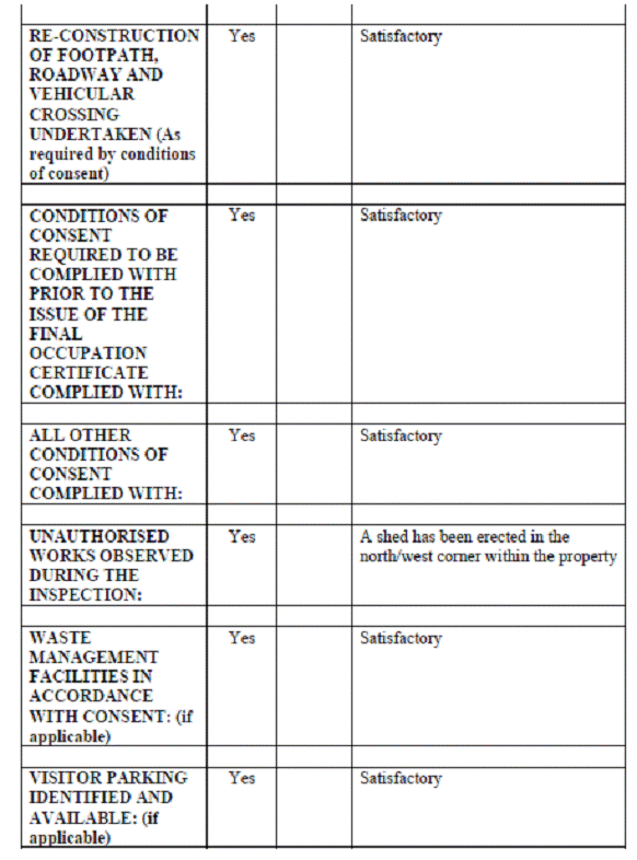
SUMMARY OF ANY ACTION (if applicable) TAKEN AS A RESULT OF NON-COMPLIANCE IDENTIFIED DURING AUDIT:_
Front fence:
The non-compliant front fence has been referred to the Development Assessment Section for a merit based assessment.
Shed:
A Notice of Intention to Serve an Order has been issued requiring removal of the shed in the north/west corner.
Disabled ramp:
A Notice of Intention to Serve an Order has been issued requiring the disabled ramp to be constructed in accordance with the consent.
Landscape:
Landscape Officer to action upon return from leave.
AUDIT UNDERTAKEN BY:
Senior Development Compliance Officer
Landscape Compliance Officer
Development Engineer
1-3 EULBERTIE AVENUE WARRAWEE – AUDIT PHOTGRAPHS
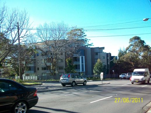
Looking in an easterly direction from south side of Pacific Hwy
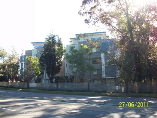
Looking in a northerly direction from south side of Pacific Hwy
Looking in a north/westerly direction from south side of Pacific Hwy
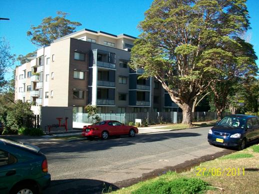
Looking in a south/easterly direction from the west side of Eulbertie Avenue
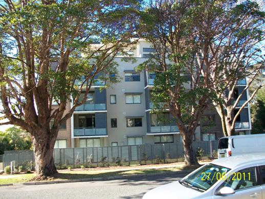
Looking in an easterly direction from the west side of Eulbertie Avenue
7-15 MILRAY STREET LINDFIELD –AUDIT PHOTOGRAPHS
|
AUDIT TYPE: Residential Flat Building |
|
|
|
AUDIT DATE: 30 March 2011 |
|
|
|
PROPERTY ADDRESS: 7-15 Milray Street Lindfield |
|
|
|
WARD: Lindfield |
|
|
|
DEVELOPMENT APPLICATION NUMBER: DA0520/08 |
|
|
|
APPROVAL DATE: 26 November 2008 |
|
|
|
DESCRIPTION OF APPROVAL: Demolition of four existing dwellings & construction of a residential flat building comprising 58 units & associated car parking & landscaping |
|
|
|
APPLICANT: IPM Pty Ltd |
|
|
|
OWNER: Structured Finance Corporation Pty Ltd |
|
|
|
CONSTRUCTION CERTIFICATE ISSUE DATE: 3 April 2009 |
|
|
|
PRINCIPAL CERTIFYING AUTHORITY: Anthony Protas Consulting Pty Ltd |
|
|
|
FINAL OCCUPATION ISSUE DATE: 10 March 2011 |
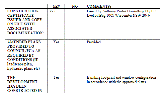
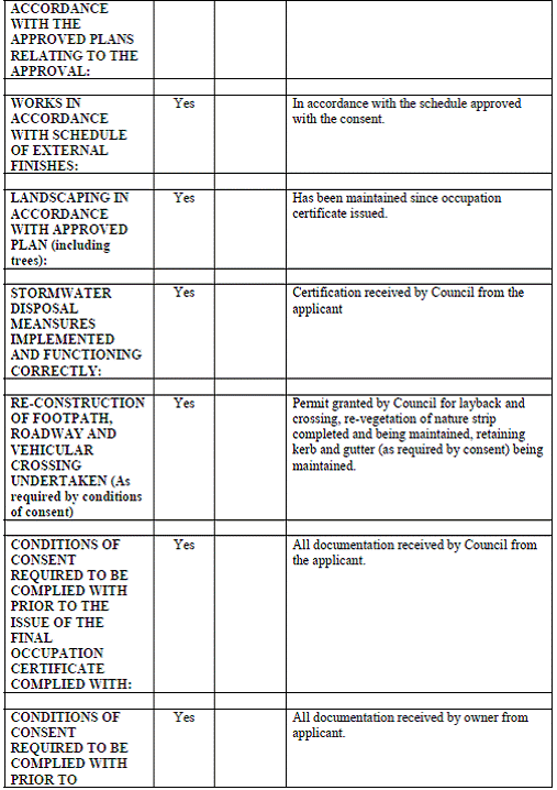
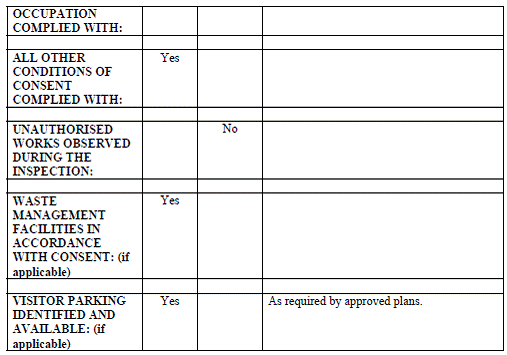
SUMMARY OF ANY ACTION (if applicable) TAKEN AS A RESULT OF NON-COMPLIANCE IDENTIFIED DURING AUDIT: N/A
GENERAL COMMENTS FOLLOWING AUDIT:-
Inspection undertaken has revealed that all conditions of development consent have been complied with and works undertaken in accordance with the approved stamped plans relating to Development Consent No. 520/2008.
AUDIT UNDERTAKEN BY:
Building and Compliance Team, Development and Regulation
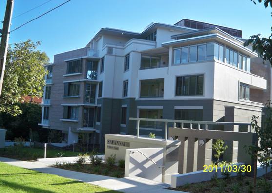
Northern side of development with disabled ramp on the left side of the main entry.
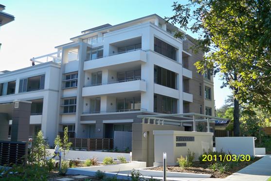
Southern unit block and disabled access in foreground
View of centre of development site and rear unit block
View of courtyard and access ramp/path to units
Pedestrian pathway and landscaping
Driveway entry with 2.5m clearance
9-15 KINGS AVENUE ROSEVILLE
|
AUDIT TYPE: Residential Flat Building |
|
|
|
AUDIT DATE: 26 September 2011 |
|
|
|
PROPERTY ADDRESS: 9-15 Kings Avenue Roseville |
|
|
|
WARD: Roseville |
|
|
|
DEVELOPMENT APPLICATION NUMBER: DA1285/04, DA1285/04A, MOD0088/10, MOD0093/11, and DA0001/10 Strata Subdivision |
|
|
|
APPROVAL DATE: 8 November 2005 and subsequent modifications 28 February 2007, 10 June 2010, 16 June 2011 & 16 March 2010 (Strata Subdivsision) |
|
|
|
DESCRIPTION OF APPROVAL: Demolition of four existing dwellings & construction of a residential flat building comprising 23 units & basement car parking for 41 vehicles |
|
|
|
APPLICANT: DA1285/04Colston, Budd, Hunt & Kafes DA0001/10 Geometra pty Ltd MOD0088/10 Hone Constructions Pty Ltd MOD0093/11 Jabour Jabbour |
|
|
|
OWNER: Johnson Bourke Pty ltd |
|
|
|
CONSTRUCTION CERTIFICATE ISSUE DATE: 561/08 dated 5 November 2008 and 211/09 dated 29 May 2009 |
|
|
|
PRINCIPAL CERTIFYING AUTHORITY: Lyall Dix of Dix Gardner Pty Ltd |
|
|
|
FINAL OCCUPATION ISSUE DATE: 23 June 2011 |
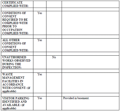
SUMMARY OF ANY ACTION (if applicable) TAKEN AS A RESULT OF NON-COMPLIANCE IDENTIFIED DURING AUDIT: ________________________________N/A_________________________________
GENERAL COMMENTS FOLLOWING AUDIT:-
Inspection undertaken has revealed that all conditions of development consent have been complied with and works undertaken in accordance with the consent. The landscaping has been maintained and is growing well.
AUDIT UNDERTAKEN BY:
Development Compliance Officer
9-15 KINGS AVENUE ROSEVILLE- AUDIT PHOTOGRAPHS
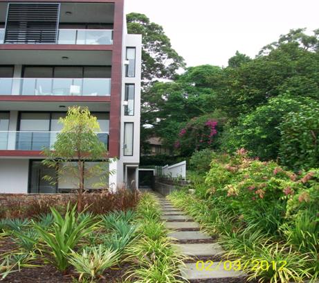
Southern side of units showing landscape separation from adjoining residence
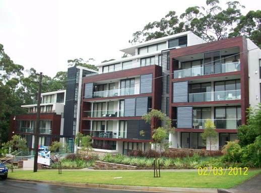
Western façade of Kings Avenue looking north east
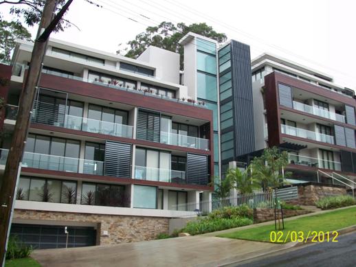
Western façade of Kings Avenue looking south east
Beautification of reserve on the corner of Maclaurin Parade and Kings Avenue Roseville adjoining units
View within front setback of northern block looking south
View within front setback of southern block looking north
|
Ordinary Meeting of Council - 26 June 2012 |
GB.8 / 320 |
|
|
|
|
Item GB.8 |
CY00349/2 |
|
|
21 May 2012 |
Council Submission: Sydney Over the next 20 years - Discussion Paper NSW Department of Planning & Infrastucture
EXECUTIVE SUMMARY
|
purpose of report: |
To have Council consider a submission on the Discussion Paper “Sydney Over the next 20 years”. |
|
|
|
|
background: |
On 3 May, 2012 the NSW Department of Planning & Infrastructure released the Discussion Paper “Sydney Over the next 20 years” for public comment. The new Metropolitan Strategy is being developed for Sydney over the next 20 years. It will provide a framework for Sydney’s growth to help plan for housing, employment, transport, infrastructure, the environment and open space. |
|
|
|
|
comments: |
This report provides some key points for inclusion into a submission on the discussion paper “Sydney Over the next 20 years”. |
|
|
|
|
recommendation: |
That a submission to the NSW Department of Planning & Infrastructure be prepared based on the key points identified in the report. |
Purpose of Report
To have Council consider a submission on the Discussion Paper “Sydney Over the next 20 years”.
Background
A new Metropolitan Strategy is being developed for Sydney by the NSW Department of Planning & Infrastructure (DoPI) and is provided as Attachment A1. It is an attempt to provide a framework for Sydney’s growth to help plan for housing, employment, transport, infrastructure, the environment and open space.
The strategy will update the current Metropolitan Strategy for Sydney and link it to the Government’s other long-term plans: the Long Term Transport Master Plan and the NSW State Infrastructure Strategy. These plans will also inform the NSW Budget priorities for funding.
In a city of Sydney’s size, there is a need to plan for enough housing and jobs of the right type in the right place, properly serviced by infrastructure and transport networks. These issues cannot be left to chance. An overarching vision is to plan for short, medium and long term improvements and manage growth, change and opportunities in the future.
The new Metropolitan Strategy will set an agreed government and community vision for Sydney in the next 20 years. It will also identify the other partners and actions needed to make that vision a reality.
Released on 3 May 2012 the Discussion Paper - “Sydney Over the Next 20 Years” is the first step in the development of a new Metropolitan Strategy. The DoPI is inviting submissions on the Discussion Paper until 29 June 2012.
A draft strategy will be released in mid-late 2012 and will be the subject of more detailed consultation. It is anticipated that the draft subregional strategies, including the Sydney North (Ku-ring-gai & Hornsby) Sub-regional Strategy will be updated and finalised following the release of the new Metropolitan Strategy.
Comments
The Discussion Paper draws on the objectives set out in NSW 2021: A Plan to Make NSW Number One (NSW 2021). The aim of the review is to enable the incorporation of the feedback received from the community, stakeholders and local government as well as the latest government policies.
“Sydney Over the Next 20 Years” is a Discussion Paper that:
· identifies the State Government’s current approaches to delivering outcomes;
· seeks to generate feedback on whether current plans and policies are appropriate, deliverable and supported by the community;
· identifies key directions that guide planning for discussion within the community; and
· invites consideration of what the priorities are now and in the future for Sydney.
The Discussion Paper outlines revised growth forecasts for 2031, with the main forecasts for Sydney being:
· that the population is expected to rise by more than 1.3 million by 2031;
· the need for 570,000 additional homes by 2031; and
· the need to accommodate an additional 600,000 jobs.
The Discussion Paper identifies important trends that will set the vision for Sydney for the next 20 years and Planning for Sydney is being shaped by a number of principles as set out below:
• linking land use planning to transport and infrastructure
• strengthening the economic and employment opportunities that come from growth protecting the natural environment and our Aboriginal and cultural heritage
• providing housing across the city that suits different needs and budgets
• providing access to a range of jobs across the city, particularly to balance growth in
Western Sydney
• supporting the Regional Cities of Parramatta, Penrith and Liverpool and other centres with appropriate services and infrastructure
• making it easier to access public transport from all parts of Sydney
• providing access to economic and recreational opportunities, regardless of where people live
• building new places and improving existing places through a high standard of design, energy efficiency and excellent public spaces
• building new places and improving existing places to promote healthy, active lifestyles
and to create safe, inclusive and comfortable neighbourhoods; and
• adapting to a changing climate.
Key Points for a Submission
General
Council supports the initiative of releasing a discussion paper and supports the process whereby long term land use planning is linked with transport planning, infrastructure provision and a State funding strategy.
The Principles are generally supported and should form a central part of guiding the strategy, however, it should be noted there are inherent potential conflicts between the various principles. They need to be identified and balanced (for example, housing and protecting natural, Aboriginal and cultural environments).
There are nine (9) Shaping Sydney themes outlined in the discussion paper and these are listed below along with the key points for a submission.
Housing our growing population
· In the case of population projections and housing targets, the NSW State agencies need to provide to local Council’s the methodology, base data and any other supporting material of which they were created.
· A transparent methodology needs to be providing population projections and housing targets and must take into account the supporting local and regional infrastructure, equity and cumulative impacts of historic population growth in established areas.
· In relation to ongoing extrapolations of targets into the future, these should be adjusted to acknowledge allocated growth in planning instruments and actual growth in the intervening periods. Recognising where further targets may not be appropriate where saturation density has occurred.
· Housing and employment targets are to be matched by commitments by state agencies to deliver associated infrastructure and services.
· Increased co-operation and data sharing between local government and the State should be explored to minimise the duplication of expenditure of financial and staff resources.
· Ensure where possible that housing targets take advantage of opportunities for local centres revitalisation.
· Improve affordable housing and key worker accommodation through new initiatives.
Providing Jobs and Economic opportunities
· Maintain and protect the commercial centres hierarchies set out in the sub regional strategies with clearly defined roles, appropriate land use management and established relationships between centres both within the subregions and across the metropolitan region.
· Support the revitalisation of existing centres (and infrastructure) rather than creating new centres or land use activities which may undermine the role and functions of the established centres.
Providing Efficient Transport networks
· Prioritise delivery of the key actions identified in Transport Long Term Infrastructure masterplan (NRSOC submission).
· Prioritise the delivery of the local and regional actions identified in the Ku-ring-gai Council Integrated Transport Strategy (2010).
Providing The Infrastructure We Need
· Ensure that housing and employment targets are matched by commitments by state government agencies to deliver associated infrastructure and services.
· Population strategies should clearly identify actions and timeframes, assign responsibility and allocate funding for the delivery of actions. The Strategy should also acknowledge that concessions to councils may be required, should critical infrastructure not be provided by state agencies in a timely manner.
· Ensure that the delivery of infrastructure proceeds in accordance with population, housing and employment growth in the subregion and clearly aligned to the NSW State Infrastructure Plan.
· Provide an appropriate funding stream for the delivery of infrastructure taking into account the current practices of rate pegging and capping of section 94 development Contributions.
Providing equitable access to a great lifestyle
· Aligning local and regional planning with infrastructure and transport.
· Support high quality urban design including the findings of the recent review into SEPP No.65 – Design Quality Design of Residential Flat development should also be taken into consideration.
Protecting our environment and building resilience to natural hazards
· Discuss the environmental consequences of any actions outlined in the Strategy.
· Conserve the natural and built environment that is identified as having high ecological and community value, particularly environmentally sensitive places, remnant bushland and threatened species that need to be protected.
Protecting productive rural and resource lands
· Develop effective measures to maintain a diversity of land holdings and protect local food and agricultural production for the Sydney Basin.
Connecting with the regions
· Reinforce the roles and functions of the various subregions in the plan and aligned with the regional organisation of Council’s structures where possible
Delivering the Strategy
· Identify priorities for all actions but build in flexibility in delivery timetables in order to be able to respond to changing circumstances.
· Support the process whereby the strategy will update the current Metropolitan Plan for Sydney and link it to the Government’s other long-term plans – the Long Term Transport Master Plan and the NSW State Infrastructure Strategy.
· Include an action plan that clearly identifies actions, responsibility, timing and funding for the delivery of the actions. The strategy should also include guidance as to how agencies are to resolve differences between competing objectives/principles to deliver on their obligations.
· The identification of an implementation plan assigning responsibility for actions with performance targets is also supported.
· Identify priorities for all actions but build in flexibility in delivery timetables in order to be able to respond to changing circumstances.
· Ensure that the delivery of infrastructure proceeds in accordance with population, housing and employment growth in the subregion.
Governance Matters
The NSW State Government – Department of Planning & Infrastructure (DoPI) have released the Discussion Paper “Sydney over the next 20 Years. This report provides Council with the key points for making a submission by the due date of 29 June 2012.
It is anticipated a formal draft strategy will be released by the NSW Government in mid-late 2012 and will be the subject of more detailed consultation and consideration by Council.
Risk Management
Within the Discussion Paper there is insufficient information to gauge the direct impact of any new housing/employment targets on Sydney North Subregion. Council will have another opportunity to make a formal submission draft strategy which is anticipated to be released by the NSW Government in mid-late 2012.
Financial Considerations
The cost of preparing this report is covered by the Urban Planning & Heritage budget.
Social Considerations
The Discussion Paper provides some high level discussion on social considerations including the principle Building new places and improving existing places to promote healthy, active lifestyles and to create safe, inclusive and comfortable neighbourhoods. Council will have another opportunity to make a formal submission draft strategy which is anticipated to be released by the NSW Government in mid-late 2012.
Environmental Considerations
The discussion paper “Sydney Over the next 20 years” contains some high level discussion on environmental considerations, including the principles Building new places and improving existing places through a high standard of design, energy efficiency and excellent public space and Strengthening the economic and employment opportunities that come from growth protecting the natural environment and our Aboriginal and cultural heritage.
Community Consultation
No specific consultation has been conducted for this report. The NSW DoPI has conducted its own consultation for the release of the discussion paper.
Internal Consultation
This report has been prepared by the Strategy & Environment Department and where relevant input has been sought from other departments in the preparation of this report.
Summary
A new Metropolitan Strategy is being developed for Sydney that will provide a framework for housing, employment, transport, infrastructure, the environment and open space over the next 20 years. The new strategy is being prepared to align with the priorities and timeframe of the recently released NSW 2021, the NSW Government’s 10 year plan to guide the State’s policy and budget decisions. The new strategy will replace the current Metropolitan Plan for Sydney 2036 and link it to the State Government’s other long-term plans: the NSW Long Term Transport Master Plan and the State Infrastructure Strategy.
The NSW Government has released a Discussion Paper - “Sydney Over the Next 20 Years”, to start the public consultation process. The draft strategy will follow in mid 2012. The Discussion Paper notes that Sydney’s population is expected to reach 5.6 million by 2031, some 700,000 higher than was predicted in the 2005 Strategy, City of Cities: A Plan for Sydney’s Future. The Discussion Paper highlights the key planning issues for Sydney. This report sets out some key points for Council’s consideration and for inclusion into a submission.
|
That a submission to the NSW Department of Planning & Infrastructure on the Discussion Paper - “Sydney Over the Next 20 Years”, be prepared based on the key points identified in this report. |
|
Antony Fabbro Manager Urban & Heritage Planning |
Andrew Watson Director Strategy & Environment |
|
A1View |
Draft Discussion Paper "Sydney over the next 20 Years" |
|
2012/117101 |
|
Ordinary Meeting of Council - 26 June 2012 |
GB.9 / 364 |
|
|
|
|
Item GB.9 |
CY00349/2 |
|
|
6 June 2012 |
Council Car Park - Woodford Lane, Lindfield - Reclassification
EXECUTIVE SUMMARY
|
purpose of report: |
To have Council consider the reclassification of Council Car Park – Woodford Lane, Lindfield to Operational land. |
|
|
|
|
background: |
Council’s Car Park at Woodford Lane, Lindfield has been identified by Transport for NSW for a new commuter car park as recently announced under its public transport infrastructure initiative. |
|
|
|
|
comments: |
It is proposed to commence the reclassification for this site to Operational land to facilitate the delivery of this new public transport infrastructure. Any future divestment or joint venture for development of the land between Council and Transport for NSW would be the subject of a separate process and report to Council following reclassification. |
|
|
|
|
recommendation: |
That Council prepare a Planning Proposal to reclassify the site from Community land to Operational land and that a further report be brought back to Council regarding the future divestment following the reclassification process. |
Purpose of Report
To have Council consider the reclassification of Council Car Park – Woodford Lane, Lindfield to Operational land.
Background
The land known as Woodford Lane Car Park (1b Beaconsfield Parade & 19 Drovers Way), Lindfield - being Part Lot 1 DP 929131 & Lots 1-16 DP 1099330 is located within the Lindfield local centre area.
Council, in its Statement of Commitments to the Minister for Planning adopted on 22 November 2011 regarding the preparation of local centres plans, agreed to address reclassification of key Council owned sites within the local centre areas to facilitate orderly and economic growth.
On 20 March 2012, Council adopted a revised Statement of Commitments for the preparation of the new centres plans, which among other things, removed the commitment to reclassify land in the centres. As a result, the planning proposal for the draft Local Centres Local Environmental Plan (LEP) adopted by Council on 3 April 2012 did not include the reclassification of Council land.
As part of the $170 million investment in public transport infrastructure the NSW Premier, The Hon. Barry O’Farrell, and Minister for Transport, The Hon. Gladys Berejiklian recently announced for Ku-ring-gai the following projects:
· Lindfield: A car park with 240 additional spaces, new Kiss and Ride zone, estimated to cost $34 million; and
· Gordon: More than 160 additional spaces at two locations, upgrade of bus interchange, Kiss and Ride zone, estimated to cost $44 million;
Woodford Lane Car Park, Lindfield has been identified as the site for the proposed new commuter car park in Lindfield.
Comments
The recent announcement by the Minister for Transport provides a significant opportunity for Council to bring forward vital urban design and community facilities in the Lindfield town centre which might otherwise be delayed many years. Further, the provision of commuter car parking in this locality has long been a matter raised in the various consultation processes Council has facilitated over the last ten years or so.
It is proposed to commence the reclassification of the Woodford Lane Car Park to Operational land to facilitate the delivery of the new commuter car park in Lindfield and provide Council with the maximum flexibility to provide a range of other facilities and services in concert with any works carried out by Transport for NSW.
The Woodford Lane Car Park (1 Beaconsfield Parade & 19 Drovers Way), Lindfield - being Part Lot 1 DP 929131 and Lots 1-16 DP 1099330 is an existing Council Car Park of 5574.61m2 and accommodates 109 spaces. A location map is included as Attachment A1.
The land is owned by Council and used for public car parking. Funding used to acquire the site was from the Lindfield Car Parking fund. The Car Park is classified as Community land and zoned Special Uses 5(a) – Parking under the Ku-ring-gai Planning Scheme Ordinance 1971 (KPSO). In the draft Planning Proposal Ku-ring-gai Local Centres 2012 the site is zoned B2 Local Centre, with a potential maximum height of 11.5 metres and an FSR of 1:1.
If Council’s site retains its Community classification at the Woodford Lane Car Park, it may limit the
ability to jointly deliver the new commuter car park with Transport for NSW, as part of the site may need to be transferred, sold, leased or exchanged for the project to proceed. At this stage the location, layout and design details of project are undeveloped and Council has the opportunity to work with Transport for NSW to achieve the best outcomes for the community while meeting the requirements for commuter parking.
Section 45 of the Local Government Act, 1993 prevents Council from selling, exchanging or otherwise disposing of Community classified land; therefore it is proposed to reclassify the site from Community Land to Operational Land in accordance with Section 27 of the Act.
The first step is to prepare a planning proposal to submit to the Department of Planning & Infrastructure (DP&I) to reclassify Council owned community land to operational land status. The objective of this proposed Local Environmental Plan is to reclassify the site from “Community” land to “Operational” land, including the discharge all interests in the land.
Should a Gateway Determination for the planning proposal be granted formal consultation with the State Agencies and the community commences. The reclassification of land also requires a public hearing. The public hearing shall be held after the public exhibition of the draft LEP for reclassification.
The reclassification of the land itself, does not commit Council to the sale of the site. Any future divestment of the land would be the subject of a separate process and report to Council following reclassification.
Importantly, any future divestment/ or agreements such as a joint venture for the land between Council and Transport for NSW would be the subject of a separate process and report to Council following reclassification.
Governance Matters
The process outlined in this report complies with both legislative requirements and Council Policy.
The Planning Proposal is to be prepared, in accordance with Section 55, Environmental
Planning and Assessment Act, 1979, to change the classification status from Community Land to Operational Land as required under Chapter 6, Part 2 Division 1 of the Local Government Act, 1993.
Currently there are two (2) planning instruments under which the land could be reclassified - either the KPSO or the draft Planning Proposal Ku-ring-gai Local Centres 2012. At this stage it is proposed to consult further with DoPI on the most appropriate instrument to reclassify the site - taking into account timing by Transport for NSW and the draft status of the Local Centres LEP.
Upon reclassification to Operational land the property will be available for divestment (if required) and this would be conducted inline with the procedures outlined in Council’s Acquisition and Divestment of Land Policy, 2009. The future divestment of the land would be the subject of a separate report to Council following reclassification.
Risk Management
Council needs to make a decision to reclassify Woodford Lane Car Park, Lindfield to assist in attaining the best outcome in the delivery of the new commuter Car Park and any other associated land uses activities for the site.
The NSW State Government at this stage has not expressed an intention to formally compulsorily acquire the site to enable the commuter Car Park to be constructed. Moreover, they have expressed a willingness to work on a joint venture basis with Council to deliver the new infrastructure. It is therefore prudent that Council has identified and dealt with any restrictions or barriers that may impede the delivery of the infrastructure and/or any use of the residual of Council’s landholdings. This matter would be the subject of a separate report to Council.
Financial Considerations
The reclassification of the site would maximise Council’s ability to provide a wide range of facilities and services on the subject land, or in the event of compulsory acquisition, place Council in the best possible position.
Social Considerations
The reclassification of this site will assist Council in its dealings with Transport for NSW for the delivery of additional public transport infrastructure for Lindfield.
Environmental Considerations
The planning proposal for the reclassification of Woodford Lane Car Park, Lindfield will not result in any additional environmental effects to those considered during the preparing of the draft Local Centres LEP.
Community Consultation
Statutory community consultation will be carried out through the reclassification process. An independently chaired public hearing is also necessary in relation to reclassification from Community land to Operational land.
Internal Consultation
This report was prepared by the Strategy & Environment Department in consultation with staff from other Departments where relevant.
Summary
Council’s car park at Woodford Lane, Lindfield has been identified by Transport for NSW for a new commuter car park recently announced under its public transport infrastructure initiative.
It is proposed to commence the reclassification process for this site to Operational land to facilitate the delivery of this new public transport infrastructure. Any future divestment/or agreements such as joint venture for the land between Council and Transport for NSW would be the subject of a separate process and report to Council following reclassification.
|
A. That a Planning Proposal be prepared, in accordance with section 55 of the Environmental Planning and Assessment Act, 1979, to reclassify Woodford Lane Car Park (1b Beaconsfield Parade & 19 Drovers Way), Lindfield - being Part Lot 1 DP929131 & Lots 1, 2, 3, 4, 5, 6, 7, 8, 9, 10, 11, 12, 13, 14, 15, 16 DP1099330 from Community land to Operational land either via an amendment the Ku-ring-gai Planning Scheme Ordinance (KPSO) or the draft Ku-ring-gai Local Centres LEP (2012)
B. That Council undertake a public hearing under the provisions of the Local Government Act, 1993 for the proposed reclassification of Woodford Lane Car Park (1b Beaconsfield Parade & 19 Drovers Way), Lindfield from Community land to Operational land.
C. That Council formally seek to discharge all interests for Woodford Lane Car Park (1b Beaconsfield Parade & 19 Drovers way), Lindfield - being Part Lot 1 DP929131 & Lots 1, 2, 3, 4, 5, 6, 7, 8, 9, 10, 11, 12, 13, 14, 15, 16 DP1099330.
D. That the Planning Proposal by submitted to the Department of Planning and Infrastructure for a Gateway Determination in accordance with Section 56 of the Environmental Planning and Assessment Act, 1979.
E. That upon receipt of a Gateway Determination, the exhibition and consultation process is carried out in accordance with the requirements of the Environmental Planning and Assessment Act, 1979 and with the Gateway Determination requirements.
F. That a report be brought back to Council at the end of the exhibition and public hearing processes.
G. That a further report be brought back to Council regarding the arrangements with Transport for NSW for the delivery of a commuter car park at Woodford Lane, Lindfield.
|
|
Antony Fabbro Manager Urban & Heritage Planning |
Andrew Watson Director Strategy & Environment |
|
A1View |
Woodford lane, Lindfield Car park Location Map |
|
2012/141660 |
|
Ordinary Meeting of Council - 26 June 2012 |
GB.10 / 370 |
|
|
|
|
Item GB.10 |
S02777 |
|
|
8 June 2012 |
Ku-ring-gai Bicycle Plan
EXECUTIVE SUMMARY
|
purpose of report: |
To have Council consider the draft Ku-ring-gai Bicycle Plan for formal public exhibition. |
|
|
|
|
background: |
As part of Council’s adopted Integrated Transport Strategy GHD consultants were recently commissioned to review the 1995 bike plan, taking into account changed community expectations, as well as changes to technical specifications, Council, State and Federal policies. |
|
|
|
|
comments: |
The Ku-ring-gai Bicycle Plan will set out a strategy for the provision of bicycle facilities in the local government area, and connectivity to the surrounding regions. It also sets out broad strategies for behavioural change and promotion. |
|
|
|
|
recommendation: |
That the draft Ku-ring-gai Bicycle Plan be placed on formal public exhibition for a minimum of 28 days and a report be brought back to Council at the conclusion of the exhibition period. |
Purpose of Report
To have Council consider the draft Ku-ring-gai Bicycle Plan for formal public exhibition.
Background
Through the Ku-ring-gai Integrated Transport Strategy (ITS), Ku-ring-gai Council, in partnership with all levels of government, community and other stakeholders, aims to put in place and facilitate good practice transport planning by setting out:
· desired outcomes that provide a consistent framework to focus planning on achieving good outcomes for the community and the transport system; and
· directions and principles that provide guidance on how to achieve the desired outcomes.
The Ku-ring-gai ITS is a guide for transport planning in the Ku-ring-gai local government area (LGA). It sets out a collaborative, consistent and sustainable approach to transport planning for use across the LGA.
The ITS acknowledges that developing actions to encourage cycling (and walking) has the potential to make significant changes to transport patterns by shifting a high number of short car trips to cycling (and walking), and that cyclable (and walkable) environments facilitate greater public transport use and also contribute to healthy communities through the encouragement of physical activities. One of the short term actions of the Ku-ring-gai ITS is that Council prepare and progressively implement a Ku-ring-gai Bicycle Plan.
In 1992 Ku-ring-gai Council commissioned Cycle Planning Consulting Services to prepare a bicycle transport plan to enable safe cycling to take place in the Council area. Council adopted that plan in August 1995 and resolved to undertake a review of the plan after ten years. When the Ku-ring-gai Bicycle Transport Plan was adopted, facilities for cyclists consisted of less than 4 kilometres of sealed bikeway at Council's Bicentennial Park (West Pymble) and Golden Jubilee Field Wahroonga for recreation cycling purposes only. Since then Council has constructed over 17 km of on road cycleways, 11 km of shared footway cycleways and 2 km of rideable fire trails.
As the 1995 plan is now largely outdated, and in response to community expectations and the actions in the ITS, Council recently commissioned GHD consultants to renew the 1995 plan, taking into account changes to technical specifications, Council, State and Federal policies.
The structure of the Ku-ring-gai Bicycle Plan draft report (Attachment A1) is described below, including a brief summary of each section:
1. Introduction
Defines the study area and objectives of the Bicycle Plan.
2. Background Information
Provides a review of background information, including existing local, state and national policy documents.
3. Project Approach and Considerations
Provides some introductory guidance on planning for cyclists, and describes the
methodology used for identifying cyclist needs and an assessment of crash data.
4. Consultation
Describes the consultation process undertaken and consultation outcomes for this project.
5. Existing Facilities Audit
Outlines the existing status of cycling conditions and facilities in Ku-ring-gai.
6. Proposed Cycle Improvements
Provides details of the proposed improvements to cycling facilities.
7. Prioritisation and Funding
Prioritises the identified works and investigates funding sources for bicycle improvements.
8. Supporting a Culture of Cycling
Outlines the recommended cycling promotion and behaviour change programs to encourage cycling in Ku-ring-gai.
9. Further Considerations
Outlines further considerations for bicycle users, such as maintenance, potential monitoring criteria, bicycle parking and other measures to increase cycle use in Ku-ring-gai.
10. Summary
Provides a short summary of the Bicycle Plan.
Comments
The outcomes of the Ku-ring-gai Bicycle Plan seek to address the bicycle transport infrastructure and supporting facilities needs of Ku-ring-gai’s residents and its visitors. Through these outcomes, it is hoped that not only cyclist activity will increase, but also awareness of cyclists and the cycling network, so that the amenity for all local residents and visitors is improved. The recommendations are intended to guide the development of new cycling facilities to fit within the wider context of Council’s aims, objectives and planning for anticipated future developments.
The identified locations for cycle improvements are mapped in Appendix A of the draft Ku-ring-gai Bicycle Plan. Proposed cycle routes were developed through an iterative process between the consultants, council staff, stakeholders and the community. Stakeholder and community consultation feedback was considered during the development of the routes. These routes have been ranked using criteria which include land use factors, traffic impact and safety factors, facility benefits, continuity of routes and route hierarchy. Indicative configurations and costings for the routes, and the body responsible for delivering the route, have been outlined.
Governance Matters
The Integrated Transport Strategy is a key strategy within Council’s Principal Local Environmental Plan (PLEP) program, which was adopted by Council on 14 December 2010. The Ku-ring-gai Delivery and Operational Plan 2010-2014 includes the finalisation and implementation of the new Ku-ring-gai Wide PLEP and Principal Development Control Plan (PDCP), along with the 1 year action of completing Stage 2 (key planning strategies including Integrated Transport Strategy). The review of the Bicycle Plan is a key short term action arising from the Integrated Transport Strategy and is seen as a high priority.
If the draft Bicycle Plan is adopted for exhibition, then the outcomes of the plan will inform the overall bicycle transport planning requirements for Ku-ring-gai. In addition the Bicycle Plan will strengthen Council’s future lobbying regional and state cycling improvements and funding opportunities.
Risk Management
An updated Bicycle Plan will further assist Council in providing an informed and balanced approach to dealing with bicycle infrastructure/programs for Ku-ring-gai.
Inaction may result in limiting the ability of Council to adequately plan for new cycling infrastructure/programs, or in articulating funding needs or attracting external funding. With surrounding Councils progressing their cycling infrastructure at a fast rate, there is a risk that Council could lag further behind in its provision, denying its residents a similar level of infrastructure provision and connectivity as its neighbours.
Financial Considerations
A number of proposed bicycle related facilities in the Local Centres (as part of the Ku-ring-gai Public Domain Plan (2010)) have been costed and incorporated into the Ku-ring-gai Contributions Plan (2010) works schedules. This includes works such as cycleways, bicycle parking and other facilities, and the estimated total capital cost of these works is approximately $7.8 million. These are incorporated in Council’s Long Term Financial Plan. Some of these projects overlap with the cycleways identified in the draft Bicycle Plan
The extension to Council’s Environmental Levy has $780,000 allocated over 7 years (or approximately $111,000 per annum) for sustainable transport initiatives, including cycleways. If dedicated entirely to cycleways, this could potentially be doubled to $1,560,000 through the Roads and Maritime Services’ Cycleway grant program, which is 50/50 funded.
From the Roads and Maritime Services Memorandum of Understanding for Works By Council and Funded by RTA, funding arrangements under the Cycleways program fall into two broad categories:
· State bicycle routes identified in each RTA Region’s component of BikePlan 2010. Projects listed within BikePlan 2010 will generally be 100% funded by the RTA [RMS].
· Local bicycle routes identified in each Council’s Bike Plan. Generally all cycleway projects identified in Council Bike Plans will be funded on a shared (dollar for dollar) basis with Councils.
· Furthermore, under the RMS’ Bicycle User Support program, there is 50/50 funding available for projects such as Bike Week, regional bicycle promotions and development and production of cycleways maps.
Funding for the preparation of this bike plan was provided by RMS on a 50/50 funding basis, with the project expected to cost $50,000. The RMS allocation is up to $25,000.
Other funding opportunities exist, such as other State or Federal Government grant programs which are typically either 50/50 or 100% funded (depending on the program).
There are 3 routes in the top 15 priority routes that would be funded by the Roads and Maritime Services, as these routes are identified in BikePlan 2010 as regional routes. Excluding these 3 routes, the next top 15 priority routes would have an estimated cost of between $939,000 and $2,588,000 (subject to final designs). The funding from the Environmental Levy and other grant sources would therefore allow a meaningful selection of projects to be delivered.
There are also opportunities to develop cycle tourism, through improved access to, and facilities at, key attractions and landmarks in Ku-ring-gai.
Social Considerations
In terms of social equity for the community, the Bicycle Plan would contribute to promoting an alterative (non-car) mode of travel. Cycling is also a relatively low-cost travel mode which therefore makes it an option for users who do not have access to, or cannot afford the cost of owning and operating, a private motor vehicle. Improved cycling infrastructure also has the opportunity to make better use of available road capacity and improve access to other more affordable (public transport) travel modes.
There are also health benefits from cycling. Encouraging active transport and active lifestyles contributes to healthy communities an increases social interaction.
Environmental Considerations
Currently, growth pressures, travel habits and car ownership rates contribute to vehicle traffic and associated issues of congestion, loss of amenity, local air quality, urban noise, energy use/ greenhouse emissions, safety concerns, health and parking issues. Ku-ring-gai has one of the highest car ownership rates in NSW.
Increasing cycling’s mode share of trips to 5% (objective of the Ku-ring-gai Integrated Transport Strategy) would assist in the reduction of car dependency while promoting alterative modes of transport.
Community Consultation
Prior to the study commencing, a briefing was given to Council’s Bicycle Reference Committee (BRC) on Wednesday 16 November 2011. The purpose of the briefing was to give the BRC (and indirectly, Councillors) an overview of the objectives of the Bicycle Plan, the planning context, an indication of the anticipated outputs of the study, a consultation strategy and an indicative timeline. Updates on the progress of the Bicycle Plan were provided to the BRC at its meetings on 15 February 2012 and 4 April 2012.
The following public consultation was undertaken:
· Community Survey – 10 February 2012 to 7 March 2012
· School Survey – 10 February 2012 to 7 March 2012
Community surveys allowed residents and the wider community to contribute to the formation of the Bicycle Plan by completing an on-line or reply paid survey. The participation rate was considered to be very high. Schools in Ku-ring-gai were targeted directly by mail through a survey, to understand the enablers and barriers to cycling to and from schools, and to understand attitudes by staff and students towards cycling. 29 of 46 schools in Ku-ring-gai completed the survey. There was also media coverage of the Bicycle Plan surveys through the Mayoral column, through articles in local newspapers and on Council’s Facebook page.
As part of the stakeholder consultation process, the following workshop sessions were held:
· Bicycle User Groups Workshop - 22 February 2012; and
· State and local agency/transport workshop – 28 February 2012.
The draft Bicycle Plan will be exhibited for 28 days and there will be notification to relevant community groups and stakeholders, as well as on Council’s website and advertisement in local newspaper.
Internal Consultation
Staff in Council’s Operations Department (Traffic) have been involved during the preparation of the Bike Plan. There has also been participation from staff from Council’s Corporate Planning and Sustainability unit (within Strategy & Environment Department) and Community Department at key stages in relation to behaviour change, events and promotion.
Summary
GHD consultants were recently commissioned to renew the 1995 bike plan, taking into account changed community expectations, as well as changes to technical specifications, Council, State and Federal policies.
The Ku-ring-gai Bicycle Plan will set out a strategy for the provision of bicycle facilities in the local government area, and connectivity to the surrounding regions. It also sets out broad strategies for behavioural change and promotion.
|
That the draft Ku-ring-gai Bicycle Plan be placed on formal public exhibition for a minimum of 28 days and a report be brought back to Council at the conclusion of the exhibition period.
|
|
Joseph Piccoli Strategic Traffic Engineer |
Antony Fabbro Manager Urban & Heritage Planning |
|
Andrew Watson Director Strategy & Environment |
|
|
A1View |
Ku-ring-gai Bicycle Plan - Draft Report |
|
2012/145196 |
|
Ordinary Meeting of Council - 26 June 2012 |
GB.11 / 510 |
|
|
|
|
Item GB.11 |
FY00382/4 |
|
|
27 April 2012 |
Delivery Program and Operational Plan
2012-2013 - Post Exhibition
EXECUTIVE SUMMARY
|
purpose of report: |
For Council to adopt the revised Delivery Program and draft Operational Plan 2012-2013, incorporating the budget, capital works program and fees and charges for 2012/2013. |
|
|
|
|
background: |
On 8 May 2012, Council considered a report (GB .7) on the Delivery Program and Draft Operational Plan 2012-2013, incorporating the budget, capital works program and fees and charges for 2011/12. At this meeting Council resolved to place the program and draft plan on public exhibition. |
|
|
|
|
comments: |
The legislative requirement is to prepare and exhibit the Delivery Program and Draft Operational Plan 2012-2013, incorporating the budget, capital works program and fees and charges for 2012/2013 is governed by sections 404 and 405 of the Local Government Act, 1993. |
|
|
|
|
recommendation: |
That Council adopt the Delivery Program and draft Operational Plan 2012-2013, incorporating the Budget, Capital Works Program and Fees and Charges for 2012-2013. |
Purpose of Report
For Council to adopt the revised Delivery Program and draft Operational Plan 2012-2013, incorporating the budget, capital works program and fees and charges for 2012/2013.
Background
On 8 May 2012, Council considered a report (GB .7) on the Delivery Program and Draft Operational Plan 2012-2013, incorporating the budget, capital works program and fees and charges for 2011/12. At this meeting Council resolved to place the program and draft plan on public exhibition.
This report provides comment and proposes amendments to the Delivery Program and Draft Operational Plan 2012-2013, arising from the consultation period.
Comments
This year’s Delivery Program and draft Operational Plan links the 72 functions undertaken by Council by their internal budget allocation (also referred to as the cost centre or code). This may also be useful in determining future resource decisions that respond to the outcomes of community satisfaction surveys, policy directions by Council, workforce and long term financial planning. Specific actions that align to the four year objectives are also included. This process is consistent with the structure of the Community Strategic Plan.
Key performance indicators (KPI’s) form an integral part of the monitoring and reporting of the plan. They represent a measure of the standard or outcome of the services or activities undertaken. For this year each KPI has been given a priority listing of 1, 2 or 3 based on the following criteria:
· whether its achievement is a legislative responsibility (1);
· if it responds to a Ministerial directive or order (1);
· if it relates to the ongoing sustainability of Council or is strategically important in that it informs Councillors of the overall direction of the organisation (2);
· whether it is tied to the operational efficiency that enables benchmarking against other Council’s (2);
· if the achievement of the KPI relates to an adopted capital works program (2); and
· if the indicator is designed to report on the output of a program (3).
As required by the Local Government Act, 1993, progress against the delivery program, operational plan and budget will be reported to Council bi-annually.
Capital works program
The allocation of funding for capital works is determined by the Long Term Financial Plan.
In March 2011, Council adopted a revised capital works prioritising system to enable future capital works programs to be developed. Included in the Delivery Program and draft Operational Plan are the proposed four (4) year programs based on Council’s adopted prioritisation system.
Program of capital works and other projects for 2012/13
The program for 2012/2013 proposes $79.7M in expenditure for capital works and major projects and $93.4M (including depreciation) for the delivery of services. This includes:
· the special rate infrastructure levy that is upgrading the road assets;
· the upgrade of the North Turramurra Recreation Area;
· a new indoor aquatic and leisure facility;
· the purchase of a new operational building to relocate some Council services;
· the purchase of properties for open space;
· a new program of building works funded by a special Local Infrastructure Renewal Scheme loan;
· completion of Council’s new works depot and SES/RFS building; and
· continuation of a special eight (8) year environmental program of works funded from the Environmental Levy special rate.
Governance Matters
The legislative requirement to prepare and exhibit the Delivery Program and Draft Operational Plan 2012-2013, incorporating the budget, capital works program and fees and charges for 2012/2013 is governed by sections 404 and 405 of the Local Government Act, 1993.
It is the responsibility of Council to consider all submissions made during the exhibition of the draft plan and program prior to adopting the plan.
The changes proposed to the Delivery Program and Draft Operational Plan 2012-2013, incorporating the budget, capital works program and fees and charges for 2012/2013 are not considered to have a substantial or material change to the strategic direction and delivery of Council’s services and projects. For this reason it is considered and recommended that Council adopt the revised document without the need to re-exhibit.
Risk Management
In terms of the structure and content of the revised Delivery Program and draft Operational Plan 2012-2013, has met the legislative requirement pursuant to sections 404 and 405 of the Local Government Act, 1993. Furthermore this report has considered all submissions made during the exhibition and these are summarised in the community consultation section in this report.
Council has a statutory obligation to prepare, exhibit, consider feedback and adopt the Delivery Program and Draft Operational Plan 2012-2013, no later than 30 June each year.
Financial Considerations
Budget principles
Council’s budget for 2012/2013 is developed using the 20 Year Long Term Financial Plan (LTFP). The LTFP is based on the following principles:
1. Maximise funds available for projects to upgrade or renew infrastructure by:
· Maximising the operating profit before capital items.
· Prioritising the use of Council cash reserves.
· Borrowing in accordance with policy.
· Timing project expenditure over a longer period and linking to funds availability.
2. Financial sustainability tests applied by the LTFP:
· Target a minimum working capital of 5.5% of operating expenses (excluding depreciation) as recommended by Council’s external auditors. Working capital is determined by taking net current assets less internally and externally restricted reserves and adding those current liabilities to be funded from the next year’s budget. Essentially, working capital is a measure of Council’s liquidity and ability to meet its obligations as they fall due. It is the primary measure of the overall financial position in Local Government. This will allow for unforeseen expenditure or reductions in revenue or other accounting adjustments.
· Maximum debt service ratio of 4% in any one year (industry green light benchmark less than10%).
· Achieve an operating surplus, before capital income items, to fund capital expenditure.
· Maintain a minimum level of internal discretionary cash reserves (excluding liability cash reserves) of 10% of revenue.
· Maintain a minimum level of s94 Development reserves of $5m.
· Only capital items to be funded from cash reserves.
· Proceeds of asset sales returned to reserves for expenditure on new assets or major asset refurbishment.
3. Borrowing and Debt Strategy
· Borrowings are considered as a source of funding for:
a. Building or purchase of infrastructure assets where a detailed cash flow analysis shows that full funding costs can be recovered over the life of the asset.
b. Economic investments where a new asset or service decreases existing costs or provides new revenue in excess of their funding costs (positive NPV).
c. In an emergency.
· As borrowings are usually the highest cost source of funds:
a. all possible internal funding sources are considered and used first (including re-allocation of funds from lower priority projects or operating items); and
b. the proposed project is re-timed to match internal funds availability.
The 2012/13 budget has been developed to ensure that the above financial targets are met and maintained in the future.
Major components of the 2012/13 budget include:
· CPI increase of 2.8%;
· the Independent Pricing and Regulatory Tribunal (IPART) approved rate pegging increase of 3.6%;
· domestic waste charges increased by a maximum of $20.00 with the basic services increasing by $15 (houses) and $10 (units) in accordance with increases in waste disposal cost (including the estimated impact of the Carbon Tax) and other service running costs;
· fees and charges increased by an average of 3.6%;
· interest on investments estimated at 5.5%;
· operational and capital grant revenue increased by 2.8%;
· employee award increase of 3.25%;
· new loan borrowing up to a maximum of $31.368M;
· capital works and other major projects program $79.7m;
· reductions in debt servicing costs allocated to infrastructure renewal of $1.6m;
· section 94 revenue of $11.8M transferred to externally restricted reserves. This consists of $11.0M from the new 2010 Contributions Plan and $800K from old plans; and
· no asset sales used to fund operations.
Rating Structure 2012/2013
The Independent Pricing and Regulatory Tribunal (IPART) has determined that Council’s general income may be increased by 3.6% under section 506 of the Local Government Act, 1993 for the rating year commencing 1 July 2012, and this increase is reflected in the 2012/13 budget.
Details of rates levied will be as follows:
|
Rate pegging increase of 3.6% |
||||
|
Rate Type |
Category |
Rate in $ |
Min/Base Amount $ |
Yield $ |
|
General |
Residential |
0.00094362 |
458 |
$24,616,423 |
|
General |
Business |
0.00621143 |
458 |
$3,714,883 |
|
Special |
Environmental |
0.00010512 |
|
$2,510,293 |
|
Special |
Infrastructure* |
0.00046881 |
|
$11,195,296 |
|
Special |
Infrastructure* |
|
270 |
$10,871,280 |
|
Special |
New Facilities |
0.00006636 |
|
$1,584,688 |
* These amounts consist of $2,384,314 special rate variation granted by the Minister from 2007/08, plus a transfer of $19,682,262 of Council’s general rates to the Infrastructure levy.
At its meeting of 24 March 2009, Council adopted a change to the rating structure commencing in 2009/10 and being phased in until 2011/12. This has now been completed and consideration needs to be given to ongoing rates policy in relation to the Infrastructure levy and the base amount component.
It is proposed that the total notional income of Council, less special rate variation income obtained from Ministerial approval, be divided each year into General rates and Infrastructure levy in the following proportions:
· General rates 59%.
· Infrastructure levy component transferred from Council general rates 41%.
These proportions are based on the actual rates levied plus rates growth in 2011/12, the first full year of the phased rates restructure. In addition, the resulting Infrastructure levy amount be levied as a 50% base charge, rounded to the nearest $5 annually. This will allow continued maximisation of rating income from property growth as total income changes through rates pegging increases.
Sections of the LGA that govern the levying of rates require that funds levied as a special rate are spent on activities related to the purpose of the special rate. Adopting this principle of the division of Council’s general rates into a general component and an infrastructure levy will ensure that, with inflation of rates through pegging into the future, a constant proportion of rates income in real terms is devoted to infrastructure maintenance, renewal, upgrade and replacement.
Stormwater Management Charge
The stormwater management service charge for 2012/2013 is levied under Section 496A of the Local Government Act, 1993 (as amended).
The charges have been set in accordance with the Local Government Amendment (Stormwater) Bill 2005 and for 2012/2013 are as follows:
Strata / Company titled residential home units: $12.50 per unit
Strata / Company titled business units: $12.50 per unit
Other residential property: $25.00 per rateable property
Business rateable property: $25.00 per 350 square metres of land area (a maximum charge of $1,500.00 applies to land area greater than 21,000 square metres).
Waste Management Charge
The waste management charge for 2012/2013 is levied under Section 501 of the Local Government Act, 1993 (as amended).
Council’s annual waste management charges include a charge for waste management per business service provided or proposed to be provided. Upon request, a 120L Waste Bin to be emptied weekly will be provided. In 2012/2013 this charge will be $220 per service.
In addition, business properties also receive the benefit of services associated with:
• street sweeping;
• roadside litter removal; and
• footpath sweeping.
The charge for Aged Care/Nursing Homes rated as Business Properties will be $220 per service. The service is:
· equivalent of 120 litres of waste per service per week; and
· equivalent of 120 litres of recycling per service per week.
Domestic Waste Management Charge
Sections 496 and 504 of the Local Government, Act 1993 (as amended), require councils to make and levy an annual charge for the provision of domestic waste (DWM) service for each parcel of rateable land for which the service is available, ensure that the cost of providing the service is met by the charge and that the charge is reasonable for the services provided. A council cannot use income from its ordinary rate towards the cost of providing DWM services. Domestic waste charges have been increased to cover increases in waste disposal and running costs.
Charges for 2012/2013 are shown below:
|
Category |
Charge per Occupancy |
Service / Properties |
Estimated Yield |
|
Base Service with Green waste |
$350.00 |
27,510 |
$9,628,500 |
|
Base Service without Green waste |
$255.00 |
416 |
$106,080 |
|
Flat, Home Unit |
$310.00 |
8,217 |
$2,547,270 |
|
Additional Green waste bin |
$120.00 |
1,924 |
$230,880 |
|
240L waste bin with Green waste |
$465.00 |
3,595 |
$1,671,675 |
|
Additional 120L waste bin |
$145.00 |
114 |
$16,530 |
|
Availability/Vacant Land |
$150.00 |
190 |
$28,500 |
|
240L waste bin without Green waste |
$370.00 |
23 |
$8,510 |
|
240L waste, flat home unit |
$455.00 |
5 |
$2,275 |
|
Total Yield |
|
|
$14,240,220 |
Note: For Aged Care/Retirement villages rated as Residential Properties, charge is applied per service at:
· base service without green waste plus $127.50 (50%) for each additional service – 1 x bed self care unit; and
· base service without green waste plus $63.75 (25%) for each additional service – 1 x bed fully serviced hostel room.
Borrowing and Debt
Borrowings of $27.436M were included in the draft delivery program for 2012/2013. This amount now needs to increase for the carry forward of borrowings anticipated for 2011/12 that are not required and can be deferred until 2012/2013. These borrowings are:
· Purchase of new operational building - the draft delivery program assumed that a deposit of $2.250M for the new operational building would be paid during the current financial year, 2011/12. This amount was to be borrowed in 2011/2012. The deposit is now to be paid in July 2012 and therefore the borrowings related to it moved forward to 2012/2013.
· West Pymble Aquatic Centre – this project is partly funded from borrowings that were budgeted at $3.782M during 2011/2012. Due to delays in the project, actual expenditure is significantly under budget and it is estimated that borrowings of only $2.100M will be required in 2011/2012. The remainder of the borrowings, $1.682M, needs to be transferred to 2012/13.
Proposed maximum borrowings for 2012/2013 are therefore $31.368M ($27.436M + $2.250M + $1.682M). As this amount is only changed by borrowings not drawn in 2011/2012, there is no change to Council’s total level of indebtedness at the end of 2012/2013. This remains at $36.962M. The short delay in loan drawdown will result in a small adjustment to estimated interest costs of $20K and consequent immaterial adjustment to Council’s Debt Service Ratio.
Cash Reserves
The financial sustainability principle applied to budget development also requires capital adequacy i.e. that reserves are adequate to cover future project expenditure and liabilities of Council in future years. Council has adopted the following targets to ensure that reserves are adequate to meet planned commitments:
· internal project reserves to be not less than 10% of revenue; and
· target a minimum working capital of 5.5% of operating expenses (excluding depreciation), as recommended by Council’s external auditors.
Council’s reserves and working capital level are budgeted to achieve the following balances in the Operational Plan period:
|
$000’s |
Budget 2012/13 |
Projected 2013/14 |
Projected 2014/15 |
Projected 2015/16 |
|
|
|
|
|
|
|
Closing Working Capital |
4,200 |
4,400 |
4,500 |
4,600 |
|
|
|
|
|
|
|
Closing Reserves Balances: |
|
|
|
|
|
Internal Liability Reserves |
3,550 |
3,740 |
3,920 |
4,110 |
|
Internal Project Reserves |
9,760 |
14,910 |
12,890 |
18,770 |
|
External Reserves - s94 |
50,410 |
54,260 |
52,390 |
52,680 |
|
External Reserves - Other |
4,180 |
4,240 |
3,950 |
3,760 |
|
Total Reserves |
67,900 |
77,150 |
73,150 |
79,320 |
|
|
|
|
|
|
|
Internal Project Reserves /Revenue |
10.0% |
14.8% |
12.2% |
17.3% |
Fees and charges schedule for 2012-2013
The Delivery Program and Draft Operational Plan 2012-2013, includes a range of proposed increases to current fees and charges in 2012/2013. These fees and charges have been publicly exhibited for the minimum period of twenty eight (28) days to allow for community feedback. An internal request has been received regarding the wording of the Pricing Policy. This has been amended to Pricing Methodology. No community feedback was received for fees and charges in 2012/2013.
Social Considerations
The Delivery Program and draft Operational Plan 2012-2013, including budget, fees and charges and capital works is to provide structure and process for Council to deliver projects and services to the local community and the environment.
The formation of actions for the coming year and the four (4) year direction has reflected on past consultations and community input in relation to the delivery and priority of services.
Environmental Considerations
The Delivery Program and draft Operational Plan 2012-2013 continues to support a range of environmental initiatives extending to urban planning policies and controls through to regeneration of bushland by the Operations Department.
Community Consultation
The Delivery Program and draft Operational Plan 2012-2013, was developed inline with the requirements of the Integrated Planning & Reporting framework and informed by the community strategic plan, adopted by Council (October 2009).
The Delivery Program and Draft Operational Plan 2012-2013, was publicly exhibited from 11 May 2012 – 8 June 2012. In addition, feedback was also sought from Council’s community reference committees.
Three (3) written submissions were received during the exhibition period. The questions identified, along with the responses are summarised in the following table.
|
Submission topic |
Submission type |
Response type |
Comments |
|
Parks Development & Roads Program |
|
Written response sent |
The submission noted that there was no proposal for parks maintenance and/or playground upgrade at Robert Pymble Park. It also sought information on any proposed road re-surfacing work on the surrounding Park Crescent , Pymble. A written response was provided to the resident advising that in 2015/16 $1.68 million has been allocated for the upgrade of the park and playground and that the extent of the upgrade works will depend on the Robert Pymble Park Landscape Masterplan which will be prepared in consultation with the local community during 2013/14 and 2014/15. Also advised was that it is recognised that the surrounding street is in need of attention and is on a reserve list, whereby if there are monies left from budgeted works, then the street may be considered for improvement works.
|
|
Road Program - Memorial Avenue, |
|
Written response sent |
The submission supported the works to be carried in 2012/2013 out under the Roads to Recovery funding, and requested the works to be carried out as a priority. These works are proposed to commence in January 2013. The submission also highlighted parking issues north of the traffic lights at the intersection of Memorial and Killeaton Avenues on both sides of the road just where it narrows. This has been referred to Manager Traffic & Transport for review.
|
|
Roads Program - Craiglands Avenue, Gordon |
Written |
Written response sent |
The submission supported the roads works to be carried in 2012/2013 and requested additional works for kerb and gutter to address drainage impacts. Based on internal advice no formal concrete kerb and gutter works are proposed due lack of available funding. However in the sections without formal kerb and gutter, shoulder works plus asphalt kerb will be done. The final treatment is still to be determined.
The submission also sought a future request for the construction of a new footpath in the street. The footpath capital works program is directed towards key areas such as schools and local shops as part of an adopted prioritisation process. Craiglands Avenue is listed in the new footpath program but rates lowly based on our ranking criteria, and available funding will not be done within the next 10 years |
Internal Consultation
The development of the Delivery Program and draft Operational Plan 2012-2013, incorporating the budget, capital works program and fees and charges for 2012/2013 has been undertaken in full consultation with all departments across council. Refinements to the draft document as a result of ongoing review by staff across the organisation during the public exhibition period are summarised in the table below:
|
Function |
Code |
Objective/Action |
Add/Delete/Change |
Reason |
|
Urban Planning |
UD4.4.5 |
Finalise strategy and commence implementation to complete stage 2. Key Planning strategies, documentation including revision of Heritage items/Heritage conservation areas, integrated transport strategy/ natural resource management programs , open space |
delete |
Completed and also part repeated in UD4.5.1 |
|
|
UD4.4.9 |
Increased staff involvement in pre Development Applications and referrals, DA Assessments, JRPP on local centre applications |
delete |
This is a duplication and was repeated in UE4.3.5 |
|
|
UD4.4.8 |
Conduct the 12 month review of the local centres DCP and integrate any changes into Principal DCP |
Change – delete first 5 words and replace with “Prepare and finalise the” |
New local centres DCP to be prepared in light of former Town Centres LEP being declared invalid |
|
|
UD4.5.4 |
Conduct the review of the dwelling house controls for incorporation into the Principal LEP |
Delete “LEP “and replace with “DCP” |
Typographical error |
|
Climate Change
|
CC4.2.4
|
Form a regional partnership to deliver a pilot house buddy program
|
delete |
This is a new initiative that relies on approved resources. Due to lack of available funding and staff these items will be submitted as part of future funding request |
|
Bushland |
BL4.6.6
BL4.7.4 |
Implement currently non-funded priority actions in the Bushland Reserves Plan of Management
Implement currently non-funded priority actions identified in the a gap analysis of the Biodiversity Strategy
|
delete
|
These are new initiatives that rely on approved resources. Due to lack of available funding and staff these items will be submitted as part of future funding request
|
|
Water
|
WAT.4.2.11 |
Develop water re-use management plans for Council's stormwater harvesting and water recycling sites
|
change |
Combined with WAT4.2.12 |
|
Water
|
WAT.4.2.12 |
See above |
delete |
See above |
|
Water
|
WAT.4.2.24 |
Develop and implement a community education and engagement program to promote community potable water conservation |
delete |
Duplicate action now incorporated into WAT4.2.23
|
|
Environmental Management
|
EM |
Implement priority 1B actions from Corporate Sustainability Action Plan |
delete |
This is a new initiative that relies on approved resources. Due to lack of available funding and staff this item will be submitted as part of future funding request. However resources were approved for the related primary initiative to be carried out in 2012/2013 |
Four-year Capital Works Program Changes
Due to a review of estimated costs conducted during the public exhibition period the year of delivery has been amended within the Parks and Recreation category for a small number of projects. The total funding allocated in each year remains unchanged. The revised changes are as follows:
2012/13 (year 1)
Fencing and Parking Areas – defer George Christie Playing Field (Wahroonga) car park re-sheeting $32,200 from 2012/13 to 2013/14 and increase Kent Road Oval (Turramurra) car park re-sheeting in 2012/13 by $32,200 from $55,400 to $89,800. The Kent Road car park project will be undertaken in conjunction with the recently awarded contract for the Kent Road Oval creek restoration and stormwater harvesting. The flow-on effect of this change is that one open space car park upgrade project will be deferred by one year in each of the four years. The other projects to be deferred by one year in the following years are: Canoon Road Recreation Area southern car park (the main northern car park was upgraded in 2011/12) from 2013/14 to 2014/15; Karuah Park (new car park in Turramurra Avenue) from 2014/15 to 2015/16; and Brown’s Field (internal access road upgrade) from 2015/16 to 2016/17.
Parks Development – dog off-leash area upgrades at two (2) locations have been swapped by bringing forward Warrimoo Oval (St Ives) and deferring Leuna Avenue (Wahroonga) by one year. This is being done so that the Warrimoo Oval dog off-leash area upgrade can be done at the same time as the Warrimoo Oval clubhouse construction and surrounding landscape works in 2012/13.
2015/16 (year 4)
Parks Development – the exhibited Delivery Program listed Small Parks Upgrade Program in 2015/16 as works to be confirmed for $206,800 (in 2011/12 dollars). These projects have now been defined in accordance with Council’s Parks Development prioritisation criteria. They are (2011/12 dollars): Rushall Street reserve (Turramurra) $36,800; Echo Point Park (Roseville Chase) $140,000; and Carlyle Road Reserve (East Lindfield) $30,000.
Sports Courts Development Program - the exhibited Delivery Program listed Sports Courts Development Program in 2015/16 as projects to be confirmed worth $168,000 (in 2011/12 dollars). This funding will be allocated to the relocation of the four tennis/netball courts at St Ives Village Green to be adjacent to the bowling club, in accordance with the adopted landscape masterplan and plan of management for the Village Green.
Summary
The Delivery Program and Draft Operational Plan 2012-2013, incorporating the budget, capital works program and fees and charges for 2012-2013 has been prepared in accordance with the Local Government Act, 1993 and incorporates the requirements of the Division of Local Government’s integrated planning and reporting framework.
The program for 2012/2013 proposes $79.7M in expenditure for capital works and major projects and $93.4M (including depreciation) for the delivery of services. This includes:
· the special rate infrastructure levy that is upgrading the road assets,
· the upgrade of the North Turramurra Recreation Area;
· a new indoor aquatic and leisure facility;
· the purchase of a new operational building to relocate some Council services;
· the purchase of properties for open space;
· a new program of building works funded by a special Local Infrastructure Renewal Scheme loan;
· completion of Council’s new works depot, and SES/RFS building; and
· continuation of environmental program of works funded from the Environmental Levy special rate
The Delivery Program and Draft Operational Plan 2012-2013, continues to be structured around six principal activities that are consistent with the adopted Community Strategic Plan.
The changes proposed are not considered to have a substantial or material change to the strategic direction and delivery of Council’s services and projects. For this reason it is considered and recommended that Council adopt the revised document without the need to re-exhibit.
|
A. That Council adopt the Delivery Program and draft Operational Plan 2012-2013, incorporating the Budget, Capital Works Program and Fees and Charges for 2012-2013.
B. That an ordinary rate in the dollar of $0.00094362 on the unimproved capital value of all rateable land categorised as residential in the Council area be made for the period of 1 July 2012 to 30 June 2013.
C. That an ordinary rate in the dollar of $0.00621143 on the unimproved capital value of all rateable land categorised as business in the Council area be made for the period of 1 July 2012 to 30 June 2013.
D. That an environmental special rate in the dollar of $0.00010512 on the unimproved capital value of all rateable land categorised as residential or business in the Council area, with a zero base amount, be made for the period of 1 July 2012 to 30 June 2013.
E. That an infrastructure special rate in the dollar of $0.00046881 on the unimproved capital value of all rateable land categorised as residential or business in the Council area, with a $270 base amount for an infrastructure category, be made for the period of 1 July 2012 to 30 June 2013.
F. That a new facilities special rate in the dollar of $0.00006636 on the unimproved capital value of all rateable land categorised as residential or business in the Council area, with a zero base amount, be made for the period of 1 July 2012 to 30 June 2013.
G. That the minimum rate for both residential and business be set
at $458.00 for the period
H. That the voluntary pensioner rebate be granted to all eligible pensioners as a flat percentage of 11% of total rates and charges in 2012/2013.
I. That the charge for the Domestic Waste Management base service with green waste be set at $350.00 per residential property per annum excluding flats and home units.
J. That the charge for Domestic Waste Management base service without green waste be set at $255.00 per annum.
K. That the charge for Domestic Waste Management service be set at $310.00 per residential property per annum for flats and home units.
L. That the charge for an additional green waste service be set at $120.00 per container, per annum.
M. That the charge for a 240 litre waste bin with green waste be set at $465.00 per annum, excluding flats and home units.
N. That the charge for a 240 litre waste container without green waste be set at $370.00 per annum, excluding flats and home units.
O. That the charge for a 240 litre waste container for flats and home units be set at $455.00 per annum.
P. That the charge for the provision of an additional 120 litre waste bin, per bin, per annum be set at $145.00.
Q. That the charge for Domestic Waste Management on vacant land be charged at $150.00 per annum, per residential property.
R. That the annual waste management charge be set at $220.00 per business service provided or proposed to be provided.
S. That the Stormwater Management Charge be set as follows:
- Strata / Company titled residential home units: $12.50 per unit - Strata / Company titled business units: $12.50 per unit - Other residential property: $25.00 per rateable property - Business rateable property: $25.00 per 350 square metres of Land area (a maximum charge of $1,500 applies to land area greater than 21,000 square metres).
T. That Council acknowledge the formal submissions made on the Delivery Program and draft Operational Plan 2012-2013, and respond to the authors with the outcomes.
U. The General Manager and Director Corporate be delegated to negotiate and establish Council’s new borrowings up to a maximum of $31.368M and the Common Seal be affixed to all required documents.
|
|
Deborah Silva Manager Integrated Planning, Property & Assets |
Angela Apostol Acting Manager Finance |
|
Tino Caltabiano Acting Director Corporate |
Andrew Watson Director Strategy & Environment |
|
Ordinary Meeting of Council - 26 June 2012 |
GB.12 / 525 |
|
|
|
|
Item GB.12 |
S09277/2 |
|
|
30 May 2012 |
Tender T54/2012 - Scheduled Maintenance of Mechanical Services - Various Buildings
EXECUTIVE SUMMARY
|
purpose of report: |
For Council to consider the tender received for scheduled maintenance of Mechanical Services Various Buildings and appoint the preferred tenderer. |
|
|
|
|
background: |
Under Council’s Building Maintenance Program, Mechanical Services comprising air conditioning have been undertaken by contract on a month by month agreement. Operations has identified potential savings and improved services by seeking to test new rates from the market. |
|
|
|
|
comments: |
Public tenders were called on 21 April 2012 and closed on 15 May 2012. Council has proposed a contract term initially of three (3) years, with an option for an extension of two (2) years. Tender documents were produced with eight (8) submissions received. The submissions were assessed using agreed criteria which identified the tender submission providing the best value to Council. |
|
|
|
|
recommendation: |
That Council accepts the preferred tender from Hayden Engineering Pty Ltd for the Scheduled Maintenance of Mechanical Services Various Buildings. |
Purpose of Report
For Council to consider the tender received for scheduled maintenance of Mechanical Services Various Buildings and appoint the preferred tenderer.
Background
Council, as part of the building maintenance program provides service and repairs to air conditioning units. Council has called for Tenders to provide scheduled maintenance of mechanical services over a three (3) year program with a two (2) year option. Tenders opened on
21 April 2012 and closed on 15 May 2012 and were called through Tenderlink.
Comments
Eight (8) tenders were received and recorded in accordance with Council’s tendering policy.
Tenders were received from the following companies:
§ Critical Air
§ Beaver Air Conditioning
§ Inter Chiller Pty Ltd
§ Endeavour Air Conditioning
§ Crest Air Conditioning
§ Enterprise Air Conditioning and Refrigeration Pty Ltd
§ Katopa Holdings Pty Ltd T/A CBD Mechanical Electrical
§ Norfolk Group Holdings Pty Ltd (Haden)
A Tender Evaluation Panel was formed consisting of staff from the Operations Department and Community Services Department. The evaluation took into account the lump sum fee, provisional rates, company and staff experience, the ability to provide the full range of services required, work program, previous performance in relation to similar type work and the company financial capacity.
The confidential attachments to the report include:
§ List of tenders received. (Attachment A1)
§ Tender Evaluation Panel’s recommendations. (Attachment A2)
§ Detailed Financial Assessment as provided by Corporate Scorecard Pty Ltd.
(Attachment A3)
§ Financial Assessment for Year Ending 2011. (Attachment A4)
From the available information taken into account during the scoring from each element of the assessment, Norfolk Group Holdings Pty Ltd (Haden) and Crest Air Conditioning were identified as providing the best value to Council. In order to ensure that Council is not exposed to financial risk and that Norfolk Group Holdings Pty Ltd (Haden) and Crest Air Conditioning are trading in a sound and profitable manner, both companies have been referred to Corporate Scorecard to undertake an independent Financial and Performance Assessment. Norfolk Group Holdings Pty Ltd (Haden) is identified as providing the best value to Council. They advised that Norfolk Group Holdings Pty Ltd (Haden) scored “very strong” and Crest Air Conditioning scored “sound”.
Governance Matters
The attachments are considered to be confidential in accordance with Section 10A (2)(d)(iii) of the Local Government Act 1993 as they are considered to contain commercial in confidence information.
Risk Management
Three (3) key areas of risk were identified in relation to the proposed work:
§ That work needed to be carried out by a suitably qualified company with experience of maintenance of mechanical services.
§ That Council should not be exposed to financial risk.
Maintenance Risk was addressed by ensuring works were undertaken by suitably qualified companies by demonstration of:
§ A good understanding of the requirements of the work required.
§ Sound previous experience of carrying out work of a similar nature.
§ High quality results in relation to previous work of a similar nature.
To ensure that Council would not be exposed to financial risk, an independent Financial and Performance assessment was carried out by Corporate Scorecard Pty Ltd.
Financial Considerations
Council has provided sufficient funding in the annual recurrent budget for the Maintenance of Mechanical Services under the Building Maintenance Program.
Social Considerations
This work forms part of Council’s ongoing commitment to maintain its buildings to satisfactory standards.
Environmental Considerations
Not applicable.
Community Consultation
Not required. This is an operational matter.
Internal Consultation
Staff from Operations Department and Community Department have been consulted and included in the evaluation of the tenders.
Summary
This report discusses the outcome of Tender T54/2012. Tenders were called in April 2012 with a closing date of 15 May 2012. A Tender Evaluation Panel was formed consisting of representatives from the Operations Department and Community Service Department.
In general, all tenderers demonstrated an understanding of the work required. Following the evaluation and independent performance and financial checks, it is recommended the Norfolk Holdings Pty Ltd (Haden) be appointed on the basis of providing the best value to Council.
|
A. That Council accept the preferred tender from Norfolk Holdings Pty Ltd (Haden) to carry out scheduled maintenance of mechanical services various buildings for a period of three (3) years with a two (2) year option.
B. That the Mayor and General Manager be delegated authority to execute all tender documents on Council’s behalf in relation to the contract.
C. That the Common Seal of Council be affixed to all necessary documents.
D. That all tenderers be advised of Council’s decision in accordance with Clause 178 of the Local Government Tendering Regulations.
|
|
Graham Nix Building Contractors Supervisor |
Ian Taylor Manager Engineering Services |
|
Greg Piconi Director Operations |
|
|
List of Tenders Received |
|
Confidential |
||
|
|
Tender Evaluation Panel's recommendations |
|
Confidential |
|
|
|
Detailed Financial Assessment |
|
Confidential |
|
|
|
Financial Assessment for 2011 |
|
Confidential |
|
Ordinary Meeting of Council - 26 June 2012 |
GB.13 / 529 |
|
|
|
|
Item GB.13 |
PCDC0369/11 |
|
|
29 May 2012 |
60 Westbrook Avenue, Wahroonga - amendment of terms of drainage easement over downstream property
EXECUTIVE SUMMARY
|
purpose of report: |
To consider a request by the owners of 60 Westbrook Avenue, Wahroonga, to amend the terms of the drainage easements over 62 Westbrook Avenue and 27 Morris Avenue to permit the passage of runoff from 60 Westbrook Avenue, Wahroonga. |
|
|
|
|
background: |
A Complying Development Certificate has been issued for major alterations and additions at 60 Westbrook Avenue, Wahroonga. The owners wish to connect runoff from the property into a Council pipe which runs through 62 Westbrook Avenue, 27 Morris Avenue and into the watercourse. The terms of the existing drainage easements permit the passage of runoff from Westbrook Avenue and 62 Westbrook Avenue only. |
|
|
|
|
comments: |
The applicant has submitted the written consent of the owners of both 62 Westbrook Avenue and 27 Morris Avenue to the amendment of the terms of the easements. There are no physical works required except for the connection of the stormwater drainage system from the property. |
|
|
|
|
recommendation: |
That the proposal be approved subject to the conditions given in the recommendation. |
Purpose of Report
To consider a request by the owners of 60 Westbrook Avenue, Wahroonga, to amend the terms of the drainage easement
Background
In 2011, a Complying Development Certificate was granted for major alterations and additions at 60 Westbrook Avenue, Wahroonga. The property falls away from the road to the extent that gravity drainage to the street gutter is not possible. A Council trunk drainage pipe runs along the southern boundary of the adjoining property, 62 Westbrook Avenue and through 27 Morris Avenue into the watercourse within that property.
The applicant is seeking permission to connect the runoff from 60 Westbrook Avenue into the Council pipe. The terms of the drainage easement over 62 Westbrook Avenue only permit the passage of runoff from Westbrook Avenue and the easement over 27 Morris Avenue only permit the passage of runoff from Westbrook Avenue and 62 Westbrook Avenue. For the connection of runoff from 60 Westbrook Avenue to the pipe, the terms of the easements would have to be amended to include that property.
Comments
Council’s procedure for obtaining approval for connection into an easement is outlined in Appendix 8 of Development Control Plan 47 Water Management. The applicant has submitted the written approval of the owners of the downstream properties to have the terms amended.
(Attachment A2).
There are no works associated with the amendment of the terms of the easements, except for the connection of the stormwater drainage system from the property. The applicant has submitted an engineer’s assessment demonstrating the flow regime in the system is not expected to change with the connection of runoff from the subject property.
Governance Matters
Section 88B Instruments will be created in accordance with the Conveyancing Act 1919. The instrument will be similar to the instrument created to allow the legal drainage of runoff from the dwelling at 62 Westbrook Avenue.
Risk Management
Amendment to the terms of the easements will allow the owners of 60 Westbrook Avenue to dispose of their stormwater to a legally recognised drainage system.
Financial Considerations
There is no community benefit in granting approval to alter the terms of the easements.
The applicant has agreed to pay all the costs of legal, survey, registration and administration.
Social Considerations
The amendment of the terms of the easements will have no direct social impact on Council’s infrastructure.
Environmental Considerations
Environmental matters (sediment and erosion control) have been considered with the Complying Development Certificate.
Community Consultation
Consultation has been held between the owners of 60 Westbrook Avenue and Council staff. The owners of the downstream properties have provided their written consent to the amendment of the easement terms.
Internal Consultation
Council’s Operations, Development and Regulation and Strategy and Environment staff have reviewed and considered matters associated with the proposed easements.
Summary
The owners of 60 Westbrook Avenue, Wahroonga, seek permission to convey the stormwater runoff from their property to Council’s underground pipe within the adjoining property, 62 Westbrook Avenue. The pipe runs along the southern boundary of 62 Westbrook Avenue into 27 Morris Avenue, Wahroonga.
The easement over the pipe within 62 Westbrook Avenue, only permits the passage of runoff from the road, and within 27 Morris Avenue. The owners of 62 Westbrook Avenue and 27 Morris Avenue, Wahroonga, being the downstream properties, have provided a written agreement to amend the terms of the Section 88B Instrument.
An engineer’s report has been submitted which confirms that the flow regime in Council’s pipe will not be altered as a result of the connection of runoff from 60 Westbrook Avenue.
|
A. That
Council grants approval for the amendment of the terms of the drainage
easements over Lot 13 DP24317, known as 62 Westbrook Avenue, and Lot 19
DP27768, known as
B. That Council authorise the Mayor and the General Manager to execute all documentation associated with the amendment to the terms of the existing easements.
C. That Council authorise the affixing of the Common Seal of the Council to the amended Section 88B Instruments and if required, for any extinguishment of the existing easement.
D. The applicant will be responsible for all costs to amend the terms of the drainage easements including but not limited to the costs of legal, survey, registration and administration.
|
|
Dirk Nagel Strategic Property Advisor |
Kathy Hawken Team Leader Development Engineers |
|
Deborah Silva Manager Integrated Planning, Property & Assets |
Greg Piconi Director Operations |
|
A1View |
Locality map |
|
2012/134219 |
|
|
|
A2View |
Written consent to amendment of easement terms |
|
2012/138168 |
|
Ordinary Meeting of Council - 26 June 2012 |
GB.14 / 536 |
|
|
|
|
Item GB.14 |
S07618 |
|
|
6 June 2012 |
Open Space Reference Committee -
Meeting held on 21 May 2012
EXECUTIVE SUMMARY
|
PURPOSE of report: |
To advise Council of the notes from the Open Space Reference Committee meeting held on 21 May 2012. |
|
|
|
|
background: |
The Committee is working with Council on its forward planning and providing valuable feedback on Council’s current programs for sportsfields, bushland activities and policies. |
|
|
|
|
comments: |
The meeting provided the Committee with follow up actions from the previous meeting and presented further matters for feedback on a number of initiatives currently in progress. |
|
|
|
|
recommendation: |
That the notes from the Open Space Reference Committee meeting of 21 May 2012 be received and noted. |
Purpose of Report
To advise Council of the notes from the Open Space Reference Committee meeting held on 21 May 2012.
Background
In 2009, Council appointed four (4) community reference committees under Section 355(b) of the Local Government Act, 1993. One of the committees appointed was the Open Space Reference Committee. The Committee consists of twenty (20) community representatives. The Chair of the Committee is Councillor Keays and the Deputy Chair is Councillor Hardwick.
The Committee is working with Council on its forward planning and providing valuable feedback on Council’s current programs for sportsfields, bushland activities and policies.
Comments
The Committee is concentrating on assisting Council with input into policies and procedures and providing valuable feedback on Council’s future programs.
Notes from the meeting held on 21 May 2012 are attached.
Governance Matters
The Open Space Reference Committee is established under Section 355(b) of the Local Government Act, 1993. It is not a decision making committee but provides Council with valuable information on the items presented to the Committee and to assist Council with its decision making.
Risk Management
Not applicable.
Financial Considerations
The Committee is not empowered to make decisions and therefore there are no financial decisions made by the Committee.
Social Considerations
Matters raised at the Open Space Reference Committee take into consideration the social considerations associated with the various programs and projects.
Environmental Considerations
This is a major function of the Committee and most of the projects and programs go through a due diligence program relating to environmental considerations.
Community Consultation
The Committee is a community forum. The various programs and plans presented to the Committee undergo community consultation. Details of the Committee, presentation material, notes and reports can be obtained from Council’s website or in reports at Council.
Internal Consultation
Presentations and servicing of the Committee is undertaken by Strategy and Environment, Operations and Community Departments and relevant staff were involved in the presentations and support for the Open Space Reference Committee.
Summary
The meeting held on 21 May 2012 provided the Committee with follow up action from the previous meeting and presented further matters to the Committee seeking feedback on a number of initiatives currently in progress.
|
That the notes of the Open Space Reference Committee held on 21 May 2012 be received and noted.
|
|
Matthew Drago Manager Open Space Services |
Greg Piconi Director Operations |
|
A1View |
Open Space Reference Committee Notes 21 May 2012 |
|
2012/142567 |
|
APPENDIX No: 1 - Open Space Reference Committee Notes 21 May 2012 |
|
Item No: GB.14 |
Open Space Reference Committee
Notes of 21 May 2012
Meeting Rooms – Level 3
Council Chambers
Meeting Commenced 6.00pm
Attendance:
Councillors:
Councillor Keays (Chair) Councillor Hardwick (Deputy Chair)
Mayor, Councillor Anderson
Committee members:
Philip Youdale Margaret Booth Dr Harley Wright
Alan Fredericks Sandra Fry Andrew Falk
Margery Street Dr Andrew Little Christiane Berlioz
David Howard
Guests:
Greg Hay (for John Ceccato)
Apologies:
Miguel Andrade Grant Corderoy
Nancy Pallin John McFadden Sandra Van De Water
John Ceccato Andrew Watson Mary-lou Lewis
Staff:
Greg Piconi Matt Drago Roger Faulkner
Ian Dreghorn Mark Taylor Marnie Kikken
Phil Beninati
1. Confirmation of meeting notes from 20 February 2012:
The Chair tabled the notes from the last meeting.
The notes were considered and accepted as a true record of the meeting.
2. Apologies:
Apologies were noted by the Chair.
3. Business arising from previous meeting.
It was noted that all actions from previous meeting had been undertaken or listed as Agenda items for this meeting.
Sportsfields and Parks
4. 4.1 North Turramurra Recreation Area (NTRA) update
Phil Beninati, Contract Supervisor NTRA, presented the committee with an update of the works undertaken to date and an outline of the masterplan for NTRA works.
A copy of the presentation can be found at the following link: http://www.kmc.nsw.gov.au/resources/documents/2012_135541_North_Turramurra_Recreation_Area_Update_-_Presentation_-_21_May_2012.pdf
4.2 West Pymble Pool Redevelopment update
Ian Dreghorn, Manager Strategic Projects, provided the committee with an update of the West Pymble Pool redevelopment. The key points were that rain had affected the project with 35 days being lost which meant the revised completion date was some time in January 2013.
5. New Booking System Update
Mark Taylor, Manager Community and Recreation Services, presented the committee with information on Council’s new booking system and the improvements that would be able to be achieved through the booking process.
A copy of the presentation can be found at the following link: http://www.kmc.nsw.gov.au/resources/documents/2012_140188___New_Booking_System_Update_-_Presentation_21_May_2012.pdf
A demonstration of the system will be set up for the next committee meeting if possible.
6. Review of Sportsfield Allocation process for Winter users
Mark Taylor and Matt Drago, Manager Open Space Services, talked about the implementation of the Winter season allocation which had changed this year to limit the number of hours of use for each field.
It was acknowledged that, apart from only a few cases, clubs appeared to be able to accommodate the changes with minimal disruption.
It was requested that clubs provide Council with specific details of teams using grounds at specific times for training so that proper monitoring could occur. The KDSA agreed they would follow this up for their member clubs.
It was further noted that improvements had been made to the management of training across all winter codes and individual clubs were employing rotation, signage, blocking of worn areas and other things to limit wear on their fields. It was appreciated that some clubs had adopted this positive approach.
Mark Taylor presented a comparison table that highlighted the hours booked per ground in 2011 and 2012.
A copy of this information can be found at the following link:
7. St Ives Showground and Precincts Plan of Management Update
Roger Faulkner, Sport and Recreation Planner, advised the committee a review of the draft report prepared by consultants had been completed and the report sent back to the consultants for amendments. Until this was finalised, a meeting with Department of Lands could not proceed to discuss land consolidation and boundary confirmation as well as the draft plan.
Cr Elise Keays requested that, at the discretion of the Director Strategy and Environment, a copy of the final draft report be distributed to the committee for comments/information.
It was further requested that this item be listed for discussion at the next committee meeting.
Sandra Fry raised a concern regarding camping at the showground in relation to a dog event recently held. Matt Drago responded that camping at the showground could only be accommodated if associated with a major event and that the request would have to come from the organising group and go through the bookings department. Matt further advised that consultants were being engaged to undertake a review of the suitability of the Showground for camping and the cost of bringing it up to and appropriate level of compliance. A further update would be provided to the committee upon completion of the report.
8. General Business – Sportsfields and Parks
It was agreed that all general business items would be discussed at the end of all listed agenda items.
Bushland and Natural Areas
9. Environmental Levy 1 – Wrap up and Major Achievements
Marnie Kikken, Manager Environment and Sustainability, presented the committee with a breakdown of the major achievements and wrap up of Environmental Levy 1.
A copy of the presentation can be found at the following link:
The presentation was a summary of a report on the success of Environmental Levy 1.
A copy of the report can be found at the following link:
10. Environmental Levy 2 – Overview of Program Areas
Marnie Kikken gave the committee an overview of Environmental Levy 2 and advised that there were a number of programs within levy 2 that were currently being prioritised. There would be an opportunity for committee members to be involved in this in the future.
11. Haloragondendron near Barra Brui Oval
Matt Drago advised that the Office of Environment and Heritage (OEH) had been contacted regarding the plant on their site but Council had not yet received a response. Matt advised that an assessment of the area had failed to reveal any items of significant concern in relation to runoff.
Dr Harley Wright commented that he believed there was a drainage line with a weed plume that was impacting on this plant.
Matt agreed to organise a meeting on site with Dr Wright, Council and OEH in six weeks time as Dr Wright would be away. Dr Andrew Little and Margery Street also requested to attend the meeting.
Action: Matt Drago to organise meeting.
12. General Business
12.1 Review of Open Space Reference Committee
Alan Fredericks, addressed the committee about its current structure and makeup, how it has been structured in the past, what level of input and consultation was afforded to committee members in the past compared to currently. Alan acknowledged that there was a Council election coming up and that there would be an opportunity for the current committee to make some notes of their concerns or comments for the current and future Council to consider.
Alan encouraged members of the committee to be open and put their thoughts on the table regarding:
· Committee structure
· Charter
· Does the committee make enough recommendations
· Size of the committee
· Meeting frequency
Alan did not feel empowered as part of the committee however he did note an improvement over the last 20 years as Council staff had improved in terms of their level of knowledge and awareness of ideas and technology. He complimented the quality of the information being presented by staff over the last 4 years.
A general discussion between committee members and staff followed where a number of people put forward their ideas and views and this is summarised below.
Cr Elise Keays expressed her desire for the committee to see things earlier and have more input into the masterplanning processes. Andrew Falk agreed with Cr Keays on this point.
Sandra Fry commented that there seemed to be a lot more decision making in the former Companion Animals Advisory Committee. Greg Piconi noted that the Companion Animals Committee was charged with establishing a number of key outcomes in a short period with reference to legislative changes at the time which gave that committee more scope to make recommendations.
Cristiane Berlioz wanted to know the difference between previous committee structures and the current structure given that Bushland and Parks and Sportsfields all seemed to be mixed in together.
Margaret Booth noted that the previous Bushland Advisory Committee did not seem to be as streamlined as the current committee.
Dr Harley Wright commented that he saw a lot of value in being part of the committee if the members had an opportunity to work on items such as prioritisation of capital works or allocation of grant and other funding.
Greg Piconi noted that there may be some lack of synergy between Parks/Sportsfields and Bushland and further noted that this was the first time that the two committees had been combined and there were some benefits in having separate committees.
Cristiane Berlioz talked about some of the synergies that did exist in terms of bushland interface issues.
Margery Street commented that she did not believe that synergies existed between the groups.
Matt Drago suggested that future committee could still be combined but noted that the most beneficial aspect of the group over the last few years was where sub-committees worked on specific issues and had more input.
David Howard suggested the committee was too large and maybe should be split into smaller sub-committees that met on a more regular basis with the larger full committee only meeting a couple of times a year.
Greg Hay commented that there was no representation on the current committee for indoor sports.
Cr Elise Keays summarised that there appeared to be a consensus that the information presented at the full committee is always excellent and appeared to be relevant to all groups. Her preference would be for the larger committee to continue with smaller sub committees developed that meet more regularly.
Action: Cr Keays requested that staff work on a document to distribute prior to the next meeting that focused on one main committee that met twice a year with two sub-committees to meet on a more regular basis so that this could be recorded in the notes for the last meeting of the group.
11.2 The Glade Oval
Dr Andrew Little requested some specific information regarding the categorisation of the Glade Oval and surrounds under the EPBC Act with reference to Blue Gum High Forest.
Action: It was requested that Dr Little email his request to Matt Drago and Marnie Kikken for a response.
11.3 Mynah Birds
The Mayor Councillor Anderson requested that the committee be updated on Council’s response to feral Mynah Birds.
Action: A response would be sent to Cr Anderson and the committee copied.
Meeting closed at 9.30pm
Next Meeting: 20 August 2012
* * * *
|
Ordinary Meeting of Council - 26 June 2012 |
NM.1 / 545 |
|
|
|
|
Item NM.1 |
S09318 |
|
|
15 June 2012 |
Notice of Motion
Proposed Reclassification of Council Land, St Ives
Notice of Motion from Councillor Rakesh Duncombe dated 15 June 2012
The draft Ku-ring-gai Local Environmental Plan (Local Centres) 2012 now has been given a gateway determination by the Department of Planning & Infrastructure and the draft plan is now on formal exhibition until 18 June 2012. It is noted at this stage there are no proposed reclassification of Council-owned land in the Draft Plan.
On 8 May 2012, Council considered the Delivery Program and draft Operational Plan 2012-2013 incorporating the Budget and Capital Works Program. The program includes a special loan proposed for the purchase of a Council new operational building of $23.8M.
Council is a strategic land holder within the St Ives precinct. Reclassification of Council’s land (see map - Proposed Reclassification of Land in St Ives) from community to operational will assist in the first steps of Council both achieving its objectives under both the Delivery Program and draft Operational Plan 2012-2013 and attaining the significant public benefit which could arise from the inclusion of Council’s landholdings within the St Ives precinct within the planning and redevelopment process.
I therefore move:
"A. That Council adopts the following sites for the purpose of reclassification from community to operational land status in an amendment to the Draft Ku-ring-gai Local Environmental Plan (Local Centres) 2012;
1. Council Car Park - known as 176 Mona Vale Road, St Ives being Lot 103 DP627012 & Lot 105 DP629388.
2. St Ives Village Green Parade and St Ives Library, Early Childhood Centre and Neighbourhood Centre St Ives Lot 201 in DP 1164994.
3. Council’s car park known as 11-21 Cowan Road, St Ives being:
· Lot 200 in DP 1164994,
· Lot A in DP336206,
· Lot B in DP336206,
· Lot 1 DP504794,
· Lot A DP321567,
4. Occasional Child Care Centre - known as 261 Mona Vale Road, St Ives being Lot 31 DP719052."
|
That the above Notice of Motion as printed be adopted.
|
|
Councillor Rakesh Duncombe Councillor for Roseville Ward |
|
|
A1View |
Map - Proposed Reclassification of Land in St Ives |
|
2012/149287 |