|
APPENDIX No: 1 - Creative Industries and Cultural Tourism Symposium information |
|
Item No: GB.2 |

Ordinary Meeting of Council
TO BE HELD ON Tuesday, 28 May 2013 AT 7.00pm
Level 3 Council Chambers
Agenda
** ** ** ** ** **
NOTE: For Full Details, See Council’s Website –
www.kmc.nsw.gov.au under the link to business papers
DECLARATIONS OF INTEREST
Confirmation of Reports to be Considered in Closed Meeting
Address the Council
NOTE: Persons who address the Council should be aware that their address will be tape recorded.
Documents Circulated to Councillors
CONFIRMATION OF MINUTEs
Minutes of Ordinary Meeting of Council 8
File: S02131
Meeting held 14 May 2013
Minutes numbered 113 to 127
minutes from the Mayor
Petitions
GENERAL BUSINESS
i. The Mayor to invite Councillors to nominate any item(s) on the Agenda that they wish to have a site inspection.
ii. The Mayor to invite Councillors to nominate any item(s) on the Agenda that they wish to adopt in accordance with the officer’s recommendation allowing for minor changes without debate.
GB.1 Tender for Management of West Pymble Aquatic and Fitness Centre T67/2012 42
File: S09556/3
For Council to approve the appointment of a Leisure Services Provider to manage the new West Pymble Aquatic and Fitness Centre, following completion of construction.
Recommendation:
That Council accept the Alternative Tender from YMCA to manage the West Pymble Pool and Fitness Centre under the “Expert Operator” model for an initial period of 18 months.
GB.2 Local Government NSW - Creative Industries and Cultural Tourism Forum 54
File: S02046/6
To advise Council of the Local Government NSW (LGNSW) Creative Industries and Cultural Tourism Forum to be held on 4 June 2013.
Recommendation:
That any Councillors interested in attending the LGNSW Creative Industries and Cultural Tourism Forum advise the General Manager by Thursday, 30 May 2013.
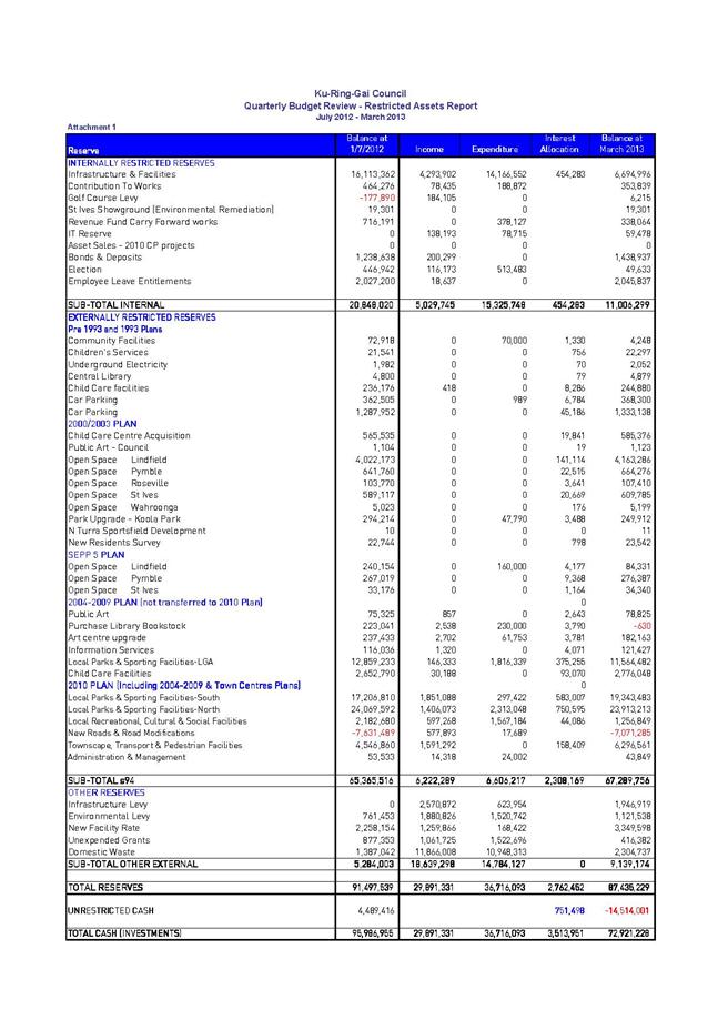
GB.3 2012 to 2013 Budget Review - 3rd Quarter ended March 2013 58
File: FY00467/2
To inform Council of the results of the third quarter budget review for 2012/13 and seek approval to adjust the annual budget based on the actual financial performance and trend for the period 1 July 2012 to 31 March 2013.
Recommendation:
That Council receive and note the March 2013 Quarterly Budget Review; and that the recommended changes to the 2012/13 Budget be adopted.
GB.4 Analysis of Land and Environment Court Costs - 3rd Quarter, 2012 to 2013 79
File: S05273
To report legal costs in relation to development control matters in the Land and Environment Court for the quarter ended 31 March 2013.
Recommendation:
That the analysis of Land and Environment Court costs for the nine months to 31 March 2013 be received and noted.
GB.5 Investment Report as at 30 April 2013 90
File: S05273
To present to Council investments portfolio performance for April 2013.
Recommendation:
That the summary of investments performance for April 2013 be received and noted; and that the Certificate of the Responsible Accounting Officer be noted and report adopted.
GB.6 Mayor and Councillor Fees - Local Government Remuneration Tribunal Report 2013 100
File: S03158/2
To determine the Mayor and Councillor fees payable from 1 July 2013.
Recommendation:
That, from 1 July 2013, the Councillor fee be set at $17,490 and the Mayoral fee be set at $38,160.
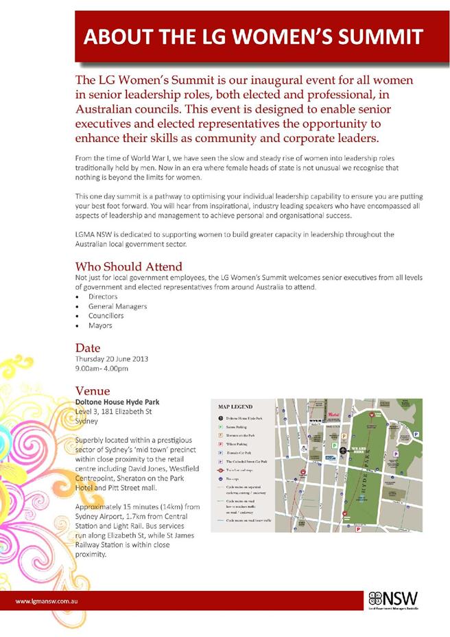
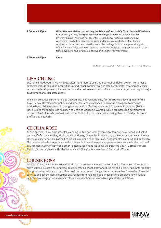
GB.7 Local Government Women’s Summit 114
File: S08561/3
To advise Councillors of the 2013 Local Government Managers Australia (LGMA) NSW Summit for Executive Women in Local Government held at Doltone House Hyde Park, Sydney on 20 June 2013.
Recommendation:
That any Councillors interested in attending the 2013 LGMA Summit for Executive Women in Local Government held at Doltone House Hyde Park, Sydney on 20 June 2013 advise the General Manager by Friday, 31 May 2013.
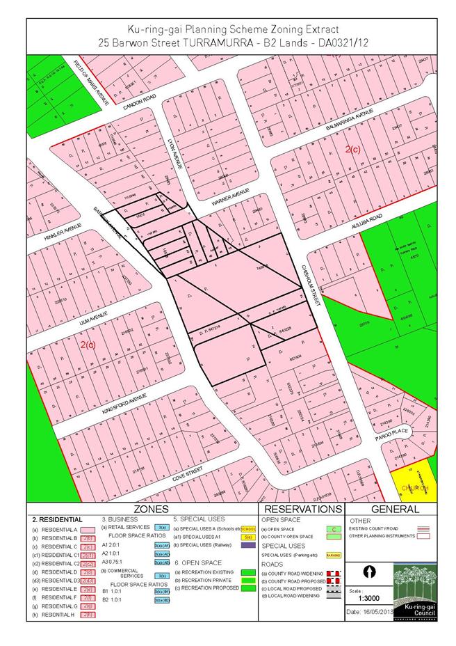
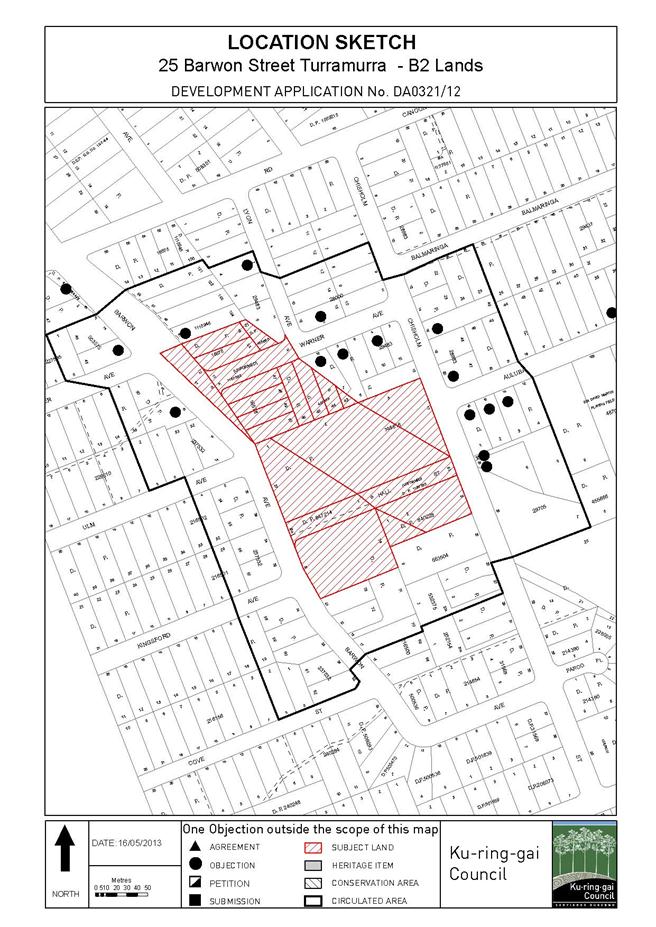
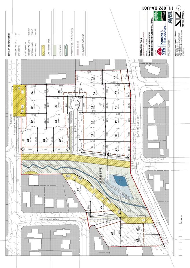
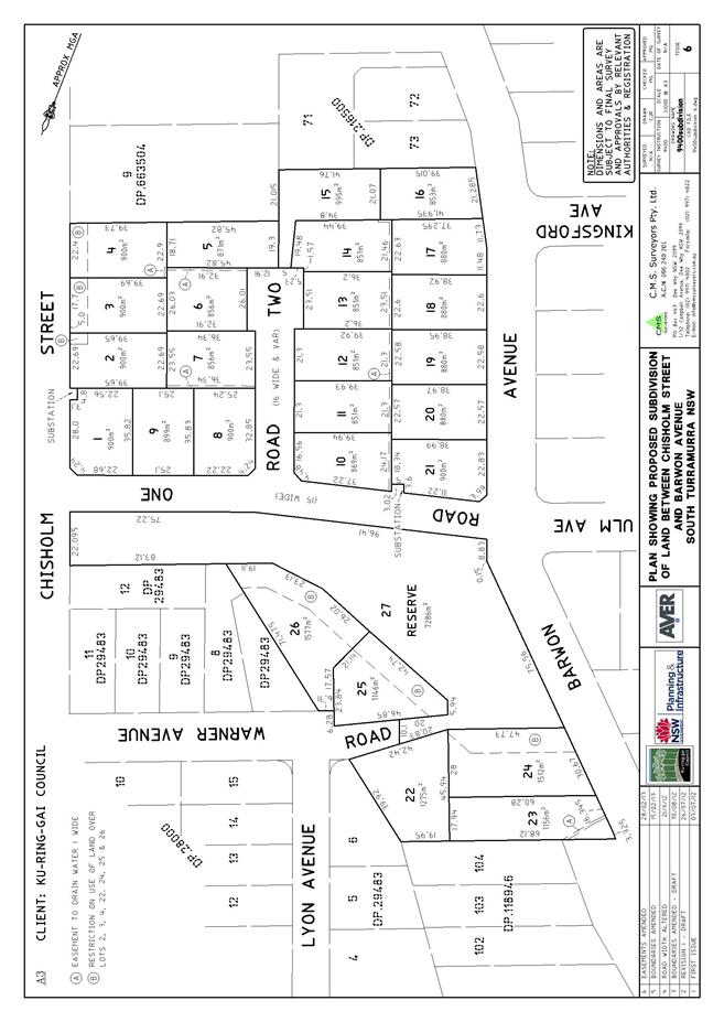
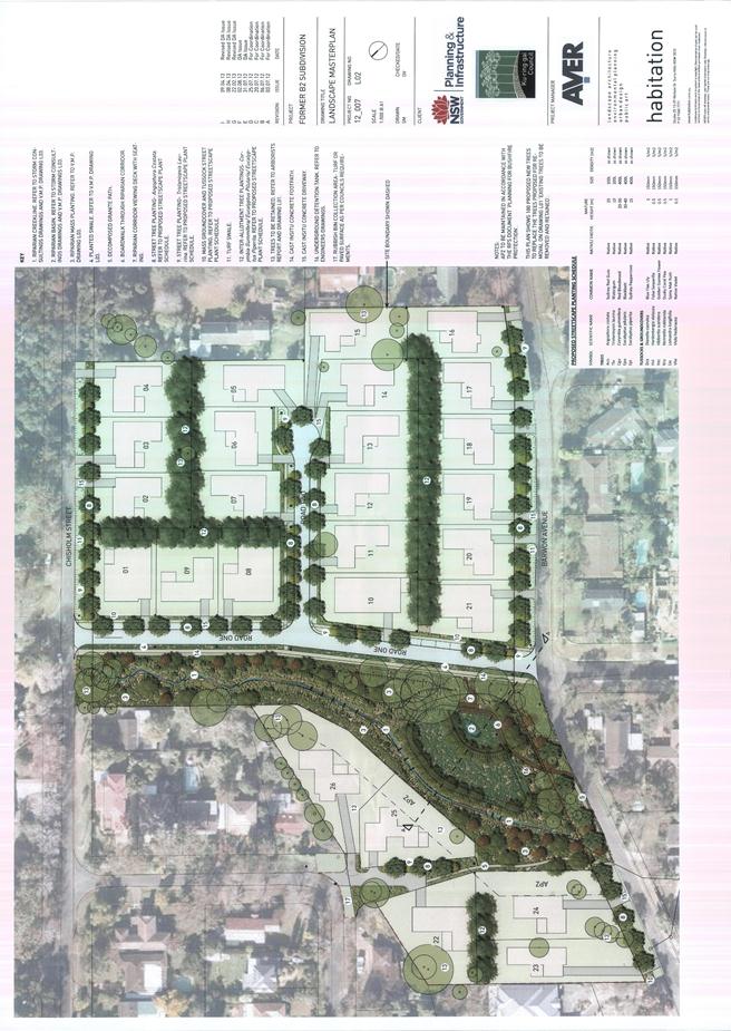
GB.8 Subdivision of 21 lots into 26 lots including roadworks and service infrastructure over former B2 lands at South Turramurra 124
File: DA0321/12
Ward: Comenarra
Applicant: Aver Pty Ltd
Owner: Ku-ring-gai Council and NSW State Government
Subdivision of 21 allotments, into 26 residential allotments and 1 allotment for public open space, reconstruction of a creek and wetland system with ancillary landscaping, construction of three roads and associated infrastructure.
Recommendation:
Approval.
GB.9 Draft Ku-ring-gai Local Centres Development Control Plan - Consideration of Submissions 214
File: CY00054/5
To have Council consider submissions made on the draft Ku-ring-gai Local Centres Development Control Plan.
Recommendation:
That Council adopt the Ku-ring-gai Local Centres Development Control Plan.
GB.10 Lindfield Community Hub and Commuter Carpark - Next Steps 315
File: S09530
To update Council on the progress of the Lindfield Community hub project, Woodford Lane, Lindfield and to recommend the next steps.
Recommendation:
That a project team and project funding be established to oversee and support the preparation of the Lindfield Community Hub master plan.
GB.11 Tender T03/2013 - Construction of New Park - Bruce Avenue, Killara 338
File: S09572
To consider the tenders received for the construction of the new park in Bruce Avenue, Killara.
Recommendation:
That Council accepts the tender from Hargraves Landscapes Pty Ltd for the construction of the new park at Bruce Avenue, Killara.
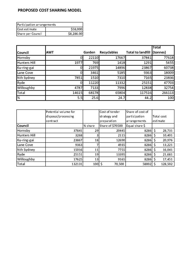
GB.12 Regional Shared Services and Regional Waste Project 344
File: CY00430
To seek Council’s commitment to participate in the regional tender for the procurement of waste disposal and processing services for a contract commencing in 2014.
Recommendation:
That Council endorse participation in preparations to go to tender for procurement of waste disposal/processing services for NSROC Councils for a contract commencing in 2014, noting that a further report on tender criteria will come to Council in July-August 2013 for final agreement as to participation in the tender.
GB.13 Tender T04/2013 - Allan Small Park Sports Field Upgrade 390
File: S08356
To consider the tenders received for the upgrade of Allan Small Park Sports Field with associated landscape works located in Saiala Road Killara and appoint the preferred tenderer.
Recommendation:
That Council accepts the tender from R&N Paddison Pty Ltd for the upgrade of Allan Small Park Sports Field with associated landscape works located in Saiala Road Killara.
Extra Reports Circulated to Meeting
Motions of which due Notice has been given
NM.1 Gordon Community Pre-School - 2A Park Avenue Gordon 397
File: S07252/4
Notice of Rescission from Councillors Citer, Szatow and Armstrong dated 13 May 2013
We are moving a motion to rescind the decision of Council, made on 30 April 2013, to reclassify and/or rezone the land at 2A Park Avenue Gordon from community land to operational land.
We move:
“That the parcel of land, occupied by the Gordon Community Pre-school at 2A Park Avenue, Gordon be removed from the list of proposed reclassified sites, mentioned within Item GB.8 of the Business Paper, from the Ordinary Meeting of Council dated 30 April 2013.”
NM.2 Lifeline Building - 4 Park Avenue Gordon 398
File: S07252/4
Notice of Rescission from Councillors Citer, Szatow and Armstrong dated 13 May 2013
We are moving a motion to rescind the decision of Council, made on 30 April 2013, to reclassify and/or rezone the land at 4 Park Avenue Gordon from community land to operational land.
We move:
“That the parcel of land, occupied by the Lifeline at 4 Park Avenue, Gordon be removed from the list of proposed reclassified sites, mentioned within Item GB.8 of the Business Paper, from the Ordinary Meeting of Council dated 30 April 2013.”
BUSINESS WITHOUT NOTICE – SUBJECT TO CLAUSE 241 OF GENERAL REGULATIONS
Questions Without Notice
Inspections Committee – SETTING OF TIME, DATE AND RENDEZVOUS
Confidential Business to be dealt with in Closed Meeting
C.1 Turramurra - Potential Public Private Partnership 1
File: S08428
In accordance with the Local Government Act 1993 and the Local Government (General) Regulation 2005, in the opinion of the General Manager, the following business is of a kind as referred to in sections 10A(2)(c) & 10A(2)(d)(i), of the Act, and should be dealt with in a part of the meeting closed to the public.
Section 10A(2)(c) of the Act permits the meeting to be closed to the public in respect of information that would, if disclosed, confer a commercial advantage on a person with whom the Council is conducting (or proposes to conduct) business.
The matter is classified confidential because it deals with the proposed acquisition and/or disposal of property.
It is not in the public interest to release this information as it would prejudice Council’s ability to acquire and/or dispose of the property on appropriate terms and conditions.
Section 10A(2)(d) of the Act permits the meeting to be closed to the public for business relating to commercial information of a confidential nature that would, if disclosed:
(i) prejudice the commercial position of the person who supplied it, or
(ii) confer a commercial advantage on a competitor of Council, or
(iii) reveal a trade secret.
This matter is classified confidential under section 10A(2)(d)(i) because it deals with tenders. Tender details, should they be revealed, may result in commercial disadvantage to parties involved in the tender process. Some information provided to Council by tenderers is provided on the basis that Council will treat it as commercial in confidence.
It is not in the public interest to reveal details of these tenders or the assessment process. Tenderers have provided sensitive information about their operations in the confidence that their details will not be made public by Council. The practice of publication of sensitive information provided by tenderers could result in the withholding of such information by tenderers and reduction in the provision of information relevant to Council’s decision.
Report by Director Strategy and Environment dated 3 May 2013
John McKee
General Manager
** ** ** ** ** **
MINUTES OF Ordinary Meeting of Council
HELD ON Tuesday, 14 May 2013
|
Present: |
The Mayor, Councillor E Malicki (Chairperson) (Comenarra Ward) Councillor J Pettett (Comenarra Ward) Councillors D Citer & C Szatow (Gordon Ward) Councillor C Berlioz (St Ives Ward) Councillors J Anderson & D Armstrong (Roseville Ward) Councillor C Fornari-Orsmond (Wahroonga Ward) |
|
|
|
|
Staff Present: |
Director Development & Regulation (Michael Miocic) Director Operations (Greg Piconi) Director Community (Janice Bevan) Acting Director Strategy & Environment (Deborah Silva) Acting Director Corporate (John Giovinazzo) Acting Manager Finance (Angela Apostol) Manager Records & Governance (Matt Ryan) Governance Officer (Christie Spry) |
The Meeting commenced at 7.00pm
The Mayor offered the Prayer
|
113 |
File: S02194
Councillor Duncan McDonald tendered an apology for non-attendance [business commitment] and requested leave of absence.
Councillor David Ossip tendered an apology for non-attendance (family reasons) and requested leave of absence.
NOTE: The General Manager, John McKee and the Director Strategy and Environment, Andrew Watson, tendered apologies for non-attendance.
|
|
|
(Moved: CouncillorS Szatow/Fornari-Orsmond)
That the apologies by Councillors Duncan McDonald and David Ossip be accepted and leave of absence granted.
CARRIED UNANIMOUSLY
|
The Mayor adverted to the necessity for Councillors and staff to declare a Pecuniary Interest/Conflict of Interest in any item on the Business Paper.
Councillor David Citer declared a pecuniary conflict of interest in GB.1 - The Novus Foundation 2013 Gala Dinner (advised that he is the Manager of KYDS which is one of the beneficiaries of the Novus Dinner) and he will leave the Chamber during the debate and voting on the item.
Councillor Cheryl Szatow declared a pecuniary conflict of interest in GB.1 - The Novus Foundation 2013 Gala Dinner - (advised that she is a Councillor representative on the Board of KYDS which is a beneficiary of the Novus Dinner) and she will leave the Chamber during the debate and voting on the item.
The following members of the public addressed Council on items not on the Agenda:
R Younan
F Stuart
I Mahon
DOCUMENTS CIRCULATED TO COUNCILLORS
The Mayor adverted to the documents circulated in the Councillors’ papers and advised that the following matters would be dealt with at the appropriate time during the meeting:
|
Late Items: |
Refer Minute No 102 of Ordinary Meeting of Council held
|
|
Councillors Information: |
Annual Report from NSW Government Planning and Infrastructure - Local Development Performance Monitoring 2011 - 2012 - Memorandum from Director Development and Regulation dated 7 May 2013 in answer to a Question Without Notice raised by Councillor Chantelle Fornari-Orsmond at the Ordinary Meeting of Council held on 9 April 2013. |
A Motion moved by
Councillors Armstrong and Berlioz
that a site inspection take place in relation to
GB.2 - 15 Normac Street, Roseville Chase
For the Motion: Councillors Szatow, Armstrong and Berlioz
Against the Motion: The Mayor, Councillor E Malicki, Councillors Citer, Pettett, Fornari-Orsmond and Anderson
No decision was taken in respect of the above matter as
the Motion when put to the vote was LOST
|
116 |
Draft Community Strategic Plan 'Our Community - Our Future' 2030
File: FY00382/5 Vide: GB.3
|
|
|
To place Council's Community Strategic Plan ‘Our Community – Our Future’ 2030 on public exhibition.
|
|
|
(Moved: Councillors Berlioz/Szatow)
A. That the report on the draft Community Strategic Plan ‘Our Community - Our Future’ 2030, be received and noted.
B. That pursuant to Section 402 of the Local Government Act, 1993, the draft Community Strategic Plan ‘Our Community - Our Future’ 2030, be endorsed and placed on public exhibition for a period of 28 days commencing Friday, 17 May 2013.
C. That the draft Community Strategic Plan ‘Our Community - Our Future’ 2030, be endorsed and sent to relevant NSW State Government agencies as part of the public exhibition process.
D. That following public exhibition, a further report be submitted to Council for the adoption of the Community Strategic Plan ‘Our Community - Our Future’ 2030.
CARRIED UNANIMOUSLY
|
|
117 |
File: FY00382/5 Vide: GB.4
|
|
|
To place Council's Resourcing Strategy incorporating the Long Term Financial Plan, Asset Management Strategy and Workforce Strategy on public exhibition.
|
|
|
(Moved: Councillors Berlioz/Pettett)
A. That the report on Council’s Resourcing Strategy 2013 – 2017, incorporating the Long Term Financial Plan, Asset Management Strategy and Workforce Strategy be received and noted.
B. That the principles and framework of the 10 Year LTFP as outlined in the Resourcing Strategy be adopted, provided that capital works related to the 2010 Contributions Plan are phased in accordance with the availability of revenue from sales of Council assets which fund these works as outlined in the report.
C. That Council’s 2013/2014 budget includes the following:
i) Reductions in debt servicing costs are restricted to the Infrastructure and Facilities Reserve and fully expended on Capital Works. This amounts to $335K. ii) An amount of $308K transferred to the Infrastructure and Facilities Reserve, based on a Council policy to transfer funds to a former Building Reserve. iii) An amount of $410K transferred to the Infrastructure and Facilities Reserve for Development Application Infrastructure Restoration Fees received. iv) An amount of $323K transferred to the Infrastructure and Facilities Reserve for Street Advertising (bus shelters) receipts. v) An amount of $2.5M transferred to the Infrastructure and Facilities Reserve for 15% of depreciation charge. vi) Interest earned on the average balance of the Infrastructure and Facilities Reserve be credited to that reserve. vii) All asset sale revenue (except for 2010 Contribution Plan Asset Sales) is transferred to the Infrastructure and Facilities Reserve.
D. That Council endorse a total level of borrowing as outlined in this report as a maximum level.
E. That actual levels of borrowings will be determined in accordance with a dynamic Capital Management Strategy, as outlined in this report and in Council’s Resourcing Strategy that continuously re-assesses requirements.
F. That, in accordance with the capital management strategy, particular emphasis will be given to monitoring and estimating the working capital component so that any shortfall is made up by further borrowings (within the maximum permissible level) and any excess is transferred firstly to internal liability reserves where prudentially required, and then allocated to Council’s Infrastructure and Facilities Reserve.
G. That any estimated funds that remain, after all other resolutions of Council are incorporated into the LTFP, and would otherwise be credited to the Infrastructure and Facilities reserve, be expended on additional asset renewal strategy programs in order to address the gap between the required level of funding and that otherwise available. As the Asset Management Strategy is more fully developed, specific projects be identified that expends these funds in the most effective manner to address the asset renewal gap.
H. That following public exhibition, a further report be submitted to Council for the adoption of the Resourcing Strategy 2013 – 2017, incorporating the Long Term Financial Plan, the Asset Management Strategy and the Workforce Strategy.
CARRIED UNANIMOUSLY
|
|
118 |
Report following
Exhibition of Catchment Mapping Amendments to
File: S05878 Vide: GB.6
|
|
|
To report back following the exhibition of mapping amendments to the Ku-ring-gai Contributions Plan 2010 to ensure the catchment mapping boundaries accurately reflect all current environmental planning instruments.
|
|
|
(Moved: Councillors Berlioz/Pettett)
A. That
the amended maps be adopted and incorporated within the existing
B. That any development application, the subject of a development consent issued after the gazettal of Ku-ring-gai Local Environmental Plan (Local Centres) 2012 on 25 January 2013 and prior to the consequential mapping corrections in this resolution coming into effect, that has been levied contributions on the basis of a former zone that was not in effect at the time of consent, be invited to lodge a s96 request for modification to correct the anomaly.
CARRIED UNANIMOUSLY
|
Councillor Citer declared a pecuniary conflict of interest
in respect of the following item -
GB.1 - The Novus Foundation 2013 Gala Dinner
and withdrew from the Chamber taking no part
in discussion and voting on the item
Councillor Szatow declared a pecuniary conflict of interest
in respect of the following item -
GB.1 - The Novus Foundation 2013 Gala Dinner
and withdrew from the Chamber taking no part
in discussion and voting on the item
|
119 |
The Novus Foundation 2013 Gala Dinner
File: S05650 Vide: GB.1
|
|
|
To advise Council of a request from The Novus Foundation to purchase tickets for a Gala Dinner to be held at Miramare Gardens Function Centre, Terrey Hills on Saturday, 25 May 2013.
|
|
|
(Moved: Councillors Berlioz/Anderson)
A. That Council determined to purchase tickets for The Novus Foundation Gala Dinner on 25 May 2013.
B. That any Councillors who would like to attend The Novus Foundation 2013 Gala Dinner advise the General Manager by Friday, 17 May 2013.
CARRIED UNANIMOUSLY by those present
|
Councillor Citer returned
Councillor Szatow returned
|
120 |
15 Normac Street, Roseville Chase
File: DA0259/12 Vide: GB.2
|
||||||||||||||||||||||||||||||||||||||||||||||||||||||||||||||||||||||||||||||||||||||||||
|
|
The following member of the public addressed Council:
L Fletcher
|
||||||||||||||||||||||||||||||||||||||||||||||||||||||||||||||||||||||||||||||||||||||||||
|
|
To determine Development Application No. DA0259/12 for Demolition of an Existing Dwelling and Construction of a New Dwelling.
|
||||||||||||||||||||||||||||||||||||||||||||||||||||||||||||||||||||||||||||||||||||||||||
|
|
(Moved: Councillors Anderson/Fornari-Orsmond)
PURSUANT TO SECTION 80(1) OF THE ENVIRONMENTAL PLANNING AND ASSESSMENT ACT, 1979
A. THAT Council, as the consent authority, is of the opinion that the proposal includes works of a permanent character on land reserved for the purpose of County Open Space and in accordance with Clause 10(2) of the KPSO, the Council, as the responsible authority is of the opinion that the purpose for which the land is reserved cannot be carried into effect within a reasonable time after the appointed day, 1 October 1971.
AND
B. THAT Council, as the consent authority, is of the opinion that the objection under State Environmental Planning Policy No. 1 – Development Standards to clause 46(2) – maximum height of the Ku-ring-gai Planning Scheme Ordinance is well founded. The Council is also of the opinion that strict compliance with the development standard is unreasonable and unnecessary in the circumstances of this case as the objectives of the standard are achieved not withstanding the failure to achieve compliance with the development standard.
AND
C. THAT Council, as the consent authority, being satisfied that the objection under SEPP No. 1 is well founded and also being of the opinion that the granting of consent to DA0259/12 is consistent with the aims of the Policy, grant development consent to DA0259/12 for ‘demolition of existing dwelling and construction of new dwelling house including swimming pool and landscape works’ on land at 15 Normac Street Roseville Chase, for a period of two (2) years from the date of the Notice of Determination, subject to the following conditions:
Conditions that identify approved plans:
1. Approved architectural plans and documentation (new development)
The development must be carried out in accordance with the following plans and documentation listed below and endorsed with Council’s stamp, except where amended by other conditions of this consent:
Reason: To ensure that the development is in accordance with the determination.
2. Inconsistency between documents
In the event of any inconsistency between conditions of this consent and the drawings/documents referred to above, the conditions of this consent prevail.
Reason: To ensure that the development is in accordance with the determination.
3. Approved landscape plans
Landscape works shall be carried out in accordance with the following landscape plan(s), listed below and endorsed with Council’s stamp, except where amended by other conditions of this consent:
Reason: To ensure that the development is in accordance with the determination.
Conditions to be satisfied prior to demolition, excavation or construction:
4. Road opening permit
The opening of any footway, roadway, road shoulder or any part of the road reserve shall not be carried out without a road opening permit being obtained from Council (upon payment of the required fee) beforehand.
Reason: Statutory requirement (Roads Act 1993 Section 138) and to maintain the integrity of Council’s infrastructure.
5. Notice of commencement
At least 48 hours prior to the commencement of any development (including demolition, excavation, shoring or underpinning works), a notice of commencement of building or subdivision work form and appointment of the principal certifying authority form shall be submitted to Council.
Reason: Statutory requirement.
6. Notification of builder’s details
Prior to the commencement of any development or excavation works, the Principal Certifying Authority shall be notified in writing of the name and contractor licence number of the owner/builder intending to carry out the approved works.
Reason: Statutory requirement.
7. Dilapidation photos (public infrastructure)
Prior to the commencement of
any works on site the applicant must submit to · The existing footpath · The existing kerb and gutter · The existing full road surface between kerbs · The existing verge area · The existing driveway and layback where to be retained · Any existing drainage infrastructure including pits, lintels, grates. Particular attention must be paid to accurately recording any pre-developed damaged areas on the aforementioned infrastructure so that Council is fully informed when assessing damage to public infrastructure caused as a result of the development (which is not to be repaired by the Applicant as part of the development). The developer may be held liable to all damage to public infrastructure in the vicinity of the site, where such damage is not accurately recorded and demonstrated under the requirements of this condition prior to the commencement of any works.
Reason: To protect public infrastructure.
8. Access through public reserve not permitted
Access for construction purposes shall not be gained through the adjoining public reserve. Should no alternative access exist, an application for access to the construction site via the public reserve shall be submitted to Council for consideration and approval prior to the commencement of works.
Reason: To protect public reserves.
9. Construction and traffic management plan
The applicant must submit to Council a Construction Traffic Management Plan (CTMP), which is to be approved prior to the commencement of any works on site.
The plan is to consist of a report with Traffic Control Plans attached.
The report is to contain commitments which must be followed by the demolition and excavation contractor, builder, owner and subcontractors. The CTMP applies to all persons associated with demolition, excavation and construction of the development.
The report is to contain construction vehicle routes for approach and departure to and from all directions.
The report is to contain a site plan showing entry and exit points. Swept paths are to be shown on the site plan showing access and egress for an 11 metre long heavy rigid vehicle.
The Traffic Control Plans are to be prepared by a qualified person (red card holder). One must be provided for each of the following stages of the works:
o Demolition o Excavation o Concrete pour o Construction of vehicular crossing and reinstatement of footpath o Traffic control for vehicles reversing into or out of the site.
Traffic controllers must be in place at the site entry and exit points to control heavy vehicle movements in order to maintain the safety of pedestrians and other road users.
When a satisfactory CTMP is received, a letter of approval will be issued with conditions attached. Traffic management at the site must comply with the approved CTMP as well as any conditions in the letter issued by Council. Council’s Rangers will be patrolling the site regularly and fines may be issued for any non-compliance with this condition.
Reason: To ensure that appropriate measures have been considered during all phases of the construction process in a manner that maintains the environmental amenity and ensures the ongoing safety and protection of people.
10. Erosion and drainage management
Earthworks and/or demolition of any existing buildings shall not commence until an erosion and sediment control plan is submitted to and approved by the Principal Certifying Authority. The plan shall comply with the guidelines set out in the NSW Department of Housing manual "Managing Urban Stormwater: Soils and Construction" certificate. Erosion and sediment control works shall be implemented in accordance with the erosion and sediment control plan.
Reason: To preserve and enhance the natural environment.
11. Bushland protection fencing
To preserve the adjoining bushland reserve, no work shall commence until the following area is fenced off to prevent any activities, storage or the disposal of materials within the fenced area. The fence/s shall be maintained intact until the completion of all demolition/building work on site.
Reason: To preserve the natural environment during the construction phase.
12. Bushland protective fencing type galvanised mesh
The tree protection fencing shall be constructed of galvanised pipe at 2.4 metre spacing and connected by securely attached chain mesh fencing to a minimum height of 1.8 metres in height prior to work commencing.
Reason: To protect existing trees during construction phase.
13. Fencing inspection
Upon installation of the required tree protection measures, an inspection of the site by the Principal Certifying Authority is required to verify that tree protection measures comply with all relevant conditions.
Reason: To protect existing trees during the construction phase.
14. Boundary fence adjoining a reserve
A permanent, 1.5 metres high, cyclone wire (or similar) boundary fence, shall be constructed along the common boundary (from RL8.00 contour to RL10.00 contour) with the adjoining reserve to the north-west of the site prior to any work commencing.
Reason: To protect the adjoining reserve.
Conditions to be satisfied prior to the issue of the construction certificate:
15. Approval for wastewater management system
Prior to the issue of the Construction Certificate, the Principal Certifying Authority is to be satisfied that the applicant has obtained a Section 68 approval from Ku-ring-gai Council to operate the pump-out sewage system.
Reason: To maintain health and amenity
16. Deed of release
The landowner enter into a deed of release with the acquisition authority prohibiting the landowner and their successors in title from claiming compensation for the works associated with this development consent prior to the issue of a construction certificate to the extent that the works increase the value of the land and its improvements over and above its present value.
Reason: Department of Planning requirement.
17. Amendments to approved landscape plan
Prior to the issue of a Construction Certificate, the Principal Certifying Authority shall be satisfied that the approved landscape plans, listed below and endorsed with Council’s stamp, have been amended in accordance with the requirements of this condition as well as other conditions of this consent:
The above landscape plan(s) shall be amended in the following ways:
· The existing hedge of Cupressocyparis x leylandii (Leyland Cypress) planted within the garden area on the southern side of the new dwelling shall be removed as they will impede the new landscaping proposal.
Prior to the issue of the Construction Certificate, the Principal Certifying Authority shall be satisfied that the landscape plan has been amended are required by this condition.
Note: An amended plan, prepared by a landscape architect or qualified landscape designer shall be submitted to the Certifying Authority.
Reason: To ensure adequate landscaping of the site
18. Long service levy
In accordance with Section 109F(i) of the Environmental Planning and Assessment Act a Construction Certificate shall not be issued until any long service levy payable under Section 34 of the Building and Construction Industry Long Service Payments Act 1986 (or where such levy is payable by instalments, the first instalment of the levy) has been paid. Council is authorised to accept payment. Where payment has been made elsewhere, proof of payment is to be provided to Council.
Reason: Statutory requirement.
19. Builder’s indemnity insurance
The applicant, builder, developer or person who does the work on this development, must arrange builder’s indemnity insurance and submit the certificate of insurance in accordance with the requirements of Part 6 of the Home Building Act 1989 to the Certifying Authority for endorsement of the plans accompanying the Construction Certificate.
It is the responsibility of the applicant, builder or developer to arrange the builder's indemnity insurance for residential building work over the value of $20,000. The builder's indemnity insurance does not apply to commercial or industrial building work or to residential work valued at less than $20,000, nor to work undertaken by persons holding an owner/builder's permit issued by the Department of Fair Trading (unless the owner/builder's property is sold within 7 years of the commencement of the work).
Reason: Statutory requirement.
20. Landscape plan
Prior to the issue of the Construction Certificate, the Principal Certifying Authority shall be satisfied that a landscape plan has been completed in accordance with Council’s DA Guide, relevant development control plans and the conditions of consent by a Landscape Architect or qualified Landscape Designer.
Note: The Landscape Plan must be submitted to the Principal Certifying Authority.
Reason: To ensure adequate landscaping of the site.
21. Utility provider requirements
Prior to issue of the Construction Certificate, the applicant must make contact with all relevant utility providers whose services will be impacted upon by the development. A written copy of the requirements of each provider, as determined necessary by the Certifying Authority, must be obtained. All utility services or appropriate conduits for the same must be provided by the developer in accordance with the specifications of the utility providers.
Reason: To ensure compliance with the requirements of relevant utility providers.
Conditions to be satisfied prior to the issue of the construction certificate or prior to demolition, excavation or construction (whichever comes first):
22. Infrastructure restorations fee
To ensure that damage to Council Property as a result of construction activity is rectified in a timely matter:
a) All work or activity taken in furtherance of the development the subject of this approval must be undertaken in a manner to avoid damage to Council Property and must not jeopardise the safety of any person using or occupying the adjacent public areas.
b) The applicant, builder, developer or any person acting in reliance on this approval shall be responsible for making good any damage to Council Property, and for the removal from Council Property of any waste bin, building materials, sediment, silt, or any other material or article.
c) The Infrastructure Restoration Fee must be paid to the Council by the applicant prior to both the issue of the Construction Certificate and the commencement of any earthworks or construction.
d) In consideration of payment of the Infrastructure Restorations Fee, Council will undertake such inspections of Council Property as Council considers necessary and also undertake, on behalf of the applicant, such restoration work to Council Property, if any, that Council considers necessary as a consequence of the development. The provision of such restoration work by the Council does not absolve any person of the responsibilities contained in (a) to (b) above. Restoration work to be undertaken by the Council referred to in this condition is limited to work that can be undertaken by Council at a cost of not more than the Infrastructure Restorations Fee payable pursuant to this condition.
e) In this condition:
“Council Property” includes any road, footway, footpath paving, kerbing, guttering, crossings, street furniture, seats, letter bins, trees, shrubs, lawns, mounds, bushland, and similar structures or features on any road or public road within the meaning of the Local Government Act 1993 (NSW) or any public place; and
“Infrastructure Restoration Fee” means the Infrastructure Restorations Fee calculated in accordance with the Schedule of Fees & Charges adopted by Council as at the date of payment and the cost of any inspections required by the Council of Council Property associated with this condition.
Reason: To maintain public infrastructure.
23. Rural Fire Service requirements
Water and utilities The intent of measures is to provide adequate services of water for the protection of buildings during and after the passage of a bush fire, and to locate gas and electricity so as not to contribute to the risk of fire to a building. To achieve this, the following conditions shall apply:
1. Water, electricity and gas are to comply with the following requirements of section 4.1.3 of 'Planning for Bush Fire Protection 2006'.
Design and construction The intent of measures is that buildings are designed and constructed to withstand the potential impacts of bush fire attack. To achieve this, the following conditions shall apply:
2. New construction on the northwest elevation(s) shall comply with section 9 (BAL FZ) Australian Standard AS3959-2009 'Construction of buildings in bush fire-prone areas'. However, where any material, element of construction or system when tested to the method described in Australian Standard AS1530.8.2 ‘Methods for fire tests on building materials, components and structures’ Part 8.2: ‘Tests on elements of construction for buildings exposed to simulated bushfire attack—Large flaming sources’, it shall comply with Clause 13.8 of the Standard except that flaming of the specimen is not permitted and there shall be no exposed timber.
3. Window assemblies on the northwest elevation(s) shall comply with one of the following:
a) Clause 9.5.2 of AS 3959-2009 as modified above; or
b) They shall comply with the following:
(i) Completely protected by a non-combustible and non perforated shutter that complies with Section 3.7 of AS3959-2009 excluding parts (e) & (f). (ii) Window frames and hardware shall be metal. (iii) Glazing shall be toughened glass minimum 6mm. (iv) Seals to stiles, head and sills or thresholds shall be manufactured from materials having a flammability index no greater than 5 or from silicone. (v) The openable portion of the window shall be screened internally or externally with screens that comply with Clause 9.5.1A.
4. External Doors and door frames (not including garage doors) on the northwest elevation(s) shall comply with one of the following:
a) Clause 9.5.3 or 9.5.4 of AS 3959-2009 as modified above; or
b) They shall comply with the following:
(i) Completely protected by a non-combustible and non perforated shutter that complies with Section 3.7 of AS3959-2009 excluding parts (e) & (f). (ii) Doors shall be non-combustible. (iii) Externally fitted hardware that supports the panel in its function of opening and closing shall be metal. (iv) Where doors incorporate glazing, the glazing shall be toughened glass minimum 6mm. (v) Seals to stiles, head and sills or thresholds shall be manufactured from materials having a flammability index no greater than 5 or from silicone. (vi) Door frames shall be metal. (vii) Doors shall be tight fitting to the doorframe and to an abutting door if applicable. (viii) Weather strips, draught excluders or draught seals shall be installed at the base of side-hung external doors.
5. New construction on the northeast, southeast and southwest elevation(s) shall comply with section 8 (BAL 40) Australian Standard AS3959-2009 'Construction of buildings in bush fire-prone areas'.
General advice Roofing shall be gutterless or guttering and valleys are to be screened to prevent the build up of flammable material. Any materials used shall be non-combustible.
Reason: Conditions imposed by the Rural Fire Service under Section 79BA of the Environmental Planning and Assessment Act 1979.
24. Bush fire risk assessment and conditions
Bush fire protection measures shall be carried out in accordance with the following bush fire risk assessment listed below and endorsed with Council’s stamp and all bush fire conditions:
Prior to the issue of the construction certificate, the principal certifying authority must be satisfied that the construction certificate is in accordance with the recommendations of the report listed above and all bush fire conditions.
Reason: To ensure that the development is in accordance with the determination.
25. Conditions to be satisfied during the demolition, excavation and construction phases:
Prescribed conditions
The applicant shall comply with any relevant prescribed conditions of development consent under clause 98 of the Environmental Planning and Assessment Regulation. For the purposes of section 80A (11) of the Environmental Planning and Assessment Act, the following conditions are prescribed in relation to a development consent for development that involves any building work:
· The work must be carried out in accordance with the requirements of the Building Code of Australia · In the case of residential building work for which the Home Building Act 1989 requires there to be a contract of insurance in force in accordance with Part 6 of that Act, that such a contract of insurance is in force before any works commence.
Reason: Statutory requirement.
26. Hours of work
Demolition, excavation, construction work and deliveries of building material and equipment must not take place outside the hours of 7.00am to 5.00pm Monday to Friday and 8.00am to 12 noon Saturday. No work and no deliveries are to take place on Sundays and public holidays.
Excavation or removal of any materials using machinery of any kind, including compressors and jack hammers, must be limited to between 7.30am and 5.00pm Monday to Friday, with a respite break of 45 minutes between 12 noon 1.00pm.
Where it is necessary for works to occur outside of these hours (ie) placement of concrete for large floor areas on large residential/commercial developments or where building processes require the use of oversized trucks and/or cranes that are restricted by the RTA from travelling during daylight hours to deliver, erect or remove machinery, tower cranes, pre-cast panels, beams, tanks or service equipment to or from the site, approval for such activities will be subject to the issue of an "outside of hours works permit" from Council as well as notification of the surrounding properties likely to be affected by the proposed works.
Note: Failure to obtain a permit to work outside of the approved hours will result in on the spot fines being issued.
Reason: To ensure reasonable standards of amenity for occupants of neighbouring properties.
27. Availability of car parking
During construction of the development a minimum of 20 on site car parking spaces are to be available for the exclusive use of marina patrons. Vehicles associated with the construction of the development are not to be parked in the 20 on site spaces that are to be made available for the exclusive use of marina patrons.
Reason: To ensure that construction of the development does not have an adverse impact on the local road network.
28. Approved plans to be on site
A copy of all approved and certified plans, specifications and documents incorporating conditions of consent and certification (including the Construction Certificate if required for the work) shall be kept on site at all times during the demolition, excavation and construction phases and must be readily available to any officer of Council or the Principal Certifying Authority.
Reason: To ensure that the development is in accordance with the determination.
29. Site notice
A site notice shall be erected on the site prior to any work commencing and shall be displayed throughout the works period.
The site notice must:
· be prominently displayed at the boundaries of the site for the purposes of informing the public that unauthorised entry to the site is not permitted · display project details including, but not limited to the details of the builder, Principal Certifying Authority and structural engineer · be durable and weatherproof · display the approved hours of work, the name of the site/project manager, the responsible managing company (if any), its address and 24 hour contact phone number for any inquiries, including construction/noise complaint are to be displayed on the site notice · be mounted at eye level on the perimeter hoardings/fencing and is to state that unauthorised entry to the site is not permitted
Reason: To ensure public safety and public information.
30. Dust control
During excavation, demolition and construction, adequate measures shall be taken to prevent dust from affecting the amenity of the neighbourhood. The following measures must be adopted:
· physical barriers shall be erected at right angles to the prevailing wind direction or shall be placed around or over dust sources to prevent wind or activity from generating dust · earthworks and scheduling activities shall be managed to coincide with the next stage of development to minimise the amount of time the site is left cut or exposed · all materials shall be stored or stockpiled at the best locations · the ground surface should be dampened slightly to prevent dust from becoming airborne but should not be wet to the extent that run-off occurs · all vehicles carrying spoil or rubble to or from the site shall at all times be covered to prevent the escape of dust · all equipment wheels shall be washed before exiting the site using manual or automated sprayers and drive-through washing bays · gates shall be closed between vehicle movements and shall be fitted with shade cloth · cleaning of footpaths and roadways shall be carried out daily
Reason: To protect the environment and amenity of surrounding properties.
31. Further geotechnical input
The geotechnical and hydro-geological works implementation, inspection, testing and monitoring program for the excavation and construction works must be in accordance with the report by Douglas Partners dated 6 June 2012. Over the course of the works, a qualified geotechnical engineer/ engineering geologist must complete the following:
· further geotechnical investigations and testing recommended in the above report(s) and as determined necessary · further monitoring and inspection at the hold points recommended in the above report(s) and as determined necessary · written report(s) including certification(s) of the geotechnical inspection, testing and monitoring programs
Reason: To ensure the safety and protection of property.
32. Compliance with submitted geotechnical report
A contractor with specialist excavation experience must undertake the excavations for the development and a suitably qualified and consulting geotechnical engineer must oversee excavation.
Geotechnical aspects of the development work, namely:
· appropriate excavation method and vibration control · support and retention of excavated faces · hydro-geological considerations
must be undertaken in accordance with the recommendations of the geotechnical report prepared by Douglas Partners dated 6 June 2012. Approval must be obtained from all affected property owners, including Ku-ring-gai Council, where rock anchors (both temporary and permanent) are proposed below adjoining property(ies).
Reason: To ensure the safety and protection of property.
33. Toilet facilities
During excavation, demolition and construction phases, toilet facilities are to be provided, on the work site, at the rate of one toilet for every 20 persons or part of 20 persons employed at the site.
Reason: Statutory requirement.
34. Recycling of building material (general)
During demolition and construction, the Principal Certifying Authority shall be satisfied that building materials suitable for recycling have been forwarded to an appropriate registered business dealing in recycling of materials. Materials to be recycled must be kept in good order.
Reason: To facilitate recycling of materials.
35. Road reserve safety
All public footways and roadways fronting and adjacent to the site must be maintained in a safe condition at all times during the course of the development works. Construction materials must not be stored in the road reserve. A safe pedestrian circulation route and a pavement/route free of trip hazards must be maintained at all times on or adjacent to any public access ways fronting the construction site. Where public infrastructure is damaged, repair works must be carried out when and as directed by Council officers. Where pedestrian circulation is diverted on to the roadway or verge areas, clear directional signage and protective barricades must be installed in accordance with AS1742-3 (1996) “Traffic Control Devices for Work on Roads”. If pedestrian circulation is not satisfactorily maintained across the site frontage, and action is not taken promptly to rectify the defects, Council may undertake proceedings to stop work.
Reason: To ensure safe public footways and roadways during construction.
36. Services
Where required, the adjustment or inclusion of any new utility service facilities must be carried out by the applicant and in accordance with the requirements of the relevant utility authority. These works shall be at no cost to Council. It is the applicants’ full responsibility to make contact with the relevant utility authorities to ascertain the impacts of the proposal upon utility services (including water, phone, gas and the like). Council accepts no responsibility for any matter arising from its approval to this application involving any influence upon utility services provided by another authority.
Reason: Provision of utility services.
37. Treatment of tree roots
If tree roots are required to be severed for the purposes of constructing the approved works, they shall be cut cleanly by hand, by an experienced Arborist/Horticulturist with a minimum qualification of Horticulture Certificate or Tree Surgery Certificate. All pruning works shall be undertaken as specified in Australian Standard 4373-2007 – Pruning of Amenity Trees.
Reason: To protect existing trees.
38. Approved tree works
Approval is given for the following works to be undertaken to trees on the site:
Removal or pruning of any other tree on the site is not approved, excluding species exempt under Council’s Tree Preservation Order.
Reason: To ensure that the development is in accordance with the determination.
39. No storage of materials beneath trees
No activities, storage or disposal of materials shall take place beneath the canopy of any tree protected under Council's Tree Preservation Order at any time.
Reason: To protect existing trees.
40. Removal of refuse
All builders' refuse, spoil and/or material unsuitable for use in landscape areas shall be removed from the site on completion of the building works.
Reason: To protect the environment.
41. Canopy replenishment trees to be planted
The canopy replenishment trees to be planted shall be maintained in a healthy and vigorous condition until they attain a height of 5.0 metres whereby they will be protected by Council’s Tree Preservation Order. Any of the trees found faulty, damaged, dying or dead shall be replaced with the same species.
Reason: To maintain the treed character of the area.
42. On site retention of waste dockets
All demolition, excavation and construction waste dockets are to be retained on site, or at suitable location, in order to confirm which facility received materials generated from the site for recycling or disposal.
· Each docket is to be an official receipt from a facility authorised to accept the material type, for disposal or processing. · This information is to be made available at the request of an Authorised Officer of Council.
Reason: To protect the environment.
Conditions to be satisfied prior to the issue of an Occupation Certificate:
43. Sydney Water approval
Prior to the issue of the Occupation Certificate, the Principal Certifying Authority is to be satisfied that Sydney Water has given approval to the disposal of sewerage and pool backwash to the main in accordance with the Section 68 approval issued by Ku-ring-gai Council.
Reason: To maintain health and amenity.
44. Consolidation of allotments
Prior to the issue of any Occupation Certificate, the Principal Certifying Authority is to be satisfied that the three allotments which form the property known as 15 Normac Street Roseville Chase (Lot 91 DP 13450, Lot 92 DP 13450 and Lot 93 DP 13450) have been consolidated into one allotment and that the plan of consolidation has been registered with the Department of Lands:
Reason: To ensure that the development of the site is undertaken in an orderly manner and that the configuration of the site reflects its current use.
45. Compliance with BASIX Certificate
Prior to the issue of an Occupation Certificate, the Principal Certifying Authority shall be satisfied that all commitments listed in BASIX Certificate No. 427299S_02 have been complied with.
Reason: Statutory requirement.
46. Completion of landscape works
Prior to the release of the Occupation Certificate, the Principal Certifying Authority is to be satisfied that all landscape works, including the removal of all noxious and/or environmental weed species, have been undertaken in accordance with the approved plan(s) and conditions of consent.
Reason: To ensure that the landscape works are consistent with the development consent.
47. Retention and re-use positive covenant
Prior to issue of the Occupation Certificate, the applicant must create a positive covenant and restriction on the use of land under Section 88E of the Conveyancing Act 1919, burdening the property with the requirement to maintain the site stormwater retention and re-use facilities on the property.
The terms of the instruments are to be generally in accordance with the Council's "draft terms of Section 88B instruments for protection of retention and re-use facilities" and to the satisfaction of Council (refer to appendices of Ku-ring-gai Water Management Development Control Plan No. 47). For existing titles, the positive covenant and the restriction on the use of land is to be created through an application to the Land Titles Office in the form of a request using forms 13PC and 13RPA. The relative location of the reuse and retention facility, in relation to the building footprint, must be shown on a scale sketch, attached as an annexure to the request forms.
Registered title documents showing the covenants and restrictions must be submitted to and approved by the Principal Certifying Authority prior to issue of an Occupation Certificate.
Reason: To protect the environment.
48. Provision of copy of OSD designs if Council is not the PCA
Prior to issue of the Occupation Certificate, the following must be provided to Council’s Development Engineer:
· a copy of the approved Construction Certificate stormwater detention/retention design for the site · A copy of any works-as-executed drawings required by this consent · The Engineer’s certification of the as-built system.
Reason: For Council to maintain its database of as-constructed on-site stormwater detention systems.
49. Certification of drainage works (new single dwellings)
Prior to issue of the Occupation Certificate, the Principal Certifying Authority is to be satisfied that:
· the stormwater drainage works have been satisfactorily completed in accordance with the approved Construction Certificate drainage plans · the minimum retention and on-site detention volume storage requirements of BASIX and Ku-ring-gai Water Management Development Control Plan No. 47, respectively, have been achieved in full · retained water is connected and available for use · the drainage system has been installed by a licensed contractor in accordance with the Plumbing and Drainage Code AS3500.3 (2003) and the Building Code of Australia · all enclosed floor areas, including habitable and garage floor levels, are safeguarded from outside stormwater runoff ingress by suitable differences in finished levels, gradings and provision of stormwater collection devices
The rainwater certification sheet contained in Appendix 13 of Ku-ring-gai Water Management Development Control Plan No. 47, must be completed and attached to the certification. Where an on-site detention system has been constructed, the on-site detention certification sheet contained at appendix 4 of DCP 47 must also be completed and attached to the certification.
Note: Evidence from a qualified and experienced consulting civil/hydraulic engineer documenting compliance with the above is to be provided to Council prior to the issue of an Occupation Certificate.
Reason: To protect the environment.
50. Infrastructure repair
Prior to issue of the Occupation Certificate, the Principal Certifying Authority must be satisfied that any damaged public infrastructure caused as a result of construction works (including damage caused by, but not limited to, delivery vehicles, waste collection, contractors, sub contractors, concrete vehicles) is fully repaired to the satisfaction of Council Development Engineer and at no cost to Council.
Reason: To protect public infrastructure.
51. Swimming pool (part 1)
Prior to the issue of the Occupation Certificate, the Principal Certifying Authority shall be satisfied that:
1. Access to the pool/spa shall be restricted by a child resistant barrier in accordance with the regulations prescribed in the Swimming Pools Act, 1992:
(a) The pool shall not be filled with water or be allowed to collect stormwater until the child resistant barrier is installed; and (b) The barrier is to conform to the requirements of AS 1926-1 2007 Fences and Gates for Private Swimming Pools.
Reason: To ensure the safety of children.
2. Any mechanical equipment associated with the swimming pool and/or spa pool shall be located in a sound-attenuating enclosure and positioned so that it is setback a minimum of 2m from the boundary of any adjoining premises. The Principal Certifying Authority shall be satisfied that the sound levels associated with the swimming pool/spa filtration system and associated mechanical equipment do not exceed 5dB(A) above the background noise level at the boundaries of the site.
Reason: To protect the amenity of surrounding properties.
52. Pool overflow to sewer
Prior to issue of the Occupation Certificate a high level overflow pipe is to be provided from the back of the skimmer box to the filter backwash line discharging to the sewer. This line must not directly vent the receiving Sydney Water sewer. This requirement is to collect stormwater overflow from the swimming pool surface only. A certificate from the installer, indicating compliance with this condition, must be submitted to the Principal Certifying Authority prior to issue of the Occupation Certificate.
Reason: To provide satisfactory drainage.
53. Compliance with bush fire assessment report and conditions
Prior to the issue of an Occupation Certificate, the Principal Certifying Authority shall be satisfied that all recommendations listed in the bush fire risk assessment and any conditions regarding bush fire protection have been complied with:
Reason: Statutory requirement.
Conditions to be satisfied at all times:
54. Wastewater management
Wastewater management for the residence is to be installed and operated in accordance with the separate approval granted by Council under Section 68 of the Local Government Act.
Reason: To maintain health and amenity.
55. Compliance with bush fire assessment, report and certificate In accordance with the recommendations listed in the bush fire risk assessment and report below, all on going recommendations must be complied with at all times.
Reason: To protect against bush fire.
56. Swimming pool (part 2)
At all times:
1. Access to the swimming pool must be restricted by fencing or other measures as required by the Swimming Pools Act 1992.
2. Noise levels associated with spa/pool pumping units shall not exceed 5dB(A) at the boundaries of the site.
3. Devices or structures used for heating swimming pool water must not be placed where they are visible from a public place.
4. For the purpose of health and amenity, the disposal of backwash and/or the emptying of a swimming pool into a reserve, watercourse, easement or storm water drainage system is prohibited. These waters are to discharge via a permanent drainage line into Sydney Water's sewer in accordance with Australian Standard AS3500.2 section 10.9. Permission is to be obtained from Sydney Water prior to the emptying of any pool to the sewer.
5. Lighting from the swimming pool and other communal facilities shall not detrimentally impact the amenity of other premises and adjacent dwellings.
Reason: Health and amenity.
CARRIED UNANIMOUSLY
|
||||||||||||||||||||||||||||||||||||||||||||||||||||||||||||||||||||||||||||||||||||||||||
MOTIONS OF WHICH DUE NOTICE HAS BEEN GIVEN
|
121 |
Interpretive Signage - Firs Estate Cottage, Roseville Park
File: S06604/2 Vide: NM.1
|
|
|
The following member of the public addressed Council:
B Walker
|
|
|
Notice of Motion from Councillor Jennifer Anderson dated 30 April 2013
Firs Estate Cottage is located within Roseville Park, Clanville Road, Roseville, is owned by Ku-ring-gai Council and is a listed heritage item. It is currently leased and operates as Sous le Soleil Cafe.
The following historical summary is taken from the Firs Estate Conservation Management Plan. (Rod Howard Heritage Conservation Pty Ltd, 1999):
"The land on which the Firs Estate Cottage and its environs is located was once part of a 400 acre property granted to Daniel Dering Mathew (1788-1856) in 1819 who was reported to be the first trained architect to reach Australia. The property became known as "Clanville".
Mathew sold the property to Richard Archbold (1791-1836) in 1824. Ownership was to pass through many members of the Archbold family until in 1850 when the land was divided between Archbold's children.
It is not known when the first part of the Firs Estate Cottage was constructed, although it has been estimated to be in the last quarter of the nineteenth century.
The property was eventually sold to the Fowler family in 1905 where the cottage became a permanent residence for some of the family members.
In 1918 the Council of the Shire of Ku-ring-gai purchased part of the estate to form a large part of what is now known as Roseville Park. Council has owned the Firs Estate Cottage continuously since this period, and at one time it served as a caretaker’s cottage."
Local resident group, the Archbold Estate Inc. is keen to see interpretive signage at the site, in order to provide information to the public about its historical significance. The early parts of the cottage may be the oldest surviving building in Ku-ring-gai. The Archbold Estate Inc. has indicated it is willing to provide a financial contribution towards the signage. Council officers have indicated that a resolution of Council would be required to progress the matter.
I move:
"That Council support the concept of erecting interpretive signage on the history of Firs Estate Cottage at the site and that Council officers progress this by entering into discussions with the Archbold Estate Inc., obtaining quotes and providing a report back to Council for consideration. The lease holders, Sous le Soleil, be apprised of the proposal."
|
|
|
(Moved: Councillors Anderson/Armstrong)
That the above Notice of Motion as printed be adopted.
CARRIED UNANIMOUSLY
|
GENERAL BUSINESS (cont)
|
122 |
Draft Delivery Program 2013-2017 and Draft Operational Plan 2013-2014
File: FY00382/5 Vide: GB.5
|
|
|
To place Council's draft Delivery Program 2013-2017 and draft Operational Plan 2013-2014, incorporating the Budget, Capital Works Program and Fees and Charges for 2013-2014, on public exhibition.
|
|
|
(Moved: Councillors Szatow/Armstrong)
A. That the report on Council’s draft Delivery Program 2013-2017 and draft Operational Plan 2013-2014, incorporating the Budget, Capital Works Program and Fees and Charges for 2013-2014, be received and noted.
B. That Council gives notice of its intention, should IPART approve Council's application for a special rate variation for the five year infrastructure levy program, to:
(i) Make and levy an ordinary rate to comprise a minimum rate and ad valorem rating structure for both Residential and Business categories, make and levy a special rate to comprise an ad valorem with a zero base rate for Environmental and New Facilities categories and make and levy a special rate to comprise an ad valorem with a $280 base charge for an infrastructure category. (ii) Increase its rate income by the maximum 8.4% approved by IPART. (iii) Future rates (other than special rate variations) are levied as 59% General and 41% Infrastructure levy, with the Infrastructure levy consisting of a 50% base charge component. (iv) That the voluntary pensioner rebate be granted to all eligible pensioners as a flat percentage of 11% of total rates and charges in 2013-2014.
C. That Council gives notice of its intention, should IPART not approve Council's application for a special rate variation for the five year infrastructure levy program, to:
(i) Make and levy an ordinary rate to comprise a minimum rate and ad valorem rating structure for both Residential and Business categories, make and levy a special rate to comprise an ad valorem with a zero base rate for Environmental and New Facilities categories and make and levy a special rate to comprise an ad valorem with a $280 base charge for an infrastructure category. (ii) Increase its rate income by the maximum 3.4% approved by IPART. (iii) Future rates (other than special rate variations) are levied as 54% General and 46% Infrastructure levy, with the Infrastructure levy consisting of a 50% base charge component. (iv) That the voluntary pensioner rebate be granted to all eligible pensioners as a flat percentage of 8% of total rates and charges in 2013-2014.
D. That pursuant to Sections 404 and 405 of the Local Government Act, 1993, the draft Delivery Program 2013-2017, and draft Operational Plan 2013-2014, incorporating the Budget, Capital Works Program and Fees and Charges for 2013-2014, as amended, be endorsed and placed on public exhibition for a period of 28 days commencing Friday, 17 May 2013.
E. That following public exhibition, a further report be submitted to Council for the adoption of the draft Delivery Program 2013-2017, and draft Operational Plan 2013-2014, incorporating the Budget, Capital Works Program and Fees and Charges for 2013-2014.
CARRIED UNANIMOUSLY
|
Motions of which due Notice has been given (cont)
|
123 |
Tree Works Review Application - 12 Wellesley Road, Pymble
File: EM00003/51 Vide: NM.2
|
|
|
Notice of Motion from Councillor David Ossip dated 3 May 2013
Council is in receipt of a Tree Works Review Application RMTR13/01938 for removal of one Sequoia Sempervirens at 12 Wellesley Road, Pymble. This follows an earlier refusal by Council.
The applicant has submitted the review application with additional technical information from consultants to augment the previous application. Issues of public safety have been raised in the application.
I move:
"1. That Council officers provide a report with recommendations to an Ordinary Meeting of Council so that full Council can determine the application.
2. That a site inspection of the tree be organised for Councillors."
|
|
|
(Moved: Councillors Anderson/Fornari-Orsmond)
That the above Notice of Motion as printed be adopted.
For the Resolution: Councillors Szatow, Fornari-Orsmond and Anderson
Against the Resolution: The Mayor, Councillor E Malicki, Councillors Armstrong, Citer, Pettett and Berlioz
No decision was taken in respect of the above matter as the Motion when put to the vote was LOST
The above Motion was subject to an Amendment which was LOST. The Lost Amendment was:
(Moved: Councillors Fornari-Orsmond/Anderson
A. That Council officers provide a report with recommendations to an Ordinary Meeting of Council so that full Council can determine the application.
B. That a site inspection of the tree be organised; and
C. That this Notice of Motion only be applied if the staff recommendation is for refusal of permission to remove the tree.
|
|
124 |
File: S09292 Vide: QN.1
|
|
|
Question Without Notice from Councillor Chantelle Fornari-Orsmond
I note in GB.5 the report mentions the 'impact of the carbon tax' - depending on the outcome of the Federal Election, would Council anticipate a reduction of costs to Council?
If so, could there be potential reductions to the Ku-ring-gai Council ratepayers?
Answer by Acting Director Strategy and Environment
This afternoon I sent an IPART document to all Councillors in relation to the decisions of the potential impact of the carbon tax. I haven't had the opportunity to review that document as I only received that today myself, so I am happy to take that on notice and find out what the actual impacts will or won't be. The IPART document actually refers to the whole local government area not just Council's facilities.
|
|
125 |
Barometer of Dwelling Yields on Council's Website
File: S03624 Vide: QN.2
|
|
|
Question Without Notice from Councillor Christiane Berlioz
With regard to a question put to Director of Strategy at the Ordinary Meeting of Council four weeks ago, when will the barometer of increase dwelling numbers approved and dwellings constructed since 2004 be made available and put up on Council website?
Answer by Manager Corporate Communications
It is still being updated at this time but it will be going back up.
|
|
126 |
Queen Elizabeth Tennis Courts Cleaning
File: S02946 Vide: QN.3
|
|
|
Question Without Notice from Councillor David Armstrong
Can there be any meeting organised with the gentleman who spoke earlier regarding the issues?
Answer by Director Operations
Normally, with a Question Without Notice, it relates to coming back with some information but more than happy to arrange a meeting with the tennis coach and my relevant staff and also the staff from Community in regards to all the activities and what we can do and things like that as well. I will have to send an invitation to see what time is suitable to every one.
|
|
127 |
Queen Elizabeth Tennis Courts - Maintenance
File: S02946 Vide: QN.4
|
|
|
Question Without Notice from Councillor Jennifer Anderson
Would the Director of Operations please advise Council regarding Mr Younan's comments that the Queen Elizabeth Tennis Court toilets have not been cleaned since July 2012 and apprise Council of maintenance works undertaken at the facility by Council at the location over recent years?
Answer by Director Operations
Happy to provide a memo to the Councillors on that matter.
|
The Meeting closed at 8pm
The Minutes of the Ordinary Meeting of Council held on 14 May 2013 (Pages 1 - 34) were confirmed as a full and accurate record of proceedings on 28 May 2013.
__________________________ __________________________
General Manager Mayor / Chairperson
|
Ordinary Meeting of Council - 28 May 2013 |
GB.1 / 40 |
|
|
|
|
Item GB.1 |
S09556/3 |
|
|
2 May 2013 |
Tender for Management of West Pymble Aquatic and Fitness Centre T67/2012
EXECUTIVE SUMMARY
|
purpose of report: |
For Council to approve the appointment of a Leisure Services Provider to manage the new West Pymble Aquatic and Fitness Centre, following completion of construction. |
|
|
|
|
background: |
In December 2011 Council accepted the tender from Ichor Constructions Pty Ltd for the construction of West Pymble Aquatic and Fitness Centre, and in February 2012 construction commenced on the site of the West Pymble Pool in Bicentennial Park, West Pymble. Council commenced a tender process in December 2012 to seek a suitably qualified Leisure Services Provider to manage the West Pymble Pool and Fitness Centre, following completion of the centre. |
|
|
|
|
comments: |
The appointment of a suitable provider, with the most suitable management model, is a critical decision for Council. Council sought tenders from qualified aquatic and fitness providers to manage the West Pymble Aquatic and Fitness Centre and to finalise the fit-out of the gym, café and child minding areas. On closing, Council received three (3) submissions, of which two (2) were conforming tenders. A detailed evaluation of the tender options proposed has been undertaken. The evaluation included 3 year, 10 year and Alternative Tender options. |
|
|
|
|
recommendation: |
That Council accept the Alternative Tender from YMCA to manage the West Pymble Pool and Fitness Centre under the “Expert Operator” model for an initial period of 18 months. |
Purpose of Report
F
or Council to approve the appointment of a Leisure Services Provider to manage the new West Pymble Aquatic and Fitness Centre, following completion of construction.
Background
On 6 December 2011 Council accepted the tender Ichor Constructions Pty Ltd for the construction of West Pymble Pool, Bicentennial Park West Pymble
Construction commenced on the West Pymble Aquatic and Fitness Centre in February 2012. The facility mix and overall project strategy has been developed based on recommendations from two feasibility studies - HM Leisure Planning Pty Ltd and Prior& Cheney Pty Ltd’s study (2006/2008), and the Financial Plan for the Redevelopment of the West Pymble Pool,that was undertaken by Sport and Leisure Solutions (February 2010).
The redeveloped facility incorporates the existing 50 metre and learn-to-swim pools, along with the following new facilities:
· Indoor 8-lane 25m heated pool
· Indoor warm water program pool
· Indoor and outdoor toddlers pool and water play area
· Cardio & weights room (350m2)
· Multi-purpose fitness rooms (250m2)
· Child-minding facility (45m2)
· Café and seating
· Offices and reception area
· Change rooms, storage rooms, first aid room
· Amateur swimming club storeroom and administration room
· Additional car parking
The tender was advertised via Tenderlink for 5 weeks and closed on 18 December 2012, over 17 companies registered to receive the tender package.
Tender submissions were then received from the following three (3) organisations:
1. YMCA of Sydney (YMCA)
2. Bluefit Pty Limited (Bluefit)
3. Belgravia Leisure Pty Ltd (Belgravia Leisure)
The tenders were evaluated by the Tender Evaluation Panel in accordance with the criteria set out in the tender package.
Comments
The construction and management of local government leisure centres is far more complex today than it was for the traditional outdoor pools of the 1960s and 1970s, due mainly to a wider range of programs and services offered, and the fact that centres are in operation all year round.
The new West Pymble Aquatic and Fitness Centre, like other new major leisure facilities, has benefited from a broad and long term planning process that has considered:
· aquatic facility design and development facility mix options;
· development through strategic planning and needs assessment/project feasibility;
· a large capital budget designed to deliver a sustainable centres in the long term;
· increased emphasis on environmental sustainability and financial sustainability;
· a community focussed facility that transcends ‘lap swimming’ only outcomes, in delivering a broad range of services.
Choosing a suitable Management Model for the pool is a crucial decision for the continual success of the facility. The previous pool was run under a long term lease (over 20 years), by a family business until 2010. Over the last two (2) seasons before closing the pool, management services were contracted to Bluefit on a season basis only.
Ku-ring-gai Council does not currently have an existing in-house Aquatic Management Team, but has historically managed an operator contract, capital upgrades and major maintenance programs at the West Pymble pool.
To assess the range of options for a new management model, leisure consultants Simply Great Leisure, were engaged to undertake a review of possible management scenarios. Simply Great Leisure staff have extensive experience in opening new centres and managing leisure facilities, and are advising many Councils on crucial issues during the start-up and commissioning phases for new centres
The five most commonly used management models for aquatic centres in Australia are:
1. In House or Direct Council Management
2. Contract Management
3. Management by Lease Arrangement
4. Commercialised Business Unit
5. Committee of Management
Other Councils have recently appointed in-house management models, however, because Ku-ring-gai Council does not have in-house management staff or necessary experience managing aquatic centres, the recommendation from Simply Great Leisure was for Council to appoint a Contract Manager. After discussion with Senior Management, the Contract Management was considered the most appropriate option.
Simply Great Leisure also advised that the following specialist knowledge and skills are essential in determining the successful operator:
· marketing/promotion and sponsorships
· food and beverage service
· health and fitness centre operations
· learn to swim
· squad coaching
· general business management
Tender Assessment
A Tender Evaluation Panel was established to assess the submissions received in accordance with the Selection Criteria and Weighting that was communicated in the advertised Tender.
The criteria included:
· Respondent’s financial offer; Weighting 30%
· Respondent’s experience in successfully managing similar facilities; Weighting 15%
· Respondent’s staffing, marketing and promotional proposals for the Centre; Weighting 20%
· Proposals for new/additional programs and activities at the Centre to enhance the community’s use of, and benefit from, the Centre; Weighting 15%
· Respondent’s environmental policies and plans; Weighting 10%
· Respondent’s Work Health & Safety Plan for the Centre. Weighting 10%
The scoring by the Panel was based on these criteria.
Due to the tender submissions closing late 2012 respondents were informed after the closing date that a decision for the tender would not be available until early/mid 2013. This was accepted by the respondents and their offers have been confirmed as still current.
Assessment Process
The Tender Evaluation Panel assessed the three (3) respondents against the selection criteria, including the financial net returns offered to Council over a 3 year period, 10 year period or an alterative period.
The confidential attachments to this report include:
· list of tenders received & Tender Evaluation Panel’s comments, financial analysis and recommendations (Attachment 1), and
· the independent Performance and Financial Assessment which was carried out by Corporate Scorecard Pty Ltd (Attachments 2 and 3).
The Panel then considered the two (2) conforming tenders, being YMCA’s Alternative Tender and Bluefit’s Tender for a 3 Year Period.
YMCA Tender
YMCA is currently in partnership with over 100 local councils, schools and community organisations in New South Wales. Facilities under YMCA management include, Ian Thorpe Aquatic Centre, Hawkesbury Oasis and University of New South Wales Aquatic & Recreation Centre.
The Alternative Model proposed by YMCA is the Expert Operator Model, which YMCA describes as follows:
YMCA experience across a significant number of like contracts, transitions and new establishments indicates that an initial “18 Month Expert Operator Period” is the best model to allow both partners to get a true indication of business performance potential.
Through the utilisation of this approach both Council and the YMCA will be able to monitor and develop the business and after the initial 18 month period both have a clear understanding of performance to allow budgeting the future performance over 10 years.
This in turn will reduce the likelihood of poor performance as compared to forecasting at the commencement of the Contract prior to the true performance of the business being known.
In this expert operator model, the YMCA will operate effectively as a “Business Unit” of Council for the initial 18 month period.
YMCA is the largest leisure provider in NSW and Australia in terms of facilities under management. They have a large and advanced information technology system, including the use of mobile apps. They use Links Modular Solutions software, which is one of the world’s leading software solutions for health clubs, leisure centres, children’s activities and sport facilities.
At Ian Thorpe Aquatic Centre in Ultimo, which is managed by the YMCA, the daily takings are linked to the City of Sydney’s financial system.
YMCA claims that while costs are reasonably predictable, it is the participation levels that are the most important variable. They believe the Centre Manager is always vital in building and maintaining participation levels. A specialist Transitional Manager would be appointed prior to the recruitment of the Permanent Manager under the YMCA model.
YMCA works harmoniously with the local swimming club at all of their centres. For example, at the Hawkesbury Oasis Leisure Centre, YMCA employs a full time swimming squad coach, as does the Swimwest Swimming Club at the same venue – in these 2 cases, both the club’s and YMCA’s squad programs have been very successful.
YMCA provides a greater level of experience and background in operating and documenting systems for facility management which is imperative in the initial years of operation of a new centre.
The base line for the proposed YMCA business model is 1,780 enrolments in learn to swim classes, with a best case capacity of up to 3,000, and in health and fitness YMCA has a base line of 1,900 to 3,000, and YMCA will conduct its own Swim School utilising in-house expert staff.
YMCA’s strength is its financial and centre management structure, which operates under a model of shared leadership - YMCA proposes a Transitional Team approach consisting of the Transition Team including the Transitional Specialist Manager, with support from an Aquatics Specialist, a Health Club Specialist, and an Operations Specialist ,who together establish the management structure over the first 6 months, prior to the appointment of a permanent Centre Manager.
The YMCA Head Office in Sydney also provides accountancy services, marketing, community development and IT specialist support to the Centre Manager.
The YMCA presentation to the Evaluation Committee is included as Confidential Attachment 4.
Bluefit Tender
Bluefit has managed the West Pymble Pool under a short term licence agreement for 2 summer swim seasons in 2010/11 and 2011/12.
The Bluefit tender offers a 3 year contract with a small financial return to Council through a management fee. The tender includes Bluefit financing the Stage 2 fit-out works. All income over the 3 years would be retained by Bluefit, and they would also absorb any losses over that period.
Under this option, Council would need to re-tender after 3 years. Bluefit also proposed other options, including a 10 year contract and alternative contracts up to 20 years.
Bluefit manages other facilities including the Lane Cove Aquatic Leisure Centre, Greenwich Baths, Hurstville Aquatic Leisure Centre, Hurstville Golf Course, and Seven Hills Health Club at The Hills Sports High School.
Bluefit also previously managed a number of centres in South East Queensland, however the Queensland branch of Bluefit is now a separate operation, with the current Bluefit directors focussing solely on the Sydney market.
Hurstville Aquatic Leisure Centre currently has a gym membership of approximately 4,000 and swim school enrolments of approximately 3,000 per term. The centre has around 800,000 visits per annum.
Bluefit predicts West Pymble swim school could start at 750 enrolments in first term and grow to approximately 2,000-2,500 per term within 2-3 years, and then remain at those levels.
Bluefit also predicts the gym would quickly grow to 1,500 members and then plateau.
At Lane Cove, the swim school is sub-contracted to Carlyle Swimming by Bluefit. This type of arrangement would be possible at West Pymble, or Bluefit could run its own swim school.
Bluefit’s strengths include the hands-on approach of the directors and their ability to partner in future improvements to facilities.
Senior staff would include Centre Manager, Swim School Manager, Café Manager, Sales Manager, and Reception Coordinator and Health and Fitness Manager. The Manager is expected to be Andrew Hungerford, who was Council’s previous manager.
The Bluefit presentation to the Evaluation Committee is included as Confidential Attachment 5.
Governance Matters
At the close of tender, three (3) tenders were received and recorded in accordance with Council’s tendering policy. A Tender Evaluation Panel consisting of staff from the Community Department, Finance Department, Strategy & Environment Department and an independent Aquatic Consultant was formed to assess the three (3) tenders received. The evaluation took into account the criteria and considered the strengths of each tender.
The Tender from Belgravia Leisure was considered non-conforming as no compulsory offer was made under Option A (3 years) or B (10 years). Submitting an offer under Options A or B was a condition of tender which was not fulfilled by Belgravia Leisure.
The confidential attachments in this report include the list of tenders received, the Tender Evaluation Panel’s comments and recommendation, and the independent Performance and Financial Assessment carried out by Corporate Scorecard Pty Ltd.
Risk Management
There are a range of risks associated with opening a new Indoor Aquatic and Fitness Centre, however they are generally managed through sound contracts, experienced operators and a commitment to delivering quality programs and services to the community at a fair price.
Contract Management Risks/ Advantages
Both YMCA and Bluefit are offering a Contract Management model, in which the contractor delivers staff, programs and services for an agreed fee, which will include the contractor’s profit margin.
In return Council receives revenue (varying amounts under each tender), and if the facility is well managed and operated, this revenue can, over time, offset the initial contract fee, particularly if the programs become established and attendances increase.
The main advantages of Contract Management include:
· All staff matters including salaries and wages are the responsibility of the contractor and, as such, will not need to comply with Local Government Award conditions, including penalty rates that may result in increased staffing costs, particularly on weekends.
· A greater degree of flexibility in day-to-day management/decision-making on the part of the contractor will enable a pro-active response to changing market conditions, particularly in terms of the range of programs on offer, and/or their pricing. This may also apply to the response times for on-site matters such as minor maintenance.
· Council can retain a high level of understanding and control of the day-to-day operations.
The following potential weaknesses and risks of the Contract Management model have been identified. These risks have also been addressed in the following points:
· The ability to secure suitable contract managers from the marketplace is a risk, and it may be difficult, however in this case, Council has received tenders from two (2) highly experienced contractors.
· There is currently an under supply of suitable management companies in the marketplace, as recent trends in leisure management have seen a reduction in the market (this was reflected in Council receiving only three (3) tenders), however this risk has been overcome because all tenders were from reputable and experienced companies.
· Any new leisure facility will experience initial fluctuations in operating costs, which Council will need to fund – this risk was better addressed in the YMCA Expert Operator model that has inherent flexibility in programming, staffing and services, and the benefit of regular management support from their head office.
· Under Contract Management models Council is exposed to considerable administration and management costs – under both tenders these costs are fixed.
· Poorly managed contracts are a risk if staff do not have a clear understanding of the contract, which also needs to be well managed. This risk has been addressed as staff have detailed knowledge of the objectives of the contract, including service standards and contractors’ responsibilities. Additionally a detailed contract has been prepared by Council’s legal team for staff to manage.
· Contractors with unproven management history could be a risk, however both YMCA and Bluefit are able to demonstrate success in a range of other Sydney locations
A number of other key areas of risk were also identified in relation to the tender project and submissions, some of which are detailed below:
Contract and Start-Up Risk
· Should the contract fail, Council will not own all building fit-out – to address this risk, the contract will be prepared so all fixtures revert to Council at the end of the agreement
· Should the contract fail, there is the risk that the operator would remove the fitness equipment – to address this risk, Council will include the rights to take over all equipment leases in the contract
· Funding for unbudgeted works and equipment (e.g. shade sails and signage are not included in construction tender) – these works are now budgeted in the 2013/14 Draft Capital Works budget
· Poor patronage following opening may be a risk if the facility is not professionally advertised and marketed – this has been addressed by both tenderers who have proposed a Marketing Plan to promote membership and services prior to opening
· Opening the facility before it is adequately staffed and operationally functional – this has been addressed by both tenderers proposing a series of soft launches to ensure all systems are functional, and staff are trained and ready before a full public opening
Financial Considerations
The respondents offered a range of different models in their tender submissions, and each of these options was assessed. The Tender Evaluation Panel considered that none of the 10 year models provided a return expected in Council’s Long Term Financial Plan (LTFP)
Of the 3 year options received, only the proposal from Bluefit was considered reasonable, as this option saw Bluefit cover the all start-up expenses over the first 3 years, with a small return to Council.
The financial return to Council over a 3 year term was then used as the basis to compare the submissions and alternative tenders.
Under the Bluefit 3 year offer the Stage 2 fit-out is included, and would revert to Council at the end of the 3 year contract period, and all loose equipment would remain Bluefit property.
Under the YMCA offer, the amount of approximately $300K for costs for the fit-out of the centre, will be the responsibility of Council. Council can either accept the YMCA offer to finance the fit-out through a loan, or Council can choose to fund the fit-out through the 2013/14 budget. It is anticipated however that this expenditure will be realised within 2-3 years of income under the YMCA model.
A subsequent report would then be presented to Council following a more detailed assessment of fit-out costs.
Confidential Attachment A6 contains a summary of tender submissions, plus a financial analysis of both tenders
Social Considerations
The West Pymble Aquatic and Fitness Centre is positioned to become a significant Council asset - it is anticipated that following its opening, and the introduction of a diverse range of services and programs, the Centre will become an exciting new community venue.
A key component in developing and maintaining the popularity and success of this vital community asset is the provision of the most suitable professional leisure and management services.
The Tender Evaluation Panel was impressed by the approaches of Bluefit and YMCA towards programming that specifically targeted and considered local resident’s and community needs.
Having the recent experience of running the outdoor pool at West Pymble, Bluefit has demonstrated it can manage the facility and offer a range of programs. Bluefit also manages larger busy Centres at Lane Cove and Hurstville.
Bluefit’s submission included a range of programs, including in the first 12 months:
· Family programs including learn to swim, holiday programs and birthday parties.
· Facility open day (free entry), movie nights and Swimathons.
· Aqua classes, senior social groups.
In comparison, the submission from the YMCA included the following programs:
· Commitment to family programming, taking into account that 61% of West Pymble community are families.
· A range of programs including lap swimming, aquatic recreation, squad.
· Specialist programs including - Youth Gym, Oasis Youth Support.
· Pryme Movers – membership for over 50s.
The Tender Evaluation Panel considered the approach of YMCA was stronger and more diverse, and therefore the YMCA scoring was more favourable overall in community and social areas.
Environmental Considerations
All tenderers were required to submit an Environmental Questionnaire attached to their tender.
The successful pool manager will be required in its Management Plan to carry out all necessary steps to comply with the requirements of the Environmental Planning and Assessment Act 1979 (“EPA Act”) or the Protection of the Environment Operation Act 1997 (“PEO Act”).
The Manager will also:
· Comply with the EPA Act, and PEO Act;
· Maintain and pay all licenses; and
· Set out in detail all environmental compliance requirements that relate to the management of the Centre.
Community Consultation
Further consultation will be undertaken once the appointed operator has commenced, for the purpose of developing Marketing and Communication Plans for the facility. The appointment of the operator is a key step in progressing from planning stage to preparing for opening.
The Ku-ring-gai Amateur Swim Club has been consulted throughout the West Pymble Aquatic and Fitness Centre redevelopment, and will be consulted on a continual basis once the Centre Manager is appointed.
Internal Consultation
Significant internal consultation has been undertaken to ensure the Pool Management Tender is consistent with Council’s policies, resolutions and commitments. Staff from Strategy and Environment, Finance and Operations have been involved in the tender evaluation and also consulted in the preparation of the tender document.
Summary
A Tender Evaluation Panel assessed submissions for the management of the West Pymble Aquatic and Fitness Centre, based on Selection Criteria and Expression of Interest documentation.
The Panel recommended Council accept the Alternative Tender option from YMCA to establish the Facility Contract under an “Expert Operator” model for a period of 18 months with further 5 x 2 year options at Council’s discretion.
This model provides Council with an operator with a high level of experience and background in operating and documenting systems for facility management which is imperative in the initial years of operation of a new centre. It also provides an opportunity for review every 2 years following the initial 18 month period. The incentive will be for YMCA to offer excellent programs and services to reach a sound position within 18 months.
Under the YMCA model, Council has input into the quality and quantity of fit-out associated with the facility. Council will be required to negotiate the funding for the fit-out to determine whether YMCA provides funding through a loan to Council, or Council funds the fit-out from the 2013/14 capital budget.
Council will also have input into the recruitment of key staff, marketing and program decisions under the YMCA model.
It is considered Council will be best served by ensuring the establishment period (18 months) is undertaken by a company with a strong industry reputation and performance record at start up facilities.
After 18 months of operation, Council will be well positioned to assess the performance of the centre and to continue with YMCA guaranteed offer, or again test the market with confidence knowing what the centre is capable of achieving in terms of attendances, expenditure patterns and market penetration in the current catchment.
|
A. That Council accept the tender from YMCA of Sydney to operate the West Pymble Aquatic and Fitness Centre
B. That the Mayor and General Manager be delegated authority to execute all tender documents on Council’s behalf in relation to the contract.
C. That the seal of Council be affixed to all necessary documents.
D. That all tenderers be advised of Council’s decision in accordance with Clause 178 of the Local Government Tendering Regulations.
E. That the General Manager be delegated authority to negotiate with YMCA of Sydney based on the alternate option for an 18 month Expert Operator and a subsequent 5 x 2 year option at Council’s sole discretion.
|
|
Mark Taylor Manager Community & Recreation Services |
Janice Bevan Director Community |
|
List of tenders and Tender Evaluation Panel recommendations |
|
Confidential |
||
|
|
Independent financial assessment YMCA |
|
Confidential |
|
|
|
Independent financial assessment Bluefit |
|
Confidential |
|
|
|
YMCA Presentation on alternative tender |
|
Confidential |
|
|
|
Bluefit presentation on tender |
|
Confidential |
|
|
|
Summary of Tender Submissions |
|
Confidential |
|
Ordinary Meeting of Council - 28 May 2013 |
GB.2 / 51 |
|
|
|
|
Item GB.2 |
S02046/6 |
|
|
16 May 2013 |
Local Government NSW - Creative Industries and Cultural Tourism Forum
EXECUTIVE SUMMARY
|
purpose of report: |
To advise Council of the Local Government NSW (LGNSW) Creative Industries and Cultural Tourism Forum to be held on 4 June 2013. |
|
|
|
|
background: |
The 2013 LGNSW Creative Industries & Cultural Tourism Forum will be held at the Museum of Contemporary Art, The Rocks, Sydney. The symposium identifies and explores Local Government roles in developing creative industries and cultural tourism. |
|
|
|
|
comments: |
The Cultural accord between State and Local Government in NSW identifies one of five priorities to encourage councils to explore local initiatives to provide artist studios and residency programs, develop creative enterprise hubs and support local creative industries. |
|
|
|
|
recommendation: |
That any Councillors interested in attending the LGNSW Creative Industries and Cultural Tourism Forum advise the General Manager by Thursday, 30 May 2013. |
Purpose of Report
To advise Council of the Local Government NSW (LGNSW) Creative Industries and Cultural Tourism Forum to be held on 4 June 2013.
Background
Local Government NSW is partnering with Destination NSW to present this symposium as part of the Vivid Sydney Ideas Exchange program. This symposium identifies and explores Local Government roles in developing creative industries and cultural tourism.
Comments
The Cultural accord between State and Local Government in NSW identifies one of five priorities to encourage councils to explore local initiatives to provide artist studios and residency programs, develop creative enterprise hubs and support local creative industries.
The Symposium sessions and workshops include:
· Live Music and Events industry
· Film Industry
· Aboriginal Arts and Culture
· Pairing creative enterprises with vacant spaces
· Cultural Facilities – as destinations and facilitating point of sale.
Information regarding the symposium is at Attachment A1.
Governance Matters
The Policy on Payment of Expenses and Provision of Facilities to Councillors applies in this case. Council shall meet expenses incurred by Councillors attending conferences, seminars and training when authorised by resolution of Council.
Risk Management
Not applicable.
Financial Considerations
The registration fee for the Local Government Roles in Creative Industries and Cultural Tourism Symposium is $295.00 per delegate.
Social Considerations
Not applicable.
Environmental Considerations
Not applicable.
Community Consultation
Not applicable.
Internal Consultation
Not applicable.
Summary
The Local Government NSW (LGNSW) Creative Industries & Cultural Tourism Forum will be held at the Museum of Contemporary Art, Sydney on 4 June 2013.
The registration fee for the Local Government Roles in Creative Industries and Cultural Tourism Symposium is $295.00 per delegate. Information regarding the symposium is at Attachment A1.
The Policy on Payment of Expenses and Provision of Facilities to Councillors applies in this case. Council shall meet expenses incurred by Councillors attending conferences, seminars and training when authorised by resolution of Council.
|
That any Councillors interested in attending the LGNSW Creative Industries and Cultural Tourism Forum, advise the General Manager by Thursday, 30 May 2013.
|
|
Janice Bevan Director Community |
|
|
A1View |
Creative Industries and Cultural Tourism Symposium information |
|
2013/123112 |
|
Ordinary Meeting of Council - 28 May 2013 |
GB.3 / 55 |
|
|
|
|
Item GB.3 |
FY00467/2 |
|
|
3 May 2013 |
2012 to 2013 Budget Review -
3rd Quarter ended March 2013
EXECUTIVE SUMMARY
|
purpose of report: |
To inform Council of the results of the third quarter budget review for 2012/13 and seek approval to adjust the annual budget based on the actual financial performance and trend for the period 1 July 2012 to 31 March 2013. |
|
|
|
|
background: |
Section 203(1) of the Local Government Regulation 2005 requires that at the end of each quarter, a Budget Review Statement be prepared and submitted to Council that provides the latest estimate of Income and Expenditure for the current (2012/13) financial year. |
|
|
|
|
comments: |
Council’s operating result (including capital income) for the quarter is $26.07m compared to a budget surplus of $25.82m, resulting in a favourable variance of $250k. Capital & Operational projects expenditure for the quarter is $53m compared to the budget of $67m. The lower than expected expenditure of $14m is mainly due to projects not commencing as originally planned. |
|
|
|
|
recommendation: |
That Council receive and note the March 2013 Quarterly Budget Review; and that the recommended changes to the 2012/13 Budget be adopted. |
Purpose of Report
To inform Council of the results of the third quarter budget review for 2012/13 and seek approval to adjust the annual budget based on the actual financial performance and trend for the period 1 July 2012 to 31 March 2013.
Background
In accordance with Part 9, Division 3, Clause 203 of the Local Government (General) Regulation 2005 (“The Regulation”):
(1) Not later than 2 months after the end of each quarter (except the June quarter), the responsible accounting officer of a council must prepare and submit to the council a budget review statement that shows, by reference to the estimate of income and expenditure set out in the statement of the council’s revenue policy included in the operational plan for the relevant year, a revised estimate of the income and expenditure for that year.
(2) A budget review statement must include or be accompanied by:
a) a report as to whether or not the responsible accounting officer believes that the statement indicates that the financial position of the council is satisfactory, having regard to the original estimate of income and expenditure, and
b) if that position is unsatisfactory, recommendations for remedial action.
(3) A budget review statement must also include any information required by the Code to be included in such a statement.
The Division of Local Government has developed a set of minimum requirements that assists councils in meeting their obligations as set out in legislation.
At the Council meeting held on 26 June 2012, Council adopted the 2012-2016 Delivery Program & Operational Plan, which incorporated the annual budget for 2012/2013. The resolution adopting this Delivery Program was under Minute 177.
Comments
Summary
This review analyses Council’s financial performance for the third quarter of 2012/13 by comparing actual income and expenditure against budget, and forecasts an end of financial year position.
The organisation’s operating result (including capital income) for the 3rd Quarter is $26.07m compared to a budget of $25.82m, a surplus of $250k.
This results from:
· operating surplus (excluding capital income) of $4.42m
· capital income deficit of $4.17m
These have been addressed as part of the Quarterly Business Review process.
The table below provides a summary of the income and expenditure performance against budget by department and by resource groups for the 9 months ending March 2013, and a forecast of the end of financial year position.
The key drivers in income and expenditure performance are provided in more detail under its relevant section in the report.
Operating Income
Operating income for the third quarter is $91.22m compared to a year to date (YTD) budget of $90.50m, resulting in a favourable variance of $724k.
Significant variances include:
· Rates and Annual Charges - $481k above budget as a result of rate income levied more than forecast due to supplementary rating.
· Interest on Investments and Overdue Rates - $198k above budget as a result of improved interest rates and better return on longer term maturities, however, this will decrease in the next quarter due to the decrease in the official cash rate of 0.25%.
· User Fees – $362k under budget due to Art Centre, Nth Turramurra Golf Course, Sportsfield and DA income are all less than forecast by $750k, this however, is partially offset by additional restoration income of $400k.
· Other Revenue - $105k above budget mainly due to phasing of Council’s rental income on Community Facilities.
· Operating Grants and Contributions – $204k above budget mainly due to the phasing of Child Care Benefit received from Family Day Care and Thomas Carlyle Childcare Centre.
Capital Income
Capital income for the third quarter is $5.77m compared to a YTD budget of $9.95m, resulting in an unfavourable variance of $4.18m
Significant variances include:
· Loss on Asset Sales - $1.1m unfavourable variance mainly due to the demolishing of three Council properties to enable construction of a future park.
· Section 94 Income - $1.4m below budget mainly due to less than anticipated Section 94 income received.
· Capital Grants - $1.6m below budget mainly due to phasing of capital grants budget as well as grants income not yet received.
Expenditure
The actual expenditure as at 31 March 2013 is $70.93m compared to a budget of $74.63m, resulting in a favourable variance of $3.7m.
Reasons for significant variances in expenditure are:
· Employee costs - $1.3m below budget across all departments. The major variances are within Operations $326k, Corporate $308k and Development and Regulation $328k.
· Other Expenses - $249k below budget mainly due to Commission paid on Infringements, Insurance, Phone and Postage Costs being less than forecast.
· Depreciation Expense - $682k below budget across Council. The variance is mainly due to actual depreciation being less than originally forecast. The budget has been adjusted in this review.
· Operating Projects - $1.17m below budget mainly due to projects not being completed as previously forecast.
Quarterly Budget Review Statements (QBRS)
The Quarterly Budget Review Statements (QBRS) as prescribed by the DLG guidelines are composed of the following budget review reports:
· Income and Expenses Budget Review Statement
· Capital Budget (Expenditure and Funding) Budget Review
· Budget Review Income and Expenses Statement by Principal Activity
· Budget Review Cash and Investments position
· Budget Review Contracts and Consultancy Expenses
· Statement by the Responsible Accounting Officer on Council’s projected financial position at the end of the year based on the information in the QBRS
These statements are shown below.
Income and Expenses Budget Review Statement
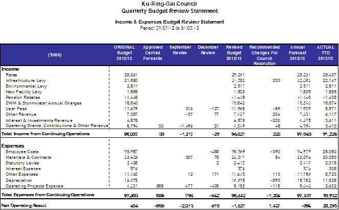
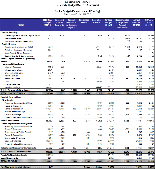
Budget Review Income and Expenses Statement by Principal Activity
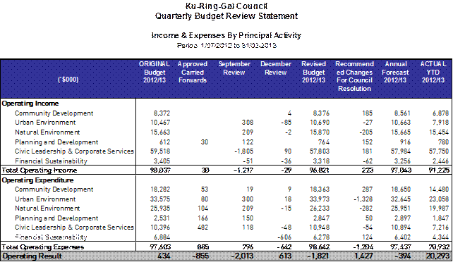
Budget Review Cash and Investments position
Restricted funds are invested in accordance with Council’s Investment Policy. Total investments portfolio as per the March Investment Report is $73.06m.
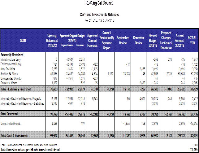
A detailed Restricted Assets Report as at March 2013 (Actual) is shown in Attachment A1
Budget Review Contracts and Consultancy Expenses
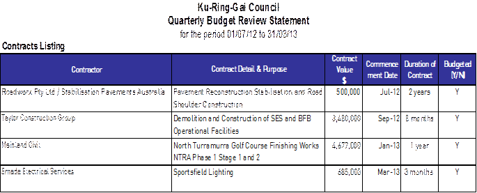
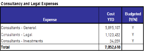
Proposed Budget Adjustments
The table below lists the proposed budget adjustments for the March Quarterly Budget Review.
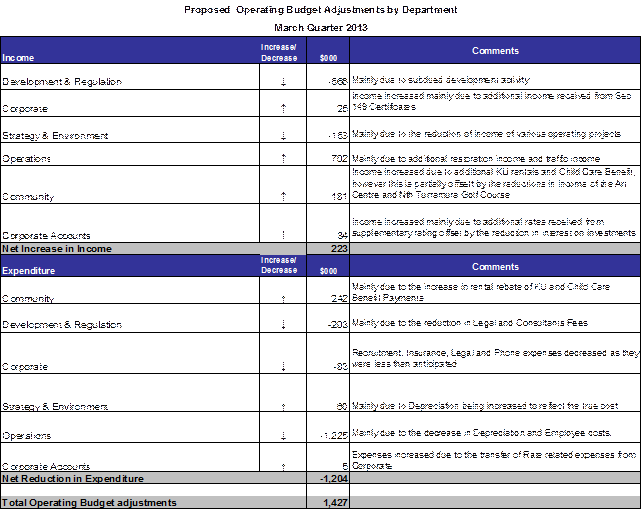

Capital & Operational Projects 2012/2013
Actual expenditure for capital & operational projects for the period ending 31 March 2013 is $53m against the YTD budget of $67m, resulting in a favourable variance of $14m. The variance is mainly due to various major and minor projects not commencing as originally planned. Historically, project expenditure increases in the last quarter of the year.
The table and chart below shows the YTD actual projects expenditure against YTD budget for the quarter ended March 2013.

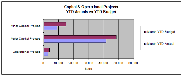
All Proposed Budget adjustments for each Project and explanation for the changes is detailed in Attachment A2 – Summary of Capital and Operational Project Budget Adjustments
Major Capital Works Summary
Operations Projects
Work is complete or nearing completion on all of the capital projects allocated to Operations. Expenditure and the works schedule are ahead of the program. A review of the budget was also necessary in a number of program areas. The status of various projects and reviews of programs is covered in the commentary below:
· Buildings
The new SES/RFS building is now complete and when the budget was originally prepared the grant funding was included in the allocation. The grant funding should have been separate and therefore, the original budget was deficient. The building cost was consistent with the tender and variations only amounted to about 10% of the project cost. In order to fund the over expenditure and the delay in receiving a component of the grant from the RFS, adjustments were made to the recurrent budget where savings were realised from employee costs and increased income from restoration and work zones.
· Roads
The roads program at the end of the third quarter was more than 80% complete and it is planned to complete the roads program by June 2013. There is a need to delay some projects in order to allocate funds to the new SES/RFS building as the payment from RFS will not be realised until 2013/14.
· Footpaths
New footpaths at the following locations have been completed
§ Lynbara Avenue, St Ives
§ Mona Vale Road, St Ives
§ Malga Avenue, Roseville
§ Handley Avenue, Turramurra
· Traffic Facilities
Work is now completed on the camber correction works at Eastern Arterial Road and work has started on the camber correction works on The Comenarra Parkway and due for completion by the end of May 2013.
· Drainage
At this stage, only minor drainage works have been carried out. Works have commenced at 43 Eastgate Avenue Killara and quotes have been called for works at 10 Doncaster Avenue, West Pymble and 5 Cassandra Avenue, St Ives.
· Playgrounds
Designs are now complete for Bancroft Park and tenders will soon be called for this upgrade. Work is now complete on Blackburn Reserve Playground.
· Sportsfield
Work is now complete on the stormwater harvesting works at Koola Oval and Alan Small Oval in preparation for the upgrades. Fill has been placed at Golden Jubilee Oval No. 2 as surplus material was able to be sourced from the new SES/RFS site and also the West Pymble pool site. This has saved Council money for all projects involved. The cricket nets at Koola Park are nearing completion and work is soon to start on the sewer relocation.
· Sports Courts
Council has recently approved the tenders for all the sports courts upgrades. Work has commenced on the upgrades and expected to be completed by June 2013.
· Sewer Mining
The North Turramurra sewer mining plant is now operational.
· Public Toilets
An order has been placed for the new public toilet at William Street Turramurra for installation towards the end of June 2013. Works is also soon to start on the upgrade of the public toilets at Allan Small Park.
Strategy Projects
Updates of significant projects are provided below:
· St Ives Girl Guides and Scouts Relocations and St Ives Village Green Master Plan
Construction of the new club house at Warrimoo Oval was completed in March 2013 and associated landscape works were completed in April 2013. After St Ives Football Club has completed some internal fitout works they will be moving into the new facility. The next stage of works is the disabled toilet extension to the existing club house at Warrimoo Oval during the first quarter of 2013/14, after which the St Ives Girl Guides group will be relocating from St Ives Village Green to the renovated facility. St Ives North Scouts have also received development approval for alterations and additions to the Warrimoo Oval Scout Hall and a builder has been appointed to commence works during May 2013. Upon completion of the scout hall works, the Scouts will move out of St Ives Village Green and consolidate all of their activities at Warrimoo Oval. The Scout and Guides old buildings at the Village Green will then be demolished and implementation of the Village Green Masterplan will get underway, commencing with the expanded children’s playground and new youth precinct, including the new Skate & Bike Park.
· Koola Park Redevelopment, East Killara
The stormwater harvesting system, amenities block extensions, and new cricket nets above the water storage tank at Koola Park have all been completed. The sewer connection to replace the septic system is due to be completed during the last quarter 2012/13 and first quarter 2013/14 and the oval extension, irrigation, drainage, floodlights, exercise path and car park works are due to commence in the third quarter of 2013/14 following design , documentation and tendering for this stage of works.
· New park at Bruce Ave Killara
Tenders for the construction of a park on the newly acquired land in Bruce Avenue Killara were advertised on 16 March 2013. The tenders have closed and been assessed and are due to be reported to Council on 28 May 2013 for approval to proceed with construction of the project.
· Eton Road Oval and Community Centre, Lindfield (former UTS Oval)
These two projects have both been tendered and had contractors appointed during the third quarter 2012/13. Both projects are commencing construction during the fourth quarter and are due for completion prior to Christmas 2013.
· Allan Small Park
Design works for the upgrade of the sports field and linking of the stormwater harvesting system to the storage tank and irrigation system were completed on the third quarter 2012/13 and went to tender early in the second quarter. The tenders have closed and been assessed and are due to be reported to Council on 28 May 2013 for approval to proceed with construction of the project.
· Mahratta Curtilage Park
Design and documentation for the new park and playground at Mahratta Curtilage Park, Warrawee was completed during the third quarter 2012/13. Tenders are due to be called during the fourth quarter and construction is due to commence early in 2013-14.
· B2 Land Subdivision
The B2 Subdivision is a joint project with the adjoining land owner, the NSW Department of Planning and is one of the major funding sources for the West Pymble Pool. A development application was lodged in August 2012 and it is anticipated that a determination will be made by the end of the fourth quarter. Land sales have been deferred to 2013/2014 and a report on the B2 land subdivision is scheduled for the Council meeting of 28 May 2013.
• West Pymble Pool
It is anticipated that he pool will be finished in time for the ordinary swim season. As previously flagged, some of the potential cost overruns shall be going to arbitration. Upon the completion of the arbitration, when costs can be fully quantified a report shall be brought to Council. A development application is soon to be lodged for the fit out of the centre.
• NTRA
Stabilisation of the landfill slopes is some 70% complete. Contractors have been appointed for both the bulk earth works and the finishing works. Both contracts will be completed over two stages. Stage one of the civil works is some 20% complete. The finishing contractor will commence upon the completion of stage one works.
Report by Responsible Accounting Officer
It is my opinion that the Quarterly Budget Review Statement for Ku-ring-gai Council for the quarter ended 31 March 2013 indicates that Council’s projected financial position at 30 June 2013 will be satisfactory, having regard to the projected estimates of income and expenditure and the original budgeted income and expenditure.
One of Council’s key performance indicators in the Long Term Financial Plan (LTFP) is to provide for a minimum available working capital balance of $4.2m. As a result of the March Review the forecast of available working capital at 30 June 2013 will remain at $4.2m.
Governance Matters
Not applicable.
Risk Management
Income and expenditure is managed through the quarterly budget review process. Although some income and expenditure can not be directly controlled, it can be monitored and action taken to mitigate potential financial or budgetary risk. Further, Council staff utilise monthly management reporting for managing operational and project income and expenditure, and any budget variations are reported to the Director. The executive team are also provided with a monthly financial pack that allows Directors to make informed decisions and plan ahead to ensure budget targets are met.
Financial Considerations
Should Council adopt the recommendations of this report, Council’s working capital forecast will remain at $4.2m as per LTFP target.

Social Considerations
Not applicable.
Environmental Considerations
Not applicable.
Community Consultation
Not applicable.
Internal Consultation
Finance met with each Director as part of the Quarterly Business Review to ensure departmental budget target reflects current market conditions and where applicable adjusted to reflect the change. Any increase in expenditure has been offset by savings in other areas. Comments from Directors have also been included as part of this report.
Summary
The organisation’s operating result (including capital income) for the 3rd Quarter is $26.07m compared to a budget of $25.82m, a surplus of $250k.
Capital & Operational projects expenditure for the quarter is $53m compared to a budget of $67m. The lower than expected expenditure of $14m is mainly due to projects not commencing as originally planned.
Council’s working capital as at 1 July 2012 was $5.69m and is forecast to be $4.2m at 30 June 2013 in line with the target identified in Council’s adopted Long Term Financial Plan.
|
A. That Council receive and note the March 2013 Quarterly Budget Review.
B. That the Restricted Assets Report as at 31 March 2013, as shown in Attachment A1 be noted.
C. That the recommended changes to the 2012/13 Budget as reported be adopted.
|
|
Michael Lopez Management Accountant |
Angela Apostol Acting Manager Finance |
|
John McKee General Manager |
|
|
A1View |
Restricted Assets Report - March 2013 |
|
2013/120668 |
|
|
|
A2View |
Summary of Capital and Operational Project Budget Adjustments - March 2013 |
|
2013/120647 |
|
APPENDIX No: 2 - Summary of Capital and Operational Project Budget Adjustments - March 2013 |
|
Item No: GB.3 |
|
Ordinary Meeting of Council - 28 May 2013 |
GB.4 / 76 |
|
|
|
|
Item GB.4 |
S05273 |
|
|
6 May 2013 |
Analysis of Land and Environment Court Costs - 3rd Quarter, 2012 to 2013
EXECUTIVE SUMMARY
|
purpose of report: |
To report legal costs in relation to development control matters in the Land and Environment Court for the quarter ended 31 March 2013. |
|
|
|
|
background: |
A person may commence proceedings in the Land and Environment Court in relation to a development application which has either been refused by Council or is deemed to have been refused. An appeal may also be commenced in relation to conditions of development consent and the issue of building certificates and orders. |
|
|
|
|
comments: |
For the nine months to 31 March 2013, Council’s legal costs and associated expenses in relation to Land and Environment Court development control matters were $707,301. This compares with the budget for the period of $923,400 for expenses, resulting in a positive variance of $216,099. |
|
|
|
|
recommendation: |
That the analysis of Land and Environment Court costs for the nine months to 31 March 2013 be received and noted. |
Purpose of Report
To report legal costs in relation to development control matters in the Land and Environment Court for the quarter ended 31 March 2013.
Background
A person may commence proceedings in the Land and Environment Court in relation to a development application which has either been refused by Council or is deemed to have been refused (a development application is deemed to have been refused if it has not been determined within a period of 40 days or such longer period that may be calculated in accordance with the Act). An appeal may also be commenced in relation to conditions of development consent and the issue of building certificates and orders. Council is a respondent to such proceedings.
Comments
Appeals Lodged
In third quarter, there was one new appeal lodged with the Land and Environment Court. The number of appeals received in prior years is as follows:
|
Financial year |
Number of appeals received (whole year) |
|
2008/2009 |
39 |
|
2009/2010 |
54 |
|
2010/2011 |
38 |
|
2011/2012 |
33 |
|
2012/2013 (as at 31 March 2013) |
23 |
The appeal received in the third quarter was brought in relation to the refusal, by Sydney West Joint Regional Planning Panel, of a proposal for the construction of a residential flat building.
costs
For the nine months to 31 March 2013, Council had expenditure of $675,122 on appeals and associated expenses in relation to Land & Environment Court matters. In addition to expenditure on appeals, a further amount of $32,179 was spent in obtaining expert advice regarding development assessment matters resulting in total expenditure of $707,301 against a total budget of $923,400, a variance of $216,099. These costs are made up of legal costs, fees charged by any consultants retained as expert witnesses and other costs incurred as a result of Council’s role in the proceedings.
Accordingly, there was an overall positive variance for appeals against budget of $216,099.
|
Land & Environment Court Costs 2009/2010 - 2012/2013 |
|||||
|
Financial Year |
Total Costs |
1st quarter September |
2nd quarter December |
3rd quarter March |
4th quarter June |
|
(54 appeals lodged) |
$1,445,394 |
$217,726 |
$368,642 |
$264,137 |
$594,899 |
|
2010/2011* (38 appeals lodged) |
$1,297,458 |
$333,219 |
$271,232 |
$256,486 |
$436,521 |
|
2011/2012* (33 appeals lodged) |
$1,396,006 |
$183,714 |
$314,271 |
$333,656 |
$564,365 |
|
2012/2013 (23 appeals lodged) |
$675,122 |
$172,245 |
$322,751 |
$180,126 |
|
* Costs reported to Council in previous reports
For the same period, receipts of legal costs recovered were $30,500 compared to a year to date budget of $38,700.
SUMMARY BY WARD
A summary of the above Land & Environment Court costs by Ward for quarter end as at 31 March 2013 is shown in the following table:

Outcomes
At an early stage of each appeal, Council as respondent, is required to file with the Court a Statement of Facts and Contentions outlining the grounds which Council asserts as warranting refusal of a development, or alternatively, that may be addressed by way of conditions of consent.
In cases where issues raised by Council are capable of resolution by the provision by the applicant of additional information or amendment of the proposal, it is the Court’s expectation that this should occur. The Court’s current practice of listing appeals for a preliminary mediation conference before a Commissioner of the Court pursuant to section 34 of the Land & Environment Court Act, strongly encourages this.
In this context, any of three outcomes can be regarded as favourable, namely:
1. If the appeal is in relation to a deemed refusal of an application which, upon assessment, is appropriate for approval: that the development is determined by Council, allowing the appeal to be discontinued by the applicant and avoiding as much as is practicable the incurring of unnecessary legal costs;
2. If the issues raised by Council are capable of resolution by the applicant providing further information, or amending the proposal: that this occurs, so that development consent should be granted, either by Council or the Court;
3. If the issues raised by Council are either not capable of resolution or the applicant declines to take the steps that are necessary to resolve them: that the appeal is either discontinued by the applicant, or dismissed (refused) by the Court.
Eighteen matters have been concluded during the three quarters to 31 March 2013 and a favourable, or substantially favourable, outcome was achieved in seventeen of those matters:
· four appeals were discontinued by the applicant;
· two dismissed by the Court;
· six cases were resolved by agreement being reached with the applicant in relation to an amended proposal;
· six cases were concluded by the Court determining to approve the development. Five of the six matters approved by the Court involved significant amendment to the original proposal by way of amended plans or the imposition of changes imposed by way of condition.
Governance Matters
Under Section 428 of the Local Government Act 1993, Council is required to report legal costs, and the outcome of each case in its Annual Report.
Risk Management
Quarterly reporting of legal costs to Council together with information about the number, character and outcomes of proceedings enable ongoing oversight of this area of Council’s activity.
Financial Considerations
Land & Environment Court legal costs form part of Council’s recurrent operating budget.
Social Considerations
None undertaken or required.
Environmental Considerations
None undertaken or required.
Community Consultation
None undertaken or required.
Internal Consultation
This report has been developed with input from Council’s Corporate Lawyer, Acting Director Corporate and Director Development & Regulation.
Summary
For nine months to 31 March 2013, Council had expenditure of $707,301 on appeals and associated expenses in relation to Land & Environment Court matters. This compares to a year to date budget of $923,400, a positive variance of $216,099.
Accordingly, there was an overall positive variance for appeals against budget of $216,099.
For the same period, receipts of legal costs recovered were $30,500 compared to a year to date budget of $38,700.
|
That the analysis of Land and Environment Court costs for nine months to 31 March 2013 be received and noted.
|
|
Tony Ly Financial Accounting Officer |
Jamie Taylor Corporate Lawyer |
|
John Giovinazzo Acting Director Corporate |
Michael Miocic Director Development & Regulation |
|
A1View |
Individual Case Summary March 2013 Quarter - Land and Environment Court Costs |
|
2013/123791 |
|
APPENDIX No: 1 - Individual Case Summary March 2013 Quarter - Land and Environment Court Costs |
|
Item No: GB.4 |
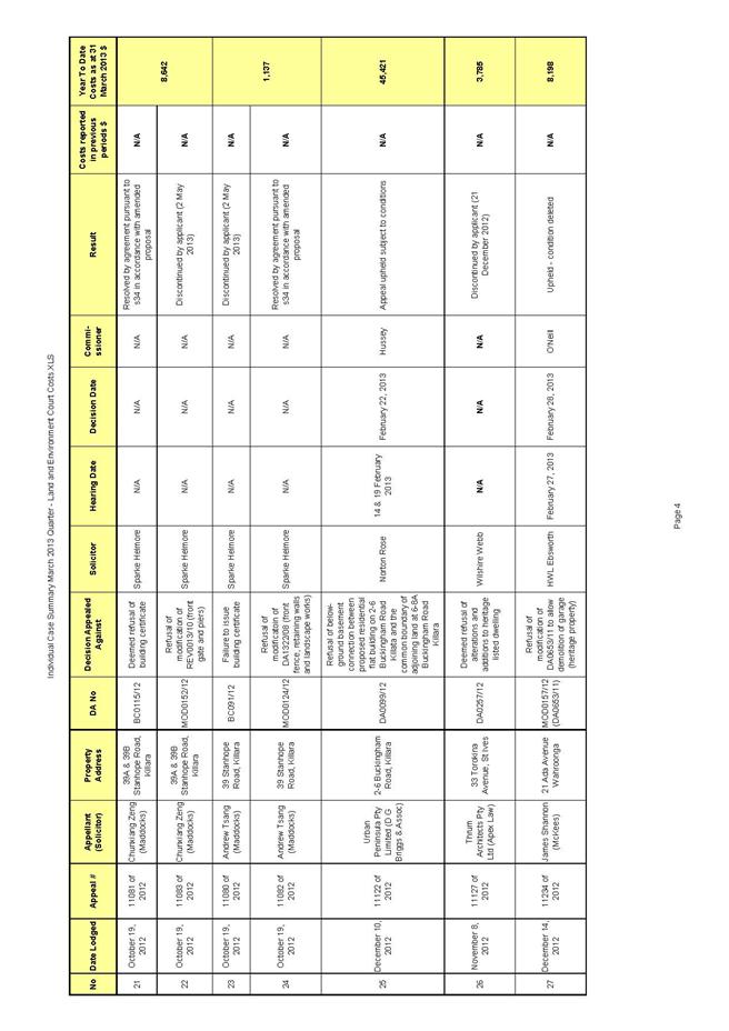
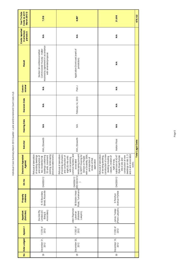
|
Ordinary Meeting of Council - 28 May 2013 |
GB.5 / 87 |
|
|
|
|
Item GB.5 |
S05273 |
|
|
8 May 2013 |
Investment Report as at 30 April 2013
EXECUTIVE SUMMARY
|
purpose of report: |
To present to Council investments portfolio performance for April 2013. |
|
|
|
|
background: |
Council’s investments are reported monthly to Council in accordance with the Local Government Act 1993, the Local Government (General) Regulation 2005 and Council’s Investment Policy. |
|
|
|
|
comments: |
The net return on investments for the 10 months ending April 2013 was $3,810,600 against a budget of $3,760,300, giving a YTD favourable variance of $50,300. |
|
|
|
|
recommendation: |
That the summary of investments performance for April 2013 be received and noted; and that the Certificate of the Responsible Accounting Officer be noted and report adopted. |
Purpose of Report
To present to Council investments portfolio performance for April 2013.
Background
Council’s investments are reported monthly to Council in accordance with the Local Government Act 1993, the Local Government (General) Regulation 2005 and Council’s Investment Policy.
Comments
Investment Portfolio Performance Snapshot
The table below provides the investments portfolio performance against targets identified in Council’s Investment Policy as well as other key performance indicators based on industry benchmarks.
Cumulative Investment Return against Budget
The net return on investments for the 10 months ending April 2013 was $3,810,600 against a budget of $3,760,300, giving a YTD favourable variance of $50,300.
The total return on investments (interest and capital gain/loss) for the month of April is provided below.

A comparison of the cumulative investment returns against year to date budget is shown in Chart 1 below.
Chart 1 - Cumulative Investment Return YTD vs. Budget
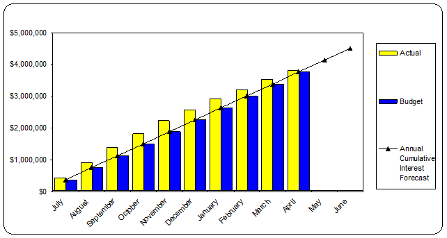
Cash Flow and Investment Movements
Council’s total investment portfolio at the end of April 2013 is $67,813,100, a decrease of $27,969,700 since July 2012. The net cash outflow for the month was $5,256,300 mainly due to creditor payments.
The major payments were:
· Waste (Veolia and Sita) $1.2M
· Swimming Pools (Ichor Constructions) $844K
· SES Buildings (Taylor Constructions) $625K
· Emergency Management NSW (Council’s Quarterly Contributions) $550K
· Energy Australia $215K
· C W Concrete Pty Ltd $273K
Two investments matured during the month. Table 1 below provides detailed movement of investments during the month by institution name, investment rating and interest rates.
Table 1 – Investment Movements (April 2013)

Due to the recent cash rate cut announced by the RBA, the budget for investment earnings has been revised. A reduction of $200K is proposed in the March Quarterly Budget Review.
Investment Performance against Industry Benchmarks
Overall during the month of April the investments performance was well above industry benchmark. The benchmarks are specific to the type of investment and details provided below.
Ø Cash and at call investments are compared against the 11am Cash Rate. This applies to AMP Business Easy Saver Account and Westpac Maxi-I Investment Account.
Ø UBS Bank Bill Index is used for all other investments except Cash.
A comparison of the portfolio returns against investment benchmarks is provided in Table 2 below.
Table 2 - Investments Performance against Industry Benchmarks

Table below provides a summary of all investments by type and performance during the month. Attachment A1 provides definitions in relation to different types of investments.
Table 3 - Investments Portfolio Summary
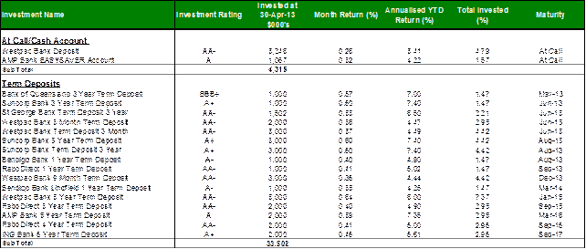
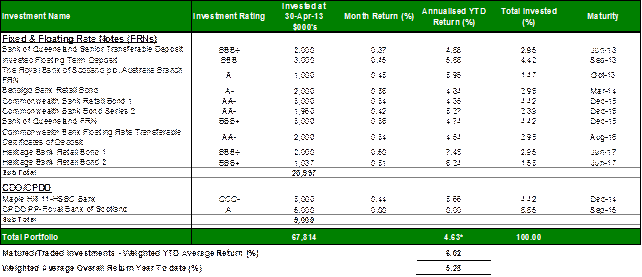
* Weighted average returns excluding Cash/At Call
Investment by Credit rating and Maturity Profile
The allocation of Council’s investments by credit rating and the maturity profile are shown in the chart below:
Chart 2 - Credit Rating (Actual level of investment compared to proportion permitted by policy)
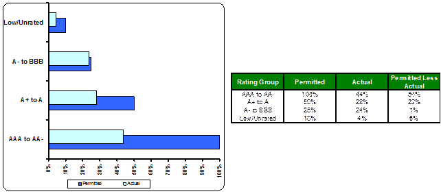
Chart 3 - Maturity Profile (Excludes Cash)
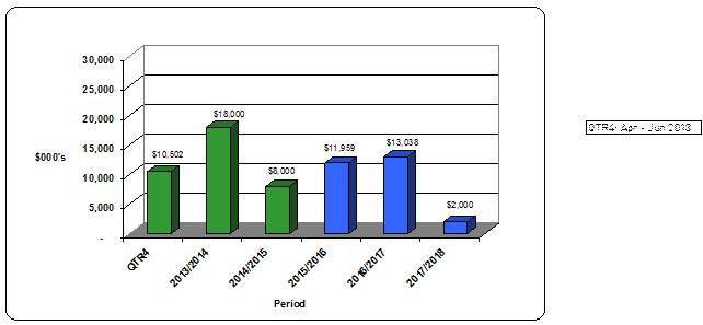
Economic Analysis
International
· US unemployment for March was 7.6% as the labour force participation rate slipped to 63.3%. This is partly due to an ageing population, growing number of discouraged workers and an increase in disabled benefits recipients.
· The US Federal Reserve considered a reduction in its asset purchases from $85 billion per month. However as “economic objectives” such as 6% employment remains unmet, tapering of asset purchases may possibly be delayed past year-end.
· While American efforts have focused on bond purchases, European Central Bank efforts have centred on direct financing of banks. In Europe’s case, the impact on economic activity therefore depends on banks taking funds obtained from the European Central Bank and extending them to borrowers. With some European banks losing deposits and trying to rebuild capital ratios, this translation has been weak. The real GDP of the Eurozone has contracted for five straight quarters, and the unemployment rate passed 12%.
· China’s real GDP posted grew just +6.3% annualised in Quarter 1, being the smallest gain since early 2009.
Domestic
· The RBA left the official cash rate at 3%, while hinting more strongly at an easing bias. They are observing domestic data for signs that previous rate cuts will flow through the economy. The question is whether house prices, consumer confidence and spending have reacted to lower rates while below trend global growth weighs on sentiment.
· RBA's April minutes were silent on rising unemployment, after a one-off statistical change saw an improbable spike in employment data reported a month earlier.
· CPI inflation was well contained in the March quarter, rising just 0.4% with the annual rate at 2.5% for the year to March (including a one-off effect of carbon pricing).
· The Australian dollar spiked to a recent high of US105½ before easing around ¾c from last month’s 104½ close.
Governance Matters
Council’s investments are made in accordance with the Local Government Act (1993), the Local Government (General) Regulation 2005 and Council’s Investment Policy which was adopted by Council on 20 April 2010.
Section 212 of the Local Government (General) Regulation 2005 states:
(1) The responsible accounting officer of a council:
(a) must provide the council with a written report (setting out details of all money that the council has invested under section 625 of the Act) to be presented:
(i) if only one ordinary meeting of the council is held in a month, at that meeting, or
(ii) if more than one such meeting is held in a month, at whichever of those meetings the council by resolution determines, and
(b) must include in the report a certificate as to whether or not the investment has been made in accordance with the Act, the regulations and the council’s investment policies.
(2) The report must be made up to the last day of the month immediately preceding the meeting.
Risk Management
The major risk associated with investments is price risk and that being the capital value of investments may fluctuate due to changes in market prices. These changes can be triggered by factors specific to individual financial instruments, their issuers or by factors affecting similar instruments traded in a market.
Cash & Investments are also subject to interest rate risk as changes in interest rates could also have an adverse impact on returns and income.
A further risk associated with Cash & Investments is credit risk where the investment counterparty may not complete their obligations particular to a financial instrument, resulting either a capital or income loss.
Council manages these risks by diversifying its portfolio and only purchasing investments with high credit ratings or capital guarantees.
Council’s new investments are considered low risk as they are only made in a form of investment notified by order of the Minister for Local Government and Council’s adopted Investment Policy.
All investments are made with consideration of advice from Council’s appointed investment advisor, Denison Financial Advisory Services.
Financial Considerations
The budget for interest on investments for the financial year 2012/2013 is $4,512,400. Of this amount approximately $2,972,400 is restricted for the benefit of future expenditure relating to developers’ contributions, $583,300 transferred to the internally restricted Infrastructure & Facility Reserve, and the remainder of $956,700 is available for operations.
Due to the recent cash rate cut announced by the RBA, the budget for investment earnings has been revised and a reduction of $200K is proposed in the March Quarterly Budget Review.
Social Considerations
Not applicable.
Environmental Considerations
Not applicable.
Community Consultation
None undertaken or required.
Internal Consultation
None undertaken or required.
Certification - Responsible Accounting Officer
I hereby certify that the investments listed in the attached report have been made in accordance with Section 625 of the Local Government Act 1993, clause 212 of the Local Government General Regulation 2005 and Council’s Investment Policy which was adopted by Council on 20 April 2010.
Summary
As at 30 April 2013:
Ø Council’s total investment portfolio is $67,813,100, which is a decrease of $27,969,700 compared to an opening balance of $95,782,800 at 1 July 2012.
Ø Council’s net return on investments for the 10 months ending April 2013 was $3,810,600 against a budget of $3,760,300, giving a YTD favourable variance of $50,300.
|
A. That the summary of investments and performance for April 2013 be received and noted.
B. That the Certificate of the Responsible Accounting Officer be noted and the report adopted.
|
|
Tony Ly Financial Accounting Officer |
Angela Apostol Acting Manager Finance |
|
John McKee General Manager |
|
|
A1View |
Investments definitions specific to Council’s investment portfolio |
|
2012/223363 |
|
Ordinary Meeting of Council - 28 May 2013 |
GB.6 / 97 |
|
|
|
|
Item GB.6 |
S03158/2 |
|
|
13 May 2013 |
Mayor and Councillor Fees -
Local Government Remuneration Tribunal Report 2013
EXECUTIVE SUMMARY
|
purpose of report: |
To determine the Mayor and Councillor fees payable from 1 July 2013. |
|
|
|
|
background: |
On 8 April 2013 the Local Government Remuneration Tribunal had made a determination in regards to its 2013 annual review. The Tribunal reviews and sets the range of fees for all councillors and mayors in NSW each year. |
|
|
|
|
comments: |
The Tribunal has determined that Mayor and Councillor fees be increased by 2.5%. |
|
|
|
|
recommendation: |
That, from 1 July 2013, the Councillor fee be set at $17,490 and the Mayoral fee be set at $38,160. |
Purpose of Report
To determine the Mayor and Councillor fees payable from 1 July 2013.
Background
On 8 April 2013 the Local Government Remuneration Tribunal had made a determination in regards to its 2013 annual review. The Tribunal reviews and sets the range of fees for all councillors and mayors in NSW each year. A full copy of the report and determination of the Local Government Remuneration Tribunal is attached to this report (see Attachment A1).
Comments
Pursuant to s.241 of the Local Government Act 1993, the Local Government Remuneration Tribunal determines in each category of Council, the maximum and minimum amount of fees to be paid to Mayors and Councillors of Councils, as well as Chairpersons and Members of County Councils.
The Tribunal did not call for general submissions from individuals Councils as part of the 2013 review although Councils were advised they could raise any issues of concern. The Tribunal also advised that it would not be reviewing the categories of Councils.
On 27 June 2011, the Parliament passed amendments to the Act to apply the same government public sector wages cap that binds the Industrial Relations commission to the determination of ranges of fees for Councillors and Mayors. Therefore no increase beyond 2.5 per cent may be applied by the Tribunal to the minimum and maximum amounts of fees to be paid to Councillors and Mayors. The effect of the amendments to the Act was to remove the Tribunal’s discretion to determine any increase beyond 2.5 per cent.
Taking into account key economic factors, the views of the assessors, and the State Government’s wages policy, the Tribunal determined that an increase of 2.5 per cent in fees for Councillors and Mayors is appropriate. The increases are effective from 1 July 2013.
Therefore the annual fees to be paid in each of the categories to Councillors, Mayors, Members and Chairpersons of County Councils effective on and from 1 July 2013 are determined as follows;
|
|
Councillor/Member Annual Fee |
Mayor/Chairperson Additional Fee* |
||
|
|
Minimum |
Maximum |
Minimum |
Maximum |
|
Principal City |
23,830 |
34,950 |
145,810 |
191,860 |
|
Major City |
15,880 |
26,220 |
33,760 |
76,390 |
|
Metropolitan Major |
15,880 |
26,220 |
33,760 |
76,390 |
|
Metropolitan Centre |
11,910 |
22,240 |
25,320 |
59,100 |
|
Metropolitan |
7,930 |
17,490 |
16,890 |
38,160 |
|
Regional Rural |
7,930 |
17,490 |
16,890 |
38,160 |
|
Rural |
7,930 |
10,480 |
8,430 |
22,870 |
|
Council Council – Water |
1,580 |
8,740 |
3,380 |
14,350 |
|
County Council - Other |
1,580 |
5,230 |
3,380 |
9,540 |
Governance Matters
The recent report and determination of the Local Government Remuneration Tribunal for 2013 is made in accordance with s.239 and s.241 of the Local Government Act 1993.
“The Remuneration Tribunal must, not later than 1 May in each year, determine, in each of the categories determined under section 239, the maximum and minimum amounts of fees to be paid during the following year to councillors (other than mayors) and mayors”.
Risk Management
There are no significant risks associated with this report. If Council decides not to increase fees payable to the Mayor and Councillors there is some risk that Council’s ability to attract candidates at Local Government Elections will be reduced as a result of remuneration levels being below the maximum amount available as set by the Local Government Remuneration Tribunal.
Financial Considerations
An amount of $212,900 has been provided in the 2013/2014 Draft Budget for Mayor and Councillor
fees. A total amount of $213,060 is required to fund the maximum permitted fees.
Social Considerations
There are no social considerations associated with this report.
Environmental Considerations
There are no environmental considerations associated with this report.
Community Consultation
None undertaken or required.
Internal Consultation
None undertaken or required.
Summary
The Local Government Remuneration Tribunal has determined that Mayor and Councillor fees be increased by 2.5% from 1 July 2013.
It is recommended that the maximum fees be paid, being $17,490 for Councillors and $38,160 for the Mayor.
|
That, from 1 July 2013, the Councillor fee be set at $17,490 and the Mayoral fee be set at $38,160.
|
|
Matt Ryan Manager Records & Governance |
John Giovinazzo Acting Director Corporate |
|
A1View |
Report and Determination of the Local Government Remuneration Tribunal - 08/04/2013 |
|
2013/116057 |
|
APPENDIX No: 1 - Report and Determination of the Local Government Remuneration Tribunal - 08/04/2013 |
|
Item No: GB.6 |

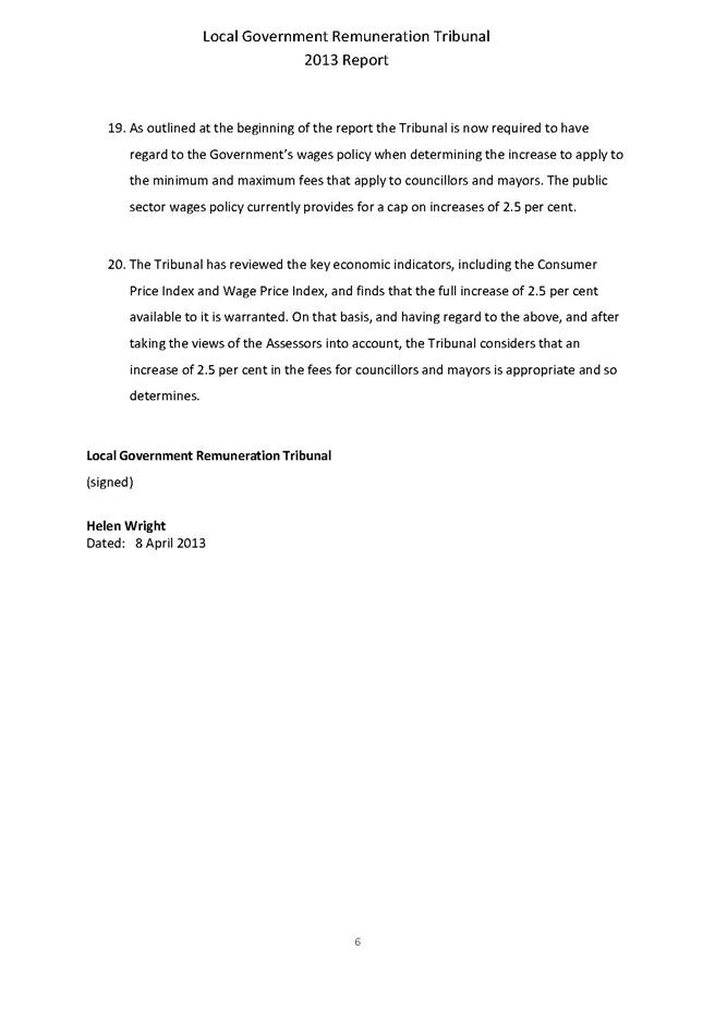
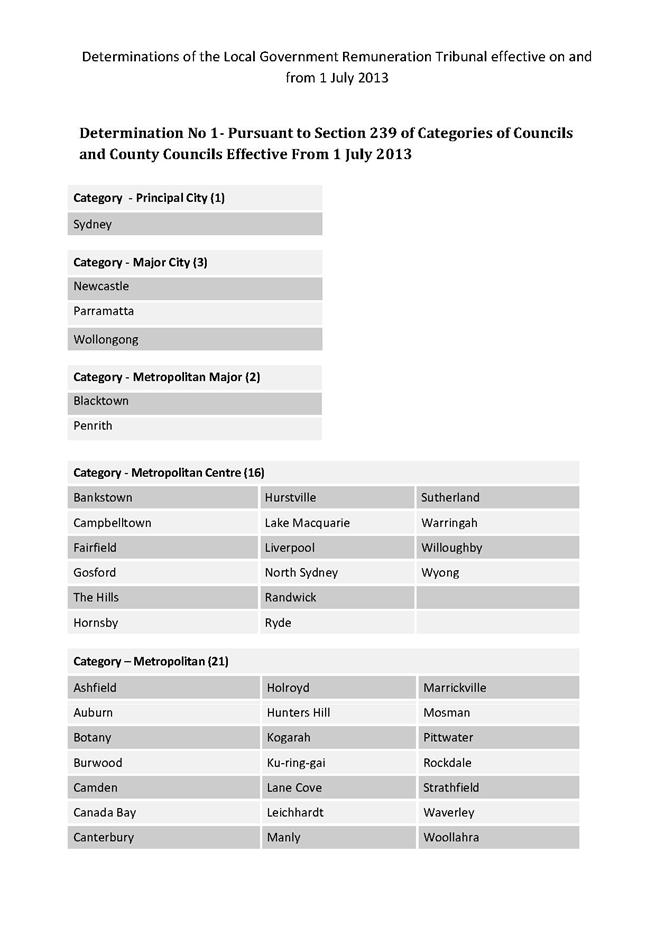
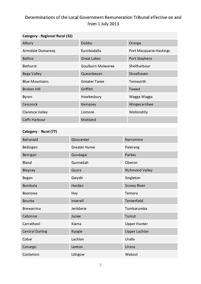
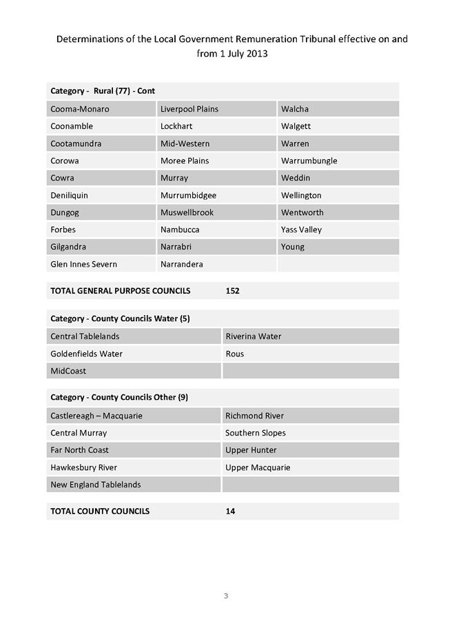
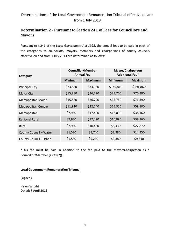
|
Ordinary Meeting of Council - 28 May 2013 |
GB.7 / 111 |
|
|
|
|
Item GB.7 |
S08561/3 |
|
|
14 May 2013 |
Local Government Women’s Summit
EXECUTIVE SUMMARY
|
purpose of report: |
To advise Councillors of the 2013 Local Government Managers Australia (LGMA) NSW Summit for Executive Women in Local Government held at Doltone House Hyde Park, Sydney on 20 June 2013. |
|
|
|
|
background: |
The LG Women’s Summit is an LGMA NSW inaugural event for all women in senior leadership roles, both elected and professional, in Australian councils. Delegates will hear from inspirational, industry leading speakers who have encompassed all aspects of leadership and management to achieve personal and organisational success. |
|
|
|
|
comments: |
This event is designed to enable senior executives and elected representatives the opportunity to enhance their skills as community and corporate leaders.
Registrations for the Summit close on Thursday, 6 June 2013. |
|
|
|
|
recommendation: |
That any Councillors interested in attending the 2013 LGMA Summit for Executive Women in Local Government held at Doltone House Hyde Park, Sydney on 20 June 2013 advise the General Manager by Friday, 31 May 2013. |
Purpose of Report
To advise Councillors of the 2013 Local Government Managers Australia (LGMA) NSW Summit for Executive Women in Local Government held at Doltone House Hyde Park, Sydney on 20 June 2013.
Background
The LG Women’s Summit is an inaugural event for all women in senior leadership roles, both elected and professional, in Australian councils.
Delegates will hear from inspirational, industry leading speakers who have encompassed all aspects of leadership and management to achieve personal and organisational success.
Comments
This event is designed to enable senior executives and elected representatives the opportunity to enhance their skills as community and corporate leaders.
Registrations for the summit close on Thursday 6 June 2013.
Governance Matters
The Policy on Payment of Expenses and Provision of Facilities to Councillors provides for Council to meet the reasonable costs of Councillors attending conferences authorised by resolution of Council.
Risk Management
There are no risk management considerations associated with the recommendation in this report.
Financial Considerations
The cost of attending the summit is $350 for LGMA members and $460 for non-members. Travel costs will be additional.
Attendance is provided for in the Councillor’s conference budget in accordance with the Payment of Expenses and Provision of Facilities Policy.
Council has an annual budget of $33,000 for Councillor’s attendance at conferences with $22,197 remaining in the 2012/2013 financial year.
Social Considerations
There are no social considerations associated with the recommendation in this report.
Environmental Considerations
There are no environmental considerations associated with the recommendation in this report.
Community Consultation
None required or undertaken
Internal Consultation
None required or undertaken
Summary
The LG Women’s Summit is an inaugural event for all women in senior leadership roles, both elected and professional, in Australian councils.
Delegates will hear from inspirational, industry leading speakers who have encompassed all aspects of leadership and management to achieve personal and organisational success.
This event is designed to enable senior executives and elected representatives the opportunity to enhance their skills as community and corporate leaders.
Registrations for the summit close on Thursday 6 June 2013.
|
That any Councillors interested in attending the 2013 LGMA Summit for Executive Women in Local Government held at Doltone House Hyde Park, Sydney on 20 June 2013 advise the General Manager by Friday, 31 May 2013.
|
|
Matt Ryan Manager Records & Governance |
John Giovinazzo Acting Director Corporate |
|
A1View |
LGMA NSW Summit for Executive Women in Local Government Programme |
|
2013/118532 |
|
Ordinary Meeting of Council - 28 May 2013 |
GB.8 / 121 |
|
|
|
|
Item GB.8 |
DA0321/12 |
|
|
20 May 2013 |
development application
Summary Sheet
|
Report title: |
Subdivision of 21 lots into 26 lots including roadworks and service infrastructure over former B2 lands at South Turramurra |
|
ITEM/AGENDA NO: |
GB.8 |
|
application No: |
DA0321/12 |
|
Property Details: |
25, 25A, 27, 37, 41 & 45 Barwon Avenue, Nos. 17, 17A, 19 & 21 Chisholm Street, No. 13 Lyon Avenue and unformed portions of Hall Street, Barwon Avenue and Warners Avenue. Lots 10-12, DP 1167303 (unformed roads), Lots 19 & 20, DP 16578, Lot 21, DP 455668, Lots 43- 46, DP 455669, Lots 1-3, DP 746618, Lot 1, DP 847214 (unformed road), Lot 74, DP 216500, Lots 47-50, DP 455669, and Lots 1-2, DP 840228. Site area: 3.71 hectares Zoning: Part 2(c) and part unzoned under KPSO |
|
Ward: |
|
|
Proposal/Purpose: |
Subdivision of 21 allotments, into 26 residential allotments and 1 allotment for public open space, reconstruction of a creek and wetland system with ancillary landscaping, construction of three roads and associated infrastructure.
|
|
Type of Consent: |
Integrated |
|
Applicant: |
Aver Pty Ltd |
|
Owner: |
Ku-ring-gai Council & NSW State Government |
|
Date Lodged: |
8 August 2012 |
|
Recommendation: |
Approval.
|
Purpose of Report
To determine development application No. DA0321/12 for the subdivision of South Turramurra Road Corridor, currently comprised of 21 allotments, into 26 residential allotments and 1 allotment for public open space (to contain riparian land), reconstruction of a creek and wetland system with ancillary landscaping, construction of three roads and associated infrastructure
Executive Summary
The application seeks approval for subdivision of 21 existing allotments that form part of the abandoned South Turramurra Road Corridor into 26 residential allotments and one allotment for public open space, reconstruction of a creek and wetland system with ancillary landscaping, construction of three roads and associate infrastructure.
The site has been assessed by consultant ecologists and an arborist and it has been determined that the site does not contain any vegetation, habitat, communities or species of significance and contains no threatened or endangered species. An assessment of the proposed rerouting and revegetation of the creek shows that the proposal can be supported from an ecological assessment viewpoint for these reasons and that the works are likely to improve the habitat value of the land.
The proposed design of the subdivision is supported, providing appropriately designed roads and infrastructure (including drainage infrastructure) that will provide adequately for the proposed allotments. The design of the allotments, whilst limited by the orientation of Barwon Avenue and Chisholm Street, is reasonable and will provide for an acceptable level of amenity for future residents.
The variation to the 929m2 minimum allotment size proposed for the majority of the allotments is supported in this instance due to the significant number of allotments in the vicinity which are also smaller than this size and as the allotments are capable of supporting future development which would comply with DCP 38 and would be characteristic of the area. The number of allotments which vary from the control is also supported due to the significant public benefit being provided by way of the public reserve and for this reason it is not considered that supporting the SEPP 1 objection will set an unacceptable precedent for other development to breach this control.
Eighteen submissions were received in response to the notification of the application and were given due consideration in the assessment of this application. Where the concerns raised were supported they have been addressed either by amendment to the plan or by recommended conditions of consent.
For these reasons the proposed development is recommended for deferred commencement consent.
History
Site
The site was previously part of the South Turrumarra Road corridor, a project which has been abandoned. As such, the site has been unused for a number of years. The Minister’s land was rezoned to Residential 2(c) under LEP 201 on 13 January 2006. The Council owned portions of the site were reclassified from community land to operational land on 30 March 2012 under LEP 216. The unformed portions of Hall Street and Warner Avenue were also rezoned to 2(c) Residential under the provisions of the KPSO.
In order to guide the development of the site, Council adopted DCP 58 – South Turramurra Corridor on 24 July 2012.
Pre-DA
No pre-DA consultation was undertaken by the applicant.
DA History
8 August 2012 The application was lodged.
23 August 2012 A consultant town planner was engaged to assess application.
21 September
& 22 October 2012 The application was notified to owners of surrounding properties.
4 October 2012 Initial letter requesting additional information was sent to the applicant, which also contained a ‘stop the clock’ advice. This letter sought information about whether the application was a ‘Crown Application and sought a constraints plan, a Species Impact Statement (SIS), details of offsets for the identified Endangered Ecological Community (EEC) that was to be removed and clarification of the extent of cut and fill, the Asset Protection Zones (APZ) proposed and the archaeological assessment.
10 October 2012 A consultant ecologist engaged to assess application
15 October 2012 The Rural Fire Service (RFS) comments received, requesting more information on the ongoing management of the APZ on future Council land.
17 October 2012 A consultant arborist was engaged to assess application
31 October 2012 Additional information was received from applicant, including SIS.
1 November 2012 Confirmation was provided by the applicant that the application was not a Crown Application.
22 November 2012 General Terms of Approval (GTAs) were issued by the Office of Water.
5 December 2012 An initial assessment was completed and a letter was sent to the applicant advising of concerns with the application and of additional information/clarification required.
Concerns were raised in relation to the level of information contained in the Arborist Report, with a significant number of trees onsite not addressed and no specific recommendations in relation to the protection of trees given the design of the proposal. Concern was also raised as to the identification of a number of trees and the lack of consideration of the desirability of retaining semi-mature trees. Further, concern was raised that no assessment had been made of the impact upon trees of the proposed APZ, the impact upon trees to be retained due to wind forces and upon trees in neighbouring properties.
Concerns were raised at the level of information provided in the Flora and Fauna Assessment Report, particularly in relation to the potential for Threatened Species to be found on the site, the extent of surveys undertaken, the analyses and conclusion in relation to the presence onsite of an EEC (Coastal Upland Swamp in the Sydney Basin Bioregion), the lack of testing for the potential for other EECs onsite such as Duffys Forest Ecological Community and the need for additional work to be carried out.
Concerns were raised in relation to the design and extent of information for the engineering works, in particular having regard to the potential for downstream flooding, the need to relocate existing easements, the location of the rainwater tank, the need to clarify the design details, the need to clarify the stormwater treatment for a number of proposed lots, details in relation to the road design, identification of how some lots will be serviced for garbage collection and clarification of the geotechnical report and environmental site assessment.
Concerns were raised with the design of the subdivision, in particular having regard to the number of undersized allotments and the extent of the breach of the minimum lot size standard, the need for proposed Lot 28 (which had no planning purpose), the length of Road 2 (which appeared unnecessarily long), the proposed front setback covenant dimensions, the inappropriate provision of APZ on land to be dedicated to Council rather than on the private land which is being protected and the potential conflict between the APZ and the trees to be retained on some lots.
15 January 2013 A meeting was held with the applicant to discuss potential redesign options to address planning concerns.
9 April 2013 Amended plans were lodged, together with additional information in response to the matters raised in the letter of 5 December 2012. The amended plans made the following changes from the original plans and provided additional information. The amended proposal is described in detail in the section of the report headed “The Proposal” and is the subject of this assessment:
· Deletion of Lot 28
· Reduction in the length of Road 2
· Increases in the dimensions of the front setback covenant
· Increases in the area of allotments fronting Barwon Avenue and Chisholm Street and some reductions in the area of allotments fronting proposed Road 2
· Widening of Lot 24 and provision of APZ largely within proposed residential lots
17 April 2013 A letter was sent to the applicant advising that the Flora and Fauna report remained unsatisfactory and that the methodology used to determine whether the site contained an EEC was of concern as it did not appear to comply with the final determination for Coastal Upland Swamp. The applicant was asked to review the findings of the ecologist peer reviewing the application and to justify the position of the applicant’s ecologist having regard to that review.
29 April 2013 The applicant confirmed that the applicant’s ecologist did not agree with the views of the ecologist peer reviewing the application and, as such, the original position would stand.
1 May 2013 Discussions with Office of Environment and Heritage resulted in suggestion of review by a third ecologist.
2 May 2013 Council’s Ecological Assessment Officer indicated his opinion that the site did not contain an EEC .
20 May 2013 The request for concurrence from the Office of Environment and Heritage was withdrawn.
The Site
Site description
The site is a large, irregular shaped, site comprised of 21 allotments, including 4 lots that form components of unformed road reserves and is located between Chisholm Street and Barwon Avenue, South Turramurra, with the majority of the site being to the south of Warners Avenue. The site is known as Nos. 25, 25A, 27, 37, 41 & 45 Barwon Avenue, Nos. 17, 17A, 19 & 21 Chisholm Street, No. 13 Lyon Avenue and unformed portions of Hall Street, Barwon Avenue and Warners Avenue. The site is legally described as Lots 10- 12, DP 1167303 (unformed roads), Lots 19 & 20, DP 16578, Lot 21, DP 455668, Lots 43- 46, DP 455669, Lots 1-3, DP 746618, Lot 1, DP 847214 (unformed road), Lot 74, DP 216500, Lots 47-50, DP 455669, and Lots 1-2, DP 840228.
The site has a frontage to Barwon Avenue of approximately 280m, a frontage to Chisholm Street of approximately 140.6m, an irregular southern boundary of approximately 187.3, an irregular northern boundary of approximately 278.9m and a site area of 3.71 hectares. The site generally slopes from east (Chisholm Street) to west (Barwon Avenue), with a fall of approximately 7.5m. There are also localised variations to this slope, with the southern corner of the site sloping from north to south, as does the portion of the site between Lyon Avenue and Barwon Avenue.
The site contains two open drainage channels, the largest of which runs from the piped system under Chisholm Street, running near and parallel to the northern boundary of the site, then veering to the north-west, exiting into the drainage pipe under Barwon Street. This drainage line is tree lined, with the trees largely being planted specimens. The second smaller drainage line runs from the piped system in Lyons Avenue and exits to the piped system in Barwon Avenue.
The site is undeveloped and is largely either covered in grass or dense bushy vegetation, with some areas of tree cover. Some of the adjoining properties have structures that encroach on the subject site, including the fencing of part of the site to the west of Lyons Avenue which has been included in the backyard and the encroachment of part of a shed on No. 8 Warner Avenue. A dirt and gravel track runs along the alignment of the unformed Hall Road, between Chisholm Street and Barwon Avenue.
The site is serviced, with an overhead electricity line running along the alignment of the unformed Hall Road, between Chisholm and Barwon Avenue and a second one running along the alignment of the unformed extension of Warner Avenue. A sewer main runs from the end of the formed Warner Avenue, diagonally to the south of the unformed extension of Warner Avenue to Barwon Avenue. A second sewer main runs just inside the northern portion of the front boundary of the site in Barwon Avenue. A water main runs parallel to the previously described overhead electricity line that runs along the unformed extension of Warner Avenue.
The site is burdened by an easement for electricity purposes (5.8m wide) running approximately half the length of the unformed Hall Street (from the Barwon Avenue end). An easement for drainage purposes (1.83m wide) crosses the largest of the two drainage channels and travels to Barwon Avenue.
Surrounding development
The site is located in a low density residential area which is predominantly characterised by rectangular shaped lots of between 900m2 and 1150m2. The area also contains a number of allotments that are between 850m2 and 900m2 (approximately 3%) and some lots that are below 850m2 in area (approximately 6%). The relatively large allotments are generally occupied by detached dwellings, with the older dwellings largely being small and single storey and the new dwellings being large, two storey dwellings.
To the east of the site, behind properties in Chisholm Street and Paroo Place, is Auluba Reserve and to the west of the site at the end of Hinkler Avenue, Ulm Avenue, Kingsford Avenue and Cove Street is the Lane Cove River and National Park.
The Proposal
The proposal is for subdivision of the old South Turramurra Road Corridor, currently comprised of 21 allotments, into 26 residential allotments and 1 allotment for public open space (to contain riparian land), reconstruction of a creek and wetland system with ancillary landscaping, construction of three roads and associated infrastructure. The proposed residential allotments vary in size from 851m2 to 1,577m2 and the public reserve will have an area of 7,286m2.
Proposed Roads 1 and 2 are new roads, with Road 1 linking Auluba Road to Ulm Avenue and with Road 2 being a cul-de-sac located off Road 1. Warner Avenue will be extended slightly to the west, with a narrow public road having the visual appearance of a wide driveway. This road will link to a pathway through the public reserve, providing a pedestrian connection from Warner Avenue to Barwon Avenue. A second pathway is located through the reserve, running from Barwon Avenue around the edge of the proposed wetland and connecting to the pathway along proposed Road 1 to Chisholm Street. Formalised parking spaces are proposed along the southern side of Road 1 and the western side of Road 2 (10 in total).
Consultation
Community
In accordance with Council's Notification DCP 56, adjoining owners were given notice of the original application. Eighteen (18) submissions were received in response to the notification, ten (10) of which were proforma letters, from the following persons.
1. Mrs M. M. and Mr P. A. Thompson – 3 Warner Avenue, South Turramurra 2074
2. David and Kate Watson – 4 Warner Avenue, South Turramurra 2074
3. Nathan and Melissa Self – 16 Chisholm Street, South Turramurra 2074
4. Ray Clark – 7 Auluba Road, South Turramurra 2074
5. Nigel and Jacqueline Cunningham – 16 Auluba Road, South Turramurra 2074
6. The occupier – 52 Barwon Avenue, South Turramurra 2074
7. Debra and Eric Yamashiter – 46 Barwon Avenue, South Turramurra 2074
8. Louise Bromley – 42 Barwon Avenue, South Turramurra 2074
9. David Mills – 14 Auluba Road, South Turramurra 2074
10. Roger Carlsson – 24 Chisholm Street, South Turramurra 2074
11. Mr and Mrs Olive 18 Auluba Road, South Turramurra 2074
12. Mr Sampath Kariyawasam – 10 Warner Avenue, South Turramurra 2074
13. Vinko Stibilj – 8 Warner Avenue, South Turramurra 2074
14. Nicolas Dunn – 47 Barwon Avenue, South Turramurra 2074
15. Mr and Mrs Millar – 20 Chisholm Street, South Turramurra 2074
16. F and Y Langshaw – 26 Chisholm Street, South Turramurra 2074
17. Step Inc – PO Box 5136, Turramurra 2074
18. Massud Zhouand and Davina Jones - 7 Lyon Avenue, South Turramurra 2074
The issues raised in the submissions are summarised and addressed following.
The width and pavement structure of Warner Avenue is inadequate for the volume and type of construction traffic and will be damaged. The construction traffic should be reduced to 40k/h by signage and flagman to mitigate noise and protect the road surface. Truck movement should be banned from the intersection of Canoon Road and Chisholm Street due to the deficiency in width and sight distance.
The Outline Construction Management Plan submitted is conceptual and a more detailed report will be required prior to the commencement of works. This is the subject of a recommended condition requiring the submission of traffic control plans, provision of traffic controllers and clear identification of site entry and exit points as well as construction vehicle routes [see Condition 26].
Access will be required from Warner Avenue for the construction of the new Road 3. A condition of consent will require dilapidation survey of roads proposed to be used for access to the site and restoration of any damage caused by construction traffic [see Condition 22]. However, it should be noted that excavation is minimal, so the heavy truck and trailer combinations which are used elsewhere in the Ku-ring-gai area, such as for residential flat development will not be required.
The proposed capacity of the pipe to drain water from Warner Avenue is insufficient and will lead to water travelling overland.
The initial design for the new pipe between Warner Avenue and Barwon Avenue (Line 10) was based on the assumption that all flow in the catchment could be collected and conveyed in the pipe. Section 9.3.3 of Council’s DC 47 Water Management requires provision for overland flow for all drainage systems. An overland flowpath has now been shown on the amended engineering drawings by ACOR.
The catchment for Line 10 appears to be only the area shown as “Area = 0.053ha” on ACOR Drawing C6.05E, however the flow shown on the longitudinal section on Drawing C6.01E indicates that the upstream catchment has been included in the calculations. Documentation submitted with the application confirms that the flows were obtained from Council’s own model.
Concern is raised at the lack of traffic control/ safety of the design of the intersection of Chisholm Street and proposed Road 1 to provide suitable safety on Saturdays, given its likely use as a ‘rat-run’ to the netball and soccer fields and given its slight offset from the Auluba Road intersection and high volume of pedestrian traffic. The four way intersections should provide a stop sign at each end of Road 1, with Chisholm Street and Barwon Avenue traffic given priority. Road 1 should have traffic calming devices making it possible for only one car to travel at a time and making cars in the other direction wait.
Concerns have been raised about Road 1 being used as a through route for local traffic and a possible alternative access to the Canoon Road netball courts. The introduction of the Give Way restriction at either end of Road 1 will deter motorists other than internal residents. It is noted that the environmental capacity of a local street is 200 vehicles per peak hour (RTA Guide), and the traffic which is expected to be generated by the new lots is 22 vehicles per peak hour, so there will be sufficient capacity in Road 1 without the safety of other motorists, cyclists or pedestrians being compromised, The environmental capacity is based on both amenity and safety.
The new road should occur at the existing alignment for Hall Street to prevent a dangerous 4 way intersection.
The slight offset on the southern side of the Road 1/Chisholm Street/Auluba Avenue intersection, which is due to the narrower pavement width of Road 1, is not considered to be a concern due to the good sight distances available and the low traffic volumes anticipated. The location of the proposed road is also consistent with the requirements of DCP 58.
Roundabouts should be provided at each intersection with planting in the centre.
The roads in the vicinity of the subject site have a low traffic accident history and there is no evidence of increase in traffic volumes since 1998. Accordingly, it is not considered that roundabouts are required at either end of Road 1.
The level of parking provision within the development is inadequate.
Formalised parking is provided along both Road 1 and Road 2, with a total of 10 spaces provided. Further, parking will be possible along the Barwon Avenue and Chisholm Street frontages of the subject site. As the proposal is for a subdivision of low density residential allotments and as parking for residents will in the future be provided within each allotment, the street parking is largely for visitors and is considered adequate.
The lots are not designed to have north facing rear yards and should be redesigned to do so in order to prevent overshadowing adjoining properties and to improve amenity.
The orientation of the allotments is largely determined by the orientation of Barwon Avenue and Chisholm Street, which also dictates the orientation of Roads 1 and 2 and the allotments fronting them. Whilst not optimal, the orientation of the allotments is considered acceptable given these site constraints. It is also noted that the additional width of many of the allotments will assist in ensuring suitable solar access into future rear yards.
The riparian corridor and revegetation is supported as is the retention of the native trees in this area.
The above support is noted, however it should be clarified that the most of the vegetation in the reserve area is to be removed to allow regrading of the land and relocation of the creek and replanting is proposed.
Proposed Lots 25 and 26 will have unacceptable height and setback impacts upon No. 10 Warner Avenue due to their size, shape, orientation and location in close proximity to the watercourse. This area should form part of the reserve.
Proposed lots 25 and 26 are very large allotments and are of sufficient size to allow the construction of substantial dwellings without unacceptable impacts upon No. 10 Warner Avenue. Whilst the outlook from No. 10 Warner Avenue will be significantly changed by it being adjoined by residential properties rather than undeveloped land, given the residential zoning of the land such a change was to be expected. The proximity of the allotments to the watercourse is supported by the Office of Water.
As the application is on behalf of Council, it should be independently peer reviewed to ensure fairness and independence.
The application has been assessed by an independent consultant arborist, ecologist and town planner.
The proposal is an overdevelopment in a bushfire area which relies on clearing of natural corridors and habitats and reconfiguring the watercourse.
Assessment of the application by the arborist and ecologist supports the level of vegetation clearing as the site does not contain natural bushland, but rather land that has been cleared and planted with largely non-endemic species. Appropriate asset protection zones have been provided to ensure protection of the proposed dwellings. The watercourse is being reconfigured and revegetated to provide improved habitat value as it is currently a system that is not protected from soil erosion and is planted by largely non-endemic species.
The small lot sizes make inadequate provision for landscaping on the site which can be seen in the illustrative plan submitted with the application and is not characteristic of the area which has smaller footprints on larger lots.
This concern was agreed with and the applicant was asked to redesign the proposal to increase the size of allotments, particularly where they front the existing road. A landscape scheme was prepared by the applicant showing the ability to provide for a layer of canopy trees throughout the development comprised of both street trees and trees in the rear yards. It was considered reasonable for the allotments of the new internal road to be smaller as they do not impact the streetscape of the wider area, subject to the provision of an appropriate tree planting scheme.
The site is mapped as containing biodiversity and Category 2/3a riparian land, yet the proposal does not provide a core riparian zone of 20m and an additional 10m buffer zone, having a width as little at 5m in places. How is biodiversity being maintained when almost the entire site is to be altered and vegetation removed? The proposed road is too close to the riparian zone.
The ecological value of the entire site, including the riparian land, has been assessed and the conclusion reached was that the biodiversity and habitat value in its current state is low to moderate. The Office of Water and the expert ecologist both support the proposed riparian corridor both in terms of its width and the biodiversity and the habitat value that will be created.
No Species Impact Statement has been prepared.
A SIS has subsequently been prepared and has been provided to the consultant ecologist for consideration. However, detailed assessment of the location of the suspected EEC, including soil testing, has led to two ecologists determining that the EEC does not exist on the site.
Any future dwelling on Lot 25 would be likely to be forward of the building line of dwellings in Warner Avenue and would not comply with the setback requirements of DCP 38.
Given the Warner Road is not to be connected through to Barwon Avenue but rather is to be continued as a narrow access handle to three lots, the existing setbacks in Warner Avenue would not continue in the same manner as for the existing component of the road. This is similar to the situation in a cul-de-sac head, where the setbacks follow the change in alignment of the road. As the small extension of the road will read more as a battleaxe access handle than a road, the change in location of the setbacks is appropriate and will not appear to be detrimental to the streetscape of Warner Avenue.
The proposal removes direct access from No 47 Barwon Avenue to the reserve and such access should be retained and would be willing to discuss buying a portion of land to retain such access. This will result in the backyard of Lot 23 adjoining the dwelling on No. 47 Barwon Avenue causing privacy problems. Further, a side boundary fence forward of the dwelling on that property would be inappropriate in the streetscape.
The issue of access to the reserve for No. 47 Barwon Avenue is a matter for Council’s parks section to address directly with the owner of the property and the issue of purchase of land is one for the owner to take up with Council’s property section. There is no planning reason why access to the reserve should be maintained from No. 47 Barwon Avenue and no evidence has been found that such access has a legal basis (ie easement for access), as such, there is no reason to condition such access as part of this assessment.
Whilst it is acknowledged that No. 47 Barwon Avenue would now have a residential neighbour rather than undeveloped land adjoining, the layout of the subdivision is not such that a reasonable dwelling could not be erected on proposed Lot 23 that could ensure privacy is protected to No. 47 Barwon Avenue, though this is a matter for consideration at the assessment of a development application for the erection of such dwelling.
The existing sewer and stormwater lines that run through the front of the Barwon Avenue properties would run through the middle of any dwelling on Lots 23 and 24.
As part of the redevelopment, an easement for drainage across this line is being created and any dwellings erected on the lots would need to be located clear of the sewer or in accordance with Sydney Water requirements.
The electricity supply to No, 47 Barwon Avenue would need to be relocated which would detrimentally impact 4 Casuarina at the front of that property.
A condition of consent requires a number of electricity supply lines to be relocated as part of the subdivision and also requires that such relocation occur in a manner so as to minimise impact upon trees that are required to be retained [see Conditions 9 & 12].
The proposed setbacks to Lots 23 and 34 are well forward of the dwelling at No. 47 Barwon Avenue and that property owner was not allowed to buy part of the road reserve and construct their dwelling closer to the road.
Amended plans were requested and provided which provide for an increased setback on proposed Lots 23 and 24 such that any dwelling on the allotments would be no more than a few metres forward of the dwelling on No. 47 Barwon Avenue at most to ensure an appropriate streetscape presentation to Barwon Avenue.
A 40 k/h speed limit should be introduced along Auluba Road and Road 1.
The setting of speed limits would be the subject of future local area traffic committee meetings. It is not considered warranted that the speed limit for Auluba Road be reduced as a result of the proposed development.
Should introduce no parking on one side of Road 1 between March and September on Saturdays and Sundays between 7am and 5pm.
The northern side of Road 1 will have a 2 metres wide grass swale on the edge of the pavement. To protect the swale from vehicles attempting to park on it, a No Stopping restriction is to be implemented, as shown on the Signage and Linemarking Plan ACOR Drawing C2.02E. The southern side of Road 1 has dedicated parking bays.
The design of the wetland has an excessive footprint and its location will result in an unacceptable impact upon the tall forest in the area and the extent of soil disturbance will make recovery of the tall forest less likely.
The ecologist and arborist have determined that, whilst the existing tall trees in the vicinity of the riparian zone are attractive and add to the visual amenity of the area, they are largely planted trees that are not endemic to the area. As such, whilst few of the trees will be retained, it is more appropriate to the long term habitat value of the site that they be replanted with endemic species. It is noted that the site is considered to be so disturbed that regeneration from the soil onsite is unlikely to result in an appropriate range of vegetation.
Water treatment should occur on each lot and in swales for the roads, not in the large riparian zone.
This is not an appropriate approach for the subdivision as there is no requirement for water treatment on individual allotments under the DCP.
The provision of the large rainwater tank within the riparian zone is inappropriate.
It is agreed that a large water tank would not normally be provided within a riparian zone, however the water tank is proposed to provide for reuse of the collected water for irrigation of the Council reserves. The relocation of the water tank has been considered by the engineer and arborist and it is agreed that there is not a more appropriate location for the water tank.
The APZ should be retained in the public reserve to allow for a place for children to play.
It is inappropriate for APZ to be located in public reserves as it places an ongoing maintenance burden and potential liability upon Council into the future. For this reason, the subdivision was required to be amended to provide for the APZ as much as possible on the land which is to be protected by it, it being noted that this was also a request of the Rural Fire Service. The small amount of APZ remaining on the land to be retained by Council is located in proximity to a path and, as such, is unlikely to involve a significant ongoing maintenance burden.
The top soil in proximity to any trees to be retained should not be removed from the site as the top soil plays an important role in sustaining soil organisms.
Confirmation was received from the applicant that the land grading works proposed would not occur in the immediate vicinity of trees to be retained.
Request that footpaths be provided along the new and existing roads to improve pedestrian safety.
Proposed Road 1 and 2 are provided with footpaths. It is inappropriate to provide footpaths on the Barwon Avenue and Chisholm Street frontages as they would not connect with any existing footpaths and would interfere with retained vegetation and drainage swales.
Within Council
Engineering comments
Comments were received from Council’s Engineer in relation to the original plans which are summarised as follows:
· Written approval is to be provided from the relevant authority to the relocation of the existing easement for electricity purposes over Lot 1 DP 847214.
· The interallotment drainage pipe that crosses the front of proposed Lot 23 is to be relocated or an easement is to be shown over the pipe if it is to be retained in this position.
· The drainage longitudinal sections do not appear to be complete with some lines not shown (eg Line 19 which would give some detail of the arrangement of the wetland and the rainwater tank).
· Explanation is required as to why some drainage lines have been designed to convey the 100 year ARI and others only the 20 year ARI.
· Interallotment drainage is required to have an overland flow path in the event of a blockage and a typical section should be provided.
· Concern is raised at what is an apparent surcharge for the 20 year ARI in drainage line 10 between Pit 10/2 and 10/1 which is not acceptable as the system flows into downstream private properties.
· Concern is raised with the location of the rainwater tank under the bank of the wetland and whether this would allow for appropriate vegetation of the riparian zone. Clarification is required or the tank is to be relocated (potentially under a road). A section is to show the top and invert levels, how the water flows into the tank and the depth of soil over the top of the tank, along with access details (may address point 15 above). Cross section FF provides inadequate details of the discharge control mechanism.
· Compliance with the MUSIC model in the Stormwater Management and Water Quality Treatment Report is reliant upon the treated water being used for irrigation of Sir David Martin playing field and/or Auluba Oval however pipes to these grounds are not proposed as part of this application. Without such pipework, the proposal would be non-compliant.
· No stormwater treatment for Lots 16 to 26 is provided (stating it would occur at the house construction stage, however DCP 47 does not require detention in some circumstances or water quality measures for dwellings). Details of proposed treatment are to be provided and included in the pre and post development stormwater model.
· The total pre and post development flows from the entire development site are to be modelled as there is no capacity for increased flow downstream. The DRAINS model printout in Appendix C is illegible and unclear. Further, a schematic plan of the site showing the detention basin volume and outflows, including emergency overflow is to be provided, together with details of the capacity of the watercourse downstream of the overflow.
· There are inconsistencies in the flood modelling as follows and/or additional information is required, which need to be addressed:
a. The post development model indicates a rise of 0.55m at the downstream extremity, but this may be an error.
b. The report does not address overland flow along Warner Avenue nor the flood affectation of proposed Lot 24 after the swale/channel from Warner Avenue is filled and replaced with a pipe.
c. No details are given of the connection with the existing trunk drainage system to the 750mm pipe or of the inlet structures.
d. Clarification is required as to whether the 750mm pipe to convey water from Warner Avenue shown on Drawing C10.06B would reduce the overland flow across proposed Lots 23 and 24 to zero.
e. Post development modelling is to be amended to address overland flow from proposed Road 3.
f. Clarification is required as to whether the deflection mound opposite Hinkler Avenue is to be removed and whether the existing pit at the front of proposed Lot 23 is to be removed or converted to Pit 10/1. It must be made clear that vehicular access is possible to proposed Lot 24 (though an actual design is not required).
g. The civil works drawings shall be amended to show the use of rubber ring jointed reinforced concrete pipes for pipes larger than 300mm in diameter in public roads and reserves.
h. The pre and post development flood levels are to be calculated assuming that the watercourse is 50% blocked.
i. More detail is to be provided of the wetland, including volumes and outflows, emergency overflow and the capacity of the downstream watercourse.
· The road design plans need to be amended as follows:
a. Details of a barrier to prevent parking on the swale of Road 1 are required
b. Compliance of the design with the PBP 2006 is required and shall be noted on the plans.
c. The 50km/hr speed limit signs are to be deleted.
d. The proposed driveways are to be deleted from the plans.
e. A typical cross section is to be provided for Chisholm Street and Barwon Avenue to show if there is sufficient space for a footpath.
f. Typical section Road 2 shows a slotted pipe under the swale, however the detail on Sheet 5.03A does not. Further, the pipe Line 4 should be shown. The plans are to be made consistent.
· Longitudinal sections for all drainage lines are to be shown on the plans and a report is to be provided justifying the flow rates.
· The Waste Management Plan is to address how proposed Lots 22 and 25 will be serviced as there is no provision for turning. Further, it is to be amended to reflect the Remediation Action Plan.
· Comments are to be provided by a geotechnical engineer in relation to the provision of suitable residential slabs and footings having regard to the slotted subsoil pipe across proposed Lots 23 and 24 with engineered fill around and over and specifications are to be provided for the engineered fill for future building platforms for proposed Lots 12, 13 and 19.
· The Environmental Site Assessment predates Council’s Contaminated Land Policy and requires updating to address that policy. The Assessment does not appear to have included Lots 1 and 3 DP 746618, Lot 74 DP 216500 or Lot 1 DP 840228. It is unclear whether testing has occurred around the shed onsite. The Construction Management Plan refers to removal of affected soils in accordance with the RAP, which contradicts the SEE which indicates no material is to be imported or exported from the site.
After receipt of the amended plans and additional information the following comments were received from Council’s Engineer:
The application is supported, subject to conditions of consent. If the application is to be approved, a deferred commencement consent is recommended, with the formal submission of Ausgrid approval to relocate its easement and electricity lines as a Schedule A condition.
Electricity easement
The applicant feels that Ausgrid, in advising it can service the development, has given tacit approval to the release or relocation of the easement. However, the letter from Ausgrid dated 18 February 2013 is completely generic and does not mention property rights associated with the existing easement, only the creation of new easements. In fact, the section titled “Property Rights” states “The land owner is required to grant tenure over Ausgrid existing and/or proposed assets…”.
I am not sure that it can be said that the approval of Ausgrid to relocate the easement and its overhead power lines has actually been obtained. No plans are referenced so it is not clear whether the proposed subdivision plan only has been viewed or a survey plan showing the easement.
For that reason, a deferred commencement consent would be most appropriate, with the formal submission of Ausgrid approval to relocate the easement and lines as a Schedule A condition.
Water management
The amended drawings address the issues raised in my previous report.
The water management proposal for this site incorporates the rehabilitation of the watercourse between Chisholm Street and Barwon Avenue, treatment of runoff from Roads 1 and 2 and Lots 1 to 15 in the wetland, attenuation of flows in the detention basin, then discharge at a controlled rate to the downstream drainage system, so that the net effect of the development on downstream properties and the downstream drainage system is improvement in terms of quantity and quality of runoff.
The existing channel from Warner Avenue to Barwon Avenue is to be piped. No issues have been raised by the ecological consultants in regard to this piping.
The initial design for this new line (Line 10) was based on the assumption that all flow in the catchment could be collected and conveyed in the pipe. Section 9.3.3 of Council’s DCP 47 Water management requires provision for overland flow for all drainage systems. An overland flowpath has now been shown on the engineering drawings by ACOR.
The catchment for Line 10 appears to be only the area shown as “Area = 0.053ha” on ACOR Drawing C6.05E, however the flows shown on the longitudinal section on Drawing C6.01E indicate that the upstream catchment has been included in the calculations. Documentation submitted with the application confirms that the flows were obtained from Council’s own model.
Lots 16 to 26 are not able to drain to the wetland because of their levels. When they are developed, Council’s current policy allows the provision of a large rainwater tank to be substituted for on site detention for a new single dwelling. In the event that the rainwater tank is full, it can be seen that the runoff from each of these lots once developed would be the same as if no detention had been provided.
The model used to assess the impact of the development on the downstream drainage system confirms that runoff from these lots will not contribute to an increase in peak flows in the downstream drainage system. The report by ACOR states that the provision of a rainwater tank of volume equal to the Site Storage Requirement calculated under Section 6.7.1 of Council’s DCP 47, together with the provision of a 2 metres long bioretention trench, will achieve Council’s water quality targets given in Section 8.3.1 of DCP 47. These measures will be required to be provided on these lots by the creation of a Positive Covenant in favour of Council upon registration of the subdivision.
Stormwater storage is also proposed in a 250 cubic metres tank, which is shown on the drawings as being located within the embankment of the detention basin. Although there are no technical objections to this location, its construction may raise issues of impermeability of the embankment, as compacting against this structure will require the use of hand-held equipment, which can have varied results. There would appear to be sufficient space in the Barwon Avenue verge for the tank to be located there without the need for it to go under the road.
The existing deflection mound outside Lots 23 and 24 is to be removed. When the subdivision works have been completed, it will no longer be required.
The interallotment drainage pipe which conveys runoff from Canoon Road and Barwon Avenue properties has now been shown on the drawings, along with a future easement over the pipe. This is satisfactory.
Traffic, vehicular access and parking
The predicted traffic generation of the entire development (26 new lots), using the figures contained in the RTA (now Roads and Maritime Services) Guide to Traffic Generating Developments, is 22 vehicle trips per peak hour. A trip is a one way movement. The result of the subdivision and future development of the lots will be a minimal increase in traffic flows in the road network.
The proposed intersections of the new Road 1 with both Chisholm Street/ Auluba Road and Barwon Avenue/ Ulm Avenue will be four way, with Chisholm Street and Barwon Avenue traffic having right of way. This is considered to be the optimum configuration. The slight offset on the southern side of the Road 1/ Chisholm Street/ Auluba Avenue intersection, which is due to the narrower pavement width of Road 1, is not considered to be a concern due to the good sight distance available, and the low traffic volumes anticipated.
The site is within 500 metres of the Canoon Road Netball Courts, which are the main contributor to Saturday traffic in this area. The development of itself will not significantly contribute to traffic flow in the surrounding road network and therefore there is no requirement for the applicant to ameliorate an existing situation.
Council uses set criteria to prioritise traffic facility projects, which include accident history, increase in traffic volume and proximity to schools. There is a low accident history in the vicinity of this site and traffic counts indicate that Saturday traffic volumes have not increased since 1998 and that speeds have slightly decreased. It is not considered that roundabouts are required at either end of Road 1.
Concerns have been raised about Road 1 being used as a through route for local traffic and a possible alternative access to the Canoon Road netball courts. The introduction of the Give Way restriction at either end of Road 1 will deter motorists other than internal residents. It is noted that the environmental capacity of a local street is 200 vehicles per peak hour (RTA Guide), and the traffic which is expected to be generated by the new lots is 22 vehicle trips per peak hour, so there will be some spare capacity in Road 1 without the safety of other motorists, cyclists or pedestrians being compromised. The environmental capacity is based on both amenity and safety.
The signage and linemarking plan shows the Give Way linemarking for the new roads, but not for the streets opposite. This will obviously have to be done at the same time, and is included in the recommended conditions. Traffic Committee approval is required for the linemarking and signage as well as the parking restrictions along Road No. 1. The conditions require this approval to be obtained and the signs and linemarking implemented prior to issue of the Subdivision Certificate.
Council’s Director Operations will also have to give approval to the type of street lighting to be installed. This is also included in the recommended conditions.
The northern side of Road 1 will have a 2 metres wide grass swale on the edge of the pavement. To protect the swale from vehicles attempting to park on it, a No Stopping restriction is to be implemented, as shown on the Signage and Linemarking Plan ACOR Drawing C2.02E. It is understood that the use of physical barriers, such as guardrail, bollards or boulders, is not desirable here due to the need for permanent firefighting vehicle access.
Earthworks and site preparation
The geotechnical engineer has confirmed that the slotted pipe across Lots 23 and 24 will not affect the lot classification, and that recommendations in the report for site preparation apply to Lots 12, 13 and 19 as well as Lots 23 and 24.
Construction traffic management
The Outline Plan submitted is conceptual, and a more detailed report will be required prior to commencement of works. This is the subject of a recommended condition.
Access will be required from Warner Avenue for the construction of the new Road 3.
The conditions of consent will require dilapidation survey of roads proposed to be used for access to the site and restoration of any damage caused by construction traffic.
Environmental site assessment
An updated, site-specific report has now been submitted. The report concludes that the site is suitable for the proposed use, subject to further inspection, sampling and testing. These works can be carried out in conjunction with subdivision works, and conditions are recommended to that effect.
Comment: The requested conditions have been included in the recommendation.
Outside Council
Arborist comments
Comments were received from the consultant arborist in relation to the original plans which requested the following deficiencies in the application be addressed by additional information:
· The Arborist Report addresses 121 trees whilst the survey plan shows approximately 445 trees, including trees with diameters greater than 400mm and as such inadequate information is provide to allow assessment of the application;
· The Arborist Report appears to be only a very limited preliminary assessment providing audit information on some of the trees on site. It does not provide specific tree protection recommendations related to the proposal that comply with the guidelines and principles of AS 4970-2009. The Arborist Report lacks the following information required by Council’s DA Guide:
a. A tree location plan showing all trees on site, in the road reserve and on adjacent properties within 5m of the site, with trees to be numbered and identified.
b. TPZ and SRZ in accordance with AS 4970;
c. An assessment of the full extent of the proposed works including building, landscape and stormwater/infrastructure with regard to impact on trees;
d. Provision of recommendations as to alternatives to removal/transplantation of trees; and
e. Proposed location of tree protective fencing by way of a 1:200 scale plan
· DCP 38 requires that arborist reports be prepared by a qualified and experienced arborist and no information is provided of Mr Potts qualifications and experience.
· There are inconsistencies and conflicts between the Arborist Report and Landscape Plan in terms of tree removal/retention (eg the Arborist Report recommends 31 trees for removal where the Landscape Plan shows 81). Given the number of trees onsite and in neighbouring properties, both figures are misleading and inaccurate.
· The identification of species is unreliable (eg trees in the planted woodland area are identified as Eucalyptus saligna whilst they are mainly Eucalyptus grandis, other introduced species including Corymbia citriodora and Corymbia torelliana are identified as Eucalyptus deanei. Most trees identified as Eucalytus haemastome are more likely to be E. racemosa or ingrades between the two species).
· The Arborist Report does not include an assessment of the unaccustomed wind forces on the trees to be retained.
· No consideration has been given to the young and/or semi-mature trees that may have good prospects for retention.
· The Arborist Report specifies the “trunk to dripline” as the minimum offsets for tree protections which is not in line with the principles of AS 4970.
· No assessment has been made of the impact of trees on adjoining properties in terms of SRZ, TPZ, pruning impacts, impacts of drainage works and wind exposure.
· No assessment of the APZ management and its impact upon trees has been provided.
· A review of the Landscape Plan shows several trees proposed for retention that would have compromised retention capability due to encroachments in the SRZ.
· Inadequate information is also provided in relation to :
a. A tree location plan showing all trees on site, in the road reserve and on adjacent properties within 5m of the site, with trees to be numbered and identified.
b. The stormwater plans do not show locations of existing trees;
c. The bulk earthwork plans do not identify the impact upon trees to be retained due to earthworks on proposed Lots 12, 13 and 19;
d. Sediment and Erosion Control plans show temporary stockpiles in the vicinity of at least one tree proposed for retention; and
e. The location of some trees to be retained as shown on the Landscape Plans is not consistent with their location on the survey.
· An Aboricultural Impact Assessment (AIA) is to be prepared in accordance with AS 4970, including the following:
a. Evidence of the aboricultural qualifications and experience fo the person undertaking the AIA;
b. A Tree Audit and assessment, including the Structural Root Zone (SRZ) and Tree Protection Zone (TPZ) offsets of site and neighbouring trees to be retained.
c. A Tree Plan including the requirements of DCP 38, DCP 58 and AS 4970.
d. Address tree removal/retention inconsistencies with the Landscape Plan.
e. Assess the potential impacts of the proposed development on trees to be retained (including pruning and root zone encroachments), including, but not limited to: bulk earthworks, grading, stormwater and other utilities, building envelopes, tree removal, APZ management.
f. A Tree Protection and Management Plan providing tree specific protection and management details for trees to be retained.
Amended plans and additional information were received to address the above comments and the consultant arborist provided the following response.
I am happy to advise the report has appropriately addressed the several concerns outlined in previous requests for additional arboricultural information from the applicant.
Ms. Hopwood has undertaken a detailed audit of all the site trees and major tree groups as requested, and provided appropriate comment in regard to tree retention and removal in response to the proposed site development.
In particular, the report confirms that he site’s tree assets include a high percentage of trees with low landscape and retention values, with subsequent poor retention potential for residential development.
Of those trees proposed to be retained, the author has aptly applied the principles of Australian Standard 4970-2009 Protection of trees on development sites and identified suitable forms of tree protection and management of trees to be retained, including those on adjoining properties.
From an arboricultural perspective, I am satisfied the report, including the Tree Protection Zone Plan prepared by Tree iQ, addresses the arboricultural requirements of the development application. I can support the application, subject to the inclusion of appropriate conditions of consent.
Comment: The requested conditions have been included in the recommendation.
Ecologist comments
Comments were received from the consultant ecologist (Anne Clements and Associates) in relation to the original plans which requested the following deficiencies in the application be addressed by additional information:
· The information provided does not adequately describe the location and its context, particularly in relation to its bushland connectivity.
· Insufficient desktop review undertaken, including geology and soil landscapes, previous vegetation mapping such as NPWS 2002/Tozer 2003, Tozer et al 2010, Ku-ring-gai Council (2010).
· The recommended methods stated in the Threatened Biodiversity Survey and Assessment: Guidelines for Development and Activities – Working Draft 2004 have not been applied. The “fixed plot based or transect survey” was not undertaken and sampling locations either as GPS co-ordinates and/or on figures are not provided.
· The limiting of listed threatened species to 5 km is inappropriate given the disjunct populations of some of the threatened species. A 10 km grid search area as provided on the current NSW Wildlife Atlas is expected. The additional threatened species that should be considered include Deyeuxia appressa, Grevillea caleyi, Lasiopetalum joyceae and Persoonia hirsuta.
· Surveys for threatened flora and fauna were not undertaken at the appropriate time of the year, especially with regard to threatened flora species and bats and reptiles .
· The site Zones 1-8 for the species recorded are not shown on maps. The vegetation of these zones is not described. Inadequate sampling has occurred and inadequate description provided of the structure and composition of the mapped vegetation communities.
· For testing presence of endangered ecological communities (EEC), no data analyses have been undertaken to compare vegetation with the legal definitions in the Final Determinations, nor is sufficient information provided to carry out the required comparisons. There is insufficient evidence provided to determine the presence of the legally defined endangered ecological community Coastal Upland Swamp in the Sydney Basin Bioregion. No testing was undertaken for other potential EECs such as Duffys Forest Ecological Community despite it being mapped in Auluba Reserve. Additional site vegetation and soil survey is required.
· Inadequate assessment has been provided against SEPP 19 and SEPP 44.
· Additional work is required to adequately assess the vegetation onsite and connectivity with adjoining lands such as Auluba Reserve including:
a. Review the requirements under the revised Guidelines for the riparian corridor.
b. Presentation of environment setting (climate, geology, soil landscape, site specific soil data, review of past land use historic fire records.
c. Flora compositional and structural quadrat-based data with locations of the sampling locations clearly identified on plan, data clearly presented in Tables and photographs at time of sampling of the sampling locations.
d. Likelihood of fauna species based on the records from the adjoining land and habitat values onsite.
e. Comparison using the site specific data and existing data with the Final Determination for the listed ecological communities.
After receipt of the amended plans and additional information (including an assessment of soils carried out by Dr Hazelton), Anne Clements and Associates advised that the information had not completely addressed the previous request for information, but notwithstanding that, the findings of the ecological assessment were not concurred with for the following reasons.
The Presence of the Endangered
Ecological Community Coastal Upland Swamp in the Sydney Basin Bioregion,
is dependent on the soil conditions “associated with periodically waterlogged
soils on Hawkesbury sandstone plateaus”. Dr Hazelton found
that the soil was not periodically waterlogged and does not fit
the description of the Final Determination. In the judgment of Gales Holdings
Pty Limited v Tweed Shire Council [2008] NSWLEC 209 (file number 10264
of 2005), ![]()
![]() CJ Preston found that the land
in this Court proceedings did not support a particular endangered ecological
community as:
CJ Preston found that the land
in this Court proceedings did not support a particular endangered ecological
community as:
The vegetation communities do not satisfy the edaphic [soil characteristics including drainage, texture, or chemical properties such as pH], locational, floristic or structural criteria specified by the Scientific Committee in its final determination.
CJ Preston clarifies the argument of “associated” for the Final Determination for Freshwater Wetland on Coastal Floodplains of the NSW North Coast, Sydney Basin and South East Corner Bioregions in paragraph 64 of the judgment.
64 This description [in the final determination] has three components that are linked: an edaphic (soil) component (“silts, muds or humic loams”), a topographical component (“depressions, flats, drainage lines, backswamps, lagoons and lakes”) and a locational component (“associated with coastal floodplains”). The soils are “in” the topographical features identified, which are in turn “associated” with the coastal floodplain, as defined by the Scientific Committee. This suggests that these topographical features are formed by the fluvial processes referred to in the definition of floodplains, namely, “active erosion and aggradation by channelled and overbank stream flow with an average recurrence interval of 100 years or less”. So too the soils which are in such topographical features will be formed by such fluvial processes.
If there is no endangered ecological community present then no Assessment of Significance nor Species Impact Statement is required.
The flora conservation rankings (7 classes - very high to very low) and fauna conservation rankings (4 classes – very high (paddock), high (most of the site), medium (along south-east boundary) and low (adjoining the south-west boundary) are not supported by the limited data used for the ranking. Is it an error in the ranking of the paddock - “Very Low” for flora and “Very High” for fauna? No overall conservation ranking is provided.
The flora and fauna assessment remains unsatisfactory. It appears to be a degraded site with a ongoing history of clearing (including in the north of the site), diverted drainage and nursery stock plantings.
In response to the above assessment, discussions were undertaken with the Office of Environment and Heritage (the concurrence body in relation to the impact upon an EEC), whereby it was suggested that a third opinion should be sought in relation to the ecological issues as the expert for the applicant and the expert peer reviewing that assessment were fundamentally opposed as to the significance of the site and the existence or otherwise of an EEC. In response to this suggestion, an assessment was sought from Council’s Ecological Assessment Officer and the following advice was provided, after the receipt of which the Office of Environment and Heritage were notified that a concurrence was no longer sought as it had been concluded that the site does not contain an EEC.
I undertook a site visit of the area identified by Total Earth Care as containing endangered Coastal Upland Swamp (CUS) vegetation on the 26/03/2013.
During the site inspection I traversed the area mapped by Total Earthcare as containing the CUS and made the following observations/notes.
· The soil type consisted of clay with ironstones.
· Remnant Woodland vegetation type present was dominated by Eucalyptus haemastoma (Scribbly Gum) and Allocasuarina littorals (Forest Oak) within a highly modified under storey comprising mostly of exotic weed species e.g. Blackberry, Privet, Ginger, Senna & Crofton Weed. Native groundcovers, shrubs and small trees were present but were not dominant within the area mapped as containing CUS. The assemblage of species present within the area mapped as CUS was characteristic of dry woodland/forest communities.
· No wet species were dominant within the area mapped as CUS.
· Planted Agapanthus were located within the area mapped as containing CUS indicating past disturbance and past garden landscaping planting works. A review of the attachment particularly photograph 6 taken in 1951 shows a single driveway access and dwelling and clearing around the house site. It is highly likely that the Agapanthus were planted in association with the house.
· Overland flow from northern properties was seeping into the area mapped as CUS. It is clearly apparent that development upslope (north) is contributing to an increase in overland flow.
· An artificial drainage line has been dug along the southern end of the area mapped as CUS within the uniformed section of Warner Avenue. The drainage line appears to have been installed after 1961. Discussion with a resident of the area for 52 years onsite confirmed that the drainage line was installed in 1962. The drainage line picks up overland flow from the formed end of Warner Avenue and moves the water in a south-westerly direction into a storm water pit located within the road verge of Barwon Avenue.
Section 1 of the scientific determination for CUS states the following "Soils that support Coastal Upland Swamp are acidic and vary from yellow or grey mineral sandy loams with a shallow organic horizon to highly organic spongy black peats with pallid subsoils. They vary in depth from a few centimetres to at least four metres". The soil type within the area mapped as CUS is not consistent with determination, as the soil identified during the site visit forms part of the Lucas Height landscape, this is also supported by Soil mapping. As the soil within the area mapped by CUS does not meet the section 1 of scientific determination for this reason alone the vegetation cannot be considered to be representative of the CUS Endangered Ecological Community listed under the TSC Act.
The vegetation present within the area mapped as CUS EEC is not considered to meet the structure definition of the CUS EEC. Section 1 of the Scientific Determination states the following:” The vegetation is dominated by sclerophyll shrubs and/or sedges, with dynamic mosaics of structural forms that may include tall scrub, open heath and/or sedgeland. Although typically treeless, Coastal Upland Swamp may include scattered trees”. The area mapped as CUS was not treeless and did not contain scattered trees instead was dominant by woodland trees except within areas that had been previously cleared and were dominated by exotic weeds. Scribbly Gum and Forest Oaks comprised that of a Woodland structure in accordance with Specht classification (1963). The vegetation within the area mapped as CUS does not meet the structural definition as per section 1 of the scientific determination.
A review of aerial photographs of the subject property from 1943 to the present was undertaken to determine the structure of the vegetation through time. Aerial photographs show that the area mapped as CUS was dominated by Woodland vegetation prior to disturbance events. The scientific determination states that the CUS is “typically treeless with scattered trees”, none of the aerial photographs from 1943 to the present show an open vegetation structure absent of trees or with scattered trees. It is clearly evident from the aerial photographs that woodland vegetation has been cleared for access roads and drainage works which explains the sparse nature of canopy within part of the area mapped as CUS.
For the reasons given above, the vegetation identified and mapped by Total Earthcare as containing CUS is not considered to be an endangered ecological community under the TSC Act.
The results of this review were provided to Anne Clements and Associates and the following response was received.
We have agreed with the opinion by the third ecologist, Mr John Whyte, that there is no significant vegetation on the site, including the listed Coastal Upland Swamp in the Sydney Basin Bioregion, an endangered ecological community (EEC) under the NSW Threatened Species Conservation Act 1995.
As there is no EEC on the site, there is no need for offsets offsite to be provided for the proposed development. There are no fauna nor flora constraints on the site. The development proposed should proceed, subject to conditions.
Comment: The requested conditions have been included in the recommendation.
Rural Fire Service
The following comments were received from the Rural Fire Service (RFS) in response to the original application.
“The service is not in a position to properly assess the application as submitted by Ku-ring-gai Council on the basis of the information provided, The following will need to be provided for further assessment.
1. The proposed asset protection zones (APZ) to lots 24, 25 and 26 to the north of the riparian zone require management of the adjoining land. No evidence has been submitted as to how the lots APZ will be managed on the adjoining land. Evidence is required either to have the requirement to maintain the APZ on the lot title or Council acceptance an approval for Council to maintain the area.”
This information was not sought from the applicant as it was assessed that it was inappropriate to burden Council (and its ratepayers) with the cost of ongoing maintenance of the APZ and also the potential for liability if at some time in future the APZ is not considered to be appropriately maintained and the adjacent properties are damaged by bushfire. Accordingly, the applicant was requested to provide the APZ as much as possible on the lots for which it serves and advised a positive covenant would be placed on the affected lots requiring ongoing fuel maintenance within the APZ (both on private and public land).
After receipt of amended plans, the following comments were received from the RFS, together with required conditions which are included in the recommendation.
This response is to be deemed a bush fire safety authority as required under section 100B of the ‘Rural Fires Act 1997’ and is issued subject to the following numbered conditions.
Asset Protection Zones
The intention of measures is to provide sufficient space and maintain reduced fuel loads so as to ensure radiant heat levels of buildings are below critical limits and to prevent direct flame contact with a building.
Water and utilities
The intent of measures is to provide adequate services of water for the protection of buildings during and after the passage of a bush fire, and to locate gas and electricity so as not to contribute to the risk of firs to a building.
Access
The intent of measures for public roads is to provide safe operational access to structures and water supply for emergency services, while residents are seeking to evacuate from an area.
Comment: The requested conditions have been included in the recommendation.
Office of Water
The application was referred to the Office of Water due to the proposal to carry out work requiring a controlled activity approval pursuant to the Water Management Act 2000. The Office of Water provided its General Terms of Approval (GTAs) for the proposal and requested a condition be placed on any consent requiring that a construction certificate not be issued for any works requiring a controlled activity approval until a copy of such approval is approval has been provided to Council.
Comment: The GTAs and requested condition have been included in the recommendation.
Office of Environment and Heritage
Due to the determination that the site did not contain an EEC and as such there was to be no significant impact upon an EEC, the concurrence of the Office of Environment and Heritage was no longer necessary and, as such, the request was withdrawn.
Statutory Provisions
Environmental Planning and Assessment Act
The provisions of Section 79C(1) of the Environmental Planning and Assessment Act, 1979 (as amended) determine the matters for consideration in assessing a development application as stated below:
(a) The provisions of:
(i) any environmental planning instrument, and
(ii) any proposed instrument that is or has been the subject of public consultation under this Act and that has been notified to the consent authority (unless the Director General has notified the consent authority that the making of the proposed instrument has been deferred indefinitely or has not been approved), and
(iii) any development control plan; and
(iiia) any planning agreement that has been entered into under section 93F, or any draft planning agreement that a developer has offered to enter into under section 93F, and
(iv) the regulations (to the extent that they prescribe matters for the purposes of this paragraph), and
(v) any coastal zone management plan (within the meaning of the Coastal Protection Act 1979),
that apply to the land to which the development application relates.
(b) the likely impacts of that development, including environmental impacts on both the natural and built environments, and social and economic impacts in the locality,
(c) the suitability of the site for the development,
(d) any submissions made in accordance with this Act or the regulations,
(e) the public interest.
The relevant provisions of environmental planning instruments, proposed instruments, DCPs, the Regulations and Policies are addressed following. There are no planning agreements (or draft) for consideration in this assessment. The likely impacts, suitability of the site and public interest are also addressed below and the submissions received have previously been addressed.
Disability Discrimination Act
The Disability Discrimination Act (DDA) requires Council in the assessment of all development applications to assess whether the proposal has been designed for an appropriate level of equitable access for all. Considerations, in particular, include whether a building or public place has an appropriate level of accessibility for all persons and whether such accessibility is equitable.
No buildings are proposed as part of this application and the accessibility of the proposed footpaths and pathways is largely determined by the topography of the site. The proposal includes long sections of the two proposed roads which show that both roads are under 1:14 in grade and, as such, the footpaths along these roads will be accessible subject to the provision of appropriately designed footpath crossings. A condition to ensure appropriate footpath crossings is proposed. A further condition is recommended requiring the pathways through the reserve and to the viewing platform to be accessible pathways pursuant to AS 1428 [see Condition 18].
State Environmental Planning Policies
State Environmental Planning Policy No. 19 – Bushland in Urban Areas (SEPP 19)
The provisions of SEPP 19 require Council to consider, impacts of development on bushland on public open space or adjoining public open space. The site is not zoned for public open space and has no bushland adjoining land zoned public open space and as such the policy is not applicable.
State Environmental Planning Policy No. 44 – Koala Habitat Protection (SEPP 44)
The provisions of SEPP 44 require Council to consider, when assessing a development application, the potential for a site to contain Koala Habitat. The peer review of the application by Anne Clements and Associates found that the site did not constitute Koala Habitat and, as such, the provisions of SEPP 44 don’t apply to the application.
State Environmental Planning Policy No. 55 – Remediation of Land (SEPP 55)
The provisions of SEPP 55 require Council to consider, when assessing a development application, the potential for a site to be contaminated. A Stage 2 Environmental Site Assessment was prepared by Geotechnique Pty Ltd, dated 24 July 2002, which followed a Stage 1 Assessment. The assessment addressed Precincts 8, 10a, 10b and 11, which were identified as potentially containing contamination given the past use of the site and concluded that the only area of the abandoned road corridor which posed a potential risk of hazard to the environment or human health was localised surface soils in the vicinity of and beneath galvanised iron sheds and scrap metals in Precinct 10b, which is located on the subject site.
The sampling of Precinct 10b targeted areas occupied by sheds, scrap metal and former sheds and twelve surface soil samples were taken. The results show elevated levels of lead and zinc under the scrap metal and galvanised iron sheds and recommended that remediation works were necessary. The Remediation Action Plan indicates that the shed and scrap metal was to be removed, with further sampling required beneath the sheds and in the vicinity to delineate both laterally and vertically the volume of soil to be remediated, The soils are then to be classified for disposal and taken to a suitable landfill. Validation of the excavated areas is to occur after remediation to ensure all contaminated soils have been removed. A condition of consent is recommended requiring the carrying out of the Remediation Act Plan and requiring verification of the soils prior to the carrying out of any works related to the subdivision in the vicinity of the contaminated soils [see Conditions 10 & 72].
Planning for Bushfire Protection 2006
The provisions of Planning for Bushfire Protection require Council to consider, when assessing a development application, the potential for allotments within the subdivision to be impacted by bushfire. The proposal has been assessed by the RFS who have issued a bushfire safety authority subject to conditions of consent (which are included in the recommendation). As such, subject to the conditions the proposal will satisfy the requirements of Planning for Bushfire Protection.
Ku-ring-gai Planning Scheme Ordinance (KPSO)
The subject site is part zoned 2(c) (the majority of the site) and part unzoned (a portion of road reserve to Barwon Avenue and Warner Avenue) under KPSO and the subdivision of land in both zones is permissible with consent pursuant to clause 58A, however the portions of the site that are unzoned would not permit residential development. The site does not contain a heritage item and is not located in the immediate vicinity of an item of heritage. Schedule 10 of the KPSO identifies the allotments contained within the proposed development parcel that are owned by Ku-ring-gai Council as being classified as operational land. The following provisions of the KPSO apply to the proposed development.
Clause 38B requires that consent cannot be granted to development unless the land has a water supply and a drainage area and facilities for the removal and disposal of sewage or arrangements satisfactory to Council and the Water Board have been made to make provision for such supply. The subject site will have appropriate connection to water, drainage and sewage systems upon completion, satisfying this provision.
Clause 58B sets minimum allotment sizes and widths for allotments intended to be occupied by a single dwelling-house. In the 2(c) zone, a minimum allotment size of 929m2 and width of 18m (measured 12.2m from the street alignment) for allotments with road frontage is set and an area of 1,300m2 and minimum width for the access handle of 4.6m is set for battleaxe lots. The clause also requires that a dwelling-house shall not be erected on an allotment not having a common boundary with a public road.
The following table shows each of the proposed allotments, intended for the erection of a dwelling house, and their areas and dimensions and identifies whether they comply with the above controls. All proposed residential allotments have a common boundary with a proposed public road.
|
Proposed Lot |
Area/ Width at 12.2m from road frontage |
Compliance |
|
Lot 1 |
900m2 25.66m |
No (variation 29m2 – 3.1%) Yes |
|
Lot 2 |
900m2 22.69m |
No (variation 29m2 – 3.1%) Yes |
|
Lot 3 |
900m2 22.69m |
No (variation 29m2 – 3.1%) Yes |
|
Lot 4 |
900m2 22.69m |
No (variation 29m2 – 3.1%) Yes |
|
Lot 5 |
871m2 18.71m |
No (variation 58m2 – 6.2%) Yes |
|
Lot 6 |
856m2 26.01m |
No (variation 73m2 – 7.9%) Yes |
|
Lot 7 |
856m2 23.55m |
No (variation 73m2 – 7.9%) Yes |
|
Lot 8 |
900m2 25.24m |
No (variation 29m2 – 3.1%) Yes |
|
Lot 9 |
900m2 25.1m |
No (variation 29m2 – 3.1%) Yes |
|
Lot 10 |
869m2 21.1m |
No (variation 78m2 – 8.4%) Yes |
|
Lot 11 |
851m2 21.3m |
No (variation 78m2 – 8.4%) Yes |
|
Lot 12 |
851m2 21.3m |
No (variation 78m2 – 8.4%) Yes |
|
Lot 13 |
851m2 23.51m |
No (variation 78m2 – 8.4%) Yes |
|
Lot 14 |
851 m2 (whilst having only a narrow frontage to the road this site does not contain an access handle) 21.46m |
No (variation 78m2 – 8.4%)
Yes |
|
Lot 15 |
1,574m2 (879m2 excluding access handle) Minimum access handle width 4.94m |
No (variation 421m2 – 32%) Yes |
|
Lot 16 |
853m2 21.07m |
No (variation 76m2 – 8.2%) Yes |
|
Lot 17 |
880m2 22.63m |
No (variation 49m2 – 5.3%) Yes |
|
Lot 18 |
880m2 22.6m |
No (variation 49m2 – 5.3%) Yes |
|
Lot 19 |
880m2 22.58m |
No (variation 49m2 – 5.3%) Yes |
|
Lot 20 |
880m2 22.57m |
No (variation 49m2 – 5.3%) Yes |
|
Lot 21 |
900m2 24.5m |
No (variation 29m2 – 3.1%) Yes |
|
Lot 22 |
1,275m2 35.8 |
Yes Yes |
|
Lot 23 |
1,163m2 17.94m |
Yes* No |
|
Lot 24 |
1,508m2 28m |
Yes* Yes |
|
Lot 25 |
1,146m2 40.3m |
Yes Yes |
|
Lot 26 |
1,574m2 (1,365m2 excluding access handle) Minimum access handle width 6.31m |
Yes Yes |
* Proposed Lots 23 and 24 both contain areas that are currently unzoned under KPSO, however they are proposed to be zoned for residential purposes under DLEP (see later discussion). It is considered that the residentially zoned area of both allotments would permit the construction of a dwelling without the need to use the unzoned areas.
Proposed allotments Nos. 15 and 26 are battleaxe allotments and, as such, are required to have minimum site areas (exclusive of the access handle) of 1,300m2. Proposed lot 26 is compliant, though Lot 15 breaches the control by a significant degree. Generally, the subdivision contains compliant allotments in terms of the width of access handles and the width at a setback of 12.2m from the frontage (other than a minor non-compliance in relation to width for proposed Lot 23
The areas of the allotments proposed to the north of the riparian reserve are compliant with the controls, with all of these lots being of generous dimensions and area.
All of the allotments to the south of the reserve are non-compliant with the minimum area requirement to various degrees, with the allotments fronting Chisholm Street, Barwon Avenue and proposed Road 1 generally being larger and those fronting proposed Road 2 being generally smaller and having more significant breaches of the minimum lot size standard.
SEPP 1 objections have been lodged in relation to the breaches of the minimum allotment size and width standards, with the following arguments being put forward in support of the breach of the standards:
· Future development on the site will be low density in nature and will uphold a similar streetscape presentation and character to surrounding development in South Turramurra;
· The numerical variation to the control will not result in any adverse environmental impact;
· No perceptible numerical non-compliance will be evident when the proposal is viewed from the public domain;
· There is unlikely to be any adverse visual, acoustic, privacy or shadowing amenity impacts on surrounding properties and the breach is not likely to result in any loss of significant views;
· Future dwellings will be able to comply with the requirements of DCP 38 or SEPP (Exempt and Complying Development Codes without creating adverse environmental impact;
· The proposal demonstrates good urban design and there is a precedent for the type of variation proposed in the South Turramurra locality; and
· The non-compliance is minor with variations of less than 10%, other than in relation to proposed Lot 15 which is a battleaxe lot and, as such, the variation will not be readily perceptible from the public domain or surrounding development.
A detailed analysis has been undertaken of the South Turramurra locality and it has been found that the subdivision pattern is not consistent, with allotment sizes varying quite significantly, and with some portions of the locality providing for areas of consistent and relatively large variation from the 929m2 minimum lot size standard.
In this regard, the allotments to the west of the site fronting Barwon Avenue (south of proposed Road 1) generally have areas of 880m2, with only one compliant allotment. The allotments fronting Barwon Avenue (with the exception of proposed Lot 16) have areas of 880m2 – 900m2 breaching the control by 3-5%, which equates to the allotments being a little over 1-2m shorter in depth than a compliant allotment. As such, the proposed lots are commensurate with the size and dimension of the lots opposite and, these proposed lots will be consistent with the character of Barwon Street and the variation of these lots can be supported for this reason. The allotments opposite the site in Barwon Street to the north of proposed Road 1 are all larger allotments, as are the lots to the north on the same side of Barwon Road and, as such, the design whereby the proposed lots to the north of Road 1 comply with the control is appropriate.
No residential allotments front Chisholm Street opposite the subject site and, as such, properties to the north and south of the site provide for the character of the streetscape. These lots vary in size from 881m2 to 986m2, with most of the allotments in the vicinity of the site being below the 929m2 minimum. The allotments fronting Chisholm Street have areas of 900m2, breaching the control by 3%, which equates to the allotments being a little over 1m shorter in depth than a compliant allotment. As such, the proposed lots are commensurate with the existing allotments and will result in an acceptable streetscape upon development.
The allotments which do not front existing streets will set new streetscapes, with those fronting Road 1 being located on a through road and, as such, the streetscape is more sensitive to the character of the area than those fronting the dead end Road 2. The allotments fronting proposed Road 1 have areas of 900m2, breaching the control by 3%, which equates to the allotments being a little over 1m shorter in depth than a compliant allotment. The lots fronting Road 1 have areas consistent with the streetscape in the vicinity of the site in Chisholm Street and Barwon Street and, as such, this through road will provide for continuity in the streetscape character of the area.
The allotments fronting proposed Road 2 are the allotments with the most significant variations to the 929m2 standard, ranging from between 851m2 and 871m2, equating to breaches of 6.2% - 8.4%, which equates to the allotments being between 3m – 3.5m shorter in depth than a compliant allotment. The exception to this is proposed Lot 15 which has an area of 879m2 (excluding the access handle), equating to a significant breach of 32% as it is required to have a much larger area due to it being a battleaxe lot. Notwithstanding the larger breach, these allotments are still not inconsistent with the character of some parts of South Turrumurra, with a series of lots fronting Canoon Road ranging in area from 732m2 to 916m2, the majority of which have areas of around 830m2. Similarly, lots in Lyon Avenue and Warner Avenue range in size from 754m2 to 890m2. Both of these examples show that small areas within the locality exhibit more significant variation to the area control and the lots fronting proposed Road 2 would be consistent with this extent of variation.
In an area which exhibits such wide levels of variation in lot sizes and where there are small localities of more significant variation to the control, it is considered that variations such as those proposed can be supported as they would be generally characteristic of the area. As such, the future development of the proposed lots is not likely to result in uncharacteristic streetscape presentations. There is also sufficient area on the proposed allotments to provide for the treed canopy cover that is characteristic of the area. Given the character of the area is not compromised by the variation sought, nor is the amenity of adjoining properties, such a variation can be supported on planning grounds with the proposal remaining consistent with the objectives of the zone and the assumed objectives of the standard.
As the characteristics of the lot size pattern in the locality are quite unique and as the proposal also provides for a significant public benefit in the form of the reserve, it is not considered that such a level of variation is likely to set a precedent. For these reasons the submitted SEPP 1 objection is supported.
The proposed variation to the minimum Lot width evident in Lot 23 of 6cm is very minor, inconsequential and will not compromise any objectives of Clause 58B.
Clause 59 addresses subdivisions and new roads and requires that a subdivision of land where a new road is proposed must propose a road in “reasonable conformity with the road design shown on the scheme map”. There are two roads shown on the scheme map for the subject site, being a westward extension of Warner Avenue and an unformed road (Hall Road) between Chisholm Street and Barwon Avenue to the south of Auluba Road.
The proposal provides for a westward extension of Warner Avenue, though not extending through to Barwon Avenue and also provides for a link road between Chisholm Street and Barwon Avenue, though it provides a connection between Auluba Road and Ulm Avenue and, as such, is located slightly further north than Hall Street. It is considered that the differences are not significant and, as such, the proposal is in reasonable conformity with the scheme map.
Schedule 9 contains the aims and objectives for residential zones and, to the extent that they are relevant to the proposal, they are addressed following:
1. The general aims of this Ordinance in relation to land within Zones Nos 2(a), 2(b), 2(c), 2(d), 2(e). 2(f). 2(g) and 2 (h) are –
(a) To maintain and, where appropriate, improve the existing amenity and environmental character of residential zones.
The amenity of the residential area is maintained by providing appropriately designed allotments adjoining existing allotments. In this regard, proposed Lot 22 is designed such that the rear yard of that property would adjoin the rear yards of the existing adjoining properties in Lyon Avenue and Barwon Avenue, as does the design of proposed Lot 23, with the proposed setback covenant ensuring the dwelling on that lot would not extend significantly forward of the dwelling adjoining. Similarly, the size and orientation of proposed Lots 4, 5, 15 and 16 are such that the future dwellings on those lots are likely to align with either the existing dwellings on adjoining lots or the likely location of future dwellings if the adjoining large lot is subdivided. Finally, the provision of larger sized lots fronting Barwon Avenue and Chisholm Street as well as along Road 1 will ensure the visual character of the area is maintained.
(b) To permit new residential development only where it is compatible with the existing environmental character of the locality and has a sympathetic and harmonious relationship with adjoining development.
The above described design features (in response to (a) will result in the future residential development within the subdivision being visually compatible with the existing character of the locality.
2. The specific objectives of this Ordinance in relation to land within Zones Nos 2(a), 2(b), 2(c), 2(d), 2(e). 2(f). 2(g) and 2 (h) are to ensure that –
(a) All new dwelling-houses and additions to dwelling-houses maintain a reasonable level of sunlight to neighbours’ living areas and recreation space between 9am and 3pm during the winter solstice on 22 June.
The design of the subdivision is such that a well-designed dwelling can be provided on each allotment that provides for suitable solar access on the subject lot, whilst protecting the solar access of adjoining properties.
(b) All new dwelling-houses and additions to dwelling-houses are sited and designed so as to minimise overlooking of neighbours’ living areas and recreation space.
This objective is more relevant at the design stage for the future dwellings.
(c) Any building or development work shall maintain or encourage replacement of treecover whenever possible to ensure the predominant landscape quality of the Municipality is maintained and enhanced.
This objective is more relevant at the design stage for the future dwellings, however all allotments are of sufficient size to permit the planting of canopy trees and canopy street trees are to be provided.
(d) Any building or development work on a site avoids total or near total site utilisation by maintaining a reasonable proportion of the site as a soft landscaping area.
This objective is more relevant at the design stage for the future dwelling, however all allotments are of sufficient size to permit the planting of canopy trees and an appropriate area of soft landscaping.
(e) All new dwelling-houses and additions to existing dwelling-houses are of a height, size and bulk generally in keeping with that of neighbouring properties and, where larger buildings are proposed, they are designed so as not to dominate and so far as possible to harmonise with neighbouring development.
This objective is not relevant to the assessment of an application for subdivision of land.
(f) In areas where one period, style or genre of architecture predominates, the new dwelling-house reflects either that style or the main stylistic features such as roof pitch, materials, proportions, setbacks, etc. and additions to existing dwelling-houses reflect the style of and continue the main stylistic features of the existing structure.
This objective is not relevant to the assessment of an application for subdivision of land.
(g) All new dwelling-houses and additions provide reasonable space on the site for the forward entrance and exit of vehicles.
This objective is more relevant at the design stage for the future dwellings, however all allotments are of sufficient size to permit appropriate garaging arrangements for the future dwellings.
(h) All applications will be assessed against the considerations of section 90 of the Environmental Planning and Assessment Act 1979, and section 303 of the Local Government Act 1919.
The abovementioned provisions are no longer relevant, however the current provisions dealing with these matters are addressed within this report.
Ku-ring-gai Draft Local Environmental Plan 2013 (DLEP) and Draft LEP 218
Ku-ring-gai Draft Local Environmental Plan 2013 (DLEP) and Draft Local Environmental Plan 218 have been publicly exhibited and, as such, is a matter for consideration in the assessment of the application, however the DLEP is not considered imminent or certain for the purpose of this assessment and therefore should not be given significant weight. The subject site is to be zoned R2 Low Density Residential and the subdivision of land is permissible with consent under that zoning. The site does not contain a heritage item and is not located in the immediate vicinity of an item of heritage. The site is identified as having a biodiversity corridor and category 2 riparian zone in the approximate location of the proposed reserve and part of Road 1.
Clause 4.1 provides a minimum subdivision size for most of the subject site of 930m2 (excluding the upper half of the unformed Hall Street and Warner Street road reserves which have no minimum lot size). The portion of the site that currently forms part of the Barwon Road reserve also does not have a minimum lot size but is also affected by clause 4.1A. All allotments are required to have a minimum width of 18m, measured at 12m from the road frontage of the lot. In the case of battleaxe allotments, the access handle is excluded from the site area calculation. This provision is very similar to that contained within the KPSO and has been addressed in that section of the report. The only significant difference is the treatment of battleaxe allotments, where they are not required to be larger than street frontage allotments and, as such, the two proposed battleaxe allotments would comply with this provision.
Clause 4.1A only applies to the small portion of the site within the Barwon Avenue road reserve and the provision requires that “any new lot created on any land containing a bush fire hazard, where the effective slope is within the specified range in Column 1 of the Table to this subclause, the distance between the bushfire hazard and the furthest boundary must not be less than the distance specified in Column 2 of the Table to this subclause”. This provision is very unclear as to its meaning and the wording makes it difficult to understand the intent of the provision. If read literally, the provision would only apply to land when the land itself contained a bush fire hazard, not when the land was in the vicinity of a bushfire hazard. Under such a reading the subclause would not apply to the area of the road reserve as the area is surrounded by either a road or residential development and is not of sufficient size of itself to be classified as a bushfire hazard (note the bushfire report did not indicate it was a hazard).
As such, it would not appear that the provision applied to the site notwithstanding the site is specifically identified for the purpose of the provision. Under this interpretation it is unlikely that the provision would apply to many of the identified lots, so clearly this cannot be the correct interpretation. However, alternatively, if bushfire hazards off the subject site are considered (contrary to the wording of the clause) then again the identified portion of Barwon Avenue would not seem to be a lot where a concern would be raised due to the distance to the nearest bushfire hazard, again being noted that RFS have no concern with bushfire hazard in relation to this portion of the site. Given the lack of clarity of the wording or intent of the provision and as the subdivision has been assessed as acceptable from bushfire hazard risk viewpoint by the RFS, it is not considered appropriate to give any weight to this provision in the assessment of the application.
Clause 6.6 provides controls for biodiversity protection and applies to areas identified as being of biodiversity significance and, as such, applies to the portion of the subject site proposed to be the reserve and part of Road 1, together with the front portion of proposed Lots 1-4 and 24. The clause requires consideration to be given to the impact of the proposed development upon native vegetation, the habitat of threatened species, populations or communities, regionally significant species, biodiversity corridors, wetlands, biodiversity values and the stability of the land. The ecological value of the subject site has been considered in detail by several ecologists and the conclusions drawn are that the site contains no significant areas of ecological or biodiversity value and that the proposed vegetation of the riparian corridor within the reserve is the best chance of providing an improvement to the biodiversity on the site as well as a biodiversity corridor. A condition addressing this revegetation work is included in the recommendation, together with a requirement to retain native vegetation fronting Chisholm Street to create a vegetative corridor [see Condition 14].
Clause 6.7 addresses riparian land and waterways and the area generally contained within the proposed reserve, part of Road 1 and parts of Lots 1, 8 and 9 is mapped as a Category 2 riparian land, and a smaller part near Barwon Avenue as Category 3a riparian land. The clause requires consideration of the impact of the development upon water quality, the natural flow, aquatic and riparian species, populations, communities and habitats, stability, passage of fauna and public access prior to determination of the application. Assessment of the application has revealed the land does not contain a natural waterway, but rather an artificial one that has been created over time and does not contain any significant biodiversity value. The waterway is also not stable in its current state, being subject to erosion in large rainfall events. The proposed rerouted waterway, with stability works, water treatment facility and revegetation works will appropriately ameliorate the damage done to the waterway in the past and is supported by the Office of Water and the consultant ecologist assessing the application.
Clause 6.10 addresses stormwater and water sensitive urban design and the proposal has been addressed as satisfactory by Council’s engineer in this regard.
With regard to Draft LEP 218, that instrument is an amending instrument to the KPSO. These foreshadowed objectives and standards have been included as part of the comprehensive Draft KLEP 2013. Subsequently, as the proposed development is assessed as being satisfactory with regard to the Draft KLEP 2013, it is also consistent with the foreshadowed objectives and controls of Draft LEP 218.
Policy Provisions (DCPs, Council policies, strategies and management plans)
Development Control Plan No. 40 – Construction and Demolition Waste (DCP 40)
The provisions of DCP 40 require Council to consider, when assessing a development application, the construction and demolition waste and seeks ways to reduce or reuse the waste. A Construction Management Plan and Waste Management Plan have been prepared for the proposal and are considered to satisfactorily address DCP 40.
Development Control Plan No. 47 – Water Management (DCP 47)
The provisions of DCP 47 require Council to consider, when assessing a development application, the design of the proposal against the specified criteria for water management. The comments of the development engineer provide a detailed assessment against these controls and conclude that the proposal is appropriately designed with regard to water management, subject to recommended conditions.
Development Control Plan No. 58 – South Turramurra Corridor (DCP 58)
The provisions of SEPP 58 were adopted by Council on 24 July 2012 and were prepared specifically to address the subject site and as such should be accorded significant weight in the assessment of the application. It is noted that DCP 58 prevails over other DCPs to the extent of any inconsistency between the Plan and those DCPs.
Section 4.1 addresses riparian land and requires the following:
1. The Riparian Land is to be restored and rehabilitated, through the removal of weed species, decreasing the abundance of non-locally indigenous plant species and revegetated with locally indigenous plant species.
The proposal seeks to reroute and recreate a riparian corridor with an engineered open channel designed to prevent soil erosion, which is landscaped with suitable riparian vegetation. This process will involve the removal of weed species and non-locally indigenous plants and a replanting with locally indigenous species.
2. A Vegetation Management Plan (VMP) is to be prepared for any Riparian Land and for public land. The VMP must include management actions, plant densities, responsibilities, maintenance and monitoring.
A Conservation Management Plan has been prepared, however is not considered appropriate in its current form. As such, a condition of consent will specify that an updated Conservation Management Plan be prepared specifying management actions, plant densities, responsibilities, maintenance and monitoring [see condition 14].
3. Road crossings of the Riparian Land are discouraged but where proposed, road crossings are to be designed to maintain riparian connectivity.
No road crossings are proposed across the riparian land, with the extension of Warner Avenue stopping before it reaches the riparian land.
4. A suitable interface between the Riparian Land and urban development (eg roads, passive open space) is to be provided.
The interface with the riparian land is either Road 1 or reserve on the southern side of the land. On the northern side of the land the riparian land is already adjoined by two residential allotments and two more such allotments (proposed Lots 25 and 26) are proposed to adjoin this land, however a pathway is proposed to separate the riparian land from proposed Lot 24. Other than by reducing these allotments to a single allotment, there is no way that the riparian land could be separated from the residential lot by passive open space due to the need to provide wide APZ for the lots. Given the majority of the riparian land has a suitable interface and that the Office of Water supports the design, it is considered reasonable to allow two allotments to border this land. An appropriate condition of consent in relation to the provision of fencing adjoining the riparian land is recommended [see condition 14].
5. All services (eg power, water and sewerage, water retention tanks) are to be outside of the Core Riparian Zone unless the impact on riparian functions is demonstrated to be minimal.
The existing sewer connections through the riparian land are to be retained, however new servicing is to be provided along the proposed roads and, as such, is outside the riparian land.
6. Any Riparian Land design must consider reshaping, rock armouring, revegetation and potential for public access.
The submitted design for the watercourse and the VMP satisfy this requirement, with public access proposed by way of a pathway connecting proposed Road 1 with Barwon Avenue which travels along the edge of the proposed wetland and accesses a viewing platform and seating.
7. The Riparian Land may be within private or public ownership.
Noted.
8. Any fencing fronting Riparian Land is to be a maximum height of 1.2m with use of high quality materials incorporating native landscaping.
No details of fencing are provided, however a condition of consent requires the proposed lots fronting the riparian land (Nos 25 and 26) to be fenced with a 1.2m high fence to allow passive surveillance [see Condition 19].
9. Provide bushfire asset protection zones outside the Core Riparian Zone.
The APZ are largely proposed within private land and as such are outside the CRZ.
Section 4.2 addresses biodiversity and requires the following:
1. A Tree Survey is to be submitted as part of any development application for subdivision of land to which this Plan applies. The Plan is to identify the location, type and condition of all existing trees and is to indicate those trees proposed to be removed and those to be retained.
Appropriate tree survey information was lodged to allow for the assessment of the vegetation on the subject site and to determine what vegetation is to be retained and removed.
2. Where possible, existing locally indigenous vegetation and fauna habitat is to be retained and restored either within public open space or within private allotments.
There is little significant locally indigenous vegetation on the site and no significant fauna habitat. However, the proposed reserve will provide for revegetation with locally indigenous vegetation, creating suitable fauna habitat, including assisting in provision of a vegetation corridor for fauna.
Section 4.3 addresses riparian land and water cycle management and requires the following:
1. All development is to incorporate water sensitive urban design (WSUD). A stormwater management plan incorporating WSUD principles is to be submitted with any development application for subdivision of land. The plan is to include water cycle management measures generally in accordance with Council’s civil engineering advice and documentation.
The proposal makes suitable provision for WSUD and Council’s engineer is satisfied with the design and compliance of the proposal.
2. On site stormwater detention is to be provided in accordance with Council’s “On Site Stormwater Detention Technical Specification”.
The proposal makes suitable provision for onsite stormwater detention and Council’s engineer is satisfied with the design and compliance of the proposal.
3. A rainwater retention tank is to be provided with a minimum capacity of 250m2, to accommodate water recycling associated with development on land to which this Plan applies, for the benefit of nearby community facilities.
The proposal makes suitable provision for an onsite rainwater retention tank and Council’s engineer is satisfied with the design and compliance of the proposal.
4. As far as is possible, overland flow frequency and runoff volumes should replicate pre-development circumstances, Any subdivision development application submitted should include modelling to demonstrate how pre-development and post-development flows have been calculated.
Suitable calculations have been provided to allow assessment of this requirement and Council’s engineer is satisfied with the design and compliance of the proposal.
5. Pollution reduction targets for the subdivision of land to which this Plan applies are to be as follows:
- 90% reduction in gross pollutants
- 85% reduction in Total Suspended Solids
- 65% reduction in Total Phosphorous
- 45% reduction in Total Nitrogen
Pollution reduction targets are to be calculated in accordance with the methodology outlined in the Ku-ring-gai Development Control Plan No. 47 – Water Management.
Suitable calculations have been provided to allow assessment of this requirement and Council’s engineer is satisfied with the design and compliance of the proposal.
Section 4.4 addresses street network, public open space and access and requires the following:
1. Provide a vehicle connection between Chisholm Street and Barwon Avenue.
Road 1 provides a vehicle connection between Chisholm Street and Barwon Avenue.
2. The Chisholm Street/Barwon Avenue connection should generally align with existing street intersections.
Proposed Road 1 aligns with the existing street intersections of Auluba Road and Ulm Avenue.
3. Provide access and a street frontage to the Riparian Land.
Road 1 runs along the frontage of the riparian land, providing appropriate access and a street frontage.
4. Riparian Land and new roads/carriageways are to be designed generally in accordance with Appendix B.
Appendix B provides indicative road sections which show Road 1 as having a reserve of 16m and being located immediately adjoining the riparian land, providing a 2.5m wide footpath, then a 2.0m wide bioswale, a 6m carriageway, a 2.8m wide treed and turfed area with interspersed parking spaces, then a 1.2m wide footpath and 1.5m wide planting adjacent to the residential properties on the other side of the street. Proposed Road 1 complies with this requirement.
Appendix B provides indicative road sections which show roads other than Road 1 as having a reserve of 16m, providing a 1.5m wide planted strip, then a 1.2m wide footpath, then a 3.0m wide turfed swale on one side of the street, a 6m carriageway, then a 2.8m wide treed and turfed area with interspersed parking spaces, then a 1.5m wide planted strip on the other side of the street. Proposed Road 2 complies with this requirement.
Appendix B also requires that the street trees be informally clumped and they are shown as regularly spaced trees on the plans, as such, a condition of consent is recommended requiring the trees to be clumped informally [see Condition 5].
5. A footpath should be provided on at least one site of each street.
A footpath is proposed on one side (eastern) of Road 2 and both sides of Road 1. No footpath is proposed for Road 3 (extension of Warner Avenue) which, whilst not being a through road and only serving 3 properties, is not considered appropriate as the road links up with a pathway through the reserve from Barwon Avenue. Therefore, a condition of consent is recommended requiring the pathway to be extended past proposed Lot 22 to the existing Warner Avenue road reserve [see Condition 5].
6. Public pedestrian access is to be provided that connects Chisholm Street and Barwon Avenue. This should occur adjacent to the carriageway and wherever possible connect through the Riparian Land.
A pathway is provided along both sides of Road 1 and a pathway is provided from that path through the riparian reserve to Barwon Road.
7. Footpaths and boardwalks are to be a minimum of 1.2m wide and be designed in accordance with Australian Standard 1428:1-4 (also refer to Appendix B).
All footpaths provided have a minimum width of 1.2m and a condition of consent will ensure compliance with Australian Standard 1428.1-4 [see Condition 18].
8. Streets are to have a total road reserve up to 16 meters wide comprising a 6 metre wide carriageway and verges on both sides ranging between 4.3 metres and 5.7 metres wide with use of grassed swales for drainage where possible (Appendix B).
Proposed Roads 1 and 2 have 16m wide road reserves, with 6m wide carriage ways. The roads have verges on both sides within the specified range and grass swales are proposed for drainage.
9. Where possible, on-street parking shall be integrated within the turn nature strip.
On-street parking is integrated into the nature strips of Roads 1 and 2.
Section 4.5 addresses lot layout and requires the following:
1. Lots should front streets and overlook open space to improve personal and property security.
The majority of allotments front streets, with only two battleaxe lots, one of which fronts the open space reserve. Three lots front the reserve, providing for improved casual surveillance.
2. Lots should be orientated so that one axis is within 30o east and 20o west of true solar north (Figure 2).
Only proposed Lots 22, 25 and 26 comply with this control. The lots fronting Barwon Avenue and Chisholm Street are slightly outside this requirement, however their orientation is largely set by the orientation of the roads and to artificially angle the lots would achieve little in terms of improved solar access, but would result in inappropriate streetscape presentation. Similarly, the lots fronting Road 1 and Road 2 run parallel to Chisholm Street and Barwon Avenue and for the same reason the small variation is supported. To achieve compliance with this control would result in lots that were at significant angles to the existing and proposed streets creating streetscape impacts and design issues for future dwellings without substantial solar access benefits.
3. Reduce the number of lots that have a street on the northern boundary.
Only 5 lots have streets to the northern boundary, as such, this criteria has been satisfied.
4. Dwelling houses on the lots should take into account the orientation of the lot.
This provision is best addressed at the design stage of the dwelling.
Section 4.6 addresses general site landscaping and requires the following:
1. All planting within 40m of the centre of the watercourse shall be native species of local provenance in accordance with the Vegetation Management Plan.
A condition requiring this is recommended where the vegetation is included in the riparian zone and is within the reserve [see Condition 14].
2. For lots not within the area nominated in 3.6(1), 50% of all plantings on the site must be selected from the ‘Desired Species’ within the Plan Species List in Appendix A.
This is a matter for applications for dwelling houses, not the subdivision.
3. Plants in the prohibited section of the Plant Species List are not to be planted in any part of the land to which this Plan applies.
A condition to this effect in relation to the reserve and road reserves is proposed, however implementation for residential lots can only occur at the dwelling house stage of the development [see Condition 5].
4. All planting on the site is to have regard to the controls prescribed in DCP 38.
Noted.
Section 4.7 addresses public utilities and services and requires the following:
1. Subject to agreement by the electricity authority, electricity kiosk/substations are to be appropriately located and suitably landscaped so that these structures do not dominate the streetscape or any entrance/exits to the site.
Electricity providers do not allow landscaping surrounding substations. The location of the proposed substation midway between Barwon Avenue and proposed Road 2, along Road 1 is considered appropriate.
2. All electricity power lines in new streets are to be located underground.
A condition to this effect is recommended [see Condition 7].
3. Where practicable, all stormwater infrastructure on public land is to be located so that it is not visually prominent.
The proposed stormwater design consists largely of ‘soft’ landscaped, rather than ‘hard’, structures and as such is not visually prominent.
The Ku-ring-gai Subdivision Code (Subdivision Code)
The provisions of Subdivision Code are for all subdivisions of land and should be considered in conjunction with the more site specific controls contained in DCP 58.
Sections 2.1 and 2.2 addresses frontages, dimensions and areas and contains the same controls as the KPSO which have been addressed previously in this report.
Section 4 requires the environmental impact of the proposal to be considered and this has been addressed at length in the arboricultural and ecological comments within this report and is considered acceptable.
Section 5 requires the dedication of land for active public open space, however it would appear that this requirement has been superseded by the s94. contributions policy. Notwithstanding this, the proposed development involves dedication of a large area of public reserve.
Section 6 deals with subdivision involving new roads and sets standard for road design which are considered to have been superseded by the specific controls contained within DCP 58, with which the application complies.
Section 7 deals with drainage and again sets standards for drainage which are considered to be superseded by the specific controls contained within DCP 58, with which the application complies.
Ku-ring-gai Council Riparian Policy 2004 (Riparian Policy)
The provisions of the Riparian Policy require Council to consider, when assessing a development application, impacts of a proposal in relation to riparian land and, as such, apply to the site due to the watercourse on the subject site. The proposal to reroute, reconstruct and revegetate the watercourse is supported by Council’s engineer and the consultant ecologist assessing the application and has been granted GTAs by the Office of Water. As such, the proposal is considered acceptable when assessed against this Policy.
Ku-ring-gai Biodiversity Strategy (Biodiversity Strategy)
The provisions of Biodiversity Strategy require Council to consider, when assessing a development application, impacts of a proposal in relation to the biodiversity value of land and, as such, apply to the site due to the watercourse and vegetation existing on the subject site. An assessment of the application reveals the site had in the past been largely cleared of vegetation and as a consequence of this and previous development and use of the land, the subject site no longer has any significant biodiversity value. The proposal to reroute, reconstruct and revegetate the watercourse is supported by the consultant ecologist assessing the application and is considered likely to improve the biodiversity values of the site significantly. As such, the proposal is considered acceptable when assessed against this Policy.
Ku-ring-gai Contributions Plan 2010
The Section 94 contributions applicable to the proposal have been calculated and a condition of consent is recommended requiring the payment of those contributions [see Condition 17].
Likely Impacts
The potential impacts of the subdivision largely relate to changing the visual character of the area, increasing traffic generation in the area and physical impacts of future dwellings on the proposed lots which adjoin existing residential lots.
The first two of these potential impacts have been addressed at length throughout this report and it is considered that the visual character of the area will be maintained by the proposed subdivision and that the traffic generation will not significantly alter the performance or amenity of the road network.
The allotments which adjoin existing residential properties are considered to be appropriately located and designed such that an appropriately designed dwelling on each of those lots would not result in unacceptable impacts upon the adjoining properties by way of loss of views, solar access or privacy.
Suitability of the Site
The site is largely zoned residential and contains no significant environmental constraints and the proposed range of lot sizes are commensurate with lot sizes in the general area, with larger lots proposed where they front existing road and existing allotments, ensuring amenity is protected. As such, the site is considered suitable for the proposed subdivision.
Public Interest
The public interest is best served by an appropriately designed subdivision that fits into the character of the area and provides for additional housing stock of a character that is suited to the area.
This is achieved by the proposal which, although providing a significant number of allotments below the KPSO specified minimum lot size and width, will result in lots commensurate with the range of lot sizes in the area and which are of sufficient size to maintain the character of the area.
The public interest is also served by permitting allotments that are somewhat smaller than the control in this instance in order to maximise the size of the public riparian reserve provided with the application. As the reserve is a significant public benefit provided by the subdivision, a variation to the lot size control can be supported in this instance without creating a precedent for variation in other subdivisions which do not provide such a public benefit.
Conclusion
The proposed subdivision is considered to be acceptable when assessed against the matters for consideration of s.79C of the Environmental Planning and Assessment Act, 1979 and, as such, the accompanying SEPP 1 objection to the lot size standard is recommended for support and the application is recommended for deferred commencement consent.
|
A. THAT Council, as the consent authority is of the opinion that the objections under State Environmental Planning Policy No. 1 to Clause 58B– minimum allotment size and width of the Ku-ring-gai Planning Scheme Ordinance is well founded. The Council is also of the opinion that strict compliance with the development standards is unreasonable and unnecessary in the circumstance of the case as the objective of the standards are achieved notwithstanding the failure to achieve compliance with the development standards.
B. THAT Council as the consent authority, being satisfied that the objections under SEPP No. 1 is well founded and also being of the opinion that the granting of consent to DA0321/12 is consistent with the aims of the Policy, grant deferred commencement development consent to Development Application No. 0321/12 for subdivision of South Turramurra Road Corridor, currently comprised of 21 allotments, into 26 residential allotments and 1 allotment for public open space (to contain riparian land), reconstruction of a creek and wetland system with ancillary landscaping, construction of three roads and associated infrastructure at Nos. 25, 25A, 27, 37, 41 & 45 Barwon Avenue, Nos. 17, 17A, 19 & 21 Chisholm Street, No. 13 Lyon Avenue and unformed portions of Hall Street, Barwon Avenue and Warners Avenue (Lots 10- 12, DP 1167303 (unformed roads), Lots 19 & 20, DP 16578, Lot 21, DP 455668, Lots 43- 46, DP 455669, Lots 1-3, DP 746618, Lot 1, DP 847214 (unformed road), Lot 74, DP 216500, Lots 47-50, DP 455669, and Lots 1-2, DP 840228), subject to the following conditions.
DEFERRED COMMENCEMENT CONDITION
DC1. Ausgrid approval for electricity easement and infrastructure relocation
Prior to the operation of the consent, the applicant is to submit to Council documentary evidence that Ausgrid has given its formal approval to relocate the 5.8 metres wide easement for electricity over Lot 1 DP 847214 and the associated electricity infrastructure. This consent will not operate until documentation has been provided to Council and Council has provided written confirmation that this condition is satisfied. This condition shall be satisfied within 12 months of the date of development consent.
Reason: To ensure that the new lots can be created and developed in an orderly way without being unduly restricted by the easement and electricity infrastructure.
CONDITIONS THAT IDENTIFY APPROVED PLANS
1. Approved architectural plans and documentation (new development)
The development must be carried out in accordance with the following plans and documentation listed below and endorsed with Council’s stamp, except where amended by other conditions of this consent:
2. Inconsistency between documents
In the event of any inconsistency between conditions of this consent and the drawings/documents referred to above, the conditions of this consent prevail. In the event of any inconsistency between the above documents, the document with the later date shall prevail.
Reason: To ensure that the development is in accordance with the determination.
3. Approved landscape and conservation management plans
Landscape works and works in the riparian corridor and fronting Chisholm Street shall be carried out in accordance with the landscape plan and Conservation Management Plan listed below, and required by condition, and endorsed with Council’s stamp, except where amended by other conditions of this consent:
Reason: To ensure that the development is in accordance with the determination.
4. Approved plans to be on site
A copy of all approved and certified plans, specifications and documents incorporating conditions of consent and certification (including the Construction Certificate if required for the work) shall be kept on site at all times during the demolition, excavation and construction phases and must be readily available to any officer of Council or the Principal Certifying Authority.
Reason: To ensure that the development is in accordance with the determination.
CONDITIONS TO BE SATISFIED PRIOR TO THE ISSUE OF THE CONSTRUCTION CERTIFICATE
5. Amended landscape plan
Amended landscape plans are to be prepared providing for street tree planting in informal clumps, rather than regularly spaced intervals. The plan is also to show the continuation of the path running from Barwon Avenue along the northern side of the reserve to the intersection of Warner Avenue and Lyon Avenue. Details to be provided for approval with the Construction Certificate. The landscape plan is also to specify that no species identified on the prohibited species list contained within DCP 58 are used throughout the site.
Reason: To ensure compliance with DCP 58.
6. Utility provider requirements
Prior to issue of the Construction Certificate, the applicant must make contact with all relevant utility providers whose services will be impacted upon by the development. A written copy of the requirements of each provider, as determined necessary by the Certifying Authority, must be obtained. All utility services or appropriate conduits for the same must be provided by the developer in accordance with the specifications of the utility providers Reason: To ensure compliance with the requirements of relevant utility providers.
7. Underground services
All electrical services (existing and proposed) shall be undergrounded. Undergrounding of services must not disturb the root system of existing trees to be retained and shall be undertaken in accordance with the requirements of the relevant service provided. Documentary evidence that the relevant service provider has been consulted and that their requirements have been met are to be provided to the Certifying Authority prior to the issue of the Construction Certificate. All electrical and telephone services to the subject property must be placed underground and any redundant poles are to be removed at the expense of the applicant.
8. Infrastructure restorations fee
To ensure that damage to Council Property as a result of construction activity is rectified in a timely matter:
a) All work or activity taken in furtherance of the development the subject of this approval must be undertaken in a manner to avoid damage to Council Property and must not jeopardise the safety of any person using or occupying the adjacent public areas.
b) The applicant, builder, developer or any person acting in reliance on this approval shall be responsible for making good any damage to Council Property, and for the removal from Council Property of any waste bin, building materials, sediment, silt, or any other material or article.
c) The Infrastructure Restoration Fee must be paid to the Council by the applicant prior to both the issue of the Construction Certificate and the commencement of any earthworks or construction.
d) In consideration of payment of the Infrastructure Restorations Fee, Council will undertake such inspections of Council Property as Council considers necessary and also undertake, on behalf of the applicant, such restoration work to Council Property, if any, that Council considers necessary as a consequence of the development. The provision of such restoration work by the Council does not absolve any person of the responsibilities contained in (a) to (b) above. Restoration work to be undertaken by the Council referred to in this condition is limited to work that can be undertaken by Council at a cost of not more than the Infrastructure Restorations Fee payable pursuant to this condition.
e) In this condition:
“Council Property” includes any road, footway, footpath paving, kerbing, guttering, crossings, street furniture, seats, letter bins, trees, shrubs, lawns, mounds, bushland, and similar structures or features on any road or public road within the meaning of the Local Government Act 1993 (NSW) or any public place; and
“Infrastructure Restoration Fee” means the Infrastructure Restorations Fee calculated in accordance with the Schedule of Fees & Charges adopted by Council as at the date of payment and the cost of any inspections required by the Council of Council Property associated with this condition Reason: To maintain public infrastructure.
9. Street lighting
The applicant is to provide a road lighting plan for the development with due consideration given to all areas’ operating characteristics, proposed traffic management devices and intersection including all works within the road reserve and adjoining public spaces. The lighting plan shall be designed in accordance with Australian Standard AS/NZS 1158 – Road Lighting. On completion of the road lighting design plans, the plan and a schedule of annual charges shall be forwarded to Council for its acceptance of the ongoing maintenance and charges. These plans shall include a statement by the designer certifying that the design meets all requirements of AS/NZS 1158. The Construction Certificate for the development shall not be issued prior to Council providing this letter of acceptance, unless otherwise agreed to by Council. This letter of acceptance and approved plan shall then be submitted to Ausgrid for their approval and certification for connection to their public lighting network.
Reason: Public safety
10. Site remediation
Works are to be carried out as recommended by Geotechnique in the Preliminary Contamination Assessment Report 12806/1-AA, dated 22 January 2013. This is to include all sampling, testing and inspection works recommended by the environmental consultant.
Reason: Protection of the environment and compliance with SEPP 55
11. Interallotment drainage design
Prior to issue of the Construction Certificate, the applicant must submit, for approval by the Principal Certifying Authority, full hydraulic design documentation for the required interallotment drainage system from the subject property to the approved point of discharge to the public drainage system. Plans are to be prepared by a suitably qualified and experienced consulting civil/hydraulic engineer in accordance with Ku-ring-gai Water Management Development Control Plan No. 47 and AS3500.3 (2003) Plumbing Code. New pipes within the downstream easement drainage system must be sized to have adequate capacity to carry uncontrolled runoff from the contributing catchment and an associated overland flow path is to be provided in the event of blockage of the interallotment line.
The following engineering details must be included:
· plan view of interallotment system to scale showing dimensions, location and reduced levels of all pits, grates, pipe inverts, flushing facilities and exact point of discharge · the contributing catchment calculations and supporting pipe sizing information · longitudinal section, showing existing ground levels and proposed pipe invert levels, grades and flow capacities · surrounding survey detail, including all trees within 7 metres of the proposed interallotment drainage system · means to preserve the root systems of trees within 7 metres of the drainage system
Reason: To ensure that satisfactory design of the interallotment drainage in accordance with relevant codes and Australian Standards.
12. Excavation for services
Prior to the issue of the Construction Certificate, the Principal Certifying Authority shall be satisfied that no proposed underground services (ie: water, sewerage, drainage, gas or other service) are located beneath the canopy of any tree required to be retained or located on adjoining allotments. Services are to avoid areas with more than 50% projected foliage cover with native vegetation component, where practicable.
Note: A plan detailing the routes of these services and trees to be retained and protected and areas with more than 50% projected foliage cover with native vegetation component shall be submitted to the Principal Certifying Authority.
Reason: To ensure the protection of trees.
13. Paving near trees
Prior to the issue of the Construction Certificate, the Principal Certifying Authority shall be satisfied that paving works within the specified radius of the trunks of the following trees will be of a type and construction to ensure that existing water infiltration and gaseous exchange to the trees root system is maintained:
Note: Details of the paving prepared by a suitably qualified professional shall be submitted to the Principal Certifying Authority.
Reason: To protect existing trees.
14. Conservation management plan
The riparian corridor is to be bush regenerated with supplementary local native planting to achieve a fully structure native vegetation community as required under the Water Management Act 2000. It is to consist of native vegetation, typical of sandstone slopes and gully. Such vegetation is to be of local provenance where possible. The works should be in accordance with a Conservation Management Plan.
Existing native canopy trees and understorey is to be retained and enhanced along Chisholm Street in the south-east (opposite Auluba Reserve), where practicable, with additional local native planting to further enhance ecological connection between the riparian corridor reserve and Auluba Reserve.
The Conservation Management Plan is to be prepared by a suitably experienced and qualified expert and is to include: · clear aims to enhance, conserve and protect the local indigenous vegetation on the site, as well as minimising risk to onsite and adjoining bushland during and post construction; · objectives; · realistic targets · details of bush regeneration and weed removal; · regular monitoring (1-, 6-, 12-, 18-, 24-monthly, then yearly) which includes monitoring of any corrective action requested, · regular reporting (including corrective action requests and reassessment of targets as required) within one month post monitoring issued to Council; and · Bush regeneration works to be carried out by qualified bush regenerators under the supervision of a bush regenerator/restoration ecologist with at least 5 years experience.
The Conservation Management Plan is to be submitted prior to the release of the Construction Certificate and is to be prepared in consultation with Council.
Reason: To preserve the tree canopy, enhance natural ecological value and connectivity, and ensure adequate landscaping of the site.
15. Design for bushfire safety
Water, electricity and gas provision are to comply with section 4.1.3 of ‘Planning for Bush Fire Protection 2006’. Public access roads shall comply with section 4.1.3(1) of ‘Planning for Bush Fire Protection 2006”. Certification that the final design is compliant is to be provided prior to the release of the Construction Certificate.
Reason: Statutory requirement.
16. Long service levy
In accordance with Section 109F(i) of the Environmental Planning and Assessment Act a Construction Certificate shall not be issued until any long service levy payable under Section 34 of the Building and Construction Industry Long Service Payments Act 1986 (or where such levy is payable by instalments, the first instalment of the levy) has been paid. Council is authorised to accept payment. Where payment has been made elsewhere, proof of payment is to be provided to Council.
Reason: Statutory requirement.
17. Section 94 development contributions
This development is subject to a development contribution calculated in accordance with Ku-ring-gai Contributions Plan 2010, being a s94 Contributions Plan in effect under the Environmental Planning and Assessment Act, as follows:
Notwithstanding the total above, in accordance with the s94E Direction issued by the Minister for Planning dated 4 March 2011, for so long as it remains legally in force, the maximum amount payable for the subject development application shall be $20,000 x 26 = $520,000.
The contribution shall be paid to Council prior to the issue of any Construction Certificate, Linen Plan, Certificate of Subdivision or Occupation Certificate whichever comes first in accordance with Ku-ring-gai Contributions Plan 2010.
The contributions specified above are subject to indexation and may vary at the time of payment in accordance with Ku-ring-gai Contributions Plan 2010 to reflect changes in the consumer price index and housing price index. Prior to payment, please contact Council directly to verify the current payable contributions.
Ku-ring-gai Contributions Plan 2010 may be viewed online at www.kmc.nsw.gov.au and at the Council Chambers.
Reason: To ensure the provision, extension or augmentation of the Key Community Infrastructure identified in Ku-ring-gai Contributions Plan 2010 that will, or is likely to be, required as a consequence of the development.
18. Accessible paths of travel
All proposed footpaths on Roads 1, 2 and 3 and the pathways through the reserve from Barwon Avenue to Warner Avenue and from Road 1 to the viewing platform thence Barwon Avenue are to be a minimum of 1.2m wide and are to be made accessible pathways pursuant to AS 1428 unless the topography makes such accessible pathways impossible. Details of the pathways, including any pram ramps at intersections, are to be provided with the Construction Certificate and certified as accessible by a suitably qualified access consultant.
Reason: To ensure equity of access.
19. Fencing to reserve
At the completion of subdivision works fencing is to be erected along the south-eastern boundary of proposed Lot 24, the southern boundary of proposed Lot 15 and the irregular southern-south-eastern boundary of proposed Lot 26. The fencing is to have a maximum height of 1.2m, be of suitable material for location in an asset protection zone and be of aesthetically pleasing design and materials. Details, are to be provided for approval with the Construction Certificate.
Reason: To allow for casual surveillance of the public reserve as required by DCP 58.
CONDITIONS TO BE SATISFIED PRIOR TO COMMENCEMENT OF WORKS
20. Notice of commencement
At least 48 hours prior to the commencement of any development (including demolition, excavation, shoring or underpinning works), a notice of commencement of building or subdivision work form and appointment of the principal certifying authority form shall be submitted to Council.
Reason: Statutory requirement.
21. Notice of proposed work (contaminated land)
A notice of proposed work form must be given to Council’s Manager Development Assessment Services, in accordance with SEPP 55, Clause 16. Note: At least 30 days notice is required, except in the case of work required to be carried out immediately under the terms of remediation order (in which case, at least 1 days notice is required).
SEPP 55, Clause 16 requires that the notice must:
· be in writing · provide the name, address and telephone number of the person who has the duty of ensuring that the notice is given · briefly describe the remediation work · show why the person considers that the work is category 2 remediation work by reference to Clause 9, 14 and (if it applies) 15(1) · specify, by reference to its property description and street address (if any), the land on which the work is to be carried out · provide a map of the location of the land · provide estimates of the dates for the commencement and completion of the work
The following additional information must be submitted with the notice to Council:
· copies of any preliminary investigation, detailed investigation and remediation action plan for the site · contact details for the remediation contractor and any other party responsible for ensuring compliance of remediation work with regulatory requirements
Reason: Protection of the environment and compliance with SEPP 55.
22. Dilapidation survey and report (public infrastructure)
Prior to the commencement of any development or excavation works on site, the Principal Certifying Authority shall be satisfied that a dilapidation report on the visible and structural condition of all structures of the following public infrastructure, has been completed and submitted to Council:
Public infrastructure
· Full road pavement width, including kerb and gutter, of A. Warner Avenue; B. Lyon Avenue; C. Barwon Avenue from Canoon Rod to the southern end of the site frontage; D. Chisholm Street from Canoon Road to the southern end of the site frontage; E. Auluba Road from Kissing Point Road to the site; and F. Canoon Road from Kissing Point Road to Barwon Avenue.
· All driveway crossings and laybacks opposite the subject site.
The report must be completed by a consulting structural/civil engineer. Particular attention must be paid to accurately recording (both written and photographic) existing damaged areas on the aforementioned infrastructure so that Council is fully informed when assessing any damage to public infrastructure caused as a result of the development.
The developer may be held liable to any recent damage to public infrastructure in the vicinity of the site, where such damage is not accurately recorded by the requirements of this condition prior to the commencement of works.
Note: A written acknowledgment from Council must be obtained (attesting to this condition being appropriately satisfied) and submitted to the Principal Certifying Authority prior to the commencement of any excavation works.
Reason: To record the structural condition of public infrastructure before works commence.
23. Road opening permit
The opening of any footway, roadway, road shoulder or any part of the road reserve shall not be carried out without a road opening permit being obtained from Council (upon payment of the required fee) beforehand.
Reason: Statutory requirement (Roads Act 1993 Section 138) and to maintain the integrity of Council’s infrastructure.
24. Erosion and drainage management
Earthworks and/or demolition of any existing buildings shall not commence until an erosion and sediment control plan is submitted to and approved by the Principal Certifying Authority. The plan shall comply with the guidelines set out in the NSW Department of Housing manual "Managing Urban Stormwater: Soils and Construction" certificate. Erosion and sediment control works shall be implemented in accordance with the erosion and sediment control plan.
Reason: To preserve and enhance the natural environment.
25. Sediment controls
Prior to any work commencing on site, sediment and erosion control measures shall be installed along the contour immediately downslope of any future disturbed areas.
The form of the sediment controls to be installed on the site shall be determined by reference to the ‘NSW Department of Housing manual ‘Managing Urban Stormwater: Soils and Construction’. The erosion controls shall be maintained in an operational condition until the development activities have been completed and the site fully stabilised. Sediment shall be removed from the sediment controls following each heavy or prolonged rainfall period.
Any hay bales used on site must be wrapped to reduce the risk of weed introduction. Exotic cover crops are not to be used in proximity of the riparian corridor or conservation plantings.
Reason: To preserve and enhance the natural environment.
26. Construction and traffic management plan
The applicant must submit to Council a Construction Traffic Management Plan (CRMP), which is to be approved prior to the commencement of any works on site.
The plan is to consist of a report with Traffic Control Plans attached.
The report is to contain commitments which must be followed by the contractor(s), owner and subcontractors. The CTMP applies to all persons associated with construction of the development.
The report is to contain construction vehicle routes for approach and departure to and from all directions.
The report is to contain a site plan showing entry and exit points. Swept paths are to be shown on the site plan showing access and egress for an 11 metre long heavy rigid vehicle.
The Traffic Control plans are to be prepared by a qualified person (red card holder). One or more as necessary must be provided for each of the proposed site entry/exit points.
Traffic controllers must be in place at the site entry and exit points to control heavy vehicle movements in order to maintain the safety of pedestrians and other road users.
When a satisfactory CTMP is received, a letter of approval will be issued with conditions attached. Traffic management at the site must comply with the approved CTMP as well as any conditions in the letter issued by Council. Council’s Rangers will be patrolling the site regularly and fines may be issued for any non-compliance with this condition.
Reason: To ensure that appropriate measures have been considered during all phases of the construction proves in a manner that maintains the environmental amenity and ensures the ongoing safety and protection of people.
27. Insurances
The applicant or the applicant’s contractor shall ensure that there is adequate Worker’s Compensation policy in force for the staff carrying out the work, and shall supply a copy of such policy to Council prior to the commencement of work.
The applicant must indemnity Council against all loss of or damage to the property of others and injury or death to any persons which may arise out of or in consequence of the carrying out of the work and against all claims, demands, proceedings, costs, charges and expenses whatsoever in respect thereof or in relation thereto, In this regard, the applicant shall take out a public liability policy during the currency of the works in the sum of not less than $20,000,000 and to be endorsed with Ku-ring-gai Council as principal, and keep such policy in force at the applicant’s own expense. A certificate from the applicant’s insurers to this effect is to be lodged with Council before any work is commence. The amount of Common Law liability shall be unlimited.
Any hay bales used on site must be wrapped to reduce the risk of weed introduction. Exotic cover crops are not to be used in proximity of the riparian corridor or conservation plantings.
Reason: Public interest.
28. Sydney Water Section 73 Compliance Certificate
The applicant must obtain a Section 73 Compliance Certificate under the Sydney Water Act 1994. An application must be made through an authorised Water Servicing CoOrdinator. The applicant is to refer to “Your Business” section of Sydney Water’s web site at www.sydneywater.com.au then the “e-develop” icon or telephone 13 20 92. Following application a “Notice of Requirements” will detail water and sewer extensions to be built and charges to be paid. Please make early contact with the CoOrdinator, since building of water/sewer extensions can be time consuming and may impact on other services and building, driveway or landscape design.
Reason: Statutory requirement.
29. Tree protection fencing
To preserve the following tree/s, no work shall commence until the area beneath their canopy is fenced off at the specified radius from the trunk/s to prevent any activities, storage or the disposal of materials within the fenced area. The fence/s shall be maintained intact until the completion of all demolition/building work on site.
Reason: To protect existing trees during the construction phase.
30. Tree protective fencing type galvanised mesh
The tree protection fencing shall be constructed of galvanised pipe at 2.4 metre spacing and connected by securely attached chain mesh fencing to a minimum height of 1.8 metres in height prior to work commencing.
Reason: To protect existing trees during construction phase.
31. Tree protection signage
Prior to works commencing, tree protection signage is to be attached to each tree protection zone, displayed in a prominent position and the sign repeated at 10 metres intervals or closer where the fence changes direction. Each sign shall contain in a clearly legible form, the following information:
Tree protection zone.
· This fence has been installed to prevent damage to the trees and their growing environment both above and below ground and access is restricted. · Any encroachment not previously approved within the tree protection zone shall be the subject of an arborist's report. · The arborist's report shall provide proof that no other alternative is available. · The Arborist's report shall be submitted to the Principal Certifying Authority for further consultation with Council. · The name, address, and telephone number of the developer.
Reason: To protect existing trees during the construction phase.
32. Tree protection mulching
Prior to works commencing and throughout construction, the area of the tree protection zone is to be mulched to a depth of 100mm with composted organic material being 75% Eucalyptus leaf litter and 25% wood.
Reason: To protect existing trees during the construction phase.
33. Tree fencing inspection
Upon installation of the required tree protection measures, an inspection of the site by the Principal Certifying Authority is required to verify that tree protection measures comply with all relevant conditions.
Reason: To protect existing trees during the construction phase.
34. Seed bank
No work shall commence until seed and other plant material from local native plants (not planted native species) on the site or nearby is collected for use in subsequent landscape works. Plant propagation seed is to be collected, stored and propagated by a specialist seed collector as part of the Conservation Management Plan.
Reason: To preserve existing indigenous plant species, native to the site.
35. Noise and vibration management plan
Prior to the commencement of any works, a noise and vibration management plan is to be prepared by a suitably qualified expert addressing the likely noise and vibration from demolition, excavation and construction of the proposed development and provided to the Principal Certifying Authority. The management plan is to identify amelioration measures to ensure the noise and vibration levels will be compliant with the relevant Australian Standards and Ku-ring-gai Council’s Code for the Control and Regulation of Noise on Building Sites. The report shall be prepared in consultation with any geotechnical report that itemises equipment to be used for excavation works.
The management plan shall address, but not be limited to, the following matters:
· identification of the specific activities that will be carried out and associated noise sources · identification of all potentially affected sensitive receivers, including residences, churches, commercial premises, schools and properties containing noise sensitive equipment · the construction noise objective specified in the conditions of this consent · the construction vibration criteria specified in the conditions of this consent · determination of appropriate noise and vibration objectives for each identified sensitive receiver · noise and vibration monitoring, reporting and response procedures · assessment of potential noise and vibration from the proposed demolition, excavation and construction activities, including noise from construction vehicles and any traffic diversions · description of specific mitigation treatments, management methods and procedures that will be implemented to control noise and vibration during construction · construction timetabling to minimise noise impacts including time and duration restrictions, respite periods and frequency · construction timetabling to minimise noise impacts including time and duration restrictions, respite periods and frequency · procedures for notifying residents of construction activities that are likely to affect their amenity through noise and vibration · contingency plans to be implemented in the event of non-compliances and/or noise complaints · compliance with Council’s Code for the Control and Regulation of Noise on Building Sites
Reason: To protect the amenity afforded to surrounding residents during the construction process.
36. Road opening permit
The opening of any footway, roadway, road shoulder or any part of the road reserve shall not be carried out without a road opening permit being obtained from Council (upon payment of the required fee) beforehand.
Reason: Statutory requirement (Roads Act 1993 Section 138) and to maintain the integrity of Council’s infrastructure.
CONDITIONS TO BE SATISFIED DURING THE CONSTRUCTION
37. Hours of construction
Demolition, excavation, construction work and deliveries of building material and equipment must not take place outside the hours of 7.00am to 5.00pm Monday to Friday and 8.00am to 12 noon Saturday. No work and no deliveries are to take place on Sundays and public holidays.
Excavation or removal of any materials using machinery of any kind, including compressors and jack hammers, must be limited to between 7.30am and 5.00pm Monday to Friday, with a respite break of 45 minutes between 12 noon 1.00pm.
Where it is necessary for works to occur outside of these hours (i.e.) placement of concrete for large floor areas on large residential/commercial developments or where building processes require the use of oversized trucks and/or cranes that are restricted by the RTA from travelling during daylight hours to deliver, erect or remove machinery, tower cranes, pre-cast panels, beams, tanks or service equipment to or from the site, approval for such activities will be subject to the issue of an "outside of hours works permit" from Council as well as notification of the surrounding properties likely to be affected by the proposed works.
Note: Failure to obtain a permit to work outside of the approved hours will result in on the spot fines being issued.
Reason: To ensure reasonable standards of amenity for occupants of neighbouring properties.
38. Survey marks
The applicant must not remove, damage, destroy, displace, obliterate or deface any survey mark unless authorised to do so by the Surveyor-General and is to comply with Section 24(1) of the Surveying Act 2002. Further details are contained in Surveyor General’s Direction NO. 11. Information can be found at http://www.lpma.nsw.gov,au_data/assets/pdf_file/0008/25946/section11.pdf or by searching on the Lands Department website through the tags ‘Survey & Maps’. ‘SCIMS Online’, ‘Survey Mark Status’ to get a copy of the document. For the purpose of this clause ‘survey mark’ means a mark that is in a form or style declared by the regulations to be the form or style for a survey mark under the Surveying Act 2002.
Reason: Public interest.
39. Construction standards
All construction and restoration work shall be carried out in accordance with the approved plans (including any amendments shown in red) and with Council’s General Specification for Construction of Road Works and Drainage Works and to the satisfaction of Council’s Development Engineer.
Any inspections carried out by Council do not relieve the applicant or the Applicant’s Engineer/Surveyor of their responsibility to ensure works are carried out in accordance with these approved plans and with Council’s Specification for Road Works and Drainage Works.
Reason: Public interest.
40. Council assets
Any disturbance or damaged areas adjacent to the public land or roadway shall be restored or landscaped to the satisfaction of Council’s Direction Operations, Full cost to be bourne by the developer. The total cost of all construction and restoration work shall be bourne by the applicant.
Reason: To ensure a high standard of Council asset.
41. Engineering fees
For the purpose of any development related inspections by Ku-ring-gai Council engineers, the corresponding fee set out in Councils adopted Fees and Charges are payable to Council. A re-inspection fee per visit may be charged where work is unprepared at the requested time of inspection, or where remedial work is unsatisfactory and a further inspection is required. Engineering fees must be paid in full prior to any final consent from Council.
Reason: To protect public infrastructure.
42. Design requirements
The approval does not confer any responsibility upon Council with respect to eh accuracy of the design for which responsibility fully rests with the design engineer.
This approval does not confer any responsibility upon Council with respect to the design meeting requirements of AS 1428.
Reason: Disability Discrimination Act requirements.
43. Road safety
Lighting, fencing, traffic flagging and advance warning signs and other measures shall be provided in accordance with the RMS’s “Traffic Control at Work Sites Version 4”, SSA’s “Field Guide for Traffic Control at Works on Roads – Part 1” and AS 1742.3 “Manual of uniform traffic control devices, Part 3, Traffic control devices for works on roads” and the approved Traffic Management Plan for these works. Traffic movement in both directions and vehicular access to private properties is to be maintained at all times.
Reason: Public interest.
44. Council inspections - engineering
Council’s Development Engineer is to undertake an inspection of the works which will be dedicated to Council or come under Council control at the time of the subdivision. The applicant or their engineer is to give Council’s Development Engineer at least 48 hours notice of a need for inspection fo the following stages;
a) After excavation and prior to pipe laying commencing.. b) Pipes laid and jointed, prior to backfilling. c) Pits formed prior to pouring. d) Road, excavated to subgrade and subgrade compacted e) Road, base placed and compacted, prior to laying asphalt.. f) Prior to any concrete pours. g) All works completed and restoration complete. h) Before commencement and at agreed times during earthworks and wetland/detention basin construction.
Reason: To ensure a high standard of public asset.
45. Construction requirements
Joins to existing asphalt to be at least 300mm overlap of edge of excavation below asphalt. See Council’s drawing 2004-010.
Reason: To ensure a high standard of public asset.
46. Pedestrian safety
All public footways and roadways fronting and adjacent to het site must be maintained in a safe condition at all times during the course of the development works. Construction materials must not be stored in the road reserve. A safe pedestrian circulation route and a pavement/route free of trip hazards must be maintained at all times on or adjacent to any public access ways fronting the construction site,. Where public infrastructure is damaged, repair works must be carried out when and as directed by Council officers. Where pedestrian circulation is diverted on to the roadway or verge areas, clear directional signage and protective barricades must be installed in accordance with AS 1742-3 (1996) “Traffic Control Devices for Work on Roads”. If pedestrian circulation is not satisfactorily maintained across the site frontage, and action is not taken promptly to rectify the defects, Council may undertake proceedings to stop work.
Reason: To ensure safe public footways and roadways during construction.
47. Services
Where required, the adjustment or inclusion of any new utility service facilities must be carried out by the applicant and in accordance with the requirements of the relevant utility authority. It is the applicants’ full responsibility to make contact with the relevant utility authorities to ascertain the impacts of the proposal upon utility services (including water, phone, gas and the like).
Reason: Provision of utility services.
48. On site retention of waste dockets
All demolition, excavation and construction waste dockets are to be retained on site, or at suitable location, in order to confirm which facility received materials generated from the site for recycling or disposal.
· Each docket is to be an official receipt from a facility authorised to accept the material type, for disposal or processing. · This information is to be made available at the request of an Authorised Officer of Council.
Details are to be included in the monitoring reports associated with Conservation Management Plan.
Reason: To protect the environment.
49. Arborist’s report
The tree/s to be retained shall be inspected, monitored and treated by a qualified Arborist during and after completion of development works to ensure their long term survival. Regular inspections and documentation from the Arborist to the Principal Certifying Authority are required at the following times or phases of work:
Reason: To ensure protection of existing trees.
50. Temporary groundcover
On disturbed areas which will otherwise remain exposed for more than fourteen (14) days before permanent stabilisation works are undertaken, a temporary cover of mulch shall be applied or a dense cover crop shall be established utilising sterile/non seed-setting species.
Reason: To protect the environment.
51. Stockpiling of top soil
Top soil shall be stripped from areas to be developed and stock-piled within the site. Stock-piled topsoil must be located outside drainage lines and tree canopies and be protected from run-on water by suitably positioned diversion banks. Where the period of storage will exceed fourteen (14) days, stock-piles are to be seeded or sprayed with an appropriate emulsion solution to minimise particle movement.
Reason: To protect the environment.
52. Private property stormwater drainage
If any private property stormwater drainage pipes are encountered during the course of the works (for example draining runoff from Lyon Avenue or Warner Avenue properties), the pipe(s) shall be relocated to discharge directly to the public drainage system at the expense of the applicant.
Reason: To protect the environment
53. Canopy/root pruning
Canopy and/or root pruning of the following tree/s which is necessary to accommodate the approved building works shall be undertaken by an experienced Arborist/Horticulturist, with a minimum qualification of the Horticulture Certificate or Tree Surgery Certificate. All pruning works shall be undertaken as specified in Australian Standard 4373-2007 – Pruning of Amenity Trees.
Reason: To protect the environment.
54. Treatment of tree roots
If tree roots are required to be severed for the purposes of constructing the approved works, they shall be cut cleanly by hand, by an experienced Arborist/Horticulturist with a minimum qualification of Horticulture Certificate or Tree Surgery Certificate. All pruning works shall be undertaken as specified in Australian Standard 4373-2007 – Pruning of Amenity Trees.
Reason: To protect existing trees.
55. Cutting of tree roots
No tree roots of 30mm or greater in diameter located within the specified radius of the trunk/s of the following tree/s shall be severed or injured in the process of any works during the construction period. All pruning works shall be undertaken as specified in Australian Standard 4373-2007 – Pruning of Amenity Trees:
Reason: To protect existing trees.
56. Approved tree works
Approval is given for the following works to be undertaken to trees on the site:
Removal or pruning of any other tree on the site is not approved, excluding species exempt under Council’s Tree Preservation Order.
Reason: To ensure that the development is in accordance with the determination.
57. No storage of materials beneath trees
No activities, storage or disposal of materials shall take place beneath the canopy of any tree protected under Council's Tree Preservation Order at any time.
Reason: To protect existing trees.
58. Canopy replenishment trees to be planted
The canopy replenishment trees to be planted shall be maintained in a healthy and vigorous condition until they attain a height of 5.0 metres whereby they will be protected by Council’s Tree Preservation Order. Any of the trees found faulty, damaged, dying or dead shall be replaced with the same species.
Reason: To maintain the treed character of the area.
59. Construction noise
During excavation, demolition and construction phases, noise generated from the site shall be controlled in accordance with the recommendations of the approved noise and vibration management plan.
Reason: To ensure reasonable standards of amenity to neighbouring properties.
60. Site notice
A site notice shall be erected on the site prior to any work commencing and shall be displayed throughout the works period.
The site notice must:
· be prominently displayed at the boundaries of the site for the purposes of informing the public that unauthorised entry to the site is not permitted · display project details including, but not limited to the details of the builder, Principal Certifying Authority and structural engineer · be durable and weatherproof · display the approved hours of work, the name of the site/project manager, the responsible managing company (if any), its address and 24 hour contact phone number for any inquiries, including construction/noise complaint are to be displayed on the site notice · be mounted at eye level on the perimeter hoardings/fencing and is to state that unauthorised entry to the site is not permitted
Reason: To ensure public safety and public information.
61. Dust control
During excavation, demolition and construction, adequate measures shall be taken to prevent dust from affecting the amenity of the neighbourhood. The following measures must be adopted:
· physical barriers shall be erected at right angles to the prevailing wind direction or shall be placed around or over dust sources to prevent wind or activity from generating dust · earthworks and scheduling activities shall be managed to coincide with the next stage of development to minimise the amount of time the site is left cut or exposed · all materials shall be stored or stockpiled at the best locations · the ground surface should be dampened slightly to prevent dust from becoming airborne but should not be wet to the extent that run-off occurs · all vehicles carrying spoil or rubble to or from the site shall at all times be covered to prevent the escape of dust · all equipment wheels shall be washed before exiting the site using manual or automated sprayers and drive-through washing bays · gates shall be closed between vehicle movements and shall be fitted with shade cloth · cleaning of footpaths and roadways shall be carried out daily
Reason: To protect the environment and amenity of surrounding properties.
62. Use of road or footpath
During excavation, demolition and construction phases, no building materials, plant or the like are to be stored on the road or footpath without written approval being obtained from Council beforehand. The pathway shall be kept in a clean, tidy and safe condition during building operations. Council reserves the right, without notice, to rectify any such breach and to charge the cost against the applicant/owner/builder, as the case may be.
Reason: To ensure safety and amenity of the area.
63. Toilet facilities
During excavation, demolition and construction phases, toilet facilities are to be provided, on the work site, at the rate of one toilet for every 20 persons or part of 20 persons employed at the site.
Reason: Statutory requirement.
64. Protection of public places
If the work involved in the erection, demolition or construction of the development is likely to cause pedestrian or vehicular traffic in a public place to be obstructed or rendered inconvenient, or building involves the enclosure of a public place, a hoarding or fence must be erected between the work site and the public place.
If necessary, a hoarding is to be erected, sufficient to prevent any substance from, or in connection with, the work falling into the public place.
The work site must be kept lit between sunset and sunrise if it is likely to be hazardous to persons in the public place.
Any hoarding, fence or awning is to be removed when the work has been completed.
Reason: To protect public places.
65. Road reserve safety
All public footways and roadways fronting and adjacent to the site must be maintained in a safe condition at all times during the course of the development works. Construction materials must not be stored in the road reserve. A safe pedestrian circulation route and a pavement/route free of trip hazards must be maintained at all times on or adjacent to any public access ways fronting the construction site. Where public infrastructure is damaged, repair works must be carried out when and as directed by Council officers. Where pedestrian circulation is diverted on to the roadway or verge areas, clear directional signage and protective barricades must be installed in accordance with AS1742-3 (1996) “Traffic Control Devices for Work on Roads”. If pedestrian circulation is not satisfactorily maintained across the site frontage, and action is not taken promptly to rectify the defects, Council may undertake proceedings to stop work.
Reason: To ensure safe public footways and roadways during construction.
66. Road repairs necessitated by excavation and construction works
It is highly likely that damage will be caused to the roadway at or near the subject site as a result of the construction (or demolition or excavation) works. The applicant, owner and builder (and demolition or excavation contractor as appropriate) will be held responsible for repair of such damage, regardless of the Infrastructure Restorations Fee paid (this fee is to cover wear and tear on Council's wider road network due to heavy vehicle traffic, not actual major damage).
Section 102(1) of the Roads Act states “A person who causes damage to a public road is liable to pay to the appropriate roads authority the cost incurred by that authority in making good the damage.”
Council will notify when road repairs are needed, and if they are not carried out within 48 hours, then Council will proceed with the repairs, and will invoice the applicant, owner and relevant contractor for the balance.
Reason: To protect public infrastructure.
67. Temporary disposal of stormwater runoff
During construction, stormwater runoff must be disposed of in a controlled manner that is compatible with the erosion and sediment controls on the site. Immediately upon completion of any impervious areas on the site (including roofs, driveways, paving) and where the final drainage system is incomplete, the necessary temporary drainage systems must be installed to manage and control runoff as far as the approved point of stormwater discharge. Such measures shall be to the satisfaction of the Principal Certifying Authority.
Reason: To preserve and enhance the natural environment.
68. Removal of noxious plants & weeds
The following noxious and/or environmental weed species shall be removed from the property as part of the implementation of the conservation Management plan
Reason: To protect the environment.
69. Vegetating steep slopes
Constructed slopes greater than 1:3 gradient shall be vegetated immediately after earthworks are completed.
Any hay bales used on site must be wrapped to reduce the risk of weed introduction. Exotic cover crops are not to be used in proximity of the riparian corridor or conservation plantings.
Reason: To protect the environment.
CONDITIONS TO BE SATISFIED PRIOR TO RELEASE OF SUBDIVISION CERTIFICATE
70. Post-construction dilapidation report
The applicant shall engage a suitably qualified person to prepare a post construction dilapidation report at the completion of the construction works. This report is to ascertain whether the construction works created any structural damage to adjoining buildings, infrastructure and roads. The report is to be submitted to the Principal Certifying Authority. In ascertaining whether adverse structural damage has occurred to adjoining buildings, infrastructure and roads, the Principal Certifying Authority must:
· compare the post-construction dilapidation report with the pre-construction dilapidation report · have written confirmation from the relevant authority that there is no adverse structural damage to their infrastructure and roads.
A copy of this report is to be forwarded to Council at the completion of the construction works.
Reason: Management of records.
71. Submission of supplementary environmental report
Prior to the release of the Subdivision Certificate, a report is to be submitted attesting to the suitability of the site for residential use, as recommended by Geotechnieque in Preliminary Contamination Assessment Report 12806/1-AA, dated 22 January 2013. If remediation was found to be required, then the validation certification is to be provided.
Reason: Protection of the environment and compliance with SEPP 55.
72. Completion of construction
A Consulting Civil Engineer’s Certificate is to be supplied to Council on completion of all works which is to certify that all works have been carried out in accordance with the approved plans and with Council’s “General Specification for Road Works and Drainage Works”. The Subdivision Certificate will not be issued until Council is satisfied with the Certificate.
Reason: To ensure a high standard of public asset.
73. Works-as-executed drawings
Works-as-executed drawings of the completed works are to be provided to Council’s Development Engineer immediately upon completion of works. To be prepared by a registered surveyor. The Subdivision Certificate will not be issued until satisfactory works-as-executed drawings re received.
Reason: To ensure works are constructed as designed.
74. Drainage assets
After the works are completed an inspection of all 375mm or larger diameter pipelines by closed circuit TV or suitable alternative be undertaken to verify the structural integrity of pipelines by the applicant at no cost to Council. Prior to the issue of the Subdivision Certificate, the applicant is to obtain written acceptance from Council of the pipelines and the inspection reports..
Reason: To ensure works are constructed as designed.
75. Street lighting
Prior to the issue of the Subdivision Certificate, street lighting is to be installed in accordance with the approved plans and to the satisfaction of Council and Ausgrid.
Reason: Public safety.
76. Traffic committee approval for traffic signs and linemarking
During the course of the works, the applicant shall obtain the approval of the Ku-ring-gai Traffic Committee for the parking and other signs and linemarking shown on the approved plans, The signs and linemarking are to be implemented in accordance with the Traffic Committee approval prior to the issue of the Subdivision Certificate.
Reason: Public safety.
77. Construction of works
Prior issue of the Subdivision Certificate all road, footpath and/or drainage works in the public road must be completed in full, inspected and approved by Council. The applicant’s designing engineer is to provide certification upon completion that the works were constructed in accordance with the Council approved drawings. This certification shall be provided prior to release of the linen plan/issue of the Subdivision Certificate. The completed works are to be approved by Council’s Development Engineer prior to release of the linen plan/issue of the Subdivision Certificate.
Reason: To ensure completion of all road, footpath and/or drainage works in the public road.
78. Provision of services
Prior to issue of the Subdivision Certificate, separate underground electricity, gas and phone or appropriate conduits for the same, must be provided to each allotment to the satisfaction of the utility provider. A suitably qualified and experienced engineer or surveyor is to provide certification that all new lots have ready underground access to the services of electricity, gas and phone. Alternatively, a letter from the relevant supply authorities stating the same may be submitted to satisfy this condition.
Reason: Access to public utilities.
79. Retention and re-use positive covenant
The applicant shall create a positive covenant and restriction on the use of land under Section 88B of the Conveyancing Act 1919, burdening Lots 16 to 26 with the requirement to provide on site retention and re-use facilities sized in accordance with Section 6.7.1 of Council’s DCP 47 Water Management (full Site Storage Requirement to be provided), as well as a 2 metre long bioretention trench, in conjunction with residential development on each lot. The terms of the instrument are to be generally in accordance with the Council’s ‘Terms of Section 88B instrument for protection o on-site detention facilities” and to the satisfaction of Council (refer to appendices of Ku-ring-gai Water Management Development Control Plan No. 47).
Reason: To ensure that water management for future development will be in accordance with the overall modelling carried out for the subdivision.
80. Building setbacks
The applicant shall create a positive covenant and restriction on the use of land under Section 88B of the Conveyancing Act 1919, burdening all residential allotments with the requirement that no buildings shall be erected forward of the front or side setback line shown as a red dashed line on drawing No. 11_092 DA-U03, Rev H, dated 25-2-13, prepared by Smith & Tzannes, as amended by the following:
a) the front setback line shown for proposed Lot 15 shall be relocated at the southern end of the access handle; and b) the front setback line for proposed Lot 16 shall be relocated such that it aligns with the dwelling shown on the plan on the immediately adjoining allotment in Warner Avenue.
The terms of the instrument are to be to the satisfaction of Council.
Reason: To ensure an appropriate streetscape presentation for future development.
81. Issue of Subdivision Certificate
The Subdivision Certificate must not be issued until all conditions of development consent have been satisfied and an Occupation Certificate has been issued by the Principal Certifying Authority.
Reason: To ensure that the development is completed prior to transfer of responsibility for the site and development to another person.
82. Submission of 88b instrument
Prior to the issue of the Subdivision Certificate, the applicant must submit an original instrument under Section 88B of the Conveyancing Act with the plan of subdivision, plus six (6) copies to Council. Ku-ring-gai Council must be named as the authority whose consent is required to release, vary or modify the burdens.
Reason: To create all required easements, rights-of-carriageway, positive covenants, restrictions-on-use or other burdens/benefits as may be required.
83. Submission of plans of subdivision (Torrens Title)
For endorsement of the subdivision certificate, the applicant shall submit an original plan of subdivision plus 6 copies, suitable for endorsement by Council. The following details must be submitted with the plan of subdivision and its copies:
a) the endorsement fee current a the time of lodgement b) the 88B instrument plus 6 copies c) all surveyor’s and/or consulting engineers’ certification(s) required under this subdivision consent d) The Section 73 (Sydney Water) Compliance Certificate for the subdivision. e) Proof of payment of S94 contribution
Council will check the consent conditions on the subdivision. Failure to submit the required information will delay endorsement of the linen plan and may require payment of rechecking fees. Plans and copies of subdivision must not be folded. Council will not accept bonds in lieu of completing subdivision works.
Reason: Statutory requirement.
84. General easement/R.O.W. provision and certification
Prior to issue of the Subdivision Certificate, a registered surveyor is to provide details to Council that all physical structures are fully contained within the proposed allotments or will be fully covered by the proposed burdens upon registration of the final plan of subdivision. Alternatively, where the surveyor is of the opinion that creation of burdens and benefits is not required, then proof to this effect must be submitted to the Principal Certifying Authority.
Reason: To ensure that all physical structures are fully contained within the proposed allotments or will be fully covered by the proposed burdens upon registration of the final plan of subdivision.
85. Requirements of public authorities for connection to services
Prior to the issue of the Subdivision Certificate, the Principal Certifying Authority shall be satisfied that the applicant has complied with the requirements of any public authorities (e.g. Energy Australia, Sydney Water, Telstra Australia, AGL, etc) in regard to the connection, relocation and/or adjustment of the services affected by the proposed subdivision. All costs related to the relocation, adjustment or support of services are the responsibility of the applicant.
Note: Details of compliance with the requirements of any relevant public authorities are to be submitted to the Principal Certifying Authority.
Reason: To ensure that services are available to the allotments of land.
86. Sydney Water Section 73 Compliance Certificate
Prior to release of the linen plan/issue of the subdivision certificate, the Section 73 Sydney Water compliance certificate which refers to the subdivision application must be obtained and submitted to the Council.
Reason: Statutory requirement.
87. Completion of landscape works
Prior to the release of the Subdivision Certificate, the Principal Certifying Authority is to be satisfied that all landscape works and the requirements of the Conservation Management Plan, including the removal of all noxious and/or environmental weed species, have been undertaken in accordance with the approved plan(s) and conditions of consent.
Reason: To ensure that the landscape works are consistent with the development consent
88. Watercourse protection – Section 88b instrument
The Certifying Authority is to be provided with evidence of the creation of a restriction on the use of land under Section 88B of the Conveyancing Act 1919 for the area as specified in the site specific DCP
Reason: To protect watercourse vegetation.
89. Asset protection zones
A restriction as to the use of land pursuant to Section 88B of the Conveyancing Act 1919 shall be placed on the portions of proposed lots 2, 3, 4, 24, 25 and 26 identified as asset protection zones on drawing 11_092 DA-U01, Rev H, dated 26-2-13, prepared by Smith & Tzannes to be maintained as an asset protection zone. The asset protection zone shall be managed as required within section 4.1.3 and Appendix 5 of ‘Planning for Bush Fire Protection 2006’ and the NSW Rural Fire Service’s document ‘Standards for asset protection zones’.
Reason: To minimise bush fire risk.
90. Fencing
Prior to the issue of the Subdivision Certificate, the Principal Certifying Authority is to be satisfied that a childproof fence is provided around the wetland/detention basin if the sides exceed 15% gradient and the ponding depth exceeds 300mm. The works-as-executed plans are to clearly indicate the maximum depths and maximum and minimum side slopes for the basin.
Reason: Public safety.
CONDITIONS TO BE SATISFIED ON AN ONGOING BASIS
91. Dedication
Upon registration of the subdivision the public reserve (proposed Lot 27) and Roads 1, 2 and 3 are to be dedicated to Council free of cost (including legal costs).
Reason: Public interest.
92. Maintenance
The vegetation within the public reserve, Roads 1, 2 and 3 and the verge vegetation on Barwon Avenue and Chisholm Street fronting the subject site are to be maintained by the developer for a period of 12 months after dedication of the reserve and roads to Council. Any vegetation that dies during the maintenance period is to be replaced.
Reason: To ensure maintenance of vegetation.
93. Maintenance period for works in public road
A maintenance period of six (6) months applies to all work in the public road reserve carried out by the applicant – after the works have been completed to the satisfaction of Ku-ring-gai Council. In that maintenance period, the applicant shall be liable for any section of the public infrastructure work which fails to perform in the designed manner, or as would reasonably be expected under the operating conditions. The maintenance period shall commence once the applicant receives a formal letter from Council stating that the works involving public infrastructure have been completed satisfactorily.
Reason: To protect public infrastructure.
94. Asset protection zone
At all times, the property is to be maintained as an asset protection zone, consistent with the Rural Fire Services guidelines for asset protection zones. Removal of vegetation within an asset protection zone located inside the property shall be carried out by hand and is to be confined to those works consistent with the Rural Fire Service guidelines for bush fire hazard reduction in such zones.
Reason: To protect against bush fire.
95. General terms of Approval – Office of Water
(1) These General Terms of Approval (GTA) only apply to the controlled activities described in the plans and associated documentation relating to DA 2012/0321 and provided by Council:
a. Site plan, map and/or surveys
Any amendments or modifications to the proposed controlled activities may render these GTA invalid, If the proposed controlled activities are amended or modified the NSW Office of Water must be notified to determine if any variations to the GTA will be required.
(2) Prior to the commencement of any controlled activity (works) on waterfront land, the consent holder must obtain a Controlled Activity Approval (CM) under the Water Management Act from the NSW Office of Water. Waterfront land for the purposes of this DA is land and material in or within 40 metres of the top of the bank or shore of the river identified.
(3) The consent holder must prepare or commission the preparation of:
b. Erosion and Sediment Control Plan c. Soil and Water Management Plan
(4) The consent holder must (i) carry out any controlled activity in accordance with approved plans and (ii) construct and/or implement any controlled activity by or under the direct supervision of a suitably qualified professional and (iii) when required, provide a certificate of completion to the NSW Office of Water.
(5) The consent holder must reinstate waterfront land affected by the carrying out of any controlled activity in accordance with a plan or design approved by the NSW Office of Water.
(6) The consent holder must use s suitably qualified person to monitor the progress, completion, performance of works, rehabilitation and maintenance and report to the NSW Office of Water as required.
(7) The consent holder must not locate ramps, stairs, access ways, cycle paths, pedestrian paths or any other non-vehicular form of access way in a riparian corridor other than in accordance with a plan approved by the NSW Office of Water.
(8) The consent holder must ensure that no materials or cleared vegetation that may (i) obstruct flow, (ii) wash into the water body, or (iii) cause damage to river banks; are left on waterfront land other than in accordance with a plan approved by the NSW Office of Water.
(9) The consent holder is to ensure that all drainage works (i) capture and convey runoffs, discharges and flood flows to low flow water level in accordance with a plan approved by the NSW Office of Water; and (ii) do not obstruct the flow of water other than in accordance with a plan approved by the NSW Office of Water.
(10) The consent holder must stabilize drain discharge points to prevent erosion in accordance with a plan approved by the NSW Office of Water.
(11) The consent holder must establish all erosion and sediment control works and water diversion structures in accordance with a plan approved by the NSW Office of Water, These works and structures must be inspected and maintained throughout the working period and must not be removed until the site has been fully stabilized.
(12) The consent holder must ensure that no excavation is undertaken on waterfront land other than in accordance with a plan approved by the NSW Office of Water.
|
||||||||||||||||||||||||||||||||||||||||||||||||||||||||||||||||||||||||||||||||||||||||||||||||||||||||||||||||||||||||||||||||||||||||||||||||||||||||||||||||||||||||||||||||||||||||||||||||||||||||||||||||||||||||||||||||||||||||||||||||||||||||||||||||||||||||||||||||||||||||||||||||||||||||||||||||||||||||||||||||||||||||||||||||||||||||||||||||||||||||||||||||||||||||||||||||||||||||||||||||||||||||||||||||||||||||||||||||||||||||||||||||||||||||||||||||||||||||||||||||||||||||||||||
|
Kerry Gordon Town Planning Consultant |
|
|
A1View |
Zoning extract |
|
2013/123290 |
|
|
|
A2View |
Location sketch |
|
2013/123291 |
|
|
A3View |
Subdivision plan |
|
2013/052863 |
|
|
A4View |
Detailed subdivision plan |
|
2013/052860 |
|
|
A5View |
Landscape plan |
|
2013/085726 |
|
|
A6View |
SEPP No. 1 Objection - Lot size |
|
2013/052852 |
|
|
A7View |
SEPP No. 1 Objection - Lot width |
|
2013/124024 |
|
Ordinary Meeting of Council - 28 May 2013 |
GB.9 / 205 |
|
|
|
|
Item GB.9 |
CY00054/5 |
|
|
8 April 2013 |
Draft Ku-ring-gai Local Centres Development Control Plan - Consideration of Submissions
EXECUTIVE SUMMARY
|
purpose of report: |
To have Council consider submissions made on the draft Ku-ring-gai Local Centres Development Control Plan. |
|
|
|
|
background: |
The draft Ku-ring-gai Local Centres Development Control Plan was placed on exhibition from 1 March 2013 to 2 April 2013. A total of 33 submissions were received during the exhibition period. |
|
|
|
|
comments: |
The submissions made in response to exhibition have been reviewed and assessed with the appropriate recommendations on amendments prior to Council’s consideration for adoption. |
|
|
|
|
recommendation: |
That Council adopt the Ku-ring-gai Local Centres Development Control Plan. |
Purpose of Report
To have Council consider submissions made on the draft Ku-ring-gai Local Centres Development Control Plan.
Background
The Ku-ring-gai (Local Centres) LEP 2012 was gazetted on 25 January 2013 and is now in effect.
Detailed guidelines are required to facilitate the achievement of the objectives within the LEP. The draft Ku-ring-gai Local Centres Development Control Plan (Local Centres DCP) establishes a framework for future development in the local centres under the new LEP.
At its meeting of 26 February 2013, Council resolved the following:
A. That Council endorse draft Ku-ring-gai Development Control Plan (Local Centres) as included in Attachment 1 for the purpose of public exhibition.
B. That draft Ku-ring-gai Development Control Plan (Local Centres) be placed on public exhibition in accordance with the requirements of the EP & A Act 1979 & Regulations.
C. That a report be brought back to Council outlining recommendations resulting from the exhibition.
The draft Local Centres DCP was exhibited in accordance with the above, from Friday 1 March to Tuesday 2 April 2013. 33 public submissions were received.
The following table provides an outline of the User guide for the Draft DCP that is divided into three volumes:
Volume A - Controls for Specific Development Types
Volume B - Centre and Site Specific Controls and
Volume C - General Development Controls
The analysis and response to the submissions in this report and the summary submission table corresponds to each respective volume.
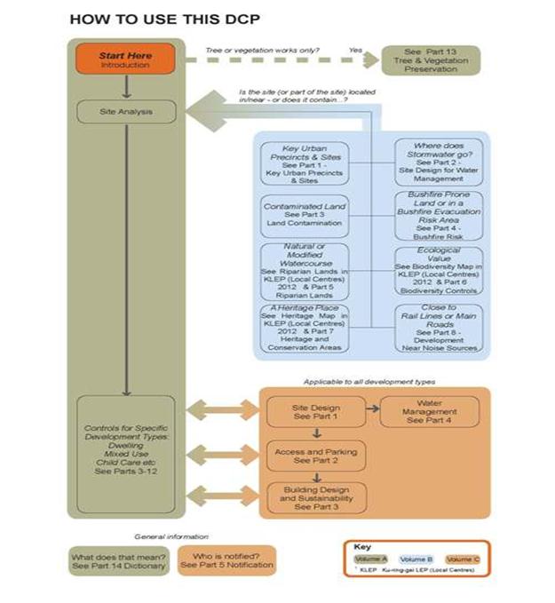
Legislative requirements and the status of DCPs
The process for the preparation and implementation of Development Controls is governed by the provisions of the Environmental Planning and Assessment Act 1979 (EP&A Act) and associated Regulations. While the purpose of a DCP is to provide more detailed provision with respect to development permitted by a LEP, the EP&A Act requires that a DCP cannot be inconsistent or incompatible with any provisions of the LEP.
The State Government has recently amended the EP&A Act to increase the flexibility and reduce the weight of DCPs. This amendment is now in effect. It pertains to all existing and new DCPs. Key changes as described in the Planning Circular PS 13 - 003 by the Department of Planning and Infrastructure include:
· shifting the main purpose of a DCP to the facilitation of LEP aims, land use objectives and permissible development;
· a clear statement that such provisions are not statutory; and
· a requirement for flexibility in applying the provisions and allowing reasonable alternative solutions that achieve the objectives of those provisions;
While it is likely the weight of DCP provisions will ultimately be determined by the Land and Environment Court, Section 79C of the EP&A Act will continue to require the consent authority to consider the provisions of a DCP in assessing a development application. DCPs will continue to have a significant role in guiding development.
A letter to Ku-ring-gai Council from the Department of Planning and Infrastructure, dated 16 April 2013, (see Attachment A1) states (in part) the following:
‘Before finalising the draft DCP, it is requested that Council ensure its consistency with the new legislative changes regarding DCPs. Consideration needs to be given to how the draft DCP applies across each of the relevant zones to ensure the objectives of the DCP controls are closely aligned with the objectives and standards in these zones.’
The ‘Governance’ section of this report outlines how the DCP complies with the legislation.
Comments
A total of 33 submissions were received by Council in relation to the draft Local Centres DCP. This report provides an outline of the key issues raised in submissions, and includes a number of recommendations for amendments resulting from the submissions. A more detailed analysis can be found in Attachments A3, A4 and A5.
General comments
A number of submissions expressed support for the DCP as a whole, and in particular for the structure of the DCP and the inclusion of hyperlinks in the electronic version. The urgent need for an adopted DCP was highlighted.
The general aims of the DCP were supported; however, some amendments and clarifications were sought. Additional measures were also sought for the e-version to assist in navigation of the document.
The following amendments are proposed to address these issues.
1. Amend the General Aims of the DCP in Volume A Part 1A.5 as follows:
a. Replace the text in Volume A Part 1A.5(xi) with:
‘Ensure the heritage significance of the heritage items and heritage conservation areas is conserved.’
b. Add an additional aim:
‘xv) Ensure that the process of notifying development applications allows public participation that is proportionate to the potential impact.’
2. Replace the last paragraph of the Volume B Part 7 outline in Volume A Part 1 (p1-9) with:
‘This part includes objectives and design controls to ensure that any development affecting a heritage item and/or heritage conservation area conserves the heritage significance of the heritage item and/or heritage conservation area, including their setting.’
3. Amend the title of the Introduction to Volume B Part 7 to:
‘Part 7: Heritage Items and Heritage Conservation Areas’.
Comments on Volume A – Controls for specific development types
· Parts 3 -5
Issues
Two submissions considered that control 6 in relation to isolated sites in Part 3A.1 (Land Amalgamation) is too onerous. Submitters considered that it would be reasonable to require either proof of reasonable attempts to purchase the isolated site, or design measures such as increased setbacks on the development site, but not both. The current controls are considered to allow the owner of the isolated site to hold the developer to ‘ransom’ preventing economic and orderly development.
Changes to the visual character map included for dwelling house developments were sought to include all areas that are zoned for low density as well as medium and high density.
Response
Regarding the isolated site controls, Part 3A.1-6 is based on the Land and Environment Court Planning Principles which aim to ensure the orderly and economic development of both lots. This seeks to prevent, as stated, one lot (being either the isolated site or the lot with a development application pending) holding the other to ‘ransom’. Further clarification is recommended to ensure that the aim for the reasonable redevelopment of both lots is clearly articulated.
Amending the visual character maps to include all low density areas is supported, as these areas will provide for dwelling houses into the future. The future desired character of the R3 and R4 zoned land is articulated in the design controls within the DCP. In this sense the application of visual character mapping to the higher-density zones is not relevant or helpful in terms of generating better contemporary design outcomes. Note that the visual character mapping will need to be reviewed as part of the preparation of the DCP to accompany the principal LEP for Ku-ring-gai.
Most secondary dwellings will be approved through State Environmental Planning Policy (SEPP) Affordable Rental Housing. This state government policy does not require parking on site for secondary dwellings. The DCP parking controls provide a compromise that is equitable between developments approved under the SEPP and those approved under the KLEP.
Proposed Amendments
1. Reword Volume A- Part 3A.1 – 6 ii) as follows:
Where a development proposal results in an isolated site, as described in 4 above, the applicant must demonstrate that:
i. Both the isolated site and the development site can be orderly and economically developed in accordance with the provisions of KLEP (Local Centres) 2012 and this DCP, including:
· achieving an appropriate urban form for the location, and
· having an acceptable level of amenity.
2. Reword the 2nd and 3rd paragraphs of the note to Volume A Part 3A.1-6 as follows:
To assist in this assessment, applicants are to submit details and diagrams of development for the isolated site, that is of appropriate urban form and amenity. The diagram is to indicate height, setbacks and resultant footprint (both building and basement). This should be schematic but of sufficient detail to understand the relationship between the subject application and the isolated site and the likely impacts of the developments. Important considerations include solar access, deep soil landscaping, privacy impacts for residential development and the traffic impacts of separate driveways if the development is on a main road.
The application may need to include a setback greater than the minimum requirement in the relevant planning controls. Or the development potential of both sites may need to be reduced to enable reasonable development of the both sites while maintaining the amenity of both developments.
3. Amend the Visual Character Maps in the reference section of Part 4 to show the visual character for all areas within the centres that are zoned R2 Low Density Residential or E4 Environmental Living.
· Multi dwelling housing controls –Part 6
Issues
Submissions sought reduced setbacks to the street and to the rear and reduced building separation distances as shown in the diagrams accompanying the controls in Part 6A.3. The latter diagrams were not considered to be consistent with the residential flat design code (RFDC).
Concerns were also raised that the 40% deep soil and site coverage controls are inadequate to allow for viable redevelopment for townhouses and fail to encourage 2 storey townhouse developments.
Response
The setbacks for multi-dwelling housing are appropriate to the context of a transition from dwelling house development to residential flat buildings, and to provide space for the tree canopy which supports both the existing and desired character of these areas.
The Residential Flat Design Code (RFDC) was developed prior to the Standard LEP template (on which the KLEP is based), which defines setback in relation to the balcony, not the primary wall of the building. The RFDC diagram shows separation between buildings without showing balconies. There is no inconsistency.
Some townhouses (multi-dwelling housing) have been developed under LEP 194 under the same deep soil landscaping and site coverage controls. The inclusion of these controls in the DCP rather than the LEP makes them more flexible, and allows better tailoring to the individual circumstances.
A previous feasibility study found that that a key financial constraint to the development of multi-dwelling housing is the need for basement car parking, and the resultant need for lifts for access to accessible dwellings. Given this, the draft DCP now provides for reduced deep soil and increase maximum site coverage where at grade parking is provided, to support this type of development. While it is acknowledged that further relaxing of these controls would encourage 2 storey townhouses, it is important to recognise that generous landscaped areas, with large tree canopies, are critical to the character of Ku-ring-gai.
· Residential flat building controls –Part 7
Issues
Seven submissions commented on the provisions in relation to residential flat buildings. Of these 3 were particularly detailed. The key issues raised include the following:
- Additional objectives were sought in relation to building articulation, the preferred building line and solar access.
- An objection to the requirement for increased setbacks on steep sites as the imposition of higher amenity standards for residential development on steep sites was not considered to be justified. Increasing the ground floor setback as well as the upper levels was suggested where controls require increased upper level setbacks at interface sites.
- A requirement for detail in relation to building separation for steep sites where the 4th floor was adjacent to the 5th floor of another building.
- A provision allowing buildings on angled site frontages to be stepped was sought.
- The DCP should be amended to be consistent with the RFDC. A common theme related to Figure 1.62 regarding Building Separation in the RFDC. Inconsistencies were identified in relation to balcony location in diagrams and separation between non-habitable rooms (such as bathrooms).
- A reduced setback to the side boundary for driveways on steep sites.
- The standard instrument definition of ‘site coverage’ used in the DCP is significantly different from the LEP194 definition of ‘Building footprint’. 'Building footprint' included balconies while the definition of site coverage does not, yet the maximum percentages are the same. Balconies are approximately 10% of a building footprint.
Response
- A number of additional objectives are recommended, as suggested, to support the controls in the relevant parts of the DCP.
- The increased setback requirement on steep sites is for sites adjacent to R2 Low Density Residential and R3 Medium Density Residential zoned land. It is reasonable for a lower density site to expect to retain a reasonable level of amenity, even if the adjoining site is zoned for higher density – and amenity impacts from high density development on upslope sites are demonstrably higher for the same bulk and height than from flatter sites. Some clarification of the control is however, appropriate.
- The development near the corner of the Pacific Highway and Bobbin Head Road provides an example of a building that responds to the angled site by stepping. A control in this regard would be appropriate.
- Part 1 of the DCP states that the DCP prevails over the RFDC to the extent of any inconsistency. Nevertheless, in most cases where this issue has been raised, namely in relation to setbacks and separation between buildings, there is no inconsistency:
· the relevant sections of the RFDC refer to ‘setbacks’;
· the RFDC was made prior to the standard LEP. The KLEP (Local Centres) 2012 (under the standard LEP template) defines setback in relation to the balcony, not the primary wall; and
· the relevant diagram in the RFDC shows only 1 balcony (for a much higher building than permitted in the R4 zone), with the other setbacks relating to the building edge – which could either be a wall or a balcony.
There is however, an inconsistency regarding the minimum setbacks between non-habitable rooms, where the DCP requires a 9m separation and the RFDC, 6m. It is recommended that this control be made consistent with the RFDC. Figure 7A.2-2 may also be inconsistent with the RFDC, and an amendment of the figure is recommended.
- It is agreed that for steep sites the most efficient driveway location is closer to the lower end of the site and Council has previously been flexible in this regard. It is recommended that this be recognised in the DCP and additional objectives and controls are recommended to ensure that such driveways do not compromise deep soil landscaping or dominate the streetscape.
- The main issue for Ku-ring-gai relates to how this may affect the extent of deep soil landscaping on the site. It is noted that overhanging balconies usually project over ground floor terraces, which do not provide for deep soil landscaping. The extent of overhang of the balconies is also controlled in Part 7C.10. The control can be amended to ensure that the site coverage does not compromise the achievement of deep soil landscaping, and a similar amendment can be added to Part 6 Multi Dwelling Housing.
Proposed Amendments
It is proposed that the DCP be amended as follows to address the issues in relation to residential flat buildings:
1. Add the following objectives to Parts 7A.1 and 6A.1 Building Setbacks:
To reduce the visual bulk of buildings from the street.
To maintain the rhythm of the built form on the street.
2. Add the following objective to Parts 7C.3 and 8C.1:
‘To ensure occupants have direct access to sunlight within apartments and areas of communal and private open space.’
3. Add an objective to Volume A Part 7C.4:
‘To encourage design that enables cross ventilation of apartments and natural ventilated kitchens.’
4. Amend control 7A.1-4 to add the following:
For angled sites, a stepped façade may be appropriate.
5. Add a diagram to Part 7A.1 to illustrate the above stepped façade control.
6. Amend the second sentence of Volume A Part 7A.1 -9(i) to read:
‘However, on steep sites located upslope from the lower density zone, greater setbacks may be required to minimise amenity impacts on neighbouring development. The setbacks must respond to the attributes identified in the site analysis, including consideration of the location of adjoining building and views of the site.’
7. Amend Figure 7A.1-6 by showing a setback to the ground floor as greater than 6m side/rear, as for the floor above.
8. In Parts 7A.2 and 8A.2, amend Control 1 that relates to ‘up to 4 storeys...’ to read:
(i) 12m between habitable rooms/balconies;
(ii) 9m between habitable rooms/balconies and non-habitable rooms;
(iii) 6m between non-habitable rooms.
9. Amend Figure 7A.2-2 by relocating the balcony balustrade on the fifth floor to the edge of the roof below.
10. Include an objective in Part 7A.1:
To ensure driveways do not compromise the landscape setting or neighbouring amenity.
11. Add a control to Part 7A.1 as follows:
Reduced setbacks may be considered where the driveway and building entry appear as a secondary visual element.
12. Add the following control to Volume C Part 2.2 Vehicle Access:
For driveways on sloping sites, where high retaining walls are required on both sides of the drive, one wall is to be no higher than 1.2m. Where greater level change is required, the retaining wall should be stepped back and softened by landscaping. High solid walls should be relieved by:
i) change in colour or finish;
ii) recessing; and /or
iii) exposed brick or block work.
13. At the end of objective 2 in Part 2.2 add:
‘and driveways.’
14. Reword Part 7A.3 – 1 as follows:
1. The site coverage may be up to a maximum of 35% of the site area, provided that the deep soil landscaping requirements in Part 7A.4 can be met.
15. Reword the sentence above the table in Part 6A.4-1 as follows:
1. The site coverage for multi dwelling housing may be up to a maximum site coverage as outlined in the table below, provided that the deep soil landscaping requirements in Part 6A.5 can be met.
In addition to the above amendments to the controls for residential flat buildings, there are a number of other amendments that address typographical and other minor errors and clarifications identified in submissions. Specific details of these are contained in the tables in Attachment A3.
Comments on Volume B – Centre and Site Specific Controls
A number of submissions received raised issues or concerns for the controls in Volume B relating specific centres and/or sites within each centre. The key issues raised in submissions for each centre and the subsequent proposed amendments are outlined below. More detailed changes and rationale for the proposed amendments along with other minor changes are contained in the Submission Summary Tables for Volume B Part 1 in Attachment A4.
· Turramurra
Issues
Key Issues raised by submissions include:
- Traffic on the Pacific Highway and surrounding streets, the traffic jams. Submitters noted the lack of connectivity between the two sides of the highway both for pedestrians and vehicles. Some solutions to these issues have been provided by submitters.
- Necessity to revitalise areas surrounding Cameron Park and through the centre itself.
- Heritage concerns are raised over the permissible land uses for the Hillview site and the necessity to retain the properties in the Gilroy Road precinct.
- The lack of protection afforded to dwellings within Heritage Conservation Areas.
- Confusion over the status and protection of ‘character items’ and the meaning of ‘street wall’ is also noted by submitters.
- Concern is raised over the 50% reduction in car parking for retail and commercial sites that have been amalgamated.
- There is also concern that Council is seeking to develop community car parking areas.
Proposed Amendments
It is proposed that the DCP be amended as follows to address the issues in relation to the Turramurra centre:
1. Amend DCP Volume A Part 14 - Definitions to include a definition of ‘street wall’ as follows
“A street wall is created when the facades of consecutive buildings are aligned along the edge of a street. An ideal street wall offers a sense of consistency and formality and includes a continuous variety of ground floor businesses”.
This change is made in relation to confusion over the definition of a street wall as there have been misunderstandings in the application and subsequent implications of a 3 meter high street wall for the Heritage properties along the Pacific Highway
2. Amend DCP Volume A Part 14 - Definitions to include a definition of ‘character item’ as follows:
“A character item is a building with a commercial streetscape that has a significant facade that warrants retention within the street wall. A character item is not a heritage item”.
This change is made add clarity to the meaning and role of a character item.
· St Ives
Key Issues raised by submissions for St Ives Local Centre include:
- Issues of adequate provision of parking spaces for the shopping centre and the necessity should it redevelop to provide all parking in basement areas to ensure there is no impact on parking availability on the surrounding streets.
- Traffic congestion and moveability of vehicular traffic through and around the centre.
- The relationship between the shopping centre and the village green. Some are concerned the DCP controls will reduce the number of trees or diminish the status of the Village Green. Submissions also raised concerns over the use of the phrase “seamless transition” as it was too vague and may imply a greater dominance of the shopping centre over the green.
- The position and type of facilities provided by the new community facility proposed in the DCP are discussed in submissions with some stating a preference for an aged care facility. Objections to the location of the facility are also noted.
Proposed Amendments
It is proposed that the DCP be amended as follows to address the issues in relation to the St Ives centre:
1. Amend DCP Volume B Part 1 page 1-7 as follows:
The words “provide a seamless transition” is replaced by the following: “…will allow people to move easily and safely between…”
The amendment seeks to provide more clarity to the control and ensure a positive design outcome.
· Gordon
Submissions concerning the Gordon Local Centre predominantly revolve around site specific issues. The two sites key sites are 11-15 Merriwa Street and 836 Pacific Highway, Gordon.
The key issues raised by submissions include:
- Requirements to provide pedestrian links on their sites are too onerous.
- The use of the term “principal active street frontage” is unclear, and thus its application is difficult.
- Concern with the application and meaning of ‘street wall’.
- General concerns include traffic congestion and circulation through the Gordon town centre.
Proposed Amendments
It is proposed that the DCP be amended as follows to address the issues in relation to the Gordon centre:
1. Amend DCP Part 1D.3 Building Setbacks Plan to show possible closure and/or relocation of McIntyre Lane adjacent to the zone boundary to enable site consolidation
This change addresses a site specific issue encountered on a site where the zone boundary changes. This recommendation will lead to a better design outcome for the site.
2. Amend DCP Volume A Part 14 - Definitions to include a cross-reference to the explanation of the terms ‘Principal Active Frontage’ and ‘Supporting Active frontage’ in Volume A part 8C-14.
3. Amend DCP Volume A Part 14 - Definitions to include a definition of street wall with a diagram (RE Merriwa street wall issues).
These changes aim to provide further clarity on the meaning and application of Principal and Supporting Active street frontage and Street Wall.
4. Amended the title of part 8C.14 to read “Ground Floor Commercial uses.”
This change is made to address the issues of clarity surrounding the use of the term principal active street frontage.
5. Amend DCP Part 1D.3 Precinct G4 p1-67 to include new point as follows:
- 5 metre building setback to McIntyre Street applying to no.1 McIntyre Street and 836 Pacific Highway. Setback starts at a distance of 15 metres back from the Pacific Highway property line
This change addresses a site specific issue; it aims to provide a visually attractive landscaped area on the corner lot.
· Roseville
Key issues raised by submissions for the Roseville local centre include:
- The lack of protection afforded by the heritage related controls, specifically for the Hill street shops.
- Support for the Public Domain and Pedestrian Access plan for Hill Street and Bancroft Avenue, and for the Propose Community Infrastructure.
- The provision of underground parking in the proposed Village Green should be noted in the DCP controls.
Proposed Amendments
It is proposed that the DCP be amended as follows to address the issues in relation to the Roseville centre:
1. Amend DCP volume B part 1F.4 - controls 1iii) and 1iv) by deleting the words “wherever possible”.
This change aims to strengthen the controls concerning the conservation of the facades on the Hill Street shops.
2. Amend DCP Volume B Part 1F.2 pg 10 bullet point 3 as follows:
- include in brackets “car parking to be relocated to basement parking on-site.”
This change aims to better state Council’s intentions to provide underground car parking at the proposed Village Green.
· Lindfield
Key issues raised by submissions for the Lindfield Local Centre include:
- Traffic generation and parking is a strong theme throughout submissions for Lindfield Local Centre. More detailed comments included providing parking at both Woodford Lane and Tryon Road and the provision of parking for new developments on the basement level.
- The new community centre should be co-located with the Library and available for a range of uses. Objections to the Bent Street Park have been raised by submissions.
- A rewording of the controls is suggested to provide for the dedication of the access way to council. There are some site specific concerns dealing with deep soil Landscaping requirements in Lindfield Avenue when part of the land is to be dedicated to the public.
Proposed Amendments
It is proposed that the DCP be amended as follows to address the issues raised in submissions in relation to the Lindfield centre:
1. Amend DCP Volume B, 1A.3, 1B.3, 1C.3, 1D.3, 1E.3 and 1F.3 to include a general note to cover all dedication of land requirements:
- In all cases, where land dedication is required for a public purpose, such as a road or walkway, Council will consider the creation of a right of way or any other alternative means that will assist Council to meet its planning objectives.
2. Amend DCP Volume B, 1A.3, 1B.3, 1C.3, 1D.3, 1E.3 and 1F.3 to include a general note to cover all dedication of land requirements:
- In all cases, where land dedication is required for a public purpose, such as a road or walkway, the affected land is to be excluded from deep soil calculations and included in setback requirements.
· Pymble
Key issues raised by submissions for the Pymble local centre include
- Concerns over the expansion of the Pymble Town centre, the need to strengthen the controls to state that Grandview Street is the current centre of Pymble and is intended to stay as such. A modest expansion of the Grandview shops is supported and controls should be changed to reflect that, the area should only be used as small local shops not as a retail precinct.
- Extension of Grandview Lane is questioned due to the slope and heavy traffic use, one-way only traffic is suggested.
- Setbacks to heritage properties.
- The omissions from visual character maps were highlighted.
Proposed Amendments
It is proposed that the DCP be amended as follows to address the issues raised in submissions in relation to the Pymble centre:
1. Amend 1C.1 Page 45 as follows:
- Delete the statement: “The Grandview Street area is planned to become the central focus of Pymble…” and replace with: “Grandview Street is planned to remain the central focus of Pymble…”
- Delete the statement: “The retail area will expand eastwards towards Park Crescent to create a leisure-orientated retail precinct with cafes and restaurants offering outdoor dining with a northerly aspect and views over Robert Pymble Park”.
Replace with:
“There may be a modest expansion of the retail area north-eastwards towards Park Crescent to create a retail precinct with cafes and restaurants offering outdoor dining with a northerly aspect and views over Robert Pymble Park”.
- Delete the statement: “Given the unique location it is envisaged the location will attract people from a broad area and provide a new commercial anchor for Pymble Centre.”
Replace with:
“Given the unique location it is envisaged the location will attract people from a broad area and provide a renewed focus for the Pymble Centre”.
These changes are made to better reflect the current and intended character of Pymble Local Centre, taking into consideration the issues raised in the submissions.
2. Amend DCP to include statement in 1C.4 p1-51:“Retain the façades of the following character buildings fronting Grandview Street and Alma Street - No.85 and No.81 Grandview Street”.
3. Amend built form plan 1C.4-1 as follows:
- Include graphic to show No.85 and No.81 Grandview Street as character items.
4. Amend Building setbacks plan 1C.3-1 as follows:
- delete reference to 2 metre setback to Alma Street.
5. Amend DCP page 1-49 Precinct P1 as follows:
- delete control i) and ii) referring to setbacks on Alma Street.
These changes have been made to increase the protection afforded to numbers 85 and 81 Grandview Street.
· Volume B general themes
A number of submissions raised concerns relating more broadly to Volume B as a whole. Of these submissions two strong themes emerged. The first of which are concerns regarding Heritage Items and Conservation Areas. Submitters noted that National Trust suggested Heritage Conservation Areas (HCA’s) have not been included in the LEP. Support for HCA’s and the level of protection afforded by the controls on the DCP. Certain submissions call for additional dwellings to be heritage listed. All these issues are LEP consideration and cannot be modified by the DCP.
The other key theme is biodiversity and riparian, concerns include confusion about land owners who have piped water ways or biodiversity on their block. Once again, these issues are LEP consideration and cannot be modified by the DCP.
Comments on Volume C- general development controls
The submission on Volume C stated that the controls requiring visitor parking to be behind a security grille or screen are unreasonable and contrary to the principles of Crime Prevention Through Environmental Design (CEPTED), resulting in concealment opportunities, having a negative effect on residents and neighbours. The submission suggests the control and diagram be deleted.
While the CEPTED issues are acknowledged, it is still important that visitor parking is easily accessible for visitors so as to minimise the desire or need to park in the street. To ensure visitor parking is provided in safe and accessible areas and ensure the controls better satisfy the objectives of CEPTED, the following amendments are proposed:
1. That an objective be added to Volume C part 2.3
- To minimise the impact of visitor parking on the street.
2. That a control be added to Volume C 2.3:
- Where visitor parking is situated behind a security screen or grille, inter-com access for visitors must be provided in a safe location within the driveway.
- Where visitor parking is not separated by a barrier, a light colour palette is to be used for the interior of the car park and lines of sight should be as open as possible to promote an open and safe environment.
FURTHER MATTERS
Due to changes in State Government legislation, updating of green building tools, and issues raised in discussion with compliance staff, further review of a number of Parts of the DCP will be required. This includes the following:
· Part 4 Dwelling House controls (Note this is scheduled for review as part of the DCP to support the future Ku-ring-gai LEP 2013);
· Part 12 Signage and Advertising Controls;
· Part 3.1 Green Buildings.
The review of these issues will occur as part of the preparation of the Principal DCP to accompany the Ku-ring-gai Local Environmental Plan 2013 (Principal LEP). It is also recommended that a review of the Local Centres DCP be conducted following 12 months of operation to ensure its ongoing effectiveness.
Governance Matters
It is critical that a DCP be adopted for the KLEP (Local Centres) 2012 to facilitate development permitted under the LEP. The current lack of a DCP in place creates uncertainty for both landholders and the community, and has the potential to compromise the aims and objectives outlined in the LEP.
With the changed legislation in relation to DCPs and the letter from the Department of Planning and Infrastructure dated 16 April 2013 (Attachment A1), it is appropriate to consider how the draft DCP complies with the legislation as updated.
Part 1 Introduction explains what a DCP is, and how to use the DCP. These descriptions include specific reference to the achievement of the purpose of the LEP, that provisions cannot be inconsistent with the LEP, and that alternate solutions to achieve the planning outcomes and objectives may be provided by the applicant and must be considered by Council. It also specifically states that the controls ‘guide’ the siting, design and assessment of development. In other words, it is not prescriptive.
Part 1A Preliminary outlines the purpose of the DCP and uses similar terminology to the legislation, namely, it ‘provides more detailed provision with respect to development to facilitate the stated aims and purpose of the KLEP (Local Centres) 2012’.
The general aims of the DCP support the aims of the LEP and the objectives of the land use zones and standards. Attachment A2 (Relationship between LEP and DCP) outlines this in detail.
Risk Management
Currently there are no DCPs applying for the area covered by the Ku-ring-gai LEP (Local Centres) 2012. Not proceeding with the DCP for the local centres and therefore relying only on the higher order standards of the LEP may have unintended outcomes for development within these precincts. Council risks damage to its reputation if it does not have up-to-date and consistent development controls in place in an effective and timely manner.
The draft DCP also contains detailed provisions to guide development in managing risks such as bushfire, flooding and land contamination.
Financial Considerations
The cost of preparing and exhibition of the draft DCP as outlined in this report is covered by Council’s Strategy and Environment Department – Urban Planning budget.
Social Considerations
The draft DCP provides a raft of provisions in relation to social considerations. These include, but are not limited to, heritage protection, social impact assessment, improvements to the public domain, residential amenity, access for people of different ages and mobility, pedestrian amenity and safety.
Environmental Considerations
The draft DCP provides extensive guidance on the protection and management of our creeks and waterways, of native vegetation and habitat. It also includes provisions to minimise waste, to manage water sustainably and reduce energy use, where this is not covered by BASIX. The objectives and controls provide more detailed guidance on environmental matters of consideration identified in the Ku-ring-gai (Local Centres) LEP 2012.
Community Consultation
The draft Local Centres DCP was placed on public exhibition from Friday 1 March to Tuesday 2 April 2013. A notice advertising the exhibition was included in the North Shore Times on 1 March 2013 and on Council’s website. The information was available at the Council Chambers and on the website during this period.
A total of 33 submissions from the public were received by Council. This report summarises these submissions and proposes a number of resulting amendments to the draft plan.
Internal Consultation
The draft Local Centres DCP was prepared with significant input from staff from across council departments. During and following the exhibition, further consultation with staff from Development and Regulation has provided guidance in relation to the recommended amendments.
Staff from Development and Regulation also recommended the rewording of an objective in Volume A Parts 7C.6 and 8C.5 in line with a decision from the Land and Environment Court in relation to the unit mix. Errors were also identified that are to be corrected.
The following amendments are proposed to address issues identified as a result of internal consultation:
1. Volume B Part 1 be amended as follows, to ensure the DCP is internally consistent:
- Amend the title of Part 1A.3 Precinct S3 by deleting the words ‘Mixed Use Buildings in R4 zones’;
- Amend the first sentence in Part 1E.3 Precinct L6 to: ‘The following are applicable for buildings in R4 zones, where mixed use buildings are permitted:’
- Amend the title of Parts 1A.1 Precinct S3, 1D.1 Precinct G5 and 1E.1 Precinct L6: ‘Mixed Use Buildings in R4 Zones’, by deleting the phrase ‘Mixed Use’.
2. Volume A Part 7A.1 be amended to replace the reference in control 2 to ‘Reduced Setback Maps’ to ‘Building setbacks plans’.
3. Objective 4 in Volume A Parts 7C.6 and 8C.5 be amended to read: To provide housing that caters for different household requirements now and in the future.
4. In Volume A Part 13.2 -3 the reference to ‘AS 4838 – 1996’ be replaced with ‘AS 4373 – 2007’;
5. In Volume C the title of Part 1.3 be renamed to ‘Part 1.3 Landscape Design’.
6. Amendments to section 3.1 Green Buildings to give clarification about the green building requirements of non-residential buildings according to their sizes. Changes include:
- A statement inserted into paragraph 1 of the introductory passage, stipulating that non-residential buildings are to incorporate ecologically sustainable design features to ensure efficiency in building design.
- A statement inserted into paragraph 2 of the introductory passage, and the removal of repetitive wording in paragraph 3 in the introductory passage give clarification that non-residential buildings above 2,000m2 are required to utilise the Green Building Council of Australia rating tools to ensure a 4 or 5 star building is achieved.
- Wording has been inserted into control 2 and 3 both expanding the abbreviation GFA to give a complete explanation of the term.
Summary
The Ku-ring-gai (Local Centres) LEP 2012 was gazetted on 25 January 2013 and is now in effect.
Detailed guidelines are required to facilitate the achievement of the objectives within the LEP. The Draft Ku-ring-gai Local Centres Development Control Plan establishes a framework for future development in the local centres under the new LEP.
The draft Local Centres DCP was exhibited in accordance with the above, from Friday 1 March to Tuesday 2 April 2013. A total of 33 public submissions were received.
There are a number of amendments that are proposed to be made to the Draft DCP as a result of the submissions and further internal consultation. A revised draft DCP incorporating these amendments is included as Attachment A6.
|
A. That Council adopt the amended Ku-ring-gai Local Centres Development Control Plan as included in Attachment A6.
B. That other minor or typographical errors and inconsistencies be corrected prior to the DCP coming into effect.
C. That the adopted DCP be forwarded to the Department of Infrastructure and Planning in accordance with the Environmental Planning and Assessment Regulation 2000.
D. That a review of the DCP be conducted a year after the DCP becomes effective, and a report be brought back to Council.
|
|
Terri Southwell Senior Urban Planner |
Craige Wyse Team Leader Urban Planning |
|
Antony Fabbro Manager Urban & Heritage Planning |
Andrew Watson Director Strategy & Environment |
|
A1View |
Letter from Department of Planning and Infrastructure on Purpose of DCP |
|
2013/094024 |
|
|
|
A2View |
Relationship between LEP and DCP |
|
2013/105980 |
|
|
A3View |
Submissions Summary and Response - Local Centres DCP Volume A |
|
2013/088675 |
|
|
A4View |
Submissions Summary and Response - Local Centres DCP Volume B Part1 |
|
2013/088674 |
|
|
A5View |
Submissions Summary and Response - Local Centres DCP Volume B (General) & Volume C |
|
2013/088933 |
|
|
A6View |
Ku-ring-gai Local Centres Development Control Plan:
Volume A - Click here to view Volume A Volume B - Click here to view Volume B Volume C - Click here to view Volume C
|
|
|
|
APPENDIX No: 1 - Letter from Department of Planning and Infrastructure on Purpose of DCP |
|
Item No: GB.9 |
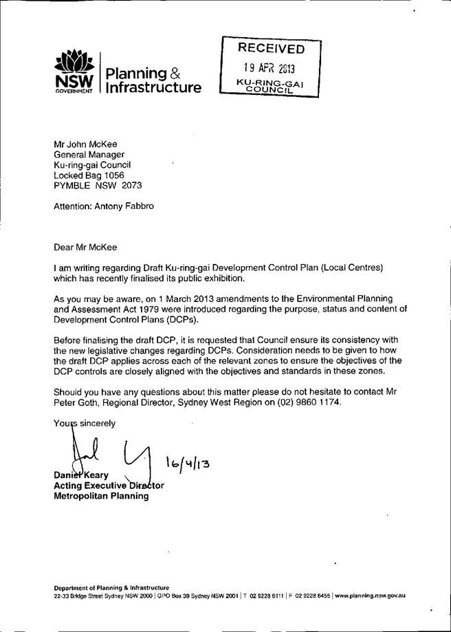
|
|
Item No: GB.9 |
RELATIONSHIP BETWEEN THE LOCAL CENTRES DCP AND THE LEP IN TERMS OF AIMS AND ZONE OBJECTIVES
1. Relationship between the LEP aims, the general aims of the DCP and the parts of the DCP
Note the general aims of the DCP are listed below the table by the number shown in the table
|
LEP aims |
DCP general aims (not comprehensive) |
Key DCP Parts |
|
|
a) |
to establish a hierarchy of centres for Ku-ring-gai
|
i) iii) |
Volume B Part 1 Volume A |
|
b) |
to guide the future development of land and the management of environmental, social, economic, heritage and cultural resources in Ku-ring-gai for the benefit of present and future generations
|
All aims
|
All Volumes |
|
c) |
to facilitate the development of the centres to enhance Ku-ring-gai’s economic role and cater to the retail and commercial needs of the local community
|
ii) iv) vii) viii) x) xv)
|
Volume B Part 1 Volume C Sections of each part in Volume A |
|
d) |
to provide a variety of housing choice within and adjacent to the centres |
iii) viii) xi) xiv) xv)
|
Volume A Volume C Volume B |
|
e) |
to protect, enhance and sustainably manage the biodiversity, natural ecosystems, water resources and ecological processes within the catchments of Ku-ring-gai
|
vii) xii) xiii) xiv) xv)
|
Volume B Parts 2 -6 & 8 Volume C Sections of each part in Volume A Volume A Part 2 |
|
f) |
to recognise, protect and conserve Ku-ring-gai’s indigenous and non-indigenous cultural heritage
|
xi) xv)
|
Volume B Part 7 Volume A Part 2 |
|
g) |
to encourage a diversity of employment in Ku-ring-gai |
iii) viii) xv)
|
Volume B Part 1 Volume A – in particular Part 8 Some sections of Volume C |
|
h) |
to achieve land use relationships that promote the efficient use of infrastructure
|
ii) ix) x) xiv) xv)
|
Volume A Parts 2, 3 and particular sections in each part of the rest of Volume A Volume C Parts of Volume B |
|
i) |
to facilitate good management of public assets and promote opportunities for social, cultural and community activities |
ii) v) viii) ix) x) xi) xv)
|
Volume B Parts 1 and 7 Volume C Sections in each Part of Volume A |
|
j) |
to protect the character of low density residential areas, and the special aesthetic values of land in the Ku-ring-gai area. |
i) iv) v) x) xi) xiii) xv) |
Volume A Parts 2 and 4 Volume C Volume B (except Part 1) |
DCP General Aims as outlined in Volume A Part 1A (with amendments recommended in this report)
i) Establish a future character for Ku-ring-gai’s local centres
ii) Provide high quality public spaces and streets
iii) Encourage the provision of a range of building types which provide for increased housing choice, diversity of employment opportunities, access to retail and commercial services and other activities that contribute to a sustainable vibrant community
iv) Ensure high quality sustainable urban design and architectural design of buildings
v) Ensure buildings and other development have a good relationship with neighbouring developments, the public domain and the landscape qualities of the locality
vi) Ensure a high level of residential amenity in building design for the occupants of buildings, including daylight access, acoustic control, privacy protection, natural ventilation, design for safety, outdoor living, landscape design, indoor amenity and storage provision
vii) Promote the principles of ecologically sustainable development including water sensitive urban design, climate responsive building design, energy efficiency, and selection/use of building materials
viii) Ensure buildings and landscaping are designed for all age groups and degrees of mobility
ix) Promote increased use of public transport, walking and cycling
x) Provide traffic control measures and outcomes that manage and improve local traffic impacts and promote pedestrian safety
xi) Ensure the heritage significance of the heritage items and heritage conservation areas is conserved
xii) Promote and support biodiversity conservation, riparian restoration and ecological integrity
xiii) Ensure the long term survival of Ku-ring-gai’s native and exotic tree and vegetation cover
xiv) Ensure the appropriate management of risks, such as flooding, bushfire and land contamination
xv) Ensure that the process of notifying development applications allows public participation that is proportionate to the potential impact.
2. The relationship between the land use zone objectives and the general aims of the DCP and the objectives and controls in the DCP.
The objectives and controls of a number of sections of the DCP apply to all types of development and will help to facilitate the aims of the LEP and the objectives of the zones and provisions of the LEP. These include Volume A Parts 2 and 13 and Volume C.
The objectives and provisions of Volume B encourage the early consideration in the design stage of the relevant site values and urban design parameters sought for key urban precincts within the centres, therefore facilitating outcomes sought under the LEP.
In addition the following table identifies the General Aims of the DCP (listed above) which are most relevant to the objectives of each zone as identified in the LEP. It also identifies the parts of the DCP specific to these zones where the objectives and controls are designed to facilitate the development types permitted in these zones. Note the general aims of the DCP are listed above by the number shown in the table.
|
LEP zone objectives |
DCP aims |
Key DCP Parts |
|
|
R2 |
• To provide for the housing needs of the community within a low density residential environment • To enable other land uses that provide facilities or services to meet the day to day needs of residents • To provide housing that is compatible with the existing environmental and built character of Ku-ring-gai. |
i) iii) iv) v) vi) xi) xiii) especially |
Volume A Part 4 especially & Volume A Parts 5 & 10
|
|
R3 |
• To provide for the housing needs of the community within a medium density residential environment. • To provide a variety of housing types within a medium density residential environment. • To enable other land uses that provide facilities or services to meet the day to day needs of residents. • To provide a transition between low density residential housing and higher density forms of development. |
i) iii) iv) v) vi) xiii) ix) xiii) |
Volume A Part 6 especially & Volume A Part 3
|
|
R4 |
• To provide for the housing needs of the community within a high density residential environment. • To provide a variety of housing types within a high density residential environment. • To enable other land uses that provide facilities or services to meet the day to day needs of residents. • To provide for high density residential housing close to public transport, services and employment opportunities. |
i) iii) iv) v) vi) xiii) ix) xiii) |
Volume A Part 7 especially & Volume A Part 3
|
|
B2 |
• To provide a range of retail, business, entertainment and community uses that serve the needs of people who live in, work in and visit the local area. • To encourage employment opportunities in accessible locations. • To maximise public transport patronage and encourage walking and cycling. • To provide for residential housing close to public transport, services and employment opportunities. • To encourage mixed use buildings that effectively integrate suitable business, office, residential, retail and other development. |
i) to x) especially |
Volume A Part 8 and Volume B Part 1 especially & Volume A Parts 9 to 12. |
|
B4 |
• To provide a mixture of compatible land uses. • To integrate suitable business, office, residential, retail and other development in accessible locations so as to maximise public transport patronage and encourage walking and cycling. • To support the integrity and viability of adjoining local centres by providing for a range of “out of centre” retail uses such as bulky goods premises and compatible business activities. |
i) to x) especially |
Volume A Part 8 and Volume B Part 1 especially & Volume A Parts 9 to 12 |
|
B5 |
• To enable a mix of business and warehouse uses, and bulky goods premises that require a large floor area, in locations that are close to, and that support the viability of, centres. • To provide for specialty retailing and other compatible non-residential uses in locations with poor residential amenity. |
i) to v), vii) to x) especially |
Volume A Parts 8 to 12 especially |
|
SP1 |
• To provide for special land uses that are not provided for in other zones. • To provide for sites with special natural characteristics that are not provided for in other zones. • To facilitate development that is in keeping with the special characteristics of the site or its existing or intended special use, and that minimises any adverse impacts on surrounding land. |
i) iii) iv) v) vii) viii) xiii) |
Volume C provides objectives and controls that apply to all forms of development, including those not specifically covered in Volume A. |
|
SP2 |
•To provide for infrastructure and related uses. • To prevent development that is not compatible with or that may detract from the provision of infrastructure. |
ii) v) viii) x) |
Volume A Part 2
|
|
RE1 |
• To enable land to be used for public open space or recreational purposes. • To provide a range of recreational settings and activities and compatible land uses. • To protect and enhance the natural environment for recreational purposes. • To protect, manage and restore areas of high ecological, scientific, cultural or aesthetic value. |
i) ii) iv) vii) viii) xii) xiii) |
Volumes B & C |
|
E2 |
• To protect, manage and restore areas of high ecological, scientific, cultural or aesthetic values. • To prevent development that could destroy, damage or otherwise have an adverse effect on those values. |
xii) & xiii) especially |
Volume B Parts 5 & 6 especially |
|
E4 |
To provide for low-impact residential development in areas with special ecological, scientific or aesthetic values. • To ensure that residential development does not have an adverse effect on those values. • To prevent further fragmentation of ecological communities, biodiversity corridors or other significant vegetation or habitat. |
i) iii) iv) v) vi) xi) xiii) xii) and xiii) xiv) |
Volume A Parts 4 & 5 Volume B Parts 4, 5 & 6 |
|
APPENDIX No: 3 - Submissions Summary and Response - Local Centres DCP Volume A |
|
Item No: GB.9 |
|
SUMMARY OF SUBMISSIONS Draft Local Centres Ku-ring-gai DCP
|
||||
|
General |
||||
|
THEME |
ISSUE/CONCERN |
COMMENT |
RECOMMENDATION |
|
|
Layout |
Support for the presentation and quality of the DCP. Submission notes the hyperlinks in the online version as being very helpful.
It is suggested that all defined terms being highlighted and bold italics be hyperlinked in the online version.
It is also requested that the Volume identification for Volume C be consistently applied or have the Volume identification on each part cover page, eg Part 1A- Volume A and under each page number state the Volume (P 1-3/Volume A)
|
Support noted.
Several submissions seek hyperlinking (or other means to highlight the definition) and formatting defined terms in such a way as to be clearly identified as terms within the dictionary can be undertaken at any stage post exhibition as these are only changes to the form of the on line version of the plan, rather than changes to the plan itself. It is a very time consuming task however.
Further formatting to support navigation can be undertaken.
|
It is recommended that in the electronic version of the DCP all defined terms be clearly identified as such by formatting, and that access to the definition in the dictionary be simplified, eg by including a hyperlink.
In the electronic version of the DCP, increase the referencing to volume numbers (eg on cover page of each part, or on page numbers) to ensure easy identification.
|
|
|
Format |
It is urgent that this DCP be brought into force as there is no DCP for the Local Centres LEP to be assessed against.
Support for the structure of the DCP- noting the usefulness of the hyperlinks.
User guide paragraph 3 pg 1-2 the diagrams are helpful but it is unfortunate that the diagrams are not authoritative. The words at the beginning of the Users Guide have been repeated at the beginning of each volume under start here with extra text added. This is confusing.
|
Agreed. Council understands the value of this DCP in the assessment of DA’s.
Support noted.
The Illustrated Guide to the DCP diagram is purely informative, to show the interrelationship between the different sections of the DCP to the reader. It is not feasible to have this diagram as a control in the DCP.
The text at the beginning of each Part provides information on the section so the reader can determine the context and the relevance of the Part to their project. There is added detail in these sections as the outline given in Volume A is very general. |
No change recommended.
No change recommended. |
|
|
General Aims of the DCP |
Volume A 1A.5 General Aims of the DCP 1) Replace with “define the character for each local Centre and encourage development consistent with existing streetscape and planning controls specific to each centre”. Each centre should be encourage to develop, while retaining individual characteristics based on elements specific to each centre.
It Is suggested that an additional clause be added. xv) Set out the process for persons to be notified of development applications.
|
It needs to be acknowledged that the character of the centres will change as a result of re-development; therefore consistency with the existing streetscape is not appropriate. This does not preclude the consideration of elements specific to each centre within the planned future character. Indeed, the planned future character outlined for each of the urban precincts in Volume C recognises and builds on some of these elements (e.g. the Village Green for the shopping village precinct and the retention of the small shop character for the Stanley Street shops in St Ives, Robert Pymble park in the Grandview Rd Pymble precinct, and small scale infill development or sympathetic adaptive re-use of the existing character buildings in Hill St Roseville).
It is agreed that an additional objective regarding notification would be appropriate.
|
No change recommended.
It is recommended that an additional aim be added to Volume A Part 1A.5 as follows: xv) Ensure that the process of notifying development applications allows public participation that is proportionate to the potential impact.
|
|
|
General Aims |
Aim xi) Heritage items and HCAs. This control should be replaced with “Ensure the significance of heritage items and conservation areas is identified and retained or protected”. Recognition alone is not sufficient.
|
The heritage items and conservation areas are identified and protected by listing them on schedule 5 of the LEP. Clause 5.10 contains the relevant development controls that apply to heritage. The DCP provides additional guidance in how this can be achieved. The aim must include the term ‘conservation’ (of these heritage items and HCAs) as this implies both the retention of heritage significance and change.
It is noted that the brief outline of Part 7 in Volume B in the Introduction could also be clarified. |
Replace the text in Volume A Part 1A.5(xi) with: ‘Ensure the heritage significance of the heritage items and heritage conservation areas is conserved.’
Amend the title of the Introduction to Volume B Part 7 to: ‘Part 7: Heritage Items and Heritage Conservation Areas’. Replace the last paragraph of the Part 7 outline with: ‘This part includes objectives and design controls to ensure that any development affecting a heritage item and/or heritage conservation area conserves the heritage significance of the heritage item and/or heritage conservation area, including their setting.’ |
|
|
General Support |
Support for the DCP
The submission thanks Council for their strenuous work in preparing what is a high quality DCP.
|
Support noted. |
No change required. |
|
Volume A
|
THEME |
ISSUE/CONCERN |
COMMENT |
RECOMMENDATION |
|
Volume A general |
Volume A Volume A Part 3C.2 pg 3-17 Control 1 does not read logically and the word ‘with’ should be deleted.
Volume A Part 7 does not match with the Volume A Table of Contents.
Contents pages for Volume 1 Parts 7A, 7B, 7C omits title saying that this is for residential flat buildings.
|
Agreed.
No error has been found.
It is agreed that this would improve identification of the relevant section. |
It is recommended that the word ‘with’ be deleted from Volume A Part 3C.2 (1).
No change recommended.
Add the name of the development type to the contents pages in Volume A. |
|
Purpose of the DCP |
Volume A Part 1: Inclusion of the recent clause 74BA(1) of the Environmental Planning and Assessment Act 1979 under 1.A.1- ‘Purpose of this DCP. Suggestion of the change of the section from Purpose of this DCP to Purpose and Status of this DCP and Clause 74BA(1) be quoted first (an indicative layout has been supplied in the body of the submission see trim link).
|
The amendment to the Act is acknowledged, and page 1-2 on What is a DCP and How to use this DCP include guidance specifically based on the new 74BA and the guidelines published by the Department of Planning. However, this is not specifically addressed in part 1A.1. The submitter recommends repeating clause 74BA(1), however this is unnecessary, as it is already covered in the Act. |
It is recommended that the last sentence of paragraph 1 in Part 1A.1 Purpose of this DCP be amended to read as follows: ‘The DCP provides more detailed guidance to facilitate the aims and objectives in the KLEP (Local Centres) 2012 and to facilitate development permissible within the LEP.’
|
|
Isolated sites
Volume A Part 3A.1 |
Volume A- Part 3A.1.-6 Isolated site: Some controls are too onerous or ambivalent. The test in Control 6(ii) and associated note, pertaining to the avoidance of isolated sites when used in conjunction impose unreasonable constraints on the development and may well prevent orderly and economic development of land. The submission foresees an isolated site holding to ransom a fully compliant development if the developer cannot show how the isolated site can be developed adequately. If the site can be developed in accordance with KLEP (Local Centres) and this DCP then the applicant does not need to make a reasonable offer. (This issue is outlined in detail in submission 022). It is recommended that Council require either 6(1) or 6(ii) but not both. As it stands, the owner of the isolated lot can refuse to sell, or hold the proponent to ransom for an excessively high price. This is not orderly or economic development.
Delete the phrase “but not limited to” from Control 6(ii). This opens a Pandora’s box, which leads to disputes in the Land and Environment Court.
|
The controls in Part 3A.1-6 are based on the Land and Environment Court Planning Principles which aim to ensure the orderly and economic development of both lots. This seeks to prevent, as stated, one lot (being either the isolated site or the lot with a development application pending) holding the other to ‘ransom’. The control can be further clarified to ensure this aim is correctly articulated.
The term ‘includes’ is used in the control and covers this. “But not limited to’ is unnecessary.
|
It is recommended that Volume A- Part 3A.1 – 6 ii) be reworded as follows:
Where a development proposal results in an isolated site, as described in 4 above, the applicant must demonstrate that: i. Both the isolated site and the development site can be orderly and economically developed in accordance with the provisions of KLEP (Local Centres) 2012 and this DCP, including: · achieving an appropriate urban form for the location, and · having an acceptable level of amenity. It is recommended that the 2nd and 3rd paragraphs of the note to Volume A Part 3A.1-6 be reworded as follows: To assist in this assessment, applicants are to submit details and diagrams of development for the isolated site, that is of appropriate urban form and amenity. The diagram is to indicate height, setbacks and resultant footprint (both building and basement). This should be schematic but of sufficient detail to understand the relationship between the subject application and the isolated site and the likely impacts of the developments. Important considerations include solar access, deep soil landscaping, privacy impacts for residential development and the traffic impacts of separate driveways if the development is on a main road.
The application may need to include a setback greater than the minimum requirement in the relevant planning controls. Or the development potential of both sites may need to be reduced to enable reasonable development of the both sites while maintaining the amenity of both developments.
|
|
Isolated sites
Volume A Part 3A.1 |
Control 6 refers to isolated site, as described in Control 3. It should refer to Control 4.
|
Agreed. |
It is recommended that the first sentence of Volume A Part 3A.1 - 6 be amended by replacing ‘as described in 3 above’, with ‘as described in 4 above’. |
|
Environ-mental zones landscap-ing |
Volume A Part 4A.4 Landscaping wording should be included that all dwellings adjoining RE1 and E4 sites are to create a buffer incorporating species indigenous to Ku-ring-gai.
|
Volume C Part 1.3 contains landscaping controls that apply to development generally, including development for dwelling houses. Controls 13, 14, and 16-21 include sufficient controls to address this issue. |
No change recommended. |
|
Dwelling House Controls
Volume A Part 4 |
There are missing parts of information in the summary of the Visual Character Classification Study for Low Density R2 zoned land in the Local Centres. The following are the maps that have missing information:
· Visual Character Classification map Gordon: missing R2 zoned areas between Park, Robert, Khartoum Streets – no visual character classification
· Visual Classification map Pymble: R2 areas southwest of Pacific Highway – zoned R2 – no visual character classification
· Visual Character Classification for the eastern side of the Lindfield Local centre: R2 zoned land without a Visual Character Classification north of Havilah Rd and eastern side Nelson Rd
· Visual Character Classification for the eastern side of the Roseville Local centre: R2 zoned land without a Visual Character Classification between Oliver Rd and Lord St
· Visual Character Classification for the north- eastern and south side of the Turramurra Local centre: R2 zoned land without a Visual Character Classification
There is no reason that the Visual Character Classification cannot apply to R3 and R4 zoned land. For example, for multi-dwelling housing, densities can be increased without destroying the character of the local centres by requiring the following for multi-dwelling housing and Residential Flat buildings:
· Top floor is to be a maximum of 60% of the lower floor and be contained within a hipped roof form · Hipped roof forms with gabled features · External walls are predominantly face brick · External colours are to be sympathetic to the predominant colours in the street. · Use of architectural features such as columns to match surrounding Federation and Inter-war housing.
|
Agree with this submission that better integration of visual character assessment and low-density housing zones is required, and agree that some of the visual character mapping in the DCP does not fully cover some R2 zones and areas within HCAs.
Note that the visual character areas will need to be reviewed as part of the review of dwelling house controls in the preparation of the DCP to accompany the principal LEP for Ku-ring-gai.
The future visual character for the R3 and R4 zones is outlined through the objectives in various sections of Parts 6 (Multi Dwelling Housing) and 7 (Residential Flat Buildings) in this Volume
The visual character classifications/maps use broad historical categories to describe the current built character (generally low-density housing), and do not refer to future desired character. The future desired character of the R3 and R4 zoned land is articulated in the design controls within the DCP. In this sense the application of visual character mapping to the higher-density zones is not relevant or helpful in terms of generating better contemporary design outcomes. R2 and R3 zones within HCAS are subject to the specific heritage controls in Section 7. |
It is recommended that the Visual Character Maps be amended to show the visual character for all areas within the centres that are zoned R2 Low Density Residential or E4 Environmental Living.
No change recommended. |
|
Secondary dwellings Part 5A |
Volume A Part 5A
Secondary dwellings in E4 zones, in a heritage conservation area and on a Heritage Item should only be permitted with a Development Application.
|
The permissibility of secondary dwellings, with or without a development application is governed by SEPP (Affordable Rental Housing) 2009 and the KLEP (Local Centres) 2012. The DCP cannot address this issue. The DCP provides extensive controls in Volume B Part 7 in relation to heritage conservation areas, which proposals for secondary dwellings will be required to consider. |
No change recommended. |
|
Access and parking Volume A Part 5B.2 |
Volume A Access and Parking 5B.2 Concerns are raised over the exemption for the provision of car parking for Secondary dwellings located within 800m of a Railway Station or 400 of bust stop within a strategic corridor. Significant pressure has been placed on local streets due to increased parking demands from nearby units. The control is inconsistent with the objectives. |
SEPP Affordable Housing 2009 permits secondary dwellings on residential sites, in accordance with certain criteria. In relation to parking for such developments, clause 22(4) includes the following: ‘A consent authority must not refuse consent to development to which this Division applies ....if no additional parking is to be provided on the site.’ The draft Local Centres DCP requires some limited parking for the larger (2 bedroom) secondary dwellings, where they are beyond the acceptable walking distance to reasonable public transport. This is a reasonable compromise to ensure that parking requirements are equitable between the SEPP and the Local Centres DCP. This is not inconsistent with the objectives, as the other controls outline how parking, where provided, can be functional and protect the streetscape. |
No change recommended. |
|
Multi Dwelling Housing
Volume A 6A.2.C1 (i)
|
6A.2.C1(i) Multi Dwelling Housing- Townhouses and the front setback of 10 metres. This is too onerous, it is the same setback as for a RFB of 5 storeys townhouses do not have the same impact on the streetscape as townhouses and do not require the same setback. This will have a negative effect on the design of the townhouses.
|
Single dwelling houses have a 12m setback to the high side of the road, and a 9m setback to the low side. A consistent 10m setback for townhouses is appropriate in this context.
|
No change recommended. |
|
Minimum setbacks
Volume A 6A.2.C5 |
Minimum setback of 6m provided from rear boundary. The rear boundary provisions should be no different from the provisions on the side boundary. This control may inhibit good design and sitting. It may at times be preferable to have a smaller ready boundary setback and a larger side boundary setback.
|
Multi-dwelling housing is the main development type in the R3 zone, which is often located near or at the interface with low density dwellings. Low density dwellings have a requirement for a larger rear setback (generally 8-12m). The 6m setback requirement for multi-dwelling housing reflects this pattern of providing for larger spaces for landscaping at the rear of the site, often forming a continuous landscaped area which is part of the character of Ku-ring-gai. |
No change recommended. |
|
Building Setbacks Volume A Part 6A.2
|
Building Setbacks- Encroachment Point 12 is unclear as to whether eaves, pergolas and columns are associated with the private courtyards or an encroachment. Concern that there is no specification as to the distance/ area that the above mentioned elements can encroach into the setback. A maximum area of total encroachment should be given.
|
These are not specified as being necessarily part of a courtyard or not. In particular, eaves and blades are likely to also be associated with the building where no courtyard is provided. The control is performance based rather than numerical, recognising that different designs, site constraints and building layouts will mean that the same setback to these features may result in different outcomes in terms of increasing the apparent bulk. |
No change recommended. |
|
Building separation
Volume
A |
6A.3-1 The 12m separation bar on the 3rd floor. The 12m separation bar on the top floor should be drawn from the wall of each of the 3rd storey, not from the edge of each balcony. The DCP Diagram is in conflict with the Diagram 01.62 on pg 28 of the RFDC and should be amended.
|
The RFDC was developed prior to the Standard LEP template, which defines setback in relation to the balcony, not the primary wall of the building. The RFDC diagram shows separation between buildings without showing balconies. There is no inconsistency. |
No change recommended. |
|
Multi-dwelling housing Site coverage 6A.4 |
6A.4.-1 Town house site coverage of 40%. The 40% site coverage combined with the FSR of 0.8:1 means that a feasible development must be 3 storeys. However, there is a very small market for three storey townhouses (a combination of the extra stairs and complaints from local residents about the 3rd storey). Increasing the site coverage to 45% would allow for the development of two storey townhouses without having an adverse impact on the deep soil landscaping. There would be a marginal impact on the streetscape but this would be mitigated by the reduction in height. The higher site coverage would encourage the development of 2 storey townhouses.
|
It is acknowledged that a greater site coverage would encourage two storey townhouse development rather than 3 storey. However, it is also important to recognise that generous landscaped areas, with large tree canopies, are critical to the character of Ku-ring-gai. Site coverage does not include eaves, basements, certain awnings, unenclosed pergolas, decks and the like. Increasing the site coverage would be likely to conflict with the proposed deep soil landscaping requirements in the majority of cases. Increased site coverage has been provided to allow at grade car parking, in recognition of the cost of basement parking and lifts. However these areas will not contribute to the bulk of the development, and are still required to include landscaped elements. |
No change recommended.
|
|
Deep Soil Landscap-ing for Multi-dwelling housing |
Concern that a minimum deep soil landscaping area of 40% of the site for multi-dwelling housing would make potential developments on the R3 zone unviable.
Development constraints related to the 40% landscaping control could prevent small developers to proceed with multi-dwelling housing due to financial reasons. If this type of control discourages multi-dwelling housing construction, pressure on Ku-ring-gai local area to meet housing targets will increase.
There is no perceived justification for the 40% deep soil landscaping requirement. A minimum deep soil landscaping area of 30% would better suit the purpose of R3 zones.
|
Some townhouses (multi dwelling housing) have been developed under LEP 194 under the 40% deep soil landscaping control. The inclusion of the control in the DCP rather than the LEP makes this more flexible, and allows better tailoring to the individual circumstances.
A previous feasibility study found that that a key financial constraint to the development of multi dwelling housing is the need for basement carparking, and the resultant need for lifts for access to accessible dwellings. Given this, the draft DCP now provides for reduced deep soil where above ground parking is provided, to allow for this type of development.
|
No change recommended. |
|
Part 7 Volume A General Comments |
This section should state its relationship to the Residential Flat Design Code as per DCP 55.
Part 7 should reference/ point to other relevant sections. |
The relationship is outlined in Volume A Part 1A.7 and covers residential flat buildings as defined in SEPP 65, which includes the residential components of mixed use developments as well as residential flat buildings as described in Part 7 of this DCP.
These references to other parts and volumes are contained in colour coded text boxes in the margins of each page where relevant. |
No change recommended.
No change recommended. |
|
Volume A Part 7 |
Thanks staff for preparation of the DCP. It is a considerable improvement over DCP 55.
|
Noted. |
No change required. |
|
Volume A Part 7A.1 & 7A.2 |
Volume A Part 7: 7A.1 - 9 is ambiguous and should be deleted. There is no justification for imposition of higher amenity standards for residential development on steep sites.
|
7A.1 -9(i) provides for a minimum setback to land zoned for lower density. It includes the following and references a diagram: However, on steep sites, greater setbacks may be required to minimise amenity impacts on neighbouring development. The setbacks must respond to the attributes identified in the site analysis, including consideration of the location of adjoining building and views of the site.
This provision is a result of experience with a number of residential flat buildings under LEP 194 that adjoin down-slope low density sites, and the difficulties encountered. It is reasonable for a low density site to expect to retain a reasonable level of amenity, even if the adjoining site is zoned for higher density – and amenity impacts from high density development on upslope sites are demonstrably higher for the same bulk and height than from flatter sites. It is acknowledged that this is a performance based control – providing flexibility in how the objective can be met, rather than a numeric control- providing greater certainty. While a control, such as a building height envelope, could be developed, a performance based control is considered appropriate given the variety of circumstances where this issue occurs. Greater certainty could be provided by specifying that it only applies where the higher density development is uphill from the low density site. |
It is recommended that the second sentence of Volume A Part 7A.1 -9(i) be amended to read:
However, on steep sites located upslope from the lower density zone, greater setbacks may be required to minimise amenity impacts on neighbouring development. The setbacks must respond to the attributes identified in the site analysis, including consideration of the location of adjoining building and views of the site. |
|
Building Setbacks 7A.1 -3 & 4 |
7A.1-3 this control concerning an articulation zone needs an objective.
It is suggested that the wording “and within the side setbacks” be added after behind the street setback for this control.
7A.1-4 Control requires an objective.
For angled sites should the frontage be strictly parallel or can the building be stepped, for example on the Pacific Highway and Bobbin Head Road).
|
Agreed.
A control in 7C.10 requires that no single wall plane exceed 81m2 in area. This is adequate for the facades to the side of buildings. Additional articulation requirements would reduce the development potential on the site. Note that the DCP must be compatible with the LEP.
Agreed that an objective is required.
Stepping the building may be a desirable option for such sites, rather than an angled façade.
|
It is recommended that: · the following objectives be added to Parts 7A.1 and 6A.1 Building Setbacks as follows: o To reduce the visual bulk of buildings from the street. o To maintain the rhythm of the built form on the street. · Control 7A.1-4 be amended to add a the following: o For angled sites, a stepped façade may be appropriate. · a diagram be added to illustrate the stepped façade control. |
|
Building Setbacks 7A.1 - 5 |
Fig7A.1-5 The second diagram in this couple is always going to be preferable as it gives wider deep soil for larger landscaping. Larger, staggered and layered landscaping should be an objective at these interfaces.
|
Agreed. However, the stepped back option is consistent with development already approved under LEP 194. In DCP 55 it was unclear whether the option demonstrated by the second diagram was supported. Including this diagram makes this clear, and provides opportunities for more varied built forms. |
No change recommended. |
|
Side and rear setbacks
Volume A 7A.1 - 4
|
Figure 7A 1-4 minimum side and rear setback controls. The diagram shows that the minimum building separation is measured from the boundary to the balcony balustrade, not the wall of the 5th floor. This conflicts with the RFDC Diagram 1.62 pg 28 and increases the setback for 5th floor apartments. The top storey (of a 5 storey RBF) should be located to the 6m setback line and the building wall at the 9m setback line allowing the space created to be uses as habitable terraces. Other wise this wastes space and reduces economic viability and makes the area non trafficable making maintenance difficult.
|
Figure 1.62 is a diagram showing setbacks appropriate to various heights. Where there is an increase in the setback to the wall of the building the setback to the habitable terrace is the same as for the level below. The RFDC was made prior to the standard LEP. The KLEP (Local Centres) 2012 (under the standard LEP template) defines setback in relation to the balcony, not the primary wall. Figure 1.62 in the RFDC shows only one balcony, namely that above the step back. Note that at higher levels, balconies are often stepped back to ensure that visual privacy is maintained to adjoining developments.
|
No change is recommended. |
|
Part 7A.1-9 Interface sites |
7A.1-9 How is Lower Density defined?
|
7A. 1-9 relates to side and rear setbacks at the zone interface and to development adjoining land zoned for ‘lower density’. It is clear that this is intended to be any zoning for lower density – such as R3 or R2. The diagrams could be more realistic with at least 2 storeys shown on the lower density site.
|
It is recommended that figures 7A.1-5 and 7A.1-6 be amended: · to show 2 storey dwellings on the lower density site · to identify the adjoining lower density site as ‘Site zoned R2 or R3’ |
|
Building Setbacks 7A.1 -6
|
Fig7A.1-6 The ground floor setback should probably be 9m. Stepped buildings like these are difficult to design. The control should encourage less stepping and a greater setback (Beaconsfield Road L&EC)
|
Figure 7A.1-6 includes a number of steps. This could be reduced by increasing the setback of the ground floor to the same as the floor above. |
It is recommended that Figure 7A.1-6 be amended by showing a setback to the ground floor as greater than 6m side/rear, as for the floor above.
|
|
Driveway setbacks to allow for deep soil landscape
Volume A 7A.1 - 7
|
The 6m setback to the driveway is unreasonable for sites with a slope of greater that 10% across the street frontage. For sloping sites the driveway should be located as close to the lower side boundary as possible to reduce the length of the driveway and the length of the drive way at the front setback. This also reduces the amount of building that is ‘gouged out’ by the driveway.
|
It is agreed that for steep sites the most efficient driveway location is closer to the lower end of the site. There are a number of examples where Council has been flexible in this regard with the current controls. However additional advice could be included in a control to guide the design of developments seeking reduced driveway setbacks in these locations. An objective would also support this.
Such driveways often require high retaining walls on both sides, which, if not well designed, are unduly dominant. Stepping back one of these walls would open it up, and landscaping between the retaining walls would soften it. The high walls can also be made to appear less dominant by the choice of materials and finishes.
One of the objectives could be amended to ensure that driveways are considered. |
It is recommended that an objective be included in Part 7A.1: To ensure driveways do not compromise the landscape setting or neighbouring amenity.
It is recommended that an additional control be added to Part 7A.1 as follows: Reduced setbacks may be considered where the driveway and building entry appear as a secondary visual element.
Add the following control to Volume C Part 2.2 Vehicle Access: For driveways on sloping sites, where high retaining walls are required on both sides of the drive, one wall is to be no higher than 1.2m. Where greater level change is required, the retaining wall should be stepped back and softened by landscaping. High solid walls should be relieved by · change in colour or finish; · recessing; and /or · exposed brick or block work.
At the end of objective 2 in Part 2.2 add: ‘and driveways.’
|
|
7A.1-7 |
Suggestion that this control require driveway entries are “through a front face of the building”.
|
This is not required. Part 7A.1-6 already states that side setback areas behind the building line are not to be used for driveways.
|
No change recommended. |
|
Side and rear setbacks for interface sites
Volume A 7A.1 -9 |
Side and rear setbacks to adjoining land zoned for lower density: Due to interface zoning this control is not necessary. The wording includes land which is proposed to be zoned R3 as well as land zoned R2. The control need only apply to land adjoining R2 land as there is no need to impose onerous controls on land R4 land that adjoins R3. The wording of the control is too vague and may lead to disputes over that an appropriate setback is. The ambiguity gives Council assessment officers too much power to choose the setbacks they feel appropriate.
|
The interface controls impose an additional setback at the higher levels adjacent to both R2 and R3 sites. Townhouse development is much more like dwelling houses than residential flat buildings in nature and an increased setback at the higher levels is reasonable.
The control regarding the potential need for increased setbacks on steep land recognises that the impact of 5 storey development on a site located steeply downhill is much greater than that on a similar topographic level. The control is merit based, with guidance about factors to take into account. Numeric controls are not always the best way to address a particular issue as the individual circumstances will need to be considered. |
No change recommended. |
|
Building Setbacks 7A.1 -11 |
7A.1-11 The meaning of to allow for deep soil landscaping in common areas is unclear.
|
7A.1-11 outlines the degree of encroachment into the setback areas for private courtyards. The phrasing could be clarified for this Part, and for the same controls in Part 6 Multi Dwelling Housing.
|
It is recommended that the phrasing of Volume A Part 7A.1 – 11 be amended as follows: Ground floor private terraces/courtyards may encroach into the setback areas (refer to Figure 7A.1-7). A minimum setback to the courtyard wall of: i) 8m from the street boundary; ii) 4m from the side and rear boundaries must be retained to ensure space for deep soil planting within the adjoining common areas. It is recommended that the phrasing of Volume A Part 6A.2-9 be amended as follows: Ground floor private terraces/courtyards may encroach into the setback areas. A minimum setback to the courtyard wall of: i) 8m from the primacy street boundary; ii) 4m from the secondary street boundary; iii) 3m from any side and rear boundary; and iv) 4m from the rear boundary; must be retained to ensure space for deep soil planting within the adjoining common areas.
|
|
Building Setbacks 7A.1 -12 |
7A.1-12 The submission suggests this control may be redundant.
|
7A.1-12 requires that no more than 15% of the total area of the street setback area is to be occupied by private courtyards. This control is required to ensure that most of the front setback is retained as common area to allow for deep soil planting to support the desired character of the area. It also limits the extent and therefore visual impact of built elements such as fencing in the front setback. |
No change recommended.
|
|
Building Setbacks 7A.1 -13
|
Volume A 7A.1 Building Setbacks- Encroachment Point 13 is unclear as to whether eaves; pergolas and columns are associated with the private courtyards or an encroachment. Concern that there is no specification as to the distance/ area that the above mentioned elements can encroach into the setback. A maximum area of total encroachment should be given.
|
These are not specified as being necessarily part of a courtyard or not. In particular, eaves and blades are likely to also be associated with the building where no courtyard is provided. The control is performance based rather than numerical, recognising that different designs, site constraints and building layouts will mean that the same setback to these features may result in different outcomes in terms of increasing the apparent bulk. |
No change recommended. |
|
Building Separation 7A.2 |
7A.2 Objective 2 should be deleted as is does not relate to the controls. The controls relate to scale massing, solar access and open space provision. The objective appears to imply that it is acceptable for residents to lower levels to have lesser visual an acoustic amenity than the residents of upper levels. While this may be a result of the other objectives, it should not be a stated objective.
|
Objective 2 states: To configure buildings to protect and enhance visual and acoustic privacy for occupants and adjacent residents. Not all objectives relate to all the controls, some objectives relate to only one control. The controls about the higher levels are particularly relevant to the objectives about massing and overshadowing. Note also that planting measures at the higher levels are less likely to assist in enhancing privacy.
|
No change recommended. |
|
Building Separation 7A.2-1 |
7A.2-1 What is the measurement for building separation on sloping sites if the 5th storey of one building is opposing the 4th storey of another?
|
Note that this issue could also apply across site boundaries. It is agreed that this issue is not addressed in the DCP. Neither is it addressed in the RFDC. Given the extent of different circumstances a merit based approach is appropriate.
|
No change recommended. |
|
7A.2 -1 |
7A.2-1 These separations are greater than the Residential Flat Design Code which allows 6m NH-NH. They are also an increase from DCP 55 4.5.3 C-2iii. 7A.2 C1(ii) requires a separation of ‘9m between rooms/ balconies in all other cases’. The control differs from the RFDC control and should be amended to avoid confusion.
|
Agreed. |
It is recommended that the section of Control 1 that relates to ‘up to 4 storeys...’ (in Volume A, Parts 7A.2 and 8A.2 be amended to read:
(i) 12m between habitable rooms/balconies; (ii) 9m between habitable rooms/balconies and non-habitable rooms; (iii) 6m between non-habitable rooms.
|
|
Minimum building separation controls
Volume A 7A.2-2 |
7A.2-2 Minimum building separation controls. The diagram is inconsistent with the C1 controls and with the RFDC from which the controls are derived. The diagram requires a greater setback than stipulated in C1 and should be amended to reflect these controls and the controls in the RFDC.
|
The Residential Flat Design Code (RFDC) does not show balconies, Figure 7A.2-2 makes it clear how balconies are affected. However, one example of the balcony edge above the building setback is inconsistent with the RFDC (namely that shown at the 5th floor) This should be extended to the edge of the roof above, for consistency with the RFDC. |
Amend Figure 7A.2-2 by relocating the balcony balustrade on the fifth floor to the edge of the roof below. |
|
Site Coverage 7A.3-1 |
7A.3-1 Definition of site coverage has changed significantly under the KLEPLC 2012, from KLEP194 definition. 'Building footprint' used to include balconies. The KLEPLC 2012 definition does not appear to. Balconies are approximately 10% of a building footprint.
Fig7A.3-1 The submission suggests the equation can be simplified to [Ax35%] m2
|
This is correct. Based on the 10% suggested in the submission, this would mean that a 35% building footprint (as defined in the KPSO), would convert to a 31.5% site coverage under the new definition (from the LEP). Given that the LEP term ‘site coverage’ is very close to council’s previous ‘building footprint’, the use of the term ‘site coverage’ is more consistent with the LEP. The main issue for Ku-ring-gai relates to how this may affect the extent of deep soil landscaping on the site. It is noted that overhanging balconies usually project over ground floor terraces, which do not provide for deep soil landscaping. The extent of overhang of the balconies is also controlled in Part 7C.10. The first control can be amended to ensure that the site coverage does not compromise the achievement of deep soil landscaping. A similar amendment could be added to Part 6 Multi Dwelling Housing.
The intent is to exclude the access handle from the area of the site. The definition of site coverage in the LEP includes the entire site. This simplified version achieves this, but is not consistent with the definition of ‘site’ used within the term ‘site coverage’ in the dictionary. However, an additional note could be included under Figure 7A.3-1 to explain that this formula equates to [A x 35%]m2.
|
It is recommended that Volume A Part 7A.3 – 1 be reworded as follows: 1. The site coverage may be up to a maximum of 35% of the site area, provided that the deep soil landscaping requirements in Part 7A.4 can be met.
It is recommended that the sentence above the table in Volume A Part 6A.4-1 be reworded as follows: 1. The site coverage for multi dwelling housing may be up to a maximum site coverage as outlined in the table below, provided that the deep soil landscaping requirements in Part 6A.5 can be met. It is recommended that an additional sentence be added to the label for Figure 7A.3-1 stating: Note: This is equivalent to [A x 35%]m2.
|
|
Deep Soil Landscape Vol A Part 7A.4 |
7A.4 State that deep soil is a primary DCP control?
7A.4 This section should promote the retention of trees
7A.4 Submission suggests all trees should be provided in communal open space.
7A.4 Trees should be planted at least 4m from buildings (so that TPOs cover them).
|
Unlike the Residential Flat Design Code, this DCP does not identify primary and other controls. Note however, that it is included within the Site Design sections for the relevant development types, to ensure that the objectives are considered in the early design phase. Objective 4 promotes the retention of trees. A control could be added to require the configuration of deep soil landscaping to retain trees on the site where appropriate. The relevant section in Part 6 Multi Dwelling Housing and Part 9 Office Buildings could be similarly amended.
Communal open space and common areas are different under the DCP. It is acknowledged that trees in both of these areas have better protection than those in private areas. However, some increased scope for the encroachment of private courtyards into setback areas is warranted to support viable development options and good design of the built form. The encroachments are limited under Part 7A. 1-11 to ensure that significant areas of deep soil landscaping and tree planting is provided within the communal and common areas.
This issue is addressed through a merit consideration of the space required for a tree to grow. In many instances, 4m from the building is inadequate, and council staff require a greater setback. |
No change recommended.
It is recommended that a control be added before the existing Control 2 in Volume A Part 7A.4 , before existing Control 4 in Part 6A.4 and after the existing Control 3 in Part 9A.3 as follows:
Deep soil zones are to be configured to retain healthy and significant trees on the site and adjoining sites, where possible.
No change recommended.
No change recommended. |
|
Car Parking Provision |
7B.1-2 Remove note. This can lead to deep soil between buildings in centre of site (Precinct 3 UTS Ku-ring-gai)
There is not enough street parking for residential flat buildings. The DCP should more explicitly encourage off street parking.
|
The controls for Precinct 3 on the UTS site are quite different, as they have been based on the concept plan approved by the state government and the “Edgelea Design Guidelines”, rather than an LEP or DCP. The area above basement links between buildings will not count as ‘deep soil’ under the definition of deep soil landscaping in the DCP. The configuration and topography of some sites, makes such basement links a better option –including from a landscape perspective- than separate entries to each building.
The DCP sets out requirements for parking to be provided on the site, both for residents and visitors, consistent with those required by other councils near train stations. |
No change recommended.
No change recommended. |
|
Location of Communal Open Space
Volume A 7C.1 C3 7C.3
|
7C.1 C3- location of communal open space at ground level and behind the building line. This is not feasible on all sites can in some cases conflict with 7C.3 C3. Communal open space that receives 3 hours of sun in mid winter for RFB’s of 5 storeys is often located in the front setback due to shadowing created by the building its self.
|
The description of Better Design Practice in the Residential Flat Design Code states (under Site Configuration- Open Space): Provide communal open space which is appropriate and relevant to the context and the building’s setting. The general setting of residential areas in Ku-ring-gai is private open space areas behind the building line, and usually at the rear of the site. Where there are conflicting objectives and careful design that seeks to integrate these objectives is not feasible, variations can be sought. . As outlined in Volume A Part 1, the applicant and council will consider the appropriateness of compliance with the specific control in the light of the objectives and the individual circumstances of the site. |
No change recommended. |
|
Communal Open Space Volume 7C.1 |
DCP55 4.8.2 C-3ii) requires natural ground level to be maintained within 2m of a side or rear boundary. It is recommended that this control be included here.
7C.1-5 The control is unclear on how much solar access to communal open space is required.
7C.1-5 Consider whether communal open space assists or compromises neighbours (Telegraph Rd L&EC)
|
This control is provided in volume C Part 1.2 -5 and therefore covers all development types, not just residential flat buildings.
The extent of solar access required for communal open space is outlined in 7C.3- 3; namely at least 3 hours to at 50% of the space between 9am and 3pm midwinter.
This case considered the impact on neighbouring development from communal open space. These areas are similar to backyards in low density areas, where some noise is to be expected. An objective could be added in regard to neighbouring amenity. Note that screen planting is also required to side and rear boundaries, in Part 7A.4. An objective regarding amenity of neighbours could also be added to Part 7A.4. |
No change recommended.
No change recommended.
It is recommended that an objective be added to Volume A Part 7C.1: 4. To ensure that the design of communal open space protects the privacy of neighbouring residents. It is recommended that objective 5 in Volume A Part 7A.4 be amended by adding after ‘locality’: ‘and help to protect neighbouring amenity.’
|
|
Access to communal open space
Volume A 7C.1 |
7C.1 Control 4 access to a communal open space for people with a disability. The control is too broad and thus too onerous. It could be interpreted that access for people with a disability is to be provided to all areas of the communal open space. In some areas of Ku-ring-gai this is not possible due to steeply sloping sites. The control should state access to the principal communal open space.
|
AS 1428 includes standards in relation to accessible paths of travel to outdoor spaces that service the building. The control could be improved by more direct reference to this standard. Any amendment should flow through to development for mixed use, office premises and multi-dwelling housing.
|
It is recommended that Volume A Parts 7C.1-4, 8C.10-5, 9C.7-3 and 6C.1-5 be amended to read: Access to communal open space must be provided for people with a disability in accordance with Part 2 Section 7 of AS 1428. Access within the largest area of communal open space must be provided for people with a disability. |
|
Solar Access
7C.3 |
7C.3 it is advisable that the three hours standard Control 2 be reduced to two hours for residential flat buildings developments over three storeys high in R4. This would make the control consistent with the Residential Flat Design Code for high density residential areas.
Control 8 is unreasonable and should be deleted; it is not feasible to establish the solar access compliance unless the size of the adjacent under-developed sites is known. There is no certainty that the adjoining site may ever be developed. It is very difficult to design for a site when the design of the potential building is unknown. There are too many unknown factors to be able to design with any certainty, for example the site may be amalgamated that this will change the design. Multiple potential designs would have to be generated for the under-developed site increasing time and cost for a DA. The onus should be on the developer of the potential future sites to design the building to achieve compliance with the solar access controls.
|
7C.3 Control 2 requires solar access to 70% of apartments for 3 hours midwinter. This is considered consistent with the Residential Flat Design Code (RFDC) and achievable, given the character and setbacks of development within the R4 zone. Note that shop top housing in the business zones require only 2 hours, as it is recognised that these areas are high density as envisaged in the RFDC.
Control 8 is a response to the issues encountered in developments under LEP 194, where development on R4 sites was treated as ‘first in best dressed’, resulting in subsequent adjoining developments finding it extremely difficult to plan a feasible development while meeting the solar access controls. It should be noted that the drawings need only be schematic and of enough detail so show the relationship between development on both sites. This clause does not mean to require a full site analysis and design for every foreseeable development on both sites. Merely drawings showing one possible option that facilitates the development of both sites.
|
No change recommended.
No change recommended.
|
|
Solar Access 7C.3 |
7C.3 Objectives should include achievement of direct sunlight to apartments, communal open space and neighbours
7C.3-2 Include a note on what is required to demonstrate sunlight access (hourly 'sun's eye view' diagrams with tabulated results).
7C.3-2 To capture sites with multiple buildings include the phrase in each building after at least 70% of apartments
7C.3-3 Clarify that this relates to communal open space with a minimum 80m2 (as required by 7C.1-2) |
The second objective in this part addresses the matter of solar access to neighbouring living areas and open space areas. However, an additional more detailed objective would support these aspects for the occupants of the site.
The appropriate location for this requirement is the DA Guide.
Agreed. This would improve the overall building design and apartment mix on a large site.
The requirement for solar access to 50% of communal open space overall is the control here. Requiring 50% of the main communal open space area to have 3 hours solar access midwinter could be added as a control to 7C.1-2. Similar requirements could be added for mixed use development.
|
It is recommended that an objective be added to Volume A Parts 7C.3 and 8C.1: ‘To ensure occupants have direct access to sunlight within apartments and areas of communal and private open space.’
No change to the DCP recommended.
It is recommended that Volume A Part 7.3-2 be amended to include the phrase ‘in each building’ after ‘at least 70% of apartments’.
It is recommended that the following be added to Part 7C.1 -2: and iii) access to direct sunlight for at least three hours between 9am and 3pm on 21st June, to at least 50% of the space. Add the following to Part 8C.10 -2: and iii) access to direct sunlight for at least two hours between 9am and 3pm on 21st June, to at least 50% of the space.
|
|
7C.3 Solar Access
|
7C.3-4 Purpose of control is unclear. Which objective does it relate to? · West and south-facing apartments should be separated. Relate west to afternoon sun and heat gain. Relate south to no direct sunlight. Single aspect is not relevant to sunlight issues (Beaconsfield Road L&EC). · Orientations should be expressed as a range of directions rather than a strict west or south.
|
An additional objective in relation to heat gain could be added. Using a wider orientation would pick up both southerly and some westerly single orientation apartments, and be consistent with the RFDC.
|
It is recommended that the following objective be added to Volume A Parts 7C.3 and 8C.1: To minimise heat gain to apartments in summer for the comfort of residents.
Amend the first sentence of 7C.3 - 4 and 8C.1 - 4 to read: 4. The number of single aspect apartments with a southerly aspect (SW to SE) is limited to 10% of the total number of apartments proposed in each building.
|
|
7C.3 Solar Access
|
7C.3.8 Replace the under-developed site with “yet to be redeveloped sites”
|
Agreed that this would be clearer.
|
In Volume A Part 7C.3.8 replace ‘the under-developed site’ with “yet to be redeveloped sites”
|
|
7C.3 Solar Access
|
The RFDC does not address shading, neither do the objectives within the solar access section. These controls should be deleted.
|
Amenity in terms of living with the climate needs to address comfort in both winter and summer. Heat stress has also been identified as an increasing health issue in the future under climate change. The controls are not unreasonable, and should be retained. An additional point could be added to the objectives to support them.
This should also apply to mixed use development.
Note the solar access section for multi-dwelling housing already contains a similar objective.
|
It is recommended that objective 1 in Volume A Part 7C. 3 be amended to read as follows: 1. To ensure a high level of internal amenity for all occupants: · with direct access to daylight in all habitable rooms, and · a comfortable internal environment in summer..
Amend Part 8C.1 by replacing objectives 1 and 2 with the above objective.
|
|
Natural Ventilation 7C.4 |
7C.4 Objective should include achievement of cross ventilation to apartments and natural ventilation for kitchens.
7C.4-3 Clarify that 25% kitchens must be immediately adjacent to a window.
Clarify difference between advice on natural ventilation and cross ventilation.
Controls recommended: · Cannot cross ventilate through skylights · Cannot cross ventilate using open corridors if it causes a privacy issue
7C.4-4ii Suggested removal of this clause, as 2 storey single orientation units do not cross ventilate.
Fig 7C.4-1 Using this diagram to describe max 8m to rear of kitchen is unclear. It is open to interpretation; some would measure from the lounge window. This aspect specifically needs it own diagram and control.
|
Agreed. It should also be added for Multi Dwelling Housing and Mixed Use.
This would make it clearer what is required for a kitchen to be naturally ventilated.
Agreed.
An additional control could be provided to clarify this for residential flat buildings and mixed use development.
Figure 7C4-2 demonstrates functional examples of 2 storey apartments with cross ventilation. References to the diagrams can be added to the relevant controls to support this for both residential flat buildings and mixed use development.
Agreed. Figure 7C4-1 relates to cross ventilation of the apartment. Figure 7C5-2 is intended to show the 8m distance from the window to the back wall of the kitchen. Similar changes are recommended for Mixed Use development.
|
It is recommended that an objective be added to Volume A Parts 7C.4, 8C.2 and 6C. 4: ‘To encourage design that enables cross ventilation of apartments and naturally ventilated kitchens.’
It is recommended that: Volume A Parts 7C.4 -3, 8C.2-3 and 6C.4 -3 be amended to read: 3. At least 25% of all kitchens are to be immediately adjacent to an operable window.
Amend 7C.4 -4, 8C.2 -4 and 6C.4-4 by replacing the word ‘natural’ with ‘cross’ in the first sentence.
Add a control Part 7C.4 and Part 8C.2 as follows: 5. Cross ventilation as required in 4) above, should not be dependent on skylights, or on open corridors where it would impact on privacy.
Add references to Figures 7C.4-1 and 7C.4-2 to the relevant controls in Part 7C.4 Natural Ventilation, and to Figures 8C.2-1 and 8C2-2 to the relevant controls in Part 8C.2.
It is recommended that: · Figures 7C4-1 and 8C.2-1 be amended to delete the measurement from the kitchen to the window, and move the kitchen to adjoin a window. · Figures 7C5-2 and 8C.4-2 be amended to ensure that the 8m minimum dimension is measured from the lounge window, and make it obvious it is the closest window.
|
|
Apartment depth and width Volume A 7C.5-1 |
7C.5 The objective should refer to ‘daylight access’ rather than ‘sun access’.
|
Agreed. This is an amenity issue. |
It is recommended that the objective to 7C.5 be amended to replace the term ‘sun access’ with ‘daylight access’. |
|
8m apartment width
Volume A 7C.5-1
|
7C.5-1 and 7C5-2 The calculation of the 8m apartment width: The diagrams do not take the measurement from the closest window. Figure 7C.5-1 single aspect apartment takes the measurement from the balcony balustrade and not the window to the balcony which is closer. This has in advertently increased the 8m depth.
The same applies for 7C.5-2 where the distance is not taken from the closest window. This conflicts with the RFDC rule of thumb and pg 69 and should be brought into line.
|
The dimensions shown in Figure 7C.5-1 relating to single aspect apartments apply from the window of the area without a balcony to the rear wall. To avoid confusion, the dimensions and the length to be measured could be rearranged to ensure they are adjacent to each other.
Agreed. |
It is recommended that: · Figure 7C.5-1 and 8C4-1 be amended to ensure that the dimensions and the length to be measured are adjacent to each other · Figure 7C5-2 and 8C.4-2 be amended to ensure that the 8m minimum dimension is measured from the lounge window, and make it obvious it is the closest window.
|
|
Apartment Mix and Sizes 7C.6 |
7C.6-2i 50m2 is very large for a studio apartment. Perhaps 35m2 would be appropriate.
7C.6-6 Definition of visitable in dictionary needs to be more specific to be useful for this clause.
|
50m2 is the minimum size recommended for a 1 bedroom apartment in the RFDC Rule of Thumb. A studio apartment layout would allow for reasonable use of space within a smaller size. The relevant RFDC table notes that an internal dimension of 38.5m2 allows for a functional and well organised layout for a studio apartment. This would also apply to studio apartments in mixed use developments.
Clarifying the definition could be achieved by referring to the relevant standard. |
It is recommended that Volume A 7C. 6 - 2 and 8C.5-2 be amended to provide for a minimum studio apartment size of 38.5m2.
Amend the definition of ‘visitable’ in the Dictionary in Part 14 to read: ‘a place that can be accessed by people who use wheelchairs, in that there must be at least one wheelchair accessible entry and accessible path of travel to the living area and to a toilet that is either accessible or visitable as defined by AS 4299’. |
|
Room Sizes 7C.7 |
7C.7-2 All bedrooms should be required to have a built-in wardrobe |
Requiring built in robe for all bedrooms up to at least 2 bedrooms for multi dwelling housing, mixed use development and residential flat building is reasonable. Additional bedrooms may sometimes be used for other purposes, such as studies, and more flexibility is warranted. |
It is recommended that a control be added to Volume A 7C.7, 8C.6, and 6C.5 as follows: Built in wardrobes are to be provided: · to all studio apartments; · to all bedrooms in one and two bedroom apartments; · to at least two bedrooms in apartments of three or more bedrooms.
|
|
Multiple entries for buildings over 18m long
Volume A 7C.8-2 |
7C.8 -2 Buildings with facades over 18m long must have multiple entries. Most Residential flat buildings are over 18m, the maximum building length allowed is 36 meters. The control is unreasonable, as multiple entranceways increase cost and can confuse visitors and means duplication of lifts and lobbies where otherwise not necessary.
|
The RFDC identifies multiple entries as a ‘better design practice’ with entries located so they relate to the existing street and subdivision pattern (among other matters). 18m is reasonable given the existing subdivision and landscaping pattern in Ku-ring-gai. Further, requiring multiple entries helps to ensure that lifts are provided in such a way as to limit the number of units off any single hallway. Multiple entries support improved legibility within the building, and simple clear entry signage is all that is required to ensure that visitors can find their way. |
It is recommended that the following objective be added to 7C.8: ‘To provide entries that relate to the existing pattern of subdivision, landscaping, the street and pedestrian movement.’
|
|
Building Entries 7C.8 |
7C.8-2 This control has the potential to strongly suggest/force multiple lift cores. This control will thus require an objective to say so.
Does it create address issues at the street front?
|
Agreed.
The controls include the potential to have a building entry at the side where the path is readily visible form the street. This allows for sites where the configuration would not suit multiple entries directly from the street. |
It is recommended that an additional objective be included in Volume A Part 7C.8: ‘To provide legible, safe and pleasant internal circulation spaces.’
No change recommended. |
|
Internal Common Circulation 7C.9 |
7C.9-2i This control can be made stronger by requiring natural light (similar to iv) (as per DCP55 4.5.1 C-3)
7C.9-2ii Define short, perhaps 30m absolute maximum. Could note that fire doors within corridors are not encouraged as a solution.
7C.9-3 Energy efficient light should be required in all instances. Include energy efficiency as an objective.
|
Some flexibility is reasonable in regard to access to natural light for circulation spaces.
Corridor lengths are also limited by 7C.9 – 4(i) which requires a maximum of 8 apartments off any single corridor. A note on fire doors would support the objective.
An additional objective could relate to maintenance costs for residential flat buildings mixed use and office developments. Energy efficiency is dealt with by BASIX and the DCP cannot cover this issue.
|
No change recommended.
It is recommended that a note be added to Volume A 7C.9 -2(ii) and 8C.8 -2(ii): Note: Fire doors within corridors are not considered to shorten corridors. It is recommended that an objective be added to 7C.9, and 8C.8 and 9C.5: 2. To minimise ongoing maintenance costs by providing natural light and efficient lighting to circulation areas. |
|
Building Facades 7C.10 |
7C.10 A materials palette could be suggested.
|
Materials are considered in Volume C Part 3.7.
|
No change recommended. |
|
Building façade articulation
Volume A 7C.10 -3 |
7C.10 Control 3 is not based on any objective design principles and has not being consistently applied to RFB development in Ku-ring-gai. Control 2 can achieve the modulation and articulation of building facades. Control 7C10 Control 3 and associated Figure 7C.10.2 should be deleted.
|
7C.10 Control 3 requires ‘No single wall plane is to exceed 81m2 in area’. This control has been applied successfully in LEP 194. It is based on an area of 9m by 9m, with 9m being the height of 3 storeys of a residential flat building (3 x 3m floor to floor). The control is included in the compliance table for the assessment of all residential flat buildings, and where it is not met, justification is provided. Control 2 only describes the type of articulation. |
No change recommended.
|
|
Building Facades
Continuous length of a building
Volume A 7C.10- 4
|
7C.10 -4 continuous length of a single building on any elevation not exceeding 36 meters in length. The control is ambiguous and open to interpretation that it establishes an absolute length of any elevation. This could be onerous and restrictive. An alternative control is recommended: The length of any façade segment should not exceed 36m. The length of a single building may exceed 36m provided the façade is modelled by recessed wall planes of adequate depth and width to appear as distinctive building bays or wings.
|
DCP 55 applied this control only to elevations facing the street. The draft DCP extends the 36m maximum to all elevations. Providing a more performance based control for elevations that do not face the street is reasonable, as deep insets, changing angles etc can help to relieve the apparent bulk of the building, and allow for additional landscaping adjoining other development.
|
It is recommended that Control 4 be amended to add the following: The length of a single building elevation facing the side or rear may exceed 36m provided that: (i) the façade is recessed to an adequate depth and width to appear as distinctive building bays or wings; and (ii) the recess is common area with landscaping which includes at least one medium tree(at least 8m canopy diameter at maturity).
|
|
Building Facades 7C.10 -5 |
7C10 C.5 Control 5 is vague, already covered by control 4, and reads like an objective it is inconsistent with Control 4 and should be deleted.
7C.10-5 Delete this control as it is not always desirable or possible and highly dependant on site. This control was used to argue for layout in Beaconsfield Rd L&EC, when building should have gone the other way.
|
Agreed.
|
It is recommended that control 5 in Volume A part 7C.10 be deleted.
|
|
Building Facades 7C.10 -10 |
7C.10-10 Conflicts with previous 1.2m diagram in POS. Consideration should be given to corner balcony exemption.
|
Agreed. The figure should be updated. Exempting corner balconies however, is not supported. A proposal for a greater balcony projection on a corner can be considered on merit against the objectives – eg to emphasise a corner site. Note that the 1.5m is already greater than the 1.2m allowed under DCP55. |
It is recommended that Figure 7C2-2 be amended to identify a maximum balcony projection of 1.5m. |
|
Height of Buildings
Volume A 7C.11 |
7C.11: Control 1 is an unnecessary duplication of height controls which conflict with Clause 4.3 KLEP (LC) 2012. Other controls achieve the same outcome thorough statutory height controls and internal ceiling height controls. The control has no urban design on amenity benefits and should be deleted.
|
This control is not inconsistent with Clause 4.3 of the LEP, but provides additional detail. It is agreed that it also supports the ceiling height clause. The number of storeys is consistent with development that has already occurred under LEP 194. There have been a number of constructed residential flat buildings since 2004 that have a substantial number of floors with 2.4m ceiling heights, despite meeting the 2.7m requirement in the design phase. Deletion of the storey control would exacerbate this issue.
|
No change recommended.
|
|
Building Storeys 7C.11 |
Fig7C.11-1 Support for the diagram as it explains principle of storeys well. However does it create issues with other controls, for example separation which refer to a specific storey? |
Support for diagram noted. The separation controls are considered under Building Separation in this summary. The diagram illustrates graphically the outcome of the definition of ‘basement’ in the LEP (as per the standard LEP template) and how storeys are therefore to be counted. |
No change recommended. |
|
Ground Floor Apartments7C.12 |
7C.12-3 Is reference to March sun angle relevant if it is only applicable from northeast direction?
|
The sun angle is not the critical factor in determining whether the private open space and living areas have adequate access to daylight and ventilation. The reference to the sun angle is confusing and unnecessary for the control to be effective. |
It is recommended that Volume A Part 7C.12 -3 be amended by deleting the phrase in brackets, namely ‘(10am sun angle at 23 March)’. |
|
Top Storey Design and Roof Forms 7C.13 |
7C.13-1(ii) How this control will work is unclear.
7C.13-2 Requires a minimum dimension Perhaps 600mm (articulation)? Or if the aim of the control is to reduce visual height of building 2.4m (balcony)? If the control is in place to combat overshadowing, then top floor should be loaded to central north of footprint.
7C.13-2 Is roof projection allowed beyond the primary building footprint? 7C.13-2 Could note that lift cores should not be located on the outer edges of buildings (as they cannot be set back).
|
There has been considerable confusion in the past about which is the top storey. In some instances the top storey was seen as the highest level of the building at any given vertical point. For a stepped building this resulted in an interpretation of the top storey as the highest level at each step – ie multiple top storeys on a single building. This control is intended to clarify that the top storey refers only to the highest level of the building as a whole, not the highest level at any given point.
This is not envisaged.
A note could be added to the control to this effect. |
No change recommended.
No change recommended. Add a note to Volume A 7C13 - 2: ‘Note: Lift cores will need to be located internally within the building to facilitate the top storey setback.’ |
|
Overshadowing
Volume A 7C.13 |
7C.13 Objective 2 conflicts with the statutory FSR, a breach of the EP&A act defining what is permissible for a DCP. Compliance with the objective would reduce the top storey area by 50%. To date this has not been enforced by Development Assessment and should be modified as follows: ‘To provide articulation that reduces where possible and additional overshadowing’.
|
Objective 2 states: To provide articulation that prevents any increased overshadowing. The control is not inconsistent with the FSR control in the LEP. It does not define development that is permissible or prohibited, as stated in the submission, it provides guidelines for achieving development under the LEP. However, the key solar access issues are addressed in Part 7C.3. This objective and the associated controls should support, rather than replace or increase these requirements. |
It is recommended that objective 2 in Volume A Part 7C.13 be amended to read as follows: 2. To ensure that the design and location of the top floor minimises any increased overshadowing.
|
|
Volume A Privacy 7C.15 |
Visual Privacy is okay.
There should also be a section on Acoustic Privacy - should cover acoustic items such as air conditioning compressors mounted on balconies. |
Noted. It is also supplemented by the general Visual Privacy controls in Volume C Part 3.6.
Volume C Part 3.5 includes objectives and controls in relation to acoustic privacy for all development types. I t includes controls related to air conditioning systems – on balconies or otherwise.
|
No change recommended.
No change recommended. |
|
Visual Privacy |
7C.15-2 This control does not sit well with Fig7C.12-2. Rephrase as there being several ways to deal with this issue: fences, horizontal separation, planting, and level change (or a combination of these) (DCP55 4.1 C-10)
|
The DCP 55 control referenced is only in relation to private open space. This control is provided at 7C.2 – 7.
7C.15 -2 seeks to address privacy issues to habitable rooms on the ground floor. However, it is agreed that it is only one possible solution. |
It is recommended that 7C.15 – 2 be replaced with the following: ‘2. The privacy of ground floor apartments must be separated from common areas, communal open space and the public domain. Examples include the use of: · a change in level; · screen planting such as hedges or low shrubs. This will require a co-ordinated design that takes into account the need for disabled access ramps and entry into building foyers.’
It is recommended that Part 8C.18 -2 be replaced by the following: ‘2. The privacy of ground floor apartments and apartments at podium level must be separated from common areas, communal open space and the public domain. Examples include the use of: · a change in level; · screen planting such as hedges or low shrubs. This will require a co-ordinated design that takes into account the need for disabled access ramps and access to building foyers and communal open space.’
|
|
Storage |
7C.16-2 Include note that a schedule should be provided
7C.16-2 Internalised studio/media rooms without windows should not be encouraged as they could be used as habitable space (Precinct 3 UTS Ku-ring-gai)
|
This is unnecessarily onerous.
It is not intended that rooms without windows be used as habitable space. |
No change recommended.
Amend Note 1 to Volume A 7C.16 – 2 and 8C.21 by deleting the following: ‘which can also be used as studios/media rooms etc). |
|
External Air Cloths Drying Facilities |
7C.17-1 Reference 7C.2-3 for clarity |
Agreed. 7C.2-3 relates to the exclusion of services from the minimum size of private open space areas. |
It is recommended that Volume A 7C.17 -1 be amended by adding: ‘See 7C.2 -3’ and 8C.22 be amended by adding ‘See 8C.11 – 2’. When staff time is available it is recommended that a hyperlink be provided via a box on the left of the page. |
|
Fencing |
Fig7C.18-1 Example appears higher than 1.2m (1.5m?)
DCP definitions should include ‘Fences’ and “Hedges” and refer simply to the definition of the Dividing Fences Act 1991. Retaining walls etc are being sneaked through as if they are not fences.
The note at the end of the side fence paragraph should be moved to be the first item after ‘Controls’ and be printed in bold type.
Guidance is needed on the cut-offs between a ‘shrub planting’ and a ‘high hedge’. The growth of “green fences” which block outlooks across boundaries is changing the character of Ku-ring-gai and affecting safety and surveillance.
|
A clearer example could be found to replace this figure.
Fences and hedges are well understood by the public. The definition in the Dividing Fences Act includes watercourses, but does not include retaining walls so the use of this definition would not be helpful. The first control is the only control that references ‘open fencing’, so the note is appropriate in this location. Bolding of notes or controls in the DCP is not recommended, as the objectives and controls must be considered together.
Both hedges and shrubs along the front boundary are limited to 1.2m under 7C.18-4. This part also supported by an objective which states ‘To ensure that fencing does not detract from the overall visual amenity and character of the area.’ |
Replace Figure 7C.18 -1 in Volume A with a figure that clearly shows a lower fence, or if higher, shows landscape screening to the street.
No change recommended.
No change recommended.
No change recommended.
|
|
Minimum car parking for mixed use. Part 8 |
Part 8 – Mixed Use Development Controls
Volume A 8B.2 Control 10 Maximum car parking provisions – The number of car parking spaces for a 3 bedroom unit in a mixed use development should not be any different to a 3 bedroom unit in an RFB. The maximum number of car spaces for a 3 bedroom unit in an RFB is 2 car spaces and yet for a mixed use development is it limited to 1.5 car spaces for a 3 bedroom unit. This is relevant as the control states that any car parking above the maximum must be counted as FSR. |
Mixed use development is permitted only in areas within proximity of rail or bus infrastructure. People living within these dwellings will also have good access to a range of services in easy walking distance within their centre. These developments are designed to encourage pedestrian and public transport use. Limiting car parking spaces supports this objective, and also helps to reduce the overall cost of the development. |
It is recommended that the third objective in Volume A Part 8B.2 be amended to; 3 To encourage walking and public transport use. |
|
169 -177 Mona Vale Road, St Ives – JBA *
Volume A Part 8:
|
This submission is in regards to the following controls for mixed used development (Volume A Section 8): · The maximum 35% site coverage control. · The minimum 50% deep soil landscaping control (for sites in excess of 1,800m²).
These controls are exactly the same as the ones for flat buildings despite the very different built forms, especially at ground floor where these controls have more effect. The two controls do not take into account the type of development envisaged for the site and supported by existing controls in the LEP (Local Centres) 2012, including the requirement for an active street frontage in this location.
It is important that the DCP reflects the particular built form associated with a mixed-use development of the site, which will encompass a ground floor commercial floor plate with narrower residential floor plates above. This means that 60% maximum site coverage and a 25% deep soil landscaping are more appropriate for this site.
If the two controls were to be applied, the commercial/office FSR of 0.5:1 envisaged under the LEP 2012 would not be possible. This is against the EP&A 2012 (Amendment Act) requirement that DCPs facilitate development permitted under a LEP.
Other local councils, such as Willoughby Council, have chosen not to have site coverage controls applied to mixed-used development nor deep soil requirements. The suggestion is not to remove the deep soil or site coverage controls, but to have a reasonable control applied to this specific development type that acknowledges the nature of mixed-used development. |
As noted by the submitter, the former Local Centres LEP permitted a much higher amount of commercial floor space than the current Local Centres LEP as outlined below. Former LEP Current LEP Business, office, restaurant Part commercial, FSR 1:1 Part office to 0.5:1
This is within a context of a maximum FSR consistent with other residential flat buildings in Ku-ring-gai at 1.3:1.
This site (Precinct S3 in the DCP) is zoned R4 with the main permitted use being residential flat buildings. While some limited commercial use is permitted, the R4 zoning makes it clear that the built form should relate more to other residential flat buildings than the form of mixed use development permitted closer to the centres, in the B2 zones. This is supported by requirements in relation to this site in Volume B Part 1 which include a supporting (not principal) active frontage, a 6m setback to Mona Vale Rd and 3m to Shinfield and no awnings to the street. The reduced setbacks in comparison to other R4 sites would allow substantial areas at the rear of the site to be retained for deep soil landscaping, were a purely residential development to be proposed.
However, it is noted that should the proposal include commercial uses, for the majority of the area of this site, the LEP confines this use to the ground floor. Council has modelled the deep soil and site coverage that would result from a development with a 0.5:1 commercial floor space on the ground floor, and ascertained that the applicant’s suggested 60% maximum site coverage and 25% maximum deep soil landscaping are required to permit the commercial floor space to be achieved at ground level. The DCP cannot be inconsistent or incompatible with the LEP.
It is noted that other R4 sites under the LEP where commercial uses are permitted generally have a commercial FSR of 0.3:1. The site coverage and deep soil landscaping should be relaxed where a commercial use is over and above that of other R4 sites with permitted commercial uses, that is over 0.3:1 FSR. The other site with a permitted ground floor commercial use of 0.5:1 is 30 -36 Henry Street Gordon (Precinct G5). The site coverage and deep soil should be relaxed for this site for the same reasons as above.
It is also recommended that the introduction and relevant sections of Part 7 make it clear that residential only uses are to comply with Part 7 Residential Flat Buildings, with the exception of those measures that allow for future adaptation for commercial use.
|
It is recommended that the last paragraph of the Introduction to Volume A Part 7 be reworded as follows: For development in the R4 zone where commercial uses are permitted under Schedule 1 of the KLEP (Local Centres) 2012, Volume B Part 1 (Urban Precincts and Sites) must also be considered. Where a mixed use development is proposed on these sites, Part 8 (Mixed use) provides the relevant controls for the commercial component.
It is recommended that Volume A 7C.14 Internal Ceiling Heights be amended to add a control: 2. For sites within the R4 zone where commercial development is permitted under Schedule 1 of the KLEP (Local Centres) 2012, the minimum ceiling heights for the ground floor, measured from finished floor level to finished ceiling level, is to be a minimum of 3.3m, whether or not commercial uses are proposed. Note: Internal ceiling height of 2.25m may be permitted for non-habitable rooms or service areas.
Amend the first sentence in Volume B Part 1A.3 Precinct S3 to read: The following controls apply within Precinct S3:
Add the following to Precinct S3 after Control ix) and amend the numbering accordingly: x) The maximum site coverage applicable to the properties identified in vii), viii) and ix) above is: · 60% where a commercial component with an FSR greater than 0.3:1 on the ground floor is proposed · in all other cases Volume A Part 7A.3 applies. xi) The minimum deep soil landscaping requirement for the properties identified in vii), viii) and ix) above is: · 25% where a commercial component with an FSR greater than 0.3:1 on the ground floor is proposed. · in all other cases Volume A Part 7A.4 applies.
Amend Volume B Part 1D.3 Precinct G5 to read: The following controls apply to properties 30, 32, 34 and 36 Henry Street: xxi) A minimum front setback of 6m; xxii) A maximum site coverage of: · 60% where a commercial component with an FSR greater than 0.3:1 on the ground floor is proposed; · 40% in other cases. xxiii) A minimum deep soil landscaping requirement of: · 25% where a commercial component with an FSR greater than 0.3:1 on the ground floor is proposed; · 30% in other cases.
|
|
Setbacks for RFBs with mixed use Part 1B.3 |
Volume B Part 1 Pg 31
RE 10-12 meter setback for all properties in the R4 zone. The properties at 6-18 Ray street, 47-51 Rohini Street, 9 Gilroy Road and 1-5 Turramurra Avenue have been setback only 6 meters. This will be very intrusive for surrounding residential neighbours. These properties should have been zoned B4 if they are to include a mix of residential flat buildings and commercial uses. |
The R4 zoning of these sites reflects the intention of the LEP that the main permitted use is residential flat buildings. The proximity of these sites to the commercial areas within the centres means that a reduced setback will help to provide a transition between the denser mixed use zones and the more suburban residential flat buildings around the centres. The addition of limited commercial uses for some R4 sites does not preclude their use as a transition along the street. |
No change to the setback is recommended. |
|
Volume A - Other parts |
|||
|
Childcare Centre Controls
Part 10 |
Volume A Part 10 Childcare Centre Controls 10.1 location Suggested to add “not encouraged in a high bushfire risk area”.
10.2 Vehicular access and car parking Add the phrase “on site” after to provide and “to provide adequate drop off and pick up area”. A traffic Management Plan needs to be required in the submission of a DA, change the wording from should to must. Define the Maximum capacity eg limited to 40 children, as per Waverly Council controls. To the objective add minimise visual privacy and acoustic impact of adjoining and surrounding properties.
|
It is agreed that child care centres is such locations should not be encouraged. Child care centres are not permitted in E4 - Environmental Living zones which are often located on bushfire prone land. However, there are a few areas zoned residential or mixed use, where child care centres are permitted under the LEP.
|
It is recommended that Volume A Part 10.1 include an additional control under Locations where a Child care centres is not encouraged The location of child care centres on bushfire prone lands should be avoided. Where such a use is proposed, it must be accompanied by a report demonstrating that the development will be safe in the event of a bushfire and include a satisfactory bushfire evacuation plan. Note: A Bush Fire Safety Authority will be required under section 100B of the Rural Fires Act 1997. |
|
Tree and Vegetation Preserv-ation
Part 13 |
Volume A Part 13 Tree and Vegetation Preservation Add” any person that contravenes the provisions of this plan shall be guilty of an offence”. Tree and Vegetation works sanctioned in a development consent; suggest added clause concerning protecting trees on a development site.
|
This was previously noted in the TPO. It could be carried over to the draft DCP.
|
It is recommended that the Introduction to Volume A Part 13 add a note at the end as follows: Note 2. A person who contravenes, or causes or permits to be contravened, the provisions of this Part are guilty of an offence in accordance with the provisions of the Environmental Planning and Assessment Act 1979. |
|
APPENDIX No: 4 - Submissions Summary and Response - Local Centres DCP Volume B Part1 |
|
Item No: GB.9 |
VOLUME B – Local Centres Specific Themes
|
No |
THEME |
ISSUE/CONCERN |
COMMENT |
|
||||||||||||||||
|
Turramurra Local Centre |
||||||||||||||||||||
|
Turramurra Town Square
|
Volume B Part 1 page 1-22 Concern that the Turramurra town square is not continuous for pedestrian access: The current retaining wall makes access difficult from the train station. The fencing is visually obstructive. It would be better to juxtapose the town square with a landscaped green park. |
The KLEP 2012 identifies the location shown in the DCP for the town square as RE1 – Public Recreation. The location cannot be changed by this DCP.
Many of concerns raised in the submission can be addressed at the design stage |
No change recommended |
|
||||||||||||||||
|
Turramurra Town Square
|
Concern for safety issues in the town square at night. Late night dining and shops and more lighting around the town square could revitalise the areas to provide a 24 hour service to the town square. |
Concern regarding safety is noted.
The town square would only be built once development was taking place in the vicinity. The objective is to create a town square surrounded on three sides by shops, cafes and restaurants so that the area would be safe and active at night. |
No change recommended |
|
||||||||||||||||
|
Turramurra Town Square
|
There are concerns about the pedestrian connectivity between precincts T3 and T4 with the town square (see Volume B page 1-22) as currently there is only one set of signals to cross Pacific Highway from the corner of Kissing Point Road. A pedestrian link that is independent of traffic could protect pedestrians from traffic and elements (sun and rain). |
Noted.
The DCP does not prohibit the delivery of a pedestrian walkway over the Pacific Highway however such a project is, at this stage, unfunded. The most likely scenario would be for a new walkway to be included as part of a major redevelopment of sites on either side of the highway |
No change recommended |
|
||||||||||||||||
|
Turramurra - Vehicular Access from Ray Street to Rohini street
|
Volume B Part 1 page 1-22 In regards to page 1-22, it is cumbersome to get from precinct T2 to T1 using a vehicle, which creates disconnection between urban precincts. A vehicular bridge linking Ray street with Rohini street would alleviate this problem.
|
Noted.
The DCP does not prohibit the construction of a new vehicle bridge over the railway line connecting Ray Street and Rohini Street however such a project, at this stage, is unfunded.
The most likely scenario would be for a new a bridge to be constructed as part of a major redevelopment of the Ray Street area |
No change recommended |
|
||||||||||||||||
|
Turramurra - Vehicular Access from Ray Street to Rohini street
|
Has midday and peak hour stand stills, “1B Turramurra Local Centre” Provides no solution. Town centre and increase population will worsen traffic.
Allow access from area north of the Turramurra centre into the highway – preferably bypassing the town centre altogether.
|
Issues related to traffic are not controlled by the DCP.
Council has prepared a traffic management Plan for Turramurra which has been approved by the Roads and Maritime Service (RMS).
An important part of this plan is the removal of through traffic from Rohini Street. |
No change recommended |
|
||||||||||||||||
|
Turramurra – Gilroy Road between Eastern road and Gilroy Lane |
The streetscape on the road facing Cameron Park is not very visually enjoyable. Revitalisation of this area is needed to attract people to Cameron Park. |
Noted.
The DCP requires any new development along Gilroy Road opposite the park to have retail on the ground floor.
Revitalisation of this area relies on the property owners to redevelop their sites. The DCP cannot compel private owners to redevelop. |
No change recommended |
|
||||||||||||||||
|
Turramurra – Pedestrian Access between Pacific Highway and Boyd Street |
The pedestrian access from Pacific Highway to Boyd Street has a steep gradient so there are concerns about accessibility for elderly and wheelchairs. |
This pedestrian access way would not be accessible for elderly and wheelchairs due to the topography.
Funds are not available to make such an access way universally accessible using ramps. |
No change recommended |
|
||||||||||||||||
|
General |
Item 4 Part 7: Heritage and Conservation Areas The heritage significance of the Local Centres is poorly protected by the Heritage Conservation Areas contained in the Local Centres LEP. A number of National Trust Urban Conservation Areas contain no protection under the Local Centres LEP.
The areas of high density housing are poorly located and highly impacting on the heritage of the Local Centres as continued from LEP 194. The heritage significance of Ku-ring-gai which is of State and National significance for Inter-war housing will continue to be negatively affected despite the DCP provisions. |
Matters relating to heritage items and conservation areas are an LEP consideration and cannot be modified by the DCP. |
No change recommended |
|
||||||||||||||||
|
Precinct specific (50% car parking reduction for amalgamated sites) |
Precinct T2
Note: allows for a 50% reduction in car parking for retail and commercial amalgamated sites. Retail and commercial parking requirements should not be reduced by 50% for amalgamated sites. There is already heavy congestion in the area parking is scarce in the surrounding streets. This note will result in severely increased congestion and issues for commuters, residents and shoppers.
The note implies that the Turramurra Ave car park will be developed or the car parking reduced. The Straight Talk community workshops did not state there was any development on the car park and since it is classified community land the community should be allowed to have their say on any changes to it. The note should be deleted or amended to require the full amount of parking for the proposed development type.
|
The DCP aims to promote and encourage the revitalisation of Turramurra Local Centre; such parking concessions are consistent with this aim.
Council has not adopted any plans that propose to develop or reduce car parking on the Turramurra Ave car park. |
No change recommended |
|
||||||||||||||||
|
HCA – Hillview (C40) |
Volume B Part 1 (Urban Precincts and Sites) - T4 Urban Precinct Hillview Page 25 xv) Providing a mix of commercial and residential uses to activate the area.
This is not supported. The listing of Hillview as a HCA with items listed in Schedule 5 shows the heritage significance of the area. Any commercial or residential development within or overlooking the precinct could impact on the heritage value of the site. Hillview has been mysteriously up-zoned to 3 storeys after the exhibition which precludes the public from commenting.
The R4 zoning is inappropriate, this allows RFB’s and shop top housing. The statement should be deleted until the community has had a chance to comment and a heritage expert consulted. |
Hillview HCA (C40): Historically uses of the site have been mixed, thus the proposed mix of residential and commercial uses can be supported on heritage grounds.
These sites are well located in terms of access to transport, services and facilities.
Matters relating to land use zones are an LEP consideration and cannot be addressed by the DCP. |
No change recommended |
|
||||||||||||||||
|
The old chemist shop at 1362 Pacific Highway should be included in Hillview HCA as it was one of the first buildings in Turramurra. It should be retained not as part of the street wall.
|
Matters relating to heritage items and conservation areas are an LEP consideration and cannot be modified by the DCP.
No 1362 Pacific Highway (corner Kissing Point Road) was recommended as a potential heritage item in the Town Centres HCAs Review by Paul Davies. The item was not recommended for listing in the Council’s report dated 16 February 2006 based on the Turramurra Town Centre Master plan Heritage & Interface Report, 2006, by habitation in association with Urban Heritage: ‘Two storey Federation dwelling on corner site. Has been altered and its condition is not good. The substantial setback from the street frontage and dense plantings diminish its potential contributory value, and underutilise the landmark potential of this key corner site. |
No change recommended |
|
|||||||||||||||||
|
HCA – Hillview (C40) |
Volume B Part 1 (Urban Precincts and Sites) - T4 Urban Precinct Hillview Page 35 xxii) Create a consistent street wall of 3 storeys (11.5m) built parallel to the street alignment on properties 2 Kissing Point Road and 1356-1362 Pacific Highway.
Unclear as to the meaning of street wall of 3 storeys in the DCP.
|
Noted that the meaning of ‘street wall’ is not clear.
|
Amend DCP Volume A Part 14 - Definitions to include a definition of ‘street wall’ |
|
||||||||||||||||
|
HCA – Hillview (C40) |
Properties at 1356-1360 are heritage listed and unless 11.5m should not be included in the street wall. |
Both buildings at No 1356 – 1360 Pacific Highway are about 11.5m in height
The intent of street wall is to ensure new buildings are built in a consistent manner to the older style buildings |
No change recommended |
|
||||||||||||||||
|
T2 |
Volume B Part 1 (Urban Precincts and Sites) - Precinct T2 - Rohini Street and Eastern Road Retail Area Page 24
Friends of Turramurra continue to argue that the whole precinct of Gilroy Road and adjoining properties on Eastern Road should be a HCA. |
The listing of areas as HCAs is a LEP matter and cannot be addressed by a DCP |
No change recommended |
|
||||||||||||||||
|
T2 |
Volume B Part 1 (Urban Precincts and Sites) - Precinct T2 - Rohini Street and Eastern Road Retail Area Page 24 vi) what does ‘character buildings’ and ‘whenever possible’ mean?
and which are to be retained or enhanced by new development.
|
Character buildings are identified as buildings with a particular architectural character that are worthy of protection. They are not heritage items and cannot be contributory items as they are not within an HCA
As they are not heritage items listed in an LEP there is no statutory protection, therefore land owners are encouraged to retain elements of the building but cannot be compelled. |
Amend DCP Volume A Part 14 - Definitions to include a definition of ‘character item’ |
|
||||||||||||||||
|
T2 |
Volume B Part 1 (Urban Precincts and Sites) - Precinct T2 - Rohini Street and Eastern Road Retail Area Page 24
vii) A new community building is proposed on Gilroy Lane to house the existing community services (seniors centre and HACC) in a larger purpose-built space. The croquet lawn will be retained and protected.
The wording of is not supported as it infers that a new building will be put on the site. Only the croquet lawn is identified as being protected and retained. Page 34
A suitable redevelopment (even sympathetic extension of the Meals on Wheels) of the site to better facilitate their current uses could be undergone whilst retaining the buildings. The buildings are in a prime position overlooking Cameron Park. The croquet lawn can be used privately, publicly of commercially as a café outdoor eating area. As these are community sites the community should have the last say on what is planned for the site. (There are detailed documents as to the heritage significance of these sites attached to the submission).
|
When Council adopted the Local Centres LEP in 2012 they Council also resolved to locate all new community facilities for Turramurra on the Gilroy Road site. This will require a new building
The quantum of community floor space needed to meet current and future demand is in the order of 3,000sqm (for HACC and seniors centre). To achieve a building of this scale all existing buildings would need to be demolished to make space for a new building. |
No change recommended |
|
||||||||||||||||
|
|
Volume B Part 1 (Urban Precincts and Sites) - Precinct T2 - Rohini Street and Eastern Road Retail Area Page 24
x) Retain the facades of ‘character buildings’ fronting Rohini Street (Nos 35-39, 21, and 1-3 Rohini Street and No 1 Gilroy Road) wherever possible. The wording is not strong enough to ensure the buildings will be retained. FOT believes these buildings should be retained for their significant heritage value and contribution to the village-like character of the Rohini Street area.
|
Character buildings are identified as buildings with a particular architectural character that are worthy of protection. They are not heritage items and cannot be contributory items as they are not within an HCA
As they are not heritage items listed in an LEP there is no statutory protection, therefore land owners are encouraged to retain elements of the building but cannot be compelled. |
No change recommended |
|
||||||||||||||||
|
Car Park general- Turramurra specific |
Precinct T1 This submission raises concerns that there are plans for community classified car parks and facilities on this site and others across Turramurra. Details of these agreements between Council and developers or land owners should be fully disclosed to the public during any reclassification of the sites |
This issue is beyond the scope of a DCP. Reclassification is an LEP process |
No change recommended. |
|
||||||||||||||||
|
St Ives Local Centre |
||||||||||||||||||||
|
St Ives - Shopping Village
|
Volume B Part 1 page 1-7 There is lack of clarity in the sentence: ‘The improved interface area will provide a seamless transition between the commercial Shopping Centre and the Village Green’ (Volume B page 1-7). There are no specifications in this section as how will the area be developed.
Village green is incapable of “Seamless transition”.
The village green is a valued community space separate from the shopping centre therefore it should not be fused seamlessly. |
The lack of clarity is noted.
The intention of the sentence is to say that that the existing Council car park will be replaced by a new pedestrian promenade and narrow street allowing people to move easily and safely between the village green and the shopping centre
|
Amend DCP Volume B Part 1 page 1-7 as follows:
- The words “provide a seamless transition” is replaced by the following: “…will allow people to move easily and safely between…”
|
|
||||||||||||||||
|
St Ives - Shopping Village
|
There are approximately 150 mature native trees along the southern edge of Village Green and there is a concern that this ‘improved interface area’ would affect these trees.
The transition should conserve the ‘village atmosphere’ of the Village Green/Sports Oval area. The vista from Village Green to the South should not be affected by this development.
Trees and vegetation should not be lost to provide views form the centre.
The identity of the village green should be preserved in its present state. |
All improvements or changes to the St Ives Village Green are subject to the St Ives Village Green Master plan adopted by Council in May 2010.
The DCP does not propose any change to the St Ives Village Green |
No change recommended |
|
||||||||||||||||
|
St Ives - Shopping Village
|
St. Ives shopping centre should not dominate in terms of height or bulk.
St. Ives shopping centre should not dominate the village green or impact on the view from the green.
The scale, setback and associated landscaping of the shopping centre should minimise the visual impact of the building. Its bulk should be contained and setback from the village green.
|
Matters relating to bulk and scale of the buildings are determined largely by the Building height and FSR standards in KLEP 2012 and are not controlled by the DCP.
The maximum building height allowable under the KLEP 2012 is 4 storeys (14.5 metres), a building of this height will not dominate the Village Green.
The DCP proposes a zero setback along the current northern property boundary of the Shopping Village. This represents a 20-30 metre setback from the edge of the Village Green. |
No change recommended |
|
||||||||||||||||
|
St Ives - Shopping Village
|
Power lines should run underground to improve streetscape amenity. |
This is proposed in Council’s Town Centre Public Domain Plan |
No change recommended |
|
||||||||||||||||
|
St Ives - Shopping Village
|
Multipurpose community facility building should be a stand alone owned and managed by council. Not integrated with the shopping centre. |
The DCP states on page 1-11 point 2: “A new freestanding Council owned multi-purpose facility incorporating a branch library, neighbourhood centre, youth facility and childcare centre….” |
No change recommended |
|
||||||||||||||||
|
St Ives - Shopping Village
|
Adequate car parking spaces should be provided independent of the shopping centre.
The shopping centre should be self contained with its own parking resources.
Parking on streets is not a solution beneficial to residents or the community.
The inevitable patrol of rangers enforcing parking restrictions will impact on the relaxed use of amenities. |
The shopping centre would, if it were to redevelop, be required to provide all required parking on-site. The parking requirements a set out in Part C of the DCP.
Any on-street parking would be additional to these requirements and owned by Council.
|
No change recommended |
|
||||||||||||||||
|
St Ives - Car Parking Facilities
|
Volume B Part 1A.6 page 1-18 There is insufficient parking capacity in the present Town Centre and there are no sufficient specifications in the DCP as how will this issue be targeted. |
Redevelopment of the St Ives Shopping Village is the most likely catalyst for a change to the parking capacity in St Ives.
The parking requirements for all development types are set out in Volume C of the DCP. |
No change recommended |
|
||||||||||||||||
|
St Ives - Car Parking Facilities
|
Should residential development be included in the Town Centre, residential parking will become a major problem too. Off street parking should be increased for apartment complexes in St Ives. |
The parking requirements for all development types are set out in Volume C of the DCP.
Council’s current parking requirements are considered adequate and are in line with NSW Roads and Maritime Service standards |
No change recommended |
|
||||||||||||||||
|
St Ives - Car Parking Facilities
|
There should be more clear provisions in the DCP in regards to ‘new basement public parking areas’, their location and their size.
|
The DCP requires all new retail and commercial developments to provide basement car parking for shoppers and office workers on-site.
Parking requirements for specific development types are set out in Volume A of the DCP |
No change recommended |
|
||||||||||||||||
|
St Ives - Car Parking Facilities
|
Kenthurst Road and Memorial Avenue have become congested with parked vehicles. The DCP should have a more clear strategy to target this. |
Both these streets have road widths designed to cater for car parking on both sides of the street without disrupting traffic flow. |
No change recommended |
|
||||||||||||||||
|
|
Car parking and access to the centre should accommodate the pedestrian traffic from Cowan Road and surrounding areas.
|
Part 1A.5 shows the Pedestrian Access controls for the area.
A new pedestrian link is proposed from Cowan Road to Memorial Avenue |
No change recommended |
|
||||||||||||||||
|
St Ives - Traffic Flows |
The DCP does not have detailed information in regards to how delivery trucks and cars will travel from one side of the Town Centre to the other and if they will use the same entry/exit points or not.
The DCP should include more detailed traffic information for St Ives.
The intersection of Killeaton Street and Cowan Road requires traffic lights, especially if the St Ives Town Centre is expanded. |
1A.6, page 1-18 provides controls in regard service access.
Traffic Management is not controlled by a DCP. Council has prepared a traffic management Plan for St Ives which has been approved by the Roads and Maritime Service (RMS) |
No change recommended |
|
||||||||||||||||
|
St Ives Facilities |
The DCP should include the need for a Seniors Centre in St Ives local centre. It is an important need for the community, given the increasing number of ‘senior living’ facilities being built in the area.
Concern that the St Ives multi-purpose community facility would impact the character of the area in the following ways: · If the multi-purposes centre is located adjacent to the Shopping Centre, this could mean that community uses could be limited to the decisions of the Shopping Centre owners, not the decisions of the community. · If it is built at the north-eastern corner of St Ives Shopping Village, there will not be enough space to build a spacious centre. A different option could be to build the community facility on the land comprising the Cowan Road car parks, because the land dimensions of this site are more evenly balanced. · The multi-purpose centre should not dominate the area in terms of height and no trees or vegetation should be compromised. · The new multi-purpose centre should not be connected to the Shopping Centre and public parking should not be lost. · The identity of Village Green and surrounding area must be preserved. |
The DCP proposes a new multi-purpose community facility. The final design and use of the facility would be subject to detail design and community consultation. If it is found that a senior’s centre is required then this could be accommodated. The DCP does not prohibit such a use.
The DCP clearly states “A new freestanding Council owned multi-purpose facility…”
The DCP identifies a location near Denley Lane as this is considered to be the most central location. The final location of the facility would be subject to community consultation and further studies. If it is found that a community building is better located on Cowan Road then the DCP does not prohibit this.
|
No change recommended |
|
||||||||||||||||
|
St Ives Local Centre
|
Volume B 1A St Ives Local Centre
Precinct S1: St Ives Shopping Centre The association is concerned that Council has not given equal weight to each submission and has prioritised the wishes of the shopping centre owners over the residents. The Village green should remain the focus of the St Ives Centre not become the garden for a commercial centre. Pedestrian links should only be established if there is no loss of vegetation or the provision of “seamless transition”. Objection to the seamless transition is noted.
|
It is not clear to which submissions are being referred to as this is the first time this DCP has been exhibited. Any submissions received prior to the exhibition would not be relevant.
The intention of the phrase “seamless transition” is to say that that the existing Council car park will be replaced by a new pedestrian promenade and narrow street allowing people to move easily and safely between the village green and the shopping centre
|
Amend DCP Volume B Part 1 page 1-7 as follows:
- The words “provide a seamless transition” is replaced by the following: “…will allow people to move easily and safely between…”
|
|
||||||||||||||||
|
St Ives Local Centre
|
Location of the Town Square is rejected by the submission; proposed location should be north facing and located centrally between the shopping centre and the Village Green with direct access to the Green.
|
The DCP identifies a location near Denley Lane as this is considered to be the most central location. The final location of the town square would be subject to community consultation. If it is found that a town square is better located on further to the west then the DCP does not prohibit this.
|
No change recommended |
|
||||||||||||||||
|
St Ives Local Centre
|
The dimensions of the Town Square should be 900sqm to accommodate an active frontage and a range of community events. |
Agree. The DCP states “The town square will be generously proportioned (a minimum dimension of 30m x 30m or 900sqm) located so as to be level, with a northern aspect” |
|
|
||||||||||||||||
|
St Ives Local Centre
|
The location of the free standing council owned multipurpose building is too prescriptive. It is on the corner of a heavily trafficked site and is where Woolworths has a 20-25 year lease. An alternative site is the Cowan street car park.
|
The DCP identifies a location near Denley Lane as this is considered to be the most central location.
The final location of the facility would be subject to community consultation and studies. If it is found that a community building is better located on Cowan Road then the DCP does not prohibit this.
|
No change recommended |
|
||||||||||||||||
|
St Ives Local Centre |
Car parking along Village Green Parade is supported as it provides an active street frontage. |
Support noted
|
Support noted
|
|
||||||||||||||||
|
St Ives Local Centre
|
The shopping centre has grown and increased and yet the parking has not. The centre should be made to provide adequate underground parking. However public parking should not be located underground and any redevelopment should not result in a net loss of parking. |
Noted. This is the intention of the DCP
|
No change recommended |
|
||||||||||||||||
|
|
Building heights should be limited to 4 storeys across the centre, 3 storeys on the Village Green Parade and Mona Vale Road with a 4 m setback on the podium.
|
Building heights are controlled by KLEP 2012.
The maximum building height allowable under the KLEP 2012 is 4 storeys (14.5 metres), a building of this height will not dominate the Village Green.
With regard setbacks the DCP is in agreement with the submission. Part 1A.4 states:
“i) Create a consistent 3 storey (11.5 metres) street wall that is built parallel to the street alignment of Mona Vale Road. All levels above the street wall height are to have a 2 metre setback. ii) Create a consistent 3 storey (11.5 metres) street wall that is built parallel to the street alignment of the Village Green Parade. All levels above the street wall height are to have a 4 metre setback.”
|
No change recommended |
|
||||||||||||||||
|
St Ives Centre
Part 1A.3 |
Precinct S3: Mixed Use buildings in R4 zones
The increased commercial and retail development is not supported as there is a lack of parking and there are large traffic constraints
Reduced setbacks are rejected as they will have an increased negative impact on the Streetscape. |
The allowance for commercial uses on the subject properties is a provision within Schedule 1 of the KLEP 2012. A DCP cannot restrict what is allowable under a LEP.
The reduced setbacks will allow limited visibility of the commercial premises from the street which will enhance the viability of the premises. |
No change recommended |
|
||||||||||||||||
|
Setbacks for residential Flat Buildings and Mixed Use buildings in R4 Zone |
The reduced setbacks for flat buildings and mixed-used buildings in R4 zone from 10m to 6m is not supported except when adjacent to a laneway or adjacent to a business zone. This is particularly the case for Memorial Avenue, St Ives, where mixed use development is permitted along the eastern side of the Avenue opposite the Village Green. |
The allowance for commercial uses on the subject properties is a provision within Schedule 1 of the KLEP 2012. A DCP cannot restrict what is allowable under a LEP.
The reduced setbacks will allow limited visibility of the commercial premises from the street which will enhance the viability of the premises.
It is considered these sites would be good locations for health related practices such as dentists and doctors |
No change recommended |
|
||||||||||||||||
|
Stanley Street Shops – St. Ives
Part 1 |
The traditional shop should develop and orientate an active street frontage to the rear laneway, away from noise and pollution. It should retain and improve its character and unique landscape.
. |
Agree. The DCP encourages active frontages to rear lanes
|
No change recommended |
|
||||||||||||||||
|
Stanley Street Shops – St. Ives
Part 1 |
Any new development must provide adequate parking with regard to capacity limits to ease the impact on adjoining residential roads already overburdened |
The DCP requires all new retail and commercial developments to provide basement car parking for shoppers and office workers on-site.
Parking requirements for specific development types are set out in Volume A of the DCP |
No change recommended |
|
||||||||||||||||
|
St. Ives neighbour- hood centre |
The neighbourhood centre should retain its present location. It is essential that if relocated they would be sent to a place with all key attributes of current location in terms of subsidised rent, visibility, consumer convenience, and accessibility, and have same dimensions.
Seeking Council’s support in any redevelopment of the St Ives shopping Village area. |
Council has no proposal to relocate the St. Ives neighbourhood centre.
This is not a DCP matter |
No change recommended |
|
||||||||||||||||
|
Gordon Local Centre |
|
|||||||||||||||||||
|
Gordon – Dumaresq street |
Needs to be developed all the way down the street and should be contained to the one street. |
The matter raised relates to land use zoning and increased density. These are LEP matters, the DCP provides more detailed guidance in relation to matters such as building design, and cannot address this issue. |
No change recommended. |
|
||||||||||||||||
|
General Volume A
|
Support for Volume A part 8 - Mixed Use Development
|
Support noted |
Support noted |
|
||||||||||||||||
|
Gordon Property 11-15 Merriwa St |
The ‘Building Setbacks Map’ in the draft DCP shows a 12m setback to Merriwa Street. The agreed setback for 11-15 Merriwa St varies between 9.4 and 11.8, primarily to save existing trees on the site. As setbacks have been already resolved for this site with Council, a 12m setback should not apply for this site.
|
The figures quoted in the submission do not vary greatly from the draft DCP controls. The DCP is a guideline document that allows minor variations to accommodate site characteristics such as trees.
As there is currently no DCP that applies to this site any discussions that have taken place as part of a pre-DA for the site would be on a merit basis.
If a DA for the subject site is submitted prior to the adoption of the DCP by Council, then the DCP will not apply. Should the DCP be in place when a DA is submitted, it will not preclude merit consideration of any proposed variations. |
No change recommended. |
|
||||||||||||||||
|
Gordon Property 11-15 Merriwa St |
The ‘Public Domain And Pedestrian Access Map’ shows a pedestrian link on the western boundary of the site. It is unclear if pedestrian demand would exist for this site. It is difficult to see how this new pedestrian access way could be achieved while meeting Council’s expectations to retain the existing trees. |
The proposed pedestrian link is part of a broader strategy to provide a new pedestrian link running from Fitzsimmons Lane in the north of Gordon to St Johns Avenue in the south.
The DCP shows a new pedestrian link on the boundary of 11-15 Merriwa Street and 17-23 Merriwa Street. Either site would have capacity to provide the new link.
As there is currently no DCP that applies to this site any discussions that have taken place as part of a pre-DA for the site would be on a merit basis.
If a DA for the subject site is submitted prior to the adoption of the DCP by Council, then the DCP will not apply. Should the DCP be in place when a DA is submitted, it will not preclude merit consideration of any proposed variations. |
No change recommended. |
|
||||||||||||||||
|
Gordon Property 11-15 Merriwa St |
The ‘Building Entries, Car Parking and Service Area Map’ shows vehicular access from Merriwa Street. In the pre-DA of this site, this solution was discounted by Council because it would result in the removal of all existing trees along Merriwa Street. An entry through Merriwa Street would give rise to resident opposition to increasing traffic on Merriwa Street.
|
The reason for requiring the vehicle entry from Merriwa Street is so that the Fitzsimmons Lane frontage can be activated with small scale retail. Active frontage to the lane is preferred as it has a north aspect and the Lane will have commercial development on both sides making it more likely that the street will be used by pedestrians.
As there is currently no DCP that applies to this site any discussions that have taken place as part of a pre-DA for the site would be on a merit basis.
If a DA for the subject is submitted prior to the adoption of the DCP by Council, then the DCP will not apply. Should the DCP be in place when a DA is submitted, it will not preclude merit consideration of any proposed variations. |
|
|
||||||||||||||||
|
Gordon Property 11-15 Merriwa St |
The ‘Building Entries, Car Parking and Service Area Map’ shows red dots for pedestrian access. It is unclear what these dots are trying to achieve as it is clear that pedestrian access can be provided from either Merriwa Street or Fitzsimons Lane. The Council regards foyers as floor space contributing to increased car parking and less usable floor space for lease, so 2 pedestrian entries to the site would be detrimental. |
The DCP does not require entry points from both streets rather it allows entry from either street. This in contrast to some other sites where entry is only allowable from one street. In the case of the subject site the preference is for it to be located on Fitzsimmons Lane. This would assist with activating the Lane and making it safer for pedestrians |
No change recommended. |
|
||||||||||||||||
|
Gordon Property 836 Pacific Highway
|
Volume B Part 1D Submission deals specifically with one block of land in the Gordon Local Centre. The suggested changes are as follows:
1D.2 Local Community infrastructure be amended to note the possible closure and relocation of McIntyre Lane adjacent to the zone boundary. Enabling consolidation for a good design outcome whilst still allowing access to all landowners.
|
Requested amendment noted and supported.
Planning for this site has anticipated the possible closure of McIntyre Lane to allow site consolidation, however this is not explicitly stated in the DCP. |
Amend DCP Part 1D.3 Building Setbacks Plan as follows: · Show possible closure and/or relocation of McIntyre Lane adjacent to the zone boundary to enable site consolidation
|
|
||||||||||||||||
|
Gordon Property 836 Pacific Highway |
The words Principal Active Street Frontage should be removed as they are misleading and is unknown as to what it means in the DCP.
|
Noted. The terms ‘Principal Active Frontage’ and ‘Supporting Active frontage’, while not defined in the DCP Volume A Part 14 – Definitions, are described in detail in Volume A part 8C-14. Application of the terms would be improved if they were listed in the definitions with a reference to the explanation of the terms in part 8C.14.
It is also noted that the heading for part 8C.14 should be amended to read “Ground Floor Commercial uses” to better reflect the clause. |
Amend DCP Volume A Part 14 - Definitions to include definitions of the terms ‘Principal Active Frontage’ and ‘Supporting Active frontage’ and a cross reference to the explanation in Volume A part 8C-14.
Amended the title of part 8C.14 to read “Ground Floor Commercial uses” |
|
||||||||||||||||
|
Gordon Property 836 Pacific Highway |
Request 1D.4 Local Centre Built Form is amended by deleting the paragraph “Create a consistent 3 storey (11.5m) street well that is built parallel to the street alignment of the Pacific Highway between McIntyre Street and Merriwa Street”. Amend Figure 1D.4-1 eliminating the grey shading of 3 storey street wall requirement. This is to allow for a single bottom story of commercial and the above floors to be residential. The 3 storey wall height is prohibitive to good design outcomes.
|
Noted that the meaning of ‘street wall’ is not clear.
The control relating to street walls does not prohibit residential uses on the second a third level of a building. The control relates to façade design of the building so that for the length of the Highway between McIntyre Street and Merriwa Street there is a consistent upper level setback at the third storey.
The site and adjoining properties are characterised by shallow lot depths and more irregular shaped lots. For this reason the draft DCP controls require the bulk of the building mass to be located along the Pacific Highway frontage. This will ensure a consistent built form within the precinct. Setbacks significantly greater than 2 metres are therefore not supported.
|
Amend DCP Volume A Part 14 - Definitions to include a definition of street wall with a diagram |
|
||||||||||||||||
|
Gordon Property 836 Pacific Highway |
Precinct G4 There is full support for the DCP setback requirements for mixed-use buildings in B2 and B4 zones.
|
Support noted
|
Support noted
|
|
||||||||||||||||
|
Gordon Property 836 Pacific Highway |
The area along the Pacific Highway within the Precinct G4 should be set as Supportive Active Frontage, instead of Principal Active Frontage. |
Principal active frontage refers to the primary frontage of a building within a mixed use zone. Supporting Active frontage refers to other frontages where activity is still sought for example where a rear lane is proposed to be activated by redevelopment.
In the case of the subject site there is only on major street frontage which is the Pacific Highway, for this reason it is proposed to be the Principal Active Frontage |
No change recommended.
|
|
||||||||||||||||
|
Gordon Property 836 Pacific Highway |
Urban design company GM Urban Design & Architecture has done a sketch design of the site that is compliant with the draft DCP. The result is a narrow 6 storey building, which is not a desired outcome. Instead, flexibility in the setbacks for this zone would allow for other more appropriate options.
|
The sketch design provided within the submission reflects the desired outcome, from a planning perspective, for the site.
This area within precinct G4 is distinguishable from the areas to the north by the shallow lot depths and more irregular shaped lots. For this reason the draft DCP controls require the bulk of the building mass to be located close to and parallel with the Pacific Highway frontage.
The subject site is located in a B2 zone which requires mixed use buildings. The northern areas of precinct G4 is zoned B4 and allows residential flat buildings. It is for this reason the controls are more flexible in the B4 zone. |
No change recommended.
|
|
||||||||||||||||
|
Gordon Property 836 Pacific Highway |
1D.4 Local Centre Built Form be amended by placing a # on the subject site or Pacific Highway Street frontage, Figure 1D.4-1 with a notation stating these are regarded as minimum setbacks.
|
The DCP is a guideline document and as such there is scope for some variations to the setback control to be considered on merit.
The site and adjoining properties are characterised by shallow lot depths and more irregular shaped lots. For this reason the draft DCP controls require the bulk of the building mass to be located along the Pacific Highway frontage. This will ensure a consistent built form within the precinct. Setbacks significantly greater than 2 metres are therefore not supported.
|
No change recommended. |
|
||||||||||||||||
|
Gordon Property 836 Pacific Highway |
There should be a 5-8 metres setback at the corner side of McIntyre Street and Pacific Highway. This corner setback will form a triangular site that can be made into a landscaped garden that better serves traffic and pedestrian access. |
Noted and supported
Setback should be consistent with existing apartment building adjoining subject site on McIntyre Street |
Amend DCP Part 1D.3 Precinct G4 p1-67 to include new point as follows: - 5 metre building setback to McIntyre Street applying to no.1 McIntyre Street and 836 Pacific Highway. Setback starts at a distance of 15 metres back from the Pacific Highway property line
|
|
||||||||||||||||
|
Gordon Property 836 Pacific Highway |
Requirement that Principal Active Frontage must consist of a 3 storey street wall that is built parallel to the street alignment of the Pacific Highway is overly restrictive. Suggestion is to remove this restriction and instead uniformly apply the controls for G4 to this site.
|
Principal active frontage refers to the primary frontage of a building within a mixed use zone. Secondary Active frontage refers to other street frontages where activity is still sought for example where a rear lane is proposed to be activated by redevelopment; or on a side street
In the case of the subject site there is only one major street frontage which is the Pacific Highway, for this reason it is proposed to be the Principal Active Frontage |
No change recommended.
|
|
||||||||||||||||
|
Gordon Property 836 Pacific Highway |
Currently there is no traffic light at the intersection of McIntyre Street and Pacific Highway, which puts off potential shoppers to drive to the Precinct G4 area. Suggestion is to put a traffic light at this point and to design a roundabout at the intersection of McIntyre Street and Dumaresq Street. |
Council has prepared a Traffic Management Plan for Gordon which has been approved by the NSW Roads and Maritime Service.
The matter is not relevant to the DCP
|
No change recommended.
|
|
||||||||||||||||
|
Roseville Local Centre |
|
|||||||||||||||||||
|
Roseville Heritage (east side)
Part 7 |
The DCP should include provisions for the location of solar panels visible from street frontage being untenable. As there are solar panels installed on the corner of Bancroft and Glencroft Rd which are unsympathetic.
The controls protecting Hill street shops are not stringent enough the reference to ‘retaining the facades of** where possible’ is not enough. Previous plans have asked to retain at least the “front rooms” (10 of 12 meters) of the shops. The writer believes the front interiors of the shops are close to intact with features such as patterned ceilings. No 11 has become an institution in Roseville and should be retained and outlined in the DCP.
Support for the Public Domain and Pedestrian access plan concerning Hill street and Bancroft. Support for the Proposed Community Infrastructure 1F.2.
The submission requests the inclusion of coordinated painting plan of colours as used in Napier, North Island NZ. Support is voiced for the village green on Lord Street car park however concern is raised over the car parking, will it go underneath? There should be plans for the inclusion of a public toilet as there is none. This seems conveniently located in the proposed children’s playground and Village Green.
Request is made for a community notice board as in Castlecrag shopping centre, one that is preferably enclosed for community notices.
|
SEPP Infrastructure 2007 provides for solar panels on residential sites, including for land containing a State or local heritage item or within a heritage conservation area. To be exempt development it must not be attached to a roof or wall facing a primary road. In other circumstances consent is required and the merits of the proposed location of solar panels will be considered on a case by case basis.
The DCP controls applying to Hill Street shops in part ‘1F.4 – Local Centre Built Form’ specifically identifies the heritage/character items in Hill Street and provides a number of objectives that reinforce the need for future development to respect and be sympathetic to the existing fabric and character of the street and exiting buildings and facades.
The suggested blanket 10m setback from the Hill Street façade alignment for new additions is not supported as it is overly prescriptive and does not take into consideration any unique characteristics of individual character buildings. Additions to such buildings should be dealt with on a case by case basis to ensure objectives are achieved.
It is agreed that the deletion of the term ’…wherever possible’ will strengthen the relevant provisions
Volume B Part 1F.2 pg 10 bullet point 3 of the draft DCP states:
“New village green with playground facilities on the Lord Street Council car park site.”
The matter of a community notice board is a public domain matter and not relevant to the DCP. |
Recommended amend DCP volume B part 1F.4 - controls 1iii) and 1iv) by deleting the words “wherever possible”.
|
|
||||||||||||||||
|
Roseville Part 1F.2 |
Volume B Part 1F.2 pg 10 bullet three should state Councils intentions to provide a village green with underground parking.
|
The submission seeks clarity that there will be no loss of car parking |
Recommend amend DCP Volume B Part 1F.2 pg 10 bullet point 3 as follows: - include in brackets “car parking to be relocated to basement parking on-site” |
|
||||||||||||||||
|
Lindfield Local Centre |
|
|||||||||||||||||||
|
Car parking in Lindfield Town Centre |
The DCP should allow for flexibility to allow the commuter car parking to be located in both Woodford Lane and Tryon Road precincts. Distributing the parking across two locations reduces the need for commuters to cross the highway in peak hour. This will, in the long run aid in the creation of a more vibrant town centre.
|
The DCP provides a list of community infrastructure funded by Council’s Development Contributions Plan or by State government.
This part of the DCP is not a control and therefore does not limit the location of the commuter car park to only that location.
The outcome described in the submission is possible however ultimately it will rely on a negotiated outcome with Transport for NSW.
|
No change recommended |
|
||||||||||||||||
|
Car parking in Lindfield Town Centre |
All new car parking (commuter and private) should be located underground in a basement allowing for the ground plane to be used for public purposes.
|
The DCP requires that all new private parking is located in basement car parks – refer Volume A.
The relocation of public parking to a basement or the creation of new public basement parking areas will be subject to funding being available from Council or the relevant government agency. |
No change recommended |
|
||||||||||||||||
|
Lindfield Library and Community hub |
The Library and Community hub should be combined (collocated) this would provide for an integrated significant facility. Support Lindfield’s community feedback strongly supports this. |
The DCP provides a list of community infrastructure funded by Council’s Development Contributions Plan.
This part of the DCP is not a control and therefore does not limit the location of the library to that location.
Council’s current approach is to provide for a new library on the eastern side of Lindfield local centre adjoining the proposed village green.
The feasibility of the east side location of a library will be investigated during the development of detail design plans for the Lindfield Village Green.
The option for a library on the west side co-located with other facilities will be investigated during the development of a master plan for the Woodford Lane area in association with Transport for NSW.
|
No change recommended |
|
||||||||||||||||
|
Lindfield Library and Community hub |
The community hub should allow for a variety of uses not specified in the DCP (see artist impression attached to submission). |
The DCP provides a list of community infrastructure funded by Council’s Development Contributions Plan or by State government.
The provision of other public facilities not specified in the DCP would be subject to funding from other sources.
The KLEP 2012 has zoned the area B2 – Local Centre which is a flexible zone allowing a wide range of uses. |
No change recommended |
|
||||||||||||||||
|
Lindfield Local Centre
Part 1E.2 |
The proposed park on land in Bent Street, Lindfield will imply the destruction of a recently built family home and a number of inter-war bungalows. The topography of the area is also unsuitable for a park.
Instead of this proposed park, the Key Community Infrastructure Plan should show the location of a park on the eastern side of the railway line. In addition, on the western side of the highway, a park can be located, with a basement car park provided underneath |
This is an LEP matter as the subject land is zoned RE1 – Public Recreation under KLEP 2012. |
No change recommended |
|
||||||||||||||||
|
Lindfield Local Centre Footpaths |
Volume B, Part 1E.3 Point ix) should be amended to include the words: As an alternative to the dedication of land, an access way having an equivalent width is to be provided as part of any development of the subject or adjoining sites. The access way is to be benefitted by a right of carriageway with Council nominated as the power to vary, modify or release the term of the restriction. |
Comments noted and supported.
The objective for Council is to achieve a public access way, and if there are other methods available, then Council is willing to consider these.
|
Amend DCP Volume B, 1A.3, 1B.3, 1C.3, 1D.3, 1E.3 and 1F.3 to include a general note to cover all dedication of land requirements:
- In all cases, where land dedication is required for a public purpose, such as a road or walkway, Council will consider the creation of a right of way or any other alternative means that will assist Council to meet its planning objectives.
|
|
||||||||||||||||
|
Lindfield Local Centre Footpaths |
Volume B, Part 1E.3 Point ix)
A dedication of a pathway to the Council would affect properties at 43 Lindfield Avenue and 9 Havilah Lane because it could become an unmanaged strip of land with little amenity or security. |
The design of adjoining new buildings will be required to provide passive surveillance of the walkway.
The access way would be designed with a pathway, pedestrian lighting and landscaping to provide amenity and security. |
No change recommended |
|
||||||||||||||||
|
Lindfield Local Centre Footpaths |
Volume B, Part 1E.3 Point ix) As an alternative, the site could become an enclosed arcade forming part of a commercial development or residential development, managed by the owner corporation. An access way of this type could be achieved through the creation of a right of way rather than the dedication of land. |
The proposed access way is located to align with another proposed access way linking Havilah Lane to Milray Street.
A retail arcade, while suitable in some locations, would not be acceptable in this location as the location would not align with the proposed access way linking Havilah Lane to Milray Street. |
No change recommended |
|
||||||||||||||||
|
Lindfield Setbacks |
Volume B, Part 1E.3 Point xvii) should be amended to include the following words: A reduced setback of less than 6m will be considered where an applicant can demonstrate the provision of a reduced setback will provide a significant public benefit.
Considering that No. 43-47 Lindfield Avenue will have zero setbacks, it is requested that No. 51, 55, 55A and 57 Lindfield Avenue, which have 6mt setbacks, be changed to have flexible setbacks to allow for a transitioning of setbacks.
A reduction of setbacks could allow for the provision of a village green, which would be a significant public benefit. |
The DCP section 1E.2 identifies all community infrastructure (public benefit) sought by Council within this precinct
The public benefit sought for this site is a public access way between 41 and 43 Lindfield Avenue linking with Havilah Lane.
The concept of a village green is supported as part of private communal open space within a development.
Given the existing apartment building at 57 Lindfield Avenue has a setback of approximately 9 metres a proposed setback of 6 metres is considered an acceptable guideline. |
No change recommended |
|
||||||||||||||||
|
Lindfield Deep Soil Requirement |
Volume B, Part 1E.3 Point xx) should be amended to include the following words: A reduced deep soil area will be considered where an applicant can demonstrate that the provision of a reduced area of deep soil will provide a significant public benefit.
This element requires No. 51, 55 & 55A Lindfield Avenue to have a 30% deep soil area, which should be amended to make it flexible in case a reduction of deep soil would be associated with public benefit, such as a site link or a village green.
|
The DCP has a 30% deep soil requirement for this site which represents a reduction from the standard R4 deep soil requirement of 50%.
If a public access way were to be provided on this site then further concessions on deep soil can be made by excluding the affected land from deep soil calculations and included in standard setback requirements.
|
Amend DCP Volume B, 1A.3, 1B.3, 1C.3, 1D.3, 1E.3 and 1F.3 to include a general note to cover all dedication of land requirements:
- In all cases, where land dedication is required for a public purpose, such as a road or walkway, the affected land is to be excluded from deep soil calculations and included in setback requirements. |
|
||||||||||||||||
|
Lindfield Land Dedicated to Council |
Volume B, Part 1E.3 Point ix) and xviii) mention that land is to be dedicated to Council at no cost. It should be made clearer that this does not preclude the use of a Voluntary Planning Agreement or the Ku-ring-gai Contributions Plan 2010 as foreshadowed at 1E.2. |
Where the dedication of land is requested this indicates that the Contributions Plan does not have funds available for land acquisition but funding is available for construction of the new facility i.e. walk way, road way or the like.
Council clearly indicates in the DCP that Voluntary Planning Agreements are acceptable. Part1E.2 p1-80 states:
“Proposed Community Infrastructure The following proposed Community Infrastructure is to be provided through the Ku-ring-gai Contributions Plan 2010 or by Voluntary Planning Agreement (VPA)…” |
No change recommended |
|
||||||||||||||||
|
Land dedication |
Local Centres DCP Part 1 Urban Precincts and Sites', section 1E.2 Local Centre Key Community Infrastructure (Lindfield), item 17.
Submission strongly objects to this proposal for 'A new pedestrian lane way from Havilah Lane to Milray St (land for access way dedicated to council)'.
Concern that lane way will take a 5 metre strip from our property at 10 Milray St. This lane way will significantly adversely impact future development of our property. What compensation is being offered ?
|
To clarify, Council will only seek delivery of this walk way at the time of redevelopment of 10 Milray Street and surrounding properties for apartment buildings.
Further clarification of this matter is provided on Page 1-85 of the DCP where it is stated:
xxii) Provide a 3 metre land dedication within the side setback of property no.10 Milray Street. The reason is to provide a public walkway. The affected land is to be excluded from deep soil calculations and included in setback requirements and the land is to be dedicated to Council at no cost.
The effect of this statement is that there will be no loss of value to the landowner as the walkway will be located within the standard setback requirement and will be excluded from deep soil calculations. |
No change recommended |
|
||||||||||||||||
|
|
b) Pedestrian or pushbike traffic in Milray St is practically non-existent. In the main, the only pedestrians we observe are commuters parking in Milray St. Any study of pedestrian traffic in Milray St will confirm these observations. Have there been any such studies |
The principle reason for the walkway is to provide an access for residents of Milray Street and commuters parking in Milray Street to the rail station, as an alternative to Kochia Lane.
Page 1-90 of the DCP provides an objective for the walkway:
“To increase the pedestrian permeability of the commercial area” |
No change recommended |
|
||||||||||||||||
|
|
Pedestrian traffic between Milray St and Havilah Lane is more than adequately served by Havilah Rd and Kochia Lane, and traffic between Milray St and Lindfield Ave is served by Havilah Rd, Kochia Lane and Tryon Rd. What is the actual basis for the requirement for another pathway? |
Kochia Lane near the intersection with Lindfield Avenue is not safe for pedestrians as it has no footpaths and Havilah Road represents a significant diversion.
The proposed walkway is located midway between Kochia Lane and Havilah Lane. |
No change recommended |
|
||||||||||||||||
|
|
There is a similar lane way near the intersection of Milray St and Tryon Rd. It runs between Tryon Rd and Tryon Lane. We have never seen it used.
|
Unable to provide comment as no data is available on the usage of this walkway.
It is noted that this walkway is privately owned and located in the middle of a private development |
No change recommended |
|
||||||||||||||||
|
|
Will council adequately maintain the proposed path way, lighting, etc ? |
Council is responsible for maintaining all its assets |
No change recommended |
|
||||||||||||||||
|
Pymble Local Centre |
|
|
||||||||||||||||||
|
Pymble Heritage- Grandview Street |
Planned Future Character Vol B, Part 1 1C.1 Page 45 ii) The Grandview Street area is planned to become the central focus of Pymble, supported by the other smaller areas to the west and south. Grandview is already the Centre of Pymble Village. Pymble has been categorised as a small village under the Town Centres Plan and has retained this feel since. It is important that Grandview Street be recognised as the current centre of that Village. Amend wording to show Grandview Street as remaining the Centre of Pymble village. Further more the wording should be changed to state “a modest expansion of the retail area north-eastwards towards Park Crescent to create a retail precinct with cafes and restaurants offering outdoor dining with a northerly aspect and views over Robert Pymble Park. This precinct is not envisaged by FOP to be a new retail anchor but merely village shops. The description Pymble Centre is not appropriate for the Pymble village shops. (Rewording suggested see submission).
The wording in p1-45 (Volume B, Part1C) affects how the character of the Pymble Precinct 1 is interpreted. The following are suggestions for change: · The sentence ‘The Grandview Street area is planned to become the central focus of Pymble…’ could instead be ‘The Grandview Street area is planned to remain the central focus of Pymble village…’. This way the already central character of Grandview Street and the small village character of Pymble will be acknowledged. · The sentence ‘The retail area will expand eastwards towards Park Crescent to create a leisure-oriented retail precinct…’, could be modified to ‘There will be modest expansion of the retail area north-eastwards towards Park Crescent to create a retail precinct…’. Expansion will be only modest and the word ‘leisure-oriented’ is confusing.
The sentence ‘Given the unique location it is envisaged the location will attract people from a broad area and provide a new commercial anchor for Pymble Centre’ could be modified to ‘Given the unique location it is envisaged the location will attract people from a broad area and provide a renewed focus for the Pymble village local centre’. The Grandview Street village shops are not intended to become a new anchor, but to remain a village centre after all.
|
Comments noted and accepted. |
Amend DCP Planned Future Character Vol B, Part 1 1C.1 Page 45 as follows:
Delete the statement: “The Grandview Street area is planned to become the central focus of Pymble…”
And replace with:
“Grandview Street is planned to remain the central focus of Pymble…”
Delete the statement:
“The retail area will expand eastwards towards Park Crescent to create a leisure-orientated retail precinct with cafes and restaurants offering outdoor dining with a northerly aspect and views over Robert Pymble Park”.
And replace with
“There may be a modest expansion of the retail area north-eastwards towards Park Crescent to create a retail precinct with cafes and restaurants offering outdoor dining with a northerly aspect and views over Robert Pymble Park”.
Delete the statement
“Given the unique location it is envisaged the location will attract people from a broad area and provide a new commercial anchor for Pymble Centre.”
Replace with
“Given the unique location it is envisaged the location will attract people from a broad area and provide a renewed focus for the Pymble Centre”. |
|
||||||||||||||||
|
Pymble Proposed community infrastructure Grandview Street |
(Vol B, Part 1C.2 Precinct 1, p 1-47) Clause ii) The proposed extension to Grandview Lane from Alma Street to Station Street should be reviewed because of safety concerns. The steep inclines of Station Street, visibility, traffic speeds, relative narrowness and the location of Pinjarra Pre-School on the corner below street level make a new Station Street intersection dangerous. A one-way only extension could solve the problem.
|
The LEP identifies no.4 Station Street as SP2 - Local Road.
The draft DCP is required to be consistent with the KLEP 2012.
The narrow frontage of the lot (less than 9 metres) suggests that a one way road is likely to be the only practicable solution. This will be assessed at the detail design stage. |
No change recommended. |
|
||||||||||||||||
|
Pymble Grandview Street Furniture |
(Vol B Part 1C.2) point 5 is supported. Community submissions have been sent to council in the past requesting for a recovery plan for Grandview Street. It is important that community input is requested at the stage of selecting new lighting, paving and street furniture, to adopt an appropriate heritage character. |
Support noted |
Support noted |
|
||||||||||||||||
|
Pymble Setbacks for Heritage Items |
(Volume B, Part 1C, p1-49) Properties located on are potential heritage items with strong heritage values, as recorded in a number of past submissions to council. The draft DCP shows a 2 meter setback for these properties. Setbacks for these properties should be subject to heritage review, before setting a 2 meter setback for them. |
The properties No. 85 and No. 81 Grandview Street are not listed as heritage items under the KLEP 2012. These properties could be treated the same way as character items in Hill Street Roseville are treated (refer 1F.4 pages 1-104 and 1-105). |
Amend DCP to include statement in 1C.4 p1-51
“Retain the façades of the following character buildings fronting Grandview Street and Alma Street - No.85 and No.81 Grandview Street - wherever possible”.
Amend Built form plan 1C.4-1 as follows: - Include graphic to show No.85 and No.81 Grandview Street as character items
Amend Building setbacks plan 1C.3-1 as follows: - delete reference to 2 metre setback to Alma Street
Amend DCP page 1-49 Precinct P1 as follows:
- delete control i) and ii) referring to setbacks on Alma Street
|
|
||||||||||||||||
|
Pymble – Grandview Street & Pacific Highway Landmark/Heritage items |
Local Centre Built Form Vol B, Part 1C Figure 1C.4-1 Page 50 The built form plan has significant omissions. The following items should be shown as heritage/character items: No 85 Grandview Street-presently shown as a landmark building No 81 Grandview Street –presently shown as a landmark building No 975-985 Pacific Highway No 959-969 Pacific Highway Pymble Railway Station No 6 Station Street No 8 Station Street No 1082-1084 Pacific Highway (Pymble Uniting Church). |
These sites are not listed as heritage items in the LEP.
The DCP does not provide site specific controls for the area where Nos.975-985 Pacific Highway and Nos.959-969 Pacific Highway are located.
The DCP does not provide site specific controls for the area where No.6 Station Street, No.8 Station Street and No.1082-1084 Pacific Highway (Pymble Uniting Church) are located.
Refer proposed amendments in relation to the properties No. 85 and No. 81 Grandview Street.
The properties No. 85 and No. 81 Grandview Street are not listed as heritage items under the KLEP 2012. These properties could be treated the same way as character items in Hill Street Roseville are treated (refer 1F.4 pages 1-104 and 1-105). |
Amend DCP to include statement in 1C.4 p1-51
“Retain the façades of the following character buildings fronting Grandview Street and Alma Street - No.85 and No.81 Grandview Street - wherever possible”.
Amend Built form plan 1C.4-1 as follows: - Include graphic to show No.85 and No.81 Grandview Street as character items
. |
|
||||||||||||||||
|
APPENDIX No: 5 - Submissions Summary and Response - Local Centres DCP Volume B (General) & Volume C |
|
Item No: GB.9 |
VOLUME B – General Themes
|
THEME |
ISSUE/CONCERN |
COMMENT |
RECOMMENDATION |
|||
|
Heritage and Conservation Areas |
The Heritage significance of the Local Centres is not adequately protected under the Local Centres LEP. A number of national trust conservation areas are not listed in the LEP (Local Centres), an example is the western side of the Pacific Highway at Roseville which is a contained in a national trust Conservation Area.
Areas of high density housing are poorly located as they were under LEP 194. This will have a negative impact on Ku-ring-gai’s heritage (Inter-war housing) which is of state and national significance.
|
The National Trust Conservation Areas were put forward during the 1980s and 1990s. These have been subject to subsequent independent reviews by Godden Mackay Logan, Paul Davies, Architectural Projects and Perumal Murphy Alessi to determine the current proposed HCA boundaries. HCA boundaries are an LEP matter; they are not a DCP matter.
Housing densities are determined by the LEP; they are not a DCP matter.
|
No change recommended.
No change recommended.
|
|||
|
Heritage Conservation Areas |
The Heritage Conservation Areas contained in Volume B Part 7 of the DCP outstandingly retain the original character of the heritage areas. The objectives of this part of the DCP are in line with the protection and maintenance of the heritage values of Ku-ring-gai. Controls for the Conservation Area C39 truly retain the original character of the site and the interwar bungalow which is a significant domestic architecture item.
The protection of views and vistas should be effective not only from surrounding areas towards HCA but also views from the HCA outwards.
There is strong support for the C28 Area, in particular the landscape buffer. It is important to ensure that broad notification, especially signage, is delivered for all HCA alterations and additions. This is a valuable way of educating all residents about prevailing conditions on development in the HCA. |
|
Support for HCA noted. |
|||
|
Heritage Conservation Areas |
This submission argues that the precinct of Gilroy Road and adjoining properties on Eastern Road should be a heritage conservation area (including the above mentioned properties). The Paul Davies review did not include these areas and thus Council resolved to undertake a peer review the findings of this are unknown and it is assumed Council has not undertaken the peer review despite the resolution to do so. (See submission) |
Council has engaged independent heritage specialists to conduct a peer review of Gilroy Avenue and Eastern Road. The findings of that review have not been delivered or finalised (as at April 2013).
The creation of any additional HCAs based on the finding of peer reviews requires an LEP amendment; it is not a DCP matter. |
No change recommended at this stage; awaiting the outcome of the peer review. |
|||
|
Riparian Land Controls and Biodiversity Controls |
Concern that Category 3A (Volume B page 5-9) will create uncertainty for landowners who have an existing piped watercourse on or adjacent to their property and/or are shown as having a biodiversity zone on their block. It appears that no other NSW councils are using the Riparian 3A Category and the zoning impacts Ku-ring-gai residents. |
The riparian category and areas of biodiversity significance are not land use zones. They are maps overlaid over the zoning, and do not affect the zoning of the land. Category 3A is included in the LEP, and the DCP cannot be inconsistent with the LEP. Category 3A recognises that Ku-ring-gai retains relatively large lots within the urban area, comparative to many other Sydney areas, with a significant topographical difference in height between the top of the catchment and the receiving rivers. Restoration works at the top of the catchment have great potential for downstream ecosystem improvements. Opportunities for future restoration should be considered where appropriate.
The biodiversity and riparian layers are included in the LEP and are accompanied in that plan by matters of consideration that applicants need to address when designing their development. It is accepted that protecting natural resources while developing site requires merit consideration. However, to increase certainty for applicants, the DCP provides further guidance for development within both the biodiversity and the riparian lands. |
No change recommended. |
|||
|
Biodiversity Controls |
There are a number of sites with highly significant biodiversity in Ku-ring-gai which do not have correct zoning on the Local Centres LEP. The DCP provisions cannot adequately protect these areas, if the LEP does not have the correct zoning for these sites. For example the Nola Road Precinct should have been zoned for environmental living or low density housing. |
The DCP does not have to power to change zoning nor impose more onerous controls than those in the LEP (Local Centres) 2012.
The DCP controls in Volume B Part 6 provide more detailed guidance for landowners and developers in relation to areas identified on the biodiversity map in the LEP, regardless of the zoning. Applicants will need to address the matters of consideration in the LEP, guided by this section of the DCP. |
No change recommended. |
|||
|
Heritage Items location/ address errors |
(Volume B, Part 7.7.12) Park Estate is shown as located on Graham Street. This is a mistake; it is actually on Graham Avenue.
Pymble Heights (Part 7.7.13) is shown as located on Wellesley Avenue. This is a mistake. It is located on Wellesley Road. |
Minor typographical errors. |
Change “Graham Street” to “Graham Avenue” on p 7-55 of Part 7 of DCP.
Change “Wellesley Avenue” and “Wellesley Street” to “Wellesley Road” on p 7-56 of Part 7 of DCP. |
|||
|
Volume C |
|||
|
Visitor Parking |
Control 2 concerning the location of visitor parking not behind security grilles or similar devices is unreasonable. It is contrary to the principles on the Crime Prevention though Environmental Design (CEPTED) as it would result in concealment opportunities having a negative affect on residents and visitors.
The control and figure should be deleted. |
Council understands this point however there can be merit in providing visitor parking in basement in an open space where there is a high level of casual surveillance. In some cases this ease of access encourages visitors to use the parking provided instead of using the street.
We do accept however that more can be done to ensure that basement and at grade visitor parking behind a physical barrier can be made more attractive whilst minimising concealment areas. An effective way of achieving this is by the use of light colour paint and a mix of finishes. A control will be added to Volume C 2.3.
|
That an objective be added to Volume C part 2.3
To minimise the impact of visitor parking on the street.
That a control be added to Volume C 2.3:
Where visitor parking is situated behind a security screen or grille, inter-com access for visitors must be provided in a safe location within the driveway.
Where visitor parking is not separated by a barrier, use a light colour palette is to be used for the interior of the car park and lines of sight should be as open as possible to promote an open and safe environment.
|
|
APPENDIX No: 6 - Volumes A, B & C Ku-ring-gai Local Centres Development Control Plan - circulated separately |
|
Item No: GB.9 |
Placeholder for Appendix 6
General Business No. .DOC
Volumes A, B & C Ku-ring-gai Local Centres Development Control Plan - circulated separately
Pages
|
Ordinary Meeting of Council - 28 May 2013 |
GB.10 / 296 |
|
|
|
|
Item GB.10 |
S09530 |
|
|
3 May 2013 |
Lindfield Community Hub and
Commuter Car park - Next Steps
EXECUTIVE SUMMARY
|
purpose of report: |
To update Council on the progress of the Lindfield Community hub project, Woodford Lane, Lindfield and to recommend the next steps. |
|
|
|
|
background: |
On 29 May 2012, the NSW Government announced it would build a new commuter car park for 240 new spaces and a new kiss-and-ride zone in Woodford Lane, Lindfield.
In response to this announcement Council resolved, at the OMC on 26 June 2012, to prepare a Planning Proposal to reclassify the site. The reclassification process is underway and the Public Hearing date has been set for 12 June 2013.
To further advance Council’s and the public interest on the site a report went to Council on 13 February 2013 regarding the preparation of a Heads of Agreement and a master plan for the site. |
|
|
|
|
comments: |
The announcement by the Minister for Transport provides a significant opportunity for Council to bring forward vital urban design and community facilities in the Lindfield town centre which might otherwise be delayed many years. Further, the provision of commuter car parking in this locality has long been a matter raised in the various consultation processes Council has facilitated over the last ten years or so. If Council wishes to proceed with the project then appropriate funding sources for the project need to be identified. |
|
|
|
|
recommendation: |
That a project team and project funding be established to oversee and support the preparation of the Lindfield Community Hub master plan. |
Purpose of Report
To update Council on the progress of the Lindfield Community hub project, Woodford Lane, Lindfield and to recommend the next steps.
Background
On 29 May 2012, the NSW Government announced it would build a new commuter car park for 240 new spaces and a new kiss-and-ride zone in Woodford Lane, Lindfield. The budget for the project was announced to be $34 million.
In response to this announcement Council resolved, at OMC on 26 June 2012, to prepare a Planning Proposal to reclassify the Council Car Park at Woodford Lane, Lindfield (the site) from Community land to Operational land and that a further report be brought back to Council regarding the future divestment following the reclassification process.
Council considers the reclassification of the site to Operational land would facilitate the delivery of the new commuter car park in Lindfield and provide Council with the maximum flexibility to provide a range of other facilities and services in concert with any works carried out by Transport for NSW (TfNSW). The reclassification process has commenced; the planning proposal recently came off exhibition and the Public Hearing date has been set for 12 June 2013.
To further advance Council’s and the public interest on the site, a report went to Council on 13 February 2013 regarding the preparation of a Heads of Agreement and a master plan for the site. At that meeting Council resolved in part:
“That Council authorises the General Manager and/or his delegate to negotiate the development of a Heads of Agreement for the Lindfield Commuter Car Parking Project……..Within the Heads of Agreement there is a requirement for TfNSW to prepare a precinct master plan for the site in partnership with Council. The master plan once adopted by Council will form the basis of a Delivery Agreement or Memorandum of Understanding between TfNSW and Ku-ring-gai Council.”
In response to the resolution Council Officers have prepared a master plan project brief which was issued to TfNSW in February 2013 (Attachment A1). Since that time Council has been pro-actively working with representatives of TfNSW to refine the project brief so that it will be suitable for both parties.
The Transport Planning arm of TfNSW has now become involved with the project, this step is a significant one as the project is no longer under the control of the Transport Access Program (TAP) which is the delivery arm of TfNSW. Transport Planning has given assurances that the project program has now been significantly extended to allow time for proper planning to take place on the site before a final car park design is finalised. Council can feel satisfied that their requests, in this regard, have been met.
Comments
Since 2006 Council’s long term vision for the Council car park on Woodford Lane, Lindfield, henceforth the ‘site’, has been to create a community hub consisting of a range of community facilities, public parking and a new public open space. The site is defined in Figure 1.
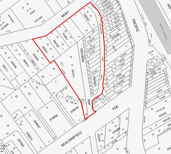
Figure 1 – Site Location
The site comprises privately owned land and Council owned land and can be described as:
Privately owned:
· No. 12 Bent Street - Lot5 DP 666521
· No. 6 Bent Street – Lot 3 DP 1090427
· No. 4 Bent Street – Lot 10 DP 1090427
· No. 2 Bent Street – Lot 9 DP 1090427
· Woodford Lane - Lot A DP 445535
Council owned:
· No. 18 Beaconsfield Parade - Lot 1 DP 929131
· Drovers Way Lots 1-16 DP 1099330
· Woodford Lane and Drovers Way rights-of-way
· No. 10 Bent Street – Lot 1 DP980108
· No. 8 Bent Street – Lot 1 DP 742823
The announcement by the Minister for Transport provides a significant opportunity for Council to bring forward vital urban design and community facilities in the Lindfield town centre which might otherwise be delayed many years. Further, the provision of commuter car parking in this locality has long been a matter raised in the various consultation processes Council has facilitated over the last ten years or so.
There would be significant advantage in designing, and potentially constructing (depending on funding), all public works in the immediate area to ensure a co-ordinated outcome.
To date Council has taken a number of significant steps towards delivering the vision for the precinct. The next step is to identify appropriate funding sources for the project, this discussion will occur in the financial considerations section of this report. The discussion below will outline the community infrastructure planned for the site and surrounds and the potential funding that may be available for the works.
a) New ‘Bent Street’ park
The Ku-ring-gai Contributions Plan, 2010 -Works Programmes: Local parks, Local sporting facilities – South allocates funding for construction of a new Village Green on the western side of Lindfield. The total funding available is $1.185 million (in 2010 dollars).
Council is currently in the process of acquiring properties on Bent Street which will allow the creation of the new park.
Approximately 100% of the acquisition of land and construction of the park would be funded by development contributions with a small general fund component in the Long Term Financial Plan.
b) Streetscape works
The Ku-ring-gai Contributions Plan, 2010 Works Programmes: Local roads; Local bus facilities and Local drainage facilities - Lindfield (pp.214-215) allocates funding for streetscape improvements in the vicinity of the site that could be integrated with this project. Streetscape works include new high quality footpath pavements, street furniture, street trees, street and pedestrian lighting and underground power lines. The streets that could be included are parts of:
· Bent Street;
· Woodford Lane; and
· Beaconsfield Parade.
Approximately 100% of this work could be funded by development contributions with a small general fund component in the Long Term Financial Plan. However there is currently a limited amount of funds available for streetscape works so Council would have to borrow from other programmes within the CP to fund the works if these works are brought forward.
c) Road improvement works
The Ku-ring-gai Contributions Plan, 2010 Works Programmes: Local roads; Local bus facilities and Local drainage facilities - Lindfield (pp.214-215) allocates funding for road improvements and transport in the vicinity of the site. The works could include:
· upgrade of Bent Street;
· upgrade and widening of Woodford Lane;
· clearing/preparing site and installation of Gross Pollutant Traps within the road reservations of Bent Street and Beaconsfield Parade;
· allowance for stormwater treatment & detention within the road reservation of Woodford Lane and Drovers Way;
· new kiss and ride zone and taxi ranks Woodford Lane;
· bicycle route (off-road) Beaconsfield; and
· bicycle parking Woodford Lane
Approximately 100% this work could be funded by development contributions with a small general fund component in the Long Term Financial Plan. However there is currently a limited amount of funds available for road works so Council would have to borrow from other programmes within the CP to fund the works if these works are brought forward.
d) New Street (realigned Drovers Way)
The Ku-ring-gai Contributions Plan, 2010 - Works Programmes: Local roads; Local bus facilities and Local drainage facilities - Lindfield (pp.214-215) allocates funding for the realignment of Drovers Way to the western edge of the site. The works would involve the construction of new 12 metre wide street between Beaconsfield Parade and Bent Street.
Approximately 100% the acquisition and construction work could be funded by development contributions (with a small general fund component in the Long Term Financial Plan). However there is currently a limited amount of funds available for road works so Council would have to borrow from other programmes within the CP to fund the works.
e) Multi-purpose community facility
Ku-ring-gai Contributions Plan, 2010 - Works Programmes: Local recreational and cultural facilities, and Local social facilities identifies the site as the preferred location for a new multi-purpose community building with a total floor space of Lindfield 1,800m2. The funds include site clearance and preparation, construction, full internal fit-out, security, lighting, landscaping and additional associated car parking. The plan identifies total funds of $5.167 million (in 2010 dollars).
Due to apportionment, about 33% of the cost of the multi-purpose building would be funded by development contributions the remainder would be required to be funded by Council from general revenue. Given the funding shortfall for the building, which is in the order of $3.4 million, Council’s commitment to the provision of a facility on this site would need to be matched with a funding strategy.
There is also the potential for a new Lindfield Branch Library to be co-located with the multi-purpose facility on the site. Currently the library is planned for the eastern side of Lindfield in the vicinity of Kochia Lane, if Council decides not to proceed with the provision of a library on Kochia Lane (as a result of the feasibility analysis for that project for example) it will be necessary to investigate the potential to provide a new library on the western side of Lindfield co-located with the proposed multi-purpose community building.
The Ku-ring-gai Contributions Plan, 2010 (KCP) allocates funding of $6.1 million for the construction of a new 1,200m² branch library. These funds include site clearance, full internal fit out, security and lighting. In addition the KCP allocates $2.49 million for the design and construction of 50 basement car park spaces required for library and community facilities (KCP, page 210).
As for all community facilities only about 33% of the cost of the library building would be funded by development contributions, the funding shortfall for the building, which is in the order of $4 million, would need to be matched with a funding strategy.
In the case of both facilities the master plan will explore options for the provision of community buildings on the site. This would be in a staged manner so that if funding is available in the medium to long term the project can be designed in a way that would allow provision of the facility on this site in the future when funding is available, this could include the provision of 50 community parking spaces that would be 100% funded by development contributions.
f) Commercial uses
The financial success of this project will also involve the provision of retail and commercial floor space to further activate the area. There is potential for some form of commercial use on the site ranging from buildings up to three storeys that incorporate cafés and public amenities on the ground level, and two levels of commercial/residential space on the upper levels through to a supermarket (at basement level) based retail shopping centre.
The inclusion of commercial uses within the project would potentially provide revenue opportunities for Council through leasing of the commercial space for example. A larger development incorporating a supermarket would have the potential to assist with the funding of identified shortfalls and potentially assist with delivery of the project within a shorter period of time.
f) Public short stay and commuter car parking
At this stage TfNSW have indicated that they will be funding, in the order of, 386 new car spaces in a proposed semi-basement parking structure. To date, there has been no commitment from Transport NSW to provide underground car parking on the site although it is clear from the initial project announcement by the Minister that there is an adequate budget for such a project.
Council and the community have indicated that an above ground car park on this important site is not a satisfactory outcome as it would ‘sterilise’ a large proportion of the site that could otherwise accommodate active commercial and community uses. From an urban design point of view an underground car park in such a location is the preferred outcome as it will allow active uses at ground level.
It remains to be determined whether an underground parking structure can be funded, however if Council is committed to relocating its own parking as well as the new commuter car parking underground then a funding strategy may be required. It may also be necessary at some point in time for Council to contact the NSW Government to seek clarification as to the project budget.
Governance Matters
A project of this type is identified in the draft Operational/ Delivery Plan:
· Key theme – Places Spaces and Infrastructure
· P6 – Revitalisation of our Centres

Figure 2: Extract from Council’s Delivery Program 2013-2017 and Operational Plan 2013-2014, page 40
Risk Management
The greatest risk for this project at this stage is to Council’s reputation. As discussed below the project has become the catalyst for the establishment of a new community group called ‘Support Lindfield’ which is well organised and highly active. If Council is seen to be not proactive on this project and is not seeking the best possible outcome for the community then there would be a high risk of loss of reputation as a result.
There is also a risk for Council for the loss of potential for new and updated community facilities if the land is utilised for a car park.
Financial Considerations
The discussion above under comments section of this report has indicated that aspects of the community hub project can be fully funded by development contributions, within the short term ie 5 years; this particularly applies to the acquisition and construction of the new park and the new road.
In the case of other aspects of the project including streetscape improvements; road and transport improvements; and community facilities Council would be required to fund these by borrowing from the plan and effectively bringing the projects forward by at least 10-15 years. Given the size of the shortfall this strategy is not recommended - an alternative funding strategy is required.
Car parking and commercial uses cannot, in this case, be funded by development contributions and an alternative funding strategy is required.
Four possible funding options have been identified for discussion, they are not mutually exclusive and a combination of options is the most likely preferred strategy:
· reclassification and sale of Council land on the Pacific Highway, Lindfield currently occupied by the library and Seniors Centre;
· increasing height and densities on the site to provide for residential development;
· entering into a public private partnership (PPP) with a commercial partner; and/or
· staged delivery of the project.
1. Reclassification of the land currently occupied by the Lindfield library and Lindfield seniors centre
Council owns land at 265-271 Pacific Highway, Lindfield which is currently utilised for a senior’s centre, a branch library, tennis courts and a housing co-operative (KOPWA). If Council is to proceed with the relocation of the branch library and construction of a new community building that would house the seniors centre then a large component of the sites’ function would be lost.
Council may wish to consider the reclassification and sale of this asset to fund shortfall and provide new community buildings on Woodford Lane for example.
2. Increase development potential of the site
Council has the option to prepare a planning proposal that would propose to increase the building height and densities (FSR) on the Woodford Lane to an appropriate scale to allow residential development.
This option has the potential to significantly increase the financial return to Council and thereby assist with the funding shortfall and delivery of the project in the short term.
3. Public private partnership (PPP)
A PPP is an arrangement between a council and a private person for the purposes of:
a) providing public infrastructure or facilities in which the council has an interest, liability or responsibility under the arrangement, and/or;
b) delivering services in accordance with the arrangement.
In the case of the Lindfield community hub project a PPP might involve a major retail developer, and/or residential developer (if the Council decides to amend the LEP) who would be responsible for delivering the whole project including the community infrastructure, on behalf of Council, and commuter car park on behalf of TfNSW.
This approach would deliver commercial uses, and potentially residential uses, making the area more active and safe.
4. Staged delivery
Council could choose to fund the community hub project using a combination of development contributions and general revenue without borrowing from the plan.
This option would involve staged delivery of community infrastructure. The new road and new park could be provided within the next 5 years, community facilities and other works would be provided over a 10-20 year time span (depending on development take-up rates). This option would see TfNSW deliver a commuter car park within the next 2 years, the car park would be designed and located to allow the new facilities to be built around the car park in the future. This option is considered the least preferred of all options.
In summary the report finds that there is insufficient information to recommend a way forward, at this point in time, and that if Council wishes to proceed with the project further studies will be required.
Social Considerations
Currently the site is utilised for car parking by shoppers, commuters and local business owners, beyond this function the site provides very little social benefit to the community and is very much an under-utilised asset for Council.
The site has the potential to provide new community buildings that will provide a high level of social benefit to the community. Elton Consulting undertook a Community Facilities Strategy on behalf of Council in 2009, this study undertook and audit of the existing community facilities in Lindfield. The study findings for Lindfield are summarised below:
Lindfield library building:
· is too small to meet contemporary standards and the needs of users;
· is in poor condition with numerous maintenance issues identified in a building audit;
· requires improved staff parking and disabled access; and
· is located too far from shops and train station for people to walk.
Lindfield Seniors Centre building:
· is too small to meet contemporary standards;
· is an old style facility with basic facilities in poor condition;
· contains identified trip hazards and maintenance requirements;
· lacks flexibility for multi-use; and
· is located too far from shops and train for people to walk (particularly the elderly).
Environmental Considerations
Overall, if the development were to be undertaken in a considered manner there is potential for the environmental quality of the site to be improved particularly through the provision of a new park on Bent Street, new community buildings and streetscape improvements. Potential negative impacts might include:
· Along the western edge of the site there are a number of mature trees that are identified as having biodiversity significance in the KLEP 2012. Most of these trees will require removal in order to facilitate development of a community hub. This could be mitigated through offset planting in the new park.
· To the south-west of the site there are three residential properties that could be potentially impacted by a development of the subject site. These properties have been zoned as R4 – High Density Residential under the KLEP 2012 and may over time redevelop.
Community Consultation
To date Council has not undertaken community consultation on this project. Consultation is planned as part of the master plan process; this will include exhibition of a preferred option. Consultation will be managed by TFNSW.
A highly active and well organised lobby group consisting of residents and business owners, called ‘Support Lindfield’, has been formed to gather community support and liaise with State government and Ku-ring-gai Council. The main aim of the group is to prevent Transport for NSW building an above ground car park and to ensure a community hub is developed with an underground commuter car park. The group states in their promotional material:
“We believe we have a real opportunity to design a fantastic community area. A people place of hybrid spaces, a focus of Lindfield community life for all. A green, active and safe village square that integrates with an inspiring building containing a new age library, family cafés, activity/meeting/performance areas and much more. This could be linked to short/ long term parking and station access.
The group has already run a number of Community Forums and developed a concept for the site (refer Figure 2 below), in addition the group has briefed Paul Fletcher (Federal MP) and Jonathon O’Dea (State MP) and the latter has discussed the matter with the Premier. The group has also established a web site www.supportlindfield.net.
It is important to note this group does not have any formal decision making powers and does not own land within the site.
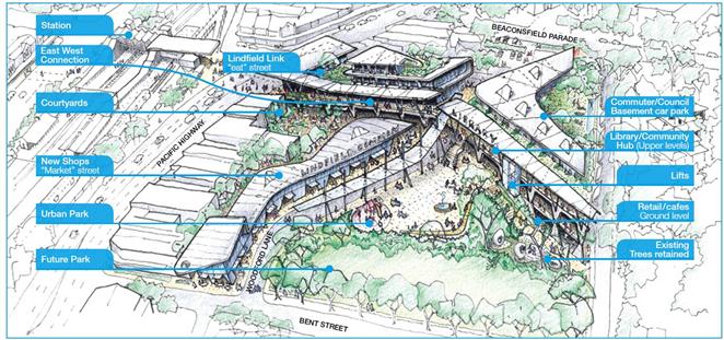
Figure 2 – ‘Support Lindfield’ concept for Council’s car park at Woodford Lane, Lindfield
Internal Consultation
Consultation has occurred with senior staff and managers within the Strategy Department and GMD.
Summary
On 29 May 2012, the NSW Government announced it would build a new commuter car park for 240 new spaces and a new kiss-and-ride zone in Woodford Lane, Lindfield. This announcement came without prior consultation with Council.
In response to this announcement Council resolved, at the OMC on 26 June 2012, to prepare a Planning Proposal to reclassify the Council Car Park at Woodford Lane, Lindfield (the site). The reclassification process has commenced; the planning proposal recently came off exhibition and the Public Hearing date has been set.
Council resolved, on 13 February 2013, to commence the preparation of a Heads of Agreement and a master plan for the site with TfNSW. To date Council Officers have prepared a master plan project brief and have been pro-actively working with representatives of TfNSW to refine the project brief so that it will be suitable for both parties.
The announcement by the Minister for Transport provides a significant opportunity for Council to bring forward vital urban design and community facilities in the Lindfield town centre which might otherwise be delayed many years. To date Council has taken a number of significant steps towards delivering the vision for the precinct.
Transport Planning has given assurances that the project program has now been realigned and extended to allow time for proper planning to take place on the site before a final car park design is finalised.
The report has outlined the community infrastructure planned for the site and surrounds and the potential funding that may be available for the works. The works include:
· new ‘Bent Street’ park;
· streetscape works;
· road works;
· new street (realignment of Drovers Way);
· multi-purpose community facility (and possibly a new library);
· commercial uses; and
· public short stay and commuter car parking.
The report has also discussed available funding sources for the project and has found that aspects of the community hub project could be fully funded by development contributions whereas other aspects of the project would be required to be funded by borrowing from the plan and effectively bringing the projects forward by at least 10-15 years. Given the size of the shortfall this strategy is not recommended. The provision of underground car parking and commercial uses cannot be funded by development contributions.
The report discusses four possible funding options:
· reclassification and sale of Council land on the Pacific Highway, Lindfield currently occupied by the library and Seniors Centre;
· increasing height and densities on the site to allow residential development;
· entering into a public private partnership/joint venture with a commercial partner; and
· staged delivery of the project.
In summary the report finds that there is insufficient information to recommend a way forward, at this point in time, and that if Council wishes to move forward with the project further studies are required.
It is therefore recommended that Council undertake a planning study that will run parallel with, and support, the master plan process being undertaken jointly by Council and TfNSW.
The planning study will:
· identify an appropriate range of uses for the site;
· undertake economic feasibility studies;
· funding strategies for community infrastructure;
· other studies as required; and
· monitor and review the master plan preparation (a Project Control Group) will be established).
The planning study will require seed funding to cover staff time and the costs of consultants. In addition Council will be required to fund a large proportion of the master plan being prepared by TfNSW. The estimated funds required are in the order of $250,000 for the year 2013-2014 from the section 94 reserve.
|
A. Council acknowledge TfNSW responsiveness to Council’s request to extend the project program to allow for proper planning of the site.
B. A project team be established to prepare a planning study and oversee and support the preparation of the Lindfield Community Hub master plan in partnership with TfNSW.
C. Funds of $250,000 are allocated to the project for the year 2013-2014 from the section 94 reserve.
D. That a report be brought back to Council discussing the master plan process, reviewing the options and recommending a preferred option, timing and next steps.
|
|
Bill Royal Team Leader Urban Design |
Antony Fabbro Manager Urban & Heritage Planning |
|
Andrew Watson Director Strategy & Environment |
|
|
A1View |
Preparation of master plan for Lindfield community hub - Woodford lane - draft - for issue to TfNSW |
|
2013/034581 |
|
APPENDIX No: 1 - Preparation of master plan for Lindfield community hub - Woodford lane - draft - for issue to TfNSW |
|
Item No: GB.10 |
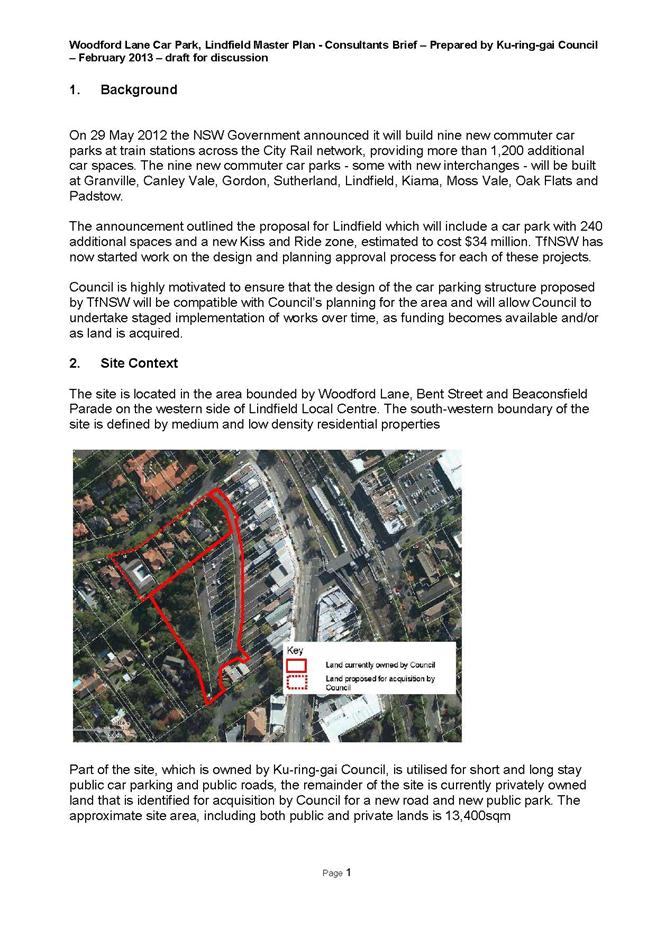
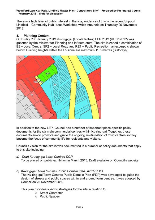
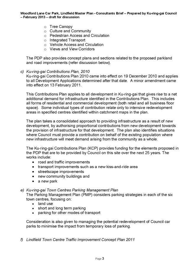
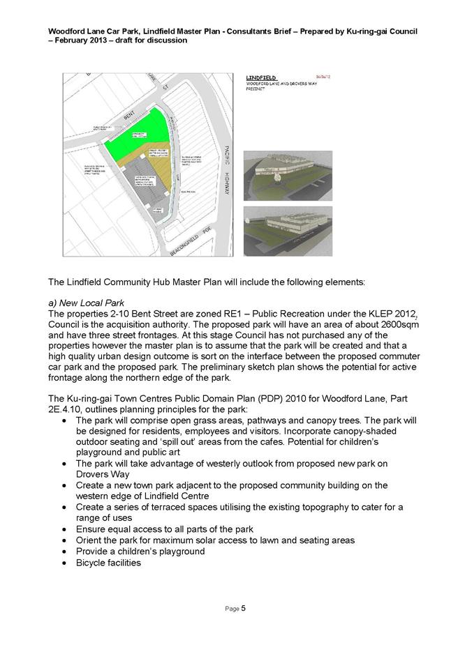
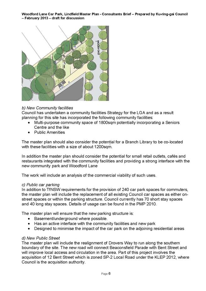
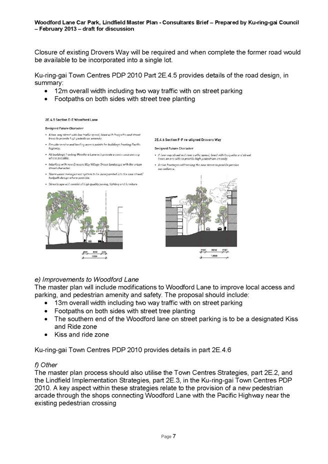

|
Ordinary Meeting of Council - 28 May 2013 |
GB.11 / 318 |
|
|
|
|
Item GB.11 |
S09572 |
|
|
7 May 2013 |
Tender T03/2013 - Construction of New Park - Bruce Avenue, Killara
EXECUTIVE SUMMARY
|
purpose of report: |
To consider the tenders received for the construction of the new park in Bruce Avenue, Killara. |
|
|
|
|
background: |
At the Ordinary Meeting of Council held on 8 October 2010, Council resolved to acquire three (3) properties, numbers 27, 29 and 31 Bruce Avenue, Killara, as part of Council’s Open Space Acquisition program. These properties were subsequently purchased. Staff then undertook a design process with tender documents being prepared and released through Tenderlink on 16 March 2013 with a closing date for receipt of tenders of 16 April 2013. |
|
|
|
|
comments: |
Tender documents were produced with seven (7) submissions received. The submissions were assessed using agreed criteria which identified the best value to Council. |
|
|
|
|
recommendation: |
That Council accepts the tender from Hargraves Landscapes Pty Ltd for the construction of the new park at Bruce Avenue, Killara. |
Purpose of Report
To consider the tenders received for the construction of the new park in Bruce Avenue, Killara.
Background
At the Ordinary Meeting of Council held on 8 October 2010, Council resolved to acquire three (3) properties, numbers 27, 29 and 31 Bruce Avenue, Killara as part of Council’s Open Space Acquisition program. These properties were subsequently purchased. Staff then undertook a design process including:
· a site analysis;
· a community survey;
· development of a concept plan;
· an on-line exhibition and finally
· a preparation of a final concept design plan for Council endorsement.
At the Ordinary Meeting of Council 12 June 2012, Council approved the concept design plan for the new park in Bruce Avenue, Killara and resolved Council staff to proceed with the preparation of construction and tender documentation.
Following the production of final design plans and specification, tender documents were produced requesting costs for the construction of the new park.
Tender documents were prepared and released through Tenderlink on 16 March 2013 with a closing date of 16 April 2013. At the close of tender, seven (7) tenders were received and recorded in accordance with Council’s tendering policy. Following receipt of the tenders, each was initially assessed for conformity and price against Council’s internal budget and estimates.
Comments
Seven (7) tenders were received and recorded in accordance with Council’s tendering policy. Tenders were received from the following companies:
· Synergy Resource Management Pty Ltd
· Sydney Design and Construct Pty Ltd
· Landscape Solutions Pty Ltd
· Hargraves Landscapes Pty Ltd
· Go Gardening
· GJ’s Landscapes Pty Ltd
· Ford Civil Pty Ltd
A Tender Evaluation Panel consisting of staff from Operations, Corporate and Strategy & Environment Departments was formed to assess the seven (7) tenders received. The initial part of the evaluation, based on conformity and cost, identified all submissions as being within Council’s available funds. However, two (2) submissions were identified as non-conforming due to a combination of failure to provide all requested information and late submission. No further assessment was carried out on the two (2) non-conforming submissions.
The remaining five (5) submissions were evaluated taking into account:
· the lump sum fee,
· provisional rates,
· company and staff experience,
· the ability to provide the full range of services required,
· work program,
· previous performance in relation to similar type work and
· the company’s financial capacity.
The confidential attachments to this report include:
· list of tenders received and additional financial information (Attachment 1),
· the Tender Evaluation Panel’s comments and recommendation (Attachment 2), and
· an independent Performance and Financial Assessment which was carried out by Corporate Scorecard Pty Ltd (Attachment 3).
All five (5) companies assessed demonstrated suitability and qualifications to carry out all of the services required to complete the work. From the available information taken into account during the scoring from each element of the assessment, Hargraves Landscapes Pty Ltd was identified as providing the best value to Council.
In order to ensure Council is not exposed to financial risk and Hargraves Landscapes Pty Ltd is trading in a ‘sound and profitable manner’, an independent Performance and Financial Assessment was carried out by Corporate Scorecard Pty Ltd.
Hargraves Landscapes Pty Ltd is identified as providing the ‘best value’ to Council.
Governance Matters
Tender documents were prepared and released through Tenderlink on 16 March 2013 with a closing date of 16 April 2013. At the close of tender, seven (7) tenders were received and recorded in accordance with Council’s tendering policy.
A Tender Evaluation Panel, consisting of staff from Operations, Corporate and Strategy & Environment Departments, was formed to assess the seven (7) tenders received. The evaluation took into account:
· conformity of submission,
· lump sum fee,
· provisional rates,
· company and staff experience,
· the ability to provide the full range of services required, work program,
· previous performance in relation to similar type work and
· the company’s financial capacity.
The confidential attachments to this report include the list of tenders received, the Tender Evaluation Panel’s comments and recommendation and the independent Performance and Financial Assessment carried out by Corporate Scorecard Pty Ltd.
The attachments are considered to be confidential in accordance with Section 10A (2)(d)(iii) of The Local Government Act 1993 as they are considered to contain commercial in confidence information.
Risk Management
Three (3) key areas of risk were identified in relation to the proposed work:
· That work needed to be carried out by a suitably qualified company with experience of landscape/urban work in close proximity to residential properties.
· The ability to work in an environmentally sensitive area – this was assessed from the information requested as part of the tender submission.
· That Council should not be exposed to financial risk. As part of the evaluation process, tenderers were assessed on providing all information and costs requested within the tender document and an independent Performance and Financial Assessment was carried out on the preferred tender to ensure that they were trading responsibly and had the financial capacity to undertake the work as detailed within the tender documents.
Following evaluation, including an independent Performance and Financial Assessment of Hargraves Landscapes Pty Ltd by Corporate Scorecard Pty Ltd, the tenderer assessed as providing the best value and quality to Council was Hargraves Landscapes Pty Ltd.
As part of the independent Financial and Performance Assessment the following areas were examined:
· that Hargraves Landscapes Pty Ltd had the financial capacity to undertake the proposed value of work;
· that Hargraves Landscapes Pty Ltd has been trading in a profitable and responsible manner during the last three (3) years; and
· that Hargraves Landscapes Pty Ltd has sufficient assets/reserves to cover all possible debts during the period of work.
The financial aspect of the assessment shows Hargraves Landscapes Pty Ltd is able to satisfy all requirements and is unlikely to expose Council to any financial risk if awarded the tender as detailed within Council’s tender documents.
Financial Considerations
The project is fully funded by developer contributions for design, demolition and construction, with the present available funds in PJ 101975 – Bruce Avenue, New Park, Killara equalling $656,300, the remaining balance of funds to be allocated following approval to award the tender.
Additional financial details are included within the confidential attachments to this report.
Social Considerations
Ku-ring-gai's Open Space Acquisition Strategy (2007) identifies the need for a new local park in the area to support the development of medium-density residential apartments and provide passive recreation and community building opportunities. The park will provide a location for healthy outdoor pursuits for residents living in nearby apartments and the local surrounding area.
Environmental Considerations
The existing residential lots had overland flow to the street stormwater system. The new park has been designed with an on-site stormwater drainage infiltration system, where overland flow will be directed to a sand infiltration bed with subsurface drains under the open grassed area for infiltration. Overflow will be connected to the existing street stormwater system.
Overall, the design of the new park reduces the extent of impervious surfaces and stormwater run-off volumes from current conditions and lessens the impact on the environment.
Existing significant trees are being retained and incorporated into the overall design.
Community Consultation
A series of community information and consultation activities were undertaken during and as part of the design development process. These involved engagement with residents living in close proximity to the proposed new Bruce Avenue Park and the following:
· Press Release - 11/10/2011: Council issued a Press Release announcing Council had purchased the land for a new park and was commencing consultation and design process.
· Resident Postal Survey - 01/11/11: Council mailed over 700 households living within 500m of the proposed new park. Residents were asked how they would like to use the new park and what types of features they would like to see included.
· Online Exhibition - draft concept plan - 15/05/12: Council sent out over 1000 letters to residents seeking feedback to the draft concept plan of the park. Survey link was also included on Council's homepage to capture the interest of other residents. Closing date for comments was 31/05/12.
· June 2012: An onsite meeting was held with neighbouring properties to discuss concept design.
· Naming of the new park - March 2013: Council mailed over 700 households living within 500m of the proposed new park. Residents were asked what their preferred name was for the proposed new park from a choice of four (4) each relating to site and local heritage. Opportunity was available to make suggestions. Survey link was also included on Council's website to capture the interest of other residents. Closing date for comments was 10 May 2013.
Internal Consultation
Consultation was undertaken by officers from Operations and Strategy & Environment Departments, for the proposed construction of the new park at Bruce Avenue, Killara. Strategy & Environment Department prepared the detailed design/specification for the works prior to the documentation being released for tender and construction by the Operations Department. Tender assessment has been undertaken by officers from Operations, Corporate and Strategy & Environment Departments. Two (2) additional presentations also took place. On 7 November 2011, a Managers Workshop was held and on 27 March 2013, the Bruce Avenue Park project was presented to Councillors, the General Manager and Directors.
Summary
At the Ordinary Meeting of Council held on 8 October 2010, Council resolved to acquire three (3) properties, numbers 27, 29 and 31 Bruce Avenue, Killara, as part of Council’s Open Space Acquisition program. These properties were subsequently purchased.
Staff then undertook a design process with a final concept design plan being endorsement at the Ordinary Meeting of Council 12 June 2012. Tender documents for the construction of a new park were prepared and released through Tenderlink on 16 March 2013 with a closing date of 16 April 2013. A Tender Evaluation Panel was formed consisting of representatives from Operations, Corporate and Strategy & Environment Departments.
At the close of tender, seven (7) tenders were received and recorded in accordance with Council’s tendering policy.
Following the evaluation and independent performance and financial check, it is recommended Hargraves Landscapes Pty Ltd be appointed on the basis of providing the best value to Council.
|
A. That Council accepts the tender submission from Hargraves Landscapes Pty Ltd to carryout the construction of a new park at Bruce Avenue, Killara.
B. That Council approve the balance of funds required to be transferred from Section 94 funds to the project.
C. That the Mayor and General Manager be delegated authority to execute all tender documents on Council’s behalf in relation to the contract.
D. That the Seal of Council be affixed to all necessary documents.
E. That all tenderers be advised of Council’s decision in accordance with Clause 178 of the Local Government Tendering Regulations.
|
|
David Morris Manager Open Space Projects |
Greg Piconi Director Operations |
|
List of Tenders and additional financial information |
|
Confidential |
||
|
|
Tender Evaluation Panel - recommendation |
|
Confidential |
|
|
|
Performance and Financial Assessment |
|
Confidential |
|
Ordinary Meeting of Council - 28 May 2013 |
GB.12 / 324 |
|
|
|
|
Item GB.12 |
CY00430 |
|
|
10 May 2013 |
Regional Shared Services and
Regional Waste Project
EXECUTIVE SUMMARY
|
purpose of report: |
To seek Council’s commitment to participate in the regional tender for the procurement of waste disposal and processing services for a contract commencing in 2014. |
|
|
|
|
background: |
Most Council have their own contracts for collection and disposal of general waste and recycling processing. Generally, the time frame for the contract period is around three (3) years due to uncertainty in the market for the introduction of new competitors or new technologies. Each Council, on their own, demonstrates insufficient waste to bargain for improved technologies. Council’s current Waste Disposal Contract is due for renewal on 31st October 2013 and the Recycling Processing Contract is due for renewal in September 2014. |
|
|
|
|
comments: |
NSROC has been working with all Councils to phase in a regional contract to help bargain for better waste disposal charges and possibly provide incentives for new waste technologies. |
|
|
|
|
recommendation: |
That Council endorse participation in preparations to go to tender for procurement of waste disposal/processing services for NSROC Councils for a contract commencing in 2014, noting that a further report on tender criteria will come to Council in July-August 2013 for final agreement as to participation in the tender. |
Purpose of Report
To seek Council’s commitment to participate in the regional tender for the procurement of waste disposal and processing services for a contract commencing in 2014.
Background
At present, Ku-ring-gai Council has separate contracts for collection and disposal of waste and recycling products. The collection contracts vary from Council to Council due to different types of services offered.
Ku-ring-gai currently has a contract with Veolia Services Pty Ltd for disposal of general waste expiring on 31st October 2013. Also, Council has a Contract with Sita Pty Ltd for green waste expiring 31st October 2013 and a recycling processing Contract for Council’s paper and other recycling products expiring in September 2014.
Most Councils have their own contracts for collection and disposal of general waste and recycling processing. Generally, the time frame for the contract period is around three (3) years due to the uncertainty in the market for the introduction of new competitors or new technologies. Each Council, on their own, demonstrates insufficient waste to bargain for improved technologies.
Recently it was agreed by Northern Sydney Regional Organisation of Councils (NSROC) through General Manager Advisory Committee (GMAC) and the Board to undertake an investigation into a regional tender for waste disposal in order to achieve better outcomes for waste disposal costs and provide incentives for new technologies.
Comments
Attached is a copy of the draft NSROC Regional Shared Services and Regional Waste Project report which examines all aspects associated with undertaking regional tenders for waste disposal and recycling processing.
In November 2012, the NSROC Board considered the findings of the research phase, which were:
· Disposal of all waste streams is a significant and increasing cost centre, accounting for about $24 million in expenditure per annum across the region;
· The total annual residual waste after recycling or processing within NSROC during
2011-12 was over 117,000 tonnes;
· NSROC Councils do not control any residential waste transfer, processing or disposal facilities, and must purchase all services from the private sector, where two (2) firms predominate;
· Policy and market failure over the last decade has led to inadequate investment in new infrastructure, consolidation of ownership and limited competition in the waste disposal services market;
· Industry consultation resulted in strong interest in higher volume and greater security in contract term as drivers of better pricing;
· New forms of waste disposal, through treatment of putrescible waste or greater separation and streaming, require long term financial and/or culture change investments by the public and private sectors;
· Councils’ waste disposal contracts are in sufficient alignment to allow for a single contract across the region commencing in 2014 with 60 % of total volume; and
· Councils’ waste disposal contracts are aligned to the extent that all could migrate to a regional contract established between mid 2014 and the end of 2015. This opportunity to harmonise contracts will be difficult to recreate in the coming decade if, for some reason, this regional contract does not proceed.
Council currently has around 24,000 tonnes of general waste per annum going to landfill which represents about 20% of the region’s total of general waste. Also, Council has around 37,000 tonnes of recycling products which represents around 25% of the region’s recycling products.
The benefits of a single waste disposal contract for the region include:
· Demonstration to the market that the NSROC Councils are serious about an efficient approach to shared services procurement;
· Better price outcomes in the immediate term through a secure and high volume supply requirement; and
· Incentive for new investment in processing in the medium term to meet the need for higher diversion from landfill than is currently available for total regional waste volumes.
As Council’s current waste disposal contract is due to expire on 31st October 2013, it is now timely to engage in a regional tender process for waste disposal. Even though the regional contract is likely to commence in mid 2014, an extension to the existing contracts can be negotiated under the Local Government Act due to the extenuating circumstances associated with the regional procurement process. An extension to current Contracts would therefore be short term till any regional Contract comes into effect.
With the recycling processing, Council has contracts in place for its paper products and is currently receiving a reasonable return on the product as it is not contaminated with other recyclables. Further discussion with NSROC will need to be negotiated as most other Councils in the region have mixed recycling products which require sorting and processing.
Governance Matters
Expert advice on governance arrangements has been obtained from Maddocks Lawyers, who advise that a participation agreement between Councils should be established to operate shared services through a committee structure managed by General Managers, for the first stage shared service waste disposal contract.
Under this model, Councils would determine overall policy, strategic direction and significant investment in shared services while a governance board, comprised of General Managers, would be responsible for implementing the strategic direction and overseeing management decisions. A contract would be established spelling out the role of each level in the structure and business rules for its operation.
Participation agreement between Councils would establish a strong legal relationship for the purpose of cooperative procurement of services, and identify the rules and procedures for any governance board and/or committee responsible for individual services.
Maddocks Lawyers advised that an application be made to the Australian Competition and Consumer Commission for authorisation to approach the market as a group. This step was also observed, and authorisation granted, prior to the 2003-04 NSROC tender. As a result, the process will be less expensive and time-consuming in 2013.
Maddocks Lawyers recommended a tender release and procurement management through Local Government Procurement would be the most efficient approach for a single contract for multiple Councils.
Risk Management
The risk to Council associated with a joint tender process may result in possible increased costs associated with the transfer of waste to processing centres. This required negotiation with any preferred regional tenderers. As there are currently only two (2) major contractors in waste disposal, it is not likely to have a major impact on Council.
The main risk associated with a joint tender is for Council’s recycling products. At present, Council receives a good return for its paper products. This will need to be negotiated further when preparing regional tenders. However, the sale of paper products is totally dependent on the state of the market at the time of tender.
Financial Considerations
There are likely to be savings for a regional tender due to the larger volume of waste material and more certainty with a regional tender.
The costs of being part of a regional tender can be funded from the Domestic Waste Budget and funds are available for this process.
Social Considerations
With consideration of a regional tender, there is possibility of more incentives in the market place to invest in new technologies and possibly better bargaining powers for the industry to lobby for funding grants for new technologies in order to help divert general waste from landfill.
Environmental Considerations
The possibility of new waste technologies being introduced may result in the diversion of waste from landfill and therefore better environmental outcomes.
Community Consultation
At this stage there is no need for community consultation on the joint tender but it may be appropriate for Council to issue a media release on the adoption of the report on the potential benefits of a regional tender for waste disposal.
Internal Consultation
Not applicable
Summary
Council currently has separate contracts for collection and disposal of waste and recycling products. The collection contracts vary from Council to Council due to different types of services offered.
Ku-ring-gai Council currently has a contract with Veolia Services Pty Ltd for disposal of general waste which expires on 31st October 2013. Also, Council has a contract with Sita Pty Ltd for Green waste expiring on 31st October and a recycling processing of Council’s paper and other recycling products which expires in September 2014.
Recently, it was agreed by NSROC through GMAC and the Board to undertake an investigation into a regional tender for waste disposal in order to achieve better outcomes for waste disposal costs and provide incentives for new technologies.
Council currently has around 24,000 tonnes of general waste per annum going to landfill which represents about 20% of the region’s total of general waste. Also, Council has around 37,000 tonnes of recycling products which represents around 25% of the region’s recycling products.
The benefits of a single waste disposal contract for the region include:
· Demonstration to the market that the NSROC Councils are serious about an efficient approach to shared services procurement;
· Better price outcomes in the immediate term through a secure and high volume supply requirement; and
· Incentive for new investment in processing in the medium term to meet the need for higher diversion from landfill than is currently available for total regional waste volumes.
|
A. That Council endorse participation in preparations to go to tender for procurement of waste disposal/processing services for NSROC Councils for a contract commencing in 2014, noting that a further report on tender criteria will come to Council in July-August 2013 for final agreement as to participation in the tender.
B. That Council agree to be part of an application for authorisation, through revocation and substitution of 2003 authorisation, from the Australian Competition and Consumer Commission for group purchasing of waste disposal services. C. That Council agree to formal participation arrangements with NSROC Councils to contribute to the costs of establishing partnership arrangements for shared services procurement and management by NSROC Councils, on a case-by-case basis, commencing with the waste disposal tender. D. That Council agree to contribute to the governance structure establishment costs on an equal basis amongst all NSROC Councils, and the tender preparation costs, in line with volume participation in the waste contract. E. That Council’s existing disposal Contracts be extended due to extenuating circumstances associated with the regional procurement process and their extension being of sufficient duration to allow the regional contracts to come into effect.
|
|
Greg Piconi Director Operations |
|
|
A1View |
Draft Regional Shared Services and Regional Waste Project |
|
2013/116915 |
|
|
|
A2View |
Proposed cost sharing model |
|
2013/116941 |
|
APPENDIX No: 1 - Draft Regional Shared Services and Regional Waste Project |
|
Item No: GB.12 |

REGIONAL SHARED SERVICES AND REGIONAL WASTE PROJECT
CONTENTS
Executive Summary and Recommendations
1. Strategic Collaboration between Councils
2. NSROC Regional Waste Project
3. Implementation Requirements
4. Recommendations
5. Council Issues
EXECUTIVE SUMMARY
In response to the increasing cost of waste disposal and the limited market services available, NSROC Councils have been working together to examine how regional action can improve the availability of long-term, cost-effective waste solutions for member Councils. A strategic planning process has been followed over the last 12 months to establish whether sound evidence exists for regional waste management. Research has included consultation with industry and waste professionals in the consulting sector and collaboration with amongst waste management staff in Councils.
As a result, this report sets out the case supporting recommendations for:
· collaboration between NSROC Councils in waste management in two stages of joint procurement over the next decade, and
· entering into participation agreements between NSROC Councils to establish the governance arrangements for management of a single waste disposal contract, and other shared services procurement as new opportunities emerge and are evaluated.
Commencing in 2014 a binding regional contract of four to five years for waste disposal is proposed as the first stage of a longer term plan. During the initial contract period a longer term market solution will be developed to secure long term waste processing facilities for the region to improve diversion of waste from landfill and create marketable products from waste.
The 2014 contract will position NSROC Councils to engage with industry as an influential single customer, better able to demand better solutions for alternative waste treatment, including the possibility of energy from waste thermal treatment, under a second stage contract commencing after 2017. A budget estimate for the regional waste project has been developed for Councils to consider.
This report supports recommendations that each NSROC Council will consider in April-May 2013. Councils that decide to participate will then be part of a tender planned for release in October 2013, for commencement in the first half of 2014. A second report will be made to Councils in July-August 2013, prior to the tender being issued.
Greater regional collaboration and shared services is one of the acknowledged pathways under the NSW local government reform agenda. NSROC Councils have shared objectives for waste management – seeking better waste outcomes, securing safe and environmentally sound disposal, price improvement, the opportunity to innovate and the desire to work together to achieve greater efficiency.
NSROC has a 20 year history and sound relationships between Councils on which to base the next step in collaboration. Waste disposal services is a readily aggregated purchasing need across Councils, and its high value (up to $100 million over five years for the seven NSROC Councils) requires robust governance to mitigate business risk and maximise market advantage.
In November 2012 the NSROC Board considered the findings of the research phase, which were:
· Disposal of all waste streams is a significant and increasing cost centre, accounting for about $24 million in expenditure per annum across the region
· The total annual residual waste (after recycling or processing) in NSROC in 2011-12 was over 117,000 tonnes.
· NSROC Councils do not control any residential waste transfer, processing or disposal facilities, and must purchase all services from the private sector, where two firms predominate.
· Policy and market failure over the last decade has led to inadequate investment in new infrastructure, consolidation of ownership and limited competition in the waste disposal services market
· Industry consultation resulted in strong interest in higher volume and greater security in contract term as drivers of better pricing
· New forms of waste disposal through treatment of putrescible waste or greater separation and streaming require long term financial and/or culture change investments by the public and private sectors
· Councils’ waste disposal contracts are in sufficient alignment to allow for a single contract across the region commencing in 2014 with 60 % of total volume
· Councils’ waste disposal contracts are aligned to the extent that all could migrate to a regional contract established between mid 2014 and the end of 2015.This opportunity to harmonise contracts will be difficult to recreate in the coming decade if, for some reason, this regional contract does not proceed.
The benefits of a single waste disposal contract for the region include:
· Demonstration to the market that the NSROC Councils are serious about an efficient approach to shared services procurement.
· Better price outcomes in the immediate term through a secure and high volume supply requirement.
· Incentive for new investment in processing in the medium term to meet the need for higher diversion from landfill than is currently available for total regional waste volumes.
Implementing this single contract necessitates that, prior to tendering, formal decision-making arrangements between Councils are established to ensure that robust commercial market engagement is delivered under the contract and that advantages from consolidated buying are not compromised by high transaction costs and duplicated processes in the day-to-day management of the contract.
Expert advice on governance arrangements has been obtained from Maddocks Lawyers, who advised that a participation agreement between Councils should be established to operate shared services through a committee structure managed by General Managers, for the first stage shared service waste disposal contract.
Under this model, Councils would determine overall policy, strategic direction and significant investment in shared services while a governance board comprised of General Managers would be responsible for implementing the strategic direction and overseeing management decisions. A contract would be established spelling out the role of each level in the structure and business rules for its operation. This participation agreement between Councils would establish a strong legal relationship for the purpose of cooperative procurement of services, and spell out the rules and procedures for the governance board and the committees responsible for individual services.
Maddocks also advised that an application be made to the Australian Competition and Consumer Commission for authorisation to approach the market as a group. This step was also observed, and authorisation granted, prior to the 2003-04 NSROC tender. As a result, the process will be less expensive and time-consuming in 2013.
Maddocks also recommended that tender release and procurement management through Local Government Procurement would be the most efficient approach for a single contract for multiple Councils.
The NSW Environment Protection Authority has released new policies and programs designed to promote investment in new waste infrastructure, and wider options for the region’s waste disposal and processing are expected to result in the next three to five years. EPA financial support will be pursed when more information on the new NSW waste programs is available and applications are open.
Acceptance of the recommendations of this report will trigger these steps: an application for authorisation to the Australian Competition and Consumer Commission; development of a tender strategy (technical specifications, term of contract and option period); application to the EPA for funding support for the project management of the contract as part of the regional waste strategy; preparation of a draft tender and contract and engagement of consulting advice on legal and tender matters.
RECOMMENDATIONS
Participation
· Agree to Council’s participation in preparations to go to tender for procurement of waste disposal/processing services for NSROC Councils for a contract commencing in 2014, noting that a further report on tender criteria will come to Council in July-August 2013 for final agreement as to participation in the tender.
· Agree to be part of an application for authorisation (through revocation and substitution of 2003 authorisation) from the Australian Competition and Consumer Commission for group purchasing of waste disposal services.
Governance
· Agree to participate in formal participation arrangements with NSROC Councils as shown diagrammatically at Figure One, and to contribute to the costs of establishing partnership arrangements for shared services procurement and management by NSROC Councils, on a case-by-case basis, commencing with the waste disposal tender.
Investment
· Agree to contribute to the governance structure establishment costs on an equal basis amongst all NSROC Councils, and the tender preparation costs, in line with volume participation in the waste contract
Figure one: NSROC shared services governance structure
|
APPENDIX No: 1 - Draft Regional Shared Services and Regional Waste Project |
|
Item No: GB.12 |
1.0 STRATEGIC COLLABORATION BETWEEN COUNCILS
· NSW Councils have
been collaborating to deliver services for many years and in both
back-of-house and client service types; most report cost and service
delivery benefits · One of the
acknowledged pathways under the local government reform agenda is the
expansion of regional collaboration and shared services · Reviews and surveys
of previous co-operative arrangements between Councils report that
organisational culture and strategic leadership are critical success
factors · NSROC has a 20 year
history and sound relationships between Councils on which to base the next
step in collaboration · Waste disposal
services is a readily aggregated purchasing need across Councils, and its
high value (up to $100 million over five years for all Councils) requires
robust governance to mitigate business risk and maximise market advantage.
1.1 Resource sharing is not a new concept to local government. Most Councils in NSW participate in some form of collaborative arrangement for the performance of some of their functions, services or projects. The legislation (Local Government Act 1993) enables Councils to exercise their functions jointly with one of more other Councils (s355). The NSW Government has actively encouraged this practice through the Destination 2036 process and the publication of guidance documents, surveys and reports, most recently in June 2011.[1]
1.2 The Independent Panel on Local Government Reform has recognised that:
‘Another avenue for enhanced efficiency and effectiveness in service delivery is expanded regional collaboration and shared services.’
(Better, Stronger Local Government: the case for sustainable change, November 2012).
1.3 The main aim of collaboration is to ensure that communities benefit from the productive use of the cumulative resources available to Councils. Some of the benefits that have been reported by Councils from collaborative arrangements are:
· Strengthened regional development and services
· Capacity to reduce costs
· Capacity to access economies of scale
· Reduced duplication of effort
· Ability to deliver services that no Council is able to do on their own
· Better environmental outcomes
1.4 Councils across NSW have engaged in an array of shared service arrangements, using various administrative mechanisms. All maintain the role of local Councils as the key governance structure, with Councils setting key policy and strategic directions.[2]
1.5 The many reports on local government collaboration show that some arrangements have worked well and some have not delivered the intended benefits. There are consistent findings about the success factors of those reporting higher returns in cost-related and service-related benefits from council collaboration. These may be summarised as:
· Commitment by councils to the shared service and adoption of an explicit decision-making model allocating strategic and major investment decisions to councils, while delegating the mechanics of day-to-day resource sharing to officials.
· Governance suited to the circumstances of the service and the market, with the collaboration’s purpose, membership, powers and financing arrangements spelt out to enable high levels of accountability to ratepayers and other levels of government.
· Planning before commencement to identify risks and benefits in prospect, how success will be measured, performance tolerances, exit options and costs.
1.6 It is clear from the analysis that agreed goals, a suitable governance structure, approach to risk management and organisational culture are important success factors. Analysis undertaken for the Independent Panel on Local Government Reform[3] in 2012 neatly summarises the findings of research in this area:
‘Organisational culture is important in that shared services development requires strategic thinking, a careful approach to risk taking, as well as leadership built on trust, a clear vision and a commitment to communication…Existing relationships are obviously also important in building a foundation for the development of shared services, as is a strong change management process to overcome any institutional obstacles.’
1.7 With a 20 year history, the Northern Sydney Regional Organisation of Councils has sound and well-established relationships between its seven Councils. These ties are supported by high levels of strategic capability embedded in management that can fuel the next stage of collaboration for the benefit of constituents. There is a sound track record of engagement on policy and advocacy and in some shared contracting for the purchase of business inputs.
1.8 This report sets out the case for strategic collaboration between NSROC Councils for procurement of waste disposal services. The case for aggregated purchasing of this service is a straightforward exercise that should be considered on its merits by each Council.
1.9 The scale of the potential contract (potentially $100 million over five years) requires an accompanying case to be made for clear and reliable collaboration, decision-making and management arrangements between the participating Councils. Such arrangements will mitigate risk and provide assurance that advantages from consolidated buying are not compromised by high transaction costs and duplicated processes by Councils in day-to-day management of the contract.
1.10 The uncertainty arising from the local government reform agenda adds impetus to the drive towards inter-Council collaboration in higher order services in northern Sydney. The regional waste project and the governance structures recommended in this report will bring collateral benefits by demonstrating the capacity of northern Sydney Councils to work together to drive efficiency while retaining the primacy of Councils in decision-making for local level service provision.
2.0 NSROC REGIONAL WASTE PROJECT
Waste disposal services for Sydney is
dominated by a small number of large companies and improvement to economic
and environmental outcomes is limited by the shortfall in alternative waste
disposal and processing facilities accessible from the Sydney metropolitan
area. Industry perceives advantage to them
and is likely to offer price advantages to secure a contract for a high volume
of waste disposal services. Regional action is the best form of
advocacy for longer term improvement in waste facilities. By establishing a
regional approach to waste disposal in 2013-14, NSROC Councils will set
themselves up to become more capable and influential participants in waste
management for the future. By demonstrating to the market that the
Council group is serious about an efficient approach to shared service
procurement, stimulus would be provided to the market, fuelling competition
and better prices for the short term and better processing options under a
second contract period, commencing in three to five years.
Waste policy
2.1 Waste policy and the region
2.1.1 Council waste management is an increasing complex area. KPMG reported to the NSW Government in 2012 [4] that waste management policy is fraught with complexity. In broad terms Councils act under the dual objectives of reducing the volumes of waste generated and maximising the potential of waste to be recycled, re-used or applied to the generation of energy. It is a significant cost in Council budgets, with collection and disposal together accounting for as much as 15 per cent of annual outlays.
2.1.2 Over the last two years the NSROC group of Councils has identified waste management as one of seven priorities for the region, as stated in the NSROC Regional Priorities document:
Priority 6: Develop regional sustainable waste treatment and resource recovery. Actions in pursuit of this priority include the examination of regional waste management service provision, through engagement with the private sector.
2.1.3 The current State-wide NSW Government policy target for waste management and resource recovery for 2014 is for 66 per cent of household waste to be diverted away from landfill. As an incentive to landfill diversion for over 15 years the NSW Government has imposed a waste levy escalated at $10 per tonne per annum plus CPI every year to 2016 (currently $95.20 per tonne, around half the total cost of every tonne sent to landfill).
2.1.4 The effectiveness of the levy in reducing residential waste depends on the availability and price of substitute services for landfill and on the clarity of the price signal to households, in whose hands is source separation (separating types of recyclable wastes for recovery after it is collected by Council). Neither condition is met by the current environment, due to lack of alternative waste recovery facilities and the muting of the escalating price signal by incorporation of the waste levy into Council rates. KPMG reported on the operation of the levy in the following terms:
“Because home owners are charged a flat fee for their waste, they do not receive any financial benefit from reducing the amount of waste they produce at the individual household level, even though all households would benefit if they collectively reduced waste.”
2.1.5 Currently, about half of the region’s waste ends up in landfill; a disposal option that has continued to see steady price increases driven by the increasing charges under the NSW Waste Levy, the introduction of the carbon price mechanism, and increased costs arising from long haul transportation. While regional population has been growing at 1-2% per annum, waste volumes are growing at 4%, and the rate of growth in recycling through education programs and separation of waste by the householder has stalled.
2.1.6 In March 2013 the NSW Environment Protection Authority (EPA) released a new set of waste programs to support higher levels of recycling and resource recovery. The programs will replace the previous funding to councils under the Waste and Sustainability Improvement Payment Program (WaSIP) and offer various options for councils subject to the Waste Levy, mainly as programs requiring merit based contests for funds. NSROC will work with its constituent Councils to develop proposals for regional projects, including assistance with the current regional waste disposal project, if approved by Councils.
2.1.7 The EPA has also released a Draft Energy from Waste policy for comment. NSROC will be submitting a response to the draft, supporting regulatory change to allow new approach to thermal treatment of waste residue, under strict environmental conditions.
2.1.8 These new policies and programs are designed to create incentive for investment in new forms of waste treatment by the private sector and by Councils owning waste assets or land suitable for such sites. As a region with all waste infrastructure in private sector hands, NSROC is dependent for services in the immediate three to four years on the existing facilities owned by the private sector.
2.2 Waste industry
2.2.1 While there are a number of companies active in waste collection services, waste disposal for Sydney is dominated by two large companies, SITA and Veolia Environmental Services. NSROC Councils’ business is split between these two companies under current contracts, with SITA managing disposal of residual waste volume for five councils (48% total volume), and Veolia managing the residual waste disposal for Hornsby and Ku-ring-gai (52% total volume).
2.2.2 A related issue to the concentration of ownership of waste facilities is the lack of incentive for new investment or new market entrants, which has resulted in limited availability for waste disposal in the Sydney region. Landfill capacity has been constrained in part by the costs of establishing new facilities and in part by the difficulty in obtaining approvals within the Sydney basin for new facilities or within an economic distance of Sydney. Compounding the shortage of facilities are problems with access to waste transfer (all facilities are owned by SITA), which is an impediment to the development of both disposal and recycling facilities.
2.2.3 Facilities to process municipal solid waste (MSW), known generically as Alternative Waste Treatment facilities, are also limited. SITA offers processing of residual waste at Eastern Creek and Kemp’s Creek, both in Western Sydney. North Sydney and Willoughby have some part of their residual waste diverted by the facility at Eastern Creek, which turns red bin waste into a compost like output (CLO). Kimbriki at Terrey Hills is has planning approval for the construction of a waste processing facility for its shareholder Councils (Warringah, Pittwater, Manly and Mosman) but is unlikely to have capacity for NSROC volumes and is still two to three years from completion of a facility.
2.2.4 SITA has advised that some capacity for additional processing may be available in the next three to four years as other Council contracts expire. The company has also indicated an intention to increase processing capacity at Kemp’s Creek by the end of 2015.Veolia has announced an intention to construct a processing facility for the SSROC Councils, whose tender for AWT the company recently won, commencing in December 2015. The facility will be approved for extension to 200,000 tonnes per annum, but only constructed for the SSROC tonnage (around 100,000 tpa) until additional contracts are secured.
2.2.5 Over the last decade, the performance of these and other waste processing facilities around the State (known collectively as Alternative Waste Treatment, AWT) has been variable, and what capacity exists is close to or at capacity. No guarantee of capacity to process all of NSROC’s waste has been given by either of the major companies.
2.2.6 Landfill is available from SITA at Eastern Creek and at Woodlawn, near Tarago from Veolia Environmental Services. The Eastern Creek facility has had a number of expansions approved and. Woodlawn has landfill capacity but requires long distance transport of waste to the facility.
2.2.7 This means that the waste disposal and processing market has limited competition, and a small number of offers will be made for NSROC Councils business in the immediate three to four years. Prices can be expected to increase as capacity becomes scarcer, until new facilities are approved and built – a minimum of three years delay. This reality reinforces the case for building advantage in the market through higher volumes via aggregated purchasing.
2.2.7 NSROC disposal contracts are aligned to the extent that all could migrate to a regional contract established between mid 2014 and the end of 2015. While waste collection practices amongst the NSROC councils are similar they are not harmonised, which means that red bin waste is the simplest common waste disposal need. This is not an issue for contracts for disposal only.
2.2.8 A single disposal contract for the region is expected to create incentive for new investment in processing in the medium term, and better price outcomes in the immediate term through surety and volume advantages.
2.3 Regional waste management
2.3.1 In the short term NSROC Councils share the challenges arising from the limited service options available from the waste industry. As well, Councils share a common set of objectives in dealing with the dual environmental and economic responsibilities of waste management.
2.3.2 Based on consultation over the last 12 months with General Managers, Table 1 captures the shared perspectives of the NSROC management group.
Table 1: Council objectives for regional waste management
|
Objective |
What this means |
|
Better waste outcome |
Reducing the percentage of material disposed of directly to landfill without increasing the environmental impact of the diverted materials. |
|
Opportunity to innovate |
Providing sufficient volume that the market will consider it worthwhile to look for better pricing and processing options. Potentially removing barriers to entry for a new participant that may have appropriate technology/sites. |
|
Security of disposal arrangements / options |
There is a clear disposal option for the longer term which is committed to each Council's waste stream. |
|
Price |
The price is no worse than and if possible better than the price that would otherwise be achieved. (Not necessarily a reduction in price from the present contracts). |
|
Working together for efficiency |
Councils finding efficient ways of working together across regions. |
Source: Report on Governance model Options for NSROC. Maddocks Lawyers, March 2013.
2.3.3 Tables 2 and 3 summarise the seven Councils’ waste volumes for the year ending June 2012.The region has achieved strong improvements in diverting waste from landfill through recycling over the last decade, but there has been no significant change in the 55% rate of recycling and recovery over the last three years. Nevertheless the region’s diversion rate is better than the State average of 52% (2010-11). Table 3 indicates that a small share of total residual waste from across the region was subject to AWT in 2011-12, 5.5%. This low share of MSW processing is a result of choices made by Councils not to pay the additional cost of MSW processing and/or lack of capacity to take on additional volume for processing by SITA.
Table 2: 2011- 2012 Waste Volumes by Landfill/Recycled
|
Council |
Total to landfill |
Total recycled |
Total (tonnes) |
|
Hornsby |
37841 |
39777 |
77618 |
|
Hunters Hill |
1291 |
4164 |
5455 |
|
Ku-ring-gai |
23867 |
36871 |
60738 |
|
Lane Cove |
9363 |
8646 |
18009 |
|
Nth Sydney |
7165 |
16671 |
23836 |
|
Ryde |
25151 |
22552 |
47703 |
|
Willoughby |
12838 |
19916 |
32754 |
|
Total |
117516 |
148597 |
266113 |
|
% |
44.2 |
55.8 |
100 |
Table 3: 2011-12 Waste Volumes by Type of Waste, showing AWT volume
|
Council |
AWT |
Garden |
Recyclables |
Total to landfill |
Total (tonnes) |
|
Hornsby |
0 |
22110 |
17667 |
37841 |
77618 |
|
Hunters Hill |
1977 |
769 |
1418 |
1291 |
5455 |
|
Ku-ring-gai |
0 |
21975 |
14896 |
23867 |
60738 |
|
Lane Cove |
0 |
3461 |
5185 |
9363 |
18009 |
|
Nth Sydney |
7851 |
1510 |
7310 |
7165 |
23836 |
|
Ryde |
0 |
11220 |
11332 |
25151 |
47703 |
|
Willoughby |
4787 |
7133 |
7996 |
12838 |
32754 |
|
Total |
14615 |
68178 |
65804 |
117516 |
266113 |
|
% |
5.5 |
25.6 |
24.7 |
44.2 |
100 |
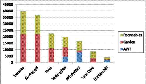
2.4 NSROC regional waste project
2.4.1 NSROC has been working on assessing the case for regional waste services for more than 12 months, following the decision of the 2011 NSROC Conference to explore opportunities to join together to seek better environmental and economic outcomes.
2.4.2 At its November 2012 meeting, a presentation on the research and scoping stage of the regional waste project was made to the NSROC Board. The Board, comprising Mayors and Council delegates from all NSROC Councils, was briefed on the Council, industry and policy research undertaken to test whether there was a sound case for regional waste shared services. During this stage, two questions were assessed:
· What are the advantages for Councils in regional action, compared with continuing with individual service purchasing?
· What should be the objectives of a regional group purchase?
2.4.3 The process to build an evidence base from which to answer these questions involved the issue of an industry consultation paper(attracting 23 responses), two workshops with General Managers, presentations by four of the industry key players to the General Managers and Waste Managers, and consultations with waste management experts.
2.4.4 The findings presented to the NSROC Board were:
· There are two major companies with waste infrastructure for disposal and processing of mixed waste with NSROC Councils’ business currently split between them.
· Improvement in the volume of putrescible waste diverted from landfill for the region as a whole is constrained by lack of facilities able to accommodate greater volume and by collection based on three bin system operating across the region.
· The earliest date for new mixed waste processing infrastructure to be commissioned is 2015 and the facilities are largely committed to contracts with other Councils or Council groups.
· Industry will not presume volume certainty as a basis for investment in new facilities. Investment follows the securing of contracts.
· Industry prices in risk – certainty of supply of a large volume of waste reduces their risks in dealing with local government.
· Industry has concerns about risks in dealing with a group of councils, based on previous experience where Councils did not remain committed to group contracting after tenders were called.
· Regional action is the best form of advocacy for longer term improvement in waste facilities. By demonstrating to the market that the Council group is serious about an efficient approach to shared service procurement, stimulus would be provided to the market, fuelling competition and better prices.
· Red bin mixed waste is the simplest and clearest first waste service to be regionalised, due to variations in collection systems and contracts amongst the Councils, constraining other waste stream disposal services.
2.4.5 On the basis of these findings, the NSROC Board considered two strategic options:
Continue with individual Council contracts, thus avoiding disruption to current arrangements.
OR
Engage the market as a regional group, to establish regional management capacity, create incentive for new entrants and new investment and seek improved price.[5]
The Board agreed in principle that a case for option two had been established.
2.4.6 Based on industry and market research, the facts are:
· Disposal of all waste streams is a significant and increasing cost centre, accounting for about $24 million in expenditure per annum across the region
· NSROC Councils do not control any waste transfer, processing or disposal facilities, and must purchase all services from the private sector, where two firms predominate.
· Policy and market failure over the last decade has led to inadequate investment in new infrastructure, consolidation of ownership and limited competition in the waste disposal services market
· Industry consultation resulted in strong interest in higher volume and greater security in contract term as drivers of better pricing
· New forms of waste disposal through treatment of putrescible waste or greater separation and streaming are long term financial and/or culture change investments
· NSROC Councils’ waste disposal contracts are in sufficient alignment to allow for a single contract across the region commencing in 2014 with 60 % of total volume, with a harmonisation period that would allow 100 % of volume from all seven Councils to be managed through the contract by the end of 2015. This opportunity to harmonise contracts will be difficult to recreate in the coming decade if, for some reason, this regional contract does not proceed.
2.4.7 The case for regional waste management by northern Sydney Councils rests on these fundamental facts and shared Council objectives in this service area. Together these constitute the evidence base for a regional approach to waste disposal contracting.
2.5 Project direction – immediate and long-term goals
2.5.1 The evidence collected during the research phase of the NSROC regional waste project supports the view that by establishing a regional approach to waste disposal in 2013-14, NSROC Councils will set themselves on a course that will see Councils experiencing better prices from existing providers in the immediate term, and stimulating better service options for the future.
2.5.2 This report recommends the establishment of a (relatively) simple joint contract for waste disposal (with or without some portion of MSW processed into compost like output) commencing in 2014. This high volume opportunity can be expected to create incentive for existing industry participants to invest in winning NSROC business, delivering leverage to Councils not available as single participants in the market.
2.5.3 This proposal also serves the longer term goal of better resource recovery and recycling. By operating under a joint waste disposal contract, NSROC will position itself in the market and with government as a single buyer able to reliably deliver large waste volumes and engage efficiently with the market through a collective contract.
2.5.6 Early in the contract period, planning would commence for a second stage of waste management collaboration, with the goal of engaging directly with industry for higher recovery outcomes from either AWT or waste to energy facilities built or expanded to suit the region. By this means, the initial contract (which will inevitably be mainly for landfill services) will serve the longer term goal of greater levels of diversion of waste away from landfill, through new infrastructure to treat and recycle waste.
Prior to tendering, formal
decision-making arrangements between Councils need to be established to
ensure that robust commercial market engagement is possible. Expert advice on governance has been
obtained and a participation agreement between Councils to operate shared
services through a committee structure managed by General Managers is
proposed, for the initial shared service waste contract. Tender release and procurement
management through Local Government Procurement is recommended as an
efficient approach for a single contract for multiple Councils. A budget estimate has been developed
for Councils to consider. EPA financial support will be pursed when more
information on the new waste programs is available and applications are
open.
3.0 IMPLEMENTATION
REQUIREMENTS
3.1 Moving from concept to reality in NSROC regional shared services requires the establishment of suitable arrangements between Councils so that they can act together in the market as a single buyer and manager of services, to drive the best possible outcome for their communities.
3.2 The waste disposal tender and contract is the first of what may be a series of shared services for the region, using the same decision-making and risk management structures. The decisions needed to make this contract happen and the cost of implementing governance and procurement structures falls inordinately on this proposal. However it will be a significant corporate governance asset for NSROC Councils, enabling greater innovation in service methods, and create potential for improved service efficiency and effectiveness across a range of service types.
3.3 Expert advice has been obtained on governance arrangements. The advice has been considered by General Managers meeting as the NSROC General Managers Advisory Committee and options sifted through, with a consensus view emerging on the preferred strategy for recommendation to Councils.
3.4 The key issues requiring Council consideration are in the areas of:
· governance
· procurement
· tender development
· resourcing
3.5 Governance issues
3.5.1 One of the issues raised by industry during the research and consultation phase of the NSROC regional waste project was the unreliability of Council groups as clients. Senior company officials from the major companies expressed the view that the associated risks and transaction costs of dealing with Council groups required risk pricing, mitigating the potential advantage of group buying.
3.5.2 Many other Council group arrangements have been relatively informal, typically with one Council leading the tender process and taking on the role as the contracting party with an exchange of letters with other Councils to specify their obligations. In many cases these arrangements have seen late drop-outs after costly tender and research phases, rendering regional contracts unworkable through loss of volume, or inordinate delays in executing or varying contracts as circumstances change.
3.5.3 In response to this record with other Council groups, the NSROC Board endorsed the recommendation to engage consultants to advise on options for formal linkages between Councils as the basis for market engagement. The brief was to provide advice on how best to structure the alliance amongst Councils for regional waste management, and potentially other forms of shared services.
3.5.4 A brief was issued in November 2012 and Maddocks Lawyers were appointed in December. They were asked to consider the risk management requirements of both the purchasers and suppliers in the waste market in developing engagement models. The brief also called for draft business rules to ensure that individual Councils retained control of strategic and investment decisions, while delegating operational matters to enhance the commercial nimbleness of the structure.
3.5.5 The over-riding concerns were to ensure that the joint procurement arrangements provide Councils with confidence that the decision-making structure meets requisite standards of legislative compliance, ethical decision-making, transparency and accountability to residents. Equally, the structure must be ‘fit for purpose’ for successfully working with the private sector to deliver reliable waste services to residents.
3.5.6 General Managers concurred that the governance arrangements should enable:
- a single contract between the service provider and the group of participating Councils;
- a small number of clearly defined opt-in or out points for Councils; and
- clear allocation of responsibility for strategic, management and operational decisions related to the waste service as between Councils and various levels of management.
3.6 Analysis of governance options
3.6.1 Council General Managers considered the report from Maddocks in February 2013 and decided to recommend one of the five options to Councils. The Executive Summary and Recommendations of the report are attached at Appendix 1 to this report.
3.6.2 The report took account of the need to move from separate Council contracts with disposal companies to a harmonised model to be fully subscribed over time as Councils conclude their existing separate contracts and are able to join the group contract. The report also examined how governance needs would change over time. For example, if the group decided to enter into a more complex form of engagement with the industry, such as a public-private partnership or a build and operate contract, it would need to consider formation of a company structure, as SHOROC Councils have done with Kimbriki Enterprises.
3.6.3 The key dimensions of the governance structures considered in the Maddocks report were:
· The relationship between the Councils
· The governance organs established
· The decision making style of the governance organs
· The relationship between each Council and the service contractor
· The legal and managerial relationship between each Council and the contractor.
3.6.4 Maddocks developed recommendations around each of these dimensions, as summarised below.
Table: Summary of Recommendations
|
Element |
Recommendation |
What this requires legally |
Comment |
|
Relationship between the councils |
There should be a binding and enforceable relationship between the councils that the councils are prepared to enforce. This needs to provide certainty as to the participation of the councils and the opt-out or break points and the consequences of opting out. |
A participation agreement executed by all the councils (could be called a joint venture or an alliance but these terms are better avoided). |
There is little point in proceeding with a loose MOU or similar document that does not bind council because this allows the councils to opt out easily and contractors to 'pick off' individual councils. |
|
Governance organs and decision making style of governance organs |
Tiered decision making process that seeks to have operational decisions made at the interface with the contractor on an independent commercial basis. Decisions of strategy or policy may need to be made mutually by a committee of the participating councils. Some decisions (e.g. for capital expenditure) will need to remain with councils to be made by each council separately. |
Establishment of governance Board and of committee under the Board for participating councils. Participation agreement to identify which decisions are made at which levels. |
Decisions to opt in or opt out will need to be made by individual councils but subject to any controls or sanctions in the participation agreement. |
|
Relationship between each council and the contractor |
A joint contract that ensures that the minimum tonnage of waste is available to the contractor for a definable period. |
A single contract. Initially each council will need to resolve to enter into a contract. |
There seems to be little point in proceeding with this process to then have each council contract severally. The contractor in the AWT&D phase will want one contract and one point of contact. |
|
Legal and managerial interface between each council and the contractor |
A single interface with the contractor. |
One entity representing all the participating councils under an agency agreement or delegation. Tender called by one entity on behalf of all the councils. Tender assessed by committee and recommendations made. |
|
|
Initially a delegate council or a project manager.
Ultimately for the AWT&D phase an SPV Co. |
One entity representing all the participating councils under an agency agreement or delegation. SPV Co will require constitution and the establishment of the Board etc. |
The costs of establishing and running an SPV Co may not be justified until the AWT&D phase. |
3.6.5 Based on these elements, five options for formalising the relationship between Councils for effective shared services were examined and rated for their suitability for both short and long term services:
· Option 1 Strategic alliance – or memorandum of understanding (MOU) style arrangement;
· Option 2 Participation Agreement, Governance Board, several contracts, and delegate council or project manager interface;
· Option 3 Participation Agreement, Governance Board, joint contracts, and delegate council or project manager interface;
· Option 4 Participation Agreement, Governance Board, joint contracts, established with an SPV Co;
· Option 5 County Council.
3.6.6 General Managers accepted advice that Option 3 is the most suitable governance structure for the 2013 contract for waste disposal utilising existing waste infrastructure. GMs agreed with Maddocks’ advice that when the next waste contract is developed, for waste processing using treatment facilities built or extended specifically for the region’s waste, Option 4 is likely to be a better option.
3.6.7 Figure 1 shows this structure diagrammatically for the contract harmonisation phase. The model also allows for other shared services to be added, setting up separate committees for their management.
Figure 1: NSROC shared services governance structure
3.6.8 Under this model, Councils would determine overall policy, strategic direction and significant investment in shared services while a governance board comprised of General Managers would be responsible for implementing the strategic direction and overseeing management decisions. A contract would be established spelling out the role of each level in the structure and business rules for its operation. This participation agreement between Councils would establish a strong legal relationship for the purpose of cooperative procurement of services, and spell out the rules and procedures for the governance board and the committees responsible for individual services.
3.6.9 If the arrangement is supported, consultation with the Division of Local Government of the NSW Department of Premier and Cabinet would be pursued, to ascertain whether any approvals are required under section 358 of the Local Government Act 1993 (the Act) which requires Ministerial approval of the formation of joint ventures, corporations or other entities. Given the many precedents of this type of arrangement, albeit in varying forms, and the support for regional delivery of services emerging from NSW Government central agencies, it is not anticipated that this would prevent the structure from being implemented.
3.6.10 Maddocks also advised that an application be made to the Australian Competition and Consumer Commission for authorisation to approach the market as a group. This step was also observed, and authorisation granted, prior to the 2003-04 NSROC tender. As a result, the process will be less expensive and time-consuming in 2013.
3.7 Tender planning
3.7.1 An inter-Council group of waste managers drawn from each NSROC Council was convened in 2012 to provide expert guidance to NSROC staff on the regional waste project. The group has been chaired by the General Manager of Hunters Hill Council and has given advice on each Council’s waste management needs and objectives.
3.7.2 Documentation from previous waste disposal tenders has been shared, and one Council (Hornsby) has made an officer available part-time to work on drafting the tender and contract, based on well-established practices amongst NSROC Councils.
3.7.3 The tender strategy needs to be further refined and a series of tasks related to this and other preparatory steps is in an Action Plan, prepared with external assistance in early 2013. The Action Plan summary is at Appendix 2. It sets out all steps required to prepare and issue the tender, evaluate it and execute the contract, with time required for each step. The goal is to issue the tender in October 2013, award it February 2014 and commence it in April 2014.
3.7.4 Included in the plan is advice on the form and timing of external assistance needed to go to market, assess tenders and execute the contract. Financial and probity advice, tender strategy guidance and authorisation of the joint procurement by the Australian Competition and Consumer Commission are other costs to be met.
3.7.5 The Action Plan includes the key junctures for Councils and GMAC consideration of milestones in the project and will be used as a working tool over the course of the project. This report is one of three that Council will consider on the project over 2013.
3.8. Procurement as a regional group
3.8.1 Under the Act, councils have the power to enter into cooperative or shared service arrangements to meet the needs of their areas. However the requirements for tendering and the controls on delegation mean that councils can contract with third parties to manage a tender process but cannot delegate: “the acceptance of a tender other than under [the] Act to be invited by council.”
3.8.2 Normally councils would be required to tender the contract for waste disposal services with the result that the acceptance of the tender would need to come back to the elected councils. That function could not be delegated.
3.8.3 The Act provides for situations where tenders are not required to be invited, and therefore where that restraint on delegation would not apply. These include those referred to in s55(3)(a) of the Act, where the contract is for services specified by a person prescribed by the regulations and made with a contractor specified by a person prescribed by the regulations.
3.8.4 Local Government Procurement (LGP), an entity wholly-owned by the NSW Local Government and Shires Association, is prescribed by the regulations for this purpose. This means LGP could specify the services and contract, call tenders and, following the tender, LPG could engage the contractor to provide services to NSROC. Prior to tender issue council officers would instruct LGP as to the tender and contract conditions and upon receipt of tenders, control the tender assessment process. This would remove the need for each council to have called the tender and resolved individually to accept the outcome.
3.8.5 If LGP is not used then a tender must be called and returned to each council for resolution to accept the tender. This alternative would mean that each Council has to separately resolve to enter into a contract. Maddocks advised that such a process raises a number of issues:
· if the price or other contractual terms are dependent upon all of the councils participating or a minimum number participating – it is not possible for any of the councils to know what they are voting to accept (except in the case of the last council to vote). The result of this is that the resolutions may have to be held in escrow or ratified once the number of participants is known;
· there is a risk of loss of confidentiality; and
· there is a risk that as each of the councils votes the unsuccessful contractor will seek to influence the remaining councils. These two issues might be managed by having simultaneous meetings and briefings of councils (this was what was done for a similar process by MACROC).
3.8.6 These issues increase the likelihood of a very difficult process for getting the necessary resolutions – a process fraught with the risks of loss of confidentiality and procedural errors that may undo the process. There is informal evidence that significant delays and last-minute direction changes have occurred with other Council group tenders.
3.8.7 The use of LGP and consultation with Councils prior to the issue of the tender to ensure the service requirement and acceptable price and quality limits are determined before the tender is issued, is the recommended pathway.
3.8.8 Maddocks considered these options and advised in the following terms:
“Clearly the easiest option is to use LGP but it will be necessary to work closely with the company to make sure that they are willing to run the tender and that the specifications capture the particular needs of the participating councils.”
3.8.9 The other options to avoid these problems would be to adopt governance Option 4 (form a company) or Option 5 (form a county council) as described above. These Options were assessed to be less suitable and more costly and complex than required for the waste disposal contract by both the consultants and GMAC.
3.9 Resourcing requirements
3.9.1 The establishment of a robust and multi-purpose shared services governance structure for NSROC Councils will require investment in developing agreements between Councils. A proposal was sought from Maddocks for this work and is included in the budget below.
3.9.2 Similarly, the cost of engaging LGP to manage the tender process has been quoted for. Estimates for other services recommended by the action plan consultants are included also. Not costed is the time of the NSROC and Council staff who will participate in the tender preparation process. As noted above, application will be made to the EPA to assist with the cost of the regional waste management, so the budget should be considered conservative (that is, costs may be less). Neither quote has been subject to negotiation at this time.
3.9.3 It is proposed that costs be shared equally for the shared service arrangements, and that the tender and contract costs are levied according to volume (as was done under the 2003 tender conducted by NSROC for waste services). On this basis establishing the shared service agreements would involve a payment by each Council of $8,285.00.
REGIONAL WASTE PROJECT AND SHARED SERVICES DRAFT BUDGET
|
Shared service participation and governance arrangements |
Cost Estimate ($) |
|
Preparation and execution of participation and governance arrangements, decision-making rules, and related documentation |
50,000 |
|
Project management contract development and procurement |
8,000 |
|
Total to establish shared service arrangements |
$58,000 |
|
Tender for waste disposal |
Cost Estimate ($) |
|
Tender strategy facilitation |
10,000 |
|
Tender management (LGP) |
30,000 |
|
Financial Assessment of final tenders |
3,000 |
|
Tender and contract review – legal advice |
12,000 |
|
Probity Advisor |
10,000 |
|
ACCC authorisation – submission fee |
2,500 |
|
Contingency |
3,000 |
|
Total –tender and contract |
$70,500 |
3.10 Reports to Council
3.10.1 Acceptance of the recommendations of this report will trigger these steps:
· An application for authorisation to approach the market as a group, to be made to the Australian Competition and Consumer Commission for protection under the Competition and Consumer Act 2010
· Development of a tender strategy (technical specifications, term of contract and option period)
· Application to the EPA for funding support for the project management of the contract under the new regional waste strategies funding program
· Preparation of a draft tender and contract
· Engagement of consulting advice on legal and tender matters, including the participation agreement between Councils and with the project manager.
3.10.2 The results of this work will return in a second report to all seven Councils in July-August 2013, prior to the tender being issued, with more detailed advice on the tender specifications and on the participation agreement and related contracts.
--------------------------------------------------------------------
4.0 RECOMMENDATIONS
DRAFT ONLY – wording to be further developed after GM responses.
Participation
- Agree to Council’s participation in preparations to go to tender for procurement of waste disposal/processing services for NSROC Councils for a contract commencing in 2014 noting that a further report on tender criteria will come to Council in July-August 2013 for final agreement as to participation in the tender.
- Agree to be part of an application for authorisation (through revocation and substitution of 2003 authorisation) from the Australian Competition and Consumer Commission for group purchasing of waste disposal services.
Governance
- Agree to participate in formal participation arrangements with NSROC Councils and to contribute to the costs of establishing partnership arrangements for shared services procurement and management by NSROC Councils, on a case-by-case basis, commencing with the waste disposal tender.
Investment
- Agree to contribute to the governance structure establishment costs on an equal basis amongst all NSROC Councils, and the tender preparation costs, in line with volume participation in the waste contract
- Agree to an initial payment of $... to be made to NSROC by ….
|
APPENDIX No: 1 - Draft Regional Shared Services and Regional Waste Project |
|
Item No: GB.12 |
APPENDIX ONE
Northern Sydney
Regional Organisation of Councils:
Waste Project

REPORT ON GOVERNANCE MODEL OPTIONS
14 MARCH 2013
Lead Author: Patrick Ibbotson
|
APPENDIX No: 1 - Draft Regional Shared Services and Regional Waste Project |
|
Item No: GB.12 |
1. Executive Summary
1.1 Background
The NSROC councils each have disposal contracts falling due for renewal in the period 2012 to 2016. The councils are considering contracting for waste disposal in a cooperative or shared manner. This report provides analysis and recommendations as to governance structures that might be adopted. This is not a report on the detail of contractual models or contractual risk management – although we consider these issues in the discussion. One of the next steps in the procurement process will be a detailed risk assessment that informs contract drafting.
To identify and then recommend governance options we have:
- identified the need for new contracting arrangements as the existing contracts expire;
- identified the legal, commercial and practical constraints;
- through discussions with the councils and review of available literature, identified the objectives and characteristics required of a cooperative or shared arrangement;
- broken down the overall concept of cooperative or shared services contracting into the relevant decision making and relationship dimensions;
- proposed five options described in terms of those dimensions;
- assessed those options against the objectives and characteristics and
- made recommendations
There are observations and defined terms used in this report. A glossary is at the end of this report.The need for a cooperative arrangement
The impetus for a cooperative arrangement comes from:
- the imminent or past expiry of the existing waste disposal contracts;
- the potential to obtain better waste and efficiency outcomes; and
- the Government's policy settings.
Table 1: Current contractual expiry
|
LGA |
Collection |
MSW disposal / processing |
Garden/organics processing |
Recyclables processing |
Clean up |
|
Hornsby |
2017 + 1yr option |
June 2013 + |
June 2013 + |
Under extension from Dec 2012 |
June 2013 + |
|
Hunters Hill |
July 2012 |
July 2012 |
July 2012 |
July 2012 |
July 2012 |
|
Ku-ring-gai |
September 2014 |
September 2013 |
September 2013 |
September 2014 |
2013 |
|
Lane Cove |
December 2015 |
December 2015 |
December 2015 |
December 2015 |
December 2015 |
|
North Sydney |
June 2017 |
January 2015 |
January 2015 |
January 2015 |
January 2015 |
|
Ryde |
April 2015 |
April 2015 |
April 2015 |
April 2015 |
April 2015 |
|
Willoughby* |
July 2020 |
September 2020 |
September 2020 |
September 2020 |
September 2020 |
Source: NSROC
* Disposal contracts include termination for convenience provisions
There are four contractual phases that need to be considered and the governance model needs to be capable of responding to all of these:
- Current – there are separate contracts with various disposal companies and limited private sector disposal locations. The contracts are all separately administered. The contracts are not on the same terms as each other and are not coordinated;
- Harmonisation – some of the councils will be participating in a coordinated scheme and others will be working under their existing contracts until they expire. During this period, as contracts expire, it may be necessary to 'farm in' new participating councils. Participating councils would agree to processes to ensure that contracts 'come into line' with each other;
- Coordinated Disposal – the councils will all be operating under a coordinated regime. This might be one contract or several contracts on the same terms. Administration may be centralised or it may remain in each council with coordination from a coordinating person or team;
- AWT&D – there will be a contract between councils and a contractor for the provision of an AWT&D service or the councils will have established their own AWT&D service.
The contractual structure in each phase will be different and the governance arrangements need to be able to evolve with these different phases.
1.2 Overall Objectives
The following are the overall policy or strategic objectives (based on our discussions with GMs and staff). These objectives address the question: why would the councils participate in a collaborative procurement arrangement for waste disposal?
Table 2: Overall objectives
|
|
Objective |
What this means |
Comment |
|
1 |
Better waste outcome |
Reducing the percentage of material disposed of directly to landfill without increasing the environmental impact of the diverted materials. |
Achieving better diversion from landfill but the technology used to do this must not have unacceptable environmental impacts and be cost effective/efficient. |
|
2 |
Opportunity to innovate |
Providing sufficient volume that the market will consider it worthwhile to look for better pricing and processing options. Potentially removing barriers to entry for a new participant that may have appropriate technology/sites. |
Perception that current market participants will not be prepared to commit to an AWT&D facility unless faced with a significant volume of waste. Also other participants may find the volume sufficient to justify their launch into the market. |
|
3 |
Security of disposal arrangements / options |
There is a clear disposal option for the longer term which is committed to each Council's waste stream. |
Driven by uncertainty about landfill capacity. |
|
4 |
Price |
The price is no worse than and if possible better than the price that would otherwise be achieved. (Not necessarily a reduction in price from the present contracts). |
Based on industry consultations, the councils perceive that by providing a larger volume they will be able to achieve economies of scale so that the price is likely to be less than if there had been individual tenders. |
|
5 |
Working together for efficiency |
Councils finding efficient ways of working together across regions. |
This anticipates a policy trend towards possible shared services or amalgamations. There is a desire to find models for shared services and procurement that will not just be limited to waste disposal. |
The following are the characteristics (based on our discussions with GMs and staff) that need to be displayed by any arrangements that are put in place.
Table 3: Operating characteristics
|
|
Characteristic |
What this means |
|
|
1 |
Legitimate |
The market participants are prepared to spend the resources, time and money dealing with this structure. It is tried and proven. |
|
|
2 |
Accepted |
The rate payers will need to understand and accept why the structure is proposed. Councillors will need to understand and accept why the structure is the most suitable. |
|
|
3
|
Proper Decision Making |
The structure is capable of making decisions efficiently. Decisions should be made in the interests of the region as a whole not as representatives for limited constituents. There must be sufficient protection for each constituency represented to know that their interests are being appropriately looked after. |
|
|
4 |
Accountable |
The structure must have processes and controls that assure accountability to a standard no less than required by the Act. |
|
|
5 |
Certain |
Once participants have committed then they must stay in with very limited and well defined break points. |
|
|
6 |
Deliverable |
The structure needs to be realistic so that the people who are being asked to work with it and within it can readily understand its requirements. The structure works legally and practically in the context of the requirements of the Act. The structure needs to allow each council to continue to charge and recover the DWMC in accordance with the IPART Determinations and the Act. |
|
|
7 |
Justified |
Additional costs should be able to be justified by reference to the benefits that will flow. The structure should not demand significant additional resources and should not have any unnecessary complexity. Treats councils' staff fairly. |
|
|
8 |
Liability managed |
The structure should provide a very clear and legally enforceable, reasonable and certain process for the management of liabilities between participants. |
|
|
9 |
Adaptable |
The structure needs to be capable of being used for services other than waste disposal. The structure can expand to include other councils. The structure needs to be able to evolve for more complex projects than just disposal (eg AWT&D contract). |
|
|
10 |
Develop a centre of expertise |
The structure is an opportunity to develop leading expertise in the field. |
|
1.3 The different dimensions and decisions within the governance and contracting structures
Often the structures for coordinated or shared servicing arrangements are discussed in terms of there being an 'alliance' or a 'joint venture' (JV) or the establishment of an 'entity' – usually a company. These discussions do not reflect the dimensions of the issues that need to be considered.
The following dimensions need to be considered:
Table 4: Dimensions of the governance structure
|
The relationship between the councils |
For example, is this an alliance or a joint venture or something else? |
|
The governance organs or entities that are established |
Should there be a committee or a board of the participating councils? Should there be a new company established? |
|
The decision making style of the governance organs |
Should there be representative decisions or mutual decisions or independent commercial decisions? |
|
The relationship between each council and the contractor |
Should there be a contract jointly between the councils and the contractor or severally between each council and the contractor? |
|
The legal and managerial interface between each council and the contractor |
Should there be one council, one person, a new entity? |
There are some decisions that should or must be made by the elected councils. Others can be delegated to individuals or committees. In commercial dealings it is better if the day to day commercial and managerial decisions are to be delegated to competent people with the expertise to manage the contract. We have therefore suggested the following hierarchy of decisions:
Table 5: Tiered decision making model
|
Level of Decision Making |
Examples of Decisions |
|
Level 1 |
§ To provide capital expenditure beyond a specified threshold § To participate in a new shared service opportunity § To accept tender (not required where s55(3)(a) of the Act applies) |
|
Level 2(a) |
§ To accept other councils into the participation arrangement § To recommend the establishment of a new shared services arrangement and its governance structure |
|
Level 2(b) |
§ Pre-tender process – waste audit; market sounding; budgets § Determine assessment of tenders § To enter into contract where s55(3)(a) applies § To terminate a shared service arrangement § To accept a re-priced extension of the contract with the contractor |
|
Level 3 |
§ To carry out tender process and prepare assessment reports § To manage contract on a day to day basis § To accept a pre-priced extension of the contract with the contractor |
1.4 Commercial, practical and legal constraints and context
There are a number of commercial, practical and legal constraints that need to be considered. These include:
- the powers and functions of councils under the Act to contract in respect of services across a region and not just their area. Councils have the power to do this where appropriate for the current and future needs of their area;
- the tendering requirements under the Act. In particular, where tenders are called they must be accepted by resolution of each council. The council's discretion in this regard cannot be fettered. However, if the tender is specified by a person prescribed by the Regulations for the purpose of section 55(3)(a) of the Act then the tender can be accepted without resolution of the council. LGP is prescribed for this purpose. Alternatively council could form an entity and request the Minister to have it prescribed for this purpose;
- the waste industry will go to significant expense in tendering. It is essential that they get the message that the participating councils have serious intent and are committed to the process;
- the use of special purpose vehicle (SPV) companies is common. However, a company limited by guarantee is not a normal commercial structure for significant contracts. In our view, based on our experience, the use of a company limited by guarantee will cause difficulty with contract and finance negotiations. An SPV should be a company limited by shares;
- Ministerial approval is required to form an entity including a joint venture or company limited by shares;
- commitment of waste is essential;
- ACCC authorisation may arguably be required. If authorisation is not sought, the consequences of a challenge being made to the procurement process may be disastrous. It is better to avoid this risk and obtain authorisation.
1.5 Options
We assessed five options. They are:
- Option 1 Strategic alliance – or memorandum of understanding (MOU) style arrangement;
- Option 2 Participation Agreement, Governance Board, several contracts, and delegate council or project manager interface;
- Option 3 Participation Agreement, Governance Board, joint contracts, and delegate council or project manager interface;
- Option 4 Participation Agreement, Governance Board, joint contracts, established with an SPV Co;
- Option 5 County Council.
and Table 3 above.
In those tables we have assessed each of options 1 to 5 against each of the criteria for firstly the harmonisation phase and coordinated disposal phase and secondly the AWT&D phase.
1.6 Options Assessment
In assessing the benefits/disadvantages of the governance options against the objectives and desirable operating characteristics of the governance arrangements, we have ranked each option from 1 (weakest) to 5 (best).
Table 6: Assessments against objectives
|
|
Objective |
What this means |
Options during Harmonisation of coordinated disposal phase |
Options during AWT&D phase |
||||||||
|
Option 1 |
Option 2 |
Option 3 |
Option 4 |
Option 5 |
Option 1 |
Option 2 |
Option 3 |
Option 4 |
Option 5 |
|||
|
1 |
Better waste outcome |
Reducing the percentage of material disposed of directly to landfill without increasing the environmental impact of the diverted materials. |
1 |
2 |
4 |
4 |
4 |
1 |
2 |
3 |
5 |
4 |
|
2 |
Opportunity to innovate |
Providing sufficient volume that the market will consider it worthwhile to look for better pricing and processing options. Potentially removing barriers to entry for a new participant that may have appropriate technology. |
1 |
2 |
3 |
5 |
4 |
1 |
2 |
3 |
5 |
4 |
|
3 |
Security of disposal arrangements/ options |
There is a clear disposal option for the longer term which is committed to each Council's waste stream. |
1 |
2 |
4 |
4 |
4 |
1 |
2 |
3 |
5 |
4 |
|
4 |
Price |
The price is no worse than and if possible better than the price that would otherwise be achieved. (Not necessarily a reduction in price from the present contracts). |
2 |
3 |
3 |
3 |
3 |
1 |
2 |
3 |
4 |
4 |
|
5 |
Working together for efficiency |
Councils finding efficient ways of working together across regions. |
1 |
3 |
4 |
5 |
2 |
1 |
3 |
4 |
5 |
2 |
Table 7: Assessments against desired operating characteristics
|
|
Characteristic |
What this means |
Harmonisation of coordinated disposal phase |
AWT&D Phase |
||||||||
|
Option 1 |
Option 2 |
Option 3 |
Option 4 |
Option 5 |
Option 1 |
Option 2 |
Option 3 |
Option 4 |
Option 5 |
|||
|
1 |
Legitimate |
The market participants are prepared to spend the resources, time and money dealing with this structure. It is tried and proven. |
1 |
2 |
3 |
4 |
4
|
1 |
2 |
3 |
4 |
4 |
|
2 |
Accepted |
The rate payers will need to understand and accept why the structure is proposed. Councillors will need to understand and accept why the structure is the most suitable. |
3 |
3 |
3 |
2 |
2 |
2 |
2 |
3 |
3 |
2 |
|
3 |
Proper Decision Making |
The structure is capable of making decisions efficiently. Decisions should be made in the interests of the region as a whole not as representatives for limited constituents. There must be sufficient protection for each constituency represented to know that their interests are being appropriately looked after. |
1 |
2 |
3 |
5 |
4 |
1 |
2 |
3 |
5 |
4 |
|
4 |
Accountable |
The structure must have processes and controls that assure accountability to a standard no less than required by the Act. |
1 |
3 |
3 |
5 |
5 |
1 |
3 |
3 |
5 |
5 |
|
5 |
Certain |
Once participants have committed then they must stay in with very limited and well defined break points. |
1 |
2 |
3 |
4 |
5 |
1 |
2 |
3 |
4 |
5 |
|
6 |
Deliverable |
The structure needs to be realistic so that the people who are being asked to work with it and within it can readily understand its requirements. The structure works legally and practically in the context of the requirements of the Act. The structure needs to allow council to continue to charge and recover the DWMC in accordance with the IPART Determinations and the Act. |
1 |
4 |
4 |
4 |
2 |
1 |
4 |
4 |
4 |
2 |
|
7 |
Justified |
Additional costs should be able to be justified by reference to the benefits that will flow. The structure should not demand significant additional resources and should not have any unnecessary complexity. Treat council staff fairly. |
5 |
3 |
4 |
2 |
1 |
1 |
2 |
3 |
4 |
5 |
|
8 |
Liability managed |
The structure should provide a very clear and legally enforceable, reasonable and certain process for the management of liabilities between participants. |
|
2 |
3 |
4 |
5 |
1 |
2 |
3 |
4 |
5 |
|
9 |
Adaptable |
The structure needs to be capable of being used for services other than waste disposal. The structure can expand to include other councils. The structure needs to be able to evolve for more complex projects than just disposal (eg AWT&D contract). |
1 |
2 |
4 |
5 |
2 |
1 |
3 |
4 |
5 |
2 |
|
10 |
Develop a centre of expertise |
The structure is an opportunity to develop leading expertise in the field. |
1 |
2 |
5 |
5 |
5 |
1 |
2 |
5 |
5 |
5 |
1.7 Recommended options
Table sets out the recommendations from this report.
Table 8: Summary of Recommendations
|
Element |
Recommendation |
What this requires legally |
Comment |
|
Relationship between the councils |
There should be a binding and enforceable relationship between the councils that the councils are prepared to enforce. This needs to provide certainty as to the participation of the councils and the opt-out or break points and the consequences of opting out. |
A participation agreement executed by all the councils (could be called a joint venture or an alliance but these terms are better avoided). |
There is little point in proceeding with a loose MOU or similar document that does not bind council because this allows the councils to opt out easily and contractors to 'pick off' individual councils. |
|
Governance organs and decision making style of governance organs |
Tiered decision making process that seeks to have operational decisions made at the interface with the contractor on an independent commercial basis. Decisions of strategy or policy may need to be made mutually by a committee of the participating councils. Some decisions (eg for capital expenditure) will need to remain with councils to be made by each council separately. |
Establishment of governance Board and of committee under the Board for participating councils. Participation agreement to identify which decisions are made at which levels. |
Decisions to opt in or opt out will need to be made by individual councils but subject to any controls or sanctions in the participation agreement. |
|
Relationship between each council and the contractor |
A joint contract that ensures that the minimum tonnage of waste is available to the contractor for a definable period. |
A single contract. Initially each council will need to resolve to enter into a contract. |
There seems to be little point in proceeding with this process to then have each council contract severally. The contractor in the AWT&D phase will want one contract and one point of contact. |
|
Legal and managerial interface between each council and the contractor |
A single interface with the contractor. |
One entity representing all the participating councils under an agency agreement or delegation. Tender called by one entity on behalf of all the councils. Tender assessed by committee and recommendations made. |
|
|
Initially a delegate council or a project manager.
Ultimately for the AWT&D phase an SPV Co. |
One entity representing all the participating councils under an agency agreement or delegation. SPV Co will require constitution and the establishment of the Board etc. |
The costs of establishing and running an SPV Co may not be justified until the AWT&D phase. |
Figure 1 shows this structure diagrammatically for the harmonisation phase and coordinated disposal phase. (Note that the need to enable different services to be added to the structure, in a situation where the councils who participate for any particular service may differ, has led to the need to establish 'committees' of the overall governance board.)
Figure 1: Recommended structure Harmonisation and Coordinated Contract Phase
This option could also work for the AWT&D phase but is not preferred for that phase primarily because it provides, relative to the preferred option, inferior opportunities for managing the contractual and commercial arrangements and risks. Figure 2 shows the recommended structure for the AWT&D phase.
Figure 2: Recommended structure AWT&D Phase
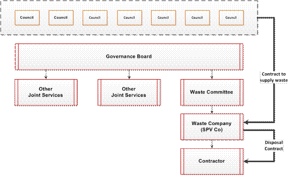
This structure is assessed as being:
- less suitable to the harmonisation phase and coordinated disposal phase primarily because of the time and resources required to establish it; and
- more suitable to the AWT&D phase primarily because of the ability to manage contractual and commercial arrangements and risks through the SPV Co.
APPENDIX 2
12-Month Action Plan
Waste Disposal/Processing Procurement Project
NSROC – Northern Sydney Regional Organisation of Councils
Executive Summary
Northern Sydney Regional Organisation of Councils has embarked on a project to procure a regional waste disposal/processing contract to be available to member Councils for the disposal of their municipal putrescible waste.
Wright Corporate Strategy was commissioned to develop a 12-Month Action Plan that sets out the critical actions and decision-making points to secure a disposal/processing contract for NSROC Councils for contract commencement in 2014. In this plan we have proposed a process that will enable contract commencement by May 2014.
In the following table, the three core steps for the procurement of the contract are summarised.
|
Task |
Success Criteria |
Completion Date |
Responsibility |
Comments |
|
Prepare for and call tenders |
Call for tenders made public |
1 Nov 13 |
NSROC |
- All preparation completed to satisfaction of Councils and strong market interest - All Councils agree to tender process and commitments post-tender - Call for tenders advertisement distributed |
|
Select preferred tenderer |
Tender assessment report tabled at GMAC |
17 Feb 14 |
NSROC |
- Tender assessment panel reaches a view on the tender most likely to meet best interests of participating Councils - Recommendations on preferred tenderer and modifications to contract terms and conditions - GMAC instructions given to contract negotiating team |
|
Execute and commence contract |
Councils commence to deliver waste to contractor |
5 May 14 |
NSROC |
- Tender assessment panel recommends to all participating Councils for resolutions to execute contract(s) - All participating Councils resolve to accept the recommended tender and execute the contract(s) - Councils commence delivering waste to contractor as existing contract permit |
2. 12-Month Action Plan Time Line
2.1 Table of Activities
The following table sets out all of the activities incorporated into the MS Project schedule for the 12-Month Action Plan, showing for each activity –
- the description of the activity,
- the duration of the activity in working days (5-days per week),
- the start date for the activity, and
- the finish date for the activity.
|
Task Name |
Durn |
Start |
Finish |
|
Procure Waste Disposal/Processing Contract |
|
|
|
|
Call Tenders |
171 days |
Fri 1/03/13 |
Fri 1/11/13 |
|
Project Preliminaries |
58 days |
Fri 1/03/13 |
Fri 24/05/13 |
|
Establish Tender Management Group |
30 days |
Fri 1/03/13 |
Mon 15/04/13 |
|
Establish Budget for Procurement Project |
30 days |
Fri 1/03/13 |
Mon 15/04/13 |
|
Determine governance structure |
15 days |
Fri 1/03/13 |
Thu 21/03/13 |
|
Decision on seeking ACCC ruling |
15 days |
Fri 1/03/13 |
Thu 21/03/13 |
|
Develop outline tender strategy |
5 days |
Mon 18/03/13 |
Fri 22/03/13 |
|
GMAC Meeting 18 April 2013 |
1 day |
Thu 18/04/13 |
Thu 18/04/13 |
|
Report 1 to Councils |
25 days |
Fri 19/04/13 |
Fri 24/05/13 |
|
Prepare information for tender documents |
25 days |
Mon 25/03/13 |
Wed 1/05/13 |
|
Prepare information for contract documents |
25 days |
Mon 25/03/13 |
Wed 1/05/13 |
|
ACCC ruling |
136 days |
Fri 19/04/13 |
Wed 30/10/13 |
|
Prepare applications for authorisations |
10 days |
Fri 19/04/13 |
Fri 3/05/13 |
|
Submit application for authorisation |
1 day |
Mon 6/05/13 |
Mon 6/05/13 |
|
Submit application for interim authorisation |
1 day |
Mon 6/05/13 |
Mon 6/05/13 |
|
ACCC ruling on interim authorisation |
30 days |
Tue 7/05/13 |
Tue 18/06/13 |
|
ACCC ruling on authorisation |
125 days |
Tue 7/05/13 |
Wed 30/10/13 |
|
Establish governance arrangements |
20 days |
Mon 27/05/13 |
Mon 24/06/13 |
|
Release briefs for advisors – technical, legal, probity |
9 days |
Mon 27/05/13 |
Thu 6/06/13 |
|
Finalise tender strategy |
24 days |
Mon 27/05/13 |
Fri 28/06/13 |
|
Engage technical advisor |
10 days |
Fri 7/06/13 |
Fri 21/06/13 |
|
Engage legal advisor |
10 days |
Fri 7/06/13 |
Fri 21/06/13 |
|
Engage probity advisor |
10 days |
Fri 7/06/13 |
Fri 21/06/13 |
|
Prepare probity plan |
25 days |
Mon 24/06/13 |
Fri 26/07/13 |
|
Prepare tender assessment plan |
25 days |
Mon 24/06/13 |
Fri 26/07/13 |
|
Prepare tender documents |
40 days |
Mon 24/06/13 |
Fri 16/08/13 |
|
Prepare contract documents |
40 days |
Mon 24/06/13 |
Fri 16/08/13 |
|
GMAC Meeting 11 July 2013 |
1 day |
Thu 11/07/13 |
Thu 11/07/13 |
|
GMAC Meeting 22 August 2013 |
1 day |
Thu 22/08/13 |
Thu 22/08/13 |
|
Report 2 to Councils |
27 days |
Fri 23/08/13 |
Mon 30/09/13 |
|
Call Tenders |
1 day |
Fri 1/11/13 |
Fri 1/11/13 |
|
|
|
|
|
|
Select Preferred Tenderer |
66 days |
Fri 1/11/13 |
Mon 17/02/14 |
|
Release brief for financial assessment advisors |
8 days |
Mon 4/11/13 |
Wed 13/11/13 |
|
Engage financial assessment advisor |
10 days |
Thu 14/11/13 |
Wed 27/11/13 |
|
Select and brief tender assessment panel |
6 days |
Thu 28/11/13 |
Thu 5/12/13 |
|
Tender period (close tenders) |
36 days |
Fri 1/11/13 |
Fri 20/12/13 |
|
Review tenders |
15 days |
Mon 6/01/14 |
Fri 24/01/14 |
|
Complete financial assessment |
9 days |
Mon 6/01/14 |
Thu 16/01/14 |
|
Interview tenderers |
5 days |
Tue 28/01/14 |
Mon 3/02/14 |
|
Determine preferred tenderer |
5 days |
Tue 4/02/14 |
Mon 10/02/14 |
|
Prepare assessment report |
5 days |
Tue 11/02/14 |
Mon 17/02/14 |
|
Execute and Commence Contract |
52 days |
Tue 18/02/14 |
Mon 5/05/14 |
|
Finalise contract terms and conditions |
25 days |
Tue 18/02/14 |
Mon 24/03/14 |
|
Finalise contract documentation |
25 days |
Tue 18/02/14 |
Mon 24/03/14 |
|
Report 3 to Councils |
26 days |
Tue 25/03/14 |
Fri 2/05/14 |
|
Commence contract |
1 day |
Mon 5/05/14 |
Mon 5/05/14 |
|
Ordinary Meeting of Council - 28 May 2013 |
GB.13 / 371 |
|
|
|
|
Item GB.13 |
S08356 |
|
|
14 May 2013 |
Tender T04/2013 -
Allan Small Park Sports Field Upgrade
EXECUTIVE SUMMARY
|
purpose of report: |
To consider the tenders received for the upgrade of Allan Small Park Sports Field with associated landscape works located in Saiala Road Killara and appoint the preferred tenderer. |
|
|
|
|
background: |
Council, as part of the Open Space Capital Works Program, approved funding for the upgrade of Allan Small Park Sports Field with associated landscape works which include drainage, irrigation, new artificial cricket wicket and regrading of the sports surface. |
|
|
|
|
comments: |
Tender documents were produced with six (6) submissions received. The submissions were assessed using agreed criteria which identified the tender submission providing the best value to Council. |
|
|
|
|
recommendation: |
That Council accepts the tender from R&N Paddison Pty Ltd for the upgrade of Allan Small Park Sports Field with associated landscape works located in Saiala Road Killara. |
Purpose of Report
To consider the tenders received for the upgrade of Allan Small Park Sports Field with associated landscape works located in Saiala Road Killara and appoint the preferred tenderer.
Background
Council, as part of the Open Space Capital Works Program, approved funding for the upgrade of Allan Small Park Sports Field with associated landscape works which include drainage, irrigation, new artificial cricket wicket and regrading of the sports field surface. The irrigation will be linked to the existing stormwater harvesting system.
Comments
Six (6) tenders were received and recorded in accordance with Council’s tendering policy.
Tenders were received from the following companies:
· Synergy Resource Management Pty Limited
· R&N Paddison Pty Ltd
· M. Collins & Sons
· Go Gardening
· Civil Constructions Pty Ltd
· A J Bristow and Sons Pty Ltd
A Tender Evaluation Panel consisting of staff from the Operations and Strategy & Environment Departments reviewed all six (6) tenders. The initial part of the evaluation, based on conformity and cost, identified two (2) submissions received were significantly greater than Council’s available funds. No further assessment was carried out on these submissions.
The remaining four (4) submissions were evaluated taking into account:
· the lump sum fee,
· provisional rates,
· company and staff experience,
· the ability to provide the full range of services required,
· work program,
· previous performance in relation to similar type work and
· the company’s financial capacity.
The confidential attachments to this report include:
· list of tenders received and additional financial information (Attachment 1),
· the Tender Evaluation Panel’s comments and recommendation (Attachment 2), and
· an independent Performance and Financial Assessment which was carried out by Corporate Scorecard Pty Ltd (Attachment 3).
All four (4) companies assessed demonstrated suitability and qualifications to carry out all of the services required to complete the work. From the available information taken into account during the scoring from each element of the assessment, R&N Paddison Pty Ltd was identified as providing the best value to Council.
In order to ensure Council is not exposed to financial risk and that R&N Paddison Pty Ltd is trading in a ‘sound and profitable manner’, an independent Performance and Financial Assessment was carried out by Corporate Scorecard Pty Ltd.
R&N Paddison Pty Ltd is identified as providing the ‘best value’ to Council.
Governance Matters
Tender documents were prepared and released through Tenderlink on 6 April 2013 with a closing date of 30 April 2013. At the close of tender, six (6) tenders were received and recorded in accordance with Council’s tendering policy.
A Tender Evaluation Panel, consisting of staff from Operations and Strategy & Environment Departments, was formed to assess the six (6) tenders received.
The evaluation took into account:
· conformity of submission,
· lump sum fee,
· provisional rates,
· company and staff experience,
· the ability to provide the full range of services required, work program,
· previous performance in relation to similar type work and
· the company’s financial capacity.
The confidential attachments to this report include the list of tenders received, the Tender Evaluation Panel’s comments and recommendation and the independent Performance and Financial Assessment carried out by Corporate Scorecard Pty Ltd.
The attachments are considered to be confidential in accordance with section 10A (2)(d) (iii) of the Local Government Act 1993 as they are considered to contain commercial in confidence information.
Risk Management
Three (3) key areas of risk were identified in relation to the proposed work:
§ that the work is in close proximity to an environmentally sensitive area,
§ that Council should not be exposed to financial risk, and
§ the preferred company should be able to demonstrate experience in carrying out similar work to that requested within the tender documents.
As part of the evaluation process all tenderers within Council’s available budget were assessed on their ability and documented evidence of previous work of a similar nature, and in relation to working in close proximity to environmentally sensitive areas.
All tenderers demonstrated:
§ a good / very good understanding of the requirements of the work required,
§ of the requirements necessary when working in close proximity/adjacent to environmentally sensitive areas, and
§ having appropriate company systems to ensure that the work would not impact on the adjacent environmentally sensitive areas.
Following the evaluation of all submitted tenders, the tenderer assessed as providing the best value to Council was R&N Paddison Pty Ltd. In order to ensure that Council would not be exposed to financial risk, an independent Performance and Financial Assessment was carried out by Corporate Scorecard Pty Ltd.
As part of this assessment the following areas were examined:
§ that R&N Paddison Pty Ltd had the financial capacity to undertake the proposed value of work,
§ that R&N Paddison Pty Ltd have during the last three (3) years been trading in a profitable manner, and
§ that R&N Paddison Pty Ltd has sufficient assets/reserves to cover all possible debts during the period of the work.
The financial aspect of the assessment shows R&N Paddison Pty Ltd is able to satisfy all the aforementioned requirements and is unlikely to expose Council to any financial risk if awarded the work as detailed within Council’s tender documents.
Financial Considerations
Council’s adopted Capital Works Program has allocated funding for the upgrade / rebuild of Allan Small Sports Field including rebuilding the sports field, drainage, irrigation (which will be linked to the existing stormwater harvesting system), and installation of a new artificial cricket wicket. The proposed work will be funded from the approved funding resources as listed below.
|
Allan Small Park Upgrade Funding Sources at 14 May 2013 |
||||
|
Project number |
Funding source |
Annual Budget |
Expended |
Remaining |
|
PJ101246 |
Environmental Levy |
$ 185,000 |
$ 127,411 |
$ 57,589 |
|
PJ101557 |
S.94 & Facilities Reserve |
$ 119,400 |
$ 4,564 |
$ 114,836 |
|
PJ101571 |
Grants, S.94 & Facilities Reserve |
$ 286,400 |
$ 33,660 |
$ 252,740 |
|
PJ101575 |
Facilities Reserve |
$ 44,000 |
$ 48,843 |
$ - 4,843 |
|
PJ101876 |
Facilities Reserve |
$ 49,800 |
$ 5,412 |
$ 44,388 |
|
2013/14 budget |
S.94 contributions |
$ 208,200 |
0 |
$ 208,200 |
|
Not received yet |
Contribution to works - cricket associations |
$ 10,000 |
0 |
$ 10,000 |
|
TOTALS |
$ 902,800 |
$ 219,890 |
$ 682,910 |
|
Social Considerations
The proposed site works includes drainage, irrigation and regrading. This will enhance the recreational value of the site allowing greater access for sporting clubs and casual users. In particular, the improved drainage will allow increased access to the site during the wetter months. The site will utilise water for the new irrigation system from the previously installed stormwater system. The water collected in the stormwater harvesting has been collected from the surrounding area, and proposed field drainage system therefore reducing the impact on potable supplies.
The proposed works are in keeping with the following adopted Council policies and plans:
|
People, parks and bushland, Open Space Strategy for Ku-ring-gai (KMC 2005). |
Proposed works are in line with strategies including those to protect and rehabilitate existing remnant vegetation and fauna habitats; minimise the negative impacts of urban development; and allow adequate and appropriate access to recreational facilities. |
|
Community Strategic Plan 2030 |
Proposed works are in line with the Plan’s long term directions to meet a number of 20 year visions including the objective to protect, enhance and increase local biodiversity and habitats. |
|
Management Plan 2009-2012 |
Proposed works are in line with the Plan’s 5 year objectives to improve the conservation and recovery of flora and fauna; to improve water quality in urban streams; and to create parks and recreation areas that are focal points for the community. |
|
Allan Small Sports Field Upgrade |
Proposed works are in line with objectives of the adopted Capital Works Program. |
Due to the nature of the works, public access to the sports field will not be allowed during the construction or establishment period. Access to the adjoining tennis and multi-court will be maintained as much as possible although, for reasons of safety, there may be periods during which this will not be possible. Notification will be provided. It will give as much notice as possible advising users of the periods when access to the tennis, multi-court and other areas of the site will not be possible.
Environmental Considerations
The proposed upgrade works of Allan Small Park Sports Field will include drainage, irrigation, new artificial cricket wicket and regrading of the sports surface.
A Review of Environmental Factors [REF] has been prepared which outlines specific environmental requirements, procedures and precautions that are to be undertaken by the appointed contractor as part of construction. Precautionary treatments will include erosion control measures, drainage and silt management.
Proposed site works aim to maintain, preserve and help regenerate surrounding vegetation by relieving soil compaction and erosion issues and by draining water from the site without causing surface erosion.
Subsurface drainage across the site will collect excess water and direct it into the existing stormwater system. As the drainage system filters the surface water through sand before it is released in to the stormwater system, the water is of a relatively high quality and will cause no detrimental affects. The drainage system will considerably reduce surface erosion from the site.
Community Consultation
In developing the upgrade plans for Allan Small Sports Field, local sporting groups were consulted as major stakeholders prior to the final design / specification being produced and released for tender.
Local sporting groups and residents will be notified prior to commencement of works. Due to the nature of the works, public access will not be allowed during the construction or establishment period of the works. Access to the adjoining tennis and multi-court will be maintained as much as possible although, for reasons of safety, there may be periods during which this will not be possible. Notification will provided and give as much notice as possible to users, advising them of these periods, when access to the tennis and multi-court will not be possible.
Internal Consultation
Consultation was undertaken by officers from the Operations, Strategy & Environment and Community Departments, for the development of the upgrade works, and in the preparation of detailed designs / specification for the site prior to the documentation being released for tender and construction.
Tender assessment has been undertaken by officers from the Operations and Strategy & Environment Departments.
Summary
Council, as part of the Open Space Capital Works Program, approved funding for the upgrade of Allan Small Park Sports Field with associated landscape works which include drainage, irrigation, new artificial cricket wicket and regrading of the sports surface.
Tenders were called on the 6 April 2013 and closed on 30 April 2013. A Tender Evaluation Team was formed consisting of representatives from the Operations and Strategy & Environment Departments with the preferred tenderer being identified as R&N Paddison Pty Ltd.
In general, all tenderers demonstrated an understanding of the work required and of a need to protect the surrounding environment. Following the evaluation and independent performance and financial checks, it is recommended that R&N Paddison Pty Ltd be appointed on the basis of providing the best value to Council.
|
A. That Council accepts the tender from R&N Paddison Pty Ltd to carry out the upgrade work at Allan Small Park Sports Field located in Saiala Road, Killara.
B. That the Mayor and General Manager be delegated authority to execute all tender documentation on Council’s behalf in relation to the contract.
C. That the Seal of Council be affixed to all necessary documents.
D. That all tenderers be advised of Council’s decision.
|
|
David Morris Manager Open Space Projects |
Greg Piconi Director Operations |
|
List of tenders received |
|
Confidential |
||
|
|
Tender Evaluation Panel's comments and recommendations |
|
Confidential |
|
|
|
Corporate Scorecard Pty Ltd performance and financial assessment |
|
Confidential |
|
Ordinary Meeting of Council - 28 May 2013 |
NM.1 / 377 |
|
|
|
|
Item NM.1 |
S07252/4 |
|
|
13 May 2013 |
Notice of Rescission
Gordon Community Pre-School - 2A Park Avenue Gordon
Notice of Rescission from Councillors Citer, Szatow and Armstrong dated 13 May 2013
We are moving a motion to rescind the decision of Council, made on 30 April 2013, to reclassify and/or rezone the land at 2A Park Avenue Gordon from community land to operational land.
We move:
“That the parcel of land, occupied by the Gordon Community Pre-school at 2A Park Avenue, Gordon be removed from the list of proposed reclassified sites, mentioned within Item GB.8 of the Business Paper, from the Ordinary Meeting of Council dated 30 April 2013.”
|
That the above Notice of Rescission as printed be adopted.
|
|
Councillor David Citer Councillor for Gordon Ward |
Councillor Cheryl Szatow Councillor for Gordon Ward |
|
Councillor David Armstrong Councillor for Roseville Ward |
|
|
Ordinary Meeting of Council - 28 May 2013 |
NM.2 / 378 |
|
|
|
|
Item NM.2 |
S07252/4 |
|
|
13 May 2013 |
Notice of Rescission
Lifeline Building - 4 Park Avenue Gordon
Notice of Rescission from Councillors Citer, Szatow and Armstrong dated 13 May 2013
We are moving a motion to rescind the decision of Council, made on 30 April 2013, to reclassify and/or rezone the land at 4 Park Avenue Gordon from community land to operational land.
We move:
“That the parcel of land, occupied by the Lifeline at 4 Park Avenue, Gordon be removed from the list of proposed reclassified sites, mentioned within Item GB.8 of the Business Paper, from the Ordinary Meeting of Council dated 30 April 2013.”
|
That the above Notice of Rescission as printed be adopted.
|
|
Councillor David Citer Councillor for Gordon Ward |
Councillor Cheryl Szatow Councillor for Gordon Ward |
|
Councillor David Armstrong Councillor for Roseville Ward |
|
[1] ‘Collaborative Arrangements between Councils’ (Division of Local Government, Department of Premier and Cabinet).
[2] ‘Collaboration and Partnerships between Councils- a guidance paper’ (NSW Department of Local Government, 2007)
[3] ‘Options to Enhance Regional Collaboration amongst Councils in NSW: the Role of Regional Organisations of Councils’ Gooding Davies, November 2012
[4] Review of the NSW Waste and Environment Levy, June 2012, KPMG.
[5] On the matter of price, while there can be no guarantee of the margin of advantage, the experience of other buying groups has been reported as significant price improvement over individual buying. The intuitive case for a multiple of no less than three times current volume (the lowest multiple, applicable to the largest volume Council) attracting a better price is strong and was not refuted in consultations with the major companies.