|
|
Item No: GB.1 |


Ordinary Meeting of Council
TO BE HELD ON Tuesday, 30 July 2013 AT 7.00pm
Level 3 Council Chambers
Agenda
** ** ** ** ** **
NOTE: For Full Details, See Council’s Website –
www.kmc.nsw.gov.au under the link to business papers
APOLOGIEs
DECLARATIONS OF INTEREST
Confirmation of Reports to be Considered in Closed Meeting
Address the Council
NOTE: Persons who address the Council should be aware that their address will be tape recorded.
Documents Circulated to Councillors
CONFIRMATION OF MINUTEs
Minutes of Ordinary Meeting of Council 2
File: S02131
Meeting held 16 July 2013
Minutes numbered 195 to 219
minutes from the Mayor
MM.1 VALE Frank Vittorino 2
File: CY00455
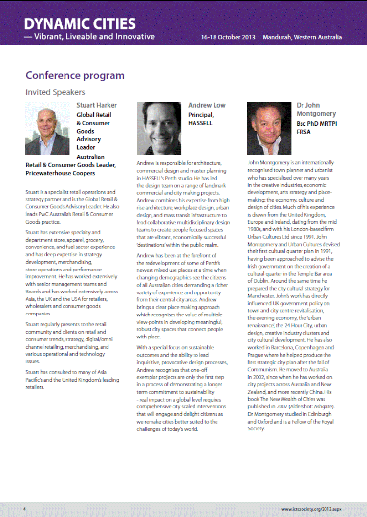
I am particularly sad to present this Mayoral Minute in honour of the life of Frank Vittorino from Frank’s Gents’ Hairdressing in St John’s Avenue Gordon. Frank was very much a central character in the Gordon Shopping Centre and his barber shop is a North Shore Icon.
Frank has been cutting and styling the hair of many Ku-ring-gai residents for over 36 years. In fact, the Premier Barry O’Farrell and his boys, Stirling Mortlock and his family, Ken Rosewall and Tony Roach were few of his famous customers. Many Mayors and General Managers and staff from Ku-ring-gai Council were his clients, and I am proud to say I number myself among them. Ku-ring-gai’s longest serving Mayor, Richard Lennon, even went to Frank’s daughter’s wedding.
Frank came to Australia at just five years old and his family settled in Newtown. He never lost his long term passion for the Newtown Jets and you could count on a discussion on any type of football whenever Frank was in the shop.
He always had an incredible work ethic and from a young age was delivering bread and papers after school helping make ends meet. His father wanted him to get a trade and so the young Frank started as an apprentice Hairdresser/Barber.
He learnt from some of the best, including Louis Cordony who called him “Francois de Paris”. Frank then went to the high end salons in Surry Hills and Kings Cross owned by Angelo De Marco who was known as “the man of all the stars” tending to the hair of Johnny O’Keefe and Frank Sinatra when they came to Australia.
Frank moved to Turramurra in 1965 and then to his very own salon - a 2 seat shop in Pymble in 1969. This is where his fame began, as everyone used to pass by and say hello.
In 1976 he opened on the site now known as the Sun Building just next door. There he built a business that he loved and became loved by his customers.
In 1987 Frank’s moved to St Johns Ave and there the business has been ever since. When his son Anthony started with him in 1991 he said there were two things you need to know as a barber - call everyone “Sir” and “Madam” and always be the best at what you do so others can learn from you. Frank always practised what he preached!
Frank was well known for treating everyone the same no matter if you were the local Mayor, Premier or school child. He liked to tell a joke and was one of the most positive and cheerful people I have ever met. He always brought a friendly word and a smile and genuinely cared about his customers.
Since Frank Vittorino’s sudden passing, the salon has been visited by many people who have come in and passed on their condolences, sometimes 3 and 4 generations of the one family.
Frank is survived by his wife Ann - they were married for 48 years - son Anthony and daughters Katherine and Ann and nine grandchildren aged from 3 to 18.
Frank Vittorino will be greatly missed by his family and customers and Gordon will be a lesser place without him, but we can always pop into the salon in St Johns Avenue with all the sporting memorabilia and relive his legacy.
Petitions
GENERAL BUSINESS
i. The Mayor to invite Councillors to nominate any item(s) on the Agenda that they wish to have a site inspection.
ii. The Mayor to invite Councillors to nominate any item(s) on the Agenda that they wish to adopt in accordance with the officer’s recommendation allowing for minor changes without debate.
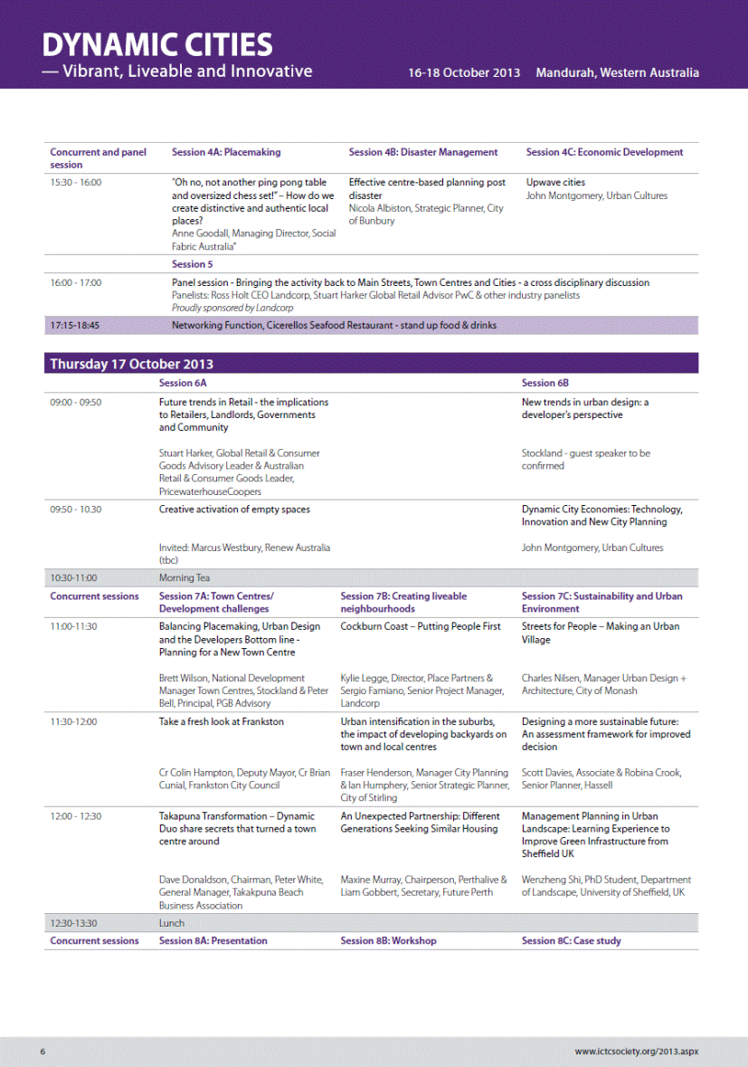
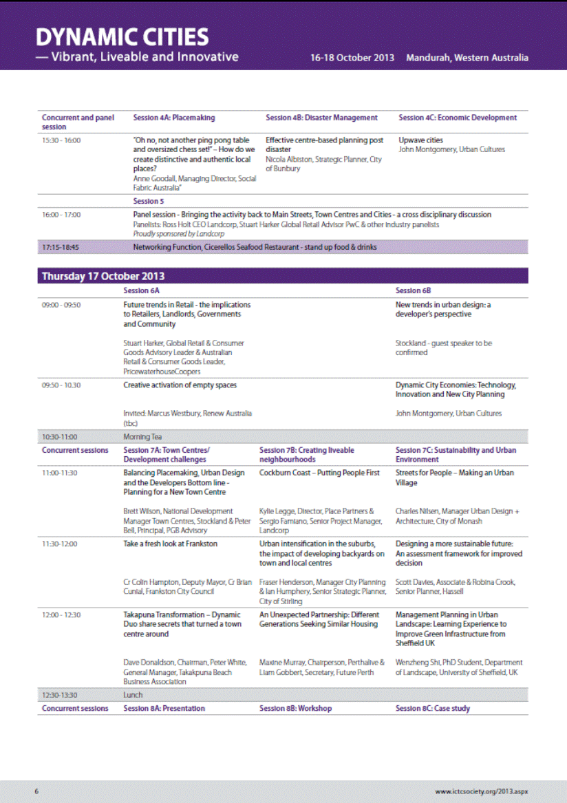
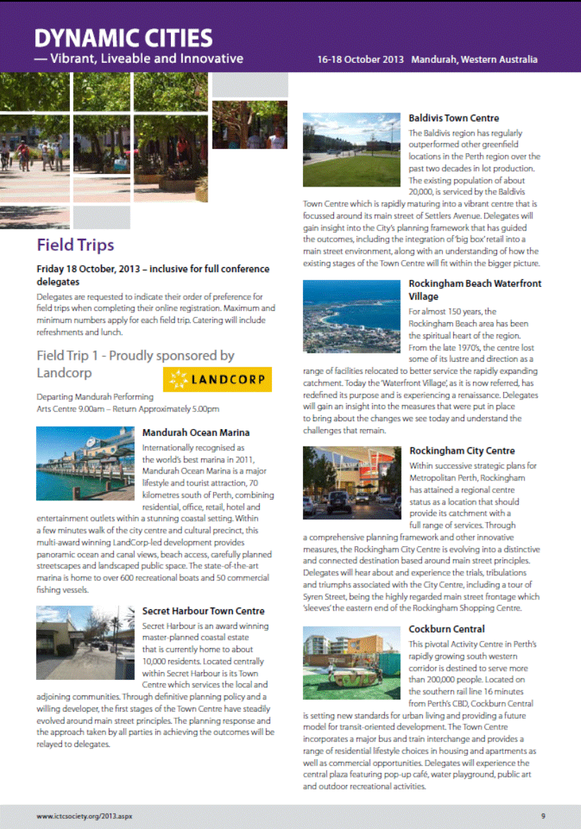
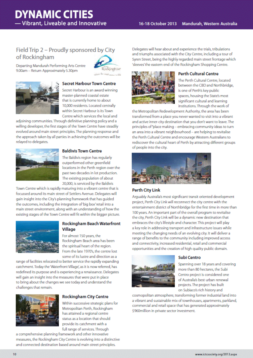
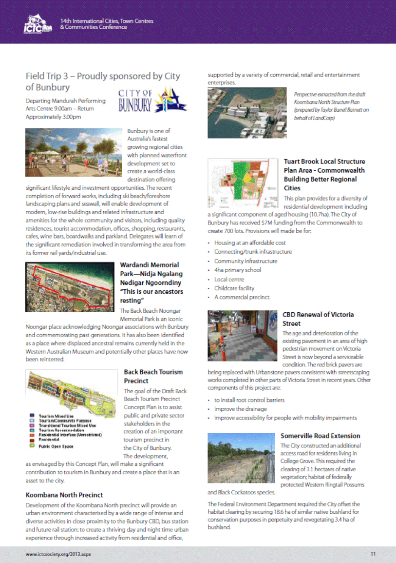
GB.1 2013 ICTC Conference 2
File: CY00212/5
To advise Councillors of the 14th International Cities Town Centres and Communities Conference, 16-18 October 2013 being held in Mandurah, Western Australia.
Recommendation:
That all interested Councillors advise the General Manager of their interest in attending the ICTC Conference by Friday, 9 August 2013.
GB.2 Investment Report as at 30 June 2013 84
File: S05273
To present to Council investments portfolio performance for June 2013.
Recommendation:
That the summary of investments performance for June 2013 be received and noted; and that the Certificate of the Responsible Accounting Officer be noted and report adopted.
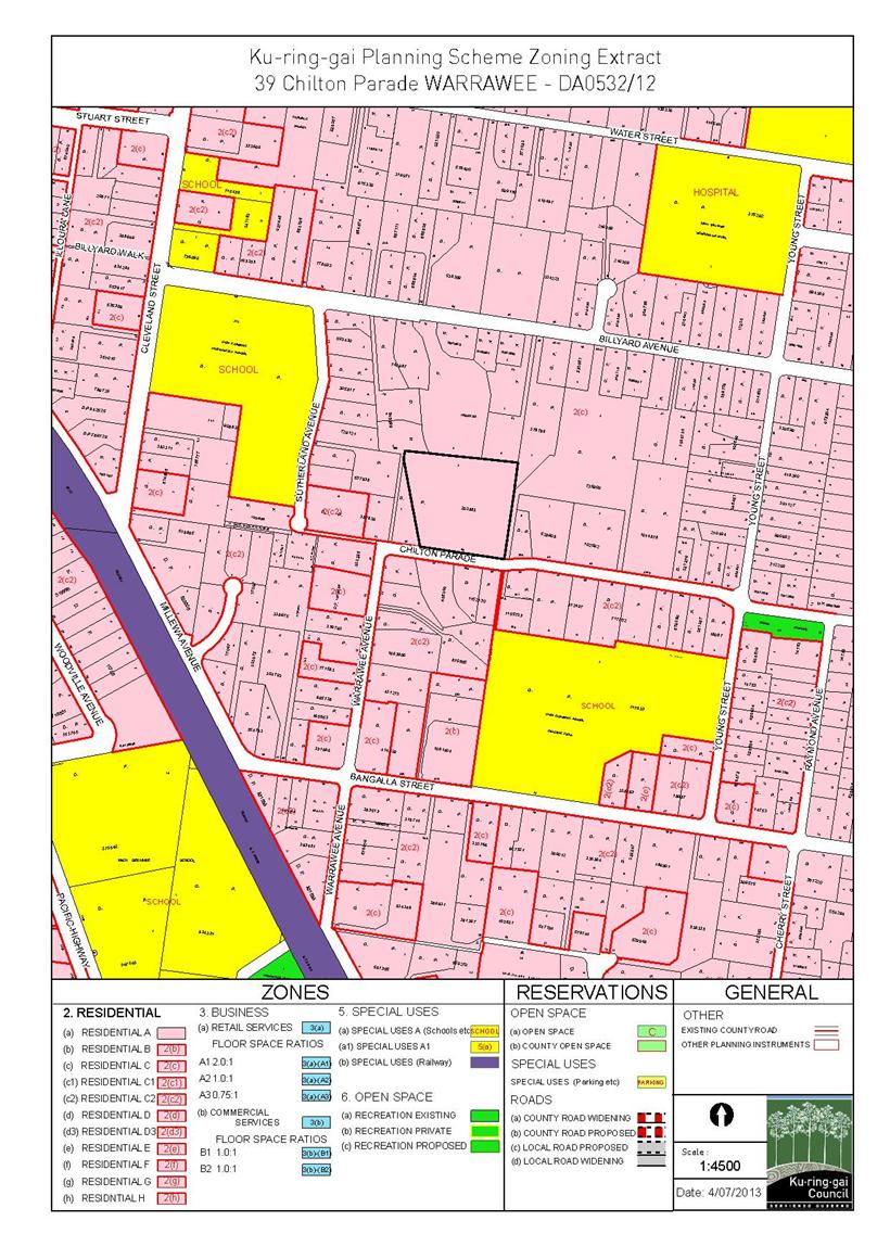
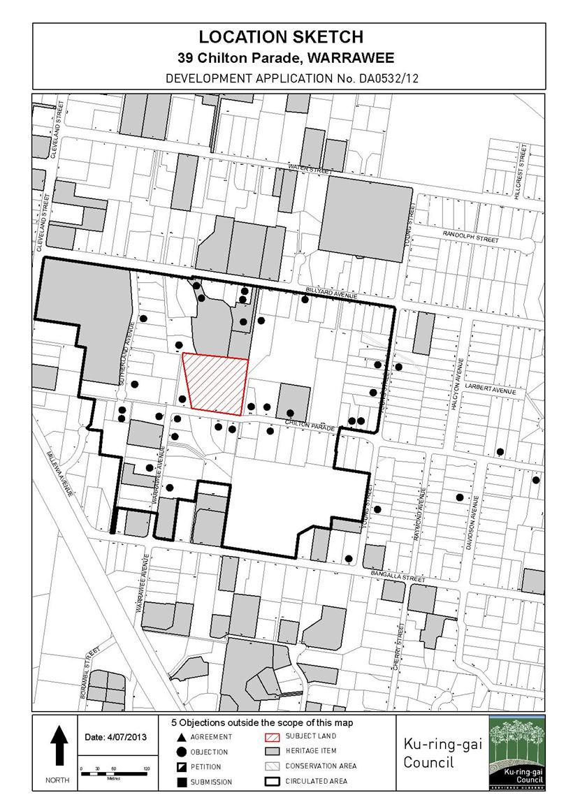
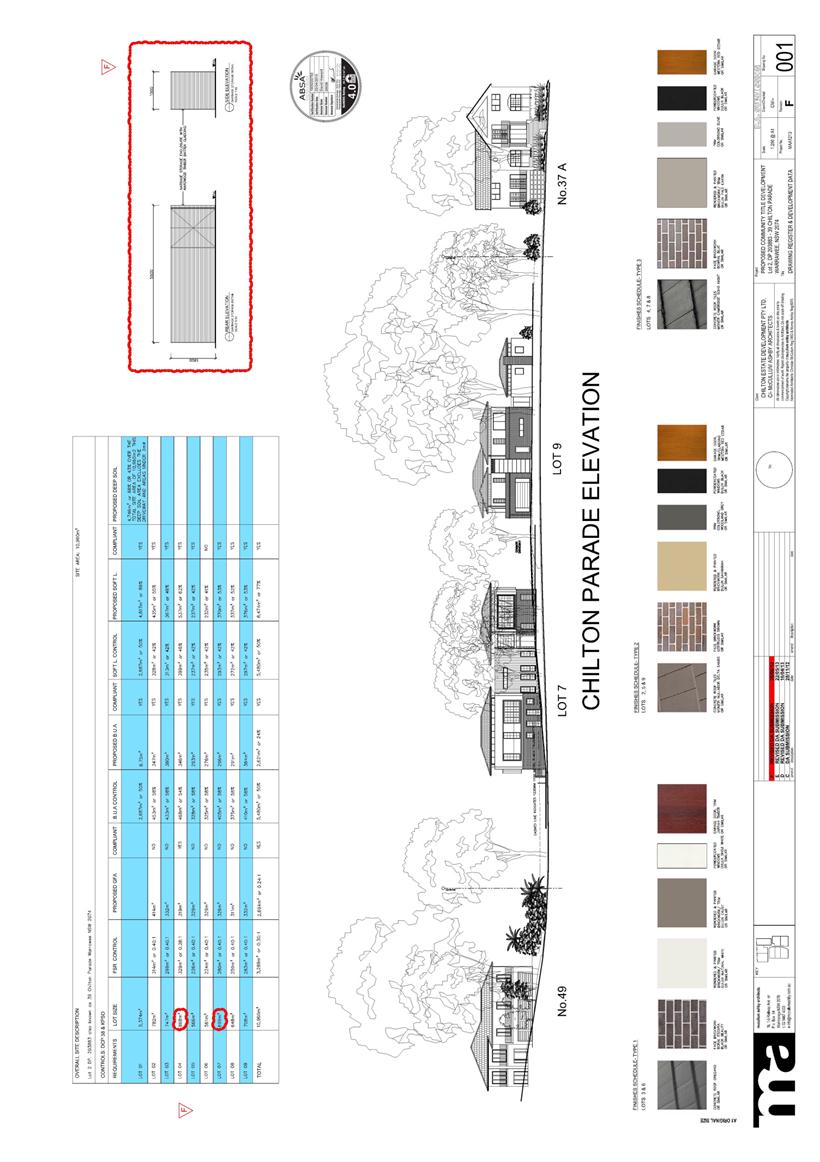
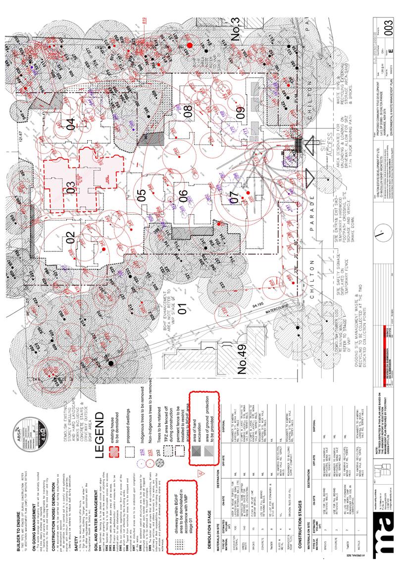
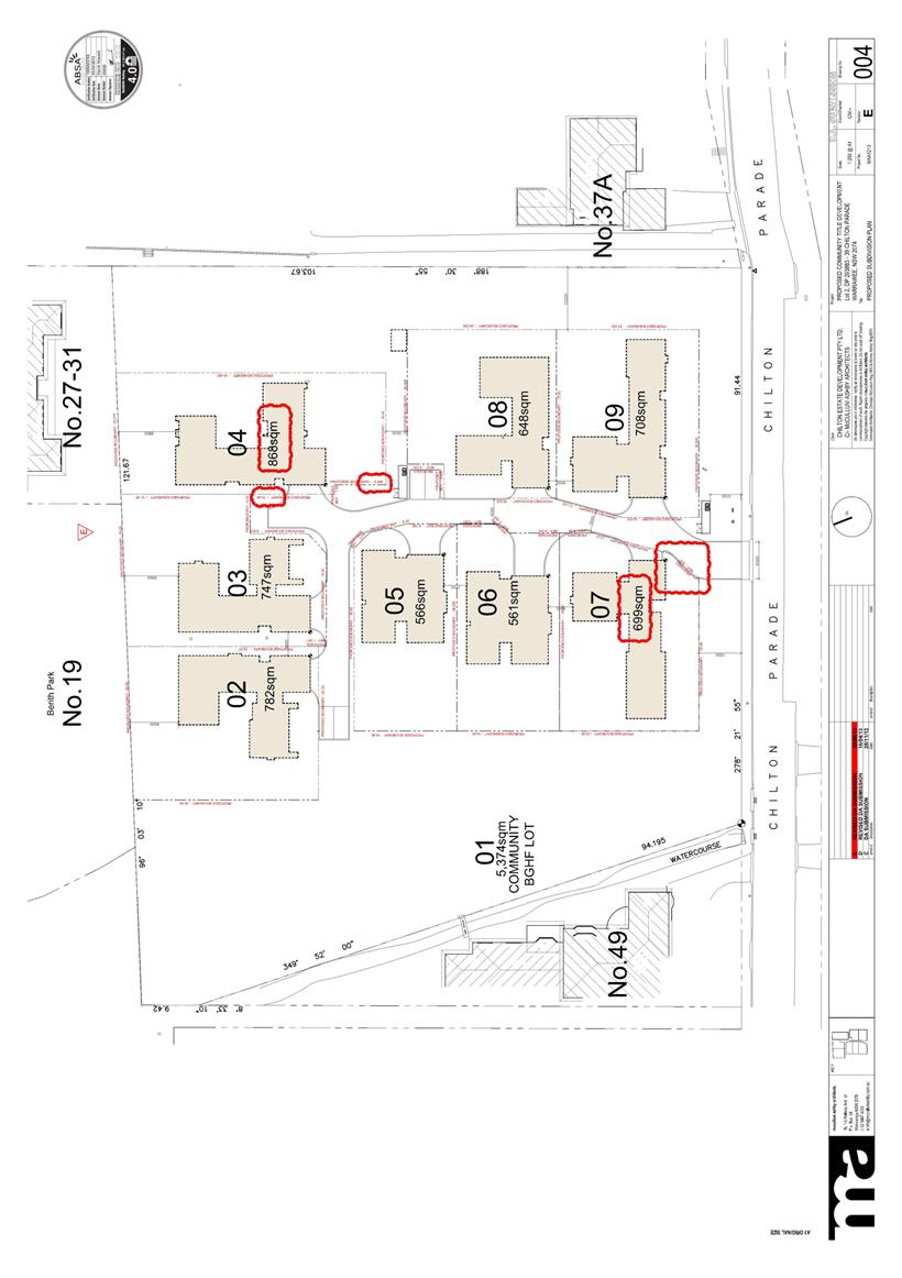
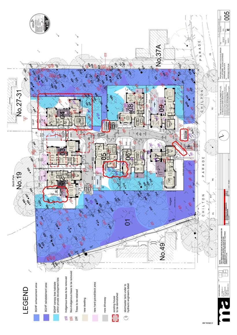
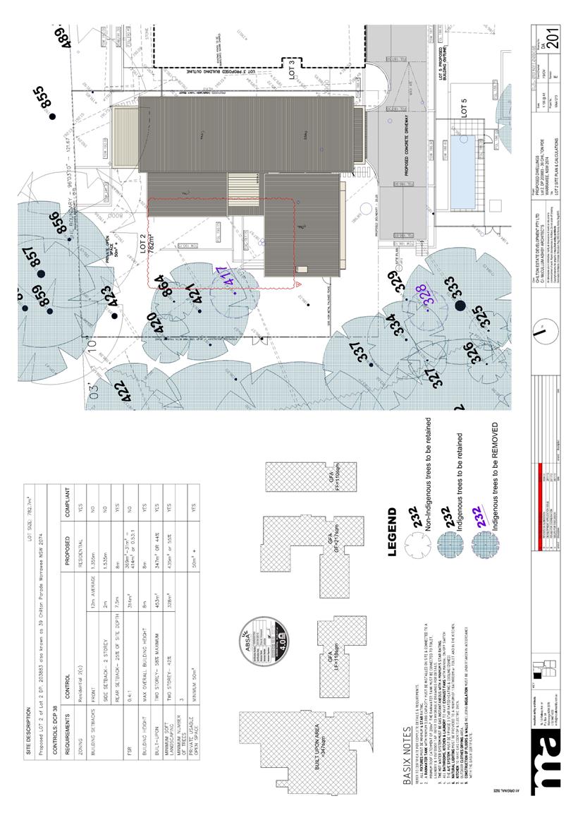
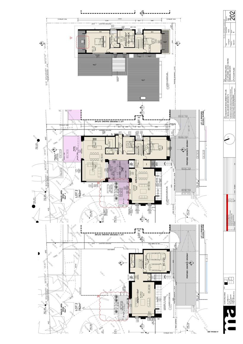
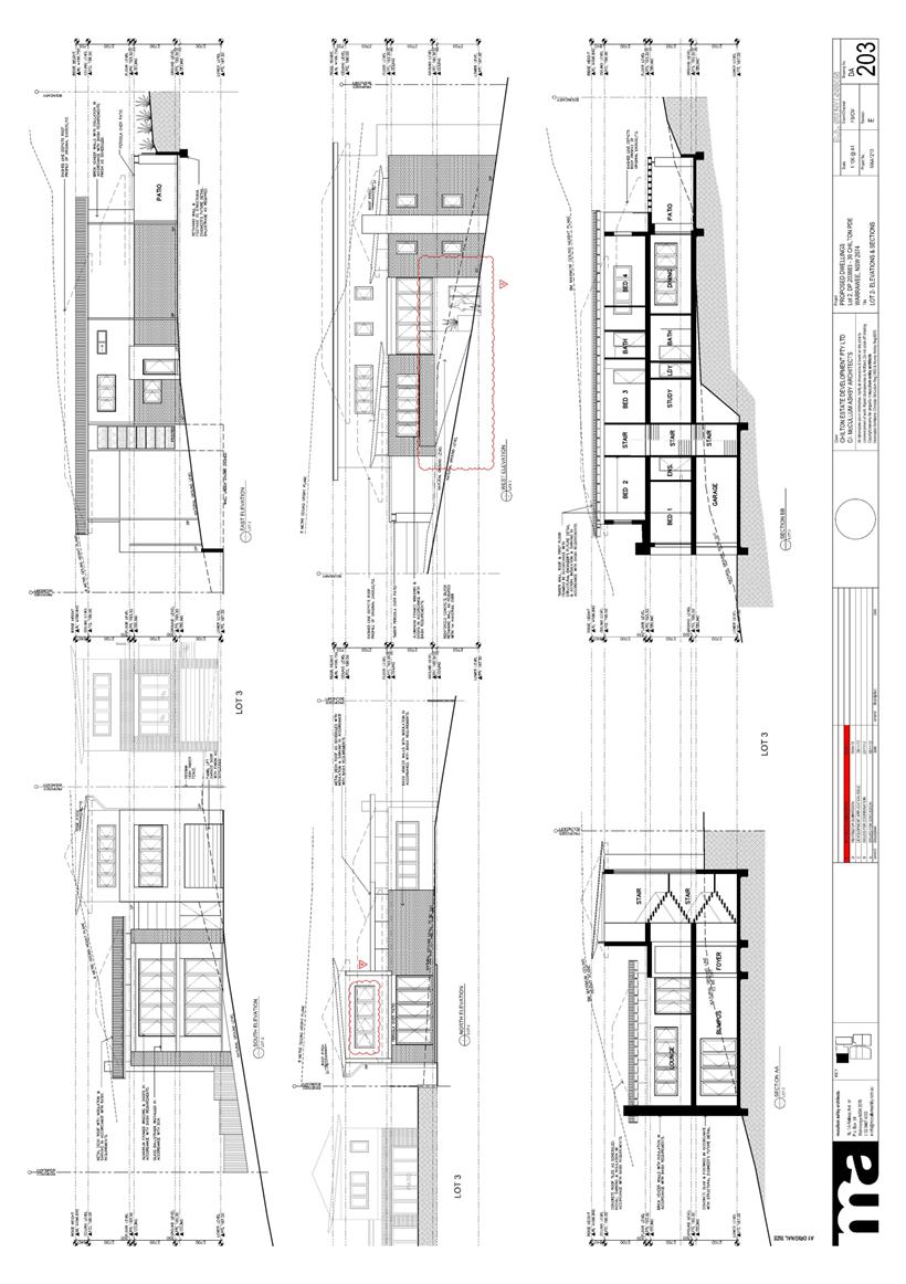
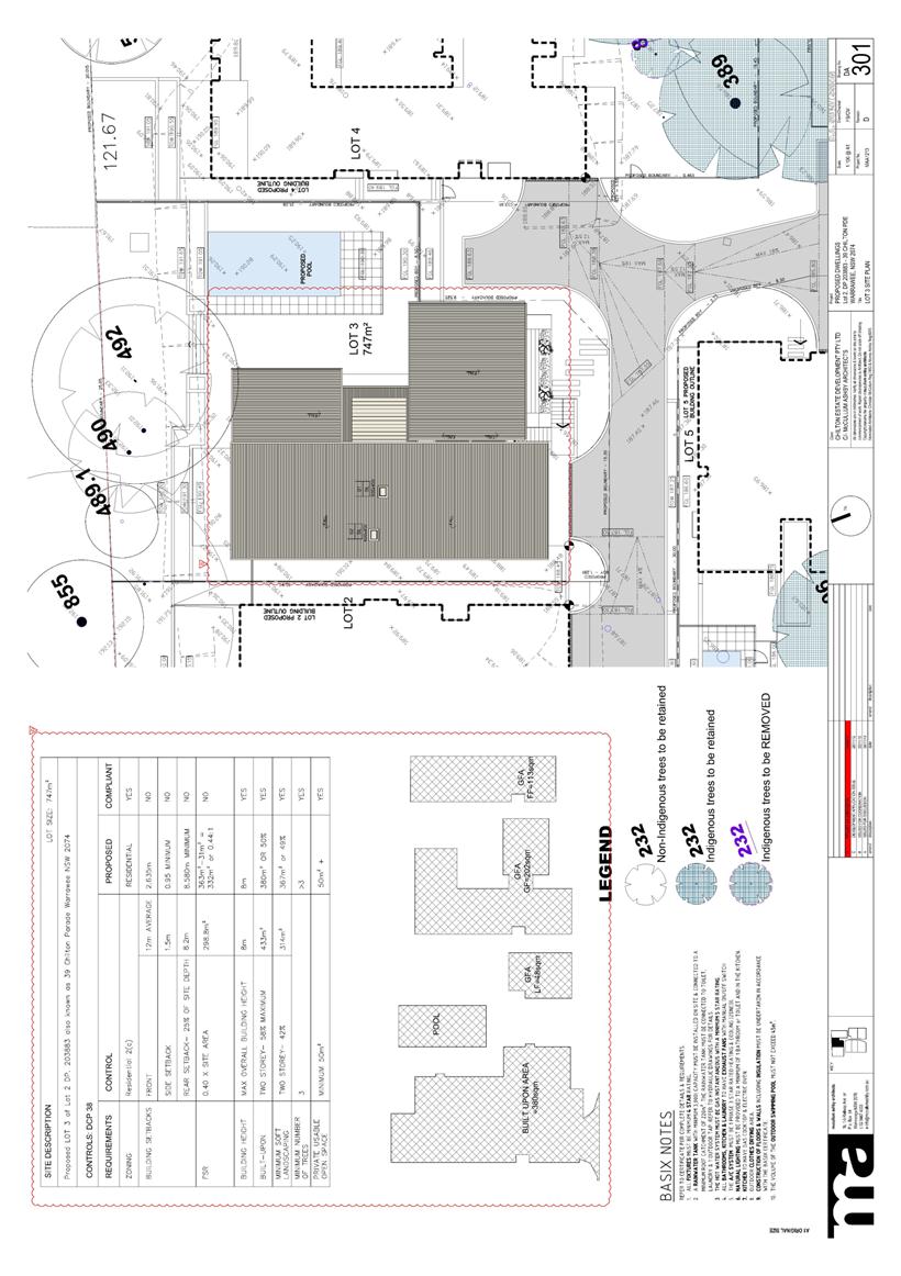
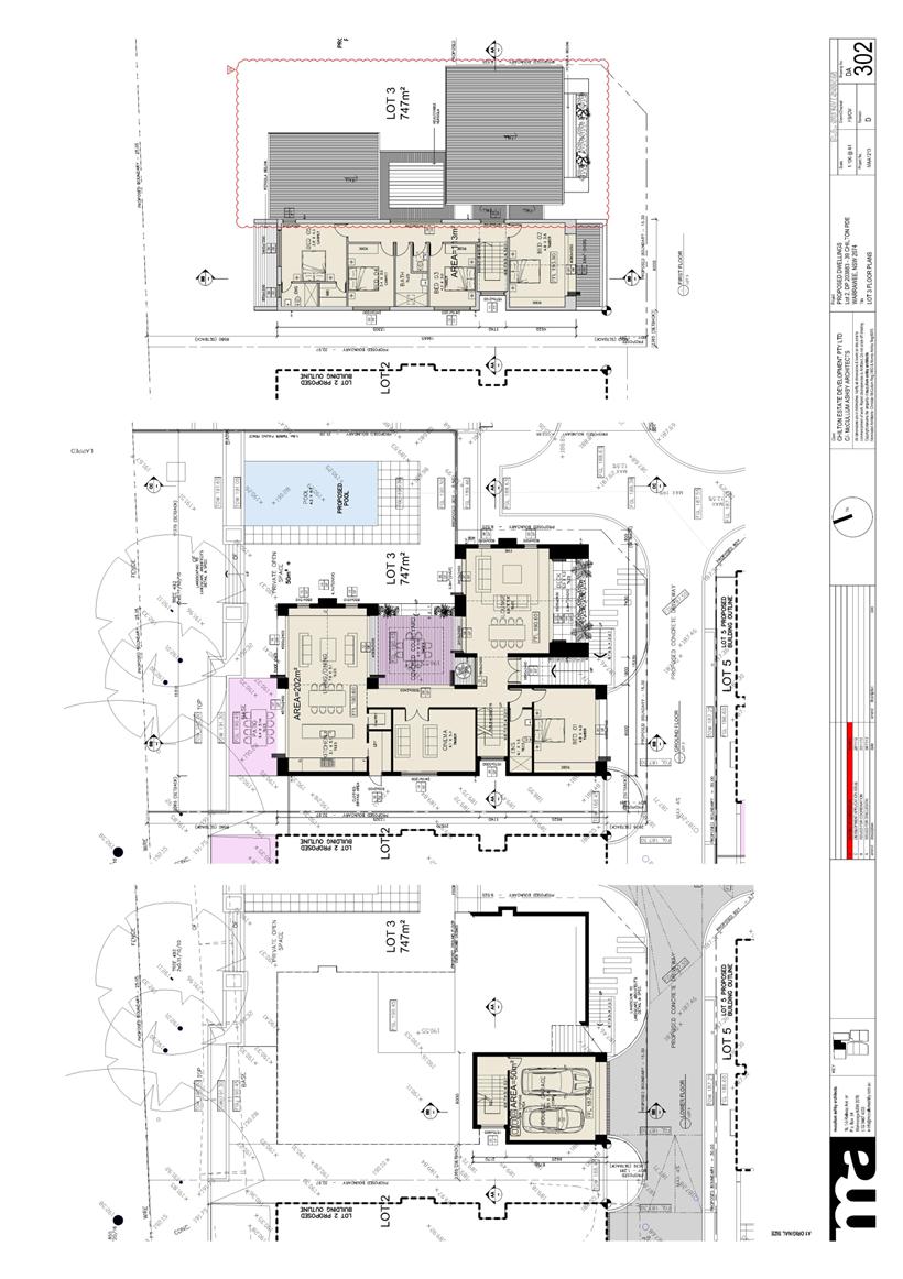
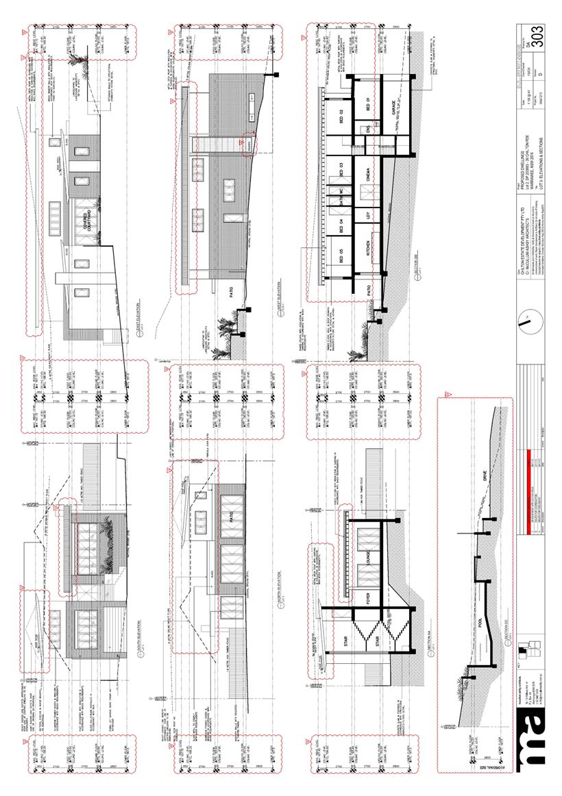
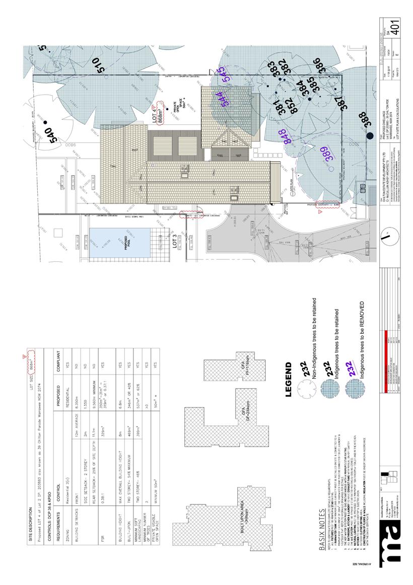
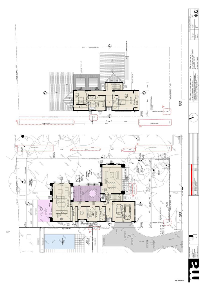
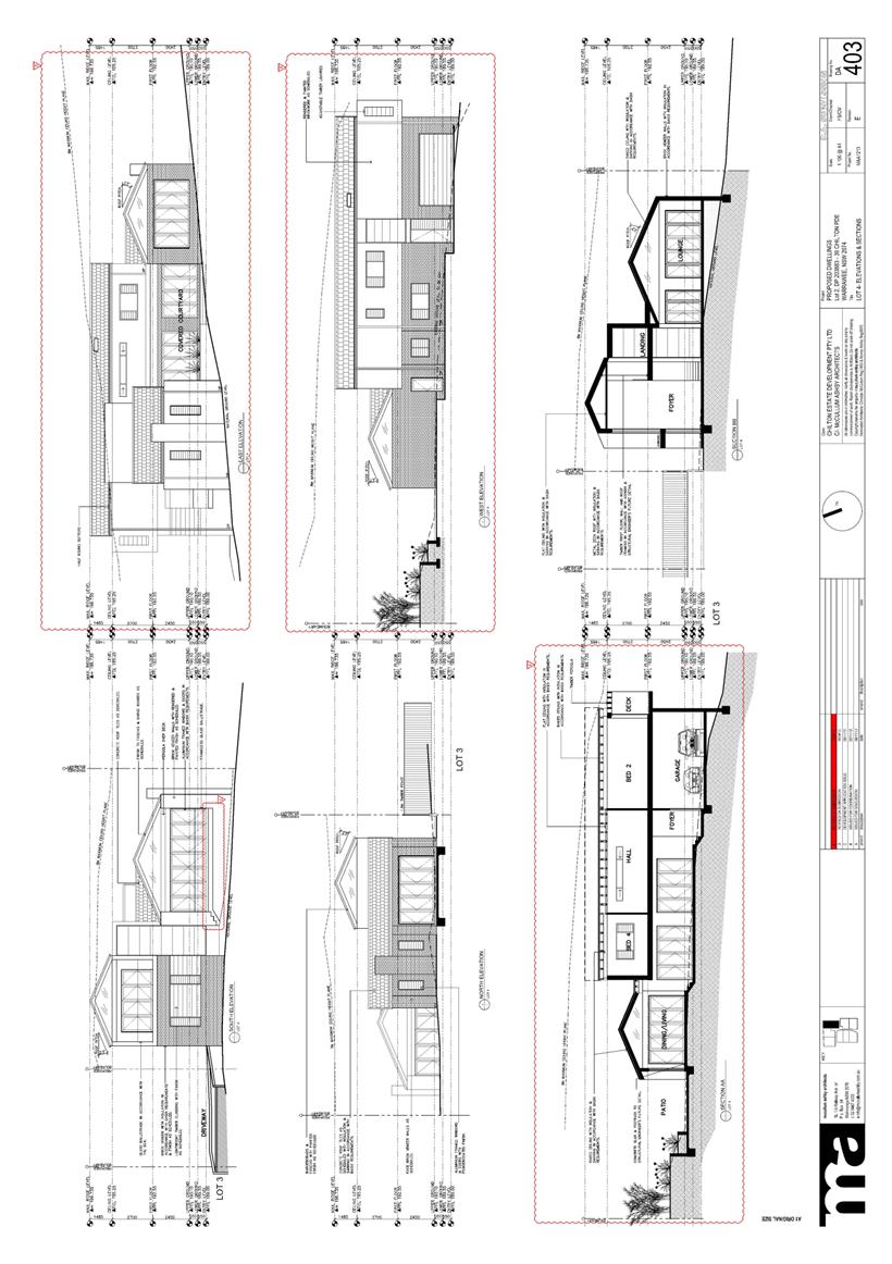
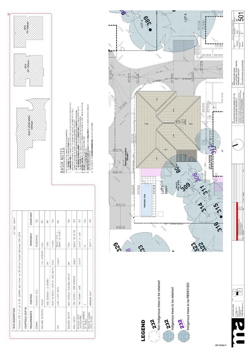
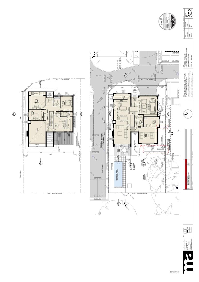
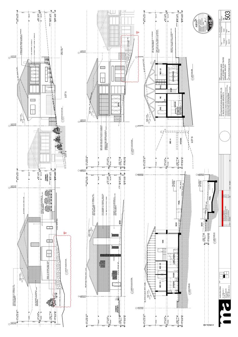
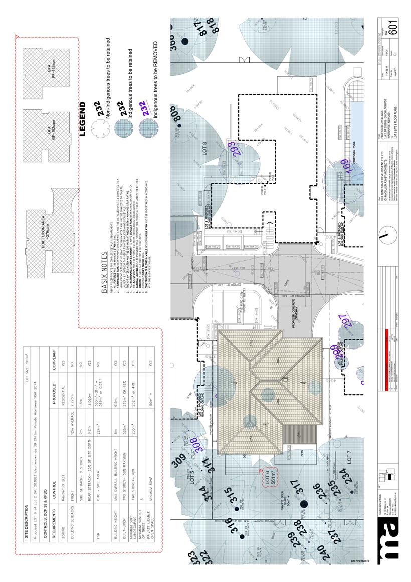
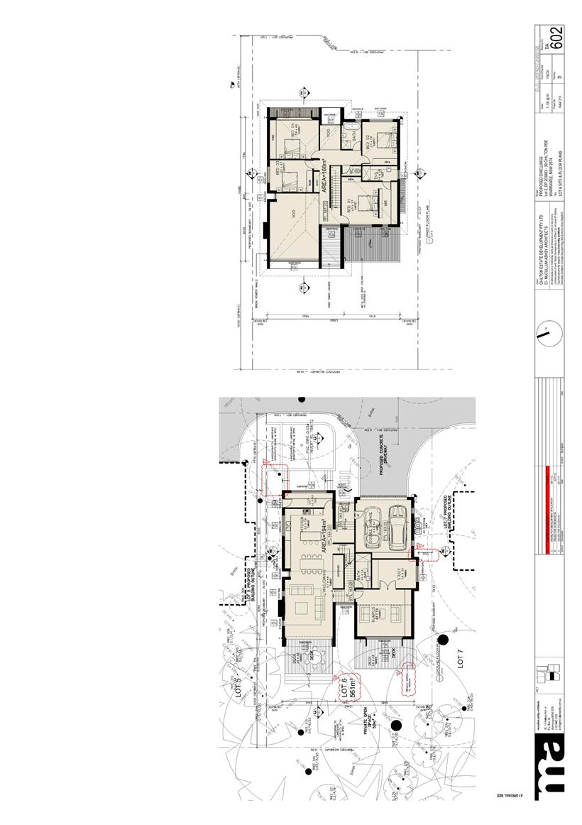
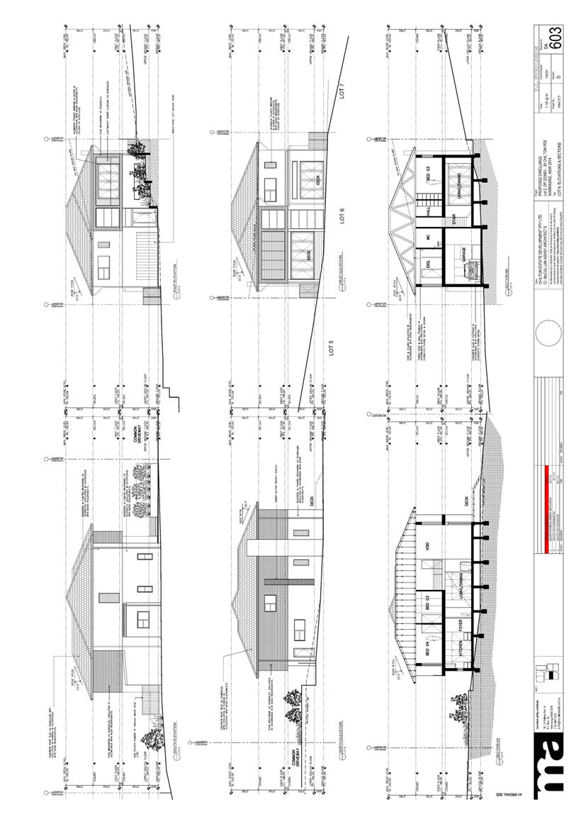
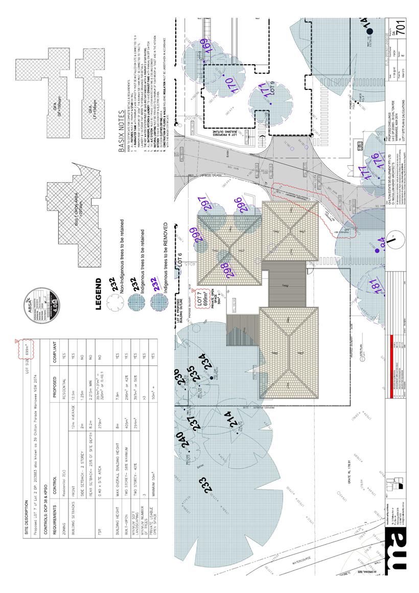
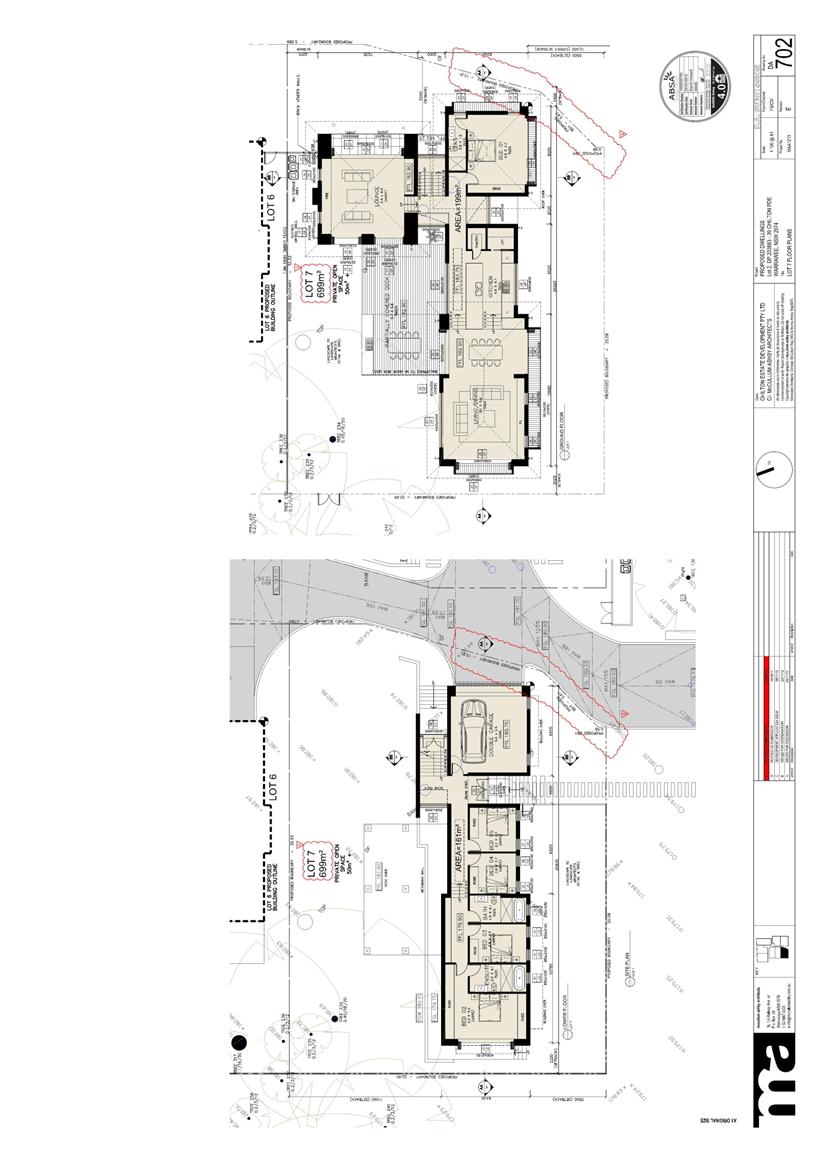
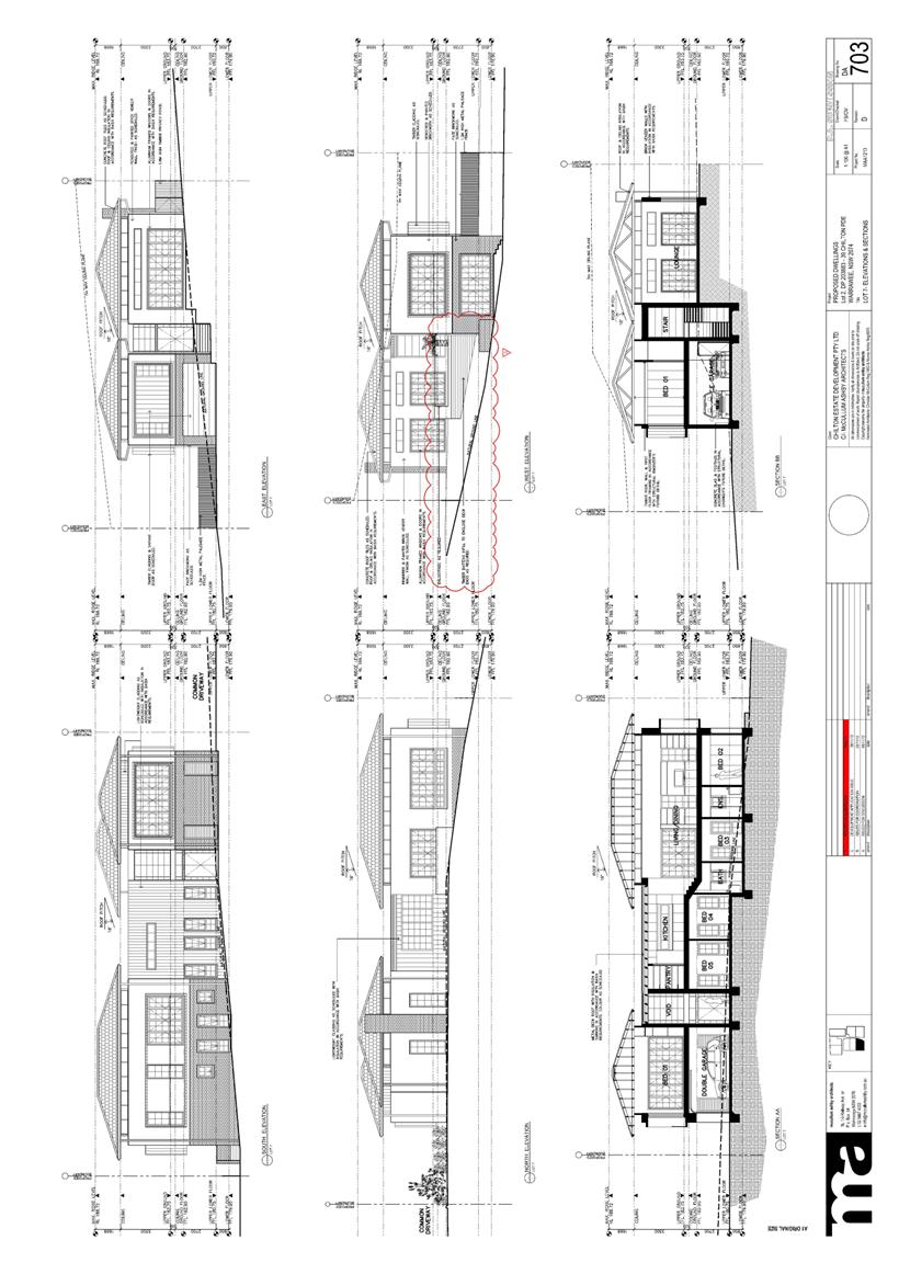
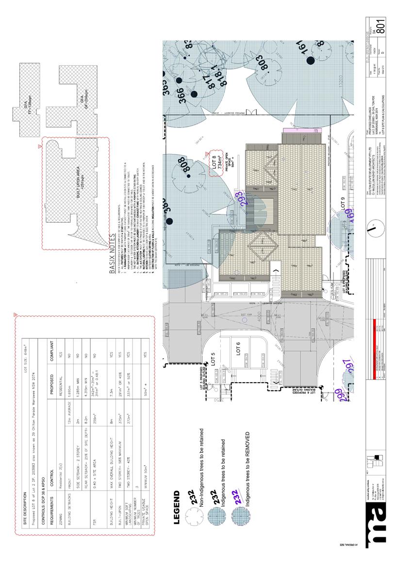
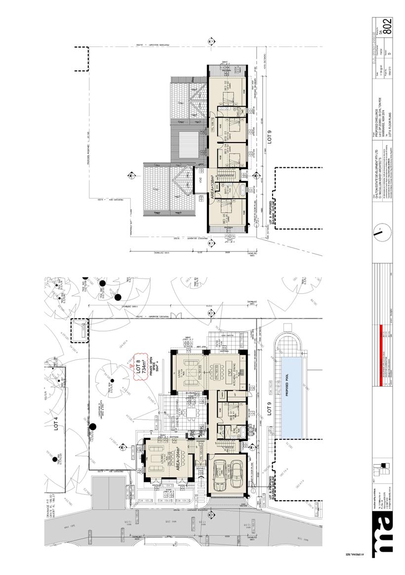
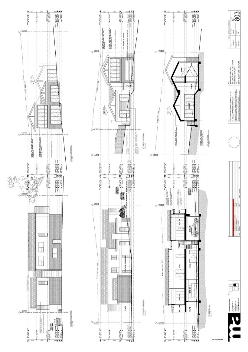
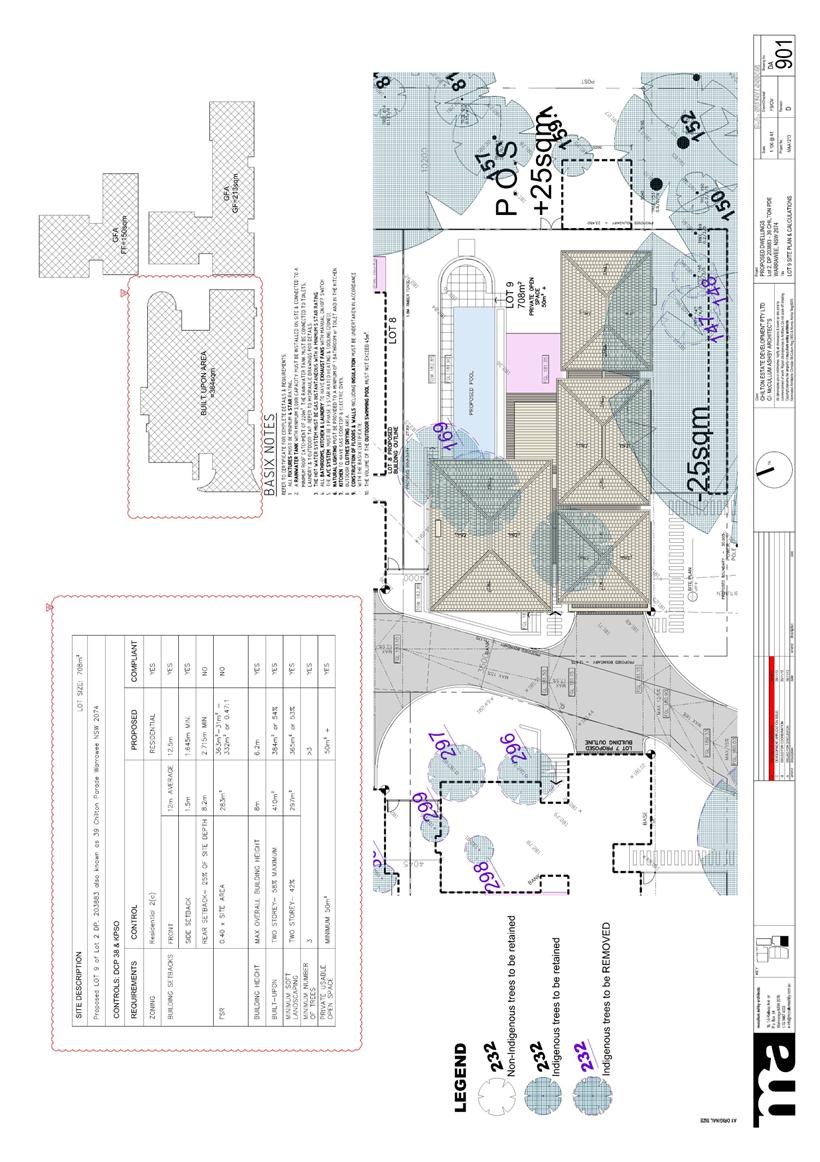
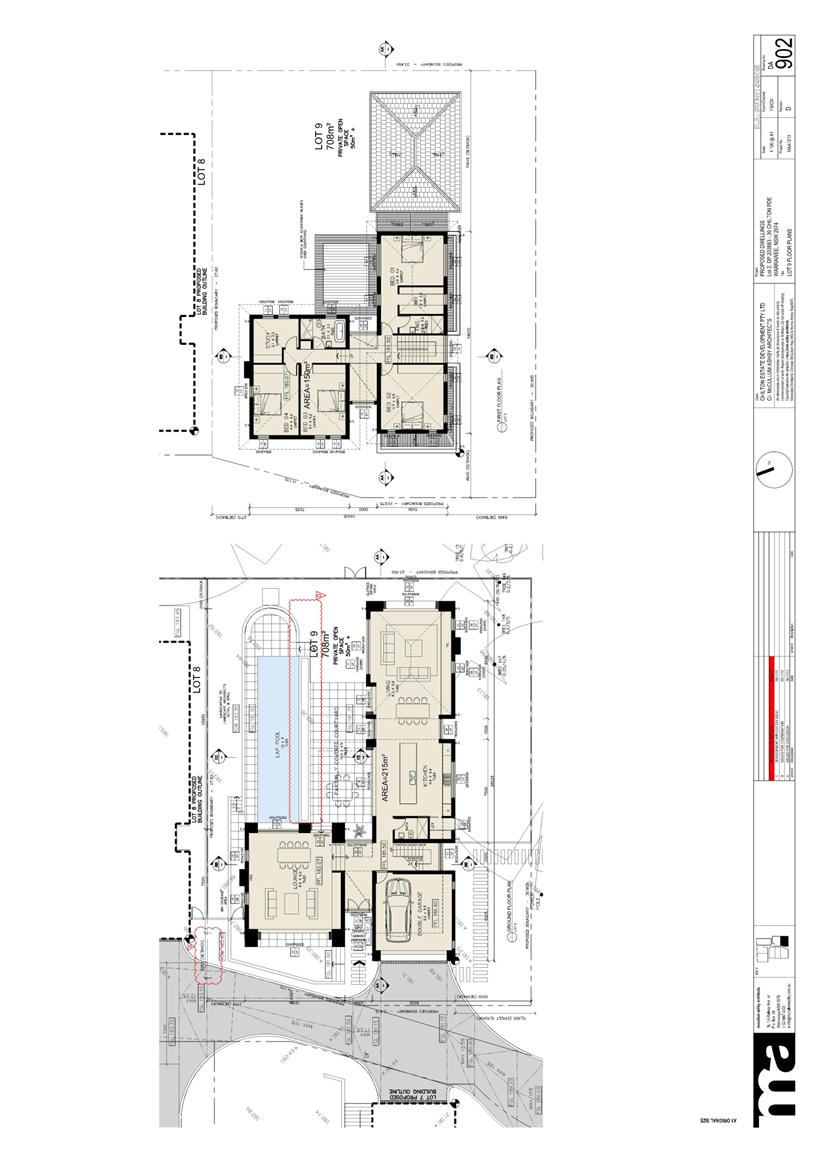
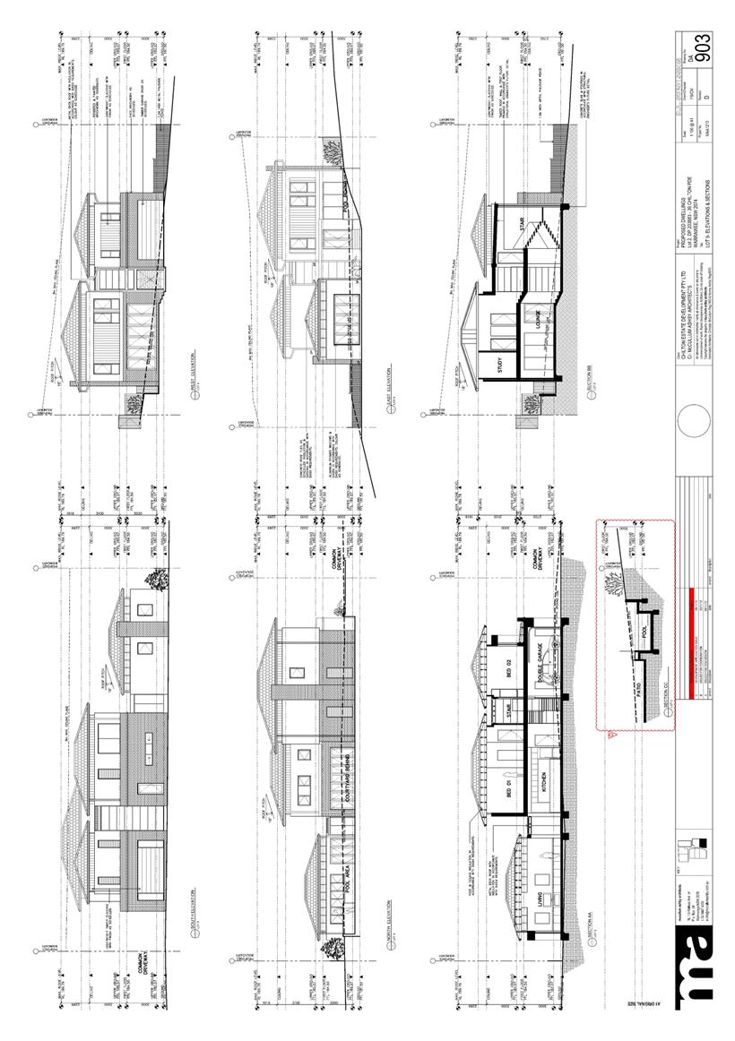
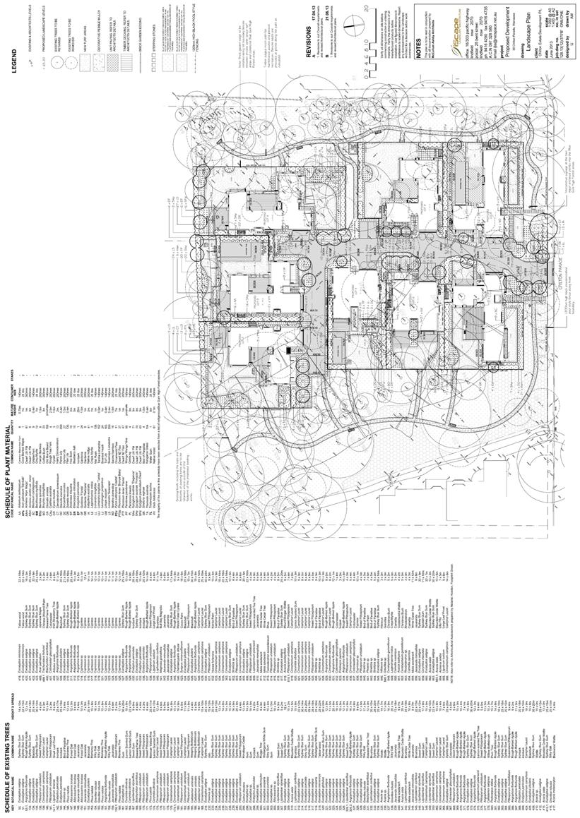
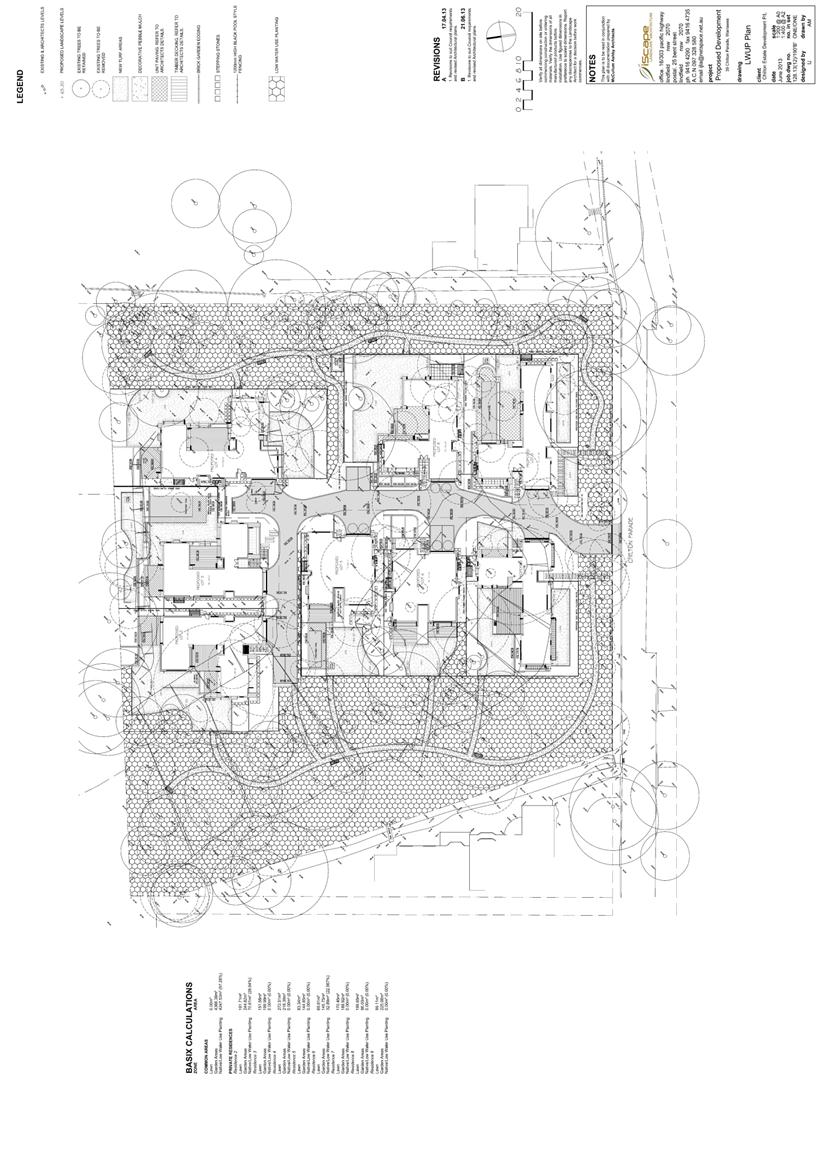
GB.3 39 Chilton
Parade, Warrawee DA0532/12 - Demolition of Existing Dwelling, Community Title
Subdivision into 9 Lots, Construction of
8 Dwellings and Ancillary Site Works including Swimming Pools and Fences 93
File: DA0532/12
Ward: Wahroonga
Applicant: Chilton Estate Development P/L
Owners: Yongning Han; Yufang Fu; Bing Jin Jiang
Demolition of existing dwelling,
community title subdivision into 9 lots, construction of
8 dwellings and ancillary site works, including swimming pools and fences.
Recommendation:
Approval.
GB.4 Nominations for Joint Regional Planning Panel Members 205
File: S08316
To appoint Council members to the Sydney West Joint Regional Planning Panel.
Recommendation:
That Council resolve to appoint Council members to the Sydney West Joint Regional Planning Panel from 10 October 2013 to 30 June 2014 as an interim measure, pending implementation of the NSW planning review and that Council reaffirms its decision that Council members of the JRPP receive $500 for attending a formal decision making meeting and that Council notifies the Minister for Planning and Infrastructure of its decision.
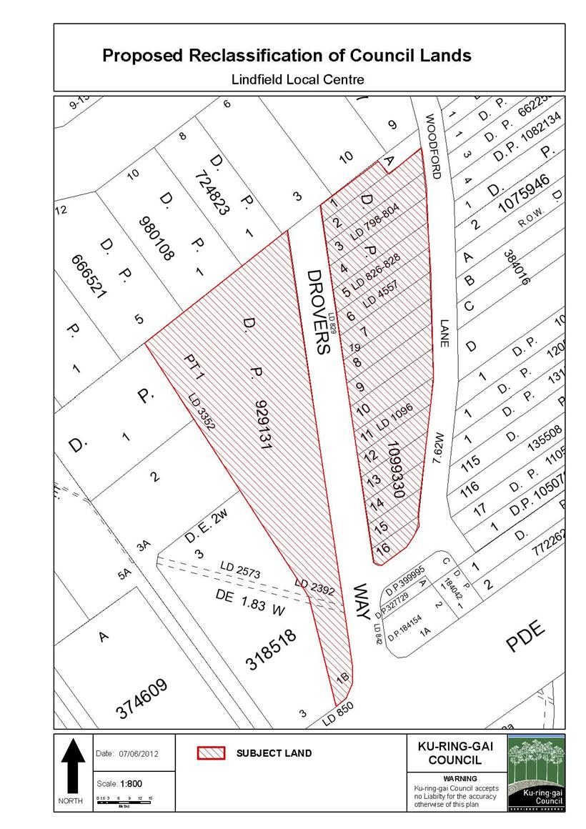
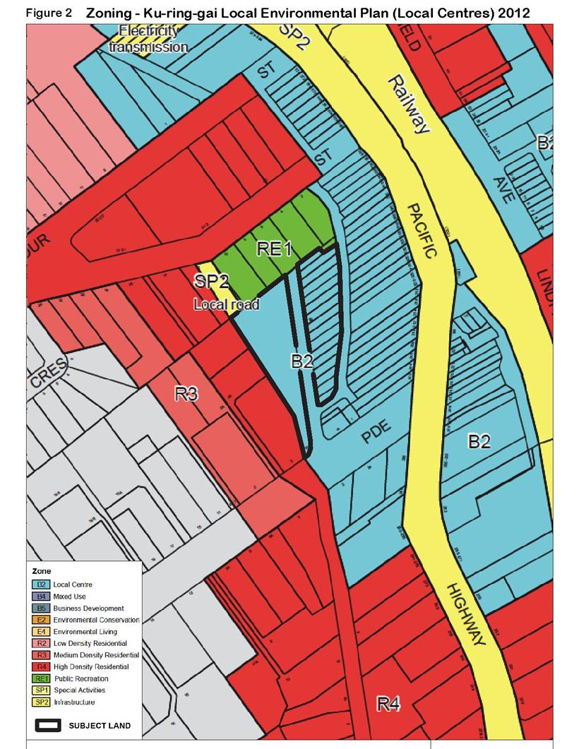
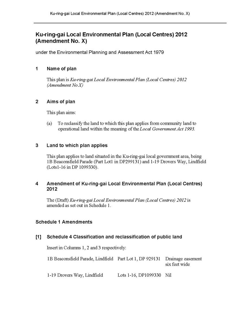
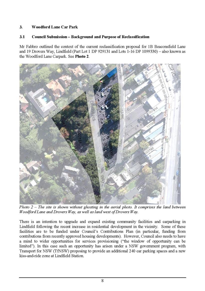
GB.5 Proposed Reclassification of 1B Beaconsfield Parade and 19 Drovers Way, Lindfield (Woodford Lane Car Park) to Operational Land following the Exhibition and Public Hearing Process 262
File: S09605
To report back to Council on
submissions received during the exhibition and public hearing into the proposed
reclassification of the properties at 1B Beaconsfield Parade and
19 Drovers Way Lindfield, known as the Woodford Lane Car Park, from community
land to operational land.
Recommendation:
That Council proceed with the proposed reclassification of the subject properties to operational land.
GB.6 Independent Pricing and Regulatory Tribunal (IPART) - Section 508 (A) - Special Variation Application - Infrastructure Levy 329
File: S06788
To seek Council’s endorsement to apply for a Special Rate Variation under Section 508(A) of the Local Government Act.
Recommendation:
That Council apply to the Independent Pricing and Regulatory Tribunal for a Special Rate Variation under Section 508(A) of the Local Government Act.
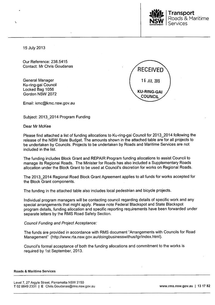
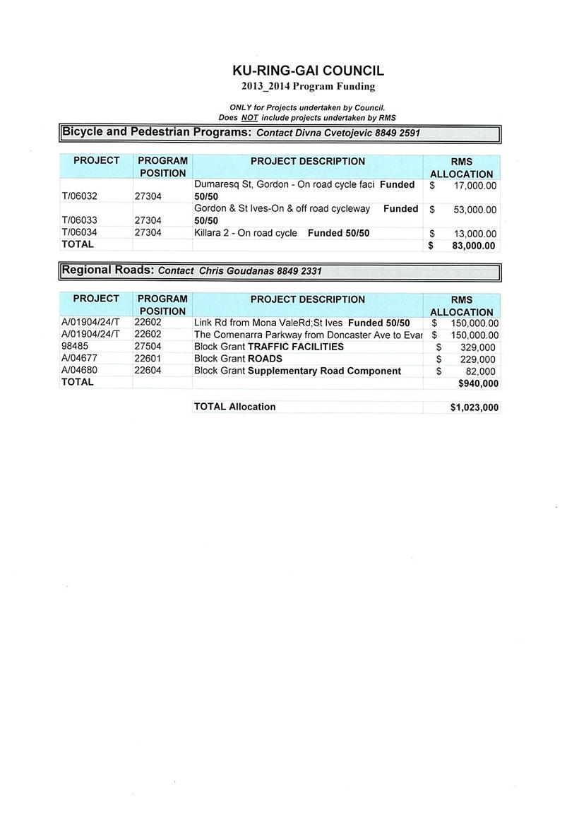
GB.7 Roads and Maritime Services - Regional Road Block Grant Funding for 2013/2014 333
File: S02585
To advise Council of the Roads and Maritime Services funding program for 2013/2014 and adopt the various grants as provided by the Roads and Maritime Services.
Recommendation:
That Council accept the grants for the various programs except the Traffic Facilities Block Grant for 2013/2014.
Extra Reports Circulated to Meeting
BUSINESS WITHOUT NOTICE – SUBJECT TO CLAUSE 241 OF GENERAL REGULATIONS
Questions Without Notice
Inspections Committee – SETTING OF TIME, DATE AND RENDEZVOUS
Confidential Business to be dealt with in Closed Meeting
C.1 Staff Matter (circulated separately to Councillors ONLY)
File: CY00254/5
In accordance with the Local Government Act 1993 and the Local Government (General) Regulation 2005, in the opinion of the General Manager, the following business is of a kind as referred to in section 10A(2)(a), of the Act, and should be dealt with in a part of the meeting closed to the public.
Section 10A(2)(a) of the Act permits the meeting to be closed to the public for business relating to personnel matters concerning particular individuals (other than Councillors).
Confidential Mayoral Minute by the Mayor, Councillor Elaine Malicki dated 18 July 2013
C.2 Staff Matter (circulated separately to Councillors ONLY)
File: CY00254/5
In accordance with the Local Government Act 1993 and the Local Government (General) Regulation 2005, in the opinion of the General Manager, the following business is of a kind as referred to in section 10A(2)(a), of the Act, and should be dealt with in a part of the meeting closed to the public.
Section 10A(2)(a) of the Act permits the meeting to be closed to the public for business relating to personnel matters concerning particular individuals (other than Councillors).
Confidential Mayoral Minute by the Mayor, Councillor Elaine Malicki dated 18 July 2013
John McKee
General Manager
** ** ** ** ** **
MINUTES OF Ordinary Meeting of Council
HELD ON Tuesday, 16 July 2013
|
Present: |
The Mayor, Councillor E Malicki (Chairperson) (Comenarra Ward) Councillor J Pettett (Comenarra Ward) Councillors D Citer & C Szatow (Gordon Ward) Councillors C Berlioz & D Ossip (St Ives Ward) Councillors J Anderson & D Armstrong (Roseville Ward) Councillors C Fornari-Orsmond & D McDonald (Wahroonga Ward) |
|
|
|
|
Staff Present: |
General Manager (John McKee) Director Corporate (David Marshall) Director Development & Regulation (Michael Miocic) Director Operations (Greg Piconi) Director Strategy & Environment (Andrew Watson) Director Community (Janice Bevan) Manager Urban & Heritage Planning (Antony Fabbro) Manager Corporate Communications (Virginia Leafe) Manager Strategic Projects (Ian Dreghorn) Manager Records & Governance (Matt Ryan) Minutes Secretary (Christie Spry) |
The Meeting commenced at 7.00pm
The Mayor offered the Prayer
The Mayor adverted to the necessity for Councillors and staff to declare a Pecuniary Interest/Conflict of Interest in any item on the Business Paper.
Councillor Duncan McDonald declared a less than significant non-pecuniary of interest in GB.6 – Can Too Gala Fundraiser Dinner Dance and Auction [was previously involved in supporting activities to raise funds for cancer research] and there is no need for him to leave during debate of the item.
The following member of the public addressed Council on items not on the Agenda:
J Harwood
DOCUMENTS CIRCULATED TO COUNCILLORS
The Mayor adverted to the documents circulated in the Councillors’ papers and advised that the following matters would be dealt with at the appropriate time during the meeting:
|
Memorandums: |
Refer GB.11 – Pymble Business Park Draft Development Control Plan – Memorandum from Manager Urban and Heritage Planning dated 16 July 2013 with an attached late submission received 16 July 2013.
Refer GB.12 – Proposal to Rezone and Reclassify three Council-owned Sites from Community Land to Operational Land – Memorandum from Manager Urban and Heritage Planning dated 16 July 2013 with attached late submissions received and an assessment. |
PETITIONS
Recommendations from Committee
Minutes of Ku-ring-gai Traffic Committee
File: CY00022/5
Meeting held 27 June 2013
Minutes numbered KTC.8 to KTC.11.
|
201 |
File: S02527 Vide Minute No KTC.9
|
|
|
To update Council's Traffic and Transport Policy.
|
|
|
(Moved: Councillors Berlioz/Fornari-Orsmond)
That the updated Traffic and Transport Policy be adopted.
CARRIED UNANIMOUSLY
|
GENERAL BUSINESS
|
208 |
Licence Renewal -
C.A.R.E.S Facility - Portion of 451 Mona Vale Road,
File: S07255 Vide: GB.9
|
|
|
To seek the approval of Council for the grant of a 5 year Licence Agreement to Her Most Gracious Majesty Queen Elizabeth II (Minister for Police) for the C.A.R.E.S. (Community and Road Education Scheme) over a portion of the St Ives Road Safety Centre (SIRSC) at 451 Mona Vale Road, St Ives.
|
|
|
(Moved: Councillors McDonald/Ossip)
A. That Council approves the grant of a 5 year Licence subject to the consent of the Department of Lands to Her Most Gracious Majesty Queen Elizabeth II (Minister for Police) for the C.A.R.E.S. (Community and Road Education Scheme) over a portion of the St Ives Road Safety Centre (SIRSC) at 451 Mona Vale Road St Ives.
B. That Council authorise the Mayor and General Manager to sign all documentation associated with the grant of a licence.
C. That Council authorise the affixing of the Common Seal of Council to the Licence Agreement.
CARRIED UNANIMOUSLY
|
Standing Orders were suspended to deal with items
where there are speakers first after a
Motion moved by Councillors Berlioz and Szatow
was CARRIED UNANIMOUSLY
|
209 |
Options for the ongoing Provision of Children's Services in Council Facilities
File: S09146 Vide: GB.2
|
|
|
The following member of the public addressed Council:
C Legg
|
|
|
To report to Council on the management and leasing options for a variety of Children’s Services operating from Council owned facilities in Ku-ring-gai.
|
|
|
(Moved: Councillors Anderson/Berlioz)
A. That Council approve the granting of a 5 year lease, with an option to renew for a further 5 years, for the KU Children’s Centres at Fox Valley, South Turramurra, West Pymble and Wahroonga from 1 January 2014.
B. That Council approve the granting of a 5 year licence, with an option to renew for a further 5 years, for the KU Children’s Centres at Killara, Barra Brui, and The Chase from 1 January 2014.
C. That Council authorise the Mayor and General Manager to sign all documentation associated with the granting of the leases and licences.
D. That Council authorise the affixing of the Common Seal of Council to the Lease and Licence Agreements.
E. That staff provide further briefings to Councillors about the operation and leasing arrangements of Children’s Services located in Council facilities
F. That staff review the Policy for Management of Community and Recreation Land and Facilities with regard to the capacity to pay reference for playgroups, occasional care facilities, community preschools and before and after school care services.
G. That staff continue to review rebates and report back to Council at appropriate times.
CARRIED UNANIMOUSLY
|
|
210 |
50A McIntosh Street, Gordon - Construction of a New Dwelling on an Allotment at rear of 50 McIntosh Street (New Lot Registered now known as 50A McIntosh Street, Gordon)
File: DA0523/12 Vide: GB.8
|
|||||||||||||||||||||||||||||||||||||||||||||||||||||||||||||||||||||||||||||||||||||||||||||||||||||||||||||||||||||||||||||||||||||||||||||||||||||||||||||||||||||||
|
|
The following members of the public addressed Council:
I Glendinning
|
|||||||||||||||||||||||||||||||||||||||||||||||||||||||||||||||||||||||||||||||||||||||||||||||||||||||||||||||||||||||||||||||||||||||||||||||||||||||||||||||||||||||
|
|
Construction of new dwelling on an allotment at rear of 50 McIntosh Street (new lot registered, now known as 50A McIntosh Street. Gordon).
|
|||||||||||||||||||||||||||||||||||||||||||||||||||||||||||||||||||||||||||||||||||||||||||||||||||||||||||||||||||||||||||||||||||||||||||||||||||||||||||||||||||||||
|
|
(Moved: Councillors Szatow/Ossip)
A. That Council, as the consent authority, is of the opinion that the objection under State Environmental Planning Policy No. 1 – Development Standards to Clause 43 (3-d) – minimum size and width of allotments of the Ku-ring-gai Planning Scheme Ordinance is well founded. Council is also of the opinion that strict compliance with the development standard is unreasonable and unnecessary in the circumstances of this case, AND
B. THAT Council, as the consent authority, being satisfied that the objection under SEPP No. 1 is well founded and also being of the opinion that the granting of consent to DA0523/12 is consistent with the aims of the Policy, grant development consent for the erection of a dwelling house and associated works on land at 50A McIntosh Street Gordon for a period of two (2) years from the date of the Notice of Determination, subject to the following conditions:
1. Approved architectural plans and documentation (new development)
The development must be carried out in accordance with the following plans and documentation listed below and endorsed with Council’s stamp, except where amended by other conditions of this consent:
Reason: To ensure that the development is in accordance with the determination.
2. Inconsistency between documents
In the event of any inconsistency between conditions of this consent and the drawings/documents referred to above, the conditions of this consent prevail.
Reason: To ensure that the development is in accordance with the determination.
3. Approved landscape plans
Landscape works shall be carried out in accordance with the following landscape plan(s), listed below and endorsed with Council’s stamp, except where amended by other conditions of this consent:
Reason: To ensure that the development is in accordance with the determination.
4. No demolition of extra fabric
Alterations to, and demolition of the existing building shall be limited to that documented on the approved plans (by way of notation). No approval is given or implied for removal and/or rebuilding of any portion of the existing building which is shown to be retained.
Reason: To ensure compliance with the development consent.
CONDITIONS TO BE SATISFIED PRIOR TO DEMOLITION, EXCAVATION OR CONSTRUCTION:
5. Road opening permit
The opening of any footway, roadway, road shoulder or any part of the road reserve shall not be carried out without a road opening permit being obtained from Council (upon payment of the required fee) beforehand.
Reason: Statutory requirement (Roads Act 1993 Section 138) and to maintain the integrity of Council’s infrastructure.
6. Tree identification
Prior to works commencing the existing trees shall be numbered in accordance with the arborist report and/or the approved plans. Trees shall be clearly tagged with confirmation from the project arborist that all marked trees correspond with those shown on the approved plan.
Reason: To protect existing trees during the construction phase.
7. Notice of commencement
At least 48 hours prior to the commencement of any development (including demolition, excavation, shoring or underpinning works), a notice of commencement of building or subdivision work form and appointment of the principal certifying authority form shall be submitted to Council.
Reason: Statutory requirement.
8. Notification of builder’s details
Prior to the commencement of any development or excavation works, the Principal Certifying Authority shall be notified in writing of the name and contractor licence number of the owner/builder intending to carry out the approved works.
Reason: Statutory requirement.
9. Dilapidation photos (public infrastructure)
Prior to the commencement of any works on site the applicant must submit to Ku-ring-gai Council and the Principal Certifying Authority a photographic record on the visible condition of the existing public infrastructure over the full site frontage (in colour - preferably saved to cd-rom in ‘jpg’ format). The photos must include detail of: · The existing footpath · The existing kerb and gutter · The existing full road surface between kerbs · The existing verge area · The existing driveway and layback where to be retained · Any existing drainage infrastructure including pits, lintels, grates. Particular attention must be paid to accurately recording any pre-developed damaged areas on the aforementioned infrastructure so that Council is fully informed when assessing damage to public infrastructure caused as a result of the development (which is not to be repaired by the Applicant as part of the development). The developer may be held liable to all damage to public infrastructure in the vicinity of the site, where such damage is not accurately recorded and demonstrated under the requirements of this condition prior to the commencement of any works.
Reason: To protect public infrastructure.
10. Tree protection fencing
To preserve the following tree/s, no work shall commence until the tree protection zone is fenced off at the specified radius from the trunk/s to prevent any activities, storage or the disposal of materials within the fenced area. The fence/s shall be maintained intact until the completion of all development work on site.
Reason: To protect existing trees during the construction phase.
11. Tree protective fencing type galvanised mesh
The tree protection fencing shall be constructed of galvanised pipe at 2.4 metres spacing and connected by securely attached chain mesh fencing to a minimum height of 1.8 metres in height prior to work commencing.
Reason: To protect existing trees during construction phase.
12. Tree protection signage
Prior to works commencing, tree protection signage is to be attached to each tree protection zone, displayed in a prominent position and the sign repeated at 10 metres intervals or closer where the fence changes direction. Each sign shall contain in a clearly legible form, the following information:
· Tree protection zone/No access · This fence has been installed to prevent damage to the tree/s and their growing environment both above and below ground · The name, address, and telephone number of the developer/builder and project arborist
Reason: To protect existing trees during the construction phase.
13. Ground protection - avoiding soil compaction
To preserve the following tree/s no work shall commence until temporary measures to avoid root damage and soil compaction is carried out in accordance with Section 4.5.3 (Figure 4) of AS4970-2009 within the specified radius of the following tree/s:
Reason: To protect existing trees during the construction phase.
14. Ground protection - avoiding soil compaction
To preserve the following tree/s no work shall commence until temporary measures to avoid root damage and soil compaction is carried out in accordance with Section 4.5.3 (Figure 4) of AS4970-2009 within the specified radius of the following tree/s:
Reason: To protect existing trees during the construction phase.
15. Tree protection measures inspection
Upon installation of the required tree protection measures, an inspection of the site by the project arborist and/or the Principal Certifying Authority is required to verify that tree protection measures comply with all relevant conditions.
Reason: To protect existing trees during the construction phase.
16. Construction waste management plan
Prior to the commencement of any works, the Principal Certifying Authority shall be satisfied that a waste management plan, prepared by a suitably qualified person, has been prepared in accordance with Council’s DCP 40 - Construction and Demolition Waste Management.
The plan shall address all issues identified in DCP 40, including but not limited to: the estimated volume of waste and method for disposal for the construction and operation phases of the development.
Note: The plan shall be provided to the Certifying Authority.
Reason: To ensure appropriate management of construction waste.
CONDITIONS TO BE SATISFIED PRIOR TO THE ISSUE OF THE CONSTRUCTION CERTIFICATE:
17. Project arborist
A project Arborist shall be commissioned prior to the release of the Construction Certificate to ensure all tree protection measures are carried out in accordance with the conditions of consent.
The project arborist shall have a minimum AQF Level 5 qualification with a minimum of 5 years’ experience. Details of the arborist including name, business name and contact details shall be provided to the Principal Certifying Authority with a copy to Council.
Reason: To ensure the protection of existing trees
18. Amendments to approved landscape plan
Prior to the issue of a Construction Certificate, the Principal Certifying Authority shall be satisfied that the approved landscape plans, listed below and endorsed with Council’s stamp, have been amended in accordance with the requirements of this condition as well as other conditions of this consent:
The
above landscape plan(s) shall be amended in the following ways: · T2 - Acmena smithii (Lilly pilly) and T18 - Brachychiton acerifolius (Flame Tree) are to be retained. The branch of T2 overhanging the driveway can be pruned. · The dwelling layout shall be amended in accordance with the approved architectural plans.
Prior to the issue of the Construction Certificate, the Principal Certifying Authority shall be satisfied that the landscape plan has been amended as required by this condition.
Note: An amended plan, prepared by a landscape architect or qualified landscape designer shall be submitted to the Principal Certifying Authority.
Reason: To ensure adequate landscaping of the site.
19. Amendments to approved engineering plans
Prior to the issue of a Construction Certificate, the Certifying Authority shall be satisfied that the approved engineering plan(s), listed below and endorsed with Council’s stamp, have been amended in accordance with the requirements of this condition as well as other conditions of this consent:
The above engineering plan(s) shall be amended as follows:
· The storage volume of the rainwater tank shall be sized as per Section 6.7.1 of Council's DCP 47 Water Management. · The layout of the driveway should be in accordance with the architectural and landscape plans.
The above amendments are required to ensure compliance with Ku-ring-gai Council Water Management Development Control Plan 47.
Note: An amended engineering plan, prepared by a qualified engineer shall be submitted to the Certifying Authority.
Reason: To ensure that the development is in accordance with the determination.
20. Privacy
To ensure that privacy and visual amenity is maintained to the adjoining property at 50 McIntosh Street the following measure(s) shall be implemented:
(i) The first floor southern elevation windows are to have a minimum sill height of 1.6m above the finished floor level and must be openable to satisfy BCA ventilation requirements. Alternatively, the window/s maybe permanently fixed to this height (that is the windows are not to swing or lift open) with obscure glazing provided. The window must be manufactured with the bottom section permanently fixed and fitted with obscure glazing.
Note: Adhesive film is not acceptable and normal double hung windows with the bottom panel fixed are also not permitted as the fixing can easily be reversed.
And
(ii) A fixed privacy screen shall be installed along the full length of the southern elevation of the balcony accessed off Bedroom 1. The privacy screen shall have a height of 1.6 metres above the finished floor level. The privacy screen shall be constructed of a durable material, appropriately integrated and shall be designed so as to prevent direct overlooking of No. 50 McIntosh Street, Gordon.
Reason: To maintain neighbour amenity.
21. Long service levy
In accordance with Section 109F(i) of the Environmental Planning and Assessment Act a Construction Certificate shall not be issued until any long service levy payable under Section 34 of the Building and Construction Industry Long Service Payments Act 1986 (or where such levy is payable by instalments, the first instalment of the levy) has been paid. Council is authorised to accept payment. Where payment has been made elsewhere, proof of payment is to be provided to Council.
Reason: Statutory requirement.
22. Builder’s indemnity insurance
The applicant, builder, developer or person who does the work on this development, must arrange builder’s indemnity insurance and submit the certificate of insurance in accordance with the requirements of Part 6 of the Home Building Act 1989 to the Certifying Authority for endorsement of the plans accompanying the Construction Certificate.
It is the responsibility of the applicant, builder or developer to arrange the builder's indemnity insurance for residential building work over the value of $20,000. The builder's indemnity insurance does not apply to commercial or industrial building work or to residential work valued at less than $20,000, nor to work undertaken by persons holding an owner/builder's permit issued by the Department of Fair Trading (unless the owner/builder's property is sold within 7 years of the commencement of the work).
Reason: Statutory requirement.
23. Stormwater management plan (new single dwellings)
Prior to issue of the Construction Certificate, the applicant must submit, for approval by the Principal Certifying Authority, scaled construction plans and specifications in relation to the stormwater management and disposal system for the development. The plan(s) must be based on Stormwater Management Plan, Project No. GO120579 Dwg. No. C1 & C2 issue 2 and C3 & C4 issue 1 prepared by Acor Appleyard Consultants Pty Ltd and must include the following detail:
· exact location and reduced level of discharge point to the public drainage system · layout of the property drainage system components, including but not limited to (as required) gutters, downpipes, pits, grated drains, swales, kerbs, flushing facilities, subsoil drainage and all ancillary plumbing - all designed for a 235mm/hour rainfall intensity for a duration of five (5) minutes (1:50 year storm recurrence) · location(s), dimensions and specifications for the required rainwater storage and reuse tank systems and where proprietary products are to be used, manufacturer specifications and details must be provided · specifications for reticulated pumping facilities (including pump type and manufacturer specifications) and ancillary plumbing to fully utilise rainwater in accordance with BASIX commitments
The above construction drawings and specifications are to be prepared by a suitably qualified and experienced civil/hydraulic engineer in accordance with Council’s Water Management Development Control Plan 47, Australian Standards 3500.2 and 3500.3 - Plumbing and Drainage Code and the BCA.
Reason: To protect the environment.
24. Stormwater retention
Prior to the issue of a Construction Certificate, the Principal Certifying Authority is to be satisfied that a mandatory rainwater retention and re-use system, comprising storage tanks and ancillary plumbing is provided. The minimum total storage volume of the rainwater tank system, and the prescribed re-use of the water on site must satisfy all relevant BASIX commitments and the requirements specified in Chapter 6 of Ku-ring-gai Water Management Development Control Plan 47.
Reason: To protect the environment.
25. Excavation for services
Prior to the issue of the Construction Certificate, the Principal Certifying Authority shall be satisfied that no proposed underground services (ie: water, sewerage, drainage, gas or other service) unless previously approved by conditions of consent, are located within the canopy spread of any tree protected under Council’s Tree Preservation Order, located on the subject allotment and adjoining allotments.
Alternatively if underground services must be located within the canopy spread of any protected tree/s the plan shall be endorsed by the project arborist outlining any tree protection measures required. A plan detailing the routes of these services and trees protected under Council’s Tree Preservation Order shall be submitted to the Principal Certifying Authority.
Reason: To ensure the protection of trees.
26. Landscape plan
Prior to the issue of the Construction Certificate, the Principal Certifying Authority shall be satisfied that a landscape plan has been completed in accordance with Council’s DA Guide, relevant development control plans and the conditions of consent by a Landscape Architect or qualified Landscape Designer.
Note: The Landscape Plan must be submitted to the Principal Certifying Authority.
Reason: To ensure adequate landscaping of the site.
27. Vehicular access and garaging
Driveways and vehicular access ramps must be designed not to scrape the underside of cars. In all respects, the proposed vehicle access and accommodation arrangements must be designed and constructed to comply with Australian Standard 2890.1 - 2004 “Off-Street car parking”. Details are to be provided to and approved by the Certifying Authority prior to the issue of the Construction Certificate.
Reason: To ensure that parking spaces are in accordance with the approved development.
CONDITIONS TO BE SATISFIED PRIOR TO THE ISSUE OF THE CONSTRUCTION CERTIFICATE OR PRIOR TO DEMOLITION, EXCAVATION OR CONSTRUCTION (WHICHEVER COMES FIRST):
28. Infrastructure restorations fee
To ensure that damage to Council Property as a result of construction activity is rectified in a timely matter:
a) All work or activity taken in furtherance of the development the subject of this approval must be undertaken in a manner to avoid damage to Council Property and must not jeopardise the safety of any person using or occupying the adjacent public areas.
b) The applicant, builder, developer or any person acting in reliance on this approval shall be responsible for making good any damage to Council Property, and for the removal from Council Property of any waste bin, building materials, sediment, silt, or any other material or article.
c) The Infrastructure Restoration Fee must be paid to the Council by the applicant prior to both the issue of the Construction Certificate and the commencement of any earthworks or construction.
d) In consideration of payment of the Infrastructure Restorations Fee, Council will undertake such inspections of Council Property as Council considers necessary and also undertake, on behalf of the applicant, such restoration work to Council Property, if any, that Council considers necessary as a consequence of the development. The provision of such restoration work by the Council does not absolve any person of the responsibilities contained in (a) to (b) above. Restoration work to be undertaken by the Council referred to in this condition is limited to work that can be undertaken by Council at a cost of not more than the Infrastructure Restorations Fee payable pursuant to this condition.
e) In this condition:
“Council Property” includes any road, footway, footpath paving, kerbing, guttering, crossings, street furniture, seats, letter bins, trees, shrubs, lawns, mounds, bushland, and similar structures or features on any road or public road within the meaning of the Local Government Act 1993 (NSW) or any public place; and
“Infrastructure Restoration Fee” means the Infrastructure Restorations Fee calculated in accordance with the Schedule of Fees & Charges adopted by Council as at the date of payment and the cost of any inspections required by the Council of Council Property associated with this condition.
Reason: To maintain public infrastructure.
29. Bush fire risk certification
Bush fire protection measures shall be carried out in accordance with the following bush fire risk assessment, report and certificate, listed below and endorsed with Council’s stamp, except where amended by other conditions of this consent:
Prior to the issue of the construction certificate, the principal certifying authority must be satisfied that the construction certificate is in accordance with the recommendations of the report and certificate as listed above.
Reason: To ensure that the development is in accordance with the determination.
Conditions to be satisfied during the demolition, excavation and construction phases:
30. Prescribed conditions
The applicant shall comply with any relevant prescribed conditions of development consent under clause 98 of the Environmental Planning and Assessment Regulation. For the purposes of section 80A (11) of the Environmental Planning and Assessment Act, the following conditions are prescribed in relation to a development consent for development that involves any building work:
· The work must be carried out in accordance with the requirements of the Building Code of Australia · In the case of residential building work for which the Home Building Act 1989 requires there to be a contract of insurance in force in accordance with Part 6 of that Act, that such a contract of insurance is in force before any works commence.
Reason: Statutory requirement.
31. Hours of work
Demolition, excavation, construction work and deliveries of building material and equipment must not take place outside the hours of 7.00am to 5.00pm Monday to Friday and 8.00am to 12 noon Saturday. No work and no deliveries are to take place on Sundays and public holidays.
Excavation or removal of any materials using machinery of any kind, including compressors and jack hammers, must be limited to between 7.30am and 5.00pm Monday to Friday, with a respite break of 45 minutes between 12 noon 1.00pm.
Where it is necessary for works to occur outside of these hours (ie) placement of concrete for large floor areas on large residential/commercial developments or where building processes require the use of oversized trucks and/or cranes that are restricted by the RTA from travelling during daylight hours to deliver, erect or remove machinery, tower cranes, pre-cast panels, beams, tanks or service equipment to or from the site, approval for such activities will be subject to the issue of an "outside of hours works permit" from Council as well as notification of the surrounding properties likely to be affected by the proposed works.
Note: Failure to obtain a permit to work outside of the approved hours will result in on the spot fines being issued.
Reason: To ensure reasonable standards of amenity for occupants of neighbouring properties.
32. Approved plans to be on site
A copy of all approved and certified plans, specifications and documents incorporating conditions of consent and certification (including the Construction Certificate if required for the work) shall be kept on site at all times during the demolition, excavation and construction phases and must be readily available to any officer of Council or the Principal Certifying Authority.
Reason: To ensure that the development is in accordance with the determination.
33. Statement of compliance with Australian Standards
The demolition work shall comply with the provisions of Australian Standard AS2601: 2001 The Demolition of Structures. The work plans required by AS2601: 2001 shall be accompanied by a written statement from a suitably qualified person that the proposal contained in the work plan comply with the safety requirements of the Standard. The work plan and the statement of compliance shall be submitted to the satisfaction of the Principal Certifying Authority prior to the commencement of any works.
Reason: To ensure compliance with the Australian Standards.
34. Construction noise
During excavation, demolition and construction phases, noise generated from the site shall be controlled in accordance with the recommendations of the approved noise and vibration management plan.
Reason: To ensure reasonable standards of amenity to neighbouring properties.
35. Site notice
A site notice shall be erected on the site prior to any work commencing and shall be displayed throughout the works period.
The site notice must:
· be prominently displayed at the boundaries of the site for the purposes of informing the public that unauthorised entry to the site is not permitted · display project details including, but not limited to the details of the builder, Principal Certifying Authority and structural engineer · be durable and weatherproof · display the approved hours of work, the name of the site/project manager, the responsible managing company (if any), its address and 24 hour contact phone number for any inquiries, including construction/noise complaint are to be displayed on the site notice · be mounted at eye level on the perimeter hoardings/fencing and is to state that unauthorised entry to the site is not permitted
Reason: To ensure public safety and public information.
36. Dust control
During excavation, demolition and construction, adequate measures shall be taken to prevent dust from affecting the amenity of the neighbourhood. The following measures must be adopted:
· physical barriers shall be erected at right angles to the prevailing wind direction or shall be placed around or over dust sources to prevent wind or activity from generating dust · earthworks and scheduling activities shall be managed to coincide with the next stage of development to minimise the amount of time the site is left cut or exposed · all materials shall be stored or stockpiled at the best locations · the ground surface should be dampened slightly to prevent dust from becoming airborne but should not be wet to the extent that run-off occurs · all vehicles carrying spoil or rubble to or from the site shall at all times be covered to prevent the escape of dust · all equipment wheels shall be washed before exiting the site using manual or automated sprayers and drive-through washing bays · gates shall be closed between vehicle movements and shall be fitted with shade cloth · cleaning of footpaths and roadways shall be carried out daily
Reason: To protect the environment and amenity of surrounding properties.
37. Use of road or footpath
During excavation, demolition and construction phases, no building materials, plant or the like are to be stored on the road or footpath without written approval being obtained from Council beforehand. The pathway shall be kept in a clean, tidy and safe condition during building operations. Council reserves the right, without notice, to rectify any such breach and to charge the cost against the applicant/owner/builder, as the case may be.
Reason: To ensure safety and amenity of the area.
38. Guarding excavations
All excavation, demolition and construction works shall be properly guarded and protected with hoardings or fencing to prevent them from being dangerous to life and property.
Reason: To ensure public safety.
39. Toilet facilities
During excavation, demolition and construction phases, toilet facilities are to be provided, on the work site, at the rate of one toilet for every 20 persons or part of 20 persons employed at the site.
Reason: Statutory requirement.
40. Protection of public places
If the work involved in the erection, demolition or construction of the development is likely to cause pedestrian or vehicular traffic in a public place to be obstructed or rendered inconvenient, or building involves the enclosure of a public place, a hoarding or fence must be erected between the work site and the public place.
If necessary, a hoarding is to be erected, sufficient to prevent any substance from, or in connection with, the work falling into the public place.
The work site must be kept lit between sunset and sunrise if it is likely to be hazardous to persons in the public place.
Any hoarding, fence or awning is to be removed when the work has been completed.
Reason: To protect public places.
41. Recycling of building material (general)
During demolition and construction, the Principal Certifying Authority shall be satisfied that building materials suitable for recycling have been forwarded to an appropriate registered business dealing in recycling of materials. Materials to be recycled must be kept in good order.
Reason: To facilitate recycling of materials.
42. Construction signage
All construction signs must comply with the following requirements:
· are not to cover any mechanical ventilation inlet or outlet vent · are not illuminated, self-illuminated or flashing at any time · are located wholly within a property where construction is being undertaken · refer only to the business(es) undertaking the construction and/or the site at which the construction is being undertaken · are restricted to one such sign per property · do not exceed 2.5m2 · are removed within 14 days of the completion of all construction works
Reason: To ensure compliance with Council's controls regarding signage.
43. Road reserve safety
All public footways and roadways fronting and adjacent to the site must be maintained in a safe condition at all times during the course of the development works. Construction materials must not be stored in the road reserve. A safe pedestrian circulation route and a pavement/route free of trip hazards must be maintained at all times on or adjacent to any public access ways fronting the construction site. Where public infrastructure is damaged, repair works must be carried out when and as directed by Council officers. Where pedestrian circulation is diverted on to the roadway or verge areas, clear directional signage and protective barricades must be installed in accordance with AS1742-3 (1996) “Traffic Control Devices for Work on Roads”. If pedestrian circulation is not satisfactorily maintained across the site frontage, and action is not taken promptly to rectify the defects, Council may undertake proceedings to stop work.
Reason: To ensure safe public footways and roadways during construction.
44. Services
Where required, the adjustment or inclusion of any new utility service facilities must be carried out by the applicant and in accordance with the requirements of the relevant utility authority. These works shall be at no cost to Council. It is the applicants’ full responsibility to make contact with the relevant utility authorities to ascertain the impacts of the proposal upon utility services (including water, phone, gas and the like). Council accepts no responsibility for any matter arising from its approval to this application involving any influence upon utility services provided by another authority.
Reason: Provision of utility services.
45. Erosion control
Temporary sediment and erosion control and measures are to be installed prior to the commencement of any works on the site. These measures must be maintained in working order during construction works up to completion. All sediment traps must be cleared on a regular basis and after each major storm and/or as directed by the Principal Certifying Authority and Council officers.
Reason: To protect the environment from erosion and sedimentation.
46. Drainage to street
Stormwater runoff from all new
impervious areas and subsoil drainage systems shall be piped to the street
drainage system via the existing stormwater drainage pipe approved under
subdivision work (DA1173/00). New drainage line connections to the street
drainage system shall conform and comply with the requirements of Sections
5.3 and 5.4 of
Reason: To protect the environment.
47. Arborist report
The tree/s to be retained shall be inspected and monitored by an AQF Level 5 Arborist in accordance with AS4970-2009 during and after completion of development works to ensure their long term survival. Regular inspections and documentation from the project arborist to the Principal Certifying Authority are required at the following times or phases of work including date, brief description of the works inspected, and any mitigation works prescribed.
All monitoring shall be provided to the Principal Certifying Authority prior to issue of the Occupation Certificate.
· All works as recommended by the project arborist are to be undertaken by an experienced arborist with a minimum AQF Level 3 qualification.
Reason: To ensure protection of existing trees.
48. Treatment of tree roots
If tree roots and branches are required to be severed for the purposes of constructing the approved works, they shall be cut cleanly by hand, by an experienced Arborist/Horticulturist with a minimum AQF Level 3 qualification. All root and branch pruning works shall be undertaken as specified in AS 4373-2007 - Pruning of Amenity Trees.
Reason: To protect existing trees.
49. Approved tree works
Approval is given for the following works to be undertaken to trees on the site:
Removal or pruning of any other tree on the site is not approved, excluding species exempt under Council’s Tree Preservation Order.
Reason: To ensure that the development is in accordance with the determination.
50. Excavation near trees
No mechanical excavation shall be undertaken within the specified radius of the trunk/s of the following tree/s until root pruning is carried out by hand digging and/or air knife to a depth of 600 mm along the perimeter line of such works:
Reason: To protect existing trees.
51. Hand excavation
All excavation within the specified radius of the trunk/s of the following tree/s shall be carried out by hand digging and/or using an air knife.
Reason: To protect existing trees.
52. No storage of materials beneath trees
No activities, storage or disposal of materials shall take place beneath the canopy of any tree protected under Council's Tree Preservation Order at any time.
Reason: To protect existing trees.
53. Removal of refuse
All builders' refuse, spoil and/or material unsuitable for use in landscape areas shall be removed from the site on completion of the building works.
Reason: To protect the environment.
54. Removal of noxious plants & weeds
All noxious and/or urban environmental weed species as listed in Council’s Weed Management Policy shall be removed from the property prior to completion of building works.
Reason: To protect the environment.
55. On site retention of waste dockets
All demolition, excavation and construction waste dockets are to be retained on site, or at suitable location, in order to confirm which facility received materials generated from the site for recycling or disposal.
· Each docket is to be an official receipt from a facility authorised to accept the material type, for disposal or processing. · This information is to be made available at the request of an Authorised Officer of Council.
Reason: To protect the environment.
CONDITIONS TO BE SATISFIED PRIOR TO THE ISSUE OF AN OCCUPATION CERTIFICATE:
56. Compliance with BASIX Certificate
Prior to the issue of an Occupation Certificate, the Principal Certifying Authority shall be satisfied that all commitments listed in BASIX Certificate No. 459819S_03 have been complied with.
Reason: Statutory requirement.
57. Completion of landscape works
Prior to the release of the Occupation Certificate, the Principal Certifying Authority is to be satisfied that all landscape works, including the removal of all noxious and/or environmental weed species, have been undertaken in accordance with the approved plan(s) and conditions of consent.
Reason: To ensure that the landscape works are consistent with the development consent.
58. Retention and re-use positive covenant
Prior to issue of the Occupation Certificate, the applicant must create a positive covenant and restriction on the use of land under Section 88E of the Conveyancing Act 1919, burdening the property with the requirement to maintain the site stormwater retention and re-use facilities on the property.
The terms of the instruments are to be generally in accordance with the Council's "draft terms of Section 88B instruments for protection of retention and re-use facilities" and to the satisfaction of Council (refer to appendices of Ku-ring-gai Water Management Development Control Plan No. 47). For existing titles, the positive covenant and the restriction on the use of land is to be created through an application to the Land Titles Office in the form of a request using forms 13PC and 13RPA. The relative location of the reuse and retention facility, in relation to the building footprint, must be shown on a scale sketch, attached as an annexure to the request forms.
Registered title documents showing the covenants and restrictions must be submitted to and approved by the Principal Certifying Authority prior to issue of an Occupation Certificate.
Reason: To protect the environment.
59. Certification of drainage works (new single dwellings)
Prior to issue of the Occupation Certificate, the Principal Certifying Authority is to be satisfied that:
· the stormwater drainage works have been satisfactorily completed in accordance with the approved Construction Certificate drainage plans · the minimum retention volume storage requirements of BASIX and Ku-ring-gai Water Management Development Control Plan No. 47 has been achieved in full · retained water is connected and available for use · the drainage system has been installed by a licensed contractor in accordance with the Plumbing and Drainage Code AS3500.3 (2003) and the Building Code of Australia · all enclosed floor areas, including habitable and garage floor levels, are safeguarded from outside stormwater runoff ingress by suitable differences in finished levels, gradings and provision of stormwater collection devices
The rainwater certification sheet contained in Appendix 13 of Ku-ring-gai Water Management Development Control Plan No. 47, must be completed and attached to the certification.
Note: Evidence from a qualified and experienced consulting civil/hydraulic engineer documenting compliance with the above is to be provided to Council prior to the issue of an Occupation Certificate.
Reason: To protect the environment.
60. Infrastructure repair
Prior to issue of the Occupation Certificate, the Principal Certifying Authority must be satisfied that any damaged public infrastructure caused as a result of construction works (including damage caused by, but not limited to, delivery vehicles, waste collection, contractors, sub-contractors, concrete vehicles) is fully repaired to the satisfaction of Council Development Engineer and at no cost to Council.
Reason: To protect public infrastructure.
61. Mechanical ventilation
Prior to the issue of the Occupation Certificate, the Principal Certifying Authority shall be satisfied that all mechanical ventilation systems are installed in accordance with Part F4.5 of the Building Code of Australia and comply with Australian Standards AS1668.2 and AS3666 Microbial Control of Air Handling and Water Systems of Building.
Reason: To ensure adequate levels of health and amenity to the occupants of the building.
62. Compliance with bush fire assessment, report and certificate
Prior to the issue of an Occupation Certificate, the Principal Certifying Authority shall be satisfied that all recommendations listed in the bush fire risk assessment and report below have been complied with:
Reason: Statutory requirement.
63. Compliance with bush fire assessment, report and certificate
Prior to the issue of a Subdivision Certificate, the Principal Certifying Authority shall be satisfied that all recommendations listed in the bush fire risk assessment and report below have been complied with:
Reason: Statutory requirement.
CONDITIONS TO BE SATISFIED AT ALL TIMES:
64. Noise control - plant and machinery
All noise generating equipment associated with any proposed mechanical ventilation system/s shall be located and/or soundproofed so the equipment is not audible within a habitable room in any other residential premises before 7am and after 10pm Monday to Friday and before 8am and after 10pm Saturday, Sunday and public holidays. The operation of the unit outside these restricted hours shall emit a noise level of not greater than 5dbA above the background when measured at the nearest boundary.
Reason: To protect the amenity of surrounding residents.
CARRIED UNANIMOUSLY
|
|||||||||||||||||||||||||||||||||||||||||||||||||||||||||||||||||||||||||||||||||||||||||||||||||||||||||||||||||||||||||||||||||||||||||||||||||||||||||||||||||||||||
|
211 |
Future Planning for the Ray Street Precinct Turramurra
File: S08428 Vide: GB.10
|
|
|
The following members of the public addressed Council:
J Harwood
|
|
|
The purpose of this report is to have Council consider the future of its landholdings within the Ray Street Precinct, Turramurra in light of a supermarket redevelopment proposed by Coles.
|
|
|
(Moved: Councillors Berlioz/McDonald)
A. That the matter be deferred until a briefing has been held with Councillors to discuss possible options in the master planning process.
B. That the briefing should include details of the Development Application DA0133/13 lodged by Coles and consideration of broader master planning options for Turramurra precinct as a whole.
C. That following the briefing, a report should be brought back to Council.
CARRIED UNANIMOUSLY
The above Resolution was subject to an Amendment which was LOST. The Lost Amendment was:
(Moved: Councillors Anderson/Szatow)
That Council:
A. Undertake
an assessment of the potential for reclassification and sale of
B. Prepare a master plan for a potential Turramurra Community Hub addressing the issues and opportunities raised in the report.
C. Allocate
funds of $150,000 to the project for the year 2013-2014 from the
D. A report is brought back to Council discussing the master plan process, reviewing the options and recommending a preferred option, timing and next steps.
|
|
212 |
Pymble Business Park Draft Development Control Plan
File: S09403 Vide: GB.11
|
|
|
The following members of the public addressed Council:
P Drew
|
|
|
To report to Council amendments to the draft Pymble Business Park DCP following the public exhibition.
|
|
|
(Moved: Councillors Szatow/Citer)
A. That Council adopt the amended Development Control Plan (Pymble Business Park) as included in Attachment A1, subject to the incorporation of an updated (category 5 canopy remnant) Greenweb map prior to the DCP coming into effect.
B. That other minor or typographical errors and inconsistencies be corrected prior to the DCP coming into effect.
C. That the adopted DCP be forwarded to the Department of Infrastructure and Planning in accordance with the Environmental Planning and Assessment Regulation 2000.
CARRIED UNANIMOUSLY
|
A Motion moved by Councillors Berlioz and Armstrong
that voting on the following Item GB.12 –Proposal to Rezone and Reclassify Three Council-owned Sites from Community Land to Operational Land
be in seriatum was
CARRIED UNANIMOUSLY
|
213 |
Proposal to Rezone and Reclassify Three Council-owned Sites from Community Land to Operational Land
File: S09190 Vide: GB.12
|
|
|
The following members of the public addressed Council:
J Linstead H Linstead E Gross R Smith J Halliday B Anderson C Galet-Lalande R Clayton T Hazeldine N Carter C Levy A Trayhurn
|
|
|
To report to Council on submissions received during the public exhibition and public hearing, and additional studies and investigations conducted by Council regarding the Planning Proposal to rezone and reclassify to operational land at 90 Babbage Road, Roseville Chase; 4 Binalong Street, West Pymble; and 21 Calga Street, Roseville Chase.
|
|
|
(Moved: Councillors Szatow/McDonald
A. That 21 Calga Street, Roseville Chase be rezoned from Recreation Existing 6(a) to Residential 2(c) and be reclassified from community to operational land as per the Planning Proposal; and the following conditions be attached to the site:
- a covenant be placed on the land to prevent the construction of a residential dwelling on the site; and
- random surveillance of the site continue to determine its usage and due consideration be given to augmenting one of the other three site on the Calga Street to allow a similar usage.
For the Resolution: The Mayor, Councillor E Malicki, Councillors Pettett, Fornari-Orsmond and McDonald
Against the Resolution: Councillors Szatow, Armstrong, Citer, Berlioz, Anderson and Ossip
No decision was taken in respect of the above matter as the Motion when put to the vote was LOST
B. That 90 Babbage Road, Roseville Chase be rezoned from Recreation Existing 6(a) to Residential 2(c) as per the Planning Proposal and be reclassified from community to operational land; and the following conditions be attached to the site:
- the Greenweb category and extent be amended to include only the biodiversity corridor through 90 and 92 Babbage Road, and accordingly reflecting this change in the draft KLEP 2013; and
- Council’s riparian mapping be updated to indicate the Category 3 riparian land on 90-92 Babbage Road, primarily on 92 Babbage Road, with a section of it located adjacent to the north-eastern corner of 90 Babbage Road.
For the Resolution: The Mayor, Councillor E Malicki, Councillors Szatow, Citer, Pettett, Ossip, Anderson and McDonald
Against the Resolution: Councillors Armstrong, Berlioz and Fornari-Orsmond
C. That 4 Binalong Street, West Pymble be rezoned from Business 3(a)-(A3) to Residential 2(c) as per the Planning Proposal and be reclassified from community to operational land; and the following conditions be attached to the site:
- a positive covenant be placed on the land title to protect the STIF on the site prior to any sale of the property; and - Council’s vegetation mapping be updated to amend areas incorrectly shown as Category 3 including the removal of the Category 3 area from the draft KLEP 2013 biodiversity map, and the inclusion of a portion of the access handle as Category 5 in the Greenweb.
For the Resolution: The Mayor, Councillor E Malicki, Councillors Szatow, Citer, Berlioz, Fornari-Orsmond, Anderson, Ossip and McDonald
Against the Resolution: Councillors Armstrong and Pettett
D. That the Planning Proposal be submitted to the Minister in accordance with Division 4 of the Environmental Planning & Assessment Act, 1979.
E. That all persons who made a submission be notified of Council’s decision.
CARRIED UNANIMOUSLY
|
|
214 |
Local Government NSW Conference 2013 Registration and Voting Delegates
File: S02046/6 Vide: GB.3
|
|
|
For Council to determine its voting delegates for the 2013 Local Government NSW inaugural Conference.
|
|
|
(Moved: Councillor McDonald/Ossip)
A. That the first Councillor to register from each Ward attend as Council’s voting delegate for the 2013 Local Government NSW Conference and the additional two delegates will be determined by the General Manager on a first to register basis.
B. That Councillors are also able to nominate as voting delegates on a shared basis as appropriate.
C. That the General Manager and/or his delegate accompany the elected representatives to the Conference.
CARRIED UNANIMOUSLY
|
|
215 |
Can Too Gala Fundraiser Dinner Dance and Auction
File: CY00043/5 Vide: GB.6
|
|
|
To advise Council of a request from Can Too to purchase tickets for a Gala Dinner Dance and Auction to be held at Hornsby RSL Ballroom, Hornsby on Friday, 26 July 2013.
|
|
|
(Moved: Councillor Ossip/Councillor McDonald)
That Councillors who are interested in attending the dinner advise the General Manager by close of business Wednesday, 17 July 2013.
CARRIED UNANIMOUSLY
|
|
216 |
Location of Off-Leash Areas in Pymble
File: S02038/3 Vide: QN.1
|
|
|
Question Without Notice from Councillor David Ossip
Are there any off-leash dog areas currently available for residents in Pymble?
Answer by Director Operations
I will have to take that on notice.
|
|
217 |
File: S08073/7 Vide: QN.2
|
|
|
Question Without Notice from Councillor Jennifer Anderson
Would the General Manager please update Council on any plans to commemorate the Anzac Centenary of 1915-2015?
Answer by the General Manager
Happy to do that through our Community Services department.
|
|
218 |
Petitions: Re-surface Kokoda Avenue Wahroonga and Repair Gutter Edge at Rohini Street and Eastern Road Turramurra
Files: 88/05651/01, 88/05999/01 Vide: QN.3
|
|
|
Question Without Notice from Councillor Chantelle Fornari-Orsmond
Could the Director Operations please advise whether Petition 1 – Re-surface of Kokoda Avenue Wahroonga – when is it scheduled for? Also, information relating to the repair of the gutter edge.
Answer by Director Operations
The Delivery Program already has the next four years in it. I’ll check on the Delivery Program to see where Kokoda is situated and the gutter – I will have to inspect what they are referring to but normally Council doesn’t do the kerb and gutter associated with the road works unless there is existing kerb and gutter there and it needs replacing.
|
|
219 |
Gordon Community Pre-school – Member of Parliament’s correspondence
File: S07458 Vide: QN.4
|
|
|
Question Without Notice from Councillor Jeff Pettett
Has Council received any correspondence from Jonathan O’Dea’s office in regards to the e-mail tabled about Gordon Preschool?
Answer by General Manager
Yes, we have had ongoing dialog – there has been two letters back and forth. The last letter from Mr O’Dea confirmed that the request had been made on the basis that it had been said in the Council Meeting that the government mandated us to buy a new building.
I have subsequently checked the transcripts of the two Meetings being the original Meeting and the subsequent Meeting which dealt with the Rescission.
I’ve taken relevant excerpts from that which clearly state both from Councillors and myself that, that was not said. It has been clarified with Mr O’Dea. I’ve drafted a covering memo to respond to the Question Without Notice and you will have that for the next Meeting of the 30th.
|
The Meeting closed at 10.25pm
The Minutes of the Ordinary Meeting of Council held on 16 July 2013 (Pages 1 - 52) were confirmed as a full and accurate record of proceedings on 30 July 2013.
__________________________ __________________________
General Manager Mayor / Chairperson
|
Ordinary Meeting of Council - 30 July 2013 |
MM.1 / 56 |
|
|
|
|
Item MM.1 |
CY00455 |
|
|
22 July 2013 |
Mayoral Minute
VALE Frank Vittorino
I am particularly sad to present this Mayoral Minute in honour of the life of Frank Vittorino from Frank’s Gents’ Hairdressing in St John’s Avenue Gordon. Frank was very much a central character in the Gordon Shopping Centre and his barber shop is a North Shore Icon.
Frank has been cutting and styling the hair of many
Ku-ring-gai residents for over 36 years. In fact, the Premier Barry O’Farrell
and his boys, Stirling Mortlock and his family, Ken Rosewall and Tony Roach
were few of his famous customers. Many Mayors and General Managers and staff
from
Ku-ring-gai Council were his clients, and I am proud to say I number myself
among them.
Ku-ring-gai’s longest serving Mayor, Richard Lennon, even went to Frank’s
daughter’s wedding.
Frank came to Australia at just five years old and his family settled in Newtown. He never lost his long term passion for the Newtown Jets and you could count on a discussion on any type of football whenever Frank was in the shop.
He always had an incredible work ethic and from a young age was delivering bread and papers after school helping make ends meet. His father wanted him to get a trade and so the young Frank started as an apprentice Hairdresser/Barber.
He learnt from some of the best, including Louis Cordony who called him “Francois de Paris”. Frank then went to the high end salons in Surry Hills and Kings Cross owned by Angelo De Marco who was known as “the man of all the stars” tending to the hair of Johnny O’Keefe and Frank Sinatra when they came to Australia.
Frank moved to Turramurra in 1965 and then to his very own salon - a 2 seat shop in Pymble in 1969. This is where his fame began, as everyone used to pass by and say hello.
In 1976 he opened on the site now known as the Sun Building just next door. There he built a business that he loved and became loved by his customers.
In 1987 Frank’s moved to St Johns Ave and there the business has been ever since. When his son Anthony started with him in 1991 he said there were two things you need to know as a barber - call everyone “Sir” and “Madam” and always be the best at what you do so others can learn from you. Frank always practised what he preached!
Frank was well known for treating everyone the same no matter if you were the local Mayor, Premier or school child. He liked to tell a joke and was one of the most positive and cheerful people I have ever met. He always brought a friendly word and a smile and genuinely cared about his customers.
Since Frank Vittorino’s sudden passing, the salon has been visited by many people who have come in and passed on their condolences, sometimes 3 and 4 generations of the one family.
Frank is survived by his wife Ann - they were married for 48 years - son Anthony and daughters Katherine and Ann and nine grandchildren aged from 3 to 18.
Frank Vittorino will be greatly missed by his family and customers and Gordon will be a lesser place without him, but we can always pop into the salon in St Johns Avenue with all the sporting memorabilia and relive his legacy.
|
A. That the Mayoral Minute be received and noted.
B. That Council pass on its sincere condolences to Mr Vittorino’s family, together with a copy of the Mayoral Minute.
C. That we stand for a minute’s silence to pay respects to the life of Frank Vittorino.
|
|
Elaine Malicki Mayor |
|
|
Ordinary Meeting of Council - 30 July 2013 |
GB.1 / 58 |
|
|
|
|
Item GB.1 |
CY00212/5 |
|
|
10 July 2013 |
2013 ICTC Conference
EXECUTIVE SUMMARY
|
purpose of report: |
To advise Councillors of the 14th International Cities Town Centres and Communities Conference, 16-18 October 2013 being held in Mandurah, Western Australia. |
|
|
|
|
background: |
The 2013 ICTC Conference is to be held at the Mandurah Performing Arts Centre.
The aims of the conference are:
· To discuss the latest developments in urban design, planning, development, project management and sustainability on an international and national basis; · Mix with professionals from varying backgrounds in a true cross disciplinary event; · Provide access to and hands on experience from national and international specialists; and · Provide national and international case studies for discussion and analysis.
|
|
|
|
|
comments: |
The Policy on Payment of Expenses and Provision of Facilities to Councillors provides for Council to meet the reasonable costs of Councillors attending conferences authorised by resolution of Council. |
|
|
|
|
recommendation: |
That all interested Councillors advise the General Manager of their interest in attending the ICTC Conference by Friday, 9 August 2013.
|
Purpose of Report
To advise Councillors of the 14th International Cities Town Centres and Communities Conference, 16-18 October 2013 being held in Mandurah, Western Australia.
Background
The 2013 ICTC Conference is to be held at the Mandurah Performing Arts Centre in Mandurah Western Australia
Comments
The aims of the conference are:
· To discuss the latest developments in urban design, planning, development, project management and sustainability on an international and national basis;
· Mix with professionals from varying backgrounds in a true cross disciplinary event;
· Provide access to and hands on experience from national and international specialists; and
· Provide national and international case studies for discussion and analysis.
The conference covers a broad range of topics including:
Place Making, Marketing, Mainstreet, Retail and Town Centres Planning, Urban Design, Development, Property, Economic Development Architecture, Landscape, Environment, Infrastructure, Resources, Energy, Transport Engineering, surveying, Public Works, Banking, Law, Finance, Technology Demography, Consumer Behaviour and Data Analysis.
Governance Matters
The Policy on Payment of Expenses and Provision of Facilities to Councillors provides for Council to meet the reasonable costs of Councillors attending conferences authorised by resolution of Council.
Risk Management
There are no risk management considerations associated with the recommendation in this report.
Financial Considerations
The cost of attending the conference is;
Mid rate - $904.55 per delegate – if booked by 23 August 2013
Late rate - $995.45 per delegate – if booked after 23 August 2013
Travel costs will be additional as airfares and accommodation costs will be required due to the location of the conference.
Attendance is provided for in the Councillor’s conference budget in accordance with the Payment of Expenses and Provision of Facilities Policy.
Council has an annual budget of $34,200 for Councillor’s attendance at conferences of which there has been no previous expenditure in this current financial year.
Social Considerations
There are no social considerations associated with the recommendation in this report.
Environmental Considerations
There are no environmental considerations associated with this report.
Community Consultation
None required or undertaken.
Internal Consultation
None required or undertaken.
Summary
The 2013 ICTC Conference is to be held at the Mandurah Performing Arts Centre in Mandurah, Western Australia.
The aims of the conference are:
· To discuss the latest developments in urban design, planning, development, project management and sustainability on an international and national basis;
· Mix with professionals from varying backgrounds in a true cross disciplinary event;
· Provide access to and hands on experience from national and international specialists; and
· Provide national and international case studies for discussion and analysis.
The Policy on Payment of Expenses and Provision of Facilities to Councillors provides for Council to meet the reasonable costs of Councillors attending conferences authorised by resolution of Council.
That Council determine if it wishes to send delegates to the 2013 ICTC Conference.
|
That all interested Councillors advise the General Manager of their interest in attending the ICTC Conference by Friday, 9 August 2013.
|
|
Matt Ryan Manager Records & Governance |
David Marshall Director Corporate |
|
A1View |
ICTC 2013 registration brochure |
|
2013/176022 |
|
|
|
A2View |
2013 ICTC Conference Program |
|
2013/171778 |
|
Ordinary Meeting of Council - 30 July 2013 |
GB.2 / 80 |
|
|
|
|
Item GB.2 |
S05273 |
|
|
18 July 2013 |
Investment Report as at 30 June 2013
EXECUTIVE SUMMARY
|
purpose of report: |
To present to Council investments portfolio performance for June 2013. |
|
|
|
|
background: |
Council’s investments are reported monthly to Council in accordance with the Local Government Act 1993, the Local Government (General) Regulation 2005 and Council’s Investment Policy. |
|
|
|
|
comments: |
The net return on investments for the financial year ending June 2013 was $4,411,000 against a revised budget of $4,312,000, giving a YTD favourable variance of $99,000. |
|
|
|
|
recommendation: |
That the summary of investments performance for June 2013 be received and noted; and that the Certificate of the Responsible Accounting Officer be noted and report adopted. |
Purpose of Report
To present to Council investments portfolio performance for June 2013.
Background
Council’s investments are reported monthly to Council in accordance with the Local Government Act 1993, the Local Government (General) Regulation 2005 and Council’s Investment Policy.
Comments
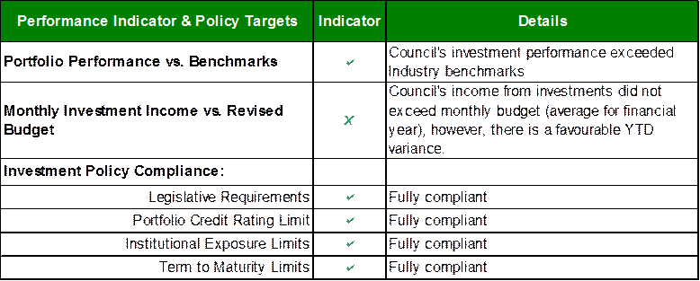
Investment Portfolio Performance Snapshot
The table below provides the investments portfolio performance against targets identified in Council’s Investment Policy as well as other key performance indicators based on industry benchmarks.
Cumulative Investment Return against Revised Budget
The net return on investments for the financial year ending June 2013 was $4,411,000 against a revised budget of $4,312,000, giving a YTD favourable variance of $99,000.
The total return on investments (interest and capital gain/loss) for the month of June is provided below.

A comparison of the cumulative investment returns against year to date budget is shown in Chart 1 below.
Chart 1 - Cumulative Investment Return YTD vs. Budget
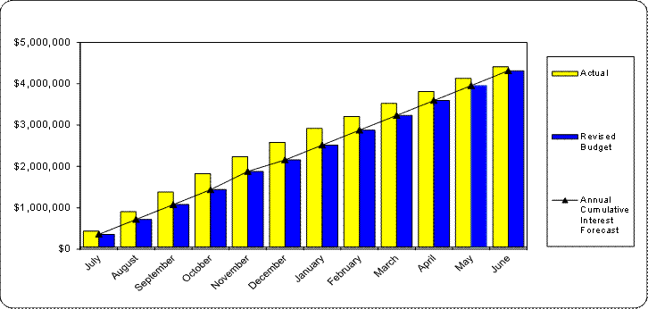
Cash Flow and Investment Movements
Council’s total investment portfolio at the end of June 2013 is $77,874,800, a decrease of $17,908,000 since July 2012. The net cash inflow for the month was $10,447,000 mainly due to borrowing at end of year.
On 30 June Council also held $13,103,000 in the main bank account due to loan funds received but not reinvested. Subsequently the funds were reinvested on 1st July. This brings the total balance of cash plus investments at financial year end to $90,977,800.
Four investments matured during the month and there were five new investments made. Table 1 below provides detailed movement of investments during the month by institution name, investment rating and interest rates.
Table 1 – Investment Movements (June 2013)
Investment Performance against Industry Benchmarks
Overall during the month of June the investments performance was well above industry benchmark. The benchmarks are specific to the type of investment and details provided below.
Ø Cash and at call investments are compared against the 11am Cash Rate. This applies to AMP Business Easy Saver Account and Westpac Maxi-I Investment Account.
Ø UBS Bank Bill Index is used for all other investments except Cash.
A comparison of the portfolio returns against investment benchmarks is provided in Table 2 below.
Table 2 - Investments Performance against Industry Benchmarks

Table below provides a summary of all investments by type and performance during the month. Attachment A1 provides definitions in relation to different types of investments.
Table 3 - Investments Portfolio Summary
* Weighted average returns excluding Cash/At Call
Investment by Credit rating and Maturity Profile
The allocation of Council’s investments by credit rating and the maturity profile are shown in the chart below:
Chart 2 - Credit Rating (Actual level of investment compared to proportion permitted by policy)
Chart 3 - Maturity Profile (Excludes At Call/Cash)
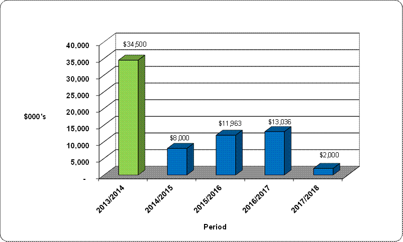
Governance Matters
Council’s investments are made in accordance with the Local Government Act (1993), the Local Government (General) Regulation 2005 and Council’s Investment Policy which was adopted by Council on 20 April 2010.
Section 212 of the Local Government (General) Regulation 2005 states:
(1) The responsible accounting officer of a council:
(a) must provide the council with a written report (setting out details of all money that the council has invested under section 625 of the Act) to be presented:
(i) if only one ordinary meeting of the council is held in a month, at that meeting, or
(ii) if more than one such meeting is held in a month, at whichever of those meetings the council by resolution determines, and
(b) must include in the report a certificate as to whether or not the investment has been made in accordance with the Act, the regulations and the council’s investment policies.
(2) The report must be made up to the last day of the month immediately preceding the meeting.
Risk Management
The major risk associated with investments is price risk and that the capital value of investments may fluctuate due to changes in market prices. These changes can be triggered by factors specific to individual financial instruments, their issuers or by factors affecting similar instruments traded in a market.
Cash & Investments are also subject to interest rate risk as changes in interest rates could also have an adverse impact on returns and income.
A further risk associated with Cash & Investments is credit risk where the investment counterparty may not complete their obligations particular to a financial instrument, resulting either a capital or income loss.
Council manages these risks by diversifying its portfolio and only purchasing investments with high credit ratings or capital guarantees.
Council’s new investments are considered low risk as they are only made in a form of investment notified by order of the Minister for Local Government and Council’s adopted Investment Policy.
All investments are made with consideration of advice from Council’s appointed investment advisor, CPG Research & Advisory.
Financial Considerations
The revised budget for interest on investments for the financial year 2012/2013 is $4,312,400. Of this amount approximately $2,832,600 is restricted for the benefit of future expenditure relating to developers’ contributions, $557,600 transferred to the internally restricted Infrastructure & Facility Reserve, and the remainder of $922,200 is available for operations.
Social Considerations
Not applicable.
Environmental Considerations
Not applicable.
Community Consultation
None undertaken or required.
Internal Consultation
None undertaken or required.
Certification - Responsible Accounting Officer
I hereby certify that the investments listed in the attached report have been made in accordance with Section 625 of the Local Government Act 1993, clause 212 of the Local Government General Regulation 2005 and Council’s Investment Policy which was adopted by Council on 20 April 2010.
Summary
As at 30 June 2013:
Ø Council’s total investment portfolio is $77,874,800, which is a decrease of $17,908,000 compared to an opening balance of $95,782,800 at 1 July 2012.
Ø On 30 June Council also held $13,103,000 in the main bank account due to loan funds received but not reinvested. Subsequently the funds were reinvested on 1st July. This brings the total balance of cash plus investments at financial year end to $90,977,800.
Ø Council’s net return on investments for the 12 months ending June 2013 was $4,411,000 against a revised budget of $4,312,000, giving a YTD favourable variance of $99,000.
|
A. That the summary of investments and performance for June 2013 be received and noted.
B. That the Certificate of the Responsible Accounting Officer be noted and the report adopted.
|
|
Tony Ly Financial Accounting Officer |
Angela Apostol Acting Manager Finance |
|
David Marshall Director Corporate |
|
|
A1View |
Investments definitions specific to Council’s investment portfolio |
|
2012/223363 |
|
Ordinary Meeting of Council - 30 July 2013 |
GB.3 / 89 |
|
|
|
|
Item GB.3 |
DA0532/12 |
|
|
22 May 2013 |
development application
Summary Sheet
|
Report title: |
39 Chilton Parade, Warrawee DA0532/12 - Demolition of Existing Dwelling, Community Title Subdivision into 9 Lots, Construction of 8 Dwellings and Ancillary Site Works, including Swimming Pools and Fences |
|
ITEM/AGENDA NO: |
GB.3 |
|
Application No: |
|
|
Property Details: |
39 Chilton Parade, Warrawee Lot & DP No: Lot 2 DP203883 Site area: 10,960 m2 Zoning: 2(c) |
|
Ward: |
|
|
Proposal/Purpose: |
Demolition of existing dwelling, community title subdivision into 9 lots, construction of 8 dwellings and ancillary site works, including swimming pools and fences. |
|
Type of Consent: |
Local |
|
Applicant: |
Chilton Estate Development P/L |
|
Owner: |
Yongning Han; Yufang Fu; Bing Jin Jiang |
|
Date Lodged: |
11 December 2012 |
|
Recommendation: |
Approval. |
Purpose of Report
The purpose of this report is to determine DA0532/12. It is reported to Council as the application seeks consent for subdivision of the site into 9 lots. The Development Application also seeks to vary development standards in Clauses 43 and 58 of the KPSO, supported by an objection to those development standards pursuant to SEPP No. 1.
History
Site
The subject site has historical links to the Wahroonga Catholic Church, when the site was owned by the church and used as a convent.
In 2005, Council approved an application to rezone the property from 5(a) special uses convent to residential 2(c) under the KPSO, as the site was no longer being used as a convent. The residential zoning enabled the residential use of the site, consistent with the land use of surrounding properties.
In 2008, Council refused a Development Application for the development and use of the site as a school. That application was principally refused for reasons relating to traffic issues and impacts on the large area of remnant Blue Gum High Forest located onsite. The subsequent appeal to the Land and Environment Court was dismissed.
Since that time, the large dwelling (previously used as the convent) has been infrequently occupied.
Pre-DA
A Pre-DA consultation was undertaken in May 2012. A scheme similar to the current proposal was presented. The scheme comprised a community title subdivision of the site into 7 lots, construction of 6 dwellings and a large communal pool and cabana.
The issues raised by Council officers included:
· amenity impacts due to undersized allotments
· impacts to core riparian zone
· tree and ecological impacts
· views from the adjoining heritage item ‘Berith Park’
· limited street frontages and potential prohibition with regard to the KPSO
Current DA
11 December 2012 – application lodged
21 December 2012 – application notified until 14 February 2013
1 February 2013 – Office of Water advise Council that the development is not integrated with regard to the Water Management Act 2000
7 February 2013 – deferral letter sent to applicant to address issues identified in the preliminary assessment and arising from the notification process
26 February 2013 – Council obtains legal advice on permissibility of the community title subdivision as proposed
22 March 2013 – the applicant responds to Council’s position with counter legal advice
9 April 2013 – Council obtains further legal advice
10 May 2013 – amended plans submitted to Council
15 May 2013 – amended plans notified for 14 days
5 July 2013 – final plans submitted to Council
The Site
Site description
|
Type of development:
|
Local |
|
Relevant external referrals: |
NSW Office of Water |
|
Bushfire Prone Land: |
No |
|
Riparian Zone: |
Yes – Category 2 under Riparian Policy and Category 3 under LEP No. 218 and Draft KLEP 2013 |
|
Vegetation/Endangered Species: |
Blue Gum High Forest (BGHF) |
|
Heritage Item: |
No |
|
In the vicinity of a Heritage Item |
Yes – adjoins No. 19 Billyard Avenue (‘Berith Park’) and within the vicinity of No. 35 Chilton Parade (‘Amberley’) |
|
Urban Conservation Area: |
Yes –Heritage Conservation Area under LEP No. 218 and Draft KLEP 2013 |
|
Visual Character Study Category: |
Pre 1920 |
The subject site subject is located on the northern (high) side of Chilton Parade, just to the east of its intersection with Warrawee Avenue.
The site is an irregular shaped allotment of 10,960m2, with a substantial 91.44m frontage to Chilton Parade. The site currently contains a large two storey building that was previously used as a convent and is now occupied as a residential dwelling.
The key feature of the site is the large expanse of Blue Gum High Forest which surrounds the site, being concentrated on the eastern, western boundaries and southern boundary with Chilton Parade. The expanse of Blue Gum High Forest on the site is one of the largest areas in single, private ownership in the Ku-ring-gai Local Government Area.
Surrounding development
Surrounding development consists of dwelling houses of varying scale and character. It is noted that the surrounding character of the built environment varies significantly, from substantial heritage items such as the adjoining ‘Berith Park’ at the rear of the site, to recent contemporary dwelling houses on the opposite side of Chilton Parade.
The Proposal
The Development Application proposes the following:
· demolition of the existing dwelling and ancillary structures on site
· community title subdivision of the site into 9 lots, being 1 community lot and 8 lots for residential purposes, as follows:
- Lot 1 (community lot) containing areas of protected Blue Gum High Forest and communal driveway – 5,381m2
- Lot 2 (residential) - 782m2
- Lot 3 (residential) - 747m2
- Lot 4 (residential) – 868m2
- Lot 5 (residential) – 566m2
- Lot 6 (residential) – 561m2
- Lot 7 (residential) – 699m2
- Lot 8 (residential) – 648m2
- Lot 9 (residential) – 708m2
· construction of a two storey dwelling on each allotment, each with open plan living areas, double garage and a minimum of 4 bedrooms
· construction of inground swimming pools in the rear of Lots 3,5 and 9
· construction of a new palisade fence along the street frontage
· extensive landscaping of the site, including the rehabilitation of 4746m2 of Blue Gum High Forest
Amended plans
Amended plans were submitted on 10 May 2013, incorporating the following modifications and information:
· reduced heights of Dwellings 2, 3 and 4
· increased rear setback of Dwellings 2,3 and 4
· redesign of Dwelling 2
· changes to the layout and composition of the subdivision
· updated vegetation management plan
· revised landscaping plan providing connectivity through the community lot
· revised stormwater plan
· detailed site excavation and benching plan
Consultation
Community
Council notified the application to owners of surrounding properties on two occasions, being the lodgement of the original scheme between 21 December 2012 and 14 February 2013 and the amended scheme between 15 May 2013 and 29 May 2013.
During the first notification period, Council received 31 submissions from the following:
1. S. Davis – 12 Warrawee Avenue, Warrawee
2. J & J Cronan – 49a Chilton Parade, Warrawee
3. B. Patel – 49 Chilton Parade, Warrawee
4. W & E Baker – 45 Billyard Avenue, Wahroonga
5. J & R Lees
6. W. White – 19 Billyard Avenue, Wahroonga
7. G & L Youlden – 37A Chilton Parade, Warrawee
8. C. Farrell – 19 Warrawee Avenue, Warrawee
9. C & C Routledge – 36a Chilton Parade, Warrawee
10. J & J Pope – 33 Billyard Avenue, Wahroonga
11. J & M Hayes – 31 Warrawee Avenue, Warrawee
12. J & M Beard – 11 Sutherland Avenue, Wahroonga.
13. N. Hicks – 36 Chilton Parade, Warrawee
14. J & K. Longstaff – 18 Warrawqee Avenue, Warrawee
15. J. Waugh – 4 Sutherland Avenue, Wahroonga
16. R. Walters – 25 Bagnall Street, Warrawee
17. P. Breden – 37 Chilton Parade, Warrawee
18. B & M Shankland – 24 Warrawee Avenue, Warrawee
19. T & K Pragastis – 27-31 Billyard Avenue, Warrawee
20. P. Davis – 5 Young Street, Warrawee
21. K. White – 19 Billyard Avenue, Wahroonga
22. N. Ashurst – 16 Young Street, Wahroonga
23. L. Tropman – 55 Lower Fort Street, Sydney
24. R. Lembit – Po Box 1, Canterbury
25. C. Morris – 33-35 Ilka Street, Lillyfield
26. J. Marsden – 32 Chilton Parade, Warrawee
27. J. Burchett – 4 Sutherland Avenue, Wahroonga
The following issues were raised, notwithstanding that the overwhelming majority of the submissions made to Council supported residential development on the site:
The development would place an increased strain on vehicular access to Warrawee Avenue from Bangalla Street and Millewa Avenue.
The composition and density of the development is not of a type or scope that would significant increase traffic volumes to a point where it would have an impact upon the efficiency or flow of traffic through the surrounding intersections. Comments by Council’s engineers provided elsewhere in this report confirm this.
The proposed development will be to the detriment of the local environment and in particular the Blue Gum High Forest.
The proposed development has been designed and configured in a way whereby it seeks to retain and enhance the canopy of the Blue Gum High Forest present on site, thus retaining and reinforcing the existing treed character of the site.
Requests that the riparian zone be planted to form a dense understory of locally native species to provide screen to adjoining properties but also to improve biodiversity.
Council’s Ecological Assessment Officer has reviewed the plantings proposed within the riparian corridor and is satisfied that they are consistent with Council’s Riparian Policy. These plantings will improve the biodiversity of the area, and enhance the separation between the development site and adjoining properties.
Adjoining the western boundary a large Blue Gum exists that we respectively ask to be removed as it was severely damaged in a storm and we are concerned that it high winds it may come down or drop large branches on our house.
This tree’s health has been considered and assessed by the applicant’s arborist to be in good health and vigour. Accordingly, it is not considered reasonable to remove this tree, given its endangered status.
The density of the development will significantly increase the demand for on street parking, which is already in high demand due to the surrounding schools.
Each dwelling proposed includes a double garage, as is required by the parking provisions of DCP 38. Furthermore, the site provides for 4 visitor car spaces. These parking provisions will satisfactorily accommodate the likely demand for car parking on site.
There are no footpaths in this section of Chilton Parade, the development warrants an upgrade to the surrounding street network.
This matter has been considered by Council’s Development Engineer. Condition 29 requires kerbing and guttering to be provided along the frontage of the development site and opposite side of the street.
The increase in traffic will have a potentially dangerous impact at the junction of Chilton Parade and Warrawee Avenue, due to its tight angle, steep incline and poorly located light pole and pedestrian pathway.
Council’s Development Engineer is satisfied that the minor increase in traffic volumes would not result in an unsafe environment for vehicles or pedestrian movements.
Cluster housing is not in keeping with the character of Chilton Parade.
The proposed development is not cluster housing, but detached dwellings, which are in character with the surrounding area.
Allowing this development to proceed will set a precedent for other surrounding large properties.
The proposed development does not set a precedent for the development of other surrounding allotments, as each development is considered on its merits. The development does, however set a desirable precedent as to how Blue Gum High Forest can be managed, retained and enhanced with development.
The proposed will have adverse impacts on the heritage conservation area.
Council’s Heritage Advisor considers that the proposal will have an acceptable impact on the heritage conservation area within which it is situated. It is noted that the retention of the park like setting around the development is the most critical of the historical characteristics of the site and is the basis for its contribution to the HCA.
The proposed development will have unacceptable privacy impacts upon surrounding residents through unrestricted views from the upper floors.
The development is well set back from the side boundaries providing more than sufficient separation from adjoining dwellings. At the rear, the prevailing topography serves as a natural screen between the adjoining properties and dwellings in the development. In respect of privacy, the proposed development is well considered and designed.
Concern is raised with the removal of asbestos during demolition.
Condition 39 requires that the removal of any asbestos must be undertaken in accordance with the provisions of the applicable Australian Standards and WorkCover requirements.
The development is not in keeping with the character of the surrounding development.
There are a number of new dwellings in the surrounding area. Whilst the lot layouts are different to the prevailing subdivision character, the desire to retain the Blue Gum High Forest on the site has limited the opportunity to replicate the surrounding subdivision pattern. A more traditional Torrens subdivision of the site would likely have an adverse impact on the Blue Gum High Forest.
The removal of 150 trees from the site will destroy the character of the area.
The development will result in the loss of 120 trees, the majority of which are invasive weed species or trees in poor health (noting that the higher number referred to in the submissions includes exempt species that could otherwise be removed without requiring approval). The removal of trees was given substantial consideration by Council’s Landscape Assessment Officer who found it to be acceptable as proposed. Whilst consideration was given to the retention of a number of non-indigenous trees on site, this was seen to preclude the successful rehabilitation of the areas of Blue Gum High Forest.
The site contains too many dwellings. A lesser number (6) would be more acceptable and in harmony with the surrounding area.
The eight dwellings proposed represents a lower density than the site could sustain when the minimum yield of the site is considered against the minimum lot size under a more conventional Torrens title subdivision (with the site supporting a yield of up to 10 dwellings / lots) under such a scenario. Notwithstanding this, a lesser number of lots would still facilitate the same amount of physical development, with larger dwellings being proposed, as well as ancillary buildings and the like.
The location of the driveway will result in undesirable headlight glare shining into our property, this will be compounded by the large number of traffic movements.
The development’s driveway will be in the same location as the existing driveway. Whilst it is accepted that the proposal will generate additional traffic movements, these are not considered to result in the significant loss of amenity through head light glare on adjoining properties.
The front dwellings are too close to the street and are not provided with sufficient setbacks.
The proposed front setback complies with the front setback controls of DCP 38.
The removal of the large area of grass land surrounding the property will impact wildlife and disadvantage local residents who use the area to walk their dogs.
Council’s Ecological Assessment Officer is not of a view that the development would have a detrimental impact on the habitat of any local wildlife, particularly as a large portion of the site is to remain in a natural state. It is noted that the site is in private ownership and not available to the public.
The density of the proposal is excessive.
The density of the development represents a yield that is less than the maximum achievable under the KPSO and DCP 38.
The internal access driveway should be wide enough to allow access for garage trucks.
The design of the development facilitates access by Council’s small waste truck as well as the servicing of the development’s waste requirements internally.
The Blue Gum High Forest preceded any development and should therefore be protected at all costs. The constraint of this on the land should not be used to avoid compliance with the Council’s controls, rather adapted into the development in a sympathetic way.
It is considered that the scheme before Council achieves this, noting that the application considered by Council is all encompassing and does not leave consideration of unresolved issues to future applications.
The impact on the heritage listed Berith Park will be significant and will degrade the whole setting of such an important part of Wahroonga.
A heritage impact assessment was lodged with the application and was reviewed by Council’s Heritage Advisor who supports its findings and considers the impact of the development upon Berith Park to be acceptable.
The setbacks to the adjoining properties at the rear are inadequate.
A minimum 8m setback is provided to these properties, which is consistent with the setback of the existing dwelling. The adjoining properties are much higher than the subject site, which reduces the likelihood of adverse impacts.
The development will result in a significant increase in noise.
It is not considered that the development would generate noise that would unreasonably affect the amenity of any surrounding property, particularly given the significant separation provided to adjoining properties.
The justification for the removal of 73 trees within the Blue Gum High Forest area for regeneration purposes is dubious logic.
To successfully revegetate and rehabilitate the Blue Gum High Forest to a natural state free of non-indigenous species, it is necessary to remove those trees which are not part of the Blue Gum High Forest community.
Lots 2 and 3 are too close to Berith Park and should be deleted.
The amended scheme provides building setbacks and heights that are consistent with that of the existing dwelling on the site.
Lots 2 and 3 will intrude into the privacy of Berith Park.
Berith Park sits on land that is much higher than the development site and, when the existing vegetation between the two properties is considered, no views from the development site into Berith Park are available.
The community title subdivision should be altered so that it links around the back providing a greater buffer to Berith Park.
The proposed community lot has been configured to include the areas of Blue Gum High Forest and communal elements (such as the common driveway) of the development. As no remnant Blue Gum High Forest is located at the rear, there is no reason to extend the lot as suggested.
The removal of trees onsite will have a detrimental impact to the outlook from the rear of Berith Park and its swimming pool, which were original designed to ‘frame’ that view.
Council’s Heritage Advisor has considered the impact of tree loss on the outlook of Berith Park and is satisfied that the proposed tree removal will not have a detrimental impact.
The proposed development and retained buffer zone does not appear to respect Council recommended buffer zone of 20m.
The buffer zone exceeds 20m in width and Council’s Ecological Assessment Officer is satisfied that it will provide adequate protection to the riparian corridor along the western boundary.
Significant landscaping should occur between the rear of the development and Berith Park.
Council’s Landscape Assessment Officer is satisfied that the landscape plan provides for appropriate screen plantings between the development and Berith Park.
The view from the rear of Berith Park has been uninterrupted for more than 100 years and will be destroyed by this development. If Lot 2 was deleted, the trees in that lot could remain and the views protected.
A total of 4 trees are proposed to be removed to accommodate the dwelling on Lot 2. Given the dense vegetation at the rear of Lot 2 and Berith Park, the loss of these trees would not significantly alter the view from Berith Park. Tree removal would in fact extend the scope of views to the south from Berith Park.
Council should not allow native trees that are not Blue Gum High Forest species to be removed if they have high landscape significance.
Suitable non indigenous trees that are of high landscape value in the Blue Gum High Forest are proposed to be retained in the amended scheme.
Amended plans
During notification of the amended scheme, Council received 30 submissions and a petition from the following:
1. J & J Cronan – 49a Chilton Parade, Warrawee
2. B. Patel – 49 Chilton Parade, Warrawee
3. W & E Baker – 45 Billyard Avenue, Wahroonga
4. J Marsden – 32 Chilton Parade, Wahroonga
5. G & L Youlden – 37A Chilton Parade, Warrawee
6. C. Farrell – 19 Warrawee Avenue, Warrawee
7. J & M Hayes – 31 Warrawee Avenue, Warrawee
8. J & M Beard – 11 Sutherland Avenue, Wahroonga.
9. N. Hicks – 36 Chilton Parade, Warrawee
10. J & K. Longstaff – 18 Warrawqee Avenue, Warrawee
11. B & M Shankland – 24 Warrawee Avenue, Warrawee
12. K. White – 19 Billyard Avenue, Wahroonga
13. L. Kelly – 1 Sutherland Avenue, Wahroonga
14. D & M Algar – 23 Chilton Parade, Warrawee
15. P. Westhuizen 0 10 Davidson Avenue, Warrawee
16. J. Burchett – 4 Sutherland Avenue, Wahroonga
17. C. Butler – resident ,Chilton Parade, Warrawee
18. M. Cohen – 27 Warrawee Avenue, Warrawee
19. K & G Smith – 10 Young Street, Wahroonga
20. M & N Drury – 9 Chilton Parade, Warrawee
21. Kim Lo Ricco – 27 Young Street, Wahroonga
22. C. Shaw – 21 Chilton Parade, Warrawee
23. T & K Pragastis – 27-31 Billyard Avenue, Wahroonga
24. S. Thompson – 25 Billyard Avenue, Wahroonga
25. R & S Kirsop – no address supplied
26. L. Tropman – 55 Lower Fort Street, Sydney
27. Em & MJ Van Zyl – 6 Chilton Parade, Warrawee
28. A. Hurdis – 25 Billyard Avenue, Wahroonga
29. N. Ashurst – 16 Young Sreet, Wahroonga
30. C & C Routledge – 36A Chilton Parade, Warrawee
31. A petition objecting to the proposed development on change.org containing (1) signature.
The following additional issues were raised:
The development does not comply with Council’s minimum lot size control.
It is acknowledged that the proposed residential lots do not comply with the minimum lot size of 929m2 specified in the KPSO. As detailed further in this report, the proposed lot sizes are justified through an objection, pursuant to SEPP No. 1. Nevertheless, the density proposed is within the maximum lot yield of the site, and the resultant allotment sizes are sufficient to provide for reasonably sized dwellings, as well as compliant open space, setbacks and car parking as required by DCP 38.
The development does not comply with FSR and setback controls.
The overall FSR when applied to the entire site is less than the maximum under DCP 38 (0.24:1 proposed, 0.3:1 maximum). The amount of floor space proposed for each dwelling is acceptable, particularly when this floor space is concentrated to the middle of the site and does not impact on adjoining properties.
The setback of the built elements to the external boundaries of the site (including to the street) meet the controls of DCP 38. Internally, the setbacks between dwellings provide for building separations of 3m and greater, with the average setback between dwellings ranging between 4m and 10m in the case of opposing dwellings along the central driveway. This is considered an acceptable arrangement for this type of development.
The development is unacceptable from a safety perspective as emergency vehicles cannot get to each of the dwellings.
The development will provide adequate access for emergency vehicles, notwithstanding that no statutory standard applies to such access for this scale of development.
The proposed subdivision pattern is inconsistent with the subdivision pattern of the surrounding area
This point is acknowledged, however the subdivision pattern has been derived through the retention of the Blue Gum High Forest. A subdivision pattern characteristic of the surrounding area could be achieved, however this would fragment the Blue Gum High Forest and its ongoing viability.
The area of Blue Gum High Forest should not be included in the area calculation for development yield.
Council’s planning controls and policies do not exclude such areas from the site calculations.
Within Council
Heritage:
Council’s Heritage Advisor provided the following comments:
Heritage conservation area (HCA)
The following is the Statement of Significance for the Wahroonga HCA provided by the heritage consultant Paul Davies in 2010 which forms the justification for including the site in the HCA:
“Wahroonga HCA is of heritage significance for its distinctive residential streetscapes which evidence the transformation of early subdivisions of the 1890s into the later rectilinear grid lot street and lot pattern of later subdivisions including the Wahroonga Heights Estate. The area contains a significant collection of grand residences from the Federation and Inter-war periods, built following the opening of the North Shore Railway line in 1890, many of these the residences of prominent families of this period, and often designed by prominent architects, for example the 1894 Ewan House (formerly Innisfall) designed by architect Herbert Wardell for John Toohey, and eleven houses designed by the architect Howard Joseland. The western end of Burns Road and western side of Coonanbarra Road are representative streetscapes of intact more modest Federation period houses.
The through-block pathways and formal avenues of street trees within the area (in Burns Road, Water Street and Coonanbarra Road) along with the formal landscaping of Wahroonga Park, and its distinctive John Sulman-designed shops facing the Park, are a tribute to the work of the Wahroonga Progress Association in the early 20th century (which included Sulman as a member), and have resulted in a high-quality and distinctive residential landscape”.
Demolition
The site is graded as contributory to the HCA. From the history in the HIS, the land was formerly part of Berith Park which was subdivided in 1929 prior to its purchase by Sir Hugh Denison, a manager of Associated Newspapers. The existing house was built c1929 was designed by architects Scott Green and Scott. It remained a single residence for the Denison family until its purchase in 1957 by the Catholic Church for use as an accommodation wing for the adjoining Novitiate at Berith Park and renamed St Catherine’s.
Since 1957 a triangular portion of the site (west of the watercourse) was subdivided from the property. A tennis court was added at an unknown time (now removed). The original garage was removed at an unknown time and a metal carport was added in 1982 and alterations and additions undertaken in 1987.
The house is sited on a high point close to the rear (northern) boundary of its site and is a reasonable example of a restrained Inter War period house located on a large parcel of land. The house was inspected internally on 5/2/13 and the inspection confirmed that the house is generally in good condition with no obvious faults. It is clearly apparent that the southern wing which comprises the garage, terrace, rumpus room, stair, a bedroom, bathroom and laundry is an addition – possibly the 1987 addition. A wall has also been removed from the hall to create a larger room – possibly a chapel when used by the church. The kitchen appears to have been recently refitted but most bathrooms contained original tiles with some new fittings such as shower screens and vanities. The internal walls are plastered, most likely cement render and the ceilings are a combination of timber beams in the hall and main living room (painted white) and fibrous plaster, mainly undecorated with simple cornices. Joinery is generally original with timber doors, windows, skirtings and picture rails. As noted above, the interior decoration is restrained but of good quality and reflects the restrained Inter War style of the exterior of the house.
The house was designed to face east as its main front and has a driveway loop to the east of the house. The house is set on a highpoint in a park like garden setting comprised of a number of mature canopy trees, including indigenous and non-indigenous and exotic plantings. There are broad areas with mown grass and patches of ground cover. The western part of the site contains a gully and creek with denser vegetation of canopy trees a sub canopy and ground cover.
The statement by the architect for the scheme, dated 8 May 2013, states that retention of the existing building would result in a reduction of dwellings on the site from 8 to 7 as it would not be possible to locate another dwelling to the east of the existing building due to BGHF constraints and new private open space to the east of the building. The architect also states that he believes the existing building would dominate the proposed development and has a poor relationship to the proposed common driveway and would unduly detract from the long term objectives of the proposed development. It is also argued that the existing dwelling makes little if any contribution to the HCA, rather it is the treed setting that makes the contribution.
If the existing building were retained in a revised scheme, it would not unreasonably dominate the proposed development. The existing building is largely single storey and is located towards the rear of the site and has a similar footprint and ridge height to the proposed dwelling on Lot 3. However, it is agreed that the existing building has a minor contribution to the HCA and it is the wooded character of the site that makes the main contribution towards the HCA. On this basis, demolition is acceptable provided photographic recording to archival standards is undertaken prior to any works commencing.
Amended scheme
The major amendments made are primarily to proposed Lots 2, 3 & 4. The rear setbacks have been increased to align with the setback of the proposed building on Lot 3 which is the same setback as the existing house on the site.
The roof form to the house on proposed Lot 2 has been modified from a hipped form to a skillion form with a reduction in height of just over 1m on the western side and about 500mm of the eastern end. It is claimed that the high point of the proposed roof now is just below the ridge of the existing Inter War house on the site.
Similarly, for the proposed house on Lot 3, the roof form has been altered to a low pitched skillion form with the maximum height being just below the height of the ridge of the existing Inter War house on the site. These changes ensures that the existing views from the adjoining heritage item “Berith Park” at 19 Billyard Avenue will not be compromised by the height of the proposed buildings.
It is considered that these changes have largely resolved the impacts of the proposed development on the adjoining item – “Berith Park”. The views from the main house, the tennis court and pool area will largely be retained with acceptable impacts from the new development. In this regard I agree with the heritage response that;
“...retained mature trees on the subject site will continue to be the principal feature of any views from Berith Park looking east and south over the subject site”.
With regard to the HCA, from the immediate streetscape of Chilton Parade, the proposed development would modify the existing bushland character of the site by introducing eight new dwellings where there is currently one building located towards the rear of the site. The existing building has a low profile to the streetscape and is highly screened due to the treed nature of the site. Two new dwellings are proposed either side of the driveway with areas of bushland to the east and west. Behind the street frontage 6 additional new dwellings are proposed. Those dwellings will be visible from the streetscape due to the slope of the land. The proposed development would result in considerable intensification in terms of the built character on the site.
The proposed development would intensify the built elements on the site to the HCA, Area “C 1”. The HCA is primarily characterised by high quality houses from several periods, well established landscapes and some institutional buildings including churches and schools.
In terms of impacts on the other nearby heritage items, the setting of No 35 Chilton Parade “Amberley” would not be directly affected due to its physical separation from the site.
Conclusions and recommendations
An adequate case for demolition of the existing building has been made. The contributory status of the site to the HCA is related to its treed character and historic links to the adjoining heritage item Berith Park, not the existing building on the site. It is considered that demolition is acceptable in this context provided that archival photographic recording is undertaken.
The amendments to the proposed dwellings on Lots 2 and 3 have resulted in acceptable heritage impacts on the adjoining heritage item at No 19 Billyard Avenue including its setting, the views to the south and its general appreciation. It is also considered that the proposed development would not have an adverse impact on the item at 35 Chilton Parade.
The significance of the HCA is related to its distinctive residential streetscapes, examples of substantial Federation and Inter War architecture on relatively large lots, with some more modest examples and some institutional buildings within a mature and treed setting.
With regard to the HCA, the proposed development would result in intensification of the built character but it retains the important almost “park-like” character of the site to the HCA and in this way retains its primary contribution.
Engineering:
Council’s Development Engineer provided the following comments:
Subdivision
The application includes both Community Title subdivision and construction of eight new residences. The residual lot, Lot 1, will comprise the shared access driveway and the protected Blue Gum High Forest and riparian zone.
The conditions are to be formulated so that the construction of the approved residences is integral with the subdivision, and vice versa.
Water management
NSW Office of Water has advised that the development does not require a Controlled Activity Approval.
The BASIX water commitments include a 3 000 litres rainwater tank for each dwelling, with re-use for toilet flushing, clothes washing, irrigation and pool top-up (Lots 3, 5 and 9). Combined retention and detention tanks have been provided for each dwelling, which achieves Council’s water management requirements. An allowance in volume has been provided for each tank, to adjust for the driveway runoff.
The stormwater management plans are satisfactory. Landscape Services have requested that the rainwater tanks for Dwelling 2, T1 and T2, be located beneath the garage (the access points can be outside the garage door) to maximise soft landscape area. This has been conditioned (Condition 21).
The point of discharge will either be where the existing outlet is from the existing detention basin (to be removed under the new landscape/ vegetation management plans) or at a new connection to the street drainage pit. This can be shown on the Construction Certificate plans.
Traffic and vehicular access
Vehicular access to the development will be via a single shared driveway. The dimensions and gradient of the driveway are satisfactory. Each residence is provided with a double garage.
The Roads and Maritime Services Guide to Traffic Generating Developments gives a traffic generation for dwelling houses of 0.85 weekday peak hour trips per dwelling, i.e. approximately 7 vehicle trips per peak hour for the eight dwellings proposed (a trip being a one way movement). This is equivalent to one trip every 8 minutes. It can be seen that this is a very low traffic generation.
The Guide gives an environmental capacity of 200 vehicles per peak hour for a local street – this is the desirable volume; the maximum is 300 vehicles per peak hour. Warrawee Avenue is narrower and could be classified as a local accessway, for which the environmental goal is 100 vehicles per peak hour.
Considering the number of residences in Chilton Parade and Warrawee Avenue, existing flows are not likely to approach this limit. Therefore, it is not considered that the development will significantly affect traffic flows in the surrounding road network.
Waste management
Internal collection by the small waste collection vehicle will be required. The plans show two waste collection areas where bins can be placed on collection day. An easement for waste collection will have to be created over the shared driveway, which is part of Lot 1, with the registration of the subdivision.
Council infrastructure
There is no kerb and gutter on the opposite side of Chilton Parade. It is considered reasonable that kerb and gutter and road shoulder be constructed as a part of this development, and this is conditioned (Condition 29).
Construction traffic management plan
A detailed Construction Traffic Management Plan will be required, being required as a condition of consent (Condition 9). This will include such traffic management measures as heavy vehicle routes (no use of Warrawee Avenue), parking restrictions, traffic controllers and size of construction vehicle.
Council will assess and approve the CTMP prior to commencement of any works on site.
Landscaping:
Council’s Landscape Assessment Officer provided the following comments:
Site characteristics
The site rises approximately 12 metres from Chilton Parade to the north. The sloping site has been largely cleared with a combination of Blue Gum High Forest community and exotic plantings. The existing building is to be demolished. The site is mapped as within the Wahroonga Heritage Conservation Areas (and the heritage listed property, Berith Park adjoins the site to the north-west. The site is also mapped as having biodiversity significance and the riparian corridor of a Category 3 watercourse, located along the western boundary, within the adjoining property.
Tree impacts
An arborist report, prepared by Footprint Green, dated 15/07/13, has been submitted with the application. Tree numbers refer to this report. The report states that there are 264 trees on site, however this includes ‘exempt tree species’ that could otherwise be removed without consent and in the absence of this application. The accurate number of trees on site is 223. Of the 223 trees, 120 require removal and 103 are to be retained. Of the 120 to be removed, 18 are species representative of the Blue Gum High Forest (BGHF) community and 102 are either native or exotic species.
Significant BGHF trees to be removed
Tree 298/ Eucalyptus paniculata (Grey Ironbark) This 9m high tree is located to the south of the existing residence. The tree is in poor condition and has been given a Safe Useful Life Expectancy category of 4 or less than 5 years. There is no objection to the removal of this tree.
Tree 312/ Eucalyptus saligna (Sydney Blue Gum) This 22m high tree is located to the south of the existing residence. The tree is growing on the steep embankment excavated as part of the disused tennis court. There is no objection to the removal of this tree.
Tree 530/ Eucalyptus paniculata (Grey Ironbark) This 28m high tree is located to the east of the existing residence. The tree exhibits several large trunk wounds and fair vigour. There is no objection to the removal of this tree.
Tree 544/ Eucalyptus saligna (Sydney Blue Gum) This 17m high tree is located to the east of the existing residence. The tree appears to have been removed previously to ground level. There is no objection to the removal of this tree.
Tree 545/ Angophora floribunda (Rough barked Apple) This 15m high tree is located to the east of the existing residence. There is no objection to the removal of this tree.
Tree 806/ Eucalyptus saligna (Sydney Blue Gum) This 22m high tree is located in the rear yard of Residence 5. The tree is 3.4m from proposed building and will not be viable in the long term.
Significant exotic trees to be removed
Tree 342/ Lophostemon confertus (Brushbox) This 24m high tree is located to the east of the existing residence. The tree is an excellent specimen. The tree canopy is located towards the rear of the site however, the canopy is visible from the house and southern terraces of ‘Berith Park’. The tree is to be removed for the proposed driveway and Lot 2 dwelling.
The most notable loss to the view from Berith Park is that of the mature Lophostemon confertus (Brushbox) (Tree 342) which creates a solid canopy behind the pool. It can be argued that the canopy is for the most part screened by the existing tree and shrub vegetation located along the southern boundary of Berith Park, including a mature White Cedar (Tree 855) and Jacaranda(Tree 856) and several Sydney Blue Gums (Tree 857 and 860). In respect to early photographs taken at the pool in the 1930s, the removal of this tree will restore the more historically accurate views to the south of Blue Gum High Forest. The existing vegetation located along the southern boundary of Berith Park, in association with the existing and proposed tree and shrub plantings along the northern boundary of the development, will screen the proposed development while preserving the distant view of mature locally occurring canopy trees located along the eastern and western boundary of the site.
To preserve the canopy views from adjoining properties, planting of canopy and sub-canopy trees is to be undertaken within 3 months after the commencement dated of the VMP’s Stage 1 works (initial weed eradication and tree removal) in accordance with Footprint Green’s VMP.
Trees to be retained
Trees with possible structural weaknesses:
Several of the trees to be retained in close proximity to the proposed lots display possible structural weaknesses and have been investigated further to demonstrate long term viability in relation to the increased target area to enable a true assessment by the ecologist.
Tree/Location
Tree 142/ Eucalyptus paniculata (Grey Ironbark) 8m from building - Lot 9 - Weight reduction pruning is recommended.
Tree 161/ Eucalyptus saligna (Sydney Blue Gum) 8.5m from private open space - Lot 8/9- Weight reduction pruning is recommended.
Tree 317/ Eucalyptus saligna (Sydney Blue Gum) 5.7m from building - Lot 6 – Root crown investigation is recommended.
A neighbour has requested the removal, due to structural instability of Tree 624/ Eucalyptus pilularis (Blackbutt), a mature tree located at the north-western corner of the site. The arborist’s assessment makes comment on a wound on the trunk, however gives the tree a Safe Useful Life Expectancy category rating of 1, which describes the tree as retainable for over 40 years.
Restrictions for private open spaces with significant trees
Section 88B restrictions should be placed on the following significant trees. The restrictions should prevent all changes of level or construction other than minor works such as garden edging. (Condition 85).
Tree 510/ Eucalyptus punctata (Grey Gum)
Tree 383/ Eucalyptus saligna (Sydney Blue Gum)
Tree 234/ Eucalyptus saligna (Sydney Blue Gum)
Tree 315/ Eucalyptus punctata (Grey Gum)
Tree 3l7/ Eucalyptus saligna (Sydney Blue Gum)
Heritage landscape impacts
The site is located within the Wahroonga Conservation Area and is listed as a contributory item. The heritage listed ‘Berith Park', c 1908/9, is located on the adjoining property to the north, upslope of the subject site. The house and terraced grounds afford distant views of tree canopies to the south from where the 3 acre site fronting Chilton Parade was subdivided in 1928.
The residence ‘Guyong’ built in 1929 by Leslie Denison was constructed at the highest part of the subject site, reached by a long driveway ending in a turning circle at the front porch. The 1943 aerial indicates that the cleared slope below the house was dotted with new plantings of which likely remnants include the Cedrus deodara ( Himalayan Cedar) (Tree 295), Pinus radiata (Monterey Pine) (Tree146 and 160), Pinus patula(Mexican Pine)
(Tree 173), Podocarpus elatus (Brown Pine) (Tree 380) and Chamaecyparis obtusa (Hinoki False Cypress) (Tree 546). Mature locally occurring trees consisting of Eucalyptus saligna (Sydney Blue Gum), Eucalyptus paniculata (Grey Iron bark), Eucalyptus pilularis (Blackbutt) and Angophora floribunda (Rough Barked Apple) were retained along the Chilton Road frontage, the eastern boundary, and on the steeper western slopes of the watercourse.
A mature Arbutus unedo (Irish Strawberry Tree)(Tree 492) and a Livistona chinensis (Chinese Fan Palm) (Tree 489.1) are likely to be early plantings located on the northern boundary of the site. Two mature Lophostemon confertus (Brushbox) (Trees 342 and 345) can be seen on the aerial photograph planted along an earlier service driveway linking to ‘Berith Park’. There are also assorted mature palms, including Syagrus romanzoffianum (Cocos Palm) )(Trees 623), Howea forsteriana (Kentia Palm)(Trees 632), that have been planted within the canopies of the endemic trees located at the north-western corner riparian zone of the site. Trees 489.1, 492, 623, 632 are likely to be associated with earlier uses of the site, and should be retained.
The Dominican Sisters purchased the site from Denison in 1957, renaming it ‘St Catherine's'. A tennis court was constructed along the service driveway in the early 1960s. Additions to the house were added in the late 1980s included a new driveway that required the removal of several of the original plantings on the southern side of the residence.
Landscape buffer
Significant and visually prominent trees that can be viewed from ‘Berith Park’ are proposed to be retained including Arbutus unedo (Irish Strawberry Tree) (Tree 492) and Livistona chinensis (Chinese Fan Palm) (Tree 489.1). The proposed garden beds along the northern boundary of Lots 2, 3 and 4 provide sufficient width for the retention of existing trees and further establishment of a vegetated buffer that will screen the buildings while retaining distant views of the indigenous canopy trees. The proposed hedge of Lilly Pillys and Blue Gum High Forest species are to be substituted with an assortment of more horticulturally sympathetic tree and shrub plantings that can attain at least 4 metres in height. This has been conditioned (Condition 20).
Landscape plan
To preserve the biodiversity significance of this site, the proposed development has included a large area of community land (Lot 1) that retains the principal areas of Blue Gum High Forest. The remaining area of land in the centre of the site has been subdivided into eight lots, seven of which have large setbacks to either the eastern or western boundaries of the development. In the creation of community forest as part of the development, it fulfils several of the primary landscape objective of DCP38 in regards to retention of trees and enhancement of biodiversity (Section 4.3 DCP38).
Front and side setbacks
The non-compliant front and side setbacks as required under DCP38 reduce the available area for soft landscape and screen planting which prevents predominantly private amenity issues. Overall, the detailed building layout and design has assisted in the achievement on merit of an acceptable level of amenity and landscape character and it has been demonstrated that where landscape treatment is not viable, architectural elements have been successfully integrated.
Comments on individual lots:
Lot 1 - community land
· The proposed community land is primarily located along the eastern (10-17m
width) and western boundary (16-35m width) with a 7 metres wide strip along the front of the site.
To allow access for maintenance and passive recreation, a mulch/crushed sandstone path has been provided through the community lot linking the front entry paths to Residence 7 and 9 to driveway areas at top of site and private open space areas. The community land includes paths, seating and interpretive signage at the entrance to the Blue Gum High Forest.
Lot 2 – Residence 2
· The increased setback to the rear boundary optimises the existing level northern area of private open space. The remaining private open space to the west of the dwelling is within an area of existing steep sloping banks. To preserve the existing Eucalyptus saligna [Sydney Blue Gum) (Tree 420, 421, 423) these existing grades are to be clearly shown as to be retained and planted with stabilising shrubs and groundcovers rather than the proposed lawn. This has been conditioned (Condition 20).
· To preserve the health and condition of existing trees, the architectural section BB, DA 203 Rev E, Mccullum Ashby, is to be amended to indicate no excavation beyond the retaining wall and top of wall levels in accordance with the landscape plan. The proposed excavation for the proposed private courtyards within the northern building setback for Lot 2 and Lot 3 is not to encroach beyond the line of the retaining wall and the top of wall levels are to finish flush with the existing levels. This has been conditioned (Condition 20).
· The proposed location of on-site detention tanks conflicts with the proposed soft landscape area shown on the landscape plan for screen planting so that the built form will not dominate. To provide sufficient area for effective planting along the southern elevation of Residence 2, the tanks are to be relocated. This has been conditioned (Condition 21).
Lot 3 – Residence 3
· The level north-facing private open space includes a swimming pool. Existing trees along the northern boundary are to be retained within proposed screen planting. To preserve the heritage buffer, the garden bed is to be increased to minimum 2 metre width. This has been conditioned (Condition 20).
Lot 4 – Residence 4
· The private open space is a 1:20 grade, gently sloping lawn area. A large proportion of the lawn area is located within the tree protection zone of Tree 510/ Eucalyptus punctata (Grey Gum) and Tree 383/ Eucalyptus saligna (Sydney Blue Gum). The proposed decks are approximately 5m from the trees. The building is between 8-9m from the trees. This is considered satisfactory.
Lot 5 – Residence 5
· The lawn area slopes at approximately 1:10 grade to the west. This is in addition to a deck and pool area. The proposed level is to be added at the base of the steps from the deck.
Lot 6 – Residence 6
· The rear private open space is a level lawn area located entirely within the tree protection zone of Tree 315/ Eucalyptus punctata (Grey Gum) and Tree 317/ Eucalyptus saligna (Sydney Blue Gum). The proposed decks are approximately 5m from the trees. The building is between 8-9m from the trees. This is considered satisfactory.
Lot 7 – Residence 7
· The rear private open space is a 1:8 grade sloping lawn almost entirely within the tree protection zone of Tree 234/ Eucalyptus saligna (Sydney Blue Gum). The proposed deck is approximately 5m from the tree. The building is approximately 7.5m from the tree. This is considered satisfactory.
Lot 8 – Residence 8
· The rear private open space is a 1:8 grade sloping lawn almost entirely within the tree protection zone of Tree 388/Eucalyptus paniculata (Grey Ironbark). The proposed excavation for the retaining wall is approximately 6.5m from the tree. The building is approximately 7.5m from the tree. This is considered satisfactory.
Tree replenishment
The proposed lots have insufficient space to enable viable
establishment
of sufficient canopy trees to enable compliance with the control in DCP 38. The
associated community lot, however, provides substantial tree canopy for the
benefit of the development as a whole. A total of 16 additional canopy and 43
additional sub canopy trees are to be planted on Lot 1.
BASIX
The proposal nominates 4255m2 indigenous/low water species within the common area. The common area shown as indigenous/low water species on the low water use landscape plan is able to comply with this area requirement. The areas of garden and lawn for individual dwellings correlate with the BASIX certificate.
Stormwater plan
The stormwater connections are mostly located along the central driveway. Several of the tanks conflict with the proposed planting of screening trees and shrubs. The stormwater is proposed to be connected to the existing pit in the south-west corner of the site. The existing above ground retention area is to be demolished, regraded and revegetated in accordance with the VMP. This is supported.
Environmental site management plan
The environmental site management plan is considered satisfactory.
Conclusion
The proposed development is supported, subject to condition (Conditions 11, 12, 13, 14, 15, 20, 37, 53, 54, 55, 56, 57, 58, 59, 60, 61, 62, 63 & 66)
Ecology:
Council’s Ecological Assessment Officer provided the following comments:
Ecological comments
The site contains Blue Gum High Forest (BGHF) a Critically Endangered Ecological community listed under the Threatened Species Conservation Act 1995.
The BGHF is comprised of a canopy dominated by Eucalyptus saligna (Sydney Blue Gum), Eucalyptus paniculata (Grey Ironbark) & Syncarpia glomulifera (Sydney Turpentine). Sub-canopy trees identified were Brachychiton acerifolius (Illawarra Flame Tree) & Pittosporum undulatum (Sweet Pittosporum). A number of the Sweet Pittosporum appear to have been planted as they follow the edge of the existing driveway and have been planted equal distances from one another. Residual native grass and herb species were identified within the canopy spread of some of the native canopy trees.
The native vegetation within the site has been mapped as “biodiversity significance” Category 2 support for core (A & B) under the recent amendments to the KPSO (LEP 218).
The site is mapped as containing a Category 3 riparian corridor/watercourse which runs along the western boundary of the site. In accordance with Council Riparian Policy the Category 3 watercourses requires a 10m core riparian zone (CRZ).
The development has been considered against these controls and is assessed as being satisfactory in this regard.
A detailed flora and fauna investigation and assessment of the proposal upon threatened species, endangered ecological communities and endangered populations was prepared by Footprint Green. The flora and fauna assessment was reviewed and the following comments are made.
The proposed development will result in the removal of 454m2 of Blue Gum High Forest habitat. A review of the arborist report has identified that 18 canopy/sub-canopy trees representative of the Blue Gum High Forest (BGHF) are proposed for removal. It is noted that 87% of existing BGHF canopy trees are being retained in this scheme.
The following BGHF canopy trees are proposed for removal; Tree 298-Eucalyptus paniculata (Grey Ironbark), T312-Eucalyptus saligna (Sydney Blue Gum), T544-Eucalyptus saligna (Sydney Blue Gum) & T545-Angophora floribunda (Rough barked Apple).
The arborist has assessed T298 as being a poor specimen with a short life expectancy. T 312 is a healthy Blue Gum which has been misidentified, the tree is a Tasmanian Blue Gum. T544 is healthy Blue Gum, T555 is a healthy juvenile Rough-barked Apple.
In addition 14 BGHF sub-canopy trees comprising of Brachychiton acerifolius (Illawarra Flame Tree) & Pittosporum undulatum (Sweet Pittosporum) are proposed for removal. Brachychiton acerifolius is listed in the scientific determination as being a species characteristic of BGHF, however this species is not likely to be representative of the pre-European BGHF community but an introduced species which has become naturalised due to a number of specimens being planted within gardens.
A number of the Sweet Pittosporum specimens proposed for removal are predominantly plantings along the existing driveway access and within the site frontage, and therefore are also not considered to comprise part of Blue Gum High Forest as they are not naturally occurring.
Notwithstanding, the applicant’s ecologist has taken the precautionary principle and assessed the loss of both the Brachychiton acerifolius and a number of planted Pittosporum undulatum despite a number of each species not likely to be representative of the onsite BGHF community.
Threatened species impact assessment
Threatened species impact assessment is an integral part of environmental impact assessment. The objective of s. 5A of the Environmental Planning and Assessment Act 1979 (EP&A Act), the assessment of significance, is to improve the standard of consideration afforded to threatened species, populations and ecological communities, and their habitats through the planning and assessment process, and ensure that the consideration is transparent.
The assessment of significance is the first step in considering potential impacts. When a significant effect is likely which is determined by the impact assessment, further consideration is required and is carried out by preparing a species impact statement.
The assessment of significance is not considered a ‘pass or fail’ test but a system allowing applicants to undertake a qualitative analysis of the likely impacts, and ultimately, whether further assessment needs to be undertaken through a species impact statement. All factors as set out in the threatened species assessment guidelines have been considered by the applicant’s ecologist (Footprint Green) in the preparation of the impact assessment.
The impact assessment (7-part test) prepared by Footprint Green is in accordance with section 5a of the EP&A Act and is considered to have adequately assessed the impacts of the proposal upon threatened species and the critically endangered BGHF community. The impact assessment conclusion that the proposed development will not result in a significant impact upon threatened species and the onsite BGHF community is supported. No species impact statement is considered to be warranted.
Outside Council
The proposed works are within 40m of a water course (straddling the western boundary) and subsequently, pursuant of Section 91 of the Environmental Planning and Assessment Act 1979, the proposal was referred to the Office of Water as potential ‘Integrated Development’.
By way of letter, dated 1 February 2013, the Office of Water advised Council that the works proposed did not constitute ‘Integrated Development’, as the works did not amount to development on waterfront land. The development is therefore not integrated and concurrence was not necessary.
Statutory Provisions
Environmental Planning and Assessment Act
The provisions of Section 79C(1) of the Environmental Planning and Assessment Act, 1979 (as amended) determine the matters for consideration in assessing a development application as stated below:
(a) The provisions of:
(i) any environmental planning instrument, and
(ii) any proposed instrument that is or has been the subject of public consultation under this Act and that has been notified to the consent authority (unless the Director General has notified the consent authority that the making of the proposed instrument has been deferred indefinitely or has not been approved), and
(iii) any development control plan; and
(iiia) any planning agreement that has been entered into under section 93F, or any draft planning agreement that a developer has offered to enter into under section 93F, and
(iv) the regulations (to the extent that they prescribe matters for the purposes of this paragraph), and
(v) any coastal zone management plan (within the meaning of the Coastal Protection Act 1979),
that apply to the land to which the development application relates.
(b) the likely impacts of that development, including environmental impacts on both the natural and built environments, and social and economic impacts in the locality,
(c) the suitability of the site for the development,
(d) any submissions made in accordance with this Act or the regulations,
(e) the public interest.
The relevant provisions of environmental planning instruments, proposed instruments, DCPs, the regulations and policies are addressed following. There are no planning agreements (or draft) for consideration in this assessment. The likely impacts, suitability of the site and public interest are also addressed below and the submissions received have previously been addressed.
State Environmental Planning Policies
State Environmental Planning Policy No. 55 – Remediation of Land
The provisions of SEPP 55 require Council to consider the potential for a site to be contaminated. The subject site has a history of residential use and as such, it is unlikely to contain any contamination and further investigation is not warranted in this case.
State Environmental Planning Policy (Building Sustainability Index: BASIX) 2004
A valid BASIX certificate has been submitted. The certificate demonstrates compliance with the provisions of the SEPP and adequately reflects all amendments to the application.
Sydney Regional Environmental Plan No. 20 – Hawkesbury-Nepean River
SREP 20 applies to land within the catchment of the Hawkesbury Nepean River. The general aim of the plan is to ensure that development and future land uses within the catchment are considered in a regional context. The Plan includes strategies for the assessment of development in relation to water quality and quantity, scenic quality, aquaculture, recreation and tourism.
The proposed development is assessed as being consistent with the aims and objectives of the REP.
Ku-ring-gai Planning Scheme Ordinance
Part A: Development standards
|
Development standard |
Proposed |
Complies |
|
Site area: 10,960m2 |
||
|
Building height 8m (max) |
All dwellings <8m |
YES |
|
Built upon areas 60%(6576m2)(max) |
29% (3241m2) across entire site; all proposed lots <60% (max 54%) |
YES |
|
Allotment sizes and width 929m2 area; 18m width |
Lot 1 – 5374sqm - >18m width Lot 2 – 782m2, 25.25m width Lot 3 - 747m2, 25.05m width Lot 4 - 868m2, 20.015m width Lot 5 -566m2, 16.96m width Lot 6 - 561m2, 16.89m width Lot 7 - 699m2, 22.95m width Lot 8 - 648m2, 24.55m width Lot 9 - 708m2, 23.43m width |
YES NO NO NO NO* NO* NO NO NO |
|
Access to a public road Each lot must have a frontage to a public road |
No, except for Lot 1 |
NO |
* lots fail minimum size and width requirements
As detailed within the above table, the proposed development seeks to vary the minimum lot size of the KPSO for each of the residential lots, whilst also seeking to vary the minimum width of two residential lots, (being Lots 5 and 6).
Clause 58B(3)(c)(i) of the KPSO states:
As to a lot, other than a hatchet-shaped (battleaxe) lot not having frontage to a main road or county road – has an area of not less than 929 square meters and also a width not less than 18 metres at a distance of 12.2 metres from the street alignment.
Supporting the minimum allotment size provisions for residentially zoned land of Clause 58B of the KPSO, Clause 43(3) sets a minimum allotment size for the construction of a dwelling in the relevant zone.
Clause 43(3) of the KPSO states:
A dwelling house shall not be erected in Zone No. 2(c) –
· on any allotment which has an area of less than 929 square metres
· on any rectangularly shaped allotment which has a width of less than 18 metres
· on any irregularly shaped allotment, other than a hatchet-shaped allotment, which has a width of less than 18 metres at a distance of 12.2 metres from the street alignment
· on any hatchet shaped allotment which has an area of less than 1,300 square metres exclusive of the area of the access corridor which shall have a width of 4.6 metres
· on any allotment, other than a hatchet-shaped allotment, having a frontage to a main road or county road which allotment has a width of less than 27.4 metres at a distance of 12.2 metres from the street alignment
In addition to the proposed departure to the numerical Lot controls of Clause 58B(3) and Clause 43(3), the proposed development also seeks to vary the controls of Clause 58B(4) of the KPSO, requiring each allotment to have a frontage to a public road. Relevantly, Clause 58(4) of the KPSO states:
Land to which this Clause applies must not be subdivided for the purpose of dwelling-houses unless each separate lot created has a boundary to a public road.
As the non-compliances with Clauses 43(3) and 58B(3) and (4) of the KPSO amount to departures from development standards, an objection made pursuant of SEPP No. 1 is required.
The applicant has submitted and objection pursuant of SEPP No. 1 to Council, arguing why it is unreasonable or unnecessary to comply with the allotment size and width control, but also why it is unnecessary for each lot being created not have a frontage to a public road. In arguing why it is unreasonable to comply with the minimum allotment size and width, justification has also been provided supporting the construction of dwelling’s on the under sized lots being created by the subdivision.
SEPP No. 1 establishes a general principle that a development standard maybe varied where strict compliance can be shown to be unreasonable or unnecessary or would tend to hinder the attainment of the objects specified in Section 5(a)(i) and (ii) of the Environmental Planning and Assessment Act, 1979.
Whether the planning control in question is a development standard
Clauses 43 and 58 of the KPSO contain a series of development standard relating to the subdivision of land and construction of dwelling’s thereupon. As the controls do not ‘prohibit’ the development if it were not complied with, nor are the control a ‘pre-condition’ for development to occur, they can be varied via an objection pursuant to SEPP No. 1.
It is recognised that development standards are traditionally numerical controls, as are the case in Clauses 43(3) and 58(3). However, the applicant has provided a detailed legal opinion the Clause 58(4) is also a development standard and able to be varied pursuant of SEPP No. 1. This opinion has been considered and accepted by Council’s legal advisors.
The underlying object or purpose of the standard
Clause 58 establishes the minimum criteria for the subdivision of land within the various residential zones listed in the KPSO, the objective of which is to ensure that land subdivided is consistent with the character of the localities to which they relate, that sufficient area is afforded to allow the construction of a dwelling whilst retaining and enhancing the natural environment and that each lot created has unrestricted or unencumbered access to a public road.
Clause 43 complements the minimum subdivision criteria established by Clause 58, ensuring that allotments are of a sufficient size for the purpose of constructing a dwelling house, as envisaged and allowed for by the rest of the controls of the KPSO.
Whether compliance with the development standard is consistent with the aims of this policy, and in particular whether compliance with the development standard would tend to hinder the attainment of the objects specified in Section 5(a)(i) and (ii) of the Environmental Planning and Assessment Act, 1979
The objects of the Act are to:
(a) to encourage:
(i) the proper management, development and conservation of natural and artificial resources, including agriculture land, natural areas, forests, minerals, water, cities, town and villages for the purpose of promoting the social, and economic welfare of the community and a better environment.
(ii) the promotion and co-ordination of the orderly and economic use and development of land.
The applicant submits that the following arguments in this regard:
It is considered that strict compliance with the development standards would be inconsistent with the above objects in the circumstances of this particular case as it would:
1. Prevent the adoption of a Community title subdivision for the site noting that it is widely agreed including by the Land & Environment Court of NSW that the use of Community title subdivision is an appropriate means for ensuring the preservation of endangered ecological communities including Blue Gum High Forest. Reference is made to Ingham Planning P/L v Ku-ring-gai Council [2010] NSWLEC 1222, paragraph 171.
2. Require the adoption of a conventional Torrens title subdivision layout which would most likely result in uncertainty regarding the long term retention and rehabilitation of the existing BGHF community upon the site due to conflicts between the BGHF community and the actions of future land owners.
3. Regardless of which form of subdivision is proposed strict compliance would require a significant reduction in allotment/dwelling yield from the site which would bring into question the financial viability of the development noting that the retention and rehabilitation of the BGHF in the manner set out in the accompanying Vegetation Management Plan comes at a significant cost. Such an outcome would not involve the orderly and economic development of land.
4. In the absence of appropriate developer incentives it is likely that development of the site will not proceed or will be delayed and the existing
BGHF will further decline.
It is therefore submitted that in order to provide for an outcome which will ensure the long term preservation and rehabilitation of the site’s BGHF that a variation to the development standards as detailed within the objections is required.
Whether compliance with the development standard is unreasonable or unnecessary in the circumstance of the case
The applicant argues that compliance with the minimum lot size and width and requiring frontage to a public road for the residential lots being created is unreasonable or unnecessary in the circumstance of the case for the following reasons:
(a) The proposal satisfies the objectives of Schedule 9 of the KPSO in that:
(a) All new dwelling houses and additions to dwelling houses maintain a
reasonable level of sunlight to neighbours living areas and recreation space between 9am and 3pm during the winter solstice on 22 June; and
The proposal as a result of the generous setbacks provided to the adjoining properties together with the orientation of the site will result in an outcome whereby there is no overshadowing of adjoining properties. The proposal has also been designed so as to ensure that appropriate solar access is provided to the future occupants of the development.
(b) All new dwelling houses and additions to dwelling houses are sited and
designed so as to minimise overlooking of neighbours living areas and recreation space; and
Similar to above it is my opinion that as a result of the generous setbacks provided to the adjoining properties, the change in levels, combined with the intervening landscaping that the proposal will not result in any loss of privacy to adjoining properties. The proposal has also been designed so as to ensure that appropriate levels of privacy are provided to the future occupants of the development.
(c) Any building or development work shall maintain or encourage replacement of tree cover whenever possible to ensure the predominant landscape quality of the Municipality is maintained and enhanced; and
The objective of maintain and enhancing tree canopy and in this case Blue Gum High Forest is the primary objective of the subject application.
As detailed within the accompanying Flora and Fauna Report the proposal will provide for removal of 454 m2 of modified Blue Gum High Forest habitat, retention of 1,250 m2 of modified Blue Gum High Forest habitat within the proposed development Lots 2-9, retention and enhancement of 3,489 m2 of Blue Gum High Forest in Lot 1 and reinstatement of 1,065 m2 of Blue Gum High Forest in Lot 1. It is my opinion that on the basis of the above that this objective is complied with.
(d) Any building or development work on a site avoids total or near total site utilisation by maintaining a reasonable proportion of the site as a soft landscaping area; and
The proposal will result in a site coverage of 29% resulting in an outcome whereby 7,746m2 or 71% of the site is available for landscaping. This compares favourably to the minimum landscape area requirement of the
Council of 40%.
(e) All new dwelling houses and additions to existing dwelling houses are of a height, size and bulk generally in keeping with that of neighbouring properties and, where larger buildings are proposed , they are designed so as not to dominate and so far as possible to harmonise with neighbouring development; and
The proposal provides for dwelling houses which in my opinion have a height, bulk and scale which are in keeping with surrounding dwellings. Importantly it is considered that the height, bulk and scale of the two street front dwellings together with the proposed setbacks are compatible with the surrounding dwellings and streetscape and will not in my opinion result in any unreasonable streetscape impacts. Whilst it is acknowledged that the proposal will provide for a number of dwellings in closer proximity to that which would normally occur it is considered that this element of the proposal will not result in any detrimental impacts as a result of the generous setback of development from the site boundaries and the significant amount of landscaping located within these setbacks.
(f) In areas where one period, style or genre of architecture predominates,
the new dwelling house reflects either that style or the main stylistic features such as roof pitch, materials, proportions, setbacks etc. and additions to existing dwelling houses reflect the style of and continue the main stylistic features of the existing and
The proposed architectural style of the proposed dwellings is considered to
be compatible with the surrounding locality.
(g) All new dwelling houses and additions provide reasonable space on the site for the forward entrance and exist of vehicles; and
The internal access driveway and garages have all been configured so as to allow for all vehicles to enter and leave the site in a forward direction.
(h) All applications will be assessed against the considerations of Section 90
(sic) of the Environmental Planning & Assessment Act 1979, and section 313 of the Local Government Act 1919.
An assessment of the proposal against the requirements of the now applicable Section 79C of the Environmental Planning Assessment Act 1979 has been undertaken at Section 6 of this report. It is my opinion that the proposal satisfies the relevant heads of consideration of that Clause.
(a) The proposal will provide for the retention and rehabilitation of an existing degraded Blue Gum High Forest Community.
(c) The proposal will not result in any significant impacts upon any threatened species or threatened species communities and in the case of the BGHF community will provide for a net improvement in the extent and condition of the Blue Gum High Forest on the site.
(d) The proposal will result in a lot density consistent with that envisaged by Council’s controls and occurring within the immediate vicinity of the site.
On the basis of the above it is my opinion that the objectives of the standard are achieved notwithstanding the proposed non-compliance with the standard and accordingly that strict compliance would be both unnecessary and unreasonable in the circumstances of this case.
The mapping which Council has undertaken to support both the environmental controls of the KPSO and DKLEP 2013, involves detailed information relating to land containing areas of biodiversity significance. Given the sites expansive areas of Blue Gum High Forest, this vegetation has been included in this mapping. The below extract from Council’s associated map is attached below:
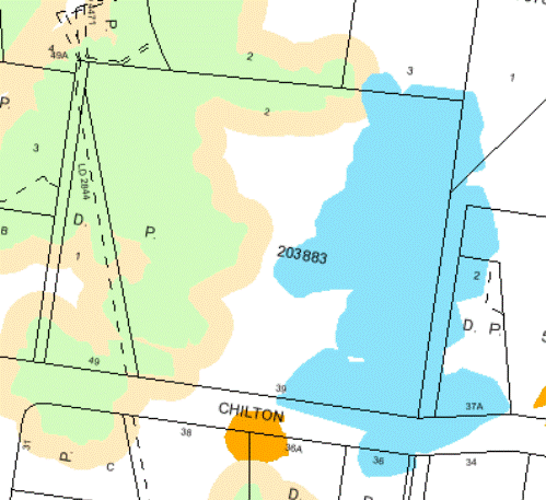
The above extract clearly details the location of significant vegetation on site, which accords with the natural areas proposed to be retained and enhanced as part of this DA. The extent of physical development is limited to the middle of the site where no significant or endangered vegetation occurs. Given the need to concentrate development in the middle of the site, it is not unreasonable to allow the proposed density, particularly when the density proposed of 8 residential lots is less than that which could be achieved with a conventional Torrens title subdivision of a traditional configuration. Such a subdivision would yield a density of between 9 – 11 lots (depending on the number of battle-axe allotments that may be included). Such an arrangement is not desirable, due to the greater potential for impact on the Blue Gum High Forest.
The smaller lot sizes proposed will not be evident from the road or adjoining properties, as all lots (with the exception of Lot 3) have a boundary to the community Lot (and Blue Gum High Forest) and will appear larger than shown on plan. Were the common boundaries of these lots to the Community Lot to be deleted and the Lot boundaries extended to the outer boundaries of the site, these lots would comply with the minimum lot size of the KPSO. However, this is considered to be highly undesirable as it would fragment the ownership and management of the Blue Gum High Forest, which would in turn jeopardise its ongoing viability and severely restrict the extent of rehabilitation that this application proposes.
Moreover, as this application encompasses both subdivision and dwelling construction, Council can give a definitive assessment of the impacts on the holistic development, but also ensure that the extent of development, its composition and character is cohesive and without unreasonable impact. Cohesive development as is proposed in this instance is desirable in this concentrated form as it appears and functions as a unified development. A traditional subdivision in this context with individual dwelling construction by individual owners is less desirable and in this context would fail to properly recognise and respect the unique context in which this development is proposed.
Whether the objection is well founded
The SEPP 1 objection is considered to be well founded, noting that it accurately cites the development standards to be varied, it clearly establishes the context in which the variations are proposed and it provides sufficient reasoning and justification for not needing to strictly comply with the development standard.
Whether the proposed variation is of regional or state significance
The context and situation in which the departure from the development standards is proposed is not assessed as have any regional or state significance. It is isolated to this site and development and does not hinder the application of the development standards for subdivision elsewhere in the Ku-ring-gai Local Government Area.
The public benefit in maintaining the planning controls under the environmental planning instrument
It is considered that no benefit to the public is to be gained in maintaining the planning controls in this instance as it would have the effect of fragmenting the ownership of the Blue Gum High Forest areas on site, which would compromise the viability and integrity of this critically endangered community.
Part B: Aims and objectives for residential zones:
The development: (i) provides satisfactory levels of solar access & privacy to surrounding properties; (ii) is of a bulk, scale and design, characteristic of the area; (iii) maintains adequate levels of soft landscaping; (iv) provides suitable egress/ingress for vehicles; and (v) maintains the landscape quality of the municipality. Consequently, the aims and objectives for residential development as outlined by Schedule 9 have been satisfied.
Part C: Heritage considerations:
The proposed development adjoins 19 Billyard Avenue, Wahroonga (Berith Park), a listed heritage item under the KPSO.
The development has been assessed against the provisions of Clause 61E & G of the KPSO, by Council’s Heritage Advisor and found to be acceptable in terms of its impact on the adjoining heritage item and on the surrounding heritage conservation area.
Part D: Environmental Considerations
The proposed development has been considered against the biodiversity and riparian controls of Clause’s 61L & 61M and the KPSO by Council’s Landscape Assessment Officer and found to be acceptable.
Local Content (LEP, KPSO, etc)
Ku-ring-gai Draft Local Environmental Plan 2013
Ku-ring-gai Draft Local Environmental Plan 2013 (DLEP) has been publicly exhibited and, as such, is a matter for consideration in the assessment of the application. However the DLEP is not considered imminent or certain as it has only been exhibited and not progressed beyond this stage in the plan making process established by the EP&A Act.
For the purpose of this application it is appropriate that the DKLEP 2013 not be given significant weight in its assessment. The subject site is to be zoned R2 Low Density Residential and the subdivision of land is permissible with consent under that zoning (with the same lot sizes and widths applying per the KPSO provisions). The site does not contain a heritage item, however as with the KPSO, is located in the immediate vicinity of a heritage item and would also be part of a heritage conservation area. The site is identified as containing vegetation of high biodiversity significance, and Category 3 riparian zone along its western boundary.
Notwithstanding this, the form of development proposed would not inhibit the attainment of the future character of development envisaged under that plan, nor would it restrict the plan’s implementation.
Policy Provisions (DCPs, Council policies, strategies and management plans)
Development Control Plan No. 38 – Residential Design Manual (DCP 38)
The subject site is zoned residential and supporting the zoning and controls for residential development within the KPSO is Council’s Residential Design Manual – DCP 38. The DCP has the following objectives:
a) to conserve Ku-ring-gai’s landscape and habitat and ensure that the natural environment is not dominated by the built form.
b) to protect and conserve Ku-ring-gai’s natural, built and cultural heritage.
c) to discourage fragmentation of the established landscape character as a result of increased development pressures and to encourage development that reinforces Ku-ring-gai’s distinctive treed canopy character.
d) To respect the natural topography.
e) To maintain biodiversity within Ku-ring-gai.
f) By retaining remanent native vegetation and wildlife habitats.
g) To protect and improve the endangered Blue Gum High Forest , Duffy’s forest and Sydney Turpentine Ironbark Forest ecological communities and threatened species under the Threatened Species Conservation Act 1995.
h) To protect and improve the ecological environment within and along Ku-ring-gai’s watercourses
i) To design for the high rainfall and steep catchment areas of much of Ku-ring-gai in accordance with the principles of ecologically sustainable development (ESD).
j) To manage stormwater discharge and runoff problems.
k) To protect and enhance neighbourhood and visual character.
When regard is given to the proposed development against the objectives of the DCP, the development is assessed as being of a type and scope that accords with the objectives for residential development, particularly when the fact that the proposed scheme seeks to retain and enhance the existing areas of Blue Gum High Forest is taken into consideration. Likewise the development maintains the sensitive areas on site in single ownership and ensures the retention both of the sites topography and remnant riparian features.
In addition to the objectives for residential development, the DCP sets numerical and prescriptive development controls to guide and facilitate residential development in residential zones. The below tables sets out the core controls of the DCP and indicates wether the development complies with those controls:
Lot 2 Residence
|
Control |
Setbacks: Front – 12/14m Side – 3.03m Rear - 8m Building Envelope |
FSR – 0.4:1 |
Height & No. Stories – Max. 2 stories and <8m |
Roof Pitch - <350 |
BUA – Max 58% |
Length of wall - <8m |
Solar Access - >4 hours to living rooms and open space |
Cut – Max 900mm |
Soft Landscaping – 42% |
Open space - >50m2 |
Car Parking – 2 spaces per dwelling |
Location of swimming pools |
|
Compliance |
No – variation to building envelope and minimum side setback of 1.2m |
No – 0.52:1 |
No – 3 stories |
Yes |
Yes |
No - >8m |
Yes |
No – 2.4m |
Yes |
Yes |
Yes |
N/A – no pool proposed |
Lot 3 Residence
|
Control |
Setbacks: Front - 12/14m Side – 3m Rear - 8m Building Envelope |
FSR -0.4:1 |
Height & No. Stories – Max. 2 stories and <8m |
Roof Pitch - <350 |
BUA – Max 58% |
Length of wall - <8m |
Solar Access - >4 hours to living rooms and open space |
Cut – Max 900mm |
Soft Landscaping – 42% |
Open space - >50m2 |
Car Parking – 2 spaces per dwelling |
Location of swimming pools |
|
Compliance |
No – variation to building envelope |
No – 0.44:1 |
No – 3 stories |
Yes |
Yes |
No - >8m |
Yes |
No -2.75m |
Yes |
Yes |
Yes |
Yes |
Lot 4 Residence
|
Control |
Setbacks: Front 12/14m Side – 2.4m Rear - 8m Building Envelope |
FSR – Max 0.38:1 |
Height & No. Stories – Max. 2 stories and <8m |
Roof Pitch - <350 |
BUA – 54% |
Length of wall - <8m |
Solar Access - >4 hours to living rooms and open space |
Cut / Fill – Max 900mm |
Soft Landscaping – 46% |
Open space - >50m2 |
Car Parking – 2 spaces per dwelling |
Location of swimming pools |
|
Compliance |
No – variation to building envelope and minimum side setback of 1.55m |
Yes |
Yes |
Yes |
Yes |
No ->8m |
Yes |
Yes |
Yes |
Yes |
Yes |
N/A – no pool proposed |
Lot 5 Residence
|
Control |
Setbacks: Front – 12/14m Side – 2m Rear – 8m Building Envelope |
FSR – 0.4:1 |
Height & No. Stories – Max. 2 stories and <8m |
Roof Pitch - <350 |
BUA -58% |
Length of wall - >8m |
Solar Access - >4 hours to living rooms and open space |
Cut / Fill – Max 900mm |
Soft Landscaping – 42% |
Open space - >50m2 |
Car Parking – 2 spaces per dwelling |
Location of swimming pools |
|
Compliance |
No – variation to building envelope and minimum side setback of 1.35m |
No – 0.58:1 |
Yes |
Yes |
Yes |
No -<8m |
Yes |
Yes |
Yes |
Yes |
Yes |
Yes |
Lot 6 Residence
|
Control |
Setbacks: Front - 12/14m Side – 2m Rear – 8m Building Envelope |
FSR – 0.4:1 |
Height & No. Stories – Max. 2 stories and <8m |
Roof Pitch - <350 |
BUA – 58% |
Length of wall - <8m |
Solar Access - >4 hours to living rooms and open space |
Cut / Fill – Max 900mm |
Soft Landscaping – 46% |
Open space - >50m2 |
Car Parking – 2 spaces per dwelling |
Location of swimming pools |
|
Compliance |
No – variation to building envelope and minimum side setback of 1.35m |
No – 0.568:1 |
Yes |
Yes |
Yes |
No - >8m |
Yes |
No -1.2m cut |
Yes |
Yes |
Yes |
N/A – no pool proposed |
Lot 7 Residence
|
Control |
Setbacks: Front -12/14m Side – 2.7m Rear – 8m Building Envelope |
FSR – 0.4:1 |
Height & No. Stories – Max. 2 stories and <8m |
Roof Pitch - <350 |
BUA – 58% |
Length of wall - <8m |
Solar Access - >4 hours to living rooms and open space |
Cut / Fill – Max 900mm |
Soft Landscaping – 42% |
Open space - >50m2 |
Car Parking – 2 spaces per dwelling |
Location of swimming pools |
|
Compliance |
No – variation to building envelope and minimum side setback of -2.215m and rear setback of 2.25m |
No – 0.46:1 |
Yes |
Yes |
Yes |
No - >8m |
Yes |
No – 2.4m cut |
Yes |
Yes |
Yes |
N/A |
Lot 8 Residence
|
Control |
Setbacks: Front - 12/14m Side – 2.95 Rear – 8m Building Envelope |
FSR – 0.4:1 |
Height & No. Stories – Max. 2 stories and <8m |
Roof Pitch - <350 |
BUA – 58% |
Length of wall - <8m |
Solar Access - >4 hours to living rooms and open space |
Cut / Fill – Max 900mml |
Soft Landscaping – 42% |
Open space - >50m2 |
Car Parking – 2 spaces per dwelling |
Location of swimming pools |
|
Compliance |
No – variation to building envelope and minimum side setback of 1.28m and rear setback of 4.59m |
No – 0.47:1 |
Yes |
Yes |
Yes |
No - >8m |
Yes |
No -1m cut |
Yes |
Yes |
Yes |
N/A – no pool proposed |
Lot 9 Residence
|
Control |
Setbacks: Front – 12/14m Side – 2.81m Rear – 8m Building Envelope |
FSR – 0.4:1 |
Height & No. Stories – Max. 2 stories and <8m |
Roof Pitch - <350 |
BUA – 58% |
Length of wall <8m |
Solar Access - >4 hours to living rooms and open space |
Cut / Fill – max 900mm |
Soft Landscaping – 42% |
Open space - >50m2 |
Car Parking – 2 spaces per dwelling |
Location of swimming pools |
|
Compliance |
No – variation to side setback – minimum 2.7m and rear setback of 1.65m |
No – 0.45:1 |
Yes |
Yes |
Yes |
No - >8m |
No- less than 4 hours to open space |
No – 2.5m cut |
Yes |
Yes |
Yes |
Yes |
It should be recognised that DCP 38 is not easily applied to the type of development proposed in this application. DCP 38 was written to facilitate single residential development on traditional single allotments of residentially zoned land, rather than a less conventional community title scheme as proposed in this DA.
Nevertheless, consideration is given to the core controls of the DCP, being setbacks, height, FSR and built upon area as they are intended to be applied to the overall development, the proposal as a whole strictly complies, in that its setbacks to adjoining development and to the street satisfy the minimums for the type of development, the heights proposed are consistent with the maximum allowable and consistent with that of surrounding development, the overall FSR is less than the maximum allowable on this site as is the built upon area.
The non-compliances arise (as identified in the above tables) where the DCP controls are applied ‘internally’ to each individual dwelling. The non-compliances are as follows:
Setbacks:
The internal setbacks from the proposed dwellings to the proposed internal side boundaries range from a minimum of 1.2m to the eastern boundary of Lot 2 to 2.7m for the northern boundary of Lot 7. These minimum setbacks represent the point of greatest variation, with the average setbacks being greater than detailed in the above tables. The resultant setbacks equate to building separations of between 3 and 5m, providing the necessary degree of separation to maintain desirable levels of amenity and privacy (being the objective of Council’s setback controls). In the case of rear setbacks the variation proposed to Lot 7 and 9 are inconsequential as they adjoin the community lot and no external boundary.
A subset of the variation to side setbacks is a variation on to the building height plane or envelope control. All of the proposed dwellings vary the envelope control to some degree. However, as overshadowing and privacy are acceptable between the proposed lots, the objective of the control is satisfied.
FSR:
Each of the proposed dwellings (with the exception of the dwelling on Lot 4) vary the FSR control of the DCP.
A FSR of 0.58:1 is proposed on Lot 5, in excess of the DCP 38 maximum 0.4:1, however the non-compliance is deemed acceptable, as the overall amount of floor space proposed complies over the site as a whole with the controls of the DCP. The maximum permitted for the site is 0.3:1, with a overall FSR of 0.24:1 being proposed. As FSR is a prescriptive control to limit bulk and scale, the bulk and scale of the proposed dwellings is acceptable as it is concentrated to the middle of the site and separated by a considerable distance to the other buildings in the surrounding locality.
Height:
The dwellings on Lots 2 and 3 comply with the overall height control to the ceiling, but have been designed in a manner whereby the front parts of the dwellings are 3 storeys (departing from the 2 storey control of the DCP).
This variation is a result of the steep topography of this section of the site and, as these dwellings are at the rear of the site, they are not visible from the street or public domain. Strict compliance would not result in a better built outcome.
Wall length:
Each of the proposed dwellings will result in a variation to the maximum wall length control of 8m contained in the DCP. However, the departures from the control are supported as they are minor and there are no adverse impacts caused by these non-compliances. The dwellings have been sufficiently articulated and designed to minimise bulk and provide visual interest, which is the overall objective of the control.
Solar access:
With the exception of the open space to the dwelling on Lot 9, the development complies with the solar access controls of the DCP. The non-compliance is as a consequence of dwelling 8 over shadowing the private open space of the dwelling on Lot 9. Given the constraints on the site as a consequence of the Blue Gum High Forest (which constrains lot and dwelling configuration), the impact of this variation is assessed as being minimal.
Cut / fill:
The proposal would vary the maximum excavation depth control of the DCP. Excavation in excess of 900mm has been proposed in the construction of Dwellings 2, 3, 6, 7, 8 and 9. Support has been given to these departures on the basis of the sites steep topography and the need to balance the development with the prevailing land form. As the proposed excavation is well set back from the boundaries, no impact results on any adjoining property. It is considered that were strict compliance enforced no better built outcome would result.
The departures are assessed to have minimal if any impact, on the adjoining established allotments, as the positioning of the dwellings in the middle of the site limits the opportunity for impact (such as loss of privacy or overshadowing). Whist a degree of impact may occur internally between the dwellings proposed, those dwellings will be occupied after being constructed, with future occupants purchasing or occupying those dwellings knowing the extent of the adjoining built form and established amenity.
Notwithstanding there are a few numerical departures from the controls of the DCP, the proposed dwellings have been designed so that acceptable levels of amenity are provided to the future occupants in a manner generally consistent with the DCP (such as for example building separation and open space).
The cohesive nature of the built form is desirable and, whilst aspects of the development do not strictly comply with the numerical controls of the DCP, the built outcome provides for a unified built form that is distinguished from the surrounding built form, reinforcing its unique setting.
It should be noted that a traditional Torrens title subdivision and subsequent residential dwelling development of comparable scale and density could conceivably be developed on this site, resulting in lot sizes that would comply with Council’s controls. However, the outcome would be greater impact upon the areas of Blue Gum High Forest.
It is also noted that a development of a lesser density would not necessarily achieve an improved outcome as has been suggested in some of the submissions made to Council, as larger lots would likely result in the same developed area. Larger lots would accommodate larger dwellings and building footprints, as well as ancillary structures (such as outbuildings, pools and cabanas). Subsequently, the density of the development at 8 dwellings is assessed as being satisfactory, particularly when regard is given the development’s generous degree of compliance with overall setbacks, FSR and built upon area.
Development Control Plan No. 40 – Construction Waste and Management (DCP 40)
The provisions of DCP 40 require Council to consider, the construction and demolition waste and seeks ways to reduce or reuse the waste. A Construction Management Plan and Waste Management Plan have been prepared for the proposal and are considered to satisfactorily address DCP 40.
Development Control Plan No. 47 – Water Management (DCP 47)
The provisions of DCP 47 require Council to consider, the design of the proposal against the specified criteria for water management. Council’s Development Engineer has undertaken a detailed assessment against these controls and concludes that the proposal is appropriately designed with regard to water management, subject to recommended conditions (Conditions 21, 68, 69, 70 and 71).
Ku-ring-gai Council Riparian Policy 2004
The provisions of the Riparian Policy require Council to consider the impacts of a proposal in relation to riparian land and, as such, apply to the site due to the watercourse on the subject site. The proposal to revegetate and rehabilitate the watercourse is supported by Council’s ecological assessment officer As such, the proposal is considered acceptable when assessed against this Policy.
Ku-ring-gai Biodiversity Strategy
The provisions of Biodiversity Strategy require Council to consider the impacts of a proposal in relation to the biodiversity value of land and, as such, apply to the site due to the remnant vegetation existing on the subject site. As the proposed development seeks to retain and enhance the significant Blue Gum High Forest on site, it is assessed as being satisfactory with the objectives of Council’s Biodiversity Strategy.
Ku-ring-gai Contributions Plan 2010
The Section 94 contributions applicable to the proposal have been calculated and a condition of consent is recommended requiring the payment of those contributions (Condition 33).
Likely Impacts
As demonstrated by the assessment, the proposed development is assessed as having an acceptable impact upon the surrounding natural, social, economic and built environments.
This assessment is predicated on the basis that the site is being developed for residential purposes, consistent with its zoning and the use of surrounding land. Also the proposed development has a benefit to the natural environment, protecting and enhance a significant area of Blue Gum High Forest onsite.
Suitability of the Site
For the reasons provided within this report, the site is assessed as being suitable for the proposed development, noting that the scale and composition of the subdivision is not dissimilar in density to that of the surrounding area. Further, the scope of development proposed is assessed as being consistent with the scope of development encouraged for residential land within the KPSO.
Public Interest
The development is assessed as being within the public interest, particularly in respect of the enhancement and protection proposed to be afforded to the critically endangered Blue Gum High Forest.
Conclusion
For the reasons detailed within the report and having regard to the matters for consideration prescribed by Section 79C of the Act, the proposed development is assessed as being an acceptable form of redevelopment of the site that also retains and rehabilitates the significant area of Blue Gum High Forest onsite.
|
That Ku-ring-gai Council, as the consent authority, is of the opinion that the objection under State Environmental Planning Policy No. 1 – Development Standards to Clause 43(3(a) & (b) minimum size of allotments and Clause 58B(3)(c) and 58B(4) – subdivision requirements for dwelling house allotments of the Ku-ring-gai Planning Scheme Ordinance is well founded. Ku-ring-gai Council is also of the opinion that strict compliance with the development standards is unreasonable and unnecessary in the circumstances of this case.
AND
THAT the Council, as the consent authority, being satisfied that the objection under SEPP No. 1 is well founded and also being of the opinion that the granting of consent to DA0532/12 is consistent with the aims of the Policy, grant development consent to the demolition of existing structures, community title subdivision and construction of 8 dwellings including swimming pool, associated structures, site works and landscaping on land at 39 Chilton Parade, Warrawee for a period of two (2) years from the date of the Notice of Determination, subject to the following conditions:
Conditions that identify approved plans:
1. Approved architectural plans and documentation (new development)
The development must be carried out in accordance with the following plans and documentation listed below and endorsed with Council’s stamp, except where amended by other conditions of this consent:
Reason: To ensure that the development is in accordance with the determination.
2. Inconsistency between documents
In the event of any inconsistency between conditions of this consent and the drawings/documents referred to above, the conditions of this consent prevail.
Reason: To ensure that the development is in accordance with the determination.
3. Amendments to approved plans
The development plans and documentation shall be amended in the following ways to ensure consistent between documents and to ensure the desired built outcome is achieved:
· To preserve the health and condition of existing trees and onsite and those adjoining, the architectural section BB, DA203 Issue D, prepared by mccullam ashby architects, is to be amended to ensure no excavation beyond the retaining wall and top of wall levels in accordance within the landscape plan. · The proposed excavation for the proposed private courtyards within the northern building setback for Lot 2 and Lot 3 is not to encroach beyond the line of the retaining wall and the top of wall levels are to finish flush with the existing levels prior to construction. · The draft Community Management Statement shall be amended to refer to VMP, prepared by Footprint Green, dated 15 July 2013.
Reason: To ensure that the development is in accordance with the determination.
Conditions to be satisfied prior to demolition, excavation or construction:
4. Road opening permit
The opening of any footway, roadway, road shoulder or any part of the road reserve shall not be carried out without a road opening permit being obtained from Council (upon payment of the required fee) beforehand.
Reason: Statutory requirement (Roads Act 1993 Section 138) and to maintain the integrity of Council’s infrastructure.
5. Notice of commencement
At least 48 hours prior to the commencement of any development (including demolition, excavation, shoring or underpinning works), a notice of commencement of building or subdivision work form and appointment of the principal certifying authority form shall be submitted to Council.
Reason: Statutory requirement.
6. Notification of builder’s details
Prior to the commencement of any development or excavation works, the Principal Certifying Authority shall be notified in writing of the name and contractor licence number of the owner/builder intending to carry out the approved works.
Reason: Statutory requirement.
7. Dilapidation survey and report (public infrastructure)
Prior to the commencement of any development or excavation works on site, the Principal Certifying Authority shall be satisfied that a dilapidation report on the visible and structural condition of all structures of the following public infrastructure, has been completed and submitted to Council:
Public infrastructure
· Full road pavement width, including kerb and gutter, of Chilton Parade over the site frontage, including the full intersection. · All driveway crossings and laybacks opposite the subject site.
The report must be completed by a consulting structural/civil engineer. Particular attention must be paid to accurately recording (both written and photographic) existing damaged areas on the aforementioned infrastructure so that Council is fully informed when assessing any damage to public infrastructure caused as a result of the development.
The developer may be held liable to any recent damage to public infrastructure in the vicinity of the site, where such damage is not accurately recorded by the requirements of this condition prior to the commencement of works.
Note: A written acknowledgment from Council must be obtained (attesting to this condition being appropriately satisfied) and submitted to the Principal Certifying Authority prior to the commencement of any excavation works.
Reason: To record the structural condition of public infrastructure before works commence.
8. Archival recording of buildings
Prior to the commencement of any development or excavation works on site, the Principal Certifying Authority shall be satisfied that an archival report has been submitted to Council’s Heritage Advisor.
The report must consist of an archival standard photographic record of the building (internally and externally), its garden and views of it from the street illustrating its relationship to neighbouring properties and the streetscape. Recording shall be undertaken in accordance with the guidelines for “Photographic Recording of Heritage Items Using Film or Digital Capture (2006)” prepared by the New South Wales Heritage Office.
Information shall be bound in an A4 report format. It shall include copies of photographs, referenced to plans of the site. Two (2) copies (one (1) copy to include negatives or CD of images shall be submitted to Council's Heritage Advisor. The recording document will be held in the local studies collection of Ku-ring-gai Library, the local historical society and Council’s files.
Note: A written acknowledgment from Council must be obtained (attesting to this condition being appropriately satisfied) and submitted to the Principal Certifying Authority prior to the commencement of any works.
Reason: To ensure the proper management of historical artefacts and to ensure their preservation.
9. Construction and traffic management plan
The applicant must submit to Council a Construction Traffic Management Plan (CTMP), which is to be approved prior to the commencement of any works on site.
The plan is to consist of a report with Traffic Control Plans attached.
The report is to contain commitments which must be followed by the demolition and excavation contractor, builder, owner and subcontractors. The CTMP applies to all persons associated with demolition, excavation and construction of the development.
The report is to contain construction vehicle routes for approach and departure to and from all directions. Heavy vehicles will be not be permitted to travel in Warrawee Avenue.
The report is to contain a site plan showing entry and exit points. Swept paths are to be shown on the site plan showing access and egress for an 11 metre long heavy rigid vehicle.
The applicant is to install 'No Parking' signs along the opposite side of Chilton Parade which would be effective for the approved hours of construction (Stages 1 and 2). The signs are to be considered by the Ku-ring-gai Traffic Committee and approved by Council (subject to resident concurrence), and installed prior to the commencement of any work on the site. The extent of the restriction shall be determined by the Traffic Committee. The applicant shall pay for the consideration of the matter by the Ku-ring-gai Traffic Committee, as well as for the installation, maintenance, and removal of the signs following completion of the work and the occupation certificate being issued.
If Traffic Committee approval is not granted for the parking restriction, the CTMP is to be amended so that the maximum size of construction vehicle is reduced to that which can enter and leave the site without affecting cars parked on the verge.
Traffic Control Plans are to be prepared by a qualified person (red card holder). One must be provided for each of the following stages of the works:
o Demolition o Excavation o Concrete pour o Construction of vehicular crossing and reinstatement of footpath o Traffic control for vehicles reversing into or out of the site.
Traffic controllers must be in place at the site entry and exit points to control heavy vehicle movements in order to maintain the safety of pedestrians and other road users.
When a satisfactory CTMP is received, a letter of approval will be issued with conditions attached. Traffic management at the site must comply with the approved CTMP as well as any conditions in the letter issued by Council. Council’s Rangers will be patrolling the site regularly and fines may be issued for any non-compliance with this condition.
Reason: To ensure that appropriate measures have been considered during all phases of the construction process in a manner that maintains the environmental amenity and ensures the ongoing safety and protection of people.
10. Erosion and drainage management
Earthworks and/or demolition of any existing buildings shall not commence until an erosion and sediment control plan is submitted to and approved by the Principal Certifying Authority. The plan shall comply with the guidelines set out in the NSW Department of Housing manual "Managing Urban Stormwater: Soils and Construction" certificate. Erosion and sediment control works shall be implemented in accordance with the erosion and sediment control plan.
Reason: To preserve and enhance the natural environment.
11. Tree protection fencing
To preserve the following tree/s, no work shall commence until the area beneath their canopy is fenced off as shown on the following plan, to prevent any activities, storage or the disposal of materials within the fenced area. The fence/s shall be maintained intact until the completion of all demolition/building work on site.
The tree protection fencing shall be constructed of galvanised pipe at 2.4 metre spacing’s and connected by securely attached chain mesh fencing to a minimum height of 1.8 metres in height prior to work commencing.
Reason : To protect existing trees during construction phase.
12. Tree protective fencing type galvanised mesh
The tree protection fencing shall be constructed of galvanised pipe at 2.4 metre spacing and connected by securely attached chain mesh fencing to a minimum height of 1.8 metres in height prior to work commencing.
Reason: To protect existing trees during construction phase.
13. Tree protection signage
Prior to works commencing, tree protection signage is to be attached to each tree protection zone, displayed in a prominent position and the sign repeated at 10 metres intervals or closer where the fence changes direction. Each sign shall contain in a clearly legible form, the following information:
Tree protection zone.
· This fence has been installed to prevent damage to the trees and their growing environment both above and below ground and access is restricted. · Any encroachment not previously approved within the tree protection zone shall be the subject of an arborist's report. · The arborist's report shall provide proof that no other alternative is available. · The Arborist's report shall be submitted to the Principal Certifying Authority for further consultation with Council. · The name, address, and telephone number of the developer.
Reason: To protect existing trees during the construction phase.
14. Tree protection mulching
Prior to works commencing and throughout construction, the area of the tree protection zone is to be mulched to a depth of 100mm with composted organic material being 75% Eucalyptus leaf litter and 25% wood.
Reason: To protect existing trees during the construction phase.
15. Tree fencing inspection
Upon installation of the required tree protection measures, an inspection of the site by the Principal Certifying Authority is required to verify that tree protection measures comply with all relevant conditions.
Reason: To protect existing trees during the construction phase.
16. Construction waste management plan
Prior to the commencement of any works, the Principal Certifying Authority shall be satisfied that a waste management plan, prepared by a suitably qualified person, has been prepared in accordance with Council’s DCP 40 - Construction and Demolition Waste Management.
The plan shall address all issues identified in DCP 40, including but not limited to: the estimated volume of waste and method for disposal for the construction and operation phases of the development.
Note: The plan shall be provided to the Certifying Authority.
Reason: To ensure appropriate management of construction waste.
17. Noise and vibration management plan
Prior to the commencement of any works, a noise and vibration management plan is to be prepared by a suitably qualified expert addressing the likely noise and vibration from demolition, excavation and construction of the proposed development and provided to the Principal Certifying Authority. The management plan is to identify amelioration measures to achieve the best practice objectives of AS 2436-2010 and NSW Department of Environment and Climate Change Interim Construction Noise Guidelines. The report shall be prepared in consultation with any geotechnical report that itemises equipment to be used for excavation works.
The management plan shall address, but not be limited to, the following matters:
· identification of the specific activities that will be carried out and associated noise sources · identification of all potentially affected sensitive receivers, including residences, churches, commercial premises, schools and properties containing noise sensitive equipment · the construction noise objective specified in the conditions of this consent · the construction vibration criteria specified in the conditions of this consent · determination of appropriate noise and vibration objectives for each identified sensitive receiver · noise and vibration monitoring, reporting and response procedures · assessment of potential noise and vibration from the proposed demolition, excavation and construction activities, including noise from construction vehicles and any traffic diversions · description of specific mitigation treatments, management methods and procedures that will be implemented to control noise and vibration during construction · construction timetabling to minimise noise impacts including time and duration restrictions, respite periods and frequency · procedures for notifying residents of construction activities that are likely to affect their amenity through noise and vibration · contingency plans to be implemented in the event of non-compliances and/or noise complaints
Reason: To protect the amenity afforded to surrounding residents during the construction process.
Conditions to be satisfied prior to the issue of the construction certificate:
18. Waste collection locations
Prior to the issue of any Construction Certificate, the architectural and landscape plans are to be amended to show two central waste collection locations which are sufficient in total area for two 240 litre containers for each dwelling.
Reason: Environmental protection.
19. Design of driveway
Prior to the issue of any Construction Certificate, the Principal Certifying Authority is to be satisfied that the common driveway has been designed to accommodate a fully-laden concrete delivery truck.
Reason: To ensure that access will be available for the construction of the dwellings.
20. Amendments to approved landscape plan
Prior to the issue of a Construction Certificate, the Principal Certifying Authority shall be satisfied that the approved landscape plans, listed below and endorsed with Council’s stamp, have been amended in accordance with the requirements of this condition as well as other conditions of this consent:
The following changes are required to the Landscape Plan:
1. To preserve the heritage significance of the adjoining heritage item, the hedge of Lilly Pillys and Blue Gum High Forest species that is proposed along the northern boundary of Lot 2 and Lot 3 is to be substituted with an assortment of more horticulturally sympathetic tree and shrub species such as Camellia, Magnolia, Photinia, Rothmania or Viburnum, that can attain at least 4 metres in height.
2. To preserve the heritage significance of the adjoining heritage item, Trees 489.1, 492, 623, 632 are to be shown to be retained.
3. To preserve the existing Eucalyptus saligna [Sydney Blue Gum) (Tree 420, 421, 423) the existing graded bank is to be clearly shown on the plan as to be retained at existing level, except where approved to be retained, and be shown as planted with stabilising shrubs and groundcovers rather than the proposed lawn.
4. To preserve a vegetated buffer to the adjoining heritage item, the garden bed along the northern boundary of Lot 3 is to be increased to minimum of 2 metres width.
Prior to the issue of the Construction Certificate, the Principal Certifying Authority shall be satisfied that the landscape plan has been amended are required by this condition.
Note: An amended plan, prepared by a landscape architect or qualified landscape designer shall be submitted to the Certifying Authority.
Reason: To ensure adequate landscaping of the site
21. Amendments to approved engineering plans
Prior to the issue of a Construction Certificate for Stage 1, the Certifying Authority shall be satisfied that the approved engineering plan(s), listed below and endorsed with Council’s stamp, have been amended in accordance with the requirements of this condition as well as other conditions of this consent:
The above engineering plan(s) shall be amended as follows:
· To increase the soft landscaped area, the tanks for Dwelling 2, T1 and T2, are to be relocated under the garage.
· The plans are to be amended in accordance with the architectural drawings including the final layout of Dwelling 4, Mc Cullum Ashby, DA402, Revision E, 13/06/13. To preserve existing trees, all stormwater trenching is to be shown relocated in close proximity to the amended building footprint.
· The existing outlet to the street drainage system is to be investigated and if it is not adequate, a new outlet to the street drainage system is to be provided.
The above amendments are required to ensure compliance with Ku-ring-gai Council Water Management Development Control Plan 47.
Note: An amended engineering plan, prepared by a qualified engineer shall be submitted to the Certifying Authority.
Reason: To ensure that the development is in accordance with the determination.
22. Long service levy
In accordance with Section 109F(i) of the Environmental Planning and Assessment Act a Construction Certificate shall not be issued until any long service levy payable under Section 34 of the Building and Construction Industry Long Service Payments Act 1986 (or where such levy is payable by instalments, the first instalment of the levy) has been paid. Council is authorised to accept payment. Where payment has been made elsewhere, proof of payment is to be provided to Council.
Reason: Statutory requirement.
23. Builder’s indemnity insurance
The applicant, builder, developer or person who does the work on this development, must arrange builder’s indemnity insurance and submit the certificate of insurance in accordance with the requirements of Part 6 of the Home Building Act 1989 to the Certifying Authority for endorsement of the plans accompanying the Construction Certificate.
It is the responsibility of the applicant, builder or developer to arrange the builder's indemnity insurance for residential building work over the value of $20,000. The builder's indemnity insurance does not apply to commercial or industrial building work or to residential work valued at less than $20,000, nor to work undertaken by persons holding an owner/builder's permit issued by the Department of Fair Trading (unless the owner/builder's property is sold within 7 years of the commencement of the work).
Reason: Statutory requirement.
24. Outdoor lighting
Prior to the issue of a Construction Certificate, the Certifying Authority shall be satisfied that all outdoor lighting will comply with AS/NZ1158.3: 1999 Pedestrian Area (Category P) Lighting and AS4282: 1997 Control of the Obtrusive Effects of Outdoor Lighting.
Note: Details demonstrating compliance with these requirements are to be submitted prior to the issue of a Construction Certificate.
Reason: To provide high quality external lighting for security without adverse affects on public amenity from excessive illumination levels.
25. Excavation for services
Prior to the issue of the Construction Certificate, the Principal Certifying Authority shall be satisfied that no proposed underground services (ie: water, sewerage, drainage, gas or other service) unless previously approved by conditions of consent, are located beneath the canopy of any tree protected under Council’s Tree Preservation Order, located on the subject allotment and adjoining allotments.
Note: A plan detailing the routes of these services and trees protected under the Tree Preservation Order shall be submitted to the Principal Certifying Authority.
Reason: To ensure the protection of trees.
26. Recycling and waste management
Prior to the issue of the Construction Certificate, the Certifying Authority shall be satisfied that the development provides a common garbage collection/separation area sufficient in size to store all wheelie garbage bins and recycling bins provided by Council for the number of units in the development in accordance with DCP 40. The garbage collection point is to be accessible by Council’s Waste Collection Services.
The responsibility for:
· the cleaning of waste rooms and waste service compartments; and · the transfer of bins within the property, and to the collection point once the development is in use;
shall be determined when designing the system and clearly stated in the Waste Management Plan.
Note: The architectural plans are to be amended and provided to the Certifying Authority.
Reason: Environmental protection.
27. Noise from plant in residential zone
Where any form of mechanical ventilation equipment or other noise generating plant is proposed as part of the development, prior to the issue of the Construction Certificate the Certifying Authority, shall be satisfied that the operation of an individual piece of equipment or operation of equipment in combination will not exceed more than 5dB(A) above the background level during the day when measured at the site’s boundaries and shall not exceed the background level at night (10.00pm -6.00 am) when measured at the boundary of the site.
C1. Note: A certificate from an appropriately qualified acoustic engineer is to be submitted with the Construction Certificate, certifying that all mechanical ventilation equipment or other noise generating plant in isolation or in combination with other plant will comply with the above requirements.
Reason: To comply with best practice standards for residential acoustic amenity.
28. Driveway crossing levels
Prior to issue of the Construction Certificate for Stage 1, driveway and associated footpath levels for any new, reconstructed or extended sections of driveway crossings between the property boundary and road alignment must be obtained from Ku-ring-gai Council. Such levels are only able to be issued by Council under the Roads Act 1993. All footpath crossings, laybacks and driveways are to be constructed according to Council's specifications "Construction of Gutter Crossings and Footpath Crossings".
Specifications are issued with alignment levels after completing the necessary application form at Customer Services and payment of the assessment fee. When completing the request for driveway levels application from Council, the applicant must attach a copy of the relevant development application drawing which indicates the position and proposed level of the proposed driveway at the boundary alignment.
This development consent is for works wholly within the property. Development consent does not imply approval of footpath or driveway levels, materials or location within the road reserve, regardless of whether this information is shown on the development application plans. The grading of such footpaths or driveways outside the property shall comply with Council's standard requirements. The suitability of the grade of such paths or driveways inside the property is the sole responsibility of the applicant and the required alignment levels fixed by Council may impact upon these levels.
The construction of footpaths and driveways outside the property in materials other than those approved by Council is not permitted.
Reason: To provide suitable vehicular access without disruption to pedestrian and vehicular traffic.
29. Design of works in public road (Roads Act approval)
Prior to issue of the Construction Certificate, the Certifying Authority shall be satisfied that engineering plans and specifications prepared by a qualified consulting engineer have been approved by Council’s Development Engineer. The plans to be assessed must be to a detail suitable for construction issue purposes and must detail the following infrastructure works required in Chilton Parade:
· construction of kerb and gutter and road shoulder on the opposite side of Chilton Parade.
Development consent does not give approval to these works in the road reserve. The applicant must obtain a separate approval under sections 138 and 139 of The Roads Act 1993 for the works in the road reserve required as part of the development. The Construction Certificate must not be issued, and these works must not proceed until Council has issued a formal written approval under the Roads Act 1993.
The required plans and specifications are to be designed in accordance with the General Specification for the Construction of Road and Drainage Works in Ku-ring-gai Council, dated November 2004. The drawings must detail existing utility services and trees affected by the works, erosion control requirements and traffic management requirements during the course of works. Survey must be undertaken as required. Traffic management is to be certified on the drawings as being in accordance with the documents SAA HB81.1 - 1996 - Field Guide for Traffic Control at Works on Roads - Part 1 and RTA Traffic Control at Work Sites (1998). Construction of the works must proceed only in accordance with any conditions attached to the Roads Act approval issued by Council.
A minimum of three (3) weeks will be required for Council to assess the Roads Act application. Early submission of the Roads Act application is recommended to avoid delays in obtaining a Construction Certificate. An engineering assessment and inspection fee (set out in Council’s adopted fees and charges) is payable and Council will withhold any consent and approved plans until full payment of the correct fees. Plans and specifications must be marked to the attention of Council’s Development Engineers. In addition, a copy of this condition must be provided, together with a covering letter stating the full address of the property and the accompanying DA number.
Reason: To ensure that the plans are suitable for construction purposes.
30. Utility provider requirements
Prior to issue of the Construction Certificate, the applicant must make contact with all relevant utility providers whose services will be impacted upon by the development. A written copy of the requirements of each provider, as determined necessary by the Certifying Authority, must be obtained. All utility services or appropriate conduits for the same must be provided by the developer in accordance with the specifications of the utility providers.
Reason: To ensure compliance with the requirements of relevant utility providers.
31. Underground services
All electrical services (existing and proposed) shall be undergrounded from the proposed building on the site to the appropriate power pole(s) or other connection point. Undergrounding of services must not disturb the root system of existing trees and shall be undertaken in accordance with the requirements of the relevant service provided. Documentary evidence that the relevant service provider has been consulted and that their requirements have been met are to be provided to the Certifying Authority prior to the issue of the Construction Certificate. All electrical and telephone services to the subject property must be placed underground and any redundant poles are to be removed at the expense of the applicant.
Reason: To provide infrastructure that facilitates the future improvement of the streetscape by relocation of overhead lines below ground.
Conditions to be satisfied prior to the issue of the construction certificate or prior to demolition, excavation or construction (whichever comes first):
32. Infrastructure restorations fee
To ensure that damage to Council Property as a result of construction activity is rectified in a timely matter:
a) All work or activity taken in furtherance of the development the subject of this approval must be undertaken in a manner to avoid damage to Council Property and must not jeopardise the safety of any person using or occupying the adjacent public areas.
b) The applicant, builder, developer or any person acting in reliance on this approval shall be responsible for making good any damage to Council Property, and for the removal from Council Property of any waste bin, building materials, sediment, silt, or any other material or article.
c) The Infrastructure Restoration Fee must be paid to the Council by the applicant prior to both the issue of the Construction Certificate and the commencement of any earthworks or construction.
d) In consideration of payment of the Infrastructure Restorations Fee, Council will undertake such inspections of Council Property as Council considers necessary and also undertake, on behalf of the applicant, such restoration work to Council Property, if any, that Council considers necessary as a consequence of the development. The provision of such restoration work by the Council does not absolve any person of the responsibilities contained in (a) to (b) above. Restoration work to be undertaken by the Council referred to in this condition is limited to work that can be undertaken by Council at a cost of not more than the Infrastructure Restorations Fee payable pursuant to this condition.
e) In this condition:
“Council Property” includes any road, footway, footpath paving, kerbing, guttering, crossings, street furniture, seats, letter bins, trees, shrubs, lawns, mounds, bushland, and similar structures or features on any road or public road within the meaning of the Local Government Act 1993 (NSW) or any public place; and
“Infrastructure Restoration Fee” means the Infrastructure Restorations Fee calculated in accordance with the Schedule of Fees & Charges adopted by Council as at the date of payment and the cost of any inspections required by the Council of Council Property associated with this condition.
Reason: To maintain public infrastructure.
33. Section 94 development contributions
This development is subject to a development contribution calculated in accordance with Ku-ring-gai Contributions Plan 2010, being a s94 Contributions Plan in effect under the Environmental Planning and Assessment Act, as follows:
The contribution shall be paid to Council prior to the issue of any Construction Certificate, Linen Plan, Certificate of Subdivision or Occupation Certificate whichever comes first in accordance with Ku-ring-gai Contributions Plan 2010.
The contributions specified above are subject to indexation and may vary at the time of payment in accordance with Ku-ring-gai Contributions Plan 2010 to reflect changes in the consumer price index and housing price index. Prior to payment, please contact Council directly to verify the current payable contributions.
Copies of Council’s Contribution Plans can be viewed at Council Chambers, 818 Pacific Hwy Gordon or on Council’s website at www.kmc.nsw.gov.au.
Reason: To ensure the provision, extension or augmentation of the Key Community Infrastructure identified in Ku-ring-gai Contributions Plan 2010 that will, or is likely to be, required as a consequence of the development.
Conditions to be satisfied during the demolition, excavation and construction phases:
34. Prescribed conditions
The applicant shall comply with any relevant prescribed conditions of development consent under clause 98 of the Environmental Planning and Assessment Regulation. For the purposes of section 80A (11) of the Environmental Planning and Assessment Act, the following conditions are prescribed in relation to a development consent for development that involves any building work:
· The work must be carried out in accordance with the requirements of the Building Code of Australia · In the case of residential building work for which the Home Building Act 1989 requires there to be a contract of insurance in force in accordance with Part 6 of that Act, that such a contract of insurance is in force before any works commence.
Reason: Statutory requirement.
35. Hours of work
Demolition, excavation, construction work and deliveries of building material and equipment must not take place outside the hours of 7.00am to 5.00pm Monday to Friday and 8.00am to 12 noon Saturday. No work and no deliveries are to take place on Sundays and public holidays.
Excavation or removal of any materials using machinery of any kind, including compressors and jack hammers, must be limited to between 7.30am and 5.00pm Monday to Friday, with a respite break of 45 minutes between 12 noon 1.00pm.
Where it is necessary for works to occur outside of these hours (ie) placement of concrete for large floor areas on large residential/commercial developments or where building processes require the use of oversized trucks and/or cranes that are restricted by the RTA from travelling during daylight hours to deliver, erect or remove machinery, tower cranes, pre-cast panels, beams, tanks or service equipment to or from the site, approval for such activities will be subject to the issue of an "outside of hours works permit" from Council as well as notification of the surrounding properties likely to be affected by the proposed works.
Note: Failure to obtain a permit to work outside of the approved hours will result in on the spot fines being issued.
Reason: To ensure reasonable standards of amenity for occupants of neighbouring properties.
36. Temporary irrigation
Temporary irrigation within the tree protection fencing is to be provided. Irrigation volumes are to be determined by the project arborist.
Reason: To protect trees to be retained on site.
37. Vegetation management plan (VMP)
The vegetation management plan, prepared by Footprint Green, dated 15 July 2013 is endorsed in its entirety.
· All works detailed within the VMP – revegetation, weed removal, weed techniques, environmental protection measures and proposed planting are to be carried out in accordance with the VMP. · Planting to be undertaken within the Blue Gum High Forest within the site are to be species characteristic of Blue Gum High Forest in accordance with the Vegetation Management Plan. Plantings are to be sourced locally within 10km of the site. · All noxious and environmental weeds are to be removed from Blue Gum High Forest community areas within the site. · All works within the Blue Gum High Forest community are to be conducted by a suitably qualified bush regenerator. The minimum qualifications and experience for the site supervisor is a TAFE Certificate 2 in Bushland Regeneration and one year demonstrated experience for other staff. In addition the site supervisor is to be eligible for full professional membership of the Australian Association of Bush Regenerators (AABR).
Reason: To ensure the protection and enhancement of the Blue Gum High Forest community within the site.
38. Approved plans to be on site
A copy of all approved and certified plans, specifications and documents incorporating conditions of consent and certification (including the Construction Certificate if required for the work) shall be kept on site at all times during the demolition, excavation and construction phases and must be readily available to any officer of Council or the Principal Certifying Authority.
Reason: To ensure that the development is in accordance with the determination.
39. Statement of compliance with Australian Standards
The demolition work shall comply with the provisions of Australian Standard AS2601: 2001 The Demolition of Structures. The work plans required by AS2601: 2001 shall be accompanied by a written statement from a suitably qualified person that the proposal contained in the work plan complies with the safety requirements of the Standard. The work plan and the statement of compliance shall be submitted to the satisfaction of the Principal Certifying Authority prior to the commencement of any works.
Reason: To ensure compliance with the Australian Standards.
40. Construction noise
During excavation, demolition and construction phases, noise generated from the site shall be controlled in accordance with the recommendations of the approved noise and vibration management plan.
Reason: To ensure reasonable standards of amenity to neighbouring properties.
41. Site notice
A site notice shall be erected on the site prior to any work commencing and shall be displayed throughout the works period.
The site notice must:
· be prominently displayed at the boundaries of the site for the purposes of informing the public that unauthorised entry to the site is not permitted · display project details including, but not limited to the details of the builder, Principal Certifying Authority and structural engineer · be durable and weatherproof · display the approved hours of work, the name of the site/project manager, the responsible managing company (if any), its address and 24 hour contact phone number for any inquiries, including construction/noise complaint are to be displayed on the site notice · be mounted at eye level on the perimeter hoardings/fencing and is to state that unauthorised entry to the site is not permitted
Reason: To ensure public safety and public information.
42. Dust control
During excavation, demolition and construction, adequate measures shall be taken to prevent dust from affecting the amenity of the neighbourhood. The following measures must be adopted:
· physical barriers shall be erected at right angles to the prevailing wind direction or shall be placed around or over dust sources to prevent wind or activity from generating dust · earthworks and scheduling activities shall be managed to coincide with the next stage of development to minimise the amount of time the site is left cut or exposed · all materials shall be stored or stockpiled at the best locations · the ground surface should be dampened slightly to prevent dust from becoming airborne but should not be wet to the extent that run-off occurs · all vehicles carrying spoil or rubble to or from the site shall at all times be covered to prevent the escape of dust · all equipment wheels shall be washed before exiting the site using manual or automated sprayers and drive-through washing bays · gates shall be closed between vehicle movements and shall be fitted with shade cloth · cleaning of footpaths and roadways shall be carried out daily
Reason: To protect the environment and amenity of surrounding properties.
43. Use of road or footpath
During excavation, demolition and construction phases, no building materials, plant or the like are to be stored on the road or footpath without written approval being obtained from Council beforehand. The pathway shall be kept in a clean, tidy and safe condition during building operations. Council reserves the right, without notice, to rectify any such breach and to charge the cost against the applicant/owner/builder, as the case may be.
Reason: To ensure safety and amenity of the area.
44. Guarding excavations
All excavation, demolition and construction works shall be properly guarded and protected with hoardings or fencing to prevent them from being dangerous to life and property.
Reason: To ensure public safety.
45. Toilet facilities
During excavation, demolition and construction phases, toilet facilities are to be provided, on the work site, at the rate of one toilet for every 20 persons or part of 20 persons employed at the site.
Reason: Statutory requirement.
46. Protection of public places
If the work involved in the erection, demolition or construction of the development is likely to cause pedestrian or vehicular traffic in a public place to be obstructed or rendered inconvenient, or building involves the enclosure of a public place, a hoarding or fence must be erected between the work site and the public place.
If necessary, a hoarding is to be erected, sufficient to prevent any substance from, or in connection with, the work falling into the public place.
The work site must be kept lit between sunset and sunrise if it is likely to be hazardous to persons in the public place.
Any hoarding, fence or awning is to be removed when the work has been completed.
Reason: To protect public places.
47. Recycling of building material (general)
During demolition and construction, the Principal Certifying Authority shall be satisfied that building materials suitable for recycling have been forwarded to an appropriate registered business dealing in recycling of materials. Materials to be recycled must be kept in good order.
Reason: To facilitate recycling of materials.
48. Construction signage
All construction signs must comply with the following requirements:
· are not to cover any mechanical ventilation inlet or outlet vent · are not illuminated, self-illuminated or flashing at any time · are located wholly within a property where construction is being undertaken · refer only to the business(es) undertaking the construction and/or the site at which the construction is being undertaken · are restricted to one such sign per property · do not exceed 2.5m2 · are removed within 14 days of the completion of all construction works
Reason: To ensure compliance with Council's controls regarding signage.
49. Road reserve safety
All public footways and roadways fronting and adjacent to the site must be maintained in a safe condition at all times during the course of the development works. Construction materials must not be stored in the road reserve. A safe pedestrian circulation route and a pavement/route free of trip hazards must be maintained at all times on or adjacent to any public access ways fronting the construction site. Where public infrastructure is damaged, repair works must be carried out when and as directed by Council officers. Where pedestrian circulation is diverted on to the roadway or verge areas, clear directional signage and protective barricades must be installed in accordance with AS1742-3 (1996) “Traffic Control Devices for Work on Roads”. If pedestrian circulation is not satisfactorily maintained across the site frontage, and action is not taken promptly to rectify the defects, Council may undertake proceedings to stop work.
Reason: To ensure safe public footways and roadways during construction.
50. Road repairs necessitated by excavation and construction works
It is highly likely that damage will be caused to the roadway at or near the subject site as a result of the construction (or demolition or excavation) works. The applicant, owner and builder (and demolition or excavation contractor as appropriate) will be held responsible for repair of such damage, regardless of the Infrastructure Restorations Fee paid (this fee is to cover wear and tear on Council's wider road network due to heavy vehicle traffic, not actual major damage).
Section 102(1) of the Roads Act states “A person who causes damage to a public road is liable to pay to the appropriate roads authority the cost incurred by that authority in making good the damage.”
Council will notify when road repairs are needed, and if they are not carried out within 48 hours, then Council will proceed with the repairs, and will invoice the applicant, owner and relevant contractor for the balance.
Reason: To protect public infrastructure.
51. Services
Where required, the adjustment or inclusion of any new utility service facilities must be carried out by the applicant and in accordance with the requirements of the relevant utility authority. These works shall be at no cost to Council. It is the applicants’ full responsibility to make contact with the relevant utility authorities to ascertain the impacts of the proposal upon utility services (including water, phone, gas and the like). Council accepts no responsibility for any matter arising from its approval to this application involving any influence upon utility services provided by another authority.
Reason: Provision of utility services.
52. Sydney Water Section 73 Compliance Certificate
The applicant must obtain a Section 73 Compliance Certificate under the Sydney Water Act 1994. An application must be made through an authorised Water Servicing CoOrdinator. The applicant is to refer to “Your Business” section of Sydney Water’s web site at www.sydneywater.com.au <http://www.sydneywater.com.au> then the “e-develop” icon or telephone 13 20 92. Following application a “Notice of Requirements” will detail water and sewer extensions to be built and charges to be paid. Please make early contact with the CoOrdinator, since building of water/sewer extensions can be time consuming and may impact on other services and building, driveway or landscape design.
Reason: Statutory requirement.
53. Arborist’s report
The trees to be retained shall be inspected, monitored and treated by a project arborist who must be a qualified (AQF) Level 5 arborist in accordance with AS4970-2009 Protection of trees on development sites. Regular inspections and documentation from the project arborist to the Principal Certifying Authority are required including at the following times or phases of work. All monitoring shall be recorded and provided to the Principal Certifying Authority prior to completion of the works. An arborist report prepared by prepared by Footprint Green, dated 15 July 2013, has been submitted as part of the application. Tree numbers refer to this report.
Reason: To ensure protection of existing trees.
54. Stockpiling of top soil
Top soil shall be stripped from areas to be developed and stock-piled within the site. Stock-piled topsoil must be located outside drainage lines and tree canopies and be protected from run-on water by suitably positioned diversion banks. Where the period of storage will exceed fourteen (14) days, stock-piles are to be seeded or sprayed with an appropriate emulsion solution to minimise particle movement.
Reason: To protect the environment.
55. Vegetating steep slopes
Constructed slopes greater than 1:3 gradient shall be vegetated immediately after earthworks are completed.
Reason: To protect the environment.
56. Treatment of tree roots
If tree roots are required to be severed for the purposes of constructing the approved works, they shall be cut cleanly by hand, by an experienced Arborist/Horticulturist with a minimum qualification of Horticulture Certificate or Tree Surgery Certificate. All pruning works shall be undertaken as specified in Australian Standard 4373-2007 - Pruning of Amenity Trees.
Reason: To protect existing trees.
57. Cutting of tree roots
No tree roots of 30mm or greater in diameter located within the specified radius of the trunk(s) of the following, tree(s) shall be severed or injured in the process of any works during the construction period.
Reason: To protect existing trees.
58. Hand excavation prior to mechanical excavation near trees
No mechanical excavation shall be undertaken within the specified radius of the trunk(s) of the following tree(s) until root pruning by hand along the approved perimeter line of such works to minimum 700mm depth, under the supervision of the Project Arborist, is completed:
Reason: To protect existing trees.
59. Hand excavation
All excavation within the specified radius of the trunk(s) of the following tree(s) shall be hand dug under the supervision of the Project Arborist.
Reason: To protect existing trees.
60. No storage of materials beneath trees
No activities, storage or disposal of materials shall take place beneath the canopy of any tree protected under Council's Tree Preservation Order at any time.
Reason: To protect existing trees.
61. Removal of refuse
All builders' refuse, spoil and/or material unsuitable for use in landscape areas shall be removed from the site on completion of the building works.
Reason: To protect the environment.
62. Canopy replenishment trees to be planted
The canopy replenishment trees to be planted shall be maintained in a healthy and vigorous condition until they attain a height of 5.0 metres whereby they will be protected by Council’s Tree Preservation Order. Any of the trees found faulty, damaged, dying or dead shall be replaced with the same species.
Reason: To maintain the treed character of the area.
63. Removal of noxious plants & weeds
All noxious and/or environmental weed species shall be removed from the property prior to completion of works.
Reason: To protect the environment.
64. On site retention of waste dockets
All demolition, excavation and construction waste dockets are to be retained on site, or at suitable location, in order to confirm which facility received materials generated from the site for recycling or disposal.
· Each docket is to be an official receipt from a facility authorised to accept the material type, for disposal or processing. · This information is to be made available at the request of an Authorised Officer of Council.
Reason: To protect the environment.
Conditions to be satisfied prior to the issue of an Occupation Certificate:
65. Compliance with BASIX Certificate
Prior to the issue of an Occupation Certificate, the Principal Certifying Authority shall be satisfied that all commitments listed in BASIX Certificate No.458537M_06 have been complied with.
Reason: Statutory requirement.
66. Completion of landscape works
Prior to the release of the Occupation Certificate, the Principal Certifying Authority is to be satisfied that all landscape works, including the removal of all noxious and/or environmental weed species, have been undertaken in accordance with the approved plan(s) and conditions of consent.
Reason: To ensure that the landscape works are consistent with the development consent.
67. Completion of tree works
Prior to the issue of the Occupation Certificate, the Principal Certifying Authority is to be satisfied that all tree works, including the weight reduction pruning as recommended in the Arboricultural Resistograph Testing report, prepared by Urban Tree Management, 10/07/13, pruning in accordance with AS4373-2007 or remediation works in accordance with AS4370-2009, have been undertaken in accordance with the approved plan(s) and conditions of consent.
Reason: To ensure that the tree works are consistent with the development consent.
68. Retention and re-use positive covenant
Prior to issue of the Occupation Certificate for each dwelling, the applicant must create a positive covenant and restriction on the use of land under Section 88B or 88E of the Conveyancing Act 1919, burdening the property with the requirement to maintain the site stormwater retention and re-use facilities on the property.
The terms of the instruments are to be generally in accordance with the Council's "draft terms of Section 88B instruments for protection of retention and re-use facilities" and to the satisfaction of Council (refer to appendices of Ku-ring-gai Water Management Development Control Plan No. 47). For existing titles, the positive covenant and the restriction on the use of land is to be created through an application to the Land Titles Office in the form of a request using forms 13PC and 13RPA. The relative location of the reuse and retention facility, in relation to the building footprint, must be shown on a scale sketch, attached as an annexure to the request forms.
Registered title documents showing the covenants and restrictions must be submitted to and approved by the Principal Certifying Authority prior to issue of an Occupation Certificate.
Reason: To protect the environment.
69. Certification of drainage works (new single dwellings)
Prior to issue of the Occupation Certificate for each dwelling, the Principal Certifying Authority is to be satisfied that:
· the stormwater drainage works have been satisfactorily completed in accordance with the approved Construction Certificate drainage plans · the minimum retention and on-site detention volume storage requirements of BASIX and Ku-ring-gai Water Management Development Control Plan No. 47, respectively, have been achieved in full · retained water is connected and available for use · the drainage system has been installed by a licensed contractor in accordance with the Plumbing and Drainage Code AS3500.3 (2003) and the Building Code of Australia · all enclosed floor areas, including habitable and garage floor levels, are safeguarded from outside stormwater runoff ingress by suitable differences in finished levels, gradings and provision of stormwater collection devices
The rainwater certification sheet contained in Appendix 13 of Ku-ring-gai Water Management Development Control Plan No. 47, must be completed and attached to the certification. Where an on-site detention system has been constructed, the on-site detention certification sheet contained at appendix 4 of DCP 47 must also be completed and attached to the certification.
Note: Evidence from a qualified and experienced consulting civil/hydraulic engineer documenting compliance with the above is to be provided to Council prior to the issue of an Occupation Certificate.
Reason: To protect the environment.
70. OSD positive covenant/restriction
Prior to issue of the Occupation Certificate for each dwelling, the applicant must create a positive covenant and restriction on the use of land under Section 88E of the Conveyancing Act 1919, burdening the owner with the requirement to maintain the on-site stormwater detention facilities on the lot.
The terms of the instruments are to be generally in accordance with the Council's "draft terms of Section 88B instrument for protection of on-site detention facilities" and to the satisfaction of Council (refer to appendices of Ku-ring-gai Council Water Management DCP 47). For existing titles, the positive covenant and the restriction on the use of land is to be created through an application to the Land Titles Office in the form of a request using forms 13PC and 13RPA. The relative location of the on-site detention facility, in relation to the building footprint, must be shown on a scale sketch, attached as an annexure to the request forms.
Registered title documents, showing the covenants and restrictions, must be submitted and approved by the Principal Certifying Authority prior to issue of an Occupation Certificate.
Reason: To protect the environment.
71. Sydney Water Section 73 Compliance Certificate
Prior to issue of an Occupation Certificate for each dwelling, the Section 73 Sydney water Compliance Certificate must be obtained and submitted to the Principal Certifying Authority
Reason: Statutory requirement.
72. Reinstatement of redundant crossings and completion of infrastructure works
Prior to issue of the Final Occupation Certificate, the Principal Certifying Authority must be satisfied that he or she has received a signed inspection form from Council which states that the following works in the road reserve have been completed:
· new concrete driveway crossing in accordance with levels and specifications issued by Council · removal of all redundant driveway crossings and kerb laybacks (or sections thereof) and reinstatement of these areas to footpath, turfed verge and upright kerb and gutter (reinstatement works to match surrounding adjacent infrastructure with respect to integration of levels and materials) · full repair and resealing of any road surface damaged during construction · full replacement of damaged sections of grass verge to match existing
This inspection may not be carried out by the Private Certifier because restoration of Council property outside the boundary of the site is not a matter listed in Clause 161 of the Environmental Planning and Assessment Regulation 2000.
All works must be completed in accordance with the General Specification for the Construction of Road and Drainage Works in Ku-ring-gai Council, dated November 2004. The Occupation Certificate must not be issued until all damaged public infrastructure caused as a result of construction works on the subject site (including damage caused by, but not limited to, delivery vehicles, waste collection, contractors, sub-contractors, concrete vehicles) is fully repaired to the satisfaction of Council. Repair works shall be at no cost to Council.
Reason: To protect the streetscape.
73. Construction of works in public road - approved plans
Prior to issue of the Occupation Certificate, the Principal Certifying Authority must be satisfied that all approved road, footpath and/or drainage works have been completed in the road reserve in accordance with the Council Roads Act approval and accompanying drawings, conditions and specifications.
The works must be supervised by the applicant’s designing engineer and completed and approved to the satisfaction of Ku-ring-gai Council.
The supervising consulting engineer is to provide certification upon completion that the works were constructed in accordance with the Council approved stamped drawings. The works must be subject to inspections by Council at the hold points noted on the Roads Act approval. All conditions attached to the approved drawings for these works must be met prior to the Occupation Certificate being issued.
Reason: To ensure that works undertaken in the road reserve are to the satisfaction of Council.
74. Swimming pool (part 1)
Prior to the issue of the Occupation Certificate, the Principal Certifying Authority shall be satisfied that:
1. Access to the pool/spa shall be restricted by a child resistant barrier in accordance with the regulations prescribed in the Swimming Pools Act, 1992:
(a) The pool shall not be filled with water or be allowed to collect stormwater until the child resistant barrier is installed; and (b) The barrier is to conform to the requirements of AS 1926-1 2007 Fences and Gates for Private Swimming Pools.
Reason: To ensure the safety of children.
2. Any mechanical equipment associated with the swimming pool and/or spa pool shall be located in a sound-attenuating enclosure and positioned so that it is setback a minimum of 2m from the boundary of any adjoining premises. The Principal Certifying Authority shall be satisfied that the sound levels associated with the swimming pool/spa filtration system and associated mechanical equipment do not exceed 5dB(A) above the background noise level at the boundaries of the site.
Reason: To protect the amenity of surrounding properties.
75. Reinstatement of crossings
Prior to issue of any Occupation Certificate, the Principal Certifying Authority is to be satisfied that following works have been completed:
· construction of the new driveway crossing and layback in accordance with the levels and specifications issued by Council · removal of all redundant driveway crossings, pipe crossing and/or kerb laybacks. Full reinstatement of these sections to footway, and/or turfed verge and/or kerb and gutter to the satisfaction of Council · reinstatement works match surrounding adjacent infrastructure with respect to marrying of levels and materials · any sections of damaged grass verge are to be replaced with a non-friable turf of native variety to match existing · any damaged public infrastructure caused as a result of construction works on the subject site (including damage caused by, but not limited to, delivery vehicles, waste collection, contractors, sub-contractors, concrete vehicles) has been repaired to the satisfaction of Council and at no cost to Council
Reason: To protect public infrastructure and the streetscape.
76. Issue of Occupation Certificates with regard to subdivision
No interim or final occupation certificate(s) shall be issued by the certifying authority until the subdivision certificate associated with this consent has been lodged and registered with the NSW Department of Lands.
Reason: To ensure the orderly sequence of development.
Conditions to be satisfied prior to the issue of a Subdivision certificate:
77. Construction of shared driveway and interallotment drainage
Prior to the issue of the Subdivision Certificate, the common driveway and interallotment drainage works are to be completed to the satisfaction of the Principal Certifying Authority. The driveway must be structurally adequate for a fully-laden concrete delivery truck.
Reason: To ensure that access and stormwater drainage facilities are available to all the allotments of land.
78. Issue of Subdivision certificate
The subdivision certificate shall not be issued by Council until such time that the frame of each dwelling (including external and internal walls and roof) has been erected and that each dwelling has an external cladding equivalent to 10 courses of bricks. A sealed driveway to each lot shall also be provided from Chilton Parade. Any subdivision certificate application made to Council shall be proactive in evidence in this regard.
Reason: To ensure the orderly sequence of development.
79. Easement for waste collection
An easement for waste collection is to be created under Section 88B of the Conveyancing Act 1919. This is to permit legal access for Council, Council’s contractors and their vehicles over the subject property for the purpose of collecting waste from the property. The terms of the easement are to be generally in accordance with Council’s draft terms for an easement for waste collection and shall be to the satisfaction of Council’s Development Engineer.
Reason: To permit legal access for Council, Council’s contractors and their vehicles over the subject site for waste collection.
80. Sydney Water Section 73 Compliance Certificate
Prior to release of the linen plan/issue of the subdivision certificate, the Section 73 Sydney Water compliance certificate which refers to the subdivision application must be obtained and submitted to the Council.
Reason: Statutory requirement.
81. Provision of services
Prior to issue of the Subdivision Certificate, separate underground electricity, gas and phone or appropriate conduits for the same, must be provided to each allotment to the satisfaction of the utility provider. A suitably qualified and experienced engineer or surveyor is to provide certification that all new lots have ready underground access to the services of electricity, gas and phone. Alternatively, a letter from the relevant supply authorities stating the same may be submitted to satisfy this condition.
Reason: Access to public utilities.
82. Submission of 88b instrument
Prior to the issue of the Subdivision Certificate, the applicant must submit an original instrument under Section 88B of the Conveyancing Act with the plan of subdivision, plus six (6) copies to Council. Ku-ring-gai Council must be named as the authority whose consent is required to release, vary or modify the burdens.
Reason: To create all required easements, rights-of-carriageway, positive covenants, restrictions-on-use or other burdens/benefits as may be required.
83. Submission of plans of subdivision (community title)
For endorsement of the subdivision certificate, the applicant shall submit an original plan of subdivision plus 6 copies, suitable for endorsement by Council. The following details must be submitted with the plan of subdivision and its copies:
a) the endorsement fee current at the time of lodgment b) the 88B, associated community management statement instrument plus 6 copies d) all surveyor’s and/or consulting engineers’ certification(s) required under this subdivision consent e) the Section 73 (Sydney Water) Compliance Certificate for the subdivision. f) proof of payment of S94 contribution g) evidence that the required standard of site construction has been achieved.
Council will check the consent conditions on the subdivision. Failure to submit the required information will delay endorsement of the linen plan and may require payment of rechecking fees. Plans and copies of subdivision must not be folded. Council will not accept bonds in lieu of completing subdivision works.
Reason: Statutory requirement.
84. General easement/R.O.W. provision and certification
Prior to issue of the Subdivision Certificate, a registered surveyor is to provide details to Council that all physical structures are fully contained within the proposed allotments or will be fully covered by the proposed burdens upon registration of the final plan of subdivision. Alternatively, where the surveyor is of the opinion that creation of burdens and benefits is not required, then proof to this effect must be submitted to the Principal Certifying Authority.
Reason: To ensure that all physical structures are fully contained within the proposed allotments or will be fully covered by the proposed burdens upon registration of the final plan of subdivision.
85. Tree protection - Section 88b instrument
Prior to the issue of the Subdivision Certificate, the Council is to be provided with evidence of the creation of a restriction on the use of land under Section 88B of the Conveyancing Act 1919, burdening the area of land beneath the canopy of the following tree/s for a specified radius in metres from the trunk of that tree, the terms of which state that any excavations, soil level changes or construction works such as pools are prohibited with the exception of any works as approved by Council:
Reason: To protect existing vegetation.
86. Tree investigation works
Prior to the issue of the Subdivision Certificate, Council is to be provided with evidence of further root crown investigation of the following tree, as recommended in the Arboricultural Resistograph Testing report, prepared by Urban Tree Management, 10/07/13. Should the testing demonstrate that the tree is to be removed, it must be removed prior to the issue of the Subdivision Certificate.
Reason: To protect existing vegetation.
Conditions to be satisfied at all times:
87. Outdoor lighting
At all times for the life of the approved development, all outdoor lighting shall not detrimentally impact upon the amenity of other premises and adjacent dwellings and shall comply with, where relevant, AS/NZ1158.3: 1999 Pedestrian Area (Category P) Lighting and AS4282: 1997 Control of the Obtrusive Effects of Outdoor Lighting.
Reason: To protect the amenity of surrounding properties.
88. Car parking
At all times, the visitor car parking spaces are to be clearly identified and are to be for the exclusive use of visitors to the site. On site permanent car parking spaces are not to be used by those other than an occupant or tenant of the subject building. Any occupant, tenant, lessee or registered proprietor of the development site or part thereof shall not enter into an agreement to lease, license or transfer ownership of any car parking spaces to those other than an occupant, tenant or lessee of the building. These requirements are to be enforced through the following:
· restrictive covenant placed on title pursuant to Section 88B of the Conveyancing Act, 1919 · restriction on use under Section 68 of the Strata Schemes (Leasehold Development) Act, 1986 to all lots comprising in part or whole car parking spaces
Reason: To ensure adequate provision of visitor parking spaces.
89. Swimming pool (part 2)
At all times:
1. Access to the swimming pool must be restricted by fencing or other measures as required by the Swimming Pools Act 1992.
2. Noise levels associated with spa/pool pumping units shall not exceed 5dB(A) at the boundaries of the site.
3. Devices or structures used for heating swimming pool water must not be placed where they are visible from a public place.
4. For the purpose of health and amenity, the disposal of backwash and/or the emptying of a swimming pool into a reserve, watercourse, easement or storm water drainage system is prohibited. These waters are to discharge via a permanent drainage line into Sydney Water's sewer in accordance with Australian Standard AS3500.2 section 10.9. Permission is to be obtained from Sydney Water prior to the emptying of any pool to the sewer.
5. Lighting from the swimming pool and other communal facilities shall not detrimentally impact the amenity of other premises and adjacent dwellings.
Reason: Health and amenity.
|
|||||||||||||||||||||||||||||||||||||||||||||||||||||||||||||||||||||||||||||||||||||||||||||||||||||||||||||||||||||||||||||||||||||||||||||||||||||||||||||||||||||||||||||||||||||||||||||||||||||||||||||||||||||||||||||||||||||||||||||||||||||||||||||||||||||||||||||||||||||||||||||||||||||||||||||||||||||||||||||||||||||||||||||||||||||||||||||||||||||||||||||||||||||||||||||||||||||||||||||||||||||||||||||||||||||||||||||||||||||||||||||||||||
|
Adam Richardson Executive Assessment Officer |
Selwyn Segall Team Leader - Development Assessment North |
|
Corrie Swanepoel Manager Development Assessment Services |
Michael Miocic Director Development & Regulation |
|
A1View |
Attachment A - Zoning Extract |
|
2013/166506 |
|
|
|
A2View |
Attachment B - Objectors Map |
|
2013/166507 |
|
|
A3View |
Attachment C - Architectural Plans |
|
2013/169760 |
|
|
A4View |
Attachment D - Landscape Plans |
|
2013/169569 |
|
|
A5View |
Attachment E - Department of Planning variations to development standard circular |
|
2013/173150 |
|
APPENDIX No: 5 - Attachment E - Department of Planning variations to development standard circular |
|
Item No: GB.3 |
|
Ordinary Meeting of Council - 30 July 2013 |
GB.4 / 195 |
|
|
|
|
Item GB.4 |
S08316 |
|
|
9 July 2013 |
Nominations for Joint Regional Planning Panel Members
EXECUTIVE SUMMARY
|
purpose of report: |
To appoint Council members to the Sydney West Joint Regional Planning Panel. |
|
|
|
|
background: |
Council resolved on 9 October 2012 to re-appoint Councillor Elaine Malicki and Mr Ian Cross and the Director of Strategy, Andrew Watson as the alternate member for a 12 month period. |
|
|
|
|
comments: |
The 12 month period will expire on 9 October 2013 and Council is now required to review nominations for Council membership of the Sydney West Joint Regional Planning Panel. |
|
|
|
|
recommendation: |
That Council resolve to appoint Council members to the Sydney West Joint Regional Planning Panel from 10 October 2013 to 30 June 2014 as an interim measure, pending implementation of the NSW planning review and that Council reaffirms its decision that Council members of the JRPP receive $500 for attending a formal decision making meeting and that Council notifies the Minister for Planning and Infrastructure of its decision.
|
Purpose of Report
To appoint Council members to the Sydney West Joint Regional Planning Panel.
Background
The Joint Regional Planning Panels were established across New South Wales and commenced operation on 1 July 2009. JRPPs exercise consent authority functions in regard to regional development or development deemed to be of regional significance pursuant to Section 23G and Section 118 of the Environmental Planning and Assessment Act (as amended). Development for which JRPPs are the consent authority includes:
· development with a CIV over $20 million
· development with a CIV over $5 million which is
- council related
- lodged by or on behalf of the Crown (State of NSW)
- private infrastructure and community facilities or
- eco-tourist facilities
· extractive industries, waste facilities and marinas that are designated development
· development with a CIV between $10 million and $20 million which are referred to the regional panel by the applicant after 120 days
· crown development applications (with a CIV under $5 million) referred to the regional panel by the applicant or local council after 70 days from lodgement as undetermined, including where recommended conditions are in dispute.
State Environmental Planning Policy (State and Regional Development) 2011 sets out the functions of regional panels in determining applications for regional development. These functions were transferred from Part 3 of the repealed MD SEPP.
For administrative purposes, New South Wales is divided into six separate regions, four regional and two metropolitan (Hunter, Northern, Southern, Western, Sydney Metro West and Sydney Metro East) and each will have its own JRPP. Ku-ring-gai is situated within the northern part of the Sydney West Region.
Details of administrative arrangements associated with the JRPPs including membership and remuneration of Panel members is attached (Attachment A1). The JRPP Code of Conduct, Procedures for the Operation of Joint Regional Planning Panels. These documents are attached for information (Attachments A2 and A3).
Each of the JRPPs comprises three state members appointed by the Minister for Planning and two council members appointed by each council within a region (the functions of the JRPP members appointed by councils are restricted to their particular local government area).
Currently the Sydney West Joint Regional Planning Panel comprises:
|
State members |
Council members |
|
|
Mary-Lynne Taylor (Chair) |
Councillor Elaine Malicki |
|
|
Bruce McDonald |
Councillor Ian Cross |
|
|
Paul Mitchell |
Director of Strategy, Andrew Watson |
|
|
Stuart McDonald, Lindsay Fletcher (usual alternates) Bob McCotter, Bruce Clarke, Kara Krason, Jason Perica, et al (pool of alternates) |
|
|
On 27 June 2013, the Minister for Planning advised Council that the state appointed members were re-appointed for a period of 12 months up to 30 June 2014 as an interim measure, pending implementation of the NSW planning review (Attachment 4). In this regard, it is noted that the Draft Exposure Bill proposes to reduce the number of members in a Planning Panel from 5 to 3 (2 state appointed and 1 council appointed). It is also proposed to enable the Regional Planning Panels to delegate their functions directly to a council’s General Manager to ensure that non-controversial, strategy consistent development, with few public submissions, can be determined more quickly by council professional staff.
At its meeting of 9 October, 2012, Council resolved:
A. That Council reaffirms its decision that Council or Community members of the JRPP receive $500 for attending a formal decision making meeting.
B. If Part A is accepted then Council will move to appoint Council members through a separate motion.
C. Council re-appoint Councillor Elaine Malicki and offer to re-appoint Mr Ian Cross who both have served for the past 3 years as Council members on the JRPP. That the Director of Strategy, Andrew Watson be Council's alternate member.
i. That should Mr Ian Cross be unable or unwilling to serve on the JRPP that Council would then go out to an expression of interest.
D. That all Councillors be provided with appropriate training on the development assessment process and the role of Councillors in that process beginning by the end of November 2012. Further, that interested Councillors are provided with a copy of JRPP agenda items and formal minutes for information upon request.
E. That the panel members be appointed for a 12 month period.
F. Council notifies the Minister for Planning and Infrastructure of its decision.
In accordance with Council’s resolution of 9 October 2012, a review of Council’s panel members post 9 October 2013 is required.
Membership
The Department of Planning's selection criteria for council members on a JRPP are:
· senior level experience in dealing with multiple stakeholders
· high level communication skills
· capability to drive high profile outcomes in a credible and authoritative manner
· high level analytical skills
· knowledge of the assessment of complex developments and planning matters
In addition, at least one of the two council nominees is required to have high level expertise in one or more of the following areas:
· planning
· architecture
· heritage
· the environment
· urban design
· land economics
· traffic and transport
· law
· engineering
· tourism
Financial Considerations
In a letter received by Council on 27 July 2009, the Minister for Planning advised Council that the following should be considered when setting fees:
· Council staff members: No fees should be paid, as participation in the Regional Panel would form part of the employee’s regular duties, consistent with the Department of Premier and Cabinet Guidelines for NSW Board and Committee Members: Appointment and Remuneration (“the DPC Guidelines”) on payment to Public Sector Employees.
· Elected councillors: As councillors already receive an annual fee set by the Local Government Remuneration Tribunal each year for performing their councillor duties, an additional per meeting fee of no more than $600 appears reasonable; recognising that membership of the Regional Panel will bring additional responsibilities.
· Community members: Each council may determine an appropriate level of remuneration for that person, by arrangement with that member, but that a meeting fee not exceeding $1400 should be considered as a guide when determining appropriate remuneration rates. This is commensurate with the fee proposed for State appointed members.
· Alternates: Alternate members, when serving on the Regional Panel, should receive fees commensurate to those paid to comparable council-appointed members.
Councils are also advised to refer to the DPC Guidelines when calculating travel and subsistence allowances for their nominees.
Ku-ring-gai Council members of the Sydney West Joint Regional Planning Panel are currently paid $500 per meeting in accordance with Council resolutions of 9 October 2012, 20 October 2010 and 8 December 2009.
The per meeting cost for Council’s nominees, based on the current remuneration rate, will not exceed $1000 plus travel allowances. The full cost to Council with the running and administration of the JRPP cannot be quantified. Substantial assistance is provided by Council staff by attendance of professional staff and general administration, such as taking minutes and organising the meeting venues.
Summary
Based on the selection criteria specified by the Department of Planning, Council is required to ensure that at least one of the two council nominees have high level expertise in one or more of the following areas:
· planning
· architecture
· heritage
· the environment
· urban design
· land economics
· traffic and transport
· law
· engineering
· tourism
|
A. That Council resolve to appoint Council members to the Sydney West Joint Regional Planning Panel from 10 October 2013 to 30 June 2014 as an interim measure, pending implementation of the NSW planning review.
B. That Council reaffirms its decision that Council members of the JRPP receive $500 for attending a formal decision making meeting.
C. That Council notifies the Minister for Planning and Infrastructure of its decision.
|
|
Corrie Swanepoel Manager Development Assessment Services |
Michael Miocic Director Development & Regulation |
|
A1View |
Letter from the Minister of Planning dated 28 July 2009 |
|
2012/239899 |
|
|
|
A2View |
Regional Panels Code of Conduct September 2012 |
|
2013/170162 |
|
|
A3View |
Regional Panels Operational Procedures September 2012 |
|
2013/170164 |
|
|
A4View |
Letter from the Minister for Planning and Infrastructure received 27 June 2013 |
|
2013/159269 |
|
APPENDIX No: 4 - Letter from the Minister for Planning and Infrastructure received 27 June 2013 |
|
Item No: GB.4 |
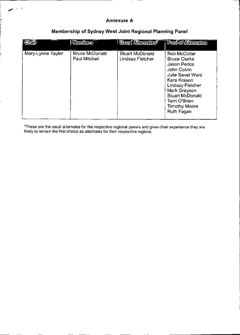
|
Ordinary Meeting of Council - 30 July 2013 |
GB.5 / 252 |
|
|
|
|
Item GB.5 |
S09605 |
|
|
9 July 2013 |
Proposed Reclassification of
1B Beaconsfield Parade and 19 Drovers Way, Lindfield (Woodford Lane Car Park)
to Operational Land following the Exhibition and Public Hearing Process
EXECUTIVE SUMMARY
|
purpose of report: |
To report back to Council on submissions received during the exhibition and public hearing into the proposed reclassification of the properties at 1B Beaconsfield Parade and 19 Drovers Way Lindfield, known as the Woodford Lane Car Park, from community land to operational land. |
|
|
|
|
background: |
A planning proposal was exhibited and a public hearing was held into the proposed reclassification of the subject properties. |
|
|
|
|
comments: |
This report provides feedback from the public exhibition and public hearing process and makes recommendations for Council’s consideration. |
|
|
|
|
recommendation: |
That Council proceed with the proposed reclassification of the subject properties to operational land. |
Purpose of Report
To report back to Council on submissions received during the exhibition and public hearing into the proposed reclassification of the properties at 1B Beaconsfield Parade and 19 Drovers Way Lindfield, known as the Woodford Lane Car Park, from community land to operational land.
Background
Site Information
The properties at 1B Beaconsfield Parade (Part Lot 1 DP 929131) and 19 Drovers Way (Lots 1-16 DP 1099330) are popularly known as the Woodford Lane Carpark. These properties are located on the western side of Lindfield which is bisected by the Pacific Highway and the Northern Railway Line. These properties total approximately 5,558sqm plus the area of Drovers Way itself which separates them. There is a total potential site area of approximately 6,500sqm if consolidated.
Records indicate that most of the properties were acquired between 1950 and 1951 and developed as car parking from the 1950s. Approximately 109 formal spaces are used for a combination of both short term and unrestricted parking spaces. The properties were recently rezoned from Special Uses 5(a) – Parking under the Ku-ring-gai Planning Scheme Ordinance 1971 to B2 Local Centre under Ku-ring-gai Local Environmental Plan (Local Centres) 2012 which was gazetted on 25 January 2013 and came into effect in February.
A site plan can be found at Attachment A1.
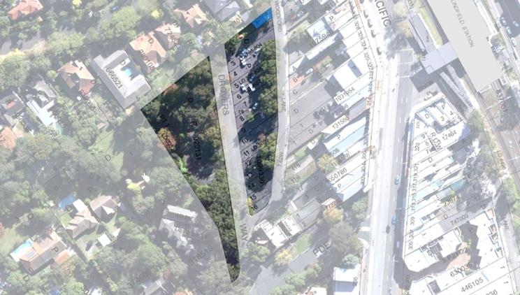
Picture caption: Aerial image showing 1B Beaconsfield Parade (Part Lot 1 DP 929131) and 19 Drovers Way (Lots 1-16 DP 1099330). Please note that Lot A DP 445535 (shown blue) is not in Council ownership and is not part of this planning proposal.
Planning Context
Following the gazettal of the Ku-ring-gai Local Environmental Plan (Local Centres) 2012 there is a need to commence the reclassification of Council land to facilitate revitalisation of the local centres as set out in the new local centres plan.
On 29 May 2012, as part of the $170 million investment in public transport infrastructure the NSW Premier, The Hon. Barry O’Farrell, and Minister for Transport, The Hon. Gladys Berejiklian announced the following projects for Ku-ring-gai:
· Lindfield: A car park with 240 additional spaces, new Kiss and Ride zone, estimated to cost $34 million; and
· Gordon: More than 160 additional spaces at two locations, upgrade of bus interchange, Kiss and Ride zone, estimated to cost $44 million;
Woodford Lane Car Park, Lindfield has been identified as the site for the proposed new commuter car park in Lindfield.
At the OMC of 26 June 2012 (GB9) Council considered a report recommending the reclassification of the Woodford Lane Carpark and resolved as follows:
Council Car Park - Woodford Lane, Lindfield - Reclassification
To have Council consider the reclassification of Council Car Park – Woodford Lane, Lindfield to Operational land.
Resolved:
(Moved: Mayor, Councillor J Anderson/Councillor Holland)
A. That a Planning Proposal be prepared, in accordance with section 55 of the Environmental Planning and Assessment Act, 1979, to reclassify Woodford Lane Car Park (1b Beaconsfield Parade & 19 Drovers Way), Lindfield - being Part Lot 1 DP929131 & Lots 1, 2, 3, 4, 5, 6, 7, 8, 9, 10, 11, 12, 13, 14, 15, 16 DP1099330 from Community land to Operational land either via an amendment the Ku-ring-gai Planning Scheme Ordinance (KPSO) or the draft Ku-ring-gai Local Centres LEP (2012)
B. That Council undertake a public hearing under the provisions of the Local Government Act, 1993 for the proposed reclassification of Woodford Lane Car Park (1b Beaconsfield Parade & 19 Drovers Way), Lindfield from Community land to Operational land.
C. That Council formally seek to discharge all interests for Woodford Lane Car Park (1b Beaconsfield Parade & 19 Drovers way), Lindfield - being Part Lot 1 DP929131 & Lots 1, 2, 3, 4, 5, 6, 7, 8, 9, 10, 11, 12, 13, 14, 15, 16 DP1099330.
D. That the Planning Proposal by submitted to the Department of Planning and Infrastructure for a Gateway Determination in accordance with Section 56 of the Environmental Planning and Assessment Act, 1979.
E. That upon receipt of a Gateway Determination, the exhibition and consultation process is carried out in accordance with the requirements of the Environmental Planning and Assessment Act, 1979 and with the Gateway Determination requirements.
F. That a report be brought back to Council at the end of the exhibition and public hearing processes.
G. That a further report be brought back to Council regarding the arrangements with Transport for NSW for the delivery of a commuter car park at Woodford Lane, Lindfield.
The Gateway Determination for the Planning Proposal was issued by the Department of Planning and Infrastructure (DP&I) on Thursday, 10 January 2013 with requirements for exhibition, agency consultation and conducting a public hearing which have been met. These matters are discussed in more detail in the consultation section of the report. The Planning Proposal was exhibited from 22 February 2013 to 22 March 2013 inclusive. A Public Hearing was held on Wednesday 12 June 2013. The independent Chairperson’s report was received by Council on 30 June 2013 and placed on Council’s website on Tuesday 2 July 2013. This report is presented in fulfilment of part F of Council’s resolution (above). In respect of part G of the resolution, Council has previously been presented reports on the commuter car park matter on 28 May 2013 and 26 February 2013.
Key points in relation to the progress of liaison with TfNSW are summarised as follows:
· Council has commenced the master planning process; the first Project Control Group (PCG) was on the 3 July 2013 and representatives from TfNSW attended the meeting along with Council staff;
· PCG adopted a draft Heads of Agreement as modified by the Council resolution of 26 February 2013;
· PCG also adopted a Terms of Reference for the project;
· consultant brief for a traffic network modelling has been issued to 6 consultants; and
· briefs for community facilities analysis and development feasibility modelling are currently under preparation.
The progression of the reclassification process of the Woodford Lane Carpark is a key part of this project.
Comments
The purpose of this report is to progress the reclassification of the subject properties as a key component of the bigger project. It should be noted that even with the reclassification of the subject properties, there will not be a consolidated parcel of land due to the current alignment of Drovers Way which essentially bisects the existing car park. All existing roads are classified operational and do not require a reclassification process.
Under the Local Centres LEP and associated DCP, it is proposed to realign Drovers Way along the western boundary of the subject site to intersect with Bent Street. The property at 12 Bent Street has recently been acquired for the fulfilment of this objective. The ultimate closing of the current Drovers Way is an entirely separate formally prescribed process under Part 4 of the Roads Act 1993 and will be commenced at the appropriate time with requisite consultation.
Governance Matters
The process outlined in this report complies with both legislative requirements and Council policy.
The Planning Proposal has been prepared and exhibited and a public hearing notified and conducted in accordance with the Environmental Planning and Assessment Act, 1979 and Local Government Act, 1993.
Risk Management
Council needs to make a decision to reclassify Woodford Lane Car Park, Lindfield to assist in attaining the best outcome in the delivery of the new commuter Car Park and any other associated land uses activities for the site.
The NSW State Government at this stage has not expressed an intention to formally compulsorily acquire the site to enable the commuter Car Park to be constructed. Moreover, they have expressed a willingness to work on a joint venture basis with Council to deliver the new infrastructure. It is therefore prudent that Council has identified and dealt with any restrictions or barriers that may impede the delivery of the infrastructure and/or any use of the residual of Council’s landholdings. This matter would be the subject of a separate report to Council.
The certificates of title show two restrictions on the site being:
· G820213 being an easement for drainage; and
· C130099 being a splay at the corner of Drovers Way and Beaconsfield Parade.
The easement of drainage is proposed to be retained. No record of any unregistered interest has been found.
Financial Considerations
The reclassification of the site would maximise Council’s ability to provide a wide range of facilities and services on the subject land, or in the event of compulsory acquisition, place Council in the best possible position to obtain the best the value for the community. Similarly, it would allow delivery of facilities on the site by way of private involvement through a Public-Private partnership or similar.
Social Considerations
The reclassification of this site will assist Council in its dealings with TfNSW for the delivery of additional public transport infrastructure for Lindfield.
It should be noted that a common theme among the submissions related to the opportunity to combine with TfNSW to deliver a master planned community hub.
Environmental Considerations
The planning proposal for the reclassification of Woodford Lane Car Park, Lindfield will not result in any additional environmental effects to those considered during the preparation of the Local Centres LEP. Any future development of the site will be subject to separate proposals and reports. A Phase I Preliminary Environmental Site Investigation was undertaken for Transport for NSW (TfNSW) in November 2012, which was provided to Council and exhibited as part of the proposed reclassification. The report concluded that, consistent with use as a car park since the 1950s/60s preceded by residential and commercial use, potential contamination could include asbestos containing materials (the presence of building materials embedded in the car park surface was specifically noted), heavy metals, PAHs, TPHs, OCPs and OPPs (being chemical groups listed on page 23 of the report); the sources of contamination being past uses, presence of fill material, presence of surrounding roads and stormwater run-off. A Phase II Detailed Site Contamination Investigation was recommended which is currently under commission by TfNSW.
Community Consultation
The planning proposal (Attachment A2) was exhibited from 22 February 2013 to 22 March 2013 inclusive, notified by advertisements in the North Shore Times and by letters to adjoining and nearby property owners.
The exhibition period gave rise to a total of six submissions which have been separately circulated to Councillors.
One submission supported the concept of placing the proposed Carpark underground and using the area above for a useable space for all the people of Lindfield with possible community facilities – rather than an ugly above ground car park.
One submission objects to any loss of car parking that has served residents for over 40 years allowing access to the shops and emphasising that it is often full.
One submission from a business owner fronting the Pacific Highway, emphasised that the current number of car parking spaces is absolutely critical to the viability of businesses fronting the Pacific Highway and that, in the event of any redevelopment, the number of spaces should be at least maintained and, preferably, increased.
One submission objects to the future sale of the land for future development on the basis that it will not serve the public interest, citing the example of the reduction in car parking on the private Westfield Chatswood site from 3 hours to 2 hours despite Council and public objection. The writer argues that he cannot see how the public interest can be protected. The writer is also concerned that Council and the public would not achieve fair value for the site in view of the proposal for a commuter car park and community facilities limiting other development potential.
One submission argues that a commuter car park does not represent the highest and best use of the land and requests Council to bring forward a master plan for the site incorporating highest and best uses as well as a commuter car park as well as other improvements around the site.
Support Lindfield submitted a copy of the PowerPoint presentation previously provided to Councillors, arguing for an underground car park together with a civic/open space and the potential for modern community facilities as well as linkages to the Pacific Highway and, thence the railway station.
Following notification of the public hearing for this and two other sites to be held concurrently, one generic objection was received via Council’s website opposing all reclassifications undertaken for the purposes of raising money without any specific reference to the circumstances of this particular site. It was submitted in respect of the notification of the public hearing and did not distinguish between the three sites for which the Public Hearing was held that night.
The Public Hearing was held on Wednesday, 12 June 2013 following statutory notification in the North Shore Times and by letters/emails to persons who made submissions. In addition to Council, there was one speaker at the Public Hearing for this site from the local residents’ group Support Lindfield. The independent Chairperson’s report was received by Council on Sunday 30 June 2013 and uploaded to Council’s website on Tuesday 2 July 2013. It can be found at Attachment A3 (please note that the report also includes two other properties for which a Public Hearing was also held that night however these properties are part of the Draft Ku-ring-gai Local Environmental Plan 2013 process and will be reported as part of that matter).
The Chairperson for the Public Hearing, after considering all written submissions and oral submissions, prepared a report on the matter which is attached. He concluded that reclassification of the land to operational would allow Council to enter into negotiation to achieve the multi-faceted objectives for the site. He recommended that:
1. Negotiations and any future contracts with TfNSW, and others, retain the required ‘line of site’ to the achievement of the outcomes sought from the Lindfield Community Hub, and Council document protocols for achieving this.
2. The reclassification of 1B Beaconsfield Parade and 19 Drovers Way Lindfield (Part Lot 1 DP 929131 and Lots 1-16 DP 1099330) to operational land is supported conditional on the above.
Agency consultation was also undertaken in accordance with the Gateway determination (Attachment A4). Letters were sent to: State Transit Authority; Roads and Maritime Services (RMS); Sydney Water Corporation; Energy Australia; Transport for NSW; Lifetime Care and Support Authority of NSW; NSW Department of Family & Community Services (Housing); NSW Department of Education & Communities; NSW Health Department; and Railcorp. These have been separately circulated to Councillors along with the community submissions.
Responses were received from the following agencies.
Roads and Maritime Services (RMS) which raised no objection.
Transport for NSW/State Transit Authority (aka Sydney Buses) which advised that they did not run buses in the area and that TfNSW would be better placed to comment;
Sydney Water which advised that as the subject site is not of significant size and the proposed rezoning of Operational Land will have a limited impact on future capacity, we have no specific comments. However, any future Development Application for site and Drovers Road must be referred to Sydney Water for review, as a Sydney Water wastewater main traverses the site;
Ausgrid which noted some of their infrastructure in the area and that changes might be required as a result of any future changes permitted by the reclassification;
Lifetime Care and Support Authority of NSW who were somewhat mystified as to the reasons for their inclusion in the consultation process as they own no properties in the vicinity and are an agency concerned with assisting people who have been injured to get on with their lives on a practical level. During a telephone discussion, the agency representative was assured that consideration for access for mobility impaired persons would certainly be an essential part of the design process for any community infrastructure on the site. Additional comment: provision for access and mobility at the design stage is a core obligation of Council both legally under the Disability Discrimination Act and as a component of all Council DCPs that relate to design including the now adopted Ku-ring-gai Local Centres DCP.
Internal Consultation
This report was prepared by the Strategy & Environment Department in consultation with staff from other Departments where relevant.
Summary
Council’s car park at Woodford Lane, Lindfield has been identified by TfNSW for a new commuter car park. Council is undertaking a master planning exercise for this site in consultation with TfNSW; a matter which was the subject of a report to Council on 28 May 2013.
The reclassification of these sites to operational land is required to facilitate the delivery of this new public transport infrastructure and associated community infrastructure. Any future divestment, leasing arrangements or agreements such as joint venture for the land between Council and any other party would be the subject of a separate process and reported to Council at the appropriate time.
The achievement of a consolidated site for this future vision also depends on the future closure and realignment of Drovers Way for which the property at 12 Bent Street Lindfield has been acquired. This will require the instigation of a road closure process at the appropriate time. Council should also resolve to allow Council staff to commence the preliminary work for this process in a timely manner.
This report recommends that the reclassification from community to operational land of 1B Beaconsfield Parade and 19 Drovers Way Lindfield (Part Lot 1 DP 929131 and Lots 1-16 DP 1099330) also known as ‘the Woodford Lane car park’ be approved and proceed to the next stage.
|
A. That Council adopt the Planning Proposal for the reclassification of the properties at 1B Beaconsfield Parade (Part Lot 1 DP 929131) and 19 Drovers Way (Lots 1-16 DP 1099330) known as ‘the Woodford Lane Car Park’ from community land to operational land status inclusive of the extinguishment of any trusts applicable to the land.
B. That the Planning Proposal be submitted to the Minister in accordance with Section 58 of the Environmental Planning & Assessment Act, 1979.
C. That all persons who made submissions in respect of the proposed reclassification of these properties, the subject of this report, be notified of Council's decision.
D. That the other two properties considered at the Public Hearing and included in the Chairpersons report be reported to Council as part of the Draft Ku-ring-gai Local Environmental Plan 2013 process.
|
|
Kate Paterson Infrastructure Co-ordinator |
Antony Fabbro Manager Urban & Heritage Planning |
|
Andrew Watson Director Strategy & Environment |
|
|
A1View |
Location Map |
|
2012/141660 |
|
|
|
A2View |
Planning Proposal as Exhibited |
|
2013/082699 |
|
|
A3View |
Public Hearing Report |
|
2013/172844 |
|
|
A4View |
Gateway Determination for 1B Beaconsfield Parade and 19 Drovers Way Lindfield |
|
2013/041683 |
|
APPENDIX No: 4 - Gateway Determination for 1B Beaconsfield Parade and 19 Drovers Way Lindfield |
|
Item No: GB.5 |
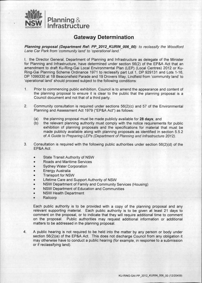
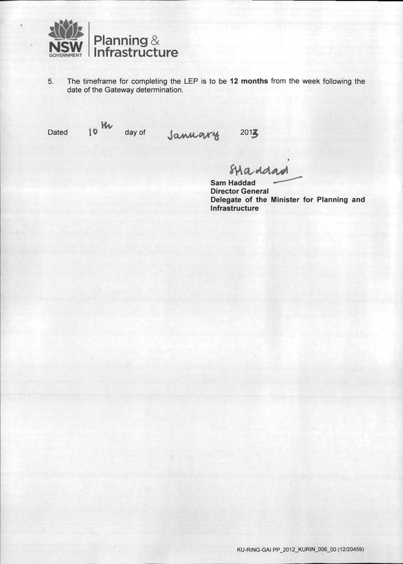
|
Ordinary Meeting of Council - 30 July 2013 |
GB.6 / 318 |
|
|
|
|
Item GB.6 |
S06788 |
|
|
2 July 2013 |
Independent Pricing and Regulatory Tribunal (IPART) - Section 508 (A) - Special Variation Application - Infrastructure Levy
EXECUTIVE SUMMARY
|
purpose of report: |
To seek Council’s endorsement to apply for a Special Rate Variation under Section 508(A) of the Local Government Act. |
|
|
|
|
background: |
Council was recently advised of a one year extension to the Infrastructure Levy under Section 508(2) of the Local Government Act. This levy ceases on 30 June 2014. |
|
|
|
|
comments: |
The purpose of applying for a Special Variation under Section 508(A) is to assist with the funding of Council’s assets in order to help reduce the backlog in bringing Council’s assets up to a satisfactory standard. |
|
|
|
|
recommendation: |
That Council apply to the Independent Pricing and Regulatory Tribunal for a Special Rate Variation under Section 508(A) of the Local Government Act. |
Purpose of Report
To seek Council’s endorsement to apply for a Special Rate Variation under Section 508(A) of the Local Government Act.
Background
Council has been successful in its applications for a special rate variation for infrastructure assets in 2001, 2006 and 2013. The purpose of the special variation is to assist with the funding of much needed road works to help bring the standard of Council’s roads to a satisfactory standard. Based on current calculations, there is backlog for Council’s roads of approximately $80 million. The backlog is based on those roads that have a condition rating less than fair and the estimated cost to return these roads to a good standard.
Council was recently advised by the Independent Pricing and Regulatory Tribunal (IPART) of a one year extension to the Infrastructure Levy under Section 508(2) of the Local Government Act.This levy ceases on 30 June 2014.
However, in the recent application, Council sought a five (5) year extension of the Infrastructure Levy but was advised that only one year would be granted due to the need to undertake broader consultation with the whole community. Also, the guidelines specifically require Council to include in the Delivery Program that Council is planning to apply for a Special Variation Levy so the community can make comment about Council’s intention to apply for a levy given the Delivery Program is advertised to the community for the statutory 28 day period.
Comments
In Council’s current Delivery Program, it was clearly stated in the General Manager’s introduction and further throughout the document and also the Resourcing Strategy that Council will be applying for a Special Rate Variation under Section 508(A) of the Local Government Act. In particular to this matter, there were no public submissions or objections to Council applying for the levy.
The purpose of applying for a Special Variation under Section 508(A) is to assist with the funding of Council’s assets in order to help reduce the backlog in bringing Council’s assets up to a satisfactory standard.
Section 508(A) of the Local Government Act provides for Council to receive a Special Rate Variation in perpetuity and this will assist in closing the gap on all of Council’s assets.
Council currently receives around $2.6 million per year from the Infrastructure Levy. These funds are fully allocated to roads.
Council has completed all its integrated planning documents and Asset Management Plans. The current stated backlog is approximately $208 million as at 30th June 2013. Consequently, it is proposed to apply for a Section 508(A) Special Rate Variation to provide funding for all of Council’s assets.
Whilst further work is required to be done on some of the Asset Management Plans, the contents and conclusion are sufficient for Council to justify the need for a Special Rate Variation.
Governance Matters
For Council to apply for a Special Rate Variation, it needs to be transparent in its application to IPART and indicate that the application has received support from the broader community.
The IPART guidelines for the application for a Special Rate Variation are included on the IPART web site. Council is required to comply with the guidelines before consideration can be given to the application.
Risk Management
The risk of Council not receiving the levy of approximately $2.6 million per year for Council’s assets will either result in a deterioration of its assets or a significant reduction in the other services provided by Council.
Financial Considerations
Council in its Delivery Program, Resourcing Strategy and Long Term Financial Plan has indicated the need to provide additional funding for Council’s assets. These documents include the assumption the levy will continue in perpetuity.
Social Considerations
The condition of Council’s assets is a significant matter for the community as the users of Council’s infrastructure and facilities. It is important Council strives to deliver quality assets for the community.
Environmental Considerations
Inherent in all of Council’s assets is the need to consider the environment. Prior to any Capital Works being undertaken, a Review of Environmental Factors or a Project Impact Statement is carried out to assess any environmental impacts.
Community Consultation
It is proposed to undertake extensive consultation with the community on the need for a levy prior to submitting an application to IPART under Section 508(A) of the Local Government Act.
It is proposed to develop a consultation strategy and engage with IPART on the proposed strategy to seek their concurrence.
Internal Consultation
An application for a Section 508(A) involves input from a number of departments from Corporate, Community, Strategy and Operations.
Summary
Council was recently advised by the Independent Pricing and Regulatory Tribunal (IPART) of a one year extension to the Infrastructure Levy under Section 508(2) of the Local Government Act. This levy ceases on 30 June 2014.
The purpose of applying for a Special Variation under Section 508(A) is to assist with the funding of Council’s assets in order to help reduce the backlog in bringing Council’s assets up to a satisfactory standard.
Section 508(A) of the Local Government Act provides for Council to receive a Special Rate Variation in perpetuity. This will assist in closing the gap on all of Council’s assets.
Council currently receives around $2.6 million per year from the Infrastructure Levy. These funds are fully allocated to roads.
Council has now completed all its integrated planning documents and Asset Management Plans. The current stated backlog is around $167 million. Consequently, it is proposed to apply for a Section 508(A) Special Rate Variation to provide funding for all of Council’s assets.
|
That Council apply to the Independent Pricing and Regulatory Tribunal for a Special Rate Variation under Section 508(A) of the Local Government Act.
|
|
Greg Piconi Director Operations |
|
|
Ordinary Meeting of Council - 30 July 2013 |
GB.7 / 322 |
|
|
|
|
Item GB.7 |
S02585 |
|
|
17 July 2013 |
Roads and Maritime Services - Regional Road Block Grant Funding for 2013/2014
EXECUTIVE SUMMARY
|
purpose of report: |
To advise Council of the Roads and Maritime Services funding program for 2013/2014 and adopt the various grants as provided by the Roads and Maritime Services. |
|
|
|
|
background: |
In September 2012, Council submitted a list of projects for the 2013/2014 Roads and Maritime Services (RMS) program seeking funding for various projects. |
|
|
|
|
comments: |
By letter dated 15 July 2013, the Roads and Maritime Services advised Council of the approved grants for the various programs for 2013/2014. |
|
|
|
|
recommendation: |
That Council accept the grants for the various programs except the Traffic Facilities Block Grant for 2013/2014. |
Purpose of Report
To advise Council of the Roads and Maritime Services funding program for 2013/2014 and adopt the various grants as provided by the Roads and Maritime Services.
Background
In September 2012, proposals were submitted to the Roads and Maritime Services (RMS) for grant funding of various road and cycleway projects for the financial year 2013/2014.
Under the current Memorandum of Understanding, the Roads and Maritime Services (RMS) requires advice of acceptance of the grants by 1 September 2013.
In the past, Council has resolved to accept the Repair Program Grant, the Block Grant Roads and the Supplementary Grant but has not accepted the Traffic Facilities Block Grant as it does not provide sufficient funds for the requirements of this service. The acceptance of this grant would require Council to provide resources to undertake traffic facilities work. As consequence, the RMS will be required to continue its existing traffic facility services to Council.
Comments
On 15 July 2013, Council was advised by the RMS of the proposed grants for 2013/2014 and a copy of the letter from the RMS is attached.
The projects approved by the RMS for grants are as follows:
Bicycle and Pedestrian Component
· Dumaresq Street, Gordon – On road cycleway $17,000.
· Gordon and St Ives – On road cycleway $53,000
· Killara 2 – On road cycleway $13,000
All the above projects are in accordance with Council’s Bike Plan. Matching funds are available through the Environmental Levy.
Regional Road Repair Program Component
Council has received a grant for the rehabilitation of regional roads being $150,000 for Link Road from Mona Vale Road St Ives and also $150,000 for The Comenarra Parkway from Doncaster Avenue to Evans Road, Turramurra.
The acceptance of this grant is recommended and no adjustment of the Roads Program is required. Matching funds are provided in the roads budget.
Block Grant Traffic Facilities Component
Council has been offered a grant of $329,000 for Traffic Facilities for 2013/2014. Council has not previously accepted the Traffic Facilities component of the Block Grant. Community perception is that the maintenance of traffic facilities infrastructure is a Council responsibility, but this work is currently the responsibility of the RMS on both regional and local roads. Funds available under this component are currently administered and expended by the RMS on Council’s behalf.
The RMS believes Council should accept responsibility for facilities on local roads and will not fund Local Area Traffic Management Schemes or facilities it considers non-essential.
By accepting this grant, Council would be accepting full responsibility for the maintenance of all road markings and signage on both regional and local roads. Council has contended that the grant offered is inadequate, that the existing infrastructure is still degraded and that the RMS should upgrade the facilities before Council accepts responsibility for their maintenance. Council would need to employ additional staff to undertake this work and investment in suitable equipment.
While 31 of the 41 Councils in the Sydney region have accepted the grant, some of these Councils consider the allocated funds insufficient to maintain facilities on local and regional roads in their areas.
Council was previously advised that the funds required to bring its traffic facilities up to a satisfactory standard was $2,355,144 and the annual expenditure required to maintain the standard is $589,274.
Funds allocated to Councils that do not accept the grant are pooled. Each Council is allowed to draw from the pool until funds are exhausted. It is considered that this arrangement does not materially affect Councils such as Ku-ring-gai whose past grants have been inadequate. This has been demonstrated in previous years by Council’s allocation being fully expended early in the new financial year. By submitting a significant number of work requests early in recent financial years, Ku-ring-gai has received more than its share of pooled funds.
It is recommended Council not accept the Traffic Facilities component from the Block Grant for 2013/2014 and continues to monitor the impact of any changes when work has been assigned to the RMS.
Block Grant Roads Component
The RMS provides this component of the Block Grant to assist with maintenance of regional roads. In 1996, the RMS adopted a distribution formula to determine the allocation of funds amongst the 41 Councils in the Sydney region. The formula takes into account heavy traffic, traffic volume, and pavement area based on the length of regional roads and number of lanes.
Since then the Regional Roads component has increased annually and for 2013/2014 is $229,000.
It is proposed to use the Block Grant and the Supplementary Grant for heavy patching on the following regional roads in 2013/2014:
§ Eastern Arterial Road
§ Bobbin Head Road
§ Eastern Road
§ Burns Road
§ The Comenarra Parkway
Acceptance of this component of the Block Grant for 2013/2014 is recommended.
Block Grant Supplementary Road Component
This was formerly known as the ex 3x3 component of the Block Grant. The grant of $82,000 is the same as that provided in previous years. These funds are available for any roadwork on regional roads as determined by Council. It has been the practice to use these funds for maintenance on Regional Roads.
Acceptance of this component for Supplementary Roads from the Block Grant for 2013/2014 is recommended.
Governance Matters
The acceptance of these grants will require an adjustment of a couple of programs and projects but will not require re-exhibition of the Delivery Program and Operational Plan as the projects are supplementary to the exhibited program.
Risk Management
The risk management consideration will relate to the estimated costs as some of the estimates were prepared without detailed plans. Any adjustments in estimates will be reported to Council as part of the budget quarterly review process.
Financial Considerations
Acceptance of the RMS grants requires an equal contribution from Council totalling $383,000. As Council was advised that it was likely to receive this grant in April 2013, the projects were included in the Delivery Program and no adjustment to the project program is required.
Social Considerations
The upgrade to roads and traffic facilities is intended to improve road safety and road condition. This will improve the condition of Council’s assets which help to prevent accidents and vehicle damage for users of Council’s roads.
Environmental Considerations
Environmental management measures are incorporated in designs and construction practices.
Community Consultation
Most of the proposed works covered by the RMS grants have been included in the current Delivery Program and Operational Plan. A number of these projects have been discussed with the community and included in the report on the nominations.
Internal Consultation
Consultation has taken place with Council’s Corporate and Strategy Departments with regard to funding sources.
Summary
In September 2012, Council submitted a list of projects for the financial year 2013/14 in the RMS program areas. A letter was received on 15 July 2013 from the RMS advising of Council’s component of the 2013/2014 State Roads Budget as $1,023,000.
The grants are provided annually and formal advice of acceptance is required by 1 September 2013.
It is recommended Council accept the Regional Roads Repair Program grant of $300,000 and the Bicycle and Pedestrian Program grant of $83,000. The funding is conditional upon Council matching most of these funds on a dollar for dollar basis and completing the work by 30 June 2014.
The RMS provides funds to assist Council with the maintenance of regional roads. The Block Grant has a Traffic Facilities component of $329,000, a Roads component of $229,000, and a Supplementary Roads component of $82,000.
Council has previously accepted the Roads component and the Supplementary Roads component of the Block Grant. Council has not previously accepted the Traffic Facilities component.
|
A. That Council accepts the grant offer of $83,000 for the Bicycle and Pedestrian Programs.
B. That Council accepts the grant offer of $300,000 for the Regional Roads Upgrade Program.
C. That Council accepts the Roads Component of $229,000 and the Supplementary Road Component of $82,000 of the Regional Roads Block Grant for 2013/2014.
D. That Council not accept the Traffic Facilities Component of the Regional Road Block Grant for 2013/2014 and continues to use RMS resources to carry out traffic facilities.
|
|
Greg Piconi Director Operations |
|
|
A1View |
Roads & Maritime Services - 2013/2014 Program Funding |
|
2013/181964 |