|
APPENDIX No: 1 - Letter from Department of Planning and Infrastructure - Hardware and Building Supplies in Pymble Business Park |
|
Item No: GB.10 |
Ordinary Meeting of Council
TO BE HELD ON Tuesday, 10 December 2013 AT 7.00pm
Level 3 Council Chambers
Agenda - BOOK 2 and LATE ITEMS
** ** ** ** ** **
NOTE: For Full Details, See Council’s Website –
www.kmc.nsw.gov.au under the link to business papers
minutes from the Mayor
LATE ITEM
MM.3 Excellence in the Environment Awards and Institute of Landscape Architects Awards 7
File: S09362
Ku-ring-gai Council received a number of significant accolades this week.
On 3rd December Local Government NSW held its annual Excellence in the Environment Awards recognising outstanding achievements by local government in managing and protecting the environment. Council was successful in Division C – Climate Change Action Awards for its Building Climate Wise Communities project. The project then took out the Overall Winner for 2012/2013.
The Climate Wise Communities Program focusses on fostering shared responsibility, integrating with Council’s Emergency Management Plan and collaborating with emergency management agencies.
Council also developed a multi-hazard assessment tool that means residents can review their vulnerability to severe weather events at a personal, property and neighbourhood level. This tool helps people determine what action needs to be taken in case of bush fire, storms, heat stress and drought.
On 5th December the Australian Institute of Landscape Architects NSW (AILA) held its Awards in Landscape Architecture. Council took out the Research and Communication category with 'Thinking Outside The Box' Key Design Elements for Apartments in Ku-ring-gai’ and the Planning category for the ‘Ku-ring-gai Open Space Acquisition Program’.
The Open Space Acquisition Program in particular builds on years of policy development, contributions planning, site identification and acquisition and ultimately design and construction involving staff from across Council as well as Council and the community.
OSAP provides much needed parkland to the community. Ku-ring-gai Council has been acquiring land at an unprecedented rate, spending $33.4 million on acquiring 14,700 m2 of land for new parks and civic spaces in Gordon, Killara, Turramurra, St Ives and Wahroonga since 2007.
Once complete, OSAP will deliver 10 new local parks and civic spaces within close proximity to high density residential areas in Ku-ring-gai.
The other AILA award for Research and Communication was for ‘Thinking outside the Box’: Key Design Elements for Apartments in Ku-ring-gai.
To improve residential apartment building design outcomes in Ku-ring-gai, Council created an impressive publication, ‘Thinking Outside The Box’, published in 2011. The booklet highlights examples of well-designed local buildings and provides advice on how good design principles can be applied.
Thinking Outside the Box promotes awareness of well-designed buildings in Ku-ring-gai that are responsive to community expectations and landscape character. It also aims to improve the standard of site planning and design by showcasing a range of good local examples in a landscape setting.
In some cases these awards reflect many years of ground breaking work by staff and are a credit to Council.
Petitions
LATE ITEM
PT.1 Petition to Implement Effective Means to Curtail Dangerous Speeding along Park Avenue, Roseville – (One Hundred and Three [103] Signatures 9
File: TM8/05
The following Petition was presented by Councillor David Armstrong:
“We, the undersigned residents, here by submit a petition to Ku-ring-gai Council for the implementation of an effective means to curtail the proven prevalence of excessive and dangerous speeding along Park Avenue, Roseville.
We believe that the painting of line markings will NOT resolve the current speeding issue.
The speeding issue is largely to do with accessing Babbage Road from Archbold Road. The topography of Park Avenue - unlike surrounding streets - makes speeding highly dangerous. A line down the centre of the street will only embolden drivers to speed more so in the knowing that any unsighted oncoming traffic will now be keeping to its side of the road.
We demand that an alternative be implemented as soon as possible and we request that you ensure that your staff continue to work toward finding a n effective means to curtail this situation which poses a danger to all residents, pedestrians and drivers.”
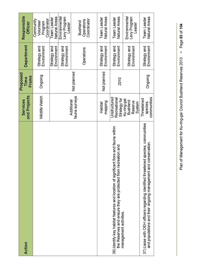
LATE ITEM
PT.2 Petition to STOP Culworth Avenue Car Park being SOLD for High Rise Residential Development by Council – (One Thousand, Eight Hundred and Forty-Three [1,843] Signatures) 10
File: S09768
The following Petition was presented by Councillor David Citer:
“We, the undersigned, residents of Ku-ring-gai [and commuters] strongly oppose Council’s planned rezoning/reclassification of 20 to 28 Culworth Avenue. This will result in high rise residential development within a local heritage conservation area and the loss of 204 commuter car park spaces at Killara Station within a large area of declared biologically significant open space.”
BOOK 2 AGENDA ITEMS
GENERAL BUSINESS
i. The Mayor to invite Councillors to nominate any item(s) on the Agenda that they wish to have a site inspection.
ii. The Mayor to invite Councillors to nominate any item(s) on the Agenda that they wish to adopt in accordance with the officer’s recommendation allowing for minor changes without debate.
GB.10 Planning Proposal to include 'Hardware and Building Supplies' in the B7 Zone under the KPSO 11
File: S09781
For Council to consider a planning proposal to amend the Ku-ring-gai Planning Scheme Ordinance (KPSO) to permit ‘hardware and building supplies’ as a use permissible with consent within the B7 – Business Park zone.
Recommendation:
That the Planning Proposal to amend the KPSO to include ‘hardware and building supplies’ as a permissible land use with development consent in Zone B7 (Business Park) be supported in principle, subject to amendments and be forwarded to the DP&I for a Gateway Determination and that upon receipt of a gateway determination, the exhibition and consultation process is carried out and a report be brought back to council at the conclusion of the exhibition period.
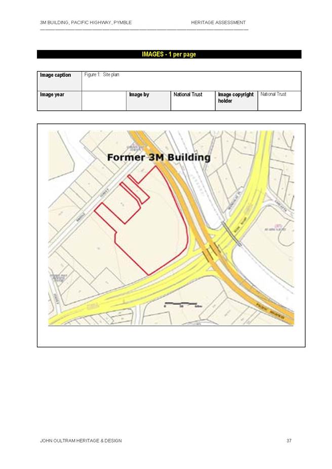
GB.11 Heritage Assessment of Former 3M building at 950 Pacific Highway, Pymble 61
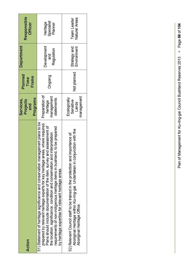
File: S09781
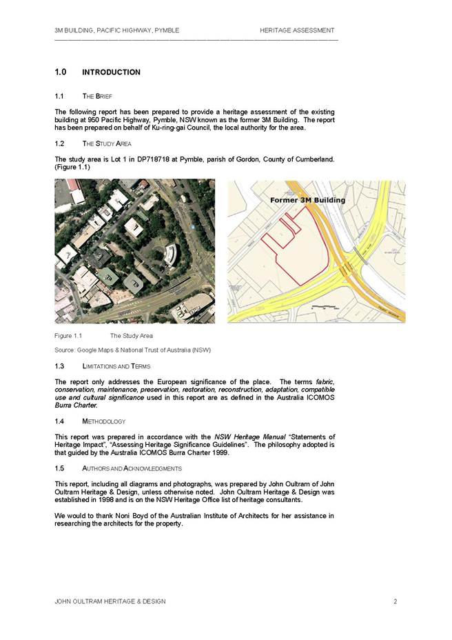
To consider the heritage significance of the former 3M Building at 950 Pacific Highway, Pymble.
Recommendation:
That Council prepares a Planning Proposal to list 950 Pacific Highway, Pymble as an item of Local heritage significance as an amendment to the draft KLEP 2013.
GB.12 St Ives Shopping Village 125
File: S09318
To consider a proposal from EK Nominees Pty Limited in relation to future planning and redevelopment of the St Ives Shopping Village.
Recommendation:
That Council commences the process of reclassification for 3 parcels of land: the Council car park known as 176 Mona Vale Road; Village Green Parade (which includes a Council car park, St Ives Library, St Ives Early Childhood Centre and St Ives Neighbourhood Centre); and the Council car park known as 11-21 Cowan Road, St Ives.
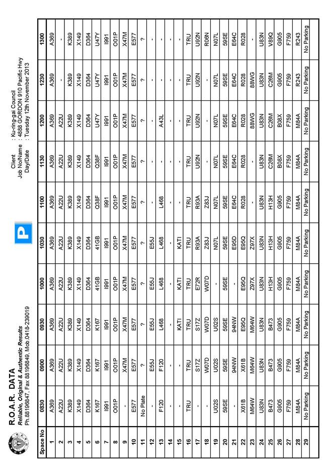
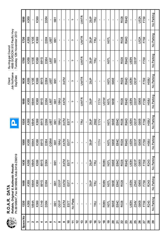
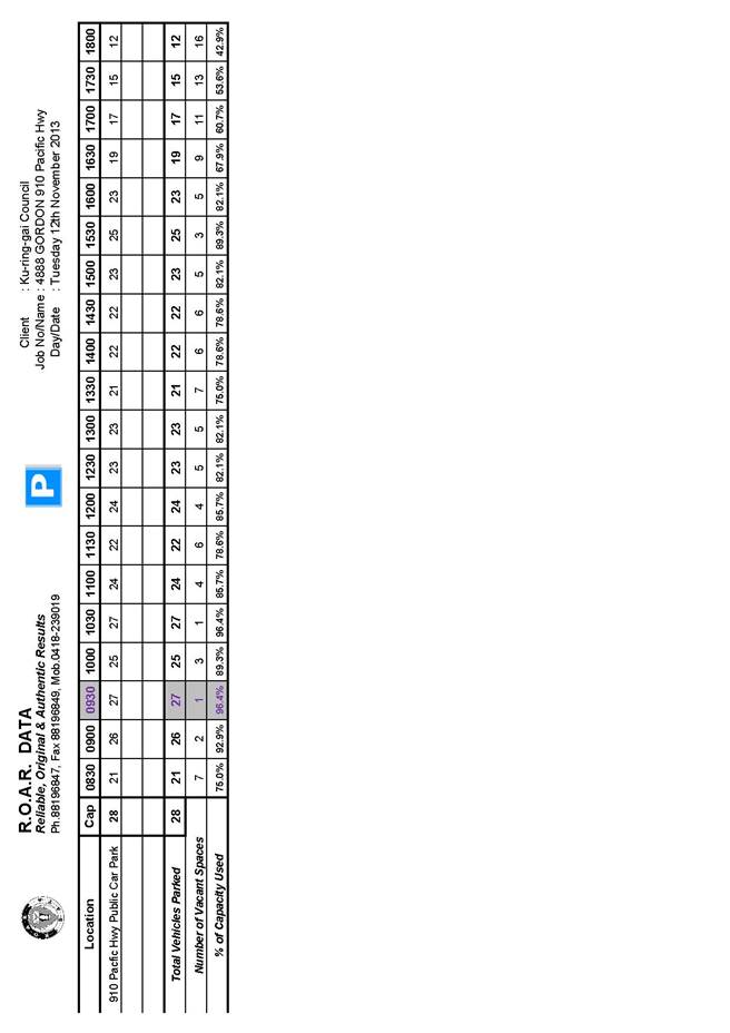
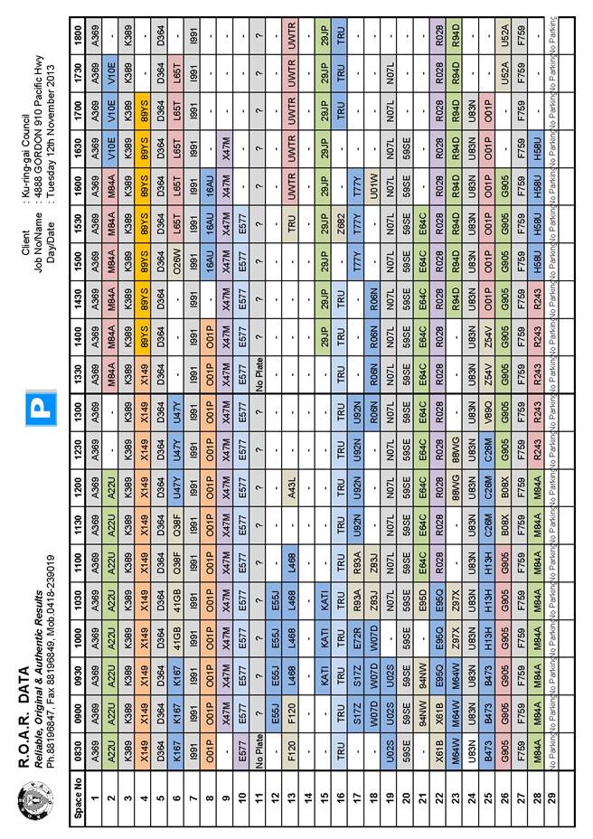
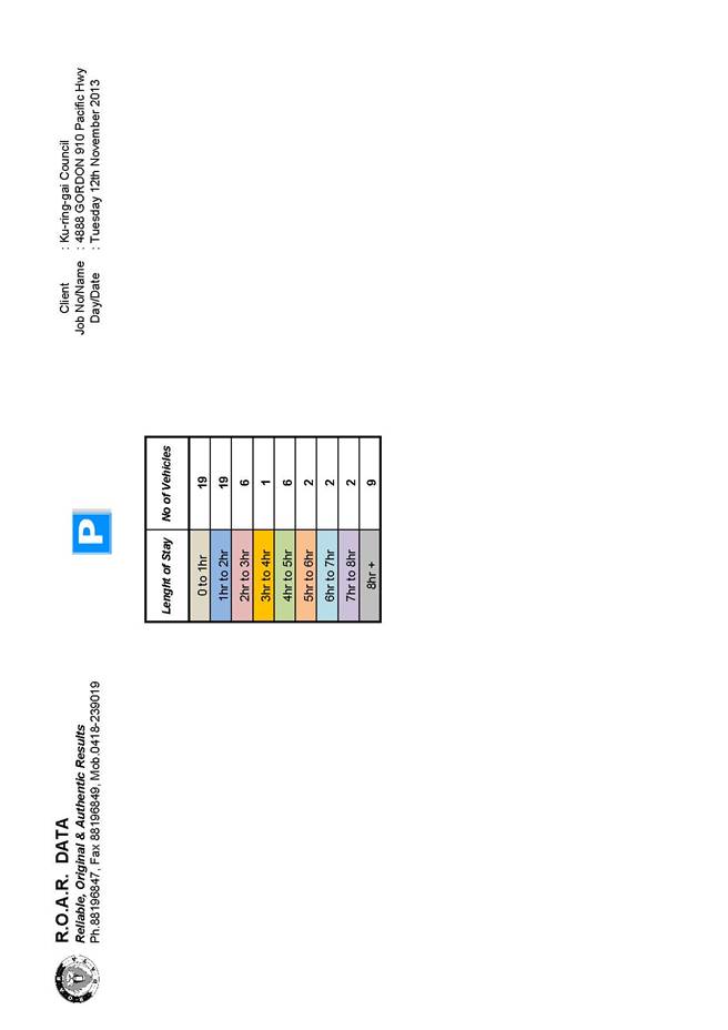
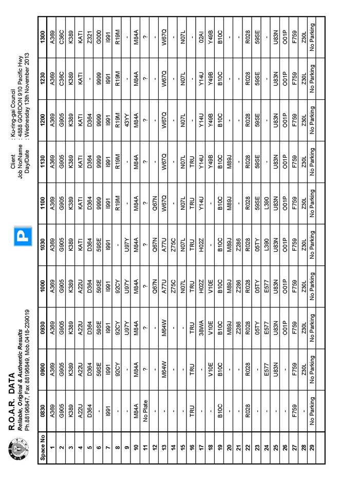
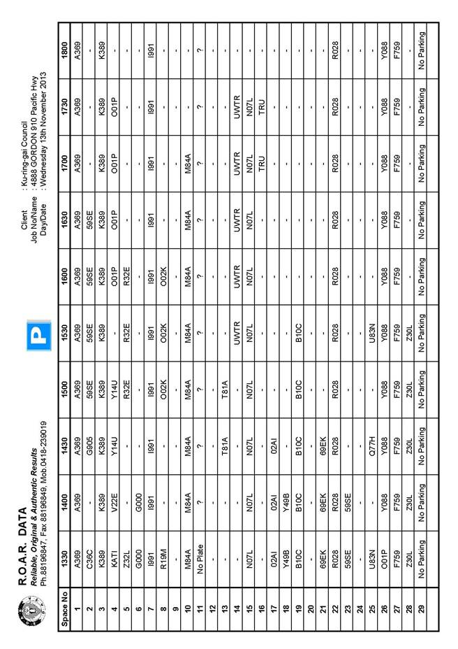
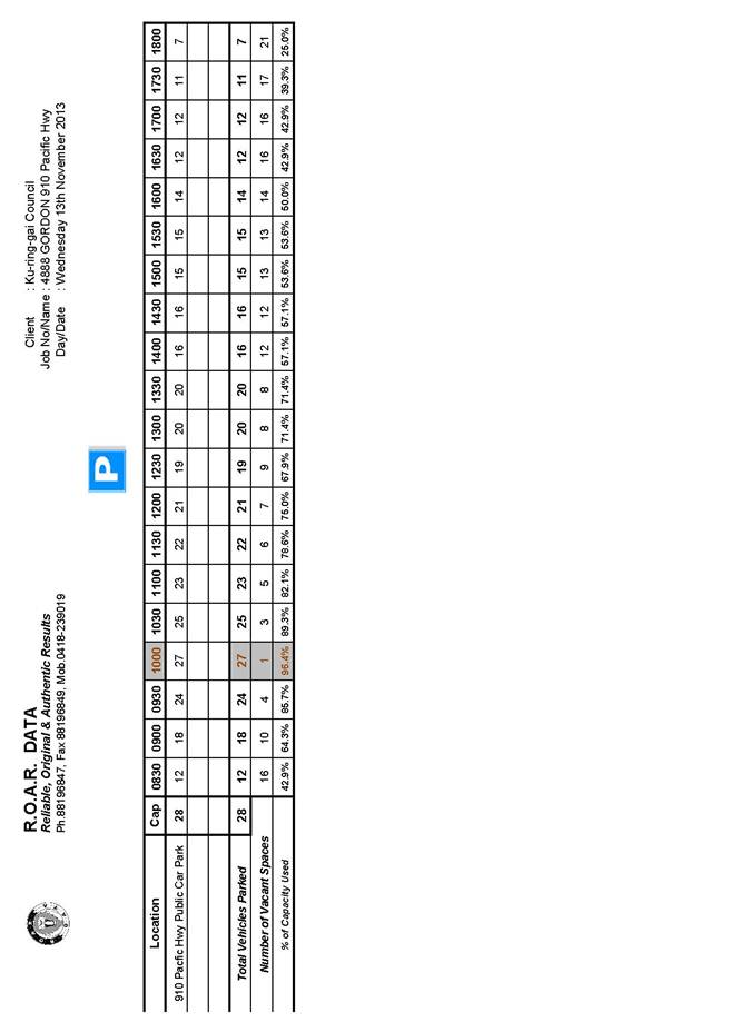
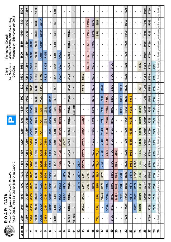
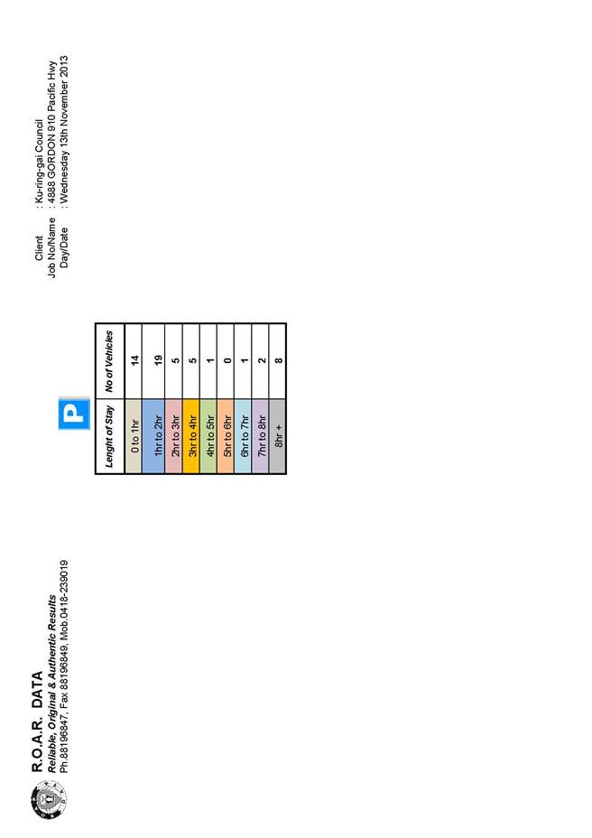
GB.13 910 Pacific Highway, Gordon - Public Car Park 147
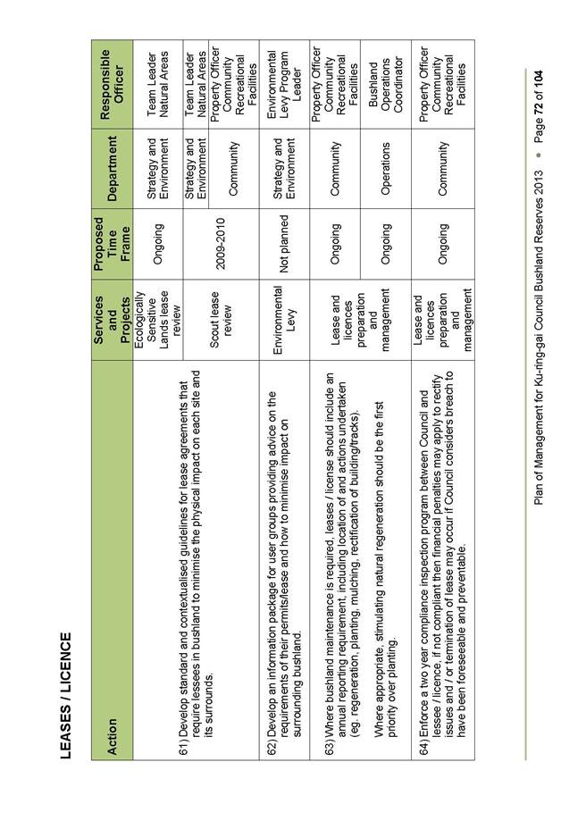
File: S07252/4
For Council to consider the surrender of a lease of a public car park in a private property at 904 -914 Pacific (AKA 910 Pacific) Highway, Gordon.
Recommendation:
That the General Manager is delegated to negotiate Council’s requirements including compensation for the surrender of lease of the public car park at 904 -914 Pacific (AKA 910 Pacific) Highway, Gordon.
GB.14 828 Pacific Highway, Gordon - Design, Refurbishment and Fit-out - Select Tender 248
File: S09905
To advise Council of the Expressions of Interest (EoI) received for the design, refurbishment & fit-out of 828 Pacific Highway, Gordon and to seek approval to call select tenders from the recommended shortlist in this report.
Recommendation:
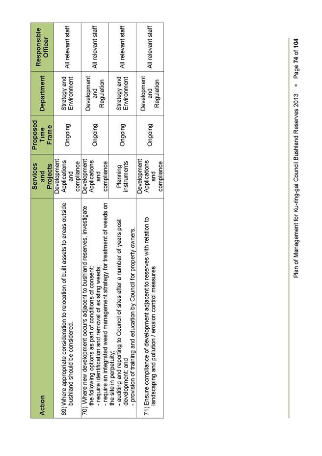
That Council delegates authority for the Mayor and General Manager to accept the preferred shortlist for select tender for the design, refurbishment & fit-out of 828 Pacific Highway, Gordon and approves the calling of select tenders from those companies nominated by the Mayor and General Manager for the design, refurbishment & fit-out of 828 Pacific Highway, Gordon.
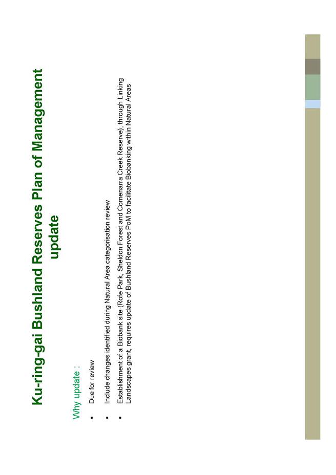
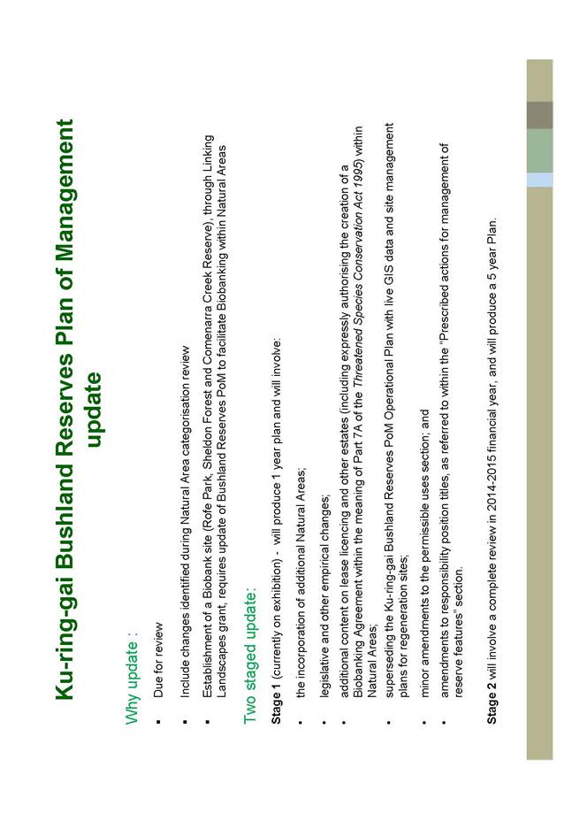
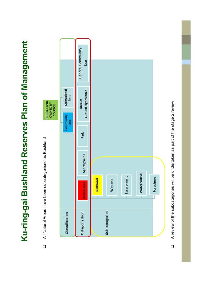
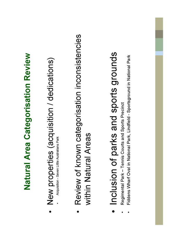
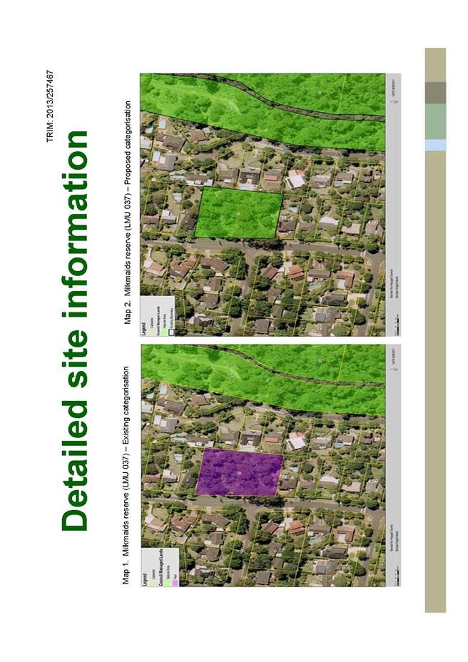
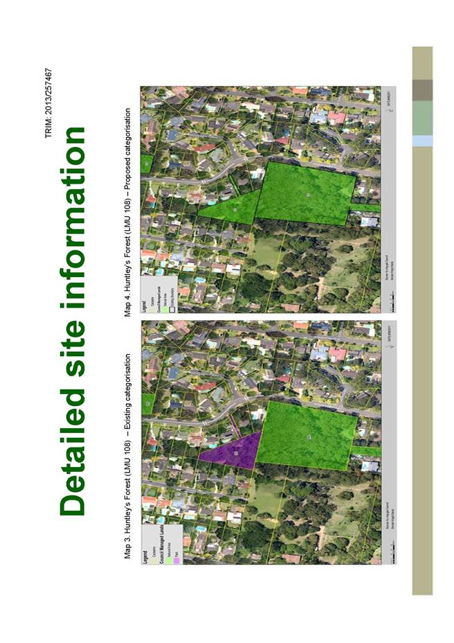
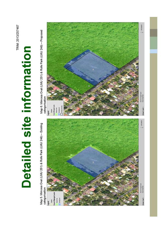
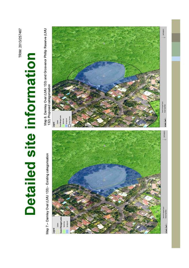
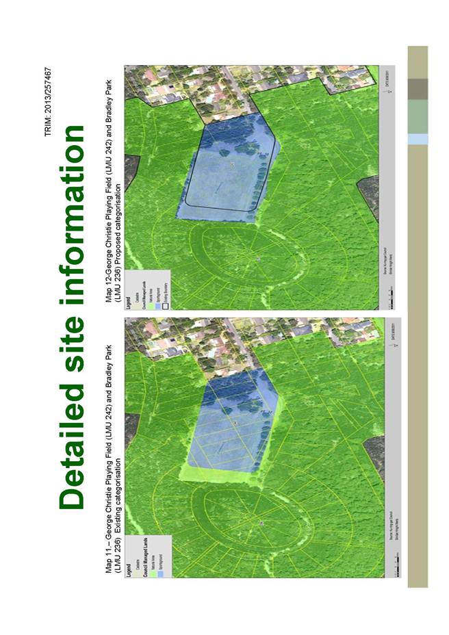
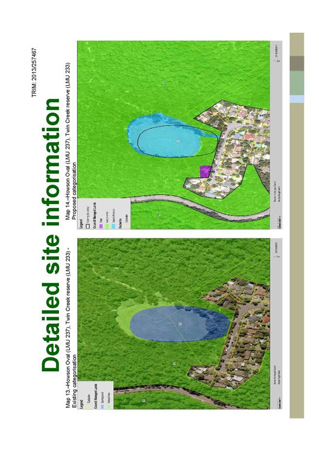
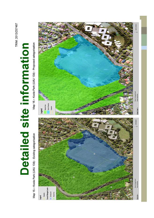
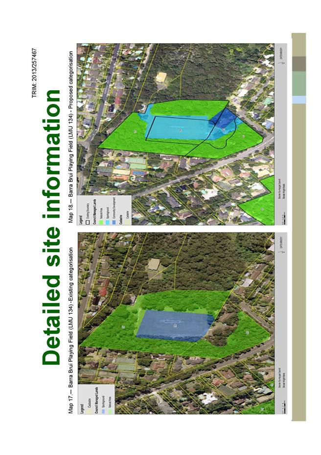
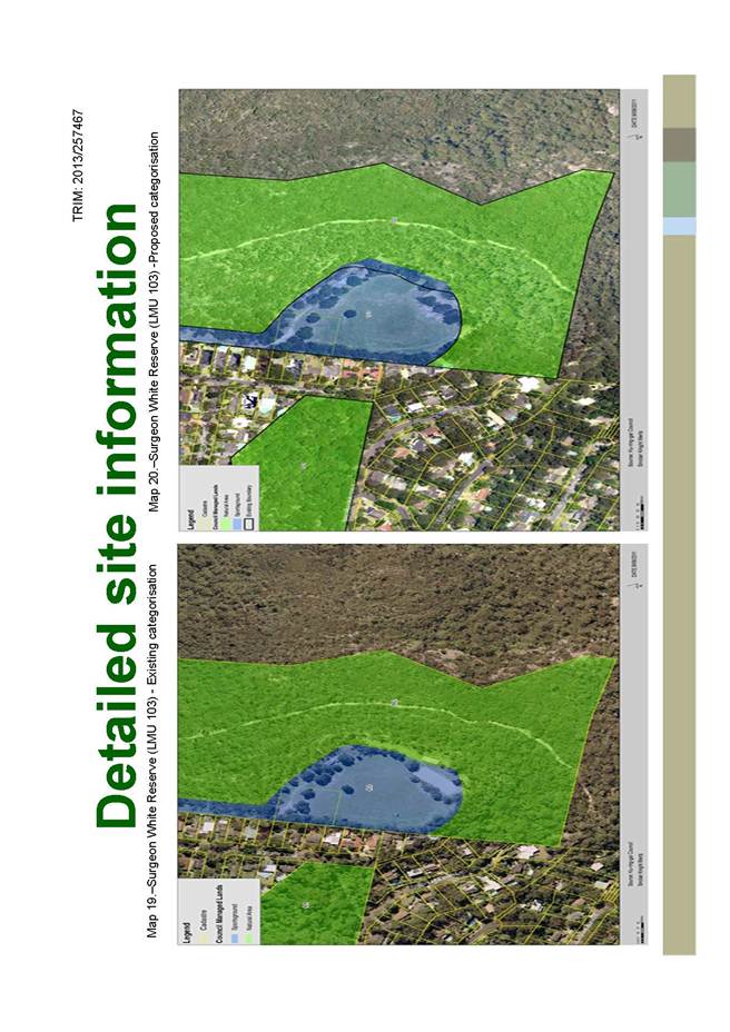
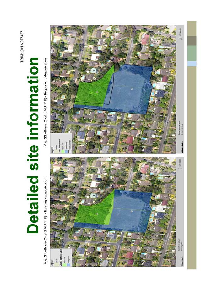
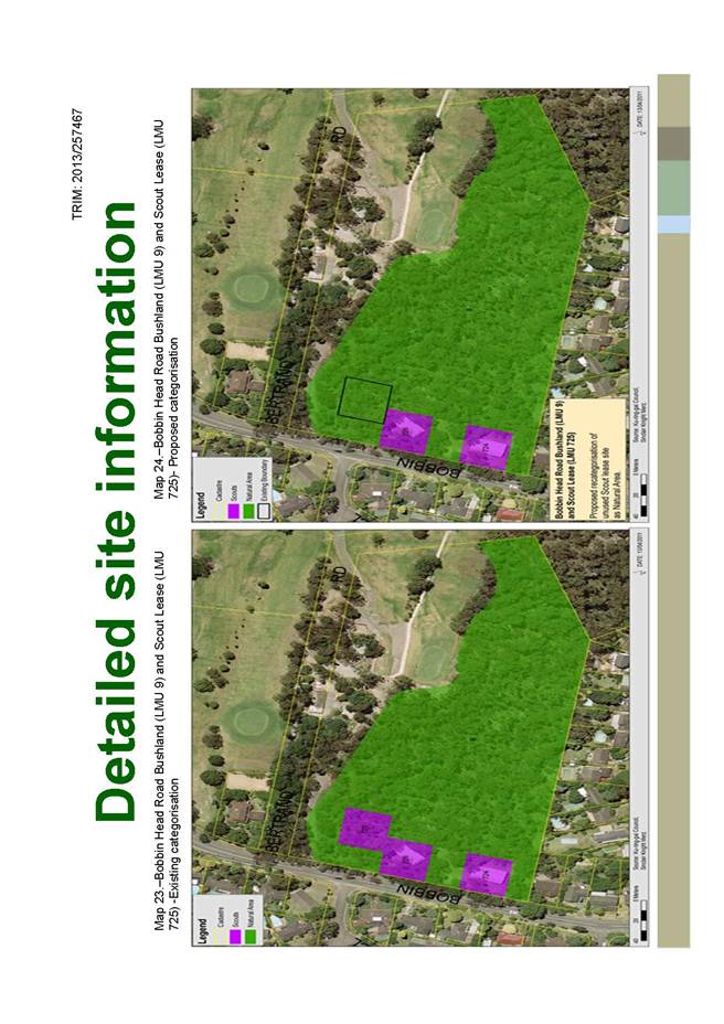
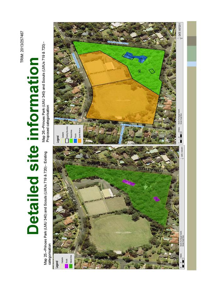
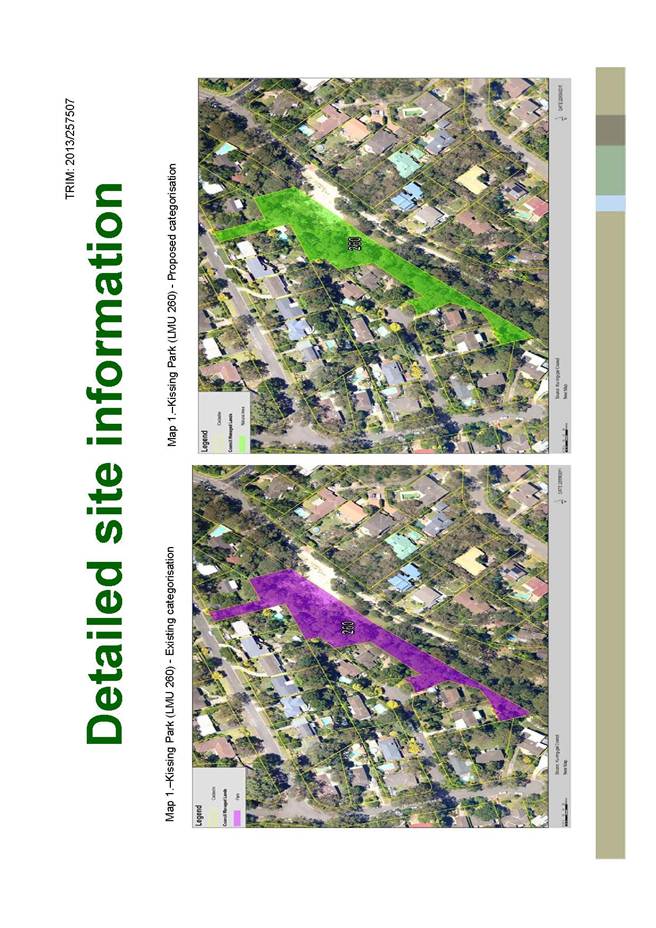
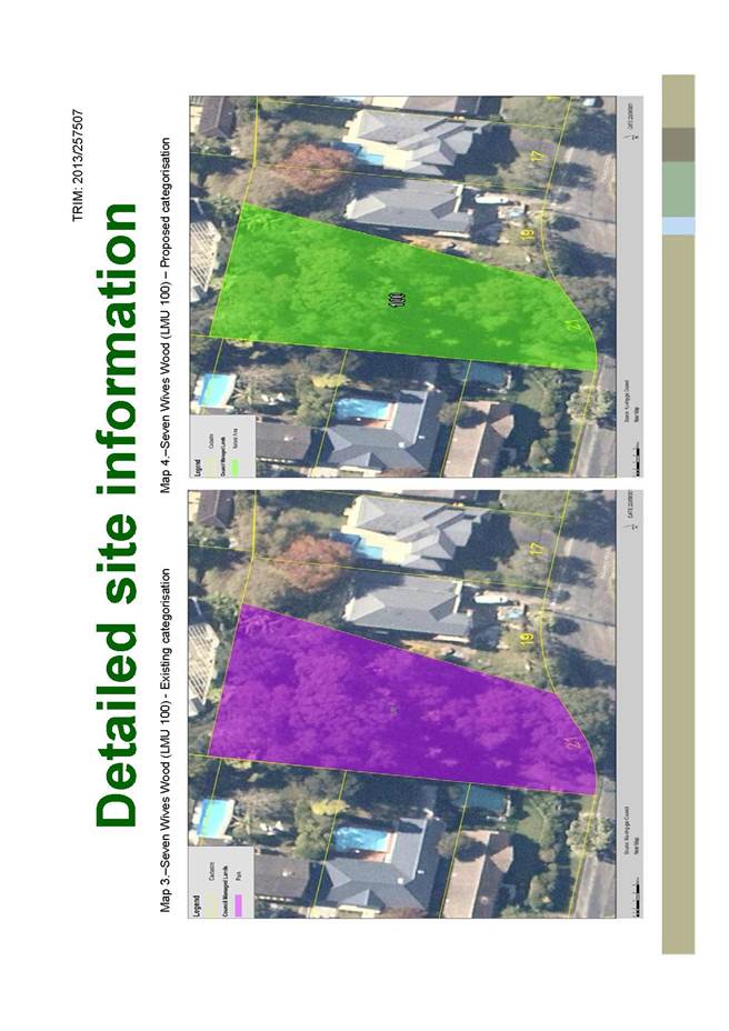
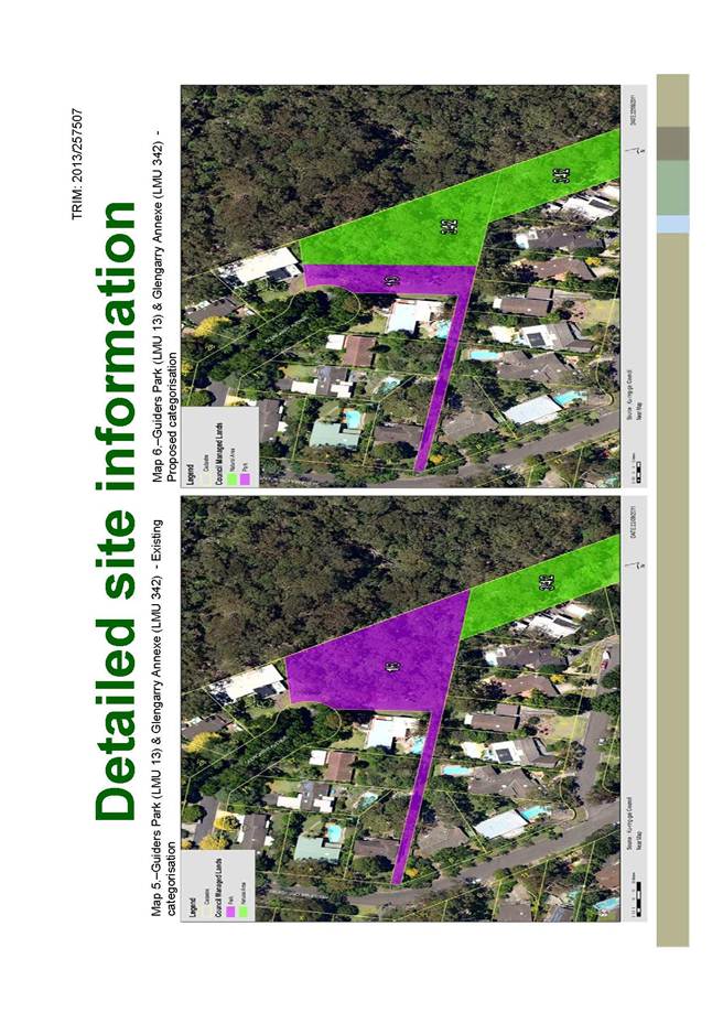
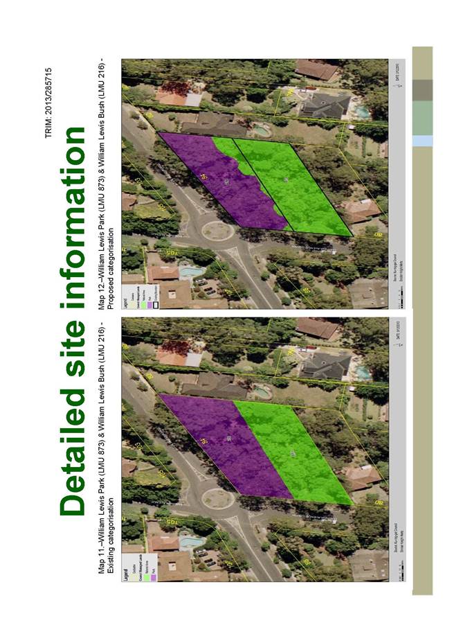
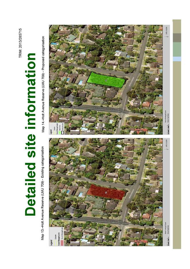
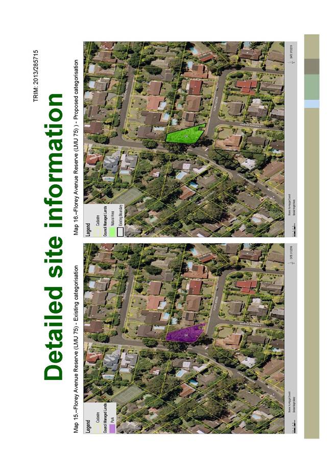
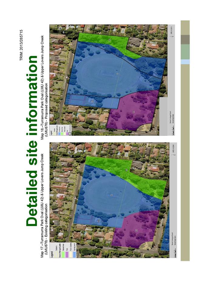
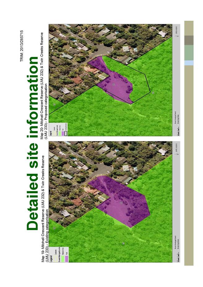
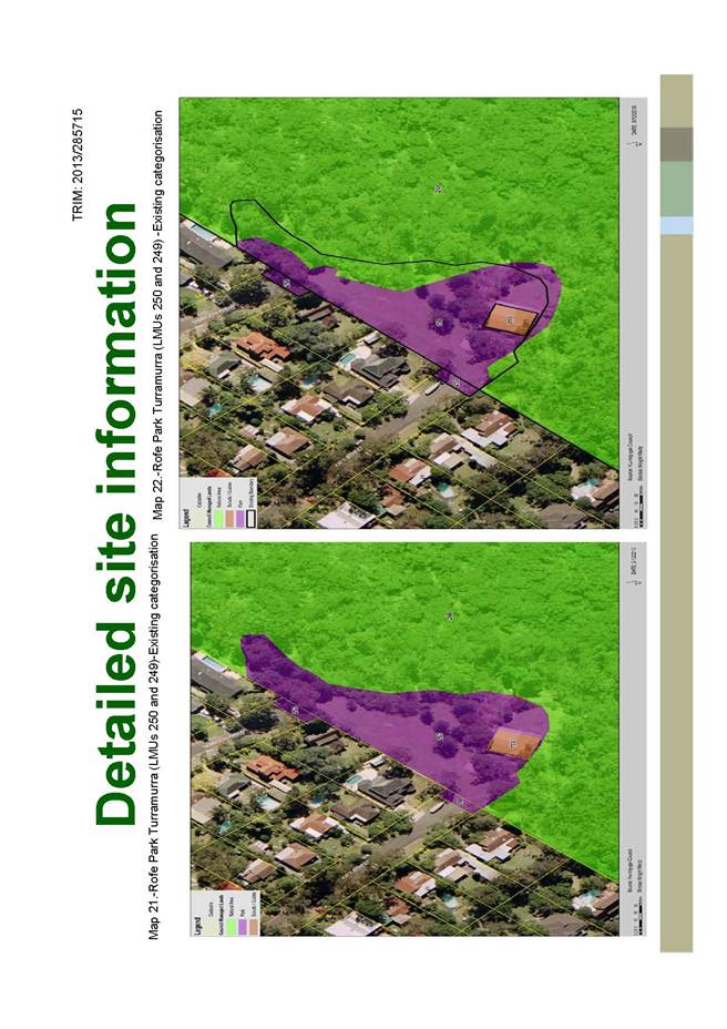
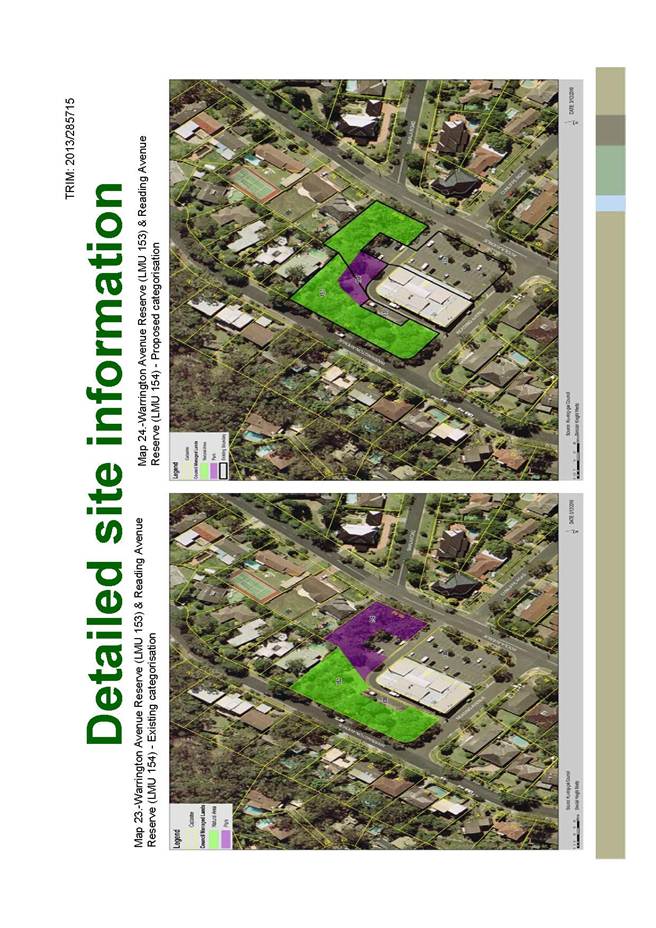
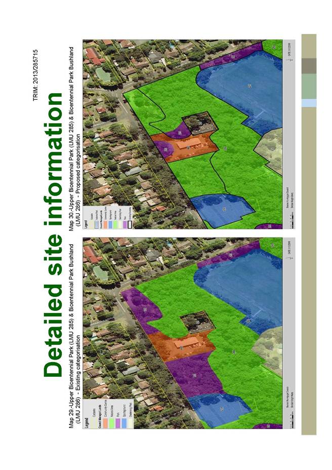
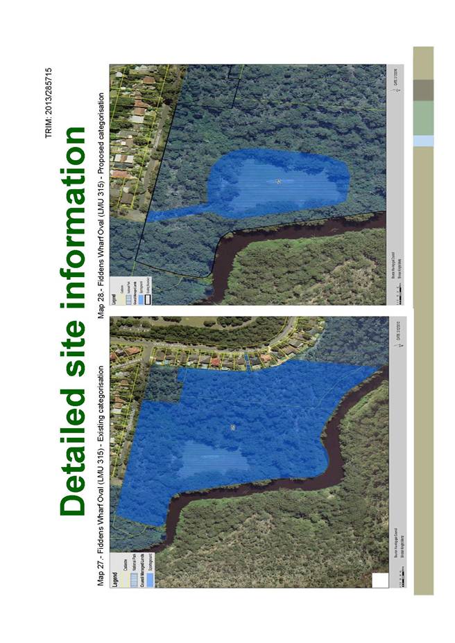
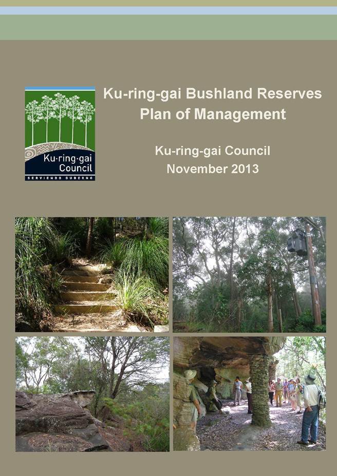
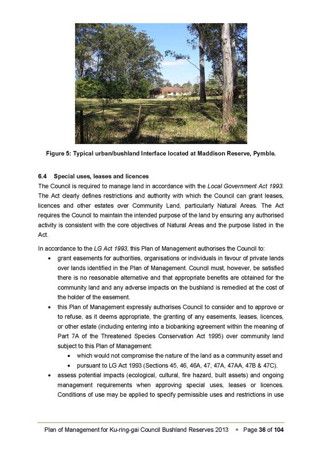
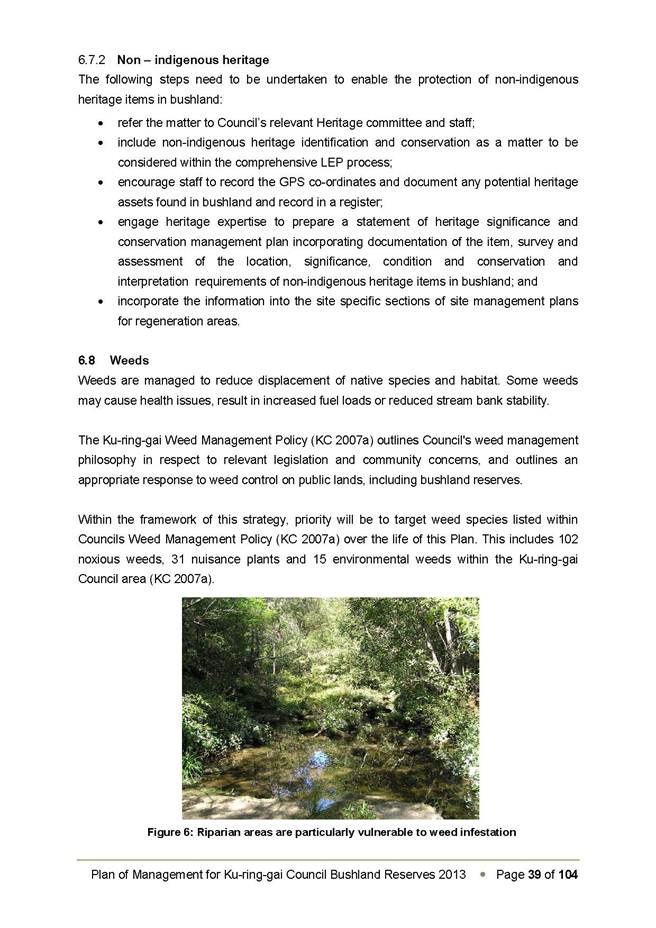
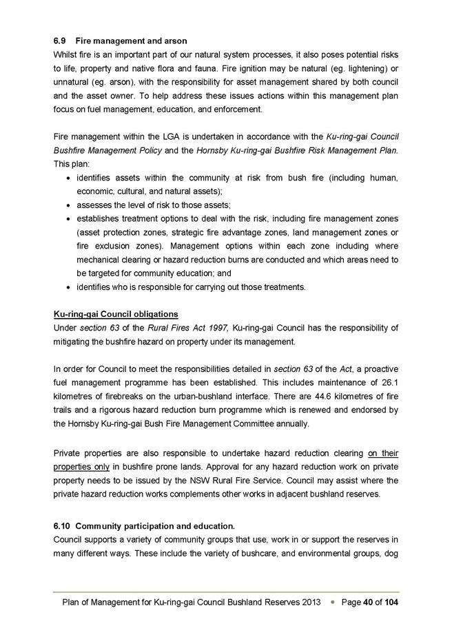
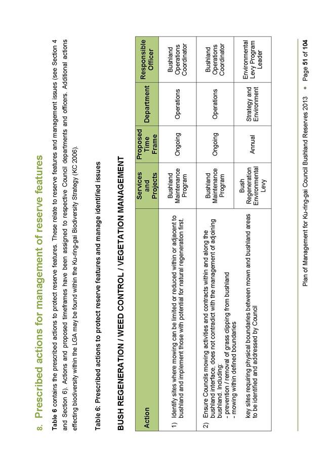
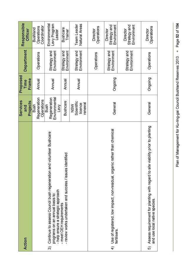
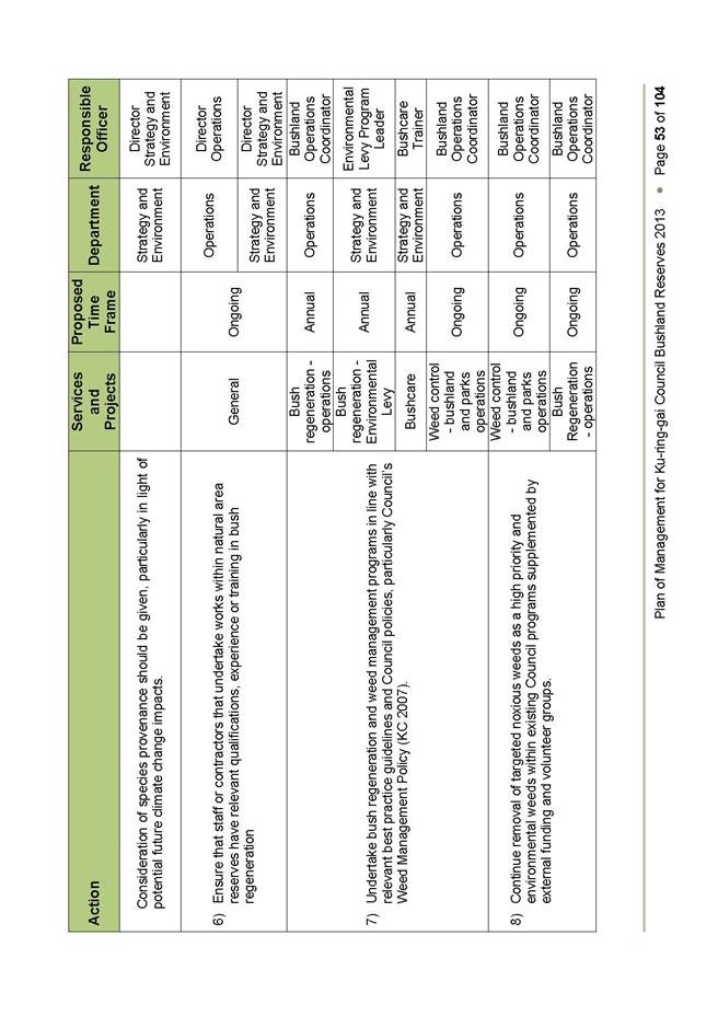
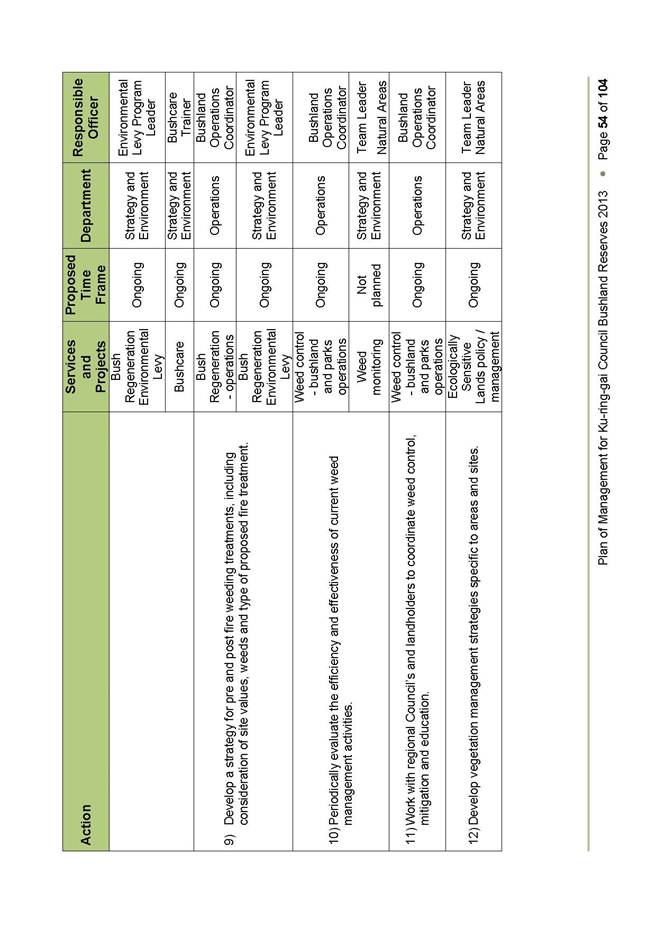
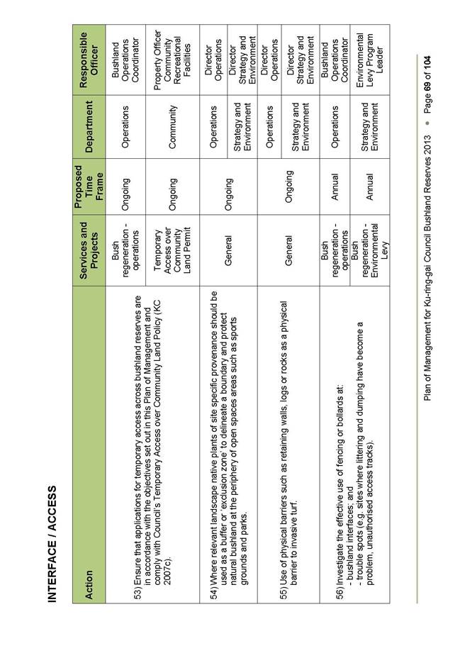
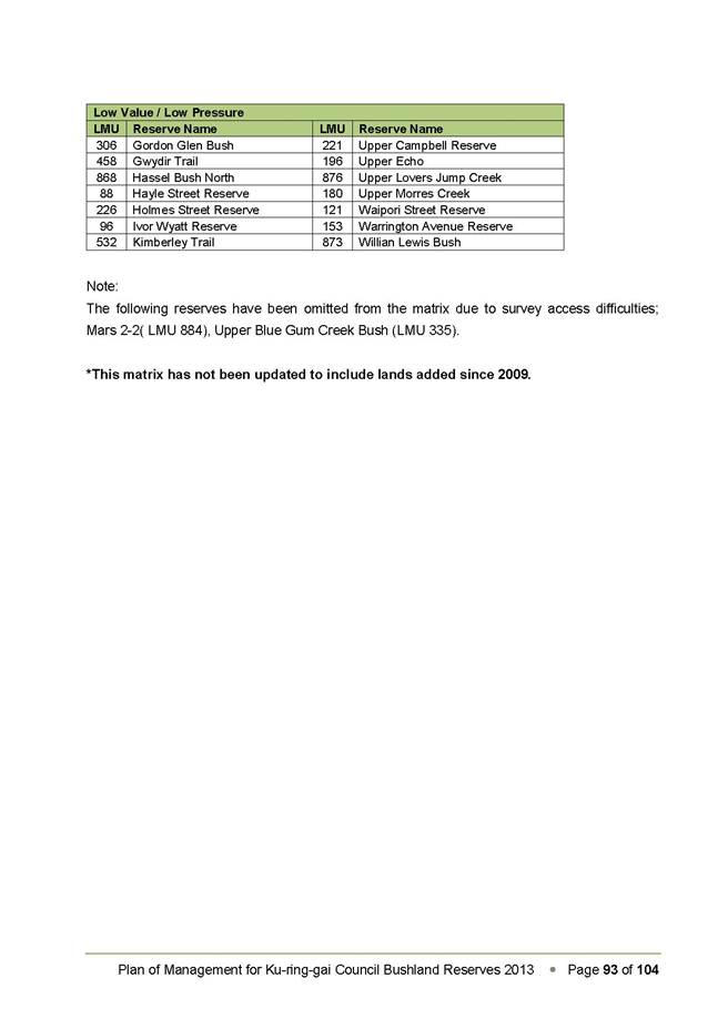
GB.15 Consideration of Submissions - Draft Ku-ring-gai Bushland Reserves Plan of Management 259
File: S04326
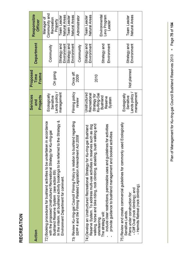
For Council to adopt the exhibited 2013 Ku-ring-gai Bushland Reserves Plan of Management (PoM), incorporating the categorisation and re-categorisation of natural areas addressed through a public hearing conducted on 19 November 2013, and the Proposal for an estate - Biobank site at Rofe Park, Sheldon Forest and Comenarra Creek Reserve, with minor amendments and corrections as outlined in this report.
Recommendation:
That Council adopts the 2013 Ku-ring-gai Bushland Reserves Plan of Management and the Proposal for an estate - Biobank site at Rofe Park, Sheldon Forest and Comenarra Creek Reserve, with the amendments and corrections.
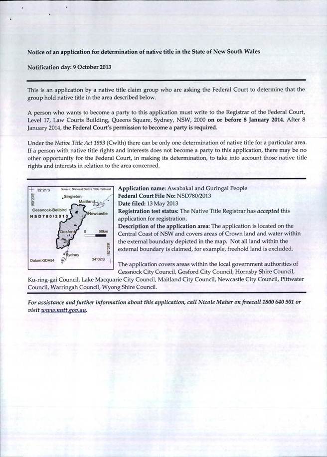
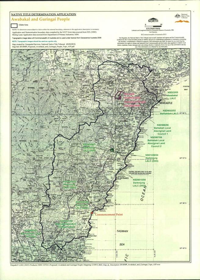
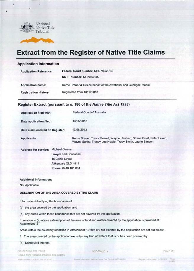
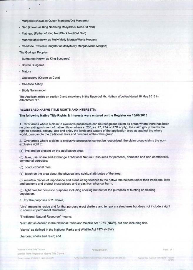
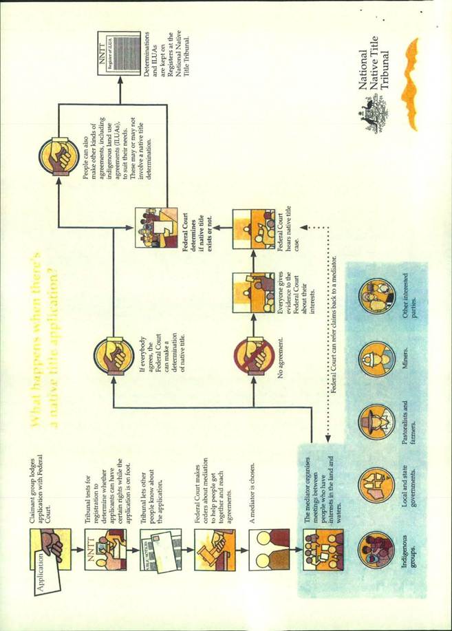
GB.16 Native Title Claim by Awabakal and Guringai People 484
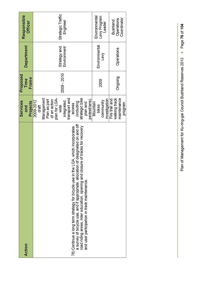
File: S03213
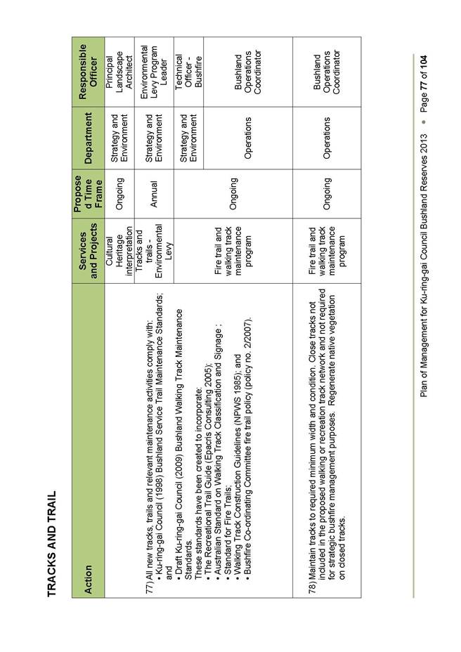
To inform Council of a Native Title claimant application made on behalf of the Awabakal and Guringai People.
Recommendation:
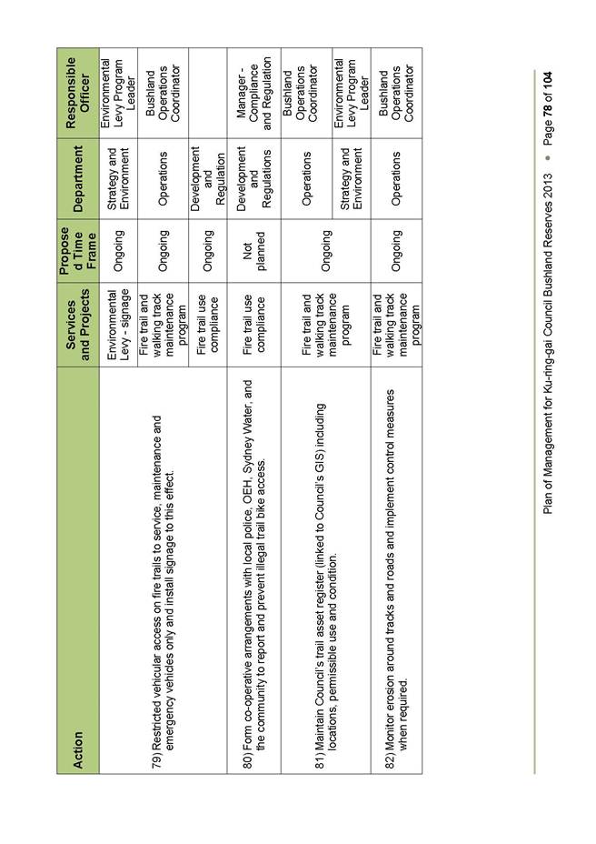
Council receive and note the intended course of action.
GB.17 Acquisition and Divestment of Land Policy - Review 504
File: S07209
For Council to adopt the revised draft Acquisition & Divestment of Land Policy for public exhibition.
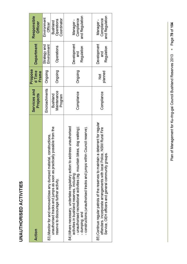
Recommendation:
That Council adopt the revised draft Acquisition & Divestment of Land Policy for public exhibition for a period of 28 days with a further 14 days for public comment in accordance with the requirements of the Local Government Act 1993.
GB.18 Draft Commercial Leasing Policy 521
File: S07252/4
For Council to adopt the draft Commercial Leasing Policy (policy) for public exhibition.
Recommendation:
That Council adopts the draft Commercial Leasing Policy and place the draft policy on public exhibition for a period of 28 days with a further 14 days for public comment in accordance with the requirements of the Local Government Act, 1993.
GB.19 Lindfield Village Green - Tryon Road - Project Update 532
File: S09780
To update Council on the progress of the masterplanning for Lindfield Village Green and to outline the next steps for the project.
Recommendation:
That Council proceeds to the next stage of the project which is to prepare detailed concept plans for the site and undertake community engagement.
** ** ** ** ** **
|
Ordinary Meeting of Council - 10 December 2013 |
MM.3 / 7 |
|
|
|
|
Item MM.3 |
S09362 |
|
|
10 December 2013 |
Mayoral Minute
Excellence
in the Environment Awards &
Institute of Landscape Architects Awards
Ku-ring-gai Council received a number of significant accolades this week.
On 3rd December Local Government NSW held its annual Excellence in the Environment Awards recognising outstanding achievements by local government in managing and protecting the environment. Council was successful in Division C – Climate Change Action Awards for its Building Climate Wise Communities project. The project then took out the Overall Winner for 2012/2013.
The Climate Wise Communities Program focusses on fostering shared responsibility, integrating with Council’s Emergency Management Plan and collaborating with emergency management agencies.
Council also developed a multi-hazard assessment tool that means residents can review their vulnerability to severe weather events at a personal, property and neighbourhood level. This tool helps people determine what action needs to be taken in case of bush fire, storms, heat stress and drought.
On 5th December the Australian Institute of Landscape Architects NSW (AILA) held its Awards in Landscape Architecture. Council took out the Research and Communication category with 'Thinking Outside The Box' Key Design Elements for Apartments in Ku-ring-gai’ and the Planning category for the ‘Ku-ring-gai Open Space Acquisition Program’.
The Open Space Acquisition Program in particular builds on years of policy development, contributions planning, site identification and acquisition and ultimately design and construction involving staff from across Council as well as Council and the community.
OSAP provides much needed parkland to the community. Ku-ring-gai Council has been acquiring land at an unprecedented rate, spending $33.4 million on acquiring 14,700 m2 of land for new parks and civic spaces in Gordon, Killara, Turramurra, St Ives and Wahroonga since 2007.
Once complete, OSAP will deliver 10 new local parks and civic spaces within close proximity to high density residential areas in Ku-ring-gai.
The other AILA award for Research and Communication was for ‘Thinking outside the Box’: Key Design Elements for Apartments in Ku-ring-gai.
To improve residential apartment building design outcomes in Ku-ring-gai, Council created an impressive publication, ‘Thinking Outside The Box’, published in 2011. The booklet highlights examples of well-designed local buildings and provides advice on how good design principles can be applied.
Thinking Outside the Box promotes awareness of well-designed buildings in Ku-ring-gai that are responsive to community expectations and landscape character. It also aims to improve the standard of site planning and design by showcasing a range of good local examples in a landscape setting.
In some cases these awards reflect many years of ground breaking work by staff and are a credit to Council.
|
A. That Council receive and note the Mayoral Minute.
B. That the General Manager convey Council’s congratulations to staff for these outstanding achievements.
|
|
Jennifer Anderson Mayor |
|
|
Ordinary Meeting of Council - 10 December 2013 |
PT.1 / 9 |
|
|
|
|
Item PT.1 |
TM8/05 |
|
|
11 December 2013 |
Petition
Petition to Implement Effective Means to Curtail Dangerous Speeding along Park Avenue, Roseville –
(One Hundred and Three [103] Signatures
The following Petition was presented by Councillor David Armstrong:
“We, the undersigned residents, here by submit a petition to Ku-ring-gai Council for the implementation of an effective means to curtail the proven prevalence of excessive and dangerous speeding along Park Avenue, Roseville.
We believe that the painting of line markings will NOT resolve the current speeding issue.
The speeding issue is largely to do with accessing Babbage Road from Archbold Road. The topography of Park Avenue - unlike surrounding streets - makes speeding highly dangerous. A line down the centre of the street will only embolden drivers to speed more so in the knowing that any unsighted oncoming traffic will now be keeping to its side of the road.
We demand that an alternative be implemented as soon as possible and we request that you ensure that your staff continue to work toward finding a n effective means to curtail this situation which poses a danger to all residents, pedestrians and drivers.”
|
That the petition be received and referred to the appropriate Officer of Council for attention.
|
|
Ordinary Meeting of Council - 10 December 2013 |
PT.2 / 10 |
|
|
|
|
Item PT.2 |
S09768 |
|
|
11 December 2013 |
Petition
Petition to STOP Culworth Avenue Car Park being SOLD for High Rise Residential Development by Council –
(One Thousand, Eight Hundred and Forty-Three [1,843] Signatures)
The following Petition was presented by Councillor David Citer:
“We, the undersigned, residents of Ku-ring-gai [and commuters] strongly oppose Council’s planned rezoning/reclassification of 20 to 28 Culworth Avenue. This will result in high rise residential development within a local heritage conservation area and the loss of 204 commuter car park spaces at Killara Station within a large area of declared biologically significant open space.”
|
That the petition be received and referred to the appropriate Officer of Council for attention.
|
|
Ordinary Meeting of Council - 10 December 2013 |
GB.10 / 11 |
|
|
|
|
Item GB.10 |
S09781 |
|
|
4 November 2013 |
Planning Proposal to include
'Hardware and Building Supplies' in the
B7 Zone under the KPSO
EXECUTIVE SUMMARY
Purpose of Report
For Council to consider a planning proposal to amend the Ku-ring-gai Planning Scheme Ordinance (KPSO) to permit ‘hardware and building supplies’ as a use permissible with consent within the B7 – Business Park zone.
Background
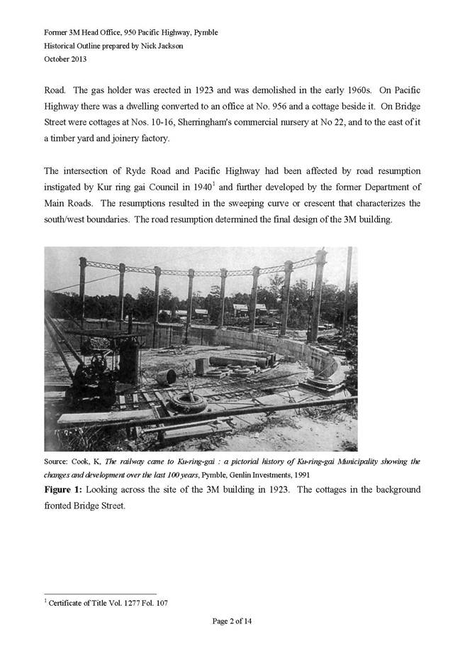
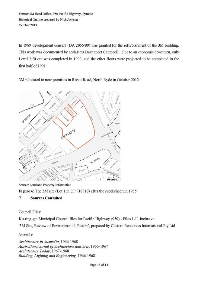
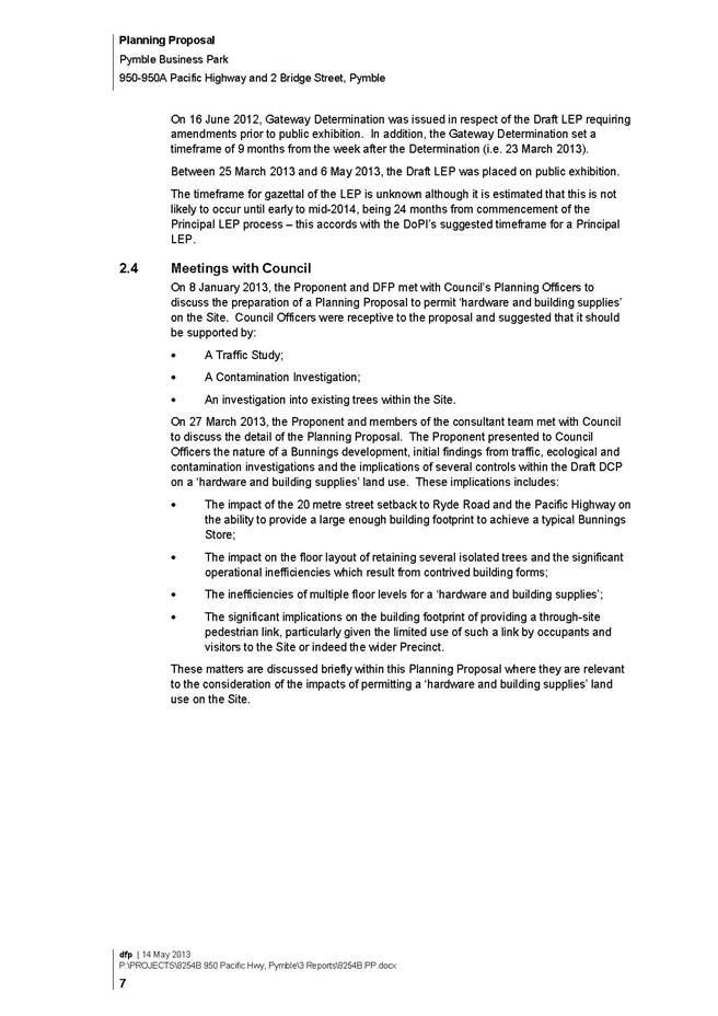
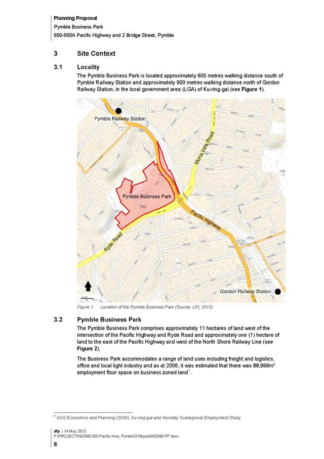
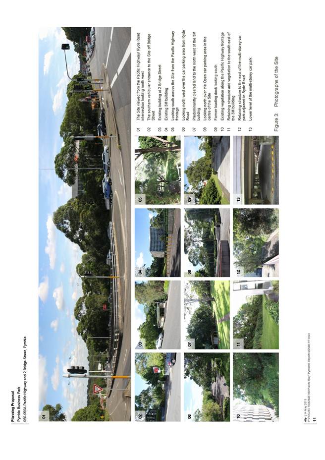
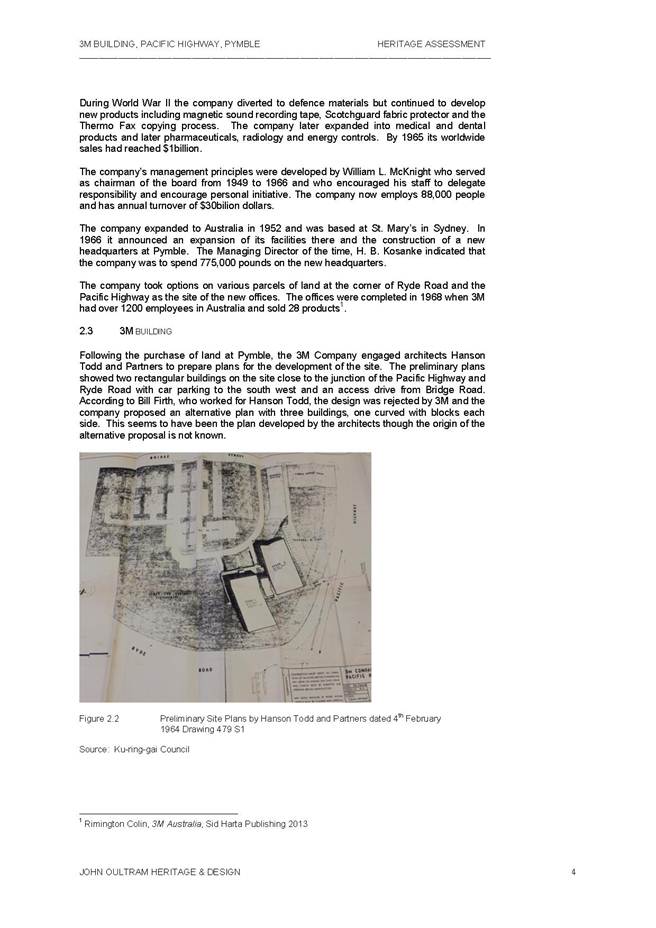
Council received a Planning Proposal from Bunnings Pty Ltd on 15 May 2013 which seeks to amend the Ku-ring-gai Planning Scheme Ordinance (KPSO) to include ‘hardware and building supplies’ as a permissible land use in Zone B7 (Business Park). The ultimate purpose of the planning proposal is to enable a Bunnings store to be developed on their landholding at 950-950A Pacific Highway and 2 Bridge Street, Pymble (also known as the 3M site).
On 27 August 2013 Council considered a report on the planning proposal and resolved:
‘That the matter be deferred until an independent heritage report comes back to Council with a study of the 3M Building and the site’.
Council engaged the services of John Oultram Heritage consultants to conduct the heritage assessment of the former 3M site at 950 Pacific Highway, Pymble. On 31 October 2013 Council received from the Bunning’s group a heritage assessment of the site prepared by Paul Davies Pty Ltd heritage consultants & Nick Jackson. The outcomes and recommendations of this heritage assessment are now subject to a separate report to Council.
Council had previously adopted Planning Proposal to amend the KPSO to rezone Pymble Business Park to B7 Business Park (known as LEP 219) at its meeting of 17 July 2012. During the exhibition period a submission was made seeking the inclusion ‘hardware and building supplies’ as a permitted use in the B7 zone. While this proposed amendment was supported by Council officers, Council resolved not to proceed with the additional use. LEP 219 was gazetted on 18 January 2013.
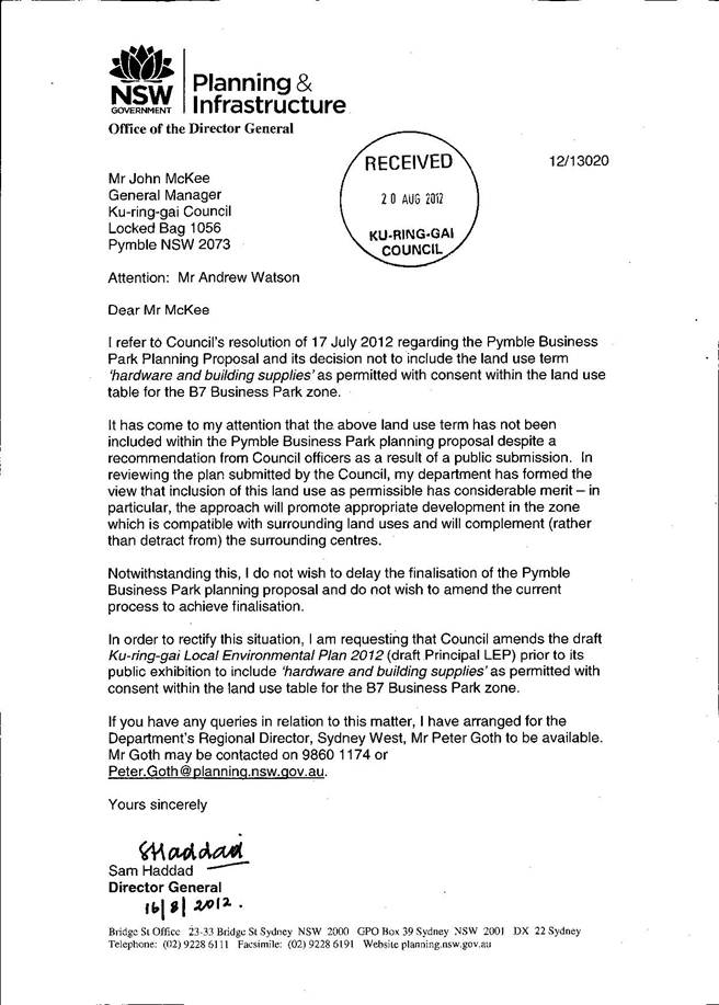
Council received correspondence from the Director General of the Department of Planning and Infrastructure dated 16 August 2012 regarding Council’s decision not to include the land use term 'hardware and building supplies' as permitted with consent within the B7 Business Park zone in the Pymble Business Park (see Attachment A1). It was noted that land use term had not been included within the Pymble Business Park Planning Proposal despite a recommendation from Council officers as a result of a public submission.
The Department had formed the view that inclusion of this land use as permissible has considerable merit and requested that Council amend the draft Ku-ring-gai Local Environmental Plan 2013 (draft KLEP 2013) prior to its public exhibition to include 'hardware and building supplies' as permitted with consent within the B7 Business Park zone. The draft KLEP instrument was amended to accommodate this request from the DP&I prior to it being exhibited from 25 March 2013 to 6 May 2013. Apart from this amendment, the draft KLEP incorporated the final adopted B7 Business Park zone and associated provisions as contained in LEP 219.
At the Council meeting on 26 November 2103 Council adopted the final KLEP 2013 which includes Hardware and Building supplies as permitted with consent in the Zone B7 Business Park. The KLEP 2013 is currently with the DP&I with a request that the plan be made.
To support development under LEP 219, Council, on 16 July 2013 adopted a DCP to guide the design of future development within Pymble Business Park. The Pymble Business Park DCP not only addresses building design in the context of the business park, it also addresses development relationships with the surrounding bushland and other adjoining development. It is expected that these DCP controls would be transferred into a future Principal DCP.
Bunnings acknowledge that Council is addressing this matter as part of its principal local environment plan (KLEP 2013). However, as the timing of its completion is uncertain, Bunnings is seeking the support of Council and the approval of the Minister for Planning and Infrastructure (the Minister) to expedite this matter as a separate Planning Proposal, to facilitate the timely redevelopment of their landholding.
Comments
The Planning Proposal from Bunnings Pty Ltd seeking to amend the Ku-ring-gai Planning Scheme Ordinance (KPSO) to include ‘hardware and building supplies’ as a permissible land use in Zone B7 (Business Park) is included as Attachment A2. The submitted planning proposal also includes the following documents as appendices:
A. Site Survey;
B. Tree Assessment Report;
C. Flora and Fauna Assessment;
D. Strategic Contaminated Land Review;
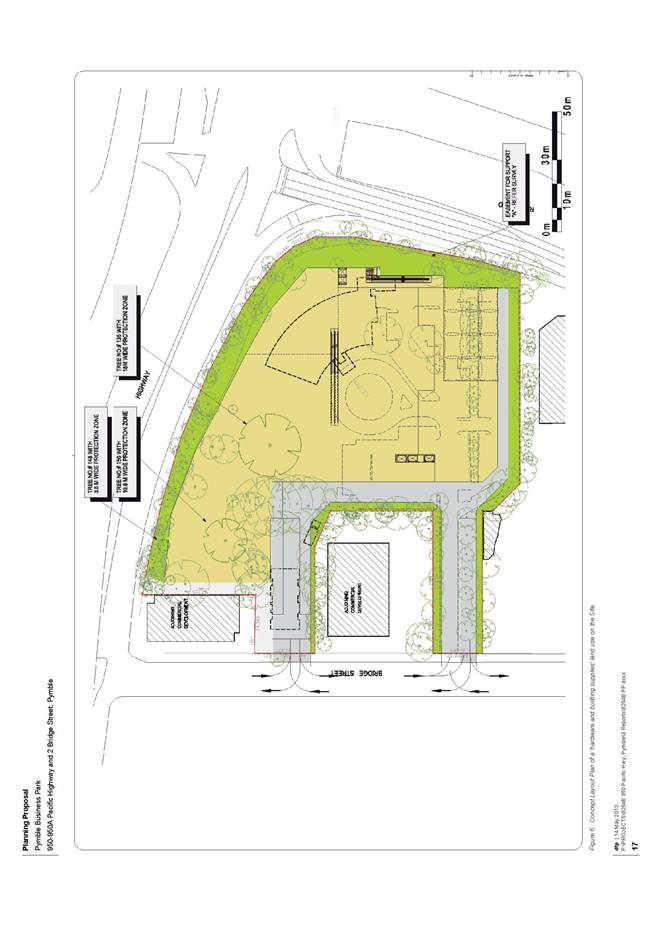
E. Concept Layout Plan;
F. Traffic and Parking Assessment Report;
G. Urban Design Report.
These documents have been circulated separately to Councillors.
Prior to submitting the Planning Proposal to the DP&I for a gateway determination Council must be satisfied that the Planning Proposal satisfies the requirements of Section 55 of the EP&A Act and the Department of Planning and Infrastructures ’A guide to preparing planning proposals’.
Following is a consideration of the appropriateness of the Planning Proposal against the requirements of Section 55 of the EP&A Act and DP&I requirements under ’A guide to preparing planning proposals’.
Part 1 – Objectives or intended outcomes
The stated objective or intended outcome of the Planning Proposal is:
“To enable land within the Pymble Business Park zoned Zone B7 (Business Park) to be redeveloped for the purposes of ‘hardware and building supplies.”
The current zone objectives the B7 Business Park Zone under the KPSO are as follows:
“1 Objectives of the Zone
· To provide a range of office and light industrial uses.
· To encourage employment opportunities.
· To enable other land uses that provide facilities or services to meet the day to day needs of workers in the area.
Under the Standard Instrument LEP definitions, ‘hardware and building supplies’ fall within the category of ‘retail premises’. Within the B7 Business Park zone, ‘retail premises’ are included as a prohibited use. The intent of this prohibition was to ensure that the business park does not compete with the core retail function of Gordon. However, the sub-category retail uses of ‘food and drink premises’ and ‘neighbourhood shops’ are permissible as they are considered to be consistent with the objective to “… provide facilities or services to meet the day to day needs of workers in the area.”
When considering additional land uses, it is important that those land uses do not distract from the core objective of the zone which is to provide for a range of office and light industrial uses and generate employment opportunities. Also, in the case of Pymble Business Park, any expanded land uses should not detract from the economic growth of Gordon as a key retail centre. To this end, it is considered that the inclusion of ‘hardware and building supplies’ as additional permitted uses in the precinct would not be incompatible with the zone objectives as it is a use that would not be developed in a traditional retail centre such as Gordon under the modern market format proposed.
Part 2 – Explanation of provisions
The Planning Proposal seeks to achieve the intended outcome by amending the KPSO to include ‘hardware and building supplies’ as a permissible land use with development consent in Zone B7 (Business Park). This would involve an amendment to the land use table under Cl 30H of the KPSO to insert the term ‘hardware and building supplies’ under part 3 ‘Permitted with consent’.
This amendment would make the land use table consistent with Council’s adopted land use table for the Zone B7 (Business Park) under the adopted KLEP 2013.
Part 3 – Justification
Section A – Need for the planning proposal
Q1. Is the planning proposal a result of any strategic study or report?
The strategic studies and reports identified in support of the Planning Proposal include those relied on by Council for the justification of LEP 219. These include:
· Hornsby and Ku-ring-gai Subregional Employment Study (May 2008) prepared by SGS Economics;
· Sphere Property Corporation development feasibility report prepared as part of the preparation of Ku-ring-gai LEP (Town Centres) 2010;
· Pymble Business Park – Transport Assessment of Access Improvements report prepared by GTA Consultants in 2011; and
· Advice to Council by Jones Lang LaSalle from June 2012 included in Council’s Report of 17 July 2012 in response to submissions on the exhibition of draft LEP 219.
The arguments presented in the Planning Proposal are consistent with those used to support Council’s adoption of LEP 219 and the officers’ recommendation to include ‘hardware and building supplies’ as a permissible land use in the Zone B7 (Business Park).
In addition to Council’s strategic planning studies, the Planning Proposal is accompanied by a number of reports specific to the potential redevelopment of the site at 950-950A Pacific Highway and 2 Bridge Street including:
· Tree Assessment Report;
· Flora and Fauna Assessment;
· Strategic Contaminated Land Review;
· Concept Layout Plan;
· Traffic and Parking Assessment Report;
· Urban Design Report.
While these studies are less strategic in nature and deal largely with site specific issues, they do help inform the broader suitability of the proposed hardware and building supply use within the precinct and the B7 Business Park zone.
Q2. Is the planning proposal the best means of achieving the objectives or intended outcomes, or is there a better way?
The proponent suggests two possible mechanisms to achieve the intended outcome of the Planning Proposal, ie, to facilitate the development of the site at 950-950A Pacific Highway and 2 Bridge Street, Pymble for the purpose of a ‘hardware and building supplies’. The two options are:
1. add ‘hardware and building supplies’ as a permissible land use with development consent in the B7 Zone; or
2. permit ‘hardware and building supplies’ on the site at 950-950A Pacific Highway and 2 Bridge Street only, by adding it as an additional permissible use on the site via a Schedule to the KPSO.
Of these two options the first option is preferred as it offers a more strategic approach to the whole B7 Business Park Zone and provides consistency with the adopted KLEP 2013, it is also supported by the Department of Planning & Infrastructure.
Section B – Relationship to strategic planning framework.
Q3. Is the planning proposal consistent with the objectives and actions of the applicable regional or sub-regional strategy (including the Sydney Metropolitan Strategy and exhibited draft strategies)?
The following regional and subregional plans are applicable to the Planning Proposal:
· Metropolitan Plan for Sydney 2036;
· Draft Sydney North Subregional Strategy; and
· Draft Metropolitan Strategy for Sydney to 2031.
The Metropolitan Plan for Sydney 2036 specifies a subregional (Hornsby and Ku-ring-gai) employment target of 15,000 jobs (from 2006) to assist in attaining the objective of providing more jobs closer to home. The Sydney North Subregional Strategy was prepared in 2007 and provides for an employment target for Ku-ring-gai LGA of 4,500 jobs by 2031.
The Draft Metropolitan Strategy for Sydney to 2031 was exhibited in early 2013 and when adopted will replace Sydney 2036. Under this new draft strategy, Ku-ring-gai is included in an expanded Sydney North Subregion which includes Hornsby, Manly, Pittwater and Warringah. An employment target of 39,000 jobs (from 2011) is specified for the new subregion with greater details to be provided in a future ‘Subregional Delivery Plan’.
While the additional floor space facilitated by Ku-ring-gai LEP (Local Centres) 2012 and LEP No. 219, will make a significant contribution towards Ku-ring-gai’s future employment targets, it is acknowledged that enabling a wider range of land uses within the Pymble Business Park will enhance the opportunities to generate greater commercial activity and employment generation within the precinct. The greater diversity in uses in the precinct is supported by the Jones Lang LaSalle report for LEP 219 which stated that:
“The planning controls should be flexible enough to encourage development that re-activates the precinct as a vibrant destination with a range of employment based uses. This also helps to minimise the impact of economic cycles on a precinct as different sectors can be at different points in the economic cycle;”
As such, the Planning Proposal is considered to be consistent with the above regional and subregional strategies and will contribute to Ku-ring-gai’s employment targets under these strategies.
Q4. Is the planning proposal consistent with a Council’s local strategy or other local strategic plan?
The Planning Proposal has sufficiently demonstrated consistency with the following applicable Ku‑ring-gai Council strategies and strategic Plans:
· Ku-ring-gai Council Community Strategic Plan 2030;
· Ku-ring-gai Sustainability Vision 2008-2033; and
· Ku-ring-gai Integrated Transport Strategy – July 2011.
Q5. Is the planning proposal consistent with applicable State Environmental Planning Policies?
The following State Environmental Planning Policies have been identified as relevant to the Planning Proposal:-
· SEPP 55 Remediation of Land
· SEPP Infrastructure 2007
SEPP 55 Remediation of Land
SEPP 55 requires Council to consider if the land to which this Planning Proposal applies is contaminated and if so, whether the land is suitable for the intended use (ie ‘hardware and building supplies’) or can readily be made suitable prior to that use commencing. The Planning Proposal is accompanied by a Strategic Contaminated Land Review prepared by Cavvanba Consulting for the site at 950-950A Pacific Highway and 2 Bridge Street. The report identifies that the southernmost part of the Site formerly contained a gas holder and there may be several underground storage tanks (USTs) within the site.
The Cavvanba Consulting report identifies that site has been subject to several detailed assessments between 2009 and 2012, and there is a good understanding of the site contamination status, with limited likelihood of any significant additional unexpected finds or sources of contamination. It concludes that the site can be made suitable for the proposed development subject to the completion of a number of recommendations relating to remediation of soils and groundwater. These issues would need to be addressed during the redevelopment process.
SEPP Infrastructure 2007
While SEPP Infrastructure is not directly relevant to the Planning Proposal, it would become a matter of consideration for a future development application for the use of the Site for ‘hardware and building supplies’ purpose. Clause 101 of SEPP Infrastructure relates to development with a frontage to a classified road and Clause 104 relates to assessment of traffic impacts of certain types of development, such as development with car parking supply in excess of 200 vehicles.
The Planning Proposal is accompanied by a Traffic Impact Assessment Report prepared by TTPA Consultants for the future development of the site for hardware and building supplies purposes. Further consideration of the traffic impact of the use is discussed under Q8 below.
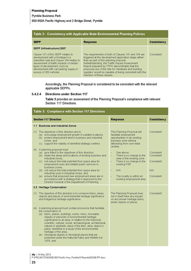
Q6. Is the planning proposal consistent with applicable Ministerial Directions (s.117 directions)?
The Planning Proposal identifies the following applicable Section 117 directions:
· 1.1 Business and Industrial Zones;
· 2.3 Heritage Conservation;
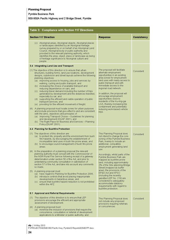
· 3.4 Integrating Land Use and Transport;
· 4.4 Planning for Bushfire Protection;
· 6.1 Approval and Referral Requirements;
· 6.3 Site Specific Provisions;
· 7.1 Implementation of the Metropolitan Plan for Sydney 2036.
The justifications contained in the Planning Proposal for consistency with each relevant s117 direction (refer to section 5.4.2.4 of Attachment 1) are generally supported subject to the following matters being addressed.
Direction 2.3 Heritage Conservation
It is noted that the discussion under 2.3 Heritage Conservation does not make reference to the State heritage item at 982 Pacific Highway (Pymble Electricity Substation) or the Fire Station at 966 Pacific Highway which are on the State Government’s ‘Heritage and Conservation Register’ under section 170 of the Heritage Act 1977. As the Planning Proposal is to apply to the whole B7 Business Park zone, including these sites, they should be identified in the Planning Proposal. The Planning Proposal should also be referred to the Department of Environment and Heritage as part of the public authority consultation process.
Direction 6.3 Site Specific Provisions
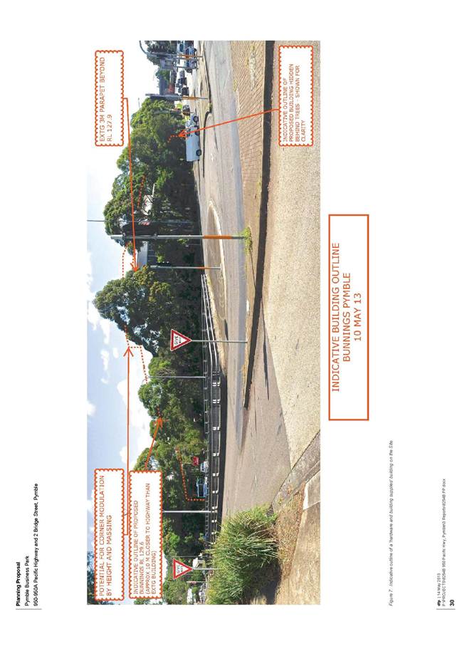
Direction 6.3 (Site Specific Provisions) is relevant where a planning proposal will allow a particular development to be carried out. The Planning Proposal is consistent with the requirement of this Direction to utilize an existing zone within the environmental planning instrument. However, the Direction also requires that a planning proposal not contain or refer to drawings that show details of the development proposal. The submitted Planning Proposal is not considered to be consistent with this requirement of the Direction as it contains a concept plan for the development of a ‘hardware and building supplies’ use on the site at 950-950A Pacific Highway and 2 Bridge Street.
It is acknowledged in the table in section 5.4.2.4 of the Planning Proposal that the concept development proposal for a ‘hardware and building supplies’ land use contained within the report is merely to demonstrate that a use of this kind is capable of being provided and that it is compatible with the strategic considerations. However, the structure of the Planning Proposal is not considered suitable as it does not adequately separate the indicative development layout and potential future development from the change to the broader zoning. The proposal needs to justify the new land use within the broader zone on its merits without reference to the indicative development layout of the individual site. The primary address of the planning proposal should be the suitability of the proposed land use within the zone and its consistency within the strategic context.
The Planning Proposal should be revised to remove references to the design of the proposed future development from the technical component of the report. This could be achieved by re‐structuring the report so that details of the proposed future development are within the first part of the report and the technical planning proposal elements are within a second part.
Section C – Environmental, social and economic impact
Q7. Is there any likelihood that critical habitat or threatened species, populations or ecological communities, or their habitats, will be adversely affected as a result of the proposal?
The Pymble Business Park precinct has been a longstanding commercial area and it is unlikely that any critical habitats or threatened species exist on any of the sites. There is no currently identified critical habitat within or directly adjoining the Ku-ring-gai LGA.
The Planning Proposal seeks to amend the KPSO to introduce an additional commercial use into the B7 Business Park zone which currently caters for a range of commercial and light industrial land uses. The planning proposal will not affect the existing biodiversity and environmental protection provisions introduced into the KPSO via LEP 218. Any future development proposal for hardware and building supplies will still be subject to the provisions.
The Planning Proposal includes a Flora and Fauna Assessment report prepared by Cumberland Ecology for the site at 950-950A Pacific Highway and 2 Bridge Street to ascertain what biodiversity significance the site might contain and whether this is likely to impact on the feasibility of the land being used for a ‘hardware and building supplies’ land use. The Planning Proposal and supporting Flora and Fauna Assessment report have been referred to Council’s Team Leader Natural Areas. While the matters raised relate to site specific issues associated with the concept design attached to the Planning Proposal it was noted that, should the Planning Proposal proceed, any future development application should include a Species Impact Assessment with any proposal to remove remnant trees to be accompanied by offset mitigations. Any offsetting should be undertaken within Blue Gum High Forest located within the LGA and should be of a nature/scope so as to ensure overall biodiversity benefit.
Many of the issues raised such as impacts on the vegetation in the batters to the Pacific Highway and Ryde Road are addressed by the Pymble Business Park DCP. Such issues are largely matters that should be addressed through the development assessment process and would be relevant to any form of commercial or light industrial development permitted on the site and not necessarily unique to the use of the site for ‘hardware and building supplies’. As such, they are not considered sufficient reason not to proceed with the planning proposal
Q8. Are there any other likely environmental effects as a result of the planning proposal and how are they proposed to be managed?
The other environmental effects identified in the Planning Proposal relate to the following issues:
· Traffic and Parking;
· Contamination;
· Visual impact.
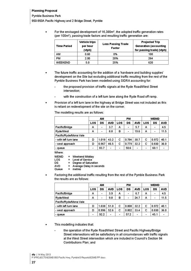
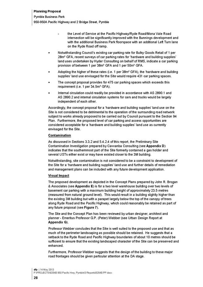
Traffic and Parking
The Planning Proposal is accompanied by a Traffic Impact Assessment Report prepared by TTPA for the future development of the site for hardware and building supplies purposes. As identified in the Planning Proposal, the previous traffic impact assessment undertaken by Council to inform the Town Centres LEP and LEP 219 did not take into consideration the potential development of hardware and building supplies within the B7 Business Park zone. Consequently, the Traffic Impact Assessment Report takes into consideration the impacts of this variation to land uses within the Pymble Business Park precinct.
While the traffic report includes information relating specifically to the processed redevelopment of the site at 950-950A Pacific Highway and 2 Bridge Street, Pymble such as access and parking, it also includes an analysis of the traffic network impacts of a large hardware and building supplies business within the Pymble Business Park. The traffic impact assessment report has been reviewed by Council’s Strategic Traffic Engineer, who has provided the following comments on the capacity of the traffic network in accommodating the proposed change of land use:
· The peak traffic generation of hardware and buildings supplies outlets is on weekends during the middle hours of the day, which does not conflict with the weekday commuter peaks. Anecdotally though, traffic conditions during the Saturday midday period are considered to be similar to weekday pm peak conditions in Sydney.
· Traffic surveys were undertaken during weekday am/pm commuter peaks as well as weekend midday periods, to determine the existing traffic conditions. These were broadly consistent with those undertaken for Council by GTA Consultants in the Pymble Business Park Assessment of Transport Options.
· Traffic modelling of the existing surveys indicate that existing average vehicle delays at the intersection of Pacific Highway with Ryde Road/Mona Vale Road are higher on weekends than weekdays but that the intersection operates at a level of service “D” (operating near capacity) which is generally the lowest desirable level of service. The traffic study notes that vehicles do have difficulty exiting West Street onto Ryde Road particularly during the weekday pm peak, which aligns with my observations.
· Adopted traffic generation rates were based on surveys of similar hardware outlets published by RMS, and seem reasonable.
· The inclusion in the analysis of traffic signals at the intersection of Ryde Road and West Street, the widening of the left turn lane at the Ryde Road off-ramp and pedestrian access across Pacific Highway at Bridge Street is consistent with the Pymble Business Park Assessment of Transport Options.
· The proposal is not dependent on the potential entry access from the Ryde Road off-ramp, although this would provide an additional access point into the site and potentially reduce weekend (and to a lesser extent, weekday) traffic volumes in West Street and Bridge Street. If this access is provided, the widening of the left turn lane at the Ryde Road off-ramp would most likely need to be implemented. Conversely if approval is not given (by RMS) for this access, then it is unlikely the proponent would construct the widening of the left turn lane at the Ryde Road off-ramp although RMS may require that land be dedicated by the proponent for future implementation of the widening of the left turn lane (by others).
· When incorporating the traffic generation from the hardware and building supplies, the results of the traffic modelling show that operation of all intersections within the precinct would be improved if the proposed traffic signals were installed at the intersection of Ryde Road and West Street, and widening of the left turn lane at the Ryde Road off ramp was implemented. However, RMSs view of these results, and how the upgrade proposals fit in with the broader road network operation, needs to be considered and their concurrence is required.
From the information available in the traffic study, the proposal has merit from a transport perspective provided the proposed intersection upgrades are implemented. It is noted that Ku‑ring-gai Contributions Plan 2010 does identify the Ryde Road/West Street and Pacific Highway/Bridge Street improvements as part of its works programme. Further feedback on the Planning Proposal from RMS is considered essential, particularly on the proposed road and intersection upgrades.
Contamination
As discussed above, the Planning Proposal is accompanied by a Preliminary Site Contamination Investigation which indicates that the precinct formerly contained a gas holder and several underground storage tanks either exist or may have existed on the 3M site. The report’s conclusion that site contamination is not considered to be a constraint for development for the purposes of ‘hardware and building supplies’ subject to further details of remediation and management plans to be included with any future development application is supported.
Visual Impact
The Planning Proposal contains discussion of an urban design analysis of the Concept Plan for the redevelopment of the site at 950-950A Pacific Highway and 2 Bridge Street, Pymble. As this information relates to a specific development outcome rather than the strategic outcomes of the planning proposal it is considered contrary to the requirements Section 117 Direction 6.3 (Site Specific Provisions) and should be removed.
Heritage
As identified above, the Planning Proposal fails to make reference to the State heritage items at 982 Pacific Highway (Pymble Electricity Substation) or the Fire Station at 966 Pacific Highway which are on the State Government’s ‘Heritage and Conservation Register’ under section 170 of the Heritage Act 1977. As the Planning Proposal is to apply to the whole B7 Business Park zone, including these sites, they should be identified in the Planning Proposal. The Planning Proposal should also be referred to the Department of Environment and Heritage as part of the public authority consultation process.
A separate report on the heritage merits of the former 3M building at 950 Pacific Highway is currently before Council. If, as a result of the report, it is deemed worthy to identify the property as a heritage item within a local environmental plan it would need to be subject to a separate planning proposal process. Should Council pursue the heritage listing of the site, this fact should be referenced in the Bunnings Planning Proposal.
Q9. Has the planning proposal adequately addressed any social and economic effects?
The Planning Proposal identifies the key social and economic considerations as employment and safety and security.
Employment
It is noted that the proposal to permit hardware and building supplies in the B7 Business Park zone will help facilitate the rejuvenation of the Pymble Business Park generally and provide additional local employment opportunities. This is consistent with the findings of the Hornsby/ Ku‑ring-gai Employment Lands Study and the strategic direction for the precinct under Draft Ku‑ring-gai Local Environmental Plan 2013.
Safety and Security
The planning proposal contains comments regarding perceived safety and security issues and the certain provisions within the Pymble Business Park DCP. Once again, this information relates to a specific development outcome rather than the strategic outcomes of the planning proposal, and it is considered contrary to the requirements Section 117 Direction 6.3 (Site Specific Provisions) and should be removed.
Section D – State and Commonwealth interests
Q10. I s there adequate public infrastructure for the planning proposal?
As discussed previously in this report, the traffic modelling submitted by the proponent indicates that the Planning Proposal would be acceptable with regard to traffic impacts, subject to several network improvements which are already planned for and included in Council’s Development Contributions Plan 2010.
Consultation with key agencies about the capacity to service the development concept was not undertaken by the applicant prior to submitting the Planning Proposal to Council.
Q11. What are the views of State and Commonwealth public authorities consulted in accordance with the Gateway determination?
The proponent has indicated that initial consultation has already occurred with Roads and Maritime Services (RMS). There is a need for further formal consultation with RMS, particularly on the proposed road and intersection upgrades.
No consultation has been undertaken with any other agencies at this stage. If the Planning Proposal were to be supported by Council, the views of State and Commonwealth Public Authorities will need to be obtained. In addition to RMS, consultation should also take place with the department of Environment and Heritage and the Heritage Branch.
2.4. Part 4 – Mapping
Planning proposals should be supported by relevant and accurate mapping where appropriate. As this planning proposal only involves the inclusion of an additional land use with the Land Use table there is no technical mapping required. The proponent has included supporting maps and illustrations which are included as background information. These do not form part of the formal Planning Proposal.
2.5. Part 5 – Community consultation
A Planning Proposal should outline the community consultation to be undertaken in respect of the proposal, having regard to the requirements set out in the Department of Planning and Infrastructure’ A guide to preparing local environmental plans.’
The proponent notes that the previous investigative studies which culminated in Ku-ring-gai LEP (Local Centres) 2012 and LEP No. 219, as well as these instruments themselves, have been the subject of considerable community and statutory consultation over the past few years. As such this planning proposal should be considered a ‘low impact’ planning proposal. As such, the planning proposal should be subject to a 14 day public exhibition period as opposed to a 28 day exhibition period for other planning proposals.
Under A guide to preparing local environmental plans, a ‘low’ impact planning proposal is considered to be”…a planning proposal that, in the opinion of the person making the Gateway determination is:
• consistent with the pattern of surrounding land use zones and/or land uses
• consistent with the strategic planning framework
• presents no issues with regard to infrastructure servicing
• not a principal LEP
• does not reclassify public land.”
Given the previous studies and exhibited planning proposals in relation to the Pymble Business Park and that the ‘hardware and building supplies’ land use has been included in the adopted KLEP 2013, it is considered that this planning proposal satisfies the “low impact” criteria. As such, the 14 day exhibition period is supported.
2.6. Part 6 – Project timeline
The Planning Proposal does not include a project timeline. This needs to be incorporated into the final Planning Proposal so as to provide a mechanism to monitor the progress of the planning proposal through the plan making process. It will also allow the Council, the Department and Parliamentary Counsel’s Office (PCO) to more accurately manage resources to ensure there are no unexpected delays in the process.
The following details should be provided as a minimum in the project timeline:
· anticipated commencement date (date of Gateway determination);
· anticipated timeframe for the completion of required technical information;
· timeframe for Government agency consultation (pre and post exhibition as required by Gateway determination);
· commencement and completion dates for public exhibition period;
· timeframe for consideration of submissions;
· timeframe for the consideration of a proposal post exhibition;
· date of submission to the department to finalise the LEP;
· anticipated date Council will make the plan (if delegated); and
· anticipated date Council will forward to the department for notification.
Governance Matters
The planning process will be governed by the provisions of the Environmental Planning and Assessment Act 1979 and the Local Government Act 1993 (where relevant).
On 29 October 2012 Council was advised by the NSW Department of Planning about new delegations and independent reviews related to plan-making under Part 3 of the Environmental Planning and Assessment Act 1979. This new administrative review processes enables a proponent to request a pre-gateway review before a planning proposal has been submitted to the department for a gateway determination. These reviews are informed by advice from Joint Regional Planning Panels (regional panels) or the Planning Assessment Commission (PAC). The proponent may ask for a pre-gateway review if:
a) the council has notified the proponent that the request to prepare a planning proposal is not supported, or
b) the council has failed to indicate its support 90 days after the proponent submitted a request, accompanied by the required information.
Also a gateway review may be requested by a council or proponent following a gateway determination, but before community consultation on the planning proposal has commenced. These reviews are informed by advice from the PAC.
Council will seek the plan-making delegation under Section 23 of the EP&A Act to finalise the Planning Proposal. This involves Council taking on the Director General’s function under s59(1) of the Act in liaising with the Parliamentary Counsel’s Office (PCO) to draft the required local environmental plan to give effect to the Planning Proposal as well the Minister’s function under s59(2) of the Act in making the Plan
Risk Management
Council now is in a position to make a formal determination on whether the planning proposal should be formally submitted to the Department of Planning & Infrastructure requesting a gateway determination. If a timely decision is not made on this matter, is it understood the applicant may have recourse to a further review under the proposed amendments to the local plan-making process under the EP&A Act and EP&A Regulations recently announced by the NSW Minister for Planning and Infrastructure.
Financial Considerations
The Planning Proposal submitted by Bunnings Properties Pty Ltd was subject to the relevant application fee under Council’s Schedule of Fees and Charges 2012-13. The cost of the review and assessment of the Planning Proposal is covered by the application fee.
Social Considerations
Social considerations for the planning proposal relate to the implementation of strategic planning policies and directions that call for a greater range of land uses in the Pymble Business Park to generate a viable employment base. This is consistent with the findings of the Hornsby/Ku-ring-gai Employment Lands Study and the Draft Ku-ring-gai Local Environmental Plan 2013.
Environmental Considerations
The Planning Proposal will not affect the existing biodiversity and environmental protection provisions introduced into the KPSO via LEP 218. Any future development proposal for hardware and building supplies within the Pymble Business Park will be subject to the existing environmental protection provisions.
Community Consultation
Should the Planning Proposal receive a favourable Gateway Determination, it will be exhibited in accordance with the Department’s Gateway Determination requirements. This will involve appropriate notification and receipt of submissions on the draft plan from the relevant State agencies and the general community.
Internal Consultation
The Planning Proposal has been referred to relevant internal sections of Council.
Summary
Council has received a Planning Proposal from Bunnings Pty Ltd which seeks to amend the (KPSO) to include ‘hardware and building supplies’ as a permissible land use in Zone B7 (Business Park). The DP&I have previously requested that the use be permitted in the B7 Business Park zone under Draft KLEP 2013.
On 27 August 2013 Council consider a report on the Planning Proposal and resolved ‘That the matter be deferred until an independent heritage report comes back to Council with a study of the 3M Building and the site’. The heritage assessment of the property has now been undertaken, the outcomes and recommendations of which are subject to a separate report to Council on this agenda.
At the Council meeting on 26 November, 2013 Council adopted the final Principal LEP (KLEP 2013) which includes Hardware and Building supplies as permitted with consent in the Zone B7 Business Park.
The Planning Proposal from Bunnings has been reviewed by Council staff and considered consistent with Council’s adopted Ku-ring-gai LEP 2013. Subject to amendments to ensure consistency with statutory requirements, the Planning Proposal is in an appropriate form to be forwarded to DP&I for a gateway determination.
|
A. That the Planning Proposal to amend the Ku-ring-gai Planning Scheme Ordinance to include ‘hardware and building supplies’ as a permissible land use with development consent in Zone B7 (Business Park) be supported in principle.
B. That the Proponent be advised to amend their Planning Proposal as follows:
i. Remove references to the concept design of the proposed future development at 950-950A Pacific Highway and 2 Bridge Street, Pymble from the technical component of the Planning Proposal in accordance with the requirements of Section 117 Direction 6.3 (Site Specific Provisions). ii. Incorporate appropriate consideration of the State heritage items at 982 Pacific Highway (Pymble Electricity Substation) and the Fire Station at 966 Pacific Highway. iii. Incorporate an appropriate project time line in consultation with Council staff.
C. That the amended Planning Proposal be prepared to the satisfaction of the General Manager and then be forwarded to the DP&I for a Gateway Determination in accordance with the provisions of the EP&A Act and Regulations.
D. That Council request the plan-making delegation under Section 23 of the EP&A Act for this planning proposal.
E. That upon receipt of a Gateway Determination, the exhibition and consultation process is carried out in accordance with the requirements of the Environmental Planning and Assessment Act, 1979 and with the Gateway Determination requirements.
F. That a report be brought back to Council at the conclusion of the exhibition period.
|
|
Craige Wyse Team Leader Urban Planning |
Antony Fabbro Manager Urban & Heritage Planning |
|
A1View |
Letter from Department of Planning and Infrastructure - Hardware and Building Supplies in Pymble Business Park |
|
2012/204358 |
|
|
|
A2View |
Planning Proposal - Inclusion of 'hardware and building supplies' in Zone B7 (Business Park) under KPSO |
|
2013/210585 |
|
APPENDIX No: 1 - Letter from Department of Planning and Infrastructure - Hardware and Building Supplies in Pymble Business Park |
|
Item No: GB.10 |
|
APPENDIX No: 2 - Planning Proposal - Inclusion of 'hardware and building supplies' in Zone B7 (Business Park) under KPSO |
|
Item No: GB.10 |


|
Ordinary Meeting of Council - 10 December 2013 |
GB.11 / 60 |
|
|
|
|
Item GB.11 |
S09781 |
|
|
29 November 2013 |
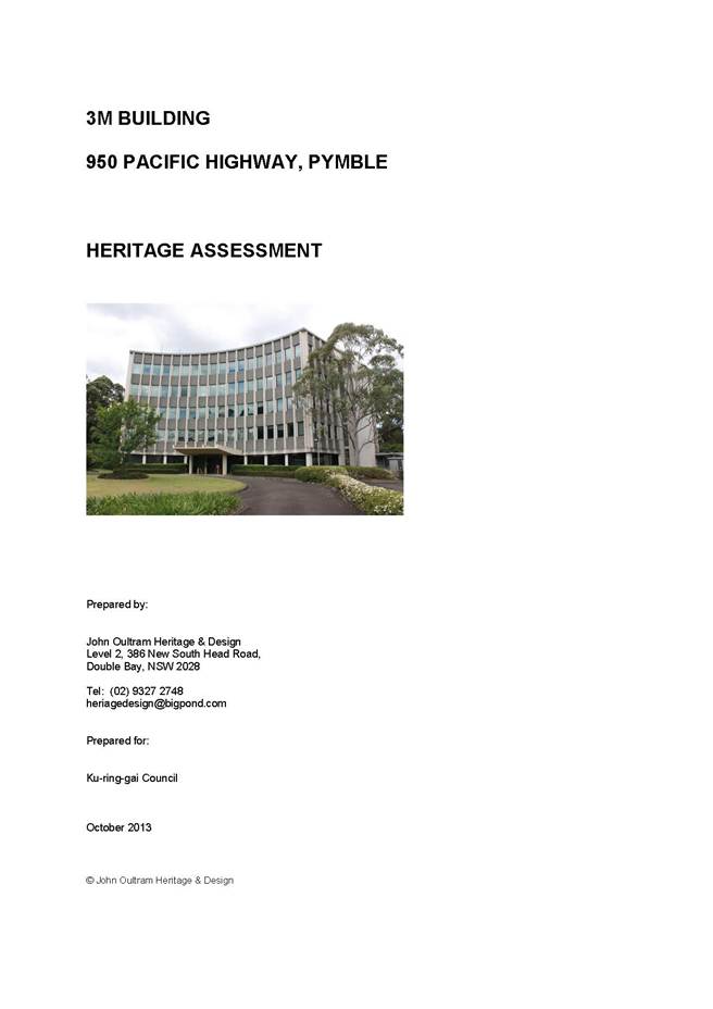
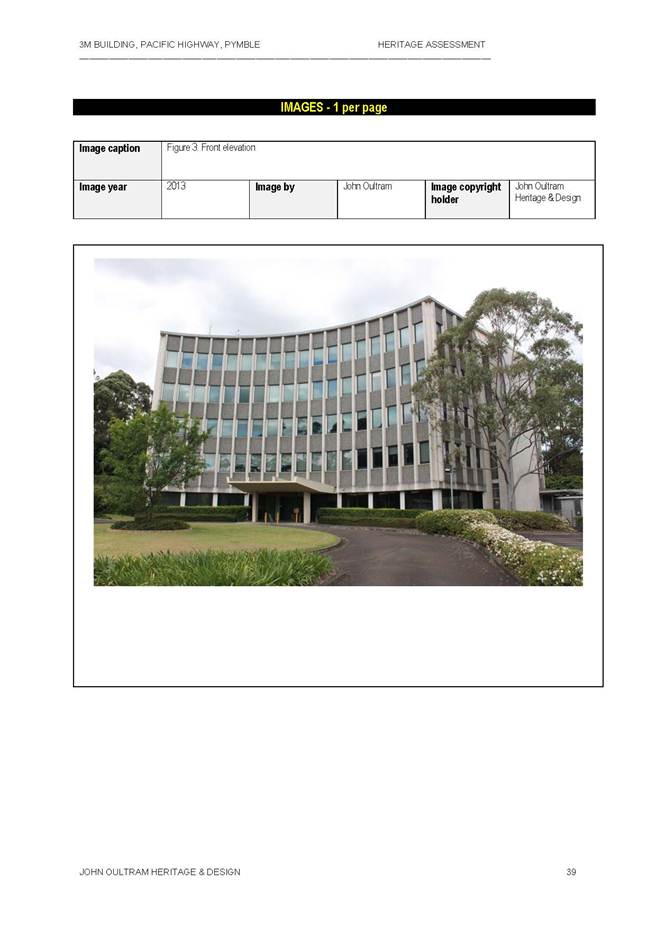
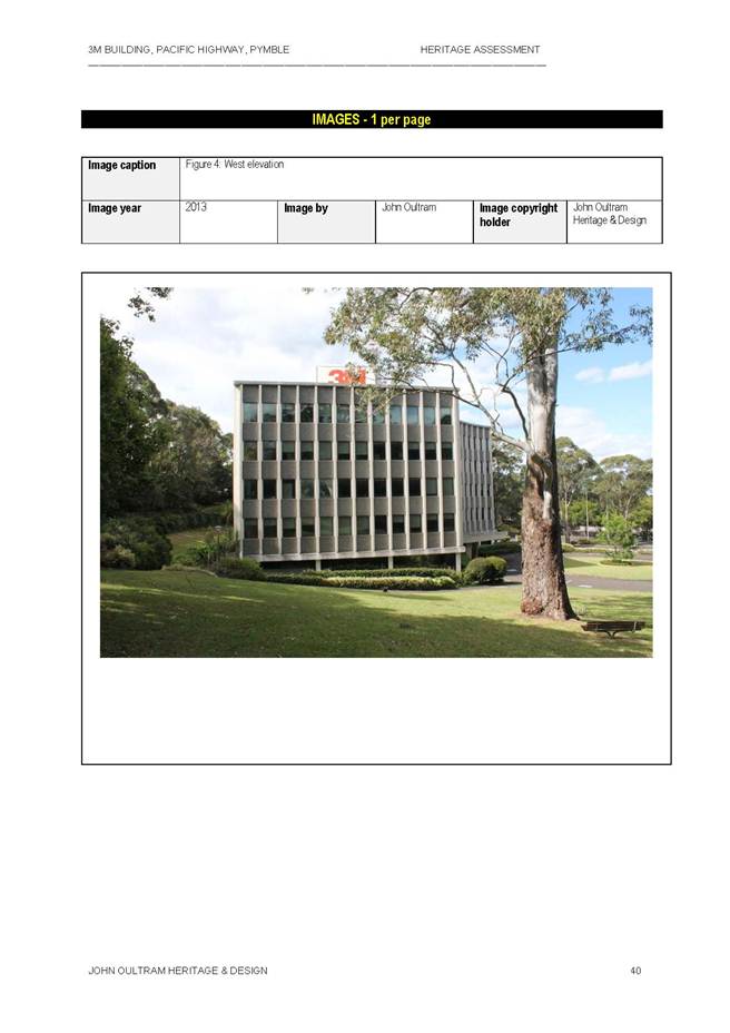
Heritage Assessment of Former 3M building at 950 Pacific Highway, Pymble
EXECUTIVE SUMMARY
|
purpose of report: |
To consider the heritage significance of the former 3M Building at 950 Pacific Highway, Pymble. |
|
|
|
|
background: |
On 27 August 2013 Council considered an Officer’s report for a planning proposal to amend the Ku-ring-gai Planning Scheme Ordinance (KPSO) to permit ‘hardware and building supplies’ as a use permissible with consent within the B7 – Business Park zone. Council resolved “That the matter be deferred until an independent heritage report comes back to Council with a study of the 3M Building and the site”. |
|
|
|
|
comments: |
John Oultram Heritage & Design consultants have conducted the heritage assessment of the site. On 31 October 2013, the Bunnings Group also submitted a heritage assessment prepared by Paul Davies Pty Ltd heritage consultants & Nick Jackson. This report provides an analysis of the heritage significance of the site and a recommendation. |
|
|
|
|
recommendation: |
That Council prepares a Planning Proposal to list |
Purpose of Report
To consider the heritage significance of the former 3M Building at 950 Pacific Highway, Pymble.
Background
On 27 August 2013 Council considered an officer’s report for a planning proposal to amend the Ku-ring-gai Planning Scheme Ordinance (KPSO) to permit ‘hardware and building supplies’ as a use permissible with consent within the B7 – Business Park zone. (Note this matter is being separately reported back to Council).
Council resolved on 27 August 2013 in relation to this site “That the matter be deferred until an independent heritage report comes back to Council with a study of the 3M Building and the site”.
Council engaged the services of John Oultram Heritage & Design consultants to conduct a heritage assessment of the site and the report was received in October 2013.
On 31 October 2013, Council also received a submission from the Bunnings Group with a heritage assessment of 950 Pacific Highway, Pymble prepared by Paul Davies Pty Ltd heritage consultants & Nick Jackson.
Comments
The John Oultram Heritage & Design Study October 2013 (See Attachment A1– Summary of Findings)
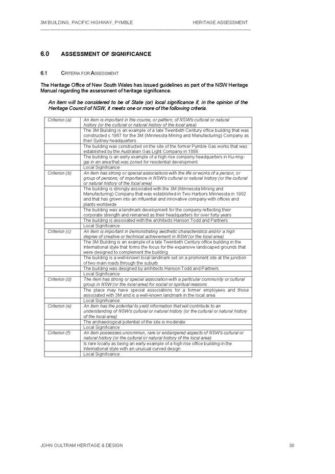
The John Oultram Heritage & Design Study prepared for Council considers that the former 3M building meets the Heritage Branch criteria for listing as a local heritage item (Attachments A1 & A2). In summary, the report notes:
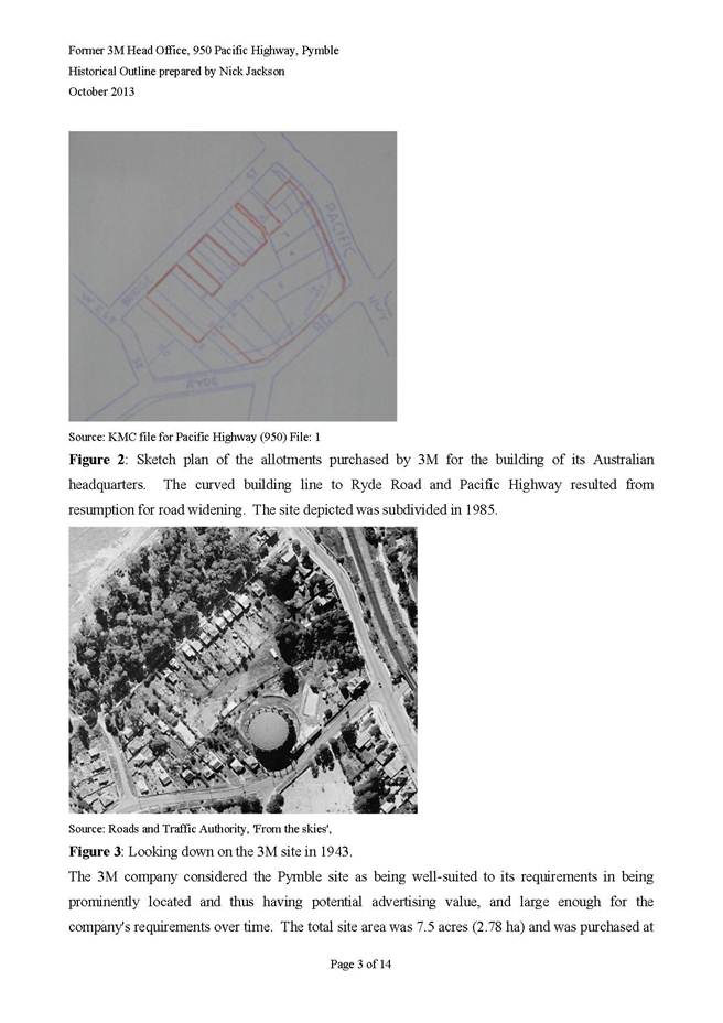
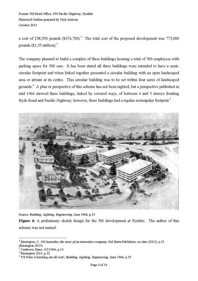
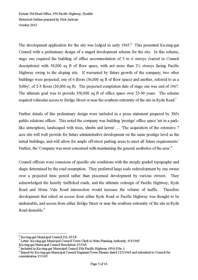
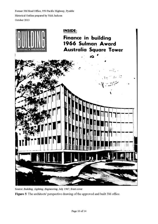
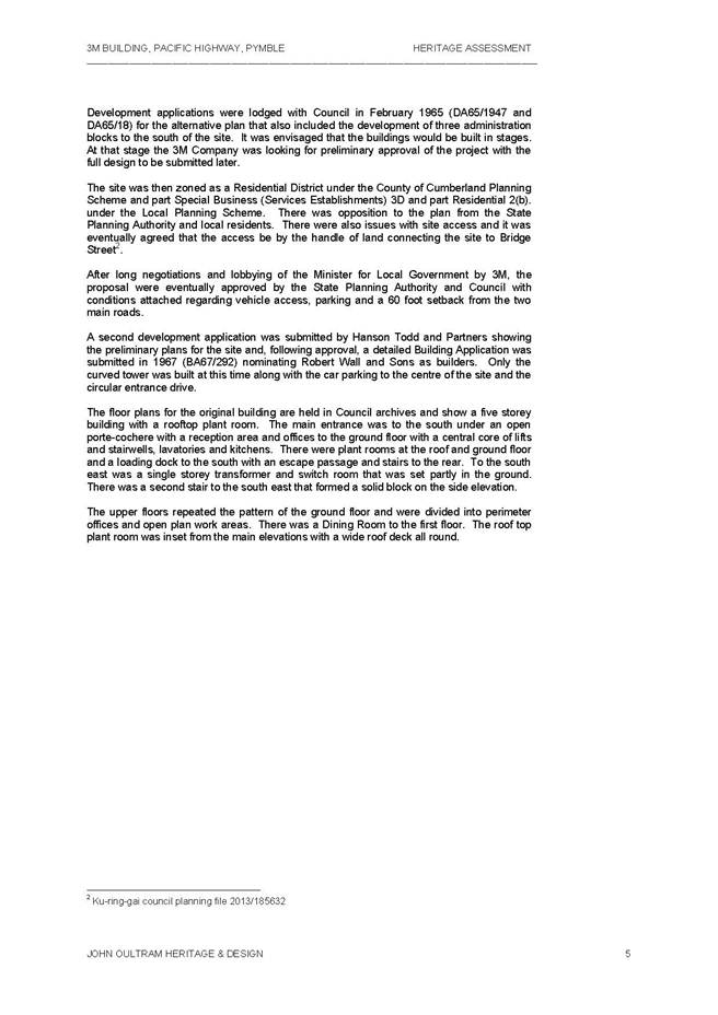
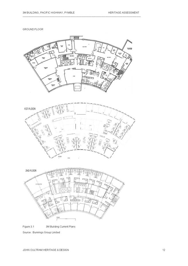
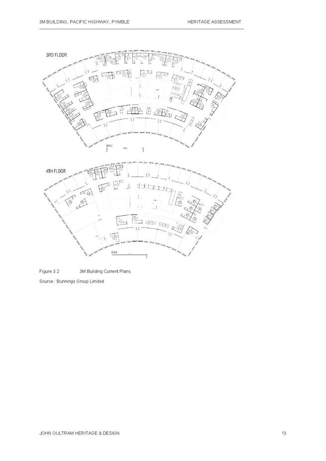
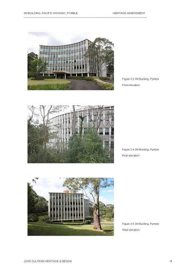
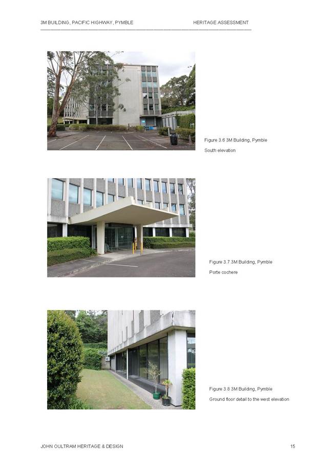
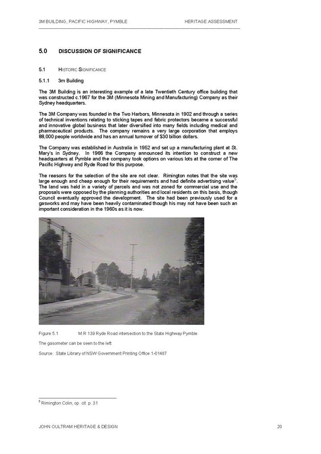
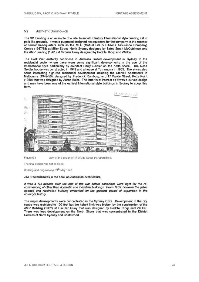
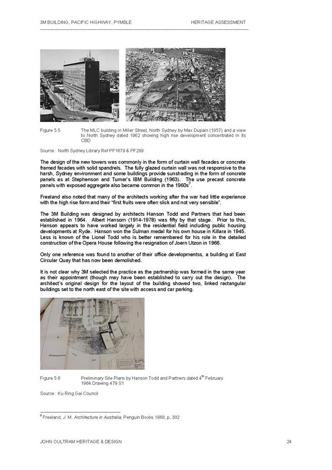
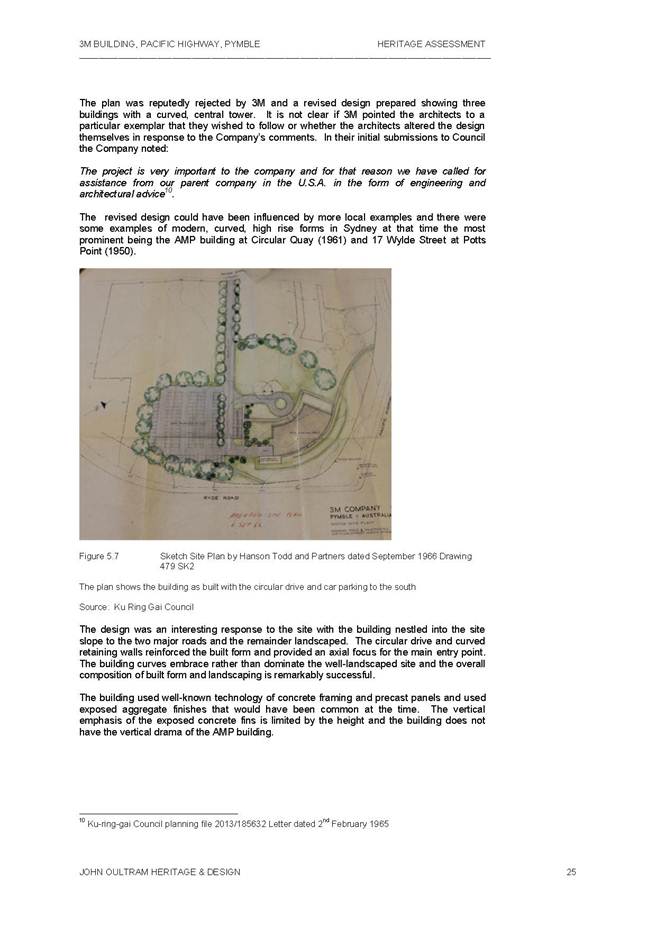
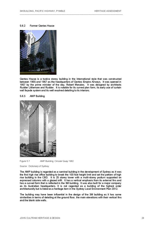
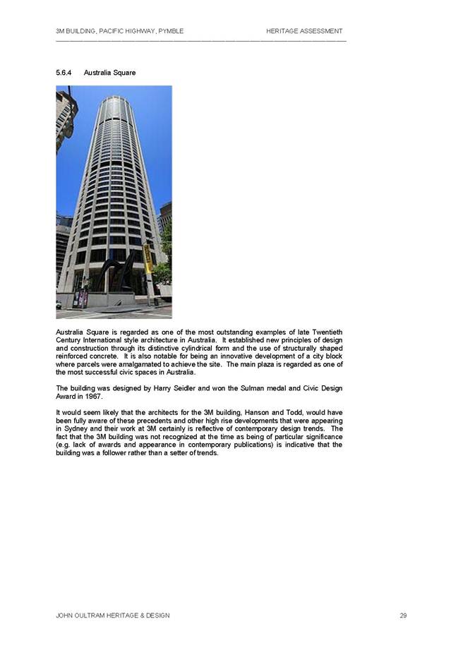
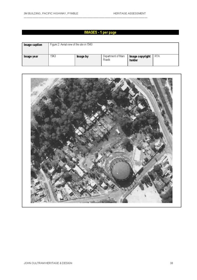
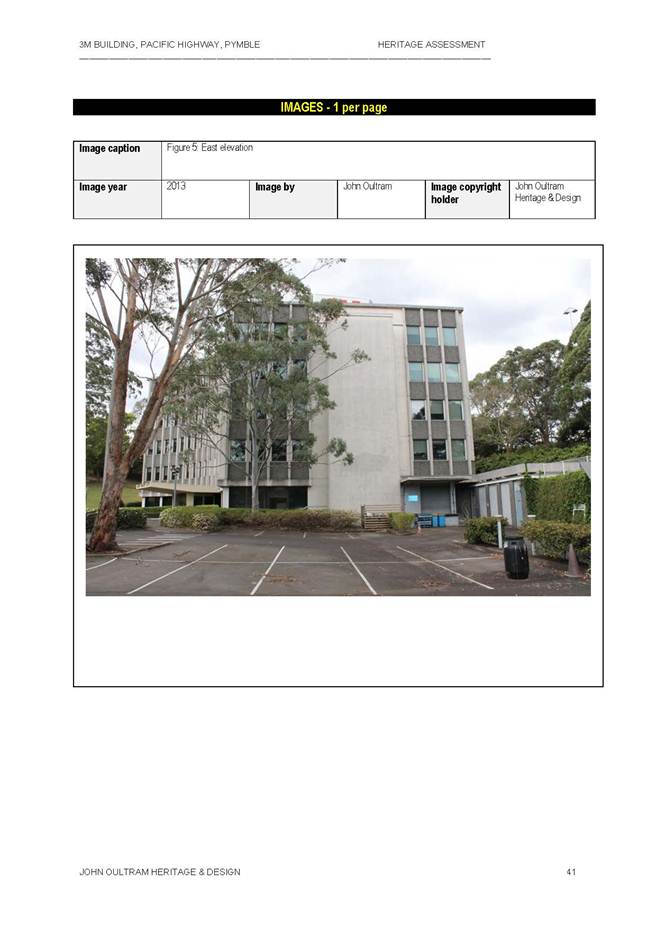
The 3M Building is an interesting and locally rare example of a late Twentieth Century office building in the International style that was constructed c.1967 for the 3M (Minnesota Mining and Manufacturing) Company as their Sydney headquarters. The building is an early example of a high rise company headquarters in Ku-ring-gai in an area that was zoned for residential development. The building was designed by architects Hanson Todd and Partners on the site of the former Pymble Gas works that was established by the Australian Gas Light Company in 1888. The building is intact externally but has been altered internally and is set in a well-landscaped site that retains much of the original setting of the building. The building represents the establishment of the 3M Company in Australia was a landmark development for the company reflecting their corporate strength and remained as their headquarters for over forty years. It is likely to have special associations for former employees and is a local landmark.
The building is of high significance locally.
In summary we consider that the 3M building:
· Cannot not be considered to be an architecturally important at a citywide level
· Is a well designed and relatively intact, representative example of the International style
· Retains its original landscaped setting that is unusual for a building of this style
· Is an important building in Ku-ring-gai as it was likely the first high-rise, International style building in the LGA
· Has important historical connections with the 3M Company
· Represents the beginnings of the Post War, large scale, commercial development in the LGA
In heritage terms, we consider that the building meets the Heritage Branch criteria for listing as a heritage item in the Draft Ku-ring-gai Local Environment Plan 2013.
The report concludes that the site meets the Heritage Branch criteria for listing as a heritage item in the draft KLEP 2013 for the following reasons:
· Though further research is required to confirm this, the building is likely the first International style, high rise building in Ku-ring-gai. It represents the beginnings of the post-war, large scale, commercial development in the LGA.
· It is a well-designed and relatively intact, representative example of the International style.
· Retains much of the original setting … and is a local landmark.
· The gasholder [pre-1943] was to the south of the site and may be outside the current lot boundary of the 3M complex. The level of development and any site remediation may preclude there being any underground remains. [Note that the study does not state it, these potential remains are common in Sydney or are expected to be significant].
· It is not a seminal work in terms of its style, layout, detail or construction methods. The use of precast concrete panels with exposed aggregate also became common in the 1960s.
· The study notes the lack of recognition at the time of construction.
· The site is currently being considered for inclusion on the AIA’s Register.
· The site has been identified by the Twentieth Century Heritage Society of NSW as an item of cultural heritage.
· The site is listed on the Register of the National Trust of Australia (NSW).
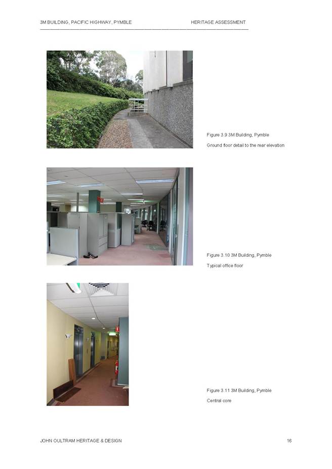
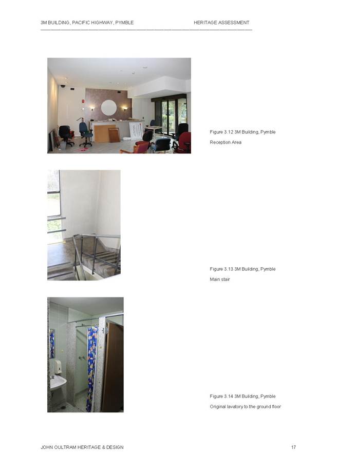
· A ‘Total Internal Refurbishment’ was undertaken in c1989, designed by Architects Devine Erby Mazlin. This involved the demolition of all interior partitions and finishes. The plans retained much of the internal layout of offices and open plan areas though the entry foyer was enclosed and the central halls altered. The partitions are generally modern, aluminium framed, glazed partitions with solid core doors … gridded acoustic ceilings. Only one lavatory and the stairs appear intact. The extant detail is not distinctive and uses materials common at the time.
Paul Davies Pty Ltd & Nick Jackson Study October 2013 – Summary of Findings (see Attachment A3)
The Paul Davies Pty Ltd & Nick Jackson report concludes that there are no reasons to suggest that the site should be a heritage item or that it has any heritage value for the following reasons.
· In considering the potential heritage values of a place there are guidelines established by the NSW Heritage Council. The intent of the guidelines is to establish a level of consistency in approach to heritage listing. More modern [recent] buildings can be quite hard to assess as often they are not within an understanding of heritage value that can be achieved with a greater historical perspective, however, buildings from the mid to late twentieth century are being placed on heritage registers and there is a reasonable understanding of the values that can be understood to achieve this. For a building to be a heritage item it needs to demonstrate values that are beyond the normal.
· The site was part of a gasholder that was significant, but this was completely removed for the construction of the current building. While this is historically of interest, the site no longer demonstrates any aspects of its use or development prior to the 3M building construction.
· There is no suggestion that the 3M building is an important part of the work of that firm or that the building was particularly innovative. Its curved form is interesting but its use of materials and its construction technique were reasonably standard for the time.
· It is also important to consider whether the building has been recognised by other bodies such as the AIA in their register…and it is not…is not an important twentieth century building.
· The interior of the building has been refitted so that there is little of the early fit-out that remains.
Comments
Whilst there are two reports that provide different outcomes on whether the site meets the criteria for heritage listing, it is recommended that Council commence the process for heritage listing of the property as an item of local significance. The justification for the listing would be on the following basis:
· The John Oultram report concludes that the site meets the Heritage Branch criteria for listing as a heritage item in the draft KLEP 2013 for a local listing. It is appears this building was the first International style, high rise building in Ku-ring-gai and represents the beginning of the post-war, larger scale commercial development in Ku-ring-gai;
· The building is a well-designed and relatively intact representative example of the International style;
· The building retains its original landscape setting;
· The building has important historical connection to the 3M Company;
· The building represents the beginnings of post-war, large scale commercial development in Ku-ring-gai.
It is understood the site is currently being considered for inclusion on the Australian Institute of Architects register of significant Architecture in NSW.
Several submissions were received during the public exhibition of the draft KLEP 2013 that are also relevant to this matter.
· Australian Institute of Architects submission supporting the inclusion of the site on Council’s LEP (dated 26 August 2013);
· The Twentieth Century Heritage Society of NSW Inc submission supporting the inclusion of the site on Council’s LEP (dated 6 August);
· National Trust of Australia (NSW) letter advising Council of the listing of the site on the Trust’s Register dated 23 August 2013.
The listing process would involve the preparation of a planning proposal for submission to the Department of Planning and Infrastructure (DP&I) for a gateway determination on whether the listing process should commence. Should a gateway for exhibition of the planning proposal be issued, additional historical material and information to assist Council in its decision on the local heritage listing may come via further submissions. Following formal exhibition and consideration of submissions, Council can then decide to proceed, vary or not proceed with the local heritage listing.
Governance Matters
Council resolved on 27 August 2013 “That the matter be deferred until an independent heritage report comes back to Council with a study of the 3M Building and the site”.
This report addresses the first stage in obtaining a gateway for a Planning Proposal which seeks to list 950 Pacific Highway Pymble as an item of local heritage significance under an amendment to the draft KLEP 2013.
If the planning proposal is supported by the State Government the draft plan will be placed on public exhibition seeking further State agency and stakeholder feedback prior to being reported back to Council.
The adopted Delivery Program and Operational Plan (Places, Spaces and Infrastructure) sets out Council’s 4 year Term Achievement for the Principal LEP:
· Strategies, plans and processes are in place to effectively protect and preserve Ku-ring-gai’s heritage.
The Operational Plan for 2013/2014 also identifies the following series of actions to achieve the Term Achievement:
• Identify gaps in existing strategies and plans.
Council will seek the plan-making delegation under Section 23 of the EP&A Act to finalise the Planning Proposal. This involves Council taking on the Director General’s function under s59(1) of the Act in liaising with the Parliamentary Counsel’s Office (PCO) to draft the required local environmental plan to give effect to the Planning Proposal as well the Minister’s function under s59(2) of the Act in making the Plan
Risk Management
Council is responsible for the identification and management of Ku-ring-gai’s Local Cultural Heritage. Council now is in a position to make a formal determination on whether the planning proposal should be formally submitted to the Department of Planning & Infrastructure requesting a gateway determination for a potential local heritage listing.
Financial Considerations
The costs associated with this matter are covered by the Strategy and Environment Department - Urban Planning and Heritage budget. Additional costs may be incurred for any further heritage assessment of the site.
Social Considerations
Ku-ring-gai Council is responsible for the identification and management of Ku-ring-gai’s local cultural heritage. Consideration of this matter will assist in meeting its requirements to identify and protect items of local cultural heritage significance.
Environmental Considerations
Ku-ring-gai Council is responsible for the identification and management of Ku-ring-gai’s environmental heritage. Consideration of this matter will assist in meeting its requirements to identify and protect items of local cultural heritage significance.
Community Consultation
Should the Planning Proposal receive a favourable Gateway Determination, it will be exhibited in accordance with the Department’s Gateway Determination requirements. This will involve appropriate notification and receipt of submissions on the draft plan from the relevant State agencies and the general community and a further report back to Council.
In previous heritage consultation practice for the proposed Heritage Conservation Areas, Council has undertaken an extra level of consultation via a non-statutory exhibition prior to going to the next stage of a formal Gateway for a Planning Proposal. However, in this case of an individual heritage item, this approach is not recommended due to time constrains and Council’s recent consideration of draft KLEP 2013.
Internal Consultation
Where relevant the Planning Proposal has been referred to relevant internal sections of Council.
Summary
On 27 August 2013 Council considered an Officer’s report for a planning proposal to amend the Ku-ring-gai Planning Scheme Ordinance (KPSO) to permit ‘hardware and building supplies’ as a use permissible with consent within the B7 – Business Park zone. Council resolved “That the matter be deferred until an independent heritage report comes back to Council with a study of the 3M Building and the site”.
John Oultram Heritage & Design consultants were commissioned by Council to prepare the heritage assessment of the site. On 31 October 2013, the Bunnings group also submitted a heritage assessment prepared by Paul Davies Pty Ltd heritage consultants & Nick Jackson. This report provides and analysis of the heritage significance of the site and a recommendation.
|
A. That a Planning Proposal be prepared, in accordance with section 55 of the Environmental Planning and Assessment Act, 1979, to amend Draft Ku-ring-gai Local Environmental Plan 2013 by listing 950 Pacific Highway, Pymble (Lot 1 DP718718) Schedule 5 as a heritage item of local significance.
B. That the Planning Proposal be submitted to the Department of Planning and Infrastructure for a Gateway Determination in accordance with Section 56 of the Environmental Planning and Assessment Act, 1979.
C. That Council request the plan-making delegation under Section 23 of the EP&A Act for this planning proposal
D. That upon receipt of a Gateway Determination, the exhibition and consultation process is carried out in accordance with the requirements of the Environmental Planning and Assessment Act, 1979 and with the Gateway Determination requirements.
E. That a report be brought back to Council at the end of the exhibition processes.
|
|
Craige Wyse Team Leader Urban Planning |
Antony Fabbro Manager Urban & Heritage Planning |
|
A1View |
No 950 Pymble - Heritage Assessment by John Oultram - Final Report October 2013 |
|
2013/308221 |
|
|
|
A2View |
No 950 Pymble - 2013 Heritage Inventory Sheet by John Oultram Heritage and Design |
|
2013/308218 |
|
|
A3View |
No 950 Pymble - Heritage - Bunnings Group Submission |
|
2013/308253 |
|
APPENDIX No: 1 - No 950 Pymble - Heritage Assessment by John Oultram - Final Report October 2013 |
|
Item No: GB.11 |


|
APPENDIX No: 2 - No 950 Pymble - 2013 Heritage Inventory Sheet by John Oultram Heritage and Design |
|
Item No: GB.11 |

|
Ordinary Meeting of Council - 10 December 2013 |
GB.12 / 124 |
|
|
|
|
Item GB.12 |
S09318 |
|
|
17 October 2013 |
St Ives Shopping Village
EXECUTIVE SUMMARY
|
purpose of report: |
To consider a proposal from EK Nominees Pty Limited in relation to future planning and redevelopment of the St Ives Shopping Village. |
|
|
|
|
background: |
Following a Council resolution on 9 April 2013 a meeting between Councillors, staff and representatives of EK Nominees was held on 6 August 2013. A further meeting and inspection of the St Ives Shopping Centre involving Councillors, Council staff and representatives from EK Nominees was conducted on 10 September 2013. |
|
|
|
|
comments: |
On 16 October 2013, following on from the meetings between EK Nominees and Council, a formal letter was submitted to Council by EK Nominees. The letter clarifies EK Nominees’ vision for the St Ives Shopping Village and sets out the steps for Council to undertake if it is of a mind to participate in the proposal. |
|
|
|
|
recommendation: |
That Council commences the process of reclassification for 3 parcels of land: the Council car park known as 176 Mona Vale Road; Village Green Parade (which includes a Council car park, St Ives Library, St Ives Early Childhood Centre and St Ives Neighbourhood Centre); and the Council car park known as 11-21 Cowan Road, St Ives. |
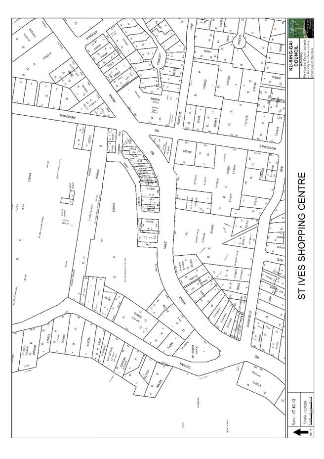
Purpose of Report
To consider a proposal from EK Nominees Pty Limited in relation to future planning and redevelopment of the St Ives Shopping Village.
Background
At its meeting of 9 April 2013, Council adopted a Notice of Motion (NoM) submitted by Councillor Ossip in relation to St Ives Shopping Village. The NoM reads as follows:
“The St Ives Shopping Village is a focal point for the community of St Ives. Together with the Village Green, it is at the heart of the community. The shopping village is one of the oldest shopping centres in Sydney and is long overdue for a major revamp.
I understand that the owners of the site briefed the former Council and staff a number of times on their plans for upgrading the centre. Now that the Local Centres LEP has been gazetted, it would be appropriate for the new Council to be briefed on plans for the Shopping Village as well.
I move that:
"Council staff facilitate a meeting between Councillors and the owners of St Ives Shopping Village so that Councillors can be briefed on any plans for upgrading the Shopping Village."
Following the Council resolution on 9 April 2013, Council wrote to EK Nominees advising of Council’s resolution. A meeting between Councillors and representatives of EK Nominees was held on 6 August 2013. A further meeting and inspection of the St Ives Shopping Centre involving Councillors, Council staff and representatives from EK Nominees was conducted on 10 September 2013.
Comments
On 16 October 2013, following on from the meetings between EK Nominees and Council, a formal letter was submitted to Council from EK Nominees (refer Attachment A1). The letter clarifies EK Nominees’ vision for the St Ives Shopping Village and sets out the steps for Council to undertake, if it is of a mind to, participate in the proposal.
The letter addresses the following matters:
1. the vision of the St Ives Shopping Village owner;
2. establishing a planning framework (primarily building height and floor space ratio) which allows economically feasible development of the centre;
3. the closure of a number of public roads to provide a consolidated building footprint;
4. reclassification of certain Council-owned lands from community to operational to provide a consolidated building footprint and space and expansion of the centre;
5. the formalisation of certain easements and rights; and
6. a delivery mechanism.
Vision
EK Nominees indicate that, on the whole, their vision is aligned with Council’s vision as expressed in Council’s Public Domain Plan however they note that under the current planning controls there is no means for the vision to be delivered. Key elements of the EK Nominees’ vision are as follows:
- a pedestrian through-site link between Mona Vale Road and the Village Green;
- the creation of a new public space along the northern edge of the centre adjoining the Village Green;
- new community facilities such as child care, a new library and a neighbourhood centre;
- a new town square;
- improved traffic conditions and circulation;
- improvements to the safety of the area particularly at night; and
- greater levels of amenity and events.
Staff Commentary
Council’s vision for the area is set out in the Town Centres Public Domain Plan, 2010; the Ku-ring-gai Contributions Plan, 2010; the Ku-ring-gai Local Environmental Plan (Local Centres), 2012 and the Local Centres DCP 2013. The key elements are:
- a new town square;
- a new free-standing, Council-owned, multi-purpose community facility;
- a new one-way Village Green Parade;
- a pedestrian promenade;
- partial closure of Denley Lane;
- streetscape improvements;
- closure of Durham Lane for a new civic space; and
- traffic and parking improvements.
For comparison purposes full details of the community infrastructure proposed by Council for the area is included in Attachment A4.
Figure 1 below is taken from DCP 2013 and shows the key community infrastructure elements for the area.
Figure 1- Local Centres DCP 2013 – Key Community Infrastructure Plan
Planning framework
EK Nominees’ note that the current provisions in the Local Centres LEP 2012 do not allow economically feasible development and request that the planning controls for the site be set out follows:
- FSR of 2.0:1 with potential to increase to 2.3:1;
- maximum building height of 26.5 metres (8 storeys) with potential to increase to 29.5 metres (nine storeys); and
- maintain the current B2 – Local Centre zone allowing shop top housing.
EK Nominees’ note that these provisions are the same as the former (invalid) Ku-ring-gai Local Environmental Plan (Town Centres) 2010.
Staff Commentary
The current LEP provisions applicable to the St Ives Shopping Centre are as follows:
- B2 Local Centre Zone;
- Maximum building height 14.5 metres (equivalent to 4 residential storeys);
- FSR of 1.6:1.
Figures 2, 3, and 4 show the relevant map extracts.
The variable heights and FSRs referred to in the EK Nominees’ letter are in relation to the design excellence clause from the former Town Centres LEP 2010. As this clause is not available within the Local Centres LEP 2012 it will be necessary for EK Nominees to accurately define the proposed building height and FSR they seek should they prepare a Planning Proposal for their land and the surrounds. It is not the purpose of this report to consider the merits of height and floor space beyond that within the Local Centres LEP 2012. It is incumbent upon EK Nominees to make their own case in a formal Planning Proposal.
Figure 2 - Local Centres LEP 2012 – Land zoning map extract – St Ives
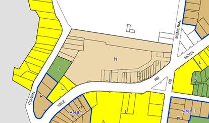
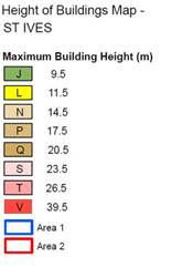
Figure 3 - Local Centres LEP 2012 – Height of buildings map extract – St Ives
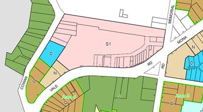
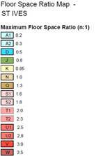
Figure 4 - Local Centres LEP 2012 – FSR map extract – St Ives
Road closures
EK Nominees’ request that Council move forward with the closure of certain Council-owned lane ways. The lanes identified by EK Nominees are:
- Denley Lane;
- An “unnamed lane” located immediately to the west of council’s car park at 176 Mona Vale Road.
Figure 5 shows the location of these lands.
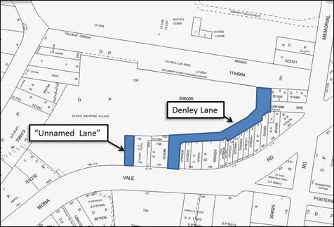
Figure 5 – Council owned lane ways – EK Nominees requesting closure or part closure
Staff commentary
The Ku-ring-gai DCP (Local Centres) 2013 assumes closure of the “unnamed lane”, which runs along the western boundary of 176 Mona Vale Road, and incorporation into an amalgamated site. The Local Centres DCP assumes partial closure of Denley Lane between Mona Vale Road and the property at 190 Mona Vale Road. Full closure of Denley Lane has not been considered to date as the properties at 190-192B Mona Vale Road, 200 Mona Vale Road, 2 Durham Avenue and 2 Memorial Avenue will require ongoing access to their properties via Denley Lane. This situation may change if ownership patterns change in the area in the future.
Council previously resolved to close the subject roads. Formal consultation with affected property owners was not carried out as EK Nominees had not demonstrated that ongoing access was available to properties fronting Mona vale Road which they did not own.
Reclassification of Council lands
EK Nominees request that Council move forward with the reclassification of certain Council-owned lands from community to operational. The lands identified by EK Nominees are:
- Council car park - known as 176 Mona Vale Road, St Ives being Lot 103 DP 627012 & Lot 105 DP 629388;
- Village Green Parade (incorporating the St Ives Library, St Ives Early Childhood Centre and St Ives Neighbourhood Centre) being Lot 1 in DP 420106 and Lot2 in DP 822373; and
- the Council car park known as 11-21 Cowan Road, St Ives being Lot A in DP 336206, Lot B in DP 336206, Lot 1 in DP 504794 and Lot A in DP 321567.
EK Nominees argue that reclassification of these lands is essential to allow redevelopment of the centre.
Staff Commentary
It is noted that the letter from EK Nominees lists two Lot and DP references in relation to the Village Green Parade which could not be located on Council’s property system, namely Lot 1 in DP 420106 and Lot 2 in DP 822373. These references relate to an earlier Lot and DP plan which existed prior to Council re-subdividing (boundary adjustment) for the land in August 2011.
The correct references are as follows:
- The Village Green Parade Lot 201 in DP 1164994; and Lot 200 in DP 1164994.
Council may also wish to consider reclassification of the St Ives Occasional Child Care Centre - known as 261 Mona Vale Road, St Ives being Lot 31 DP719052. If a new child care centre is provided as part of a future redevelopment of the Shopping Centre then this site will no longer be required as the service could considered for possible relocation to the new centre along with other children’s services.
Figure 6 shows the location of these lands and Attachment A3 provides a detailed Lot and DP diagram.
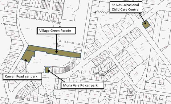
Figure 6 – Council-owned land classified community
Easements and rights
EK Nominees request that Council address the matter of formalisation of various easements and rights between Council’s land, namely car parking areas and access ways, and the centre’s land. EK Nominees note that they have been seeking formalisation of this matter over a number of years. A plan of easements was prepared.
Staff commentary
Council received correspondence from EK Nominees in 2010, seeking to formalise access rights over the Council owned car park land. Council staff have obtained legal advice in relation to the request (refer Attachment A2).
The reclassification of lands and discharging all interests over Council’s land holdings will make the request to formalise these rights redundant.
Delivery mechanism
EK Nominees indicate that an appropriate development agreement, such as a Voluntary Planning Agreement (VPA) or deed, could be established between Council and the owners of the centre which provides a framework for the sale or lease of Council land and the provision of community facilities. The letter notes that similar successful redevelopments on the north shore have used similar agreements such as Lane Cove and Willoughby Councils.
Staff commentary
There is a range of mechanisms Council can utilise to ensure delivery of community infrastructure. Council will require further advice in this regard.
Governance Matters
The adopted Delivery Program and Operational Plan (Places, Spaces and Infrastructure) sets out Council’s 4 year Term Achievement to deliver for St Ives; The Operational Plan for 2013/2014 also identifies the a series of actions to achieve the Term Achievement.

Council’s recently revised and adopted Community Strategic Plan 2030 (CSP), identifies the revitalisation of our centres as an important long term objective for the community.
Specifically our community desires that the St Ives, Lindfield and Gordon centres offer a broad range of shops and services and contain lively urban village spaces and places where people can live, work, shop, meet and spend leisure time.
The CSP endorses Council’s role to lead, facilitate and deliver the following for St Ives:
· Plans to revitalise local centres are being progressively implemented and achieve quality design outcomes in collaboration with key agencies, landholders and the community.
· Planning opportunities are investigated for the revitalisation of the St Ives Centre and surrounding precincts in collaboration with owners, developers, government agencies and local residents.
Risk Management
An important risk that would need to be identified is the integrity and due protection of the value of the public assets held and administered by the council, or the public interest generally. Such a risk may be reputational as well as financial.
A second risk would be the possible inability of the Council to discharge its Charter obligations to provide adequate, equitable and appropriate services and facilities for the community. Such a risk may be reputational as well as financial.
Financial Considerations
Council has funds it could contribute to the project through the Ku-ring-gai Contributions Plan 2010. It is also noted that Council would expect some form of cash payment for its land in addition to any in-lieu development contributions that may be agreed to.
A Planning Proposal from EK Nominees as outlined in their letter would be subject to Council’s fees and charges and charges – this would assist in covering the costs of review, analysis, exhibition and reporting the draft Plan.
Social Considerations
The reclassification of Council land could potentially provide Council with the opportunity to plan for and provide a wider range of new and updated community facilities and services for St Ives residents.
Council provides a wide range of community facilities within St Ives local centre. In 2009 Elton Consulting, on behalf of Council, undertook a review of existing community facilities to determine the current provision of community facilities in Ku-ring-gai and to identify key issues regarding their adequacy in meeting the demands of the community. The overall picture is of highly valued and well-used facilities that are short of space; in buildings not built-for-purpose; buildings that are ageing; and facilities in need of maintenance and renovation.
The descriptions below are extracts from the Community Facilities Strategy, 2009 prepared by Elton Consulting.
St Ives Library
· heavily used library in relatively small space;
· cramped and limited space for required uses creates noise issues; and
· particular shortage of study space, display space, lounge reading space, meeting room space.
St Ives Community Centre
· extremely popular and highly utilised space; and
· limited capacity.
Ku-ring-gai Community Groups Centre
· maintenance and upgrading needs identified in building condition audit, especially to address “meets minimum standards for egress”, OH&S and accessibility;
· need for space to enable service expansion, and particularly more meeting space for carer meetings/carer forums; space for staff amenities; and space for volunteer training;
· parking is a real issue – 2 hour limit is a real problem for staff (even with the allocated bays);
· need a room for staff to meet – a shared one with all the other service providers could work;
· only one bathroom for the whole centre and a sink (no kitchen facilities on site);
· safety and security is an issue;
· a more suitable premises could be identified which addresses concerns raised in regard to need for more space as demand will grow as population increases.
Ku-ring-gai Neighbourhood Centre
· looking to improve the service in the future to support carers; and
· would like additional space to provide respite while carers are shopping.
St Ives Occasional Care Centre
· building ageing - service has been in this location for 30 years;
· full to capacity; and
· purpose-built would be preferable and better to deal with childcare environment.
St Ives (Fitz) Youth Centre
· facilities limited to one room – limits leisure activities that can be provided;
· lack of equipment for youth centre;
· renovation of the space is required;
· not set up with furnishings or amenities/activities for young people (this limits ownership of the space).
The value of the Council facilities to the community and the need for modern facilities is further emphasised by a recent submission to Council of a proposal by the St Ives Progress Association for a multi-purpose community centre for St Ives on community land on Cowan Road (received 22 October 2013). Discussion of the document is not provided here as SIPA request that the proposal remain confidential.
The important point to note is that the existing facilities are highly valued and well-used facilities which now require modern built-for-purpose buildings that will meet the future social needs of St Ives residents. This conclusion is further supported by a prominent local community group.
Environmental Considerations
The redevelopment of the St Ives Shopping Centre and the reclassification of Council-owned land will have environmental implications. These would be addressed in the formal Planning Proposal and open for further public review and comment.
The KLEP 2012 indicates there are no areas of biodiversity significance or heritage within the lands owned by council or the Shopping Village.
Community Consultation
There has been significant community consultation since 2005 on earlier proposals for reclassification of Council’s land holdings in St Ives.
The Town Centres Public Domain Plan, 2010; the Ku-ring-gai Contributions Plan, 2010; and the Local Centres DCP, 2013 have all been through community consultation and public exhibition processes.
A formal Planning Proposal process will include statutory consultation for the exhibition of the planning proposal and the public hearing process. Throughout the process there will be series of Council reports and further opportunity for community involvement.
Internal Consultation
To date Council has met with the proponent on two occasions to further understand the position of the St Ives Shopping Centre. Where relevant, consultation with other sections of Council has been undertaken in the preparation of this report.
Summary
Over the past years there have been several meetings between Council and the St Ives Shopping Centre on their plans for upgrading and redeveloping the shopping centre.
Following the Ku-ring-gai LEP Local Centres, 2012 gazettal on 25 January 2013 and the Local Centres Development Control Plan adoption by Council, it is timely for Council to consider using its landholdings to assist in facilitating the redevelopment of the St Ives Shopping Centre, whilst capitalising on the returns to Council and the potential community benefits.
Reclassification
Council is a strategic landholder within the St Ives precinct. Reclassification of Council’s land (see figure 6 - Proposed Reclassification of Land in St Ives) from community to operational will assist in the first steps of Council both achieving its objectives under the Community Strategic Plan 2030, the Delivery Program 2013-2017 and Operational Plan 2013-2014, whilst attaining the significant public benefit which could arise from the inclusion of Council’s landholdings within the planning and redevelopment process for the St Ives precinct.
If Council wishes to proceed in this direction outlined in the letter from EK Nominees and the discussion in this report, then the first step is to adopt the following sites for the purpose of reclassification from community to operational land status via an amendment to the Ku-ring-gai Local Environmental Plan (Local Centres) 2012;
The Planning Proposal process for reclassification is as follows:
1. Council resolves to reclassify its land holdings;
2. Council submits a Gateway form to DOPI;
3. Exhibition of Planning Proposal (call for submissions);
4. Notice of public hearing (call for submissions);
5. Public hearing held;
6. Public hearing chairperson prepares report and report released;
7. Council consideration of submissions and the public hearing report;
8. Council sends Planning Proposal to DOPI requesting Plan be made; and
9. DOPI determination of the plan.
This process normally takes a minimum of 12 months.
The relevant parcels of land are as follows:
· Council Car Park - known as 176 Mona Vale Road, St Ives being Lot 103 DP627012 & Lot 105 DP629388.
· St Ives Village Green Parade (incorporating St Ives Library, Early Childhood Centre and Neighbourhood Centre St Ives Lot 201 in DP 1164994 & Lot 200 in DP 1164994.
· Council’s car park known as 11-21 Cowan Road, St Ives being:
- Lot A in DP336206,
- Lot B in DP336206,
- Lot 1 in DP504794,
- Lot A in DP321567,
· St Ives Occasional Child Care Centre - known as 261 Mona Vale Road, St Ives being Lot 31 in DP719052.
Closure of public roads
Council is the owner of roads and lanes within the precinct. Two of these are identified in this report as having potential for closure, and these are shown on Figure 5. The relevant public roads are the “unnamed lane”, which runs along the western boundary of 176 Mona Vale Road; and partial closure of Denley Lane between Mona Vale Road and the property at 190 Mona Vale Road.
There are two ways a road can be closed:
· Closure of public road by Minister;
· Closure of public roads by Compulsory Acquisition.
The first process can take up to two years to complete while the second process will take significantly less time than closure by the Minister.
Closure of public road by Minister
· The Council as roads authority for a public road, may make an application for the closing of it to the Minister;
· After the Council has lodged the application form with the Crown Lands Division on behalf of the Minister, the Minister must cause notice of the proposed closing of a public road to be published in a local newspaper;
· Any person may make a submission to the Minister with respect to the closing of the road;
· After considering any submissions duly made, the Minister may, by notice published in the Gazette, and with the consent of the Council, close the public road;
· On publication of the notice closing the public road the road ceases to be a public road.
Closure of public roads by Compulsory Acquisition
· Section 41 of the Roads Act states that a ‘public road that is compulsorily acquired under this or any other Act or law ceases to be a public road as a consequence of its compulsory acquisition’;
· The process for compulsory acquisition is found in the Just Terms Act;
· The land is compulsorily acquired when, with the approval of the Governor, a notice is published in the Gazette that declares that the land is acquired by compulsory process;
· The acquisition notice is, if practicable, to be published in at least one newspaper circulating in the Ku-ring-gai district.
Closure of the unmade Hall Street within what is now the B2 subdivision was done by compulsory acquisition.
If Council is of a mind to proceed with reclassification and road closures as outlined in this report then the onus will be on the St Ives Shopping Village to prepare a Planning Proposal for submission to Council and make their own case in relation to height and floor space ratio.
A Planning Proposal for reclassification is not proposed to be processed independent of a planning proposal by EK Nominees.
|
A. That a Planning Proposal be prepared, in accordance with section 55 of the Environmental Planning and Assessment Act, 1979, to reclassify the council car park known as 176 Mona Vale Road, St Ives, being Lot 103 in DP627012 & Lot 105 in DP629388, from community land to operational land via an amendment the Ku-ring-gai LEP Local Centres (2012).
B. That a Planning Proposal be prepared, in accordance with section 55 of the Environmental Planning and Assessment Act, 1979, to reclassify the Council land known as Village Green Parade (which includes a Council car park, St Ives Library, St Ives Early Childhood Centre and St Ives Neighbourhood Centre) being Lot 201 in DP 1164994 & Lot 200 in DP 1164994 from community land to operational land via an amendment the Ku-ring-gai LEP Local Centres (2012).
C. That a Planning Proposal be prepared, in accordance with section 55 of the Environmental Planning and Assessment Act, 1979, to reclassify the Council car park known as 11-21 Cowan Road, St Ives, being:
- Lot A in DP 336206, - Lot B in DP 336206, - Lot 1 in DP 504794 and - Lot A in DP 321567 from community land to operational land via an amendment the Ku-ring-gai LEP Local Centres (2012).
D. That a Planning Proposal be prepared, in accordance with section 55 of the Environmental Planning and Assessment Act, 1979, to reclassify the Council land known as the St Ives Occasional Child Care Centre, 261 Mona Vale Road, St Ives being Lot 31 in DP 719052 from community land to operational land via an amendment the Ku-ring-gai LEP Local Centres (2012).
E. That Council undertake a public hearing under the provisions of the Local Government Act, 1993 for the proposed reclassification of the land resolved by Council in resolution A from community land to operational land.
F. That Council formally seek to discharge all interests for the St Ives Council land holdings as set out in the Planning Proposal.
G. That the Planning Proposal be submitted to the Department of Planning and Infrastructure for a Gateway Determination in accordance with Section 56 of the Environmental Planning and Assessment Act, 1979.
H. That upon receipt of a Gateway Determination, the exhibition and consultation process is carried out in accordance with the requirements of the Environmental Planning and Assessment Act, 1979 and with the Gateway Determination requirements.
I. That a report be brought back to Council at the end of the exhibition and public hearing processes.
J. That Council’s submission of a final Planning Proposal to DOPI is contingent on the prior submission and Council adoption of a Planning Proposal by EK Nominees, in relation to height and floor space ratio.
K. That Council write to EK Nominees notifying them of its resolution.
L. That a further report be brought to Council in relation to the compulsory acquisition of the unnamed lane and part Denley Lane as shown in Figure 5.
M. That Council commence preparation of a detailed community facilities strategy for St Ives and that a budget of $60,000 is allocated for the study from S94 2010 Plan – local recreational, cultural and social facilities.
|
|
Bill Royal Team Leader Urban Design |
Antony Fabbro Manager Urban & Heritage Planning |
|
Andrew Watson Director Strategy & Environment |
|
|
A1View |
EK Nominees letter dated 16 October 2013 |
|
2013/266688 |
|
|
|
Sparke Helmore legal advice dated 9 July 2013 |
|
Confidential |
|
|
|
A3View |
St Ives Shopping centres Lot & DP plan |
|
2013/267616 |
|
|
A4View |
Proposed Community Infrastructure - St Ives Local Centre |
|
2013/298814 |
|
Ordinary Meeting of Council - 10 December 2013 |
GB.13 / 145 |
|
|
|
|
Item GB.13 |
S07252/4 |
|
|
21 October 2013 |
910 Pacific Highway, Gordon - Public Car Park
EXECUTIVE SUMMARY
|
purpose of report: |
For Council to consider the surrender of a lease of a public car park in a private property at 904 -914 Pacific (AKA 910 Pacific) Highway, Gordon. |
|
|
|
|
background: |
Circa 1980s Council entered into
negotiations with the then owners of land at 904-914 Pacific Highway, Gordon,
Condux Developments Pty Ltd, for the construction of a 29 space |
|
|
|
|
comments: |
The owners of the premises have sought to divest the property over a number of years and now have secured a potential purchaser. As part of the negotiations they are seeking to ascertain whether Council would consider divesting the public car park lease subject to an amount of compensation. |
|
|
|
|
recommendation: |
That the General Manager is delegated to negotiate Council’s requirements including compensation for the surrender of lease of the public car park at 904 -914 Pacific (AKA 910 Pacific) Highway, Gordon. |
Purpose of Report
For Council to consider the surrender of a lease of a public car park in a private property at 904 -914 Pacific (AKA 910 Pacific) Highway, Gordon.
Background
Circa 1980s Council entered into negotiations with the then owners of land at 904-914 Pacific Highway Gordon, Condux Developments Pty Ltd (Condux), for the construction of a 29 space (28 usable spaces) public car park within a private property.
At the time, the demand for public parking in the Gordon west precinct was high due to the amount of development occurring in the area and the approach of the Council was that a lump sum payment of $180,000 was a low-cost alternative to purchasing land and constructing a car park.
In November 1984, Condux lodged a development application for the construction of a commercial office building and car park.
On 7 May 1985, Council resolved to accept an offer from Condux for the allocation of 28 car spaces at a cost of $180,000 and entered into a 99 year lease for a public car park within the premises at a rental of $1.00 per annum.
On 28 May 1985, Council’s Chief Town Planner under delegated authority approved the development of a commercial office building and car parking.
In April 1986, a report was submitted to Council in relation to a request from Condux for Council to contribute to outgoings as part of the lease conditions. As a result the following agreement was reached and incorporated into the lease;
Term of Lease: 99 years
Rent: $1.00
Outgoings: $1,500 year one increased annually by CPI
Contribution: $180,000
Other terms and conditions relating to cleaning, payment of electricity (subject to separate metering), cleaning, maintenance and repairs, patrolling and securing the public car park are also incorporated into the lease documentation.
The lease will expire in 2085 and has seventy-two (72) years of remaining tenure.
Comments
The public car park is located within the ground level of the commercial premises known as 910 Pacific Highway, Gordon with access from Fitzsimmons Lane in the western precinct of the Gordon Town Centre. The public car park provides for 2 hour time free parking and comprises 29 spaces with 28 usable spaces.
Council staff were first approached by the current owners (Lochrie Pty Ltd) of 904-914 Pacific Highway (AKA 910 Pacific Highway) Gordon in February 2013 requesting information on the site. Lochrie advised that they had been trying to divest the property for a number of years and had finally secured a potential purchaser. As part of the negotiations they were seeking to ascertain whether Council would consider surrendering the lease of the public car park.
On 19 September 2013, Council staff met with representatives acting on behalf of Lochrie to listen to their assertions in relation to a range of matters affecting the public car park. These being the lack of regular monitoring and patrols, vehicle overstay at the timed car park, underutilisation, security and general cleanliness of the public car park. At this meeting staff requested that the owners submit a business case to enable Council to consider the potential surrender of the lease.
On 10 October 2013, a business case was submitted for Council to consider (Attachment A1) in which Lochrie offered $180,000 as consideration to surrender the lease.
On 22 October 2013, a briefing was held with Councillors to inform of the lease surrender request.
Council staff then engaged a Valuer to establish the compensation for the surrender of the lease and a parking survey to confirm claims by the owners that the public car park is underutilised.
Council’s parking survey (Attachment A2) was undertaken on two (2) separate days during the same week to enable comparison with the survey provided by the Lessor. The Lessor’s parking assessment report concluded that the overall occupancy over the two (2) days was 76% on the Tuesday and 54% on the Wednesday. Whilst Council’s report identified similar results in that the average occupancy over the two (2) days was 78.8% on the Tuesday and 62% on the Wednesday.
In addition, an internal assessment of Council’s parking survey by our Strategic Transport Engineer provided the following observations;
· “There are 28 spaces in the car park;
· 14 of the same vehicles were present on both days of the survey, and parked for significant periods of time;
· Of these 14, 6 were parked in exactly the same space;
· Apart from the 14 above, there were another 4-6 vehicles that stayed for significant periods of time on one of the survey days;
· Some of these vehicles were observed to be parked in different spaces across the day.
My conclusion is that the results indicate 18-20 (or 64%-71%) of the vehicles parked in the car park are long stay parking, most likely to be employees from surrounding businesses parking in the car park”.
Further, Council’s adopted the Town Centres Parking Management Plan 2010 sets out car parking strategies for the 6 town centres within the Ku-ring-gai LGA. One consideration of the management plan was to evaluate ways to manage existing and future Council car parks.
The management plan acknowledges that "as redevelopment of town centres occurs, new on-site parking would need to be provided to cater for the parking needs of the development. As this on-site provision increases, the role and importance of large at-grade Council car parks would be slowly diminished."
Analysis undertaken by ARUP Consulting in the preparation of the Town Centres Parking Management Plan 2010 indicated that the western precinct of Gordon had spare capacity of 480 short stay parking spaces available during the weekday peak and estimated that a further 280 long stay spaces would also be available.
On 1 November 2013, Council staff received notification that the purchaser of the premises had submitted a development application (DA0407/13) for the part demolition and construction of a mixed-use development comprising commercial and residential units.
Within the current lease, Clause 6 provides for the demolition and/or redevelopment of the building and details the Lessor’s requirements in relation to the public car park. In summary they are;
· the lessor shall grant the lessee a lease of similar area in the redeveloped building; or
· at the lessor’s option on an adjoining site, or in another premises in the general locality of the existing car park; and
· for the remaining balance of the unexpired lease.
In effect, once the demolition and redevelopment of the building is approved this will eventuate in the closure of the free public car park, and the Lessor either relocating 29 spaces for parking within the general locality, or providing the spaces within the new development for the remaining term of the lease.
Should Council wish to retain the 28 public car spaces within Gordon and subject to approval of the lease surrender for an acceptable amount of compensation, Council could provide the spaces within its own premises within Gordon town centre.
The 28 useable public parking spaces could be provided for in Council’s new Civic and Administration building at 828 Pacific Highway Gordon, and any compensation paid for the surrender of the lease would contribute towards the funding upgrade required for the car park to comply with the BCA requirements of a Public Administration building.
Governance Matters
Section 377 of the Local Government Act 1993, states that certain functions of Council cannot be delegated. Specifically s.377 1(h) refers to the sale, exchange or surrender of any land or other property (but not including the sale of items of plant or equipment).
In accordance with Section 377 of the Act any decision to dispose of Land must be made by resolution of Council as the power to sell, exchange or surrender Land cannot be delegated.
Risk Management
The closure of the free public car park will eventuate once the development application is approved.
The risk for Council is that whether the new lessor chooses to relocate the public car park within the general locality or within the new development, there is an ongoing financial commitment associated with providing the free car park.
There are also specific lease obligations in relation to the payment of electricity, cleaning, security and monitoring that have not been applied by the current Lessor and that a new Lessor may insist on being implemented. These have financial implications over the remaining 71 years of the lease tenure.
This is further discussed in the Financial Considerations section of the report.
Financial Considerations
A valuation was obtain from registered Valuers, Corporeal Pty Ltd, and established the lease surrender compensation (Confidential Attachment A3).
The current Lessor (Lochrie) has submitted an offer of $180,000 as compensation for Council to surrender the lease. Council’s valuation report has established that this amount is not acceptable.
The attached financial assessment (Confidential Attachment A4) sets out the lease costs in 2013 and projects those costs for the remaining lease term (2085) and assesses the future value of the compensation determined by Council’s Valuer.
Subject to Council’s approval compensation for the lease surrender should be allocated towards public car parking in the Gordon town centre.
Social Considerations
Council’ s adopted Town Centres Parking Management Plan 2010 acknowledges that:
"as redevelopment of town centres occurs, new on-site parking would need to be provided to cater for the parking needs of the development. As this on-site provision increases, the role and importance of large at-grade Council car parks would be slowly diminished."
Analysis undertaken by ARUP Consulting in the preparation of the Town Centres Parking Management Plan 2010 indicated that the western precinct of Gordon had spare capacity of 480 short stay parking spaces available during the weekday peak and estimated that a further 280 long stay spaces would also be available.
The loss of 28 useable spaces within the western precinct of Gordon will have little impact on the available spare capacity.
Environmental Considerations
No environmental considerations are associated with the surrender of the lease.
Community Consultation
No community consultation has been undertaken in regards to the surrender of the lease. However, significant community consultation was undertaken for the development, exhibition and adoption of the Ku-ring-gai Town Centres Parking Management Plan 2010.
Councillors were briefed on the proposal on 22 October 2013.
Internal Consultation
Consultation with, and contribution from Strategy & Environment Department staff has been incorporated into this report.
Summary
Circa 1980s Council entered into negotiations with the then owners of land at 904-914 Pacific Highway Gordon, for the construction of a 29 space (28 usable spaces) public car park within a private property.
At the time the demand for public parking in the Gordon west precinct was high due to the amount of development occurring in the area. As a result, the Council at the time considered that a lump sum payment of $180,000 and entering into a long term lease was a low-cost alternative to purchasing land and constructing a new car park.
In 1986, Council entered into a 99 year lease which expires in 2085 and has seventy-two (72) years of remaining tenure.
The public car park is located within the ground level of the commercial premises with access of Fitzsimmons Lane in the western precinct of the Gordon Town Centre.
Council staff were first approached by the current owners to ascertain whether Council would consider divesting the public car park lease subject to an amount of compensation. An amount of $180,000 has been offered as payment to surrender the lease. Council’s valuation report has established that this amount is not acceptable.
Two parking surveys have been undertaken one by the Lessor and the other by Council. Both surveys revealed similar utilisation rates of the car park. In addition, Council’s Strategic Transport Engineer undertook a review of both surveys and observed that;
“My conclusion is that the results indicate 18-20 (or 64%-71%) of the vehicles parked in the car park are long stay parking, most likely to be employees from surrounding businesses parking in the car park”
Further, Council’s adopted the Town Centres Parking Management Plan 2010 acknowledges that "as redevelopment of town centres occurs, new on-site parking would need to be provided to cater for the parking needs of the development. As this on-site provision increases, the role and importance of large at-grade Council car parks would be slowly diminished." Analysis undertaken by ARUP Consulting in the preparation of the Town Centres Parking Management Plan 2010 indicated that the western precinct of Gordon had spare capacity of 480 short stay parking spaces available during the weekday peak and estimated that a further 280 long stay spaces would also be available.
The loss of 28 useable spaces within the western precinct of Gordon will have little impact on the available spare capacity in this precinct.
In addition, there is currently a development application (DA0407/13) for the part demolition and construction of a mixed-use development comprising of commercial and residential units being assessed. The lease does provide for the relocation of the public car park into a similar location or within the new development. However, there are also specific lease obligations in relation to the payment of electricity, cleaning, security and monitoring that have not been applied by the current Lessor and that a new Lessor may insist on being implemented. These have significant financial implications over the remaining 71 years of lease tenure.
In summary, demolition and redevelopment of the building once approved will eventuate in the closure of the free public car park, which appears to be predominantly used as a long stay car park.
There exists an opportunity for Council to reconsider whether the 28 useable car spaces in a private property is the best location for a public car park, and to understand the financial implications of providing public parking in a private property for the remaining term of the lease.
|
A. That the General Manager is delegated to negotiate Council’s requirements including compensation for the surrender of the lease of the public car park at 904 -914 Pacific (AKA 910 Pacific) Highway, Gordon.
B. Subject to the General Manager completing negotiations that Council grant approval for the surrender of lease of the public car park at 904 -914 Pacific (AKA 910 Pacific) Highway, Gordon.
C. That the compensation amount is allocated towards public parking and upgrades at 828 Pacific Highway, Gordon.
D. That authority is given to the General Manager and the Mayor to affix the Common Seal of the Council to any relevant documents associated with the lease.
E. That Council authorise the Mayor and General Manager to execute all associated lease documentation.
F. That Council authorise the affixing of the Common Seal to the associated lease documentation.
|
|
Deborah Silva Manager Integrated Planning, Property & Assets |
Andrew Watson Director Strategy & Environment |
|
A1View |
Business Case Report for termination of lease - Council Car Park - 910 Pacific Highway Gordon |
|
2013/305829 |
|
|
|
A2View |
Car park survey |
|
2013/306133 |
|
|
Corporeal Valuation - 904-914 Pacific Highway, Gordon |
|
Confidential |
|
|
|
Lease Financials - 910 Pacific Highway |
|
Confidential |
|
APPENDIX No: 1 - Business Case Report for termination of lease - Council Car Park - 910 Pacific Highway Gordon |
|
Item No: GB.13 |
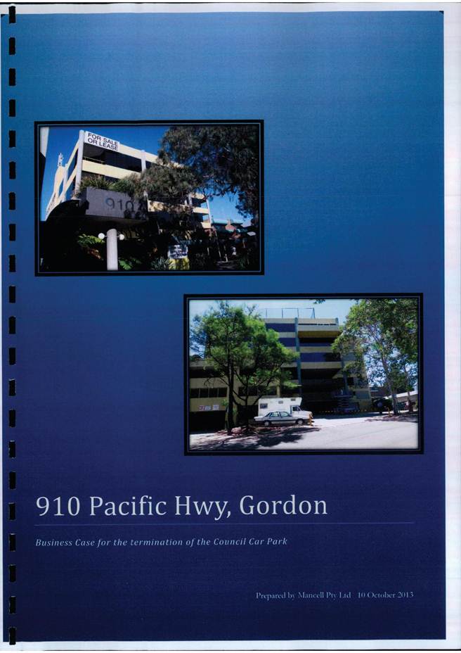

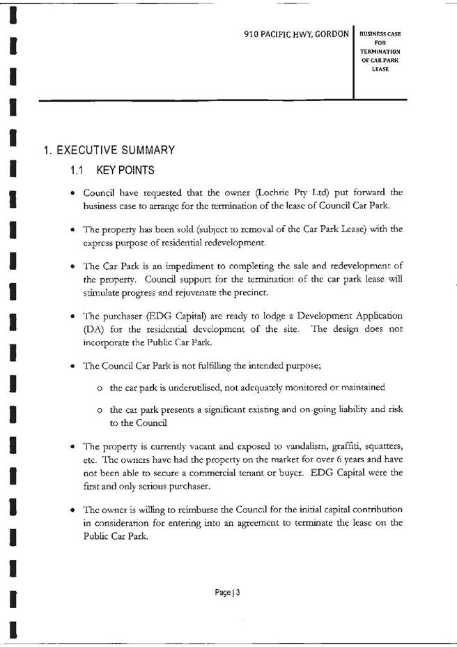
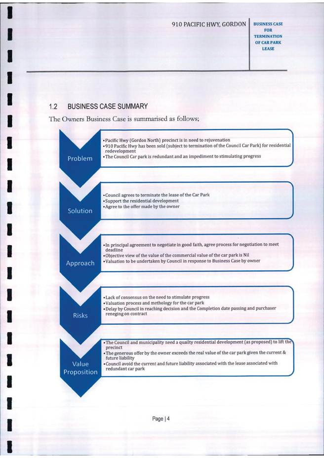

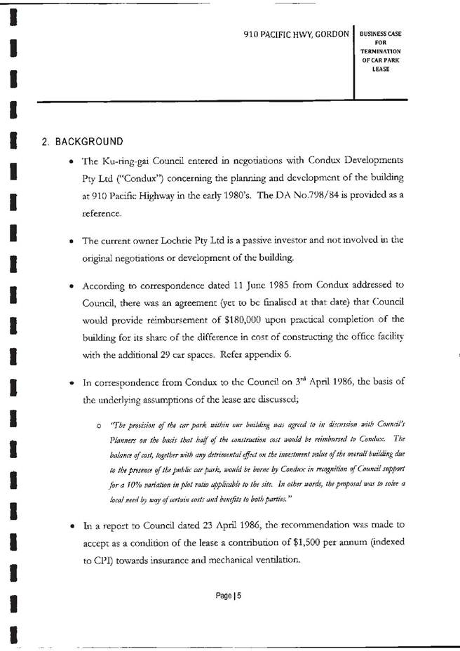
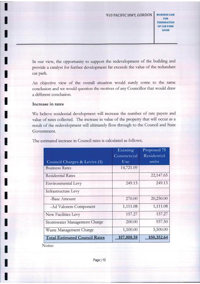
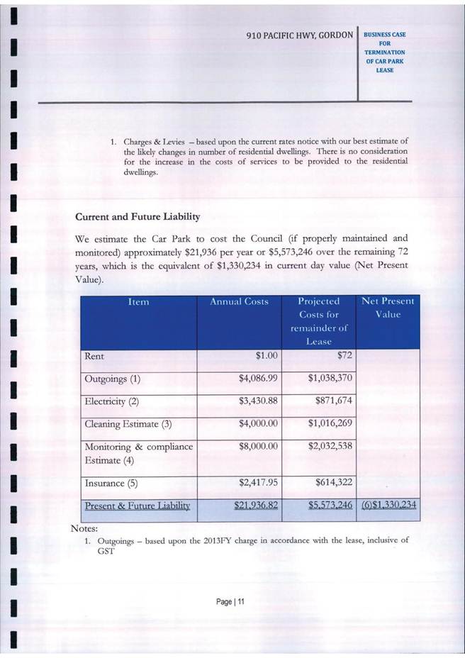
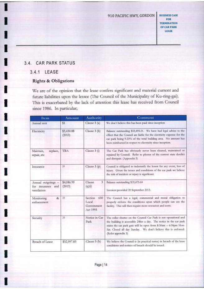

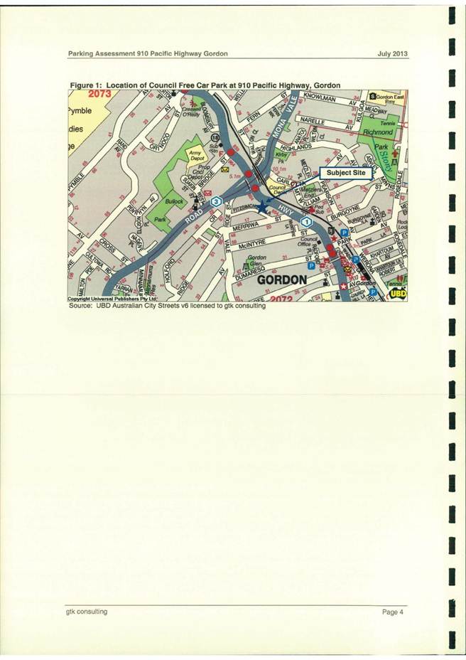
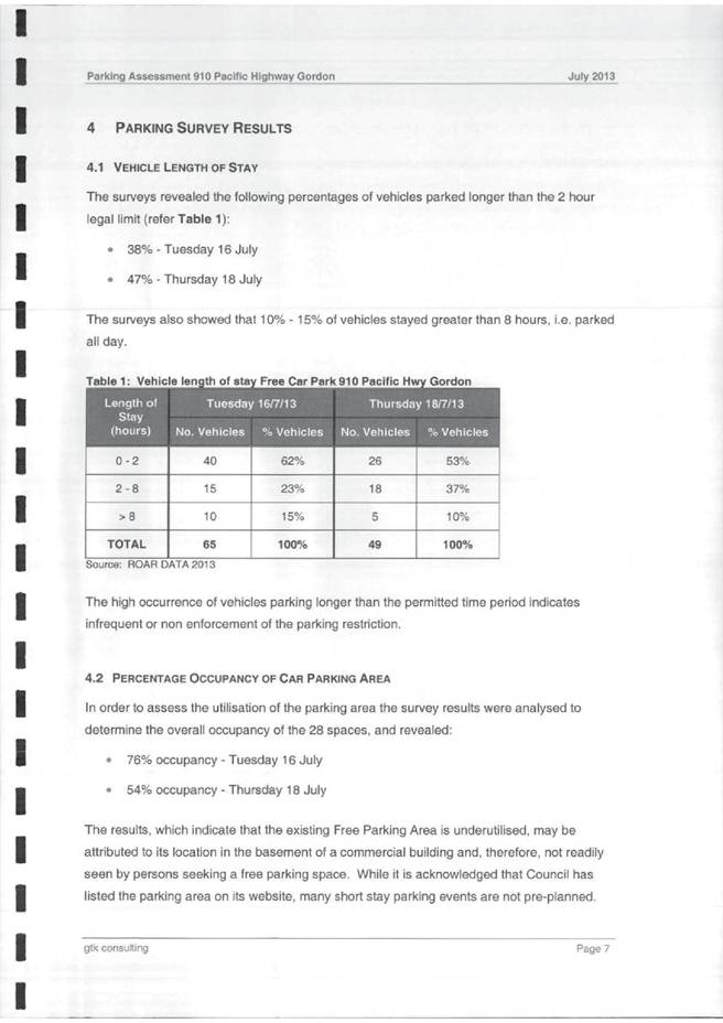

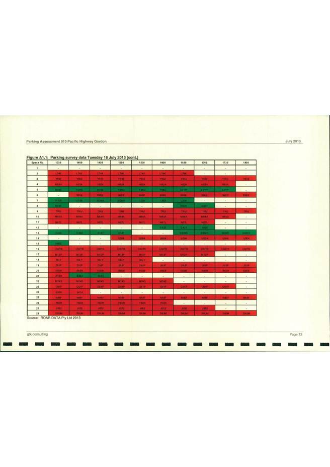
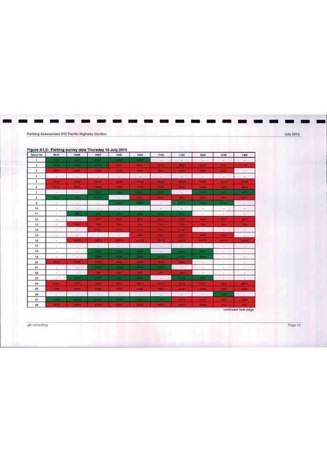
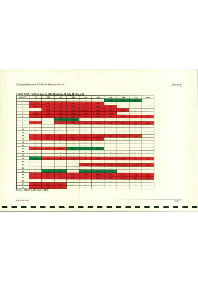


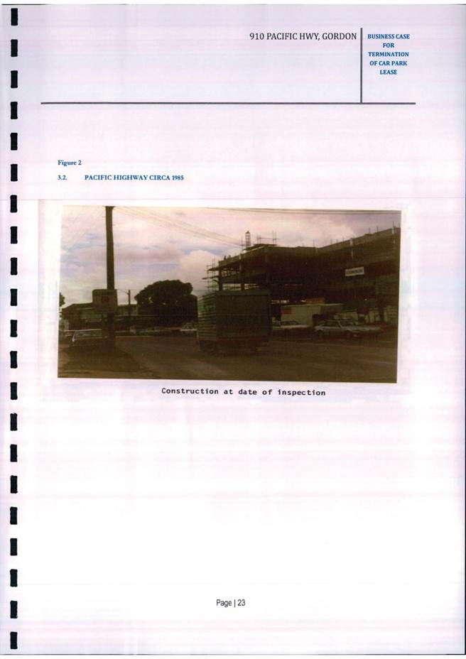
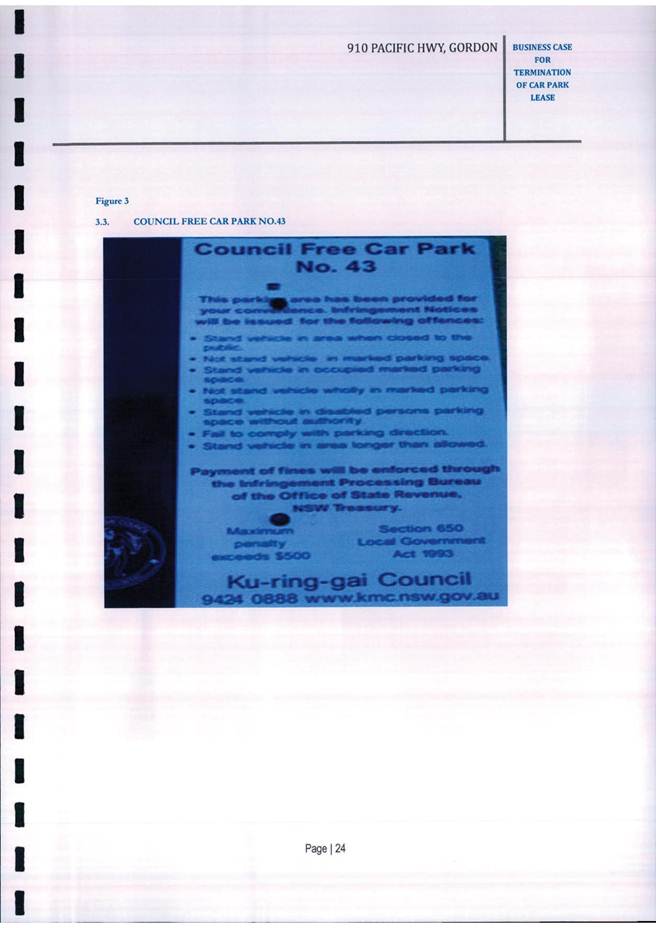
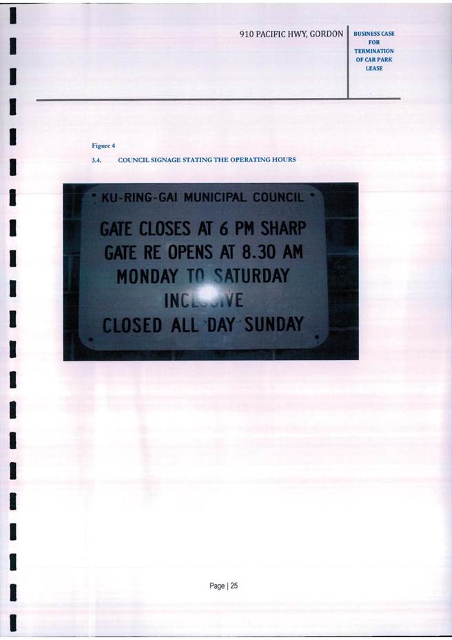
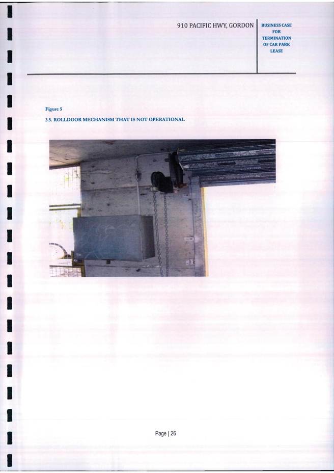
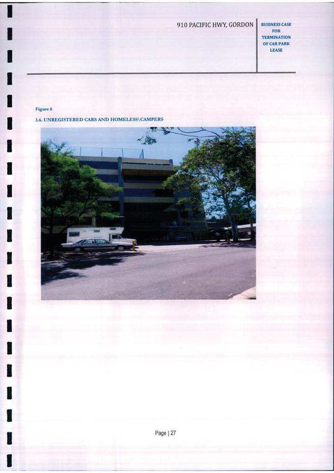
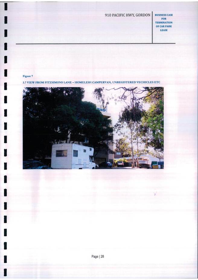
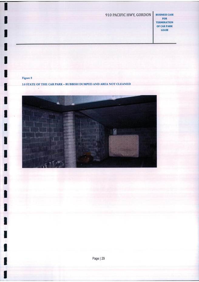

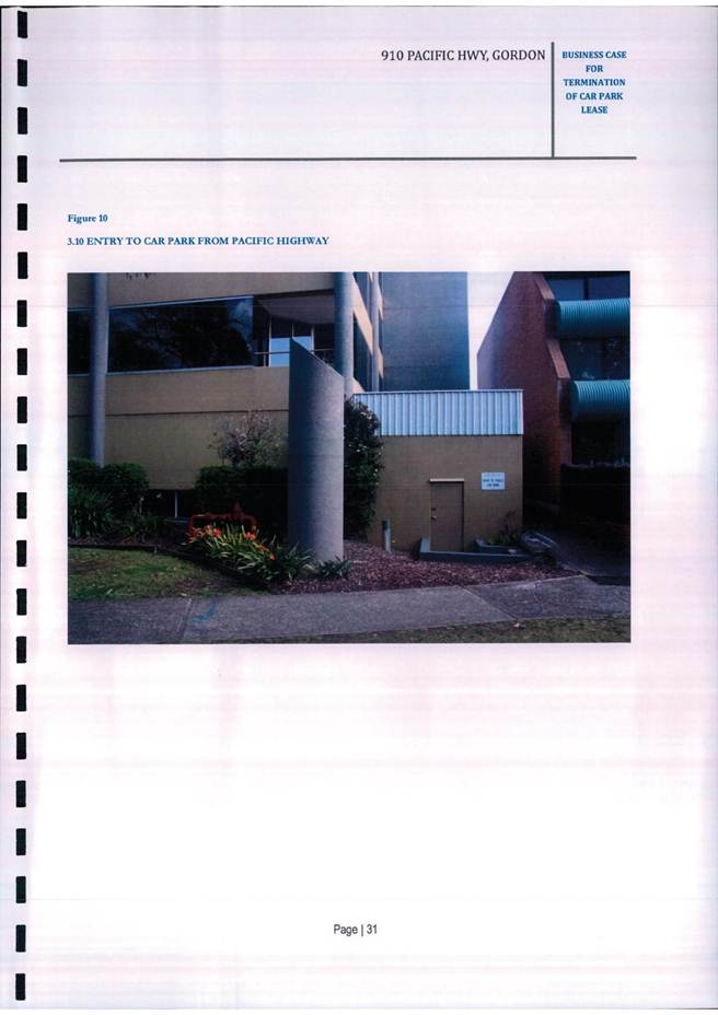
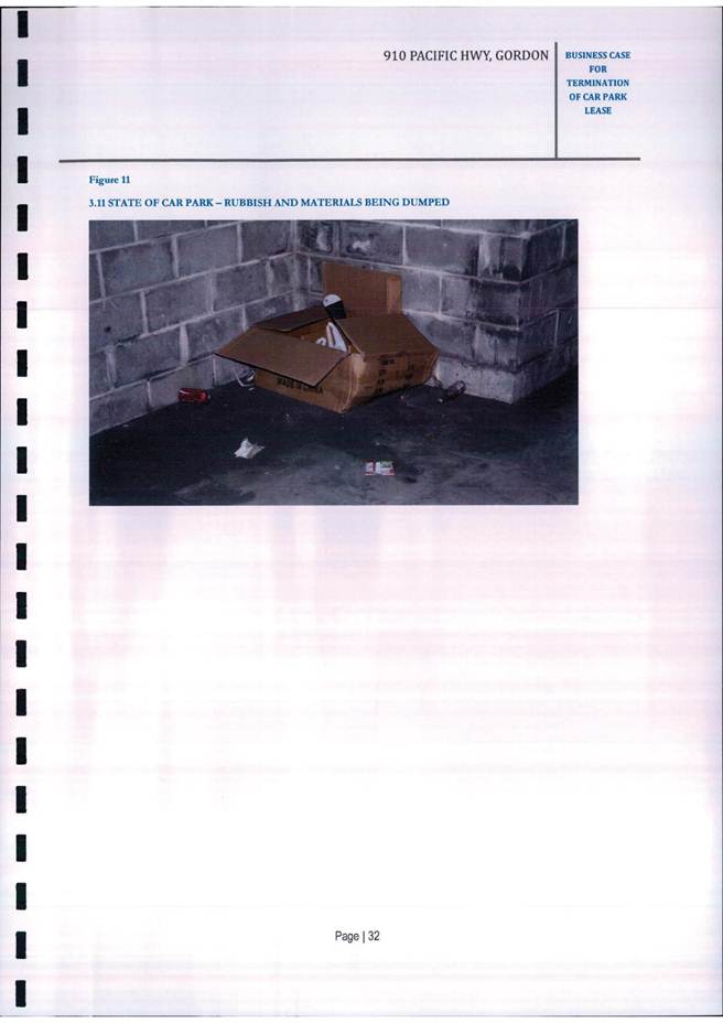
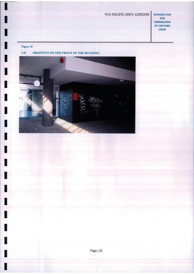
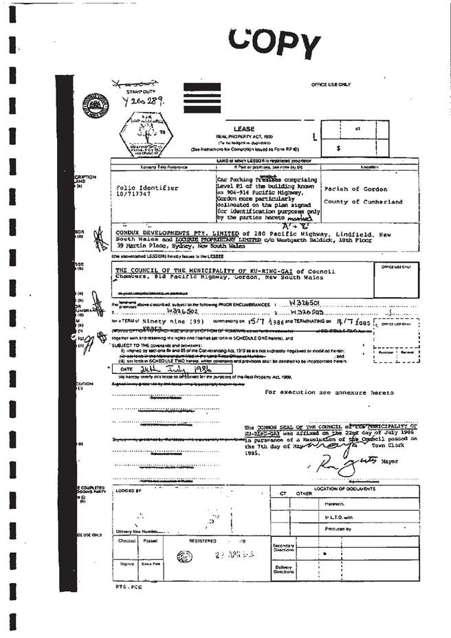
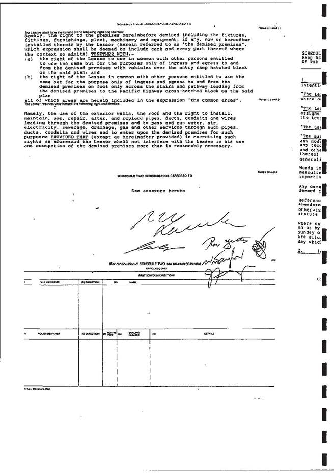

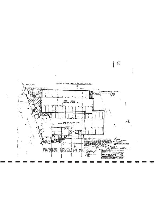
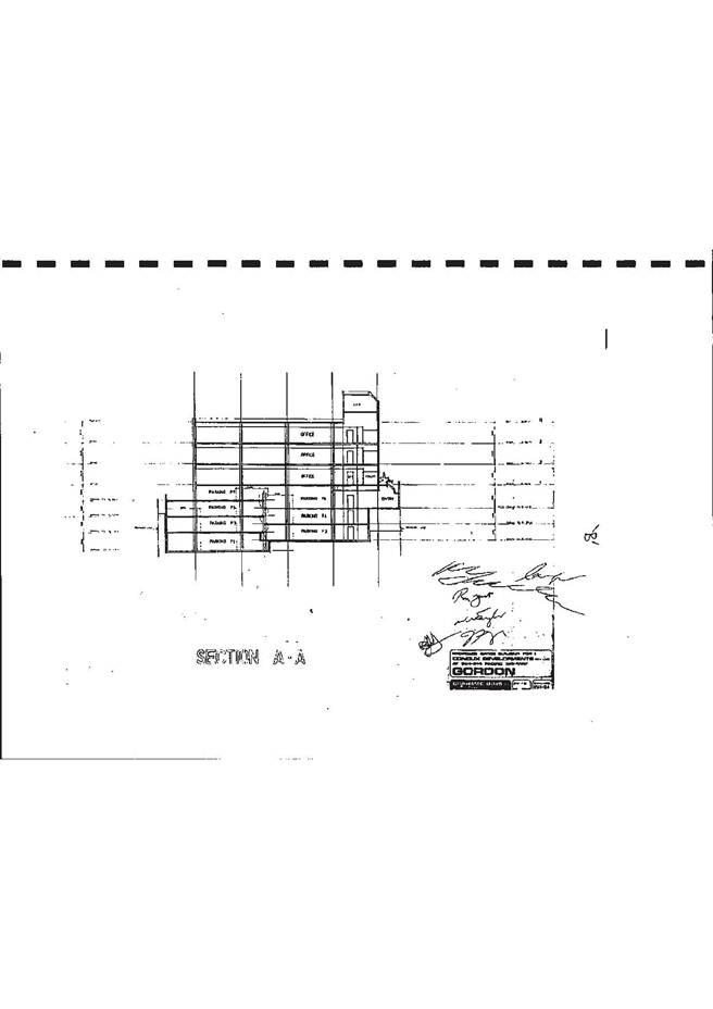

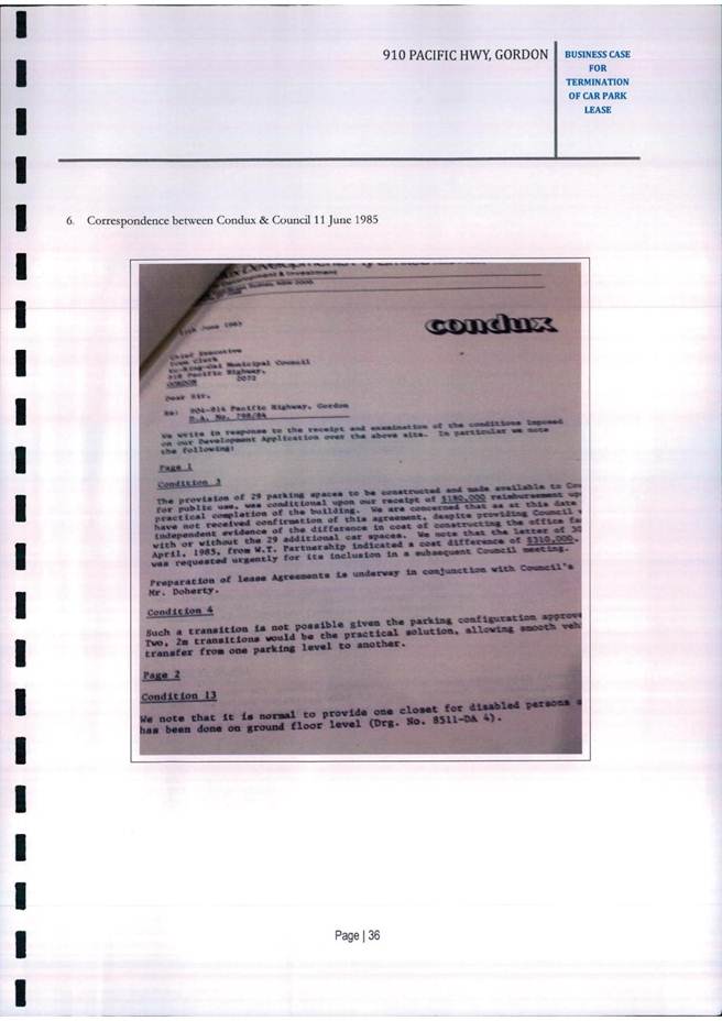
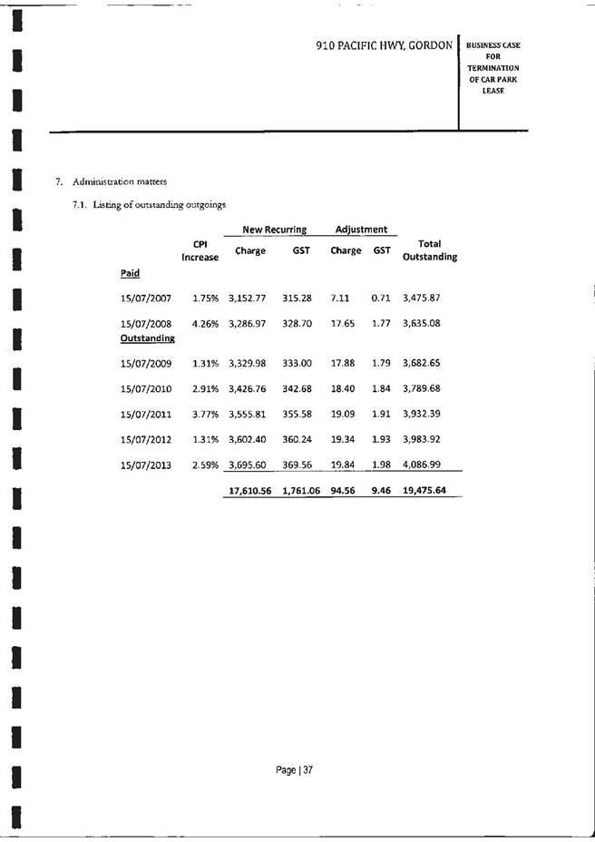
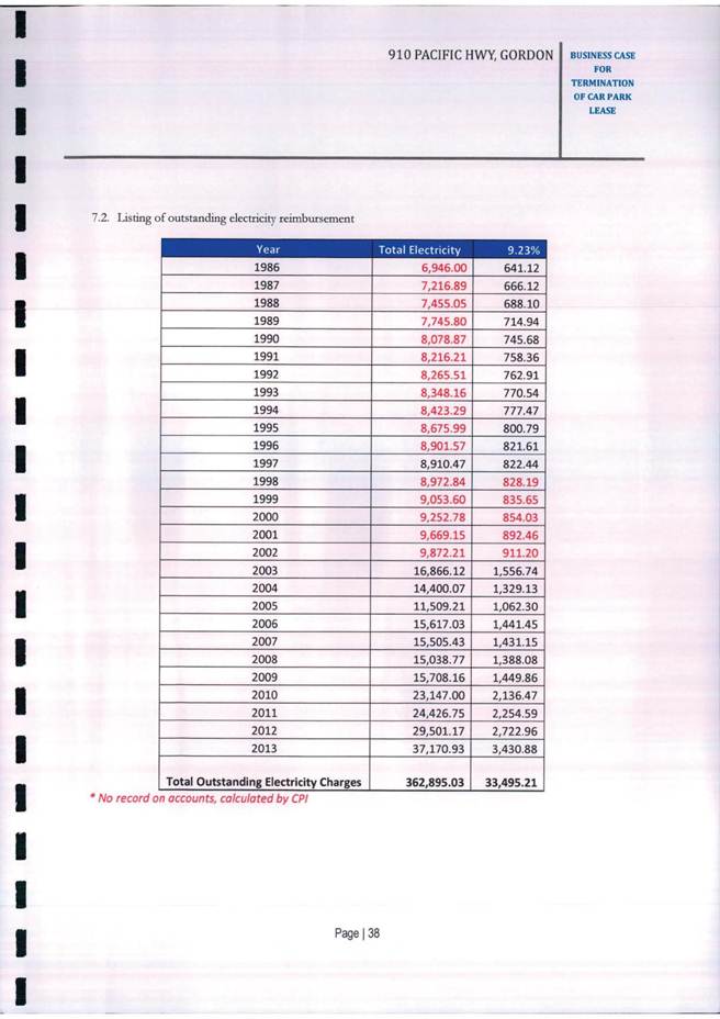
|
Ordinary Meeting of Council - 10 December 2013 |
GB.14 / 245 |
|
|
|
|
Item GB.14 |
S09905 |
|
|
21 October 2013 |
828 Pacific Highway, Gordon - Design, Refurbishment and Fit-out - Select Tender
EXECUTIVE SUMMARY
|
purpose of report: |
To advise Council of the Expressions of Interest (EoI) received for the design, refurbishment & fit-out of 828 Pacific Highway, Gordon and to seek approval to call select tenders from the recommended shortlist in this report. |
|
|
|
|
background: |
In November 2013, Council issued an Expression of Interest (EoI) to obtain a list of suitably qualified and experienced companies for the refurbishment and fit-out of the building. The EoI closed on 19 November and 17 parties listed their interest. |
|
|
|
|
comments: |
The process of selecting an appropriate company to engage for the refurbishment and fit-out of the building is to shortlist appropriate companies to tender. This has been achieved through the Expression of Interest (EoI) process. A full evaluation of the EoI submissions is currently being assessed by a Tender Evaluation Committee (TEC), who will prepare a report to establish a list of 5 or 6 companies recommended for the calling of select tenders. |
|
|
|
|
recommendation: |
That Council delegates authority for the Mayor and General Manager to accept the preferred shortlist for select tender for the design, refurbishment & fit-out of 828 Pacific Highway, Gordon and approves the calling of select tenders from those companies nominated by the Mayor and General Manager for the design, refurbishment & fit-out of 828 Pacific Highway, Gordon. |
Purpose of Report
To advise Council of the Expressions of Interest (EoI) received for the design, refurbishment & fit-out of 828 Pacific Highway, Gordon and to seek approval to call select tenders from the recommended shortlist in this report.
Background
In December 2012, Council acquired the building at 828 Pacific Highway, Gordon for administration purposes. The building is commercial office premises with secure parking adjacent to the existing Council Chambers site.
Since early 2013 Council staff and project consultants has been planning for the design, refurbishment and fit-out of the building to relocate Council’s civic and administration services.
In addition, a development application is required for the change of use for the component of the building being utilised for public administration and providing access to members of the public. As a result a number compliance works are being undertaken to comply with the change of use requirements.
On 26 October 2013, Council advertised an Expression of Interest (EoI) to obtain a list of suitably qualified and experienced companies for the refurbishment and fit-out of the building. The EoI closed on 19 November and 17 parties listed their interest.
Comments
The first stage of the process of selecting an appropriate company to engage for the refurbishment and fit-out of the building is to shortlist appropriate companies to tender. This has been achieved through the Expression of Interest (EoI) process.
The EoI specifically required that all interested parties attended a mandatory site inspection as part of the process.
A review of the 17 submissions received revealed that only 12 companies had attended the site inspection which resulted in five immediately disqualified. The following 12 companies are currently being assessed for shortlist to select tender:
|
1 |
ADCO Constructions Pty Ltd |
|
2 |
Buildcorp Group Pty Ltd |
|
3 |
Graphite Projects Pty Ltd |
|
4 |
Ichor Constructions Pty Ltd |
|
5 |
INTREC Management |
|
6 |
ISIS Group Australia Pty Limited |
|
7 |
Kane Constructions (Vic) Pty Ltd |
|
8 |
MPA Projects |
|
9 |
Petra Construction Group |
|
10 |
Projectcorp Australia Pty Ltd |
|
11 |
Renascent Sydney Pty Ltd |
|
12 |
Taylor Construction Group Pty Ltd |
|
13 |
Formula Interiors |
A full evaluation of the remaining 12 companies is currently being assessed by a Tender Evaluation Committee (TEC), who will prepare a report to establish a list of 5 or 6 companies recommended for the calling of select tenders.
In parallel to this EoI a Development Application (DA) for the change of use requirement has been submitted and pending assessment, with further refinement to councillor and departmental layouts still being finalised.
Following an EoI it is usual practice for full Council to determine the shortlist for select tender. However, due to the cessation of Council between December – February, and in order to continue to progress the project in a timely manner, this report seeks to obtain Council approval for the Mayor and General Manager to accept the preferred shortlist for select tender under delegated authority.
This will in no way diminish the requirement of the TEC to complete and submit an assessment report to the Mayor and General Manager identifying the preferred proponents for select tender.
It will however, enable the tender document to be prepared and the tender to be advertised during the cessation period and once the select tender is closed and assessed a further report will be submitted to full Council for selection of the final tenderer.
Governance Matters
This process complies with procurement best practice, Council policy and legislative requirements.
Risk Management
The EoI has been undertaken in accordance with Council’s Procurement Policy which provides a systematic manner for the purchasing of goods and services with a value(or potential value) in excess of $150,000 (incl GST). The objective of this procedure is to ensure that sound tendering practices and procedures are fully implemented which ensure Council receives best value, meets its legislative requirements, and ensure that the highest standards of ethical conduct and best practice are applied.
The risk for Council by not delegating authority to the Mayor and General Manager to accept the preferred shortlist for the select tender will be the delay of the project and relocation into the premises.
Financial Considerations
Council accepting the EoI’s and calling a select tender involves minimal cost to Council. Full financial consideration must be given at the time of accepting a tender.
Social Considerations
Within Council’s Community Strategic Plan (CSP) Our Community – Our Commitment 2030, an important long term objective under Good Governance and Management is that:
“Council’s governance framework is developed to ensure probity, transparency and the principles of sustainability are integrated and applied into our policies, plans and guidelines and decision making processes. “
The EoI and selection process ensures that Council maintains transparency and accountability in the management of tender, contracts and purchasing of goods and services.
This project is identified in Council’s Delivery Program 2013-2017 and Operational Plan 2013-2014 and has been for a number of preceding years.
Environmental Considerations
Respondents’ environmental policies were one of the selection criteria used to shortlist the nominated selected tenderers. Sustainability initiatives are a crucial part of the design, refurbishment and fit-out and are considered in the development application process.
Community Consultation
The actions outlined in this report build upon the extensive consultation already carried out for this project. Specific public consultation in relation to the EoI process itself is not required and was not undertaken. The DA for the project has recently come off extended notification.
Internal Consultation
The Tender Evaluation Committee (TEC) is comprised of the following members:
· Director Strategy & Environment;
· Director Operations;
· Manager Information Management;
· Manager Environment & Sustainability;
· Manager Integrated Planning, Property & Assets;
· External Project Manager – Viridis.
This report was prepared by the Strategy and Environment Department in consultation with Council’s Operations Department.
Summary
This report discusses the outcomes of the Expression of Interest (EoI) for the design, refurbishment and fit-out of Council’s new civic and administration premises.
Due to the cessation of Council between December – February, and in order to continue to progress the project in a timely manner, this report seeks to obtain Council approval for the Mayor and General Manager to accept the preferred shortlist for select tender under delegated authority.
This will in no way diminish the requirement of the TEC to complete and submit an assessment report to the Mayor and General Manager identifying the preferred proponents for select tender.
A further report will be submitted to full Council for selection of the final tenderer in early 2014
|
A. That Council delegates authority for the Mayor and General Manager to accept the preferred shortlist for select tender for the design, refurbishment & fit-out of 828 Pacific Highway, Gordon.
B. That Council approves the calling of select tenders from those companies nominated by the Mayor and General Manager for the design, refurbishment & fit-out of 828 Pacific Highway, Gordon.
|
|
Deborah Silva Manager Integrated Planning, Property & Assets |
Andrew Watson Director Strategy & Environment |
|
A1View |
Risk Assessment - Sun Building - October 2011 |
|
2013/308220 |
|
Ordinary Meeting of Council - 10 December 2013 |
GB.15 / 256 |
|
|
|
|
Item GB.15 |
S04326 |
|
|
23 October 2013 |
Consideration of Submissions -
Draft Ku-ring-gai Bushland Reserves
Plan of Management
EXECUTIVE SUMMARY
|
purpose of report: |
For Council to adopt the exhibited 2013 Ku-ring-gai Bushland Reserves Plan of Management (PoM), incorporating the categorisation and re-categorisation of natural areas addressed through a public hearing conducted on 19 November 2013, and the Proposal for an estate - Biobank site at Rofe Park, Sheldon Forest and Comenarra Creek Reserve, with minor amendments and corrections as outlined in this report. |
|
|
|
|
background: |
On 22 October 2013 (GB6) Council resolved to: (i) exhibit the draft 2013 Ku-ring-gai Bushland Reserves PoM; (ii) hold a public hearing in relation to the categorisation and re-categorisation of Natural Areas; and (iii) exhibit notice of the Proposal for an estate - Biobank site at Rofe Park, Sheldon Forest and Comenarra Creek Reserve. |
|
|
|
|
comments: |
At the time of writing this report, no submissions were received on the draft 2013 Ku-ring-gai Bushland Reserves PoM and four (4) written submissions were received on the Proposal for an estate - Biobank site at Rofe Park, Sheldon Forest and Comenarra Creek Reserve. Written and verbal submissions were received in relation to the public hearing. |
|
|
|
|
recommendation: |
That Council adopts the 2013 Ku-ring-gai Bushland Reserves Plan of Management and the Proposal for an estate - Biobank site at Rofe Park, Sheldon Forest and Comenarra Creek Reserve, with the amendments and corrections. |
Purpose of Report
For Council to adopt the exhibited 2013 Ku-ring-gai Bushland Reserves Plan of Management (PoM), incorporating the categorisation and re-categorisation of natural areas addressed through a public hearing conducted on 19 November 2013, and the Proposal for an estate - Biobank site at Rofe Park, Sheldon Forest and Comenarra Creek Reserve, with minor amendments and corrections as outlined in this report.
Background
On 10 September 2013 (GB5) Council endorsed the creation of a 119 hectare Biobank site at Rofe Park, Sheldon Forest and Comenarra Creek Reserve, Ku-ring-gai, through the ‘Linking Landscapes through Local Action’ project, a grant program being managed by the Office of Environment & Heritage (OEH) and funded through the NSW Environmental Trust.
Establishing a Biobank site involves a number of steps, including updating Council’s 2009 Bushland Reserves Plan of Management (PoM) to facilitate Biobanking within natural areas; and exhibiting notice of the proposal to create a Biobanking Agreement (within the meaning of Part 7A of the Threatened Species Conservation Act 1995), at Rofe Park, Sheldon Forest and Comenarra Creek Reserve, Ku-ring-gai, in accordance with the requirements of the Local Government Act 1993.
In addition, since the adoption of the 2009 Ku-ring-gai Bushland Reserves PoM Council has acquired land for the purpose of conservation, resolved to re-categorise land to create new natural areas and carried out a number of boundary adjustments to community land. These amendments have been incorporated in the draft 2013 Ku-ring-gai Bushland Reserves PoM. A public hearing must be conducted for the categorisation and re-categorisation of community land under the Local Government Act 1993.
In order to meet both legislative and the Linking Landscapes grant requirements, on 22 October 2013 (GB6) Council resolved to: (i) exhibit the draft 2013 Ku-ring-gai Bushland Reserves PoM for a period of 28 days and provide a further 14 days for public comment; (ii) hold a public hearing in relation to the acquisition and re-categorisation of Natural Areas incorporated within the draft 2013 Ku-ring-gai Bushland Reserves PoM; and (iii) exhibit notice of the Proposal for an estate - Biobank site at Rofe Park, Sheldon Forest and Comenarra Creek Reserve for a period of 28 days.
Comments
In accordance with Section 38 of the Local Government Act 1993, Council publicly exhibited the draft 2013 Ku-ring-gai Bushland Reserves PoM from Wednesday 23 October 2013 to Wednesday 20 November 2013, and accepted submissions until 4 December 2013.
In accordance with Section 40A of the Local Government Act 1993, Council held a public hearing for the categorisation and re-categorisation of community land which was incorporated into the draft 2013 Ku-ring-gai Bushland Reserves PoM on Tuesday 19 November 2013 and accepted submissions until 4 December 2013.
In accordance with Section 47 of the Local Government Act 1993, Council provided public notice of, and accepted submissions on, its intention to create a Biobanking Agreement at Rofe Park, Sheldon Forest and Comenarra Creek Reserve, from Wednesday, 23 October 2013 to Wednesday, 20 November 2013.
At the time of writing this report, Council received:
· no submissions on the draft 2013 Ku-ring-gai Bushland Reserves PoM; and
· four (4) submissions on the Proposal for an estate - Biobank site at Rofe Park, Sheldon Forest and Comenarra Creek Reserve.
This report addresses submissions received by Wednesday, 27 November 2013. Any submissions received on the draft 2013 Ku-ring-gai Bushland Reserves PoM until 4 December 2013 will be addressed as an addendum to this report, via a memo circulated to Councillors.
The public hearing was attended by six (6) members of the community and was independently chaired by Sandy Hoy, the Principal of Parkland Planners. Written and verbal submissions received in relation to the public hearing have been incorporated into a report, provided as Attachment A1 and addressed below. The presentation provided by Council staff at the public hearing is provided as Attachment A2.
Governance Matters
In accordance with the Local Government Act 1993 all land classified as community land must be managed in accordance with a plan of management adopted by Council. It is considered that the 2013 Ku-ring-gai Bushland Reserves PoM is the appropriate plan of management for Council for all community land acquired, re-categorised or dedicated as Natural Areas - Bushland.
The proposed Biobank site (being Rofe Park, Sheldon Forest and Comenarra Creek Reserve) is currently managed as Natural Areas – Bushland under the Local Government Act 1993. The proposed Biobank site will be established and managed through the placing of a Biobanking Agreement (under Part 7A of the Threatened Species Conservation Act 1995) over the three reserves. This Biobanking Agreement will not involve offsetting, as all credits created are to be transferred to OEH and retired for the purpose of conservation. Whilst the 2013 Ku-ring-gai Bushland Reserves PoM will permit Biobanking within natural areas, any future decision to approve offsetting via the Biobanking scheme will be directed either through a draft Ku-ring-gai Offset Policy (yet to be reported to Council and publicly exhibited) or Council resolution.
Risk Management
Changes to Natural Areas categorisation (as outlined in OMC 22 October 2013 GB6) was undertaken following a review of existing disturbances, site values, current management actions and community use. These refinements will help ensure that Council is meeting its obligations under the Local Government Act 1993 and Threatened Species Conservation Act 1995. Consequently, Council’s risk of using and managing community land inappropriately is reduced.
Financial Considerations
Once adopted, the implementation of the 2013 Ku-ring-gai Bushland Reserves PoM will be funded through Council’s Environmental Levy, capital works and operational budgets. Council will continue to seek external grant funding for specific projects in the PoM, to supplement Council’s current implementation budget.
The 2013 Ku-ring-gai Bushland Reserves PoM allows Council to adopt a ‘user pays’ principle for special uses, leases or licences where contribution, either by cash or in-kind, may be required, including for maintenance requirements across the full life cycle of impacts.
Currently there are a number of Council authorised special uses for Ku-ring-gai’s bushland reserves, including:
· bookings for commercial/organised activities, including filming, research, bushwalking, and access over land for construction; and
· leases and licences for use of built assets within bushland (eg scout and guide halls).
There is also provision for groups or associations to assist in ongoing maintenance of bushland areas and recreational tracks through, for example, Council’s Bushcare program, which reduces the need to draw on Council’s operational budget for these maintenance activities.
Through the ‘Linking Landscapes through Local Action’ project Council will receive an ongoing, annual payment to manage the Biobank site in perpetuity for the purpose of conservation. Grant funding for the Biobank site has been determined, in consultation with OEH, to be approximately $1,571,000, with Council contributing an additional $469,000 over the first 3 years. Total funding for the site is therefore approximately $2,040,000.
Social Considerations
With the exception of Biobanking, minimal changes to actions and permissible uses within the 2013 Ku-ring-gai Bushland Reserves PoM have been made as part of the Stage 1 review. As such, changes to recreational use of Natural Areas – Bushland within the Ku-ring-gai Local Government Area (LGA) as are considered to be negligible.
It is proposed that the Biobank site (at Rofe Park, Sheldon Forest and Comenarra Reserve) be limited to the Natural Areas management boundary and will exclude:
· Mimosa Oval, including the playground, car park and amenities block. Biobanking within the adjacent reserve will not impact upon use of this area, but may improve the site’s amenity through increased biodiversity (weed) management (particularly within the north-eastern corner).
· Rofe Park (off Kate Street) and the 1st Turramurra and 2nd Turramurra scout halls. It is considered that changes to current or future lease agreements will not be required as a result of the establishment of the Biobank site.
Environmental Considerations
Ku-ring-gai’s natural areas provide significant environmental, aesthetic, educational and recreational benefits to the area. As a significant section of Council’s open space reserve system, Ku-ring-gai’s bushland reserves provide habitat and bio-linkage opportunities of regional and local importance, including habitat for a broad range of listed flora and fauna species (as summarised in Table 1 below). The 2013 Ku-ring-gai Bushland Reserves PoM aims to improve the ecology and biodiversity of natural areas within the LGA.
Table 1: Listed species, populations and threatened ecological communities in Ku-ring-gai’s bushland reserves
|
|
State listed (Threatened Species Conservation Act 1995) |
Federally listed (Environment Protection and Biodiversity Conservation Act 1999) |
|
Flora |
15 |
12 |
|
Fauna |
35 |
16 |
|
Endangered population |
1 |
|
|
Threatened ecological communities |
7 |
2 |
The Biobank site (Rofe Park, Sheldon Forest and Comenarra Creek Reserve) provide fauna habitat of regional importance (DECC, 2008); contain and provide habitat for 4 threatened plant and 8 threatened animal species; and contain two (2) threatened ecological communities - Blue Gum High Forest and Sydney Turpentine Ironbark Forest, listed under state and federal legislation. Linking Landscapes funding will improve the ecology and biodiversity values of these three (3) important reserves.
Community Consultation
During the public exhibition period, copies of the 2013 Ku-ring-gai Bushland Reserves PoM were available on Council’s website, at customer service during opening hours and at all Council libraries. In addition, the public exhibition was advertised in the North Shores Times.
Details of the public hearing for the categorisation and re-categorisation of community land that was incorporated into the draft 2013 Ku-ring-gai Bushland Reserves PoM were available on Council’s website, at customer service during opening hours and at all Council libraries. In addition, the public hearing was advertised in the North Shores Times.
Council provided public notice of its intention to create a Biobanking Agreement at Rofe Park, Sheldon Forest and Comenarra Creek Reserve, Ku-ring-gai. Copies of the Biobank proposal were available on Council’s website, at customer service during opening hours and at all Council libraries. In addition, the public notification was advertised in the North Shores Times.
In addition to the above, notification letters for the above three (3) community consultation processes were sent to: Department of Planning and Infrastructure (Land and Property Information Head Office); Metropolitan Local Aboriginal Land Council; NSW Aboriginal Land Council; Metropolitan Lands Office; The Minister administering the Environmental Planning & Assessment Act 1979; NSW Rural Fire Service headquarters; Hornsby Ku-ring-gai Fire Control Centre; NSW Rural Fire Service; Parks & Wildlife Office of Environment & Heritage; Department of Premier & Cabinet; Scouts Australia, NSW Branch (Sydney North region); Newington College Council; Sydney Water - Urban Growth Strategy; Ausgrid (Electricity & Transmission Lines); STEP Inc; Australian Association of Bush Regenerators; Ku-ring-gai Bushcare Association (KBA); all residents with properties along the interface, and across the road from the reserves that form the Biobank site; and all residents within 100 metres of 26A Northcote Road, Lindfield.
At the time of writing this report, no submissions were received on the draft 2013 Ku-ring-gai Bushland Reserves PoM.
Four (4) written submissions were received as a result of the public notification period for the Proposal for an estate - Biobank site at Rofe Park, Sheldon Forest and Comenarra Creek Reserve. The matters identified along with the responses are summarised in the following table.
Grammatical and formatting errors and minor re-wording suggestions which were not considered to result in a substantial or material change to the draft 2013 Ku-ring-gai Bushland Reserves PoM and Proposal for an estate - Biobank site at Rofe Park, Sheldon Forest and Comenarra Creek Reserve have been actioned but not included in the summary below.
|
Submissions in response to the Proposal for an estate – Biobank site at Rofe Park, Sheldon Forest and Comenarra Creek Reserve |
|
This submission expressed disappointment that the role of Bushcare groups was not mentioned in the draft site management plan (included within the Biobank proposal) and requested that volunteer groups be recognised within this management plan, and that Bushcare groups be informed of how the Biobank site will affect their work in the future. There was also concern regarding the perceived lack of notification around the proposed Biobank proposal, with a request for additional consultation in the future.
Comment: As part of the Biobanking Agreement a site management plan will be created for the Biobank site which outlines zones and broad, costed management actions within those zones (as included within the Biobank proposal). Whilst Bushcare is to be an approved action within the Biobanking Agreement, the site management plan for the Biobank site will not detail unfunded or supporting management actions, such as the work of Bushcare groups. However, reserve specific management plans currently being developed by Council for a number of bushland reserves (including those reserves that form the Biobank site) will provide detailed management actions for these reserves, including Bushcare activities. Consultation will occur with Bushcare groups on an ongoing basis during the Biobanking Agreement development process and in relation to future works at the Biobank site.
As part of the public exhibition process, a notification letter was sent to all residents directly adjoining, or across the road from, the proposed Biobank site and to the Ku-ring-gai Bushcare Association. It is acknowledged that a targeted letter should have been forwarded to Bushcare groups working within the Biobank site, however Council staff did provide a briefing on the Biobanking proposal at a Bushcare trainers meeting on 14 November 2013, which trainers of the Bushcare groups within the Biobank site attended. |
|
This submission applauds the regeneration work conducted to date at Sheldon Forest and supports proper management of the site if this beautiful area is to be conserved, and the diversity of flora and fauna protected and hopefully restored.
However, this submission pointed out two areas of concern with the Biobank proposal:
1) The formalisation of the informal walking track on the Warragal Road side of Sheldon Forest, which comes far too close to their property (page 24: figure 12). This submission strongly objects to the current path becoming formalised in its present location and respectfully asks that consideration be given to altering the location of a formal walking track so that it is located in the more central area of Sheldon Forest and away from the extreme perimeter of Sheldon Forest. We are not aware of any ecological reason why a formal walking track should come so close to residential properties.
Comment: Council does not support the creation of a new walking track in another location, as this will lead to greater ecological impact than the formalisation of the track in its current location.
2) Roaming dogs in Sheldon Forest. The closeness of the current informal track to our property has meant that for years we have had to put up with other people's dogs – not on lead- killing and harassing animals on our property. The selfishness and arrogance and total lack of regard to the flora and fauna in Sheldon Forest shown by local residents who regularly let their dogs run free in Sheldon Forest is breathtaking, and leads to numerous negative impacts on the flora and fauna of the forest, undermining conservation efforts. What is Council's plan for the selfish dog owners who let their dogs loose in Sheldon Forest, when there are many off lead parks in the Ku-ring-gai Municipality?
Comment: Council recognises the ongoing issues relating to dogs off leashes in conservation areas, such as Sheldon Forest. Council intends to tackle this issue by increasing signage in these areas, as well as increasing ranger patrols and enforcement measures.
|
|
This submission supports that approximately $2,000,000 will be available as part of the Biobanking Agreement to be used to preserve and regenerate the biodiversity of the Biobank site covering Sheldon Forest, Rofe Park and Comenarra Creek Reserve.
The following comments were provided on the Biobanking Agreement:
1. Sediment basins above and within Sheldon Forest.
There has been significant soil erosion along the upper drainage line caused by urban stormwater run-off. In the flatter drainage areas there is evidence of seasonal water logging, aggravated by the high frequency and significant urban stormwater discharge into the Reserve. There are concerns that sediment basins themselves will not fully address the problems caused by the urban stormwater and it is recommended that Council carefully considers long term solutions to the adequate treatment of urban stormwater.
Comment: Council acknowledges that sediment basins alone will not adequately address the issue of urban stormwater. Priority erosion sites along the creek in Sheldon Forest, Rofe Park and Comenarra Creek Reserve have been identified in the Avondale Creek Catchment Study. This study also provides concept designs for appropriate stabilisation works and these are planned to be implemented over the coming years using available funding, supplemented by grants as they become available. In addition, residents in the surrounding catchment will be encouraged through Council’s Water Smart program to help minimise stormwater runoff through implementing rainwater tanks and rain gardens.
2. Location of Scout Hall near Blue Gum High Forest (BGHF) in Sheldon Forest. It is completely inappropriate to have a Scout lease and associated building retained in this area containing BGHF in the long term. There is evidence that the hard surfaces of the road, pavement and building are increasing stormwater runoff into some of the adjoining areas of the reserve and favouring weed and rainforest type species in regeneration.
Comment: Council’s longer term position on a Scout lease in Sheldon Forest is beyond the scope of the Biobanking proposal (the leased area under question will be excluded from the Biobanking Agreement).
3. Determination of the Total Fund Deposit Amount. It is questioned whether the Council estimates of management costs that will be scheduled in the Agreement and from the basis of annual payment amounts have made adequate allowance for inflation and annual wage increases.
Comment: “The Total Fund Deposit (TFD) is the net present value of all management actions and other recurring costs (worked out using the biodiversity credits pricing spreadsheet) and is specified in each Biobanking Agreement. The fund provides annual payments to the landowner to enable them to carry out the management actions described in their Biobanking Agreement. The agreement also includes the payment schedule."
OEH website [page last updated: 27 February 2011] http://www.environment.nsw.gov.au/biobanking/trustfund.htm
Whilst the TFD spreadsheet shows the net present value (including repayments), it is Council’s understanding that the spreadsheet does incorporate the interest and projected CPI increases within its calculations. These increases, however, will be reflected within the repayments made.
4. Climate change. The Biobanking Agreement should provide for climate change that could lead to increased costs or the need for revision of the management actions to achieve its objectives of preserving the biodiversity and threatened species in the Biobank site.
Comment: The Biobanking Agreement requires a review every five years of the management plan for the Biobank site, which will facilitate management action/costing reviews deemed necessary as a result of climate change impacts.
5. Permissible development on the Biobank site. The use of the Scout hall and permissible use area is included as permissible development on the Biobank site, as defined within the boundaries of the approved lease agreement to Scouts NSW in Sheldon Forest (1st Turramurra Group)(page 13), which appears to be incompatible with the exclusion of the Scout halls from the Biobank site (page 4).
Comment: Council notes this inconsistency and has removed references to the scout hall in Sheldon Forest from Figure 5 (page 12) and Figure 6 (Page 13) of the Biobanking proposal.
6. Proposed management actions.
There are concerns that zone ID 26 and 27 includes mowing as a management activity for the Sheldon Forest scout area. Firstly, the scout area has been excluded from the Biobanking area (page 4) and secondly, the funding for this should be recouped from the fees as part of the lease to the scouts.
Comment: Although mowing in the Scout area in Sheldon Forest is included as a management activity in the Biobanking proposal, as outlined above, this area will be excluded from the Biobanking Agreement. Mowing as a management activity has been addressed on page 21 of the Biobanking proposal. Funding for mowing of the Sheldon Forest scout area will be investigated as part of the lease renewal process conducted for Scout halls.
There is leeway to include unfunded actions within the site management plan contained in the Biobanking Agreement (page 21). Essential actions should include: (i) fully adequate treatment of urban stormwater that leads to a naturally stable main drainage line through the BGHF and addresses erosion, sedimentation, waterlogging and soil creep on the slopes, so that a representative and healthy BGHF ecological community can be sustained in the long term; and (ii) a commitment to fully rehabilitate the scout site in Sheldon Forest to BGHF over a 10-15 year period and to relocate the scouts to a site that is less environmentally sensitive.
Comment: As part of the Biobanking Agreement development process OEH has now indicated that unfunded actions will not form part of the Biobanking Agreement. Unfunded actions will be permitted within the Biobank site, but may require consent from the Minister.
As outlined above, (i) priority erosion sites along the creek in Sheldon Forest, Rofe Park and Comenarra Creek Reserve have been identified in the Avondale Creek Catchment Study. This study also provides concept designs for appropriate stabilisation works and these are planned to be implemented over the coming years using available funding, supplemented by grants as they become available; and (ii) Council’s longer term position on a Scout lease in Sheldon Forest is beyond the scope of the Biobanking proposal (the leased area under question will be excluded from the Biobanking Agreement).
7. This submission also recommends that the Bushland Plan of Management applicable to the area provides for the contingency of carrying out additional work if, at a future date, adjoining land uses lead to further degradation of the site.
Comment: This recommendation is supported.
8. It is also noted that the burn years in the site management plan actions (figure 15: pages 25-26) are not consistent with the burn years marked on the maps (figures 13 and 14: pages 23-24).
Comment: Figure 15 should include proposed burns beyond year 17, as indicated in figure 13 and 14: (pages 23-24) and this has been amended in the Biobanking proposal.
9. Walking Tracks. There is an informal track linking Rofe Park with the Comenarra Creek Reserve that passes through Avondale Golf Course bushland. There would be a public benefit in formalising this track and linking the two bushland areas. This would allow a Chatswood to Pymble walk linked by public transport. We would like to see this included in the management plan as an unfunded action.
Comment: As outline above, as part of the Biobanking Agreement development process OEH has now indicated that unfunded actions will not form part of the Biobanking Agreement (which will include the site management plan for the Biobank site).
|
|
This submission notes that page 10 indicates the location and type of numerous easements encumbering the land subject to Council's proposal. In respect to the various easements shown thereon as Easement for Transmission Line and Easement for Electricity, it is advised that vegetation management in relation to those easements is conducted on an as required basis to maintain clearances and provide access to the towers and lines. Further routine maintenance is conducted every 5 years; however emergency maintenance and inspection is conducted after feeder trips or other issues impacting on supply. To enable these works to be undertaken unfettered access is required for heavy and commercial vehicles, including EWPs, cranes, line trucks and smaller commercial vehicles. Vegetation management is also conducted on access tracks and for approximately 5 metres around towers to the ground line, and within easements to maintain safety clearances. Accordingly it is requested that the above be noted by Council and included in any management plans affecting the subject lands.
Comment: Council and the Office of Environment and Heritage (OEH) acknowledge the requirement to maintain electricity assets and seek to undertake further consultation regarding proposed access and future management of these assets as part of the Biobanking assessment process.
Council and OEH are currently seeking to include Ausgrid easements within the Biobanking Agreement. Clause 3.5 and Clause 3.6 of the Biobanking Agreement will address permissible development and permissible human activities relating to maintenance, emergency works, removal, creation and upgrading of electricity assets within the easement and the broader Biobank site. This may include actions that are exempt from approval (as outlined within the NSW State Environmental Planning Policy [Infrastructure] 2007) as well as actions where Council, other agency and ministerial approval is required. |
It is recommended that Council adopts the 2013 Ku-ring-gai Bushland Reserves PoM without re-exhibition.
The proposed changes to the Proposal for an estate - Biobank site at Rofe Park, Sheldon Forest and Comenarra Creek Reserve are not considered to have a substantial or material change to the strategic directions and long term objectives contained in these documents. For these reasons it is recommended that Council adopts the revised document without re-exhibition.
Written and verbal submissions received in relation to the public hearing are detailed in a public hearing report, provided as Attachment A1.
Page references to the written and verbal submissions relating to individual reserves are provided below, in order of being raised at the public hearing. If a reserve is not listed below a submission about it was not made, and therefore Council may assume the community supports the proposed categorisation or re-categorisation which is intended to apply to that reserve.
· Comenarra Creek Reserve (pages 9 - 10)
· Mimosa Oval and Rofe Park (pages 10 – 12)
· Princes Park (pages 12 – 16)
· Kissing Point Road (pages 16 – 18)
The independent chairperson’s recommendations in relation to the submissions raised on the individual reserves listed above are as follows:
1. Retain the categorisation of Comenarra Creek Reserve.
2. Recategorise parts of Mimosa Oval and Rofe Park as Natural Area and Sportsground, as shown on Map 6 in the supporting documents which were displayed on Council’s website during the public notification period (and Map 6 in Attachment A1)
3. Categorise as Natural Area the area of Princes Park shown in blue as ‘Scouts’ on Map 26 in the supporting documents which were displayed on Council’s website during the public notification period (and Map 26 in Attachment A1)
4. Review the agreement for use of the brick hall in Princes Park to reflect the requirements of Section 47B of the Local Government Act 1993.
5. Recategorise Kissing Park from Park to Natural Area as shown on Map 2 in the supporting documents which were displayed on Council’s website during the public notification period (and Map 2 in Attachment A1)
6. Adopt all other proposed categorisations and recategorisations of community land because it is reasonably assumed that the community supports and has no objections to the proposed categorisation, and there is no known reason not to adopt the proposed categorisations.
7. Update the generic Plans of Management for Sportsgrounds and Parks to reflect the adopted changes in categorisation.
The above recommendations are supported, with the exception of recommendations three (3) and four (4).
Following further investigation after the public hearing into the written and verbal submissions received in relation to Princes Park, specifically in relation to the proposed categorisation of the current licenced area in Princes Park shown in blue as ‘Scouts’ on Map 26 in Attachment A1 as Natural Area – Bushland, Council advised the independent chairperson of the requirements of Section 47B of the Local Government Act 1993, which informed the chairperson’s assessment in relation to this reserve (see page 15-16 of Attachment A1) and the recommendations 3 and 4 above.
It is the Council Officer’s recommendation, however, that a decision on the categorisation of land within Princes Park shown in blue as ‘Scouts’ on Map 26 in Attachment A1 as Natural Area – Bushland (or otherwise) be deferred until a more thorough investigation is undertaken by Council into the current (and desired future) licence agreement for the site, in light of the requirements of Section 47B of the Local Government Act 1993.
This has broader applicability to all leases and licences relating to buildings on community land categorised as Natural Area – Bushland. Hence, it is also recommended that Council resolve to conduct a thorough review of Council’s leases and licences relating to buildings on community land categorised as Natural Area – Bushland, to ensure: (i) compliance with the requirements of Section 47B of the Local Government Act 1993; (ii) the appropriate categorisation of community land where these leases and licences apply; and (iii) an appropriate Plan of Management is in place for the community land where these leases and licences apply. It is not recommended that Council grant any new leases relating to buildings on community land categorised as Natural Area – Bushland until consideration of these matters has occurred.
Internal Consultation
Consultation has been undertaken as part of developing the 2013 Ku-ring-gai Bushland Reserves POM and the Proposal for an estate - Biobank site at Rofe Park, Sheldon Forest and Comenarra Creek Reserve with staff from the Operations, Community and Strategy and Environment directorates.
Summary
On 10 September 2013 (GB5) Council endorsed the creation of a 119 hectare Biobank site at Rofe Park, Sheldon Forest and Comenarra Creek Reserve, Ku-ring-gai, through the ‘Linking Landscapes through Local Action’ project, a grant program being managed by the Office of Environment & Heritage (OEH) and funded through the NSW Environmental Trust.
In order to meet both legislative and the Linking Landscapes grant requirements, on 22 October 2013 (GB6) Council resolved to: (i) exhibit the draft 2013 Ku-ring-gai Bushland Reserves PoM for a period of 28 days and provide a further 14 days for public comment; (ii) hold a public hearing in relation to the acquisition and re-categorisation of Natural Areas incorporated within the draft 2013 Ku-ring-gai Bushland Reserves PoM; and (iii) exhibit notice of the Proposal for an estate - Biobank site at Rofe Park, Sheldon Forest and Comenarra Creek Reserve for a period of 28 days.
At the time of writing this report, Council received:
· No submissions on the draft 2013 Ku-ring-gai Bushland Reserves PoM;
· Four (4) submissions on the Proposal for an estate - Biobank site at Rofe Park, Sheldon Forest and Comenarra Creek Reserve.
Any submissions received on the draft 2013 Ku-ring-gai Bushland Reserves PoM until 4 December 2013 will be addressed as an addendum to this report, via a memo circulated to Councillors.
The public hearing was attended by six (6) members of the community and was independently chaired by Sandy Hoy, the Principal of Parkland Planners. Written and verbal submissions received in relation to the public hearing have been incorporated into a report, provided as Attachment A1.
It is recommended that Council adopts the 2013 Ku-ring-gai Bushland Reserves PoM without re-exhibition (Attachment A3).
The proposed changes to the Proposal for an estate - Biobank site at Rofe Park, Sheldon Forest and Comenarra Creek Reserve are not considered to have a substantial or material change to the strategic directions and long term objectives contained in these documents. For these reasons it is recommended that Council adopts the revised document without re-exhibition (Attachment A4).
The independent chairperson’s recommendations in relation to the submissions raised before or at the public hearing on the categorisation and re-categorisation of community land are supported, with the exception of recommendations three (3) and four (4).
It is the Council Officer’s recommendation that a decision on the categorisation of land within Princes Park shown in blue as ‘Scouts’ on Map 26 in Attachment A1 as Natural Area – Bushland (or otherwise) be deferred until a more thorough investigation is undertaken into the current (and desired future) licence agreement for the site, in light of the requirements of Section 47B of the Local Government Act 1993.
This has broader applicability to all leases and licences relating to buildings on community land categorised as Natural Area – Bushland. Hence, it is also recommended that Council resolve to conduct a thorough review of Council’s leases and licences relating to buildings on community land categorised as Natural Area – Bushland, to ensure: (i) compliance with the requirements of Section 47B of the Local Government Act 1993; (ii) the appropriate categorisation of community land where these leases and licences apply; and (iii) an appropriate Plan of Management is in place for the community land where these leases and licences apply. It is not recommended that Council grant any new leases relating to buildings on community land categorised as Natural Area – Bushland until consideration of these matters has occurred.
|
A. That Council adopts the 2013 Ku-ring-gai Bushland Reserves Plan of Management.
B. That Council adopts the Proposal for an estate - Biobank site at Rofe Park, Sheldon Forest and Comenarra Creek Reserve, with the amendments and corrections detailed in this report.
C. That a copy of the 2013 Ku-ring-gai Bushland Reserves Plan of Management is placed on Council’s website.
D. That Council acknowledges the formal submissions made on the 2013 Ku-ring-gai Bushland Reserves Plan of Management and Proposal for an estate - Biobank site at Rofe Park, Sheldon Forest and Comenarra Creek Reserve and responds to the authors with the outcomes.
E. That Council adopts the independent chairperson’s recommendations in relation to the submissions raised before or at the public hearing on the categorisation and re-categorisation of community land are supported, with the exception of recommendations three (3) and four (4).
F. That a decision on the categorisation of land within Princes Park shown in blue as ‘Scouts’ on Map 26 in Attachment A1 as Natural Area – Bushland (or otherwise) be deferred until a more thorough investigation is undertaken into the current (and desired future) licence agreement for the site, in light of the requirements of Section 47B of the Local Government Act 1993.
G. That Council resolves to conduct a thorough review of Council’s leases and licences relating to buildings on community land categorised as Natural Area – Bushland, to ensure: (i) compliance with the requirements of Section 47B of the Local Government Act 1993; (ii) the appropriate categorisation of community land where these leases and licences apply; and (iii) an appropriate Plan of Management is in place for the community land where these leases and licences apply.
|
|
Penny Colyer Team Leader - Natural Areas |
Marnie Kikken Manager Environment & Sustainability |
|
Andrew Watson Director Strategy & Environment |
|
|
A1View |
Ku-ring-gai Bushland Reserves Plan of Management - public hearing report |
|
2013/307239 |
|
|
|
A2View |
Public hearing - Council presentation |
|
2013/307247 |
|
|
A3View |
2013 Ku-ring-gai Bushland Reserves Plan of Management |
|
2013/307269 |
|
|
A4View |
Proposal for an estate - Biobank site at Rofe Park, Sheldon Forest and Comenarra Creek Reserve |
|
2013/307273 |
|
APPENDIX No: 1 - Ku-ring-gai Bushland Reserves Plan of Management - public hearing report |
|
Item No: GB.15 |
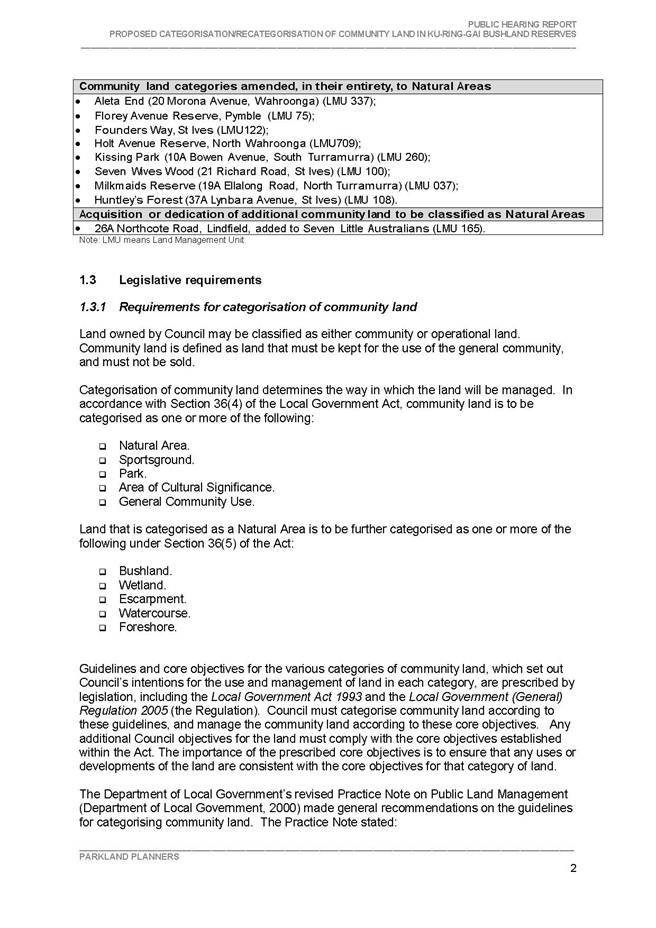
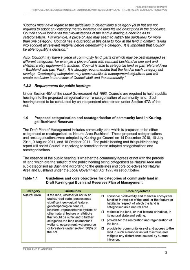
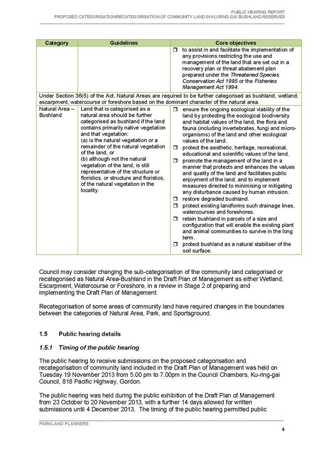
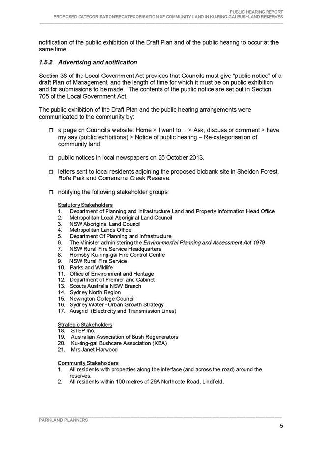


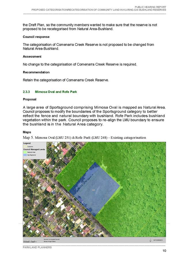
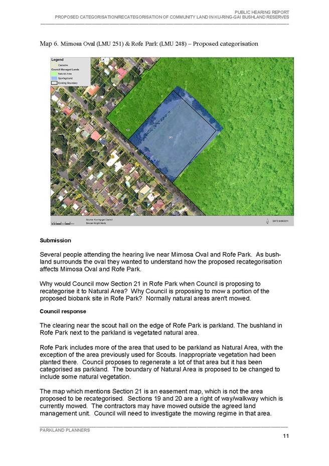
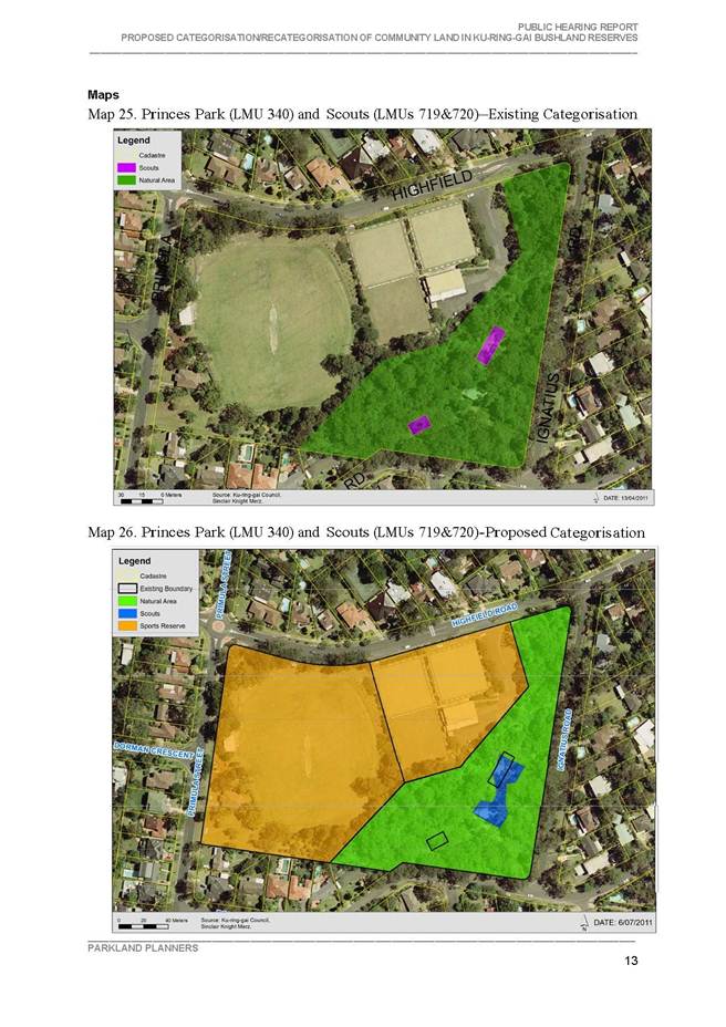
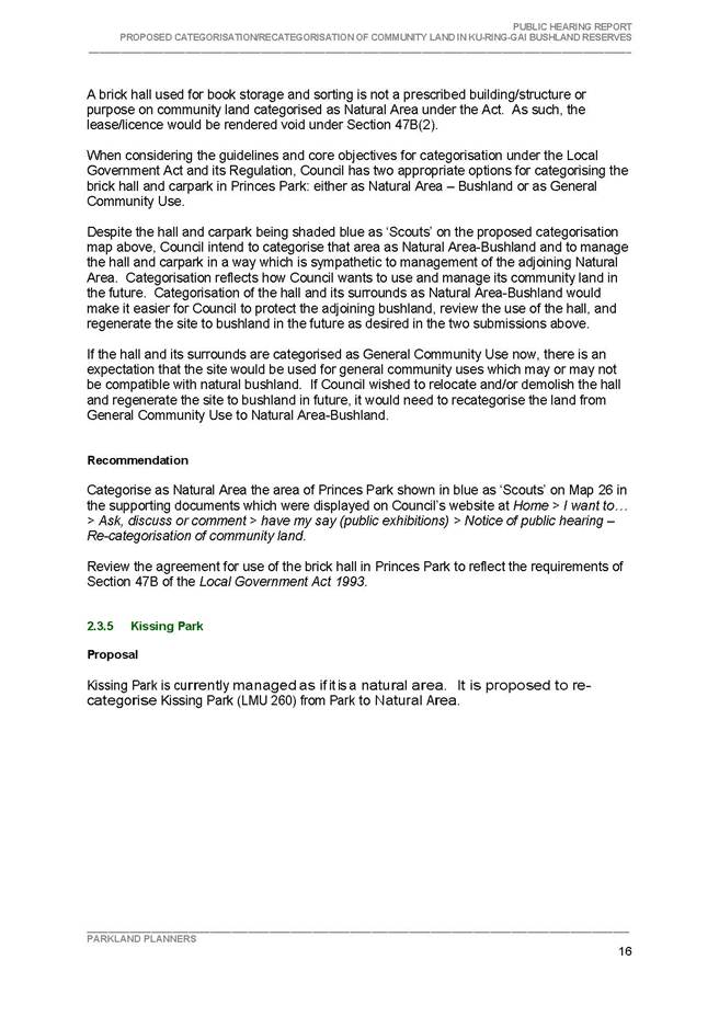
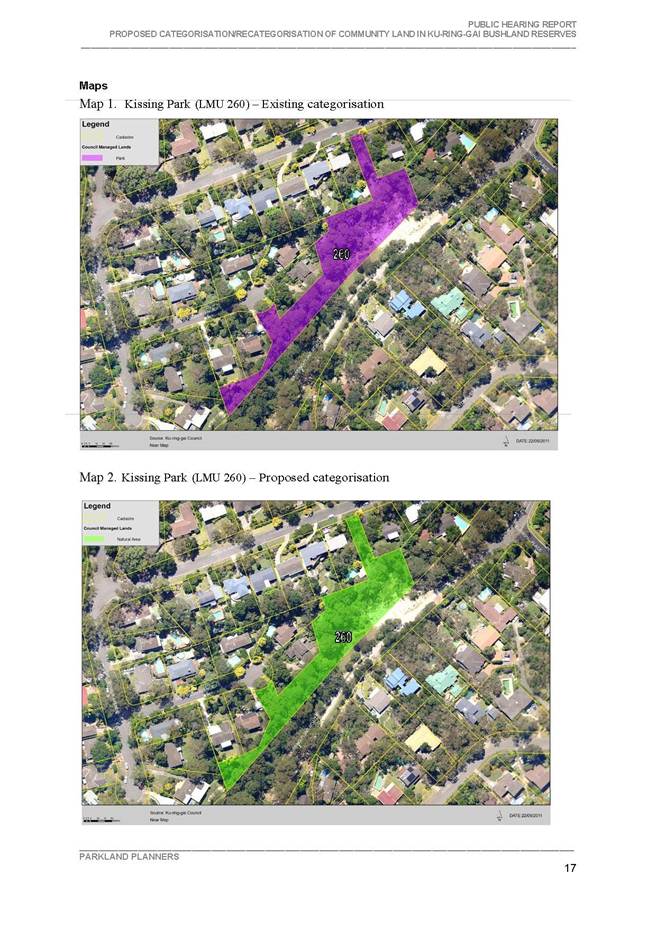

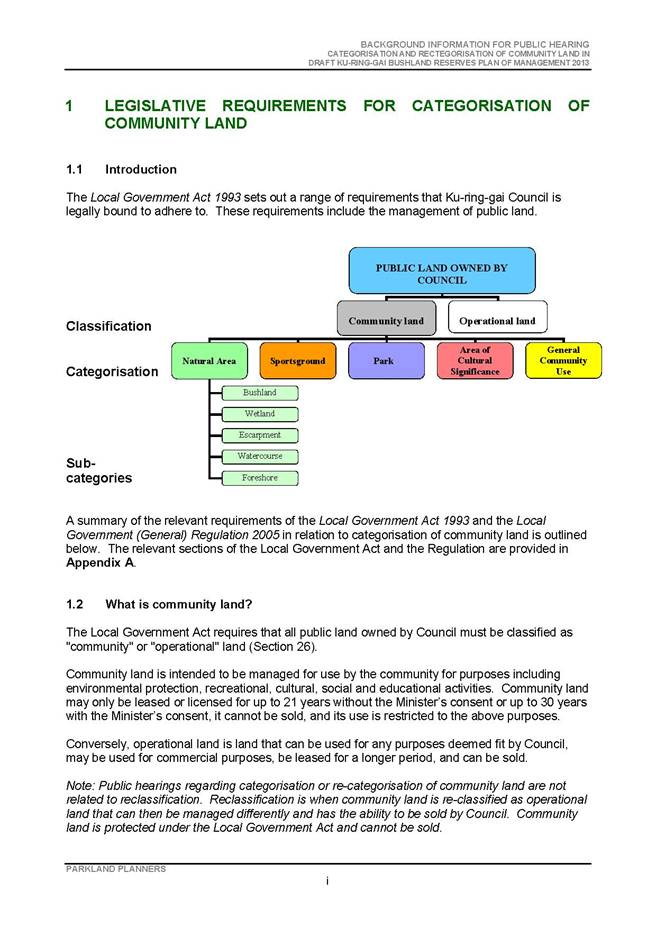
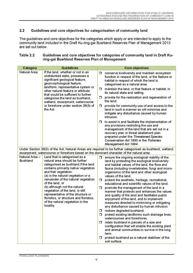

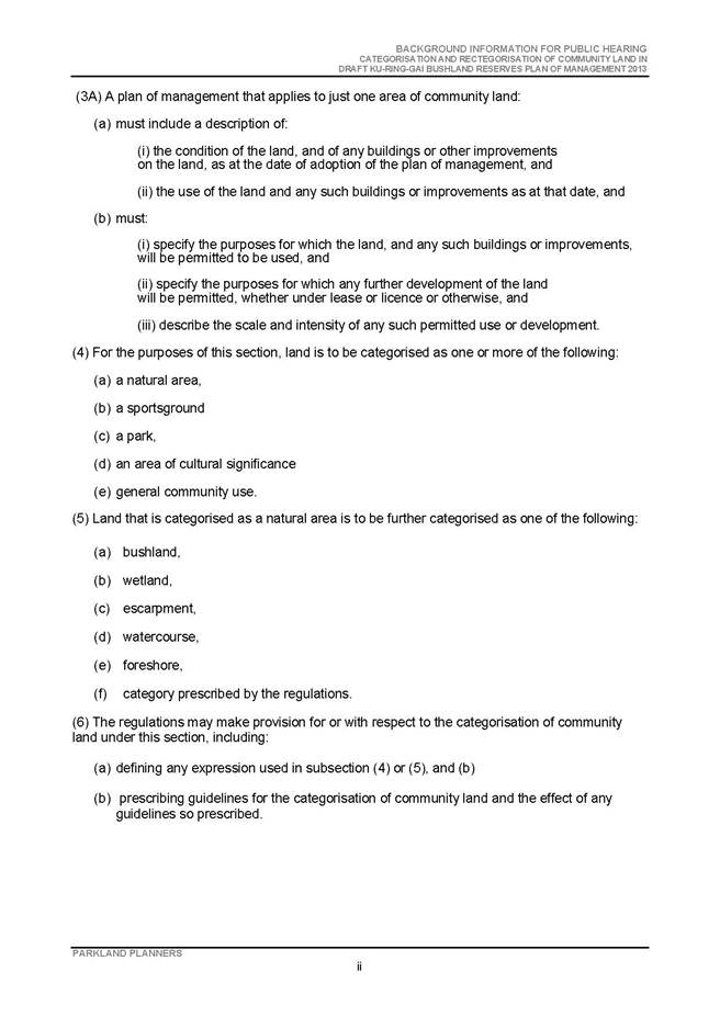
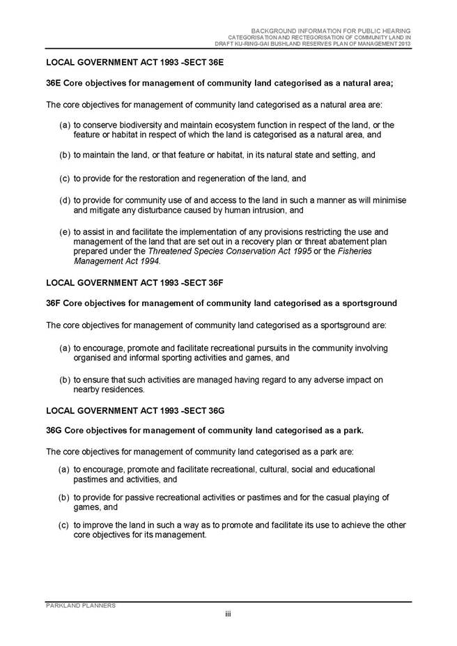
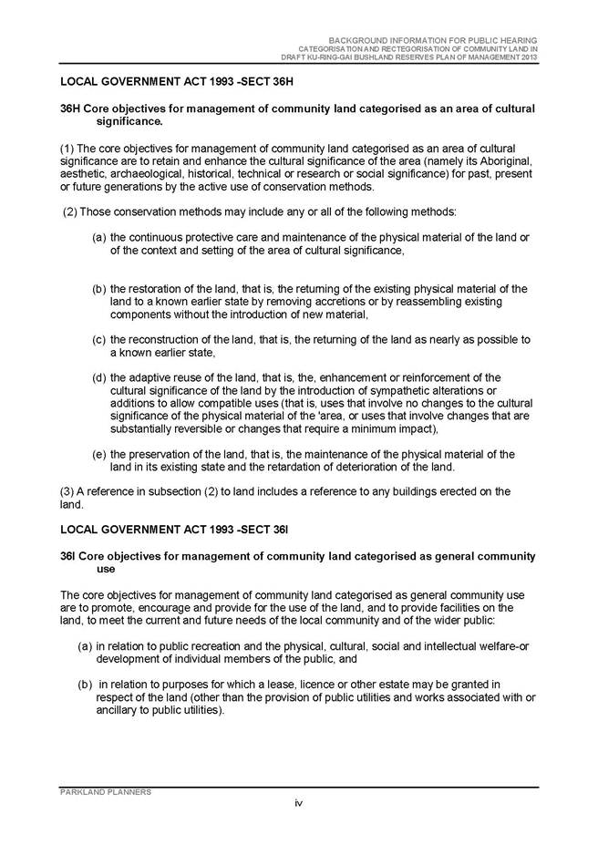

|
APPENDIX No: 4 - Proposal for an estate - Biobank site at Rofe Park, Sheldon Forest and Comenarra Creek Reserve |
|
Item No: GB.15 |
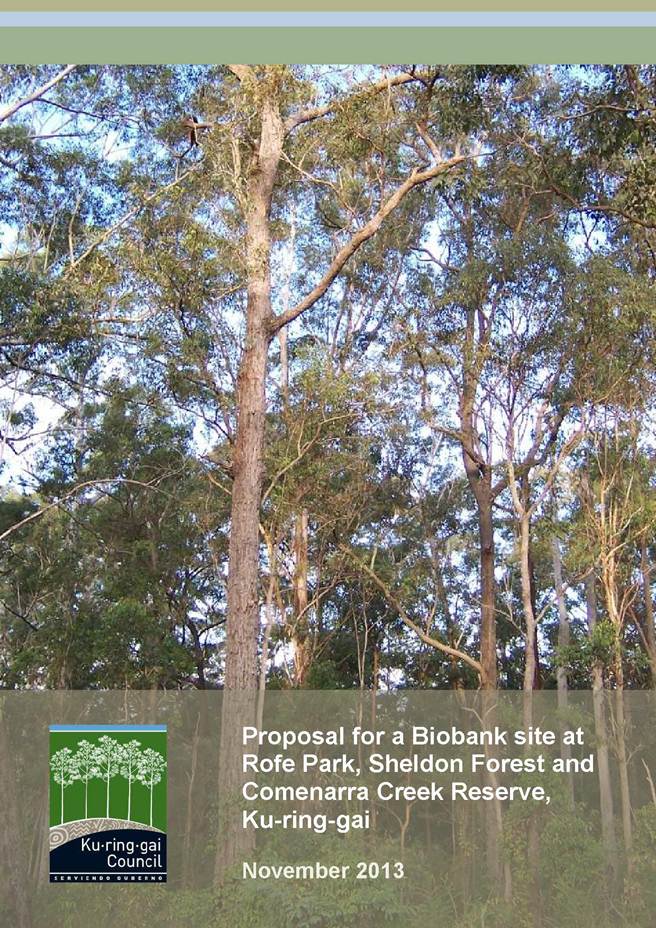

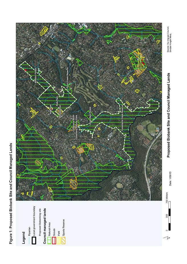

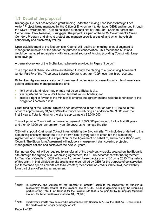

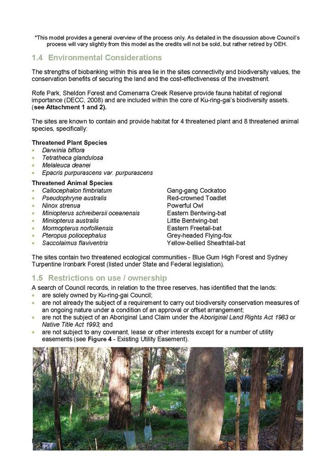
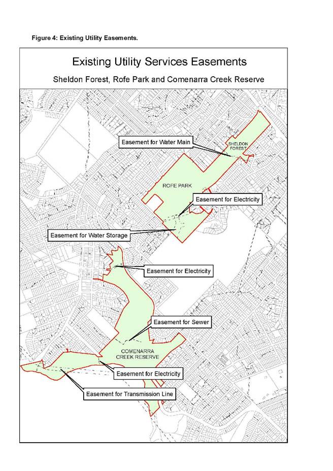
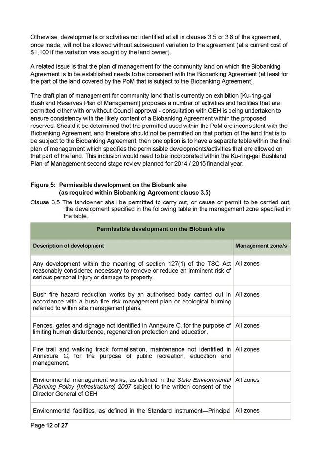
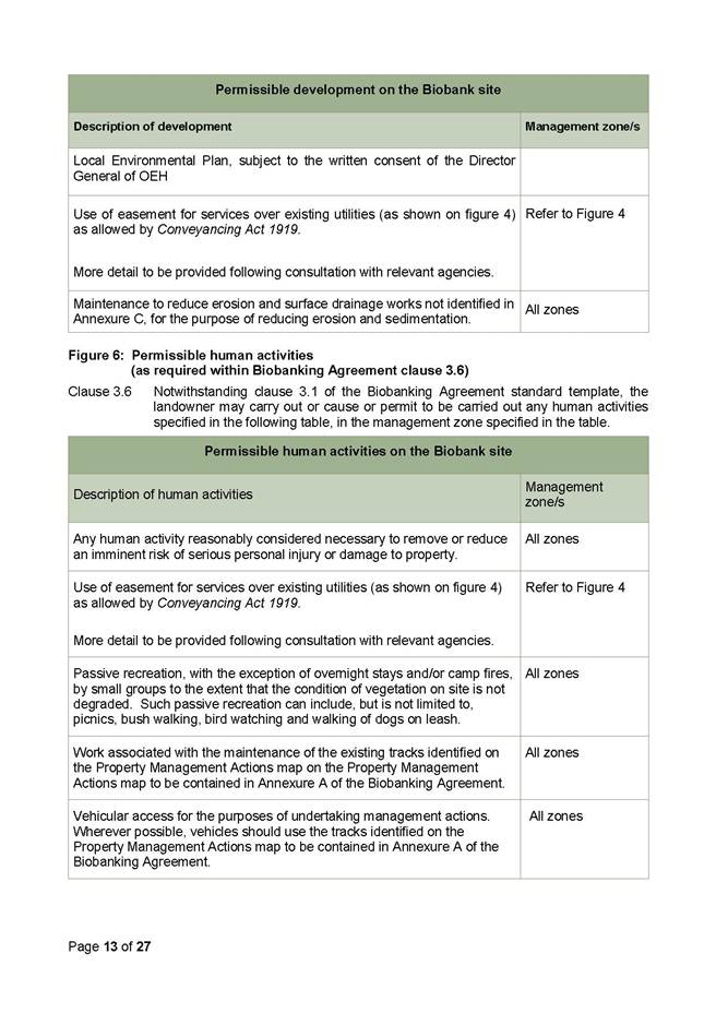

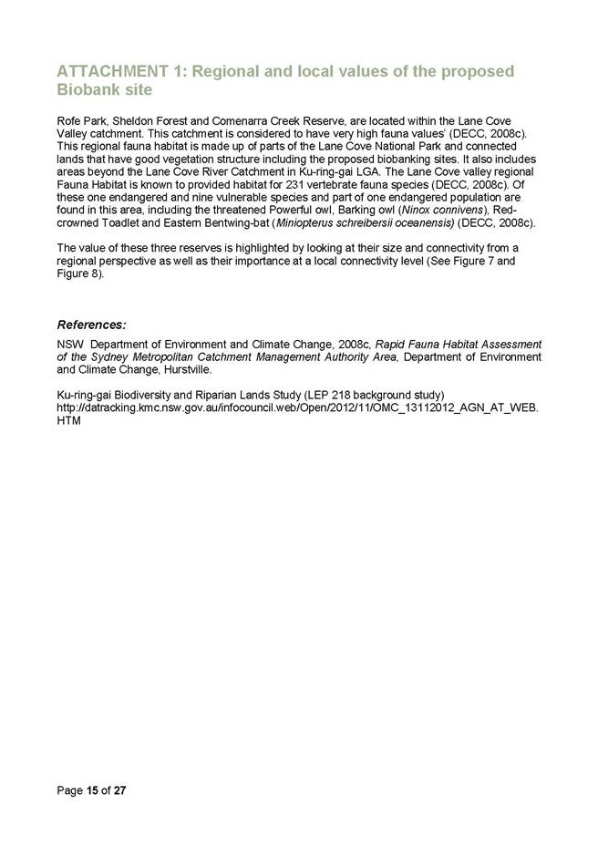
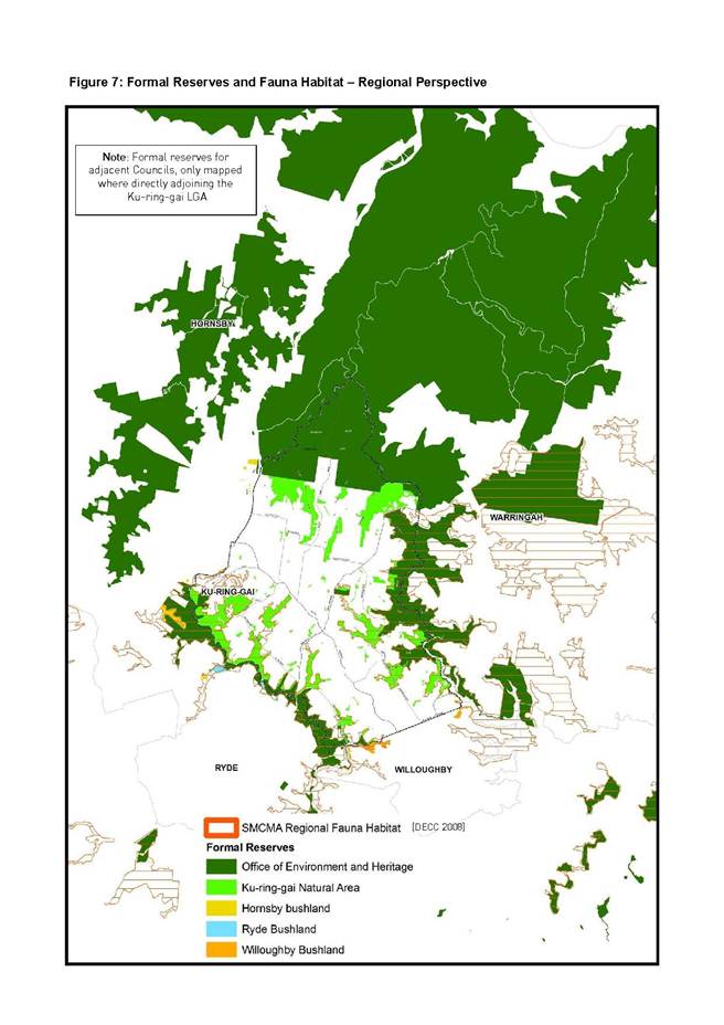
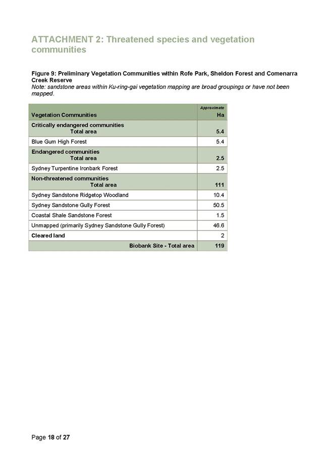
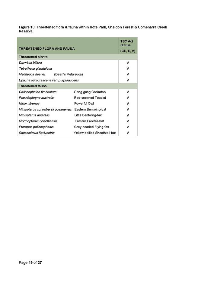
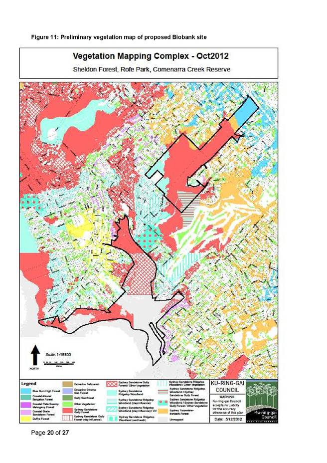
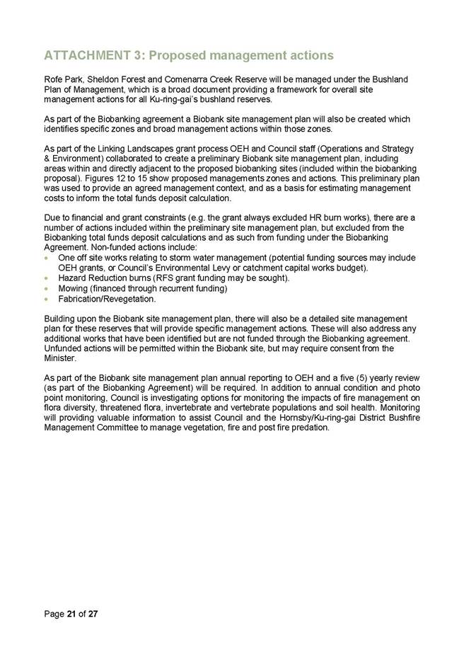
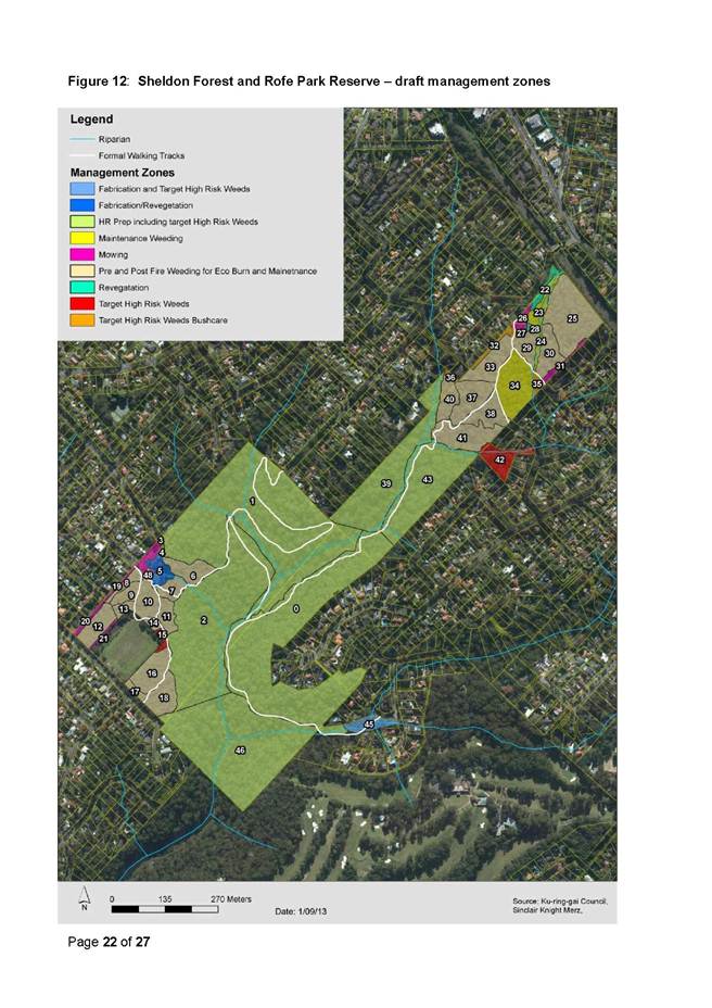
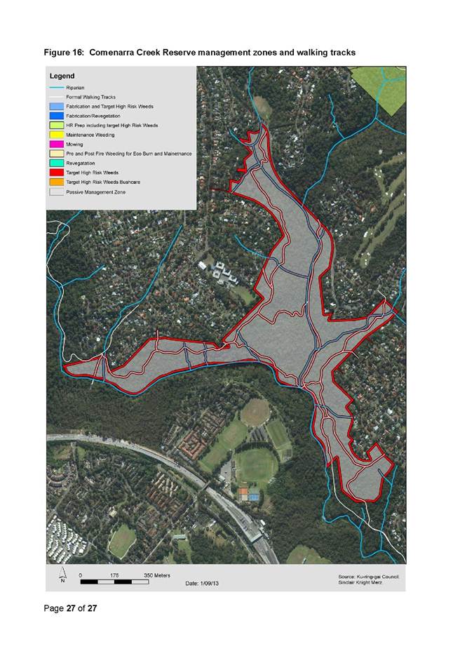
|
Ordinary Meeting of Council - 10 December 2013 |
GB.16 / 480 |
|
|
|
|
Item GB.16 |
S03213 |
|
|
19 November 2013 |
Native Title Claim by Awabakal and
Guringai People
EXECUTIVE SUMMARY
|
purpose of report: |
To inform Council of a Native Title claimant application made on behalf of the Awabakal and Guringai People. |
|
|
|
|
background: |
The Awabakal and Guringai People have submitted an application for the determination of Native Title. The application area is generally described as the Central Coast and covers areas of Crown land and water within the mapped boundary provided with the notice of application. This boundary covers an area from Ku-ring-gai and Hornsby in the south to Maitland in the north. |
|
|
|
|
comments: |
The application covers areas of Crown Land within the boundaries of 10 local government authorities, including Ku-ring-gai Council.
Not all land within the mapped area is claimed, for example, freehold land is excluded. There are also other exclusions to the claim, for example, the valid construction or establishment of any public work, where the construction or establishment of the public work commenced on or before 23 December 1996. |
|
|
|
|
recommendation: |
Council receive and note the intended course of action.
|
Purpose of Report
To inform Council of a Native Title claimant application made on behalf of the Awabakal and Guringai People.
Background
Council has been notified of a Native Title claimant application made on behalf of the Awabakal and Guringai People – Federal Court Application No – NSD780/2013. This application is currently in the notification stage.
The area that the claim encompasses is on the Central Coast of New South Wales, and covers areas of Crown Land and water within the external boundaries depicted on the map. Not all land within the external boundaries is claimed, for example, freehold land is excluded, as are public works such as roads, schools and hospitals.
The National Native Title Tribunal advises that if the claim succeeds, no other aboriginal person can claim the land affected. It also advised that the Council is able to apply to the Federal Court to be a party to the claim.
Comments
The notification documents relating to the application are provided in Attachment A1.
The application covers Crown Land in 10 local government areas: Ku-ring-gai Council, Cessnock City Council, Gosford City Council, Hornsby Shire Council, Lake Macquarie City Council, Maitland City Council, Newcastle City Council, Pittwater Council, Warringah Council and Wyong Shire Council.
The map provided with the notice of claim is a small scale map; and the Specific Crown Land and waters subject of the application cannot be identified. However, this is a large claim which covers the majority of the Central Coast, extending from Ku-ring-gai and Hornsby in the south to Maitland in the north.
It is understood that the section of Ku-ring-gai which is potentially impacted is the area to the north of the Pacific Highway and north-west of Mona Vale Road as shown in Attachment A2.
Acceptance of the claimant application for registration provides applicants with certain procedural rights while their application is being considered by the Federal Court.
Governance Matters
Council is able to apply to the Federal Court to be a respondent party to the claim on or before 8 January 2014. It is proposed to seek legal advice as to the interest of Council being a respondent party to the application. If Council does become a party, legal representation will be required.
Gosford City Council sent a letter to the General Manager on 8 November 2013 suggesting a joint representation be considered. This letter is provided in Attachment A3.
Risk Management
The Native Title claimant application made on behalf of the Awabakal and Guringai People has been accepted for registration and is currently in the notification stage. Acceptance of the claimant application for registration provides applicants with certain procedural rights while their application is being considered by the Federal Court.
These rights may impact on current and future proposed management and use of Crown Lands. In addition, the claimants may need to be consulted in reference to management decisions made in respect to Crown Lands potentially affected by this claim.
Financial Considerations
Should Ku-ring-gai Council become a respondent party to the action, there will be costs associated with that action. The likely quantum of costs, however, cannot be ascertained at this time. The sharing of resources with other councils would potentially reduce the costs.
The costs of legal action are unbudgeted and not able to be covered by the Strategy and Environment departmental budget.
Social Considerations
If the claim is successful it will prevent other Aboriginal people seeking Native Title and may have an impact on how determined land right titles can be used.
There may also be an impact in areas of Crown Land that are or may be used for recreation, but are not covered by existing public works. These impacts, however, cannot be predicted at this time and will depend on the progress of the claim.
Environmental Considerations
The impact of this Native Title claim on the environment will largely depend on the nature of use (exclusive or non-exclusive). These impacts however cannot be predicted at this time and will depend on the progress of this specific claim.
To a large extent Native Title does not remove the environmental protection provided by existing legislation.
Community Consultation
Initial consultation has been undertaken with key organisations to determine the impacts on the Metropolitan Local Aboriginal Land Council, Crown Land and Council and to better understand the future process and required course of action.
Consultation has been undertaken with:
· Robert Keed from the Metropolitan Local Aboriginal Land Council; and
· Michael Smole, Senior Case Manager - NSW Department of Trade and Investment (Representing Crown Lands)
Internal Consultation
Relevant staff from all departments in Council have been notified of this Native Title claim application. Council’s corporate mapping system has also been updated to show the areas of Crown land in Ku-ring-gai potentially impacted by this Native Title claim.
Summary
An application for Native Title claim has been made by the Awabakal and Guringai People which covers the northern part of Ku-ring-gai. This claimant application has been accepted for registration and is currently in the notification stage. As such Council should ensure that any procedural rights provided to the applicants while their application is being considered by the Federal Court are addressed.
As the claim covers a significant amount of Crown Lands in Ku-ring-gai, Council should seek legal advice and consider becoming a respondent party to this claim. If Council receives advice recommending becoming a respondent party, this application needs to be submitted on or before 8 January 2014. In addition, the letter from Gosford City Council suggesting joint representation should be considered.
|
That Council receive and note the intended course of action.
|
|
Penny Colyer Team Leader - Natural Areas |
Jamie Taylor Corporate Lawyer |
|
Marnie Kikken Manager Environment & Sustainability |
Andrew Watson Director Strategy & Environment |
|
A1View |
Notification Documents for NSD780/2013 |
|
2013/257919 |
|
|
|
A2View |
Map of Ku-ring-gai Council land potentially affected by Awabakal and Guringai Native Title Claim 2013 |
|
2013/304549 |
|
|
A3View |
Letter from Gosford City Council regarding Aboriginal Land Claim by Awabakal and Guringai people |
|
2013/291100 |
|
APPENDIX No: 2 - Map of Ku-ring-gai Council land potentially affected by Awabakal and Guringai Native Title Claim 2013 |
|
Item No: GB.16 |
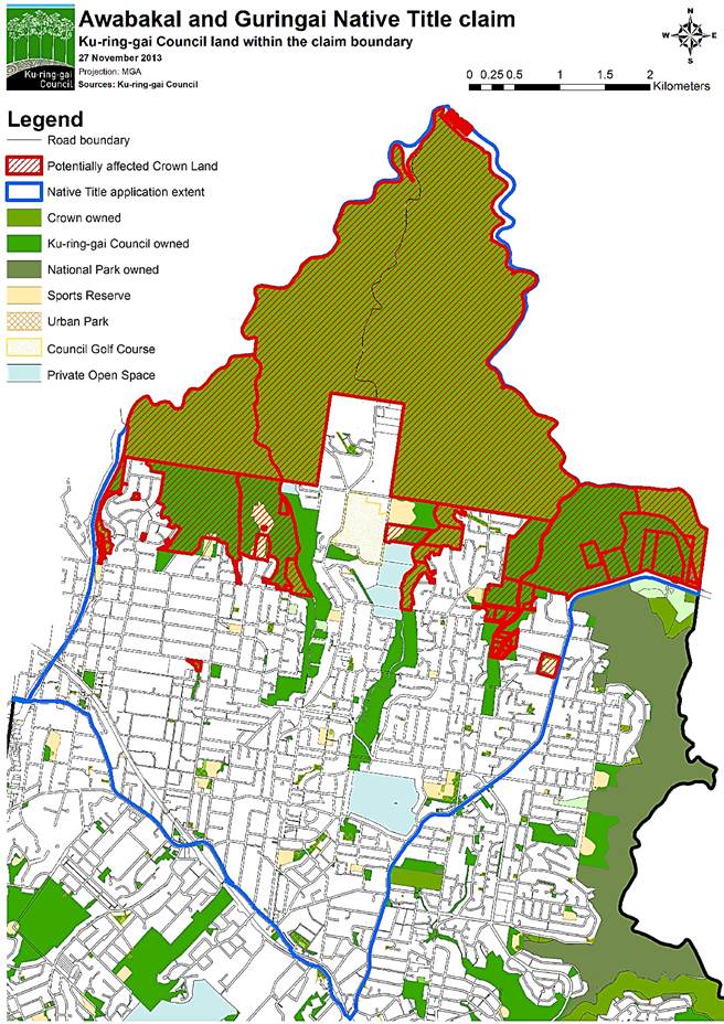
|
APPENDIX No: 3 - Letter from Gosford City Council regarding Aboriginal Land Claim by Awabakal and Guringai people |
|
Item No: GB.16 |
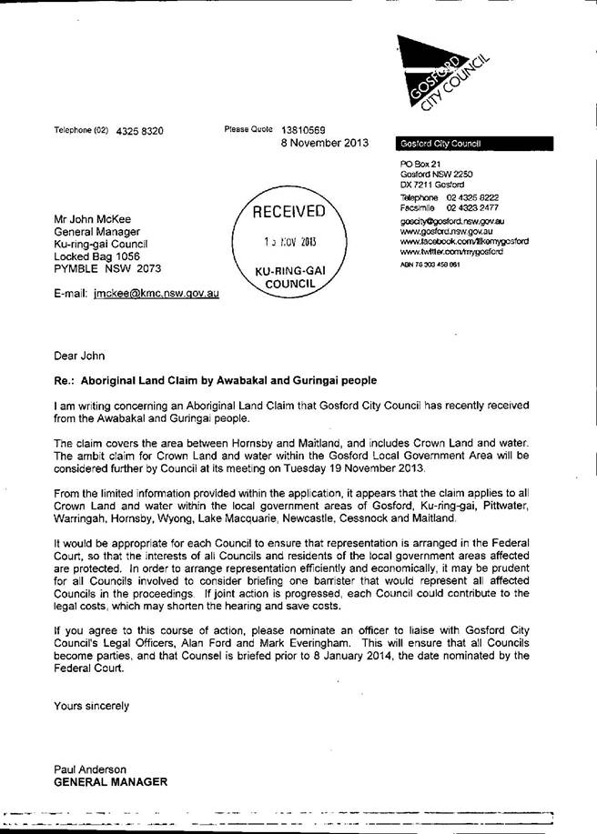
|
Ordinary Meeting of Council - 10 December 2013 |
GB.17 / 500 |
|
|
|
|
Item GB.17 |
S07209 |
|
|
21 October 2013 |
Acquisition and Divestment of
Land Policy - Review
EXECUTIVE SUMMARY
|
purpose of report: |
For Council to adopt the revised draft Acquisition & Divestment of Land Policy for public exhibition. |
|
|
|
|
background: |
On 8 September 2009, Council adopted its first Acquisition & Divestment of Land Policy. |
|
|
|
|
comments: |
Since the adoption of the first Policy in 2009, Council has acquired twenty-four (24) properties for future open space and new roads as identified in our Local Environmental Plans. These land acquisitions have been crucial to the strategic provision of open space, other community benefits and achievement of planning objectives associated with the development, growth and revitalisation of the local centres. |
|
|
|
|
recommendation: |
That Council adopt the revised draft Acquisition & Divestment of Land Policy for public exhibition for a period of 28 days with a further 14 days for public comment in accordance with the requirements of the Local Government Act 1993. |
Purpose of Report
For Council to adopt the revised draft Acquisition & Divestment of Land Policy for public exhibition.
Background
On 8 September 2009, Council adopted its first Acquisition & Divestment of Land Policy (Policy) with a review date established for September 2012.
Since that time a number of land acquisitions have been completed by Council in line with the principles of the Policy.
The revised draft Acquisition & Divestment of Land Policy (Attachment A1) sets out the principles, framework, responsibilities and processes for Council and officers to account for, and manage the acquisition and divestment of Council’s land assets.
Comments
The purpose of the Policy is to describe the manner in which Council will undertake the acquisition and divestment of land assets.
Since the adoption of the first Policy in 2009, Council has acquired twenty-four (24) properties for future open space and new roads. Some of these were opportunistic market opportunities identified in our local environmental plans, which nominated Council as the acquisition authority. These land acquisitions have been crucial to the strategic provision of open space, other community benefits and achievement of planning objectives associated with the development, growth and revitalisation of the local centres.
The revised draft policy has been updated to include gazetted and adopted changes in Council policy and plans, and minor amendments within the body of the document to reflect current legislation. The Policy contains the same provisions as the adopted Policy (2009) with the exception of an amendment to Part 7.3 under Methods of Acquisition which reads as follows:
7.3 Council’s preferred position is not to acquire land through compulsory acquisition. However, Council has an obligation to provide services to the community and if required Council MAY consider utilising its powers under the Local Government Act 1993 in respect of “compulsory acquisition”.
It is proposed that this section of the revised draft Policy be amended as follows;
7.3 Council’s preferred position is to acquire land through negotiation. However, Council has an obligation to provide services to the community and if required Council will consider utilising its powers under the Local Government Act 1993 in respect of “compulsory acquisition”.
The reasoning behind the proposed amendment is that there are still a number of strategic acquisitions to be completed, and while Council staff endeavour to achieve a negotiated agreement within valuation parameters, there are times when unrealistic price expectations thwart negotiations and acquisitions fail. This can result in costly and protracted valuation and legal argument between parties.
The purpose of the proposed amendment is to provide clarity for any persons/parties negotiating with Council, and to reinforce Council’s preferred acquisition method without diminishing our statutory powers to compulsory acquire land should Council deem this necessary to enforce.
It is also relevant that the Planning Reform Bill currently being debated in Parliament will impose far stricter timelines on the expenditure of development contributions when they are finally passed by both Houses and commenced.
Governance Matters
This draft policy applies to the acquisition and divestment of all land as defined within the policy, and acknowledges Council’s charter as the custodian and trustee of public assets required to effectively account for and manage the assets for which it is responsible for (Section 8 of the Local Government Act 1993).
Risk Management
The revised draft Acquisition & Divestment of Land Policy provides Council with:
· a documented reference to guide its decision making process;
· a reference which will survive successive Councils;
· an endorsed framework to enable and pursue land acquisition and divestment opportunities of merit and pro-actively present such opportunities to Council; and
· establish delegations necessary to allow implementation functions to be addressed to meet market drivers.
The policy provides for impartiality, transparency, accountability and the delivery of best value in the acquisition and divestment of land.
Financial Considerations
There are no specific financial considerations relating to the adoption of this policy apart from advertising costs and staff time.
Social Considerations
Land acquisitions and disposals are crucial to the strategic provision of open space, community benefits and achievement of long term planning outcomes associated with the development and growth of the local centres. This has now been confirmed through the Ku-ring-gai Local Environmental Plan (Local Centres) 2012, which nominates Council as the acquisition authority for RE1 lands and some SP2 lands.
Environmental Considerations
There are no specific environmental considerations relating to the adoption of this policy.
Community Consultation
The revised draft Acquisition & Divestment of Land Policy will be placed on public exhibition for a period of 28 days with a further 14 days for public comment in accordance with the requirements of the Local Government Act 1993.
At the conclusion of the public exhibition period a further report will be submitted to Council detailing any submissions received.
Internal Consultation
Council’s Strategy and Environment Department has provided input into the development of the revised draft Acquisition and Divestment of Land Policy.
Summary
On 8 September 2009, Council resolved to adopt its first Acquisition & Divestment of Land Policy (Policy) with a review date established for September 2012.
Since that time Council has acquired twenty-four (24) properties for future open space and new roads as identified in our local environmental plans or other strategic planning processes.
These land acquisitions have been crucial to the strategic provision of open space, other community benefits and achievement of planning associated with the development, growth and revitalisation of the local centres.
There are still a number of strategic acquisitions to complete, however, and while Council staff endeavour to achieve a negotiated agreement within valuation parameters there are times when unrealistic expectations thwart negotiations and acquisitions fail.
The purpose of the revised Policy continues to describe the manner in which Council will undertake the acquisition and divestment of land assets, and essentially contains the same provisions as the adopted Policy (2009) with the exception of an amendment to Part 7.3 under Methods of Acquisition.
The purpose of the proposed amendment is to provide clarity for any persons/parties negotiating with Council, and to reinforce Council’s preferred acquisition method without diminishing our statutory powers to compulsory acquire land should Council deem this necessary to enforce.
|
A. That Council to adopt the revised draft Acquisition & Divestment of Land Policy for public exhibition for a period of 28 days with a further 14 days for public comment in accordance with the requirements of the Local Government Act 1993.
B. That a further report be presented to Council following the public exhibition process.
|
|
Deborah Silva Manager Integrated Planning, Property & Assets |
Andrew Watson Director Strategy & Environment |
|
A1View |
Revised Draft Acquisition and Divestment of Land Policy |
|
2013/305832 |
|
APPENDIX No: 1 - Revised Draft Acquisition and Divestment of Land Policy |
|
Item No: GB.17 |
Ku-ring-gai Council
Draft Acquisition and Divestment of Land Policy
Introduction
The acquisition and divestment of Land by Council requires a formal process that is underpinned by probity, due diligence, analysis of risk and other key issues. Land acquisitions and/or divestments undertaken by Council are crucial to the strategic provision of open space, operational and community benefits, and achieving planning objectives associated with the development, growth and revitalisation of the local centres.
1. Purpose
This Policy applies to the acquisition and divestment of all Land as defined in this Policy. To acknowledge Council’s charter as the custodian and trustee of public assets and required to effectively account for and manage the assets for which it is responsible (Section 8 of the Local Government Act 1993).
To set out the principles, framework, responsibilities and processes for Council and officers to account for, and manage the acquisition and divestment of Council Land assets.
To identify, manage and mitigate the risks associated with the acquisition and divestment of Land.
To ensure impartiality, transparency, accountability and the delivery of best value in the divestment of Land (“fundamental principles”).
The purpose of this Policy is to describe the manner in which Ku-ring-gai Council will undertake the acquisition and divestment of Land assets and to provide Council with:
· a documented reference to guide its decision making process;
· a reference that will survive successive Councils;
· an endorsed framework to enable and pursue Land acquisition and divestment opportunities of merit and pro-actively present such opportunities to Council; and
· establish delegations necessary to allow implementation functions to be addressed to meet market drivers.
2. Objectives
To define the criteria which must be considered prior to the acquisition and/or divestment of Council owned Land and to define the process and procedures, including public consultation and notification, required to be undertaken prior to the divestment of any Council owned Land. The objectives of this Policy aim to provide Council with a framework which adopts the following principles:
· probity;
· statutory compliance;
· commercial maximisation, flexibility and confidentiality;
· transparency of process; and
· achievement of specific strategic outcomes of Council and the community.
3. Definitions
For the purposes of this Policy:
Acquisition Authority means the responsible agency to acquire affected properties identified in the Ku-ring-gai Local Environmental Plan (Local Centres) 2012 or the Ku-ring-gai Planning Scheme Ordinance or the yet to be gazetted draft Ku-ring-gai Local Environmental Plan 2013 and as amended from time to time.
Act means the Local Government Act 1993 and any replacement Act.
Contract means any form of contract which legally binds the Council [or potentially binds Council] and includes formal contracts and other forms of contractual arrangements including heads of agreement, in principle agreement, options to purchase etc.
Land is as defined in Section 21 of the Interpretation Act 1987.
As a more specific reference for the purpose of this Policy, Land is defined as;
1. Land as a physical entity including:
(i) any building or structure on or improvement to Land; or
(ii) any stratum of land whether below or above ground; or
(iii) a strata lot pursuant to relevant strata subdivision legislation.
Open Space Acquisition Strategy means strategy adopted by Council in October 2007.
Owner Initiated Acquisition means the principle considerations defined in Section 23 of the Land Acquisition (Just Terms Compensation) Act 1991 to acquire affected properties.
Programmed Acquisition means when the acquiring authority requires the affected
property and initiates the acquisition process.
Compulsory Acquisition means when the acquiring authority requires the affected
property and initiates the acquisition process in accordance with the Land Acquisition (Just Terms Compensation) Act 1991.
Regulation means the Local Government (General) Regulation 2005 and any replacement Regulation.
4. Legislation
4.1 The Local Government Act, 1993 vests authority in Council to sell or exchange Real Property. In respect of this Policy, “exchange” includes property acquisition and other related activities including Land swaps etc.
4.2 In accordance with Section 377 of the Act any decision to dispose of Land must be made by resolution of Council as the power to sell, exchange or surrender Land cannot be delegated.
4.3 Section 45 of the Act prevents Council from selling, exchanging or otherwise disposing of community Land other than to become or be added to a Crown Reserve or National Park.
4.4 Section 55 of the Act requires tenders to be called in certain circumstances. However, it is not necessary to call tenders for the sale of Land.
4.5 In accordance with Council’s Purchasing Policy, Land acquisition activities are excluded from the provisions of the Purchasing Policy.
Council’s property activities will be managed within the legislative parameters of the:
· Local Government Act, 1993;
· Valuation of Land Act, 1916;
· Conveyancing Act, 1919;
· Environmental Planning and Assessment Act, 1979;
· Land Acquisition (Just Terms Compensation) Act, 1991;
· Roads Act, 1993;
· Crown Lands Act, 1989;
· Environment Protection and Biodiversity Conservation Act, 2000;
· National Parks and Wildlife Conservation Act, 1975;
· Real Property Act, 1919;
· Regulations under each of the above Acts;
· Relevant Codes, Plans and Policies referred to in Section 13 of this policy; and
· any other legislation applicable to the Policy.
5. Fundamental Principles
All decisions and actions in relation to the acquisition and/or divestment of Land will have due regard to the following fundamental principles:
· Best Value for Money – Achieving “best value” may include financial, social and environmental benefits.
· Transparency – processes must be open to scrutiny and provide full information and record the reasons behind decisions.
· Accountability – demonstrate the best use of public resources and the highest level of performance through appropriate record keeping and audit trails.
· Impartiality – address perceived or actual conflicts of interests.
6. Land Acquisition Procedure
6.1 Fundamental Principles
Council will acquire Land for the purpose of carrying out its functions under
the Act. Any Land to be acquired by Council is subject to a formal resolution of Council.
6.2 Independent Valuation Benchmark and Special Value. Any Land acquisition is to be benchmarked to an independent valuation of Land.
In some cases there will be justified basis for Council acquiring property at a price above the valuation benchmark in order to guarantee the successful securing of the property to achieve defined goals and objectives of Council or to acquire the property with a view to adding value [or reducing risk] to a larger scheme or development [future or current].
Any special value should be determined and quantified within the decision of Council and referenced to the achievement of specific goals and objectives of Council.
6.3 Acquisition Process
While the General Manager and/or their delegate may make preliminary enquiries regarding a possible purchase, no negotiations will commence without there first being a resolution of Council authorising the negotiations. The General Manager shall:
· be responsible for the conduct of all negotiations;
· have regard to an independent valuation obtained from a registered valuer;
· seek such other professional advice as is considered necessary in the circumstances;
· have regard to the Independent Commission Against Corruption publication Direct Negotiations so far as is appropriate in the circumstances; and
· report the outcome of all negotiations to the Council for determination.
6.4 Prior to finalisation of an acquisition Council shall determine the
classification of the Land as either operational or community.
6.5 Council’s process of Land acquisition must include the following steps:
· identification of the Land acquisition opportunity by Council and/or the Responsible Officer;
· in principle decision by the General Manager to commence the pre-acquisition process;
· preparation of a comprehensive assessment of the Land acquisition including:
(I) required due diligence;
(II) independent valuation, maximum price [purchase, lease or other];
(III) if applicable an assessment against the principles and objectives of Council’s Open Space Acquisition Strategy 2007;
(IV) identification of funding source and assessment against Council’s Long Term Financial Model; and
(V) a statement of goals and objectives for the proposed Land to be acquired including a statement of any “Special Value” deemed appropriate by Council.
· formal consideration by Council of dealing with the matter and if required in accordance with Section 10A of the Act be dealt with in a closed meeting;
· formal report to Council including the Land acquisition assessment and documented reasons for Council’s acquisition of the Land, and if supported delegation to the General Manager to negotiate an outcome subject to the financial and risk parameters as determined by Council;
· negotiation, and if successful, implementation of all matters necessary for the preparation, signing and sealing of contract documentation required; and
· once completed the General Manager to advise Council of the outcome [successful or otherwise].
The process is designed to ensure fairness and equity.
7. Methods of Acquisition
Wherever possible Council’s preferred method of acquisition is to acquire Land through mutual agreement with the owner of the Land. The key principles in the acquisition of Land are:
7.1 opportunistically by responding when the desired Land is offered to the market; and
7.2 pro-actively by initiating negotiations for the desired Land.
7.3 Council’s preferred position is to acquire Land through negotiation. However, Council has an obligation to provide services to the community and if required Council may consider utilising its powers under the Local Government Act 1993 in respect of “compulsory acquisition”.
7.4 Council is the nominated acquisition authority for land reserved for public purposes as RE1 and SP2 within its draft Ku-ring-gai Local Environmental Plan (Local Centres) 2012 and these acquisitions will be dealt with in accordance with Land Acquisition (Just Terms Compensation) Act, 1991 for the acquisition of Land and the payment of compensation.
8. Compensation
Compensation will apply to affected property owners under the following provisions;
8.1 owner initiated acquisitions
8.2 programmed acquisitions
8.3 compulsory acquisitions
In determining the amount of compensation to which a person is entitled, Part 3 Division 4 of the Land Acquisition (Just Terms Compensation) Act, 1991 requires that regard must be given to the following matters only:
(a) the market value of the land on the date of its acquisition;
(b) any special value of the land to the person on the date of its acquisition;
(c) any loss attributable to severance;
(d) any loss attributable to disturbance;
(e) solatium ( i.e. that is compensation for non-financial disadvantage arising the need to relocate as a result of the acquisition); and
(f) any increase or decrease in the value of any other land of the person at the date of acquisition which adjoins or is severed from the acquired land by reason of the carrying out of, or the proposal to carry out, the public purpose for which the land was acquired.
8.3 Property owners claiming hardship in accordance with Section 24 of the Land Acquisition (Just Terms Compensation) Act, 1991 provisions should note that:
8.3.1 Council is not required to acquire land unless it is of the opinion that the owner will suffer hardship (within the meaning of the Land Acquisition (Just Terms Compensation) Act, 1991. An owner of land must demonstrate they suffer hardship if:
(a) the owner is unable to sell the land, or is unable to sell the land at its market value, because of the designation of the land for acquisition for a public purpose, and
(b) it has become necessary for the owner to sell all or any part of the land without delay:
(i) for pressing personal, domestic or social reasons, or
(ii) in order to avoid the loss of (or a substantial reduction in) the owner’s income.
8.3.2 However, if the owner of the land is a corporation the corporation does not suffer hardship unless it has become necessary for the corporation to sell all or any part of the land without delay for pressing personal, domestic or social reasons of an individual who holds at least 20 per cent of the shares in the corporation, or in order to avoid the loss of (or a substantial reduction in) the income of such an individual.
9. Land Divestment Procedures
9.1 Fundamental Principles
All decisions and actions in relation to the divestment of Land will have due
regard to the following fundamental principles:
· Best Value for Money – Achieving “best value” may include financial, social and environmental benefits.
· Transparency – processes must be open to scrutiny and provide full information and record the reasons behind decisions.
· Accountability – demonstrate the best use of public resources and the highest level of performance through appropriate record keeping and audit trails.
· Impartiality – address perceived or actual conflicts of interests, ensuring fairness and equity.
9.2 Land Deemed to be Surplus
“Land” includes all real property whether vacant or improved. Land may not be sold by Council unless it is classified as “operational land” under Section 25 of the Local Government Act, 1993.
In order to establish whether or not Land is deemed to be surplus, a process of consultation is required to be completed across relevant divisions of Council prior to reclassification in accordance with the Local Government Act, 1993.
9.3 Delegated Authority
Section 377 (1) (h) of the Local Government Act 1993 requires a specific resolution of Council to dispose of Land. The decision cannot be delegated.
The report to Council is to include reference to the manner of divestment (often contained within a confidential report) in regards to the terms of the sale and the agreed price, or range for negotiations. The sale can not proceed outside of such parameters (without a further resolution).
The resolution should also provide for the General Manager to be provided with delegated authority to negotiate any outstanding, usually minor conditions, and to be authorised to execute any documents in relation to the matter deemed appropriate by Council’s legal advisors.
A copy of the report and resolution is to be provided to Council’s legal advisors upon instruction, as authority to act and to ensure compliance with the resolution.
No formal actions may be commenced in the divestment of Land until a report has been considered by Council and an appropriate resolution adopted.
Informal pre-sale discussions/negotiations must always be qualified “subject to resolution of Council” if there is no current resolution of Council to dispose of the Land.
9.4 Valuation Processes
At least one formal market valuation undertaken by a valuer registered to value such property is required to be commissioned prior to all property divestments.
Two valuations may be required when the value of the property is likely to exceed $5,000,000.00 and/or the process of divestment is not competitive (as defined below).
An internal review of the valuation(s) is to be carried out and reported, with specific attention to the valuation rationale, method of valuation, calculations and sales evidence used. After such review, the valuation is to be considered in the setting of an asking price for sale, reserve price for auction or benchmark for negotiations, tender or expression of interest.
When two valuations have been provided, averaging is the preferred method for considering the price, when any difference in the valuation is 10% or less. Differences in valuations of more than 10% require an assessment of the reasons why they are different, and more detailed justification of the price.
An update valuation, or valuation advice is required after 12 months of the date of the original valuation if the Land is not sold, or at any time there is considered to be a material movement in the value.
The valuation instructions must clearly state the following:
· the purpose of the valuation’
· the basis of valuation being “market value highest and best use”, unless an alternative basis is considered more appropriate in the circumstances;
· that the valuation is to be marked confidential; and
· the valuation includes market commentary, details of sales evidence and adjustments, valuation rationale and methodology, a valuation range (for negotiations) and comments on marketability, most appropriate method of divestment and opportunities to add value.
In addition, the valuer must make a statement that there is no actual or perceived conflict of interest in undertaking the valuation.
10. Methods of Divestment
An open competitive process of divestment is required choosing one of the following methods:
· Expression of interest – usually used for unusual properties capable of a variety of development, difficult to determine a market value.
· Tender – least common and used predominantly in high value, limited market situations.
· Auction – the most open and public method, favoured by government, but reliant on high levels of competition. Often achieves a quick sale. Can fail in poor market.
· Private Treaty – most common, where an asking price is set and negotiated with individuals, usually through a real estate agent (who can be an independent third party to the negotiation process) and can arise after an unsuccessful Auction.
Council may approve a non-competitive process of divestment such as direct negotiations, subject to clearly documented reasons and the employment of risk mitigation measures.
Risk mitigation measures for direct negotiations may include:
· obtaining two valuations where the Land may be valued at more than $5,000,000.00;
· pre-establishing a range for negotiation, having regard to the two valuations;
· managing conflicts of interest with declarations of no personal or financial associations;
· establishing a Negotiation Protocol, describing the manner in which meetings, negotiations, decisions and progress reporting is to be managed and documented; and
· limitation on marketing budget and exclusive agency periods.
10.1 Contract for the Sale of Land
Contracts for the sale of Land will usually contain standard conditions of sale. Any unusual or special conditions of sale require the delegated approval of Council or the General Manager as set out in 9.3 above.
Council’s solicitor is responsible to ensure Contracts for the sale of Land satisfy statutory disclosure and warranty obligations (Conveyancing (Sale of Land) Regulation 2005).
10.2 Divestment below Market Value
In rare circumstances Land may be disposed of to achieve strategic outcomes. In such situations, “best value” may comprise financial, environmental or social elements, with the price falling below the “market value” range.
The report seeking resolution of Council should clearly state the reasons for such sale and quantify the amount below market value attributable to each element. The obligation to obtain a market valuation exists in accordance with the above, in order to provide a measure of the non-financial elements of the sale.
10.3 Sale to Adjoining Owners
In circumstances where Land is not able to be sold in isolation on the open market (such as small parcels, undersized lots, former road widening, closed laneways, boundary adjustments etc) and the only potential purchasers are adjoining owners; the Land must be offered in equal proportions to each adjoining owner on identical sale terms and conditions.
Where an adjoining owner does not wish to purchase their proportion of the Land, the rejected Land will be equally offered to the remaining adjoining owner.
The recommended method of determining the sale price is the “before and after” method as related to the purchaser’s Land. For small portions of Land, the “piecemeal” ($ rate per square metre) method may be more appropriate.
An essential condition of sale is that the purchaser is required to consolidate the subject Land with their existing holding at no cost to Council.
The costs associated with the sale process will be borne by the prospective purchaser.
10.4 Sale of Roads – Roads Act, 1993
No road can be sold until it is formally closed in accordance with the provisions of the Roads Act, 1993.
For purchaser initiated closures and sales, the costs associated with the road closure will be borne up front by the prospective purchaser.
When Council initiates the road closure (in order to realise the value of surplus Land), the costs will be borne by Council as development costs.
The agreed purchase price and estimated costs will be reported to Council seeking resolution agreeing to make application to close the road and dispose of the Land upon closure in accordance with the terms of sale.
In accordance with Section 43 of the Roads Act, 1993, funds from the sale of roads are required to be set aside for acquiring Land for public roads or for carrying out work on public roads.
11. Confidentiality
In the majority of divestments of Land, the information contained in reports to Council to sell Land may confer an advantage upon a person with whom Council is, or proposes, to be conducting business. On balance, it would be contrary to the public interest for Council to deal with such matter in an open session because release of the information could prejudice Council’s ability to obtain the maximum return on the property.
Therefore, it is acknowledged that reports to Council on the divestment of Land will be generally deemed confidential under Section 10A(2)(c) of the Local Government Act, 1993. This confidentiality may be lifted by Council resolution upon settlement, if considered to be in the public interest.
12. Departure from change this Policy
Any provision of this policy may be varied to meet the needs of a particular matter, by resolution of Council. The reasons for change will be clearly articulated within the report submitted for consideration by Council in adopting such resolution and will only apply to such matter.
13. Associated documents
Codes, plans and policies
Ku-ring-gai Council Open Space Acquisition Strategy – Adopted October 2007.
Ku-ring-gai Council Contributions Plan 2010
Ku-ring-gai Local Environment Plan [Local Centres] 2012 – Gazetted January 2013
Draft Ku-ring-gai Local Environmental Plan 2013 – as amended
Council’s Local Centres Development Control Plan [DCP] – Adopted May 2013, and as amended.
Ku-ring-gai Council Community Strategic Plan Our Community Our Commitment 2030 – adopted June 2013
Ku-ring-gai Council Easement Management Policy – Adopted August 2013
External references
Independent Commission Against Corruption [ICAC], Direct Negotiations, May 2006
|
Ordinary Meeting of Council - 10 December 2013 |
GB.18 / 515 |
|
|
|
|
Item GB.18 |
S07252/4 |
|
|
29 November 2013 |
Draft Commercial Leasing Policy
EXECUTIVE SUMMARY
|
purpose of report: |
For Council to adopt the draft Commercial Leasing Policy (policy) for public exhibition. |
|
|
|
|
background: |
To date, the commercial management of Council’s property portfolio has been carried out in line with the legislative leasing requirements applicable to public land management. |
|
|
|
|
comments: |
The focus of this Policy is on agreements relating to exclusive occupation of a Council property for commercial and retail uses only. |
|
|
|
|
recommendation: |
That Council adopts the draft Commercial Leasing Policy and place the draft policy on public exhibition for a period of 28 days with a further 14 days for public comment in accordance with the requirements of the Local Government Act, 1993. |
Purpose of Report
For Council to adopt the draft Commercial Leasing Policy (policy) for public exhibition.
Background
To date, the commercial management of Council’s property portfolio has been carried out in line with the legislative leasing requirements applicable to public land management. This includes the leasing provisions established under the following legislation;
· Local Government Act, 1993;
· Conveyancing Act, 1919;
· Roads Act, 1993;
· Crown Lands Act, 1989;
· Environment Protection and Biodiversity Conservation Act, 2000;
· National Parks and Wildlife Conservation Act, 1975;
· Real Property Act, 1919;
· Retail Leases Act 1994;
· Regulations under each of the above Acts.
In addition, Council’s adopted Acquisition & Divestment of Land Policy 2009, also provided a reference source for commercial leasing activities undertaken by Council.
Council’s Audit Committee, however, recently recommended that a specific policy was required to detail the commercial leasing and licencing activities.
The attached draft Commercial Leasing Policy (Attachment A1) has been prepared in response to the Audit Committee’s request and sets out the framework, responsibilities and processes for Council and officers to account for, and manage the leasing and licencing of Council’s property assets that provide a commercial return.
Comments
Council owns a great deal of land across the local government area. Much of this land is used under formal arrangement by other people, groups or companies.
The number of commercial and retail leases, however, is relatively small in comparison.
The focus of this draft policy is on agreements relating to exclusive occupation of a Council property for commercial and retail uses only.
This draft policy does not directly apply to leases/licences for residential or community use, seasonal tenancies or ground allocations for Council’s sporting ovals.
The objectives of this policy aim to provide Council with a framework which adopts the following principles:
· probity;
· statutory compliance;
· commercial maximisation, flexibility and confidentiality;
· transparency of process; and
· achievement of specific strategic outcomes of Council and the community.
Governance Matters
This draft draft policy applies to the acquisition and divestment of all land as defined within the policy, and acknowledges Council’s charter as the custodian and trustee of public assets required to effectively account for and manage the assets for which it is responsible for (Section 8 of the Local Government Act, 1993).
Risk Management
The draft policy provides for impartiality, transparency, accountability and the delivery of best value in the commercial leasing of Council property.
The draft policy sets out the framework, responsibilities and processes for Council and officers to account for, and manage the leasing and licencing of Council’s property assets that provide a commercial return and to identify, manage and mitigate the risks associated with the leasing and licensing of Council land.
Financial Considerations
There are no specific financial considerations relating to the adoption of this policy apart from advertising costs and staff time.
Social Considerations
Within Council’s Community Strategic Plan (CSP) Our Community – Our Commitment 2030, an important long term objective under Financial Capacity and Sustainability is that;
“Council rigorously manages its financial resources and assets to maximise delivery of services “
The draft policy documents current commercial standards and practices to support the objective identified in the CSP.
Environmental Considerations
There are no specific environmental considerations relating to the adoption of this draft policy.
Community Consultation
The draft policy will be placed on public exhibition for a period of 28 days with a further 14 days for public comment in accordance with the requirements of the Local Government Act, 1993.
At the conclusion of the public exhibition period a further report will be submitted to Council detailing any submissions received.
Internal Consultation
A review of other Councils’ existing policies of a similar nature has been undertaken in the development of this draft policy.
Summary
To date, the commercial management of Council’s property portfolio has been carried out in line with the legislative leasing requirements applicable to public land management.
Council’s Audit Committee recently recommended that a specific policy was required to detail our commercial leasing and licencing activities.
The draft policy sets out the framework, responsibilities and processes for Council and officers to account for, and manage the leasing and licencing of Council’s property assets that provide a commercial return.
This policy does not directly apply to leases/licences for residential or community use, seasonal tenancies or ground allocations for Council’s sporting ovals.
The draft Commercial Leasing Policy will be placed on public exhibition for a period of 28 days with a further 14 days for public comment in accordance with the requirements of the Local Government Act, 1993.
At the conclusion of the public exhibition period a further report will be submitted to Council detailing any submissions received.
|
A. That Council adopts the draft Commercial Leasing Policy and place the draft policy on public exhibition for a period of 28 days with a further 14 days for public comment in accordance with the requirements of the Local Government Act, 1993.
B. That a further report be presented to Council following the public exhibition process.
|
|
Deborah Silva Manager Integrated Planning, Property & Assets |
Andrew Watson Director Strategy & Environment |
|
A1View |
Draft Commercial Leasing Policy - OMC version |
|
2013/306618 |
|
APPENDIX No: 1 - Draft Commercial Leasing Policy - OMC version |
|
Item No: GB.18 |
Ku-ring-gai Council
Draft Commercial Leasing Policy
Introduction
Council owns a great deal of land across the local government area. Much of this land is used under formal arrangement by other people, groups or companies.
Examples of these types of uses include:
· Commercial, retail, or residential use
· Community or recreation groups that exclusively occupy a premises
· Community or recreation groups that seasonally occupy a premises
· Groups that have regular non-exclusive access to Council facilities
· Groups or people that use a facility on an irregular or one off basis
However, the number of commercial and retail leases is relatively small in comparison.
The focus of this policy is on agreements relating to exclusive occupation of a Council facility or land for commercial and retail uses only. Such occupation will typically be in the form of a lease agreement, but may also include a licence.
This policy does not directly apply to leases/licences for residential or community use, seasonal tenancies or ground allocations for Council’s sporting ovals.
1. Purpose
To set out the framework, responsibilities and processes for Council and officers to account for, and manage the leasing and licencing of Council’s property assets that provide a commercial return.
To identify, manage and mitigate the risks associated with the leasing and licensing of Council Land.
2. Objectives
The objectives of this Policy aim to provide Council with a framework which adopts the following principles:
· probity;
· statutory compliance;
· commercial maximisation, flexibility and confidentiality;
· transparency of process; and
· achievement of specific strategic outcomes of Council and the community.
3. Definitions
For the purposes of this Policy:
Act means the Local Government Act 1993 and any replacement Act.
Community land means land that is classified as community land under Division 1 of Part 2 of Chapter 6 of the Local Government Act 1993.
Land is as defined in Section 21 of the Interpretation Act 1987.
As a more specific reference for the purpose of this Policy, Land is defined as;
1. Land as a physical entity including:
(i) any building or structure on or improvement to Land; or
(ii) any stratum of land whether below or above ground; or
(iii) a strata lot pursuant to relevant strata subdivision legislation.
Lease means a contract granting exclusive use or occupation of property during a specified period in exchange for a specified rent.
Licence means a contract granting non- exclusive use or occupation of property during a specified period in exchange for a specified rent.
Plan of Management means a plan of management adopted by a council under Division 2 of Part 2 of Chapter 6 and in force in relation to an area of public land.
Regulation means the Local Government (General) Regulation 2005 and any replacement Regulation.
4. Legislation
4.1 The Local Government Act, 1993 vests authority in Council to sell or exchange Real Property. In respect of this Policy, “exchange” includes property acquisition and other related activities including land swaps etc.
4.2 In accordance with Section 377 of the Act any decision to dispose of land must be made by resolution of Council as the power to sell, exchange or surrender land cannot be delegated.
4.3 In accordance with Council’s Purchasing Policy, Land activities are excluded from the provisions of the Purchasing Policy.
Council’s property activities will be managed within the legislative parameters of the:
· Local Government Act, 1993;
· Valuation of Land Act, 1916;
· Conveyancing Act, 1919;
· Environmental Planning and Assessment Act, 1979;
· Roads Act, 1993;
· Crown Lands Act, 1989;
· Environment Protection and Biodiversity Conservation Act, 2000;
· National Parks and Wildlife Conservation Act, 1975;
· National Competition Policy;
· Real Property Act, 1919;
· Retail Leases Act 1994’
· Regulations under each of the above Acts;
· Relevant Codes, Plans and Policies referred to in Section 13 of this policy; and
· any other legislation applicable to the Policy.
5. Fundamental Principles
All decisions and actions in relation to the leasing/licensing of land will have due regard to the following fundamental principles:
· Best Value for Money – Achieving “best value” may include financial, social and environmental benefits.
· Transparency – processes must be open to scrutiny and provide full information and record the reasons behind decisions.
· Accountability – demonstrate the best use of public resources and the highest level of performance through appropriate record keeping and audit trails.
· Impartiality – address perceived or actual conflicts of interests.
6. Methods of Leasing/Licencing
Council’s standard leasing process requires that vacant tenancies are advertised through an Expression of Interest (EOI) or through a Real Estate Agent and that a competitive process determines the successful lessee.
Direct negotiation with existing tenants or where a lease has been re-assigned following the sale of a business is a standard leasing practice.
Commercially confidential discussions with prospective and/or existing tenants are a standard practice as part of the lease negotiation process.
6.1 Leases and Licences to new tenants
Irrespective of whether land is offered via competitive process or direct negotiation, applicants for a new lease must provide the following information to Council when requested:
· a Business Case, outlining their financial capacity to successfully undertake the ongoing lease commitments;
· details of relevant skills and experience in the business or operation proposed to be carried out on the Land;
· evidence of capacity to satisfy the financial obligations of the lease (including rent, make-good, proposed capital works and maintenance) as well as information regarding the prospective lessee’s compliance with previous leases (if applicable).; and
· any other information reasonably required by Council for the purpose of deciding whether or not to lease land to the prospective lessee.
It is the intention that these provisions satisfy Council that the proposed business endeavours are viable and have a reasonable prospect of success before entering into a lease or licence.
6.2 Leases and Licences Renewals to existing tenants
As is standard practice, Council is able to renegotiate with existing tenants without going to Expression of Interest. This helps reduce property vacancies and encourages tenants to invest in upgrading the property. This includes where a property has been re-assigned following the sale of a business.
Lease renewals are negotiated against a clear set of criteria including value for money, meeting or exceeding independent market rental expectations and lessees overall fit with Council’s strategy. Lease renewals guidelines are as follows:
· Council will not consider a retail lease renewal more than 12 months before the existing lease expiry date, unless the tenant is proposing a major refit of the premises or has established other compelling reasons in writing;
· commercial leases will be considered for renewal at any time within their lease term at Council’s discretion;
· there is no automatic right for any existing tenant to have their lease renewed;
· in determining whether an existing tenant is to be offered a new lease, Council may consider the following criteria;
Ø The proposed use is in line with Council’s strategic direction;
Ø The tenant has demonstrated proven financial capacity and business viability;
Ø The tenant has a proven record of compliance with all existing lease condition; including but not limited to meeting the financial obligations under the lease;
Ø The renewed lease will meet or exceed financial benchmarks including the deemed market rent;
Ø The tenant’s level of commitment to a new tenancy fitout including financial and timeframe; and
Ø The impacts of the current or proposed use to any heritage building.
7. Leasing/Licencing Procedure
7.1 The leasing and/or licencing of Council land requires a formal resolution of Council.
7.2 Rental for the leasing and/or licencing of Land is to be benchmarked to an independent valuation of land.
In some cases there will be justified basis for Council to consider rents below the valuation benchmark as incentives to guarantee the successful securing of a tenant and/or where a tenant is investing a substantial capital contribution towards and upgrade of the leased premises.
Any incentives should be determined and quantified within the decision of Council and referenced to the achievement of specific goals and objectives of Council.
7.3 Leasing/Licensing Process
The General Manager and/or their delegate may undertake preliminary enquiries and negotiations regarding a possible lease/licence for commercial purposes. The General Manager shall:
· be responsible for the conduct of all negotiations;
· have regard to an independent valuation obtained from a registered valuer;
· seek such other professional advice as is considered necessary in the circumstances;
· have regard to the Independent Commission Against Corruption publication Direct Negotiations so far as is appropriate in the circumstances; and
· report the outcome of all negotiations to the Council for final determination.
7.4 Council’s process must include the following steps:
· formal consideration by Council of dealing with the matter and if required in accordance with Section 10A of the Act be dealt with in a closed meeting;
· formal report to Council and documented reasons and if supported delegation to the Mayor and General Manager to implement all matters necessary for the preparation, signing and sealing of contract documentation required; and
· public notification of a proposed lease/licence over community classified land.
The process is designed to ensure fairness and equity.
7.5 Valuation Processes
A formal market valuation undertaken by a registered Valuer to establish the current market rental is required. The valuation instructions must clearly state the following:
· the purpose of the valuation being “market value”, unless an alternative basis is considered more appropriate in the circumstances;
· that the valuation is to be marked confidential; and
· the valuation includes market commentary, details of rental evidence and adjustments, valuation rationale and methodology, and valuation range for negotiations.
7.6 Rent
Rents for commercial activities will be based on or reflect market rates. Rents will be subject to:
· an annual adjustment to reflect positive movements in CPI
· a regular rent review at a specified period(s) during the lease term, to ensure the lease provisions remain consistent with market rates; and
· to the extent permitted by law, a ‘ratchet’ clause providing that despite the methodology for the rent review, a reviewed market rent may not be less than the rent payable prior to the review.
7.7 Documentation
Council’s solicitor will prepare all lease and licence documentation.
· A ‘Heads of Agreement’ or an ‘Agreement to Lease’ will be prepared and agreed between lessor and lessee prior to entering into a formal Lease of Licence;
· Retail Leases shall be prepared in accordance with the Retail Leases Act 1994 and include appropriate disclosure information and certificates;
· Leases and Licences will be prepared by Council’s solicitors;
· Leases and Licences will comprise of current commercial terms including but not limited to;:
Ø recovery of outgoings;
Ø bank guarantees, cash bonds and/or personal guarantees;
Ø indemnities and insurances;
Ø maintenance & repair obligations;
Ø assignment and holdover provisions.
· Where required Leases will be registered on the Certificate of Title the land subject to the lease agreement.
8. Confidentiality
In the majority of leases and licences the information contained in reports to Council may confer an advantage upon a person with whom Council is, or proposes, to be conducting business. On balance, it would be contrary to the public interest for Council to deal with such matter in an open session because release of the information could prejudice Council’s ability to obtain the maximum return on the property.
Therefore, it is acknowledged that reports to Council on commercial leasing matters will be generally deemed confidential under Section 10A(2)(c) of the Local Government Act, 1993. This confidentiality may be lifted by Council resolution upon settlement, if considered to be in the public interest.
9. Departure from change this Policy
Any provision of this policy may be varied to meet the needs of a particular matter, by resolution of Council. The reasons for change will be clearly articulated within the report submitted for consideration by Council in adopting such resolution and will only apply to such matter.
10. Associated documents
Codes, plans and policies
Ku-ring-gai Local Environment Plan [Local Centres] 2012 – Gazetted January 2013
Draft Ku-ring-gai Local Environmental Plan 2013 – as amended
Ku-ring-gai Council Community Strategic Plan Our Community Our Commitment 2030 – adopted June 2013
Generic and specific Plans of Management for Community Classified Land
External references
Independent Commission Against Corruption [ICAC], Direct Negotiations, May 2006
|
Ordinary Meeting of Council - 10 December 2013 |
GB.19 / 526 |
|
|
|
|
Item GB.19 |
S09780 |
|
|
3 December 2013 |
Lindfield Village Green - Tryon Road - Project Update
EXECUTIVE SUMMARY
|
purpose of report: |
To update Council on the progress of the masterplanning for Lindfield Village Green and to outline the next steps for the project. |
|
|
|
|
background: |
Council has resolved to undertake a masterplanning process in Lindfield local centre involving two Council-owned sites, these are:
· a public car park at 8-10 Tryon Road; and 3 and 5 Kochia Lane, Lindfield; and · a public car park at 19 Drovers Way and 1B Beaconsfield Parade, Lindfield.
On the site at Tryon Road it is proposed to place the existing car parking underground and deliver a new civic space. |
|
|
|
|
comments: |
The proposed projects comprise works on two sites with a range of facilities and improvements which jointly need to be considered within a broader context of the Lindfield local centre and the surrounding district. The key considerations for the Woodford Lane site are:
· traffic and transportation; and · community needs. |
|
|
|
|
recommendation: |
That Council proceeds to the next stage of the project which is to prepare detailed concept plans for the site and undertake community engagement. |
Purpose of Report
To update Council on the progress of the masterplanning for Lindfield Village Green and to outline the next steps for the project.
Background
Council has resolved to undertake a masterplanning process in the Lindfield local centre involving two Council-owned sites, these sites are:
· a public car park at 8-10 Tryon Road and 3 and 5 Kochia Lane, Lindfield (henceforth the Tryon Road site); and
· a public car park at 19 Drovers Way and 1B Beaconsfield Parade, Lindfield (henceforth the Woodford Lane site).
The purpose of this report is to update Council on the progress of background studies as they relate to the Lindfield Village Green. Items relating to the Woodford Lane site are not yet resolved in sufficient detail and will be reported to Council in early 2014.
Lindfield Village Green
On the Tryon Road site it is proposed to place the existing car parking underground and create a new civic space called the “Lindfield Village Green”. The potential for a branch library co-located with the public space has also been investigated.
In relation to the Lindfield Village Green, Council resolved at the OMC of 9 April 2013 as follows:
A. That Council confirm their in principle support for the proposed location of the new Lindfield Village Green.
B. That $100,000 from development contributions (local parks) be allocated as seed funding to undertake stage 1 of the project for the year 2012-2013.
C. That Council advertise an Expression of Interest seeking potential joint venture partners for the project.
D. That a report be brought back to Council on the results of the EOI with recommendations for funding of the project.
E. That a consultant be engaged to prepare Community Consultation Strategy for Council’s approval.
Stage 1 of the project has been completed; it involved Council advertising an Expression of Interest (EOI) seeking potential joint venture partners for the delivery of the project. This was reported to Council at the OMC of 13 August 2013 where Council resolved:
B. That Council does not progress the Lindfield Village Green EOI process due to the non-compliant nature of the submissions and that those persons who made submissions are notified of Council’s decision.
As per resolution E a consultation strategy has been prepared by Council’s Manager Corporate Communications and Community Engagement and Research Planner; details of the strategy are in the community consultation section of this report and attached to this report (Attachment A1). At this stage it is not envisaged that a consultant will be necessary to manage the process however this will be reviewed over the next few months in light of staff work loads.
This report will recommend the next stage of work for this project.
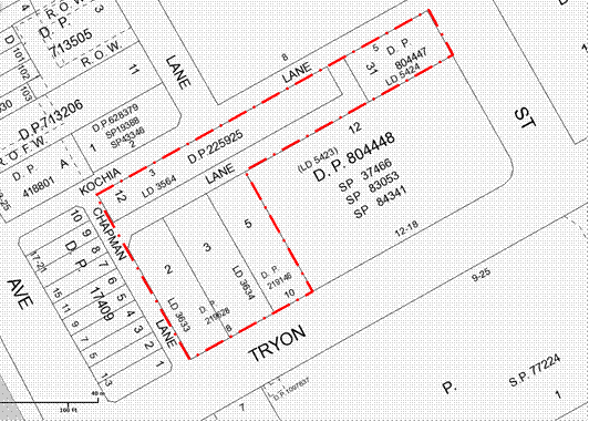
Figure 1 – Site Plan – Tryon Road Site
Comments
The Tryon Road site comprises works including a range of improvements which need to be considered within the broader context of the Lindfield Local Centre and the surrounding district. The key considerations are discussed below.
Traffic and transportation
· With a 240 space commuter car park planned for the Woodford Lane site this will place a load on the local streets at peak times. Consideration will be given to splitting the commuter parking across the two sites and whether this will be necessary to balance traffic impacts. (Noting it is TfNSW’s preference to locate the commuter parking in one location on the western side of the Pacific Highway.)
Community needs
· In terms of the community facilities the critical decision for Council is whether to co-locate a library and multi-purpose community facility on the Woodford Lane site or construct the library separately on the Tryon Road site. This will have both functional and economic impacts i.e., a single building will be more efficient and less costly than two separate buildings but will it best meet the community’s needs?
· The size and internal design of the new community buildings will be determined by the size and mix of the population of the surrounding areas. Council will need to consider the future population within the catchment of the facilities so that the size of the facility will meet the needs of the community in 20-30 years’ time.
· The community needs will determine the internal configuration of the facilities and this in turn will impact the cost of the facilities.
Road closure
· The Tryon Road site has an unnamed lane which runs east-west across the site. The lane currently forms part of the car park circulation. In order to deliver the Lindfield Village Green, Council will need to consolidate various properties owned by Council fronting Kochia Lane, Chapman Lane and Tryon Road and partially close and realign local public roads as shown in the Figure 2. It is noted this arrangement is intended to not disadvantage any adjoining landowners.
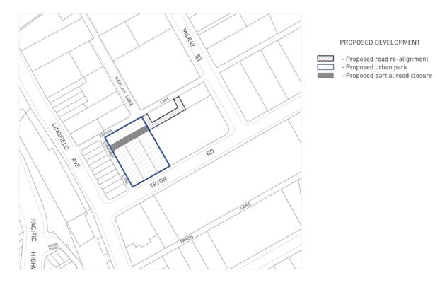
Figure 2 – proposed partial road closure of unnamed lane - Tryon Road site
Council has engaged consultants to provide background studies on the various aspects noted above. The studies being undertaken are:
· Lindfield Local Centre Transport Network Model Study by PeopleTrans P/L;
· Lindfield Community Facilities Study by Elton Consulting P/L; and
· Lindsay Taylor Lawyers.
The project scope, methodology and key findings of each study will be discussed below under the respective headings.
Lindfield Local Centre Transport Network Model Study
Once complete a transport network model of Lindfield will test alternative development scenarios to determine the network impacts and capacity; as well as recommend traffic network improvements.
Project scope
The scope of the transport modelling study is to develop a comprehensive transport network model for Lindfield Local Centre compatible with current Roads and Maritime Services (RMS) standards. The model includes existing and future traffic movements, public transport, pedestrian patterns and cycle movements, and will incorporate the latest traffic improvements proposed by Council as per the Lindfield Local Centre Traffic Improvement Concept Plan.
Also included within the scope of the subsequent analysis is:
· consideration of improvements to public transport which may be proposed by State agencies or operators;
· to incorporate accessibility to the centre from surrounding residential areas, by foot and bicycle, by including bicycle and pedestrian routes/facilities identified in the Ku-ring-gai Bicycle Plan/Public Domain Plan and draft Pedestrian Access and Mobility Plan;
· the opportunity to rationalise on-street car parking (where appropriate) to better provide for a range of users including shoppers, commuters, visitors and residents; and
· to review and investigate access for the mobility impaired.
Methodology
PeopleTrans commenced the project with a full review of background material on the project, including Council reports, traffic and transport studies as well as Council’s Parking Management Plan. From that point the consultant commenced developing the transport network model which includes:
· full traffic counts for key intersections within the Lindfield local centre;
· counts of other transport options within the centre including pedestrian volumes and desire lines, cycle, taxi, bus and train movements; and
· input of traffic generation from projected development as a result of KLEP (Local Centres) 2013 as verified by Council staff.
A base model has now been prepared and has been peer-reviewed. Capacity testing is currently being carried out on the network model. The transport consultant will then use the data to test scenarios and recommend potential network changes to maximise capacity. From this data, Council will develop a range of traffic improvement measures across the Lindfield Local Centre.
Key findings (to date)
Vehicle trip generation of the various options has been quantified and this may be an early indicator of the impact of the options. Residential uses are likely to generate the least amount of vehicle trips while a supermarket would generate the highest number of vehicle trips.
The vehicle trip generation patterns suggest that the weekday pm peak and Saturday peak would be the times most likely to be impacted by the proposal. Vehicle trip generation during the am peak is generally expected to be lower.
Staff commentary and recommendations
Until the base model is peer-reviewed and signed off by RMS, no formal testing of options can occur. Therefore, it is not possible at this stage to comment on whether the provision of commuter car parking on the Tryon Road site will benefit the traffic network. This work will occur in early 2014 and the results reported to Council.
Lindfield Community Facilities Study
Project scope
The Lindfield Community Facilities Study scope has been to undertake a detailed analysis of the Lindfield branch library and multi-purpose community facility as nominated in Council’s Contributions Plan and has been broken down into the following parts:
· Library analysis - the consultant has undertaken an analysis of the functional and space requirements for a new Lindfield branch library.
· Multi-purpose facility analysis - the allocated floor areas of the multi-purpose community floor space in the contributions plan are undefined in terms of the mix of uses and required functions. The community facility needs analysis incorporates an analysis of shortfalls in the existing provision of the community facility and future trends to determine the appropriate mix of uses for the proposed facility.
· Facilities siting strategy - the consultant has undertaken an analysis of the benefits and weaknesses of two siting options, the first being co-location of the two facilities on Woodford Lane; the second being splitting of the facilities with the library on the Tryon Road site and the multi-purpose community facility on the Woodford Lane site.
· Functional brief - the mix of uses and functions for each facility or the single co-located facility are to be broken down into a functional brief. The brief will provide specific information on each element of the facility in terms of function/use, proximity to other uses and spatial requirements.
Methodology
The consultant commenced the project with a full review of background material on the project, including Council reports, previous community facility and library studies as well as Council’s Local Centres Development Control Plan. The methodology and process adopted by Elton Consulting has been as follows:
· Relevant catchment areas of each facility were identified and assessed to establish relevant indicative service provision boundaries.
· Spatial requirements of each facility were reviewed through an analysis of population data (including comment and analysis on the latest population projections) and standards in Library and community facility provision.
· A Library Facilities Discussion Paper was prepared to further inform the brief for the branch library.
· A workshop with library staff on the Lindfield branch library was conducted to refine the library requirements, establish key drivers and characteristics and test the siting options.
· A workshop with users of the current Lindfield halls and meeting rooms in addition to relevant service providers and agencies was conducted to refine the multi-purpose community facility requirements, establish key drivers and characteristics and test the siting options.
· A workshop with relevant staff on the facilities provision and siting options was conducted to refine the outcomes of the two previous workshops and further inform the siting strategy.
Key findings (to date)
Elton Consulting have completed a draft report outlining their findings in relation to the library analysis, multi-purpose facility analysis and a facilities siting strategy. The draft report can be found in Attachment A2. A summary of the key findings of the study to date is set out below.
Community Centre – floor space requirements
Based on a comparative analysis of standards of provision of community centres, and consideration of existing levels of provision in Ku-ring-gai, it is suggested that a future level of provision of 80 square metres for every 1,000 people be considered appropriate.
The following table shows the implications of this for the Lindfield Community Hub community centre catchment.
|
|
|
|
Projected catchment population to 2031 |
50,653 |
|
Proposed rate of provision for community centre (square metres per 1,000 people) |
80 |
|
Required community centre floor area for catchment (square metres) |
4,045 |
The table shows that based on a rate of provision of 80 square metres for every 1,000 people, the required community centre floor space for a projected 2031 catchment population of 50,653 is 4,045 square metres. The existing provision in the catchment area for community centres is 2,172 square metres. When this is deducted from the required community centre floor space for the catchment (4,045 square metres), the deficit (i.e. community centre space required to be provided as part of the new community hub) is 1,873 square metres.
Library – floor space requirements
The Ku-ring-gai Council Library Facilities Study (2004) identified four library catchments across the LGA. Lindfield sits within the southern catchment which includes the suburbs of Lindfield and Roseville.
The projected Lindfield branch library catchment population is 26,011 people. Unlike community centres, public libraries have a well-developed and accepted set of standards determining required levels of provision. These standards have been developed by the State Library of New South Wales and form part of the People Places library planning documents.
When the State Library standards are applied (approximately 46.8sqm per 1,000 head of population) to the projected catchment population of 26,011, the required library floor space is estimated to be 1,217 square metres.
These figures of 1,873 square metres for a community centre and 1,217 square metres for a library confirm Council’s original analysis of the floor space requirements for the Lindfield Community Hub. It is important to note however that if the preferred facility model involves the co-location of both the community centre and the library into an integrated community hub building, there may be opportunities for some floor space efficiencies through the shared use of some spaces.
Library and Community Centre – location analysis
Two alternative siting arrangements have been identified across the two sites. Option 1 involves separating the library on the Tryon Road site and the multi-purpose community facility on the Woodford Lane site with Option 2 having both facilities co-located on the Woodford Lane site.
Both alternatives were presented at each of the workshops with a strong preference for a co-located facility evident in all but the library staff workshop. Reasons for co-location included; efficiency of access, financial benefits, the library acting as anchor for the community facility and the potential to challenge traditional concepts of the library through integration with some aspects of the community facility. Reasons against the co-located facility focused on Tryon Road being a better location for a library with close proximity to new development occurring in Lindfield and the lack of activation for the current Woodford Lane site.
The consultants have recommended co-location of the two facilities on Woodford Lane (Option 2). Further analysis has been undertaken in regards to preferred library locations; this identified a best practice trend toward co-location. The recommendation also takes into account site constraints and the financial and operational incentives of co-location.
The siting analysis also acknowledges some key site constraints on the Woodford Lane site and recommends further measures to ensure that the site achieves the maximum potential. These include:
· activation of the site through the inclusion of additional land uses such as retail and commercial space;
· strengthened connections from the east side of the Pacific Highway to ensure appropriate access to the site;
· improving permeability from the Pacific Highway through to the site;
· including the provision of high quality open space associated with the facilities;
· ensuring that the development is of a high standard; and
· ensuring that the community facilities are well-managed and programmed to ensure attraction for a broad range of the community.
Staff commentary and recommendations
The key findings to date from the Community Facilities Study are:
· the preferred size of the library is 1,217sqm;
· the preferred size of the community centre is 1,873sqm; and
· the preferred siting strategy is to co-locate the new facilities combining the Lindfield branch library and the multi-purpose community centre on the Woodford Lane site.
Other aspects of the study including the functional brief will be further developed to detail the final requirements for each facility. It is therefore recommended that Council proceed with the masterplanning of the Lindfield Village Green on the basis that there will be no library on the site and that the consultant continue to develop the functional briefs for the facilities on the Woodford Lane site consistent with this direction.
Road closure
Project scope
The Council sought advice as to the best manner and the statutory requirements to effect partial closure of the local public road on the Tryon Road site as shown in Figure 2. Advice from Lindsay Taylor Lawyers is in Confidential Attachment A3.
Methodology
The advice reviewed two ways by which the road can be closed:
· by the Minister administering the Roads Act 1993 (Minister) pursuant to an application lodged by the Council; or
· by way of compulsory acquisition of the road by the Council.
Key findings (to date)
The closure of the public road by way of compulsory acquisition is considered the best option for Council as it is less procedurally burdensome; however the Division of Local Government has issued guidelines to the effect that compulsory acquisition should not be used to close roads. Council may therefore want to consider whether to pursue this option. However:
· the Guidelines are not guidelines adopted under s23A of the Local Government Act 1993 which Council is obliged to consider when exercising its functions;
· there is nothing in the legislation which limits the circumstances in which road closure can take effect through compulsory acquisition; and
· Council should consider compulsory acquisition as a valid option.
Staff commentary and recommendations
Road closures by the Minister can take up to two years to complete which could represent a significant delay for delivery of the projects. Based on the advice received to date, compulsory acquisition may be an appropriate option for Council in Lindfield. It is therefore recommended that Council proceeds with the compulsory acquisition of the unnamed public road shaded in grey and marked as ‘Proposed partial road closure’ in Figure 2 of the report by way of agreement under s30 of the Land Acquisition (Just Terms Compensation) Act 1991 (‘Just Terms Act’).
Governance Matters
A project of this type is identified in the draft Operational/ Delivery Plan:
· Key theme – Places Spaces and Infrastructure P4.1.4

Figure 6: Extract from Council’s Delivery Program 2013-2017 and Operational Plan 2013-2014, page 40
The RMS have been engaged through the Lindfield traffic study.
Risk Management
The greatest risk at this stage in the project is to Council’s reputation. There is significant interest in the project with ‘Support Lindfield’ an increasingly active voice in the community. Council will need to be seen to have a high standard of consultation with the community in conjunction through a well-executed communication strategy demonstrating Council’s pursuit of the best community outcomes to mitigate the risk of loss of reputation.
Financial Considerations
Lindfield Village Green
Stage 1 of the project has been completed which involved Council advertising an Expression of Interest (EOI) seeking potential joint venture partners for the delivery of the project. Two EOIs were received, one from a construction company and one from an architectural firm. The EOIs have been assessed and both have been found to be non-compliant. Both submissions have misinterpreted the EOI criteria by offering their services rather than offering a potential joint venture partnership for the project.
The EOI process has clarified that there are no potential joint venture partners for the project. This means that Council will be required utilise development contribution funds (open space acquisition - south) collected under the Ku-ring-gai Contributions Plan 2010 to fund the construction works associated with the new underground car park and new village green (as previously discussed in the report to Council on 9 April 2013). Subject to successful allocation of development contribution funds to a project account the funds would pay for the cost of undergrounding the existing car parking at the same time as creating an open, at-grade site to build a new park.
Given the library is no longer proposed for this site it will be necessary to provide some form of public amenities on the site such as toilets. There may also be some financial benefit to Council if it were to provide a small kiosk building to house a café in the park. Additional funding will need to be found for these facilities. It is proposed to further develop this idea as part of the concept design stage of the project.
The concept design stage will also include a quantity surveyor so that a project budget can be more accurately identified.
Social Considerations
Currently the Tryon Road site is utilised for car parking by shoppers and local business owners. Beyond this function the sites provide very little social benefit to the community and are very much under-utilised assets for Council.
The site has the potential to provide new community infrastructure which will provide high levels of social benefit to the community.
A Community Facilities Strategy undertaken on behalf of Council by Elton Consulting P/L in 2009 prepared an audit of the existing community facilities in Lindfield. The study found that both of Council’s facilities require replacement. A summary of the findings is below:
The Lindfield library building:
· is too small to meet contemporary standards and the needs of users;
· is in poor condition with numerous maintenance issues identified in a building audit;
· requires improved staff parking and disabled access; and
· is located too far from shops and train station for people to walk.
The Lindfield Seniors Centre building:
· is too small to meet contemporary standards;
· is an old style facility with basic facilities in poor condition;
· contains identified trip hazards and maintenance requirements;
· lacks flexibility for multi-use; and
· is located too far from shops and train for people to walk (particularly the elderly).
Environmental Considerations
Lindfield Village Green
There have been no significant environmental considerations identified to date. A geotechnical study will be required in the near future.
If the development on the Tryon Road site was to be undertaken in a considered manner there is potential for the environmental quality of the site to be dramatically improved through the provision of a new village green, tree planting and streetscape improvements.
Community Consultation
Council has not undertaken community consultation to date beyond what was carried out for the preparation of the Lindfield Community Facilities Strategy. Consultation is planned as part of the next stage of the process. An engagement strategy has been prepared by Council’s Community Engagement and Research Planner and is set out in Attachment A1 and outlined below.
Engagement strategy – Activate Lindfield
Ku-ring-gai Council will undertake extensive and multi-modal consultation to ensure all community stakeholders are informed, engaged and collaborate on Activate Lindfield.
The Tryon Road site represents a distinct opportunity for our community; it will have its own unique functions, uses and aesthetics. To ensure we comprehensively examine the site, we propose a strategy to engage the site separately from the Woodford Lane site.
The objectives of our engagement strategy are to:
1. Increase community awareness of Activate Lindfield and the benefits the project will bring to the local and broader community;
2. Tap into local knowledge and expertise on Lindfield including local businesses, residents and community groups;
3. Deliver creative and engaging opportunities for stakeholders to collaborate with Council in designing, delivering and managing the Activate Lindfield sites;
4. Determine community priorities for Activate Lindfield including the negotiable and non-negotiable for each site; and
5. Meet Council requirements in delivering Activate Lindfield, including car parking, new parks and civic spaces.
The community engagement process will be divided into a series of phases:
1. Multi-channel communications to inform stakeholders on the Activate Lindfield project and possible options for the site. Activities will include:
a. local newspapers;
b. letterbox drop;
c. website – Council and Have Your Say Ku-ring-gai; and
d. email newsletters;
e. community networks – organisations, associations, staff networks;
f. rates notice; and
g. social media campaign.
2. Online discussion forum – open to all community stakeholders prior to formal consultation;
3. Concept design workshops and place performance evaluations;
· Tryon Road engagement program,
· Focus groups and deliberative workshops to examine elements to be included on site; materials and equipment used; trees, planting; how to the space can/could be used/function; Comfort and Image, Usability, Access and Linkages, Sociability.
4. Place making and partnership forums to set the way forward for Lindfield
Internal Consultation
Extensive consultation has also occurred as part of the Lindfield Community Facilities Study including staff from Operations, Community, Strategy and Environment, Corporate and Development and Regulation.
Summary
Council has resolved to undertake a masterplanning process in Lindfield local centre involving two Council-owned sites, these sites are the Tryon Road site and the Woodford Lane site.
On the Tryon Road site it is proposed to place the existing car parking underground and create a new civic space called the “Lindfield Village Green”. The Woodford Lane site will be subject to further detailed investigation to be presented in a report to Council in early 2014.
Council has engaged consultants to provide background studies relating to the Lindfield Village Green. The studies being undertaken are:
· Lindfield Local Centre Transport Network Model Study; and
· Lindfield Community Facilities Study by Elton Consulting P/L.
This report provides an update on the results to date of these studies and makes a range of recommendations for moving forward on the Lindfield Village Green.
Lindfield Village Green – key recommendations
This report recommends the following:
1. That the Lindfield branch library is not located on the Lindfield Village Green rather that it is to be co-located within the Lindfield Community Hub on the Woodford Lane site.
2. The viability and cost of a small building containing public amenities and a kiosk to house a café or restaurant in the park is to be investigated.
3. That Council continues to actively investigate the potential to provide some of the TfNSW commuter car parking under the Lindfield Village Green.
4. That Council proceeds with the compulsory acquisition of the unnamed public road shaded in grey and marked as ‘Proposed partial road closure’ in Figure 2 of the report by way of agreement under s30 of the Land Acquisition (Just Terms Compensation) Act 1991 (‘Just Terms Act’).
The next steps in the process are:
· Prepare a consultant brief and issue a Request for Quotation to up to six consultants. The lead consultants will be a landscape architect and selected on the basis of experience with similar projects, reputation and awards.
· The selected consultant team will prepare a draft concept design and undertake community consultation guided and facilitated by Council.
· Following consultation the concept will be amended to reflect community comments and then reported to Council for their endorsement prior to public exhibition.
At this stage it is anticipated that the draft concept plan for the Lindfield Village Green will be placed on public exhibition by early to mid-2014.
|
A. That the proposed Lindfield branch library and the proposed Lindfield Community Centre are to be co-located on the Woodford Lane site.
B. That Council continues to actively investigate the potential to provide some of the commuter car parking proposed by Transport for NSW under the proposed Lindfield Village Green.
C. That Council prepares an illustrative concept design for the Lindfield Village Green and proceed to public engagement and, following this, the draft concept is to be reported to Council for their endorsement prior to public exhibition.
D. That pursuant to sections 186(1) and 187(1) of the Local Government Act 1993, the Council compulsorily acquire the unnamed public road shaded in grey and marked as ‘Proposed partial road closure’ in Figure 2 of the report to the Council dated 10 December 2013 for the purpose of creating the Lindfield Village Green in accordance with the Land Acquisition (Just Terms Compensation) Act 1991.
E. That for the purposes of section 30 of the Land Acquisition (Just Terms Compensation) Act 1991, the Council, as the owner of the road, agree to the road being acquired for compensation in the amount of $1.00.
F. That Council delegate to the General Manager or his delegate the power to do anything further as necessary to give effect to the compulsory acquisition including obtaining any necessary approvals and publishing any necessary notices in the Gazette.
|
|
Bill Royal Team Leader Urban Design |
Andrew Watson Director Strategy & Environment |
|
A1View |
Activate Lindfield - Community Engagement Strategy - October 2013 |
|
2013/302255 |
|
|
|
A2View |
Lindfield Community Facilities Study - Progress Report |
|
2013/302258 |
|
|
Lindfield Village Green - Road Closure Process - Legal Advice |
|
Confidential |