Ordinary
Meeting of Council
TO
BE HELD ON Tuesday, 4 February 2014 AT 7.00pm
Level
3 Council Chambers
Agenda
** ** ** ** ** **
NOTE:
For Full Details, See Council’s Website –
www.kmc.nsw.gov.au
under the link to business papers
APOLOGIEs
DECLARATIONS OF INTEREST
Confirmation of Reports to be
Considered in Closed Meeting
NOTE:
That in
accordance with the provisions of Section 10 of the Local Government Act 1993,
all officers’ reports be released to the press and public, with the exception
of confidential attachments to the following General Business reports:
Refer GB.13 Wahroonga Park Playground
Upgrade - Tender T11-2013
Attachment A1: . List
of Tenders received and financial considerations
Attachment A2: . Tender
Evaulation Panel's comments and recommendation
Attachment A3: Corporate
Scorecard - Tenderer A - Financial and Performance Assessment
Attachment A4: . Corporate
Scorecard - Tenderer B - Financial and Performance Assessment
Address the Council
NOTE: Persons
who address the Council should be aware that their address will be tape
recorded.
Documents Circulated to Councillors
CONFIRMATION OF MINUTEs
Minutes of Ordinary Meeting of Council 10
File: S02131
Meeting held 10 December 2013
Minutes numbered 380 to 415
minutes from the Mayor
Petitions
GENERAL BUSINESS
i.
The Mayor to invite Councillors to
nominate any item(s) on the Agenda that they wish to have a site inspection.
ii.
The Mayor to invite Councillors to
nominate any item(s) on the Agenda that they wish to adopt in accordance with
the officer’s recommendation allowing for minor changes without debate.
GB.1 Cavalcade
of History and Fashion Inc - Renewal of Occupation Licence 83
File: S07505
For Council to consider granting
a 5 year licence, with 3 additional 5 year option periods, to Cavalcade of
History and Fashion Inc, for occupation at 4 Babbage Road, Roseville.
Recommendation:
That Council grant a licence to
Cavalcade of History and Fashion Inc for 5 years from 1 March 2014, with
options for an additional 3 x 5 years.
GB.2 Lifeline
Harbour to Hawkesbury Inc - Renewal of Occupation Lease 88
File: S07471
For Council to consider granting
a 2 year lease to Lifeline Harbour to Hawkesbury Inc for continued occupation
at 4 Park Avenue Gordon.
Recommendation:
That Council grant a new lease to
Lifeline Harbour to Hawkesbury Inc expiring on 31 January 2016.
GB.3 Investment
Report as at 30 November 2013 93
File: S05273
To present Council’s investment
portfolio performance for November 2013.
Recommendation:
That the summary of investments
performance for November 2013 be received and noted; and that the Certificate
of the Responsible Accounting Officer be noted and report adopted.
GB.4 Investment
Report as at 31 December 2013 103
File: S05273
To present Council’s investment
portfolio performance for December 2013.
Recommendation:
That the summary of investments
performance for December 2013 be received and noted; and that the Certificate
of the Responsible Accounting Officer be noted and report adopted.
GB.5 Amendment
to Council Meeting Cycle - March 2014 113
File: CY00438/2
To consider amending the adopted
Council meeting cycle to avoid the meeting clashing with the Local Government
NSW Tourism Conference being held between the
10 – 12 March 2014 in the Hunter Valley.
Recommendation:
That Council amend its adopted
meeting cycle so that the Ordinary Meeting of Council scheduled for Tuesday, 11
March 2014 be rescheduled to Tuesday, 18 March 2014 and that appropriate notice
be given to members of the public.
GB.6 Australian
Local Government Women's Association (NSW) 60th Annual Conference - March 2014 116
File: S02815
To advise Councillors of the
Australian Local Government Women’s Association (NSW) Annual Conference to be
held at Broken Hill between 20 – 22 March 2014.
Recommendation:
That any Councillors interested
in attending the Australian Local Government Women’s Association (NSW) Annual
Conference advise the General Manager by Friday, 7 February 2014.
GB.7 Smart
Urban Futures Conference 132
File: CY00076/6
To advise Council of the Smart
Urban Futures Conference.
Recommendation:
That all interested Councillors
advise the General Manager of their interest in attending the Smart Urban
Futures Conference by Friday, 7 February 2014.
GB.8 17 to 25
Boundary Street, Roseville - Demolition of Existing Dwellings and Construction
of Two Residential Flat Buildings containing 58 Units and Associated Works 139
File: DA0139/13
Ward: Roseville
Applicant: Develotek Roseville Pty Ltd
Owners: Mrs Denise Voysey, Mr Sung Don Moon, Mrs Eun Ju Kim
Moon, Doctor Teck Huah Tang, Mr Paul Ernest Jonas, Mrs Jennifer Karen Jonas, Mr
Donald Pearson, Mrs H M Pearson and NSW Roads and Maritime Services (owners of
land reserved for road widening)
To determine Development
Application No. 0139/13 for the demolition of the existing dwellings and
construction of two residential flat buildings containing 58 units and
associated works.
Recommendation:
Approval.
GB.9 12
Wellesley Road, Pymble - Removal of Tree (Californian Redwood) in Front Setback
(Heritage Conservation Area) 233
File: DA0376/13
Ward: St
Ives
Applicant: Mr
Anthony Everall
Owners: Mr
Anthony & Mrs Philippa Everall
Removal of tree (Californian
Redwood) in front setback (Heritage Conservation Area).
Recommendation:
Refusal.
GB.10 10 Kimo
Street, Roseville - Alterations and Additions to the Existing Dwelling, Construction
of a Garage and Driveway, Provision of Stormwater Infrastructure and Torrens
Title Subdivision of One Lot into Two 295
File: DA0220/13
Ward: Roseville
Applicant:
Matthew Benson Planning Pty Ltd
Owners: Ms J
Cummins & Mr M Lochtenberg
Alterations and additions to the
existing dwelling, construction of a garage and driveway, provision of
stormwater infrastructure and Torrens title subdivision of one lot into two.
Recommendation:
Approval
GB.11 Update
Report on the Development Contributions System 347
File: S06785/3
The purpose of this report is to
provide Council with an overview of key activities and highlights in the
development contributions system over the past six months and anticipated
highlights for the coming twelve months.
Recommendation:
That the information in the
report be received and noted.
GB.12 Regional
Waste Project 367
File: S02294
To seek Council’s consent for
application to the Minister of Local Government under Section 358 of the Local
Government Act, 1993, to participate in entering a Waste Alliance Agreement
with other Councils associated with NSROC for waste disposal.
Recommendation:
That Council resolve to make
application to the Minister for Local Government under Section 358 of the Local
Government Act, 1993, with a report back to Council detailing associated
roles and governance of the Waste Alliance Agreement.
GB.13 Wahroonga
Park Playground Upgrade - Tender T11-2013 372
File: S09916
To consider the tenders received
for the refurbishment and upgrade of Wahroonga Park Playground, Wahroonga, and
appoint the preferred tenderer.
Recommendation:
In accordance with Section 55 of
the Local Government Act and Tender Regulations, it is recommended
Council accept the tender submitted by tenderer ‘A’ as identified in the
Confidential Summary (Attachment A1).
Extra Reports Circulated to Meeting
Motions of which due Notice has
been given
NM.1 Promoting Awareness
of Road Safety and Parking Signs in School Zones 379
File: CY00020/6
Notice
of Motion from Councillor Fornari-Orsmond dated 21 January 2014
There have been a number of
issues with illegal parking around schools which results in safety concerns for
the school children and fines for parents who illegally park.
Council’s Road Safety Officer,
along with Road Safety Officers from other Councils, have developed a brochure
that will be sent to all schools in the area advising them of the rules about
parking around school sites. The schools will be asked to include the brochure
in their newsletters that go out to the parents. A copy of the brochure is
attached.
I am proposing that Council send
out a similar brochure with the last quarter rate notices in order to get the
message out to all residents about the rules associated with parking signs and
related traffic issues in schools zones. The aim is to enable residents to
have a better understanding of these rules to hopefully improve the safety for
children around school zones.
I am also proposing that an
advertisement be placed in the local paper incorporating some of the points in
the brochure to help spread the message further.
It is proposed that the funding
for this work be costed against Council’s Road Safety budget.
Therefore, I move that:
“A. That
a brochure on road parking signs around school zones be sent with Council’s
last quarter rates notice.
B. That
an advertisement be placed in the local paper outlining the parking regulations
regarding parking in school zones and the fines applicable for any breaches.”
NM.2 Letter of
Appreciation to Departing Superintendent Jeff Philippi of Kuring Gai Local Area
Command NSW Police 382
File: CY00455/2
Notice
of Motion from Councillor Fornari-Orsmond dated 23 January 2014
Superintendent Jeff Philippi has
been the Commander of the Kuring Gai Local Area Command (LAC) since February
2012. In this role, he also has a number of other important community
positions, one being the Local Emergency Management Controller (LEOCON) for
major emergencies including bushfires.
Prior to Christmas I received a
call from Superintendent Philippi to let me know that he has been posted to Mt
Druitt LAC and would be moving on from Kuring Gai LAC in February 2014. This is
certainly a case of their gain is our loss.
I have known Superintendent
Philippi for a few years now, through the involvement of my community
activities with Kuring Gai LAC. I have found him to be very hands on, showing
to be extremely committed and passionate about both his personal role in the
community and that of the fine officers under his command. Importantly, he has
been readily prepared to give his time when requested to participate in
community events.
Superintendent Philippi has
served our community very well indeed during his term as Commander at Kuring
Gai LAC and we owe him a debt of gratitude.
Therefore I move that:
“The Mayor write a letter of
appreciation to Superintendent Jeff Philippi, on behalf of
Ku-ring- gai Council and residents, thanking him for his valuable contribution
to our community and wishing him the best for the future.”
NM.3 Bike Plan 383
File: S02777/8
Notice of Motion from Councillor
McDonald dated 24 January 2014
Previously the Roads and Traffic
Authority (RTA), now the Roads and Maritime Services (RMS), had a 2010 Bike
Plan that incorporated a bike route along the railway corridor from Hornsby to
the City. This was never implemented.
With the growing success of the
sport of road cycling there is an increasing risk of major injuries and
fatalities where bikes are using main roads.
The proposed Bike Plan was never
fully implemented and the RMS is now looking at alternatives to the original
plan. There is a definite need for bikes to be provided with a safe route to
the city and this could be best done by using the railway corridor.
The original plan was before the
current Liberal Government’s time and I recommend that the Mayor write to the
Premier and the Local Member requesting support for the implementation of the
original bike plan corridor.
Therefore, I recommend:
“That the Mayor write to the
Premier, Mr O’Farrell MP and the Local Member for Davidson, Mr Jonathan O’Dea
MP requesting the State Government reinstate the original RTA Bike Plan 2010
and in particular provide an off road link from Hornsby to the City.”
BUSINESS WITHOUT NOTICE – SUBJECT TO CLAUSE 241 OF
GENERAL REGULATIONS
Questions Without Notice
Inspections Committee – SETTING OF TIME, DATE AND
RENDEZVOUS
Confidential Business to be
dealt with in Closed Meeting
C.1 Acquisition
of Land in Lindfield 1
File: S07457/5
In accordance
with the Local Government Act 1993 and the Local Government (General)
Regulation 2005, in the opinion of the General Manager, the following
business is of a kind as referred to in sections 10A(2)(c) & 10A(2)(d)(ii),
of the Act, and should be dealt with in a part of the meeting closed to the
public.
Section 10A(2)(c) of the Act
permits the meeting to be closed to the public in respect of information that
would, if disclosed, confer a commercial advantage on a person with whom the
Council is conducting (or proposes to conduct) business.
The matter is classified
confidential because it deals with the proposed acquisition and/or disposal of
property.
It is not in the public interest
to release this information as it would prejudice Council’s ability to acquire
and/or dispose of the property on appropriate terms and conditions.
Section 10A(2)(d) of the Act
permits the meeting to be closed to the public for business relating to
commercial information of a confidential nature that would, if disclosed:
(i)
prejudice the commercial position of the person who supplied it, or
(ii)
confer a commercial advantage on a competitor of Council, or
(iii)
reveal a trade secret.
This matter is classified
confidential under section 10A(2)(d)(ii) because it would confer a commercial
advantage on a competitor of the Council.
Report by Director
Strategy and Environment dated 21 January 2014
John McKee
General
Manager
** ** ** ** ** **
Minute Ku-ring-gai
Council Page
MINUTES OF Ordinary Meeting of Council
HELD ON Tuesday, 10 December 2013
|
Present:
|
The Mayor, Councillor J Anderson (Chairperson) (Roseville
Ward)
Councillors E Malicki & J Pettett (Comenarra Ward)
Councillors D Citer & C Szatow (Gordon Ward)
Councillors C Berlioz & D Ossip (St Ives Ward)
Councillor D Armstrong (Roseville Ward)
Councillors C Fornari-Orsmond & D McDonald (Wahroonga
Ward)
|
|
|
|
|
Staff Present:
|
General Manager (John McKee)
Director Corporate (David Marshall)
Director Development & Regulation (Michael Miocic)
Director Operations (Greg Piconi)
Director Strategy & Environment (Andrew Watson)
Director Community (Janice Bevan)
Manager Corporate
Communications (Virginia Leafe)
Manager Urban & Heritage Planning (Antony Fabbro)
Manager Records & Governance (Matt Ryan)
Minutes Secretary (Lisa Hopkin)
|
The Meeting
commenced at 7.00pm
The Mayor offered
the Prayer
DECLARATIONS OF
INTEREST
The Mayor
adverted to the necessity for Councillors and staff to declare a Pecuniary
Interest/Conflict of Interest in any item on the Business Paper.
Councillor
Elaine Malicki declared a less than significant non-pecuniary interest in
GB.15 – Consideration of Submissions – Draft Ku-ring-gai Bushland Reserves Plan
of Management (advised that she lives relatively near Sheldon Forest and
doesn’t think that it is close enough to consider herself conflicted but just
to make the point that she lives in the vicinity).
Councillor
Cheryl Szatow declared a less than significant non-pecuniary interest in PT.2 -
Petition to STOP Culworth Avenue Car Park being SOLD for High Rise Residential
Development by Council – (One Thousand, Eight Hundred and Forty-Three [1,843]
Signatures), GB.2 – Marian Street Theatre – Strategic Management Options and
Building Safety Requirements and NM.1 – Heritage Conservation Areas (advised
that she lives in Marian Street and has no pecuniary or non-pecuniary interest
in the Marian Street Theatre nor in the Culworth Avenue Car Park).
The Director
Strategy and Environment, Andrew Watson, declared an interest in GB.10 –
Planning Proposal to include ‘Hardware and Building Supplies’ in the B7 Zone
under the KPSO and GB.11 – Heritage Assessment of former 3M Building at
950 Pacific Highway, Pymble (his family’s SMSF holds shares in the ASX-listed
Bunnings Warehouse Trust (BWP) but at the present time, BWP does not own the
site the subject of the reports, though by its very nature, has a close
relationship with Bunnings).
|
380
|
CONFIRMATION OF REPORTS TO BE
CONSIDERED IN CLOSED MEETING
File: S02499/7
|
|
|
Resolved:
(Moved: Councillors Szatow/ Berlioz)
That in accordance with the provisions of Section 10 of
the Local Government Act 1993, all officers’ reports be released to the press
and public, with the exception of confidential attachments to the following
General Business reports:
GB.12 St Ives Shopping Village
Attachment
2: Sparke Helmore legal advice dated 9 July 2013
GB.13 910 Pacific Highway,
Gordon - Public Car Park
Attachment
3: Corporeal Valuation - 904-914 Pacific Highway, Gordon
Attachment
4: Lease Financials - 910 Pacific Highway
GB.19 Lindfield Village Green -
Tryon Road - Project Update
Attachment
3: Lindfield Village Green - Road Closure Process – Legal Advice
CARRIED
UNANIMOUSLY
|
Address the Council
The following members of the
public addressed Council on items not on the Agenda:
R Hooper
B Watson
D Nicol
K Gibbons
J Harwood
DOCUMENTS CIRCULATED
TO COUNCILLORS
The Mayor adverted to the
documents circulated in the Councillors’ papers and advised that the following
matters would be dealt with at the appropriate time during the meeting:
|
Late Items:
|
Refer MM.3 – Excellence in the Environment Awards and
Institute of Landscape Architects Awards
Refer GB.14 – 828 Pacific Highway, Gordon – Design,
Refurbishment and Fit-out – Select Tender – Memorandum from
Director Strategy and Environment dated 9 December 2013 advising of a
correction on page 242 of Business Paper No 21/13, Book 2, in relation to a
company not identified on the list because the parent company submitted the
Expression of Interest on Tenderlink.
Refer GB.15 - Consideration of Submissions – Draft
Ku-ring-gai Bushland Reserves Plan of Management - Memorandum from
Director Strategy and Environment with two Late Submissions to Councillors
and Directors ONLY.
Refer
NM.2 – Naming of Community Centre and Sportsfield at former UTS site
Lindfield – Memorandum from Manager Records and Governance
dated 9 December 2013 advising that due to an administrative oversight, the
Notice of Rescission omitted a follow-up motion if the rescission motion was
to be successful. Attached also to the memorandum was an amended Notice of
Rescission.
Refer
NM.2 – Naming of Community Centre and Sportsfield at former UTS site
Lindfield – Additional information in relation to
Background Information to the Rescission Motion that was omitted from
Business Paper No 21/13.
|
|
Memorandums:
|
Refer GB12 – St Ives Shopping Village – Memorandum
from Manager Urban and Heritage Planning dated 10 December 2013 advising
Councillors of clarification and a revised recommendation.
|
CONFIRMATION OF
MINUTEs
|
381
|
Minutes of Ordinary
Meeting of Council
File: S02131
|
|
|
Meeting held 26 November 2013
Minutes numbered 357 to 379
|
|
|
Resolved:
(Moved: Councillors Berlioz/McDonald)
That Minutes numbered 357 to 379 circulated to Councillors
were taken as read and confirmed as an accurate record of the proceedings of
the Meeting.
CARRIED
UNANIMOUSLY
|
minutes from the Mayor
|
382
|
VALE Eric Ralphs
File: CY00455
Vide: MM.1
|
|
|
On behalf of Ku-ring-gai Council I would like to pay
tribute to the life of Eric Ralphs, who sadly passed away on Tuesday 24
September 2013, aged 76.
Eric was born at North Shore hospital in 1937 and spent
his early years living in “The Gums”, Catalpa Crescent, Turramurra. His
parents were both migrants from England and Eric was the eldest of six
children. He went to kindy at St Pauls Church in Wahroonga and in 1943 he
attended Warrawee Public School.
In 1947 the family moved to Carcoar. Eric moved back to
Sydney in 1954 to work as an engineering cadet with the Metropolitan Water
Board.
Eric started his army career with National Service in 1956
- it was through the army reserve that he met his wife Patricia and they were
married in 1963. They had two children, David and Fiona.
Eric left the Water Board and went to work as an engineer
at Mosman Council in 1960. Then, on 6 December 1976, he started his career
at Ku-ring-gai Council as the Investigations Engineer.
Highlights of his long and illustrious career include:
· The Freedom of Entry to the 17th
Battalion Royal New South Wales Regiment, to mark the Council’s golden
jubilee as a municipality in 1978.
· His appointment as liaison officer
for Ku-ring-gai SES from 1983.
· In 1988 Eric was appointed Local
Emergency Management Officer which was his position during the notorious
storm of 1991 – a storm so ferocious there were hail stones the size of
tennis balls!
· In 2000 he took long service leave
to work as Tournament Director for Hockey at the Sydney Olympics.
Eric finished at the Council on 22nd January 2001. This
was the 10th anniversary of the big storm – a memorable day to leave.
Eric had a long military career including National Service
and he received several awards including:
· the Reserve Force Decoration with
two bars
· the Australian Active Service Medal
· the Vietnam Logistic and Support
Medal.
· the Australian Efficiency Decoration
· the Australian Defence Medal and the
Anniversary of National Service medal. He also won the Australian Sports
Medal.
To say Eric was active in retirement is an
understatement! He spent his days travelling, playing bridge, joining
several committees such as the Forestville RSL, University of NSW Regimental
Association, the Sapper’s Association, Reserve Forces Day Council.
Eric was also a board member of Hockey NSW, volunteered as
a tour guide at the National Artillery Museum at North Head, as well as being
a keen cricket fan, family history researcher and a very involved grandfather
to Sarah.
On behalf of Ku-ring-gai Council, I would like to pay
tribute to Eric Ralph’s life and send our sincere condolences to his family.
|
|
|
Resolved:
A. That
the Mayoral Minute be received and noted.
B. That
we stand for a minute’s silence to honour Eric Ralphs.
C. That
the Mayor writes to Mr Ralph’s family and encloses a copy of this Mayoral
Minute.
CARRIED
UNANIMOUSLY
|
|
383
|
VALE Peter Wem
File: CY00455
Vide: MM.2
|
|
|
On behalf of Ku-ring-gai Council I would like to pay
tribute to the life of Peter Wem who tragically died in a horrific traffic
accident on Tuesday, 1 October 2013, aged 73.
Formerly of Middlesbrough, England, Peter has been
described as a life loving person who would do anything for his family and
friends.
Peter was a registered bush care volunteer from Feb 2000
and was very active, looking after the bushland near his home in Hartley
Close, Turramurra.
He was also on the Bushland Advisory Committee at
Ku-ring-gai Council in the late 1990s early 2000s when he worked for DLWC. He
was also very active in the local Scouts.
Peter left behind his wife Margaret, siblings Olga and
Jim, sons Andrew, Graeme and Owen. He was also the proud grandfather of five
grandchildren who must be missing him dreadfully.
On behalf of Ku-ring-gai Council I would like to pay
tribute to Peter Wem’s life and send our sincere condolences to his family.
|
|
|
Resolved:
A. That
the Mayoral Minute be received and noted.
B. That
we stand for a minute’s silence to honour Peter Wem.
C. That
the Mayor writes to Mr Wem’s family and encloses a copy of this Mayoral
Minute.
CARRIED
UNANIMOUSLY
|
|
384
|
Excellence in the Environment Awards
and Institute of Landscape Architects Awards
File: S09780
Vide: MM.3
|
|
|
Ku-ring-gai Council received a number of significant
accolades this week.
On 3rd December Local Government NSW held its annual
Excellence in the Environment Awards recognising outstanding achievements by
local government in managing and protecting the environment. Council was
successful in Division C – Climate Change Action Awards for its Building
Climate Wise Communities project. The project then took out the Overall
Winner for 2012/2013.
The Climate Wise Communities Program focusses on fostering
shared responsibility, integrating with Council’s Emergency Management Plan
and collaborating with emergency management agencies.
Council also developed a multi-hazard assessment tool that
means residents can review their vulnerability to severe weather events at a
personal, property and neighbourhood level. This tool helps people determine
what action needs to be taken in case of bush fire, storms, heat stress and
drought.
On 5th December the Australian Institute of Landscape
Architects NSW (AILA) held its Awards in Landscape Architecture. Council took
out the Research and Communication category with 'Thinking Outside The Box'
Key Design Elements for Apartments in
Ku-ring-gai’ and the Planning category for the ‘Ku-ring-gai Open Space
Acquisition Program’.
The Open Space Acquisition Program in particular builds on
years of policy development, contributions planning, site identification and
acquisition and ultimately design and construction involving staff from across
Council as well as Council and the community.
OSAP provides much needed parkland to the community.
Ku-ring-gai Council has been acquiring land at an unprecedented rate,
spending $33.4 million on acquiring 14,700 m2 of land for new
parks and civic spaces in Gordon, Killara, Turramurra, St Ives and Wahroonga
since 2007.
Once complete, OSAP will deliver 10 new local parks and
civic spaces within close proximity to high density residential areas in
Ku-ring-gai.
The other AILA award for Research and Communication was
for ‘Thinking outside the Box’: Key Design Elements for Apartments in
Ku-ring-gai.
To improve residential apartment building design outcomes
in Ku-ring-gai, Council created an impressive publication, ‘Thinking Outside
The Box’, published in 2011. The booklet highlights examples of well-designed
local buildings and provides advice on how good design principles can be
applied.
Thinking Outside the Box promotes awareness of
well-designed buildings in Ku-ring-gai that are responsive to community
expectations and landscape character. It also aims to improve the standard of
site planning and design by showcasing a range of good local examples in a
landscape setting.
In some cases these awards reflect many years of ground
breaking work by staff and are a credit to Council.
|
|
|
Resolved:
A. That
Council receive and note the Mayoral Minute.
B. That the
General Manager convey Council’s congratulations to staff for these
outstanding achievements.
CARRIED
UNANIMOUSLY
|
Councillor Ossip
withdrew during discussion
PETITIONS
|
385
|
Petition to Implement Effective
Means to Curtail Dangerous Speeding along Park Avenue, Roseville – (One
Hundred and Three [103] Signatures
File: TM8/05
Vide: PT.1
|
|
|
The following Petition
was presented by Councillor David Armstrong:
“We, the undersigned residents, here by submit a petition
to Ku-ring-gai Council for the implementation of an effective means to
curtail the proven prevalence of excessive and dangerous speeding along Park
Avenue, Roseville.
We believe that the painting of line markings will NOT
resolve the current speeding issue.
The speeding issue is largely to do with accessing
Babbage Road from Archbold Road. The topography of Park Avenue - unlike
surrounding streets - makes speeding highly dangerous. A line down the
centre of the street will only embolden drivers to speed more so in the
knowing that any unsighted oncoming traffic will now be keeping to its side
of the road.
We demand that an alternative be implemented as soon as
possible and we request that you ensure that your staff continue to work
toward finding a n effective means to curtail this situation which poses a
danger to all residents, pedestrians and drivers.”
|
|
|
Resolved:
(Moved: Councillors
Armstrong/Szatow)
That the petition be received
and referred to the appropriate Officer of Council for attention.
CARRIED UNANIMOUSLY by those present
|
|
386
|
Petition to STOP Culworth Avenue Car
Park being SOLD for High Rise Residential Development by Council – (One
Thousand, Eight Hundred and Forty-Three [1,843] Signatures)
File: S09768
Vide: PT.2
|
|
|
The following Petition
was presented by Councillor David Citer:
“We, the undersigned,
residents of Ku-ring-gai [and commuters] strongly oppose Council’s planned
rezoning/reclassification of 20 to 28 Culworth Avenue. This will result in
high rise residential development within a local heritage conservation area
and the loss of 204 commuter car park spaces at Killara Station within a
large area of declared biologically significant open space.”
|
|
|
Resolved:
(Moved: Councillors Citer/Szatow)
That the petition be received and referred to the
appropriate Officer of Council for attention.
CARRIED
UNANIMOUSLY by those present
|
Councillor Ossip
returned
Recommendations
from Committee
Minutes of Ku-ring-gai Traffic Committee
File: CY00022/5
Vide: RC.1
Meeting held 28 November 2013
Minutes
numbered KTC12 to KTC16.
|
387
|
General Matter
Items under Delegated Authority
File: S02738
Vide Minute No KTC12
|
|
|
Advice on matters considered under Delegated Authority.
|
|
|
Resolved:
(Moved: Councillors Berlioz/Fornari-Orsmond)
That the information regarding traffic facilities approved
during June to November 2013 be noted.
For the
Resolution: The Mayor, Councillor J Anderson, Councillors
Berlioz, Citer, McDonald, Ossip, Pettett, Szatow, Malicki and Fornari-Orsmond
Against
the Resolution: Councillor Armstrong
|
|
388
|
Meeting Dates 2014
File: CY00022/5
Vide Minute No KTC13
|
|
|
To determine Ku-ring-gai Traffic Committee meeting dates
for 2014.
|
|
|
Resolved:
(Moved: Councillors Berlioz/Fornari-Orsmond)
That the Ku-ring-gai Traffic Committee meetings in 2014 be
scheduled for the dates shown below:
20 February
20 March
17 April
22 May
19 June
24 July
21 August
18 September
23 October
20 November
For the
Resolution: The Mayor, Councillor J Anderson, Councillors
Berlioz, Citer, McDonald, Ossip, Pettett, Szatow, Malicki and Fornari-Orsmond
Against
the Resolution: Councillor Armstrong
|
|
389
|
Proposed Cycleway - Killara 2
File: S02777/7
Vide: Minute No KTC14
|
|
|
To consider a concept
plan for the implementation of ‘Killara 2’ and part of ‘Killara 1’ cycleways.
|
|
|
Resolved:
(Moved: Councillors Berlioz/Fornari-Orsmond)
That the Killara
2 and the short section of Killara 1 cycleway be approved.
For the
Resolution: The Mayor, Councillor J Anderson, Councillors
Berlioz, Citer, McDonald, Ossip, Pettett, Szatow, Malicki and Fornari-Orsmond
Against
the Resolution: Councillor Armstrong
|
|
390
|
Greengate Road,
Killara
File: TM5/05
Vide Minute No KTC15
|
|
|
To consider a request from Greengate Hotel to partially
close a section of Greengate Road at Pacific Highway and to implement traffic
control measures on Pacific Highway on Christmas Eve 2013.
|
|
|
Resolved:
(Moved: Councillors Berlioz/Fornari-Orsmond)
That Council approve the
temporary partial closure of Greengate Road between Pacific Highway and the
eastern end of Greengate Hotel on Tuesday, 24 December 2013, subject to:
A. Transport
for NSW TMC granting approval for the closure of travel lanes and reduction
of speed limit on Pacific Highway in the vicinity of Greengate Hotel for
Christmas Eve 2013.
B. The
Greengate Hotel fully implementing the Roads and Maritime Services’ approved
Traffic Management Plan to ensure safety of the patrons and to address the
traffic impacts that may result from the proposed road closure.
C. The
eastbound section of Greengate Road between Pacific Highway and the eastern
end of Greengate Hotel be closed from 3.00pm on 24 December to 1.00am on 25
December 2013, while the westbound traffic on Greengate Road will be
controlled by traffic controllers from 9.00pm on 24 December and 1.00am 25
December 2013.
D. The
travel lanes on Pacific Highway be reduced and speed be limited to 40 km/h in
the vicinity of Greengate Hotel from 8:00pm on Tuesday, 24 December to 1.00am
on Wednesday, 25 December 2013.
E. The
closure being advertised by Council as required by Section 116 of the Roads
Act 1993 and no substantial objection to the proposal which cannot be
addressed, being received by the closing date of the advertising.
F. The
Applicant to inform the affected residents of the proposed road closure of
Greengate Road and other detour arrangements in the area on Christmas Eve
2013.
G. The
Applicant providing and maintaining all necessary signs, barricades and all
other safety equipment at its expense to properly effect the changed traffic
conditions.
H. The
Applicant placing appropriate advance warning signs on Pacific Highway to
warn motorists about the closure of travel lanes on Pacific Highway.
I. The
Applicant engaging RMS-accredited traffic controllers to monitor the road
closure at all times and to provide vehicular access for emergency vehicles
and residents if such access is required.
K. The
Greengate Hotel responds in writing to Council by Friday, 13 December 2013,
regarding the acceptance of Council’s conditions for the temporary partial
closure of a section of Greengate Road and traffic alterations on Pacific
Highway on Christmas Eve 2013.
For the
Resolution: The Mayor, Councillor J Anderson, Councillors
Berlioz, Citer, McDonald, Ossip, Pettett, Szatow, Malicki and Fornari-Orsmond
Against
the Resolution: Councillor Armstrong
|
|
391
|
Park Avenue,
Roseville
File: TM8/05
Vide Minute No KTC16
|
|
|
The
following member of the public addressed Council:
G Ioia
|
|
|
To consider traffic conditions in Park Avenue and Earl
Street, Roseville.
|
|
|
Resolved:
(Moved: Councillors Berlioz/Fornari-Orsmond)
A. That
in view of the excessive speeds detected in Park Avenue and Earl Street,
Roseville, and the relatively low collision data for both streets, that the
line marking as shown in Plan No. Park-Earl-Moore/KTC/11/13 be approved.
B. That
Police be requested to increase their presence in both Park Avenue and Earl
Street during morning peak periods, in particular.
C. That
traffic speeds and road safety in Park Avenue be monitored over the next 12
months.
D. That
further investigations be undertaken regarding collision data in Park Avenue.
E. That
residents of Park Avenue who have written to Council, be informed of
Council’s decision.
For the
Resolution: The Mayor, Councillor J Anderson, Councillors
Berlioz, Citer, McDonald, Ossip, Pettett, Szatow, Malicki and Fornari-Orsmond
Against
the Resolution: Councillor Armstrong
|
PRESENTATION OF ROUND 15 ENVIRONMENTAL LEVY
SMALL GRANT SCHEME AWARDS
The presentation of cheques for
the Environmental Levy Small Grant Scheme
(Round 15) were presented during the Meeting.
A Motion was moved
by Councillors Citer/Armstrong
to have a site
inspection take place at the Culworth Avenue Car Park
For the
Motion: Councillors Armstrong, Citer, Ossip, Berlioz and Szatow
Against
the Motion: The Mayor, Councillor J Anderson, Councillors McDonald,
Pettett, Malicki and Fornari-Orsmond
The voting being
EQUAL,
the Mayor
exercised her Casting Vote
AGAINST the Motion
No decision was
taken in respect of the above matter as
the Motion when
put to the vote was LOST
GENERAL BUSINESS
|
392
|
Code of Conduct -
Complaint Statistics
File: S08447
Vide: GB.1
|
|
|
To report statistics in relation to complaints as required
by the Procedures for the Administration of the Model Code of Conduct for
Local Councils in NSW – March 2013.
|
|
|
Resolved:
(Moved: Councillors Szatow/Pettett)
A. That
the contents of this report be received and noted; and
B. That
the statistics contained in this report be provided to the Division of Local
Government in accordance with clause 12.2 of the Procedures for the
Administration of the Model Code of Conduct for Local Councils in NSW – March
2013.
CARRIED
UNANIMOUSLY
|
|
393
|
Local Government
NSW Tourism Conference 2014
File: S09601
Vide: GB.3
|
|
|
To advise Council of the Local Government NSW (LGNSW) 2014
Tourism Conference.
|
|
|
Resolved:
(Moved: Councillors Szatow/Pettett)
That any Councillors interested in attending the Local
Government NSW 2014 Tourism Conference in the Hunter Valley from 10 to12
March advise the General Manager by 20 December 2013.
CARRIED
UNANIMOUSLY
|
|
394
|
Licence to St Ives
Football Club Inc - New Warrimoo Oval Clubhouse
File: S07489
Vide: GB.4
|
|
|
For Council to approve a 5 year licence to the St Ives
Football Club Inc (The Club) for the new Warrimoo clubhouse facility at
Warrimoo Oval, St Ives.
|
|
|
Resolved:
(Moved: Councillors Szatow/Ossip)
A. That
Council grant a licence to St Football Club Inc to occupy the new Warrimoo
Oval Clubhouse for a period of 5 years from 1 January 2014 to 31 December
2018 under the terms of the report.
B. That
Council approve a 70% rental rebate of the market rental to St Ives Football
Club Inc equating to $5,250 per annum plus GST, for the first year, with 5%
increases for each successive year of the licence term.
C. That
the St Ives Football Club Inc make available the meeting room and toilet
facilities for hire by Council approved community groups for a minimum of 200
hours per calendar year.
D. That
St Ives Football Club Inc hire the facility to approved community groups at
the Council approved rates and charges under its sole management of
activities.
E. That
St Ives Football Club Inc be permitted to keep the fees from hirers to assist
with the development of the Club activities.
F. That
access to water, hot water and refrigeration utilities be made available to
community groups in the hire of the facility.
G. That
the Mayor and General Manager or their delegate be authorised to execute the
necessary documentation.
H. That
Council authorise the affixing of the Common Seal of Council to the Lease
Agreement.
CARRIED
UNANIMOUSLY
|
|
395
|
Analysis of Land
and Environment Court Costs - 1st Quarter 2013 to 2014
File: S05273
Vide: GB.6
|
|
|
To report legal costs in relation to development control
matters in the Land and Environment Court for the quarter ended 30 September
2013.
|
|
|
Resolved:
(Moved: Councillors Szatow/McDonald)
That the
analysis of Land and Environment Court costs for the year ended 30 September
2013 be received and noted.
CARRIED
UNANIMOUSLY
|
|
396
|
Christmas/New Year
Recess Delegations 2013/2014
File: CY00259/5
Vide: GB.7
|
|
|
To grant appropriate Delegations during the Christmas/New
Year recess period for 2013/2014.
|
|
|
Resolved:
(Moved: Councillors Szatow/Pettett)
A. That
the following Delegations of Authority be granted to the Mayor, Deputy Mayor
and the General Manager for the Christmas/New Year recess period for
2013/2014 as follows;
1. That
the Mayor (Councillor Jennifer Anderson), the Deputy Mayor (Councillor Elaine
Malicki), and the General Manager (John McKee), be granted authority to
exercise all powers, authorities, duties and functions of Council except
those set out in Section 377 of the Local Government Act 1993 during
the period 11 December 2013 to 3 February 2014, subject to the following
conditions:
a. Such
powers, authorities and functions may only be exercised by unanimous
agreement between the Mayor, Deputy Mayor and General Manager.
b. Any
such power, authority, duty or function shall only be exercised by the Mayor,
Deputy Mayor and General Manager jointly where they are of the opinion that
the exercise of any such power, authority, duty or function could not be deferred
until the meeting of Council on 4 February 2014.
B. That
consultation, subject to their availability, be held with Ward Councillors on
matters where they would normally be contacted, before delegation is
exercised.
CARRIED
UNANIMOUSLY
|
|
397
|
12 and 14 Cecil
Street, Gordon. Retention and Modification of the Existing Heritage-listed
Dwellings, Construction of a Five Storey Residential Flat Building containing
37 Apartments over Two Levels of Basement Car Parking
File: DA0094/13
Vide: GB.9
|
|
|
Retention and modification of the existing heritage listed
dwellings and construction of a five storey residential flat building
containing 37 apartments over two levels of basement car parking.
|
|
|
Resolved:
(Moved: Councillors Szatow/Ossip)
That Council as the consent
authority grant deferred commencement development consent to DA0094/13 for
partial demolition and alterations to two existing dwellings and construction
of a residential flat building, basement parking and associated works on land
at 12 & 14 Cecil Street, Killara for a period of two (2) years from the
date of the notice of determination subject to the following conditions.
SCHEDULE A:
Drainage
easement (deferred commencement)
The applicant shall submit
documentary evidence that the property benefits from a drainage easement over
the downstream properties as far as the public drainage system. This consent
will not operate until the documentary evidence has been submitted to and
approved by Council’s Development Engineer.
Reason: To ensure that provision is made for stormwater
drainage from the site in a proper manner that protects adjoining properties.
NOTE: The deferred commencement terms must be satisfied
within 1 year of the date that development consent is granted.
SCHEDULE B:
Conditions that identify approved
plans:
1. Approved architectural plans and documentation (new
development)
The
development must be carried out in accordance with the following plans and
documentation listed below and endorsed with Council’s stamp, except where
amended by other conditions of this consent:
|
Plan
no.
|
Drawn
by
|
Dated
|
|
A-0001
Rev D, drawing list
|
Mackenzie
Architects
|
30/10/2013
|
|
A-100
Rev B, site / roof plan
|
Mackenzie
Architects
|
23/08/2013
|
|
A-101
Rev B, floor plan -02
|
Mackenzie
Architects
|
23/08/2013
|
|
A-102
Rev B, floor plan -01
|
Mackenzie
Architects
|
23/08/2013
|
|
A-103
Rev C, floor plan -LG
|
Mackenzie
Architects
|
8/10/2013
|
|
A-104
Rev C, floor plan -00
|
Mackenzie
Architects
|
8/10/2013
|
|
A-105
Rev C, floor plan -01
|
Mackenzie
Architects
|
8/10/2013
|
|
A-106
Rev D, floor plan -02
|
Mackenzie
Architects
|
30/10/2013
|
|
A-107
Rev D, floor plan -03
|
Mackenzie
Architects
|
30/10/2013
|
|
A-108
Rev D, floor plan -04
|
Mackenzie
Architects
|
30/10/2013
|
|
A-200
Rev C, elevations 1
|
Mackenzie
Architects
|
8/10/2013
|
|
A-201
Rev C, elevations 2
|
Mackenzie
Architects
|
8/10/2013
|
|
A-202
Rev C, elevations 3
|
Mackenzie
Architects
|
8/10/2013
|
|
A-203
Rev C, elevations 4
|
Mackenzie
Architects
|
8/10/2013
|
|
A-300
Rev C, sections 1
|
Mackenzie
Architects
|
8/10/2013
|
|
A-301
Rev A, section 02
|
Mackenzie
Architects
|
8/10/2013
|
|
A-600
Rev B, environmental site management plan
|
Mackenzie
Architects
|
23/08/2013
|
|
A-601
Rev B, excavation plan
|
Mackenzie
Architects
|
23/08/2013
|
|
LPDA
11 - 340 / 1 - Landscape Plan
|
Conzept
Landscape Architects
|
16/10/2013
|
|
LPDA
11 - 340- / 3 - Landscape Details 1
|
Conzept
Landscape Architects
|
14/06/2011
|
|
LPDA
11 - 340- / 4 - Landscape Details 2
|
Conzept
Landscape Architects
|
14/06/2011
|
|
DA1.01
Revision 3
|
Northrop
|
27/08/2013
|
|
DA2.01
Revision 3
|
Northrop
|
27/08/2013
|
|
DA3.01
Revision 4
|
Northrop
|
27/08/2013
|
|
DA3.11
Revision 4
|
Northrop
|
27/08/2013
|
|
DA3.02
Revision 6
|
Northrop
|
27/08/2013
|
|
DA3.03
Revision 4
|
Northrop
|
27/08/2013
|
|
DA3.04
Revision 4
|
Northrop
|
27/08/2013
|
|
DA4.01
Revision 4
|
Northrop
|
27/08/2013
|
|
DA4.02
Revision 3
|
Northrop
|
27/08/2013
|
|
Document(s)
|
Dated
|
|
Colours
and finishes schedule
|
undated
|
|
Basix
certificate No. 502813M_02
|
16/10/2013
|
|
Waste
management plan
|
22/03/2013
|
|
Air
conditioning plant space requirements letter prepared by Northrop
|
16/10/2013
|
|
Geotechnical
Report prepared by Jeffery and Katauskas Pty Ltd
|
9/06/2011
|
|
Access
Report prepared by Accessibility Solutions Pty Ltd
|
16/06/2011
|
|
DA
Acoustic Report prepared by Acoustic Logic
|
7/04/2011
|
|
SEPP
65 Design Verification Statement prepared by Dugald Mackenzie
|
25/03/2013
|
Reason: To ensure that the development is in accordance with
the determination.
2.
Inconsistency between documents
In
the event of any inconsistency between conditions of this consent and the
drawings/documents referred to above, the conditions of this consent prevail.
Reason: To
ensure that the development is in accordance with the determination.
3.
No demolition of extra fabric
Alterations to, and demolition
of the existing building shall be limited to that documented on the approved
plans (by way of notation). No approval is given or implied for removal
and/or rebuilding of any portion of the existing building which is shown to
be retained.
Reason: To ensure compliance with the development consent.
Conditions to be satisfied prior to
demolition, excavation or construction:
4. Road opening permit
The opening of any footway, roadway, road
shoulder or any part of the road reserve shall not be carried out without a
road opening permit being obtained from Council (upon payment of the required
fee) beforehand.
Reason: Statutory requirement
(Roads Act 1993 Section 138) and to maintain the integrity of Council’s
infrastructure.
5.
Asbestos works
All
work involving asbestos products and materials, including
asbestos-cement-sheeting (ie Fibro), must be carried out in accordance with
the guidelines for asbestos work published by WorkCover Authority of NSW.
Reason: To
ensure public safety
6. Groundwater inflow
predictions
Prior to the commencement of works on site, but after the geotechnical
investigation comprising cored boreholes and groundwater monitoring:
1. The predicted instantaneous inflow rate
(expressed in litres per second) and the predicted total groundwater
extraction volume (expressed in megalitres) for the defined period of
construction (expressed in months) of the development shall be determined and
advised to the NSW Office of Water. The treatment, management and disposal of
the pumped groundwater will be subject to the approval of the appropriate
regulatory authority.
2. The predicted instantaneous inflow rate
(expressed in litres per second) and the predicted total groundwater
extraction volume (expressed in megalitres per year) for the long-term
operation of the development shall be determined and advised to the NSW
Office of Water. The treatment, management and disposal of the pumped
groundwater will be subject to the approval of the appropriate regulatory
authority.
Note: The appropriate regulatory authority may be
either council, Sydney Water, the NSW Environmental Protection Authority or
the NSW Office of Water, depending on the quality or contamination status of
the groundwater and the proposed method of disposal.
Reason: To protect the
environment.
7. Parking restrictions
Prior to the commencement of
any works on the site, the applicant must install parking restrictions in
Cecil Street opposite the site. The restrictions are to apply for the duration
of construction and are to comprise No Parking for school drop-off and
pick-up times and 4 hour parking in between or as otherwise agreed by the
Ku-ring-gai Traffic Committee. This is to apply to the currently
unrestricted zone and not the zone which is already restricted.
Reason: Neighbour amenity and to ensure traffic flow is
maintained in Cecil Street.
8. Notice of commencement
At least 48 hours prior to the
commencement of any development (including demolition, excavation, shoring or
underpinning works), a notice of commencement of building or subdivision work
form and appointment of the principal certifying authority form shall be
submitted to Council.
Reason: Statutory requirement.
9.
Notification of builder’s details
Prior to the commencement of any development or
excavation works, the Principal Certifying Authority shall be notified in
writing of the name and contractor licence number of the owner/builder
intending to carry out the approved works.
Reason: Statutory
requirement.
10. Dilapidation survey and
report (public infrastructure)
Prior to the
commencement of any development or excavation works on site, the Principal
Certifying Authority shall be satisfied that a dilapidation report on the
visible and structural condition of all structures of the following public
infrastructure, has been completed and submitted to Council:
Public infrastructure
· Full
road pavement width, including kerb and gutter, of Cecil Street over the site
frontage.
· All
driveway crossings and laybacks opposite the subject site.
The report must be completed
by a consulting structural/civil engineer. Particular attention must be paid
to accurately recording (both written and photographic) existing damaged
areas on the aforementioned infrastructure so that Council is fully informed
when assessing any damage to public infrastructure caused as a result of the
development.
The developer may be held
liable to any recent damage to public infrastructure in the vicinity of the
site, where such damage is not accurately recorded by the requirements of
this condition prior to the commencement of works.
Note: A written acknowledgment from Council must be
obtained (attesting to this condition being appropriately satisfied) and
submitted to the Principal Certifying Authority prior to the commencement of
any excavation works.
Reason: To record the structural condition of public
infrastructure before works commence.
11.
Dilapidation survey and report (private property)
Prior to the
commencement of any demolition or excavation works on site, the Principal
Certifying Authority shall be satisfied that a dilapidation report on the
visible and structural condition of all structures upon the following lands,
has been completed and submitted to Council:
Address:
· The two
heritage residences on the subject site (Nos. 12 & 14 Cecil Street)
· 10 Cecil
Street, 16 Cecil Street (eastern wing only), 2-8 Bruce Avenue
The
dilapidation report must include a photographic survey of adjoining
properties detailing their physical condition, both internally and
externally, including such items as walls ceilings, roof and structural
members. The report must be completed by a consulting structural/geotechnical
engineer as determined necessary by that professional based on the
excavations for the proposal and the recommendations of the submitted
geotechnical report.
In the event that access for
undertaking the dilapidation survey is denied by a property owner, the
applicant must demonstrate in writing to the satisfaction of the Principal
Certifying Authority that all reasonable steps have been taken to obtain
access and advise the affected property owner of the reason for the survey
and that these steps have failed.
Note: A copy of
the dilapidation report is to be provided to Council prior to any excavation
works been undertaken. The dilapidation report is for record keeping purposes
only and may be used by an applicant or affected property owner to assist in
any civil action required to resolve any dispute over damage to adjoining
properties arising from works.
Reason: To record
the structural condition of likely affected properties before works commence.
12. Geotechnical report
Prior to the commencement of
any bulk excavation works on site, the applicant shall submit to the
Principal Certifying Authority, the results of the detailed geotechnical
investigation comprising a minimum of four cored boreholes to at least 1
metre below the proposed basement level, and installation and monitoring of
two piezometer standpipes. The report is to address such matters as:
· appropriate
excavation methods and techniques
· vibration
management and monitoring
· dilapidation
survey
· support
and retention of excavates faces
· hydrogeological
considerations
The recommendations of the report
are to be implemented during the course of the works.
Reason: To ensure the safety and protection of property.
13. Construction and
traffic management plan
The applicant must submit to
Council a Construction Traffic Management Plan (CTMP), which is to be
approved prior to the commencement of any works on site.
The plan is to consist of a
report with Traffic Control Plans attached.
The report is to contain
commitments which must be followed by the demolition and excavation
contractor, builder, owner and subcontractors. The CTMP applies to all
persons associated with demolition, excavation and construction of the
development.
The report is to contain
construction vehicle routes for approach and departure to and from all
directions.
The report is to contain a
site plan showing entry and exit points. Swept paths are to be shown on the
site plan showing access and egress for an 11 metre long heavy rigid vehicle.
The Traffic Control Plans are
to be prepared by a qualified person (red card holder). One must be provided
for each of the following stages of the works:
o demolition
o excavation
o concrete
pour
o construction
of vehicular crossing and reinstatement of footpath
o traffic
control for vehicles reversing into or out of the site
Traffic controllers must be in
place at the site entry and exit points to control heavy vehicle movements in
order to maintain the safety of pedestrians and other road users.
For traffic and pedestrian
safety, no truck movements are permitted in Cecil Street during school
drop-off (7.45 to 8.30am) and pick-up (2.30 to 3.45pm) periods on school
days.
When a satisfactory CTMP is
received, a letter of approval will be issued with conditions attached.
Traffic management at the site must comply with the approved CTMP as well as
any conditions in the letter issued by Council. Council’s Rangers will be
patrolling the site regularly and fines may be issued for any non-compliance
with this condition.
Reason: To ensure that appropriate measures have been considered
during all phases of the construction process in a manner that maintains the
environmental amenity and ensures the ongoing safety and protection of
people.
14. Work zone
A Works Zone is to be provided
in Cecil Street prior to the commencement of works subject to the approval of
the Ku-ring-gai Local Traffic Committee.
No loading or unloading must
be undertaken from the public road or nature strip unless within a Works Zone
which has been approved and paid for.
In the event that the Works
Zone is required for a period beyond that initially approved by the Traffic
Committee, the applicant shall make a payment to Council for the extended
period in accordance with Council's Schedule of Fees and Charges for Works
Zones prior to the extended period commencing.
Reason: To ensure that appropriate measures have been made
for the operation of the site during the construction phase.
15.
Erosion and drainage management
Earthworks
and/or demolition of any existing buildings shall not commence until an erosion
and sediment control plan is submitted to and approved by the Principal
Certifying Authority. The plan shall comply with the guidelines set out in
the NSW Department of Housing manual "Managing Urban Stormwater: Soils
and Construction" certificate. Erosion and sediment control works shall
be implemented in accordance with the erosion and sediment control plan.
Reason: To preserve and enhance the natural environment.
16.
Tree protection fencing
To
preserve the following tree/s, no work shall commence until the area beneath
their canopy is fenced off at the specified radius from the trunk/s to
prevent any activities, storage or the disposal of materials within the
fenced area. The fence/s shall be maintained intact until the completion of
all demolition/building work on site.
|
Schedule
|
|
|
Tree/location
|
Radius
from trunk
|
|
|
Tree
1/ Lophostemon confertus (Brushbox) located on Cecil Street nature
strip
|
3m
|
|
|
Tree
8/ Archontophoenix cunninghamiana (Bangalow Palm) located in front
setback of No. 14 Cecil Street
|
2m
|
|
|
Tree
9/ Archontophoenix cunninghamiana (Bangalow Palm) located in front
setback of No. 14 Cecil Street
|
1m
|
|
|
Tree
12/ Archontophoenix cunninghamiana (Bangalow Palm) located in front
setback of No. 14 Cecil Street
|
2m
|
|
|
Tree
36/ Syagrus romanzoffiana (Cocos Palm)
located on the eastern boundary
|
2m
|
|
|
Tree
61/ Magnolia grandiflora (Bull-bay Magnolia) located at the centre
of the site
|
6m
|
The
tree protection fencing shall be constructed of galvanised pipe at 2.4 metres
spacings and connected by securely attached chain mesh fencing to a minimum
height of 1.8 metres in height prior to work commencing.
Reason : To protect existing trees during construction phase
17.
Tree protection fencing excluding structure
To
preserve the following tree/s, no work shall commence until the area beneath
their canopy excluding that area of the approved (driveway to House 2,
driveway to basement of flat building, flat building) shall be fenced off
for the specified radius from the trunk to prevent any activities, storage or
the disposal of materials within the fenced area. The fence/s shall be
maintained intact until the completion of all demolition/building work on
site:
|
Schedule
|
|
|
Tree/location
|
Radius
from trunk
|
|
|
Tree
5/ Juniperus sp. located within the front setback of No. 14 Cecil
Street
|
7.8m
|
|
|
Tree
20/ Phoenix canariensis (Canary Island Palm) located within the
front setback of No. 12 Cecil Street
|
2m
|
|
|
Tree
26/ Acer buergeranum (Trident Maple) located on the eastern boundary
within the adjoining property
|
3.3m
|
|
Tree
50/ Grevillea robusta (Silky Oak) located on the southern boundary
at the rear of No. 12 Cecil Street
|
7.2m
|
|
|
Tree
55/ Corymbia maculata (Spotted Gum) located at the south-east corner
of the site
|
2.5m
|
|
Tree
56/ Casuarina cunninghamiana (River Oak) located at the south-east
corner of the site
|
4m
|
|
|
Tree
57/ Casuarina cunninghamiana (River Oak) located at the south-east
corner of the site
|
5m
|
|
|
Tree
58/ Lophostemon confertus (Brushbox) TPZ 7.2m. The tree is located
at the south-east corner of the site, within the adjoining property
|
5m
|
|
|
Tree
59/ Eucalyptus saligna (Sydney Blue Gum) TPZ 7.2m. The tree is
located at the south-east corner of the site, within the adjoining property
|
5m
|
|
Reason: To protect existing trees during the construction
phase.
18.
Tree protection signage
Prior to works commencing, tree protection signage is to
be attached to each tree protection zone, displayed in a prominent position
and the sign repeated at 10 metres intervals or closer where the fence
changes direction. Each sign shall contain in a clearly legible form, the
following information:
Tree protection zone.
· This fence has been installed to prevent
damage to the trees and their growing environment both above and below ground
and access is restricted.
· Any encroachment not previously approved
within the tree protection zone shall be the subject of an arborist's report.
· The arborist's report shall provide proof that
no other alternative is available.
· The Arborist's report shall be submitted to
the Principal Certifying Authority for further consultation with Council.
· The name, address, and telephone number of the
developer.
Reason: To
protect existing trees during the construction phase.
19. Tree protection mulching
Prior to works commencing and throughout construction,
the area of the tree protection zone is to be mulched to a depth of 100mm
with composted organic material being 75% Eucalyptus leaf litter and 25%
wood.
Reason: To
protect existing trees during the construction phase.
20.
Tree protection - avoiding soil compaction
To
preserve the following tree/s and avoid soil compaction, no work shall
commence until temporary measures to avoid soil compaction (eg rumble boards)
beneath the canopy of the following tree/s is/are installed:
|
Schedule
|
|
Tree/Location
|
|
Tree
5/ Juniperus sp. located within the front setback of No. 14 Cecil
Street
|
|
Tree
20/ Phoenix canariensis (Canary Island Palm) located within the
front setback of No. 12 Cecil Street
|
|
Tree
50/ Grevillea robusta (Silky Oak) located on the southern boundary
at the rear of No. 12 Cecil Street
|
|
Tree
55/ Corymbia maculata (Spotted Gum) located at the south-east corner
of the site
|
|
Tree
56/ Casuarina cunninghamiana (River Oak) located at the south-east
corner of the site
|
|
Tree
57/ Casuarina cunninghamiana (River Oak) located at the south-east
corner of the site
|
|
Tree
58/ Lophostemon confertus (Brushbox) TPZ 7.2m. The tree is located
at the south-east corner of the site, within the adjoining property
|
|
Tree
59/ Eucalyptus saligna (Sydney Blue Gum) TPZ 7.2m. The tree is
located at the south-east corner of the site, within the adjoining property
|
Reason: To
protect existing trees during the construction phase.
21.
Trunk protection
To preserve the following tree/s, no work shall commence
until the trunk/s are protected by the placement of 2.0 metres lengths of 50
x 100mm hardwood timbers spaced at 150mm centres and secured by 2mm wire at
300mm wide spacing over suitable protective padding material. The trunk
protection shall be maintained intact until the completion of all work on
site.
Any damage to the tree/s shall be treated immediately by
an experienced Horticulturist/Arborist, with minimum qualification of
Horticulture Certificate or Tree Surgery Certificate and a report detailing
the works carried out shall be submitted to the Principal Certifying
Authority:
|
Schedule
|
|
Tree/Location
|
|
Tree
20/ Phoenix canariensis (Canary Island Palm) located within the
front setback of No. 12 Cecil Street
|
|
Tree
34/ Archontophoenix cunninghamiana (Bangalow Palm) located on the
eastern boundary
|
|
Tree
35/ Archontophoenix cunninghamiana (Bangalow Palm) located on the
eastern boundary
|
Reason: To
protect existing trees during the construction phase.
22.
Tree fencing inspection
Upon
installation of the required tree protection measures, an inspection of the
site by the Principal Certifying Authority is required to verify that tree
protection measures comply with all relevant conditions.
Reason: To
protect existing trees during the construction phase.
23. Noise and vibration
management plan
Prior to the commencement of
any works, a noise and vibration management plan is to be prepared by a
suitably qualified expert addressing the likely noise and vibration from
demolition, excavation and construction of the proposed development and
provided to the Principal Certifying Authority.
The management plan is to identify amelioration measures to achieve the best
practice objectives of AS 2436-2010 and NSW Department of Environment and
Climate Change Interim Construction Noise Guidelines. The report shall be
prepared in consultation with any geotechnical report that itemises equipment
to be used for excavation works.
The management plan shall address,
but not be limited to, the following matters:
i. identification of the specific activities that will be carried
out and associated noise sources
ii. identification of all potentially affected sensitive receivers,
including residences, churches, commercial premises, schools and properties
containing noise sensitive equipment
iii. the construction noise objective specified in the conditions of
this consent
iv. the construction vibration criteria specified in the conditions
of this consent
v. determination of appropriate noise and vibration objectives for
each identified sensitive receiver
vi. noise and vibration monitoring, reporting and response procedures
vii. assessment of potential noise and vibration from the proposed
demolition, excavation and construction activities, including noise from
construction vehicles and any traffic diversions
viii. description of specific mitigation treatments, management methods
and procedures that will be implemented to control noise and vibration during
construction
ix. construction timetabling to minimise noise impacts including time
and duration restrictions, respite periods and frequency
x. procedures for notifying residents of construction activities
that are likely to affect their amenity through noise and vibration
xi. contingency plans to be implemented in the event of
non-compliances and/or noise complaints
Reason: To
protect the amenity afforded to surrounding residents during the construction
process.
Conditions to be satisfied prior to
the issue of the construction certificate:
24. Additional water
management information
Prior to the issue of a
Construction Certificate, the Principal Certifying Authority is to be
satisfied that:
1. The MUSIC model
demonstrating that the development complies with the water quality
requirements of Volume C Part 4B.6 of Council's Local Centres Development
Control Plan is attached to the Construction Certificate water management
plans.
2. The rainwater retention
and re-use for the development, as shown on the Construction Certificate
water management plans, will achieve the 50% reduction in runoff days
required under Volume C Part 4B.3 of Council's Local Centres Development
Control Plan.
Reason: To protect the environment.
25.
Amendments to approved landscape plan
Prior to
the issue of a Construction Certificate, the Principal Certifying Authority
shall be satisfied that the approved landscape plans, listed below and
endorsed with Council’s stamp, have been amended in accordance with the
requirements of this condition as well as other conditions of this consent:
|
Plan no.
|
Drawn by
|
Date
|
|
Landscape
plan LPDA11-340/1 Issue D, Landscape Details 1 LPDA11-340/3 Issue A and
Landscape Details 2 LPDA11-340/4 Issue A
|
Conzept
Landscape Architects
|
16/10/2013, 14/06/2011, 14/06/2011
|
The
following changes are required to the Landscape Plan:
1. To provide appropriate width planting
bed along the western boundary of the flat building, the proposed path is not
to kink to the west as shown until the rectangular planter with the 5
camellias. The widening of the garden bed along the side boundary to minimum
2 metres wide is to optimise the viable planting area for the establishment
of tall tree plantings in association with the residential flat building.
Additional plantings of 5 Eucalyptus saligna (Sydney Blue Gum) along
the western side setback of the flat building are to be shown.
2. The proposed planting of three (3) Magnolia grandiflora
(Bull-bay Magnolia) at the rear of House 2 is to be substituted with faster
growing evergreen canopy tree species such as three (3) Stenocarpus
sinuatus (Firewheel Tree), or similar.
3. Sufficient raised planters over the
detention tank are to be provided to ensure that the proposed surface
proposed planting indicated on the landscape plan is viable within the
private courtyards of Units 8 and 9.
4. Tree 36 and Tree 58 are to be shown to
be retained.
Prior
to the issue of the Construction Certificate, the Principal Certifying
Authority shall be satisfied that the landscape plan has been amended are
required by this condition.
Note: An amended plan, prepared by a landscape
architect or qualified landscape designer shall be submitted to the
Certifying Authority.
Reason: To ensure adequate landscaping of the site
26. Amendments to approved
engineering plans
Prior
to the issue of a Construction Certificate, the Certifying Authority shall be
satisfied that the approved engineering plan(s), listed below and endorsed
with Council’s stamp, have been amended in accordance with the requirements of
this condition as well as other conditions of this consent:
|
Plan
no.
|
Drawn
by
|
Dated
|
|
Drawing
3.02 Revision 6
|
Northrop
|
27.08.13
|
The
above engineering plan(s) shall be amended as follows:
The
note stating "300 diameter in-ground interallotment drainage
pipe..." is to be amended to reflect the approved diameter of the
interallotment drianage pipe (280mm diameter HDPE).
Note: An
amended engineering plan, prepared by a qualified engineer shall be submitted
to the Certifying Authority.
Reason: To
ensure that the development is in accordance with the determination.
27. Long service levy
In accordance with Section
109F(i) of the Environmental Planning and Assessment Act a Construction Certificate
shall not be issued until any long service levy payable under Section 34 of
the Building and Construction Industry Long Service Payments Act 1986 (or
where such levy is payable by instalments, the first instalment of the levy)
has been paid. Council is authorised to accept payment. Where payment has
been made elsewhere, proof of payment is to be provided to Council.
Reason: Statutory
requirement.
28.
Builder’s indemnity insurance
The
applicant, builder, developer or person who does the work on this
development, must arrange builder’s indemnity insurance and submit the
certificate of insurance in accordance with the requirements of Part 6 of the
Home Building Act 1989 to the Certifying Authority for endorsement of the
plans accompanying the Construction Certificate.
It is the
responsibility of the applicant, builder or developer to arrange the
builder's indemnity insurance for residential building work over the value of
$20,000. The builder's indemnity insurance does not apply to commercial or industrial
building work or to residential work valued at less than $20,000, nor to work
undertaken by persons holding an owner/builder's permit issued by the
Department of Fair Trading (unless the owner/builder's property is sold
within 7 years of the commencement of the work).
Reason: Statutory requirement.
29. Outdoor lighting
Prior to the issue of a
Construction Certificate, the Certifying Authority shall be satisfied that
all outdoor lighting will comply with AS/NZ1158.3: 1999 Pedestrian Area
(Category P) Lighting and AS4282: 1997 Control of the Obtrusive Effects of
Outdoor Lighting.
Note: Details demonstrating compliance with these
requirements are to be submitted prior to the issue of a Construction
Certificate.
Reason: To provide high quality external lighting for
security without adverse affects on public amenity from excessive
illumination levels.
30.
Air drying facilities
Prior to the issue of the
Construction Certificate, the Certifying Authority shall be satisfied that a
common open space area dedicated for open air drying of clothes is provided.
This area is to be located at ground level behind the building line and in a
position not visible from the public domain.
In
lieu of the above, written confirmation that all units will be provided with
internal clothes drying facilities prior to the Occupation Certificate is to
be submitted to the Certifying Authority prior to the issue of the
Construction Certificate.
Reason: Amenity
& energy efficiency.
31. External service pipes
and the like prohibited
Proposed water pipes, waste
pipes, stack work, duct work, mechanical ventilation plant and the like must
be located within the building. Details confirming compliance with this
condition must be shown on construction certificate plans and detailed with
construction certificate specifications. Required external vents or vent
pipes on the roof or above the eaves must be shown on construction
certificate plans and detailed with construction certificate specifications.
External vents or roof vent pipes must not be visible from any place unless
detailed upon development consent plans. Where there is any proposal to fit
external service pipes or the like this must be detailed in an amended
development (S96) application and submitted to Council for determination.
Vent pipes required by Sydney
Water must not be placed on the front elevation of the building or front roof
elevation. The applicant, owner and builder must protect the appearance of
the building from the public place and the appearance of the streetscape by
elimination of all external services excluding vent pipes required by Sydney
Water and those detailed upon development consent plans.
Reason: To protect the
streetscape and the integrity of the approved development.
32. Access for people with
disabilities (residential)
Prior to the issue of the
Construction Certificate, the Certifying Authority shall be satisfied that
access for people with disabilities to and from and between the public
domain, residential units and all common open space areas is provided.
Consideration must be given to the means of dignified and equitable access.
Compliant access provisions
for people with disabilities shall be clearly shown on the plans submitted
with the Construction Certificate. All details shall be provided to the
Principal Certifying Authority prior to the issue of the Construction
Certificate. All details shall be prepared in consideration of the Disability
Discrimination Act, and the relevant provisions of AS1428.1, AS1428.2,
AS1428.4 and AS 1735.12.
Reason: To ensure the provision of equitable and dignified
access for all people in accordance with disability discrimination
legislation and relevant Australian Standards.
33.
Adaptable units
Prior to the
issue of the Construction Certificate, the Certifying Authority shall be satisfied
that the nominated adaptable units within the development application, [enter
unit nos.], are designed as adaptable housing in accordance with the
provisions of Australian Standard AS4299-1995: Adaptable Housing.
Note: Evidence
from an appropriately qualified professional demonstrating compliance with
this control is to be submitted to and approved by the Certifying Authority
prior to the issue of the Construction Certificate.
Reason: Disabled
access & amenity.
34.
Excavation for services
Prior
to the issue of the Construction Certificate, the Principal Certifying
Authority shall be satisfied that no proposed underground services (ie:
water, sewerage, drainage, gas or other service) unless previously approved
by conditions of consent, are located beneath the canopy of any tree
protected under Council’s Tree Preservation Order, located on the subject
allotment and adjoining allotments.
Note: A
plan detailing the routes of these services and trees protected under the
Tree Preservation Order shall be submitted to the Principal Certifying
Authority.
Reason: To
ensure the protection of trees.
35.
Noise from road and rail (residential only)
Prior to the issue of the
Construction Certificate, the Certifying Authority shall be satisfied that
the residential flat building will be acoustically designed and constructed
to ensure that the following LAeq levels are not exceeded:
(a) in
any bedroom in the building-35 dB(A) at any time between 10 pm and 7 am,
(b) anywhere
else in the building (other than a garage, kitchen, bathroom or hallway)-40
dB(A) at any time.
Plans and specifications of
the required acoustic design shall be prepared by a practicing acoustic
engineer and shall be submitted to the Principal Certifying Authority.
Reason: To minimise the impact of noise from the adjoining
road or rail corridor on the occupants of the development.
36.
Noise from plant in residential zone
Where any form of mechanical
ventilation equipment or other noise generating plant is proposed as part of the
development, prior to the issue of the Construction Certificate the
Certifying Authority, shall be satisfied that the operation of an individual
piece of equipment or operation of equipment in combination will not exceed
more than 5dB(A) above the background level during the day when measured at
the site’s boundaries and shall not exceed the background level at night
(10.00pm -6.00 am) when measured at the boundary of the site.
Note: A certificate from an appropriately qualified
acoustic engineer is to be submitted with the Construction Certificate,
certifying that all mechanical ventilation equipment or other noise
generating plant in isolation or in combination with other plant will comply
with the above requirements.
Reason: To comply with best practice standards for
residential acoustic amenity.
37.
Location of plant (residential flat buildings)
Prior to the issue of the
Construction Certificate, the Certifying Authority shall be satisfied that
all plant and equipment (including but not limited to air conditioning
equipment) is located within the basement.
Note: Architectural plans identifying the location of
all plant and equipment shall be provided to the Certifying Authority.
Reason: To minimise impact on surrounding properties,
improved visual appearance and amenity for locality.
38. Driveway crossing
levels
Prior to issue of the
Construction Certificate, driveway and associated footpath levels for any
new, reconstructed or extended sections of driveway crossings between the
property boundary and road alignment must be obtained from Ku-ring-gai
Council. Such levels are only able to be issued by Council under the Roads
Act 1993. All footpath crossings, laybacks and driveways are to be
constructed according to Council's specifications "Construction of
Gutter Crossings and Footpath Crossings".
Specifications are issued with
alignment levels after completing the necessary application form at Customer
Services and payment of the assessment fee. When completing the request for
driveway levels application from Council, the applicant must attach a copy of
the relevant development application drawing which indicates the position and
proposed level of the proposed driveway at the boundary alignment.
This development consent is
for works wholly within the property. Development consent does not imply approval
of footpath or driveway levels, materials or location within the road
reserve, regardless of whether this information is shown on the development
application plans. The grading of such footpaths or driveways outside the
property shall comply with Council's standard requirements. The suitability
of the grade of such paths or driveways inside the property is the sole
responsibility of the applicant and the required alignment levels fixed by
Council may impact upon these levels.
The construction of footpaths
and driveways outside the property in materials other than those approved by
Council is not permitted.
Reason: To provide
suitable vehicular access without disruption to pedestrian and vehicular
traffic.
39. Basement car parking
details
Prior to issue of the
Construction Certificate, certified parking layout plan(s) to scale showing
all aspects of the vehicle access and accommodation arrangements must be
submitted to and approved by the Certifying Authority. A qualified
civil/traffic engineer must review the proposed vehicle access and
accommodation layout and provide written certification on the plans that:
· all
parking space dimensions, driveway and aisle widths, driveway grades,
transitions, circulation ramps, blind aisle situations and other trafficked
areas comply with Australian Standard 2890.1 - 2004 “Off-street car parking”
· a
clear height clearance of 2.6 metres and a maximum gradient of 20% (required
under Volume C Part 3.4 of the Ku-ring-gai Local Centres DCP for waste
collection trucks) is provided over the designated garbage collection truck
manoeuvring areas within the basement
· no
doors or gates are provided in the access driveways to the basement carpark
which would prevent unrestricted access for internal garbage collection at
any time from the basement garbage storage and collection area
· Convex
mirrors are shown where required to facilitate safe access
· the
vehicle access and accommodation arrangements are to be constructed and
marked in accordance with the certified plans
Reason: To ensure
that parking spaces are in accordance with the approved development.
40.
Car parking allocation
Car parking within the
development shall be allocated in the following way:
|
Resident car spaces
|
44
|
|
Visitor spaces
|
10
|
|
Total spaces
|
54
|
Each adaptable dwelling must
be provided with car parking complying with the dimensional and location
requirements of AS2890.1 - parking spaces for people with disabilities.
At least one visitor space
shall also comply with the dimensional and location requirements of AS2890.1
- parking spaces for people with disabilities.
Consideration must be given to
the means of access from disabled car parking spaces to other areas within
the building and to footpath and roads and shall be clearly shown on the
plans submitted with the Construction Certificate.
Reason: To ensure equity of access and appropriate
facilities are available for people with disabilities in accordance with
federal legislation.
41. Number of bicycle
spaces
The basement car park shall
contain the number of bicycle spaces required by the Local Centres DCP. The
bicycle parking spaces shall be designed in accordance with AS2890.3. Details
shall be submitted to the satisfaction of the Certifying Authority prior to
the issue of a Construction Certificate.
Reason: To provide alternative modes of transport to and
from the site.
42. Energy Australia
requirements
Prior to issue of the
Construction Certificate, the applicant must contact Energy Australia
regarding power supply for the subject development. A written response
detailing the full requirements of Energy Australia (including any need for
underground cabling, substations or similar within or in the vicinity the
development) shall be submitted to the Principal Certifying Authority for
approval prior to issue of the Construction Certificate.
Any structures or other
requirements of Energy Australia shall be indicated on the plans issued with
the Construction Certificate, to the satisfaction of the Principal Certifying
Authority and Energy Australia. The requirements of Energy Australia must be
met in full prior to issue of the Occupation Certificate.
Reason: To ensure
compliance with the requirements of Energy Australia.
43. Utility provider
requirements
Prior to issue of the Construction
Certificate, the applicant must make contact with all relevant utility
providers whose services will be impacted upon by the development. A written
copy of the requirements of each provider, as determined necessary by the
Certifying Authority, must be obtained. All utility services or appropriate
conduits for the same must be provided by the developer in accordance with
the specifications of the utility providers.
Reason: To ensure
compliance with the requirements of relevant utility providers.
44.
Underground services
All electrical services
(existing and proposed) shall be undergrounded from the proposed building on
the site to the appropriate power pole(s) or other connection point.
Undergrounding of services must not disturb the root system of existing trees
and shall be undertaken in accordance with the requirements of the relevant
service provided. Documentary evidence that the relevant service provider has
been consulted and that their requirements have been met are to be provided
to the Certifying Authority prior to the issue of the Construction
Certificate. All electrical and telephone services to the subject property
must be placed underground and any redundant poles are to be removed at the
expense of the applicant.
Reason: To provide infrastructure that facilitates the
future improvement of the streetscape by relocation of overhead lines below
ground.
Conditions to be satisfied prior to
the issue of the construction certificate or prior to demolition, excavation
or construction (whichever comes first):
45. Infrastructure
restorations fee
To ensure that damage to
Council Property as a result of construction activity is rectified in a
timely matter:
a) All work or activity taken in furtherance of
the development the subject of this approval must be undertaken in a manner
to avoid damage to Council Property and must not jeopardise the safety of any
person using or occupying the adjacent public areas.
b) The applicant, builder, developer or any person
acting in reliance on this approval shall be responsible for making good any
damage to Council Property, and for the removal from Council Property of any
waste bin, building materials, sediment, silt, or any other material or
article.
c) The Infrastructure Restoration Fee must be paid
to the Council by the applicant prior to both the issue of the Construction
Certificate and the commencement of any earthworks or construction.
d) In consideration of payment of the
Infrastructure Restorations Fee, Council will undertake such inspections of Council
Property as Council considers necessary and also undertake, on behalf of the
applicant, such restoration work to Council Property, if any, that Council
considers necessary as a consequence of the development. The provision of
such restoration work by the Council does not absolve any person of the
responsibilities contained in (a) to (b) above. Restoration work to be
undertaken by the Council referred to in this condition is limited to work
that can be undertaken by Council at a cost of not more than the
Infrastructure Restorations Fee payable pursuant to this condition.
e) In this condition:
“Council
Property” includes any road, footway, footpath paving, kerbing, guttering,
crossings, street furniture, seats, letter bins, trees, shrubs, lawns, mounds,
bushland, and similar structures or features on any road or public road
within the meaning of the Local Government Act 1993 (NSW) or any public
place; and
“Infrastructure
Restoration Fee” means the Infrastructure Restorations Fee calculated in accordance
with the Schedule of Fees & Charges adopted by Council as at the date of
payment and the cost of any inspections required by the Council of Council
Property associated with this condition.
Reason: To maintain public infrastructure.
46.
Section 94 Contributions - Centres.
This
development is subject to a development contribution calculated in accordance
with Ku-ring-gai Contributions Plan 2010, being a s94 Contributions Plan in
effect under the Environmental Planning and Assessment Act, as follows:
|
Key Community Infrastructure
|
Amount
|
|
Local parks and local sporting facilities
|
$415,092.46
|
|
Local recreation and cultural facilities; Local social
facilities
|
$66,151.55
|
|
Local roads, local bus facilities & local drainage
facilities (new roads and road modifications)
|
$165,803.25
|
|
Local roads, local bus facilities & local drainage
facilities (townscape, transport & pedestrian facilities)
|
$236,414.86
|
|
Total:
|
$883,462.12
|
The
contribution shall be paid to Council prior to the issue of any Construction
Certificate, Linen Plan, Certificate of Subdivision or Occupation Certificate
whichever comes first in accordance with Ku-ring-gai Contributions
Plan 2010.
The
contributions specified above are subject to indexation and will continue to
be indexed to reflect changes in the consumer price index and housing price
index until they are paid in accordance with Ku-ring-gai Contributions Plan
2010 to reflect changes in the consumer price index and housing price index.
Prior to payment, please contact Council directly to verify the current
payable contributions.
Copies
of Council’s Contribution Plans can be viewed at Council Chambers, 818
Pacific Hwy Gordon or on Council’s website at www.kmc.nsw.gov.au.
Reason: To ensure the provision, extension or augmentation of the
Key Community Infrastructure identified in Ku-ring-gai Contributions Plan
2010 that will, or is likely to be, required as a consequence of the
development.
Conditions to be satisfied during the
demolition, excavation and construction phases:
47. Prescribed conditions
The applicant shall comply
with any relevant prescribed conditions of development consent under clause
98 of the Environmental Planning and Assessment Regulation. For the purposes
of section 80A (11) of the Environmental Planning and Assessment Act, the
following conditions are prescribed in relation to a development consent for
development that involves any building work:
· The
work must be carried out in accordance with the requirements of the Building
Code of Australia
· In the
case of residential building work for which the Home Building Act 1989
requires there to be a contract of insurance in force in accordance with Part
6 of that Act, that such a contract of insurance is in force before any works
commence.
Reason: Statutory requirement.
48.
Hours of work
Demolition, excavation,
construction work and deliveries of building material and equipment must not
take place outside the hours of 7.00am to 5.00pm Monday to Friday and 8.00am
to 12 noon Saturday. No work and no deliveries are to take place on Sundays
and public holidays.
Excavation or removal of any
materials using machinery of any kind, including compressors and jack
hammers, must be limited to between 7.30am and 5.00pm Monday to Friday, with
a respite break of 45 minutes between 12 noon 1.00pm.
Where it is necessary for
works to occur outside of these hours (ie) placement of concrete for large
floor areas on large residential/commercial developments or where building
processes require the use of oversized trucks and/or cranes that are
restricted by the RTA from travelling during daylight hours to deliver, erect
or remove machinery, tower cranes, pre-cast panels, beams, tanks or service
equipment to or from the site, approval for such activities will be subject
to the issue of an "outside of hours works permit" from Council as
well as notification of the surrounding properties likely to be affected by
the proposed works.
Note: Failure to obtain a permit to work outside of the
approved hours will result in on the spot fines being issued.
Reason: To ensure reasonable standards of amenity for
occupants of neighbouring properties.
49.
Temporary irrigation
Temporary irrigation within
the tree protection fencing is to be provided. Irrigation volumes are to be
determined by the project arborist.
Reason: To protect trees to be retained on site.
50. Reduction or elimination of groundwater impact
If, during the detailed design
of the development or during construction significant quantities of
groundwater are identified or encountered, the NSW Office of Water shall be
consulted. Any measures as directed or agreed to by the NSW Office of Water
to reduce or eliminate the inflow of groundwater to the construction site
shall be incorporated into the detailed design and/or construction of the
development.
Note: The NSW Office of
Water shall determine the significance of any extraction volume and the need
for an authorisation to account for the take of water so identified. Where an
authorisation is deemed to be required, the applicant shall procure an
entitlement from the relevant water source(s) appropriate to account for the
extraction of groundwater. The authorisation shall be subject to prescribed
assessment fees and administrative charges as determined from time-to-time by
the Independent Pricing and Regulatory Tribunal (IPART).
Reason:
To protect the environment.
51. Approved plans to be on site
A
copy of all approved and certified plans, specifications and documents
incorporating conditions of consent and certification (including the
Construction Certificate if required for the work) shall be kept on site at
all times during the demolition, excavation and construction phases and must
be readily available to any officer of Council or the Principal Certifying
Authority.
Reason: To
ensure that the development is in accordance with the determination.
52. Statement of compliance
with Australian Standards
The demolition work shall
comply with the provisions of Australian Standard AS2601: 2001 The Demolition
of Structures. The work plans required by AS2601: 2001 shall be accompanied
by a written statement from a suitably qualified person that the proposal
contained in the work plan comply with the safety requirements of the
Standard. The work plan and the statement of compliance shall be submitted to
the satisfaction of the Principal Certifying Authority prior to the
commencement of any works.
Reason: To ensure compliance with the Australian Standards.
53. Construction noise
During excavation, demolition
and construction phases, noise generated from the site shall be controlled in
accordance with the recommendations of the approved noise and vibration
management plan.
Reason: To ensure reasonable standards of amenity to
neighbouring properties.
54. Site notice
A site notice shall be erected
on the site prior to any work commencing and shall be displayed throughout
the works period.
The site notice must:
· be
prominently displayed at the boundaries of the site for the purposes of
informing the public that unauthorised entry to the site is not permitted
· display
project details including, but not limited to the details of the builder,
Principal Certifying Authority and structural engineer
· be
durable and weatherproof
· display
the approved hours of work, the name of the site/project manager, the
responsible managing company (if any), its address and 24 hour contact phone
number for any inquiries, including construction/noise complaint are to be
displayed on the site notice
· be
mounted at eye level on the perimeter hoardings/fencing and is to state that
unauthorised entry to the site is not permitted
Reason: To ensure public safety and public information.
55. Dust control
During excavation, demolition
and construction, adequate measures shall be taken to prevent dust from
affecting the amenity of the neighbourhood. The following measures must be
adopted:
· physical barriers shall
be erected at right angles to the prevailing wind direction or shall be
placed around or over dust sources to prevent wind or activity from
generating dust
· earthworks and
scheduling activities shall be managed to coincide with the next stage of
development to minimise the amount of time the site is left cut or exposed
· all materials shall be
stored or stockpiled at the best locations
· the ground surface
should be dampened slightly to prevent dust from becoming airborne but should
not be wet to the extent that run-off occurs
· all vehicles carrying
spoil or rubble to or from the site shall at all times be covered to prevent
the escape of dust
· all equipment wheels
shall be washed before exiting the site using manual or automated sprayers
and drive-through washing bays
· gates shall be closed
between vehicle movements and shall be fitted with shade cloth
· cleaning of footpaths
and roadways shall be carried out daily
Reason: To protect the environment and amenity of
surrounding properties.
56. Further geotechnical
input
The geotechnical and
hydro-geological works implementation, inspection, testing and monitoring
program for the excavation and construction works must be in accordance with
the report by JK Geotechnics dated 9 June 2011 and the report submitted prior
to commencement of works. Over the course of the works, a qualified
geotechnical/hydro-geological engineer must complete the following:
· further geotechnical
investigations and testing recommended in the above report(s) and as
determined necessary
· further monitoring and
inspection at the hold points recommended in the above report(s) and as
determined necessary
· written report(s)
including certification(s) of the geotechnical inspection, testing and
monitoring programs
Reason: To ensure the safety and protection of property.
57. Compliance with
submitted geotechnical report
A contractor with specialist
excavation experience must undertake the excavations for the development and
a suitably qualified and consulting geotechnical engineer must oversee
excavation.
Geotechnical aspects of the
development work, namely:
· appropriate excavation
method and vibration control
· support and retention of
excavated faces
· hydro-geological
considerations
must be undertaken in
accordance with the recommendations of the geotechnical report prepared by JK
Geotechnics dated 9 June 2011 and the report submitted prior to commencement
of works. Approval must be obtained from all affected property owners,
including Ku-ring-gai Council, where rock anchors (both temporary and
permanent) are proposed below adjoining property(ies).
Reason: To ensure the safety and protection of property.
58.
Guarding excavations
All
excavation, demolition and construction works shall be properly guarded and
protected with hoardings or fencing to prevent them from being dangerous to
life and property.
Reason: To ensure public safety.
59. Toilet
facilities
During
excavation, demolition and construction phases, toilet facilities are to be
provided, on the work site, at the rate of one toilet for every 20 persons or
part of 20 persons employed at the site.
Reason: Statutory requirement.
60.
Protection of public places
If the work
involved in the erection, demolition or construction of the development is
likely to cause pedestrian or vehicular traffic in a public place to be
obstructed or rendered inconvenient, or building involves the enclosure of a
public place, a hoarding or fence must be erected between the work site and
the public place.
If necessary,
a hoarding is to be erected, sufficient to prevent any substance from, or in
connection with, the work falling into the public place.
The work site
must be kept lit between sunset and sunrise if it is likely to be hazardous
to persons in the public place.
Any hoarding,
fence or awning is to be removed when the work has been completed.
Reason: To protect public places.
61.
Recycling of building material (general)
During demolition and
construction, the Principal Certifying Authority shall be satisfied that
building materials suitable for recycling have been forwarded to an
appropriate registered business dealing in recycling of materials. Materials
to be recycled must be kept in good order.
Reason: To facilitate recycling of materials.
62.
Construction signage
All construction signs must
comply with the following requirements:
· are not to cover any
mechanical ventilation inlet or outlet vent
· are not illuminated,
self-illuminated or flashing at any time
· are located wholly within
a property where construction is being undertaken
· refer only to the
business(es) undertaking the construction and/or the site at which the
construction is being undertaken
· are restricted to one
such sign per property
· do not exceed 2.5m2
· are removed within 14
days of the completion of all construction works
Reason: To ensure compliance with Council's controls
regarding signage.
63.
Approval for rock anchors
Approval
is to be obtained from the property owner for any anchors proposed beneath adjoining
private property. If such approval cannot be obtained, then the excavated
faces are to be shored or propped in accordance with the recommendations of
the geotechnical and structural engineers.
Reason: To ensure the ongoing safety and protection of
property.
64. Road reserve safety
All public footways and
roadways fronting and adjacent to the site must be maintained in a safe
condition at all times during the course of the development works.
Construction materials must not be stored in the road reserve. A safe
pedestrian circulation route and a pavement/route free of trip hazards must
be maintained at all times on or adjacent to any public access ways fronting
the construction site. Where public infrastructure is damaged, repair works
must be carried out when and as directed by Council officers. Where
pedestrian circulation is diverted on to the roadway or verge areas, clear
directional signage and protective barricades must be installed in accordance
with AS1742-3 (1996) “Traffic Control Devices for Work on Roads”. If
pedestrian circulation is not satisfactorily maintained across the site
frontage, and action is not taken promptly to rectify the defects, Council
may undertake proceedings to stop work.
Reason: To ensure safe public footways and roadways during
construction.
65. Services
Where required, the adjustment
or inclusion of any new utility service facilities must be carried out by the
applicant and in accordance with the requirements of the relevant utility
authority. These works shall be at no cost to Council. It is the applicants’
full responsibility to make contact with the relevant utility authorities to
ascertain the impacts of the proposal upon utility services (including water,
phone, gas and the like). Council accepts no responsibility for any matter
arising from its approval to this application involving any influence upon
utility services provided by another authority.
Reason: Provision of utility services.
66. Sydney Water Section 73
Compliance Certificate
The applicant must obtain a Section
73 Compliance Certificate under the Sydney Water Act 1994. An
application must be made through an authorised Water Servicing
Co-ordinator. The applicant is to refer to “Your Business” section of Sydney
Water’s web site at www.sydneywater.com.au
<http://www.sydneywater.com.au> then the “e-develop” icon or
telephone 13 20 92. Following application a “Notice of Requirements” will
detail water and sewer extensions to be built and charges to be paid. Please
make early contact with the Co-ordinator, since building of water/sewer extensions
can be time consuming and may impact on other services and building, driveway
or landscape design.
Reason: Statutory requirement.
67.
Arborist’s report
The
trees to be retained shall be inspected, monitored and treated by a qualified
arborist during and after completion of development works to ensure their
long term survival. Regular inspections and documentation from the arborist
to the Principal Certifying Authority are required at the following times or
phases of work:
|
Schedule
|
|
Tree/location
|
Time
of inspection
|
|
Tree
20/ Phoenix canariensis () located within the front setback of No.
12 Cecil Street
|
Commencement
of excavation for driveway slab
|
|
Tree
26/ Acer buergeranum (Trident Maple) located on the eastern boundary
within the adjoining property
|
Commencement
of excavation for driveway
|
|
Tree
34/ Archontophoenix cunninghamiana (Bangalow Palm) located on the
eastern boundary
|
Commencement
of excavation for driveway
|
|
Tree
35/ Archontophoenix cunninghamiana (Bangalow Palm) located on the
eastern boundary
|
Commencement
of excavation for driveway
|
|
Tree
61/ Magnolia grandiflora (Bull-bay Magnolia) located at the centre
of the site
|
All
excavation within tree protection zone
|
Reason: To
ensure protection of existing trees.
68.
Canopy/root pruning
Canopy
and/or root pruning of the following tree(s) which is necessary to
accommodate the approved building works shall be undertaken by an experienced
AQF level 3 arborist under the supervision of the project arborist and in
accordance with the reduction pruning clause of AS4373-2007. All other
branches are to be tied back and protected during construction, under the
supervision of a qualified arborist.
|
Schedule
|
|
Tree/location
|
Tree
works
|
|
|
Tree
50/ Grevillea robusta (Silky Oak) located on the southern boundary
at the rear of No. 12 Cecil Street
|
Minor
pruning for building clearance
|
|
|
Tree
55/ Corymbia maculata (Spotted Gum) located at the south-east corner
of the site
|
Minor
pruning for building clearance
|
|
|
Tree
56/ Casuarina cunninghamiana (River Oak) located at the south-east
corner of the site
|
Minor
pruning for building clearance
|
|
Reason: To
protect the environment.
69.
Treatment of tree roots
If
tree roots are required to be severed for the purposes of constructing the
approved works, they shall be cut cleanly by hand, by an experienced
arborist/horticulturist with a minimum qualification of horticulture
certificate or tree surgery certificate. All pruning works shall be
undertaken as specified in Australian Standard 4373-2007 - Pruning of Amenity
Trees.
Reason: To
protect existing trees.
70.
Cutting of tree roots
No tree roots of 30mm or greater in diameter located
within the specified radius of the trunk(s) of the following, tree(s) shall
be severed or injured in the process of any works during the construction
period.
|
Schedule
|
|
|
Tree/location
|
Radius
from trunk
|
|
|
Tree
5/ Juniperus sp. located within the front setback of No. 14 Cecil
Street
|
7.8m
|
|
|
Tree
20/ Phoenix canariensis (Canary Island Palm) located within the
front setback of No. 12 Cecil Street
|
2m
|
|
|
Tree
26/ Acer buergeranum (Trident Maple) located on the eastern boundary
within the adjoining property
|
3.3m
|
|
Tree
34/ Archontophoenix cunninghamiana (Bangalow Palm) located on the
eastern boundary
|
2m
|
|
|
Tree
35/ Archontophoenix cunninghamiana (Bangalow Palm) located on the
eastern boundary
|
2m
|
|
|
Tree
50/ Grevillea robusta (Silky Oak) located on the southern boundary
at the rear of No. 12 Cecil Street
|
7.2m
|
|
|
Tree
55/ Corymbia maculata (Spotted Gum) located at the south-east corner
of the site
|
2.5m
|
|
Tree
56/ Casuarina cunninghamiana (River Oak) located at the south-east
corner of the site
|
4m
|
|
|
Tree
57/ Casuarina cunninghamiana (River Oak) located at the south-east
corner of the site
|
5m
|
|
|
Tree
58/ Lophostemon confertus (Brushbox) TPZ 7.2m. The tree is located
at the south-east corner of the site, within the adjoining property
|
5m
|
|
|
Tree
59/ Eucalyptus saligna (Sydney Blue Gum) TPZ 7.2m. The tree is
located at the south-east corner of the site, within the adjoining property
|
5m
|
|
|
Tree
61/ Magnolia grandiflora (Bull-bay Magnolia) located at the centre
of the site
|
9.5m
|
Reason: To protect existing trees.
71. Approved tree works
Approval
is given for the following works to be undertaken to trees on the site. An
arboricultural assessment prepared by Advanced Treescape Consulting and dated
16/06/11 has been submitted with the application. Tree numbers refer to this
report.
|
Schedule
|
|
Tree
location
|
Approved
tree works
|
|
Tree
13/ Cupressus sempervirens (Italian Cypress) located on the front
boundary within the nature strip
|
Removal
|
|
Tree
14/ Cupressus sempervirens (Italian Cypress) located on the front
boundary within the nature strip
|
Removal
|
|
Tree
17/ Callistemon viminalis (Weeping Bottlebrush) located on the front
boundary
|
Removal
|
|
Tree
18/ Banksia integrifolia (Coast Banksia) located on the front
boundary
|
Removal
|
|
Tree
19/ Jacaranda mimosifolia (Jacaranda) located on the front boundary
|
Removal
|
|
Tree
22/ Liquidambar styraciflua (Liquidambar) located within the eastern
setback of No. 12 Cecil Street.
|
Removal
|
|
Tree
23/ Pittosporum undulatum (Sweet Pittosporum) located on the eastern
boundary within the eastern setback of No. 12 Cecil Street.
|
Removal
|
|
Tree
27/ Fraxinus excelsior (Ash) located on the eastern boundary within
the eastern setback of the heritage item
|
Removal
|
|
Tree
28/ Casuarina cunninghamiana (River Oak) located on the eastern
boundary
|
Removal
|
|
Tree
29/ Casuarina cunninghamiana (River Oak) located on the eastern
boundary
|
Removal
|
|
Tree
30/ Casuarina cunninghamiana (River Oak) located on the eastern
boundary
|
Removal
|
|
Tree
31/ Syzygium paniculatum (Brush Cherry) located on the eastern
boundary
|
Removal
|
|
Tree
37/ Corymbia maculata (Spotted Gum)This tree is located on the
eastern boundary
|
Removal
|
|
Tree
38/ Corymbia citriodora (Lemon Scented Gum) located on the eastern
boundary
|
Removal
|
|
Tree
39/ Agonis flexuosa (Willow Myrtle) located at the rear of No. 12
Cecil Street
|
Removal
|
|
Tree
40/ Syagrus romanzoffiana (Cocos Palm)
located at the rear of No. 12 Cecil Street
|
Removal
|
|
Tree
41/ Syagrus romanzoffiana (Cocos Palm)
located at the rear of No. 12 Cecil Street
|
Removal
|
|
Tree
42/ Casuarina cunninghamiana (River Oak) located at the rear of No.
12 Cecil Street
|
Removal
|
|
Tree
43/ Jacaranda mimosifolia (Jacaranda) located at the rear of No. 12
Cecil Street
|
Removal
|
|
Tree
44/ Pittosporum undulatum (Sweet Pittosporum) located at the rear of
No. 12 Cecil Street
|
Removal
|
|
Tree
45/ Eucalyptus sp. located at the rear of No. 12 Cecil Street.
|
Removal
|
|
Tree
47/ Araucaria heterophylla (Norfolk Island Pine) located at the rear
of No. 12 Cecil Street
|
Removal
|
|
Tree
48/ Corymbia maculata (Spotted Gum) located near the southern
boundary at the rear of No. 12 Cecil Street
|
Removal
|
|
Tree
53/ Pittosporum undulatum (Sweet Pittosporum) located at the rear of
No. 12 Cecil Street
|
Removal
|
|
Tree
54/ Lophostemon confertus (Brushbox) located at the rear of No. 12
Cecil Street
|
Removal
|
|
Tree
60/ Eucalyptus sp. located at the south-east corner of the site
|
Removal
|
|
Tree
62/ Archontophoenix cunninghamiana (Bangalow Palm) located at the
rear of No. 14 Cecil Street
|
Removal
|
|
Tree
63/ Phoenix canariensis (Canary Island Palm) located at the rear of
No. 14 Cecil Street
|
Removal
|
|
Tree
64/ Stenocarpus sinuatus (Firewheel Tree) located at the rear of No.
14 Cecil Street
|
Removal
|
|
Tree
65/Prunus cerasifera ‘Nigra’ (Purple-Leafed Plum) located at
the rear of No. 14 Cecil Street
|
Removal
|
|
Tree
66/ Livistona chinensis (Chinese Fan Palm) located at the rear of
No. 14 Cecil Street
|
Removal
|
|
Tree
67/ Stenocarpus sinuatus (Firewheel Tree) located at the rear of No.
14 Cecil Street
|
Removal
|
|
Tree
68/ Cupressus macrocarpa (Monterey Cypress) located at the rear of
No. 14 Cecil Street
|
Removal
|
Removal or pruning of any other tree on the
site is not approved.
Reason: To ensure that the development is in accordance with the
determination of Council.
72.
Excavation near trees
No
mechanical excavation shall be undertaken within the specified radius of the
trunk(s) of the following tree(s) until root pruning by hand to minimum 700mm
depth along the perimeter line of such works, is completed:
|
Schedule
|
|
|
Tree/location
|
Radius
from trunk
|
|
|
Tree
5/ Juniperus sp. located within the front setback of No. 14 Cecil
Street
|
7.8m
|
|
|
Tree
20/ Phoenix canariensis (Canary Island Palm) located within the
front setback of No. 12 Cecil Street
|
2m
|
|
|
Tree
26/ Acer buergeranum (Trident Maple) located on the eastern boundary
within the adjoining property
|
3.3m
|
|
Tree
34/ Archontophoenix cunninghamiana (Bangalow Palm) located on the
eastern boundary
|
2m
|
|
|
Tree
35/ Archontophoenix cunninghamiana (Bangalow Palm) located on the
eastern boundary
|
2m
|
|
|
Tree
50/ Grevillea robusta (Silky Oak) located on the southern boundary
at the rear of No. 12 Cecil Street
|
7.2m
|
|
|
Tree
55/ Corymbia maculata (Spotted Gum) located at the south-east corner
of the site
|
2.5m
|
|
Tree
56/ Casuarina cunninghamiana (River Oak) located at the south-east
corner of the site
|
4m
|
|
|
Tree
57/ Casuarina cunninghamiana (River Oak) located at the south-east
corner of the site
|
5m
|
|
|
Tree
58/ Lophostemon confertus (Brushbox) TPZ 7.2m. The tree is located
at the south-east corner of the site, within the adjoining property
|
5m
|
|
|
Tree
59/ Eucalyptus saligna (Sydney Blue Gum) TPZ 7.2m. The tree is
located at the south-east corner of the site, within the adjoining property
|
5m
|
|
|
Tree
61/ Magnolia grandiflora (Bull-bay Magnolia) located at the centre
of the site
|
9.5m
|
Reason: To
protect existing trees.
73.
Hand excavation
All
excavation within the specified radius of the trunk(s) of the following tree(s)
shall be hand dug under the supervision of the Project Arborist.
|
Schedule
|
|
|
Tree/location
|
Radius
from trunk
|
|
|
Tree
5/ Juniperus sp. located within the front setback of No. 14 Cecil
Street
|
7.8m
|
|
|
Tree
20/ Phoenix canariensis (Canary Island Palm) located within the
front setback of No. 12 Cecil Street
|
2m
|
|
|
Tree
26/ Acer buergeranum (Trident Maple) located on the eastern boundary
within the adjoining property
|
3.3m
|
|
Tree
34/ Archontophoenix cunninghamiana (Bangalow Palm) located on the
eastern boundary
|
2m
|
|
|
Tree
35/ Archontophoenix cunninghamiana (Bangalow Palm) located on the
eastern boundary
|
2m
|
|
|
Tree
50/ Grevillea robusta (Silky Oak) located on the southern boundary
at the rear of No. 12 Cecil Street
|
7.2m
|
|
|
Tree
55/ Corymbia maculata (Spotted Gum) located at the south-east corner
of the site
|
2.5m
|
|
Tree
56/ Casuarina cunninghamiana (River Oak) located at the south-east
corner of the site
|
4m
|
|
|
Tree
57/ Casuarina cunninghamiana (River Oak) located at the south-east
corner of the site
|
5m
|
|
|
Tree
58/ Lophostemon confertus (Brushbox) located at the south-east
corner of the site, within the adjoining property
|
5m
|
|
|
Tree
59/ Eucalyptus saligna (Sydney Blue Gum) located at the south-east
corner of the site, within the adjoining property
|
5m
|
|
|
Tree
61/ Magnolia grandiflora (Bull-bay Magnolia) located at the centre
of the site
|
9.5m
|
Reason: To protect existing trees.
74.
No storage of materials beneath trees
No activities,
storage or disposal of materials shall take place beneath the canopy of any
tree protected under Council's Tree Preservation Order at any time.
Reason: To
protect existing trees.
75.
Removal of refuse
All
builders' refuse, spoil and/or material unsuitable for use in landscape areas
shall be removed from the site on completion of the building works.
Reason: To
protect the environment.
76.
Canopy replenishment trees to be
planted
The
canopy replenishment trees to be planted shall be maintained in a healthy and
vigorous condition until they attain a height of 5.0 metres whereby they will
be protected by Council’s Tree Preservation Order. Any of the trees found
faulty, damaged, dying or dead shall be replaced with the same species.
Reason: To
maintain the treed character of the area.
77.
Removal of noxious plants & weeds
All
noxious and/or environmental weed species shall be removed from the property
prior to completion of building works.
Reason: To
protect the environment.
78. Survey and inspection
of waste collection clearance and path of travel
At the stage when formwork for
the ground floor slab is in place and prior to concrete being poured, a
registered surveyor is to:
· ascertain the reduced
level of the underside of the slab at the driveway entry,
· certify that the level
is not lower than the level shown on the approved DA plans; and
· certify that the minimum
headroom of 2.6 metres will be available for the full path of travel of the
small waste collection vehicle from the street to the collection area.
· This certification is to
be provided to Council’s Development Engineer prior to any concrete being
poured for the ground floor slab.
· No work is to proceed
until Council has undertaken an inspection to determine clearance and path of
travel.
At the stage when formwork for
the ground floor slab is in place and prior to concrete being poured,
Council’s Development Engineer and Manager Waste Services are to carry out an
inspection of the site to confirm the clearance available for the full path
of travel of the small waste collection vehicle from the street to the
collection area. This inspection may not be carried out by a private
certifier because waste management is not a matter listed in Clause 161 of
the Environmental Planning and Assessment Regulation 2000.
Reason: To ensure access will be available for Council’s
contractors to collect waste from the collection point.
79. On site retention of waste dockets
All
demolition, excavation and construction waste dockets are to be retained on
site, or at suitable location, in order to confirm which facility received
materials generated from the site for recycling or disposal.
· Each docket is to be an
official receipt from a facility authorised to accept the material type, for
disposal or processing.
· This information is to
be made available at the request of an Authorised Officer of Council.
Reason: To protect
the environment.
Conditions to be satisfied prior to
the issue of an Occupation Certificate:
80. Easement for waste
collection
Prior to the issue of an
Occupation Certificate, the Principal Certifying Authority shall be satisfied
that an easement for waste collection has been created under Section 88B of
the Conveyancing Act 1919. This is to permit legal access for Council, Council's
contractors and their vehicles over the subject property for the purpose of
collecting waste from the property. The terms of the easement are to be
generally in accordance with Council's draft terms for an easement for waste
collection and shall be to the satisfaction of Council's Development
Engineer.
Reason: To permit legal access for Council, Council's
contractors and their vehicles over the subject site for waste collection.
81. Compliance with BASIX
Certificate
Prior to the issue of an Occupation
Certificate, the Principal Certifying Authority shall be satisfied that all
commitments listed in BASIX Certificate No. 502813M_02 have been complied
with.
Reason: Statutory requirement.
82.
Clotheslines and clothes dryers
Prior
to the issue of the Occupation Certificate, the Principal Certifying
Authority shall be satisfied that the units either have access to an external
clothes line located in common open space or have a mechanical clothes dryer
installed.
Reason: To provide
access to clothes drying facilities.
83. Completion of landscape works
Prior to the release of the Occupation Certificate, the
Principal Certifying Authority is to be satisfied that all landscape works,
including the removal of all noxious and/or environmental weed species, have
been undertaken in accordance with the approved plan(s) and conditions of
consent.
Reason: To ensure that the landscape works are consistent
with the development consent.
84.
Completion of tree works
Prior
to the release of the Occupation Certificate, the Principal Certifying
Authority is to be satisfied that all tree works, including pruning in
accordance with AS4373-2007 or remediation works in accordance with
AS4370-2009, have been undertaken in accordance with the approved plan(s) and
conditions of consent.
Reason: To
ensure that the tree works are consistent with the development consent.
85.
Accessibility
Prior to the
issue of an Occupation Certificate, the Principal Certifying Authority shall
be satisfied that:
· the lift design and
associated functions are compliant with AS 1735.12 & AS 1428.2
· the level and direction
of travel, both in lifts and lift lobbies, is audible and visible
· the controls for lifts
are accessible to all persons and control buttons and lettering are raised
· international symbols
have been used with specifications relating to signs, symbols and size of
lettering complying with AS 1428.2
· the height of lettering
on signage is in accordance with AS 1428.1 - 1993
· the signs and other
information indicating access and services incorporate tactile communication
methods in addition to the visual methods
Reason: Disabled
access & services.
86. Retention and re-use
positive covenant
Prior to issue of the
Occupation Certificate, the applicant must create a positive covenant and
restriction on the use of land under Section 88B or 88E of the Conveyancing
Act 1919, burdening the property with the requirement to maintain the site
stormwater retention and re-use facilities on the property.
The terms of the instruments
are to be generally in accordance with the Council's "draft terms of
Section 88B instruments for protection of retention and re-use
facilities" and to the satisfaction of Council (refer to Volume C
Appendix 4R.9 of Ku-ring-gai Local Centres Development Control Plan). For
existing titles, the positive covenant and the restriction on the use of land
is to be created through an application to the Land Titles Office in the form
of a request using forms 13PC and 13RPA. The relative location of the reuse
and retention facility, in relation to the building footprint, must be shown
on a scale sketch, attached as an annexure to the request forms.
Registered title documents
showing the covenants and restrictions must be submitted to and approved by
the Principal Certifying Authority prior to issue of an Occupation
Certificate.
Reason: To protect the environment.
87. Certification of
drainage works (dual occupancies and above)
Prior to issue of the
Occupation Certificate, the Principal Certifying Authority is to be satisfied
that:
· the
stormwater drainage works have been satisfactorily completed in accordance
with the approved Construction Certificate drainage plans
· the
minimum retention and on-site detention storage volume requirements of Volume
C Part 4 of Ku-ring-gai Local Centres Development Control Plan have been
achieved
· retained
water is connected and available for use
· all
grates potentially accessible by children are secured
· components
of the new drainage system have been installed by a licensed plumbing
contractor in accordance with the Plumbing and Drainage Code AS3500.3 2003
and the Building Code of Australia
· all
enclosed floor areas, including habitable and garage floor levels, are
safeguarded from outside stormwater runoff ingress by suitable differences in
finished levels, gradings and provision of stormwater collection devices
Note: Evidence from a qualified and experienced
consulting civil/hydraulic engineer documenting compliance with the above is
to be provided to Council prior to the issue of an Occupation Certificate.
Reason: To protect the environment.
88. WAE plans for
stormwater management and disposal (dual occupancy and above)
Prior to issue of the
Occupation Certificate, a registered surveyor must provide a works as
executed survey of the completed stormwater drainage and management systems.
The survey must be submitted to and approved by the Principal Certifying
Authority prior to issue of the Occupation Certificate. The survey must
indicate:
· as built (reduced)
surface and invert levels for all drainage pits
· gradients of drainage
lines, materials and dimensions
· as built (reduced)
level(s) at the approved point of discharge to the public drainage system
· as built location and
internal dimensions of all detention and retention structures on the property
(in plan view) and horizontal distances to nearest adjacent boundaries and
structures on site
· the achieved storage
volumes of the installed retention and detention storages and derivative
calculations
· as built locations of
all access pits and grates in the detention and retention system(s),
including dimensions
· the size of the orifice
or control fitted to any on-site detention system
· dimensions of the
discharge control pit and access grates
· the maximum depth of
storage possible over the outlet control
· top water levels of
storage areas and indicative RL’s through the overland flow path in the event
of blockage of the on-site detention system
The works as executed plan(s)
must show the as built details above in comparison to those shown on the
drainage plans approved with the Construction Certificate prior to
commencement of works. All relevant levels and details indicated must be
marked in red on a copy of the Principal Certifying Authority stamped
construction certificate stormwater plans.
Reason: To protect the environment.
89. OSD positive
covenant/restriction
Prior to issue of the
Occupation Certificate, the applicant must create a positive covenant and
restriction on the use of land under Section 88B or 88E of the Conveyancing
Act 1919, burdening the owner with the requirement to maintain the on-site
stormwater detention facilities on the lot.
The terms of the instruments
are to be generally in accordance with the Council's "draft terms of
Section 88B instrument for protection of on-site detention facilities"
and to the satisfaction of Council (refer to Appendix 4R.9 of Ku-ring-gai
Local Centres DCP). For existing titles, the positive covenant and the
restriction on the use of land is to be created through an application to the
Land Titles Office in the form of a request using forms 13PC and 13RPA. The
relative location of the on-site detention facility, in relation to the
building footprint, must be shown on a scale sketch, attached as an annexure
to the request forms.
Registered title documents,
showing the covenants and restrictions, must be submitted and approved by the
Principal Certifying Authority prior to issue of an Occupation Certificate.
Reason: To protect the environment.
90. Easement drainage line
construction
Prior to issue of the
Occupation Certificate, the Principal Certifying Authority shall be satisfied
that the required interallotment drainage system has been installed and
surveyed under the supervision of a designing engineer or equivalent
professional.
Note: At the completion of the interallotment works, the
following must be submitted to the Principal Certifying Authority for
approval:
· details
from the supervising engineer that that the as-constructed works comply with
the approved interallotment design documentation
· a full
works as executed drawing of the as built interallotment drainage line
(dimensions, grades, materials, invert levels) prepared by a registered
surveyor, and details from the surveyor that all drainage structures are
wholly contained within existing drainage easement(s)
Reason: To protect the environment.
91. Sydney Water Section 73
Compliance Certificate
Prior to issue of an
Occupation Certificate the Section 73 Sydney Water Compliance Certificate
must be obtained and submitted to the Principal Certifying Authority
Reason: Statutory requirement.
92. Certification of
as-constructed driveway/car park - RFB
Prior to issue of an
Occupation Certificate, the Principal Certifying Authority is to be satisfied
that:
§ the as-constructed car
park complies with the approved Construction Certificate plans
§ the completed vehicle
access and accommodation arrangements comply with Australian Standard 2890.1
- 2004 “Off-Street car parking" in terms of minimum parking space
dimensions
§ finished driveway
gradients and transitions will not result in the scraping of the underside of
cars
§ no doors, gates,
grilles or other structures have been provided in the access driveways to the
basement car park, which would prevent unrestricted access for internal garbage
collection from the basement garbage storage and collection area
· Convex
mirrors are provided where required to facilitate safe access
§ the vehicular headroom
requirements of:
- Australian Standard 2890.1 - “Off-street car parking”,
- 2.6 metres height clearance for waste collection trucks
are met from the public street into and within the applicable areas of the
basement car park.
Note: Evidence from a suitably qualified and experienced
traffic/civil engineer indicating compliance with the above is to be provided
to and approved by the Principal Certifying Authority prior to the issue of
an Occupation Certificate.
Reason: To ensure that vehicular access and accommodation
areas are compliant with the consent.
93. Reinstatement of
redundant crossings and completion of infrastructure works
Prior to issue of the
Occupation Certificate, and upon completion of all works likely to cause
damage to Council's infrastructure, the Principal Certifying Authority must
be satisfied that he or she has received a signed inspection form from
Council which states that the following works in the road reserve have been
completed:
· new concrete driveway
crossing in accordance with levels and specifications issued by Council
· removal of any redundant
driveway crossings and kerb laybacks (or sections thereof) and reinstatement
of these areas to footpath, turfed verge and upright kerb and gutter
(reinstatement works to match surrounding adjacent infrastructure with
respect to integration of levels and materials)
· full repair and
resealing of any road surface damaged during construction
· full replacement of
damaged sections of grass verge to match existing
This inspection may not be
carried out by the Private Certifier because restoration of Council property outside
the boundary of the site is not a matter listed in Clause 161 of the
Environmental Planning and Assessment Regulation 2000.
All works must be completed in
accordance with the General Specification for the Construction of Road and
Drainage Works in Ku-ring-gai Council, dated November 2004. The Occupation
Certificate must not be issued until all damaged public infrastructure caused
as a result of construction works on the subject site (including damage
caused by, but not limited to, delivery vehicles, waste collection,
contractors, sub contractors, concrete vehicles) is fully repaired to the
satisfaction of Council. Repair works shall be at no cost to Council.
Reason: To protect the streetscape.
94. Fire safety certificate
Prior to the issue of the
Occupation Certificate, the Principal Certifying Authority shall be satisfied
that a Fire Safety Certificate for all the essential fire or other safety
measures forming part of this consent has been completed and provided to Council.
Note: A copy of the Fire Safety Certificate must be
submitted to Council.
Reason: To ensure suitable fire safety measures are in
place.
Conditions to be satisfied at all
times:
95. Outdoor lighting
At all times for the life of
the approved development, all outdoor lighting shall not detrimentally impact
upon the amenity of other premises and adjacent dwellings and shall comply
with, where relevant, AS/NZ1158.3: 1999 Pedestrian Area (Category P) Lighting
and AS4282: 1997 Control of the Obtrusive Effects of Outdoor Lighting.
Reason: To protect the amenity of surrounding properties.
96. Noise control - plant
and machinery
All noise
generating equipment associated with any proposed mechanical ventilation
system/s shall be located and/or soundproofed so the equipment is not audible
within a habitable room in any other residential premises before 7am and
after 10pm Monday to Friday and before 8am and after 10pm Saturday, Sunday
and public holidays. The operation of the units outside these restricted
hours shall emit a noise level of not greater than 5dbA above the background
when measured at the nearest boundary.
Reason: To protect the amenity of surrounding residents.
97. Car parking
At all times, the visitor car
parking spaces are to be clearly identified and are to be for the exclusive
use of visitors to the site. On site permanent car parking spaces are not to
be used by those other than an occupant or tenant of the subject building.
Any occupant, tenant, lessee or registered proprietor of the development site
or part thereof shall not enter into an agreement to lease, license or
transfer ownership of any car parking spaces to those other than an occupant,
tenant or lessee of the building. These requirements are to be enforced
through the following:
· restrictive covenant
placed on title pursuant to Section 88B of the Conveyancing Act, 1919
· restriction on use under
Section 68 of the Strata Schemes (Leasehold Development) Act, 1986 to all
lots comprising in part or whole car parking spaces
Reason: To ensure adequate provision of visitor parking
spaces.
CARRIED
UNANIMOUSLY
|
|
398
|
910 Pacific
Highway, Gordon - Public Car Park
File: S07252/4
Vide: GB.13
|
|
|
For Council to consider the surrender of a lease of a
public car park in a private property at 904 -914 Pacific (AKA 910 Pacific)
Highway, Gordon.
|
|
|
Resolved:
(Moved: Councillors Szatow/Pettett)
A. That the General Manager is delegated to negotiate Council’s
requirements including compensation for the surrender of the lease of the
public car park at 904-914 Pacific (AKA 910 Pacific) Highway, Gordon.
B. Subject to the General Manager completing negotiations that
Council grant approval for the surrender of lease of the public car park at 904
-914 Pacific (AKA 910 Pacific) Highway, Gordon.
C. That the compensation amount is allocated towards public parking
and upgrades at 828 Pacific Highway, Gordon.
D. That authority is given to the General Manager and the Mayor to
affix the Common Seal of the Council to any relevant documents associated
with the lease.
E. That
Council authorise the Mayor and General Manager to execute all associated
lease documentation.
F. That
Council authorise the affixing of the Common Seal to the associated lease
documentation.
CARRIED
UNANIMOUSLY
|
|
399
|
828 Pacific
Highway, Gordon - Design, Refurbishment and Fit-out - Select Tender
File: S09905
Vide: GB.14
|
|
|
To advise Council of the Expressions of Interest (EoI)
received for the design, refurbishment & fit-out of 828 Pacific Highway,
Gordon and to seek approval to call select tenders from the recommended
shortlist in this report.
|
|
|
Resolved:
(Moved: Councillors Szatow/Pettett)
A. That Council delegates authority for the Mayor and
General Manager to accept the preferred shortlist for select tender for
the design, refurbishment and fit-out of
828 Pacific Highway, Gordon.
B. That
Council approves the calling of select tenders from those companies nominated
by the Mayor and General Manager for the design, refurbishment and fit-out of
828 Pacific Highway, Gordon.
CARRIED
UNANIMOUSLY
|
|
400
|
Native Title Claim
by Awabakal and Guringai People
File: S03213
Vide: GB.16
|
|
|
To inform Council of a Native Title claimant application
made on behalf of the Awabakal and Guringai People.
|
|
|
Resolved:
(Moved: Councillors Szatow/Ossip)
That Council receive and note the intended course of
action.
CARRIED
UNANIMOUSLY
|
|
401
|
Acquisition and
Divestment of Land Policy - Review
File: S07209
Vide: GB.17
|
|
|
For Council to adopt the revised draft Acquisition
& Divestment of Land Policy for public exhibition.
|
|
|
Resolved:
(Moved: Councillors Szatow/Pettett)
A. That
Council to adopt the revised draft Acquisition & Divestment of Land
Policy for public exhibition for a period of 28 days with a further 14
days for public comment in accordance with the requirements of the Local
Government Act 1993.
B. That
a further report be presented to Council following the public exhibition
process.
CARRIED
UNANIMOUSLY
|
|
402
|
Draft Commercial
Leasing Policy
File: S07252/4
Vide: GB.18
|
|
|
For Council to adopt the draft Commercial Leasing Policy
(policy) for public exhibition.
|
|
|
Resolved:
(Moved: Councillors Szatow/Pettett)
A. That
Council adopts the draft Commercial Leasing Policy and place the draft policy
on public exhibition for a period of 28 days with a further 14 days for
public comment in accordance with the requirements of the Local Government
Act, 1993.
B. That a
further report be presented to Council following the public exhibition
process.
CARRIED
UNANIMOUSLY
|
Councillor Ossip
withdrew during discussion
MOTIONS OF WHICH DUE NOTICE HAS BEEN GIVEN
|
403
|
Aircraft Noise over
the North Shore
File: S02511
Vide: NM.3
|
|
|
Notice
of Motion from Councillor Fornari-Orsmond dated 2 December 2013
As stated on the Sydney Airport Community Forum website:
“The Sydney Airport Long Term Operating Plan (LTOP) is the program which was
introduced to manage the aircraft noise associated with Sydney Airport. It
was drawn up through a major consultative process during 1996 and 1997. The
Plan was designed to ensure that aircraft movements are maximised over water
and non-residential land. Where overflight of residential areas cannot be
avoided the Plan aims to safely share the noise between communities."
LTOP targets:
The LTOP has the following noise sharing targets for
aircraft movements:
17% of movements to the North of the Airport
13% of movements to the East of the Airport
15% of movements to the West of the Airport
55% of movements to the South of the Airport
After comparing the set targets above against the actuals
in Attachment A1, it is clear that these targets are not being adhered to.
From speaking to residents about this issue it is also obvious people are
frustrated that there is no regard for complying with the LTOP nor any regard
for the residents that make complaints about the excessive noise over the
North Shore – which is way above, at times double, the set targets and these
are figures based over a 3 year period.
The residents on the North Shore should be able to expect
that a Government agreement set up to ensure equitable distribution of
aircraft noise from Sydney Airport be adhered to.
I move:
“1. That
the General Manager write to the Federal Minister of Infrastructure and
Regional Development, with the supporting document (Attachment A1),
requesting that Airservices Australia adhere to the agreed LTOP.
2. That
the General Manager requests a response from the Minister both as to why
Airservices Australia are not adhering to the LTOP targets and when the
residents of the North Shore can expect operations will resume as per the
agreed LTOP.”
|
|
|
Resolved:
(Moved: Councillors Szatow/Fornari-Orsmond)
That the above Notice of Motion as printed be adopted.
CARRIED
UNANIMOUSLY by those present
|
Councillor Ossip
returned
Standing Orders
were suspended to deal with
items where there
are speakers first and
GB.11 – Heritage
Assessment of former 3M Building at 950 Pacific Highway, Pymble
be dealt with
before GB.10 – Planning Proposal to include ‘Hardware and Building Supplies’
in the B7 Zone
under the KPSO
after a Motion
moved by Councillors Malicki and Ossip
was CARRIED
UNANIMOUSLY
GENERAL BUSINESS (cont)
|
404
|
Marian Street
Theatre - Strategic Management Options and Building Safety Requirements
File: S06620/3
Vide: GB.2
|
|
|
The
following members of the public addressed Council:
D Castle
D Burges
M McCrae
W
Blaxland
D Newman
|
|
|
For Council to undertake immediate upgrades to the Marian
Street Theatre to ensure the safety of users and patrons of the theatre, and
for Council to consider future management model recommendations for the
theatre.
|
|
|
Resolved:
(Moved: Councillors Malicki/Pettett)
A. That
Marian Street Theatre for Young People be given notice to vacate the building
immediately so that the necessary BCA works can be undertaken to ensure
safety of people using and attending the theatre.
B. That
Council undertake to fund the essential capital, electrical and safety
requirement upgrades to Marian Street Theatre of $222,000 including the
$75,000 grant funds, as soon as possible, to ensure the safe operation of the
theatre.
C. That
Council staff consult with the MSTYP about possible Council venues for hire
should that be necessary for the time that the works are being undertaken at
the Marian Street Theatre.
D. That
Council adopt a Direct Management model as the future operational and management
model for the Marian Street Theatre. This model will ensure the continued
operation of the MSTYP, access for community and professional performing
arts, and other commercial bodies.
E. That staff
report to Council in early 2014 with further details for a Direct Management
model for the Marian Street Theatre. This report will include recommendations
for theatre programming and partnership opportunities, marketing, staffing,
technical management and financial considerations.
F. That
staff report to Council in early 2014 with further details on a comprehensive
funding strategy for the capital works proposed in this report. The report
will include construction costs and possible funding sources available,
including grant opportunities.
For the
Resolution: The Mayor, Councillor J Anderson, Councillors
Berlioz, McDonald, Ossip, Pettett, Malicki and Fornari-Orsmond
Against
the Resolution: Councillors Armstrong, Citer and Szatow
The above Resolution was
CARRIED as an Amendment to the Original Motion. The Original Motion was:
(Moved: Councillors Citer/Szatow)
A. That,
in consultation with MSTYP, Council undertakes such short term work as is
necessary for the continued assurance of the safety of the premises but in
such manner as to cause minimum disruption to the performance and class
schedules of MSTYP and so as to avoid MSTYP having to vacate the entire
premises.
B. That
Council undertake to fund the essential capital, electrical and safety
requirement upgrades to Marian Street Theatre of $222,000 including the
$75,000 grant funds, as soon as possible, to ensure the safe operation of the
theatre.
C. That
Council staff consult with the MSTYP about possible Council venues for hire
should that be necessary for the time that the works are being undertaken at
the Marian Street Theatre.
D. That
Council adopt a preferred management model in consultation with stakeholders
including MSTYP for the future management and operation of the Marian Street
Theatre. This model will ensure the continued operation of the MSTYP, access
for community and professional performing arts, and other commercial bodies.
E. That
staff report to Council in early 2014 with further details for a preferred
management model for the Marian Street Theatre. This report will include recommendations
for theatre programming and partnership opportunities, marketing, staffing,
technical management and financial considerations.
F. That
staff report to Council in early 2014 with further details on a comprehensive
funding strategy for the capital works proposed in this report. The report
will include construction costs and possible funding sources available,
including grant opportunities.
|
|
405
|
Heritage Assessment of Former 3M
building at 950 Pacific Highway, Pymble
File: S09781
Vide: GB.11
|
|
|
To consider the heritage significance of the former 3M
Building at 950 Pacific Highway, Pymble.
|
|
|
Motion:
(Moved: Councillors Fornari-Orsmond/Pettett)
A. That
a Planning Proposal be prepared, in accordance with section 55 of the Environmental
Planning and Assessment Act, 1979, to amend Draft Ku-ring-gai Local
Environmental Plan 2013 by listing 950 Pacific Highway, Pymble (Lot 1
DP718718) Schedule 5 as a heritage item of local significance.
B. That
the Planning Proposal be submitted to the Department of Planning and
Infrastructure for a Gateway Determination in accordance with Section 56 of
the Environmental Planning and Assessment Act, 1979.
C. That
Council request the plan-making delegation under Section 23 of the EP&A
Act for this planning proposal
D. That
upon receipt of a Gateway Determination, the exhibition and consultation
process is carried out in accordance with the requirements of the Environmental
Planning and Assessment Act, 1979 and with the Gateway Determination
requirements.
E. That
a report be brought back to Council at the end of the exhibition processes.
For the
Motion: The Mayor, Councillor J Anderson, Councillors
Armstrong, Berlioz, Pettett and Malicki
Against
the Motion: Councillors Citer, McDonald, Ossip, Szatow and Fornari-Orsmond
The Mayor did
not exercise her Casting Vote
and ruled the
Motion LOST
No decision was
taken in respect of the above matter
as the Motion
when put to the vote was LOST
|
During debate of
the business in Minute No 406,
Standing Orders
were suspended to further consider
GB.11 – Heritage
Assessment of former 3M Building at 950 Pacific Highway, Pymble
after a Motion
moved by Councillors Malicki and Berlioz was CARRIED
For
the Motion: The Mayor, Councillor J Anderson, Councillors
Armstrong, Berlioz, McDonald, Pettett, Fornari-Orsmond and Malicki
Against
the Motion: Councillors Citer, Ossip and Szatow
|
406
|
Heritage Assessment
of Former 3M building at 950 Pacific Highway, Pymble
File: S09781
Vide: GB.11
|
|
|
To consider the heritage significance of the former 3M
Building at 950 Pacific Highway, Pymble.
|
|
|
Resolved:
(Moved: Councillors Malicki/Berlioz)
A. That a Planning Proposal be prepared, in accordance with section
55 of the Environmental Planning and
Assessment Act, 1979, to amend
Draft Ku-ring-gai Local Environmental Plan 2013 by listing 950 Pacific
Highway, Pymble (Lot 1 DP718718) Schedule 5 as a heritage item of local
significance.
B. That the Planning Proposal be submitted to the Department of
Planning and Infrastructure for a Gateway Determination in accordance with
Section 56 of the Environmental Planning and Assessment Act, 1979.
C. That Council request the plan-making delegation under Section 23
of the EP&A Act for this planning proposal
D. That upon receipt of a Gateway Determination, the exhibition and
consultation process is carried out in accordance with the requirements of
the Environmental Planning and Assessment Act, 1979 and with the
Gateway Determination requirements.
E. That a report be brought back to Council at the end of the
exhibition processes.
For the
Resolution: The Mayor, Councillor J Anderson, Councillors
Armstrong, Berlioz, McDonald, Pettett and Malicki
Against
the Resolution: Councillors Citer, Ossip, Fornari-Orsmond and Szatow
|
Standing Orders
were suspended to resume consideration of
GB.10 – Planning
Proposal to include ‘Hardware and Building Supplies’ in the B7 Zone under the
KPSO after a Motion moved by Councillors Malicki and Pettett was CARRIED
For
the Motion: The Mayor, Councillor J Anderson, Councillors
Armstrong, Berlioz, McDonald, Pettett, Citer, Fornari-Orsmond and Malicki
Against
the Motion: Councillors Ossip and Szatow
|
407
|
Planning Proposal
to include 'Hardware and Building Supplies' in the B7 Zone under the KPSO
File: S09781
Vide: GB.10
|
|
|
The
following members of the public addressed Council:
G
Tabuteau
K
Gibbons
|
|
|
For Council to consider a planning proposal to amend the
Ku-ring-gai Planning Scheme Ordinance (KPSO) to permit ‘hardware and building
supplies’ as a use permissible with consent within the B7 – Business Park
zone.
|
|
|
Resolved:
(Moved: Councillors Berlioz/Citer)
A. That
the Planning Proposal to amend the Ku-ring-gai Planning Scheme Ordinance to include
‘hardware and building supplies’ as a permissible land use with development
consent in Zone B7 (Business Park) be supported in principle.
B. That
the Proponent be advised to amend their Planning Proposal as follows:
i. Remove
references to the concept design of the proposed future development at
950-950A Pacific Highway and 2 Bridge Street, Pymble from the technical
component of the Planning Proposal in accordance with the requirements of
Section 117 Direction 6.3 (Site Specific Provisions).
ii. Incorporate
appropriate consideration of the State heritage items at
982 Pacific Highway (Pymble Electricity Substation) and the Fire Station at
966 Pacific Highway. Incorporate appropriate consideration for the building
and curtilage on the site at 950 Pacific Highway, Pymble. A copy of the
resolution in relation to 950 Pacific Highway, Pymble also be included.
iii. Incorporate
an appropriate project time line in consultation with Council staff.
C. That
the amended Planning Proposal be prepared to the satisfaction of the General
Manager and then be forwarded to the DP&I for a Gateway Determination in
accordance with the provisions of the EP&A Act and Regulations.
D. That
Council request the plan-making delegation under Section 23 of the EP&A
Act for this planning proposal.
E. That
upon receipt of a Gateway Determination, the exhibition and consultation
process is carried out in accordance with the requirements of the
Environmental Planning and Assessment Act, 1979 and with the Gateway
Determination requirements.
F. That
a report be brought back to Council at the conclusion of the exhibition
period.
For the
Resolution: Councillors Citer, McDonald, Ossip, Pettett,
Szatow and Fornari-Orsmond
Against
the Resolution: The Mayor, Councillor J Anderson, Councillors
Armstrong, Berlioz and Malicki
|
|
408
|
St Ives Shopping
Village
File: S09318
Vide: GB.12
|
|
|
The
following members of the public addressed Council:
T
Martire
J Watts
M Gooley
K
Callinan
P Moate
S
Barwick
|
|
|
To consider a proposal from EK Nominees Pty Limited in
relation to future planning and redevelopment of the St Ives Shopping
Village.
|
|
|
Resolved:
(Moved: Councillors Ossip/Szatow)
A. That a Planning Proposal be prepared, in accordance with section
55 of the Environmental Planning and
Assessment Act, 1979, to
reclassify the council car park known as 176 Mona Vale Road, St Ives, being
Lot 103 in DP627012 & Lot 105 in DP629388, from community land to
operational land via an amendment the Ku-ring-gai LEP Local Centres (2012).
B. That a Planning Proposal be prepared, in accordance with section
55 of the Environmental Planning and
Assessment Act, 1979, to
reclassify the Council land known as Village Green Parade (which includes a
Council car park, St Ives Library, St Ives Early Childhood Centre and St Ives
Neighbourhood Centre) being Lot 201 in DP 1164994 & Lot 200 in DP 1164994
from community land to operational land via an amendment the Ku-ring-gai LEP
Local Centres (2012).
C. That a Planning Proposal be prepared, in accordance with section
55 of the Environmental Planning and
Assessment Act, 1979, to
reclassify the Council car park known as 11-21 Cowan Road, St Ives, being:
- Lot A in DP 336206,
- Lot B in DP 336206,
- Lot 1 in DP 504794 and
- Lot A in DP 321567 from community land to operational land via
an amendment the Ku-ring-gai LEP Local Centres (2012).
D. That a Planning Proposal be prepared, in accordance with section
55 of the Environmental Planning and
Assessment Act, 1979, to
reclassify the Council land known as the St Ives Occasional Child Care
Centre, 261 Mona Vale Road, St Ives being Lot 31 in DP 719052 from community
land to operational land via an amendment the Ku-ring-gai LEP Local Centres
(2012).
E. i. That
Council undertake a public hearing under the provisions of the Local
Government Act, 1993 for the proposed reclassification of the land resolved
by Council in resolution A to D from community land to operational land.
ii. In
recommendation “B”. Reference to Lot 200 in D.P. 1164994 should be deleted
and put into recommendation “C”.
iii. On page 119 of the business paper, in the Executive Summary
for GB.12, the recommendation makes reference to 3 parcels of land, this
should be amended to read four (4) parcels of land.
F. That Council formally seek to discharge all interests for the St
Ives Council land holdings as set out in the Planning Proposal.
G. That the Planning Proposal be submitted to the Department of
Planning and Infrastructure for a Gateway Determination in accordance with
Section 56 of the Environmental Planning and Assessment Act, 1979.
H. That upon receipt of a Gateway Determination, the exhibition and
consultation process is carried out in accordance with the requirements of
the Environmental Planning and Assessment Act, 1979 and with the
Gateway Determination requirements.
I. That a report be brought back to Council at the end of the
exhibition and public hearing processes.
J. That Council’s submission of a final Planning Proposal to DOPI is
contingent on the prior submission and Council adoption of a Planning
Proposal by EK Nominees, in relation to height and floor space ratio.
K. That Council write to EK Nominees notifying them of its
resolution.
L. That a further report be brought to Council in relation to the
compulsory acquisition of the unnamed lane and part Denley Lane as shown in
Figure 5.
M. That Council commence preparation of a detailed community
facilities strategy for St Ives and that a budget of $60,000 is allocated for
the study from S94 2010 Plan – local recreational, cultural and social
facilities.
N. That Council begins the process of determining the future of the
St Ives Village Precinct in a similar manner to activate Lindfield, by
holding meetings, consultations and the like with all parties present
including EK Nominees, the St Ives Progress Association, sporting users of
Council’s fields, the Neighbourhood Centre, and all interested shopkeepers,
community groups and individuals. That there be regular minuting and
reporting of these meetings commencing early in the new year (2014).
For the
Resolution: The Mayor, Councillor J Anderson, Councillors
Citer, Ossip, Szatow and Fornari-Orsmond
Against
the Resolution: Councillors Armstrong, Berlioz, McDonald, Pettett and
Malicki
The voting being
EQUAL,
the Mayor
exercised her Casting Vote
IN FAVOUR of the
Resolution
The above Resolution was
subject to an Amendment which was LOST. The Lost Amendment was:
(Moved: Councillors
Malicki/Armstrong)
A. That
Council begins the process of determining the future of the St Ives Village
Precinct in a similar manner to activate Lindfield, by holding meetings,
consultations and the like with all parties present including EK Nominees,
the St Ives Progress Association, sporting users of Council’s fields, the
Neighbourhood Centre, and all interested shopkeepers, community groups and
individuals. That there be regular minuting and reporting of these meetings
commencing early in the new year (2014).
B. That
Council write to EK Nominees notifying them of its resolution.
C. That
a further report be brought to Council in relation to the compulsory
acquisition of the unnamed lane and part Denley Lane as shown in Figure 5.
D. That
Council commence preparation of a detailed community facilities strategy for
St Ives and that a budget of $60,000 is allocated for the study from S94 2010
Plan – local recreational, cultural and social facilities.
For the
Amendment: Councillors Armstrong, Berlioz, McDonald, Pettett and
Malicki
Against
the Amendment: The Mayor, Councillor J Anderson, Councillors Citer,
Ossip, Szatow and Fornari-Orsmond
The voting being
EQUAL,
the Mayor
exercised her Casting Vote
AGAINST the
Amendment
The above Resolution was
subject to a Foreshadowed Amendment which was LOST. The Lost Foreshadowed
Amendment was:
(Moved: Councillors
Berlioz/Malicki
A. That a Planning Proposal be prepared, in accordance
with section 55 of the Environmental
Planning and Assessment Act, 1979, to reclassify the council
car park known as 176 Mona Vale Road, St Ives, being Lot 103 in DP627012
& Lot 105 in DP629388, from community land to operational land via
an amendment the Ku-ring-gai LEP Local Centres (2012).
B. That a Planning Proposal be prepared, in accordance
with section 55 of the Environmental
Planning and Assessment Act, 1979, to reclassify the Council
land known as Village Green Parade (which includes a Council car park,
St Ives Library, St Ives Early Childhood Centre and St Ives Neighbourhood
Centre) being Lot 201 in DP 1164994 & Lot 200 in DP 1164994 from
community land to operational land via an amendment the Ku-ring-gai LEP Local
Centres (2012).
C. That the Council car park known as 11-21 Cowan Road, St Ives
being:
- Lot A in DP 336206,
- Lot B in DP 336206,
- Lot 1 in DP 504794,
- Lot A in DP 321567,
- Lot 200 DP 1164994,
be
excluded from reclassification.
D. That a Planning Proposal be prepared, in accordance with
section 55 of the Environmental
Planning and Assessment Act, 1979, to reclassify the Council
land known as the St Ives Occasional Child Care Centre, 261 Mona Vale
Road, St Ives being Lot 31 in DP 719052 from community land to
operational land via an amendment the Ku-ring-gai LEP Local Centres (2012).
E. i. That
Council undertake a public hearing under the provisions of the Local
Government Act, 1993 for the proposed reclassification of the land resolved
by Council in resolution A to D from community land to operational land.
ii. In
recommendation “B”. Reference to Lot 200 in D.P. 1164994 should be deleted
and put into recommendation “C”.
iii. On page 119 of the business paper, in the Executive Summary
for GB.12, the recommendation makes reference to 3 parcels of land, this
should be amended to read four (4) parcels of land.
F. That Council formally seek to discharge all interests for
the St Ives Council land holdings as set out in the Planning Proposal.
G. That the Planning Proposal be submitted to the Department of
Planning and Infrastructure for a Gateway Determination in accordance with
Section 56 of the Environmental Planning and Assessment Act, 1979.
H. That upon receipt of a Gateway Determination, the exhibition
and consultation process is carried out in accordance with the requirements
of the Environmental Planning and Assessment Act, 1979 and with the Gateway
Determination requirements.
I. That a report be brought back to Council at the end of the
exhibition and public hearing processes.
J. That Council’s submission of a final Planning Proposal to
DOPI is contingent on the prior submission and Council adoption of a Planning
Proposal by EK Nominees, in relation to height and floor space ratio.
K. That Council write to EK Nominees notifying them of
its resolution.
L. That a further report be brought to Council in relation to
the compulsory acquisition of the unnamed lane and part Denley Lane as shown
in Figure 5.
M. That
Council commence preparation of a detailed community facilities strategy for
St Ives and that a budget of $60,000 is allocated for the study from S94 2010
Plan – local recreational, cultural and social facilities.
N. That
the reclassification process describing E, F, G, H, and I should not proceed
until a planning proposal has been received and adopted from EK Nominees.
O. Any
resolution to reclassify community land to operational land in St Ives does
not bind Council to adopt the planning proposal by EK Nominees.
P. That
Council begins the process of determining the future of the St Ives Village
Precinct in a similar manner to activate Lindfield, by holding meetings,
consultations and the like with all parties present including EK Nominees,
the St Ives Progress Association, sporting users of Council’s fields, the
Neighbourhood Centre, and all interested shopkeepers, community groups and
individuals. That there be regular minuting and reporting of these meetings
commencing early in the New Year 2014.
For the
Lost Foreshadowed Amendment: Councillors Armstrong, Berlioz, McDonald,
Pettett and Malicki
Against
the Lost Foreshadowed Amendment: The Mayor, Councillor J Anderson,
Councillors Citer, Ossip, Szatow and Fornari-Orsmond
The voting being
EQUAL, the Mayor exercised her Casting Vote
AGAINST the
Foreshadowed Amendment
|
A Motion moved by
Councillors Malicki and McDonald
to extend the
Meeting beyond midnight
was put to the
vote
and was CARRIED
UNANIMOUSLY
MOTIONS OF WHICH DUE NOTICE HAS BEEN GIVEN (cont)
|
409
|
Heritage
Conservation Areas
File: S09768
Vide: NM.1
|
|
|
The
following members of the public addressed Council:
Dr N
Olbourne
H
Loughnan
B Watson
J Hooke
J Watson
J
Townend
|
|
|
Notice
of Rescission from Councillors Szatow, Citer and Armstrong dated
2 December 2013
We the undersigned hereby rescind that part of the
decision of Council of 26 November 2013 to amend the following zoning, FSR
and alteration of boundaries of a Heritage Conservation Area (HCA).
We hereby rescind:
“1. Amendment
of the Heritage Map and Schedule 5 to alter the boundaries of the following
HCAs:
a. C24
Marian Street Conservation Area to exclude Lot 6, DP 3694, Lots 1, 2, 3, DP
119937, Lot 2, DP 932235, Lot 1, DP 945545, Parts 30 and 31, DP 3263, Lot 1,
DP 102600 (being Part D. i. a. of the resolution).
2. Amendment
of the floor space ratio for 20-28 Culworth Avenue, Killara (Lots 1, 2 and 3
DP 119937, Lot 6 DP 3694, Lot 2 DP 932235 to ‘Q’ (1.3:1) and the height of
buildings Map ‘P’ (17.5m) (being Part C. 5. of the resolution).”
|
|
|
Motion:
(Moved: Councillors Szatow/Armstrong)
That the above Notice of Rescission as printed be adopted.
For
the Motion: Councillors Armstrong, Berlioz, Citer, Ossip and
Szatow
Against
the Motion: The Mayor, Councillor J Anderson, Councillors McDonald,
Pettett, Malicki and Fornari-Orsmond
The voting being
EQUAL,
the Mayor
exercised her Casting Vote
AGAINST the
Rescission Motion
A Procedural Motion was
moved before the Motion above asking the Mayor to seek a vote on the matter
as there had been 2 speakers For and 2 Against.
For the
Procedural Motion: The Mayor, Councillor J Anderson, Councillors
Berlioz, McDonald, Pettett, Malicki and Fornari-Orsmond
Against
the Procedural Motion: Councillors Armstrong, Citer, Ossip and Szatow
|
|
410
|
Naming of Community
Centre and Sportsfield at former UTS site Lindfield
File: S08640/3
Vide: NM.2
|
|
|
The
following members of the public addressed Council:
K Cowley
|
|
|
Notice
of Rescission from Councillors Malicki, Berlioz and Pettett dated
2 December 2013
Following approaches from the community and based on new
information including a suggestion of an extremely significant local figure -
We the undersigned Councillors, hereby move rescission of
Minute No 373/13, GB 6 of the Ordinary Meeting of Council on 26 November,
2013 (Attachment A1) as follows:
“1. That
Council name the former UTS sportsfield as the William Symons Sportsground
and the community centre as the Leonard Keysor Community Centre.”
We further
move:
“A. That
the former UTS Sportsfield now owned by Council be named the Charles Bean
Sportsfield, subject to the concurrence of the Geographical Names Board, and
the Community Centre be named the Blair Wark VC Community Centre. Council
notes that these two men were heroes of WW1 and also both strongly associated
with Ku-ring-gai. Council will meet the cost of appropriate replacement
signage and installation.
B. That
DHA be asked to consider other features or buildings within their site to be
named after the VC winners they nominated. ”
|
|
|
Resolved:
(Moved: Councillors Malicki/Pettett)
A. That
the former UTS Sportsfield now owned by Council be named the Charles Bean
Sportsfield, subject to the concurrence of the Geographical Names Board, and
the Community Centre be named the Blair Wark VC Community Centre. Council
notes that these two men were heroes of WW1 and also both strongly associated
with Ku-ring-gai. Council will meet the cost of appropriate replacement
signage and installation.
B. That
DHA be asked to consider other features or buildings within their site to be
named after the VC winners they nominated.
For the
Resolution: The Mayor, Councillor J Anderson ,Councillors
Armstrong, Berlioz, McDonald, Pettett and Malicki
Against
the Resolution: Councillors Szatow, Citer, Ossip and Fornari-Orsmond
The above Resolution was
CARRIED as a Substantive Motion to the Original Motion. The Original Motion
was:
(Moved: Councillors
Malicki/Pettett)
That the above Notice of
Rescission, as printed, be adopted.
For the
Resolution: The Mayor, Councillor J Anderson ,Councillors
Berlioz, McDonald, Pettett and Malicki
Against
the Resolution: Councillors Szatow, Citer, Ossip, Armstrong and
Fornari-Orsmond
The voting being
EQUAL,
the Mayor
exercised her Casting Vote
IN FAVOUR of the
Rescission Motion
A Procedural Motion was
moved before the Motion above asking the Mayor to seek a vote on the matter
as there had been 2 speakers For and 2 Against.
For the
Procedural Motion: Councillors Szatow, Berlioz, Armstrong,
McDonald, Pettett and Malicki
Against
the Procedural Motion: The Mayor, Councillor J Anderson, Councillors
Citer, Ossip and Fornari-Orsmond
|
GENERAL BUSINESS (cont)
|
411
|
Review of Council's
Investment Policy - 2013
File: S05273
Vide: GB.5
|
|
|
To review Council's Investment Policy and recommend the
adoption of a revised policy.
|
|
|
Resolved:
(Moved: Councillors Malicki/Pettett)
A. That
the attached revised Investment Policy be adopted by Council subject to the
following amendment:
- Removal
of “in general, it is expected that professional advice will be sought before
transacting in ‘grandfathered investments’” and insert “Professional advice
will be sought before transacting in ‘grandfathered’ investments” in Section
4.2 of Appendix 1 on page 195 of the business paper.
B. That Council’s Investment Policy be reviewed again within two (2)
years, or earlier if emergent circumstances require it.
For the
Resolution: The Mayor, Councillor J Anderson, Councillors
Armstrong, Berlioz, Citer, McDonald, Ossip, Pettett, Malicki and
Fornari-Orsmond
Against
the Resolution: Councillor Szatow
|
|
412
|
Review of Council
Committees
File: S02080
Vide: GB.8
|
|
|
To provide recommendations on Council’s Committee
structure following consideration at the Councillor Workshop in November
2013.
|
|
|
Resolved:
(Moved: Councillors Berlioz/Fornari-Orsmond)
A. That
Council reinstate the Heritage Reference Committee with meetings to
recommence in 2014.
B. That
Council elect to the Heritage Reference Committee, the Mayor, Jennifer
Anderson as Chairperson and Councillor Szatow as Deputy Chairperson.
C. That
Council call Expressions of Interest for external members of the Heritage
Reference Committee and report back to Council.
D. That
Council hold bi-annual forums for the Environment/Bushland and Sporting
Groups to commence in 2014.That the bi-annual forums be held as soon as
practicable in the first half of the 2014 calendar year.
CARRIED
UNANIMOUSLY
|
|
413
|
Consideration of
Submissions - Draft Ku-ring-gai Bushland Reserves Plan of Management
File: S04326
Vide: GB.15
|
|
|
For Council to adopt the exhibited 2013 Ku-ring-gai
Bushland Reserves Plan of Management (PoM), incorporating the
categorisation and re-categorisation of natural areas addressed through a
public hearing conducted on 19 November 2013, and the Proposal for an
estate - Biobank site at Rofe Park, Sheldon Forest and Comenarra Creek
Reserve, with minor amendments and corrections as outlined in this
report.
|
|
|
Resolved:
(Moved: Councillors Berlioz/Armstrong)
A. That
Council adopts the 2013 Ku-ring-gai Bushland
Reserves Plan of Management.
B. That
Council adopts the Proposal for an estate - Biobank site at Rofe
Park, Sheldon Forest and Comenarra Creek Reserve, with the amendments and
corrections detailed in this report.
C. That
a copy of the 2013 Ku-ring-gai Bushland Reserves
Plan of Management is placed on Council’s website.
D. That
Council acknowledges the formal submissions made on the 2013 Ku-ring-gai Bushland Reserves Plan of Management
and Proposal for an estate - Biobank site at Rofe Park, Sheldon
Forest and Comenarra Creek Reserve and responds to the authors with the
outcomes.
E. That
Council adopts the independent chairperson’s
recommendations in relation to the submissions raised before or at the public
hearing on the categorisation and re-categorisation of community land are
supported, with the exception of recommendations three (3) and four (4).
F. That
a decision on the categorisation of land within Princes Park shown in blue as
‘Scouts’ on Map 26 in Attachment A1 as Natural Area – Bushland (or otherwise)
be deferred until a more thorough investigation is undertaken into the
current (and desired future) licence agreement for the site, in light of the
requirements of Section 47B of the Local Government Act 1993.
G. That Council
resolves to conduct a thorough review of Council’s leases and licences
relating to buildings on community land categorised as Natural Area –
Bushland, to ensure: (i) compliance with the requirements of Section 47B of
the Local Government Act 1993; (ii) the appropriate categorisation of
community land where these leases and licences apply; and (iii) an
appropriate Plan of Management is in place for the community land where these
leases and licences apply.
CARRIED
UNANIMOUSLY
|
|
414
|
Lindfield Village
Green - Tryon Road - Project Update
File: S09780
Vide: GB.19
|
|
|
To update Council on the progress of the masterplanning
for Lindfield Village Green and to outline the next steps for the project.
|
|
|
Resolved:
(Moved: Councillors Malicki/Ossip)
A. That
the proposed Lindfield branch library and the proposed Lindfield Community
Centre are to be co-located on the Woodford Lane site.
B. That Council
continues to actively investigate the potential to provide some of the
commuter car parking proposed by Transport for NSW under the proposed
Lindfield Village Green.
C. That
Council prepares an illustrative concept design for the Lindfield Village
Green and proceed to public engagement and, following this, the draft concept
is to be reported to Council for their endorsement prior to public
exhibition.
D. That
pursuant to sections 186(1) and 187(1) of the Local Government Act 1993,
the Council compulsorily acquire the unnamed public road shaded in grey and
marked as ‘Proposed partial road closure’ in Figure 2 of the report to the
Council dated 10 December 2013 for the purpose of creating the Lindfield
Village Green in accordance with the Land Acquisition (Just Terms
Compensation) Act 1991.
E. That
for the purposes of section 30 of the Land Acquisition (Just Terms
Compensation) Act 1991, the Council, as the owner of the road, agree to
the road being acquired for compensation in the amount of $1.00.
F. That
Council delegate to the General Manager or his delegate the power to do
anything further as necessary to give effect to the compulsory acquisition
including obtaining any necessary approvals and publishing any necessary
notices in the Gazette.
For the
Resolution: The Mayor, Councillor J Anderson, Councillors
Armstrong, Berlioz, Citer, McDonald, Ossip, Pettett, Malicki and
Fornari-Orsmond
Against
the Resolution: Councillor Szatow
The above Resolution was
carried as an Amendment to the Original Motion. The Original Motion was:
A. That
the proposed Lindfield branch library and the proposed Lindfield Community
Centre are to be co-located on the Woodford Lane site.
B. That
Council continues to actively investigate the potential to provide
some of the commuter car parking proposed by Transport for NSW under the
proposed Lindfield Village Green.
C. That
Council prepares an illustrative concept design for the Lindfield Village
Green and proceed to public engagement and, following this, the draft concept
is to be reported to Council for their endorsement prior to public
exhibition.
D. That
pursuant to sections 186(1) and 187(1) of the Local Government Act 1993, the
Council compulsorily acquire the unnamed public road shaded in grey and
marked as ‘Proposed partial road closure’ in Figure 2 of the report to the
Council dated 10 December 2013 for the purpose of creating the Lindfield
Village Green in accordance with the Land Acquisition (Just Terms
Compensation) Act 1991.
E. That
for the purposes of section 30 of the Land Acquisition (Just Terms
Compensation) Act 1991, the Council, as the owner of the road, agree to the
road being acquired for compensation in the amount of $1.00.
F. That
Council delegate to the General Manager or his delegate the power to do
anything further as necessary to give effect to the compulsory acquisition
including obtaining any necessary approvals and publishing any necessary
notices in the Gazette.
G.
That there should be no net loss of public car parking spaces with the
redevelopment of the Lindfield Village Green and that this include the 25 car
spaces lost from the sale of 9 Havilah Lane, Lindfield.
H. That
the $4.55 million from the sale of 9 Havilah Lane, Lindfield be directed to
cover any shortfall in replacing public car spaces in the Lindfield Village
Green project.
|
QUESTIONS WITHOUT
NOTICE
|
415
|
Culworth Avenue Car Park - Site
Inspection
File: S09768
Vide: QN.1
|
|
|
Question Without Notice from Councillor
Chantelle Fornari-Orsmond
I note that Councillor Citer requested a site inspection
of Culworth Car Park. Could the Director of Strategy please remind, to the
benefit of Councillors who may have forgotten, that staff did already offer,
maybe even twice, an opportunity to Councillors to have an inspection of this
site.
Answer
by Director Strategy and Environment
Mayor and Councillors, I will take that one now Madam
Mayor. Councillor Fornari-Orsmond is correct. There was at least two offers
and there was a number of other offers in relation to sites at Binnalong and
Calga and related sites. Some Councillors took up the sites in Roseville and
West Pymble but I am not sure that anyone took up the core sites in the Town
Centres because it was my understanding that everyone was familiar with those
sites.
|
The Meeting closed
at 1.10am
The Minutes of the
Ordinary Meeting of Council held on 10 December 2013 (Pages 1 - 73) were
confirmed as a full and accurate record of proceedings on 4 February 2014.
__________________________ __________________________
General Manager` Mayor
/ Chairperson
|
Ordinary
Meeting of Council - 4 February 2014
|
GB.1 / 78
|
|
|
|
|
Item
GB.1
|
S07505
|
|
|
20 January 2014
|
Cavalcade of History and Fashion Inc -
Renewal of Occupation Licence
EXECUTIVE
SUMMARY
|
purpose of report:
|
For Council to consider granting a 5 year licence,
with 3 additional 5 year option periods, to Cavalcade of History and Fashion
Inc, for occupation at 4 Babbage Road, Roseville.
|
|
|
|
|
background:
|
Cavalcade of History and Fashion Inc.(Cavalcade) was
formed in 1960 and has occupied the premises at the Babbage Road for over 13
years. Cavalcade uses the premises for the storage, cataloguing and
restoration of a historical clothing collection.
|
|
|
|
|
comments:
|
Cavalcade of History and Fashion Inc has been
operating at this location since July 2000. Cavalcade is a volunteer based
not-for-profit organisation that is now well established in Ku-ring-gai.
|
|
|
|
|
recommendation:
|
That Council grant
a licence to Cavalcade of History and Fashion Inc for 5 years from 1 March
2014, with options for an additional 3 x 5 years.
|
Purpose of Report
For Council to consider granting a 5 year licence, with 3
additional 5 year option periods, to Cavalcade of History and Fashion Inc, for
occupation at 4 Babbage Road, Roseville.
Background
Cavalcade of History and Fashion Inc is a volunteer based,
not for profit organisation that has an extensive range of over
8,000 items, including 2,500 gowns and accessories.
The Cavalcade of History and Fashion Inc. (Cavalcade) was
originally formed in 1960 and has for the last 13 years operated from the
Babbage Road premises. Cavalcade uses the premises for the storage, cataloguing
and restoration of a priceless historical clothing collection.
Cavalcade occupies a portion of the building at Roseville,
known as the East Roseville Community Hall. The remainder of the building is
occupied by 2 other community organisations, namely Roseville Kids Care
Association and KU Children’s Services.
In 2013 Council carried out internal alterations to the East
Roseville Community Hall to create additional storage areas for all 3 groups,
including Cavalcade who made a sizable financial contribution to Council. The
Cavalcade licence agreement has now expired and is currently holding over on a
month to month basis.
Comments
The Cavalcade collection of historic gowns
and accessories dates back to the late 1700s and has been used by its volunteer
custodians to share Australia’s social and fashion history.
The collection is used as a resource for a
wider variety of community groups including students, craftspeople, artists and
historical groups. Its continued purpose is the continued conservation of the
collection as a public asset for future generations.
Cavalcade is dedicated to preserving the collection and
regards Ku-ring-gai as its home. Being able to house the majority of the
collection at one site has allowed Cavalcade to invite small groups of
interested people to view specific areas of the collection. Activities
undertaken at the facility include housing, cataloguing, restoration and
preservation of the collection.
As Cavalcade has committed to contributing funds towards
both the new storage area and renovations to the existing room, they have
requested that Council give favourable consideration to a new licence agreement
that has several option periods for renewal, to enable amortisation of
Cavalcade’s costs in upgrading the facility, including the installation of air
conditioning equipment.
integrated planning and reporting
Community, People and Culture
|
Community Strategic Plan Long Term Objective
|
Delivery Program
Term Achievement
|
Operational Plan
Task
|
|
A harmonious community that respects, appreciates,
celebrates and learns from each other and values our
evolving cultural identity.
|
Our community facilities are
accessible and function as cultural hubs to attract a
range of users.
A range of cultural, recreational
and leisure facilities and activities are available to
encourage social interaction and stimulate everyday wellbeing
|
Promote opportunities for cultural groups to stage events
consistent with Council’s Sponsorship policy.
Volunteers are recognised and rewarded for their efforts.
|
Governance Matters
Council is the owner of Lot Pt. 19-21 DP 9852, Lot Pt. 24 DP
7517 and Lot 23 DP 7517, that is zoned Special Uses 5 (a) Municipal Purposes
and classified as Community Land.
As per section 47 of the NSW Local Government Act, 28 days
public notification of the proposed licence is required.
The facility is covered under the Community Halls and
Meeting Rooms Plan of Management
(adopted 25 June 2013). Under the Plan, Council is permitted
by resolution to enter into lease and licence agreements with relevant
authorities, organisations, individuals or companies.
The current and proposed licence also complies with
Council’s Policy for Management of Community and Recreation Land and
Facilities .
Risk Management
Cavalcade will indemnify Council by undertaking contents
insurance as well as $20 million Public Liability Insurance. Evidence of currency
is to be supplied annually to Council.
Cavalcade has a record over the last 13 years of its
occupation of meeting its full responsibilities as a licensee and has complied
with the conditions of previous licensing arrangements.
Financial Considerations
Following a market review, the licence fee payable by
Cavalcade of History and Fashion Inc., with 5% increases each successive year,
will be:
Year 1 - $3,572 pa
Year 2 - $3,750 pa
Year 3 - $3,938 pa
Year 4 - $4,135 pa
Year 5 - $4,341 pa
The above fees include a 90% rental rebate in accordance
with Council’s current Policy for Management of Community and Recreation Land
and Facilities.
A market rent review will be applicable at start of each
option period and the licence fee at the start of each option period shall be
the either the new market fee or the previous year’s fee whichever be the
greater. Cavalcade has agreed to these conditions.
Additionally, in accordance with Council’s Policy for
Management of Community and Recreation
Land and Facilities, Cavalcade is obliged to pay Council’s
legal costs incurred associated with the preparation of the lease.
It should also be noted that Cavalcade has recently
contributed $30,000 towards the recent refurbishment of the premises. Cavalcade
has also contributed to recent capital works improvements in the building
including air conditioning, shelving and flooring.
Social Considerations
Cavalcade of History and Fashion Inc has been based in the
Ku-ring-gai Local Government Area for over 13 years. The priceless Cavalcade
collection provides educational opportunities and activities
for the community that present an awareness of earlier social times and the
people who lived in those eras. The collection comes to life and contributes to
the community’s heritage understanding of past times.
With security of tenure for another 5 years, and several
option periods, Cavalcade will be able to continue its occupation of this
current site on Council’s land with no disruption to its collection and
operations.
Environmental Considerations
There are no environmental considerations associated with
the granting of a new licence.
Community Consultation
As the site is classified as Community Land a 28 day public
notification period is required as per the requirements under section 47 of the
NSW Local Government Act.
No other consultation is required to approve a licence.
Internal Consultation
Council’s Operations and Development and Regulation
Departments have been consulted on a range of building and operational issues
associated with Cavalcade over the past 12 months.
Summary
Cavalcade of History and Fashion Inc has been operating for
the last 13 years from the Babbage Road Roseville premises and has established
Ku-ring-gai as their home base since this time. Cavalcade has committed a
reasonable financial contribution to Council for the upgrading of the premises,
together with a willingness to pay an increase in licence fees.
As a community based non-profit organisation, Cavalcade has
made its resources available to a wider variety of community
groups including students, craftspeople, artists and historical groups. The
purpose of Cavalcade of History and Fashion Inc is the continued conservation
of the collection for future generations.
|
Recommendation:
A. That
Council grant a licence to Cavalcade of History and Fashion Inc for a period
of 5 years, with additional 3 x 5 year option renewals.
B. That
the new licence also include the additional storage area adjacent to the main
Cavalcade room.
C. That
the licence commence from 1 March 2014 and expire on 28 February 2019.
D. That
the Mayor and General Manager or their delegate be authorised to execute the
necessary documentation.
E. That
Council authorise the affixing of the Common Seal of Council to the Lease Agreement.
|
|
Michael New
Property Officer Recreational Facilties
|
Mark Taylor
Manager Community & Recreation Services
|
|
Janice Bevan
Director Community
|
|
|
Ordinary
Meeting of Council - 4 February 2014
|
GB.2 / 83
|
|
|
|
|
Item
GB.2
|
S07471
|
|
|
23 January 2014
|
Lifeline Harbour to Hawkesbury Inc - Renewal
of Occupation Lease
EXECUTIVE
SUMMARY
|
purpose of report:
|
For Council to consider granting a 2 year lease to
Lifeline Harbour to Hawkesbury Inc for continued occupation at 4 Park Avenue
Gordon.
|
|
|
|
|
background:
|
Lifeline Harbour to Hawkesbury Inc has been operating
at the Gordon location since 1991. It is a not-for-profit organisation and
operates a 24-hour telephone counselling service and face to face counselling
for people in need including suicide prevention.
|
|
|
|
|
comments:
|
Lifeline has complied with the terms and conditions of
the previous lease and has requested a renewal of their lease with Council
for a further term.
|
|
|
|
|
recommendation:
|
That Council grant a new lease to Lifeline Harbour to
Hawkesbury Inc expiring on 31 January 2016.
|
Purpose of Report
For Council to consider granting a 2 year lease to Lifeline
Harbour to Hawkesbury Inc for continued occupation at 4 Park Avenue Gordon.
Background
Lifeline Harbour to Hawkesbury Inc (Lifeline) has been
operating for over 22 years at the current location in Gordon. It is a
not-for-profit community based organisation operating a 24-hour telephone
counselling service and face to face counselling.
The lease has expired and is currently holding over on a
month to month basis. Council has been in discussions with Lifeline over the
last 18 months regarding the renewal of the lease in Park Avenue, Gordon.
Comments
Lifeline Harbour to Hawkesbury Inc has complied with the
terms and conditions of the previous lease and has requested a renewal of their
lease with Council for a further term.
The granting of a 2 year lease will allow Lifeline certainty
to continue its operations throughout 2014 and 2015 at this current location.
The Lifeline building is next door to the Gordon Community Preschool.
As the Preschool was granted a 2 year lease in late 2013, it is also
recommended that Lifeline be granted a lease for the same term expiring on 31
January 2016.
integrated planning and reporting
Community, People and Culture
|
Community Strategic Plan Long Term Objective
|
Delivery Program
Term Achievement
|
Operational Plan
Task
|
|
An equitable and inclusive community that cares and
provides for its members.
|
Volunteers are valued,
recognised and supported in providing services to the
community.
Council’s policies, programs and advocacy address the
social and health needs of all age groups, reduce disadvantage and address
gaps in service provision.
|
Facilitate new opportunities for volunteering by the
community to achieve community goals.
Provide up to date demographic profile of the community.
|
Governance Matters
4 Park Avenue or Lot 11 DP 852087 is classified as Community
Land, and as such, a 28 days public notification of the proposed lease is
required as per section 47 of the NSW Local Government Act.
It is zoned R4 High Density Residential and is coved by
Ku-ring-gai Development Control Plan (Town Centres) 2010.
The building facility is covered under the Community
Halls and Meeting Rooms Plan of Management (adopted 25 June 2013). Under
the Plan, Council is permitted by resolution to enter into lease and licence
agreements with relevant authorities, organisations, individuals or companies.
The current and proposed licence also complies with
Council’s Policy for Management of Community and Recreation Land and
Facilities .
Risk Management
Lifeline will indemnify Council by undertaking contents
insurance as well as $20 million Public Liability Insurance. Evidence of
currency is to be supplied annually to Council.
Lifeline has a record over the last 22 years of its
occupation in meeting its full responsibilities as a lessee and has complied
with the conditions of previous licensing arrangements.
Financial Considerations
The current rental payable by Lifeline Harbour to Hawkesbury
Inc. is $5,701.65 per annum (incl GST).
The rental for the 2 year term after rebate will be:
Year 1: $5986 pa (incl GST)
Year 2: $6,286 pa (incl GST)
The above fees include a 90% rental rebate in accordance
with Council’s current Policy for Management of Community and Recreation Land
and Facilities.
Additionally, in accordance with Council’s Policy for
Management of Community and Recreation
Land and Facilities, Lifeline is obliged to pay Council’s
legal costs incurred associated with the preparation of the lease.
Social Considerations
Lifeline has over 350 staff and volunteers who provide
24-hour telephone counselling and a range of services including:
· Face-to-Face counselling
· Gambling Counselling
· Suicide prevention
programs
· Suicide Bereavement Support Group
· Men's Anger Management
Course
· Partners in Depression
Group
· Emergency relief (Hornsby &
Ku-ring-gai residents)
· Support Line
· Community Aid
Lifeline also operates telephone counsellor training courses
covering a variety of communication and counselling skills, with both
theoretical and experiential components.
Lifeline offers counselling for people coping with a range
of problems including suicide, grief and loss, relationship or family
breakdown, depression, financial struggles, anger or violence, problem
gambling, and loneliness.
Environmental Considerations
There are no environmental considerations associated with
this report.
Community Consultation
As the site is classified as Community Land a 28 day public
notification period is required as per the requirements under section 47 of the
NSW Local Government Act.
No other consultation is required to approve a lease.
Internal Consultation
Council’s Operations and Strategy Departments have been
consulted on a range of building and planning issues associated with Lifeline.
Summary
Lifeline Harbour to Hawkesbury Inc has been operating for
over 22 years, and is a not-for-profit community based organisation carrying
out essential counselling services for the Ku-ring-gai community. Lifeline has
requested a new lease until 31 January 2016 to provide certainty with its
operations and staffing over the next 2 years.
|
Recommendation:
A. That
Council grant a lease to Gordon Community Preschool for a period of 2 years.
B. That
the Mayor and General Manager or their delegate be authorised to execute the
necessary documentation.
C. That
Council authorise the affixing of the Common Seal of Council to the Lease
Agreement.
|
|
Michael New
Property Officer Recreational Facilties
|
Mark Taylor
Manager Community & Recreation Services
|
|
Janice Bevan
Director Community
|
|
|
Ordinary
Meeting of Council - 4 February 2014
|
GB.3 / 87
|
|
|
|
|
Item
GB.3
|
S05273
|
|
|
12 December 2013
|
Investment Report as at 30 November 2013
EXECUTIVE
SUMMARY
|
purpose of report:
|
To present Council’s investment portfolio performance
for November 2013.
|
|
|
|
|
background:
|
Council’s investments are reported monthly to Council
in accordance with the Local Government Act 1993, the Local Government
(General) Regulation 2005 and Council’s Investment Policy.
|
|
|
|
|
comments:
|
The net return on investments for the financial year
ended November 2013 was $1,686,000 against a revised budget of $1,686,000.
|
|
|
|
|
recommendation:
|
That the summary of investments performance for
November 2013 be received and noted; and that the Certificate of the
Responsible Accounting Officer be noted and report adopted.
|
Purpose of Report
To present Council’s investment portfolio performance for
November 2013.
Background
Council’s investments are reported monthly to Council in
accordance with the Local Government Act 1993, the Local Government (General)
Regulation 2005 and Council’s Investment Policy.
Comments
Investment
Portfolio Performance Snapshot
The table below provides the investments portfolio
performance against targets identified in Council’s Investment Policy as well
as other key performance indicators based on industry benchmarks.

Cumulative Investment
Return against Revised Budget
The net return on investments for
the financial year ended November 2013 was $1,686,000
in line with the revised year to date budget. It is expected to achieve the
forecasted yearly budget of $3,779,100 by financial year end. The total return
on investments (interest and net capital gain) for the month of November is
provided below.

A comparison of the cumulative investment returns against
year to date budget is shown in Chart below.
Cash
Flow and Investment Movements
Council’s total cash & investment portfolio at the end
of November 2013 is $96,121,000, an increase of $5,218,000 from the opening
balance of $90,903,000 on 1 July 2013.
The net cash inflow for the month was $1,901,000 mainly due
to second instalment of rates income.
One investment matured during
the month. There were no new investments made in November 2013. Table 1 below
provides detailed movement of the investment by institution name, investment
rating and interest rate.
Table
1 – Investment Movements - November 2013

Investment
Performance against Industry Benchmarks
Overall during the month of
November the investments performance was well above industry benchmark. The
benchmark is specific to the type of investment and details are provided below.
Ø UBS Bank Bill Index is used for all Council’s
Investments
A comparison of the portfolio
returns against the investment benchmark is provided in Table 2 below.
Table
2 - Investments Performance against Industry Benchmark

Table 3 below provides a summary
of all investments by type and performance during the month.
Attachment A1 provides
definitions in relation to different types of investments.
Table
3 - Investments Portfolio Summary
**
Refer to Risk Management section for commentary on these investments
Investment
by Credit rating and Maturity Profile
The allocation of Council’s investments by credit rating and
the maturity profile are shown below:
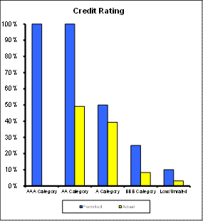
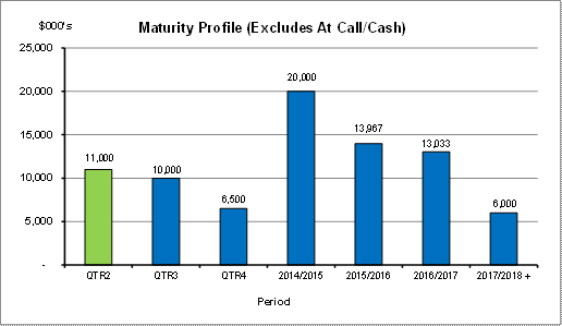
integrated planning and reporting
Leadership & Governance
|
Community Strategic Plan Long Term Objective
|
Delivery Program
Term Achievement
|
Operational Plan
Task
|
|
L2.1 Council rigorously manages its financial
resources and assets to maximise delivery of
services
|
Council maintains and improves its long term financial
position and performance.
|
Continue to analyse opportunities to expand the revenue
base of Council
|
Governance Matters
Council’s investments are made in accordance with the Local
Government Act (1993), the Local Government (General) Regulation 2005 and
Council’s Investment Policy.
A revised Investment Policy was adopted by Council on 10
December 2013.
Section 212 of the Local Government (General) Regulation
2005 states:
(1) The
responsible accounting officer of a council:
(a) must
provide the council with a written report (setting out details of all money
that the council has invested under section 625 of the Act) to be presented:
(i) if
only one ordinary meeting of the council is held in a month, at that meeting,
or
(ii) if
more than one such meeting is held in a month, at whichever of those meetings
the council by resolution determines, and
(b) must
include in the report a certificate as to whether or not the investment has
been made in accordance with the Act, the regulations and the council’s
investment policies.
(2) The report must be made up to the last day of
the month immediately preceding the meeting.
Risk Management
Council manages the risk associated with investments by
diversifying the types of investment, credit quality, counterparty exposure and
term to maturity profile.
Council invests its funds in accordance with The Ministerial
Investment Order.
All investments are made with consideration of advice from
Council’s appointed investment advisor, CPG Research & Advisory.
Council has two “Grandfathered” investments in structured
products that were previously entered into in accordance with The Ministerial
Investment Order at the time. The Ministerial Investment Order no longer allows
investment in these products. These investments are:
Maple Hill – HSBC Bank
Maple Hill, with a face value of $3,000,000, is invested by
Council on a “held to maturity” basis being December 2014. This CDO has
incurred six previous credit events by the underlying securities and can
withstand a further five credit events before principal loss is incurred. There
are no distressed securities now and independent advice is that the CDO is at
low risk of not recovering the full principal. The investment has not operated
outside of its terms and conditions, it continues to fully meet interest
payments as and when they fall due and there has not been a reduction in the
coupon rate. While Council intends to hold this investment to maturity, the
market value at 30 November 2013 was quoted by HSBC at $2,933,000.
CPDO PP – Royal Bank of Scotland
This Constant Proportion Debt Obligations Principal
Protected (CPDO PP), with a face value of $6,000,000, is invested by Council on
a “held to maturity” basis being September 2016. This CPDO is capital protected
at maturity date by Royal Bank of Scotland. Since December 2011 it ceased to
pay interest, due to a decrease in the credit indices it was linked to,
creating an unwind event. The investment now takes the form of a zero coupon
senior bank bond with a value of $6M. While Council intends to hold this
investment to maturity, the market value at 30 November 2013 was quoted by RBS
Morgan at $5,347,000.
Financial Considerations
The revised budget for interest on investments for the
financial year 2013/2014 is $3,779,100. Of this amount approximately $2,671,200
is restricted for the benefit of future expenditure relating to developers’
contributions, $361,200 transferred to the internally restricted Infrastructure
& Facility Reserve, and the remainder of $746,700 is available for
operations.
Social Considerations
Not applicable.
Environmental Considerations
Not applicable.
Community Consultation
None undertaken or required.
Internal Consultation
None undertaken or required.
Certification - Responsible Accounting
Officer
I hereby certify that the investments listed in the attached
report have been made in accordance with Section 625 of the Local Government
Act 1993, clause 212 of the Local Government General Regulation 2005 and
Council’s Investment Policy.
Summary
As at 30 November 2013:
Ø Council’s total cash and investment
portfolio is $96,121,000, which is an increase of $5,218,000 compared to the
opening balance of $90,903,000 at 1 July 2013.
Ø Council’s net return on investments for
the year to November 2013 was $1,686,000 against a revised budget of
$1,686,000.
|
Recommendation:
A. That
the summary of investments and performance for November 2013 be received and noted.
B. That
the Certificate of the Responsible Accounting Officer be noted and the report
adopted.
|
|
Tony Ly
Financial Accounting Officer
|
Angela Apostol
Manager Finance
|
|
David Marshall
Director Corporate
|
|
|
Attachments:
|
A1View
|
Investments
definitions specific to Council’s investment portfolio
|
|
2014/019897
|
|
APPENDIX
No: 1 - Investments
definitions specific to Council’s investment portfolio
|
|
Item No: GB.3
|
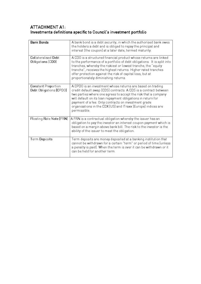
|
Ordinary
Meeting of Council - 4 February 2014
|
GB.4 / 96
|
|
|
|
|
Item
GB.4
|
S05273
|
|
|
9 January 2014
|
Investment Report as at 31 December 2013
EXECUTIVE
SUMMARY
|
purpose of report:
|
To present Council’s investment portfolio performance
for December 2013.
|
|
|
|
|
background:
|
Council’s investments are reported monthly to Council
in accordance with the Local Government Act 1993, the Local Government
(General) Regulation 2005 and Council’s Investment Policy.
|
|
|
|
|
comments:
|
The net return on investments for the financial year
ended December 2013 was $2,021,000 against a revised budget of $2,021,000.
|
|
|
|
|
recommendation:
|
That the summary of investments performance for
December 2013 be received and noted; and that the Certificate of the
Responsible Accounting Officer be noted and report adopted.
|
Purpose of Report
To present Council’s investment portfolio performance for
December 2013.
Background
Council’s investments are reported monthly to Council in
accordance with the Local Government Act 1993, the Local Government (General)
Regulation 2005 and Council’s Investment Policy.
Comments
Investment
Portfolio Performance Snapshot
The table below provides the investments portfolio
performance against targets identified in Council’s Investment Policy as well
as other key performance indicators based on industry benchmarks.

Cumulative Investment
Return against Revised Budget
The net return on investments for
the financial year ended December 2013 was $2,021,000
in line with the revised year to date budget. It is expected to achieve the
forecasted yearly budget of $3,779,100 by financial year end. The total return
on investments (interest and net capital gain) for the month of December is
provided below.

A comparison of the cumulative investment returns against
year to date budget is shown in Chart below.
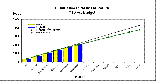
Cash
Flow and Investment Movements
Council’s total cash & investment portfolio at the end
of December 2013 is $92,870,000, an increase of $1,967,000 from the opening
balance of $90,903,000 on 1 July 2013.
The net cash outflow for the month was $3,251,000 mainly due
to creditor payments.
Three investments matured during
the month, and two new investments were made in December 2013. Table 1 below
provides detailed movements of the investment by institution name, investment
rating and interest rate.
Table
1 – Investment Movements - December 2013

Investment
Performance against Industry Benchmarks
Overall during the month of
December the investments performance was well above industry benchmark. The
benchmark is specific to the type of investment and details are provided below.
Ø UBS Bank Bill Index is used for all Council’s
investments
A comparison of the portfolio
returns against investment benchmark is provided in Table 2 below.
Table
2 - Investments Performance against Industry Benchmarks

Table 3 below provides a summary
of all investments by type and performance during the month.
Attachment A1 provides
definitions in relation to different types of investments.
Table
3 - Investments Portfolio Summary
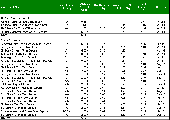

*
Weighted average returns
**
Refer to Risk Management section for commentary on these investments
Investment
by Credit rating and Maturity Profile
The allocation of Council’s investments by credit rating and
the maturity profile are shown below:

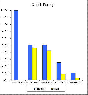
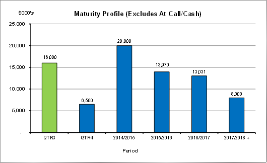
integrated planning and reporting
Leadership & Governance
|
Community Strategic Plan Long Term Objective
|
Delivery Program
Term Achievement
|
Operational Plan
Task
|
|
L2.1 Council rigorously manages its financial
resources and assets to maximise delivery of
services
|
Council maintains and improves its long term financial
position and performance.
|
Continue to analyse opportunities to expand the revenue
base of Council
|
Governance Matters
Council’s investments are made in accordance with the Local
Government Act (1993), the Local Government (General) Regulation 2005 and
Council’s Investment Policy.
A revised Investment Policy was adopted by Council on 10
December 2013.
Section 212 of the Local Government (General) Regulation
2005 states:
(1) The
responsible accounting officer of a council:
(a) must
provide the council with a written report (setting out details of all money
that the council has invested under section 625 of the Act) to be presented:
(i) if
only one ordinary meeting of the council is held in a month, at that meeting,
or
(ii) if
more than one such meeting is held in a month, at whichever of those meetings
the council by resolution determines, and
(b) must
include in the report a certificate as to whether or not the investment has
been made in accordance with the Act, the regulations and the council’s
investment policies.
(2) The report must be made up to the last day of
the month immediately preceding the meeting.
Risk Management
Council manages the risk associated with investments by
diversifying the types of investment, credit quality, counterparty exposure and
term to maturity profile.
Council invests its funds in accordance with The Ministerial
Investment Order.
All investments are made with consideration of advice from Council’s
appointed investment advisor, CPG Research & Advisory.
Council has two “Grandfathered” investments in structured
products that were previously entered into in accordance with The Ministerial
Investment Order at the time. The Ministerial Investment Order no longer allows
investment in these products. These investments are:
Maple Hill – HSBC Bank
Maple Hill, with a face value of $3,000,000, is invested by
Council on a “held to maturity” basis being December 2014. This CDO has
incurred six previous credit events by the underlying securities and can
withstand a further five credit events before principal loss is incurred. There
are no distressed securities now and independent advice is that the CDO is at
low risk of not recovering the full principal. The investment has not operated
outside of its terms and conditions, it continues to fully meet interest
payments as and when they fall due and there has not been a reduction in the
coupon rate. While Council intends to hold this investment to maturity, the
market value at 31 December 2013 was quoted by HSBC at $2,942,000.
CPDO PP – Royal Bank of Scotland
This Constant Proportion Debt Obligations Principal
Protected (CPDO PP), with a face value of $6,000,000, is invested by Council on
a “held to maturity” basis being September 2016. This CPDO is capital protected
at maturity date by Royal Bank of Scotland. Since December 2011 it ceased to
pay interest, due to a decrease in the credit indices it was linked to,
creating an unwind event. The investment now takes the form of a zero coupon
senior bank bond with a value of $6M. While Council intends to hold this
investment to maturity, the market value at 31 December 2013 was quoted by RBS
Morgan at $5,365,000.
Financial Considerations
The revised budget for interest on investments for the
financial year 2013/2014 is $3,779,100. Of this amount approximately $2,671,200
is restricted for the benefit of future expenditure relating to developers’
contributions, $361,200 transferred to the internally restricted Infrastructure
& Facility Reserve, and the remainder of $746,700 is available for
operations.
Social Considerations
Not applicable.
Environmental Considerations
Not applicable.
Community Consultation
None undertaken or required.
Internal Consultation
None undertaken or required.
Certification - Responsible Accounting
Officer
I hereby certify that the investments listed in the attached
report have been made in accordance with Section 625 of the Local Government
Act 1993, clause 212 of the Local Government General Regulation 2005 and
Council’s Investment Policy.
Summary
As at 31 December 2013:
Ø Council’s total cash and investment
portfolio is $92,870,000, which is an increase of $1,967,000 compared to the
opening balance of $90,903,000 at 1 July 2013.
Ø Council’s net return on investments for
the year to December 2013 was $2,021,000 against a revised budget of
$2,021,000.
|
Recommendation:
A. That
the summary of investments and performance for December 2013 be received and
noted.
B. That
the Certificate of the Responsible Accounting Officer be noted and the report
adopted.
|
|
Tony Ly
Financial Accounting Officer
|
Angela Apostol
Manager Finance
|
|
David Marshall
Director Corporate
|
|
|
Attachments:
|
A1View
|
Investments
definitions specific to Council’s investment portfolio
|
|
2013/213934
|
|
APPENDIX
No: 1 - Investments
definitions specific to Council’s investment portfolio
|
|
Item No: GB.4
|
|
Ordinary
Meeting of Council - 4 February 2014
|
GB.5 / 105
|
|
|
|
|
Item
GB.5
|
CY00438/2
|
|
|
17 January 2014
|
Amendment to Council Meeting Cycle -
March 2014
EXECUTIVE
SUMMARY
|
purpose of report:
|
To consider amending the adopted Council meeting cycle
to avoid the meeting clashing with the Local Government NSW Tourism
Conference being held between the
10 – 12 March 2014 in the Hunter Valley.
|
|
|
|
|
background:
|
Council adopted a meeting cycle for 2014 at the
Ordinary Meeting of Council held on the 26 November 2013. The adopted meeting
schedule has an Ordinary Meeting of Council held on Tuesday, 11 March 2014.
|
|
|
|
|
comments:
|
It is proposed that Council should give consideration
to the cancellation of the Ordinary Meeting of Council scheduled for Tuesday,
11 March 2014 and instead hold the meeting on Tuesday, 18 March 2014.
|
|
|
|
|
recommendation:
|
That Council amend its adopted meeting cycle so that
the Ordinary Meeting of Council scheduled for Tuesday, 11 March 2014 be
rescheduled to Tuesday, 18 March 2014 and that appropriate notice be given to
members of the public.
|
Purpose of Report
To consider amending the adopted Council meeting cycle to
avoid the meeting clashing with the Local Government NSW Tourism Conference
being held between the 10 – 12 March 2014 in the Hunter Valley.
Background
Council adopted a meeting cycle for 2014 at the Ordinary
Meeting of Council held on the 26 November 2013. The adopted meeting schedule
has an Ordinary Meeting of Council held on Tuesday, 11 March 2014. Council has
now been advised that the Local Government NSW Tourism Conference will be held
between 10 – 12 March 2014. Both the Mayor and Deputy Mayor will be in
attendance at the conference.
Comments
It is proposed that Council should give consideration to the
cancellation of the Ordinary Meeting of Council scheduled for Tuesday, 11 March
2014 and instead hold the meeting on Tuesday, 18 March 2014 to avoid the clash
of dates.
integrated planning and reporting
Leadership and Governance
|
Community Strategic Plan Long Term Objective
|
Delivery Program
Term Achievement
|
Operational Plan
Task
|
|
Ensure
effective and efficient conduct of Council and committee meetings for the
benefit of councillors and the community.
|
Council's
Governance framework is developed to ensure probity, transparency and the
principles of sustainability are integrated and applied into our policies,
plans, guidelines and decision-making processes.
|
Business
Papers and associated Minutes are published in an accurate and timely manner
for public scrutiny and encourage community participation.
|
Governance Matters
Section 9 of the Local Government Act 1993 requires Council
to give notice to the public of times and places of its meetings. Section 365
of the Local Government Act 1993 requires Council to hold at least ten (10)
meetings each year, each time in a different month.
The proposed amendment to Council’s adopted meeting cycle as
identified in the recommendation of this report will not affect Council’s
compliance with these sections of the Act.
Risk Management
There are no risk management considerations associated with
the recommendation in this report.
Financial Considerations
There are no financial considerations associated with the
recommendation in this report.
Social Considerations
There are no social considerations associated with the
recommendation in this report.
Environmental Considerations
There are no environmental considerations associated with
the recommendation in this report.
Community Consultation
None undertaken or required.
Internal Consultation
None undertaken or required.
Summary
Council adopted a meeting cycle for 2014 at the Ordinary
Meeting of Council held on the 26 November 2013. The adopted meeting schedule
has an Ordinary Meeting of Council held on Tuesday, 11 March 2014. Council has
now been advised that the Local Government NSW Tourism Conference will be held
between 10 – 12 March 2014 in the Hunter Valley. Both the Mayor and Deputy
Mayor will be in attendance at the conference.
It is proposed that Council should give consideration to the
cancellation of the Ordinary Meeting of Council scheduled for Tuesday, 11 March
2014 and instead hold the meeting on Tuesday, 18 March 2014 to avoid the clash
of dates.
|
Recommendation:
A. That
Council amend its adopted meeting cycle so that the Ordinary Meeting of
Council scheduled for Tuesday, 11 March 2014 be rescheduled to Tuesday, 18
March 2014.
B. That
appropriate notice be given to members of the public.
|
|
Matt Ryan
Manager Records & Governance
|
David Marshall
Director Corporate
|
|
Ordinary
Meeting of Council - 4 February 2014
|
GB.6 / 108
|
|
|
|
|
Item
GB.6
|
S02815
|
|
|
6 December 2013
|
Australian Local Government Women's
Association (NSW) 60th Annual Conference - March 2014
EXECUTIVE
SUMMARY
|
purpose of report:
|
To advise Councillors of the Australian Local
Government Women’s Association (NSW) Annual Conference to be held at Broken Hill
between 20 – 22 March 2014.
|
|
|
|
|
background:
|
The theme for the conference is “Embracing Change –
Be the Driver not the Passenger”.
|
|
|
|
|
comments:
|
The conference will provide a platform for Councillors
and staff to discuss current and emerging issues facing women in local
government.
|
|
|
|
|
recommendation:
|
That any Councillors interested in attending the
Australian Local Government Women’s Association (NSW) Annual Conference
advise the General Manager by Friday,
7 February 2014.
|
Purpose of Report
To advise Councillors of the Australian Local Government
Women’s Association (NSW) Annual Conference to be held at Broken Hill between
20 – 22 March 2014.
Background
The theme for the conference is “Embracing Change – Be the
Driver not the Passenger”. The program and registration details are attached
Comments
The annual ALGWA conference provides a platform for
councillors and staff to gather to discuss current and emerging issues facing
women in local government. A number of presenters have been scheduled to
address the conference. Each presenter will bring to the conference stories of
how they have made a difference in the community that they live in.
integrated planning and reporting
Leadership and Governance
|
Community Strategic Plan Long Term Objective
|
Delivery Program
Term Achievement
|
Operational Plan
Task
|
|
Council leads the community by advocating, influencing and
participating in policy development to the benefit of the local area
|
Council actively engages with stakeholders to inform the
development of Council’s strategies and plans as appropriate
|
Pursue opportunities to contribute to policy development
affecting Ku-ring-gai at state and regional levels
|
Governance Matters
The Policy on Payment of Expenses and Provision of
Facilities to Councillors provides for Council to meet the reasonable costs of
Councillors attending conferences authorised by resolution of Council.
Risk Management
There are no risk management considerations associated with
this report.
Financial Considerations
The cost of attending the ALGWA Conference is:
Early Bird ALGWA Member rate - $865 per delegate. Travel and
accommodation costs will be additional due to the location of the conference.
Attendance is provided for in the Councillor’s conference
budget in accordance with the Payment of Expenses and Provision of Facilities
to Councillors Policy.
Council has an annual budget of $34,200 for Councillor’s
attendance at conferences with $19,279 remaining in the 2013/2014 financial
year.
Social Considerations
There are no social considerations associated with the
recommendation in this report.
Environmental Considerations
There are no environmental considerations associated with
the recommendation in this report.
Community Consultation
None undertaken or required.
Internal Consultation
None undertaken or required.
Summary
The annual ALGWA Conference is being held in Broken Hill
between the 20 – 22 March 2014. The theme for the conference is “Embracing
change – be the driver not the passenger”.
Attendance is provided for in the Councillor’s conference
budget in accordance with the Payment of Expenses and Provision of Facilities
to Councillors Policy.
Council has an annual budget of $34,200 for Councillor’s
attendance at conferences with $19,279 remaining in the 2013/2014 financial
year.
That Council determine if it wishes to send delegates to the
2014 Australian Local Government Women’s Association (NSW) Annual Conference.
|
Recommendation:
That any Councillors interested in attending the
Australian Local Government Women’s Association (NSW) Annual Conference
advise the General Manager by Friday, 7 February 2014.
|
|
Matt Ryan
Manager Records & Governance
|
David Marshall
Director Corporate
|
|
Attachments:
|
A1View
|
2014
ALGWA Annual Conference - Embracing Change
|
|
2014/017432
|
|
APPENDIX
No: 1 - 2014
ALGWA Annual Conference - Embracing Change
|
|
Item No: GB.6
|

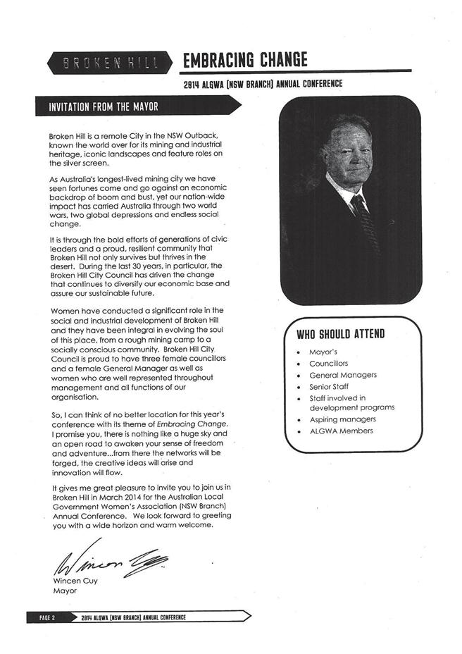

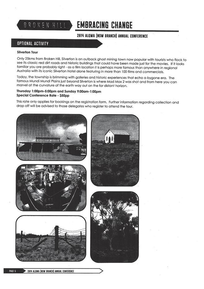
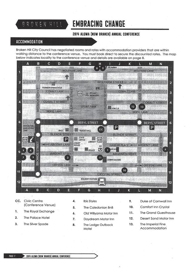
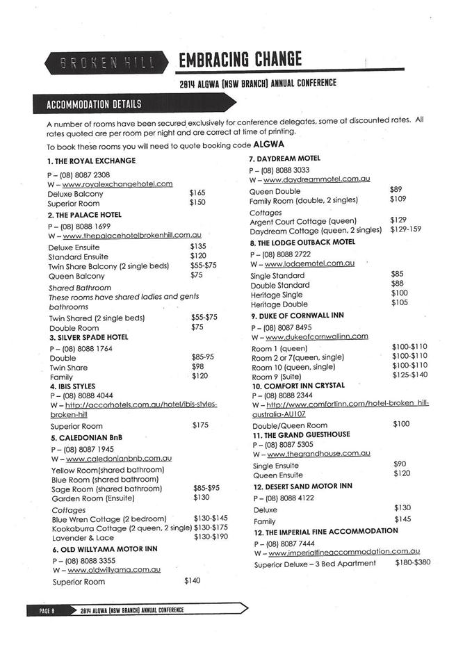
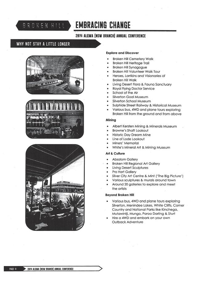

|
Ordinary
Meeting of Council - 4 February 2014
|
GB.7 / 124
|
|
|
|
|
Item
GB.7
|
CY00076/6
|
|
|
22 January 2014
|
Smart Urban Futures Conference
EXECUTIVE
SUMMARY
|
purpose of report:
|
To advise Council of the Smart Urban Futures
Conference.
|
|
|
|
|
background:
|
The conference is to be held in Melbourne from
Wednesday, 26 March to Thursday, 27 March, 2014. The conference is being
convened by the Municipal Association of Victoria and Victoria Walks.
|
|
|
|
|
comments:
|
The conference will examine how to design communities
to meet the challenges of the 21st century, and will feature a
range of significant local and international case studies and world-class
presenters.
|
|
|
|
|
recommendation:
|
That all interested Councillors advise the General
Manager of their interest in attending the Smart Urban Futures Conference by
Friday, 7 February 2014.
|
Purpose of Report
To advise Council of the Smart Urban Futures Conference.
Background
The conference is to be held in Melbourne from Wednesday, 26
March to Thursday, 27 March, 2014. The conference is being convened by the Municipal
Association of Victoria and Victoria Walks.
Comments
The conference will examine how to design communities to
meet the challenges of the 21st century, and will feature a range of
significant local and international case studies and world-class presenters.
integrated planning and reporting
Leadership and Governance
|
Community Strategic Plan Long Term Objective
|
Delivery Program
Term Achievement
|
Operational Plan
Task
|
|
Council leads the community by advocating, influencing and
participating in policy development to the benefit of the local area
|
Council actively engages with stakeholders to inform the
development of Council’s strategies and plans as appropriate
|
Pursue opportunities to contribute to policy development
affecting Ku-ring-gai at state and regional levels
|
Governance Matters
The Policy of Payment of Expenses and Provision of
Facilities to Councillors provides for Council to meet the reasonable costs of
Councillors attending conferences authorised by resolution of Council.
Risk Management
There are no risk management considerations associated with
the recommendation in this report.
Financial Considerations
The cost of attending the conference is $550 (including
GST).
Travel costs will be additional as airfares and
accommodation costs will be required due to the location of the conference.
Attendance is provided for in the Councillor’s conference
budget in accordance with the Policy on the Payment of Expenses and Provision
of Facilities to Councillors.
Council has an annual budget of $34,200 for Councillor’s
attendance at conferences with $19,279 remaining in the 2013/2014 financial
year.
Social Considerations
There are no social considerations associated with the
recommendation in this report.
Environmental Considerations
There are no environmental considerations associated with
the recommendation in this report.
Community Consultation
None undertaken or required.
Internal Consultation
None undertaken or required.
Summary
The conference is to be held in Melbourne from Wednesday, 26
March to Thursday, 27 March, 2014. The conference is being convened by
Municipal Association of Victoria and Victoria Walks.
The conference will examine how to design communities to
meet the challenges of the 21st century, and will feature a range of
significant local and international case studies and world-class presenters.
Attendance is provided for in the Councillor’s conference/training
budget in accordance with the Policy on the Payment of Expenses and Provision
of Facilities to Councillors.
Council has an annual budget of $34,200 for Councillor’s
attendance at conferences with $19,279 remaining in the 2013/2014 financial
year.
|
Recommendation:
That all interested Councillors advise the General Manager
of their interest in attending the Smart Urban Futures Conference by Friday,
7 February 2014.
|
|
Matt Ryan
Manager Records & Governance
|
|
|
Attachments:
|
A1View
|
Smart
Urban Futures Conference
|
|
2014/017361
|
|
APPENDIX
No: 1 - Smart
Urban Futures Conference
|
|
Item No: GB.7
|

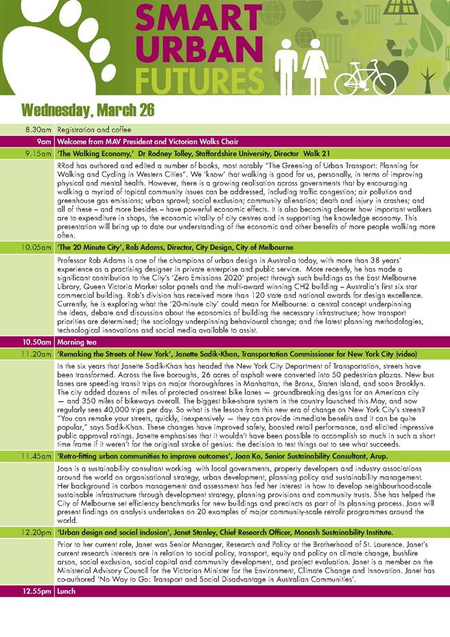

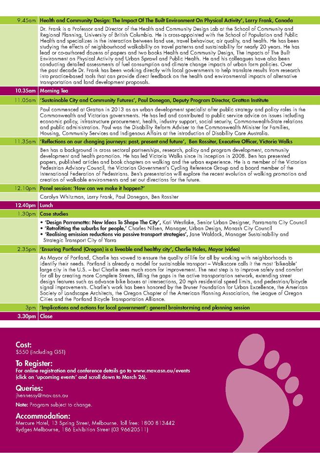
|
Ordinary
Meeting of Council - 4 February 2014
|
GB.8 / 131
|
|
|
|
|
Item
GB.8
|
DA0139/13
|
|
|
28 November 2013
|
Summary
Sheet
|
Report title:
|
17 to 25
Boundary Street, Roseville - Demolition of Existing Dwellings and
Construction of Two Residential Flat Buildings containing 58 Units and
Associated Works
|
|
ITEM/AGENDA
NO:
|
GB.8
|
|
Application No:
|
DA0139/13
|
|
Property Details:
|
17, 19, 21, 23, 25 Boundary Street, Roseville
Lot &
DP No: Lot 1 DP315280, Lot D DP322051, Lot C
DP322051,
Lots 9 and 10 DP1143965, Lot 11 DP1143956 and Lot 1 DP943894
Site area (m2): 3,488m2
Zoning: R4 – High Density Residential
|
|
Ward:
|
Roseville
|
|
Proposal/Purpose:
|
To determine Development Application No. 0139/13 for
the demolition of the existing dwellings and construction of two residential
flat buildings containing 58 units and associated works.
|
|
Type of Consent:
|
Local
|
|
Applicant:
|
Develotek Roseville Pty Ltd
|
|
Owner:
|
Mrs Denise Voysey, Mr Sung Don Moon, Mrs Eun Ju Kim
Moon, Doctor Teck Huah Tang, Mr Paul Ernest Jonas, Mrs Jennifer Karen Jonas,
Mr Donald Pearson, Mrs H M Pearson and NSW Roads and Maritime Services
(owners of land reserved for road widening)
|
|
Date Lodged:
|
7 May 2013
|
|
Recommendation:
|
Approval.
|
Purpose of Report
To determine Development Application No. 0139/13, which
proposes the demolition of existing dwellings and the construction of two
residential flat buildings containing 58 dwellings, basement parking and associated
landscape works.
Executive Summary
|
Issues:
|
Urban design, apartment size
|
|
|
|
Submissions:
|
One (1) submission received
|
|
|
|
Land and Environment Court:
|
N/A
|
|
|
|
Recommendation:
|
Approval
|
integrated planning and reporting
Places, Spaces & Infrastructure
|
Community Strategic Plan
Long Term Objective
|
Delivery Program
Term Achievement
|
Operational Plan
Task
|
|
P2.1 A robust planning
framework is in place to deliver quality design outcomes and maintain the
identity and character of Ku-ring-gai
|
Applications are assessed in accordance with State and
local plans
|
Assessments are of a high quality, accurate and consider
all relevant legislative requirements
|
History
Site
The site has no history relevant to this application.
Pre-DA
No Pre-DA consultation was undertaken with Council prior to
the lodgement of this Development Application.
Current DA History
|
7 May 2013
|
Application lodged.
|
|
|
|
|
17 May 2013
|
The application was notified to neighbouring property
owners for a period of 30 days. One submission was received.
|
|
16 August 2013
|
|
|
|
A letter was sent to the applicant advising of outstanding
issues relating to:
- plan
information
- balcony
sizes
- urban
design
- clothes
drying area
- traffic
impacts
- stormwater
management design
- geo-technical
information
- deep
soil landscaping
- tree
impacts
|
|
|
|
|
4 November 2013
|
Amended plans and additional information was submitted.
|
|
|
|
|
26 November 2013
|
Council officers advise the applicant of remaining
outstanding issues relating to:
- deep
soil landscaping
- plan
inconsistencies
- tree
impacts
- BASIX
information
|
|
|
|
|
29 November 2013
|
Amended plans and additional information was submitted.
|
The Site
Site description
The five properties that comprise the site encompasses seven
(7) allotments, located on the north-western side of Boundary Street,
approximately 370 metres south-east of the Roseville local centre and railway
station. The site details are as follows:
- 17
Boundary Street, Lot 1 DP315280 and Lot D DP322051: The site is an irregular
shaped allotment with a frontage to Boundary Street containing a single storey
brick dwelling and swimming pool.
- 19
Boundary Street, Lot C DP322051: The site is a rectangular shaped allotment
with a frontage to Boundary Street containing a single storey brick dwelling
and detached garage.
- 21
Boundary Street, Lots 9 and 10 DP1143965: The site is a rectangular shaped
allotment with a frontage to Boundary Street containing a single storey
dwelling and detached garage.
- 23
Boundary Street, Lot 11 DP1143956: The site is a rectangular shaped allotment
with a frontage to Boundary Street containing a single storey dwelling and
detached garage.
- 25
Boundary Street, Lot 1 DP943894: The site is a rectangular shaped allotment
with a frontage to Boundary Street containing a single storey dwelling and
detached greenhouse.
The site is subject to a land reservation for the
purpose of widening a Classified Road (Boundary Street) as identified by the
maps prepared under Ku-ring-gai Local Environmental Plan (Local Centres) 2012.
The reserved area is zoned ‘SP2 – Infrastructure – Classified Road’. The
reserved area aligns the Boundary Street frontage of the site and widens from
approximately 1.9 metres to 7.3 metres in an east-west direction.
The consolidated area of the site is 3,488m2
(exclusive of the abovementioned land reservation) with an approximate frontage
of 91 metres to Boundary Street. The average depth of the site is approximately
37 metres. The site slopes away from the rear boundary towards the Boundary
Street frontage. The site supports several trees that are spread across the
property.
Surrounding development
Properties to the east, north and west are all zoned ‘R4 –
High Density Residential’. The adjoining property to the east (No. 27-31
Boundary Street) contains a recently constructed five storey residential flat
development. DA0053/12 for a residential flat development was recently approved
on the adjoining property to the west(No. 5-15 Boundary Street).
The adjoining northern half of the street block is currently
occupied by single, detached dwellings fronting Victoria Street. DA0371/13 was
recently lodged (after the lodgement of the subject application) for the demolition
of these dwellings (1-31 Victoria Street) and the construction of several
residential flat buildings containing 220 units. This application remains under
assessment.
Willoughby Local Government Area commences on the opposite
side of Boundary Street, to the south of the site. The properties located on
this side of Boundary Street are predominantly occupied by single, detached
dwellings.
The Proposal
The application proposes the demolition of existing
dwellings and the construction of two residential flat buildings containing 58
dwellings, basement parking and associated landscape works. The details of the
proposed development are as follows:
- 16
x 1 bedroom dwellings
- 36
x 2 bedroom dwellings
- 6
x 3 bedroom dwellings
The application proposes a basement level that connects the
two buildings containing 77 car parking spaces, motorcycle and bicycle parking
spaces, general storage areas, waste storage areas, plant rooms and stormwater
storage tanks distributed across two levels and a mezzanine area. Building 1
(to the west of the site) contains 31 units over five levels. Building 2 (to
the east of the site) contains 27 units over 5 levels.
The application also proposes various landscaping works,
including accessible pathways, open lawn areas, planter beds and a masonry pier
with timber slat fence aligning the boundary street frontage of the site. This
fence aligns with the boundary of the land reserved for road widening, not the
current frontage of the site to Boundary Street. A single driveway for
vehicular access to and from the site is to be provided at the eastern end of
the property. This driveway will cross the land reserved for road widening.
Consultation
Community
In accordance with the requirements of Part 5, Volume 3 of
the Ku-ring-gai Local Centres Development Control Plan, owners of surrounding
properties were given notice of the application. In response, Council received
a submission from the following:
1. Dr
J.H. Drabble – 18 Boundary Street, Roseville
The submission raised the following issues:
Traffic impacts upon Boundary Street
The application has been referred to the NSW Roads and
Maritime Services who are satisfied that the proposed development will not
unduly impact upon the movement of vehicles along Boundary Street, subject to
conditions (addressed in further detail, below).
Amended plans received 4 November 2013 and 29 November
2013
The amended plans did not alter
the proposal in a way that would likely result in a greater environmental
impact than the original scheme. Therefore, as per the provisions of Part 5,
Volume 3 of the Ku-ring-gai Local Centres Development Control Plan, notification
was not required.
Within Council
Urban Design
Council's Urban Design
Consultant undertook an assessment of the original proposal against the design
quality principles of SEPP 65 (Design Quality of Residential Flat Development)
and recommended that the following issues be addressed:
· integration
of the upper levels into the overall building design
· inadequate
articulation due to excessive visual bulk, an absence of delineation between
horizontal and vertical elements and hidden entrances
· simplify
the plans and sections
· visual
dominance of balconies
· incoherent
use of materials and finishes
· apartment
layouts
· improve
amenity and functionality to lift lobbies
· absence
of mailbox details
Council’s Urban Design Consultant has provided the following
comments on the amendments that have been made to the application to address
these issues:
· integration
of the upper levels into the overall building design
The straightening of the parapet and the introduction of
the horizontal header course assists in creating a top to the four lower levels
of both buildings. This improves the relationship between the upper level and
the lower levels by indicating a ‘top’ to the lower levels. A top implies that
the buildings are meant to terminate at that height and they do not look as if
they can extend upwards indefinitely.
· inadequate
articulation due to excessive visual bulk, an absence of delineation between
horizontal and vertical elements and hidden entrances
The introduction of the full height glazing to the living
room walls in Units 1G.01; 11.01; 12.01;13.01 on the re-entrant western wall,
the oblique views of the building from Boundary Street will be improved. .
· simplify
the plans and sections
There has only been one minor change to the narrow
vertical elements that form the elevations of the buildings, however the
introduction of the horizontal string courses at the head and sill of windows
in the vertical brickwork elements and the straightened parapet and the brick
edge detail at the parapet level and the full height glazing in the walls to
the balconies rather than the ‘hole in the wall’ windows has strengthened the
horizontality of the building and lessened the impact of the numerous vertical
elements.
· visual
dominance of balconies
Although the balconies have not been reorganised, the
additional brick string courses; the parapet edge on the 4th level,
the use of full height glazing to the openings in the walls facing the
balconies and the extension of the sandstone walls at the base have improved
the balance of horizontal and vertical elements.
· incoherent
use of materials and finishes
Full height glazing and panels for the windows and doors
facing the five balconies have been introduced.
Horizontal string courses that align in with the heads
and sills of the windows have been introduced in the two vertical brickwork
elements.
Straightening of the parapet line has been undertaken and
an edge brickwork course has been incorporated into the parapet.
The sandstone courtyard walls on the southern elevation
have been extended.
· apartment
layouts
Furniture layouts for the living areas are now
shown on the drawings.
Minor changes have been made to the north-western corner
of Building 2 in plan by introducing a re-entrant corner to accommodate a tree.
This has resulted in a projecting bedroom on the westerly elevation in Units
2G.02; 11.02; 12:02; 13.02
Minor variations to the configuration of the planters on
northern side and roof area on the western end of Building 2 have been made.
Small pergolas have been introduced on the northern side
in to Units 14.01; 1402; 14.03 Building 1 and Units 24.01; 24.02 + 24.03 in
Building 2.
· improve
amenity and functionality to lift lobbies
The urban design report argues that light to the lobbies is adequate.
It does not address the fact that the entrance and lobby to Building 2 is set
very deeply within the building so even the easterly lobbies will not receive
very much light. The western lobbies still receive none.
· absence
of mailbox details
The location of mailboxes
(adjacent to the street frontage) has been provided.
The issues identified by Council’s Urban Design Consultant
have been satisfactorily addressed in the amended proposal. Although some
concern remains with regard to natural light to lift lobbies, it is noted that
this issue is largely related to the street address of the building being
oriented to the south. In this regard, providing light to these areas would require
the lobby being set deeply into the building, away from the building entrance.
As these areas are only used for a short period of time, this issue is not
significant. Additionally, as outlined in further detail below, the proposal is
consistent with the design quality principles of SEPP 65.
Heritage
Council’s Heritage Advisor, commented on the proposal as
follows:
Heritage status
None of the houses on the site
are listed as heritage items. The site is not within the vicinity of a HCA in Ku-ring-gai,
although the opposite side of Boundary Street is within the North Chatswood
Conservation Area which is located in the Willoughby Council area.
The site is not within the
direct vicinity of a heritage item. Heritage items are located at 3 Hill Street
(corner of Boundary Street), 16 Victoria Street and 1 Hill Street (corner of
Victoria Street).
Heritage Impact Statement
(HIS)
A HIS prepared by an
experienced heritage consultant is included with the application. It contains a
relatively good background history of the area prior to its residential
subdivision and histories of each of the individual houses proposed for
demolition. The assessment of heritage impacts has been prepared in accordance
with the guidelines prepared by the NSW Heritage Council.
The HIS contains a few errors
in that it identifies 5 Victoria Street as a listed heritage item and does not
recognise No 16 Victoria Street as a heritage item. No 5 Victoria Street was
an item in the KPSO but was removed with gazettal of the Local Centres LEP in
January 2013. Similarly, No 16 Victoria Street was not a heritage item in the
KPSO but was gazetted as a local heritage item in the Local Centres LEP. No
consideration of potential impacts on No 16 Victoria Street has been provided
in the applicant’s HIS.
The HIS also notes the National
Trust UCA classification that applies to the site. The site was previously
rezoned as Residential 2(d3) in LEP 194 which allows a similar scale of
development. DCP 55 contains objectives and controls for sites rezoned
Residential 2(d3) and the HIS refers to those controls. With gazettal of the
Local Centres LEP, those controls have become redundant. Council has adopted
controls and objectives for sites zoned in the Local Centres LEP and I will
refer to those controls in this report.
The HIS concludes that:
“…the proposed development is a
reasonable response to the Ku-ring-gai LEP (Local Centres) 2012 requirements
and the Council R4 residential zoning of the area for increased urban density.
The development will have a limited and acceptable impact on the identified UCA
by the National Trust of Australia, UCA 3 – Roseville East and the surrounding
development patterns. It will only have a minor impact on the North Chatswood
Conservation Area located opposite the site in Boundary Street. This impact
has been partially mitigated by the physical separation of the site from the
conservation area by Boundary Street’s increasing road widening to become a
major arterial road. These items opposite Boundary Street have a low level of
contribution to the wider area of residential development. The developments
visual impact on the heritage significance of other items identified in the
vicinity of the site, located on Hill and Victoria Streets, is considered
marginal and therefore acceptable. Appropriate recording of the site and
recovery of building materials for responsible re-cycling is appropriate in
this context”.
Demolition
Despite the individual houses
having a degree of local significance to the general area, demolition is
acceptable as the sites have been rezoned for larger scale development provided
photographic recording is undertaken prior to any works commencing. It is also
appropriate that building materials salvaged from demolition are re-used
appropriately and conditions are provided (Condition Nos 8 and 49).
Development within the
Vicinity of a Heritage Item or HCA
With reference to Chapter 7.3
and 7.6 of the Local Centres LEP, the development site is not within the
immediate vicinity of a heritage item or a HCA in the Ku-ring-gai area.
The closest heritage item is No
16 Victoria Street, located on the northern side of the street. The development
site is separated from the heritage item by the roadway and existing
residential development on the south side of Victoria Street. In this situation
the objectives and controls in the Local Centres DCP have little effect. The
proposed development would be seen in the background but it is considered to
have minimal heritage impacts. The southern side of Victoria Street is zoned
for a similar scale of development and it is likely any future development on
those sites may impact on the heritage item at No 16 Victoria Street.
The HCA – Area C 36 in the
Local Centres LEP includes part of Bancroft Avenue and Lord Street. It is
located a considerable distance from the subject site and this development is
likely to have minimal impact on it.
The proposed development is
likely to have some impact on the Chatswood North HCA, located in the
Willoughby area. The impacts should be limited to those houses facing directly
opposite in Boundary Street. As noted in the applicant’s HIS, the future
upgrading of Boundary Street will change the character to a main arterial road
which will to some extent provide a reasonable degree of separation.
Conclusions and
recommendations
The proposal is considered to
have minimal impacts on the nearby heritage items and HCAs in the Ku-ring-gai
area and is acceptable.
The proposed development will
have a low level of impact on the Chatswood North HCA, located on the southern
side of Boundary Street.
Archival photographic recording
of the houses to be demolished should be undertaken. Appropriate recycling of
building materials should also be undertaken.
Landscaping
Council’s Landscape Assessment Officer, commented on the proposal
as follows:
Deep soil landscape area
The calculation for deep soil is 1744m2 or 50.0%
of the site area which complies with the 50% deep soil requirement.
Tree removal
An
Arboricultural Assessment prepared by Tree
Talk and dated February 2013 has
been submitted with the application. Tree numbers refer to this report. A
further assessment of the structural integrity of a broken stub and several
smaller dead branches, has been provided.
The
following abbreviations have been used to describe the size of existing trees:
height (H), canopy spread(S), diameter at breast height (DBH), tree protection
zone (TPZ) and structural root zone (SRZ).
Significant
trees to be removed
The
trees to be removed are either exempt under Council’s Tree Preservation Order
or less than 8m in height and are not considered significant. Trees 5, 15 and
16 are located within the road reservation widening on Boundary Street.
Significant
trees to be retained
Tree
2/ Melaleuca quinquenervia (Broad Leaved Paperbark): This tree is located at
the north-western corner of the site.
Tree
8/ Angophora costata (Sydney Red Gum): This tree straddles the northern
boundary. Recent filling to the boundary on the adjoining property to the north
and a pool filter has been constructed within the structural root zone of the
tree. The tree displays signs of dieback and epicormic growth. To preserve the
health and condition of this tree, the proposed drying area and associated
paving is to be set back a minimum of 6m from the tree as measured from the
centre of the trunk (Condition No. 23).
Tree
11/ Angophora costata (Sydney Red Gum): This mature tree is located within the
northern rear yard. The tree is a locally occurring species and a likely
remnant tree. The tree is visible from Boundary Street and is considered of
high landscape significance. Council’s mapping indicates that it
is likely to be a remnant of an endangered ecological community.
The
tree is described in the arborist report as having possible structural issues
due to internal decay. Further investigation, including an aerial inspection
has been undertaken. The tree has been assessed as being able to be retained
with some remedial pruning.
Tree
14/ Jacaranda mimosifolia (Jacaranda): This mature tree is located within the
front setback of the development, outside of the future road reservation. The
tree is to be retained and protected. The proposed excavation within structural
root zone of the following tree will require arborist supervision (Condition
No. 60).
Impacts
on trees within adjoining properties
Several
trees are located on adjoining property boundaries. The proposal should include
consideration of root and canopy impacts. This can be conditioned (Condition
No’s 23, 56, 57, 59 and 60). Tree A is a Magnolia x soulangiana (Magnolia),
not a Jacaranda as shown.
Street
trees to be removed
A row
of existing mature Jacaranda mimosifolia (Jacaranda) are to be retained in the
short term. However, these trees are shown to be removed under the future road
widening.
Landscape plan
The
site adjoins the North Chatswood Conservation Area within the Willoughby Local
Government Area.
The
management policy includes the following considerations:
Retain
the scale, form, massing and detailing of original buildings of heritage
significance
and the typical scale, rhythm and character of individual
streetscapes;
“Retain
landscaped settings by minimising hard surfaces forward of the
building
line, locating carparking structures behind the building alignment
where
possible, and maintaining the existing patterns of low/semi-transparent
fencing
to the street; and
Infill
development must respect existing patterns of development including the
spacing,
rhythm and siting of built forms, the landscaped settings, and the
scale
massing, form and materials of the general development.”
Except
for Tree 14, a mature Jacaranda, the existing plantings within the front
setback as well as the street tree plantings will be removed as part of the
road widening. The landscape treatment within the front setback of the proposed
development will therefore provide the principal landscape buffer to the
heritage conservation area.
Front
setback
The
proposed front setback provides tall tree planting of Eucalyptus pilularis
(Blackbutt), Eucalyptus saligna (Sydney Blue Gum) and Angophora costata (Sydney
Red Gum). Planting along the front setback of Boundary Street, in the vicinity
of the heritage conservation area is considered sympathetic to the
horticultural style of the buildings on the southern side of Boundary Street.
The planting will be a mix of locally occurring native and deciduous canopy
trees with an assortment of exotic shrubs. To reduce the bulk of the proposed
retaining walls within the front setback additional planting forward of the
walls is conditioned (Condition No. 24).
Tree replenishment
The site should support a minimum 13 tall trees capable of
attaining at least 13 metres in height. The proposal provides well in excess of
this number.
Communal
open space
The
development provides a communal open space of consolidated deep soil landscape area that incorporates the central area between the buildings
as well as an area at the north-western corner of the site. Both areas provide
seating, receive satisfactory solar access and provide privacy and acoustic
amenity.
Screen planting
Eastern boundary – Camellia japonica (Japanese Camellia) 4m
, Rondoletia amoena (Rondoletia) 3m, Franklinia axillaris (Gordonia) 7H
Northern boundary–Camellia japonica (Japanese Camellia) 4m
, Rondoletia amoena (Rondoletia) 3m, Magnolia ‘Little Gem’ 3m, Franklinia
axillaris (Gordonia) 7H
Western boundary – Camellia japonica (Japanese Camellia) 4m
, Rondoletia amoena (Rondoletia) 3m, Viburnum sp. (Viburnum) 3m, Franklinia
axillaris (Gordonia) 7H
The density and mix of planting species is considered to be
appropriate for screening purposes.
BASIX
The BASIX Certificate is satisfactory.
Stormwater plan
The
proposed drainage swale along the site boundaries is likely to have adverse
impacts on existing trees and vegetation as well as proposed landscape
treatment proposed within the side setbacks as part of the development. To
preserve existing trees, drainage of landscape areas to building surrounds is
to be localised and connected to stormwater lines running adjacent to the
building (Condition No. 25).
Engineering
Council’s Development Engineer, commented on the proposal as
follows:
Water management
Amended plans have been
received, together with the models requested.
The rainwater tanks have now
been sized based on 1,000 litres per unit, a total of 68 cubic metres. Re-use
for irrigation and car washing is indicated. The water balance model confirms
that the required reduction in runoff days will be achieved.
Proprietary treatment devices
have been introduced to achieve Council’s water quality objectives. The MUSIC
model demonstrates these will be achieved.
Landscape Services have raised
concerns about the swale around the high side of the buildings. A condition is
recommended (Condition No. 25) that the swale be replaced with an upturn
to the courtyard walls and/or grated pits connected to the main stormwater
lines through the basement. This can be shown on the Construction Certificate
plans.
Vehicular access and works
in road reserve
An amended detail of the entry
driveway has been submitted. This has been referred to Roads and Maritime
Services (RMS). It appears that the future kerb alignment is approaching the
existing at the location of the driveway entry, so the design will be
applicable to both cases.
The footpath elevation and sections
requested have not been submitted, however, it appears that the proposed works
will provide satisfactory vehicular and pedestrian access for the current and
future situation. The recommended conditions require the detailed design for
this work to be approved by both Council and RMS prior to the issue of the
Construction Certificate (Condition No’s 19, 20 and 30).
Geotechnical report
The report has been amended to
recommend a tanked basement construction. This is consistent with the
requirements of the Local Centres DCP.
Building
Council’s Building Surveyor is satisfied the proposed
development will be compliant with the requirements of the Building Code of
Australia, subject to conditions (Condition No. 33).
Outside Council
NSW Roads and Maritime Services
The works of the proposed development do not encroach within
the land required for road that aligns the Boundary Street frontage of the
site, with the exception of the driveway crossing. In this regard, the
application was referred to the NSW Roads and Maritime Services (RMS) seeking
concurrence under Section 138 (2) of the Roads Act 1993 and Part 2,
Division 17 of State Environmental Planning Policy (Infrastructure) 2007.
The RMS have issued concurrence to the proposed development,
subject to condition relating to the configuration of the vehicle entrance and
exit points, the location of kerb and guttering, noise impacts, stormwater
management and construction vehicle movements (Condition Nos 11, 19, 20 and
21).
Statutory Provisions
This proposal is ‘Local Development’ under Part 4 of the EP
and A Act, 1979 and requires development consent pursuant to the Ku-ring-gai
Local Environmental Plan (Local Centres) 2012 .
State Environmental Planning Policies
Sydney Regional Environmental
Planning Policy (Sydney Harbour Catchment) 2005
SREP 2005 applies to the site as
the site is located in the Sydney Harbour Catchment. The Planning Principles in
Part 2 of the SREP must be considered in the preparation of environmental
planning instruments, development control plans, environmental studies and
master plans. The proposal is not affected by the provisions of the SREP which
relate to the assessment of development applications as the site is not located
in the Foreshores and Waterways Area as defined by the Foreshores and Waterways
Area Map.
State Environmental Planning Policy (Infrastructure) 2007
As outlined above, the application has been referred to the
RMS for comments, as is required by the SEPP. The RMS have issued concurrence
to the proposal, subject to conditions (Condition Nos 11, 19, 20, and 21).
Therefore, the application is assessed as being consistent with the matters for
consideration set out under the SEPP.
State Environmental Planning Policy No. 55 - Remediation
of Land
The provisions of SEPP 55 require consideration of the
potential for a site to be contaminated. The site has a history of residential
use and is unlikely to be contaminated. Further investigation is not warranted.
State Environmental Planning Policy (Building
Sustainability Index: BASIX) 2004
An amended BASIX certificate was submitted with the amended
plans. The application documentation is consistent with the commitments
identified in the BASIX certificate.
State Environmental Planning Policy No 65-Design Quality
of Residential Flat Development
SEPP 65 aims to improve the design quality of residential
flat buildings across New South Wales and to provide an assessment framework
and design code for assessing “good design”.
A Design Verification Statement, prepared by James Grant,
has been submitted with the application in accordance with clause 50(1A) of the
Environmental Planning and Assessment Regulation 2000.
The application has been assessed by Council’s Urban Design Consultant
and the amended proposal is considered acceptable.
Part 2 of the SEPP sets out design principles against which
design review panels and consent authorities may evaluate the merits of a
design. This section is to be considered in addition to the comments of
Council’s Urban Design Consultant above. The proposal has been assessed against
the heads of consideration specified in SEPP 65 as follows:
Principle 1: Context
The proposal is located within an area zoned R4 High Density
Residential and is consistent with the desired future character of the R4 High
Density Residential zone.
The proposal is in keeping with the design outcomes and
controls, as detailed in the Local Centres LEP and DCP. The submitted site
analysis identified prime constraints and opportunities and the resultant
design responds to these. Setbacks allow for adequate separation from Boundary
Street and the site boundaries. Building orientation takes advantage of solar
access.
Principle 2: Scale
The development provides an acceptable bulk and scale to the
streetscape and adjoining properties. The height of the building complies with
the building height development standard in Ku-ring-gai LEP (Local Centres)
2012.
Principle 3: Built form
The built form is consistent with the desired future
character of the zoning featuring a five storey building set back from the
street and within a landscape setting. An appropriate scale relationship to the
street and the surrounding development is achieved through modulation of
façades and setbacks in plan and section. The colours and finishes selected for
the building are consistent with neighbouring residential flat developments.
Principle 4: Density
The development complies with the development standard for
floor space ratio. The bulk and scale has been controlled by the compliant
floor space ratio, setbacks, landscaping, building separating and a top floor
with reduced floor area. Sufficient car parking has been provided to cater for
the likely demand generated by the development. The density proposed is
consistent with the R4 High Density Residential zoning.
Principle 5: Resource, energy and water efficiency
The development is based on energy efficient passive solar
design that includes natural cross-ventilation and a minimum of 3 hours solar
access to >70% of the units. A valid Basix Certificate supports the
application which confirms that the development will meet the energy and
resource conservation targets and achieve adequate levels of thermal comfort
for future occupants.
Principle 6: Landscaping
The 50% of the site area that is designated for deep soil
landscaping complies with the design control in the Local Centres DCP. Existing
significant trees on the site will be retained.
The landscaping includes retention of major trees and
planting of additional canopy trees and native plants which significantly
contribute to the tree canopy, provide habitat for local fauna and integrate
the building with the surrounding development.
Landscaping provides both green buffers to adjoining
properties and a generous outdoor communal open space that is set back from the
street and will receive good solar access.
Principle 7: Amenity
High levels of internal amenity would be achieved through
well designed communal areas such as the pedestrian entry and common open
space. Visual privacy is provided through setbacks, separation, window design
and screening devices.
Principle 8: Safety and security
The layout of the development promotes good natural
surveillance of public areas. The front entry path and front entries to the
residential flat building towards the communal open space and will be visible
from balconies on the northern elevation of the building.
Resident access to the common open space is via ramps. Units
are accessible by people with disabilities in accordance with AS 1428.1 -
Design for Access and Mobility while four units are adaptable in accordance
with AS 4299-1995 - Adaptable Housing.
Principle 9: Social dimensions
The proposal would provide a mix of 1, 2 and 3 bedroom
apartments with differing layouts to maximise housing choice within the
Ku-ring-gai Local government Area. Adaptable apartments, visitable apartments
and visitor and disabled parking have been provided.
Principle 10: Aesthetics
The aesthetic style of the building has been designed to be
consistent with the prevailing form of residential flat development within the
surrounding area. The building is strongly modelled in plan to reduce the
apparent length of elevations and introduce smaller facade segments that are
articulated by both recessed and projecting balconies and a variation of
finishes. Brickwork and painted rendered concrete have been used to create
large scale elements and distinguish the vertical articulation of the building.
Residential
Flat Design Code Compliance Table
Pursuant to
Clause 30(2) of SEPP 65 in determining a development application for a
residential flat building, the consent authority is to take into consideration
the Residential Flat Design Code (RFDC). The following table is an assessment
of the proposal against the guidelines provided in the RFDC.
|
PART 02
SITE DESIGN
|
|
Site
Configuration
|
|
Deep Soil Zones
|
A minimum of 25 percent of the
open space area of a site should be a deep soil zone; more is desirable.
Exceptions may be made in urban areas where sites are built out and there is
no capacity for water infiltration. In these instances, stormwater treatment
measures must be integrated with the design of the residential flat building.
|
YES
|
|
Fences + walls
|
Define the edges between
public and private land to provide privacy and security and contribute
positively to the public domain.
|
YES
|
|
Open Space
|
The area of communal open
space required should generally be at least between 25 and 30 percent of the
site area. Larger sites and brown field sites may have potential for more
than 30 percent.
|
YES
|
|
|
The minimum recommended area
of private open space for each apartment at ground level or similar space on
a structure, such as on a podium or car park, is 25m2 .
|
YES
|
|
Orientation
|
Optimise solar access,
contribute positively to desired streetscape character, support landscape
design with consolidated open space areas, protect amenity of existing
development and improve thermal efficiency.
|
YES
|
|
Stormwater management
|
Minimise impact on the health
and amenity of natural waterways, preserve existing topographic and natural
features and minimise the discharge of sediment and other pollutants to the
stormwater drainage system.
|
YES
|
|
Safety
|
Carry out a formal crime risk
assessment for all residential developments of more than 20 new dwellings.
|
YES – a crime risk assessment
report has been undertaken and is acceptable
|
|
|
Ensure Residential flat
developments are safe and secure for residents and visitors.
|
YES
|
|
Visual Privacy
|
up to four storeys/12 metres
- 12 metres between habitable
rooms/balconies
- 9 metres between
habitable/balconies and
non-habitable rooms
- 6 metres between
non-habitable rooms
five
to eight storeys/up to 25 metres
-
18 metres between habitable rooms/balconies
-13
metres between habitable/balconies and
non-habitable
rooms
-
9 metres between non-habitable rooms
|
YES
NO, less than 18 metres
separation to the top floor balconies of the adjacent residential flat
buildings
|
|
Building Entry
|
Create entrances which provide
a desirable residential identity, provide clear orientation for visitors and
contribute positively to the streetscape and building façade design.
|
YES
|
|
Parking
|
Provide adequate parking for
occupants, visitors and disabled.
|
YES
|
|
Pedestrian Access
|
Identify the access
requirements from the street or car parking area to the apartment entrance.
|
YES
|
|
|
Follow the accessibility
standard set out in Australian Standard AS 1428 (parts 1 and 2), as a
minimum.
Provide barrier free access to
at least 20 percent of dwellings in the development.
|
YES
|
|
PART 03
BUILDING DESIGN
|
|
Building
Configuration
|
|
Apartment layout
|
Single-aspect apartments
should be limited in depth to 8 metres from a window.
|
YES, habitable areas of all
single aspect dwellings within 8 metres of a window
|
|
|
The back of a kitchen should
be no more than 8 metres from a window.
|
YES
|
|
|
The width of cross-over or
cross-through apartments over 15 metres deep should be 4 metres or greater to
avoid deep narrow apartment layouts.
|
YES
|
|
|
If Council chooses to
standardise apartment sizes, a range of sizes that do not exclude affordable
housing should be used. As a guide, the Affordable Housing Service suggest
the following minimum apartment sizes, which can contribute to housing
affordability: (apartment
size is only one factor
influencing affordability)
- 1 bedroom apartment 50m²
- 2 bedroom apartment 70m²
- 3 bedroom apartment 95m²
|
NO - 3
bedroom apartments range in size from 90m2 to 94m2
|
|
Apartment Mix
|
Include a mixture of unit
types for increased housing choice.
|
YES
|
|
Balconies
|
Provide primary balconies for
all apartments with a minimum depth of 2 metres. Developments which seek to
vary from the minimum standards must demonstrate that negative impacts from
the context-noise, wind – can be satisfactorily mitigated with design
solutions.
|
YES
|
|
Ceiling Heights
|
The following recommended
minimum dimensions are measured from finished floor level (FFL) to finished
ceiling level (FCL).
- in
residential flat buildings or other residential floors in mixed use
buildings:
- in
general, 2.7 metres minimum for all habitable rooms on all floors, 2.4 metres
is the preferred minimum for all non-habitable rooms, however 2.25m is
permitted.
|
YES
|
|
Ground Floor Apartments
|
Optimise the number of ground
floor apartments with separate entries and consider requiring an appropriate percentage
of accessible units. This relates to the desired streetscape and topography
of the site.
|
NO
Combined entrances to the
ground floor units of all three residential buildings are provided.
|
|
|
Provide ground floor
apartments with access to private open space, preferably as a terrace or
garden.
|
YES
|
|
Internal Circulation
|
In general, where units are
arranged off a double-loaded corridor, the number of units accessible from a
single core/corridor should be limited to eight.
|
YES
|
|
Storage
|
In addition to kitchen
cupboards and bedroom wardrobes, provide accessible storage facilities at the
following rates:
- studio apartments 6m³
- one-bedroom apartments 6m³
- two-bedroom apartments 8m³
- three plus bedroom
apartments 10m³
|
YES - additional storage
provided both within units and the basement
|
|
Building
Amenity
|
|
Acoustic Privacy
|
Ensure a high level of amenity
by protecting the privacy of residents within apartments and private open
space
|
YES
|
|
Daylight Access
|
Living rooms and private open
spaces for at least 70% of apartments in a development should receive a
minimum of three hours direct sunlight between 9am and 3pm in mid winter.
|
YES
|
|
|
Limit the number of
single-aspect apartments with a southerly aspect (SW-SE) to a maximum of 10%
of the total units proposed.
|
YES
|
|
Natural Ventilation
|
Building depths, which support
natural ventilation typically, range from 10 to 18 metres.
|
NO
Building depths up to 21
metres are proposed
|
|
|
Sixty percent (60%) of
residential units should be naturally cross ventilated.
|
YES
|
|
|
Twenty five percent (25%) of
kitchens within a development should have access to natural ventilation.
|
NO
|
|
Building Performance
|
|
Waste Management
|
Supply waste management plans
as part of the development application submission as per the NSW Waste Board.
|
YES
|
|
Water Conservation
|
Rainwater is not to be
collected from roofs coated with lead- or bitumen-based paints, or from
asbestos- cement roofs. Normal guttering is sufficient for water collections
provided that it is kept clear of leaves and debris.
|
YES
|
Visual
privacy – building separation
The top floor balconies along the eastern elevation of
proposed Building 2 are 17 metres from those of the adjacent residential flat
building at 27-31 Boundary Street. However, the balconies of both the proposed
development and those of the existing neighbouring development are orientated
towards the public realm and/or the communal open space of the respective
sites. These balconies will not directly overlook each other. Additionally, the
development provides adequate separation between buildings to control bulk and
scale impacts and ensure consistency with the built form character of the area.
Building configuration – apartment size
The Code recommends that three bedroom units have a minimum
area of 95m2. The three bedroom units of the proposed development
vary in size from 90m2 to 94m2. However, all of the proposed three bedroom
units are located at the fifth floor level of the development and are provided
with generous (and often multiple) private open space areas that are well in
excess of the required minimums. Additionally, the submitted plans include
furniture layouts that demonstrate functional internal areas to all units and
all of the units will be provide with good solar access and cross-ventilation.
Therefore, this minor non-compliance is acceptable.
Building configuration – ground floor apartment entries
Both proposed buildings provide a single entrance point to
all units. These entrances are centrally located along the street facing
facades and are clearly identifiable through indentation within the building
design and pathways leading from the public realm.
The entrances to each building serve a maximum of seven
units and the front facades of the buildings are well articulated. In this
regard, it is not considered that the introduction of additional entrances will
be beneficial to either the functionality of the buildings’ internal areas or
the presentation of the development to the streetscape.
Natural ventilation –
building depth
The Code recommends building
depths of between 10-18m to support natural ventilation. The proposed building
has a maximum depth of 21m. The objective of the maximum building depth control
is to promote shallow building depths which in turn promote a high ratio of
external wall length to floor area. Shallow building depths maximise
opportunities for dual-aspect apartments, promote solar access and natural
ventilation and minimise the number of rooms in a development which require
artificial ventilation and illumination. Despite the variation to the building
depth control, the subject development achieves the requirements of the Code
for solar access and ventilation (notwithstanding a minor departure from the
requirements for natural ventilation to kitchens, discussed below). As
satisfactory daylight and natural ventilation would be achieved, the variation
to the building depth control is acceptable.
Natural ventilation –
kitchens
The Code recommends a minimum 25% (15) of kitchens within
the development are naturally ventilated by way of an operable window. The
proposal provides 14 kitchens that comply, or 24.13%. In this regard, it is
noted that the majority of units have been designed in a manner that promotes
cross-ventilation (such as through the use of shallow depths and dual aspects)
and this cross-ventilation will serve to benefit the kitchens of the proposed
dwellings. Therefore, and noting that the extent of the departure from the
control is relatively minor, this noncompliance is acceptable.
Local Content (LEP, KPSO, etc)
Ku-ring-gai LEP (Local Centres)
2012
Zoning
and permissibility:
The
site is zoned R4 High Density Residential. The proposed development is defined
as a residential flat building and is permissible in the zone.
Residential
zone objectives:
The development:
· provides
increased housing choice (including adaptable dwellings) in proximity to public
transport
· complies
with deep soil landscaping requirements and includes a landscape strategy which
provides for the protection of existing trees and enhancement of the landscaped
character of the area
· achieves
a high level of residential amenity through a high standard of building and
landscape design
· will
be energy and water efficient through compliance with BASIX requirements
· has
a rear garden adjacent to a rear garden of another property
· has
an on site detention system to minimise impact on downstream waterways
· has
a basement carpark with dedicated storage areas for waste, household items and
bicycles
The proposed development therefore
upholds the zone objectives.
Development standards:
|
Development standard
|
Proposed
|
Complies
|
|
Building height: 17.5m
|
16.78m
|
YES
|
|
Minimum street frontage: 30m
|
91m
|
YES
|
|
Floor space ratio:
1.3:1
|
1.3:1 – confirmed through
compliance diagrams submitted
|
YES
|
|
Minimum allotment size:
1200m2
|
3,488m2
|
YES
|
Clause 5.9 – Preservation of trees or
vegetation
Council’s Landscape Development Officer is
satisfied that the proposed development will not unduly impact upon any
existing significant trees or vegetation, subject to conditions.
Clause 5.10 – Heritage conservation
Council’s Heritage Advisor is
satisfied the proposed development is acceptable, subject to the conditions
relating to the archival recording of the buildings to be demolished and the
re-use of appropriate building materials (Condition Nos 8 and 49).
Clause 6.1 – Earthworks
The proposed development will
not restrict the existing or future use of the site, adversely impact on
neighbouring amenity, the quality of the water table or disturb any known
relics. Additionally, the fill to be removed is associated with land used for
residential purposes and is unlikely to be contaminated. This fill will be
disposed of accordingly.
6.2 Stormwater and water sensitive urban design
Council’s Development Engineer
is satisfied that the proposed development has been designed to control
stormwater run-off as per the requirements of the LEP, subject to conditions.
Policy Provisions (DCPs, Council policies, strategies and
management plans)
Ku-ring-gai
Local Centres Development Control Plan
|
COMPLIANCE TABLE
|
|
Development control
|
Proposed
|
Complies
|
|
Volume A
|
|
Part 3 Land amalgamation
and subdivision
|
|
Lot amalgamation is to
avoid creating:
|
|
|
|
A primary street frontage less
than that required by KLEP (Local Centres) 2012
A lot size less than that
required by KLEP (Local Centres) 2012
|
The
adjoining lots to the north (fronting Victoria Street) could be amalgamated
to form a development site which complies with the minimum street frontage
and site area requirements of the LEP. The adjoining lots to the east and
west have already been developed for the purpose of a residential flat
building.
|
YES
|
|
A highly constrained site
|
No
isolated and highly constrained sites will be created by the development
|
YES
|
|
Part 7 Residential flat development
controls
|
|
7A – Site design
|
|
7A.1 Building Setbacks
|
|
A minimum street setback of
10m is required.
|
10m
setback to land reserved for road widening
|
YES
|
|
A 2m articulation zone must be
provided behind the street setback with no more than 40% of the zone occupied
by the building.
|
<40%
|
YES
|
|
The building line is to be
parallel to the prevailing building line in the street.
|
Building
line is parallel to prevailing building line acknowledging the additional
separation created by the land reserved for road widening
|
YES
|
|
A minimum side setback of 6m
is required up to the fourth storey.
|
6m
|
YES
|
|
A minimum side setback of 9m
is required for the fifth storey and above.
|
7.5m
to eastern boundary of Building 2
|
NO
|
|
For building of 3 storeys or
less on sites less than 1800m2 a minimum side setback of 3m is required.
|
N/A
– 5 storey building
|
N/A
|
|
Side setback areas behind the
building line are not to be used for driveways or vehicular access into the
building.
|
Side
setbacks adjacent to the residential flat buildings do not contain a driveway
|
YES
|
|
Driveways must be set back a
minimum of 6m from the side boundary within the street setback to allow for
deep soil planting.
|
The
driveway has a 6m setback from the side boundary
|
YES
|
|
Basements must not encroach
into the street, side and rear setbacks.
|
No
encroachments
|
YES
|
|
Ground floor terraces and
courtyards must have a minimum setback of 8m from the street boundary
|
7.6m
to Unit 1G.01 courtyard
|
NO
|
|
Ground floor terraces and
courtyards must have a minimum setback of 4m from the side and rear
boundaries
|
Min.
4m
|
YES
|
|
A maximum of 15% of the total
area of the street setback is to be occupied by private terraces and
courtyards
|
<15%
|
YES
|
|
7A.2 Building separation
|
|
The minimum separation between
residential buildings on the development sites and the adjoining sites must
be:
Up to 4th storey
12m between habitable
rooms/balconies
9m between habitable
rooms/balconies and non-habitable rooms
6m between non-habitable rooms
From 5th to 7th
storey
18m between habitable rooms/balconies
9m between habitable
rooms/balconies and non- habitable rooms
6m between non-habitable rooms
|
>12m
>9m
>6m
16m
to 5th floor west elevation of the neighbouring residential flat
building (27 Boundary Street)
9m
6m
|
YES
YES
YES
NO
YES
YES
|
|
7A.3 Site coverage
|
|
|
|
The site coverage may be up to
a maximum of 35% of the site area providing that the deep soil landscaping
requirements in Part 7A.4 can be met.
|
35%
confirmed through compliance diagram
|
YES
|
|
Where a site incorporates an
access handle the site coverage must not exceed 35% of the total site area
less 35% of the access handle.
|
No
access handle
|
N/A
|
|
7A.4 Deep soil landscaping
|
|
Residential flat development
must have a minimum deep soil landscaping area of 40% for a site area less
than 1800m2 and 50% for a site area of 1800m2 or more
|
50%
- confirmed by submitted compliance diagram
|
YES
|
|
Lots with the following sizes
are to support a minimum number of tall trees capable or attaining a mature
height of 13m on shale transitional soil and 10m on sandstone derived soils
1200m2 of less / 1
per 400m2 of site area
1201-1800m2 / 1 per
350m2 of site area
1801m2 or more / 1
per 300m2 of site area
|
The
site area is 3,488m2.
A
minimum of 13 trees capable with a mature height of at least 13m are
required. More than 13 trees are proposed.
|
YES
|
|
At least 50% of all tree
plantings are to be locally occurring trees and spread around the site.
|
At
least 50% of the proposed tree plantings are locally occurring trees
|
YES
|
|
7B – Access and parking
|
|
Residential flat developments
must provide on-site car parking within basements
|
A
basement car park is proposed
|
YES
|
|
Basement car park areas must
be consolidated under building footprints.
|
The
basement car park is located under the building footprint
|
YES
|
|
The basement car park must not
project more than 1m above existing ground level to the floor level of the
storey immediately above.
|
Basement
car parking area of Buildings 1 and 2 extends up to 1.5m above ground level
|
NO
|
|
Direct internal access must be
provided from the basement car park to each level of the building
|
Lift
access from the basement to all floors of the residential flat building has
been provided
|
YES
|
|
For residential flat
developments not within 400m of a railway station the car parking rates for
the following apartment types apply:
One bedroom: 1 spaces
Two bedroom:1 spaces
Three bedroom:1.5 spaces
|
A
minimum of 61 spaces are required. These have been provided
|
YES
|
|
For every 4 apartments one
visitor car space is required. At least one visitor car space is to comply
with the dimensional and location requirements of AS2890.6
|
A
minimum 15 visitor spaces are required. These have been provided
|
YES
|
|
One visitor car space is to be
provided with a tap to make provision for on-site car washing
|
One
car washing bay to be provided (Condition No. 29)
|
YES
|
|
Each adaptable housing
dwelling is to be provided with at least one car space which complies with
the dimensional and locational requirements of AS2890.6
|
Each
adaptable dwelling has a car space which complies with the dimensional and
locational requirements of AS2890.6
|
YES
|
|
A space to the temporary
parking of service and removalist vehicles is to be provided. The space is to
have a minimum dimension of 3.5m x 6m and minimum manoeuvring area 7m wide.
|
The
required space is provided on basement level 1
|
YES
|
|
A minimum of 1 bicycle space
per 5 units shall be provided within the residential car park area
|
Twelve
resident bicycle spaces provided
|
YES
|
|
A minimum of 1 bicycle space
per 10 units shall be provided for visitors in the visitor car park area
|
Two
visitor bicycle spaces provided
|
NO
|
|
7C - Building design and sustainability
|
|
7C.1 - Communal Open Space
|
|
At least 10% of the site area
must be provided as communal open space with a minimum dimension of 5m
|
>10%
|
YES
|
|
A
single parcel of communal open space with a minimum area of 80m2,
minimum dimensions of 8m and 3 hours solar access to 50% of the space on 21
June must be provided
|
Communal
open space >80m2 and >8m minimum dimension provided
More
than 40m2 of communal open space area will achieve 3 hours solar access
|
YES
|
|
The communal open space must
be provided at ground level behind the building line
|
Open
space provided between the proposed buildings and to the rear of the site
|
YES
|
|
Shared facilities such as
BBQs, shade structures, play equipment and seating are to be provided in the
communal open space
|
Seating
areas provided
|
YES
|
|
7C.2 – Private open space
|
|
Ground
floor and podium apartments are to have a terrace or private courtyard with a
minimum area of 25m2
|
>25m2
|
YES
|
|
All
apartments not at the ground floor or podium level are to include private
open space with a minimum area (internal dimension) of::
- 10m2
– 1 bedroom apartment
- 12m2
– 2 bedroom apartment
- 15m2 – 3 bedroom or larger
apartment
|
1
bedroom min. 10m2
2
bedroom min. 12m2
3
bedroom min. 15m2
|
YES
YES
YES
|
|
The
primary outdoor open space must have a minimum dimension of 2.4m
|
2.4m
|
YES
|
|
The primary private open space is to have direct access
from the main living areas
|
All outdoor spaces are accessed from the main living area
|
YES
|
|
Private open space for ground and podium level apartments
is to be differentiated from common areas by:
A change in level
Screen planting, such as hedges and low shrubs
A fence wall to a maximum height of 1.8m, any solid wall
component is to be a maximum height of 1.2m with 30% transparent component
above plus gate to the common area.
|
Changes in level, planting and fencing are used to
differentiate ground level private open space from common areas. Where
fencing above 1.2 metres is proposed, transparent elements will be used.
|
YES
|
|
7C.3 –
Solar access
|
|
A
minimum of 70% of apartments in each building must receive at least 3 hours
direct sunlight to living rooms and adjacent private open space between 9am
and 3pm on 21 June
|
72%
|
YES
|
|
A
minimum of 50% of the common open space for residents use must receive direct
sunlight for 3 hours between 9m and 3pm on 21 June
|
>50%
of the common open space will receive 3 hours solar access
|
YES
|
|
The
number of single aspect apartments with a southerly aspect (SW to SE) is
limited to 10% of the total number of apartments proposed in each building.
|
No
single aspect apartments to SW or SE
|
YES
|
|
All
developments must allow the retention of 3
hours sunlight between 9am and 3pm on 21 June to living areas and the
principal portion of the private and communal open space of existing
residential flat buildings and multi-dwelling housing on adjoining lots and
any residential development in adjoining lower density zones
|
>3
hours solar access to living areas and the
principal portion of the private and communal open space of existing adjacent
residential flat buildings. No overshadowing of neighbouring detached
dwellings
|
YES
|
|
Developments
must allow the retention of a minimum 4
hours direct sunlight to all existing neighbouring solar collectors and solar
hot water services
|
No impact on neighbouring solar collectors and solar hot
water services
|
YES
|
|
All
developments must utilise shading and glare control
|
Shading
devices are proposed
|
YES
|
|
7C.4 – Natural Ventilation
|
|
All habitable rooms are to
have operable windows or doors
|
operable
windows and doors provided
|
YES
|
|
At least 60% of apartments
must have natural cross ventilation
|
63%
|
YES
|
|
At least 25% of kitchens are
to be immediately adjacent to an operable window
|
14
/ 58 = 24.13%
|
NO
|
|
Cross ventilation is not to be
dependent on skylights or open corridors where it would impact on privacy
|
No
reliance on windows to open corridors or skylights
|
YES
|
|
7C.5 – Apartment depth and width
|
|
Dual aspect apartments are to
have a maximum internal plan depth of 18m from glass line to glass line
|
<18m
|
YES
|
|
Single aspect apartments are
to have a maximum internal plan depth of 8m from glass line to internal face
of wall of habitable area
|
<8m
depth to the glass line in all single aspect dwellings
|
YES
|
|
The
width of dual aspect apartments over 15m deep must be 4m or greater to avoid
deep narrow apartment layouts
|
<15m
|
YES
|
|
All
kitchens must not be located more than 8m to the back wall of the kitchen
from an external opening
|
All
kitchen are within 8m on an external opening
|
YES
|
|
7C.6 – Apartment mix and
sizes
|
|
A
range of apartment sizes and types must be included in the development
|
A
mix of 1, 2 and 3 bedroom apartments is proposed
|
YES
|
|
One
bedroom and studio apartments are to have a minimum floor area of 38.5m2
|
50m2
min.
|
YES
|
|
Two
bedroom apartments are to have a minimum floor area of 70m2
|
80m2
min.
|
YES
|
|
Three
bedroom apartments are to have a minimum floor area of 95m2
|
90m2
min.
|
NO
|
|
A
mix of 1, 2 and 3 bedroom apartments are to be provided on the ground level
|
A
mix of 1 and 2 bedroom apartments are provided at the ground level
|
NO
|
|
At least one apartments for
each 10 apartments is to be designed as adaptable housing Class C
|
Six adaptable
apartments have been provided
|
YES
|
|
At least 70% of apartments in
the development are to be visitable
|
71%
|
YES
|
|
7C.7 –
Room sizes
|
|
Living areas in apartments
with two or more bedrooms are to have living areas with a minimum internal
plan dimension of 4m
|
>4m
|
YES
|
|
Living areas in one bedroom
apartments are to have a minimum internal plan dimension of 3.5m
|
3.5m min.
|
YES
|
|
Bedrooms in one and two
bedroom apartments must have minimum internal plan dimension of 3m (excluding
wardrobes)
|
3m min.
|
YES
|
|
In apartments with 3 or more
bedrooms at least two bedrooms are to have minimum internal plan dimension of
3m (excluding wardrobes)
|
3m min.
|
YES
|
|
Built in wardrobes are to be provided
to all studio apartments, to all bedrooms in one and two bedroom apartments
and to at least two bedrooms in apartments of three or more bedrooms
|
Built in wardrobes have been provided.
|
YES
|
|
7C.8 –
Building entries
|
|
Buildings
must address the street either:
with
main entrances to lift lobbies directly accessible and visible from the
street; or
with
the path to the building entry readily visible from the street where site
configuration is conducive to having a side entry.
|
The entrances to both buildings are visible from the
street and directly accessible via the pathways to be provided.
|
YES
|
|
Buildings
with facades over 18m long must have multiple entries.
|
The facades of both buildings are >18m in length but
both provide a single entry
|
NO
|
|
Building
entry must be integrated with building facade design. At street level, the
entry is to be articulated with awnings, porticos, recesses or projecting
bays for clear identification.
|
The entries to the building are identified through awnings
and a distinct indent within the buildings front façade
|
YES
|
|
All
entry areas must be well lit and designed to avoid any concealment or
entrapment areas. All light spill is prohibited.
|
The entry area does not contain concealment or entrapment
areas. Light spill will be minimised by the proposed awnings.
|
YES
|
|
Lockable
mail boxes must be provided close to the street. They must be at 90 degrees
to the street and to Australia Post standards and integrated with front
fences or building entries.
|
Mailboxes are located at the front boundary of the site.
|
YES
|
|
On
large development sites comprising multiple building blocks, clear entries,
sightlines and way-finding signs are to be provided.
|
The layout of the development is relatively simple and way
finding signage is unlikely to be necessary.
|
YES
|
|
7C.9 Internal Common
Circulation
|
|
The
design of internal common circulation space must comply with the provisions
in AS1428.1 and AS1428.2 to provide adequate pedestrian
mobility and access.
|
An
access report which demonstrates compliance with the standards has been
provided.
|
YES
|
|
All
common circulation areas including foyers, lift lobbies and stairways must
have:
i) appropriate
levels of lighting with a preference for natural light where possible;
ii) short
corridor lengths that give clear sight lines;
iii) clear
signage noting apartment numbers, common areas and general direction finding;
iv) natural
ventilation;
v) low
maintenance and robust materials.
|
Appropriate
lighting, sight lines, way finding, ventilation and materials to be available
to lift lobbies and foyers.
|
YES
|
|
Where
artificial lighting is required energy efficient lights are to be used in
conjunction with timers or daylight controls.
|
This
issue is addressed by the BASIX certificate
|
YES
|
|
All
single common corridors must:
- serve a maximum of 8 units
- >1.5m wide
- >1.8m wide at lift lobbies
|
No
corridor serves more than 7 units. All corridors are 1.8m wide at lift
lobbies and 1.5m wide elsewhere.
|
YES
|
|
7C.10 Building facades
|
|
Street, side and rear building facades must be modulated
and articulation with wall planes varying in depth by not less than 0.6m. No
single wall plane is to exceed 81m2 in area.
|
The
street facing façade of Building 1 has an unarticulated wall plane of 98m2
|
NO
|
|
The continuous length of a single building on any
elevation must not exceed 36m. The length of a single building elevation
facing the side or rear may exceed 36m providing that:
The façade is recessed to an adequate depth and width to
appear as distinctive bays or wings
The recess is common area with landscaping which includes
at least one medium tree with an 8m canopy diameter at maturity
|
Building
1 = 36m
Building
2 = 33.5m
|
YES
|
|
Air conditioning units must not be located on the building
façade or with the private open space
|
Air
conditioning units are located in the basement plant rooms or concealed from
view behind the rooftop parapets
|
YES
|
|
Balconies that run the full length of the building façade
are not permitted
|
No
balconies that run the full length of the building façade are proposed
|
YES
|
|
Balconies must not project more than 1.5m from the
outermost wall of the building facade
|
No
balconies project more than 1.5m from the outermost wall of the building
façade
|
YES
|
|
Windows to a habitable room are to be situated to
encourage opportunities for passive surveillance to the site and on site
areas surrounding the building
|
Windows
to a habitable room are located to provide for passive surveillance to the
site and on site areas surrounding the building
|
YES
|
|
7C.11 – Building storeys
|
|
Sites with the following maximum building heights under
the Ku-ring-gai LEP (Local Centres) are to have a maximum number of storeys
above the basement as follows:
11.5m = 3 storeys
14.5m = 4 storeys
17.5m = 5 storeys
23.5m = 7 storeys
|
The
site is subject to a height limit of 17.5m and the building has a height of 6
storeys due to the basement extending more than 1 metre above ground level
|
NO
|
|
7C.12 – Ground floor apartments
|
|
The
finished ground level outside the living area at the building line of a
ground level apartment must not be more than 0.9m below existing ground
level.
|
The
private open space at the rear of Unit 1G.02 is 1.1m below existing ground
level
|
NO
|
|
Where
the finished ground level outside the living area at the building line is
more than 0.5m, the private open space must be level for a minimum of 2.4m
from the living area.
|
Level
for >2.4m
|
YES
|
|
No
obstructions, such as retaining walls or fences, are permitted to project
beyond a 45˚ control plane, (10am sun angle at 23 March) drawn from the
finished ground level outside the living area at the building line to the end
of the private open space. Plants may project beyond the 45˚ control
plane.
|
No
obstructions that will prohibit solar access
|
YES
|
|
7C.13 – Top storey design and roof forms
|
|
The
gross floor area of the top storey is not to exceed 60% of the gross floor
area of the storey immediately below.
|
Building
1 = 58.13%
Building
2 = 59.79%
|
YES
|
|
The
top storey of a building is to be set back from the outer face of the floors
below on all sides (roof projection is allowed beyond the outer face of the
top storey).
|
Top
storey bedrooms align the floors below of both buildings along the street
facing elevations
|
NO
|
|
The
upper storeys of residential buildings are to be articulated with
differentiated roof forms, maisonettes or mezzanine penthouses and the like.
|
A
skillion roof is proposed
|
YES
|
|
Service
elements are to be integrated into the overall design of the roof so as not
to be visible from the public domain or any surrounding development. These
elements include lift overruns, plant equipment, chimneys, vent stacks, water
storage, communication devices and signage.
|
The
lift overruns and air-conditioning compressor units have been integrated into
the design of the buildings.
|
YES
|
|
Roof
design must respond to solar access, for example, by using eaves and skillion
roofs.
|
The
eaves of the skillion roofs will provide sun protection to the windows on the
top floor level.
|
YES
|
|
Where
solar panels are provided they must be integrated into the roof line.
|
Solar
panels are not proposed.
|
YES
|
|
Lightweight
pergolas, privacy screens and planters are permitted on the roof, provided
they do not increase the bulk of the building, create visual clutter or
impact on significant views from adjoining properties.
|
The
proposed structures to be provided at the roof level will not create visual
clutter or impact significant views
|
YES
|
|
7C.14 – Internal ceiling heights
|
|
The minimum ceiling height for a habitable room shall be
2.7m
|
2.7m
min.
|
YES
|
|
The minimum ceiling height for a non-habitable room shall
be 2.25m
|
2.4m
min.
|
YES
|
|
7C.15 – Visual privacy
|
|
Buildings
must be designed to ensure privacy for residents of the development and of
the neighbouring site. The use of offset balconies, recessed balconies,
vertical fins, solid and semi-transparent balustrades, louvres/screen panels
and planter boxes is encouraged.
|
Privacy
for residents of the development and neighbouring sites has been considered.
Recessed balconies and vertical fins have been utilised.
|
YES
|
|
Privacy for ground floor apartments should be achieved by
the use of a change in level and/or screen planting.
|
Changes
in level, fencing and landscaping used to achieve privacy
|
YES
|
|
Continuous
transparent balustrades are not permitted to balconies or terraces for the
lower 3 storeys.
|
No
continuous balconies across the facades
|
YES
|
|
Screening
between apartments must be integrated with the overall building design.
|
Screening
devices are integrated into the design of the building
|
YES
|
|
Landscaped
screening must be provided to adjoining sites.
|
Landscape
planting has been provided adjacent to the site boundaries
|
YES
|
|
7C.16 - Storage
|
|
Storage space shall be provided at the following minimum
volumes:
- 6m3 for studio and one bedroom apartments
- 8m3 for two bedroom units
- 10m3 for two bedroom units
- 12m3 for units with three or more bedrooms
At least 50% of the required
storage space must be provided inside the apartment.
|
Storage
provision complies with these requirements.
|
YES
|
|
7C.17 – External air
clothes drying facilities
|
|
Each
apartment is required to have access to an external air clothes drying area,
e.g. a screened balcony, a terrace or common area.
|
All apartments have access to
a screen clothes drying area.
|
YES
|
|
External
air clothes drying areas must be screened from public and common open space
areas.
|
All external clothes drying
area are screened from public and common open space
areas
|
YES
|
|
7C.18
- Fencing
|
|
Front
fences and walls (to a public street) and side fences in the street setback
must not be higher than:
i)
0.9m if of closed construction (such as masonry, lapped and capped timber or
brushwood fences); or
ii)
1.2m if of open construction (such as open paling and picket fences).
Note: Open fencing includes: panels set into a timber frame
or between brick piers, where any solid base is not taller than 0.9m, and
panels are spaced pickets, palings, or lattice.
|
An open timber slat fence with brick piers to a maximum
height of 1.5 metres is proposed
|
NO
|
|
Closed
front fences with a maximum height of 1.8m may be considered where the site
fronts a busy road or other sources of undesirable noise. These fences are to
be set back at least 2m from the front boundary and screened by landscaping.
Note: Rendered masonry boundary walls are generally
inappropriate to the landscape character of Ku-ring-gai.
|
An open front fence is proposed <1.8 meters in height
is proposed
|
N/A
|
|
Fences
and walls must step down and follow the natural contours of the site.
|
The new front fence has been stepped to follow the natural
slope of the site
|
YES
|
|
All
fencing must be designed to highlight entrances, and be compatible with
buildings, letterboxes and garbage storage areas.
|
An opening in the front fence identifies the location of the
pedestrian entry to the site
|
YES
|
|
External
finishes for fencing must be robust and graffiti resistant.
|
The design of the fence is not an attractive graffiti
canvas and is easily repainted if graffiti does occur
|
YES
|
Part 1.11 - How to use the DCP design objectives and
controls
Part
1A of the DCP provides the following guidance of how the provisions of the
local centres DCP are to be applied:
How to
use this DCP The planning framework
contained in this DCP adopts a place-based planning approach. This is supported
by design and environmental objectives and detailed controls aimed
at achieving a high quality built environment, landscape setting and community
spaces. These are supported by diagrams and photos.
1. Objectives
The objectives contained in this DCP outline the outcomes
that proposed developments are required to achieve. In order to gain consent,
developments need to demonstrate that they have fulfilled the relevant
objectives for each element.
Note: The
numbering of the aims of the plan and the objectives within each part are for
convenience only, and do not indicate priority.
2. Controls
The design controls demonstrate the preferred ways in which
the objectives are to be achieved for improving site and building design. The
controls focus on building performance/functionality, form, layout,
sustainability and residential amenity.
Council may consider alternate solutions to the controls
provided in this DCP where:
· the alternate solution is considered to be a
reasonable planning outcome; and
· the alternate solution achieves the aims and
objectives of that design element.
An assessment of the variations
to the design controls identified in the compliance table is provided below.
Fifth floor side setback
The eastern elevation of the fifth floor (top storey) of
Building 2 is set back 7.5 metres from the side boundary where 9 metres is
required by the DCP control.
This non-compliance is centrally located along the eastern
elevation and is well set back from the street fronting façade. As such, the
non-compliant section will not be immediately visible from the public realm and
will be of minimal visual impact as viewed from adjacent sites. Moreover, the
non-compliance will not result in any undue impacts on solar access, privacy or
general amenity.
Courtyard setback to street
frontage
The proposed courtyard of Unit
1G.01 located at the south-western corner of Building 1 will have a setback of
7.6 metres to the area of land reserved for road widening at the front of the
property. However, this area is to be well planted and the remainder of
courtyards along the street facing elevations of the development comply with
the 8 metres requirement. In this regard, it is not considered that the
proposed non-compliance will unduly impact on streetscape character.
Building separation
At the top storey (fifth level),
the DCP control requires a minimum separation of 18 metres between habitable
rooms and balconies. The eastern wall elevation of the top floor of Building 2
is associated with a living room and is separated by 16 metres from the western
wall elevation of the opposing residential flat building (27-31 Boundary
Street) that is also associated with a living room.
The objective associated with
this control seeks to ensure the retention of appropriate massing and spacing
between buildings, protect privacy and solar amenity, facilitate the provision
of open space and landscaping and maximise view sharing. For the reasons
outlined, the proposed development achieves these objectives. It is
particularly noted that the non-compliant wall does not incorporate any windows
and as such, cross-looking with the neighbouring building will not occur.
Basement height
The DCP limits the protrusion of
basement levels above the existing ground level to a maximum of 1 metre (at
which point, the basement is considered to be a storey). The basement level of
both buildings will extend up to 1.5 metres above the existing ground level and
do not comply with this requirement.
The non-compliance is largely
attributable to the sloping nature of the subject site. While the design of the
development has sought to reduce the protrusion of the basement level above
ground (i.e. through the stepping of the buildings to follow the slope of the
site), the non-compliance will nevertheless occur.
The development complies with
the overall building height development standard prescribed by KLEP (Local
Centres) 2012. This standard operates in a manner that allows for the
development of sloping sites as the 17.5 metres height limit is taken from the
uppermost point of any feature of the building(s) above the ground level
directly below. In this regard, the standard essentially foresees that a
building on a sloping site may incorporate basement areas below the ground
floor platform that protrude above ground level without creating a breach of
the control. This is the case with the subject application as the non-compliant
protruding areas are limited to small sections towards the east of the
buildings as the ground level slopes away.
In order to mitigate the
associated impacts, particularly those of bulk and scale, the proposal
incorporates a variety of plantings that will conceal the base of the
buildings. These measures are considered to be acceptable and will ensure the
buildings effectively present as five storey developments, achieving the
objectives of the DCP.
Bicycle parking spaces –
visitors
The proposed development
provides formalised (marked) parking areas for two visitor bicycles where the
DCP requires six spaces be provided. Council’s Development Engineer raises no
issue in this regard, noting that 14 bicycle spaces are provided for residents
and that the development complies with the requirements for vehicle parking.
Natural ventilation –
kitchens
This issue has been addressed in
the assessment of the proposal against SEPP65 above and is acceptable.
Apartment sizes
This issue has been addressed in
the assessment of the proposal against SEPP65 above and is acceptable.
Apartment mix – ground level
The ground level of the
development provides a mix of one and two bedroom units but no three bedroom
units, as required by the DCP. However, the building does provide six, three
bedroom units at the top storey levels of the proposed buildings that will be
afforded generous private open space, solar access, cross-ventilation and
general amenity. Therefore, with regard to these factors, no issue regarding
this non-compliance is raised.
Building entries
This issue has been addressed in
the assessment of the proposal against SEPP65 above and is acceptable.
Building façade articulation
The street facing elevation of
Building 1 incorporates and unarticulated wall area of 98m2,
breaching the maximum 81m2 allowable under the DCP control. However,
this is the only wall length of the development that breaches the specified
control and the remaining elevations of both buildings are well articulated
through the use of setbacks, balcony configurations and other architectural
design features.
In terms of the unarticulated
wall area, it is noted that this area incorporates a change in building
materials (being face brick work at the lower level and rendered masonry above)
that reduces the visual impact of the façade. This, in combination with the
overall articulation of the building outlined above, is an acceptable design
approach and is supported by Council’s Urban Design Consultant.
Building storeys
The impacts associated with this
non-compliance have been addressed above (refer to ‘Basement height’).
Ground floor apartments
The private open space to the
rear of ground floor Unit 1G.02 located at the north-western corner of Building
1 is to have a finished level of 1.1 metres below the existing ground level,
breaching the maximum 0.9 metres allowable under the DCP control. This is
largely due to the sloping nature of the property at this location and the
excavation is necessary to provide a usable and practical area adjacent to the
internal areas of the unit the space services. This area will be provided with
adequate solar access and planted areas that will afford an acceptable level of
amenity for the occupants of the unit. Therefore, this non-compliance is
acceptable.
Top storey setback
The southern elevations of both
buildings incorporate top storey areas that are not set back from the level
below, as is required by the DCP control. However, these areas are very small
(less than 3.5 metres) and occur at only one point in both buildings. The
remainder of the top storeys are well set back from the levels below so as to
mitigate the visual bulk and scale impacts of the development as they present
to the streetscape. Additionally, as mentioned above, both buildings
incorporate good architectural articulation. Therefore, with respect to these
factors, no issue regarding this non-compliance is raised.
Front fence height
The proposed fence that will
align the Boundary Street frontage has a maximum height of 1.5 metres,
breaching the maximum 1.2 metres allowable under the DCP control. However, this
non-compliance is largely attributable to the cross-fall of the site and the
majority of the fence has a maximum height of 1.2 metres or less, largely
complying with the control.
In terms of merit, the proposed
fence utilises a stepped setback from the street frontage to allow for planting
to be placed in front of the structure. This planting will soften its
appearance and positively contribute to streetscape character. Additionally,
the fence is to be constructed of a mixture of timbers slats, masonry piers and
sandstone that is consistent with the backdrop that will be created by the
proposed buildings.
VOLUME B
Part 2 – Site design for
water management
Council’s Development Engineer
is satisfied that the proposed development has been designed to control
stormwater run-off as per the requirements of the DCP, subject to conditions.
VOLUME C
Part 1 – Site Design
This part relates to earthworks
and landscape design.
The proposed development
incorporates substantial earthworks, particularly those needed to accommodate
the basement level parking areas. These works are effectively integrated into
the natural topography of the site and are consistent with the requirements of
this part.
Additionally, the landscaping
works of the proposed development will complement the character of the
surrounding area while providing functional and practical spaces on-site for
the enjoyment of residents. The plantings to be implemented include a mix of
locally occurring and exotic species that are sited in a manner that will
retain amenity to the dwellings of the site and neighbouring properties.
Part 3.4 – Waste Management
A waste management plan prepared
in accordance with the DCP has been submitted and is acceptable.
Part 3.5 and 3.6 – Acoustic
privacy and visual privacy
The applicant has submitted an
acoustic impact report detailing the measures to be implement to protect
resident amenity from noise sources both on and off the site, including
vehicular traffic along Boundary Street, that generated by plant equipment and
vehicles using the proposed driveway. This report is acceptable.
The visual privacy impacts of
the development have been assessed having consideration of the controls set out
under SEPP65 and LEP (Local Centres) 2012 and the underlying DCP. These impacts
are also acceptable.
Part 3.7 – Materials,
finishes and colours
The applicant has submitted a materials
and finishes board. The proposed materials and finishes to be used are
acceptable.
Part 4 – Water management
As mentioned, Council’s
Development Engineer is satisfied that the proposed development has been
designed to control stormwater run-off as per the requirements of the DCP,
subject to conditions.
Part 5 – Notification
The application has been
notified in accordance with the requirements of the DCP. One submission was
received and the issues raised have been addressed above.
Section 94 Development
Contributions Plan 2010
The development attracts a section
94 contribution of $1,222,496.58 which
is required to be paid prior to the issue of the Construction Certificate. (Condition
No. 32).
Likely Impacts
The likely impacts of the
development have been considered within this report and are deemed to be
acceptable, subject to conditions.
Suitability of the Site
The site is suitable for the
proposed development.
Public Interest
The proposal is considered to be
in the public interest.
Conclusion
Having regard to the provisions of
section 79C of the Environmental Planning and Assessment Act 1979, the proposed
development is considered to be satisfactory.
|
Recommendation:
That Council as the consent
authority grant development consent to DA0139/13 for the demolition of
the existing dwellings and construction of two residential flat buildings
containing 58 units, basement parking and associated landscaping works on
land at 17-25 Boundary Street, Roseville for a
period of two (2) years from the date of the notice of determination, subject
to the following conditions:
Conditions that identify approved
plans:
1. Approved
architectural plans and documentation (new development)
The development must be
carried out in accordance with the following plans and documentation listed
below and endorsed with Council’s stamp, except where amended by other
conditions of this consent:
|
Plan no.
|
Drawn by
|
Dated
|
|
DA-02C
|
Fortney + Grant Architecture
|
27/11/13
|
|
DA-03B
|
Fortney + Grant Architecture
|
18/09/13
|
|
DA-04B
|
Fortney + Grant Architecture
|
4/09/13
|
|
DA-05B
|
Fortney + Grant Architecture
|
18/09/13
|
|
DA-06C
|
Fortney + Grant Architecture
|
27/11/13
|
|
DA-07B
|
Fortney + Grant Architecture
|
18/09/13
|
|
DA-08B
|
Fortney + Grant Architecture
|
18/09/13
|
|
DA-09B
|
Fortney + Grant Architecture
|
18/09/13
|
|
DA-10B
|
Fortney + Grant Architecture
|
18/09/13
|
|
DA-11D
|
Fortney + Grant Architecture
|
27/11/13
|
|
DA-12E
|
Fortney + Grant Architecture
|
27/11/13
|
|
DA-13C
|
Fortney + Grant Architecture
|
23/10/13
|
|
DA-14B
|
Fortney + Grant Architecture
|
4/09/13
|
|
DA-15C
|
Fortney + Grant Architecture
|
27/11/13
|
|
DA-16B
|
Fortney + Grant Architecture
|
18/09/13
|
|
DA-17C
|
Fortney + Grant Architecture
|
23/10/13
|
|
DA-18C
|
Fortney + Grant Architecture
|
23/10/13
|
|
DA-19D
|
Fortney + Grant Architecture
|
23/10/13
|
|
DA-20B
|
Fortney + Grant Architecture
|
18/09/13
|
|
DA-21C
|
Fortney + Grant Architecture
|
23/10/13
|
|
DA-22C
|
Fortney + Grant Architecture
|
23/10/13
|
|
DA-23B
|
Fortney + Grant Architecture
|
18/09/13
|
|
DA-24B
|
Fortney + Grant Architecture
|
18/09/13
|
|
DA-25C
|
Fortney + Grant Architecture
|
27/11/13
|
|
DA-26B
|
Fortney + Grant Architecture
|
18/09/13
|
|
DA-27C
|
Fortney + Grant Architecture
|
23/10/13
|
|
DA-28C
|
Fortney + Grant Architecture
|
23/10/13
|
|
DA-29D
|
Fortney + Grant Architecture
|
23/10/13
|
|
DA-30B
|
Fortney + Grant Architecture
|
18/09/13
|
|
DA-31C
|
Fortney + Grant Architecture
|
23/10/13
|
|
DA-32C
|
Fortney + Grant Architecture
|
23/10/13
|
|
DA-33B
|
Fortney + Grant Architecture
|
18/09/13
|
|
DA-34B
|
Fortney + Grant Architecture
|
18/09/13
|
|
DA-40B - CMTP
|
Fortney + Grant Architecture
|
18/09/13
|
|
DA-52B
|
Fortney + Grant Architecture
|
18/09/13
|
|
DA-38A
|
Fortney + Grant Architecture
|
3/05/13
|
|
Landscape
Plan L01 to L03 Revision B
|
A
Total Concept
|
27/11/13
|
|
H-01 and H-02 Revision C
|
A K Y Civil Engineering
|
31 October 2013
|
|
Document(s)
|
Dated
|
|
BASIX Certificate 480140M_06
|
28 November 2013
|
|
Acoustic Impact Assessment –
SLR Global Environmental Solutions
|
5 March 2013
|
|
Access for People with a
Disability / Adaptable Housing Report – BCA Access
|
3 May 2013
|
|
Preliminary Geotechnical
Site Assessment – JK Geotechnics
|
25 October 2013
|
Reason: To ensure that the development is in accordance
with the determination.
2. Inconsistency between documents
In
the event of any inconsistency between conditions of this consent and the
drawings/documents referred to above, the conditions of this consent prevail.
Reason: To
ensure that the development is in accordance with the determination.
Conditions
to be satisfied prior to demolition, excavation and construction:
3. Road opening permit
The opening of any footway, roadway, road
shoulder or any part of the road reserve shall not be carried out without a
road opening permit being obtained from Council (upon payment of the required
fee) beforehand.
Reason: Statutory requirement
(Roads Act 1993 Section 138) and to maintain the integrity of Council’s
infrastructure.
4. Asbestos works
All
work involving asbestos products and materials, including
asbestos-cement-sheeting (ie. Fibro), must be carried out in accordance with
the guidelines for asbestos work published by WorkCover Authority of NSW.
Reason:
To ensure public safety.
5. Notice
of commencement
At least 48 hours prior to the
commencement of any development (including demolition, excavation, shoring or
underpinning works), a notice of commencement of building or subdivision work
form and appointment of the principal certifying authority form shall be
submitted to Council.
Reason: Statutory
requirement.
6. Notification of builder’s details
Prior to the commencement of any development or
excavation works, the Principal Certifying Authority shall be notified in
writing of the name and contractor licence number of the owner/builder
intending to carry out the approved works.
Reason: Statutory requirement.
7. Dilapidation
survey and report (public infrastructure)
Prior to the
commencement of any development or excavation works on site, the Principal
Certifying Authority shall be satisfied that a dilapidation report on the
visible and structural condition of all structures of the following public
infrastructure, has been completed and submitted to Council:
Public infrastructure
· Full
road pavement width, including kerb and gutter, of Boundary Street over the
site frontage, including the full intersection.
· All driveway crossings
and laybacks opposite the subject site.
The report must be completed
by a consulting structural/civil engineer. Particular attention must be paid
to accurately recording (both written and photographic) existing damaged
areas on the aforementioned infrastructure so that Council is fully informed
when assessing any damage to public infrastructure caused as a result of the
development.
The developer may be held
liable to any recent damage to public infrastructure in the vicinity of the
site, where such damage is not accurately recorded by the requirements of
this condition prior to the commencement of works.
Note: A written acknowledgment from Council must
be obtained (attesting to this condition being appropriately satisfied) and
submitted to the Principal Certifying Authority prior to the commencement of
any excavation works.
Reason: To record the structural condition of public
infrastructure before works commence.
8. Archival recording
of buildings
Prior to the
commencement of any development or excavation works on site, the Principal
Certifying Authority shall be satisfied that an archival report has been
submitted to Council’s Heritage Advisor.
The report must consist of an
archival standard photographic record of the building (internally and
externally), its garden and views of it from the street illustrating its
relationship to neighbouring properties and the streetscape. Recording shall
be undertaken in accordance with the guidelines for “Photographic Recording
of Heritage Items Using Film or Digital Capture (2006)” prepared by the New
South Wales Heritage Office.
Information
shall be bound in an A4 report format. It shall include copies of
photographs, referenced to plans of the site. Two (2) copies (one (1) copy
to include negatives or CD of images shall be submitted to Council's Heritage
Advisor. The recording document will be held in the local studies collection
of Ku-ring-gai Library, the local historical society and Council’s files.
Note: A written acknowledgment from Council must
be obtained (attesting to this condition being appropriately satisfied) and
submitted to the Principal Certifying Authority prior to the commencement of
any works.
Reason: To ensure the proper management of historical
artefacts and to ensure their preservation.
9. Dilapidation survey and report (private
property)
Prior to the
commencement of any demolition or excavation works on site, the Principal
Certifying Authority shall be satisfied that a dilapidation report on the
visible and structural condition of all structures upon the following lands,
has been completed and submitted to Council:
|
Address
|
|
· 15 and
27-33 Boundary Street
|
|
· 15 to
21 Victoria Street
|
The
dilapidation report must include a photographic survey of adjoining
properties detailing their physical condition, both internally and
externally, including such items as walls ceilings, roof and structural
members. The report must be completed by a consulting structural/geotechnical
engineer as determined necessary by that professional based on the
excavations for the proposal and the recommendations of the submitted
geotechnical report.
In the event that access for
undertaking the dilapidation survey is denied by a property owner, the
applicant must demonstrate in writing to the satisfaction of the Principal
Certifying Authority that all reasonable steps have been taken to obtain
access and advise the affected property owner of the reason for the survey
and that these steps have failed.
Note: A
copy of the dilapidation report is to be provided to Council prior to any
excavation works been undertaken. The dilapidation report is for record
keeping purposes only and may be used by an applicant or affected property
owner to assist in any civil action required to resolve any dispute over
damage to adjoining properties arising from works.
Reason: To
record the structural condition of likely affected properties before works
commence.
10. Geotechnical report
Prior to the commencement of
any bulk excavation works on site, the applicant shall submit to the
Principal Certifying Authority, the results of the detailed geotechnical
investigation comprising a minimum of four cored boreholes and groundwater
monitoring as recommended in the report by Jeffery and Katauskas . The report
is to address such matters as:
· appropriate excavation
methods and techniques
· vibration management
and monitoring
· dilapidation survey
· support and retention
of excavates faces
· hydrogeological considerations,
including construction stage dewatering and whether referral to NSW Office of
Water is indicated
The recommendations of the
report are to be implemented during the course of the works.
Reason: To ensure the safety and protection of property.
11. Construction and
traffic management plan
The applicant must submit to
Council a Construction Traffic Management Plan (CTMP), which is to be
approved prior to the commencement of any works on site. The CTMP would also
be referred to Roads and Maritime Services for approval.
The plan is to consist of a
report with Traffic Control Plans attached.
The report is to contain
commitments which must be followed by the demolition and excavation
contractor, builder, owner and subcontractors. The CTMP applies to all
persons associated with demolition, excavation and construction of the
development.
The report is to contain
construction vehicle routes for approach and departure to and from all
directions.
The report is to contain a
site plan showing entry and exit points. Swept paths are to be shown on the
site plan showing access and egress for an 11 metre long heavy rigid vehicle.
The Traffic Control Plans are
to be prepared by a qualified person (red card holder). One must be provided
for each of the following stages of the works:
· Demolition
· Excavation
· Concrete pour
· Construction of
vehicular crossing and reinstatement of footpath
· Traffic control for
vehicles reversing into or out of the site.
Traffic controllers must be in
place at the site entry and exit points to control heavy vehicle movements in
order to maintain the safety of pedestrians and other road users.
When a satisfactory CTMP is
received, a letter of approval will be issued with conditions attached.
Traffic management at the site must comply with the approved CTMP as well as
any conditions in the letter issued by Council. Council’s Rangers will be
patrolling the site regularly and fines may be issued for any non-compliance
with this condition.
Reason: To ensure that appropriate measures have been
considered during all phases of the construction process in a manner that
maintains the environmental amenity and ensures the ongoing safety and
protection of people.
12. Erosion
and drainage management
Earthworks
and/or demolition of any existing buildings shall not commence until an
erosion and sediment control plan is submitted to and approved by the
Principal Certifying Authority. The plan shall comply with the guidelines
set out in the NSW Department of Housing manual "Managing Urban
Stormwater: Soils and Construction" certificate. Erosion and sediment
control works shall be implemented in accordance with the erosion and
sediment control plan.
Reason: To preserve and enhance the natural environment.
13. Tree
protection fencing
To
preserve the following tree/s, no work shall commence until the area beneath
their canopy is fenced off as shown on the following plans as amended by
other conditions, to prevent any activities, storage or the disposal of
materials within the fenced area. The fence/s shall be maintained intact
until the completion of all demolition/building work on site.
|
Plan no.
|
Drawn by
|
Date
|
|
Construction
Management and Traffic Control Plan
|
Fortey
and Grant Architecture
|
18/09/13
|
The
tree protection fencing shall be constructed of galvanised pipe at 2.4 metre
spacings and connected by securely attached chain mesh fencing to a minimum
height of 1.8 metres in height prior to work commencing.
Reason
: To protect existing trees during construction
phase
14. Tree
protection signage
Prior to works commencing, tree protection signage is to
be attached to each tree protection zone, displayed in a prominent position
and the sign repeated at 10 metres intervals or closer where the fence changes
direction. Each sign shall contain in a clearly legible form, the following
information:
Tree protection zone.
· This fence has been installed to prevent
damage to the trees and their growing environment both above and below ground
and access is restricted.
· Any encroachment not previously approved
within the tree protection zone shall be the subject of an arborist's report.
· The arborist's report shall provide proof that
no other alternative is available.
· The Arborist's report shall be submitted to
the Principal Certifying Authority for further consultation with Council.
· The name, address, and telephone number of the
developer.
Reason: To
protect existing trees during the construction phase.
15. Tree protection mulching
Prior to works commencing and throughout construction,
the area of the tree protection zone is to be mulched to a depth of 100mm
with composted organic material being 75% Eucalyptus leaf litter and 25%
wood.
Reason: To
protect existing trees during the construction phase.
16. Tree
fencing inspection
Upon
installation of the required tree protection measures, an inspection of the
site by the Principal Certifying Authority is required to verify that tree
protection measures comply with all relevant conditions.
Reason: To protect existing trees during the construction
phase.
17. Construction waste
management plan
Prior to the
commencement of any works, the Principal Certifying Authority shall be
satisfied that a waste management plan, prepared by a suitably qualified person,
has been prepared in accordance with Council’s DCP 40 - Construction and
Demolition Waste Management.
The plan
shall address all issues identified in DCP 40, including but not limited to:
the estimated volume of waste and method for disposal for the construction
and operation phases of the development.
Note: The
plan shall be provided to the Certifying Authority.
Reason: To
ensure appropriate management of construction waste.
18. Noise and vibration
management plan
Prior to the commencement of any
works, a noise and vibration management plan is to be prepared by a suitably
qualified expert addressing the likely noise and vibration from demolition,
excavation and construction of the proposed development and provided to the
Principal Certifying Authority. The management
plan is to identify amelioration measures to achieve the best practice
objectives of AS 2436-2010 and NSW Department of Environment and Climate
Change Interim Construction Noise Guidelines. The report shall be prepared in
consultation with any geotechnical report that itemises equipment to be used
for excavation works.
The management plan shall
address, but not be limited to, the following matters:
· identification of the
specific activities that will be carried out and associated noise sources
· identification of all
potentially affected sensitive receivers, including residences, churches,
commercial premises, schools and properties containing noise sensitive
equipment
· the construction noise
objective specified in the conditions of this consent
· the construction
vibration criteria specified in the conditions of this consent
· determination of
appropriate noise and vibration objectives for each identified sensitive
receiver
· noise and vibration
monitoring, reporting and response procedures
· assessment of
potential noise and vibration from the proposed demolition, excavation and
construction activities, including noise from construction vehicles and any
traffic diversions
· description of
specific mitigation treatments, management methods and procedures that will
be implemented to control noise and vibration during construction
· construction
timetabling to minimise noise impacts including time and duration
restrictions, respite periods and frequency
· procedures for
notifying residents of construction activities that are likely to affect
their amenity through noise and vibration
· contingency plans to
be implemented in the event of non-compliances and/or noise complaints
Reason: To protect the amenity afforded to surrounding residents
during the construction process.
Conditions
to be satisfied prior to the issue of the construction certificate:
19. Driveway access to Boundary Street
The design and construction of the proposed new driveway
on Boundary Street shall be in accordance with AS2890.1 2004 and the RMS
requirement. All vehicles are to enter and leave the site in a forward
direction.
The existing driveway located on the southern property
boundary shall be removed and replaced with kerb and gutter to match
existing.
Details of the requirements of the proposed driveway and
kerb and gutter works can be obtained from the RMS Project Services Manager,
Traffic Projects Section, Parramatta (PH: 02 8849 2496).
Detailed plans of the proposed gutter crossing are to be
submitted to the RMS for approval prior to the issue of the Construction
Certificate and commencement of any road works. It should be noted that a
plan checking fee (amount to be advised) and lodgement of a performance bond
may be required from the applicant prior to the release of the approved road
design plans by the RMS.
The layout of the proposed car parking areas associated
with the subject development (including driveways, grades, turn paths, sight
distance requirements, aisle widths, aisle lengths and parking bay
dimensions) are to be in accordance with AS2890.1 – 2004 and AS2890.2 – 2002
heavy vehicle usage.
Reason: To
ensure the development is undertaken in accordance with the requirements of
the NSW Roads and Maritime Service.
20. Roads and Maritime Service design requirements
Prior to the issue of the Construction Certificate, the
Principal Certifying Authority shall be satisfied that the development
complies with the following:
- Road
noise from Boundary Street is mitigated by durable materials in order to
satisfy the requirements for habitable rooms under Clause 102, Subdivision 3
of State Environmental Planning Policy (Infrastructure) 2007.
- Any
proposed landscaping and/or fencing must not restrict sight distance to
pedestrians and cyclists travelling along the footpath of Boundary Street.
- Should
there be any changes to the RMS drainage system, then detailed plans and
hydraulic calculations of the stormwater drainage system are to be submitted
to the RMS for approval, prior to the commencement of any works at:
The Sydney Asset Management
Roads and Maritime Services
PO Box 973 PARRAMATTA CBD 2124
- Note:
a plan checking fee will be payable and a performance bond may be required
before the RMS approval is issued. With regard to the Civil Works
requirement, please contact the RMS Project Engineer, External Works PH: 8849
2114 of FAX: 8849 2766.
- All
demolition and construction vehicles are to be contained wholly within the
site as a work zone permit will not be approved on Boundary Street.
- A
Construction Traffic Management Plan detailing construction vehicle routes,
number of trucks, hours of operation, access arrangments and traffic control
are to be submitted to Council for approval prior to the issue of a
Construction Certificate.
- All
works / regulatory signage associated with the proposed development are to be
at no cost to the RMS.
Reason: To
ensure the development is undertaken in accordance with the requirements of
the NSW Roads and Maritime Service.
21. Stormwater discharge
The post development storm water discharge from the
subject site into the RMS drainage system is not to exceed the
pre-development discharge.
Reason: To protect storm water drainage
infrastructure.
22. Amendments
to environmental site management plan
Prior to
the issue of a Construction Certificate, the Principal Certifying Authority
shall be satisfied that the approved plans, listed below and endorsed with
Council’s stamp, have been amended in accordance with the requirements of
this condition as well as other conditions of this consent:
|
Plan no.
|
Drawn by
|
Date
|
|
Enviromental
Site Management Plan DA-40 Issue B
|
Fortey
and Grant
|
18/09/13
|
The
following changes are required to the Environmental Site
Management Plan:
1. To preserve the
health and condition of the following tree, tree protection fencing is to be
shown in accordance with arborist recommendations.
|
Schedule
|
|
Tree/location
|
Radius
from trunk
|
|
Tree
14/ Jacaranda mimosifolia (Jacaranda) located within the front
setback of the development, outside of the future road reservation.
|
9.8m
|
Prior
to the issue of the Construction Certificate, the Principal Certifying
Authority shall be satisfied that the environmental site management plan has
been submitted as required by this condition.
Note: A site management plan shall be submitted to the
Certifying Authority.
Reason: To
ensure that the development is in accordance with the determination.
23. Amendments
to stormwater plan
Prior to the issue of a
Construction Certificate, the Principal Certifying Authority shall be
satisfied that the approved plans, listed below and endorsed with Council’s
stamp, have been amended in accordance with the requirements of this
condition as well as other conditions of this consent:
|
Plan no.
|
Drawn by
|
Date
|
|
H-01/A
to H-02/C
|
AKY
Civil Engineering
|
31/10/13
|
The
following changes are required to the stormwater
plan:
1. To preserve the following existing
tree/s, the diversion drainage system is to be relocated closer to the
building to run along the northern edge of the private courtyard terraces.
The diversion system is not to be constructed within the specified radius of
the following trees
- the system west of the central
courtyard is to terminate and be diverted into the pit north of Unit 2G05.
- the system east of the central
courtyard is to commence north of Unit 2G03 and continue as proposed.
|
Schedule
|
|
Tree/location
|
Radius
from trunk
|
|
Tree
2/ Melaleuca quinquenervia (Broad Leaved Paperbark) located at the
northwest corner of the site.
|
4m
|
|
Tree
8/ Angophora costata (Sydney Red Gum) located on the northern
boundary.
|
3m
|
|
Tree
11/ Angophora costata (Sydney Red Gum) located within the northern
rear yard.
|
8m
|
|
Tree
A / Magnolia x soulangiana (Magnolia) located on the western
boundary, within the adjoining property
|
3.0m
|
Prior
to the issue of the Construction Certificate, the Principal Certifying Authority
shall be satisfied that the stormwater plan has been submitted as required by
this condition and verified by the Project Arborist.
Note: A stormwater plan shall be submitted to the Certifying
Authority.
Reason: To
ensure that the development is in accordance with the determination.
24. Amendments
to approved landscape plan
Prior to the issue of a
Construction Certificate, the Principal Certifying Authority shall be
satisfied that the approved landscape plans, listed below and endorsed with
Council’s stamp, have been amended in accordance with the requirements of
this condition as well as other conditions of this consent:
|
Plan no.
|
Drawn by
|
Date
|
|
Landscape
Plan L01 to L03 Revision B
|
A
Total Concept
|
27/11/13
|
The following changes are
required to the landscape plan:
1. To preserve the garden setting of the front setback of
Building 1, additional screen planting that can attain 1.5 metres in height,
located in a garden bed forward of the proposed retaining walls along the
base of the building, is to be provided.
2. To preserve neighbour amenity, an additional canopy tree is to
be planted at the north-eastern corner of the communal open space area
located at the north-western corner of the site. The tree should be a
deciduous species that can attain 13 metres in height.
3. To preserve streetscape amenity, the proposed 2 Acer
palmatum planted within the planting bed in the front setback of Building
2 are to be substituted with 2 Pyrus ‘Bradford’.
Prior
to the issue of the Construction Certificate, the Principal Certifying
Authority shall be satisfied that the landscape plan has been amended are
required by this condition.
Note: An
amended plan, prepared by a landscape architect or qualified landscape
designer shall be submitted to the Certifying Authority.
Reason: To
ensure adequate landscaping of the site
25. Amendments to
approved engineering plans
Prior
to the issue of a Construction Certificate, the Certifying Authority shall be
satisfied that the approved engineering plan(s), listed below and endorsed
with Council’s stamp, have been amended in accordance with the requirements
of this condition as well as other conditions of this consent:
|
Plan
no.
|
Drawn
by
|
Dated
|
|
13031
H-02 Revision C
|
AKY
Civil Engineering 31.10.13
|
31.10.13
|
The
above engineering plan(s) shall be amended as follows:
The
diversion drainage system is not to be provided by a swale but by providing
an upturn to the rear courtyard wall and/ or grated inlet pits connected to
the internal stormwater drainage system.
Note: An
amended engineering plan, prepared by a qualified engineer shall be submitted
to the Certifying Authority.
Reason: Tree
protection.
26. Long service levy
In accordance with Section
109F(i) of the Environmental Planning and Assessment Act a Construction
Certificate shall not be issued until any long service levy payable under
Section 34 of the Building and Construction Industry Long Service Payments
Act 1986 (or where such levy is payable by instalments, the first instalment
of the levy) has been paid. Council is authorised to accept payment. Where
payment has been made elsewhere, proof of payment is to be provided to
Council.
Reason: Statutory
requirement.
27. Builder’s
indemnity insurance
The
applicant, builder, developer or person who does the work on this
development, must arrange builder’s indemnity insurance and submit the
certificate of insurance in accordance with the requirements of Part 6 of the
Home Building Act 1989 to the Certifying Authority for endorsement of the
plans accompanying the Construction Certificate.
It is the
responsibility of the applicant, builder or developer to arrange the
builder's indemnity insurance for residential building work over the value of
$20,000. The builder's indemnity insurance does not apply to commercial or
industrial building work or to residential work valued at less than $20,000,
nor to work undertaken by persons holding an owner/builder's permit issued by
the Department of Fair Trading (unless the owner/builder's property is sold
within 7 years of the commencement of the work).
Reason: Statutory requirement.
28. Excavation
for services
Prior
to the issue of the Construction Certificate, the Principal Certifying
Authority shall be satisfied that no proposed underground services (ie:
water, sewerage, drainage, gas or other service) unless previously approved
by conditions of consent, are located beneath the canopy of any tree
protected under Council’s Tree Preservation Order, located on the subject
allotment and adjoining allotments.
Note: A
plan detailing the routes of these services and trees protected under the
Tree Preservation Order shall be submitted to the Principal Certifying
Authority.
Reason: To
ensure the protection of trees.
29. Basement car parking
details
Prior to issue of the
Construction Certificate, certified parking layout plan(s) to scale showing
all aspects of the vehicle access and accommodation arrangements must be
submitted to and approved by the Certifying Authority. A qualified
civil/traffic engineer must review the proposed vehicle access and
accommodation layout and provide written certification on the plans that:
· all
parking space dimensions, driveway and aisle widths, driveway grades,
transitions, circulation ramps, blind aisle situations and other trafficked
areas comply with Australian Standard 2890.1 - 2004 “Off-street car parking”
· a
clear height clearance of 2.6 metres (required for waste collection
trucks) is provided over the designated garbage collection truck manoeuvring
areas within the basement
· no
doors or gates are provided in the access driveways to the basement carpark
which would prevent unrestricted access for internal garbage collection at
any time from the basement garbage storage and collection areathe vehicle
access and accommodation arrangements are to be constructed and marked in
accordance with the certified plans
· a tap
for the washing of vehicles is to be provided adjacent to at least one (1)
visitor parking space
Reason: To
ensure that parking spaces are in accordance with the approved development.
30. Design of works in
public road (Roads Act approval)
Prior to issue of the
Construction Certificate, the Certifying Authority shall be satisfied that
engineering plans and specifications prepared by a qualified consulting
engineer have been approved by Roads and Maritime Services and Council’s
Development Engineer. The plans to be assessed must be to a detail suitable
for construction issue purposes and must detail the following infrastructure
works required in Boundary Street:
· Works to provide
vehicular access to the basement carpark, including regrading the footpath
and nature strip, the new driveway crossing and the separator island.
Development consent does not
give approval to these works in the road reserve. The applicant must obtain
a separate approval under sections 138 and 139 of The Roads Act 1993 for the
works in the road reserve required as part of the development. The Construction
Certificate must not be issued, and these works must not proceed until Roads
and Maritime Services and Council have issued a formal written approval under
the Roads Act 1993.
The required plans and
specifications are to be designed in accordance with the General
Specification for the Construction of Road and Drainage Works in Ku-ring-gai
Council, dated November 2004. The drawings must detail existing utility
services and trees affected by the works, erosion control requirements and
traffic management requirements during the course of works. Survey must be
undertaken as required. Traffic management is to be certified on the drawings
as being in accordance with the documents SAA HB81.1 - 1996 - Field Guide for
Traffic Control at Works on Roads - Part 1 and RTA Traffic Control at Work
Sites (1998). Construction of the works must proceed only in accordance with
any conditions attached to the Roads Act approval issued by RMS and Council.
A minimum of three (3) weeks
will be required for Council to assess the Roads Act application. Early
submission of the Roads Act application is recommended to avoid delays in
obtaining a Construction Certificate. An engineering assessment and
inspection fee (set out in Council’s adopted fees and charges) is payable and
Council will withhold any consent and approved plans until full payment of
the correct fees. Plans and specifications must be marked to the attention of
Council’s Development Engineers. In addition, a copy of this condition must
be provided, together with a covering letter stating the full address of the
property and the accompanying DA number.
Reason: To
ensure that the plans are suitable for construction purposes.
Conditions to be satisfied prior to
the issue of the construction certificate or prior to demolition, excavation
or construction (whichever comes first):
31. Infrastructure
restorations fee
To ensure that damage to
Council Property as a result of construction activity is rectified in a
timely matter:
a) All work or activity taken in furtherance of the development
the subject of this approval must be undertaken in a manner to avoid damage
to Council Property and must not jeopardise the safety of any person using or
occupying the adjacent public areas.
b) The applicant, builder, developer or any person acting in
reliance on this approval shall be responsible for making good any damage to
Council Property, and for the removal from Council Property of any waste bin,
building materials, sediment, silt, or any other material or article.
c) The Infrastructure Restoration Fee must be paid to the Council
by the applicant prior to both the issue of the Construction Certificate and
the commencement of any earthworks or construction.
d) In consideration of payment of the Infrastructure Restorations
Fee, Council will undertake such inspections of Council Property as Council
considers necessary and also undertake, on behalf of the applicant, such
restoration work to Council Property, if any, that Council considers
necessary as a consequence of the development. The provision of such
restoration work by the Council does not absolve any person of the
responsibilities contained in (a) to (b) above. Restoration work to be
undertaken by the Council referred to in this condition is limited to work
that can be undertaken by Council at a cost of not more than the
Infrastructure Restorations Fee payable pursuant to this condition.
e) In this condition:
“Council
Property” includes any road, footway, footpath paving, kerbing, guttering,
crossings, street furniture, seats, letter bins, trees, shrubs, lawns,
mounds, bushland, and similar structures or features on any road or public
road within the meaning of the Local Government Act 1993 (NSW) or any public
place; and
“Infrastructure
Restoration Fee” means the Infrastructure Restorations Fee calculated in
accordance with the Schedule of Fees & Charges adopted by Council as at
the date of payment and the cost of any inspections required by the Council
of Council Property associated with this condition.
Reason: To maintain
public infrastructure.
32. Section
94 Contributions – Centres (For DAs determined on or after 19 December 2010)
This
development is subject to a development contribution calculated in accordance
with Ku-ring-gai Contributions Plan 2010, being a s94 Contributions Plan in
effect under the Environmental Planning and Assessment Act, as follows:
|
Key
Community Infrastructure
|
Amount
|
|
Local
parks and local sporting facilities
|
$560,621.11
|
|
Local
recreation and cultural facilities; Local social facilities
|
$90,002.10
|
|
Local
roads, local bus facilities & local drainage facilities (new roads and
road modifications)
|
$46,167.31
|
|
Local
roads, local bus facilities & local drainage facilities (townscape,
transport & pedestrian facilities)
|
$525,706.06
|
|
Total:
|
$1,222,496.58
|
The
contribution shall be paid to Council prior to the issue of any Construction
Certificate, Linen Plan, Certificate of Subdivision or Occupation Certificate
whichever comes first in accordance with Ku-ring-gai Contributions
Plan 2010.
The
contributions specified above are subject to indexation and will continue to
be indexed to reflect changes in the consumer price index and housing price
index until they are paid in accordance with Ku-ring-gai Contributions Plan
2010 to reflect changes in the consumer price index and housing price index.
Prior to payment, please contact Council directly to verify the current
payable contributions.
Copies
of Council’s Contribution Plans can be viewed at Council Chambers, 818
Pacific Hwy Gordon or on Council’s website at www.kmc.nsw.gov.au.
Reason: To ensure the provision, extension or augmentation of the
Key Community Infrastructure identified in Ku-ring-gai Contributions Plan
2010 that will, or is likely to be, required as a consequence of the
development.
Conditions to be satisfied during the
demolition, excavation and construction phases:
33. Prescribed conditions
The applicant shall comply
with any relevant prescribed conditions of development consent under clause
98 of the Environmental Planning and Assessment Regulation. For the purposes
of section 80A (11) of the Environmental Planning and Assessment Act, the following
conditions are prescribed in relation to a development consent for
development that involves any building work:
· The work must be
carried out in accordance with the requirements of the Building Code of
Australia
· In the case of
residential building work for which the Home Building Act 1989 requires there
to be a contract of insurance in force in accordance with Part 6 of that Act,
that such a contract of insurance is in force before any works commence.
Reason: Statutory requirement.
34. Hours
of work
Demolition, excavation,
construction work and deliveries of building material and equipment must not
take place outside the hours of 7.00am to 5.00pm Monday to Friday and 8.00am
to 12 noon Saturday. No work and no deliveries are to take place on Sundays
and public holidays.
Excavation or removal of any
materials using machinery of any kind, including compressors and jack
hammers, must be limited to between 7.30am and 5.00pm Monday to Friday, with
a respite break of 45 minutes between 12 noon 1.00pm.
Where it is necessary for
works to occur outside of these hours (ie) placement of concrete for large
floor areas on large residential/commercial developments or where building
processes require the use of oversized trucks and/or cranes that are restricted
by the RTA from travelling during daylight hours to deliver, erect or remove
machinery, tower cranes, pre-cast panels, beams, tanks or service equipment
to or from the site, approval for such activities will be subject to the
issue of an "outside of hours works permit" from Council as well as
notification of the surrounding properties likely to be affected by the
proposed works.
Note: Failure to obtain a permit to work outside of the
approved hours will result in on the spot fines being issued.
Reason: To ensure reasonable standards of amenity for
occupants of neighbouring properties.
35. Temporary
irrigation
Temporary irrigation within
the Tree Protection Fencing is to be provided. Irrigation volumes are to be
determined by the Project Arborist.
Reason: To protect
trees to be retained on site.
36. Approved plans to be on site
A
copy of all approved and certified plans, specifications and documents
incorporating conditions of consent and certification (including the
Construction Certificate if required for the work) shall be kept on site at
all times during the demolition, excavation and construction phases and must
be readily available to any officer of Council or the Principal Certifying
Authority.
Reason: To
ensure that the development is in accordance with the determination.
37. Engineering fees
For the purpose of any development
related inspections by Ku-ring-gai Council engineers, the corresponding fees
set out in Councils adopted Schedule of Fees and Charges are payable to
Council. A re-inspection fee per visit may be charged where work is
unprepared at the requested time of inspection, or where remedial work is
unsatisfactory and a further inspection is required. Engineering fees must be
paid in full prior to any final consent from Council.
Reason: To protect public infrastructure.
38. Statement of
compliance with Australian Standards
The demolition work shall
comply with the provisions of Australian Standard AS2601: 2001 The Demolition
of Structures. The work plans required by AS2601: 2001 shall be accompanied
by a written statement from a suitably qualified person that the proposal
contained in the work plan comply with the safety requirements of the
Standard. The work plan and the statement of compliance shall be submitted to
the satisfaction of the Principal Certifying Authority prior to the
commencement of any works.
Reason: To ensure compliance with the Australian
Standards.
39. Construction noise
During excavation, demolition
and construction phases, noise generated from the site shall be controlled in
accordance with the recommendations of the approved noise and vibration
management plan.
Reason: To ensure reasonable standards of amenity to
neighbouring properties.
40. Site notice
A site notice shall be erected
on the site prior to any work commencing and shall be displayed throughout
the works period.
The site notice must:
· be prominently
displayed at the boundaries of the site for the purposes of informing the
public that unauthorised entry to the site is not permitted
· display project
details including, but not limited to the details of the builder, Principal
Certifying Authority and structural engineer
· be durable and
weatherproof
· display the approved
hours of work, the name of the site/project manager, the responsible managing
company (if any), its address and 24 hour contact phone number for any
inquiries, including construction/noise complaint are to be displayed on the
site notice
· be mounted at eye
level on the perimeter hoardings/fencing and is to state that unauthorised
entry to the site is not permitted
Reason: To ensure public safety and public information.
41. Dust control
During excavation, demolition
and construction, adequate measures shall be taken to prevent dust from
affecting the amenity of the neighbourhood. The following measures must be
adopted:
· physical
barriers shall be erected at right angles to the prevailing wind direction or
shall be placed around or over dust sources to prevent wind or activity from
generating dust
· earthworks
and scheduling activities shall be managed to coincide with the next stage of
development to minimise the amount of time the site is left cut or exposed
· all
materials shall be stored or stockpiled at the best locations
· the
ground surface should be dampened slightly to prevent dust from becoming
airborne but should not be wet to the extent that run-off occurs
· all
vehicles carrying spoil or rubble to or from the site shall at all times be
covered to prevent the escape of dust
· all
equipment wheels shall be washed before exiting the site using manual or
automated sprayers and drive-through washing bays
· gates
shall be closed between vehicle movements and shall be fitted with shade
cloth
· cleaning
of footpaths and roadways shall be carried out daily
Reason: To protect the environment and amenity of
surrounding properties.
42. Further geotechnical
input
The geotechnical and
hydro-geological works implementation, inspection, testing and monitoring
program for the excavation and construction works must be in accordance with
the report by Jeffery and Katauskas dated 25 October 2013 and the report
submitted prior to commencement of works. Over the course of the works, a
qualified geotechnical/hydro-geological engineer must complete the following:
· further
geotechnical investigations and testing recommended in the above report(s)
and as determined necessary
· further
monitoring and inspection at the hold points recommended in the above
report(s) and as determined necessary
· written
report(s) including certification(s) of the geotechnical inspection, testing
and monitoring programs
Reason: To ensure the safety and protection of property.
43. Compliance with
submitted geotechnical report
A contractor with specialist
excavation experience must undertake the excavations for the development and
a suitably qualified and consulting geotechnical engineer must oversee
excavation.
Geotechnical aspects of the
development work, namely:
· appropriate
excavation method and vibration control
· support
and retention of excavated faces
· hydro-geological
considerations
must be undertaken in
accordance with the recommendations of the geotechnical report prepared by
Jeffery and Katauskas dated 25 October 2013 and the report submitted prior to
the commencement of works. Approval must be obtained from all affected
property owners, including Ku-ring-gai Council, where rock anchors (both
temporary and permanent) are proposed below adjoining property(ies).
Reason: To ensure the safety and protection of property.
44. Use
of road or footpath
During
excavation, demolition and construction phases, no building materials, plant
or the like are to be stored on the road or footpath without written approval
being obtained from Council beforehand. The pathway shall be kept in a
clean, tidy and safe condition during building operations. Council reserves
the right, without notice, to rectify any such breach and to charge the cost
against the applicant/owner/builder, as the case may be.
Reason: To ensure safety and amenity of the area.
45. Guarding
excavations
All
excavation, demolition and construction works shall be properly guarded and
protected with hoardings or fencing to prevent them from being dangerous to
life and property.
Reason: To ensure public safety.
46. Toilet
facilities
During
excavation, demolition and construction phases, toilet facilities are to be
provided, on the work site, at the rate of one toilet for every 20 persons or
part of 20 persons employed at the site.
Reason: Statutory requirement.
47. Protection
of public places
If the work
involved in the erection, demolition or construction of the development is
likely to cause pedestrian or vehicular traffic in a public place to be
obstructed or rendered inconvenient, or building involves the enclosure of a
public place, a hoarding or fence must be erected between the work site and
the public place.
If necessary,
a hoarding is to be erected, sufficient to prevent any substance from, or in
connection with, the work falling into the public place.
The work site
must be kept lit between sunset and sunrise if it is likely to be hazardous
to persons in the public place.
Any hoarding,
fence or awning is to be removed when the work has been completed.
Reason: To protect public places.
48. Recycling
of building material (general)
During demolition and construction,
the Principal Certifying Authority shall be satisfied that building materials
suitable for recycling have been forwarded to an appropriate registered
business dealing in recycling of materials. Materials to be recycled must be
kept in good order.
Reason: To
facilitate recycling of materials.
49. Recycling
of building material (specific)
During demolition and
construction, the Principal Certifying Authority shall be satisfied that, in
addition to building materials generally suitable for recycling, the
following materials have been forwarded to an appropriate registered business
dealing in recycling of materials. All materials to be recycled must be kept
in good order:
Stone salvaged from footings
and front verandas of buildings on the site to be used for landscaping works.
Reason: To
facilitate recycling of materials.
50. Construction
signage
All construction signs must
comply with the following requirements:
· are
not to cover any mechanical ventilation inlet or outlet vent
· are
not illuminated, self-illuminated or flashing at any time
· are
located wholly within a property where construction is being undertaken
· refer
only to the business(es) undertaking the construction and/or the site at
which the construction is being undertaken
· are restricted
to one such sign per property
· do not
exceed 2.5m2
· are
removed within 14 days of the completion of all construction works
Reason: To ensure compliance with Council's controls
regarding signage.
51. Approval for rock anchors
Approval
is to be obtained from the property owner for any anchors proposed beneath
adjoining private property. If such approval cannot be obtained, then the
excavated faces are to be shored or propped in accordance with the
recommendations of the geotechnical and structural engineers.
Reason: To ensure the ongoing safety and protection of
property.
52. Road reserve safety
All public footways and
roadways fronting and adjacent to the site must be maintained in a safe
condition at all times during the course of the development works.
Construction materials must not be stored in the road reserve. A safe
pedestrian circulation route and a pavement/route free of trip hazards must
be maintained at all times on or adjacent to any public access ways fronting
the construction site. Where public infrastructure is damaged, repair works
must be carried out when and as directed by Council officers. Where
pedestrian circulation is diverted on to the roadway or verge areas, clear
directional signage and protective barricades must be installed in accordance
with AS1742-3 (1996) “Traffic Control Devices for Work on Roads”. If
pedestrian circulation is not satisfactorily maintained across the site
frontage, and action is not taken promptly to rectify the defects, Council
may undertake proceedings to stop work.
Reason: To ensure safe public footways and roadways
during construction.
53. Services
Where required, the adjustment
or inclusion of any new utility service facilities must be carried out by the
applicant and in accordance with the requirements of the relevant utility
authority. These works shall be at no cost to Council. It is the applicants’
full responsibility to make contact with the relevant utility authorities to
ascertain the impacts of the proposal upon utility services (including water,
phone, gas and the like). Council accepts no responsibility for any matter
arising from its approval to this application involving any influence upon
utility services provided by another authority.
Reason: Provision of utility services.
54. Temporary
rock anchors
If
the use of temporary rock anchors extending into the road reserve is
proposed, then approval must be obtained from Council and/or Roads and
Maritime Services in accordance with Section 138 of the Roads Act 1993. The
Applicant is to submit details of all the work that is to be considered, and
the works are not to commence until approval has been granted. The designs
are to include details of the following:
· How the temporary rock anchors will be left in a way that
they will not harm or interfere with any future excavation in the public road
· That the locations of the rock anchors are registered
with Dial Before You Dig
· That approval of all utility authorities likely to use
the public road has been obtained. All temporary rock anchors are located outside
the allocations for the various utilities as adopted by the Streets Opening
Conference.
· That any remaining de-stressed rock anchors are
sufficiently isolated from the structure that they cannot damage the
structure if pulled during future excavations or work in the public road.
· That signs will be placed and maintained on the building
stating that de-stressed rock anchors remain in the public road and include a
contact number for the building manager. The signs are to be at least 600mm
x 450mm with lettering on the signs is to be no less than 75mm high. The
signs are to be at not more than 60m spacing. At least one sign must be
visible from all locations on the footpath outside the property. The wording
on the signs is to be submitted to Council’s Director Operations for approval
before any signs are installed.
Permanent
rock anchors are not to be used where any part of the anchor extends outside
the development site into public areas or road reserves.
All
works in the public road are to be carried out in accordance with the
Conditions of Construction issued with any approval of works granted under
Section 138 of the Roads Act 1993.
Reason: To ensure the ongoing safety and protection of
property.
55. Sydney
Water Section 73 Compliance Certificate
The applicant must obtain a Section
73 Compliance Certificate under the Sydney Water Act 1994. An
application must be made through an authorised Water Servicing CoOrdinator.
The applicant is to refer to “Your Business” section of Sydney Water’s web
site at www.sydneywater.com.au
<http://www.sydneywater.com.au> then the “e-develop” icon or
telephone 13 20 92. Following application a “Notice of Requirements” will
detail water and sewer extensions to be built and charges to be paid. Please
make early contact with the CoOrdinator, since building of water/sewer extensions
can be time consuming and may impact on other services and building, driveway
or landscape design.
Reason: Statutory requirement.
56. Arborist’s
report
The
trees to be retained shall be inspected, monitored and treated by a Project
Arborist who must be a qualified (AQF) Level 5 arborist in accordance with
AS4970-2009 Protection of trees on development sites. Regular inspections
and documentation from the Project Arborist to the Principal Certifying
Authority are required including at the following times or phases of work.
All monitoring shall be recorded and provided to the Principal Certifying
Authority prior to completion of the works. An Arboricultural Assessment
prepared by Tree Talk and dated February 2013 has been submitted with the application.
Tree numbers refer to this report.
|
Schedule
|
|
Tree/location
|
Time
of inspection
|
|
Tree
2/ Melaleuca quinquenervia (Broad Leaved Paperbark) located at the
northwest corner of the site.
|
Commencement
of demolition of pool and surrounds
|
|
Tree
8/ Angophora costata (Sydney Red Gum) located on the northern
boundary.
|
Commencement
of demolition of retaining wall
|
|
Tree
11/ Angophora costata (Sydney Red Gum) located within the northern
rear yard.
|
Commencement
of demolition of house and paving surrounds, commencement of excavation for
private courtyard terrace
|
|
Tree
14/ Jacaranda mimosifolia (Jacaranda) located within the front
setback of the development, outside of the future road reservation.
|
Commencement
of demolition of house, driveway and front path, commencement of excavation
for entry ramp including excavation within the structural root zone
|
|
Tree
A / Magnolia x soulangiana (Magnolia) located on the western
boundary, within the adjoining property
|
Commencement
of excavation for private courtyard to Unit 1G02
|
Reason: To
ensure protection of existing trees.
57. Canopy/root
pruning
Canopy
and/or root pruning of the following tree(s) which is necessary to
accommodate the approved building works shall be undertaken by an experienced
AQF level 3 Arborist under the supervision of the Project Arborist and in
accordance with the reduction pruning clause of AS4373-2007. All other
branches are to be tied back and protected during construction, under the
supervision of a qualified arborist.
|
Schedule
|
|
Tree/location
|
Tree
works
|
|
Tree
11/ Angophora costata (Sydney Red Gum) located within the northern
rear yard.
|
Pruning
of branch to the south east for building clearance, pruning of stub to
west (Further arboricultural assessment, Section 7.0 Tree Talk, September
2013)
|
|
Tree
A / Magnolia x soulangiana (Magnolia) located on the western
boundary, within the adjoining property
|
Minor
pruning for building clearance
|
Reason: To
protect the environment.
58. Treatment of tree roots
If
tree roots are required to be severed for the purposes of constructing the
approved works, they shall be cut cleanly by hand, by an experienced
Arborist/Horticulturist with a minimum qualification of Horticulture
Certificate or Tree Surgery Certificate. All pruning works shall be
undertaken as specified in Australian Standard 4373-2007 - Pruning of Amenity
Trees.
Reason: To
protect existing trees.
59. Excavation
near trees
No
mechanical excavation shall be undertaken within the specified radius of the
trunk(s) of the following tree(s) until root pruning by hand to minimum 700mm
depth along the perimeter line of such works, is completed:
|
Schedule
|
|
|
Tree/location
|
Radius
from trunk
|
|
|
Tree
2/ Melaleuca quinquenervia (Broad Leaved Paperbark) located at the
northwest corner of the site.
|
7.2m
|
|
|
Tree
8/ Angophora costata (Sydney Red Gum) located on the northern
boundary.
|
9.6m
|
|
Tree
11/ Angophora costata (Sydney Red Gum) located within the northern
rear yard.
|
11m
|
|
|
Tree
14/ Jacaranda mimosifolia (Jacaranda) located within the front
setback of the development, outside of the future road reservation.
|
9.8m
|
|
|
Tree
A / Magnolia x soulangiana (Magnolia) located on the western
boundary, within the adjoining property
|
3.0m
|
|
Reason: To
protect existing trees.
60. Hand
excavation
All
excavation except for basement and driveways within the specified radius of
the trunk(s) of the following tree(s) shall be hand dug under the supervision
of the Project Arborist.
|
Schedule
|
|
|
Tree/location
|
Radius
from trunk
|
|
|
Tree
2/ Melaleuca quinquenervia (Broad Leaved Paperbark) located at the
northwest corner of the site.
|
7.2m
|
|
|
Tree
8/ Angophora costata (Sydney Red Gum) located on the northern
boundary.
|
9.6m
|
|
Tree
11/ Angophora costata (Sydney Red Gum) located within the northern
rear yard.
|
11m
|
|
|
Tree
14/ Jacaranda mimosifolia (Jacaranda) located within the front
setback of the development, outside of the future road reservation.
|
9.8m
|
|
|
Tree
A / Magnolia x soulangiana (Magnolia) located on the western
boundary, within the adjoining property
|
3.0m
|
|
Reason: To protect existing trees.
61. No
storage of materials beneath trees
No
activities, storage or disposal of materials shall take place beneath the
canopy of any tree protected under Council's Tree Preservation Order at any
time.
Reason: To
protect existing trees.
62. Removal
of refuse
All
builders' refuse, spoil and/or material unsuitable for use in landscape areas
shall be removed from the site on completion of the building works.
Reason: To
protect the environment.
63. Canopy
replenishment trees to be planted
The
canopy replenishment trees to be planted shall be maintained in a healthy and
vigorous condition until they attain a height of 5.0 metres whereby they will
be protected by Council’s Tree Preservation Order. Any of the trees found
faulty, damaged, dying or dead shall be replaced with the same species.
Reason: To
maintain the treed character of the area.
64. Removal of noxious plants & weeds
All
noxious and/or environmental weed species shall be removed from the property
prior to completion of building works.
Reason: To
protect the environment.
65. Survey and inspection
of waste collection clearance and path of travel
At the stage when formwork for
the ground floor slab is in place and prior to concrete being poured, a
registered surveyor is to:
· ascertain
the reduced level of the underside of the slab at the driveway entry,
· certify
that the level is not lower than the level shown on the approved DA plans;
and
· certify
that the minimum headroom of 2.6 metres will be available for the full path
of travel of the small waste collection vehicle from the street to the
collection area.
· This
certification is to be provided to Council’s Development Engineer prior to
any concrete being poured for the ground floor slab.
· No
work is to proceed until Council has undertaken an inspection to determine
clearance and path of travel.
At the stage when formwork for
the ground floor slab is in place and prior to concrete being poured,
Council’s Development Engineer and Manager Waste Services are to carry out an
inspection of the site to confirm the clearance available for the full path
of travel of the small waste collection vehicle from the street to the
collection area. This inspection may not be carried out by a private
certifier because waste management is not a matter listed in Clause 161 of
the Environmental Planning and Assessment Regulation 2000.
Reason: To ensure access will be available for Council’s
contractors to collect waste from the collection point.
66. On site retention of waste dockets
All demolition,
excavation and construction waste dockets are to be retained on site, or at
suitable location, in order to confirm which facility received materials
generated from the site for recycling or disposal.
· Each
docket is to be an official receipt from a facility authorised to accept the
material type, for disposal or processing.
· This
information is to be made available at the request of an Authorised Officer
of Council.
Reason: To
protect the environment.
Conditions to be satisfied prior to the
issue of an Occupation Certificate:
67. Easement for waste
collection
Prior to issue of the
Occupation Certificate, an easement for waste collection is to be created
under Section 88B or 88E of the Conveyancing Act 1919. This is to permit
legal access for Council, Council's contractors and their vehicles over the
subject property for the purpose of collecting waste from the property. The
terms of the easement are to be generally in accordance with Council's draft
terms for an easement for waste collection and shall be to the satisfaction
of Council's Development Engineer.
Reason: To permit legal access for Council, Council's
contractors and their vehicles over the subject site for waste collection.
68. Compliance with BASIX
Certificate
Prior to the issue of an
Occupation Certificate, the Principal Certifying Authority shall be satisfied
that all commitments listed in BASIX Certificate No. 480140M_06 have been
complied with.
Reason: Statutory requirement.
69. Compliance with BASIX
Certificate
Prior to the issue of an
Occupation Certificate, the Principal Certifying Authority shall be satisfied
that all commitments listed in BASIX Certificate No. 480140M_06 have been
complied with.
Reason: Statutory requirement.
70. Accessibility
Prior to the issue of an Occupation Certificate, the Principal
Certifying Authority shall be satisfied that:
· the
lift design and associated functions are compliant with AS 1735.12 & AS
1428.2
· the
level and direction of travel, both in lifts and lift lobbies, is audible and
visible
· the
controls for lifts are accessible to all persons and control buttons and
lettering are raised
· international
symbols have been used with specifications relating to signs, symbols and
size of lettering complying with AS 1428.2
· the
height of lettering on signage is in accordance with AS 1428.1 - 1993
· the
signs and other information indicating access and services incorporate
tactile communication methods in addition to the visual methods
Reason: Disabled
access & services.
71. Retention and re-use
positive covenant
Prior to issue of the
Occupation Certificate, the applicant must create a positive covenant and
restriction on the use of land under Section 88E of the Conveyancing Act
1919, burdening the property with the requirement to maintain the site
stormwater retention and re-use facilities on the property.
The terms of the instruments
are to be generally in accordance with the Council's "draft terms of
Section 88B instruments for protection of retention and re-use facilities"
and to the satisfaction of Council (refer to appendices of Ku-ring-gai Local
Centres Development Control Plan). For existing titles, the positive covenant
and the restriction on the use of land is to be created through an
application to the Land Titles Office in the form of a request using forms
13PC and 13RPA. The relative location of the reuse and retention facility, in
relation to the building footprint, must be shown on a scale sketch, attached
as an annexure to the request forms.
Registered title documents
showing the covenants and restrictions must be submitted to and approved by
the Principal Certifying Authority prior to issue of an Occupation
Certificate.
Reason: To protect the environment.
72. Certification of
drainage works (dual occupancies and above)
Prior to issue of the
Occupation Certificate, the Principal Certifying Authority is to be satisfied
that:
· the
stormwater drainage works have been satisfactorily completed in accordance
with the approved Construction Certificate drainage plans
· the
minimum retention and on-site detention storage volume requirements of BASIX
and Ku-ring-gai Local Centres Development Control Plan have been achieved
· retained
water is connected and available for use
· all
grates potentially accessible by children are secured
· components
of the new drainage system have been installed by a licensed plumbing
contractor in accordance with the Plumbing and Drainage Code AS3500.3 2003
and the Building Code of Australia
· all
enclosed floor areas, including habitable and garage floor levels, are
safeguarded from outside stormwater runoff ingress by suitable differences in
finished levels, gradings and provision of stormwater collection devices
Note: Evidence from a qualified and experienced
consulting civil/hydraulic engineer documenting compliance with the above is
to be provided to Council prior to the issue of an Occupation Certificate.
Reason: To protect the environment.
73. WAE plans for
stormwater management and disposal (dual occupancy and above)
Prior to issue of the
Occupation Certificate, a registered surveyor must provide a works as
executed survey of the completed stormwater drainage and management systems.
The survey must be submitted to and approved by the Principal Certifying
Authority prior to issue of the Occupation Certificate. The survey must
indicate:
· as
built (reduced) surface and invert levels for all drainage pits
· gradients
of drainage lines, materials and dimensions
· as
built (reduced) level(s) at the approved point of discharge to the public
drainage system
· as
built location and internal dimensions of all detention and retention
structures on the property (in plan view) and horizontal distances to nearest
adjacent boundaries and structures on site
· the
achieved storage volumes of the installed retention and detention storages
and derivative calculations
· as
built locations of all access pits and grates in the detention and retention
system(s), including dimensions
· the
size of the orifice or control fitted to any on-site detention system
· dimensions
of the discharge control pit and access grates
· the
maximum depth of storage possible over the outlet control
· top
water levels of storage areas and indicative RL’s through the overland flow
path in the event of blockage of the on-site detention system
The works as executed plan(s)
must show the as built details above in comparison to those shown on the
drainage plans approved with the Construction Certificate prior to
commencement of works. All relevant levels and details indicated must be
marked in red on a copy of the Principal Certifying Authority stamped
construction certificate stormwater plans.
Reason: To protect the environment.
74. OSD positive
covenant/restriction
Prior to issue of the
Occupation Certificate, the applicant must create a positive covenant and
restriction on the use of land under Section 88E of the Conveyancing Act
1919, burdening the owner with the requirement to maintain the on-site
stormwater detention facilities on the lot.
The terms of the instruments
are to be generally in accordance with the Council's "draft terms of
Section 88B instrument for protection of on-site detention facilities"
and to the satisfaction of Council (refer to appendices of Ku-ring-gai Local
Centres DCP). For existing titles, the positive covenant and the restriction
on the use of land is to be created through an application to the Land Titles
Office in the form of a request using forms 13PC and 13RPA. The relative
location of the on-site detention facility, in relation to the building
footprint, must be shown on a scale sketch, attached as an annexure to the
request forms.
Registered title documents,
showing the covenants and restrictions, must be submitted and approved by the
Principal Certifying Authority prior to issue of an Occupation Certificate.
Reason: To protect the environment.
75. Sydney Water Section
73 Compliance Certificate
Prior to issue of an
Occupation Certificate the Section 73 Sydney water Compliance Certificate
must be obtained and submitted to the Principal Certifying Authority
Reason: Statutory requirement.
76. Certification of
as-constructed driveway/carpark - RFB
Prior to issue of an
Occupation Certificate, the Principal Certifying Authority is to be satisfied
that:
· the as-constructed car
park complies with the approved Construction Certificate plans
· the completed vehicle
access and accommodation arrangements comply with Australian Standard 2890.1
- 2004 “Off-Street car parking" in terms of minimum parking space
dimensions
· finished driveway
gradients and transitions will not result in the scraping of the underside of
cars
· no doors, gates,
grilles or other structures have been provided in the access driveways to the
basement carpark, which would prevent unrestricted access for internal
garbage collection from the basement garbage storage and collection area
· the vehicular headroom
requirements of:
- Australian Standard 2890.1 - “Off-street car parking”,
- 2.6 metres height clearance for waste collection trucks
are met from the public street into and within the applicable areas of the
basement carpark.
Note: Evidence from a suitably qualified and
experienced traffic/civil engineer indicating compliance with the above is to
be provided to and approved by the Principal Certifying Authority prior to
the issue of an Occupation Certificate.
Reason: To ensure that vehicular access and
accommodation areas are compliant with the consent.
77. Construction of works
in public road - approved plans
Prior to issue of the
Occupation Certificate, the Principal Certifying Authority must be satisfied
that all approved road, footpath and/or drainage works have been completed in
the road reserve in accordance with the Council Roads Act approval and accompanying
drawings, conditions and specifications.
The works must be supervised
by the applicant’s designing engineer and completed and approved to the
satisfaction of Ku-ring-gai Council and Roads and Maritime Services.
This inspection may not be carried
out by the Private Certifier because restoration of Council property outside
the boundary of the site is not a matter listed in Clause 161 of the
Environmental Planning and Assessment Regulation 2000.
All redundant driveway
crossings and laybacks must be removed or evidence provided to Council that
payment for their removal has been made to RMS.
The supervising consulting
engineer is to provide certification upon completion that the works were
constructed in accordance with the Council approved stamped drawings. The
works must be subject to inspections by Council at the hold points noted on
the Roads Act approval. All conditions attached to the approved drawings for
these works must be met prior to the Occupation Certificate being issued.
Reason: To ensure that works undertaken in the road
reserve are to the satisfaction of Council.
78. Fire safety
certificate
Prior to the issue of the
Occupation Certificate, the Principal Certifying Authority shall be satisfied
that a Fire Safety Certificate for all the essential fire or other safety
measures forming part of this consent has been completed and provided to
Council.
Note: A copy of the Fire Safety Certificate must
be submitted to Council.
Reason: To ensure suitable fire safety measures are in
place.
Conditions to be satisfied at all
times:
79. Outdoor
lighting
At all times for the life of
the approved development, all outdoor lighting shall not detrimentally impact
upon the amenity of other premises and adjacent dwellings and shall comply
with, where relevant, AS/NZ1158.3: 1999 Pedestrian Area (Category P) Lighting
and AS4282: 1997 Control of the Obtrusive Effects of Outdoor Lighting.
Reason: To protect the amenity of surrounding properties.
80. Noise control - plant
and machinery
All noise
generating equipment associated with any proposed mechanical ventilation
system/s shall be located and/or soundproofed so the equipment is not audible
within a habitable room in any other residential premises before 7am and
after 10pm Monday to Friday and before 8am and after 10pm Saturday, Sunday
and public holidays. The operation of the unit outside these restricted
hours shall emit a noise level of not greater than 5dbA above the background
when measured at the nearest boundary.
Reason: To protect the amenity of surrounding residents.
|
|
Stuart Ratcliff
Senior Development Assessment Officer
|
Shaun Garland
Team Leader Development Assessment South
|
|
Corrie Swanepoel
Manager Development Assessment Services
|
Michael Miocic
Director Development & Regulation
|
|
Attachments:
|
A1View
|
Location
sketch
|
|
2014/016979
|
|
|
A2View
|
Zoning
extract
|
|
2014/016975
|
|
|
A3View
|
Architectural
plans
|
|
2014/017192
|
|
|
A4View
|
Landscape
plans
|
|
2014/017165
|
|
APPENDIX
No: 1 - Location
sketch
|
|
Item No: GB.8
|
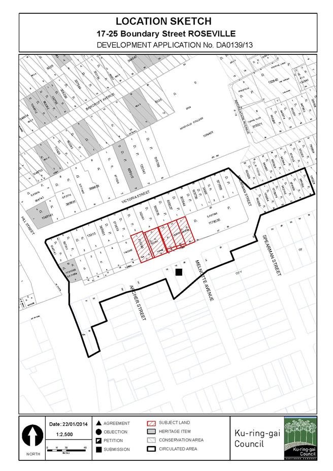
|
APPENDIX No: 2 - Zoning
extract
|
|
Item No: GB.8
|
|
APPENDIX No: 3 - Architectural
plans
|
|
Item No: GB.8
|
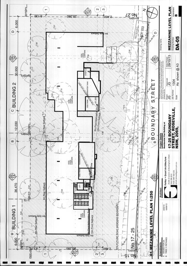
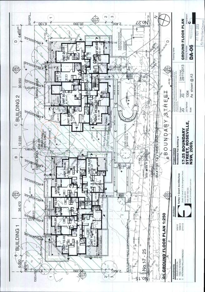
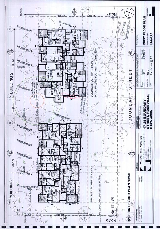
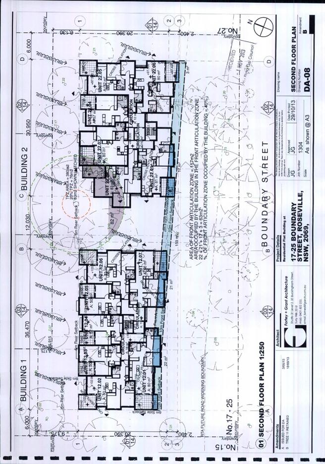
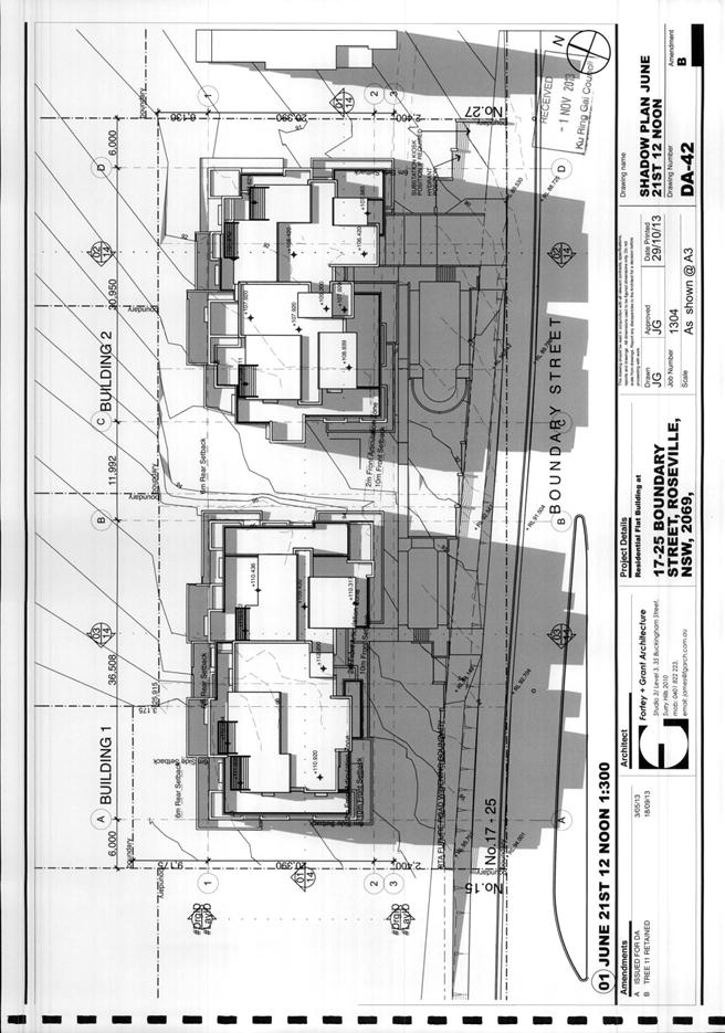
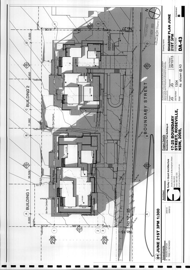
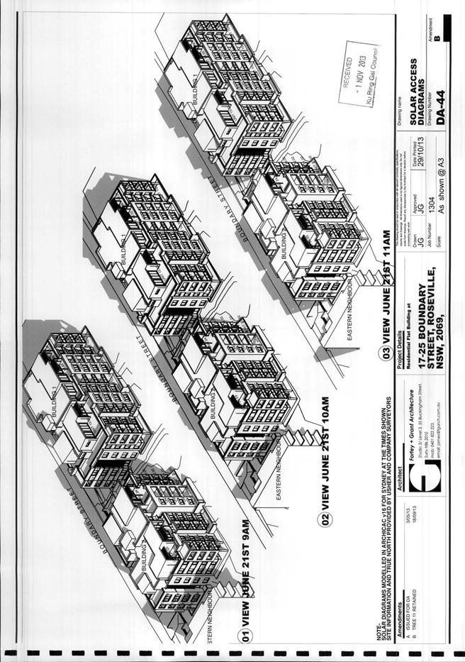
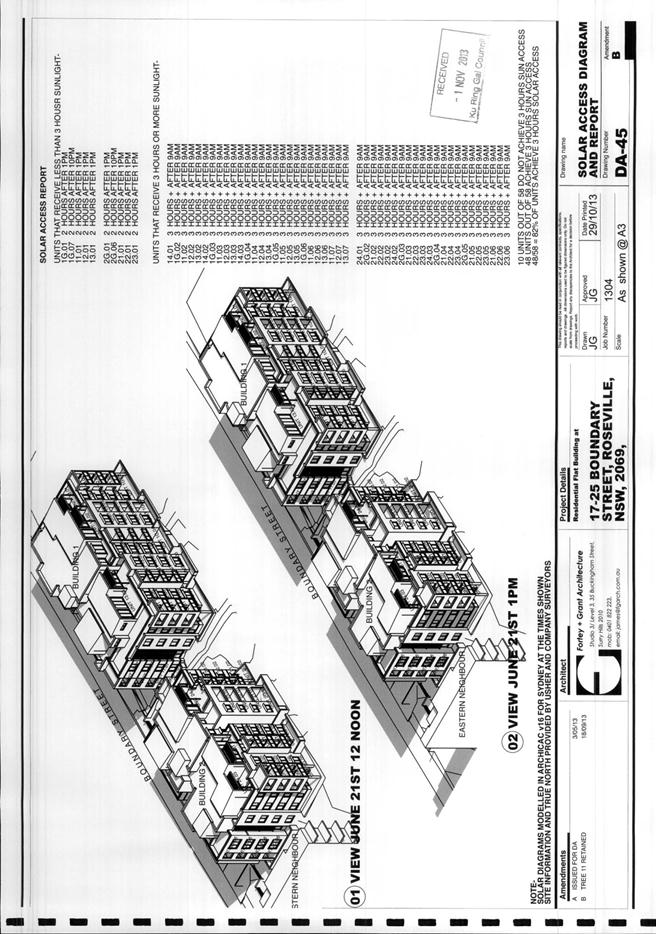
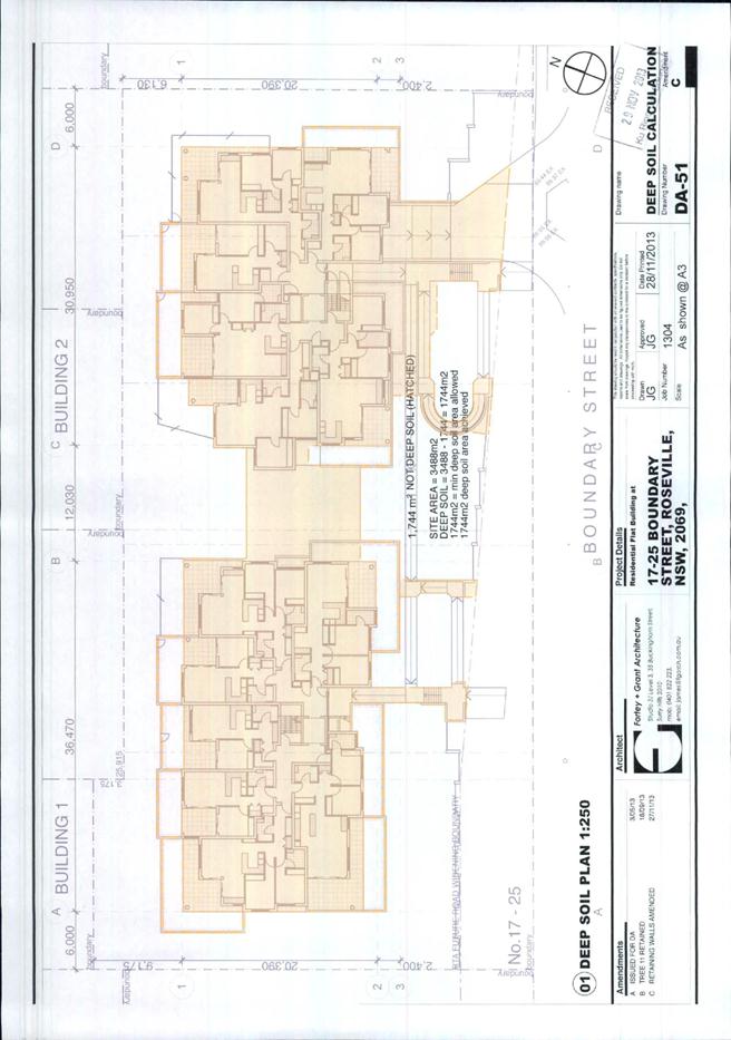
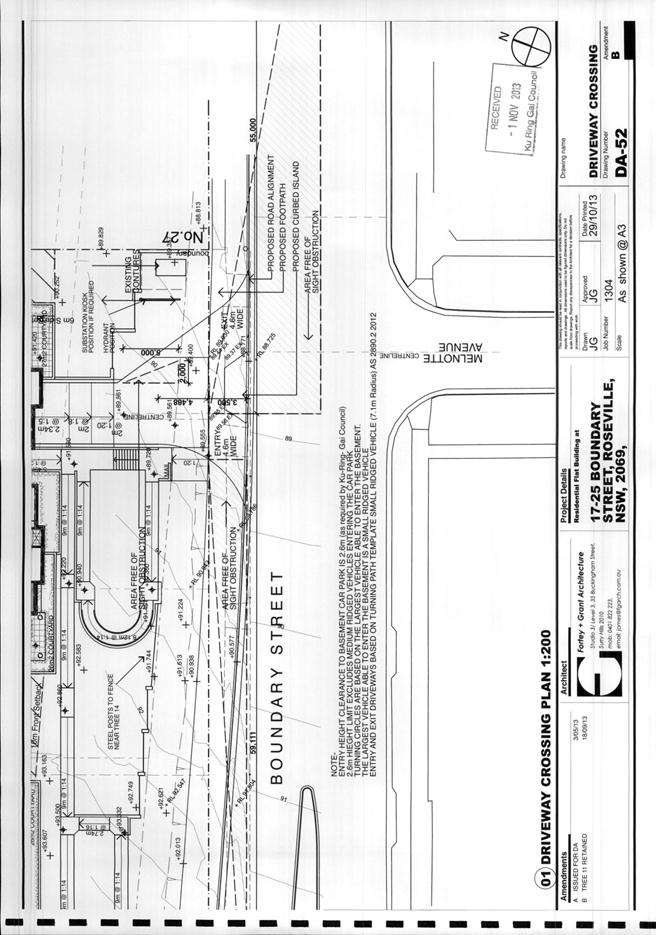
|
APPENDIX No: 4 - Landscape
plans
|
|
Item No: GB.8
|
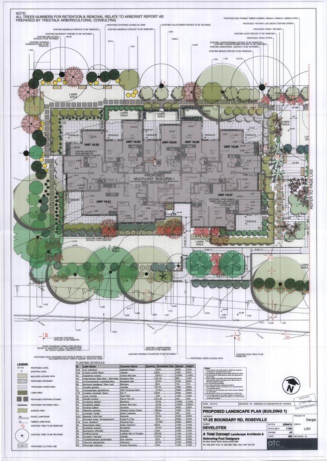
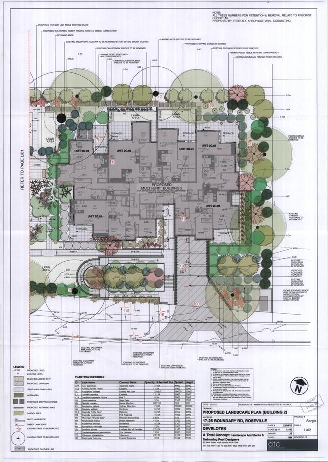
|
Ordinary
Meeting of Council - 4 February 2014
|
GB.9 / 219
|
|
|
|
|
Item
GB.9
|
DA0376/13
|
|
|
8 January 2014
|
Summary
Sheet
|
Report title:
|
12 Wellesley
Road Pymble - Removal of tree (Californian Redwood) in front setback
(Heritage Conservation Area)
|
|
ITEM/AGENDA
NO:
|
GB.9
|
|
Application No:
|
DA0376/13
|
|
Property Details:
|
12 Wellesley Road Pymble
Lot & DP No: Lot 4 DP 14093
Site area (m2): 929.5m2
Zoning: R2 Low Density Residential
|
|
Ward:
|
St Ives
|
|
Proposal/Purpose:
|
Removal of tree (Californian Redwood) in front setback
(Heritage Conservation Area)
|
|
Type of Consent:
|
Local
|
|
Applicant:
|
Mr Anthony Everall
|
|
Owner:
|
Mr Anthony & Mrs Philippa Everall
|
|
Date Lodged:
|
30 September 2013
|
|
Recommendation:
|
Refusal
|
Purpose of Report
To determine Development Application No 376/13, which
proposes removal of a Sequoia sempervirens (Californian Redwood) within
the front setback of No. 12 Wellesley Road, Pymble. The site is located within
a Heritage Conservation Area.
This matter has been called to full Council for
determination by Councillor Ossip.
Executive Summary
|
Issues:
|
Tree removal, Heritage Conservation
|
|
|
|
Submissions:
|
Four (4) submissions received from three (3) persons
|
|
|
|
Land and Environment Court:
|
N/A
|
|
|
|
Recommendation:
|
Refusal
|
History
Site history
Tree works history:
· 7 August 2012 – An application
(RMTR13/01938) pursuant to Council’s Tree Preservation Order to remove the
subject tree was lodged with Council.
· 10 October 2012 - The applicant was
asked to provide an arborist’s report and engineer’s report concerning the
subject tree.
· 8 November 2012 - A botanist’s report,
engineer’s report and a petition containing 24 signatures were received by
Council.
· 3 December 2012 - The application for
tree removal was refused by Council under delegated authority for the following
reasons:
o The tree is visually significant
in the local area and provides a positive landscape element to the streetscape.
o There are reasonable alternatives
to manage the issues raised without removing the tree.
o Council’s Tree Management Policy
requires that tree works decisions have a focus on retaining and protecting
trees unless there is strong justification for removal and in this instance the
decision to refuse removal is consistent with the outcomes of that Policy.
· 5 April 2013 – Council received a
request to review the refusal of the tree works application, pursuant to
section 82A(7) of the Environmental Planning and Assessment Act 1979.
· 3 May 2013 – Councillor Ossip
presented a notice of motion that a report of the review be presented to full
Council for determination.
· 14 May 2013 – The motion was
considered at an Ordinary Council meeting. The motion was lost when put to the
vote (three for and six against). No decision concerning the review was made at
the Council meeting.
· 21 May 2013 – A report by an
independent arborist engaged by Council, was received by Council’s Tree
Management Officer (refer to Attachment 1).
· 28 May 2013 – Council refused the
section 82A(7) review application under delegated authority for the following
reasons:
o The tree is visually significant
in the local area and provides a positive landscape element to the streetscape.
o Council determines that the
boundary fence and the damaged section of the driveway adjacent to the tree are
not classified as major structures and there are options available to manage
these issues as outlined in the report by Waddington Consulting and Arborsaw.
o The survey results within the
report from GBG Australia (ground penetrating radar) show roots at an
established depth and spread. The report does not state that the tree is
unstable nor does it recommend removal of the tree.
o The professional interpretation of
the submitted reports, by Alex Austin, Arborsaw, concludes that the evidence
demonstrates that the tree is sufficiently anchored to withstand weather events
within the area.
Land and Environment Court history:
· 5 June 2013 – The applicant lodged a
Class One appeal against Council’s refusal of the tree works application.
· 14 June 2013 – Council received legal
advice which stated that there are no appeal rights under sections 82A or 97 of
the Environmental Planning Act 1979 in relation to the Tree Preservation Order.
· 27 June 2013 - The applicant
discontinued the appeal.
Planning history:
· 8 February 2013 - Ku-ring-gai LEP
(Local Centres) 2012 came into effect. The site was rezoned R2 Low Density
Residential under this instrument. The Tree Preservation Order no longer
applies and the removal of the tree must now be considered against Ku-ring-gai
LEP (Local Centres) 2012 and Ku-ring-gai Development Control Plan 2012.
The Site
Site description
The site is No. 12 Wellesley Road, Pymble and is legally
known as Lot 4 in DP 14093. The site is located on the north-western side of
Wellesley Road, Pymble. The site is an irregular shaped allotment with a street
frontage of 20 metres, a rear boundary of 17 metres and side boundaries of 53
metres. The site has an area of 921.6m2.
Development currently on the site comprises a part single,
part two storey dwelling house with a swimming pool and entertainment area to
the rear. Within the front setback is an attached double carport, a sandstone
front fence and a paved sandstone driveway.
The subject tree, a Sequoia sempervirens (Californian
Redwood), is located within the front setback, in the north-eastern corner of
the site.
Surrounding development
The site is situated within Heritage Conservation Area C8B -
Pymble Heights under Ku-ring-gai LEP (Local Centres) 2012. The site is also in
the vicinity of Heritage Conservation Area C9 – Fern Walk which encompasses the
south-eastern (opposite) side of Wellesley Road.
The site is surrounded by a mixture of single storey and two
storey dwelling houses.
Located opposite the site are heritage items at Nos 3 and 7
Wellesley Road, Pymble.
The Proposal
The proposal is for removal of the Sequoia sempervirens
(Calfironian Redwood) located within the front setback of the site, at the
north-eastern corner of the site.
The tree is estimated to be 20-25 metres in height. The age
of the tree is unknown but it is thought to be more than 70 years old.
The applicant has submitted the following arguments for
removal of the tree:
· The tree has caused damage to the
driveway of No. 12 Wellesley Road, the fences of Nos 12 and 14 Wellesley Road
and the water pipe in front of No. 14 Wellesley Road.
· The applicant’s botanist has advised
that the damage will increase as the tree grows.
· Construction of a raised driveway to
prevent damage to the driveway would cost more than $50,000. Construction of a
root barrier would not be feasible. There is insufficient room to rebuild the
fences on their respective sites. Reconstruction of a new sandstone driveway
would be impractical due to cost.
· The aesthetic value of the tree has
been compromised by past pruning and the presence of nearby power lines.
· The tree is more appropriate for large
spaces such as parks rather than suburban allotments.
· The visual absorption of the area is
such that removal of the tree could be accommodated without any unacceptable
changes.
· The tree is not listed as a heritage
item in its own right.
· The majority of residents in Wellesley
Road support the removal of the tree.
The applicant would replace the tree with a smaller native
tree and would provide two replacement specimens to be planted in Council’s
parks.
Consultation
Community
Council notified and advertised the application from 9 to 23
October 2013. During this period, Council received three (3) submissions from
the following:
1. Mr G.
Tabuteau and Mrs J. Tabuteau – No. 1 Wellesley Road, PYMBLE
2. Mr D.
Low – No. 14 Wellesley Road – No. 14 Wellesley Road, PYMBLE
3. Mr J.
Bialkowski – No. 11 King Edward Street, PYMBLE
The tree is significant and appears mature and healthy
The tree was assessed by an independent arborist engaged by
Council who described the tree as “mature” and “free from defects and in good
health.” The arborist also assessed the tree as having a very high
visual/aesthetic value.
The tree makes a substantial contribution to the
street, its period homes and garden settings
It is agreed that the tree makes an important contribution
to the streetscape. The location of the tree adjacent to the driveway is
evidence of place marking which was a popular theme in garden design during the
late19th and early 20th centuries.
The tree and its surrounding area lies within Heritage
Conservation Areas C8And C9
The subject tree is located within Heritage Conservation
Area C8B - Pymble Heights and is the vicinity of Heritage Conservation Area C9
- Fern Walk.
Damage attributable to the tree appears to be limited
and repairable
It is agreed that the damage attributed to the tree is minor
and/or cosmetic in nature.
Removal of the tree would be unjustifiable
Removal of the tree is not considered to be justified as it
is in good health, has a positive streetscape contribution and has only caused
minor damage.
Request that the owner of the tree reinstate the
fences to 12 and 14 Wellesley Road
This is a civil matter which does not fall under Council’s
jurisdiction.
The tree is inappropriate for a suburban environment
The tree is appropriately located on the allotment and is
adequately set back from nearby dwellings. Under the current site conditions
(soil, rainfall etc.), Council’s Landscape Officer considers that the tree will
not grow to the height it would in its native environment of California.
Potential damage by growing root system
Potential damage by a tree is not a justifiable reason to
remove a tree. Whilst it is acknowledged that the tree has caused damage to a
driveway and two fences, it is considered that these structures were built too
close to the tree. The damage to the structures is considered minor and can be
easily rectified.
Loss of the tree will not impact on the streetscape
due to the presence of other native trees
Whilst the tree is not a native tree, it makes a significant
contribution to the Wellesley Road streetscape. The upright form and distinct
foliage of the tree make it a prominent element of the streetscape when viewed
from the north-east and the south-west. The subject tree is one of several
large exotics in the locality which contribute to the character and heritage
significance of the streetscape.
Stability of the tree
The tree was assessed by an
independent arborist on behalf of Council on 30th
of April 2013. The tree was found to
be free from defects and in good health. It was given Safe Useful Life
Expectancy of 1B which means it is suitable for long term retention (more than
40 years) subject to minor remedial works.
Within Council
Council’s Senior Landscape Officer commented as follows:
Plans/reports
sighted
|
Plan/document
|
Designer
|
Drawing No.
|
Date
|
|
Environment and Heritage
Impact Assessment Report
|
Chris Betteridge
|
|
17/09/13
|
|
Botanist’s Report
|
John Ford
|
|
14/10/12
|
|
Supplementary Report
|
John Ford
|
|
26/03/12
|
Reports
prepared
A report from
John Ford, a consulting botanist, dated 14 October 2013 was submitted with the
application for removal of the tree. Two additional reports by Keen (2013) and
Austin (2013) have been reviewed in a table in the Environment and
Heritage Impact Assessment Report (pp.14, 16-17). The report by Alex Austin, an
AQF5 consulting arborist, was prepared in May 2013 on behalf of Council.
Tree
description and condition
The tree is a
mature Sequoia sempervirens (Californian Redwood) of approximately 20-25 metres
in height, diameter at breast height of 1.2 metres and is located at the
north-eastern corner of the site, on the front boundary.
The tree is
described as vigorous and healthy (Ford 14/10/12) and of good health and
condition (Austin 2013). The tree is located 18.5 metres from the subject
residence, 13 metres from the carport and 13 metres from the adjoining
residence at No. 14 Wellesley Road (Ford 14/10/12).
The subject
tree is visually prominent in the streetscape due to its location in the front
setback, mature size and distinctive pyramidal form. The tree’s canopy has been
pruned for overhead wires on its eastern side and is otherwise intact. The
subject tree is assessed as having ‘very high visual and aesthetic values’
(Austin 2013). The heritage report considers that the tree has
‘aesthetic value’ however the pruning for wires has meant that its ‘intactness
and integrity are compromised.’
Reasons for
removal
a. Unsuitability
of the species for the location
The applicant considers the tree to
be unsuitable due to its mature size and proximity to dwellings, masonry walls,
paving and overhead wires. The applicant has argued that the mature size of the
tree is not suited to a suburban situation.
The Sequoia sempervirens
(Californian Redwood) in its natural habitat along the central
and northern California coast, has recorded heights of greater than 100
metres due to the even temperature and high level of
moisture from the heavy winter rains and summer fog. Annual
precipitation varies between 640 and 3100 mm and these
trees reach maximum development on the alluvial soils. However,
as altitude, dryness, and slope increase, Redwoods are smaller in size.
http://www.na.fs.fed.us/pubs/silvics_manual/Volume_1/sequoia/sempervirens.htm.
For these reasons, Californian
Redwoods planted in Australia, where the climate and soils are far less
favourable, only attain about a third of the size that they would attain in
their native habitat, (Macoboy, 1979; Macquarie Dictionary of Trees and Shrubs
1986). References provided from European and American sources, such as
regarding trees in Britain, Ireland or California, are of little relevance
unless comparative climatic and soil conditions to the subject site prevail.
The link between the specimens in cultivation listed (2.4.3 Betteridge 2013)
and the species being unsuitable for suburban gardens is disputed as the list
does not claim to be comprehensive, as trees in private gardens are not
included and the properties that have been selected are those which are most
easily viewed, such as public parks and large gardens.
It is agreed that a tree with a
possible mature height of 30-35 metres, such as the subject tree, is a tall
tree. It is however not unusual to have both locally occurring and exotic
planted specimens such as Araucaria heterophylla (Norfolk Island Pine) and
Araucaria bidwillii (Bunya Pine), of similar size within the gardens of the
relative large suburban lots of Ku-ring-gai where the predominant Eucalyptus
saligna (Sydney Blue Gum) reach in excess of 40 metres in height. The subject
site is approximately 929m2 and the adjoining lot at No. 14
Wellesley in which a proportion of the canopy overhangs, is 1151m2.
It is evident that many of the adjoining lots of similar size, support trees of
a similar if not greater size, all of which are in similar situations in
relation to the built environment.
Conclusion: The mature height of
the tree does not make it unsuitable for the location.
b. Damage
to driveway and front fence
A section of
masonry front fence, approximately 1.5m in length has been pushed out of
vertical alignment by the roots of the subject tree. A similar length of front
fence of the adjoining property (No. 14 Wellesley Road) has also been moved.
The driveway edging that is located against the trunk of the tree is being
pushed out by the base of the trunk and there is evidence of cracking in the
pavement within approximately 3 metres of the tree.
The house,
constructed c.1929, had a single garage and an original single sandstone
crazy-paved driveway. A broad garden bed approximately 2-3 metres in width was
situated along the northern boundary of the front setback. The subject tree was
planted within this garden bed in the north-eastern corner of the site,
approximately 2 metres from the driveway. It is unknown if the front sandstone
wall is original. The driveway paving and stepped drystone retaining wall were
consistent with the pedestrian path to the front porch and associated drystone
terracing.
In 1982, a
double carport was constructed in front of the garage and the single driveway
was widened between the house and the street to approximately 4.5 metres. This
would have required the driveway pavement and the northern pier of the front
fence to be constructed in close proximity to the trunk of the subject tree.
The paving laid for the widening can be seen on site to be of less substantial
construction. The structural integrity of the footings of both sections of
front fence in the vicinity of the tree is unknown, however it can be assumed
that in 1982 the northern pier was constructed within the structural root zone
of the subject tree. As the widened driveway was laid over the structural root zone
of a tree, it is likely that over time there would have been movement caused by
the structural roots. Similarly, it is likely in this situation in relation to
the tree that there would be some movement in the alignment of the front fence.
Clause 13.3(1) of Ku-ring-gai DCP (Local Centres) refers to
the Tree Assessment Guidelines for Private Lands. These guidelines include
criteria that are not considered as justification for tree removal where there
are feasible alternatives to mitigate or solve problems and retain the tree,
and the tree is significant. The criteria include:
· minor lifting of driveways, paths and paving
· minor damage to roof structures, outbuildings, gardens
structures and walls, and
· damage to underground services (such as sewer lines, water
services and the like)
The alternatives suggested by Ford include a suspended slab
or a root barrier. Neither methods would be feasible, the suspended slab due to
existing levels and the root barrier due to the mature age of the tree and associated
root plate.
A reasonable alternative would be to reduce the width of
the driveway and enlarge the garden bed by removing the paving in close
proximity to the trunk of the tree. The driveway crossing width of
approximately 4.5 metres exceeds Council maximum of 3.5 metres. The paving
should be relaid in accordance with the arborist’s recommendations (Austin
2013). The front fence construction on the northern side of the driveway should
be modified to be of more flexible construction (i.e. pier rather than strip
footings). The water pipe should be relocated in accordance with the arborist’s
recommendations.
The damage to the driveway and
front fence are not considered to be valid justification for the removal of the
tree.
c. Public
safety risk and the likelihood of failure - Safe Useful Life Expectancy (SULE)
categories (after Barrell 1995)
The tree has
been given a SULE of 1B (Austin 2013). Category 1 is a safe useful life
expectancy applied to trees ‘that appeared to be retainable at the time of
assessment for over 40 years with an acceptable degree of risk, assuming
reasonable maintenance’. 1B can be further defined as ‘trees which could be
made suitable for long-term retention by remedial care’. Evidence to
substantiate the claims that the tree is unstable has not been provided (Austin
2013).
The tree has a safe useful
life expectancy of over 40 years and is therefore not considered a public
safety risk.
Effect of
the proposed tree removal on the heritage significance of the area including
the associated setting
A heritage
conservation area is defined as a mapped area of land of heritage
significance and includes buildings, works, archaeological sites, trees and
places, situated on or within that land. The proposed removal of this
mature tree located within a heritage conservation area is not considered by
Council to be works of a minor nature and therefore requires development
consent under Clause 5.10 KLEP (Local Centres) 2013.
The principle heritage objective is
‘to conserve the heritage significance of heritage items and heritage conservation
areas, including associated fabric, settings
and views’
(Clause 5.10, (1)(b) KLEP (Local Centres) 2013. As fabric refers to all
the physical material of the place, the impact on the significance of
the setting and the views should be included when considering the loss of the
tree (The Burra Charter).
The setting is
defined as the visual catchment of an area. Council objectives identify
the importance of setting, ‘to ensure streetscape within the HCAs are
characterised by front gardens with substantial landscaped area and minimum
hard surfaces’ (Objective 16, Part 7.4 Ku-ring-gai Local Centres Development
Control Plan 2013). To achieve this setting ,‘gardens, garden structures,
landscaping and vegetation that contribute to the significance of the HCAs, are
to be conserved.’
The significance of the Pymble
Heights Heritage Conservation Area (HCA8B) is described as the largely intact
streetscapes of Federation to Inter-war housing (7.7.13 Ku-ring-gai Local
Centres DCP (2013). The term “streetscape” overwhelmingly refers to individual
houses in garden settings on individual lots (p 9, Paul Davies 2010). These
streetscapes are unique as opposed to those of HCAs in many other areas of
Sydney due to the substantial front setbacks and generous garden settings. The
consistent siting of buildings to preserve the large setbacks for generous
front gardens is an important part of the HCA (Controls 14-19, 7.4 Ku-ring-gai
Local Centres DCP (2013).
Effect of
the proposed tree removal on the heritage significance of the area including
the associated views
Significant views of prominent
houses and gardens, and in particular trees, are also to be retained in an HCA(
Objective 4, 7.4 Ku-ring-gai Local Centres DCP (2013).
It is
recognised in the heritage report submitted with the application that
‘unrestricted views of the subject tree from the public domain’ are available
and that it is ‘a prominent landscape element in its part of Wellesley Road’
(2.6 Betteridge 2013). It has also been described as ‘visible from a considerable
distance and against the skyline’ as being an ‘excellent representation of
species’ and ‘a significant contribution to the visual contribution of the area
(Austin 2013)’.
The subject
tree is visually prominent in the streetscape due to it’s location in the front
setback, mature size and distinctive pyramidal form. Its height and form are
typical of the period of inter-war gardens, where tall evergreen trees were
used as specimen plantings within the large front setbacks of suburban blocks
to signify site entries such as driveways and to enframe the residence when
viewed from the street. The subject tree is assessed as having ‘very
high visual and aesthetic values’ (Austin 2013).
The distinct
visual form and focal location of the tree when approaching the subject site
along Wellesley Road from either direction, makes the tree an important part of
the existing views of the HCA. Its removal will adversely impact the heritage
significance of the area including the setting and views.
Mitigation works
- replacement planting
It is not
proposed to replace the subject tree with a tree of the same species. To
mitigate the loss the removal of the tree, a smaller replacement tree species
is proposed on the site. Up to two (2) additional trees of the same species are
proposed to be planted in other locations, such as public parks, however these
would not be within the subject HCA.
The subject
tree is historically significant as the mid-20th century planting
date relates specifically to the inter-war period of the heritage conservation
area. The proposal does not conserve the scale and horticultural style of
garden and streetscape plantings within the heritage conservation area.
Conclusion
The removal of
the subject tree is therefore not supported.
Council’s consultant Heritage Adviser, Robyn Conroy,
commented as follows:
Heritage
status
The property is
within the Pymble Heights Conservation Area C8B listed under Ku-ring-gai Local
Environmental Plan (Local Centres) 2012 and is in the vicinity of the Fern Walk
Conservation Area (C9) and two individually listed heritage items at Nos 3 and
7 Wellesley Road (listed under the KPSO). The existing property is understood
to have been established in 1929, which is within the key period of
significance for the Conservation Area (late 19th Century to WWII).
Both the house and garden demonstrate heritage values consistent with those of
the Heritage Conservation Area and the property has been assessed as making a
positive contribution to the heritage significance of the conservation area.
The tree
provides evidence of the ongoing theme of place-marking that characterised the
suburbanisation of Ku-ring-gai, with owners seeking exotic plantings and garden
features to distinguish their properties. In this regard, the tree also
provides evidence of the embrace of all things American that can be seen
throughout Ku-ring-gai in the inter-war period, which included movie culture,
architecture and landscapes. The Sydney Morning Herald carried articles
regularly about the impressive and unique qualities of the Californian Redwood
during this period and it is possible that its localised popularity in the
precinct was a result of this (Sydney Morning Herald: accessed via the National
Library of Australia’s Trove collection).
Under the
provisions of the Ku-ring-gai LEP (Local Centres), the removal of a tree in a
heritage conservation area is a form of demolition and development consent is
required. The heritage provisions of the KPSO also include matters that must be
considered when development is proposed in the vicinity of a heritage item or
heritage conservation area (this is relevant to the development being in the
vicinity of the Fern Walk Conservation Area and two heritage items).
Information
submitted with the application included a Heritage Impact Assessment by Chris
Betteridge (MUSEscape Pty Ltd) (2013), Botanical Assessment by John Ford
(botanist) (2012 and 2013), and Sam Keen (2013), root survey by GBG Australia
(2013), proposed remedial works by Waddington Consulting Pty Ltd (2013) and a
petition signed by local residents supporting the removal of the tree.
Other
information available included a report by consultant arborist for Ku-ring-gai
Council, Alex Austin (2013) and advice from Stuart Read, the NSW Heritage
Branch’s (currently known as the Heritage Division of the Office of Environment
and Heritage) Specialist Landscape Heritage Officer.
Background
The property on
which the tree was planted was created as part of the subdivision of the Pymble
Heights Estate in the early 20th Century.
The site is approximately 930m2, with the house set toward the
middle of the block and surrounded by a very well-tended and maturing garden
that includes many of the plantings typical of the area such as camellia
japonica and azaleas.
The streetscape
is characterised by its large (c900-1000m2) lots, substantial houses
and mature gardens. It falls gradually from south-west to north-east.
The subject
tree is located in the north-eastern corner of the site adjacent to the
boundary with No. 14 Wellesley Road. It has been assessed by both Ford and
Austin as a good and healthy example of the species known commonly as the
Californian Redwood. The height of the tree has been estimated as approximately
20-25 metres at present, with a trunk diameter of 1.2 metres measured at breast
height, and it’s condition has been assessed as sound, being in mid-life
(according to the life expectancy of the species in cultivation in Australian
soils and climate). With the exception of the lower branches on the street side
which have been trimmed to accommodate street power lines, the tree has a good
quality and distinctive conical form. It is located 18.5 metres from the
dwelling on the site and 13 metres from the dwelling on the adjoining property
No. 14 Wellesley Street. It is also 13 metres from the carport between the two
dwellings. The root analysis (via ground penetrating radar) reveals that roots
(potentially those of this tree) extend under much of the driveway area and
this is evidenced by lifting of the sandstone paving in places.
The tree’s
height, distinctive conical form and location close to the public domain mean
that it plays an important role in the local streetscape, rising well above the
skyline and providing the most prominent element in views from both directions
along Wellesley Road.
The gardens in
the vicinity of the property (Wellesley Road and Mocatta Avenue) are all
substantial in scale and mature in character and many include large exotic
coniferous and Cedar trees. These trees form an aesthetically cohesive and
distinctive layer that plays an important role in unifying and characterising
the local streetscape in the vicinity of the property. One appears from site
inspection to also be a Redwood, a preliminary identification agreed with by
Chris Betteridge in his HIS. This is discussed further below.
The base of the
tree sits in a narrow garden bed that defines the edge of the driveway. The
driveway is wide and has been paved in random-laid sandstone flagging commonly
known as ‘crazy paving’. The pattern of paving reveals that the driveway was
originally narrower and the garden bed wider than it is now. Lifting of the
paving slabs is evident on the driveway near the tree. A modest,
well-proportioned sandstone stone wall has been built on the street boundary to
No. 12 Wellesley Road, Pymble and a low brick wall to No. 14 Wellesley Road,
Pymble. Both fences have been displaced by the growth of the trunk and are now
well off vertical alignment, to the point where they are in danger of toppling
over.
Issues
The removal of
a tree within a heritage conservation area is defined in the LEP as demolition:
demolish,
in relation to a heritage item or an Aboriginal object, or a building, work,
relic or tree within a heritage conservation area, means wholly or partly
destroy, dismantle or deface the heritage item, Aboriginal object or building,
work, relic or tree. (KLEP (Local Centres) 2012).
Under the
provisions of the LEP, development consent is required for the demolition of a
tree in a heritage conservation area, and the following objectives must be
applied to the consideration of the application:
(1) The objectives of this clause are as follows:
(a) to conserve the environmental heritage of Ku-ring-gai,
(b) to conserve the heritage significance of heritage items and
heritage conservation areas, including associated fabric, settings and views,
(c) to conserve archaeological sites,
(d) to
conserve Aboriginal objects and Aboriginal places of heritage significance.
(5.10.1)
Subclause
5.10.4 states:
The consent
authority must, before granting consent under this clause in respect of a
heritage item or heritage conservation area, consider the effect of the
proposed development on the heritage significance of the item or area
concerned. This subclause applies regardless of whether a heritage management
document is prepared under subclause (5) or a heritage conservation management
plan is submitted under subclause (6).
A heritage
management document (the Heritage Impact Assessment prepared by MUSEscape Pty
Ltd) has been submitted in support of the application. Several of the arguments
it presents will be discussed in more detail below.
Development
Control Plan
The Local
Centres DCP also provides controls and requirements that are to be addressed in
the proposed demolition. See below for a more detailed assessment of the
proposed development against the requirements of the DCP.
Matters raised
in the HIS
The argument in
the HIS (which is supported by the applicant’s other reports) for removal of
the tree can be summarised as responding to three main issues: it is an
unsuitable species for the location; the damage it has caused/will cause to the
front fences and driveway paving; and risks to public safety.
The HIS and
arborist reports prepared in support of the application place an emphasis on
the unsuitability of this species for standard suburban lots. It should be
noted however that the subject lot is part of a traditional, early 20th Century ‘quarter acre’ subdivision,
whereas the references cited in support of the argument that the tree should
not be planted in residential subdivisions were published in recent years in
the USA, where, like in Australia, the standard lot size has shrunk to less
than half that of the subject site. It is not disputed that the tree is not
suitable for a contemporary residential subdivision of 400-500m2
standard, particularly if planted in its native soils and climate of the west
coast of the USA, but the subject site is approximately 930m2 and is
quite capable, both physically and aesthetically, of supporting a large tree.
This generous
lot size and the scale of front gardens throughout the precinct (including both
heritage conservation areas) means that the subject tree sits comfortably
within the streetscape. The tree does not crowd the site, obstruct important
views or read as being out of scale in the streetscape. It can be argued that
the tree provides an aesthetically satisfying counterbalance to the
horizontality of the house in views over the site and is an important element
in local streetscape views; and if not present there would be a loss in the
aesthetic qualities of these views due to a lack of vertical or softening
elements in the viewscape (see photos below).
It is not
disputed that the Californian Redwood is a tall-growing species but it needs to
be considered in the context of other trees endemic to the Ku-ring-gai area
such as the Eucalyptus saligna (Sydney Blue Gum), which commonly reaches
heights of at least 40 metres; as well as the trees that were planted commonly
as ‘marker’ trees (i.e. specifically for their tall-growing habit) in the 19th Century throughout Sydney, the Araucaria
Bidwillii (Bunya Pine) and Araucaria Cunninghamii (Hoop Pine) which can grow to
even greater heights in Australian gardens. The Redwood is tall, but not
significantly taller than other trees in the vicinity, and even if it was to
reach the 30-40 metres which is cited as the tallest height likely to be
reached by the species in cultivation (and in favourable climatic conditions
and soils), the tree would still not be out of scale with or unduly prominent
in the views along the streetscape of Wellesley Road. It would however read as
a local ‘marker’ tree, which was likely to have been the intention when planted
originally. That the public was made aware of the species and its majestic
qualities in its native California is revealed by the wondering tone of the
many articles in media such as the Sydney Morning Herald in the inter-War and
early post-War eras.
Further, its
suitability for cool, mountain climates rather than the coastal plains does not
negate the validity of the subject tree as part of the streetscape of the heritage
conservation area. It does however suggest that the tree may not reach even the
heights that are nominated as being expected in the Australian context.
The suggestion
in the reports that Californian Redwoods are found primarily in parks and
publicly accessible gardens is perhaps more actually an indication of the scope
of most arboreal surveys. These have traditionally focused on documenting
public parks and gardens (and the significant/publically accessible gardens of
stately Victorian homes) rather than trees in the more recent ‘ordinary’
private suburban landscape.
The gardens of
Ku-ring-gai are notable for their plantings of exotic and specimen trees, and
the subject tree is an excellent example of the genre.
The HIS
includes an assessment of the heritage value of the tree as an individual
specimen, i.e. using the NSW Heritage Council’s criteria to assess whether the
tree has inherent heritage values that would justify its listing as a heritage
item, which it concludes that it does not. This conclusion is of little
relevance to the subject application because the issue of concern is not
whether the tree should be listed as a heritage item or not, rather, its role
as part of the heritage conservation area. For example, the argument that the
significance of the tree has been diminished because it has been trimmed to
allow clearance for the power lines may have the potential to carry more weight
if the tree was being considered for possible listing as a separate heritage
item for its horticultural value but is of lower import when its contribution
to the streetscapes of the heritage conservation areas is the issue being
considered. Like most of the large trees throughout Ku-ring-gai that are
located on the same side of the street as overhead power lines, the lower
branches have been cut back by utility authorities to achieve statutory
clearances. Once again, this does not negate the heritage value of the tree,
although of course the streetscape presentation would be more complete were the
tree to be untrimmed. This could be said of all trees on nature strips and in
private gardens in proximity to power lines throughout the LGA and is not an
argument for its removal. The impact of the trimming on streetscape views will
not worsen: the tree grows from its tip and the existing bare area will remain
roughly where it is now and will not require further trimming.
Similarly, the
presence of power lines, whilst unfortunate, is a feature of most streets in
Ku-ring-gai and is not sufficient justification to argue that the quality of
views in the vicinity of the tree are diminished because the lines are visible.
The assessment
does not explore in any detail the contribution that the tree makes to the
heritage values and significance of the streetscape as part of the heritage
conservation area; nor of its contribution to the heritage significance and in
particular the setting of the adjacent Fern Walk Conservation Area and the
nearby heritage items (two of which are almost opposite the subject site).
These areas and items are joined by, and are described by, the streetscape
qualities of Wellesley Street, qualities that are expressed to a large part by
the gardens and settings of the individual houses.
In particular,
although the report identifies some of the other similar trees in the immediate
vicinity it does not identify the group (i.e. collective) value of the
prevalence of coniferous species in streetscapes of Wellesley Road and Mocatta
Avenue. Grouping of similar forms, whether trees or houses, plays an important
role in establishing and maintaining the aesthetic (and historic) character of
a precinct and the loss of individual elements has the potential to have an
adverse impact on this heritage value. If one of these trees is removed for the
reasons proposed it is reasonable to predict that applications to remove other
coniferous trees in the area would follow and much of the essential character
of this precinct would be eroded.
In the case of
the subject tree, site inspection revealed that there is another tree which is
also likely to be a Redwood and is of a similar age and stage in the group.
This tree is growing in the north-western corner of the garden of No. 7
Wellesley Road, Pymble (which is the Heritage Item diagonally opposite the
subject site). If so, this may be a very rare pair of Redwoods planted in the
private domain (no other similar groups are known to the author, and discussion
with Stuart Read, the NSW Heritage Branch’s (currently known as the Heritage
Division of the Office of Environment and Heritage) Specialist Landscape
Heritage Officer confirmed that this may indeed be the case.
The tree is
particularly prominent in views when travelling south along Wellesley Road.
These views cannot be assumed to be short in duration and therefore of
negligible contributory value as is suggested in the report. The area is
suburban and travel speeds are slow, including a high proportion of pedestrians
and people walking to enjoy the qualities of the streetscapes in the heritage
conservation area.
With regard to
the damage to property caused by the tree, that to the fence is appreciable,
and the need to demolish this part of the wall (to both Nos 12 and 14 Wellesley
Road, Pymble) agreed. Given this, it is noted that the tree trunk forms an
effective marker of the edge of the property and that it may not be necessary
or even appropriate to re-build a masonry wall in this position. Both the wall
and the tree contribute to the aesthetic qualities of the streetscape but the
tree plays a more prominent role. A more appropriate option would be to allow
the tree itself to mark the boundary, and if necessary, infill the area at the
base with shade tolerant planting.
The lifting of
paving on the driveway is also noted but the damage appears to be worst in the
part of the driveway that was created by infilling much of the garden bed
within which the tree had been planted when the carport was built. Crazy paving
is created by the fitting together of separate slabs of stone of irregular form
and variable size and is readily capable of being repaired or altered by
re-laying stone (including the lifted slabs, even if cracked) in the same
pattern. Part of this additional paved area near the street frontage could
potentially be removed to reinstate the garden (i.e. permeable zone) beside the
driveway where the roots could access water readily without adverse impact on
the aesthetic qualities of the property. Active manipulation of the root zone
(e.g. cutting roots/installing root barriers) would not be likely to be successful
and could destabilise the tree.
The damage to
the underground services attributed to the tree is unfortunate but is commonly
found throughout any area where trees are planted close to services and any
replacement tree in this part of the site or nature strip would potentially
cause similar problems. Given that the lowest branches on the street side have
already been cut to provide clearance for power lines, undergrounding them (as
suggested in the HIS) will not make any significant difference.
Significant
weather events have occurred in the area, including the major storm that
damaged and destroyed densely planted areas of trees (ie relatively sheltered
by trees of similar height) as well as individual specimens; and even the most
recent mini-tornado in the Hornsby area. All trees are vulnerable to strong
winds, regardless of species. Any replacement tree that is capable of replacing
the streetscape qualities of the existing would potentially be at similar risk.
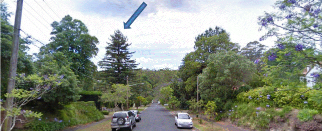
Figure 1: View to the north-east along Wellesley Road. The
subject tree is a prominent element, with the delicate tracery of its branches
clearly defined against the skyline (blue arrow). The tree to its left is now
in very poor condition and has lost most of its foliage. (Image Google Earth
2009)
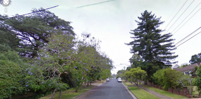
Figure 2: The tree is also prominent in streetscape views
towards the south-west, with the branches clear against the sky and minimal
background vegetation present that would otherwise soften the view. The loss of
the tree would leave views over the western side of Wellesley Street noticeably
less well vegetated. (Image Google Earth 2009)
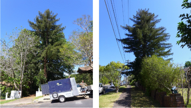
Figure 3: The ‘pair’ of Redwoods
at No. 7 Wellesley Road, Pymble (left) and No. 12 Wellesley Road, Pymble
(right) are of similar size, form, maturity and planted position, each being at
the front corner of their property close to the northern boundary. This
suggests co-ordinated, or at least copied planting between the owners of the
two properties.
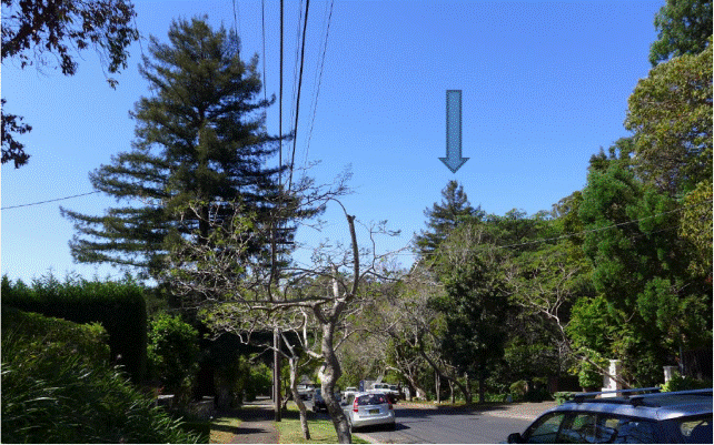
Figure 4: The other Redwood is
planted at the front corner of No. 7 Wellesley Road, Pymble, near the driveway
leading to No. 9 Wellesley Road, Pymble.
Figure 5: The subject tree also
forms one of a group of exotics with distinctive forms and dark foliage that
contrast with the other plantings in the area. These include the other Redwood,
other coniferous species and the Deodaras (Himilayan Cedars). (Image Google
Earth 2009)
Figure 6: The entrance to the
driveway is close to the base of the tree. This image shows clearly the
original (left) and widened (right) sections of the driveway. The area that has
been widened was originally a garden area which provided generous room for the
growth of the trunk. Its covering by pavement has potentially encouraged root
spread. The houses are set well back from the front boundary and their setting
is not overwhelmed by the presence of the tree. (Image Google Earth 2009)
Figures 7 and 8: The subject
tree and detail showing its proximity to the property boundary as well as
damage that has occurred because the wall and paving have been placed too close
to the base of the tree and inadequate area allowed for its growth. The
required space could be achieved readily by removing the damaged paving (i.e.
reinstating the original garden bed over part of the driveway) and by allowing
the tree, rather than the fence, to mark the front corner of the property.
The tree is approximately 75% of
the size that the species is likely to achieve in favourable soils, climate
(cool and wet) and situation (in a valley) in cultivation in Australia.
Although it is still growing, it is debatable whether this example will reach
the height it would if growing in optimum conditions.
The question of ‘acceptable
change’
The HIS concludes that the removal
of the tree will change the aesthetic qualities of the streetscape but that
this change will be acceptable in the context of the streetscape qualities of
the precinct and the other matters that were raised in the report.
Council has resolved to protect and
conserve the heritage significance of the recently gazetted heritage
conservation areas and this commitment includes the retention of the quality
and variety of substantial trees that create the unique canopies of
Ku-ring-gai’s conservation areas.
When considering the impact of a
proposed development in a heritage conservation area, however, it is necessary
that the proposal be considered not only in terms of its implications for the
owners of the subject site but also on the impact that the development may have
on the heritage significance of the area.
One of the defining characteristics
of a heritage conservation area is its size and in particular the way that it
includes many (usually dozens, sometimes up to thousands) of separate
properties, each with structures and in most instances in the suburban context,
gardens. Although it is often argued that one element on one property in a heritage
conservation area can be changed and the remainder of the area is not affected,
this is rarely the case, particularly when the element is a visually prominent
component of the streetscape; as well as being a potentially rare example of an
even rarer group.
It is agreed that the removal of
the tree will change the aesthetic qualities of the streetscape but after
consideration of the submitted reports and my additional research, I am of the
opinion that this change will have a significant adverse impact on the
streetscape qualities of the precinct and therefore the heritage values of the
heritage conservation areas and nearby heritage items, for the following
reasons:
· The tree is a good example of a
cultivated variety of the species in the context of a siting, soil, and climate
that is notably different to its native habitat. Its growth rate, form and
expected life expectancy have all been modified by these factors and it is not
considered to be, or have the potential to grow to be, an inappropriate species
for a lot of this size and scale.
· The tree is well-sited on its
property, which is large and aesthetically capable of including a large tree
without crowding, dominating or obscuring views of the house.
· Examples of this tree in Sydney
are understood to be rare, with few documented in the private domain. Such a
prominent and healthy example should be retained if at all possible. This is a
requirement of Council’s adopted DCP.
· The subject tree appears to be
part of a group planting that included at least one other of this species in
the immediate vicinity. This is the only occurrence of this known to the
author, or in NSW.
· The planting of the Californian
Redwood in the first half of the 20th Century (the likely date)
provides rare surviving botanical evidence of the contemporary fashion for
American culture (including buildings, gardens and lifestyle) that is part of
the historic theme of Americana that was prominent in Ku-ring-gai in the
Inter-War and early post-War periods. That the house is not of Spanish Mission
or similar style does not negate this contributory value, since it is possible
(based on the aerial photos submitted with the application) that the tree was
planted at least 15 years after the house was constructed.
· The tree is a prominent element
in streetscape views, particularly when viewed from the north (along Wellesley
Road), where it rises well above the prevailing skyline and its characteristic
conical shape with delicate tracery is notable.
· The subject tree is one half of a
‘paired’ planting with a matching specimen in the garden of the heritage item
of No. 7 Wellesley Road. It’s removal will have an adverse impact on the
heritage values of this item and its setting and on the framing of streetscape
views between the two trees.
· The tree also forms part of a
group of similar ‘statement’ trees with distinctive exotic forms and
dark-foliaged with delicate tracery that characterise the streetscape in this
part of the precinct (Wellesley Road and Mocatta Avenue). Its removal will
erode the integrity of this group.
Conclusion and recommendation
The existing tree should be
retained because its removal would have an adverse impact on the aesthetic and
historic values of the Pymble Heights Conservation Area, the Fern Walk
Conservation Area and the heritage significance of the two heritage items in
the immediate vicinity of the site, including the significance of the garden of
No. 7 Wellesley Road and the quality of the setting of both items and areas.
Approval would therefore be contrary to the Ku-ring-gai LEP (Local Centres)
2012 and Ku-ring-gai DCP; which require that gardens, garden structures,
landscaping and vegetation that contribute to the significance of heritage
conservation area(s) are to be conserved.
Although it is only one element in
the context of the wider heritage conservation area, the subject tree is one of
the most visually prominent features of the streetscape views along this part
of Wellesley Road. Wellesley Road forms the boundary between the Pymble Heights
and Fern Walk Conservation Areas. It is also a prominent element in the
setting of the nearby heritage items at Nos. 3 and 7 Wellesley Road, which are
situated in close proximity to the subject tree. The tree also reads as a
paired planting with another located in the same (front northern corner)
position in the garden of No. 7 Wellesley Road. The presence of a paired
planting of Redwoods in private gardens is potentially rare.
The growth of the tree has damaged
the fence and driveway because the structures are located too close to its
trunk. The diameter of the trunk (and the maximum diameter likely in
cultivation on unfavourable soils, aspect and climate) is not extraordinary in
the context of the historic cultural landscape of Ku-ring-gai, which is
renowned for its majestic trees and similar space would be required for any
replacement species of appropriate scale and form.
Space for continued growth could be
achieved readily by removing the damaged paving (i.e. by narrowing the driveway
width near the front of the property (whilst retaining the area in front of the
carport), allowing the original wide garden bed to be reinstated.
The tree and other plantings,
rather than constructed fences, could mark the north-eastern corner of the
property effectively. The low wall to the adjoining property (No. 14 Wellesley
Road, Pymble) is less directly affected and could be reconstructed using piers
rather than strip footings, and/or with the wall commencing clear of the
maximum expected diameter and an infill planting placed in the gap.
All trees in the vicinity of
service lines have the potential to affect lines and infrastructure and council
and authorities have guidelines for the management of the interface. The
subject tree is no different in this regard to all other substantial trees in
the LGA.
The contributory heritage values of
the existing tree could not be replaced by new planting unless it is an
equivalent to the existing tree, and such a replacement would raise similar
issues to the existing with regard to the need to remove the fence, amend the
configuration of the driveway and maintain (and potentially repair) services.
Replacement by smaller scaled and
native vegetation (as proposed in the DA) would not be appropriate in the
context of this streetscape.
Statutory Provisions
Environmental Planning and Assessment Act 1979
This application is deemed to be ‘Local Development’ under
Part 4 of the EP and A Act, 1979 and requires development consent pursuant to
the KLEP (Local Centres) 2012.
State Environmental Planning Policy No. 55 – Remediation
of Land
The provisions of SEPP55 require Council to consider the
potential for a site to be contaminated. The subject site has a history of
residential use and as such, it is unlikely to contain any contamination.
Further investigation is not warranted in this case.
Sydney Regional Environmental Planning Policy (Sydney
Harbour Catchment) 2005
Matters for consideration under SREP 2005 include
biodiversity, ecology and environmental protection, public access to and scenic
qualities of foreshores and waterways, maintenance of views, control of boat
facilities and maintenance of a working harbour. The proposal is not in close
proximity to, or within view, of a waterway or wetland and is considered
satisfactory.
Local Content (LEP, KPSO, etc)
KLEP (Local Centres) 2012
The removal of a tree within a Heritage Conservation Area is
defined by the KLEP as demolition. To demolish is defined as follows:
demolish,
in relation to a heritage item or an Aboriginal object, or a building, work,
relic or tree within a heritage conservation area, means wholly or partly
destroy, dismantle or deface the heritage item, Aboriginal object or building,
work, relic or tree. (KLEP (Local Centres) 2012).
Under the provisions of clause
5.10(2), development consent is required for demolition of a tree in a heritage
conservation area. Clause 5.10(4) requires the consent authority to consider
the effect of the proposed development on the heritage significance of the item
or area concerned.
Clause 5.10(1) of the KLEP
provides objectives which must be applied to the consideration of an
application. The relevant objectives are considered below:
Assessment of compliance
with the heritage objectives of LEP (Local Centres) 2012
|
Objective
|
Comment
|
|
(a) to conserve the environmental heritage of Ku-ring-gai,
|
The
proposed development will result in the demolition of a significant landscape
element in a heritage conservation area.
|
|
(b) to conserve the heritage significance of heritage
items and heritage conservation areas, including associated fabric, settings
and views,
|
The
loss of the tree will not conserve the aesthetic values of the streetscape of
Wellesley Road and its contribution to the heritage conservation area. The
conical form of the tree and its delicate and distinctive tracery are
distinctive in the streetscape views, from many angles. Loss of the tree will
have an adverse impact on these views, the streetscape and the heritage
significance of the group of similar coniferous/cedar trees in the vicinity
within the heritage conservation area.
The
existing property is believed to have been established within the key period
of significance, with both the house and the garden making a positive
contribution to the heritage significance of the area. The use of an exotic
tree in a prominent location on the site provides evidence of the ongoing
theme of place-marking which characterised the suburbanisation of
Ku-ring-gai. The gardens in the vicinity of the subject site are substantial
in scale and mature in character and many include large exotic trees. These
trees form an aesthetically cohesive and distinctive layer which unifies the
streetscape.
The
loss of the tree will also have an adverse impact on the setting of the
adjacent Fern Walk heritage conservation area by removing one of the trees
that together form an aesthetically distinctive group of similar species in
the immediate streetscape.
The
subject tree forms one half of a pair of Redwoods of similar scale and form,
and which were planted in mirror-imaged positions on the properties Nos. 7
and 12 Wellesley Road, thus forming a distinctive and potentially rare
‘paired’ planting pattern of this species. The loss of the tree would
therefore not conserve the setting and potentially the heritage significance
of the item at No. 7 Wellesley Road.
The proposed replacement tree (a smaller native, nectar
producing species) is not consistent with the qualities of the streetscape.
|
The removal of the subject tree
would result in the loss of a significant and characteristic element of the
streetscape. The loss of the tree would be apparent and detrimental to the
streetscape when viewed from both directions. Photo montages have been created
to demonstrate the effect the loss of the tree would have on the streetscape (Figures
9 and 10). It is noted that the loss of the tree cannot easily be
quantified as the impact of the loss changes depending on the location of the
viewer.
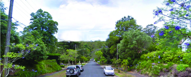
Figure 9: Before and after
views towards the north-east (photo taken out front of No. 8 Wellesley Road)
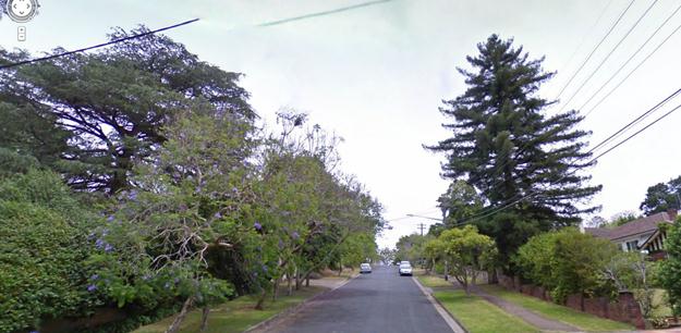

Figure 10: Before and after
views towards the south-west (photo take out front of No. 16 Wellesley Road)
Ku-ring-gai Planning Scheme
Ordinance
The subject site is the vicinity
of two heritage items at Nos. 3 and 7 Wellesley Road, Pymble. The heritage
items are outside the local centres area and are governed by the KPSO.
Clause 61E of the KPSO states
that the Council cannot grant consent to an application in the vicinity of a
heritage item unless it has made an assessment of the effect the carrying out
of that development will have on the heritage significance of the item and its
setting.
The subject tree is paired with
a similar tree, which appears to also be a Redwood, which is situated within
the front setback of No. 7 Wellesley Road, Pymble. This is potentially a very
rare pairing of Redwoods planted in the private domain. Removal of the subject
tree would therefore have a detrimental impact on the setting of the heritage
item at No. 7 Wellesley Road.
Policy Provisions (DCPs, Council policies, strategies and
management plans)
Local Centres DCP
Part 4 Dwelling houses
Part 4 of Ku-ring-gai Local Centres DCP concerns dwelling
houses and ancillary development. Clause 1 in Section 4A.1Local Character and
streetscape provides the following assessment criteria for visual character:
i) architectural
themes
ii) building
scale and setbacks
iii) landscape
themes
iv) fencing
styles
Landscape themes (such as garden design and tree species)
make an important contribution to visual character throughout Ku-ring-gai. The
proposed tree removal does not comply with this clause.
The importance of landscaping is also addressed in Section
4A.4 Landscaping, with a stated objective of this section being to protect and
enhance the tree canopy of Ku-ring-gai. Further, clause 1 states that trees
will be valued and conserved as an integrated feature of the area and their
dominant role in the landscape will be protected and enhanced.
Part 7 Heritage and Conservation Areas
Part 7 of Ku-ring-gai Local Centres DCP provides detailed
heritage provisions for heritage items and heritage conservation areas within
the local centres. An assessment of compliance has been taken below:
Assessment of compliance
with the heritage provisions of Ku-ring-gai DCP 2012
|
Aims of heritage controls:
|
Comment
|
|
|
xii) Retain and
enhance the heritage items, HCAs and their associated settings in the Local
Centres;
xiii) Ensure the
heritage significance, streetscape and landscape character of HCAs are
maintained;
xiv) Ensure
alterations and additions to existing heritage buildings respect those
buildings and do not compromise the significance and character of the
individual heritage items or the HCAs; and
xv) Ensure new
development in the vicinity of heritage items and HCAs respects the heritage
context and is sympathetic in terms of form, scale, character, bulk,
orientation, setback, colours and textures and does not mimic or adversely
affect the significance of heritage items or HCAs and their settings.
|
The development proposes the
demolition of an element that is part of the streetscape in the Pymble
Heights HCA.
|
|
Specific objectives for development
in a heritage conservation area (section 7.4)
|
|
1. To
retain contributory buildings within the HCA.
2. To ensure that
new development retains the identified historic and aesthetic character of
the HCA in which it is situated.
3. To ensure new
development respects the character of, and minimises the visual impact upon,
the HCA and its streetscapes through appropriate design and siting.
4. To maintain and
enhance the existing heritage character of the streetscape and the precinct.
|
The removal of the tree will result
in the loss of an element that forms part of the streetscape in the heritage
conservation area. Although the streetscape of Wellesley Street is not
‘identified’ in the Statement of Significance which (in common with the other
HCA assessments) focuses on the architectural characteristics of individual
properties); Wellesley Road and adjoining streets such as Mocatta Avenue are
good examples of the streetscapes of the heritage conservation area, their
cohesiveness providing evidence of the interest in establishing and
maintaining high quality gardens in the area over many years. This quality is
enhanced further by the group of similar trees seen in the vicinity of the
site.
|
|
Objective relevant specifically to
gardens
16 To ensure streetscape within the
HCAs are characterised by front gardens with substantial landscaped area and
minimum hard surfaces.
|
No change is proposed to the ratio
of hard:soft landscaped area. If the area of the driveway was reduced by
removing the paving in the vicinity of the tree (i.e. making it a single-car
width) this objective would be better satisfied.
|
|
Gardens and Landscaping - Controls
|
|
58 Gardens, garden structures,
landscaping and vegetation that contribute to the significance of HCAs are to
be conserved.
|
The tree is individually
aesthetically distinctive and is also one of a group of similar species that
together contribute to aesthetic value of the Wellesley Road streetscape.
|
|
59 Traditionally designed gardens that
enhance the appearance of the historic houses and streetscapes are
encouraged.
|
The
tree is the focal planting in its garden and is an important element in the
streetscape, particularly when approaching the heritage conservation area
from the north.
It
is also interesting to note that the house is of Inter-War Georgian Revival
style. The original Georgian and early Victorian bungalow villa was noted
for its inclusion of large ‘marker trees’ of exotic and tall-growing
species. The subject tree could be considered a 20th century
reinterpretation of this tradition.
The
planting and long-term maintenance of unusual and exotic trees in the
generous gardens of Ku-ring-gai is one of the most distinctive
characteristics of the streetscapes of the LGA and is exemplified by its
heritage conservation areas.
Removal of the tree would be contrary to this provision.
|
|
60 Gardens in HCAs that are
historically characterised by either predominantly native plants,
predominantly introduced plants or a mix of both should retain that historic
character.
|
The prevailing character of the
existing garden and that of the streetscape in the vicinity of the site is
exotic. This character should be retained. The tree should not be removed and
replaced by a native shrub or small tree.
|
|
61 Paving and hard surfacing,
particularly to front gardens is to be limited; gardens including substantial
trees and shrubs are to be established along street elevations; front gardens
within the HCA must have minimum 70% landscaped area.
|
The
DCP encourages the planting of substantial trees along the street elevation.
Reducing the amount of paving would help to further comply with this
control. A similarly substantial tree would be required to satisfy this
requirement.
The existing double-width driveway
at the street alignment would not comply with Council’s current controls.
|
|
63 Provide landscape screening and
softening to buildings throughout the HCA.
|
The
existing tree softens views over and within the buildings in the local
streetscape. It also softens the skyline views. If removed, the views to the
west over this part of Wellesley Street will have a much more open and
starker character.
Any replacement tree would need to
be of similar size to soften streetscape views.
|
|
Detailed controls for the Pymble
Heights Conservation Area:
|
The detailed controls for the HCA
address architectural and fabric issues. No controls specific to the gardens
in the HCA have been adopted. The general controls for gardens in
HCAs (above) apply.
|
The DCP also contains clauses relating to driveway width.
Clause 43 states that the maximum width of a driveway at street frontage should
be 3.5 metres. Part of the applicant’s argument is that the tree should be
removed because it is causing damage to the driveway. However, the driveway is
excessively wide (approximately 4.5 metres) and exceeds Council’s current
maximum driveway width. The width of the driveway could reasonably be reduced
by up to one metre which would reduce its streetscape impact, allow more room
for the tree to grow and remove the hazard caused by the uplifted stones.
Section 7.7.13 of the DCP contains a specific description
and controls relating to the Pymble Heights Conservation Area. Whilst this
section does not specifically refer to the subject tree, it is noted that no
individual trees are mentioned in the DCP. However, retention of individual
trees is encouraged by the overarching objectives of the part (specifically
objective xiii), specific objectives of section 7.4 and the clauses concerning
landscaping described above.
Likely Impacts
The subject tree is a significant feature of the Wellesley
Road streetscape. The tree is highly visible from both the south-western and
north-eastern approaches. The tree is also part of a unifying layer of
distinctive exotic trees which unify the streetscape and is characteristic of
late 19th and early 20th century development.
Removal of the tree would result in adverse streetscape
impacts to Wellesley Road when viewed from the north-east and south-west. It
would also compromise the historical significance of Heritage Conservation Area
C8B – Pymble Heights which is significant for its intact streetscapes.
The tree is in good health and condition and Council’s
arborist considers it suitable for long-term retention, subject to minor
remedial action (such as removal of fencing and driveway pavers.
Suitability of the Site
The site is zoned R2 Low Density Residential and is suitable
for residential purposes.
Development on the site currently comprises a dwelling with
a detached double carport in the front setback and pool and entertaining area
in the rear setback. The site also features generous areas of landscaping,
particularly within the front setback.
The site has an area of approximately 930m2,
which is an average sized allotment in Ku-ring-gai, but generous by current
subdivision standards in Sydney. Development on the site is typical of a low
density residential setting and is not compromised by the subject tree. The
subject tree is appropriately located on the lot and is set back a suitable
distance from the nearest dwellings (13-18.5 metres).
The applicant has argued that the tree is inappropriate for
a suburban setting and has sited numerous sources which state that Redwoods are
suitable for parks, large gardens etc. Nonetheless, as Council’s Consultant
Heritage Adviser has concluded, this is perhaps more an indication of the scope
of most arboreal surveys than the appropriateness of such trees in the suburban
landscape. It is also noted that the lot sizes in Ku-ring-gai are significantly
larger than more recently created allotments, both in Australia and overseas.
The height of the subject tree is also comparable to that of
other exotic planted specimens such as Araucaria heterophylla (Norfolk
Island Pine) and Araucaria bidwillii (Bunya Pine) and locally occurring
trees such as Eucalyptus saligna (Sydney Blue Gum) and Eucalyptus pilularis
(Blackbutt). Council’s consultant arborist has advised that the risks
associated with these large native trees (which are prone to dropping large
branches) are often far greater than those presented by the subject tree.
Lidar imaging of the subject and surrounding sites shows
that the height of the subject tree is comparable to that of many other trees
in the locality. The tree is shown to have a height of 20-25 metres, whilst
other trees on the opposite side of Wellesley Road are shown to have a height
of approximately 40 metres (refer to Attachment 2). In this
regard, the scale of the tree is appropriate for both the site and the
streetscape.
Public Interest
Four submissions were received from three neighbours during
the notification period. One submission was received in support of the proposal
and one was received against the proposal. The remaining two submissions (made
by the same person) are somewhat neutral, and request that the applicant
reinstate the damaged fence at No. 14 Wellesley Road, Pymble.
The applicant has submitted a petition containing 24
signatures supporting the removal of the tree. The addresses of the signatories
have been provided and most reside within Wellesley Road, Pymble. As Council’s
Consultant Heritage Adviser has noted, petitions cannot be considered to be an
accurate indicator of social heritage value. It is also noted that, whilst many
of these residents were notified of the subject development application, none
of the signatories made a submission to Council.
Conclusion
Having regard to the provisions of section 79C of the
Environmental Planning and Assessment Act 1979, the proposed development is
considered to be unsatisfactory. Therefore, it is recommended that the
application be refused.
Recommendation:
PURSUANT TO SECTION 80(1) OF
THE ENVIRONMENTAL PLANNING AND ASSESSMENT ACT, 1979
THAT Council,
as the consent authority, refuse development consent to Development
Application No. 376/13 for Removal of tree within front setback
(Californian Redwood) within Heritage Conservation Area on
land at No. 12 Wellesley Road, Pymble, for the following reasons:
1. The subject tree is
in good health and condition.
Particulars:
(a) The
tree is a mature Sequoia sempervirens (Californian Redwood) of
approximately 20-25 metres in height with a diameter at breast height of 1.2
metres.
(b) The
tree has been described by the applicant’s arborist (Ford, October 2012) as
“vigorous and healthy” and by Council’s consultant arborist as “free from
defects and in good health” (Austin, May 2013).
(c) The
tree has been assessed Council’s consultant arborist has having a SULE of 1B
which means that it could be made suitable for retention in the long term (40
years plus) by remedial care.
2. The subject tree is visually significant and its removal
would result in adverse streetscape impacts.
Particulars:
(a) The considerable height, conical form and
distinctive dark foliage of the tree make it a prominent element of the
Wellesley Road streetscape. Views of the tree are significant travelling down
the street towards the north-east and up the street towards the south-west.
The prominence of the tree can be seen by persons travelling on foot or in a
vehicle.
b) The presence of tall trees and landscaped
gardens are defining characteristics of the character of Ku-ring-gai. The
proposed tree removal does not comply with sections 4A.1 and 4A.4 of
Ku-ring-gai Development Control Plan which emphasise the importance of
landscape themes and the conservation of trees as important elements of
visual character and streetscape.
3. Removal of the tree would result in adverse
impacts to Heritage Conservation Area C8B – Pymble Heights and Heritage
Conservation Area C9 – Fern Walk.
(a) The dwelling and garden of No. 12 Wellesley
Road demonstrate heritage values consistent with those of the heritage
conservation area and the property has been assessed as making a positive
contribution to the heritage significance of the conservation area. The
dwelling was constructed during the period of core significance for the
conservation area which is from the late 19th Century to World War
II. The tree may also have been planted during this period. The tree is
located in a garden bed that defines the edge of the driveway and provides
evidence of place-marking. The height and form of the tree are typical of the
period of inter-war gardens where tall evergreen trees were used as specimen
plantings. The tree forms part of a group of large exotic trees which form an
aesthetically cohesive and distinctive layer which unifies the heritage
conservation area. Removal of the tree would not conserve the significance of
the heritage conservation area and does not comply with the objectives
contained within clause 5.10(1) of Ku-ring-gai LEP (Local Centres) 2012.
(d) The
proposed tree removal does not comply with objective 4 of section 7.4 of
Local Centres Development Control Plan which is to maintain and enhance the
existing heritage character of the streetscape and the precinct. The proposed
tree removal is also inconsistent with clauses 58, 59 and 60 of Ku-ring-gai
Development Control Plan. The tree is an exotic, which is characteristic of
garden design from the late 19th Century to the inter-war period.
The tree retains the historic character of the locality and enhances the
streetscape. It also makes a significant contribution to two heritage
conservation areas.
4. The
damage caused to ancillary structures and services does not warrant removal
of the tree.
Particulars:
(a) The
damage to the water pipe and sandstone driveway is minor. The driveway has
been constructed too close to the tree and that the eastern half of the
driveway is of lower quality.
(b) The
width of the driveway is approximately 4.5 metres which is much wider than
necessary. The driveway does not comply with part 7.4 clause 43 of Local
Centres DCP which allows a maximum driveway width of 3.5m at the street
frontage.
(c) Damage
to the masonry front fences of Nos. 12 and 14 Wellesley Road, Pymble is
cosmetic. The fences are not structural walls and serve only to mark the
front boundary of each property. The damaged part of each fence needs to be
removed, though does not need to be replaced as the tree forms an effective
marker of the edge of the property.
5. The subject tree is suitable for the site.
Particulars:
(a) The
site has an area of approximately 930m2. The site contains a
dwelling house, pool, entertainment area and double carport.
Development on the site has not been hindered by the size or location of the
tree.
(b) The
tree is appropriately located on the site and is located 18.5 metres from the
dwelling on the subject site and 13 metres from its carport. The tree is set
back 13 metres from the adjoining dwelling at No. 14 Wellesley Road, Pymble.
(c) The
height of the subject tree is comparable to that of other locally occurring
trees such as Eucalyptus saligna (Sydney Blue Gum) and exotic planted
specimens such as Araucaria heterophylla (Norfolk Island Pine) and Araucaria
bidwillii (Bunya Pine). Lidar imaging produced by Council indicates that
the tree has a height of 20-25 metres and that there are numerous trees on
the opposite side of Wellesley Road with a height of approximately 40 metres.
6. The proposed replacement planting with a smaller
native species is unsuitable.
Particulars:
(a) The
contributory heritage values of the existing tree could not be replaced by a
new planting unless it is equivalent in size and form to the existing tree.
Any suitable replacement tree would grow to a similar size as the subject
tree and would also necessitate removal of the front fences.
7. Removal
of the tree would have an adverse impact on the heritage significance of the
heritage item at No. 7 Wellesley Road, Pymble.
Particulars:
(a) The subject tree is one half of a ‘paired’
planting with a matching specimen in the garden of the heritage item of 7
Wellesley Road. The proposed tree removal would have an adverse impact on
the heritage value of this item and its setting and does not comply with
clause 61E of the KPSO.
|
|
Brodee Gregory
Senior Assessment Officer
|
Selwyn Segall
Team Leader - Development Assessment North
|
|
Corrie Swanepoel
Manager Development Assessment Services
|
Michael Miocic
Director Development & Regulation
|
|
Attachments:
|
A1View
|
Arborist's
report
|
|
2014/010626
|
|
|
A2View
|
Lidar
image
|
|
2014/019934
|
|
|
A3View
|
Public
opinion
|
|
2014/010030
|
|
|
A4View
|
Zoning
map
|
|
2014/010036
|
|
APPENDIX
No: 1 - Arborist's
report
|
|
Item No: GB.9
|
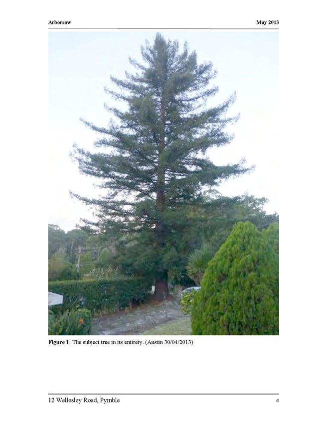
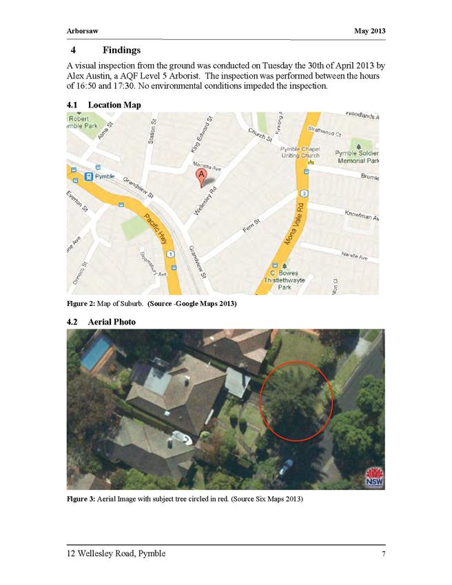
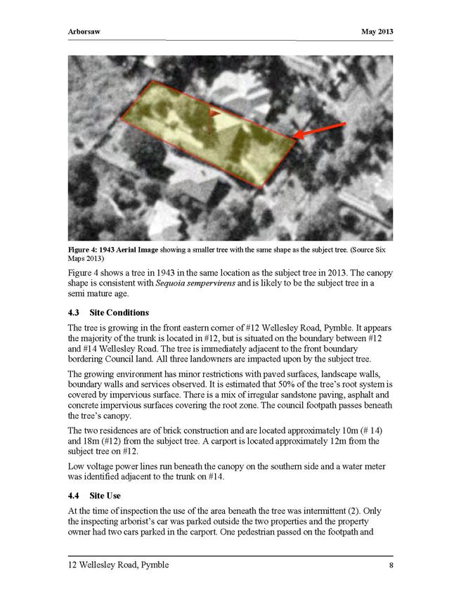
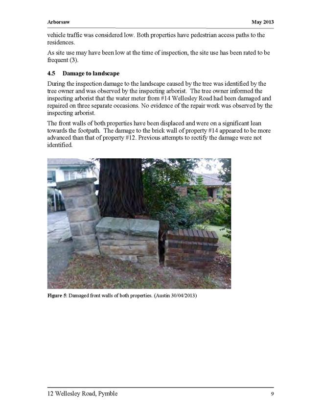
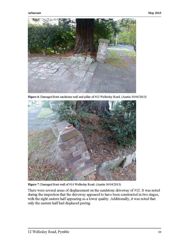
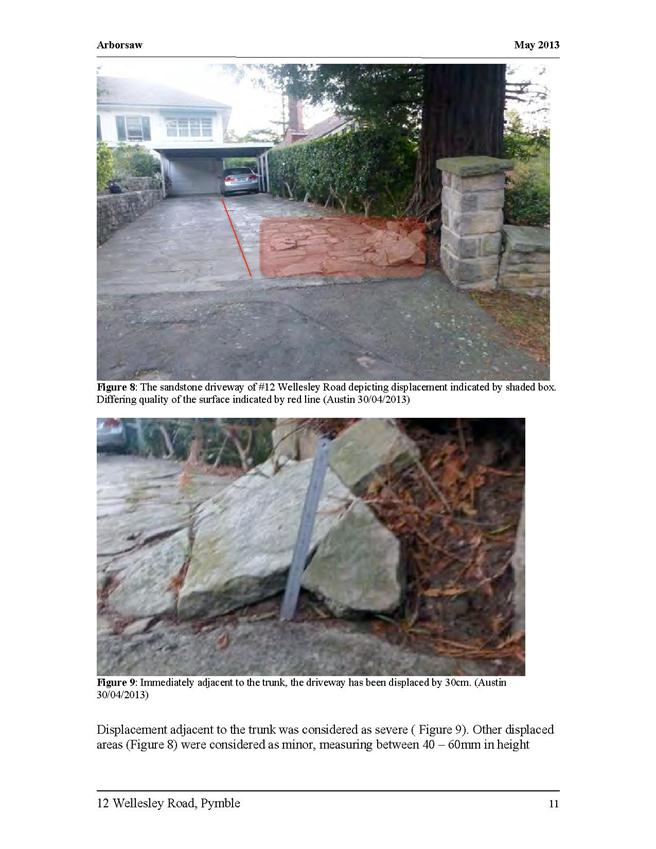
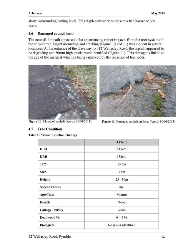
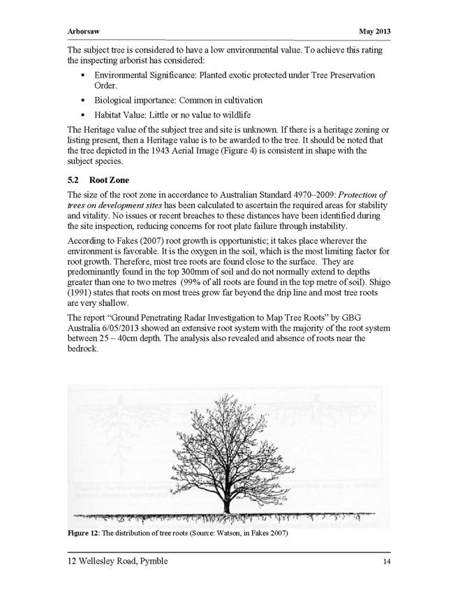

|
APPENDIX No: 2 - Lidar
image
|
|
Item No: GB.9
|

|
APPENDIX No: 3 - Public
opinion
|
|
Item No: GB.9
|
|
APPENDIX No: 4 - Zoning
map
|
|
Item No: GB.9
|
|
Ordinary
Meeting of Council - 4 February 2014
|
GB.10 / 277
|
|
|
|
|
Item
GB.10
|
DA0220/13
|
|
|
14 January 2014
|
Summary Sheet
|
Report title:
|
10 Kimo Street
Roseville - Alterations and additions to the existing dwelling, construction
of a garage and driveway, provision of stormwater infrastructure and Torrens title
subdivision of one lot into two.
|
|
ITEM/AGENDA
NO:
|
GB.10
|
|
Application No:
|
DA0220/13
|
|
Property Details:
|
10 Kimo Street Roseville
Lot & DP No: Lot 118 DP 13028
Site area : 4829m2
Zoning: Residential 2(a)
|
|
Ward:
|
Roseville
|
|
Proposal/Purpose:
|
Alterations and additions to the existing dwelling,
construction of a garage and driveway, provision of stormwater infrastructure
and Torrens title subdivision of one lot into two.
|
|
Type of Consent:
|
Integrated
|
|
Applicant:
|
Matthew Benson Planning Pty Ltd
|
|
Owner:
|
Ms J Cummins & Mr M Lochtenberg
|
|
Date Lodged:
|
25 June 2013
|
|
Recommendation:
|
Approval
|
Purpose of Report
To determine Development Application No. DA0220/13 for
alterations and additions to the existing dwelling, construction of a garage
and driveway, provision of stormwater infrastructure and Torrens title
subdivision of one lot into two.
The application is to be determined by full Council in
accordance with the requirements of the Department of Planning. Council’s
attention is directed to the attached Planning Circular PS08-014 from the NSW
Department of Planning which requires all development applications that involve
a variation of greater than 10% under the provisions of SEPP No 1 to be
determined by full Council. The proposed variation to the site width
development standard exceeds 10%. The application is also reported to Council
as it proposes Torrens title subdivision of land that contains remnant
bushland.
integrated planning and reporting
Places, Spaces & Infrastructure
|
Community Strategic Plan
Long Term Objective
|
Delivery Program
Term Achievement
|
Operational Plan
Task
|
|
P3.1 The built environment delivers attractive,
interactive and sustainable living and working environments.
|
A high standard of design quality and building
environmental performance is achieved in new development.
|
Assessment of applications is consistent with Council’s
adopted LEPs and DCPs.
|
History
Pre-DA
On 28 February 2013 a Pre DA consultation was held for a
proposal to subdivide the site into two allotments, construct a garage and
carry out alterations and additions to an existing dwelling.
DA History
25 June 201
The DA is lodged.
28 June
2013 A letter is sent to the applicant
requesting payment of the Integrated Development referral fee.
31 July
2013 The Rural Fire Services requests
additional information.
29 August
2013 A letter is sent to the applicant
requesting additional information and amended plans.
17 October
2013 Additional information and amended plans
are submitted.
26 November
2013 The Rural Fire Services provides General Terms
of Approval.
13 January
2014 A SEPP 1 objection is requested by
council.
14 January
2014 A SEPP 1 objection is submitted.
The Site
Site description
The site is a 4829m2 allotment located in a
cul-de-sac known as Kimo Street and is accessed from the head of the
cul-de-sac. The south-eastern end of Kimo Street is unformed. The site contains
a dwelling-house, swimming pool and detached garage. The upper portion of the
site is relatively flat however the lower portion has a steep fall in a
south-easterly direction. The existing dwelling is located near the rear
(southern) boundary in a steep portion of the site and is not visible from the
street. The existing swimming pool is located below the dwelling. The site is
identified as land of biodiversity significance and riparian land by the
Ku-ring-gai Planning Scheme Ordinance.
Surrounding development
The site is an uncharacteristically large allotment located
in a low density residential area. The adjoining site to the rear
(south-western boundary) is the Ku-ring-gai Campus of UTS. This site is subject
to a Concept Plan Approval under Part 3A of the Environmental Planning and
Assessment Act for 345 dwellings, including single lot dwellings, townhouses
and apartments. The Concept Plan Approval includes the construction of a row of
nine single lot dwellings behind the existing dwellings on the south-eastern
side of Kimo Street. An Asset Protection Zone for the purposes of bushfire
protection has been established on this site. The south-eastern boundary of the
site adjoins Sugarbag Reserve which is zoned RE1 Public Recreation.
The Proposal
· Subdivision of the existing 4829m2
allotment into a 1000m2 vacant allotment (proposed lot 1) and an
3829m2 allotment (proposed lot 2) containing the existing dwelling.
· Demolition of existing detached garage
located in the south-western corner of the site.
· Construction of a driveway and detached
garage in proposed lot 2 containing bin storage room, two car spaces and a
storage room.
· Alterations and additions to the
existing dwelling including demolition of existing laundry and the construction
of a new laundry, one bedroom and roof light windows.
· Removal of 14 trees.
Consultation
Community
In
accordance with Development Control Plan No. 56, owners of surrounding
properties were given notice of the application. No submissions were
received.
Amended
plans
Amended
plans and additional information were submitted on 3 October 2013 and 17
October 2013. In accordance with Development Control Plan No. 56, owners of
surrounding properties were given notice of the application. No
submissions were received.
Within Council
Ecology
Council’s
Ecological Assessment Officer commented on the amended proposal as follows:
Vegetation
The
vegetation within the lower and mid levels of the subject property was
identified as Sydney Sandstone Gully Forest (SSGF) a non-threatened vegetation
type. A small area of Sydney Sandstone Ridgetop Woodland was identified along
the western boundary and partly transitions with the SSCF community at the top
(northern) end of the subject property.
Threatened
species
No
endangered ecological communities, threatened flora or endangered populations
were identified on the subject property during the site inspection. However the
intact areas of native vegetation within the subject property contain habitats
that would provide suitable habitat for threatened flora & fauna species.
Biodiversity
and riparian land controls
Ecological
constraints/environmental controls
The
native vegetation (Sydney Sandstone Gully Forest) within the site which occurs primarily
adjacent to the watercourse (southern portion) has been mapped as category 1
'core" biodiversity significance under the KPSO.
The
site is also mapped as containing a category 1 riparian corridor which occurs
on the lower southern portion of property. In accordance with Council’s Riparian
Policy, the Category 1 watercourse requires a 40m core riparian zone (CRZ). The
proposed subdivision will result in the extensive removal of vegetation within
the category 1 watercourse.
The
vegetation along the watercourse has also been mapped as Category 1 Watercourse
under the KPSO. The required setback under the KPSO is 40m which is also in
accordance with Council’s Riparian Policy.
In
order to establish the subdivision vegetation within the area of land
identified as biodiversity significance and within the Category 1 Watercourse
will require modification for fire protection purposes.
Note: The requirement to manage the area of land identified as
biodiversity significance and riparian would be required irrespective of the
proposal to ensure fire protection to the existing asset (house).
A
vegetation management plan (VMP) has been prepared which addresses the required
management of the area of land identified as biodiversity and riparian with
regards to fire protection. The VMP ensures that the ecological values of the
biodiversity and riparian areas as defined under clauses 61L and 61M of the
KPSO are maintained and are not likely to be detrimentally affected by the
proposal.
Review
of technical reports
Amended
flora and fauna report
The
amended flora and fauna assessment has addressed previous comments and is now
considered to be satisfactory. The level of survey effort to detect threatened
flora and fauna species is in accordance with the Introduction and Amphibians
by DECCW (April 2009) and the Biodiversity Survey and Assessment: Guidelines
for Development and Activities - Working Draft by DEC (November 2004).
The
impact assessments (7-part tests) for the threatened species are now in
accordance with section 5a of the Environmental Planning & Assessment Act
1979.
Amended
arborist report
The
amended arborist report has now considered tree loss as result of proposed fire
protection. The report clearly notates those trees that are proposed for
removal for fire protection.
The
arborist, ecologist and bushfire consultant have collaborated to establish
those trees which are of poor health, low habitat value which are required to
be removed to achieve canopy separation for fire protection within the asset
protection zones (APZ) ensuring a balance between tree removal & retention.
Amended
Vegetation Management Plan
The
amended Vegetation Management Plan IVMP) is now considered to be satisfactory
having addressed my previous comments. The VMP is sufficient to ensure the
enhancement, protection and ensure the long-term viability of the SSGF
community and channel vegetation upon the site. The VMP demonstrates compliance
with proposed Asset Protection Zones and demonstrates the retention of
vegetation within the Category 1 Watercourse to ensure compliance with
Council’s riparian & biodiversity controls. The proposal is also considered
to fulfil the riparian controls set by NSW of Office of Water.
The
VMP has selected appropriate species which are to be planted that are
representative of SSGF community within the rear of the eastern lot, soft
(Non-sclerophyllic) species have been selected to be planted over sclerophyllic
species as they have a lower combustion.
The
VMP describes each task necessary for the implementation of the plan, the
duration and priority. Maps, diagrams and plant species lists are contained
within the plan. The VMP describes the existing vegetation and natural features
to be retained, proposed vegetation, sediment and erosion control and land
stabilisation works.
Vegetation Management Plan prepared by Narla Environmental
Consultants revised October 2013
The
vegetation management plan is adequate to ensure the protection and enhancement
of the vegetation within the site. On this basis the development application is
deemed satisfactory and is unlikely to compromise the existing vegetation
within the site.
Landscaping
Council's
Landscape and Tree Assessment Officer has commented on the amended proposal as
follows:
Tree
impacts
An arborist report, prepared by
Perfect Outdoors dated 7/05/13, has been submitted with the application. Tree numbers refer
to this report. The following
abbreviations have been used to describe the size of existing trees: height
(H), canopy spread (S), diameter at breast height (DBH), tree protection zone
(TPZ) and structural root zone (SRZ).
Trees
to be removed
A
map prepared by Narla Environmental has been submitted indicating trees to be
retained and removed across the entire site.
Development
of Subdivision 1 Site
There
are no significant trees identified for removal as part of the subdivision 1
site (Trees 3,4,6, 9, 10a,10b,10d and 10f) . There is no landscape objection to
the removal of these trees.
Subdivision
2 site
A
total of 14 trees are proposed to be removed within subdivision site 2. Three
(3) of these trees are considered significant.
Tree
12/ Eucalyptus pilularis (Blackbutt) This mature co-dominant tree is located
within the front of the site. The tree exhibits a high level of canopy dieback.
There is no objection to the removal of this tree.
Tree
16/ Eucalyptus pilularis (Blackbutt) This mature tree is located at the north-western
corner of the site. The tree exhibits a bracket fungus on one of the trunks and
exhibits several large diameter branch failures as well as a high level of
epicormic growth and canopy dieback. The tree is to be removed for the proposed
garage. There is no objection to the removal of this tree.
Tree
18/ Eucalyptus piperita (Sydney Peppermint) This mature co-dominant tree is
located adjacent to the pedestrian entry to Subdivision 2. The tree exhibits
several large cavities and a high level of canopy dieback. There is no
objection to the removal of this tree.
The
following trees can be removed without permission as they are exempt under
Council’s Tree Preservation Order – Tree 1, 3, 11, 13.
Trees
to be retained
Driveway
to proposed lot 2
To
preserve the existing Trees 15 and 19 that are located on the site, the
driveway is to be located on the existing driveway with new aggregate-filled
permeable plastic paving grid to be constructed above grade. The driveway
turning circle is to be suspended construction. This is considered satisfactory
with conditions. (Conditions 11, 12, 13, 14 and 33)
Stormwater
plan
There
are no landscape objections to the proposed stormwater drainage.
Bushfire
prone land
The
new allotment (Subdivision 1) shall be managed as an Inner Protection Area in
its entirety.
The
existing allotment (Subdivision 2) shall be managed as an Inner Protection Area
for a distance of 35m or the boundary to the east, and 25m or the boundary to
the north and other aspects. The proposed tree removal and retention are
considered to result in the required tree canopy cover.
Environmental
site management plan
The
Construction Management Plan is to indicate tree protection fencing in
accordance with the arborist recommendations. This has been provided in the
Environmental Site Management Plan by Narla Environmental dated October 2013.
Engineering
Council's Development Engineer
commented on the proposal as follows:
Water management
The amended stormwater plan shows rainwater tanks to a
proposed house and garage on new Lot 1, with overflow from the tanks conveyed
to a gross pollutant trap and thence to a level spreader consisting of a
slotted pipe concealed in a landscaped rock wall, dispersing evenly onto the
massive rock shelf. From this rock shelf, the contours indicate that surface
flow would disperse evenly over the site between the proposed garage and the
existing residence.
A similar level spreader is proposed for the overflow
from the garage rainwater tank. No length is given for either spreader.
Roughly scaling off the reduced plan gives a length of about 6 metres for the
spreader for the garage and about 10 metres for the spreader for the new lot.
These lengths are included in the recommended conditions, as they will provide
an even outflow which will minimise the effects on the downslope vegetation.
Because the application does not include any dwelling or
garage on proposed Lot 1, it is considered that the gross pollutant trap and
level spreader should be constructed in conjunction with the subdivision and
that tanks should be provided with the later DA for the new residence – this
will allow for some flexibility in the siting of any new buildings.
The Environmental Site Management Plan now refers to the
stormwater plan and identifies the dispersal of garage rainwater tank overflow
by level spreader as having potential impacts in relation to weed growth.
The Vegetation Management Plan includes the monitoring of
overflows from the garage rainwater tanks and the installation of a small
drainage channel to divert flows to merge with flow coming from the Kimo Street
drainage system. This monitoring is intended to be carried out after
completion of the garage and issue of the Occupation Certificate, in conjunction
with other vegetation management works. It will be covered by an ecological
condition endorsing the Vegetation Management Plan in its entirety – there are
no additional engineering conditions which would apply to these works after the
Subdivision and Occupation Certificates had been issued.
Section 1.10.8 of the ESMP states that the effects of
vegetation removal for bushfire protection will only be minor in regard to
increased overland flows.
Vehicular access
The garage plans include a vehicle barrier, noted as
being constructed to AS2890.1 and AS1170.1. This is satisfactory and can be
detailed on the Construction Certificate drawings. There is no need for a
specific condition, as it is on the DA plans.
The DA has two components, the new garage and works to
the existing residence, and the subdivision. Most of the recommended
engineering conditions relate to the subdivision and require implementation
prior to issue of the Subdivision Certificate. An Occupation Certificate will
be required in relation to the works to the residence and the new garage, which
would require the construction of the new driveway crossing and the rainwater
tanks and level spreader to the garage to be completed. These works do not
depend on the subdivision and could be completed first.
Outside Council
Rural Fire Services
Subdivision of bushfire prone
land requires a bush fire safety authority under Section 100B of the Rural
Fires Act 1997. The application was referred to the Rural Fire Services for
General Terms of Approval as Integrated Development. The Rural Fire Services
provided their General Terms of Approval by letter dated 26 November 2013.
Statutory Provisions
State Environmental Planning
Policy No. 55 – Remediation of Land
The provisions of SEPP 55 require
Council to consider the potential for a site to be contaminated. The subject
site has a history of residential use and as such, it is unlikely to contain
any contamination and further investigation is not warranted in this case
Sydney Regional Environmental
Planning Policy (Sydney Harbour Catchment) 2005
SREP 2005 applies to the site as
the site is located in the Sydney Harbour Catchment. The Planning Principles in
Part 2 of the SREP must be considered in the preparation of environmental
planning instruments, development control plans, environmental studies and
master plans. The proposal is not affected by the provisions of the SREP which
relate to the assessment of development applications as the site is not located
in the Foreshores and Waterways Area as defined by the Foreshores and Waterways
Area Map.
Ku-ring-gai
Planning Scheme Ordinance
Part A:
Development standards
Proposed Lot
1:
|
Development standard
|
Proposed
|
Complies
|
|
Site area: 1000m2
|
|
Minimum size allotments
|
|
|
|
Site area: 790m2 (min)
|
1000m2
|
YES
|
|
Site width: 18m (min) at 12.2m
from street alignment
|
12.1m
|
NO
|
|
Land must have frontage to a
public road
|
The
allotment has frontage to Kimo Street
|
YES
|
|
Built upon area 60%(600m2)(max)
|
0%
|
YES
|
Proposed Lot
2:
|
Development standard
|
Proposed
|
Complies
|
|
Site area: 3829m2
|
|
Minimum size allotments
|
|
|
|
Site area: 790m2 (min)
|
3829m2
|
YES
|
|
Site width: 18m (min) at 12.2m
from street alignment
|
75m
|
YES
|
|
Land must have frontage to a
public road
|
The
allotment has frontage to Kimo Street
|
YES
|
|
Built upon area
60% (2297.4m2)
(max)
|
16%
(625m2)
|
YES
|
|
Building height: 8m
(max)
|
<8m
|
YES
|
Allotment
width
The width of
proposed Lot 1 at a distance of 12.2m from the street frontage is 12.1m, this
does not satisfy the 18m width requirement specified by the KPSO. An allotment
width of 12.1m represents at 32.7% variation to the development standard for
allotment width.
A SEPP 1
objection has been submitted (Attachment 4). The main arguments advanced
by the applicant in the SEPP 1 objection are:
(i) The subdivision could be redesigned to
achieve compliance with the development standard ,however this would result in
greater environmental impact through the loss of additional trees as the new
garage and driveway for the existing dwelling would need to be relocated
downslope to a more sensitive part of the site.
(ii) The proposal provides the opportunity to
locate the future dwelling on Lot 1 away from Kimo Street where it would have
minimal amenity impacts on surrounding properties and the environment.
(iii) The dimensions of proposed lot 1 provide
adequate space for a dwelling located towards the rear of the lot.
(iv) The proposal has been designed to maintain
the environmentally sensitive areas of the existing allotment by retaining the
existing dwelling and providing an opportunity for a new dwelling in a less
sensitive part of the site.
SEPP 1
CONSIDERATION
whether
the control is a development standard
The allotment
width control in clause 58B of the KPSO is a development standard as defined
under section 4 of the Environmental Planning & Assessment Act, 1979.
the
underlying objectives or purpose behind the standard
There are no
specifically stated purposes or objectives expressed in the Ku-ring-gai
Planning Scheme Ordinance for the allotment width control. The general aims for
the Residential 2(a) zone are:
(a)to
maintain and, where appropriate, improve the existing amenity and environmental
character of residential areas;
(b)to
permit new residential development only where it is compatible with the
existing environmental character of the locality and has a sympathetic and
harmonious relationship with adjoining development.
An allotment
width control works in conjunction with the allotment area control to create
consistency in allotment size and shape within the zone. The size and shape of
allotments has an impact on the characteristics of an area as it influences the
way in which houses and gardens are designed. Wide allotments enable the
provision of side setbacks that can support screen planting and provide
separation between buildings which influences privacy, amenity and the
character of an area.
whether
compliance with the development standard is consistent with the aims of the
policy and, in particular, whether compliance with the development standard
hinders the attainment of the objectives specified under Section 5(A)(i), (ii),
(iii) and (iv) of the Environmental Planning and Assessment Act 1979
The SEPP 1
objection states that strict compliance would hinder the attainment of the
objects of the Act as the objectives of the development standard are achieved
notwithstanding the non compliance with the development standard.
The aim of
SEPP 1 is to:
Provide flexibility in the application of planning controls operating
by virtue of development standards in circumstances where strict compliance
with those standards would, in any particular case, be unreasonable or
unnecessary or tend to hinder the attainment of the objects specified in
Section 5(a) (i) and (ii) of the Act.
In this
regard, the objectives of Section 5(a)(i) and (ii) of the Act are:
(a) To encourage:
1. the proper management, development and conservation of natural and
artificial resources, including agricultural land, natural areas, forests,
minerals, water, cities, towns and villages for the purpose of promoting the
social and economic welfare of the community and a better environment;
2. the promotion and co-ordination of the orderly and economic use and
development of land.
For the
reasons outlined below it is agreed that strict compliance with the development
standard would hinder the attainment of the objectives of the Act in this instance
as the proposal is consistent with the objectives of the Act despite the non
compliance.
whether
compliance with the development standard is unreasonable or unnecessary in the
circumstances of the case
The unique
circumstances of the case are that the site is located at the end of Kimo
Street and neither the existing dwelling nor a future dwelling on proposed Lot
1 will have a significant visual presence in the streetscape. The existing
impression of the site is one of a heavily landscaped allotment that seamlessly
blends with the bushland located on the adjacent land to the north-east,
south-east and south-west. The non compliant width of the allotment will
encourage future development on the site to be located towards the rear of the
allotment where it will be screened by existing vegetation.
The
application does not seek to create a non compliant allotment within a row of
existing allotments. As the proposed allotment is located at the end of Kimo
Street the future development of the allotment would have minimal impact on the
streetscape.
The applicant
has argued that the non compliant allotment width has reduced the environmental
impact of the new garage by allowing for the preservation of existing trees and
avoiding development in a steep part of the site to the west of the proposed
garage. Development in the steeper part of the site would require additional
earthworks and have greater impact on existing trees.
Compliance
with the development standard is unreasonable and unnecessary as the objectives
of the control are achieved despite the non compliance and if compliance were
achieved it is likely to result greater environmental impacts. The potential
for greater environmental impacts should be avoided as they would be
inconsistent with the objectives of the Residential 2(a) zone under the KPSO
and the draft E4 Environmental Living zone under the draft Ku-ring-gai LEP.
whether
the objection is well founded
In Wehbe v
Pittwater Chief Justice Preston expressed the view that there are five different
ways in which an objection may be well founded:
1. the
objectives of the standard are achieved notwithstanding non-compliance with the
standard;
2. the
underlying objective or purpose of the standard is not relevant to the
development and therefore compliance is unnecessary;
3. the
underlying object of purpose would be defeated or thwarted if compliance was
required and therefore compliance is unreasonable;
4. the
development standard has been virtually abandoned or destroyed by the Council's
own actions in granting consents departing from the standard and hence
compliance with the standard is unnecessary and unreasonable;
5. the
zoning of the particular land is unreasonable or inappropriate so that a
development standard appropriate for that zoning is also unreasonable and
unnecessary as it applies to the land and compliance with the standard would be
unreasonable or unnecessary. That is, the particular parcel of land should not
have been included in the particular zone.
The applicant
submits that the objective satisfies criterion 1 and 3 for the following
reasons:
Criterion 1
The
objectives of the standard essentially relate to development fitting into the
character
of the locality and resulting in acceptable environmental amenity. As set out
above, the
depth of proposed allotment 1 is sufficient for a satisfactory dwelling house
to be
accommodated in character with the locality notwithstanding non-compliance
with the
development standard. Furthermore, the proposal represents an appropriate
outcome on
balance, given the size of the existing allotment and given that the
proposed
design is preferable in relation to environmental impacts compared to a
compliant
design.
Criterion 3
The SEPP 1
objection satisfies this criterion because, as set out above, a compliant
proposal
would have a negative outcome in relation to the underlying objective of the
standard
compared to the present proposal.
The applicant
submits that criteria 2, 4 and 5 are not relevant to the circumstances of the
case.
It is agreed
that criteria 4 and 5 are not relevant to the circumstances of the case,
however it is considered that a sound argument can be established for the
satisfaction of criterion 2. Criterion 2 is satisfied by the development as the
draft Ku-ring-gai LEP seeks to zone the site E4 Environmental Living. The draft
LEP is considered to be imminent and certain and therefore it is entitled to
significant determinative weight. The objectives of the E4 Environmental Living
zone are different to the objectives of the current Residential 2(a) zone. The
objectives of the E4 Environmental Living zone seek to achieve low-impact
development in areas that have special ecological, scientific or aesthetic
values. The focus is on minimising impacts on ecological communities,
biodiversity corridors, significant vegetation and habitat. The objectives of
the Residential 2(a) are primarily aimed at minimising the impacts of new
development on the residential amenity and maintaining the architectural
character of residential areas. The non-compliant width and irregular shape of
proposed Lot 1 will significantly influence the design of future development on
the allotment by encouraging the main building to be located away from the
street and allow for the retention of existing vegetation in the north-eastern
part of the allotment.
whether non-compliance with the development standard
raises any matter of significance for State or regional environmental planning,
and
There are no matters of
significance for State or regional environmental planning. Council’s Ecologist
has advised that the development will not have an impact on any endangered or
threatened ecological communities.
whether there is public benefit of maintaining the
planning controls adopted by the environmental planning instrument.
The SEPP 1 register shows that the allotment width standard
in the KPSO has been varied on previous occasions. In this instance, the
applicant has demonstrated that compliance with the development standard would
be unnecessary as the objectives of the control are achieved despite the non
compliance. The unique circumstances of the case will not create an undesirable
precedent for the variation of the development standard in other development
applications.
Part B:
Aims and objectives for residential zones:
The proposal
is consistent with the aims and objectives for residential development as
outlined by Schedule 9.
Draft
Ku-ring-gai Local Environmental Plan 2013
The
draft LEP was on exhibition from 25 March 2013 to 6 May 2013. The draft LEP was
adopted by Council on 26 November 2013 and has been forwarded to the Minster
for Planning to be made. The site is zoned E4 Environmental Living under the
draft LEP and subject to a minimum allotment size of 1500m2. The
proposal is permissible under the provisions of the draft LEP and compliant
with the development standards for floor space ratio and building height,
however it does not comply with the development standard for minimum allotment
size because the site area of proposed Lot 1 is less than 1500m2 and
the allotment has a width of less than 18m at a distance of 12m from the street
frontage. The applicant has acknowledged that the proposal does not comply with
the development standard in the draft LEP and has provided the following
justification for the variation to the minimum allotment size control:
· The proposal creates two allotments out of the existing
single allotment having an average lot size of 2,414.5 square metres.
Therefore, the overall density of the development is less than is provided for
by the provision;
· The distribution of density is concentrated to the northern
area of the site, where the proposed new allotment would create a breach in the
draft development standard. The area of the existing lot where the breach would
occur is furthest from the most environmentally sensitive areas of the existing
lot, which are to the south where the site adjoins bushland;
· Objective (a) of the minimum lot size provision is to
ensure that lot sizes and dimensions are able to accommodate development
consistent with relevant development controls. As set out elsewhere in this
report, the proposal otherwise complies with those relevant controls;
· Objective (b) of the minimum lot size provision is to allow
development to be sited to protect natural features such as remnant vegetation,
habitat and waterways and to provide generous landscaping to support the
amenity of surrounding properties. In that regard, as set out elsewhere in this
report the proposal will not cause any unacceptable amenity impact to
surrounding properties. Furthermore, as set out in the ecological, bushfire and
Arboricultural documentation accompanying the development application, the
proposal does not cause an unacceptable impact upon existing natural features.
To the extent that there is an impact, that arises from the triggering of
bushfire hazard mitigation measures for the existing dwelling rather than from
requirements associated with the construction of a dwelling on the proposed
allotment that does not comply with the proposed development standard.
Therefore, to the extent that there would be any impact on the natural features
of the site, that impact does not arise from the proposed non-compliance with
the draft development standard;
· Objective (c) of the minimum lot size provision is to
ensure that the subdivision of low density residential areas reflects and
reinforces the predominant subdivision pattern of the area. In that regard, the
proposed allotment that would breach the draft minimum allotment size
development standard is larger than the adjoining allotment to the north, which
has an area of approximately 924 square metres, and is consistent with the
general areas of allotments in the locality.
If the subject application was submitted to Council after
the draft LEP had been gazetted, the applicant would be required to submit a
request for a development standard variation in accordance with the
requirements outlined in clause 4.6 ‘Exceptions to development standards’. This
clause requires an applicant to demonstrate that compliance with the
development standard is unreasonable or unnecessary in the circumstances of the
case and that there are sufficient environmental planning grounds to justify
contravening the development standard.
The objectives of the zone and the minimum subdivision lot
size control must be considered. In this instance it is considered that the
applicants’ justification for the variation to the draft minimum allotment size
control is well founded. While a compliant proposal could be achieved for the
site, the subject proposal preserves the ecologically important areas of the
site within a single allotment whilst providing for future development
opportunities in the less significant part of the site. This outcome is
consistent with the objectives of the E4 Environmental Living zone which
requires that development does not have an adverse impact on ecological values
and avoids further fragmentation of ecological communities and significant
vegetation. The variation to the development standards in draft Ku-ring-gai LEP
2013 is supported in this instance.
Local
Environmental Plan 218
LEP 218 was
gazetted on 5 July 2013 and inserted provisions into the KPSO regarding
riparian land, biodiversity and heritage. The site is identified as riparian
land and land of biodiversity significance and is subject to the biodiversity
protection (cl. 61L) and riparian land (cl. 61M) clauses of the KPSO.
The
objectives of the biodiversity protection clause are to
protect, maintain and improve the diversity and condition of native vegetation
and habitat. Prior to granting development consent for development on
land identified as having biodiversity significance the following issues must
be considered by the consent authority:
(a) the impact of the proposed development
on the following:
(i) any native vegetation community,
(ii) the habitat of any threatened species,
population or ecological community,
(iii) any regionally significant species of
plant, animal or habitat,
(iv) any biodiversity corridor,
(v) any wetland,
(vi) the biodiversity values within any
reserve,
(vii) the stability of the land, and
(b) any proposed measure to be undertaken to
ameliorate any potential adverse environmental impact, and
(c) any opportunity to restore or enhance
remnant vegetation, habitat and biodiversity corridors.
Development consent must not be granted for development on
land identified as land of biodiversity significance unless the consent authority is satisfied that the development:
(a) is consistent with the objectives of
this clause, and
(b) is designed, and will be sited and
managed, to avoid any potential adverse environmental impact or, if a potential
adverse environmental impact cannot be avoided:
(i) the development minimises disturbance
and adverse impacts on remnant vegetation communities, habitat and threatened
species and populations, and
(ii) measures have been considered to
maintain native vegetation and habitat in parcels of a size, condition and
configuration that will facilitate biodiversity protection and native flora and
fauna movement through biodiversity corridors, and
(iii) the development avoids clearing steep
slopes and facilitates the stability of the land, and
(iv) measures have
been considered to achieve no net loss of significant vegetation or habitat.
Council’s Ecological
Assessment Officer has assessed the proposal and has determined that it is
consistent with the Biodiversity Protection clause of the KPSO.
The
objectives of the riparian land and waterways clause are:
(a) to protect and improve the following:
(i) water quality within waterways,
(ii) the stability of the bed and banks of waterways,
(iii) aquatic and riparian species, communities, populations and
habitats,
(iv) ecological processes within waterways and riparian lands,
(v) scenic and cultural heritage values of waterways and riparian
lands, and
(b) where practicable, to provide for the rehabilitation of existing
piped or
channelised waterways to a near natural state.
Prior to
granting development consent for development on land identified as riparian
land the following issues must be considered by the consent authority:
(a) whether or not the
development is likely to have any adverse impact on the following:
(i) the water quality in the
waterway,
(ii) the natural flow regime,
including groundwater flows to a waterway,
(iii) aquatic and riparian
species, populations, communities, habitats and ecosystems,
(iv) the stability of the bed,
shore and banks of the waterway,
(v) the free passage of native
aquatic and terrestrial organisms within or along the waterway and riparian
land,
(vi) public access to, and use
of, any public waterway and its foreshores, and
(b) any opportunities for
rehabilitation or re-creation of the waterway and riparian land, and
(c) any appropriate measures
proposed to avoid, minimise or mitigate the impacts of the development.
Development consent must not be granted for development on
land identified as riparian land unless the consent authority is satisfied that
the development:
(a) the development integrates
riparian, stormwater and flooding measures, and
(b) the development is
designed, sited and will be managed to avoid any significant adverse
environmental impact, or if that impact cannot be reasonably avoided by
adopting feasible alternatives, the development is designed, sited and will be
managed to minimise that impact to a satisfactory extent.
The application does not include any building works within
the area identified as riparian land, however tree removal for the establishment
of an Asset Protection Zone is proposed within the riparian land and the
application includes the provision of stormwater infrastructure for proposed
Lot 1 and the garage on proposed Lot 2. To minimise the impact of the
development on the riparian land tree removal has been limited to that required
to establish the asset protection zone for bushfire protection purposes and
stormwater disposal for the new allotment and new garage is in the form of
level spreaders with gross pollutant traps. Rainwater tanks with a capacity of
5000 litres are proposed for the new garage and rainwater tanks will also be
required for the future dwelling on proposed Lot 1. The rainwater tanks will
allow for the capture and reuse of rainwater thereby minimising runoff from the
site and impacts on waterways. The development is consistent with the
requirements of clause 61M ‘Riparian land and waterways’ of the KPSO.
Policy provisions
Development Control Plan No.
38 - Ku-ring-gai Residential Design Manual
The proposed works include the
construction of a new garage and driveway in proposed Lot 2 and alterations and
additions to the existing dwelling on Lot 2. An assessment of the proposed
building works on Lot 2 against the provisions of DCP 38 is provided below.
|
Development
Control
|
Proposed
|
Complies
|
|
4.1 Streetscape:
|
|
Building setbacks (s.4.1.3)
|
|
|
|
Rear setback: 12m(min)
|
2.5m
|
NO
|
|
4.2 Building form:
|
|
FSR (s.4.2.1) 0.3:1
(max)
|
0.08:1
|
YES
|
|
Building height plane
(s.4.2.3)
450 from horizontal
at any point 3m above boundary
|
No
encroachments
|
YES
|
|
Built-upon area (s.4.2.7)
50% (m2)
(max)
|
16%
(625m2)
|
YES
|
|
4.3 Open space &
landscaping:
|
|
Soft landscaping area
(4.3.3)
50% (min)
|
84%
(3204m2)
|
YES
|
|
Tree replenishment (s.4.3.6)
min. 10 trees
|
>10
trees
|
YES
|
|
Useable open space
(s.4.3.8)
Min depth 5m and min area 50m2
|
Depth
>5m
Area
>50m2
|
YES
YES
|
|
4.5 Access & parking:
|
|
No. of car parking spaces
(s.4.5.1)
2 spaces
behind building line
|
2
spaces in front of building line
|
NO
|
|
Design of Carports and
Garages (s4.5.3)
Where
forward of the building line, front setback complies with s4.1.3 and/or the
building line
|
Proposed
garage is set back 14.4m from the street boundary. Part 4.1.3 specifies a
minimum setback of 9m.
|
YES
|
|
Carport/garage
<6m in width or <40% site width whichever is the lesser
|
The
garage is 6.2m wide
|
NO
|
|
4.6 Ancillary facilities:
|
|
Outbuildings (s.4.6.3)
|
|
|
|
Setback
from boundary: 2m
|
3m
minimum side setback for the proposed garage
|
YES
|
Part 4.1 -
Streetscape:
The proposed
bedroom for the existing dwelling has a setback of 2.5m from the rear boundary.
The rear setback of the existing dwelling is a minimum of 900mm and a maximum
of 11.4m. The DCP specifies a minimum setback of 12m for sites which have a
depth of more than 48m. The objectives of the rear setback control include
maintaining the amenity of adjacent properties, allowing for the provision of
landscaping and minimising bushfire hazard by preserving a fuel free zone where
development is adjacent to high bushfire hazard areas.
The site
represents a unique circumstance as the rear boundary is adjacent to a bushland
reserve and there are no ‘neighbours’ adjacent to the site, apart from the
proposed lot which will be vacant until such time that it is developed. The
site area is more than 3800m2 and only a small proportion of the site, less
than 10%, is built upon area. The location of the bedroom would not impact on
the amenity of adjacent properties and the landscaped area of 84% significantly
exceeds the DCP requirement of 50%. The bedroom addition will be protected from
bushfire by the use of fire protection construction techniques recommended in
Planning for Bushfire Protection and the Asset Protection Zone that has been
established in the adjacent site.
Part 4.5 –
Access and Parking
The proposed
detached garage on proposed Lot 2 is located in front of the existing dwelling
and has a setback of 14.4m from the front boundary. Part 4.5.1 states that two
car spaces must be provided behind the building line, however part 4.5.3 states
that parking spaces can be located at or behind the building line defined by
the existing dwelling or the minimum setback specified in part 4.1.3 of the
DCP. The required front setback for a single storey dwelling on the low side of
the street is 9m, therefore the proposed setback of 14.4m generously complies
with the requirements of the DCP. The DCP also specifies that the maximum width
of a garage is 6m, the proposed garage has a width of 6.2m. The non compliant
width of the garage is considered acceptable as the garage is set back 14.4m
from the street boundary, the site is at the end of a no through road and the
street setback of the carport of the closest dwelling (No. 8 Kimo Street) is
less than 4m. In these circumstances is it considered that the garage will not
dominate the site or the streetscape and the variation to the garage width
control is supported.
The existing
garage on proposed Lot 1 is to be demolished as part of the development, this
will leave the existing house of proposed Lot 2 without a suitable car parking
facility until the new garage is built. To ensure that adequate car parking is
provided to the existing dwelling at all times a condition (Condition 43)
has been included in the recommendation which requires that the subdivision
certificate may be issued until construction of the new garage on proposed Lot
2 has been completed and an occupation certificate has been issued.
Development Control Plan No.
47 – Water Management
The requirements of DCP 47 have
been considered by Council’s Development Engineer who has advised that the
proposal is acceptable, subject to conditions.
Section 94 Plan
Condition 20 requires the
payment of the applicable Section 94 development contributions.
Likely Impacts
The
likely impacts of the development have been assessed and are considered
acceptable having regard to the zoning of the site and the requirements of the
planning controls.
Suitability of the Site
The
site is considered to be suitable for the proposed development.
Public Interest
The proposal is consistent with
the requirements of the planning controls, approval of the application is
considered to be in the public interest.
Conclusion
Having regard to the provisions
of section 79C of the Environmental Planning and Assessment Act 1979, the
proposed development is considered to be satisfactory. Therefore, it is
recommended that the application be approved.
|
Recommendation:
PURSUANT TO SECTION 80(1)
OF THE ENVIRONMENTAL PLANNING AND ASSESSMENT ACT, 1979
A. THAT Council, as the consent authority, is of
the opinion that the objection under State Environmental Planning Policy
No. 1 – Development Standards to clause 58B – allotment width of the
Ku-ring-gai Planning Scheme Ordinance is well founded. The Council is also
of the opinion that strict compliance with the development standard is
unreasonable and unnecessary in the circumstances of this case as the
objectives of the standard are achieved notwithstanding the failure to
achieve compliance with the development standard.
AND
B. THAT Council, as the consent authority, being
satisfied that the objection under SEPP No. 1 is well founded and also being
of the opinion that the granting of consent to DA0220/13 is consistent with
the aims of the Policy, grant development consent to DA0220/13 for ‘alterations
and additions to the existing dwelling, construction of a garage and
driveway, provision of stormwater infrastructure and Torrens title
subdivision of one lot into two’ on land at
10 Kimo Street Roseville, for a period of two (2) years from the date of the
Notice of Determination, subject to the following conditions:
Integrated referral conditions:
1. Rural
Fire Services - General Terms of Approval
i.) At the issue of subdivision certificate and in perpetuity,
asset protection zones shall be maintained as illustrated in 'Figure 7:
Diagrammatic approximation of recommended APZs' of the Bushfire Hazard
Assessment prepared by Bushfire Consulting Services numbered 177/13 and dated
'Issue 5 dated 1 October 2013' in accordance with section 4.1.3 and Appendix
5 of 'Planning for Bush Fire Protection 2006' and the NSW Rural Fire
Service's document 'Standards for asset protection zones'.
ii.) Water, electricity and gas for the proposed new dwelling
are to comply with section 4.1.3 of 'Planning for Bush Fire Protection 2006'.
Property
access roads for the proposed new dwelling shall comply with section 4.1.3
(2) of 'Planning for Bush Fire Protection 2006' except that an alternate
access is not required.
iii.) Property access roads for the existing dwelling shall
comply with the following
requirements
of section 4.1.3 (2) of 'Planning for Bush Fire Protection 2006'. -
A
minimum vertical clearance of 4 metres to any overhanging obstruction,
including
tree branches. - The capacity of road surfaces and bridges is
sufficient
to carry fully loaded fire fighting vehicles (approximately 15 tonnes
for
areas with reticulated water, 28 tonnes or 9 tonnes per axle for all other
areas).
iv.) All new fencing shall be non-combustible.
v.) New construction of the proposed new dwelling shall comply
with Sections 3
and
7 (BAL 29) Australian Standard AS3959-2009 'Construction of buildings in
bush
fire-prone areas' and section A3.7 Addendum Appendix 3 of 'Planning for
Bush
Fire Protection'.
vi.) New construction on the existing dwelling shall comply with
Sections 3 and 8
(BAL
40) Australian Standard AS3959-2009 'Construction of buildings in bush
fire-prone
areas' and section A3.7 Addendum Appendix 3 of 'Planning for Bush
Fire
Protection'.
vii.) The existing dwelling is required to be upgraded to improve
ember protection.
This
is to be achieved by enclosing all openings (excluding roof tile spaces) or
covering
openings with a non-corrosive metal screen mesh with a maximum
aperture
of 2mm. Where applicable, this includes any sub floor areas,
openable
windows, vents, weepholes and eaves. External doors are to be
fitted
with draft excluders.
Reason: Statutory
requirements.
2. Approved architectural plans and documentation (new
development)
The
development must be carried out in accordance with the following plans and
documentation listed below and endorsed with Council’s stamp, except where
amended by other conditions of this consent:
|
Plan
no.
|
Drawn
by
|
Dated
|
|
A011/A
- Existing Ground Floor Plan
|
Seeman
Rush Architects
|
3/06/13
|
|
A016/A
- Construction Management Plan
|
Seeman
Rush Architects
|
3/06/13
|
|
A017/A
- Site Analysis
|
Seeman
Rush Architects
|
3/06/13
|
|
A100/A
- New Floor Plan
|
Seeman
Rush Architects
|
3/06/13
|
|
A101/A
- Proposed Roof Plan
|
Seeman
Rush Architects
|
3/06/13
|
|
A101/C
- Site Plan
|
Seeman
Rush Architects
|
14/10/13
|
|
A102/B
- Subdivision Site Plan
|
Seeman
Rush Architects
|
9/09/13
|
|
A310/A
- Elevations 1
|
Seeman
Rush Architects
|
3/06/13
|
|
A311/A
- Elevations 1
|
Seeman
Rush Architects
|
3/06/13
|
|
A700/C
- Proposed Garage
|
Seeman
Rush Architects
|
14/10/13
|
|
A701/C
- Garage Sections 1
|
Seeman
Rush Architects
|
14/10/13
|
|
A702/C
- Garage Sections 2
|
Seeman
Rush Architects
|
14/10/13
|
|
A703/C
- Garage Elevations
|
Seeman
Rush Architects
|
14/10/13
|
|
2013/92-SW1
Revision A - Site/Concept Stormwater Plan, Details and Stormwater Notes
|
Law
and Dawson Pty Ltd
|
27/09/13
|
|
Document(s)
|
Dated
|
|
Waste
Management Plan
|
5
June 2013
|
|
Bushfire
risk assessment certificate prepared by Catherine Gorrie of Bushfire Consulting
Services Pty Ltd
|
17
April 2013, revised 1 October 2013
|
|
Basix
certificate No. A163933
|
3
June 2013
|
|
Bush
fire risk hazard assessment (Issue 5) prepared by Catherine Gorrie of
Bushfire Consulting Services Pty Ltd
|
1
October 2013
|
|
Stormwater
drainage letter prepared by Law and Dawson Pty Ltd
|
1
October 2013
|
|
Vegetation
Management Plan prepared by Narla Environmental Pty Ltd
|
October
2013
|
|
Environmental
Site Management Plan prepared by Narla Environmental Pty Ltd
|
October
2013
|
|
Tree
Assessment Report Revision 3 prepared by Perfect Outdoors Pty Ltd
|
7
May 2013
|
Reason: To
ensure that the development is in accordance with the determination.
3. Inconsistency
between documents
In
the event of any inconsistency between conditions of this consent and the drawings/documents
referred to above, the conditions of this consent prevail.
Reason: To
ensure that the development is in accordance with the determination.
Conditions to be satisfied prior to
demolition, excavation or construction:
4. Road opening permit
The opening of any footway, roadway, road
shoulder or any part of the road reserve shall not be carried out without a
road opening permit being obtained from Council (upon payment of the required
fee) beforehand.
Reason: Statutory requirement
(Roads Act 1993 Section 138) and to maintain the integrity of Council’s
infrastructure.
5. Asbestos
works
All
work involving asbestos products and materials, including
asbestos-cement-sheeting (ie. Fibro), must be carried out in accordance with
the guidelines for asbestos work published by WorkCover Authority of NSW.
Reason:
To ensure public safety
6. Notice of
commencement
At least 48 hours prior to the
commencement of any development (including demolition, excavation, shoring or
underpinning works), a notice of commencement of building or subdivision work
form and appointment of the principal certifying authority form shall be
submitted to Council.
Reason: Statutory
requirement.
7. Notification
of builder’s details
Prior to the commencement of any development or
excavation works, the Principal Certifying Authority shall be notified in
writing of the name and contractor licence number of the owner/builder
intending to carry out the approved works.
Reason: Statutory requirement.
8. Dilapidation photos
(public infrastructure)
Prior to the commencement of
any works on site the applicant must submit to Ku-ring-gai Council and the
Principal Certifying Authority a photographic record on the visible condition
of the existing public infrastructure over the full site frontage (in
colour - preferably saved to cd-rom in ‘jpg’ format). The photos must include
detail of:
· The existing
footpath
· The existing kerb
and gutter
· The existing full
road surface between kerbs
· The existing verge
area
· The existing
driveway and layback where to be retained
· Any existing
drainage infrastructure including pits, lintels, grates.
Particular
attention must be paid to accurately recording any pre-developed damaged areas
on the aforementioned infrastructure so that Council is fully informed when
assessing damage to public infrastructure caused as a result of the
development (which is not to be repaired by the Applicant as part of the
development). The developer may be held liable to all damage to public
infrastructure in the vicinity of the site, where such damage is not
accurately recorded and demonstrated under the requirements of this condition
prior to the commencement of any works.
Reason: To protect
public infrastructure.
9. Access
through public reserve not permitted
Access for
construction purposes shall not be gained through the adjoining public
reserve. Should no alternative access exist, an application for access to
the construction site via the public reserve shall be submitted to Council
for consideration and approval prior to the commencement of works.
Reason: To protect public reserves.
10. Erosion
and drainage management
Earthworks
and/or demolition of any existing buildings shall not commence until an
erosion and sediment control plan is submitted to and approved by the
Principal Certifying Authority. The plan shall comply with the guidelines
set out in the NSW Department of Housing manual "Managing Urban
Stormwater: Soils and Construction" certificate. Erosion and sediment
control works shall be implemented in accordance with the erosion and
sediment control plan.
Reason: To preserve and enhance the natural environment.
11. Tree
protection fencing excluding structure
To
preserve the following tree/s, no work shall commence until the area beneath
their canopy excluding that area of the proposed driveway and turning bay
shall be fenced off for the specified radius from the trunk to prevent any
activities, storage or the disposal of materials within the fenced area. The
fence/s shall be maintained intact until the completion of all work on site:
|
Schedule
|
|
Tree/location
|
Radius
from trunk
|
|
Tree
15/ Eucalyptus saligna (Sydney Blue Gum) This mature tree is located
at the northwest corner of the site.
|
7.2m
|
Reason: To
protect existing trees during the construction phase.
12. Tree
protective fencing type galvanised mesh
The
tree protection fencing shall be constructed of galvanised pipe at 2.4 metre
spacing and connected by securely attached chain mesh fencing to a minimum
height of 1.8 metres in height prior to work commencing.
Reason: To protect existing trees during construction phase.
13. Tree
protection signage
Prior to works commencing, tree protection signage is to
be attached to each tree protection zone, displayed in a prominent position
and the sign repeated at 10 metres intervals or closer where the fence
changes direction. Each sign shall contain in a clearly legible form, the
following information:
Tree protection zone.
· This fence has been installed to prevent
damage to the trees and their growing environment both above and below ground
and access is restricted.
· Any encroachment not previously approved
within the tree protection zone shall be the subject of an arborist's report.
· The arborist's report shall provide proof that
no other alternative is available.
· The Arborist's report shall be submitted to
the Principal Certifying Authority for further consultation with Council.
· The name, address, and telephone number of the
developer.
Reason: To
protect existing trees during the construction phase.
14. Tree
fencing inspection
Upon
installation of the required tree protection measures, an inspection of the
site by the Principal Certifying Authority is required to verify that tree
protection measures comply with all relevant conditions.
Reason: To protect existing trees during the construction
phase.
Conditions to be satisfied prior to
the issue of the construction certificate:
15. Amendments to
approved engineering plans
Prior
to the issue of a Construction Certificate, the Certifying Authority shall be
satisfied that the approved engineering plan(s), listed below and endorsed
with Council’s stamp, have been amended in accordance with the requirements
of this condition as well as other conditions of this consent:
|
Plan
no.
|
Drawn
by
|
Dated
|
|
2013/92-SW1
Revision A
|
Law
& Dawson
|
27.09.13
|
|
|
|
|
The
above engineering plan(s) shall be amended as follows:
i.) The lengths of the level
spreaders are to be indicated - minimum 10 metres for Lot 1 and minimum 6
metres for the garage on Lot 2.
ii.) The plans are to note that the
gross pollutant trap and level spreader for Lot 1 are included in the
subdivision works, but the rainwater tanks for Lot 1 need not be constructed
prior to the issue of the Subdivision Certificate.
Note: An
amended engineering plan, prepared by a qualified engineer shall be submitted
to the Certifying Authority.
Reason: To
protect the environment.
16. Long service levy
In accordance with Section
109F(i) of the Environmental Planning and Assessment Act a Construction
Certificate shall not be issued until any long service levy payable under
Section 34 of the Building and Construction Industry Long Service Payments
Act 1986 (or where such levy is payable by instalments, the first instalment
of the levy) has been paid. Council is authorised to accept payment. Where
payment has been made elsewhere, proof of payment is to be provided to
Council.
Reason: Statutory
requirement.
17. Builder’s
indemnity insurance
The applicant,
builder, developer or person who does the work on this development, must
arrange builder’s indemnity insurance and submit the certificate of insurance
in accordance with the requirements of Part 6 of the Home Building Act 1989
to the Certifying Authority for endorsement of the plans accompanying the
Construction Certificate.
It is the
responsibility of the applicant, builder or developer to arrange the
builder's indemnity insurance for residential building work over the value of
$20,000. The builder's indemnity insurance does not apply to commercial or
industrial building work or to residential work valued at less than $20,000,
nor to work undertaken by persons holding an owner/builder's permit issued by
the Department of Fair Trading (unless the owner/builder's property is sold
within 7 years of the commencement of the work).
Reason: Statutory requirement.
18. Excavation
for services
Prior
to the issue of the Construction Certificate, the Principal Certifying
Authority shall be satisfied that no proposed underground services (ie:
water, sewerage, drainage, gas or other service) unless previously approved
by conditions of consent, are located beneath the canopy of any tree
protected under Council’s Tree Preservation Order, located on the subject
allotment and adjoining allotments.
Note: A
plan detailing the routes of these services and trees protected under the
Tree Preservation Order shall be submitted to the Principal Certifying
Authority.
Reason: To
ensure the protection of trees.
19. Driveway crossing
levels
Prior to issue of the
Construction Certificate, driveway and associated footpath levels for any
new, reconstructed or extended sections of driveway crossings between the
property boundary and road alignment must be obtained from Ku-ring-gai
Council. Such levels are only able to be issued by Council under the Roads
Act 1993. All footpath crossings, laybacks and driveways are to be
constructed according to Council's specifications "Construction of
Gutter Crossings and Footpath Crossings".
Specifications are issued with
alignment levels after completing the necessary application form at Customer
Services and payment of the assessment fee. When completing the request for
driveway levels application from Council, the applicant must attach a copy of
the relevant development application drawing which indicates the position and
proposed level of the proposed driveway at the boundary alignment.
This development consent is
for works wholly within the property. Development consent does not imply
approval of footpath or driveway levels, materials or location within the
road reserve, regardless of whether this information is shown on the
development application plans. The grading of such footpaths or driveways
outside the property shall comply with Council's standard requirements. The
suitability of the grade of such paths or driveways inside the property is
the sole responsibility of the applicant and the required alignment levels
fixed by Council may impact upon these levels.
The construction of footpaths
and driveways outside the property in materials other than those approved by
Council is not permitted.
Reason: To
provide suitable vehicular access without disruption to pedestrian and
vehicular traffic.
Conditions to be satisfied prior to
the issue of the construction certificate or prior to demolition, excavation
or construction (whichever comes first):
20. Section
94 contribution - residential development
A contribution pursuant to
section 94 of the Environmental Planning and Assessment Act as specified in
Ku-ring-gai Section 94 Contributions Plan 2010 for the services detailed in
column A and for the amount detailed in Column B is required.
|
Column A
|
Column B
|
|
LGA Wide Local Recreational
& Cultural
|
$2,925.08
|
|
Southern Area Local Parks
& Sporting Facilitiies
|
$17,324.51
|
|
Total
contribution is:
|
$20,249.59
|
The contribution shall be paid
to Council prior to the issue of the construction certificate for the
approved stormwater works in proposed lot 1, subdivision certificate or release
of the linen plan/subdivision certificate or prior to occupation of the
premises, whichever occurs first. The charges may vary at the time of payment
in accordance with Council’s Section 94 Contributions Plan to reflect changes
in land values, construction costs and the consumer price index. Prior to
payment, you are advised to check the contribution amount required with
Council.
Copies
of Council’s Contribution Plans can be viewed at Council Chambers, 818
Pacific Hwy Gordon or on Council’s website at www.kmc.nsw.gov.au.
Reason: To
ensure the provision, extension or augmentation of community facilities,
recreation facilities, open space and administration that will, or are likely
to be, required as a consequence of the development.
21. Infrastructure
restorations fee
To ensure that damage to
Council Property as a result of construction activity is rectified in a
timely matter:
a) All work or activity taken in furtherance of the development
the subject of this approval must be undertaken in a manner to avoid damage
to Council Property and must not jeopardise the safety of any person using or
occupying the adjacent public areas.
b) The applicant, builder, developer or any person acting in
reliance on this approval shall be responsible for making good any damage to
Council Property, and for the removal from Council Property of any waste bin,
building materials, sediment, silt, or any other material or article.
c) The Infrastructure Restoration Fee must be paid to the Council
by the applicant prior to both the issue of the Construction Certificate and
the commencement of any earthworks or construction.
d) In consideration of payment of the Infrastructure Restorations
Fee, Council will undertake such inspections of Council Property as Council considers
necessary and also undertake, on behalf of the applicant, such restoration
work to Council Property, if any, that Council considers necessary as a
consequence of the development. The provision of such restoration work by the
Council does not absolve any person of the responsibilities contained in (a)
to (b) above. Restoration work to be undertaken by the Council referred to in
this condition is limited to work that can be undertaken by Council at a cost
of not more than the Infrastructure Restorations Fee payable pursuant to this
condition.
e) In this condition:
“Council
Property” includes any road, footway, footpath paving, kerbing, guttering,
crossings, street furniture, seats, letter bins, trees, shrubs, lawns,
mounds, bushland, and similar structures or features on any road or public
road within the meaning of the Local Government Act 1993 (NSW) or any public
place; and
“Infrastructure
Restoration Fee” means the Infrastructure Restorations Fee calculated in
accordance with the Schedule of Fees & Charges adopted by Council as at
the date of payment and the cost of any inspections required by the Council
of Council Property associated with this condition.
Reason: To maintain
public infrastructure.
22. Bush
fire risk certification
Bush
fire protection measures shall be carried out in accordance with the
following bush fire risk assessment, report and certificate, listed below and
endorsed with Council’s stamp, except where amended by other conditions of
this consent:
|
Document
title
|
Prepared
by
|
Dated
|
|
Bush
fire risk hazard assessment (Issue 5)
|
Bushfire
Consulting Services Pty Ltd
|
1
October 2013
|
Prior
to the issue of the construction certificate, the principal certifying
authority must be satisfied that the construction certificate is in accordance
with the recommendations of the report and certificate as listed above.
Reason: To ensure that the development is in accordance with
the determination.
Conditions to be satisfied during the
demolition, excavation and construction phases:
23. Prescribed conditions
The applicant shall comply
with any relevant prescribed conditions of development consent under clause
98 of the Environmental Planning and Assessment Regulation. For the purposes
of section 80A (11) of the Environmental Planning and Assessment Act, the
following conditions are prescribed in relation to a development consent for
development that involves any building work:
· The work must be
carried out in accordance with the requirements of the Building Code of
Australia
· In the case of
residential building work for which the Home Building Act 1989 requires there
to be a contract of insurance in force in accordance with Part 6 of that Act,
that such a contract of insurance is in force before any works commence.
Reason: Statutory requirement.
24. Hours of work
Demolition, excavation,
construction work and deliveries of building material and equipment must not
take place outside the hours of 7.00am to 5.00pm Monday to Friday and 8.00am
to 12 noon Saturday. No work and no deliveries are to take place on Sundays
and public holidays.
Excavation or removal of any
materials using machinery of any kind, including compressors and jack
hammers, must be limited to between 7.30am and 5.00pm Monday to Friday, with
a respite break of 45 minutes between 12 noon 1.00pm.
Where it is necessary for
works to occur outside of these hours (ie) placement of concrete for large
floor areas on large residential/commercial developments or where building
processes require the use of oversized trucks and/or cranes that are
restricted by the RTA from travelling during daylight hours to deliver, erect
or remove machinery, tower cranes, pre-cast panels, beams, tanks or service
equipment to or from the site, approval for such activities will be subject
to the issue of an "outside of hours works permit" from Council as
well as notification of the surrounding properties likely to be affected by
the proposed works.
Note: Failure to obtain a permit to work outside of the
approved hours will result in on the spot fines being issued.
Reason: To ensure reasonable standards of amenity for
occupants of neighbouring properties.
25. Approved plans to be on site
A
copy of all approved and certified plans, specifications and documents
incorporating conditions of consent and certification (including the
Construction Certificate if required for the work) shall be kept on site at
all times during the demolition, excavation and construction phases and must
be readily available to any officer of Council or the Principal Certifying
Authority.
Reason: To
ensure that the development is in accordance with the determination.
26. Site notice
A site notice shall be erected
on the site prior to any work commencing and shall be displayed throughout
the works period.
The site notice must:
· be prominently
displayed at the boundaries of the site for the purposes of informing the
public that unauthorised entry to the site is not permitted
· display project
details including, but not limited to the details of the builder, Principal
Certifying Authority and structural engineer
· be durable and
weatherproof
· display the
approved hours of work, the name of the site/project manager, the responsible
managing company (if any), its address and 24 hour contact phone number for
any inquiries, including construction/noise complaint are to be displayed on
the site notice
· be mounted at eye
level on the perimeter hoardings/fencing and is to state that unauthorised
entry to the site is not permitted
Reason: To ensure public safety and public information.
27. Toilet
facilities
During
excavation, demolition and construction phases, toilet facilities are to be
provided, on the work site, at the rate of one toilet for every 20 persons or
part of 20 persons employed at the site.
Reason: Statutory requirement.
28. Recycling
of building material (general)
During demolition and
construction, the Principal Certifying Authority shall be satisfied that
building materials suitable for recycling have been forwarded to an
appropriate registered business dealing in recycling of materials. Materials
to be recycled must be kept in good order.
Reason: To facilitate recycling of materials.
29. Road reserve safety
All public footways and
roadways fronting and adjacent to the site must be maintained in a safe
condition at all times during the course of the development works.
Construction materials must not be stored in the road reserve. A safe
pedestrian circulation route and a pavement/route free of trip hazards must
be maintained at all times on or adjacent to any public access ways fronting
the construction site. Where public infrastructure is damaged, repair works
must be carried out when and as directed by Council officers. Where
pedestrian circulation is diverted on to the roadway or verge areas, clear
directional signage and protective barricades must be installed in accordance
with AS1742-3 (1996) “Traffic Control Devices for Work on Roads”. If
pedestrian circulation is not satisfactorily maintained across the site
frontage, and action is not taken promptly to rectify the defects, Council
may undertake proceedings to stop work.
Reason: To ensure safe public footways and roadways
during construction.
30. Services
Where required, the adjustment
or inclusion of any new utility service facilities must be carried out by the
applicant and in accordance with the requirements of the relevant utility
authority. These works shall be at no cost to Council. It is the applicants’
full responsibility to make contact with the relevant utility authorities to ascertain
the impacts of the proposal upon utility services (including water, phone,
gas and the like). Council accepts no responsibility for any matter arising
from its approval to this application involving any influence upon utility
services provided by another authority.
Reason: Provision of utility services.
31. Sydney Water Section
73 Compliance Certificate
The applicant must obtain a Section
73 Compliance Certificate under the Sydney Water Act 1994. An
application must be made through an authorised Water Servicing CoOrdinator.
The applicant is to refer to “Your Business” section of Sydney Water’s web
site at www.sydneywater.com.au
<http://www.sydneywater.com.au> then the “e-develop” icon or
telephone 13 20 92. Following application a “Notice of Requirements” will
detail water and sewer extensions to be built and charges to be paid. Please
make early contact with the CoOrdinator, since building of water/sewer
extensions can be time consuming and may impact on other services and
building, driveway or landscape design.
Reason: Statutory requirement.
32. Treatment
of tree roots
If
tree roots are required to be severed for the purposes of constructing the
approved works, they shall be cut cleanly by hand, by an experienced
Arborist/Horticulturist with a minimum qualification of Horticulture
Certificate or Tree Surgery Certificate. All pruning works shall be
undertaken as specified in Australian Standard 4373-2007 - Pruning of Amenity
Trees.
Reason: To
protect existing trees.
33. Hand
excavation
All
excavation within the specified radius of the trunk(s) of the following
tree(s) shall be hand dug:
|
Schedule
|
|
Tree/location
|
Radius
from trunk
|
|
Tree
15/ Eucalyptus saligna (Sydney Blue Gum) This mature tree is located
at the northwest corner of the site.
|
7.2m
|
Reason: To protect existing trees.
34. No
storage of materials beneath trees
No
activities, storage or disposal of materials shall take place beneath the
canopy of any tree protected under Council's Tree Preservation Order at any
time.
Reason: To
protect existing trees.
35. Removal
of refuse
All
builders' refuse, spoil and/or material unsuitable for use in landscape areas
shall be removed from the site on completion of the building works.
Reason: To
protect the environment.
36. Removal
of noxious plants & weeds
The
following noxious and/or environmental weed species shall be removed from the
property by ecological sustainable practices prior to the issue of the
Subdivision Certificate:
|
Schedule
|
|
Plant species
|
|
Asparagus
aethiopicus (Asparagus fern) Asparagus asparagoides (Bridal Creeper)
Bidens pilosa (Cobblers Pegs) Cardiospermum grandiflorum (Balloon
Vine) Celtis sinensis (Chinese Celti) Chlorophytum comosum (Spider
Plant) Cinnamomum camphora (Camphor Laurel) Crassocephalum crepidioides
(Thickhead) Ehrharta erecta Panic (Veldtgrass) Hedychium gardnerianum
(Ginger Lily) Hedera helix (English Ivy) Hydrocotyle bonariensis
(Pennywort) Ipomoea indica (Morning Glory) Ipomoea cairica (Coastal
Moring Glory) Jacarandas mimosifolia (Jacarandas) Lantana camara
(Lantana) Ligustrum lucidum (Large Leaf Privet) Ligustrum sinense
(Small Leaf Privet) Lonicera japonica (Japanese Honey Suckle)
Monstera deliciosa (Fruit Salad Plant) Nephrolepis cordifolia (Fishbone
Fern) Ochna serrulata (Ochna) Persicaria capitata Phyllostachys sp.
(Rhizomatous Bamboo) Plectranthus verticillatus Ricinus communis
(Castor Oil Plant) Rubus fruticosus (Blackberry) Senna pendula (Cassia)
Setaria incrassate (Pigeon Grass) Solanum mauritianum (Wild Tobacco)
Tradescantia fluminensis (Wandering Jew) Wisteria sp. (Chinese
wisteria)
|
Reason: To protect the
environment.
Conditions to be satisfied prior to
the issue of an Occupation Certificate:
37. Compliance with BASIX
Certificate
Prior to the issue of an
Occupation Certificate for the works to the existing dwelling on proposed lot
2, the Principal Certifying Authority shall be satisfied that all commitments
listed in BASIX Certificate No. A163933 have been complied with.
Reason: Statutory requirement.
38. Reinstatement of
redundant crossings and completion of infrastructure works
Prior to issue of the
Occupation Certificate, the Principal Certifying Authority must be satisfied
that he or she has received a signed inspection form from Council which
states that the following works in the road reserve have been completed:
· new driveway
crossing in accordance with levels and specifications issued by Council
· full repair and
resealing of any road surface damaged during construction
· full replacement of
damaged sections of grass verge to match existing
This inspection may not be
carried out by the Private Certifier because restoration of Council property
outside the boundary of the site is not a matter listed in Clause 161 of the
Environmental Planning and Assessment Regulation 2000.
All works must be completed in
accordance with the General Specification for the Construction of Road and
Drainage Works in Ku-ring-gai Council, dated November 2004. The Occupation
Certificate must not be issued until all damaged public infrastructure caused
as a result of construction works on the subject site (including damage
caused by, but not limited to, delivery vehicles, waste collection,
contractors, sub contractors, concrete vehicles) is fully repaired to the
satisfaction of Council. Repair works shall be at no cost to Council.
Reason: To protect the streetscape.
Conditions to be satisfied prior to
the issue of a Subdivision certificate:
39. Vegetation Management Plan (VMP)
The
Vegetation Management Plan, prepared by Narla Environmental Consultants,
dated Revised October 2013, is endorsed in its entirety.
· All works detailed within the VMP-revegetation, weed
removal, weed techniques, environmental protection measures and proposed
planting are to be carried out in accordance with the VMP.
· All noxious and environmental weeds (Appendix C) are to
be removed from within the site.
· All works detailed within the VMP are to be conducted by
a suitably qualified bush regenerator. The minimum qualifications minimum
qualifications and experience (for bush regenerator) are a TAFE Certificate 2
in Bushland Regeneration and one year demonstrated experience (for other
personnel). In addition the site supervisor is to be eligible for full
professional membership of the Australian Association of Bush Regenerators
(AABR).
Reason:
To ensure the protection and enhancement of riparian lands & an area of
biodiversity significance.
40. Sydney
Water Section 73 Compliance Certificate
Prior to release of the linen
plan/issue of the subdivision certificate, the Section 73 Sydney Water
compliance certificate which refers to the subdivision application
must be obtained and submitted to the Council.
Reason: Statutory
requirement.
41. Infrastructure repair
- subdivision works
Prior to issue of the
Subdivision Certificate, any infrastructure within the road reserve along the
frontage of the subject site or within close proximity, which has been
damaged as a result of subdivision works, must be fully repaired to the
satisfaction of Council’s Development Engineer and at no cost to Council.
Reason: To protect public infrastructure.
42. Provision of services
Prior to issue of the
Subdivision Certificate, separate underground electricity, gas and phone or
appropriate conduits for the same, must be provided to each allotment to the
satisfaction of the utility provider. A suitably qualified and experienced
engineer or surveyor is to provide certification that all new lots have ready
underground access to the services of electricity, gas and phone.
Alternatively, a letter from the relevant supply authorities stating the same
may be submitted to satisfy this condition.
Reason: Access to public utilities.
43. Issue of Subdivision
Certificate
The Subdivision Certificate
must not be issued until all conditions of development consent have been
satisfied and a Final Certificate of Compliance has been issued by the
certifiying authority.
The gross pollutant trap and
level spreader for proposed lot 1 must be in place, and compliance with the
Construction Certificate plans certified by a suitably qualified engineer.
The construction of the garage on proposed lot 2 must have been completed and
an Occupation Certificate for the garage issued.
Reason: To ensure that the development is completed
prior to transfer of responsibility for the site and development to another
person.
44. Submission of 88b
instrument
Prior to the issue of the
Subdivision Certificate, the applicant must submit an original instrument
under Section 88B of the Conveyancing Act with the plan of subdivision, plus
2 copies to Council. Ku-ring-gai Council must be named as the authority whose
consent is required to release, vary or modify the burdens.
Reason: To create all required easements,
rights-of-carriageway, positive covenants, restrictions-on-use or other
burdens/benefits as may be required.
45. Submission of plans
of subdivision (Torrens title)
For endorsement of the
subdivision certificate, the applicant shall submit an original plan of
subdivision plus 2 copies, suitable for endorsement by Council. The following
details must be submitted with the plan of subdivision and its copies:
a) the endorsement fee current at the time of lodgment
b) the 88B instrument plus 2 copies
c) a copy of the Final Certificate of Compliance for the
driveway, garage and stormwater works
d) all surveyor’s and/or consulting engineers’ certification(s)
required under this subdivision consent
e) The Section 73 (Sydney Water) Compliance Certificate for the
subdivision.
f) Proof of payment of S94 contribution
Council will check the consent
conditions on the subdivision. Failure to submit the required information
will delay endorsement of the linen plan and may require payment of
rechecking fees. Plans and copies of subdivision must not be folded.
Council will not accept bonds in lieu of completing subdivision works.
Reason: Statutory requirement.
46. General
easement/R.O.W. provision and certification
Prior to issue of the
Subdivision Certificate, a registered surveyor is to provide details to
Council that all physical structures are fully contained within the proposed
allotments or will be fully covered by the proposed burdens upon registration
of the final plan of subdivision. Alternatively, where the surveyor is of
the opinion that creation of burdens and benefits is not required, then proof
to this effect must be submitted to the Principal Certifying Authority.
Reason: To ensure that all physical structures are fully
contained within the proposed allotments or will be fully covered by the
proposed burdens upon registration of the final plan of subdivision.
Conditions to be satisfied at all
times:
47. Swimming
pool
At all times:
1. Access to the swimming pool must be restricted
by fencing or other measures as required by the Swimming Pools Act 1992.
2. For the purpose of health and
amenity, the disposal of backwash and/or the emptying of a swimming pool into
a reserve, watercourse, easement or storm water drainage system is
prohibited.
Reason: Health and amenity.
|
|
Jonathan Goodwill
Executive Assessment Officer
|
Shaun Garland
Team Leader Development Assessment South
|
|
Corrie Swanepoel
Manager Development Assessment Services
|
Michael Miocic
Director Development & Regulation
|
|
Attachments:
|
A1View
|
Plans
and elevations
|
|
2014/012695
|
|
|
A2View
|
Location
Sketch
|
|
2014/011031
|
|
|
A3View
|
Zoning
Extract
|
|
2014/011028
|
|
|
A4View
|
SEPP
1 Objection
|
|
2014/018619
|
|
|
A5View
|
Planning
Circular PS08-014
|
|
2012/287313
|
|
APPENDIX
No: 1 - Plans
and elevations
|
|
Item No: GB.10
|

|
APPENDIX No: 2 - Location
Sketch
|
|
Item No: GB.10
|
|
APPENDIX No: 3 - Zoning
Extract
|
|
Item No: GB.10
|
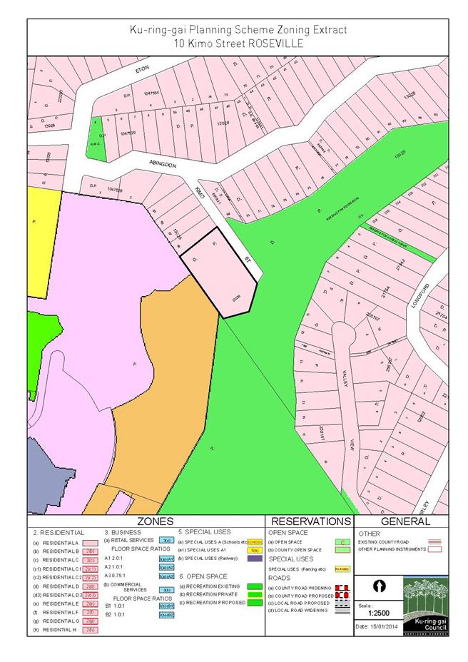
|
APPENDIX No: 4 - SEPP
1 Objection
|
|
Item No: GB.10
|

|
APPENDIX No: 5 - Planning
Circular PS08-014
|
|
Item No: GB.10
|
|
Ordinary
Meeting of Council - 4 February 2014
|
GB.11 / 326
|
|
|
|
|
Item
GB.11
|
S06785/3
|
|
|
10 January 2014
|
Update Report on the Development
Contributions System
EXECUTIVE
SUMMARY
|
purpose of report:
|
The purpose of this report is to provide Council with
an overview of key activities and highlights in the development contributions
system over the past six months and anticipated highlights for the coming
twelve months.
|
|
|
|
|
background:
|
Development contributions are a whole-of-Council
activity, encompassing policy development, development assessment, customer
services, financial management and project management and delivery of
community assets.
|
|
|
|
|
comments:
|
This report focuses on key aspects of the development
contributions policy, systems management and communications and highlights in
asset instigation.
|
|
|
|
|
recommendation:
|
That the information in the report be received and
noted.
|
Purpose of Report
The purpose of this report is to provide Council with an
overview of key activities and highlights in the development contributions
system over the past six months and anticipated highlights for the coming
twelve months.
Background
Development contributions are a whole-of-Council activity,
encompassing policy development, development assessment, customer service,
financial management (including works programme cash-flow) and project
management and delivery of community assets.
A report is provided to Council on a six-monthly basis
outlining progress on the delivery of key items of infrastructure through the
development contributions system. This report focuses on key aspects of
development contributions policy, systems management and communications and
highlights in asset instigation.
Comments
Ku-ring-gai Contributions Plan 2010
Ku-ring-gai Contributions Plan 2010 came into force
on 19 December 2010 and has continued to lawfully operate and apply to all new
development in the Local Government Area of Ku-ring-gai – notwithstanding the
changing statutory planning context in the centres along the Pacific Highway
and in St Ives. Following the gazettal of Ku-ring-gai Local Environmental
Plan (Local Centres) 2012 on 25 January 2013, the catchment mapping was
updated (through the statutory processes of exhibition and adoption by Council)
to accurately reflect the new statutory planning context.
Data on the full title, works programme and delivery
progress of this Contributions Plan has recently been provided to the
Department of Planning and Infrastructure as part of an audit of contributions
plans (undertaken by JBA planning consultants on their behalf) to ensure
Ku-ring-gai’s plan is recognised in respect of future Savings and Transitional
arrangements at such time as the Planning Bill may become law.
The White Paper – A New Planning System for NSW –
Planning Bill 2013
As reported in the previous six-monthly update (OMC 13
August 2013), Ku-ring-gai Council made a comprehensive submission on the White
Paper and Planning Bill. In respect of Chapter 7 – Provision of
Infrastructure, key points included:
· emphasising the different but very
real infrastructure needs of established areas undergoing intensive urban
renewal resulting in a changing urban form in the local centres;
· supporting the principal of
integrated infrastructure provision and noting emerging trends in the demography
of residents in new housing developments – including younger adults and
increasingly including families with children;
· the importance of new local and
civic open space compared to regional open space;
· the need to properly allow for costs
of paved civic spaces in urban areas as a ‘baseline’ cost in any generic
guideline for the future funding where grass is not an appropriate response to
the urban context;
· objecting strongly to an impractical
time-limit on the expenditure of contributions proposing instead that a local
government authority that can demonstrate a well-planned rolling works
programme of infrastructure delivery over the development life of the LEP
should be able to be exempted from any such arbitrary requirement – linked to
support in principal for greater reporting of the detailed staged delivery
programme under Contributions Plans. Considerable work in the form of
community consultation, detailed design, approval processes and tendering takes
place before the visible on-the-ground construction of community infrastructure
commences which can contribute to an erroneous impression that infrastructure
is not being delivered and/or that a council is ‘hoarding’;
· demonstrating through the inclusion
of plans and photographs with commentary that Ku‑ring-gai Council
currently has community infrastructure works at all stages of the delivery
process as part of a rolling works programme linked to the Long Term Financial
Plan;
· objecting to the deferral of payment
to a later stage as the draft included in the White Paper would involve
transferring considerable financial risk to Council and the community among
many other practical and logistical issues; and
· expressing concern that any future
contributions towards State infrastructure e.g. new and augmented schools and
improvements to State Roads, should not reduce the capacity for local
government to deliver key open space, community facilities and transport
upgrades in the planning (and levying) since the start of the current
redevelopment phase in 2004.
The Planning Bill underwent only a few minor amendments to
infrastructure contributions matters before being presented to Parliament last
year; most of the amendments that took place both between consultation and
introduction to Parliament and subsequently, especially in the Legislative
Council, related to other aspects of the Bill. There remains within the Bill a
time-limit on the time to expend contributions but this has been extended from
three years to five years with the option for the Minister to grant
extensions. The Bill also still contains provisions to allow for the payment
of contributions to be delayed until later in the development phase. In both
cases, the detail will not be known until the Regulations are drafted.
The importance of contributions to rapidly redeveloping and
intensifying established (brownfield) areas like Ku-ring-gai, and also Green
Square in the south of Sydney, including the difference in what constitutes
‘baseline’ surfaces and facilities for areas of intensive public usage, needs
regular reiteration as it seems to be greenfield release areas that are at the
forefront of perceptions where infrastructure funding is considered. It is
important that the new system caters for all variations of infrastructure
required to support new development in all its forms.
Parliament next sits on 25 February 2014 (Legislative
Assembly). It is unknown if the Planning Bill will be reintroduced
immediately.
Development, infrastructure and development contributions
Development – including intensive redevelopment in
established area - brings with it demand for physical and community
infrastructure. The demands for new and upgraded infrastructure in areas of
urban renewal are different from those found in greenfield areas but they are
no less essential to supporting a successful intensification of density.
Infrastructure, provided by contributions that are levied on higher-density
development, supports a significant change in density in many areas,
integrating improvements in public squares, civic spaces, new parks, new roads
and pedestrian linkages with the surrounding development. Infrastructure is
essential to support the shift in character of a suburban centre to an urban
one, bringing with it changing lifestyles and demographics. These are very
real infrastructure demands.
The paragraphs below provide an overview of Ku-ring-gai’s
actions as well as future intentions with respect to the provision of
infrastructure supporting development in the local centres.
New open space and new civic space
To date, Ku-ring-gai Council has acquired approximately
23,100sqm of land at a cost of just over $47.7M for the provision of
new local parks and civic spaces – excluding the acquisitions of 2, 4 and 6
Bent Street, Lindfield which were in the process of settlement as this report
was being finalised. The process of designing and delivering some of these
prospective new parks is well underway.
The following is a stepped process for delivering a new
park:
1. property
acquisition and site consolidation (at least three, usually more properties);
2. first
stage community consultation – surveys of local residents and potential park
users;
3. detailed
preliminary designs;
4. second
stage community consultation – seeking feedback on the draft preliminary
design;
5. detailed
final design;
6. approval
processes and tenders;
7. construction
phase begins;
8. construction
phase; and
9. handover
and official opening.
Lindfield Community Hub, Woodford Lane, Lindfield
On 28 May 2013 Council resolved to prepare a master plan for
the site and allocated a budget for the project. A Project Control Group has
been established with representatives of Council and TFNSW to guide the
preparation of the master plan.
One of the key constraints of the site is vehicle access and
circulation, particularly if Council is to consider a mix of uses on the site
such as residential, retail and community uses. In order to inform planning for
the site, council has commenced preparation of a Lindfield Local Centre
Transport Network Model Study. This project involves:
· Development of a comprehensive
transport network model for Lindfield Local Centre compatible with current
Roads and Maritime Services (RMS) standards. The model will include existing
and future traffic movements, public transport, pedestrian patterns and cycle
movements, and will incorporate the latest traffic improvements proposed by
Council as per the Lindfield Local Centre Traffic Improvement Concept Plan.
· Testing alternative development scenarios
to determine the network impacts and capacity; as well as recommend traffic
network improvements.
The consultants have completed a full review of background
material on the project, including Council reports, traffic and transport
studies as well as Council’s Parking Management Plan. The consultants have
completed the survey work which includes:
· full traffic counts for key
intersections within the Lindfield local centre;
· counts of other transport options
within the centre including pedestrian volumes and desire lines, cycle, taxi,
bus and train movements; and
· input of traffic generation from
projected development as a result of KLEP (Local Centres) 2013 as verified by
Council staff.
A base model has now been prepared and has been
peer-reviewed. Capacity testing is currently being carried out on the network
model. The transport consultant will then use the data to test scenarios and
recommend potential network changes to maximise capacity. From this data,
Council will develop a range of traffic improvement measures across the
Lindfield Local Centre.
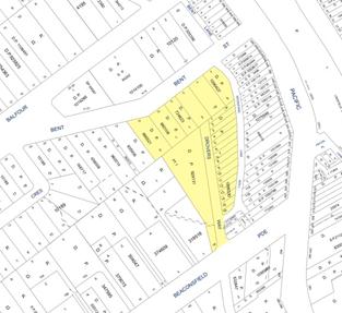
Lindfield Community Hub – location diagram
Lindfield Village Green, Tryon Road, Lindfield
At the OMC of 9 April 2013 Council resolved to commence
detailed planning for the Lindfield Village Green Project. At the same time
they allocated a project budget for this work. Lindfield Village Green will be
a large green space on the eastern side of Lindfield.
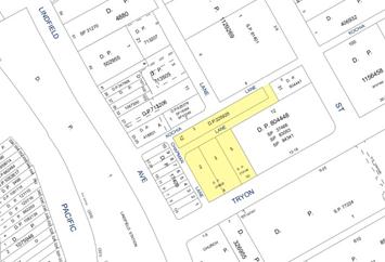
Lindfield Village Green – location diagram
Community Facilities
The critical decision for Council is whether to co-locate a
new branch library with the Lindfield Village Green, as nominated in Council’s
Contributions Plan, or to co-locate the library and multi-purpose community facility
within the Lindfield Community hub site.
To address these questions Elton Consulting P/L. were
engaged to prepare a Community Facilities Study for Lindfield. A draft of the
study was completed in December 2013 and the results of this study were reported
to Council on the 10th December 2013.
The key findings to date from the Community Facilities Study
are:
· the
preferred size of the library is 1,217sqm; and
· the preferred siting strategy is to
co-locate the new facilities combining the Lindfield branch library and the
multi-purpose community centre on the Woodford Lane site.
Council has resolved to proceed with the master planning of
the Lindfield Village Green on the basis that there will be no library on the
site and that the consultant continue to develop the functional briefs for the
facilities on the Woodford Lane site consistent with this direction.
Road closures
The Tryon Road site has an unnamed lane which runs east-west
across the site. The lane currently forms part of the car park circulation. In
order to deliver the Lindfield Village Green, Council will need to consolidate
various properties owned by Council fronting Kochia Lane, Chapman Lane and
Tryon Road and partially close and realign local public roads as shown in the
diagram below. It is noted this arrangement is intended to not disadvantage any
adjoining landowners.
Council
has sought advice as to the best manner and the statutory requirements to
effect partial closure of the local public road on the Tryon Road site. Advice
was received from Lindsay Taylor Lawyers. The advice reviewed two ways
by which the road can be closed:
o by the Minister administering the Roads
Act 1993 (Minister) pursuant to an application lodged by the Council; or
o by way of compulsory acquisition of
the road by the Council.
Based on this advice Council resolved on the 10 December
2013 to compulsorily acquire the unnamed public road and delegate to the
General Manager to do anything further as necessary to give effect to the
compulsory acquisition and publishing any necessary notices in the Gazette.
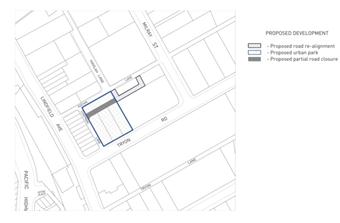
Sale of 9 Havilah Lane Lindfield
Contributions are a key component of funding for these
facilities although not the exclusive source. Additional funding for the
Lindfield Village Green project also derives from the excellent sale result
arising from the divestment of 9 Havilah Lane, a small, isolated, 25-space car
park located a short distance from the future Village Green.
Next Steps
Council will now prepare an illustrative concept design for
the Lindfield Village Green and proceed to public engagement and, following
this, the draft concept is to be reported to Council for their endorsement
prior to public exhibition.
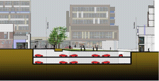
Section showing proposed
village green with basement car park under looking north to Kochia Lane
Carcoola Road Park , St Ives
Carcoola Road Park at 14-18 Carcoola Road, St Ives provides
an opportunity to develop parkland of 2,800sqm in concert with the local
community. Carcoola Road Park is currently at Stage 3 of the process outlined
above.
Community consultation, including surveys of local residents
and potential park users, was completed in September 2013. Results have been
assessed and concept design plans are currently being developed, based on this
feedback. Survey results show that a local playground and picnic facilities are
most valued, with parking, fencing and cycle paths attracting support. A site
analysis has been completed to inform the design plans, and some minor site
contamination works have been completed.
Plans for tender are anticipated to be completed in the
middle of the 2014-15 financial year for construction.
Eton Road Community Centre and synthetic sports field
A new community centre has being constructed by Defence
Housing Australia as part of the voluntary planning agreement for redevelopment
of part of the former UTS site at Lindfield. The community centre is now
complete and was officially opened on Tuesday 17 December 2013 together with
the adjoining sports oval. Currently two-thirds of upper floor is being
utilised by the DHA as a housing display and sales area under agreement for
approximately one to two years but, as the community begins to move in, it will
come into its own as the community centre for this brand new housing area and
for the wider KMC community. The change rooms and public toilets on the sports
field level are already in use with matches being held on the oval including
the inaugural match on opening day.
A new synthetic playing field has been constructed by
Council and Defence Housing Australia as part of the voluntary planning
agreement for redevelopment of part of the UTS site at Lindfield. The synthetic
playing field is complete and was concurrently officially opened on Tuesday 17
December 2013. A valuable contribution of $100,000 from the Northern Suburbs
Football Association (NSFA) assisted with the installation of a more durable
synthetic playing surface and sportsfield lighting. A NSW Government Community
Building Partnership grant of $40,000 assisted with the construction of change
rooms and public toilets for the oval.
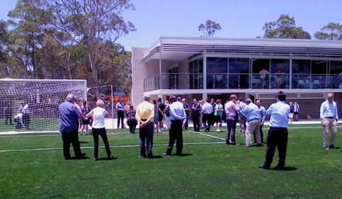
Opening Day Tuesday 17 December 2013
Ready to take the field for the inaugural opening day
match
Ready for players and spectators
Greengate Park (located in Bruce Avenue Killara)
Located on Bruce Avenue and Greengate Lane in Killara, this
project has been recently completed and became available for use by the public
just before Christmas. It is already proving very popular with locals. The
official opening will be scheduled in the near future. The name, ‘Greengate
Park’ is awaiting formal approval from the Geographic Names Board. Greengate
Park is at the final stage - Stage 9 - of the process outlined above.
The new playground and picnic shelter with BBQ on the far
right of the picture
New BBQ and nearby tap and bubbler
Pathway suitable for bikes and adjacent to the picnic
area
Another quieter space
Cameron Park extension
Located in Gilroy Road in Turramurra and adjoining the
existing Cameron Park, the new acquisitions will effectively double the size of
Cameron Park when complete. Council adopted a final concept plan at the OMC of
25 June 2013. Cameron Park is concurrently in Stages 6-7 of the process
outlined above.
Demolition of the four houses commenced in November 2013 and
will be completed during January 2014. The site will then be secured with 1.8
metre chain-wire fencing until construction of the park commences, which, at
this stage, is anticipated to be in late 2014.
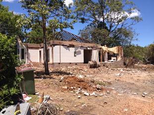
Demolition of houses,
Gilroy Road, Turramurra
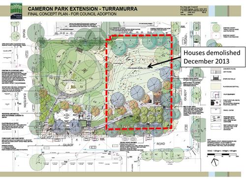
Adopted concept plan,
Cameron Park extension
Areas of priority for new parkland and/or civic spaces
Ku-ring-gai Council is actively pursuing opportunities for
land acquisitions for new parks in areas of recent development activity where
no new parks have yet been established.
As indicated above, an area of continued focus is Lindfield
which has experienced substantial development and has further approved
development yet to commence. Council’s ownership on land for a new park
commenced with the purchase of 8 and 10 Bent Street, Lindfield which settled on
17 May 2013. This was followed by the acquisition of 12 Bent Street on 15
August 2013 which will allow the realignment of Drovers Way. The final three
properties at 2, 4 and 6 Bent Street settled on 15 January 2014. The master planning
of the site as part of the Woodford Lane commuter car parking project is
outlined in detail above.
A vital contribution to other major works
The funding of two of Ku-ring-gai’s major capital works –
the West Pymble Aquatic Centre and the North Turramurra Recreation Area (NTRA)
come from a number of sources of which contributions from development are only
a small but important part. The West Pymble Aquatic Centre is nearing
completion and will be a valuable year-round facility for Ku-ring-gai. Work on
the NTRA is also actively progressing.
New roads and traffic and pedestrian improvement works
To date, Ku-ring-gai Council has acquired several properties
for the provision of new link roads to facilitate traffic and pedestrian access
in and around the local centres.
Gordon is the target of several new link roads to break the
very long blocks that stretch from the Pacific Highway to Vale Street and,
thereby, improve vehicular and pedestrian circulation and access around the
local centre. The affected properties were zoned for acquisition as SP2
Infrastructure and revert to the relevant residential zone after acquisition by
Ku-ring-gai Council. This facilitates the divestment of any part of the width
of the affected property that is not required for the provision of the link
road reservation itself.
The Dumaresq Street to McIntyre Street link has been
designed to draft stage. The cottage at 36 McIntyre Street has been demolished
and the site secured. Detailed planning on the delivery of this road by Council
is underway. Demolition of the house at 41 Dumaresq Street will proceed when
the current tenant vacates the property in coming months.
The Dumaresq Street to Moree Street link is planned
to proceed in stages with the first stage to be delivered as part of a
Voluntary Planning Agreement (VPA) with the adjoining developer. The draft VPA
has been exhibited with the Development Application and Council has agreed to
enter into it. However, there remain issues with the Development Application
that have delayed its presentation to the Joint Regional Planning Panel (JRPP)
and, accordingly, the VPA has not yet been executed. Construction drawings are
near final and demolition ahead of construction has taken place. Council
continues to negotiate with the adjoining owner with a view to the second stage
of the road delivery being possible in the future.
Council has also acquired 4A Moree Street Gordon for
a road link to St Johns Avenue, however the present development activity in the
Gordon commercial area does not yet trigger need for this link.
Current levels of development activity in McIntyre, Dumaresq
and Moree Streets make these two link roads from Dumaresq Street a much higher
priority.
No. 12 Bent Street, Lindfield has also been purchased
by Council, which will eventually create a new road linking a new realigned
Drovers way to Beaconsfield Parade, Lindfield and Bent Street Lindfield. This
is part of the integrated Woodford Lane Lindfield project.
The Local Centres Local Environmental Plan (LEP) removed a
proposed link road through 12A Park Crescent in Pymble. On 23 October
2012 Council resolved to divest 12A Park Crescent and on the 15 June 2013 the
property was sold.
Census 2011
A relatively small proportion of the development approved
from mid-2004 onwards was both constructed and inhabited by the time of the
2006 census, and considerable development has taken place since then. As such,
the 2011 census is a very important census for Ku-ring-gai and the first
opportunity to understand who is living in these new developments.
Data from the 2011 census is expected to provide valuable
information on new residents arising from new development both directly (in
terms of the residents of newly constructed units) and indirectly (new
residents moving into established housing vacated by people down-sizing, though
this is more difficult to definitively examine). Concentrated census analysis
is on hold until there is more certainty arising from the new planning regime
following the White Paper and Planning Bill.
Voluntary Planning Agreement Policy
Ku-ring-gai’s current Planning Agreement Policy 2008
is nearly five years old. There had been no active use of this policy until the
negotiation of the Planning Agreement to deliver the infrastructure, arising
from the concept approval by the Department of Planning of the Defence Housing
Australia redevelopment of lands which were formally part of the University of
Technology Sydney (UTS) at Lindfield. A second draft VPA for another site is
currently in final draft stages.
Following the experience of these two VPAs it would be
appropriate to review and update this policy in the 2013/2014 year. Once
drafted, a report will be put to Council prior to the exhibition of any such
draft document.
integrated planning and reporting
Theme One: Community, People and Culture
|
Community Strategic Plan Long Term Objective
|
Delivery Program
Term Achievement
|
Operational Plan
Task
|
|
C1.1 An equitable and inclusion community that cares and
provides for its members
|
Our community facilities are accessible and function as
cultural hubs to attract a range of users
|
C6.1.1.1.1-C6.1.1.1.3 New community facilities under
design and planned delivery for Lindfield Town Centre
|
|
C4.1 A community that embraces healthier lifestyle choices
and practices
|
New and enhanced open space and recreation facilities have
been delivered to increase community use and enjoyment
|
C4.1.2.1.1; C4.1.2.1.2; and C4.1.2.1.3
Greengate Park ready to open. Eton Road Oval and community
centre opened 17 December 2013. Balcombe Park Wahroonga opened last year.
Cameron Park Turramurra ready to commence construction.
|
Theme Three: Places, Spaces and Infrastructure
|
Community Strategic Plan Long Term Objective
|
Delivery Program
Term Achievement
|
Operational Plan
Task
|
|
P1.1 Ku-ring-gai’s unique and visual character and
identity is maintained
|
Place making programmes are being implemented for selected
council owned areas
|
P1.1.1.1.2
Lindfield town centre – both east and west of the railway
line/Pacific Hwy – undergoing urban renewal
|
|
P2.1 A robust planning framework is in place to deliver
quality design outcomes and maintain the identity and character of
Ku-ring-gai
|
Strategies, plans and processes are in place to
effectively manage the impact of new development
|
P8.1.1.1.1.1-2
Ku-ring-gai Contributions Plan 2010 ensures new
development contributes towards the cost of delivering supporting
infrastructure.
|
|
P4.1 Our centres offer a broad range of shops and services
and contain lively urban village spaces where people can live, work, shop,
meet and spend leisure time
|
Plans to revitalise local centres are bring progressively
implemented and achieve quality design outcomes in collaboration with key
agencies, landholders and the community
|
P1.1.1.1.2
Lindfield is the first centre to undergo comprehensive
Masterplanning for revitalisation.
|
|
P6.1 Recreation, sporting and leisure facilities are
available to meet the community’s diverse and changing needs
|
A programme is being implemented to improve existing
recreation, sporting and leisure facilities and facilitate the establishment
of new facilities.
|
C4.1.2.1.2-3;
New facilities are being established including: Eton Road
Oval, Greengate Park and Cameron Park.
|
|
P7 Multipurpose community buildings and facilities are
available to meet the community’s diverse and changing needs
|
Standards are developed to improve the condition and
functionality of existing and new assets
|
C6.1.2.1.2
New community facilities including a new library and
multi-purpose community facilities are in the Masterplanning stages for
Lindfield.
|
|
P8.1 An improved standard of infrastructure that meets the
community’s service level standards and Council’s obligations as the
custodian of our community’s assets
|
Our public infrastructure and assets are planned, managed and
funded to meet community expectations, defined levels of service and address
inter-generational equity
|
C6.1.2.1.2; C4.1.2.1.3
New public infrastructure is planned to support new
development and ensure that everyone who lives and works in Ku-ring-gai continues
to enjoy access to public facilities.
|
Theme Four: Access, Traffic and Transport
|
Community Strategic Plan Long Term Objective
|
Delivery Program
Term Achievement
|
Operational Plan
Task
|
|
T1.1 A range of integrated transport choices are available
to enable effective movement to, from and around Ku-ring-gai
|
A network of safe and convenient links to local centres,
major land uses and recreational opportunities is in place
|
C6.1.2.1.1; T1.1.3.1.1
Lindfield Commuter car park, park, community facilities and
realigned Drovers Way.
|
|
T3.1 An accessible public transport and regional road
network that meets the diverse and changing needs of the community
|
A strategic access, traffic and transport plan is being
implemented for the Northern Sydney Region
|
C6.1.2.1.1; T 1.1.3.1.1
Commuter car parking and new link roads
|
Theme Six: Leadership and Governance
|
Community Strategic Plan Long Term Objective
|
Delivery Program
Term Achievement
|
Operational Plan
Task
|
|
L1.1 A shared long term vision for Ku-ring-gai underpins
strategic collaboration, policy development and community engagement
|
Council’s responses to government policy and reforms are
guided by and aligned with the adopted Community Strategic Plan 2030 “Our
Community – Our Future’
|
L1.1.2.1.1 and L1.1.2.1.2
Ku-ring-gai made a comprehensive submission to the White
Paper and Planning Bill and continues to have input into on-going planning
for the future Planning System in respect of the future contributions system
with the Department of Planning and Infrastructure.
|
|
L2.1 Council rigorously manages its financial resources
and assets to maximise delivery of services
|
Council expenditure satisfies the needs of the community
and Council has increased its commitment to infrastructure asset management priorities
|
C6.1.1.1.2
Council is leveraging the value of its assets to combine
with contributions to deliver major community assets in Lindfield
|
Governance Matters
Regular reporting
The need to give members of Council and the community more
information on progress and activity in the development contributions systems
was identified as part of the Delivery Program and the Operational Plans. It
is intended to continue to provide this report regularly (six-monthly) and to
provide additional information and links on Council’s website throughout the
year.
Internal audit
Council’s Contributions System was recently the focus of an
internal review. While generally the system is well managed, there are a
couple of areas that could be further improved including documenting and
updating of current procedures for incorporation in the procedures manuals of
each relevant section of Council which is involved in a component of the
contributions process, and a formal audit that contributions arising from
privately certified applications have been paid (and appropriate legal
proceedings instigated if required). An internal committee has been set up to
ensure these matters are attended to and work is progressing.
Risk Management
The works programme arising out of Ku-ring-gai
Contributions Plan 2010 through to at least 2031 is a multi-million dollar
undertaking. Infrastructure delivery will be possible only through the receipt
of contributions which will be affected by several economic cycles over the
life of the contributions plan. The risks in taking such a strategic horizon
are managed through regular reviews of the contributions plan, at a minimum
after the release of data from each five-yearly census or, more frequently, if
the pace or scale of development is definitely changed by any statutory process
or economic cycle. The rate and scale of development is monitored by Council
staff.
A much greater risk is the uncertainty surrounding the
implementation of many of the proposals provided for in the White Paper: A
New Planning System for NSW and associated Draft Exposure Bill. This will
be a key focus of effort and activity during 2014.
Acquisition of a number of targeted sites by negotiation has
not been possible. Council may need to consider compulsory acquisition of some
of these sites to assist with finalisation of a range of park and local road
land projects in a timely manner.
An internal review is currently being undertaken by
Council’s Finance Section for the purpose of confirming receipts of section 94
development contributions and projecting future contributions income for
currently operating development applications. The process involves the
reconciliation and maintenance of the section 94 contributions register in
compliance with the Environmental Planning & Assessment (EP&A) Act and
Government Information (Public Access) Act (GIPA) requirement and the review of
procedures followed by staff to ensure adequate controls are in placed when
levying and collecting contributions. It is anticipated that the outcome of the
review will facilitate the analysis of funding available for the Long Term
Financial Plans capital works programme and allow better cash-flow management.
Financial Considerations
Council maintains a dynamic Long Term Financial Plan. The
works programme of Ku-ring-gai Contributions Plan 2010 was integrated
into the Long Term Financial Plan from the start of 2011 and adopted by Council
on 3 May 2011. It is updated annually and duly reported to Council to ensure
its currency. Staff of both the Finance Unit and the Urban Planning &
Heritage Unit monitor both income and development growth respectively and
liaise to maintain a deliverable works programme. The scheduling of works
through to the long term should be considered somewhat fluid depending on
strategic opportunities that might arise from time-to-time and the management
of cash flows during the economic cycle.
In this context, Ku-ring-gai Contributions Plan 2010
comprises a large range of works from small-scale parkland embellishments to
major community infrastructure facilitating considerable flexibility in
managing a financially deliverable work programme over time. Ku-ring-gai
Council Finance staff continue to refine the cash-flow management of
development contributions to support and facilitate the delivery programme over
the life of the Contributions Plan. As part of this process, staff from both
the Finance and the Strategy Planning Unit have met to consider managing the
issue of pooling contributions across the Contributions Plan to facilitate an
efficient programme of infrastructure delivery over time. A much-anticipated
improvement is a dedicated cash-flow management system feeding into the Long
Term Financial Plan for the analysis and improved financial cash-flow management
of development contributions. This will become an even greater priority in
2014 ahead of new systems to be instigated by the Department of Planning and
Infrastructure.
Social Considerations
Ku-ring-gai Local Government Area has been going through a
period of change commencing in 2004. This is bringing about population growth
following years of declining and stable population since the 1980s.
Infrastructure is essential to support and encourage the integration of the new
residents of Ku-ring-gai, both among residents of the new dwellings being built
and those moving into larger existing housing vacated by the members of
Ku-ring-gai’s older population who have ‘downsized’ into smaller local
accommodation.
The provision of additional community infrastructure
providing both outdoor and indoor community spaces will continue to support
this process and help Ku-ring-gai continue to be a vibrant and popular place to
live for all ages.
Environmental Considerations
Environmental considerations are part of the detailed design
of every item of infrastructure provided for in the Contributions Plan. The
provision of this infrastructure is required to support cohesive and
sustainable communities in areas of increasing urbanisation.
Community Consultation
One of the areas where Council could do better is in the
publication of information relating to the delivery of infrastructure arising
from development contributions on an on-going basis. The recent review,
redesign and upgrade of Ku-ring-gai Council’s website can facilitate this
process. This remains a key objective for the second half of 2013/2014.
As well as providing a current information resource for the
community and local developers, this visual demonstration of Council’s on-going
delivery of infrastructure will also assist in addressing media inquiries and
criticism from external development agencies.
Internal Consultation
The management of the development contributions system is a
truly whole-of-Council system from policy development, to contributions
calculation, through inflation and receipting to infrastructure development.
All aspects of the contributions system are co-ordinated across Council with
input from all areas with a direct interest in that aspect on an on-going
basis.
Summary
This report summarises where Ku-ring-gai is heading in the
delivery of infrastructure funded, or partly funded, by development
contributions across the LGA with particular reference to the local centres
along the Pacific Highway and in St Ives where the majority of redevelopment is
concentrated. This is the fifth in a series of six-monthly updates since 2011.
It outlines progress on the delivery of community infrastructure on recently
acquired sites for the both parks and roads as well as other works wholly or
partly funded by development contributions.
More technical financial detail is reported quarterly in
Council’s Long Term Financial Plan, in Council’s annual budget and as part of
individual key infrastructure items such as the West Pymble Aquatic Centre and
North Turramurra Recreation Area.
|
Recommendation:
That the latest update report on the development
contributions system in Ku-ring-gai be received and noted.
|
|
Kate Paterson
Infrastructure Co-ordinator
|
Roger Faulkner
Team Leader Sport & Recreation Planning
|
|
Bill Royal
Team Leader Urban Design
|
Antony Fabbro
Manager Urban & Heritage Planning
|
|
Andrew Watson
Director Strategy & Environment
|
|
|
Ordinary
Meeting of Council - 4 February 2014
|
GB.12 / 345
|
|
|
|
|
Item
GB.12
|
S02294
|
|
|
9 January 2014
|
EXECUTIVE
SUMMARY
|
purpose of report:
|
To seek Council’s consent for application to the Minister
of Local Government under Section 358 of the Local Government Act, 1993, to
participate in entering a Waste Alliance Agreement with other Councils
associated with NSROC for waste disposal.
|
|
|
|
|
background:
|
In May 2013, Council agreed to participate in preparing a
joint Tender for processing and disposal of waste with NSROC Councils.
|
|
|
|
|
comments:
|
NSROC has been working with member Councils to phase
in a regional contract to help achieve better waste disposal charges and
possibly provide incentives for new waste technologies.
|
|
|
|
|
recommendation:
|
That Council resolve to make application to the Minister
for Local Government under Section 358 of the Local Government Act, 1993,
with a report back to Council detailing associated roles and governance of
the Waste Alliance Agreement.
|
Purpose of Report
To seek Council’s consent for application to the Minister of
Local Government under Section 358 of the Local Government Act, 1993, to
participate in entering a Waste Alliance Agreement with other Councils
associated with NSROC for waste disposal.
Background
In May 2013, Council recommended the preparation of a joint
Tender for processing and disposal of waste with Northern Sydney
Regional Organisation of Councils (NSROC) and resolved as
follows:
A. That
Council endorse participation in preparations to go to tender for procurement
of waste disposal/processing services for NSROC Councils for a contract
commencing in 2014, noting that a further report on tender criteria will come
to Council in July-August 2013 for final agreement as to participation in the
tender.
B. That
Council agree to be part of an application for authorisation, through
revocation and substitution of 2003 authorisation, from the Australian
Competition and Consumer Commission for group purchasing of waste disposal
services.
C. That
Council agree to formal participation arrangements with NSROC Councils to
contribute to the costs of establishing partnership arrangements for shared
services procurement and management by NSROC Councils, on a case-by-case basis,
commencing with the waste disposal tender.
D. That
Council agree to contribute to the governance structure establishment costs on
an equal basis amongst all NSROC Councils, and the tender preparation costs, in
line with volume participation in the waste contract.
E. That
Council’s existing disposal Contracts be extended due to extenuating
circumstances associated with the regional procurement process and their
extension being of sufficient duration to allow the regional contracts to come
into effect.
The previous report to Council dated 28 May 2013, advised of
proposed governance arrangements for the Regional Waste Project to formalize
the legal and operational processes for Council participating in the regional
waste service.
The governance arrangements are now termed “The Northern
Sydney Waste Alliance Agreement” which is being formally drafted for
consideration of Council.
As indicated, the Northern Sydney Waste Alliance Agreement
will establish a clear legal relationship between all Councils associated with
NSROC for the purpose of cooperative procurement of waste services and to
identify the procedures and roles for the management of the service.
In July 2013, NSROC sought advice from the Division of Local
Government in respect of the Northern Sydney Waste Alliance Agreement. The
Chief Executive advised Council must seek approval from the Minister for Local
Government’s before entering into an agreement. It is deemed to fall within the
requirement of a Council obtaining prior approval from the Minister to form an
‘entity’.
The advice further indicated the wording of the previously
adopted recommendations was not sufficiently specific and each Council planning
to enter into the Northern Sydney Waste Alliance Agreement would need to pass a
specific resolution supporting an application under Section 358 of the Local
Government Act 1993.
A specific resolution from Council is required to proceed
with the application to the Minister for Local Government.
Comments
The Regional Waste Tender is a joint procurement opportunity
made possible by the current contract termination dates for member Councils of
NSROC.
Between 2014 and 2015 all seven (7) Councils associated with
NSROC agreed to join a shared Contract for waste services. The benefits of the
shared approach have been detailed in the report considered by all Councils
associated with NSROC in May/June 2013. The strategic and likely commercial
advantages explained in the report are unchanged.
Establishing the Alliance
Agreement requires a special resolution by Council, as noted above, in respect
of Section 358 of the Local Government Act, 1993 and under DLG Circular
07/49. In addition to the resolution from Council, the submission to the
Minister is required to address the following four (4) criteria:
· Is the proposal
consistent with the functions of the council or an existing service that the
council provides?
· Will the proposed entity
be legally separated from the council?
· Is the council currently
financially viable?
· What is the impact of the proposal
on existing council staff?
The criteria above will not present any impediments for the
submission to the Minister by participating Councils. Further, the Alliance
Agreement allows for other Councils to join the arrangement.
integrated planning and reporting
Natural Environment
|
Community Strategic Plan Long Term Objective
|
Delivery Program
Term Achievement
|
Operational Plan
Task
|
|
N51.1 Community progressively reducing its consumption of
resources and leading in recycling and reuse
|
% household waste diverted from landfill
|
Participate in regional waste/processing procurement
process
|
Governance Matters
Details of the final agreement associated with the role and
operational processes will be the subject of a further report to Council. This
report is confined to seeking a specific resolution from Council to make an
application to the Minister for Local Government for consent to proceed in
forming an Alliance Agreement for procuring a long term regional waste
disposal / processing Contract.
Risk Management
The aim in proceeding with the joint regional procurement
for waste disposal is to lessen the risk of escalating costs associated with
disposal and secure a long term contract with a reliable supplier with
sufficient quantities of waste to allow for development of higher level
processing technologies for reducing waste to landfill.
Financial Considerations
Councils associated with NSROC have contributed funds for
the establishment of agreements and no further contributions are required to
implement this recommendation.
Funds relating to disposal and processing are currently
within Council’s recurrent budgets for domestic and non- domestic operational
wastes.
Social Considerations
The regional procurement process will allow for more
incentive in the market for the development of high level technologies in
processing waste and diverting waste from landfill. This will provide environmental
and social benefits with the improved management of wastes.
Environmental Considerations
Increased diversion from landfill will result due to the
Contract structure requiring processing as part of its service specifications
over the term of the Contract.
Community Consultation
No formal consultation is required to proceed with this
process. Media release and other waste educational material will be provided
for the community on securing any long term Contract.
Internal Consultation
Council’s Corporate Lawyer was consulted on legal aspects
associated with this report.
Summary
The Regional Waste Project has taken longer to deliver than
expected for a number of reasons, including staffing changes at NSROC and the
emergence of the merger proposal between NSROC and SHOROC.
Approval is sought from Council for a submission of an
application to the Minister for Local Government under Section 358 of the
Local Government Act, 1993, seeking the Minister’s consent to enter into an
“entity” called the Northern Sydney Waste Alliance Agreement.
The Northern Sydney Waste Alliance Agreement will outline
the roles for Councils’ decision making and governance processes of the
operation for a shared waste disposal Contract.
The details of the Northern Sydney Waste Alliance Agreement
will be subject to a further report to Council before implementation.
|
Recommendation:
A. That
Council resolve to make application to the Minister for Local Government
under Section 358 of the Local Government Act, 1993, for consent to
enter into a joint agreement specifying the roles and governance of
participating Councils for the purpose of a joint waste disposal and
processing Contract.
B. That
upon receipt of the Minister’s consent and finalisation of the details associated
with the roles and governance processes of the Northern Sydney Waste Alliance
Agreement, a further report will be tabled to formalise Council’s
participation.
|
|
Colin Wright
Manager Waste, Drainage & Cleansing
|
Greg Piconi
Director Operations
|
|
Ordinary
Meeting of Council - 4 February 2014
|
GB.13 / 350
|
|
|
|
|
Item
GB.13
|
S09916
|
|
|
22 January 2014
|
Wahroonga Park Playground Upgrade -
Tender T11-2013
EXECUTIVE
SUMMARY
|
purpose of report:
|
To consider the tenders received for the refurbishment
and upgrade of Wahroonga Park Playground, Wahroonga, and appoint the
preferred tenderer.
|
|
|
|
|
background:
|
Council, as part of the Open Space Capital Works
Program, approved funding for the refurbishment and upgrade of Wahroonga Park
Playground, Wahroonga, including replacement of out-dated play equipment and improved
landscaping works.
Tender documents were released through Tenderlink on
12 November 2013 with a closing date of 17 December 2013.
|
|
|
|
|
comments:
|
Tender documents were produced with four (4)
submissions received. The submissions were assessed using agreed criteria
which identified the best value to Council.
|
|
|
|
|
recommendation:
|
In accordance with Section 55 of the Local
Government Act and Tender Regulations, it is recommended Council accept
the tender submitted by tenderer ‘A’ as identified in the Confidential
Summary (Attachment A1).
|
Purpose of Report
To consider the tenders received for the refurbishment and
upgrade of Wahroonga Park Playground, Wahroonga, and appoint the preferred
tenderer.
Background
Council, as part of the Open Space Capital Works Program,
approved funding for the refurbishment and upgrade of Wahroonga Park
Playground, Wahroonga, including replacement of out-dated play equipment and
improved landscaping works.
Following this approval, staff undertook consultation and
preparation of tender documents which were released through Tenderlink on 12
November 2013 with a closing date for receipt of tenders of 17 December 2013.
As the estimated cost of the refurbishment works is over
$150,000, Tenders were called using Tenderlink in accordance with the tender
requirements of the Local Government Act and Regulation.
Comments
Four (4) tenders were received
and recorded in accordance with Council’s tendering policy.
Tenders were received from the
following companies:
· Eco
Fresh Solutions Pty Ltd.
· Furnass
Landscape Pty Ltd.
· GJ’s
Property Management Pty Ltd.
· Go
Gardening Pty Ltd.
It should be noted the order above does not correspond to
the order of the list of tenderers named from ‘A’ to ‘D’ in the confidential
attachment.
A Tender Evaluation Panel
consisting of staff from the Operations Department, Strategy & Environment
Departments and the Corporate Department was formed to assess the four (4)
tenders received.
The evaluation took into account:
· lump sum fee,
· provisional rates,
· company and staff experience,
· ability to provide the full range of
services required,
· work program, and availability,
· previous performance in relation to
similar type work, and
· company’s financial capacity.
Confidential attachments to this report
include:
· List of tenders received and
additional financial information (Attachment A1),
· Tender Evaluation Panel’s comments
and recommendation (Attachment A2), and
· An independent Performance and
Financial Assessment which was carried out by Corporate Scorecard Pty Ltd (Attachment
A3).
From the four (4) submissions
received and the available information taken into account during the evaluation
and scoring of each element of the assessment, Tenderer ‘A’ was identified as
providing the best value to Council.
In
order to ensure Council is not exposed to financial risk and Tenderer ‘A’ is
trading in a sound and profitable manner, an independent Performance and
Financial Assessment was carried out by Corporate Scorecard Pty Ltd.
Tenderer ‘A’ was identified as
providing the ‘best value’ to Council.
integrated planning and reporting
Enhance Recreation, Sporting and Leisure Facilities.
|
Community Strategic Plan Long Term Objective
|
Delivery Program
Term Achievement
|
Operational Plan
Task
|
|
P6.1 Recreation, sporting and leisure facilities are
available to meet the community’s diverse and changing needs.
|
A program is being implemented to improve existing
recreational, sporting and leisure facilities and facilitate the
establishment of new facilities.
|
Deliver park asset refurbishment program at priority
locations.
|
Governance Matters
Tender documents were prepared
and released through Tenderlink on 12 November 2013 with a closing date of 17
December 2013. At the close of tender, three (3) tenders were received. The fourth
submission was received after the closing date / time. All submissions were
recorded in accordance with Council’s tendering policy.
A Tender Evaluation Panel
consisting of staff from the Operations Department, Strategy & Environment
Departments and Corporate Department was formed to assess the four (4) tenders
received.
The evaluation
took into account:
· conformity
of submission,
· lump
sum fee,
· provisional
rates,
· company
and staff experience,
· the
ability to provide the full range of services required, work program,
· previous
performance in relation to similar type work and
· the
company’s financial capacity.
Confidential
attachments to this report include the list of tenders received, the Tender
Evaluation Panel’s comments and recommendation and the independent Performance
and Financial Assessment carried out by Corporate Scorecard Pty Ltd.
The
attachments are considered to be confidential in accordance with Section 10A
(2)(d)(iii) of The Local Government Act 1993 as they are
considered to contain commercial in confidence information.
Risk Management
Three (3) key areas of risk were
identified in relation to the proposed work:
· That work needed to be
carried out by a suitably qualified company with experience of landscape/urban
work in close proximity to residential properties.
· Availability – the
company was available to commence work within a few weeks of the work being
awarded and has the resources to complete the work within 16 weeks or less,
subject to weather delays.
· That Council should not
be exposed to financial risk. As part of the evaluation process, tenderers
were assessed on providing all information and costs requested within the
tender document and an independent Performance and Financial Assessment was
carried out on the preferred tender to ensure that they were trading
responsibly and had the financial capacity to undertake the work as detailed
within the tender documents.
Following
evaluation, including an independent Performance and Financial Assessment of
Tender ‘A’ by Corporate Scorecard Pty Ltd, the tenderer assessed as providing
the best value and quality to Council was Tenderer ‘A’.
As
part of the independent Financial and Performance Assessment the following
areas were examined:
· Tenderer
‘A’ has the financial capacity to undertake the proposed value of work;
· that
Tender ‘A’ has been trading in a profitable and responsible manner during the
last three (3) years; and
· that
Tender ‘A’ has sufficient assets/reserves to cover all possible debts during
the period of work.
The
financial aspect of the assessment shows Tender ‘A’ is able to satisfy all
requirements and is unlikely to expose Council to any financial risk if awarded
the tender as detailed within Council’s tender documents.
Financial Considerations
This project is currently listed in Council’s 2013/14
Delivery Program and Operational Plan as PJ101566 Wahroonga Park Playground
Upgrade. The current funding allocation for the project in PJ101566 is
$391,800, of which $13,100 has been spent on project design costs to date.
The project is fully funded through the Section.94 2004-09
Contributions Plan (Local Parks and Sports Facilities – LGA). Additional
funding, as identified in confidential Attachment A1, is required from
the Section 94 reserve to pay the tender price, contingency, project management
and other projects costs.
During the planning and design
stages of this project, it was always planned the budget would be increased
following the tender assessment in order the correct amount could be allocated.
When Council adopted the Wahroonga Park Precinct Landscape Masterplan on 4
December 2012, the estimate provided for the playground upgrade was $500,000.
Now the tender price is known,
the required balance of funds, identified in the confidential Attachment A1
needs to be allocated from the S.94 2004-09 reserve following approval to award
the tender. In accordance with statutory obligations, at the finalisation of
the project, all unspent funds will be returned to this plan.
Additional financial details are
included within the confidential attachments to this report.
Social Considerations
Wahroonga Park is heavily
utilised and much loved parkland. The present playground within the park has
served the community for a number of years but has now become dated and has reached
the end of its useful life. The present equipment is becoming both difficult
and expensive to maintain.
The
proposed works to replace the existing playground is in line with Council’s
Community Strategic Plan 2030 and the Plan’s long term directions including
the objective to have a community embrace healthier lifestyle choices and
practices; and to provide quality open space, community and recreational
facilities to meet the needs of our changing community.
Environmental Considerations
Prior to tender, the project
was subject to a Potential Environmental Impact Assessment which determined
the impact on the environment by the works is minor.
Community Consultation
The Strategy & Environment Department, as part of the
design process, carried out community consultation prior to finalising the
present proposed design. The design aims to maintain the heritage aspect of
the site while providing new, challenging and interesting play for children.
Prior to the commencement of on-site works, local residents
and businesses will be advised of the commencement of works and be provided
with a time estimate for the completion of the works.
The children’s playground will be closed during the
construction period. The remainder of the park will be kept open and available
for use.
Internal Consultation
Consultation was undertaken by
officers from Strategy & Environment Department for the proposed
construction of the playground, with staff from the Operations and Community
Departments being consulted.
Summary
At the Ordinary Meeting of Council held on 4 December 2012,
Council resolved to proceed to the documentation and tender process with the
adoption of the Wahroonga Park Precinct Landscape Masterplan. Following this
approval staff undertook final preparation of plans and specification with
tender documents being released through Tenderlink on 12 November 2013 with a
closing date for receipt of tenders of 17 December 2013.
A Tender Evaluation Panel was formed consisting of
representatives from Operations Department, Strategy & Environment
Department and Corporate Department.
At the close of tender, three (3) tenders were received with
one additional tender being received after the closing date and time. All
tenders were recorded in accordance with Council’s tendering policy.
Following the evaluation and
independent performance and financial check, it is recommended Tenderer ‘A’ be
appointed on the basis of providing the best value to Council.
|
Recommendation:
A. That Council accept the tender submission from Tenderer ‘A’ to
carry out the refurbishment and upgrade of Wahroonga Park Playground,
Wahroonga.
B. That Council approve the balance of funds required to be
transferred from Section 94 funds to the project.
C. That the Mayor and General Manager be delegated authority to
execute all tender documents on Council’s behalf in relation to the contract.
D. That the Seal of Council be affixed to all necessary documents.
E. That all tenderers be advised of Council’s decision in
accordance with Clause 178 of the Local Government Tendering Regulations.
|
|
David Morris
Manager Projects
|
Greg Piconi
Director Operations
|
|
Attachments:
|
A1
|
List
of Tenders received and financial considerations
|
|
Confidential
|
|
|
A2
|
Tender
Evaulation Panel's comments and recommendation
|
|
Confidential
|
|
|
A3
|
Corporate
Scorecard - Tenderer A - Financial and Performance Assessment
|
|
Confidential
|
|
|
A4
|
Corporate
Scorecard - Tenderer B - Financial and Performance Assessment
|
|
Confidential
|
|
Ordinary
Meeting of Council - 4 February 2014
|
NM.1 / 356
|
|
|
|
|
Item
NM.1
|
CY00020/6
|
|
|
21 January 2014
|
Promoting
Awareness of Road Safety and
Parking Signs in School Zones
Notice
of Motion from Councillor Fornari-Orsmond dated 21 January 2014
There have been a number of issues with illegal parking
around schools which results in safety concerns for the school children and
fines for parents who illegally park.
Council’s Road Safety Officer, along with Road Safety
Officers from other Councils, have developed a brochure that will be sent to all
schools in the area advising them of the rules about parking around school
sites. The schools will be asked to include the brochure in their newsletters
that go out to the parents. A copy of the brochure is attached.
I am proposing that Council send out a similar brochure with
the last quarter rate notices in order to get the message out to all residents
about the rules associated with parking signs and related traffic issues in
schools zones. The aim is to enable residents to have a better understanding
of these rules to hopefully improve the safety for children around school
zones.
I am also proposing that an advertisement be placed in the
local paper incorporating some of the points in the brochure to help spread the
message further.
It is proposed that the funding for this work be costed
against Council’s Road Safety budget.
Therefore, I move that:
“A. That a
brochure on road parking signs around school zones be sent with Council’s last
quarter rates notice.
B. That an
advertisement be placed in the local paper outlining the parking regulations
regarding parking in school zones and the fines applicable for any breaches.”
|
Recommendation:
That the above Notice of Motion as printed be adopted.
|
|
Councillor Chantelle Fornari-Orsmond
Councillor for Wahroonga Ward
|
|
|
Background
Information:
|
A1View
|
Park
Safe and Stay Safe around schools Brochure
|
|
2014/018674
|
|
APPENDIX
No: 1 - Park
Safe and Stay Safe around schools Brochure
|
|
Item No: NM.1
|
|
Ordinary
Meeting of Council - 4 February 2014
|
NM.2 / 359
|
|
|
|
|
Item
NM.2
|
CY00455/2
|
|
|
23 January 2014
|
Letter
of Appreciation to Departing Superintendent
Jeff Philippi of Kuring Gai Local Area Command NSW Police
Notice of Motion from Councillor
Fornari-Orsmond dated 23 January 2014
Superintendent Jeff Philippi has been the Commander of the
Kuring Gai Local Area Command (LAC) since February 2012. In this role, he also
has a number of other important community positions, one being the Local
Emergency Management Controller (LEOCON) for major emergencies including
bushfires.
Prior to Christmas I received a call from Superintendent
Philippi to let me know that he has been posted to Mt Druitt LAC and would be
moving on from Kuring Gai LAC in February 2014. This is certainly a case of
their gain is our loss.
I have known Superintendent Philippi for a few years now,
through the involvement of my community activities with Kuring Gai LAC. I have
found him to be very hands on, showing to be extremely committed and passionate
about both his personal role in the community and that of the fine officers
under his command. Importantly, he has been readily prepared to give his time
when requested to participate in community events.
Superintendent Philippi has served our community very well
indeed during his term as Commander at Kuring Gai LAC and we owe him a debt of
gratitude.
Therefore I move that:
“The Mayor write a letter of appreciation to Superintendent
Jeff Philippi, on behalf of Ku-ring- gai Council and residents, thanking him
for his valuable contribution to our community and wishing him the best for the
future.”
|
Recommendation:
That the above Notice of Motion as printed be adopted.
|
|
Councillor Chantelle Fornari-Orsmond
Councillor for Wahroonga Ward
|
|
|
Ordinary
Meeting of Council - 4 February 2014
|
NM.3 / 360
|
|
|
|
|
Item
NM.3
|
S02777/8
|
|
|
24 January 2014
|
Bike
Plan
Notice of Motion from Councillor
McDonald dated 24 January 2014
Previously the Roads and Traffic Authority (RTA), now the
Roads and Maritime Services (RMS), had a 2010 Bike Plan that incorporated a
bike route along the railway corridor from Hornsby to the City. This was never
implemented.
With the growing success of the sport of road cycling there
is an increasing risk of major injuries and fatalities where bikes are using
main roads.
The proposed Bike Plan was never fully implemented and the
RMS is now looking at alternatives to the original plan. There is a definite
need for bikes to be provided with a safe route to the city and this could be
best done by using the railway corridor.
The original plan was before the current Liberal
Government’s time and I recommend that the Mayor write to the Premier and the
Local Member requesting support for the implementation of the original bike
plan corridor.
Therefore, I recommend:
“That the Mayor write to the Premier, Mr O’Farrell MP and
the Local Member for Davidson, Mr Jonathan O’Dea MP requesting the State
Government reinstate the original RTA Bike Plan 2010 and in particular provide
an off road link from Hornsby to the City.”
|
Recommendation:
That the above Notice of Motion as printed be adopted.
|
|
Councillor Duncan McDonald
Councillor for Wahroonga Ward
|
|