Ordinary
Meeting of Council
TO
BE HELD ON Tuesday, 31 March 2015 AT 7.00pm
Level
3 Council Chamber
Agenda
** ** ** ** ** **
NOTE:
For Full Details, See Council’s Website –
www.kmc.nsw.gov.au
under the link to business papers
APOLOGIEs
DECLARATIONS OF INTEREST
CONFIRMATION OF
REPORTS TO BE CONSIDERED IN CLOSED MEETING
Address the Council
NOTE: Persons
who address the Council should be aware that their address will be tape
recorded.
Documents Circulated to Councillors
CONFIRMATION OF MINUTEs
Minutes of Ordinary Meeting of Council 7
File: S02131
Meeting held 10 March 2015
Minutes numbered 46 to 63
minutes from the Mayor
Petitions
GENERAL BUSINESS
i.
The Mayor to invite Councillors to
nominate any item(s) on the Agenda that they wish to have a site inspection.
ii.
The Mayor to invite Councillors to
nominate any item(s) on the Agenda that they wish to adopt in accordance with
the officer’s recommendation allowing for minor changes without debate.
GB.1 Investment
Report as at 28 February 2015 24
File: S05273
To present Council’s investment
portfolio performance for February 2015.
Recommendation:
That the summary of investments
performance for February 2015 be received and noted; and that the Certificate
of the Responsible Accounting Officer be noted and report adopted.
GB.2 2015
National General Assembly of Local Government - Call for Motions 33
File: S03788
To consider motions for
submission for the 2015 National General Assembly (NGA) of Local Government.
Recommendation:
That Council does not submit any
motions to the 2015 National General Assembly of Local Government.
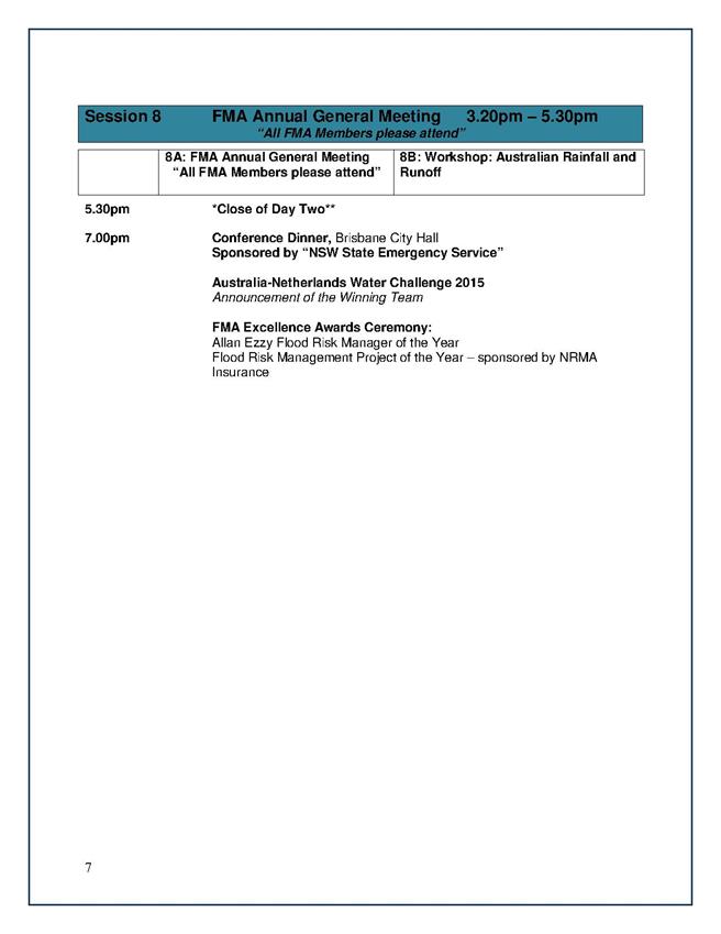
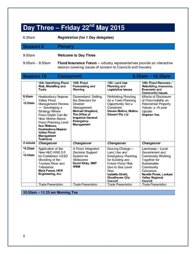
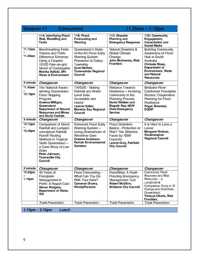
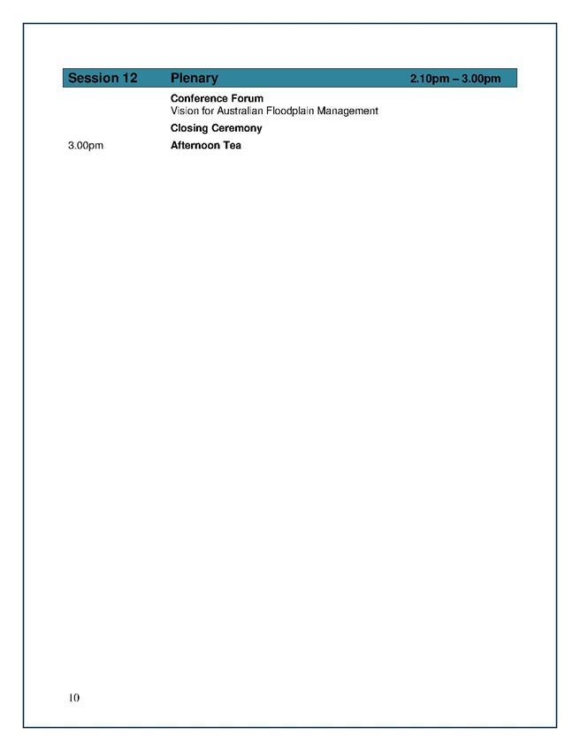
GB.3 Floodplain
Management Association National Conference 37
File: S03939
To advise Councillors of the
Floodplain Management Association National Conference to be held in Brisbane
between 19 – 22 May 2015.
Recommendation:
That any Councillors interested
in attending the 2015 Floodplain Management Association National Conference
advise the General Manager by Friday, 10 April 2015.
GB.4 65 Roland
Avenue Wahroonga - Torrens Title Subdivision into Two Lots 51
File: DA0005/14
Ward: Comenarra
Applicant:
Turnbull Planning International Pty Ltd
Owner: Mr N
Pocock and Mrs I Pocock
To determine Development
Application No. DA0005/14 for the subdivision of one lot into two lots
including tree removal and associated civil works.
Recommendation:
Approval.
GB.5 Consideration
of Officers' Recommendation to the Sydney West Joint Regional Panel on S94
Contribution for DA0327/13 90
File: DA0327/13
For Council to determine whether
it will make a submission to the JRPP on the Section 94 contribution for
DA0327/13 which proposes construction of a new hospital at 742, 746 and 746A
Pacific Highway, Gordon.
Recommendation:
That Council determine whether it
will make a submission to the JRPP on the Section 94 contribution for
DA0327/13.
GB.6 Planning
Proposal to Amend the draft Ku-ring-gai Local Environmental Plan 2015 -
Consideration of Submissions 206
File: S10381
For Council to consider the
submissions made to the exhibition of the Planning Proposal to amend the Ku-ring-gai
Local Environmental Plan 2015.
Recommendation:
That the Planning Proposal to
amend the KLEP 2015 to rectify anomalies, refine local clauses and incorporate
amendments arising from submissions made to the exhibition be endorsed to
proceed.
GB.7 Update
Report on the Development Contributions System 332
File: S06785/3
The purpose of this report is to
provide Council with an overview of key activities and highlights in the
development contributions system since the last report to Council in October
2014 and anticipated actions and highlights for the coming 12 months.
Recommendation:
That the information in the
report be received and noted.
GB.8 Review and
Amendments to the Bush Fire Prone Land Map 345
File: S06342/3
For Council to note amendments to
the Bush Fire Prone Land Map 2008 and to seek Council's approval to exhibit the
draft Bush Fire Prone Land Map 2015 for the Ku-ring-gai Local Government
Area (LGA).
Recommendation:
That Council approve the draft
Bush Fire Prone Land Map 2015 for public exhibition and seek the approval from
the Department of Planning to apply the Bush Fire Evacuation Risk Map overlay
as previously identified in the 2008 certification process.
GB.9 Gordon and
Turramurra Master Plans - Probity Framework 392
File: S10047
The purpose of this report is to
present to Council Probity Management Frameworks for both the Gordon Cultural
Hub and the Turramurra Community Hub.
Recommendation:
That Council receive and note the
Turramurra Community Hub Probity Management Framework and the Gordon Cultural
Hub Probity Management Framework.
GB.10 Gordon Hub
- Authority to Liaise with Ausgrid - Electricity Substation located adjacent to
Radford Place Gordon 464
File: S10376
The purpose of this report is to
provide for the on-going use/lease of the electricity substation owned by
Ausgrid located in the car park at the rear of 818 Pacific Highway Gordon and
to seek formal approval to commence discussions with Ausgrid in advance of the
process of preliminary planning for the Gordon Community and Cultural hub as
this is likely to necessitate relocation of this asset to accommodate most
design solutions.
Recommendation:
That the requirements of Ausgrid
for a suitable site for a future or replacement substation be considered in
current and future planning for the consolidated site known as 818 Pacific
Highway Gordon.
GB.11 Carcoola
Park Concept Plan 468
File: S05624
To seek Council’s endorsement of
the concept design plan for the extension of Carcoola Park and to name the park
“Lapwing Reserve”.
Recommendation:
That Council endorses the final
design concept plan for Carcoola Road Reserve, St Ives as the basis on which
staff prepares construction documentation including plans, cost estimates and
specifications, and tender documentation for calling tenders and that an
application for the name “Lapwing Reserve” be made to the Geographical Names
Board for consideration.
GB.12 828
Pacific Highway Gordon - Independent Review 485
File: S10388
To provide Council with the
independent Project Review – 828 Pacific Highway Gordon Report.
Recommendation:
That Council receive and note the
Project Review – 828 Pacific Highway Gordon Report.
Extra Reports Circulated to Meeting
Motions of which due Notice has
been given
NM.1 Review and
Improvements to Parking at Wahroonga Village Shops 522
File: S03125
Notice of Motion from Councillor
Fornari-Orsmond dated 31 March 2015
When Council considered and
adopted the Wahroonga Town Centre Traffic and Parking Study Report prepared by
Arup, Council adopted the recommendation to only allow a one (1) parking visit
per day at the car park in Coonanbarra Road.
The purpose of only allowing one
parking visit per day was to help prevent shop owners and staff occupying
spaces as they were frequently changing vehicles around in the car park to
avoid fines.
This has caused a general concern
with the residents who use the car park and a number of fines have been issued
as the notice is not clear for the users of the car park. As this is the only
Council car park that has this restriction, it would be fairer to allow two (2)
visits per day.
Some residents have also
expressed concern that the 2 hour limit is not sufficient to allow them to
complete their business.
Accordingly, I move:
“A. That
Council staff carry out a review of the current parking conditions and
restrictions at Wahroonga Village Shops, gather feedback from stakeholders and
bring a report back to Council with the findings and recommendations.
B. That
Council take into consideration the below points:
i. That
the one (1) visit per day be increased to two (2) visits per day for the
Wahroonga car park.
ii. That
more prevalent and clearer signs be placed at the car park entrances advising
users of the rule to permit two visits per day.
iii. That
Council staff investigate the possibility of providing an area in the car park
to allow for three (3) hour parking restrictions.”
BUSINESS WITHOUT NOTICE – SUBJECT TO CLAUSE 241 OF
GENERAL REGULATIONS
Questions Without Notice
Inspections Committee – SETTING OF TIME, DATE AND
RENDEZVOUS
** ** ** ** ** **
Minute Ku-ring-gai
Council Page
MINUTES OF Ordinary Meeting of Council
HELD ON Tuesday, 10 March 2015
|
Present:
|
The Mayor, Councillor J Anderson (Chairperson) (Roseville
Ward)
Councillors E Malicki & J Pettett (Comenarra Ward)
Councillors D Citer & C Szatow (Gordon Ward)
Councillors C Berlioz & D Ossip (St Ives Ward)
Councillor D Armstrong (Roseville Ward)
Councillors C Fornari-Orsmond (Wahroonga Ward)
|
|
|
|
|
Staff Present:
|
General Manager (John McKee)
Director Corporate (David Marshall)
Director Development & Regulation (Michael Miocic)
Director Operations (Greg Piconi)
Director Strategy & Environment (Andrew Watson)
Director Community (Janice Bevan)
Manager Corporate
Communications (Virginia Leafe)
Manager Records & Governance (Matt Ryan)
Minutes Secretary (Judy Murphy)
|
The Meeting
commenced at 7.00pm
The Mayor offered
the Prayer
|
46
|
Apologies
File: S02194
Councillor Duncan McDonald tendered an apology for
non-attendance [business commitment] and requested leave of absence.
|
|
|
Resolved:
(Moved: Councillors Fornari-Orsmond/Pettett)
That the apologies from Councillor McDonald be accepted
and leave of absence granted.
CARRIED
UNANIMOUSLY
|
DECLARATIONS OF
INTEREST
The Mayor
adverted to the necessity for Councillors and staff to declare a Pecuniary
Interest/Conflict of Interest in any item on the Business Paper.
No such
Interest was declared.
|
47
|
CONFIRMATION OF REPORTS TO BE
CONSIDERED IN CLOSED MEETING
File: S02499/9
|
|
|
Resolved:
(Moved:
Councillors Szatow/Berlioz)
That in accordance with the provisions of Section 10 of
the Local Government Act 1993, all officers’ reports be released to the press
and public, with the exception of confidential attachments to the following
General Business reports:
GB.1 Market Operator for St Ives Old School Site
Attachment 1: Evaluation Committee Report
GB.5 Renewal of Air Stratum Lease over Wade Lane
Gordon
Attachment 1: Valuation Report by AEC Group
Attachment 2: Acceptance of lease terms by Charter
Hall
Attachment 3: Heads of Agreements - Renewal of lease
for Wade Lane Air-bridge
CARRIED
UNANIMOUSLY
|
Address the Council
The following members of the
public addressed Council on items not on the Agenda:
J Harwood – Urban
Biodiversity
DOCUMENTS CIRCULATED
TO COUNCILLORS
The Mayor adverted to the
documents circulated in the Councillors’ papers and advised that the following
matters would be dealt with at the appropriate time during the meeting:
|
Memorandums:
|
Refer
GB.1 - Market Operator for St Ives Old School Site – Memorandum from Director Community dated 10 March 2015 requesting
that the item be deferred until after the Plan of Management, which is on
exhibition, has been adopted by Council.
Refer
GB.6 - Middle Harbour Road, Lindfield - Potential Heritage Conservation Area
Review – Memorandum from Manager Urban and Heritage Planning dated
10 March 2015 advising of a minor correction on page 8 of Attachment 2 – PMA
– Middle Harbour Road Heritage Inventory Sheet (page 122 of Business Paper
03/15) under (b) Protection of contributory items and their settings and
advised that the text at bullet point 7 Protect curtilage and element
within Swain Gardens and Killara Park will be deleted from the document
prior to the exhibition of the proposed HCA.
|
|
Councillors Information:
|
Meeting
with Rural Fire Service Commissioner – Memorandum from Director
Operations dated 6 March 2015 in answer to a Question Without Notice raised
by Councillor Elaine Malicki at the Ordinary Meeting of Council held 24
February 2015.
Northern
ERUV – Current Development Work and Plastic Conduits – Memorandum
with attachments from Director Operations dated 6 March 2015 in answer to a
Question Without Notice raised by Councillor Duncan McDonald at the Ordinary
Meeting of Council held 24 February 2015.
|
CONFIRMATION OF
MINUTEs
|
48
|
Minutes of Ordinary
Meeting of Council
File: S02131
|
|
|
Meeting held 24 February 2015
Minutes numbered 21 to 45
|
|
|
Resolved:
(Moved: Councillors Szatow/Pettett)
That Minutes numbered 21 to 45 circulated to Councillors
were taken as read and confirmed as an accurate record of the proceedings of
the Meeting.
CARRIED
UNANIMOUSLY
|
Recommendations
from Committee
Minutes of
Ku-ring-gai Traffic Committee
File: CY00022/7
Vide: RC.1
Meeting held 19 February 2015
Minutes
numbered KTC.1 to KTC.5.
|
49
|
General Matter
Items under Delegated Authority
File: S02738
Vide Minute No KTC1
|
|
|
Advice on matters considered under Delegated Authority.
|
|
|
Resolved:
(Moved: Councillors Berlioz/Szatow)
That the information regarding traffic
facilities approved during November 2014 to January 2015 be noted.
CARRIED
UNANIMOUSLY
|
|
50
|
General Matter -
Lindfield Fun Run
File: S02158/7
Ward: Roseville
Electorate: Davidson
Vide Minute No KTC2
|
|
|
To consider a request from Rotary Club of Lindfield Inc.
for a Fun Run on Sunday,
6 April 2015.
|
|
|
Resolved:
(Moved: Councillors Berlioz/Szatow)
A. That
Council not object to the proposed Fun Run to be held on Sunday, 6 April 2015
following the routes shown on the Traffic Management Plan submitted by the
Rotary Club of Lindfield Inc., subject to the event organisers observing the
following conditions:
1. The
Roads and Maritime Services approving the Traffic Management Plan submitted
by Council on behalf of the Rotary Club of Lindfield Inc.
2. The
event organisers closing McLeod Avenue and Marjorie Street prior to
commencing the race at the intersection of Marjorie Street and McLeod Avenue.
3. The
event organisers closing the other seven intersections, as highlighted in the
Traffic Management Plan, for a short period of time during the Fun Run.
4. The
event organisers adhering to Police Service conditions set out by the North
Shore Local Area Command.
5. The
organisers to be responsible for supply and erection of barriers, road cones
and the deployment of RMS accredited traffic controllers at appropriate
positions, as directed by the Police Service to make motorists aware of the
potential danger of runners/walkers in the near vicinity.
6. Competitors
to use the footpath where practicable and at other times to run/walk as near
as practicable to the left hand side of the carriageway.
7. Any
motor vehicles used in conjunction with this event must be driven at the
general speed of other traffic. When used for relief or supervisory purposes
while stationary, such vehicles must be clear of the trafficable portion of
the roadway used by moving traffic.
8. The
Event Organiser supplying a copy of the Rotary Club of Lindfield Inc.’s 50
million dollar public liability insurance cover, naming Ku-ring-gai Council
as principal.
B. The
proposed Fun Run and the closures of McLeod Avenue, Marjorie Street and the
other seven intersections along the event’s route be advertised by Council in
the North Shore Times.
C. That
Mr Bruce Dowling, Fun Run Operations Team Leader of Rotary Club of Lindfield
Inc, be notified of Council’s decision, and be requested to respond in
writing to Council by 20 March 2015, regarding the acceptance of Council’s
conditions for conducting the Lindfield Fun Run.
CARRIED
UNANIMOUSLY
|
|
51
|
Traffic and
Transport Policy Parking at Driveways
File: S02527
Vide Minute No KTC3
|
|
|
To consider changes to the Traffic & Transport Policy
to prohibit parking adjacent to some driveways.
|
|
|
Resolved:
(Moved: Councillors Berlioz/Szatow)
A. That
Council’s Traffic & Transport Policy be amended to permit the
installation of ‘No Parking’ restrictions at individual driveways, extending
for up to 6 metres in length, particularly on the approach side, subject to
installations being restricted to:
1. Multi-residential
developments of at least four apartments,
2. Developments
with their driveways being on roads with daily traffic volumes of at least
5,000 vehicles per day, and
3. Individual
requests being considered on their merit but requiring Body Corporate
endorsement.
B. That
Council’s fees and charges for the installation of signs and referral to KTC
apply.
CARRIED
UNANIMOUSLY
|
|
52
|
Mona Vale Road
Clearway Proposal
File: TM1/07
Ward: St Ives
Electorate: Ku-ring-gai
Vide Minute No KTC4
|
|
|
For the committee to consider the proposal from the Roads
and Maritime Services for the introduction of clearways along Mona Vale Road
through St Ives.
|
|
|
Resolved:
(Moved: Councillors Berlioz/Szatow)
That Council not object, in principle, to the
RMS proposal for a clearway on Mona Vale Road, St Ives, on condition that RMS
in consultation with the community and Council, further investigate the
provision of parking in Council’s car park opposite Stanley Street, in the
car park off Porters Lane and potentially behind private shops off Stanley
Lane, as well as improving way finding signs, investigating visibility of
parking signs and clarifying the proposed on-street short term parking
restrictions in St Ives.
CARRIED
UNANIMOUSLY
|
|
53
|
Cowan Road, St Ives
File: TM9/07
Ward: St Ives
Electorate: Davidson
Vide Minute No KTC5
|
|
|
To consider a proposal to introduce full-time ‘No Parking’
restrictions on a section on the western side of Cowan Road between Village
Green Parade and Killeaton Street, St Ives.
|
|
|
Resolved:
(Moved: Councillors Berlioz/Szatow)
A. That
full-time ‘No Parking’ restrictions be introduced at driveways to property
numbers 52 to 60 Cowan Road, St Ives, as per Plan No. Cowan/KTC/02/15,
subject to receiving concurrence from the affected residents.
B. That
affected residents of Cowan Road, St Ives and Council’s Team Leader
Regulations be informed of Council’s decision.
CARRIED
UNANIMOUSLY
|
GENERAL BUSINESS
|
54
|
Market Operator for
St Ives Old School Site
File: S10182
Vide: GB.1
|
|
|
For Council to consider the tenders received for the
Market Operator for St Ives Old School Site Request for Tender (RFT) T09/2014
for provision of commercial market operators, and appoint a preferred
tenderer to operate a market in St Ives.
|
|
|
Resolved:
(Moved: Councillors Malicki/Ossip)
That the matter be deferred
pending the adoption of the St Ives Showground Plan of Management.
CARRIED
UNANIMOUSLY
|
|
55
|
2015 National
General Assembly of Local Government - Call for Motions
File: S03788
Vide: GB.2
|
|
|
To consider an invitation from the Australian Local
Government Association (ALGA) to submit motions to the 2015 National General
Assembly (NGA) of Local Government.
|
|
|
Resolved:
(Moved: Councillors Malicki/Ossip)
A. That
Councillors consider whether they propose to submit any motions to the NGA of
Local Government and provide them to the Manager Records and Governance by
Thursday, 19 March 2015.
B. That
a further report containing any submitted motions from Councillors be
referred to a subsequent Ordinary Meeting of Council prior to the Friday, 17
April 2015 deadline.
CARRIED
UNANIMOUSLY
|
|
56
|
2015 National
General Assembly of Local Government - Delegates
File: S02133
Vide: GB.3
|
|
|
For Council to determine its elected delegates to the 2015
National General Assembly (NGA) of Local Government.
|
|
|
Resolved:
(Moved: Councillors Malicki/Ossip)
A. That
Councillors are to advise the General Manager if they wish to attend the 2015
National General Assembly of Local Government.
B. That
Council determines its voting delegate for the debating session is the Mayor,
Councillor Jennifer Anderson.
CARRIED
UNANIMOUSLY
|
|
57
|
24 Melbourne Road
East Lindfield - Alterations and Additions – Enclosure of an Existing Balcony
and Construction of an Ensuite Bathroom
File: DA0396/14
Vide: GB.4
|
|
|
To determine Development Application DA0396/14 proposing
alterations and additions – enclosure of an existing balcony and construction
of an ensuite bathroom
|
|
|
Resolved:
(Moved: Councillors Malicki/Ossip)
PURSUANT TO SECTION 80(1)
OF THE ENVIRONMENTAL PLANNING AND ASSESSMENT ACT, 1979
THAT the Council, as the
consent authority, is of the opinion that the objection under State
Environmental Planning Policy No. 1 - Development Standards to clause 46
of the Ku-ring-gai Planning Scheme Ordinance is well founded. The Council is
also of the opinion that strict compliance with the development standard is
unreasonable and unnecessary in the circumstances of this case.
AND
THAT the Council, as the
consent authority, being satisfied that the objection under SEPP No. 1 is
well founded and also being of the opinion that the granting of consent to
DA0396/14 is consistent with the aims of the Policy, grant development
consent to DA0396/14 for alterations and additions on land at 24 Melbourne
Road, East Lindfield, for a period of two (2) years from the date of the
Notice of Determination, subject to the following conditions:
Conditions
that identify approved plans:
1. Approved architectural plans and documentation (new
development)
The
development must be carried out in accordance with the following plans and
documentation listed below and endorsed with Council’s stamp, except where
amended by other conditions of this consent:
|
Drawing
no.
|
Drawn
by
|
Dated
|
|
2861
- site plan, plan, elevations, section
|
Architronics
Building Design
|
Revision
A - 24/02/2015
|
Reason: To
ensure that the development is in accordance with the determination.
Conditions
to be satisfied prior to demolition, excavation or construction:
2.
Asbestos works
All
work involving asbestos products and materials, including
asbestos-cement-sheeting (ie. Fibro), must be carried out in accordance with
the guidelines for asbestos work published by WorkCover Authority of NSW.
Reason:
To ensure public safety
3. Notice of commencement
At least 48 hours prior to the
commencement of any development (including demolition, excavation, shoring or
underpinning works), a notice of commencement of building or subdivision work
form and appointment of the principal certifying authority form shall be
submitted to Council.
Reason: Statutory
requirement.
4. Structural adequacy
(alterations and additions)
Prior to commencement of any
development or excavation works, the Principal Certifying Authority shall be
satisfied that that those components of the building to be retained and/or
altered will be structurally sound and able to withstand the construction
process.
Note: Evidence from a qualified practising
structural engineer, demonstrating compliance with the above and detailing,
where relevant, means of support for those parts of the retained building
shall be provided to the Principal Certifying Authority.
Reason: To ensure that the development can be undertaken
in accordance with accepted construction practices as indicated on the
endorsed development plans, without the need for modification of the consent.
Conditions
to be satisfied prior to the issue of the construction certificate:
5. Long service levy
In accordance with Section
109F(i) of the Environmental Planning and Assessment Act a Construction
Certificate shall not be issued until any long service levy payable under
Section 34 of the Building and Construction Industry Long Service Payments
Act 1986 (or where such levy is payable by instalments, the first instalment
of the levy) has been paid. Council is authorised to accept payment. Where
payment has been made elsewhere, proof of payment is to be provided to
Council.
Reason: Statutory
requirement.
Conditions
to be satisfied prior to the issue of the construction certificate or prior to demolition, excavation
or construction (whichever comes first):
6. Infrastructure
restorations fee
To ensure that damage to
Council Property as a result of construction activity is rectified in a
timely matter:
a) All work or activity taken in furtherance of the development
the subject of this approval must be undertaken in a manner to avoid damage
to Council Property and must not jeopardise the safety of any person using or
occupying the adjacent public areas.
b) The applicant, builder, developer or any person acting in
reliance on this approval shall be responsible for making good any damage to
Council Property, and for the removal from Council Property of any waste bin,
building materials, sediment, silt, or any other material or article.
c) The Infrastructure Restoration Fee must be paid to the Council
by the applicant prior to both the issue of the Construction Certificate and
the commencement of any earthworks or construction.
d) In consideration of payment of the Infrastructure Restorations
Fee, Council will undertake such inspections of Council Property as Council
considers necessary and also undertake, on behalf of the applicant, such
restoration work to Council Property, if any, that Council considers
necessary as a consequence of the development. The provision of such
restoration work by the Council does not absolve any person of the
responsibilities contained in (a) to (b) above. Restoration work to be
undertaken by the Council referred to in this condition is limited to work
that can be undertaken by Council at a cost of not more than the
Infrastructure Restorations Fee payable pursuant to this condition.
e) In this condition:
“Council
Property” includes any road, footway, footpath paving, kerbing, guttering,
crossings, street furniture, seats, letter bins, trees, shrubs, lawns,
mounds, bushland, and similar structures or features on any road or public
road within the meaning of the Local Government Act 1993 (NSW) or any public
place; and
“Infrastructure
Restoration Fee” means the Infrastructure Restorations Fee calculated in
accordance with the Schedule of Fees & Charges adopted by Council as at
the date of payment and the cost of any inspections required by the Council
of Council Property associated with this condition.
Reason: To maintain
public infrastructure.
Conditions
to be satisfied during the demolition, excavation and construction phases:
7. Road opening permit
The opening of any footway, roadway, road
shoulder or any part of the road reserve shall not be carried out without a
road opening permit being obtained from Council (upon payment of the required
fee) beforehand.
Reason: Statutory requirement
(Roads Act 1993 Section 138) and to maintain the integrity of Council’s
infrastructure.
8. Prescribed conditions
The applicant shall comply
with any relevant prescribed conditions of development consent under clause
98 of the Environmental Planning and Assessment Regulation. For the purposes
of section 80A (11) of the Environmental Planning and Assessment Act, the
following conditions are prescribed in relation to a development consent for
development that involves any building work:
The work must be carried out in accordance with the
requirements of the Building Code of Australia
In the case of residential building work for which the
Home Building Act 1989 requires there to be a contract of insurance in force
in accordance with Part 6 of that Act, that such a contract of insurance is
in force before any works commence.
Reason: Statutory requirement.
9. Hours of work
Demolition, excavation,
construction work and deliveries of building material and equipment must not
take place outside the hours of 7.00am to 5.00pm Monday to Friday and 8.00am
to 12 noon Saturday. No work and no deliveries are to take place on Sundays
and public holidays.
Excavation or removal of any
materials using machinery of any kind, including compressors and jack
hammers, must be limited to between 7.30am and 5.00pm Monday to Friday, with
a respite break of 45 minutes between 12 noon 1.00pm.
Where it is necessary for
works to occur outside of these hours (ie) placement of concrete for large
floor areas on large residential/commercial developments or where building
processes require the use of oversized trucks and/or cranes that are
restricted by the RTA from travelling during daylight hours to deliver, erect
or remove machinery, tower cranes, pre-cast panels, beams, tanks or service
equipment to or from the site, approval for such activities will be subject
to the issue of an "outside of hours works permit" from Council as
well as notification of the surrounding properties likely to be affected by
the proposed works.
Note: Failure to obtain a permit to
work outside of the approved hours will result in on the spot fines being
issued.
Reason: To ensure reasonable standards of amenity for
occupants of neighbouring properties.
10. Toilet
facilities
During
excavation, demolition and construction phases, toilet facilities are to be
provided, on the work site, at the rate of one toilet for every 20 persons or
part of 20 persons employed at the site.
Reason: Statutory requirement.
11.
Recycling of building material (general)
During demolition and
construction, the Principal Certifying Authority shall be satisfied that
building materials suitable for recycling have been forwarded to an
appropriate registered business dealing in recycling of materials. Materials
to be recycled must be kept in good order.
Reason: To facilitate recycling of materials.
12. Road reserve safety
All public footways and
roadways fronting and adjacent to the site must be maintained in a safe
condition at all times during the course of the development works.
Construction materials must not be stored in the road reserve. A safe
pedestrian circulation route and a pavement/route free of trip hazards must
be maintained at all times on or adjacent to any public access ways fronting
the construction site. Where public infrastructure is damaged, repair works
must be carried out when and as directed by Council officers. Where
pedestrian circulation is diverted on to the roadway or verge areas, clear
directional signage and protective barricades must be installed in accordance
with AS1742-3 (1996) “Traffic Control Devices for Work on Roads”. If
pedestrian circulation is not satisfactorily maintained across the site
frontage, and action is not taken promptly to rectify the defects, Council
may undertake proceedings to stop work.
Reason: To ensure safe public footways and roadways
during construction.
13. Services
Where required, the adjustment
or inclusion of any new utility service facilities must be carried out by the
applicant and in accordance with the requirements of the relevant utility
authority. These works shall be at no cost to Council. It is the applicants’
full responsibility to make contact with the relevant utility authorities to
ascertain the impacts of the proposal upon utility services (including water,
phone, gas and the like). Council accepts no responsibility for any matter
arising from its approval to this application involving any influence upon
utility services provided by another authority.
Reason: Provision of utility services.
14. Drainage to existing
system
Stormwater runoff from all new
impervious areas and subsoil drainage systems shall be piped to the existing
site drainage system. The installation of new drainage components must be
completed by a licensed contractor in accordance with AS3500.3 (Plumbing
Code) and the BCA. No stormwater runoff is to be placed into the Sydney Water
sewer system. If an illegal sewer connection is found during construction,
the drainage system must be rectified to the satisfaction of Council and
Sydney Water.
Reason: To protect the environment.
15.
No storage of materials beneath trees
No
activities, storage or disposal of materials shall take place beneath the
canopy of any tree protected under Council's Tree Preservation Order at any
time.
Reason: To
protect existing trees.
16.
Removal of refuse
All
builders' refuse, spoil and/or material unsuitable for use in landscape areas
shall be removed from the site on completion of the building works.
Reason: To
protect the environment.
17. On site retention of waste dockets
All
demolition, excavation and construction waste dockets are to be retained on
site, or at suitable location, in order to confirm which facility received
materials generated from the site for recycling or disposal.
Each docket is to be an official receipt from a
facility authorised to accept the material type, for disposal or processing.
This information is to be made available at the
request of an Authorised Officer of Council.
Reason: To
protect the environment.
Conditions
to be satisfied prior to the issue of an Occupation Certificate:
18. Infrastructure repair
Prior to issue of the
Occupation Certificate, the Principal Certifying Authority must be satisfied
that any damaged public infrastructure caused as a result of construction
works (including damage caused by, but not limited to, delivery vehicles,
waste collection, contractors, sub- contractors, concrete vehicles) is fully
repaired to the satisfaction of Council Development Engineer and at no cost
to Council.
Reason: To protect public infrastructure.
CARRIED
UNANIMOUSLY
|
|
58
|
Middle Harbour
Road, Lindfield - Potential Heritage Conservation Area Review
File: S10099
Vide: GB.6
|
|
|
To have Council to consider the findings of the Middle
Harbour Road, Lindfield, Potential Heritage Conservation Area (HCA) Review,
prepared by Perumal Murphy Alessi Heritage Consultants (PMA), for a
non-statutory public exhibition.
|
|
|
Resolved:
(Moved: Councillors Malicki/Ossip)
A. That
the Middle Harbour Road, Lindfield, Potential Heritage Conservation Area
Review, prepared by Perumal Murphy Alessi Heritage Consultants be placed on
non-statutory public exhibition for 28 days after being amended in accordance
with the Manager Urban and Heritage Planning’s memorandum dated 10 March 2015 regarding the deletion of bullet point 7 Protect
curtilage and element within Swain Gardens and Killara Park from page 8
of Attachment 2 to the report namely PMA – Middle Harbour Road Heritage
Inventory Sheet.
B. That
a report be brought to Council at the conclusion of the exhibition period.
CARRIED
UNANIMOUSLY
|
|
59
|
Policy for Covert
Electronic Surveillance for Illegal Dumping
File: S02294
Vide: GB.7
|
|
|
To report on the exhibition period associated with the
Policy for Covert Electronic Surveillance for Illegal Dumping to be carried
out in public places for the purposes of law enforcement associated with
illegal dumping.
|
|
|
Resolved:
(Moved: Councillors Malicki/Ossip)
That Council adopt the Policy for Covert Electronic
Surveillance for Illegal Dumping.
CARRIED
UNANIMOUSLY
|
Motions
of which due Notice has been given
|
60
|
Council
Notification Policy for Graffiti and Dumping on NSW Public Authority Properties
in Ku-ring-gai
File: S05122
Vide: NM.1
|
|
|
Notice
of Motion from Councillor Szatow dated 2 March 2015
NSW Public Authorities with property and assets in
Ku-ring-gai are continually defaced by graffiti and subject to illegal
dumping.
Examples are the Gordon RailCorp substation on the corner
of Henry Street and Werona Avenue Gordon; The Sydney Water Reservoir on
Pacific Highway in Killara, railway land in Culworth Avenue Killara .
In spite of numerous phone calls and e-mails by staff over
a number of years and the personal representation of Ward Councillors, the
graffiti and dumping has not been satisfactorily addressed by the relevant
authorities.
Clearly our present policy and system of notification
needs addressing.
Therefore I move that:
“1. A
report be brought to Council advising of the relevant Council Policies and
Procedures currently in place to address graffiti and illegal dumping on land
belonging to State Authorities.
2. That
Council write to the Local Members following the State Election requesting
action by the State Authorities to address graffiti and illegal dumping on
State Authority property.”
|
|
|
Resolved:
(Moved: Councillors Malicki/Ossip)
That the above Notice of Motion, as printed, be adopted.
CARRIED
UNANIMOUSLY
|
GENERAL
BUSINESS (cont)
Council
resolved that the meeting be closed during the discussion of the matter
‘Renewal of Air Stratum Lease over Wade Lane Gordon’ in accordance with section
10A(2)(d)(ii) of the Local Government Act 1993 on the basis that the item
involves the receipt and discussion of commercial information of a confidential
nature that would, if disclosed, confer a commercial advantage on a competitor
of the Council.
This
resolution was moved by Councillors Berlioz and Fornari-Orsmond and
was
CARRIED UNANIMOUSLY
On balance, the
public interest in preserving the confidentiality of information about ‘Renewal
of Air Stratum Lease over Wade Lane Gordon’ outweighs the public interest in
maintaining openness and transparency in council decision-making because the
disclosure of this information may confer a commercial advantage to a
competitor of Council.
Council resolved
to return to Open Council
after a Motion
moved by Councillors Berlioz and Szatow
was CARRIED
UNANIMOUSLY
|
61
|
Renewal of Air
Stratum Lease over Wade Lane Gordon
File: S07252/6
Vide: GB.5
|
|
|
To seek Council approval to renew the lease for the Wade
Lane Air-bridge with the current lessee for a term of ten (10) years with a
ten (10) year option.
|
|
|
Resolved:
(Moved: Councillors Szatow/Berlioz)
A. That,
subject to securing the approval of the appropriate delegate in the
Department of Planning and Environment, Council approve of the grant of a
lease to Perpetual Trustees Ltd (Charter Hall Retail Management Ltd as the
Responsible Entity for the Lessee) of a stratum for Wade Lane Air-bridge in
accordance with section 149 of the Roads Act 1993 on the terms
contained in the report.
B. That
Council approve of an approach being made to the Department of Planning and
Environment to obtain formal delegation for Council to be able to grant
future leases under section 149 of the Roads Act 1993 in line with
similar delegations given to a number of other Councils.
C. That
the Mayor and General Manager are delegated authority to execute all
documentation associated with the lease.
D. That
the General Manager or his delegate are authorised to conclude the lease on
the terms and conditions contained in the report.
E. That
Council approve the affixing of the Common Seal to any necessary documents.
CARRIED
UNANIMOUSLY
|
QUESTIONS WITHOUT
NOTICE
|
62
|
828 Pacific Highway Gordon – Update
File: S09285/3
Vide: QN.1
|
|
|
Question
Without Notice from Councillor Elaine Malicki
Can Council be updated on
progress of 828 Pacific Highway, please?
Answer by the General Manager
We will be happy to send
something out to Councillors.
|
|
63
|
Canoon Road Netball Courts – Night
Lighting
File: S09042
Vide: QN.2
|
|
|
Question
Without Notice from Councillor Elaine Malicki
Why did the recent North Shore
Times article on netball in Canoon Road raise the point that night lighting
is recommended for approval in an upcoming meeting? This is very unusual.
Answer by Director Strategy and Environment
I was asked the question
several times during the week. I didn’t say it was by one person, it was by
a number of people. In terms of the comment Councillor Malicki made, I
wasn’t aware that there was dissatisfaction with the answer I provided. The
material that was consulted on late last year, specifically and clearly,
refers to night lighting in terms of consideration by Council at that
particular point in time. I have certainly had no conversation with any
person about that.
|
The Meeting closed
at 7.20pm
The Minutes of the
Ordinary Meeting of Council held on 10 March 2015 (Pages 1 - 17) were confirmed
as a full and accurate record of proceedings on 31 March 2015.
__________________________ __________________________
General Manager Mayor
/ Chairperson
|
Ordinary
Meeting of Council - 31 March 2015
|
GB.1 / 23
|
|
|
|
|
Item
GB.1
|
S05273
|
|
|
10 March 2015
|
Investment Report as at 28 February 2015
EXECUTIVE
SUMMARY
|
purpose of report:
|
To present Council’s investment portfolio performance
for February 2015.
|
|
|
|
|
background:
|
Council’s investments are reported monthly to Council
in accordance with the Local Government Act 1993, the Local Government
(General) Regulation 2005 and Council’s Investment Policy.
|
|
|
|
|
comments:
|
The net return on investments for the financial year
to February 2015 was $2,675,000 against a revised budget of $2,584,000 giving
a YTD favourable variance of $91,000.
|
|
|
|
|
recommendation:
|
That the summary of
investments performance for February 2015 be received and noted; and that the
Certificate of the Responsible Accounting Officer be noted and report
adopted.
|
Purpose of Report
To present Council’s investment portfolio performance for
February 2015.
Background
Council’s investments are reported monthly to Council in
accordance with the Local Government Act 1993, the Local Government (General) Regulation
2005 and Council’s Investment Policy.
Comments
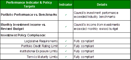
Investment
Portfolio Performance Snapshot
The table below provides the investments portfolio
performance against targets identified in Council’s Investment Policy as well
as other key performance indicators based on industry benchmarks.
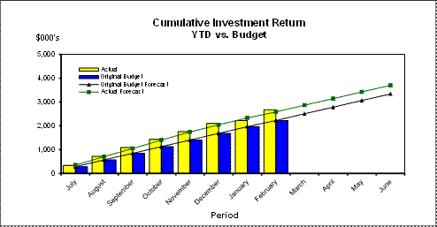
Cumulative Investment
Returns against Revised Budget
The net return on investments for
the financial year to February 2015 was $2,675,000 against a revised budget of
$2,584,000, giving a YTD favourable variance of $91,000. The total return on
investments (interest and net capital gain) for the month of February is
provided below.

A comparison of the cumulative investment returns against
year to date original budget is shown in the Chart below.
Cash
Flow and Investment Movements
Council’s total cash and
investment portfolio at the end of February 2015 was $92,161,000.
The net cash inflow for the
month was $4,293,000 mainly due to the third instalment of rates income.
No new or matured investments
were recorded during the month.
Investment
Performance against Industry Benchmarks
Overall during the month of
February the investments performance was well above industry benchmark. The
benchmark is specific to the type of investment and details are provided below.
Ø UBS Bank Bill Index is used for all Council’s
investments
A comparison of the portfolio
returns against investment benchmark is provided in Table 2 below.
Table
2 - Investments Performance against Industry Benchmarks

Table 3 below provides a summary
of all investments by type and performance during the month.
Attachment A1 provides
definitions in relation to different types of investments.
Table
3 - Investments Portfolio Summary during February 2015
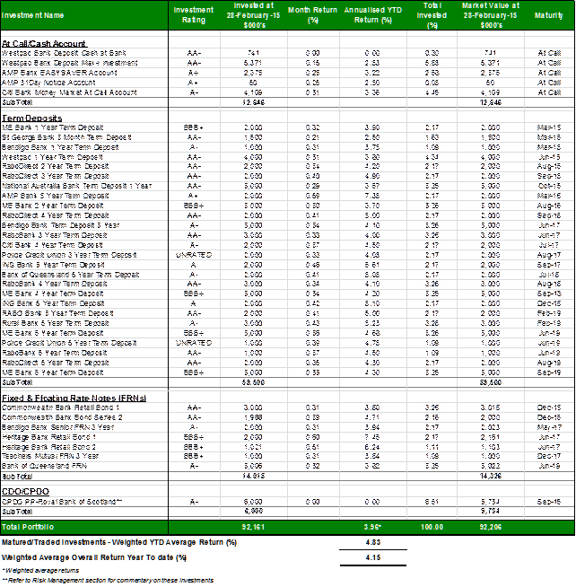
Investment
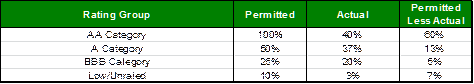
by Credit rating and Maturity Profile
The allocation of Council’s investments by credit rating and
the maturity profile are shown below:
integrated planning and reporting
Leadership & Governance
|
Community Strategic Plan Long Term Objective
|
Delivery Program
Term Achievement
|
Operational Plan
Task
|
|
L2.1 Council rigorously manages its financial
resources and assets to maximise delivery of
services
|
Council maintains and improves its long term financial
position and performance.
|
Continue to analyse opportunities to expand the revenue
base of Council
|
Governance Matters
Council’s investments are made in accordance with the Local
Government Act (1993), the Local Government (General) Regulation 2005 and
Council’s Investment Policy.
A revised Investment Policy was adopted by Council on 10
December 2013.
Section 212 of the Local Government (General) Regulation
2005 states:
(1) The
responsible accounting officer of a council:
(a) must
provide the council with a written report (setting out details of all money
that the council has invested under section 625 of the Act) to be presented:
(i) if
only one ordinary meeting of the council is held in a month, at that meeting,
or
(ii) if
more than one such meeting is held in a month, at whichever of those meetings
the council by resolution determines, and
(b) must
include in the report a certificate as to whether or not the investment has
been made in accordance with the Act, the regulations and the council’s
investment policies.
(2) The report must be made up to the last day of the
month immediately preceding the meeting.
Risk Management
Council manages the risk associated with investments by
diversifying the types of investment, credit quality, counterparty exposure and
term to maturity profile.
Council invests its funds in accordance with The Ministerial
Investment Order.
All investments are made with consideration of advice from
Council’s appointed investment advisor, CPG Research & Advisory.
Council has one “Grandfathered” investment in structured
products that was previously entered into in accordance with The Ministerial
Investment Order at the time. The Ministerial Investment Order no longer allows
investment in this product. This investment is:
CPDO PP – Royal Bank of Scotland
This Constant Proportion Debt Obligations Principal
Protected (CPDO PP), with a face value of $6,000,000, is invested by Council on
a “held to maturity” basis being September 2016. This CPDO is capital protected
at maturity date by Royal Bank of Scotland. Since December 2011 it ceased to
pay interest, due to a decrease in the credit indices it was linked to,
creating an unwind event. The investment now takes the form of a zero coupon
senior bank bond with a value of $6M. While Council intends to hold this
investment to maturity, the market value at 28 February 2015 was quoted by RBS
Morgan at $5,734,000.
Financial Considerations
The revised budget for interest on investments for the
financial year 2014/2015 is $3,699,100. Of this amount approximately $2,517,100
is restricted for the benefit of future expenditure relating to development
contributions, $717,700 transferred to the internally restricted Infrastructure
& Facility Reserve, and the remainder of $464,300 is available for
operations.
Social Considerations
Not applicable.
Environmental Considerations
Not applicable.
Community Consultation
None undertaken or required.
Internal Consultation
None undertaken or required.
Certification - Responsible Accounting
Officer
I hereby certify that the investments listed in the attached
report have been made in accordance with Section 625 of the Local Government
Act 1993, clause 212 of the Local Government General Regulation 2005 and
Council’s Investment Policy.
Summary
As at 28 February 2015:
Ø Council’s total cash and investment
portfolio is $92,161,000.
Ø Council’s net return on investments for
the financial year to February 2015 was $2,675,000 against a revised budget of
$2,584,000, giving a YTD favourable variance of $91,000.
|
Recommendation:
A. That
the summary of investments and performance for February 2015 be received and
noted.
B. That
the Certificate of the Responsible Accounting Officer be noted and the report
adopted.
|
|
Tony Ly
Financial Accounting Officer
|
Angela Apostol
Manager Finance
|
|
David Marshall
Director Corporate
|
|
|
Attachments:
|
A1View
|
Investments
definitions specific to Council’s investment portfolio
|
|
2015/017138
|
|
APPENDIX
No: 1 - Investments
definitions specific to Council’s investment portfolio
|
|
Item No: GB.1
|
|
Ordinary
Meeting of Council - 31 March 2015
|
GB.2 / 31
|
|
|
|
|
Item
GB.2
|
S03788
|
|
|
19 March 2015
|
2015 National General Assembly of
Local Government - Call for Motions
EXECUTIVE
SUMMARY
|
purpose of report:
|
To consider motions for submission for the 2015
National General Assembly (NGA) of Local Government.
|
|
|
|
|
background:
|
The NGA of Local Government is an annual event and is
to be held in 2015 at the National Convention Centre in Canberra between
Sunday, 14 June and Wednesday, 17 June 2015. The Australian Local Government
Association (ALGA) Board is calling for motions for the 2015 NGA of Local
Government under this year’s theme ‘Closest to the Community: Local
Government in the Federation’. The theme reflects current issues being
debated nationally and priority issues facing local government.
|
|
|
|
|
comments:
|
Council resolved at the Ordinary Meeting of Council
held Tuesday, 10 March 2015 that Councillors were to provide any motions they
proposed to submit by Thursday, 19 March 2015. There were no submissions
received by the Manager Records and Governance prior to the deadline.
|
|
|
|
|
recommendation:
|
That Council does not submit any motions to the 2015
National General Assembly of Local Government.
|
Purpose of Report
To consider motions for submission for the 2015 National
General Assembly (NGA) of Local Government.
Background
The NGA of Local Government is an annual event and is to be
held in 2015 at the National Convention Centre in Canberra between Sunday, 14
June and Wednesday, 17 June 2015. The NGA of Local Government provides the
opportunity for councils to contribute to the development of national local
government policy. Every council has the opportunity to raise relevant issues
for debate at the NGA and is invited to participate in the 2015 NGA by
submitting a motion for consideration.
The Australian Local Government Association (ALGA) Board is
calling for motions for the 2015 NGA of Local Government under this year’s
theme ‘Closest to the Community: Local Government in the Federation’. The theme
reflects current issues being debated nationally and priority issues facing
local government.
Motions must be submitted electronically via the online form
on the website and should be received by the ALGA no later than Friday, 17
April 2015.
A previous Council resolution from the Ordinary Meeting of
Council held on Tuesday, 10 March 2015 resolved that:
A. That
Councillors consider whether they propose to submit any motions to the NGA of
Local Government and provide them to the Manager Records and Governance by
Thursday, 19 March 2015.
B. That a
further report containing any submitted motions from Councillors be referred to
a subsequent Ordinary Meeting of Council prior to the Friday, 17 April 2015
deadline.
The ALGA have now advised Council that they are extending
the deadline from Friday, 17 April to Tuesday, 28 April 2015.
Comments
There were no submissions from Councillors regarding any
proposed motions received by the Manager Records and Governance prior to the
deadline.
integrated planning and reporting
Leadership and Governance
|
Community Strategic Plan Long Term Objective
|
Delivery Program
Term Achievement
|
Operational Plan
Task
|
|
Ensure effective and efficient conduct of Council and
committee meetings for the benefit of councillors and the community.
|
Council’s Governance framework is developed to ensure
probity, transparency and the principles of sustainability are integrated and
applies to our policies, plans, guidelines and decision-making processes.
|
Business papers and associated minutes are published in an
accurate and timely manner for public scrutiny and encourage community
participation.
|
Governance Matters
There are no governance matters associated with the
recommendation in this report.
Risk Management
There are no risk management considerations associated with
the recommendation in this report.
Financial Considerations
There are no financial considerations associated with the
recommendation in this report.
Social Considerations
There are no social considerations associated with the
recommendation in this report.
Environmental Considerations
There are no environmental considerations associated with
the recommendation in this report.
Community Consultation
None undertaken or required.
Internal Consultation
None undertaken or required.
Summary
The NGA of Local Government is an annual event and is to be
held in 2015 at the National Convention Centre in Canberra between Sunday, 14
June and Wednesday, 17 June 2015. The NGA of Local Government provides the
opportunity for councils to contribute to the development of national local
government policy. Every council has the opportunity to raise relevant issues
for debate at the NGA and is invited to participate in the 2015 NGA by
submitting a motion for consideration.
The Australian Local Government Association (ALGA) Board is
calling for motions for the 2015 NGA of Local Government under this year’s
theme ‘Closest to the Community: Local Government in the Federation’. The theme
reflects current issues being debated nationally and priority issues facing
local government.
Council resolved at the Ordinary Meeting of Council held
Tuesday, 10 March 2015 that Councillors were to provide any motions they
proposed to submit by Thursday, 19 March 2015. There were no submissions
received by the Manager Records and Governance prior to the deadline.
|
Recommendation:
That Council does not submit any motions to the 2015 National
General Assembly of Local Government.
|
|
Matt Ryan
Manager Records & Governance
|
David Marshall
Director Corporate
|
|
Ordinary
Meeting of Council - 31 March 2015
|
GB.3 / 35
|
|
|
|
|
Item
GB.3
|
S03939
|
|
|
23 March 2015
|
Floodplain Management Association
National Conference
EXECUTIVE
SUMMARY
|
purpose of report:
|
To advise Councillors of the Floodplain Management
Association National Conference to be held in Brisbane between 19 –
22 May 2015.
|
|
|
|
|
background:
|
The FMA promotes wise land use planning which guides
appropriate floodplain development, and supports programs which manage flood
risks and reduce private and public flood losses. It represents members'
interests at State and Commonwealth government levels, promote public
awareness of flood issues, support flood education programs and improve the
knowledge and skills of floodplain management practitioners. The FMA is
dedicated to working with all states and territories to raise flood awareness
and the priority of flooding on the national agenda. The FMA has members in
NSW, Queensland, Victoria and Tasmania, and in 2013 established the National
Flood Risk Managers Working Group to develop a framework for national
cooperation and advocacy for flood risk management.
|
|
|
|
|
comments:
|
The theme for the conference is ‘building a flood
resilient Australia’ focusing on resilient communities and flood resilient
buildings and infrastructure. Conference attendees will include Commonwealth,
State and Local Government elected representatives and staff, researchers and
education providers.
|
|
|
|
|
recommendation:
|
That any Councillors interested in attending the 2015
Floodplain Management Association National Conference advise the General
Manager by Friday, 10 April 2015.
|
Purpose of Report
To advise Councillors of the Floodplain Management
Association National Conference to be held in Brisbane between 19 –
22 May 2015.
Background
The FMA promotes wise land use planning which guides
appropriate floodplain development, and supports programs which manage flood
risks and reduce private and public flood losses. It represents members'
interests at State and Commonwealth government levels, promote public awareness
of flood issues, support flood education programs and improve the knowledge and
skills of floodplain management practitioners. The FMA is dedicated to working
with all states and territories to raise flood awareness and the priority of
flooding on the national agenda. The FMA has members in NSW, Queensland,
Victoria and Tasmania, and in 2013 established the National Flood Risk Managers
Working Group to develop a framework for national cooperation and advocacy for
flood risk management.
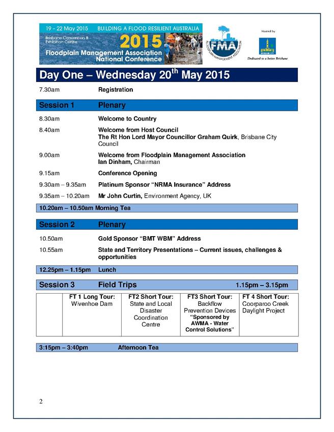
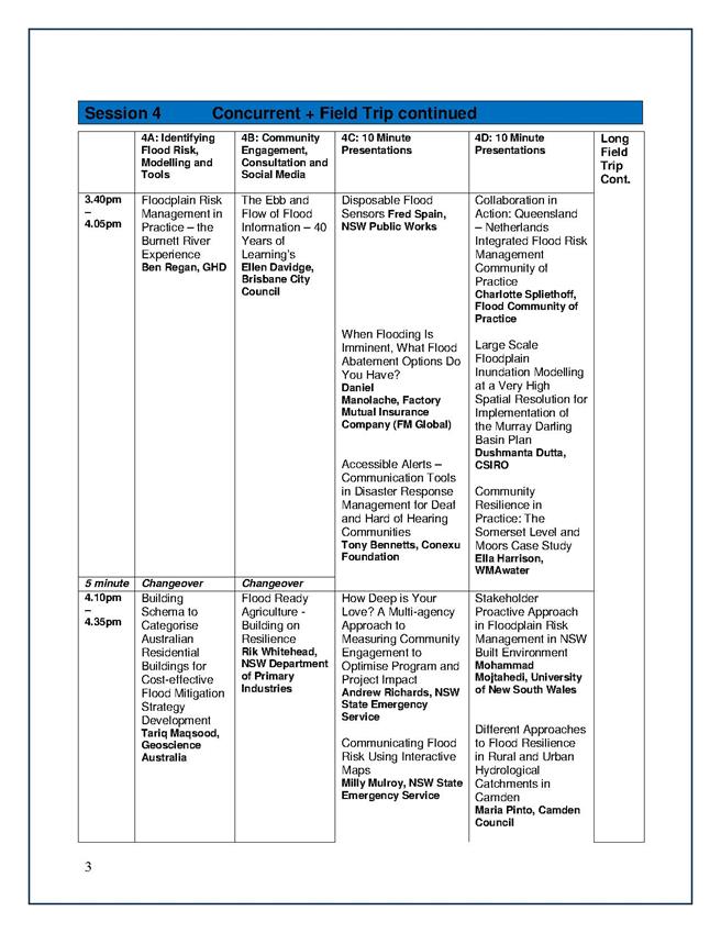
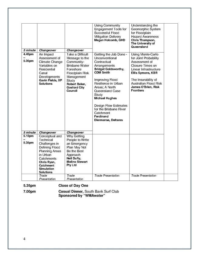
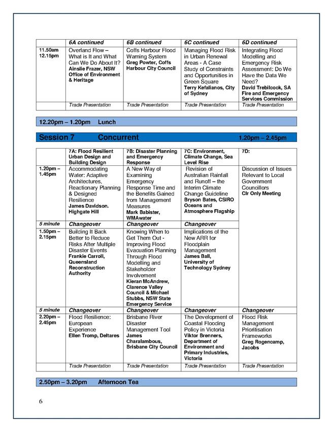
The conference will include:
· Australian and international keynote
speakers
· More than 75 presentations
· Local Government councillors session
· National conference forum
· Field trips
· Pre-conference workshops
· Networking events.
Comments
The theme for the conference is ‘building a flood resilient
Australia’ focusing on resilient communities and flood resilient buildings and
infrastructure. Conference attendees will include Commonwealth, State and Local
Government elected representatives and staff, researchers and education
providers.
The program for the conference is attached to this report (See
attachment A1).
integrated planning and reporting
Leadership and Governance
|
Community Strategic Plan Long Term Objective
|
Delivery Program
Term Achievement
|
Operational Plan
Task
|
|
Council leads the community by advocating, influencing and
participating in policy development to the benefit of the local area
|
Council actively engages with stakeholders to inform the
development of Council’s strategies and plans as appropriate
|
Pursue opportunities to contribute to policy development
affecting Ku-ring-gai at state and regional levels
|
Governance Matters
The Policy on Payment on Expenses and Provisions of
Facilities to Councillors provides for Council to meet the reasonable costs of
Councillors attending conferences authorised by resolution of Council.
Risk Management
There are no risk management considerations associated with
recommendation in this report.
Financial Considerations
The conference is to be held at the Brisbane Convention and
Exhibition Centre. The cost of attending the conference is:
Three day registration – FMA Full member: $1125
Earlybird three day registration – FMA Full member: $925
Three day registration – Non-member: $1325
One day registration – FMA Full member: $150
One day registration – Non- member: $450
Travel and accommodation costs will be additional.
Attendance is provided for in the Councillor’s conference
budget in accordance with the Payment of Expenses and Provision of Facilities
Policy.
Council has an annual budget of $30,700 for Councillors’
attendance at conference with $20,806 remaining in the 2014/2015 financial
year.
Social Considerations
There are no social consideration s associated with the
recommendation in this report.
Environmental Considerations
There are no environmental considerations associated with
recommendation in this report.
Community Consultation
None undertaken or required.
Internal Consultation
None undertaken or required.
Summary
To advise Councillors of the Floodplain Management
Association National Conference to be held in Brisbane between 19 –
22 May 2015.
The theme for the conference is ‘building a flood resilient
Australia’ focusing on resilient communities and flood resilient buildings and
infrastructure. Conference attendees will include Commonwealth, State and Local
Government elected representatives and staff, researchers and education
providers.
|
Recommendation:
That any Councillors interested
in attending the 2015 Floodplain Management Association National Conference
advise the General Manager by Friday, 10 April 2015.
|
|
Matt Ryan
Manager Records & Governance
|
David Marshall
Director Corporate
|
|
Attachments:
|
A1View
|
Floodplain
Management Association National Conference 2015 - Program
|
|
2015/069646
|
|
APPENDIX
No: 1 - Floodplain
Management Association National Conference 2015 - Program
|
|
Item No: GB.3
|

|
Ordinary
Meeting of Council - 31 March 2015
|
GB.4 / 49
|
|
|
|
|
Item
GB.4
|
DA0005/14
|
|
|
25 February 2015
|
Summary
Sheet
|
Report title:
|
65 Roland
Avenue Wahroonga - Torrens Title Subdivision into Two Lots
|
|
ITEM/AGENDA
NO:
|
GB.4
|
|
Application No:
|
DA0005/14
|
|
Property Details:
|
65 Roland Avenue, Wahroonga
Lot & DP No: Lot 3 DP 369490
Site area (m2): 6058m2
Zoning: Residential 2(c)
|
|
Ward:
|
Comenarra
|
|
Proposal/Purpose:
|
To determine Development Application No. DA0005/14 for
the subdivision of one lot into two lots including tree removal and
associated civil works.
|
|
Type of Consent:
|
Integrated- S.100B Rural Fires Act
|
|
Applicant:
|
Turnbull Planning International Pty Ltd
|
|
Owner:
|
Mr N Pocock and Mrs I Pocock
|
|
Date Lodged:
|
10 January 2014
|
|
Recommendation:
|
Approval
|
Purpose of Report
To determine Development Application No. DA0005/14 for the
subdivision of one lot into two lots including tree removal and associated civil
works. The matter is reported to Council as the proposal involves a Torrens
title subdivision of bushfire prone land and contains remnant bushland
vegetation.
integrated planning and reporting
Places, Spaces & Infrastructure
|
Community Strategic Plan Long Term Objective
|
Delivery Program
Term Achievement
|
Operational Plan
Task
|
|
P3.1 The built environment delivers attractive,
interactive and sustainable living and working environments.
|
A high standard of design quality and building
environmental performance is achieved in new development.
|
Assessment of applications is consistent with Council’s
adopted LEPs and DCPs.
|
Executive Summary
Issues: SEPP
1 objection (access corridor width), vegetation and riparian impacts,
Submissions: 1 objection
Land and Environment Court: N/A
Recommendation: Approval
History
Pre-DA
No pre-DA consultation was undertaken by the applicant.
DA History
|
10 January 2014
|
Application lodged
|
|
22 January to 14 February 2014
|
Application notified to neighbouring properties. 1
submission was received.
|
|
13 March 2014
|
A letter was sent to the applicant advising of outstanding
issues relating to:
Biodiversity
- Amendments
to the 7 part test assessment of significance
- Amendments
to the vegetation management plan
- Bushfire
management impacts on areas identified as riparian and biodiversity
significant
Landscaping
- tree
impacts generated by indicative building footprints, stormwater pipes and
driveway
Engineering
- additional
plans
- method
for stormwater disposal
- amendments
to driveway
- details
regarding the provision of essential services
|
|
1 April 2014
|
RFS bushfire safety authority was issued pursuant to
section 100B of the Rural Fires Act 1997
|
|
15 May 2014
|
Amended plans/documentation were submitted.
|
|
24 July 2014
|
A second letter was sent to the applicant advising of
outstanding issues relating to:
Biodiversity
- Bushfire
management impacts on areas identified as riparian and biodiversity
significant
|
|
20 August 2014
|
Amended documentation received by Council.
|
|
14 October 2014
|
RFS Bushfire safety authority issued based on amended
plans.
|
The Site
Site description
The site is a battle-axe shaped lot with a total area of
6058m2 situated on the low, north-western side of Roland Avenue. The
site contains a single brick dwelling, free-standing garage, cabana and a
swimming pool accessed via an 83-88 metres long access handle.
The site is divided into three tiered levels, terminating at
the Category 2 watercourse which forms the rear boundary. The site is
vegetated at the lower and mid levels with Sydney Sandstone Gully Forest (SGGF)
and Sydney Turpentine Ironbark Forest (STIF) located in the top tier along the
southeast (side) boundary the site.
Surrounding development
The site is described in Council’s Visual Character Study
area as an area established after 1968 and is characterised by natural features
such as rock outcrops, creek lines and native vegetation. The area is also characterised
by streetscapes with detached residences on single lots varying in size from
863m2 to 4186m2. Properties surrounding the site consist
of battle-axe and regular shaped allotments, accessed from Roland Avenue.
The Proposal
The application proposes:
- Removal
of 25 trees and partial site clearing
- subdivision
of the site into 2 Torrens title allotments, comprising two battle-axe
allotments as follows:
· Proposed Lot 1
Site area: 2595m2
(excluding access corridor)
Frontage: 3.95
metres
· Proposed Lot 2
Site area: 2654m2
(excluding access corridor)
Frontage: 3.95
metres
This application does not propose demolition of the existing
structures on the site.
Consultation
Community
In accordance with Council's Notification DCP 56, owners of
adjoining properties were given notice of the application. One submission was
received in response, from:
1. Mr AM
Baghaei-Nanehkaran & Mrs J Baghaei-Nanehkaran- 63 Roland Avenue, Wahroonga
The submission raised the following issues:
Access corridor is too narrow for two vehicles to pass
each other safely
Council’s Development Engineer has not raised any concerns
regarding the width of the proposed driveway. Two passing bays are provided
which allow for two vehicles to pass each other safely (refer to Engineering
comments below).
Increased vehicle traffic and noise generation
The subdivision itself does not generate any additional
vehicle movements. Applications for the future construction of dwellings on the
proposed allotments will need to provide the required car parking on site.
Nonetheless, the size of the proposed allotments suggests that this can be
easily achieved.
Increased heavy vehicle construction traffic and noise
generation
Apart from tree removal, the establishment of an asset protection
zone and minor civil works, it is unlikely that there will be a noticeable
increase in construction traffic. A condition of consent is recommended (Condition
26) restricting construction within the hours of 7.00am to 5.00pm Monday to
Friday and 8.00am to 12 noon Saturday. No work and no deliveries are to take
place on Sundays and public holidays.
Applications for the future construction of dwellings on the
proposed allotments will also need to consider how construction traffic and
noise generation are to be managed.
Increased residential density and fire safety within
bushfire prone lands
The site is zoned Residential 2(c) and E4 Environmental
Living under the Ku-ring-gai Planning Scheme Ordinance and Draft Ku-ring-gai
Local Environmental Plan 2013, respectively and satisfies the minimum lot size
requirements under both environmental planning instruments.
The NSW Rural Fire Service has issued the application with a
bush fire safety authority under section 100B of the Rural Fires Act 1997,
subject to conditions (Condition 57).
Dwelling footprint for proposed Lot 1 is 1m for the
side boundary
The notional building footprint for proposed Lot 1 is
located 5.7 metres from the north-eastern side boundary and complies with
Development Control Plan No. 38 Residential Design Manual (refer to Local
Provisions assessment below).
Potential for overshadowing on open space affecting
the pool and front gardens
The impact of privacy and overshadowing upon adjoining,
established properties will be matters to be considered and addressed as part
of any future application for dwelling houses.
Tree removal associated with the subdivision
Council’s Landscape and Biodiversity Assessment Officers
have not raised concerns regarding the proposed tree removal.
Within Council
Ecology
Council’s Ecological Assessment Officer commented on the
proposal as follows:
Vegetation
The vegetation within the lower and mid-levels of the
subject property was identified as Sydney Sandstone Gully Forest (SSGF) a
non-threatened vegetation type. The vegetation within the upper managed area of
the property is considered to comprise part of the Sydney Turpentine Ironbark
Forest (STIF) an endangered ecological community listed under the Threatened
Species Conservation Act 1995.
Threatened species
No threatened flora or endangered populations were
identified on the subject property during the site inspection. The intact
areas of native vegetation within the subject property would provide suitable
habitat for threatened flora & fauna species.
The trees within the subdivision area would provide
suitable foraging habitat for transient species e.g. the Grey-headed Flying Fox
which may seasonaly forage upon flowering Eucalypts and Angophora species.
Biodiversity controls
The native vegetation (Sydney Sandstone Gully Forest
& Sydney Turpentine Ironbark Forest) within the site (outlined in red) has
been mapped as an area of biodiversity significance under the KPSO.
The proposed subdivision will result in the removal of
vegetation from land mapped as biodiversity significance.
Riparian controls
The site outlined in red below is mapped as containing a
Category 2 riparian corridor KPSO which occurs on the northern side of the
existing dwelling. In accordance with Council riparian policy & riparian
controls the Category 2 watercourse requires a 20 metres core riparian zone
(CRZ). The proposed asset protection zones (APZ) is well within the Category 2
riparian corridor.
Review of Flora and Fauna Assessment
The level of survey effort to detect threatened flora and
fauna species is accordance with the Introduction and Amphibians by DECCW
(April 2009) and the Biodiversity Survey and Assessment: Guidelines for
Development and Activities - Working Draft by DEC (November 2004).
The flora and fauna assessment prepared by Abel Ecology
has adequately assessed the proposal in accordance with section 5A of the
Environmental Planning and Assessment Act 1979. The proposal will not
significantly affect habitat for threatened fauna species which are known to
reside within the locality of the site e.g. Grey-headed Flying-fox.
Bushfire management within land identified as
Biodiversity and riparian
A review of the land use advice provided by the Rural
Fire Service indicates that a 31 metres APZ is required to protect the dwelling
sites.
As stated above the asset protection zone (APZ) is well
within land mapped as an area of biodiversity significance and riparian lands.
The proposal nominates the removal of eight small
sub-canopy trees to accommodate the proposed APZ. The understorey and
groundcover vegetation within the proposed APZ is already managed.
Note: It is important to note that the extent of the
proposed tree removal on site does not greatly exceed that what is currently
allowed to protect the existing dwelling house for fire protection purposes.
Ongoing management within lots
A vegetation management plan (VMP) has been prepared
which addresses the required management of the area of land identified as
biodiversity significance with regards to the fire protection. The VMP ensures
that the ecological values of the biodiversity area as defined under KPSO are
maintained and are not likely to be detrimentally affected by the proposal.
Ecological values are maintained primarily through weeding works which will
enhance the native understorey but more specifically mechanisms such as
selected removal of native vegetation to achieve fire protection, in short not
all vegetation will be removed as a result of the proposal.
The site contains extensive rock outcropping which helps
achieve the desired management of the ground layer as an inner protection area
(IPA) due to limited fuel loading.
The VMP is sufficient to ensure the enhancement,
protection and ensure the long-term viability of the SSGF community/vegetation
upon the site. The VMP demonstrates compliance with proposed Asset Protection
Zones and demonstrates the retention of vegetation to ensure compliance with
Council’s KPSO Biodiversity Land controls.
The VMP has selected appropriate species which are to be
planted that are representative of SSGF community within the rear of lot 2,
soft (Non-sclerophyllic) species have been selected to be planted over
sclerophyllic species as they have a lower combustion.
The VMP describes each task necessary for the
implementation of the plan, the duration and priority. Maps, diagrams and plant
species lists are contained within the plan. The VMP describes the existing
vegetation and natural features to be retained, proposed vegetation, sediment
and erosion control and land stabilisation works.
Conclusion
The application is acceptable on ecological grounds,
subject to conditions.
Landscaping
Council’s Landscape Assessment Officer commented on the
proposal as follows:
Tree impacts
A total of 113 trees were
assessed by the arborist. A total of 25 trees are to be removed for the
proposed subdivision, including 17 trees for fire protection within the asset
protection zone and 8 trees for the proposed passing bay as follows:
|
Tree / location
|
Comments
|
|
T95.5, T95.6, T95.7, T95.8,
T95.9 & T95.10
6 x Chamaecyparis obtusa
'Crippsii' (Golden Cripps Cypress)
/ Southern side of access
handle (Passing bay)
|
8 to 10 metres high in fair
health, suppressed canopies
|
|
T1, T2 & T3 – 3 x Ligustrum
lucidum (Large-leaved Privet)
/ within the designated
asset protection zone
|
Weed species
|
|
T19 – Allocasuarina
torulosa (Forest Oak)
/ within the designated
asset protection zone
|
18 metres high in fair
health
|
|
T52 – Syncarpia glomulifera
(Turpentine)
/ within the designated
asset protection zone
|
12 metres high in good
health, suppressed canopy
|
|
T53 - Ligustrum lucidum
(Large-leaved Privet)
/ within the designated
asset protection zone
|
Weed species
|
|
T54 – Pittosporum undulatum
(Sweet Pittosporum)
/ within the designated
asset protection zone
|
5 metres high bin good
health
|
|
T55 – Syncarpia glomulifera
(Turpentine)
/ within the designated
asset protection zone
|
10 metres high in good
health
|
|
T58 – Pinus radiata
(Monterey Pine)
/ within the designated asset
protection zone
|
15 metres high in poor
health
|
|
T61 – Syncarpia glomulifera
(Turpentine)
/ within the designated
asset protection zone
|
15 metres high in good
health
|
|
T65 – Allocasuarina
torulosa (Forest Oak)
/ within the designated
asset protection zone
|
14 metres high in good
health
|
|
T67 – Pittosporum undulatum
(Sweet Pittosporum)
/ within the designated
asset protection zone
|
6 metres high in fair
health
|
|
T68 – Pittosporum undulatum
(Sweet Pittosporum)
/ within the designated
asset protection zone
|
6 metres high in good
health
|
|
T69 – Allocasuarina
torulosa (Forest Oak)
/ within the designated
asset protection zone
|
16 metres high in good
health
|
|
T70 – Allocasuarina
torulosa (Forest Oak)
/ within the designated
asset protection zone
|
14 metres high in good health
|
|
T73 – Allocasuarina
torulosa (Forest Oak)
/ within the designated
asset protection zone
|
9 metres high in fair
health
|
|
T74 – Allocasuarina
torulosa (Forest Oak)
/ within the designated
asset protection zone
|
7 metres high in fair
health
|
|
T93 – Cupressus species
(Cypress)
/ Eastern boundary of Lot 1
|
12 metres high in poor
health
|
|
T112 – Cupressus torulosa
(Bhutan Cypress)
/ Eastern side of building
footprint on Lot 2
|
13 metres high with good
vigour, unstable branching structure
|
No objection is raised to the
removal of the 17 trees for the establishment of an APZ given that this is a
statutory requirement under the NSW Rural Fires Act 1997. The removal of a
further 8 trees to allow for the driveway passing bay is acceptable given that
the trees are of moderate landscape value and their removal will not be evident
from Roland Avenue.
Stormwater plan
No landscape issues
Conclusion
The proposal is acceptable,
subject to conditions.
Engineering
Council’s Development
Engineer commented on the proposal as follows:
Stormwater disposal
Given the site is heavily vegetated and possible impacts
to the core riparian zone and bushfire asset protection zone, a direct outlet
to the watercourse may not be the optimum means of stormwater disposal. Each
lot will be able to implement its own water management system at building stage
without affecting the other lot, so it is not considered necessary for systems
to be provided at subdivision stage. The revised stormwater plans have been
amended to only consider capturing runoff from the new driveway and passing pay
areas to be directed and conveyed to a 25,200L on-site detention tank located
within the lower portion of the right of carriageway and the overflow directed
to a grated trench drain located directly behind the existing sandstone
retaining wall of Lot 2.
The Stormwater Management Plans whilst acceptable for DA
purposes will need to be amended prior to the issue of the construction
certificate. Condition 19 requires that the overflow from the detention
tank is directed to a bioretention system to improve the quality of stormwater
flowing to the watercourse and natural environment. Design details of the
bioretention system including plan and section is to be in accordance with the
Water Sensitive Urban Design ‘Technical Design Guidelines’. The project
arborist and ecologist must comment on the stormwater management plans and
refer to them specifically in their reports.
The scheme advanced in the
Stormwater Management Plans 29160-H1/A & H2/A, dated 1/5/2014 and prepared
by Jack Hodgson Consultants P/L, is considered satisfactory for this type of
development and satisfies the requirements outlined in Council’s Water
Management DCP No.47.
Vehicular access
The applicant proposes to utilise the existing 7.87m wide
access handle by providing a right of carriage way of 3.765m wide for each
property and reciprocal rights of way which is acceptable.
Given that the driveway is approximately 83.5m in length,
two separate passing bays has been provided, one at the end of the driveway and
the other approximately 35m down the right of carriageway with the driveway
widened to at least 5.5m over the length of at least 10m. The location and
dimensions of the passing bay satisfy the requirements of Section 3 of
AS2890.1:2004. Council’s Landscape officer raises no objection to the location
of the passing bays and the removal of trees for their construction.
Indicative building footprints are shown on the drawings
accompanying the development application which would presumably accommodate two
(2) off street car parking spaces for each allotment. The plans now show an
indicative driveway layout leading to the garage for each allotment as well as
a turning bay area for vehicles to safely manoeuvre on site and leave in a
forward direction as per the manoeuvring requirements of a B85 vehicle The
swept paths for the passing bay is also compliant as per the B99 design vehicle
allowing two large vehicles passing each other whilst travelling in the
opposite directions.
Plan of Subdivision
A preliminary plan of subdivision has been submitted
which is acceptable for DA purposes. All physical works are located within the
property boundaries with the stormwater pipeline and point of discharge
contained within the proposed easement.
Submission of an 88B instrument and Plan of Subdivision
is required by Condition 51. This is to create all required easements,
right-of-carriage-way, positive covenants, restrictions-on-use or other burdens
/benefits as may be required.
Conclusion
Council’s Development Engineer finds the proposal
acceptable in relation to engineering issues, subject to conditions.
Outside
Council
NSW Rural Fire Service
Under the provisions of section
91 of the Environmental Planning and Assessment Act 1979, the proposal is
Integrated Development on the basis that a bush safety authority from the
Commissioner of the NSW Rural Fire Service is required under the provisions of
s.100B of the Rural Fires Act 1997, due to the proposal involving subdivision
of bush fire prone land for residential purposes.
The RFS by way of letter dated
14 August 2014, provided a bushfire safety authority, subject to the terms in Condition
57.
Statutory Provisions
Environmental Planning and
Assessment Act 1979 and Rural Fires Act
1997
Under the provisions of section
91 of the Environmental Planning and Assessment Act 1979, the proposal is
Integrated Development on the basis that a bush safety authority from the
Commissioner of the NSW Rural Fire Service is required under the provisions of
s.100B of the Rural Fires Act 1997, due to the proposal involving subdivision
of bush fire prone land for residential purposes.
Water
Management Act 2000
Under the provisions of section 91 of the Environmental
Planning and Assessment Act 1979, the proposal was not considered Integrated
Development on the basis that no significant works will occur within 40 metres
of the watercourse at the rear boundary. Accordingly, a Controlled Activity
Approval is not required under the provisions of Part 3 of the Water Management
Act 2000.
State
Environmental Planning Policies
Sydney Regional Environmental
Planning Policy (Sydney Harbour Catchment) 2005 (SREP SHC)
SREP SHC covers the area of Sydney Harbour, including
Parramatta River and its tributaries and the Lane Cove River. The plan aims to
establish a balance between promoting a prosperous working harbour, maintaining
a healthy and sustainable waterway environment and promoting recreational
access to the foreshore and waterways. It establishes planning principles and controls
for the catchment as a whole.
SREP SHC applies to the site as it is located within the
Sydney Harbour Catchment. Under Division 2 of SREP SHC, a consent authority
must take into consideration all relevant matters under this Division.
A rear of the site is mapped as
containing a Category 2 riparian corridor. Council’s Biodiversity Assessment
Officer has assessed the development proposal in this regard and finds it
acceptable in terms of potential impacts to water quality and riparian matters
and is consistent with the relevant matters listed under Division 2 of SREP SHC
(refer to Ecology comments above).
Ku-ring-gai
Planning Scheme Ordinance (KPSO)
Permissibility
Subdivision
within the Residential 2(c) zone is permissible under Clause 23 of the KPSO.
Clause 58A of the KPSO provides that a person shall not subdivide land to which
the Ordinance applies except with the development consent.
Clause
58B sets out the subdivision requirements for dwelling house lots and provides
the following minimum requirements for Residential 2(c) subdivisions:
Part A:
Development standards
|
Development standard
|
Proposed
|
Complies
|
|
Subdivision for dwelling
houses
|
|
|
|
Site area: 1300m2 (min)(exc. access corridor)
|
Lot
1:2595m2
Lot
2: 2654m2
|
YES
YES
|
|
Access corridor width: 4.6m
|
7.87m
|
YES
|
Access corridor width
A SEPP 1 Objection has been lodged in respect of the access
corridor width (Clause 58B (3)(c)(iii)), however this is not required as the
two sites will benefit from a right of carriageway that, when all three access
handles are combined, will exceed the minimum 4.6 metres access corridor width
standard.
Ku-ring-gai
Planning Scheme Ordinance – LEP 218 Biodiversity and Heritage (LEP 218)
Cl.61L
Biodiversity protection
The subject site is mapped as an area
of Biodiversity Significance and, as such, the biodiversity protection
provisions of LEP 218 apply.
Council’s Ecological Assessment
Officer is satisfied that the proposal is acceptable with regard to the
requirements of Cl 61L.
Cl.61M Riparian land and waterways
The subject site is mapped as an
area of Natural Resources Riparian Land and, as such, the riparian land and
waterways provisions of the LEP apply.
Council’s Ecological Assessment
Officer is satisfied that the proposal is satisfactory with regard to the
requirements of Cl 61M.
Ku-ring-gai
Draft Local Environmental Plan 2013 (Draft KLEP)
The Draft KLEP was on exhibition
from 25 March 2013 to 6 May 2013. The Draft KLEP was gazetted 5 March 2015. The
Draft KLEP does not take effect until 2 April 2015 and includes savings
provisions for applications made prior to the date it takes effect. Under the
provisions of the Draft KLEP the site is zoned E4 Environmental Living (E4),
subdivision is permissible within the E4 zone with development consent.
This
assessment report has considered the following provisions of the exhibited
Draft KLEP:
Land use table
It is considered that the proposal would not contradict the
following draft objectives established under the E4 zoning:
· to provide for low-impact residential
development in areas with special ecological, scientific or aesthetic values,
· to ensure that residential
development does not have an adverse effect on those values,
· to ensure development does not result
in further fragmentation of ecological communities, biodiversity corridors or
other significant vegetation or habitat.
Part 4 Principal development standards
|
Principal development
standards
|
Proposed
|
Complies
|
|
Section 4.1 Minimum
subdivision lot size
|
|
|
|
Site area: 1500m2 (min)(exc. access handle)
Site dimensions: 18 metres wide
at 12 metres from the street frontage of
the lot.
|
Lot
1:2595m2
Lot
2: 2654m2
Lot
1:32m
Lot
2: 28m
|
YES
YES
YES
YES
|
|
Section 4.1A Minimum lot
depth for subdivision of bush fire prone land
|
|
|
|
Slope 50 to 100 :65 metres lot depth
|
Lot
1: 60m
Lot
2: 54m
|
NO
NO
|
Section 4.1A Minimum lot
depth for subdivision of bushfire prone land
The site has been identified on
Council’s Bushfire Prone Land Map as being within the vegetation buffer. The
objective of this clause is to:
“(a) to
ensure that lot depths allow for adequate setbacks to a bushfire hazard to
minimise risk to life, property and the environment from bushfire events and
bushfire management measures.”
The site is located on land with
blue edging on the minimum lot size map and does apply to this proposal;
however, this development standard has been removed from the gazetted DKLEP and
therefore requires minimal consideration regarding this non-compliance. The
proposal has been issued with a Bushfire Safety Authority from the RFS. The environmental impacts resulting from Bush Fire Safety
Authority, particularly with regard to achieving the Asset Protection Zone
within areas with riparian and biodiversity significance have been considered
by Council’s Landscape and Biodiversity Officer and are acceptable.
Part 6 Additional Local
Provisions
Biodiversity Protection
The subject site is mapped as an area
of Biodiversity Significance and, as such, the biodiversity protection
provisions apply. The subject proposal is compatible with the existing low
density character of the area. The vegetation within the site forms part of a
urban vegetated corridor “biolink” which connects to Browns Field.
Council’s Ecological Assessment
Officer has provided an assessment of the proposed development against the
biodiversity lands controls in accordance with the Draft KLEP. The proposal is
acceptable in this regard (refer to Ecology comments above).
Riparian Land and waterways
The subject site is mapped as an
area of Natural Resources Riparian Land and, as such, the riparian land and
waterways provisions of the Draft KLEP apply.
Council’s Ecological Assessment
Officer has provided an assessment of the proposed development against the
riparian lands controls in accordance with the Draft KLEP. The proposal is
acceptable in this regard (refer to Ecology comments above).
Development
Control Plan No. 38 - Ku-ring-gai Residential Design Manual (DCP 38)
With regard to building setback controls of DCP 38, the
proposed subdivision does not prevent any future dwellings on proposed Lot 5
and Lot 2 from achieving compliant setbacks.
Development Control Plan No.
43 – Car Parking
The proposal is consistent with
the objectives and guidelines for the design of parking and service areas and
demonstrates safe and efficient vehicular access, consistent with the desirable
characteristics and environmental standards expected in the Ku-ring-gai area.
Development
Control Plan No. 47 – Water Management
The
provisions of DCP 47 require Council to consider, when assessing a development
application, the design of the proposal against the specified criteria for
water management. The comments of Council’s Development Engineer provide a
detailed assessment against these controls and conclude that the proposal is
appropriately designed with regard to water management, DCP 47.
Ku-ring-gai
Contributions Plan 2010
The
Section 94 contributions applicable to the proposal have been calculated and a
condition of consent is recommended requiring the payment of those
contributions (Condition 22).
LIKELY
IMPACTS
As
demonstrated by this assessment, the proposed subdivision is assessed as having
an acceptable impact upon the surrounding natural, social, economic and built
environments.
SUITABILITY
OF THE SITE
The
site is considered suitable for the proposed development.
PUBLIC
INTEREST
Approval
of the application is assessed as being in the public interest as the lot sizes
proposed are consistent with those of surrounding properties and the minimum
lot size prescribed under the Draft KLEP.
Conclusion
The proposed subdivision is
considered to be acceptable when assessed against the matters for consideration
of s.79C of the Environmental Planning and Assessment Act, 1979 and, as such,
the accompanying SEPP 1 objection to the access corridor width standard is well
founded and the application is recommended for approval.
|
Recommendation:
THAT the Council, as the consent authority, grant
development consent to DA0005/14 for a Torrens title subdivision of 1 lot
into 2 lots on land at 65 Roland Avenue, Wahroonga, for a period of two [2)
years from the date of the Notice of Determination, subject to the following
conditions:
Conditions
that identify approved plans:
1. Approved
architectural plans and documentation (new development)
The
development must be carried out in accordance with the following plans and
documentation listed below and endorsed with Council’s stamp, except where
amended by other conditions of this consent:
|
Plan no.
|
Drawn by
|
Dated
|
|
4706-DET, Plan: Showing detail and levels with proposed
subdivision at No. 65 Roland Avenue, Wahroonga being Lot 3 in DP 369490
|
USHER & COMPANY Surveying & Land Development
Consultants
|
01/05/2014
|
|
29160-H1/A, Plan: Stormwater management plan proposed
subdivision at No. 65 Roland Avenue, Wahroonga
|
Jack Hodgson Consultants PTY LTD
|
12/05/2014
|
|
Document(s)
|
Dated
|
|
Bush fire risk assessment and certification, Building
Code & Bushfire Hazard Solutions Pty Limited
|
4/12/2013
|
Reason: To
ensure that the development is in accordance with the determination.
Conditions
to be satisfied prior to demolition, excavation or construction:
2. Asbestos works
All
work involving asbestos products and materials, including
asbestos-cement-sheeting (ie. Fibro), must be carried out in accordance with
the guidelines for asbestos work published by WorkCover Authority of NSW.
Reason:
To ensure public safety
3. WAE plans for stormwater management and disposal
Prior to issue of the Final
Certificate of compliance, a registered surveyor must provide a works as
executed survey of the completed stormwater drainage and management systems.
The survey must be submitted to and approved by the Principal Certifying
Authority prior to issue of the Final Certificate. The survey must indicate:
· as built (reduced) surface
and invert levels for all drainage pits
· gradients of drainage
lines, materials and dimensions
· as built (reduced)
level(s) at the approved point of discharge to the public drainage system
· as built location and
internal dimensions of all detention and retention structures on the property
(in plan view) and horizontal distances to nearest adjacent boundaries and
structures on site
· the achieved storage
volumes of the installed retention and detention storages and derivative
calculations
· as built locations of all
access pits and grates in the detention and retention system(s), including
dimensions
· the size of the orifice or
control fitted to any on-site detention system
· dimensions of the
discharge control pit and access grates
· the maximum depth of
storage possible over the outlet control
· top water levels of
storage areas and indicative RL’s through the overland flow path in the event
of blockage of the on-site detention system
The works as executed plan(s)
must show the as built details above in comparison to those shown on the
drainage plans approved with the Construction Certificate prior to
commencement of works. All relevant levels and details indicated must be
marked in red on a copy of the Principal Certifying Authority stamped construction
certificate stormwater plans.
Reason: To protect the environment.
4. Certification of drainage works
Prior to issue of the Final
Certificate of compliance, the Principal Certifying Authority is to be
satisfied that:
· the stormwater drainage
works have been satisfactorily completed in accordance with the approved
Construction Certificate drainage plans
· the minimum on-site
detention storage volume requirements and Ku-ring-gai Water Management
Development Control Plan No. 47 respectively, have been achieved
· that the bioretention
system has been constructed in accordance in accordance with the Water
Sensitive Urban Design ‘Technical Design Guidelines’ http://www.wsud.org/
· components of the new
drainage system have been installed by a licensed plumbing contractor in
accordance with the Plumbing and Drainage Code AS3500.3 2003 and the Building
Code of Australia
Where an on-site detention
system has been constructed, the on-site detention certification sheet
contained in Appendix 4 of DCP 47 must be completed and attached to the
certification.
Note: Evidence from a qualified and experienced
consulting civil/hydraulic engineer documenting compliance with the above is
to be provided to Council prior to the issue of the Final Certificate.
Reason: To protect the environment.
5. Tree identification
Prior
to works commencing the existing trees shall be numbered in accordance with
the arborists report listed below and/or the approved plans. Trees shall be
clearly tagged with confirmation from the project arborist that all marked
trees correspond with those shown on the approved plan.
|
Report
|
Prepared
by
|
Dated
|
|
Arboricultural
Impact Assessment
|
Footprint
Green Pty Ltd
|
12
May 2014
|
Reason: To
protect existing trees during the construction phase.
6. Notice of commencement
At least 48 hours prior to the
commencement of any development (including demolition, excavation, shoring or
underpinning works), a notice of commencement of building or subdivision work
form and appointment of the principal certifying authority form shall be
submitted to Council.
Reason: Statutory requirement.
7. Sediment controls
Prior to any
work commencing on site, sediment and erosion control measures shall be
installed along the contour immediately downslope of any future disturbed
areas.
The form of
the sediment controls to be installed on the site shall be determined by
reference to the ‘NSW Department of Housing manual ‘Managing Urban
Stormwater: Soils and Construction’. The erosion controls shall be maintained
in an operational condition until the development activities have been
completed and the site fully stabilised. Sediment shall be removed from the
sediment controls following each heavy or prolonged rainfall period.
Reason: To preserve and enhance the natural environment.
8. Erosion and drainage
management
Earthworks
and/or demolition of any existing buildings shall not commence until an
erosion and sediment control plan is submitted to and approved by the
Principal Certifying Authority. The plan shall comply with the guidelines
set out in the NSW Department of Housing manual "Managing Urban
Stormwater: Soils and Construction" certificate. Erosion and sediment
control works shall be implemented in accordance with the erosion and
sediment control plan.
Reason: To preserve and enhance the natural environment.
9. Tree protection fencing
To
preserve the following tree/s, no work shall commence until the area beneath
their canopy is fenced off at the specified radius from the trunk/s to prevent
any activities, storage or the disposal of materials within the fenced area.
The fence/s shall be maintained intact until the completion of all
demolition/building work on site.
|
Tree/location
|
Radius
from trunk
|
|
T95.1
to 95.4, T95.11 to 95.21, T96.1 to 96.23 38 x Chamaecyparis obtusa
'Crippsii' (Golden Cripps Cypress) / Southern and northern sides of
access handle
|
Fence
to be erected along both sides of the existing driveway
|
|
T99
- Chamaecyparis obtusa 'Crippsii' (Golden Cripps Cypress) / Eastern
side of building footprint on Lot 1
|
5
metres
|
|
T84
- Cedrus deodara (Himalayan Cedar) / South eastern corner of Lot 2
|
3
metres
|
|
T103
to 109 - 7 x Cedrus deodara (Himalayan Cedar) / Northern side
boundary of Lot 1
|
4 metres
|
Reason: To
protect existing trees during the construction phase.
10. Tree protective
fencing type galvanised mesh
The
tree protection fencing shall be constructed of galvanised pipe at 2.4 metre
spacing and connected by securely attached chain mesh fencing to a minimum
height of 1.8 metres in height prior to work commencing.
Reason: To protect existing trees during construction phase.
11. Tree protection
signage
Prior
to works commencing, tree protection signage is to be attached to each tree
protection zone, displayed in a prominent position and the sign repeated at
10 metres intervals or closer where the fence changes direction. Each sign
shall contain in a clearly legible form, the following information:
· Tree protection zone/No access
· This fence has been installed to prevent damage to the
tree/s and their growing environment both above and below ground
· The name, address, and telephone number of the
developer/builder and project arborist
Reason: To
protect existing trees during the construction phase.
12. Trunk protection
To preserve the following tree/s, no work shall commence
until the trunk/s are protected by the placement of 2.0 metres lengths of 50
x 100mm hardwood timbers spaced at 150mm centres and secured by 2mm wire at
300mm wide spacing over suitable protective padding material. The trunk
protection shall be maintained intact until the completion of all work on
site.
Any damage to the tree/s shall be treated immediately by
an experienced Horticulturist/Arborist, with minimum qualification of
Horticulture Certificate or Tree Surgery Certificate and a report detailing
the works carried out shall be submitted to the Principal Certifying
Authority
|
Tree/location
|
|
T85
- Cedrus deodara (Himalayan Cedar) / Eastern boundary of Lot 2
|
Reason: To
protect existing trees during the construction phase.
13. Tree protection
measures inspection
Upon
installation of the required tree protection measures, an inspection of the
site by the project arborist and/or the Principal Certifying Authority is
required to verify that tree protection measures comply with all relevant
conditions.
Reason: To
protect existing trees during the construction phase.
Conditions
to be satisfied prior to the issue of the construction certificate:
14. Civil
design drawings
Prior to issue of the
Construction Certificate, the applicant must submit, for approval by the
Principal Certifying Authority, scale construction plans and specifications
in relation to the following:
· stormwater management and
disposal system for the development. The plan(s) must be based on the
approved drawings. The above construction drawings and specifications are to
be prepared by a qualified and experienced civil/hydraulic engineer in
accordance with Council’s Water Management Development Control Plan 47,
Australian Standards 3500.2 and 3500.3 - Plumbing and Drainage Code and the
Building Code of Australia.
· civil and structural
details of the driveway access to the main body of each lot. The driveway
design are to be prepared by a qualified civil/traffic engineer in accordance
with AS2890.1:2004. Plans and cross and longitudinal sections are to be
prepared at a recognised scale.
Reason: To
protect the environment and provide suitable vehicular access.
15. Project ecologist
A
Project Ecologist shall be commissioned prior to the release of the
Construction Certificate to ensure all bushland/environmental protection
measures are carried out in accordance with the conditions of consent.
The
Project Ecologist shall have a minimum qualification of TAFE Certificate III
in Bush Regeneration or Conservation and Land Management - Natural Area
Restoration. He/she shall have at least 4 years experience in the management
of native bushland in the Sydney region. Details of the arborist including
name, business name and contact details shall be provided to the Principal
Certifying Authority with a copy to Council.
Reason: To ensure the protection of existing biodiversity values
of the site.
16. Nest boxes
Prior to
works commencing and/or tree removal works being undertaken six nest boxes
comprising of 2 small mammal, 2 microbat & 2 medium mammal, shall be
installed within the retained trees within the site. The nest boxes shall be
constructed of durable wood material (marine ply) and installed at a minimum
height of 6 metres from the ground and positioned under the direction of a
qualified ecologist.
The qualified
ecologist must hold an Animal Ethics Permit from the Office of Environment
& Heritage and a wildlife licence under section 132C of the National
Parks and Wildlife Act 1974 issued by the Office of Environment and
Heritage.
Reason: To ensure protection of fauna
species.
17. Fauna protection
Prior to works commencing and/or tree
removal works a qualified ecologist shall investigate all trees for fauna
occupation. In accordance with appropriate licensing requirements the
ecologist shall supervise the relocation of any fauna found within the trees
approved for removal.
The qualified ecologist must hold an
Animal Ethics Permit from the Office of Environment & Heritage and a
wildlife licence under section 132C of the National Parks and Wildlife Act
1974 issued by the Office of Environment and Heritage.
Evidence of engagement of the qualified
ecologist and the required licensing must be provided to the Private
Certifying Authority with a copy to Council prior to the trees being removed.
Reason: To ensure protection of fauna species.
18. Project arborist
A project Arborist shall be
commissioned prior to works commencing to ensure all tree protection measures
are carried out in accordance with the conditions of consent.
The project arborist shall
have a minimum AQF Level 5 qualification with a minimum of
5 years’ experience. Details of the arborist including name, business name
and contact details shall be provided to the Principal Certifying Authority
with a copy to Council.
Reason: To ensure the protection of existing trees
19. Amendments to approved engineering plans
Prior
to the issue of a Construction Certificate, the Certifying Authority shall be
satisfied that the approved Stormwater Management Plans 29160-H1/A
& H2/A dated 1/5/2014 prepared by Jack Hodgson Consultants P/L have been amended in accordance with the requirements of
this condition as well as other conditions of this consent:
The
above engineering plan(s) shall be amended as follows:
That the overflow from the
detention tank is to be directed to a bioretention system to improve the
quality of stormwater flowing to the watercourse and natural environment.
Design details of the bioretention system including plan and section is to be
in accordance with the Water Sensitive Urban Design ‘Technical Design
Guidelines’. Refer to http://www.wsud.org/
The
above amendments are required to ensure compliance with Ku-ring-gai
Council Water Management Development Control Plan 47.
Note: An
amended engineering plan, prepared by a qualified engineer shall be submitted
to the Certifying Authority.
Reason: To
ensure that the development is in accordance with the determination.
20. Excavation for
services
Prior
to works commencing, the Principal Certifying Authority shall be satisfied
that no proposed underground services (ie: water, sewerage, drainage, gas or
other service) unless previously approved by conditions of consent, are
located within the canopy spread of any tree protected under Council’s Tree
Preservation Order, located on the subject allotment and adjoining
allotments.
Alternatively
if underground services must be located within the canopy spread of any
protected tree/s the plan shall be endorsed by the project arborist outlining
any tree protection measures required. A plan detailing the routes of these
services and trees protected under Council’s Tree Preservation Order shall be
submitted to the Principal Certifying Authority.
Reason: To
ensure the protection of trees.
Conditions
to be satisfied prior to the issue of the construction certificate or prior to demolition, excavation
or construction (whichever comes first):
21. Infrastructure
restorations fee
To ensure that damage to
Council Property as a result of construction activity is rectified in a
timely matter:
a) All work or activity taken in furtherance of the development
the subject of this approval must be undertaken in a manner to avoid damage
to Council Property and must not jeopardise the safety of any person using or
occupying the adjacent public areas.
b) The applicant, builder, developer or any person acting in
reliance on this approval shall be responsible for making good any damage to
Council Property, and for the removal from Council Property of any waste bin,
building materials, sediment, silt, or any other material or article.
c) The Infrastructure Restoration Fee must be paid to the Council
by the applicant prior to both the issue of the Construction Certificate and
the commencement of any earthworks or construction.
d) In consideration of payment of the Infrastructure Restorations
Fee, Council will undertake such inspections of Council Property as Council
considers necessary and also undertake, on behalf of the applicant, such
restoration work to Council Property, if any, that Council considers
necessary as a consequence of the development. The provision of such
restoration work by the Council does not absolve any person of the
responsibilities contained in (a) to (b) above. Restoration work to be
undertaken by the Council referred to in this condition is limited to work
that can be undertaken by Council at a cost of not more than the
Infrastructure Restorations Fee payable pursuant to this condition.
e) In this condition:
“Council
Property” includes any road, footway, footpath paving, kerbing, guttering,
crossings, street furniture, seats, letter bins, trees, shrubs, lawns,
mounds, bushland, and similar structures or features on any road or public
road within the meaning of the Local Government Act 1993 (NSW) or any public
place; and
“Infrastructure
Restoration Fee” means the Infrastructure Restorations Fee calculated in
accordance with the Schedule of Fees & Charges adopted by Council as at
the date of payment and the cost of any inspections required by the Council
of Council Property associated with this condition.
Reason: To maintain public infrastructure.
22. Section 94 development
contributions - other than identified centres
This
development is subject to a development contribution calculated in accordance
with Ku-ring-gai Contributions Plan 2010, being a s94 Contributions Plan in
effect under the Environmental Planning and Assessment Act, as follows:
|
Key Community Infrastructure
|
Amount
|
|
Local parks and local sporting facilities
|
$20,183.90
|
|
Local recreation and cultural facilities; Local social
facilities
|
$3,454.09
|
|
Total:
|
$23,637.99
|
The
contribution shall be paid to Council prior to the issue of any Construction
Certificate, Linen Plan, Certificate of Subdivision or Occupation Certificate
whichever comes first in accordance with Ku-ring-gai Contributions Plan 2010.
The contributions specified
above are as at the December 2014 quarter and are subject
to indexation and will continue to be indexed to reflect changes in the
consumer price index and housing price index until they are paid in
accordance with Ku-ring-gai Contributions Plan 2010. Prior to payment, please
contact Council directly to verify the current payable contributions.
Notwithstanding
the total above, in accordance with the s94E Direction issued by the Minister
for Planning dated 3 March 2011, for so long as it remains legally in force,
the maximum amount payable for the subject development application shall be
$20,000 x 1 = $20,000.
Reason: To ensure the provision, extension or augmentation of the
Key Community Infrastructure identified in Ku-ring-gai Contributions Plan
2010 that will, or is likely to be, required as a consequence of the
development.
Conditions
to be satisfied during the demolition, excavation and construction phases:
23. Road opening permit
The opening of any footway, roadway, road
shoulder or any part of the road reserve shall not be carried out without a
road opening permit being obtained from Council (upon payment of the required
fee) beforehand.
Reason: Statutory requirement
(Roads Act 1993 Section 138) and to maintain the integrity of Council’s
infrastructure.
24. Prescribed conditions
The applicant shall comply
with any relevant prescribed conditions of development consent under clause
98 of the Environmental Planning and Assessment Regulation. For the purposes
of section 80A (11) of the Environmental Planning and Assessment Act, the following
conditions are prescribed in relation to a development consent for
development that involves any building work:
· The work must be carried
out in accordance with the requirements of the Building Code of Australia
· In the case of residential
building work for which the Home Building Act 1989 requires there to be a
contract of insurance in force in accordance with Part 6 of that Act, that
such a contract of insurance is in force before any works commence.
Reason: Statutory requirement.
25. Hours of work
Demolition, excavation,
construction work and deliveries of building material and equipment must not
take place outside the hours of 7.00am to 5.00pm Monday to Friday and 8.00am
to 12 noon Saturday. No work and no deliveries are to take place on Sundays
and public holidays.
Excavation or removal of any
materials using machinery of any kind, including compressors and jack
hammers, must be limited to between 7.30am and 5.00pm Monday to Friday, with
a respite break of 45 minutes between 12 noon 1.00pm.
Where it is necessary for
works to occur outside of these hours (ie) placement of concrete for large
floor areas on large residential/commercial developments or where building
processes require the use of oversized trucks and/or cranes that are restricted
by the RTA from travelling during daylight hours to deliver, erect or remove
machinery, tower cranes, pre-cast panels, beams, tanks or service equipment
to or from the site, approval for such activities will be subject to the
issue of an "outside of hours works permit" from Council as well as
notification of the surrounding properties likely to be affected by the
proposed works.
Note: Failure to obtain a permit to work outside of
the approved hours will result in on the spot fines being issued.
Reason: To ensure reasonable standards of amenity for
occupants of neighbouring properties.
26. Hours of work
Demolition, excavation,
construction work and deliveries of building material and equipment must not
take place outside the hours of 7.00am to 5.00pm Monday to Friday and 8.00am
to 12 noon Saturday. No work and no deliveries are to take place on Sundays
and public holidays.
Excavation or removal of any
materials using machinery of any kind, including compressors and jack
hammers, must be limited to between 7.30am and 5.00pm Monday to Friday, with
a respite break of 45 minutes between 12 noon 1.00pm.
Where it is necessary for
works to occur outside of these hours (i.e.) placement of concrete for large
floor areas on large residential/commercial developments or where building
processes require the use of oversized trucks and/or cranes that are
restricted by the RTA from travelling during daylight hours to deliver, erect
or remove machinery, tower cranes, pre-cast panels, beams, tanks or service equipment
to or from the site, approval for such activities will be subject to the
issue of an "outside of hours works permit" from Council as well as
notification of the surrounding properties likely to be affected by the
proposed works.
Note: Failure to obtain a permit to work outside of
the approved hours will result in on the spot fines being issued.
Reason: To ensure reasonable standards of amenity for
occupants of neighbouring properties.
27. Statement of compliance with Australian
Standards
The demolition work shall
comply with the provisions of Australian Standard AS2601: 2001 The Demolition
of Structures. The work plans required by AS2601: 2001 shall be accompanied
by a written statement from a suitably qualified person that the proposal contained
in the work plan comply with the safety requirements of the Standard. The
work plan and the statement of compliance shall be submitted to the
satisfaction of the Principal Certifying Authority prior to the commencement
of any works.
Reason: To ensure compliance with the Australian
Standards.
28. Construction noise
During excavation, demolition
and construction phases, noise generated from the site shall be controlled in
accordance with the recommendations of the approved noise and vibration management
plan.
Reason: To ensure reasonable standards of amenity to
neighbouring properties.
29. Site notice
A site notice shall be erected
on the site prior to any work commencing and shall be displayed throughout
the works period.
The site notice must:
· be prominently
displayed at the boundaries of the site for the purposes of informing the
public that unauthorised entry to the site is not permitted
· display project
details including, but not limited to the details of the builder, Principal Certifying
Authority and structural engineer
· be durable and
weatherproof
· display the approved
hours of work, the name of the site/project manager, the responsible managing
company (if any), its address and 24 hour contact phone number for any
inquiries, including construction/noise complaint are to be displayed on the
site notice
· be mounted at eye
level on the perimeter hoardings/fencing and is to state that unauthorised
entry to the site is not permitted
Reason: To ensure public safety and public information.
30. Dust control
During excavation, demolition
and construction, adequate measures shall be taken to prevent dust from
affecting the amenity of the neighbourhood. The following measures must be
adopted:
· physical barriers shall be
erected at right angles to the prevailing wind direction or shall be placed
around or over dust sources to prevent wind or activity from generating dust
· earthworks and scheduling
activities shall be managed to coincide with the next stage of development to
minimise the amount of time the site is left cut or exposed
· all materials shall be
stored or stockpiled at the best locations
· the ground surface should
be dampened slightly to prevent dust from becoming airborne but should not be
wet to the extent that run-off occurs
· all vehicles carrying
spoil or rubble to or from the site shall at all times be covered to prevent
the escape of dust
· all equipment wheels shall
be washed before exiting the site using manual or automated sprayers and
drive-through washing bays
· gates shall be closed
between vehicle movements and shall be fitted with shade cloth
· cleaning of footpaths and
roadways shall be carried out daily
Reason: To protect the environment and amenity of
surrounding properties.
31. Guarding excavations
All
excavation, demolition and construction works shall be properly guarded and
protected with hoardings or fencing to prevent them from being dangerous to
life and property.
Reason: To ensure public safety.
32. Toilet facilities
During
excavation, demolition and construction phases, toilet facilities are to be
provided, on the work site, at the rate of one toilet for every 20 persons or
part of 20 persons employed at the site.
Reason: Statutory requirement.
33. Road reserve safety
All public footways and
roadways fronting and adjacent to the site must be maintained in a safe
condition at all times during the course of the development works.
Construction materials must not be stored in the road reserve. A safe
pedestrian circulation route and a pavement/route free of trip hazards must
be maintained at all times on or adjacent to any public access ways fronting
the construction site. Where public infrastructure is damaged, repair works
must be carried out when and as directed by Council officers. Where
pedestrian circulation is diverted on to the roadway or verge areas, clear
directional signage and protective barricades must be installed in accordance
with AS1742-3 (1996) “Traffic Control Devices for Work on Roads”. If
pedestrian circulation is not satisfactorily maintained across the site
frontage, and action is not taken promptly to rectify the defects, Council
may undertake proceedings to stop work.
Reason: To ensure safe public footways and roadways
during construction.
34. Services
Where required, the adjustment
or inclusion of any new utility service facilities must be carried out by the
applicant and in accordance with the requirements of the relevant utility
authority. These works shall be at no cost to Council. It is the applicants’
full responsibility to make contact with the relevant utility authorities to
ascertain the impacts of the proposal upon utility services (including water,
phone, gas and the like). Council accepts no responsibility for any matter
arising from its approval to this application involving any influence upon
utility services provided by another authority.
Reason: Provision of utility services.
35. Erosion control
Temporary sediment and erosion
control and measures are to be installed prior to the commencement of any
works on the site. These measures must be maintained in working order during
construction works up to completion. All sediment traps must be cleared on a
regular basis and after each major storm and/or as directed by the Principal
Certifying Authority and Council officers.
Reason: To protect the environment from erosion and
sedimentation.
36. Sydney Water Section 73 Compliance
Certificate
The applicant must obtain a Section
73 Compliance Certificate under the Sydney Water Act 1994. An
application must be made through an authorised Water Servicing Co-ordinator.
The applicant is to refer to “Your Business” section of Sydney Water’s web
site at www.sydneywater.com.au
<http://www.sydneywater.com.au> then the “e-develop” icon or
telephone 13 20 92. Following application a “Notice of Requirements” will
detail water and sewer extensions to be built and charges to be paid. Please
make early contact with the Co-ordinator, since building of water/sewer extensions
can be time consuming and may impact on other services and building, driveway
or landscape design.
Reason: Statutory requirement.
37. Arborist monitoring
and documentation
The
tree/s to be retained shall be inspected and monitored by an AQF Level 5
Arborist in accordance with AS4970-2009 during and after completion of
development works to ensure their long term survival. Regular inspections
and documentation from the project arborist to the Principal Certifying
Authority are required at the following times or phases of work including
date, brief description of the works inspected, and any mitigation works
prescribed.
All
monitoring shall be provided to the Principal Certifying Authority prior to
release of the Subdivision Certificate.
|
Tree/location
|
Time
of inspection
|
|
Trees
to be retained in accordance with the Arboricultural impact assessment by
Footprint Green dated 12 May 2014
|
At
the commencement of tree works followed by fortnightly inspections until
the completion of works on site
|
· All works as recommended by the project arborist are to
be undertaken by an experienced arborist with a minimum AQF Level 3
qualification.
Reason: To
ensure protection of existing trees.
38. Treatment of tree
roots
If
tree roots are required to be severed for the purposes of constructing the
approved works, they shall be cut cleanly by hand, by an experienced
Arborist/Horticulturist with a minimum qualification of Horticulture Certificate
or Tree Surgery Certificate. All pruning works shall be undertaken as
specified in Australian Standard 4373-2007 - Pruning of Amenity Trees.
Reason: To
protect existing trees.
39. Cutting of tree
roots
No
tree roots of 30mm or greater in diameter located within the specified radius
of the trunk/s of the following tree/s shall be severed or injured in the
process of any works during the construction period. All pruning works shall
be undertaken as specified in Australian Standard 4373-2007 - Pruning of
Amenity Trees:
|
Tree/location
|
Radius
from trunk
|
|
T95.1
to 95.4, T95.11 to 95.21, T96.1 to 96.23 38 x Chamaecyparis obtusa
'Crippsii' (Golden Cripps Cypress) / Southern and northern sides of
access handle
|
2.3
metres
|
Reason: To
protect existing trees.
40. Approved tree works
Approval
is given for the following works to be undertaken to trees on the site:
|
Tree
/ location
|
Comments
|
|
T95.5,
T95.6, T95.7, T95.8, T95.9 & T95.10 6 x Chamaecyparis obtusa
'Crippsii' (Golden Cripps Cypress) / Southern side of access handle
|
Remove
|
|
T1,
T2 & T3 - 3 x Ligustrum lucidum (Large-leaved Privet) / within
the designated asset protection zone
|
Remove
|
|
T19
- Allocasuarina torulosa (Forest Oak) / within the designated asset
protection zone
|
Remove
|
|
T52
- Syncarpia glomulifera (Turpentine) / within the designated asset
protection zone
|
Remove
|
|
T53
- Ligustrum lucidum (Large-leaved Privet) / within the designated
asset protection zone
|
Remove
|
|
T54
- Pittosporum undulatum (Sweet Pittosporum) / within the designated
asset protection zone
|
Remove
|
|
T55
- Syncarpia glomulifera (Turpentine) / within the designated asset
protection zone
|
Remove
|
|
T58
- Pinus radiata (Monterey Pine) / within the designated asset
protection zone
|
Remove
|
|
T61
- Syncarpia glomulifera (Turpentine) / within the designated asset
protection zone
|
Remove
|
|
T65
- Allocasuarina torulosa (Forest Oak) / within the designated asset
protection zone
|
Remove
|
|
T67
- Pittosporum undulatum (Sweet Pittosporum) / within the designated
asset protection zone
|
Remove
|
|
T68
- Pittosporum undulatum (Sweet Pittosporum) / within the designated
asset protection zone
|
Remove
|
|
T69
- Allocasuarina torulosa (Forest Oak) / within the designated asset
protection zone
|
Remove
|
|
T70
- Allocasuarina torulosa (Forest Oak) / within the designated asset
protection zone
|
Remove
|
|
T73
- Allocasuarina torulosa (Forest Oak) / within the designated asset
protection zone
|
Remove
|
|
T74
- Allocasuarina torulosa (Forest Oak) / within the designated asset
protection zone
|
Remove
|
|
T93
- Cupressus species (Cypress) / Eastern boundary of Lot 1
|
Remove
|
|
T112
- Cupressus torulosa (Bhutan Cypress) / Eastern side of building
footprint on Lot 2
|
Remove
|
Removal
or pruning of any other tree on the site is not approved, excluding species
exempt under Council’s Tree Preservation Order.
Reason: To
ensure that the development is in accordance with the determination.
41. No storage of
materials beneath trees
No
activities, storage or disposal of materials shall take place beneath the
canopy of any tree protected under Council's Tree Preservation Order at any
time.
Reason: To
protect existing trees.
42. Removal of refuse
All
builders' refuse, spoil and/or material unsuitable for use in landscape areas
shall be removed from the site on completion of the building works.
Reason: To
protect the environment.
43. On site retention of waste dockets
All
demolition, excavation and construction waste dockets are to be retained on
site, or at suitable location, in order to confirm which facility received
materials generated from the site for recycling or disposal.
· Each docket is to be
an official receipt from a facility authorised to accept the material type,
for disposal or processing.
· This information is
to be made available at the request of an Authorised Officer of Council.
Reason: To
protect the environment.
Conditions
to be satisfied prior to the issue of a Subdivision certificate:
44. Arborist report
Prior
to the issue of the Subdivision Certificate, the Principal Certifying
Authority is to be provided with a report by the project arborist, with a
copy of the report issued to Council, detailing the monitoring of all tree
protection measures listed in the conditions of consent.
The
report shall include the times or phases of works carried out including date,
brief description of the works inspected, and any mitigating measures
prescribed.
Reason: To
protect existing vegetation.
45. OSD positive covenant
Prior issue of the Subdivision
Certificate, the applicant shall create a positive covenant and restriction
on the use of land under Section 88B of the Conveyancing Act 1919, burdening
the property with the requirement to maintain the on-site stormwater
detention facilities on site. The terms of the instruments are to be
generally in accordance with the Council's "terms of Section 88B
instrument for protection of on-site detention facilities" and to the
satisfaction of Council (refer to appendices of Ku-ring-gai Water Management
Development Control Plan No. 47). The location of the on-site detention
facilities for all dwellings is to be noted on the final plan of subdivision.
Reason: To ensure maintenance of on-site stormwater
detention facilities.
46. Sydney Water Section
73 Compliance Certificate
Prior to release of the linen
plan/issue of the subdivision certificate, the Section 73 Sydney Water
compliance certificate which refers to the subdivision application
must be obtained and submitted to the Council.
Reason: Statutory requirement.
47. Requirements of public authorities for
connection to services
Prior to the issue of the
Subdivision Certificate, the Principal Certifying Authority shall be
satisfied that the applicant has complied with the requirements of any public
authorities (e.g. Energy Australia, Sydney Water, Telstra Australia, AGL,
etc) in regard to the connection, relocation and/or adjustment of the
services affected by the proposed subdivision. All costs related to the
relocation, adjustment or support of services are the responsibility of the
applicant.
Note: Details of compliance with the requirements
of any relevant public authorities are to be submitted to the Principal
Certifying Authority.
Reason: To ensure that services are available to the allotments
of land.
48. Infrastructure repair - subdivision works
Prior to issue of the
Subdivision Certificate, any infrastructure within the road reserve along the
frontage of the subject site or within close proximity, which has been
damaged as a result of subdivision works, must be fully repaired to the
satisfaction of Council’s Development Engineer and at no cost to Council.
Reason: To protect public infrastructure.
49. Provision of services
Prior to issue of the
Subdivision Certificate, separate underground electricity, gas and phone or
appropriate conduits for the same, must be provided to each allotment to the
satisfaction of the utility provider. A suitably qualified and experienced
engineer or surveyor is to provide certification that all new lots have ready
underground access to the services of electricity, gas and phone.
Alternatively, a letter from the relevant supply authorities stating the same
may be submitted to satisfy this condition.
Reason: Access to public utilities.
50. Issue of Subdivision Certificate
The Subdivision Certificate
must not be issued until all conditions of development consent have been
satisfied and a Final Certificate of compliance has been issued by the
Principal Certifying Authority.
Reason: To ensure that the development is completed
prior to transfer of responsibility for the site and development to another
person.
51. Submission of 88b instrument
Prior to the issue of the
Subdivision Certificate, the applicant must submit an original instrument
under Section 88B of the Conveyancing Act with the plan of subdivision, plus
six (6) copies to Council. Ku-ring-gai Council must be named as the authority
whose consent is required to release, vary or modify the burdens.
Reason: To create all required easements,
rights-of-carriageway, positive covenants, restrictions-on-use or other
burdens/benefits as may be required.
52. Submission of plans of subdivision (Torrens
title)
For endorsement of the
subdivision certificate, the applicant shall submit an original plan of
subdivision plus 6 copies, suitable for endorsement by Council. The following
details must be submitted with the plan of subdivision and its copies:
a) the endorsement fee current a the time of
lodgement
b) the 88B instrument plus 6 copies
c) a copy of the Final Certificate of compliance
d) all surveyor’s and/or consulting engineers’
certification(s) required under this subdivision consent
e) The Section 73 (Sydney Water) Compliance
Certificate for the subdivision.
f) Proof of payment of S94 contribution
Council will check the consent
conditions on the subdivision. Failure to submit the required information
will delay endorsement of the linen plan and may require payment of
rechecking fees. Plans and copies of subdivision must not be folded.
Council will not accept bonds in lieu of completing subdivision works.
Reason: Statutory requirement.
53. General easement/R.O.W. provision and
certification
Prior to issue of the
Subdivision Certificate, a registered surveyor is to provide details to Council
that all physical structures are fully contained within the proposed
allotments or will be fully covered by the proposed burdens upon registration
of the final plan of subdivision. Alternatively, where the surveyor is of
the opinion that creation of burdens and benefits is not required, then proof
to this effect must be submitted to the Principal Certifying Authority.
Reason: To ensure that all physical structures are fully
contained within the proposed allotments or will be fully covered by the proposed
burdens upon registration of the final plan of subdivision.
54. Asset protection zone - Section 88b
instrument
Prior to the issue of the
Subdivision Certificate, the Certifying Authority is to be provided with
evidence of the creation of a restriction on the use of land under Section
88B of the Conveyancing Act 1919, burdening the area for a distance of
distance in metres, in width inside the location/boundary of the property/lot
no for the purpose of an asset protection zone, the terms of which state that
this area shall be maintained consistent with Rural Fire Service guidelines.
Reason: Bush fire safety.
55. Compliance with bush fire assessment, report
and certificate
Prior to the issue of a
Subdivision Certificate, the Principal Certifying Authority shall be
satisfied that all recommendations listed in the bush fire risk assessment
and report below have been complied with:
|
Document title
|
Prepared by
|
Dated
|
|
Bushfire Hazard Assessment Report
|
Building Code & Bushfire Hazard Solutions Pty Ltd
|
4/12/2013
|
Reason: Statutory requirement.
Conditions
to be satisfied at all times:
56. Vegetation Management Plan (VMP)
The
Vegetation Management Plan, prepared by Footprint Green, dated 14th
of March 2014, is endorsed in its entirety.
|
Plan/document
|
Designer
|
Drawing
No.
|
Date
|
|
Vegetation
Management Plan
|
Footprint
Green
|
vmpc2.01
(REV 3)
|
4th
of September 2014
|
· All weeding removal, weed
techniques, environmental protection measures, planting works and ongoing
maintenance works are to be carried out in accordance with the VMP.
· All noxious and
environmental weeds are to be removed from the within the site.
· All vegetation works are to
be conducted by a suitably qualified bush regenerator. The minimum
qualifications minimum qualifications and experience (for bush regenerator)
are a TAFE Certificate 2 in Bushland Regeneration and one year demonstrated
experience (for other personnel). In addition the site supervisor is to be
eligible for full professional membership of the Australian Association of
Bush Regenerators (AABR).
Reason: To ensure the protection
and enhancement of biodiversity and riparian lands within the site.
57. Integrated referral conditions:
Rural Fire Service
Asset Protection Zone
The intent of measures is to
provide sufficient space and maintain reduced fuel loads so as to ensure
radiant heat levels of buildings are below critical limits and to prevent
direct flame contact with a building. To achieve this, the following
conditions shall apply:
1. At the issue of subdivision certificate and in perpetuity the
asset protection zone shall be managed as an inner protection area (IPA) as
outlined within section 4.1.3 and Appendix 5 of 'Planning for Bush Fire
Protection 2006' and the NSW Rural Fire Service's document 'Standards for
asset protection zones' as depicted on the plan prepared by Usher &
Company numbered 4706-DET Issue 7 and dated 1-05-2014.
Water and Utilities
The intent of measures is to
provide adequate services of water for the protection of buildings during and
after the passage of a bush fire, and to locate gas and electricity so as not
to contribute to the risk of fire to a building. To achieve this, the
following conditions shall apply:
2. Water, electricity and gas are to comply with section 4.1.3 of
'Planning for Bush Fire Protection 2006'.
Access
The intent of measures for
property access is to provide safe access to/from the public road system for
fire fighters providing property protection during a bush fire and for
occupants faced with evacuation. To achieve this, the following conditions
shall apply:
3. Property access roads shall comply with section 4.1.3 (2) of
'Planning for Bush Fire Protection 2006'.
Landscaping
4. Landscaping to the site is to comply with the principles of
Appendix 5 of 'Planning for Bush Fire Protection 2006'.
Reason: Rural Fire Service requirements.
|
|
Scott McInnes
Major Project Planner
|
Corrie Swanepoel
Manager Development Assessment Services
|
|
Selwyn Segall
Team Leader - Development Assessment North
|
Michael Miocic
Director Development & Regulation
|
|
Attachments:
|
A1View
|
Attachment
A- Zoning map
|
|
2015/053571
|
|
|
A2View
|
Attachment
B- Notification map
|
|
2015/053569
|
|
|
A3View
|
Attachment
C- Plan of subdivision
|
|
2014/118809
|
|
|
A4View
|
Attachment
D- Stormwater management plans
|
|
2014/118799
|
|
APPENDIX
No: 1 - Attachment
A- Zoning map
|
|
Item No: GB.4
|
|
APPENDIX No: 2 - Attachment
B- Notification map
|
|
Item No: GB.4
|
|
APPENDIX No: 3 - Attachment
C- Plan of subdivision
|
|
Item No: GB.4
|
|
APPENDIX No: 4 - Attachment
D- Stormwater management plans
|
|
Item No: GB.4
|
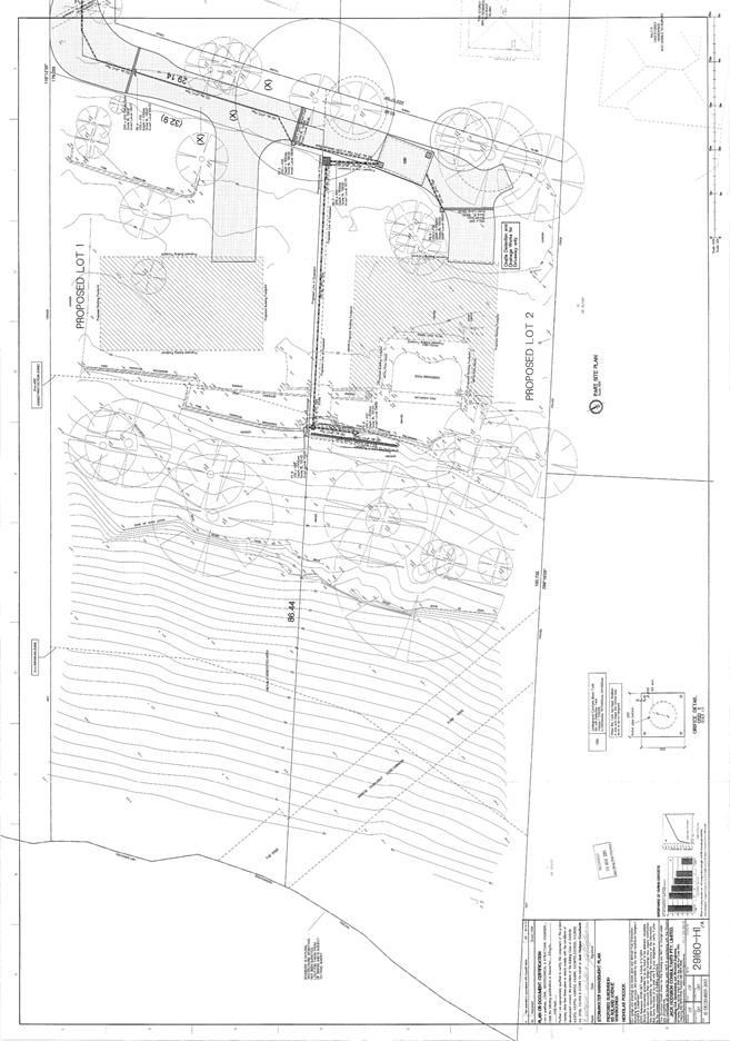
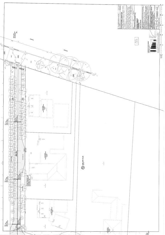
|
Ordinary
Meeting of Council - 31 March 2015
|
GB.5 / 85
|
|
|
|
|
Item
GB.5
|
DA0327/13
|
|
|
23 March 2015
|
Consideration of Officers' Recommendation
to the Sydney West Joint Regional Panel on S94 Contribution for DA0327/13
EXECUTIVE
SUMMARY
|
purpose of report:
|
For Council to determine whether it will make a
submission to the JRPP on the Section 94 contribution for DA0327/13 which
proposes construction of a new hospital at 742, 746 and 746A Pacific Highway,
Gordon.
|
|
|
|
|
background:
|
Councillor David Citer requested
that the officers’ recommendation to the JRPP concerning the Section 94
contribution for DA0327/13 be referred to full Council for consideration.
|
|
|
|
|
comments:
|
The officers’ DA assessment report has been finalised
and forwarded to the JRPP for consideration at its meeting on 8 April 2015.
An elected Council may make a submission on a DA within their local
government area where the JRPP is the consent authority. Any submission made
by Council must be received by the JRPP seven days before the JRPP meeting.
|
|
|
|
|
recommendation:
|
That Council determine whether it will make a
submission to the JRPP on the Section 94 contribution for DA0327/13.
|
Purpose of Report
For Council to determine whether it will make a submission
to the JRPP on the Section 94 contribution for DA0327/13 which proposes
construction of a new hospital at 742, 746 and 746A Pacific Highway, Gordon.
Background
DA0327/13 was considered by the JRPP at its meeting of 11
September 2014. At the meeting, the JRPP deferred determination of the DA and
requested the applicant to address various outstanding issues and concerns. The
applicant submitted amended plans and further documentation which has been
considered by Council officers in a subsequent report to the JRPP meeting of 8
April 2015 (Attachment 1).
The JRPP Operational Procedures provide that a elected
council may make a submission on a DA within their local government area where
the JRPP is the consent authority. Any council submission must be received by
the JRPP seven days before the JRPP meeting.
On 10 March 2015, Councillor Citer requested that the
officers’ recommendation in the JRPP assessment report concerning Section 94
contribution be referred to Council for consideration. The officers’ DA
assessment report was finalised and forwarded to the JRPP on 23 March 2015 (Attachment
1). The report will be considered by the JRPP at its meeting on 8 April
2015.
Comments
This application was assessed
under the heads of consideration of Section 79C of the Environmental Planning
and Assessment Act 1979 and all relevant instruments and policies. The proposal
(as amended) still does not achieve compliance with the requirements of the
relevant instruments and policies. The officers’ report recommends that the
Sydney West Joint Regional Planning Panel, as the consent authority, refuse
development consent to Development Application No. 0327/13.
The report also states that if
the application were to be approved by the JRPP, payment of a Section 94
contribution would be required. The applicable S94 contribution for this
development is $451,987.86.
The applicant has requested full
exemption form payment of a Section 94 contribution. The
officers’ assessment report recommends that the applicant’s request for
exemption not be granted. The applicant’s
request for full exemption from the payment of a section 94 contribution is
included in Attachment 2.The basis to the applicant’s request for
exemption is that, whilst the hospital will operate on a for-profit basis, it
is however proposed to donate the use of the inpatient facility to the UNSW for
teaching and research purposes.
Section 1.26 of Council’s
Section 94 Contributions Plan only allows exemptions from the payment of S94
contributions in the following cases:
1. Developments
which provide a distinct community benefit on a not-for-profit basis including
but not necessarily limited to: fire stations, police stations or police
shopfronts, ambulance stations, rescue services, State Emergency Service (SES)
and Rural Fire Services (RFS) operational bases and the like;
2. Development
by or for non-profit or cooperative organisations which provide a distinct
community benefit including but not limited to: the provision of childcare
services (especially for under-2s and/or special needs children) including
kindergartens and pre-schools; outreach services, community services or the
like, on a cooperative or not-for-profit basis;
3. Development
which involves an application solely for the internal conversion of one
existing single terrace style shop-top type dwelling (typically located in the
town centres along the Pacific Highway) or a freestanding single dwelling which
has recently been used for commercial purposes back to residential use. This
potential exemption will not apply where that conversion occurs as part of a
larger redevelopment which must be considered as a whole; and/or
4. Development
where it can be demonstrated to the satisfaction of Council that in any
particular category of contribution that the development, by the particular
nature of its use, in the unique circumstances of the case, does not generate a
demand for, or derive benefit from, some or any of the types of facilities and
amenities to be provided. Note: Given that the grant of any such exemption,
full or partial, may be considered to create a precedent or confer a pecuniary
advantage on one developer over others, such an exemption is not likely to be
granted unless there are absolute meritorious circumstances that would
distinguish the case of the subject development from any other. All such
arguments will be put before Council for formal determination and the full text
of any such submission will be publicly available on Council’s website for
public scrutiny.
The
proposed use does not satisfy any of the categories for exemption under section
1.26 of Council’s S94 Contributions Plan as it is intended to operate the
facility on a for profit basis and the hospital will generate a demand for and
benefit from the facilities and amenities provided by the contributions plan
(i.e. new roads and road upgrades). Accordingly, the officer’s report
recommends that an exemption from the payment of section 94 contributions in
the event of the DA being approved by the JRPP should not be granted.
integrated planning and reporting
Places, Spaces & Infrastructure
|
Community Strategic Plan Long Term Objective
|
Delivery Program
Term Achievement
|
Operational Plan
Task
|
|
P3.1 The built environment delivers attractive,
interactive and sustainable living and working environments.
|
A high standard of design quality and building
environmental performance is achieved in new development.
|
Assessment of applications is consistent with Council’s
adopted LEPs and DCPs.
|
Governance Matters
The Joint Regional Panels’ Operational Procedures specifies
the following with regard to Council representation to the regional panel:
· An elected Council may make a submission
on a DA within their LGA that is to be determined by a regional panel up to
seven days before the regional panel meeting.
· After the assessment report has been
forwarded to the secretariat, it may be provided to the elected Council to
assist in its decision as to whether it will be making a submission to the
regional panel.
· The elected Council’s submission should
not be prepared by persons involved in the assessment of the application and
should be prepared by another council officer or a consultant.
· If Council makes a submission, a staff
representative or individual Councillors may register to address the regional
panel at the meeting to express the views of council.
· Councillors who are also panel members
have an independent role because they have been nominated by their council as
its nominee to the regional panel. They should declare any interest in a DA for
regional development that comes before their council and not participate at the
council meeting. They should also not remain in the council chamber during
council’s deliberations.
Risk Management
There are no risk management considerations associated with
the recommendations in this report.
Financial Considerations
There are no financial considerations associated with the
recommendations in this report.
Social Considerations
There are no social considerations associated with the recommendations
in this report.
Environmental Considerations
There are no environmental considerations associated with
the recommendations in this report.
Community Consultation
None undertaken or required.
Internal Consultation
None undertaken or required.
Summary
DA0327/13 proposes demolition of
three dwellings at 742, 746 and 746A Pacific Highway, Gordon and construction
of a 4 storey hospital with 64 beds. The officers’ DA assessment report on the
amended proposal was forwarded to the JRPP for consideration at its meeting on
8 April 2015. The officers’ report recommends refusal of the application but
states that if the application were to be approved by the JRPP then payment of
section 94 contributions would be required. The applicable S94 contribution for
this development would be $451,987.86.
Council needs to determine whether it will make a submission
to the JRPP on the S94 contribution for DA0327/13 as requested by Councillor
Citer.
|
Recommendation:
A. That
Council note the officers’ report recommending refusal of for DA0327/13 which
proposes demolition of three dwellings at 742, 746 and 746A Pacific Highway,
Gordon and construction of a 4 storey hospital with 64 beds.
B. That
Council determines whether it will make a submission on DA0327/13 to the
Sydney West Joint Regional Planning Panel at its meeting on 15 April 2015 on
the Section 94 contribution for DA0327/13.
|
|
Corrie Swanepoel
Manager Development Assessment Services
|
Michael Miocic
Director Development & Regulation
|
|
Attachments:
|
A1View
|
JRPP
supplementary report
|
|
2015/031349
|
|
|
A2View
|
Planning
Consultant letter responding to JRPP deferral
|
|
2014/302472
|
|
|
A3View
|
Assessment
considered by JRPP at the meeting on 11 September 2014
|
|
2014/201781
|
|
|
A4View
|
Architectural
Plans
|
|
2014/302861
|
|
|
A5View
|
Landscape
Plans
|
|
2014/302864
|
|
APPENDIX
No: 1 - JRPP
supplementary report
|
|
Item No: GB.5
|
JOINT REGIONAL
PLANNING PANEL
(Sydney West)
|
JRPP No
|
2013SYW094
|
|
DA Number
|
DA0327/13
|
|
Local Government
Area
|
Ku-ring-gai
|
|
Proposed
Development
|
Demolition
of three dwellings at 742, 746 and 746A Pacific Highway. Construction of a 4
storey hospital with 64 beds. Boundary adjustment between 746 and 748 Pacific
Highway. Consolidation of 742, 746 and 746A Pacific Highway into a single
allotment.
|
|
Street Address
|
742,
746, 746A and 748 Pacific Highway, Gordon
|
|
Lot & DP
|
Lot A
DP350224, Lots 1 and 2 DP 851223 and Lot C DP337904.
|
|
Applicant
|
The
Lawson Clinic Pty Ltd
|
|
Owner
|
JSNL Pty Ltd, R I A F Pty Ltd
|
|
Number of
Submissions
|
Original proposal: 12 submissions and 1 petition
Amended proposal: 4 submissions
Second amended proposal: 6 submissions
|
|
Regional
Development
Criteria
(Schedule
4A of the Act)
|
The
proposed hospital has a CIV of over $5 million and falls into the category of
‘private infrastructure and community facility’
|
|
List of All
Relevant
s79C(1)(a)
Matters
|
SEPP 55 – Remediation of Land
SEPP (Sydney Harbour Catchment) 2005
SEPP (Infrastructure) 2007
Ku-ring-gai LEP (Local Centres) 2012
Ku-ring-gai LEP Local Centres DCP
Development Contributions Plan 2010
|
|
List all
documents
submitted
with this
report for
the panel’s
consideration
|
Attachment
A – Amended clause 4.6 variation request
Attachment
B – Heritage Consultant comments dated 18 December 2014
Attachment
C – Urban Design Consultant comments dated 20 February 2015
Attachment
D – Request for exemption from Section 94 Contributions
Attachment
E – Planning Consultant letter responding to JRPP deferral
Attachment
F – architectural plans
Attachment
G – landscape plans
Attachment
H – stormwater plans
Attachment
I – assessment report considered by JRPP at the meeting on 11 September 2014
Attachment
J – JRPP Record of Deferral
|
|
Recommendation
|
Refusal
|
|
Report By
|
Jonathan
Goodwill – Executive Assessment Officer
|
Assessment Report and
Recommendation Cover Sheet
742-746 pacific highway, gordon –
supplementary report
executive
summary
|
purpose for report:
|
To
address the issues raised by the Sydney West Joint Regional Planning Panel
(JRPP) at the 11 September 2014 meeting and for the JRPP to determine Development
Application No. 0327/13 for the demolition of existing dwellings and
construction of a hospital at 742-748 Pacific Highway, Gordon.
|
|
background:
|
An
assessment report was considered by the JRPP on 11 September 2014 where the
JRPP resolved to defer the determination pending the submission of additional
information by the applicant in response to the issues raised relating to:
· isolation
of 744 Pacific Highway
· setbacks
from northern and western boundaries
· massing
of the western elevation
· non
compliant building height
· excessive
retaining wall height
· access
to open space
· car
parking
· inconsistent
plans
· stormwater
· response
to topography
· site
slope
|
|
Comments:
|
The
adequacy of the additional information submitted by the applicant to address
the issues raised has been assessed.
|
|
recommendation:
|
Refusal
|
Legislative requirements
Zoning R4 High Density Residential under
Ku-ring-gai LEP (Local Centres) 2013
Permissible
Under Ku-ring-gai
LEP (Local Centres) 2012
Relevant legislation Environmental Planning
and Assessment Act 1979
SEPP 55 – Remediation of land
SEPP
(Sydney Harbour Catchment) 2005
SEPP
(Infrastructure) 2007
Ku-ring-gai
LEP (Local Centres) 2012
Local Centres DCP
Development Contributions Plan 2010
Integrated
Development No
PURPOSE FOR REPORT
To
address the issues raised by the Sydney West Joint Regional Planning Panel
(JRPP) at the 13 September 2014 meeting and for the JRPP to determine
Development Application No. 0327/13 for the demolition of existing dwellings
and construction of a hospital at 742-748 Pacific Highway, Gordon.
BACKGROUND
An assessment
report was considered by the JRPP at its meeting of 13 September 2014 where it
was resolved to defer the determination pending the submission of additional
information by the applicant. The JRPP asked the applicant to address the
following:
1. As a threshold issue, whether or
not development of 244 Pacific Hwy is practical, or the site is isolated. If
the former applies, concept plans are to be provided showing potential
development with and without a right of way. In the case of a right of way,
legal advice is to be provided demonstrating that such a right of way will
remain available over the long term. If the latter case applies and the
property is found to be isolated, appropriate evidence of attempts to acquire
the property is to be provided. Any valuation of the property must be based on
the correct zoning and permissible development.
2. The need for increased setbacks at
the northern and western sides of the main building are to be examined, taking
into account the neighbouring heritage item to the north and the visual impact
on R2 properties to the west.
3. Measures to mitigate the effects of
the long western elevation of the main building.
4. Measures to address or otherwise
comply with the excessive height at the northern and southern ends of the main
building, taking into account its location at a zone interface.
5. Measures to mitigate the perceived
excessive height of retaining walls for
driveways to the south of the main
building.
6. Demonstration that access to the
area of open space to the south is practical and safe.
7. Demonstration of compliance with
the parking requirements of Council or RMS or proper justification for any
variations thereto.
8. Provision of a completely
consistent set of amended plans.
9. Address the non-complying
stormwater drainage issues as per the council officer’s report.
10. A building design that better
adjusts to the significant north/south gradient of the site, that does not
result in unused underbuilding void and reduces the impact on interface
properties to the west, potentially by stepping the building into differing
levels.
Comments
In response
to the deferral, the applicant submitted amended plans and additional
information on 27 November 2014. The adequacy of this information to address
the issues identified by the JRPP is discussed below.
1. As a threshold issue, whether or
not development of 744 Pacific Highway is practical, or the site is isolated.
If the former applies, concept plans are to be provided showing potential development
with and without a right of way. In the case of a right of way, legal advice is
to be provided demonstrating that such a right of way will remain available
over the long term. If the latter case applies and the property is found to be
isolated, appropriate evidence of attempts to acquire the property is to be
provided. Any valuation of the property must be based on the correct zoning and
permissible development.
The
applicant maintains their view that 744 Pacific Highway is not an isolated site
despite the fact that the site does not comply with the minimum site area and
minimum frontage development standards specified in Ku-ring-gai LEP (Local
Centres) 2012. The applicant states that a right of way over part of the
driveway which currently services 742 Pacific Highway can be created to
facilitate future development of the site as a residential flat building and
has provided legal advice to support their view that the right of way will
remain available over the long term.
The
applicant has also submitted a revised valuation report based on the correct
zoning which values 744 Pacific Highway at $1,200,000. Details of attempts made
to purchase the site have also been provided. The new valuation of $1,200,000
is less than the original valuation of $1,225,000 which was based on the
incorrect zoning. A concern identified in the previous assessment report was
that the sale price of 742, 746 and 746A Pacific Highway had not been used to
form the valuation, the new valuation advises that these sales were not
included as, ‘…these prices reflect a special value to the
purchasing/adjoining owner and cannot be considered as market evidence’.
One
of the properties used as market evidence is 12-14 Cecil Street, Gordon. This
site contains two dwelling houses, is zoned R4 High Density Residential and was
sold in May 2014 for $4,109,547 with approved plans for a 37 unit residential
flat building development. This site is situated 370 metres to the south-east
of the subject site. The sale price of $4,109,547 reflects a value of $110,000
per unit and $1,160 per square metre of site area. If these figures are applied
to 744 Pacific Highway the value is between $1,180,880 and $1,320,000,
accordingly the valuation of $1,200,000 for 744 Pacific Highway is considered
reasonable.
Included
in the applicant’s bundle of additional information was an offer to purchase
744 Pacific Highway for $1,750,000. The applicant states that this information
is provided for information only as it is their position that the purchase of
744 Pacific Highway is not required because it is not an isolated site. The
owner of 744 Pacific Highway initially rejected this offer, however changed his
mind several days later and decided to accept the offer. The Lawson Clinic
wrote to the owner’s solicitor on 15 December 2014 to discuss the terms of
sale. The terms suggested by the Lawson Clinic included a 5% deposit and a 12
months settlement period. The owner rejected these terms and requested a 10%
deposit and a 6 week settlement period. On 10 February 2015 the owner advised
the Lawson Clinic by letter that he would accept a 10% deposit and a 3 month
settlement period. On 3 March 2015 the Lawson Clinic advised Council that they
had purchased 744 Pacific Highway but did not intend to incorporate the site
into the development at the present time.
Other
additional information submitted by the applicant included concept plans for a
3 storey residential flat building development containing 12 dual-aspect
apartments with and without a right of way. The concept plans do not address
the sloping topography of the site and the size of the basement is excessive,
however they do demonstrate that the site can be developed for the purpose of a
residential flat building thus achieving the objectives of the R4 High Density
Residential zone.
The
submission of the new valuation report and concept plans addresses Council’s
previous concerns regarding the isolation of 744 Pacific Highway.
2. The need for increased setbacks at
the northern and western sides of the main building are to be examined, taking
into account the neighbouring heritage item to the north and the visual impact
on R2 properties to the west.
The
setback from the northern boundary has been increased by 500mm to a minimum of
4.027m. The third storey of the building has also been deleted.
The
increased setback and deletion of the third storey addresses Council’ concerns
regarding the impact of the building on the heritage significance of the
heritage items at 748 Pacific Highway and 750-754 Pacific Highway.
Parts
of the western elevation have an increased setback from the boundary and other
parts have a reduced setback. The setback of the southern end of the building
which has a height of 4 storeys has been reduced from between 6m and 6.58m to
6m. The reduced setback increases the visual impact of the proposal on 3
Bushlands Avenue which is zoned R2.
3. Measures to mitigate the effects of
the long western elevation of the main building
The
major amendment to the western elevation is the deletion of the third storey
over the northern end of the building and adjacent to the eastern side boundary
of the dwelling-house at 22 St Johns Avenue. Minor changes to the setback from
the western boundary have also been made. The reduction in the height of the
northern end of the building significantly reduces the impact of the proposal
on the adjacent dwelling-house at 22 St Johns Avenue.
The reduced western side setback at the southern end of the building increases
the visual impact of the proposal on the adjacent R2 zoned property, 3
Bushlands Avenue.
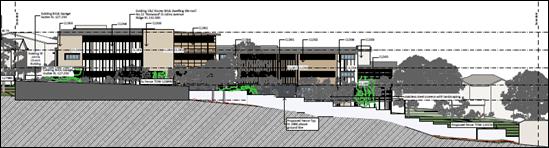
Figure
1 - original proposal
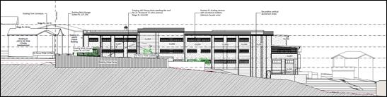
Figure
2 - amended proposal
4. Measures to address or otherwise
comply with the excessive height at the northern and southern ends of the main
building, taking into account its location at a zone interface.
The
third storey at the northern end of the building has been deleted thus reducing
the impact of the development on the adjacent dwelling house 22 St Johns
Avenue. The southern end of the building remains non-compliant with the maximum
building height development standard of 11.5m. The height of the proposed
building is a maximum of 1.3m higher than the height limit.
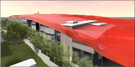
Figure
3 - height non-compliance, shaded area represents 11.5m height plane
The
applicant has submitted an amended clause 4.6 variation request (Attachment
A). The request contains detailed justification for the variation, however
it fails to explain why compliance with the development standard is
unreasonable or unnecessary and does not quantify the physical impacts of the
non-compliance (i.e. additional overshadowing) on the backyard of the adjacent
dwelling house 3 Bushlands Avenue. The failure to adequately address the
overshadowing issue is considered a significant concern as the 1.3m height
variation will increase the length of the 9am shadow by approximately 3.8m
(11%).
The
variation request states that the non-compliance achieves a better
environmental planning outcome as it minimises the amount of cut and fill. A
nexus between cut and fill and the non-compliance with the building height
limit cannot be reasonably established as the portion of the building that
breaches the height limit is located on the top storey of the building. The
Local Centres LEP does not state that a reduction in cut and fill is an
objective of the building height development standard.
The
site most vulnerable to impacts from the non-compliant building height is 3
Bushlands Avenue. This site is a deep allotment with a relatively narrow width
of 15.24 metres. The site contains a split level dwelling and a detached granny
flat. The site has not been developed to its potential, significant extensions
to the house could be accommodated within the maximum floor space ratio that
applies to the site. The backyard of the site is steeply sloping, the ground
level of the rear patio is 7 metres lower than the ground level at the rear
boundary. The existing two storey dwelling-house at 742 Pacific Highway is
visible from the backyard of 3 Bushlands Avenue. The western elevation of the
proposed development is approximately 3.9 metres higher than the ridge height
of the existing two storey dwelling and 17.9 metres higher than the ground
level of the rear patio. The non-compliant portion of the building has a four
storey presentation and is located upslope of the backyard of 3 Bushlands
Avenue. The non-compliant portion is not set back further from the side
boundary than the portions of the building which comply with the height limit.
The partial four storey presentation to 3 Bushlands Avenue will have an
overbearing impact on the private open space of this dwelling and will
unreasonably impact on the amenity of its private open space area. It is not
considered unreasonable or unnecessary for the development to comply with the
height limit in order to minimise its impact on the backyard of 3 Bushlands
Avenue.
5. Measures to mitigate the perceived
excessive height of retaining walls for driveways to the south of the main
building.
The
lower carpark at the southern end of the building is now connected to the upper
level carpark by a ramp. The truck turning area which was previously a level
platform has been modified by lowering the southern end by 755mm and providing
a slope of 1m over a distance of 9.2m. The height of the retaining walls has
been reduced and they are stepped in response to the slope. The planter bed
between the eastern edge of the ramp/truck turning area and the rear boundary
of the dwelling-house at 744 Pacific Highway has a width of between 750mm and
1300mm.
The
Local Centres DCP requires a minimum setback of 6m and a landscaped setback of
4m for residential flat buildings. The amendment does not resolve Council’s
concerns regarding the inadequate landscape setback between the rear of the
dwelling-house at 744 Pacific Highway and the 3 storey eastern elevation of the
hospital. The proposal will have a significant adverse visual impact on the
backyard of the dwelling house at 744 Pacific Highway. The visual impact cannot
be adequately alleviated through planting of 3-5m high Lilly Pilly shrubs in a
landscaped bed with a width of 750-1300mm.
6. Demonstration that access to the
area of open space to the south is practical and safe.
The
pathway in the western side setback area of the site provides access to the
open space at the south of the site. The applicant states that the main outdoor
open space area for the patients is at the northern side of the site between
the northern elevation and the northern boundary. The outdoor open space on the
northern elevation is more easily accessible then the open space in the
southern part of the site.
7. Demonstration of compliance with
the parking requirements of Council or RMS or proper justification for any
variations thereto.
The
amendments to the proposal have increased the number of car spaces from 31 to
35. Council’s Team Leader Development Engineering has provided the following
advice regarding the applicant’s amended proposal:
The
documentation does not really add anything new and does not cover some of the
matters raised during the JRPP meeting. Matters not addressed which were raised
at the meeting include: the mother and baby unit (daily visitors expected),
the trainees and medical students associated with the role of the Lawson Clinic
as a teaching hospital and the two spaces currently leased from St John’s
Church.
The
report states that Council’s DCP car parking codes do not cater for mental
health facilities, however the Local Centres LEP definition of “hospital”
specifically includes psychiatric care.
The
example given in support of the variation is the expansion of South Pacific
Private Hospital at 24 Beach Street Curl Curl. This is an existing facility
with 41 beds and 10 off-street parking spaces (from the Hospital website). The
expansion proposal included 12 to 13 beds and 13 parking spaces, i.e. a nominal
increase of one parking space per new bed and a total provision of 23 car
spaces. A significant difference between the subject site and the South Pacific
Private Hospital is that on street parking is available in Beach Street at and
around the frontage of the hospital. On street parking is not available on
Pacific Highway.
A
letter at Attachment A regarding the low numbers of visitors expected is
accepted, as is the statement that patients are not permitted to drive.
However, patients need to be dropped off as well as picked up for their home
visits later in their stay, which means that on-site parking is required for
the carers rather than patients. Further, the Draft Operational Plan, which
has not been amended, gives visiting hours for each day.
Summary:
On
the site, post-development, will be:
· 360m2
consulting rooms (medical centre) with 11 day staff
· 64
bed hospital with 14 day staff
Parking
required under Ku-ring-gai Local Centres DCP is:
Consulting
rooms – 1 space per 25m2 of floor area = 14.4 spaces.
Hospital
– 1 space per 3 rooms + 1 space per 2 staff = 28.3 spaces.
TOTAL
= 43 spaces
If
the ambulance bay and loading bay are included as car spaces, the shortfall is
6 spaces. The provision of 6 additional car spaces would require an additional
130 square metres of basement excavation. The additional car spaces could be
accommodated to the north of car spaces 23 and 24. The applicant should amend
the plans to provide these additional spaces.
8. Provision of a completely
consistent set of amended plans.
The
amended plans contain the following inconsistencies:
· The
10,000 litres above ground rainwater tank on the stormwater plan is located in
the middle of the pathway in the western side setback
· The
landscape plan indicates that a fence ‘to architects detail’ is to be
constructed over the retaining wall on the rear boundary of 744 Pacific
Highway. The architectural plans do not contain any details for the fence.
· The
sections (DA-04.01 & DA-04.02) do not match the location indicated on the
floor plans (DA-02.01 & DA-02.02)
· The
outbuilding at the rear of 3 Bushlands Avenue is described as both a garage and
a temporary dwelling. The building is a granny flat and has been located on the
site since the late 1980s.
· The
photomontage shows a row of conifers on the southern side of the northern
access handle. The landscape plan shows that planting in the 400mm wide planter
bed adjacent to the driveway is a grass (Spreading Flax Lilly). The
photomontage does not accurately represent the visual character of the proposed
driveway.
· The
landscape plan provides a top of wall RL for the fence on the boundary with 3
Bushlands Avenue of 123.35. If this RL is correct the top of the fence is 4.67m
higher than the gutter of the dwelling at 3 Bushlands Avenue and approximately
7.6m higher than the floor of the patio at the rear of the house.
9. Address the non-complying
stormwater drainage issues as per the council officer’s report.
In
the amended plans, the proposed easement has been relocated from 1A Bushlands
Avenue to 738 Pacific Highway. A right angle bend in the stormwater pipe is no
longer required. The owner of 738 Pacific Highway has provided a letter stating
that they are willing to grant a drainage easement over the property.
The
previously identified concerns regarding the proposed rainwater storage tank
have not been adequately addressed. The rainwater tank is still shown on the
landscape plan as a slimline tank which is not available in the 10,000 litre
size proposed. The footpath on the architectural plans is located in the same
position as the above ground rainwater tank. A below-ground tank could be
provided under the driveway and upstream of the detention tank. This could be
conditioned.
The proposed
detention tank protrudes beyond the southern edge of the lower carpark and
conflicts with the proposed stepped batter. The detention tank could be
redesigned so that it is located wholly under the carpark. This could be
conditioned.
10. A building design that better
adjusts to the significant north/south gradient of the site, that does not
result in unused underbuilding void and reduces the impact on interface
properties to the west, potentially by stepping the building into differing
levels.
The
void at the southern end of the building has been deleted by enclosing the
space, excavating the ground under the building and using the space as a
carpark. The floor level of the floor over the void space which was previously
known as the basement level has been raised 150mm to RL 124.5 and is now known
as the lower ground floor level. Other changes include deleting one car space
in the lower carpark and reducing the setback of the lower carpark from the
western side boundary from 15.6 metres to 6 metres. The height of the western
elevation has not been reduced.
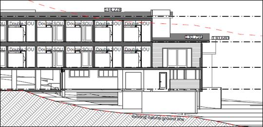
Figure
4 - original proposal
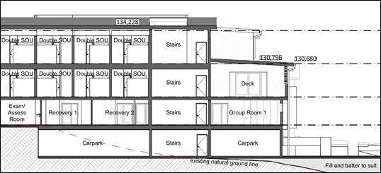
Figure
5 - amended proposal
CONSULTATION – COMMUNITY
The amended
plans and information submitted by the applicant were notified to owners of
neighbouring properties. Submissions from the following were received:
1.
Jingchun Gao – 1 Bushlands Avenue, Gordon
2.
Gerald Rousseau – 5 Bushlands Avenue, Gordon
3.
In Shik Hong – 22 St Johns Avenue, Gordon
4.
Chao-Hiang Wang – 3 Bushlands Avenue, Gordon
5.
Michael Coates - 15 Bushlands Avenue, Gordon
6.
Michael Kocsard – 744 Pacific Highway, Gordon
The
following issues were raised in the submissions:
Security issues
The
likelihood of hospital patients presenting a security risk to neighbours is
considered to be low. The hospital is proposed to be staffed at all times and
the proposed use is not a correctional facility.
Overshadowing
The
previously identified concerns with the overshadowing diagrams have not been
fully addressed. The outstanding concerns relate to the plans not being based
on survey data and a failure to provide plans which accurately shown the
different between existing and proposed shadows.
Inadequate outdoor recreation space for patients
The
planning controls which apply to the development do not include an outdoor
recreation space requirement for hospitals.
The fence between the development site and 3 Bushlands Avenue is
inadequate
The
proposal includes a new fence adjacent to the boundary with 3 Bushlands Avenue.
The landscape plan provides a top of wall RL for the fence of 123.35. If this
RL is correct the top of the fence is 4.67m higher than the gutter of the
dwelling at 3 Bushlands Avenue and approximately 7.6m higher than the floor of
the patio at the rear of the house. The height of the proposed fence is
excessive.
The hospital is located on a high part of the hill, is close to
neighbours and will result in traffic, noise, light and privacy issues
The
topography of the site exacerbates the impacts arising from the non-compliance
with the development standard for maximum building height. The height of the
building does not comply with the height limit and the justification for the variation
advanced by the applicant is not supported.
Increased potential for traffic or pedestrian accidents
on the Pacific Highway
The
application was referred to Roads and Maritime Services for comment, who
advised that the proposal was acceptable in this regard, subject to conditions.
How an ambulance or fire truck would negotiate entry and exit to
the facility in the intersection of Pacific Highway and St John Avenue were to
be gridlocked
This
concern relates to the public road network and could apply to any building
located near an intersection on a busy road. The public road network is not the
responsibility of the applicant and this concern is not a reason to refuse the
application.
Excessive bulk
For
the reasons discussed elsewhere in the report, it is considered that the design
of the western elevation does not successfully break down the building mass and
has an unacceptable impact on adjacent properties which are zoned R2 Low
Density Residential.
The acquisition of 744 Pacific Highway would allow for the
relocation of the building further away from residential neighbours
The
acquisition of 744 Pacific Highway may allow for an alternative design which
provides greater boundary setbacks and reduces impacts on neighbouring
properties. The applicant has indicated that they have purchased 744 Pacific
Highway but at the present time they have no intention of incorporating the
site into the proposed development.
The proposal is incompatible with residential zoning
The
applicant’s propsed development is permissible under the provisions of SEPP
(Infrastructure) 2007, however it is considered that the development fails to
appropriately manage the change in character and bulk/scale at the zone
interface with adjacent R2 Low Density Residential zoned land.
Inadequate car parking
The
number of car spaces provided for the development does not comply with the
requirements of the Local Centres DCP. The variation to the parking controls
has not been adequately justified and is not supported.
CONSULTATION
– WITHIN COUNCIL
Heritage
Council’s
Heritage Consultant reviewed the amended plans and advised that the previous
concerns regarding the impact of the development on the heritage significance
of the adjacent church and Windsor House have been addressed. The full comments
of Council’s Heritage Consultant are included as Attachment B.
Urban
Design
Council’s Urban Design Consultant reviewed the amended plans and
advised that the setback from the northern boundary should be increased to a
minimum of 6m as this would reduce the impact of the proposal on the adjacent
site 750-754 Pacific Highway which is zoned R4 High Density Residential and
contains buildings that could be demolished to make way for a residential flat
building development. Council staff are of the opinion that a 6m setback from
the northern boundary is not required as the northern elevation of the building
is two storeys in height and any future development at 750-754 Pacific Highway
would need to be designed to address issues of privacy and overlooking. It is
also considered that the southern elevation of a future residential flat
building development at 750-754 Pacific Highway is unlikely to be the optimal
location for balconies and living room windows. An increased setback of 6m
would also move the building further to the south and result in greater impacts
on 1 & 3 Bushlands Avenue.
Council’s Urban Design Consultant is also of the opinion that the
variation to the 11.5 metres height limit may be supported on urban design
grounds if a setback of 6 metres is provided from the northern boundary. The
reasons for this opinion include the overall design improvements, the overall
reduced impact to the adjacent R2 Low Density Residential zoned properties, and
that the area of non-compliance being confined. From a town planning
perspective, the variation to the building height development standard is not
supported as the impacts on 3 Bushlands Avenue are unacceptable and the
applicant has not demonstrated that compliance with the standard is
unreasonable or unnecessary. It is also noted that a variation to a development
standard must be considered in accordance with the provisions of clause 4.6 and
issues such as unrelated design considerations and overall improvements to the
design are not relevant considerations.
The full comments of Council’s Urban Design Consultant are
included in Attachment C.
Landscape
Council’s Landscape Assessment Officer commented on the amended
proposal as follows:
Deep soil landscape area (Part 7A.4 Volume A Ku-ring-gai Local Centres
DCP)
The site area for the hospital is
2908m2 (excluding access handles). For a residential flat building
50% of the site area (1454m2) is required to be deep soil
landscaping. For the proposed hospital 35% of the site area (1038m2)
has been provided as deep soil landscaping.
The
proposal provides less than the amount of deep soil landscape area required
under the zoning. The majority of the deep soil will be located south of 742
Pacific Highway and in the front setback of 748 Pacific Highway.
On merit, the development should
provide consolidated deep soil zones through careful planning and design, to
provide landscaped areas that are appropriate to the scale and context of the
development (Part 7A.4
Volume A
Ku-ring-gai (Local Centres)DCP). It would appear that the inclusion of 742
Pacific Highway has not translated into significantly improved deep soil areas
between the heritage item, however there is an acceptable deep soil landscape
provision adjacent to the neighbouring dwelling at 22 St Johns Avenue.
The building setbacks to the northern
boundary provide greater deep soil zones including canopy trees proposed of a
similar scale to the proposed building.
The proposal provides a vertical
garden between the proposed building and the heritage item at 748 Pacific
Highway. Details have not been provided, however it is assumed that the height
of the green wall is approximately 3 metres as shown on the rendering
(DA-05.09/DA2, Elevation).
Tree replenishment (Part 7A.4 Volume A Ku-ring-gai Local CentresDCP)
The proposal should support a minimum
number of 16 trees. The proposed of Pyrus calleryana ‘Capital’ are not canopy
trees. Without these trees the proposal would not comply with the minimum
canopy tree requirement. Additional canopy trees within side setbacks could be
conditioned.
Tree Impacts (Clause 5.9 KLEP(Local Centres))
An
arborist report, prepared by Landscape Matrix, dated 10/07/13, has been
submitted.
Trees to be removed
Tree
1/ Pittosporum undulatum (Sweet Pittosporum). This tree is located on the
front boundary of 748 Pacific Highway, within the heritage item. There is no
objection to the tree’s removal. Tree 1 identified on the landscape plan as
located on the nature reserve is a mature Melaleuca quinquinervia (Broad-leaved
Paperbark) that should be retained and protected.
Tree
2/ Pittosporum undulatum (Sweet Pittosporum). This tree is located on the front
boundary of 748 Pacific Highway, within the heritage item. The tree exhibits
poor health and vigour with high levels of dieback. There is no objection to
the tree’s removal.
Tree
3/ Grevillea robusta (Silky Oak). This tree is located on the southern
boundary of 748 Pacific Highway, within the heritage item. The tree exhibits
poor health and vigour with high levels of dieback. There is no objection to
the tree’s removal.
Tree
4/ Jacaranda mimosifolia (Jacaranda). This tree is located on the southern
boundary of the driveway to 746A Pacific Highway. The tree is in good health,
however its form is poor due to past pruning. There is no objection to the
tree’s removal.
Tree
5/ Cupressus macrocarpa 'Brunniana' (Golden Cypress). This tree is located on
the southern boundary at the driveway entrance to 746 Pacific Highway. The
multi trunked tree is a good specimen and is visually prominent. It has been
assessed in the arborist report as having high landscape significance. The tree
would have to be removed for construction access. As there is no other means of
entering the rear of the site, there is no objection to the tree’s removal.
Tree
6/ Jacaranda mimosifolia (Jacaranda). This tree is located at the driveway
entrance to 746 Pacific Highway. The tree is a poor specimen having been
severely pruned in the past. There is no objection to the tree’s removal.
Tree
7/ Jacaranda mimosifolia (Jacaranda.) This tree is located at the driveway
entrance to 746 Pacific Highway. The tree is a poor specimen having been
severely pruned in the past. There is no objection to the tree’s removal.
Tree
8/ Liquidambar styraciflua (Liquidambar). This tree is located within the rear
yard of the heritage item at 748 Pacific Highway, adjacent to the driveway of
746A Pacific Highway. The tree has poor form due to being suppressed by a tree
that has recently been removed. There is no objection to the tree’s removal.
Trees
10-15/ Jacaranda mimosifolia (Jacaranda). These trees are located along the
southern boundary of 746 Pacific Highway. The trees have all been poorly pruned
in the past. There is no objection to the removal of these trees.
Tree
17/ Robinia pseudoacacia "Frisia" (Black Locust). This tree is
located within the rear setback of 746A Pacific Highway. The tree exhibits
poor health and is a poor specimen. There is no objection to the tree’s
removal.
Tree
19/ Jacaranda mimosifolia (Jacaranda). This tree is located along the eastern
boundary of 746A Pacific Highway. The tree has poor form due to being
suppressed by a tree that has recently been removed. There is no objection to
the tree’s removal.
Tree
22/ Quercus robur (English Oak). This tree is located along the northern
boundary of 746A Pacific Highway. The tree is a poor specimen and approval to
remove the tree is not required. There is no objection to the tree’s removal.
Trees
23-24/ Archontophoenix alexandrae (Alexandra Palm). This group of small palms
are located at the northeast corner of 746A Pacific Highway. The trees are to
be removed to accommodate the building footprint. There is no objection to the
removal of these trees.
Tree
25/ Archontophoenix cunninghamiana (Bangalow Palm). This palm is not identified
on the landscape plan or the arborist’s tree location plan. There is no
objection to the tree’s removal.
Tree
26/Cupressus torulosa (Bhutan Cypress). This tree is located on the southern
boundary of 742 Pacific Highway. The tree is of moderate health and poor
vigour. There is no objection to the tree’s removal.
Trees to be retained
Tree
9/ Syagrus romanzoffiana(Cocos Palm). This tree is located on the southern side
of the existing driveway, within the adjoining property. The proposed driveway
widening and retaining wall will encroach within the tree protection zone. The
proposed retaining wall construction will be likely to have an adverse impact
on this tree. Works to mitigate the impact on this tree could be conditioned.
Tree
20/ Magnolia x soulangiana (Magnolia). This tree is located on the western
boundary of the site. The proposed path is located 1.6m from the tree. The tree
is low branching and it is unlikely that it would survive the construction
impacts of the proposed works. The impact is considered acceptable.
Tree
21/ Tiboucina granulosa (Purple Glory Tree). This tree is located on the
northwest corner of 746A Pacific Highway. The tree provides amenity to the
adjoining heritage conservation area. The proposed paved area off the staff
room is 3.5m from the tree. The impact is considered acceptable.
Landscape plan
Front setback (7A.1Volume A Ku-ring-gai Local Centres
DCP)
The proposal will remove
several trees and landscaping at the driveway entrance to the proposed
development in order to widen the driveway from 3 metres to 6 metres.
Additional trees located within the heritage item are to be removed to enable
construction access to the site.
Two canopy trees and
additional shrub planting are proposed to be planted within the heritage item
on the northern corner of the driveway entrance.
Side setback (7A.1Volume A Ku-ring-gai Local
Centres DCP)
The ramp behind the rear boundary of
744 Pacific Highway will compromise the landscape setting and neighbouring
amenity and is not supported. The proposed planter is insufficient to provide
effective planting that enable the development to achieve the landscape
objectives required by the zoning.
Driveway (1.2 Volume C Ku-ring-gai Local Centres
DCP)
The proposed widening of
the central driveway will require removal of the existing trees and hedge
planting along the driveway. The
proposal includes on the southern side of the driveway a 600mm wide planting
bed of groundcover planting, Dianella revoluta ‘Little Rev’ (Spreading Flax
Lily) that grows to about 300mm. To provide landscape amenity, additional
hedge planting that can attain approximately 1.5 to 2 metres in height should
be included. This could be conditioned.
Cut and fill (Part 1.2 Volume C Ku-ring-gai Local Centres
DCP)
The proposed driveway will
require up to approximately 600mm excavation by the end of the access handle
this is not shown on the Excavation Plan, dwg DA-01.13/DA4. The proposed
excavation within 2 metres of the northern boundary is not supported. This
could be conditioned. The lower carpark will require filling to 2 metres and
the soil is proposed to be retained by a planted batter. The batter is
considered of excessive grade and a terraced retaining structure is preferable
to ensure viable planting beds adjacent to the western boundary. This could be
conditioned.
Neighbour amenity (Part 1.2 Volume C Ku-ring-gai Local Centres
DCP)
The site falls away to the
west providing views across the adjoining properties and distant views.
Existing screen planting located along the western boundary should be retained
where possible including along the northwest corner of the site. This could be
conditioned.
Heritage impacts - Development in the
vicinity of a heritage item (7.3 Volume B Ku-ring-gai Local Centres DCP)
Impacts on setting of the existing Lawson Clinic
The enhancement of views of the heritage item from the south-east
has been considered in the landscape design.
The rear of the existing Lawson Clinic is an existing area of
carpark. The proposed lot reconfiguration will reduce the area along the rear
boundary of the heritage item by 95.7m2. This area currently
provides 1.5m landscape setback to the carpark. Despite a larger development,
the proposal provides minimal area for common landscape between the rear
carpark and the proposed building. A narrow planting bed is proposed in
association with a pergola to which climbers are to be fixed. An area of
planting proposed at the northern and southern end of the carpark, though not
directly behind the heritage building, will provide a landscape buffer to the
northeast and southeast corner of the proposed building.
St John’s church and cemetery and the
Heritage Conservation Area
The
existing church buildings, cemetery and columbarium are in close proximity to
the proposed development. The hall and the weatherboard building have little
outlook to the site however they will be viewed with a backdrop of the proposed
building. The view of the building is more prominent from the south-east corner
of the cemetery and the southern end of the columbarium.
The
proposed assorted planting along the northern boundary of shrubs is consistent
with the horticultural style of the adjoining item. Three additional medium
sized deciduous trees should be provided along this boundary. This could be
conditioned.
Stormwater plan
The proposed OSD tank has been
relocated to within the carpark at the southern end of the building. It would
be preferable is the tank could be located entirely within the carpark pavement
as opposed to encroaching within areas of deep soil and planters. The proposed
easement for Hydraulic works within 742 and 738 Pacific Highway is likely to
impact existing trees. An arborist report recommending thrust boring through
this area has been provided. This could be conditioned.
Engineering
Council’s
Team Leader Engineering Assessment commented on the amended proposal as
follows:
Water management
The
owner of 738 Pacific Highway has provided a letter stating that they are
willing to grant a drainage easement. If the application were to be approved,
a deferred commencement consent would be recommended, with the registration of
the easement as Schedule A.
The
Siteworks and Drainage Plan Drawing DAC02 is the only drawing in the set which
has been amended. A Section 1-1 is shown on plan, but there is no Section
drawing. A Section drawing would address concerns about the works on the
boundary with 744 Pacific Highway and the available width for the driveway.
Sections were previously requested but have not been provided.
The
rainwater tank is still shown on the landscape plan as a slimline tank – these
are not available in 10,000 litre size. The footpath will need to be diverted
around a tank with a diameter of between 2 to 3 metres. Alternatively, the
rainwater tank could be located underneath the driveway and upstream of the
detention tank. This could be conditioned.
There
seems no reason why the detention tank has to protrude beyond the driveway.
The landscape plan shows a stepped batter to the south of the carpark but the
levels conflict with the tank configuration. It could be re-oriented to be
completely under the driveway. This could be conditioned.
Traffic and parking
The
documentation does not really add anything new and does not cover some of the
matters raised during the JRPP meeting. Matters not addressed which were raised
at the meeting include: the mother and baby unit (daily visitors expected),
the trainees and medical students associated with the role of the Lawson Clinic
as a teaching hospital and the two spaces currently leased from St John’s
Church.
The
report states that Council’s DCP car parking codes do not cater for mental
health facilities, however the Local Centres LEP definition of “hospital”
specifically includes psychiatric care.
The
example given in support of the proposed variation is the expansion of South
Pacific Private Hospital. This is an existing facility with 41 beds and 10
off-street parking spaces (from the Hospital website). The expansion proposal
included 12 to 13 beds and 13 parking spaces, i.e. a nominal increase of one
parking space per new bed and a total provision of 23 car spaces. A significant
difference between the subject site and the South Pacific Private Hospital is
that on street parking is available in Beach Street at and around the frontage
of the hospital. On street parking is not available on the Pacific Highway.
A
letter at Attachment A regarding the low numbers of visitors expected is
accepted, as is the statement that patients are not permitted to drive.
However, patients need to be dropped off as well as picked up for their home
visits later in their stay, which means that on-site parking is required for
the carers rather than patients. Further, the Draft Operational Plan, which
has not been amended, gives visiting hours for each day.
Summary:
On
the site, post-development, will be:
· 360m2
consulting rooms (medical centre) with 11 day staff
· 64
bed hospital with 14 day staff
Parking
required under Ku-ring-gai Local Centres DCP is:
Consulting
rooms – 1 space per 25m2 of floor area = 14.4 spaces.
Hospital
– 1 space per 3 rooms + 1 space per 2 staff = 28.3 spaces.
TOTAL
= 43 spaces
If
the ambulance bay and loading bay are included as car spaces the shortfall is 6
spaces. The provision of 6 additional car spaces would require an additional
130 square metres of basement excavation. The additional car spaces could be
accommodated to the north of car spaces 23 and 24. The applicant should amend
the plans to provide these additional spaces.
LIKELY IMPACTS
The likely impacts of the development have been considered within
this report and it is concluded that further amendments are required to the
design before consent can be granted. To ameliorate the unacceptable impacts of
the development the following amendments should be considered:
· cut back the southern end of the first floor
level to ensure compliance with the 11.5m building height development standard
· increase the size of the basement carpark to
allow for six additional car spaces
· retain the existing driveway in the southern
access handle as a one way entrance driveway
· provide a narrower exit driveway in the
northern access handle with an appropriate landscape treatment
· change the two way ramp between the southern
carpark and the northern carpark to a one way ramp to allow for an increased
landscape setback from the rear boundary of 744 Pacific Highway and taller and
denser screening vegetation
SUITABILITY OF THE SITE
The site is zoned R4 High Density Residential and the proposed is
permissible under the provisions of SEPP (Infrastructure) 2007. The development
site is constrained through it sharing a boundary with R2 Low Density Residential
Zoned land and heritage items on the site (748 Pacific Highway) and adjacent
sites (750-754 Pacific Highway). The height of the elevation which faces the R2
Low Density Residential zoned land does not comply with the building height
development standard. The proposed development has unsatisfactory impacts on
the R2 Low Density Residential Zoned land and is considered unacceptable.
ANY SUBMISSIONS
The submissions have been considered in the above assessment.
PUBLIC INTEREST
The public interest is best served by the consistent application
of the requirements of the relevant planning controls, and by Council ensuring
that any adverse effects on the surrounding area and the environment are
minimised. The proposal has been assessed against the provisions of the
relevant planning controls and is deemed to be unacceptable. On this basis, the
proposal is not considered to be in the public interest.
OTHER RELEVANT MATTERS
Section 94
Contributions
The assessment report previously considered by the JRPP recommended
that the applicant’s request for an exemption from the payment of section 94
contributions not be granted. The applicable S94 contribution for this
development would be $451,987.86. The applicant has submitted further
information regarding their request for a full exemption from the payment of
any section 94 contributions (Attachment D pages 8-10). The information
acknowledges that the hospital will operate on a for profit basis. It is now
proposed to donate the use of the inpatient facility to the UNSW for teaching
and research purposes.
Section
1.26 of the contributions plans provides exemptions in the following cases:
1. Developments which provide a distinct
community benefit on a not-for-profit basis including but not necessarily
limited to: fire stations, police stations or police shopfronts, ambulance
stations, rescue services, State Emergency Service (SES) and Rural Fire
Services (RFS) operational bases and the like;
2. Development by or for non-profit or
cooperative organisations which provide a distinct community benefit including
but not limited to: the provision of childcare services (especially for
under-2s and/or special needs children) including kindergartens and
pre-schools; outreach services, community services or the like, on a
cooperative or not-for-profit basis;
3. Development which involves an
application solely for the internal conversion of one existing single terrace
style shop-top type dwelling (typically located in the town centres along the
Pacific Highway) or a freestanding single dwelling which has recently been used
for commercial purposes back to residential use. This potential exemption will
not apply where that conversion occurs as part of a larger redevelopment which
must be considered as a whole; and/or
4. Development where it can be
demonstrated to the satisfaction of Council that in any particular category of
contribution that the development, by the particular nature of its use, in the
unique circumstances of the case, does not generate a demand for, or derive benefit
from, some or any of the types of facilities and amenities to be provided.
Note: Given that the grant of any such exemption, full or partial, may be
considered to create a precedent or confer a pecuniary advantage on one
developer over others, such an exemption is not likely to be granted unless
there are absolute meritorious circumstances that would distinguish the case of
the subject development from any other. All such arguments will be put before
Council for formal determination and the full text of any such submission will
be publicly available on Council’s website for public scrutiny.
The proposed use does not satisfy any of the categories for
exemption under section 1.26 of the contributions plans as it is intended to
operate the facility on a for profit basis and the hospital will generate a
demand for and benefit from the facilities and amenities provided by the
contributions plan (i.e. new roads and road upgrades). Accordingly, it is not
recommended that an exemption from the payment of section 94 contributions be
granted.
CONCLUSION
This application has been assessed under the heads of
consideration of Section 79C of the Environmental Planning and Assessment
Act 1979 and all relevant instruments and policies. The proposal does not
achieve compliance with the requirements of the relevant instruments and
policies and refusal is recommended.
RECOMMENDATION
PURSUANT TO SECTION 80(1) OF THE ENVIRONMENTAL PLANNING
AND ASSESSMENT ACT, 1979
THAT
the Sydney West Joint Regional Planning Panel, as the consent authority, refuse
development consent to Development Application No. 0327/13 for the following
reasons:
1. Unsatisfactory
impacts on land zoned R2 Low Density Residential and failure to
achieve compatibility with the surrounding land uses
Particulars
· The proportion of the hospital site that is
deep soil landscaping is significantly less than adjacent properties. The
landscape character of the development is inconsistent and incompatible with
the existing and likely future landscape character of the locality.
· The western elevation of the development is
of excessive height and has an unacceptable visual impact on the adjacent R2
Low Density Residential zoned land.
· The proposed driveway between the eastern
elevation of the hospital and the rear boundary of 744 Pacific Highway has an
inadequate side setback of 1.5m from the rear boundary of the dwelling-house at
744 Pacific Highway. The setback of 1.5m will not provide sufficient area for
landscape screening of the hospital building.
· The proposed driveway in the northern access
handle occupies the entire width of the northern access handle and there is
inadequate space for landscaping which would soften the built form.
2. The
clause 4.6 variation to the development standard for building height is
not well founded.
Particulars
· The physical impacts of the non-compliant
building height have not been quantified and justified, i.e. additional
overshadowing to the private open space of 3 Bushlands Avenue.
· The non-compliant building height, inadequate
setbacks, inadequate landscape space and 4 storey presentation of the western
elevation will have an unacceptable visual impact on the private open space of
3 Bushlands Avenue.
· It has not been demonstrated that compliance
with the development standard is unreasonable or unnecessary.
· It has not been demonstrated that there are
sufficient environmental planning grounds to justify contravening the
development standard.
· It has not been demonstrated that the
non-compliance with the development standard achieves an better environmental
planning outcome.
3. Inadequate
car parking
Particulars
· The number of car spaces provided for the
development does not comply with the requirements of Ku-ring-gai Local Centres
DCP and the RTA (now RMS) Guide to Traffic Generating Developments.
· The justification for the variation to the
parking controls is not supported by the review of similar uses.
· A reduction in the number of car spaces is
not consistent with the promotion of visitation described in the original
application documentation and that the existing Lawson Clinic premises leases
two car spaces in an adjacent site.
4. Inaccurate
and inconsistent plans
Particulars
· The
10,000 litres above ground rainwater tank on the stormwater plan is located in
the middle of the pathway in the western side setback. The 10,000 litre tank is
specified as being of a ‘slimline’ design. Slimline tanks are not available in
10,000 litres size.
· The
landscape plan indicates that a fence ‘to architects detail’ is to be
constructed over the retaining wall on the rear boundary of 744 Pacific
Highway. The architectural plans do not contain any details for the fence.
· The
sections do not match the locations indicated on the floor plans
· The
plans describe the outbuilding at the rear of 3 Bushlands Avenue as both a
garage and a temporary dwelling. The building is a granny flat and has been
located on the site since the late 1980s.
· The
photomontage shows a row of conifers on the southern side of the northern
access handle. The landscape plan shows that planting in the 400mm wide planter
bed adjacent to the driveway is a grass (Spreading Flax Lilly). The photomontage
does not accurately represent the visual character of the proposed driveway.
· The
landscape plan provides a top of wall RL for the fence on the boundary with 3
Bushlands Avenue of 123.35. If this RL is correct the top of the fence is 4.67m
higher than the gutter of the dwelling at 3 Bushlands Avenue and approximately
7.6m higher than the floor of the patio at the rear of the house.
|
Jonathan
Goodwill
Executive Assessment Officer– South
Corrie
Swanepoel
Manager Development & Assessment Services
|
Shaun Garland
Team Leader Development Assessment – South
Michael Miocic
Director Development & Regulation
|
ATTACHMENTS:
|
Attachment
|
Description
|
TRIM No.
|
|
A
|
Revised
clause 4.6 variation request
|
2014/302481
|
|
B
|
Heritage
Consultant comments dated 18 December 2014
|
2015/056748
|
|
C
|
Urban
Design Consultant comments dated 20 February 2015
|
2015/044719
|
|
D
|
Planning
Consultant letter responding to JRPP deferral
|
2014/302472
|
|
E
|
architectural
plans
|
2014/302861
|
|
F
|
landscape
plans
|
2014/302864
|
|
G
|
stormwater
plans
|
2014/302872
|
|
H
|
assessment
report considered by JRPP at the meeting on 11 September 2014
|
2014/201781
|
|
I
|
JRPP Record
of Deferral
|
2014/239840
|
|
APPENDIX No: 2 - Planning
Consultant letter responding to JRPP deferral
|
|
Item No: GB.5
|
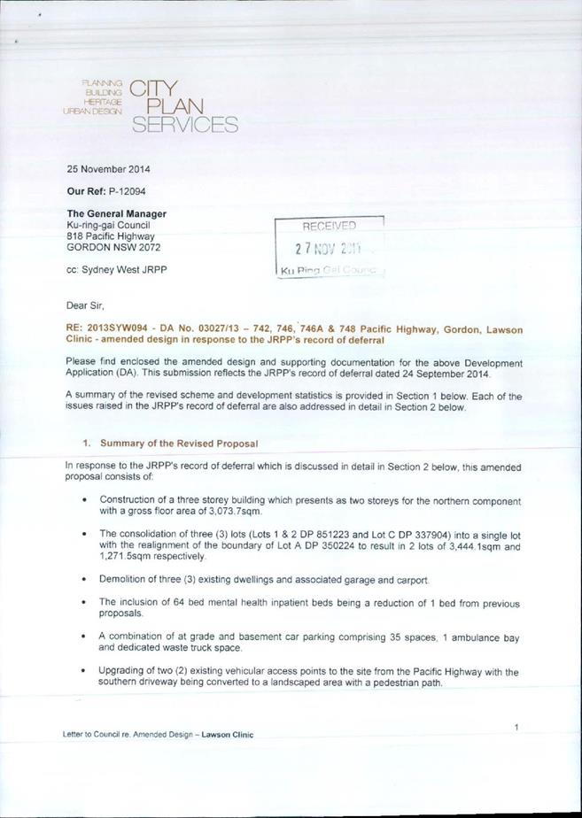
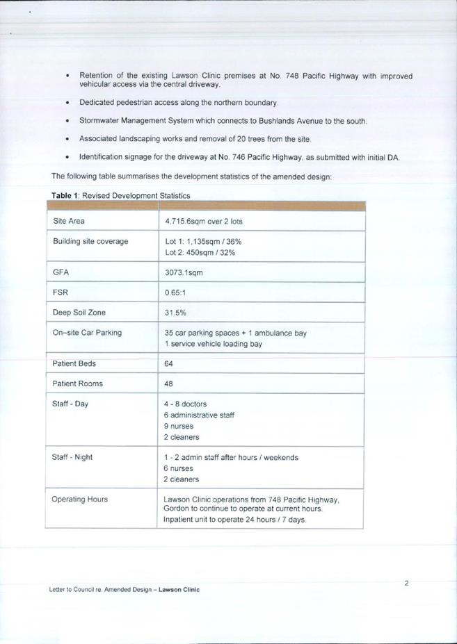
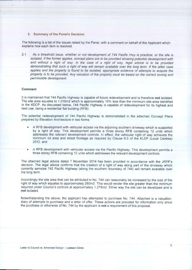
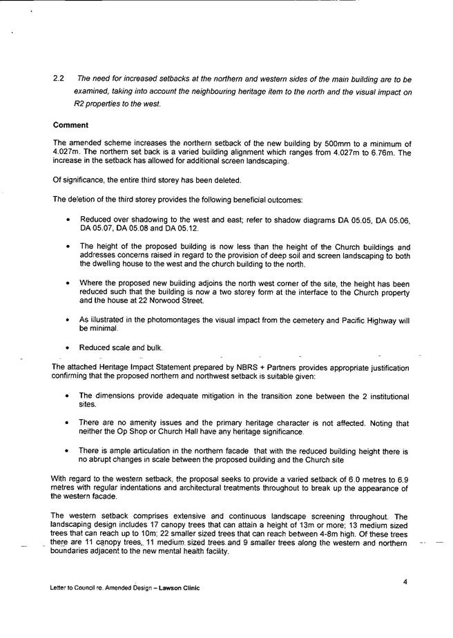
|
APPENDIX No: 3 - Assessment
considered by JRPP at the meeting on 11 September 2014
|
|
Item No: GB.5
|
JOINT REGIONAL
PLANNING PANEL
(Sydney West)
|
JRPP No
|
2013SYW094
|
|
DA Number
|
DA0327/13
|
|
Local Government
Area
|
Ku-ring-gai
|
|
Proposed
Development
|
Demolition
of three dwellings at 742, 746 and 746A Pacific Highway. Construction of a 4
storey hospital with 65 beds. Boundary adjustment between 746 and 748 Pacific
Highway. Consolidation of 742, 746 and 746A into a single allotment.
|
|
Street Address
|
742,
746, 746A and 748 Pacific Highway, Gordon
|
|
Lot & DP
|
Lot A
DP350224, Lots 1 and 2 DP 851223 and Lot C DP337904.
|
|
Applicant
|
The
Lawson Clinic Pty Ltd
|
|
Owner
|
Mr A Kapel and Mrs R Kapel, JSNL Pty Ltd, R I A F Pty Ltd
|
|
Number of
Submissions
|
original proposal: 12 submissions and 1 petition
amended proposal: 4 submissions
|
|
Regional
Development
Criteria
(Schedule
4A of the Act)
|
The
proposed hospital has a CIV of over $5 million and falls into the category of
‘private infrastructure and community facility’
|
|
List of All
Relevant
s79C(1)(a)
Matters
|
SEPP 55 – Remediation of Land
SEPP (Sydney Harbour Catchment) 2005
SEPP (Infrastructure) 2007
Ku-ring-gai LEP (Local Centres) 2012
Local Centres DCP
Development Contributions Plan 2010
|
|
List all
documents
submitted
with this
report for
the panel’s
consideration
|
Attachment
A – Pre DA Meeting Report
Attachment
B – Council’s letter to applicant dated 26 November 2013
Attachment
C – Urban Design Consultant comments dated 12 December 2013
Attachment
D – Urban Design Consultant comments dated 21 March 2014
Attachment
E – Heritage Consultant comments dated 25 June 2014
Attachment
F – Urban Design Consultant comments dated 23 May 2014
Attachment
G – Clause 4.6 Variation Request
Attachment
H - architectural
plans
Attachment
I - landscape
plans
Attachment
J - stormwater
plans
Attachment
K - valuation
report dated 10 December 2013
Attachment
L - Planning
Consultant letter dated 22 April 2014
|
|
Recommendation
|
Refusal
|
|
Report By
|
Jonathan
Goodwill – Executive Assessment Officer
|
Assessment Report and
Recommendation Cover Sheet
Legislative requirements
Zoning R4 High Density Residential under
Ku-ring-gai LEP (Local Centres) 2013
Permissible
Under Ku-ring-gai
LEP (Local Centres) 2012
Relevant legislation Environmental Planning
and Assessment Act 1979
SEPP 55 – Remediation of land
SEPP
(Sydney Harbour Catchment) 2005
SEPP
(Infrastructure) 2007
Ku-ring-gai
LEP (Local Centres) 2012
Local Centres DCP
Development Contributions Plan 2010
Integrated
Development No
PURPOSE FOR REPORT
To
determine Development Application No. 0327/13 for the demolition of existing
dwellings and construction of a hospital at 742-748 Pacific Highway, Gordon.
The Joint Regional Planning Panel (JRPP)
is the consent authority as a hospital is a type of ‘health related
facility’ captured
by the development category ‘private infrastructure and community facilities’
pursuant of Schedule 4A Clause 6 of the Environmental Planning and Assessment Act,
1979 and as the CIV for this development exceeds $5 million ($6.73 million).
HISTORY
Pre
DA Meeting
On 17 May
2013, a Pre DA consultation to discuss a proposal for the construction of a
hospital was held. The following concerns were identified by Council officers:
· isolation
of 744 Pacific Highway Gordon
· non-compliant
building height
· zone
interface response (overshadowing, overlooking, visual bulk, articulation)
· inadequate
setbacks
· landscaping
issues (such as removal / protection of significant existing trees, 50% deep
soil landscape provision, tree replenishment, side setback planting,
landscaping between the development and heritage items, extent of cut and fill,
communal open space)
· water
management (no increase in surface water runoff into the Pacific Highway, water
management plan addressing site detention, retention, re-use of roof water and
water quality measures)
· traffic
/ parking and construction traffic management
· waste
management
· heritage
The Pre DA
report is Attachment A.
Current
development application
|
3 September
2013
|
Development
application lodged
|
|
13
September 2013
|
Notification
commences
|
|
26 November
2013
|
Applicant
is sent a letter advising that the application is unsatisfactory and that the
following issues are required to be addressed:
· overshadowing
· site
isolation and amalgamation
· pedestrian
access and equitable access
· energy
and water efficiency
· use
of 742 Pacific Highway
· colours
and finishes
· heritage
impacts
· development
engineering
· landscaping
Council’s
letter to the applicant is Attachment B.
|
|
13 December
2013
|
The
applicant is further advised that the issues identified by Council’s Urban
Design Consultant are required to be addressed. The full comments of
Council’s Urban Design Consultant are Attachment C.
|
|
13 December
2013
|
The
applicant is advised that a response to the identified issues is required by
1 February 2014.
|
|
5 February
2014
|
The
applicant advises Council that amended plans will be ready by 7 March 2014.
|
|
6 February
2014
|
JRPP
briefing takes place
|
|
14 February
2014
|
The JRPP
advises Council that the applicant should be afforded additional time to
prepare the amended plans
|
|
4 March
2014
|
Meeting
with applicant and Council officers.
|
|
5 March
2014
|
The
applicant submits draft amended plans which include the demolition of the
dwelling at 742 Pacific Highway, revised building footprint and a new car
park at the southern end of the site.
|
|
18 March
2014
|
The
comments of Council’s Urban Design Consultant are sent to the applicant.
|
|
18 March
2014
|
In response
to concerns regarding the legibility of the plans high resolution plans are
sent Council’s Urban Design Consultant for further review.
|
|
21 March
2014
|
Following a
review of the high resolution plans revised comments from Council’s Urban
Design Consultant (Attachment D) are sent to the applicant.
|
|
28 April
2014
|
The
applicant submits amended plans and additional documentation to Council.
|
|
1 May 2014
|
Notification
of the amended plans commences
|
|
3 June 2014
|
The
applicant is advised that the valuation report for 744 Pacific Highway is
inadequate and that a revised report is required.
|
|
3 July 2014
|
The
applicant is advised that the amended plans have been reviewed and issues
relating to building height, site isolation,
heritage, car parking, stormwater, inaccurate and inconsistent information
still need to be addressed.
|
|
9 July 2014
|
The
applicant provides a response to the issues identified in Council’s
correspondence and advises that the application will not be further amended.
The issues identified in Council’s letter along with the applicant’s
responses are provided below.
|
Issue 1:
Zone Interface and building height
The western elevation of the
development has a length of approximately 60m, a height of more than 11.5m and
a part 3/4 storey presentation. If the provisions of the Local Centres DCP were
applied the development would be required to have a minimum setback of 6m for
the first 3 storeys and 9m for the fourth storey. In addition, the façade would
be required to be broken down into distinctive bays and wings through deep
articulation. The design of the development does not have adequate regard to
the zone interface principles established by the Land and Environment Court in Seaside
Property Developments Pty Ltd v Wyong Shire Council.
The applicant’s clause 4.6 variation
request states that the second level is only provided for the northern portion
of the development and does not impose on the adjoining R2 interface. This
position is not supported as the southern part of the western elevation which
faces the R2 zoned land has a 4 storey presentation, does not comply with the
11.5m height limit and is of greater height than the northern portion. The 4
storey portion of the development is visible from the private open space of 22
St Johns Avenue and 3 Bushlands Avenue and will have an overbearing impact on
these R2 zoned properties. At the zone interface between R2 and R4 zoned land
is it considered inappropriate and unacceptable for the eastern outlook from
the private open space of two single dwellings to be dominated by a building
elevation with a length of 60m and height of more than 11.5m.
The intent of the articulation to the
western elevation should be to provide a built form which respects and relates
to the characteristics of the adjacent R2 zoned land. The proposed articulation
is shallow in depth and limited in width. This type of articulation does not relate
to the form and proportions of development in the adjacent R2 zoned land.
The articulation of the western
elevation should be amended. The indentation at Rooms 60 and 28/29 should be
extended to include Rooms 26/27 and 58/59. To avoid a four storey presentation
and non-compliant building height adjacent to the R2 zoned land Rooms 48/49 and
50/51 should be deleted.
Response from applicant’s Town
Planning Consultant
The majority of the development is 3
storeys in height and is significantly under the 11.5m height limit. The
building is also articulated by virtue of physical attributes and material
changes. The proposal addresses the zone interface principles as set out in
Seaside Property Developments Pty Ltd v Wyong Shire Council with regard to building
height (less than the control), meeting and exceeding the building setbacks and
maintaining privacy of neighbouring properties through highlight and
un-openable windows and privacy screening.
The subject site as Council is aware,
is zoned R4 High Density Residential and the alternative redevelopment of this
site for the purpose of a permissible residential flat building would
reasonably envisage the whole western elevation of such a building to feature
balconies at 6m separation up to 3 storeys in height. Such a development would
ultimately result in a four storey flat building pursuant to the 11.5 metre
height limit. The proposal is far better in terms of amenity in comparison to
such a development outcome. Should Council remain concerned with regard to the
treatment of the western elevation, we recognise that Council may chose (sic)
to impose a condition to delete what they consider to be the offending rooms or
seek further articulation in specific terms as detailed in their correspondence
dated 3 July 2014.
Any such condition can be eminently
drafted to satisfy the Newbury Principles.
Issue 2:
Overshadowing
The plan details for the dwelling at
22 St Johns Avenue are incorrect. The areas between the eastern wall of the
dwelling and the shared boundary and the northern wall of the dwelling and the
detached garage are paved. These paved areas are of a consistent level which is
slightly lower than the floor level of the ground floor of the dwelling. The
plans, sections and shading plans which show these areas as sloping and higher
than the floor level are not correct.
The shading plans are not in
consecutive order and the various angles of view makes comparisons between the
drawings difficult. The windows of the dwelling at 22 St Johns Avenue are not
shown. Accurate plans which show the existing and proposed shading are
required.
Response from applicant’s Town
Planning Consultant
The shadow diagrams were prepared in
lieu of survey plans of No. 22 St Johns Avenue and are based on observation
only. At the eastern boundary of No. 22 St Johns Avenue, the proposal is notably
under the permissible height limit and provides between 6m – 6.9m boundary
setbacks. Therefore, the resulting shadow impacts are less than what would
result for a compliant residential flat building. The demonstration of further
shadow diagrams in this case would not be warranted nor of determining weight
and the 3D shadow diagrams provide a representation of the shadow impacts which
would result; being less than anticipated by the controls.
Issue 3: Site isolation and amalgamation
The issues regarding the concept plans
for a residential flat building at 744 Pacific Highway remain unresolved as
they do not demonstrate that the allotment can be redeveloped without reliance
on a right of carriageway through 742 Pacific Highway. The assertion that the
site can be developed as a residential flat building with vehicle access to the
Pacific Highway should be supported by revised concept plans.
The issues identified in Council’s
e-mail of 3 June 2014 regarding the adequacy of the valuation are also required
to be addressed.
Response from applicant’s Town
Planning Consultant
We have demonstrated that No. 744
Pacific Highway is not isolated having regard to the relevant Planning
Principles and the DA was accompanied by plans and a property valuation which
supported the potential to redevelop No. 744 Pacific Highway for a residential
flat building. This design proposal was accompanied by an offer of a right of
way easement which permits access to No. 744 Pacific Highway via the subject
site’s driveway. Should Council feel that it’s appropriate, this right of way
can be conditioned accordingly.
Given we have demonstrated that the
site is not isolated, there is no further requirement for revised concept
designs or valuations of No. 744 Pacific Highway.
The items raised with regard to
heritage were previously addressed in our DA and further response submitted in
April 2014. We disagree with the points raised as per our previous
correspondence.
Issue 4:
Heritage concerns
The following issues identified by
Council’s Heritage Consultant are required to be addressed:
· It
is recommended that the development be amended to move the footprint of the new
building further to the south in order to provide complying setbacks and
stepping of built forms as required by the DCP.
· The
setbacks from St Johns Church and Cemetery, although slightly greater under the
amended proposal, could be extended still further. This would also allow more
space for substantial trees and deep planting to help minimise the impact of
the proposed development on views over and from the Cemetery in particular. It
would also improve usability and amenity of open spaces for users of the
hospital.
· Increasing
the footprint (or potentially splitting the footprint into several smaller
blocks to reduce the monolithic qualities of the scale and form) over a wider
area would potentially allow the overall height of the development to be
reduced to two levels above natural ground level. If this is not a practical
outcome given the functional requirements of the facility, the bulk of the
development could be located closer to the south-eastern part of the site
adjacent to other (non heritage listed) properties that are also zoned for
high-density residential development and which are therefore not as vulnerable
to the environmental and heritage impacts caused by large differences in
building scale and form.
· Further
details should be provided to clarify the details of the proposed landscaping
(including trees proposed to be removed) and splay corner to the street
elevation of 748 Pacific Highway.
· The
issue of potential psychological conflict caused by the proximity of the
hospital to the cemetery needs to be considered very carefully as the proposal
should not unduly restrict the existing cemetery use.
Other design details:
· Species
selection both in front of 748 Pacific Highway and along the boundary with St
Johns: the Alexandra Palms shown in the plans will provide no effective
screening and will not be appropriate in immediate proximity to the two
heritage items. They should be replaced by more suitable species in
consultation with Council’s landscape officers.
· Tonally
neutral colours and non-reflective finishes should be required to the eastern
and northern elevations in particular to minimise the visual prominence of the
development in views to, from and over adjacent heritage items.
· All
driveways and parking areas surrounding 748 Pacific Highway should be finished
in dark asphalt to minimise their aesthetic impact on the setting of the
heritage item.
Response
from applicant’s Town Planning Consultant
The site is zoned R4 High Density
Residential and contains a heritage item. This zoning and the relevant controls
therefore confirm that Council has accepted that the redevelopment of this site
is capable of accommodating a residential flat building in association with a
heritage item with building separation which is also reflected in this DA.
Given Council has directed such a form of development, the proposal for this
development is in keeping with the allowable built form outcome which is
proposed.
The Heritage Consultant has also
raised issue with regard to the ‘potential psychological conflict’ of the
cemetery. This item is beyond the technical skills of the Council to make any
comment.
With regard to the further design
details raised, if Council considered it appropriate, these items can readily
be conditioned.
Issue 5:
Development engineering concerns
Council’s Development Engineer has
reviewed the amended application. The following additional information is
required:
· The
rainwater tank should be sized in accordance with the ESD report, and shown on
all the plans to scale (not over a proposed pathway). The proposed re-use of
the rainwater is to be indicated on the stormwater plans.
· Connection
of the interallotment drainage pipe to the existing pit within 738 Pacific
Highway via an adverse right angle bend may affect that property’s stormwater
drainage system and may not function hydraulically. The applicant should
investigate whether a separate kerb connection, in line with the interallotment
drainage pipe, should instead be provided.
· For
further consideration of the parking reports, a breakdown of staff into
outpatient and hospital staff is required. This does not guarantee that the
shortfall will be supported. It appears that there would be space under the
northern wing of the new hospital building for additional parking.
· Cross-sections
of the new driveway are required, showing existing and proposed levels,
crossfall, walls and fences, the neighbour’s encroaching roof and the actual proposed
width of the driveway (the photomontage seems to show vegetation being retained
which will probably be removed). A minimum width of 5.5 metres is required for
two way movement.
· The
photomontage does not show the splay on the driveway at the front boundary, but
it is shown on the landscape plan. It is unclear whether the splay will be
provided and if it will affect trees at 748 Pacific Highway.
Response
from applicant’s Town Planning Consultant
Several items have been raised with
regard to the size of the rainwater tank. The interallotment drainage pipe
features a bend which does not have adverse affects on the main system and the
proposed driveway is capable of appropriate width and design which is
compatible with the adjoining structures, etc.
The proposed access and parking
arrangement is supported by a report prepared by URaP-TTW which confirms that
the parking provision is suitable for the proposed use and there is no
shortfall in parking. Should Council feel that an additional space is
preferable under the northern wing, this can be conditioned appropriately.
Issue 6:
Landscaping concerns
Inadequate deep soil landscape area
within the development including along the northern and western boundary and
along eastern elevation
In consideration of the merit of the
deep soil that has been provided, the following modifications are required:
· To
achieve an effective landscape treatment that will contribute to the garden
character of the Heritage Conservation Area, protect neighbour amenity and
preserve heritage significance, the building setback at the north-west corner
of the building should comply with the 6 metre setback. Paving and pergola
should be reduced to optimise deep soil provision and canopy establishment at
the northwest corner of the site.
· To
retain and enhance the heritage setting of the existing Lawson Clinic, the
reconfiguration of the lot boundaries should include a redesign of the rear
carpark providing additional sufficient areas for tree and shrub planting along
the eastern elevation of the proposed building.
Adverse tree impacts (Clause 5.9 Local
Centres LEP)
Tree
9/ Syagrus romanzoffiana (Cocos Palm). This tree is located on the
southern side of the existing driveway, within the adjoining property. The
proposed driveway widening and retaining wall will encroach within the tree
protection zone. The proposed retaining wall construction is likely to have an
adverse impact on this tree.
Adverse impacts on neighbour amenity
(Part 1.3
Volume C
Ku-ring-gai Local Centres DCP)
To preserve neighbour
amenity, increased setbacks to the proposed driveway should be provided to the
adjoining property 744 Pacific Highway.
Inadequate
landscape plan
The Landscape plan is unsatisfactory
for the following reasons:
·
· Existing
screen planting located along the western boundary should be retained where
possible including along the northwest corner of the site. Additional hedging
that can attain 4 metres in height should be provided at the northwest corner
of the site in association with the existing Tibouchina.
· An accessible principal area of
communal area has not been proposed. It is unclear whether the proposed area is
accessible as insufficient levels to paths and associated external areas have
been provided on the landscape plan. The series of ramps on the western side of
the existing dwellings is approximately 1 metre below the carparks. Similarly
the levels for the ramp between the carpark and the dwelling at 742 Pacific
Highway appear to be too steep and are likely to require steps.
· Details of screen wall fencing along
western boundary are required.
Response
from applicant’s Town Planning Consultant
The amended landscaping proposal was
prepared in close consultation with Council’s Landscape Officer. The western
setback of minimum 6m provides sufficient width to accommodate extensive
landscaping with natural soil beneath. The northern setback has a minimum
setback width of 4.2m which increases up to 6m also with natural soil beneath.
Furthermore, the existing op-shop structure located on the adjoining heritage
property to the north has no openings to the shared boundary, with reasonable
building separation to the proposal. These boundary setbacks therefore provide
eminent space for landscaping.
The landscaping treatment along the
eastern side of the development provides for the embellishment of this facade
through the utilisation of pockets of landscaping as well as a mix of planting
and a vertical garden to create a trellised green wall effect.
Overall, the landscaping treatment
creates an interesting mix of shrubs and tree planting which supports the mix
of architectural articulation and material changes of the development.
Adverse tree impacts
Should Council feel it necessary, the
driveway treatment in the vicinity of the Cocos Palm (Tree 9) can be
conditioned as appropriate to ensure the trees retention. Alternatively,
Council could allow removal (and replacement) of the tree.
Driveway setback
The proposed new driveway along the
northern boundary of No. 744 Pacific Highway is an existing circumstance. This
driveway is anticipated to accommodate a minor traffic increase in comparison
to the existing conditions. The proposed driveway treatment is considered to
not unreasonably impact on the neighbouring property, which is sought to be
supported.
Landscape plan
The items raised by Council are
capable of being resolved by conditions of consent, should Council feel it
appropriate.
Issue 7: Urban design concerns
The following issues identified by
Council’s Urban Design Consultant are required to be addressed:
Built form
Demolition of 742 Pacific Highway
should have presented opportunities to better arrange the massing such that
deep articulation of the western elevation in particular would communicate a
rhythm that interprets the existing urban context of smaller scaled residential
building, separated by generous landscape of established gardens of trees and
large plant species. Instead, the built form has been articulated superficially
and still reads as a single massing and out of scale in an interface context –
being over 60 metres long. The stepping has been expressed by changes in
materials that assist in the architectural expression of the built form,
however, of itself do not provide the overall physical relief of deeply
articulated massing. The western side of the building should be more deeply
articulated so that the scale of proposed massing provides a better interface
with the adjoining R2 zone and the St Johns Heritage Conservation Area.
The articulation of the northern
façade is arbitrary and not a cohesive design response to the site and
neighbouring built form. Within a clearly articulated form, the architectural
expression should demonstrate a grouping of architectural elements that is
rational, consistent and communicates a cohesive architectural language across
the proposed development.
The type of construction selected to
deal with the poorly resolved floor levels to ground levels at the southern end
of the proposed development needs to be reconsidered. The Car Park/Drop Off
level sees a series of columns up to a height over 4.3 metres out of the ground
to support the suspended slab. This structural order and structural language
bears no relationship to the structural language and order of the northern
component. Rather it serves to emphasise the poor resolution of the ground
floor level with the existing and proposed ground levels.
Setbacks
Setbacks to the northern boundary
remain insufficient at 4 metres. The need to provide for patient safety by
limiting or preventing access to outside areas is not at question being an
operational aspect of the development. At issue is the proposed setting of the
proposed built form in achieving the KLEP and KDCP objectives, the provision of
a pleasant landscape outlook to and from the subject site. A setback of 6
metres to the northern boundary is capable of being achieved by the development
and should be provided.
Inconsistent or poorly coordinated
ground levels
RLs at the Lower Car Park level
require clarification. They appear to be approximately 0.56m higher than the
internal floor level of the building and therefore not compliant with BCA
access requirements.
Notations for existing and proposed
ground levels are confusing. These are to be consistently represented and
clearly identified. Natural ground level should be shown on all sections.
Natural ground levels at the face of the building should be shown on all
elevations.
Landscape
RLs on landscape plans are
inconsistent with architectural plans in places, the numbers of risers of
stairs do not seem to match some levels and the labelling of proposed and
existing ground and path levels is unclear.
The following information is required
to fully assess the relationship of the proposed landscape to the proposed
building:
- All existing and proposed RLs are to
be clearly annotated and differentiated.
- Contours are to be clearly indicated.
- All bottom and top of wall RLs are to
be accurately located and checked*
- All external stair flights are to be
numbered for identification
* For example, there is ambiguous
information regarding top of wall levels at the truck turning area. It appears
the TOW annotated as RL124.50 is the proposed ground level of the turning
area. The TOW height needs to indicate a height and fence construction that
will prevent trucks reversing over the platform and dropping some 2 metres to
the lower car park level.
The landscape zone separating the
truck turning area and No 744 needs to demonstrate that adequate width is
provided to enable appropriate planting to screen the raised platform of the
truck turning area - which appears to be over 1.5 metres out of the ground and,
with a required solid barrier above, will impact upon the visual amenity of the
current resident and future residents of that site should it be redeveloped as
RFBs.
Pedestrian and vehicle ramps are to
indicate the direction of ramp up and nominate all gradients.
There’s a missing gradient at the main
entry pedestrian ramp.
The main pedestrian ramp appears to
rise from RL 127.85 at northern car park landing near Windsor House to RL128.15
at the NE corner of the proposed hospital then fall to RL127.50 at main
building entry. This appears to be unnecessary as the high point does not link
to any other levels.
Fire stairs
Fire Stairs do not indicate direction
of stair or breaks between levels.
Fire Stair 3 risers indicate the same
number of risers between the Lower Ground and Ground Floor levels as between
the Ground Floor and First Floor despite the floor having different ceiling
heights. Stair design for the first floor and ground floor are the same despite
the first floor not sitting below another floor.
The lift at the southern end appears
to offer the only means of entering the building from the lower car park.
Provision of stair access for staff from the lower car park should be
considered.
Car parking
The functioning of the basement car
park is confusing. Labelled as ‘Staff and Delivery Carpark’ there appears to
be no visitor parking now provided apart from the existing Lawson Clinic. The building
entry at this level is also annotated as ‘Staff and Emergency Entrance Only’.
The southern end of the building at this level appears to be for staff access
only as well limiting visitor entry to the ground level only. Therefore, the
amount and location of visitor car parking and pedestrian access of visitors
from the basement car park to the building entry is confusing and unclear.
The site rationale that proposes a
semi-surface level car park accessed from the higher point on the site results
in difficulties for the southern component of the building in its relationship
to the ground levels, and flow-on inefficiencies of the functionalities. It may
be possible for a basement car park to be accessed from the lower southern
driveway connecting to a continuous ramped driveway that exits from the higher
point. This would make better use of the wasted space currently below the Car
park/Drop Off level, better separate the staff and visitor/patient access once
that has been clarified and accommodate additional spaces if required.
The levels for the truck turning area
are inconsistent between the floor plans and the elevations. The height and
material for the barrier on the southern and eastern side of the turning area
is not clearly identified on the plans.
Response
from applicant’s Town Planning Consultant
As an outcome of the urban design
comments, Council’s primary concern with regard to the western elevation is
contained within Point 1, and is addressed above.
Ground levels
With regard to the finished levels of
the proposed development, please refer to the Elevation Plans (DA-03.01 and
DA-03.02). The Lower Ground Level has a proposed RL 124.5. The Ground Level has
a proposed RL 127.2.
The proposed RLs and levels provide a
cohesive development outcome which are coordinated and result in a suitable
built form and landscaped outcome.
Landscape and fire stairs
The issues raised in relation to RLs,
landscaping and risers of stairs are BCA related matters and can be
appropriately conditioned to comply with the issue of the relevant Construction
Certificate.
Car parking
As discussed with Council in our
meeting held on 7 March 2014, the proposed car parking arrangement serves the
needs of staff, vehicles and servicing of the development, and appropriate way
finding signs can be implemented which direct persons to the appropriate
locations.
Summary
The
applicant has been advised of the issues with the proposal and the amendments
and additional information required. The applicant has declined Council’s offer
to submit an amended proposal and has asked that the application be determined
in its current form.
THE
SITE
|
Zoning
|
R4 High Density Residential
|
|
Height
|
11.5m
|
|
Floor
space ratio
|
0.8:1
|
|
Site
area
|
4715m2
|
|
Easements/rights
of way:
|
Easement
to drain water and reciprocal rights of carriageway over the access handle of
746 and 746A Pacific
Highway.
|
|
Heritage
Item:
|
Yes:
748 Pacific Highway
|
|
Heritage
conservation area:
|
Yes:
St Johns Avenue Conservation Area
|
|
In
the vicinity of a heritage item:
|
Yes:
750-754 Pacific Highway, 24 St Johns Avenue, 738 Pacific Highway, 707 Pacific
Highway
|
|
Bush fire prone land:
|
No
|
|
Endangered
species:
|
No
|
|
Urban
bushland:
|
No
|
|
Contaminated
land:
|
No
|
|
Biodiversity
land:
|
No
|
|
Riparian
land:
|
No
|
THE SITE AND SURROUNDING AREA
|
DESCRIPTION
OF THE SITE AND ITS LOCATION:
|
The site is
located on the high side of the Pacific Highway and has an irregular shape.
The site is comprised of the heritage listed building at 748 Pacific Highway
which is currently used as the Lawson Clinic outpatient facility and three
battleaxe allotments known as 746, 746A and 742 Pacific Highway. Each
battleaxe allotment contains a dwelling-house. The adjoining allotments to
the west are 22 St Johns Avenue and 3 Bushlands Avenue. These allotments
contain single dwellings and are zoned R2 Low Density Residential.
|
|
TOPOGRAPHY
(SLOPE) OF THE SITE:
|
The site
falls from north to south and from east to west.
|
|
SIGNIFICANT
FEATURES ON THE SITE:
|
The site
contains three dwelling-houses and a heritage listed building that is used as
the Lawson Clinic outpatient facility.
|
|
CONTEXT
OF THE SITE AND SURROUNDING DEVELOPMENT:
|
The site is
located in a predominantly residential area. To the north and north-west of
the site is 750-754 Pacific Highway, this site is heritage listed and
contains a church, church hall and cemetery. The adjacent allotment to the
west and south of the site contain single dwellings.
|
THE PROPOSAL
The proposal
is for the demolition of existing structures and the construction of a hospital
with 65 beds and 19 car spaces. The hospital is to operate in conjunction with
the existing Lawson Clinic outpatient facility located at 748 Pacific Highway
Gordon. Details of the proposed development include:
i. Demolition of three dwellings at 746, 746A and 742
Pacific Highway.
ii. Construction of a 3-4 storey hospital building with 65
beds, car parking for 19 cars. The hospital is to be used to provide treatment
for people with mood and anxiety disorders.
iii. The hospital is an inpatient facility and will operate 24
hours a day, there will be a maximum of 25 staff during the day time shift and
10 staff at night.
iv. Retention of the existing Lawson Clinic premises at No.
748 Pacific Highway with vehicular access via the northern access handle, a
reconfigured car park with 12 spaces and a new pedestrian access path for the
hospital adjacent to the northern boundary.
v. Modification of northern access handle to provide a two
way driveway to the site from the Pacific Highway.
vi. Removal of 17 trees from the site.
vii. Associated landscaping works.
viii. Creation of an easement through 738 Pacific Highway for
disposal of stormwater into the street gutter of Bushlands Avenue.
ix. Identification signage for the driveway at No. 746
Pacific Highway;
x. The consolidation of Lot 1 DP 851223, Lot 2 DP 851223 and
Lot C DP 337904) into a single lot and the realignment of the boundary of Lot A
DP 350224 to result in two lots of 3,406m2 and 1,309.6m2,
respectively.
COMMUNITY CONSULTATION
In accordance with the requirements of the Local Centres DCP,
owners of surrounding properties were given notice of the application. In response, Council received one
petition with 110 signatures and twelve submissions from the following:
1. In Shik Hong – 22 St Johns Avenue Gordon
2. Jingchun Gao – 1 Bushlands Avenue Gordon
3. Chao-Hsiang Wang – 3 Bushlands Avenue Gordon
4. Gerald Rousseau – 5 Bushlands Avenue Gordon
5. Michael Coates – 15 Bushlands Avenue Gordon
6. Jerome Lander – 7A Bushlands Avenue Gordon
7. Stephen Dwyer - 4 Oberon Crescent Gordon
8. Dan Guenther and Megan Luke-Guenther - 1 Oberon Crescent Gordon
9. Amy – 29 St Johns Avenue Gordon
10. Ms Vicki Steer (Principal Ravenswood) – Henry Street
Gordon
11. Michael Kocsard – 744 Pacific Highway Gordon
12. Suzanne Pegg – 9 Bushlands Avenue Gordon
The
submissions and petition raised the following issues:
The proposal does not address site isolation principles
For
the reasons discussed elsewhere in this report, it is considered that the
development does not adequately address the land amalgamation requirements in
the Local Centres DCP and the site isolation planning principles established by
the NSW Land and Environment Court.
Overlooking
Overlooking
from the western elevation of the hospital has been minimised through high set
windows and louvre screens. The overlooking impacts of the development are now
considered to be acceptable.
Overshadowing
The
shadow diagrams submitted by the applicant are inaccurate, poorly labelled and
not based on survey data of the impacted sites. The shadow diagrams do not
clearly illustrate the impact of the development on the solar amenity of
adjacent properties.
The justification for the non-compliant building height
fails to consider alternative design options and additional overshadowing
For
the reasons discussed elsewhere is this report, it is considered that the
applicant’s request under clause 4.6 to vary the building height development
standard is not well founded.
Excessive bulk
For
the reasons discussed elsewhere in the report, it is considered that the design
of the western elevation does not successfully break down the building mass and
has an unacceptable impact on adjacent properties which are zoned R2 Low
Density Residential.
Tree removal
The
merits of the proposed tree removal have been considered by Council’s Landscape
Officer and found to be acceptable.
Inadequate setbacks and unacceptable impacts on heritage
items
Concerns
regarding the setbacks from boundaries, separation distance from heritage
items, ability for the development to provide screening vegetation and
materials selection have been identified in the assessment of the application
by Council’s Heritage Consultant. The impact of the development is unacceptable
in this regard and these issues are among the reasons for the refusal
recommendation.
Noise
If
approval of the application was recommended the likely noise impacts of the
development could be addressed through conditions.
The proposal is incompatible with residential zoning
The
development is permissible under the provisions of SEPP (Infrastructure) 2007,
however it is considered that the development fails to appropriately manage the
change in character and bulk/scale at the zone interface with adjacent R2 Low
Density Residential zoned land.
Inadequate outdoor recreation space for patients
The
planning controls do not include an outdoor recreation space requirement for
hospitals.
Inappropriate location due to noise and fumes from the
Pacific Highway
The
hospital is set back from the Pacific Highway and unlikely to be impacted by
vehicle emissions. If approval of the application were recommended, the impacts
of traffic noise could be addressed through conditions.
Inadequate car parking
The
number of car spaces provided for the development is significantly less than
the requirements of the Local Centres DCP. The variation to the parking
controls has not been adequately justified and is not supported.
Unsafe driveway design
Council’s
Development Engineer has identified concerns with the design of the proposed
northern driveway, in particular, whether the required width for two-way
vehicular traffic can be achieved having regard to existing encroachments and
proposed retaining walls and fencing. A cross section of the driveway was
requested from the applicant but has not been provided.
Increased potential for traffic accidents on the Pacific
Highway
The
application was referred to Roads and Maritime Services for comment, who
advised that the proposal was acceptable in this regard, subject to conditions.
The use of Henry Street and Cecil Street for construction
vehicles is unsafe as these streets are regularly used by school children
If
approval of the application were recommended, a condition of consent could be
imposed which restricted the use of Henry Street and Cecil Street to outside
school drop-off and pick-up times.
The use of the hospital to provide
psychiatric services will present a security risk to adjacent dwellings
The use of the site as a hospital is permissible under the
provisions of SEPP (Infrastructure) 2007. It is considered unlikely that the
type of services offered at the hospital will present a security risk to adjacent
dwellings.
AMENDED PLANS
The
amended plans submitted were notified for 14 days from 1 May 2014 to 15 May
2014. In response, Council received four submissions from the following:
1. In Shik Hong – 22 St Johns Avenue Gordon
2. Chao-Hsiang Wang – 3 Bushlands Avenue Gordon
3. Michael Coates – 15 Bushlands Avenue Gordon
4. Gerald Rousseau – 5 Bushlands Avenue Gordon
The
submissions raised the following additional issues:
Landscaping adjacent to the western boundary should be
retained
If
the application were to be recommended for approval the retention of existing
landscaping adjacent to the western boundary could be achieved through
conditions of consent.
Smoking should not be permitted
The
applicant has advised that the smoking will not be permitted at the hospital.
Regardless of whether smoking will be permitted at the hospital, it is
considered unlikely the smokers using the outdoor areas of the site which are
set back from the boundaries would be able to generate sufficient levels of
second-hand smoke to have an impact on the amenity of adjacent dwellings.
The boundary fence height should be increased by 2m
The
landscape plan shows the replacement of existing boundary fences with new
1800mm high lapped and capped timber fences. The replacement of boundary fences
is subject to the provisions of the Dividing Fences Act and approval for
replacement cannot lawfully be provided under a development consent unless
consent from the owners of the existing fence is provided. If approval of the
application were recommended, a condition would be imposed stating that the
development consent does not grant approval for the replacement of boundary
fences.
Driveway access to the Pacific Highway is poor
Council’s
Development Engineer has requested further details of the proposed development
including the design of the driveways. The applicant has not provided the
requested information. In the absence of sufficient information regarding the
design of the driveway a conclusion regarding the adequacy of the driveway
access and whether the required minimum width of 5.5m is achievable cannot be
made.
The setbacks from the side boundary are insufficient
The
proposal includes a car park and a driveway with side setbacks of 3m and 1.5m
from boundaries to allotments which contain dwelling-houses. The setbacks do
not provide sufficient space for landscape screening. The elevated driveway at
the southern end of the building has a setback of 1.5m from the rear boundary
of 744 Pacific Highway and is likely to have adverse acoustic impacts on this
dwelling.
Increased potential for accidents in the Pacific Highway
The
application was referred to the Roads and Maritime Services for comment. No
concerns regarding increased potential for accidents in the Pacific Highway
were identified.
EXTERNAL REFERRALS
Roads and Maritime Services
The
proposal was referred to Roads and Maritime Services for comment. Roads and
Maritime Services advised by letter, dated 30 September 2013, that subject to
conditions, they had no objections.
INTERNAL REFERRALS
Heritage
Council's
Heritage Consultant reviewed the application and provided the following summary
of issues and suggested design changes. The complete
Heritage Comments can be found at Attachment E to this report.
Summary of issues
· It
is recommended that the development be amended to move the footprint of the
proposed building further to the south in order to provide complying setbacks
and stepping of built forms as required by the DCP.
· The
setbacks from St Johns church and cemetery, although slightly greater under the
amended proposal, could be extended further. This would also allow more space
for substantial trees and deep planting to help minimise the impact of the
proposed development on views over and from the cemetery in particular. It
would also improve usability and amenity of open spaces for users of the
hospital.
· Increasing
the footprint (or potentially splitting the footprint into several smaller
blocks to reduce the monolithic qualities of the scale and form) over a wider
area would potentially allow the overall height of the development to be
reduced to two levels above natural ground level. If this is not a practical
outcome given the functional requirements of the facility, the bulk of the
development could be located closer to the south-eastern part of the site
adjacent to other (non heritage listed) properties that are also zoned for high
density residential development and which are therefore not as vulnerable to
the environmental and heritage impacts caused by large differences in building
scale and form.
· Further
details should be provided to clarify the details of the proposed landscaping
(including trees proposed to be removed) and splay corner to the street
elevation of 748 Pacific Highway.
· The
issue of potential psychological conflict caused by the proximity of the
hospital to the cemetery needs to be considered very carefully by applicant as
the proposal should not unduly restrict the existing cemetery use.
Other design details:
· Species
selection both in front of 748 Pacific Highway and along the boundary with St
Johns: the Alexandra Palms shown in the plans will provide no effective
screening and will not be appropriate in immediate proximity to the two
heritage items. They should be replaced by more suitable species in
consultation with Council’s Landscape Officers.
· Tonally
neutral colours and non-reflective finishes should be required to the eastern
and northern elevations in particular to minimise the visual prominence of the
development in views to, from and over adjacent heritage items.
· All
driveways and parking areas surrounding 748 Pacific Highway should be finished
in dark asphalt to minimise their aesthetic impact on the setting of the
heritage item.
Urban design
Council's
Urban Design Consultant reviewed the application and provided the following
comments. The complete Urban Design comments can be
found at Attachment F to this report.
Built form
Demolition of 742 Pacific Highway
should have presented opportunities to better arrange the massing such that
deep articulation of the western elevation in particular would communicate a
rhythm that interprets the existing urban context of smaller scaled residential
building, separated by generous landscape of established gardens of trees and
large plant species. Instead, the built form has been articulated superficially
and still reads as a single massing and out of scale in an interface context –
being over 60 metres long. The stepping has been expressed by changes in materials
that assist in the architectural expression of the built form, however, of
itself do not provide the overall physical relief of deeply articulated
massing. The western side of the building should be more deeply articulated so
that the scale of proposed massing provides a better interface with the
adjoining R2 zone and the St Johns Heritage Conservation Area.
The articulation of the northern
façade is arbitrary and not a cohesive design response to the site and
neighbouring built form. Within a clearly articulated form, the architectural
expression should demonstrate a grouping of architectural elements that is
rational, consistent and communicates a cohesive architectural language across
the proposed development.
The type of construction selected to
deal with the poorly resolved floor levels to ground levels at the southern end
of the proposed development needs to be reconsidered. The car park/drop off
level sees a series of columns up to a height over 4.3 metres out of the ground
to support the suspended slab. This structural order and structural language
bears no relationship to the structural language and order of the northern
component. Rather it serves to emphasise the poor resolution of the ground
floor level with the existing and proposed ground levels.
Setbacks
Setbacks to the northern boundary
remain insufficient at 4 metres. The need to provide for patient safety by
limiting or preventing access to outside areas is not at question being an
operational aspect of the development. At issue is the proposed setting of the
proposed built form in achieving the KLEP and KDCP objectives, the provision of
a pleasant landscape outlook to and from the subject site. A setback of 6
metres to the northern boundary is capable of being achieved by the development
and should be provided.
Inconsistent or poorly coordinated
ground levels
RLs at the lower car park level
require clarification. They appear to be approximately 0.56m higher than the
internal floor level of the building and therefore not compliant with BCA
access requirements.
Notations for existing and proposed
ground levels are confusing. These are to be consistently represented and
clearly identified. Natural ground level should be shown on all sections.
Natural ground levels at the face of the building should be shown on all
elevations.
Landscape
RLs on landscape plans are
inconsistent with the RLs on the architectural plans in places, the numbers of
risers of stairs do not seem to match some levels and the labelling of proposed
and existing ground and path levels is unclear.
The following information is required
to fully assess the relationship of the proposed landscape to the proposed
building:
- all existing and proposed RLs are to
be clearly annotated and differentiated
- contours are to be clearly indicated
- all bottom and top of wall RLs are to
be accurately located and checked*
- all external stair flights are to be
numbered for identification
* For example, there is ambiguous
information regarding top of wall levels at the truck turning area. It appears
the TOW annotated as RL124.50 is the proposed ground level of the turning area.
The TOW height needs to indicate a height and fence construction that will
prevent trucks reversing over the platform and dropping some 2 metres to the
lower car park level.
The landscape zone separating the
truck turning area and No 744 Pacific Highway needs to demonstrate that
adequate width is provided to enable appropriate planting to screen the raised
platform of the truck turning area - which appears to be over 1.5 metres out of
the ground and, with a required solid barrier above, will impact upon the
visual amenity of the current resident.
Pedestrian and vehicle ramps are to
indicate the direction of ramp up and nominate all gradients.
There’s a missing gradient at the main
entry pedestrian ramp.
The main pedestrian ramp appears to
rise from RL 127.85 at northern car park landing near No 748 Pacific Highway to
RL128.15 at the NE corner of the proposed hospital then fall to RL127.50 at
main building entry. This appears to be unnecessary as the high point does not
link to any other levels.
Fire stairs
Fire stairs don’t indicate direction
of stair or breaks between levels.
Fire Stair 3 risers indicate the same
number of risers between the lower ground and ground floor levels as between
the ground floor and first floor despite the floor having different ceiling
heights. Stair design for the first floor and ground floor are the same despite
the first floor not sitting below another floor.
The lift at the southern end appears
to offer the only means of entering the building from the lower car park.
Provision of stair access for staff from the lower car park should be
considered.
Car parking
The functioning of the basement car
park is confusing. Labelled as ‘Staff and Delivery Carpark’ there appears to
be no visitor parking now provided apart from the existing Lawson Clinic. The
building entry at this level is also annotated as ‘Staff and Emergency Entrance
Only’. The southern end of the building at this level appears to be for staff
access only as well limiting visitor entry to the ground level only.
Therefore, the amount and location of visitor car parking and pedestrian access
of visitors from the basement car park to the building entry is confusing and
unclear.
The site rationale that proposes a
semi-surface level car park accessed from the higher point on the site results
in difficulties for the southern component of the building in its relationship
to the ground levels, and flow-on inefficiencies of the functionalities. It may
be possible for a basement car park to be accessed from the lower southern
driveway connecting to a continuous ramped driveway that exits from the higher
point. This would make better use of the wasted space currently below the car
park/drop off level, better separate the staff and visitor/patient access once
that has been clarified and accommodate additional spaces if required.
The levels for the truck turning area
are inconsistent between the floor plans and the elevations. The height and
material for the barrier on the southern and eastern side of the turning area
is not clearly identified on the plans.
Landscaping
Council's Landscape Assessment Officer commented on the amended
proposal as follows:
Deep soil landscape area (Part 7A.4 Volume A Ku-ring-gai Local Centres
DCP)
The
site area for the hospital is 3406m2. For a residential flat
building 50% of the site (1703m2) is required to be deep soil
landscaping. For the proposed hospital 25% of the site area (854m2)
has been provided as deep soil landscaping.
The
total site area is 4715m2 and the site area for the purposes of the
deep soil requirement is 4282m2 as the access handles are not
included. This generates a deep soil landscaping requirement of 2141m2.
For the entire site 26.9% of the site area (1155m2) has been
provided as deep soil landscaping.
The
proposal provides 849-986m2 less deep soil landscaping than a
residential flat building development designed in accordance with the
requirements of the Local Centres DCP. The majority of the deep soil will be
located south of 742 Pacific Highway and in the front setback of 748 Pacific
Highway.
On merit, the development should
provide consolidated deep soil zones through careful planning and design, to
provide landscaped areas that are appropriate to the scale and context of the
development (Part 7A.4
Volume A
Ku-ring-gai (Local Centres)DCP). It would appear that the inclusion of 742
Pacific Highway has not translated into significantly improved deep soil areas
between the heritage item and the neighbouring dwelling at 22 St Johns Avenue.
The building setbacks to the northern
boundary provides greater compliance and greater deep soil zones, however there
are no trees proposed of a similar scale to the proposed building but this
could be conditioned.
The proposed architectural screen
along the western boundary of the proposed carpark is considered a structure
that would prevent tree planting and conflict with the intent of the deep soil
area landscape along the western elevation of the building. This should be
deleted.
The proposal provides a vertical
garden between the proposed building and the heritage item at 748 Pacific
Highway. Details have not been provided, however it is assumed that the height
of the green wall is approximately 3 metres as shown on the rendering
(DA-05.09/DA2, Elevation). This will provide minimal landscape screening to a
building that has a height of over 11.5m.
Tree Impacts (Clause 5.9 KLEP(Local Centres))
An
arborist report prepared by Landscape Matrix, dated 10/07/13, has been
submitted. The landscape plan indicates two trees as Tree 1.
Trees to be removed
Tree
1/ Pittosporum undulatum (Sweet Pittosporum). This tree is located on the
front boundary of 748 Pacific Highway, within the heritage item. There is no
objection to the tree’s removal. Tree 1 identified on the landscape plan as
located on the nature reserve is a mature Melaleuca quinquinervia (Broad-leaved
Paperbark) that should be retained and protected.
Tree
2/ Pittosporum undulatum (Sweet Pittosporum). This tree is located on the front
boundary of 748 Pacific Highway, within the heritage item. The tree exhibits
poor health and vigour with high levels of dieback. There is no objection to
the tree’s removal.
Tree
3/ Grevillea robusta (Silky Oak). This tree is located on the southern
boundary of 748 Pacific Highway, within the heritage item. The tree exhibits
poor health and vigour with high levels of dieback. There is no objection to
the tree’s removal.
Tree
4/ Jacaranda mimosifolia (Jacaranda). This tree is located on the southern
boundary of the driveway to 746A Pacific Highway. The tree is in good health,
however its form is poor due to past pruning. There is no objection to the
tree’s removal.
Tree
5/ Cupressus macrocarpa 'Brunniana' (Golden Cypress). This tree is located on
the southern boundary at the driveway entrance to 746 Pacific Highway. The
multi trunked tree is a good specimen and is visually prominent. It has been
assessed in the arborist report as having high landscape significance. The tree
would have to be removed for construction access. As there is no other means of
entering the rear of the site, there is no objection to the tree’s removal.
Tree
6/ Jacaranda mimosifolia (Jacaranda). This tree is located at the driveway
entrance to 746 Pacific Highway. The tree is a poor specimen having been
severely pruned in the past. There is no objection to the tree’s removal.
Tree
7/ Jacaranda mimosifolia (Jacaranda.) This tree is located at the driveway
entrance to 746 Pacific Highway. The tree is a poor specimen having been
severely pruned in the past. There is no objection to the tree’s removal.
Tree
8/ Liquidambar styraciflua (Liquidambar). This tree is located within the rear
yard of the heritage item at 748 Pacific Highway, adjacent to the driveway of
746A Pacific Highway. The tree has poor form due to being suppressed by a tree
that has recently been removed. There is no objection to the tree’s removal.
Trees
10-15/ Jacaranda mimosifolia (Jacaranda). These trees are located along the
southern boundary of 746 Pacific Highway. The trees have all been poorly pruned
in the past. There is no objection to the removal of these trees.
Tree
17/ Robinia pseudoacacia "Frisia" (Black Locust). This tree is
located within the rear setback of 746A Pacific Highway. The tree exhibits
poor health and is a poor specimen. There is no objection to the tree’s
removal.
Tree
19/ Jacaranda mimosifolia (Jacaranda). This tree is located along the eastern
boundary of 746A Pacific Highway. The tree has poor form due to being
suppressed by a tree that has recently been removed. There is no objection to
the tree’s removal.
Tree
22/ Quercus robur (English Oak). This tree is located along the northern
boundary of 746A Pacific Highway. The tree is a poor specimen and approval to
remove the tree is not required. There is no objection to the tree’s removal.
Trees
23-24/ Archontophoenix alexandrae (Alexandra Palm). This group of small palms
are located at the northeast corner of 746A Pacific Highway. The trees are to
be removed to accommodate the building footprint. There is no objection to the
removal of these trees.
Tree
25/ Archontophoenix cunninghamiana (Bangalow Palm). This palm is not identified
on the landscape plan or the arborist’s tree location plan. There is no
objection to the tree’s removal.
Tree
26/Cupressus torulosa (Bhutan Cypress). This tree is located on the southern
boundary of 742 Pacific Highway. The tree is of moderate health and poor
vigour. There is no objection to the tree’s removal.
Trees to be retained
Tree
9/ Syagrus romanzoffiana(Cocos Palm).This tree is located on the southern side
of the existing driveway, within 744 Pacific Highway. The proposed driveway
widening and retaining wall will encroach within the tree protection zone. The
proposed retaining wall construction is likely to have an adverse impact on
this tree.
Tree
20/ Magnolia x soulangiana (Magnolia). This tree is located on the western
boundary of the site. The proposed path is located 1.6m from the tree. The
impact is considered acceptable.
Tree
21/ Tiboucina granulosa (Purple Glory Tree). This tree is located in the
north-west corner of 746A Pacific Highway. The tree provides amenity to the
adjoining heritage conservation area. The proposed paved area adjacent to the
staff room is 3.5m from the tree. The impact is considered acceptable.
Landscape plan
Front setback (7A.1Volume A Ku-ring-gai (Local Centres)
DCP)
The proposal will remove
several trees and landscaping at the driveway entrance to the proposed
development in order to widen the driveway from 3 metres to 6 metres.
Additional trees located within the heritage item are to be removed to enable
construction access to the site.
Two canopy trees and
additional shrub planting are proposed to be planted on the northern corner of
the driveway entrance as replacement planting.
Driveway (1.3 Volume C Ku-ring-gai (Local Centres)
DCP)
The proposed driveway in
the northern access handle will occupy the entire width of the access handle.
Existing trees and hedge planting along the driveway will be removed for the
driveway widening. This will result in inadequate landscape treatment to the
driveway.
Cut and fill (Part 1.2 Volume C Ku-ring-gai (Local Centres)
DCP)
The proposed driveway will
require excavation to a depth of 1.2m. The carpark and loading area will
require excavation to a depth of 2.5m excavation along the line of the existing
carpark to the existing Lawson Clinic and fill to approximately 2 metres along
the western boundary.
Neighbour amenity (Part 1.2 Volume C Ku-ring-gai (Local Centres)
DCP)
The site falls to the west
and has views across the adjoining properties and distant views towards the
blue mountains. Existing screen planting located along the western boundary
should be retained where possible including along the north-west corner of the
site. This can be conditioned.
Heritage impacts - Development in the
vicinity of a heritage item (7.3 Volume B Ku-ring-gai (Local Centres) DCP)
Impacts on setting of the existing Lawson Clinic
The enhancement of views of the heritage item from the south-east
has been considered in the landscape design.
At the rear of the existing Lawson Clinic is an existing bitumen
car park. The proposed boundary adjustment will reduce the site area along the
rear boundary of the heritage item by 95.7m2. This area currently
provides 1.5m landscape setback to the car park. Despite the proposed hospital
being a significantly larger development than the existing dwelling-houses, the
proposal provides minimal area for landscaping between the car park and the
proposed building. A narrow planter bed (800mm) with groundcovers is proposed
in association with a pergola to which climbers are to be fixed. Planter beds
at the northern and southern end of the carpark, not directly behind the
heritage building, are also proposed. The planter beds are an inadequate
landscape treatment which fails to achieve an appropriate buffer between the
heritage item and the proposed 3 storey building.
St John’s church and cemetery and the
Heritage Conservation Area
The
existing church buildings, cemetery and columbarium are in close proximity to
the proposed development. The hall and the weatherboard building have little
outlook to the site however they will be viewed with a backdrop of the proposed
building. The view of the building is more prominent from the south-east corner
of the cemetery and the southern end of the columbarium.
The
proposed assorted planting along the northern boundary of shrubs are consistent
with the horticultural style of the adjoining item. Three additional medium
sized deciduous trees should be provided along this boundary. This could be
conditioned.
Stormwater plan
The proposed OSD tank has been
relocated to within the new car park at the southern end of the hospital. The
proposed easement for stormwater works within 742 and 738 Pacific Highway is
likely to impact existing trees. An arborist report recommending thrust boring
through this area has been provided. This could be conditioned.
Drawing inaccuracies
The photomontage of the northern
driveway on DA-05.11 indicates planting to either sides of the driveway which
cannot be provided as the new driveway is shown as the same width as the access
handle on DA-01.01. There is no planting proposed in association with the
existing driveway nor will any existing vegetation be retained.
Engineering
Council's
Team Leader Engineering Assessment commented on the amended proposal as
follows:
Water management
It
is now proposed to convey runoff from the development to Bushlands Avenue via a
proposed easement through 1a Bushlands Avenue (Lot D DP337904). The written
approval of the owner of that property to grant the easement has not been
submitted, however the letter from CityPlan states that negotiations are
underway, and it is noted that no submission has been received from that owner.
The
arborist has advised that the installation of the interallotment drainage pipe
can be by thrust boring. The plans show that it is proposed to connect the pipe
to an existing pit within the neighbouring property, which requires an adverse
right angle bend. This appears to be in order to avoid excavation into the
steep nature strip in Bushlands Avenue. It would be necessary to confirm that
the flow from the development would not cause the system within 738 Pacific
Highway to surcharge. Otherwise a separate connection to the gutter should be
provided, generally in line with the new pipe, with a bend at the kerb to
direct flow in line with the gutter. It is expected that the owners of the
neighbouring property will also require this as a condition of granting the
easement. If the application were to be approved, a deferred commencement consent
could be recommended, with the registration of the easement as the Schedule A
condition.
The
Stormwater Concept Plan shows an 8,000 litres rainwater tank on the western
side of the building. The tank is located over a path and is not shown on the
landscape plan. This size of tank generally has a diameter between 2 and 3
metres and there does not seem to be space between the path and the building
for it. The ESD report states on page 6 that the rainwater tank size should be
10,000 litres, with re-use for irrigation. This should be stated on the
stormwater plans as well. Since the ESD report has been prepared, the
development should comply with it.
The
size of the one site detention tank and the StormFilter water quality devices
for pollution control are satisfactory. The MUSIC model output submitted
demonstrates that Council’s water quality targets will be met with the proposed
system.
Traffic and parking
The
traffic response again ignores the existing outpatient facility. However, a
closer examination of the report and Section 2.6 of the Statement of
Environmental Effects reveals that the staff numbers quoted are for both
facilities, so that calculating the parking requirement for the outpatient
clinic based on the gross floor area would give an overestimate.
If
a shortfall of parking is to be considered, it must first be quantified.
Therefore a breakdown of staff numbers by outpatient clinic and hospital is
required. This does not guarantee that the shortfall will be supported. It
appears that there would be room under the northern wing of the new hospital
building for additional parking spaces.
There
appears to be a locked gate at the existing vehicular entry to the Lawson
Clinic, which might explain why there are so many spaces free in the carpark
during the day.
In
comparison to the rates in Council’s DCP, the formula given in the RTA (now
Roads and Maritime Services) Guide to Traffic Generating Developments 2002,
gives a parking requirement of 39 spaces just for the hospital (but using the
total number of staff, so also an overestimate).
No
sections have been provided of the main driveway as requested. Cross-sections
are required to indicate the actual width proposed. The plans indicate a wall
on either side, which is right up against the neighbour’s residence, but no
details have been provided for this wall. The landscape plan indicates a top
of wall of RL 126.90 adjacent to the neighbour’s house, with an 1800 mm high
fence above the wall, however the neighbour’s gutter is over the boundary at
this location, at RL127.45, so the fence would clash with the neighbour’s roof.
The wall structure will restrict the available driveway width, so its dimensions
need to be known. A minimum width of 5.5 metres is required for two way
traffic in the driveway.
The
driveway splay at the Pacific Highway is still shown on the landscape plan, but
not elsewhere.
Geotechnical investigation
The
report is based on boreholes, and contains recommendations for vibration
monitoring and dilapidation survey, excavation methods and support. The deep
excavation adjoining the neighbour’s house is no longer required. The
recommendations of the report would be incorporated into conditions of consent
if the application were to be approved. The concerns raised previously about
groundwater are addressed.
The following information is required:
i. The rainwater tank should be sized in
accordance with the ESD report, and shown on all the plans to scale (not over a
proposed pathway). The proposed re-use of the rainwater is to be indicated on
the stormwater plans.
ii. Connection of the interallotment
drainage pipe to the existing pit within 738 Pacific Highway via an adverse
right angle bend may affect that property’s stormwater drainage system and may
not function hydraulically. The applicant should investigate whether a
separate kerb connection, in line with the interallotment drainage pipe, should
instead be provided.
iii. For further consideration of the
parking reports, a breakdown of staff into outpatient and hospital staff is
required. This does not guarantee that the shortfall will be supported. It
appears that there would be space under the northern wing of the new hospital
building for additional parking.
iv. Cross-sections of the new driveway are
required, showing existing and proposed levels, crossfall, walls and fences,
the neighbour’s encroaching roof and the actual proposed width of the driveway
(the photomontage seems to show vegetation being retained which will probably
be removed). A minimum of 5.5 metres is required for two way movement.
v. The photomontage does not show the
splay on the driveway at the front boundary, but it is shown on the landscape
plan. Is this splay to be provided, and will it affect trees on the heritage
property?
STATUTORY PROVISIONS
State Environmental Planning
Policy (Infrastructure) 2007
The proposed application is subject to the requirements of SEPP
infrastructure. Clause 57 (1) states that development for the purpose of health services facilities
may be carried out by any person with consent on land in a prescribed zone. The
R4 High Density Residential zone is specified as a prescribed zone in clause 56
‘Definitions’. Clause 57 (4) states:
(4) Nothing in this
clause:
(a) prevents a consent
authority from:
(i) granting consent for
development on a site by reference to site and design features that are more
stringent than those identified in a site compatibility certificate for the
same site, or
(ii) refusing to grant
consent for development by reference to the consent authority’s own assessment
of the compatibility of the development with the surrounding land uses, or
(b) otherwise limits the
matters to which a consent authority may have regard in determining a
development application for development of a kind referred to in subclause (2).
The SEPP makes the ordinarily prohibited use of ‘hospital’ a
permissible use. Clause 57 (4) (a) (ii) enables a consent authority to carry
out an assessment of the compatibility of the development with surrounding land
uses. The clause allows for the refusal of a development application which
relies on the SEPP if the assessment finds that an appropriate standard of
compatibility has not been achieved. In consideration of this requirement, the
applicant’s Statement of Environmental Effects contains the following comment:
In this case, a site compatibility
certificate is not required, therefore the assessment of the application will
be guided by the consent authority’s own assessment of the compatibility of the
development with the surrounding residential and institutional land uses.
Having regard to the development of the site for a hospital / inpatient unit in
association with an established clinic on the same site, and the residential /
low impact nature of the proposed development, it is considered that the
proposal is compatible with the adjacent land uses.
Further to this, the applicant’s Statement of Environmental
Effects contains an assessment of the proposal against the controls of the
Local Centres DCP for residential flat buildings. Where the proposal does not
comply with the design controls justification for the variation has been
provided. The Statement of Environmental Effects was prepared for the original
development application and identifies non compliances with the design controls
for setbacks and deep soil landscaping and compliance with the design controls
for site coverage and number of storeys.
The following table provides an assessment of the amended proposal
against the controls of the Local Centres DCP for residential flat buildings.
|
7A.1 Building setbacks
|
|
A minimum side setback of 6m is required up
to the fourth storey.
|
northern
boundary: 4.2m
eastern
boundary with 748 Pacific Highway: 2m
eastern
boundary with 744 Pacific Highway: 7.2m
southern
boundary: 29m
western
boundary: 6m
|
NO
NO
YES
YES
YES
|
|
Side setback areas behind the building line
are not to be used for driveways or vehicular access into the building.
|
3.2m setback to western side boundary
shared with 22 St Johns Avenue
1.5m to eastern side boundary shared with
744 Pacific Highway
|
NO
NO
|
|
7A.2
Building separation
|
|
The minimum separation between residential
buildings on the development sites and the adjoining sites must be:
Up to 4th storey
12m between habitable rooms/balconies
9m between habitable rooms/balconies and
non-habitable rooms
6m between non-habitable rooms
|
>12m between
western elevation and first floor windows of 22 St Johns Avenue
|
YES
|
|
7A.3 Site coverage
|
|
|
|
The site coverage may be up to a maximum of
35% of the site area providing that the deep soil landscaping requirements in
Part 7A.4 can be met.
Where a site incorporates an access handle
the site coverage must not exceed 35% of the total site area less 35% of the
access handle.
|
38.2%
|
NO
|
|
7A.4
Deep soil landscaping
|
|
Residential flat development must have a
minimum deep soil landscaping area of 50% for a site area of 1800m2
or more
|
26.9% (entire site)
25% (hospital site
only)
|
NO
NO
|
|
Lots with the following sizes are to
support a minimum number of tall trees capable or attaining a mature height
of 13m on shale transitional soil and 10m on sandstone derived soils
1200m2 of less / 1 per 400m2
of site area
1201-1800m2 / 1 per 350m2 of
site area
1801m2 or more / 1 per 300m2
of site area
|
The site area is 4715m2. A
minimum of 16 trees capable with a mature height of at least 13m are
required, 10 trees are proposed.
|
NO
|
|
At least 50% of all tree plantings are to
be locally occurring trees and spread around the site.
|
At least 50% of the proposed tree plantings
are locally occurring trees
|
YES
|
|
7C.3 – Solar access
|
|
All developments must allow the
retention of 3 hours sunlight between 9am and 3pm on 21 June to living areas
and the principal portion of the private and communal open space of existing
residential flat buildings and multi-dwelling housing on adjoining lots and
any residential development in adjoining lower density zones
|
The shadow diagrams are not based on survey
data and the perspective view format does allow for compliance with the
design control to be determined.
|
NO
|
|
Developments must allow the
retention of a minimum 4 hours direct sunlight to all existing
neighbouring solar collectors and solar hot water services
|
No impact
on neighbouring solar collectors and solar hot water services
|
YES
|
|
All developments must utilise
shading and glare control
|
Shading devices have been provided.
|
YES
|
|
7C.10 Building facades
|
|
Street,
side and rear building facades must be modulated and articulation with wall
planes varying in depth by not less than 0.6m. No single wall plane is to
exceed 81m2 in area.
|
100m2 western elevation
90m2
eastern elevation
|
NO
|
|
The
continuous length of a single building on any elevation must not exceed 36m. The
length of a single building elevation facing the side or rear may exceed 36m
providing that:
1. The façade is
recessed to an adequate depth and width to appear as distinctive bays or
wings
2. The recess is
common area with landscaping which includes at least one medium tree with an
8m canopy diameter at maturity
|
The western elevation has a length of 60m.
|
NO
|
|
7C.11
– Building storeys
|
|
Sites
with the following maximum building heights under the Ku-ring-gai LEP (Local
Centres) are to have a maximum number of storeys above the basement as
follows:
11.5m
= 3 storeys
14.5m
= 4 storeys
17.5m
= 5 storeys
23.5m
= 7 storeys
|
The site is subject to a height limit of
11.5m and the building has a height of 4 storeys (ref. Section HT5 on
DA-05.04)
|
NO
|
|
7C.13
– Top storey design and roof forms
|
|
The gross floor area of the top storey is not to exceed 60% of
the gross floor area of the storey immediately below.
|
59%
|
YES
|
|
The top storey of a building is to be set back from the outer
face of the floors below on all sides (roof projection is allowed beyond the
outer face of the top storey).
|
The top storey is set back at the southern
side only.
|
NO
|
|
Service elements are to be integrated into the overall design of
the roof so as not to be visible from the public domain or any surrounding
development. These elements include lift overruns, plant equipment, chimneys,
vent stacks, water storage, communication devices and signage.
|
The lift overruns have been adequately
integrated into the design of the building.
|
YES
|
|
Roof design must respond to solar access, for example, by using
eaves and skillion roofs.
|
The eaves of the skillion roof will provide
sun protection to windows.
|
YES
|
|
7C.15
– Visual privacy
|
|
Buildings must be designed to ensure privacy for residents of
the development and of the neighbouring site. The use of offset balconies,
recessed balconies, vertical fins, solid and semi-transparent balustrades,
louvres/screen panels and planter boxes is encouraged.
|
Privacy screens and high set windows are
proposed.
|
YES
|
The amended proposal does not comply with the following design
controls:
· setbacks
· site coverage
· deep soil landscaping area
· number of canopy trees
· solar access (inadequate information)
· wall plane size
· building elevation length
· number of storeys
· top storey setbacks
In accordance with clause 57 (4) (a) (ii) of SEPP (Infrastructure)
2007 an assessment of the compatibility of the proposal with surrounding land
uses has been carried out. The assessment is based on the existing and likely
future character of the area having regard to zoning, development standards and
the design controls of the Local Centres DCP. The following issues have been
identified:
i. The western elevation of the development has a length of
approximately 60m, a height of more than 11.5m and a partial 4 storey
presentation. For residential flat buildings and sites adjacent to a heritage
item the Local Centres DCP does not permit elevations which exceed a length of
36m. Facades with a length of more than 36m are required to be broken down into
distinctive bays and wings through deep articulation. The design of the western
elevation should provide a built form which respects and relates to the
characteristics of the adjacent R2 zoned land. The proposed articulation is
shallow in depth and limited in width. This type of articulation does not
relate to the form and proportions of development in the adjacent R2 zoned
land.
·
ii. The staff and delivery carpark has a side setback of 3.2m
and includes a 20m long, 3m-5m high concrete wall on
its western end that has a setback of 2m from the boundary with 22 St Johns
Avenue. The wall is adjacent to the private open space of this dwelling-house.
The wall and carpark significantly compromises the ability to provide landscape
screening to the western elevation. The height of the wall, at more than 5m
above the ground level of 22 St Johns Avenue at its southern end is considered
excessive and uncharacteristic of the area. The wall would have a significant
adverse impact on the amenity of 22 St Johns Avenue as its height, length and
minimal setback results in a visually dominant structure that is inappropriate
in a residential setting.
·
iii. The driveway between the
southern end of the eastern elevation and the rear boundary of 744 Pacific
Highway has a surface level that is up to 1m higher than the existing ground
level and a 1.5m setback from the rear boundary of 744 Pacific Highway. The
elevated position of the driveway is likely to adversely impact the acoustic
amenity of 744 Pacific Highway. The 1.5m setback from the rear boundary will
prevent the establishment of screening vegetation in scale with the building.
The proposed driveway will compromise the landscape setting and have an
unacceptable impact on the amenity of 744 Pacific Highway.
·
iv. The proportion of the site
area that is deep soil landscaping is approximately half that required for a
residential flat building. Dwelling-house development in the adjacent R2 Low
Density Residential zone is required to have a minimum landscaped area of between
40-50% of the site area and it is considered that existing development on
adjacent sites would exceed these requirements. Allotments with a high
proportion of hard surfaces and minimal landscaping are not characteristic of
the subject R4 High Density Residential zone, the adjacent R2 Low Density
Residential zone and the St Johns Avenue Conservation Area to the north-west.
The quantum of deep soil landscaping results in significantly fewer canopy
trees than the number required for a residential flat building on an
equivalently sized site. In consideration of the merits of the landscape
proposal it is noted that inadequate building, driveway and car park setbacks
do not allow for suitable landscape screening of the northern, eastern and
western elevations. The landscaped character of the development is inconsistent
with the existing and desired future character of the area.
101 Development
with frontage to classified road
(1) The objectives of this clause are:
(a) to ensure that new
development does not compromise the effective and ongoing operation and
function of classified roads, and
(b) to prevent or reduce
the potential impact of traffic noise and vehicle emission on development
adjacent to classified roads.
(2) The consent authority must not grant
consent to development on land that has a frontage to a classified road unless
it is satisfied that:
(a) where practicable,
vehicular access to the land is provided by a road other than the classified
road, and
(b) the safety, efficiency
and ongoing operation of the classified road will not be adversely affected by
the development as a result of:
(i) the design of the
vehicular access to the land, or
(ii) the emission of smoke
or dust from the development, or
(iii) the nature, volume
or frequency of vehicles using the classified road to gain access to the land,
and
(c) the development is of
a type that is not sensitive to traffic noise or vehicle emissions, or is
appropriately located and designed, or includes measures, to ameliorate
potential traffic noise or vehicle emissions within the site of the development
arising from the adjacent classified road.
The site has a frontage to the Pacific Highway which is a
classified road, however the proposed hospital building has a significant
setback from the road corridor. The proposed development is considered to be
largely consistent with the above requirements. The proposal does not create
any new vehicular access points and will rely on existing access handles. It is
noted that the RMS did not raise an objection to the proposal.
Clause 102 ‘Impact of road noise or vibration on non-road
development’ applies
to development for the purposes of a hospital but only if the consent authority
considers that the development is likely to be adversely affected by road noise
or vibration. As the proposed building has a significant setback from the road
corridor, it is unlikely to be adversely affected by road noise or vibration.
State Environmental Planning Policy No. 55 -
Remediation of Land
The
provisions of SEPP 55 require consideration of the potential for a site to be
contaminated. The proposed hospital is located on three allotments which
currently contain dwelling-houses. The subject sites have a history of
residential use and, as such, are unlikely to contain any contamination.
Sydney Regional Environmental Planning Policy
(Sydney Harbour Catchment) 2005
SREP
2005 applies to the site as the site is located in the Sydney Harbour
Catchment. The Planning Principles in Part 2 of the SREP must be considered in
the preparation of environmental planning instruments, development control
plans, environmental studies and master plans. The proposal is not affected by
the provisions of the SREP which relate to the assessment of development applications
as the site is not located in the Foreshores and Waterways Area as defined by
the Foreshores and Waterways Area Map.
Ku-ring-gai LEP (Local Centres) 2012
Zoning and permissibility:
The site is zoned R4 High Density Residential. The proposed development
is defined as a hospital and a hospital is a prohibited use in the zoning
table. The application is lodged pursuant to Clause 57 of SEPP (Infrastructure)
2007.
Residential zone objectives:
The objectives for the R4 High Density Residential Zone are:
• To
provide for the housing needs of the community within a high density
residential environment.
• To
provide a variety of housing types within a high density residential
environment.
• To enable
other land uses that provide facilities or services to meet the day to day
needs of residents.
• To
provide for high density residential housing close to public transport,
services and employment opportunities.
The proposal
is inconsistent with the following objective:
To provide for high density residential housing close to public
transport, services and employment opportunities.
The
proposal is inconsistent with this objective as it results in the isolation of
744 Pacific Highway. Of importance to the success of the Ku-ring-gai LEP (Local
Centres) 2012 and the achievement of Ku-ring-gai’s housing targets is ensuring
that development does not result in isolated sites which cannot be developed to
their reasonable potential. Particular concerns with the subject application
include the failure to provide an adequate valuation for 744 Pacific Highway
and that the concept plans for the potential redevelopment of 744 Pacific
Highway rely on a right of carriageway that does not exist and cannot be
reasonably required as a condition of consent.
Development standards:
|
Development standard
|
Proposed
|
Complies
|
|
Building height: 11.5m
|
12.5m
|
NO
|
|
Floor space ratio: 0.8:1
|
0.64:1
|
YES
|
4.6
Exceptions to development standards:
The applicant
has submitted a request for a variation to the maximum building height
development standard.
The
objectives of clause 4.6 are:
(a)
to provide an appropriate degree of flexibility in applying certain development
standards to particular development,
(b)
to achieve better outcomes for and from development by allowing flexibility in
particular circumstances.
Subclause (3)
states that development consent must not be granted for development that
contravenes a development standard unless the consent authority has considered
a written request from the applicant that seeks to justify the contravention of
the development standard by demonstrating:
(a)
that compliance with the development standard is unreasonable or unnecessary in
the circumstances of the case, and
(b)
that there are sufficient environmental planning grounds to justify
contravening the development standard.
Subclause (4)
states that development consent must not be granted for development that
contravenes a development standard unless:
(a)
the consent authority is satisfied that:
(i)
the applicant’s written request has adequately addressed the matters required
to be demonstrated by subclause (3), and
(ii)
the proposed development will be in the public interest because it is
consistent with the objectives of the particular standard and the objectives for
development within the zone in which the development is proposed to be carried
out, and
The
objectives of the ‘height of buildings’ clause are:
(a)
to ensure that the height of development is appropriate for the scale of the
different centres within the hierarchy of Ku-ring-gai centres,
(b)
to establish a transition in scale between the centres and the adjoining lower
density residential and open space zones to protect local amenity,
(c)
to enable development with a built form that is compatible with the size of the
land to be developed.
In response
to objective (a), ‘To ensure that the height of development is appropriate
for the scale of the different centres within the hierarchy of Ku-ring-gai
centres’, the applicant states:
This
objective ensures that the height of developments within the designated centres
of Gordon, Lindfield, Pymble, Roseville, St Ives and Turramurra is appropriate
to the centre’s place in the hierarchy of centres. Within the Gordon Centre,
whilst the height standard of the subject site is 11.5m, the height of the
lands to the south of the site (Nos. 730 – 736 Pacific Highway) is 17.5m whilst
lands to the north of the site have a height limit of 20.5m (Nos. 756 – 782
Pacific Highway) and 38.5m (Gordon Centre). The contravention of the height
standard on the site by a maximum of 1m to allow for a maximum height over a
section of the building of 12.5m will have no impact on the scale of
development in Gordon relative to its hierarchy.
The
lands to the north and south of the site have a maximum building height
standard of 11.5m, the same as the subject site. The lands to the northwest (St
John’s Cemetery), though at a lower level, have no building height standard
pertaining to them. As outlined in the Heritage Impact Statement, the proposed
development will not negatively impact the cemetery as the portion of the
development adjoining the cemetery complies with the control.
In response
to objective (b), ‘To establish a transition in scale between the centres
and the adjoining lower density residential and open space zones to protect
local amenity’, the applicant states:
The
lands to the west of the site are zoned R2 (low density residential
development) and have a maximum building height of 9.5m. Every effort has been
made in the design of the development to minimise the impact of the proposed
building on this adjoining residential property; the setbacks at ground level
have been increased to allow for the provision of a landscape strip and the
Second Level is provided for only the northern portion of the development and
therefore does not impose on adjoining R2 interface. Having regard to the
marginal excess of the building height limit (up to 1m), the portion of the
development which exceeds the building height which is minimal and the
negligible impact of this variation, it is considered that the proposed
variation is not inconsistent with this objective.
In response
to objective (c), ‘To
enable development with a built form that is compatible with the size of the
land to be developed’,
the applicant states:
The
scale of the proposed hospital, with a Gross Floor Area of 3,048.6m2
on a site of 4,715m2, resulting in a total FSR on the site of 0.64:1
and the majority of the building height complying with the 11.5m maximum building
height, is considered appropriate to the size of the land to the development.
The building storey controls set out in the Ku-ring-gai DCP (Part 7C.11
Building storeys) state that sites with a maximum building height of 11.5m must
have a maximum of 3 storeys above basement. The proposed development complies
with this translation from height in metres to height in storeys.
In order to assess the
compatibility of the proposal relative to its surroundings, reliance is placed
on the Land Environment Court Planning Principle of ‘compatibility with
context’ in Project Venture Developments v Pittwater Council [2005] NSWLEC 191.
To test whether a proposal is compatible with its context, the following two
questions can be asked:
Are the proposal’s
physical impacts on surrounding development acceptable? The physical impacts
include constraints on the development potential of surrounding sites.
The site is zoned for R4,
high density residential development and as such, with a Maximum Building
Height of 11.5m, a three storey Residential Flat Building would normally be
permissible on the site. It is argued, that the physical impacts of the
proposed inpatient mental care facility are no greater and likely significantly
less than those which would arise from a Residential Flat Building. This is
particularly the case as the proposed design does not have any openings on the
western elevation and only emergency egress from the building to this
elevation. This western boundary features fencing and dense landscape screening
which ensures that the neighbouring properties are not physically impact upon.
Due to the consolidation
of a number of lots, the question as to the impact on the development potential
of No. 744 Pacific Highway is raised and addressed in the SEE. It is
demonstrated therein, supported by the architectural plans prepared by
Elevation Architecture for this site, that the proposed development on the
subject site will not isolate No. 744 Pacific Highway or otherwise constrain the
development potential of this site.
It is further argued, that
the physical impacts on surrounding development which will result from this
specific variation from the development standards (to allow for a 1m excess of
the 11.5m building height over a limited area of the building) will be
negligible. As can be seen from the shadow diagrams accompanying this DA, the
overshadowing resulting from the portion of the building which exceeds 11.5m
will have no impact on the residential amenity of the adjoining properties.
Is the proposal’s
appearance in harmony with the buildings around it and the character of the
street?
The
site of the proposed development contains a Heritage Item of Local
Significance: Windsor House, whilst part of the site and the lands to the north
which contain St John’s Church and associated buildings, is designated a
Heritage Conservation Area. As outlined in the Heritage advice HIS which
accompanies this DA, the proposal will be relatively discreet when viewed from
the public domain and will not affect significant views to or from the heritage
items.
In response
to the objectives of the R4 High Density Residential zone the applicant states:
Whilst
the land use table for R4 provides that health service facilities, hospitals
and medical centres are not permissible within the R4 Residential zone, the
proposed use of the land for a hospital / inpatient unit is not incompatible
with the objectives of the zone generally. Specifically it would provide
facilities and services for local residents not otherwise available.
On 3 July
2014, the applicant was advised by Council that the building height variation
was not supported. The following issues were identified:
The western elevation of the
development has a length of approximately 60m, a height of more than 11.5m and
a partial 4 storey presentation. If the provisions of the Local Centres DCP
were applied, the development would be required to have a minimum setback of 6m
for the first 3 storeys and 9m for the fourth storey. In addition the façade
would be required to be broken down into distinctive bays and wings through
deep articulation. The design of the development does not have adequate regard
to the zone interface principles established by the Land and Environment Court
in Seaside Property Developments Pty Ltd v Wyong Shire Council.
The clause 4.6 variation states that
the second level is only provided for the northern portion of the development
and does not impose on the adjoining R2 interface. This position is not
supported as the southern part of the western elevation which faces the R2
zoned land has a 4 storey presentation, does not comply with the 11.5m height
limit and is of greater height than the northern portion. The 4 storey portion
of the development will be visible from the private open space of 22 St Johns
Avenue and 3 Bushlands Avenue and will have an overbearing impact on these R2
zoned properties. At a zone interface between R2 and R4 zoned land it is
considered inappropriate and unacceptable for the eastern outlook from the
private open space of two single dwellings to be dominated by a building
elevation with a length of 60m and maximum height of more than 11.5m.
The intent of the articulation to the
western elevation should be to provide a built form which respects and relates
to the characteristics of the adjacent R2 zoned land. The proposed articulation
is shallow in depth and limited in width. This type of articulation does not
relate to the form and proportions of development in the adjacent R2 zoned
land.
The articulation of the western
elevation should be amended. The indentation at Rooms 60 and 28/29 should be
extended to include Rooms 26/27 and 58/59. To avoid a four storey presentation
and non-compliant building height adjacent to the R2 zoned land Rooms 48/49 and
50/51 should be deleted.
The applicant
provided the following response:
The majority of the
development is 3 storeys in height and is significantly under the 11.5m height
limit. The building is also articulated by virtue of physical attributes and
material changes. The proposal addresses the zone interface principles as set
out in Seaside Property Developments Pty Ltd v Wyong Shire Council with regard
to building height (less than the control), meeting and exceeding the building
setbacks and maintaining privacy of neighbouring properties through highlight
and un-openable windows and privacy screening.
The subject site as
Council is aware, is zoned R4 High Density Residential and the alternative
redevelopment of this site for the purpose of a permissible residential flat
building would reasonably envisage the whole western elevation of such a
building to feature balconies at 6m separation up to 3 storeys in height. Such
a development would ultimately result in a four storey flat building pursuant
to the 11.5 metre height limit. The proposal is far better in terms of amenity in comparison to such a
development outcome. Should Council remain concerned with regard to the
treatment of the western elevation, we recognise that Council may chose to
impose a condition to delete what they consider to be the offending rooms or
seek further articulation in specific terms as detailed in their correspondence
dated 3 July 2014.
Any
such condition can be eminently drafted to satisfy the Newbury Principles.
Assessing
officers response:
The
applicant’s statement that a height limit of 11.5m allows for 4 storey
development is incorrect. The Ku-ring-gai Local Centres LEP is a Standard
Instrument style LEP. This type of LEP requires building height to be measured
from the existing ground
level (existing) to the highest point of the building. The typical floor to
floor height for a residential flat building is 3m, a height limit of 11.5m
allows for sloping topography, three residential levels and the roof structure.
Part 7C.11 ‘Building Storeys’ of the Local Centres DCP states that a building
height limit of 14.5m is required for 4 storey development.
It is also
noted that the applicant’s response of 9 July 2014 appears to contradict the
clause 4.6 variation which states that the R4 zoning and 11.5m height limit
would make a 3 storey residential flat building permissible on the site.
The
site is zoned for R4, high density residential development and as such, with a
Maximum Building Height of 11.5m, a three storey Residential Flat Building
would normally be permissible on the site. (extract from clause
4.6 variation)
The clause
4.6 variation does not adequately address the impacts of the non-compliance on
the adjacent land which is zoned R2 Low Density Residential. The applicant’s
claim that only the northern portion of the hospital does not comply with the
building height control is incorrect. The southern portion of the western
elevation, which is adjacent to the private open space of 22 St Johns Avenue
and 3 Bushlands Avenue, has a 4 storey presentation and a non-compliant height
of 12.2m.
In support of
the variation the applicant seeks to compare the proposal to a residential flat
building which would feature balconies set back 6m from the side boundary. It
is agreed that a residential flat building on the site is likely to have west
facing balconies. Balconies provide a façade with depth and shadow lines that
have the effect of breaking down the building mass and minimising visual bulk.
The proposed development does not incorporate design features which would
achieve a similar outcome. The length of the western elevation (60m) is also
considerably greater than the maximum length permitted for a residential flat
building (36m).
The DCP
controls for residential flat buildings also require additional setbacks at the
zone interface. For the 4th storey and above (i.e. building height
>11.5m) a minimum setback of 9m is required. Those parts of the building
which exceed a height of 11.5m do not have a setback of 9m.
The impacts
of the additional height have not been ameliorated through additional setbacks
and the shadow diagrams are not sufficiently detailed to allow for an
assessment of the impacts of the additional shadowing caused by the
non-compliant building height.
Having regard
to the issues identified above, it is considered that the applicant’s variation
request to the development standard does not satisfy the requirements of clause
4.6 as compliance with the development standard is not unreasonable or
unnecessary and the environmental
planning grounds relied upon by the applicant to justify contravening the
development standard are not well founded.
The applicant
has suggested that the design changes suggested by Council could be achieved
through conditions of consent. It is not agreed that conditions requiring
significant design changes could be worded with such precision that ambiguity
in the interpretation of the condition could be avoided. Ultimately, the
required design changes would also require some type of planning assessment,
which is not the role of a condition of development consent.
5.9 Preservation of trees or vegetation:
Clause 5.9
requires that a person must not ringbark,
cut down, top, lop, remove, injure or wilfully destroy any tree without the
authority conferred by a development consent or permit. Council’s Landscape
Officer has advised that the proposed tree removal is acceptable.
5.10
Heritage conservation:
The proposal
is subject to this clause as the existing Lawson Clinic outpatient facility at
748 Pacific Highway is a heritage item. The proposed works to the heritage item
include replacement of the existing driveway with a footpath/landscaping,
modifications to the carpark and a boundary adjustment which will reduce the
site area by 66.1m2. Clause 5.10 (4) requires the consent authority
to consider the effect of
the proposed development on the heritage significance of the item or area
concerned before granting consent.
POLICY PROVISIONS
|
COMPLIANCE
TABLE
|
|
Development control
|
Proposed
|
Complies
|
|
Volume A
|
|
Part 3 Land amalgamation and
subdivision
|
|
Lot amalgamation is to avoid
creating:
|
|
|
|
A primary street frontage less than that
required by KLEP (Local Centres) 2012
|
The development
will isolate 744 Pacific Highway. This site has a frontage of 22.86m which
does not comply with the minimum frontage requirement of 24m
|
NO
|
|
A lot size less than that required by KLEP
(Local Centres) 2012
|
The development
will isolate 744 Pacific Highway which has a site area of 1037m2.
The minimum site area for a residential flat development is 1200m2.
|
NO
|
|
A highly constrained site
|
The isolated site
is not constrained by heritage, riparian or biodiversity values.
|
YES
|
|
Volume
B – Heritage and Conservation Areas
|
|
7.3
Development in the vicinity of a heritage item
|
|
The minimum separation from a heritage item is 12m.
|
6.2m
to the Op Shop and 5m to the Church Hall at 750-754 Pacific Highway Gordon
13.6m
to the heritage item at 748 Pacific Highway.
|
NO
YES
|
|
The façade height must not exceed 8m from existing ground level.
|
eastern
and northern elevations have a height of 9.8m
|
NO
|
|
Any building mass above 8m from existing ground level must be
stepped back an additional 6m from the heritage item.
|
7.2m
to the Op Shop and 5m to the Church Hall at 750-754 Pacific Highway Gordon.
13.6m
to the heritage item at 748 Pacific Highway
|
NO
NO
|
|
Any new development must have a maximum 36m wall length to any
boundary.
|
the
western elevation has a length of 60m
|
NO
|
|
Screen planting on side and rear boundaries adjoining a heritage
item site is to achieve a minimum mature height of 4m
|
groundcovers
in the 800mm wide planter bed between the eastern elevation and the heritage
item at 748 Pacific Highway will not achieve a height of 4m
|
NO
|
|
No metal panel fencing is to be constructed on any heritage item
boundary.
|
no
metal fencing proposed
|
YES
|
|
Volume
C - Car parking
|
|
Car parking rates
|
|
|
|
Hospitals: 1 space per 3 beds plus 1 space per 2 day-shift staff
or practitioners plus 1 ambulance space, 1 space per 1 full time night-shift
employee = 37
Health consulting rooms: 1 per 40m2 of GFA = 10
Total = 47
|
31
|
NO
|
|
Volume C – Building
Design and Sustainability
|
|
All new non-residential development must include Ecologically
Sustainable Design measures
|
Ecologically
Sustainable Design measures have been incorporated into the proposed
development
|
YES
|
3A.1 Land amalgamation
The development includes the amalgamation of three lots and a
boundary adjustment. Design control 4 states that lot amalgamation is to avoid
creating a site with a primary street frontage or lot size less than required
by Ku-ring-gai LEP (Local Centres) 2012. The proposed land amalgamation will
result in the isolation of 744 Pacific Highway Gordon which currently contains
a single storey dwelling-house. The site is isolated as it will be surrounded
by the development on all non-road frontage boundaries thus preventing it from
being amalgamated with another allotment. The site is zoned R4 High Density
Residential and is subject to a building height control of 11.5m and a floor
space ratio control of 0.8:1. The lot size and street frontage of the site does
not comply with the development standards of Ku-ring-gai LEP (Local Centres)
2012 which apply to residential flat building development.
In response to the land amalgamation requirements of the DCP, the
applicant has:
· prepared a concept plan for a 3 storey
residential flat building at 744 Pacific Highway with vehicular access through
the access handle of 742 Pacific Highway
· suggested that a condition be imposed on any
development consent requiring registration of a right of carriageway over 742
Pacific Highway for the benefit of 744 Pacific Highway
· commissioned Mark O’Neil valuations Pty Ltd
to prepare a valuation of 744 Pacific Highway
· made a written offer to the owner of 744
Pacific Highway to purchase the property
On 3 June 2014, the applicant was advised that the assessing
officer had the following concerns with the valuation prepared for 744 Pacific
Highway
I
have checked the zoning of the properties listed in the valuation.
1
Bushlands Avenue is zoned R4 with same FSR and height as the subject site
7
Bushlands Avenue is zoned R2, 9.5m height, 0.3:1 FSR
47
St Johns Avenue is zoned R2, 9.5m height, 0.3:1 FSR
59
St Johns Avenue is zoned R2, 9.5m height, 0.3:1 FSR
9
Oberon Crescent is zoned R2, 9.5m height, 0.3:1 FSR
724
Pacific Highway, zoned R2, 9.5m height, 0.3:1 FSR, heritage item
Only
1 Bushlands Avenue has the same zoning as 744 Pacific Highway.
Nos
746 and 746A Pacific Highway were not included in the comparison despite these
sites being sold within the same date range as the other properties.
The
report also contains the following advice:
I
have been verbally advised by Council that the subject property is within an
area zoned residential under Ku-Ring-Gai LEP which permits single dwelling
houses.
The
site is zoned R4 and the valuation should be based on the highest and best use,
a residential flat development.
On 9 July 2014 the applicant provided the following response:
We have demonstrated that
No. 744 Pacific Highway is not isolated having regard to the relevant Planning
Principles and the DA was accompanied by plans and a property valuation which
supported the potential to redevelop No. 744 Pacific Highway for a residential
flat building. This design proposal was accompanied by an offer of a right of
way easement which permits access to No. 744 Pacific Highway via the subject
site’s driveway. Should Council feel that it’s appropriate, this right of way
can be conditioned accordingly.
Given we have demonstrated that the
site is not isolated, there is no further requirement for revised concept
designs or valuations of No. 744 Pacific Highway.
Council’s concerns regarding the valuation report have not been
addressed and the applicant’s position that 744 Pacific Highway is not an
isolated site cannot be sustained. The development will result in the
undersized allotment known as No. 744 Pacific Highway being ‘sandwiched’
between the access handles of the development site. The planning principles to
which the applicant refers do not support the applicant’s position. In Melissa
Grech v Auburn Council Brown C of the NSW Land and Environment Court said:
Firstly, where a property
will be isolated by a proposed development and that property cannot satisfy the
minimum lot requirements then negotiations between the owners of the properties
should commence at an early stage and prior to the lodgement of the development
application.
Secondly, and where no
satisfactory result is achieved from the negotiations, the development
application should include details of the negotiations between the owners of
the properties. These details should include offers to the owner of the
isolated property. A reasonable offer, for the purposes of determining the
development application and addressing the planning implications of an isolated
lot, is to be based on at least one recent independent valuation and may
include other reasonable expenses likely to be incurred by the owner of the
isolated property in the sale of the property.
Thirdly, the level of
negotiation and any offers made for the isolated site are matters that can be
given weight in the consideration of the development application. The amount of
weight will depend on the level of negotiation, whether any offers are deemed
reasonable or unreasonable, any relevant planning requirements and the
provisions of s 79C of the Environmental Planning and Assessment Act 1979.
None of the above principles support the position that 744 Pacific
Highway will not be isolated as a result of the proposed development. However,
the principles do support the position that the reasonableness of any offer to
purchase an isolated site is a relevant planning consideration.
The valuation for 744 Pacific Highway appears to have been based
on incorrect zoning information and an assumption that only dwelling houses are
permissible on the site. Significant concerns remain regarding the
reasonableness of the offer to purchase the property.
The land amalgamation requirements of the Local Centres DCP have
not been adequately addressed. The proposal is not consistent with the objects
of the Environmental Planning and Assessment Act, specifically object (a) (ii),
‘the promotion and
co-ordination of the orderly and economic use and development of land’.
Heritage
The proposal does not comply with the following controls which
apply to development in the vicinity of a heritage item:
· separation distance
· façade height
· setbacks
· building elevation length
· screen planting
Council’s Heritage Consultant has assessed the proposal and found
that the impact of the development on adjacent heritage items is unacceptable
for reasons of inadequate setbacks, separation distance and landscaping. The
full comments of Council’s Heritage Consultant are Attachment E.
Car parking
The applicant’s traffic consultant states that the parking demand
for the development is 25 spaces and the amended DA provides 31 spaces. The
consultant justifies the variation from the DCP requirement on the basis that a
hospital providing mental health services is very different from typical
medical facilities and hospitals and that the current occupancy rates for the
existing Lawson Clinic car park indicate a vacancy of 5-8 spaces during the
day. The consultant states that surveys of similar facilities cannot be
provided as no related private mental hospital has been established in
Metropolitan Sydney for over two decades.
The existing Lawson Clinic is an outpatient unit and is used for
both face to face consultations and telepsychiatry. In terms of likely parking
demand it is acknowledged that the telepsychiatry services are unlikely to
generate demand for patient car parking, however this element of the existing
service is an operational issue that cannot be subject to a development consent
requirement as enforcement of any condition requiring a certain portion of the
service to be telepsychiatry would be impossible.
The consultant has attempted to distinguish the proposed hospital
for mental health services from a conventional hospital offering surgical
services. It is unclear as to the basis of this difference. For example, on the
subject of visitation, the Statement of Environmental Effects advises:
The number of visitors to
the facility will be significantly less than a standard ‘general’ hospital.
Unfortunately, there is still a stigma attached to mental health issues, and
most patients will only inform their immediate family or partner that they are
admitted. Visiting times are Monday to Saturday 11:30am to 2pm and 4:30 –
8:30pm, and Sunday 10am – 8pm. Weekend visitations are encouraged as there are
no compulsory group programs run on weekends and as such there will be less
interference with the patients’ routines and treatment. On average, it can be
anticipated that patients may have 2 visitors per weekend. The number of
professional visitors (visiting consultants, students, etc) to the facility is
likely to be in the order of 4 to 5 per week.
The number of staff during the day is between 21 and 25. If every
staff member drove to work the provision of 31 car spaces leaves 6-10 car
spaces available for visitors. As visitors are encouraged and the hospital has
a capacity for 65 patients, it appears unlikely that 6-10 visitor car spaces
would be sufficient.
The car parking rates in the Local Centres DCP are not
unreasonable, in fact the car parking rates for hospitals in the RTA (now RMS)
Guide to Traffic Generating Developments are more onerous. The RTA (now RMS)
Guide requires 39 spaces compared to the DCP requirement of 37 spaces.
Significant concerns are held regarding the adequacy of the car
parking arrangements. The shortfall in the car parking requirements is in the
order of 16 spaces. The applicant’s correspondence of 9 July 2014 advised that
if additional car parking is required by Council, it can be provided by a
condition requiring additional parking under the northern wing of the building.
A condition requiring the modification of the plans to include a basement car
park should not be imposed as the outcome of such a condition is unknown.
Ku-ring-gai Contributions Plan 2010
The
applicant has requested an exemption from the payment of development
contributions on the basis that
· patients
will not be permitted access to private or public transport during their stay
· the
hospital will provide a community benefit
· the
hospital will have a teaching and medical research function in furtherance of
the public interest
Section
1.26 of the contributions plans provides exemptions in the following cases:
1. Developments which provide a distinct
community benefit on a not-for-profit basis including but not necessarily
limited to: fire stations, police stations or police shopfronts, ambulance
stations, rescue services, State Emergency Service (SES) and Rural Fire
Services (RFS) operational bases and the like;
2. Development by or for non-profit or
cooperative organisations which provide a distinct community benefit including
but not limited to: the provision of childcare services (especially for under-2s
and/or special needs children) including kindergartens and pre-schools;
outreach services, community services or the like, on a cooperative or
not-for-profit basis;
3. Development which involves an
application solely for the internal conversion of one existing single terrace
style shop-top type dwelling (typically located in the town centres along the
Pacific Highway) or a freestanding single dwelling which has recently been used
for commercial purposes back to residential use. This potential exemption will
not apply where that conversion occurs as part of a larger redevelopment which
must be considered as a whole; and/or
4. Development where it can be
demonstrated to the satisfaction of Council that in any particular category of
contribution that the development, by the particular nature of its use, in the
unique circumstances of the case, does not generate a demand for, or derive
benefit from, some or any of the types of facilities and amenities to be
provided. Note: Given that the grant of any such exemption, full or partial,
may be considered to create a precedent or confer a pecuniary advantage on one
developer over others, such an exemption is not likely to be granted unless
there are absolute meritorious circumstances that would distinguish the case of
the subject development from any other. All such arguments will be put before
Council for formal determination and the full text of any such submission will
be publicly available on Council’s website for public scrutiny.
The
proposed hospital is not a ‘not for profit’ venture, accordingly an exemption
can only be sought on the basis that the development will not generating a
demand for or derive a benefit from any of the facilities and amenities
provided by the Contributions Plan.
The
contributions plans provides for the following:
· local
parks and sporting facilities
· local
recreational, cultural and social facilities
· new
roads and road modifications
· townscape,
transport and pedestrian facilities
The
statement of the applicant that patients will not have access to transport
during their stay cannot be relied upon as this is an operational aspect of the
development which may change in the future. In addition, the rules which apply
to patients during their stay are not aspects of the development that Council
has the ability to monitor or enforce.
Staff,
visitors and potentially patients from the hospital would have access to
facilities within the Ku-ring-gai LGA that are provided by the Contributions
Plan, if approval of the application were recommended payment of section 94
contributions would be required.
LIKELY IMPACTS
The likely impacts of the development have been considered within
this report and it is considered that further amendments are required to the
design before consent can be granted.
SUITABILITY OF THE SITE
The site is zoned R4 High Density Residential and the proposed is
permissible under the provisions of SEPP (Infrastructure) 2007. The development
site is constrained through it sharing a boundary with R2 Low Density
Residential Zoned land and heritage items on the site (748 Pacific Highway) and
adjacent sites (750-754 Pacific Highway). The development does not display an
appropriate design response to the zone interface and the adjacent heritage
items.
The proposed development has unsatisfactory impacts on the R2 Low
Density Residential Zoned land and the heritage items at 748 and 750-754
Pacific Highway. The documentation submitted with the application also exhibit
inconsistencies which lead to concerns regarding the certainty and finality of
any consent which relied on these documents.
ANY SUBMISSIONS
The submissions have been considered in the above assessment.
PUBLIC INTEREST
The public interest is best served by the consistent application
of the requirements of the relevant planning controls, and by Council ensuring
that any adverse effects on the surrounding area and the environment are
minimised. The proposal has been assessed against the provisions of the
relevant planning controls and is deemed to be unacceptable. On this basis, the
proposal is not considered to be in the public interest.
OTHER RELEVANT MATTERS
There are no other matters for consideration.
CONCLUSION
This application has been assessed under the heads of
consideration of Section 79C of the Environmental Planning and Assessment
Act 1979 and all relevant instruments and policies. The proposal does not
achieve compliance with the requirements of the relevant instruments and
policies and refusal is recommended.
RECOMMENDATION
PURSUANT TO SECTION 80(1) OF THE ENVIRONMENTAL PLANNING
AND ASSESSMENT ACT, 1979
THAT
the Sydney West Joint Regional Planning Panel, as the consent authority, refuse
development consent to Development Application No. 0327/13 for the following
reasons:
1. Isolation
of 744 Pacific Highway Gordon
Particulars
· The development will result in the isolation
of 744 Pacific Highway Gordon which has a frontage width and site area which
does not comply with the development standards of Ku-ring-gai LEP (Local
Centres) 2012.
· The site is zoned R4 High Density Residential
and its highest and best use is a residential flat building.
· The valuation for 744 Pacific Highway is
significant flawed as only one of the six comparable properties is zoned R4
High Density Residential.
· The valuation for 744 Pacific Highway is
significantly flawed as it is based on an incorrect assumption regarding zoning
and permissible development.
· The proposal is not consistent with the
objects of the Environmental Planning and Assessment Act, specifically object
(a) (ii), ‘the
promotion and co-ordination of the orderly and economic use and development of
land’.
· The proposal does not comply with Part 3A.1
‘Amalgamation’ of the Local Centres DCP.
· The isolation of 744 Pacific Highway is
inconsistent with the zone objectives for the R4 High Density Residential zone.
2. Unsatisfactory
impacts on heritage items
Particulars
· The development fails to achieve the setback
and separation distances requirements specified in Part 7.3 ‘Development in the
vicinity of a heritage item’ of the Ku-ring-gai Local Centres DCP.
· The application documentation contains inadequate and inconsistent
details regarding the proposed landscaping
and splay corner works within the site of the heritage item at 748 Pacific
Highway.
· The
plant species selection both in front of 748 Pacific Highway and along the
northern boundary will provide no effective screening and will not be
appropriate in immediate proximity to the two heritage items.
· The
colours and materials selection for the eastern and northern elevations are not
appropriate in the context of the adjacent heritage items and heritage
conservation area. Tonally neutral colours and non-reflective finishes should
be provided to minimise the visual prominence of the development in views to,
from and over adjacent heritage items.
· The
setback between the northern end of the eastern elevation and the car park of
the outpatient facility is inadequate to accommodate effective landscape
screening between the heritage item at 748 Pacific Highway and the hospital and
to provide a landscape backdrop at the rear of the heritage item.
· The
setback of the building from the northern boundary shared with 750-754 Pacific
Highway increases the scale of the development as viewed from St Johns church
and cemetery and changes the view from the sky and trees to a building wall
with minimal landscaping.
3. Unsatisfactory
impacts on land zoned R2 Low Density Residential and failure to
achieve compatibility with the surrounding land uses
Particulars
· The proportion of the site that is deep soil landscaping
(26.9%) is significantly less than adjacent properties. The landscape character
of the development is inconsistent and incompatible with the existing and
likely future landscape character of the locality.
· The western elevation of the development is
of excessive length, non-compliant height and has not been suitably modulated
to break down the built form in a manner that respects and reflects the
characteristics of the adjacent R2 Low Density zoned land.
· The 3.2m side boundary setback of the ‘staff
& delivery carpark’ does not provide adequate space for landscape screening
in scale with the building. The proposed 3m-5m high wall on the western end of
the car park has a setback of 2m from the western side boundary and will have
an unacceptable visual impact on the private open space of 22 St Johns Avenue.
· The proposed elevated driveway at the
southern end of the hospital is likely to have unacceptable acoustic impacts on
the dwelling-house at 744 Pacific Highway.
· The proposed elevation at the southern end of
the hospital has an inadequate setback of 1.5m from the rear boundary of the
dwelling-house at 744 Pacific Highway. The setback of 1.5m is will not provide
sufficient area for landscape screening of the driveway and the hospital
building.
· The proposed driveway in the northern access
handle occupies the entire width of the northern access handle and provides no
space for landscaping which would soften the built form.
4. The
clause 4.6 variation to the development standard for building height is
not well founded.
Particulars
· The variation is based on an incorrect
statement that only the northern part of the building does not comply with the
building height control. The southern part of the building also fails to comply
with the building height control.
· The physical impacts of the non-compliant
building height have not been quantified and justified, i.e. additional
overshadowing to the private open space of 22 St Johns Avenue and 3 Bushlands
Avenue.
· The non-compliant building height, inadequate
setbacks, inadequate landscape space and 4 storey presentation of the western
elevation will have an unacceptable visual impact on the private open space of
22 St Johns Avenue and 3 Bushlands Avenue.
· It has not been demonstrated that compliance
with the development standard is unreasonable or unnecessary.
· It has not been demonstrated that there are
sufficient environmental planning grounds to justify contravening the development
standard.
5. Inadequate
car parking
Particulars
· The number of car spaces provided for the
development does not comply with the requirements of Ku-ring-gai Local Centres
DCP and the RTA (now RMS) Guide to Traffic Generating Developments.
· The justification for the variation to the
parking controls is not based on surveys of similar uses.
· The justification for the variation to the
parking controls does not adequately explain why a hospital providing mental
health services requires significantly less car parking than a hospital
providing other health services.
6. Inaccurate
and inconsistent plans
Particulars
· RLs on landscape plans are inconsistent with
architectural plans in places, the numbers of risers of stairs do not seem to
match some levels and the labelling of proposed and existing ground and path
levels is unclear.
· There is ambiguous information regarding top of wall
levels at the truck turning area. The top of wall height is annotated as
RL124.50, however this appears to be the finished driveway surface level. If
the top of wall height and finished driveway surface level height is the same
there is nothing to prevent trucks reversing over the platform and dropping
some 2 metres to the lower car park level.
· Pedestrian and vehicle ramps do not indicate the
direction of the ramps and nominate all gradients.
· There’s a missing gradient at the main entry pedestrian
ramp.
· The main pedestrian ramp appears to rise from RL 127.85
at northern car park landing near Windsor House to RL128.15 at the NE corner of
the proposed hospital then fall to RL127.50 at main building entry. This
appears to be unnecessary as the high point does not link to any other levels.
· Fire Stairs don’t indicate direction of stair or breaks
between levels.
· Fire Stair 3 risers indicate the same number of risers
between the lower ground and ground floor levels as between the ground floor
and first floor despite the floor having different ceiling heights. Stair
design for the first floor and ground floor are the same despite the first
floor not sitting below another floor.
· The lift at the southern end appears to offer the only
means of entering the building from the lower car park. Provision of stair
access for staff from the lower car park should be considered.
· Floor levels on HT2
Section do not match the floor plans.
· The
driveway design is not achievable as the survey plan shows that the roof of the
garage at 744 Pacific Highway is over the boundary.
· The
landscape plans (L001 & L003) shows a splay on the driveway at the front
boundary which is not shown on the photomontage (DA-05.11) and the site plan
(DA-01.01). It is unclear whether the splay will be provided and if it will
affect trees at 748 Pacific Highway.
· The
capacity of the rainwater tank shown on the stormwater plan is different to the
capacity of the rainwater tank recommended in the ESD report.
· The
above ground rainwater tank is not shown on the landscape plans (L001 &
L004). If the location of the rainwater tank on the stormwater plan (DAC02) is
correct, the tank is located on top of a footpath.
7. The design of the
stormwater system does not comply with the requirements of Volume C, Part 4,
Water Management Controls of the Local Centres DCP.
Particulars
· Connection
of the interallotment drainage pipe to the existing pit within 738 Pacific
Highway via an adverse right angle bend may affect that property’s stormwater
drainage system and may not function hydraulically. The applicant should
investigate whether a separate kerb connection, in line with the interallotment
drainage pipe, should instead be provided. The capacity of the rainwater tank
shown on the stormwater plan is different to the capacity of the rainwater tank
recommended in the ESD report.
|
Jonathan
Goodwill
Executive Assessment Officer– South
Corrie
Swanepoel
Manager Development & Assessment Services
|
Shaun Garland
Team Leader Development Assessment – South
Michael Miocic
Director Development & Regulation
|
ATTACHMENTS:
Attachment A
– Pre DA Meeting Report
Attachment B
– Council’s letter to applicant dated 26 November 2013
Attachment C
– Urban Design Consultant comments dated 12 December 2013
Attachment D
– Urban Design Consultant comments dated 21 March 2014
Attachment E
– Heritage Consultant comments dated 25 June 2014
Attachment F
– Urban Design Consultant comments dated 23 May 2014
Attachment G
– Clause 4.6 Variation Request
Attachment H -
architectural
plans
Attachment I - landscape plans
Attachment J - stormwater plans
Attachment K - valuation report dated 10
December 2013
Attachment L - Planning Consultant letter
dated 22 April 2014
|
APPENDIX No: 4 - Architectural
Plans
|
|
Item No: GB.5
|
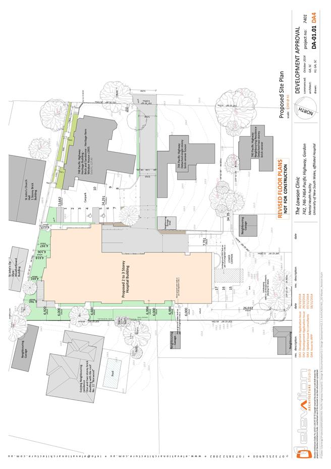
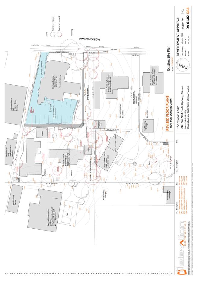
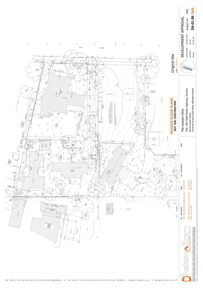
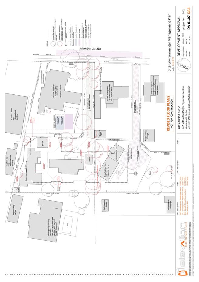
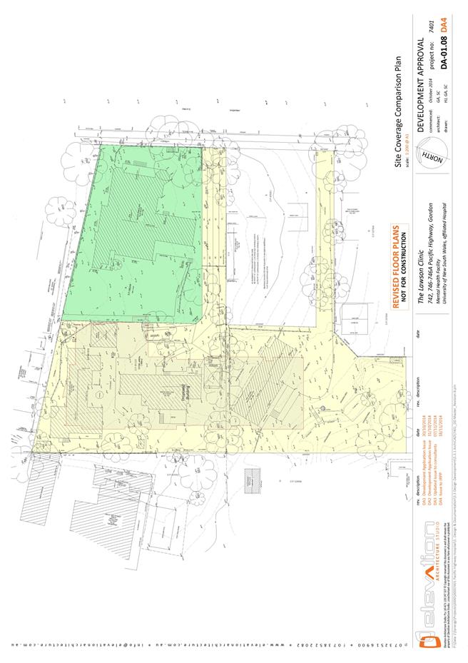
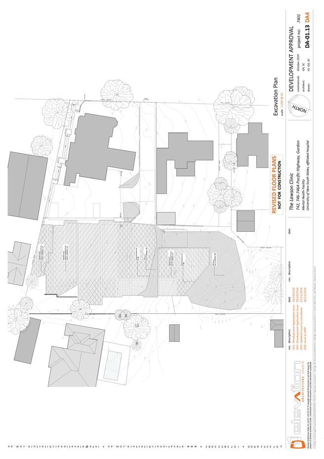
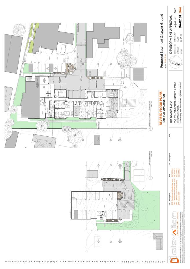
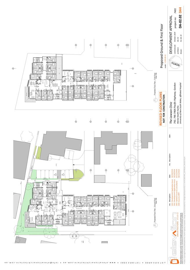
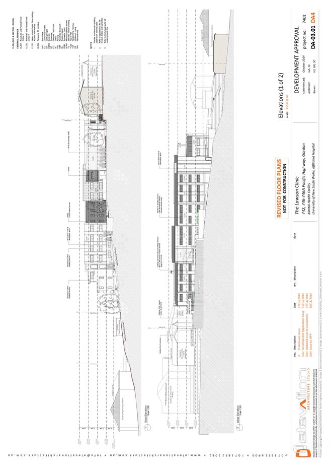
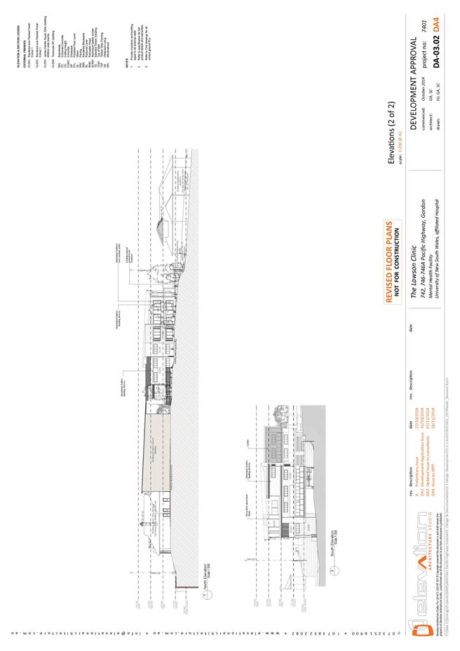
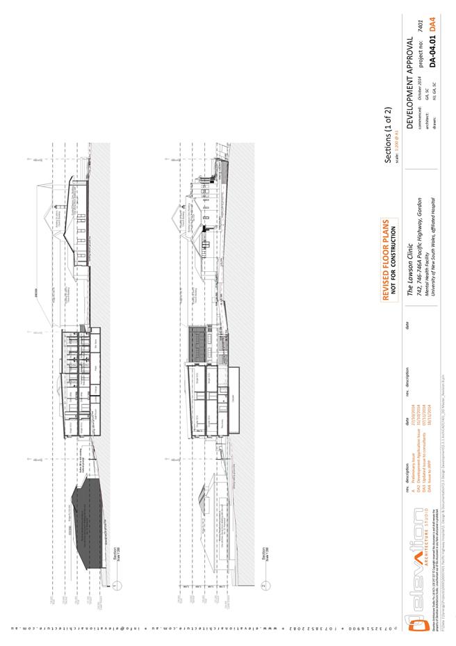
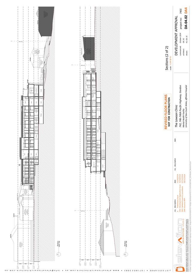
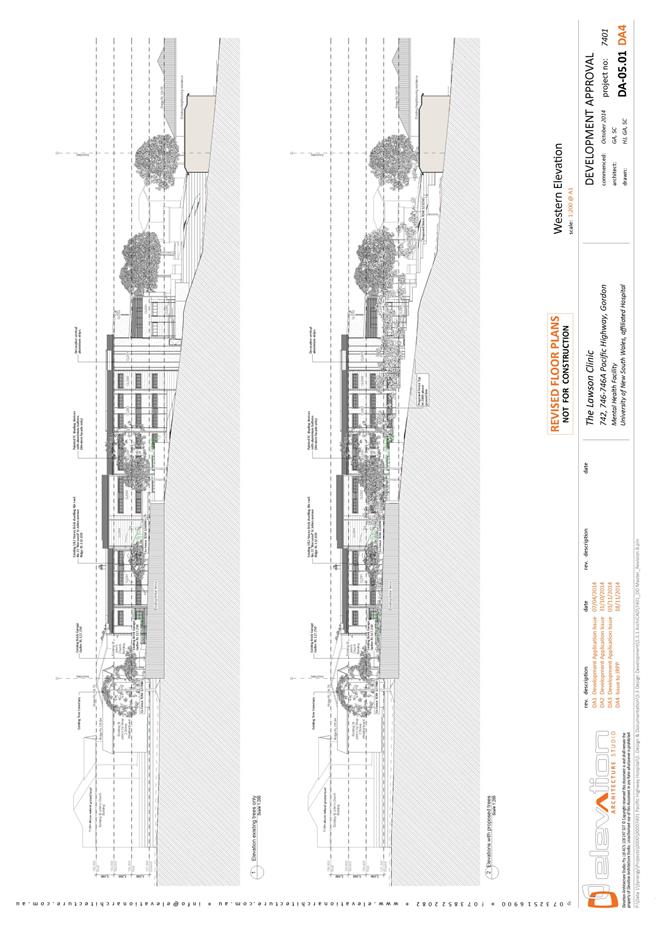
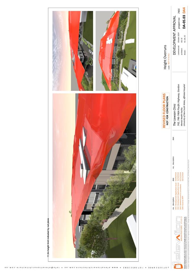
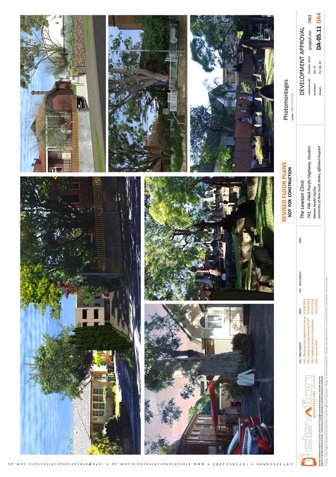
|
APPENDIX No: 5 - Landscape
Plans
|
|
Item No: GB.5
|
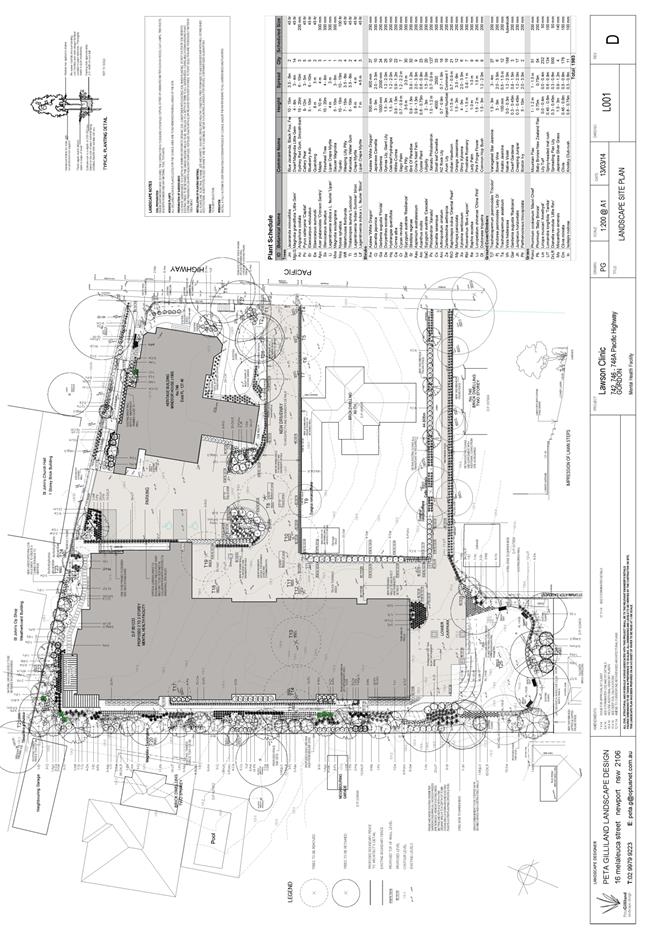
|
Ordinary
Meeting of Council - 31 March 2015
|
GB.6 / 201
|
|
|
|
|
Item
GB.6
|
S10381
|
|
|
12 January 2015
|
Planning Proposal to Amend the draft
Ku-ring-gai Local Environmental Plan 2015 - Consideration of Submissions
EXECUTIVE
SUMMARY
|
purpose of report:
|
For Council to consider the submissions made to the
exhibition of the Planning Proposal to amend the Ku-ring-gai Local
Environmental Plan 2015.
|
|
|
|
|
background:
|
On 26 November 2013 Council resolved to proceed with
the Planning Proposal to amend the Ku-ring-gai Local Environmental Plan
2015 to rectify anomalies, refine local clauses and incorporate
amendments arising from submissions made to the exhibition.
The Planning Proposal received a Gateway Determination
on 2 October 2014. The Planning Proposal was exhibited in accordance with the
Gateway Determination for 28 days from 7 November 2014 to 5 December 2014.
|
|
|
|
|
comments:
|
Submissions (18) were received in response to the
exhibition. These have been considered in this Report.
|
|
|
|
|
recommendation:
|
That the Planning Proposal to
amend the KLEP 2015 to rectify anomalies, refine local clauses and
incorporate amendments arising from submissions made to the exhibition be
endorsed to proceed.
|
Purpose of Report
For Council to consider the submissions made to the
exhibition of the Planning Proposal to amend the Ku-ring-gai Local
Environmental Plan 2015.
Background
On 26 November 2013 Council resolved to adopt the draft
Ku-ring-gai Local Environmental Plan 2013 (KLEP) with a number of minor
amendments. Other more significant amendments also formed part of the
resolutions. To ensure transparency and give due process and consideration to
the affected landholders and surrounding properties, Council resolved to prepare
a number of Planning Proposals on these amendments, and forward them to the
Department of Planning and Environment (formerly Department of Planning and
Infrastructure) for a Gateway Determination.
This report deals with the Planning Proposal (Attachment
A1) which included various proposed general amendments to the draft KLEP
2013. Separate Planning Proposals are being, or will be, prepared for matters
not covered by this Planning Proposal.
The relevant resolutions relating to amendments within this Planning
Proposal to amend the draft Ku-ring-gai Local Environmental Plan 2013 (Attachment
A1) are listed below:
C. That Council resolve to prepare a
planning proposal in accordance with section 55 of the EP&A Act to amend
the Ku-ring-gai Local Environmental Plan 2013 as follows, and that the planning
proposal then be forwarded to the DoPI for a Gateway Determination in
accordance with the provisions of the EP&A Act and Regulations:
1. To
amend the Zoning Map for Edith Street, between 74 and 76 Bannockburn Road,
Pymble (unformed road reserve) to zone R2 Low Density Residential, the FSR Map:
A3(0.3:1) and the Lot Size Map: T (930sqm)
2. To
amend the Zoning Map for No. 1 Bundarra Avenue Wahroonga, 1685 & 1687
Pacific Highway Wahroonga to zone R4 – High Density residential, the FSR Map:
‘N’ (1:1), Height Map ‘N’ (14.5m), Lot Size Map ‘U1’ (1200sqm).
3. To
amend the Zoning Map for 2, 4, 6 Caithness Street, Killara to zone R2 Low
density Residential with associated development standards.
For the
Motion: The Mayor, Councillor J Anderson, Councillors Armstrong,
Berlioz, Citer, McDonald, Ossip, Szatow and Fornari-Orsmond
Against
the Motion: Councillors Pettett and Malicki
The above Resolution was an
Amendment to an Original Motion. The Original Motion was:
3. To amend the Zoning Map
for 2, 4, 6 Caithness Street, Killara to zone R3 Medium density Residential
4. To
amend the Zoning Map for 18 Marian St, Killara to zone R4 High Density
Residential, the FSR Map ‘K’ (0.85:1), the Height Map ‘L’ (11.5m), Lot Size Map
‘U1’ (1200sqm).
5. To
amend the Floor Space Ratio Map for 20-28 Culworth Ave, Killara (Lots 1, 2 and
3 DP119937; Lot 6 DP3694; lot 2 DP932235) to ‘Q’ (1.3:1) and the Height of
buildings Map ‘P’ (17.5m).
6. To
amend the Zoning Map for Avondale Golf Club, 40 Avon Road Pymble to Zone
RE2 Private Recreation to the northern corner of the site.
7. To
amend the Riparian Lands Map as it applies to the following sites:
· Corner of Woniora Avenue and
Woonona Avenue North, Wahroonga
· Ortona Road to Westbourne Road,
Lindfield
· 90 and 92 Babbage Road, Roseville
Chase
9. To
amend the Land Use Table for Zone E4 Environmental Conservation to
include the following additional objectives:
· To minimise direct and indirect
risks to life, property and the environment from bushfire events and bushfire
management.
· To ensure that development in
this zone on land that adjoins land zoned E1 National Parks and Nature Reserves
or E2 Environment Conservation is compatible with the objectives for those
zones.
· To enable other land uses that
provide facilities or services to meet the day to day needs of residents
10. To
amend Schedule 3 Part 1 (Complying Development) to include complying
development provisions for dwelling houses in the E4 zone in accordance
with the provisions included as Attachment A15.
D. That Council resolve to prepare a
planning proposal in accordance with section 55 of the EP&A Act to amend
the Ku-ring-gai Local Environmental Plan 2013 for the following Heritage
related matters and that the planning proposal be forwarded to the DoPI for a
Gateway Determination in accordance with the provisions of the EP&A Act and
Regulations:
i. To
amend the Heritage Map and Schedule 5 to alter the boundaries of the following
HCAs:
a. C24
Marian St Conservation Area to exclude Lot 6, DP 3694, Lots 1, 2, 3, DP 119937,
Lot 2, DP 932235, Lot 1, DP 945545, Parts 30 and 31, DP 3263, Lot 1, DP 102600.
b. C1
Wahroonga Conservation Area to exclude 38 Billyard Avenue, Wahroonga.
A complete copy of Council’s resolution may be viewed in
Appendix B of the Planning Proposal.
The above resolutions relate to the draft Ku-ring-gai
Local Environmental Plan 2013 however the Planning Proposal, subject
of this report, relates to the draft Ku-ring-gai Local Environmental Plan 2014.
The reason for the difference in dates is that during negotiations between
Council and the Department to finalise the KLEP, one of the amendments made by
the Department was the change to the date as it was then likely that the KLEP
would be gazetted in 2014. In fact the gazettal occurred on 5 March 2015 and
therefore the document will henceforth be known as KLEP 2015.
The amendments sought in this Planning Proposal are mostly
site specific and are listed below. Maps, explanations and details of each
amendment may be seen in Part 1 of the Planning Proposal at Attachment A1.
a. Edith
Street, between 74 and 76 Bannockburn Road, Pymble (unformed road reserve)
Current: Residential
2(c) under KPSO and RE1- Public Recreation under the draft KLEP.
Proposed: Rezone to
R2 Low Density Residential.
b. 1
Bundarra Avenue, 1685 & 1687 Pacific Highway Wahroonga
Current:
R4 High Density Residential with maximum height of buildings (HOB) of 11.5m
and floor space ratio (FSR) of 0.85:1 allowing 3 storey development.
Proposed: R4
High Density Residential with maximum height of buildings (HOB) of 14.5m and
floor space ratio (FSR) of 1:1 allowing 4 storey development.
c. 2,
4, 6 Caithness Street, Killara
Current: Zoned
R4 Residential high density with a HOB of 17.5m and FSR of 1.3:1 Under KPSO and
draft KLEP 2014.
Proposed: Rezone
to R2 Low Density Residential simultaneously reduce the HOB to 9.5m, FSR to
0.3:1, and minimum lot size to 840sqm, with the associated development
standards of that zone
d. 18
Marian St, Killara
Current:
Zoned R2 Low Density Residential, however, it is already developed as a 3
and 4 storey residential flat building.
Proposed:
Rezone the site to R4 High Density Residential with development standards of
0.85:1 FSR, 11.5m building height and 1200sqm minimum lot size, to reflect the
existing development.
e. Lots
1, 2 and 3 DP119937; Lot 6 DP3694; lot 2 DP932235 Culworth Ave, Killara
Current: Zoned
R4 High Density Residential under the draft KLEP 2014 with FSR 1:1 and HOB
14.5m and is currently utilised as a paid public carpark.
Proposed: Zone
R4 High Density Residential and increase the FSR to 1.3:1 and HOB to 17.5m.
f. Avondale
Golf Club, 40 Avon Road, Pymble
Current:
Zoned E2 Environmental Conservation.
Proposed:
Rezone northern corner of the Avondale Golf Club and a strip of Council owned
land at the western boundary of the site to RE2 Private Recreation.
g. Woniora
Avenue and Woonona Avenue North, Wahroonga
It is intended to
correct errors in the riparian mapping to accurately reflect the existing
extent of riparian lands at this location. The amendment is to extend the
Category 3 riparian land.
h. Ortona Road to Westbourne Road, Lindfield
It
is intended to correct errors in the riparian mapping to accurately reflect the
existing extent of riparian lands at this location. The amendment is to extend
the Category 3A and introduce a tract of Category 3 riparian land.
i. 90
and 92 Babbage Road, Roseville Chase
It is intended to
correct errors in the riparian mapping to accurately reflect the existing
extent of riparian lands at this location. The amendment is to introduce a
tract of Category 3A and Category 3 riparian land.
j. Adjustment
to the boundary of HCA C24 Marian St Conservation Area to exclude Lot 6, DP
3694, Lots 1, 2, 3, DP 119937, Lot 2, DP 932235, Lot 1, DP 945545, Parts 30 and
31, DP 3263, Lot 1, DP 102600
It is intended to
adjust the boundary of the Marian St HCA to exclude a number of lots including
land currently operating as Culworth Avenue car park, adjoining sites at 18
Culworth Avenue, 1 and 3 Marian Street. In their current state these lots are
not considered to contribute to the HCA, and this will continue to be the case
with any R4 High Density Residential development carried out under the Draft
KLEP 2014.
k. Adjustment
to the boundary of HCA C1 Wahroonga Conservation Area to exclude 38 Billyard
Avenue, Wahroonga
It is intended to
adjust the boundary of the Wahroonga HCA by removing 38 Billyard Avenue. This
property comprises a recently constructed house on the boundary of the HCA and
does not contribute to the character of the HCA.
l. Amendment
to the Written Instrument – Land Use table/ Schedule 3 for all E3 and E4
properties.
Ø Land Use Table
It is intended to
remove from the E3 Environmental Management zone and include in the E4
Environmental Living zone objectives relating to risk in the event of bushfire,
development adjoining E1 and E2 zones, enabling other land uses.
Ø Schedule 3 Complying Development
It is intended to
include appropriate complying development provisions for dwelling houses in the
E4 Environmental Living zone.
Council received a Gateway Determination (Attachment A2)
from the Department of Planning and Environment on 2 October 2014 to permit the
exhibition of the Planning Proposal.
The Planning Proposal was exhibited in accordance with the
Gateway Determination for 28 days from 7 November to 5 December 2014.
Comments
Following receipt of the Gateway Determination, the
exhibition of the Planning Proposal was advertised in the North Shore Times (7
November 2014), with all exhibition documents being made available to the
public at Council’s Chambers and on Council’s website for the required 28 days.
Three submissions were received in response to the State
Agency consultation required through the Gateway Determination. These may be
seen at Attachment A3.
A total of 17 submissions from residents and their
representatives were received by Council. Copies of all the submissions have
been provided to Councillors. A summary of all the submissions may be seen at Attachment
A4.
The submissions are presented and discussed below, with the
according recommendation on each issue.
STATE AGENCY CONSULTATION
In accordance with the Gateway Determination, State Agency
consultations were undertaken with Office of Environment and Heritage, and with
the Rural Fire Service. The Environmental Protection Authority also submitted a
response (Attachment A3).
1. Office
of Environment and Heritage (OEH)
Key issues
OEH does not support the change
in zoning at Avondale Golf Course from E2 Environment Conservation to RE2
Private Recreation on the northern part of the golf course, and to RE1 Public
Recreation of the Council owned strip of land adjacent to the E2 golf course
land for the following reasons:
· The area contains Sydney Turpentine
Ironbark Forest (STIF) vegetation and is linked by riparian corridors to Rofe
Park/Sheldon Forest.
· The area is of higher conservation
significance than the E2 area on the west of the golf course which is being
retained as E2.
· Council has other smaller and isolated
sites which remain as E2, such as the corner of Duff St and Cornwall Ave.
Discussion
It is agreed that the parcel of
land contains STIF and has a riparian corridor. The corridor that OEH refers to
is only connected to Rofe Park/Sheldon Forest via a piped drainage line and is
not of the same quality or extent of riparian as on this site. The status of
that connection is unlikely to change given the piping occurs within privately
owned residential land and across a roadway.
Avondale Golf Course is a
privately owned parcel of land and the landowner has requested that this
northern part of their site be rezoned to RE2. Council has not been requested
by the owner to rezone the larger patch of E2 land to the west of the golf
course; therefore, that E2 zoning is not under consideration here.
The land at corner Duff St and
Cornwall Ave, that OEH makes a comparison with, is Council owned land and not
in private ownership; therefore, the issue of its restricted use for private
purposes as a result of E2 zoning does not arise.
Since the KLEP 2015 maps
biodiversity and riparian areas on the land, any development proposal on this
parcel of land will be subject to a development application at which time the
impact on the riparian, biodiversity and STIF will be assessed. This approach
is consistent with the treatment of other private properties with STIF or Blue
Gum High Forest vegetation within the LGA. Further to this, since this site
contains STIF, it is protected by 2 other layers: Federal Legislation -
Environment Protection and Biodiversity Conservation Act 1999 (EPBC); and State
Legislation - Threatened Species Conservation Act 1995. Therefore any
development on the land would be assessed at 3 levels for impact on the land
ecology.
Although OEH objects to the RE2
zoning to this land parcel, it has not made any offer to acquire the site.
Where rezoning of private land restricts the range of uses applicable to the
land, the Land Acquisition (Just Terms Compensation) Act 1991 may be
invoked and there is an obligation to acquire the land to compensate the owner
for their loss through restricting the use of their land. The E2 zoning to the
Avondale Golf Club may potentially restrict the use of the landowner as there
are very limited uses permitted within the E2 zoning. Council is not in a
position to make this acquisition and OEH has not expressed an interest in the
purchase of the land. Where there is no agreed nominated acquisition authority,
then Council is obliged to assist in retaining the land in private ownership.
Therefore the rezoning to RE2 on this part of the privately owned Avondale Golf
Club is supported on the basis that the environmental attributes of the site
are recognised under Federal, State and Local (KLEP 2015) legislation.
The proposed E2 zoning to the
narrow strip of Council land adjacent to the golf course land is proposed to
remain as E2 given it is in Council’s ownership.
Recommendation:
It is recommended:
Ø to amend the KLEP 2015 Zoning Map for
Avondale Golf Club, 40 Avon Road Pymble to Zone RE2 Private Recreation to the
northern corner of the site.
2. Environmental
Protection Authority (EPA)
Key issues:
· Road traffic noise impacts to the
residents of 1 Bundarra Avenue, 1685 & 1687 Pacific Highway Wahroonga, and
the management of those amenity issues.
Discussion:
The issues facing residents that
live on busy main roads is acknowledged. For this reason the adopted
Ku-ring-gai DCP has included a section on ‘Development Near Road or Rail
Noise’, and references the Department of Planning and Environment’s
“Development Near Rail Corridors and Busy Roads – Interim Guidelines December
2008”. Building orientation and design to address amenity and manage noise
impact would typically be addressed at the development application stage. They
are not matters that would be addressed by the proposed changes to the LEP
development standards on the site.
Recommendation:
No change recommended.
3. NSW Rural Fire Service (RFS)
RFS had no
comment on the Planning Proposal
SUBMISSIONS TO EXHIBITION
Seventeen submissions were received in response to the
exhibition. Two submissions supported the amendments, one of these was from AUSGRID
regarding their sites at 17 Larnock Avenue (Kulgoa Road), Pymble; and 2d
Carlyle Road (Tryon Road), East Lindfield. The other was a general letter of
support.
The remaining submissions fell into 2 categories:
I. Submissions
not relevant to this Planning Proposal and the amendments it seeks to make
A number of these
submissions raise issues previously assessed within the exhibition of the draft
KLEP 2013. These issues are briefly discussed at Attachment A4 but are
not discussed in this Report as they are not matters for consideration under
this Planning Proposal. The sites the submissions refer to are listed below:
· 101 Eton Rd, Lindfield - Screen
Australia;
· 48 Warragal Rd, Turramurra;
· 6-10 Edward Street, Gordon - ARV
Retirement Village;
· 121 Mona Vale Road, St Ives.
Two submissions claimed
errors in Council’s mapping. These issues are detailed at Attachment A4.
Since they are not matters for consideration under this Planning Proposal they
are not discussed in this report. A comprehensive review of the biodiversity
and mapping will occur in conjunction with the periodic review of the KLEP and
any amendments to the biodiversity mapping and any consequential zoning changes
will be made as part of that overall review process. The sites the submissions
refer to are listed below:
· 4 Raleigh Crescent, St Ives Chase
· 51 Wentworth Avenue, Killara
II. Submissions
that are relevant to this Planning Proposal and the amendments it seeks to make
The key issues put
forward in the submissions that relate to this Planning Proposal amendments are
stated below under each proposed amendment with a brief discussion and
recommendation. Refer to Attachment A4 for
a summary of submissions and discussion.
a. Edith
Street, between 74 and 76 Bannockburn Road, Pymble (unformed road reserve)
Key issues:
· Sydney Water made a submission objecting
to the rezoning as they are concerned about future access to the drainage line
that crosses the site.
· Owners of 74 and 76 Bannockburn Rd
(properties adjacent to the Edith St land) object to the rezoning of the land
from RE1 to R2 as they wish to retain access across the land to their side
boundaries. In addition, the submission from 76 Bannockburn Rd claims that the land
parcel provides a corridor for fauna and fauna across to the Bannockburn Oval
Bush land and is a home to a variety of birdlife and a number of large mature
gum trees.
Discussion
The proposed rezoning
will not affect access to the sewer pipes by Sydney Water as there is no
resolution to sell the land at present. In the event of sale, the status of the
land parcel will be the same as all other R2 zoned and developed land with
sewer lines running through them. Typically there is an easement over such
pipework and access is sought from and granted by the landowner.
The issue of access
across the Edith St parcel of land to neighbouring properties at 76 and
74 Bannockburn Rd will not be altered by a rezoning to the land. Right of
access will only be an issue when the land is being sold for private purposes
and Edith St is formally closed. Whilst Council resolved to reclassify and
rezone the land, there has been no Council resolution to sell the land. If
Council resolves to sell the land in the future, due process and consultation
will occur and owners of the adjoining properties will be invited to make their
submissions.
Site visits (4 in
total) by Council officers note that the land at 74A Bannockburn Rd/Edith St is
being used by the owners of 74 and 76 Bannockburn Rd for car parking and other
private purposes (bin storage, gardening, vegetable patches, swing, basketball
net, compost heaps, planting of hedging and random saplings). The current uses
on Edith St do not reflect any public recreation use of the land in line with
the current RE1 infill zoning; however, the uses on the land are more akin to
the R2 infill zoning being proposed.
With regards to the
comment on Edith St providing a corridor for flora and fauna across to
Bannockburn Oval, investigation by Council’s Natural Areas officer confirms
that the site contains 3 mature Sydney Blue Gum and recent plantings (not by
Council) of 3 immature native Hop Bush and an immature eucalypt sapling (not by
Council) of unknown species. The site has been extensively disturbed and
transformed into a mown grass block, impairing its overall ecological
functionality. The overall site vegetation lacks characteristic components of
midstorey and understory structural layers, which have been replaced entirely
by mown Kikuyu grass. Further, the site lacks fauna habitat features and there
are no threatened fauna and flora species identified in searches, both
internally and through the Office of Environment and Heritage Atlas Database.
Whilst the site has
limited linkage to other native vegetation remnants in the landscape, being
Bannockburn Oval, the small size of the site and level of disturbance places it
in a poor ecological supportive position in the landscape. Effort to restore
the site back to viable ecological function for the provision of a continuous
fauna corridor would be costly and partially ineffective due to the road
boundary and adjoining built up residential area. Since the 3 blue gums have
been captured on Council’s GIS mapping as the Endangered Ecological Community
Sydney Blue Gum High Forest and Council’s Greenweb Map as Category 2
vegetation, rezoning of the site would result in no change to the mapping of
biodiversity significance.
Recommendation:
It is recommended to
proceed with the amendment as stated in the Planning Proposal:
Ø to amend the KLEP 2015 Zoning Map for
Edith Street, between 74 and 76 Bannockburn Road, Pymble (unformed road
reserve) to zone R2 Low Density Residential, the FSR Map: A3 (0.3:1) and the
Lot Size Map: T (930sqm).
b. 1
Bundarra Avenue, 1685 & 1687 Pacific Highway Wahroonga
Discussion
There were no
submissions made on this amendment.
The site is currently zoned R4
High Density Residential with maximum height of buildings (HOB) of 11.5m and
floor space ratio (FSR) of 0.85:1 allowing 3 storey development. It is proposed
to increase the maximum height of buildings (HOB) to 14.5m and floor space
ratio (FSR) to 1:1 allowing 4 storey development. This will enable the
amalgamation of the 3 sites and development similar to the bulk and scale of
adjoining buildings whilst ensuring amenity to on site residents and to
adjacent developments.
Recommendation
It is recommended to
proceed with the amendment as stated in the Planning Proposal:
Ø to amend the KLEP 2015 Zoning Map for No.
1 Bundarra Avenue Wahroonga, 1685 & 1687 Pacific Highway Wahroonga to zone
R4 High Density Residential, the FSR Map: ‘N’ (1:1), Height Map ‘N’ (14.5m),
Lot Size Map ‘U1’ (1200sqm).
c. 2,
4, 6 Caithness Street, Killara
Key issues
The landowners of 2, 4,
6 Caithness St, their legal representative, and their town planning
representative, have made a number of submissions objecting to the downzoning
of their lands from R4 High Density Residential to R2 Low density Residential.
The key issues are:
· The 3 sites were not considered as part
of the Interface Study which investigated all R2 sites adjacent to R4 sites,
and enabled R3 Medium Density Residential zoning to those sites as a means to
ameliorate impacts from the adjacent 5 storey development.
· Council resolved against the officer’s
recommendation at the Council meeting on 26 November 2013 to zone the 3
sites as R3 and instead resolved for R2 with no substantiated evidence or due
consideration of the impacts on the 3 sites.
· DA 0350/09 (apartments at corner of
Marian St and Caithness St) dismissed impacts on 2 Caithness St due to its
R4 zoning, stating the potential impacts of the 5 storey development upon 2
Caithness St were acceptable given the zoning of 2 Caithness St permitted 5
storey future development. The lack of visual and acoustic privacy, and solar
access amenity to 2 Caithness St is a result of a concession of impacts
based upon the likely future R4 development of 2 Caithness St.
· The
inconsistency between the heritage impact assessment of DA 0350/09 (which
considered the impact on the heritage aspects as acceptable) and the current
rezoning assessment that considers there is high impact on the heritage
aspects.
· That
the separation of the road to the R2 development affords 1 Caithness St more
protection than the current R2 proposal affords the 3 sites.
· Argues
that the new DCP controls and its requirements for heritage consideration will
ensure the sensitive development of R4 apartments in the vicinity of the
Heritage Item setting.
· That
the matter should be deferred until a decision is made on the heritage status
of 6 Caithness St.
Discussion
It is acknowledged that the 3 sites were not
considered as part of the Interface Studies conducted by Council prior to the
exhibition of the draft KLEP 2013. This was due to the sites being zoned
2(d3)/R4 High Density Residential, and the criteria for interface investigation
was to assess properties adjacent or opposite 2(d3)/R4 sites. For this reason
only the properties adjacent or opposite these 3 sites were assessed for
interface impact. Therefore 2, 4 and 6 Caithness St were exhibited with R4
High Density Residential zoning during the exhibition of the draft KLEP 2013.
The criteria for assessing if an interface site is
impacted are stated in the Submission Summary Table at Attachment A4. In
general, Council’s approach to impacted interface sites has been to provide a
planning solution by zoning those sites to R3 Medium Density Residential. This
approach enables those sites to amalgamate and create a design solution that
could ameliorate impacts of overlooking/overshadowing/loss of amenity by the
adjacent 5 storey R4 High Density Residential developments. The R3 three storey
townhouse type development would also provide a good transition in bulk and
scale between the 5 storey R4 and 2 storey R2 developments.
Following the exhibition of the draft KLEP 2013, one
submission was received from the owner of 1 Caithness St, opposite 2, 4 and 6
Caithness Street. That submission argued the absence of any interface between
the R4 sites at 2, 4, 6 Caithness St and their R2 property at 1 Caithness
Street. It argued the impact that the R4 development would have on the setting
of their Heritage Listed house, as well as the traffic implications for
Caithness Street. This submission triggered investigation into the sites; and
as discussed in Council Report of 26 November 2013, the reason for the absence
of R3 interface sites in Caithness St was due to the interface site at 1
Caithness St being a Heritage Item which prevented the site from being zoned
for R3.
Further to this, Caithness St was found to be a
narrow cul-de-sac with a small landscaped island at its centre and the other
properties 1, 3, 5, 8 Caithness St were all R2 dwellings. None of those sites
were proposed for interface related zoning to R3 due to their questionable
ability to be developed given their shape or their Heritage Item status (1
Caithness St). In addition, the R4 developments adjacent to them were 3 storey
buildings, or there was adequate separation of a road. Therefore, they were
retained as R2 to help preserve the unique quality of this cul-de-sac narrow
street as a setting for the Heritage Item.
As discussed in the 26
November 2013 report, given the narrowness of the street and the minimal
frontage of the Heritage Item at 1 Caithness Street to the road, it was
considered (following the exhibition of the draft KLEP 2013) that the 5 storey
R4 zoning on the 3 sites would impact the setting of that Heritage Item and the
general character of the street, with traffic along the narrow street being of
concern. However, the assessment also concluded that downzoning the 3 sites to
R2 as requested in the submission would not be a good outcome for the 3 sites
as they would take on the status of an interface site and, undoubtedly, be
heavily impacted by the development to their rear and side which significantly
reduces their privacy and amenity as is currently apparent. In addition, the
downzoning to R2 would be contrary and inconsistent with the approach taken by
Council on all other interface sites across the LGA.
For these reasons a
townhouse style R3 development was recommended at the 26 November 2013 Council
meeting. This would enable the 3 sites to be redeveloped to mitigate the impact
on them as interface sites whilst developing in a manner fitting with the
Heritage Item setting and the street character.
It is accepted that the
decision to downzone the sites to R2 at Council’s meeting on 26 November
2013 did not take into consideration the impacts on the 3 sites as interface
sites and that due consideration and conditioning of DA 0350/09 did not occur
due to the site being zoned R4 and having the future ability to ameliorate the
impacts. However, the arguments regarding the impacts of 2, 4, 6 Caithness St
sites as R4 development are not agreed as those impacts do still apply: R4 is
not considered supportive of the Caithness Street character and setting and
traffic implications. This is consistent with the officer’s report of 26
November 2013, as are the arguments to rezone the sites as R3 Medium Density
Residential.
It is acknowledged that
there appears to be inconsistency between the assessment of impacts made in the
development assessment of DA0350/09 and the assessment made in considering the
interface site status of Caithness Street. The key difference between the
method of assessment is that the recent interface assessment has resulted from
studying the actual impact of the built structure (corner of Marian St and
Caithness St) and assess the impacts of such a scale being extended into
Caithness Street. It is clear from looking at the actual development that the
scale would present a considerable impact on the street and the heritage
setting given its narrow width. Since 2, 4 and 6 Caithness Street are not very
deep sites, it is not possible to expect greater setbacks to the street
frontage from any future R4 development to reduce its bulk and scale impacts.
Therefore R4 development is not considered suitable at this location.
It is acknowledged that
there is uncertainty due to the ongoing investigation to heritage list
6 Caithness St and there would be greater clarity on the treatment of the
sites if the status of 6 Caithness St were resolved; however, given the
KLEP 2015 will be in place in place on 2 April 2015 and that the 3 sites are
listed as R4 in that Plan, it is necessary to have a direction on these sites.
This would ensure that any DA that is submitted will have to consider the R3
recommendation awaiting approval from the Department of Planning and
Environment. Therefore deferment of this matter is not supported.
The issue of assigning
R3 zoning to a heritage site is feasible as there are examples within
Ku-ring-gai where a through-zoning has enabled a Heritage Item to be retained
and included in the medium/high density development site. Through-zoning
ensures the Heritage Item site can be incorporated into the land area of the
dwelling development site to provide an increased FSR to the development, and
enable the adaptive reuse of the heritage building and its integration into the
overall development whilst preserving its heritage value. Given this, it is
recommended that the 3 sites be zoned R3.
Recommendation
It is recommended to
vary the Planning Proposal:
Ø to amend the KLEP 2015 Zoning Map for 2,
4, 6 Caithness Street, Killara to zone R3 Medium Density Residential, the FSR
Map ‘J’ (0.8:1), the Height Map ‘L’ (11.5m), Lot Size Map ‘U1’ (1200sqm).
d. 18
Marian St, Killara
Discussion
There were no
submissions made on this amendment.
The site is currently
zoned R2 Low Density Residential, however, it is already developed as a 3 and 4
storey residential flat building. It is intended to correct this anomaly and
rezone the site to R4 High Density Residential with development standards of
0.85:1 FSR, 11.5m building height and 1200sqm minimum lot size, to reflect the
existing development on the site.
Recommendation
It is recommended to
proceed with the amendment as stated in the Planning Proposal:
Ø to amend the KLEP 2015 Zoning Map for 18
Marian St, Killara to zone R4 High Density Residential, the FSR Map ‘K’
(0.85:1), the Height Map ‘L’ (11.5m), Lot Size Map ‘U1’ (1200sqm).
e. Lots
1, 2 and 3 DP119937; Lot 6 DP3694; lot 2 DP932235 Culworth Ave, Killara
Key issues
Two submissions were made on this
site.
One submission was a general
objection to the R4 zoning to the Culworth Car Park Area as it enables high
density housing which impacts the local character, and the loss of benefit to
surrounding residents who have convenient access to a North Shore station.
The second submission was in
regards to the adjacent site at 18 Culworth Avenue, Killara where the
landowner;
· requested an increase in FSR from 1:1 to
1.3:1 and HOB from 14.5m to 17.5m in line with the adjacent Culworth Car Park
in order to mitigate impact from the adjacent development; and
· expressed concern over the impact on the
loss of sunlight, privacy, amenity and increased noise from development on
Culworth Avenue Car Park with 5 storey development adjacent to their 2 storey
building.
Discussion
The issues
raised in the first submission have been previously addressed when the draft
KLEP 2013 was exhibited. The Submission Summary Table at Attachment A4
provides some repeated discussion of the topic. The increase to the development
standards on this site do not change the justifications put forward on the land
zoning and standards that were presented in the Council Report on 26 November
2013. Since then Council has also resolved on 27 May 2014 to allow the
compulsory acquisition of a portion of its land at Culworth Car Park by
Transport for NSW. This will ensure the continued provision of commuter parking
at this location.
The issues raised in the second
submission are discussed below.
The site at 18 Culworth
Ave, Killara is a 607sqm parcel of land zoned R4 with FSR of 1:1 and Height of
14.5m, under KLEP 2015. On its own, this parcel of land is unable to develop
into R3 (Medium Density) or R4 (High Density) as the site area is less than
1200sqm; therefore, it would have to remain as the current 2 storey company
titled building.
Due to the restricted
size of 18 Culworth Ave, the zoning and development standards within the
exhibited draft KLEP 2013 were made consistent with the surrounding lots so
that there was the opportunity to amalgamate and develop the property as part
of a larger development site. However, following the exhibition, Council
resolved on 26 November 2013 to raise the FSR and Height of the adjoining
Culworth Carpark to 1.3:1 and 17.5m (the subject of this Planning Proposal) and
the issue of amalgamation with 18 Culworth Ave to prevent an isolated site was
overlooked.
The only option for
amalgamation of this site is with 20-26 Culworth Ave (Culworth Carpark).The
property to the rear of 18 Culworth Ave, 3 Marian St, is a strata titled 3
storey building highly unlikely to be demolished and redeveloped. The adjacent
16 Culworth Ave, a 3 to 4 storey apartment building, is a Heritage Item and also
highly unlikely to be demolished and redeveloped.
Whilst amalgamation
with the adjacent Culworth Carpark is still possible, the lower FSR and Height
standards do have the potential to prevent 18 Culworth Ave being considered for
amalgamation as the inconsistency may not present the site as an attractive
partner given its small land size. Therefore, there is merit in increasing the
FSR and Height standards to match those of the adjacent site to facilitate its
ease of amalgamation and to retain the intended consistency of approach taken
in the consideration of the draft KLEP 2013.
It is also acknowledged
that, as is, 18 Culworth Ave would be impacted by the adjacent 5 storey
Culworth carpark development that would be located the minimum 6m from the common
boundary to its north. Overlooking and overshadowing would be the main issues.
These issues are typical of those experienced by Interface Sites (a site with a
1 to 2 storey residential building that has a 5 storey building adjacent or
opposite it), and in particular where the existing 1-2 storey building is close
to the common boundary, as is the case with 18 Culworth Ave.
A site visit by
Council’s officers was conducted to consider whether the additional FSR and
Height on 18 Culworth would transfer impact to the adjacent sites at 3 Marian
St and 16 Culworth Ave. It was assessed that any development application
on the amalgamated site (including 18 Culworth Ave) would ensure, through the
DCP controls, that the development would preserve amenity of the adjacent
sites.
Amenity would be
preserved to the adjacent Heritage Item at 16 Culworth Ave as there are
specific controls in the DCP to ensure a minimum 12m building separation to a
Heritage Item. With regards to 3 Marian St, it has a wide, approximately 6m,
driveway adjacent to the rear boundary of 18 Culworth Ave. This, alongside the
additional minimum 6m setback requirement of any new development would enable a
good 12m separation between the buildings. In addition, negotiated development
application outcomes to preserve the privacy and amenity of the apartments at 3
Marian St (such as tree screening, stepping of building, orientation) will
ensure amenity to that site is preserved. Therefore increasing the standards to
match the adjacent Culworth Carpark is supported.
Since this increase in
FSR and Height to 18 Culworth Ave has not been previously reported to Council,
process requires that it be applied for through the planning proposal process
which will ensure due consultation and transparency on the amendment.
Recommendation
It is recommended to
proceed with the amendment as stated in the Planning Proposal:
Ø to amend the KLEP 2015 Floor Space Ratio
Map for 20-28 Culworth Ave, Killara (Lots 1, 2 and 3 DP119937; Lot 6 DP3694;
lot 2 DP932235) to ‘Q’ (1.3:1) and the Height of buildings Map to ‘P’ (17.5m).
It is recommended:
Ø to include 18 Culworth Avenue, Killara
in a future Planning Proposal to amend errors, omissions and inconsistencies in
the draft KLEP 2015 and amend its Floor Space Ratio Map to ‘Q’ (1.3:1), and
Height of Building Map to ‘P’ (17.5m).
f. Avondale
Golf Club, 40 Avon Road, Pymble
Key issues
One submission was made by STEP
against the change in zoning from E2 Environmental Conservation to RE1 and RE2
(Private and Public Recreation) as the site contains high quality STIF and
associated vegetation. The key issues were:
· The land zoned E2 is not an isolated
pocket and it has high biodiversity value with riparian and biodiversity
corridors that are functional, or could readily be made so.
· The proposed RE2 zoning would not give
adequate recognition to the environmental value of this land, and STEP concurs
with OEH and considers zoning from E2 to RE2 may not be sufficient to prevent
impacts on biodiversity and riparian values from the increased range of uses
permissible within an RE2 Private Recreation zone.
· The State Government’s preference (White
Paper) is for environmental values to be fully recognized upfront.
Discussion
The
specific issues raised by STEP are discussed at Attachment A4. Detailed
investigations of the site in response to the STEP submission, by Council’s
Natural Areas officer, concur with their assessment that the site contains high
quality biodiversity and riparian value.
There are two issues in considering
the rezoning of the northern end of the Avondale Golf Course site (subject of
this planning proposal). These are;
1. The
quality and preservation of the STIF, biodiversity, riparian aspects of the
land.
2. The
private ownership and use of the land.
STIF Vegetation
Site visits by Council’s Natural
Areas officer confirms that this northern parcel of Avondale Golf Course zoned
as E2 has an area (approximately 2.8ha) of good quality 'Turpentine-Ironbark
Forest in the Sydney Basin Bioregion' (STIF).
The current conservation status,
and avenues of consultation for any development within areas of STIF under
Federal and State Government legislation are as follows:
i. Federal
Legislation: - Listed as ‘Critically Endangered’ under the Environment Protection
and Biodiversity Conservation Act 1999 (EPBC). This site falls within the
criteria for consideration under this Act, therefore any works on the land are
required to seek advice from Department of the Environment.
ii. New
South Wales State Legislation: - Listed as ‘Endangered’ under the Threatened
Species Conservation Act 1995. This site falls within the criteria for
consideration under this Act, therefore any works on the land are required to
seek advice from OEH.
The STIF on this site is therefore
already protected by both Federal and State legislation with all development
requiring consultation with Department of the Environment and OEH. In addition
to the EPBC requirements for consultation for any development proposal within
that land, the KLEP 2015 maps biodiversity and riparian areas on this parcel of
land and any development on the land will be subject to a development
application at which time the impact on the biodiversity, riparian and STIF
will be assessed and managed.
Private Land Ownership
It is acknowledged that there is
ecological (riparian, biodiversity, STIF) value to the site at the northern end
of the Avondale Golf Course; however, this is a privately owned parcel of land
and the landowner has requested that this part of their site be rezoned to RE2
to enable its use. This parcel of land is surrounded by other privately owned
land zoned E4, R2 and RE2.
Council has not been requested by
the owner to rezone their E2 land to the west of the golf course. This is a
larger E2 area on their private land and has direct boundaries and links with
the vegetation of the adjacent E2 zoned Sheldon Forest and the continuing
corridor along Rofe Park. Since that area is not included in this Planning
Proposal, it is not discussed in this Report.
Whilst the White Paper promoted
recognition of land with environmental value in a general sense, the State
Government’s LEP Practice Note by which Council is directed, requires
specifically that any application of land use (zoning) should not in any way restrict
the use of land in private ownership and trigger its acquisition and
compensation under the Land Acquisition (Just Terms Compensation) Act 1991.
The E2 zoning to the Avondale Golf Club may potentially restrict the use of the
landowner as there are very limited uses permitted within the E2 zoning.
Council is not in a position to make this acquisition and OEH has not expressed
an interest in the purchase of the land. Where there is no agreed nominated
acquisition authority, then Council is obliged to assist in retaining the land
in private ownership.
Therefore the rezoning to RE2 on
this part of the privately owned Avondale Golf Club is supported on the basis
that the environmental attributes of the site are recognised under Federal,
State and Local (KLEP 2015) legislation.
The proposed E2 zoning to the
narrow strip of Council land adjacent to the golf course land is proposed to
remain as E2 given it is in Council’s ownership.
Recommendation
It is recommended to
proceed with the amendment as stated in the Planning Proposal:
Ø to amend the KLEP 2015 Zoning Map for
Avondale Golf Club, 40 Avon Road Pymble to Zone RE2 Private Recreation to the
northern corner of the site.
It is recommended to vary
the Planning Proposal:
Ø to not proceed with the rezoning of
Council’s land adjacent to the northern corner of Avondale Golf Club.
g. Woniora
Avenue and Woonona Avenue North, Wahroonga
Key issues
One submission, from Sydney
Water, was received regarding this amendment. The submission objected to the extension
of the riparian corridor at Woniora Ave, Wahroonga and its encroachment on
their land. The key concern is the requirement for the ecological management of
a riparian corridor on a Sydney Water land asset.
Discussion
Whilst the management of a riparian
corridor is not grounds for contesting the corridor, this site was investigated
as a result of the submission.
Investigation by Council’s Water
and Catchments Officer identified that whilst the proposed extension is
classified Category 3, the proposed area is currently a piped drainage system
predominantly under the road and partially across Sydney Water’s site and the
adjacent private property, with possibly an overlying area set aside for
overflows.
Sydney Water’s property is fully
developed and fenced and shows no signs of natural riparian surface features or
an overland flow path within or connected to adjacent properties. It appears
that Woonona Ave probably provides the pathway for overland flows. The Riparian
Policy would only come into effect if the land owner wished to undertake or
alter development on the property whereby they may need to consider the
overland flow path which, given the above, is unlikely to constrain any
development.
Given the current zoning and that
the proposed riparian corridor extension comprises a piped drain with the
roadway providing for overland flows there would be no benefit to gain from its
extension along Woonona Ave. The possibility of re-establishing any semblance
of a natural or semi-natural Riparian Zone is remote. Therefore it is
recommended not to proceed with the extension.
Recommendation
It is recommended to vary
the Planning Proposal:
Ø to not proceed with the extension of the
riparian area at Woniora Avenue and Woonona Avenue North, Wahroonga.
h. Ortona
Road to Westbourne Road, Lindfield
Discussion
There were no
submissions made on this amendment.
It is intended to
correct errors in the riparian mapping to accurately reflect the existing
extent of riparian lands at this location. The amendment is to extend the
Category 3A and introduce a tract of Category 3 riparian land mapping through
properties to the north of Westbourne Rd, Lindfield.
Recommendation
It is recommended to proceed with
the amendment as stated in the Planning Proposal:
Ø to amend the KLEP 2015 Riparian Lands
Map as it applies to Ortona Road to Westbourne Road, Lindfield.
i. 90
and 92 Babbage Road, Roseville Chase
Discussion
There were no
submissions made on this amendment.
Following the
reclassification and rezoning of 90 Babbage Rd, an area of riparian mapping
(subject of this Planning proposal) was proposed. It was also, at that time,
proposed to align and improve the drainage issues stemming from lands uphill of
90 and 92 Babbage Rd. These works have triggered a more accurate investigation
of the sites which was not previously possible as there were no survey marks to
identify site boundaries, and the vegetation on the land did not support access
and accurate investigation. Recent detailed investigation of the sites by
Council’s Natural Areas officer and Water Catchment officer, and a drainage
consultant are detailed below.
The riparian corridor
mapped at 90 Babbage Road is an ephemeral drainage-line connecting the
discontinuous stormwater pipe system between Babbage Road and Middle Harbour.
As per the Ecological
and Riparian Assessment Report prepared by SLR Global Environmental Solution
(26 February 2013), the corridor is characterised as a sandstone gully
receiving stormwater from a 300mm concrete pipe and headwall located in the
north-eastern corner of the 92 Babbage Road property. The pipe collects urban
runoff from approximately 2.5 ha of low density residential catchment via
drainage pits in an upstream section of Babbage Road. The pipe drains
stormwater across the 92 Babbage Road property before branching into several
shallow drainage paths that join at the front boundary of 90 and 92 Babbage
Road. The gully is very steep and falls 10m across over a channel length of 42
m to the Babbage Road stormwater pipe network that drains to the estuarine
waters of Middle Harbour. Due to steep terrain, flow events are transitory,
intense and short in duration, rendering parts of the land unstable and a
creating a safety hazard.
Coupled with fast
flowing stormwater events, poor vegetation cover provides little attenuation of
pollutants before they reach Middle Harbour. Whilst the Report provides
evidence of some sediment trapping occurring in the upper reaches of the gully,
there is an overall net loss of sediment due to active erosion in the middle
and lower sections. Independent modelling provided to Council suggests that a
reinstated vegetated swale of a similar grade and length to the gully will
perform appreciable pollutant removal (approximately 43% of total suspended solids,
29%of total phosphorous and 11% of total nitrogen), but the establishment of
such vegetation is unlikely due to high velocity flows. Given the proximity of
the gully to Middle Harbour, the gully also plays no significant role in
attenuating flood waters and protecting downstream development from flood
impacts.
In terms of
biodiversity, although the site provides some permanent and semi-permanent
habitat for common urban fauna, there is no permanent waterbody for aquatic and
amphibious fauna species. The riparian conservation value of the site is
therefore not considered to be significant in the context of the local area.
The SLR report revealed
that the drainage gully at 90 Babbage Road has been highly modified as a
consequence of the formal stormwater network and is unlikely to provide the
benefits that Council’s Riparian Policy (2004) attributes to riparian
corridors. The report proposes that more significant stormwater pollutant load
reductions could be provided by constructing a small rain garden near the
headwall at the top of the gully and discharging treated water via a new
stormwater pipe to manage frequent erosive flows around the gully into Babbage
Road.
SLR identified the
gully as Category 3 riparian land in their final analysis. Given SLR’s
conclusion of the site’s limited riparian attributes and recommendation for
upstream treatment and piping, Council sought further clarification from SLR on
the 12th March 2015 to determine the subtle but clear differences between
Category 3 and 3a in light of the new DCP which defines Category 3A as a
‘discontinuous or piped watercourse’.
In response, SLR
confirmed that their original conclusion was constrained by the lack of a 3a
Category definition in the Riparian Policy. They affirmed that in accordance
with the new DCP and in line with their original investigations that the
section of riparian area at 90-92 Babbage Road be categorised as a
discontinuous watercourse and appropriately classified as Category 3a Riparian
Land.
At the time of the
original assessment SLR acknowledged that their survey was constrained by dense
tree canopy cover, affecting both site and centreline mapping accuracy. Since
then Council has carefully removed weeds from the site to expose the pipe
headwall and exact drainage paths. An independent surveyor (Steve Davey and
Associates Pty Ltd Land and Engineering Surveyors) was engaged to accurately
survey and map 90 and 92 Babbage Road sewer and water infrastructure and
stormwater drainage lines. The surveyors map has now been used to accurately
position the centreline of the 3a Riparian Land and include an area 10m on each
side of the discontinuous watercourse as prescribed by the DCP. The survey and
clearing works have subsequently further revealed a riparian corridor occurring
on 92 Babbage Road which has also been updated in the mapping provided at Attachment
A5.
Recommendation
It is recommended to vary the
Planning Proposal;
Ø to amend the KLEP 2015 Riparian Lands
Map as it applies to 90 and 92 Babbage Road, Roseville Chase as per the amended
mapping at Attachment A5.
j. Adjustment
to the boundary of HCA C24 Marian St Conservation Area to exclude Lot 6, DP
3694, Lots 1, 2, 3, DP 119937, Lot 2, DP 932235, Lot 1, DP 945545, Parts 30 and
31, DP 3263, Lot 1, DP 102600
Discussion
It is intended to
adjust the boundary of the Marian St Heritage Conservation Area (HCA) to
exclude a number of lots including land currently operating as Culworth Avenue
car park, adjoining sites at 18 Culworth Avenue, 1 and 3 Marian Street. In
their current state these lots are not considered to contribute to the HCA, and
this will continue to be the case with any R4 High Density Residential
development carried out under the KLEP 2015.
There was one
submission supporting the exclusion of Culworth Car Park and 18 Culworth Avenue
from the Marian Street HCA.
Recommendation
It is recommended to
proceed with the amendment as stated in the Planning Proposal:
Ø to amend the KLEP 2015 Heritage Map and
Schedule 5 to alter the boundary of C24 Marian St Conservation Area to exclude
Lot 6, DP 3694, Lots 1, 2, 3, DP 119937, Lot 2, DP 932235, Lot 1, DP 945545,
Parts 30 and 31, DP 3263, Lot 1, DP 102600.
k. Adjustment
to the boundary of HCA C1 Wahroonga Conservation Area to exclude 38 Billyard
Avenue, Wahroonga
Discussion
There were no
submissions made on this amendment.
It is intended to
adjust the boundary of the Wahroonga HCA by removing 38 Billyard Avenue. This
property comprises a recently constructed house on the boundary of the HCA and
does not contribute to the character of the HCA.
Recommendation
It
is recommended to proceed with the amendment as stated in the Planning
Proposal:
Ø to amend the Heritage Map and Schedule 5
of the KLEP 2015 to alter the boundary of C1 Wahroonga Conservation Area to
exclude 38 Billyard Avenue, Wahroonga.
l. Amendment
to the Written Instrument – Land Use table/ Schedule 3 for all E3 and E4
properties.
Key issues
One submissions was received
objecting to the E4 zone being included in Schedule 3 to allow complying
development as it would present ecological and bushfire issues; and, another
submission requested that sites zoned E3/E4 that have biodiversity and riparian
mapping be given some consideration in the ability to utilize the proposed
Complying Development Clause if the biodiversity and riparian mapping is
limited to a small percentage of the site and located away from where
development would be proposed.
Discussion
At present the General
Housing Code under the State Environmental Planning Policy (Exempt and
Complying Development Codes) 2008 (Codes SEPP) does not apply to land in
the E 4 zones.
It is recognized that E4 lands have
more constraints and restrictions associated with their zoning to preserve
their ecological value. The proposal to enable Complying Development on E4
lands was a key issue raised by previous submissions to the draft KLEP 2013.
The fact that there are many cases where R2 sites have biodiversity and
riparian mapping on them, yet are able to benefit from Exempt and Complying
development and the reduced costs of development that is allowed, creates an
inconsistent approach to land development within riparian and biodiversity
lands
The proposed inclusion of the
complying development in the KLEP is to allow homeowners in these zones to
undertake alterations and additions or construct new dwellings as complying
development provided the land is not identified as riparian land or land of
biodiversity significance under the KLEP. The wording contained in the proposed
provisions under the Planning Proposal would exclude all sites containing any
riparian or biodiversity land regardless of the extent of its presence on the
site. Given that most sites in the E4 zone are likely to contain some extent of
riparian of biodiversity land the provisions as currently worded would have
limited application.
It is proposed to amend
the wording of clause 2 of the proposed provisions to permit complying
development on sites that may contain riparian or biodiversity land provided
such development does not encroach upon the mapped riparian or biodiversity
land under the KLEP. This approach will allow for the intended more efficient
approval process for certain development on these site while still providing
for the protection of the important riparian or biodiversity land.
Therefore an amendment
to the proposed wording to the clause is recommended as stated below.
Schedule
3 Complying Development
Part 1 Types of Development
Ø Dwelling Houses in E4 Environmental
Living zones:
2. The
development is not to be located within those parts of a site identified by
clauses 6.6 or 6.7 of this LEP, or on Class 1-4 lands identified in Clause 6.8;
Recommendation
It is recommended to
proceed with the amendment as stated in the Planning Proposal:
Ø to remove from the E3 Environmental
Management zone and include in the E4 Environmental Living zone objectives
relating to risk in the event of bushfire, development adjoining E1 and E2 zones,
enabling other land uses.
It is recommended to
vary the Planning Proposal:
Ø to amend Schedule 3 Part 1 (Complying
Development) to include complying development provisions for dwelling houses in
the E4 zone in accordance with the provisions exhibited in the Planning
Proposal with an amendment to clause (2) as stated at Attachment A6.
integrated planning and reporting
Places, Spaces & Infrastructure
|
Community Strategic Plan Long Term Objective
|
Delivery Program
Term Achievement
|
Operational Plan
Task
|
|
A robust planning framework is
in place to deliver quality design outcomes and maintain the identity and
character of
Ku-ring-gai.
|
Strategies, plans and
processes are in place to effectively manage the impact of new development
Community confidence has
continued in our assessment, regulatory and environmental processes
|
Continue to review existing strategies and plans.
Monitor and review the new
landscape and dwelling-house provisions in the
Ku-ring-gai Development Control Plan
|
Governance Matters
Draft KLEP 2013 was considered by Council on 26 November
2013. The draft Plan was submitted to the Department of Planning and it was
gazetted on 5 March 2015 with an effective date of 2 April 2015. The first
amendment to KLEP2015 that is subject of this report has been prepared and
exhibited in accordance with Council’s resolution of 26 November 2013 and the
requirement of the gateway determination issued by the Department of Planning
& Environment. This report addresses the submission raised during the exhibition
and is now for Council’s determination prior to being submitted back to the
Department of Planning & Environment and the Minister to make the final
plan.
Risk Management
KLEP 2015 was gazetted on 5 March 2015 and is effective from
2 April 2105. This report is the subject of the proposed first round of
amendments to the plan in response to public submission and Council’s
resolution to the draft KLEP 2013. There is a reputational risk to Council if
it does not respond in a timely manner to the planning matters addressed in
this report.
Financial Considerations
The cost of the preparation of the PLEP is covered by the
Strategy and Environment Department operational budget.
Social Considerations
The proposed amendments are further supporting the recently
gazetted KLEP 2015 and provides more ordered planning instrument which better
addresses contemporary planning matters.
Environmental Considerations
The proposed amendments further refine and strengthen the
planning provisions under KLEP 2015 to protect the natural environment.
Community Consultation
The Planning Proposal was placed on exhibition in accordance
with requirement of the Gateway determination issued on 8 October 2014.
The Planning Proposal was placed on exhibition from 7
November 2014 to 5 December 2014 (28 days) and:
· a
hard copy of exhibition material was provided at Council’s customer service
centre;
· the
planning proposal and supporting documents were placed on Council’s website;
· the relevant land owners and the
surrounding precinct were notified in writing of the exhibition; and
· notification of the exhibition was
provided in the North Shore Times.
All persons who made a submission, were notified of this
matter coming back to Council and invited to attend the Council meeting.
Internal Consultation
Internal consultation across the relevant Departments of
Council has occurred in the preparation of this report. A Councillor briefing
has also to held to explain the process and proposed amendments contained
within this report.
Summary
On 2 October 2014, the NSW
Department of Planning and Environment issued a Gateway Determination under
Section 56 of the EP&A Act, in respect to an amendment to the draft KLEP
2013, to rectify anomalies, refine local clauses and incorporate amendments
arising from submissions made to the exhibition.
The Planning Proposal was placed on exhibition for 28 days
from 7 November 2014 to 5 December 2014. A total of 18 submissions were
received. The matters raised in the submissions have been addressed in this
Report and the according recommendations have been made. The recommendations in
this Report retain those postulated in the Planning Proposal with five
adjustments.
|
Recommendation:
A. That
the Planning Proposal to amend the KLEP 2015 to rectify anomalies, refine
local clauses and incorporate amendments arising from submissions made to the
exhibition be endorsed to proceed with the following variations:
1. To amend the KLEP
2015 Zoning Map for 2, 4, 6 Caithness Street, Killara to zone R3 Medium
Density Residential, the FSR Map ‘J’ (0.8:1), the Height Map ‘L’ (11.5m), Lot
Size Map ‘U1’ (1200sqm).
2. To
not proceed with the rezoning of Council’s land adjacent to the Avondale Golf
Course.
3. To
not proceed with the extension of the riparian area at Woniora Avenue and
Woonona Avenue North, Wahroonga.
4. To
amend the KLEP 2015 Riparian Lands Map as it applies to 90 and 92 Babbage
Road, Roseville Chase as per the amended mapping at Attachment A5.
5. To amend the
proposed Schedule 3 (Complying Development ) Part 1 - Dwelling Houses in E4
Environmental Living zones clause 2 as follows:
2.
The development is not to be located within those parts of a site identified
by clauses 6.6 or 6.7 of this LEP, or on Class 1-4 lands identified in Clause
6.8;
B. That,
in accordance with Section 58 of the EP&A, the revised Planning Proposal
be forwarded to the Department of Planning and Environment with the request
that the amendments be made to Ku-ring-gai Local Environmental Plan 2015.
C. That
18 Culworth Avenue, Killara be included in a future Planning Proposal to
amend errors, omissions and inconsistencies in the KLEP 2015 to amend the
Floor Space Ratio Map to ‘Q’ (1.3:1), and Height of Building Map to ‘P’
(17.5m).
D. That
those who made submissions be notified of Council’s decision.
|
|
Craige Wyse
Team Leader Urban Planning
|
Antony Fabbro
Manager Urban & Heritage Planning
|
|
Andrew Watson
Director Strategy & Environment
|
|
|
Attachments:
|
A1View
|
Planning
Proposal
|
|
2014/275274
|
|
|
A2View
|
Gateway
Determination
|
|
2014/269280
|
|
|
A3View
|
State
Agency Submissions
|
|
2014/281502
|
|
|
A4View
|
Summary
of Submissions
|
|
2015/068096
|
|
|
A5View
|
Mapping
to 90, 92 Babbage Road, Roseville Chase
|
|
2015/068107
|
|
APPENDIX
No: 1 - Planning
Proposal
|
|
Item No: GB.6
|
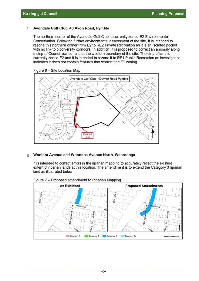
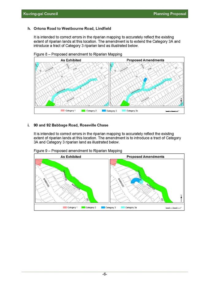
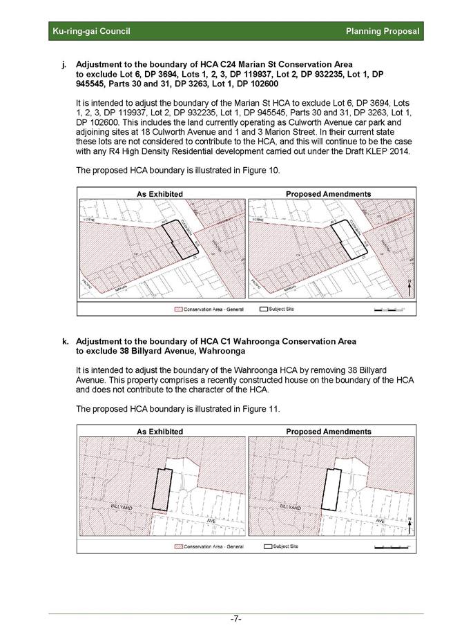
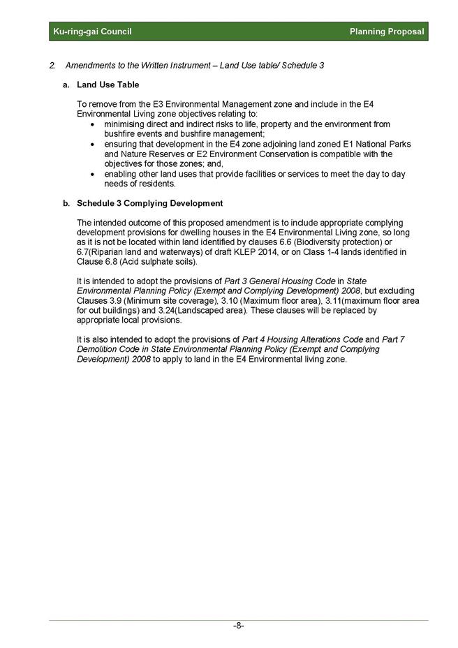
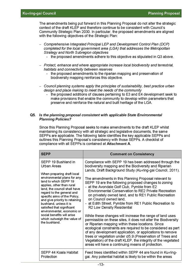
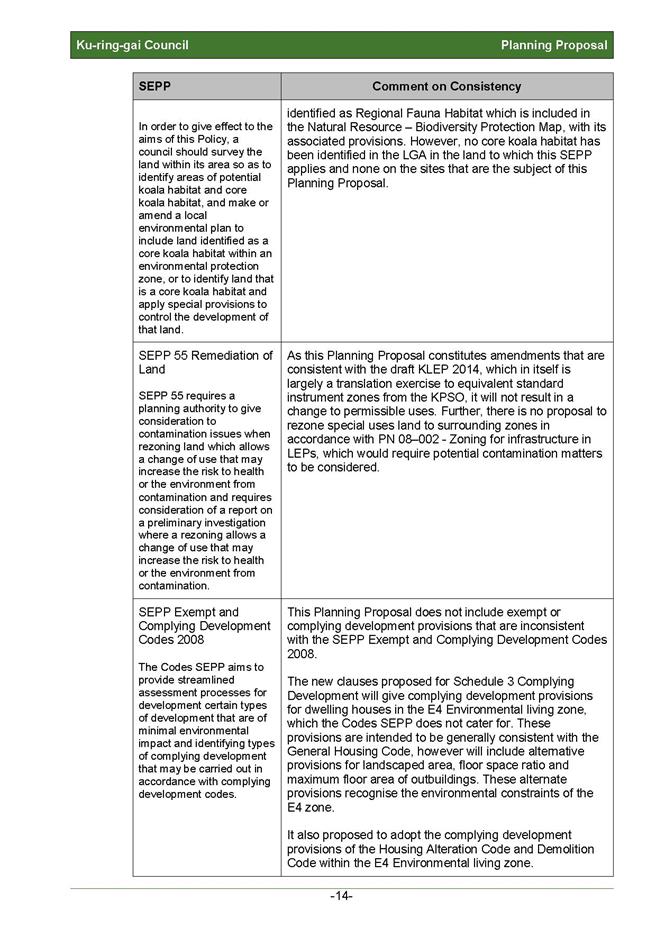
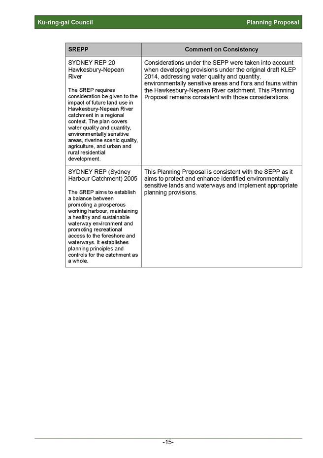
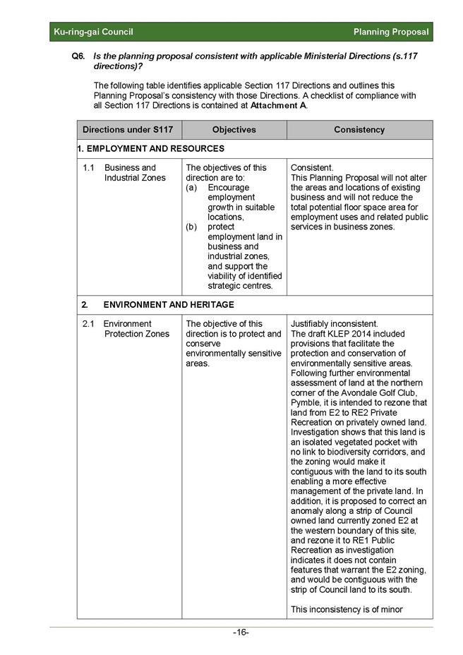
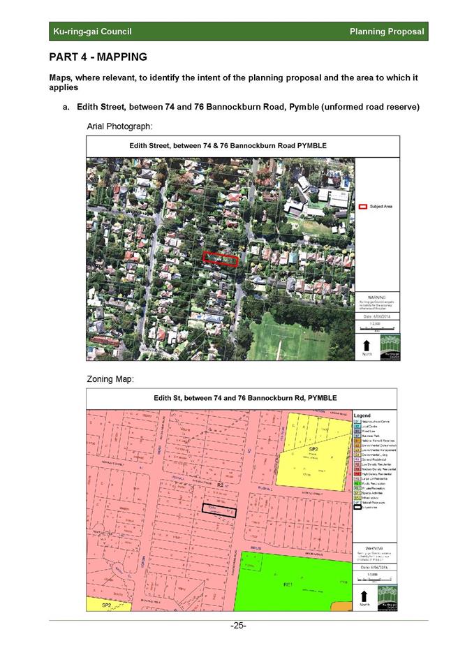
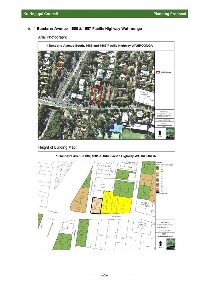
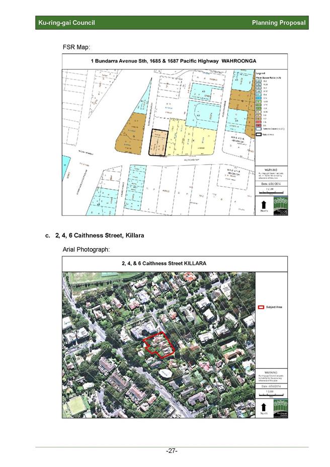
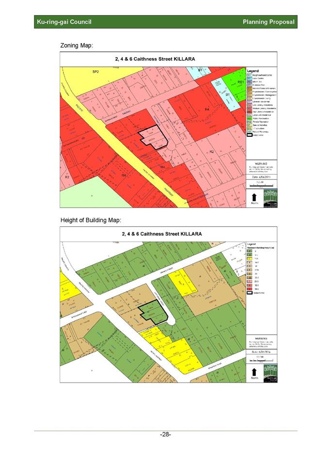
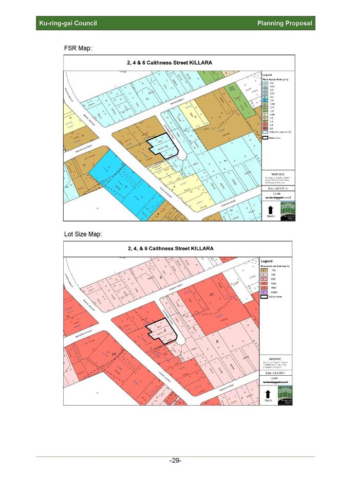
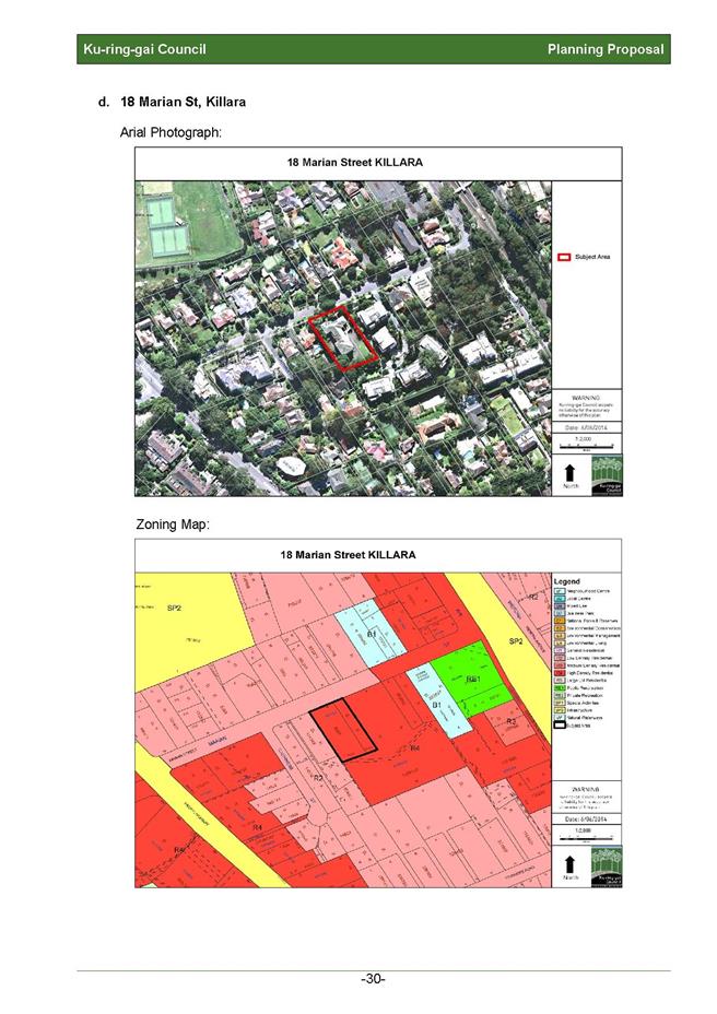
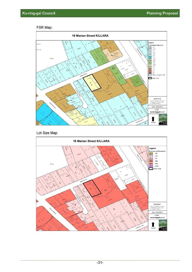
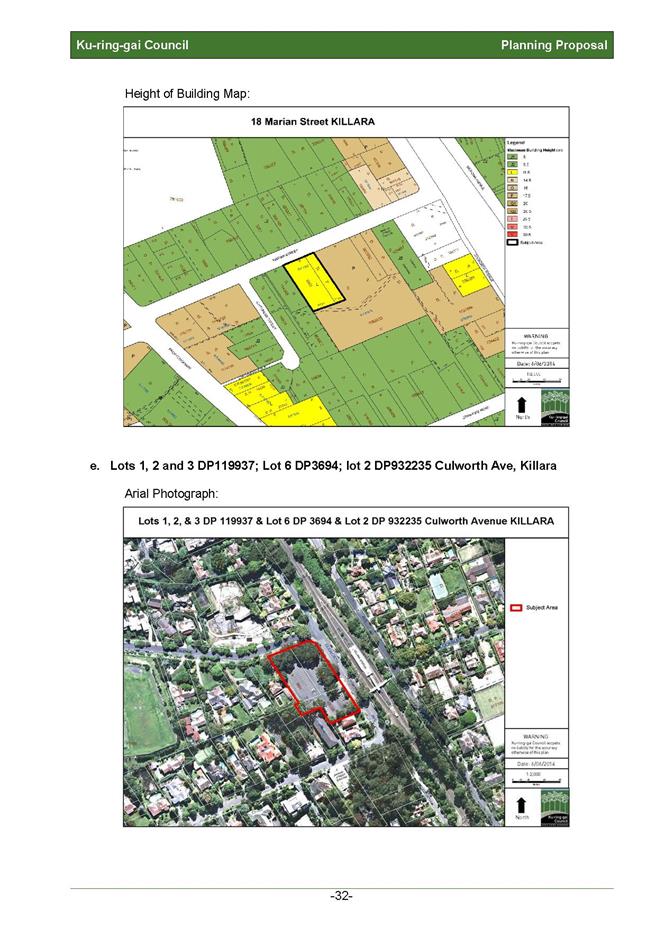
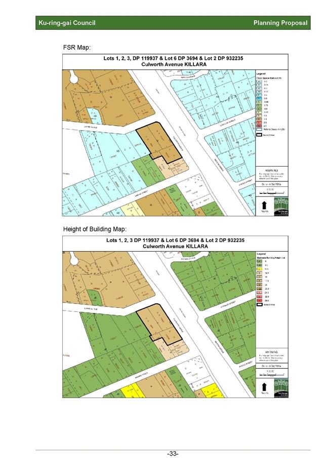
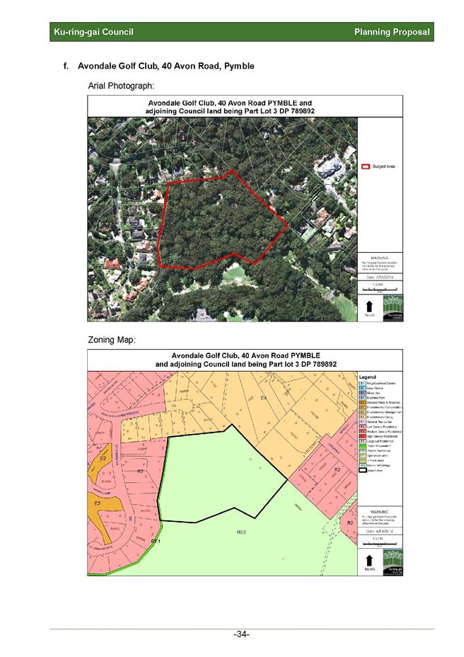
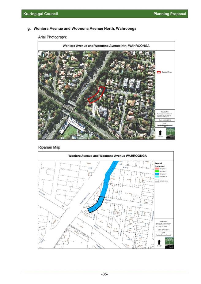
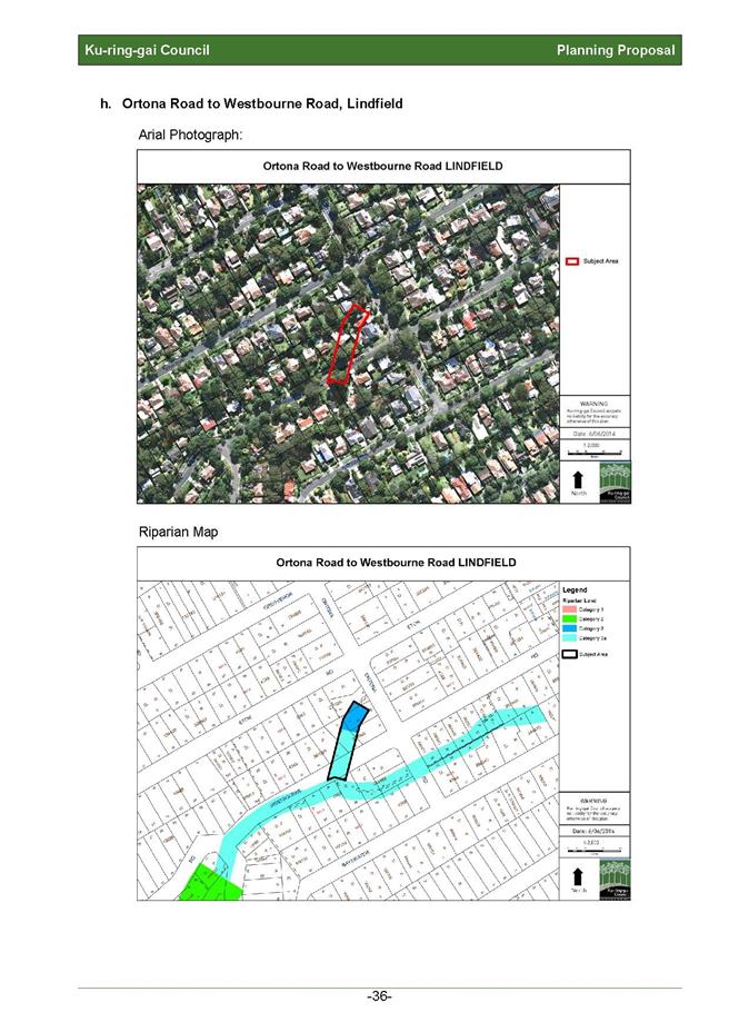
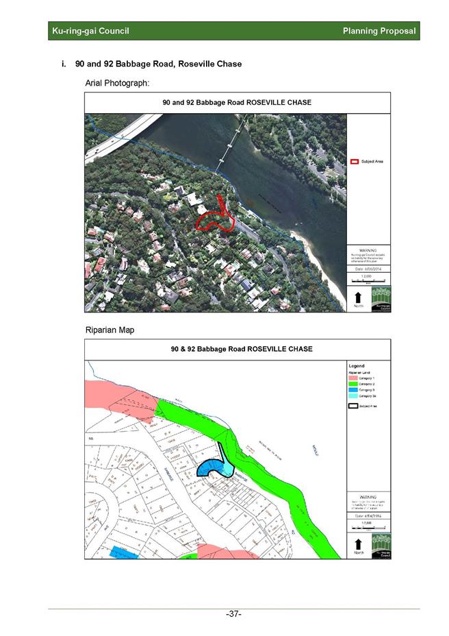
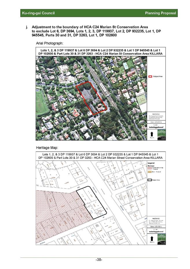
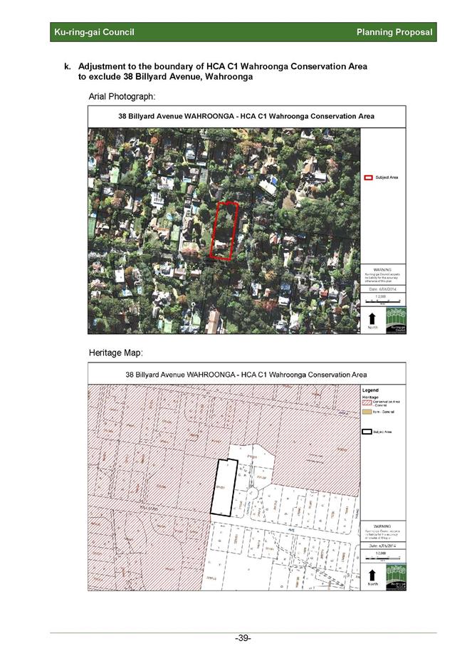
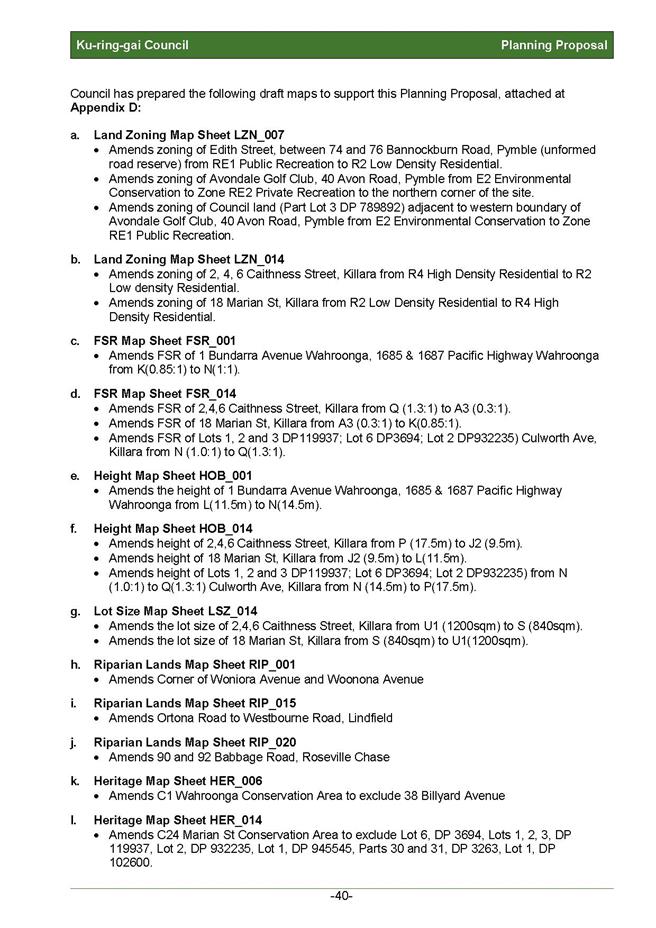
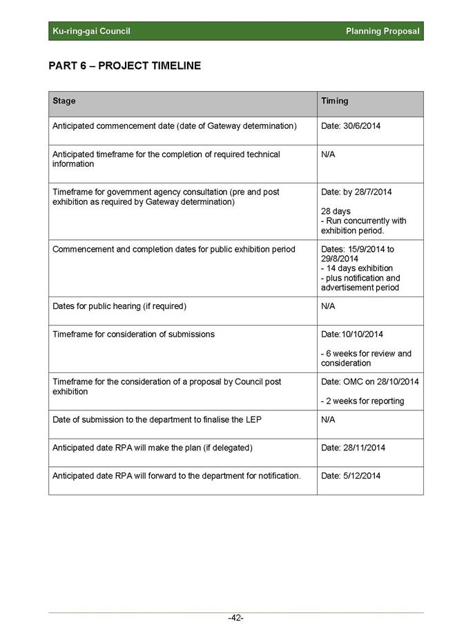
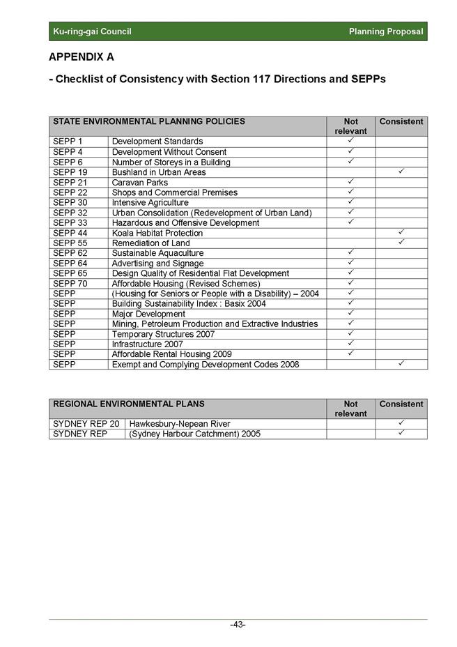
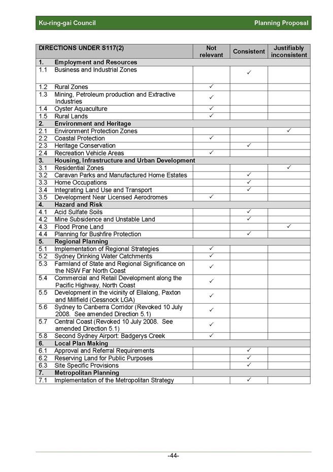
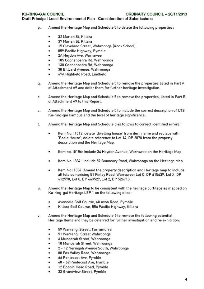
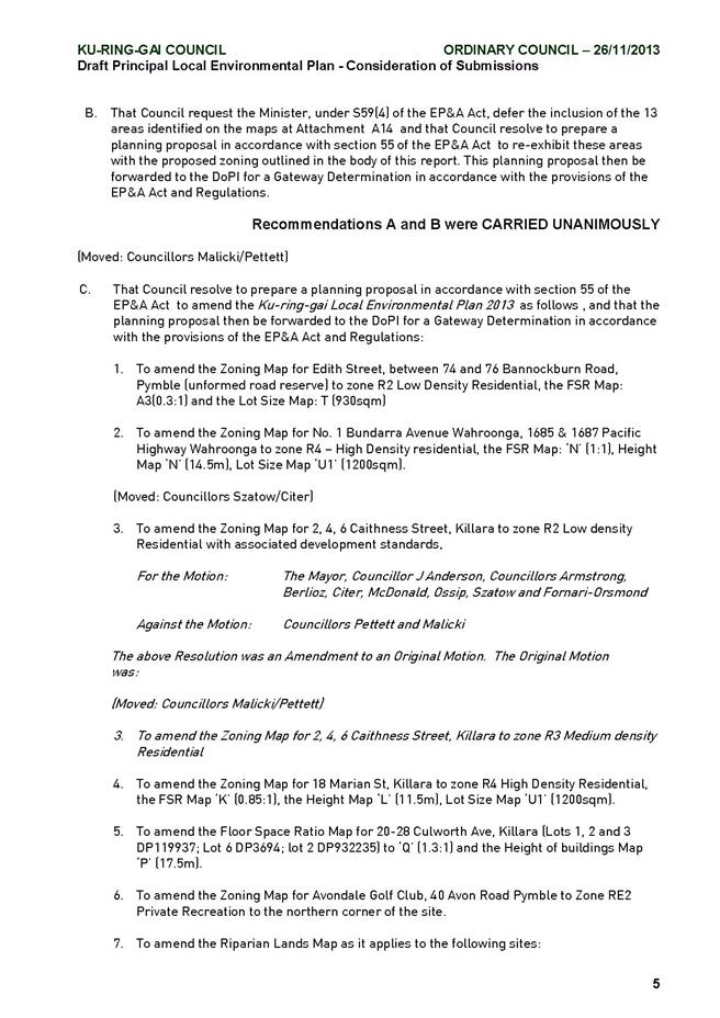
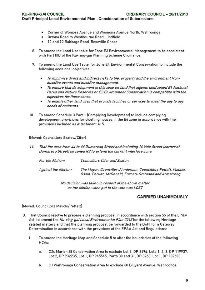
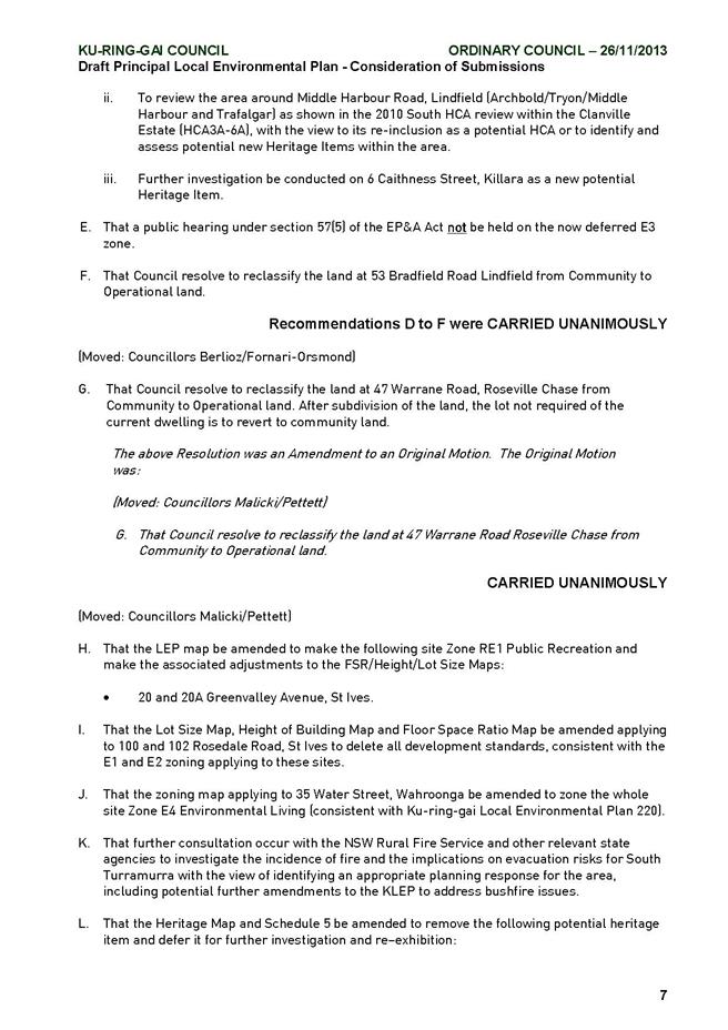

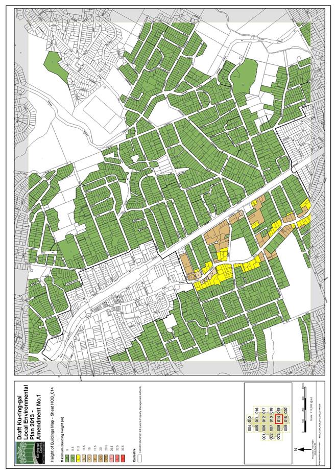
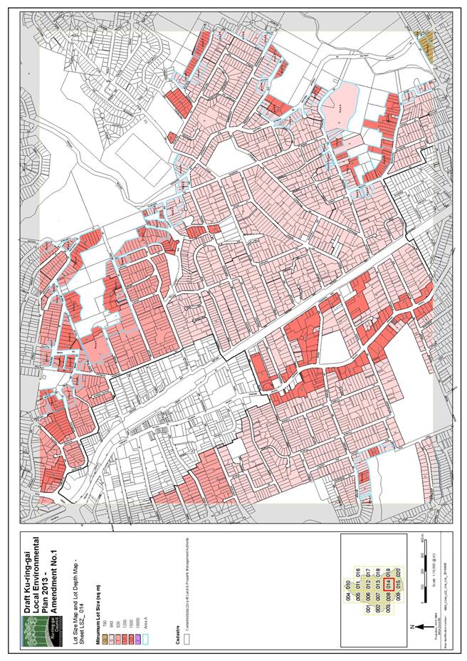
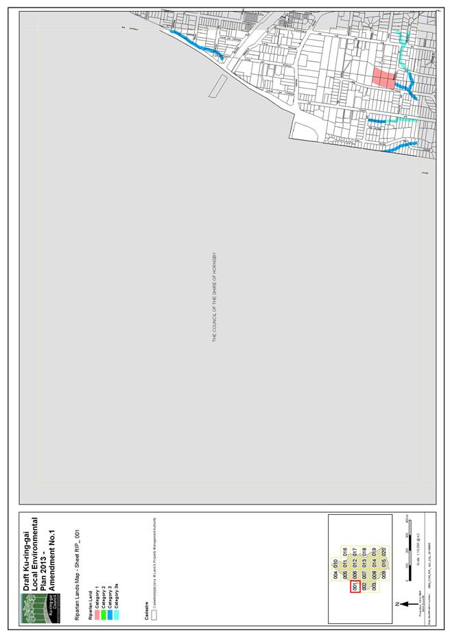
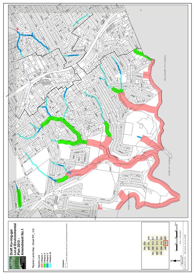
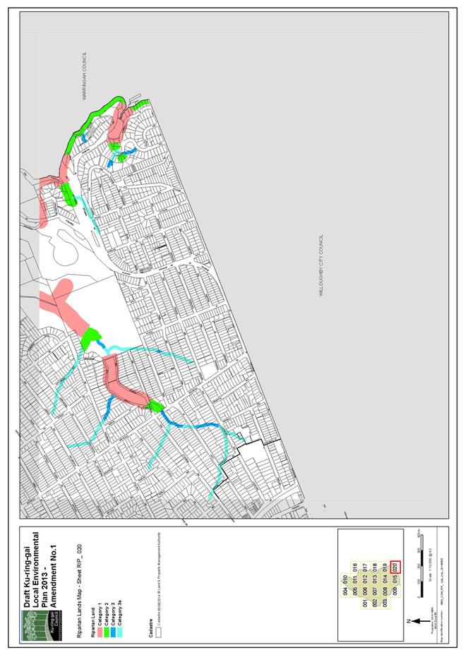
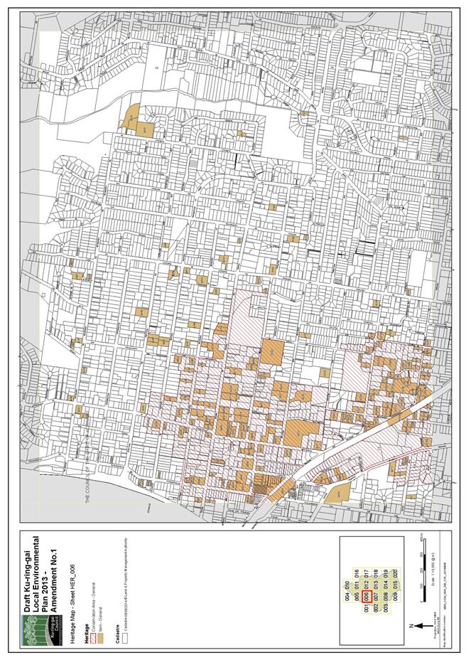
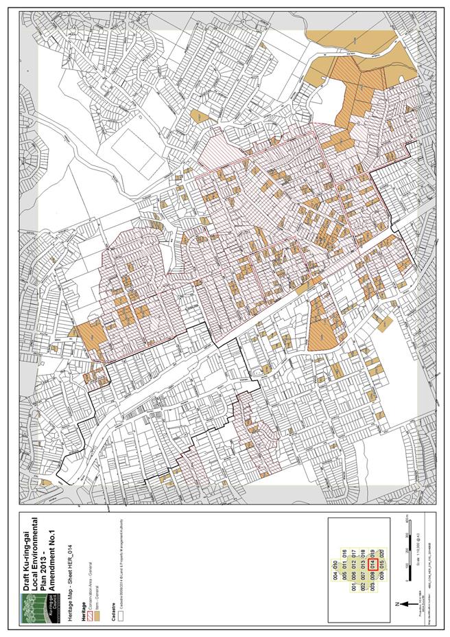
|
APPENDIX No: 2 - Gateway
Determination
|
|
Item No: GB.6
|
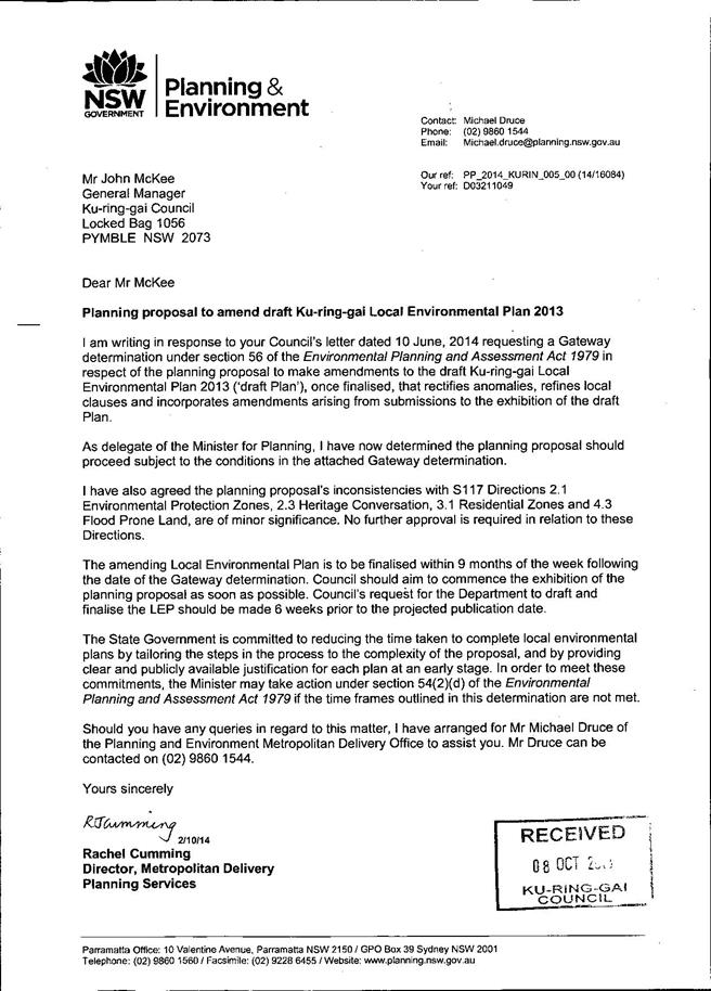
|
APPENDIX No: 3 - State
Agency Submissions
|
|
Item No: GB.6
|
|
APPENDIX No: 4 - Summary
of Submissions
|
|
Item No: GB.6
|
|
APPENDIX No: 5 - Mapping
to 90, 92 Babbage Road, Roseville Chase
|
|
Item No: GB.6
|
|
Ordinary
Meeting of Council - 31 March 2015
|
GB.7 / 326
|
|
|
|
|
Item
GB.7
|
S06785/3
|
|
|
16 March 2015
|
Update Report on the
Development Contributions System
EXECUTIVE
SUMMARY
|
purpose of report:
|
The purpose of this report is to provide Council with
an overview of key activities and highlights in the development contributions
system since the last report to Council in October 2014 and anticipated
actions and highlights for the coming 12 months.
|
|
|
|
|
background:
|
Development contributions are a whole-of-Council
activity, encompassing policy development, development assessment, customer
services, financial management, project management, and delivery of community
assets.
|
|
|
|
|
comments:
|
This report focuses on key aspects of the development
contributions policy, systems management and communications and highlights in
asset instigation.
|
|
|
|
|
recommendation:
|
That the information in the report be received and
noted.
|
Purpose of Report
The purpose of this report is to provide Council with an
overview of key activities and highlights in the development contributions
system since the last report to Council in October 2014 and anticipated actions
and highlights for the coming 12 months.
Background
Development
contributions are a whole-of-Council activity, encompassing policy development,
development assessment, customer service, financial management (including works
programme cash-flow), project management, and delivery of community assets.
A report is provided to Council on a six-monthly basis
(after end of half reserve balances are reconciled), outlining progress on the
delivery of key items of infrastructure through the development contributions
system. This report focuses on key aspects of development contributions policy,
systems management and communications and highlights in asset instigation.
The previous report to the OMC of 7 October 2014 featured
the progress of the rolling schedule of delivery of new open space and the
consequential improvement in access to nearby parkland for the redevelopment
areas along the highway in particular. The key focus of this update report is
the public domain with details of the now-advanced planning of Lindfield’s
major civic projects and a new focus on the commencement of Turramurra’s
community and civic projects.
When Turramurra’s pre-planning and community consultation
phases reach the present status of the Lindfield works, it is anticipated that
the next focus will be the Gordon Community and Civic hub. This major project
will, like Lindfield and Turramurra, be subject to on-going community
consultation throughout the process which will influence the major focus of the
new central multi-purpose community facility and the design of the urban
square.
The report also highlights the progress towards the
provision of other key infrastructure which is wholly or partially funded by
development contributions and the priorities going forward.
Comments
Civic Projects are the focus for 2015/16 and beyond
The previous Contributions Update report focused on the
progress of a rolling works programme of open space delivery which has improved
access – and continues to improve access – to local open space in the areas
currently redeveloping for higher density housing. This report focuses on
civic open space which includes the provision of urban open space within the
hearts of two of our most significant Local Centres – Lindfield and Turramurra
– together with new and improved community facilities. This urban renewal will
support the upgrade of our centres to meet the demands of the Ku-ring-gai
community into the future and are critical due to the concentration of new,
higher-density development within and around these centres. The inclusion of
significant asset renewal projects, such as new community facilities, ensures
that the people of Ku-ring-gai will continue to have access to such facilities
into the future to an appropriate standard for the 21st Century.
It is important to note that, for these major projects, only
a proportion – but a critical proportion notwithstanding – of the funding
derives from development contributions due to the legal requirement for
apportionment between existing and additional demand. The investment of
apportioned contributions, however, does make them a key highlight in
infrastructure delivery for this report.
At the time of finalising this report, the Lindfield Local
Centre Activate Lindfield public exhibition period was due to commence on 21
March 2015 and run until 8 May 2015. This exhibition will present the project
details on both the Lindfield Community Hub and Lindfield Village Green to the
Ku-ring-gai community.
Lindfield Community Hub - west side of Lindfield
This project aims to deliver new community
infrastructure including a local park and town square, a community centre and
new branch library. Consultants are currently preparing four (4) illustrative
development options which will be taken to the community in an extensive
consultation programme from late March through to early May. This is being done
to establish the fundamental controls for the precinct which will be used as
the base for a more detailed master plan for the precinct which will be
reported to Council toward the end of 2015.
Lindfield Village Green- east side of Lindfield
Three (3) alternative Draft Concept Designs
are available for comment during Council’s Activate Lindfield public exhibition
period. All three designs propose;
· Public open
space in the form of a park or civic plaza;
· Public car
parking with long and short-stay options;
· A pavilion
for leasing as a café or restaurant with public seating, toilets and a lift;
· New paving,
seating, landscaping, lighting and underground power lines;
· Climate
cooling features such as cross-ventilation and natural reflective surfaces;
· Water
sensitive urban design features such as stormwater harvesting.
RPS
and Walsh & Major proposal
Lindfield Village Green
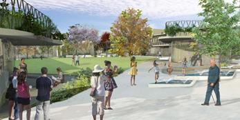
JMD
Design + Tonkin Zulaikha Greer proposal
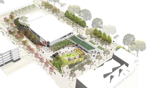
Amber
Road + Outlines LA proposal
Selection of preferred Concept Design, subject to:
· Public response to concepts;
· Cost review of concept options;
· Life cycle cost review of options;
· Accessibility and CPTED (Crime
prevention through environmental design) assessments;
· A review of traffic and parking
proposals;
· A review of against the project brief /
objectives;
· A peer review by specialist council
staff; and
· PCG approval of preferred concept.
A report will be considered by Council in June 2015
recommending a preferred Concept Design to enable progress into the next stage
of design development.
Turramurra Civic Precinct
The Turramurra Civic Precinct project commenced with a
Family Fun Day held in the Ray Street car park in August 2014 which was well
attended by members of the community. The principles for the project master
plan were adopted by Council for exhibition at the end of 2014 and include a
new branch library, multi-purpose community facilities, a large town square, a
linear park, new retail and residential uses, activation of Forbes Lane, and
the potential relocation of Turramurra Village Park within the site.
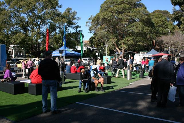
Council will seek community feedback on the developed master
plan in the first half of 2015. Any amendments will be made after exhibition
based on feedback received and internal assessment of the plan and reported
back to Council for adoption in late 2015.
Dumaresq Street to McIntyre Street, Gordon road link
This project involves construction of a new local
road (approximately 144m long) in the Gordon local centre, situated on a 15m
wide road reservation currently
known as 41 Dumaresq
Street and 36
McIntyre Street. The purpose of this road
is
to provide additional
pedestrian,
bicycle and
vehicle
permeability
in
western part of the Gordon local centre by
breaking
up
the long blocks between Pacific Highway and Vale Street. The road will also act as a separation/buffer between the adjoining R3
Medium density Residential and R4
High density Residential zones.
The existing
dwellings on the site have been demolished and
a design for the road
has been completed. Tenders for construction of the road closed on 3
March 2015. Following
an
evaluation
period, the tender is expected
to
be reported to Council in late April
2015, with construction to potentially commence around mid-2015
(subject to contractor availability), and expected to take 6-9
months to complete.
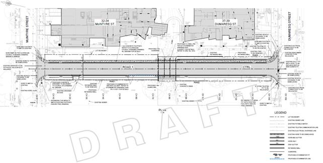
Dumaresq Street to Moree Street, Gordon - road
link
The developers with whom Council
originally negotiated
the VPA
relating to the delivery of the road linkage adjoining the development at 28-30 Dumaresq Street Gordon have on-sold
the
development. The VPA
was registered
on
the title of the land and travels with the land;
it
has now
been
formally novated to the new developers. The purchase of the residual
land
not
required for
the
road reservation was formally finalised as part of this process.
In respect of the continuity
of
road through to Moree Street, the SP2
property to be acquired is the subject of a continuing acquisition process.
Fitzsimons Lane,
Gordon
Two consolidated developments fronting the Pacific Highway at Gordon and backing
on
to Fitzsimons Lane are the subject of proposals for Voluntary Planning
Agreements. These are for the purpose of facilitating the delivery of pedestrian and townscape improvements works required by both the Development Control Plan and the Development Contributions Plan to be
delivered concurrently with these developments. Both developments are required
to
carry out works in Fitzsimons Lane to facilitate vehicular access from the secondary
street rather than the
Pacific Highway and it is logistically essential
that the improvements works under the DCP and CP
are concurrently
carried out to Council’s satisfaction.
Each proposal will be reported to an Ordinary
Meeting of Council prior to the commencement of the public consultation process.
An indirect plan Contribution Plan (Section 94A) for Ku-ring-gai
LGA
Work is progressing on an indirect (s94A) plan for Ku-ring-gai to relate to development that is exempt from direct development contributions (s94) under Ku-ring-gai Contributions Plan 2010
such as knock down rebuilds, major alterations and additions and
commercial
development outside the local
centres. Small scale improvements under $100,000 remain exempt under the
legislation and development with a
capital
cost between $100,000 and $200,000
is
subject to a
limited 0.5% levy. A
1%
levy can only be
applied to development in excess of $200,000. Those
scales and
percentages are fixed under the Environmental
Planning and Assessment Regulation.
The detailed investigation and
drafting
process is also
seeking to resolve the interrelation between the
two types of contributions plans and the practical processes for determining the capital
cost for the purposes of quantifying a contribution based
on
that cost.
It is anticipated that a further report, accompanied
by a draft document, will be formally reported to Council mid-year.
It
is emphasised that the indirect CP is intended to be complementary to the current adopted Ku-ring-gai Contributions Plan 2010 and relate to different development. The current CP will
remain in effect whether or not Council
proceeds with a s94A Contributions Plan for development that is
exempted from the 2010 Contributions Plan.
Voluntary
Planning
Agreements
Council’s
Voluntary Planning Agreement Policy
that guides the negotiation and preparation of Voluntary Planning Agreements has
been in place since 2008. Following
the execution of the second VPA
prepared under that policy it is now due for a review. Drafting
is underway and is anticipated to be reported
concurrent with the draft S94A Contributions Plan in the middle of the year.
integrated planning and reporting
Theme One: Community, People and Culture
|
Community Strategic Plan Long Term Objective
|
Delivery Program
Term Achievement
|
Operational Plan
Task
|
|
C1.1 An equitable and
inclusion
community
that cares and provides for its members
|
Our community facilities are accessible and
function as
cultural
hubs to attract a range of users
|
C6.1.1.1.1-C6.1.1.1.3
New
community
facilities under design
and planned delivery for Lindfield Town Centre
|
|
C4.1 A community that
embraces healthier lifestyle choices and practices
|
New and enhanced open space and recreation facilities have been delivered
to increase community use and enjoyment
|
C4.1.2.1.1;
C4.1.2.1.2; and
C4.1.2.1.3
Greengate Park
ready to open.
Eton Road Oval
and community
centre opened 17
December
2013. Balcombe Park Wahroonga
opened last year. Cameron Park Turramurra ready
to commence construction.
|
Theme Three: Places,
Spaces and Infrastructure
|
Community
Strategic Plan
Long Term Objective
|
Delivery Program
Term Achievement
|
Operational
Plan
Task
|
|
P1.1 Ku-ring-gai’s unique and
visual character and identity
is maintained
|
Place making
programmes
are being implemented
for
selected council
owned areas
|
P1.1.1.1.2
Lindfield town centre – both east and west of the railway
line/Pacific
Hwy
– undergoing
urban renewal
|
|
P2.1 A robust planning framework
is in place to deliver
quality design outcomes and maintain the identity and character of Ku-ring-gai
|
Strategies,
plans and processes are in place to
effectively manage the impact of new development
|
P8.1.1.1.1.1-2
Ku-ring-gai Contributions Plan
2010 ensures new development
contributes towards the cost of delivering supporting
infrastructure.
|
|
P4.1 Our centres offer a broad
range of shops and
services and
contain lively urban village spaces where people can live,
work, shop,
meet and spend leisure time
|
Plans to revitalise local
centres are being progressively implemented and achieve quality design outcomes in collaboration with key
agencies,
landholders and
the
community
|
P1.1.1.1.2
Lindfield
is the first centre to undergo comprehensive Masterplanning for revitalisation.
|
|
P6.1 Recreation, sporting
and
leisure facilities are available
to
meet the community’s diverse and changing needs
|
A programme is being
implemented to improve
existing recreation,
sporting and
leisure facilities and facilitate the establishment of new facilities.
|
C4.1.2.1.2-3;
New facilities are being established including:
Eton Road
Oval, Greengate Park and Cameron Park.
|
|
P7 Multipurpose
community
buildings and
facilities are available to meet the community’s diverse and changing needs
|
Standards are
developed to
improve the
condition and functionality of existing and new assets
|
C6.1.2.1.2
New community facilities including a new library
and multi-purpose community facilities are in the Masterplanning stages for
Lindfield.
|
|
P8.1 An
improved standard of infrastructure that meets the community’s service level
standards and Council’s obligations as the custodian of our community’s assets
|
Our public
infrastructure and assets are planned, managed and funded to meet community
expectations, defined levels of service and address inter-generational equity
|
C6.1.2.1.2; C4.1.2.1.3
New public infrastructure is planned to support
new development and ensure that everyone who lives and works in Ku-ring-gai
continues to
enjoy access to public facilities.
|
Theme Four: Access, Traffic and Transport
|
Community
Strategic
Plan
Long Term Objective
|
Delivery Program
Term Achievement
|
Operational
Plan
Task
|
|
T1.1 A range of integrated
transport choices are available
to
enable effective movement to,
from and around
Ku-ring-gai
|
A network of safe and
convenient links to local
centres, major land uses and
recreational opportunities is
in place
|
C6.1.2.1.1; T1.1.3.1.1
Lindfield Commuter car park, park,
community
facilities and realigned Drovers Way.
|
|
T3.1 An
accessible public
transport and regional road
network that meets the diverse
and
changing needs of the
community
|
A strategic access, traffic
and transport plan is being implemented for the
Northern Sydney Region
|
C6.1.2.1.1;
T 1.1.3.1.1
Commuter car parking
and
new link roads
|
Theme Six: Leadership
and
Governance
|
Community
Strategic
Plan
Long Term Objective
|
Delivery Program
Term Achievement
|
Operational
Plan
Task
|
|
L1.1 A
shared long term vision
for Ku-ring-gai underpins strategic collaboration, policy
development and community engagement
|
Council’s responses to
government policy
and
reforms are guided
by and aligned with the adopted
Community
Strategic Plan
2030 “Our Community – Our
Future”
|
L1.1.2.1.1
and
L1.1.2.1.2
Ku-ring-gai made a comprehensive submission to
the White Paper and Planning Bill and continues to have input into on-going planning
for the future Planning
System in respect of the future contributions system with the Department of Planning and Infrastructure
|
|
L2.1 Council rigorously
manages its financial resources and assets to
maximise delivery of services
|
Council expenditure satisfies
the needs of the community and Council has
increased its commitment to infrastructure asset management priorities
|
C6.1.1.1.2
Council is leveraging the value of its assets to
combine with contributions to deliver major community assets in Lindfield
|
Governance Matters
Regular reporting
The need to give members of Council and the community more information on the progress and activity in the development contributions systems was identified as part of the Delivery
Program and the Operational
Plans. This update report has been provided regularly (six-monthly) since 2011. It is also intended to provide additional
information and links on Council’s website
throughout the year.
Internal
audit
Council’s Contributions System was recently
the focus of an internal
review in 2013/14. While generally the system is well managed,
there are a
couple of areas that could
be further improved including documenting
and
updating of current procedures for incorporation in the procedures
manuals of each relevant section of Council which is involved
in
a component of the contributions
process, and a formal
audit that contributions arising from privately
certified applications have been paid
(and
appropriate legal
proceedings instigated if required). That remains a work-in-progress.
Risk Management
A rolling works program
The works programme arising out of Ku-ring-gai Contributions Plan 2010 through to at least 2031 is a multi-million dollar undertaking.
Infrastructure delivery will
be possible only through the receipt of contributions which will be affected by several
economic cycles over the life of the
contributions plan.
The risks in taking such a
strategic horizon are managed
through regular
reviews of the contributions plan,
at
a minimum after the release of data from each five-yearly
census or, more frequently,
if
the pace or scale of development is definitely changed
by any statutory process or economic cycle.
The rate and scale of development is monitored by Council
staff. Sydney Water figures for delivered
dwelling yield
are also referenced.
Acquisition of a
number of targeted sites by negotiation has not been possible. Council may
need
to consider compulsory acquisition of some of these sites to assist with finalisation of a
range of park and local
road land projects in a
timely
manner.
If
this approach becomes necessary,
this would present a risk.
Proposed
reforms to the Planning
Legislation that governs development contributions
It seems as if the Planning
Reforms that were intended to replace the Environmental Planning and Assessment Act with a new piece of legislation have not significantly
progressed since they failed to gain Senate support at the end of 2013.
There are alternative mechanisms available to the NSW
Government for the introduction of some of the reforms affecting development contributions,
for
example via Ministerial Direction under s94E or via amendments to the
Environmental Planning
and Assessment Regulation.
This matter may be revisited after
the election in March.
Fit
for the Future
A more pressing issue is the uncertainty
over the form of Local
Government in the region beyond 2016. Development contributions and the funding and delivery of infrastructure supporting
development are some aspects among
many
of
the Fit for the Future issues.
Input into
documentation is being
prepared for Ku-ring-gai Council’s submissions.
Financial Considerations
Council
maintains a
dynamic Long
Term Financial Plan. The works program of Ku-ring-gai Contributions Plan 2010 was integrated into the Long Term Financial Plan
from the start of 2011 and adopted by Council
on
3 May 2011. Since that date,
it
has been updated annually
and
duly reported
to
Council to ensure its currency. Staff from both the Finance Unit and the Urban Planning & Heritage Unit monitor both income and development growth respectively and liaise to maintain a
deliverable works programme. The scheduling
of
works through to the long
term should
be considered somewhat fluid
depending on strategic
opportunities that might arise from time-to-time and the management of cash flows during the economic
cycle.
In this context, the Ku-ring-gai Contributions Plan 2010 comprises a
large range of works from small-scale parkland embellishments to major community
infrastructure which facilitates considerable flexibility
in
managing a financially
deliverable work programme over time.
Ku-ring-gai Council
Finance staff continue to refine the cash-flow management of development contributions to support and
facilitate the delivery programme over the life of the Contributions Plan.
As
part of this process, staff from both the Finance Unit and the Strategy Planning Unit have met to consider managing the issue of pooling
contributions across the Contributions Plan to
facilitate an efficient programme of infrastructure delivery over time.
A
much-anticipated improvement is a dedicated cash-flow management system feeding into the Long
Term Financial
Plan for the analysis and improved
financial cash-flow management of development contributions.
This remains a high priority in view of the multiple sources of funding for major projects.
Social Considerations
Ku-ring-gai Local
Government Area has been going
through a
period of change commencing
in 2004. This is bringing about population growth and
demographic change following years of declining and stable population since the 1980s. Infrastructure is essential
to
support and encourage the integration of the new residents in Ku-ring-gai, both among residents of the new
dwellings being
built and those moving
into larger existing housing
vacated by
the members of Ku- ring-gai’s older population who have ‘downsized’ into smaller local
accommodation.
The provision of additional community infrastructure providing
both outdoor and indoor community spaces will continue to support this process and help Ku-ring-gai
continue to be a
vibrant and popular place to live for all
ages.
Ku-ring-gai Council
continues to prioritise the delivery
of
community
infrastructure in areas of high development activity
and
in
accessible locations for the majority of residents as well as local
businesses and their employees.
Environmental Considerations
Environmental
considerations are part of the detailed
design of every
item of infrastructure provided for in the Contributions Plan.
The provision of this infrastructure is required to support cohesive and
sustainable communities in areas of increasing urbanisation.
Community Consultation
One of the areas where Council could
do
better is in the publication of information relating to the delivery
of
infrastructure arising from development contributions on an on-going basis. The review, redesign and upgrade of Ku-ring-gai Council’s website can facilitate this process. This remains a key objective but has been delayed
by other priorities.
As well
as
providing
a current information resource for the community and local
developers,
this visual
demonstration of Council’s on-going
delivery of infrastructure will also assist in addressing inquiries from the media and
from external development agencies related to the expenditure of development contributions and the delivery of infrastructure.
Internal Consultation
The management of the development contributions system is a truly
whole-of-Council
system from policy development,
to
contributions calculation, through inflation and receipting to
infrastructure development.
All
aspects of the contributions system are co-ordinated across
Council
with input from all
areas with a direct interest in that aspect on an on-going
basis.
Summary
This report summarises where Ku-ring-gai
is heading in the delivery of infrastructure funded,
or
partly funded, by development contributions across the LGA with particular reference to the local
centres where the majority of redevelopment is concentrated. It includes an update on the community and civic projects currently
in
the advanced planning stages for Lindfield
and
early
planning stages for Turramurra. This report
is
the seventh in a
series of six-monthly
updates since 2011.
It should
be noted that this is a summary outline report.
More technical financial
detail is
reported quarterly in Council’s Long Term Financial
Plan,
in
Council’s annual budget and,
in
respect of major items of infrastructure
for example Lindfield Community
Hub,
Lindfield Village Green and the Turramurra Civic Project are also subject to separate,
more
detailed, reporting.
|
Recommendation:
That the latest update report on the development
contributions system in Ku-ring-gai be received and noted.
|
|
Kate Paterson
Infrastructure Co-ordinator
|
Antony Fabbro
Manager Urban & Heritage Planning
|
|
Andrew Watson
Director Strategy & Environment
|
|
|
Ordinary
Meeting of Council - 31 March 2015
|
GB.8 / 338
|
|
|
|
|
Item
GB.8
|
S06342/3
|
|
|
6 February 2015
|
Review and Amendments to the
Bush Fire Prone Land Map
EXECUTIVE
SUMMARY
|
purpose of report:
|
For Council to note amendments to
the Bush Fire Prone Land Map 2008 and to seek Council's approval to exhibit
the draft Bush Fire Prone Land Map 2015 for the Ku-ring-gai Local
Government Area (LGA).
|
|
|
|
|
background:
|
The Environmental Planning and Assessment Act 1979
and the Rural Fires Act 1997 require councils to prepare a Bush Fire
Prone Land Map (BFPLM) every five years. This map is certified by the
Commissioner of the NSW Rural Fire Service. The BFPLM formally identifies
land affected by a bush fire hazard and acts as a legislative trigger for the
consideration of appropriate planning and development controls. The last
significant review of the BFPLM was undertaken in 2008. The NSW Rural Fire
Service released a revised methodology for assessing bush fire prone lands in
September 2014. This report includes the draft BFMLP 2015 for the Ku-ring-gai
LGA to be exhibited for public comment.
|
|
|
|
|
comments:
|
The NSW Rural Fire Service ‘Guide for Bush Fire Prone
Land Mapping’ (2014) was used as the basis for the review. The amended
mapping identifies 3,128 hectares of Bush Fire Prone Land in the Ku-ring-gai
LGA, resulting in 11,957 bush fire prone properties. These changes have not
reduced evacuation risk. As a result, the exclusion areas for SEPP – Seniors
Living and SEPP 53, as identified on the 2008 Bushfire
Evacuation Risk Map, are recommended to be retained.
|
|
|
|
|
recommendation:
|
That Council approve the draft Bush Fire Prone Land
Map 2015 for public exhibition and seek the approval from the Department of
Planning to apply the Bush Fire Evacuation Risk Map overlay as previously
identified in the 2008 certification process.
|
Purpose of Report
For Council to note amendments to the Bush Fire Prone Land
Map 2008 and to seek Council's approval to exhibit the draft Bush Fire Prone
Land Map 2015 for the Ku-ring-gai Local Government Area (LGA).
Background
In August 2002 the Rural Fires and Environmental
Assessment Legislation Amendment Act 2002 was introduced to ensure
that people, property and the environment are better protected against bush
fire. This legislation amends both the Environmental Planning and Assessment
Act 1979 [EP&A Act (1979)] and the Rural Fires Act 1997 [RF Act
(1997)] and requires the submission of a map of Bush Fire Prone Land for
certification by the Commissioner of the NSW Rural Fire Service (NSW RFS). This
map must be reviewed every five (5) years.
It is a requirement of the NSW RFS that the Bush Fire Prone
Land Map (BFPLM) be prepared according to specifications contained in the Guide
for Bush Fire Prone Land Mapping (NSW RFS 2014), provided as Attachment
A1. This is to ensure legibility, to establish consistency across NSW and
to assist in creating a more streamlined system for planning for bush fire
protection.
The BFPLM formally identifies land affected by a bush fire
hazard and acts as a legislative trigger for the consideration of appropriate planning
and development controls. Council is required to make the BFPLM available for
public inspection. Section 149 of the EP&A Act (1979) requires that Council
may, in a planning certificate, include advice if the land has potential to be
subject to bush fire attack. This is an important mechanism to alert people to
the potential for bush fire attack through a formal planning process and to
alert people looking to purchase property in bush fire prone areas as to the
level of risk they may face. The provisions of the EP&A Act (1979) also
require that new development on Bush Fire Prone Land must comply with the
requirements of the RFS publication Planning for Bush Fire Protection (NSW
RFS 2006). For the purposes of the Building Code of Australia, designated Bush
Fire Prone Land maps are used to give effect to the Australian Standard AS 3959
– 2009 ‘Construction of buildings in bush fire prone areas’.
Ku-ring-gai’s first BFPLM was approved by the Commissioner
of the NSW RFS in 2002. This was subsequently revised in January 2008. The
2008 revision was informed by detailed site inspections and community
consultation which led to a number of minor boundary adjustments and category
reclassification. Additionally the revision also led to an expansion of SEPP Seniors
Living and SEPP 53 exclusion areas (enabled under the Environmental Planning
and Assessment Act 1979).
Since this first revision in 2008, a number of sites have
been identified as needing reclassification as a result of development and
property maintenance altering the structure of bushland. Council previously
attempted to amend the 2008 BFPLM within the 5 year review period (as reported
to Council at its Ordinary Council Meeting of 7 March 2011). These amendments
were referred to the NSW RFS Commissioner but were not addressed by the NSW
RFS. Hence, they have been incorporated into this current review.
In addition, the introduction of the 10/50 vegetation
clearing entitlements and subsequent revisions to the Bush Fire Prone Land
mapping methodology have resulted in further amendments to the way Category 1
and Category 2 vegetation is assessed and mapped.
In December 2014, following the release of the Guide for
Bush Fire Prone Land Mapping (NSW RFS 2014) and the associated metadata,
Eco Logical Australia were contracted to validate and update the Ku-ring-gai
BFPLM in line with the new methodology, to enable Council to seek certification
of its updated mapping from the NSW RFS and thus meet its statutory obligations
in regard to maintaining the currency of the mapping.
Comments
Methodology
The creation of the draft BFPLM 2015 involved a review of
existing Bush Fire Prone Land mapping and vegetation extent and structure, as
per the Guide for Bush Fire Prone Land Mapping (NSW RFS 2014); through
aerial photograph interpretation (API) across the LGA and supplementary field
validation specifically targeting areas of interest, areas of uncertainty (in
API) and areas of greatest change.
Rules for determining vegetation categories were amended in
the Guide to Bush Fire Prone Land Mapping (NSW RFS 2014) and are
provided in Table 1. Vegetation has been categorised based on vegetation type,
size (hectares) and structural characteristics. Areas of remnant vegetation
(<2.5 ha) and short fire run (<100m width) vegetation have also been
incorporated into the categorisation process.
Table 1 - Rules for determining vegetation categories
|
Category
|
Vegetation Type
|
Size (ha)
|
Remnant and short fire run
|
|
Vegetation Category 1
|
Forest, woodland, heaths (tall and short), forested
wetlands and timber plantations.
|
>= 1 ha or < 1 ha when within 100m of other Category
1 vegetation or within 30m of other Category 2 vegetation.
|
Remnant and short fire run vegetation within 30 metres of
each other where the combined area is greater than 2.5 hectares or when
within 100 metres of other Category 1 vegetation or within 30 metres of other
Category 2 vegetation.
|
|
Vegetation Category 2
|
Grasslands, freshwater wetlands, semi-arid woodlands, arid
shrub lands and rainforests.
|
>= 1 ha or < 1 ha when within 100m of other Category
1 vegetation or within 30m of other Category 2 vegetation.
|
Remnant and short fire run vegetation greater than 100
metres lateral separation from Category 1 vegetation and 30 metres from other
Category 2 vegetation.
|
Areas excluded from being mapped as bush fire prone
vegetation included:
i. single
areas of vegetation less than 1 hectare in area and greater than 100 metres
separation from other areas of Category 1 or Category 2 vegetation;
ii. multiple
areas of vegetation less than 0.25 hectares in area and not within 30 metres of
each other;
iii. strips
of vegetation less than 20 metres in width, regardless of length and not within
20 metres of other areas of Category 1 or Category 2 vegetation;
iv. areas of
“Managed grassland” including grassland on, but not limited to, grazing land,
recreational areas, commercial/industrial land, residential land,
airports/airstrips, maintained public reserves and parklands, commercial
nurseries and the like;
v. areas of
managed gardens and lawns within curtilage of buildings;
vi. non-vegetated
areas, including waterways, roads, footpaths, buildings and rocky outcrops;
vii. managed
botanical gardens;
viii. agricultural
lands used for annual and/or perennial cropping, orchard, market gardens,
nurseries and the likes are excluded; and
ix. mangroves.
A bush fire prone vegetation buffer has been applied around
all Category 1 and Category 2 vegetation to identify properties at risk. For
Category 1 vegetation this distance is 100 metres from the edge of the bush
fire prone vegetation and for Category 2 this distance is 30 metres. These
distances are derived from research that has shown that 85% of house loss as a
result of a bush fire occurs within the first 100m from bushland. This distance
is reduced for Category 2 bush fire prone vegetation as it is believed that
this category has a lower overall bush fire risk.
While the BFPLM acts as a legislative trigger for the
consideration of appropriate planning and development controls it is
acknowledged that the buffer distances also currently determine the 10/50
vegetation clearing entitlement areas. The current affiliation between the
BFPLM buffer and 10/50 vegetation clearing entitlement areas however is not the
focus of this report and the BFPLM buffer should be viewed as being primarily a
legislative trigger for the consideration of appropriate planning and
development controls.
Results
The current review of the BFPLM has resulted in a number of
changes. These fall into four broad groups:
1. Bush
fire prone vegetation retained – these areas portray minimal/ no change and
under the new methodology continue to meet the criteria to be assessed as bush
fire prone land. These areas can be broken down into the following categories
a. Category
retained;
b. Category
adjusted to Category 2 vegetation; and
c. Category
adjusted to Category 1 vegetation.
2. Bush
fire prone vegetation removed – these are areas that:
a. were
mapped as bush fire prone vegetation in 2008 but have undergone changes to the
extent that they no longer constitute a bush fire threat as provided for in the
planning and bush fire regulations. For example, some areas that once contained
fire prone vegetation have been subject to development, clearing or management
and no longer constitute a bushfire threat; or
b. are
now excluded from being mapped as bush fire prone in accordance with the Guide
for Bush Fire Prone Land Mapping (NSW RFS 2014).
3. Bush
fire prone vegetation added – these are areas that:
a. were
not mapped as bush fire prone vegetation in 2008 but have been added as part of
this update as they have undergone changes to the extent that they now
constitute a bush fire threat; or
b. are
now a consideration in accordance with the Guide for Bush Fire Prone Land
Mapping (NSW RFS 2014).
4. Minor
boundary adjustments – a large number of changes on the amended map are minor
boundary adjustments which are a direct consequence of using high resolution
aerial photography and/or undertaking detailed ground validation exercises.
These are typically areas where the overall category has been retained but
there have been small changes in vegetation extent due to vegetation removal,
addition or past mapping error. Typically these adjustments result in boundary
shifts in the order of 0.5-20m.
The draft BFPLM 2015 is significantly more accurate than the
2008 map and has incorporated relevant changes to land use and conditions since
the previous map was certified in 2008. A detailed analysis of the methods and
resulting amendments are provided in the consultant’s report as Attachment
A2. The proposed changes to the 2008 map are summarised in Tables 2 and 3.
The draft BFPLM 2015, excluding the evacuation risk overlay, has been produced
by the NSW RFS and is provided as Attachment A3. This has been used to
calculate the total number of bush fire prone properties, provided in Table 2.
Table 2 – Changes to the Bushfire Prone Land Map for
the Ku-ring-gai LGA
|
|
Category 1
vegetation (ha)
|
Category 2
vegetation (ha)
|
Buffer
area (ha)
|
Total number of
bush fire prone properties
|
|
2008 map
|
3199.1249
|
5.5654
|
1788.2833
|
14638
|
|
Draft BFPLM 2015
|
3050.6310
|
78.1298
|
1469.9571
|
11957
|
|
Overall change
-/+
|
-148.4940
|
+72.5645
|
-318.3262
|
-2681
|
Table 3 - Summary of changes to the affected land
under the draft BFPLM 2015
|
Bush fire prone
vegetation changes
|
Area (ha)
|
|
Category retained (no category change)
|
3,036
|
|
Bush fire prone vegetation retained – adjusted from
Category 1 to Category 2
|
74
|
|
Bush fire prone vegetation added
|
7
|
|
Bush fire prone vegetation removed
|
93
|
Evacuation Risk Map
The 2008 BFPLM for Ku-ring-gai
incorporates a Bushfire Evacuation Risk Map. This prohibits additional SEPP
Seniors Living, and SEPP 53 developments in specified exclusion zones. This
planning control was made pursuant to section 146 of the Environmental Planning
and Assessment Act 1979 and is also referenced within part 17 of Council’s
Principal DCP (2014). The rationale for this addition is that it recognises the
poor access and egress in certain areas based on topography, road and lot
layout and the characteristics of demographics that make these demographics
particularly vulnerable to the impacts of bush fire. As part of the review
process it is proposed that the Department of Planning is formally contacted
and a request is made for Council to continue to apply the current SEPP Senior
Living and SEPP 53 exclusion zones in the Bushfire Evacuation Risk Map, to be
displayed in conjunction with the updated BFPLM 2015.
A councillor briefing on the revised methodology and draft
BFPLM 2015 was conducted on Tuesday 3 March 2015. At this briefing some
concerns were raised about the accuracy of the mapping of particular parcels of
land, based on the aerial photograph interpretation (API) and supplementary
field validation conducted as part of the review process.
To aid the review process, Council staff ask that any
Councillor concerns relating to particular parcels of land are formally raised
as part of the public exhibition period, so that they can be collated and
addressed by Eco Logical Australia with the other submissions, as one process.
It should be noted, however, that whilst Council staff have adopted a robust
review methodology there are not the staff resources or the capacity to field
validate every property in the LGA and hence further inquiry and / or field
validation will be focused on targeted areas of interest, areas of uncertainty
(in API) and areas of greatest change.
integrated planning and reporting
Community, People and Culture
|
Community Strategic Plan Long Term Objective
|
Delivery Program
Term Achievement
|
Operational Plan
Task
|
|
An aware community able to prepare and respond to the risk
to life and property from emergency events.
|
Plans are developed in partnership with emergency service
agencies and key stakeholders and implemented.
|
Review, implement and report on the Bush Fire Risk
Management Plan in consultation with the Hornsby / Ku-ring-gai Bush Fire Risk
Management Committee.
|
Governance Matters
Bush Fire Prone Land maps and the associated digital data
are owned by the NSW RFS and held in custody by respective councils. The NSW
RFS requires councils to prepare the BFPLM and make these maps available for
public inspection. Section 146 of the EP&A Act 1979 includes provisions for
Council to update the BFPLM every five (5) years.
Risk Management
It is a requirement of the Rural Fires and Environmental
Assessment Legislation Amendment Act 2002 for councils to map Bush Fire
Prone Land within their LGA to ensure that people are better informed, and that
people, property and the environment are better protected against bush fire.
The BFPLM serves as an important planning mechanism for Council to alert people
living or looking to live or develop in areas prone to bush fire attack and to
plan development that minimises their bush fire risk.
Financial Considerations
The preparation of the draft BFPLM 2015 has involved the
engagement of consultants Eco Logical Australia at the agreed consultancy fee.
In relation to development within Bush Fire Prone Land,
there will be an economic impact in terms of permissible standards of
construction, design and layout related to each site. This will only affect
new dwellings, alterations and additions and not current buildings.
Social Considerations
Council has responsibilities under the Local Government
Act 1993, the Rural Fires Act 1997 and the Fires and
Environmental Assessment Legislation Amendment Act 2002 to manage public
land to protect and preserve the bushland, minimise the occurrence and spread
of bush fire on land under its care and control, and reduce the risk of bush
fire to the community. The BFPLM assists in ensuring that bush fire safety
provisions are incorporated into new development where that development is
identified as being located in an area of risk.
Environmental Considerations
Council and private landholders have statutory obligations
with respect to fire management and protection of the natural environment.
Identifying Bush Fire Prone Land will not directly result in environmental
impacts. However, the new Guide for Bush Fire Prone Land Mapping (NSW
RFS, 2014) attempts to present a more refined and accurate methodology for
assessing the risk and likelihood of bush fire attack, to assist in reducing
unnecessary impacts to canopy extent, Endangered Ecological Communities, threatened
species, heritage, soil erosion and riparian systems, as a result of the
recently introduced 10/50 vegetation clearing entitlement rules. It is
important for Council to consider best practice measures that will reduce risk
and conserve our environment, biodiversity and local area values/amenity.
Community Consultation
The draft BFPLM 2015 has been prepared in accordance with
the Guide for Bush Fire Prone Land Mapping 2014 (NSW RFS 2014). Council
has maintained a record of community queries and requests to undertake spot
reviews of the 2008 BFPLM. These records have been incorporated into the
current review under the new methodology. Representatives from NSW RFS Head
Office, the Hornsby Ku-ring-gai District RFS Fire Control Centre and Fire and
Rescue NSW have contributed to the preparation of the draft BFPLM 2015. In
light of the strategic importance of this process the consultation process
to-date has sought to:
· ensure a consistent approach in the
interpretation and application of the mapping guidelines;
· ensure mapping processes are
consistent;
· obtain an expert opinion on areas
where the classification of land is unclear or potentially conflicting.
It is proposed that the draft BFPLM 2015 be placed on public
exhibition for 28 days. Large copies of the amended map will be placed on
display and residents will be invited to make submissions. These maps will be
made available on Council’s website, at Council Chambers and at Council’s four
(4) libraries. Supporting documentation will be made available to provide the
community with information on the review methodology. The public exhibition
period will be promoted through Council’s social media platforms, including
Facebook and Twitter; online e-news communications; and local news media. Property
owners who have been identified as having an increase in encumbrances will be
notified of the public exhibition period by mail.
Following the public exhibition period, a report will be
brought back to Council outlining any changes and recommended amendments to the
draft BFPLM 2015 and to seek a resolution from Council to refer the final BFMLP
2015 to the NSW RFS for their certification.
Internal Consultation
Key staff from Strategy and Environment (Environment and
Sustainability and Urban and Heritage Planning teams), Development and
Regulation, and Operations directorates have been consulted during the
preparation of the draft BFPLM 2015.
Summary
The Rural Fires and Environmental Assessment
Legislation Amendment Act 2002 requires the submission of a map of
Bush Fire Prone Land for certification by the Commissioner of the NSW Rural
Fire Service (NSW RFS). This map must be reviewed every five (5) years. A Bush
Fire Prone Land Map (BFPLM) formally identifies land affected by a bush fire
hazard and acts as a legislative trigger for the consideration of appropriate
planning and development controls.
It is a requirement of the NSW RFS that the BFPLM be
prepared according to specifications contained in the Guide for Bush Fire
Prone Land Mapping (NSW RFS 2014).
Ku-ring-gai’s first BFPLM was approved by the Commissioner
of the NSW RFS in 2002. This was subsequently revised in January 2008. The
2008 revision was informed by detailed site inspections and community
consultation which led to a number of minor boundary adjustments and category
reclassification. Additionally the revision also led to an expansion of SEPP
Seniors Living and SEPP 53 exclusion areas (enabled under the Environmental
Planning and Assessment Act 1979).
Council previously attempted to amend the 2008 BFPLM within
the 5 year review period (as reported to Council at its Ordinary Council
Meeting of 7 March 2011). These amendments were referred to the NSW RFS
Commissioner but were not addressed by the NSW RFS. Hence, they have been
incorporated into this current review. In addition, the introduction of the
10/50 vegetation clearing entitlements and subsequent revisions to the Bush
Fire Prone Land mapping methodology have resulted in further amendments to the
way Category 1 and Category 2 vegetation is assessed and mapped.
In December 2014, following the release of the Guide for
Bush Fire Prone Land Mapping (NSW RFS 2014) and the associated metadata,
Eco Logical Australia were contracted to validate and update the Ku-ring-gai
BFPLM in line with the new methodology, to enable Council to seek certification
of its updated mapping from the NSW RFS and thus meet its statutory obligations
in regard to maintaining the currency of the mapping.
Changes to the Bushfire Prone Land Map for the Ku-ring-gai LGA
are presented below:
|
|
Category 1
vegetation (ha)
|
Category 2
vegetation (ha)
|
Buffer
area (ha)
|
Total number of
bush fire prone properties
|
|
2008 map
|
3199.1249
|
5.5654
|
1788.2833
|
14638
|
|
Draft BFPLM 2015
|
3050.6310
|
78.1298
|
1469.9571
|
11957
|
|
Overall change -/+
|
-148.4940
|
+72.5645
|
-318.3262
|
-2681
|
The draft BFPLM 2015 has identified 3,128 hectares of bush
fire prone land resulting in 11,957 bush fire prone properties (2681 less than
the 2008 BFMLP map identifies). These amendments are the result of the new
assessment methodology in the Guide to Bush Fire Prone Land Mapping (NSW
RFS 2014).
Council approval is sought for the public exhibition of the
draft BFPLM 2015.
The 2008 BFPLM for Ku-ring-gai
incorporates a Bushfire Evacuation Risk Map. This prohibits additional SEPP
Seniors Living, and SEPP 53 developments in specified exclusion zones. As part
of the review process it is proposed that the Department of Planning is
formally contacted and a request is made for Council to continue to apply the
current SEPP Senior Living and SEPP 53 exclusion zones in the Bushfire
Evacuation Risk Map, to be displayed in conjunction with the updated BFPLM
2015.
|
Recommendation:
A. That
Council approves the draft Bush Fire Prone Land Map 2015 for the Ku-ring-gai
Local Government Area (LGA) for public exhibition.
B. That
Council seek the approval of the Department of Planning to apply the Bush
Fire Evacuation Risk Map overlay as previously identified in the 2008
certification process.
|
|
Jennie Cramp
Technical Officer - Bushfire
|
Marnie Kikken
Manager Environment & Sustainability
|
|
Andrew Watson
Director Strategy & Environment
|
|
|
Attachments:
|
A1View
|
Guide
for Bush Fire Prone Land Mapping (NSW RFS 2014)
|
|
2015/061241
|
|
|
A2View
|
Eco
Logical Australia - Ku-ring-gai Bush Fire Prone Lands Update
|
|
2015/061244
|
|
|
A3View
|
Draft
Bush Fire Prone Land Map - Ku-ring-gai LGA - 2015
|
|
2015/056341
|
|
APPENDIX
No: 1 - Guide
for Bush Fire Prone Land Mapping (NSW RFS 2014)
|
|
Item No: GB.8
|
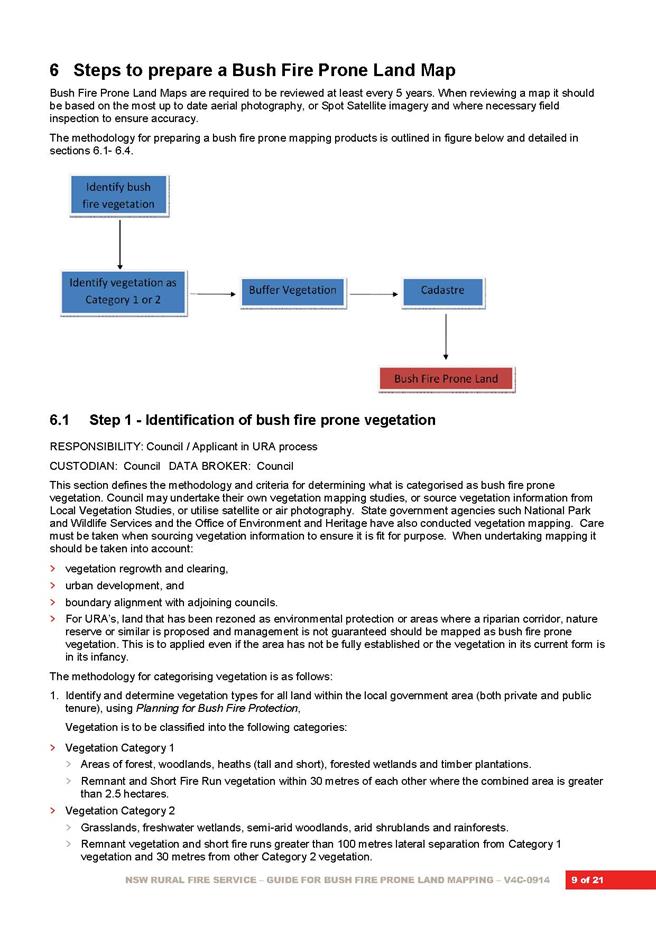
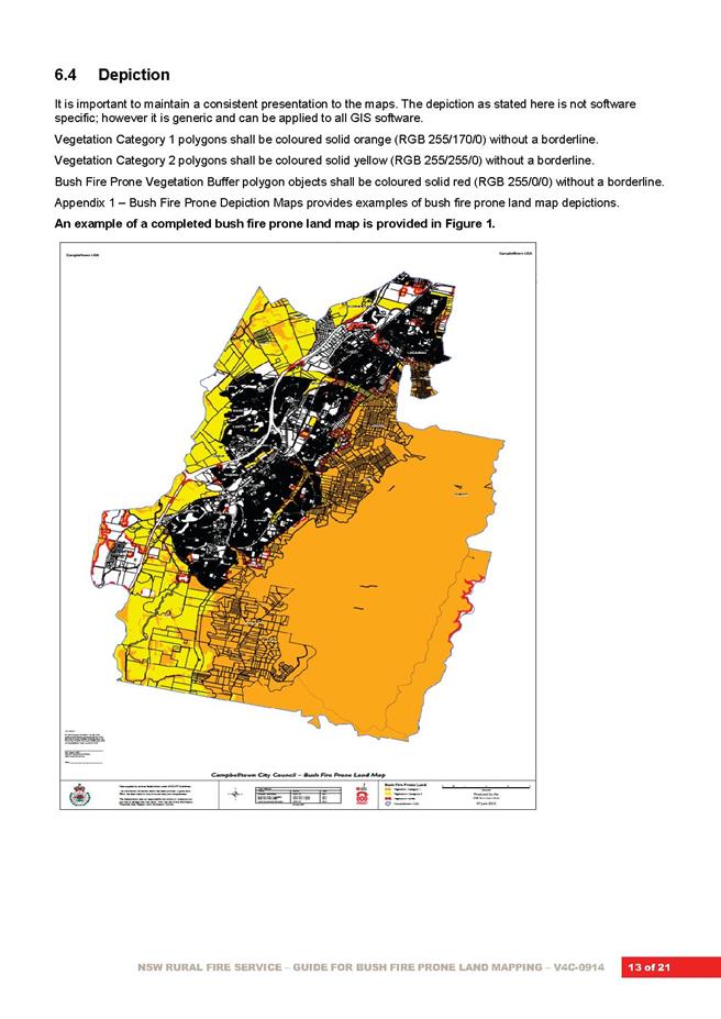
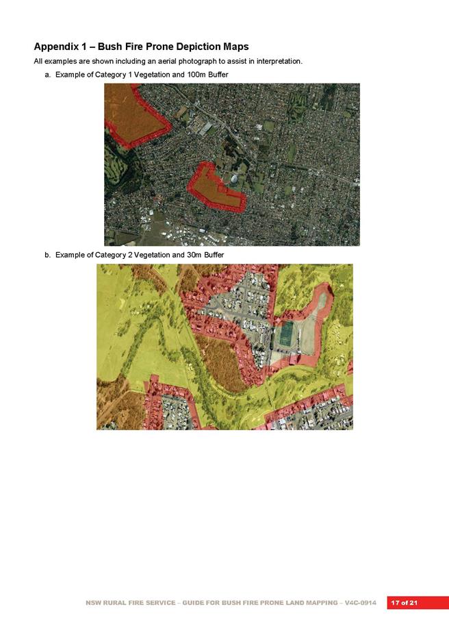
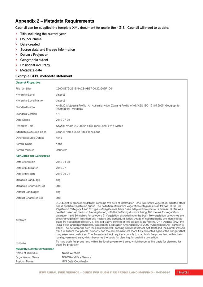
|
APPENDIX No: 2 - Eco
Logical Australia - Ku-ring-gai Bush Fire Prone Lands Update
|
|
Item No: GB.8
|
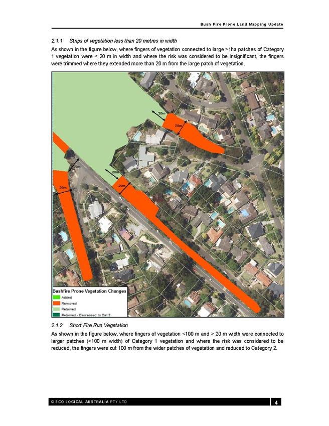
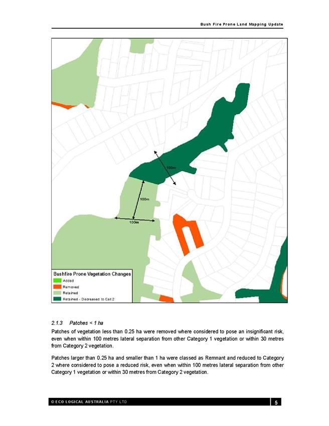
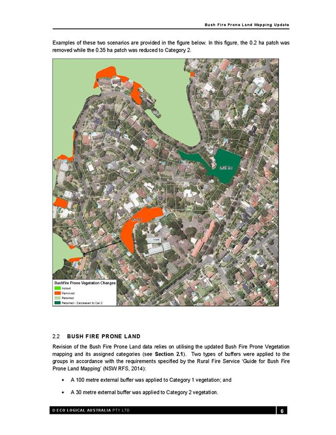
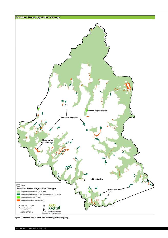

|
APPENDIX No: 3 - Draft
Bush Fire Prone Land Map - Ku-ring-gai LGA - 2015
|
|
Item No: GB.8
|
|
Ordinary
Meeting of Council - 31 March 2015
|
GB.9 / 385
|
|
|
|
|
Item
GB.9
|
S10047
|
|
|
11 March 2015
|
Gordon and Turramurra Master Plans -
Probity Framework
EXECUTIVE
SUMMARY
|
purpose of report:
|
The purpose of this report is to
present to Council Probity Management Frameworks for both the Gordon Cultural
Hub and the Turramurra Community Hub.
|
|
|
|
|
background:
|
The Ku-ring-gai Council Revised Delivery
Program 2013-2017 and Operational Plan 2014-2015 has committed Council to
preparing a master plan for a community hub within the Gordon Town Centre to
accommodate cultural and arts activities and promote social interaction.
Over the last two years Council has made a significant
commitment to the Turramurra Community Hub; in November 2013 Council has
resolved to reclassify its land holdings in the Ray Street Precinct and
commence preparation of a master plan; and in December 2014 Council resolved
to adopt a master plan for public exhibition. This work is currently underway
and exhibition is planned for May 2015.
|
|
|
|
|
comments:
|
The purpose of a Probity
Management Framework is to provide a decision-making structure that is
logical, robust, transparent, accountable to Ku-ring-gai Council (Council) as
a body, and the community, to whom the Council is responsible, to govern
major development projects such as the Gordon Cultural Hub and the Turramurra
Community Hub.
Probity management is especially important for development
projects of this size and complexity where Council is the landowner of the
project site as well as having a significant interest in the planning
controls, land zoning and reclassifications undertaken as part of this
project.
|
|
|
|
|
recommendation:
|
That Council receive and note the Turramurra Community
Hub Probity Management Framework and the Gordon Cultural Hub Probity
Management Framework.
|
Purpose of Report
The purpose of this report is to present to Council Probity
Management Frameworks for both the Gordon Cultural Hub and the Turramurra
Community Hub.
Background
Gordon Cultural Hub
Council has identified a master plan for a community hub in
Gordon as a ‘critical action’ within the Revised Delivery Program
2013-2017 and Operational Plan 2014-2015 which states, that ‘a Master
Plan is developed for a community hub within Gordon Town Centre to accommodate
cultural and arts activities and promote social interaction’.
In addition Council’s Town
Centres Public Domain Plan, 2010 and Local Centres Development Control
Plan, 2013 provides detailed development guidance to support and enhance
the planned future character of Precinct G3 – Civic Hub’.
Turramurra Community Hub
Over the last year Council has made a significant commitment
to the Turramurra Community Hub. The following decisions have been made by
Council to date:
· Ordinary Meeting of Council of 12
November 2013 Council resolved to reclassify its land holdings in the Ray
Street Precinct and commence a master plan for the area based on the current
LEP controls;
· Ordinary Meeting of Council of 26
November 2013 Council resolved to undertake a community facilities strategy for
Turramurra to determine the requirements for any new community facilities
within the centre;
· Ordinary Meeting of Council of 9
December 2014 Council resolved to adopt a master plan for public exhibition.
Comments
Both the Turramurra Community Hub project and Gordon
Cultural Hub projects will deliver significant new community infrastructure.
While the precise natures of the facilities within the
Gordon Cultural Hub are still to be determined, indicatively they will include:
· new cultural facilities;
· a component of community facilities to
be co-located on the site;
· Retention of the Council Chambers
heritage item and adaptive re-use of this asset;
· a new park/civic space; and
· public domain improvements and road
improvements works to surrounding streets.
The Turramurra project has identified the following
community infrastructure to be provided as a minimum:
· new public park
· new town square;
· new branch library;
· new multi-purpose community centre;
· replacement of Council’s existing short stay
car spaces in new basement parking; and
· public domain improvements and road
improvements works to surrounding streets
The purpose of a Probity Management Framework is to provide
a decision-making structure that is logical, robust, transparent, accountable
to Ku-ring-gai Council (Council) as a body, and the community, to whom the
Council is responsible, to govern development projects. It describes the
management structure, including the specific role, accountabilities and
responsibilities, focusing primarily on authority level, information flow and
related probity guidance.
A probity management is especially important for projects of
this size and complexity where Council is the landowner of the project site as
well as having a significant interest in the planning controls, land zoning and
reclassifications undertaken as part of this project. Council as an elected
corporate body has no private interest in this project. Council has two roles
and both are legitimate public interest roles. ICAC’s publication Corruption
risks in the development approval process (September 2007) notes that in
this type of situation there may be a “conflict of roles”, that is, it is
possible for the two roles to come into conflict. The relevant probity aim is
to ensure that both roles are properly performed, that is, that they are
carried out with due regard to the probity principles.
Turramurra Community Hub Probity Management Framework is
provided in Attachment A1 and Gordon Cultural Hub Probity Management
Framework is provided in Attachment A2.
integrated planning and reporting
|
Theme 03 - Places, Spaces and Infrastructure – P4
Revitalisation of our Centres
|
|
A range of well planned, clean
and safe neighbourhoods and public spaces designed with a strong sense of identity
and place.
|
Plans to revitalise local centres are being progressively
implemented and achieve quality design outcomes in collaboration with key
agencies, landholders and the community.
|
Implement a place management approach for the local centre
improvements to coordinate works and achieve quality outcomes.
|
|
|
A Master Plan is in place for a community hub within the
Gordon Town Centre to accommodate cultural and arts activities and promote
social interaction is developed.
|
Engage with relevant stakeholders to establish timing,
extent and partnership opportunities.
Undertake due diligence and undertake project scope.
Identify and engage with the key stakeholders.
|
|
Theme 01 – Community People
and Culture – C4 Healthy Lifestyles
|
|
A
healthy, safe, and diverse community that respects our history, and
celebrates our differences in a vibrant culture of learning.
|
New and enhanced open space
and recreational facilities have been delivered to increase community use and
enjoyment.
|
Complete the design for
identified parks and include design principles which facilitate passive
recreation activities.
|
Governance Matters
A draft Governance Structure and Probity Management
Framework has been prepared for both the Gordon Cultural Hub and Turramurra Community
Hub projects.
The role of the Probity Framework is to provide a
decision-making structure that is logical, robust, transparent, accountable to
Ku-ring-gai Council (Council) as a body, and the community, to whom the Council
is responsible, to govern both the Gordon Cultural Hub and Turramurra Community
Hub projects. It describes the management structure, including the specific
role, accountabilities and responsibilities, focusing primarily on authority
level, information flow and related probity guidance.
The Probity Framework is required to ensure that each aspect
of the process is, and is seen to be, open and transparent, that any conflict
of interest is avoided, pecuniary interests declared and that all aspects of
each project process complies with relevant legislation.
The Probity Framework includes documentation of the
relationship between parties involved in the two projects, including the
independence of any parties engaged by Council to undertake any relevant
consulting, be it financial, market and economic analysis, or any other
relevant assignment for the project.
The Probity Framework includes details on the probity
fundamentals in accordance with the Independent Commission Against Corruption’s
probity advising guidance material as well as key areas and controls to be
implemented during the project to ensure that these principles are met.
Risk Management
The Probity Framework is required to ensure that each aspect
of the process is, and is seen to be, open and transparent, that any conflict
of interest is avoided, pecuniary interests declared and that all aspects of
the project process complies with relevant legislation.
The Probity Framework includes requirements for
documentation of the relationship between parties involved in the project,
including the independence of any parties engaged by Council to undertake any
relevant consulting, be it financial, market and economic analysis, or any
other relevant assignment for the project.
The Probity Framework includes details on the probity
fundamentals in accordance with the Independent Commission Against Corruption’s
(ICAC) probity advising guidance material as well as key areas and controls to
be implemented during the project to ensure that these principles are met.
Financial Considerations
There are no financial implications of this report.
Social Considerations
There are no social considerations arising from this report.
Environmental Considerations
There are no environmental considerations arising from this
report.
Community Consultation
There are no requirements to consult with the community in
this regard. Once reported to Council the Probity Framework will be made
available to the public by placing it on Council’s website.
Internal Consultation
Council’s probity consultants undertook a probity survey
which was completed by twenty-two (22) Council officers sitting across the
following areas:
· urban planning;
· tendering/procurement;
· community;
· risk management;
· civil design / construction;
· communications;
· development application assessment; and
· maintenance and asset management.
The consultants have undertaken a review of the results from
the survey and on that basis have prepared the Probity Framework template.
Summary
The purpose of this report is to provide a copy of the
Turramurra Community Hub Probity Management Framework and the Gordon Cultural
Hub Probity Management Framework for Council’s information.
The purpose of the Probity Management Framework is to
provide a decision-making structure that is logical, robust, transparent,
accountable to Ku-ring-gai Council (Council) as a body, and the community, to
whom the Council is responsible, to govern the projects. It describes the
management structure, including the specific role, accountabilities and
responsibilities, focusing primarily on authority level, information flow and
related probity guidance.
Probity management is especially important for projects of
this size and complexity where Council is the landowner of the project site as
well as having a significant interest in the planning controls, land zoning and
reclassifications undertaken as part of this project.
An internal survey involving 22 Council staff has formed the
basis of the Probity Framework template.
Once reported to Council the Probity Framework will be made
available to the public by placing it on Council’s website.
|
Recommendation:
That Council receive and note
the Probity Management Framework for both the Gordon Cultural Hub and
Turramurra Community Hub projects.
|
|
Bill Royal
Team Leader Urban Design
|
Antony Fabbro
Manager Urban & Heritage Planning
|
|
Andrew Watson
Director Strategy & Environment
|
|
|
Attachments:
|
A1View
|
Turramurra
Community Hub - Probity Management Framework - for council report
|
|
2015/066760
|
|
|
A2View
|
Gordon
Civic Hub - Probity Management Framework - for Council report
|
|
2015/066801
|
|
APPENDIX
No: 1 - Turramurra
Community Hub - Probity Management Framework - for council report
|
|
Item No: GB.9
|


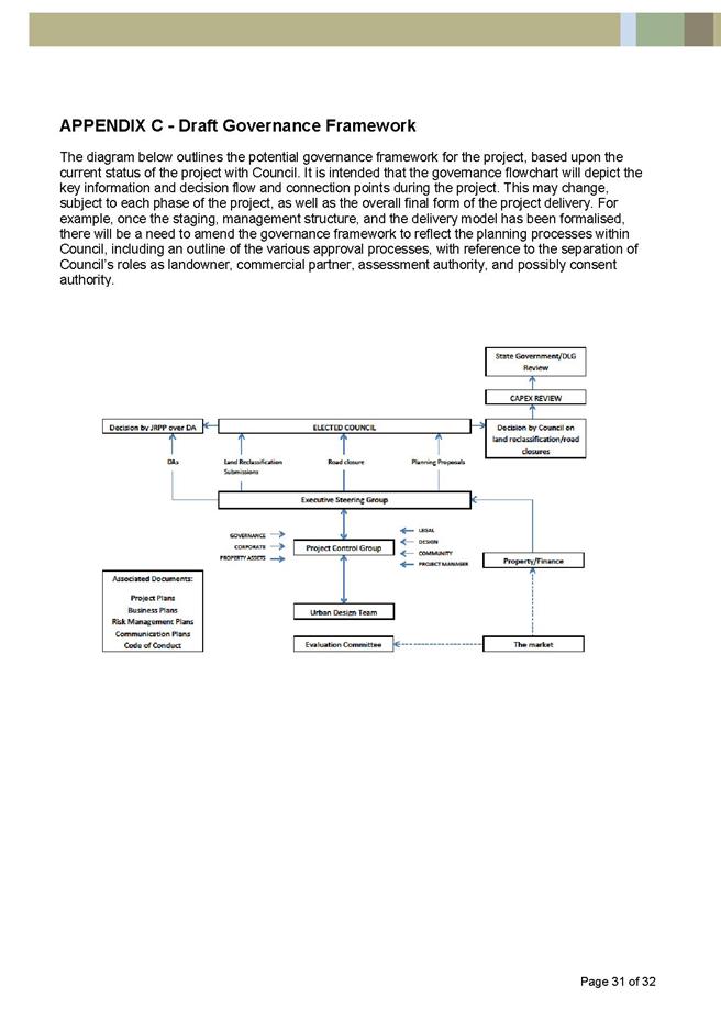
|
APPENDIX No: 2 - Gordon
Civic Hub - Probity Management Framework - for Council report
|
|
Item No: GB.9
|

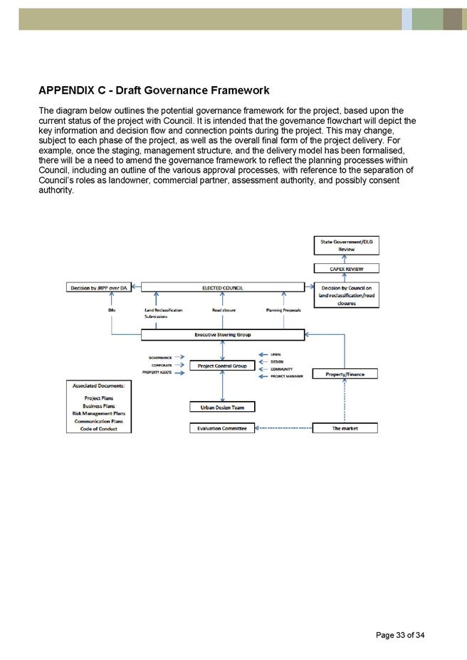
|
Ordinary
Meeting of Council - 31 March 2015
|
GB.10 / 457
|
|
|
|
|
Item
GB.10
|
S10376
|
|
|
16 March 2015
|
Gordon Hub - Authority to Liaise with
Ausgrid - Electricity Substation located adjacent to Radford Place Gordon
EXECUTIVE
SUMMARY
|
purpose of report:
|
The purpose of this report is to provide for the
on-going use/lease of the electricity substation owned by Ausgrid located in
the car park at the rear of 818 Pacific Highway Gordon and to seek formal
approval to commence discussions with Ausgrid in advance of the process of
preliminary planning for the Gordon Community and Cultural hub as this is
likely to necessitate relocation of this asset to accommodate most design
solutions.
|
|
|
|
|
background:
|
Preliminary planning and design processes for the
Gordon Community and Cultural Hub are underway and will be subject to regular
reporting to Council. However, as a matter of courtesy, Council should
advise Ausgrid that the substation currently located within the site, will
require relocation within the site as part of the new design and to seek
input from Ausgrid as to their requirements for a new location.
|
|
|
|
|
comments:
|
This report seeks the authorisation of Council to
liaise with Ausgrid and to ensure the inclusion of their interests in current
and future planning for the site.
|
|
|
|
|
recommendation:
|
That the requirements of Ausgrid for a suitable site
for a future or replacement substation be considered in current and future
planning for the consolidated site known as 818 Pacific Highway Gordon.
|
Purpose of Report
The purpose of this report is to provide for the on-going
use/lease of the electricity substation owned by Ausgrid located in the car
park at the rear of 818 Pacific Highway Gordon and to seek formal approval to
commence discussions with Ausgrid in advance of the process of preliminary
planning for the Gordon Community and Cultural hub as this is likely to
necessitate relocation of this asset to accommodate most design solutions.
Background
Under Draft Amendment No 4 Ku-ring-gai Local Environmental
Plan (Local Centres) 2012 Council is seeking to reclassify 818 Pacific Highway,
Gordon to Operational land.
As part of the Planning Proposal process, Council originally
sought to extinguish all interests in this property. It has been identified the
electricity substation owned by Ausgrid located in the car park at the rear of
818 Pacific Highway, Gordon is subject to a 50 year lease (with an easement
for access) between Council and Sydney Electricity (now Ausgrid) which expires
on 1 April 2041 and this arrangement should be preserved in the short term.
The lease also incorporates a right of way for access and easement for
electricity purposes.
Preliminary planning and design processes for the Gordon
Cultural Hub are underway and it has been identified the location of the
substation may potentially require relocation within the site as part of the
new design. Council will seek input from Ausgrid as to their requirements for a
potential new location.
Comments
This report seeks to preserve the existing lease
arrangements with Ausgrid for the existing substation and the authorisation of
Council to liaise with Ausgrid and to ensure the inclusion of their interests
in current and future planning for the site. The location of the substation
together with an easement for access in a central area of the site would, if
that location were maintained, inhibit design responses to the future provision
of civic and community / cultural space. It is essential that Ausgrid be
formally consulted on their requirements for any future substation on the site
early in the preliminary design processes.
The terms of the lease formally require Council, as Lessor,
to give 12 months’ notice of any need to relocate or remove the substation
however, it would be more practical, to liaise with Ausgrid earlier in the
design process and ensure their needs were accommodated in any detailed design
for the site.
While the lease also gives Council absolute and uncontrolled
discretion should it require the lease area “for the purpose or redevelopment
or reconstruction (or both)” during the term there is a requirement to meet
Ausgrid’s relocation costs if this right is exercised. Early liaison with
Ausgrid in terms of considering their future power infrastructure needs on the
site will help to mitigate the costs of any relocation.
Lease E479038, together with its associated easement for
access, is currently registered on the title of 818 Pacific Highway Gordon.
For the present time, these rights for Ausgrid need to remain in place until
detailed planning is further advanced and a new location can be negotiated
concurrent with the detailed design processes for the Gordon Community and
Cultural Hub. Depending on the outcome of the latter and Ausgrid’s future
requirements, the existing lease may need to be surrendered and a new lease
negotiated if Ausgrid requires an ongoing presence on the site.
integrated planning and reporting
|
Theme - Places, Spaces and Infrastructure
|
|
Community Strategic Plan Long Term Objective
|
Delivery Program
Term Achievement
|
Operational Plan
Task
|
|
Our centres offer a broad
range of shops and services and contain lively urban village spaces and
places where people can live, work, shop, meet and spend leisure time
|
An improvement plan for Gordon
Centre is being progressively implemented in collaboration with owners,
businesses and state agencies.
|
Engage with relevant
stakeholders to establish timing, extent and
partnership opportunities for new community facilities and
infrastructure
|
|
|
|
Undertake due diligence and undertake project scope
|
Governance Matters
The lease E479038 and associated easement to Sydney
Electricity, now known as Ausgrid, is an encumbrance on the title of the site
at Lot 2 DP DP786550 and needs to be considered as part of current and future
planning of the site.
Risk Management
Seeking the concurrence of Council to include Ausgrid in
preliminary design processes is part of a risk management process.
Financial Considerations
There are no direct financial implications in the matter the
subject of this report, however, not taking into account the requirements of
Ausgrid early in the design process could translate into amendments at a later
stage of the design process which would be less time and cost efficient. Any
possible costs of relocation of Ausgrid’s infrastructure on the site can also
be better considered, planned and negotiated if there is early dialogue with
Ausgrid.
Social Considerations
There are no direct social implications for the operational
matter that is the subject of this report however it is a small part of the
pre-planning for the future delivery of significant community assets on the
site.
Environmental
Considerations
There are no direct
Environmental considerations arising from this report however any future
relocation of the substation will need to be appropriately considered within
future site planning and detailed design work.
Community Consultation
As for the Lindfield Village Green, Lindfield Community Hub
and Turramurra Community Hub, extensive community consultation will take place
as the preliminary design phases commence. The current issue is an operational
matter as part of the commencement of detailed site planning.
Internal Consultation
This report has been drafted by Council’s Urban Planning and
Heritage Unit with input from the Integrated Planning Property and Assets Unit.
Summary
It is essential that Council considers the requirements of
Ausgrid regarding its current substation and options for its future relocation,
together with all associated easements in all current and future planning for
the combined sites known as the Gordon Community and Cultural Hub.
|
Recommendation:
A. That
Council authorise staff to liaise with Ausgrid to ensure that their
requirements as currently provided for by the lease E479038 and associated
easement on Lot 2 DP DP786550 known as 818 Pacific Highway, Gordon.
B. That
Council delegates authority to the General Manager to liaise with the
Department of Planning to amend the Planning Proposal in respect of 818
Pacific Highway, Gordon under Ku-ring-gai Local Environment Plan (Local
Centres) 2012 to ensure the retention of Lease E479038 and the associated
access and easement rights on the subject site in its current form until such
time as it is relocated and replaced with a subsequent lease or is
surrendered.
|
|
Kate Paterson
Infrastructure Co-ordinator
|
Vince Rago
Property Program Co-ordinator
|
|
Antony Fabbro
Manager Urban & Heritage Planning
|
Andrew Watson
Director Strategy & Environment
|
|
Ordinary
Meeting of Council - 31 March 2015
|
GB.11 / 461
|
|
|
|
|
Item
GB.11
|
S05624
|
|
|
17 March 2015
|
Carcoola Park Concept Plan
EXECUTIVE
SUMMARY
|
purpose of report:
|
To seek Council’s endorsement of
the concept design plan for the extension of Carcoola Park and to name the
park “Lapwing Reserve”.
|
|
|
|
|
background:
|
At the Ordinary Meeting of
Council of 12 June 2012, Council resolved to acquire properties in St Ives
for local open space. These properties were 14 and 16 Carcoola Road St Ives,
being vacant land adjacent to an existing Council reserve at 18 Carcoola
Road, St Ives. These properties were subsequently purchased.
|
|
|
|
|
comments:
|
Staff have undertaken a design
process including site analysis, community survey, development of a draft
concept plan, an online and mailed-out exhibition of the draft, concept plan
revision after feedback and negotiations with local residents and have
produced a final concept plan supported by local residents for Council
endorsement.
|
|
|
|
|
recommendation:
|
That Council endorses the final
design concept plan for Carcoola Road Reserve, St Ives as the basis on which
staff prepares construction documentation including plans, cost estimates and
specifications, and tender documentation for calling tenders and that an
application for the name “Lapwing Reserve” be made to the Geographical Names
Board for consideration.
|
Purpose of Report
To seek Council’s endorsement of the concept design plan for
the extension of Carcoola Park and to name the park “Lapwing Reserve”.
Background
At the Ordinary Meeting of Council of 12 June 2012, Council
resolved:
“A. That
Council resolve to acquire the properties in St Ives for local open space and
proceed as outlined in the report.
B. That the chief
petitioner be notified of the purchase at the earliest opportunity. “
The purchase of 14 and16 Carcoola Road St Ives was completed
on 7 August 2012 and both parcels of land were dedicated as Public Reserve and
the land classified as Community Land as defined within the Local Government
Act 1993. This land extended the existing Public Reserve at
18 Carcoola Road St Ives by 1868.5m2, or 66%.
This purchase secured the use of these lands as local open
space to be enjoyed by the local community and their families for many years
into the future. The land has never been formally named.
Council staff subsequently commenced the design and
consultation process.
Comments
Council staff undertook a design process that included site
survey and analysis and a community needs survey; tallying results for development
of the initial concept plan. Once completed, this was sent for resident
notification by mail-out and online exhibition and meetings held for internal
stakeholders’ input. Feedback necessitated further resident consultation and
plan revisions that resulted in this final concept design plan for Council
endorsement.
Site analysis
The existing site is characterised by undulating topography
throughout with significant slopes. The vegetation consists of a mix of mature
native and exotic evergreen and deciduous canopy trees and a variety of shrub
and ground cover understorey, with pockets of open grass particularly along the
southern and northern areas of the site. There is natural rock outcropping at
the surface indicating shallow soil, and a very large and significant Ficus sp.
(rubber tree) that is being retained because of its contribution to the site
character.
The site is contained on the northern and western sides by
fenced residential properties. The eastern side residential property is
currently unfenced. The site southern boundary is Carcoola Road. The
consultation with residents indicated that the natural character of the site
was the most significant feature they wished to retain.
Site opportunities
The site has an abundance of
vegetation and a dishevelled natural character that can be enhanced. The
introduction of supplementary planting to the understorey along with the
introduction of boundary planting will help to define the site, whilst
embracing the current much loved natural aspects.
The large canopy trees in the southern parts of the site
lend themselves to shade trees for the introduction of play elements beneath.
Open grassed areas of the site are ideal to be retained as
passive recreational areas for free running play and recreation.
Site constraints
The open grassed areas to the top of the site are
characterized by either shallow or in some cases exposed bedrock. The
identified bedrock means that the majority of earthworks proposed for the site
should be in the nature of ‘fill’ rather than ‘cut’ in order to avoid costly
rock excavation.
There is poor drainage along the western and southern
boundaries with a pond forming beneath the large rubber tree at the base of the
site following significant rain events. Filling and shaping to the southern
boundary will help to free this standing water.
The topography of the site is defined by steep grades from
the top to the bottom of the site which constrains the introduction of any play
equipment to the flatter areas at the front of the site and lends itself to the
introduction of embankment slides on the natural slopes.
The topography also limits accessibility to the site for
mobility impaired users and parents with prams. Access can be provided for
these users by creating a level flat area near the front of the site.
Design of final concept
plan
The final concept plan (Attachment A1) is based on
the preliminary site analysis, internal stakeholder discussions (refer INTERNAL
CONSULTATION for details) and a detailed review of the feedback from community
consultation (refer COMMUNITY CONSULTATION for details).
Design concept
The design concept provides a local park that sits within
the natural landform of the site and allows for intergenerational and inclusive
play by providing open areas for free play alongside structured play equipment.
The park builds a safe and level space for toddlers and
carers as well as seating/sheltered areas. The junior discovery area adjacent
to the toddler’s area, the nature trail and the natural ‘fort’ at the top end
of the playspace will allow and encourage imaginative play and challenges for
children of differing age groups. The park development will create a gathering
place for children where they can create their own games and connect with each
other through play, and a meeting place for carers.
Key elements/principles of the design include:
(a) Use of site
· Incorporating natural topography into
the design through the introduction of embankment slides.
· Retaining and enhancing the natural
aspects of the site with natural materials, such as rock walls, lucky stones,
timber sleepers, logs and boulders, as proposed in the concept plan.
(b) Landscape
· Providing of supplementary planting,
tidying and edging to current pockets of understorey.
· Creating new border planting beds and
low screen native planting to reduce the impact of new fences while retaining
sight-lines and supervision into the park.
· Considering safety and easy supervision
of park users.
(c) Play spaces
· Providing simple formal play equipment
as well as nature-play spaces.
· Enabling for a range of age groups and
abilities to use the playground together.
· Complying with the requirements of
Australian Playground Standards.
(d) Shelter and Seating
· Providing a shade shelter with picnic
setting beneath.
· Installing seating for carers,
especially grandparents.
· Choosing materials and colours that
enhance the natural character of the site.
(e) Site drainage
· Facilitating the drainage of poorly
drained areas and ponding stormwater.
(f) Access
· As required by Council’s Access Plan,
providing one accessible car space adjacent to current roadway.
· Providing a level pathway and toddler
play area to allow ease of access for mobility impaired users as well as carers
and young children.
· Providing access for service vehicles
for routine maintenance activities.
Naming the Park
A request was received from the
local residents to name the parkland as “Lapwing Reserve”, based on local bird
sightings. “Lapwing Reserve” is the local name that is currently used for this
site.
It is proposed that Council
endorse the name “Lapwing Reserve” for an application to be submitted to the
Geographical Names Board for consideration.
integrated planning and reporting
Theme 3: Places, Spaces and Infrastructure
|
Community Strategic Plan Long Term Objective
|
Delivery Program
Term Achievement
|
Operational Plan
Task
|
|
A range of well planned, clean and safe neighbourhoods and
public spaces designed with a strong sense of identity and place.
|
P.6.1.2. – A program is being implemented to improve
existing recreation, sporting and leisure facilities and facilitate the
establishment of new facilities.
|
P.6.1.2.1.1. - Report on completed concept designs and
acceptance by the community and Council
|
Governance Matters
Ku-ring-gai is planning for the provision of at least 10,000
additional dwellings from 2004 to 2036, a process which is well underway (and
currently under review). The new residents of these dwellings will still
generate pro-rata demand for open space just as the residents of the new
dwellings currently being developed generate demand. All are being, and will
continue to be, duly levied their fair share of contributions under the current
contributions plan.
Under the Ku-ring-gai
Contributions Plan 2010 the Council has purchased two (2) properties
on Carcoola Road for a new local park. The park will be approximately 2,800m²
total area which will substantially meet the demand created by new residents in
the local area. The delivery of a new local park is important to demonstrate
to the community and local developers that Ku-ring-gai Council is committed to
meeting its obligations to use development contributions for the purpose of
delivering new parks in close proximity to new development - that being the purpose
for which these contributions were levied.
Development consent is not
required as the lots have been acquired for a new local park as Public Reserve
under Part 2 Division 3 (s49) of the Local Government Act, 1993.
An application for the name “Lapwing Reserve” is required to
be lodged with the Geographical Names Board of NSW who require the endorsement
of Council to process this.
Risk Management
There are minimal risks to Council in adopting this concept
plan. There are however a number of risks if Council does not approve this
plan, these include:
· community dissatisfaction with Council
having announced the park and then not proceeding;
· criticism from developers, residents and
the State Government for not expending development contributions; and
· delay in construction, meaning the
project may run over to 2016/17 financial year.
Financial Considerations
The project documents are planned to be completed for
tendering in mid-2015 with construction works due in late 2015. The table below
shows Council can set an indicative the upper project limit of $675,000 for the
design, documentation, tendering and construction of the park, including
project management and contingencies. The desired more natural and less
developed park by the community means the project cost can be less than the
maximum budget allowance of $887,537.50 based on square metre rates. The costs
associated with the construction of the new park are entirely funded from
development contributions.
|
Carcoola Road Park -
Budget
|
|
|
Total Area
|
2,803sqm
|
|
New land area available for
embellishment under section 94
|
1868.5sqm
|
|
Development
Contributions potential budget
|
|
|
Total embellishment costs
1868.5sqm x $475sqm permitted under CP2010
|
$887,537.50
|
|
Indicative Upper Project
Limit based on Concept Plan (Attachment A1)
|
$675 000.00
|
The final budget amount that will be required to be
allocated to the project will need to be adopted when the Tender Acceptance
Report is considered by Council.
Social Considerations
The extension of this existing park will provide additional
outdoor community space which will support and encourage the health and
well-being of existing and new residents of Ku-ring-gai, and continue to bring
the local community together.
Council's local parks and playgrounds serve an important
role as meeting places for children and their carers, neighbours and extended
family groups. Most children when old enough to socialise, enjoy creating their
own games and imaginative play with other children, especially outdoors. The
open free-play space will enable a kick around area for impromptu games and
there are spaces provided for quieter activities, or watching others play.
Environmental Considerations
Environmental considerations are part of the design
development process. To ensure Council meets its legislative requirements a
Potential Impacts Assessment (PIA) will be prepared and approved by Director
Strategy and Environment and Director Operations, prior to tender.
By retaining existing trees and providing additional native
planting which is water-wise, there will be an increase in local habitat for
local wildlife and insects. Trees will also provide shade and assist with
reducing heat island effect. The play equipment and materials are selected
based on sustainable whole of life costs and recycling potential. Timber is FSC
certified. The natural topography has been considered in the design to reduce
the amount of cut and fill and also to minimise excavation into rock and thus
minimise costs.
During the construction works the site will be subject to an
environmental management plan which will ensure appropriate controls, such as,
erosion control, silt fencing, runoff protection, tree protection, recycling
appropriate materials, and dust and noise abatement.
Community Consultation
A series of community information and consultation
activities were undertaken which involved engagement with residents living in
close proximity to the proposed new local park on Carcoola Road St Ives.
1. Residential postal survey/online survey
During August 2013, ‘Have
Your Say’ community surveys where mailed to 874 local residents requesting
feedback regarding potential improvements and uses for the site. At the same
time a similar survey was launched online using Survey Monkey and linked to the
council website.
A copy of the ‘Have Your Say’ survey results is
provided in Attachment A2.
71 responses to the mail out and 16 responses to the online
survey where received. The results of the survey and additional comments were
used to inform and prepare the original concept plan. The results
overwhelmingly indicated the desire for a playground. Other strongly desired
items where picnic/seating areas, shady areas, fenced park, the use of natural
materials and some provision for car parking.
One of the mail back surveys pointed to an 89 signatory
petition submitted to Council calling largely for the preservation of the park
without embellishment.
There was also a request that the parkland be named “Lapwing
Reserve”.
2. Residential
feedback to Draft Concept Plan/press release
After development of the original concept plan, a further
mail out enclosing a copy of the plan was made to the original residential
survey recipients on 19 December 2014 asking for feedback in writing
by 2 February 2015.
A story on the new park was printed in the North Shore Times
on the 12 January 2015.
A petition of 25 signatories was received from the original
organiser of the previous petition indicating displeasure at the scale of the
concept design and a number of the design elements. This feedback was
considered and it was determined that proposed works would be scaled back in
light of this community response.
3. Community
site meeting
A site meeting with concerned residents/petition signatories
was held to discuss the design on 13 February 2015. The
discussion from this meeting was informative and positive, and a better
understanding of local residents’ ideas was taken back to inform the final
concept plan, within the constraints of providing an area that met mandatory
standards and available maintenance resources.
4. Community
meeting
The revised concept was discussed with two key members of
the concerned residents group on Tuesday 17 March 2015, and they indicated
their overall acceptance of the proposed modified concept plan by email on 18
March 2015, with some additional minor changes made as a consequence of that
contact. Further minor design details will be refined during the plan
documentation process.
Internal Consultation
Key members of the Operations Department where invited to
give comment to the draft concept plan during the community consultation phase.
Feedback was considered and the plans as amended after community consultation
feedback were re-presented to Operations staff on 23 February 2015 to
discuss the draft concept and community feedback implications. The changes were
noted and the revised plan is supported.
Summary
The concept plan for Carcoola
Road reserve has been prepared after staff undertook a comprehensive
consultation process with residents. A draft concept plan was prepared based on
a site analysis and the results of a community survey and then exhibited
on-line for five weeks allowing residents the opportunity to comment on the
plan
.
Some concerns were raised predominately
by the immediately surrounding residents of the parkland. These concerns were
assessed and the concept plan was revised to allay the majority of the
concerns, whilst still allowing the council to provide those components that
the community would expect, and indicated a desire for, during the initial
consultation process.
The design concept provides a
local park that sits within the natural landform of the site, allows for
intergenerational play and gives access to free space, natural materials and formal
play equipment.
The park will be approximately
2,800 m² total area which will substantially meet increased demand for open
space created by new residents in the local area. It will improve the existing
parkland for existing residents. Delivery of a new park is important to
demonstrate to the community and local developers that Ku-ring-gai Council is
committed to meeting its obligations to use development contributions for the
purpose of delivering new parks in close proximity to new development.
Council will be allocating a
total budget of approximately $675, 000 for the design and construction of the
park. The costs associated with the construction of the new park are entirely
funded from development contributions.
It is proposed to call tenders in
mid-2015 with construction planned in late 2015 and the park opening in early
2016.
Concurrently, it is proposed to
make an application to the Geographical Names Board to consider the local name
“Lapwing Reserve”.
|
Recommendation:
A. That
Council endorses the final design concept plan for Carcoola Road Reserve, St
Ives as the basis on which staff prepare construction documentation including
plans, details, sections and specifications; and tender documentation.
B. That
Council endorses the proposed naming of the reserve as “Lapwing Reserve” and
submission of an application to the Geographical Names Board for
consideration.
|
|
William Birt
Landscape Architect - Projects
|
Alison Walker
Principal Landscape Architect
|
|
Ian Dreghorn
Manager Strategic Projects
|
Andrew Watson
Director Strategy & Environment
|
|
Attachments:
|
A1View
|
Carcoola
final concept plan for council report
|
|
2015/068180
|
|
|
A2View
|
Carcoola
Reserve "Have Your Say" - survey results
|
|
2015/042656
|
|
APPENDIX
No: 1 - Carcoola
final concept plan for council report
|
|
Item No: GB.11
|
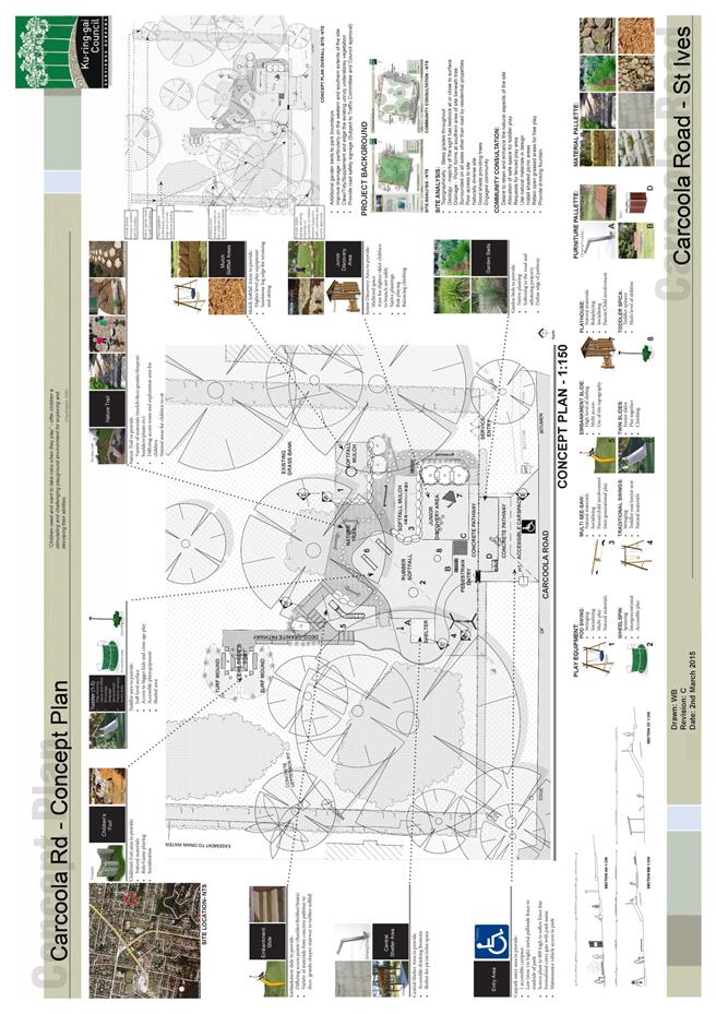
|
APPENDIX No: 2 - Carcoola
Reserve "Have Your Say" - survey results
|
|
Item No: GB.11
|
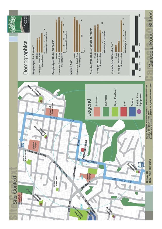
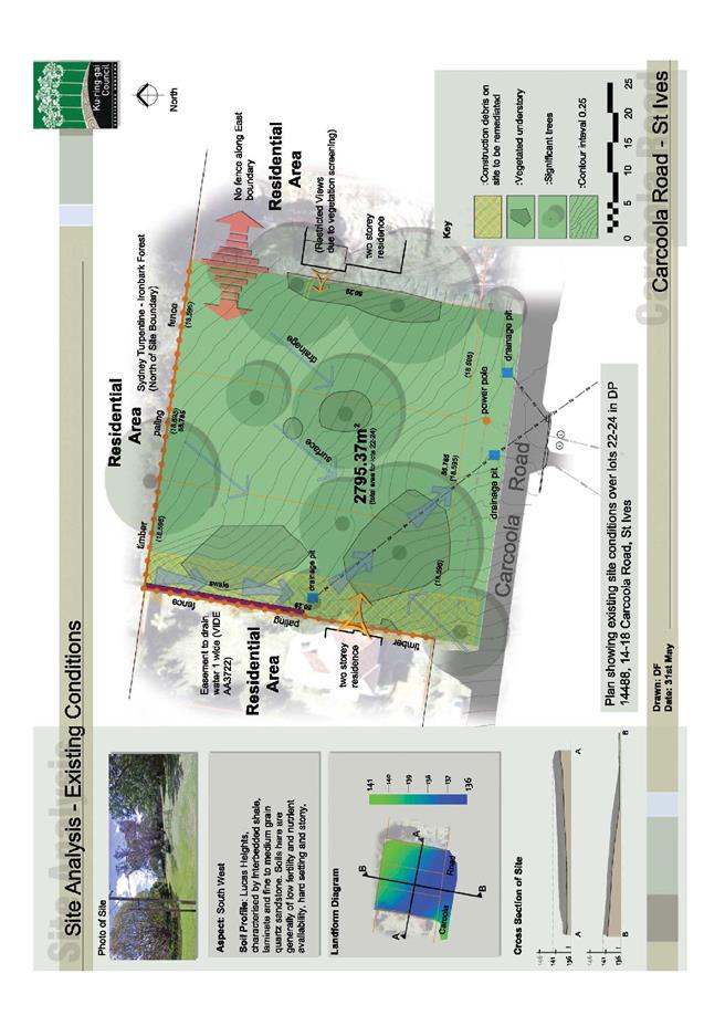
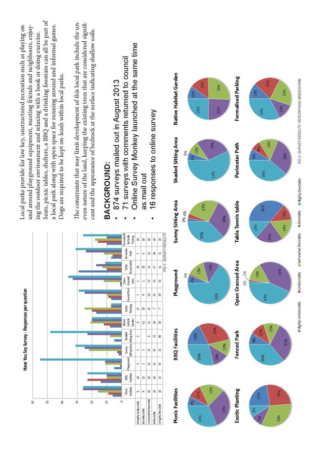
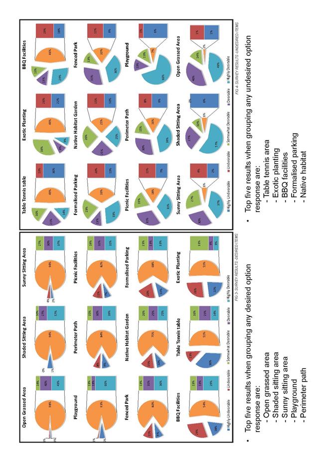
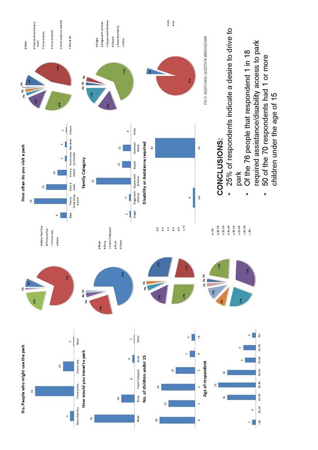
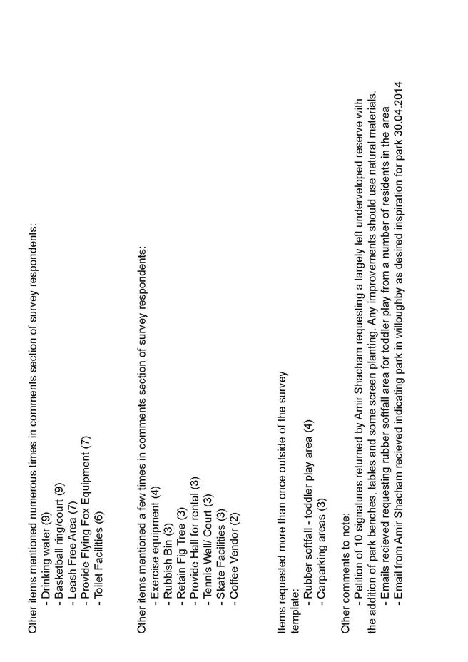
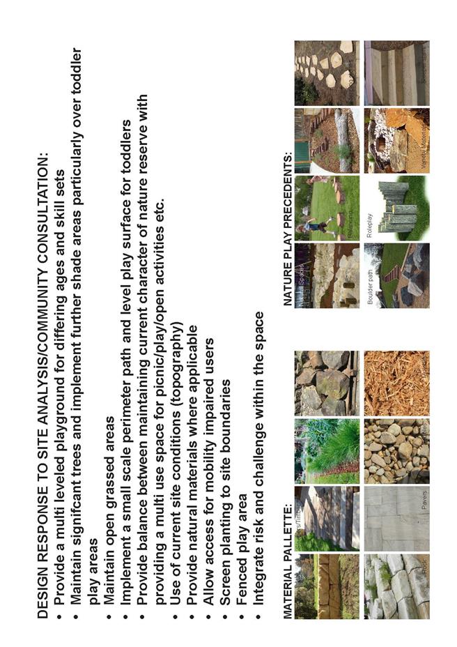
|
Ordinary
Meeting of Council - 31 March 2015
|
GB.12 / 477
|
|
|
|
|
Item
GB.12
|
S10388
|
|
|
18 March 2015
|
828 Pacific Highway Gordon -
Independent Review
EXECUTIVE
SUMMARY
|
purpose of report:
|
To provide Council with the
independent Project Review –
828 Pacific Highway Gordon Report.
|
|
|
|
|
background:
|
On 7 October 2014, Council resolved to engage independent consultants including an auditor to review
the processes associated with the acquisition of 828 Pacific Highway,
Gordon, and all information relating to the capital expenditure review,
design, documentation, and approval of the project since acquisition including
any changes of project.
|
|
|
|
|
comments:
|
The Auditors were provided
unfettered access to Council’s records and interviewed a number of staff and
Councillors. The Auditors report provides an independent assessment of information
considered, noting any potential gaps or deficiencies.
|
|
|
|
|
recommendation:
|
That Council receive and note the Project Review – 828
Pacific Highway Gordon Report.
|
Purpose of Report
To provide Council with the independent Project Review – 828
Pacific Highway Gordon Report.
Background
In
March 2012, Council resolved to acquire the building at 828 Pacific Highway,
Gordon, as its future administration building. This decision followed years of
seeking alternative accommodation for staff due to the cramped, dated and
ageing accommodation at 818 Pacific Highway, Gordon (current Council Building
& Chambers).
A
requirement of completing the sale was approval from the then Department of
Local Government (now Office of Local Government) on completing and complying
with a Capital Expenditure Review (CER).
However, as the pending acquisition of the property was
reported to Council in ‘confidential session’, the provision of the CER to
undertake community consultation could not be carried out due to the
commercially sensitive nature of the acquisition. It is important to note that
the OLG advised Council that the community consultation requirement of the CER
could only be undertaken post acquisition.
The
new Council elected in September 2012, was advised of the pending purchase
prior to completion of contract.
Council
staff submitted a CER and funding strategy to the Office of Local Government
(OLG) and, upon advice that Council had complied with the requirements of the
CER, the sale was completed in December 2012.
The
funding strategy for the purchase of the building relies on the sale of
under-utilised and surplus assets. Most of these assets are classified
Community Land (Local Government Act 1993), so the process of reclassification
commenced with a view to selling these assets to pay for the purchase of 828
Pacific Highway Gordon.
Throughout
the reclassification process there have been allegations made by some members
of the community that Council has acted irresponsibly and pressure has been
placed on the elected Council.
The
issue of reclassification and trying to relocate staff with a limited budget
has been an ongoing topic amongst the community and media.
On 7 October 2014, and in response to a Notice of Motion
submitted by Councillor Ossip to cease all planning and expenditure related to
the fit-out of 828 Pacific Highway and begin the process of divesting of the
property, Council resolved:
“That the General Manager
engages independent consultants including an auditor where necessary to:
i. review
the process leading up to the acquisition of 828 Pacific Highway, Gordon
including the advice on which Council relied on at the time
ii. review
the information contained in the capital expenditure review submitted to the
Department of local Government;
iii. review
the process of design, documentation, and approval of the project since
acquisition including any changes of project scope (together with any budget
variations) and the reasons for such change;
iv. provide
comments on the timeframes associated with the project;
v. provide
commentary on claims that the project has not been the subject of public
consultation; and
vi. provide
commentary on the revitalisation of the Gordon Town
Centre in Council’s strategic and integrated planning documents and the
relationship with retaining 828 Pacific Highway
B. That
independent review be referred to Council for consideration at the earliest
possible opportunity.
C. That
the services relocation project continue until consideration of the independent
review by Council.
D. That
the site planning for 818 Pacific Highway Gordon as identified in the Delivery
Program and Operational Plan continue until consideration of the independent
review by Council”
In November 2014, and following a procurement process
Council staff engaged BDO Auditors to undertake the review.
On 8 December 2014, a briefing session was held with
Councillors to provide an update on process.
Comments
The Auditors process included a review of all project
documentation including:
· Council reports and decisions.
· Relevant letters and correspondence.
· Financial information (including CER, LTFP, any budgets,
costings and funding models).
· Project scope and definition documentation along with any
changes or variations.
· Design process.
· Project plans and project timelines.
· Strategic linkages (to CSP, planning strategies etc).
· Any consultation or engagement regarding Council
accommodation or property acquisition, either as part of the CSP or other
strategies or policies.
The Auditors were provided unfettered access to Council’s
records and interviewed a number of staff and Councillors.
The Auditors report provides an independent assessment of
information considered, noting any potential gaps or deficiencies.
integrated planning and reporting
Leadership and Governance
|
Community Strategic Plan Long Term Objective
|
Delivery Program
Term Achievement
|
Operational Plan
Task
|
|
L3.1 The organisation is recognised and distinguished by
its ethical decision making, efficient management, innovation and quality
customer service.
|
Integrated risk management, compliance and internal
control systems are in place to identify, assess, monitor and manage risks
throughout the organisation
|
Continue the development of risk management plans and
ensure risks and related actions are monitored, reported and followed up.
|
|
|
Council’s Governance framework is developed to ensure
probity, transparency and the principles of sustainability are integrated and
applied into our policies, plans guidelines and decisions making processes.
|
Internal audit programs and statistics are reported to
each Audit Committee meeting.
|
Governance Matters
It is proposed that a copy of the final independent report
be submitted to Council’s Audit Committee.
Risk Management
Although a Risk Assessment has completed for the project and
is reviewed by the Project Control Group the independent report recommends that
the project’s risk register is revised and updated to highlight the potential
risk from the potential council amalgamations.
In September 2014, Council implemented an integrated risk
management system and the project’s Risk Register is also within the corporate
system.
Financial Considerations
There are no financial implications associated with the
preparation of this report.
Social Considerations
A long term objective within Council’s Community Strategic
Plan is that the organisation is recognised and distinguished by its ethical
decision making, efficient management, innovation and quality customer service.
The findings within the report reinforce Council’s
processes.
Environmental Considerations
There are no environmental implications associated with the
preparation of this report.
Community Consultation
None undertaken for the preparation of this report. The
attached report can be made available on Council’s website.
Internal Consultation
The Auditors interviewed a number of staff and Councillors
in preparation of their report.
On 8 December 2014, a briefing session was held with
Councillors to provide an update on process.
Summary
In
March 2012, Council resolved to acquire the building at 828 Pacific Highway,
Gordon, as its future administration building. This decision followed years of
seeking alternative accommodation for staff due to the cramped, dated and ageing
accommodation at the current Council Building & Chambers.
A
requirement of finalising the sale was approval from the then Department of
Local Government (now Office of Local Government) on complying with a Capital
Expenditure Review (CER), and, upon advice that Council had complied with the
requirements of the CER, the sale was completed in December 2012.
The
funding strategy for the purchase of the building relies on the sale of
under-utilised and surplus assets. Most of these assets are classified
Community Land and requires reclassification in accordance with the Local
Government Act 1993.
Throughout
the reclassification process there have been allegations made by some members
of the community that Council has acted irresponsibly and pressure has been
placed on the elected Council. The issue of reclassification and trying to
relocate staff with a limited budget has been an ongoing topic amongst the
community and media.
On 7 October 2014, Council resolved to engage independent
consultants including an auditor to review the processes associated with the
acquisition of 828 Pacific Highway, Gordon, and all information relating to the
capital expenditure review, design, documentation, and approval of the project
since acquisition including any changes of project.
The
Project Review – 828 Pacific Highway Gordon Report (Attachment A1)
provides an independent assessment of information considered, noting any
potential gaps or deficiencies.
|
Recommendation:
A. That
Council receive and note the Project Review – 828 Pacific Highway Gordon
Report.
B. That
a copy of the Project Review – 828 Pacific Highway Gordon Report is provided
to Council’s Audit Committee.
|
|
Deborah Silva
Manager Integrated Planning, Property & Assets
|
Andrew Watson
Director Strategy & Environment
|
|
Attachments:
|
A1View
|
Project
Review Report
|
|
2015/069398
|
|
APPENDIX
No: 1 - Project
Review Report
|
|
Item No: GB.12
|
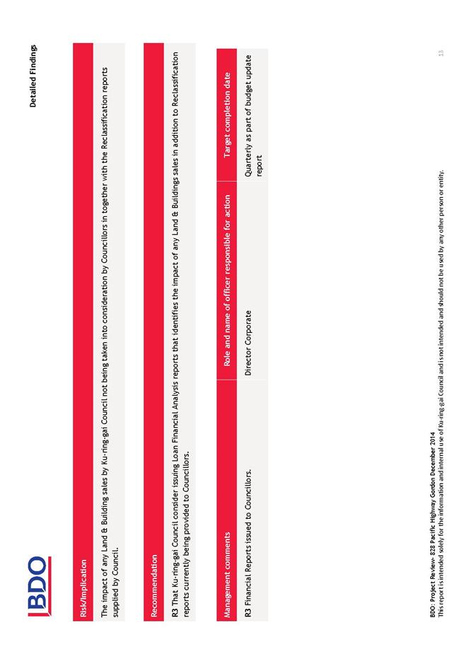
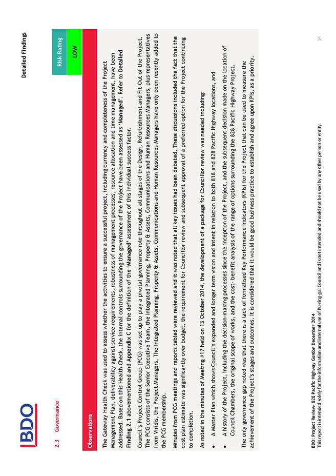
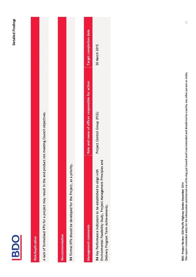
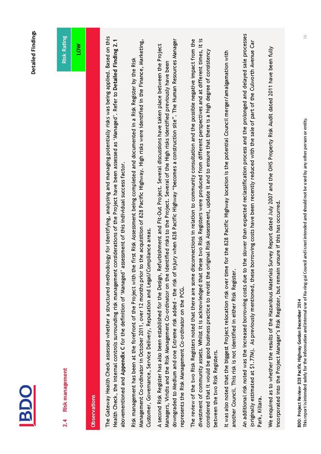
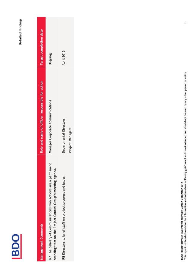
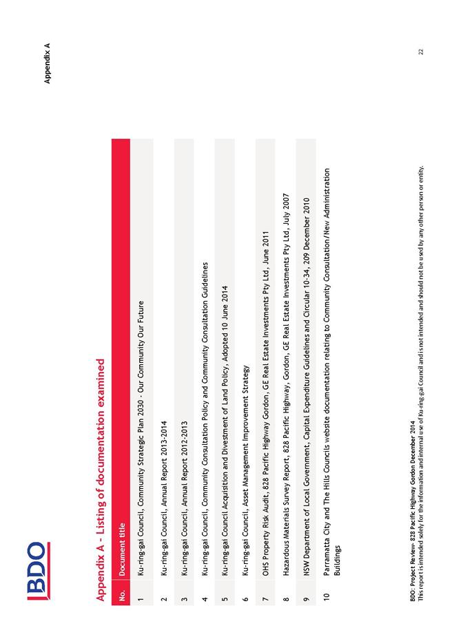
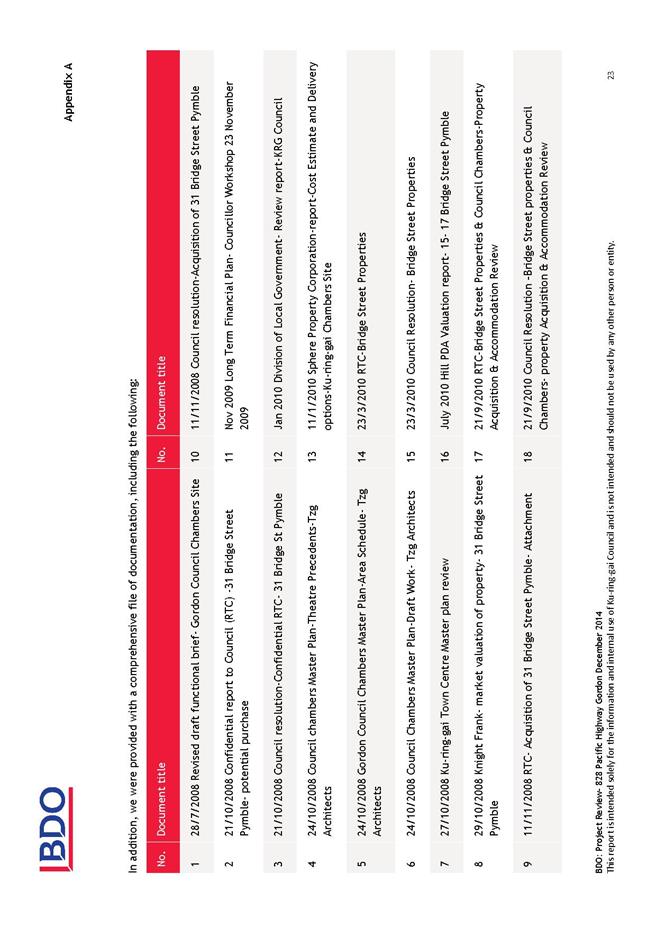
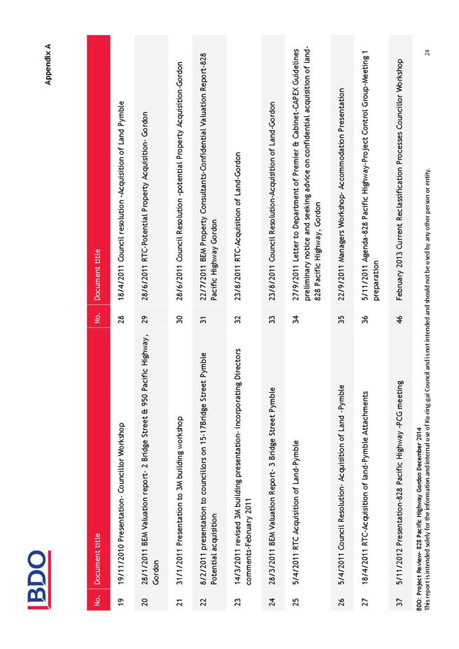
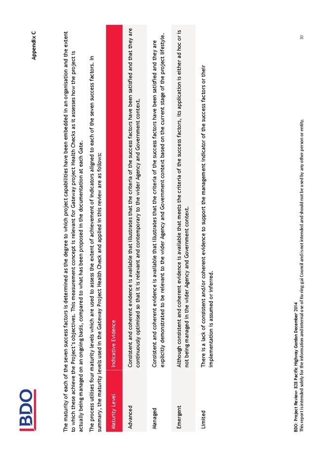
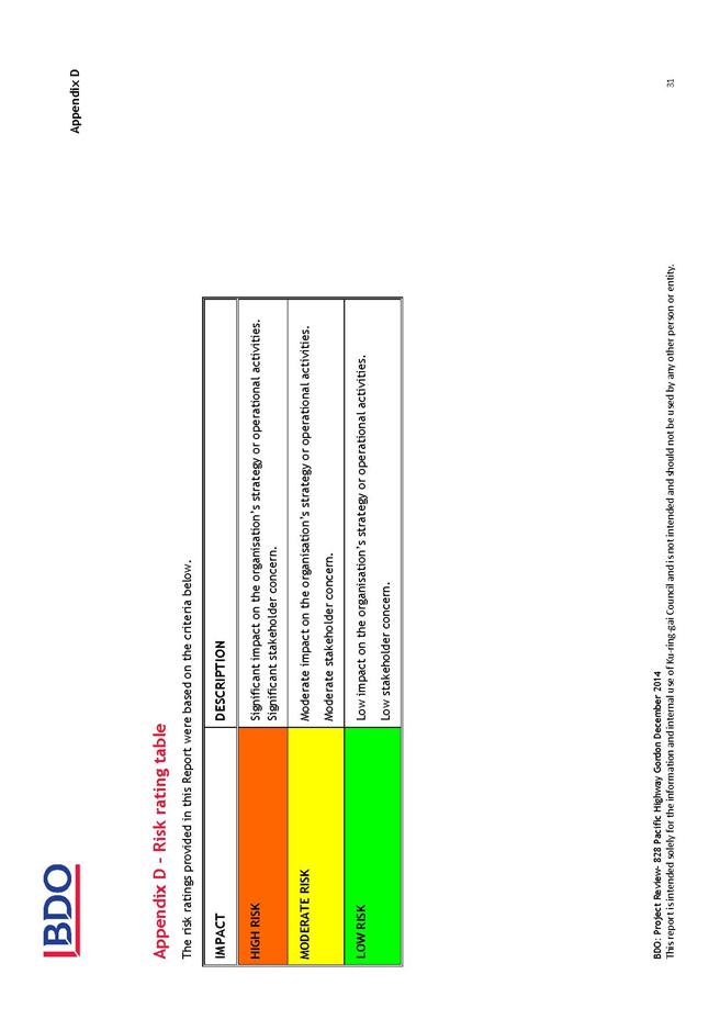
|
Ordinary
Meeting of Council - 31 March 2015
|
NM.1 / 513
|
|
|
|
|
Item
NM.1
|
S03125
|
|
|
31 March 2015
|
Review
and Improvements to Parking at
Wahroonga Village Shops
Notice of Motion from Councillor
Fornari-Orsmond dated 31 March 2015
When Council considered and adopted the Wahroonga Town
Centre Traffic and Parking Study Report prepared by Arup, Council adopted the
recommendation to only allow a one (1) parking visit per day at the car park in
Coonanbarra Road.
The purpose of only allowing one parking visit per day was
to help prevent shop owners and staff occupying spaces as they were frequently
changing vehicles around in the car park to avoid fines.
This has caused a general concern with the residents who use
the car park and a number of fines have been issued as the notice is not clear
for the users of the car park. As this is the only Council car park that has
this restriction, it would be fairer to allow two (2) visits per day.
Some residents have also expressed concern that the 2 hour
limit is not sufficient to allow them to complete their business.
Accordingly, I move:
“A. That
Council staff carry out a review of the current parking conditions and
restrictions at Wahroonga Village Shops, gather feedback from stakeholders and
bring a report back to Council with the findings and recommendations.
B. That
Council take into consideration the below points:
i. That
the one (1) visit per day be increased to two (2) visits per day for the
Wahroonga car park.
ii. That
more prevalent and clearer signs be placed at the car park entrances advising
users of the rule to permit two visits per day.
iii. That
Council staff investigate the possibility of providing an area in the car park
to allow for three (3) hour parking restrictions.”
|
Recommendation:
That the above Notice of Motion as printed be adopted.
|
|
Councillor Chantelle Fornari-Orsmond
Councillor for Wahroonga Ward
|
|