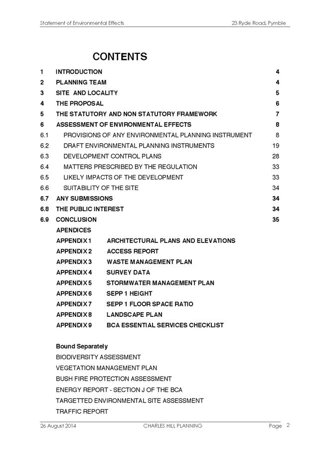
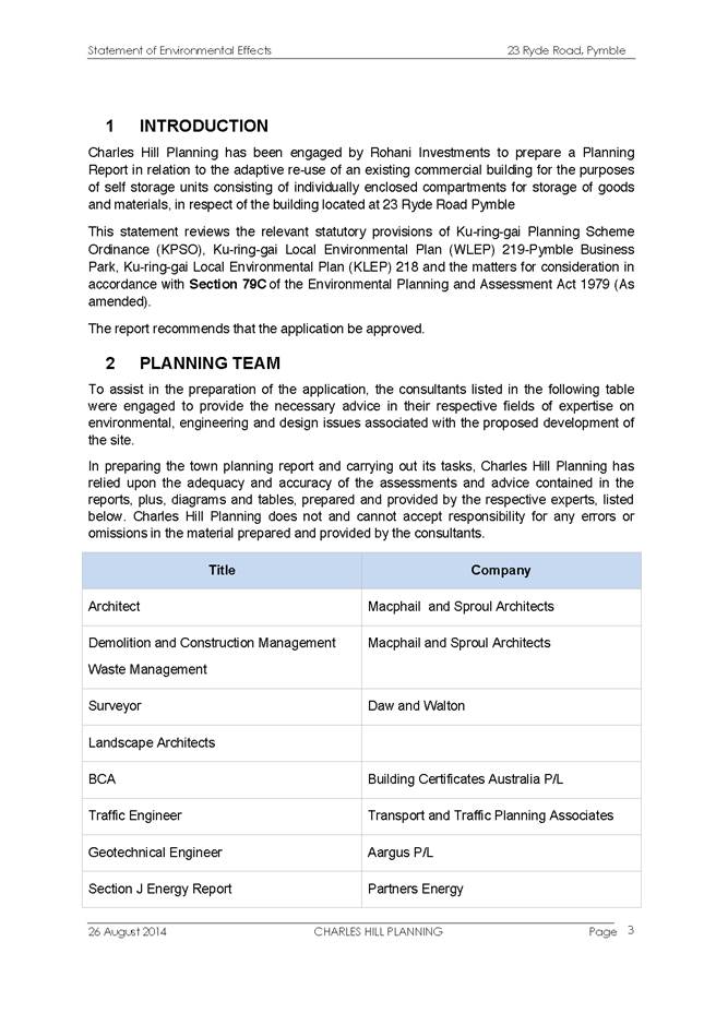
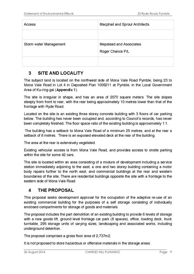
|
APPENDIX No: 1 - Invitation - Novus Foundation Gala Dinner - 30/05/2015 |
|
Item No: GB.1 |


Ordinary Meeting of Council
TO BE HELD ON Tuesday, 21 April 2015 AT 7.00pm
Level 3 Council Chamber
Agenda
** ** ** ** ** **
NOTE: For Full Details, See Council’s Website –
www.kmc.nsw.gov.au under the link to business papers
DECLARATIONS OF INTEREST
Confirmation of Reports to be Considered in Closed Meeting
NOTE:
That in accordance with the provisions of Section 10 of the Local Government Act 1993, all officers’ reports be released to the press and public, with the exception of confidential attachments to the following General Business reports:
GB.5 Compulsory Acquisition of Roads – Lindfield
Attachment A3: Lindfield Village Green - Tryon Road - Project Update
GB.6 Wahroonga Park Toilet Block - Tender T11/2014
Attachment A1: Financial information
Attachment A2: RFT 11-2014 Evaluation Committee Report
Attachment A3: Detailed Financial and Performance Assessment Report
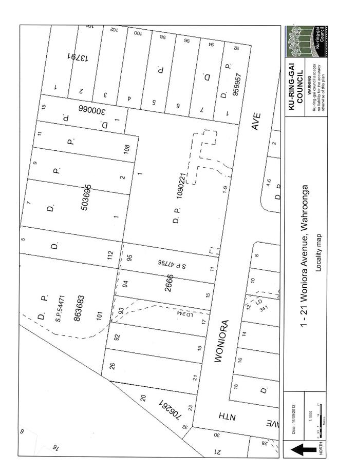
GB.8 11-21 Woniora Avenue - Extinguishment of Stormwater Drainage Easement
Attachment A2: Valuation advice from K D Wood Valuations (Aust) Pty Ltd
GB.9 Firs Cottage - Lease Renewal Submissions
Attachment A1: Heads of Agreement - Firs Cottage – 60A Clanville Road Roseville
GB.11 McIntyre Street to Dumaresq Street - New Road Tender T1-2015
Attachment A1: List of Tenders received and financial considerations
Attachment A2: Tender Evaluation Panel's recommendation
Attachment A3: Corporate Scorecard - Tenderer A - Financial and Performance Assessment
Attachment A4: Corporate Scorecard - Tenderer B - Financial and Performance Assessment
GB.12 Koola Park Upgrade (Stage 3) Tender T25-2014
Attachment A1: List of Tenders received, financial considerations and Tender Evaluation Panel's comments / recommendation
Address the Council
NOTE: Persons who address the Council should be aware that their address will be tape recorded.
Documents Circulated to Councillors
CONFIRMATION OF MINUTEs
Minutes of Ordinary Meeting of Council 8
File: S02131
Meeting held 31 March 2015
Minutes numbered 64 to 80
minutes from the Mayor
MM.1 Mollie Dive OAM – Induction into the NSW Cricket Hall of Fame 38
File: CY00455/3
It is with great pleasure that I advise my councillor colleagues and the local community of the induction of one of our most famous and deserving local sportswomen into NSW Cricket’s Hall of Fame.
Mollie Dive OAM, who passed away in 1997, was a long-time Ku-ring-gai resident, making her home in Roseville for many years and then in the Lourdes Retirement Village Killara from 1985 until her death.
Mollie was an outstanding cricketer of her time, rising from representative honours for NSW to become captain of the Australian women’s cricket team in 1948-49 and again in 1951.
At a time when media coverage of women’s sport is declining, it is interesting to note that the women’s test match held in Adelaide in the summer of 1948 drew a crowd of over 17,000 over three days. Mollie was to later comment on her feeling of great pride that the Australian team was able to win two subsequent test matches and claim the test series against England.
In all, Mollie played a total of seven test matches and eleven innings and was Australia’s captain in every test she played.
Mollie’s prowess as a sportsperson was not confined to cricket. She was an accomplished hockey player and umpire, and became an Australian selector for hockey during 1958-59. She also founded the North Shore Women’s Hockey Association in 1957 which continues to this day.
Mollie’s service to the sports of cricket and hockey was recognised in 1987 with the naming of the Mollie Dive Stand at North Sydney Oval in her honour and her Order of Australia Medal. After her playing days she unselfishly put back into both sports by giving many years of voluntary administrative work and assistance to younger players.
Ku-ring-gai Council is very proud of Mollie’s legacy and through this Mayoral Minute wishes to record our pride in the latest award honouring her achievements.
Petitions
GENERAL BUSINESS
i. The Mayor to invite Councillors to nominate any item(s) on the Agenda that they wish to have a site inspection.
ii. The Mayor to invite Councillors to nominate any item(s) on the Agenda that they wish to adopt in accordance with the officer’s recommendation allowing for minor changes without debate.
GB.1 The Novus Foundation 2015 Gala Dinner 39
File: S05650
To advise Council of a request from the Novus Foundation to purchase sponsorship package tickets for the Gala Dinner to be held at Miramare Gardens Function Centre, Terrey Hills on Saturday 30 May 2015.
Recommendation:
That Council purchase a sponsorship package of a table of 10 tickets for the Novus Foundation 2015 Gala Dinner, for $1,600, and that Councillors who are interested in attending the dinner advise the General Manager by Friday 1 May 2015.
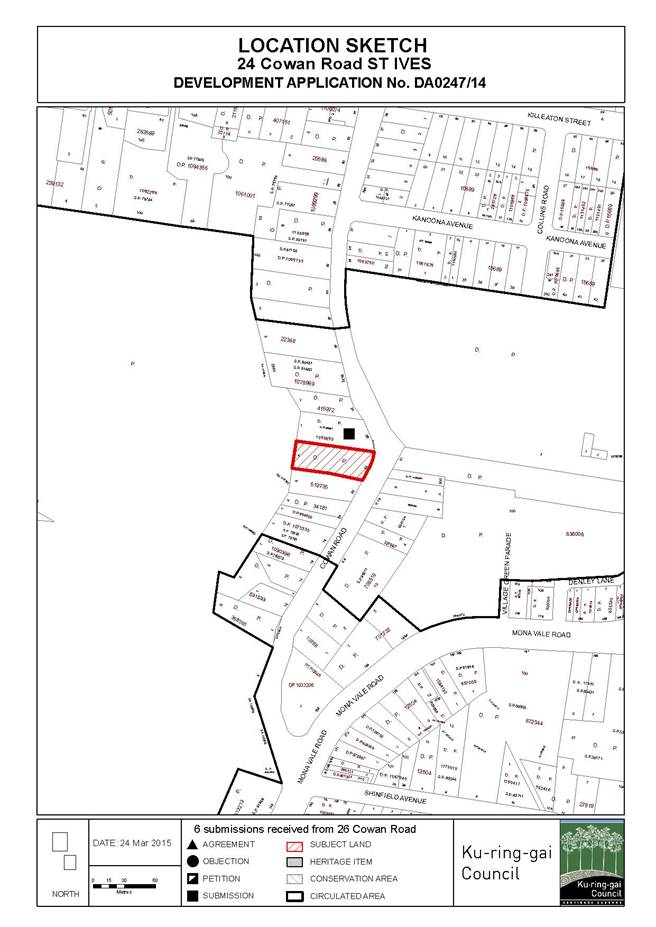
GB.2 24 Cowan Road - Demolish Existing Dwelling and Construct a Multi-Dwelling Development comprising Two Town Houses, Six Villas, Basement Parking and Landscape Works 48
File: DA0247/14
Ward: St Ives
Applicant: Mr S Macri
Owner: Mr J Irwin
To determine Development Application No. DA0247/14 which seeks consent for the demolition an existing dwelling and construction of a multi-dwelling development, comprising two town houses, six villas, basement parking and landscape works.
Recommendation:
Approval.
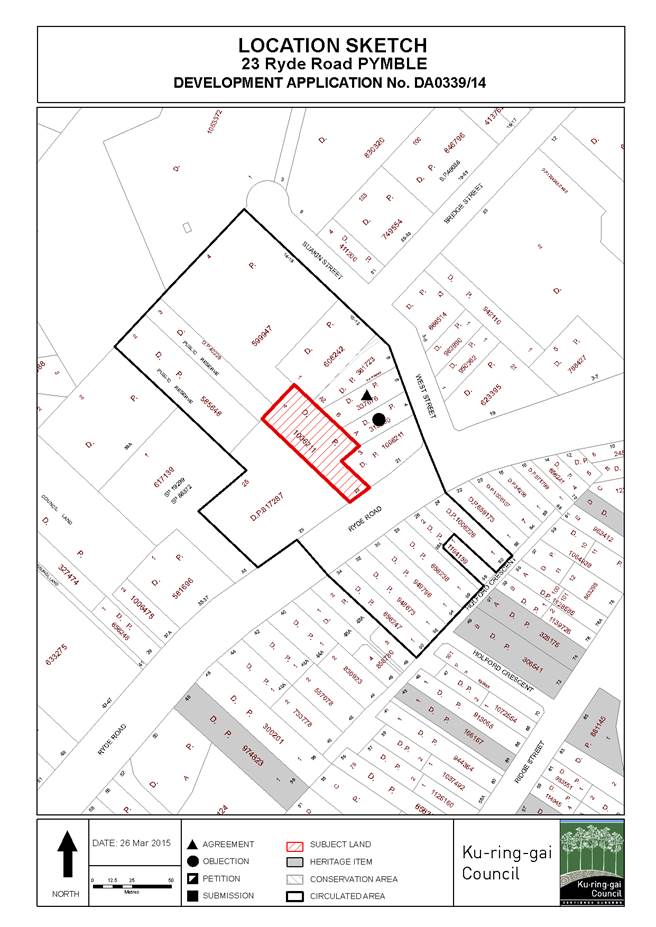
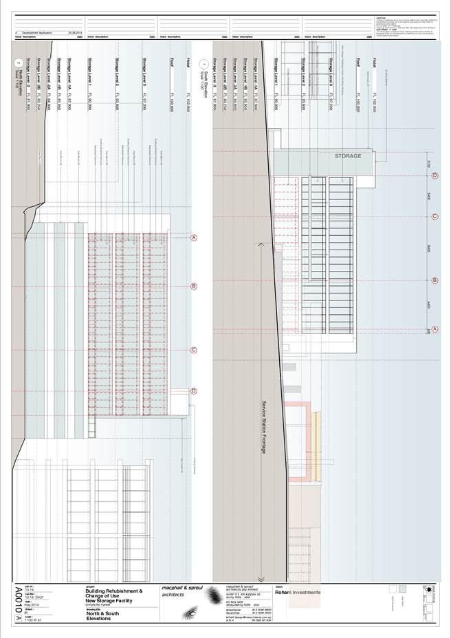
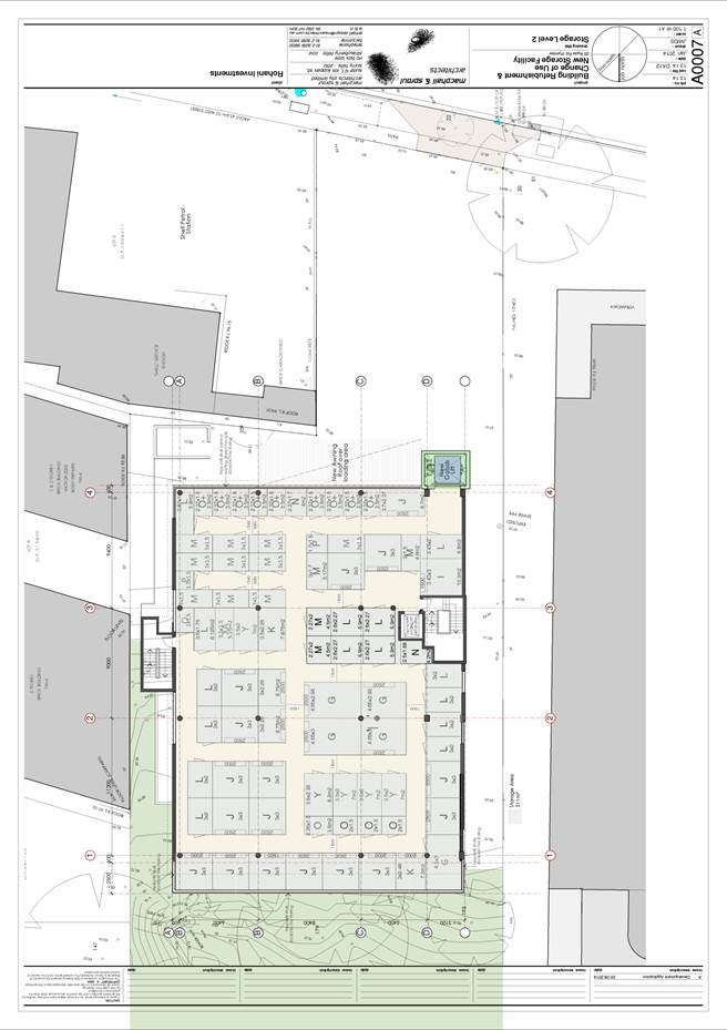
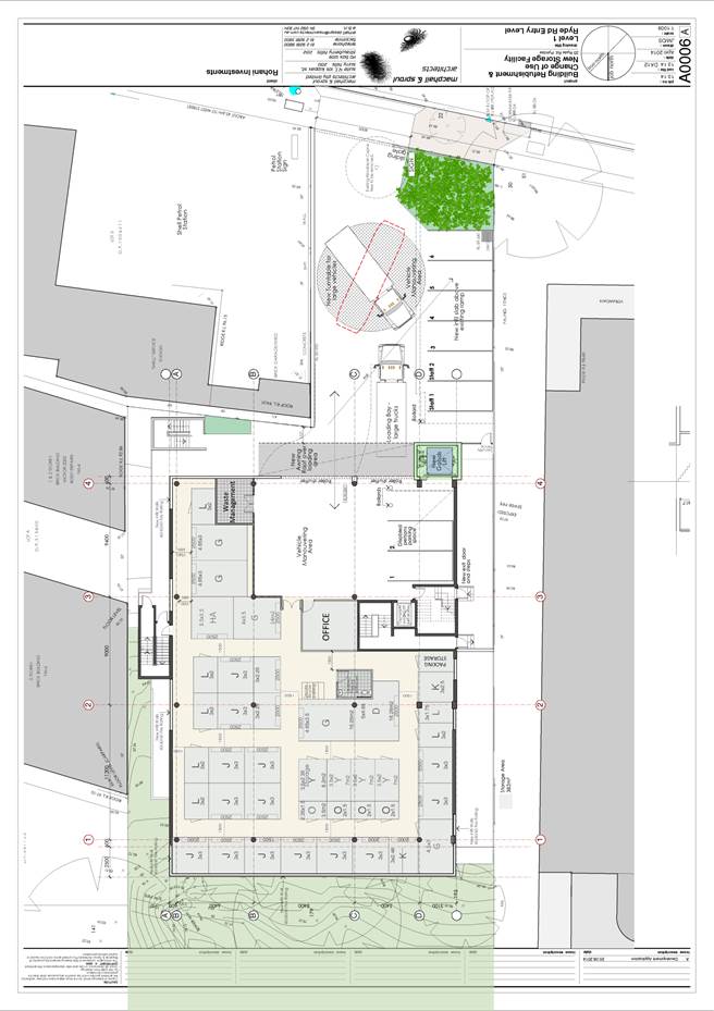
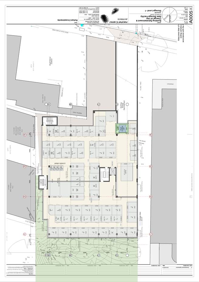
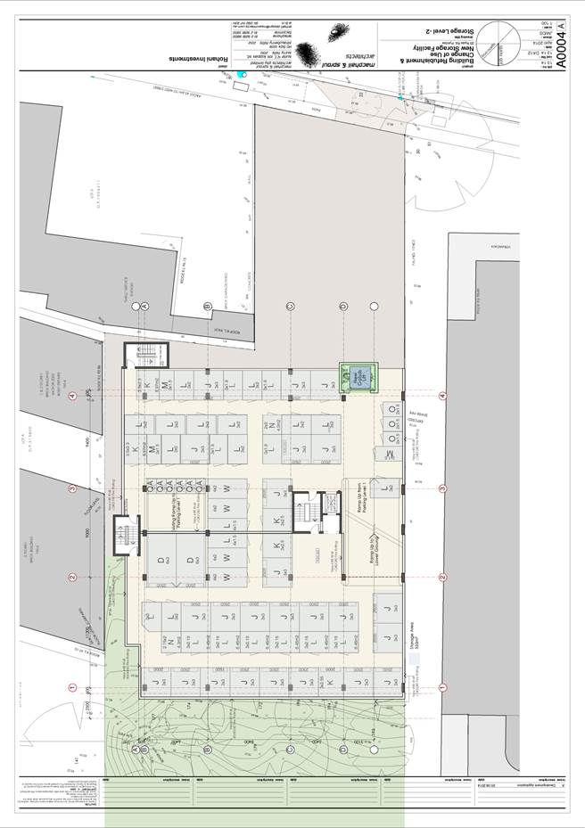
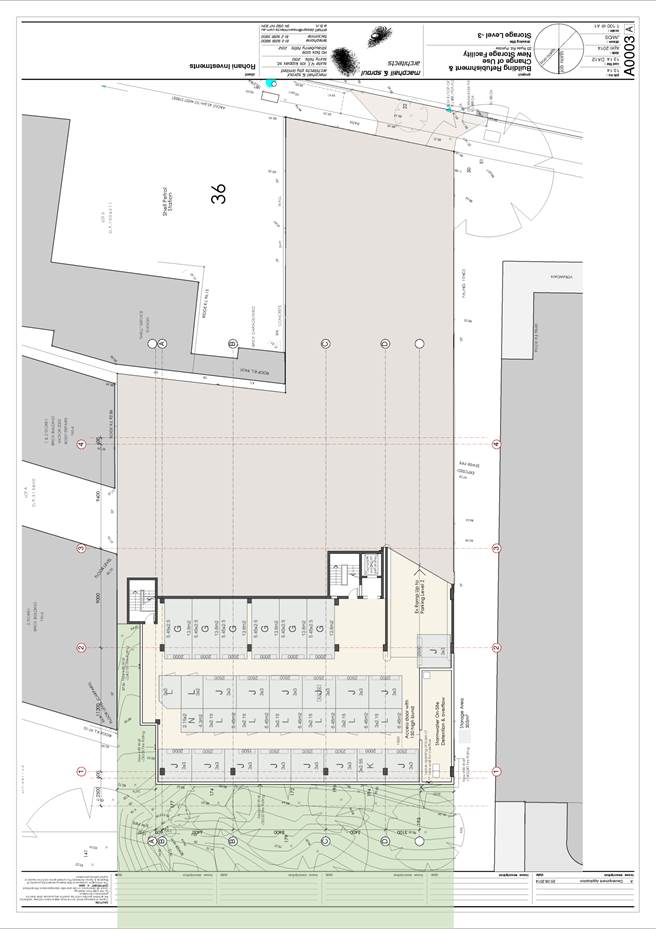
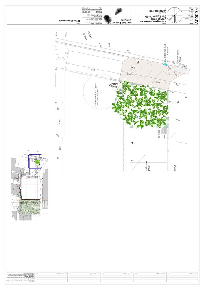
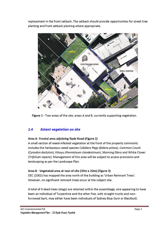
GB.3 23 Ryde Road Pymble - Change of Use to Self Storage Facility and Fit-out 216
File: DA0339/14
Ward: Comenarra
Applicant: Rohani Investments P/L
Owner: Rohani UT Holdings Pty Ltd
Change of use to self storage facility and fit-out.
Recommendation:
Approval.
GB.4 Planning
Proposal to Allow Dual-Occupancy on 28 Clissold Road, Wahroonga; 2 Loombah Avenue,
East Lindfield and Small Lot Subdivision
on 109 Bobbin Head Road, Turramurra 349
File: S10539
For Council to consider a Planning Proposal to amend the Ku-ring-gai Local Environmental Plan 2015 to allow dual occupancy on 28 Clissold Rd, Wahroonga and 2 Loombah Ave, East Lindfield; and to allow a small lot subdivision on 109 Bobbin Head Rd, Turramurra.
Recommendation:
That the Planning Proposal to amend the Ku-ring-gai Local Environmental Plan 2015 to allow dual occupancy on 28 Clissold Rd, Wahroonga and 109 Bobbin Head Rd, Turramurra be supported subject to the amendments outlined in the report. that the Planning Proposal to allow dual occupancy at 2 Loombah Ave, East Lindfield not be supported and that the Planning Proposal be amended by the applicant and prepared to the satisfaction of the Director Strategy and Environment, and then be forwarded to the Department of Planning and Environment for a Gateway Determination in accordance with the provisions of the EP&A Act and Regulations.
GB.5 Compulsory Acquisition of Roads - Lindfield 382
File: S10362
To advise Council on matters related to roads closures within the Lindfield major project sites.
Recommendation:
That Council proceed with the compulsory acquisition of the public roads for the purpose of creating the Lindfield Village Green and the Lindfield Community Hub in accordance with the Land Acquisition (Just Terms Compensation) Act 1991.
GB.6 Wahroonga Park Toilet Block - Tender T11/2014 426
File: S10233
To consider the tenders received for the demolition and construction of a new toilet block at Wahroonga Park, Wahroonga, and appoint the preferred tenderer.
Recommendation:
In accordance with Section 55 of the Local Government Act and Tender Regulations, it is recommended Council accept the tender submitted by tenderer ‘A’ as identified in the Confidential Summary (Attachment 2).
GB.7 Heritage Reference Committee Meeting Minutes 431
File: CY00069/7
Council to consider the minutes of the Heritage Reference Committee (HRC) meetings held on 10 November 2014 and 9 February 2015.
Recommendation:
That Council receive and note the Heritage Reference Committee meeting minutes from 10 November 2014 and 9 February 2015.
GB.8 11-21
Woniora Avenue - Extinguishment of Stormwater
Drainage Easement 441
File: CY00066/7
To consider a request to relocate Council’s stormwater infrastructure and extinguish an existing Council drainage easement (Dealing B549968) over the subject property.
Recommendation:
That Council grant approval for the extinguishment of the easement subject to conditions A to D of the report.
GB.9 Firs Cottage - Lease Renewal Submissions 449
File: S07252/6
To advise Council on submissions made in relation to the lease renewal of the Firs Cottage, Roseville Park, to the current lessee for a five (5) year term.
Recommendation:
That Council receive and note the submissions associated with the lease renewal of Firs Cottage.
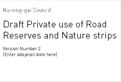
GB.10 Policy on Private Use of Road Reserves 456
File: S03467
For Council to adopt a review of the Private Use of Road Reserves and Nature Strips Policy.
Recommendation:
That Council adopt the review of the Private Use of Road Reserves and Nature Strips Policy.
GB.11 McIntyre Street to Dumaresq Street - New Road Tender T1-2015 474
File: S10226
To consider the tenders received for the building of a new road between McIntyre Street and Dumaresq Street, Gordon and appoint the preferred tenderer.
Recommendation:
In accordance with Section 55 of the Local Government Act and Tender Regulations, it is recommended that Council accept the tender submitted by Tenderer ‘A’ as identified in the Confidential Summary (Attachment1).
GB.12 Koola Park Upgrade (Stage 3) Tender T25-2014 480
File: S10422
To consider the tenders received for the rebuild and extension of Koola Park, East Killara and appoint the preferred tenderer.
Recommendation:
In accordance with Section 55 of the Local Government Act and Tender Regulations, it is recommended Council decline all submissions and authorise negotiations with the tenders submitted by tenderer ‘A’ to ‘E’ as identified in the Confidential Summary.
Extra Reports Circulated to Meeting
BUSINESS WITHOUT NOTICE – SUBJECT TO CLAUSE 241 OF GENERAL REGULATIONS
Questions Without Notice
Inspections Committee – SETTING OF TIME, DATE AND RENDEZVOUS
** ** ** ** ** **
MINUTES OF Ordinary Meeting of Council
HELD ON Tuesday, 31 March 2015
|
Present: |
The Mayor, Councillor J Anderson (Chairperson) (Roseville Ward) Councillors E Malicki & J Pettett (Comenarra Ward) Councillors D Citer & C Szatow (Gordon Ward) Councillors C Berlioz & D Ossip (St Ives Ward) Councillor D Armstrong (Roseville Ward) Councillors C Fornari-Orsmond & D McDonald (Wahroonga Ward) |
|
|
|
|
Staff Present: |
General Manager (John McKee) Director Corporate (David Marshall) Director Development & Regulation (Michael Miocic) Director Operations (Greg Piconi) Director Strategy & Environment (Andrew Watson) Director Community (Janice Bevan) Manager Records & Governance (Matt Ryan) Minutes Secretary (Sigrid Banzer) |
The Meeting commenced at 7.00pm
The Mayor offered the Prayer
The Mayor adverted to the necessity for Councillors and staff to declare a Pecuniary Interest/Conflict of Interest in any item on the Business Paper.
Councillor Cheryl Szatow declared a significant non-pecuniary interest in GB.5 - Consideration of Officers' Recommendation to the Sydney West Joint Regional Panel on S94 Contribution for DA0327/13 – [is a panel member of the Joint Regional Planning Panel [JRPP]) that will be determining this application and she will leave the Chamber during the debate and voting on the item.
Councillor Elaine Malicki declared a significant non-pecuniary interest in GB.5 - Consideration of Officers' Recommendation to the Sydney West Joint Regional Panel on S94 Contribution for DA0327/13 – [is a panel member of the Joint Regional Planning Panel [JRPP]) that will be determining this application and she will leave the Chamber during the debate and voting on the item.
Councillor Christiane Berlioz declared a significant non-pecuniary interest in GB.5 - Consideration of Officers' Recommendation to the Sydney West Joint Regional Panel on S94 Contribution for DA0327/13 – (is an alternate panel member of the Joint Regional Planning Panel [JRPP]) that will be determining this application and she will leave the Chamber during the debate and voting on the item.
DOCUMENTS CIRCULATED TO COUNCILLORS
The Mayor adverted to the documents circulated in the Councillors’ papers and advised that the following matters would be dealt with at the appropriate time during the meeting:
|
Councillors Information: |
Vehicle Load Limits on Local Roads - Heavy Vehicle National Law – Memorandum from Director Development and Regulation dated 23 March 2015 in answer to a Question Without Notice raised by Councillor Cheryl Szatow at the Ordinary Meeting of Council held 24 February 2015. |
PETITIONS
|
70 |
Update Report on the Development Contributions System
File: S06785/3 Vide: GB.7
|
|
|
The purpose of this report is to provide Council with an overview of key activities and highlights in the development contributions system since the last report to Council in October 2014 and anticipated actions and highlights for the coming 12 months.
|
|
|
(Moved: Councillors Szatow/McDonald)
That the latest update report on the development contributions system in Ku-ring-gai be received and noted.
CARRIED UNANIMOUSLY |
|
71 |
Gordon Hub - Authority to Liaise with Ausgrid - Electricity Substation located adjacent to Radford Place Gordon
File: S10376 Vide: GB.10
|
|
|
The purpose of the report is to provide for the on-going use/lease of the electricity substation owned by Ausgrid located in the car park at the rear of 818 Pacific Highway Gordon and to seek formal approval to commence discussions with Ausgrid in advance of the process of preliminary planning for the Gordon Community and Cultural hub as this is likely to necessitate relocation of this asset to accommodate most design solutions.
|
|
|
(Moved: Councillors Szatow/Fornari-Orsmond)
A. That Council authorise staff to liaise with Ausgrid to ensure that their requirements as currently provided for by the lease E479038 and associated easement on Lot 2 DP DP786550 known as 818 Pacific Highway, Gordon.
B. That Council delegates authority to the General Manager to liaise with the Department of Planning to amend the Planning Proposal in respect of 818 Pacific Highway, Gordon under Ku-ring-gai Local Environment Plan (Local Centres) 2012 to ensure the retention of Lease E479038 and the associated access and easement rights on the subject site in its current form until such time as it is relocated and replaced with a subsequent lease or is surrendered.
CARRIED UNANIMOUSLY |
|
72 |
File: S05624 Vide: GB.11
|
|
|
To seek Council’s endorsement of the concept design plan for the extension of Carcoola Park and to name the park “Lapwing Reserve”.
|
|
|
(Moved: Councillors Szatow/Berlioz)
A. That Council endorses the final design concept plan for Carcoola Road Reserve, St Ives as the basis on which staff prepare construction documentation including plans, details, sections and specifications; and tender documentation.
B. That Council endorses the proposed naming of the reserve as “Lapwing Reserve” and submission of an application to the Geographical Names Board for consideration.
CARRIED UNANIMOUSLY |
Motions of which due Notice has been given
|
73 |
Review and Improvements to Parking at Wahroonga Village Shops
File: S03125 Vide: NM.1
|
|
|
Notice of Motion from Councillor Fornari-Orsmond dated 31 March 2015
When Council considered and adopted the Wahroonga Town Centre Traffic and Parking Study Report prepared by Arup, Council adopted the recommendation to only allow a one (1) parking visit per day at the car park in Coonanbarra Road.
The purpose of only allowing one parking visit per day was to help prevent shop owners and staff occupying spaces as they were frequently changing vehicles around in the car park to avoid fines.
This has caused a general concern with the residents who use the car park and a number of fines have been issued as the notice is not clear for the users of the car park. As this is the only Council car park that has this restriction, it would be fairer to allow two (2) visits per day.
Some residents have also expressed concern that the 2 hour limit is not sufficient to allow them to complete their business.
Accordingly, I move:
“A. That Council staff carry out a review of the current parking conditions and restrictions at Wahroonga Village Shops, gather feedback from stakeholders and bring a report back to Council with the findings and recommendations.
B. That Council take into consideration the below points:
i. That the one (1) visit per day be increased to two (2) visits per day for the Wahroonga car park.
ii. That more prevalent and clearer signs be placed at the car park entrances advising users of the rule to permit two visits per day.
iii. That Council staff investigate the possibility of providing an area in the car park to allow for three (3) hour parking restrictions.”
|
|
|
(Moved: Councillors Fornari-Orsmond/Malicki)
That the above Notice of Motion as printed be adopted.
CARRIED UNANIMOUSLY |
GENERAL BUSINESS (cont)
Councillors Szatow, Malicki and Berlioz declared a
significant non-pecuniary interest in respect of the following item -
GB.5 – Consideration of Officers’ Recommendation
to the Sydney West Joint Regional Panel on S94 Contribution for DA0327/13
and withdrew from the Chamber taking no part
in discussion and voting on the item
|
74 |
Consideration of Officers' Recommendation to the Sydney West Joint Regional Panel on S94 Contribution for DA0327/13
File: DA0327/13 Vide: GB.5
|
|
|
The following member of the public addressed Council:
J Levy
|
|
|
For Council to determine whether it will make a submission to the JRPP on the Section 94 contribution for DA0327/13 which proposes construction of a new hospital at 742, 746 and 746A Pacific Highway, Gordon.
|
|
|
(Moved: Councillors Pettett/Fornari-Orsmond)
A. That Council note the officers’ report recommending refusal of for DA0327/13 which proposes demolition of three dwellings at 742, 746 and 746A Pacific Highway, Gordon and construction of a 4 storey hospital with 64 beds.
B. That Council does not make a submission on DA0327/13 to the Sydney West Joint Regional Planning Panel at its meeting on 15 April 2015 on the Section 94 contribution for DA0327/13.
For the Resolution: The Mayor, Councillor J Anderson, Councillors Pettett, Fornari-Orsmond and Armstrong
Against the Resolution: Councillors Citer, McDonald and Ossip
The above Resolution was CARRIED as an Amendment to the Original Motion. The Original Motion was:
(Moved: Councillors Citer/Ossip)
A. That Council note the officers’ report recommending refusal of for DA0327/13 which proposes demolition of three dwellings at 742, 746 and 746A Pacific Highway, Gordon and construction of a 4 storey hospital with 64 beds.
B. That Council makes a submission on DA0327/13 to the Sydney West Joint Regional Planning Panel at its meeting on 15 April 2015 on the Section 94 contribution for DA0327/13.
|
Councillors Szatow, Malicki and Berlioz returned
A Motion moved by Councillors McDonald and Szatow
that voting on the following Item – GB.6 - Planning Proposal to Amend the draft Ku-ring-gai Local Environmental Plan 2015 - Consideration of Submissions
be in seriatum was
CARRIED UNANIMOUSLY
|
75 |
Planning Proposal to Amend the draft Ku-ring-gai Local Environmental Plan 2015 - Consideration of Submissions
File: S10381 Vide: GB.6
|
|
|
The following member of the public addressed Council:
S Earp
|
|
|
For Council to consider the submissions made to the exhibition of the Planning Proposal to amend the Ku-ring-gai Local Environmental Plan 2015.
|
|
|
(Moved: Councillors McDonald/Pettett)
A. That the Planning Proposal to amend the KLEP 2015 to rectify anomalies, refine local clauses and incorporate amendments arising from submissions made to the exhibition be endorsed to proceed with the following variations:
1. To amend the KLEP 2015 Zoning Map for 2, 4, 6 Caithness Street, Killara to zone R3 Medium Density Residential, the FSR Map ‘J’ (0.8:1), the Height Map ‘L’ (11.5m), Lot Size Map ‘U1’ (1200sqm).
2. To not proceed with the rezoning of Council’s land adjacent to the Avondale Golf Course.
3. To not proceed with the extension of the riparian area at Woniora Avenue and Woonona Avenue North, Wahroonga.
4. To amend the KLEP 2015 Riparian Lands Map as it applies to 90 and 92 Babbage Road, Roseville Chase as per the amended mapping at Attachment A5.
5. To amend the proposed Schedule 3 (Complying Development ) Part 1 - Dwelling Houses in E4 Environmental Living zones clause 2 as follows:
(2) The development is not to be located within those parts of a site identified by clauses 6.6 or 6.7 of this LEP, or on Class 1-4 lands identified in Clause 6.8.
B. That, in accordance with Section 58 of the EP&A, the revised Planning Proposal be forwarded to the Department of Planning and Environment with the request that the amendments be made to Ku-ring-gai Local Environmental Plan 2015.
CARRIED UNANIMOUSLY
C. That 18 Culworth Avenue, Killara be included in a future Planning Proposal to amend errors, omissions and inconsistencies in the KLEP 2015 to amend the Floor Space Ratio Map to ‘Q’ (1.3:1), and Height of Building Map to ‘P’ (17.5m).
For the Resolution: Nil
Against the Resolution: The Mayor, Councillor J Anderson, Councillors Citer, McDonald, Pettett, Szatow, Malicki, Fornari-Orsmond, Ossip, Armstrong and Berlioz
No decision was taken in respect of the above matter as the Motion when put to the vote was LOST
D. That those who made submissions be notified of Council’s decision.
CARRIED UNANIMOUSLY
E. That all properties on the North side of Marian Street be included in the HCA C24.
CARRIED UNANIMOUSLY
|
|
76 |
Review and Amendments to the Bush Fire Prone Land Map
File: S06342/3 Vide: GB.8
|
|
|
For Council to note amendments to the Bush Fire Prone Land Map 2008 and to seek Council's approval to exhibit the draft Bush Fire Prone Land Map 2015 for the Ku-ring-gai Local Government Area (LGA).
|
|
|
(Moved: Councillors Malicki/Szatow)
That Council approves the draft Bush Fire Prone Land Map 2015 for the Ku-ring-gai Local Government Area (LGA) for public exhibition.
CARRIED UNANIMOUSLY |
|
77 |
Gordon and Turramurra Master Plans - Probity Framework
File: S10047 Vide: GB.9
|
|
|
The purpose of the report is to present to Council Probity Management Frameworks for both the Gordon Cultural Hub and the Turramurra Community Hub.
|
|
|
(Moved: Councillors Malicki/McDonald)
A. That Council receive and note the Probity Management Framework for both the Gordon Cultural Hub and Turramurra Community Hub projects.
B. That the word “key” in the first paragraph under section 3.2.4 Minutes of Meetings on page 24 of Attachment 1 – Turramurra Community Hub – Probity Management Framework and page 27 of Attachment 2 – Gordon Civic Hub – Probity Management Framework be removed.
CARRIED UNANIMOUSLY |
|
78 |
828 Pacific Highway Gordon - Independent Review
File: S10388 Vide: GB.12
|
|
|
To provide Council with the independent Project Review – 828 Pacific Highway Gordon Report.
|
|
|
(Moved: Councillors Berlioz/McDonald)
That Council formally endorses the recommendations of the BDO Auditors report and a further report come back to Council on how and when they will be actioned.
CARRIED UNANIMOUSLY
|
|
79 |
File: S07685 Vide: QN.1
|
|
|
Question Without Notice from Councillor David Armstrong
Does the Council have a program for low cost housing in Ku-ring-gai?
If so, could I have a written update?
Answer by the General Manager
To provide a full response, I will have the Director Strategy and Environment respond via e-mail, Councillor Armstrong.
|
|
80 |
Palliative Care Program in Ku-ring-gai
File: S02113 Vide: QN.2
|
|
|
Question Without Notice from Councillor David Armstrong
Does the Council have a palliative care program for Ku-ring-gai or are involved in a palliative care program in Ku-ring-gai?
Answer by the General Manager
No. There are palliative care facilities, I believe, within Ku-ring-gai but Council certainly doesn’t directly involve itself in palliative care.
|
The Meeting closed at 9.09
The Minutes of the Ordinary Meeting of Council held on 31 March 2015 (Pages 1 - 30) were confirmed as a full and accurate record of proceedings on 21 April 2015.
__________________________ __________________________
General Manager Mayor / Chairperson
|
Ordinary Meeting of Council - 21 April 2015 |
MM.1 / 36 |
|
|
|
|
Item MM.1 |
CY00455/3 |
|
|
13 April 2015 |
Mayoral Minute
Mollie
Dive OAM –
Induction into the NSW Cricket Hall of Fame
It is with great pleasure that I advise my councillor colleagues and the local community of the induction of one of our most famous and deserving local sportswomen into NSW Cricket’s Hall of Fame.
Mollie Dive OAM, who passed away in 1997, was a long-time Ku-ring-gai resident, making her home in Roseville for many years and then in the Lourdes Retirement Village Killara from 1985 until her death.
Mollie was an outstanding cricketer of her time, rising from representative honours for NSW to become captain of the Australian women’s cricket team in 1948-49 and again in 1951.
At a time when media coverage of women’s sport is declining, it is interesting to note that the women’s test match held in Adelaide in the summer of 1948 drew a crowd of over 17,000 over three days. Mollie was to later comment on her feeling of great pride that the Australian team was able to win two subsequent test matches and claim the test series against England.
In all, Mollie played a total of seven test matches and eleven innings and was Australia’s captain in every test she played.
Mollie’s prowess as a sportsperson was not confined to cricket. She was an accomplished hockey player and umpire, and became an Australian selector for hockey during 1958-59. She also founded the North Shore Women’s Hockey Association in 1957 which continues to this day.
Mollie’s service to the sports of cricket and hockey was recognised in 1987 with the naming of the Mollie Dive Stand at North Sydney Oval in her honour and her Order of Australia Medal. After her playing days she unselfishly put back into both sports by giving many years of voluntary administrative work and assistance to younger players.
Ku-ring-gai Council is very proud of Mollie’s legacy and through this Mayoral Minute wishes to record our pride in the latest award honouring her achievements.
|
That this Mayoral Minute be received and noted.
|
|
Jennifer Anderson Mayor |
|
|
Ordinary Meeting of Council - 21 April 2015 |
GB.1 / 38 |
|
|
|
|
Item GB.1 |
S05650 |
|
|
10 April 2015 |
The Novus Foundation 2015 Gala Dinner
EXECUTIVE SUMMARY
|
purpose of report: |
To advise Council of a request from the Novus Foundation to purchase sponsorship package tickets for the Gala Dinner to be held at Miramare Gardens Function Centre, Terrey Hills on Saturday 30 May 2015. |
|
|
|
|
background: |
The Novus Foundation was established in 2006, a collaboration between Phil McCarroll Automotive and the Rotary Club of Wahroonga. The Foundation supports projects directed at the welfare of young people in the Hornsby and Ku-ring-gai region. The primary target group is young people under 25 years of age. |
|
|
|
|
comments: |
Proceeds from the Novus Foundation fundraising in 2015 will support KYDS, StreetWork, Achieve Australia, Open Heart International, Australian Research Institute, and Rotary Club of Wahroonga Youth Projects. Individual tickets for the dinner are $160 per person and sponsorship packages (tables of 10) are available for $22,000, $11,000, $5,500, $3,300 and $1,600. |
|
|
|
|
recommendation: |
That Council purchase a sponsorship package of a table of 10 tickets for the Novus Foundation 2015 Gala Dinner, for $1,600, and that Councillors who are interested in attending the dinner advise the General Manager by Friday 1 May 2015. |
Purpose of Report
To advise Council of a request from the Novus Foundation to purchase sponsorship package tickets for the Gala Dinner to be held at Miramare Gardens Function Centre, Terrey Hills on Saturday 30 May 2015.
Background
The Novus Foundation was established in 2006, as a partnership between Phil McCarroll Automotive and the Rotary Club of Wahroonga. The Foundation supports projects directed at the welfare of young people in Hornsby and Ku-ring-gai region. The primary target group is young people under 25 years of age. The aim is to develop and support projects and organisations that are investing in youth, primarily in the following areas:
· Direction – giving young people improved mentoring and guidance
· Educational – giving young people wider access to skills
· Health – giving young people access to health programs, including youth related medical research
Council has been associated with the Novus Foundation Dinner for the past 5 years and in 2014 Council purchased a table of 10 tickets for $1,600.
Comments
The Foundation will be holding a Gala Dinner on Saturday 30 May 2015 at Miramare Gardens Function Centre, Terrey Hills. The purpose of the Gala Dinner is to raise funds for nominated projects. In 2015 the Novus Foundation is supporting the following organisations:
· KYDS
· StreetWork
· Achieve Australia
· Open Heart International
· Australian Research Institute
· Rotary Club of Wahroonga Youth Projects
Individual tickets for the Gala Dinner are $160.00 per person. The following Sponsorship packages are also available:
· A Bronze sponsorship table of 10 can be purchased for $1,600.
· A Silver sponsorship table of 10 can be purchased for $3,300 and includes preferential table location, sponsorship acknowledgement (table ID signage, corporate logo on screen and in official program for the evening).
· Sponsorship packages (tables of 10) are also available for $22,000, $11,000 and $5,500.
A copy of the brochure and invitation from The Novus Foundation is attached to this report. (Attachment)
integrated planning and reporting
|
Community Strategic Plan Long Term Objective |
Delivery Program Term Achievement |
Operational Plan Task |
|
C1.1 An equitable and inclusive community that cares and provides for its members.
|
Access has increased for communities that face barriers to using social services and facilities.
|
Implement priority recommendations and programs from Council’s Youth Strategy.
|
Governance Matters
In accordance with Council’s ‘Policy for the Payment of Expenses and Provision of Facilities to Councillors’ - Local Travel Arrangements, Attendance at Dinners and Other Non-Council Functions:
Council shall meet the cost of Councillors’ attendance at functions that are of a formal or ceremonial nature within the Sydney metropolitan area, including functions for charities, community service and sporting groups supported by Council or of which Council is a financial member. Council shall also meet the cost of Councillors’ attendance at dinners and other non-council functions which provide briefings to Councillors from key members of the community, politicians and business where the function is relevant to Council’s interest. Council shall meet the cost of any component of the ticket to the function that is a donation to a registered charity but shall not meet the cost of any component of the ticket that is a donation to a political party, candidate’s electoral fund or other private benefit. Each Councillor is entitled to a maximum of $1,029 per year of term for external payments in respect of the types of expenses described in this paragraph.
Risk Management
There are no significant risk management matters directly associated with this report.
Financial Considerations
Council has been invited to sponsor a table of 10 at the dinner for $22,000, $11,000, $5,500, $3,300 and $1,600. Individual tickets for the dinner are $160 per person. There are funds available in the 2014/15 budget for the purchase of Bronze Sponsorship tickets ($1,600) for the Gala Dinner.
Social Considerations
Attendance at the Gala Dinner will enable Councillors to meet other members of the community who support the Novus Foundation. There will also be opportunities to obtain further details about individual projects from representatives of various community organisations.
Environmental Considerations
There are no significant environmental considerations associated with this report.
Community Consultation
No community consultation was undertaken in the writing of this report.
Internal Consultation
Council’s Corporate department has been consulted in the writing of this report.
Summary
Council has received an invitation to purchase sponsorship tickets for the Novus Foundation Gala Dinner to be held on Saturday 30 May 2015 at Miramare Gardens Function Centre at Terrey Hills. Individual tickets are $160 each and sponsorship packages (tables of 10) are available for $22,000, $11,000, $5,500, $3,300 and $1,600.
Council has been associated with the Novus Foundation Gala Dinners for 5 years, and in 2014 Council purchased a table of 10 tickets for the fund raising dinner.
This report recommends Council purchase a table of 10 tickets for the 2015 Gala Dinner for $1,600.
|
A. That Council purchase a sponsorship package of a table of 10 tickets for $1,600 for the Novus Foundation Gala Dinner on Saturday 30 May 2015.
B. That any Councillors who would like to attend the Novus Foundation 2015 Gala Dinner advise the General Manager by Friday 1 May 2015.
|
|
Janice Bevan Director Community |
|
|
A1View |
Invitation - Novus Foundation Gala Dinner - 30/05/2015 |
|
2015/084488 |
|
Ordinary Meeting of Council - 21 April 2015 |
GB.2 / 47 |
|
|
|
|
Item GB.2 |
DA0247/14 |
|
|
27 March 2015 |
development application
Summary Sheet
|
Report title: |
24 Cowan Road - Demolish Existing Dwelling and Construct a Multi-Dwelling Development comprising Two Town Houses, Six Villas, Basement Parking and Landscape Works |
|
ITEM/AGENDA NO: |
GB.2 |
|
Application No: |
DA0247/14 |
|
Property Details: |
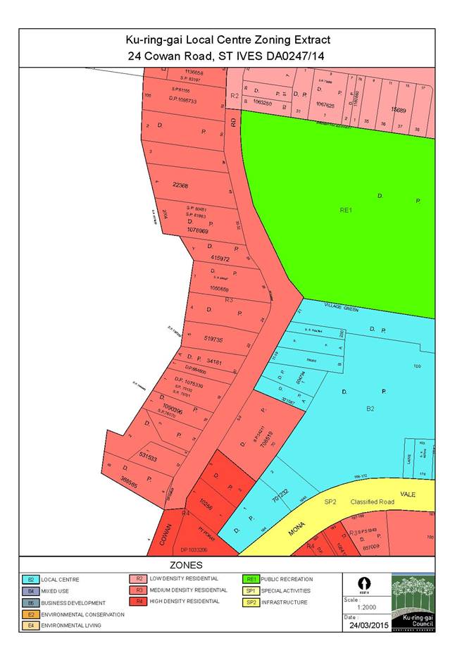
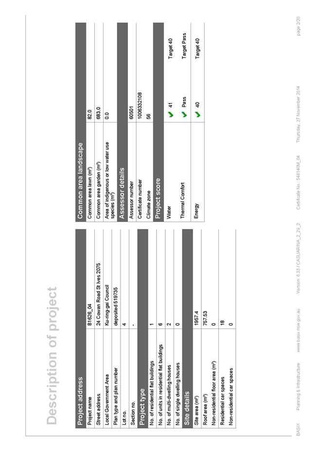
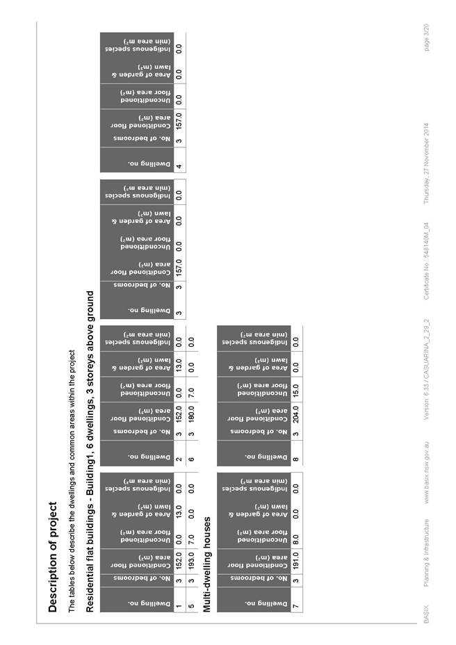
24 Cowan Road, St Ives NSW 2075 Lot & DP No: Lot 4 DP 519735 Site area (m2): 1,957.4m² Zoning: R3 Medium Density Residential |
|
Ward: |
|
|
Proposal/Purpose: |
To determine Development Application No. DA0247/14 which seeks consent for the demolition an existing dwelling and construction of a multi-dwelling development, comprising two town houses, six villas, basement parking and landscape works. |
|
Type of Consent: |
Local |
|
Applicant: |
Mr S Macri |
|
Owner: |
Mr J Irwin |
|
Date Lodged: |
4 July 2014 |
|
Recommendation: |
Approval. |
Purpose of Report
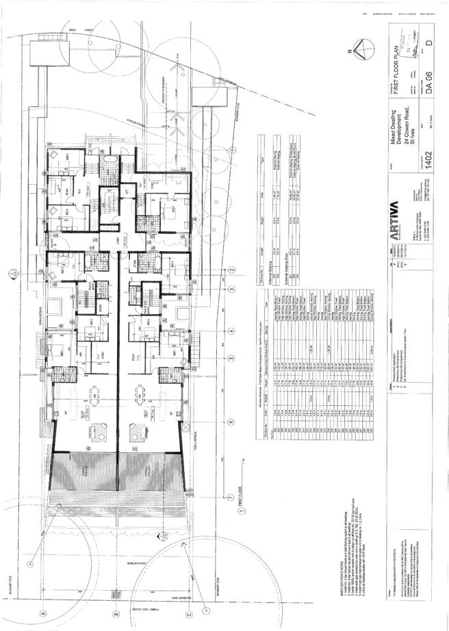
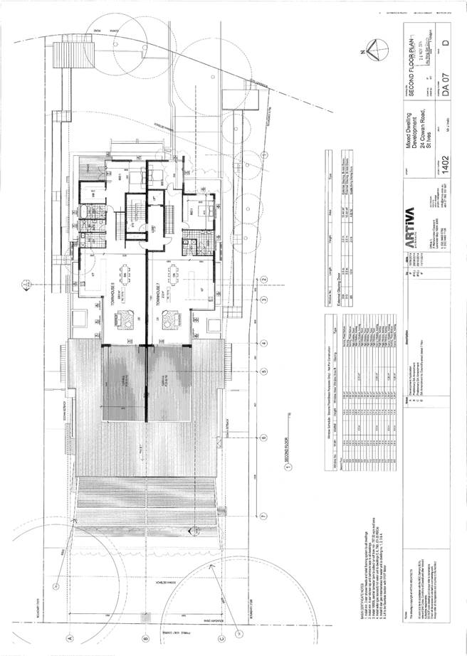
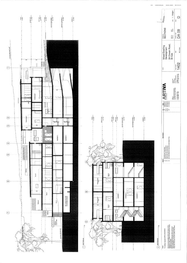
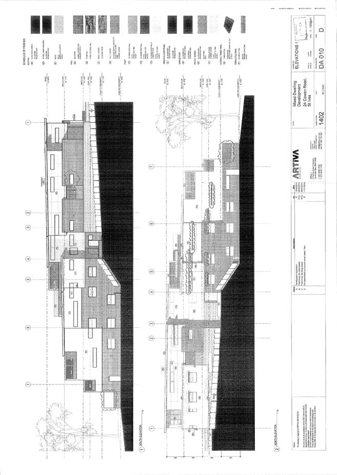
To determine Development Application No. DA0247/14 which seeks consent for the demolition of an existing dwelling and construction of a multi-dwelling development, comprising two town houses, six villas, basement parking and landscape works.
integrated planning and reporting
Places, Spaces & Infrastructure
|
Community Strategic Plan Long Term Objective |
Delivery Program Term Achievement |
Operational Plan Task |
|
P3.1 The built environment delivers attractive, interactive and sustainable living and working environments.
|
A high standard of design quality and building environmental performance is achieved in new development.
|
Assessment of applications is consistent with Council’s adopted LEPs and DCPs.
|
Executive Summary
Issues: Minimum street frontage, solar access
Submissions: Six submissions received
Land & Environment Court: N/A
Recommendation: Approval
History
Site
Council’s records indicate that the site has historically been used for residential purposes.
Pre-DA
There was no Pre-DA consultantion.
DA history
There are no previous applications of relevance to the subject application.
The Site
Site description
The site is irregular in shape with a curved 29.66 metres frontage, a maximum depth of 75.375 metres and a total area of 1957.4m². The site is located on the western (low) side of Cowan Road, near the intersection with Village Green Parade. The site has a fall from front to rear of approximately 5.5 metres and contains a number of trees and landscaped gardens.
The site is currently occupied by a one and two storey dwelling house and an in-ground swimming pool.
Surrounding development
The subject site is bounded to the rear by the Pymble Golf Course and is located opposite the St Ives Shopping Centre. The site is otherwise surrounded by allotments zoned for medium density residential development which are occupied by a mixture of seniors living units and single dwellings of various architectural styles. A multi dwelling housing development, previously approved under DA0182/13, is currently being constructed on the adjoining site immediately to the south, (No 22 Cowan Rd) whilst a two and three storey apartment complex adjoins to the immediate north of the site (26 Cowan Rd).
The Proposal
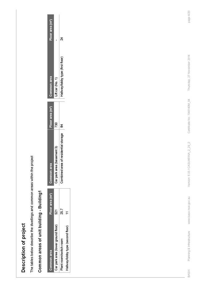
The application involves the demolition of the existing dwelling and associated structures and the construction of a multi dwelling housing development (as amended) comprising 2 x two storey townhouses and 6 x single level villas, each providing 3 bedrooms. A basement car park over three levels will provide 12 residents’ car spaces and 2 visitor spaces, with lift and stair access provided to the upper levels.
Amended plans dated 11 November 2014
Following a preliminary review of the application the following issues were identified:
· inconsistencies between the landscape plan and the BASIX certificate
· lack of detail relating to floor space ratio, solar protection elements, solar access, air conditioning plant room and garage door
· amendments to pedestrian access, driveway, bicycle spaces, window treatment, wall treatment, deep soil calculation and location of internal study rooms were required
These issues were conveyed to the applicant by letter dated 17 September 2014 and, in response, the applicant provided amended plans/information which addressed these issues.
Consultation
Community
In accordance with the Local Centres DCP, owners of surrounding properties were given notice of the application. In response, submissions from the following were received:
1. Barbara Hamilton, 7/26 Cowan Road, St Ives
2. Valerie McMahon, 6/26 Cowan Road, St Ives
3. Jim & Pam Duncan, 5/26 Cowan Road, St Ives
4. John & Joan Burstall, 4/26 Cowan Road, St Ives
5. Michael Hoskins, 2/26 Cowan Road, St Ives
6. Peter & Rosalie Moate, 1/26 Cowan Road, St Ives
The submissions raised the following issues:
Privacy
The building has been designed in such a way that the majority of the windows on the northern elevation are associated with the secondary such as bedrooms and bathrooms and, as such, they are infrequently used during daylight hours. The remainder of the windows, associated with higher use areas of the dwellings, are either highlight windows or have been located within recessed areas ensuring that they are located further back from the boundary. There is one large window associated with a study on the northern elevation which, by virtue of the fact that the building sits forward of the adjacent building at No. 26 Cowan Road, will overlook the open space area within the front setback. Terraces and balconies have been orientated towards the front and rear of the building with privacy screens and louvre panels provided to the sides of these elements. Additionally, the provision for screen planting in the landscape plan ensures that privacy impacts and any opportunities for overlooking into habitable rooms and open space areas of adjoining properties from these windows and the balconies are minimal.
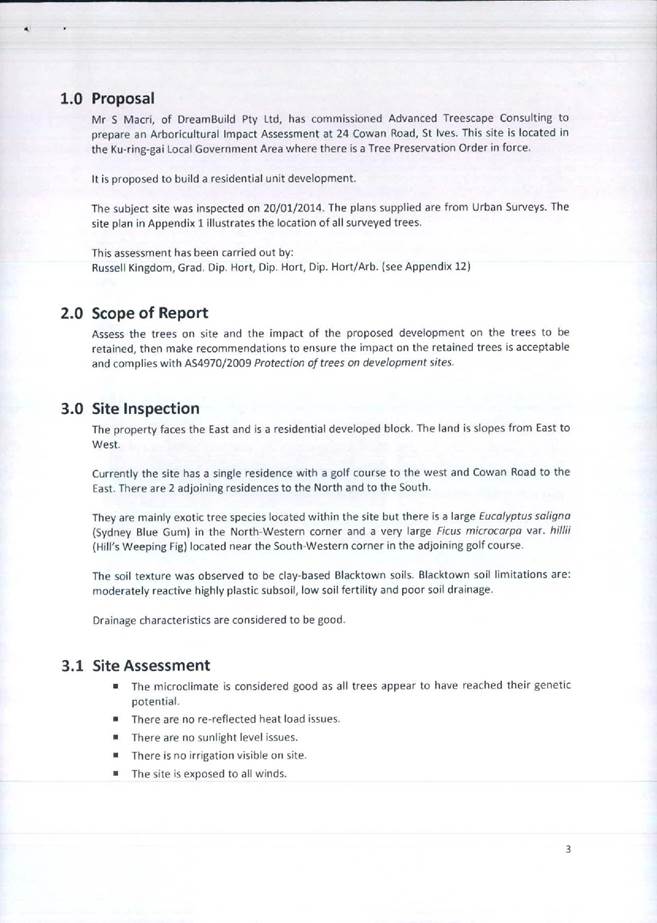
Impacts on trees
The applicant’s arboricultural report has been lodged and reviewed by Council’s Senior Landscape Development Officer. The proposal is considered to be acceptable in terms of both the removal of trees and the provision of replacement canopy trees.
Allegations pertaining to the removal of two large trees within the front setback of the site at some time during the last few years, without Council approval, have been made. It is unfortunate that the objectors did not raise the issue at the time to have enabled proper investigation of the matter. Consequently, it is unclear whether the location of the trees would have hindered the proposed development works as the setback proposed may have accommodated the retention of the trees. Notwithstanding this, it is considered that the subject development will in time provide a landscape setting that will maintain the landscape character of the locality.
Insufficient provision of soft landscaping
The extent of proposed deep soil soft landscaping complies with Council’s control.
Insufficient front setback
Whilst it is acknowledged that the subject building sits forward of the building line dictated by the development on the adjoining site, the proposed development has been assessed against the front setback controls contained with the Local Centres Development Control Plan and is compliant in this regard. In addition, it is noted that Cowan Road bends to the west at this point and that, by virtue of this, the subject development will sit forward of the adjoining property at No. 26 Cowan Road.
Building bulk, scale and loss of natural light
The proposed development meets the development standards contained with the Ku-ring-gai Local Environmental Plan (Local Centres) 2012 in relation to maximum height and floor space ratio. In addition, the development is compliant with building setbacks and building separation controls which seek to limit the bulk and scale of new development and minimise its impacts on adjoining properties. The property at No. 26 Cowan Road is located north of the subject site and, as such, the proposal will not have any significant detrimental impact on this property in terms of solar access or natural light.
Increased amount of traffic
Council’s Senior Development Engineer has raised no concerns in relation to potential traffic issues as a result of the development. A traffic report has been lodged and the application has been assessed against the provisions of the Local Centres Development Control Plan and meets all requirements in terms of on-site parking for residents and visitors alike.
Amended plans dated 11 November 2014
The amended plans were not notified to surrounding residents as the proposed amendments do not result in a greater environmental impact than the original proposal.
Within Council
Urban design
Council’s Urban Design Consultant reviewed the proposal as amended against the 10 design quality principles of SEPP 65 and commented as follows:
PRINCIPLE 1: CONTEXT
Good design responds and contributes to its context. Context can be defined as the key natural and built features of an area. Responding to context involves identifying the desirable elements of a location’s current character or, in the case of precincts undergoing a transition, the desired future character as stated in planning and design policies. New buildings will thereby contribute to the quality and identity of the area.
The site location, shape, size, fall, zoning and neighbouring properties have been described previously.
The shortfall of street frontage in relation to the size of the lot has been discussed previously. This aspect is considered acceptable from an urban design perspective.
The proposal is for multi-dwelling housing. Under KLEPLC2012, residential flat buildings are a prohibited land use. Because the proposal is 3 or more storeys and contains 4 or more dwellings, the proposal triggers SEPP 65 and it is therefore proper for the application to address the SEPP 65 Design Quality Principles. However, the relevant control to assess a multi-dwelling housing development against is considered to be KLCDCP2013 Part 6. It is not considered appropriate to use the Residential Flat Design Code to justify non-compliances.
PRINCIPLE 2: SCALE
Good design provides an appropriate scale in terms of the bulk and height that suits the scale of the street and the surrounding buildings. Establishing an appropriate scale requires a considered response to the scale of existing development. In precincts undergoing a transition, proposed bulk and height needs to achieve the scale identified for the desired future character of the area.
Building length and facade length have been discussed previously. These aspects are considered acceptable.
PRINCIPLE 3: BUILT FORM
Good design achieves an appropriate built form for a site and the building’s purpose, in terms of building alignments, proportions, building type and the manipulation of building elements. Appropriate built form defines the public domain, contributes to the character of streetscapes and parks, including views and vistas, and provides internal amenity and outlook.
The site layout has been discussed previously. This aspect is considered acceptable.
The issue of the design of the southern pedestrian entry from the street has been satisfactorily resolved. A canopy has been provided over the entry gate which will improve the street address point for Villas 1, 3 and 5. This aspect is now considered acceptable.
The issue of habitable windows at the third storey set back less than 6m from the boundary has been satisfactorily resolved. The lower panes of the double hung corner windows to Villa 5 Bed 1 and Villa 6 Bed 1 have been made obscure which will prevent over looking of the neighbours. This aspect is now considered acceptable.
The issue of the treatment of the wall on the southern elevation has been satisfactorily resolved through the introduction of an alternative material treatment to the lowest level. The stone wall finish assists to visually break down the height of this wall and provides an attractive finish to this side passage entry. This aspect is now considered acceptable.
The driveway has been widened and the plan of Townhouse 7 has been altered to accommodate additional head clearance. The internal alterations to Townhouse 7 are considered to be acceptable, as are the elevational changes to the east and south facades.
PRINCIPLE 4: DENSITY
Good design has a density appropriate for a site and its context, in terms of floor space yields (or number of units or residents). Appropriate densities are sustainable and consistent with the existing density in an area or, in precincts undergoing a transition, are consistent with the stated desired future density. Sustainable densities respond to the regional context, availability of infrastructure, public transport, community facilities and environmental quality.
The issue of inclusion of the party walls in the gross floor area diagrams has been resolved. The letter accompanying the revised drawings states that the architect has confirmed that all party walls have been included in the measurement. This aspect is now considered acceptable.
The issue of the basement level contributing to the floor space ratio by exceeding the car parking requirements has been addressed by converting four car spaces into ‘golf buggy trailer storage’ and one space into a ‘shared zone’ for accessible parking. These changes should be captured by future titling of the dwellings to ensure that the future use is as described (Condition 82). This aspect is now considered acceptable from an urban design perspective.
PRINCIPLE 5: RESOURCE, ENERGY AND WATER EFFICIENCY
Good design makes efficient use of natural resources, energy and water throughout its full life cycle, including construction. Sustainability is integral to the design process. Aspects include demolition of existing structures, recycling of materials, selection of appropriate and sustainable materials, adaptability and reuse of buildings, layouts and built form, passive solar design principles, efficient appliances and mechanical services, soil zones for vegetation and reuse of water.
The issue of shading to windows on the northern elevation has been satisfactorily resolved. Sun hoods have been provided over the majority of ground, first and second level windows to habitable rooms. This aspect is now considered acceptable.
The issue of providing an external clothes drying area within each private open space remains as previously discussed. This aspect is conditioned (Condition 24).
PRINCIPLE 6: LANDSCAPE
Good design recognises that together landscape and buildings operate as an integrated and sustainable system, resulting in greater aesthetic quality and amenity for both occupants and the adjoining public domain. Landscape design builds on the site’s natural and cultural features in responsible and creative ways. It enhances the development’s natural environmental performance by co-ordinating water and soil management, solar access, micro-climate, tree canopy and habitat values. It contributes to the positive image and contextual fit of development through respect for streetscape and neighbourhood character, or desired future character. Landscape design should optimise usability, privacy and social opportunity, equitable access and respect for neighbour’s amenity, and provide for practical establishment and long term management.
The issue of defining the extent of the courtyards to Villas 1 and 2 has been satisfactorily resolved. A note on the landscape site plan (sheet 1 of 3) indicates ‘line of private open space fence at lawn level.‘ This should be captured in the future titling of the dwellings to ensure that the side and rear setbacks remain in common ownership (Condition 83). This aspect is now considered acceptable.
The issue of providing water outlets to all primary open spaces has been satisfactorily resolved. This aspect is now considered acceptable.
PRINCIPLE 7: AMENITY
Good design provides amenity through the physical, spatial and environmental quality of a development. Optimising amenity requires appropriate room dimensions and shapes, access to sunlight, natural ventilation, visual and acoustic privacy, storage, indoor and outdoor space, efficient layouts and service areas, outlook and ease of access for all age groups and degrees of mobility.
The issue of achieving three hours direct sunlight to the living rooms of Villa 3 and Villa 5 between 9am and 3pm on 21st June remains as previously discussed. Achievement of three hours direct sunlight would require that the terrace of Villa 5 did not overhang the terrace of Villa 3 and that the roof over Villa 5 did not overhang the terrace of Villa 5. The use of the Residential Flat Design Code to justify a non-compliance in a multi dwelling development is not considered to be appropriate (see PRINCIPLE 1: CONTEXT). Solar access is a primary amenity standard and it should be upheld wherever possible. This aspect should be addressed. It is noted, however that the living rooms of Villas 3 and 5 will receive 2 hours direct sunlight from 1pm onwards in its current configuration, as well as (suboptimal) low western solar access after 3pm. Townhouse 7 could be improved through the inclusion of a skylight to the living room area.
The issue of internalised study rooms in Villas 3 and 4 has been satisfactorily resolved. The design of these studies has been amended to be similar to those in Villas 5 and 6 which are open to the corridor and provide a screen element to the dining space. This aspect is now considered acceptable.
The issue of privacy to Villa 3 Bed 3 from the entry courtyard has been satisfactorily resolved. The window in question has been removed and an alternative window is available for this bedroom. This aspect is now considered acceptable.
Planning comment: It is acknowledged that the living rooms of Villas 3 and 5 will only receive two hours direct sunlight between the hours of 1pm and 3pm on 21st June as well as later western solar access after 3pm and before 4pm. The dwellings are orientated in such a way that the living areas and associated terraces face the rear of the site to take advantage of the western aspect and the views over Pymble Golf Course. This is considered to be an important consideration in a merit assessment of the amenity available to the residents of Villas 3 and 5. Therefore, it is considered that changes to the roof forms over these private open space areas to achieve an additional hour of direct sunlight in winter is offset by the fact that the overhanging roofs will provide the desirable shade to these areas in the summer months. Therefore, changes to the design of the roof form will not be required.
PRINCIPLE 8: SAFETY AND SECURITY
Good design optimises safety and security, both internal to the development and for the public domain. This is achieved by maximising overlooking of public and communal spaces while maintaining internal privacy, avoiding dark and non-visible areas, maximising activity on streets, providing clear, safe access points, providing quality public spaces that cater for desired recreational uses, providing lighting appropriate to the location and desired activities, and clear definition between public and private spaces.
The issue of lighting to the street entries and along the side entry paths has been partially addressed. The ground floor plan (DA05) shows some lighting to these areas. Additional lighting should be provided for the northern pedestrian entry, to the northern courtyard area, and also to the external stairs leading to the gates to Villas 1 and 2. This aspect is conditioned. (Condition 23)
The issue of inclusion of a garage door to the driveway has been satisfactorily resolved. The ground floor plan (DA05) shows a garage door in a sensible location at the bottom of the driveway ramp. The proposed material selection for the garage door is suitable and its appearance will be satisfactory from the front elevation. This aspect is now considered acceptable.
The issue of proximity of the southern pedestrian entrance to the vehicular access has been satisfactorily resolved. The pedestrian entrance has been moved further to the south such that it is now 3m away from the driveway. This aspect is now considered acceptable.
PRINCIPLE 9: SOCIAL DIMENSIONS AND HOUSING AFFORDABILITY
Good designs respond to the social context and needs of the local community in terms of lifestyles, affordability, and access to social facilities. New developments should optimise the provision of housing to suit the social mix and needs in the neighbourhood or, in the case of precincts undergoing transition, provide for the desired future community. New developments should address housing affordability by optimising the provision of economic housing choices and providing a mix of housing types to cater for different budgets and housing needs.
Adaptable apartment design has been discussed previously. This aspect is considered acceptable.
The issue of visitability remains as previously discussed. Adjustments to layouts are required to ensure that at least 70% (6 of 8) of dwellings have visitable bathrooms. This requires an area of 900mm x 1250mm clear in front of the toilet plan unobstructed by door swings on the same floor level as a living room. This aspect is conditioned (Condition 25).
The issue of an accessible visitor parking space design remains as described previously. This aspect should be verified. The issue of accessible resident parking space design has been satisfactorily resolved. Parking garage P4 has been provided with a ‘share zone’ which complies with AS2890.6. The issue of bicycle parking location has been satisfactorily resolved. Bicycle parking is now located on the ground floor plan car park and is more convenient to the street. This aspect is now considered acceptable.
Planning comment: The application has been reviewed by Council’s Senior Development Engineer who is satisfied that the disabled parking space doubles up as a visitor space with a dimension of 3.8m.
PRINCIPLE 10: AESTHETICS
Quality aesthetics require the appropriate composition of building elements, textures, materials and colours and reflect the use, internal design and structure of the development. Aesthetics should respond to the environment and context, particularly to desirable elements of the existing streetscape or, in precincts undergoing transition, contribute to the desired future character of the area.
Balcony design to the western elevation has been discussed previously. This aspect is considered acceptable.
Landscaping
Council's Senior Landscape Development Officer commented on the proposal as follows:
“Tree impacts
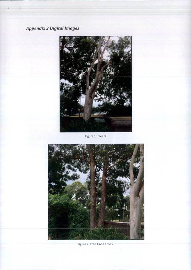
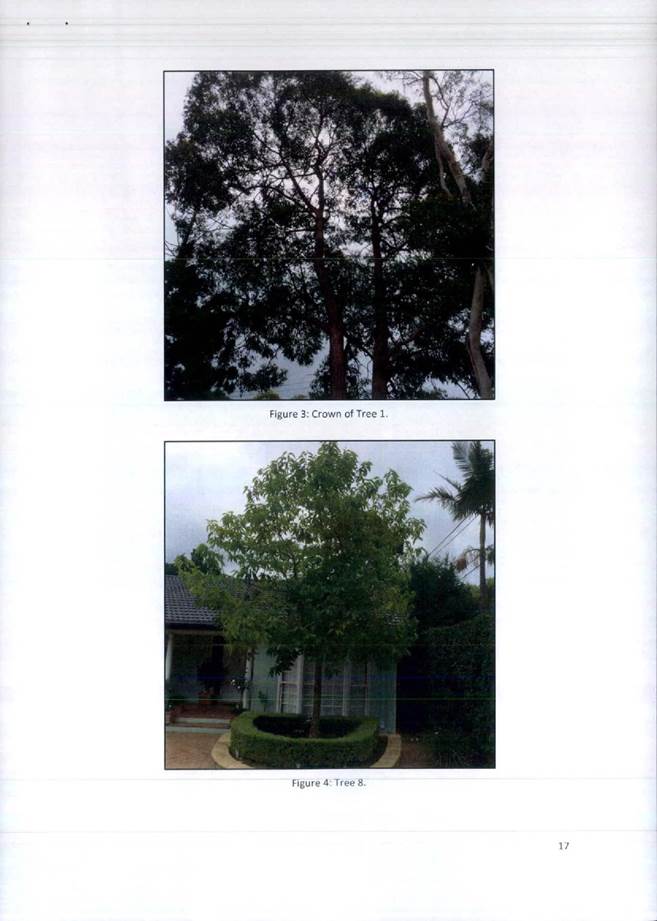
The development proposes the removal of seven trees of which two are canopy trees and five exempt species. Two trees, T2 and T3, are prominent from the site frontage.
T2 is a semi mature Corymbia citriodora (Lemon scented gum). The tree is in fair condition with a sparse crown and poor structural form. It’s removal is acceptable.
T3 is a mature Ulmus parvifolia (Chinese Elm) which has been misidentified by the project arborist as a Betula pendula (Silver Birch). The tree is outwardly in good health and condition with good structural form typical of the species. The tree, although prominent, is not of such landscape significance to warrant design considerations. It’s removal is acceptable.
The remaining trees to be removed are either exempt species or are of low landscape value.
There is an existing hedge of Leighton’s Green Cypress adjacent to the northern site boundary, which is proposed to be retained. The species is not desired as it has the potential to grow to large proportions which may create amenity problems if not maintained. It istherefore be conditioned for the hedge to be removed and a more appropriate plant species be utilised to maintain resident and neighbour amenity (Condition 20B).
T9 Eucalyptus saligna (Sydney Blue Gum) located adjacent to the north-western site corner. Proposed development works are located outside of the trees tree protection zone (TPZ) and should not be adversely impacted. Standard tree protection measures will be required.
T10 Ficus macrocarpa var. hillii (Hills Weeping Fig) located adjacent to the south-western site corner within Pymble Golf Course. There is a small encroachment of less than 10% into the TPZ which is at an acceptable threshold. Standard tree protection measures will be required.
Landscape plan/tree replenishment
The landscape plan is generally supported. Amendments required, such as the removal of existing Leighton’s Green hedge, and continuation of pedestrian paths to the rear communal open space can be conditioned (Condition 20).
However, it is considered the landscape planting within the private open space for Villas 1 & 2 is impractical as it is beneath an overhead structure (Vergola) which will generally remain closed. As this area is required to be excluded from deep soil landscape area calculations, it is recommended the area be paved (Condition 20).
Stormwater plan
The proposed drainage works are acceptable on landscape grounds subject to:
· The landscape plan shows planting within the ‘grassed swale’. Clarification/confirmation is requested that this planting is acceptable as it may impede surface drainage flows
· No excavation for the grassed swale being proposed/required within the TPZ of retained trees.
BASIX
BASIX certificate #548140M_04 submitted with the amended application has made numerous landscape based commitments. The assessing landscape officer is satisfied that the development proposal is consistent with the landscape areas.
Deep soil
By the applicant’s calculations the proposed development will result in a deep soil landscape area of 872.4sqm or 44.5% of the site area having an excess of 89.4sqm. KLCDCP 6A.5 requires a minimum 40% deep soil landscape area.
The assessing landscape officer is in disagreement with the following areas that have been included within the applicant’s deep soil area calculations:
· Overhead roof line and awnings (considered a structure)
· Retaining walls within northern and southern side setback (considered a structure)
· Garden areas <2.0m wide within northern setback (as per definition)
· Rainwater tank where it projects beyond building footprint (considered a structure)
· Side by side/double access paths within northern side setback (>1.2m wide as per definition)
NOTE: It is likely that with the deletion of the above elements from the deep soil calculable area, the development will be in compliance with the minimum deep soil landscape area requirement.
Conclusion
The application is acceptable on landscape grounds, subject to conditions.”
Planning comment: An amended deep soil landscape area compliance plan has been lodged and reviewed by the Senior Landscape Development Officer who is now satisfied that compliance is achieved.
Several of the submissions received from neighbours requested that the existing Leighton’s Green Cypress hedge on the northern boundary be maintained for the privacy benefits that it affords to the residents at No. 26 Cowan Road. In addition, the applicant has chosen to retain this feature in the landscape plan for the same reasons. Whilst it is acknowledged that an alternative planting will eventually reach a height capable of performing the same function of screening the development from the adjoining property, consideration has been given to the fact that new screen planting will take years to establish and provide adequate privacy to the residents of the adjoining property. Further, the existing hedge will provide some semblance of privacy whilst the proposed development is under construction. Therefore, no amendments to the landscape plan, in terms of removal of the existing Leighton’s Green Cypress hedge, will be conditioned.
Engineering
Council's Senior Development Engineer commented on the proposal as follows:
"Stormwater disposal
The subject site falls away from Cowan Road by approximately 6m towards the rear with no formal discharge system on site. It is proposed to create a new drainage connection to an existing stormwater pit within the adjacent Pymble Golf Course.
In discussion with the applicant, it is understood that negotiations have commenced with Pymble Golf Club regarding an easement. Although no correspondence from the Golf Club has been submitted, it is noted that an easement has recently been granted for the development on the adjoining site (No. 22 Cowan Road), and that no submission has been made by the Golf Club in regard to the application. If necessary, a deferred commencement condition could be recommended, with the registration of the easement as the Schedule A condition.
The design proposes a new 225mm diameter pipe and associated drainage easement that commences at the centre of the rear boundary of the subject site and runs along the Golf Course for approximately 33m where it connects into the existing stormwater pit. It will be conditioned that a 1.2m wide drainage easement be created for the new pipeline.
As part of the deferred commencement, the easement design will need to include survey of the proposed route and arborist’s report (addressing existing trees). The documentation is to be submitted to Council and approved prior to the operation of the consent (Condition 1, Schedule A).
The stormwater plans show a combined below ground on-site detention and retention tank comprising 36.5m3 and 10,000L of storage respectively located within the lower ground of basement 2 with the access chamber outside of the building.
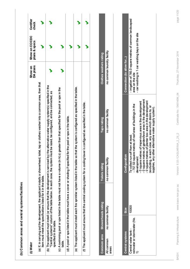
The rainwater retention and re-use has met the BASIX commitments and has satisfied the 50% reduction in runoff days required under Volume C Part 4B.3 of the DCP. The sizing of the on-site detention volume has also satisfied the requirements described in Volume C Part 4B.5 of the DCP with an offset of 10% allowed for rainwater re-use.
The BASIX commitments are for re-use of stored rainwater for irrigation of 765sq.m of common landscaped areas and 1 car wash bay. A central rainwater tank of 10m3 is proposed which satisfies the water commitments.
A pump-out system with storage capacity of 3m3 has been provided within the basement carpark to drain the basement subsoil drainage. It has been designed to have the rising main discharge to the water quality chamber within the OSD tank. The pump-out tank has been sized in accordance with AS3500.3:2003 and the Local Centres DCP requirements.
Water quality measures have been incoroporated into the design and demonstrate that stormwater can be managed efficiently on-site and the runoff controlled to assist in the maintenance of stream flow and the reduction in gross pollutants.
A water balance model was developed to reflect the water transportation process. The methodology adopted assessed the daily filling of the tank from rainwater sources, overflows during storm which was used to calculate the tank storage and daily drawdown for domestic use. The analysis also included a water quality model (MUSIC Modelling) to investigate stormwater runoff quality from the subject site. The results of the post-development nutrient control measures have been achieved when compared to the stormwater treatment standards / targets outlined in Council’s Local Centres DCP Volume C Clause 4B.6.
The applicant in this instance has provided a proprietary pollution chamber Stormwater360 ‘StormFilter’ located within the OSD tank and then discharging to a stormwater inlet pit (containing an ‘Enviropod’ filter basket) prior to connection into the easement. Grass swales along both the northern and southern property boundaries are also proposed with surface runoff diverted to this filtering system, which is acceptable.
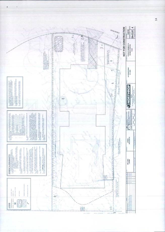
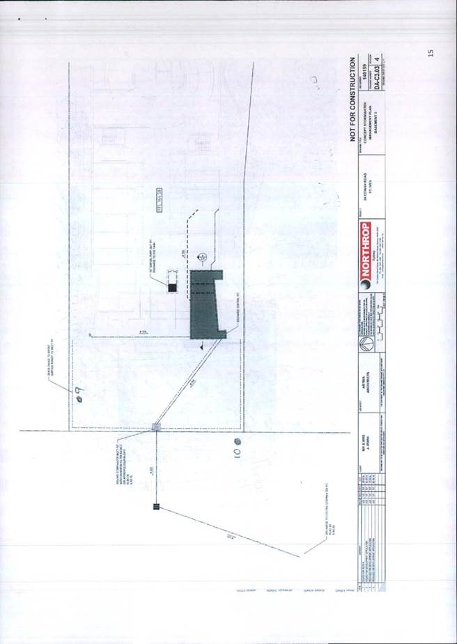
The Stormwater Management & Civil Engineering Plan DA-C2.01/5, C3.01/6, C3.02/5, C3.03/5, C5.01/4 and C6.01/5 prepared by Northrop and accompanying Documentation Information dated 21 May 2014 is considered acceptable for this type of development.
Traffic generation
According to the traffic generation rates nominated by The Roads & Maritime Services (RMS) ‘Guide to Traffic Generating Developments’, the development would generate approximately 4 peak hour vehicle trips. The net effect with the subtraction of the existing dwelling would be an additional 3 vehicles in both the AM and PM peaks which would represent one vehicle trip every 20 minutes during the peak hour. According to the above guidelines, the vehicle trips generated is considered to be very low. The minor increase in traffic flows in Cowan Road is not expected to have a significant effect on traffic flows or on the operation of the intersection with the arterial road network.
Vehicle access and accommodation arrangements
The site is zoned ‘R3’ under the Local Centres LEP. The parking provisions have been determined using Ku-ring-gai Council Local Centres Development Control Plan for multi-dwelling housing. There are no Railway Stations within 400m walking distance. The following parking provisions have been adopted:
Ku-ring-gai Council Local Centres DCP Volume C Clause 2R.2 ‘Car Parking Rates’
|
Multi-Dwelling Housing |
Parking Space Requirement |
|
1 bedroom unit |
1 space per unit |
|
2 bedroom unit |
1.25 space per unit |
|
3 bedroom unit |
1.5 spaces per unit |
|
Visitor car spaces |
1 space per 4 units |
8 x 3 bedrooms = 8 x 1.5 spaces/unit = 12 spaces
8 dwellings - visitor space/4 dwellings = 2 visitor spaces
Total parking spaces required = 14 spaces
The development provides 14 off-street parking spaces, comprising 12 residents’ spaces (includes1 adaptable space) and 2 visitor spaces, which is compliant.
Vehicle access to the car parking facility is to be provided via a new 6.1m wide entry / exit driveway crossing for two-way traffic movements, which also provides adequate sightlines for oncoming vehicles and to pedestrians on footpaths. The driveway clear width satisfies the requirements of Volume C Clause 2.2 of the DCP. There is no objection to the traffic signals for the internal circulating ramps.
A temporary service /car wash space has been provided which satisfies the minimum dimension of 3.5m x 6m. This space is to be properly signposted (Condition 78).
The driveway gradients comply with Australian Standard 2890.1 (2004) “Off-Street car parking” as do the dimensions of the parking bay, ramp grades and aisle widths.
The parking space for the adaptable unit complies with AS2890.6 (2009) in terms of space width and shared area. The amended plans also show the disabled parking space doubling up as a visitor space with a dimension of 3.8m, which is acceptable.
A driveway longitudinal section has been shown on the engineering plan. The level from the boundary to the street is relatively flat with less than 4% fall. The design is acceptable.
Waste collection
The development allows a garbage truck to enter and depart the garbage/room recycle storage area in a forward direction. The driveway grades and turning manoeuvrability are suitable for the small waste collection vehicle as shown by the swept paths within the Appendix of the Traffic Report.
A clear head height of greater than 2.6m, as shown on the Section plan, has been provided to access the basement area and also provided over the travel path of the waste service vehicle.
The sizing of the garbage collection room is adequate to provide 8x240L bins for waste, paper and recycling to satisfy the minimum bin requirements.
The requirements as per Volume C Part 3.4 of the Local Centres DCP have been satisfied.
Construction management
A construction management plan (CMP) and an indicative environmental site management plan (ESMP) has been submitted which is acceptable for DA purposes. The ESMP demonstrates that only a small rigid vehicle of 6m can turn on site and leave in a forward direction. A left in/ left out arrangement for construction vehicles has been shown on the plan together with a combined entry and exit driveway to accommodate the swept paths.
Based on the scale of works and expected construction vehicle movements, a detailed construction traffic management plan (CTMP) must be submitted for review by Council Engineers prior to the commencement of any works on site (Condition 9).
The CTMP would also need to show turning path diagrams demonstrating how construction vehicles for all stages of development will turn into the site without crossing the median in Cowan Road. For tree protection purposes, the use of the existing driveway and crossing for construction access is encouraged.
A Works Zone will be required for the duration of works (Condition 10).
Geotechnical investigation
The preliminary investigation was undertaken based on borehole testing. The results identified subsurface conditions comprising of fill overlaying silty clays. These clays merge into the weathered shale at depths in the range of 2.6m and 7.1m below the natural surface for two borehole tests. The report suggests that no groundwater was observed and may be encountered with the proposed depths of basement excavation but is not identified as likely to be significant in the long term.
All other recommendations during the construction phase shall be carried out as specified within the report.
Prior to any demolition or excavation taking place on site, it will be conditioned that a dilapidation report is to be submitted to include survey of adjoining dwelling at No. 26 Cowan Road. A new development at No. 22 Cowan Road is currently under construction
(Condition 8 ).
Recommendation
From an engineering perspective there are no objections to approval of this application, subject to conditions."
Building
Council's Senior Building Surveyor commented on the proposal as follows:
“Class 2 buildings and Carparks under Type A construction
The proposed building design complies in general with the Building Code of Australia (BCA) requirements. Detail BCA assessment will be undertaken by the Principal Certifying Authority at the CC assessment stage. The following Conditions apply:
1. CNDFH05: Compliance with the Building Code of Australia (BCA) requirements (Condition 36)
2. CNDGS05: Copy of the Final Fire Safety Certificate to be submitted to the Council with the Final Occupation Certificate (Condition 81).”
Statutory Provisions
State Environmental Planning Policies
State Environmental Planning Policy No. 65 - Design quality of residential flat development
SEPP 65 aims to improve the design quality of residential flat development and to provide an assessment framework to evaluate the merit of proposals consistently across the State.
Part 1, clause 3 defines a “residential flat building” as:
“ ….a building that comprises or includes:
(a) 3 or more storeys (not including levels below ground level provided for car parking or storage, or both, that protrude less than 1.2 metres above ground level), and
(b) 4 or more self-contained dwellings (whether or not the building includes uses for other purposes, such as shops),
but does not include a Class 1a building or a Class 1b building under the Building Code of Australia.”
The subject proposal is 3 storeys in height, contains 8 dwellings and is a Class 2 building thus satisfying the definition for a residential flat development as set out in the policy.
A Design Verification Statement, has been submitted with the application in accordance with clause 50(1A) of the Environmental Planning and Assessment Regulation 2000. This satisfies clause 29 of SEPP 65.
Residential Flat Design Code Compliance Table
Pursuant to Clause 30(2) of SEPP 65, in determining a development application for a residential flat building, the consent authority is to take into consideration the Residential Flat Design Code (RFDC). The following table is an assessment of the proposal against the guidelines provided in the RFDC.
|
Principles |
Control Check/Rule of Thumb |
Comments on Compliance
|
|
Building Height |
· Where there is an existing FSR, test height controls against it to ensure a good fit. · Test heights against the number of storeys and the minimum ceiling heights required for the desired building use. The LEP prescribes an 11.5m height and 0.8:1 FSR |
YES |
|
Building Depth |
· Resolve building depth controls in plan, section and elevation. · In general, an apartment building depth
of 10 - 18 metres is appropriate. Developments that are deeper than 18 metres
must demonstrate how satisfactory day light and natural ventilation are to be
achieved. |
YES |
|
Building Separation |
· Design and test building separation controls in plan and section. · Test building separation controls for daylight access to buildings and open spaces. · Building separation controls may be varied in response to site and context constraints. · Where minimum separation is less than recommended, must demonstrate daylight access, urban form, visual and acoustic privacy has been satisfactorily achieved. Separation controls are contained within the DCP. |
YES |
|
Street Setback |
· Identify the desired streetscape character, the common setback of buildings in the street, the accommodation of street tree planting and the height of buildings and daylight access controls. · Relate setbacks to the area's street hierarchy. · Identify the quality, type and use of gardens and landscaped areas facing the street. · Test street setbacks with building envelopes and street sections. · Test controls for their impact on the scale, proportion and shape of building facades. |
YES |
|
Side & Rear Setback |
· Relate side setbacks to existing streetscape patterns. · Test side and rear setback with building separation, open space and deep soil zone requirements (see Building Separation, Open Spaces and Deep Soil Zones). · Test side and rear setbacks for overshadowing of other parts of the development and/or adjoining properties, and of private open space. |
YES |
|
Floor Space Ratio |
· Test the desired built form outcome against proposed floor space ratio to ensure consistency with: - building height - building footprint - the three dimensional building envelope - open
space requirements. |
YES |
|
Part 2: Site Design |
|
|
|
Deep Soil Zones |
· A minimum of 25% of the open space area
of a site should be |
YES |
|
Open Space |
· The area of communal open space required should generally be at least between 35 and 20 percent of the site area. Larger sites and brownfield sites may have potential for more than 30 percent. · The minimum recommended area of private open space for each apartment at ground level or similar space on a structure, such as on a podium or car park, is 25m2; the minimum preferred dimension in one direction is 4 metres. (see Balconies for other private open space requirements) |
YES |
|
Planting on Structures |
· In terms of
soil provision there is no minimum standard that can be applied to all
situations at the requirements vary with the size of plants and trees at
maturity. The following are recommended as minimum standards for a range of
plant sizes: - minimum soil volume 35 cubic metres - minimum soil depth 1 metre - minimum soil area 6 metres x 6 metres or equivalent. |
Not Applicable |
|
Stormwater management |
· Minimise impact on the health and amenity of natural waterways, preserve existing topographic and natural features and minimise the discharge of sediment and other pollutants to the stormwater drainage system. |
YES |
|
Safety |
· Carry out a formal crime risk assessment for all residential developments of more than 20 new dwellings. |
Not Applicable |
|
Visual Privacy |
· Refer to Building Separation minimum standards (see Building Separation). |
YES |
|
Parking |
· Provide adequate parking for the building’s users and visitors. |
YES |
|
Pedestrian Access |
· Identify the access requirements from the street or car parking area to the apartment entrance. · Follow the accessibility standard set out in Australian Standard AS 1428 (parts 1 and 2), as a minimum. · Provide barrier free access to at least 20 percent of dwellings in the development. |
YES |
|
Vehicle Access |
· Generally limit the width of driveways to a maximum of six metres. · Locate vehicle entries away from main pedestrian entries and on secondary frontages. |
YES |
|
Part 3: Building Design |
|
|
|
Apartment layout |
· Single-aspect apartments should be limited in depth to 8 metres from a window. Back of a kitchen should be no more than 8 metres from a window. |
YES |
|
|
· The width of cross-over or cross-through apartments over 15 metres deep should be 4 metres or greater to avoid deep narrow apartment layouts. |
|
|
|
· Buildings not meeting the minimum standards listed above, must demonstrate how satisfactory daylighting and natural ventilation can be achieved, particularly in relation to habitable rooms (see Daylight Access and Natural Ventilation). |
|
|
|
· If council chooses to standardise
apartment sizes, a range of sizes that do not exclude affordable housing
should be used. As a guide, the Affordable Housing Service suggests the
following minimum apartment sizes, which can contribute to housing
affordability: (apartment size is only one factor influencing affordability) |
|
|
Balconies |
· Provide primary balconies for all apartments with a minimum depth of 2 metres. Developments which seek to vary from the minimum standards must demonstrate that negative impacts from the context-noise, wind- cannot be satisfactorily mitigated with design solutions. |
YES |
|
Ceiling heights |
· The following recommended dimensions are
measured from finished floor level (FFL) to finished ceiling level (FCL).
These are minimums only and do not preclude higher ceilings, if desired. |
YES |
|
Ground Floor Apartments |
· Optimise the number of ground floor apartments with separate entries and consider requiring an appropriate percentage of accessible units. This relates to the desired streetscape and topography of the site. · Provide ground floor apartments with access to private open space, preferably as a terrace or garden. |
YES |
|
Internal Circulation |
· In general, where units are arranged off a double-loaded corridor, the number of units accessible from a single core/corridor should be limited to eight. |
YES |
|
Storage |
· In addition to kitchen cupboards and
bedroom wardrobes, provide accessible storage facilities at the following
rates: |
YES |
|
Daylight Access |
· Living rooms and private open spaces for at least 70 percent of apartments in a development should receive a minimum of three hours direct sunlight between 9 am and 3 pm in mid-winter. In dense urban areas a minimum of two hours may be acceptable. · Limit the number of single-aspect apartments with a southerly aspect (SW-SE) to a maximum of 10 percent of the total units proposed. Developments which seek to vary from the minimum standards must demonstrate how site constraints and orientation prohibit the achievement of these standards and how energy efficiency is addressed (see Orientation and Energy Efficiency). |
YES |
|
Natural Ventilation |
· Building depths, which support natural ventilation typically range from 10 to 18 metres. · Sixty percent (60%) of residential units should be naturally cross ventilated. · Twenty five percent (25%) of kitchens within a development should have access to natural ventilation. · Developments, which seek to vary from the minimum standards, must demonstrate how natural ventilation can be satisfactorily achieved, particularly in relation to habitable rooms. |
YES |
|
Waste Management |
· Supply waste management plans as part of the development application submission as per the NSW Waste Board. |
YES |
|
Water Conservation |
· Rainwater is not to be collected from roofs coated with lead- or bitumen-based paints, or from asbestos-cement roofs. Normal guttering is sufficient for water collections provided that it is kept clear of leaves and debris. |
YES |
State Environmental Planning Policy No. 55 – Remediation of Land
The provisions of SEPP 55 require Council to consider the potential for a site to be contaminated. The subject site has a history of residential use and, as such, it is unlikely to contain any contamination and further investigation is not warranted in this case.
Sydney Regional Environmental Plan No. 20 – Hawkesbury-Nepean River
SREP 20 applies to land within the catchment of the Hawkesbury Nepean River. The general aim of the plan is to ensure that development and future land uses within the catchment are considered in a regional context. The Plan includes strategies for the assessment of development in relation to water quality and quantity, scenic quality, aquaculture, recreation and tourism.
The proposed development is considered to achieve the relevant aims under this policy.
State Environmental Planning Policy (Building Sustainability Index: BASIX) 2004
A valid BASIX certificate has been submitted. The certificate demonstrates compliance with the provisions of the SEPP and adequately reflects all amendments to the application.
LOCAL Provisions
Ku-ring-gai LEP (Local Centres) 2012
Part 1:Preliminary
Clause 1.2: Aims of plan
(a) to establish a hierarchy of centres for Ku-ring-gai,
(b) to guide the future development of land and the management of environmental, social, economic, heritage and cultural resources in Ku-ring-gai for the benefit of present and future generations,
(c) to facilitate the development of the centres to enhance Ku-ring-gai’s economic role and cater to the retail and commercial needs of the local community,
(d) to provide a variety of housing choice within and adjacent to the centres,
(e) to protect, enhance and sustainably manage the biodiversity, natural ecosystems, water resources and ecological processes within the catchments of Ku-ring-gai,
(f) to recognise, protect and conserve Ku-ring-gai’s indigenous and non-indigenous cultural heritage,
(g) to encourage a diversity of employment in Ku-ring-gai,
(h) to achieve land use relationships that promote the efficient use of infrastructure,
(i) to facilitate good management of public assets and promote opportunities for social, cultural and community activities,
(j) to protect the character of low density residential areas, and the special aesthetic values of land in the Ku-ring-gai area.
The proposed development has been considered against the Aims set out under this clause of KLEP (Local Centres) 2012. For the reasons outlined within this report, the proposed development has been found to be acceptable in all relevant respects.
Part 2: Permitted or permissible development
The site is located within the ‘R3 Medium Density Residential’ zoning.
The objectives of the R3 Medium Density Residential zone are as follows:
· To provide for the housing needs of the community within a medium density residential environment.
• To provide a variety of housing types within a medium density residential environment.
• To enable other land uses that provide facilities or services to meet the day to day needs of residents.
• To provide a transition between low density residential housing and higher density forms of development.
The proposed development for multi dwelling housing, consisting of townhouses and villas, is permissible with consent within the ‘R3 Medium Density Residential’ zoning. Additionally, for the reasons outlined within this report, the proposed development satisfies the objectives set out for this zone.
Part 4: Principal development standards
|
Development standard |
Proposed |
Complies |
|
Site area: 1,957.4 m2 |
||
|
Cl. 4.3 Height of buildings 11.5m (max) |
10.2m |
YES |
|
Cl. 4.4 FSR 0.8:1 |
0.79:1 |
YES |
Part 6: Additional local provisions
Clause 6.5: Site requirements for multi dwelling housing and residential flat buildings
|
Development standard |
Proposed |
Complies |
|
Cl. 6.5 Site area 1,200m² (min) |
1,957.4m² |
YES |
|
Cl. 6.5 Street frontage Site area >1,800m² = 30m (min) |
29.66m |
NO |
Minimum street frontage (clause 6.5(2))
The site frontage, at 29.66 metres, is non-compliant with the minimum street frontage requirement of 30 metres under clause 6.5(2) of the KLEP(Local Centres) 2012.
Clause 4.6 of KLEP (Local Centres) 2012 provides flexibility in applying certain development standards to particular development and in particular circumstances on the following grounds:
“(3) Development consent must not be granted for development that contravenes a development standard unless the consent authority has considered a written request from the applicant that seeks to justify the contravention of the development standard by demonstrating:
(a) that compliance with the development standard is unreasonable
or unnecessary in the circumstances of the case, and
(b) that there are sufficient environmental planning grounds to justify contravening the development standard.
(4) Development consent must not be granted for development that
contravenes a development standard unless:
(a) the consent authority is satisfied that:
(i) the applicant’s written request has adequately addressed
the matters required to be demonstrated by subclause (3), and
(ii) the proposed development will be in the public interest because it is consistent with the objectives of the particular standard and the objectives for development within the zone in which the development is proposed to be carried out, and
(b) the concurrence of the Director-General has been obtained.”
The applicant has submitted a written Clause 4.6 variation request that seeks to justify the contravention of the development standard pertaining to the minimum street frontage set out in clause 6.5(2) and this is assessed as follows:
whether compliance with the development standard is unreasonable or unnecessary in the circumstances of the case
The following are extracts from the applicant’s written request:
“No. 22 Cowan Road has a frontage of 23.165m which is marginally deficient of the required 24m but capable notwithstanding of being developed as a stand-alone site. Council has already approved No. 22 Cowan Road for a multi dwelling development (currently under construction) without the need to consolidate with No. 24 Cowan Road and therefore, has accepted that No. 24 can be developed on its own notwithstanding the minor frontage variation.”
“The shortage in width does not generate additional development yield as the proposal still complies generously with all the applicable controls including height, floor space ratio, setbacks, car parking, and deep soil planting and has been developed proportionate to its frontage constraint.
Amalgamating the site with the property to the south, whilst technically achieving compliance with the frontage, would create a building of greater bulk and massing, with inherently greater impacts on neighbours and the streetscape as compared to two stand-alone buildings.
The proposal is not an overdevelopment and does not crowd the site with buildings, rather the buildings are subservient to the landscape which is evidenced by the provision of compliant and generous deep soil planting.
Given that the site to the south adjoins a lower scale development, a smaller frontage with hence smaller building in footprint and volume, provides a respectful and sympathetic transition between the two developments.
Accordingly, the existing established character (created by the more recent developments) of the area is better maintained and respected by the erection of two (2) individual free standing developments with (with max 11.5m height and 0.8 FSR) which allows for greater landscape curtilages with 6 m landscaped voids in between so that the built form is screened and viewed through the landscape as opposed to a large and overly bulky building mass that would occur from a combined development.
The variation would in fact better fulfil the planning objective of maintaining the character of the area as opposed to a scenario incorporating a consolidated site.
In assessing whether compliance is unnecessary or unreasonable regard should be had and guidance obtained from the Land & Environment Court's planning principle in CSA Architects v Randwick City Council [2004] NSWLEC 179:
Planning principle: development on small or narrow sites
15 Where the council has a policy for small or narrow sites, the Court should, where
reasonable, apply that policy. (This is a valid principle for all matters before the
Court.) In the absence of a council policy, the assessment of a proposal on a site that is below the preferred area or width should be considered both as a development on its own site as well as in the context of possible developments on neighbouring sites.
The following questions should be asked:
- Would approval of the application result in the isolation of neighbouring sites?
- Would it render the reasonable development of neighbouring sites difficult?
- Can orderly, economic and appropriate development of the subject site as well as
neighbouring sites be achieved?
16 The main criterion for assessing the proposal on its own site is whether it meets other planning controls, eg:
-Does the proposal meet density, setback and landscaping controls? The most
critical control for small and narrow sites is that for setbacks.
-Is its impact on adjoining properties and the streetscape worse because the
development is on a small or narrow site?
17 Where an application meets other planning controls and the area and width of the
site does not exacerbate its impacts;--the failure of the site to meet the preferred area or width would usually not be a reason for refusal. (emphasis added).”
The applicant has demonstrated that, despite the non-compliant street frontage, the development meets the requirements of the LEP and DCP in terms of floor space ratio, height, landscaping, deep soil and setbacks. The frontage is deficient by a nominal amount of 340mm which does not exacerbate the proposal’s impacts on adjoining properties and the streetscape.
Whether there are sufficient environmental planning grounds to justify contravening the development standard
Clause 6.5 states:
(a) to provide site requirements for development for the purposes of multi dwelling housing and residential flat buildings so as to provide for the orderly and economic development of residential land while maintaining the local character, and
(b) to ensure that lot sizes and dimensions of medium and high density residential sites allow for generous landscaped areas and setbacks to ensure the amenity of adjoining properties and to support the desired future character of those areas.
The proposal complies with the applicable planning controls of the LEP and DCP proving that orderly and economic development of the land can be achieved. To this end, there is sufficient landscaping of the site and the compliance with setbacks respects the amenity afforded to adjoining properties. In general, despite the frontage non-compliance, the development is considered to exemplify the desired future character of the area.
Whether the proposed development will be in the public interest because it is consistent with the objectives of the particular standard and the objectives for development within the zone in which the development is proposed to be carried out
The objectives of the R3 Medium Density Residential zoning are as follows:
· To provide for the housing needs of the community within a medium density residential environment.
· To provide a variety of housing types within a medium density residential environment.
· To enable other land uses that provide facilities or services to meet the day to day needs of residents.
· To provide a transition between low density residential housing and higher density forms of development.
The proposal provides a housing type that is consistent with the character of the locality and provides a transition between the existing low and higher density forms of development prevalent in the area. Therefore, the proposal is consistent with the objectives of the zone and also, as previously discussed, with the objectives of the minimum street frontage development standard. The variation to the standard will not unduly compromise the way in which the land can be developed and is considered to maintain the public benefit.
The concurrence of the Director-General has been obtained
Planning Circular PS08-003 issued 9 May 2008 states:
Notification of assumed concurrence of the Director-General under clause 4.6(4) (and the former clause 24(4)) of the Standard Instrument
(1) Under clause 64 of the Environmental Planning and Assessment Regulation 2000, council is notified that it may assume the Director-General’s concurrence for exceptions to development standards, subject to paragraphs (2) and (3), in respect of all applications made under:
(a) clause 4.6 (or the former clause 24, or any future amended version of this clause) of the Standard Instrument (Local Environmental Plans) Order 2006, or
(b) any other clause that is based on a substantially similar format and has a substantially similar effect to the clause described in (1)(a),
where such a clause is adopted in an environmental planning instrument to provide for exceptions to development standards.
Accordingly, concurrence is assumed as clause 4.6 of the Standard Instrument has been incorporated into the KLEP (Local Centres) 2012.
In conclusion, the request to vary the development standard pertaining to street frontage is acceptable.
POLICY PROVISIONS
Ku-ring-gai Local Centres Development Control Plan
Volume A
Clause 1A.5: General aims of the DCP
The general aims of the DCP relate to the following:
· the establishment of a future character for the local centres
· provision of high quality public domain areas
· provision of a range of building types
· provision of high quality urban and architectural design
· assurance of a good relationship between development and the public domain and local landscape qualities
· assurance of a high level of residential amenity in building design
· promotion of principles of ecologically sustainable development
· provision of equitable access
· promotion of increased use of public transport, walking and cycling
· provision of measures and outcomes to ensure appropriate control of traffic
· recognition of heritage items and heritage conservation areas
· promotion and support of biodiversity conservation, riparian restoration and ecological integrity
· assurance of the long term survival of native and exotic tree and vegetation cover
· the appropriate management of risks related to flooding, bushfire and land contamination
· the allowance for public participation through the notification process
The proposed development has been assessed against these aims and is found to be acceptable in all relevant respects.
Part 2: Site analysis
A site analysis which identifies the existing characteristics of the site and the surrounding area has been provided as part of the development application. The site analysis is considered to satisfy the objectives of this part of the Local Centres DCP.
|
COMPLIANCE TABLE |
||
|
Development control |
Proposed |
Complies |
|
Volume A |
||
|
Part 6 Multi Dwelling Housing Controls |
||
|
Part 6A Site Design |
||
|
6A.1 Site layout |
||
|
Site layout to respond to site analysis
|
Site analysis provided |
YES |
|
Any dwelling with a frontage to the street must address the street
|
Two townhouses have frontage to, and address, the street
|
YES
|
|
Minimum of one dwelling to address the street
|
Two townhouses face the street |
YES |
|
Minimise hard surface to maximise landscaping
|
Hard surface kept to minimum |
YES |
|
Long straight driveways will not be permitted. Buildings and fences to be staggered
|
No long straight driveway proposed and building and fences are staggered
|
YES |
|
Provide single pedestrian entry from street level
|
Two pedestrian entries from street level
|
NO (refer discussion below) |
|
Layout to be based on figure 6A.1-2
|
Site layout does not reflect the recommended layout
|
NO (refer discussion below) |
|
6A.2 Building setbacks |
||
|
10m from primary street boundary (min) |
10m |
YES |
|
Parallel to prevailing building line |
Parallel to building line |
YES |
|
3m side setback from any side boundary (min)
|
North: 3.4m South: 3.4m
|
YES YES |
|
Driveways set back 3m from side boundary (min) to allow for deep soil planting
|
4.8m
|
YES |
|
Setback areas not be used for at grade parking |
No at grade parking in setback areas |
YES
|
|
6m rear setback (min)
|
Pergola: 9.5m Rear wall of dwelling: 12.7m |
YES YES
|
|
Basement areas must meet the street and rear setback requirements and be a minimum of 3m from any side boundary
|
Rear: 13.5m Street: 10m Side: 3m |
YES YES YES |
|
Ground floor private terraces/courtyards must have: 8m setback from street boundary (min) 3m setback from side boundary (min) 4m setback from rear boundary (min)
|
57m
3.4m 9.5m
|
YES
YES YES
|
|
Ground floor side setback encroachment by private terraces/courtyards only if deep soil planting requirements are met.
|
No encroachment |
YES
|
|
15% (max) of the total area of any street setback is to be occupied by private terraces/courtyards. |
No private terraces/courtyards proposed to street setback
|
YES
|
|
6A.3 Building separation |
||
|
The minimum separation between residential buildings on the development site and the adjoining sites must comply with the following:
Up to 2nd Storey: i) 3m between non habitable rooms ii) 6m between rooms/balconies in all other cases
3rd Storey: i) 12m between habitable rooms/balconies ii) 7m between habitable rooms/balcony and non-habitable room iii) 3m between non-habitable rooms |
6m 6m
12m
8.5m (south) 11.0m (north)
8.5m (south) 11.0m (north) |
YES YES
YES
YES YES
YES YES YES |
|
6A.4 Site coverage |
||
|
Combination of townhouses and villas with basement parking: Proposal: 25% townhouses and 75% villas (pro-rata of 40% for townhouses and 50% for villas) = 47.5%
|
43.3% |
YES |
|
6A.5 Deep soil landscaping |
||
|
Multi-unit dwelling development must have deep soil landscaping of 40% (min) |
41.2% |
YES |
|
Lots with the following sizes are to support a minimum number of tall trees capable of attaining a mature height of 13m on shale transitional soil or 10m on sandstone derived soils:
1200m2 or less: 1 per 400m2 of site area 1201-1800m2 : 1 per 350m2 of site area 1801m2 or more: 1 per 300m2 of site area
|
The site area is 1,957.4m² and therefore 1 tall tree per 300m² is required. This equates to 7 trees. There are 8 tall trees proposed to be planted as well as the retention of 2 existing trees so the requirements are satisfied. |
YES |
|
At least 50% of all tree plantings are to be locally occurring trees and spread around the site.
|
>50% |
YES |
|
Part 6B Access and Parking |
||
|
6B.1 Vehicle Access |
||
|
Driveway located 3m (min) from side boundary and separated by a continuous landscaped verge & screen planting
|
Driveway located 4.8m (min) from southern side boundary – landscaping to boundary |
YES |
|
One driveway (max)
|
Only one driveway is proposed |
YES |
|
Driveway designed to avoid straight, long gun barrel appearance by use of landscaping and variations in alignment
|
Driveway design avoids long gun barrel appearance |
YES |
|
On-site vehicle turning areas designed to permit turning in a single reversing movement
|
Vehicle turning areas allow turning in a single reversing movement |
YES |
|
On-site vehicle turning areas must be located within the basement or concealed from the view of the public domain
|
Turning areas located in the basement |
YES |
|
If provided in basement, waste and recycling room to be 2.6m ceiling height (min) along path of travel from street to residential waste collection and manoeuvring area and kept free of overhead ducts, services and other obstructions
|
>2.6m ceiling height along path of travel |
YES |
|
6B.2 Car parking provision |
||
|
Basement car parking must be consolidated under building footprint
|
Basement consolidated under building footprint |
YES |
|
The basement car park must not project more than 1m above existing ground level to the floor level of the storey immediately above
|
1.8m |
NO (refer discussion below) |
|
Wherever possible, direct access must be provided from basement car parks to entry
|
Direct access provided from basement car parks to entry |
YES |
|
Car parking spaces, circulation areas, roadways and ramps are to comply with AS2890.1
|
Council’s Senior Development Engineer is satisfied that compliance is achieved |
YES |
|
Car parking rates: (Volume C Part 2R.2)
1 bedroom unit: 1 space 2 bedroom unit: min. multiple of 1.25 spaces per unit 3 bedroom unit: min. multiple of 1.5 spaces per unit
|
The development proposes 8 dwellings, each containing 3 bedrooms. Therefore: 8 x 1.5 spaces/unit = 12 spaces. 12 spaces are proposed |
YES |
|
Visitor parking: 1 space per 4 units
1 space to be adaptable by complying with dimensional and locational requirements of AS2890.6.
One space to be provided with tap to make provision for on-site car washing
|
2 visitor spaces
Council’s Senior Development Engineer is satisfied that compliance is achieved
Car wash space is provided |
YES
YES
YES |
|
Clearly signposted space for temporary parking of service and removalist vehicles with min. dimension of 3.5m x 6m and min. manoeuvring area 7m wide (where not provided, one of visitor spaces may be used if it meets these dimensions)
|
Temporary service/car wash space provided which satisfies minimum dimensions. Condition to be imposed to ensure clear signage of the space. |
YES (Condition 78) |
|
6B.3 Bicycle parking provision |
||
|
Where basement parking is provided:
1 bicycle parking space per 5 units (or part thereof) for residents within residential car park area; and 1 bicycle parking space (in the form of a bicycle rail) per 10 units (or part thereof) for visitors within visitor car park area
|
Sufficient bicycle parking spaces have been provided and are convenient to the street being on the ground floor of the development
|
YES
|
|
Part 6C. Building Design and Sustainability |
||
|
6C.1 Communal open space |
||
|
Communal open space must be provided where more than 10 dwellings are proposed that do not address the street
|
Proposal is for less than 10 dwellings |
N/A |
|
6C.2 Private open space |
||
|
Multi-dwelling housing development must provide a minimum (internal dimension) 35m² of private open space per dwelling at ground floor, and must ensure:
i) a single space of minimum 25m² with a minimum internal dimension of 4m and direct access from a living area of the dwelling; and ii) the remaining spaces must have a minimum internal dimension of 2m
|
Villas 1 & 2: 35m² & 4m Villas 3 & 4: 35m² & 4m Villas 5 & 6: 41m² & >4m THS 7 & 8: 52m² & >4m |
YES
|
|
Primary private open space is to have direct access from the main living areas
|
All primary private open space areas have direct access from main living area |
YES |
|
Private open space (outdoor) for ground floor dwellings is to be differentiated from common areas by:
i) Change in level and/or: ii) screen planting such as hedges or shrubs and/or; iii) fence/wall to max height of 1.8m. Any solid wall component to have max 1.2m height with 30% transparent component on top. Gate to be provided from common area
|
Landscape plan indicates fence to define the line of private open space to Villas 1 and 2 |
YES |
|
6C.3 Solar access |
||
|
Dwellings must receive min 3 hours direct sunlight to at least one living room & primary private open space between 9am - 3pm on 21st June
|
Villas 3 and 5 receive 2 hours direct sunlight |
NO (refer discussion below)
|
|
Min. 3 hours between 9am – 3pm on 21st June to living areas and principal portion of private open space of existing residential flat buildings and multi-dwelling housing on adjoining lots and residential development in adjoining lower density zones
|
Minimum solar access provided to living areas and principal portion of open space of multi-dwelling housing on adjoining lots |
YES |
|
Overshadowing must not compromise the development potential of the adjoining under-developed site(s)
|
Adjoining sites are developed to their potential |
YES |
|
All development must utilise shading and glare control
|
Vergolas and sun hoods provided over majority of windows to habitable rooms |
YES |
|
6C.4 Natural ventilation |
||
|
All habitable rooms are to have windows or doors that can be opened and closed
|
All habitable rooms have windows or doors that can be opened and closed |
YES |
|
All dwellings must have natural cross ventilation
|
All dwellings have natural cross ventilation |
YES |
|
At least 25% of all kitchens are to be immediately adjacent to an operable window
|
75% of kitchens immediately adjacent to an operable window |
YES |
|
All habitable rooms are to be naturally ventilated without relying solely on lightwells or skylights
|
All habitable rooms are naturally ventilated without relying solely on lightwells or skylights |
YES |
|
6C.5 Dwelling depth, width and room size |
||
|
Maximum internal plan depth of a dwelling is to be 14m from glass line to glass line
|
Villas 1 & 2: 23m Villas 3 & 4:19m Villas 5 & 6: 26.5m TH 7 & 8: 11 and 23.5m |
NO (refer discussion below)
|
|
Each dwelling must have 4m dimension (min)
|
All dwellings have 4m dimension |
YES |
|
Living areas must have 4m internal plan dimension (min)
|
All living areas have 4m internal plan dimension |
YES |
|
Multi-dwelling housing with two bedrooms must have a minimum internal plan dimension of 3m (excl. wardrobe space) in all bedrooms
|
All dwellings have three bedrooms |
N/A |
|
Multi-dwelling housing with three or more bedrooms are to have at least two bedrooms with a minimum internal plan dimension of 3m (excluding wardrobe space)
|
All dwellings have at least two bedrooms with a minimum internal plan dimension of 3m (excl wardrobes) |
YES |
|
Built in wardrobes are to be provided: i) to all studio apartments; ii) to all bedrooms in one and two bedroom apartments iii) to at least two bedrooms in apartments of three or more bedrooms
|
Built in wardrobes are provided to at least two bedrooms in dwellings |
YES |
|
6C.6 Dwelling mix |
||
|
All multi-dwelling housing developments must contain at least one dwelling for each 10 dwellings (or part thereof) designed as adaptable housing in accordance with the provisions of AS4299-1995: Adaptable Housing Class C |
Villa 4 is designed as adaptable housing |
YES |
|
6C.7 Building entries |
||
|
The entry path is to be directly accessible and visible from the street
|
Entry paths are directly accessible and visible from street
|
YES |
|
Building entry must be integrated with building facade design. At street level, the entry is to be articulated with awnings, porticos, recesses or projecting bays for clear identification
|
Building entries are articulated with canopies provided over entries for clear identification |
YES |
|
All entries must be well lit and designed to avoid any concealment or entrapment areas
|
Additional lighting to northern pedestrian entry, northern courtyard area and external stairs leading to gates to Villas 1 and 2 to be conditioned |
YES (Condition 23) |
|
All light spill is prohibited
|
Light spill is contained by canopies and awnings |
YES |
|
6C.8 Building facades |
||
|
Building length is not to exceed 36m
|
Northern and southern elevations are approximately 48m in length |
NO (refer discussion below) |
|
All building facades must be modulated and articulated with wall planes varying in depth by not less than 0.3m. Where external walls are longer than 12m, the building alignment must be stepped by a minimum 0.6m articulation (projection or indentation) in the façade.
|
The proposed building is sufficiently modulated and articulated in its facades |
YES |
|
Building facades must be designed to respond to solar access by using solar protection elements such as eaves and louvres as environmental controls
|
Design incorporates sufficient solar protection elements such as eaves and louvres |
YES |
|
All building elements including shading devices and awnings must be coordinated and integrated within the overall façade design
|
All shading devices and awnings coordinated and integrated within overall façade design |
YES |
|
Where individual air conditioning units are used, they must not be located on the building façade or on balconies or terraces
|
Air conditioning plant room located in the basement |
YES |
|
Balconies that run the full length of the building façade are not permitted
|
Balconies to Villas 3, 4, 5 & 6 run the full length of the western facade |
NO (refer discussion below)
|
|
Balconies must not project more than 1.2m from the outermost wall of the building façade
|
>1.2m |
NO (refer discussion below) |
|
Blade walls are not to be the sole element used to provide articulation
|
Sufficient articulation and no overuse of blade walls |
YES |
|
6C.9 Top storey design and roof forms |
||
|
Where a third storey is proposed, the gross floor area of the top storey must not exceed 60% of the gross floor area of the storey immediately below it
|
<60% |
YES |
|
Where the third storey is not incorporated into the roof form, it must be set back from the outer wall of the floor below on all sides
|
Sufficient setback from the outer wall of the floor below on all sides |
YES |
|
Service elements must be integrated into the overall design of the roof so as not to be visible from the public domain or any surrounding development
|
Service elements are integrated into the overall design of the roof |
YES |
|
Roof design must respond to solar access by using eaves or skillion roofs
|
Design responds to solar access |
YES |
|
Roof forms are to be modulated or broken
|
Modulated roof form |
YES |
|
Solar panels to be integrated into the roof line (where provided)
|
Solar panels are not proposed |
YES |
|
6C.10 Internal ceiling heights |
||
|
Ceiling height for habitable room: 2.7m min
|
2.7m |
YES |
|
Ceiling height for non-habitable room: 2.25m min
|
2.7m |
YES |
|
6C.11 Visual privacy |
||
|
Buildings must be designed to ensure privacy
|
Building designed to ensure privacy |
YES |
|
Continuous transparent balustrades are not permitted to balconies/terraces
|
Sufficient treatment to balustrades to ensure there are no continuous transparent balustrades |
YES |
|
Screening between dwellings must be integrated with the overall building design
|
Screening integrated into the overall building design |
YES |
|
Landscaped screening must be provided to adjoining sites
|
Landscaped screening is to be provided to adjoining sites |
YES |
|
6C.12 Storage |
||
|
Storage space must be provided at the following minimum volumes: 10m³ for two bedroom dwellings 12m³ for dwellings with three or more bedrooms
|
>12m³ |
YES |
|
50% of storage space to be provided within the dwelling. Remaining storage located outside the dwelling to be specifically allocated to the relevant dwellings
|
Storage provision complies |
YES |
|
6C.13 External air clothes drying facilities |
||
|
Provide one external air clothes drying area for each dwelling
|
Sufficient space provided to private open space areas |
YES |
|
External air clothes drying area must be screened from public areas and common areas
|
Sufficient screening provided to private open space areas |
YES |
|
6C.14 Fencing |
||
|
Front fences and walls (to public street) and side fences in the street setback must not be higher than: i) 0.9m closed construction (masonry, lapped and capped timber or brushwood fences) ii) 1.2m open style construction (open paling and picket fencing) Closed front fences with a max height of 1.8m and set back 2m from the front boundary will be considered where the site fronts a busy road.
|
1.2m high natural dry stone wall which is set back at a minimum of 2m from the front property boundary due to the curved nature of the site’s frontage. As Cowan Road is considered to be a busy road, the fence design is considered to be appropriate. |
YES |
|
Fences and walls must be stepped down and follow the natural contours of the site
|
Fences and walls are stepped to follow natural contours of site |
YES |
|
Hedges and shrub planting no higher than 1.2m along entire front boundary
|
No hedges and shrub planting over 1.2m proposed to entire front boundary |
YES |
|
All fences to highlight entrances, and be compatible with buildings, letterboxes and garbage storage areas
|
Fences highlight entrances and are compatible with building and structures |
YES |
|
External finishes must be robust and graffiti resistant
|
External finishes considered suitable |
YES |
|
VOLUME C |
||
|
PART 1 Site Design |
||
|
1.1 General |
||
|
The development must respond to site attributes as identified in the site analysis |
Site analysis provided |
YES |
|
Must demonstrate how the proposal responds to the site and contextual attributes |
Site analysis demonstrates adequately how the application has responded to the site and contextual attributes
|
YES |
|
1.2 Earthworks and Slope |
||
|
Development must demonstrate consideration of site topography, drainage, soil landscapes, flora, fauna and bushfire hazard |
Consideration of site topography has been provided |
YES |
|
Development must be accommodated within the natural slope of the land |
Design accommodates the slope of the site |
YES |
|
Development is to minimise earthworks on steeply sloping sites Sites with a slope in excess of 15% may require certification from a geotechnical engineer as to the stability of the slope in regards to the proposed design |
4% slope on site |
N/A |
|
Minimum 600mm width is required between retaining walls to provide adequate soil area and depth to ensure that they do not read as a single level change and for the viability of landscaping |
Assessed by Council’s Landscape Officer and found to be satisfactory |
YES |
|
Existing ground level is to be maintained for a distance of 2m from any boundary |
Assessed by Council’s Landscape Officer and found to be satisfactory |
YES |
|
Fill and excavation are not permitted within sensitive environments |
Not applicable |
N/A |
|
Retaining walls, excavated and filled areas shall be located and constructed to have no adverse impact on: i) Structures to be retained on the site ii) Structures on adjacent public or private land iii) Trees to be retained onsite or on adjoining sites |
No adverse impact |
YES |
|
Excavated and filled areas are to be constructed so as not to redirect or concentrate stormwater or surface runoff onto adjoining properties |
Assessed and found to be satisfactory |
YES |
|
Design of proposal must consider the impacts of altered subsurface/groundwater flows or direction on groundwater dependent ecosystems or species |
Assessed and found to be satisfactory |
YES |
|
1.3 Landscape Design |
||
|
Assessed by Council’s Senior Landscape Assessment Officer and found to be satisfactory
|
YES |
|
|
PART 2 Access and Parking |
||
|
2.1 Equitable Access |
||
|
Applications are to demonstrate how access to and within the development meets the requirements of the Disability Discrimination Act 1992 (DDA) |
Application has provided an Access Report demonstrating that the application meets the requirements of the DDA |
YES |
|
2.2 Vehicle Access, 2.3 Basement Car Parking, 2.4 Visitor Parking, 2.5 Parking For People With A Disability, 2.6 Pedestrian Movement Within Car Parks, 2.7 Bicycle Parking and Facilities |
||
|
Assessed by Council’s Senior Development Engineer and found to be satisfactory |
YES |
|
|
PART 3 Building Design and Sustainability |
||
|
3.3 Building Services |
||
|
All applicants must consult with service providers |
Standard consent conditions will ensure that this is undertaken |
YES |
|
Services and structures required by the providers are to be located within basements, or concealed within the façade, with appropriate access. |
Standard consent conditions will ensure that this is undertaken |
YES |
|
Air conditioning units located within basements must be screened and have adequate ventilation |
Air conditioner plant room to be located within basement |
YES |
|
3.4 Waste Management |
||
|
All waste and recycling facilities must comply with the BCA and all relevant Australian Standards |
Area designed in accordance with BCA & AS |
YES |
|
All waste and recycle to be stored within site |
Garbage collection room provided |
YES |
|
Access to collection point |
Unimpeded access, suitable grade, exit forward direction and level surface, clear >2.6m clearance height |
YES |
|
Storage Room to be provided and easily accessible |
Storage rooms provided and easily accessible |
YES |
|
Waste 2 x 240l per 2 units: 4 |
4 x 240l waste |
YES |
|
Co-mingled 1 x 240l per 4 units: 2 |
2 x 240l |
YES |
|
Recycling: 1 x 240l per 4 units: 2 |
2 x 240l |
YES |
|
3.5 Acoustic Privacy |
||
|
Building to comply with separation requirements of DCP |
Adequate design principles have been used and requirements of DCP satisfied |
YES |
|
3.6 Visual Privacy |
||
|
Private open spaces and principle living spaces of the proposal and adjacent dwellings to be protected from direct or unreasonable overlooking |
Proposal has been adequately designed to mitigate privacy impacts |
YES |
|
3.7 Materials, Finishes and Colours |
||
|
Comprehensive details provided with application |
Finishes/materials have been considered by Council’s Urban Design Consultant and assessed as being satisfactory and consistent with the character of the surrounding environment. |
YES |
|
3.9 Construction, Demolition and Disposal |
||
|
Waste management plan provided with application |
A waste management plan was submitted as part of the proposed development. It is considered that the construction waste management plan meets the underlying objectives of waste management as required under the Local Centres DCP. |
YES |
|
PART 4 Water Management |
||
|
Council’s Development Engineer has assessed the proposal against the relevant provisions of the Local Centres DCP that relate to water management. The application is considered to be acceptable in this regard, subject to conditions to be imposed. |
||
Local Centres DCP Non-compliances
6A.1 Site layout
Pedestrian entries
The Local Centres DCP states that a single pedestrian entry should be provided from the street. The proposal is non-compliant in this regard as it provides two entries from Cowan Road. Consideration has been given to the layout of the dwellings and the fact that the site is divided by the driveway which makes combination of the two entries into one difficult to achieve. Both entries are clearly identifiable with canopies, security gates, intercoms and letterboxes and it is considered that for these reasons, along with the proposed landscaped setting, the objectives of the controls are met.
Site layout
The proposed site layout does not follow the preferred layout for multi dwelling development set out in clause 6A.1-2 of the Local Centres DCP where the rear dwellings are turned at 90 degrees to the dwellings facing the street. Due to the slope of the land and the amenity benefits from allowing the dwellings to face west over the golf course to the rear, the dwellings are combined into a single built form which is stepped down to follow the fall in the land. This layout is considered to be a reasonable site specific variation to the preferred layout and is consistent with the development approved on the adjoining site at 22 Cowan Road.
6B.2 Car parking provision
This clause states that ‘the basement car park must not project more than 1 metre above the existing ground level to the floor level of the storey immediately above.’ The proposed basement car park projects between 1.9m – 3.5m above the existing ground level for a length of approximately 18 metres, or 38% of the building length on both the north and south elevations. Both elevations benefit from a dry stone wall treatment which assists in breaking down the visual height of the walls and provides an attractive finish to the side passage entries. Consequently, the objectives of the control are satisfied as the garage structure will not have adverse visual and environmental impacts on the streetscape.
6C.3 Solar access & 6C.5 dwelling depth, width and room size
It is appropriate to address these two non-compliances together since the desired objectives resulting from both clauses are similar, as both aim to ensure a high level of amenity for occupants in terms of solar access to habitable rooms. The living rooms of Villas 3 and 5 will only receive two hours direct sunlight between the hours of 1pm and 3pm on 21st June as well as low western solar access after 3pm. In addition, clause 6C.5 provides that a maximum internal plan depth of a dwelling is to be 14 metres from glass line to glass line and all of the proposed dwellings will have internal depths in excess of this amount.
As discussed previously, the dwellings have been orientated in such a way that the living areas and associated terraces face the rear of the site to take advantage of the western aspect and the views over Pymble Golf Course. This is considered to be an important consideration in a merit assessment of the amenity available to the residents of all dwellings. Each dwelling receives adequate natural ventilation and has well-proportioned and functional rooms, with direct access to daylight provided to all habitable rooms. Therefore, it is considered that a high level of internal amenity will be available to all occupants in satisfaction of the objectives and that changes to the roof forms or the internal layout of the dwellings is not warranted.
6C.8 Building facades
Building length
The building length, at 48 metres on both the northern and southern elevations, is non-compliant with clause 6C.8(1) of the Local Centres DCP. However, the building is articulated with entry courtyards provided which measure 4 metres deep and over 5 metres wide which will be planted with a small tree. The courtyards provide a recess which successfully aids in breaking up the length and visual bulk of the building so that it appears as two pavilions. Consequently, the objectives of the control are satisfied.
Balconies
Clause 6C.8 states that balconies should be designed so that they do not run the full length of the building façade and, additionally, that they must not project more than 1.2 metres from the outermost wall of the façade. The balconies to Villas 3, 4, 5 and 6 on the western elevation run the full length of the façade and project more than 1.2 metres from the outermost wall. However, solid elements have been introduced to the balconies on this elevation to create some visual interest and aid in integrating the balconies into the overall building form and façade design. The balconies present to the rear of the building where the views over the adjoining golf course can be enjoyed by residents and they are stepped down which is considered to be an appropriate design response to aid in reducing the bulk and scale of the building.
Section 94 Plan
The development attracts a Section 94 contribution of $233,883.84, which is required to be paid by Condition No.34.
Likely Impacts
As has been determined through the assessment of the application, the proposed development will not have any unreasonable impacts upon the streetscape or the amenity of neighbouring properties.
Suitability of the Site
The site is considered to be suitable for the proposed development.
Public Interest
The approval of the application is considered to be in the public interest.
Conclusion
Having regard to the provisions of section 79C of the Environmental Planning and Assessment Act 1979, the proposed development is considered to be satisfactory. Therefore, it is recommended that the application be approved by way of a deferred commencement consent.
|
PURSUANT TO SECTION 80(1) OF THE ENVIRONMENTAL PLANNING AND ASSESSMENT ACT, 1979
A. THAT Council, as the consent authority, is satisfied that the request under Clause 4.6 of Ku-ring-gai Local Centres LEP 2012 to vary the minimum street frontage development standard is well founded. Council is also satisfied that the proposed development will be in the public interest and is consistent with the objectives of the development standard and the R3 Medium Density Residential zone.
AND
B. THAT Council, as the consent authority, grant deferred development consent to DA0247/14 for demolition of the existing dwelling and construction of a multi-dwelling housing development comprising two townhouses, six villas, basement parking and landscape works on land at 24 Cowan Road, St Ives for a period of two (2) years from the date of the Notice of Determination, subject to the following terms:
SCHEDULE A – Deferred commencement condition
Evidence required to satisfy the following condition must be submitted to Council within twelve (12) months of the date of this consent.
1. Drainage easement (deferred commencement)
The applicant shall submit documentary evidence that the property benefits from a drainage easement over the downstream properties as far as the public drainage system. This consent will not operate until the documentary evidence has been submitted to and approved by Council’s Development Engineer.
Reason: To ensure that provision is made for stormwater drainage from the site in a proper manner that protects adjoining properties.
Upon receipt of written notification from Council that the abovementioned condition has been satisfied, the following conditions will apply:
SCHEDULE B – The standard conditions of consent are set out as follows:
Conditions that identify approved plans:
1. Approved architectural plans and documentation (new development)
The development must be carried out in accordance with the following plans and documentation listed below and endorsed with Council’s stamp, except where amended by other conditions of this consent:
Reason: To ensure that the development is in accordance with the determination.
2. Inconsistency between documents
In the event of any inconsistency between conditions of this consent and the drawings/documents referred to above, the conditions of this consent prevail.
Reason: To ensure that the development is in accordance with the determination.
3. Approved landscape plans
Landscape works shall be carried out in accordance with the following landscape plan(s), listed below and endorsed with Council’s stamp, except where amended by other conditions of this consent:
Reason: To ensure that the development is in accordance with the determination.
Conditions to be satisfied prior to demolition, excavation or construction:
4. Asbestos works
All work involving asbestos products and materials, including asbestos-cement-sheeting (ie. Fibro), must be carried out in accordance with the guidelines for asbestos work published by WorkCover Authority of NSW.
Reason: To ensure public safety.
5. Notice of commencement
At least 48 hours prior to the commencement of any development (including demolition, excavation, shoring or underpinning works), a notice of commencement of building or subdivision work form and appointment of the principal certifying authority form shall be submitted to Council.
Reason: Statutory requirement.
6. Notification of builder’s details
Prior to the commencement of any development or excavation works, the Principal Certifying Authority shall be notified in writing of the name and contractor licence number of the owner/builder intending to carry out the approved works.
Reason: Statutory requirement.
7. Dilapidation survey and report (public infrastructure)
Prior to the commencement of any development or excavation works on site, the Principal Certifying Authority shall be satisfied that a dilapidation report on the visible and structural condition of all structures of the following public infrastructure, has been completed and submitted to Council:
Public infrastructure
· Full road pavement width, including kerb and gutter, of Cowan Road over the site frontage, including the full intersection · All driveway crossings and laybacks opposite the subject site
The report must be completed by a consulting structural/civil engineer. Particular attention must be paid to accurately recording (both written and photographic) existing damaged areas on the aforementioned infrastructure so that Council is fully informed when assessing any damage to public infrastructure caused as a result of the development.
The developer may be held liable to any recent damage to public infrastructure in the vicinity of the site, where such damage is not accurately recorded by the requirements of this condition prior to the commencement of works.
Note: A written acknowledgment from Council must be obtained (attesting to this condition being appropriately satisfied) and submitted to the Principal Certifying Authority prior to the commencement of any excavation works.
Reason: To record the structural condition of public infrastructure before works commence.
8. Dilapidation survey and report (private property)
Prior to the commencement of any demolition or excavation works on site, the Principal Certifying Authority shall be satisfied that a dilapidation report on the visible and structural condition of all structures upon the following lands, has been completed and submitted to Council:
The dilapidation report must include a photographic survey of adjoining properties detailing their physical condition, both internally and externally, including such items as walls ceilings, roof and structural members. The report must be completed by a consulting structural/geotechnical engineer as determined necessary by that professional based on the excavations for the proposal and the recommendations of the submitted geotechnical report.
In the event that access for undertaking the dilapidation survey is denied by a property owner, the applicant must demonstrate in writing to the satisfaction of the Principal Certifying Authority that all reasonable steps have been taken to obtain access and advise the affected property owner of the reason for the survey and that these steps have failed.
Note: A copy of the dilapidation report is to be provided to Council prior to any excavation works been undertaken. The dilapidation report is for record keeping purposes only and may be used by an applicant or affected property owner to assist in any civil action required to resolve any dispute over damage to adjoining properties arising from works.
Reason: To record the structural condition of likely affected properties before works commence.
9. Construction and traffic management plan
The applicant must submit to Council a Construction Traffic Management Plan (TMP), which is to be approved prior to the commencement of any works on site.
The plan is to consist of a report with Traffic Control Plans attached.
The report is to contain commitments which must be followed by the demolition and excavation contractor, builder, owner and subcontractors. The TMP applies to all persons associated with demolition, excavation and construction of the development.
The report is to contain construction vehicle routes for approach and departure to and from all directions.
The report is to contain a site plan showing entry and exit points. Swept paths are to be shown on the site plan showing access and egress for a 12.5 metre long heavy rigid vehicle and if required for demolition and excavation stages a 19.0 metre long articulated vehicle are to be shown.
The Traffic Control Plans are to be prepared by a qualified person (red card holder). One must be provided for each of the following stages of the works:
· Demolition · Excavation · Concrete pour · Construction of vehicular crossing and reinstatement of footpath · Traffic control for vehicles reversing into or out of the site.
Traffic controllers must be in place at the site entry and exit points to control heavy vehicle movements in order to maintain the safety of pedestrians and other road users.
When a satisfactory TMP is received, a letter of approval will be issued with conditions attached. Traffic management at the site must comply with the approved TMP as well as any conditions in the letter issued by Council. Council’s Rangers will be patrolling the site regularly and fines will be issued for any non-compliance with this condition.
Reason: To ensure that appropriate measures have been considered during all phases of the construction process in a manner that maintains the environmental amenity and ensures the ongoing safety and protection of people.
10. Work zone
A works zone shall be provided along the site frontage. The applicant must make a written application to the Ku-ring-gai Local Traffic Committee to install the work zone. Work zones are provided specifically for the set down and pick up of materials and not for the parking of private vehicles associated with the site. Work zones will generally not be approved where there is sufficient space on-site for the setting down and picking up of goods being taken to or from a construction site.
If the work zone is approved by the Local Traffic Committee, the applicant must obtain a written copy of the related resolution from the Ku-ring-gai Local Traffic Committee and submit this to the Principal Certifying Authority prior to commencement of any works on site.
Where approval of the work zone is resolved by the Committee, the necessary work zone signage shall be installed (at the cost of the applicant) and the adopted fee paid prior to commencement of any works on site. At the expiration of the work zone approval, the applicant is required to remove the work zone signs and reinstate any previous signs at their expense.
In the event the work zone is required for a period beyond that initially approved by the Traffic Committee, the applicant shall make a payment to Council for the extended period in accordance with Council’s schedule of fees and charges for work zones prior to the extended period commencing.
Reason: To ensure that appropriate measures have been made for the operation of the site during the construction phase.
11. Sediment controls
Prior to any work commencing on site, sediment and erosion control measures shall be installed along the contour immediately downslope of any future disturbed areas.
The form of the sediment controls to be installed on the site shall be determined by reference to the ‘NSW Department of Housing manual ‘Managing Urban Stormwater: Soils and Construction’. The erosion controls shall be maintained in an operational condition until the development activities have been completed and the site fully stabilised. Sediment shall be removed from the sediment controls following each heavy or prolonged rainfall period.
Reason: To preserve and enhance the natural environment.
12. Erosion and drainage management
Earthworks and/or demolition of any existing buildings shall not commence until an erosion and sediment control plan is submitted to and approved by the Principal Certifying Authority. The plan shall comply with the guidelines set out in the NSW Department of Housing manual "Managing Urban Stormwater: Soils and Construction" certificate. Erosion and sediment control works shall be implemented in accordance with the erosion and sediment control plan.
Reason: To preserve and enhance the natural environment.
13. Tree protection fencing
To preserve the following tree/s, no work shall commence until the area beneath their canopy is fenced off at the specified radius from the trunk/s to prevent any activities, storage or the disposal of materials within the fenced area. The fence/s shall be maintained intact until the completion of all demolition/building work on site.
Reason: To protect existing trees during the construction phase.
14. Tree protective fencing type galvanised mesh
The tree protection fencing shall be constructed of galvanised pipe at 2.4 metres spacing and connected by securely attached chain mesh fencing to a minimum height of 1.8 metres in height prior to work commencing.
Reason: To protect existing trees during construction phase.
15. Tree protection signage
Prior to works commencing, tree protection signage is to be attached to each tree protection zone, displayed in a prominent position and the sign repeated at 10 metres intervals or closer where the fence changes direction. Each sign shall contain in a clearly legible form, the following information:
Tree protection zone.
· This fence has been installed to prevent damage to the trees and their growing environment both above and below ground and access is restricted. · Any encroachment not previously approved within the tree protection zone shall be the subject of an arborist's report. · The arborist's report shall provide proof that no other alternative is available. · The Arborist's report shall be submitted to the Principal Certifying Authority for further consultation with Council. · The name, address, and telephone number of the developer.
Reason: To protect existing trees during the construction phase.
16. Tree protection mulching
Prior to works commencing and throughout construction, the area of the tree protection zone is to be mulched to a depth of 100mm with composted organic material being 75% Eucalyptus leaf litter and 25% wood.
Reason: To protect existing trees during the construction phase.
17. Tree protection - avoiding soil compaction
To preserve the following tree/s and avoid soil compaction, no work shall commence until temporary measures to avoid soil compaction (eg rumble boards) beneath the canopy of the following tree/s is/are installed if ANY vehicular access is required or repeated pedestrian access is necessary:
Reason: To protect existing trees during the construction phase.
18. Tree fencing inspection
Upon installation of the required tree protection measures, an inspection of the site by the Principal Certifying Authority is required to verify that tree protection measures comply with all relevant conditions.
Reason: To protect existing trees during the construction phase.
19. Construction waste management plan
Prior to the commencement of any works, the Principal Certifying Authority shall be satisfied that a waste management plan, prepared by a suitably qualified person, has been prepared in accordance with Council’s Local Centres DCP - Construction and Demolition Waste Management.
The plan shall address all issues identified in Local Centres DCP, including but not limited to: the estimated volume of waste and method for disposal for the construction and operation phases of the development.
Note: The plan shall be provided to the Certifying Authority.
Reason: To ensure appropriate management of construction waste.
Conditions to be satisfied prior to the issue of the construction certificate:
20. Amendments to approved landscape plan
Prior to the issue of a Construction Certificate, the Principal Certifying Authority shall be satisfied that the approved landscape plans, listed below and endorsed with Council’s stamp, have been amended in accordance with the requirements of this condition as well as other conditions of this consent:
The above landscape plan(s) shall be amended as follows:
· The proposed stepping stone paths on each side of the development shall be continued and connected through to the rear communal open space · The private open space area for Villas 1 and 2 (beneath the Vergola structure) is to be paved · The proposed planting of Brachychiton acerifolius (Illawarra Flame Tree) shall be replaced with an evergreen tree species capable of attaining a minimum height of 13m
Prior to the issue of the Construction Certificate, the Principal Certifying Authority shall be satisfied that the landscape plan has been amended as required by this condition.
Note: An amended plan, prepared by a landscape architect or qualified landscape designer shall be submitted to the Certifying Authority.
Reason: To ensure adequate landscaping of the site.
21. Long service levy
In accordance with Section 109F(i) of the Environmental Planning and Assessment Act a Construction Certificate shall not be issued until any long service levy payable under Section 34 of the Building and Construction Industry Long Service Payments Act 1986 (or where such levy is payable by instalments, the first instalment of the levy) has been paid. Council is authorised to accept payment. Where payment has been made elsewhere, proof of payment is to be provided to Council.
Reason: Statutory requirement.
22. Builder’s indemnity insurance
The applicant, builder, developer or person who does the work on this development, must arrange builder’s indemnity insurance and submit the certificate of insurance in accordance with the requirements of Part 6 of the Home Building Act 1989 to the Certifying Authority for endorsement of the plans accompanying the Construction Certificate.
It is the responsibility of the applicant, builder or developer to arrange the builder's indemnity insurance for residential building work over the value of $20,000. The builder's indemnity insurance does not apply to commercial or industrial building work or to residential work valued at less than $20,000, nor to work undertaken by persons holding an owner/builder's permit issued by the Department of Fair Trading (unless the owner/builder's property is sold within 7 years of the commencement of the work).
Reason: Statutory requirement.
23. Outdoor lighting
Prior to the issue of a Construction Certificate, the Certifying Authority shall be satisfied that all outdoor lighting will comply with AS/NZ1158.3: 1999 Pedestrian Area (Category P) Lighting and AS4282: 1997 Control of the Obtrusive Effects of Outdoor Lighting.
Note: Details demonstrating compliance with these requirements are to be submitted prior to the issue of a Construction Certificate.
Reason: To provide high quality external lighting for security without adverse affects on public amenity from excessive illumination levels.
24. Air drying facilities
Prior to the issue of the Construction Certificate, the Certifying Authority shall be satisfied that a common open space area dedicated for open air drying of clothes is provided. This area is to be located at ground level behind the building line and in a position not visible from the public domain.
In lieu of the above, written confirmation that all units will be provided with internal clothes drying facilities prior to the Occupation Certificate is to be submitted to the Certifying Authority prior to the issue of the Construction Certificate.
Reason: Amenity & energy efficiency.
25. Access for people with disabilities (residential)
Prior to the issue of the Construction Certificate, the Certifying Authority shall be satisfied that access for people with disabilities to and from and between the public domain, residential units and all common open space areas is provided. Consideration must be given to the means of dignified and equitable access.
Compliant access provisions for people with disabilities shall be clearly shown on the plans submitted with the Construction Certificate. All details shall be provided to the Principal Certifying Authority prior to the issue of the Construction Certificate. All details shall be prepared in consideration of the Disability Discrimination Act, and the relevant provisions of AS1428.1, AS1428.2, AS1428.4 and AS 1735.12.
Reason: To ensure the provision of equitable and dignified access for all people in accordance with disability discrimination legislation and relevant Australian Standards.
26. Adaptable units
Prior to the issue of the Construction Certificate, the Certifying Authority shall be satisfied that the nominated adaptable unit within the development application, [Villa 4], is designed as adaptable housing in accordance with the provisions of Australian Standard AS4299-1995: Adaptable Housing.
Note: Evidence from an appropriately qualified professional demonstrating compliance with this control is to be submitted to and approved by the Certifying Authority prior to the issue of the Construction Certificate.
Reason: Disabled access & amenity.
27. Location of plant (multi dwelling developments)
Prior to the issue of the Construction Certificate, the Certifying Authority shall be satisfied that all plant and equipment (including but not limited to air conditioning equipment) is located within the basement.
C1. Note: Architectural plans identifying the location of all plant and equipment shall be provided to the Certifying Authority.
Reason: To minimise impact on surrounding properties, improved visual appearance and amenity for locality.
28. Driveway grades - basement carparks
Prior to the issue of the Construction Certificate, longitudinal driveway sections are to be prepared by a qualified civil/traffic engineer and be submitted for to and approved by the Certifying Authority. These profiles are to be at 1:100 scale along both edges of the proposed driveway, starting from the centreline of the frontage street carriageway to the proposed basement floor level. The traffic engineer shall provide specific written certification on the plans that:
· vehicular access can be obtained using grades of 20% (1 in 5) maximum and · all changes in grade (transitions) comply with Australian Standard 2890.1 -“Off-street car parking” (refer clause 2.5.3) to prevent the scraping of the underside of vehicles.
If a new driveway crossing is proposed, the longitudinal sections must incorporate the driveway crossing levels as issued by Council upon prior application.
Reason: To provide suitable vehicular access without disruption to pedestrian and vehicular traffic.
29. Basement car parking details
Prior to issue of the Construction Certificate, certified parking layout plan(s) to scale showing all aspects of the vehicle access and accommodation arrangements must be submitted to and approved by the Certifying Authority. A qualified civil/traffic engineer must review the proposed vehicle access and accommodation layout and provide written certification on the plans that:
· all parking space dimensions, driveway and aisle widths, driveway grades, transitions, circulation ramps, blind aisle situations and other trafficked areas comply with Australian Standard 2890.1 - 2004 “Off-street car parking” · a clear height clearance of 2.6 metres (Volume C Part 3.4 of the Local Centres DCP for waste collection trucks) is provided over the designated garbage collection truck manoeuvring areas within the basement · no doors or gates are provided in the access driveways to the basement carpark which would prevent unrestricted access for internal garbage collection at any time from the basement garbage storage and collection area · the vehicle access and accommodation arrangements are to be constructed and marked in accordance with the certified plans
Reason: To ensure that parking spaces are in accordance with the approved development.
30. Energy Australia requirements
Prior to issue of the Construction Certificate, the applicant must contact Energy Australia regarding power supply for the subject development. A written response detailing the full requirements of Energy Australia (including any need for underground cabling, substations or similar within or in the vicinity the development) shall be submitted to the Principal Certifying Authority for approval prior to issue of the Construction Certificate.
Any structures or other requirements of Energy Australia shall be indicated on the plans issued with the Construction Certificate, to the satisfaction of the Principal Certifying Authority and Energy Australia. The requirements of Energy Australia must be met in full prior to issue of the Occupation Certificate.
Reason: To ensure compliance with the requirements of Energy Australia.
31. Utility provider requirements
Prior to issue of the Construction Certificate, the applicant must make contact with all relevant utility providers whose services will be impacted upon by the development. A written copy of the requirements of each provider, as determined necessary by the Certifying Authority, must be obtained. All utility services or appropriate conduits for the same must be provided by the developer in accordance with the specifications of the utility providers.
Reason: To ensure compliance with the requirements of relevant utility providers.
32. Underground services
All electrical services (existing and proposed) shall be undergrounded from the proposed building on the site to the appropriate power pole(s) or other connection point. Undergrounding of services must not disturb the root system of existing trees and shall be undertaken in accordance with the requirements of the relevant service provided. Documentary evidence that the relevant service provider has been consulted and that their requirements have been met are to be provided to the Certifying Authority prior to the issue of the Construction Certificate. All electrical and telephone services to the subject property must be placed underground and any redundant poles are to be removed at the expense of the applicant.
Reason: To provide infrastructure that facilitates the future improvement of the streetscape by relocation of overhead lines below ground.
Conditions to be satisfied prior to the issue of the construction certificate or prior to demolition, excavation or construction (whichever comes first):
33. Infrastructure restorations fee
To ensure that damage to Council Property as a result of construction activity is rectified in a timely matter:
a) All work or activity taken in furtherance of the development the subject of this approval must be undertaken in a manner to avoid damage to Council Property and must not jeopardise the safety of any person using or occupying the adjacent public areas.
b) The applicant, builder, developer or any person acting in reliance on this approval shall be responsible for making good any damage to Council Property, and for the removal from Council Property of any waste bin, building materials, sediment, silt, or any other material or article.
c) The Infrastructure Restoration Fee must be paid to the Council by the applicant prior to both the issue of the Construction Certificate and the commencement of any earthworks or construction.
d) In consideration of payment of the Infrastructure Restorations Fee, Council will undertake such inspections of Council Property as Council considers necessary and also undertake, on behalf of the applicant, such restoration work to Council Property, if any, that Council considers necessary as a consequence of the development. The provision of such restoration work by the Council does not absolve any person of the responsibilities contained in (a) to (b) above. Restoration work to be undertaken by the Council referred to in this condition is limited to work that can be undertaken by Council at a cost of not more than the Infrastructure Restorations Fee payable pursuant to this condition.
e) In this condition:
“Council Property” includes any road, footway, footpath paving, kerbing, guttering, crossings, street furniture, seats, letter bins, trees, shrubs, lawns, mounds, bushland, and similar structures or features on any road or public road within the meaning of the Local Government Act 1993 (NSW) or any public place; and
“Infrastructure Restoration Fee” means the Infrastructure Restorations Fee calculated in accordance with the Schedule of Fees & Charges adopted by Council as at the date of payment and the cost of any inspections required by the Council of Council Property associated with this condition.
Reason: To maintain public infrastructure.
34. Section 94 Contributions - Centres
This development is subject to a development contribution calculated in accordance with Ku-ring-gai Contributions Plan 2010, being a s94 Contributions Plan in effect under the Environmental Planning and Assessment Act, as follows:
The contribution shall be paid to Council prior to the issue of any Construction Certificate, Linen Plan, Certificate of Subdivision or Occupation Certificate whichever comes first in accordance with Ku-ring-gai Contributions Plan 2010.
The contributions specified above are subject to indexation and will continue to be indexed to reflect changes in the consumer price index and housing price index until they are paid in accordance with Ku-ring-gai Contributions Plan 2010 to reflect changes in the consumer price index and housing price index. Prior to payment, please contact Council directly to verify the current payable contributions.
Copies of Council’s Contribution Plans can be viewed at Council Chambers, 818 Pacific Hwy Gordon or on Council’s website at www.kmc.nsw.gov.au.
Reason: To ensure the provision, extension or augmentation of the Key Community Infrastructure identified in Ku-ring-gai Contributions Plan 2010 that will, or is likely to be, required as a consequence of the development.
Conditions to be satisfied during the demolition, excavation and construction phases:
35. Road opening permit
The opening of any footway, roadway, road shoulder or any part of the road reserve shall not be carried out without a road opening permit being obtained from Council (upon payment of the required fee) beforehand.
Reason: Statutory requirement (Roads Act 1993 Section 138) and to maintain the integrity of Council’s infrastructure.
36. Prescribed conditions
The applicant shall comply with any relevant prescribed conditions of development consent under clause 98 of the Environmental Planning and Assessment Regulation. For the purposes of section 80A (11) of the Environmental Planning and Assessment Act, the following conditions are prescribed in relation to a development consent for development that involves any building work:
· The work must be carried out in accordance with the requirements of the Building Code of Australia · In the case of residential building work for which the Home Building Act 1989 requires there to be a contract of insurance in force in accordance with Part 6 of that Act, that such a contract of insurance is in force before any works commence.
Reason: Statutory requirement.
37. Hours of work
Demolition, excavation, construction work and deliveries of building material and equipment must not take place outside the hours of 7.00am to 5.00pm Monday to Friday and 8.00am to 12 noon Saturday. No work and no deliveries are to take place on Sundays and public holidays.
Excavation or removal of any materials using machinery of any kind, including compressors and jack hammers, must be limited to between 7.30am and 5.00pm Monday to Friday, with a respite break of 45 minutes between 12 noon 1.00pm.
Where it is necessary for works to occur outside of these hours (ie) placement of concrete for large floor areas on large residential/commercial developments or where building processes require the use of oversized trucks and/or cranes that are restricted by the RTA from travelling during daylight hours to deliver, erect or remove machinery, tower cranes, pre-cast panels, beams, tanks or service equipment to or from the site, approval for such activities will be subject to the issue of an "outside of hours works permit" from Council as well as notification of the surrounding properties likely to be affected by the proposed works.
Note: Failure to obtain a permit to work outside of the approved hours will result in on the spot fines being issued.
Reason: To ensure reasonable standards of amenity for occupants of neighbouring properties.
38. Approved plans to be on site
A copy of all approved and certified plans, specifications and documents incorporating conditions of consent and certification (including the Construction Certificate if required for the work) shall be kept on site at all times during the demolition, excavation and construction phases and must be readily available to any officer of Council or the Principal Certifying Authority.
Reason: To ensure that the development is in accordance with the determination.
39. Statement of compliance with Australian Standards
The demolition work shall comply with the provisions of Australian Standard AS2601: 2001 The Demolition of Structures. The work plans required by AS2601: 2001 shall be accompanied by a written statement from a suitably qualified person that the proposal contained in the work plan comply with the safety requirements of the Standard. The work plan and the statement of compliance shall be submitted to the satisfaction of the Principal Certifying Authority prior to the commencement of any works.
Reason: To ensure compliance with the Australian Standards.
40. Construction noise
During excavation, demolition and construction phases, noise generated from the site shall be controlled in accordance with the recommendations of the approved noise and vibration management plan.
Reason: To ensure reasonable standards of amenity to neighbouring properties.
41. Site notice
A site notice shall be erected on the site prior to any work commencing and shall be displayed throughout the works period.
The site notice must:
· be prominently displayed at the boundaries of the site for the purposes of informing the public that unauthorised entry to the site is not permitted · display project details including, but not limited to the details of the builder, Principal Certifying Authority and structural engineer · be durable and weatherproof · display the approved hours of work, the name of the site/project manager, the responsible managing company (if any), its address and 24 hour contact phone number for any inquiries, including construction/noise complaint are to be displayed on the site notice · be mounted at eye level on the perimeter hoardings/fencing and is to state that unauthorised entry to the site is not permitted
Reason: To ensure public safety and public information.
42. Dust control
During excavation, demolition and construction, adequate measures shall be taken to prevent dust from affecting the amenity of the neighbourhood. The following measures must be adopted:
· physical barriers shall be erected at right angles to the prevailing wind direction or shall be placed around or over dust sources to prevent wind or activity from generating dust · earthworks and scheduling activities shall be managed to coincide with the next stage of development to minimise the amount of time the site is left cut or exposed · all materials shall be stored or stockpiled at the best locations · the ground surface should be dampened slightly to prevent dust from becoming airborne but should not be wet to the extent that run-off occurs · all vehicles carrying spoil or rubble to or from the site shall at all times be covered to prevent the escape of dust · all equipment wheels shall be washed before exiting the site using manual or automated sprayers and drive-through washing bays · gates shall be closed between vehicle movements and shall be fitted with shade cloth · cleaning of footpaths and roadways shall be carried out daily
Reason: To protect the environment and amenity of surrounding properties.
43. Post-construction dilapidation report
The applicant shall engage a suitably qualified person to prepare a post construction dilapidation report at the completion of the construction works. This report is to ascertain whether the construction works created any structural damage to adjoining buildings, infrastructure and roads. The report is to be submitted to the Principal Certifying Authority. In ascertaining whether adverse structural damage has occurred to adjoining buildings, infrastructure and roads, the Principal Certifying Authority must:
· compare the post-construction dilapidation report with the pre-construction dilapidation report · have written confirmation from the relevant authority that there is no adverse structural damage to their infrastructure and roads.
A copy of this report is to be forwarded to Council at the completion of the construction works.
Reason: Management of records.
44. Compliance with submitted geotechnical report
A contractor with specialist excavation experience must undertake the excavations for the development and a suitably qualified and consulting geotechnical engineer must oversee excavation.
Geotechnical aspects of the development work, namely:
· appropriate excavation method and vibration control · support and retention of excavated faces · hydro-geological considerations
must be undertaken in accordance with the recommendations of the Geotechnical Investigation prepared by SMEC Testing Services Pty Ltd, dated February 2014. Approval must be obtained from all affected property owners, including Ku-ring-gai Council, where rock anchors (both temporary and permanent) are proposed below adjoining property(ies).
Reason: To ensure the safety and protection of property.
45. Use of road or footpath
During excavation, demolition and construction phases, no building materials, plant or the like are to be stored on the road or footpath without written approval being obtained from Council beforehand. The pathway shall be kept in a clean, tidy and safe condition during building operations. Council reserves the right, without notice, to rectify any such breach and to charge the cost against the applicant/owner/builder, as the case may be.
Reason: To ensure safety and amenity of the area.
46. Guarding excavations
All excavation, demolition and construction works shall be properly guarded and protected with hoardings or fencing to prevent them from being dangerous to life and property.
Reason: To ensure public safety.
47. Toilet facilities
During excavation, demolition and construction phases, toilet facilities are to be provided, on the work site, at the rate of one toilet for every 20 persons or part of 20 persons employed at the site.
Reason: Statutory requirement.
48. Protection of public places
If the work involved in the erection, demolition or construction of the development is likely to cause pedestrian or vehicular traffic in a public place to be obstructed or rendered inconvenient, or building involves the enclosure of a public place, a hoarding or fence must be erected between the work site and the public place.
If necessary, a hoarding is to be erected, sufficient to prevent any substance from, or in connection with, the work falling into the public place.
The work site must be kept lit between sunset and sunrise if it is likely to be hazardous to persons in the public place.
Any hoarding, fence or awning is to be removed when the work has been completed.
Reason: To protect public places.
49. Recycling of building material (general)
During demolition and construction, the Principal Certifying Authority shall be satisfied that building materials suitable for recycling have been forwarded to an appropriate registered business dealing in recycling of materials. Materials to be recycled must be kept in good order.
Reason: To facilitate recycling of materials.
50. Construction signage
All construction signs must comply with the following requirements:
· are not to cover any mechanical ventilation inlet or outlet vent · are not illuminated, self-illuminated or flashing at any time · are located wholly within a property where construction is being undertaken · refer only to the business(es) undertaking the construction and/or the site at which the construction is being undertaken · are restricted to one such sign per property · do not exceed 2.5m2 · are removed within 14 days of the completion of all construction works
Reason: To ensure compliance with Council's controls regarding signage.
51. Maintenance period for works in public road
A maintenance period of six (6) months applies to all work in the public road reserve carried out by the applicant - after the works have been completed to the satisfaction of Ku-ring-gai Council. In that maintenance period, the applicant shall be liable for any section of the public infrastructure work which fails to perform in the designed manner, or as would reasonably be expected under the operating conditions. The maintenance period shall commence once the applicant receives a formal letter from Council stating that the works involving public infrastructure have been completed satisfactorily.
Reason: To protect public infrastructure.
52. Road reserve safety
All public footways and roadways fronting and adjacent to the site must be maintained in a safe condition at all times during the course of the development works. Construction materials must not be stored in the road reserve. A safe pedestrian circulation route and a pavement/route free of trip hazards must be maintained at all times on or adjacent to any public access ways fronting the construction site. Where public infrastructure is damaged, repair works must be carried out when and as directed by Council officers. Where pedestrian circulation is diverted on to the roadway or verge areas, clear directional signage and protective barricades must be installed in accordance with AS1742-3 (1996) “Traffic Control Devices for Work on Roads”. If pedestrian circulation is not satisfactorily maintained across the site frontage, and action is not taken promptly to rectify the defects, Council may undertake proceedings to stop work.
Reason: To ensure safe public footways and roadways during construction.
53. Road repairs necessitated by excavation and construction works
It is highly likely that damage will be caused to the roadway at or near the subject site as a result of the construction (or demolition or excavation) works. The applicant, owner and builder (and demolition or excavation contractor as appropriate) will be held responsible for repair of such damage, regardless of the Infrastructure Restorations Fee paid (this fee is to cover wear and tear on Council's wider road network due to heavy vehicle traffic, not actual major damage).
Section 102(1) of the Roads Act states “A person who causes damage to a public road is liable to pay to the appropriate roads authority the cost incurred by that authority in making good the damage.”
Council will notify when road repairs are needed, and if they are not carried out within 48 hours, then Council will proceed with the repairs, and will invoice the applicant, owner and relevant contractor for the balance.
Reason: To protect public infrastructure.
54. Services
Where required, the adjustment or inclusion of any new utility service facilities must be carried out by the applicant and in accordance with the requirements of the relevant utility authority. These works shall be at no cost to Council. It is the applicants’ full responsibility to make contact with the relevant utility authorities to ascertain the impacts of the proposal upon utility services (including water, phone, gas and the like). Council accepts no responsibility for any matter arising from its approval to this application involving any influence upon utility services provided by another authority.
Reason: Provision of utility services.
55. Erosion control
Temporary sediment and erosion control and measures are to be installed prior to the commencement of any works on the site. These measures must be maintained in working order during construction works up to completion. All sediment traps must be cleared on a regular basis and after each major storm and/or as directed by the Principal Certifying Authority and Council officers.
Reason: To protect the environment from erosion and sedimentation.
56. Drainage to interallotment easement
Stormwater runoff from all new impervious areas and subsoil drainage systems shall be piped and connected to the interallotment stormwater drainage line benefiting the site. The interallotment line must be covered by the necessary easement for drainage which may exist or need to be created under this consent.
Reason: To protect the environment.
57. Sydney Water Section 73 Compliance Certificate
The applicant must obtain a Section 73 Compliance Certificate under the Sydney Water Act 1994. An application must be made through an authorised Water Servicing Co-Ordinator. The applicant is to refer to “Your Business” section of Sydney Water’s web site at www.sydneywater.com.au <http://www.sydneywater.com.au> then the “e-develop” icon or telephone 13 20 92. Following application a “Notice of Requirements” will detail water and sewer extensions to be built and charges to be paid. Please make early contact with the Co-Ordinator, since building of water/sewer extensions can be time consuming and may impact on other services and building, driveway or landscape design.
Reason: Statutory requirement.
58. Arborist’s report
The tree/s to be retained shall be inspected, monitored and treated by a qualified Arborist during and after completion of development works to ensure their long term survival. Regular inspections and documentation from the Arborist to the Principal Certifying Authority are required at the following times or phases of work:
Reason: To ensure protection of existing trees.
59. Treatment of tree roots
If tree roots are severed for the purposes of constructing the approved works, they shall be cut cleanly by hand, by an experienced AQF3 Arborist/Horticulturist. All pruning works shall be undertaken as specified in Australian Standard 4373-2007 - Pruning of Amenity Trees.
Reason: To protect existing trees.
60. Cutting of tree roots
No tree roots of 30mm or greater in diameter located within the specified radius of the trunk/s of the following tree/s shall be severed or injured in the process of any works during the construction period. All pruning works shall be undertaken as specified in Australian Standard 4373-2007 - Pruning of Amenity Trees:
Reason: To protect existing trees.
61. Approved tree works
Approval is given for the following works to be undertaken to trees on the site:
Removal or pruning of any other tree on the site is not approved, excluding species exempt under Council’s Tree Preservation Order.
Reason: To ensure that the development is in accordance with the determination.
62. Hand excavation
All excavation within the specified radius of the trunk/s of the following tree/s shall be hand dug:
Reason: To protect existing trees.
63. No storage of materials beneath trees
No activities, storage or disposal of materials shall take place beneath the canopy of any tree protected under Council's Tree Preservation Order at any time.
Reason: To protect existing trees.
64. Removal of refuse
All builders' refuse, spoil and/or material unsuitable for use in landscape areas shall be removed from the site on completion of the building works.
Reason: To protect the environment.
65. Canopy replenishment trees to be planted
The canopy replenishment trees to be planted shall be maintained in a healthy and vigorous condition until they attain a height of 5.0 metres whereby they will be protected by Council’s Tree Preservation Order. Any of the trees found faulty, damaged, dying or dead shall be replaced with the same species.
Reason: To maintain the treed character of the area.
66. On site retention of waste dockets
All demolition, excavation and construction waste dockets are to be retained on site, or at suitable location, in order to confirm which facility received materials generated from the site for recycling or disposal.
· Each docket is to be an official receipt from a facility authorised to accept the material type, for disposal or processing. · This information is to be made available at the request of an Authorised Officer of Council.
Reason: To protect the environment.
Conditions to be satisfied prior to the issue of an Occupation Certificate:
67. Easement for waste collection
Prior to issue of the Occupation Certificate, an easement for waste collection is to be created under Section 88B of the Conveyancing Act 1919. This is to permit legal access for Council, Council’s contractors and their vehicles over the subject property for the purpose of collecting waste from the property. The terms of the easement are to be generally in accordance with Council’s draft terms for an easement for waste collection and shall be to the satisfaction of Council’s Development Engineer.
Reason: To permit legal access for Council, Council’s contractors and their vehicles over the subject site for waste collection.
68. Compliance with BASIX Certificate
Prior to the issue of an Occupation Certificate, the Principal Certifying Authority shall be satisfied that all commitments listed in BASIX Certificate No. 548140M_04 and dated 27 November 2014 have been complied with.
Reason: Statutory requirement.
69. Completion of landscape works
Prior to the release of the Occupation Certificate, the Principal Certifying Authority is to be satisfied that all landscape works, including the removal of all noxious and/or environmental weed species, have been undertaken in accordance with the approved plan(s) and conditions of consent.
Reason: To ensure that the landscape works are consistent with the development consent.
70. Retention and re-use positive covenant
Prior to issue of the Occupation Certificate, the applicant must create a positive covenant and restriction on the use of land under Section 88E of the Conveyancing Act 1919, burdening the property with the requirement to maintain the site stormwater retention and re-use facilities on the property.
The terms of the instruments are to be generally in accordance with the Council's "draft terms of Section 88B instruments for protection of retention and re-use facilities" and to the satisfaction of Council (refer to Council’s Local Centres DCP Volume C Part4R.9). For existing titles, the positive covenant and the restriction on the use of land is to be created through an application to the Land Titles Office in the form of a request using forms 13PC and 13RPA. The relative location of the reuse and retention facility, in relation to the building footprint, must be shown on a scale sketch, attached as an annexure to the request forms.
Registered title documents showing the covenants and restrictions must be submitted to and approved by the Principal Certifying Authority prior to issue of an Occupation Certificate.
Reason: To protect the environment.
71. Provision of copy of OSD designs if Council is not the PCA
Prior to issue of the Occupation Certificate, the following must be provided to Council’s Development Engineer:
· A copy of the approved Construction Certificate stormwater detention/retention design for the site · A copy of any works-as-executed drawings required by this consent · The Engineer’s certification of the as-built system.
Reason: For Council to maintain its database of as-constructed on-site stormwater detention systems.
72. Certification of drainage works
Prior to issue of the Occupation Certificate, the Principal Certifying Authority is to be satisfied that:
· the stormwater drainage works have been satisfactorily completed in accordance with the approved Construction Certificate drainage plans · the minimum retention and on-site detention storage volume requirements of BASIX and Council’s Local Centres DCP Volume C Part 4B.5 respectively, have been achieved · retained water is connected and available for use · basement and subsoil areas are able to drain via a pump/sump system installed in accordance with AS3500.3 and Council’s Local Centres DCP Volume C Part 4R.6 · all grates potentially accessible by children are secured · components of the new drainage system have been installed by a licensed plumbing contractor in accordance with the Plumbing and Drainage Code AS3500.3 2003 and the Building Code of Australia · all enclosed floor areas, including habitable and garage floor levels, are safeguarded from outside stormwater runoff ingress by suitable differences in finished levels, gradings and provision of stormwater collection devices
Note: Evidence from a qualified and experienced consulting civil/hydraulic engineer documenting compliance with the above is to be provided to Council prior to the issue of an Occupation Certificate.
Reason: To protect the environment.
73. WAE plans for stormwater management and disposal (dual occupancy and above)
Prior to issue of the Occupation Certificate, a registered surveyor must provide a works as executed survey of the completed stormwater drainage and management systems. The survey must be submitted to and approved by the Principal Certifying Authority prior to issue of the Occupation Certificate. The survey must indicate:
· as built (reduced) surface and invert levels for all drainage pits · gradients of drainage lines, materials and dimensions · as built (reduced) level(s) at the approved point of discharge to the public drainage system · as built location and internal dimensions of all detention and retention structures on the property (in plan view) and horizontal distances to nearest adjacent boundaries and structures on site · the achieved storage volumes of the installed retention and detention storages and derivative calculations · as built locations of all access pits and grates in the detention and retention system(s), including dimensions · the size of the orifice or control fitted to any on-site detention system · dimensions of the discharge control pit and access grates · the maximum depth of storage possible over the outlet control · top water levels of storage areas and indicative RL’s through the overland flow path in the event of blockage of the on-site detention system
The works as executed plan(s) must show the as built details above in comparison to those shown on the drainage plans approved with the Construction Certificate prior to commencement of works. All relevant levels and details indicated must be marked in red on a copy of the Principal Certifying Authority stamped construction certificate stormwater plans.
Reason: To protect the environment.
74. Basement pump-out maintenance
Prior to issue of the Occupation Certificate, the Principal Certifying Authority shall be satisfied that a maintenance regime has been prepared for the basement stormwater pump-out system.
Note: A maintenance regime specifying that the system is to be regularly inspected and checked by qualified practitioners is to be prepared by a suitable qualified professional and provided to the Principal Certifying Authority.
Reason: To protect the environment.
75. OSD positive covenant/restriction
Prior to issue of the Occupation Certificate, the applicant must create a positive covenant and restriction on the use of land under Section 88E of the Conveyancing Act 1919, burdening the owner with the requirement to maintain the on-site stormwater detention facilities on the lot.
The terms of the instruments are to be generally in accordance with the Council's "draft terms of Section 88B instrument for protection of on-site detention facilities" and to the satisfaction of Council (refer to Council’s Local Centres DCP Volume C Part4R.9). For existing titles, the positive covenant and the restriction on the use of land is to be created through an application to the Land Titles Office in the form of a request using forms 13PC and 13RPA. The relative location of the on-site detention facility, in relation to the building footprint, must be shown on a scale sketch, attached as an annexure to the request forms.
Registered title documents, showing the covenants and restrictions, must be submitted and approved by the Principal Certifying Authority prior to issue of an Occupation Certificate.
Reason: To protect the environment.
76. Easement drainage line construction
Prior to issue of the Occupation Certificate, the Principal Certifying Authority shall be satisfied that the required interallotment drainage system has been installed and surveyed under the supervision of a designing engineer or equivalent professional.
Note: At the completion of the interallotment works, the following must be submitted to the Principal Certifying Authority for approval:
· details from the supervising engineer that that the as-constructed works comply with the approved interallotment design documentation · a full works as executed drawing of the as built interallotment drainage line (dimensions, grades, materials, invert levels) prepared by a registered surveyor, and details from the surveyor that all drainage structures are wholly contained within existing drainage easement(s)
Reason: To protect the environment.
77. Sydney Water Section 73 Compliance Certificate
Prior to issue of an Occupation Certificate the Section 73 Sydney water Compliance Certificate must be obtained and submitted to the Principal Certifying Authority
Reason: Statutory requirement.
78. Certification of as-constructed driveway/carpark - RFB
Prior to issue of an Occupation Certificate, the Principal Certifying Authority is to be satisfied that:
· the as-constructed car park complies with the approved Construction Certificate plans
· the completed vehicle access and accommodation arrangements comply with Australian Standard 2890.1 - 2004 “Off-Street car parking" and the Seniors Living State Environment Planning Policy in terms of minimum parking space dimensions
· the temporary service / car wash space is signposted
· finished driveway gradients and transitions will not result in the scraping of the underside of cars
· no doors, gates, grilles or other structures have been provided in the access driveways to the basement carpark, which would prevent unrestricted access for internal garbage collection from the basement garbage storage and collection area
· the vehicular headroom requirements of:
- Australian Standard 2890.1 - “Off-street car parking”, - The Seniors Living SEPP (as last amended) for accessible parking spaces, - 2.6 metres height clearance for waste collection trucks (refer DCP 40) are met from the public street into and within the applicable areas of the basement carpark.
Note: Evidence from a suitably qualified and experienced traffic/civil engineer indicating compliance with the above is to be provided to and approved by the Principal Certifying Authority prior to the issue of an Occupation Certificate.
Reason: To ensure that vehicular access and accommodation areas are compliant with the consent.
79. Reinstatement of redundant crossings and completion of infrastructure works
Prior to issue of the Occupation Certificate, the Principal Certifying Authority must be satisfied that he or she has received a signed inspection form from Council which states that the following works in the road reserve have been completed:
· new concrete driveway crossing in accordance with levels and specifications issued by Council · removal of all redundant driveway crossings and kerb laybacks (or sections thereof) and reinstatement of these areas to footpath, turfed verge and upright kerb and gutter (reinstatement works to match surrounding adjacent infrastructure with respect to integration of levels and materials) · full repair and resealing of any road surface damaged during construction · full replacement of damaged sections of grass verge to match existing
This inspection may not be carried out by the Private Certifier because restoration of Council property outside the boundary of the site is not a matter listed in Clause 161 of the Environmental Planning and Assessment Regulation 2000.
All works must be completed in accordance with the General Specification for the Construction of Road and Drainage Works in Ku-ring-gai Council, dated November 2004. The Occupation Certificate must not be issued until all damaged public infrastructure caused as a result of construction works on the subject site (including damage caused by, but not limited to, delivery vehicles, waste collection, contractors, sub-contractors, concrete vehicles) is fully repaired to the satisfaction of Council. Repair works shall be at no cost to Council.
Reason: To protect the streetscape.
80. Infrastructure repair
Prior to issue of the Occupation Certificate, the Principal Certifying Authority must be satisfied that any damaged public infrastructure caused as a result of construction works (including damage caused by, but not limited to, delivery vehicles, waste collection, contractors, sub-contractors, concrete vehicles) is fully repaired to the satisfaction of Council Development Engineer and at no cost to Council.
Reason: To protect public infrastructure.
81. Fire safety certificate
Prior to the issue of the Occupation Certificate, the Principal Certifying Authority shall be satisfied that a Fire Safety Certificate for all the essential fire or other safety measures forming part of this consent has been completed and provided to Council.
Note: A copy of the Fire Safety Certificate must be submitted to Council.
Reason: To ensure suitable fire safety measures are in place.
Conditions to be satisfied at all times:
82. Car parking
At all times, the golf buggy trailer storage spaces are not to be adapted and used as additional car parking spaces. These requirements are to be enforced through the following:
· restrictive covenant placed on title pursuant to Section 88B of the Conveyancing Act, 1919 · restriction on use under Section 68 of the Strata Schemes (Leasehold Development) Act, 1986 to all lots comprising in part or whole car parking spaces
Reason: To ensure that the development is in accordance with the determination.
83. Courtyards
At all times, the extent of the courtyards to Villas 1 & 2 are to be fenced at lawn level to differentiate them from those areas in common ownership. These requirements are to be enforced through the following:
· restrictive covenant placed on title pursuant to Section 88B of the Conveyancing Act, 1919
Reason: To ensure that the development is in accordance with the determination.
84. Outdoor lighting
At all times for the life of the approved development, all outdoor lighting shall not detrimentally impact upon the amenity of other premises and adjacent dwellings and shall comply with, where relevant, AS/NZ1158.3: 2005 Pedestrian Area (Category P) Lighting and AS4282: 1997 Control of the Obtrusive Effects of Outdoor Lighting.
Reason: To protect the amenity of surrounding properties.
85. Annual Fire Safety Statement
Each 12 months after the installation of essential fire or other safety measures, the owner of a building must cause the Council to be given an Annual Fire Safety Statement for the building. In addition a copy of the statement must be given to the NSW Fire Commissioner and a copy displayed prominently in the building.
Reason: To ensure statutory maintenance of essential fire safety measures.
|
||||||||||||||||||||||||||||||||||||||||||||||||||||||||||||||||||||||||||||||||||||||||||||||||||||||||||||||||||||
|
Susan Brown Development Assessment Officer |
Richard Kinninmont Team Leader- Development Assessment - Central |
|
Corrie Swanepoel Manager Development Assessment Services |
Michael Miocic Director Development & Regulation |
|
A1View |
Location sketch |
|
2015/071190 |
|
|
|
A2View |
Zoning extract |
|
2015/071194 |
|
|
A3View |
Survey plan |
|
2014/166235 |
|
|
A4View |
Architectural plans |
|
2014/300189 |
|
|
A5View |
Deep soil calculation plan |
|
2015/039093 |
|
|
A6View |
Landscape plan |
|
2015/083547 |
|
|
A7View |
Stormwater plans |
|
2015/011099 |
|
|
A8View |
BASIX certificate |
|
2015/083543 |
|
|
A9View |
Arboricultural impact assessment |
|
2014/183208 |
|
|
A10View |
Cl. 4.6 request for variation to development standard (min. street frontage) |
|
2014/183207 |
|
APPENDIX No: 10 - Cl. 4.6 request for variation to development standard (min. street frontage) |
|
Item No: GB.2 |
|
Ordinary Meeting of Council - 21 April 2015 |
GB.3 / 209 |
|
|
|
|
Item GB.3 |
DA0339/14 |
|
|
9 March 2015 |
development application
Summary Sheet
|
Report title: |
23 Ryde Road Pymble - change of use to self storage facility and fit-out |
|
ITEM/AGENDA NO: |
GB.3 |
|
Application No: |
DA0339/14 |
|
Property Details: |
23 Ryde Road, Pymble Lot & DP No: Lot 4, DP 1006211 Site area: 2070m2 Zoning: B7 Business Park (KPSO) |
|
Ward: |
Comenarra |
|
Proposal/Purpose: |
Change of use to self storage facility and fit-out. |
|
Type of Consent: |
Integrated (Roads Act 1993) |
|
Applicant: |
Rohani Investments P/L |
|
Owner: |
Rohani UT Holdings Pty Ltd |
|
Date Lodged: |
27 August 2014 |
|
Recommendation: |
Approval. |
Purpose of Report
To determine Development Application No. 0339/14 for a change of use to a self storage facility and fit-out.
Consideration of variations pursuant to SEPP No. 1
Council’s attention is directed to the NSW Department of Planning circular PS 08-014 concerning the determination by Council of development applications where a variation of a development standard is sought under the provisions of SEPP No. 1.
The circular (Attachment A9) requires all development applications which involve a variation greater than 10% under the provisions of SEPP No. 1 to be determined by full Council and not by Council staff under delegated authority.
The proposed development involves variations of two development standards by greater than 10% as summarised in the below table.
|
Statutory planning instrument |
Clause |
Development standard |
Proposed |
Complies |
Variation |
|
Ku-ring-gai Planning Scheme Ordinance (KPSO) |
30I |
Height of buildings Area M: 12m (max)
|
19.7m |
No |
64.2% |
|
Ku-ring-gai Planning Scheme Ordinance (KPSO) |
30J |
Floor space ratio Area N: 1.0:1 (max) |
2.06:1 |
No
|
106% |
As indicated above, the extent of the proposed variations of the building height and floor space ratio development standards are 64.2% and 106%, respectively. Therefore, the application is required to be referred to full Council for determination.
The applicant has made submissions pursuant to SEPP 1, requesting variations to the above development standards. These are assessed below in relation to the relevant statutory provisions.
integrated planning and reporting
Places, Spaces & Infrastructure
|
Community Strategic Plan Long Term Objective |
Delivery Program Term Achievement |
Operational Plan Task |
|
P2.1 A robust planning framework is in place to deliver quality design outcomes and maintain the identity and character of Ku-ring-gai
|
Applications are assessed in accordance with State and local plans |
Assessments are of a high quality, accurate and consider all relevant legislative requirements |
Executive Summary
|
Issues: |
Height, floor space ratio |
|
Submissions: |
One objection received |
|
|
|
|
Zoning: |
B7 Business Park (KPSO – KLEP 219) |
|
Land and Environment Court: |
N/A |
|
Recommendation: |
Approval |
History
Site
Council records indicate the site has a history including residential use and previously supported a single storey dwelling house. Development application (DA 968/03) granted approval for the demolition of the previous dwelling house and approval for a commercial development, including the construction of the existing three storey commercial building and associated car parking.
Pre-DA
The below table provides a summary of pre-development application meeting pertaining to the current proposal.
|
Date |
Application ID |
Proposal |
Key Issues |
|
08/05/14 |
Pre-0039/14 |
Adaptive re-use of an existing commercial building as a self storage facility
|
· clarification of proposed use as “self storage facility” rather than “warehouse” · height · FSR · riparian area · stormwater drainage · vehicle access and accommodation · land contamination · adequacy of existing “as built” building
|
DA history
|
27 August 2014 |
The development application was lodged. |
|
|
|
|
8 September 2014 |
The application was notified to neighbouring property owners. |
|
|
|
|
17 September 2014 |
Additional information was lodged in relation to the Vegetation Management Plan. |
|
|
|
|
10 October 2014 |
Council sent a memorandum to the applicant requesting the following: · cheque payable to NSW Office of Water for integrated development referral · addendum to Environmental Site Assessment report to address proposed use |
|
|
|
|
14 October 2014 |
Integrated development cheque received from applicant and Council referred the application to NSW Office of Water. |
|
|
|
|
13 November 2014 |
Letter received from NSW Office of Water advising that a Controlled Activity Approval is not required and no further assessment by this agency is necessary. |
|
|
|
|
12 January 2015 |
Letter received from RMS advising that concurrence is granted under the Roads Act 1993, subject to conditions. |
|
|
|
|
18 February 2015 |
An amended environmental site assessment report was lodged in response to Council request. |
|
|
|
|
9 March 2015 |
Council requested the applicant to provide correct owner’s consent for the application in accordance with s127 of the Corporations Act 2001. |
|
|
|
|
10 March 2015 |
Correct owner’s consent was provided. |
|
|
|
The Site
Site description
The site is legally identified as Lot 4 within Deposited Plan (DP) 1006211 and is known as 23 Ryde Road, Pymble. The site is located on the northern side of Ryde Road, near its intersection with West Street, Pymble.
The site is irregular in shape and has an area of 2,070m2. Site dimensions consist of an access handle width at the frontage of 15.55 metres, rear boundary width of 30.48m and a maximum depth of 77.64 metres.
The property falls from the street towards a natural watercourse and dense vegetation at the rear of the site, which is identified as characteristic of Sydney Turpentine Ironbark Forest (STIF), as well as a small patch of vegetation that traverses the site frontage. The extent of the fall is approximately 10 metres from the site frontage to the rear.
Existing development on the site consists of a three storey commercial building with three levels of basement car parking. The building is set back from the Ryde Road frontage by approximately 25 metres and has a rear setback of approximately 8 metres. Existing vehicular access from Ryde Road is via a concrete driveway.
Council’s records indicate that the existing building was approved in December 2004, however final stages of construction remain incomplete and the building has never been occupied. Consequently, the building appears to be in a derelict state.
The site is recorded as bushfire prone land, predominantly being within a bushfire vegetation buffer, however, an extent of the rear boundary adjoins vegetation Category 1 (flame zone).
Surrounding development
The surrounding area is predominantly commercial, consisting of single to multi-storey buildings. The surrounding buildings include a multi-storey commercial building to the south-west of the site, a service station to the north-east, and several multi-storey commercial buildings to the north and north-east.
Development on the southern side of Ryde Road is predominantly detached residential dwellings with a mix of commercial development. The site is adjoined by public reserve land to the rear, which features an extensively vegetated riparian corridor.
The subject site is not identified as being contaminated, however a number of surrounding sites have been subject to uses that may have caused land contamination as identified by Council records.
The Proposal
The proposal seeks development approval for a change of use from the existing commercial building to a self storage facility and associated fit-out.
The proposed works involve partial demolition of the existing building and fit out works to provide:
· six levels of storage with a new goods lift
· ground level car park, loading dock, truck turntable and landscaping within the building frontage
· 295 storage units of varying sizes, office and associated facilities
· stormwater drainage works, including underground detention
· new vehicular crossover for access to Ryde Road
· car parking (eight spaces), bicycle spaces, waste management and toilet facilities
The facility will be managed and operated by a maximum of two staff members on site at any one time, however the proposal is for self-storage such that it will be the responsibility of the facility customers to access and utilise the storage units.
Proposed hours of operation are 6am to 10pm, 7 days a week.
The storage facility is not proposed to facilitate storage of hazardous or offensive materials. No signage is proposed as part of the application.
Consultation
Community
In accordance with the Ku-ring-gai Notification DCP No. 56, owners of surrounding properties were given notice of the application. In response, submissions from the following were received:
1. H. McCarthy, The Lorna Hodgkinson Sunshine Home, 6 West Street, Pymble (supportive of proposal)
2. A. Cameron, 1/4 West Street, Pymble (objection)
The objector who resides in the premises above a motor vehicle accident and repair centre, which shares part of the eastern boundary of the subject site, raised the following issues:
Excessive noise
The proposed change of use to a self storage facility is unlikely to result in an unreasonable level of noise having regard to the subject zone, being B7 (Business Park) under the KPSO – KLEP 219. The zone objectives include provision of a range of office and light industrial uses as well as enabling other land uses that provide facilities or services to meet the day to day needs of workers in the area. Additionally, the daily hours of operation (6am to 10pm) are considered reasonable for such use within the zone and for the protection of reasonable acoustic amenity for neighbouring properties.
Dust generated and any resultant health problems
The existing building is to be retained and the site will not undergo any major new building works or demolition works which would likely create significant dust impacts. Works will be expected to be conducted in an orderly fashion and dust control measures will be required (Condition 23).
Treatment of the area only as a commercial area and allow work to be conducted at night and weekends
As discussed above, the site is within the B7 (Business Park) zone and the proposed use as a self storage facility is consistent with the objectives of the zone. Additionally, the daily hours of operation (6am to 10pm) are considered reasonable for such use within the zone and for the protection of reasonable acoustic amenity for neighbouring properties.
Within Council
Engineering
Council’s Development Engineer commented on the proposal as follows:
Stormwater disposal
Previous stormwater design drawings, prepared in 2003 by Mepsteads and Associates, had been submitted for approval of a commercial building now partially completed. Mepsteads has also carried out a work-as-executed (WAE) plan in 2010 of the as-built on-site detention (OSD) tank which is incorporated into the lowest level of the building, in the south west corner of the carpark associated with the original approval. The storage volume of the OSD tank is 54 cubic metres which is greater than the calculated minimum design volume of 47.3 cubic metres. The as-built OSD tank is also partially incomplete.
A stormwater management report, prepared by Roger Chance Pty Ltd, has been submitted that references the Mepstead and Associates drawings and WAE plans. The report suggests that the change in use and proposed minor modifications will not result in a change to the hard surface catchment and flow of stormwater from the site. All hard surface runoff will be directed to the OSD tank with the overflow directed to a headwall as depicted on plan titled ‘Hydraulic Services Stormwater’ Drawing No. H0001 issue ‘A’ dated 15/08/2014, prepared by Roger Chance Pty Ltd. This plan can be stamped for approval.
Given that all incomplete works are proposed to be completed in association with this development application, it will be conditioned that a Positive Covenant and Restriction on the Use of Land be created for the ongoing maintenance of the detention tank.
Planner comment:
The application has been referred to the Office of Water which advised that a Controlled Activity Approval is not required and no further assessment by that agency is necessary (refer to Office of Water comments below).
Traffic and parking provisions
An assessment of traffic and parking implications, prepared by Transport & Traffic Planning Associates, has been submitted. The Roads & Maritime Services (RMS) ‘Guide to Traffic Generating Developments’ does not specify traffic generation rates for self-storage use. Therefore, a study undertaken for Self Storage Association (2001) has been used for comparison purposes which suggests that this type of use would generate more than16 vehicle trips per day. The traffic generated would be substantially less than the previously approved commercial office use on the site. The projected increase in traffic activity is minimal and would not have any unacceptable traffic implications in terms of road network capacity.
Access to the site is via an existing 8 metres wide vehicle driveway crossover on the Ryde Road frontage designed for two-way traffic which is to be maintained for ingress and egress.
Under the Pymble Business Park DCP and according to the KLEP, there are no parking rates for this type of use. Parking requirements have been determined based on a similar use (Kennard’s Self-Storage facilities) within the Sydney area.
The plans submitted indicate 8 car parking spaces which include 1 disabled parking space which is compliant with the dimensions of AS2890.6:2009. The total parking provision on site is more than adequate to accommodate peak parking demands.
A turntable is also proposed, so that an 8.8 metres medium rigid vehicle can safely manoeuvre on site and leave the site in a forward direction. Swept paths have been submitted in the appendix of the traffic report, which are acceptable. Smaller trucks will reverse into the loading dock and drive out in a forward direction.
The application has been referred to Roads and Maritime Services given that access is off Ryde Road.
Recommendation
From an engineering perspective there are no objections to approval of this application, subject to Conditions 12, 16, 24, 29 - 32, 38 -39, 43 – 47.
Landscaping
Council’s Landscape Assessment Officer commented on the proposal as follows:
Tree impacts
The proposal involves removal of one existing small Cedrus deodara in the front setback. This tree is in only fair condition and vigour and is not visually important. There is no objection to its removal for car park/access purposes. A canopy tree as replacement within the front landscape area is required by Condition 8.
Trees within the rear of the property have died for reasons unknown and are to be left as habitat. Replenishment canopy trees will be planted as part of the proposed vegetation management plan.
There are no other tree impacts.
Landscape plan/tree replenishment
Condition 8 requires amendments to the landscape plan, including provision of a canopy tree. The proposal is acceptable from a landscape perspective, subject to Conditions 8, 13, 33 – 36, 41.
Ecology
Council’s Ecological Assessment Officer commented on the proposal as follows:
A site inspection was undertaken on 16 September 2014. During the site inspection, remnant dead trees were identified within rear of the subject property.
The remnant native vegetation comprised of dead turpentine’s Syncarpia glomulifera (Sydney Turpentine) which comprise part of Sydney Turpentine Ironbark Forest (STIF) listed as an Endangered Ecological Community (EEC) under the Threatened Species Conservation Act 1995. Native ground covers were sparse to absent due to past clearing and the establishment of herbaceous weeds and grasses.
Amended Vegetation Management Plan
An amended vegetation management plan has been prepared for the rear vegetated area of the subject property to enhance the biodiversity values (STIF).
The VMP is supported on ecological grounds and will result in biodiversity enhancement of the area of land identified as riparian and biodiversity significant under the KPSO 2014.
The DA is supported on ecological grounds with a condition in relation to the VMP (Condition 50).
Building
Council’s Senior Building Surveyor commented on the proposal as follows:
Class 7a carpark and 7b storage building
The DA plans in general comply with the Building Code of Australia requirements. The following Building conditions apply (Conditions 17, 42 & 49).
Outside Council
Roads and Maritime Services (RMS)
Under the provisions of section 91 of the Environmental Planning and Assessment Act 1979, the proposal is Integrated Development on the basis that it requires consent (concurrence) under Section 138 of the Roads Act 1993.
Accordingly, the development was referred to Roads and Maritime Services. The RMS granted concurrence, subject to terms contained in Condition 55.
Office of Water
The development has been referred to the Department of Primary Industries, Office of Water, on the basis that it may be deemed to be Integrated Development for the purposes of the Water Management Act 2000 (WM Act) given the waterfront land at the rear of the site. In response, the Office of Water commented as follows:
The Office of Water has reviewed documents for the above development application and
considers that, for the purposes of the Water Management Act 2000 (WM Act), a controlled
activity approval is not required and no further assessment by this agency is necessary and a
Controlled Activity Approval will not be required.
Should the proposed development be varied in any way that results in development extending
onto land that is waterfront land, or encompassing works that are defined as controlled
activities, then the Office of Water should be notified.
Rural Fire Service
A bushfire protection assessment report has been submitted with the application given the site is identified as bushfire prone land, predominantly being within a bushfire vegetation buffer, however, an extent of the rear boundary also adjoins vegetation Category 1 (flame zone). In accordance with the provisions of Section 79BA of the Environmental Planning and Assessment Act 1979, the development has been referred to the Rural Fire Service, which commented as follows:
The New South Wales Rural Fire Service advises that it has no objection to the proposal subject to compliance with the Bushfire Protection Assessment prepared by Australian Bushfire Protection Planners Pty Ltd dated 17/7/2014 and referenced B142311.
Accordingly, conditions that require compliance with the above referenced Bushfire Protection Assessment are recommended (Conditions 1 and 49).
Statutory Provisions
State Environmental Planning Policies
State Environmental Planning Policy No. 1 – Development Standards
SEPP 1 provides flexibility to development standards and enables Council to vary standards where strict compliance with a standard would be unnecessary, unreasonable or tend to hinder the objectives of the Environmental Planning & Assessment Act, 1979.
The application is accompanied by SEPP 1 objections to two development standards specified by the KPSO relating to building height and floor space ratio. These are assessed below with reference to KPSO - KLEP 219 (Pymble Business Park) 2012.
State Regional Environmental Planning Policy (Sydney Harbour Catchment) 2005
Matters for consideration under SREP (Sydney Harbour Catchment) 2005 include biodiversity, ecology and environmental protection, public access to and scenic qualities of foreshores and waterways, maintenance of views, control of boat facilities and maintenance of a working harbour.
The proposed development involves a change of use and associated fit-out of the existing commercial building and is not expected to adversely impact the waterway to the rear of the site. The application has been referred to the Office of Water, Council’s Development Engineer and Ecological Assessment Officer and no objections have been raised having regard to potential impacts in these regards. Stormwater detention measures will minimise potential run-off impacts on downstream waterways and suitable vegetation management practices are proposed to protect and improve biodiversity values and scenic qualities of the riparian land. Consequently, the proposed development is considered satisfactory having regard to the SREP.
State Environmental Planning Policy No. 19 – Bushland in Urban Areas
The general aim of SEPP 19 is to protect and preserve bushland within urban areas such as the public reserve zoned land to the rear of the site, which is characterised by a waterway and riparian land. The policy identifies the following values for such bushland in urban areas because of:
(a) its value to the community as part of the natural heritage,
(b) its aesthetic value, and
(c) its value as a recreational, educational and scientific resource.
The application is accompanied by an arborist’s report, Vegetation Management Plan (VMP) and biodiversity assessment pursuant to the aims and objectives of SEPP 19. The proposed change of use and associated fit out does not alter the existing building footprint or encroach any further towards the bushland at the rear of the site. Moreover, the proposal incorporates measures to enhance the above values of the bushland area as supported by Council’s Ecological Assessment Officer (refer comments below). Accordingly, no adverse impacts are envisaged in this regard and the proposal is consistent with the aims and objectives of the SEPP.
State Environmental Planning Policy No. 55 - Remediation of Land
The provisions of SEPP 55 require Council to consider the potential for a site to be contaminated. The subject site has a history of residential use and, as such, it is unlikely to contain any contamination. Notwithstanding, a targeted environmental site assessment has been submitted regarding the potential impact and risk to the site of the adjoining service station to the north east.
The report concluded that:
”based on the results of this investigation, it is considered that, at present, the risks to human health and the environment associated with soil and groundwater contamination within the site from potential contaminants migrating from the
adjoining service station are low in the context of the proposed Self-Storage Facility
use of the site”.
Accordingly, the site is considered suitable for the proposed use and the development is considered satisfactory having regard to the considerations of SEPP 55.
State Environmental Planning Policy (Infrastructure) 2007
The proposal is subject to the provisions of State Environmental Planning Policy (Infrastructure) 2007 on the basis that it involves development with frontage to a classified road (Ryde Road). The relevant clause of the SEPP is provided below.
101 Development with frontage to classified road
(1) The objectives of this clause are:
(a) to ensure that new development does not compromise the effective and ongoing operation and function of classified roads, and
(b) to prevent or reduce the potential impact of traffic noise and vehicle emission on development adjacent to classified roads.
(2) The consent authority must not grant consent to development on land that has a frontage to a classified road unless it is satisfied that:
(a) where practicable, vehicular access to the land is provided by a road other than the classified road, and
(b) the safety, efficiency and ongoing operation of the classified road will not be adversely affected by the development as a result of:
(i) the design of the vehicular access to the land, or
(ii) the emission of smoke or dust from the development, or
(iii) the nature, volume or frequency of vehicles using the classified road to gain access to the land, and
(c) the development is of a type that is not sensitive to traffic noise or vehicle emissions, or is appropriately located and designed, or includes measures, to ameliorate potential traffic noise or vehicle emissions within the site of the development arising from the adjacent classified road.
The proposal was referred to Roads and Maritime Services (RMS) with regard to the above considerations, particularly having regard to the proposed vehicular crossing to Ryde Road. In response, the RMS granted their concurrence (Condition 55).
The proposed development is acceptable having regard to the relevant provisions of the SEPP.
Local Content
Ku-ring-gai Planning Scheme Ordinance:
Ku-ring-gai Local Environmental Plan 219 (Pymble Business Park) 2012
The site is zoned B7 Business Park under the provisions of the KLEP 219 (Pymble Business Park) 2012. The proposed storage premise is permitted with consent in the B7 zone.
Objectives of zone
The objectives of the B7 (Business Park) zone are:
· To provide a range of office and light industrial uses.
· To encourage employment opportunities.
· To enable other land uses that provide facilities or services to meet the day to day needs of workers in the area.
The development is consistent with the objectives stated above. The self storage facility will provide a limited number of employment opportunities, however would represent a gain in opportunities over the existing disused and incomplete commercial building. The storage facility is considered to meet the needs of those that live and work in the area with limited storage capacity. Overall, the proposed development is considered to represent a positive outcome adding to the vitality of the area over the existing disused and incomplete commercial building.
Development standards
|
Development standard |
Proposed |
Complies |
|
Cl. 30I – Height of buildings Area M: 12m (max)
|
19.7m (Existing 20.3m) |
No (SEPP 1 submitted) |
|
Cl. 30J – Floor space ratio Area N: 1.0:1 (max) |
2.06:1 (Existing 1.0:1) |
No (SEPP 1 submitted)
|
Clause 30I – Height of buildings
The existing building has a maximum height of 20.3 metres to the lift overrun. Aside from the lift overrun, the maximum height of the building is 18.9 metres to the roof. The proposed development involves an adaptive re-use of the existing building and construction of an additional lift (goods hoist), which has a maximum height of 19.7 metres. As such, the proposal does not comply with the 12 metres maximum height development standard. The extent of the proposed variation is up to 7.7 metres (64.2%).
The applicant has made a submission pursuant to SEPP 1 – Development Standards, requesting a variation to the standard, which is assessed as follows:
Whether the planning control to be varied is a development standard
Clause 30I of the KPSO - KLEP 219 (Pymble Business Park) 2012 restricts the height of buildings to a maximum of 12 metres. As the KPSO – KLEP 219 is a statutory planning instrument, this control is considered to be a development standard as defined under Section 4 of the Environmental Planning & Assessment Act, 1979.
The underlying objective or purpose of the standard
The objectives of Clause 30I are as follows:
(a) to ensure that the height of development is appropriate for the scale of the difference centres within the hierarchy of Ku-ring-gai town centres,
(b) to establish a transition in scale between the centres and the adjoining lower density residential and open space zones to protect local amenity,
(c) to enable development with a built form that is compatible with the size of the land to be developed.
Whether compliance with the development standard is consistent with the aims of the policy and, in particular, whether compliance with the development standard hinders the attainment of the objectives specified in Section 5(a)(i) and (ii) of the Environmental Planning and Assessment Act 1979
SEPP No. 1 provides flexibility in the application of planning controls operating by virtue of development standards in circumstances where strict compliance with those standards would, in any particular case, be unreasonable or unnecessary or tend to hinder the attainment of the objects specified in section 5 (a) (i) and (ii) of the Act.
The objects of the Act are:
(i) the proper management, development and conservation of natural and artificial resources, including agricultural land, natural areas, forests, minerals, water, cities, towns and villages for the purpose of promoting the social and economic welfare of the community and a better environment,
(ii) the promotion and co-ordination of the orderly and economic use and development of land.
The proposed development is consistent with the objects of the Act and represents an orderly and economic use of the land.
Whether compliance with the development standard is unreasonable or unnecessary in the circumstances of the case
The applicant submits that compliance with the standard is unnecessary and unreasonable for the following reasons:
(i) The proposed development does not result in any unreasonable impacts on the
amenity of adjoining commercial or residential properties in terms of overshadowing,
privacy, loss of views or loss of daylight.
(ii) The proposed development does not increase the footprint or the real height of the
building, and will continue to recognise the existing environmental constraints of the
site and retain the contextual relationship with other buildings in this locality.
(iii) The proposed development does not result in any material impacts in terms of
privacy, views, solar access, separation distances, light and ventilation as a result of
the variation.
(iv) The proposed variation will result in a substantial reduction in the potential traffic
generation from the site, particularly on to the major transport link of Mona Vale
Road.
(v) The proposal will facilitate the enhancement of the existing building form to create a
building or enhanced architectural merit, consistent with the desired future strategic
vision for this locality.
The proposed development essentially retains the existing building form, notwithstanding the addition of a new lift, which has a lesser height than that of the existing building given the slope to the rear of the site. Consequently, the proposed development will not result in any adverse impacts on the amenity of adjoining properties or public domain areas, having regard to considerations of streetscape character, aesthetics, overshadowing, privacy, and environmental quality. The building is satisfactory having regard to the objectives of the KPSO – KLEP219 and the building height provision.
Additionally, the proposed adaptive re-use and associated works are expected to revitalise the immediate area, which is in a current derelict state. The existing building is set back some 25 metres from the front boundary and a proposed new landscaped area and associated tree planting within this area will soften the appearance of existing built form and improve streetscape amenity. In the circumstances, insistence on compliance with the Clause 30I – Height of buildings would be unreasonable and unnecessary.
Whether the objection is well founded
The proposal essentially retains the existing building form and height, notwithstanding the new lift structure, which does not exceed the maximum height of the existing building. The proposed lift is integrated with the design of the existing building and would not result in any significant impacts. Having regard to such factors, the objection is considered to be well founded.
Whether non-compliance with the development standard raises any matter of significance for State or regional environmental planning
It is considered that there are no matters of significance for State or regional environmental planning in the subject circumstances.
Whether there is public benefit in maintaining the planning controls adopted by the environmental planning instrument
The applicant has provided sufficient planning grounds having regard to the public interest for the proposed variation to the development standard in response to the objectives of the B7 Business Park zone and the objectives of Clause 30I – height of buildings, as follows:
It is considered that the variation in the height of the building that is sought as part of this application, is not inconsistent with the objectives of the zone in that there is no real change in the physical appearance of the building, and the building will continue to contribute to the range of industrial/commercial type uses in this locality, whilst providing a service to meet the day to day needs of people who work and live in the area.
Whilst the proposal will not necessarily provide a significant increase in employment, it will encourage future employment opportunities.
Given that the building already exists, and that there will be no increase in the actual physical height of the main part of the building, as indicated in the report, it is not anticipated that there will be any adverse impacts such as traffic, scale of the existing building in respect of its contextual relationship with other commercial buildings in this locality, visual appearance and or environmental consequences, as a result of the change of use of the building, on the surrounding locality.
In relation to the objectives of the standard, it is considered that the height of building variation in this particular case is very site specific, and as such bears no relationship to the scale of existing or potential development in the different centres in the Ku-ring-gai Local
Government area, in particular as there is no physical change involved. That is from an observer's point of view, there will be no apparent change in the physical appearance of the existing building.
Furthermore because there is no change in the existing physical height of the building, the contextual relationship between other buildings in the locality is maintained, as well as that relationship between the residential developments, on the opposite side of Mona Vale Road.
Similarly the compatibility of the building form to the size of the land will continue to be maintained.
In so far as traffic generation is concerned, and as indicated in the traffic assessment in this report, the height of the building does not affect the change of use, which will generate significantly less traffic, than might occur should the building be used for any alternate purpose.
It can therefore be concluded that the variation in the technical height of the existing building, continues to acknowledge the environmental constraints of the site, and will not inhibit the contextual relationship between the subject land and that of adjoining industrial development.
In terms of the relevant objectives of the Environmental Planning and Assessment Act, it is considered that the variation to the building height will not have any adverse impact on the environmental constraints of the site, as addressed in this planning report, and in fact will continue to protect the biodiversity of the site, particularly at the rear of the site as identified by Council.
In addition approval of the development will ensure the enhancement of an existing dilapidated and visually degraded building, for a use consistent with the zoning in this locality, as well as the orderly and economic use of that land, which would otherwise continue to remain vacant.
The development standard for the building height within the site is consistent with the development outcomes promoted by the KPSO. There is public benefit in maintaining this planning control but, in this instance, requiring compliance would not be considered reasonable for the reasons discussed above. Additionally, it is considered that public benefit will be facilitated by the revitalisation of the building and site, which will improve the vitality and amenity of the locality.
Cl. 30J – Floor space ratio
The existing building has a calculable floor space ratio of 1.0:1. The proposed development involves a technical increase of the floor space ratio by virtue of the conversion of existing basement parking areas, which do not constitute gross floor area as defined, to self storage units. The resultant floor space ratio as proposed is 2.06:1. As such, the proposal does not comply with the 1.0:1 metres maximum floor space ratio development standard. The extent of the proposed variation is by a factor of 1.06:1 (106%). However, it is noted that the proposed development does not involve any increase to the existing building footprint or maximum height and the non-compliance arises from the technical interpretation of gross floor area.
The applicant has made a submission pursuant to SEPP 1 – Development Standards, requesting a variation to the standard, which is assessed as follows:
Whether the planning control to be varied is a development standard
Clause 30J of the KPSO - KLEP 219 (Pymble Business Park) 2012 restricts the a floor space ratio to a maximum of 1.0:1. As the KPSO – KLEP 219 is a statutory planning instrument, this control is considered to be a development standard as defined under Section 4 of the Environmental Planning & Assessment Act, 1979.
The underlying objective or purpose of the standard
The objectives of Clause 30J are as follows:
(a) to ensure that development density is appropriate for the scale of the different centres within the hierarchy of the Ku-ring-gai town centres,
(b) to enable development with a built form and density compatible with the size of the land to be developed, its environmental constraints and its contextual relationship,
(c) to provide an appropriate correlation between the extent of any residential development and the environmental constraints of a site,
(d) to ensure that development density provides a balanced mix of uses in buildings in the business zones.
Whether compliance with the development standard is consistent with the aims of the policy and, in particular, whether compliance with the development standard hinders the attainment of the objectives specified in Section 5(a)(i) and (ii) of the Environmental Planning and Assessment Act 1979
SEPP No. 1 provides flexibility in the application of planning controls operating by virtue of development standards in circumstances where strict compliance with those standards would, in any particular case, be unreasonable or unnecessary or tend to hinder the attainment of the objects specified in section 5 (a) (i) and (ii) of the Act.
The objects of the Act are:
(i) the proper management, development and conservation of natural and artificial resources, including agricultural land, natural areas, forests, minerals, water, cities, towns and villages for the purpose of promoting the social and economic welfare of the community and a better environment,
(ii) the promotion and co-ordination of the orderly and economic use and development of land.
The proposed development is consistent with the objects of the Act and represents an orderly and economic use of the land.
Whether compliance with the development standard is unreasonable or unnecessary in the circumstances of the case
The applicant submits that compliance with the standard is unnecessary and unreasonable for the following reasons:
(i) The proposed development does not result in any unreasonable impacts on the amenity of adjoining commercial or residential properties in terms of overshadowing, privacy, loss of views or loss of daylight.
(ii) The proposed development does not increase the footprint or the real height of the
building, and will continue to recognise the existing environmental constraints of the
site and retain the contextual relationship with other buildings in this locality.
(iii) The proposed development does not result in any material impacts in terms of
privacy, views, solar access, separation distances, light and ventilation as a result of
the variation.
(iv) The proposed variation will result in a substantial reduction in the potential traffic
generation from the site, particularly on to the major transport link of Mona Vale
Road.
(v) The proposal will facilitate the enhancement of the existing building form to create a
building or enhanced architectural merit, consistent with the desired future strategic
vision for this locality.
The proposed development retains the existing building footprint and the increase in floor space arises from a technicality due to the conversion of existing basement parking levels (which are not ‘calculable’ gross floor area) to storage units (which constitute ‘gross floor area’). New building elements consist of an additional lift shaft and awning over the loading area to the front of the existing building, neither of which constitute additional floor space. The works would not create significant visual impacts having regard to bulk and scale to the streetscape or neighbouring properties. Ultimately, the building will maintain its existing visual character and relationship with neighbouring development and is satisfactory having regard to the objectives of the KPSO – KLEP219 and the floor space ratio provision.
Additionally, the proposed adaptive re-use and associated works are expected to revitalise the immediate area, which is in a current derelict state. The existing building is set back some 25 metres from the front boundary and a proposed new landscaped area and associated tree planting within this area will soften the appearance of existing built form and improve streetscape amenity. In the circumstances, insistence on compliance with the Clause 30J – floor space ratio development standard would be unreasonable and unnecessary.
Whether the objection is well founded
The proposed development does not result in any discernible increase in the existing floor space of the building. The objection is considered to be well founded and it is agreed that compliance with the standard is unreasonable and unnecessary in the circumstances of the case.
Whether non-compliance with the development standard raises any matter of significance for State or regional environmental planning
It is considered that there are no matters of significance for State or regional environmental planning in the subject circumstances.
Whether there is public benefit in maintaining the planning controls adopted by the environmental planning instrument
The applicant has provided sufficient planning grounds having regard to the public interest for the proposed variation to the development standard in response to the objectives of the B7 Business Park zone and the objectives of Clause 30J – floor space ratio, as follows:
It is considered that the variation in the floor space sought is not inconsistent with the objectives of the zone in that it will contribute to the range of industrial/commercial type uses in this locality, whilst providing a service to meet the day to day needs of people who work and live in the area.
Whilst the proposal will not necessarily provide a significant increase in employment, it will encourage future employment opportunities.
Given that the building already exists, and that there will be no increase in the foot print or actual height of the building, as indicated in the report, it is not anticipated that there will be any adverse impacts such as traffic, scale of building, visual appearance and or environmental consequences, as a result of the change of use of the building, on the surrounding locality.
In relation to the objectives of the standard, it is considered that the floor space variation in this particular case is very site specific, and as such bears no relationship to the scale of existing or potential development in the different centres in the Ku-ring-gai Local Government area.
Furthermore the proposal does not necessarily involve a change in the form of the existing development, and there is no increase in the footprint or real height of the building. In so far as traffic generation is concerned, and as indicated in the traffic assessment in this report,
the change of use will generate significantly less traffic, than might occur should the building
be used for any alternate purpose.
It can therefore be concluded that the variation in the floor space ratio of the existing building, continues to acknowledge the environmental constraints of the site, and will not inhibit the contextual relationship between the subject land and that of adjoining industrial development.
As indicated previously, the variation in the floor space ratio will contribute to the balanced
mix of uses in this business zone.
In terms of the relevant objectives of the Environmental Planning and Assessment Act, it is considered that the variation to the floor space ratio will not have any adverse impact on the environmental constraints of the site, as addressed in this planning report, and in fact will continue to protect the biodiversity of the site, particularly at the rear of the site as identified by Council.
In addition approval of the development will ensure the enhancement of an existing dilapidated and visually degraded building, for a use consistent with the zoning in this locality, as well as the orderly and economic use of that land, which would otherwise continue to remain vacant.
The development standard for the floor space ratio of the site is consistent with the development outcomes promoted by the KPSO. There is public benefit in maintaining this planning control but, in this instance, requiring compliance would not be considered reasonable for the reasons discussed above. Additionally, it is considered that public benefit will be facilitated by the revitalisation of the building and site, which will improve the vitality and amenity of the locality.
Clause 33(a) – Aesthetic appearance
Clause 33(a) of the KPSO requires Council to consider the probable aesthetic appearance of the proposed works within view of any waterway, county road or main road, railway, public reserve or any such reserved or zoned land. The proposed development has been considered having regard to Clause 33(a) given the waterway adjacent to the site at the rear and the county road, Ryde Road, to the site’s frontage.
The existing building on the site is unfinished and in a state of disrepair, being derelict and subject to vandalism. The proposed development involves refurbishment and occupation of the existing building, in addition to provision of a new soft landscape area within the front setback. Accordingly, the proposed works are considered to significantly improve the aesthetic appearance of the site as viewed from the surrounds, thereby satisfying the requirements of this clause.
Cl. 61L – Biodiversity protection
The subject site is mapped as an area of Biodiversity Significance and, as such, the biodiversity protection provisions of the KLEP 218 apply.
A Vegetation Management Plan (VMP) has been submitted with the application and will enhance biodiversity values for the rear vegetated/riparian area. Council’s Ecological Assessment Officer has assessed the proposed development and VMP against the biodiversity controls in accordance with the KLEP 218. The proposal is acceptable in this regard with a condition relating to the VMP (Condition 50), which is considered to improve biodiversity outcomes for the rear of the subject site.
Cl.61M – Riparian land and waterways
The subject site is mapped as an area of Natural Resources Riparian Land and, as such, the riparian land and waterways provisions of KLEP 218 apply.
Council’s Ecological Assessment Officer has assessed the proposed development against the riparian land controls in accordance with the KLEP 218. The proposal is acceptable in this regard with a condition relating to the VMP (Condition 50) and is considered to result in enhancements to the riparian land and waterway at the rear of the site as discussed above.
Ku-ring-gai Local Environmental Plan 2015
The Draft LEP and supporting material was on exhibition from 25 March 2013 to 6 May 2013. The LEP was adopted by Council on 26 November 2013. The LEP was gazetted on 5 March 2015 and commenced on 2 April 2015.
Notably, the LEP includes a savings provision (Clause 1.8A) relating to development applications to the effect that if a development application has been made before the commencement of the Plan and the application has not been finally determined before that commencement, the application must be determined as if the Plan had not commenced. The subject application is affected by this savings provision.
Particular aims of the LEP are to guide the future development of land and the management of environmental, social, economic, heritage and cultural resources within Ku-ring-gai. The subject site is located within an area identified on the statutory maps and the LEP is therefore required to be taken into account as part of this assessment.
The site is zoned B7 Business Park under the LEP and the proposed storage premise is permitted with consent in this zone. The objectives and development standards of the zone remain as per those specified for the B7 Business Park zone under the KPSO (discussed above). Overall, the proposed development is consistent with the relevant aims and objectives of the LEP.
Policy Provisions (DCPs, Council policies, strategies and management plans)
Ku-ring-gai DCP (Pymble Business Park)
The development is generally consistent with the relevant aims of the DCP, which are as follows:
i) Establish a future character for Ku-ring-gai’s Pymble Business Park.
ii) Provide high quality streets and public domain.
iii) Encourage the provision of a range of building types which provide for diversity of employment opportunities, access to services and other activities that contribute to a sustainable vibrant business community.
iv) Ensure high quality sustainable urban design and architectural design of buildings.
v) Ensure buildings have a good relationship with neighbouring developments, the public domain and landscape qualities of the locality.
vi) Recognise the heritage significance of heritage items and ensure their setting is recognised in future development.
vii) Promote the principles of ecologically sustainable development including water sensitive urban design, climate responsive building design, energy efficiency, and selection/use of building materials.
viii) Ensure a high level of amenity in building design for the occupants of the building through daylight access, acoustic control, privacy protection, natural ventilation, passive security design, outdoor open areas, landscape design, indoor amenity and storage provision.
ix) Establish a network of lands that support biodiversity conservation, riparian restoration and ecological integrity.
x) Ensure buildings and landscaping are designed for all age groups and degrees of mobility.
xi) Provide traffic control measures and outcomes that manage and improve local traffic impacts and promote pedestrian safety.
xii) Promote increased use of public transport, walking and cycling for people to become more physically active.
Part 5: Pymble Business Park - Precinct Specific Controls
The proposal is generally consistent with the precinct specific controls relating to character, infrastructure, setbacks, built form, public domain and heritage conservation, in so far as they may be applied to an adaptive re-use and change of use type of development.
Notably, the building form will be largely unmodified by the proposed development, thereby retaining all existing boundary setbacks. Additionally, the proposal incorporates a new soft landscape area within the generous existing front setback (approximately 25 metres), adjacent to the front boundary. This provides opportunities for tree planting to soften the appearance of built form and improve streetscape amenity. These measures are in accordance with the specified planned future character specified for Ryde Road, which is to have a landscape character with large street setbacks allowing quality planting.
Part 6: Site Design
This part provides controls concerning site design and layout with particular attention to the relationship with the site analysis and to landscaping, earthworks and slope. The controls seek to minimise development impact on the natural landscape of the site and surrounding bushland and to manage excavation earth works in designing for sloping sites.
To the extent that the provisions may be applied, the development is generally consistent with the provisions of Part 6. The rear of the site that directly adjoins the bushland reserve remains unchanged in the proposal in accordance with the aim of minimising impacts to the bushland and adjacent watercourse. Moreover, ecological outcomes are expected to be enhanced by the VMP requirements (Condition 50) to assist in restoring the riparian area as recommended by Council’s Ecological Assessment Officer.
Additionally, Council’s Landscape Development Officer has no objection to the proposal, subject to conditions including the requirement of a canopy tree to be planted within the front landscaped area (Conditions 8, 13, 33 -36, 41).
Part 7: Access and Parking
Issues addressed in this part include equitable access and pedestrian movement, vehicle access, parking and bicycle facilities. An access report has been submitted in support of the proposed development. There is an accessible car parking space, bathroom and at grade access to the office. A new goods lift will be provided to the building. Council’s Senior Building Surveyor has not raised any objections to the proposal, subject to conditions in accordance with the BCA and with respect to access to the premises (Conditions 17, 42 and 49).
The DCP does not specify car parking rates for the proposed use of a self storage facility, however a transport and traffic planning assessment has been submitted in support of the proposal, which includes accommodation for 8 car spaces and bicycle parking provision on the ground floor. Access and parking aspects of the proposal have been assessed by Council’s Development Engineer and are considered to be adequate for the proposed change of use. The proposed conversion of existing basement car parking to storage units is considered to be reversible such that future car parking could be accommodated (reinstated) as necessary for future development.
Part 8: Building Design and Sustainability
This part provides general development controls for green buildings, heritage conservation, social impact, building materials, roof terraces and podiums, building services, waste management, development near road and rail noise and construction demolition and disposal. An energy efficiency evaluation report has been submitted with the application and the proposal for a change of use and associated fit-out of the existing building is satisfactory having regard to the relevant requirements of Part 8. The selection of materials, finishes and colours is acceptable having regard to the streetscape and any likely visual impacts.
Waste
As a self storage facility, it is expected that the development will not generate large volumes of waste. However, suitable space is provided at the ground floor for waste management. Waste will be managed and sorted into general waste and recycled waste. Waste storage shall not be visible from the street, and shall be collected by a suitable contractor.
Additionally, a suitable waste management plan has been submitted with the application indicating details of reuse and recycling (on-site and off-site) and disposal of materials during the construction/refurbishment phase of the development.
Part 11: Land Contamination
Aspects of land contamination have been assessed and discussed above having regard to the provisions of SEPP 55. It is considered that there are no land contamination issues arising from the proposed use and fit-out for a storage use within the existing building.
Part 12: Riparian Lands
This part provides guidance for development within specific categories of riparian lands and is relevant to the subject site, which adjoins riparian lands to the rear. Notably, however the proposed change of use and associated fit-out does not alter the existing building footprint or encroach towards the bushland at the rear of the site. Moreover, the proposal incorporates vegetation management measures including a VMP to enhance the subject riparian lands in accordance with Part 12 of the DCP and is supported by Council’s Ecological Assessment Officer (refer comments as above). These aspects are also discussed above having regard to SREP (Sydney Harbour Catchment) 2005, SEPP 19 and the KPSO.
Part 13: Biodiversity Controls
This Part provides guidelines for development in areas of biodiversity significance as relevant to the site, which contains areas identified by the DCP as ‘Category 5 - Canopy Remnant’ to the front of the site as well as ‘Category 2- Support for Core Biodiversity Land’ and ‘Category 4 – Biodiversity Corridor and Consolidation’ adjacent to the watercourse to the rear of the site. Biodiversity aspects have been assessed by Council’s Landscape Assessment Officer and Ecological Assessment Officer as discussed above. In summary, no objections have been raised in these respects and the proposal is likely to result in enhanced prospects for vegetation, biodiversity and ecological integrity of the site itself and the adjoining public reserve to the rear in accordance with Part 13 of the DCP.
Development Control Plan 40 - Construction and Demolition Waste Management
An acceptable waste management plan has been submitted with the application indicating details of reuse and recycling (on-site and off-site) and disposal of materials during the demolition, construction and use of premises, as well as on-going waste management pursuant to DCP 40.
Development Control Plan 47 - Water Management
Council’s Development Engineer has raised no objections to water management aspects of the proposal having regard to DCP 47 as discussed above.
Section 94 Plan
The development attracts a section 94 contribution of $244,010.69, which is required to be paid by Condition 15.
Likely Impacts
The likely impacts of the development have been considered within this report and are deemed to be acceptable, subject to conditions as recommended below.
Suitability of the Site
The site is considered to be suitable for the development.
Public Interest
The approval of the application is considered to be in the public interest.
Conclusion
Having regard to the provisions of section 79C of the Environmental Planning and Assessment Act 1979, the proposed development is considered to be satisfactory.
|
A. THAT the Council, as the consent authority, is of the opinion that the objections under State Environmental Planning Policy No. 1 - Development Standards to clauses 30I and 30J of the KLEP 219 (Pymble Business Park) 2012 relating to maximum height and floor space ratio are well founded. Council is also of the opinion that strict compliance with these development standards is unreasonable and unnecessary in the circumstances of this case.
AND
B. THAT the Council, as the consent authority, being satisfied that the objections under SEPP No. 1 are well founded and also being of the opinion that the granting of consent to DA0339/14 is consistent with the aims of the Policy, grant development consent to DA0339/14 for a change of use of the existing building to a self storage facility and associated fit out on land at 23 Ryde Road, Pymble, for a period of two years from the date of the Notice of Determination, subject to the following conditions:
Conditions that identify approved plans:
1. Approved architectural plans and documentation (new development)
The development must be carried out in accordance with the following plans and documentation listed below and endorsed with Council’s stamp, except where amended by other conditions of this consent:
Reason: To ensure that the development is in accordance with the determination.
2. Inconsistency between documents
In the event of any inconsistency between conditions of this consent and the drawings/documents referred to above, the conditions of this consent prevail.
Reason: To ensure that the development is in accordance with the determination.
Conditions to be satisfied prior to demolition, excavation or construction:
3. Asbestos works
All work involving asbestos products and materials, including asbestos-cement-sheeting (ie. Fibro), must be carried out in accordance with the guidelines for asbestos work published by WorkCover Authority of NSW.
Reason: To ensure public safety.
4. Notice of commencement
At least 48 hours prior to the commencement of any development (including demolition, excavation, shoring or underpinning works), a notice of commencement of building or subdivision work form and appointment of the principal certifying authority form shall be submitted to Council.
Reason: Statutory requirement.
5. Notification of builder’s details
Prior to the commencement of any development or excavation works, the Principal Certifying Authority shall be notified in writing of the name and contractor licence number of the owner/builder intending to carry out the approved works.
Reason: Statutory requirement.
6. Access through public reserve not permitted
Access for construction purposes shall not be gained through the adjoining public reserve.
Reason: To protect public reserves.
7. Sediment controls
Prior to any work commencing on site, sediment and erosion control measures shall be installed along the contour immediately downslope of any future disturbed areas.
The form of the sediment controls to be installed on the site shall be determined by reference to the ‘NSW Department of Housing manual ‘Managing Urban Stormwater: Soils and Construction’. The erosion controls shall be maintained in an operational condition until the development activities have been completed and the site fully stabilised. Sediment shall be removed from the sediment controls following each heavy or prolonged rainfall period.
Reason: To preserve and enhance the natural environment.
Conditions to be satisfied prior to the issue of the construction certificate:
8. Amendments to approved landscape plan
Prior to the issue of a Construction Certificate, the Principal Certifying Authority shall be satisfied that the approved landscape plans, listed below and endorsed with Council’s stamp, have been amended in accordance with the requirements of this condition as well as other conditions of this consent:
The above landscape plan(s) shall be amended in the following ways:
· Substitute Eleaocarpus for a larger native canopy tree such as Angophora costata or Syncarpia glomulifera.
Prior to the issue of the Construction Certificate, the Principal Certifying Authority shall be satisfied that the landscape plan has been amended are required by this condition.
Note: An amended plan, prepared by a landscape architect or qualified landscape designer shall be submitted to the Certifying Authority.
Reason: To ensure adequate landscaping of the site
9. Long service levy
In accordance with Section 109F(i) of the Environmental Planning and Assessment Act a Construction Certificate shall not be issued until any long service levy payable under Section 34 of the Building and Construction Industry Long Service Payments Act 1986 (or where such levy is payable by instalments, the first instalment of the levy) has been paid. Council is authorised to accept payment. Where payment has been made elsewhere, proof of payment is to be provided to Council.
Reason: Statutory requirement.
10. Outdoor lighting
Prior to the issue of a Construction Certificate, the Certifying Authority shall be satisfied that any outdoor lighting will comply with AS/NZ1158.3: 1999 Pedestrian Area (Category P) Lighting and AS4282: 1997 Control of the Obtrusive Effects of Outdoor Lighting.
Note: Details demonstrating compliance with these requirements are to be submitted prior to the issue of a Construction Certificate.
Reason: To provide high quality external lighting for security without adverse effects on public amenity from excessive illumination levels.
11. Access for people with disabilities (commercial)
Prior to the issue of the Construction Certificate, the Certifying Authority shall be satisfied that access for people with disabilities from the public domain and all car parking areas on site and within the building is provided. Consideration must be given to the means of dignified and equitable access.
Compliant access provisions for people with disabilities shall be clearly shown on the plans submitted with the Construction Certificate. All details shall be provided to the Principal Certifying Authority prior to the issue of the Construction Certificate. All details shall be prepared in consideration of the Disability Discrimination Act and the relevant provisions of AS1428.1, AS1428.2, AS1428.4 and AS 1735.12.
Reason: To ensure the provision of equitable and dignified access for all people in accordance with disability discrimination legislation and relevant Australian standards.
12. Stormwater management plan
Prior to issue of the Construction Certificate, the applicant must submit, for approval by the Principal Certifying Authority, scaled construction plans and specifications in relation to the stormwater management and disposal system for the development. The plan(s) must be based on ‘Hydraulic Services Stormwater’ Drawing No. H0001 issue ‘A’ dated 15/08/2014 prepared by Roger Chance Pty Ltd and must include the following detail:
· exact location and reduced level of discharge point to the public drainage system · layout of the property drainage system components, including but not limited to (as required) gutters, downpipes, pits, grated drains, swales, kerbs, flushing facilities, subsoil drainage and all ancillary plumbing - all designed for a 235mm/hour rainfall intensity for a duration of five (5) minutes (1:50 year storm recurrence) · location(s), dimensions and specifications for the required rainwater storage and reuse tank systems and where proprietary products are to be used, manufacturer specifications and details must be provided
Details of any required on-site detention tanks required by Ku-ring-gai Water Management Development Control Plan No. 47 including dimensions, materials, location, orifice and discharge control pit details as required (refer Chapter 6 and Appendices 2, 3 and 5 for volume, PSD and design requirements).
The above construction drawings and specifications are to be prepared by a suitably qualified and experienced civil/hydraulic engineer in accordance with Council’s Water Management Development Control Plan 47, Australian Standards 3500.2 and 3500.3 - Plumbing and Drainage Code and the BCA.
Reason: To protect the environment.
13. Landscape plan
Prior to the issue of the Construction Certificate, the Principal Certifying Authority shall be satisfied that a landscape plan has been completed in accordance with Council’s DA Guide, relevant development control plans and the conditions of consent by a Landscape Architect or qualified Landscape Designer.
Note: The Landscape Plan must be submitted to the Principal Certifying Authority.
Reason: To ensure adequate landscaping of the site.
Conditions to be satisfied prior to the issue of the construction certificate or prior to demolition, excavation or construction (whichever comes first):
14. Infrastructure restorations fee
To ensure that damage to Council Property as a result of construction activity is rectified in a timely matter:
a) All work or activity taken in furtherance of the development the subject of this approval must be undertaken in a manner to avoid damage to Council Property and must not jeopardise the safety of any person using or occupying the adjacent public areas.
b) The applicant, builder, developer or any person acting in reliance on this approval shall be responsible for making good any damage to Council Property, and for the removal from Council Property of any waste bin, building materials, sediment, silt, or any other material or article.
c) The Infrastructure Restoration Fee must be paid to the Council by the applicant prior to both the issue of the Construction Certificate and the commencement of any earthworks or construction.
d) In consideration of payment of the Infrastructure Restorations Fee, Council will undertake such inspections of Council Property as Council considers necessary and also undertake, on behalf of the applicant, such restoration work to Council Property, if any, that Council considers necessary as a consequence of the development. The provision of such restoration work by the Council does not absolve any person of the responsibilities contained in (a) to (b) above. Restoration work to be undertaken by the Council referred to in this condition is limited to work that can be undertaken by Council at a cost of not more than the Infrastructure Restorations Fee payable pursuant to this condition.
e) In this condition:
“Council Property” includes any road, footway, footpath paving, kerbing, guttering, crossings, street furniture, seats, letter bins, trees, shrubs, lawns, mounds, bushland, and similar structures or features on any road or public road within the meaning of the Local Government Act 1993 (NSW) or any public place; and
“Infrastructure Restoration Fee” means the Infrastructure Restorations Fee calculated in accordance with the Schedule of Fees & Charges adopted by Council as at the date of payment and the cost of any inspections required by the Council of Council Property associated with this condition.
Reason: To maintain public infrastructure.
15. Section 94 Contributions - Centres.
This development is subject to a development contribution calculated in accordance with Ku-ring-gai Contributions Plan 2010, being a s94 Contributions Plan in effect under the Environmental Planning and Assessment Act, as follows:
Infrastructure Type Total Pymble TC New Roads & Road Mods $244,010.69
Development Contributions Total $244,010.69
The contribution shall be paid to Council prior to the issue of any Construction Certificate, Linen Plan, Certificate of Subdivision or Occupation Certificate whichever comes first in accordance with Ku-ring-gai Contributions Plan 2010.
The contributions specified above are subject to indexation and will continue to be indexed to reflect changes in the consumer price index and housing price index until they are paid in accordance with Ku-ring-gai Contributions Plan 2010 to reflect changes in the consumer price index and housing price index. Prior to payment, please contact Council directly to verify the current payable contributions.
Copies of Council’s Contribution Plans can be viewed at Council Chambers, 818 Pacific Hwy Gordon or on Council’s website at www.kmc.nsw.gov.au.
Reason: To ensure the provision, extension or augmentation of the Key Community Infrastructure identified in Ku-ring-gai Contributions Plan 2010 that will, or is likely to be, required as a consequence of the development.
Conditions to be satisfied during the demolition, excavation and construction phases:
16. Road opening permit
The opening of any footway, roadway, road shoulder or any part of the road reserve shall not be carried out without a road opening permit being obtained from Council (upon payment of the required fee) beforehand.
Reason: Statutory requirement (Roads Act 1993 Section 138) and to maintain the integrity of Council’s infrastructure.
17. Prescribed conditions
The applicant shall comply with any relevant prescribed conditions of development consent under clause 98 of the Environmental Planning and Assessment Regulation. For the purposes of section 80A (11) of the Environmental Planning and Assessment Act, the following conditions are prescribed in relation to a development consent for development that involves any building work:
· The work must be carried out in accordance with the requirements of the Building Code of Australia · In the case of residential building work for which the Home Building Act 1989 requires there to be a contract of insurance in force in accordance with Part 6 of that Act, that such a contract of insurance is in force before any works commence.
Reason: Statutory requirement.
18. Hours of work
Demolition, excavation, construction work and deliveries of building material and equipment must not take place outside the hours of 7.00am to 5.00pm Monday to Friday and 8.00am to 12 noon Saturday. No work and no deliveries are to take place on Sundays and public holidays.
Excavation or removal of any materials using machinery of any kind, including compressors and jack hammers, must be limited to between 7.30am and 5.00pm Monday to Friday, with a respite break of 45 minutes between 12 noon 1.00pm.
Where it is necessary for works to occur outside of these hours (ie) placement of concrete for large floor areas on large residential/commercial developments or where building processes require the use of oversized trucks and/or cranes that are restricted by the RTA from travelling during daylight hours to deliver, erect or remove machinery, tower cranes, pre-cast panels, beams, tanks or service equipment to or from the site, approval for such activities will be subject to the issue of an "outside of hours works permit" from Council as well as notification of the surrounding properties likely to be affected by the proposed works.
Note: Failure to obtain a permit to work outside of the approved hours will result in on the spot fines being issued.
Reason: To ensure reasonable standards of amenity for occupants of neighbouring properties.
19. Approved plans to be on site
A copy of all approved and certified plans, specifications and documents incorporating conditions of consent and certification (including the Construction Certificate if required for the work) shall be kept on site at all times during the demolition, excavation and construction phases and must be readily available to any officer of Council or the Principal Certifying Authority.
Reason: To ensure that the development is in accordance with the determination.
20. Statement of compliance with Australian Standards
The demolition work shall comply with the provisions of Australian Standard AS2601: 2001 The Demolition of Structures. The work plans required by AS2601: 2001 shall be accompanied by a written statement from a suitably qualified person that the proposal contained in the work plan comply with the safety requirements of the Standard. The work plan and the statement of compliance shall be submitted to the satisfaction of the Principal Certifying Authority prior to the commencement of any works.
Reason: To ensure compliance with the Australian Standards.
21. Construction noise
During excavation, demolition and construction phases, noise generated from the site shall be controlled in accordance with the recommendations of the approved noise and vibration management plan.
Reason: To ensure reasonable standards of amenity to neighbouring properties.
22. Site notice
A site notice shall be erected on the site prior to any work commencing and shall be displayed throughout the works period.
The site notice must:
· be prominently displayed at the boundaries of the site for the purposes of informing the public that unauthorised entry to the site is not permitted · display project details including, but not limited to the details of the builder, Principal Certifying Authority and structural engineer · be durable and weatherproof · display the approved hours of work, the name of the site/project manager, the responsible managing company (if any), its address and 24 hour contact phone number for any inquiries, including construction/noise complaint are to be displayed on the site notice · be mounted at eye level on the perimeter hoardings/fencing and is to state that unauthorised entry to the site is not permitted
Reason: To ensure public safety and public information.
23. Dust control
During excavation, demolition and construction, adequate measures shall be taken to prevent dust from affecting the amenity of the neighbourhood. The following measures must be adopted:
· physical barriers shall be erected at right angles to the prevailing wind direction or shall be placed around or over dust sources to prevent wind or activity from generating dust · earthworks and scheduling activities shall be managed to coincide with the next stage of development to minimise the amount of time the site is left cut or exposed · all materials shall be stored or stockpiled at the best locations · the ground surface should be dampened slightly to prevent dust from becoming airborne but should not be wet to the extent that run-off occurs · all vehicles carrying spoil or rubble to or from the site shall at all times be covered to prevent the escape of dust · all equipment wheels shall be washed before exiting the site using manual or automated sprayers and drive-through washing bays · gates shall be closed between vehicle movements and shall be fitted with shade cloth · cleaning of footpaths and roadways shall be carried out daily
Reason: To protect the environment and amenity of surrounding properties.
24. Use of road or footpath
During excavation, demolition and construction phases, no building materials, plant or the like are to be stored on the road or footpath without written approval being obtained from Council beforehand. The pathway shall be kept in a clean, tidy and safe condition during building operations. Council reserves the right, without notice, to rectify any such breach and to charge the cost against the applicant/owner/builder, as the case may be.
Reason: To ensure safety and amenity of the area.
25. Guarding excavations
All excavation, demolition and construction works shall be properly guarded and protected with hoardings or fencing to prevent them from being dangerous to life and property.
Reason: To ensure public safety.
26. Toilet facilities
During excavation, demolition and construction phases, toilet facilities are to be provided, on the work site, at the rate of one toilet for every 20 persons or part of 20 persons employed at the site.
Reason: Statutory requirement.
27. Protection of public places
If the work involved in the erection, demolition or construction of the development is likely to cause pedestrian or vehicular traffic in a public place to be obstructed or rendered inconvenient, or building involves the enclosure of a public place, a hoarding or fence must be erected between the work site and the public place.
If necessary, a hoarding is to be erected, sufficient to prevent any substance from, or in connection with, the work falling into the public place.
The work site must be kept lit between sunset and sunrise if it is likely to be hazardous to persons in the public place.
Any hoarding, fence or awning is to be removed when the work has been completed.
Reason: To protect public places.
28. Recycling of building material (general)
During demolition and construction, the Principal Certifying Authority shall be satisfied that building materials suitable for recycling have been forwarded to an appropriate registered business dealing in recycling of materials. Materials to be recycled must be kept in good order.
Reason: To facilitate recycling of materials.
29. Road reserve safety
All public footways and roadways fronting and adjacent to the site must be maintained in a safe condition at all times during the course of the development works. Construction materials must not be stored in the road reserve. A safe pedestrian circulation route and a pavement/route free of trip hazards must be maintained at all times on or adjacent to any public access ways fronting the construction site. Where public infrastructure is damaged, repair works must be carried out when and as directed by Council officers. Where pedestrian circulation is diverted on to the roadway or verge areas, clear directional signage and protective barricades must be installed in accordance with AS1742-3 (1996) “Traffic Control Devices for Work on Roads”. If pedestrian circulation is not satisfactorily maintained across the site frontage, and action is not taken promptly to rectify the defects, Council may undertake proceedings to stop work.
Reason: To ensure safe public footways and roadways during construction.
30. Services
Where required, the adjustment or inclusion of any new utility service facilities must be carried out by the applicant and in accordance with the requirements of the relevant utility authority. These works shall be at no cost to Council. It is the applicants’ full responsibility to make contact with the relevant utility authorities to ascertain the impacts of the proposal upon utility services (including water, phone, gas and the like). Council accepts no responsibility for any matter arising from its approval to this application involving any influence upon utility services provided by another authority.
Reason: Provision of utility services.
31. Erosion control
Temporary sediment and erosion control and measures are to be installed prior to the commencement of any works on the site. These measures must be maintained in working order during construction works up to completion. All sediment traps must be cleared on a regular basis and after each major storm and/or as directed by the Principal Certifying Authority and Council officers.
Reason: To protect the environment from erosion and sedimentation.
32. Drainage to natural watercourses
Stormwater runoff from all new impervious areas and subsoil drainage systems shall be piped to the watercourse within the site. New drainage line connections to the watercourse must conform and comply with the requirements of section 5.5 of Ku-ring-gai Water Management Development Control Plan No. 47 and in accordance with the NSW Office of Water (NOW) Controlled Activity Approval.
Reason: To protect the environment.
33. Approved tree works
Approval is given for the following works to be undertaken to trees on the site:
Removal or pruning of any other tree on the site is not approved, excluding species exempt under Council’s Tree Preservation Order.
Reason: To ensure that the development is in accordance with the determination.
34. No storage of materials beneath trees
No activities, storage or disposal of materials shall take place beneath the canopy of any tree protected under Council's Tree Preservation Order at any time.
Reason: To protect existing trees.
35. Removal of refuse
All builders' refuse, spoil and/or material unsuitable for use in landscape areas shall be removed from the site on completion of the building works.
Reason: To protect the environment.
36. Canopy replenishment trees to be planted
The canopy replenishment trees to be planted shall be maintained in a healthy and vigorous condition until they attain a height of 5.0 metres whereby they will be protected by Council’s Tree Preservation Order. Any of the trees found faulty, damaged, dying or dead shall be replaced with the same species.
Reason: To maintain the treed character of the area.
37. On site retention of waste dockets
All demolition, excavation and construction waste dockets are to be retained on site, or at suitable location, in order to confirm which facility received materials generated from the site for recycling or disposal.
· Each docket is to be an official receipt from a facility authorised to accept the material type, for disposal or processing. · This information is to be made available at the request of an Authorised Officer of Council.
Reason: To protect the environment.
Conditions to be satisfied prior to the issue of an Occupation Certificate:
38. Certification of Mechanical Turntable
Upon completion of the mechanical turntable installation, a traffic (or suitably qualified) engineer must certify that the device is structurally sound and has been installed in accordance with the manufacturers guidelines and confirm that the device is operating satisfactorily This certification must be provided to the Accredited Certifier prior to the issue of the Occupation Certificate.
Reason: To protect the environment.
39. Vehicle turntable positive covenant
Prior to issue of the Occupation Certificate, the applicant must create a positive covenant under Section 88E of the Conveyancing Act 1919, burdening the property with the requirement to maintain the vehicle turntable on the property.
The terms of the instruments are to be generally in accordance with the Council's "draft terms of Section 88B instrument and to the satisfaction of Council (refer to Council Development Engineer for terms). For existing titles, the positive covenant is to be created through an application to the Land Titles Office. The relative location of the vehicle turntable, in relation to the building footprint, must be shown on a scale sketch, attached as an annexure to the request forms.
Registered title documents showing the covenants must be submitted to and approved by the Principal Certifying Authority prior to issue of an Occupation Certificate.
Reason: To protect the environment.
40. Mechanical ventilation
Following completion, installation and testing of any mechanical ventilation systems, the Principal Certifying Authority shall be satisfied of the following prior to the issue of any Occupation Certificate:
1. The installation and performance of the mechanical systems complies with:
· The Building Code of Australia · Australian Standard AS1668 · Australian Standard AS3666 where applicable
2. The mechanical ventilation system in isolation and in association with other mechanical ventilation equipment, when in operation will not be audible within a habitable room in any other residential premises before 7am and after 10pm Monday to Friday and before 8am and after 10pm Saturday, Sunday and public holidays. The operation of the unit outside these restricted hours shall emit a noise level of not greater than 5dbA above the background when measured at the nearest adjoining boundary.
Note: Written confirmation from an acoustic engineer that the development achieves the above requirements is to be submitted to the Principal Certifying Authority prior to the issue of the Occupation Certificate.
Reason: To protect the amenity of surrounding properties.
41. Completion of landscape works
Prior to the release of the Occupation Certificate, the Principal Certifying Authority is to be satisfied that all landscape works, including the removal of all noxious and/or environmental weed species, have been undertaken in accordance with the approved plan(s) and conditions of consent.
Reason: To ensure that the landscape works are consistent with the development consent.
42. Accessibility
Prior to the issue of an Occupation Certificate, the Principal Certifying Authority shall be satisfied that:
· the lift design and associated functions are compliant with AS 1735.12 & AS 1428.2 · the level and direction of travel, both in lifts and lift lobbies, is audible and visible · the controls for lifts are accessible to all persons and control buttons and lettering are raised · international symbols have been used with specifications relating to signs, symbols and size of lettering complying with AS 1428.2 · the height of lettering on signage is in accordance with AS 1428.1 - 1993 · the signs and other information indicating access and services incorporate tactile communication methods in addition to the visual methods
Reason: Disabled access & services.
43. Provision of copy of OSD designs if Council is not the PCA
Prior to issue of the Occupation Certificate, the following must be provided to Council’s Development Engineer:
· A copy of the approved Construction Certificate stormwater detention design for the site · A copy of any works-as-executed drawings required by this consent · The Engineer’s certification of the as-built system
Reason: For Council to maintain its database of as-constructed on-site stormwater detention systems.
44. Certification of drainage works
Prior to issue of the Occupation Certificate, the Principal Certifying Authority is to be satisfied that:
· the stormwater drainage works have been satisfactorily completed in accordance with the approved Construction Certificate drainage plans · the minimum retention and on-site detention volume storage requirements of Ku-ring-gai Water Management Development Control Plan No. 47, respectively, have been achieved in full · retained water is connected and available for use · the drainage system has been installed by a licensed contractor in accordance with the Plumbing and Drainage Code AS3500.3 (2003) and the Building Code of Australia · all enclosed floor areas, including habitable and garage floor levels, are safeguarded from outside stormwater runoff ingress by suitable differences in finished levels, gradings and provision of stormwater collection devices
Where an on-site detention system has been constructed, the on-site detention certification sheet contained at appendix 4 of DCP 47 must also be completed and attached to the certification.
Note: Evidence from a qualified and experienced consulting civil/hydraulic engineer documenting compliance with the above is to be provided to Council prior to the issue of an Occupation Certificate.
Reason: To protect the environment.
45. WAE plans for stormwater management and disposal (dual occupancy and above)
Prior to issue of the Occupation Certificate, a registered surveyor must provide a works as executed survey of the completed stormwater drainage and management systems. The survey must be submitted to and approved by the Principal Certifying Authority prior to issue of the Occupation Certificate. The survey must indicate:
· as built (reduced) surface and invert levels for all drainage pits · gradients of drainage lines, materials and dimensions · as built (reduced) level(s) at the approved point of discharge to the public drainage system · as built location and internal dimensions of all detention and retention structures on the property (in plan view) and horizontal distances to nearest adjacent boundaries and structures on site · the achieved storage volumes of the installed retention and detention storages and derivative calculations · as built locations of all access pits and grates in the detention and retention system(s), including dimensions · the size of the orifice or control fitted to any on-site detention system · dimensions of the discharge control pit and access grates · the maximum depth of storage possible over the outlet control · top water levels of storage areas and indicative RL’s through the overland flow path in the event of blockage of the on-site detention system
The works as executed plan(s) must show the as built details above in comparison to those shown on the drainage plans approved with the Construction Certificate prior to commencement of works. All relevant levels and details indicated must be marked in red on a copy of the Principal Certifying Authority stamped construction certificate stormwater plans.
Reason: To protect the environment.
46. OSD positive covenant/restriction
Prior to issue of the Occupation Certificate, the applicant must create a positive covenant and restriction on the use of land under Section 88E of the Conveyancing Act 1919, burdening the owner with the requirement to maintain the on-site stormwater detention facilities on the lot.
The terms of the instruments are to be generally in accordance with the Council's "draft terms of Section 88B instrument for protection of on-site detention facilities" and to the satisfaction of Council (refer to appendices of Ku-ring-gai Council Water Management DCP 47). For existing titles, the positive covenant and the restriction on the use of land is to be created through an application to the Land Titles Office in the form of a request using forms 13PC and 13RPA. The relative location of the on-site detention facility, in relation to the building footprint, must be shown on a scale sketch, attached as an annexure to the request forms.
Registered title documents, showing the covenants and restrictions, must be submitted and approved by the Principal Certifying Authority prior to issue of an Occupation Certificate.
Reason: To protect the environment.
47. Infrastructure repair
Prior to issue of the Occupation Certificate, the Principal Certifying Authority must be satisfied that any damaged public infrastructure caused as a result of construction works (including damage caused by, but not limited to, delivery vehicles, waste collection, contractors, sub-contractors, concrete vehicles) is fully repaired to the satisfaction of Council Development Engineer and at no cost to Council.
Reason: To protect public infrastructure.
48. Mechanical ventilation
Prior to the issue of the Occupation Certificate, the Principal Certifying Authority shall be satisfied that any mechanical ventilation systems are installed in accordance with Part F4.5 of the Building Code of Australia and comply with Australian Standards AS1668.2 and AS3666 Microbial Control of Air Handling and Water Systems of Building.
Reason: To ensure adequate levels of health and amenity to the occupants of the building.
49. Fire safety certificate
Prior to the issue of the Occupation Certificate, the Principal Certifying Authority shall be satisfied that a Fire Safety Certificate for all the essential fire or other safety measures forming part of this consent, including the recommendations of the approved Bushfire Protection Assessment report, have been completed and provided to Council.
Note: A copy of the Fire Safety Certificate must be submitted to Council.
Reason: To ensure suitable fire safety measures are in place.
Conditions to be satisfied at all times:
50. Vegetation Management Plan (VMP)
The Vegetation Management Plans, prepared by ACS Environmental, dated July 2014, endorsed with Council’s stamp are approved in their entirety.
• All weeding removal, weed techniques, environmental protection measures, planting works and ongoing maintenance works are to be carried out in accordance with the VMP.
• All noxious and environmental weeds are to be removed from within the site.
• All vegetation works are to be conducted by a suitably qualified bush regenerator. The minimum qualifications minimum qualifications and experience (for bush regenerator) are a TAFE Certificate 2 in Bushland Regeneration and one year demonstrated experience (for other personnel). In addition the site supervisor is to be eligible for full professional membership of the Australian Association of Bush Regenerators (AABR).
Reason: To ensure the protection and enhancement of biodiversity and riparian lands within the site.
51. No door restricting waste collection
At all times, the garbage storage and collection area is to be accessible by Council’s Waste Collection Services. No doors, grilles, gates or other devices shall be provided in any location which would prevent this service. Where a gate, door or the like is to be erected, unimpeded access to the garbage collection point is to be provided by other means through written agreement with Council’s Waste Collection Services.
Reason: To facilitate access to the garbage collection point.
52. Loading and unloading
At all times, all loading and unloading of service vehicles in connection with the use of the premises shall be carried out wholly within the site.
Reason: To ensure safe traffic movement.
53. Unobstructed driveways and parking areas
At all times, all driveways and parking areas shall be unobstructed. Driveways and car spaces shall not be used for the manufacture, storage or display of goods, materials or any other equipment and shall be used solely for vehicular access and for the parking of vehicles associated with the use of the premises.
Reason: To ensure safe traffic movement.
54. Hours of operation
At all times, the hours of operation are to be restricted to between 6am to 10pm, 7 days a week.
Reason: To protect the amenity of the area.
55. Roads and Maritime Services Conditions
a) A strip of land has previously been vested as road along the Ryde Road frontage of the subject property, as shown by grey colour on the attached Aerial - "X".
All buildings or structures, together with any improvements integral to the future use of the site are to be clear of the Ryde Road road reserve (unlimited in height or depth).
b) The redundant driveway shall be removed and replaced with kerb and gutter to match existing.
c) The design and construction of the gutter crossing on Ryde Road shall be in accordance Roads and Maritime requirements. Details of these requirements should be obtained from Roads and Maritime Project Services Manager, Traffic Projects Section, Parramatta (telephone 8849 2138).
Detailed design plans of the proposed gutter crossing are to be submitted to Roads and Maritime for approval prior to the issue of a Construction Certificate and commencement of any road works.
A plan checking fee (amount to be advised) and lodgement of a performance bond may be required from the applicant prior to the release of the approved road design plans by Roads and Maritime.
d) All vehicles are to enter and leave the site in a forward direction.
e) A Road Occupancy Licence should be obtained from Roads and Maritime for any works that may impact on traffic flows on Ryde Road during construction activities.
f) All demolition and construction vehicles are to be contained wholly within the site and vehicles must enter the site before stopping. A construction zone will not be permitted on Ryde Road.
g) A Construction Traffic Management Plan detailing construction vehicle routes, number of trucks, hours of operation, environmental impacts, access arrangements and traffic control should be submitted to Council prior to the issue of a construction certificate.
h) All works/regulatory signposting associated with the proposed development are to be at no cost to Roads and Maritime.
Reason: Roads Act 1993.
|
||||||||||||||||||||||||||||||||||||||
|
Joshua Daniel Executive Assessment Officer |
Richard Kinninmont Team Leader- Development Assessment - Central |
|
Corrie Swanepoel Manager Development Assessment Services |
Michael Miocic Director Development & Regulation |
|
A1View |
Location Sketch |
|
2015/073991 |
|
|
|
A2View |
Zoning Extract |
|
2015/073988 |
|
|
A3View |
Architectural plans |
|
2015/079982 |
|
|
A4View |
Landscape Plan |
|
2014/215995 |
|
|
A5View |
Vegetation Management Plan |
|
2015/079803 |
|
|
A6View |
Statement of Environmental Effects |
|
2014/215883 |
|
|
A7View |
SEPP 1 Objection – Height |
|
2015/080219 |
|
|
A8View |
SEPP 1 Objection – Floor Space Ratio |
|
2015/080220 |
|
|
A9View |
Planning Circular - Variations to SEPP 1 |
|
2010/129057 |
|
Ordinary Meeting of Council - 21 April 2015 |
GB.4 / 339 |
|
|
|
|
Item GB.4 |
S10539 |
|
|
19 February 2015 |
Planning Proposal to Allow Dual-Occupancy
on 28 Clissold ROAd, Wahroonga;
2 Loombah AveNUE, East Lindfield and Small Lot Subdivision on 109 Bobbin Head
Road, Turramurra
EXECUTIVE SUMMARY
|
purpose of report: |
For Council to consider a Planning Proposal to amend
the |
|
|
|
|
background: |
On 3 June 2011 SEPP 53 Metropolitan Residential Development (SEPP 53) was repealed. After that date no new development applications for dual occupancy could be made. Three landowners have applied for dual occupancy and small lot sub-division consideration through Council’s planning proposal process. |
|
|
|
|
comments: |
Dual occupancy is currently not a form of housing supported within Ku-ring-gai. Key to the consideration of these sites is that should dual occupancy be allowed, they should not create a precedent across Ku-ring-gai. The review of the Planning Proposal and any provision of dual occupancy is tied to each site and its unique set of circumstances which cannot set a general precedent. Dual occupancy is only supported where, given the circumstances, a good planning outcome can be achieved by this built form. |
|
|
|
|
recommendation: |
That the Planning Proposal to amend the Ku-ring-gai Local Environmental Plan 2015 to allow dual occupancy on 28 Clissold Rd, Wahroonga and 109 Bobbin Head Road Turramurra be supported subject to the amendments outlined in the report. that the Planning Proposal to allow dual occupancy at 2 Loombah Avenue East Lindfield not be supported and that the Planning Proposal be amended by the applicant and prepared to the satisfaction of the Director Strategy and Environment, and then be forwarded to the Department of Planning and Environment for a Gateway Determination in accordance with the provisions of the EP&A Act and Regulations. |
Purpose of Report
For Council to consider a Planning Proposal to amend the Ku-ring-gai Local Environmental Plan 2015 to allow dual occupancy on 28 Clissold Rd, Wahroonga and 2 Loombah Ave, East Lindfield; and to allow a small lot subdivision on 109 Bobbin Head Rd, Turramurra.
Background
On 3 June 2011 SEPP 53 Metropolitan Residential Development (SEPP 53) was repealed. This meant that after that date no new development applications for dual occupancy could be made. In 2013 three separate landowners sought dual occupancy status through submission to the exhibition of draft Ku-ring-gai Local Environmental Plan 2013 (KLEP 2013), now effective as KLEP 2015.
Since the intention of the draft KLEP 2013 was to translate the existing KPSO standards into the Department of Planning and Environment’s standard template format, no alterations to development standards were made, except where strategic considerations were nominated at the outset. Consequently, dual occupancy development was not considered or acted on through the draft KLEP 2013. Dual occupancy only applied to those sites with existing use rights under the KPSO, and to applications for a development assessment (DA) lodged prior to the SEPP 53 repeal.
The landowners of the three sites attended a pre-planning proposal meeting with Council officers on 30 April 2014 where they expressed their original intention at purchase of their properties was to develop dual occupancy, and that the SEPP 53 repeal truncated that wish. A search of Council’s records showed no details of a pre-DA booking or any other discussion regarding the development of dual occupancy on any of the sites prior to the repeal of SEPP 53.
The three landowners have now applied for dual occupancy and small lot sub-division consideration via the Planning Proposal process. Their Planning Proposal was submitted to Council in January 2015. The documents submitted were not in accordance with the Department of Planning and Environment’s requirements as set out in A Guide to Preparing Planning Proposals. Following amendments to the Planning Proposal by the applicant, the review of the proposal commenced in February 2015.
Comments
The Planning Proposal (Attachment 1) requests amendments to the KLEP 2015 to allow dual occupancy on 28 Clissold Rd, Wahroonga, and 2 Loombah Ave, East Lindfield; and small lot subdivision on 109 Bobbin Head Road, Turramurra.
The key concern about allowing any new dual occupancy development sites within Ku-ring-gai is that at present this is not a housing form supported by Council due to the intensification of development resulting from the reduced 550sqm lot sizes. The KLEP 2015 has a general minimum lot requirement ranging from 790sqm to 930sqm in all R2 low density zones. The intensification of dwellings over numerous sites within a single street has the potential to alter the Ku-ring-gai character of homes in a large garden setting with substantial landscaping features, including mature trees, to the street frontage.
Therefore, in considering the application of dual occupancy and small lot subdivision to these three sites, the particular circumstances of the site must demonstrate not only its fulfilment of the general criteria under which dual occupancy has been retained within the KPSO and KLEP 2015, but also that the location of dual occupancy will not compromise the immediate character of the neighbourhood or the amenity afforded to adjacent properties. In this way, any approval for dual occupancy on these three sites cannot set a general precedent for the agreement of such development. Further to this, where it is permitted in limited historical cases, all dual occupancy development has to be carried out through the development application process, giving Council the means of merit assessment to ensure the integration of the development into the local context and its consistency with the Ku-ring-gai character.
Since the Planning Proposal has made a case for consideration, this Report seeks to assess the proposal and whether it should progress to the Department of Planning and Environment for a Gateway Determination. Whilst the Planning Proposal has combined the application for three sites, each site has to be considered individually and assessed on its own merit.
Provisions for dual occupancy within Ku-ring-gai only apply to a limited number of sites. These sites were individually mapped and incorporated into the KPSO via LEP 194 and have now been translated from the KPSO to the KLEP 2015. These sites generally met certain criteria including the following:
· location - the site is in good proximity to transport, retail and other local facilities;
· streetscape – the dual occupancies have a streetscape appearance of a single home and are in keeping with the local residential context;
· access – the site has dual street frontage allowing separate entry and address to each dwelling; and
· site area – each land parcel is over 1200sqm and can be subdivided to 550sqm.
Following is a synopsis of each site and discussion of whether it meets the above criteria and is appropriate for dual occupancy and small lot subdivision.
28 Clissold Rd, Wahroonga
Council has no records of any pre-DA meeting appointments or discussions regarding dual occupancy development on this site prior to the repeal of SEPP 53. In terms of the criteria for dual occupancies, the following is noted for this site:
Location - The site is located close to a number of local facilities: Wahroonga neighbourhood shops, Wahroonga Public School, bus routes along Clissold Rd to Wahroonga, Turramurra and Hornsby Stations and Macquarie University, train stations at Wahroonga and Warrawee. Cherrywood Reserve is also located within close proximity.
Streetscape – The local area is characterised by low density residential dwellings. There are dual occupancy type developments adjacent to both of the boundaries of this site, and opposite the site on Clissold Rd. The site itself is level; however, both adjacent properties along Chauvel St and Clissold Rd are substantially elevated towards the rear corner of the site resulting in direct overlooking and a substantial, approximately 2.5m high, retaining wall to the northern boundary.
Access – This is a flat corner site with access from Clissold Rd and Chauvel St. There are no heritage or environmental constraints identified on, or in the vicinity of, the site.
Site Area – The site has a total area of 1105sqm which would result in two lots of 552.5sqm.
Whilst the overall lot size of 28 Clissold Rd is marginally under the 1200sqm, it is still able to meet the minimum 550sqm for each lot required for dual occupancy development; therefore it is considered to substantially meet the above criteria. Key to this site is that the land is flat, set below both its neighbours particularly at its rear, and has compromised amenity. In addition, there are a number of similar dual occupancy scale developments adjacent to both its boundaries and in the vicinity of this property. A dual occupancy development on this site would not be out of context in this particular setting and would not compromise the neighbouring properties.
Dual occupancy development on this site may be a built form that could improve its compromised amenity, particularly at its rear corner where the neighbouring house sits at a higher ground level, appears to be built at the boundary line, and has windows opening onto this site. In addition, given the Ku-ring-gai Development Control Plan has requirements for building separation between the dual occupancy houses, the new dwellings could enable a more central open private area and utilise the building bulk as a means of creating privacy. Further, any application for dual occupancy on this site would be managed through a development application to ensure the built form does not compromise the local streetscape scale or setting, and maintains the same amenity and standards as required from dwelling houses in the vicinity.
Dual occupancy on this site is therefore supported.
2 Loombah Ave, East Lindfield
In terms of the criteria for dual occupancies, the following is noted for this site:
Location - The site is located close to a number of local facilities: East Lindfield neighbourhood shops, East Lindfield Public School, bus routes along Tryon Rd to Lindfield and Chatswood train stations, train station at Lindfield. Lindfield Oval Park is also located within close proximity.
Streetscape – The local area is characterised by low density residential dwellings, generally large homes with landscaped gardens to the street frontage. There appears to be only one other dual occupancy type development in the vicinity of this site, along Tryon Rd at a distance of approximately 100m from the site. That development is not discernible as the land is flat and the building is in keeping with the streetscape pattern, setbacks and landscaping.
Access – This is a sloping corner site, high side at Tryon Rd falling away down Loombah Ave. The site has access from Loombah Ave and Tryon Rd. There are no heritage or environmental constraints identified on, or in the vicinity of, the site.
Site Area – The site has a total area of 1233sqm which would result in two lots of 616.5sqm.
Whilst 2 Loombah Ave meets some of the criteria above, there are a number of key concerns. Firstly, the dwellings in the vicinity of this site are all single homes on a single block of land and as such, dual occupancies are out of character with the subdivision pattern and built form in this locality. Secondly, this site is a corner site with its high point at Tryon Rd making any development intensification highly visible along Loombah Ave and therefore obviously different from its context. Thirdly, since there is no adjacent dual occupancy development to this site’s boundaries, the impact of dual occupancy development on the neighbouring properties’ privacy and amenity is questionable, particularly given the sloping land.
It is noted that a development application for dual occupancy on 2 Loombah Ave was lodged on 22 July 2003; however it was refused by Council. On 3 May 2005 the Land and Environment Court approved a modified dual occupancy development on the site. This approval lapsed in 2010, well before SEPP 53 was repealed. Council has no records of any appointments or discussions regarding the extension of the dual occupancy approval on this site prior to the repeal of SEPP 53. Since the built landscape of this locality has not substantially changed since 2003 when Council deemed refusal on the dual occupancy development, a dual occupancy development is still considered inappropriate in this local context.
Dual occupancy on this site is therefore not supported.
109 Bobbin Head Road, Turramurra
Council has no records of any pre-DA meeting appointments or discussions regarding dual occupancy development on this site prior to the repeal of SEPP 53. The Planning Proposal requests a small lot subdivision for this site. Since the built outcome of a small lot subdivision is similar to dual occupancy development, the criteria is considered the same as that for dual occupancy. The following is noted for this site:
Location - The site is located close to a number of local facilities: Turramurra Princes Street neighbourhood shops, Pymble Public School, bus routes along Bobbin Head Rd to Turramurra Station, train station at Turramurra. Irish Town Grove Park is also located within close proximity.
Streetscape – The site is located in a low density residential area with dual occupancy developments adjacent to its side boundary and another adjacent to its rear boundary. There is also another dual occupancy in the site’s vicinity at Pentecost Ave.
Access – This site has a single access from its frontage to Bobbin Head Rd. There are no heritage or environmental constraints identified on, or in the vicinity of, the site.
Site Area – The site has a total area of 1518sqm. The rear of the site, which has a new dwelling and a separating retaining wall, has an area of approximately 768sqm, leaving a 612sqm site area to the front of the property. This smaller parcel includes the 156sqm driveway providing access to the house on the rear part of the site.
109 Bobbin Head Rd meets all the criteria except for the dual frontage requirement. The site is located adjacent to dual occupancy developments on both its side and rear boundaries, and has other similar development in its vicinity. Although this site does not have a dual frontage, the absence of built form to the street frontage creates inconsistency with the streetscape of Bobbin Head Rd. This warrants consideration of what type of built form could fill the gap and make the frontage congruous with the streetscape.
The original house on 109 Bobbin Head Rd was in accordance with the streetscape and setback patterns of Bobbin Head Rd. Shortly after the repeal of the SEPP 53, the landowner attended a pre-DA meeting to discuss options for their land. Between November 2011 and August 2012 the existing house was demolished and replaced with a dwelling to the rear of the site, developed under Complying Development. The new house left vacant land at the front of this site leaving a street frontage and setback inconsistent with that of neighbouring dwellings and with Bobbin Head Rd in general. Under the KLEP 2015 the only structure that would now be permitted at the street frontage would be a secondary dwelling. Given the character of the local area and sizeable house frontages to the street, the limited maximum size of a secondary dwelling would not allow the mass or scale of dwelling required to match adjacent dwellings, and to create consistency of built form in the streetscape.
The landowner is seeking a small lot sub division through this Planning Proposal which would achieve the same eventual outcome as dual occupancy. Small lot subdivision would enable the landowner to sell the vacant land at the front of his property allowing it to be developed independently by the new landowner. Whilst the development of an additional dwelling on the vacant land is supported, the process of small lot subdivision is not supported. The key reason for this is that upon completion of the subdivision, a new dwelling on the site can be constructed through Complying Development. This would remove any ability for Council to ensure the new development includes features that are synonymous with the Ku-ring-gai character.
Complying Development on small lots is infrequent within the Ku-ring-gai locality which, for the most part, does not have small lots in the vicinity of 550sqm. Where these lots exist, they have generally been developed as dual occupancy sites which require a development application; alternatively, they have been constructed through a development application prior to the existence of Complying Development. The value of the development application process is that there is a means for Council to guarantee that development on small sites preserves amenity to its own and to adjacent residents, and includes elements that are consistent with the Ku-ring-gai character, such as architectural form and landscaping. Therefore, since small lot subdivision could allow a dwelling that avoids the development application process, only dual occupancy development will be considered on this site through this Planning Proposal.
Should the landowner wish to pursue the path of small lot subdivision, the appropriate mechanism would be a development application (DA) utilising KLEP 2015 Clause 4.4 Floor Space Ratio. That process will enable a detailed investigation of the subdivision including assessing the feasibility of locating a new dwelling on the land through Complying Development, alongside all its associated requirements such as vehicular access and stormwater drainage. This detailed examination is not within the scope of the Planning Proposal process, and therefore small lot subdivision cannot be progressed through this Planning Proposal.
In considering the site for dual occupancy development, the presence of similar scale developments directly next to and in the vicinity of this property means that a dual occupancy type development would not be out of context in this particular setting, and would not compromise two of the neighbouring properties which are both dual occupancy type developments. Further, any application for dual occupancy on this site could be managed through a development application to ensure the built form does not compromise the local streetscape scale or setting, and maintains the same amenity and standards expected of dwelling houses in this LGA. Given the site context and proximity to dual occupancy development, dual occupancy is considered a viable way to improve the street presentation of this site.
Small lot subdivision is not supported on this site; however, dual occupancy development is supported.
The Planning Proposal
The Planning Proposal (Attachment 1) is generally in accordance with the requirements of the Department of Planning and Environment’s A Guide to Preparing Planning Proposals. Given the above discussion, the Planning Proposal would require amendment if it is to proceed to the Department for a Gateway Determination. Following are the key amendments that the applicant is required to make and re-submit to Council before the Planning proposal can be forwarded to the Department.
1. Removal of 2 Loombah Ave, East Lindfield in its entirety from all sections of the Planning Proposal.
2. Correction to all details regarding 109 Bobbin Head Rd, Turramurra to cancel reference to small lot subdivision and replace it with dual occupancy, adjusting all arguments to reflect dual occupancy.
3. Removal of incorrect statements and assumptions, such as inferences that the sites have undergone Council processes regarding dual occupancies prior to the SEPP 53 repeal. Council has no records to validate these statements, and unless the applicant can provide evidence supporting such statements, they are to be removed from all parts of the Planning Proposal.
4. Corrections and updated references to current documents. Outdated references include draft KLEP 2013 and Metropolitan Strategy.
5. Provide detail to support the justification for dual occupancy on the individual sites. The general statements that dominate the planning proposal justification do not give sufficient proof of the proposal’s consistency, or evidence in support of the proposal. In particular, provide detail to the questions in Part 3-Justification including to the following questions:
- Section A(1) - demonstrate how the proposal is consistent with KLEP 2015, quote relevant clauses and explain consistency of the proposal;
- Section B(4) - quote relevant clauses from the Ku-ring-gai Community Strategic Plan and explain how the proposal is consistent with those clauses;
- Section B(5) – list SEPPs that apply to the land and comment on relevance, quoting clauses with explanation how the proposal is consistent or justifiably inconsistent.
- Section B(6) – justifications and demonstrations of consistency with 117 Directions that have been provided are too general and lack site specific detail. For example at (6.1) detail is required in place of the statements ‘minor change’, ‘insignificant impact’, ‘appropriate level’, ‘ an explanation of what these mean would give substance to the applicant’s justification. Similarly, at (6.3) an explanation is required of how the proposal will provide the ‘orderly development’ referred to by the applicant.
- Section C(8) – explain what is meant by ‘compatible with the capacity of the site, natural environment, and character of locality’.
- Section (D10) – specific details for each site are required on transport provision, destinations and proximity to each site. In addition reference to other facilities and local amenities would strengthen the argument. Remove the statement asking the reader to refer to another document or section for the detail. All relevant detail that answers the question and supports the proposal must be provided within the answer to the question and not elsewhere.
6. Amendment of other minor inconsistencies and errors.
Conclusion
Dual occupancy is not supported for 2 Loombah Ave, East Lindfield. Small lot subdivision is not supported for 109 Bobbin Head Rd, Turramurra. Dual occupancy is only supported for 28 Clissold Rd, Wahroonga, and 109 Bobbin Head Road, Turramurra as both sites would be able to manage the impacts of site intensification and integrate the development into the local context. Further, any application for dual occupancy would be managed through the required development application to ensure the built form does not compromise the local streetscape scale or setting, and maintains the same amenity and standards as required from dwelling houses in the vicinity.
Assessment of each site has taken into account the appropriateness of the site for dual occupancy and whether dual occupancy is the best means of providing a good planning outcome for the site and streetscape, with no compromise to the local area character. This dual occupancy provision will not create a precedent across Ku-ring-gai as this form of housing is not supported and its provision is tied to a unique set of circumstances.
Before the Planning Proposal can be forwarded to the Department for a Gateway Determination, the Planning Proposal requires a number of amendments, as outlined above, to ensure it is correct and consistent with Council’s approach. It is proposed that when the Planning Proposal has been amended to the satisfaction of Council’s Director Strategy and Environment, the necessary steps be taken to progress it through the Department.
integrated planning and reporting
Places, Spaces and Infrastructure - P1 - Preserving the unique visual character of Ku-ring-gai
|
Community Strategic Plan Long Term Objective |
Delivery Program Term Achievement |
Operational Plan Task |
|
P1.1 Ku-ring-gai’s unique visual character and identity is maintained.
|
Strategies plans and processes are in place to protect and enhance Ku-ring-gai’s unique landscape character. |
Continue to review existing strategies and plans.
|
Places, Spaces and Infrastructure - P2 - Managing Urban Change
|
Community Strategic Plan Long Term Objective |
Delivery Program Term Achievement |
Operational Plan Task |
|
P2.1 A robust planning framework is in place to deliver quality design outcomes and maintain the identity and character of Ku-ring-gai. |
Strategies, plans and processes are in place to effectively manage the impact of new development.
|
Implement and monitor Principal Local Environmental Plan and supporting Development Control Plan.
|
Governance Matters
The process for the preparation and implementation of planning proposals is governed by the provisions of the Environmental Planning and Assessment Act, 1979 and the Local Government Act, 1993 (where relevant).
Council will seek the plan-making delegation under Section 23 of the EP&A Act to finalise the Planning Proposal. This involves Council taking on the Director General’s function under s59(1) of the Act in liaising with the Parliamentary Counsel’s Office (PCO) to draft the required local environmental plan to give effect to the Planning Proposal as well the Minister’s function under s59(2) of the Act in making the Plan.
Risk Management
This is a privately initiated Planning Proposal. Council needs to determine its position on the matter and provide this to the Department of Planning and Infrastructure for consideration for a gateway determination. If a timely decision is not made on this matter, is it understood the applicant may have recourse to a further review under the proposed amendments to the local plan-making process under the EP&A Act and EP&A Regulations recently announced by the NSW Minister for Planning and Environment.
Financial Considerations
The Planning Proposal was subject to the relevant application fee under Council’s Schedule of Fees and Charges. The cost of the review, advertising and assessment of the Planning Proposal is covered by the application fee. The lumping together of a number on effectively unrelated matters into a single planning proposal has highlighted the need to review Council’s fee structure for such applications.
Social Considerations
The sites are located in good proximity to local buses with bus routes to local train stations. In addition there are retail, educational and recreational parks and facilities close by. The increase by one family unit on each site, allowed by dual occupancy, would have ready access to facilities shared by the local community and therefore avoid isolation.
Environmental Considerations
None of the sites have any biodiversity or riparian mapping. The proposal will not change or impact any environmental aspects on the sites or adjacent to the sites.
Community Consultation
In the event the Planning Proposal is granted a Gateway Determination by the Department of Planning and Environment, this Planning Proposal will be placed on public exhibition in accordance with the requirements of the Gateway and the Department’s publication A Guide to Preparing Planning Proposals.
Internal Consultation
Discussions were held with Development and Assessment officers to determine the history of the sites.
Summary
Ordinarily, it is not Council’s policy to allow dual occupancy within the LGA following the repeal of SEPP 53. The consideration of the unique circumstances of two out of the three sites, subject of this Planning Proposal, indicates that the sites at 28 Clissold Rd, Wahroonga, and 109 Bobbin Head Road, Turramurra meet the basic dual occupancy criteria. Further to this, they are able to integrate within their context without impact on the local character. In addition, it is considered that dual occupancy would provide a good planning outcome and improve the streetscape and urban quality at these locations.
|
A. That the Planning Proposal to amend the Ku-ring-gai Local Environmental Plan 2015 to allow dual occupancy on 28 Clissold Rd, Wahroonga and 109 Bobbin Head Rd, Turramurra be supported subject to the amendments outlined in this Report.
B. That the Planning Proposal to allow dual occupancy at 2 Loombah Ave, East Lindfield not be supported.
C. That the Planning Proposal be amended by the applicant and prepared to the satisfaction of the Director, Strategy and Environment, and then be forwarded to the Department of Planning and Environment for a Gateway Determination in accordance with the provisions of the EP&A Act and Regulations.
D. That Council request the plan-making delegation under Section 23 of the EP&A Act for this planning proposal.
E. That upon receipt of a Gateway Determination, the exhibition and consultation process be carried out in accordance with the requirements of the Environmental Planning and Assessment Act, 1979 and with the Gateway Determination requirements. |
|
Rathna Rana Senior Urban Planner |
Craige Wyse Team Leader Urban Planning |
|
Andrew Watson Director Strategy & Environment |
|
|
A1View |
Planning Proposal - 28 Clissold Road Wahroonga - 2 Loombah Avenue East Lindfield - 109 Bobbin Head Road Turramurra |
|
2015/086158 |
|
APPENDIX No: 1 - Planning Proposal - 28 Clissold Road Wahroonga - 2 Loombah Avenue East Lindfield - 109 Bobbin Head Road Turramurra |
|
Item No: GB.4 |
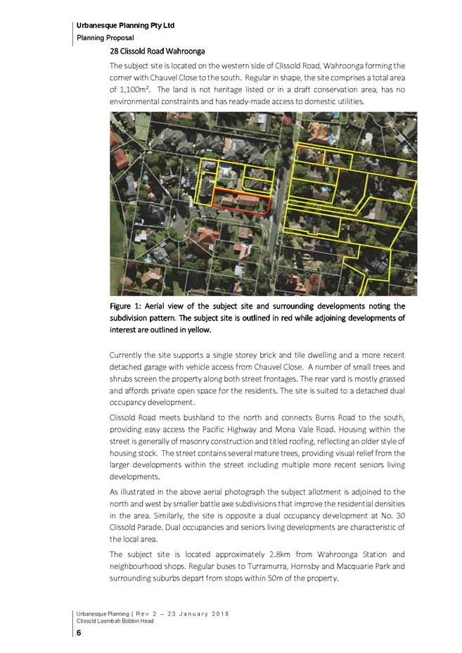
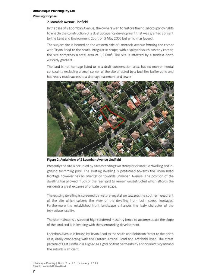
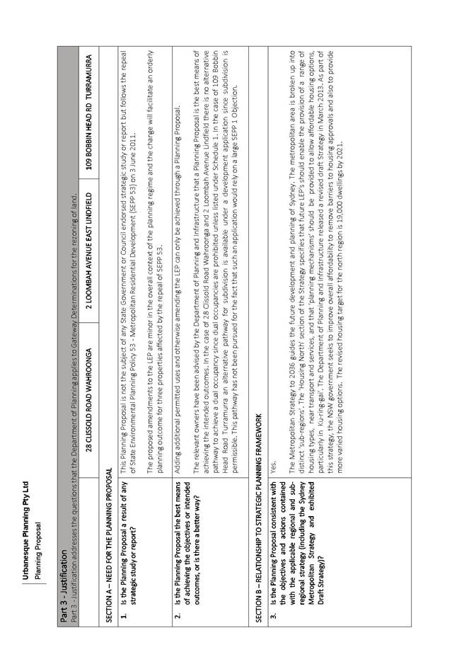
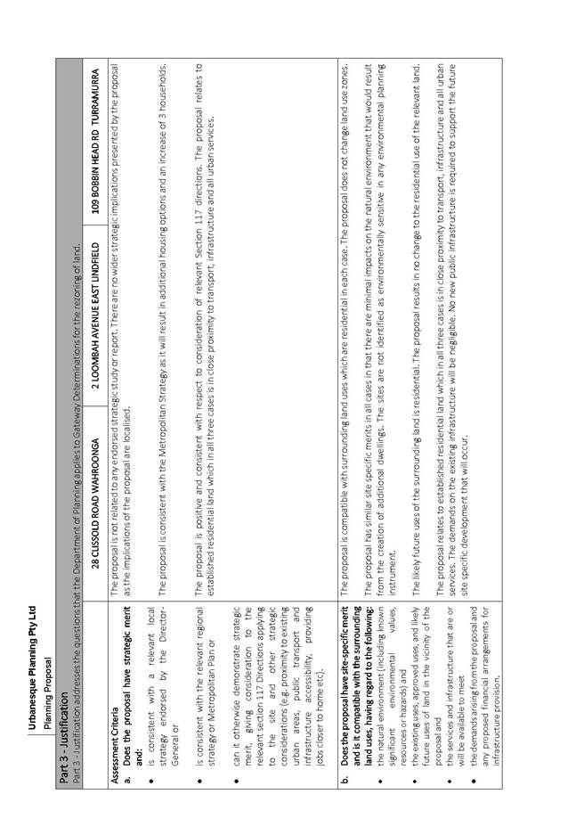
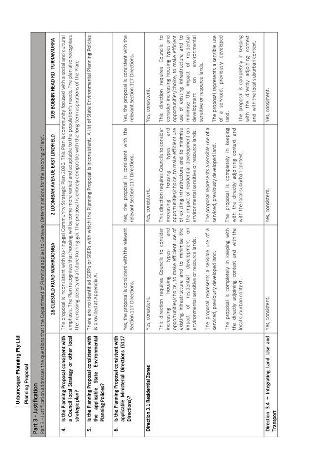
|
Ordinary Meeting of Council - 21 April 2015 |
GB.5 / 373 |
|
|
|
|
Item GB.5 |
S10362 |
|
|
28 January 2015 |
Compulsory Acquisition of Roads - Lindfield
EXECUTIVE SUMMARY
|
purpose of report: |
To advise Council on matters related to roads closures within the Lindfield major project sites. |
|
|
|
|
background: |
Throughout 2013 and 2014 Council has considered reports on the Lindfield Community Hub and the Lindfield Village major projects. A component of these reports referred to the closure and partially closure of public roads within the development sites which are discussed in further detail below. |
|
|
|
|
comments: |
Compulsory acquisition applications are administered by the Office of Local Government (OLG) and applications require the provision of specific documentation to ensure assessment and subsequent approval of the compulsory acquisition can be approved. |
|
|
|
|
recommendation: |
That Council proceed with the compulsory acquisition of the public roads for the purpose of creating the Lindfield Village Green and the Lindfield Community Hub in accordance with the Land Acquisition (Just Terms Compensation) Act 1991. |
Purpose of Report
To advise Council on matters related to roads closures within the Lindfield major project sites.
Background
Throughout 2013 and 2014 Council has considered reports on the revitalisation and masterplanning in the Lindfield local centre involving two Council-owned sites.
These sites are the Tryon Road site AKA the Lindfield Village Green and the Woodford Lane site AKA Lindfield Community Hub.
A component of the earlier reports referred to the closure and partially closure of public roads within the development sites which are discussed in further detail below.
Lindfield Village Green
On the Tryon Road site it is proposed to place the existing car parking underground and create a new civic space called the “Lindfield Village Green”.
The Tryon Road site has an unnamed lane which runs east-west across the site. The lane currently forms part of the car park circulation. In order to deliver the Lindfield Village Green, Council will need to consolidate various properties owned by Council fronting Kochia Lane, Chapman Lane and Tryon Road and partially close and realign local public roads as shown in the Figure 1.
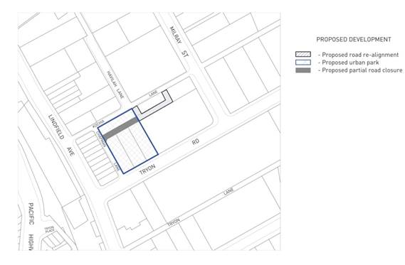
Figure 1 –Proposed Partial Road Closure
On 10 December 2013, Council considered a report on the Lindfield Village Green project (Attachment 1) at which time it resolved to commence compulsory acquisition of part of “unnamed lane” as part of the project.
The recommendation for Council to proceed with the compulsory acquisition of the unnamed public road was based on the legal advice received, and the specific wording of the Council resolution is as follows:
D. That pursuant to sections 186(1) and 187(1) of the Local Government Act 1993, the Council compulsorily acquire the unnamed public road shaded in grey and marked as ‘Proposed partial road closure’ in Figure 2 of the report to the Council dated 10 December 2013 for the purpose of creating the Lindfield Village Green in accordance with the Land Acquisition (Just Terms Compensation) Act 1991.
E. That for the purposes of section 30 of the Land Acquisition (Just Terms Compensation) Act 1991, the Council, as the owner of the road, agrees to the road being acquired for compensation in the amount of $1.00.
F. That Council delegate to the General Manager or his delegate the power to do anything further as necessary to give effect to the compulsory acquisition including obtaining any necessary approvals and publishing any necessary notices in the Gazette.
Based on legal advice the best manner to effect the partial closure of the unnamed lane was by way of compulsory acquisition. This was due to the fact that it is less procedurally burdensome, and could be achieved within considerably shorter timeframes when compared to a formal road closure process administered under the Roads Act 1993.
The proposed closure of the unnamed lane on the eastern side of the centre is to facilitate construction of the Lindfield Village Green. It is noted this arrangement is intended to not disadvantage any adjoining landowners.
Lindfield Community Hub
Council is the owner of all lands within the Woodford Lane site. The only remaining requirement for Council to fully consolidate the site into one lot is the closure of the portion of Drovers Way north of Beaconsfield Parade which is a public road.
Council’s DCP and contribution plan proposes to replace this road with a new public road along the western boundary of the site. The section of road is shown on Figure 2 below.
.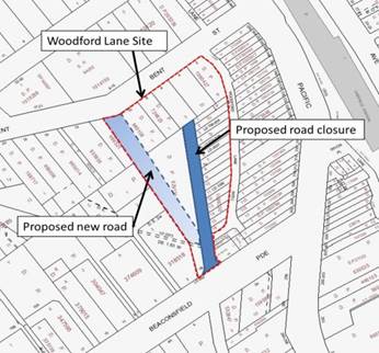
Figure 2 – Proposed road closure and road realignment
On 9 September 2014, Council resolved to commence compulsory acquisition of a portion of Drovers Way north of Beaconsfield Parade which is a public road for the purpose of creating the Lindfield Community Hub in accordance with the Land Acquisition (Just Terms Compensation) Act 1991 (Attachment 2).
At the time, the recommendation to compulsory acquire the road, which was also based on earlier legal advice, and was thought to be the most efficient and procedurally less burdensome manner to progress the road. The specific wording of the Council resolution (in part) is as follows:
D. That pursuant to sections 186(1) and 187(1) of the Local Government Act 1993, the Council compulsorily acquire the unnamed public road shaded in grey and marked as ‘Proposed partial road closure’ in Figure 2 of the report to the Council dated 10 December 2013 for the purpose of creating the Lindfield Village Green in accordance with the Land Acquisition (Just Terms Compensation) Act 1991.
E. That for the purposes of section 30 of the Land Acquisition (Just Terms Compensation) Act 1991, the Council, as the owner of the road, agrees to the road being acquired for compensation in the amount of $1.00.
F. That Council delegate to the General Manager or his delegate the power to do anything further as necessary to give effect to the compulsory acquisition including obtaining any necessary approvals and publishing any necessary notices in the Gazette.
The proposed closure of Drovers Way (north of Beaconsfield Avenue) on the western side of the centre to facilitate construction Lindfield Community Hub.
Comments
Both the Lindfield Village Green and Lindfield Community Hub projects are well advanced. Community consultation and engagement has been completed, architects have been engaged to prepare design concepts and these will be reported back to Council for consideration mid-year. It is also anticipated that Council will be in the position to conduct expression of interests to redevelop the Woodford Lane site by the end of 2015.
Compulsory acquisition applications are administered by the Office of Local Government (OLG) and applications require the provision of specific documentation to ensure assessment and subsequent approval of the compulsory acquisition application.
In recent consultation with the OLG it was revealed that the wording of Council’s earlier resolutions was incorrect. The OLG has since assisted by providing model resolutions suitable for the purposes of the compulsory acquisition of land or interests.
This report seeks to rectify that error, which will enable Council staff to submit an application to compulsory acquire the roads as previously approved by Council, and to ensure the timely delivery of the Lindfield Projects.
The compulsory acquisition will expedite the process to close and relocate the public roads within project timeframes.
Integrated planning & reporting
Places, Spaces & Infrastructure
|
Community Strategic Plan Long Term Objective |
Delivery Program Term Achievement |
Operational Plan Task |
|
Our centres offer a broad range of shops and services and contain lively urban village spaces and p[place where people can live, work, shop, meet and spend leisure time. |
Plans to revitalise local centres are being progressively implemented and achieve quality design outcomes in collaboration with key agencies, landholders and the community |
Implement a place management approach for the local centre improvements to coordinate works and achieve quality outcomes
|
|
|
An improvement plan for Lindfield Centre is being progressively implemented in collaboration with owners, businesses and state agencies |
Engage with relevant stakeholders to establish timing, extent and partnership opportunities |
|
|
|
Develop and finalise project scope |
|
|
|
Maintain engagement with key stakeholders |
Governance Matters
Council obtains its powers to compulsory acquire land and road under the Local Government Act 1993 and the Roads Act 1993.
Compulsory acquisition is a statutory process and approval by the Minister for Local Government and the Governor is required. .
The process of acquiring the public roads by compulsory acquisition is to be carried out in accordance with the Land Acquisition (Just Terms Compensation) Act 1991.
Additionally, the Guidelines for the Compulsory Acquisition of Land by Councils (Guidelines) published by the then Department of Local Government in June 2006 states at clause 1.27 that:
‘Compulsory acquisition should not be regarded as an alternative method of closing public roads. Except in limited circumstances, proposals to close roads are required to follow the procedures set out in Division 1, Part 4 of the Roads Act 1993, including public consultation.
Examples of ‘limited circumstances’ include where council proposes to widen, realign or alter the position of a public road so as to exchange the unneeded parts (of that road) in compensation for other land acquired for road purposes. To give this land in compensation, council must have the landowner’s consent (section 44).’
The Guidelines are not guidelines adopted under s23A of the Local Government Act 1993 which Council is obliged to consider when exercising its functions. Also, there is nothing in the legislation which limits the circumstances in which road closure can be affected through compulsory acquisition.
However, in stating the above, discussions with staff from the OLG have indicated that there is a strong nexus between the closure of the roads by compulsory acquisition and the public purpose through the delivery of the Lindfield Village Green and Lindfield Community Hub projects.
More importantly, Council’s resolution to compulsory acquire the roads must seek to make an application to the Minister and the Governor for approval to acquire the roads, and that the land upon acquisition is to be classified as community land or operational land.
Due to the potential partnership with Transport for NSW (TfNSW) to provide commuter car parking and other development opportunities that may arise as a result of the expression of interest process it is recommended that the roads once closed are classified Operational Land as required by the Local Government Act 1993.
Financial Considerations
For the purposes of section 30 of the Land Acquisition (Just Terms Compensation) Act 1991, the Council, as the owner of the roads, agree to each road being acquired for compensation in the amount of $1.00.
Social Considerations
There are no direct financial impacts associated with this report. However, the delivery of the Lindfield Village Green and Lindfield Community Hub projects are strongly supported by the community as evidenced from the results of the community engagement and consultation.
Environmental Considerations
There are no environmental impacts associated with this report.
Community Consultation
A number of consultation and engagement activities have been undertaken with the community on the Lindfield revitalisation projects in pursuit of achieving the best community outcomes.
Particularly in relation to site re-development, design concepts and facilities delivered and the requirement to realign roads and road closures.
Consultation is planned for all stages of the development process and an engagement strategy has been prepared by council’s community engagement and research planner for these projects.
Council has engaged consultants to provide background studies including;
· Lindfield Local Centre Transport Network Model Study; and
· Lindfield Community Facilities Study by Elton Consulting P/L.
Internal Consultation
Staff from Strategy & Environment have contributed to the content of this report.
Summary
Council has resolved to undertake a masterplanning process in Lindfield local centre involving two Council-owned sites, these sites are the Tryon Road site and the Woodford Lane site, which are also known as the Lindfield Village Green and the Lindfield Community Hub sites.
On 10 December 2013, resolved to commence compulsory acquisition of part of “unnamed lane” as part of the Lindfield Village Green project and on 9 September 2014, Council resolved to commence compulsory acquisition of a portion of Drovers Way north of Beaconsfield Parade which is a public road for the purpose of creating the Lindfield Community Hub
The recommendation for Council to proceed with the compulsory acquisition of the public roads was based on the legal advice received (Confidential Attachment 3) which also provided specific wording for the earlier Council resolutions.
However, Council’s previous resolutions omitted specific wording required to progress the application. The OLG has since provided Council staff with the model resolution which incorporates all essential components.
This report seeks to rectify an earlier error and enable staff to submit a compulsory acquisition application to the Office of Local Government to as its preferred method to close the public roads.
|
A. That Council proceed with the compulsory acquisition of the unnamed public road shaded in grey and marked as ‘Proposed partial road closure’ in Figure 1 of the report to the Council dated 21 April 2015 for the purpose of creating the Lindfield Village Green in accordance with the Land Acquisition (Just Terms Compensation) Act 1991.
B. That Council make an application to the Minister and the Governor for approval to acquire the portion of the unnamed public road shaded in grey and marked as ‘Proposed partial road closure’ in Figure 1 of the report to the Council dated 21 April 2015 by compulsory process under section [186(1) and 187(1) of the Local Government Act 1993. C. That for the purposes of section 30 of the Land Acquisition (Just Terms Compensation) Act 1991, the Council, as the owner of the road, agrees to the road being acquired for compensation in the amount of $1.00. D. That the land is to be classified as Operational land. E. Council requests the Minister for Local Government approve a reduction in the notification period from 90 days to 30 days. F. That Council proceed with the compulsory acquisition of the portion of Drovers Way Lindfield north of Beaconsfield Parade in Figure 2 of the report dated 21 April 2015 for the purpose of creating the Lindfield Community Hub in accordance with the Land Acquisition (Just Terms Compensation) Act 1991.
G. That Council make an application to the Minister and the Governor for approval to acquire the portion of Drovers Way Lindfield north of Beaconsfield Parade by compulsory process under section [186(1) and 187(1) of the Local Government Act 1993. H. That for the purposes of section 30 of the Land Acquisition (Just Terms Compensation) Act 1991, the Council, as the owner of the road, agrees to the road being acquired for compensation in the amount of $1.00. I. That the land is to be classified as Operational land. J. Council requests the Minister for Local Government approve a reduction in the notification period from 90 days to 30 days. K. That Council delegate to the General Manager or his delegate the power to do anything further as necessary to give effect to the compulsory acquisition including obtaining any necessary approvals and publishing any necessary notices in the Gazette. |
|
Deborah Silva Manager Integrated Planning, Property & Assets |
Andrew Watson Director Strategy & Environment |
|
A1View |
A1 - Lindfield Village Green - Tryon Road - Project Update |
|
2013/308401 |
|
|
|
A2View |
A2 - Lindfield Community Hub - Woodford Lane - Report on Progress |
|
2013/308036 |
|
|
Lindfield Village Green - Tryon Road - Project Update |
|
Confidential |
|
APPENDIX No: 1 - A1 - Lindfield Village Green - Tryon Road - Project Update |
|
Item No: GB.5 |
Lindfield Village Green - Tryon Road - Project Update
EXECUTIVE SUMMARY
|
purpose of report: |
To update Council on the progress of the masterplanning for Lindfield Village Green and to outline the next steps for the project. |
|
|
|
|
background: |
Council has resolved to undertake a masterplanning process in Lindfield local centre involving two Council-owned sites, these are:
· a public car park at 8-10 Tryon Road; and 3 and 5 Kochia Lane, Lindfield; and · a public car park at 19 Drovers Way and 1B Beaconsfield Parade, Lindfield.
On the site at Tryon Road it is proposed to place the existing car parking underground and deliver a new civic space. |
|
|
|
|
comments: |
The proposed projects comprise works on two sites with a range of facilities and improvements which jointly need to be considered within a broader context of the Lindfield local centre and the surrounding district. The key considerations for the Woodford Lane site are:
· traffic and transportation; and · community needs. |
|
|
|
|
recommendation: |
That Council proceeds to the next stage of the project which is to prepare detailed concept plans for the site and undertake community engagement. |
Purpose of Report
To update Council on the progress of the masterplanning for Lindfield Village Green and to outline the next steps for the project.
Background
Council has resolved to undertake a masterplanning process in the Lindfield local centre involving two Council-owned sites, these sites are:
· a public car park at 8-10 Tryon Road and 3 and 5 Kochia Lane, Lindfield (henceforth the Tryon Road site); and
· a public car park at 19 Drovers Way and 1B Beaconsfield Parade, Lindfield (henceforth the Woodford Lane site).
The purpose of this report is to update Council on the progress of background studies as they relate to the Lindfield Village Green. Items relating to the Woodford Lane site are not yet resolved in sufficient detail and will be reported to Council in early 2014.
Lindfield Village Green
On the Tryon Road site it is proposed to place the existing car parking underground and create a new civic space called the “Lindfield Village Green”. The potential for a branch library co-located with the public space has also been investigated.
In relation to the Lindfield Village Green, Council resolved at the OMC of 9 April 2013 as follows:
A. That Council confirm their in principle support for the proposed location of the new Lindfield Village Green.
B. That $100,000 from development contributions (local parks) be allocated as seed funding to undertake stage 1 of the project for the year 2012-2013.
C. That Council advertise an Expression of Interest seeking potential joint venture partners for the project.
D. That a report be brought back to Council on the results of the EOI with recommendations for funding of the project.
E. That a consultant be engaged to prepare Community Consultation Strategy for Council’s approval.
Stage 1 of the project has been completed; it involved Council advertising an Expression of Interest (EOI) seeking potential joint venture partners for the delivery of the project. This was reported to Council at the OMC of 13 August 2013 where Council resolved:
B. That Council does not progress the Lindfield Village Green EOI process due to the non-compliant nature of the submissions and that those persons who made submissions are notified of Council’s decision.
As per resolution E a consultation strategy has been prepared by Council’s Manager Corporate Communications and Community Engagement and Research Planner; details of the strategy are in the community consultation section of this report and attached to this report (Attachment A1). At this stage it is not envisaged that a consultant will be necessary to manage the process however this will be reviewed over the next few months in light of staff work loads.
This report will recommend the next stage of work for this project.
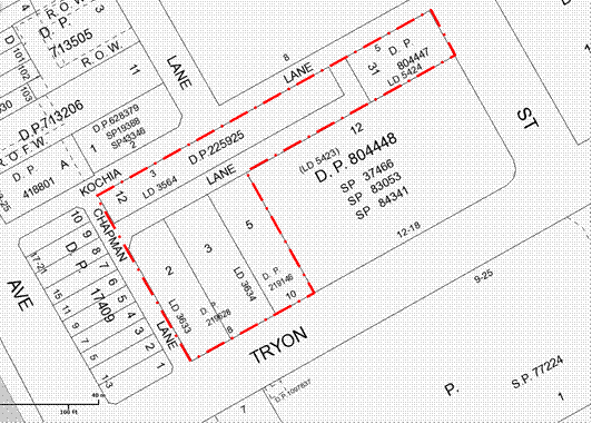
Figure 1 – Site Plan – Tryon Road Site
Comments
The Tryon Road site comprises works including a range of improvements which need to be considered within the broader context of the Lindfield Local Centre and the surrounding district. The key considerations are discussed below.
Traffic and transportation
· With a 240 space commuter car park planned for the Woodford Lane site this will place a load on the local streets at peak times. Consideration will be given to splitting the commuter parking across the two sites and whether this will be necessary to balance traffic impacts. (Noting it is TfNSW’s preference to locate the commuter parking in one location on the western side of the Pacific Highway.)
Community needs
· In terms of the community facilities the critical decision for Council is whether to co-locate a library and multi-purpose community facility on the Woodford Lane site or construct the library separately on the Tryon Road site. This will have both functional and economic impacts i.e., a single building will be more efficient and less costly than two separate buildings but will it best meet the community’s needs?
· The size and internal design of the new community buildings will be determined by the size and mix of the population of the surrounding areas. Council will need to consider the future population within the catchment of the facilities so that the size of the facility will meet the needs of the community in 20-30 years’ time.
· The community needs will determine the internal configuration of the facilities and this in turn will impact the cost of the facilities.
Road closure
· The Tryon Road site has an unnamed lane which runs east-west across the site. The lane currently forms part of the car park circulation. In order to deliver the Lindfield Village Green, Council will need to consolidate various properties owned by Council fronting Kochia Lane, Chapman Lane and Tryon Road and partially close and realign local public roads as shown in the Figure 2. It is noted this arrangement is intended to not disadvantage any adjoining landowners.

Figure 2 – proposed partial road closure of unnamed lane - Tryon Road site
Council has engaged consultants to provide background studies on the various aspects noted above. The studies being undertaken are:
· Lindfield Local Centre Transport Network Model Study by PeopleTrans P/L;
· Lindfield Community Facilities Study by Elton Consulting P/L; and
· Lindsay Taylor Lawyers.
The project scope, methodology and key findings of each study will be discussed below under the respective headings.
Lindfield Local Centre Transport Network Model Study
Once complete a transport network model of Lindfield will test alternative development scenarios to determine the network impacts and capacity; as well as recommend traffic network improvements.
Project scope
The scope of the transport modelling study is to develop a comprehensive transport network model for Lindfield Local Centre compatible with current Roads and Maritime Services (RMS) standards. The model includes existing and future traffic movements, public transport, pedestrian patterns and cycle movements, and will incorporate the latest traffic improvements proposed by Council as per the Lindfield Local Centre Traffic Improvement Concept Plan.
Also included within the scope of the subsequent analysis is:
· consideration of improvements to public transport which may be proposed by State agencies or operators;
· to incorporate accessibility to the centre from surrounding residential areas, by foot and bicycle, by including bicycle and pedestrian routes/facilities identified in the Ku-ring-gai Bicycle Plan/Public Domain Plan and draft Pedestrian Access and Mobility Plan;
· the opportunity to rationalise on-street car parking (where appropriate) to better provide for a range of users including shoppers, commuters, visitors and residents; and
· to review and investigate access for the mobility impaired.
Methodology
PeopleTrans commenced the project with a full review of background material on the project, including Council reports, traffic and transport studies as well as Council’s Parking Management Plan. From that point the consultant commenced developing the transport network model which includes:
· full traffic counts for key intersections within the Lindfield local centre;
· counts of other transport options within the centre including pedestrian volumes and desire lines, cycle, taxi, bus and train movements; and
· input of traffic generation from projected development as a result of KLEP (Local Centres) 2013 as verified by Council staff.
A base model has now been prepared and has been peer-reviewed. Capacity testing is currently being carried out on the network model. The transport consultant will then use the data to test scenarios and recommend potential network changes to maximise capacity. From this data, Council will develop a range of traffic improvement measures across the Lindfield Local Centre.
Key findings (to date)
Vehicle trip generation of the various options has been quantified and this may be an early indicator of the impact of the options. Residential uses are likely to generate the least amount of vehicle trips while a supermarket would generate the highest number of vehicle trips.
The vehicle trip generation patterns suggest that the weekday pm peak and Saturday peak would be the times most likely to be impacted by the proposal. Vehicle trip generation during the am peak is generally expected to be lower.
Staff commentary and recommendations
Until the base model is peer-reviewed and signed off by RMS, no formal testing of options can occur. Therefore, it is not possible at this stage to comment on whether the provision of commuter car parking on the Tryon Road site will benefit the traffic network. This work will occur in early 2014 and the results reported to Council.
Lindfield Community Facilities Study
Project scope
The Lindfield Community Facilities Study scope has been to undertake a detailed analysis of the Lindfield branch library and multi-purpose community facility as nominated in Council’s Contributions Plan and has been broken down into the following parts:
· Library analysis - the consultant has undertaken an analysis of the functional and space requirements for a new Lindfield branch library.
· Multi-purpose facility analysis - the allocated floor areas of the multi-purpose community floor space in the contributions plan are undefined in terms of the mix of uses and required functions. The community facility needs analysis incorporates an analysis of shortfalls in the existing provision of the community facility and future trends to determine the appropriate mix of uses for the proposed facility.
· Facilities siting strategy - the consultant has undertaken an analysis of the benefits and weaknesses of two siting options, the first being co-location of the two facilities on Woodford Lane; the second being splitting of the facilities with the library on the Tryon Road site and the multi-purpose community facility on the Woodford Lane site.
· Functional brief - the mix of uses and functions for each facility or the single co-located facility are to be broken down into a functional brief. The brief will provide specific information on each element of the facility in terms of function/use, proximity to other uses and spatial requirements.
Methodology
The consultant commenced the project with a full review of background material on the project, including Council reports, previous community facility and library studies as well as Council’s Local Centres Development Control Plan. The methodology and process adopted by Elton Consulting has been as follows:
· Relevant catchment areas of each facility were identified and assessed to establish relevant indicative service provision boundaries.
· Spatial requirements of each facility were reviewed through an analysis of population data (including comment and analysis on the latest population projections) and standards in Library and community facility provision.
· A Library Facilities Discussion Paper was prepared to further inform the brief for the branch library.
· A workshop with library staff on the Lindfield branch library was conducted to refine the library requirements, establish key drivers and characteristics and test the siting options.
· A workshop with users of the current Lindfield halls and meeting rooms in addition to relevant service providers and agencies was conducted to refine the multi-purpose community facility requirements, establish key drivers and characteristics and test the siting options.
· A workshop with relevant staff on the facilities provision and siting options was conducted to refine the outcomes of the two previous workshops and further inform the siting strategy.
Key findings (to date)
Elton Consulting have completed a draft report outlining their findings in relation to the library analysis, multi-purpose facility analysis and a facilities siting strategy. The draft report can be found in Attachment A2. A summary of the key findings of the study to date is set out below.
Community Centre – floor space requirements
Based on a comparative analysis of standards of provision of community centres, and consideration of existing levels of provision in Ku-ring-gai, it is suggested that a future level of provision of 80 square metres for every 1,000 people be considered appropriate.
The following table shows the implications of this for the Lindfield Community Hub community centre catchment.
|
|
|
|
Projected catchment population to 2031 |
50,653 |
|
Proposed rate of provision for community centre (square metres per 1,000 people) |
80 |
|
Required community centre floor area for catchment (square metres) |
4,045 |
The table shows that based on a rate of provision of 80 square metres for every 1,000 people, the required community centre floor space for a projected 2031 catchment population of 50,653 is 4,045 square metres. The existing provision in the catchment area for community centres is 2,172 square metres. When this is deducted from the required community centre floor space for the catchment (4,045 square metres), the deficit (i.e. community centre space required to be provided as part of the new community hub) is 1,873 square metres.
Library – floor space requirements
The Ku-ring-gai Council Library Facilities Study (2004) identified four library catchments across the LGA. Lindfield sits within the southern catchment which includes the suburbs of Lindfield and Roseville.
The projected Lindfield branch library catchment population is 26,011 people. Unlike community centres, public libraries have a well-developed and accepted set of standards determining required levels of provision. These standards have been developed by the State Library of New South Wales and form part of the People Places library planning documents.
When the State Library standards are applied (approximately 46.8sqm per 1,000 head of population) to the projected catchment population of 26,011, the required library floor space is estimated to be 1,217 square metres.
These figures of 1,873 square metres for a community centre and 1,217 square metres for a library confirm Council’s original analysis of the floor space requirements for the Lindfield Community Hub. It is important to note however that if the preferred facility model involves the co-location of both the community centre and the library into an integrated community hub building, there may be opportunities for some floor space efficiencies through the shared use of some spaces.
Library and Community Centre – location analysis
Two alternative siting arrangements have been identified across the two sites. Option 1 involves separating the library on the Tryon Road site and the multi-purpose community facility on the Woodford Lane site with Option 2 having both facilities co-located on the Woodford Lane site.
Both alternatives were presented at each of the workshops with a strong preference for a co-located facility evident in all but the library staff workshop. Reasons for co-location included; efficiency of access, financial benefits, the library acting as anchor for the community facility and the potential to challenge traditional concepts of the library through integration with some aspects of the community facility. Reasons against the co-located facility focused on Tryon Road being a better location for a library with close proximity to new development occurring in Lindfield and the lack of activation for the current Woodford Lane site.
The consultants have recommended co-location of the two facilities on Woodford Lane (Option 2). Further analysis has been undertaken in regards to preferred library locations; this identified a best practice trend toward co-location. The recommendation also takes into account site constraints and the financial and operational incentives of co-location.
The siting analysis also acknowledges some key site constraints on the Woodford Lane site and recommends further measures to ensure that the site achieves the maximum potential. These include:
· activation of the site through the inclusion of additional land uses such as retail and commercial space;
· strengthened connections from the east side of the Pacific Highway to ensure appropriate access to the site;
· improving permeability from the Pacific Highway through to the site;
· including the provision of high quality open space associated with the facilities;
· ensuring that the development is of a high standard; and
· ensuring that the community facilities are well-managed and programmed to ensure attraction for a broad range of the community.
Staff commentary and recommendations
The key findings to date from the Community Facilities Study are:
· the preferred size of the library is 1,217sqm;
· the preferred size of the community centre is 1,873sqm; and
· the preferred siting strategy is to co-locate the new facilities combining the Lindfield branch library and the multi-purpose community centre on the Woodford Lane site.
Other aspects of the study including the functional brief will be further developed to detail the final requirements for each facility. It is therefore recommended that Council proceed with the masterplanning of the Lindfield Village Green on the basis that there will be no library on the site and that the consultant continue to develop the functional briefs for the facilities on the Woodford Lane site consistent with this direction.
Road closure
Project scope
The Council sought advice as to the best manner and the statutory requirements to effect partial closure of the local public road on the Tryon Road site as shown in Figure 2. Advice from Lindsay Taylor Lawyers is in Confidential Attachment A3.
Methodology
The advice reviewed two ways by which the road can be closed:
· by the Minister administering the Roads Act 1993 (Minister) pursuant to an application lodged by the Council; or
· by way of compulsory acquisition of the road by the Council.
Key findings (to date)
The closure of the public road by way of compulsory acquisition is considered the best option for Council as it is less procedurally burdensome; however the Division of Local Government has issued guidelines to the effect that compulsory acquisition should not be used to close roads. Council may therefore want to consider whether to pursue this option. However:
· the Guidelines are not guidelines adopted under s23A of the Local Government Act 1993 which Council is obliged to consider when exercising its functions;
· there is nothing in the legislation which limits the circumstances in which road closure can take effect through compulsory acquisition; and
· Council should consider compulsory acquisition as a valid option.
Staff commentary and recommendations
Road closures by the Minister can take up to two years to complete which could represent a significant delay for delivery of the projects. Based on the advice received to date, compulsory acquisition may be an appropriate option for Council in Lindfield. It is therefore recommended that Council proceeds with the compulsory acquisition of the unnamed public road shaded in grey and marked as ‘Proposed partial road closure’ in Figure 2 of the report by way of agreement under s30 of the Land Acquisition (Just Terms Compensation) Act 1991 (‘Just Terms Act’).
Governance Matters
A project of this type is identified in the draft Operational/ Delivery Plan:
· Key theme – Places Spaces and Infrastructure P4.1.4

Figure 6: Extract from Council’s Delivery Program 2013-2017 and Operational Plan 2013-2014, page 40
The RMS have been engaged through the Lindfield traffic study.
Risk Management
The greatest risk at this stage in the project is to Council’s reputation. There is significant interest in the project with ‘Support Lindfield’ an increasingly active voice in the community. Council will need to be seen to have a high standard of consultation with the community in conjunction through a well-executed communication strategy demonstrating Council’s pursuit of the best community outcomes to mitigate the risk of loss of reputation.
Financial Considerations
Lindfield Village Green
Stage 1 of the project has been completed which involved Council advertising an Expression of Interest (EOI) seeking potential joint venture partners for the delivery of the project. Two EOIs were received, one from a construction company and one from an architectural firm. The EOIs have been assessed and both have been found to be non-compliant. Both submissions have misinterpreted the EOI criteria by offering their services rather than offering a potential joint venture partnership for the project.
The EOI process has clarified that there are no potential joint venture partners for the project. This means that Council will be required utilise development contribution funds (open space acquisition - south) collected under the Ku-ring-gai Contributions Plan 2010 to fund the construction works associated with the new underground car park and new village green (as previously discussed in the report to Council on 9 April 2013). Subject to successful allocation of development contribution funds to a project account the funds would pay for the cost of undergrounding the existing car parking at the same time as creating an open, at-grade site to build a new park.
Given the library is no longer proposed for this site it will be necessary to provide some form of public amenities on the site such as toilets. There may also be some financial benefit to Council if it were to provide a small kiosk building to house a café in the park. Additional funding will need to be found for these facilities. It is proposed to further develop this idea as part of the concept design stage of the project.
The concept design stage will also include a quantity surveyor so that a project budget can be more accurately identified.
Social Considerations
Currently the Tryon Road site is utilised for car parking by shoppers and local business owners. Beyond this function the sites provide very little social benefit to the community and are very much under-utilised assets for Council.
The site has the potential to provide new community infrastructure which will provide high levels of social benefit to the community.
A Community Facilities Strategy undertaken on behalf of Council by Elton Consulting P/L in 2009 prepared an audit of the existing community facilities in Lindfield. The study found that both of Council’s facilities require replacement. A summary of the findings is below:
The Lindfield library building:
· is too small to meet contemporary standards and the needs of users;
· is in poor condition with numerous maintenance issues identified in a building audit;
· requires improved staff parking and disabled access; and
· is located too far from shops and train station for people to walk.
The Lindfield Seniors Centre building:
· is too small to meet contemporary standards;
· is an old style facility with basic facilities in poor condition;
· contains identified trip hazards and maintenance requirements;
· lacks flexibility for multi-use; and
· is located too far from shops and train for people to walk (particularly the elderly).
Environmental Considerations
Lindfield Village Green
There have been no significant environmental considerations identified to date. A geotechnical study will be required in the near future.
If the development on the Tryon Road site was to be undertaken in a considered manner there is potential for the environmental quality of the site to be dramatically improved through the provision of a new village green, tree planting and streetscape improvements.
Community Consultation
Council has not undertaken community consultation to date beyond what was carried out for the preparation of the Lindfield Community Facilities Strategy. Consultation is planned as part of the next stage of the process. An engagement strategy has been prepared by Council’s Community Engagement and Research Planner and is set out in Attachment A1 and outlined below.
Engagement strategy – Activate Lindfield
Ku-ring-gai Council will undertake extensive and multi-modal consultation to ensure all community stakeholders are informed, engaged and collaborate on Activate Lindfield.
The Tryon Road site represents a distinct opportunity for our community; it will have its own unique functions, uses and aesthetics. To ensure we comprehensively examine the site, we propose a strategy to engage the site separately from the Woodford Lane site.
The objectives of our engagement strategy are to:
1. Increase community awareness of Activate Lindfield and the benefits the project will bring to the local and broader community;
2. Tap into local knowledge and expertise on Lindfield including local businesses, residents and community groups;
3. Deliver creative and engaging opportunities for stakeholders to collaborate with Council in designing, delivering and managing the Activate Lindfield sites;
4. Determine community priorities for Activate Lindfield including the negotiable and non-negotiable for each site; and
5. Meet Council requirements in delivering Activate Lindfield, including car parking, new parks and civic spaces.
The community engagement process will be divided into a series of phases:
1. Multi-channel communications to inform stakeholders on the Activate Lindfield project and possible options for the site. Activities will include:
a. local newspapers;
b. letterbox drop;
c. website – Council and Have Your Say Ku-ring-gai; and
d. email newsletters;
e. community networks – organisations, associations, staff networks;
f. rates notice; and
g. social media campaign.
2. Online discussion forum – open to all community stakeholders prior to formal consultation;
3. Concept design workshops and place performance evaluations;
· Tryon Road engagement program,
· Focus groups and deliberative workshops to examine elements to be included on site; materials and equipment used; trees, planting; how to the space can/could be used/function; Comfort and Image, Usability, Access and Linkages, Sociability.
4. Place making and partnership forums to set the way forward for Lindfield
Internal Consultation
Extensive consultation has also occurred as part of the Lindfield Community Facilities Study including staff from Operations, Community, Strategy and Environment, Corporate and Development and Regulation.
Summary
Council has resolved to undertake a masterplanning process in Lindfield local centre involving two Council-owned sites, these sites are the Tryon Road site and the Woodford Lane site.
On the Tryon Road site it is proposed to place the existing car parking underground and create a new civic space called the “Lindfield Village Green”. The Woodford Lane site will be subject to further detailed investigation to be presented in a report to Council in early 2014.
Council has engaged consultants to provide background studies relating to the Lindfield Village Green. The studies being undertaken are:
· Lindfield Local Centre Transport Network Model Study; and
· Lindfield Community Facilities Study by Elton Consulting P/L.
This report provides an update on the results to date of these studies and makes a range of recommendations for moving forward on the Lindfield Village Green.
Lindfield Village Green – key recommendations
This report recommends the following:
1. That the Lindfield branch library is not located on the Lindfield Village Green rather that it is to be co-located within the Lindfield Community Hub on the Woodford Lane site.
2. The viability and cost of a small building containing public amenities and a kiosk to house a café or restaurant in the park is to be investigated.
3. That Council continues to actively investigate the potential to provide some of the TfNSW commuter car parking under the Lindfield Village Green.
4. That Council proceeds with the compulsory acquisition of the unnamed public road shaded in grey and marked as ‘Proposed partial road closure’ in Figure 2 of the report by way of agreement under s30 of the Land Acquisition (Just Terms Compensation) Act 1991 (‘Just Terms Act’).
The next steps in the process are:
· Prepare a consultant brief and issue a Request for Quotation to up to six consultants. The lead consultants will be a landscape architect and selected on the basis of experience with similar projects, reputation and awards.
· The selected consultant team will prepare a draft concept design and undertake community consultation guided and facilitated by Council.
· Following consultation the concept will be amended to reflect community comments and then reported to Council for their endorsement prior to public exhibition.
At this stage it is anticipated that the draft concept plan for the Lindfield Village Green will be placed on public exhibition by early to mid-2014.
|
Recommendation:
A. That the proposed Lindfield branch library and the proposed Lindfield Community Centre are to be co-located on the Woodford Lane site.
B. That Council continues to actively investigate the potential to provide some of the commuter car parking proposed by Transport for NSW under the proposed Lindfield Village Green.
C. That Council prepares an illustrative concept design for the Lindfield Village Green and proceed to public engagement and, following this, the draft concept is to be reported to Council for their endorsement prior to public exhibition.
D. That pursuant to sections 186(1) and 187(1) of the Local Government Act 1993, the Council compulsorily acquire the unnamed public road shaded in grey and marked as ‘Proposed partial road closure’ in Figure 2 of the report to the Council dated 10 December 2013 for the purpose of creating the Lindfield Village Green in accordance with the Land Acquisition (Just Terms Compensation) Act 1991.
E. That for the purposes of section 30 of the Land Acquisition (Just Terms Compensation) Act 1991, the Council, as the owner of the road, agree to the road being acquired for compensation in the amount of $1.00.
F. That Council delegate to the General Manager or his delegate the power to do anything further as necessary to give effect to the compulsory acquisition including obtaining any necessary approvals and publishing any necessary notices in the Gazette.
|
|
Attachments: |
A1 |
Activate Lindfield - Community Engagement Strategy - October 2013 |
|
2013/302255 |
|
|
A2 |
Lindfield Community Facilities Study - Progress Report |
|
2013/302258 |
|
|
A3 |
Lindfield Village Green - Road Closure Process - Legal Advice |
|
Confidential |
|
APPENDIX No: 2 - A2 - Lindfield Community Hub - Woodford Lane - Report on Progress |
|
Item No: GB.5 |
Lindfield Community Hub - Woodford Lane - Report on Progress
EXECUTIVE SUMMARY
|
purpose of report: |
To seek Council’s approval of three preferred land use scenarios for the Lindfield Community Hub as the basis for engaging architectural consultants to prepare illustrative concept designs for public engagement and exhibition. |
|
|
|
|
background: |
At the Ordinary Meeting of Council on 28 May 2013 Council resolved to undertake a master planning process for a site on the western side of the Pacific Highway, Lindfield, in the vicinity of Woodford Lane, known as the Lindfield Community Hub.
The planning process for this project is underway and a Project Working Group (PWG) has been established with representatives of Council and Transport for NSW (TFNSW) to inform the preparation of the master plan. This report will summarise the planning process to date and recommending the next steps. |
|
|
|
|
comments: |
The primary objective of the project is to create a new community hub consisting of a multi-purpose community centre, a branch library, a new park and town square and public car parking.
Jones Lang LaSalle Pty. Ltd. were engaged to undertake preliminary economic feasibility assessment of development scenarios for the site, with a range of building heights and densities, which incorporate residential and retail uses as well as the proposed community infrastructure. |
|
|
|
|
recommendation: |
That Council proceed to engage an architectural consultant to prepare illustrated concept plans, based on the three preferred land use scenarios recommended in this report, and to seek the community’s views on the options. |
Purpose of Report
To seek Council’s approval of three preferred land use scenarios for the Lindfield Community Hub as the basis for engaging architectural consultants to prepare illustrative concept designs for public engagement and exhibition.
Background
At the Ordinary Meeting of Council on 28 May 2013 Council resolved to undertake a master planning process on the western side of the Pacific Highway, Lindfield, in the vicinity of Woodford Lane. The area, henceforth known as the Woodford Lane Site, consists of the following lands:
· a public car park at 8-10 Tryon Road; and 3 and 5 Kochia Lane, Lindfield;
· a public car park at 19 Drovers Way and 1B Beaconsfield Parade, Lindfield;
· 2-12 Bent Street, Lindfield;
· 1 Woodford Lane, Lindfield; and
· Drovers Way (part) public road.
At the Ordinary Meeting of Council on 10 December 2013 a report to Council gave an update on the Lindfield Community Facilities Study and Council resolved to locate the proposed Lindfield branch library on the Woodford Lane Site.
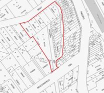
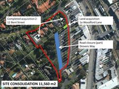
Figure 1– Woodford Lane Site Figure 2 – Woodford Lane Site
The planning process for this project is well underway and a Project Working Group (PWG) has been established with representatives of Council and Transport for NSW (TFNSW) to inform the preparation of the master plan. This report will address Resolution D by summarising the planning process to date and recommending the next steps.
This project has been largely on hold since December 2013 for two reasons:
· uncertainty regarding the Minister for Transport’s commitment to funding commuter car parking on the site; and
· the acquisition of lands zoned RE1-Public Recreation and identified in the KLEP (Local Centres) 2012 Land Acquisition Map was not complete.
With regard the former, funding has now been clarified with Transport for NSW following a meeting with Council staff and the Mayor on 27 February 2014. TFNSW have indicated they will fund up to 240 commuter car parks on the site, this does not include replacement of 40 existing Council managed commuter spaces. Further discussions are currently occurring as to whether a portion of this parking (approximately 100 spaces) will be provided on the eastern side of the centre below the proposed Lindfield Village Green. This is anticipated to be resolved over the coming months.
With regard the former, Council resolved on 24 June 2014 to proceed with the acquisition of the final parcel of land identified in the KLEP (Local Centres) 2012 Land Acquisition Map; settlement is anticipated to be finalised over the next few months. Council will soon be the owner of all lands within the site and be in a better position to develop a master plan for the site.
The only remaining requirement for Council to fully consolidate the site into one lot is the closure of the portion of Drovers Way north of Beaconsfield Parade which is a public road. Council’s DCP and contribution plan proposes to replace this road with a new public road along the western boundary of the site. It is therefore recommended that the Council compulsorily acquires the portion of Drovers Way north of Beaconsfield Parade for the purpose of creating the Lindfield Community Hub in accordance with the Land Acquisition (Just Terms Compensation) Act 1991. The section of road is shown on Figure 3 below.

Figure 3 – Proposed road closure and road realignment
Comments
As discussed in previous reports to Council the primary objective of the project is to create a new community hub consisting of a multi-purpose community centre, a branch library, a new park and town square and public car parking. The key community infrastructure components of the project are listed below with the associated funding source, where applicable.
|
New Community Infrastructure |
Size |
Funding source |
S94 % funded |
|
New Public park and town square |
3,800m2 |
Fully funded by Development Contributions (S94) |
100% |
|
New Branch library
|
1,265m2 |
Part funded by Development Contributions (S94) & part funded by Council co-contribution/project funded |
Approximately 33% |
|
New Multi-purpose community centre |
1,190m2 |
Part funded by Development Contributions (S94) & part funded by Council co-contribution/project funded |
Approximately 33% |
|
New commuter car park (excluding replacement of 40 existing council managed commuter spaces) |
up to 240 spaces |
Fully funded by Transport for NSW |
0% |
|
Replacement of Council’s existing short stay car spaces in new basement parking. |
up to 72 in total
|
Development Contributions (S94) funds parking for community facilities requirement only
Part funded by Council co-contribution/project funded |
Approximately 70% |
|
Pedestrian bridge over Pacific Highway |
|
Fully funded by Council co-contribution/project funded |
0% |
In relation to funding the following is noted:
· Ku-ring-gai Contributions Plan, 2010 - Works Programmes: Local recreational and cultural facilities, and Local social facilities allocates funding for a new multi-purpose community building and a new branch library. Due to apportionment, about 33% of the cost of the community buildings would be funded by development contributions the remainder would be required to be funded by Council from other sources; this results in a funding shortfall for the buildings in the order of $8.7 million (or 77%) based on the estimated construction cost in Council’s contribution plan.
· The Ku-ring-gai Contributions Plan, 2010 (KCP) allocates funding of $2.49 million for the design and construction of 50 basement car park spaces required for library and community facilities (KCP, page 210). This will go part way to replacing Council’s existing car parking on the site. There is likely to remain an estimated shortfall of over $1 million.
· Consultation to date has indicated that the community would like to see a pedestrian bridge connecting the west side of Lindfield to the rail station over the Pacific Highway. A feasibility study has been completed and the estimated cost is expected to be in the range of $2.7 million to $4.6 million; this project is unfunded (refer Attachment A1 for full study).
Jones Lang LaSalle P/L (JLL) have been engaged to undertake preliminary economic feasibility assessment of a range of development scenarios, with a range of building heights and densities, that incorporate residential and retail uses as well as the proposed community infrastructure; and to assess the scenarios for their potential financial return/loss to Council.
Jones Lang LaSalle has prepared a Stage 1 report (Confidential Attachment A2) which was completed in December 2013 and the Addendum (Confidential Attachment A3) which was completed in August 2014; the results of these are summarised below.
Lindfield Community Hub - preliminary feasibility assessment
The study was broken down into the following tasks:
· Market appraisal – review of market demand for retail, commercial and residential uses and provision of advice on the potential mix of floor space for the subject site.
· Preliminary economic feasibility assessment - conduct preliminary assessment of land use scenarios for the subject site including a preliminary financial appraisal of each option.
· Preferred option - assist Council with the development of a preferred option balancing the requirements of traffic, urban design and community.
· Preliminary economic feasibility assessments – undertake preliminary assessment of the preferred option and recommend modifications as required.
· Delivery method – provide advice on the preferred delivery method for the project which will maximise the economic, social, and environmental outcomes for Council.
Methodology
The consultant commenced the project with a full review of background material on the project, including Council reports, previous feasibility and market appraisal studies as well as Council’s Development Contributions Plan. In conjunction with the review, the consultant conducted a market appraisal on the current economic conditions to determine the mix of uses that could be supported on the Woodford Lane site.
Upon completion of the market appraisal, Jones Lang LaSalle prepared a 3 stage financial analysis of land use scenarios:
Stage 1 – Five preliminary land use scenarios (completed December 2013)
Stage 2 – Refinement of scenarios (completed December 2013)
Stage 3 – Final land use scenarios (completed August 2014)
Stage 1 – Five preliminary land use scenarios
The five scenarios were developed through discussions between Council staff and the consultants; the aim was to test a wide range of possible scenarios.
It is important to note that this analysis was based on current zoning under the KLEP 2012 which restricts the development footprint to the southern portion of the site as the northern portion, fronting Bent Street, is zoned RE1 – Public Recreation.
The options analysed are as follows:
· Option 1 - Community facility with secondary/specialty retail and residential; new park on Bent Street; and three storey height limit.
· Option 2 - Community facility with major and secondary/specialty retail as well as residential; new park on Bent Street; and three storey height limit.
· Option 3b - Community facility with major, mini-major and secondary/specialty retail as well as residential; new park on Bent Street; and five storey height limit.
· Option 4 - Community facility with residential only; new park on Bent Street; and five storey height limit.
· Option 5 - Full line supermarket (4,200sqm) with community facility, secondary/specialty retail, additional car spaces and no residential accommodation; new park on retail podium; and three storey height limit.
Analysis revealed that only one of these options would give a return to Council, all other options represent a financial loss to Council.
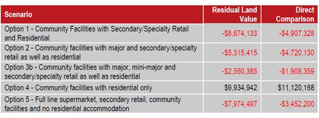
Figure 4 – Summary of preliminary Land Use Scenarios assessment
Stage 2 – Refinement of scenarios
Based on further market analysis and discussions with Council these options were further refined and three preferred scenarios were developed. The preferred scenarios are:
· Option 1 (Version 2) - Community facilities with reduced secondary/specialty retail; new park on Bent Street; residential uses; and three storey height limit.
· Option 3b (Version 2) - Community facilities with major retail (supermarket 3,400sqm in size), reduced secondary/specialty retail as well as residential; new park on Bent Street; and five storey height limit.
· Option 4 (Version 2) - Community facilities with residential only; new park on Bent Street; and five storey height limit.
Refinement of the options involved reduction in retail floor space and an increase in community floor space to include both a community facility and a branch library to be consistent with findings from the Lindfield Community Facilities Study; Option 5 was deleted as a full-line supermarket (4000sqm +) was found to not fit on the site when taking into account the current RE1 zone; Option 2 was deleted as it is similar to Option 3b (Version 2).
The gross floor areas of the refined options are set out in the Table below; in all cases a park of 3,800sqm is provided on Bent Street.
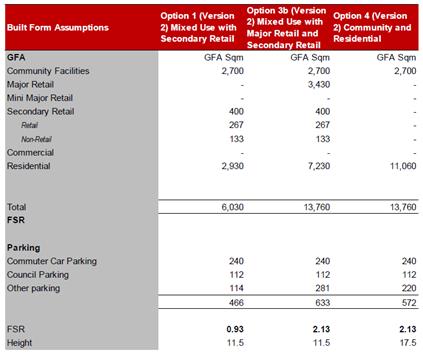
Figure 5 – Gross floor areas, building heights and FSRs for refined options
The findings of the feasibility analysis are set out in the Table below
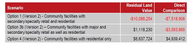
Figure 6 – Summary of results of preliminary feasibility assessment – refined options (version 2)
In summary:
· Option 1v2 may represent a significant loss to Council. This means that Council would need to make a monetary contribution in the order of $10 million to make the development economically feasible. In other words this option would not fund the proposed community facilities.
· Option 3b v2 may provide a small return to Council or a small loss depending on the economic analysis method used.
· Option 4v2 may provide a substantial return to Council.
Stage 3 – Final land use scenarios
Given that the earlier analyses were undertaken in December 2013, a review and update of the feasibility study was warranted in addition a number of other matters had arisen in the meantime that required consideration, these include:
· updated assumption on the income or equity contribution from Council (total of $6,223,138 from S94) which has not been escalated;
· inclusion of the development costs associated with the pedestrian bridge ($3,275,000);
· updated market based considerations inclusive of updated gross realisations;
· updated car parking assumptions i.e. 79 spaces for the Council car parking provision down 40 from our earlier analysis; and
· inclusion of a 5% construction contingency across the whole development.
The details of the final land use scenarios are set out below:
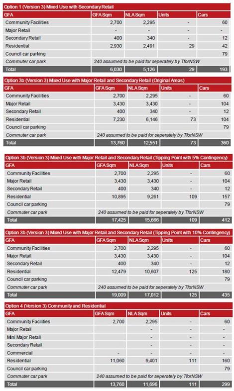
Figure 7 – Gross floor areas, building heights and FSRs for final land use scenarios
Three variations of Option 3b have been considered; the first is a five storey scenario with 73 residential units; the second is a 7 storey scenario with 109 residential units and the third is 7 storeys with 125 residential units. The latter two variations consider an additional contingency of between 5-10%
Provided below is the financial outcomes of the three scenarios tested. The objective of undertaking this analysis is to provide Council with an understanding of the viability of these options to a developer – with any shortfall requiring top up contribution from Council.
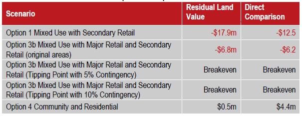
Figure 8 – Summary of results of preliminary feasibility assessment – final land use scenarios (version 3)
Staff commentary and recommendations
Council is required to consider a broad range of factors, not just financial, in order to determine a preferred option, including importantly community consultation. As this master planning process is still in its early stages it is considered too early to determine a preferred option. It is therefore recommended that Council proceed to a community consultation stage with the three land use scenarios. The benefit of this approach is that it would allow the community to compare the advantages and disadvantages of each option; some of these are described below:
Option 1 - Version 3 – Residential / community / park / speciality retail / 3 storeys
Advantages
· Limits building heights to 3 storeys which is likely to be supported by the community;
· No requirement for rezoning / planning proposal as it complies with existing height and FSR controls on the site in the local centres KLEP 2012; and
· Would likely present the least impact on surrounding residents in terms of traffic.
Disadvantages
· represents a very significant financial loss to Council ($17-18 million) which would need to be supplemented by funds from other sources such as asset divestment;
· includes residential uses which may not be supported by the community;
· does not take advantage of the proximity to the rail station by optimising residential or retail uses;
· will not encourage a significant revitalisation of western side of Lindfield due to lack of retail;
· would not provide full replacement of Council’s existing short stay car spaces;
· would not fund a pedestrian bridge over Pacific Highway; and
· would not fund the funding shortfall for proposed new community facilities.
Option 3b - Version 3 (tipping point 5% contingency) – Supermarket / community / speciality retail / residential / new park / 7 storeys
Advantages
· no financial loss to Council;
· provides Council with two new community facilities;
· would fund replacement of Council’s existing short stay car spaces;
· would fund a pedestrian bridge over Pacific Highway;
· optimises location in terms of residential and retail uses;
· includes a supermarket which may be supported by the community;
· potential for another significant retail anchor which is a desirable planning outcome in a centre with an undersupply of supermarket floor space; and
· potential for increased exposure to Council facilities by way of passing trade visiting a supermarket;
· TFNSW support for a supermarket associated with commuter parking as this allows commuters to park and shop in on location.
Disadvantages
· Increases building heights to 7 storeys which may be unpopular with the community and would a require rezoning process;
· increases density (FSR) on the site which would a require rezoning process;
· potential for impact on surrounding residents as a result of building height;
· potential for higher traffic impacts on local streets as a result of supermarket.
Option 4 - Version 3 – residential / community / 5 storeys
Advantages
· provides Council with two new community facilities;
· provides a small financial return to Council;
· would fund replacement of Council’s existing short stay car spaces
· would fund a pedestrian bridge over Pacific Highway;
· moderate visual impact on surrounding residents; and
· low traffic impacts on local streets (no major retail use).
Disadvantages
· Building heights up to 5 storeys may be unpopular with the community;
· predominantly residential uses may be unpopular with the community;
· requires a rezoning / planning proposal to provide additional height and FSR on the site;
· may not encourage a significant revitalisation of the area due to lack of retail; and
· does not take advantage of the site location.
These options will provide the community the opportunity to weigh up the pros and cons of each option. For example option 1 may maintain low building heights but would require a significant sale of land or other assets to make the project viable; comparing this to option 3b which may be feasible but has greater building heights and a new supermarket which may have traffic impacts on local streets; and option 4 which would allow 5 storey buildings and may result in a net financial gain but may not meet the objective of activating Lindfield.
Next Steps
The following indicative programme is proposed for the master plan process.
|
Task Name |
Date |
|
OMC - Report to Council - approval of land use scenarios |
9 Sept 2014 |
|
Advertise tender – design consultant services |
Sept-Oct 2014 |
|
Assess tender |
Oct-Nov 2014 |
|
Report to Council |
09 Dec 2014 |
|
Consultant – Preparation of 3 concept plans |
Jan-Feb 2015 |
|
Exhibition and community workshops |
February 2015 |
|
Consultant - Economic Feasibility Assessment - Stage 2 |
March 2015 |
|
Consultant - traffic assessment - final |
March 2015 |
|
Consultant – community assessment - final |
March 2015 |
|
OMC - Report to Council - preferred concept plan for exhibition / commence planning proposal |
April 2015 |
|
Consultant – Preparation of draft illustrative master plan |
Apr-May 2015 |
|
Public Exhibition and information sessions - draft master plan |
June 2015 |
|
Council - assessment of public submissions |
July 2015 |
|
OMC - Report to Council – final master plan |
August 2015 |
integrated planning and reporting
|
Theme - Places, Spaces and Infrastructure - P4 Revitalisation of our centres |
||
|
Community Strategic Plan Long Term Objective |
Delivery Program Term Achievement |
Operational Plan Task |
|
A range of well planned, clean and safe neighbourhoods and public spaces designed with a strong sense of identity and place. |
Plans to revitalise local centres are being progressively implemented and achieve quality design outcomes in collaboration with key agencies, landholders and the community. |
Implement a place management approach for the local centre improvements to coordinate works and achieve quality outcomes. |
|
|
An improvement plan for Lindfield centre is being progressively implemented in collaboration with owners, businesses and state agencies. |
Engage with relevant stakeholders to establish timing, extent and partnership opportunities. Undertake due diligence and undertake project scope. Identify and engage with the key stakeholders. |
|
Theme - Community People Culture - C4 Healthy lifestyles |
||
|
Community Strategic Plan Long Term Objective |
Delivery Program Term Achievement |
Operational Plan Task |
|
A healthy, safe, and diverse community that respects our history, and celebrates our differences in a vibrant culture of learning. |
New and enhanced open space and recreational facilities have been delivered to increase community use and enjoyment.
|
Complete the design for identified parks and include design principles which facilitate passive recreation activities. Construct Parks at identified locations and include design principles which facilitate passive recreation activities. |
Governance Matters
A Project Working Group has been established for the Lindfield Community Hub which includes representatives from Transport for NSW. The Roads and Maritime Service (RMS) have been engaged through the Lindfield traffic study.
A probity consultant has been engaged and is currently preparing a probity plan for the project.
Senior Council staff have visited and met with the General Manager and Director of Planning from North Sydney Council to discuss and learn from their experiences in managing similar projects.
Risk Management
This project is in the early planning stages and a full risk management plan is yet to be prepared; the key risks identified at this stage are:
· Council does not progress the project as quickly as is practicable to meet community expectations;
· Council does not progress the project as quickly as is practicable and TFNSW decide not to withdraw funding for a commuter car park; and
· The Woolworths proposal gains community support without discussion of alternatives and impacts.
The greatest risk at this stage in the project is to Council’s reputation. There is significant interest in the project from ‘Support Lindfield’ a community group with a large membership and an active voice in the community around the project. Support Lindfield are keen to see the project proceed as quickly as possible. To mitigate the risk of loss of reputation it is recommended that Council proceed to the next stage of the project as recommended in this report and that Council adopt the proposed project programme/timeline.
With TFNSW as a significant partner in the project there is a risk that funding for commuter car parking is lost should the project timeframe be significantly extended for the Community Hub project. The provision of commuter parking is strongly supported by the community and the loss of it represents a reputational risk. To mitigate this risk, Council has written both to the Minister for Transport and the Premier to ensure that the funding is available and remains available for the duration of the project (Attachment A4). A response from the Minister for Transport, the Hon. Gladys Berejiklian was received on 19 November 2013 and 28 November 2013; the letters are attached to this report as Attachment A5 & A6. In the letter the Minister confirms that
“Council may be assured that the NSW Government will honour its $34 million commitment to this project. However, I do wish to stress the importance to our customers of having these additional parking spaces delivered sooner rather than later”.
In the second letter the Minister states:
“…the approximate cost of the Lindfield commuter car park project is now estimated at $12 million, and therefore the NSW Government commits that amount of money to this project.”
A follow-up meeting was held on 27 February 2014 with the General Manager, Land Use and Integrated Transport Planning and Programs, from Transport for NSW who confirmed that there was some flexibility in the proposed funding for commuter parking.
In the same meeting TFNSW also confirmed they will consider Council’s proposal for providing some of the commuter parking on the Tryon Road site on the eastern side of the rail line. A copy of the email is attached Attachment A7.
Woolworths is actively engaging with the local community and promoting their proposal for Council’s land which involves:
· a community centre of 1284sqm;
· a library of 892sqm (approximately 370sqm smaller than Council’s requirements);
· scout hall of 176sqm;
· over 8,000sqm of retail including a supermarket of 4,000sqm; and
· 675 public car parking spaces.
The risk to Council is that the community have seen only one possibility at this stage and to manage this risk it is important that Council independently prepare development options for the site that are realistic alternatives to the Woolworth’s proposal and offer the community an opportunity to consider the costs and benefits of all options. It is therefore recommended that Council proceed to the next stage of the project as set out in this report.
Financial Considerations
As the project is still in the early planning and development stage the financial considerations relate to the funding of background studies and master planning. At the OMC 28 May 2013 Council allocated funds of $250,000 to the project for the year 2013-2014. To date most of these funds have been used to prepare a traffic study, an economic feasibility study, a community facilities study as well as staff time.
The next stage of work will involve a tender process to select a consultant team lead by an architect to prepare master plan options based on the land use scenarios described in this report. Additional funds are required to progress to the next stage and it is recommended that $250,000 are allocated to the project for the year 2014-2015 from the S94 reserve – pre-1993 and 1993 Plan - car parking.
In terms of the full project it is intended that it be financially feasible; assumptions at this stage are as follows:
· the construction of the public parkland and town square will be fully funded by development contributions;
· the cost of construction of an underground car park to accommodate up to 240 commuter car spaces will be funded by TFNSW;
· relocation of Council’s existing short stay car spaces (up to 72 in total) to a new basement parking will be partly funded by development contributions and partly project funded;
· the new community facilities will be partially (33%) funded by development contributions and partly project funded; and
· uses such as residential, retail and/or commercial will be included in the master plan to provide additional funds to cover part or all shortfalls related to community infrastructure;
· where this does not satisfy community expectations other funding sources, such as asset divestment, will be identified as an alternative; and
· funding of a pedestrian bridge over the Pacific Highway, if found to be required, is unfunded and will need to be project funded or funded by other sources, such as asset divestment.
Social Considerations
Currently the site is utilised for car parking by shoppers, commuters and local business owners, beyond this function the sites provide very little social benefit to the community. The site has the potential to provide new community infrastructure that will provide high levels of social benefit to the community.
A Lindfield community facilities strategy undertaken on behalf of Council by Elton Consulting P/L in 2014 prepared an audit of the existing community facilities in Lindfield. The study found that both of Council’s facilities require replacement. An extract of the findings, from page 31, is below in Figure 9.
Discussions with Council’s library staff identified a number of gaps that prevent the library from delivering modern services to meet the needs of the community including:
· inadequate space for all activities and collections;
· a shortage of shelving;
· lack of study and reading spaces;
· an inadequate children's area and lack of separation of this area;
· inadequate space for events; and
· a lack of contemporary technology inclusions.
Council’s Library and Cultural Services Manager also identified a lack of adequate parking as well as issues relating to access, with vehicular access to the library from the Pacific Highway viewed as unsafe, particularly by older people.

Figure 9 – Extract Lindfield Community Facilities Study, Elton Consulting, 2014
The Lindfield Community Facilities Study, 2014 recommends a new community hub be located on the western side of Lindfield combining a branch library and community centre with a total area of over 2,455 square metres. This proposal was adopted by Council at the Ordinary Meeting of Council on 10 December 2013.
Environmental Considerations
The development of the Lindfield Community Hub may lead to impacts on a stand of trees (5 x Eucalyptus paniculata, 1 x Eucalyptus punctata). The Local Centres LEP 2012 Natural Resources Biodiversity Map shows the stand of trees as having biodiversity significance (refer Figure 10). The trees are mapped on Council’s GIS as Sydney Turpentine-Ironbark Forest (STIF). The mapping and vegetation conformity has been verified by staff inspections.
Whilst the trees in question do not conform to EPBC- STIF condition criteria they nevertheless require threatened species assessment of significance under TSC Act, EPA Act (Part 4, 5) and consideration under EPBC with reference to the condition criteria for exemption. Council may explore options for recognising the environmental attributes of the trees and look at appropriate offsets, or as a second alternative Council may consider one development option that will protect the stand of trees within the proposed parkland.
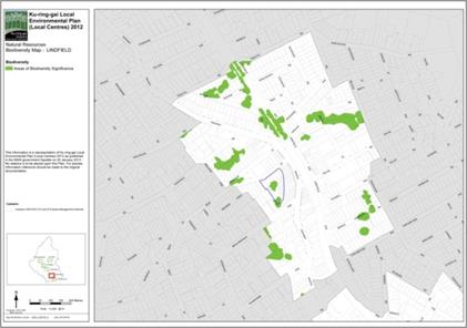
Figure 10 – Areas of biodiversity significance – Woodford Lane site
Community Consultation
Council will need to be seen to have a high standard of consultation with the community; in conjunction with a well-executed communications strategy demonstrating Council’s pursuit of the best community outcomes. An engagement strategy has been prepared and is discussed in detail below.
Work undertaken to date by Council includes:
· workshops and interviews associated with the Lindfield Community Facilities Strategy;
· workshops and meetings with key stakeholders – TFNSW and RMS;
· attendance and presentation at a Support Lindfield Forum April 2014;
· a new website for ‘Activate Lindfield’; and
· telephone calls and emails addressing enquiries.
Consultation is planned as part of the next stage of the process. An engagement strategy has been prepared by council’s community engagement and research planner and is outlined below.
Engagement strategy – Activate Lindfield
Ku-ring-gai Council will undertake extensive and multi-modal consultation to ensure all community stakeholders are informed, engaged and collaborate on Activate Lindfield.
The Woodford Lane site represents a distinct opportunity for our community; it will have its own unique functions, uses and aesthetics. To ensure we comprehensively examine the site, we propose a strategy to engage the site separately from the Tryon Road site.
The objectives of our engagement strategy are to:
· increase community awareness of Activate Lindfield and the benefits the project will bring to the local and broader community;
· tap into local knowledge and expertise on Lindfield including local businesses, residents and community groups;
· deliver creative and engaging opportunities for stakeholders to collaborate with Council in designing, delivering and managing the Activate Lindfield sites;
· determine community priorities for Activate Lindfield including the negotiable and non-negotiable for each site; and
· meet TFNSW and Council requirements in delivering Activate Lindfield, including commuter car parking, new parks and civic spaces and community facilities.
The community engagement process will be divided into a series of phases:
1. Multi-channel communications to inform stakeholders on the Activate Lindfield project and possible options for the site. Activities will include:
· local newspapers;
· letterbox drop;
· website – Council and Have Your Say Ku-ring-gai; and
· Email newsletters;
· community networks – organisations, associations, staff networks;
· rates notice; and
· social media campaign.
2. Online discussion forum – open to all community stakeholders prior to formal consultation
3. Concept design workshops and place performance evaluations:
· deliberative workshops to examine options for Woodford Lane site;
· education workshop on site – review options; presentation from technical experts (including TFNSW);
· deliberative forum to examine options and opportunity for the site;
· final option review and agreements; and
· examination of most preferred option.
4. Place making and partnership forums to set the way forward for Lindfield
Internal Consultation
Extensive internal consultation has occurred as part of the Lindfield Community Facilities Study including staff from Operations, Community, Strategy and Environment, Corporate and Development and Regulation.
Summary
Council has resolved to undertake a master planning process for the Woodford Lane Site in Lindfield. On the site it is proposed to place the existing car parking underground and construct a new “community hub”.
To date Council has engaged consultants to provide background studies:
· Lindfield Local Centre Transport Network Model Study;
· Lindfield Community Hub - Preliminary Feasibility Assessment (stage 1 complete); and
· Lindfield Community Facilities Study (complete).
This report provides an update on the results to date of the economic feasibility study and makes a range of recommendations for moving forward on each project. This report recommends the following:
· That council prepare three illustrative options for Lindfield Community Hub for public comment being:
- Option A (the same as option 1 version 3) – residential / community / specialty retail / park / 3 storey height limit;
- Option B (the same as option 3b version 3, 5% contingency) – supermarket / community / specialty retail / residential / park / 7 storey height limit; and
- Option C (the same as option 4 version 3) – residential / community / park / 5 storey height limit.
The next steps in the process are:
· prepare a design services consultant brief and advertise a Request for Tender (RFT) and select consultant by December 2014;
· selected consultant team will prepare three draft illustrative concepts during January – February 2014;
· community consultation on the options will take place in February 2015, guided and facilitated by Council;
· consultation will be conducted on the three illustrative master plans focusing on the costs and benefits of each option to inform a preferred community outcome;
· in April 2015 a report to Council will be prepared recommending a preferred option to form the basis of further planning and detailed development of the project; and
· the preferred master plan for the Lindfield Community Hub to be placed on public exhibition by June 2015.
The master plan will inform the principles and criteria upon which Council may undertake an Expression of Interest (EOI) process seeking private sector interest in the delivery of the project including the funding of new community infrastructure. The master plan would also form the basis of a Capital Expenditure Review and Department of Local Government submission.
Additional funds are required to progress to the next stage and it is recommended that $250,000 are allocated to the project for the year 2014-2015 from the S94 reserve – pre-1993 and 1993 Plan - car parking.
|
Recommendation:
That Council:
A. Adopts the following land use scenarios as the basis for preparing illustrative concept plans for community consultation and further technical assessment:
· Option A (the same as option 1 version 3) - Community facilities with secondary/specialty retail and residential; a new park; and three storey height limit. · Option B (the same as option 3b version 3 & 5% contingency) - Community facilities with major retail/secondary/specialty retail as well as residential; a new park; and seven storey height limit. · Option C (the same as option 4 version 3) - Community facilities with residential only; a new park; and five storey height limit.
B. Adopts the preliminary project programme as follows:
· Advertise tender for design services and assess tender, Sept-Nov 2014 · Report to Council preferred tender, Dec 2014 · Preparation of 3 concept options, Jan-Feb 2015 · Exhibition and community workshops, February 2015 · Assessment of options, March 2015 · Report to Council - preferred concept plan for exhibition, April 2015 · Consultant – preparation of draft illustrative master plan, Apr-May 2015 · Public Exhibition and information sessions, June 2015 · Assessment of public submissions, July 2015 · Report to Council – final master plan and planning proposal, August 2015
C. That pursuant to sections 186(1) and 187(1) of the Local Government Act 1993, the Council compulsorily acquires the portion of Drovers Way north of Beaconsfield Parade for the purpose of creating the Lindfield Community Hub in accordance with the Land Acquisition (Just Terms Compensation) Act 1991.\
D. That for the purposes of section 30 of the Land Acquisition (Just Terms Compensation) Act 1991, the Council, as the owner of the road, agrees to the road being acquired for compensation in the amount of $1.00.
E. That Council delegate to the General Manager or his delegate the power to do anything further as necessary to give effect to the compulsory acquisition including obtaining any necessary approvals and publishing any necessary notices in the Gazette.
G. That $250,000 be allocated to the project for the year 2014-2015 from the S94 reserve – pre-1993 and 1993 Plan - car parking.
|
|
Bill Royal Team Leader Urban Design |
Antony Fabbro Manager Urban & Heritage Planning |
|
Andrew Watson Director Strategy & Environment |
|
|
Attachments: |
A1 |
Lindfield Community Hub - Pedestrian Overbridge Feasibility Study - final report |
|
2014/202614 |
|
|
A2 |
Lindfield Feasibility Study - stage 1 report - FINAL |
|
Confidential |
|
|
A3 |
Lindfield Community Hub - Updated Scenarios - economic feasibility - Addendum - FINAL |
|
Confidential |
|
|
A4 |
Letters to Minister for Transport and Premier regarding proposed commuter car park at Lindfield |
|
2013/302259 |
|
|
A5 |
Response from the Minister regarding the proposed commuter car park at Lindfield |
|
2013/302784 |
|
|
A6 |
Advise - NSW Government commits 12 million to car park project - Commuter car park at Lindfield |
|
2013/310141 |
|
|
A7 |
Lindfield Community Hub - TFNSW - possible commuter car park on Tryon Road site |
|
2014/203173 |
|
Ordinary Meeting of Council - 21 April 2015 |
GB.6 / 417 |
|
|
|
|
Item GB.6 |
S10233 |
|
|
6 March 2015 |
Wahroonga Park Toilet Block -
Tender T11/2014
EXECUTIVE SUMMARY
|
purpose of report: |
To consider the tenders received for the demolition and construction of a new toilet block at Wahroonga Park, Wahroonga, and appoint the preferred tenderer. |
|
|
|
|
background: |
Council, as part of the Open Space Capital Works Program, approved funding for the replacement of Wahroonga Park Toilet Block, Wahroonga, including accessible pathways and improved landscaping works.
Tender documents were released through Tenderlink on 6 January, 2015 and closed on 3 February, 2015. |
|
|
|
|
comments: |
In total four (4) submissions received. The submissions were assessed using published criteria which identified the best value to Council. |
|
|
|
|
recommendation: |
In accordance with Section 55 of the Local Government Act and Tender Regulations, it is recommended Council accept the tender submitted by tenderer ‘A’ as identified in the Confidential Summary (Attachment 2). |
Purpose of Report
To consider the tenders received for the demolition and construction of a new toilet block at Wahroonga Park, Wahroonga, and appoint the preferred tenderer.
Background
Council originally approved funding for implementation of the Wahroonga Park Master Plan, including Toilet Block, accessible pathways and improved landscaping works, as part the Capital Works Program in the 2012/13 Delivery Program and Operational Plan.
Tender documents were released through Tenderlink on 6 January, 2015 with a closing date of 3 February, 2015.
Comments
In all four (4) tenders were received from the following companies:
· Blugum Enterprises Pty Ltd
· Kellyville Building Pty Ltd
· Westbury Constructions Pty Ltd
· Auscorp Constructions Pty Ltd
It should be noted the order above does not correspond to the order of the list of tenderers named from ‘A’ to ‘D’ in the confidential attachments.
A Tender Evaluation Panel consisting of staff from the Operations Department and Strategy & Environment Department assessed all tender submissions for conformity and then for the best value for money for Council as per the published selection criteria. Further information regarding this assessment can be found in Confidential Attachment 2.
Confidential attachments to this report include:
· Additional financial information – Confidential Attachment 1.
· Tender Evaluation Panel’s comments and recommendation - Confidential Attachment 2.
· Independent Performance and Financial Assessment carried out by Corporate Scorecard Pty Ltd - Confidential Attachment 3.
Based on the information provided and the independent Performance and Financial Assessment the Tender Evaluation Panel recommends the appointment of Tenderer ‘A’ was identified as providing the best value to Council.
integrated planning and reporting
Theme 3 – Places Spaces and Infrastructure.
|
Community Strategic Plan Long Term Objective |
Delivery Program Term Achievement |
Operational Plan Task |
|
A range of well planned, clean and safe neighbourhoods and public spaces designed with a strong sense of identity and place.
|
P.6.1.2. – A program is being implemented to improve existing recreation, sporting and leisure facilities and facilitate the establishment of new facilities. |
P6.1.2.1.1 Designs are prepared and environmental approvals obtained for the delivery of the open space capital works program.
|
Governance Matters
Tender documents were prepared and released through Tenderlink on 6 January 2015 with a closing date of 3 February 2015. At the close of tender, four (4) tenders were received. All submissions were recorded in accordance with Council’s tendering policy.
Confidential attachments to this report include the list of tenders received, the Tender Evaluation Panel’s comments and recommendation and the independent Performance and Financial Assessment carried out by Corporate Scorecard Pty Ltd.
The attachments are considered to be confidential in accordance with Section 10A (2)(d)(iii) of The Local Government Act 1993 as they are considered to contain commercial in confidence information.
Risk Management
Three (3) key areas of risk were identified in relation to the proposed work:
· That work needed to be carried out by a suitably qualified company with experience in projects of similar scale.
· Companies availability – the company was available to commence work as stipulated by Council and has the resources to complete the work within 12 weeks or less, subject to weather delays and delays by external organisations outside their control.
· That Council should not be exposed to financial risk. As part of the evaluation process the preferred tender’s financial capacity was tested through an independent Performance and Financial Assessment.
Following evaluation, including an independent Performance and Financial Assessment by Corporate Scorecard Pty Ltd, the tenderer assessed as providing the best value for money for Council was Tenderer ‘A’.
Financial Considerations
This project is currently listed in Council’s 2014/15 Delivery Program and Operational Plan as PJ101916 Wahroonga Park Master Plan - Toilet Block and Landscape Works.
The project is currently funded through the Section 94 Contributions Plan 2004-2009 (Local Parks and Sports Facilities – LGA). Additional funding, as identified in Confidential Attachment 1, is required from the Section 94 reserve to pay the tender price, contingency, project management and other projects costs. During the planning and design stages of the project, it was always planned that the budget would be increased following the tender assessment in order that the correct amount could be allocated from the Section 94 reserve.
The balance of funding for the project needs to be allocated from the Section 94 Contributions Plan 2010 (Local Parks and Sporting Facilities – North). The Wahroonga Park playground project, which was completed in October 2014 and funded by the 2004-2009 Contributions Plan, should actually have been funded by the 2010 Contributions Plan as one of the larger local playgrounds in the north of the LGA, and the toilet block, which is identified for funding in the 2004-2009 Contributions Plan, will instead need to be funded by the 2010 Contributions Plan. As the cost for the two projects is approximately equivalent, this is effectively a direct swap of funding sources.
Now the tender price and the cost of associated items are known, the required balance of funds, identified in the Confidential Attachment 1 needs to be allocated from the Section 94 Contributions Plan 2010 reserve following approval to award the tender. In accordance with statutory obligations, at the finalisation of the project, all unspent funds will be returned to this plan.
Additional financial details are included within the confidential attachments to this report.
Social Considerations
Wahroonga Park is heavily used by local residents, community and visitors. The construction of new toilet facilities will increase user comfort, provide additional capacity, be both energy & water efficient and support/encourage the health and well-being of existing and new residents of Ku-ring-gai bringing the local community together. The provision of new accessible pathways will link the site and compliment the recently completed playground and internal path system.
The toilet block in its existing condition has been a source of complaints because of its age and condition. The new toilet block will provide an accessible and family friendly facility that meets current standards and is efficient to clean and maintain.
Environmental Considerations
Prior to tender, the project was subject to a Potential Environmental Impact Assessment which determined the impact on the environment by the works as minor.
During the construction works the site will be subject to an environmental management plan which will ensure appropriate controls, such as, erosion control, silt fencing, runoff protection, tree protection, recycling appropriate materials, and dust and noise abatement.
Community Consultation
Public consultation for the Wahroonga Park Master Plan which included the new toilet block, took place 2012. The construction of a new facility was supported.
Prior to the commencement of on-site works, local residents and businesses will be advised of the commencement of works and be provided with a time estimate for the completion of the works.
Internal Consultation
Consultation for the new toilet facility was undertaken by officers from Strategy & Environment Department with staff from the Operations Department during the preparation of plans and costings, and with Community Department regarding use for events and bookings.
Summary
Tender documents were released through Tenderlink on 6 January and closed on 3 February 2015.
A Tender Evaluation Panel was formed consisting of representatives from Operations Department and the Strategy & Environment Department.
Four (4) tenders were received and all were recorded in accordance with Council’s tendering policy.
Following the evaluation and independent performance and financial check, it is recommended Tenderer ‘A’ be appointed on the basis of providing the best value to Council.
|
A. That Council accept the tender submission from Tenderer ‘A’ for construction of new toilet facilities, Wahroonga Park.
B. That Council approve the balance of funds required to be transferred from Section 94 funds to the project, as identified in Confidential Attachment 1.
C. That the Mayor and General Manager be delegated authority to execute all tender documentation on Council’s behalf in relation to the contract.
D. That the Seal of Council be affixed to the contract documents.
E. That all tenderers be advised of Council’s decision in accordance with Clause 178 of the Local Government Tendering Regulations.
|
|
Grant Taranto Landscape Architect |
Ian Dreghorn Manager Strategic Projects |
|
Andrew Watson Director Strategy & Environment |
|
|
Confidential Attachment 1 - Financial information |
|
Confidential |
||
|
|
Confidential Attachment 2 - RFT 11-2014 Evaluation Committee Report |
|
Confidential |
|
|
|
Confidential Attachment 3 - Detailed Financial and Performance Assessment Report |
|
Confidential |
|
Ordinary Meeting of Council - 21 April 2015 |
GB.7 / 422 |
|
|
|
|
Item GB.7 |
CY00069/7 |
|
|
23 March 2015 |
Heritage Reference Committee
Meeting Minutes
|
Council to consider the minutes of the Heritage Reference Committee (HRC) meetings held on 10 November 2014 and 9 February 2015. |
|
|
|
|
|
background: |
The minutes were taken at two meetings. The minutes taken at the meeting held on 10 November 2014, were confirmed and accepted at the Heritage Reference Committee meeting held on 9 February 2015. The minutes taken at the meeting on 9 February 2015 were confirmed and accepted at the Heritage Reference Committee held on 9 March 2015. |
|
|
|
|
comments: |
A number of issues regarding heritage items and policies were discussed at the Heritage Reference Committee’s meetings on 10 November 2014 and 9 February 2015. |
|
|
|
|
recommendation: |
That Council receive and note the Heritage Reference Committee meeting minutes from 10 November 2014 and 9 February 2015. |
PURPOSE OF THE REPORT
Council to consider the minutes of the Heritage Reference
Committee (HRC) meetings held on
10 November 2014 and 9 February 2015.
Background
The Ku-ring-gai Heritage Reference Committee was re-formed in August 2014 in accordance with Council’s requirements.
Comments
A range of heritage issues were discussed at the Heritage Reference Committee meeting of 10 November 2014 (Attachment 1). In particular, the HRC discussed the 14 potential heritage items reviewed by Clive Lucas Stapleton Heritage Consultants. Several of these places will be recommended to proceed to a Planning Proposal for consideration as heritage items. Also discussed was the Gordon Heritage Conservation Area Review and a written request by a resident to pursue the listing of several houses recommended for review as potential heritage items by Paul Davies Pty Ltd in the Town Centres Heritage Conservation Area review in 2008.
At the Heritage Reference Committee of 9 February 2015 (Attachment 2) the entire focus of the meeting was on discussing the heritage significance of several places deferred from the Ku-ring-gai LEP 2015.
integrated planning and reporting
Heritage conservation
|
Community Strategic Plan Long Term Objective |
Delivery Program Term Achievement |
Operational Plan Task |
|
Strategies, plans and processes are in place to effectively protect and preserve Ku-ring-gai’s heritage assets. |
Implement, monitor and review Ku-ring-gai’s heritage planning provisions.
|
Identify gaps in existing strategies and plans.
|
Governance Matters
Consisting of five members, the Heritage Reference Committee includes Councillors and heritage practitioners.
The Committee provides advice on heritage matters and assists with the promotion, understanding and appreciation of heritage. While not a decision-making body, the Committee nevertheless plays an important function in shaping Ku-ring-gai's future. This Committee is also an important link in Council's communication strategy with the community.
Risk Management
In providing advice and recommendations to Council on the management of strategic heritage issues in Ku-ring-gai, this Committee assists in the future management of Ku-ring-gai’s cultural heritage.
Financial Considerations
The costs of running the Heritage Reference Committee are covered by the Strategy and Environment Department budget.
Social Considerations
The aims of the Heritage Reference Committee are to provide advice to Council on heritage matters and to provide assistance to Council in promoting an understanding and appreciation of heritage, including matters of social heritage significance.
Environmental Considerations
A role of the Heritage Reference Committee is to support
Council in identifying and managing
Ku-ring-gai’s Cultural Heritage.
Community Consultation
The Heritage Reference Committee meets on a monthly basis and notification of meetings is provided on Council’s website.
Internal Consultation
The Heritage Reference Committee includes Councillors and heritage practitioners and is facilitated by Council staff. Where relevant, consultation with other Departments may occur.
Summary
The Heritage Reference Committee held its meeting on 10 November 2014. The Committee reviewed and discussed the following key items:
· 14 potential heritage items reviewed by Clive Lucas Stapleton Heritage Consultants; and
· Gordon Heritage Conservation Area Review.
The Committee held its next meeting on 9 February 2015 and discussed the significance of potential heritage items deferred from KLEP 2015.
|
A. That Council receive and note the Heritage Reference Committee meeting minutes of 10 November 2014 and 9 February 2015.
B. That Council in the review of KLEP (Local Centres) 2012, investigate the following properties for potential heritage listing:
· 15 McIntosh Street, Gordon; · 19 McIntosh Street, Gordon; · 2 Forsyth Street, Gordon; · 57 Werona Avenue, Gordon.
|
|
Andreana Kennedy Heritage Specialist Planner |
Antony Fabbro Manager Urban & Heritage Planning |
|
Andrew Watson Director Strategy & Environment |
|
|
A1View |
Heritage Reference Committee Meeting Minutes - 10 November 2014 |
|
2014/285282 |
|
|
|
A2View |
Heritage Reference Committee Meeting Minutes - 9 February 2015 |
|
2015/037551 |
|
APPENDIX No: 1 - Heritage Reference Committee Meeting Minutes - 10 November 2014 |
|
Item No: GB.7 |
MINUTES OF Heritage Reference Committee
HELD ON Monday, 10 November 2014
|
Present: |
Councillor C Szatow (Chairperson) (Gordon Ward) Councillor C Berlioz (St Ives Ward) Mr Robert Moore – National Trust
|
|
|
|
|
Staff Present: |
Manager Urban & Heritage Planning (Antony Fabbro)
|
|
|
|
|
Others Present: |
None |
|
|
|
|
Apologies: |
Ms Jennifer Harvey – Ku-ring-gai Historical Society Mr Hector Abrahams – Australian Institute of Architects
|
The Meeting commenced at 6.05pm.
DECLARATIONS OF INTEREST
No interest was declared.
MATTERS ARISING FROM PREVIOUS MEETING
None.
CONFIRMATION OF MINUTEs
Heritage Reference Committee minutes of 8 September 2014 were accepted.
|
|
Minutes of Heritage Reference Committee File: CY00413/2 2014/285280 Meeting held 8 September 2014
|
|
|
111 Pentecost Ave, Turramurra The committee noted this has item has been previously discussed and information circulated at the Heritage Reference Committee . The Committee noted this building is of interest and its appropriate the heritage listing should remain, noting there has been some change to the fabric of the building over the years including the front facade. It should be marketed as a home representing the Modern heritage style.
Draft Ku-ring-gai LEP 2013 The Committee was provided a further update of the draft additional heritage items arising from Draft KLEP 2013. The first batch of items – have been assessed by Clive Lucas Stapleton Heritage consultants and will be in a report going to Ordinary Meeting of Council 25 November 2014 - some are recommended for formal heritage listing via a new Planning Proposal, others do not warrant heritage listing. · 59 Warrangi Street, Turramurra · 51 Warrangi, Street Turramurra · 6 Munderah Street, Wahroonga · 10 Munderah Street, Wahroonga · 2 - 12 Neringah Avenue South, Wahroonga · 88 Fox Valley Road, Wahroonga · 66 Pentecost Ave, Pymble · 60 - 62 Pentecost Ave, Pymble · 12 Bobbin Head Road, Pymble · 33 Grandview Street, Pymble · 6 Caithness Street, Killara · 8 Braeside Street, Wahroonga · 135 Springdale Road, Killara.
An update was also provided of the additional draft heritage items exhibited in Draft KLEP 2013 and currently being reviewed. These items technically remain as Draft Heritage Items until the final version of KLEP 2014 is gazetted by the Minister. The heritage assessment reports are being finalised and further reviewed by staff and the heritage reference committee prior to a report being made back to Council in early 2015. The majority of these potential items will be recommended for inclusion in a new planning proposal for formal public exhibition, the remainder will not have any heritage status.
The importance of having the draft heritage inventory sheets further reviewed prior to the report going back to Council was also discussed.
It was decided to circulate a copy on CD Rom and Hard Copy to the Ku-ring-gai Historical Society and they be further reviewed by the Committee.
Heritage Items on Exhibition The planning proposal for the heritage listing of 950 Pacific Highway, Pymble (former 3M Building) was exhibited 15 August to 12 September 2014. A report is going to the OMC 11 November 2014. The recommendation is to proceed with heritage listing.
The planning proposals to heritage list 62- 64 Mona Vale Road Pymble Lanosa will be on pubic exhibition Friday 14 November to 12 December 2014 seeking public comment.
Gordon Heritage Conservation Area Review- The recent representations from Mr Ma, 51 Werona Ave, Gordon were regarding the Gordon Park HCA No.17 was discussed. 51 Werona Ave, Gordon is a heritage item under KLEP (Local Centres) 2012.
Background The Heritage Conservation area Gordon Park HCA No.17 is currently in place was made under the Ku-ring-gai Local Environmental Plan (Local Centres) 2012. It was noted there was an earlier Local Environmental Plan that covered the Gordon Centre known as the Ku-ring-Gai Local Environmental Plan (Town Centres) 2010 (now invalid) - this plan when exhibited proposed a larger HCA Boundary. In response to submissions at the time, the Draft HCA was reviewed by Paul Davies Heritage consultants. The HCA essentially remained the same as in the adopted Ku-ring-gai Local Environmental Plan Local Centres 2012. Under the Ku-ring-gai Local Centres LEP 2012 the area is zoned R2 Residential Low Density and the clause (5) heritage conservation also protects a heritage item by taking into account development in the vicinity of a Heritage Item. Gordon HCA was originally proposed for a larger area but as reviewed by Paul Davies Heritage consultants the area could be reduced, but additional heritage reviews would be required for the following properties · 15 Mcintosh Street · 19 Mcintosh Street · 2 Forsyth Street · 14 Forsyth · 55 Werona Ave and · 57 Werona Ave.
Note on 12 July 2012 Council resolved the property at 55 Werona Avenue, Gordon be removed from HCA C17 and 14 Forsyth Street, Gordon is already listed as a heritage item under KLEP (local centres) 2012 . T The heritage committee recommendation is that in the review of Ku-ring-gai Local Environmental Plan (Local Centres) 2012 the following properties be investigated for potential heritage listing: · 15 Mcintosh Street, Gordon · 19 Mcintosh Street, Gordon · 2 Forsyth Street, Gordon · 57 Werona Ave, Gordon.
Ku-ring-gai Heritage Walk Council’s delivery & operational plan 2014/15 includes the task of investigating a local Ku-ring-gai Heritage walk.
Ideas for the locations were discussed including · Wahroonga- local centre and surrounds · Gordon- eg St Johns Ave or eastern side · Pymble- eg Telegraph Rad · Turramurra- eg Ku-ring-gai Avenue · Roseville
Themes · World War 1 & 2 · notable Ku-ring-gai Musicians and Artists · Evolution of building types in Ku-ring-gai · Significant streets and home · Australian Institute of Architects lists/themes.
These ideas will be further investigated by staff and a proposals for a heritage walk will be brought back to the committee in 2015.
|
|
|
RECOMMENDATION:
In the review of Ku-ring-gai Local Environmental Plan (Local Centres) 2012 the following properties be investigated for potential heritage listing:
· 15 McIntosh Street, Gordon · 19 McIntosh Street, Gordon · 2 Forsyth Street, Gordon · 57 Werona Ave, Gordon.
|
GENERAL BUSINESS
Noted Code of Conduct and Conflict of Interest training is to be organised for 2015.
OTHER BUSINESS
Schedule of meeting dates for 2015 to be provide for next meeting.
The Meeting closed at 7.30pm.
|
APPENDIX No: 2 - Heritage Reference Committee Meeting Minutes - 9 February 2015 |
|
Item No: GB.7 |
MINUTES OF Heritage Reference Committee
HELD ON Monday, 9 February 2015
|
Present: |
Councillor C Szatow (Chairperson) (Gordon Ward) Councillor C Berlioz (St Ives Ward) Ms Jennifer Harvey – Ku-ring-gai Historical Society Mr Hector Abrahams – Australian Institute of Architects |
|
|
|
|
Staff Present: |
Manager Urban & Heritage Planning (Antony Fabbro) Strategy – Heritage Planner Specialist (Andreana Kennedy) |
|
|
|
|
Others Present: |
None |
|
|
|
|
Apologies: |
Mr Robert Moore – National Trust
|
The Meeting commenced at 6pm
DECLARATIONS OF INTEREST
No interest was declared.
MATTERS ARISING FROM PREVIOUS MEETING
None
CONFIRMATION OF MINUTEs
Heritage Reference Committee minutes of 10 November 2014 were accepted.
|
|
Minutes of Heritage Reference Committee File: CY00413/3 2015/037551 |
|
|
Meeting held 9 February 2014
|
|
|
Draft Ku-ring-gai LEP 2013 – Overview of deferred items A list of the deferred heritage items with their accompanying draft inventory sheets had been provided to the Ku-ring-gai Historical Society for their comment. The committee considered the draft items giving consideration to the new information provided by the Ku-ring-gai Historical Society. The Ku-ring-gai Historical Society focused upon those inventory sheets which were incomplete so not all deferred items were considered at the committee meeting.
The committee recommends the following to Council to be considered for heritage listing: · 86 Braeside Street, Wahroonga · 73 Braeside Street, Wahroonga · 91 Fox Valley Road, Wahroonga (further interior assessment recommended) · 37A Lucinda Avenue, Wahroonga · 67 Clissold Road, Wahroonga · 57 Avon Road, Pymble · 72 Bobbin Head Road, Turramurra · 77 Pymble Avenue, Pymble · 77B Pymble Avenue, Pymble · 2a Telegraph Road, Pymble · 48 Bushlands Avenue, Gordon · 105 Mona vale Road · 55a Mona Vale Road · 67 Avon Road
Places recommended for removal include: · 5 Kywong Avenue, Pymble · 67 Telegraph Road, Pymble
Further work and consideration for designation is recommended for: · 25 Pymble Avenue, Pymble · 32 Chiltern Parade, Warrawee · 3 Millewa Avenue, Warrawee
The following items were deferred to the next Heritage Reference Committee meeting: · Delivery and Operational Plan 2014-2015 Projects relevant to the HRC Heritage Walk · Update of Heritage Items on public exhibition · Meeting schedule of dates - 2015
|
The Meeting closed at 8.00pm.
|
Ordinary Meeting of Council - 21 April 2015 |
GB.8 / 432 |
|
|
|
|
Item GB.8 |
CY00066/7 |
|
|
9 April 2015 |
11-21 Woniora Avenue - Extinguishment of Stormwater Drainage Easement
EXECUTIVE SUMMARY
|
purpose of report: |
To consider a request to relocate Council’s stormwater infrastructure and extinguish an existing Council drainage easement (Dealing B549968) over the subject property. |
|
|
|
|
background: |
Following a deemed refusal of Development Application 0233/14 by Council, on 24 February 2015, the Land and Environment Court granted a deferred commencement consent to Landmark Group Australia Pty Ltd for the construction of a 5 storey residential flat development at 11‑21 Woniora Avenue, Wahroonga. The approval was conditional on the applicant meeting a number of conditions including obtaining Council’s approval for the relocation of an existing stormwater pipe and extinguishment of the associated drainage easement. |
|
|
|
|
comments: |
The property at17 Woniora Avenue (Lot 93 DP2666) is burdened by an easement of variable width which contains a 1050mm diameter stormwater pipe. The applicant proposes to abandon the existing pipe and install new stormwater infrastructure partly within the development site and along the road reserve. |
|
|
|
|
recommendation: |
That Council grant approval for the extinguishment of the easement subject to conditions A to D of the report. |
Purpose of Report
To consider a request to relocate Council’s stormwater infrastructure and extinguish an existing Council drainage easement (Dealing B549968) over the subject property.
Background
Following a deemed refusal of Development Application 0233/14 by Council, on 24 February 2015, the Land and Environment Court granted a deferred commencement consent to Landmark Group Australia Pty Ltd for the subject DA. The approved development is a five storey residential flat development comprising 86 units, basement car parking for 140 vehicles and associated works at 11 – 21 Woniora Avenue, Wahroonga (Lots 1-3 SP47796, Lots 92 to 94 DP2666 and Lot 26 DP706261).
The deferred development consent was conditional on the applicant meeting a number of conditions including obtaining Council’s approval for the relocation of an existing stormwater pipe and extinguishment of the associated drainage easement:
Schedule A. Approval Consent for relocation of Council’s stormwater pipe and easement
Prior to the operation of the consent, the Applicant shall obtain a resolution from Ku-ring-gai Council as the asset owner that it will consent to the relocation of the existing Council easements for drainage and underground pipe.
A full hydraulic design for the relocation of the pipe is to be prepared in accordance with the requirements of Chapter 9 of Council’s DCP 47 Water Management and submitted to Council with the application and the relevant fees. The design must be suitable for construction.
Council’s resolution is required for the relocation of the pipe and easement and is to be obtained prior to the operation of the consent. Such approval is not guaranteed and conditions may be imposed including monetary incentives to extinguish and relocate easements..
Reason: To protect the environment and Council’s assets.
CONDITIONS TO BE SATISFIED PRIOR TO THE ISSUE OF AN OCCUPATION CERTIFICATE:
75. Release of drainage easement
Prior to the issue of the Occupation Certificate, the Principal Certifying Authority must
be satisfied that the drainage easement over 17 Woniora Avenue has been released in
accordance with Council’s resolution and any requirements of the Council.
The Applicant has also provided detailed hydraulic design for the relocation of Council’s stormwater pipe prepared by S&G Consultants Pty Limited in accordance with Council’s DCP 47 – Water Management.
A locality map, which also shows the existing easement to be extinguished, is at Attachment 1.
The Applicant has submitted the required application for the extinguishment of Council’s easement. The easement application is in accordance with Council’s adopted Easement Management Policy 2013, which sets out the formal process and requirements to release or modify existing Council easements on private lands. These requirements include an undertaking from the Applicant to meet all of Council’s costs associated with the request and the payment of compensation in the event the release or modification of the easement is approved by Council.
The acceptance of the application and the accompanying assessment fee does not confirm that the easement request will be approved, and this is clearly stated in the Easement Management Policy.
Comments
The property 17 Woniora Avenue (Lot 93 DP2666) is currently burdened by a drainage easement of variable width which contains a 1050mm diameter stormwater pipe discharging into an open watercourse across the rear of 17 and 19 Woniora Avenue. The pipe is a Council asset and conveys runoff from a catchment which extends as far as the Wahroonga Shopping Village.
The Applicant seeks to extinguish an existing stormwater easement on 17 Woniora Avenue that benefits Council and place the new drainage infrastructure within Council’s road reserve. Depending on the final construction design a small portion of the new drainage infrastructure may remain on 21 Woniora Avenue (Lot 26 DP706261) in which case Council will require the creation of an easement for ongoing access and maintenance purposes.
An easement is a valuable property right and an asset of Council. Accordingly, there is a responsibility on Council’s part to dispose of Council’s interests in property in a commercially transparent, fair, and proper manner. This includes extinguishing easements for fair value. The most objective manner for Council to ensure that this occurs is to obtain an independent valuation of the easement to be extinguished based on the circumstances of each case.
Council’s adopted Easement Management Policy specifically provides for compensation where the extinguishment and relocation of a Council easement provides a commercial benefit to the developer or an “uplift” in the property’s value. This is the case in this application.
Council has previously approved the release and modification of an existing Council easement in respect of a residential apartment development in Wahroonga in return for a commercial consideration.
An offer of compensation has been submitted by the Applicant to extinguish the easement, and assessed by Council’s expert valuer as being commercially fair and reasonable in the circumstances.
integrated planning and reporting
Theme – Leadership and Governance - L2 Financial capacity and sustainability
|
Community Strategic Plan Long Term Objective |
Delivery Program Term Achievement |
Operational Plan Task |
|
Council rigorously manages its financial resources and assets to maximise service delivery |
Council maintains and improves its long term financial position and performance |
Continue to analyse opportunities to expand the revenue base of Council |
Governance Matters
Council is permitted to dispose, or deal with property, including easements, in accordance with the Local Government Act 1993.
The existing easement is a valuable proprietary right that benefits Council. The Council can only agree to extinguish the easement by a resolution of Council.
Council’s adopted Easement Management Policy 2013, outlines processes and requirements for both internal and external parties. The Policy has been provided to the Applicant to ensure that all parties are informed of Council’s requirements and dealings are consistent with its terms.
Risk Management
Council’s Solicitor has previously provided legal advice in relation to similar requests for the extinguishment of easements.
Subject to Council resolution, the appropriate legal documentation to extinguish and if required create the easement will be overseen by Council’s solicitors.
Financial Considerations
The Applicant will be responsible for all costs associated with the extinguishment of the easement, including but not limited to construction of new drainage works, relocation and de-commissioning of infrastructure, valuation, legal, survey, stamp duty, registration etc., and payment of final compensation.
Council secured the services of an expert independent registered valuer to advise Council staff on the matter.
Council staff and the Applicant have been in negotiation for some time to reach agreement on the quantum of commercial consideration/compensation that is reasonable for the extinguishment of the easement.
Following negotiations between Council’s valuer and the Applicant’s valuer a commercial offer to extinguish the easement has been submitted. Council’s valuer has confirmed the offer represents fair commercial consideration for the extinguishment of the easement – refer to confidential Attachment 2.
Social Considerations
Council and its officers have a responsibility to the community to only dispose of Council’s interests in property in an objective and fair manner.
Environmental Considerations
Environmental impacts have been determined and mitigated through the development assessment and approval process.
Community Consultation
There has been no specific community consultation undertaken in relation to the specific easement request contained in this report.
Internal Consultation
Consultation has been held with staff from Council’s Operations, Development and Regulation and Strategy and Environment Departments.
Summary
A deferred commencement consent was granted by the Land and Environment Court on 24 February 2015 for DA0233/14 for a residential flat development at 11–21 Woniora Avenue, Wahroonga.
Along with a number of other conditions, the Applicant was required to obtain Council’s approval for the relocation of a stormwater drainage pipe and extinguishment of Council’s easement before the consent could operate.
The Applicant seeks to extinguish an existing stormwater easement that benefits Council and place the new drainage infrastructure within Council’s road reserve. Depending on the final construction design a small portion of the new drainage infrastructure may remain on 21 Woniora Avenue in which case Council will create an easement for ongoing access and maintenance purposes.
The Applicant has been advised of Council’s requirements to progress the extinguishment of the existing easement and has paid the required application fee and submitted written confirmation agreeing to Council’s requirements set out in Council’s adopted Easement Management Policy.
Easements are a valuable property right and an asset of Council which are required to be disposed of in a commercially transparent, fair and proper manner.
The most objective manner for Council to ensure that this occurs is to obtain an independent valuation of the easement to be extinguished which takes into account all relevant circumstances, including any “uplift” in the value of the property, enhanced development potential and the relocation of a new drainage easement within Council’s road reserve.
An offer of compensation has been made by the Applicant to extinguish Council’s easement which Council’s valuer has confirmed as being commercially fair and reasonable in the circumstances.
The hydraulic design plans for the relocation of Council’s stormwater pipe prepared by S&G Consultants are in accordance with Council’s DCP47 – Water Management. The plans are considered a suitable design for the works subject to the Applicant submitting a construction stage version of the design for approval by Council’s Director Operations.
The trunk stormwater pipe would then be located in Council’s road reserve, more readily accessible for maintenance, whilst the discharge into the small watercourse across 17 and 19 Woniora Avenue would be reduced to just the detained discharge from the development itself, allowing the riparian restoration of that watercourse.
The current design plans envisage a small portion of the new drainage works being located on 21 Woniora Avenue (Lot 26 DP706261) which, if approved by Council, will require the creation of an easement for access and maintenance.
The existing Council easement burdening 17 Woniora Avenue is no longer required and can therefore be extinguished.
|
A. That the Applicant be advised that Council grants approval to extinguish the existing drainage easement (Dealing B549968) burdening 17 Woniora Avenue (Lot 93 DP2666) subject to the Applicant submitting a construction stage version of the design for approval by Council’s Director Operations and paying the compensation recommended by Council’s valuer.
B. That, if required by Council, a section 88B Instrument be created in favour of Council over Lot 26 DP706261 for access and maintenance to Council’s drainage infrastructure.
C. That authority be given to the General Manager and the Mayor to affix the Common Seal of the Council to the instrument for the release of the easement and/or create a new easement as set out above and execute all documentation associated with the conveyance.
D. That all costs associated with the extinguishment of the easement, including legal and survey costs, and all costs associated with the drainage works in the road reserve be borne by the applicant.
|
|
Vince Rago Property Program Co-ordinator |
Deborah Silva Manager Integrated Planning, Property & Assets |
|
Andrew Watson Director Strategy & Environment |
|
|
A1View |
Locality map |
|
2012/228361 |
|
|
|
Valuation advice from K D Wood Valuations (Aust) Pty Ltd |
|
Confidential |
|
Ordinary Meeting of Council - 21 April 2015 |
GB.9 / 439 |
|
|
|
|
Item GB.9 |
S07252/6 |
|
|
13 April 2015 |
Firs Cottage - Lease Renewal Submissions
EXECUTIVE SUMMARY
|
purpose of report: |
To advise Council on submissions made in relation to the lease renewal of the Firs Cottage, Roseville Park, to the current lessee for a five (5) year term. |
|
|
|
|
background: |
On 30 April 2013, Council considered a report on the lease renewal to the existing tenants of Firs Cottage, trading as Sous le Soleil. |
|
|
|
|
comments: |
Public notification was carried out between 24 May and 21 June 2013 and six (6) formal submissions were received. Of the submissions there were three (3) supporting and three (3) objecting to the lease renewal. |
|
|
|
|
recommendation: |
That Council receive and note the submissions associated with the lease renewal of Firs Cottage. |
Purpose of Report
To advise Council on submissions made in relation to the lease renewal of the Firs Cottage, Roseville Park, to the current lessee for a five (5) year term.
Background
On 30 April 2013, Council considered a report on the lease renewal to the existing tenants of Firs Cottage, trading as Sous le Soleil. At which time Council resolved;
A. That Council enter into a lease agreement for a further five (5) years with Sous Le Soleil Pty Ltd.
B. That the General Manager or his delegated are authorised to negotiate the commercial terms of the new lease as discussed within the report.
C. That the Mayor and General Manager are delegated authority to execute all documentation associated with the lease.
D. That Council affix the Common Seal to all necessary documents.
E. That public notification of the proposed lease be undertaken in accordance with Section 47A of the Local Government Act, 1993.
In accordance with the above Council resolution, staff progressed commercial negotiations and public notification.
With the execution of the new lease pending this report is to advise Council of the submissions received during the public notification period.
Comments
Public notification was carried out between 24 May and 21 June 2013 and six (6) formal submissions were received. Of the submissions there were three (3) supporting and three (3) objecting to the lease renewal.
Due to Privacy and Personal Information Protection Act 1998, a copy of each submission will be provided to Councillors under separate Memorandum, and each submission is summarised below;
|
Submission |
Submitter Comment |
Staff Response |
|
Support |
First class dining, asset to the community, responsible proprietors. |
N/A |
|
Support |
Previous management of the building was low key with no apparent upset to neighbours, well patronised. |
N/A |
|
Support |
Asset to Roseville, fulfils adaptive use of heritage property to allow the public to appreciate it. |
N/A |
|
Object |
Excessively intensive use which results in noise, traffic, waste & safety issues |
This appears to predominantly refer to increase trading hours proposed in the PoM and not the lease renewal. |
|
Object |
Current use causes disruption to neighbouring families in relation to waste, traffic and noise. Damage to the park by delivery vehicles & foot traffic |
Waste collection is carried out in accordance with approved DA. Council staff and lessee have arranged that waste is collected from inside Roseville Park rather than Cranbrook Avenue. Local residents were consulted on traffic management improvements and recommendations were rejected by residents |
|
Object |
Current lessee in breach of licence agreement in regard to: deliveries, parking, waste collection which has resulted in degrading the amenity of the area. |
The bakery was delivering outside of approved DA hours, this was rectified immediately. Parking and waste collection matters discussed above. |
Public notification of the lease renewal was being undertaken at the same time the Plan of Management (POM) was also being revised.
The POM proposed to extend the operating hours of Firs Cottage to include evening trading seven days a week. This created much angst amongst the community, especially to nearby residents and resulted in a range of complaints being made about the daily operations at Firs Cottage.
The POM was subsequently adopted on 12 November 2013 and established trading hours for the operations at Firs Cottage as;
7am – 7pm from Sundays to Wednesdays;
7am – 10.00pm Thursdays and Fridays; and
7am - 11pm on Saturdays
NOTE: The lessees are trading as approved in their original Development Consent DA0208/07 (issued 27 June 2007) and subsequent Section 96 Modification MOD0128/08 (issued 2008) and to date have not obtained approval to operate in accordance with the revised POM.
Furthermore, the lease renewal relies on the operations of the premises in accordance with approved consents only.
integrated planning and reporting
Leadership & Governance
|
Community Strategic Plan Long Term Objective |
Delivery Program Term Achievement |
Operational Plan Task |
|
Council rigorously manages its financial resources and assets to maximise the delivery of services. |
Council maintains and improves its long term financial position and performance |
Ensure the commercial property portfolio provides market returns.
|
Governance Matters
As the premises is classified Community Land a five (5) year term is the maximum term permissible under the Local Government Act1993 (Act) without the need to undertake an Expression of Interest (EoI) or a tender process as stated in S46A of the Act.
The land is covered by the Firs Cottage Plan of Management (POM), which expressly authorises the leasing of the premises.
Sections 47 and 47A of the Act defines how Council may lease or licence community land, with the latter in respect terms of 5 years or less.
It is a requirement of the Act for Council prior to entering into a lease that:
· the proposal must be notified and exhibited in the manner prescribed by section 47;
· a statement that submissions in writing may be made to the council concerning the proposal within a period, not less than 28 days, specified in the notice;
· any person may make a submission in writing to the council during the period specified for the purpose in the notice; and
· before granting the lease, licence or other estate, the council must consider all submissions duly made to it.
Although Council’s 2013 resolution sought to grant the existing lessee with a further five (5) year term the current holdover lease expired on the 31 August 2012. Due to the passage of time and delays in formalising the lease documentation Council staff propose that the renewed lease commence retrospectively from 1 September 2014 for a period of 3 years in observation of Section 47A of the Act.
Risk Management
Council’s solicitor will draft lease documentation and Disclosure Statement in accordance with the Retail Leases Act, 1994.
Council staff have ensured that terms and conditions relating to appropriate types and levels of insurances, bank guarantee and personal guarantees are obtained.
Financial Considerations
A market rental determination by a registered valuer was obtained and subject to the determination, staff negotiated essential lease terms and conditions.
A copy of the final Heads of Agreement (HoA) is attached (Confidential Attachment 1) and the lease has been prepared in accordance with the HoA.
The tenants have demonstrated they are responsible and financially capable to pay rent and take on a further lease term.
In accordance with the provisions of the Retail Leases Act, 1994 each party is responsible for their legal costs.
Social Considerations
The original upgrade in 2007 and the continuing refurbishment of Firs Cottage has greatly enhanced this Council asset and contributed socially to Roseville Park.
Environmental Considerations
There are no environmental impacts associated with the lease renewal.
Community Consultation
Public notification of the proposed lease was undertaken in accordance with Section 47A of the Local Government Act, 1993 (Attachment 2).
Notices were placed on the front entry gate of the cottage and in the North Times between 24 May and 21 June 2013.
As a result six (6) formal submissions were received in relation to the lease renewal and due to the Privacy and Personal Information Protection Act 1998, a copy of each submission will be provided to Councillors under separate Memorandum.
All submitters have been acknowledged in writing, and advised of this report being considered by Council.
Internal Consultation
No internal consultation undertaken in the preparation of this report.
Summary
In 2013, the current lessee requested a further five (5) year lease term. The lessee has been in occupancy since 1 September 2007, and has contributed significantly to the upgrade and refurbishment of the cottage. The lessee has demonstrated they are responsible and financially capable to pay rent, and take on a further lease term.
On 30 April 2013, Council considered a report on the lease renewal of Firs Cottage and resolved to enter into a lease agreement for a further five (5) years with Sous Le Soleil Pty Ltd, including negotiating commercial terms and conditions and undertaking public notification.
Although Council’s 2013 resolution sought to grant the existing lessee a further five (5) year term from the lease expiry of 31 August 2012. The lessee has remained in occupancy on a monthly holdover since then, as such Council staff propose that the renewed lease commence retrospectively from 1 September 2014 and expire 31 August 2017 in observation of Section 47A of the Act.
Due to the community classification of the land, public notification of the proposed lease was undertaken in accordance with S47A of the Act between 24 May – 21 June 2013.
As a result six formal submissions were received, of which 3 supported and three objected to the lease renewal. All submitters have been formally acknowledged in writing, and advised of this report being considered by Council.
In accordance with Council’s resolution and with the execution of the new lease pending this report provides information on the formal submissions received during the public notification period.
|
A. That Council receive and note the submissions associated with the lease renewal of Firs Cottage.
B. That Council enter into a lease agreement with Sous Le Soleil Pty Ltd for a period of 3 years.
C. That the Mayor and General Manager are delegated authority to execute all documentation associated with the lease.
D. That Council affix the Common Seal to all necessary documents.
|
|
Deborah Silva Manager Integrated Planning, Property & Assets |
Andrew Watson Director Strategy & Environment |
|
A1 Heads of Agreement - Firs Cottage - 60A Clanville Road Roseville |
|
Confidential |
||
|
|
A2View |
A2 - Section 47A advertisement North Shore Times 24 05 2013 - 60A Clanville Road Roseville |
|
2015/088655 |
|
APPENDIX No: 2 - A2 - Section 47A advertisement North Shore Times 24 05 2013 - 60A Clanville Road Roseville |
|
Item No: GB.9 |
|
Ordinary Meeting of Council - 21 April 2015 |
GB.10 / 446 |
|
|
|
|
Item GB.10 |
S03467 |
|
|
21 April 2015 |
Policy on Private Use of Road Reserves
EXECUTIVE SUMMARY
|
purpose of report: |
For Council to adopt a review of the Private Use of Road Reserves and Nature Strips Policy. |
|
|
|
|
background: |
On 24 March 2009, Council resolved to adopt the policy on Private Use of Road Reserves and Nature Strips. The Policy is due for review and updating into the new policy format. |
|
|
|
|
comments: |
Since adoption, Council has received an average of ten (10) applications per year. Section 139 of the Roads Act 1993, requires Council to approve structures on the road reserve. The road reserve is the area between property boundaries and includes the verge or nature strip area. |
|
|
|
|
recommendation: |
That Council adopt the review of the Private Use of Road Reserves and Nature Strips Policy. |
Purpose of Report
For Council to adopt a review of the Private Use of Road Reserves and Nature Strips Policy.
Background
At Council’s meeting of 24 March 2009, Council adopted the policy on the private use of Council’s road reserve and nature strips.
Since adoption, Council has received an average of ten (10) applications per year.
Section 139 of the Roads Act 1993, requires Council to approve structures on the road reserve. The road reserve is essentially the area between property boundaries and includes the verge or nature strip area. There are a number of areas where residents have used the nature strip or road reserve for landscaping or installed structures such as retaining walls. Some residents have done so with Council approval and others without. The Policy aims to provide residents with guidance on what Council will allow and to provide Council with the necessary powers should structures be installed without Council approval.
Comments
An objective of the Policy is to provide conditions on the permitted use of the nature strip by property owners.
As an outcome of processing applications, the Policy unintentionally overlooked provision of guidelines on access rights by Service Authorities. It was noted for permitted development types, information was found to be repetitive. The Policy has been updated with additional guidelines and re-formatted, comprising:
· Addition of Headings - Intent, Service Authority Access rights and Reinstatement. These aim to better clarify and raise awareness for the residents on responsibilities and risks when constructing structures on the nature strip,
· Placing of requirements in table format to remove repetition, and
· Numbering of prescribed conditions to allow easier referencing.
The updated policy is now maintained in the MyCouncil system and managed as, Controlled Document No 62. The revised policy and application form are attached.
integrated planning and reporting
Theme 6 – Leadership and Governance
|
Community Strategic Plan Long Term Objective |
Delivery Program Term Achievement |
Operational Plan Task |
|
L3.1 The organisation is recognised and distinguished by its ethical decision-making, efficient management, innovation and quality customer service |
L3.1.3 Council’s Governance framework is developed to ensure probity, transparency and the principles of sustainability are integrated and applied into our policies, plans, guidelines and decisions making processes. |
Assess
need for new policies and undertake regular policy reviews Continue to refine and enhance internal Council policies to accord with legislation |
Governance Matters
Section 139 of the Roads Act 1993, requires Council to approve structures on the road reserve.
At Council’s meeting of 24 March 2009, Council adopted the policy on the Private Use of Council’s Road Reserve and Nature Strips.
The purpose of the revised policy is to provide greater guidance to residents on Council’s requirements for private works on road reserves and nature strips.
Risk Management
The reviewed policy enables improved risk management of structures on the nature strip by property owners by clarifying the process and implementation requirements. Inclusion of additional information under the headings, Service Authority Access Rights and Reinstatement, has added clarification of other stakeholders that otherwise can be unintentionally not be considered.
Financial Considerations
There are no direct financial implications to Council Budget. Applications are charged for assessment only under council listed Fes & Charges
Social Considerations
The policy seeks to ensure public safety by managing development on the nature strip. To assess the type or form of development maintains safety and access for pedestrians, Servics Authorities and Council.
Environmental Considerations
The policy has no direct impacts on the environment.
Community Consultation
Community consultation is not necessary. It is a review an existing policy adopted in March 2009.
Internal Consultation
Internal consultation was undertaken with the Corporate Department with regard to the new policy format and process and Strategy regarding purchasing of land.
Summary
Council adopted the Private Use of Council’s Road Reserve and Nature Strips Policy in March 2009. It provides residents with guidance and necessary requirements for the permitted use of development on the nature strip by private owners.
The reviewed policy includes the provision of guidelines on access rights by Service Authorities and to clarify responsibilities and risks for private owners when developing on nature strips.
The reviewed policy is Controlled Document No 62 and managed by Council’s system called MyCouncil.
|
That Council adopts the reviewed Private Use of Road Reserves and Nature Strips Policy.
|
|
Ian Taylor Manager Engineering Operations |
Greg Piconi Director Operations |
|
A1View |
Policy for the Private Use of Road Reserves and Nature strips |
|
2015/038605 |
|
|
|
A2View |
Application form for private use of Road Reserve and nature strips plus Consent and Conditions |
|
2015/067418 |
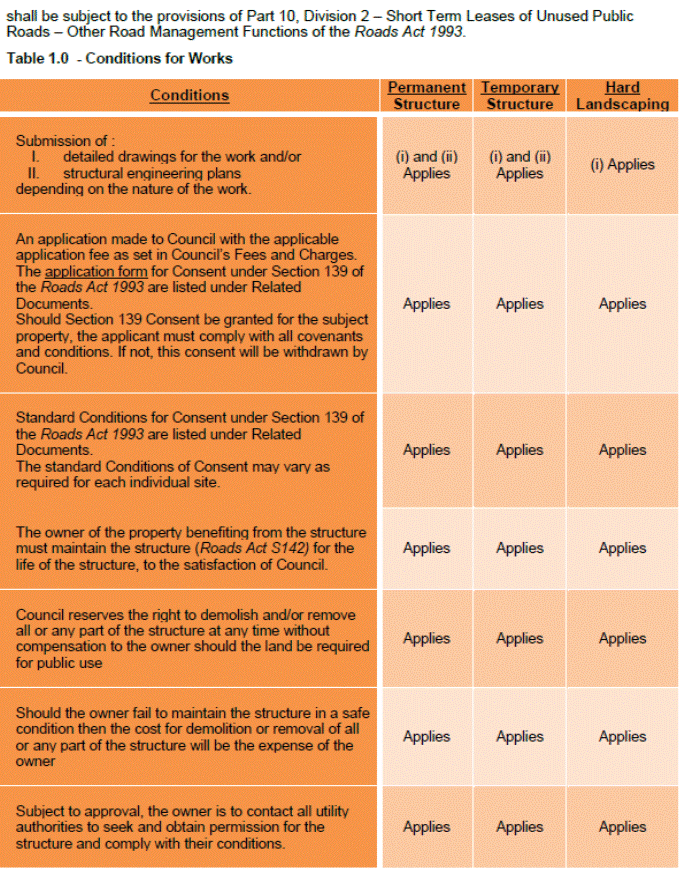
|
APPENDIX No: 2 - Application form for private use of Road Reserve and nature strips plus Consent and Conditions |
|
Item No: GB.10 |
APPLICATION FORM
FOR
CONSENT FOR STRUCTURE
TO OCCUPY ROAD RESERVE UNDER
Section 139, Roads Act 1993
Fees
Administration fee $80
Assessment fee for permanent structure $210
Assessment fee for hard landscaping $155
Property Details
Property Address:
Property Owner:
Applicant (if other than owner):
Contact details (Ph, Fax, Mobile):
Details of structure
1. Permanent Structure Yes/No – Detailed drawings to be supplied
2. Hard Landscaping Yes/No – Detailed drawings to be supplied
3. Soft Landscaping Yes/No – Letter required
4. Temporary Structure Yes/No – Detailed drawings to be supplied
Comments to support Application:
|
Property Owner’s/Secretary of the Owner’s Corporation Signature |
|
Date |
By signing this application, the applicant and the owner(s) agrees to the standard conditions as detailed in Appendix 1.
APPENDIX 1
CONSENT UNDER SECTION 139 OF THE ROADS ACT 1993
NOTATIONS
This Consent is granted pursuant to Part 9 Division 3 of the Roads Act 1993.
The Council consents to the Applicant (………………..) using the land, as marked on the attached survey prepared by (……………….), being Council owned road reserve,
For (……………………………………………………………………………………….).
In accordance with Section 140 of the Roads Act 1993, the Council can revoke this consent at any time and for any reason by serving a written notice on the Applicant. If the Council revokes this consent, the Applicant will remove, at the Applicant’s own expense any building, structures, fences or improvement erected on the land and make good all damage done to the land and/or the public road. If the Applicant fails to do so, then Council may do such work as it deems necessary and the cost incurred shall be paid by the Applicant to the Council and all materials removed from the land will be the property of the Applicant.
MATTERS TO BE SATISFIED PRIOR TO THE RELEASE OF THE CONSENT
PRESCRIBED CONDITIONS
1. The applicant is to pay Council the prescribed fee. The fee is to be paid within 28 days of the endorsement date of this consent. The amount is to be adjusted annually in accordance with Council’s Fees and Charges.
2. The Applicant will pay the relevant authorities all water rates, excess water, meter rents, Council rates and land tax should the land the subject of this consent be or become rateable or taxable. If the Applicant fails to make these payments, Council may make the payments and recover the sum paid from the Applicant after written notice.
3. The Applicant will not do any of the following:
(a) use the land other than for (………………………………….);.
(b) use the land or any part thereof for any offensive or unlawful purposes;
(c) keep anything on the land which may conflict with the laws or regulations relating to fires or store any chemicals or burning fluids and
(d) paint, affix or erect on any part of the land any signs or advertisements without Council’s prior written consent.
4. The Applicant shall at all times keep the land and all improvements, fixtures and fittings on it clean and safe condition.
5. The Applicant shall duly comply with and observe all notices received from any statutory or public authority relating to the land or the nature or use carried out on it and will comply with the requirements of such notices at their own expense.
6. The Applicant is liable for and indemnifies Council against all losses, damages, costs, expenses and other liabilities arising from or incurred in connection with:
(a) damage, loss, injury or death caused by the act of negligence or default of the Applicant or of the Applicant’s employees and agents or by faulty fittings or fixtures brought upon or affixed to the land by the Applicant; and
(b) Council doing anything which the applicant must do under this consent but has not done or has not done properly.
7. The Applicant releases Council from, and agrees that Council is not liable for, any losses, damages, costs, expenses or other liabilities arising from or incurred in connection with:
(a) damage, loss, injury or death unless it is caused by the Council’s act, negligence or default; and
(b) anything the Council is permitted or required to do under this consent.
8. Each indemnity is independent from the Applicant’s other obligations and continues during the consent and after it is revoked. The Council may enforce an indemnity before incurring expense after written notice.
9. No act, matter or thing whatsoever shall at any time be done upon the land which shall create nuisance, grievance, damage or disturbance of the occupiers or owners of the properties adjoining the land.
10. Any damage caused to:
(a) any property or person; or
(b) any part of the road or public places including the road surfaces, footpaths, kerbing, guttering, drains, gullies or other constructions vested in or under the control of Council,
(c) by reason of any work done by the Applicant shall be made good by the Applicant to the satisfaction of Council after written notice and if the Applicant fails to do so then Council may make good such damage and the cost incurred in so doing shall be paid by the Applicant to the Council.
11. If Council does any work under this consent and the costs of that work are payable by the Applicant, a certificate from an engineer for the Council duly served shall be final and conclusive as to the cost of the work.
12. The Applicant shall not knowingly permit the sale of any goods on the land.
13. The Applicant must maintain public liability insurance coverage to protect the Council against any claim arising for damages throughout the term of the consent. A copy of the relevant documentation must be provided to Council.
14. Council may enter and inspect the land when Council may require and advise the applicant.
15. Council’s right to enter and repair after written notice shall extend to affecting all repairs, painting, cleaning or other work which it shall deem expedient.
16. Notwithstanding any implication or rule of law to the contrary Council, shall not be liable for any damage or loss the Applicant may suffer by the act, default or neglect of any other person or by reason of Council neglecting to do something to the land which as between the Council and Applicant it might be legally liable to do.
17. The standard conditions of this Consent may be varied as required by Council as Roads Authority for each individual site as required.
18. The structure must be maintained for the life of the structure to the satisfaction of Council by the owner of the property benefiting from the structure.
19. Council reserves the right to demolish and remove all or any part of the structure at any time without compensation to the owner if the land is required for public use and if the owner fails to maintain the structure in a safe condition then the cost will be borne by the owner.
20. Subject to Council approval of the structure, the owner is to contact all utility authorities to seek and obtain permission for the structure and comply with their conditions.
* * * * *
|
Ordinary Meeting of Council - 21 April 2015 |
GB.11 / 464 |
|
|
|
|
Item GB.11 |
S10226 |
|
|
1 April 2015 |
McIntyre Street to Dumaresq Street -
New Road Tender T1-2015
EXECUTIVE SUMMARY
|
purpose of report: |
To consider the tenders received for the building of a new road between McIntyre Street and Dumaresq Street, Gordon and appoint the preferred tenderer. |
|
|
|
|
background: |
Council, as part of the Capital Works Program, approved funding for the construction of a new road between McIntyre Street and Dumaresq Street, Gordon. In preparation for the new road, Council approved the purchase of two (2) properties at 41 Dumaresq Street and 36 McIntyre Street – both properties have already been cleared in preparation for the construction of the new road. Tender documents were prepared and released through Tenderlink on13 January 2015 with a closing date of 3 March 2015. |
|
|
|
|
comments: |
Tender documents were produced with ten (10) submissions received. The submissions were assessed using agreed criteria which identified the best value to Council |
|
|
|
|
recommendation: |
In accordance with Section 55 of the Local Government Act and Tender Regulations, it is recommended that Council accept the tender submitted by Tenderer ‘A’ as identified in the Confidential Summary (Attachment1). |
Purpose of Report
To consider the tenders received for the building of a new road between McIntyre Street and Dumaresq Street, Gordon and appoint the preferred tenderer.
Background
Council, as part of the Capital Works Program, approved funding for the construction of a new road between McIntyre Street and Dumaresq Street, Gordon. In preparation for the new road, Council approved the purchase of two (2) properties at 41 Dumaresq Street and 36 McIntyre Street – both properties have already been cleared in preparation for the construction of the new road.
Following this approval, staff undertook preparation of tender documents which were released through Tenderlink on 13 January 2015 with a closing date for receipt of tenders of 3 March 2015. As the estimated cost of the construction works is over $150,000, tenders were called using Tenderlink in accordance with the tender requirements of the Local Government Act and Regulation.
Comments
Ten (10) tenders were received and recorded in accordance with Council’s tendering policy. Tenders were received from the following companies:
BMD Constructions Pty Ltd
Burke Pipe & Civil Contractors Pty Ltd
Celtic Civil Pty Ltd
Civil Edge Contracting Pty Ltd
Cleary Bros (Bombo) Pty Ltd
ELH Road and Bridge Construction Pty Ltd
Haines Bros Earthmoving & Drainage
Hargreaves Urban Pty Ltd
North Shore Paving Co. Pty Ltd
Wade Civil Engineering Pty Ltd
It should be noted the order above does not correspond to the order of the list of tenderers named from ‘A’ to ‘H’ in the confidential attachment. A Tender Evaluation Panel consisting of staff from Operations and Strategy & Environment Departments was formed to assess the ten (10) tenders received. The evaluation took into account:
· lump sum fee,
· company and staff experience,
· ability to provide the full range of services required,
· work program, construction methodology and availability,
· previous performance in relation to similar type work,
· risk management and
· Company’s financial capacity.
Confidential attachments to this report include:
· List of tenders received and additional financial information (Attachment 1),
· Tender Evaluation Panel’s comments and recommendation (Attachment 2), and
· An independent Performance and Financial Assessment which was carried out by Corporate Scorecard Pty Ltd on the two preferred submissions (Attachments 3 and 4).
From the ten (10) submissions received and the available information taken into account during the evaluation and scoring of each element of the assessment, Tenderer ‘A’ was identified as providing the best value to Council. In order to ensure Council is not exposed to financial risk and Tenderer ‘A’ is trading in a sound and profitable manner, an independent Performance and Financial Assessment was carried out by Corporate Scorecard Pty Ltd. Tenderer ‘A’ was identified as providing the ‘best value’ to Council.
integrated planning and reporting
Theme 4 – Access, Traffic and Transport
|
Community Strategic Plan Long Term Objective |
Delivery Program Term Achievement |
Operational Plan Task |
|
Access and connection to, from and within Ku-ring-gai provides safe, reliable and affordable public and private travel, transport and infrastructure.
|
T3.1.1 A strategic access, traffic and transport plan is being implemented for the Northern Sydney Region.
|
T3.1.1.3 Implement road network improvements identified in the Ku-ring-gai Contributions Plan 2010. T3.1.1.3.3 Plan for works in response to development in local centres. |
Governance Matters
This project has previously been identified in a number of policy documents adopted by Council, including the Public Domain Plan 2010, the Ku-ring-gai Contributions Plan 2010, and the Delivery Program and Operational Plan in 2013/14 and 2014/15.
Tender documents were prepared and released through Tenderlink on 13 January 2015 with a closing date of 3 March 2015. At the close of tender, ten (10) tenders were received. All submissions were recorded in accordance with Council’s tendering policy. A Tender Evaluation Panel consisting of staff from Operations and Strategy & Environment Departments was formed to assess the ten (10) tenders received. The evaluation took into account:
· lump sum fee,
· company and staff experience,
· ability to provide the full range of services required,
· work program, construction methodology and availability,
· previous performance in relation to similar type work,
· risk management, and
· Company’s financial capacity.
Confidential attachments to this report include the list of tenders received, the Tender Evaluation Panel’s comments and recommendation and the independent Performance and Financial Assessment carried out by Corporate Scorecard Pty Ltd. The attachments are considered to be confidential in accordance with Section 10A (2)(d)(iii) of The Local Government Act 1993 as they are considered to contain commercial in confidence information.
Risk Management
Three (3) key areas of risk were identified in relation to the proposed work:
· That work needed to be carried out by a suitably qualified company with experience of road construction and drainage works in close proximity to residential properties.
· Availability – that the company was available to commence work within a few weeks of the work being awarded and has the resources to complete the work within 26 weeks or less, subject to weather delays.
· That Council should not be exposed to financial risk. As part of the evaluation process, tenderers were assessed on providing all information and costs requested within the tender document and an independent Performance and Financial Assessment was carried out on the preferred tender to ensure that they were trading responsibly and had the financial capacity to undertake the work as detailed within the tender documents.
Following evaluation, including an independent Performance and Financial Assessment of Tender ‘A’ by Corporate Scorecard Pty Ltd, the tenderer assessed as providing the best value and quality to Council was Tenderer ‘A’. As part of the independent Financial and Performance Assessment the following areas were examined:
· Tenderer ‘A’ has the financial capacity to undertake the proposed value of work;
· that Tenderer ‘A’ has been trading in a profitable and responsible manner during the last three (3) years; and
· that Tender ‘A’ has sufficient assets/reserves to cover all possible debts during the period of work.
The financial aspect of the assessment shows Tenderer ‘A’ is able to satisfy all requirements and is unlikely to expose Council to any financial risk if awarded the tender as detailed within Council’s tender documents.
Financial Considerations
This project is identified in the Delivery Program and Operational Plan in 2014/15. There is currently $98,334 available in project number PJ101700 for this project. Additional funding, as identified in confidential Attachment 1, is required from Section 94 funding. This funding needs to be allocated to the project for construction of the new road from the Section 94 Ku-ring-gai Contributions Plan 2010 – new roads and road modifications (Expenditure Resource Type 4803). In accordance with statutory obligations, at the finalisation of the project, all unspent funds will be returned to this plan. Additional financial details are included within the confidential attachments to this report.
Social Considerations
There are a range of considerations supporting the argument that it is timely to deliver this road now:
· Council owns both allotments and demolition has taken place, i.e. they currently form a fenced vacant overgrown site, producing no rental income and constituting a potential liability if the temporary fencing is breached.
· They are visually overgrown and unkempt and do not reflect well on Council.
· Regular weeding is needed to safeguard the riparian zone from invasion by weed species which will be an on-going cost to Council until the road is delivered.
· Residential flat development on both Dumaresq Street and McIntyre Street on the downhill slope from Gordon Local Centre has already reached the new road location and this road is now required for vehicular, cycle and pedestrian accessibility. The new road in a high density precinct will be important for improved local circulation and access for pedestrians and vehicles to the Gordon Local Centre and improved recreational walking options.
· The (partial) road linking Dumaresq Street to Moree Street diagonally opposite this new road is anticipated to proceed in 2015/2016 under a Voluntary Planning Agreement with the adjoining developer; delivery of the opposite road should be concurrent to maximise accessibility and effective circulation.
· A Development Application for the R3 site on the downslope side on the partial road from Dumaresq Street to Moree Street has been lodged which suggests further R3 development may be encouraged to commence on the downslope side of the Dumaresq to McIntyre road link once it is delivered.
· The new road will also fulfil the role of a buffer between the R4 high density and R3 medium density residential zones.
Environmental Considerations
Prior to tender, the project was subject to a Review of Environmental Factors (REF) which determined that the road and construction activity is not likely to significantly affect the environment or threatened species, populations, ecological communities or their habitats and is not within land classified as critical habitat. Mitigation measures were recommended and will be carried out during the construction works.
Community Consultation
The Strategy & Environment Department, as part of the design process, carried out community consultation prior to finalising the present proposed design. The design for the proposed road was also placed on exhibition and submission period for Ku-ring-gai Local Centres DCP adopted in June 2013. In addition to community consultation the Roads & Maritime Services (RMS) and utility providers have been consulted as part of the design process to ensure the proposed new road meets their guidelines and requirements and the design plans have been certified by their engineers for installation.
Internal Consultation
Consultation was undertaken by officers from Strategy & Environment Department for the proposed construction of the new road along with staff from Operations Department.
Summary
Following the acquisition of two (2) properties at 41 Dumaresq Street and 36 McIntyre Street, design, specification and tenderer documentation was produced, this was released through Tenderlink on 13 January 2015 with a closing date for receipt of tenders of 3 March 2015. A Tender Evaluation Panel was formed consisting of representatives from Operations and Strategy & Environment Departments. At the close of tender, ten (10) tenders were received. All tenders were recorded in accordance with Council’s tendering policy. Following the evaluation and independent performance and financial check, it is recommended Tenderer ‘A’ be appointed on the basis of providing the best value to Council.
|
A. That Council accepts the tender submission from Tenderer ‘A’ to carry out the construction of the new road between McIntyre Street and Dumaresq Street, Gordon.
B. That
Council approve the balance of funds required to be transferred from Section
94
C. That the Mayor and General Manager be delegated authority to execute all tender documents on Council’s behalf in relation to the contract.
D. That the Seal of Council be affixed to all necessary documents.
E. That all tenderers be advised of Council’s decision in accordance with Clause 178 of the Local Government Tendering Regulations.
|
|
David Morris Manager Projects |
Greg Piconi Director Operations |
|
List of Tenders received and financial considerations |
|
Confidential |
||
|
|
Tender Evaluation Panel's recommendation |
|
Confidential |
|
|
|
Corporate Scorecard - Tenderer A - Financial and Performance Assessment |
|
Confidential |
|
|
|
Corporate Scorecard - Tenderer B - Financial and Performance Assessment |
|
Confidential |
|
Ordinary Meeting of Council - 21 April 2015 |
GB.12 / 470 |
|
|
|
|
Item GB.12 |
S10422 |
|
|
10 April 2015 |
Koola Park Upgrade (Stage 3) Tender T25-2014
EXECUTIVE SUMMARY
|
purpose of report: |
To consider the tenders received for the rebuild and extension of Koola Park, East Killara and appoint the preferred tenderer. |
|
|
|
|
background: |
Council, as part of the Open Space Capital Works Program, approved funding for the rebuild of Koola Park, East Killara, including the addition of a fourth sportsfield, sportsfield drainage and irrigation to all four (4) sportsfields and sportsfield lighting, along with improved landscaping works to the site. Tender documents were released through Tenderlink on13 January 2015 with a closing date of 3 March 2015. |
|
|
|
|
comments: |
Tender documents were produced with eight (8) submissions received. The submissions were assessed using agreed criteria which identified the best value to Council. |
|
|
|
|
recommendation: |
In accordance with Section 55 of the Local Government Act and Tender Regulations, it is recommended Council decline all submissions and authorise negotiations with the tenders submitted by tenderer ‘A’ to ‘E’ as identified in the Confidential Summary. |
Purpose of Report
To consider the tenders received for the rebuild and extension of Koola Park, East Killara and appoint the preferred tenderer.
Background
Council, as part of the Open Space Capital Works Program, approved funding for the rebuild of Koola Park, East Killara, including the addition of a fourth sportsfield, sportsfield drainage and irrigation to all four sportsfields and sportsfield lighting, along with improved landscaping works to the site. Following approval, staff undertook consultation and preparation of tender documents which were released through Tenderlink on 13 January 2015 with a closing date for receipt of tenders of 3 March 2015.
As the estimated cost of the rebuild works is over $150,000, tenders were called using Tenderlink in accordance with the tender requirements of the Local Government Act and Tender Regulation.
Comments
Eight (8) tenders were received and recorded in accordance with Council’s tendering policy. Tenders were received from the following companies:
Ceecorp Pty Ltd
Civil Constructions Pty Ltd
Civil Edge Contracting Pty Ltd
Courtcraft (Aust) Pty Ltd
Hargreaves Urban Pty Ltd
Landscape Solutions Australia Pty Ltd
Scape Constructions Pty Ltd
V & S Flemming Pty Ltd
It should be noted the order above does not correspond to the order of the list of tenderers named from ‘A’ to ‘H’ in the confidential attachment. A Tender Evaluation Panel consisting of staff from the Operations Department, and Strategy & Environment Department was formed to assess the eight (8) tenders received. The evaluation took into account:
· Conformity of submission,
· lump sum fee,
· company and staff experience,
· ability to provide the full range of services required,
· work program, construction methodology and availability,
· previous performance in relation to similar type work, and
· risk management
The Confidential attachment to this report includes:
· List of tenders received and additional financial information
· Tender Evaluation Panel’s comments and recommendation
From the eight (8) submissions received, none fully met Council’s requirement. Some of the factors which led to rejection include:
· Lump sum fee greater than Council’s available funds.
· Failure to complete one or more elements of the return documents.
· Inability to provide product(s) to Council’s specification and/or confirm compliance with Council’s required specification.
In addition, it became clear at least one major product specified by Council could not be obtained as it was no longer available. The tendering companies submitted widely varying alternatives for this part of their tender.
Following extensive requests for clarification, the Evaluation Panel agreed that none of the submissions fully met Council’s requirements. It was agreed all submissions be rejected and negotiations be held with the five (5) tenderers who had submitted lump sum fees closest to Council’s available funds in order to obtain the ‘best value’ to Council.
integrated planning and reporting
Enhance Recreation, Sporting and Leisure Facilities. Community Strategic Plan Long Term Objective Delivery Program Term Achievement Operational Plan Task P6.1 Recreation, sporting and leisure facilities are available to meet the community’s diverse and changing needs.
A program is being implemented to improve existing recreational, sporting and leisure facilities and facilitate the establishment of new facilities and deliver park asset refurbishment program at priority locations.
|
Community Strategic Plan Long Term Objective |
Delivery Program Term Achievement |
Operational Plan Task |
|
P6.1 Recreation, sporting and leisure facilities are available to meet the community’s diverse and changing needs.
|
A program is being implemented to improve existing recreational, sporting and leisure facilities and facilitate the establishment of new facilities. |
Deliver park asset refurbishment program at priority locations.
|
Governance Matters
Tender documents were prepared and released through Tenderlink on 13 January 2015 with a closing date of 3 March 2015. At the close of tender, eight (8) tenders were received. All submissions were recorded in accordance with Council’s tendering policy. A Tender Evaluation Panel consisting of staff from Operations and Strategy & Environment Departments was formed to assess the eight (8) tenders received. The evaluation took into account:
· Conformity of submission,
· lump sum fee,
· company and staff experience,
· ability to provide the full range of services required,
· work program, construction methodology and availability,
· previous performance in relation to similar type work, and
· risk management
The Confidential attachment to this report includes the list of tenders received and the Tender Evaluation Panel’s comments and recommendation. The attachment is considered to be confidential in accordance with Section 10A (2)(d)(iii) of The Local Government Act 1993 as they are considered to contain commercial in confidence information.
Risk Management
Three (3) key areas of risk were identified in relation to the proposed work:
That work needed to be carried out by a suitably qualified company with experience of sport field construction.
That the company was available to commence work within a few weeks of the work being awarded and has the resources to complete the work quickly and efficiently and without major delays.
That Council should not be exposed to financial risk.
As it is recommended all submission be rejected at this stage, the evaluation of financial risk was not carried out. However, as part of the negotiations and prior to a recommendation, an independent Performance and Financial Assessment will be carried out on the preferred tender(s) to ensure they are trading responsibly and have the financial capacity to undertake the work as detailed within the tender documents and or negotiated.
The independent Performance and Financial Assessment will examine the following areas:
· The tenderer’s financial capacity to undertake the proposed value of work;
· That the tenderer has been trading in a profitable and responsible manner during the last three (3) years; and
· That the tenderer has sufficient assets/reserves to cover all possible debts during the period of work.
Financial Considerations
This project is currently listed in Council’s 2014/15 Delivery Program and Operational Plan – project numbers and present available funds are detailed in the Confidential attachment.
In accordance with statutory obligations, at the finalisation of the project, all unspent funds will be returned to appropriate plan.
Social Considerations
Koola Park is a heavily utilised and much loved parkland. The present three (3) sportsfields are well used by several sporting groups. Over the last few years with the increased use by a growing number of sporting users, it has been identified the present three (3) sportsfields are insufficient to meet the ever growing demand.
The upgrade of the present facilities with an addition of a fourth sportsfield, it is expected to enhance the recreational and sports value of the site and provide greater access for sports clubs and casual users.
The proposed upgrade and expansion of the present facilities is in line with Council’s Community Strategic Plan 2030 and the Plan’s long term directions, including the objective to have a community embrace healthier lifestyle choices and practices; and to provide quality open space, community and recreational facilities to meet the needs of our changing community.
Environmental Considerations
Prior to tender, the project was subject to a Potential Environmental Impact Assessment which determined the impact on the environment by the works was minor.
Community Consultation
The Strategy & Environment Department, as part of the design process, carried out community consultation prior to finalising the present proposed design.
The design aims to maintain the character of the site while providing an additional sportsfield, new sportsfield lighting to allow extended and more flexible utilisation of the site, a new turf cricket table, and with the addition of irrigation and drainage extended use. Prior to the commencement of on-site works, local residents, schools and businesses will be advised of the commencement of works and be provided with a time estimate for the completion.
The site will be closed for use during the construction period although limited sections will be opened for use as they are available.
Internal Consultation
Staff from Strategy & Environment, Operations and Community Departments were included in the consultation for the proposed construction and upgrade of the sportsfield.
Summary
Council ,as part of the 2014/2015 Open Space Capital Works Program, approved funding for the upgrade and addition of a fourth sportsfield at Koola Park, East Killara.
Following internal and community consultation, tender documentation was produced with tenders being called on13 January 2015 with a closing date of 3 March 2015.
A Tender Evaluation Panel was formed consisting of representatives from Operations and Strategy & Environment Departments. At the close of tender, eight (8) tenders were received.
All tenders were recorded in accordance with Council’s tendering policy. Following the evaluation it is recommended all submissions be rejected.
|
A. That Council decline to accept any of the tender submissions for T24-2015 upgrade works to Koola Park Sportsfield, East Killara.
B. That fresh tender not be called due to the cost, time and staff resources needed for the process. It is unlikely to elicit any new submissions, and may result in less submissions than has been previously received.
C. That Council enter into negotiations with the five (5) tenderers ‘A’ to ‘E’ as identified in the Confidential Summary.
D. That the General Manager be authorised to negotiate the terms of the contract contemplated in “C” at a price not higher than that tendered by the highest price tenderer ‘A’ to ‘E’ as identified in the Confidential Summary.
E. That Council approve the balance of funds required to be transferred from Section 94 contribution funds to the project.
F. That the Major and General Manager be delegated authority to execute all tender documents on Council behalf in relation to the contract.
G. That the Seal of Council be affixed to all necessary documents.
H. That all tenderers be advised of Council’s decision in accordance with Clause 178 of the Local Government Tendering Regulations.
|
|
David Morris Manager Projects |
Greg Piconi Director Operations |
|
List of Tenders received, financial considerations and Tender Evaluation Panel's comments / recommendation |
|
Confidential |