Ordinary
Meeting of Council
TO
BE HELD ON Tuesday, 6 October 2015 AT 7.00pm
Level
3 Council Chamber
Agenda
** ** ** ** ** **
NOTE:
For Full Details, See Council’s Website –
www.kmc.nsw.gov.au
under the link to business papers
APOLOGIEs
DECLARATIONS OF INTEREST
Confirmation of Reports to be
Considered in Closed Meeting
Address the Council
NOTE: Persons
who address the Council should be aware that their address will be tape
recorded.
Documents Circulated to Councillors
CONFIRMATION OF MINUTEs
Minutes of Ordinary Meeting of Council 7
File: S02131
Meeting held 15 September 2015
Minutes numbered 284 to 289
minutes from the Mayor
Petitions
GENERAL BUSINESS
i.
The Mayor to invite Councillors to
nominate any item(s) on the Agenda that they wish to have a site inspection.
ii.
The Mayor to invite Councillors to
nominate any item(s) on the Agenda that they wish to adopt in accordance with
the officer’s recommendation allowing for minor changes without debate.
GB.1 Audited
General and Special Purpose Financial Statements for the year ended 30 June
2015 and auditor's report 14
File: S08023/7
To present to Council the Annual
Financial Statements and audit reports from Council’s external auditor, UHY
Haines Norton Chartered Accountants for the year ended 30 June 2015 and to
provide a summary of Council’s financial performance and financial position at
30 June 2015.
Recommendation:
That Council receives the audited
Financial Statements and the external auditor’s report from UHY Haines Norton
Chartered Accountants.
GB.2 Investment
Report as at 31 August 2015 157
File: S05273
To present Council’s investment
portfolio performance for August 2015.
Recommendation:
That the summary of investments
performance for August 2015 be received and noted; and that the Certificate of
the Responsible Accounting Officer be noted and report adopted.
GB.3 Policy for
the Payment of Expenses and Provision of Facilities to Councillors 166
File: S03779/2
To
re-adopt the Policy for the Payment of Expenses and Provisions of Facilities to
Councillors.
Recommendation:
That
the revised Policy for the Payment of Expenses and Provision of Facilities to Councillors
be adopted.
GB.4 Disclosures
of Interest Returns Register 226
File: CY00440/3
To table Council’s Disclosure of
Interest Returns Register in accordance with Section 449 of the Local
Government Act 1993.
Recommendation:
That the tabling of the
Disclosure of Interest Returns Register be noted.
GB.5 Delegation
of Authority - Mayor and Deputy Mayor - 2015/2016 229
File: CY00259/7
For Council to give consideration
to granting Delegations of Authority to the Mayor and Deputy Mayor.
Recommendation:
That the Delegations of Authority
as outlined in Attachment A1 be granted to the Mayor and that the
Delegations of Authority as outlined in Attachment A2 be granted to the
Deputy Mayor.
GB.6 Release of
a restriction on the use of land - 33 Miowera Road North Turramurra 234
File: DA0050/15
To consider a request for the
release of a restriction on the use of land.
Recommendation:
That Council resolve to release
the restriction, subject to conditions.
GB.7 1 to 3
Nulla Nulla Street - Demolish Existing Structures and Construct a
Multi-Dwelling Housing Development comprising 15 Townhouses, Basement Parking
and Landscape Works 246
File: DA0582/14
Ward: Wahroonga
Applicant:
Mackenzie Architects International
Owner: Mrs LM
Arthur (1 Nulla Nulla Street)
Mr AI Topfer & Mrs S Topfer (3 Nulla Nulla Street)
To determine Development
Application No. DA0582/14 for the demolition of two dwellings and the
construction of multi dwelling housing, comprising 15 townhouses, basement
parking and landscape works.
Recommendation:
Approval
GB.8 14 Carlotta
Avenue Gordon - Torrens title subdivision of one lot into two and construction
of a new dwelling 339
File: DA0430/14
Ward: Gordon
Applicant:
Architecture Design Studio
Owner: Mr A R El
Moungged & Mrs B El Moungged
Torrens title subdivision of one
lot into two and construction of a new dwelling
Recommendation:
Refusal
GB.9 28 Holt
Avenue North Wahroonga - Alterations and additions 395
File: DA0282/15
Ward: Wahroonga
Applicant: Mr S.
J. van Schalkwyk
Owner: Mr S. J.
& Mrs A. van Schalkwyk
Alterations and additions
Recommendation:
Approval
GB.10 Lindfield
Community Hub - Update Report 425
File: S10362
To present a comprehensive
assessment of the four (4) exhibited illustrative development options for the
Lindfield Community Hub site; and recommend a preferred option for Council
adoption for the purposes of an Expression of Interest (EOI).
Recommendation:
This report recommends that
Council adopt Option 2 (as exhibited) with a maximum building height of 7
storey heights; and for the purposes of an Expression of Interest (EOI) adopt a
variation of Option 2 that excludes Scouts Association land and AUSGRID land.
This report also recommends that
Council advertises an EOI seeking proposals from development companies based on
Option 2 (revised EOI version) and that Council accepts non-conforming bids
from the EOI process.
GB.11 Ku-ring-gai
Mini Wheels Training Club - Owner's Consent to Prepare Development Application
For Relocation to Old Tree Tip Site at St Ives 475
File: S10646
To
seek approval from Council to ask the NSW Crown Lands Division to grant owner’s
consent for a Development Application to be submitted by Ku-ring-gai Mini
Wheels Training Club for the use of the Old Tree Tip site at St Ives.
To
seek approval from Council to negotiate an agreement with the NSW National
Parks and Wildlife Service for the club to use the unsealed access road from
Mona Vale Road to the Old Tree Tip site if the club’s Development Application
for the use of the site is approved.
Recommendation:
That
Council request the NSW Crown Lands Division to sign owner’s consent on a
Development Application for the use of the Old Tree Tip site at St Ives by the Ku-ring-gai Mini Wheels Training Club; and that Council negotiate a right of way access or a similar
agreement with the NSW National Parks and Wildlife Service for the club to use
the unsealed access road from Mona Vale Road to the Old Tree Tip site if the
club’s Development Application for the use of the site is approved.
GB.12 Planning
Proposal to Allow Dual Occupancy on 109 Bobbin Head Road, Turramurra and 28
Clissold Road, Wahroonga - Report Following Exhibition 483
File: S10539
For Council to proceed with the
finalisation of the Planning Proposal to amend the Ku-ring-gai Local
Environmental Plan 2015 to allow dual occupancy on 109 Bobbin Head
Road, Turramurra and 28 Clissold Road, Wahroonga.
Recommendation:
That Council proceed with the
Planning Proposal to allow dual occupancy on 109 Bobbin Head Road Turramurra
and 28 Clissold Road, Wahroonga.
GB.13 Heritage
Assistance Fund 526
File: S07987
To seek Council’s approval to
establish a Heritage Assistance Fund for 2015/16 – 2017/18.
Recommendation:
That Council approves the
establishment of a Heritage Assistance Fund to the amount of $18,000 in
2015/16, and up to $20,000 in 2016/17 and 2017/18, subject to budget approval.
GB.14 Flood Risk
Management Committee Meeting Minutes - 25 June 2015 533
File: S10746
For Council to consider and note
the minutes of the Flood Risk Management Committee meeting held on 25 June
2015.
Recommendation:
That Council receives and notes
the minutes of the Flood Risk Management Committee meeting held on 25 June
2015.
GB.15 Consideration
of Submissions on Planning Proposal to heritage list 6 Caithness Street,
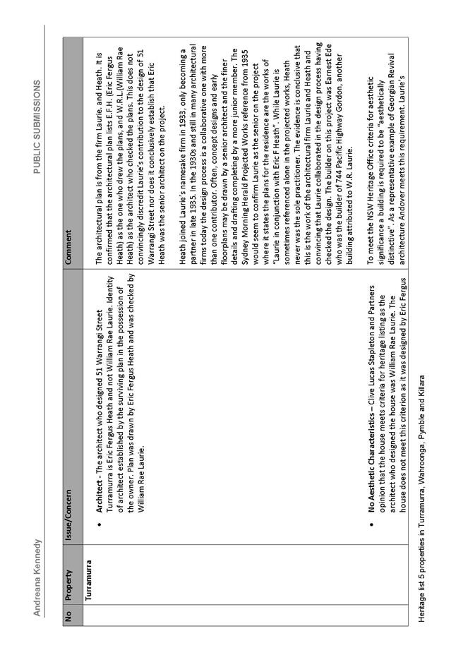
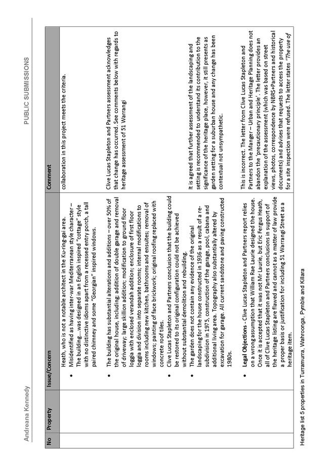
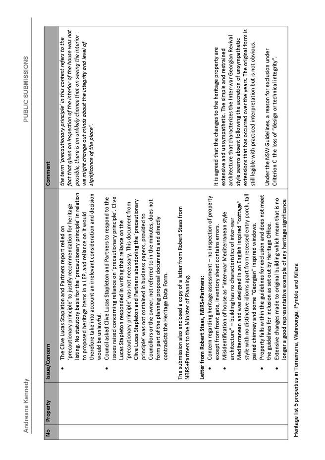
Killara and 51 Warrangi Street, Turramurra 540
File: S10453
For Council to consider the
submissions received during the public exhibition of the planning proposal to
heritage list 6 Caithness Street, Killara and 5 Warrangi Street, Turramurra.
Recommendation:
That Council take no further
action on the heritage listing for 6 Caithness Street, Killara and 51 Warrangi
Street, Turramurra.
Extra Reports Circulated to Meeting
BUSINESS WITHOUT NOTICE – SUBJECT TO CLAUSE 241 OF
GENERAL REGULATIONS
Questions Without Notice
Inspections Committee – SETTING OF TIME, DATE AND
RENDEZVOUS
** ** ** ** ** **
Minute Ku-ring-gai
Council Page
MINUTES OF Ordinary Meeting of Council
HELD ON Tuesday, 15 September 2015
|
Present:
|
The Mayor, Councillor J Anderson (Chairperson) (Roseville
Ward)
Councillors E Malicki & J Pettett (Comenarra Ward)
Councillors D Citer & C Szatow (Gordon Ward)
Councillors C Berlioz & D Ossip (St Ives Ward)
Councillor D Armstrong (Roseville Ward)
Councillors C Fornari-Orsmond & D McDonald (Wahroonga
Ward)
|
|
|
|
|
Staff Present:
|
General Manager (John McKee)
Director Corporate (David Marshall)
Director Development & Regulation (Michael Miocic)
Director Operations (Greg Piconi)
Director Strategy & Environment (Andrew Watson)
Director Community (Janice Bevan)
Corporate Lawyer (Jamie Taylor)
Manager Corporate
Communications (Virginia Leafe)
Governance Officer (Christine Dunand)
Minutes Secretary (Sigrid Banzer)
|
The Meeting
commenced at 7.00pm
The Mayor offered
the Prayer
DECLARATIONS OF
INTEREST
The Mayor
adverted to the necessity for Councillors and staff to declare a Pecuniary
Interest/Conflict of Interest in any item on the Business Paper.
No Interest
was declared.
Address the Council
The following member of the
public addressed Council on items not on the agenda:
M Middleton - Caithness
Street, Killara
DOCUMENTS CIRCULATED
TO COUNCILLORS
The Mayor adverted to the
documents circulated in the Councillors’ papers and advised that the following
matters would be dealt with at the appropriate time during the meeting:
|
Late Items:
|
Minutes of Ordinary Meeting of
Council 2
Meeting held 8 September 2015
Minutes numbered 253 to 283
|
|
Councillors Information:
|
QWN – 828 Pacific Highway Gordon - Memorandum from Director Strategy & Environment dated
11 September 2015 in relation to a QWN from Councillor Malicki regarding an
update of the plans for the move of Council into 828 Pacific Highway Gordon
and the costs associated with those plans.
|
CONFIRMATION OF
MINUTEs
|
284
|
Minutes of Ordinary
Meeting of Council
File: S02131
|
|
|
Meeting held 8 September 2015
Minutes numbered 253 to 283
|
|
|
Resolved:
(Moved: Councillors McDonald/Armstrong)
That Minutes numbered 253 to 283 circulated to Councillors
were taken as read and confirmed as an accurate record of the proceedings of
the Meeting.
CARRIED
UNANIMOUSLY
|
minutes from the Mayor
|
285
|
Ku-ring-gai's Year That Was
File: CY00455/3
Vide: MM.1
|
|
|
Tonight marks the beginning of the final year of this term
of Council as we head towards the 2016 NSW Local Government elections.
I would like to take this opportunity for a brief
reflection.
There is currently much uncertainty for Local Government
across NSW as we await recommendations from IPART and announcements by the
State Government regarding possible Council amalgamations.
The often difficult decisions made by Council over the
last few years have placed us in the enviable position of being able to meet
all of the State Government’s Fit for the Future financial thresholds within
the designated timeframe.
I commend Councillors and the staff for their commitment
to ensure Ku-ring-gai is financially strong and able to deliver facilities
and services for our community. The role of a Councillor is not only to
consider the views of individual stakeholders but to plan for the future and
to responsibly manage the Council’s resources.
Ku-ring-gai’s impressive new Indoor Fitness and Aquatic
Centre, the final stages of the North Turramurra Recreation Area, the parks
programme with refurbishments or new parks such as Greengate Lane Park
Killara, Cameron Park Turramurra, Malga Avenue Roseville Chase, Curtilage
Park Wahroonga, Carcoola Road St Ives are recent examples. New sportsfields
at Koola Park now underway and the first synthetic field at Lindfield is
being extensively utilised.
Completion of upgrades at Philip Mall, West Pymble and
Princes Street, Turramurra are early examples of works continuing through our
Neighbourhood Business Centres programme.
Master planning is progressing at a number of locations
and is well advanced at East and West Lindfield with the Hub and the Village
Green. Turramurra and Gordon are also progressing, with the fortuitous
acquisition of 828 Pacific Highway enabling more opportunities to deliver
community facilities in Ku-ring-gai’s major town centre.
The opening of the Hornsby Ku-ring-gai Women’s Shelter has
filled a desperate void for vulnerable women. Council has also played a part
in connecting groups now working to establish a similar shelter in The Hills
area.
All of these achievements and much more have been
independently recognised through a long list of Awards – most notably the
2014 Bluett Award for the top performing Council in NSW, the Gold Award this
year in the Australasian Reporting Awards, the Parks and Leisure Australia NSW
Award in the events category for Council’s inaugural St Ives Medieval Faire
and many other awards too long to list.
As this mayoral year concludes we are Fit for the Future
and ready to remain a stand-alone Council.
Council is running operating surpluses after fully funding
depreciation, has a healthy level of cash reserves and working funds and our
liquidity as measured by the Unrestricted Current Ratio has increased to
2.5:1.
We have seen significant increases in capital works -
$35.8 million in 2014/15 and $47.6 million for 2015/16. More than $27 million
has been invested in infrastructure renewal in 2015/16, with $9.7 million
committed to the roads program.
I would sincerely like to thank the General Manager, Directors,
staff and the Mayor’s PA Sigrid, for their dedication to Ku-ring-gai and for
their outstanding achievements.
As I am not able to nominate for Mayor tonight, I can
only offer my best wishes to all who put themselves forward for election
this evening.
.
|
|
|
Resolved:
That this Mayoral Minute be received and noted
CARRIED
UNANIMOUSLY
.
|
GENERAL BUSINESS
The Mayor, Councillor Anderson vacated
the Chair
|
286
|
Election of the
Mayor for the 2015/2016 Mayoral Term
File: S03662
Vide: GB.1
|
|
|
To elect the Mayor for the period 2015/2016.
|
|
|
Resolved:
(Moved: Councillors McDonald/Fornari-Orsmond)
That the Council elect the Mayor for the 2015/2016 term
using the ordinary ballot method.
CARRIED
UNANIMOUSLY
|
Two members of the public were invited
to act as scrutineers for the election:
·
I. McKie
·
P. Wilkinson
The General Manager announced
there was 1 nomination for the position of Mayor.
Councillor Szatow was nominated
and accepted the nomination.
The General Manager called for
further written nominations for the position of Mayor. No further nominations
were received, the General Manager declared nominations for the position of
Mayor closed.
Councillor Cheryl Szatow was duly
elected to the position of Mayor for the 2015/2016 term unopposed.
|
287
|
Election of Deputy
Mayor for the 2015/2016 Term
File: S03662
Vide: GB.2
|
|
|
To elect the Deputy Mayor for the 2015/2016 term.
|
|
|
Resolved:
(Moved: Councillors McDonald/Fornari-Orsmond)
That Council elect the Deputy Mayor for the 2015/2016 term
using the ordinary ballot method.
CARRIED
UNANIMOUSLY
|
The General Manager announced there were 2 nominations for
the position of Deputy Mayor.
Councillor Ossip and Councillor Pettett were nominated and
accepted nomination.
The General Manager called for further written nominations
for the position of Deputy Mayor. No further nominations were received, the
General Manager declared nominations for the position of Deputy Mayor closed.
Two members of the public were invited to act as scrutineers
for the election.
The ballot resulted in 7 votes being received for Councillor
Ossip and 3 votes for Councillor Pettett.
Councillor Ossip was duly elected for the position of Deputy
Mayor for the 2015/2016 term.
The Mayor, Councillor Szatow took the
Chair
|
288
|
Election of
Chairpersons/Deputy Chairperson Reference and Advisory Committees 2015/2016
File: S02080
Vide: GB.3
|
|
|
For Council to give consideration to the election of the
Chairpersons/Deputy Chairpersons for Council’s Reference and Advisory
Committees.
|
|
|
Resolved:
(Moved: Councillors Malicki/Armstrong)
That Council make appointments to the nominated Reference
and Advisory Committees for the 2015/2016 term:
- That Council elect Councillor Armstrong as
Chairperson and Councillor Berlioz as Deputy for the Flood Risk
Management Reference Committee.
- That Council elect Councillors Citer and
Anderson as members of the Audit and Risk Committee (noting that the
Committee is chaired by an independent community member) and further
that other Councillors are invited to attend as observers as previously
has occurred.
- That Council elect Councillor Anderson as
Chairperson and Councillor Berlioz as Deputy for the Heritage Reference
Committee
- That Council elect Councillor Berlioz as
Chairperson and Councillor Szatow as Deputy of the Ku-ring-gai Traffic
Committee.
CARRIED
UNANIMOUSLY
|
|
289
|
Representation on
External Committees and Organisations
File: CY00430/3
Vide: GB.4
|
|
|
For Council to make appointments to external Committees
and organisations for the 2015/2016 term.
|
|
|
Resolved:
(Moved: Councillors Malicki/Citer)
A. That
Council make appointments to the nominated external Committees and
organisations as follows:
Ku-ring-gai
Police and Community Safety Committee
Representative: Councillor
Fornari-Orsmond
Ku-ring-gai
Meals on Wheels Inc.
Representative: Councillor
McDonald
Alternate: Councillor
Anderson
Eryldene
Trust
Representative: Councillor
Anderson
Hornsby/Ku-ring-gai
Bushfire Management Committee
Representative: Councillor
Citer
Alternate: Councillor
Armstrong
Metropolitan
Public Libraries Association
Representative: Councillor
Anderson
Rural
Fire Service District Liaison Committee
Representative: Councillor
Citer
Alternate: Councillor
Armstrong
Hawkesbury/Nepean
Local Government Advisory Group
Representative: None
required
Northern
Sydney Regional Organisation of Councils (NSROC)
The
Mayor, Councillor Szatow was an automatic appointment
1. That
Councillor Malicki be nominated as Council’s second delegate to the Northern
Sydney Regional Organisation of Councils (NSROC)
2. That
Councillor Citer be nominated as Council’s alternate to the Northern Sydney
Regional Organisation of Councils (NSROC).
Ku-ring-gai
Youth Development Service Inc. Management Committee
Representative: Councillor
Citer
Alternate: Councillor
Anderson
Greater
Sydney Local Land Services Government Advisory Group
Representative: Councillor
Berlioz
B. That
the external Committees and organisations be informed of Council’s nominated
representatives.
CARRIED
UNANIMOUSLY
|
The Meeting closed
at 7.50pm
The Minutes of the
Ordinary Meeting of Council held on 15 September 2015 (Pages 1 - 13) were
confirmed as a full and accurate record of proceedings on 6 October 2015.
__________________________ __________________________
General Manager Mayor
/ Chairperson
|
Ordinary
Meeting of Council - 6 October 2015
|
GB.1 / 14
|
|
|
|
|
Item
GB.1
|
S08023/7
|
|
|
25 September 2015
|
Audited General and Special Purpose
Financial Statements for the year ended 30 June 2015 and auditor's report
EXECUTIVE
SUMMARY
|
purpose of report:
|
To present to Council
the Annual Financial Statements and audit reports from Council’s external
auditor, UHY Haines Norton Chartered Accountants for the year ended 30 June
2015 and to provide a summary of Council’s financial performance and
financial position at 30 June 2015.
|
|
|
|
|
background:
|
On 8 September 2015 Council resolved to receive and
certify the Draft Financial Statements for 2014/2015 and to refer them to the
external auditor. Council also resolved to fix 6 October 2015 as the date
for the public meeting to present the statements and audit reports in
accordance with Section 419(1) and 419(2) of the Local Government Act.
|
|
|
|
|
comments:
|
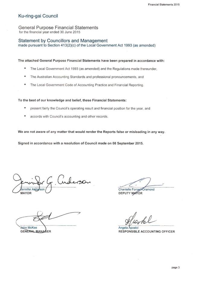
This is the final stage of the process of adopting
Council’s Annual Financial Statements for 2014/2015.
|
|
|
|
|
recommendation:
|
That Council receives
the audited Financial Statements and the external auditor’s report from UHY
Haines Norton Chartered Accountants.
|
Purpose of Report
To present to Council the Annual Financial Statements and
audit reports from Council’s external auditor, UHY Haines Norton Chartered
Accountants for the year ended 30 June 2015 and to provide a summary of
Council’s financial performance and financial position at 30 June 2015.
Background
In accordance with Section 413(2)(C) of the Local Government
Act 1993, Council must prepare a statement on the General Purpose Financial
Reports as to its opinion on the reports prior to referring them to audit.
On 8 September 2015 Council resolved to receive and certify
the Draft Financial Statements for 2014/2015 and to refer them to the external
auditor. The following certifications were made
by the Mayor, Deputy Mayor, the General Manager and Responsible Accounting
Officer:
That Council’s Annual Financial Statements have been
prepared in accordance with:
* The Local Government Act
1993 (as amended) and Regulations made thereunder
* The Australian Accounting
Standards and professional pronouncements
* The Local Government Code
of Accounting Practice and Financial Reporting
And that to the best of Council’s knowledge and belief
that the statements:
* present fairly the
Council’s operating result and financial position for the year; and
* are in accordance with
Council’s accounting and other records.
That Council’s Special Purpose Financial Statements have
been prepared in accordance with:
* The
NSW Government Policy Statement “Application of National Competition policy
to Local Government”.
* The
Division of Local Government Guidelines “Pricing and Costing for Council
Businesses – A Guide to Competitive Neutrality”.
* The Local Government Code
of Accounting Practice and Financial Reporting
And that to the best of Council’s knowledge and belief
that the statements:
* present
fairly the Council’s operating result and financial position for each of
Council’s declared Business Activities for the year,
and
* are in accordance with
Council’s accounting and other records.
Comments
Council’s external auditor, UHY Haines Norton Chartered
Accountants audited the General Purpose Financial Statements and Special
Purpose Financial Statements for the financial year ended 30 June 2015 and
expressed an opinion on the financial statements based on their audit. The
Auditor’s letter forms part of the Annual Financial Statements and includes the
following opinion:
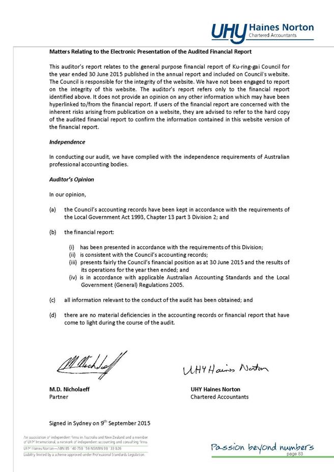
Auditor’s opinion
In our opinion,
(a) the Council’s
accounting records have been kept in accordance with the requirements of the Local
Government Act 1993, Chapter 13 part 3, Division 2;and
(b) the financial
reports:
(i) have
been presented in accordance with the requirements of this Division;
(ii) are
consistent with the Council’s accounting records
(iii) present
fairly the Council’s financial position as at 30 June 2014 and the results of
its operations for the year then ended; and
(iv) are in
accordance with applicable Australian Accounting Standards and the Local
Government (General) Regulations 2005..
(c) all
information relevant to the conduct of the audit has been obtained; and
(d) there are no
material deficiencies in the accounting records or financial reports that have
come to light during the course of the audit.
Subsequent to the meeting on 8 September 2015 and the
receipt of the Auditor’s letter, the Annual Financial Statements were placed on
public exhibition. Written submissions from the public were invited, but at the
time of writing this report none were received. Submissions received up to 4.30pm
on 6 October 2015 will be circulated to Councillors on the night of the
meeting. Section 420 of the Act requires that all submissions in respect of
the audited Financial Statements must be in writing and must be lodged with the
Council within 7 days after this meeting. Public submissions may be made up to
13 October 2015. Copies of all submissions received must be referred to
Council’s external auditor.
This is the final stage of the process of adopting the
Financial Statements for 2014/2015.
The audited Financial Statements, together with the audited
reports for the year ended 30 June 2015 are hereby presented to Council (Attachment
A1). The Financial Statements are also provided under separate cover.
Financial
Performance and Position of Council as at 30 June 2015
The comments below provide highlights of Council’s financial
performance during 2014/15 and financial position at 30 June 2015.
A summary of the financial results from the Financial
Statements 2014/15 is presented below:
|
Income Statement
‘000
|
Actual
2015
|
Actual
2014
|
|
Income from Continuing
Operations
|
133,320
|
116,869
|
|
Expenses from Continuing
Operations
|
110,734
|
100,828
|
|
Net Operating Result for
the Year
|
22,586
|
16,041
|
|
Net Operating Result for
the year before Grants and Contributions for Capital purposes
|
13,460
|
3,117
|
|
Statement of Financial Position
‘000
|
Actual
2015
|
Actual
2014
|
|
Current Assets
|
45,686
|
57,969
|
|
Non-Current Assets
|
1,139,045
|
1,028,247
|
|
Total Assets
|
1,184,731
|
1,086,216
|
|
Current Liabilities
|
23,445
|
25,759
|
|
Non-Current Liabilities
|
24,280
|
39,630
|
|
Total Liabilities
|
47,725
|
65,389
|
|
Net Assets
|
1,137,006
|
1,020,827
|
|
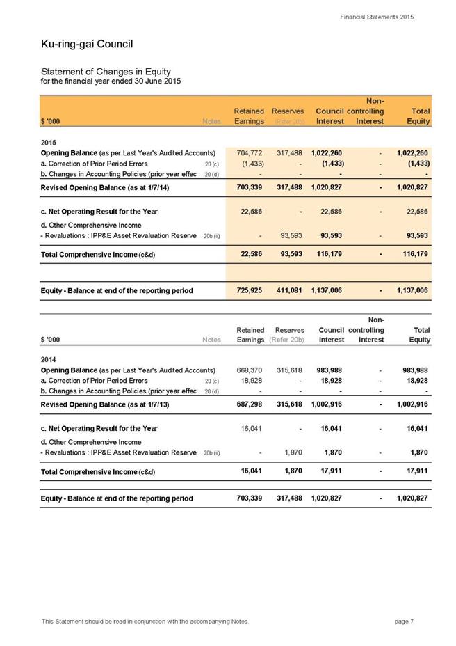
Total Equity
|
1,137,006
|
1,020,827
|
|
Statement of Cash Flows
‘000
|
Actual
2015
|
Actual
2014
|
|
Net Cash Flow from
Operating Activities
|
29,265
|
34,768
|
|
Net Cash Flow from
Investing Activities
|
(11,122)
|
(55,922)
|
|
Net Cash Flow from
Financing Activities
|
(17,909)
|
8,076
|
|
Net Decrease in Cash
|
234
|
(13,078)
|
|
Plus: Cash at beginning
of year
|
(50)
|
13,028
|
|
Cash at end of Year
|
184
|
(50)
|
|
Plus: Investments on
hand at end of year
|
97,100
|
92,462
|
|
Total Cash &
Investments
|
97,284
|
92,412
|
Income
from Continuing Operations
During the financial year 2014/15 Council received $133.32m
in income from Continuing Operations from the following sources:
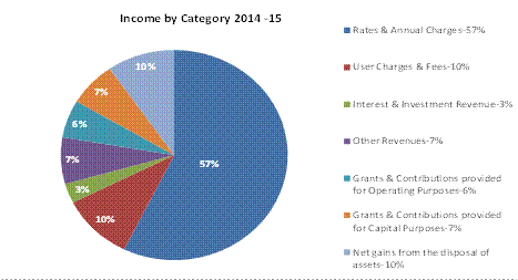
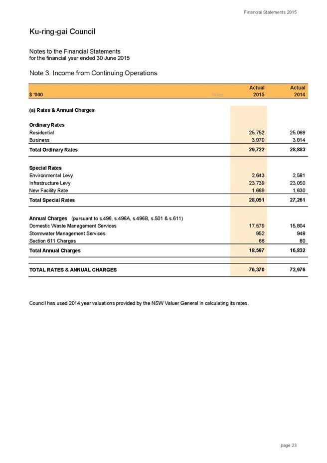
Rates & Annual Charges
Rates and Annual Charges contributed $76.3m or 57%
($72.9m in 2013/14). Rates income increased by a total of 3% from the last
financial year taking into consideration the approved rate peg increase of
2.3%, as well as supplementary rates during the year. Annual Charges which are
predominantly represented by domestic waste charges increased by 11%. This
reflects the provision of funds towards the cost of remediating the former tip
site at the North Turramurra Recreation Area. Whilst a major component of
these costs was chargeable to the Domestic Waste Management reserve, it was
necessary in the short term to fund part of this project from the
Infrastructure and Facilities reserve and recover costs in future from
increased Domestic Waste charges.
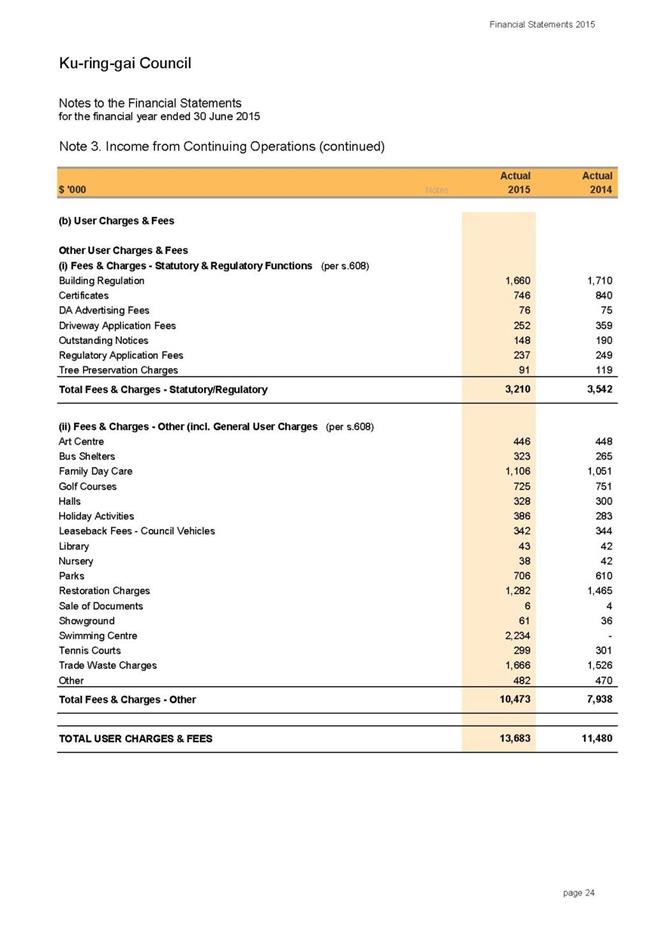
User Charges & Fees
User Charges and Fees totalled $13.68m (10%) compared to
$11.48m in 2013/14, an increase of 19%. This category of income mainly includes
regulatory/statutory fees and community facilities hire. The principal increase
from 2013/14 financial year was due to income received from Council’s Fitness
& Aquatic Centre (KFAC) which officially opened in October 2014. Additional
expenditure for KFAC to offset income has also been incurred and is reflected
in Materials and Contracts expenditure. No other major variations were
observed.
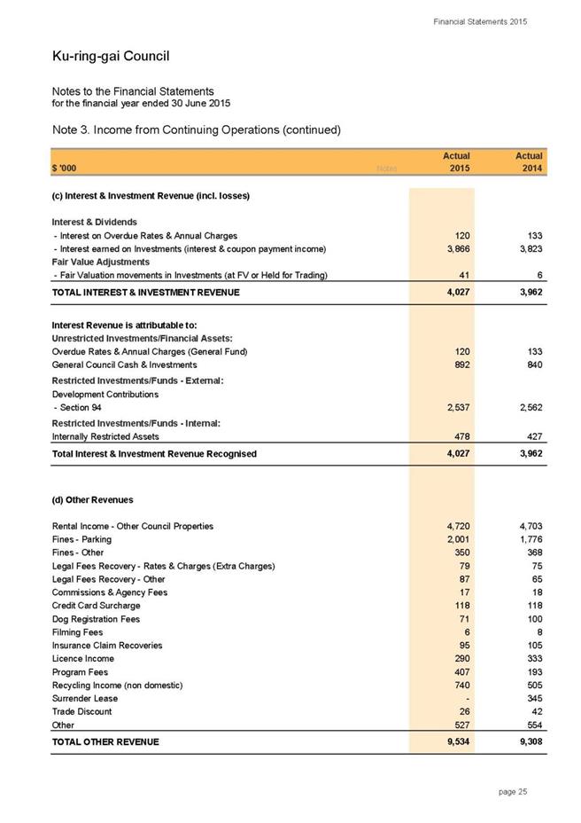
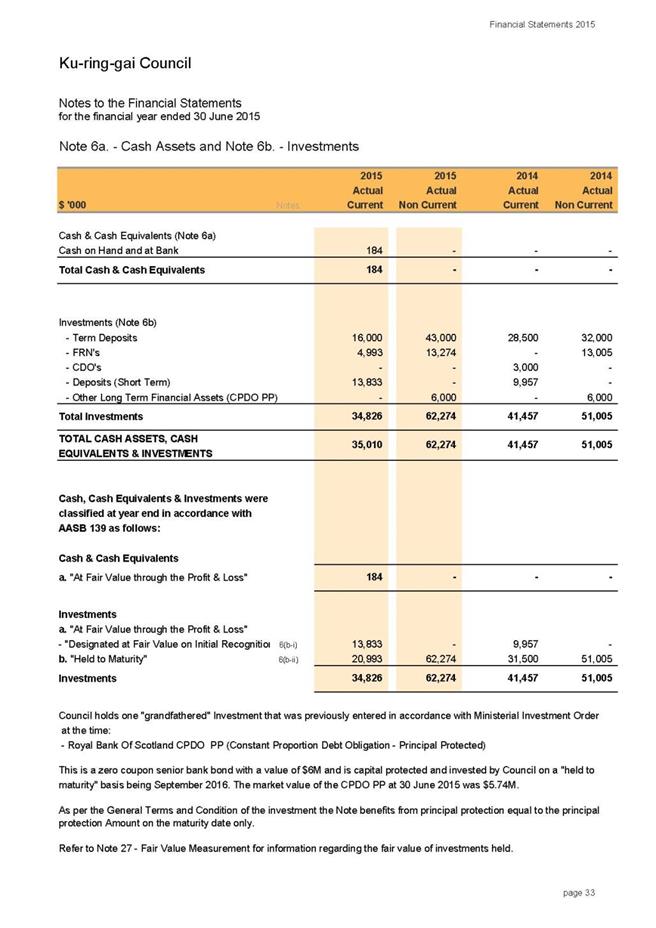
Interest and Investment Revenue
A total of $4m (3%) compared to $3.96m in 2013/14 was
received from Interest and Investment revenue. While there is no major
variance in interest earned from previous year, interest income was still lower
in 2014/15 when compared to the total average portfolio invested during the
year. This is mainly due to lower average interest rates (3.87%) in 2014/15
compared to the previous year (4.27% in 2013/14).
Council’s Cash and Investments at the end of the financial
year totalled $97.28m. Notwithstanding the decrease in income compared to
investments portfolio, Council ended the year with a strong investment
performance which exceeded the bank bill benchmark by 1.27% (the weighted
average return for the total portfolio as at end of year was 3.87% compared to
the benchmark of the UBS Bank Bill Index of 2.60%). Compared to revised budget,
the net return on investments at the end of June 2015 recorded a favourable
variance of $199k.
Other Revenue
Income from “Other Revenue “totalled $9.53m (7%) compared to
$9.30m in 2013/14.
Other Revenues have increased by 2.4% compared to 2013/14
which is principally due to higher income from program fees (from Community
events held during the year) and an increase in recycling income achieved by
changing the recycling contractor.
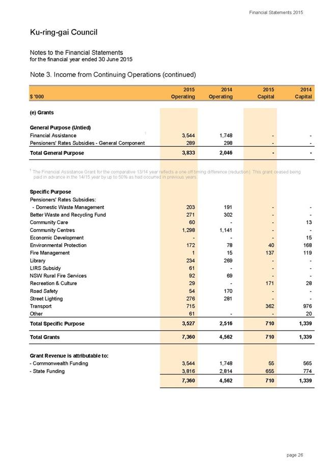
Operating Grants and Contributions
During 2014/15 a total of $7.7m
(6%) compared to $4.7m in previous year was received by Council. Grants &
Contributions provided for Operating Purposes increased by 64% on the previous
financial year. This was largely due to the full payment of the Financial
Assistance Grant (FAG) as opposed to only 50% received in 2013/14. The
Financial Assistance Grant for 2013/14 reflected a one off reduction due to the
fact that this grant was no longer being paid in advance. Other variations in
operational grants income were due to additional grants received in the
Recreation & Culture category (eg.St Ives Showground Regional playground)
and the reclassification of Roads to Recovery (RtoR) grant from capital to
operational. This reclassification is due to the fact the RtoR grants are not
specifically given to Council for capital purposes, therefore, should be
treated and disclosed as operational grants.
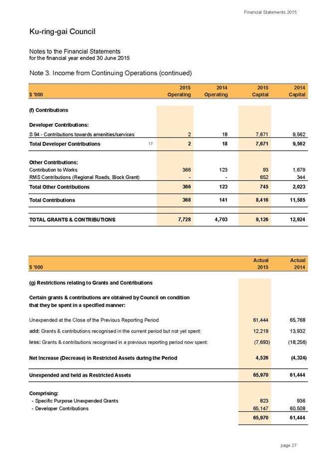
Capital Grants and Contributions
Grants and Contributions
provided for Capital Purposes decreased by 29% on the previous financial year
with $9.12m received in 2014/15 compared to $12.92m in 2013/14. This was
largely due to decreased Section 94 contributions from developers and
reclassification of the Roads to Recovery grant from capital to operational.
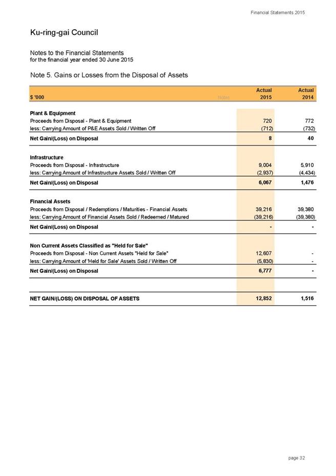
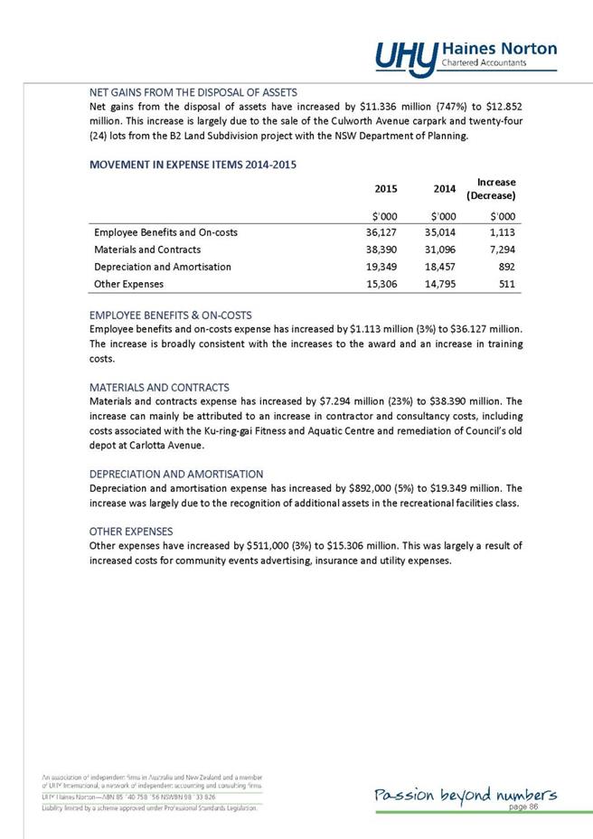
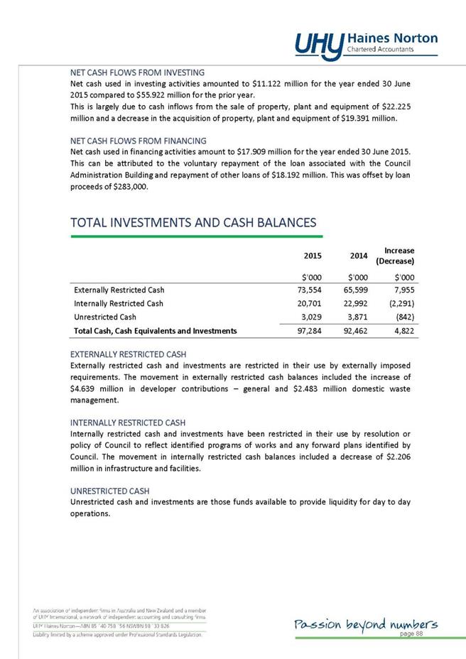
Net Gains from Disposal of Assets
One of the largest variations in the current financial
statements is identified in the Net Gains from Disposal of Assets. Net gains
from asset sales were $12.85m ($1.51m in 2013/14) largely due to the sale of
Council’s car park at Culworth Avenue, Killara and 24 lots from B2 Land
subdivision (the settlement of 2 lots is due to be finalised by December 2015).
The net gain represents the gross sale price less the written down value of
assets. A summary of major variations in Net Gain on Asset Sales follows:
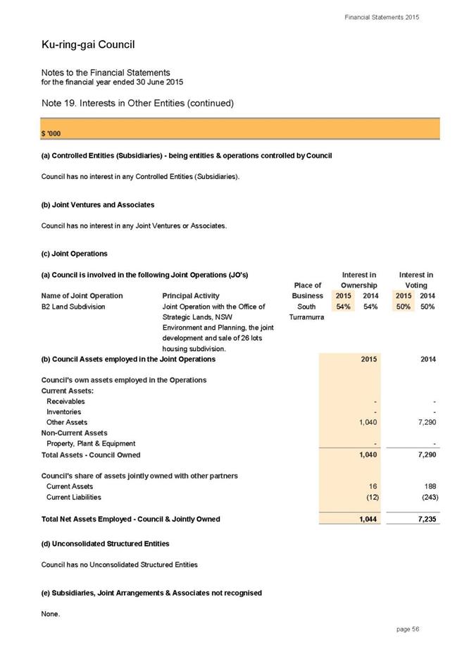
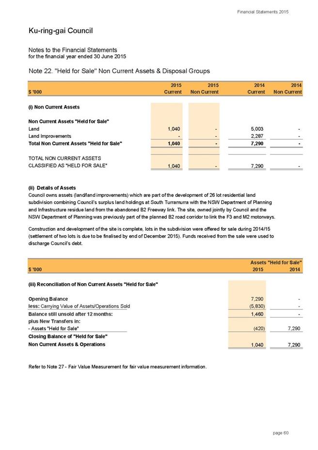
· B2 land subdivision
Council owned assets that were part of the development of 26
lot residential land subdivision at South Turramurra with the NSW Department of
Planning. Council’s owned assets were disclosed in Note 22 “Assets Held for
Sale” in previous years. Construction and development of the site was completed
during 2014/15 and 24 lots were offered for sale. Council received gross
proceeds of $13.97m from the sale during 2014/15. After accounting for the book
value of assets held for sale, the net gain on asset sales was recorded at
$7.5m.
Further disclosure relating to this project is available in
Note 19 – Interests in other entities.
· Culworth Avenue Car Park - 20-28
Culworth Ave, Killara NSW 2071
During 2014/15 Council divested a portion of the Culworth
Avenue Car Park to Rail Corporation NSW. Total proceeds from the sale were $7m.
After accounting for the book value of assets held in Council’s financial
register, the net gain on asset sales was recorded at $6.2m
Expenses
from Continuing Operations
Total Operating Expenses for the financial year ended 30
June 2015 were $110.73m, compared to $100.82m in 2013/14, this is an increase
of 9.8% on the previous financial year.
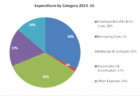
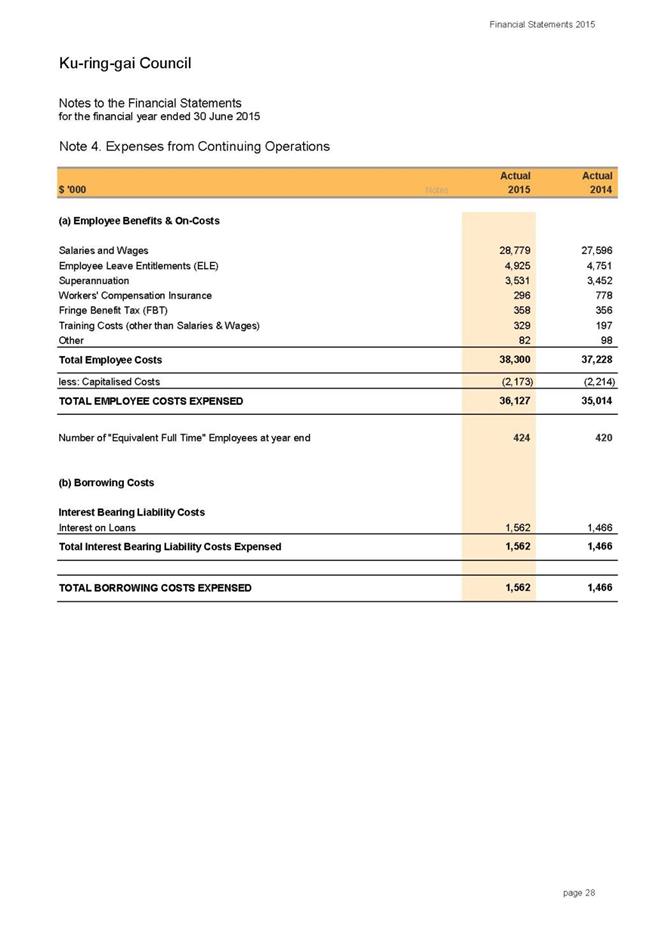
Employee Benefits and
On-costs
Employee Costs were $36.1m
compared to $35m in 2013/14, which is an increase of 3.2% on the previous
financial year. The major variation was due to the award increase. It must be
noted that notwithstanding the increase, a significant saving was achieved in
Workers compensation insurance with a decrease of 62% from the previous year
($296k in 2014/15, $778k in 2013/14). This reflects the continuation of Safestart
and other safety training programs for staff. The decrease includes a
favourable adjustment of $212k to Council’s premium relating to 2013/14
received in 2014/15.
Borrowing Costs
Borrowing Costs totalled $1.56m compared to $1.46m in
2013/14. There was no significant variation during the year. A total of $750k
(relating to 828 Pacific Highway loan), in addition to existing loans, has been
accrued /recognised in the accounts during the financial year which was not a
cash outflow, but rather an increase in the outstanding balance of the loan. As
per the loan agreement Council is required to start interest and principal
repayments on this loan by 2016/17.
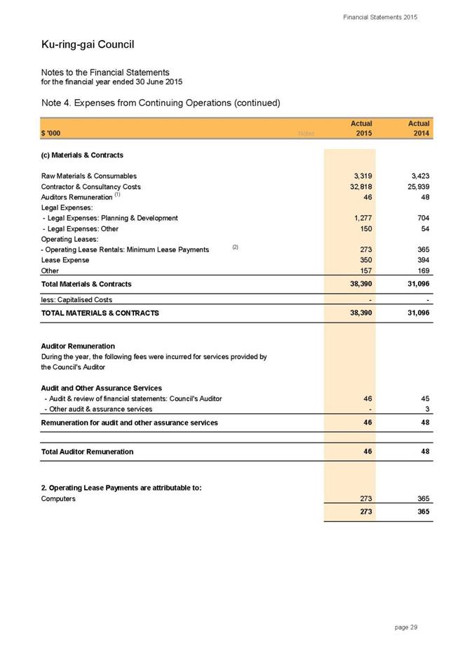
Materials & Contracts
Materials & Contracts is the largest category of
expenditure representing 35% of the total Council expenditure. A total of
$38.4m compared to $31.1m in 2013/14 was spent on Materials and Contracts
during 2014/15. This is an increase of 23.5% on the previous financial year.
The principal components of this increase are within Contractor &
Consultancy costs, in particular, costs associated with KFAC, increased costs
resulting from remediation of Council’s old depot at Carlotta Avenue, Gordon,
tree maintenance costs from storm damages, legal expenses and others.
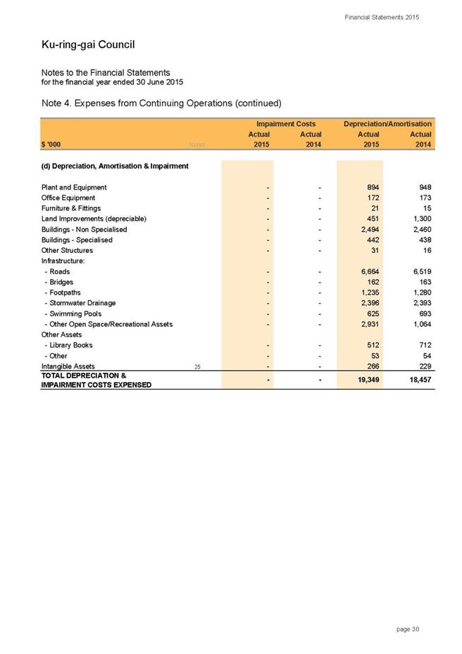
Depreciation and Amortisation
Depreciation and Amortisation
has risen by $892k or 4.8% on previous year from $18.45m in 2013/14 to $19.34
in 2014/15, primarily due to additional assets recognised in the Recreational
Facilities ( February 2014) asset class and depreciated over a full financial
year. Council revalued infrastructure assets in 2014/15 and also performed an
independent review on Council’s asset data. As part of this review depreciation
rates and assets useful lives were revised for each class of infrastructure
assets. The revised useful lives are disclosed in Note 1 to the Financial
Statements.
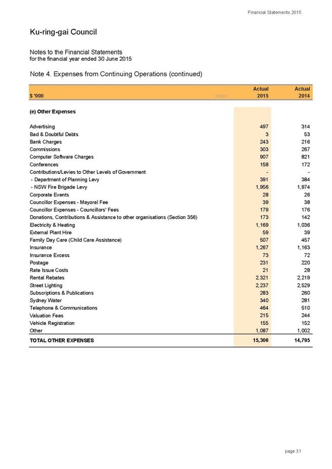
Other Expenses
Material expenditure items in
this category include electricity costs, insurance, street lighting, rental
rebates and other expenses. Other Expenses have increased by $511k or 3.5%
compared to previous financial year, mainly due to increased costs for
advertising (community events), insurance and utility expenses.
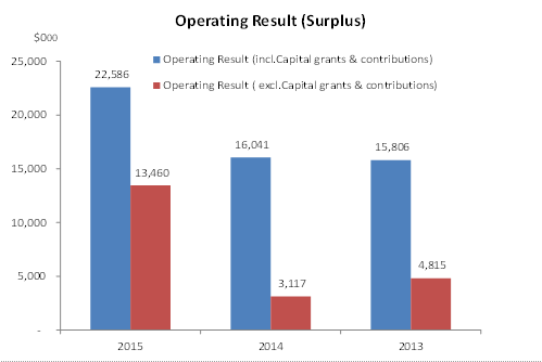
Operating
result
The operating result is a measure of the increase in the
value of Council’s net assets. It takes into account the income received by
Council less the expenses from operations including depreciation of assets. The
operating result excludes capital expenditure (expenditure on assets).
Council’s net operating result for the 2014/15 financial
year is disclosed in the Income Statement. For the financial year ended 30 June
2015 Council had an operating surplus excluding revenue from capital grants and
contributions of $13.46m compared to $3.11m in 2013/14. The operating result
after capital grants and contributions was $22.58m, a variance of $6.54m in
comparison to previous financial year ($16m in 2013/14). This variance is
mainly due to net gains from asset sales and additional operational grants
offset by higher expenditure in Materials & Contracts.
A comparison of Operating Result for 2014/15 to original
budget and 2013/14 financial year is provided in the table below. It must be
noted that major variations in expenditure and income compared to original
budget are disclosed in Note 16 of the Financial Statements.
|
$’000
|
2014/15
Actual
|
2014/15
Original Budget
|
2013/14
Actual
|
|
Net Operating
Result
(Surplus)
|
22,586
|
20,480
|
16,041
|
|
Net Operating
Result
(before Capital grants & contributions)
|
13,460
|
3,370
|
3,117
|
Council’s operating result is strong. The operating surplus
means that Council’s revenue exceeds both the cost of running its day to day
operations and the depreciation of its assets. This surplus is available for
capital works.
The operating result (shown separately as including and
excluding capital grants and contributions) for the last three financial years
is provided in the chart below.
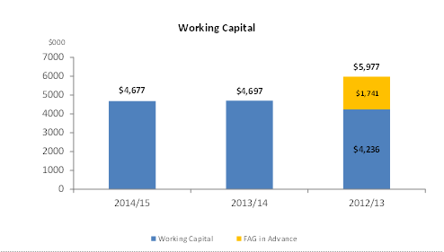
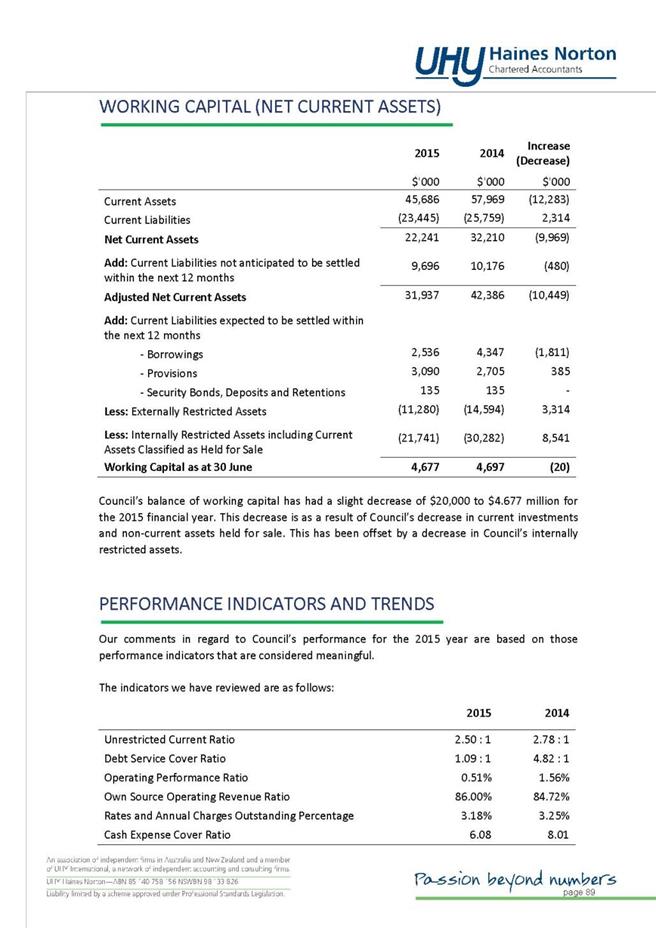
Working
capital
Working capital is a measure of
Council’s liquidity and ability to meet its obligations as they fall due. It is
one of the primary measures of the overall financial position of Council, which
allows for unforeseen expenditure or reductions in revenue.
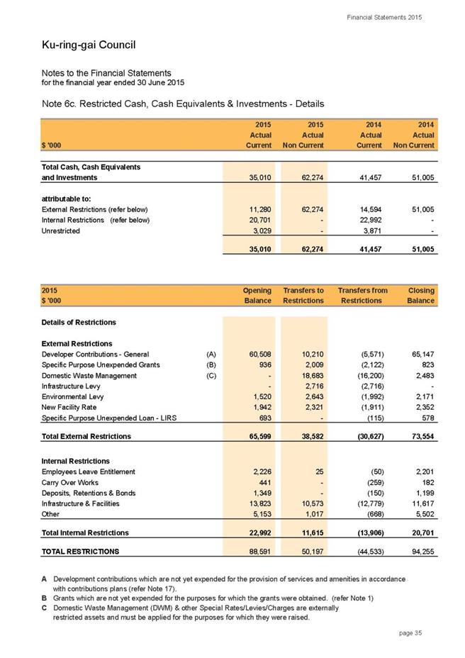
Working capital represents Council’s net current assets,
after deducting internal and external restrictions.
The available working capital at the end of 2014/15
financial year is $4.67m, in line with the target identified in Council’s
Annual Budget. This level of working capital highlights an adequate liquidity
position with Council being able to meet its short term liabilities when they
fall due.
Chart below provides a comparison of Council’s working
capital for the last 3 financial years.
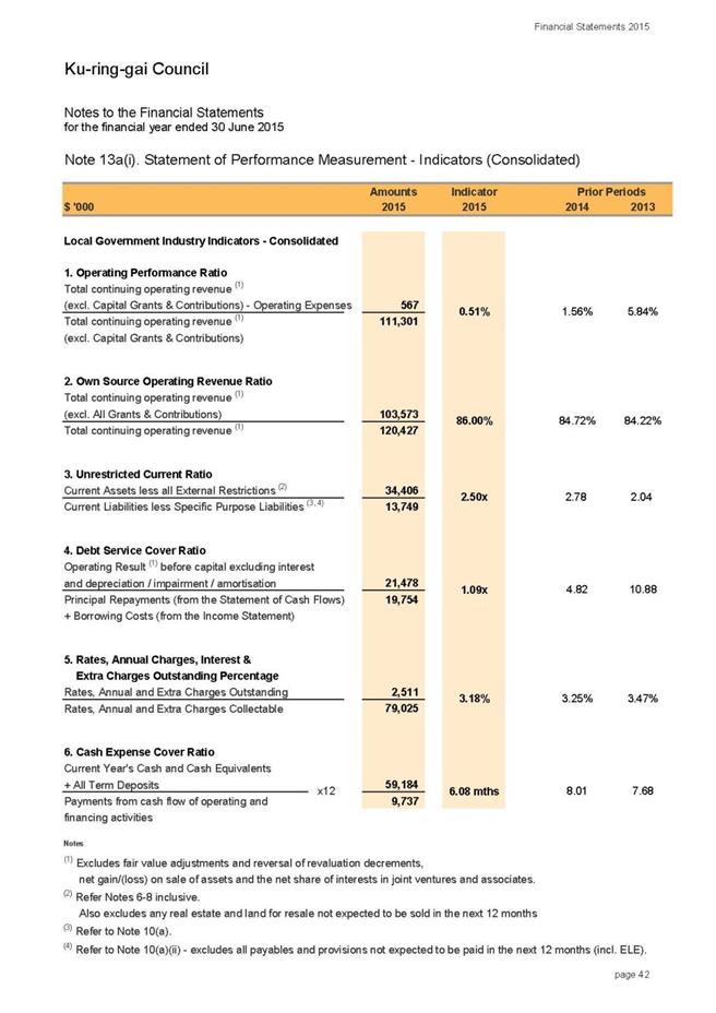
Performance
Measurement Indicators
The Statement
of Performance Measurement (Note 13 of the Financial Statements and Special
Schedule 7) provide ratios used to assess various aspects of Council’s
financial performance. These ratios have been prescribed by the Code of
Accounting Practice for 2014/15, which are mainly the financial ratios
identified in T-Corp’s Financial Assessment and Benchmarking Report. The
Infrastructure assets ratios listed in “Special Schedule 7 - Report on
Infrastructure Assets” are Building & Infrastructure Renewal Ratio,
Infrastructure Backlog Ratio, Asset Maintenance Ratio and Capital Expenditure
Ratio.
The results
of all financial indicators, including asset ratios, providing previous three
year comparisons and commentary are detailed in the table and charts below.
|
Financial
Indicator
|
|
2014/15
|
2013/14
|
2012/13
|
|
Operating Performance
Ratio
Total Operating Revenue
(excl Capital grants & Contrib.) – Operating Expense
Total Operating Revenue
|
0.51%
|
1.56%
|
5.84%
|
|
Own Source Operating
Revenue
Total Operating Revenue (
less all grants & Contributions)
Total Operating Revenue
|
86.00%
|
84.72%
|
84.22%
|
|
Unrestricted Current
Ratio
Current Assets( less all
External Restrictions)
Current Liabilities (less
Specific Purpose Liabilities)
|
2.50x
|
2.78x*
|
2.04x
|
|
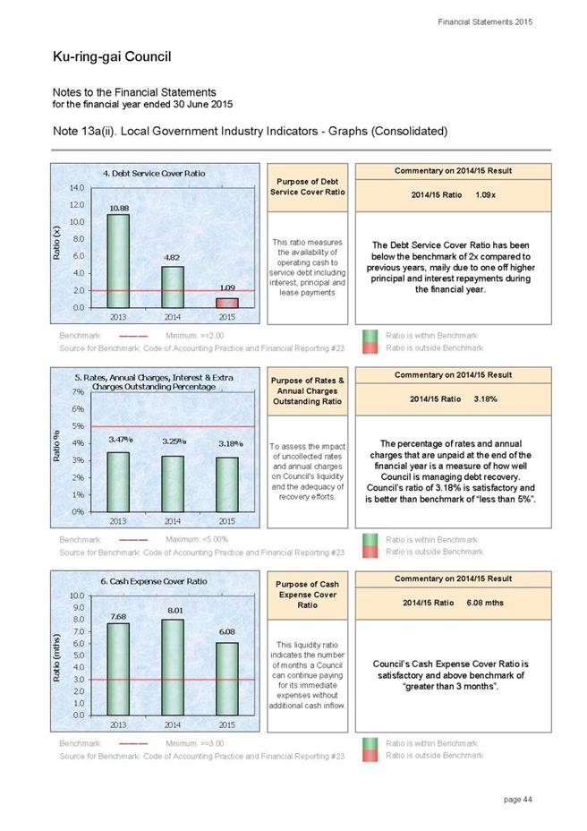
Debt Service Cover Ratio
Operating Result before
capital excl.interest & depreciation
Principal repayments plus
borrowing costs
|
1.09x
|
4.82x
|
10.88x
|
|
Rates, Annual charges,
Interest outstanding Percentage
Rates, Annual Charges
Outstanding
Rates, Annual Charges
Collectible
|
3.18%
|
3.25%
|
3.47%
|
|
Cash Expense Cover Ratio
( expressed in months)
(Current Years cash &
Cash Equivalents ( incl. Term Deposits)
Payments from cash flow of
operating and financing activities) X 12
|
6.08
|
8.01
|
7.68
|
|
Asset Ratios
|
|
|
|
|
Building &
Infrastructure Renewal Ratio
Asset Renewals( Building
& Infrastructure)
Depreciation, Amortisation
& Impairment
|
100.01%
|
104.46%
|
94.06%
|
|
Infrastructure Backlog
Ratio
Estimated cost to bring
Assets to a satisfactory condition
Total value of
Infrastructure, Building, other structure and Land Imp Assets
|
4.36%
|
28.78%
|
29.79%
|
|
Asset Maintenance Ratio
Actual Asset Maintenance
Required Asset Maintenance
|
1.01x
|
0.95x
|
0.81x
|
|
Capital Expenditure Ratio
Annual Capital
Expenditure
Annual Depreciation
|
1.28x
|
2.29x
|
4.05x
|
*The
ratio includes $8.7m of Assets held for sale
Operating
Performance Ratio
|
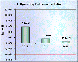
|
This ratio
measures Council’s achievement of containing operating expenditure within
operating revenue. It is important to distinguish that this ratio is
focussing on operating performance and hence capital grants and
contributions, fair value adjustments and reversal of revaluation decrements
are excluded. The benchmark is greater than (-4%).
Council
performance ratio is above the benchmark which means that Council can easily
contain operating expenditure (excluding capital grants and contributions)
within its operating revenue. The ratio has been above benchmark for the last
three years. The main decrease from last year is mainly due to higher
expenditure in Materials & Contracts from old depot remediation costs,
KFAC contractors, tree maintenance costs and others.
|
Own Source Operating Revenue
|
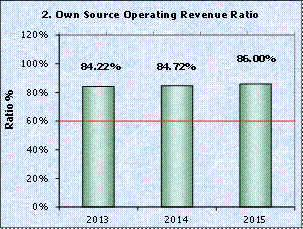
|
This ratio
measures fiscal flexibility. It is the degree of reliance on external funding
sources such as operating grants and contributions. Council’s financial
flexibility improves the higher the level of its own source revenue. The
benchmark is greater than 60%.
Council’s
Own Source Operating Revenue Ratio (86%) has remained above the benchmark of
(>60%) in the last three years. Council has sufficient level of fiscal
flexibility, in the event of being faced with unforseen events.
|
Unrestricted
Current Ratio
|
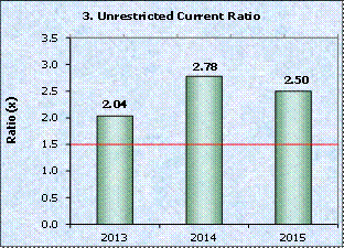
|
The
Unrestricted Current Ratio is designed to represent Council’s ability to meet
short term obligations as they fall due. The benchmark is greater than 1.5x.
Council’s
Unrestricted Current Ratio at 2.5x is above benchmark of >1.5x and has
been outperforming benchmark for the last three years. Council’s liquidity is
good and it can readily pay its debts as they fall due.
|
Debt Service Cover Ratio
|
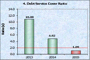
|
This ratio
measures the availability of operating cash to service debt including
interest, principal and lease payments. The benchmark is greater than 2x.
The Debt
Service Cover Ratio has been below benchmark (unfavourable) in 2014/15 and it
has decreased compared to previous years due to increased one off principal
and interest repayments during the financial year.
|
Rates,
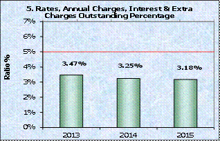
Annual Charges, Interest & Extra Outstanding Percentage
|
|
The purpose
of this ratio is to assess the impact of uncollected rates and annual charges
on liquidity and the adequacy of recovery efforts.
The
percentage of rates and annual charges that are unpaid at the end of the
financial year is a measure of how well Council is managing debt recovery.
Council’s ratio of 3.18% is satisfactory and is better than benchmark of
“less than 5%”.
|
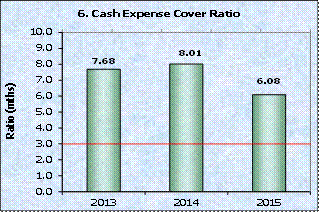
Cash Expense Cover Ratio
|
|
This
liquidity ratio indicates the number of months a Council can continue paying
for its immediate expenses without additional cash inflow.
Council’s
Cash Expense Cover Ratio is satisfactory and above benchmark of “greater than
3 months”.
|
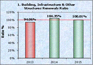
Building
and Infrastructure Renewal Expenditure
|
|
This indicator assesses Council’s rate at which buildings
and infrastructure assets are being renewed against the rate at which they
are depreciating. An indicator of 100% indicates that the amount spent on
asset renewals equals the amount of depreciation. Council’s ratio was in
line with the benchmark in 2014/15.
Council is continuing to focus on
appropriate asset standards for renewal and maintenance as identified in
Council’s Asset Management Strategy. Future financial and asset management
plans have consciously prioritised renewal capital works programs over new
programs.
|
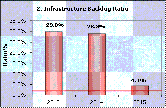
Infrastructure Backlog Ratio
|
|
This ratio
shows what proportion of the backlog is against the total value of Council’s
infrastructure. Council achieved a backlog ratio of 4.4% at the end of
2014/15, which is a major decrease from the previous year. This was mainly
due to an independent review on infrastructure assets that was undertaken
during the year. This review was focused on assessing condition of Council’s
assets by asset class and reviewing Council’s methodology to determine cost
to bring assets to a satisfactory condition. The ratio of 4.4% is an
improvement from previous years; however, it indicates that Council still has
an infrastructure backlog. Council is continuing to focus on appropriate
asset standards for renewal and maintenance of its assets.
|
Asset Maintenance Ratio
|

|
This ratio
compares actual versus required annual asset maintenance. A ratio of above
1.0
indicates
that Council is investing enough funds within the year to ensure assets reach
their useful lives. The benchmark is greater than1.0.
Council is
committed to increase expenditure on asset maintenance in future to maintain
its infrastructure assets in satisfactory condition in the long term.
|
Capital Expenditure Ratio
|
|
This
indicates the extent to which Council is forecasting to expand its asset base
with capital expenditure spent on both new assets, and renewal of existing
assets. The benchmark is greater than 1.1x. Council’s Capital Expenditure
Ratio of 1.28x continues to be above the benchmark reflecting its significant
capital expenditure program on new assets and the renewal of existing assets
compared to their depreciation. The decrease from previous year is largely
due to less capital works undertaken compared to previous year.
|
Changes
from Draft General Purpose Financial Report
The following change has been made to the final Audited
General Purpose Financial Reports:
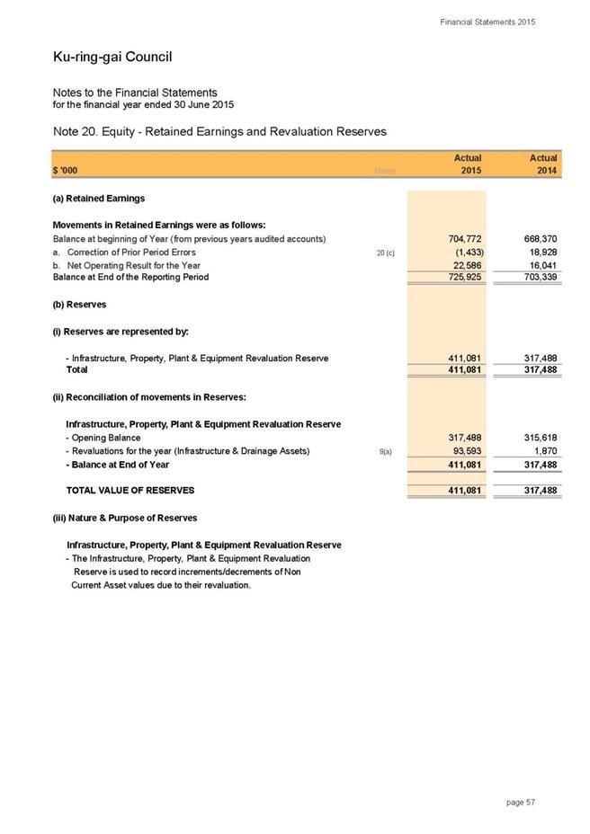
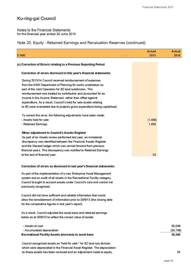
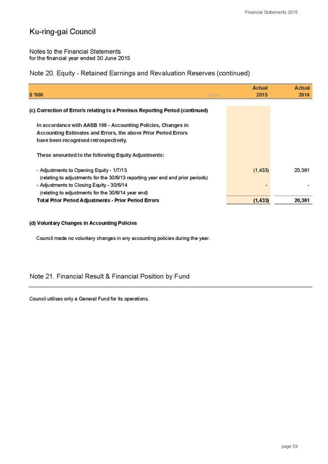
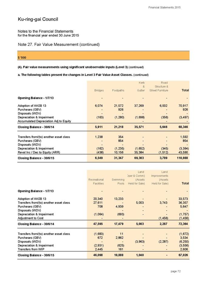
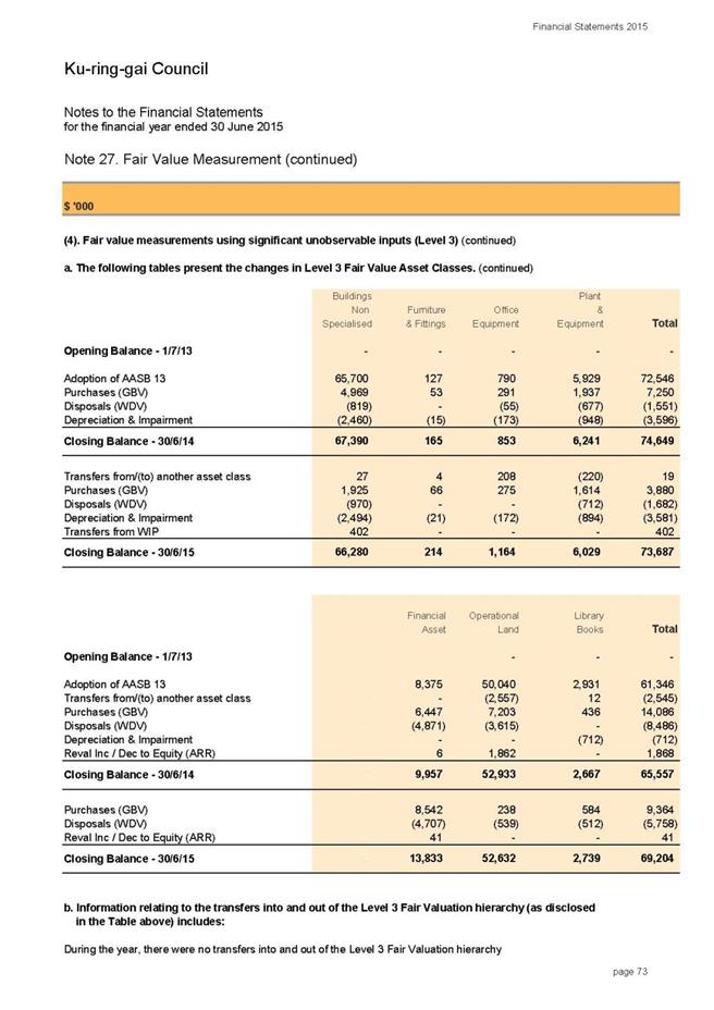
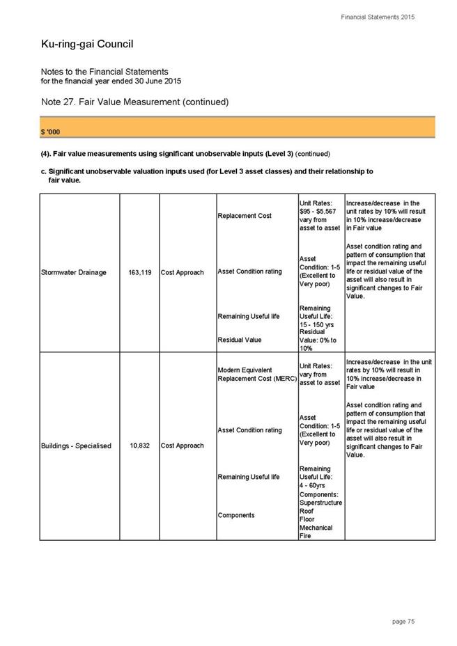
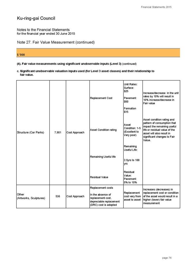
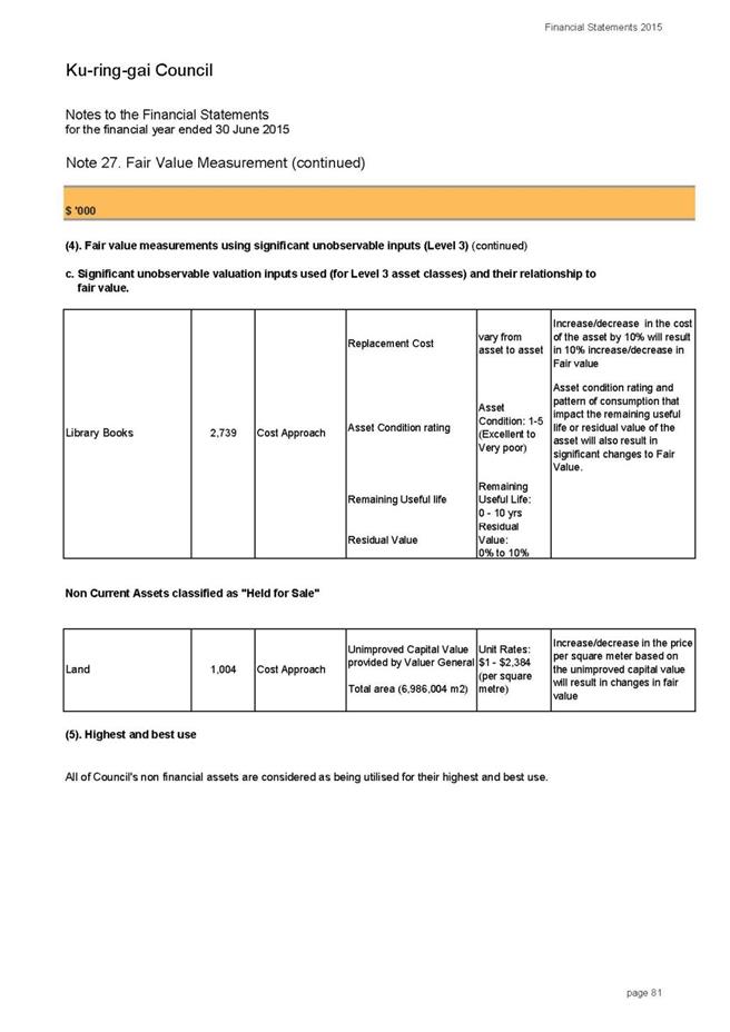
Note 20(c) - Assets Revaluation Reserve:
As part of the Revaluation of Infrastructure Assets at fair
values, Council reviewed and brought to account Fair values for the following
asset classes as at 30 June 2015:
- Roads
- Bridges
- Footpath
- Stormwater
Drainage
- Other
Structure
As part of this revaluation and measurement process, the remaining
useful life of each asset has been reassessed to actual. The reassessment
resulted in a material difference as to where some assets actually sit in
relation to their asset life cycle relative to what the value of accumulated
depreciation in Council’s Financial Reports had previously indicated. As a
result Council adjusted the accumulated depreciation for these asset classes to
reflect the correct value of depreciation. This adjustment was reflected
retrospectively in the opening balances (at 30 June 2014) of Infrastructure
Assets in the draft report (Note 9).
In accordance with Australian Accounting Standards, the
reassessment of the asset useful lives is deemed to be a change in accounting
estimate and is only required to be adjusted prospectively. As a result,
the adjustment that was initially recognised against the opening balance of
infrastructure assets was transferred to the asset revaluation reserve in the
current financial year. Therefore, the following movement in the revaluation reserve
was made:
· Opening Balance Infrastructure Assets
(Note 9) Accumulated Depreciation - Decrease $56,303k
· Asset Revaluation Reserve – Increase
$56,303k
It must be noted that this movement did not impact on the
closing balance of Council’s Infrastructure Assets or any other financial
indicators presented in the financial statements.
integrated planning and reporting
Leadership & Governance
|
Community Strategic Plan Long Term Objective
|
Delivery Program
Term Achievement
|
Operational Plan
Task
|
|
L2.1 Council rigorously manages its financial resources
and assets to maximise delivery of services.
|
L2.1.2 Council’s financial services provide accurate,
timely, open and honest advice to the community.
|
Manages financial performance to achieve targets as defined
in the Long Term Financial Plan.
|
Governance Matters
In accordance with Section 419(1) and 419(2) of the Act:
A council must present its
audited financial reports together with the auditor’s reports at a meeting of
Council held on the date fixed for the meeting; and
The council’s auditor may, and
if so required in writing by the council must, attend the meeting at which the
financial reports are presented.
In addition, Section 417(5) of the Act states that:
As soon as practicable after
receiving the auditor’s reports, the council must send a copy of the auditor’s
report on the council’s financial reports, together with a copy of the
council’s audited financial reports, to the Director General – Office of Local
Government and to the Australian Bureau of Statistics.
Risk Management
Council is financially sound which
positions it well to deal with unforseen events as they arise.
The Financial Statements are
audited by the external auditors who, amongst other things, form an opinion on
the Financial Statements whether:
· the
Council’s accounting records have been kept in accordance with the requirements
of the Local Government Act 1993, Chapter 13 part 3 Division 2; and
· the
Financial Statements:
o have been presented in accordance with the requirements of this
Division;
o are consistent with the Council’s accounting records;
o present fairly the Council’s financial position, the results of its
operations and its cash flows; and
o are in accordance with applicable Accounting Standards and other mandatory
professional reporting requirements in Australia.
· all
information relevant to the conduct of the audit has been obtained; and
· there
are no material deficiencies in the accounting records or financial statements
that the auditors have become aware of during the course of the audit.
In accordance with s. 419 (1) of the Act, a council
must present its audited financial reports together with the auditor’s reports
at a meeting of Council held on the date fixed for the meeting. If Council does
not consider the Financial Statements at the appropriate time, it does not
comply with the requirements of the Act.
Financial Considerations
Council has achieved a sound financial result for 2014/15.
Council’s net operating result for the financial year ended 30 June 2015 is a
surplus of $22.58m including Grants and Contributions for capital purposes.
After adjusting for Capital Grants and Contributions, the net operating result
was $13.46m.
The actual working capital for 2014/15 is $4.67m in line
with the target identified in Council’s Annual Budget.
Social Considerations
Not applicable.
Environmental Considerations
Not applicable.
Community Consultation
Council’s Financial Statements will be on public exhibition
from 11 September 2015 seeking comments from the community on the Statements
and the Auditor’s Reports. Section 420 of the Act requires that all
submissions in respect of the audited Financial Reports must be in writing and
must be lodged with the Council within 7 days after this meeting. Public
submissions may be made up to 13 October 2015. Copies of all submissions
received must be referred to Council’s Auditor.
Internal Consultation
All departments have been consulted on the end of year
financial results for 2014/15.
Summary
The Annual Financial Statements for the year ended 30 June
2015 and audit reports from Council’s external auditor, UHY Haines Norton
Chartered Accountants are presented to Council. Written submissions from the
public have been invited, and may be made up to 13 October 2015. Copies of all
submissions must be referred to Council’s auditor. This is the final stage of
the process of adopting Council’s Annual Financial Statements for 2014/2015.
|
Recommendation:
That Council receives the audited Financial Statements and
the external auditor’s report from UHY Haines Norton Chartered Accountants
|
|
Angela Apostol
Manager Finance
|
David Marshall
Director Corporate
|
|
Attachments:
|
A1View
|
Annual
Financial Statements for the year ended 30 June 2015
|
|
2015/256079
|
|
APPENDIX
No: 1 - Annual
Financial Statements for the year ended 30 June 2015
|
|
Item No: GB.1
|


|
Ordinary
Meeting of Council - 6 October 2015
|
GB.2 / 156
|
|
|
|
|
Item
GB.2
|
S05273
|
|
|
18 September 2015
|
Investment Report as at 31 August 2015
EXECUTIVE
SUMMARY
|
purpose of report:
|
To present Council’s investment portfolio performance
for August 2015.
|
|
|
|
|
background:
|
Council’s investments are reported monthly to Council
in accordance with the Local Government Act 1993, the Local Government
(General) Regulation 2005 and Council’s Investment Policy.
|
|
|
|
|
comments:
|
The net return on investments for the financial year
to August 2015 was $622,000 against a budget of $619,000 giving a YTD
favourable variance of $3,000.
|
|
|
|
|
recommendation:
|
That the summary of investments performance for August
2015 be received and noted; and that the Certificate of the Responsible
Accounting Officer be noted and report adopted.
|
Purpose of Report
To present Council’s investment portfolio performance for
August 2015.
Background
Council’s investments are reported monthly to Council in
accordance with the Local Government Act 1993, the Local Government (General)
Regulation 2005 and Council’s Investment Policy.
Comments
Investment
Portfolio Performance Snapshot
The table below provides the investments portfolio
performance against targets identified in Council’s Investment Policy as well
as other key performance indicators based on industry benchmarks.

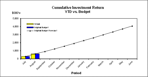
Cumulative Investment
Returns against Budget
The net return on investments for the financial year to
August 2015 was $622,000 against a budget of $619,000 giving a YTD favourable
variance of $3,000. Council will monitor the investment performance and budget
target and make adjustments if required in Quarterly Budget Reviews.
The total return on investments (interest and net capital
gain) for the month of August is provided below.

A comparison of the cumulative investment returns against
year to date original budget is shown in the Chart below.
Cash
Flow and Investment Movements
Council’s total cash and
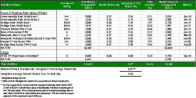
investment portfolio at the end of August 2015 was $110,535,000. This compares
to $99,812,000 at the end of July 2015, the net cash inflow for the month was
$10,723,000. This was mainly due to the first instalment of rates income.
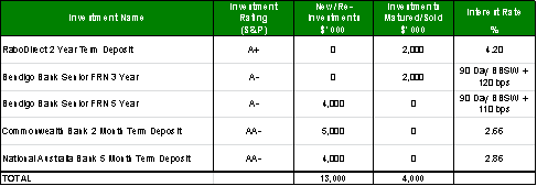
Two investments have
matured/traded in August 2015 and three new investments were made during the
month.
Table 1 below provides detailed
movements of the investment by institution name, investment rating and interest
rate.
Table 1 – Investment Movements – August 2015
Investment
Performance against Industry Benchmarks
Overall during the month of
August the investments performance was well above industry benchmark. The
benchmark is specific to the type of investment and details are provided below.
Ø UBS Bank Bill Index is used for all Council’s
investments
A comparison of the portfolio
returns against investment benchmark is provided in Table 2 below.
Table
2 - Investments Performance against Industry Benchmarks

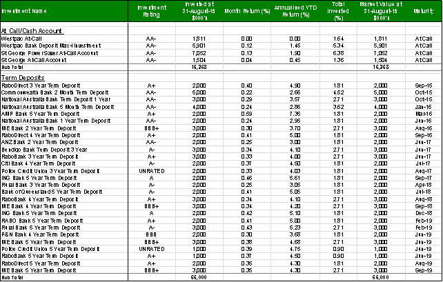
Table 3 below provides a summary
of all investments by type and performance during the month.
Attachment A1 provides
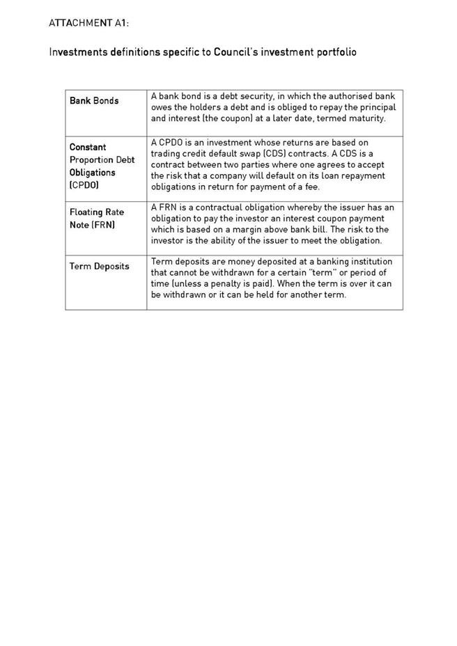
definitions in relation to different types of investments.
Table
3 - Investments Portfolio Summary during August 2015
Investment
by Credit rating and Maturity Profile
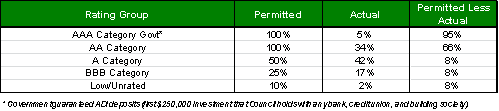
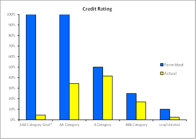
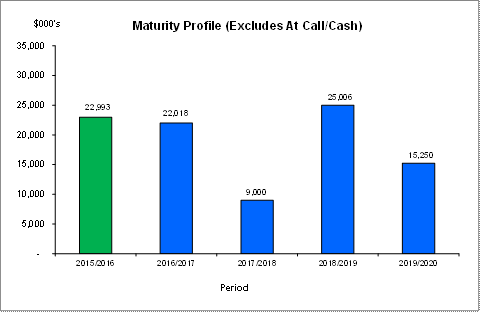
The allocation of Council’s investments by credit rating and
the maturity profile are shown below:
integrated planning and reporting
Leadership & Governance
|
Community Strategic Plan Long Term Objective
|
Delivery Program
Term Achievement
|
Operational Plan
Task
|
|
L2.1 Council rigorously manages its financial
resources and assets to maximise delivery of
services
|
Council maintains and improves its long term financial
position and performance.
|
Continue to analyse opportunities to expand the revenue
base of Council
|
Governance Matters
Council’s investments are made in accordance with the Local
Government Act (1993), the Local Government (General) Regulation 2005 and
Council’s Investment Policy.
A revised Investment Policy was adopted by Council on 10
December 2013.
Section 212 of the Local Government (General) Regulation
2005 states:
(1) The
responsible accounting officer of a council:
(a) must
provide the council with a written report (setting out details of all money
that the council has invested under section 625 of the Act) to be presented:
(i) if
only one ordinary meeting of the council is held in a month, at that meeting,
or
(ii) if
more than one such meeting is held in a month, at whichever of those meetings
the council by resolution determines, and
(b) must
include in the report a certificate as to whether or not the investment has
been made in accordance with the Act, the regulations and the council’s
investment policies.
(2) The report must be made up to the last day of
the month immediately preceding the meeting.
Risk Management
Council manages the risk associated with investments by
diversifying the types of investment, credit quality, counterparty exposure and
term to maturity profile.
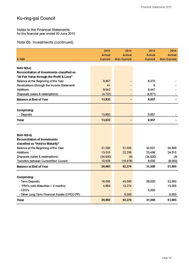
Council invests its funds in accordance with The Ministerial
Investment Order.
All investments are made with consideration of advice from
Council’s appointed investment advisor, CPG Research & Advisory.
Council has one “Grandfathered” investment in structured
products that was previously entered into in accordance with The Ministerial
Investment Order at the time. The Ministerial Investment Order no longer allows
investment in this product. This investment is:
CPDO PP – Royal Bank of Scotland
This Constant Proportion Debt Obligations Principal
Protected (CPDO PP), with a face value of $6,000,000, is invested by Council on
a “held to maturity” basis being September 2016. This CPDO is capital protected
at maturity date by Royal Bank of Scotland. Since December 2011 it ceased to
pay interest, due to a decrease in the credit indices it was linked to,
creating an unwind event. The investment now takes the form of a zero coupon
senior bank bond with a value of $6M. While Council intends to hold this
investment to maturity, the market value at 31 August 2015 was quoted by RBS
Morgan at $5,785,000.
Financial Considerations
The budget for interest on investments for the financial
year 2015/2016 is $4,068,000. Of this amount approximately $2,812,000 is
restricted for the benefit of future expenditure relating to development contributions,
$687,400 transferred to the internally restricted Infrastructure & Facility
Reserve, and the remainder of $568,600 is available for operations.
Social Considerations
Not applicable.
Environmental Considerations
Not applicable.
Community Consultation
None undertaken or required.
Internal Consultation
None undertaken or required.
Certification - Responsible Accounting
Officer
I hereby certify that the investments listed in the attached
report have been made in accordance with Section 625 of the Local Government
Act 1993, clause 212 of the Local Government General Regulation 2005 and
Council’s Investment Policy.
Summary
As at 31 August 2015:
Ø Council’s total cash and investment
portfolio is $110,535,000.
Ø Council’s net return on investments for
the financial year to August 2015 was $622,000 against a budget of $619,000,
giving a YTD favourable variance of $3,000.
|
Recommendation:
A. That
the summary of investments and performance for August 2015 be received and
noted.
B. That
the Certificate of the Responsible Accounting Officer be noted and the report
adopted.
|
|
Tony Ly
Financial Accounting Officer
|
Angela Apostol
Manager Finance
|
|
David Marshall
Director Corporate
|
|
|
Attachments:
|
A1View
|
Investments
definitions specific to Council’s investment portfolio
|
|
2015/017138
|
|
APPENDIX
No: 1 - Investments
definitions specific to Council’s investment portfolio
|
|
Item No: GB.2
|
|
Ordinary
Meeting of Council - 6 October 2015
|
GB.3 / 165
|
|
|
|
|
Item
GB.3
|
S03779/2
|
|
|
25 August 2015
|
Policy for the Payment of Expenses and
Provision of Facilities to Councillors
EXECUTIVE
SUMMARY
|
purpose of report:
|
To
re-adopt the Policy for the Payment of Expenses and Provisions of Facilities
to Councillors.
|
|
|
|
|
background:
|
Each
Council must adopt a policy concerning the payment of expenses incurred or to
be incurred by, and the provision of facilities to, the mayor, the deputy
mayor and the other councillors in relation to discharging the functions of
civic office.
On
25 November 2014 Council adopted the revised Policy for the Payment of
Expenses and Provisions of Facilities to Councillors.
There
were minor changes in this policy being:
· Increase on all monetary limits throughout the
policy in line with the CPI index for Sydney at 2.9% for the 2014/2015
financial year.
· Reformatting
into the new policy template.
|
|
|
|
|
comments:
|
Section 252 of the
Local Government Act 1993 requires Council to re-adopt such a policy within
five (5) months of 30 June each year.
Section 253 (3) of the
Act states that a council need not give public notice of amendments to its
policy for the payment of expenses or provision of facilities if the council
is of the opinion that the proposed amendment is not substantial.
There are minor changes
to the policy:
· an increase
of 2.2% being the CPI index for Sydney for the 2014/2015 financial year, and
· Clarification
that Councillors receive complimentary tickets to all Council functions and
events.
These
changes are not considered to be substantial amendments to the policy and do
not require the policy to go on public exhibition.
|
|
|
|
|
recommendation:
|
That the revised Policy
for the Payment of Expenses and Provision of Facilities to Councillors be
adopted.
|
Purpose of Report
To re-adopt the Policy for
the Payment of Expenses and Provisions of Facilities to Councillors.
Background
Each Council must adopt a policy concerning the payment of
expenses incurred or to be incurred by, and the provision of facilities to, the
mayor, the deputy mayor and the other councillors in relation to discharging
the functions of civic office. Council must not pay any expenses incurred or
to be incurred by, or provide any facilities to, the mayor, the deputy mayor or
a councillor otherwise than in accordance with the policy.
On 25 November 2014, Council adopted a revised Policy for
the Payment of Expenses and Provision of Facilities to Councillors (see
Attachment A1). Section 252 of the Local Government Act 1993 requires
Council to re-adopt such a policy by November each year.
Comments
The purpose of the policy is to ensure that councillors
receive adequate and reasonable expenses and facilities provided to the
councillors, the cost of which shall be met by Council.
The current policy has now been reviewed (see Attachment
A2). The only changes to the previously adopted policy are listed as follows:
· For the 2015/2016 financial year
increase on all monetary limits within the policy in line with the CPI index
for Sydney at 2.2% for the 2014/2015 financial year.
· Spouse and Partner Expenses to include
costs associated with attendance at Council functions and events
· Clarification that Councillors are
entitled to complimentary tickets to all Council functions and events.
Section 252 of the Local Government Act 1993 requires Council
to re-adopt such a policy within five (5) months of 30 June each year.
Section 253 (3) of the Act states that a council need not give
public notice of amendments to its policy for the payment of expenses or
provision of facilities to Councillors if the council is of the opinion that
the proposed amendment is not substantial.
Risk Management
This policy establishes the provision of councillor expenses
and facilities in a manner that is transparent and accountable.
Financial Considerations
As the monetary limits throughout the policy have been
increased in accordance with the CPI index for Sydney of 2.2% for 2014/2015
there will be a minor increase in costs to Council for the 2015/2016 financial
year. The increase has been provided for in the 2015/16 budget.
Social Considerations
It is considered that council’s policy adequately reflects
the needs of Councillors in carrying out their civic roles.
Environmental Considerations
There are no environmental considerations associated with
the recommendation in this report.
Community Consultation
There was no community consultation in line with Section
253(3) of the Local Government Act 1993 which states that public exhibition of
the policy is not required if the amendments to the policy are not considered
to be substantial.
Internal Consultation
None undertaken or required.
Summary
On 25 November 2014, Council adopted a revised Policy for
the Payment of Expenses and Provision of Facilities to Councillors. Section 252
of the Local Government Act 1993 requires Council to have such a policy
and re-adopt the policy within five (5) months of 30 June each year.
The current policy has now been reviewed. Section 253 (3) of
the Act states that a council need not give public notice of amendments to its
policy for the payment of expenses or provision of facilities to Councillors if
the Council is of the opinion that the proposed amendment is not substantial.
Attachment A1 is the draft policy with all monetary limits
increased by 2.2% being the CPI increase for Sydney for 2014/2015 financial
year. Together with clarification that Councillors are entitled to
complimentary tickets to all Council functions and events.
Attachment A2 is the existing policy adopted by Council on
25/11/2014.
|
Recommendation:
That the revised Policy for the Payment of Expenses and
Provision of Facilities be adopted.
|
|
Christine Dunand
Governance Officer
|
David Marshall
Director Corporate
|
|
Attachments:
|
A1View
|
Draft
Policy for the Payment of Expenses and Provision of Facilities to Councillors
|
|
2015/247399
|
|
|
A2View
|
Policy
for the Payment of Expenses and Provision of Facilities to Councillors
adopted by Council on 25/11/2014
|
|
2015/254432
|
|
APPENDIX
No: 1 - Draft
Policy for the Payment of Expenses and Provision of Facilities to Councillors
|
|
Item No: GB.3
|

|
APPENDIX No: 2 - Policy
for the Payment of Expenses and Provision of Facilities to Councillors
adopted by Council on 25/11/2014
|
|
Item No: GB.3
|


|
Ordinary
Meeting of Council - 6 October 2015
|
GB.4 / 224
|
|
|
|
|
Item
GB.4
|
CY00440/3
|
|
|
4 September 2015
|
Disclosures of Interest Returns Register
EXECUTIVE
SUMMARY
|
purpose of report:
|
To table Council’s Disclosure of Interest Returns
Register in accordance with Section 449 of the Local Government Act 1993.
|
|
|
|
|
background:
|
The Act places specific obligations on Councillors,
council delegates and council staff involved in making decisions or giving
advice on council matters to act honestly and responsibly in carrying out
their functions.
Councillors or designated persons need to complete and
lodge a written disclosure of interest return. The form of the return is
prescribed in Schedule 3 of the Local Government (General) Regulation 2005.
This obligation to lodge returns is as much a protection for Councillors and
designated persons as it is for the community.
Section 450A of the Act requires that the Disclosure
of Interest Return Register be tabled at the first meeting after 30 September
2015
|
|
|
|
|
comments:
|
All returns from Councillors and designated persons
have now been received and collated into a register. The register will be
tabled at the Ordinary Meeting of Council on 6 October 2015 which is
Council’s first meeting after the lodgement date of 30 September 2015.
|
|
|
|
|
recommendation:
|
That the tabling of the Disclosure of Interest Returns
Register be noted.
|
Purpose of Report
To table Council’s Disclosure of Interest Returns Register
in accordance with Section 449 of the Local Government Act 1993.
Background
The Act places specific obligations on Councillors, council
delegates and council staff involved in making decisions or giving advice on
council matters to act honestly and responsibly in carrying out their
functions.
Councillors or designated persons need to complete and lodge a
written disclosure of interest return. The form of the return is prescribed in
Schedule 3 of the Local Government (General) Regulation 2005. This obligation
to lodge returns is as much a protection for Councillors and designated persons
as it is for the community.
The General Manager must table the register of returns at the
first meeting after the lodgement date. The register is an important public
record. Councils must make it available for inspection to any member of the
public upon request. The return is also relied upon in complaints concerning
pecuniary interest breaches and issues relating to probity.
Comments
All returns from Councillors and designated persons have now
been received and collated into a register. The register will be tabled at the
Ordinary Meeting of Council on 6 October 2015 which is Council’s first meeting
after the lodgement date of 30 September 2015.
Governance Matters
Section 449 of the Local Government Act 1993 requires
the lodgement of returns disclosing interests of Councillors and designated
persons.
Under Section 450A(2) of the Act, returns for the period 1
July 2014 to 30 June 2015 must be tabled at the first Council meeting held
after the last day of lodgement. The last day of lodgement is
30 September 2015.
Risk Management
The provision of Disclosure of Interest Returns reduces the
risk of decisions being made or advice being provided that has been influenced
by competing interests. If Councillors and staff who are deemed designated
persons fail to submit a return, or complete the return inaccurately, it may
potentially expose the Councillor or designated person to action against them
at some time in the future.
Financial Considerations
There are no financial considerations associated with the recommendation
in this report.
Social Considerations
There are no social considerations associated with the
recommendation in this report.
Environmental Considerations
There are no environmental considerations associated with
the recommendation in this report.
Community Consultation
None required or undertaken.
Internal Consultation
None required or undertaken.
Summary
The Act places specific obligations on Councillors, council
delegates and council staff involved in making decisions or giving advice on
council matters to act honestly and responsibly in carrying out their
functions.
Section 449 of the Local Government Act 1993 requires
Councillors or designated persons to complete and lodge a written disclosure of
interests return. The form of the return is prescribed in Schedule 3 of the
Local Government (General) Regulation 2005. This obligation to lodge returns is
as much a protection for Councillors and designated persons as it is for the
community.
Under Section 450A(2) of the Act, returns for the period 1
July 2014 to 30 June 2015 must be tabled at the first Council meeting held
after the last day of lodgement. The last day of lodgement is
30 September 2015.
The Register will be tabled at the Ordinary Meeting of
Council on 6 October 2015.
|
Recommendation:
That the tabling of the Disclosure of Interest Returns
Register be noted.
|
|
Christine Dunand
Governance Officer
|
David Marshall
Director Corporate
|
|
Ordinary
Meeting of Council - 6 October 2015
|
GB.5 / 227
|
|
|
|
|
Item
GB.5
|
CY00259/7
|
|
|
18 September 2015
|
Delegation of Authority - Mayor and
Deputy Mayor - 2015/2016
EXECUTIVE
SUMMARY
|
purpose of report:
|
For Council to give consideration to granting
Delegations of Authority to the Mayor and Deputy Mayor.
|
|
|
|
|
background:
|
It has been Council’s practice to delegate some
additional functions to the Mayor and Deputy Mayor.
|
|
|
|
|
comments:
|
These functions are practical delegations which assist
the smooth functioning of the Mayoral Office.
|
|
|
|
|
recommendation:
|
That the Delegations of Authority as outlined in Attachment
A1 be granted to the Mayor and that the Delegations of Authority as
outlined in Attachment A2 be granted to the Deputy Mayor.
|
Purpose of Report
For Council to give consideration to granting Delegations of
Authority to the Mayor and Deputy Mayor.
Background
Section 226 of the Local Government Act 1993 outlines
the role of the Mayor. Section 226 states:
The role of the mayor is:
To exercise, in case of
necessity, the policy-making functions of the governing body of the Council
between meetings of the Council;
To exercise such other
functions of the Council as the Council determines;
To preside at meetings of the
Council;
To carry out the civic and
ceremonial functions of the Mayoral Office.
It has been Council’s practice to delegate some additional
functions to the Mayor and Deputy Mayor. These additional delegations for the
Mayor are outlined in Attachment A1 and for the Deputy Mayor in Attachment
A2.
Comments
These additional functions are practical delegations which
assist the smooth functioning of the Mayoral office.
integrated planning and reporting
Leadership and Governance
|
Community Strategic Plan Long Term Objective
|
Delivery Program
Term Achievement
|
Operational Plan
Task
|
|
Ku-ring-gai is well led, managed and supported by ethical organisations
which deliver projects and services to the community in listening, advocating
and responding to their needs.
|
Council’s Governance framework is developed to ensure
probity, transparency and the principles of sustainability are integrated and
applied into our policies, plans, guidelines and decision-making processes.
|
Compliance with the requirements of relevant Acts and
Regulations.
|
Governance Matters
Section 226 of the Local Government act 1993 outlines
the role of the Mayor.
Risk Management
There are no risk management considerations associated with
the recommendations in this report.
Financial Considerations
There are no financial considerations associated with the
recommendations in this report.
Social Considerations
There are no social considerations associated with the
recommendations in this report.
Environmental Considerations
There are no environmental considerations associated with
the recommendations in this report.
Community Consultation
None undertaken or required.
Internal Consultation
None undertaken or required.
Summary
For Council to give consideration to granting Delegations of
Authority to the Mayor and Deputy Mayor.
That the Delegations of Authority as outlined in Attachment
A1 be granted to the Mayor, and that the Delegations of Authority as
outlined in Attachment A2 be granted to the Deputy Mayor.
|
Recommendation:
A. That
the Delegations of Authority as outlined in Attachment A1 be granted
to the Mayor.
B. That
the Delegations of Authority as outlined in Attachment A2 be granted
to the Deputy Mayor.
|
|
Christine Dunand
Governance Officer
|
David Marshall
Director Corporate
|
|
Attachments:
|
A1View
|
Delegation
of Authority - Mayor
|
|
2015/250375
|
|
|
A2View
|
Delegation
of Authority - Deputy Mayor
|
|
2015/250376
|
|
APPENDIX
No: 1 - Delegation
of Authority - Mayor
|
|
Item No: GB.5
|
ATTACHMENT A1
DELEGATION
OF AUTHORITY – MAYOR
That, in addition of the role referred to in
Section 226 of the Local Government Act 1993 and by authority of Section 377 of
the Local Government Act 1993 and subject to compliance with any other
requirements of the Local Government Act or Regulations and expressed Policy of
the Council or regulations of any public authority concerned other than the
Council, the Mayor, Councillor Cheryl Szatow, be and is hereby authorised to
exercise or perform on behalf of the Council, the following powers,
authorities, duties and functions, and that such delegations shall remain in
force unless otherwise revoked or amended in whole or in part, as Council may
from time to time determine:
1. Donations
To approve
donations up to the sum of $250 subject to Council being informed of any such
decision, provided that funds are available within the sum voted by Council for
donations in the adopted Delivery Program and Operation Plan.
2. Purchase
Artwork from Ku-ring-gai Art Society
To purchase
artwork from Ku-ring-gai Art Society to the value of $1,000, provided that
funds are available within the sum voted by Council in the adopted Delivery
Program and Operation Plan.
3. Mayoral
Reception
To authorise expenditure for minor civic
receptions for visitors up to a maximum of $500 for any one reception, provided
that funds are available within the sum voted by Council in the adopted Delivery
Program and Operation Plan.
4. Temporary
General Manager during the General Manager’s Leave
In accordance with Section 351(1)(a) of the
Local Government Act, the Mayor be given the authority to appoint, after
consultation with the General Manager, a temporary General Manager during the
absence of the General Manager on leave.
5. General
Manager – Leave
Authority to approve applications for
holidays and leave of absence to the General Manager.
|
APPENDIX No: 2 - Delegation
of Authority - Deputy Mayor
|
|
Item No: GB.5
|
ATTACHMENT A2
DELEGATION
OF AUTHORITY – DEPUTY MAYOR
Pursuant to Section 231(3) of the Local
Government Act 1993 the Deputy Mayor may exercise any function of the Mayor at
the request of the Mayor or if the Mayor is prevented by illness, absence or
otherwise from exercising the function or if there is a casual vacancy in the
office of Mayor.
That the Deputy Mayor, Councillor David
Ossip, shall exercise the Delegation of Authority of the Mayor in those cases
where the General Manager certifies that the matter is of such an urgent nature
that it will not wait until the return of the Mayor.
|
Ordinary
Meeting of Council - 6 October 2015
|
GB.6 / 232
|
|
|
|
|
Item
GB.6
|
DA0050/15
|
|
|
13 July 2015
|
Release of a restriction on the use of
land - 33 Miowera Road North Turramurra
EXECUTIVE
SUMMARY
|
purpose of report:
|
To consider a request for the release of a restriction
on the use of land.
|
|
|
|
|
background:
|
Development Application DA0050/15 was approved under
delegated authority on 15 June 2015 for construction of a swimming pool and
cabana at 33 Miowera Road, North Turramurra.
The approval was conditional on the applicant meeting
a number of conditions, including obtaining approval, by resolution of
Council, for the release of a restriction which prohibits excavation, soil
level change and construction works in the vicinity of a tree which
previously existed on the site.
|
|
|
|
|
comments:
|
The property at 33 Miowera Road North Turramurra (Lot
14 DP1094029) is burdened by a restriction on the use of land for the purpose
of protection of a Sydney Blue Gum which has been removed pursuant to the NSW
RFS 10/50 Vegetation Clearing Scheme.
|
|
|
|
|
recommendation:
|
That Council resolve to release the restriction,
subject to conditions.
|
Purpose of Report
To consider a request for the release of a restriction on
the use of land.
Background
The property is currently burdened by a restriction on the
use of land for the protection of a Eucalyptus saligna (Sydney Blue Gum) tree.
The restriction was created pursuant to a condition in the
original consent for the subdivision of the land (DA0440/04, Torrens title subdivision of 1 lot into 4 lots)
which was approved by Council on 14 December 2004. Condition 48 of the
development consent reads:
48. The
creation of a Restriction on the Use of Land under Section 88B of the
Conveyancing Act 1919, burdening the area of land beneath the canopy of the
following tree/s for a specified radius in metres from the trunk of that tree,
the terms of which state that any excavations, soil level changes or
construction works are prohibited with the exception of any driveway as
approved by Council:
No./Tree/Location Radius
in Metres
1 / Eucalyptus saligna
(Sydney Blue Gum) 9 metres
Adjacent to the central eastern
boundary of Lot 14.
The restriction was created with the registration of the
subdivision on 12 April 2006 consistent with Condition 48.
The applicant has sought to have the restriction released as
the tree protected by the instrument has since been removed under the NSW Rural
Fire Service 10/50 Vegetation Clearing Scheme.
Development Application DA0050/15 for construction of a
swimming pool and cabana at 33 Miowera Road, North Turramurra was approved
under delegated authority on 15 June 2015.
DA0050/15 includes a condition that requires the applicant
to obtain approval, by resolution of Council, for the release of the
restriction on the use of land.
Condition 10 of the development consent reads as follows:
10. s.88B
A s.88B instrument for the protection of a tree exists
over the land. The instrument states that no “excavations, soil level changes
or construction works are prohibited with the exception of any driveway nor shall
the said trees be removed, except with the prior written consent of Ku-ring-gai
Council”. The instrument was enacted in 2006 due to a condition put on the
original consent (DA0440/04 for subdivision) approved by Council on 14 December
2004. This s.88B instrument shall be removed prior to excavation or construction of the
pool.
Reason: To comply with legal considerations.
The applicant has made the required application seeking to
release the restriction. These requirements include an undertaking from the
applicant to cover all of Council’s costs associated with the extinguishment in
the event that Council agrees to release the restriction on the title.
The acceptance of the application and the accompanying
assessment fee does not bind Council in any way to release the restriction.
Comments
The property, 33 Miowera Road, is currently burdened by a
restriction on the use of land for the protection of a Eucalyptus saligna
(Sydney Blue Gum) tree.
As the tree no longer exists (confirmed by site inspection),
the restriction no longer serves any useful planning purpose and may be
extinguished.
integrated planning and reporting
PLACES, SPACES & INFRASTRUCTURE
|
Community Strategic Plan Long Term Objective
|
Delivery Program
Term Achievement
|
Operational Plan
Task
|
|
P2.1 A robust planning framework is in place to deliver
quality design outcomes and maintain the identity and character of
Ku-ring-gai
|
Applications are assessed in accordance with State and
local plans
|
Assessments are of a high quality, accurate and consider
all relevant legislative requirements
|
Governance Matters
There are no governance matters.
Risk Management
There are no risk management matters.
Financial Considerations
There are no financial considerations that result as a
consequence of the resolution to extinguish the restriction. All legal costs
and applicable fees will be borne by the applicant.
Social Considerations
There are no social considerations.
Environmental Considerations
Environmental impacts have been determined and mitigated
through a separate development assessment and approval process undertaken for
DA0050/15.
Community Consultation
No community consultation is required.
Internal Consultation
Relevant staff from Council’s Planning and Landscaping
sections of the Development and Regulation Department and Council’s Corporate
Lawyer have been consulted.
Summary
The subject property is burdened by a restriction on the use
of land for the protection of a Sydney Blue Gum which has been removed, under the
10/50 Vegetation Clearing Code.
The applicant has submitted the required application seeking
the release of the restriction.
The restriction is no longer necessary and may therefore be
extinguished.
|
Recommendation:
A. That
Council grants approval to release the restriction on the use of land
burdening 33 Miowera Road North Turramurra (Lot 14 DP1094029).
B. That
authority be given to the General Manager and the Mayor to affix the Common
Seal of the Council to any required documentation for the release of the
restriction.
C. That
all costs associated with the release of the restriction, including any legal
costs and any further application fees is borne entirely by the applicant.
|
|
Amy Bentley
Senior Assessment Officer
|
Selwyn Segall
Team Leader - Development Assessment North
|
|
Corrie Swanepoel
Manager Development Assessment Services
|
Michael Miocic
Director Development & Regulation
|
|
Attachments:
|
A1View
|
Location
map
|
|
2015/231441
|
|
|
A2View
|
Zoning
map
|
|
2015/231448
|
|
|
A3View
|
Approved
pool plans DA0050/15
|
|
2015/158811
|
|
APPENDIX
No: 1 - Location
map
|
|
Item No: GB.6
|
|
APPENDIX No: 2 - Zoning
map
|
|
Item No: GB.6
|
|
APPENDIX No: 3 - Approved
pool plans DA0050/15
|
|
Item No: GB.6
|
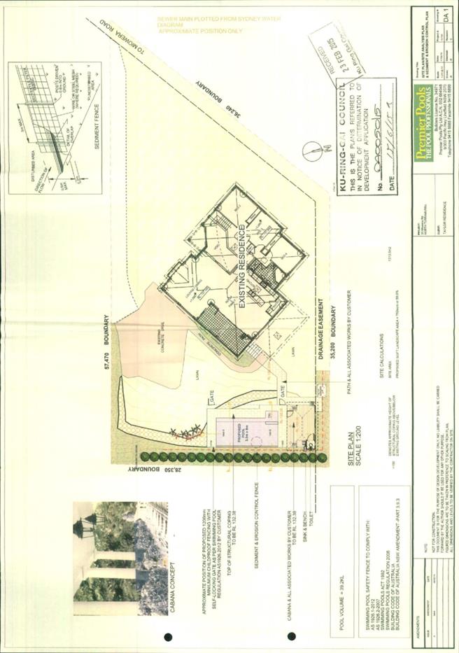
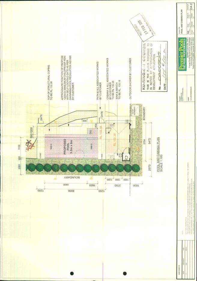
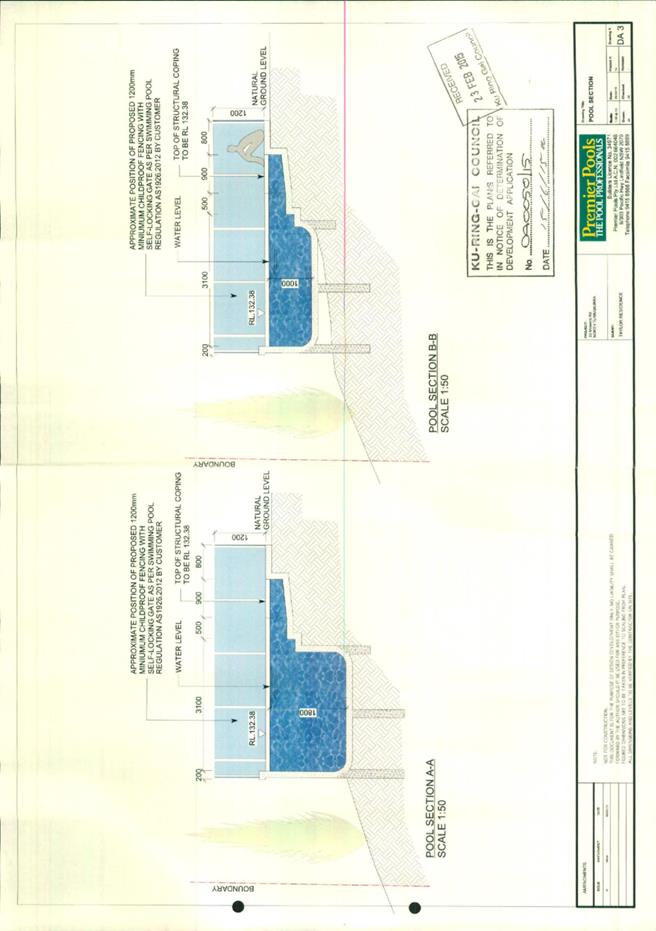
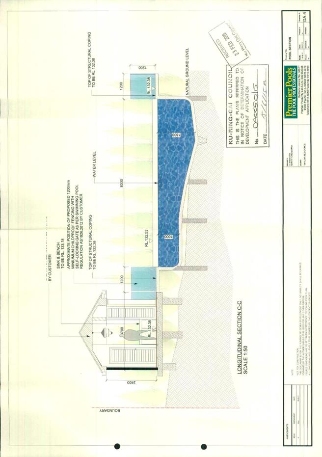
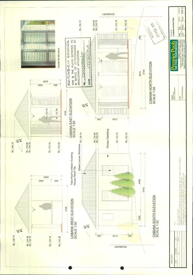
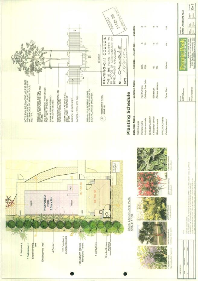
|
Ordinary
Meeting of Council - 6 October 2015
|
GB.7 / 244
|
|
|
|
|
Item
GB.7
|
DA0582/14
|
|
|
23 April 2015
|
Summary
Sheet
|
Report title:
|
1 to 3 Nulla
Nulla Street - Demolish Existing Structures and Construct a Multi-Dwelling
Housing Development comprising 15 Townhouses, Basement Parking and Landscape
Works
|
|
ITEM/AGENDA
NO:
|
GB.7
|
|
Application No:
|
DA0582/14
|
|
Property Details:
|
1 to 3 Nulla Nulla Street, Turramurra NSW 2074
Lot & DP No: Lot 1 DP 17642 (No. 1 Area: 797m2)
Lot 5 DP 17642 (No. 3 Area:
2466m2)
Site area (m2): 3,254m2 (excluding
239m2 access handle)
Zoning: R3 Medium density residential
|
|
Ward:
|
Wahroonga
|
|
Proposal/Purpose:
|
To determine Development Application No. DA0582/14 for
the demolition of two dwellings and the construction of multi dwelling
housing, comprising 15 townhouses, basement parking and landscape works.
|
|
Type of Consent:
|
Local
|
|
Applicant:
|
Mackenzie Architects International
|
|
Owner:
|
Mrs LM Arthur (1 Nulla Nulla Street)
Mr AI Topfer & Mrs S Topfer (3 Nulla Nulla Street)
|
|
Date Lodged:
|
19 December 2014
|
|
Recommendation:
|
Approval
|
Purpose of Report
To determine Development Application No. DA0582/14 for the
demolition of two dwellings and the construction of a multi dwelling housing
development, comprising 15 townhouses, basement parking and landscape works.
integrated planning and reporting
Places, Spaces & Infrastructure
|
Community Strategic Plan Long Term Objective
|
Delivery Program
Term Achievement
|
Operational Plan
Task
|
|
P3.1 The built environment delivers attractive,
interactive and sustainable living and working environments.
|
A high standard of design quality and building environmental
performance is achieved in new development
|
Assessment of applications is consistent with Council’s
adopted LEPs and DCPs.
|
Executive Summary
Issues: Minimum
street frontage
Submissions: 19
submissions received
Land & Environment Court: N/A
Recommendation: Approval
History
Site
Council’s records indicate that the site has historically
been used for residential purposes.
Pre-DA
There was no Pre-DA consultation.
|
DA History
|
|
|
19 December 2014
|
Application lodged
|
|
16 January 2015 to 16 February
2015
|
The application was notified to
neighbouring property owners for a period of 30 days. 19 submissions were
received.
|
|
13 May 2015
|
A letter was sent to the
applicant advising of outstanding issues relating to:
Building Code of Australia
- Provision of sanitary compartment in basement;
Planning
- submission of Clause 4.6 exception to development standard for
minimum street frontage
- solar access to principal private open space
- dwelling depth, width and room size
- building articulation
- top storey design for Building B
- external air clothes drying facilities
- updated access report
Urban Design
- basement
car park ventilation stacks
- front
fence details
- air
conditioning units
- inaccuracies
on the plans
Landscaping
- amended
BASIX
- Deep
soil landscaping
|
|
23 June 2015
|
Amended plans and additional
information was received from the applicant.
|
|
22 July 2014
|
A letter was sent to the
applicant advising of remaining outstanding issues relating to:
Urban Design
- inaccuracies
on the landscaping plans
- cavity
walls for subterranean units
- courtyard
walls at Building A
Landscaping
- deep
soil landscaping
- inaccuracies
on the landscaping plans
|
|
29 July 2015
|
Amended plans and additional
information was received from the applicant.
|
|
13 August 2015
|
A letter was sent to the
applicant advising of remaining outstanding issues relating to:
Landscaping
- deep
soil landscaping
- inaccuracies
on the landscaping plans
- courtyard
fencing
|
|
18 August 2015
|
Amended plans and additional information
was received from the applicant.
|
The Site
Site description
The site is located on the southern side of Nulla Nulla
Steet, to the east of its intersection with Turramurra Avenue.
The site comprises two allotments with a combined frontage
of 21.33m to Nulla Nulla Street and a depth of 128.35m. The rear lot is a
battle-axe lot with a 72m access handle and contains a tennis court, swimming
pool, two storey dwelling and a separate 50m long pedestrian access handle
which terminates at Turramurra Avenue and comprises an area of 2,466 m2.
The front lot contains a single storey dwelling, detached carport within the
street setback and comprises an area of 797m2. The combined site
area is 3,254m2 (including the access handle).
The site is located 550m from Turramurra Railway Station.
Surrounding development
The subject site is located within a corridor of land zoned
R3 Medium Density Residential (R3). It has an eastern interface with land zoned
R2 Low Density Residential (R2) located two blocks to the east at No.11, No.15
and No.17 Nulla Nulla Street. These properties comprise single storey and two
storey dwellings with generous street setbacks and formal gardens. The western
side of the site is zoned R4 High Density Residential (R4). A residential flat
building (RFB) adjoins the site at No. 7 to No. 11 Turramurra Avenue and is the
first RFB on the eastern side of Turramurra Avenue. The western side of
Turramurra Avenue is zoned R4 and is experiencing significant urban
consolidation with a number of recently competed RFBs.
The site represents a transition in density between the R4
and R2 zones.
The Proposal
The proposal involves the demolition of the two existing
dwelling houses and the construction of fifteen, two and three storey
townhouses, associated basement car parking and landscaping.
The applicant is seeking consent for the following:
· Demolition of all existing buildings
and structures, and site preparation works;
· Construction of 15 townhouse
dwellings split between 3 buildings:
- Building
A 3 x two storey townhouses with roof terrace fronting Nulla Nulla Street;
- Building
B 3 x three storey townhouses with attic space;
- Building
C 3 x two storey townhouses with roof terrace; and
- Building
D 3 x two storey townhouses with roof terrace.
· Three split levels of basement car
parking for 34 vehicles to accessed via Nulla Nulla Street;
· Removal of identified on-site trees
and significant new tree planting and landscaping of the site; and
· A landscaped pedestrian path to
Turramurra Avenue.
Consultation
Community
In
accordance with the Local Centres DCP, owners
of surrounding properties were given notice of the application. In
response, submissions from the following were received:
1. Mrs F Thiele & Mr F Thiele- 22/7-11 Turramurra Avenue,
Turramurra
2. Mr R J & Mrs K M Morrison -21/7-11 Turramurra Avenue,
Turramurra
3. Mr M Davies -Level 25, 2 Park Street, Sydney
4. Mr C G Middleton-PO Box 178, Turramurra
5. Mr E A & Mrs D M Blom-PO Box 642, Turramurra
6. Mrs L M Logaraj-15 Nulla Nulla Street, Turramurra
7. Mr D Shinde-17/7-11 Turramurra Avenue, Turramurra
8. Mr A Farzanfar-23/7-11 Turramurra Avenue, Turramurra
9. Mr J & Mrs D Colvin-3/1 Turramurra Avenue, Turramurra
10. Mrs N C A E Aubrey-4/1 Turramurra Avenue, Turramurra
11. Mr C Qing & Ms J Liu -11/7-11 Turramurra Avenue, Turramurra
12. Mr A C & Mrs M M McDougall-16/7-11 Turramurra Avenue,
Turramurra
13. Mrs R Skilbeck-5/7-11 Turramurra Avenue, Turramurra
14. Dr J J & Mrs K M Lowke -6/7-11 Turramurra Avenue, Turramurra
15. Mrs J M Check-3 Moir Place, Green Point
16. Mrs J Crawford-30 Ku-Ring-Gai Avenue, Turramurra
17. Mr G Sideridis- 11 Nulla Nulla Street, Turramurra
18. Mrs S M McNee - PO Box 468, Turramurra
19. Mr I & Mrs A Nieuwland-4/7-11 Turramurra Avenue, Turramurra
Minimum lot frontage for
multi-dwelling housing
The site has a lot frontage of 21.335m and does not satisfy
the 30m development standard for multi dwelling housing established under
Clause 6.5(2) of the Local Centres LEP. The requested variation to the street
frontage development standard submitted by the applicant in accordance with
Clause 4.6 of the Local Centres LEP is supported.
The reduced lot frontage has not resulted in any significant
non-compliances that would suggest the development would result in a
development with poor amenity for future residents and the surrounding area.
The site benefits from a separate 4.57m
wide pedestrian access handle terminating at Turramurra Avenue and will serve
as an important line of travel for residents accessing the local centre of
Turramurra and the railway station.
The proposed lot configuration will not affect future site
amalgamation and redevelopment of adjoining R4 land to the west of the site at
No. 3 to 5 Turramurra Avenue or R3 land to the east at No. 5 to 9 Nulla Nulla
Street. Any future development at No. 5 Nulla Nulla Street (battle axe block)
will rely on a site amalgamation with No. 7 Turramurra Avenue and/or No. 9
Turramurra Avenue.
Building design, streetscape and overdevelopment of
the site
The development proposal satisfies all the development
standards relating to building bulk, height and landscaping, resulting in an
appropriate development for the locality, consistent with the R3 medium density
zoning.
Car parking, manoeuvring and access
Council’s Development Engineer has not raised concerns
regarding vehicle access, driveway or the basement car parking design.
Traffic generation during construction and during
operation
Councils’ Development Engineer has not raised any concerns
regarding the potential for the development to generate significant amounts of
traffic. Furthermore, 27 car spaces are required in accordance with the Local
Centres DCP and the proposal provides 34 off-street car spaces. Accordingly, it
would be unreasonable for Council to request additional off-street car parking
beyond what is provided.
A construction traffic management plan will be required to
be implemented during construction and has been recommended (Condition 11).
In addition, a construction works zone will be required along the site
frontage. This will assist in minimising impacts in relation to vehicle sight
lines, general road safety and conflicts with construction related vehicles (Condition
12).
Inadequate tree retention
Council’s Landscape Assessment Officer has not raised
concerns regarding tree retention at the site. The proposal involves the
retention of approximately 35 trees and the provision of 10 new canopy
replenishment trees to be located within the front, side, rear and along the
pedestrian access handle and this is acceptable.
The site does contain vegetation identified as an area of
biodiversity significance under the Local Centres LEP. An Eucalyptus
punctata (Grey Gum) is located within the street setback. This species is
characteristic of the Sydney Turpentine Ironbark Forest and is an Endangered
Ecological Community protected under Threatened Species Conservation Act 1995.
The proposal does not propose removal of this tree and conditions are
recommended to ensure its protection during construction (Conditions 14, 22
and 64).
Overshadowing
The proposal will not result in less than 3 hours of solar
access to the living rooms and principal private open space of adjoining
properties during midwinter between 9am and 3pm on June 21. The proposal
therefore complies with the Local Centres DCP solar access control.
Visual and acoustic privacy
The potential for unreasonable overlooking resulting from
the development is mitigated by compliant front, side and rear setbacks and
adequate building separation within the site. In addition, living areas and
private open space are designed to face the front of each building and are not
orientated to side boundaries.
The periphery of the site will be in common ownership,
allowing for uniform planting along the side and rear boundaries to form a
visual screen which will soften the built form from adjoining properties. To
minimise overlooking of the principal private open space at No. 4/1 Turramurra
Avenue, the window to Bedroom No. 2 at Townhouse No.13 (Building E) was amended
by the applicant to a highlight window.
Construction noise will be managed via a condition requiring
a noise and vibration management plan to be prepared in accordance with AS 2436-2010
and the Office of Environment and Heritage Interim Construction Noise
Guidelines to ensure minimal impacts for sensitive receptors (Condition 18).
Conditions 33, 34 and 73 are recommended to ensure
ongoing noise management of air conditioning units and other plant at the site.
View loss
The development proposal will not result in significant view
loss, noting there are no
iconic or significant views across the subject site.
Further, the proposal complies with the
height, FSR, setbacks and landscaping controls of the Local
Centres LEP and DCP.
Communal open space
The proposal provides 235m2 of communal space
with a minimum dimension of 8m. This communal space does not satisfy the Local
Centres DCP control but is sufficient given the allocation of common area for
planting and the over provision of private open space that will ensure a high
level of amenity.
Roof top terraces
The proposed roof top terraces areas do not exceed the 11.5m
building height development standard and provide a high level of residential
amenity in terms of solar access. They do not result in unreasonable privacy
impacts, noting the terrace areas are orientated internally within the
development site, have adequate building separation and adequate setbacks (3m)
to the side boundaries.
Excavation impact
Council’s Development Engineer did not raise any concerns
regarding the excavation impact. Conditions requiring dilapidation surveys in
order to document the baseline structural condition of neighbouring dwellings
are recommended as contingency against damage caused during excavation and
construction (Condition 9 and 10).
Property devaluation
The devaluation of property is not a consideration under
Section 79C (1) of the Environmental Planning and Assessment Act 1979.
Within Council
Engineering
Council’s Development Engineer commented on the proposal as
follows:
“Stormwater disposal
It is proposed to have the site
discharge directed to the existing kerb inlet pit in Nulla Nulla Street via a
150mm diameter pipe.
The stormwater plans submitted
detail a system which complies with Council’s Local Centres DCP in relation to
on-site detention and retention, water quality and discharge from the site. The
stormwater plans shows a combined on-site detention and retention tank
comprising 62m3 and 20,000 Litres (L) of storage, respectively,
located within the Building A basement and accessed externally from the
landscaped area within the street setback.
The rainwater retention and
re-use (OSD tanks) meet the BASIX commitments, and satisfied the 50% reduction
in runoff days required under Volume C Part 4B.3 of the Local Centres DCP. The
results confirm that a 15,000L rainwater tank will reduce site runoff days by
89%. The sizing of the on-site detention volume has also satisfied the
requirements described in Volume C Part 4B.5 of the Local Centres DCP with an
offset of 10% allowed for rainwater re-use. The design of the OSD system also
provides a freeboard of 700 millimetres (mm) from the top water level to the
habitable finished floor levels of the development which is more than adequate.
A pump-out system with storage
capacity of 4.4m3 has been provided within the basement carpark to
drain the driveway area only. It has been designed to have the rising main
discharge to the water quality chamber within the OSD tank. Refer to discussion
below regarding tanked basement construction.
The BASIX commitments are for
re-use of stored rainwater for irrigation of 983m2 of common
landscaped areas. The stormwater report also suggests the collected water will
be reused for laundry and toilet flushing. A central rainwater tank of 15m3
is proposed which satisfies the water commitments.
Water quality measures using
MUSIC Modelling have been implemented into the design. The applicant has provided
a proprietary pollution chamber Stormwater360 ‘StormFilter’ located within the
OSD tank prior to connection into Councils public drainage system which is an
acceptable and effective measure for nutrient reduction. The results of the
post-development nutrient control measures have been achieved when compared to
the stormwater treatment standards / targets outlined in Volume C Part 4B.6 of
the Local Centres DCP.
Traffic generation
According to the traffic
generation rates nominated by The Roads & Maritime Services (RMS) ‘Guide to
Traffic Generating Developments’, the development would generate 8 additional
peak hour vehicle trips which would represent one vehicle trip every 7.5
minutes during the peak hour. According to the above guidelines the vehicle
trips are relatively minor. The increase in traffic flows in Nulla Nulla Street
is not expected to have a significant effect on traffic flows or on the
operation of the intersection with the arterial road network.
Vehicle access and
accommodation arrangements
The site is zoned R3 under the
Local Centres LEP. The parking provisions have been determined using the Local
Centres DCP for multi-dwelling housing. The site is located greater than 400m
walking distance from the Turramurra Railway Station. The following parking
provisions have been adopted:
Volume C Part 2R.2 ‘Car
Parking Rates’ Local Centres DCP
|
Multi Dwelling Housing
|
Parking Space Requirement
|
|
1 bedroom unit
|
1 space per unit
|
|
2 bedroom unit
|
1.25 space per unit
|
|
3 bedroom unit
|
1.5 spaces per unit
|
|
Visitor car spaces
|
1 space per 4 units
|
15 x 3 bedrooms = 15 x 1.5
spaces/unit = 23 spaces
15 dwellings - visitor space/4
dwellings = 4 visitor spaces
Total parking spaces required =
27 spaces
The development proposes 34
off-street parking spaces, comprising 29 residents’ spaces (includes 2
adaptable space) and 5 visitor spaces.
Vehicular access to the car
parking facility is to be provided via a new 6.1m wide entry / exit driveway
crossing which narrows internally from the ramp down to 5.0m at the basement
entry level. The driveway clear width satisfies the requirements of Volume C
Part 2.2 of the Local Centres DCP.
A temporary service space can
be provided which can be shared with the dedicated loading bay. The minimum
dimension of 3.5m x 6m has been satisfied and provides adequate manoeuvring for
a service/removalist vehicle and easily accessible by Council’s waste
collection vehicle.
The driveway gradients comply
with Australian Standard 2890.1 (2004) “Off-Street car parking” as do the
dimensions of the parking bay, ramp grades and aisle widths. The adaptable
parking space width also complies with AS2890.6 (2009).
A driveway longitudinal section
has been shown on the engineering plan which satisfies Council’s Standard High
Level vehicular crossing profile.
Waste collection
The development allows a
garbage truck to enter and depart the garbage/room recycle storage area in a
forward direction. The driveway grades and turning manoeuvrability are suitable
for the small waste collection vehicle.
A clear head height of 2.6m has
been provided to access the basement area as indicated on the driveway
longitudinal section plan. The section plan also indicates approximately 3m
clearance over the travel path of the waste service vehicle.
The proposed 38x240L bins for
waste, paper and recycling satisfies the minimum bin requirements.
The requirements as per Volume
C Part 3.4 of the Local Centres DCP have been satisfied.
Construction management
An indicative construction
traffic management plan (CTMP) has been discussed within the traffic report
which is acceptable for DA purposes. Based on the scale of works and expected
construction vehicle movements, a detailed construction traffic management plan
(CTMP) must be submitted for review by Council’s Engineers prior to the
commencement of any works on site.
The CTMP would also need to
show turning path diagrams demonstrating how construction vehicles for all
stages of development will turn into the site. A swept path diagram has been
shown within the appendix of the traffic report for the demolition and
excavation works indicating that only medium rigid trucks are to access the
site. For tree protection purposes, the use of the existing driveway and
crossing for construction access is encouraged.
The submitted Construction
Traffic Management Plan shows a Work Zone along the site frontage and has been
proposed. Parking restrictions currently exist between 7am to 10am Monday to
Friday along the site frontage and also opposite the site. These restrictions
will need to be changed to ‘No Stopping’ for the duration of the construction
period. The Work Zone and Parking Restriction would need to be approved by
Council’s Traffic Section (Condition 12).
Geotechnical investigation
A desktop study of previous
geotechnical investigations carried out in the immediate vicinities has been
used. The boreholes for those investigations encountered shallow fill over very
stiff to hard clayey soils, varying in depth from 6m to 9m, then underlain by
deeply weathered shale. The report suggests that groundwater was encountered at
depth of about 3m to 6m with the proposed depths of basement excavation of up
to 8m. Given that groundwater was encountered, it is conditioned that the
basement is to be fully tanked to prevent unnecessary subsurface or groundwater
extraction as per the requirement of Volume C Part 2.3.4 of the Local Centres
DCP.
The report suggests a
dilapidation report is to be submitted to include a survey of adjoining
dwelling to the east and west.
All other recommendations
during the construction phase shall be carried out as specified within the
report. It is also recommended that further geotechnical input be required in
particular to groundwater monitoring,
Recommendation
The application is acceptable,
subject to conditions.”
Building
Council’s Building Surveyor commented on the proposal as
follows:
“The building class is
categorised as a Class 2 dwelling with Class 7a basement carpark.
The proposed building design
complies in general with the Building Code of Australia (BCA) requirements.”
Health
Council’s Environmental Health Officer commented on the proposal
as follows:
“The application is acceptable,
subject to conditions.
Note: it may be prudent to give
consideration to an advisory note/condition drawing attention to the need to
give consideration to the location and installation of individual unit air
conditioners within the development and the potential impact that they might
have on adjoining allotments within the subject development.”
Planners comment: Air conditioning condensers are to
be located within two basement areas where ceiling heights exceed 3m to ensure
there is adequate ventilation space. Conditions are recommended to ensure they
remain in the basement and do not impact on the amenity of neighbouring
properties (Conditions 33, 34 and 73).
Landscaping
Council’s Landscape Assessment Officer commented on the
proposal as follows:
“Tree impacts
A total of 78 trees are to be
removed for the proposed development and 35 trees are to be retained, most of
which are located within the pedestrian access handle. Most of the trees to be
removed (65) are Alnus jorullensis (Evergreen Alder) which are exempt under
the Tree Preservation Order, with the remaining 13 trees having low to moderate
landscape value.
No objections are raised to the
proposed tree removal.
To preserve T2 – Jacaranda mimosifolia
(Jacaranda) and T4 – Eucalyptus punctata (Grey Gum) the plans have been amended
to delete the front brick fence.
The new driveway is within the
footprint of the existing driveway, however it will be approximately 200mm
lower than existing levels. The impacts are within acceptable limits in
relation to T4 – Eucalyptus punctata (Grey Gum). Conditions are recommended to
preserve T4 (Conditions 14, 22 and 64).
Deep soil landscaping (DSL)
The amended DSL plan indicates
a deep soil area of 1210.4 m2 or 40.17% which is compliant with Part
6A.5 of the Local Centres DCP.
The landscape plan is to be
amended to reflect the latest deep soil plan. A condition has been recommended
to address this issue (Condition 20).
Landscape plan
The planting detailed on the
landscape plan is acceptable except for some minor changes in relation to deep
soil requirements.
In accordance with Part 6A.5 of
the Local Centres DCP, the development will replenish the site with 10 new
canopy trees.
A condition has been recommended
to address changes to the landscape plan (Condition 20).
Communal open space (COS)
The principal COS between
Building C and D provides an area of approximately 235m2 with a
minimum dimension of 8 metres which complies with Part 6C.1 Control 3 of the
Local Centres DCP. The principal communal open space provided is acceptable in
relation to amenity and usability.
BASIX
The BASIX certificate indicates
that 90m2 of indigenous or native planting is required. The
landscape plan satisfactorily addresses this issue.
Stormwater
A condition is recommended to
amend the stormwater plan to preserve Trees 4, 34, 35, 36, 37 & 38. This
issue has been confirmed with Councils’ Development Engineer (Condition 22).
Access report
The access issues have been
satisfactorily addressed
Conclusion
The application is acceptable,
subject to conditions.”
Urban design
Council's Urban Design Consultant reviewed the application
against the provisions of State Environmental Planning Policy No 65-Design
Quality of Residential Flat Development (SEPP65) and provided the following
comments:
Principle 1 - Context
“Good design responds and
contributes to its context. Context can be defined as the key natural and built
features of an area. Responding to context involves identifying the desirable
elements of a location’s current character or, in the case of precincts
undergoing a transition, the desired future character as stated in planning and
design policies. New buildings will thereby contribute to the quality and
identity of the area.
While is acknowledged that the
proposal triggers SEPP 65 due to the 3-storey element (Building B) of the
proposal and the Class 2 characterisation of the building under the BCA . The
proposal must be considered as 'multi dwelling housing' and that the greater
standards of Local Centres DCP Part 6 must be upheld. Borrowing lesser
standards from the Residential Flat Design Code to justify non-compliances is not
considered to be appropriate. The proposal must be considered as townhouse
development, so it should be assessed as such.
The site is a transition site
between recently constructed residential flat development to the west (corner
of Nulla Nulla Street and Turramurra Avenue), an existing townhouse development
to the south-west, and R3 zoned properties adjacent to the east.
The amalgamation of 1 and 3
Nulla Nulla Street results in a long narrow allotment that achieves
significantly less (approximately 30%) than the 30 metre required street
frontage.
Analysis of the surrounding
subdivision pattern and location of the R3 zone tends to dictate the likely
amalgamation scenarios. In this case, the proposed amalgamation is the most
logical and likely arrangement due to the depth of the street block, resultant
battle-axe allotments, and subsequent boundary alignments. It is difficult to
see how an alternative rational site configuration could be achieved.
Streetscape address: The three
dwellings addressing Nulla Nulla Street (Building A) do not propose front
entries. Rather, there is a shared entry path along the western boundary
(consistent with the Multi-dwelling housing section of the Local Centres DCP)
that leads to the townhouse entries at the rear of Building.
The proposal’s response to its
context is satisfactory.
Principle 2 – Scale
SEPP 65: Good design provides
an appropriate scale in terms of the bulk and height that suits the scale of
the street and the surrounding buildings. Establishing an appropriate scale
requires a considered response to the scale of existing development. In
precincts undergoing transition proposed bulk and height needs to achieve the
scale identified for the desired future character of the area.
Scale is generally satisfactory
being consistent with the permitted building height and Floor Space Ratio (FSR)
for the site.
The proposed building typology
is consistent with R3 townhouse typology and has broken down the building
envelope into 5 separate buildings across the site.
The proposal’s response to
scale is satisfactory.
Principle 3 - Built form
Good design achieves an
appropriate built form for a site and the building’s purpose, in terms of
building alignments, proportions, building type and the manipulation of building
elements. Appropriate built form defines the public domain, contributes to the
character of streetscapes and parks, including their views and vistas, and
provides internal amenity and outlook.
The eastern and western facades
have been amended, with building elements (secondary windows and hoods) that
successfully punctuate the wall planes that previously had no openings and
inadequate articulation and provide a desirable outlook from the residential
flat building to the west and future medium density development to the east.
Sill heights of windows proposed in Building E Townhouse 13 Bed 2 are to ensure
that privacy is retained to the neighbouring townhouse.
Townhouses with partial
subterranean levels have been amended to incorporate retention walls on
elevations which have an interface with bare earth to minimise water damage and
minimise reliance on just waterproofing.
These amendments satisfactorily
resolve all outstanding issues.
The proposal’s response to
built form is now satisfactory.
Principle 4 - Density
Good design has a density
appropriate for a site and its context, in terms of floor space yields (or
number of units or residents). Appropriate densities are sustainable and
consistent with the existing density in an area or, in precincts undergoing a
transition, are consistent with the stated desired future density. Sustainable
densities respond to the regional context, availability of infrastructure,
public transport, community facilities and environmental quality.
The proposed density is within
the permitted FSR development standard.
Opportunities to increase
landscaping within common areas have been maximised to ensure the landscape is
consistently maintained across the site so that achieving visual privacy, a
landscape outlook, and the desired landscape setting is not dependent on
individual residents maintaining private landscape areas.
The proposal’s response to
density is acceptable.
Principle 5 - Resources,
energy and water efficiency
Good design makes efficient use
of natural resources, energy and water throughout its full life cycle,
including construction. Sustainability is integral to the design process.
Aspects include demolition of existing structures, recycling of materials,
selection of appropriate and sustainable materials, adaptability and reuse of
buildings, layouts and built form, passive solar design principles, efficient
appliances and mechanical services, soil zones for vegetation and reuse of
water.
There are no materials
currently onsite that appear to be proposed for onsite re-use, however, the
materials palette does include face brickwork which achieves a robust, long
lasting and generally maintenance free finish that is supported and consistent
with Volume C, Building Design and Sustainability Part 3.7 of the Local
Centres DCP.
Airconditioning units are to be
integrated into the design and will be located within the basement.
Clothes drying areas have not
been nominated; however, a condition has been recommended that they are
provided for each townhouse (Condition 26).
The proposal’s response to
resources, energy and water efficiency is acceptable.
Principle 6 - Landscape
Good design recognises that
together landscape and buildings operate as an integrated and sustainable
system, resulting in greater aesthetic quality and amenity for both occupants
and the adjoining public domain. Landscape design builds on the existing site’s
natural and cultural features in responsible and creative ways. It enhances the
development’s natural environmental performance by co-ordinating water and soil
management, solar access, micro-climate, tree canopy and habitat values. It
contributes to the positive image and contextual fit of development through
respect for streetscape and neighbourhood character, or desired future
character. Landscape design should optimise useability, privacy and social
opportunity, equitable access and respect for neighbours’ amenity, and provide
for practical establishment and long term management.
The
proposed landscape character is generally acceptable. The dominant outlook
will eventually consist of established tree canopies in a leafy surround.
These assist greatly in screening from the neighbouring lower density R2 zone
to the east.
Retention
of the Eucalyptus punctata (Grey Gum) in the Nulla Nulla Street frontage is
supported and retains the distinct established landscape character of the
street.
The proposal’s response to
landscape is acceptable.
Principle 7 - Amenity
Good design provides amenity
through the physical, spatial and environmental quality of a development.
Optimising amenity requires appropriate room dimensions and shapes, access to
sunlight, natural ventilation, visual and acoustic privacy, storage, indoor and
outdoor space, efficient layouts, and service areas, outlook and ease of access
for all age groups and degrees of mobility.
The subterranean units have
been sufficiently addressed by providing an additional external retaining wall
to components thus affected. It is acknowledged that overall amenity is
generally satisfactory.
The proposal’s response to
amenity is acceptable.
Principle 8 - Safety and
Security
Good design optimises safety
and security, both internal to the development and for the public domain. This
is achieved by maximising overlooking of public and communal spaces while
maintaining internal privacy, avoiding dark and non-visible areas, maximising
activity on streets, providing clear, safe access points, providing quality
public spaces that cater for desired recreational uses, providing lighting
appropriate to the location and desired activities, and clear definition
between public and private spaces.
The proposal’s response to
safety and security is acceptable.
Principle 9 - Social
dimensions
SEPP 65 : Good design responds
to the social context and needs of the local community in terms of lifestyles,
affordability and access to social facilities. New developments should optimise
the provision of housing to suit the social mix and needs in the neighbourhood,
or, in the case of precincts undergoing transition, provide for the desired
future community.
The proposal’s response to
social dimensions is satisfactory.
Planning Comment:
The proposal has provided eleven
visitable townhouses and two accessible townhouses which satisfies Volume A,
Part 6C.6 ‘dwelling mix’ and Volume C, Part 2.1 ‘equitable access’ of the Local
Centres DCP. An amended access report has been provided and demonstrates how
the above townhouses will satisfy the Local Centres DCP and relevant
legislation.
Principle 10 - Aesthetics
SEPP 65: Quality aesthetics
require the appropriate composition of building elements, textures, materials
and colours and reflect the use, internal design and structure of the
development. Aesthetics should respond to the environment and context,
particularly to desirable elements of the existing streetscape or, in precincts
undergoing transition, contribute to the desired future character of the area.
The issue regarding
articulation of the eastern and western facade design has been satisfactorily
resolved. The proposed aesthetic is satisfactory and will make a
positive contribution to changing urban character of Nulla Nulla Street and
Turramurra.
The materials selection and
colour palette presents a contemporary aesthetic that is expressed through the
architectural language of the built form that creates a clear narrative of the
proposed development.
The proposal’s response to
aesthetics is acceptable.”
Statutory Provisions
Environmental Planning and Assessment
Act 1979 (EP&A Act)
The proposal is “Local Development” under Part 4 of the
EP&A Act and requires development consent.
The provisions of Section 79C (1)
of the EP&A Act determine the matters for consideration in assessing a
development application as stated below:
(a) The provisions of:
(i) any environmental planning instrument, and
(ii) any proposed instrument that is or has been the subject of
public consultation under this Act and that has been notified to the consent
authority (unless the Director General has notified the consent authority that
the making of the proposed instrument has been deferred indefinitely or has not
been approved), and
(iii) any development control plan; and
(iv) any planning agreement that has been entered into under
section 93F, or any draft planning agreement that a developer has offered to
enter into under section 93F, and
(v) the regulations (to the extent that they prescribe matters
for the purposes of this paragraph), and
(vi) any coastal zone management plan (within the meaning of the
Coastal Protection Act 1979), that apply to the land to which the development
application relates.
(b) the likely impacts of that development, including
environmental impacts on both the natural and built environments, and social
and economic impacts in the locality,
(c) the suitability of the site for the development,
(d) any submissions made in accordance with this Act or the
regulations,
(e) the public interest.
The relevant provisions of
environmental planning instruments, proposed instruments, DCPs, the regulations
and policies are addressed in the following sections of this report. The likely
impacts, suitability of the site and public interest are also addressed below
and the submissions received have previously been addressed.
Sydney Regional Environmental Plan No.20 Hawkesbury
Nepean River (SREP 20)
SREP 20 applies to land within the catchment of the
Hawkesbury Nepean River. The general aim of the plan is to ensure that
development and future land uses within the catchment are considered in a
regional context. The Plan includes strategies for the assessment of
development in relation to water quality and quantity, scenic quality,
aquaculture, recreation and tourism.
The proposal is considered to achieve the relevant aims
under this policy on the basis of the proposal not being located within close
proximity to a waterway and Council’s Development Engineer has not raised any
objections regarding stormwater drainage.
State Environmental
Planning Policy No. 55 - Remediation of Land (SEPP 55)
The provisions of SEPP 55 require consideration of the
potential for a site to be contaminated. The site has a history of residential
use and is unlikely to be contaminated. Further investigation is not warranted.
State Environmental
Planning Policy (Building Sustainability Index: BASIX) 2004 (BASIX)
An amended BASIX certificate was submitted with the amended
plans. The application documentation is consistent with the commitments
identified in the BASIX certificates.
State Environmental Planning Policy No 65-Design Quality
of Residential Flat Development (SEPP65)
SEPP 65 applies typically to high density residential flat
developments. The objective of the controls are to ensure residential flat
developments are of a quality design and provide high quality amenity to the
future residents and those surrounding.
The development application being considered by Council has
been lodged, and designed as a multi dwelling development pursuant of the Local
Centres LEP and its supporting DCP.
Within SEPP 65, a residential
flat development is in part, defined as:
….a
building that comprises or includes:
(a) 3 or more storeys (not including levels below ground level
provided for car parking or storage, or both, that protrude less than 1.2m
above ground level), and
(b) 4 or more self-contained dwellings (whether or not the
building includes uses for other purposes, such as shops)….
The development proposed is 3
storeys and contains more than 4 dwellings, satisfying parts A and B of the
definition.
The development is therefore,
for the purposes of SEPP 65 defined as a residential flat building and the
Policy applies.
Clause 50(1A) of the
Environmental Planning and Assessment Regulation 2000 requires that an
application made to Council for a residential flat development as defined by
SEPP 65 be accompanied by a design verification statement that the designing
architect has incorporated through the designing process of the project, the
design principals of the SEPP and that the designing architect is a qualified
designer. Council has been provided with the necessary design verification
statement.
The
application therefore satisfies this requirement of SEPP 65.
The
proposal has been assessed by Council’s Urban Design Consultant against the ten
design quality principles under SEPP65 and it is concluded that the proposal,
subject to conditions, is satisfactory in this regard.
Residential
Flat Design Code Compliance Table
Pursuant to
Clause 30(2) of SEPP 65, in determining a development application for a
residential flat building, the consent authority is to take into consideration
the Residential Flat Design Code (RFDC). The following table is an assessment
of the proposal against the guidelines provided in the RFDC.
|
PART 02
SITE DESIGN
|
|
Site
Configuration
|
|
Deep Soil Zones
|
A minimum of 25 percent of the
open space area of a site should be a deep soil zone; more is desirable.
Exceptions may be made in urban areas where sites are built out and there is
no capacity for water infiltration. In these instances, stormwater treatment
measures must be integrated with the design of the residential flat building.
|
YES
|
|
Fences + walls
|
Define the edges between
public and private land to provide privacy and security and contribute
positively to the public domain.
|
YES
|
|
Open Space
|
The area of communal open
space required should generally be at least between 25 and 30 percent of the
site area. Larger sites and brown field sites may have potential for more
than 30 percent.
|
YES
|
|
|
The minimum recommended area
of private open space for each apartment at ground level or similar space on
a structure, such as on a podium or car park, is 25m2 .
|
YES
|
|
Orientation
|
Optimise solar access,
contribute positively to desired streetscape character, support landscape
design with consolidated open space areas, protect amenity of existing
development and improve thermal efficiency.
|
YES
|
|
Stormwater management
|
Minimise impact on the health
and amenity of natural waterways, preserve existing topographic and natural
features and minimise the discharge of sediment and other pollutants to the
stormwater drainage system.
|
YES
|
|
Safety
|
Carry out a formal crime risk
assessment for all residential developments of more than 20 new dwellings.
|
YES
|
|
|
Ensure Residential flat
developments are safe and secure for residents and visitors.
|
YES
|
|
Visual Privacy
|
up to four storeys/12 metres
- 12 metres between habitable
rooms/balconies
- 9 metres between
habitable/balconies and
non-habitable rooms
- 6 metres between
non-habitable rooms
five
to eight storeys/up to 25 metres
-
18 metres between habitable rooms/balconies
-
13 metres between habitable/balconies and
non-habitable
rooms
-
9 metres between non-habitable rooms
|
YES
|
|
Building Entry
|
Create entrances which provide
a desirable residential identity, provide clear orientation for visitors and
contribute positively to the streetscape and building façade design.
|
YES
|
|
Parking
|
Provide adequate parking for
occupants, visitors and disabled.
|
YES
|
|
Pedestrian Access
|
Identify the access
requirements from the street or car parking area to the apartment entrance.
|
YES
|
|
|
Follow the accessibility
standard set out in Australian Standard AS 1428 (parts 1 and 2), as a
minimum.
Provide barrier free access to
at least 20 percent of dwellings in the development.
|
YES
|
|
PART 03
BUILDING DESIGN
|
|
Building
Configuration
|
|
Apartment layout
|
Single-aspect apartments
should be limited in depth to 8 metres from a window.
|
YES
|
|
|
The back of a kitchen should
be no more than 8 metres from a window.
|
YES
|
|
|
The width of cross-over or
cross-through apartments over 15 metres deep should be 4 metres or greater to
avoid deep narrow apartment layouts.
|
YES
|
|
|
If Council chooses to
standardise apartment sizes, a range of sizes that do not exclude affordable
housing should be used. As a guide, the Affordable Housing Service suggest
the following minimum apartment sizes, which can contribute to housing
affordability: (apartment
size is only one factor
influencing affordability)
- 1 bedroom apartment 50m²
- 2 bedroom apartment 70m²
- 3 bedroom apartment 95m²
|
YES
|
|
Apartment Mix
|
Include a mixture of unit
types for increased housing choice.
|
YES
|
|
Balconies
|
Provide primary balconies for
all apartments with a minimum depth of 2 metres. Developments which seek to
vary from the minimum standards must demonstrate that negative impacts from
the context-noise, wind – can be satisfactorily mitigated with design
solutions.
|
YES
|
|
Ceiling Heights
|
The following recommended
minimum dimensions are measured from finished floor level (FFL) to finished
ceiling level (FCL).
- in
residential flat buildings or other residential floors in mixed use
buildings:
- in
general, 2.7 metres minimum for all habitable rooms on all floors, 2.4 metres
is the preferred minimum for all non-habitable rooms, however 2.25m is
permitted.
|
YES
|
|
Ground Floor Apartments
|
Optimise the number of ground
floor apartments with separate entries and consider requiring an appropriate
percentage of accessible units. This relates to the desired streetscape and
topography of the site.
|
YES
|
|
|
Provide ground floor
apartments with access to private open space, preferably as a terrace or
garden.
|
YES
|
|
Internal Circulation
|
In general, where units are
arranged off a double-loaded corridor, the number of units accessible from a
single core/corridor should be limited to eight.
|
YES
|
|
Storage
|
In addition to kitchen
cupboards and bedroom wardrobes, provide accessible storage facilities at the
following rates:
- studio apartments 6m³
- one-bedroom apartments 6m³
- two-bedroom apartments 8m³
- three plus bedroom
apartments 10m³
|
YES
|
|
Building
Amenity
|
|
Acoustic Privacy
|
Ensure a high level of amenity
by protecting the privacy of residents within apartments and private open
space
|
YES
|
|
Daylight Access
|
Living rooms and private open
spaces for at least 70% of apartments in a development should receive a
minimum of three hours direct sunlight between 9am and 3pm in mid-winter.
|
YES
|
|
|
Limit the number of
single-aspect apartments with a southerly aspect (SW-SE) to a maximum of 10%
of the total units proposed.
|
YES
|
|
Natural Ventilation
|
Building depths, which support
natural ventilation typically, range from 10 to 18 metres.
|
YES
|
|
|
Sixty percent (60%) of
residential units should be naturally cross ventilated.
|
YES
|
|
|
Twenty five percent (25%) of
kitchens within a development should have access to natural ventilation.
|
YES
|
|
Building Performance
|
|
Waste Management
|
Supply waste management plans
as part of the development application submission as per the NSW Waste Board.
|
YES
|
|
Water Conservation
|
Rainwater is not to be
collected from roofs coated with lead- or bitumen-based paints, or from
asbestos- cement roofs. Normal guttering is sufficient for water collections
provided that it is kept clear of leaves and debris.
|
YES
|
Draft State Environmental Planning Policy No 65—Design
Quality of Residential Flat Development (Draft SEPP 65)
On 23 September 2014, the Department of Planning and
Environment exhibited the proposed changes to SEPP 65 which includes the
replacement of the RFDC with an Apartment Design Guideline.
These amendments have been considered in the assessment of
the application. The proposal is considered to be generally consistent with
draft SEPP 65 and the draft Apartment Design Guideline which is mostly
reflected in the RFDC.
LOCAL Provisions
Ku-ring-gai LEP (Local Centres) 2012
(Local Centres LEP)
Part 1:Preliminary
Clause 1.2: Aims of plan
(a) to
establish a hierarchy of centres for Ku-ring-gai,
(b) to
guide the future development of land and the management of environmental,
social, economic, heritage and cultural resources in Ku-ring-gai for the
benefit of present and future generations,
(c) to
facilitate the development of the centres to enhance Ku-ring-gai’s economic
role and cater to the retail and commercial needs of the local community,
(d) to
provide a variety of housing choice within and adjacent to the centres,
(e) to
protect, enhance and sustainably manage the biodiversity, natural ecosystems,
water resources and ecological processes within the catchments of Ku-ring-gai,
(f) to
recognise, protect and conserve Ku-ring-gai’s indigenous and non-indigenous
cultural heritage,
(g) to
encourage a diversity of employment in Ku-ring-gai,
(h) to
achieve land use relationships that promote the efficient use of
infrastructure,
(i) to
facilitate good management of public assets and promote opportunities for
social, cultural and community activities,
(j) to
protect the character of low density residential areas, and the special
aesthetic values of land in the Ku-ring-gai area.
The proposed development has
been considered against the aims set out under this clause of Local Centres
LEP. For the reasons outlined within this report, the proposed development has
been found to be acceptable in all relevant respects.
Part 2: Permitted or permissible development
The site is located within the
‘R3 Medium Density Residential’ zoning.
The objectives of the R3 Medium Density Residential zone are as
follows:
· To provide for the housing needs
of the community within a medium density residential environment.
• To
provide a variety of housing types within a medium density residential
environment.
• To
enable other land uses that provide facilities or services to meet the day to
day needs of residents.
• To
provide a transition between low density residential housing and higher density
forms of development.
The
proposed development is permissible with consent within the ‘R3 Medium
Density Residential’ zoning and satisfies the objectives for this zone.
Part 4: Principal development standards
|
Development standard
|
Proposed
|
Complies
|
|
Site area: 3,024m2
|
|
Cl. 4.3 Height of buildings 11.5m (max)
|
<11.5m
|
YES
|
|
Cl. 4.4 FSR 0.8:1
|
0.64:1
|
YES
|
Part 5: Miscellaneous provisions
Clause 5.9 Preservation of trees or vegetation
Councils
Landscape Assessment Officer has given consideration to the objective of this
clause which involves preserving the amenity of the area and biodiversity
values of the vegetation on site. The proposal seeks to retain 35 trees in line
with the objectives of this clause. It is proposed to remove 78 trees of which,
65 are Alnus jorullensis (Evergreen Alder) which are exempt under the
Tree Preservation Order and the remaining 13 trees have low to moderate
landscape value. Accordingly, there are no objections to the proposed tree
removal.
Part 6: Additional local provisions
Clause 6.1 Earthworks
The
proposal involves a large amount of excavation to construct the basement
podium. The excavation plan has demonstrated that the works will not affect
adjoining properties and will not have a detrimental impact on the site and its
surrounding environment.
Clause 6.2 Storm water and water sensitive urban design
Council’s
Development Engineer has given consideration to the objective of this clause
which seeks to minimise the adverse impacts of urban water on the site and
within the catchment. The stormwater design corporates a combined onsite
detention and retention tank (OSD) to manage water quality and control
discharge volumes and frequency. The proposal also incorporates a pollution
chamber and stormwater filter within the OSD to measure and reduce the release
of nutrients into the Hawkesbury Nepean River catchment. The proposal is
satisfactory in this regard.
Clause 6.5: Site requirements for multi dwelling housing and
residential flat buildings
|
Development standard
|
Proposed
|
Complies
|
|
Cl. 6.5 Site area 1,200m² (min)
|
3,024m2 (Excluding
access handle)
|
YES
|
|
Cl. 6.5 Street frontage
Site
area >1,800m² = 30m (min)
|
21.33m
|
NO
|
The
proposal does not satisfy the Local Centres LEP street frontage development
standard of 30m for multi dwelling sites greater than 1800m2, the
site has a frontage of 21.33m. A clause 4.6 variation request has been lodged
in support of the 29% variation to the standard. A detailed assessment is
included below.
Clause 4.6 Exceptions to development standards (Site requirements
for multi dwelling housing and residential flat buildings):
Clause 4.6 seeks to provide an appropriate degree of
flexibility in applying certain development standards to particular
development, the premise being to achieve better outcome for and from
development by allowing flexibility in particular circumstances.
As shown in the above table, the site falls short of the
minimum frontage standard for multi dwelling housing on allotments more than
1,800m2, which is 30m. Having regard to the object and purpose of
Clause 4.6, the applicant has sought to exercise its provisions in order for
the proposed development to proceed.
Within Clause 4.6 is a ‘test’ in which any variation sought
to a development standard is to be considered and assessed against. The
relevant sections of Clause 4.6 are:
…(2) Development
consent may, subject to this clause, be granted for development even though the
development would contravene a development standard imposed by this or any
other environmental planning instrument. However, this clause does not apply to
a development standard that is expressly excluded from the operation of the
clause.
(3) Development
consent must not be granted for development that contravenes a development
standard unless the consent authority has considered a written request from the
applicant that seeks to justify the contravention of the development standard
by demonstrating:
(a) that
compliance with the development standard is unreasonable or unnecessary in the
circumstance of the case, and
(b) that
there are sufficient environmental planning grounds to justify contravening the
development standard.
(4) Development
consent must not be granted for development that contravenes a development
standard unless:
(a) the
consent authority is satisfied that:
(i) the
applicant’s written request has adequately addressed the matters required to be
demonstrated by subclause (3), and
(ii) the
proposed development will be in the public interest because it is consistent
with the objectives for development within the zone in which the development is
proposed to be carried out, and
(b) the
concurrence of the Director-General has been obtained.
The frontage of the site fails to satisfy the minimum width
required of 30m, with 21.33m, representing a variation to the development
standard of 8.67m or 29%.
The applicant has demonstrated
through a written submission (refer to Attachment A4) that the
development, with albeit a marginally decreased frontage can meet all the
requirements under the Local Centres LEP and DCP with regard to FSR, height,
landscaping, deep soil and setbacks. The 8.67m shortfall does not prevent the
site from being developed in an orderly or economic manner.
With regard to the applicants’
written request, the following assessment has been carried out:
1. Demonstrate that there are sufficient
environmental planning grounds to justify contravening the development
standard.
The applicant has provided the
following arguments to justify why compliance with the development standard is
unreasonable or unnecessary:
· “The subject site is 3,024m2
(excluding the access handle) meeting the minimum site area
requirement of 1200m2 for multi dwelling housing contained in clause
6.5(2) of the Local Centres LEP.
· The development
proposal confirms a suitable multi dwelling housing development can be accommodated
on the allotment in accordance with the building height and FSR development
standards and planning controls contained in the Local Centres DCP.
· The proposed
development meets the site coverage and deep soil landscape area development
controls, and the proposed landscape works contribute to the landscape setting
of the site.
· The proposed site
amalgamation for the multi-dwelling housing development is acceptable and
consolidation with 5 Nulla Nulla Street to achieve a 30m frontage is not necessary
noting the configuration of the adjoining allotments ensures a suitable
consolidation pattern with 5– 7 Nulla Nulla Street, Turramurra can be
achieved”.
The applicant has demonstrated
that the development, even with the decreased frontage can easily meet all the
requirements of the Local Centres LEP and DCP with regard to FSR, height,
landscaping deep soil and setbacks. The 8.67m shortfall does not prevent the
site from being developed in an orderly or economic manner.
The proposal will maintain the existing
established character of the locality in terms of bulk and scale, three
two-storey townhouses fronting the street is considered an appropriate scale
for the site and its context.
2. The applicant’s written variation request has
adequately addressed the matters required to be demonstrated and the proposed
development will be in the public interest because it is consistent with the
objectives of the particular standard and the objectives for development within
the zone in which the development is proposed to be carried out.
There are sufficient
environmental planning grounds to allow the variation to the street frontage,
particularly when the proposal is assessed against the objectives of Clause
6.5, which are:
(a) to provide site requirements for development for the purposes
of multi dwelling housing and residential flat buildings so as to provide for
the orderly and economic development of residential land while maintaining the
local character, and
(b) to ensure that lot sizes and dimensions of medium and high
density residential sites allow for generous landscape areas and setbacks to
ensure the amenity to adjoining properties and to support the desired future
character of those areas.
The applicant has provided the
following arguments to justify why the proposal meets the objectives of the
site requirements for multi dwelling housing based on the following:
· “The development
proposal confirms the street frontage is adequate for the multi dwelling
housing development meeting the height, floor area, site coverage and deep soil
landscape area controls with access to basement parking.
· The proposed
development and configuration of the adjoining allotments confirms the proposal
is an orderly and economic use of the subject site.
· The development
proposal meets the deep soil landscape area and setback controls, and the
proposed landscape works ensure the building will be viewed within a landscape
setting”.
The applicant has provided an
adequate written request with justification to vary the development standard.
The applicant has argued that the development is in the public interest as
variation results in no material environmental impact. Further to this, it has
also been submitted that the development satisfies the fundamental development
controls of height, FSR, setback and deep soil.
3. The Applicant’s clause 4.6 variation request has
adequately addressed the matters required to be demonstrated and the proposed
development will be in the public interest because it is consistent with the
objectives of the particular standard and the objectives for development within
the zone in which the development is proposed to be carried out.
The applicant has provided an
adequate written request with justification to vary the development standard.
The applicant has demonstrated that the development is in the public interest
in that it maintains the objectives of the clause, as discussed above.
4. Assessment against R3 medium density zone objectives
The objectives of the R3 zoning
are:
· To provide for the
housing needs of the community within a medium density residential environment.
· To provide a variety
of housing types within a medium density residential environment.
· To enable other land
uses that provide facilities or services to meet the day to day needs of
residents.
· To provide a
transition between low density residential housing and higher density forms of
development.
The proposal has a built form which is compatible with the
medium density residential environment of the area and the land to be
developed. The proposal provides for the housing needs of the community through
a multi dwelling development and represents an appropriate scale with the
adjoining R2 land to the east.
5. The concurrence of the Director-General has been
obtained
Under Planning Circular PS08-003
issued 9 May 2008:
Notification
of assumed concurrence of the Director-General under clause 4.6(4) (and the
former clause 24(4)) of the Standard Instrument
(1) Under clause 64 of the Environmental Planning and Assessment
Regulation 2000, council is notified that it may assume the Director-General’s
concurrence for exceptions to development standards, subject to paragraphs (2)
and (3), in respect of all applications made under:
(a) clause 4.6 (or the former clause 24, or any future amended
version of this clause) of the Standard Instrument (Local Environmental Plans)
Order 2006, or
(b) any other clause that is based on a substantially similar format
and has a substantially similar effect to the clause described in (1)(a),
where such
a clause is adopted in an environmental planning instrument to provide for
exceptions to development standards.
Accordingly, concurrence is
assumed as the Local Centres LEP has adopted Clause 4.6 of the Standard
Instrument.
For the reasons discussed and in satisfying the ‘test’ of
Cl. 4.6 of the LEP, the frontage variation to the minimum site frontage
development standard is supported.
Clause
6.3 Biodiversity protection
The site does contain vegetation identified as an area of
‘biodiversity significance’ under the Local Centres LEP. The tree is a Eucalyptus
punctata (Grey Gum) and is located within the street setback. This species
is characteristic of the Sydney Turpentine Ironbark Forest and is an Endangered
Ecological Community protected under Threatened Species Conservation Act 1995,
however, the proposal does not involve its removal and conditions have been
recommended by Councils Landscape Assessment Officer to ensure its protection
during construction (Conditions 14, 22 and 64).
Policy Provisions (DCPs, Council policies, strategies and
management plans)
Ku-ring-gai
Local Centres Development Control Plan
Volume
A
Clause
1A.5: General aims of the DCP
The general aims of the DCP are:
· the establishment of
a future character for the local centres;
· provision of high
quality public domain areas;
· provision of a range
of building types;
· provision of high
quality urban and architectural design;
· assurance of a good
relationship between development and the public domain and local landscape
qualities;
· assurance of a high
level of residential amenity in building design;
· promotion of
principles of ecologically sustainable development;
· provision of
equitable access;
· promotion of
increased use of public transport, walking and cycling;
· provision of measures
and outcomes to ensure appropriate control of traffic;
· recognition of
heritage items and heritage conservation areas;
· promotion and support
of biodiversity conservation, riparian restoration and ecological integrity;
· assurance of the long
term survival of native and exotic tree and vegetation cover
· the appropriate
management of risks related to flooding, bushfire and land contamination; and
· the allowance for
public participation through the notification process.
The proposed development has
been assessed against these aims and is found to be acceptable in all relevant
respects.
Part
2: Site analysis
A site analysis which identifies
the existing characteristics of the site and the surrounding area has been
provided as part of the development application. The site analysis is
considered to satisfy the objectives of this part of the Local Centres DCP.
|
COMPLIANCE TABLE
|
|
Development control
|
Proposed
|
Complies
|
|
Volume A
|
|
Part 6 Multi Dwelling Housing Controls
|
|
Part 6A Site Design
|
|
6A.1 Site layout
|
|
Site layout to respond to site
analysis
|
Site
analysis provided
|
YES
|
|
Any dwelling with a frontage
to the street must address the street
|
Three
townhouses have frontage to, and address, the street
|
YES
|
|
Minimum of one dwelling to
address the street
|
Three
townhouses face the street
|
YES
|
|
Minimise hard surface to
maximise landscaping
|
Hard
surface kept to minimum
|
YES
|
|
Long straight driveways will not be permitted. Buildings
and fences to be staggered
|
Short straight
driveway proposed
|
YES
|
|
Provide single pedestrian
entry from street level
|
Two
pedestrian entries provided at street level from Turramurra Avenue and Nulla
Nulla Street
|
YES
|
|
Layout to be based on figure
6A.1-2
|
Site
layout does reflect the recommended layout
|
YES
|
|
6A.2 Building setbacks
|
|
10m from primary street boundary (min)
|
12m
|
YES
|
|
Parallel to prevailing building line
|
Parallel
to building line
|
YES
|
|
3m side setback from any side boundary (min)
|
3m
|
YES
|
|
Driveways set back 3m from side boundary (min) to allow
for deep soil planting
|
0.2m
|
NO
(refer to
discussion below)
|
|
Setback areas not be used for
at grade parking
|
No
at grade parking
|
N/A
|
|
6m rear setback (min)
|
6m
|
YES
|
|
Basement areas must meet the street and rear setback
requirements and be a minimum of 3m from any side boundary
|
Rear:
6m
Street:
12m
Side:
0.2m to 3m
|
YES
YES
NO
(refer to
discussion below)
|
|
Ground floor private terraces/courtyards must have:
8m setback from street boundary (min)
3m setback from side boundary (min)
4m setback from rear boundary (min)
|
8m
No
private terraces/courtyards provided in side setback area
4m
|
YES
N/A
YES
|
|
Ground floor side setback encroachment by private
terraces/courtyards only if deep soil planting requirements are met.
|
No
private terraces/courtyards provided in side setback area.
|
N/A
|
|
15% (max) of the total area of any street setback is to be
occupied by private terraces/courtyards.
|
13%
|
YES
|
|
6A.3 Building separation
|
|
The minimum separation between residential buildings on
the development site and the adjoining sites must comply with the following:
Up to 2nd Storey:
i) 3m
between non habitable rooms
ii) 6m
between rooms/balconies in all other cases
3rd Storey:
i) 12m
between habitable rooms/balconies
ii) 7m
between habitable rooms/balcony and non-habitable room
iii) 3m between non-habitable rooms
|
>8m
>8m
N/A
8m
N/A
|
YES
YES
N/A
YES
N/A
|
|
6A.4 Site coverage
|
|
Maximum site coverage of 40% for townhouses
|
38%
|
YES
|
|
6A.5 Deep soil
landscaping
|
|
Multi-unit dwelling
development must have deep soil landscaping of 40% (min)
|
40%
|
YES
|
|
Lots with the following sizes
are to support a minimum number of tall trees capable of attaining a mature
height of 13m on shale transitional soil or 10m on sandstone derived soils:
1200m2 or less: 1
per 400m2 of site area
1201-1800m2 : 1 per
350m2 of site area
1801m2 or more: 1
per 300m2 of site area
|
10
canopy trees
|
YES
|
|
At least 50% of all tree
plantings are to be locally occurring trees and spread around the site.
|
>50%
|
YES
|
|
Part 6B Access and
Parking
|
|
6B.1 Vehicle Access
|
|
Driveway located 3m (min) from
side boundary and separated by a continuous landscaped verge & screen
planting
|
Driveway
located 0.2mm from boundary
|
NO (refer to
discussion below)
|
|
One driveway (max)
|
Only
one driveway is proposed
|
YES
|
|
Driveway designed to avoid straight,
long gun barrel appearance by use of landscaping and variations in alignment
|
Driveway
design avoids long gun barrel appearance
|
YES
|
|
On-site vehicle turning areas
designed to permit turning in a single reversing movement
|
Vehicle
turning areas allow turning in a single reversing movement
|
YES
|
|
On-site vehicle turning areas
must be located within the basement or concealed from the view of the public
domain
|
Turning
areas located in the basement
|
YES
|
|
If provided in basement, waste and recycling room to be
2.6m ceiling height (min) along path of travel from street to residential
waste collection and manoeuvring area and kept free of overhead ducts,
services and other obstructions
|
>2.6m
ceiling height along path of travel
|
YES
|
|
6B.2 Car parking provision
|
|
Basement car parking must be
consolidated under building footprint
|
Basement
consolidated under building footprint
|
YES
|
|
The basement car park must not
project more than 1m above existing ground level to the floor level of the
storey immediately above
|
Maximum
900mm projection
|
YES
|
|
Wherever possible, direct
access must be provided from basement car parks to entry
|
Direct
access provided from basement car parks to entry
|
YES
|
|
Car parking spaces,
circulation areas, roadways and ramps are to comply with AS2890.1
|
Council’s
Senior Development Engineer is satisfied that compliance is achieved
|
YES
|
|
Car parking rates:
(Volume C Part 2R.2)
1 bedroom unit: 1 space
2 bedroom unit: min. multiple
of 1.25 spaces per unit
3 bedroom unit: min. multiple
of 1.5 spaces per unit
|
The
development proposes 15 dwellings, each containing 3 bedrooms. Therefore:
15
x 1.5 spaces/unit = 23 spaces.
29
spaces are proposed
|
YES
|
|
Visitor parking: 1 space per 4
units
1 space to be adaptable by complying with dimensional and
locational requirements of AS2890.6.
One space to be provided with
tap to make provision for on-site car washing
|
5
visitor spaces
Council’s
Senior Development Engineer is satisfied that compliance is achieved
Car
wash space has been provided
|
YES
YES
YES
|
|
Clearly signposted space for
temporary parking of service and removalist vehicles with min. dimension of
3.5m x 6m and min. manoeuvring area 7m wide (where not provided, one of
visitor spaces may be used if it meets these dimensions)
|
Temporary
service/car wash space provided which satisfies minimum dimensions.
|
YES
|
|
6B.3 Bicycle parking provision
|
|
Where basement parking is
provided:
1 bicycle parking space per 5
units (or part thereof) for residents within residential car park area; and
1 bicycle parking space (in
the form of a bicycle rail) per 10 units (or part thereof) for visitors
within visitor car park area
|
Sufficient
bicycle parking spaces have been provided and are convenient to the street.
|
YES
|
|
Part 6C. Building Design
and Sustainability
|
|
6C.1 Communal open space
|
|
Communal open space must be
provided where more than 10 dwellings are proposed that do not address the
street and must be 8% of the site area with a minimum dimension of 8m.
242m2 of communal
open space required
|
235m2
|
NO (refer to
discussion below)
|
|
6C.2 Private open space
|
|
Multi-dwelling housing development must provide a minimum
(internal dimension) 35m² of private open space per dwelling at ground floor,
and must ensure:
i) a
single space of minimum 25m² with a minimum internal dimension of 4m and
direct access from a living area of the dwelling; and
ii) the
remaining spaces must have a minimum internal dimension of 2m
|
>25m2 and
4m min dimension
2m
|
YES
YES
|
|
Primary private open space is
to have direct access from the main living areas
|
All
primary private open space areas have direct access from main living area
|
YES
|
|
Private open space (outdoor)
for ground floor dwellings is to be differentiated from common areas by:
i) Change in level and/or:
ii) screen planting such as hedges or shrubs and/or;
iii) fence/wall to max height of 1.8m. Any solid wall component
to have max 1.2m height with 30% transparent component on top. Gate to be
provided from common area
|
Landscape
plan indicates fence to define the line of private open space.
|
YES
|
|
6C.3 Solar access
|
|
Dwellings must receive min 3
hours direct sunlight to at least one living room & primary private open
space between 9am - 3pm on 21st June
|
All
townhouses receive 3 hours of direct sunlight to one living room.
Townhouses
4, 7 and 14 do not receive 3 hours of direct sunlight to principal private
open space.
|
YES
NO (refer to
discussion below)
|
|
Min. 3 hours between 9am – 3pm
on 21st June to living areas and principal portion of private open
space of existing residential flat buildings and multi-dwelling housing on
adjoining lots and residential development in adjoining lower density zones
|
3
hours of sunlight retained
|
YES
|
|
Overshadowing must not
compromise the development potential of the adjoining under-developed site(s)
|
Adjoining
undeveloped sites will not be affected with more than 3 hours of
overshadowing.
|
YES
|
|
All development must utilise
shading and glare control
|
Eaves,
window hoods and general roof form will provide shade to the majority of
windows to habitable rooms
|
YES
|
|
6C.4 Natural ventilation
|
|
All habitable rooms are to
have windows or doors that can be opened and closed
|
All
habitable rooms have windows or doors that can be opened and closed
|
YES
|
|
All dwellings must have
natural cross ventilation
|
All
dwellings have natural cross ventilation
|
YES
|
|
At least 25% of all kitchens
are to be immediately adjacent to an operable window
|
26%
of kitchens immediately adjacent to an operable window
|
YES
|
|
All habitable rooms are to be
naturally ventilated without relying solely on lightwells or skylights
|
All
habitable rooms are naturally ventilated without relying solely on lightwells
or skylights
|
YES
|
|
6C.5 Dwelling depth,
width and room size
|
|
Maximum internal plan depth of
a dwelling is to be 14m from glass line to glass line
|
Block
A: 14.7m (1st floor)
Block
B: 14m (2nd floor)
Block
C: 14m (2nd floor)
Block
D: 11m (1st floor)
Block
E: 11m (1st floor)
|
NO (refer to
discussion below)
YES
YES
YES
YES
|
|
Each dwelling must have 4m
dimension (min)
|
Block
A: 5m
Block
B: 5m
Block
C: 4.8m
Block
D: 6.6m
Block
E: 6.6m
|
YES
YES
YES
YES
YES
|
|
Living areas must have 4m
internal plan dimension (min)
|
Block
A: 4.7m
Block
B: 4.7m
Block
C: 4.7m
Block D: 4m
Block
E: 4.3m
|
YES
YES
YES
YES
YES
|
|
Multi-dwelling housing with
two bedrooms must have a minimum internal plan dimension of 3m (excl.
wardrobe space) in all bedrooms
|
All
dwellings have three bedrooms
|
N/A
|
|
Multi-dwelling housing with
three or more bedrooms are to have at least two bedrooms with a minimum
internal plan dimension of 3m (excluding wardrobe space)
|
All
dwellings have bedrooms with a minimum internal plan dimension greater than
3m (excl wardrobes)
|
YES
|
|
Built in wardrobes are to be
provided:
i) to all studio apartments;
ii) to all bedrooms in one and two bedroom apartments
iii) to at least two bedrooms in apartments of three or more
bedrooms
|
Built
in wardrobes are provided in every bedroom.
|
YES
|
|
6C.6 Dwelling mix
|
|
All multi-dwelling housing
developments must contain at least one dwelling for each 10 dwellings (or
part thereof) designed as adaptable housing in accordance with the provisions
of AS4299-1995: Adaptable Housing Class C
|
Townhouse
10 and 11 are designed as adaptable housing.
|
YES
|
|
6C.7 Building entries
|
|
The entry path is to be
directly accessible and visible from the street
|
Entry
paths are directly accessible and visible from Turramurra Avenue and Nulla
Nulla Street
|
YES
|
|
Building
entry must be integrated with building facade design. At street level, the
entry is to be articulated with awnings, porticos, recesses or projecting
bays for clear identification
|
Building
entries are articulated with a recessed pathway and entry arbor for clear
identification
|
YES
|
|
All
entries must be well lit and designed to avoid any concealment or entrapment
areas
|
The
entry and communal area do not contain concealment or entrapment areas.
|
YES
|
|
All
light spill is prohibited
|
Light
spill is contained by canopies and awnings
|
YES
|
|
6C.8 Building facades
|
|
Building
length is not to exceed 36m
|
<15m
|
YES
|
|
All
building facades must be modulated and articulated with wall planes varying
in depth by not less than 0.3m. Where external walls are longer than 12m,
the building alignment must be stepped by a minimum 0.6m articulation
(projection or indentation) in the façade.
|
The
proposed building is sufficiently modulated and articulated in its facades
|
YES
|
|
Building
facades must be designed to respond to solar access by using solar protection
elements such as eaves and louvres as environmental controls
|
Design
incorporates sufficient solar protection elements such as eaves, window hoods
and louvres
|
YES
|
|
All
building elements including shading devices and awnings must be coordinated
and integrated within the overall façade design
|
All
shading devices and awnings coordinated and integrated within overall façade
design
|
YES
|
|
Where
individual air conditioning units are used, they must not be located on the
building façade or on balconies or terraces
|
Air
conditioning plant are to be located in the basement
|
YES
|
|
Balconies
that run the full length of the building façade are not permitted
|
Balconies to
Townhouses 1,2,3,4,5,6,7,8 and 9 run the full length of the northern façade
|
NO
(refer
discussion below)
|
|
Balconies must not project
more than 1.2m from the outermost wall of the building façade
|
1m
|
YES
|
|
Blade
walls are not to be the sole element used to provide articulation
|
Sufficient
articulation and recessing of the balconies has been used in-conjunction with
blade walls.
|
YES
|
|
6C.9 Top storey design
and roof forms
|
|
Where
a third storey is proposed, the gross floor area of the top storey must not
exceed 60% of the gross floor area of the storey immediately below it
|
Blocks
A,C,D,E and F all two storey
Block
B:36%
|
N/A
YES
|
|
Where
the third storey is not incorporated into the roof form, it must be set back
from the outer wall of the floor below on all sides
|
Blocks
A,C,D,E and F all two storey
Block
B: Not sufficiently setback from the outer walls on eastern, western and
southern boundary
|
N/A
NO (refer to
discussion below)
|
|
Attics
are permissible subject to being within a hipped or gable roof where the
maximum roof pitch is 350. They are to be designed to fit within
the building envelope(with the exception of dormer windows) and are not to
increase the bulk and height of the roof
|
No
attics are proposed
|
N/A
|
|
Service
elements must be integrated into the overall design of the roof so as not to
be visible from the public domain or any surrounding development
|
Service
elements are integrated into the overall design of the roof
|
YES
|
|
Roof
design must respond to solar access by using eaves or skillion roofs
|
Design
responds to solar access allowing sun to penetrate deep into the lot.
|
YES
|
|
Roof
forms are to be modulated or broken
|
Modulated
roof form
|
YES
|
|
Solar
panels to be integrated into the roof line (where provided)
|
Solar
panels are not proposed
|
YES
|
|
6C.10 Internal ceiling
heights
|
|
Ceiling
height for habitable room: 2.7m min
|
<2.7m
|
YES
|
|
Ceiling
height for non-habitable room: 2.25m min
|
<3m
|
YES
|
|
6C.11 Visual privacy
|
|
Buildings
must be designed to ensure privacy
|
Building
designed to ensure privacy
|
YES
|
|
Continuous
transparent balustrades are not permitted to balconies/terraces
|
Masonry
walls (800mm high) incorporated into facade and louvres to ensure there are
no continuous transparent balustrades
|
YES
|
|
Screening
between dwellings must be integrated with the overall building design
|
Screening
integrated into the overall building design
|
YES
|
|
Landscaped
screening must be provided to adjoining sites
|
Landscaped
screening is to be provided to adjoining sites
|
YES
|
|
6C.12 Storage
|
|
Storage
space must be provided at the following minimum volumes:
10m³
for two bedroom dwellings
12m³
for dwellings with three or more bedrooms
|
>12m³
|
YES
|
|
50%
of storage space to be provided within the dwelling. Remaining storage
located outside the dwelling to be specifically allocated to the relevant
dwellings
|
Storage
provision complies
|
YES
|
|
6C.13 External air
clothes drying facilities
|
|
Provide
one external air clothes drying area for each dwelling
|
Clothes drying area provided for each townhouse
|
YES
|
|
External
air clothes drying area must be screened from public areas and common areas
|
Screened with fencing
|
YES
|
|
6C.14 Fencing
|
|
Front
fences and walls (to public street) and side fences in the street setback
must not be higher than:
i) 0.9m
closed construction (masonry, lapped and capped timber or brushwood fences)
ii) 1.2m
open style construction (open paling and picket fencing)
Closed
front fences with a max height of 1.8m and set back 2m from the front
boundary will be considered where the site fronts a busy road.
|
Turramurra
Avenue pedestrian frontage: 1.2m high open metal pailing fence with 1.4m high
columns on boundary at Turramurra Avenue.
Nulla
Nulla Street: A Low rise variable .3m to 1.7m high private courtyard
retaining wall extends from the driveway to the western side setback and is
8m from the street boundary
|
YES
YES
|
|
Fences
and walls must be stepped down and follow the natural contours of the site
|
Fences
and walls are stepped to follow natural contours of site
|
YES
|
|
Hedges
and shrub planting no higher than 1.2m along entire front boundary
|
No
hedges and shrub plantings are proposed at front boundary
|
YES
|
|
All
fences to highlight entrances, and be compatible with buildings, letterboxes
and garbage storage areas
|
Fences
highlight entrances and are compatible with building and structures
|
YES
|
|
External
finishes must be robust and graffiti resistant
|
External
finishes considered suitable
|
YES
|
|
VOLUME B
|
|
PART 2 Site Design For
Water Management
|
|
Assessed by Council’s Development Engineer in relation to
the Local Centres LEP clause 6.2 relating to Stormwater and water sensitive
urban design and the Local Centres DCP and found to be satisfactory.
|
YES
|
|
VOLUME C
|
|
PART 1 Site Design
|
|
1.1 General
|
|
The
development must respond to site attributes as identified in the site
analysis
|
Site
analysis provided
|
YES
|
|
Must
demonstrate how the proposal responds to the site and contextual attributes
|
Site
analysis demonstrates adequately how the application has responded to the
site and contextual attributes
|
YES
|
|
1.2 Earthworks and Slope
|
|
Development
must demonstrate consideration of site topography, drainage, soil landscapes,
flora, fauna and bushfire hazard
|
Consideration
of site topography has been provided
|
YES
|
|
Development
must be accommodated within the natural slope of the land
|
Design
accommodates the slope of the site
|
YES
|
|
Development
is to minimise earthworks on steeply sloping sites
Sites
with a slope in excess of 15% may require certification from a geotechnical
engineer as to the stability of the slope in regards to the proposed design
|
4%
slope on site
|
N/A
|
|
Minimum
600mm width is required between retaining walls to provide adequate soil area
and depth to ensure that they do not read as a single level change and for
the viability of landscaping
|
Assessed
by Council’s Landscape Officer and found to be satisfactory
|
YES
|
|
Existing
ground level is to be maintained for a distance of 2m from any boundary
|
Assessed
by Council’s Landscape Officer and found to be satisfactory
|
YES
|
|
Fill
and excavation are not permitted within sensitive environments
|
Not
applicable
|
N/A
|
|
Retaining
walls, excavated and filled areas shall be located and constructed to have no
adverse impact on:
i) Structures to be retained on the
site
ii) Structures on adjacent public or
private land
iii) Trees to be retained onsite or on
adjoining sites
|
No
adverse impact
|
YES
|
|
Excavated
and filled areas are to be constructed so as not to redirect or concentrate
stormwater or surface runoff onto adjoining properties
|
Assessed
and found to be satisfactory
|
YES
|
|
Design
of proposal must consider the impacts of altered subsurface/groundwater flows
or direction on groundwater dependent ecosystems or species
|
Assessed
and found to be satisfactory
|
YES
|
|
1.3 Landscape Design
|
|
Assessed by Council’s Senior
Landscape Assessment Officer and found to be satisfactory
|
YES
|
|
PART 2 Access and
Parking
|
|
2.1 Equitable Access
|
|
Applications
are to demonstrate how access to and within the development meets the
requirements of the Disability Discrimination Act 1992 (DDA)
|
Application
has provided an Access Report demonstrating that the application meets the
requirements of the DDA
|
YES
|
|
At
least 70% of the dwellings in medium density residential development are to
be ‘visitable’.
|
73%
(11/15)
|
YES
|
|
2.2 Vehicle Access, 2.3
Basement Car Parking, 2.4 Visitor Parking, 2.5 Parking For People With A
Disability, 2.6 Pedestrian Movement Within Car Parks, 2.7 Bicycle Parking
and Facilities
|
|
Assessed by Council’s
Development Engineer and found to be satisfactory
|
YES
|
|
PART 3 Building Design
and Sustainability
|
|
3.3 Building Services
|
|
All
applicants must consult with service providers
|
Standard
consent conditions will ensure that this is undertaken
|
YES
|
|
Services
and structures required by the providers are to be located within basements,
or concealed within the façade, with appropriate access.
|
Standard
consent conditions will ensure that this is undertaken
|
YES
|
|
Air
conditioning units located within basements must be screened and have
adequate ventilation
|
Air
conditioner plant room to be located within basement
|
YES
|
|
3.4 Waste Management
|
|
All waste
and recycling facilities must comply with the BCA and all relevant Australian
Standards
|
Area
designed in accordance with BCA & AS
|
YES
|
|
All
waste and recycle to be stored within site
|
Garbage
collection rooms have been provided
|
YES
|
|
Access
to collection point
|
Unimpeded
access, suitable grade, exit forward direction and level surface, clear
>2.6m clearance height
|
YES
|
|
Storage
Room to be provided and easily accessible
|
Storage
rooms provided and easily accessible
|
YES
|
|
Waste
1 x 240L per 2 units: 15
|
15x
240L waste
|
YES
|
|
Co-mingled
1 x 240L per 4 units: 4
|
4
x 240L
|
YES
|
|
Recycling:
1 x 240L per 4 units: 4
|
4
x 240L
|
YES
|
|
3.5 Acoustic Privacy
|
|
Building
to comply with separation requirements of DCP
|
Adequate
design principles have been used and requirements of DCP satisfied
|
YES
|
|
3.6 Visual Privacy
|
|
Private
open spaces and principle living spaces of the proposal and adjacent
dwellings to be protected from direct or unreasonable overlooking
|
Overlooking
has been minimised by orientating all living rooms and associated windows
towards the north with adequate building separation to adjacent Townhouses
and the use of highlight windows and louvres on the east and west elevations
to minimise overlooking onto adjacent properties.
Rooftop
terrace levels are proposed for Townhouses 1 to 3 and 7 to 15. The impact of
visual privacy of neighbouring occupants has been minimised by:
1. stepping the terraces in from the outer walls by 1m to 2.5m
(Townhouse 1 to 12);
2. the top of the terrace slab is recessed 400-500mm below the
capping layer of the outer walls with a 1.4m high balustrade; and
3. the enclosed staircases used to access the terraces also
provide a 1.8m barrier preventing overlooking for all Townhouses on the
eastern and western elevations. Privacy between adjoining terraces is
achieved through the use of 2m high dividing walls.
Further,
Townhouses 13 to 15 are not stepped in on the southern elevation, it is
unlikely that overlooking will occur within this section of the terrace, this
portion of the terrace is likely to be used as a trafficable area and the
boundary is 6m to the south. 4m of this setback is common area and will be
planted out with adequate screening trees with mature heights varying from 2m
to 6m.
The
use of the terraces is likely to be low given there are no iconic or
significant views across the site.
|
YES
|
|
3.7 Materials, Finishes
and Colours
|
|
Comprehensive details provided
with application
|
Finishes/materials
have been considered by Council’s Urban Design Consultant and assessed as
being satisfactory and consistent with the character of the surrounding
environment.
|
YES
|
|
3.8 Roof Terraces and
Podiums
|
|
All roof terraces and podiums
must provide appropriate building
systems to make them
trafficable, and to support landscaping.
|
Townhouses
1 to 3 and 7 to 15 have rooftop terraces and have adequate trafficable areas
and capacity to support soft landscaping. Councils landscape assessment
officer has assessed the terraces and raised no issues.
|
YES
|
|
Roof terraces and podiums are
to be designed for optimum
conditions for plant growth by
appropriate solar access, soil mix, and
the provision of water
connections and drainage.
|
The
proposed rooftop terraces have a north-south orientation and are suitable for
plant growth. Councils landscape assessment officer has assessed the terraces
and raised no issues.
|
YES
|
|
3.9 Construction,
Demolition and Disposal
|
|
Waste management plan provided
with application
|
A waste management plan was
submitted as part of the proposed development. It is considered that the
construction waste management plan meets the underlying objectives of waste
management as required under the Local Centres DCP.
|
YES
|
|
PART 4 Water Management
|
|
Council’s Development Engineer
has assessed the proposal against the relevant provisions of the Local
Centres DCP that relate to water management. The application is considered to
be acceptable in this regard, subject to conditions to be imposed.
|
|
|
|
|
An assessment of the variations
to the design controls identified in the compliance table is provided below.
6A.2 Building setbacks-
driveways and 6B.1 Vehicle access
Driveways are required to be set back a minimum of 3m from a
side boundary to allow for deep soil planting. The proposed driveway is located
0.2mm from the side boundary and does not satisfy the control. However, this
variation is acceptable given the adequate provision of deep soil planting
throughout the site and the retention of a large grey gum within the street
setback area which will help soften the built form.
6A.2 Building setbacks-
basements
Basements are required to satisfy the 3m side setback to
allow for deep soil landscaping on all boundaries. The basement carpark
entrance is located on the eastern side boundary for 1.25m before it steps back
to 3m in accordance with the control. This variation is minor and acceptable
given that it does not prevent the provision of a compliant quantum of deep
soil landscaping within all setback areas.
6C.1 Communal open space
Multi dwelling housing developments involving 10 or more
townhouses are required to dedicate 8 percent of site area as communal open
space, with a minimum dimension of 8m. To avoid the provision of multiple
undersized communal areas at least one space must be a minimum of 72m2
in area with a minimum dimension of 6m. Based on a site area of 3,024m2
the proposal is required to provide 242m2 of communal open space.
The proposal provides one communal space between Buildings D and E totalling
235m2 and a minimum 8m dimension. This variation is considered to be
minor and acceptable given that the area is usable and likely to be used
intermittently as each townhouse will have private open space in excess of the
35m2 allocation requirement with north facing terraces and rooftop
terraces (all accessed from living/dining rooms). In addition, the proposal
provides an acceptable quantum of common area around the periphery of the site.
6C.3 Solar access
Multi housing developments are required to provide a minimum
of 3 hours solar access between 9am – 3pm on 21st June to the principal portion
of private open space. The proposed principal private open space for Townhouses
4, 7 and 14 (20%) are unlikely to receive 3 hours of direct solar access to
their principal open space. However, this variation is acceptable given that
the proposed rooftop terraces provide additional private open space for all
townhouses and this is an appropriate response to the constraints of the site,
the terraces have virtually unrestricted winter solar access, in combination
with similarly generous ground level private open space for use at times when
such solar access is not considered vital by the occupants.
6C.5 Dwelling depth, width
and room size
The maximum internal plan depth of a dwelling is to be 14m
from glass line to glass line. The objective of this control is to ensure
adequate amenity for the occupants in terms of solar access, natural
ventilation and functionality of rooms. Townhouses 1 to 3 (Building A) exceed
the control by 800mm due to the provision of a ground floor bathroom as part of
the visitable dwelling requirements. The townhouses are orientated to utilise
the northern aspect via the location of living spaces in the northern half of
the townhouse and the inactive rooms towards the south with cross ventilation
achieved along the eastern elevation.
The townhouses within the
development have generally been designed maximise solar access and are well
within its maximum FSR, the variation proposed in this instance is considered
acceptable.
6C.8 Building facades-
balcony length
Balconies that run the full length of the building façade
are not permitted. The objectives of this control are to integrate building
elements into the overall building and to reduce apparent bulk and scale to the
street. The proposed balconies to Townhouses 1, 2, 3, 4, 5, 6, 7, 8 and 9 run
the full length of the northern façade.
The variation is acceptable in this instance given that,
when viewed in elevation, the balconies do not appear to run the full length of
the façade, as they are well articulated between townhouses and the outer
walls, which clad the edges of the balconies, appear to be contained within the
building and are indiscernible from the street and within from the site.
6C.9 Top storey design and
roof forms- third storey setback
Where a third storey is proposed it is to be limited to 60
percent of the gross floor area of the storey immediately below and set back
from all outer walls of the floor below it. The intent of this control is to
minimise visual bulk, provide interesting roof forms and contribute to the
overall design and environmental performance of buildings. The proposed third
storey for Building B is a compliant 36 percent of the storey below it,
representing a much smaller storey than the control; however it is not set back
from the outer walls on the eastern, western and southern boundary.
This variation is nevertheless acceptable given that the
proposed roof form is typical of a three storey townhouse, the location of the
staircase on the eastern and western elevation adds bulk to 4.8m of the eastern
and western elevation and prevents the storey from being totally stepped in.
However, this element also creates a privacy wall for the rooftop terraces and
reduces overlooking into adjacent properties. The third storey is set back 7.8m
from the northern elevation which faces Nulla Nulla Street, and will therefore
present as a very small component of the building.
Volume B – Part 2 site
design for water management
The configuration and composition of the development is
considered to be consistent with the controls of Part 2 – site design for water
management.
Volume C- Part 1 site design
The configuration and composition
of the development is considered to be consistent with the controls of Part 1 –
site design contained within the DCP.
Volume C – Part 2 access and
parking
The development’s basement has
been designed to satisfy the design criteria and controls as required by Part 2
of the DCP.
In addition, the application is
accompanied by a detailed traffic report and analysis that demonstrates that
the development will have an acceptable impact upon traffic flows and movements
within the local area and that the basement allows for the necessary movements
for vehicles that need to access it.
The basement is also acceptable,
providing the ancillary facilities required by the DCP, including bicycle
parking, adaptable car parking, car wash bay and a temporary parking space for
service and removalists vehicles.
Volume C – Part 4 water
management
A detailed stormwater plan has
been submitted which demonstrates how stormwater generated by the development
will be captured and conveyed to Council’s trunk drainage system.
Consistent with the comments of
Council’s Development Engineer, the stormwater system’s design is consistent
with the controls of the DCP.
Volume C – Part 5 notification
controls
The proposed development has been
notified in accordance with the requirements of Volume C – Part 5 of the
notification controls.
Section 94 Development
Contributions Plan 2010
The development attracts a section
94 contribution of $438,179.27 which is
required to be paid prior to the issue of the Construction Certificate (Condition
44).
Likely Impacts
The likely impacts of the
development have been considered within this report and are deemed to be
acceptable, subject to conditions.
Suitability of the Site
The site is suitable for the
proposed development.
Public Interest
Approval of the application is considered to be in the
public interest.
Conclusion
Having regard to the provisions of
section 79C of the Environmental Planning and Assessment Act 1979, the proposed
development is considered to be satisfactory.
|
Recommendation:
A. THAT Council, as the consent authority, is
satisfied that the request under Clause 4.6 of Ku-ring-gai Local Centres LEP
2012 to vary the minimum street frontage development standard is well
founded. Council is also satisfied that the proposed development will be in
the public interest and is consistent with the objectives of the minimum site
frontage development standard and the R3 Medium Density Residential zone.
B. THAT Council, as the consent authority, grant
development consent to DA0582/14 for demolition of two existing dwellings
and construction of a multi dwelling housing development containing 15
townhouses, landscaping and basement car parking on land at 1 to 3 Nulla
Nulla Street, Turramurra, for a period of two years from the date of the
Notice of Determination, subject to the following conditions:
Conditions that identify approved plans:
1. Approved
architectural plans and documentation (new development)
The
development must be carried out in accordance with the following plans and
documentation listed below and endorsed with Council’s stamp, except where
amended by other conditions of this consent:
|
Plan no.
|
Drawn by
|
Dated
|
|
A002, Issue C, DA-Site Plan
|
Mackenzie Architects International
|
30/06/2015
|
|
A100, Issue B, DA-Carpark RL.168.000
|
Mackenzie Architects International
|
18/06/2015
|
|
A101, Issue E, DA- Ground Floor RL. 171.050
|
Mackenzie Architects International
|
12/08/2015
|
|
A102, Issue D, DA-First Floor RL. 174.100
|
Mackenzie Architects International
|
27/07/2015
|
|
A103, Issue D, DA-Second Floor RL. 177.150
|
Mackenzie Architects International
|
27/07/2015
|
|
A104, Issue C, DA-Third Floor RL. 182.200
|
Mackenzie Architects International
|
30/06/2015
|
|
A105, Issue B, DA-Fourth Floor RL. 183.250
|
Mackenzie Architects International
|
18/06/2015
|
|
A300, Issue E, DA-Elevations
|
Mackenzie Architects International
|
12/08/2015
|
|
A200, Issue C, DA-Sections
|
Mackenzie Architects International
|
30/06/2015
|
|
A600, Issue A, DA- Excavation Plan
|
Mackenzie Architects International
|
15/12/2015
|
|
LPDA 15-219/1, Issue E, Landscape Plan
|
Conzept Landscape Architects
|
12/08/2015
|
|
LPDA 15-219/2, Issue B, Landscape Details
|
Conzept Landscape Architects
|
31/07/2015
|
|
14049-DA-C1.01, Revision 02, Cover Sheet
|
Dawes Consulting Engineers
|
08/12/2015
|
|
14049-DA-C2.01, Revision 02, Concept Sediment and
Erosion Control Plan
|
Dawes Consulting Engineers
|
08/12/2015
|
|
14049-DA-C2.02, Revision 02, Sediment and Erosion
Details
|
Dawes Consulting Engineers
|
08/12/2015
|
|
14049-DA-C3.01, Revision 02, Concept Stormwater
Management Plan- Ground Level
|
Dawes Consulting Engineers
|
08/12/2015
|
|
14049-DA-C3.02, Revision 02, Concept Stormwater
Management Plan- Basement Level
|
Dawes Consulting Engineers
|
08/12/2015
|
|
14049-DA-C4.01, Revision 02, Driveway Long sections
|
Dawes Consulting Engineers
|
08/12/2015
|
|
14049-DA-C5.01, Revision 02, Driveway Long sections
|
Dawes Consulting Engineers
|
08/12/2015
|
|
Document(s)
|
Dated
|
|
External building materials and finishes (Mackenzie
Architects International)
|
-
|
|
Civil Engineering and Stormwater Management Report
(Dawes Consulting Engineers)
|
08/12/2014
|
|
Access Report of 1 Nulla Nulla Street Turramurra NSW
(Obvius Access Consultants)
|
10/06/2015
|
Reason: To
ensure that the development is in accordance with the determination.
2. Inconsistency between documents
In
the event of any inconsistency between conditions of this consent and the
drawings/documents referred to above, the conditions of this consent prevail.
Reason: To
ensure that the development is in accordance with the determination.
3. Approved landscape plans
Landscape
works shall be carried out in accordance with the following landscape
plan(s), listed below and endorsed with Council’s stamp, except where amended
by other conditions of this consent:
|
Plan
no.
|
Prepared
by
|
Dated
|
|
LPDA
15-219 / 1 Issue E and LPDA 15-219 / 2 Issue B
|
Conzept
Concept
|
12/08/2015
31/07/2015
|
Reason: To
ensure that the development is in accordance with the determination.
Conditions
to be satisfied prior to demolition, excavation or construction:
4. Asbestos works
All
work involving asbestos products and materials, including
asbestos-cement-sheeting (ie. Fibro), must be carried out in accordance with
the guidelines for asbestos work published by WorkCover Authority of NSW.
Reason:
To ensure public safety
5. Approved tree works
Prior
to works commencing the following works shall be undertaken to the specified
trees;
· All trees are to be clearly tagged and identified as per
the arborist report prior to the removal/pruning of any tree/s on site.
· All other branches where required shall be tied back and
protected during construction, under the supervision of a qualified arborist
|
Tree/location
|
Approved
tree works
|
|
Tree’s
5 to 32, 41 to 44 / Eastern side boundary and within the footprint of the
dwellings
|
Removal
|
|
Tree’s
45 to 58 / Southern rear boundary
|
Removal
|
|
Tree’s
59 to 70, 90 to 111 and 113 / Western side boundary and within the
footprint of the dwellings
|
Removal
|
Removal
or pruning of any other tree on the site is not approved, excluding species
and works exempt under Council’s Tree Preservation Order.
Reason: To
ensure that the development is in accordance with the determination.
6. Tree identification
Prior
to works commencing the existing trees shall be numbered in accordance with
the arborists report and/or the approved plans. Trees shall be clearly
tagged with confirmation from the project arborist that all marked trees
correspond with those shown on the approved plan.
Reason: To protect existing trees during the construction
phase.
7. Notice
of commencement
At least 48 hours prior to the
commencement of any development (including demolition, excavation, shoring or
underpinning works), a notice of commencement of building or subdivision work
form and appointment of the principal certifying authority form shall be
submitted to Council.
Reason: Statutory
requirement.
8. Notification of builder’s details
Prior to the commencement of any development or
excavation works, the Principal Certifying Authority shall be notified in
writing of the name and contractor licence number of the owner/builder
intending to carry out the approved works.
Reason: Statutory requirement.
9. Dilapidation
survey and report (public infrastructure)
Prior to the
commencement of any development or excavation works on site, the Principal
Certifying Authority shall be satisfied that a dilapidation report on the
visible and structural condition of all structures of the following public
infrastructure, has been completed and submitted to Council:
Public infrastructure
· Full
road pavement width, including kerb and gutter, of Nulla Nulla Street over
the site frontage.
· All
driveway crossings and laybacks opposite the subject site.
The report must be completed
by a consulting structural/civil engineer. Particular attention must be paid
to accurately recording (both written and photographic) existing damaged
areas on the aforementioned infrastructure so that Council is fully informed
when assessing any damage to public infrastructure caused as a result of the
development.
The developer may be held
liable to any recent damage to public infrastructure in the vicinity of the
site, where such damage is not accurately recorded by the requirements of
this condition prior to the commencement of works.
Note: A written acknowledgment from Council must
be obtained (attesting to this condition being appropriately satisfied) and
submitted to the Principal Certifying Authority prior to the commencement of
any excavation works.
Reason: To record the structural condition of public
infrastructure before works commence.
10. Dilapidation
survey and report (private property)
Prior to the
commencement of any demolition or excavation works on site, the Principal
Certifying Authority shall be satisfied that a dilapidation report on the
visible and structural condition of all structures upon the following lands,
has been completed and submitted to Council:
Address
· 1, 3, 5, 7-11
Turramurra Avenue
· 6
Ku-ring-gai Avenue
The
dilapidation report must include a photographic survey of adjoining
properties detailing their physical condition, both internally and
externally, including such items as walls ceilings, roof and structural
members. The report must be completed by a consulting structural/geotechnical
engineer as determined necessary by that professional based on the
excavations for the proposal and the recommendations of the submitted
geotechnical report.
In the event that access for
undertaking the dilapidation survey is denied by a property owner, the
applicant must demonstrate in writing to the satisfaction of the Principal
Certifying Authority that all reasonable steps have been taken to obtain
access and advise the affected property owner of the reason for the survey
and that these steps have failed.
Note: A
copy of the dilapidation report is to be provided to Council prior to any
excavation works been undertaken. The dilapidation report is for record
keeping purposes only and may be used by an applicant or affected property
owner to assist in any civil action required to resolve any dispute over
damage to adjoining properties arising from works.
Reason: To
record the structural condition of likely affected properties before works
commence.
11. Construction and
traffic management plan
The applicant must submit to
Council a Construction Traffic Management Plan (TMP), which is to be approved
prior to the commencement of any works on site.
The plan is to consist of a
report with Traffic Control Plans attached.
The report is to contain
commitments which must be followed by the demolition and excavation
contractor, builder, owner and subcontractors. The TMP applies to all
persons associated with demolition, excavation and construction of the
development.
The report is to contain
construction vehicle routes for approach and departure to and from all
directions.
The report is to contain a
site plan showing entry and exit points. Swept paths are to be shown on the
site plan showing access and egress for a 12.5 metre long heavy rigid vehicle
and if required for demolition and excavation stages a 19.0 metre long
articulated vehicle are to be shown.
The Traffic Control Plans are
to be prepared by a qualified person (red card holder). One must be provided
for each of the following stages of the works:
· Demolition
· Excavation
· Concrete pour
· Construction of
vehicular crossing and reinstatement of footpath
· Traffic control for
vehicles reversing into or out of the site.
Traffic controllers must be in
place at the site entry and exit points to control heavy vehicle movements in
order to maintain the safety of pedestrians and other road users.
When a satisfactory TMP is
received, a letter of approval will be issued with conditions attached.
Traffic management at the site must comply with the approved TMP as well as
any conditions in the letter issued by Council. Council’s Rangers will be
patrolling the site regularly and fines will be issued for any non-compliance
with this condition.
Reason: To ensure that appropriate measures have been
considered during all phases of the construction process in a manner that
maintains the environmental amenity and ensures the ongoing safety and
protection of people.
12. Work zone
A works zone shall be provided
along the site frontage. Parking
restrictions (‘No Parking’ 7am - 10am Mon-Fri) currently exist along
the site frontage and also opposite the site. These restrictions are require
to be changed to ‘No Stopping’ for the duration of the construction period.
The applicant must make a written application to the Ku-ring-gai Local
Traffic Committee to install the work zone and parking restrictions. Work
zones are provided specifically for the set down and pick up of materials and
not for the parking of private vehicles associated with the site. Work zones will
generally not be approved where there is sufficient space on-site for the
setting down and picking up of goods being taken to or from a construction
site.
If the work zone is approved
by the Local Traffic Committee, the applicant must obtain a written copy of
the related resolution from the Ku-ring-gai Local Traffic Committee and
submit this to the Principal Certifying Authority prior to commencement of
any works on site.
Where approval of the work
zone is resolved by the Committee, the necessary work zone signage shall be
installed (at the cost of the applicant) and the adopted fee paid prior to
commencement of any works on site. At the expiration of the work zone
approval, the applicant is required to remove the work zone signs and
reinstate any previous signs at their expense.
In the event the work zone is
required for a period beyond that initially approved by the Traffic
Committee, the applicant shall make a payment to Council for the extended
period in accordance with Council’s schedule of fees and charges for work
zones prior to the extended period commencing.
Reason: To ensure that appropriate measures have been
made for the operation of the site during the construction phase.
13. Sediment
controls
Prior to any
work commencing on site, sediment and erosion control measures shall be
installed along the contour immediately downslope of any future disturbed
areas.
The form of
the sediment controls to be installed on the site shall be determined by
reference to the ‘NSW Department of Housing manual ‘Managing Urban
Stormwater: Soils and Construction’. The erosion controls shall be maintained
in an operational condition until the development activities have been
completed and the site fully stabilised. Sediment shall be removed from the
sediment controls following each heavy or prolonged rainfall period.
Reason: To preserve
and enhance the natural environment.
14. Tree
protection fencing
To
preserve the following tree/s, no work shall commence until the tree
protection zone is fenced off at the specified radius from the trunk/s to
prevent any activities, storage or the disposal of materials within the
fenced area. The fence/s shall be maintained intact until the completion of
all development work on site.
|
Tree/location
|
Radius
in metres
|
|
T1
- Corymbia citriodora (Lemon Scented Gum) / Nulla Nulla nature strip
|
2
metres
|
|
T4
- Eucalyptus punctata (Grey Gum) / Front setback
|
3
metres
|
|
T34,
37 and 38 - 3 x Jacaranda mimosifolia (Jacaranda) / Eastern side
boundary
|
3
metres
|
|
T36
- Phoenix canariensis (Canary Island Palm) / Eastern side boundary
|
3
metres
|
Reason: To protect existing trees during the construction
phase.
15. Tree
protective fencing type galvanised mesh
The
tree protection fencing shall be constructed of galvanised pipe at 2.4 metre spacing
and connected by securely attached chain mesh fencing to a minimum height of
1.8 metres in height prior to work commencing.
Reason: To protect existing trees during construction phase.
16. Tree
protection signage
Prior
to works commencing, tree protection signage is to be attached to each tree
protection zone, displayed in a prominent position and the sign repeated at
10 metres intervals or closer where the fence changes direction. Each sign
shall contain in a clearly legible form, the following information:
· Tree protection zone/No access
· This fence has been installed to prevent damage to the
tree/s and their growing environment both above and below ground
· The name, address, and telephone number of the
developer/builder and project arborist
Reason: To
protect existing trees during the construction phase.
17. Tree
protection measures inspection
Upon
installation of the required tree protection measures, an inspection of the
site by the project arborist and/or the Principal Certifying Authority is
required to verify that tree protection measures comply with all relevant
conditions.
Reason: To
protect existing trees during the construction phase.
18. Noise and vibration
management plan
Prior to the commencement of
any works, a noise and vibration management plan is to be prepared by a
suitably qualified expert addressing the likely noise and vibration from
demolition, excavation and construction of the proposed development and
provided to the Principal Certifying Authority. The
management plan is to identify amelioration measures to achieve the best
practice objectives of AS 2436-2010 and NSW Department of Environment and
Climate Change Interim Construction Noise Guidelines. The report shall be
prepared in consultation with any geotechnical report that itemises equipment
to be used for excavation works.
The management plan shall
address, but not be limited to, the following matters:
· identification of the
specific activities that will be carried out and associated noise sources
· identification of all
potentially affected sensitive receivers, including residences, churches,
commercial premises, schools and properties containing noise sensitive
equipment
· the construction noise
objective specified in the conditions of this consent
· the construction
vibration criteria specified in the conditions of this consent
· determination of
appropriate noise and vibration objectives for each identified sensitive
receiver
· noise and vibration
monitoring, reporting and response procedures
· assessment of
potential noise and vibration from the proposed demolition, excavation and
construction activities, including noise from construction vehicles and any
traffic diversions
· description of
specific mitigation treatments, management methods and procedures that will
be implemented to control noise and vibration during construction
· construction
timetabling to minimise noise impacts including time and duration
restrictions, respite periods and frequency
· procedures for
notifying residents of construction activities that are likely to affect
their amenity through noise and vibration
· contingency plans to
be implemented in the event of non-compliances and/or noise complaints
Reason: To protect the amenity afforded to surrounding
residents during the construction process.
Conditions to be satisfied prior to the issue of the construction
certificate:
19. Project
arborist
A project Arborist shall be
commissioned prior to the release of the Construction Certificate to ensure
all tree protection measures are carried out in accordance with the
conditions of consent.
The project arborist shall
have a minimum AQF Level 5 qualification with a minimum of 5 years
experience. Details of the arborist including name, business name and contact
details shall be provided to the Principal Certifying Authority with a copy
to Council.
Reason: To ensure the protection of existing trees
20. Amendments
to approved architectural and landscape plans
Prior
to the issue of a Construction Certificate, the Principal Certifying
Authority shall be satisfied that the approved plans listed below and
endorsed with Council’s stamp, have been amended in accordance with the
requirements of this condition as well as other conditions of this consent:
|
Plan
no.
|
Prepared
by
|
Dated
|
|
LPDA
15-219 / 1 Issue E
|
Conzept
|
12/08/2015
|
|
A101
Issue E
|
Mackenzie
Architects
|
12/08/2015
|
|
A102
Issue D
|
Mackenzie
Architects
|
27/07/2015
|
|
A103
Issue D
|
Mackenzie
Architects
|
27/07/2015
|
|
A300
Issue E
|
Mackenzie
Architects
|
12/08/2015
|
The
above plan(s) shall be amended in the following ways:
· The plan is to be amended in accordance with the approved
deep soil compliance plan DA500 Issue F, dated 12/08/2015.
This includes:
i. Deletion of the brick wall along the
front boundary.
ii. The front courtyards of Blocks A and D
and rear courtyards of Blocks C and E are to have retaining walls to support
the fencing.
iii. The eastern side of the front courtyard
of Unit 15 and the rear courtyard of Unit 12 are to have retaining walls to
support the fencing.
iv. The front courtyards of Blocks B, C and
E and the rear courtyards of A, B and D are to have timber fencing only. (No
retaining walls are required).
Prior
to the issue of the Construction Certificate, the Principal Certifying
Authority shall be satisfied that the landscape plan has been amended as
required by this condition.
Note: An amended plan, prepared by a landscape architect or
qualified landscape designer shall be submitted to the Principal Certifying
Authority.
Reason: To ensure adequate landscaping of the site.
21. Basement
car park
Prior
to the issue of the Construction Certificate, the Principal Certifying
Authority shall be satisfied that the basement car park design incorporates
ventilation stacks that are well integrated into the overall design and are
separated from any dwelling openings.
Reason: To ensure the provision of natural ventilation to the
basement car park.
22. Amendments
to approved engineering plans
Prior
to the issue of a Construction Certificate, the Certifying Authority shall be
satisfied that the approved engineering plan(s), listed below and endorsed
with Council’s stamp, have been amended in accordance with the requirements
of this condition as well as other conditions of this consent:
|
Plan
no.
|
Prepared
by
|
Dated
|
|
14049-DA-C3.01
Revision 2
|
Dawes
Consulting Engineers
|
08/12/14
|
|
14049-DA-C3.02
Revision 2
|
Dawes
Consulting Engineers
|
08/12/14
|
|
14049-DA-C2.01
Revision 2
|
Dawes
Consulting Engineers
|
08/12/14
|
The
above engineering plan(s) shall be amended as follows:
i. Trees 4, 33, 34, 36, 37 and 38 are to
be indicated on the plans in accordance with the approved landscape plan.
ii. To preserve Trees 33, 34, 36, 37 and
38, the stormwater pits and pipes are to be relocated in accordance with the
project arborist’s recommendations.
iii. To preserve T4, the trench for the
stormwater pipe is to be dug by hand and any roots greater than 50mm in
diameter are to be left intact.
iv. Details in relation to tree protection
measures as advised by the project arborist are to be clearly indicated on
the plans.
The
above amendments are required to ensure compliance with the following:
· Australian Standard 2890.1- “Off-street car parking”.
· Volume C Part 4 “Water Management” of the Local Centres
Development Control Plan.
· To preserve trees protected under the Council’s Tree
Preservation Order and as specified in other conditions of consent.
Note: An amended engineering plan, prepared by a qualified
engineer and endorsed by the Project Arborist, shall be submitted to the
Certifying Authority.
Reason: To
ensure that the development is in accordance with the determination.
23. Long service levy
In accordance with Section
109F(i) of the Environmental Planning and Assessment Act a Construction
Certificate shall not be issued until any long service levy payable under
Section 34 of the Building and Construction Industry Long Service Payments
Act 1986 (or where such levy is payable by instalments, the first instalment
of the levy) has been paid. Council is authorised to accept payment. Where
payment has been made elsewhere, proof of payment is to be provided to
Council.
Reason: Statutory
requirement.
24. Builder’s
indemnity insurance
The
applicant, builder, developer or person who does the work on this
development, must arrange builder’s indemnity insurance and submit the
certificate of insurance in accordance with the requirements of Part 6 of the
Home Building Act 1989 to the Certifying Authority for endorsement of the
plans accompanying the Construction Certificate.
It is the
responsibility of the applicant, builder or developer to arrange the
builder's indemnity insurance for residential building work over the value of
$20,000. The builder's indemnity insurance does not apply to commercial or
industrial building work or to residential work valued at less than $20,000,
nor to work undertaken by persons holding an owner/builder's permit issued by
the Department of Fair Trading (unless the owner/builder's property is sold
within 7 years of the commencement of the work).
Reason: Statutory requirement.
25. Outdoor lighting
Prior to the issue of a
Construction Certificate, the Certifying Authority shall be satisfied that
all outdoor lighting will comply with AS/NZ1158.3: 1999 Pedestrian Area
(Category P) Lighting and AS4282: 1997 Control of the Obtrusive Effects of
Outdoor Lighting.
Note: Details demonstrating compliance with
these requirements are to be submitted prior to the issue of a Construction
Certificate.
Reason: To provide high quality external lighting for
security without adverse affects on public amenity from excessive
illumination levels.
26. Air
drying facilities
Prior to the issue of the
Construction Certificate, the Certifying Authority shall be satisfied that a
common open space area dedicated for open air drying of clothes is provided.
This area is to be located at ground level behind the building line and in a
position not visible from the public domain.
In
lieu of the above, written confirmation that all units will be provided with
internal clothes drying facilities prior to the Occupation Certificate is to
be submitted to the Certifying Authority prior to the issue of the
Construction Certificate.
Reason: Amenity
& energy efficiency.
27. External service
pipes and the like prohibited
Proposed water pipes, waste
pipes, stack work, duct work, mechanical ventilation plant and the like must
be located within the building. Details confirming compliance with this
condition must be shown on construction certificate plans and detailed with
construction certificate specifications. Required external vents or vent
pipes on the roof or above the eaves must be shown on construction
certificate plans and detailed with construction certificate specifications.
External vents or roof vent pipes must not be visible from any place unless
detailed upon development consent plans. Where there is any proposal to fit
external service pipes or the like this must be detailed in an amended
development (S96) application and submitted to Council for determination.
Vent pipes required by Sydney
Water must not be placed on the front elevation of the building or front roof
elevation. The applicant, owner and builder must protect the appearance of
the building from the public place and the appearance of the streetscape by
elimination of all external services excluding vent pipes required by Sydney
Water and those detailed upon development consent plans.
Reason: To protect
the streetscape and the integrity of the approved development.
28. Access for people
with disabilities (residential)
Prior to the issue of the
Construction Certificate, the Certifying Authority shall be satisfied that
access for people with disabilities to and from and between the public
domain, residential units and all common open space areas is provided.
Consideration must be given to the means of dignified and equitable access.
Compliant access provisions
for people with disabilities shall be clearly shown on the plans submitted
with the Construction Certificate. All details shall be provided to the
Principal Certifying Authority prior to the issue of the Construction
Certificate. All details shall be prepared in consideration of the Disability
Discrimination Act, and the relevant provisions of AS1428.1, AS1428.2,
AS1428.4 and AS 1735.12.
Reason: To ensure the provision of equitable and
dignified access for all people in accordance with disability discrimination
legislation and relevant Australian Standards.
29. Adaptable
units
Prior to the issue of the Construction Certificate, the Certifying
Authority shall be satisfied that the nominated adaptable units within the
development application, Townhouse No. 10 and No. 11 are designed as
adaptable housing in accordance with the provisions of Australian Standard
AS4299-1995: Adaptable Housing.
Note: Evidence from an appropriately qualified
professional demonstrating compliance with this control is to be submitted to
and approved by the Certifying Authority prior to the issue of the
Construction Certificate.
Reason: Disabled access & amenity.
30. Excavation
for services
Prior
to the issue of the Construction Certificate, the Principal Certifying
Authority shall be satisfied that no proposed underground services (ie:
water, sewerage, drainage, gas or other service) unless previously approved
by conditions of consent, are located within the canopy spread of any tree
protected under Council’s Tree Preservation Order, located on the subject
allotment and adjoining allotments.
Alternatively
if underground services must be located within the canopy spread of any
protected tree/s the plan shall be endorsed by the project arborist outlining
any tree protection measures required. A plan detailing the routes of these
services and trees protected under Council’s Tree Preservation Order shall be
submitted to the Principal Certifying Authority.
Reason: To
ensure the protection of trees.
31. Landscape
plan
Prior
to the issue of the Construction Certificate, the Principal Certifying
Authority shall be satisfied that a landscape plan has been completed in
accordance with Council’s DA Guide, relevant development control plans and
the conditions of consent by a Landscape Architect or qualified Landscape
Designer.
Note: The Landscape Plan must be submitted to the Principal
Certifying Authority.
Reason: To
ensure adequate landscaping of the site.
32. Recycling and waste
management
Prior to the
issue of the Construction Certificate, the Certifying Authority shall be
satisfied that the development provides a common garbage
collection/separation area sufficient in size to store all wheelie garbage
bins and recycling bins provided by Council for the number of units in the
development in accordance with Council’s Local Centres Development Control
Plan. The garbage collection point is to be accessible by Council’s Waste
Collection Services.
The
responsibility for:
· the cleaning of waste rooms and waste service compartments; and
· the transfer of bins within the property, and to the collection
point once the development is in use;
shall be
determined when designing the system and clearly stated in the Waste
Management Plan.
Note: The
architectural plans are to be amended and provided to the Certifying
Authority.
Reason: Environmental
protection.
33. Noise
from plant in residential zone
Where any form of mechanical
ventilation equipment or other noise generating plant is proposed as part of
the development, prior to the issue of the Construction Certificate the
Certifying Authority, shall be satisfied that the operation of an individual
piece of equipment or operation of equipment in combination will not exceed
more than 5dB(A) above the background level during the day when measured at
the site’s boundaries and shall not exceed the background level at night
(10.00pm -6.00 am) when measured at the boundary of the site.
C1. Note: A certificate from an appropriately qualified
acoustic engineer is to be submitted with the Construction Certificate,
certifying that all mechanical ventilation equipment or other noise
generating plant in isolation or in combination with other plant will comply
with the above requirements.
Reason: To comply with best practice standards for
residential acoustic amenity.
34. Location
of plant (residential flat buildings)
Prior to the issue of the
Construction Certificate, the Certifying Authority shall be satisfied that
all plant and equipment (including but not limited to air conditioning
equipment) is located within the basement.
C1. Note: Architectural plans identifying the location of
all plant and equipment shall be provided to the Certifying Authority.
Reason: To minimise impact on surrounding properties,
improved visual appearance and amenity for locality.
35. Driveway crossing
levels
Prior to issue of the Construction
Certificate, driveway and associated footpath levels for any new,
reconstructed or extended sections of driveway crossings between the property
boundary and road alignment must be obtained from Ku-ring-gai Council. Such
levels are only able to be issued by Council under the Roads Act 1993. All
footpath crossings, laybacks and driveways are to be constructed according to
Council's specifications "Construction of Gutter Crossings and Footpath
Crossings".
Specifications are issued with
alignment levels after completing the necessary application form at Customer
Services and payment of the assessment fee. When completing the request for
driveway levels application from Council, the applicant must attach a copy of
the relevant development application drawing which indicates the position and
proposed level of the proposed driveway at the boundary alignment.
This development consent is
for works wholly within the property. Development consent does not imply approval
of footpath or driveway levels, materials or location within the road
reserve, regardless of whether this information is shown on the development
application plans. The grading of such footpaths or driveways outside the
property shall comply with Council's standard requirements. The suitability
of the grade of such paths or driveways inside the property is the sole
responsibility of the applicant and the required alignment levels fixed by
Council may impact upon these levels.
The construction of footpaths
and driveways outside the property in materials other than those approved by
Council is not permitted.
Reason: To
provide suitable vehicular access without disruption to pedestrian and
vehicular traffic.
36. Basement car parking
details
Prior to issue of the
Construction Certificate, certified parking layout plan(s) to scale showing
all aspects of the vehicle access and accommodation arrangements must be
submitted to and approved by the Certifying Authority. A qualified
civil/traffic engineer must review the proposed vehicle access and
accommodation layout and provide written certification on the plans that:
· all
parking space dimensions, driveway and aisle widths, driveway grades,
transitions, circulation ramps, blind aisle situations and other trafficked
areas comply with Australian Standard 2890.1 - 2004 “Off-street car parking”
· a
clear height clearance of 2.6 metres (Volume C Part 3.4 of the Local
Centres DCP for waste collection trucks) is provided over the designated
garbage collection truck manoeuvring areas within the basement
· no
doors or gates are provided in the access driveways to the basement carpark
which would prevent unrestricted access for internal garbage collection at
any time from the basement garbage storage and collection area
· the
vehicle access and accommodation arrangements are to be constructed and
marked in accordance with the certified plans
Reason: To
ensure that parking spaces are in accordance with the approved development.
37. Vehicular access and garaging
Driveways and vehicular access
ramps must be designed not to scrape the underside of cars. In all respects,
the proposed vehicle access and accommodation arrangements must be designed
and constructed to comply with Australian Standard 2890.1 - 2004 “Off-Street
car parking”. Details are to be provided to and approved by the Certifying
Authority prior to the issue of the Construction Certificate.
Reason: To
ensure that parking spaces are in accordance with the approved development.
38. Car
parking allocation
Car parking within the
development shall be allocated in the following way:
|
Resident car spaces
|
29
|
|
Visitor spaces
|
5
|
|
Total spaces
|
34
|
Each adaptable dwelling must
be provided with car parking complying with the dimensional and location requirements
of AS2890.1 - parking spaces for people with disabilities.
At least one visitor space
shall also comply with the dimensional and location requirements of AS2890.1
- parking spaces for people with disabilities.
Consideration must be given to
the means of access from disabled car parking spaces to other areas within
the building and to footpath and roads and shall be clearly shown on the
plans submitted with the Construction Certificate.
Reason: To ensure equity of access and appropriate facilities
are available for people with disabilities in accordance with federal
legislation.
39. Number of bicycle
spaces
The basement car park shall be
adapted to provide 5 bicycle spaces in accordance with the Local Centres
Development Control Plan. The bicycle parking spaces shall be designed in
accordance with AS2890.3. Details shall be submitted to the satisfaction of
the Certifying Authority prior to the issue of a Construction Certificate.
Reason: To provide alternative modes of transport to and
from the site.
40. Energy Australia
requirements
Prior to issue of the
Construction Certificate, the applicant must contact Energy Australia
regarding power supply for the subject development. A written response
detailing the full requirements of Energy Australia (including any need for
underground cabling, substations or similar within or in the vicinity the
development) shall be submitted to the Principal Certifying Authority for
approval prior to issue of the Construction Certificate.
Any structures or other
requirements of Energy Australia shall be indicated on the plans issued with
the Construction Certificate, to the satisfaction of the Principal Certifying
Authority and Energy Australia. The requirements of Energy Australia must be
met in full prior to issue of the Occupation Certificate.
Reason: To
ensure compliance with the requirements of Energy Australia.
41. Utility provider
requirements
Prior to issue of the
Construction Certificate, the applicant must make contact with all relevant
utility providers whose services will be impacted upon by the development. A
written copy of the requirements of each provider, as determined necessary by
the Certifying Authority, must be obtained. All utility services or
appropriate conduits for the same must be provided by the developer in
accordance with the specifications of the utility providers.
Reason: To
ensure compliance with the requirements of relevant utility providers.
42. Underground
services
All electrical services
(existing and proposed) shall be undergrounded from the proposed building on
the site to the appropriate power pole(s) or other connection point.
Undergrounding of services must not disturb the root system of existing trees
and shall be undertaken in accordance with the requirements of the relevant
service provided. Documentary evidence that the relevant service provider has
been consulted and that their requirements have been met are to be provided
to the Certifying Authority prior to the issue of the Construction
Certificate. All electrical and telephone services to the subject property
must be placed underground and any redundant poles are to be removed at the
expense of the applicant.
Reason: To provide infrastructure that facilitates the
future improvement of the streetscape by relocation of overhead lines below
ground.
Conditions
to be satisfied prior to the issue of the construction certificate or prior to demolition, excavation
or construction (whichever comes first):
43. Infrastructure
restorations fee
To ensure that damage to
Council Property as a result of construction activity is rectified in a
timely matter:
a) All work or activity taken in furtherance of the development
the subject of this approval must be undertaken in a manner to avoid damage
to Council Property and must not jeopardise the safety of any person using or
occupying the adjacent public areas.
b) The applicant, builder, developer or any person acting in
reliance on this approval shall be responsible for making good any damage to
Council Property, and for the removal from Council Property of any waste bin,
building materials, sediment, silt, or any other material or article.
c) The Infrastructure Restoration Fee must be paid to the Council
by the applicant prior to both the issue of the Construction Certificate and
the commencement of any earthworks or construction.
d) In consideration of payment of the Infrastructure Restorations
Fee, Council will undertake such inspections of Council Property as Council
considers necessary and also undertake, on behalf of the applicant, such
restoration work to Council Property, if any, that Council considers
necessary as a consequence of the development. The provision of such
restoration work by the Council does not absolve any person of the
responsibilities contained in (a) to (b) above. Restoration work to be
undertaken by the Council referred to in this condition is limited to work
that can be undertaken by Council at a cost of not more than the
Infrastructure Restorations Fee payable pursuant to this condition.
e) In this condition:
“Council
Property” includes any road, footway, footpath paving, kerbing, guttering,
crossings, street furniture, seats, letter bins, trees, shrubs, lawns,
mounds, bushland, and similar structures or features on any road or public road
within the meaning of the Local Government Act 1993 (NSW) or any public
place; and
“Infrastructure
Restoration Fee” means the Infrastructure Restorations Fee calculated in
accordance with the Schedule of Fees & Charges adopted by Council as at
the date of payment and the cost of any inspections required by the Council
of Council Property associated with this condition.
Reason: To maintain
public infrastructure.
44. Section
94 Contributions - Local Centres.
This
development is subject to a development contribution calculated in accordance
with Ku-ring-gai Contributions Plan 2010, being a s94 Contributions Plan in
effect under the Environmental Planning and Assessment Act, as follows:
|
Key Community Infrastructure
|
Amount
|
|
Local parks and local sporting facilities
|
$28,699.34
|
|
Local recreation and cultural facilities; Local social
facilities
|
$48,385.05
|
|
Local roads, local bus facilities & local drainage
facilities (new roads and road modifications)
|
$210,720.61
|
|
Local roads, local bus facilities & local drainage
facilities (townscape, transport & pedestrian facilities)
|
$210,720.61
|
|
Total:
|
$438,179.27
|
The
contribution shall be paid to Council prior to the issue of any Construction
Certificate, Linen Plan, Certificate of Subdivision or Occupation Certificate
whichever comes first in accordance with Ku-ring-gai Contributions
Plan 2010.
The
contributions specified above are subject to indexation and will continue to
be indexed to reflect changes in the consumer price index and housing price
index until they are paid in accordance with Ku-ring-gai Contributions Plan
2010 to reflect changes in the consumer price index and housing price index.
Prior to payment, please contact Council directly to verify the current
payable contributions.
Copies
of Council’s Contribution Plans can be viewed at Council Chambers, 818
Pacific Hwy Gordon or on Council’s website at www.kmc.nsw.gov.au.
Reason: To ensure the provision, extension or augmentation of the
Key Community Infrastructure identified in Ku-ring-gai Contributions Plan
2010 that will, or is likely to be, required as a consequence of the
development.
Conditions
to be satisfied during the demolition, excavation and construction phases:
45. Road opening permit
The opening of any footway, roadway, road
shoulder or any part of the road reserve shall not be carried out without a
road opening permit being obtained from Council (upon payment of the required
fee) beforehand.
Reason: Statutory requirement
(Roads Act 1993 Section 138) and to maintain the integrity of Council’s
infrastructure.
46. Prescribed conditions
The applicant shall comply
with any relevant prescribed conditions of development consent under clause
98 of the Environmental Planning and Assessment Regulation. For the purposes
of section 80A (11) of the Environmental Planning and Assessment Act, the
following conditions are prescribed in relation to a development consent for
development that involves any building work:
· The work must be
carried out in accordance with the requirements of the Building Code of
Australia
· In the case of
residential building work for which the Home Building Act 1989 requires there
to be a contract of insurance in force in accordance with Part 6 of that Act,
that such a contract of insurance is in force before any works commence.
Reason: Statutory requirement.
47. Hours of work
Demolition, excavation,
construction work and deliveries of building material and equipment must not
take place outside the hours of 7.00am to 5.00pm Monday to Friday and 8.00am
to 12 noon Saturday. No work and no deliveries are to take place on Sundays
and public holidays.
Excavation or removal of any
materials using machinery of any kind, including compressors and jack
hammers, must be limited to between 7.30am and 5.00pm Monday to Friday, with
a respite break of 45 minutes between 12 noon 1.00pm.
Where it is necessary for
works to occur outside of these hours (ie) placement of concrete for large
floor areas on large residential/commercial developments or where building
processes require the use of oversized trucks and/or cranes that are
restricted by the RTA from travelling during daylight hours to deliver, erect
or remove machinery, tower cranes, pre-cast panels, beams, tanks or service
equipment to or from the site, approval for such activities will be subject
to the issue of an "outside of hours works permit" from Council as
well as notification of the surrounding properties likely to be affected by
the proposed works.
Note: Failure to obtain a permit to work outside of the
approved hours will result in on the spot fines being issued.
Reason: To ensure reasonable standards of amenity for
occupants of neighbouring properties.
48. Approved plans to be on site
A
copy of all approved and certified plans, specifications and documents
incorporating conditions of consent and certification (including the
Construction Certificate if required for the work) shall be kept on site at
all times during the demolition, excavation and construction phases and must
be readily available to any officer of Council or the Principal Certifying
Authority.
Reason: To
ensure that the development is in accordance with the determination.
49. Statement of
compliance with Australian Standards
The demolition work shall
comply with the provisions of Australian Standard AS2601: 2001 The Demolition
of Structures. The work plans required by AS2601: 2001 shall be accompanied
by a written statement from a suitably qualified person that the proposal
contained in the work plan comply with the safety requirements of the
Standard. The work plan and the statement of compliance shall be submitted to
the satisfaction of the Principal Certifying Authority prior to the
commencement of any works.
Reason: To ensure compliance with the Australian
Standards.
50. Construction noise
During excavation, demolition
and construction phases, noise generated from the site shall be controlled in
accordance with the recommendations of the approved noise and vibration
management plan.
Reason: To ensure reasonable standards of amenity to
neighbouring properties.
51. Site notice
A site notice shall be erected
on the site prior to any work commencing and shall be displayed throughout
the works period.
The site notice must:
· be
prominently displayed at the boundaries of the site for the purposes of
informing the public that unauthorised entry to the site is not permitted
· display
project details including, but not limited to the details of the builder,
Principal Certifying Authority and structural engineer
· be
durable and weatherproof
· display
the approved hours of work, the name of the site/project manager, the
responsible managing company (if any), its address and 24 hour contact phone
number for any inquiries, including construction/noise complaint are to be
displayed on the site notice
· be
mounted at eye level on the perimeter hoardings/fencing and is to state that
unauthorised entry to the site is not permitted
Reason: To ensure public safety and public information.
52. Dust control
During excavation, demolition
and construction, adequate measures shall be taken to prevent dust from
affecting the amenity of the neighbourhood. The following measures must be
adopted:
· physical barriers
shall be erected at right angles to the prevailing wind direction or shall be
placed around or over dust sources to prevent wind or activity from
generating dust
· earthworks and
scheduling activities shall be managed to coincide with the next stage of
development to minimise the amount of time the site is left cut or exposed
· all materials shall be
stored or stockpiled at the best locations
· the ground surface
should be dampened slightly to prevent dust from becoming airborne but should
not be wet to the extent that run-off occurs
· all vehicles carrying
spoil or rubble to or from the site shall at all times be covered to prevent
the escape of dust
· all equipment wheels
shall be washed before exiting the site using manual or automated sprayers
and drive-through washing bays
· gates shall be closed
between vehicle movements and shall be fitted with shade cloth
· cleaning of footpaths
and roadways shall be carried out daily
Reason: To protect the environment and amenity of
surrounding properties.
53. Post-construction
dilapidation report
The applicant shall engage a
suitably qualified person to prepare a post construction dilapidation report
at the completion of the construction works. This report is to ascertain
whether the construction works created any structural damage to adjoining
buildings, infrastructure and roads. The report is to be submitted to the
Principal Certifying Authority. In ascertaining whether adverse structural
damage has occurred to adjoining buildings, infrastructure and roads, the
Principal Certifying Authority must:
· compare the
post-construction dilapidation report with the pre-construction dilapidation
report
· have written
confirmation from the relevant authority that there is no adverse structural
damage to their infrastructure and roads.
A copy of this report is to be
forwarded to Council at the completion of the construction works.
Reason: Management of records.
54. Compliance with
submitted geotechnical report
A contractor with specialist
excavation experience must undertake the excavations for the development and
a suitably qualified and consulting geotechnical engineer must oversee
excavation.
Geotechnical aspects of the
development work, namely:
· appropriate excavation
method and vibration control
· support and retention
of excavated faces
· hydro-geological
considerations
must be undertaken in
accordance with the recommendations of the Geotechnical Assessment prepared
by JK Geotechnics Ref: 27950Prpt dated 28 November 2014. Approval must
be obtained from all affected property owners, including Ku-ring-gai Council,
where rock anchors (both temporary and permanent) are proposed below
adjoining property(ies).
Note 1: It will be
necessary to carry out some groundwater seepage analysis to estimate the
amount of groundwater that will be disposed of. Depending on the rate of
seepage, it may be necessary to either obtain a dewatering licence from the
NSW Office of Water.
Note 2: The basement is to
be fully tanked to prevent unnecessary subsurface or groundwater extraction
as per the requirement of Volume C Part 2.3.4 of the Local Centres DCP.
Reason: To ensure the safety and protection of property.
55. Toilet
facilities
During
excavation, demolition and construction phases, toilet facilities are to be
provided, on the work site, at the rate of one toilet for every 20 persons or
part of 20 persons employed at the site.
Reason: Statutory requirement.
56. Protection
of public places
If the work
involved in the erection, demolition or construction of the development is
likely to cause pedestrian or vehicular traffic in a public place to be
obstructed or rendered inconvenient, or building involves the enclosure of a
public place, a hoarding or fence must be erected between the work site and
the public place.
If necessary,
a hoarding is to be erected, sufficient to prevent any substance from, or in
connection with, the work falling into the public place.
The work site
must be kept lit between sunset and sunrise if it is likely to be hazardous
to persons in the public place.
Any hoarding,
fence or awning is to be removed when the work has been completed.
Reason: To protect public places.
57. Approval
for rock anchors
Approval
is to be obtained from the property owner for any anchors proposed beneath
adjoining private property. If such approval cannot be obtained, then the
excavated faces are to be shored or propped in accordance with the
recommendations of the geotechnical and structural engineers.
Reason: To ensure the ongoing safety and protection of
property.
58. Maintenance
period for works in public road
A maintenance period of six
(6) months applies to all work in the public road reserve carried out by the
applicant - after the works have been completed to the satisfaction of
Ku-ring-gai Council. In that maintenance period, the applicant shall be
liable for any section of the public infrastructure work which fails to
perform in the designed manner, or as would reasonably be expected under the
operating conditions. The maintenance period shall commence once the
applicant receives a formal letter from Council stating that the works
involving public infrastructure have been completed satisfactorily.
Reason: To protect public infrastructure.
59. Road reserve safety
All public footways and
roadways fronting and adjacent to the site must be maintained in a safe
condition at all times during the course of the development works.
Construction materials must not be stored in the road reserve. A safe
pedestrian circulation route and a pavement/route free of trip hazards must
be maintained at all times on or adjacent to any public access ways fronting
the construction site. Where public infrastructure is damaged, repair works
must be carried out when and as directed by Council officers. Where
pedestrian circulation is diverted on to the roadway or verge areas, clear
directional signage and protective barricades must be installed in accordance
with AS1742-3 (1996) “Traffic Control Devices for Work on Roads”. If
pedestrian circulation is not satisfactorily maintained across the site
frontage, and action is not taken promptly to rectify the defects, Council
may undertake proceedings to stop work.
Reason: To ensure safe public footways and roadways
during construction.
60. Road repairs
necessitated by excavation and construction works
It is highly
likely that damage will be caused to the roadway at or near the subject site
as a result of the construction (or demolition or excavation) works. The
applicant, owner and builder (and demolition or excavation contractor as
appropriate) will be held responsible for repair of such damage, regardless
of the Infrastructure Restorations Fee paid (this fee is to cover wear and
tear on Council's wider road network due to heavy vehicle traffic, not actual
major damage).
Section
102(1) of the Roads Act states “A person who causes damage to a public road
is liable to pay to the appropriate roads authority the cost incurred by that
authority in making good the damage.”
Council will
notify when road repairs are needed, and if they are not carried out within
48 hours, then Council will proceed with the repairs, and will invoice the
applicant, owner and relevant contractor for the balance.
Reason: To protect public infrastructure.
61. Services
Where required, the adjustment
or inclusion of any new utility service facilities must be carried out by the
applicant and in accordance with the requirements of the relevant utility
authority. These works shall be at no cost to Council. It is the applicants’
full responsibility to make contact with the relevant utility authorities to
ascertain the impacts of the proposal upon utility services (including water,
phone, gas and the like). Council accepts no responsibility for any matter
arising from its approval to this application involving any influence upon
utility services provided by another authority.
Reason: Provision of utility services.
62. Erosion control
Temporary sediment and erosion
control and measures are to be installed prior to the commencement of any
works on the site. These measures must be maintained in working order during
construction works up to completion. All sediment traps must be cleared on a
regular basis and after each major storm and/or as directed by the Principal
Certifying Authority and Council officers.
Reason: To protect the environment from erosion and
sedimentation.
63. Sydney Water Section
73 Compliance Certificate
The applicant must obtain a Section
73 Compliance Certificate under the Sydney Water Act 1994. An
application must be made through an authorised Water Servicing CoOrdinator.
The applicant is to refer to “Your Business” section of Sydney Water’s web
site at www.sydneywater.com.au
<http://www.sydneywater.com.au> then the “e-develop” icon or
telephone 13 20 92. Following application a “Notice of Requirements” will
detail water and sewer extensions to be built and charges to be paid. Please
make early contact with the CoOrdinator, since building of water/sewer
extensions can be time consuming and may impact on other services and
building, driveway or landscape design.
Reason: Statutory requirement.
64. Arborist’s
report
The
tree/s to be retained shall be inspected and monitored by an AQF Level 5
Arborist in accordance with AS4970-2009 during and after completion of
development works to ensure their long term survival. Regular inspections
and documentation from the project arborist to the Principal Certifying
Authority are required at the following times or phases of work including
date, brief description of the works inspected, and any mitigation works
prescribed.
All
monitoring shall be provided to the Principal Certifying Authority prior to
issue of the Occupation Certificate.
|
Tree/location
|
Time
of inspection
|
|
T4
- Eucalyptus punctata (Grey Gum) / Within the front setback
|
At
the commencement of excavation works for the driveway and stormwater works
within 7 metres of the trees trunk followed by weekly inspections until the
completion of the subject earthworks
|
· All works as recommended by the project arborist are to
be undertaken by an experienced arborist with a minimum AQF Level 3
qualification.
Reason: To ensure protection of existing trees.
65. Treatment
of tree roots
If
tree roots and branches are required to be severed for the purposes of
constructing the approved works, they shall be cut cleanly by hand, by an
experienced Arborist/Horticulturist with a minimum AQF Level 3 qualification.
All root and branch pruning works shall be undertaken as specified in AS
4373-2007 - Pruning of Amenity Trees.
Reason: To
protect existing trees.
66. No
storage of materials beneath trees
No
activities, storage or disposal of materials shall take place beneath the
canopy of any tree protected under Council's Tree Preservation Order at any
time.
Reason: To
protect existing trees.
67. Removal
of refuse
All
builders' refuse, spoil and/or material unsuitable for use in landscape areas
shall be removed from the site on completion of the building works.
Reason: To
protect the environment.
68. Canopy
replenishment trees to be planted
The
canopy replenishment trees to be planted shall be maintained in a healthy and
vigorous condition until they attain a height of 5.0 metres whereby they will
be protected by Council’s Tree Preservation Order. Any of the trees found
faulty, damaged, dying or dead shall be replaced with the same species.
Reason: To
maintain the treed character of the area.
69. On site retention of waste dockets
All
demolition, excavation and construction waste dockets are to be retained on
site, or at suitable location, in order to confirm which facility received
materials generated from the site for recycling or disposal.
· Each docket is to be
an official receipt from a facility authorised to accept the material type,
for disposal or processing.
· This information is to
be made available at the request of an Authorised Officer of Council.
Reason: To
protect the environment.
Conditions
to be satisfied prior to the issue of an Occupation Certificate:
70. Easement for waste
collection
Prior to issue of the
Occupation Certificate, an easement for waste collection is to be created
under Section 88B of the Conveyancing Act 1919. This is to permit legal
access for Council, Council’s contractors and their vehicles over the subject
property for the purpose of collecting waste from the property. The terms of
the easement are to be generally in accordance with Council’s draft terms for
an easement for waste collection and shall be to the satisfaction of
Council’s Development Engineer.
Reason: To permit legal access for Council, Council’s
contractors and their vehicles over the subject site for waste collection.
71. Lot amalgamation
Prior to the
issue of an occupation certificate, the Principal Certifying Authority is to
be satisfied that Lot 1 in DP17642 and Lot 5 in DP17642 have been amalgamated
and registered by NSW Land & Property Information.
Reason: To ensure orderly development of the site.
72. Compliance
with BASIX Certificate
All commitments listed in each
relevant BASIX Certificate for the development must be fulfilled prior to an
Occupation Certificate being issued.
Reason: Statutory requirement.
73. Mechanical
ventilation
Following
completion, installation and testing of all the mechanical ventilation
systems, the Principal Certifying Authority shall be satisfied of the
following prior to the issue of any Occupation Certificate:
1. The installation and
performance of the mechanical systems complies with:
· The Building Code of Australia
· Australian Standard AS1668
· Australian Standard AS3666 where applicable
2. The
mechanical ventilation system in isolation and in association with other
mechanical ventilation equipment, when in operation will not be audible within a habitable room in any other residential
premises before 7am and after 10pm Monday to Friday and before 8am and after
10pm Saturday, Sunday and public holidays. The operation of the unit outside
these restricted hours shall emit a noise level of not greater than 5dbA
above the background when measured at the nearest adjoining boundary.
Note: Written confirmation from an acoustic engineer that the
development achieves the above requirements is to be submitted to the
Principal Certifying Authority prior to the issue of the Occupation
Certificate.
Reason: To
protect the amenity of surrounding properties.
74. Completion
of landscape works
Prior to the
release of the Occupation Certificate, the Principal Certifying Authority is
to be satisfied that all landscape works, including the removal of all
noxious and/or environmental weed species, have been undertaken in accordance
with the approved plan(s) and conditions of consent.
Reason: To ensure that the landscape works are
consistent with the development consent.
75. Accessibility
Prior to the issue of an Occupation Certificate, the Principal
Certifying Authority shall be satisfied that:
· the lift design and
associated functions are compliant with AS 1735.12 & AS 1428.2
· the level and
direction of travel, both in lifts and lift lobbies, is audible and visible
· the controls for lifts
are accessible to all persons and control buttons and lettering are raised
· international symbols
have been used with specifications relating to signs, symbols and size of
lettering complying with AS 1428.2
· the height of
lettering on signage is in accordance with AS 1428.1 - 1993
· the signs and other
information indicating access and services incorporate tactile communication
methods in addition to the visual methods
Reason: Disabled
access & services.
76. Retention and re-use
positive covenant
Prior to issue of the
Occupation Certificate, the applicant must create a positive covenant and
restriction on the use of land under Section 88E of the Conveyancing Act
1919, burdening the property with the requirement to maintain the site
stormwater retention and re-use facilities on the property.
The terms of the instruments
are to be generally in accordance with the Council's "draft terms of
Section 88B instruments for protection of retention and re-use
facilities" and to the satisfaction of Council (refer to Council’s Local
Centres DCP Volume C Part4R.9). For existing titles, the positive covenant
and the restriction on the use of land is to be created through an
application to the Land Titles Office in the form of a request using forms
13PC and 13RPA. The relative location of the reuse and retention facility, in
relation to the building footprint, must be shown on a scale sketch, attached
as an annexure to the request forms.
Registered title documents
showing the covenants and restrictions must be submitted to and approved by
the Principal Certifying Authority prior to issue of an Occupation
Certificate.
Reason: To protect the environment.
77. Provision of copy of
OSD designs if Council is not the PCA
Prior to issue of the
Occupation Certificate, the following must be provided to Council’s
Development Engineer:
· a copy
of the approved Construction Certificate stormwater detention/retention
design for the site.
· A copy
of any works-as-executed drawings required by this consent.
· The
Engineer’s certification of the as-built system.
Reason: For Council to maintain its database of
as-constructed on-site stormwater detention systems.
78. Certification of
drainage works
Prior to issue of the
Occupation Certificate, the Principal Certifying Authority is to be satisfied
that:
· the stormwater
drainage works have been satisfactorily completed in accordance with the
approved Construction Certificate drainage plans
· the minimum retention
and on-site detention storage volume requirements of BASIX and Council’s
Local Centres DCP Volume C Part 4B.5 respectively, have been achieved
· retained water is
connected and available for use
· basement and subsoil
areas are able to drain via a pump/sump system installed in accordance with
AS3500.3 and Council’s Local Centres DCP Volume C Part 4R.6
· all grates potentially
accessible by children are secured
· components of the new
drainage system have been installed by a licensed plumbing contractor in
accordance with the Plumbing and Drainage Code AS3500.3 2003 and the Building
Code of Australia
· all enclosed floor
areas, including habitable and garage floor levels, are safeguarded from
outside stormwater runoff ingress by suitable differences in finished levels,
gradings and provision of stormwater collection devices
Note: Evidence from a qualified and experienced
consulting civil/hydraulic engineer documenting compliance with the above is
to be provided to Council prior to the issue of an Occupation Certificate.
Reason: To protect the environment.
79. WAE plans for
stormwater management and disposal
Prior to issue of the
Occupation Certificate, a registered surveyor must provide a works as
executed survey of the completed stormwater drainage and management systems.
The survey must be submitted to and approved by the Principal Certifying
Authority prior to issue of the Occupation Certificate. The survey must
indicate:
· as built (reduced)
surface and invert levels for all drainage pits
· gradients of drainage
lines, materials and dimensions
· as built (reduced)
level(s) at the approved point of discharge to the public drainage system
· as built location and
internal dimensions of all detention and retention structures on the property
(in plan view) and horizontal distances to nearest adjacent boundaries and
structures on site
· the achieved storage
volumes of the installed retention and detention storages and derivative
calculations
· as built locations of
all access pits and grates in the detention and retention system(s),
including dimensions
· the size of the
orifice or control fitted to any on-site detention system
· dimensions of the
discharge control pit and access grates
· the maximum depth of
storage possible over the outlet control
· top water levels of
storage areas and indicative RL’s through the overland flow path in the event
of blockage of the on-site detention system
The works as executed plan(s)
must show the as built details above in comparison to those shown on the
drainage plans approved with the Construction Certificate prior to commencement
of works. All relevant levels and details indicated must be marked in red on
a copy of the Principal Certifying Authority stamped construction certificate
stormwater plans.
Reason: To protect the environment.
80. Basement pump-out
maintenance
Prior to issue of the
Occupation Certificate, the Principal Certifying Authority shall be satisfied
that a maintenance regime has been prepared for the basement stormwater
pump-out system.
Note: A maintenance regime specifying that the
system is to be regularly inspected and checked by qualified practitioners is
to be prepared by a suitable qualified professional and provided to the
Principal Certifying Authority.
Reason: To protect the environment.
81. OSD positive
covenant/restriction
Prior to issue of the
Occupation Certificate, the applicant must create a positive covenant and
restriction on the use of land under Section 88E of the Conveyancing Act
1919, burdening the owner with the requirement to maintain the on-site
stormwater detention facilities on the lot.
The terms of the instruments
are to be generally in accordance with the Council's "draft terms of
Section 88B instrument for protection of on-site detention facilities"
and to the satisfaction of Council (refer to Council’s Local Centres DCP Volume
C Part4R.9). For existing titles, the positive covenant and the restriction
on the use of land is to be created through an application to the Land Titles
Office in the form of a request using forms 13PC and 13RPA. The relative
location of the on-site detention facility, in relation to the building
footprint, must be shown on a scale sketch, attached as an annexure to the
request forms.
Registered title documents,
showing the covenants and restrictions, must be submitted and approved by the
Principal Certifying Authority prior to issue of an Occupation Certificate.
Reason: To protect the environment.
82. Sydney Water Section
73 Compliance Certificate
Prior to issue of an
Occupation Certificate the Section 73 Sydney water Compliance Certificate
must be obtained and submitted to the Principal Certifying Authority
Reason: Statutory requirement.
83. Certification of
as-constructed driveway/carpark - RFB
Prior to issue of an
Occupation Certificate, the Principal Certifying Authority is to be satisfied
that:
· the as-constructed car
park complies with the approved Construction Certificate plans
· the completed vehicle
access and accommodation arrangements comply with Australian Standard 2890.1
- 2004 “Off-Street car parking" and the Seniors Living State Environment
Planning Policy in terms of minimum parking space dimensions
· finished driveway
gradients and transitions will not result in the scraping of the underside of
cars
· no doors, gates,
grilles or other structures have been provided in the access driveways to the
basement carpark, which would prevent unrestricted access for internal
garbage collection from the basement garbage storage and collection area
· the vehicular headroom
requirements of:
- Australian Standard 2890.1 - “Off-street car parking”,
- The Seniors Living SEPP (as last amended) for accessible
parking spaces,
- 2.6 metres height clearance for waste collection trucks
(refer DCP 40) are met from the public street into and within the applicable
areas of the basement carpark.
Note: Evidence from a suitably qualified and
experienced traffic/civil engineer indicating compliance with the above is to
be provided to and approved by the Principal Certifying Authority prior to
the issue of an Occupation Certificate.
Reason: To ensure that vehicular access and
accommodation areas are compliant with the consent.
84. Reinstatement of
redundant crossings and completion of infrastructure works
Prior to issue of the
Occupation Certificate, the Principal Certifying Authority must be satisfied
that he or she has received a signed inspection form from Council which
states that the following works in the road reserve have been completed:
· new concrete driveway
crossing in accordance with levels and specifications issued by Council
· removal of all redundant
driveway crossings and kerb laybacks (or sections thereof) and reinstatement
of these areas to footpath, turfed verge and upright kerb and gutter
(reinstatement works to match surrounding adjacent infrastructure with
respect to integration of levels and materials)
· full repair and resealing
of any road surface damaged during construction
· full replacement of
damaged sections of grass verge to match existing
This inspection may not be
carried out by the Private Certifier because restoration of Council property
outside the boundary of the site is not a matter listed in Clause 161 of the
Environmental Planning and Assessment Regulation 2000.
All works must be completed in
accordance with the General Specification for the Construction of Road and
Drainage Works in Ku-ring-gai Council, dated November 2004. The Occupation
Certificate must not be issued until all damaged public infrastructure caused
as a result of construction works on the subject site (including damage
caused by, but not limited to, delivery vehicles, waste collection,
contractors, sub contractors, concrete vehicles) is fully repaired to the
satisfaction of Council. Repair works shall be at no cost to Council.
Reason: To protect the streetscape.
85. Construction of works
in public road - approved plans
Prior to issue of the
Occupation Certificate, the Principal Certifying Authority must be satisfied
that all approved road, footpath and/or drainage works have been completed in
the road reserve in accordance with the Council Roads Act approval and
accompanying drawings, conditions and specifications.
The works must be supervised
by the applicant’s designing engineer and completed and approved to the
satisfaction of Ku-ring-gai Council.
The supervising consulting
engineer is to provide certification upon completion that the works were
constructed in accordance with the Council approved stamped drawings. The
works must be subject to inspections by Council at the hold points noted on
the Roads Act approval. All conditions attached to the approved drawings for
these works must be met prior to the Occupation Certificate being issued.
Reason: To ensure that works undertaken in the road
reserve are to the satisfaction of Council.
86. Infrastructure repair
Prior to issue of the
Occupation Certificate, the Principal Certifying Authority must be satisfied
that any damaged public infrastructure caused as a result of construction
works (including damage caused by, but not limited to, delivery vehicles,
waste collection, contractors, sub contractors, concrete vehicles) is fully
repaired to the satisfaction of Council Development Engineer and at no cost
to Council.
Reason: To protect public infrastructure.
87. Mechanical
ventilation
Prior to the issue of the
Occupation Certificate, the Principal Certifying Authority shall be satisfied
that all mechanical ventilation systems are installed in accordance with Part
F4.5 of the Building Code of Australia and comply with Australian Standards
AS1668.2 and AS3666 Microbial Control of Air Handling and Water Systems of
Building.
Reason: To ensure adequate levels of health and amenity
to the occupants of the building.
88. Fire safety
certificate
Prior to the issue of the
Occupation Certificate, the Principal Certifying Authority shall be satisfied
that a Fire Safety Certificate for all the essential fire or other safety
measures forming part of this consent has been completed and provided to Council.
Note: A copy of the Fire Safety Certificate must
be submitted to Council.
Reason: To ensure suitable fire safety measures are in
place.
|
|
Scott McInnes
Executive Assessment Officer
|
Selwyn Segall
Team Leader - Development Assessment North
|
|
Corrie Swanepoel
Manager Development Assessment Services
|
Michael Miocic
Director Development & Regulation
|
|
Attachments:
|
A1View
|
Zoning
extract
|
|
2015/193701
|
|
|
A2View
|
Notification
& submission map
|
|
2015/193204
|
|
|
A3View
|
Architectural
Plans
|
|
2015/242121
|
|
|
A4View
|
Cl.
4.6 Variation request for site requirements for multi dwelling housing
|
|
2015/159328
|
|
APPENDIX
No: 1 - Zoning
extract
|
|
Item No: GB.7
|
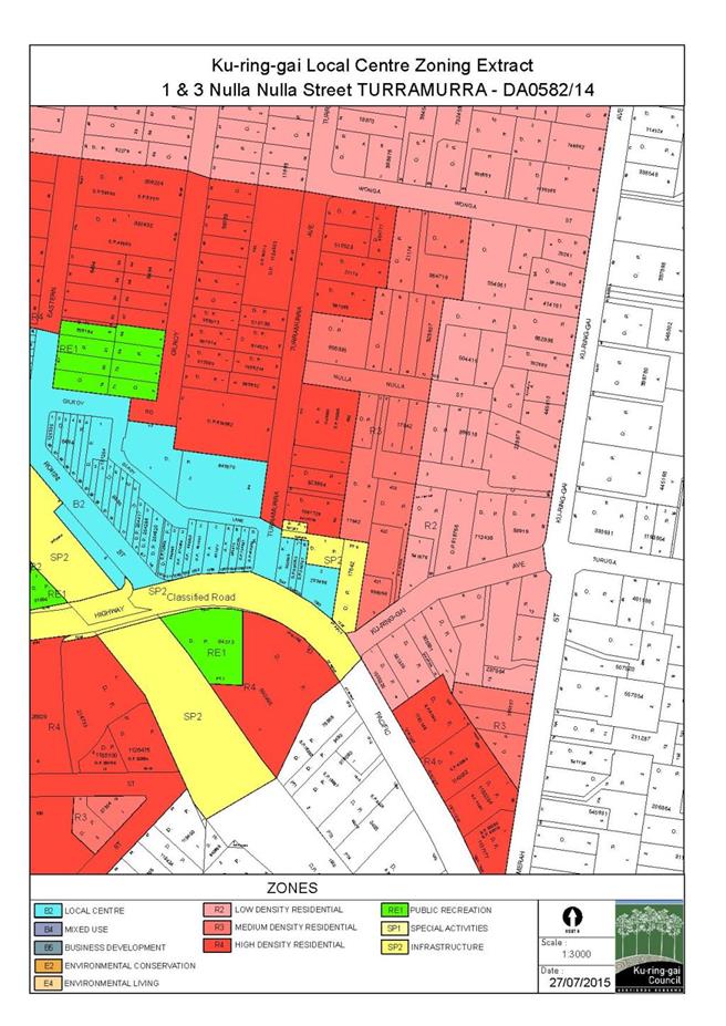
|
APPENDIX No: 2 - Notification
& submission map
|
|
Item No: GB.7
|
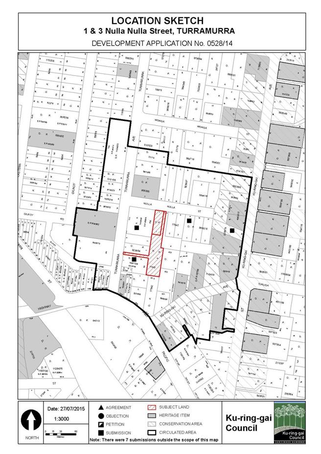
|
APPENDIX No: 3 - Architectural
Plans
|
|
Item No: GB.7
|
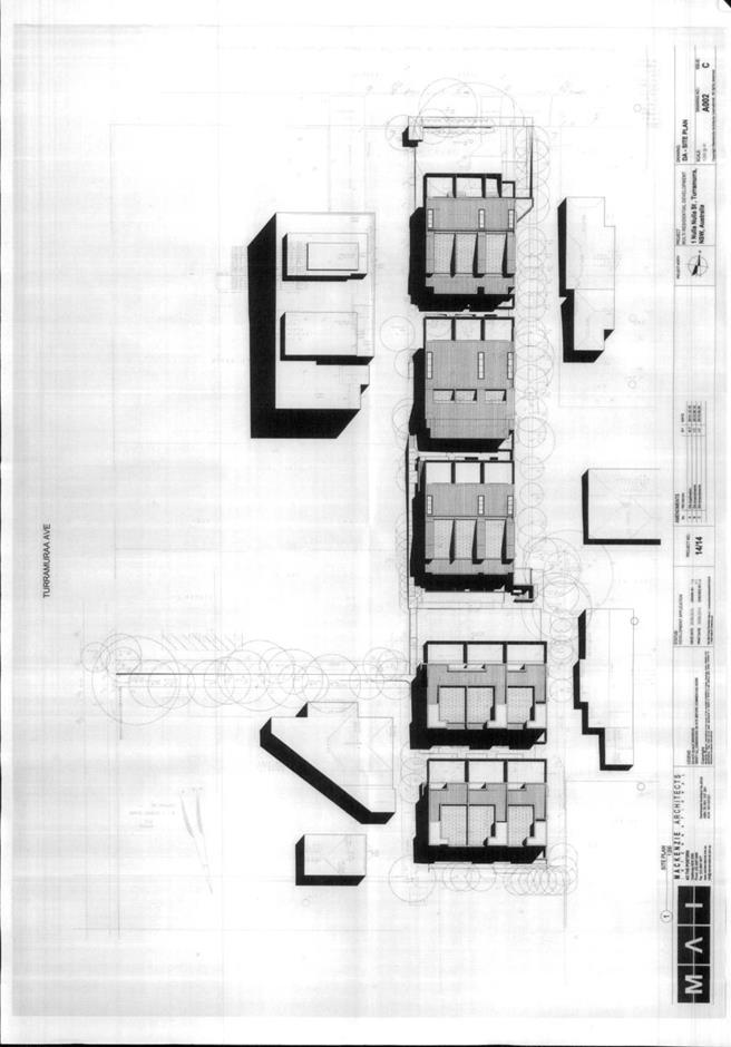

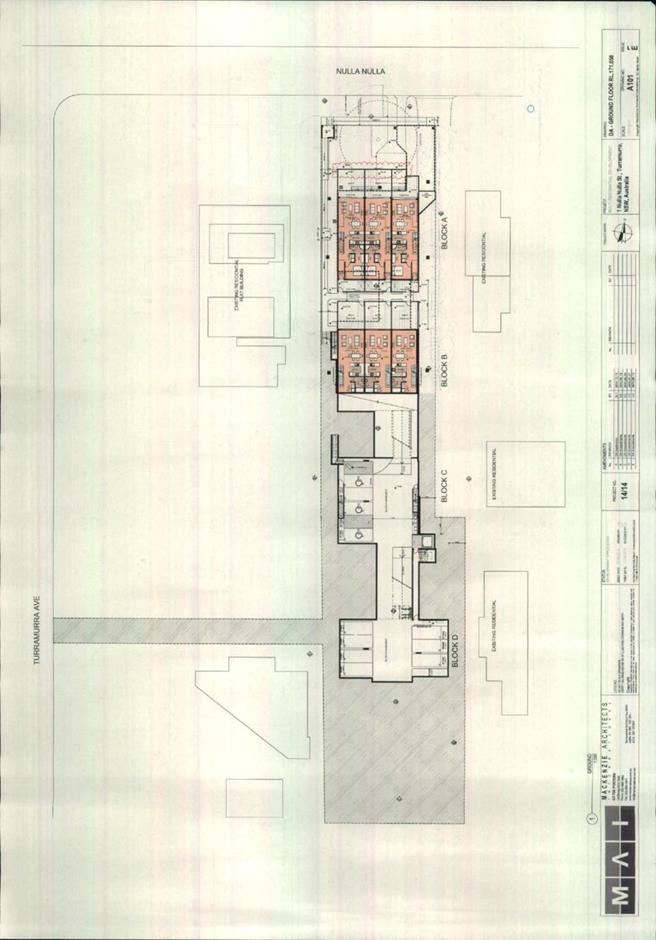
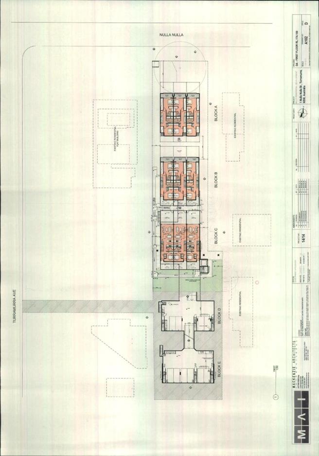
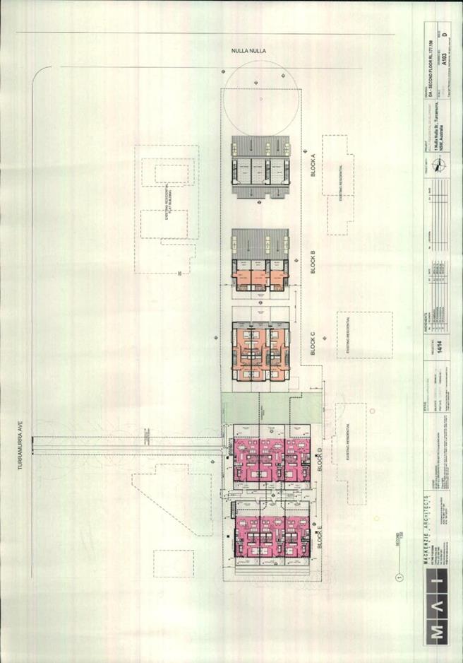
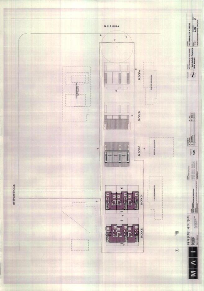
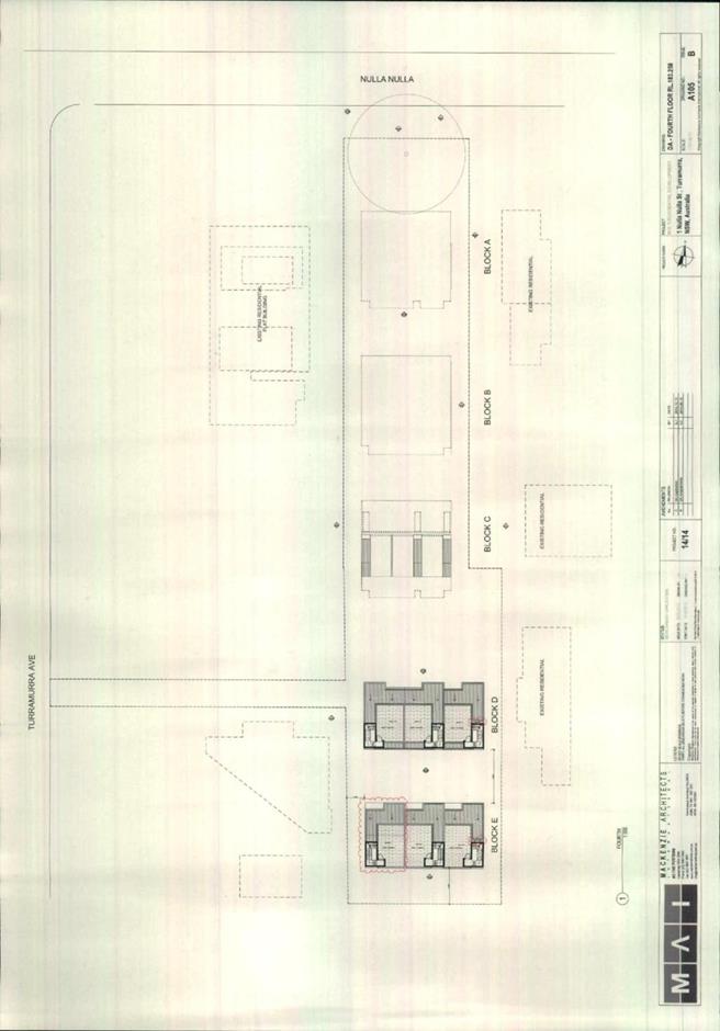
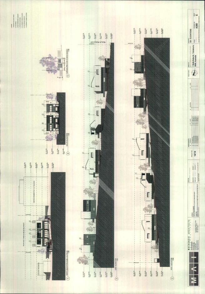

|
APPENDIX No: 4 - Cl.
4.6 Variation request for site requirements for multi dwelling housing
|
|
Item No: GB.7
|

|
Ordinary
Meeting of Council - 6 October 2015
|
GB.8 / 330
|
|
|
|
|
Item
GB.8
|
DA0430/14
|
|
|
19 August 2015
|
Summary
Sheet
|
Report title:
|
14 Carlotta
Avenue Gordon - Torrens title subdivision of one lot into two and
construction of a new dwelling
|
|
ITEM/AGENDA
NO:
|
GB.8
|
|
Application No:
|
DA0430/14
|
|
Property Details:
|
No. 14 Carlotta Avenue, Gordon NSW 2072
Lot & DP No: Lot B & DP 365052
Site area (sqm): 1815m2
Zoning: Residential 2(c2)
|
|
Ward:
|
Gordon
|
|
Proposal/Purpose:
|
Torrens title subdivision of one lot into two and
construction of a new dwelling
|
|
Type of Consent:
|
Integrated (Water Management Act 2000)
|
|
Applicant:
|
Architecture Design Studio
|
|
Owner:
|
Mr A R El Moungged & Mrs B El Moungged
|
|
Date Lodged:
|
21 October 2014
|
|
Recommendation:
|
Refusal
|
Purpose of Report
To determine Development
Application No.0430/14, for Torrens title subdivision of one lot into two lots
and construction of a new dwelling on one of the newly created lots at 14
Carlotta Avenue, Gordon.
The application is required to
be determined by full Council. Council’s attention is directed to Planning
Circular PS 08-014 from the NSW Department of Planning (attached) concerning
the determination by Council of Development Applications where a variation of a
development standard is sought under the provisions of SEPP No. 1.
The circular requires that all
development applications which involve a variation greater than 10% under the
provisions of SEPP No. 1 be determined by full Council. The application
involves variations greater than 10% to development standards for minimum
allotment size and street frontage width under Clause 25H(3)(a) and Clause
25H(4) of the KPSO. As a consequence, the application must be determined by
full Council.
integrated planning and reporting
PLACES, SPACES & INFRASTRUCTURE
|
Community Strategic Plan Long Term Objective
|
Delivery Program
Term Achievement
|
Operational Plan
Task
|
|
P2.1 A robust planning framework is in place to deliver
quality design outcomes and maintain the identity and character of
Ku-ring-gai
|
Applications are assessed in accordance with State and
local plans
|
Assessments are of a high quality, accurate and consider
all relevant legislative requirements
|
Executive Summary
|
Issues
|
· Significant variation to the minimum
allotment size (929m2).
· The smaller allotment with a narrow
site width for proposed Lot 2 cannot adequately accommodate a reasonably
sized dwelling.
· Insufficient vehicular access and
garage width opening.
· Inadequate information to allow for a
proper assessment of the application.
|
|
Submissions
|
One submission received.
|
|
Land & Environment Court
|
N/A
|
|
Recommendation
|
Refusal
|
|
|
|
LEGISLATIVE REQUIREMENTS:
|
|
|
|
|
Zoning at lodgement
|
Residential 2(c2) (zoning under KLEP 2015: E4)
|
|
Permissible under
|
KPSO & KLEP 2015
|
|
Relevant legislation
|
Water Management Act 2000
SEPP 1 – Development Standards
SEPP 55 – Remediation of Land
SREP (Sydney Harbour Catchment) 2005
SEPP (Building Sustainability Index: BASIX) 2004
KPSO
Draft KLEP 2013 (now gazetted KLEP 2015)
DCP 38 Residential Design Manual
DCP 56 Notification
Section 94 – Development Contribution
Plan
|
|
Integrated Development
|
Yes under the Water Management Act 2000
|
History
Pre-DA (previous proposal)
On 3 June 2013, a Pre- DA consultation was undertaken for
the construction of a detached dual occupancy development. The applicant was
advised of the following key issues:
· detached dual occupancy development is
prohibited development under the zoning.
· the dwelling is within the 10m riparian
setback required from the bank of the watercourse that dissects the site
· the development would impact on a large
Sydney Turpentine tree located at the rear of the proposed dwelling
· a qualified arborist should determine
the setback of the proposed dwelling and driveway location from Sydney
Turpentine tree
· information required for any future
application should include an arborist’s report, Flora and Fauna Report and
Vegetation Management Plan.
DA history (previous proposal)
On 17 September 2013, DA 0347/13 was lodged for a new
dwelling to create a dual occupancy development and strata title subdivision.
On 14 January 2014, Council refused the application for the following reasons:
· In order for the strata titled
subdivision to occur, the commencement of constructing a new dwelling is
required. Consequently, the development will result in creating two dwellings
on one lot and will therefore constitute a dual occupancy development. Detached
dual occupancy development is prohibited in accordance with KPSO. Dual
occupancy development is only permissible on land highlighted on the LEP No.
200- Detached Dual Occupancy Map.
The proposed
development is prohibited development under the provision of the KPSO. Council
cannot support a prohibited development and as
a consequence Council is not in a position to consider the merits of the
proposal.
Current DA
history
|
21 October 2014
|
The application was lodged.
|
|
03 November 2014
|
The application was notified to the owners of surrounding
properties. A stop the clock letter was also sent to the applicant requesting
information relating to the BASIX certificate, stormwater management plan and
assessment fee for integrated development (NSW Office of Water).
|
|
05 November 2014
|
A referral was sent to the NSW Office of Water
|
|
17 November 2014
|
A submission was received from Mr D Lee and Ms N Huston
from 16A Carlotta Avenue.
|
|
27 November 2014
|
Council received comment from the Office of Water
supporting the application subject to the implementation of its General Terms
of Approval (GTA’s).
|
|
18 December 2014
|
The applicant requested an extension of time for
submitting the information requested under the stop the clock letter.
|
|
30 January 2015
|
A preliminary assessment
letter was sent to the applicant requesting further information and amended
plans. The letter outlined the key issues with the application, being:
· unsatisfactory landscape
plan
· adverse impact to the
riparian corridor
· tree impacts
· arborist’s report
required
· potential impacts to the
STIF community
· unclear subdivision plan
· drawing inconsistencies
|
|
25 February 2015
|
A follow up letter was sent to the applicant regarding the
additional information and plans detailed in the STC letter and preliminary
assessment letter.
|
|
07 April 2015
|
The applicant advised that the additional information will
be provided to Council by 10 April 2015.
|
|
14 April 2015
|
Amended plans and additional information were received.
|
|
18 June 2015
|
The applicant was advised that the proposal is
unsatisfactory and the application would be determined using the available
information.
|
THE SITE AND SURROUNDING AREA
The site
Zoning: Residential
2(c2) & (E4 under KLEP 2015)
Visual Character Study Category: 1920-
1945
Lot Number: B
DP Number: 365052
Area: 1815sqm
Side of Street: North
Cross Fall: From
the north (rear) and south (front) to the centre of the site where the
watercourse is located
Stormwater
Drainage: Drainage easement located in the centre
of the site
Heritage Affected: No
Integrated Development: Yes –
Office of Water (Water Management Act 2000)
Bush Fire Prone Land: No
Endangered Species: Yes –
Sydney Turpentine Ironbark Forest
Urban Bushland: No
Contaminated Land: No
Riparian land: Yes-
Category 3, watercourse which includes a 3.65m wide drainage easement
Site description
The subject site is legally
described as Lot B in DP 365052 and is otherwise known as 14 Carlotta Avenue,
Gordon. The site is located on the northern side of Carlotta Avenue
approximately 100m to the east of the intersection with Mona Vale Road, as can
be seen in Figure 1, Locality Map. The site is rectangular in shape,
with a frontage of 15.24m and western and eastern side boundaries of
approximately 120.27m. The site has a total area of 1815m2.
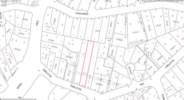
Figure 1: Locality Map
The site falls from the front boundary at RL101.0 down to
the watercourse that dissects the site and then rises towards the rear
(existing dwelling) of the site to approximately RL 102.63 which is the
northern side of the existing swimming pool. The watercourse dissecting the
site is known as Stoney Creek and runs from east to west. It is located
approximately 20 metres from the front boundary. Stoney Creek is classified as
a Category 3 watercourse under the riparian provisions contained within the
KPSO. A drainage easement, which is 3.65m wide, is located within the riparian
corridor. The site also contains Sydney Turpentine Ironbark Forest (STIF) community,
which is an endangered ecological community. The STIF community is primarily
located along the watercourse.
The site contains a two storey dwelling house,located
approximately mid-way along the site approximately 31metres from the front
boundary. Vehicular access to the dwelling is via a concrete driveway located
adjacent to the western side boundary. A concrete bridge has been constructed
over the watercourse to provide pedestrian and vehicular access to the
dwelling.
Surrounding development
The surrounding development
mainly consists of single dwelling houses, although the site is located
opposite the Council’s old works depot, which has approval for an aged care
facility.
Adjoining the site to the east
is 16 and 16A Carlotta Avenue, Gordon which contains a strata title detached
dual occupancy development approved under SEPP 53 (Metropolitan Residential
Development) on 14 April 2005. The property has a total area of 1850m2
with strata plan lot known as 16A Carlotta Avenue having an area of 634m2
and strata plan lot known as 16 Carlotta Avenue having an area of 883m2.
To the west is 12 Carlotta
Avenue which contains a dwelling house. Not dissimilar to the subject site, the
dwelling is located towards the rear of the site away from the sensitive areas
of the STIF community and Stoney Creek riparian corridor. The total site area
of 12 Carlotta Avenue is 1780m2 and it is also heavily vegetated
along Stoney Creek as can be seen in Figure 2, Aerial Photograph.
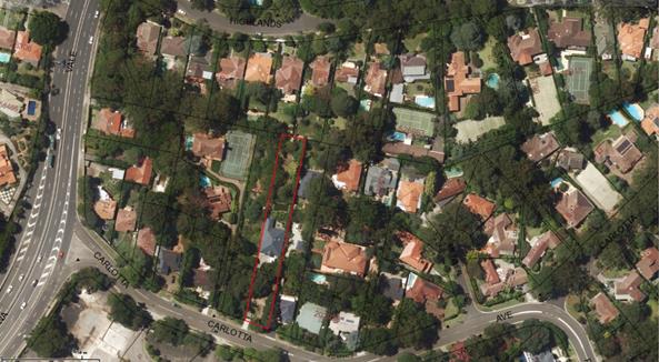
Figure 2: Aerial Photograph
The Proposal
The application proposes Torrens title subdivision of one
lot into two lots, the construction of a two storey dwelling house and
retention of the existing dwelling:
1. Lot 1:
will contain the existing dwelling and will have an area of 1354.48m2.
Lot 1 will be a battle-axe block, with a 3.3m wide access handle providing
access from Carlotta Avenue.
2. Lot 2:
will contain the proposed dwelling, which will front Carlotta Avenue. Lot 2
will have a total area of 461.89m2. Details of the proposed dwelling
house are:
· Ground floor:
single garage, kitchen, living and dining area, laundry, WC, study, terrace at
the rear of the dwelling and a car space located in front of the dwelling
· First floor:
master bedroom with ensuite, 3 bedrooms, bathroom, and a balcony.
Consultation
Community
In accordance with Development
Control Plan No.56, owners of surrounding properties were given notice of the
application. In response, one submission was received from the following:
1. D Lee
& N Hutson, 16 A Carlotta Avenue, Gordon
The submission raised the
following issues:
Small land component not
in keeping with the area.
The proposed subdivision does
not comply with the 929m2 minimum allotment size and 18m lot width
requirements under the KPSO. it is agreed that the proposed smaller lot is
inconsistent with the subdivision pattern in the locality and will result in a
significant detrimental impact.
Privacy will be compromised.
The proposed terrace and first
floor balcony are elevated above ground level by 1.5m and 4.2m, respectively.
The elevated terrace and balcony will afford overlooking onto the private space
and balcony of the neighbouring at No. 16A Carlotta Avenue, Gordon. The
proposed development will impinge on the privacy of the neighbouring property.
Light and sunlight will be
compromised.
According to the applicant’s
shadow diagram, the proposed dwelling will provide 4 hours of solar access to
the adjoining properties, which is compliant with Council’s control.
Noise levels will be
significantly increased.
The noise generated from a
proposed dwelling is unlikely to result in any unreasonable acoustic impacts to
neighbouring properties.
The creek will be impacted
with potential flooding occurring in a number of properties adjoining the
creek.
The proposed development was
referred to Council’s Development Engineer who is satisfied that the
development will not result in a significant impact in this regard.
Environment will change
from low density to high density.
The proposed development does
not comply with the objectives for subdivision in residential zones under
Clause 25H(1) of the KPSO and development controls under DCP 38. It also fails
to satisfy the objectives of the E4 Environmental Living zone under the KLEP
2015. The proposed subdivision and construction of a new dwelling will unduly
impact upon the vegetation on site on the subdivision pattern within the
locality.
Natural inhabitants of the
creek (Water Dragons) and natural inhabitants of the trees (Morepork Owls) will
be impacted.
The development application was
referred to Council’s Ecological Assessment Officer who is satisfied that the
proposal will not unduly impact upon on endangered fauna on the site.
Proposed car parking will
be allocated immediately adjacent to our bedroom accommodation.
The proposed car space has nil
setback to the eastern side boundary and does not allow for landscaping along
the side boundary. A landscape buffer is necessary along this section of
driveway to minimise amenity impacts between properties. The proposed car
parking in front of the building line will likely have an adverse impact upon
the streetscape and amenity of the neighbouring properties.
INTERNAL REFERRALS
Landscaping
Council’s Team leader Landscape
and Ecological Assessment commented on the proposal as follows:
First referral
“Landscape plan
The landscape plan is
inconsistent with the vegetation management plan in regard to treatment of the riparian
area. The landscape treatment of riparian area should be consistent with the
vegetation management plan.
The site is mapped as having
biodiversity significance and planting selected is to be consistent with local
vegetative communities as specified in the KPSO, draft KLEP and DCP 2013.The
proposed planting at present does not reflect this.
The landscape plan is
inconsistent with the architectural plans.
The hard copy of the landscape
plan is not at a scale satisfactory for assessment and is to be provided at the
full size of 1:100. There appears to be no electronic copy of this document
submitted within Council’s records.
The landscape plan does not
clearly indicate proposed external levels and top of wall heights,
notwithstanding heights to walls in the two sections. More information is
required. It is unclear whether contours represent proposed or existing levels.
Retaining walls and fill
The proposed filling of the
rear of Lot 2 and construction of a retaining wall within the riparian area is
not supported. The amount of fill is excessive, not compliant with Section
4.3.7 of DCP 38 and is likely to detrimentally impact the watercourse and trees.
The section through the rear
of the site and to the creek does not show the existing ground line nor the
creek bank and therefore does not indicate the extent of fill which appears to
be at least 3.3m in depth.
Tree impacts
Retaining walls located on
boundaries and within tree protection zones of trees to be retained are not
supported and are not consistent with Section 4.3.7 of DCP 38.
The proposed retaining wall
and fill adjacent the Syncarpia glomulifera is not supported as it is likely to
compromise the stability and health of this tree.
It is unclear whether the
driveway is widened near the existing remnant tree within the adjacent
property. The driveway is shown to the boundary adjacent to this tree, however
the survey shows the driveway slightly inside the tree protection zone of this
tree within the neighbouring property. If the driveway is rebuilt there are
potential impacts on the Tree Protection Zone and structural root zone of this
tree.
Arborist’s report
The submitted arborist report
only assesses one tree and has not assessed the impacts of the proposed
dwelling and associated works on trees.
All trees retained and removed
are to be identified, numbered consistent with the arborist’s report and
indicated on the landscape plan. This includes trees on adjacent properties in
proximity of the proposal.
Stormwater plan
The actual treatment of the
stormwater outlet within the creek is unclear. It is also unclear how the
outlet will be designed in conjunction with the proposed retaining wall within
the riparian area.
Drawing inconsistency
The treatment of the rear yard
and walls indicated to the front yard are inconsistent with the architectural
plans and elevations”
Second referral
The landscape comment on the
amended plans and additional information is summarised below:
“The
following information or amendment is required:
Arborist assessment
The
arborist assessment has not calculated the total encroachments within the Tree
Protection Zone of the mature Turpentine as the encroachment percentage
statement does not consider the area of the existing driveway.
As the
level of encroachment may therefore be approximately 25%, the arborist is to
re calculate the total of the encroachment both proposed and existing and re –
consider the tree’s viability in respect of all encroachments consistent with
the principles under AS 4970-20093, 3.3.3 and 3.3.4.
Where
discounting the terrace as an encroachment ,the arborist is to consider the
encroachment of this area within the structural root zone and also whether the
soil and feeder roots retained under the proposed terrace are likely to remain
viable in the long term.
There has
been no comprehensive inventory or assessment of all trees on or adjacent the
site. Trees proposed to be removed are not documented or assessed.
As
indicated previously, an arborist’s report is to be provided by an arborist
with a minimum qualification AQF5 fully assessing the health and structure and
impacts of the proposed works on all trees including trees on adjacent
properties within proximity of the works and including trees proposed
for removal.
A site
specific tree protection plan showing locations of tree protection structures
is to be provided.
Landscape plan
Details of plant species locations are to be indicated on the plan.
For
neighbour amenity and to compensate for the loss of vegetation in this area,
the paved drying area is to be relocated and substantial screen planting
adjacent the elevated terrace to the eastern boundary is necessary.
The
Turpentine located on the western edge of the driveway within the adjacent
property must be shown on the plans.
As
previously requested, all trees retained and removed are to be identified ,
numbered consistent with the arborist report and indicated on the landscape
plan. This includes trees on adjacent properties in proximity of the proposal.
The proposed lawn to the front setback and also to the eastern side setback is
not considered practical and should be replaced with planting. The landscape
plan is not consistent in regards to the car space configuration with the
architectural plans.
Details
of terrace
Details of
the proposed terrace are to be provided, illustrating that it is an elevated
lightweight timber structure, (using isolated small diameter posts) as
indicated in the arborist report. The terrace is to be relocated outside of the
Turpentine’s structural root zone.
Driveway
Confirm on
the site plan that the existing driveway and levels to the driveway within the
TPZ of the Turpentine are to remain as existing.”
Ecological
Council’s Ecological Assessment
Officer commented on the proposal as follows:
Ecology comments
During the site inspection,
Sydney Turpentine Ironbark Forest (STIF) listed as an Endangered Ecological
Community (EEC) under both the Threatened Species Conservation Act 1995 and
under the Environmental Protection & Biodiversity Conservation Act 1999 ,was
identified within the site.
The STIF community comprised
of scattered canopy trees of the following species Syncapria glomilufera
(Sydney Turpentine) specimens’ amongst an understorey dominated by weedy shrubs
and groundcovers. The STIF community primarily occupies the vegetation on the
embankment of the watercourse which passes through the middle portion of the
site.
Environmental
controls
The native vegetation within
the site, which occurs primarily adjacent to the watercourse, has been mapped
as an area of biodiversity significance under the KPSO.
The site is mapped as
containing a Category 3 Riparian Corridor which occurs on the southern side of
the existing dwelling. In accordance with Council’s Riparian Policy, category 3
watercourses require a 10m core riparian zone (CRZ). The proposed dwelling is
within the category 3 riparian corridor.
The vegetation along the
watercourse has also been mapped as category 3 watercourse under the draft KLEP
2013.
In order to construct the
proposed dwelling, a large Turpentine is likely to be impacted by the proposed
land filling. The proposed filling of the land does not to satisfy the riparian
& biodiversity lands controls under the draft KLEP 2013. A re-design is
required to ensure that no STIF is removed and that any future dwelling be
located outside the STIF community.
The landscape assessment
officer has requested further arboricultural assessment.
Conclusion:
The application is not acceptable on ecological grounds, further arboricultural
information is required as per the comments above.
Second referral
A
vegetation management plan (VMP) has been prepared which addresses the required
management of the area of land identified as biodiversity and riparian with
regard to the proposed development. The VMP ensures that the ecological values
of the biodiversity and riparian areas, as defined under KLEP 2015, are
maintained and are not likely to be detrimentally affected by the proposal.
The proposed development will
result in an improvement to the existing riparian and biodiversity area through
the selective removal of weeds and planting of native species characteristic of
STIF.
Conclusion:
The application is now acceptable on ecological grounds, subject to conditions.
Planners Comment: The
proposed land fill was deleted on the landscape plan (Drawing No.: LA-01
received on 14 April 2015) and the tree impact to the large Turpentine has been
resolved.
Engineering
Council’s Engineering Assessment Officer commented on the
proposal as follows:
“The stormwater drainage
plan, Job No. 140764 Dwg. No. D01(B), D02(A) and D03(B) prepared by Australian
Consulting Engineers has been reviewed. An Overland Hydraulic Report has been
submitted by Australian Consulting Engineers dated February 2015. On the basis
of the report the development proposal will not be subject to inundation or
increase the 100 year ARI overland flow level on the neighbouring properties.
Further information is
required for assessment to proceed.
· A driveway longitudinal section
shall be provided starting from the street gutter to the proposed garage
demonstrating that the proposed profile complies with Australian Standards 2890.1
- 2004 ‘’Off Street car parking”. The longitudinal section shall be at a
recognised scale including the existing levels.
· Due to the location of the patio, a
vehicle cannot exit the garage utilising the proposed driveway and turning
area. Please show the turning path and manoeuvrability for a vehicle to exit
the site in a forward manner. The design is to be in accordance with AS
2890.1:2004 using the B85 design template.
· Car space finished level shall be
marked on the stormwater plan. Any retaining wall or kerb on the southern side
if required shall be shown on all plans.
· All trees are to be indicated and
numbered on the stormwater drainage plan.
· Survey detail should be incorporated
into the stormwater drainage plan.”
Second referral
Comments on the amended plans and additional information is
summarised below:
“The applicant has provided
satisfactory water management plans and an overland flow assessment. However,
the following engineering reason for refusal is identified.
Inadequate and
unsatisfactory vehicular access
Particulars
The documentation does not
demonstrate that the development would result in satisfactory vehicular access
to either the existing residence or the new dwelling.
The width of the existing
concrete driveway is between 2.0 and 2.5 metres wide (scaled from the drawings,
as dimensions are not given). This is already less than recommended in
AS2890.1:2004 Off street car parking (3.0 metres for a domestic driveway).
The architectural plans show
the new garage wall right up to and possibly over the driveway. This will
further restrict the already narrow vehicular access along the driveway to the
existing dwelling.
No levels are provided of the
proposed transition from the existing driveway to the new garage and car
space. It appears that a section of the existing driveway would have to be
reconstructed. The resulting steep gradient along the southern side of the
curved section would result in unacceptable grades and transitions in front of
the garage.
The width of the apron in front
of the garage is insufficient for adequate manoeuvring of vehicles out of the
garage and into the driveway in a forward direction.”
Planners Comment: The deficiencies discussed above
form a part of the reasons for the recommendation of refusal.
OUTSIDE
COUNCIL
Department
of Primary Industries (Office of Water)
Under the provisions of Section
91 of the Environmental Planning and Assessment Act 1979, the proposal is
Integrated Development because it requires a Controlled Activity Approval (CAA)
under the Water Management Act 2000 (WMA).
Accordingly, the development was referred to the Office of Water and General
Terms of Approval were provided and would be included as conditions of consent
were Council to approve the application.
Statutory Provisions
State Environmental
Planning Policy No 1 - Objection to Development Standards
This policy provides flexibility in the application of
development standards within Planning Instruments in circumstances where strict
compliance would be unreasonable or unnecessary or tend to hinder the
attainment of the objects specified under Section 5(a)(1) of the Act. Clause 6
of SEPP 1 incorporates the mechanism for making of a SEPP 1 Objection and
provides as follows:
Where development could, but for any development
standard, be carried out under the Act, the person intending to carry out that
development may make a development application in respect of that development,
supported by written objection that the development standard is unreasonable or
unnecessary in the circumstances of the case, and specify the grounds of that
objection.
A SEPP 1 Objection has been submitted in respect of the
non-compliances with development standards contained within Clauses 25H(3)(a)
and (4) of the KPSO. An assessment of the objection is contained below under
the KPSO assessment.
State Environmental Planning Policy No. 55 – Remediation
of Land
The provisions of SEPP 55 require Council to consider the
potential for a site to be contaminated. The subject site has a history of
residential use and as such, it is unlikely to contain any contamination and
further investigation is not warranted in this case.
State Environmental Planning Policy (Building
Sustainability Index: BASIX) 2004
A valid BASIX certificate has been submitted. The
certificate demonstrates compliance with the provisions of the SEPP and
adequately reflects all amendments to the application.
Sydney Regional Environmental Planning Policy (Sydney
Harbour Catchment) 2005
SREP 2005 applies to the site as the site is located in the
Sydney Harbour Catchment. The Planning Principles in Part 2 of the SREP must be
considered in the preparation of environmental planning instruments,
development control plans, environmental studies and master plans. The proposal
is not affected by the provisions of the SREP which relate to the assessment of
development applications as the site is not located in the Foreshores and
Waterways Area as defined by the Foreshores and Waterways Area Map.
Ku-ring-gai Planning Scheme Ordinance
At the time of lodgement the Ku
ring gai Planning Scheme Ordinance (KPSO) was the principal environmental
planning instrument (EPI) applying to the development. Since the lodgement of
the application Ku ring Local Environmental Plan 2015 (KLEP 2015) has been
gazetted. There is a savings provision in this instrument that requires the
KLEP 2015 to be considered as if it had not been made i.e. to be treated as a
draft instrument. The application has been assessed on this basis and
significant weight is given to the KLEP 2015 given that it has been gazetted
and now applies to the subject site.
Zoning
The site is zoned Residential
2(c2) under the KPSO. The subdivision of the site and construction of a new
dwelling is permissible with development consent.
Development standards
|
Development standard
|
Proposed
|
Complies
|
|
Subdivision for dwelling houses
|
|
|
|
Clause 25H (3)(a)
Minimum size allotments: 929sqm (min)
|
Lot 1: 1354.478sqm
Lot 2: 461.89sqm
|
YES
NO
|
|
Clause 25H (4)
Street frontage: 18m (min)
|
Total: 15.4m
Lot 1: 3.3m (access handle)
Lot 2: 12.1m
|
NO
NO
|
|
Building height
Clause 46(2): 8m (max)
|
Lot 1: Existing dwelling: No
architectural plans of the existing dwelling have been submitted with the application.
Lot 2: Proposed dwelling 6.4m
|
Unknown
YES
|
|
Built upon areas :
Clause 60C(2): 60% (max)
Lot 1: 812.68sqm
Lot 2: 277.13sqm
|
Lot 1: approx. 41.8% (567.3sqm)
Lot 2: 48.19% (222.6sqm)
|
YES
YES
|
Aim and objectives for residential zones
Clause 25C and 25D of the KPSO
state the aims and objectives for development in the residential zone. The
proposed development does not comply with the objectives under these Clauses
because it fails to encourage the orderly development of land, it does not
encourage the protection of existing trees within setback areas and does not
encourage safety and security of private development as it does not provide a
high standard of building design and landscape design nor does it protect the
environmental qualities of the area.
Heritage /conservation areas:
The subject site is not listed
as a heritage item nor it is located within a heritage conservation area. There
are no impacts on Aboriginal heritage.
Minimum allotment size and width
Clause 25H (3)(a) of the KPSO states that lots created for
the purpose of dwelling-houses are to each have at least the area specified as
the “Minimum Lot Sizes” for the relevant land on the
Dwelling-house Subdivisions Map. A minimum allotment size of
929m2 is required for the proposed development. Further, Clause
25H(4) states that subdivision of land to create a lot to be used for a
dwelling house must not result in an allotment with a street frontage less than
18 metres.
Proposed Lot 1 has an area of 1354.5m2 and a
street frontage width of 3.3m. Proposed Lot 2 has an area of 461.89m2
and a street frontage width of 12.1m. Proposed Lot 1 fails to meet the minimum
allotment width requirement and seeks an 81.6% variation to the standard.
Proposed Lot 2 fails to provide sufficient site area and allotment width
seeking variations of 50.28% and 32.7%, respectively. Accordingly, a SEPP No. 1
objection has been submitted.
The SEPP 1 Objection is assessed against 7 key questions
established in the Land and Environment Court decision in Wehbe v Pittwater
Council [2007] NSW LEC 827 to determine the suitability of proposed
variations to development standards, as follows:
1. Whether the planning control in question is a
development standard
Clause 25H(3)(a) requires a minimum site area of not less
than 929sqm and Clause 25H(4) requires a minimum street frontage width of 18
metres. These controls are development standards as defined Section 4 of the
Environmental Planning and Assessment Act, 1979.
2. The underlying objective or purpose behind the
standard
The objectives for subdivision, including minimum allotment
width, in the residential zones under Clause 25H(1) of the KPSO are as follows:
a) to
set minimum lot areas that reflect previous minimum lot sizes,
b) to
set minimum lot areas and minimum street frontage lot widths that provide for
development to occur in a garden setting by substantial setbacks to enable
long-term sustainability of trees,
c) to
permit the subdivision of multi-unit housing,
d) to
provide for substantial common landscaped area to encourage good streetscape
quality and areas for trees for each development.
Proposed Lot 2 has a site area that is substantially smaller
than that of surrounding allotments with a departure of 50.28% from the
standard. The development is inconsistent with the existing established lots
sizes in the residential zone which typically range from 790m2 to
929m2 and above. The proposed subdivision will not allow a
reasonably sized dwelling house to be built on the smaller lot and
simultaneously provide a landscape setting and good streetscape quality that is
encouraged in the Ku-ring-gai local area. The proposed dwelling is likely to
have an adverse impact to the mature turpentine tree on site and the existing
remnant tree within the adjacent properties. The proposed development does not
satisfy the underlying objectives for subdivision in the residential zones
under Clause 25H(1) of the KPSO.
The applicant has also pointed to the smaller allotment
sizes of 16 and 16A Carlotta Avenue in part to support the proposed variation.
These smaller lots in a strata plan are the exception in the overall
subdivision pattern of the area and were approved under different legislation,
being SEPP 53 (Metropolitan Residential Development) which allowed this type of
development. This policy no longer applies having been repealed in 2011. The
precedence set by these properties should not direct the development,
particularly in this area given the site’s sensitivities with STIF and presence
of the riparian corridor. The KLEP 2015 recognises these site constraints and
increases the minimum allotment size for subdivision to 1500m2. To
accept a variation is also contrary to the objectives (b) and (c) under Clause
4.1 of the KLEP 2015, which seek to:
(b) to
ensure that lot sizes and dimensions allow development to be sited to protect
natural or cultural features including heritage items, remnant vegetation,
habitat and waterways, and provide for properties and the desired character of
the area;
(c) to
ensure that subdivision of low density residential sites reflects and
reinforces the predominant subdivision patter of the area.
3. Whether compliance with the development standard
is consistent with the aims of the Policy and whether compliance hinders the attainment
of the objects specified in section 5(a)(i) and (ii) of the EP & A Act 1979
The aim of SEPP 1 is to:
Provide flexibility in the
application of planning controls operating by virtue of development standards
in circumstances where strict compliance with those standards would, in any
particular case, be unreasonable or unnecessary or tend to hinder the
attainment of the objectives specified in Section 5 (a) (i) and (ii) of the
Act.
In this regard, the objects of Section 5 (a) (i) and (ii) of
the Act are:
(i) The
proper management, development and conservation of natural and artificial
resources, including agricultural land, natural areas, forests, minerals,
water, cities, towns and villages for the purpose of promoting the social and
economic welfare of the community and a better environment;
(ii) The
promotion and co-ordination of the orderly and economic use and development of
land;
The proposal is contrary to the objects of Section 5(a)(i)
and (ii) of the Environmental Planning and Assessment Act 1979 (EP&A Act
1979). The proposed development is inconsistent with the underlying objectives
of the residential zone and the specific objectives of the minimum allotment
size and width development standards. Particular concern is raised with the inconsistency
of the proposal with the surrounding subdivision pattern and consequential
impacts associated with the significant variation, as discussed. The
subdivision will result in a significantly undersized allotment, with minimal
street frontage contrary to the general character of the area. This will hinder
the attainment of the Object of the Act and is contrary to Section 5(a)(i) of
the (EP&A Act 1979) in that the proposal does not properly manage and
conserve the natural areas of the site. In addition it does not promote the
orderly development of the land particularly given the 1,500m2
minimum allotment size requirement under the KLEP 2015 which is the current
Environmental Planning Instrument overseeing development of the site.
4. Whether compliance with the development
standard is unreasonable or unnecessary in the circumstances of the case
The following is a summary of the SEPP 1 objection arguments
provided by the applicant:
· The total area of the site is
1816sqm and once subdivided will create a lot size of 908.25sqm creating
a site that is non-compliant with the minimum lot size by 20.75sqm.
· The proposal gives very close
compliance to the development standard and very importantly is complimentary to
the adjoining residence;
· The difference between the subject
development proposal and a development without a variation would not be
noticeable to the pedestrians, motorists and local residents/occupants in this
locality;
· The development will maintain the
residential character within locality;
· The proposed development has
adequate setbacks and is highly vegetated at the streetscape to maintain the
landscaping vision set out by Ku-ring-gai Council for the area. Large trees
will be retained in the development and proposed plantings will replace the
view of the front yard to incorporate a highly vegetated image, also along the
eastern side screening the neighbouring property;
· The Sydney Turpentine Ironbark
forest tree species will be retained and protected.
· The proposal is considered to
reasonably satisfy what might be deemed to be the underlying objective of
Ku-ring-gai Planning Scheme Ordinance relating to development in the low
residential zone.
The applicants SEPP No. 1 objection states that the degree
of non-compliance with the site area standard is 20.75m2 for each
lot. This is incorrect and is a significant underestimation of the
non-compliance with the minimum site area requirement. This is a result of the
applicant simply dividing the existing site in half. As proposed on the plans
submitted with the application, the site areas are those as detailed in the
description of the application.
Irrespective of the above, the SEPP No. 1 objection fails to
make reference or consider the objectives for subdivision and for residential
zones specified under Clauses 25H (1), 25C and 25D of the KPSO.
The application also fails to comply with a number of other
development controls. The proposed Lot 1 dwelling fails to meet the controls
for; minimum front setback, side setbacks including the first floor setback,
building height plane and usable open space. Lot 1 also fails to provide two
spaces for vehicles behind the front building line and does not provide
suitable vehicle access or egress with a driveway width of 2.6m.
As the application fails to meet the aims and objectives of
the development standards and does not address the minimum allotment width
requirement, the applicant cannot demonstrate why the variation is unreasonable
and unnecessary in this instance. Consequently, Council is not in position to
cannot support the proposed variations to the development standards.
5. Whether the objection is well founded
The objection is not considered
to be well founded for the following reasons:
· The proposed smaller
allotment is inconsistent with the character of the locality, where the
allotments predominately range between 790m2 to 929m2 and
upwards (except No. 4 and 6 Carlotta Avenue which have a site area of 696.7m2).
Lot 2 will result in a general change in the overall subdivision pattern of the
area, with smaller allotment of 461.89m2, as compared to the
prevailing allotment size in the area. This is particularly important in the
context of the zoning under Ku ring gai LEP 2015, which requires a minimum
allotment size of 1500m2. Significant weight is given to this
control as the KLEP 2015 has been gazetted and it sets the desired future
character of the zone. This zone recognises the site’s environmental
sensitivity, which is the response for the revised larger lot size under the
KLEP 2015.
· The neighbouring dwelling
and subdivision, created for dual occupancy at 16 and 16A Carlotta Avenue were
approved under a different Environmental Planning Instrument, which no longer exists.
Clause 58B (5) of the KPSO states that the clause 58 does not apply to
subdivision created pursuant to SEPP 53. There is no standard in the KPSO
stipulating minimum lot size for subdivision of dual occupancy. It should not
be taken as a bench mark for lot size for the reasons noted earlier. Dual
occupancy development has prohibited on the subject site since 15 July 2011.
· The proposed subdivision will not be
comparable with surrounding properties. Whilst it is acknowledged that there
are some undersized allotments in the area, the majority comply or are greater
than the minimum standard of 929m2. The proposed variation would
set an undesirable precedent which would be detrimental to the character of the
area. The variation is an ad-hoc deviation from the standards with no sound
planning basis. As a consequence, it not considered to be an appropriate use of
the dispensing power under SEPP 1.
· The proposal fails to
provide for development to occur in a garden setting within substantial
setbacks to enable long-term sustainability of trees and fails to provide for
substantial common landscaped area to encourage good streetscape quality and
areas for trees for each development.
· The proposed new dwelling
was assessed against the planning controls under DCP No.38, including 9-11m
front setback, side setback, 0.4:1 floor space ratio, building height plane,
first floor FSR and 50sqm usable open space. The proposed garage has nil
setbacks to the access handle of Lot 1 and part of the first floor bedroom
(Bedroom 4) projected above the access handle. The new dwelling does not fully
comply with the DCP given the smaller lot size and narrow site width. Proposed
Lot 2 is inadequate to accommodate a reasonable dwelling house that is of high
quality design.
· The proposed development on
Lot 2 fails to demonstrate that a usable private open space can be provided as
required under DCP 38, due to the slope of land and biodiversity (Sydney
Turpentine Ironbark Forest community) and riparian affectations.
· It
has not been demonstrated that the mature Turpentine trees on site and trees on
the adjoining properties will be protected.
· Clause
25H (5) allows for the creation of battle-axe allotments, however, in this
instance, the variation not only results in a non-compliant street frontage but
also an unsatisfactory vehicular access of 2.6 metres for Lot 1. In order to
provide a wider vehicular access of 3 metres that complies with the Australian
Standard, a re-design would likely involve the removal of the landscaping area
along the eastern side boundary or a reduction of the site width of Lot 2. The
reduction of the site width of Lot 2 will further increase the non-compliance
of the site width under Clause 25H (4) of the KPSO.
· The proposed undersized Lot
2 does not allow for a dwelling house development that will meet the aims and
objectives of residential zones under 25 C and 25D of the KPSO, in that it does
not encourage i) the protection and enhancement of the environmental qualities
of Ku-ring-gai, ii) encourage orderly development of land and resources in
Ku-ring-gai; and iii) a high level of residential amenity in building design for
the occupants of buildings through, outdoor living and landscape design.
The SEPP 1 objection has not demonstrated that strict
compliance with the standards is unreasonable and unnecessary in this
instance. The applicant fails to establish that the objectives of the
standards can be achieved notwithstanding the non compliances. Therefore, the
proposal is contrary to the objectives of the control.
6. Whether non-compliance with the development
standard raises any matter of significance for State or regional environmental
planning
The non-compliance with the development standard will not
raise any matters of significance for state and regional planning.
7. Whether there is a public benefit of
maintaining the planning controls adopted by the environmental planning
instrument
There is public benefit in maintaining the control in this
instance because the variation would undermine the objectives of the controls,
particularly in light of the future direction as prescribed under KLEP 2015,
which sets a greater minimum allotment size. This is in recognition of the
site’s environmental sensitivities with the site containing STIF and a riparian
corridor.
Ku-ring-gai Local
Environmental Plan 2015
KLEP 2015 has replaced the
Ku-ring-gai Planning Scheme Ordinance as the principal planning instrument for
the Ku-ring-gai Local Government Area. The KLEP 2015 came into effect on 2
April 2015. The gazetted instrument contains a savings provision essentially
stating that any DA lodged before the commencement of the LEP and still under
assessment at the date of this commencement must be determined as if the plan
had not commenced.
The KLEP 2015 as the current
principal planning instrument sets the future direction for planning in the Ku
ring gai area. Under the KLEP 2015, a strong emphasis has been placed to the
environmental significant of the subject site via the change in the zoning from
Residential 2(c2) (under the KPSO) to E4 Environmental Living (under the KLEP
2015). Any future developments must ensure that it does not have an adverse
impact to the ecological communities, biodiversity corridors or other
significant vegetation on site and must be in keeping with the objectives and
controls for the environmental zone specified under the KLEP 2015 and KDCP.
Proposed land use zone
The subject site is proposed to be zoned E4
Environmental Living and the development is permissible within this zoning. The
objectives of the zone are as follows:
· to provide for low-impact
residential development in areas with special ecological, scientific or
aesthetic values
· to ensure that residential
development does not have an adverse effect on those values
· to ensure development does not
result in further fragmentation of ecological communities, biodiversity
corridors or other significant vegetation or habitat
The proposed development fails to meet all the
objectives of the zone because of the undersized allotment and site widths. The
failure to meet the first objective results in the development failing to meet
the second objective. The minimum allotment size for the subdivision of the
subject site is 1500m2 under the KLEP 2015. Both proposed lots fail
to meet this requirement. The variation is significant, particularly for
proposed Lot 2 as the shortfall 1038.11m2. The proposed smaller
lots are uncharacteristic of the area and result in an inappropriate
development on proposed Lot 2 which fails to meet a number of key controls. Accordingly,
the development fails to meet the objectives of the control.
Proposed development standards
The KLEP 2015 proposes three development
standards of relevance to the subject application, as follows:
4.1 Minimum
subdivision lot size
The proposal
results in non-compliances with the minimum lot size of 1,500sqm and 18 metres
width contained within the KLEP 2015. The objectives of Clause 4.1 of the KLEP
are as follows:
a) to ensure that lot sizes and dimensions are able to accommodate development
consistent with relevant development controls
b) to ensure that lot sizes and dimensions allow development to be
sited to protect natural or cultural features including heritage items, remnant
vegetation, habitat and waterways, and provide for generous landscaping to
support the amenity of adjoining properties and the desired character of the
area
c) to ensure that subdivision of low density residential sites
reflects and reinforces the predominant subdivision pattern of the area
Proposed Lot 1 will have a street frontage of 3.3 metres
(2.6m access handle plus 700mm setback for landscaping), and proposed Lot 2 is
to have a site area of 461.89m2 and a street frontage of 12.2
metres. It fails to comply with the objectives under Part 4.1 (a) and (c) of
the KLEP.
Under KLEP 2015, the subject site is zoned E4
Environmental Living to ensure that any future developments will not generate a
significant adverse impact to the natural or cultural features of any given
site. In order to achieve this, the objectives of the E4 zone specifically
refer to the lot size and dimensions of the subdivision to ensure developments
are consistent with relevant development controls and the protection of the
significance features on site.
The proposed subdivision will vary the 1500m2
minimum allotment size standard by 69.2% or 1038.11m2 (Lot 2) and
9.7% or 145.5m2 (Lot 1) and is inconsistent with the established
subdivision pattern of the area. The proposed dwelling is excessive in scale
and does not comply with the development controls under the KLEP, including
insufficient private open, building setbacks, first floor FSR, building height
plane, excavation within the side setback and car parking forward of the
building line. The development fails to meet to objectives under Clause 4.1 (a)
and (c) of the KLEP 2015.
The proposed development is not acceptable
with regard to the retention of trees on site and there is a lack of screen
planting along the side boundaries. Particular concern is raised over the
impact on neighbour amenity given the loss of vegetation and the impact on the
landscape setting as the result of the introduction of the new dwelling. As
such, the application is inconsistent with the Objective (b) of Clause 4.1 of
the KLEP.
4.3 Height of buildings
The proposed dwelling complies with the 9.5
metres maximum building height development standard.
4.5 Calculation of floor space ratio and
site area
Under E4 Environmental Living, for allotments
less than 800m2 the maximum floor space ratio is 0.4:1. The proposed
development complies with the maximum FSR.
Development Control Plan No. 38 – Ku-ring-gai Residential
Design Manual
Existing dwelling
The existing dwelling located on proposed Lot 1 will be
retained and there are no works proposed to this dwelling. The site area will
be reduced as a result of the proposed subdivision. Irrespective of whether
there are any changes, an assessment against DCP 38 must be undertaken given
the nature of the works. No architectural plans were submitted for this
proposed lot to allow for an assessment of compliance with these provisions.
Proposed dwelling
The compliance or otherwise of
the proposed dwelling proposed Lot 2 with the development controls of DCP38 are
established in the following compliance table:
|
Development Control
|
Proposed
|
Complies
|
|
4.1 Streetscape:
|
|
Building setbacks (s.4.1.3)
|
|
|
|
Front setback: 11m (avg) -75% front
elevation 9m (min) - 25% front elevation
|
8.5m
8.3m
|
NO
NO
|
|
Side setback: Ground floor: 2
(min)
1st floor: 15% site
width or 2.5m, which even is greater = 2.5(min)
|
Nil (garage to west)
1.4m (study to east)
800mm encroached onto the access
handle of lot 1 (bed 4 to west)
1.6m (master bed to east)
|
NO
NO
NO
NO
|
|
Rear setback: 12m(min)
|
16.4m
|
YES
|
|
Front fences (s.4.1.5)
|
|
|
|
Height (forward of building line):
1.2m if visually transparent Height (behind building line): 1.8m (max)
|
No proposed fencing
|
N/A
|
|
4.2 Building form:
|
|
FSR (s.4.2.1) 0.4:1 (184.75m2 max)
|
0.398:1 (183.7m2)
|
YES
|
|
Height of building (s.4.2.2)
|
|
|
|
2 storey (max) and 8m (site >200
slope) or 7m (site <200 slope)
|
2 storey & 6.4m
|
YES
|
|
Building height plane (s.4.2.3) 450 from horizontal at
any point 3m above boundary
|
1.7m at the eastern side & 3.5m
at the western side
|
NO
|
|
First floor (s.4.2.4)
|
|
|
|
FSR: < 40% total FSR
|
55%
|
NO
|
|
Roof Line (s.4.2.6)
|
|
|
|
Roof height (5m - single storey)
(3m - two+ storey)
|
2.2m
|
YES
|
|
Roof pitch 350 (max)
|
230
|
YES
|
|
Built-upon area (s.4.2.7) 50% (230.9m2) (max)
|
Lot 1: approx. 41.8% (567.3sqm)
Lot 2: 48.19% (222.6sqm)
|
YES
YES
|
|
Unrelieved wall length (s.4.2.8) 12m for walls less than 4m in
height 8m for walls more than 4m in height
|
|
YES
|
|
Solar access (4.2.11) 4h solar access to adjoining
properties between 9am to 3pm
|
According to the submitted shadow
diagram, the proposed dwelling provides 4 hrs solar access to the adjoining
properties.
|
YES
|
|
Cut & fill (s.4.2.14)
|
|
|
|
Max cut 900mm
|
600mm at the rear terrace
|
YES
|
|
No cut or fill within side setbacks
|
190mm to 690mm fill at the clothes
line area at the eastern elevation of the dwelling set back 200mm from the
eastern boundary
|
NO
|
|
4.3 Open space & landscaping:
|
|
Soft landscaping area (4.3.3) 50% (230.9m2) (min)
|
Lot 1: approx. 58.2%
Lot 2: 51.8%
|
YES
YES
|
|
Tree replenishment (s.4.3.6) 3 Trees required
|
Refer to the landscape comment
|
YES
|
|
Landscaping cut & fill (4.3.7)
|
|
|
|
max cut or fill 500mm relative to
natural ground
|
The plans and information submitted
with the application do not provide adequate information on the construction
method of the rear terrace
|
NO
|
|
Useable open space (s.4.3.8) Min depth 5m and min area 50m2
|
No useable soft open space is
provided.
|
NO
|
|
4.4 Privacy & security:
|
|
|
|
4.5 Access & parking:
|
|
No. of car parking spaces (s.4.5.1)
2 spaces behind
building line
|
1 single garage and 1 hard stand
forward of the building line
|
NO
|
|
Size of car parking space (s.4.5.2)
Garage: 5.4m x 3.1m
Carport: 5.4m x 2.7m
|
Garage: 6m x 3.6m
Hard stand: 5.4m 3m
|
YES
|
|
Driveway width (s.4.5.6) 3.5m
|
2.6m
|
NO- does not comply with the Australian
Standard
|
Building
setbacks (s.4.1.3)
Front setback
The proposed dwelling is set
back 8.3m to 8.5m from the front boundary and does not comply with the required
9m front setback control under the DCP. The proposed front setback is
unacceptable as it does not provide sufficient area for vehicle
manoeuvrability. The proposed car space and driveway within the front setback
will result in an excessive hard surface area and do not allow for the
provision of soft landscaping as required under DCP No. 38. A greater turning
area in the front setback would further reduce any soft landscaping,
diminishing the site’s contribution to the streetscape. The proposed
development will have a material impact upon the streetscape and neighbouring
amenity contrary to the objectives of the control.
Side setback
The proposed garage has a nil
setback to the western boundary of Lot 2 and the study is set back 1.4m to 1.6m
to the eastern boundary, failing to comply with the 2m ground floor side
setback control under the DCP. Part of the first floor bedroom (Bedroom 4)
encroaches 800mm into the vehicle access of Lot 1. The first floor master bedroom
is set back 1.6m from the eastern boundary and fails to comply with the minimum
first floor side setback control of 2.5m as specified under the DCP. The
inadequate side setback will not allow sufficient landscaping between the
boundary and the proposed two storey dwelling, to soften its appearance when
viewed from the neighbouring properties and the street. As a consequence, the
development fails to meet the objectives of the control.
Building height plane
(s.4.2.3)
The proposed dwelling breaches the
prescribed building height plane along the western and eastern elevations by
3.5m and 1.7m, respectively. The non-compliance is unacceptable as the design
of the dwelling has not incorporated appropriate measures, such as sufficient
setback and a ‘stepped back’ first floor, to mitigate the bulk and scale
impacts in the form of articulation of the built form. The proposed dwelling
fails to comply with the minimum side setback and first floor FSR controls
under the DCP. The proposed dwelling is excessive in bulk and scale on an
undersized lot. This will have a significant detrimental impact when viewed
from the street and neighbouring properties. The proposed dwelling fails to
satisfy the objectives of the building form under Part 4.2. The dwelling will dominate
the natural landscape and will be inconsistent with the existing streetscape.
First floor FSR (s.4.2.4)
The proposed first floor, floor
space ratio is 55% of the total floor space and does not comply with the 40%
control under the DCP. The underlying objectives of the control seek to ensure
that the upper level will not have an overbearing bulk and scale impact to the
neighbouring properties. The control encourages first floor to be ‘stepped
back’. The proposed new dwelling is excessive and encroaches onto the driveway
for proposed Lot 1. The proposed first floor has a floor space that is more
than 50% of the total FSR which results in a ‘top heavy’ design contrary to the
control’s objectives. This proposed design is not suitable given its non-compliance
with this control, particularly on an undersized lot.
Cut & fill (s.4.2.14)
Fill of approximately 190mm to
690mm will be provided in the clothes drying area at the eastern side of the
dwelling. It is set back 200mm from the eastern boundary. The fill and concrete
pavement are not supported as they will prelude the provision of viable screen
planting along the eastern boundary, adjacent to the elevated rear terrace,
which is contrary to the control’s objective.
In addition to the above, the
proposed level for the landing to the eastern side of the terrace is shown as
RL98.70 on the landscape plan and RL98.19 on the architectural plan. The
information provided is inconsistent to allow for an accurate assessment of any
potential fill.
Useable open space (s.4.3.8)
No private open space is
provided at the natural ground level in a soft landscaped setting. The private
open space of the proposed dwelling is provided with a covered terrace at the
northern (rear) elevation of the dwelling. The rear terrace has an area of 26m2
and a depth of 3.48m. Additionally, the dimensions and combined area of the
private open space areas do not comply with the minimum dimensions required by
the DCP control.
Due to the numerous natural
constraints affecting the site, the ability to provide usable open space area
(such as an open lawn or ground paving) is restricted. However, the absence of
any useable open space at a natural ground level is indicative of the inappropriateness
of the proposed subdivision of this site (where the provision of such areas
would further remove from the landscaped setting of the site.
Privacy and security (s.4.4)
The proposed terrace and first
floor balcony are elevated 1.5m and 4.2m, respectively, above the natural
ground level and are set back 1.8m from the eastern boundary. The elevated
terrace and balcony will afford overlooking into the private open space and
balcony of the neighbouring property at 16A Carlotta Avenue. Furthermore, there
is the lack of screen planting along the eastern boundary to assist in negating
any undue overlooking impacts. The proposed terrace and balcony at the rear of
the new dwelling will result in unreasonable privacy impacts to No. 16A
Carlotta Avenue.
Design of garages and
carport, access and driveway (s.4.5)
The DCP requires two parking
spaces behind the building line for the proposed dwelling. The proposal is for
a single garage to the western side of the dwelling and a car space located in
front of the dwelling. The application was referred to Council’s Engineer who
commented that the proposed garage opening, vehicle manoeuvrability and
driveway are unsatisfactory.
The proposed driveway and car space within the front setback
will result in an excessive hard surface area and fail to enhance the provision
of landscaping within the frontage of the site that should complement any new
dwelling. The tree at the eastern side of the car space is likely to be removed
due to the concrete pavement for the proposed car space. (This information is
inconsistent on the landscape plan). Landscaping within the front setback of
the site is to be provided to ensure the development maintains the predominant
landscape characteristics of the Ku-ring-gai area, dominated by trees and
shrubs. The proposed car space and garage dominate the site and would have an
adverse impact on the streetscape and neighbouring properties.
Development Control Plan No. 40 – Construction and
Demolition Waste Management
A waste management plan has been
submitted and is deemed to be acceptable.
Development Control Plan No. 43 – Car Parking
The proposal does not comply with the on-site vehicle
parking spaces required by Section 3.1 – Car Parking
rates of Council’s DCP43 – Car Parking.
Development Control Plan No. 47 – Water Management
This DCP was considered in the assessment by Council’s Development
Engineer and the proposal is acceptable in this regard.
Ku-ring-gai Section 94 Contribution Plan 2004-2009 –
Residential Development.
Council’s Section 94 Contribution Plan requires a
contribution for the provision of additional allotments with a new dwelling.
However, the application is recommended for refusal.
Likely Impacts
The proposed development would have a significant
detrimental impact on the local area for the reasons detailed within the
report.
Suitability of the site
The
site is not suitable for the proposed development for the reasons outlined in
this report.
Any submissions
The
submission received was considered above under “Consultation – Community
above”.
Public interest
The
proposed development is not in the public interest per the reasons given in the
report.
Conclusion
The proposed subdivision will create an undersized allotment
which does not comply with the underlying objectives of the minimum lot size
and width standards. The proposed dwelling on the new allotment is excessive in
size and is not integrated into the site and does not appropriately respond to
its constraints.
The proposed variations have not been adequately justified
under the terms of SEPP 1. The applicant has failed to demonstrate that strict
compliance with the standard is unreasonable and unnecessary. The applicant has
not demonstrated that the objectives of the standard are achieved nor has it
been established that compliance would tend to hinder the attainment of the
objects in 5(a)(i) or (ii) of the EPA Act.
|
Recommendation:
Pursuant to Section 80 (1) of the Environmental Planning
and Assessment Act, 1979
THAT the Council, as the consent authority, is of the
opinion that the objection under State Environmental Planning Policy No. 1 -
Development Standards to the minimum allotment size and street frontage
standards in the Ku-ring-gai Planning Scheme Ordinance is not well founded.
Council is also of the opinion that strict compliance with the development
standard is reasonable and necessary in the circumstances of this case.
AND
THAT Council, as the consent authority, refuse development
consent to Development Application No 0430/14 for Torrens title subdivision
of one lot into two lots and construction of a new dwelling on land at 14
Carlotta Avenue, Gordon, as shown on plan A000, A101, A102, A103, A104, A105,
A106, A107, A201, A202, A301 and A401 prepared by ADS Architecture Design
Studio Pty Ltd and received at Council on 14 April 2015; and LA-01 (Landscape
plan) prepared by 24 GRP Landscape and received by Council on 14 April 2015
for the following reasons:
1. The
application fails to comply with Clause 25H (3)(a) and (4) of the Ku-ring-gai
Planning Scheme Ordinance (KPSO). The variation to the street frontage
development standard equate to 81.6% (lot 1) and 32.7% (lot 2) and a 50.28%
(lot 2) variation to the allotment size development standard in the KPSO.
Particulars
a) The
proposed undersize lot does not allow a dwelling house development that will
meet the aims and objectives of residential zones under 25 C and 25D of the
KPSO, in that it does not encourage i) the protection and enhancement of the
environmental qualities of Ku-ring-gai, ii) encourage orderly development of
land and resources in Ku-ring-gai; and iii) a high level of residential
amenity in building design for the occupants of buildings through, outdoor
living and landscape design.
b) The
new dwelling does not fully comply with the DCP given the smaller lot size
and narrow site width. The proposed Lot 2 is inadequate to facilitate a
reasonable dwelling house that is of high quality urban design and
architecture.
2. The
proposed development does not comply with the 1500m2 minimum
subdivision lot size and site width; and is inconsistent with the objective
of the E4 Environmental Living zone of Ku-ring-gai Local Environmental Plan
2015.
Particulars
a) Significant
weight is given to this control as the KLEP 2015 has been gazetted and it
sets the future expectations of the zone. This zone recognises the site’s
environmental sensitivity, which reflects the revised larger lot size under
the KLEP 2015. The E4 Environmental Living zone seeks to protect from
fragmentation of the special ecological communities and biodiversity
corridors located at the site.
3. Inadequate and unsatisfactory vehicular access
The application provides insufficient documentation and
does not demonstrate that the development would result in satisfactory
vehicular access to either the existing residence or the new dwelling.
Particulars
a) The
width of the existing concrete driveway is between 2.0 and 2.6 metres wide
(scaled from the drawings, as dimensions are not given). It does not comply
with the width of 3.0 metres for a domestic driveway as recommended in
AS2890.1:2004- Off street car parking.
b) The
architectural plans show the new garage wall right up to and possibly over
the driveway. This will further restrict the already narrow vehicular access
along the driveway to the existing dwelling.
c) No
levels are provided of the proposed transition from the existing driveway to
the new garage and car space. It appears that a section of the existing
driveway would have to be reconstructed. The resulting steep gradient along
the southern side of the curved section would result in unacceptable grades
and transitions in front of the garage.
d) The
width of the apron in front of the garage is insufficient for adequate
manoeuvring of vehicles out of the garage and into the driveway in a forward
direction.
4. Non-compliances with the planning controls
under DCP 38
The proposed dwelling fails to
comply with the planning controls under DCP 38, including front setback, side
setback, building height plane, first floor FSR, privacy and 50m2
usable open space. The proposal has not demonstrated that the smaller
allotment with narrow site width on proposed Lot 2 can adequately accommodate
a reasonable sized dwelling and can comply with key DCP 38 provisions nor
meet the relevant objectives set out in the DCP.
Particulars
a) The
proposed dwelling is set back 8.3m to 8.5m from the front boundary and does
not comply with the required 9m front setbacks control under the DCP.
b) The
proposed car space and driveway within the front setback will result in an
excessive hard surface area and do not allow the provision of soft
landscaping as required under DCP No. 38.
c) The
proposed garage has a nil setback to the western boundary of Lot 2 and the
study is set back 1.4m to 1.6m from the eastern boundary and fail to comply
with the 2m ground floor side setback control under the DCP 38. Part of the
proposed first floor bedroom (Bedroom 4) encroaches onto the vehicle access
of Lot 1 by 800mm and the first floor master bedroom is set back 1.6m from
the eastern boundary. The first floor side setbacks for Lot 2 fails to
comply with the minimum first floor side setback control of 2.5m as specified
in the DCP. The inadequate side setback will not allow sufficient landscaping
between boundary and building to soften the visual appearance of the
development from the neighbouring properties and the street.
d) The proposed dwelling breaches the prescribed building height
plane along the western and eastern elevations by 3.5m and 1.7m,
respectively. In combination with the non-compliant front setback, the
proposed dwelling is excessive in bulk and scale on an undersized lot. This
will have a visual amenity impact when viewed from the street and
neighbouring properties. The proposed dwelling also fails to satisfy the
objectives of the building form controls under Part 4.2. in that the proposed
development will dominate the natural landscape and existing streetscape.
e) The proposed floor space ratio comprises 55% of the total floor
space and does not comply with the 40% control under the DCP. The proposed
new dwelling is excessive and encroaches onto the driveway for proposed Lot
1. The proposed first floor results in a ‘top heavy’ design contrary to the
control’s objectives. This proposed design is not suitable given its
non-compliance with this control, particularly on an undersized lot.
f) The proposed terrace and first floor balcony are elevated 1.5m
and 4.2m, respectively, above the natural ground levels and are set back 1.8m
from the eastern boundary. The elevated terrace and balcony will afford
overlooking of the private open space and balcony of the neighbouring
property of 16 Carlotta Avenue. Further, there is the lack of screen planting
along the eastern boundary to assist in negating overlooking impacts. The
proposed terrace and balcony at the rear of the new dwelling will result in
unreasonable privacy impacts to neighbouring property No. 16A Carlotta
Avenue.
g) Fill of approximately 190mm to 690mm high will be carried out
along the eastern elevation of the dwelling but is set back 200mm from the
eastern boundary. This fill and concrete pavement will preclude the provision
of viable screen planting along the eastern boundary, adjacent to the
elevated rear terrace. This contrary to the objectives of the controls that
seeks to protect reasonable neighbour amenity and visual privacy.
5. Inadequate private open space
Section 4.3.8 – Usable Open Space of Council’s DCP 38
requires at least one usable private open space area with a minimum depth of
5 metres and a minimum area of 50m2 be provided to the new
dwelling. The proposed development does not provide sufficient usable
private open space to the new dwelling.
Particulars
a) The proposed private open space is to be provided within a terrace
with a maximum depth of 3.48 metres (1.52 metres less than the required
minimum) and a combined total area of 26m2, (24m2 less
than the required minimum). No usable private open space is provided at
natural ground level.
b) The absence of any usable private open space at natural ground
level and the considerable shortfall in unusable private open space is
indicative of the inappropriateness of the proposed subdivision of this site.
The provision of such areas would further remove
from the landscaped setting of the biodiversity (Sydney Turpentine Ironbark
Forest Community) and vegetation within the riparian protection zone at the
rear portion of the Lot 2.
c)
6. Inadequate arborist report
The proposed development will result in adverse impacts on
trees.
Particulars
a) The arborist’s assessment has not calculated the total
encroachments within the Tree Protection Zone of the mature Turpentine as the
encroachment percentage statement does not consider the area of the existing
driveway. As the level of encroachment may therefore be approximately 25%,
the arborist fails to calculate the totality of the encroachment both
proposed and existing and to consider properly the tree’s viability in respect
of all encroachments and consistent with the principles under AS 4970-20093,
3.3.3 and 3.3.4.
b) Where discounting the terrace as an encroachment, the arborist has
failed to consider the encroachment of this area within the structural root
zone and also whether the soil and feeder roots retained under the proposed
terrace are likely to remain viable in the long term.
c) There has been no comprehensive inventory or assessment of all
trees on or adjacent the site. Trees proposed to be removed are not documented
or assessed.
d) It has not been demonstrated that the arborist has a minimum
qualification AQF5 to fully assess the health and structure and impacts of
the proposed works on all trees including trees on adjacent properties within
proximity of the works and including trees proposed for removal.
e) A site specific tree protection plan showing locations of tree
protection structures has not been provided.
7. Insufficient and inaccurate plan information
Insufficient landscape plan and information have been
submitted to allow Council to undertake a comprehensive assessment of the
application.
Particulars
a) Details
of plant species locations have not been indicated on the plan.
b) To
minimise impacts on trees, the applicant should relocate the paved drying
area and provide substantial screen planting adjacent the elevated terrace to
the eastern boundary.
c) The
Turpentine located on the western edge of the driveway has not been shown
within the adjacent property.
d) All
trees to be retained and removed have not been identified or numbered
consistently with the arborist report and have not been indicated on the
landscape plan. This should also have included the trees on adjacent properties
in proximity of the proposal.
e) The
proposed lawn areas within the front setback and to the eastern side setback
are not practical and should be replaced with planting.
f) The
landscape plan is not consistent in regard to the car space configuration on
the architectural plans.
g) Details
of the proposed terrace are to be provided, illustrating that it is an
elevated lightweight timber structure, (using isolated small diameter posts)
as indicated in the arborist report. The terrace is to be relocated outside
of the Turpentine’s Structural Root Zone.
h) It is
not clear on the site plan that the existing driveway and levels to the
driveway within the TPZ of the Turpentine are to remain as existing.
i) The
proposed level for the landing at the eastern side of the terrace is shown as
RL98.70 on the landscape plan and RL98.19 on the architecture plan. The
information provided is inconsistent to allow for an accurate assessment of
any potential fill.
j) Plans
of the existing dwelling have not been provided to determine impacts of the
subdivision.
|
|
Bonnie Yue
Development Assessment Officer
|
Shaun Garland
Team Leader Development Assessment South
|
|
Corrie Swanepoel
Manager Development Assessment Services
|
Michael Miocic
Director Development & Regulation
|
|
Attachments:
|
A1View
|
Location
sketch
|
|
2015/255856
|
|
|
A2View
|
Zone
extract - KPSO
|
|
2015/255857
|
|
|
A3View
|
Circular
PS 08-014
|
|
2010/129057
|
|
|
A4View
|
SEPP1
Objection
|
|
2014/265470
|
|
|
A5View
|
Survey
|
|
2014/265475
|
|
|
A6View
|
Amended
architectural plans
|
|
2015/090988
|
|
|
A7View
|
Amended
landscape plan
|
|
2015/090985
|
|
APPENDIX
No: 1 - Location
sketch
|
|
Item No: GB.8
|
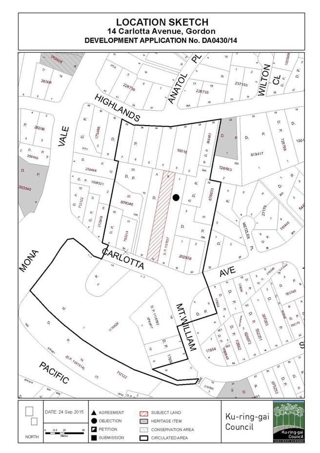
|
APPENDIX No: 2 - Zone
extract - KPSO
|
|
Item No: GB.8
|
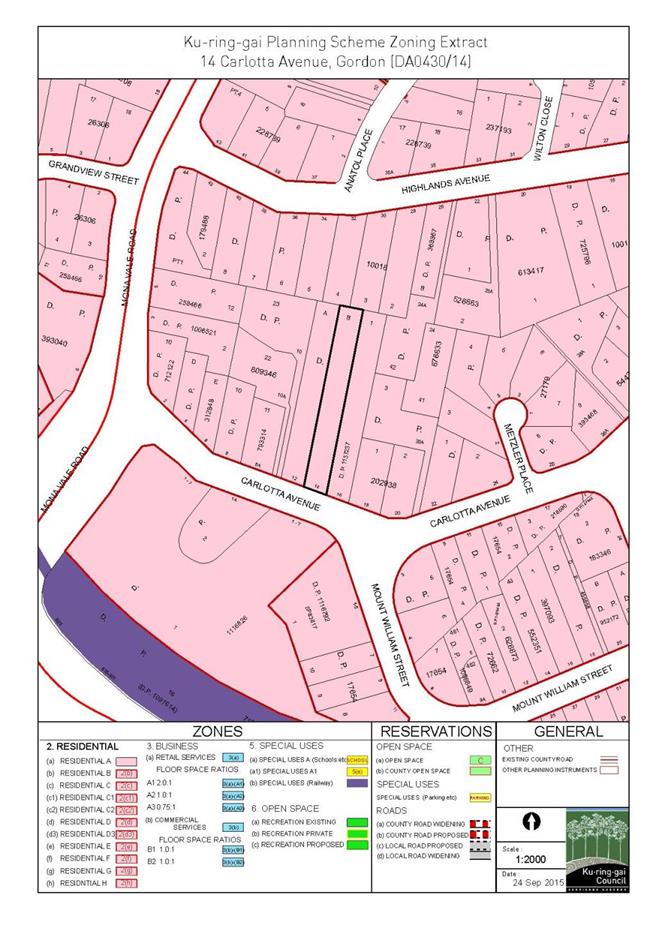
|
APPENDIX No: 3 - Circular
PS 08-014
|
|
Item No: GB.8
|
|
APPENDIX No: 4 - SEPP1
Objection
|
|
Item No: GB.8
|
|
APPENDIX No: 5 - Survey
|
|
Item No: GB.8
|

|
APPENDIX No: 6 - Amended
architectural plans
|
|
Item No: GB.8
|
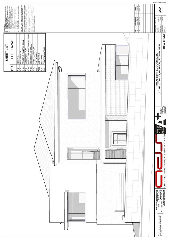
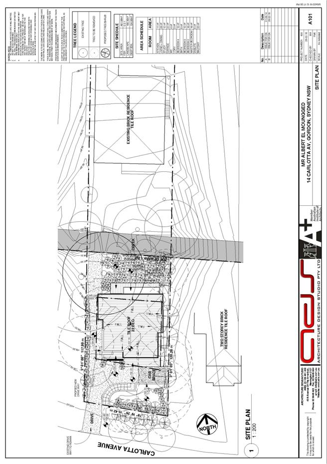
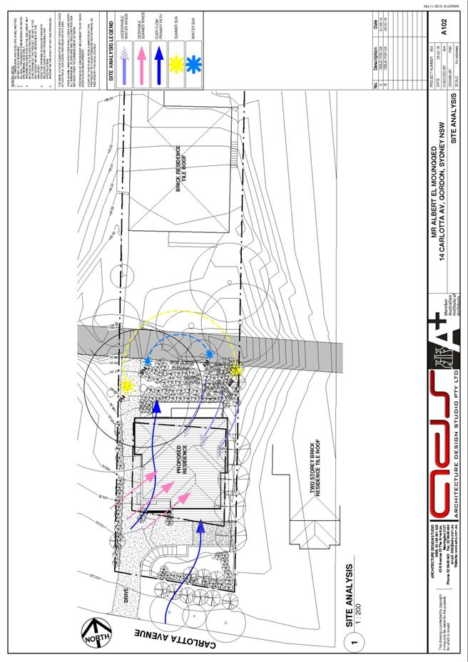
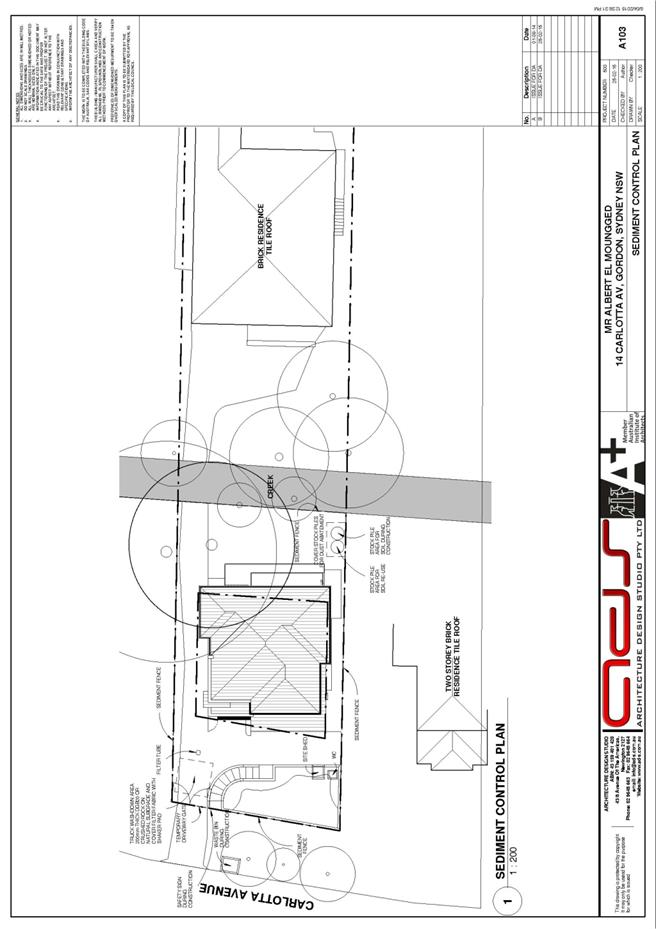
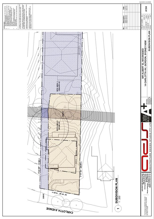
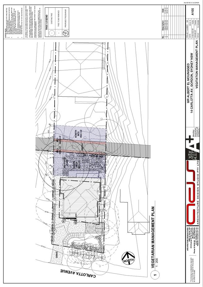
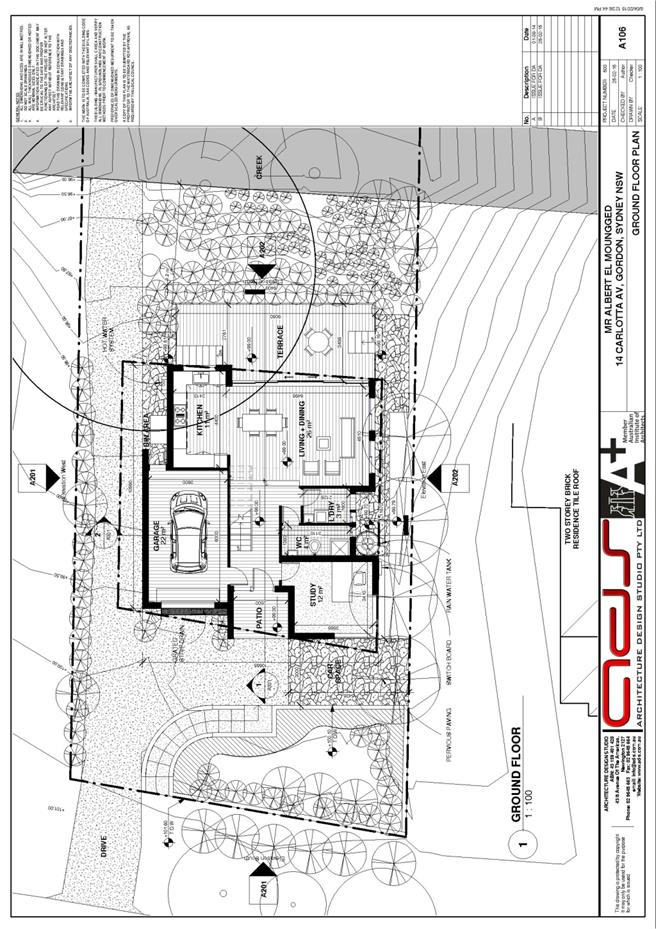
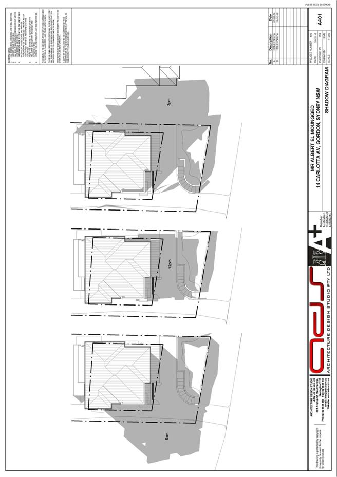
|
APPENDIX No: 7 - Amended
landscape plan
|
|
Item No: GB.8
|

|
Ordinary
Meeting of Council - 6 October 2015
|
GB.9 / 383
|
|
|
|
|
Item
GB.9
|
DA0282/15
|
|
|
3 September 2015
|
Summary
Sheet
|
Report title:
|
28 Holt Avenue
North Wahroonga - Alterations and additions
|
|
ITEM/AGENDA
NO:
|
GB.9
|
|
Application No:
|
DA0282/15
|
|
Property Details:
|
28 Holt Avenue, North Wahroonga
Lot & DP No: Lot 3 Sec 95 DP 242285
Site area (m2): 966.5m2
Zoning: Residential 2(c)
|
|
Ward:
|
Wahroonga
|
|
Proposal/Purpose:
|
Alterations and additions
|
|
Type of Consent:
|
Local
|
|
Applicant:
|
Mr S. J. van Schalkwyk
|
|
Owner:
|
Mr S. J. & Mrs A. van Schalkwyk
|
|
Date Lodged:
|
2 July 2015
|
|
Recommendation:
|
Approval
|
Purpose of Report
To determine Development Application No. 282/15 for
alterations and additions to an existing dwelling.
Consideration of variation pursuant to SEPP No. 1
Circular PS 08-014 (see
attachment) from NSW Planning and Environment requires that all development
applications which involve a variation of a development standard greater than
10% under the provisions of SEPP No. 1 be determined by full Council and not
under delegated authority.
The maximum dwelling height
allowed by clause 46(2) of the KPSO is 8 metres. The subject application
involves construction of an addition to the existing dwelling. The existing
dwelling has a maximum height of 10.56 metres and does not comply with
Council’s maximum height requirement. Accordingly, a SEPP No. 1 objection has
been submitted. As the proposal involves a variation of 32% to Council’s 8
metres height standard, the application is referred to full Council for
determination.
Executive Summary
|
Issues:
|
Building height (SEPP No. 1 objection)
|
|
|
|
Submissions:
|
No submissions received
|
|
|
|
Land and Environment Court:
|
N/A
|
|
|
|
Recommendation:
|
Approval
|
History
Site
The
site has a history of low density residential use.
The Site
Site description
The site is located on the
northern side of Holt Avenue, North Wahroonga. The site is irregular in shape,
with a width of 19.81 metres and a depth of 45.81-51.755 metres. The site has
an area of 966.5m2 (Figure 1).
The site is situated on the high
side of the street and is steeply sloping. The site falls approximately 8.5
metres from its northern corner to its southern corner.
Existing development comprises a
part two, part three storey dwelling house.
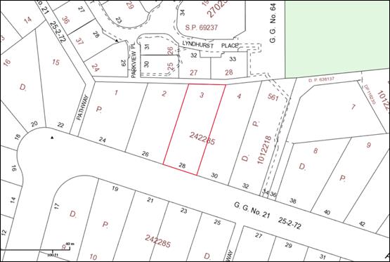
Figure 1: Subject site and surrounding properties
Surrounding development
The site is surrounded by residential
development (Figure 2). To the east and west, are detached dwellings
fronting Holt Avenue. To the north is a community titled development known as
No. 153-165 Grosvenor Street.
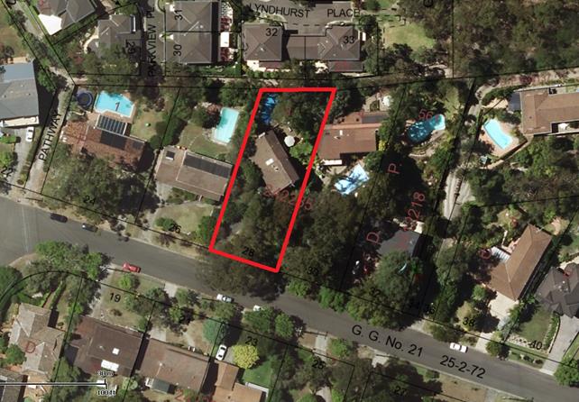
Figure
2: The subject and surrounding properties
The Proposal
The application proposes
alterations and additions to the existing dwelling house as follows:
- an addition to the existing ground floor living/dining room over an
existing balcony; provision of new windows
- a new front door with sidelight
- cladding over the lower half of the existing south-east facing
window
- internal alterations comprising demolition of existing walls to the
kitchen/lounge room
- internal alterations comprising demolition of existing steps and
cupboards and construction of new internal steps and cupboards
- bricking up of existing north-east facing window
- a new roof with skylights over the rear ground floor entertainment
area
- new rear facing bi-fold doors leading to the entertainment area
- cladding over part of an existing north-east facing bedroom window
The proposed additions have been designed to match the
finishes of the existing dwelling (brick and tile).
Consultation
Community
In
accordance with Development Control Plan No. 56, owners of surrounding properties
were given notice of the application. No submissions were received.
Within Council
Landscaping
Council's
Landscape and Tree Assessment Officer has no objection to the proposed
development, subject to standard landscaping conditions (Conditions 24
and 25).
Engineering
Council's Development Engineer
has no objection to the proposed development, subject
to standard engineering conditions (Conditions 20, 21-23 and 26).
Outside Council
Rural
Fire Service
In accordance with the
provisions of section Part 1(b) of Section 79BA of the Environmental Planning
and Assessment Act 1979, Council has been provided with a certificate by a
person who is recognised by the NSW Rural Fire Service as a qualified
consultant in bush fire risk assessment stating that the development conforms
to the relevant specifications and requirements. As such, the application
does not require a referral to the Rural Fire Service.
Council has considered the
measures to be taken with respect to the protection of persons, property and
the environment from danger that may arise from a bush fire. Appropriate
conditions that adopt the recommendations of the bush fire risk assessment report
and certificate have been applied (Conditions 9 and 29).
Statutory Provisions
State Environmental Planning Policies
State
Environmental Planning Policy No. 1 – Development Standards
Clause 46(2) of the KPSO states that a person shall not
erect a dwelling house or dual occupancy with a height in excess of 8 metres.
The height of the existing dwelling is 10.56 metres and
exceeds the maximum height requirement of the KPSO. Whilst it is not proposed
to change the height of the existing dwelling and notwithstanding that the
proposed additions comply with Council’s height control, a SEPP 1 objection is
still technically required. Accordingly, a SEPP 1 objection has been lodged,
which is considered below.
whether the planning control is a development standard
Clause
46 states:
(2) A person shall not erect a
dwelling-house or dual occupancy building with a height in excess of 8 metres.
(4) In this clause –
“Ground level”
means the level of the site before development is carried out on the site under
this Ordinance
“Height” in
relation to a building, means a distance measured vertically from any point on
the ceiling of the topmost floor of the building to the ground level
immediately below that point
Clause 46 of the KPSO is a development standard as defined
by Section 4 of the Environmental Planning and Assessment Act 1979.
the
purpose/object of the standard
There
are no specifically stated purposes or objectives expressed in clause 46(2) of
the KPSO.
The
relevant aims and objectives for residential zones as stated in schedule 9 of
the KPSO are:
(a) All new dwelling-houses and additions
to dwelling-houses maintain a reasonable level of sunlight to neighbour’s
living areas and recreation space between 9am and 3pm during the winter
solstice on 22 June.
(b) All new dwelling-houses and additions
to dwelling-houses are sited and designed so as to minimise overlooking of
neighbour’s living areas and recreation space.
(c) All new dwelling-houses and additions
to existing dwelling-houses are of a height, size and bulk generally in keeping
with that of neighbouring properties and, where larger buildings are proposed,
they are designed so as not to dominate and so far as possible to harmonise
with neighbouring development.
whether
compliance with the development standard is consistent with the aims of the
policy and whether compliance hinders the attainment of objects specified in
section 5(a)(i) and (ii) of the EP & A Act
SEPP
No. 1 provides flexibility for development standards where compliance would be
unreasonable or hinder the attainment of objects of section 5(a)(i) and (ii) of
the Act.
The
objects of the Act are:
(i) to encourage the proper
management, development and conservation of natural and artificial resources
including agricultural land, natural areas, forests, minerals, water, cities,
towns and villages for the purpose of promoting the social and economic welfare
of the community and a better environment.
(ii) Section 5(a)ii encourages the
co-ordination of the orderly and economic use and development of land.
The
proposed development is for alterations and additions to an existing dwelling
which is of a reasonable size and appears to be sound. The proposed development
represents an orderly and economic use of the land as it enables the existing
dwelling to be retained and altered.
whether
compliance with the standard unreasonable or unnecessary in the circumstances
of the case
The
applicant has stated that the existing dwelling has a height of 10.56 metres.
This is a 32% variation to the 8 metres maximum height standard.
The
following is an extract from the applicant’s SEPP 1 objection:
Compliance with this standard is
unreasonable as the ceiling height which is non-compliant with the standard is
existing and has been such since the original house was built.
The proposed addition is on the
ground floor and is well within the height restrictions.
Given that the non-compliance is existing and that the
proposed works are fully compliant, it is agreed that it would be unreasonable
and unnecessary to require the existing dwelling to comply with the current
building height requirement. The proposed addition has a height of 6.19 metres
and does not exacerbate the existing non-compliance. It also complies with
Council’s current maximum height standard.
whether the objection is well founded
The building height non-compliance is existing and is a
result of the historical development of the site. The site has a moderate slope
and it is apparent that the dwelling was designed to take advantage of the
slope through provision of a lower ground level garage.
The proposed addition, which is at ground level and has a
height of 6.19 metres, will not result in any
increase to the height of the existing dwelling, which is 10.56 metres at its
highest point. The SEPP 1 objection is well founded as it will enable
alterations and additions to the existing dwelling to be undertaken. In this
regard, it enables the orderly and economic development of the land.
State
Environmental Planning Policy No. 55 - Remediation of Land
The provisions of SEPP 55
require Council to consider the potential for a site to be contaminated. The
subject site has a history of residential use and as such, it is unlikely to
contain any contamination and further investigation is not warranted in this
case.
Sydney
Regional Environmental Plan No. 20 - Hawkesbury-Nepean River
SREP 20 applies to land within
the catchment of the Hawkesbury Nepean River. The general aim of the plan is
to ensure that development and future land uses within the catchment are
considered in a regional context. The Plan includes strategies for the
assessment of development in relation to water quality and quantity, scenic
quality, aquaculture, recreation and tourism.
The proposed development is
considered to achieve the relevant aims under this policy.
State
Environmental Planning Policy (Building Sustainability Index: BASIX) 2004
A valid BASIX certificate has
been submitted. The certificate demonstrates compliance with the provisions of
the SEPP and adequately reflects all amendments to the application (Condition
27).
Local Content (LEP, KPSO, etc)
Ku-ring-gai Planning Scheme Ordinance
Deferred areas
The Deferred Areas comprise 15 areas within
Ku-ring-gai that have been deferred from inclusion in the Ku-ring-gai Local
Environmental Plan 2015 (KLEP 2015) to allow for
reassessment of bushfire evacuation risk and proposed zoning changes. The
recommendations for deferral were approved during an Ordinary Council Meeting
on 26 November 2013.
The Ku-ring-gai Planning Scheme Ordinance applies to
all development within a Deferred Area, with Draft Ku-ring-gai Local
Environmental Plan 2013 still a matter for consideration.
The subject site is within a Deferred Area. Specifically, it
is within Area 2 – North Wahroonga. The provisions of the KPSO therefore apply.
Part A: Development standards
|
Development standard
|
Proposed
|
Complies
|
|
Site area: 966.5m2
|
|
Building height 8m (max)
|
proposed addition 6.19m
existing dwelling 10.56m
|
YES
NO
|
|
Built upon areas
60% (579.9m2)(max)
|
44% (427m2)
|
YES
|
Building
height (clause 46[2]):
The height of the existing
dwelling is 10.56 metres which exceeds the maximum height standard.
Part B: Aims and objectives for residential zones:
The
development: (i) provides satisfactory levels of solar access & privacy to
surrounding properties; (ii) is of a bulk, scale and design, characteristic of
the area; (iii) maintains adequate levels of soft landscaping; (iv) provides
suitable egress/ingress for vehicles; and (v) maintains the landscape quality
of the municipality. Consequently, the aims and objectives for residential
development as outlined by Schedule 9 have been satisfied.
Draft
Ku-ring-gai Local Environmental Plan 2013
The draft LEP and supporting material was
exhibited from Monday 25 March 2013 to Monday 6 May 2013. The particular aims
of the draft LEP are to guide the future development of land and the management
of environmental, social, economic, heritage and cultural resources within
Ku-ring-gai. The subject site is located within an area identified on the
statutory maps and, as such, the draft LEP forms a consideration for the
assessment of this application.
As a result of the plan, the subject site will
be zoned ‘R2 Low Density Residential’ and the development is permissible within
this zoning. The objectives of the zone are:
· To provide for the housing needs of
the community within a low density residential environment.
· To enable other land uses that
provide facilities or services to meet the day to day needs of residents.
· To provide housing that is
compatible with the existing environmental and low density character of
Ku-ring-gai
The proposal has a built form which is compatible with the
existing low density character of the area and the land to be developed.
Therefore, the proposal meets the objectives of the draft zone.
Policy Provisions (DCPs, Council policies, strategies and
management plans)
Development
Control Plan No. 38 - Ku-ring-gai Residential Design Manual
|
Development Control
|
Proposed
|
Complies
|
|
4.1 Streetscape:
|
|
Building setbacks (s.4.1.3)
|
|
|
|
Front setback: 14m (avg) -75% front
elevation
12m (min) - 25% front elevation
|
14m (min)
21m (avg)
|
YES
YES
|
|
Side setback: Ground floor: 2
(min)
|
1m ground floor setback to
south-eastern side boundary
|
NO
|
|
Rear setback: 12m(min) (avg site
depth greater than 48m)
|
11.2m (building)
9.864m (awning)
|
NO
|
|
4.2 Building form:
|
|
FSR (s.4.2.1) 0.37:1 (max) 361m2
|
0.3:1 or 296m2
|
YES
|
|
Height of building (s.4.2.2)
|
|
|
|
2 storey (max) and 8m (site >200
slope) or 7m (site <200 slope)
|
proposed addition 6.19m
existing dwelling 10.56m
|
YES
NO
|
|
Building height plane (s.4.2.3) 450 from horizontal at
any point 3m above boundary
|
0.8m non-compliance to south-eastern
side boundary
|
NO
|
|
First floor (s.4.2.4)
|
|
|
|
FSR: < 40% total FSR
|
45%
|
NO
|
|
Roof Line (s.4.2.6)
|
|
|
|
Roof height (5m - single storey)
(3m - two+ storey)
|
unchanged
|
N/A
|
|
Roof pitch 350 (max)
|
unchanged
|
N/A
|
|
Built-upon area (s.4.2.7)
54% (521m2) (max)
|
44% (427m2)
|
YES
|
|
Unrelieved wall length (s.4.2.8) 12m for walls less than 4m in
height 8m for walls more than 4m in height
|
unchanged
|
N/A
|
|
Solar access (4.2.11) 4h solar access to adjoining
properties between 9am to 3pm
|
Solar access to adjoining property
at No. 30 Holt Avenue maintained between 9am and 12pm
|
YES
|
|
4.3 Open space & landscaping:
|
|
Useable open space (s.4.3.8) Min depth 5m and min area 50m2
|
Min depth 9.8m and area of 204m2
|
YES
|
|
4.4 Privacy & security:
|
|
The proposed rear awning is over an
existing entertaining area and will not result in any adverse privacy impacts
to the adjoining properties to the rear, Nos 32 and 33 Lyndhurst Place.
The proposed lounge room addition
is over an existing balcony. The proposed addition is set back 9 metres from
the swimming pool at No. 30 Holt Avenue and does not feature any windows
along its north-eastern elevation. As such, the proposed addition will not
result in any adverse privacy impacts.
|
Building setbacks (s.4.1.3)
Side
setbacks
Section
4.1.3 of the DCP states that two storey dwellings on lots with a width of less
than 20 metres should be set back a minimum of 2 metres from the side boundaries.
The objective of this requirement is to allow for significant landscaping
between buildings.
The
proposed ground floor addition is set back 1 metre from the south-eastern side
boundary. Whilst the proposal does not comply with Council’s numerical
requirements, the proposed setback is acceptable for the following reasons:
· The proposed setback will not result in any adverse visual
bulk impacts to the streetscape or adjoining property. The pattern of
development is irregular due to the topography of the locality. As a result,
the dwelling on the adjoining property, No. 30 Holt Avenue, is set further
back, behind the subject dwelling (Figure 2).
· The proposed side setback will not result in any adverse
solar access impacts for the reasons listed above.
· The proposed addition is over an existing elevated ground
floor level balcony and is within the existing building footprint.
Rear
setbacks
Section 4.1.3 of the DCP
requires a minimum rear setback of 12 metres for dwellings on sites with a
depth of more than 48 metres. The relevant objectives
of section 4.1.3 are as follows:
· to ensure the amenity of neighbouring properties is
maintained or enhanced
· to allow for the provision of landscaping and to provide
room for additional tree plantings
· to facilitate solar access
· to protect significant vegetation
· to facilitate efficient use of the site
The existing development has a
rear setback of 11.2 metres to the wall of the existing dwelling. The post of
the proposed awning is set back 9.864 metres from the rear boundary and
encroaches on the required rear setback area.
The proposed awning will not
result in any adverse bulk or privacy impacts to adjoining properties and will
maintain their amenity in this regard. The awning is over an existing paved
area and does not preclude provision of an appropriate amount of private open
space nor does it impact upon existing vegetation. The proposed awning is over
an existing entertainment area and therefore facilitates efficient use of the
site. It is an open, single storey structure and will not result in any adverse
solar access impacts. For these reasons, the proposed awning is acceptable.
Height of building (s.4.2.2)
Section 4.2.2 of the DCP states
that a dwelling must not exceed two storeys in height. However, the DCP states
that Council may consider an additional floor on sloping sites where the height
is not evident from public areas or adjoining properties and where excavation
is not excessive.
The existing dwelling is three
storeys in height, having been designed to accommodate a lower ground floor
level within the slope of the land. The proposed addition is at ground floor
level and will not increase the height of the existing dwelling. The proposed
addition is therefore considered acceptable.
Building height plane (s.4.2.3)
Section 4.2.3
of DCP No. 38 states that development should avoid the creation of an
overbearing impact upon adjoining development in order to:
· maintain the relative scale relationship between buildings
· ensure that daylight to habitable rooms in adjacent dwellings is not
significantly reduced
· ensure that sunlight to the private open spaces of the subject property
and adjacent properties is not significantly reduced
· encourage increased setback with increased height
The DCP states
that this objective may be achieved by compliance with the building height
plane.
The proposed
development will project some 0.8 metres beyond the building envelope at the
south-eastern side boundary. The non-compliance is minor in nature and will not
result in any adverse bulk impacts to the streetscape. This is because the
existing dwelling is set back a minimum of 14 metres from the front property
boundary. The proposed non-compliance will not result in any adverse bulk
impacts to the adjoining property, as the dwelling and primary area of private
open space of the adjoining property, No. 30 Holt Avenue, are set significantly
behind the subject dwelling (Figure 2).
First floor area (s.4.2.4)
DCP
No. 38 states that the first floor of dwellings should be well integrated into
the design of the development to avoid an overbearing bulk/scale relationship
with neighbouring properties. The DCP states that this should be achieved by
“stepping back” upper levels and ensuring that the first floor does not exceed
40% of total floor space.
The
proposed ground floor addition results in the first floor of the dwelling
having a floor area of 45%. However, this is an improvement on the existing
situation, in which the first floor comprises 50% of the total floor area. The
proposed ground floor addition assists in “balancing” the existing dwelling by
providing a larger ground floor area (Figure 3). It is therefore
acceptable.
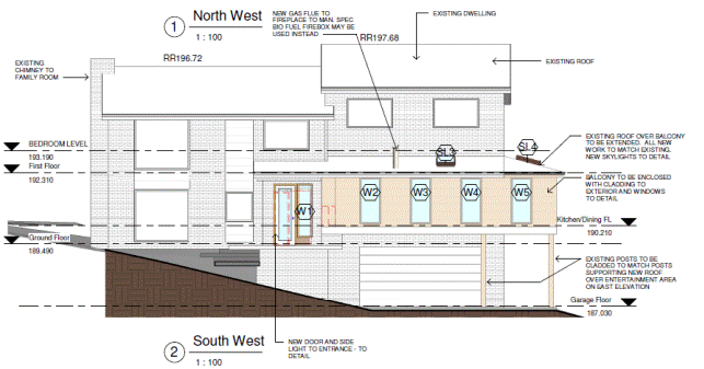
Figure 3: South-western elevation showing ground floor addition
Likely Impacts
The
proposed development will not result in any adverse streetscape, solar access,
privacy, stormwater or visual bulk impacts.
Suitability of the Site
The
site is zoned for residential purposes and is considered to be suitable for the
proposed development, being alterations and additions to an existing
residential dwelling.
Public Interest
The approval of the application is
considered to be in the public interest.
Conclusion
Having regard to the provisions
of section 79C of the Environmental Planning and Assessment Act 1979, the
proposed development is considered to be satisfactory. Therefore, it is
recommended that the application be approved.
|
Recommendation:
A. That
Council, as the consent authority, is satisfied that the objection under State Environmental Planning
Policy No. 1 - Development Standards to the maximum height development
standard in clause 46(2) of the Ku-ring-gai Planning Scheme Ordinance is well
founded. Council is also of the opinion
that strict compliance with the development standard is unreasonable and
unnecessary in the circumstances of this case as the height non-compliance
relates to the existing dwelling and will not be exacerbated by the proposed
additions.
B. That Council, as the
consent authority, grant development consent to DA0282/15 for alterations and additions on land at No. 28 Holt Avenue, North Wahroonga for
a period of two (2) years from the date of the Notice of
Determination, subject to the following conditions:
Conditions
that identify approved plans:
1. Approved
architectural plans and documentation (alterations and additions)
The development must be carried
out in accordance with work shown in colour on the following plans and
documentation listed below and endorsed with Council’s stamp, except where
amended by other conditions of this consent.
|
Plan no.
|
Drawn by
|
Dated
|
|
A001 Site and roof
|
Alison Ludwig
|
June 15
|
|
A101 Ground floor plan
|
Alison Ludwig
|
June 15
|
|
A102 First and garage floor
plans
|
Alison Ludwig
|
June 15
|
|
A301 South-east and
north-east elevations and Section A
|
Alison Ludwig
|
June 15
|
|
A302 North-west and
south-west elevations and BASIX notes
|
Alison Ludwig
|
June 15
|
|
Document(s)
|
Dated
|
|
Basix certificate No.
A224296
|
14 July 2015
|
|
Bush fire risk assessment
and certification, prepared by Sydney Bushfire Consultants
|
20 July 2015
|
Reason: To
ensure that the development is in accordance with the determination.
2. Inconsistency
between documents
In
the event of any inconsistency between conditions of this consent and the
drawings/documents referred to above, the conditions of this consent prevail.
Reason: To
ensure that the development is in accordance with the determination.
Conditions
to be satisfied prior to demolition, excavation or construction:
3. Asbestos
works
All
work involving asbestos products and materials, including
asbestos-cement-sheeting (ie. Fibro), must be carried out in accordance with
the guidelines for asbestos work published by WorkCover Authority of NSW.
Reason: To
ensure public safety.
4. Notice of
commencement
At least 48 hours prior to the
commencement of any development (including demolition, excavation, shoring or
underpinning works), a notice of commencement of building or subdivision work
form and appointment of the principal certifying authority form shall be
submitted to Council.
Reason: Statutory
requirement.
5. Notification of
builder’s details
Prior to the commencement of any development or
excavation works, the Principal Certifying Authority shall be notified in
writing of the name and contractor licence number of the owner/builder
intending to carry out the approved works.
Reason: Statutory requirement.
Conditions
to be satisfied prior to the issue of the construction certificate:
6. Long service levy
In accordance with Section
109F(i) of the Environmental Planning and Assessment Act a Construction
Certificate shall not be issued until any long service levy payable under
Section 34 of the Building and Construction Industry Long Service Payments
Act 1986 (or where such levy is payable by instalments, the first instalment
of the levy) has been paid. Council is authorised to accept payment. Where
payment has been made elsewhere, proof of payment is to be provided to
Council.
Reason: Statutory
requirement.
7. Builder’s indemnity
insurance
The
applicant, builder, developer or person who does the work on this
development, must arrange builder’s indemnity insurance and submit the
certificate of insurance in accordance with the requirements of Part 6 of the
Home Building Act 1989 to the Certifying Authority for endorsement of the
plans accompanying the Construction Certificate.
It is the
responsibility of the applicant, builder or developer to arrange the
builder's indemnity insurance for residential building work over the value of
$20,000. The builder's indemnity insurance does not apply to commercial or
industrial building work or to residential work valued at less than $20,000,
nor to work undertaken by persons holding an owner/builder's permit issued by
the Department of Fair Trading (unless the owner/builder's property is sold
within 7 years of the commencement of the work).
Reason: Statutory requirement.
Conditions
to be satisfied prior to the issue of the construction certificate or prior to demolition, excavation
or construction (whichever comes first):
8. Infrastructure
restorations fee
To ensure that damage to
Council Property as a result of construction activity is rectified in a
timely matter:
a) All work or activity taken in furtherance of the development
the subject of this approval must be undertaken in a manner to avoid damage
to Council Property and must not jeopardise the safety of any person using or
occupying the adjacent public areas.
b) The applicant, builder, developer or any person acting in
reliance on this approval shall be responsible for making good any damage to
Council Property, and for the removal from Council Property of any waste bin,
building materials, sediment, silt, or any other material or article.
c) The Infrastructure Restoration Fee must be paid to the Council
by the applicant prior to both the issue of the Construction Certificate and
the commencement of any earthworks or construction.
d) In consideration of payment of the Infrastructure Restorations
Fee, Council will undertake such inspections of Council Property as Council
considers necessary and also undertake, on behalf of the applicant, such
restoration work to Council Property, if any, that Council considers
necessary as a consequence of the development. The provision of such
restoration work by the Council does not absolve any person of the
responsibilities contained in (a) to (b) above. Restoration work to be
undertaken by the Council referred to in this condition is limited to work
that can be undertaken by Council at a cost of not more than the
Infrastructure Restorations Fee payable pursuant to this condition.
e) In this condition:
“Council
Property” includes any road, footway, footpath paving, kerbing, guttering,
crossings, street furniture, seats, letter bins, trees, shrubs, lawns,
mounds, bushland, and similar structures or features on any road or public
road within the meaning of the Local Government Act 1993 (NSW) or any public
place; and
“Infrastructure
Restoration Fee” means the Infrastructure Restorations Fee calculated in
accordance with the Schedule of Fees & Charges adopted by Council as at
the date of payment and the cost of any inspections required by the Council
of Council Property associated with this condition.
Reason: To
maintain public infrastructure.
9. Bush
fire risk certification
Bush
fire protection measures shall be carried out in accordance with the
following bush fire risk assessment, report and certificate, listed below and
endorsed with Council’s stamp, except where amended by other conditions of
this consent:
|
Document
title
|
Prepared
by
|
Dated
|
|
Bushfire
Assessment and Compliance Report
|
Sydney
Bushfire Consultants
|
20
July 2015
|
Prior
to the issue of the construction certificate, the principal certifying
authority must be satisfied that the construction certificate is in
accordance with the recommendations of the report and certificate as listed
above.
Reason: To
ensure that the development is in accordance with the determination.
Conditions
to be satisfied during the demolition, excavation and construction phases:
10. Road opening permit
The opening of any footway, roadway, road
shoulder or any part of the road reserve shall not be carried out without a
road opening permit being obtained from Council (upon payment of the required
fee) beforehand.
Reason: Statutory requirement
(Roads Act 1993 Section 138) and to maintain the integrity of Council’s
infrastructure.
11. Prescribed conditions
The applicant shall comply
with any relevant prescribed conditions of development consent under clause
98 of the Environmental Planning and Assessment Regulation. For the purposes
of section 80A (11) of the Environmental Planning and Assessment Act, the following
conditions are prescribed in relation to a development consent for
development that involves any building work:
· The work must be
carried out in accordance with the requirements of the Building Code of
Australia
· In the case of
residential building work for which the Home Building Act 1989 requires there
to be a contract of insurance in force in accordance with Part 6 of that Act,
that such a contract of insurance is in force before any works commence.
Reason: Statutory requirement.
12. Hours of work
Demolition, excavation,
construction work and deliveries of building material and equipment must not
take place outside the hours of 7.00am to 5.00pm Monday to Friday and 8.00am
to 12 noon Saturday. No work and no deliveries are to take place on Sundays
and public holidays.
Excavation or removal of any
materials using machinery of any kind, including compressors and jack
hammers, must be limited to between 7.30am and 5.00pm Monday to Friday, with
a respite break of 45 minutes between 12 noon 1.00pm.
Where it is necessary for
works to occur outside of these hours (ie) placement of concrete for large
floor areas on large residential/commercial developments or where building
processes require the use of oversized trucks and/or cranes that are restricted
by the RTA from travelling during daylight hours to deliver, erect or remove
machinery, tower cranes, pre-cast panels, beams, tanks or service equipment
to or from the site, approval for such activities will be subject to the
issue of an "outside of hours works permit" from Council as well as
notification of the surrounding properties likely to be affected by the
proposed works.
Note: Failure to obtain a permit to work
outside of the approved hours will result in on the spot fines being issued.
Reason: To ensure reasonable standards of amenity for
occupants of neighbouring properties.
13. Approved plans to be
on site
A
copy of all approved and certified plans, specifications and documents
incorporating conditions of consent and certification (including the
Construction Certificate if required for the work) shall be kept on site at
all times during the demolition, excavation and construction phases and must
be readily available to any officer of Council or the Principal Certifying
Authority.
Reason: To
ensure that the development is in accordance with the determination.
14. Site notice
A site notice shall be erected
on the site prior to any work commencing and shall be displayed throughout
the works period.
The site notice must:
· be prominently
displayed at the boundaries of the site for the purposes of informing the
public that unauthorised entry to the site is not permitted
· display project
details including, but not limited to the details of the builder, Principal
Certifying Authority and structural engineer
· be durable and
weatherproof
· display the approved
hours of work, the name of the site/project manager, the responsible managing
company (if any), its address and 24 hour contact phone number for any
inquiries, including construction/noise complaint are to be displayed on the
site notice
· be mounted at eye
level on the perimeter hoardings/fencing and is to state that unauthorised
entry to the site is not permitted
Reason: To ensure public safety and public information.
15. Dust control
During excavation, demolition
and construction, adequate measures shall be taken to prevent dust from
affecting the amenity of the neighbourhood. The following measures must be
adopted:
· physical barriers
shall be erected at right angles to the prevailing wind direction or shall be
placed around or over dust sources to prevent wind or activity from
generating dust
· earthworks and
scheduling activities shall be managed to coincide with the next stage of
development to minimise the amount of time the site is left cut or exposed
· all materials shall be
stored or stockpiled at the best locations
· the ground surface
should be dampened slightly to prevent dust from becoming airborne but should
not be wet to the extent that run-off occurs
· all vehicles carrying
spoil or rubble to or from the site shall at all times be covered to prevent
the escape of dust
· all equipment wheels
shall be washed before exiting the site using manual or automated sprayers
and drive-through washing bays
· gates shall be closed
between vehicle movements and shall be fitted with shade cloth
· cleaning of footpaths
and roadways shall be carried out daily
Reason: To protect the environment and amenity of
surrounding properties.
16. Use
of road or footpath
During
excavation, demolition and construction phases, no building materials, plant
or the like are to be stored on the road or footpath without written approval
being obtained from Council beforehand. The pathway shall be kept in a
clean, tidy and safe condition during building operations. Council reserves
the right, without notice, to rectify any such breach and to charge the cost
against the applicant/owner/builder, as the case may be.
Reason: To ensure safety and amenity of the area.
17. Toilet
facilities
During excavation,
demolition and construction phases, toilet facilities are to be provided, on
the work site, at the rate of one toilet for every 20 persons or part of 20
persons employed at the site.
Reason: Statutory requirement.
18. Recycling
of building material (general)
During demolition and
construction, the Principal Certifying Authority shall be satisfied that
building materials suitable for recycling have been forwarded to an
appropriate registered business dealing in recycling of materials. Materials
to be recycled must be kept in good order.
Reason: To facilitate recycling of materials.
19. Construction
signage
All construction signs must
comply with the following requirements:
· are not to cover any
mechanical ventilation inlet or outlet vent
· are not illuminated,
self-illuminated or flashing at any time
· are located wholly
within a property where construction is being undertaken
· refer only to the
business(es) undertaking the construction and/or the site at which the
construction is being undertaken
· are restricted to one
such sign per property
· do not exceed 2.5m2
· are removed within 14
days of the completion of all construction works
Reason: To ensure compliance with Council's controls
regarding signage.
20. Road reserve safety
All public footways and
roadways fronting and adjacent to the site must be maintained in a safe
condition at all times during the course of the development works.
Construction materials must not be stored in the road reserve. A safe
pedestrian circulation route and a pavement/route free of trip hazards must
be maintained at all times on or adjacent to any public access ways fronting
the construction site. Where public infrastructure is damaged, repair works
must be carried out when and as directed by Council officers. Where
pedestrian circulation is diverted on to the roadway or verge areas, clear
directional signage and protective barricades must be installed in accordance
with AS1742-3 (1996) “Traffic Control Devices for Work on Roads”. If
pedestrian circulation is not satisfactorily maintained across the site
frontage, and action is not taken promptly to rectify the defects, Council
may undertake proceedings to stop work.
Reason: To ensure safe public footways and roadways
during construction.
21. Services
Where required, the adjustment
or inclusion of any new utility service facilities must be carried out by the
applicant and in accordance with the requirements of the relevant utility
authority. These works shall be at no cost to Council. It is the applicants’
full responsibility to make contact with the relevant utility authorities to
ascertain the impacts of the proposal upon utility services (including water,
phone, gas and the like). Council accepts no responsibility for any matter
arising from its approval to this application involving any influence upon
utility services provided by another authority.
Reason: Provision of utility services.
22. Erosion control
Temporary sediment and erosion
control and measures are to be installed prior to the commencement of any
works on the site. These measures must be maintained in working order during
construction works up to completion. All sediment traps must be cleared on a
regular basis and after each major storm and/or as directed by the Principal
Certifying Authority and Council officers.
Reason: To protect the environment from erosion and
sedimentation.
23. Drainage to existing
system
Stormwater runoff from all new
impervious areas and subsoil drainage systems shall be piped to the existing
site drainage system. The installation of new drainage components must be
completed by a licensed contractor in accordance with AS3500.3 (Plumbing
Code) and the BCA. No stormwater runoff is to be placed into the Sydney Water
sewer system. If an illegal sewer connection is found during construction,
the drainage system must be rectified to the satisfaction of Council and
Sydney Water.
Reason: To protect the environment.
24. No
storage of materials beneath trees
No
activities, storage or disposal of materials shall take place beneath the
canopy of any tree protected under Council's Tree Preservation Order at any
time.
Reason: To
protect existing trees.
25. Removal
of refuse
All
builders' refuse, spoil and/or material unsuitable for use in landscape areas
shall be removed from the site on completion of the building works.
Reason: To
protect the environment.
26. On site retention of waste dockets
All
demolition, excavation and construction waste dockets are to be retained on
site, or at suitable location, in order to confirm which facility received
materials generated from the site for recycling or disposal.
· Each docket is to be
an official receipt from a facility authorised to accept the material type,
for disposal or processing.
· This information is to
be made available at the request of an Authorised Officer of Council.
Reason: To
protect the environment.
Conditions
to be satisfied prior to the issue of an Occupation Certificate:
27. Compliance with BASIX
Certificate
Prior to the issue of an
Occupation Certificate, the Principal Certifying Authority shall be satisfied
that all commitments listed in BASIX Certificate No. A224296 have been
complied with.
Reason: Statutory requirement.
28. Infrastructure repair
Prior to issue of the
Occupation Certificate, the Principal Certifying Authority must be satisfied
that any damaged public infrastructure caused as a result of construction
works (including damage caused by, but not limited to, delivery vehicles,
waste collection, contractors, sub-contractors, concrete vehicles) is fully
repaired to the satisfaction of Council Development Engineer and at no cost
to Council.
Reason: To protect public infrastructure.
29. Compliance with bush
fire assessment, report and certificate
Prior to the issue of an
Occupation Certificate, the Principal Certifying Authority shall be satisfied
that all recommendations listed in the bush fire risk assessment and report
below have been complied with:
|
Document
title
|
Prepared
by
|
Dated
|
|
Bushfire
Assessment and Compliance Report
|
Sydney
Bushfire Consultants
|
20
July 2015
|
Reason: Statutory requirement.
|
|
Brodee Gregory
Senior Assessment Officer
|
Selwyn Segall
Team Leader - Development Assessment North
|
|
Corrie Swanepoel
Manager Development Assessment Services
|
Michael Miocic
Director Development & Regulation
|
|
Attachments:
|
A1View
|
Attachment
1 - DOP Circular
|
|
2010/010577
|
|
|
A2View
|
Attachment
2 - Location sketch
|
|
2015/249454
|
|
|
A3View
|
Attachment
3 - Zoning Extract
|
|
2015/249438
|
|
|
A4View
|
Attachment
4 - Site plan
|
|
2015/187619
|
|
|
A5View
|
Attachment
5 - Ground floor plan
|
|
2015/187626
|
|
|
A6View
|
Attachment
6 - Lower and first floor plans
|
|
2015/187628
|
|
|
A7View
|
Attachment
7 - Elevations and section
|
|
2015/187630
|
|
APPENDIX
No: 1 - Attachment
1 - DOP Circular
|
|
Item No: GB.9
|
|
APPENDIX No: 2 - Attachment
2 - Location sketch
|
|
Item No: GB.9
|
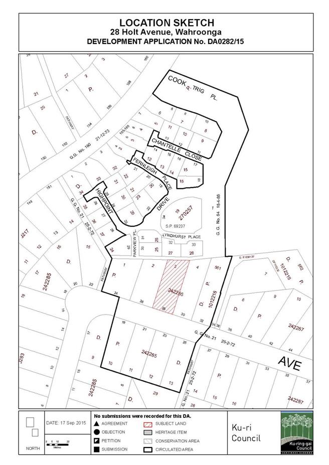
|
APPENDIX No: 3 - Attachment
3 - Zoning Extract
|
|
Item No: GB.9
|
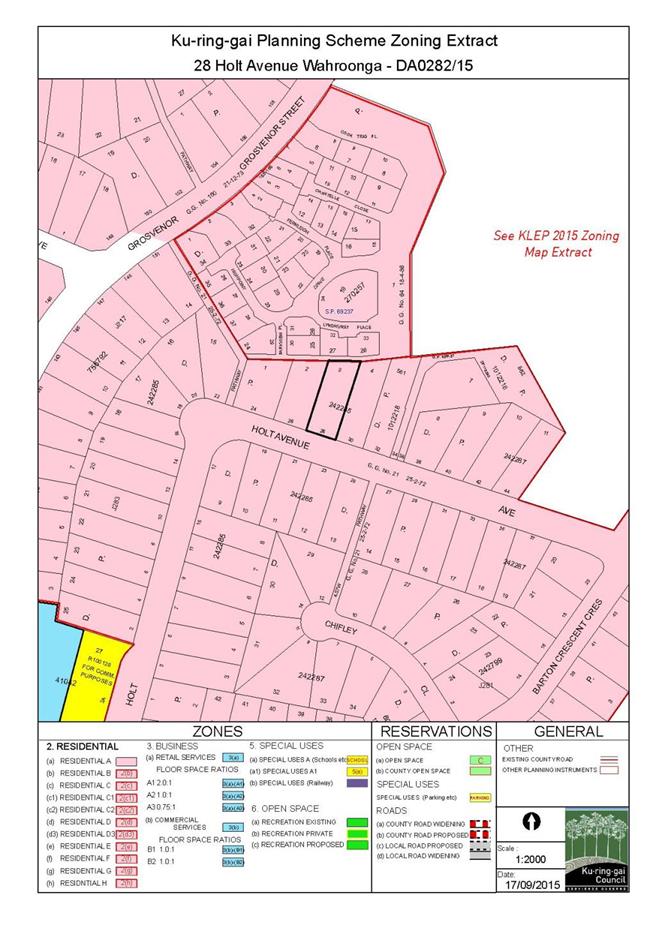
|
APPENDIX No: 4 - Attachment
4 - Site plan
|
|
Item No: GB.9
|
|
APPENDIX No: 5 - Attachment
5 - Ground floor plan
|
|
Item No: GB.9
|
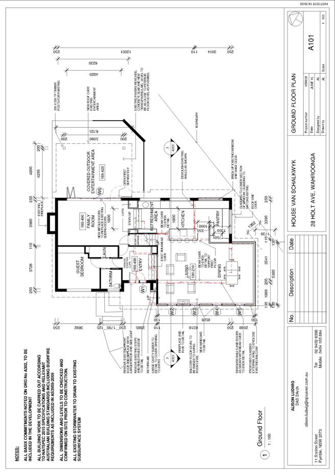
|
APPENDIX No: 6 - Attachment
6 - Lower and first floor plans
|
|
Item No: GB.9
|
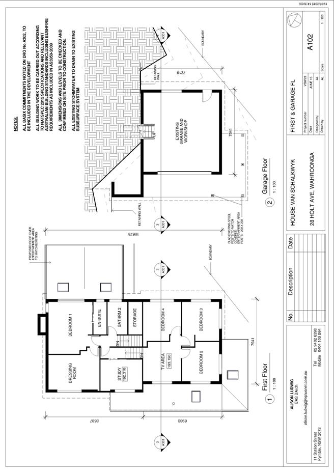
|
APPENDIX No: 7 - Attachment
7 - Elevations and section
|
|
Item No: GB.9
|
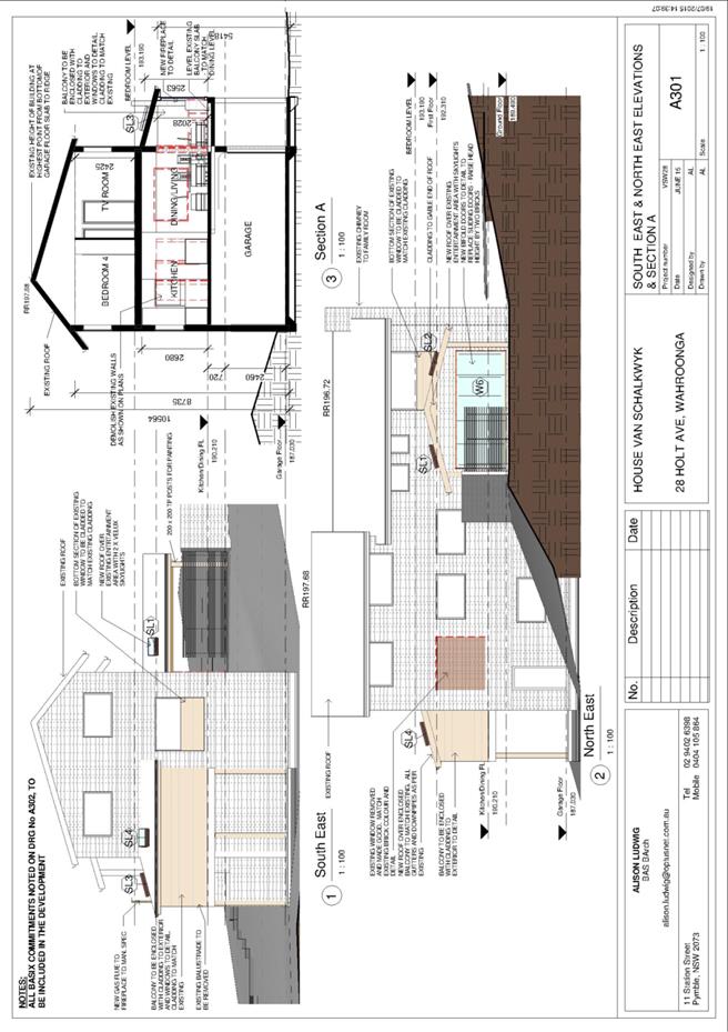
|
Ordinary
Meeting of Council - 6 October 2015
|
GB.10 / 412
|
|
|
|
|
Item
GB.10
|
S10362
|
|
|
11 September 2015
|
Lindfield Community Hub - Update Report
EXECUTIVE
SUMMARY
|
purpose of report:
|
To present a comprehensive assessment of the four (4)
exhibited illustrative development options for the Lindfield Community Hub
site; and recommend a preferred option for Council adoption for the purposes
of an Expression of Interest (EOI).
|
|
|
|
|
background:
|
At OMC of 8 September 2015,
Council resolved to defer adoption of a preferred option for the Lindfield
Community Hub requesting staff report back to Council on 6 October 2015
advising on the results of market sounding and on any recommended refinements
to the preferred option prior to advertising an Expression of Interest.
|
|
|
|
|
comments:
|
Four (4) illustrative master plan
options for the Lindfield Community Hub were prepared and publicly exhibited
during the period 21 March 2015 to 14 May 2015.
This report presents a
comprehensive assessment of the options using criteria adopted by Council in
November 2014; in addition this report presents a summary of the findings
from a market sounding process undertaken by consultants, on behalf of
Council, for a period of 3 weeks commencing 31 August 2015.
|
|
|
|
|
recommendation:
|
This report recommends that
Council adopt Option 2 (as exhibited) with a maximum building height of 7
storey heights; and for the purposes of an Expression of Interest (EOI) adopt
a variation of Option 2 that excludes Scouts Association land and AUSGRID
land.
This report also recommends that Council advertises an EOI
seeking proposals from development companies based on Option 2 (revised EOI
version) and that Council accepts non-conforming bids from the EOI process.
|
Purpose of Report
To present a comprehensive assessment of the four (4)
exhibited illustrative development options for the Lindfield Community Hub
site; and recommend a preferred option for Council adoption for the purposes of
an Expression of Interest (EOI).
Background
On 8 September 2015 at OMC 271 - Lindfield Community Hub
Preferred Option, Council resolved as follows:
A. That
adoption of a specific option be deferred and considered on 6 October with the results
of the market sounding process.
B. Adopt
the Governance Structure for the Lindfield Community Hub as attached to this
report;
C. Adopt
the Probity Plan & Market Sounding Probity Protocol for the Lindfield
Community Hub as attached to this report;
D. Adopt
the Project Decision Making Framework for the Lindfield Community Hub as
attached to this report; and
E. Adopt
the Risk Management Plan for the Lindfield Community Hub as attached to this
report.
F. That
staff report back to council advising on the results of the market sounding and
on any recommended refinements to the preferred option prior to advertising an
Expression of Interest.
The full list of council reports which pertain to the
Lindfield Hub project have been set out below for reference:
1. OMC –
26 June 2012 – GB.9 - Council Car Park – Woodford Lane, Lindfield –
Reclassification
2. OMC –
26 February 2013 – GB.16 - Woodford Lane, Lindfield Commuter Car Park
3. OMC –
28 May 2013 – GB.10 - Lindfield Community Hub and Commuter Car Park – Next
Steps
4. OMC –
30 July 2013 – GB.5 – Proposed Reclassification of 1B Beaconsfield Parade and
19 Drovers Way, Lindfield (Woodford Lane Car Park) to Operational Land
Following the Exhibition and Public Hearing Process
5. OMC –
12 November 2013 – C.1 - Potential Property Acquisition – Lindfield
6. OMC -
10 December 2013 - GB.19 - Lindfield Village Green - Tryon Road - Project
Update
7. OMC –
24 June 2014 – C.1 - Property Acquisition - Lindfield
8. OMC –
9 September 2014 – GB.4 – Lindfield Community Hub – Woodford Lane – Report on
Progress
9. OMC -
11 November 2014 – GB.7 – Lindfield Community Hub – Probity Matters
10. OMC –
25 November 2014 – GB.8 – Lindfield Community Hub – Probity Management Plan
11. OMC – 9
December 2014 – Tender No. RFT22/2014 – Lindfield Community Hub – Tender For
Consultants to Prepare Illustrative Development Options and Master Plan
12. OMC –
21 April 2015 – GB.5 – Compulsory Acquisition of Roads – Lindfield
13. OMC – 8
September 2015 – GB.9 – Lindfield Community Hub Preferred Option
Comments
4 (four) illustrative master
plan options were prepared and exhibited during the period between
21 March 2015 to 14 May 2015 during which the community and all key
stakeholders were extensively consulted (refer details under Community Consultation
in this report). A summary of the exhibited options has been provided below.
Full details of these options can be viewed on Council’s website at:
http://www.kmc.nsw.gov.au/Current_projects_priorities/Key_priorities/Activate_Lindfield/Lindfield_Community_Hub
Option 1 - Key Components
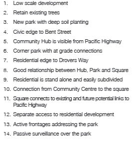
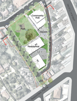
Figure 1: Option 1 - Plan
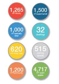
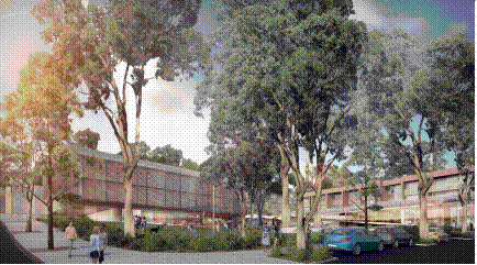
Figure 2: Option
1 Figure 3:
Option 1 – 3-D View
Development Statistics
Option 2 - Key Components
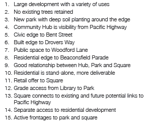
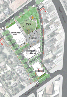
Figure 4: Option 2 - Plan
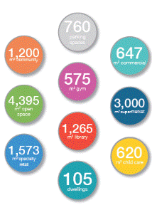
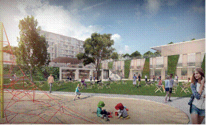
Figure 5: Option
2 Figure 6:
Option 2 – 3-D View
Development Statistics
Option 3
- Key Components`

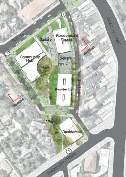
Figure 7: Option 3 - Plan
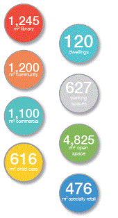
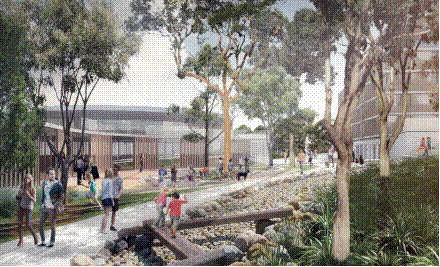
Figure 8: Option
3 Figure 9: Option
3 – 3-D View
Development Statistics
Option 4 - Key Components

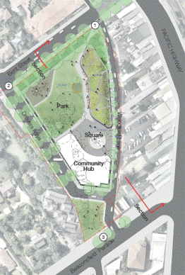
Figure 10: Option 4 - Plan
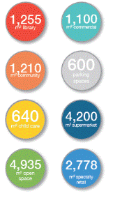
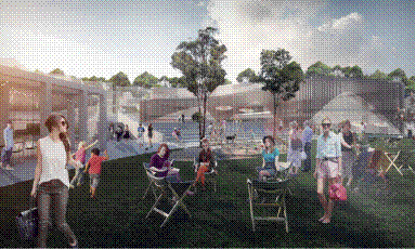
Figure 11: Option
4 Figure 12:
Option 4 – 3-D View
Development Statistics
1. Assessment of Exhibited Master Plan Options
This report seeks to provide a comprehensive assessment of
the site against the criteria adopted by Council in November 2014, with the
view to recommending a preferred option to Council, the criteria are:
· public & stakeholder responses;
· project costs;
· financial feasibility;
· project objectives;
· traffic & transport;
· community facilities review;
· specialist council staff review;
· project working group (PWG) approval;
and
· full Council approval.
Each option is ranked 1 through to 4 with 4 being the
highest score and 1 being the lowest score. The scores are colour coded for
legibility; green (score of 4); brown (score of 3); orange (score of 2); and
red (score of 1).
1.1 Public
and Stakeholder Responses
Responses to the
exhibited options are addressed under three components:
- On-line
survey results;
- Community
workshop results; and
- Public
Submissions.
CRED community planning was engaged
to manage the community engagement programme for the Lindfield Hub project and
to report on the results. The full engagement outcomes report Lindfield
Community Hub, Community Engagement Outcomes Report, 2015 can be viewed on
Council’s website at http://haveyoursaykuringgai.com.au/lindfield-community-hub
1.1.1 On-line
survey results
An online survey was conducted
between 21 March 2015 and 14 May 2015, in which 63% of respondents showed a
preference for Option 4, and the rest for Option 2. Option 4 precludes
residential uses and has a maximum building height of 3 storeys. Results
indicate residents want a new and larger supermarket with a range of high
quality shops.
The main reasons
respondents said they would visit the Lindfield Community Hub were as follows:
- community
facilities and classes;
- relaxing
and meeting up with people;
- convenient
parking and supermarket;
- library;
- restaurants
and cafes;
- retail
and shops;
- bringing
children to the park/play centre; and
- walking
home from work and the station, through the Hub.
1.1.2 Community
workshop results
An opt-in community workshop was
planned but subsequently cancelled due to lack of interest. A randomly
recruited workshop was held on 9 May 2015 where 78% of people showed a clear
preference for Option 2, 18% preferred Option 4, and the remaining 4% preferred
options 1 and 2.
1.1.3 Public
Submissions
There were two written
submissions to Council one from Support Lindfield, a local community group, and
the second from the 2nd and 3rd Lindfield Scouts Group.
1.1.3.1 Scouts
Australia: 2nd and 3rd Lindfield Scouts Group Submission
The submission from Scouts
indicated support for the Lindfield Hub redevelopment project and expressed a
preference of Options 2 and 4 over the other options. The group also expressed
an interest in relocating to the new community hub building; this matter is
discussed further later in this report. The Scouts Submission, 2nd
and 3rd Lindfield Scouts Group, May 2015 can be viewed on
Council’s website at Current projects priorities / Development and upgrades /
Major developments.
1.1.3.2 Support
Lindfield Submission
Support Lindfield made a detailed
submission which claims to be on behalf of more than 600 members who have
contributed over the last two and a half years. Support Lindfield also state
they have over 20,000 flyers distributed and 750 people attending community
forums.
A summary of the conclusions of
the Support Lindfield submission are as follows:
- the
community are supportive of a community hub;
- Options
2 and 4 most closely align with the community’s preferences;
- Option
2 is the preferred option with some modifications (increase the supermarket
size to 3,600sqm and amount of specialty retail to 2,100sqm);
- in
relation to Options 1 and 3 the community did not prefer these as there was too
little retail; and
- the
community did not identify retention of existing trees as a high priority
particularly where they would restrict the creation of high quality public
spaces and retail floor space.
The Support Lindfield submission
notes that the community is willing to compromise on a number of matters:
- height
of buildings;
- inclusions
of apartments in the development for commercial viability;
- some
increases in local traffic;
- pedestrian
link over the highway; and
- environmental
(loss of existing trees).
The Support Lindfield submission notes
that the community is not willing to compromise on:
- public
spaces and places must be included;
- a
supermarket with a mix of speciality shops;
- community
focused – enhances sense of community;
- car
parking – must cater for all uses including commuters; and
- inspiring
design that the community can be proud of.
The full Support Lindfield
submission titled Support Lindfield Submission to Ku-ring-gai Council
on Lindfield Community Hub, May 2015 can be viewed on Council’s website at
Current projects priorities / Development and upgrades / Major developments.
In summary, the submissions from
Scouts NSW and Support Lindfield showed a clear preference for Options 2 and 4
due to their public benefits, clear distinction of public and private domain,
and their ability to activate the local area.
|
Criteria
|
Option 1
|
Option 2
|
Option 3
|
Option 4
|
|
Public Submissions
|
1
|
4
|
1
|
4
|
1.1.3.3 Summary
Public Engagement Results
The overall public engagement
results show that Options 2 and 4 are equally favoured by the public. Option 2
provides for a good mix of uses including community hub building, park,
mid-range supermarket, boutique retail and residential components, potentially
providing a much-needed boost to the local community and the local economy.
Option 4 provides for a large-scale supermarket, which was highly desired by
the community. Option 1 proposes a small-scale supermarket which is not in line
with community aspirations. Option 3 has no supermarket and no central focus,
neither of which are in line with community aspirations.
The results of the assessment has
been summarised in the table below.
|
Criteria
|
Option 1
|
Option 2
|
Option 3
|
Option 4
|
|
Online Survey
|
1
|
3
|
1
|
4
|
|
Community Workshop
|
1
|
4
|
1
|
3
|
|
Public Submissions
|
1
|
4
|
1
|
4
|
|
Total
|
3
|
11
|
3
|
11
|
1.2 Project
Cost
MBM Quantity Surveyors were
engaged to prepare a preliminary budget estimate for the project. This report
entitled Lindfield Community Hub Budget Estimate - Preliminary Estimate
Report, April 2015 can be viewed on Council’s website at Current projects
priorities / Development and upgrades / Major developments
MBM prepared indicative budget
estimate for each of the proposed development options (1, 2, 3 & 4) for
Lindfield Community Hub to be used for preliminary feasibility purposes. The
total estimated cost of each option is set out in the Table below.
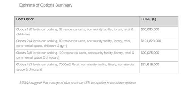
Table
1: Cost Estimate of Options Summary, by MBM
Option 2 is the most expensive
option, at a preliminary estimate of $101.3 million dollars as it is the most
complex in terms of construction and proposes the greatest range of uses;
Option 3 is the second most expensive, at $92 million, because it has a
large number of residential apartments which have higher construction and
fit-out costs when compared to other uses. Options 4 and 1 are the lowest cost
options at $74.6 million and $65.7 Million respectively. The total cost of
facilities and infrastructure to be ultimately owned by Council is
approximately $14.5 million or between 14% and 22% of the total estimated
project costs
RLB Quantity Surveyors were
subsequently engaged to undertake a peer review of the MBM report; the peer
review paper considers the following issues:
- strategic
advice;
- review
of items/rates;
- library
and community facilities allowances; and
- park
and town centre allowances.
The full report by RLB titled Peer
Review of MBM Cost Estimate by RLB, May 2015 can be viewed on Council’s
website at Current projects priorities / Development and upgrades / Major
developments.
RLB’s peer review identified the
following issues:
- the
rates provided by MBM for the construction and fit-out costs of the new
community buildings are significantly below similar benchmarks for a high
quality facility; and
- the
rates provided by MBM for the new parkland and public domain areas are considerably
lower than similar benchmarks for a high quality parks and public domain areas.
As a result of the peer review
RLB recommend an overall increase in the construction costs of the options of
between $11-12 million; the result means the total cost of facilities and
infrastructure to be ultimately owned by Council increases to approximately $25
million or between 22% and 32% of the total estimated project costs which also
represent a higher proportion of the overall project costs.
In summary, a review of the
projects costs shows us that Option 1 has the lowest overall estimated
construction cost but the highest proportion of public costs to private costs
(32%); whilst Option 2 has the highest estimated construction cost and lowest
proportion of public costs to private costs (22%). The latter is therefore more
likely to be a feasible commercial project
|
Criteria
|
Option 1
|
Option 2
|
Option 3
|
Option 4
|
|
Project Cost
|
1
|
4
|
3
|
2
|
1.3 Economic
Feasibility
Based on the MBM and RLB
findings, Jones Lang LaSalle (JLL) were engaged to further refine the economic
feasibility analysis of the options:
Provided below is a summary of
the scenarios JLL have undertaken analysis on:
- Option
1 - 3 Storey, Community facilities + library, speciality retail, mini-major
retail, residential (32 units), car parking including 240 commuter spaces
- Option
2 - 7 Storey, Community facilities + library, speciality retail, major
retail, commercial, residential (105 units) car parking including 240 commuter
spaces
- Option
3 - 5 Storey, Community facilities + library, speciality retail,
commercial, residential (120 dwellings), car parking including 240 commuter
spaces
- Option
4 - 3 Storey, Community facilities + library, speciality retail, major
retail, car parking including 240 commuter spaces
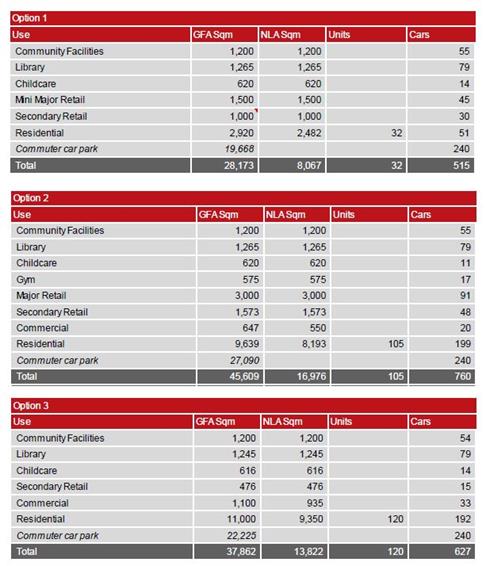

Table
2: Breakdown of floor space and car parking, exhibited options 1-4, by JLL
JLL has various key assumptions
and limitations including but not limited to:
- Equity
injection to the project $13.19 million from collected s.94 contributions as at
April 2015.
- Equity
injection to the project $16.8 million from the State Government of NSW for the
construction of 240 commuter car parks (subject to agreement from TFNSW).
- No
income is derived from the community uses or car parking.
JLL’s
observations from the above financial analysis are summarised below.
- Option
1 - Provides a poor financial outcome
of based on significant ‘community costs’ (including associated car parking)
with smaller income producing uses.
- Option
2 - Provides an indicative
‘break-even option’ given the provision of residential and major retail uses.
- Option
3 - Presents the most viable option
given the quantum of residential.
- Option
4 - Provides a poor financial outcome
based on the lack of residential which support the options viability. The major
retail also assumes constrained trade based on the assumption that there will
be no right turn lane from Pacific Highway to Beaconsfield Parade.
In
summary, Option 3 presents the most financially rewarding proposition for
Council with option 2 also ’break-even’ proposition (including a contingency
sum for error, delay or change of project scope).
|
Criteria
|
Option 1
|
Option 2
|
Option 3
|
Option 4
|
|
Economic Feasibility
|
1
|
3
|
4
|
2
|
1.4 Project
Objectives
A comprehensive
assessment of the options was carried out by council staff, against the project
objectives. The full assessment table titled Lindfield Community Hub,
Assessment of Options against Objectives, April 2015 can be viewed on
Council’s website at Current projects priorities / Development and upgrades /
Major developments.
A summary of the
assessment under the broad project objective headings is given below.
1.4.1 The
Village
A modern urban village,
like a traditional village, provides a range of opportunities for people to
live, work, shop and pursue leisure and cultural interests in the one location.
Social interaction is also a key component of a village:
- Option
3 comprises 70% of its floor space as residential apartments and lacks the
critical retail mass to create a place where residents could complete most of
their shopping in one location
- Option
4 lacks residential apartments which are a critical part of a village as they
provide multiple benefits in terms of people living in an area, caring for an
area, ‘eyes on the street’ for safety and people movements. The total amount of
retail (7,000sqm) in Option 4 is also of concern particularly in terms of
impacts on existing traders nearby on the Pacific Highway and impact on road
network.
- Options
1 and 2 both provide a balanced range of uses that would have the potential to
create a vibrant local hub.
- The
key differences between Options 1 & 2 is the proposed building scale and
the amount of retail floor space, the communities preference in this regard
will be determined through the survey results.
- As
discussed above, 7 storey buildings are compatible with the idea of an urban
village, particularly given the planning context in which properties to the
west/south-west of the site are zoned for 5 storey apartment buildings and
given the proximity to the railway station.
- The
proposed building scale and the amount of retail floor space are considered
further in relation to financial feasibility and market demand.
Options 1 and 2 are
considered to have the best potential to meet the objective of creating a
village; option 3 is considered to have the least potential.
|
Criteria
|
Option 1
|
Option 2
|
Option 3
|
Option 4
|
|
The Village
|
4
|
4
|
1
|
2
|
1.4.2 The
Attraction
The development options
explore a range of opportunities to create a place which will attract people to
the area as well as make it easy for people to visit when arriving by car, on
foot or by bicycle. It is important to note that the facilities are planned to
cater for local residents living in the southern part of the Ku-ring-gai LGA;
it is not intended to create a place that will necessarily attract people from
the broader region.
- all
options offer local attractions and facilities in the form of a new park, town
square, branch library and community centre;
- Option
1 provides a limited retail offer and as a result the attraction is likely to
be limited. The benefit of this is that it may offer a supportive role to
existing traders on the Pacific Highway;
- Option
2 provides a strong retail offer that is likely to draw people from the local
catchment (southern part of LGA);
- Option
3 offers limited facilities to attract people above and beyond the proposed
community infrastructure; and
- Option
4 provides a very large retail offer which has the potential to attract too
many people – traffic modelling suggests the number of visitors by car is
likely to exceed the capacity of the local road network.
Options 1 and 2 are
considered to have the best potential to meet the objective of creating an
attraction, while option 4 may be too large for the context.
|
Criteria
|
Option 1
|
Option 2
|
Option 3
|
Option 4
|
|
The Attraction
|
3
|
4
|
1
|
2
|
1.4.3 The
Canopy
All options to a
greater or lesser extent have responded to this objective. Options 1 and 3
clearly provide the best outcome in terms of deep soil and tree protection.
All options propose
significant new tree planting within the new streets and parks that would, over
the medium, term result in a canopy cover greater than the existing situation
|
Criteria
|
Option 1
|
Option 2
|
Option 3
|
Option 4
|
|
The Canopy
|
3
|
1
|
4
|
2
|
1.4.4 The
Environment
Overall sustainability
is achieved through eliminating the need for multiple trips as the hub becomes
a ‘one stop’ destination.
All options have
proposed green technologies explored to achieve Council’s energy targets:
- green
technology in buildings;
- orientation
of residential to maximise solar and cross ventilation;
- stormwater
storage and re-use.
The heat island effect
of the site would be reduced due to the proposed parkland and tree canopy.
|
Criteria
|
Option 1
|
Option 2
|
Option 3
|
Option 4
|
|
The Environment
|
4
|
4
|
4
|
4
|
1.4.5 Connectivity
Generally, all options
are designed to be well-connected with respect to pedestrians, cyclists and
vehicles, with good access to public transport and cycle routes. The sloping
site poses connectivity challenges however these challenges have been dealt
with in a similar manner in all options. All options improve significantly on
the existing conditions.
|
Criteria
|
Option 1
|
Option 2
|
Option 3
|
Option 4
|
|
Connectivity
|
4
|
4
|
4
|
4
|
1.4.6 Accessibility
The site has accessibility
issues due to the steep fall of the site (approximately 9m from the eastern end
to the western end of the site). All options have been designed with universal
access principles in mind and are therefore more or less equal in this regard.
All options improve significantly on existing conditions.
|
Criteria
|
Option 1
|
Option 2
|
Option 3
|
Option 4
|
|
Accessibility
|
4
|
4
|
4
|
4
|
1.4.7 Safety/Crime
Prevention Through Environmental Design (CPTED)
All options propose to
comply with CPTED principles and will have good lighting to all of the public
spaces. Options 1, 2 and 3 have a mix of residential and retail uses which
allows for passive surveillance of the site during all times of the day and night.
However, Option 4 does not have residential uses which mean that the site has
little or no surveillance during night time.
|
Criteria
|
Option 1
|
Option 2
|
Option 3
|
Option 4
|
|
Safety/CPTED
|
4
|
4
|
4
|
1
|
1.5 Traffic
and Transport Review
A traffic and transport review of
the 4 options was conducted by Transport consultants engaged by Council
(Peopletrans). The full report titled Lindfield Community Hub, Concept
Design Options, Transport Review, by Peopletrans, August 2015 can be viewed
on Council’s website at Current projects priorities / Development and upgrades
/ Major developments.
The assessment criteria used by
the consultants are as follows:
· Pedestrians;
- pedestrian
accessibility to, from and through the site
- pedestrian
accessibility within the site
· Cyclists;
- cyclist
accessibility to, from and through the site
- end of
trip facilities
· Public Transport Integration (Trains
& Buses);
· General Traffic Accessibility;
- intersection
operation
- car
parking
- loading
· Safety.
In summary,
the report made the following conclusions and recommendations:
· The assessment found it was
challenging to choose an outright preferred option as there were positive and
negative elements of each.
· The scale and type of
development of SJB Option 4 would have an unacceptable traffic impact on the
surrounding road network and would have to be scaled back significantly if it
were to be given any further consideration in the context of the other 3
options.
· The elements that could be
compared equitably related primarily to the road network configuration, number
of car parking stations and the location of the car park accesses.
· There were elements that
were identified as part of the Lindfield Transport Model Network Study 2013/14
which was not identified on any of the SJB option layouts including the
following:
- the need to maintain kiss & ride parking on Woodford Lane
(accessed to and from the south);
- the need for a community bus stop located near the community
facilities; and
- the importance of Woodford Lane as a public domain/shared zone
street including a contra-flow cycle lane providing a safer link across the
Pacific Highway from the proposed future traffic signals at Strickland Avenue.
In summary,
Options 1, 2 and 3 were deemed acceptable from a traffic and transport point of
view. Option 4, however, due to its large supermarket component, would have an
unacceptable traffic impact on the surrounding road network.
|
Criteria
|
Option 1
|
Option 2
|
Option 3
|
Option 4
|
|
Traffic & Transport
|
4
|
4
|
4
|
2
|
1.6 Community
Facilities Review
Elton Consulting were first
commissioned by Ku-ring-gai Council in 2013 to undertake a study of community
facilities in Lindfield and the southern parts of the LGA. The completed study,
entitled Lindfield Community Facilities Study, 2014, provides objectives
and guidelines to guide Council in the planning, design and delivery of new
community facilities in the Lindfield local centre.
Elton Consulting were recently
re-engaged to undertake an assessment of the four exhibited options to
determine how each of the options rate against the original objectives and
guidelines; the report titled Lindfield Community Hub Review of
Concept Design Options (Community Facilities), May 2015 can be viewed on
Council’s website at Current projects priorities / Development and upgrades /
Major developments. A summary of the findings is set out below.
Two options received
significantly higher scores in the assessment – Option 2 and Option 3, with
Option 2 being the highest scoring option. Option 4 was the lowest scoring
option. The assessment findings are summarised below.
Option 2 scored a total of 47/50
and rated well against all criteria. The proposed facility would have a strong
public presence (with both the community centre and library achieving ground
floor access), prominent entries and strong physical and visual open space
connections. The option also includes a reasonable quantity of residential and
retail uses which would assist to activate the site, revitalise the Lindfield
local centre, and contribute to public safety through passive surveillance.
Option 3 scored a total of 43/50
and rated well against most criteria. The facility design would also result a
prominent facility with at grade entries for both the library and community
centre. With the majority of the library below ground level, the positioning of
the facility foyer (a critical connection between the library and community
centre) may be somewhat restricted and may compromise connections between the
facility components. This option proposes the highest number of residential
dwellings as well as commercial space, which would assist to activate the site
and improve public safety through passive surveillance.
Option 1 received a score of
31/50. The facility is located on a prominent corner of the site however it
would have a lower profile or public presence with the main entry located to
the south and only small entry to the main, Bent street frontage. The option
proposes only a small number of dwellings and small retail component, limiting
the option’s potential to achieve an activated site and contribute to the
revitalisation of the Local Centre. Opportunities for the provision of
contained open space for the community facility are limited. In addition, this
option also represents a missed opportunity to incorporate the adjacent scout
hall into the new community hub (though this cannot be guaranteed in any
option, as it is subject to the outcome of negotiations with Lindfield Scouts).
Option 4 was the lowest scoring
option with a total score of 22/50. The proposed level change between Bent
Street and the site would result in a facility with little public presence and
a lack of connection to the local centre, compromising its potential to be a
key community focal point and gathering space. The lack of other land-uses
limits the potential to achieve a highly utilised, activated site. The park and
facility would also lack public surveillance. This option does not realise the
potential of the site. This option also represents a missed opportunity to
incorporate the adjacent scout hall into the new community hub.
A summary of the assessment is
contained in the table below:
|
Criteria
|
Option 1
|
Option 2
|
Option 3
|
Option 4
|
|
Community Facilities Review
|
2
|
4
|
3
|
1
|
1.7 Council
Staff Workshop
A workshop involving 18
specialist Council staff was held on 22 June 2015 to seek input and feedback on
each development option and to assess each option individually in order to
determine a preferred option. The workshop notes titled Lindfield
Community Hub, Staff Assessment Workshop Summary, June 2015 can be viewed
on Council’s website at Current projects priorities / Development and upgrades
/ Major developments.
In summary, the staff
unanimously agreed that Option 2 was the preferred option for the site, owing
to its variety in land uses, presence of a mid-range supermarket and clear
distinction of public and private spaces. Option 4 was gauged as second-best, as
it provided a large-scale supermarket, in line with community aspiration.
Option 1 was ruled out because it had a low development potential, proposed a
small-scale supermarket (which went against community aspiration) and was
financially unviable. Option 3 had no clarity between public and private spaces
and was excessive in its residential component.
A numeric summary of
the assessment is provided in the table below.
|
Criteria
|
Option 1
|
Option 2
|
Option 3
|
Option 4
|
|
Staff Workshop
|
1
|
4
|
1
|
3
|
1.8 Project
Control Group (PCG) Approval of Preferred Option
A PCG meeting was held
on 5 August 2015 where an update of the Lindfield Hub project was provided by
council staff and PBS consultants. It was agreed that Option 2 would be the
preferred option for the site.
2. Summary of Assessment
The assessment of the
master plan options has been summarised in the table below.
|
Criteria
|
Option 1
|
Option 2
|
Option 3
|
Option 4
|
|
Public Engagement (online survey, community workshop and public
submissions)
|
3
|
11
|
3
|
11
|
|
Estimated project
Cost
|
1
|
4
|
3
|
2
|
|
Economic Feasibility
|
1
|
3
|
4
|
2
|
|
Traffic & Transport
|
4
|
4
|
4
|
2
|
|
Community Facilities Review
|
2
|
4
|
3
|
1
|
|
Project Objective - Village
|
4
|
4
|
1
|
2
|
|
Project Objective - Attraction
|
3
|
4
|
1
|
2
|
|
Project Objective - Canopy
|
3
|
1
|
4
|
2
|
|
Project Objective - Environment
|
4
|
4
|
4
|
4
|
|
Project Objective - Connectivity
|
4
|
4
|
4
|
4
|
|
Project Objective - Accessibility
|
4
|
4
|
4
|
4
|
|
Project Objective - Safety/CPTED
|
4
|
4
|
4
|
1
|
|
Council Staff Workshop
|
1
|
4
|
1
|
3
|
|
TOTAL SCORE
|
38
|
55
|
40
|
40
|
Table
3: Assessment of master plan options – final scores
The assessment deems Option 2 as a clear preference
with a score of 55/60 or 92%. Options 1, 3 and 4 are ranked as less preferred
with scores of between 38/60 and 40/60 or 66% respectively.
3. Market Sounding
3.1 Background
Councillors were briefed on 4
August 2015 by staff and consultants and advised that a market sounding process
was to commence from 31 August 2015 for 3 weeks.
‘Market sounding’ is a process
which involves informal discussions with selected private sector participants
to determine the private sector’s reaction to and interest in Council’s
preferred development option for the site. The feedback gained from this
process will inform the preferred option which could then need to be refined or
adjusted to address any concerns or issues raised by the private sector. In
addition, it will provide Council with reliable market-based feedback on
Council’s preferred Option 2. This feedback will enable Councillors to make an
informed decision based on both the community consultation and consultation
(albeit limited) with the private sector. It is to be noted that no party
consulted during the process has any right or advantage over any other parties
if and when Council seeks formal market interest in the project.
3.2 The Intent
The intent of
the market sounding was to:
· promote
Ku-ring-gai Council as a Council that is professional, forward thinking and
focused on delivering well balanced community and commercial outcomes;
· give
confidence to the development sector that Ku-ring-gai Council was genuinely and
positively committed to achieving the development of the Lindfield Community
Hub site via an arrangement with the private sector;
· display
Council’s commitment by demonstrating that Council had retained a multi –disciplinary
project delivery team with a track record and capable of interacting with
developers in a common sense and commercially sensitive manner;
· test the
commercial viability of the project to ensure that it is capable of delivering
not only the community outcomes but also the potential for Council to derive an
income from the project that could be used to fund additional community assets;
· provide
developers with confidence that when submitting an EOI, they were doing so with
the knowledge that the project had been designed to achieve a ‘win-win-win’
outcome for the Council, the community and the private sector;
· communicate
that Council was actively seeking full and frank feedback from developers on:
- the architectural concepts publicly
exhibited to date;
- potential titling and project delivery
structures;
- initial financial feasibility
assessments;
- general desirability of a mixed use
project of this type in Lindfield (and potentially other Town Centres); and
- to illicit suggestions that may
further enhance the Community outcomes.
3.3 Market
Sounding Process
The
market sounding process was carried out via a series of face to face and
telephone interviews with a representative selection of the development
industry with companies of varying financial resources and track records. In
addition, 2 (two) major supermarket chains were also included on the list of
potential participants for the market sounding process. The entire market
sounding process was wrapped in a “probity framework” designed to protect
Council, the participants and the project. An external probity auditor, engaged
by Council, was also present at a random selection of the interviews in order
to ensure that the probity framework was maintained to the highest possible standard.
3.4 Options
Presented
Two
development options were used in the market sounding process. These are:
· Option 2,
because it has been assessed as the preferred option based on Council’s
criteria; and
· Option 4,
because the community’s preferences were equally weighted between Options 2 and
4
3.5 List
of Developers
A total of fourteen development companies were contacted for the
market sounding meetings:
Domestic Developers (Large)
· Lend Lease
· Stockland
· Mirvac
· Brookfield Multiplex
Domestic Developers (Other)
· Holdmark Property Group
· Payce Consolidated Limited
· Grocon
· LEDA Holdings
Foreign Developers
· Chiwayland Australia Pty Limited
· Dahua Group (Aust)
· China Venture Pty Ltd
· Aqualand
Retailers
· Woolworths
· Coles
3.6 Market
Sounding Results
In summary, the results of the market sounding process were
overwhelmingly positive; the companies endorsed the location, mixed-use nature
of the development concept, and the engagement process with the private sector.
The full market sounding report can be viewed at Attachment A1 Lindfield
Community Hub Market Sounding Report trim.
Some of the key
comments made are as follows:
· Undertaking
a “market sounding” exercise is an excellent idea and not something we’d expect
from a Council.
· Council
should be congratulated on the decision to appoint a professional team to
assist them with the project.
· The project
is very desirable with Option 2 clearly the best mix of community and
commercial outcomes.
· Participants
were very much aware of Ku-ring-gai Council’s history with developers and
viewed the market sounding as a clear indicator of Council’s desire to change
that although there remained some reticence.
· Participants
would be happy to provide an EOI based on Option 2 with the residential
buildings at 7 levels and also provide an alternate option(s) in order to show
Council what could be achieved on a site of this quality.
· There was
almost no interest in Option 4 as it was viewed as not commercially viable.
· Would
Council be interested in submissions that deliver “award winning” design
outcomes for the community buildings?
· A proposed
titling structure that allows the title to the land to be transferred to the
successful applicant very early in the project with substantial financial
security offered to Council to guarantee delivery of the community buildings
would further enhance project feasibility.
· All
participants raised the subject of the “project team delivery team”, citing
that prior to submitting an EOI they would seek assurances from Council that a
“professional project team” would act for Council in any negotiations that
ensued.
3.7 Market
Sounding - Preferred Option
Two
development options were presented to participants of the market sounding
process. The majority of market sounding participants identified Option 2 as
clearly the best mix of community and commercial outcomes; option 4 was
identified by most participants as not commercially viable and of no interest.
An additional
comment made by one or more (but not the majority) of the participants noted
that given the uncertainty regarding the sites owned by Scouts and Ausgrid it
would be preferable to exclude these from the EOI process.
This approach
may lower the potential financial return to Council (although this has not been
quantified as yet).It is recommended the sites owned by Scouts and Ausgrid be
excluded from the EOI but provision made for them to be included at a later
date if negotiations can be concluded with Scouts and Ausgrid on favourable
terms to Council.
4. Recommendation - Preferred Option
Based on the comprehensive
assessment presented in this report, it is recommended that Council adopt Option
2 (as exhibited, with 7 storey maximum building heights) as the preferred
option for the Lindfield Community Hub.
For the purposes of an EOI it is
recommended that option 2 be modified (as shown in diagrams 13-16) as follows:
· Exclusion of land owned by Scouts
Association - 2nd and 3rd Lindfield Scouts Group known as 1A Beaconsfield
Parade, Lindfield (Lot A DP 327729, Lot C DP 399995 and Lot 2 DP 184154); and
· Exclusion of land owned by AUSGRID
known as 1 Beaconsfield Parade, Lindfield (Lot 1 DP 184042)

Figure 13: Modified Option 2
(EOI version)– Plan View Figure 14: Modified Option 2 (EOI
version)– Rendered Plan
Figure 15: Modified Option 2 (EOI version)– 3D View 1
Figure 16: Modified Option 2 (preferred)– 3D View 2
5. Project Mandatory Scope of Work
The scope of mandatory
requirements for option 2 is given in Table 4 below. This scope is intended to
be included within the EOI document.
|
LINDFIELD
COMMUNITY HUB – PROJECT SCOPE/MANDATORY ELEMENTS
|
|
Category
of works
|
Items
of inclusion
|
Location
and extent
|
Minimum
requirements
|
Relevant
guidelines and controls
|
|
General
|
Mix of residential, retail and commercial
uses
|
_
|
_
|
_
|
|
Streetscape
works
|
- New footpaths
- Underground power lines
- LED street lighting
- Street trees and tree grates
- Landscaping of verges
- Installation of street furniture such as
benches, litter bins and bike racks, on strategic locations
|
Bent
Lane
Bent
Street
Woodford
Lane Beaconsfield Parade
|
_
|
Ku-ring-gai
Town Centres Public Domain Plan, 2010
Ku-ring-gai
Contributions Plan, 2010
Council’s
streetscape technical manual
|
|
Road
and transport works
|
- Road realignment
and resurfacing
- Kerb and gutter realignment
|
Bent
Lane
Woodford
Lane
|
_
|
Ku-ring-gai
Town Centres Public Domain Plan , 2010
Ku-ring-gai
Contributions Plan, 2010
Lindfield
Local Centre Transport Network Model Study Report 2013-14
|
|
|
- Construction of new public street
(realignment and extension of Drovers Way)
- Formal closure of existing Drovers Way
road reserve
|
Between
Bent Street and Beaconsfield Parade
|
_
|
Ku-ring-gai
Town Centres Public Domain Plan, 2010
Ku-ring-gai
Contributions Plan, 2010
Lindfield
Local Centre Transport Network Model Study Report 2013-14
|
|
|
- Construction of new kiss & ride zone
- Construction of taxi rank with shelters
and signage
|
Woodford
Lane
|
_
|
Ku-ring-gai
Contributions Plan, 2010
|
|
|
- Modifications to traffic signals
|
Intersection
of Balfour Avenue and Pacific Highway
|
_
|
Lindfield
Local Centre Transport Network Model Study Report 2013-14
|
|
|
- Installation of new traffic signals
|
Intersection
of Beaconsfield Parade and Pacific Highway
|
_
|
Lindfield
Local Centre Transport Network Model Study Report 2013-14
|
|
Public
Domain Works
|
- Construction of new public park
- Construction of new urban plaza
|
Fronting
Bent Street
|
Minimum
size 4,000m2
|
Ku-ring-gai
Town Centres Public Domain Plan, 2010
Ku-ring-gai
Contributions Plan, 2010
Design
specifications as provided by Council
|
|
|
- Construction of new pedestrian plaza on
Bent Street
|
Within
road reserve between Bent Lane and Pacific Highway
|
|
Design
specifications as provided by Council
|
|
Community
building
|
- Construction of a community hub building
comprising a café, new branch library, community centre and child care centre
with roof garden
|
Corner
of Bent Street and new street (realigned Drovers Way)
|
- Minimum size 2,950m2
- High design quality
- Iconic
|
Lindfield Community Facilities Study,
Elton consulting, 2013
Design specifications as provided by
Council
|
|
|
- Full internal fit-out of branch library
(turn-key)
|
Level
1 of community hub building
|
Minimum
size 1,250 m2
|
Lindfield Community Facilities Study,
Elton consulting, 2013
Design specifications as provided by
Council
|
|
|
- Full internal fit-out of community centre
(turn-key)
|
Level
2 of community hub building
|
Minimum
size 1,200 m2
|
Lindfield Community Facilities Study,
Elton consulting, 2013
Design specifications as provided by
Council
|
|
|
- Full internal fit-out of childcare centre
(turn-key)
|
Level
3 of community hub building
|
Minimum
size 500 m2
with
external roof top garden area
|
Design specifications as provided by
Council
Council’s DCP
|
|
Car
parking
|
- Council car parking for community uses
|
Basement
car park
|
Minimum
of 55 spaces
|
Australian
Standards and Building Code of Australia
|
|
|
- Public parking (Commuter)
|
Basement
car park
|
Minimum
of 140 spaces
|
Australian
Standards and Building Code of Australia
|
|
|
- Council car parking (replacement of
existing at-grade spaces)
|
Basement
car park
|
Minimum
of 112 spaces
|
Australian
Standards and Building Code of Australia
|
|
|
- Private parking (retail and commercial)
|
Basement
car park
|
_
|
Local
Centres DCP, 2012
Lindfield
Community Hub - Site specific DCP
|
|
|
- Private parking (residential)
|
Basement
car park
|
_
|
Local
Centres DCP, 2012
Lindfield
Community Hub - Site specific DCP
|
|
Retail
& Commercial uses
|
- Supermarket
- Commercial & Retail (including
supermarket)
|
Basement
and ground level
|
Minimum
supermarket size 3,000 m2
Maximum
retail (including supermarket) + commercial floor space 5,000m2
|
Local
Centres DCP, 2012
Lindfield
Community Hub - Site specific DCP
|
Table 4: Mandatory
requirements – Lindfield Community Hub
The following components, whilst
not mandatory, are desirable, and are to be incorporated into the development
where possible:
· innovative and sustainable solutions
for water re-use, energy sources, grey-water and sewage recycling, recyclable
or low carbon material choice;
· pedestrian bridge connecting the east
and west sides of the Pacific Highway;
· pedestrian access way from the Pacific
Highway into the site;
· scouts land; and
· Ausgrid land.
6. Non-Compliant Bids
We have been advised by our
consultants to accept non-conforming bids without which the project will be
exposed to unnecessary high-level risks such as:
· loss of developer confidence in the
project due to inability to demonstrate innovative alternatives in their
responses;
· poor interest in project and poor EOI
responses;
· lack of acceptable alternative for
Council that does not involve large injections of capital;
· loss of public confidence in the
project due to a failed EOI process;
· financial loss due to the project
capital invested to date converting to “sunk funds” as a result of the project
being shelved or not proceeding;
· loss of potential income sources to
Council due to the project not proceeding; and
· high reputational risk.
There are significant advantages
to accepting non-conforming bids such as:
· innovative design and delivery models,
forming a precedent for other major projects within the LGA;
· potentially enhanced community
outcomes;
· financial structures and offerings that
may generate previously undiscovered sources of income that can be used to fund
other project and facilities;
· demonstration that Ku-ring-gai is “ready
for business” in an intelligent, considered, and market sensitive manner; and
· Council will gain respect from the
development industry due to the adoption of a commercially intelligent EOI
process that allows developers to showcase their capability.
integrated planning and reporting
Places, Spaces and Infrastructure
- P4 Revitalisation of our centres
Community, People and Culture - C4
Healthy lifestyles
|
Community Strategic Plan Long Term Objective
|
Delivery Program
Term Achievement
|
Operational Plan
Task
|
|
A range of well planned, clean and safe neighbourhoods and
public spaces designed with a strong sense of identity and place.
|
P4.1.1
Plans to revitalise local centres are being progressively
implemented and achieve quality design outcomes in collaboration with key
agencies, landholders and the community.
P4.1.4
An improvement plan for Lindfield centre is being
progressively implemented in collaboration with owners, businesses and state
agencies.
|
Implement a place management approach for the local centre
improvements to coordinate works and achieve quality outcomes.
Engage with relevant
stakeholders to establish timing, extent and partnership opportunities.
Undertake due diligence and
undertake project scope.
Identify and engage with the key stakeholders.
|
|
A healthy, safe, and diverse community that respects our
history, and celebrates our differences in a vibrant culture of learning.
|
C4.1.2
New and enhanced open space and recreational facilities
have been delivered to increase community use and enjoyment.
|
Undertake acquisitions for new parks.
Undertake assessment and identify locations for new parks
Complete the design for identified parks and include
design principles which facilitate passive recreation activities.
Construct parks at identified locations and include design
principles which facilitate passive recreation activities
|
Governance Matters
Governance documents
The following set of governance documents for the Lindfield
Community Hub Project have been completed and reported to Council. These
documents are intended to guide the day-to-day management of the project,
including the market sounding phase and the EOI phase.
· Governance Structure;
· Probity Management Framework;
· Probity Plan & Market Sounding
Probity Protocol; and
· Project Decision Making Framework.
The following documents are currently under preparation and
will be reported to Council in the near future:
· Probity Protocol - Separation of
Planning Powers;
· Scope Management Plan; and
· Communications Strategy.
Capital Expenditure Guidelines
The Office of Local Government (OLG), Department of Premier
and Cabinet Capital Expenditure Guidelines, December 2010 are the Director
General’s Guidelines issued pursuant to section 23A of the Local Government
Act, 1993.
The guidelines apply to Council’s capital projects for
infrastructure facilities, including renovations and extensions that are
expected to cost in excess of 10% of Council’s annual ordinary rate revenue or
$1 million, whichever is the greater (GST exclusive). In addition to the
minimum requirements for a Capital Expenditure Review, a Council is also
required to complete additional requirements in cases where a project’s cost is
forecast to exceed $10 million (GST exclusive).
The
following are the minimum requirements for a Capital Expenditure Review:
· Outline proposed Project
· Justify the Need
· Assess the Capacity of
Council
· Priorities
· Alternatives
· Financial Implications
· Public Consultation Process
In addition to the minimum
requirements set out above, a Council is also required to complete the
following additional requirements in cases where a project’s cost is forecast
to exceed $10 million.
· Business/Management Project
Plan
· Risk Management Plan
· Probity Plan
· Tender Evaluation
Given the stage the project is now at it is recommended that
Council write to the Office of Local Government advising them of the Lindfield
Community Hub project; acknowledging that the guidelines apply to the project
as the cost is forecast to exceed $10 million; and note that Council intends to
submit a report to OLG in early 2016 that responds to the requirements of the
Capital Expenditure Guidelines.
RISK MANAGEMENT
1. General
There are significant risks for
Council in relation to any decisions it makes regarding zoning,
reclassification, planning controls, and/or divestment for any of its town
centre sites or “hub” projects. These risks are potential loss of revenue in
the event a site is sold with lesser development yield than might reasonably
expected under a new regime of dwelling targets and where a purchaser
subsequently comes back to Council with a planning proposal for an uplift in
controls, and/or that the “opportunity” for greater dwelling production on key
town centre sites is simply lost by development at lesser height and density.
Notwithstanding that the State
Government has not made any specific pronouncements about increased dwelling
targets since it was first elected, there is a plethora of material available
in the public realm that points to significantly increased dwelling targets for
all metropolitan councils when draft subregional plans are released later in 2015.
This is supported by the current subregional planning process being conducted
by the Department of Planning and Environment in which all councils are being
consulted, but arguably not engaged in any meaningful way, about new targets.
It is also arguable that subregional plans were substantially completed before
the State election, with release being held back until arrangements for the
greater Sydney Commission are finalised and closer to when decisions are made
in relation to local government amalgamations.
Barring direct intervention by
the Department or the new Greater Sydney Commission in the spatial distribution
of new dwellings at a local level, Council will have to make decisions about
the form of its town centres going forward. Specifically, Council may be
required to deliberate as to whether the currently relatively contained town
centres are developed to be higher and denser than currently envisaged under
the Local Centres LEP, or are they more spread out than at present, assuming
continuation of the current, generally five storey, model. In this respect, the
achievement of dwelling targets in the town centres specifically is being
hampered by the constrained development controls applied to some sites in the
translation of the Town Centres LEP into Council’s Local Centres LEP. Many
sites in the core of the town centres remain marginal or unviable
notwithstanding the recent property price escalation in Sydney. This contention
is supported by much of the viability work Council itself commissioned in its
local centres planning process, and which has been more recently confirmed by
the Department of Planning and Environment though demonstration of an Urban
Feasibility Model developed to guide subregional planning.
2. Risk Management Plan
A Risk Management Plan for the Lindfield Community Hub
Project was adopted by Council on 8 September 2015. A project-specific
Risk Management Matrix is currently being prepared in conjunction with
Council’s risk officer. The details of this Plan will be reported to Council
once finalised.
3. Due Diligence Checks
A comprehensive due diligence checklist has been prepared
and staff are currently seeking all information for Council owned land within
the site area of the Lindfield Community Hub. The list of items includes a
geotechnical survey, environmental assessments (contamination) and an
arboriculture study.
4. Co-operation of Key Stakeholders
There are a number of key stakeholders for this project
including: Lindfield 2nd 3rd Scouts Group; AUSGRID; and
Roads and Maritime Service (RMS).
4.1 Lindfield
2nd 3rd Scouts Group
Lindfield 2nd 3rd Scouts occupy a
hall located at 1A Beaconsfield Parade, Lindfield (Lot 2 of DP184154; Lot c of
DP 399995; and Lot A of 327729). The property is owned by the Boy Scouts Association.
In May 2015 Lindfield 2nd 3rd
Scouts made a submission to Council following the exhibition of the Lindfield
Community Hub options; in their submission the Group expressed interest in
relocating from their current building into the proposed community hub
building. The Group see a strong synergy between their activities and the
proposed activities within the hub.
The preferred option (Option 2)
envisaged the potential of utilising the Scouts’ land as part of the community
hub project as shown in Figure 17 below. It can be seen that the Scouts’ land
is proposed to accommodate residential uses.
Figure 17: Option 2 showing location of Scouts land
Since receiving the submission,
Council officers and consultants have met with representative of Lindfield
Scouts to gain further insight into their requirements. The meetings have been
positive, and discussions have indicated that Scouts position is as follows:
· Scouts are supportive of the community
hub project;
· Scouts have not yet made a decision to
relocate and this would be dependent on ongoing talks with Council;
· there are three levels of Scouts
management (National, branch and local) that must approve the possible
relocation, any of which can refuse the offer to relocate;
· Scouts will not consider a relocation
offer that provides any lesser accommodation than they currently enjoy;
· Scouts may wish to allow for expansion
room to allow for the possible relocation of Scouts regional office into a new
facility with them;
· Scouts have prepared a sketch that
outlines their current and future spatial needs;
· Scouts Lindfield wish to enter into a
Memorandum of Understanding with Council. This would allow them to seek
approval from the various levels of the organisation prior to commencing detailed
negotiations with Council;
· the Group has constituted a
sub-committee to advance discussions with Council to relocate into the
community hub; and
· if for whatever reason Scouts are to
stay in their current hall, their main interest is in ensuring that community
hub project does not adversely impact their operation. This cannot be
guaranteed under any scenario.
Given the time frame for an
agreement between Council and Scouts is likely to take between 6-12 months, the
inclusion of the Scouts’ land within the preferred option at this stage of the
project has been identified as a significant project risk. The multiple levels
of approval across the Scouts organisation also add considerable uncertainty.
It is recommended that the
potential for the Scouts land to be included and the status of engagement with
Scouts be fully described in the EOI so that tenderers responses can
accommodate this potentiality via alternate proposals or deal with Scouts
themselves.
4.2 AUSGRID
An AUSGRID substation is located
at 1 Beaconsfield Parade, Lindfield (Lot 1 of DP184042), adjoining the Scouts
land. The property is owned by the AUSGRID.
The recommended
preferred option (Option 2) envisages the potential of utilising the AUSGRID
land as part of the community hub project as shown in Figure 14. It can be seen
that the AUSGRID land is proposed to accommodate residential uses.
Several meetings
have been held to date between representatives of AUSGRID, Council staff and
Council-appointed consultants. AUSGRID have verbally indicated that they may be
willing to move from their current location and into one of the basement levels
of the community hub building, provided they are remunerated at market rate for
their land and a new substation is built within the development. AUSGRID have a
standard procedure with respect to sale of their land and change of premises;
the final agreement will be determined by AUSGRID’s property section in
discussions with Council staff. This approach is not unusual for a development
of this scale, though it is as yet unquantified, and may be a project risk.
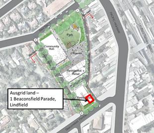
Figure 18: Option 2 showing location of AUSGRID land
Staff and consultants will
continue to meet with representatives of AUSGRID and as discussions progress
the outcomes will be reported to Council. Further work will also be undertaken
to determine the financial implications and risk profile for the project.
It is recommended that the
potential for the Ausgrid land to be included and the status of engagement with
Ausgrid be fully described in the EOI so that tenderers responses can
accommodate this potentiality via alternate proposals.
4.3 Roads
and Maritime Services
During the development of the Lindfield
Local Centre Transport Network Model Study, Roads and Maritime Services and
other key transport stakeholders were invited to a Transport Stakeholder
Workshop to discuss transport issues and opportunities that may be relevant to
the project and to the Lindfield local centre in general. In the spirit of
co-operation towards the project, Roads and Maritime Services even contributed
to the project by providing essential traffic signal operation data, at no cost
to Council or the project. Once a preferred transport scheme was developed,
Roads and Maritime Services were re-engaged to view the results of the
modelling and analysis.
The preferred transport scheme
incorporates significant elements of the Transport Improvement Concept Plan
for the Lindfield Local Centre, which was the transport scheme developed in
2008 in support of the Ku-ring-gai Local Centres LEP for Lindfield, and which
received in-principle concurrence from Roads and Maritime Services at the time.
However, at this stage, concurrence for the preferred transport scheme has not
been received from Roads and Maritime services.
The preferred transport scheme
also relies on a defined set of land uses (and floor areas) in the Lindfield
Community Hub precinct. Increases in supermarket floor areas in this precinct,
over and above those already defined in the Lindfield Local Centre Transport
Network Model Study, would have significant impacts to the transport
network and/or may require transport network upgrades which would not be
technically or financially feasible.
Therefore, it is recommended that
a subsequent report be prepared to describe the findings of the Lindfield
Local Centre Transport Network Model Study recommending in-principle adoption
by Council, subject to concurrence from Roads and Maritime Services.
Financial Considerations
A total of $851,000.00 has been spent during the financial
years 2013/14 and 2014/15 on this project; it is noted that this represents a
considerable amount of expenditure on staff salaries and consultants. The
funding sources have been from development contributions including the 2010
Plan as well as earlier Plans. During this time the work undertaken has
included project scoping, preliminary project feasibility, master plan options,
exhibition, community engagement and assessment of options. A possible result
of Council’s failure to progress the project could mean that Council will be
required to repay the S94 funds spent to date.
Approximately $14 million in funds (2014/2015 dollars) have
been allocated to this project in Council’s Long Term Financial Plan (LTFP).
This represents Council’s contribution to the costs of streetscape works, road
and transport works, public domain, community buildings and car parking
identified in the project scope earlier in this report. Council’s LTFP also
includes financial contributions from ‘development partners’ where Council is
unable to fund certain facilities such as community buildings and car parking
due to apportionment rates within the development contributions plan or a lack
of nexus. The funds are identified as expenditure for the years 2017 through to
2021. In order for Council to spend these funds in a timely manner it will be
necessary to meet the following programme:
· EOI complete late 2015;
· selection of preferred development
company by February / March 2016;
· negotiation with preferred development
company completed by mid-2016;
· submission of development application
by mid-late 2016;
· development approval by mid/late-2017;
and
· commencement of construction by early
2018.
Social Considerations
Council, as part of the Delivery
Program 2013-2017 and Operational Plan 2013-2014, seeks to revitalise the
Lindfield local centre to improve the vitality and liveability. The key
objective of the project is to create a vibrant community hub for Lindfield
incorporating a new branch library and community centre, town centre park,
commuter and community parking with other uses such as retail and residential
spaces. Council envisages this to be a rare opportunity to create a precinct
which will be a valuable asset to the residents of Lindfield and the wider
Ku-ring-gai community to gather in a quality urban environment.
The provision of additional
community infrastructure providing both outdoor and indoor community spaces
will continue to support this process and help Ku-ring-gai continue to be a
vibrant and popular place to live for all ages.
Environmental Considerations
If Council adopts the preferred option recommended in this
report then removal of remnant vegetation within the site will be required.
Remnant vegetation on the site is mapped in the Ku-ring-gai (Local Centres)
LEP, 2012 as being of biodiversity significance. Council’s DCP – Biodiversity Controls
identifies them as Category 3 – Landscape Remnants. The vegetation provides
potential habitat and seasonal foraging opportunities and refuge for bird and
potentially bat species as well as potentially being a genetic reservoir. It
also forms part of Sydney Turpentine Ironbark Forest, listed as a critically
endangered ecological community under both State and Federal legislation.
The proposed impacts to this vegetation will require an
assessment under the Threatened Species Conservation Act (TSC) 1995 and the
Environmental Protection and Biodiversity Conservation Act 1999 (although its
condition is likely to mean that it falls below the benchmark for listing at
Federal level).
The removal of vegetation as a result of the preferred
option is to be assessed through a Section 91 licence (under the TSC Act) by
the Office of Environment and Heritage. The application will be accompanied by
a species impact statement (SIS), including a mitigation /offset strategy, and
should seek to address relevant LEP and DCP biodiversity clauses (including no
net loss of significant vegetation).
Community Consultation
1. Stakeholder
Consultation
1.1 Transport
for NSW (TfNSW)
In
May 2012 the NSW Government announced by media release it will build a new
commuter car park comprising 240 new spaces in Lindfield. Since that time, and
in accordance with Council resolutions, staff have worked in close
liaison with representatives from TFNSW to resolve the location and number of
commuter car parking in Lindfield through the two Lindfield projects – the
Village Green and the Community Hub.
Given the stage of planning for
the two projects TFNSW has suggested that Council submit a formal proposal to
the Assistant Deputy Secretary - Planning Division of Transport for NSW for the
Minister’s approval as the basis for commencing negotiations and completing an
agreement between the parties for the delivery of 240 commuter car spaces in
Lindfield local centre. The proposal will cover two key aspects:
· the proposed location or spatial
arrangement of the commuter car parking; and
· the estimated cost of the car parking
A proposal is currently under
preparation and will be reported to Council in the near future.
It is noted that both projects
can proceed with or without commuter parking; if commuter parking is included
then there will be no additional cost to Council.
1.2 Ku-ring-gai
Youth Development Services (KYDS)
At OMC 11 November 2014 Council
resolved to “relocate the Ku-ring-gai Youth
Development Service (KYDS) service within the proposed Lindfield community hub
(upon completion of the facility) and that the new facility provide
purpose-built rooms to be designed in consultation with representatives of KYDS
to meet their specific requirements”.
Since that time two meetings have
been held with representatives of KYDS to discuss the proposed relocation of
the service to the new community hub building once constructed. Council’s
architect (SJB) attended the second meeting to understand the organisations
spatial needs.
KYDS have since written to
Council out their preferred location – which is within the hub building – and
their likely space and functional requirements post-2017. Current planning
assumes replacement of similar space to what KYDS currently occupy, albeit, of
course, new and purpose-built. Any additional space requirements or an
alternate location are a matter for Council at a future point in time.
2. Community
Consultation
Council started the conversation
with the local community on the opportunities and vision for the Lindfield
Community Hub in early 2014 by creating the ‘Activate Lindfield’ initiative.
Since that time 692 residents, business owners and other interested
stakeholders have signed-up to the Activate Lindfield e-newsletter.
In late 2014 Council established
a web page for the project. This is continually updated as new information
comes to hand such as Council reports and consultant reports and other relevant
material.
In April 2015 flyers were sent by
post to 8,032 residents in Lindfield, Roseville and Killara to announce the
upcoming exhibition commencing in April 2015. Council also produced a brochure
for residents to take home from the exhibition to assist with completing the
on-line survey.
The public exhibition went for
eight weeks from Saturday 21 March to Friday 8 May 2015 with a further
extension to Thursday 14 May 2014. During this time the community, invited to
provide feedback on the four options; there were numerous ways residents could
ask questions and provide feedback on the designs:
· attend the exhibition launch event
which was held on Saturday 21 March;
· complete a Lindfield Community Hub
survey on-line;
· visit the mobile exhibition space at
Council’s Woodford Lane car park where Council staff were available to talk
about the designs at the following times:
- 8am -
11am on Tuesdays
- 11am –
2pm on Wednesdays
- 3pm – 6pm
on Thursdays
· an option was also provided for groups
of six or more, to make an appointment for another time
· register to attend a workshop;
· complete a printed survey which was
available at Council’s Customer Service Centre at 818 Pacific Highway
Gordon during business hours;
· mail a submission to Ku-ring-gai
Council Locked Bag 1056 Pymble NSW 2073; or
· join a discussion using one of the
online “Have Your Say” tools which include 'Q&A', 'online forum' and
'Submit comment direct to Council'.
The following table summarises
the engagement method and number of people involved.
|
Consultation
method
|
Respondent
group
|
Number
|
|
Exhibition launch
|
General community
|
200
|
|
Mobile exhibition space
|
General Community
|
36 attended to discuss
project with staff over 8 weeks
|
|
Lindfield Community Hub
Survey
|
General community
|
206 responses
|
|
1 x Lindfield Community
Hub opt-in workshop
|
Local residents and
businesses
|
Cancelled
due to
low registration
|
|
1 x Lindfield Community
Hub recruited workshop
|
Recruited (via
telephone) local residents randomly selected and representative of a broad
range of age groups, genders, and cultural backgrounds
|
28 participants
|
|
On-line questions via
“Have Your Say”
|
General Community
|
9 questions via the
website. Responses were provided by Council staff
|
|
Submissions to Council
|
General Community
|
2 submissions
|
|
Web site traffic
|
General Community
|
1035 unique visits &
794 active visitors
|
3. Internal
Consultation
Internal consultation for this
project is prescribed by the Governance structure for this project as follows:
· Councillors;
· Executive
Steering Committee (GMD);
· Project
Sponsor - Director Strategy and Environment;
· Project
Manager - Team Leader Urban Design;
· Project
Control Group (PCG) (meetings are currently held bi-monthly);
· Project
Working Group (PWG); and
· Tender
Review Committee (various).
Fit for the Future Improvement Action
Plan
The NSW Government's Fit for the Future initiative required
all councils to prepare an Improvement Proposal and supporting Implementation
Plan demonstrating how all seven Fit for the Future benchmarks would be met by
2016/17, and maintained or improved thereafter.
Council's Fit For the Future Improvement Proposal and
supporting Implementation Plan underpins the decision to stand alone and
not merge with Hornsby Council. The objectives established in the Improvement
Proposal and Implementation Plan are embedded in Council's adopted Integrated
Planning and Reporting documents including the Revised Delivery Program
2013-2017 and Operational Plan 2015-2016, Long Term Financial Plan
2015/16 to 2024/25 and Asset Management Strategy 2015/16 to 2024/25.
It is essential that Council continues to meet relevant
targets, which in the case of the Lindfield Hub project, are outlined below:
|
EFFICIENCY
|
|
Objective
|
Action
|
Target
|
Measure
|
Link to CSP, DP&OP
|
|
The delivery of major projects and capital works is completed
within budget
|
Deliver and report on completion of major capital works as
identified in the LTFP
|
Actual meet
budget Timeframes achieved as per DP& OP
|
Reported
to Council and in the Annual Report and other IP & R documents
|
L2.1.1
Council maintains and improves its long term financial position
and performance
L3.1.5
Council services and
programs are provided on the basis of equity, community priorities, and best
value for money within available resources
|
|
Reduce
Council’s S94 co-contribution for major community hub projects utilising
Private Partner Contributions
|
Council
proactively works with landowners, developers and agencies in the local
centres through planning agreements, joint venture and developer
opportunities
|
No increase in
long term borrowings or other asset sales to fund major projects
|
$35M allocated
in the LTFP from Private Partner Contributions
|
P4.1.1
Plans to revitalise local centres are
being progressively implemented and achieve quality design
outcomes in collaboration with key agencies, landholders and the community.
|
|
Projects should
include commercial opportunities for Council to offset ongoing operational
costs of the public benefit in each precinct
|
Council
proactively works with landowners, developers and agencies in the local
centres through planning agreements, joint venture and developer
opportunities
|
No increase in
long term borrowings or other asset sales to fund major projects
|
Masterplan
adopted completed for Lindfield Local Centre.
|
P4.1.4
An improvement plan for Lindfield
centre is being progressively
implemented in collaboration with owners, businesses and state
agencies
|
Summary
Four (4) illustrative master plan options for the Lindfield
Community Hub were exhibited by Council during the period between 21 March 2015
and 14 May 2015. A comprehensive assessment of the exhibited options is now
complete. The assessment process has deemed Option 2 as the preferred option
for a wide variety of reasons, community support, financial feasibilty, market
acceptance and traffic considerations being of primary significance.
Council’s consultants have now completed a market sounding
process which found that Option 2 is preferred by the private
sector as it has the best mix of community and commercial outcomes; option 4
was identified by most participants as not commercially viable and of no
interest.
The market sounding meetings have been met with
overwhelmingly positive feedback, with several development companies showing a
keen interest in the project. In light of positive feedback, it is in Council’s
best interest to move expeditiously into the EOI phase of the project, whilst
market conditions remain favourable and whilst the community’s trust in
Council’s ability to deliver remains intact.
Advice from consultants and feedback from the market
sounding indicates that given the uncertainty regarding the
sites owned by Scouts and Ausgrid, it would be better to exclude these from the
EOI process but provision made for them to be included at a later date if
negotiations can be concluded with them on terms favourable to Council.
|
Recommendation:
A. That
Council adopts Option 2 (as exhibited) with a maximum building height of 7
(seven) storeys as the preferred option for the Lindfield Community Hub
project;
B. That
Council adopts a variation of Option 2, with a maximum building height of 7
(seven) storeys, for the purposes of an Expression of Interest (EOI), which
excludes Scouts Association land located at 1A Beaconsfield Parade, Lindfield
(Lot 2 of DP184154; Lot C of DP 399995; and Lot A of 327729) and AUSGRID land
located at 1 Beaconsfield Parade, Lindfield (Lot 1 of DP184042);
C. That
Council advertises an Expression of Interest (EOI) seeking proposals from
development companies based on option 2 (revised EOI version) as described in
resolution B;
D. That
Council accepts non-conforming bids from the EOI process in order to
encourage innovation and for other reasons as outlined in this report;
E. That
Council adopts the following community infrastructure elements as mandatory
requirements for any bid arising from EOI to be considered as conforming:
· construction of a community hub
building to be owned by Council comprising a café, new branch library,
community centre and child care centre with roof garden, & including
internal fit-outs;
· a public park and public plaza to be
owned by Council comprising a minimum area of 4,000 m2;
· a minimum of 167 public car parking
spaces to be owned by Council and accommodated within basement levels;
· up to 140 commuter car parking spaces
to be funded by TFNSW and accommodated within basement levels;
· a maximum of 5,000 m2 of retail floor
space including a supermarket with a minimum size of 3,000 m2;
· streetscape upgrade works to Bent
Lane, Bent Street, Woodford Lane and Beaconsfield Parade;
· road works to Bent Lane and Woodford
Lane;
· construction of new public street to
be owned by Council between Bent Street and Beaconsfield Parade;
· construction of a new kiss & ride
zone on Woodford Lane;
· modifications to traffic signals
works at the intersections of Tryon Place/Pacific Highway & Balfour
Street/Pacific Highway; and
· installation of new traffic signals
at intersection of Beaconsfield Parade and Pacific Highway.
F. That
Council adopts the following general programme for the next phase of the
Lindfield Community Hub project:
· advertise EOI by end October 2015;
· EOI submissions close by December
2015;
· EOI evaluation period January 2016;
· selection of preferred development
company by early 2016;
· negotiation with preferred
development company completed by mid-2016; and
· submission of development application
by late 2016.
G. That
Council writes to the Office of Local Government advising them of the
Lindfield Community Hub project and noting that Council intends to submit a
report that responds to the requirements of the Office of Local Government
Capital Expenditure Guidelines, 2010;
H. That
Council staff report back to Council at the Ordinary Meeting of Council (OMC)
on 27 October 2015 regarding a planning proposal and a site-specific
DCP in support of the preferred option; and
I. That
Council staff report back to Council on the findings of the Lindfield
Local Centre Transport Network Model Study with a view to seeking
concurrence from Roads and Maritime Services (RMS).
|
|
Sarah Koshy
Senior Urban Designer
|
Bill Royal
Team Leader Urban Design
|
|
Andrew Watson
Director Strategy & Environment
|
|
|
Attachments:
|
A1View
|
Lindfield
Community Hub Market Sounding Report
|
|
2015/256645
|
|
APPENDIX
No: 1 - Lindfield
Community Hub Market Sounding Report
|
|
Item No: GB.10
|

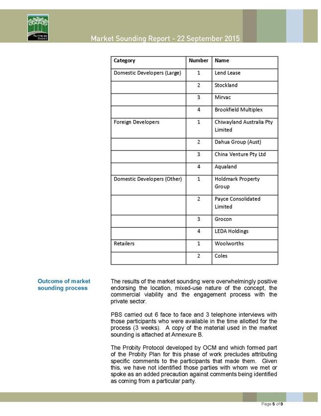

|
Ordinary
Meeting of Council - 6 October 2015
|
GB.11 / 458
|
|
|
|
|
Item
GB.11
|
S10646
|
|
|
24 August 2015
|
Ku-ring-gai Mini Wheels Training Club -
Owner's Consent to Prepare Development Application For Relocation to Old Tree
Tip Site at St Ives
EXECUTIVE
SUMMARY
|
purpose of report:
|
To seek approval from
Council to ask the NSW Crown Lands Division to grant owner’s consent for a
Development Application to be submitted by Ku-ring-gai Mini Wheels Training
Club for the use of the Old Tree Tip site at St Ives.
To
seek approval from Council to negotiate an agreement with the NSW National
Parks and Wildlife Service for the club to use the unsealed access road from
Mona Vale Road to the Old Tree Tip site if the club’s Development Application
for the use of the site is approved.
|
|
|
|
|
background:
|
At the Ordinary Meeting
of Council on 26 May 2015 it was resolved:
A. That
Council give notice to Ku-ring-gai Mini Wheels Training Club Inc that it does
not intend to enter into any new agreement after the current licence expires
on 21 March 2016.
B. That
a report be presented to Council regarding the biodiversity offset funding
options to rehabilitate the site in accordance with the Plan of Management.
C. That Council staff do everything possible
to support Mini Wheels Club to find an alternative site and a report be
brought back to Council within 6 months prior to expiry of the lease.
|
|
|
|
|
comments:
|
Since
the Council resolution on 26 May 2015 Council officers have investigated
potential alternatives with the club and found that the only site in
Ku-ring-gai with the potential to cater for the club’s activities is the Old
Tree Tip site at Mona Vale Road St Ives. This
type of activity is permitted within the RE1 Recreation zone, subject to
development consent. The Crown Lands Division is required to grant owner’s
consent before the development application is submitted.
|
|
|
|
|
recommendation:
|
That
Council request the NSW Crown Lands Division to sign owner’s consent on a
Development Application for the use of the Old Tree Tip site at St Ives by
the Ku-ring-gai Mini Wheels Training
Club; and that Council negotiate a
right of way access or a similar agreement with the NSW National Parks and
Wildlife Service for the club to use the unsealed access road from Mona Vale
Road to the Old Tree Tip site if the club’s Development Application for the
use of the site is approved.
|
Purpose of Report
To seek approval from Council
to ask the NSW Crown Lands Division to grant owner’s consent for a Development
Application to be submitted by Ku-ring-gai Mini Wheels Training Club for the
use of the Old Tree Tip site at St Ives.
To seek approval from Council
to negotiate an agreement with the NSW National Parks and Wildlife Service for
the club to use the unsealed access road from Mona Vale Road to the Old Tree
Tip site if the club’s Development Application for the use of the site is
approved.
Background
At the
Ordinary Meeting of Council on 26 May 2015 it was resolved:
A. That
Council give notice to Ku-ring-gai Mini Wheels Training Club Inc that it does
not intend to enter into any new agreement after the current licence expires on
21 March 2016.
B. That a
report be presented to Council regarding the biodiversity offset funding
options to rehabilitate the site in accordance with the Plan of Management.
C. That
Council staff do everything possible to support Mini Wheels Club to find an
alternative site and a report be brought back to Council within 6 months prior
to expiry of the lease.
Comments
This report has been prepared in satisfaction of Part C of
Council’s resolution above.
Since the Council resolution on 26 May 2015 Council officers
have investigated potential relocation alternatives in consultation with the
Ku-ring-gai Mini Wheels Training Club. Sites investigated include the St Ives
Old Tree Tip and the Clissold Road old quarry along the Golden Jubilee Fire
Trail at East Wahroonga. No other potential sites were identified. After
consideration of the club’s minimum requirements, site constraints, and the
proximity of residential properties it is considered that the only possible
site in Ku-ring-gai that has the potential to cater for the club’s activities
is the Old Tree Tip at Mona Vale Road St Ives, which is shown in Attachment
A1.
Under the St Ives Showground and Precinct Lands Plan of
Management, which was adopted by Council on 26 May 2015, the preferred option
for the Old Tree Tip site was a commercial paintball centre, an activity that
was originally recommended to Council by the Crown Lands Division when the
Options Paper for the Precinct was prepared in 2009-10. The decision to
instead use the site as the home of the Ku-ring-gai Mini Wheels Training Club
will need to be approved by the Crown Lands Division, which they can do by
granting owner’s consent on the club’s development application.
The previous
public uses of the Old Tree Tip site were:
· green waste tip;
· water plant building;
· leachate treatment; and
· non-putrescible waste
recycling.
The new public uses for the Old
Tree Tip site (under the adopted Plan of Management) are:
· public recreation - eg paintball,
adventure ropes courses, recreational track access, potential for Mini-Wheels
Training Club;
· plant nursery;
· water recycling; and
· existing
site remediation.
Development Application Requirements - Zone RE1 Public
Recreation
Under the Ku-ring-gai LEP 2015 the Old Tree Tip site is
zoned RE1 Public Recreation. The relevant
objectives and permissible and prohibited land uses for this land zone follow.
1. Objectives of zone
· To enable land to be
used for public open space or recreational purposes.
· To provide a range of
recreational settings and activities and compatible land uses.
· To protect and
enhance the natural environment for recreational purposes.
· To protect, manage and restore areas
of high ecological, scientific, cultural or aesthetic values.
2. Permitted without consent
Environmental facilities; Environmental
protection works; Roads
3. Permitted with consent
Animal boarding or training establishments; Beekeeping;
Camping grounds; Caravan parks; Car parks; Child care centres; Community
facilities; Emergency services facilities; Information and education
facilities; Flood mitigation works; Food and drink premises; Forestry; Kiosks;
Markets; Plant nurseries; Recreation areas; Recreation facilities (indoor);
Recreation facilities (major); Recreation facilities (outdoor); Registered
clubs; Respite day care centres; Roadside stalls; Signage; Water recycling
facilities; Water supply systems.
4. Prohibited
Any development not specified in item 2 or 3.
All
land use terms used in the Principal Local Environmental Plan are defined by
the Standard Instrument (Local Environmental Plans) Order 2006. Key
definitions include the following:
Recreation area
means a place used for outdoor recreation that is normally open to the public,
and includes:
(a) a children’s playground, or
(b) an area used for community
sporting activities, or
(c) a public park, reserve or
garden or the like
and any
ancillary buildings, but does not include a recreation facility (indoor),
recreation facility (major) or recreation facility (outdoor).
Recreation
facility (outdoor) means a building
or place (other than a recreation area) used predominantly for outdoor
recreation, whether or not operated for the purposes of gain, including a golf
course, golf driving range, mini-golf centre, tennis court, paint-ball centre,
lawn bowling green, outdoor swimming pool, equestrian centre, skate board ramp,
go-kart track, rifle range, water-ski centre or any other building or place of
a like character used for outdoor recreation (including any ancillary
buildings), but does not include an entertainment facility or a recreation
facility (major).
As the Mini Wheels Training Club activity falls under the
definition of Recreation facility (outdoor),
the activity is permitted with consent, i.e., it requires development consent
under Part 4 of the Environmental Planning and Assessment Act 1979. As
the land owner is the NSW Crown Lands Division it is required to sign owner’s
consent for a Development Application, when Council is not the applicant,
before it is submitted for assessment by the Ku-ring-gai Mini Wheels Training
Club.
It is therefore recommended that Council request the NSW
Crown Lands Division to provide owner’s consent to the lodging of a development
application by Mini-Wheels.
Unsealed access road
Council currently holds a permissive occupancy over the Old
Tree Tip site at St Ives which is owned by the Crown Lands Division. Under the
Plan of Management adopted by Council in May 2015 this site is to be
incorporated into the St Ives Showground and Precinct Lands Reserve Trust and
come under Council’s care, control and management, rather than remain
permissive occupancy.
To access the site from Mona Vale Road St Ives, Council had
a Licence for Fire Trail Access with National Parks and Wildlife Service
executed on 1 January 2000 which may have expired on 1 January 2004,
although use has been ongoing by Council to access the leachate pumps and ponds
at the site. Council constructed and maintains the unsealed road. No other
access route is available to the Old Tree Tip site.
Irrespective of the how the Old Tree Tip site is re-used in
the future, a right-of-way to use the existing vehicle access road through
Garigal National Park for controlled access to the site and leachate pump house
needs to be negotiated as a shared permanent access road, for Council lease
area users, with controlled gate use. The existing road, which was eventually
to be removed at the cessation of tip remediation works, has now been now
listed as a fire trail with Hornsby/Ku-ring-gai Rural Fire Service (Trail No
394) with current and future class being “essential” and capacity listed as
“Category 1”. The trail is listed as ‘In good condition” and links through and
around the Old Tree Tip site to Warringah Council and will be retained.
It is recommended that Council negotiate a right-of-way
access or a similar agreement with the NSW National Parks and Wildlife Service
for the Ku-ring-gai Mini Wheels Training Club to use the unsealed access road
from Mona Vale Road to the Old Tree Tip site at St Ives if the club’s
Development Application for the use of the site is approved.
integrated planning and reporting
Theme 3 - Places, spaces and
Infrastructure
P6 Enhancing recreation,
sporting and leisure facilities
P7 Enhancing community buildings
and facilities
|
Community Strategic Plan Long Term Objective
|
Delivery Program
Term Achievement
|
Operational Plan
Task
|
|
Continue to provide quality open space, community and
recreational facilities that meet the needs of our community.
|
6.1.2 A program is being
implemented to improve existing recreation, sporting and leisure facilities
and facilitate the establishment of new facilities.
|
Designs are prepared and
environmental approvals obtained for the delivery of the open space capital
works program.
Report on compliance with
environmental approvals for open space capital works projects.
|
|
|
P7.1.2 Usage of existing
community buildings and facilities is optimised.
|
Develop business models for
new recreation and business opportunities identified in Plan of Management.
|
Governance Matters
This proposal will be subject to a development application
under Part 4 of the Environmental Planning and Assessment Act 1979.
Risk Management
Risk Management issues will be addressed in the development
application.
There is the possibility of some reputational risk to
Council in the event an alternate location for Mini-Wheels cannot be
identified.
Financial Considerations
All costs, other than Council staff time to assist the
Ku-ring-gai Mini Wheels Training Club, as required by the resolution on 26 May
2015 that is outlined in the Background section of this report, and dealings
with the Crown Lands Division and the National Parks and Wildlife Service, will
be borne by the Mini Wheels Club.
Social Considerations
Social considerations will be addressed in the development
application.
Environmental Considerations
Environmental considerations will be addressed in the
development application.
Community Consultation
There has not been any consultation with the community
during the preparation of this report. None is required at this stage.
Internal Consultation
Staff from Operations, Community and Strategy have been
consulted during the preparation of this report.
Summary
Council resolved on 26 May 2015 not to enter into a new
lease agreement with Ku-ring-gai Mini Wheels Training Club at its current site
at St Ives Showground after the current licence expires on 21 March 2016, and
also that Council staff do everything possible to support the Mini Wheels Club
to find an alternative site and a report be brought back to Council within 6
months prior to expiry of the lease.
Since that time Council officers have investigated potential
alternatives with the club and found that the only site in Ku-ring-gai with the
potential to cater for the clubs’ activities is the Old Tree Tip site at Mona
Vale Road St Ives as indicated in Attachment A1.
This type of activity requires development consent under
Part 4 of the Environmental Planning and Assessment Act, 1979. As the
land is Crown Land it is recommended that Council request the NSW Crown Lands
Division to grant owner’s consent on a Development Application to be submitted
by Ku-ring-gai Mini Wheels Training Club for the use of the Old Tree Tip site
at St Ives.
It is also recommended that Council negotiate right-of-way
access or a similar agreement with the NSW National Parks and Wildlife Service
for the Ku-ring-gai Mini Wheels Training Club to use the unsealed access road
from Mona Vale Road to the Old Tree Tip at St Ives if the club’s Development
Application for the use of the site is approved.
|
Recommendation:
A. That
Council request the NSW Crown Lands Division to grant owner’s consent on a
Development Application to be submitted by Ku-ring-gai Mini Wheels Training
Club for the use of the Old Tree Tip site at St Ives.
B. That
the General Manager be given authority to negotiate a right-of-way access or
a similar agreement with the NSW National Parks and Wildlife Service for the
Ku-ring-gai Mini Wheels Training Club to use the unsealed access road from
Mona Vale Road to the Old Tree Tip site at St Ives, subject to the club’s Development
Application for the use of the site being approved.
|
|
Roger Faulkner
Team Leader Sport & Recreation Planning
|
Ian Dreghorn
Manager Strategic Projects
|
|
Andrew Watson
Director Strategy & Environment
|
|
|
Attachments:
|
A1View
|
St
Ives Old Tree Tip site and Precinct - aerial image
|
|
2015/226463
|
|
APPENDIX
No: 1 - St
Ives Old Tree Tip site and Precinct - aerial image
|
|
Item No: GB.11
|
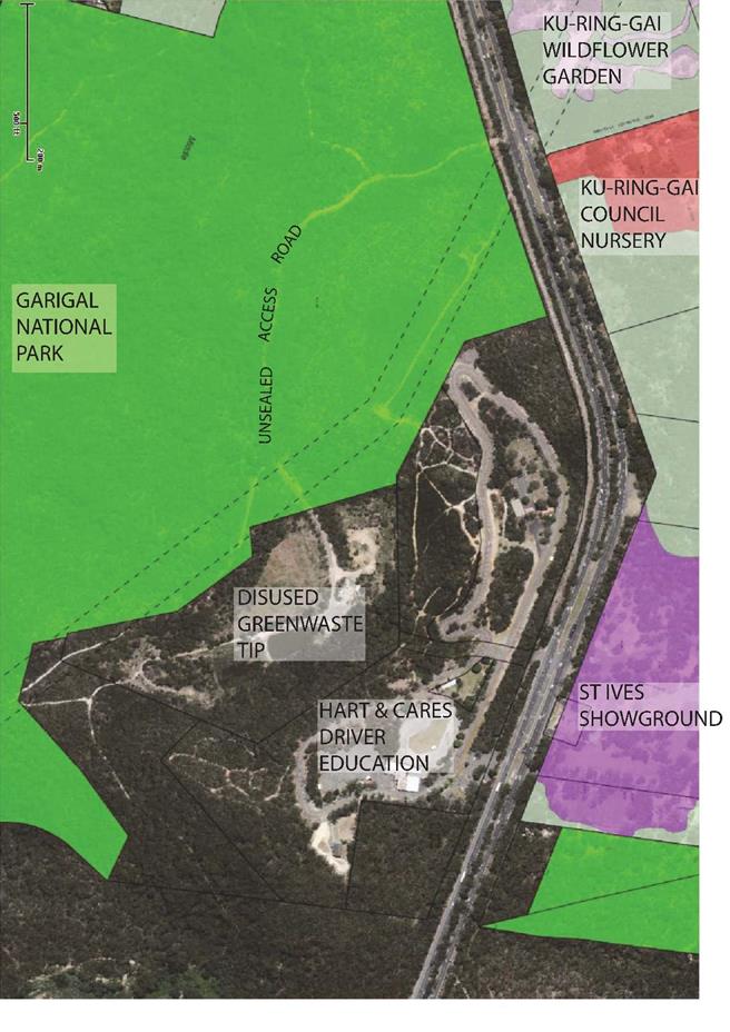
|
Ordinary
Meeting of Council - 6 October 2015
|
GB.12 / 465
|
|
|
|
|
Item
GB.12
|
S10539
|
|
|
24 September 2015
|
Planning Proposal to Allow Dual Occupancy
on 109 Bobbin Head Road, Turramurra and 28 Clissold Road, Wahroonga - Report
Following Exhibition
EXECUTIVE
SUMMARY
|
purpose of report:
|
For Council to proceed with the
finalisation of the Planning Proposal to amend the Ku-ring-gai Local
Environmental Plan 2015 to allow dual occupancy on 109 Bobbin Head
Road, Turramurra and 28 Clissold Road, Wahroonga.
|
|
|
|
|
background:
|
On 26 May 2015 Council resolved
to proceed with a revised Planning Proposal to amend the KLEP 2015 to allow
dual occupancy on 109 Bobbin Head Road, Turramurra and 28 Clissold Road,
Wahroonga. The Planning Proposal received a Gateway Determination on 18
August 2015 and was exhibited in accordance with the Gateway Determination
for 14 days, from 28 August 2015 to 11 September 2015.
|
|
|
|
|
comments:
|
No submissions were received
regarding this Planning Proposal.
|
|
|
|
|
recommendation:
|
That Council proceed with the
Planning Proposal to allow dual occupancy on 109 Bobbin Head Road Turramurra
and 28 Clissold Road, Wahroonga.
|
Purpose of Report
For Council to proceed with the finalisation of the Planning
Proposal to amend the Ku-ring-gai Local Environmental Plan 2015 to allow
dual occupancy on 109 Bobbin Head Road, Turramurra and 28 Clissold Road,
Wahroonga.
Background
This
Planning Proposal was originally submitted on behalf of three property owners
to allow dual occupancy on their land at 109 Bobbin Head Road, Turramurra, 28
Clissold Road, Wahroonga and 2 Loombah Ave, Lindfield.
On 26
May 2015, Council resolved to amend the Planning Proposal to only allow dual
occupancy on 109 Bobbin Head Road, Turramurra and 28 Clissold Road, Wahroonga.
Council
did not support dual occupancy on 2 Loombah Ave, East Lindfield, nor was a
minimum lot subdivision on 109 Bobbin Head Road, Turramurra supported.
Council resolved the following:
A. That
the Planning Proposal to amend the Ku-ring-gai Local Environmental Plan 2015 to
allow dual occupancy on 28 Clissold Road Wahroonga be supported subject to the
amendments outlined in this Report.
B. That
the Planning Proposal to amend the Ku-ring-gai Local Environmental Plan 2015 to
allow dual occupancy on 109 Bobbin Head Road Turramurra be supported subject to
the amendments outlined in the Report.
C. That
the Planning Proposal to allow dual occupancy at 2 Loombah Avenue, East
Lindfield not be supported.
D. That
the Planning Proposal be amended by the applicant and prepared to the
satisfaction of the Director, Strategy and Environment, and then be forwarded
to the Department of Planning and Environment for a Gateway Determination in
accordance with the provisions of the EP&A Act and Regulations.
E. That
Council request the plan-making delegation under Section 23 of the EP&A Act
for this Planning Proposal.
F. That
upon receipt of a Gateway Determination, the exhibition and consultation
process be carried out in accordance with the requirements of the Environmental
Planning and Assessment Act, 1979 and with the Gateway Determination
requirements.
In
accordance with the resolution, the Planning Proposal was amended (Attachment
A1) and forwarded to the Department of Planning and Environment for a
Gateway Determination.
The
Planning Proposal received a Gateway Determination (Attachment A2) on 18
August 2015 at which time Council was given delegated authority as the proposal
was not considered as high impact. This delegated authority will enable Council
to progress the amendment and incorporate it into the KLEP 2015.
Following receipt of the Gateway Determination, the
exhibition of the Planning Proposal was advertised in the North Shore Times on
28 August 2015, with all exhibition documents being made available to the
public at Council’s Chambers and on Council’s website for the required 14 days.
Comments
No submissions from members of
the public were received in response to the exhibition, and the Gateway
Determination did not require any State Agency consultation.
The owners of 2 Loombah Ave, Lindfield have requested a
pre-Gateway review to reconsider Council’s decision not to include that site in
the Planning Proposal. This is being considered by the Department of Planning
and Environment. A response to the review reiterating points tabled at
Council’s 26 May 2015 meeting has been forwarded to the Department.
integrated planning and reporting
Places, Spaces and Infrastructure - P1 - Preserving the
unique visual character of Ku-ring-gai
|
Community Strategic Plan Long Term Objective
|
Delivery Program
Term Achievement
|
Operational Plan
Task
|
|
P1.1 Ku-ring-gai’s unique
visual character and identity is maintained.
|
Strategies plans and processes
are in place to protect and enhance
Ku-ring-gai’s unique landscape
character.
|
Continue to review existing
strategies and plans.
|
Places, Spaces and Infrastructure - P2 - Managing Urban
Change
|
Community Strategic Plan Long Term Objective
|
Delivery Program
Term Achievement
|
Operational Plan
Task
|
|
P2.1 A
robust planning framework is in
place to deliver quality design outcomes and maintain the identity and character of Ku-ring-gai.
|
Strategies, plans and
processes are in place to
effectively manage the impact of
new development.
|
Implement and monitor
Principal Local Environmental Plan
and supporting Development Control Plan.
|
Governance Matters
The
process for the preparation and implementation of Planning Proposals is
governed by the provisions of the Environmental Planning and Assessment Act,
1979 and the Local Government Act, 1993 (where relevant).
Council
has been granted plan-making delegation under Section 23 of the EP&A Act to
finalise the Planning Proposal. This involves Council taking on the Director
General’s function under s59(1) of the Act in liaising with the Parliamentary
Counsel’s Office (PCO) to draft the required Local Environmental Plan to give
effect to the Planning Proposal as well the Minister’s function under s59(2) of
the Act in making the Plan.
Risk
Management
This is a privately initiated Planning Proposal. Council
needs to finalise this proposal in a timely manner. Where Council does not
progress the matter in a timely manner, the applicant may have recourse to a
further review under the proposed amendments to the local plan-making process
under the EP&A Act and EP&A Regulations recently announced by the NSW
Minister for Planning and Environment.
Financial Considerations
The
Planning Proposal was subject to the relevant application fee under Council’s
Schedule of Fees and Charges. The cost of the review, advertising and
assessment of the Planning Proposal is covered by the application fee. The
lumping together of a number of effectively unrelated matters into a single Planning
Proposal highlighted the need to review Council’s fee structure for such
applications, and resulted in the requirement for such applications to be
submitted and charged separately.
Social Considerations
The
sites are located in good proximity to local buses with bus routes to local
train stations. In addition there are retail, educational and recreational
parks and facilities close by. The increase by one family unit on each site,
allowed by dual occupancy, would have ready access to facilities shared by the
local community and therefore avoid isolation.
Environmental Considerations
None
of the sites have any biodiversity or riparian mapping. The proposal will not
change or impact any environmental aspects on the sites or adjacent to the
sites.
Community Consultation
The Planning Proposal was placed on public exhibition in
accordance with the requirements of the Gateway and the Department’s
publication A Guide to Preparing Planning Proposals. The public
exhibition occurred from 28 August 2015 to 11 September 2015. No submissions
were received.
Internal Consultation
Discussions were held with Development and Regulation
Assessment officers to determine the history of the sites. On 18 August 2015
the Department of Planning and Environment issued a Gateway Determination under
Section 56 of the EP&A Act, in respect to an amendment to the KLEP 2015, to
allow dual occupancy on 109 Bobbin Head Road, Turramurra and 28 Clissold Road,
Wahroonga.
Summary
Ordinarily,
it is not Council’s policy to allow dual occupancy within the LGA following the
repeal of SEPP 53. Both 28 Clissold Road, Wahroonga and 109 Bobbin Head
Road, Turramurra meet the basic dual occupancy criteria and are able to
integrate within their context without impact on the local character. In
addition, it is considered that dual occupancy would provide a good planning
outcome and improve the streetscape and urban quality at these locations.
The Planning Proposal was placed on exhibition for 14 days,
from 28 August 2015 to 11 September 2015. No submissions were
received regarding the proposal.
|
Recommendation:
A. That the
Planning Proposal to amend the KLEP 2015 to allow dual occupancy on 109
Bobbin Head Road, Turramurra and 28 Clissold Road, Wahroonga, be endorsed to
proceed without variation.
B. That Council
proceed to make the Plan, using its delegated authority under Section 59(2)
of the Environmental Planning and Assessment Act, 1979.
|
|
Rathna Rana
Senior Urban Planner
|
Craige Wyse
Acting Manager Urban & Heritage Planning
|
|
Andrew Watson
Director Strategy & Environment
|
|
|
Attachments:
|
A1View
|
Planning
Proposal - amended in accordance with Council resolutions
|
|
2015/185692
|
|
|
A2View
|
Gateway
Determination PP_2015_KURIN_004_00
|
|
2015/257078
|
|
APPENDIX
No: 1 - Planning
Proposal - amended in accordance with Council resolutions
|
|
Item No: GB.12
|
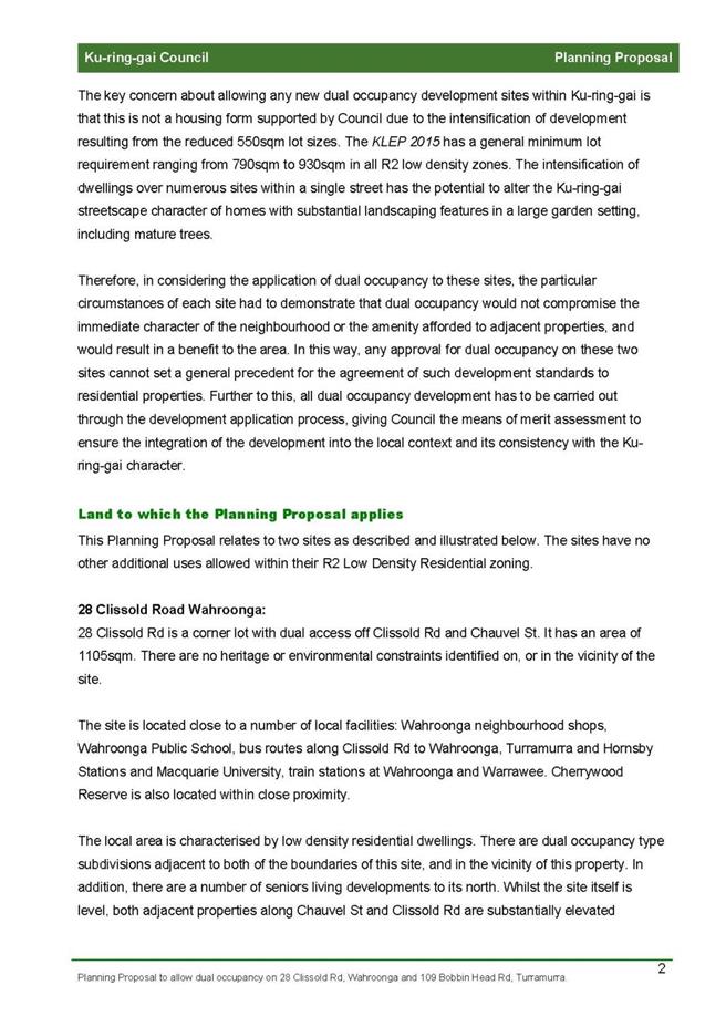
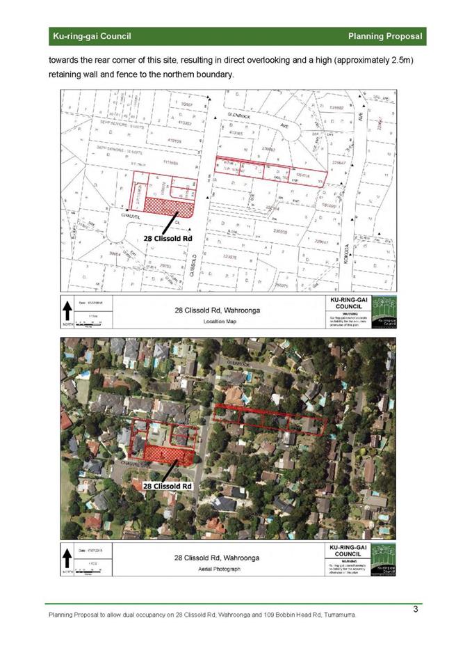
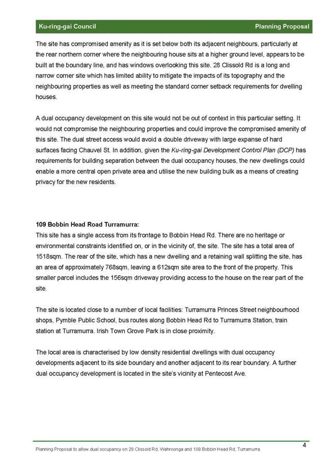
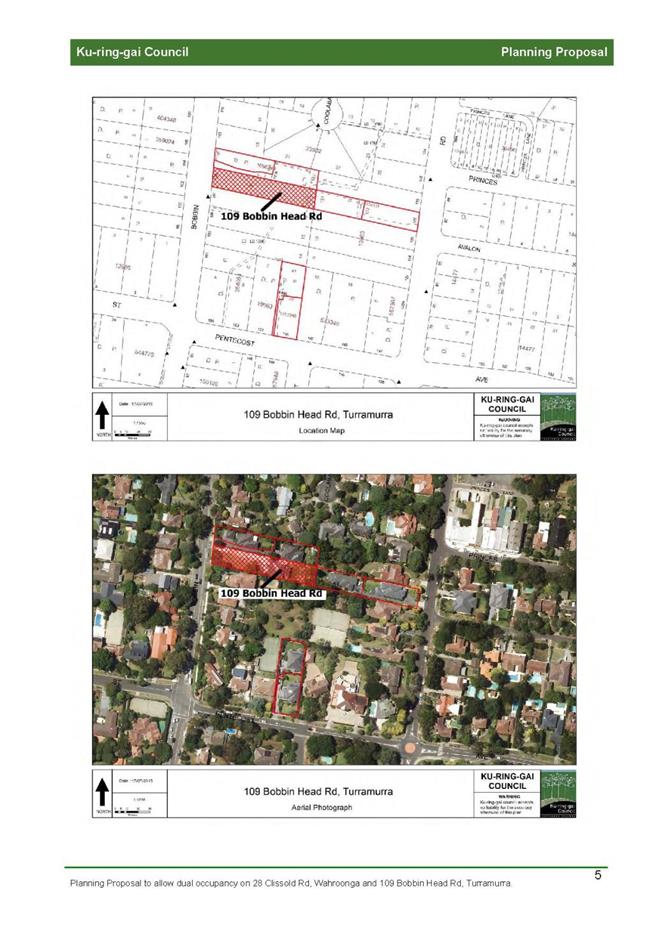

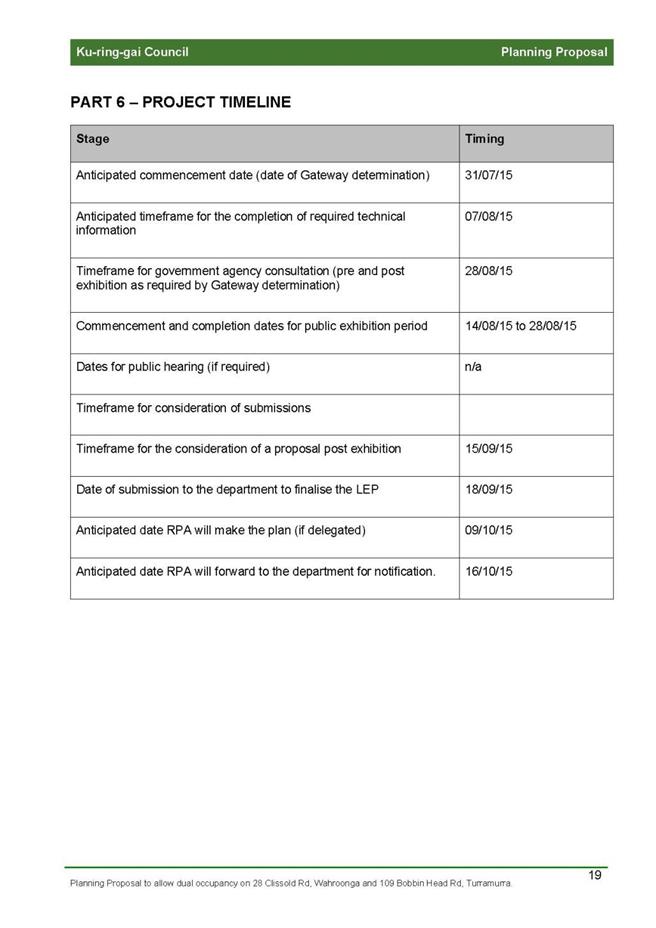
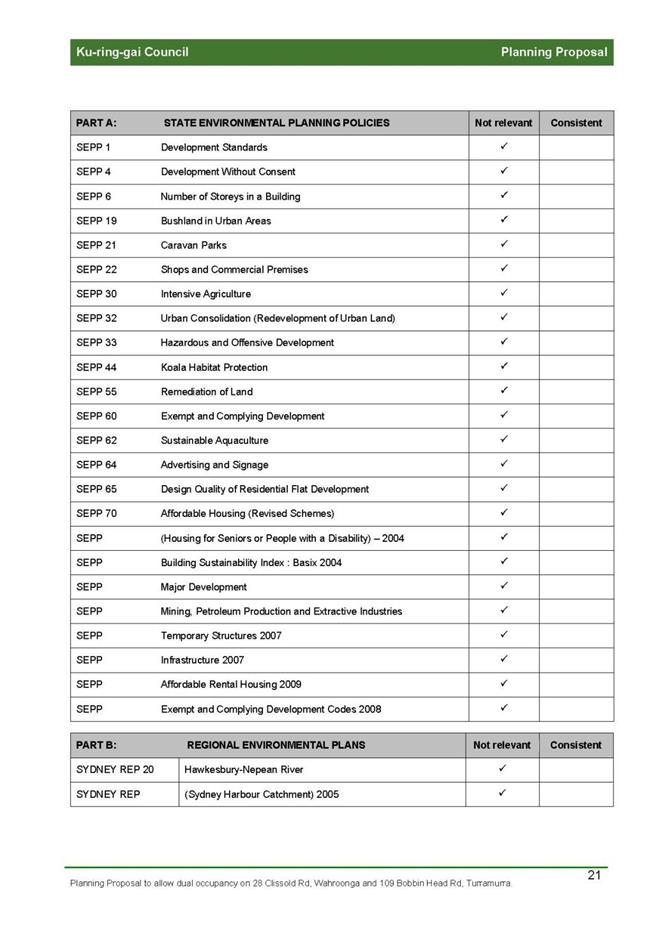

|
APPENDIX No: 2 - Gateway
Determination PP_2015_KURIN_004_00
|
|
Item No: GB.12
|
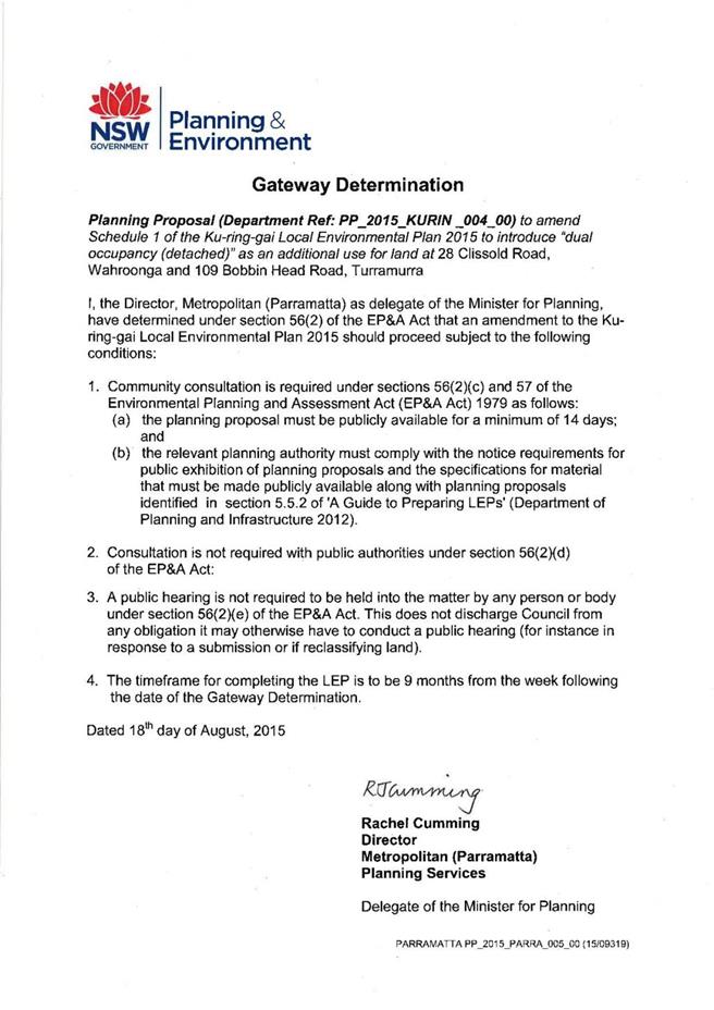
|
Ordinary
Meeting of Council - 6 October 2015
|
GB.13 / 508
|
|
|
|
|
Item
GB.13
|
S07987
|
|
|
7 September 2015
|
EXECUTIVE
SUMMARY
|
purpose of report:
|
To seek Council’s approval to
establish a Heritage Assistance Fund for 2015/16 – 2017/18.
|
|
|
|
|
background:
|
Council has received a grant from
the NSW Office of Environment and Heritage to establish a Heritage Assistance
Fund for the 2015/16 financial year. The grant is a pro-rata $1 for $2
arrangement. The grant is $9,000 and Council’s expenditure would be $18,000.
|
|
|
|
|
comments:
|
A Local Heritage Assistance Fund
will assist and encourage owners of heritage places in the ongoing
maintenance and conservation of heritage items, and contributory places
within heritage conservation areas.
|
|
|
|
|
recommendation:
|
That Council approves the
establishment of a Heritage Assistance Fund to the amount of $18,000 in
2015/16, and up to $20,000 in 2016/17 and 2017/18, subject to budget
approval.
|
Purpose of Report
To seek Council’s approval to establish a Heritage Assistance
Fund for 2015/16 – 2017/18.
Background
A grant from the Office of Environment and
Heritage has been offered to Council. It is a pro-rata $1 for $2 grant of up to
$9,000 to be allocated towards a Local Heritage Assistance Fund for the 2015/16
financial year. A total of $18,000 will be required from Council to complete
the fund.
At the Ordinary Meeting of Council on 11 August
2015 Council resolved to investigate the capacity and possibility of a modest
heritage fund comparable with other councils.
Ku-ring-gai has not had a Local Heritage
Assistance Fund to assist owners with conservation works to local heritage
items since 2008 when State grant funding was withdrawn.
Comments
A Local Heritage Assistance Fund will assist and
encourage owners of heritage places in the ongoing maintenance and conservation
of heritage items and contributory places within heritage conservation areas.
Previously Council’s Heritage Fund allocated a maximum of $6,000 per property.
This was allocated on a dollar for dollar basis; where Council would match
every dollar the applicant spent, up to a specified amount. For example, if the
project was for new slate tiles and the cost was $8,000 Council would pay
$4,000 and the owners $4,000.
It is recommended that any new Local Heritage
Assistance Fund also be based on a dollar for dollar contribution. The maximum
funding allocated to each property will be $5,000. The fund will be advertised
in the North Shore Times and on Ku-ring-gai Council’s website. Owners of heritage
items or properties within heritage conservation areas will be encouraged to
apply.
The Local Heritage Assistance Fund will cover the
following works:
· approved conservation works ; and
· maintenance to original and significant
fabric.
The Local Heritage Assistance Fund will not
provide funding:
· where assistance is reasonably
available from another source;
· where substantial assistance has been
previously provided, or where the applicant has yet to complete other assisted
projects;
· for the purchase of a building, site or
movable item;
· for a new addition to a heritage
building (including new internal fittings such as new kitchens and bathrooms);
· for the relocation of a heritage
building or work on relocated building; and
· for work on a government owned building
still used for a government purpose.
Applicants will need to include the following in
their application:
· background information/history;
· detailed description of proposed work ;
· estimate cost of works;
· amount of funding they seek from
Council;
· colour photographs of the existing
building;
· two quotes for the proposed works (one
may be adequate if it is specialist work and two cannot be reasonably
obtained);
· schedule of materials and colours
(depending on the nature of the job); and
· consent of owners of the property;
· a site inspection of the property may
be a requirement of approval.
The Heritage Reference Committee will assess the
applications and report back to Council with their recommendations on who
should receive funding.
Funding will only be provided for completed works,
inspected and signed off by Council’s heritage planner and where receipts/proof
of payment are provided.
Attachment 1 is a table of heritage funds
currently operating at other Councils within Sydney. There are a total of 12
Councils with funds in place, six of these fund works on heritage items and
contributory places within heritage conservation areas, and six Councils fund
works on heritage items only. The majority of the schemes are funded on a
dollar for dollar basis. The average overall budget provided by Councils across
Sydney on these funds is $19,900.
integrated planning and reporting
Heritage Conservation
|
Community Strategic Plan Long Term Objective
|
Delivery Program
Term Achievement
|
Operational Plan
Task
|
|
Local, aboriginal and cultural
history is recognised and
promoted.
|
Local and cultural history is
recognised and promoted.
|
Develop and implement a
program of activities to promote local heritage in
consultation with key stakeholders
|
Governance
Matters
At the Ordinary Meeting of
Council on 11 August 2015 Council adopted the recommendation of the Ku-ring-gai
Heritage Reference Committee to investigate the capacity and possibility of a
modest heritage assistance fund comparable with other councils. Council staff
in conjunction with Ku-ring-gai Heritage Reference Committee will be
responsible for the administration and implementation of the fund.
Risk Management
The risks associated with the management of this fund have
been taken into consideration in the formulation of the administrative
requirements and conditions for applicants.
Financial Considerations
Council’s commitment for this fund is $18,000 in 2015/16
with the option of continuing the fund in 2016/17 and 2017/18 with a commitment
of $20,000 per financial year. Funding for the Heritage Assistance Fund is
unbudgeted but could come from the Urban Planning & Heritage - Strategy
Project Budget in 2015/16. The funding for the program for the 2016/17 and 2017/18
financial years would be subject to future budget bids for those years.
Where not allocated in the first year, the monies unexpended
will not be rolled forward to this program and would be used within the
ordinary scope of the Urban Planning & Heritage - Strategy Project Budget.
Social Considerations
Providing an incentive for the conservation of privately
owned heritage places contributes to the ongoing conservation of Ku-ring-gai’s
community valued historic landscape and garden suburbs.
Environmental Considerations
The retention and conservation of heritage places has an
important role in protecting the environment. The environmental sustainability
benefits afforded by the retention of heritage places includes the substantial
reduction in building demolition and new construction waste, and the
conservation of embodied energy in the existing buildings.
Community Consultation
The Heritage Reference Committee has been consulted on the
formation of a heritage fund. In all recent exhibitions of potential heritage
items and heritage conservation areas submissions have been received from the
public noting Council’s failure to have a heritage fund to support owners in
conserving heritage places.
Internal Consultation
Advice on this proposal was sought from the relevant Council
Departments.
Summary
A Local Heritage Assistance Fund will assist and encourage
owners of heritage places in the ongoing maintenance and conservation of
heritage items and contributory places within heritage conservation areas.
Previously Council’s Heritage Fund allocated a maximum of $6,000 per property. This
report seeks Council’s approval to establish a Heritage Assistance Fund to
support the owners of privately owned heritage places to undertake approved
conservation works.
|
Recommendation:
A. That
Council approves the establishment of a Heritage Assistance Fund to the
amount of $18,000 in 2015/16; and
B. That
Council consider future budget bids for the extension of the fund to the
2016/17 and 2017/18 financial year to the amount of $20,000 a year as part of
the ordinary budgeting process..
|
|
Andreana Kennedy
Heritage Specialist Planner
|
Craige Wyse
Acting Manager Urban & Heritage Planning - Strategy
and Environment
|
|
Andrew Watson
Director Strategy & Environment
|
|
|
Attachments:
|
A1View
|
Table
of other heritage funds operating at Sydney Councils
|
|
2015/254396
|
|
APPENDIX
No: 1 - Table
of other heritage funds operating at Sydney Councils
|
|
Item No: GB.13
|
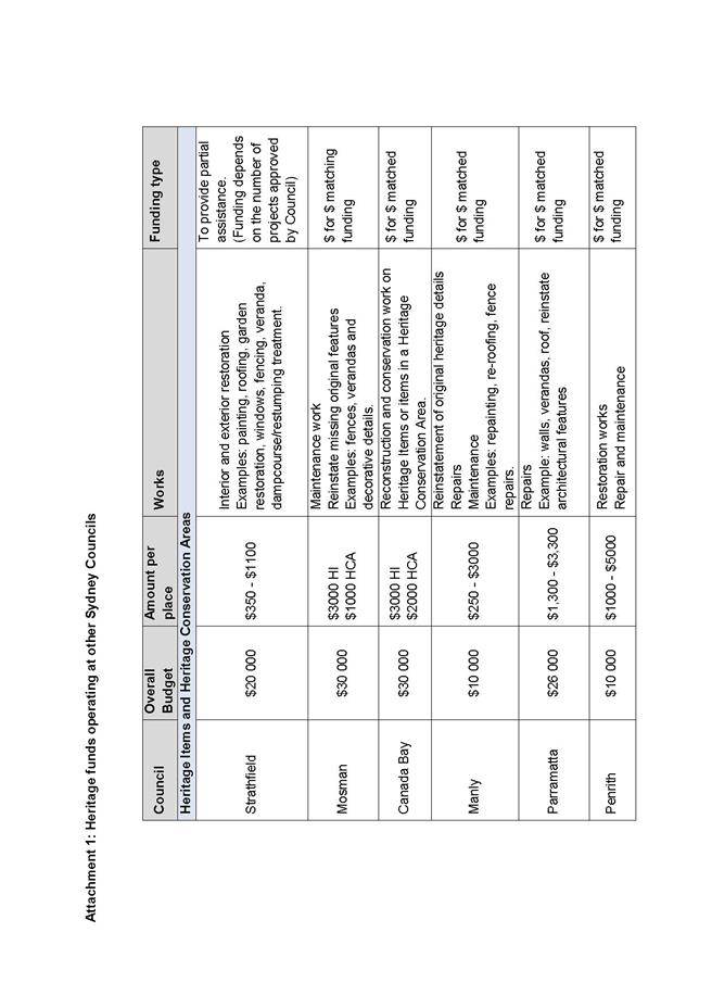
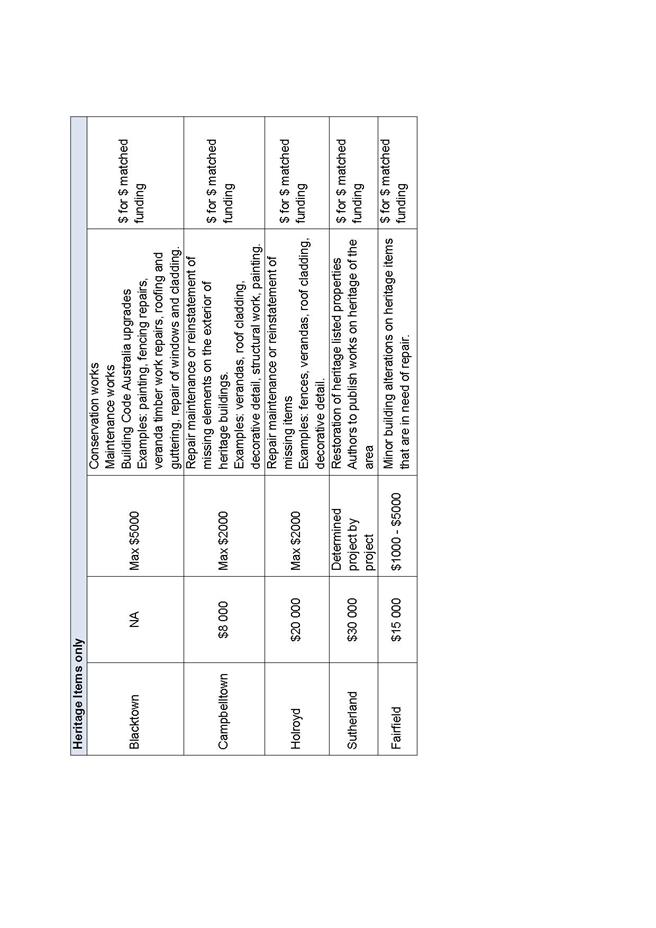
|
Ordinary
Meeting of Council - 6 October 2015
|
GB.14 / 515
|
|
|
|
|
Item
GB.14
|
S10746
|
|
|
9 September 2015
|
Flood Risk Management Committee Meeting
Minutes - 25 June 2015
EXECUTIVE
SUMMARY
|
purpose of report:
|
For Council to consider and note
the minutes of the Flood Risk Management Committee meeting held on 25 June
2015.
|
|
|
|
|
background:
|
The Flood Risk Management Committee is an essential
step in the NSW Government’s floodplain risk management process, as per the
NSW Floodplain Development Manual (2005).
The Flood Risk Management
Committee held its second meeting on the 25 June 2015.
|
|
|
|
|
comments:
|
At the meeting held on 25 June
2015 the Flood Risk Management Committee received presentations on and
discussed Ku-ring-gai’s flood studies, flood insurance and Council’s flood
database.
|
|
|
|
|
recommendation:
|
That Council receives and notes
the minutes of the Flood Risk Management Committee meeting held on 25 June
2015.
|
Purpose of Report
For Council to consider and note the minutes of the Flood
Risk Management Committee meeting held on 25 June 2015.
Background
The Flood Risk Management Committee is an essential step in
the NSW Government’s floodplain risk management process, as per the NSW
Floodplain Development Manual (2005). The Flood Risk Management Committee held
its second meeting on the 25 June 2015.
The meeting minutes (Attachment A1) have been
distributed to members of the Committee and were confirmed at the most recent
meeting held on 9 September 2015.
Comments
At the meeting held on 25 June 2015 the Flood Risk
Management Committee received presentations on and discussed: Ku-ring-gai’s
flood studies - Presentation by Lih Chong, Jacobs;
Flood insurance – Presentation by Greg White, Council’s
Water and Catchments Program Leader; and Council’s flood database –
Presentation by Eng Tan, Council’s Drainage Engineer.
Recommendations arising from the discussions are noted in
the minutes (Attachment A1).
integrated planning and reporting
Community, People and Culture
|
Community Strategic Plan Long Term Objective
|
Delivery Program
Term Achievement
|
Operational Plan
Task
|
|
An aware community able to prepare and respond to the risk
to life and property from emergency events.
|
Plans are developed in partnership with emergency service
agencies and key stakeholders and implemented.
|
Undertake floodplain risk study in consultation with
Floodplain Risk Management Committee.
|
Governance Matters
The Flood Risk Management Committee, with community,
industry and government representation, acts as an advisory committee to
Council for the development of all Flood Studies and Flood Risk Management
Plans.
Risk Management
The recent floods in various parts of Australia and the
heavy rain storms experienced in Sydney have highlighted the importance of
flood risk management and have raised public awareness of the need for all councils
to provide landowners with the best possible information on the risk of
flooding to their property.
Financial
Considerations
The Committee is an Advisory
Committee and does not have the power to incur expenditure or to bind Council
to expenditure.
Social Considerations
Activities of the Committee may have a number of
implications for property owners and members of the community. The results of
Flood Studies and Flood Risk Management Plans can impact on property values,
insurance premiums, planning controls and future development options.
Environmental Considerations
The NSW Floodplain Development Manual (2005) clearly identifies
the need for flood risk management to take into account the principles of
ecologically sustainable development and to consider ways of “maintaining
and enhancing riverine and floodplain ecology in the development of floodplain
risk management plans” (section 1.1.2). The Terms of Reference for the
Flood Risk Management Committee also incorporates this principle.
Community Consultation
The Flood Risk Management Committee is an Advisory Committee
of Council and includes members from the local community and relevant State
agencies.
Internal Consultation
Council staff have been nominated to attend the Committee
meetings.
Summary
The Flood Risk Management Committee held its second meeting
on the 25 June 2015. The Committee received presentations on and discussed
Ku-ring-gai’s flood studies, flood insurance and Council’s flood database.
The meeting minutes (Attachment A1) have been distributed
to members of the Committee and were confirmed at the most recent meeting held
on 9 September 2015.
|
Recommendation:
A. That
Council receives and notes the minutes of the Flood Risk Management Committee
meeting held on 25 June 2015.
|
|
Sophia Findlay
Water and Catchments Program Leader
|
Suzy Lykos
Acting Manager Environment & Sustainability
|
|
Andrew Watson
Director Strategy & Environment
|
|
|
Attachments:
|
A1View
|
Flood
Risk Management Committee Minutes – 25 June 2015
|
|
2015/162106
|
|
APPENDIX
No: 1 - Flood
Risk Management Committee Minutes – 25 June 2015
|
|
Item No: GB.14
|
MINUTES OF Flood Risk Management Committee
HELD ON Thursday, 25 June 2015
|
Present:
|
Councillor C Berlioz (St Ives Ward)
Margery Street – Community Representative
Philip Morley – Community Representative
Michael Brown – Community Representative
|
|
|
|
|
Staff Present:
|
Marnie Kikken – Manager Environment and Sustainability
Kathy Hawken – Team Leader Development Engineers
Greg White – Water and Catchments Program Leader
Eng Tan – Drainage Assets Engineer Operations
Jaala Malcolm – Senior Admin Officer – Strategy and
Environment
Harry Leung – Trainee Sustainability Officer
|
|
|
|
|
Invitees:
|
Wafaa Wasif – Floodplain Engineer OEH
Tony Pinelli – Local Controller – Ku-ring-gai SES
Rob Porter – Ranger – National Parks and Wildlife Service
Lih Chong - Jacobs
|
|
|
|
|
Observers:
|
|
|
|
|
|
Apologies:
|
Councillor D Armstrong (Chairperson) (Roseville Ward)
Ian Taylor – Manager Engineering Operations
Suzy Lykos – Team Leader Natural Areas
David Catterall – Local Controller – Ku-ring-gai SES
Michael Davison – Acting Regional Controller, SES Northern
Region
Fernando Ortega – Acting Manager Land and Water, Sydney
Water
|
|
|
|
The Meeting
commenced at 9:00am
DECLARATIONS
OF INTEREST
No interest was declared.
MATTERS
ARISING FROM PREVIOUS MEETING
CONFIRMATION OF
MINUTEs
|
|
Minutes
of Flood Risk Management Committee
File: S09972
|
|
|
Meeting held 23 April 2015
|
|
|
RECOMMENDATION:
That Minutes circulated to Councillors were taken as read
and confirmed as an accurate record of the proceedings of the Meeting.
|
GENERAL
BUSINESS
|
|
Information
Report - Ku-ring-gai Flood Studies
File: S09972
Vide: GB.1
|
|
|
To inform Committee members of the current status of
Council’s flood studies.
|
|
|
Recommendation:
That the report be received and noted.
|
|
|
Information
Report - Flood Insurance
File: S09972
Vide: GB.2
|
|
|
To inform Committee members of the issues associated
with flood insurance and the potential impacts on the local community.
|
|
|
Recommendation:
That the report be received and noted.
That council develop a package to be brought to the
Flood Risk Management Committee, before distribution to insurance companies
at an appropriate time in the flood risk management process.
That future consideration be given of potential
contribution by the insurance company of expertise or financial contribution
for the provision of this information package.
The Flood Risk data be presented at a community forum.
|
|
|
Information
Report - Council's Flood Data Base
File: S09972
Vide: GB.3
|
|
|
To inform Committee members of Council’s flood data base
and its uses.
|
|
|
Recommendation:
That the report be received and noted
|
OTHER BUSINESS
NEXT MEETING
The Meeting closed
at 11:30am
|
Ordinary
Meeting of Council - 6 October 2015
|
GB.15 / 521
|
|
|
|
|
Item
GB.15
|
S10453
|
|
|
14 September 2015
|
Consideration of Submissions on Planning
Proposal to heritage list 6 Caithness Street, Killara and 51 Warrangi Street,
Turramurra
EXECUTIVE
SUMMARY
|
purpose of report:
|
For Council to consider the
submissions received during the public exhibition of the planning proposal to
heritage list 6 Caithness Street, Killara and 5 Warrangi Street, Turramurra.
|
|
|
|
|
background:
|
On 14 July 2015 Council considered a report on submissions
to a planning proposal to amend KLEP 2015 and heritage list 5 properties. Two
properties:
· 6
Caithness Street, Killara; and
· 51
Warrangi Street, Turramurra
were deferred for a Councillor briefing.
The planning proposal was
exhibited between 24 April 2015 and 22 May 2015.
|
|
|
|
|
comments:
|
A total of 8 submissions were
received during the public exhibition of the planning proposal with regards
to 6 Caithness Street and 51 Warrangi Street. A councillor
briefing was held on 17 August 2015.
|
|
|
|
|
recommendation:
|
That Council take no further
action on the heritage listing for 6 Caithness Street, Killara and 51
Warrangi Street, Turramurra.
|
Purpose of Report
For Council to consider the submissions received during the
public exhibition of the planning proposal to heritage list 6 Caithness Street,
Killara and 5 Warrangi Street, Turramurra.
Background
Council at its meeting held on 26 November 2013 resolved to
remove a number of potential heritage items from the Heritage Map and Schedule
5 of the then draft KLEP 2013, and defer them for further investigation and
re-exhibition.
Council engaged the services of a Heritage Consultant, Clive
Lucas Stapleton and Partners Pty Ltd, to conduct an independent detailed
assessment of the heritage significance of 14 of the deferred properties. The
report by Clive Lucas Stapleton and Partners Pty Ltd recommended the listing of
6 Caithness Street, Killara and 51 Warrangi Street, Turramurra.
Council at its meeting held on 25 November 2014 considered a
report on the heritage assessment by Clive Lucas Stapleton and Partners on 14
of the deferred properties and resolved the following:
A. That a
planning proposal be prepared , in accordance with Section 55 of the
Environmental Planning and Assessment Act 1979 to amend the Draft Ku-ring-gai
Local Environmental Plan 2014 to include the following properties on Schedule 5
and on the Heritage Map as heritage items of local significance:
i. 51
Warrangi Street, Turramurra (Lot 1 DP580008)
ii. 4-6 Neringah
Avenue South, Wahroonga (Lot 55 and 56 DP2666)
iii. 88 Fox
Valley Road, Wahroonga (Lot 15 DP568694)
iv. 12 Bobbin
Head Road, Pymble (Lot 1 DP200728)
v. 6
Caithness Street, Killara (Lot 6 DP14824)
B. That the
planning proposal be submitted to the Department of Planning and Infrastructure
for a Gateway Determination in accordance with Section 56 of the Environmental
Planning and Assessment Act 1979.
C. That in
order to facilitate a more timely Gateway Determination, the NSW Heritage
Office be consulted prior to submitting the planning proposal to the Department
of Planning and Environment. Should comments not be received within 21 days,
the planning proposal is to be submitted regardless.
D. That
Council request the plan-making delegation under Section 23 of the EP&A Act
for this planning proposal.
E. That upon
receipt of a Gateway Determination, the exhibition and consultation process is
carried out in accordance with the requirements of the Environmental Planning
and Assessment Act 1979 and with the Gateway Determination requirements.
F. That a
report be brought back to Council at the conclusion of the exhibition period.
G. That
Council take no further action on the heritage listing for the following
properties:
i. 59
Warrangi Street, Turramurra (Lot 1 DP215730)
ii. 6
Munderah Street, Wahroonga (Lot 2 DP552850)
iii. 10
Munderah Street, Wahroonga (Lot 1 DP216542)
iv. 66
Pentecost Avenue, Pymble (Lot B DP103589)
v. 60-62
Pentecost Avenue, Pymble (Lot 1 and 2 Sec DP13451)
vi. 33
Grandview Street, Pymble (Lot 2 DP228015)
vii. 8
Braeside, Wahroonga (Lot 2 DP52186)
viii. 8-10
Neringah Avenue South, Wahroonga (Lot 54 DP2666 and Lot 2 DP585805)
ix. 35
Springdale Road, East Killara
Council at its meeting of 2 February 2015 resolved to place
an Interim Heritage Order under Section 25 of the NSW Heritage Act 1977 on 6
Caithness Street, Killara. The Interim Heritage Order was published in the NSW
Government Gazette on 6 February 2015.
On 3 February 2015, the planning proposal was referred to
the Heritage Division of the NSW Office and Environment and Heritage (OEH) for
comment prior to submitting to the NSW Department of Planning and Environment
for a Gateway Determination. The OEH submission outlined that there were no
objections to the listing of the proposed 5 items. A copy of the planning
proposal and appendices was included in the agenda for OMC 8 September 2015,
GB.11 and can be viewed on Council’s website and business paper.
The NSW Department of Planning and Environment issued a
Gateway Determination under Section 56 of the Environmental Planning
and Assessment Act 1979 on 10 April 2015.
The Planning Proposal was placed on public exhibition in
accordance with the requirements of the Gateway Determination from Friday 24
April 2015 to Friday 22 May 2015.
Council at its meeting of 14 July 2015 resolved to make the
Plan under delegated authority to include 12 Bobbin Head Road, Pymble and 88
Fox Valley Road, Wahroonga in Schedule 5 and on the Heritage Map of KLEP 2015.
At the Council meeting of 28 July 2015, Council resolved, in
part:
E. That Council defers any decision in regards to 6 Caithness Street
and 51 Warrangi Street for a Council briefing
from a Heritage expert.
It was clarified at the time that “heritage expert” was a
reference to Council’s Heritage Specialist Planner.
On 17 August 2015 a briefing was held with Councillors to
brief them on this matter. Following the briefing, a report on the
consideration of submissions for 6 Caithness Street, Killara and
51 Warrangi Street, Turramurra was resubmitted to the Council meeting of 8
September 2015, wherein Council resolved:
That this matter be deferred
until report by NBRS & Partners is available.
All submissions regarding the heritage listing of 6
Caithness Street, Killara and 51 Warrangi Street, Turramurra – including the
report by NBRS & Partners – were circulated to Councillors via memo on 23
September 2015.
Comments
A heritage item is a place, which may include built
structures, landscapes, moveable objects and relics, that has recognised
cultural significance. In NSW, heritage items of local significance are
assessed against 7 criteria:
a) Historical
significance – an item is important in the course, or pattern, of the
cultural or natural history of the local area;
b) Historical
association significance – an item has strong or special association with
the life or works of a person, or group of persons, of importance to the local
area’s cultural or natural history;
c) Aesthetic
significance – an item is important in demonstrating aesthetic
characteristics and/or a high degree of creative or technical achievement in
the local area;
d) Social
significance – an item has a strong or special association with a
particular community or cultural group in the local area, for social, cultural
or spiritual reasons;
e) Technical/research
significance – an item has potential to yield information that will
contribute to an understanding of the local area scientific, cultural or
natural history;
f) Rarity
– an item possesses uncommon, rare or endangered aspects of the local area’s
cultural or natural history; and
g) Representativeness
- an item is important in demonstrating the principal characteristics of a
class of the local area’s cultural or natural places; or cultural or natural
environments.
Items are not excluded from the heritage schedule solely
because they share similar characteristics to items already represented. Items
do not need to be significant in all of these criteria, many have significance
in only 1 or 2 of the criteria.
As a result of the public exhibition of the planning
proposal, a total of 8 submissions were received with regards to 6 Caithness
Street, Killara and 51 Warrangi Street, Turramurra:
|
Property
|
Submissions received in support of heritage listing
|
Submissions received not in support of heritage listing
|
|
6 Caithness Street, Killara
|
5
|
2
|
|
51 Warrangi Street, Turramurra
|
0
|
1
|
A summary of the public submissions along with a detailed
comment and assessment is included at Attachment A1.
The purpose of the public exhibition is to facilitate public
participation in the planning process. The submissions along with the original
assessment were analysed to form this report’s recommendation. The key findings
of the analysis of the submissions against the original assessment is provided
below.
6 Caithness Street,
Killara
The Inter-war bungalow at 6
Caithness Street, Killara was assessed at having significance for its aesthetic
contribution and its historical association with the architect Donald Esplin
and a former president of the Killara Golf Club, T.K. Smith.
The Architect Esplin designed some 400 buildings. 3 of his
buildings are recognized as heritage places under Ku-ring-gai Council’s LEPs:
· 9 Yarabah Avenue, Gordon;
· 22 Hastings Road, Warrawee; and
· 26 Billyard Avenue Warrawee.
Submissions were received both in support and against the
heritage listing. Those in support of the listing commented on the aesthetic
value and historical association significance. Those against the listing
highlighted the loss of aesthetic significance and the unsympathetic changes
that occurred to the property. This was supported by an independent heritage
assessment by NBRS + Partners which challenged the assessment of aesthetic
significance.
It should be noted that recent changes to the house, being
those in the last 12 months, are considered to be reversible. Consistent with
the principles of the Burra Charter, there is extensive knowledge of the form,
nature and appearance of the original elements that were changed such that it
would be appropriate to replace the new aluminium window and glass balustrade
with appropriate replicas to those found in historic house photos. These recent
changes are not the reason for not pursuing the heritage listing of 6 Caithness
Street Killara.
The proposed listing and submissions have been further
reviewed and it is recommended the listing not proceed for the following
reasons:
1. While
Esplin was a significant architect this is not a remarkable example of his work
nor is it a particularly remarkable example of the Inter-war bungalow style:
This view was supported by Council’s heritage advisor and
the report by NBRS + Partners. Other fine examples of Esplin’s bungalow work
include the famed ‘Esplin Bungalow’ located at 11 Cranbrook Avenue,
Cremorne. This house is cited in numerous architectural texts and by the AIA as
an early and highly accomplished Californian bungalow. Another fine example of
his more modest bungalow work is 44-46 Lang Road , known as Forster and
Braelin. Constructed for politician and timber merchant, Sir Allen Taylor and
his wife Lady Adele Taylor, the dwelling is a substantial, though conservative,
early Inter-war Californian bungalow style house whose design intent has not been
compromised by rendering or changes to the garden setting.
Additionally, according to the description of 6 Caithness
Street contained within the book Donald Thomas Esplin, Sydney Architect, His
Life and Work (Irving and Irving 2008) “the verandah supports are
conceived as a three-bay ensemble of Tuscan columns …in a classical design
motif typically favoured more by Mould than by Esplin”. The inference being
the aesthetic is more that of Mould than Esplin. Based on the association with
Esplin it is not recommended to list 6 Caithness Street, Killara.
2. While
T.K. Smith was a valued member of Killara Golf Club his short mid-term
presidency was unremarkable with no significant events or changes occurring at
the club over this short presidency. An adequate comparison with the six
earlier presidents has not been provided. The historical association
with T.K. Smith is not considered significant
The assessment by Clive Lucas Stapleton and Partners Pty Ltd
described T.K. Smith as an early president when in fact his presidency was not
until 1946, nearly 50 years since the club began. The Clive Lucas Stapleton and
Partners Pty Ltd assessment failed to undertake a comparison between T.K. Smith
and the other presidents to obtain an understanding of what being a significant
president of the club may entail. The following is a comparison of the terms
and significant events for the preceding presidents, and the immediately
following president to T.K. Smith:
|
Charles Danvers
|
1899-1901
First president (Lindfield)
|
|
|
|
|
|
|
|
|
|
|
|
J George Edwards
|
1902-1910
Moved course to Killara – known as the father of
Killara
|
|
|
|
|
|
Henry Braddon
|
1911
|
|
|
|
|
|
|
|
|
|
|
|
|
|
Charles E Graham
|
1912-1928
War years, expansion
|
|
William Maschwitz
|
1929-1935
New clubhouse
|
|
|
|
|
|
|
|
Frederick Greaves
|
1936-1945
War years
|
|
|
|
|
T. Keith Smith
|
1946-1947
|
|
|
|
|
|
|
|
|
|
|
|
|
John F. Fenwick
|
1948-1951
|
|
|
|
|
|
|
|
|
|
|
The historical association with T.K. Smith is not considered
a sufficiently convincing reason for including 6 Caithness Street as a heritage
item.
3. The
dramatic and significant change in setting from single dwellings to 5 storey
apartments has resulted in a loss of amenity to the residents of 2, 4 and 6
Caithness Street and a loss of setting to any potential heritage item:
The properties at 2, 4 and 6 Caithness Street were conceived
as bungalows surrounded by single dwellings with established gardens in a
suburban setting. The reality on the ground today is these houses are wedged
between 5 storey apartments directly to their north and to the west. There is
no longer any private open space in the backyards of these properties. More
specifically relating to the garden setting of 6 Caithness Street, the garden
no longer has a central path to the front door originating from a small garden
gate on the street as depicted in early photos and on the 1943 aerial. The gate
is long gone, so to the northern portion of the front fence. The central path
has also been diverted, with the current path to the front door sweeping from
the driveway. The sense of arrival and the symmetrical layout of the garden in
response to the symmetrical house has been altered.
It is recommended that 6 Caithness Street, Killara not
proceed as a heritage item.
51 Warrangi Street,
Turramurra
The house at 51 Warrangi
Street, Turramurra, known as Andover, was recommended for listing as a
representative example of the Georgian Revival style designed by prominent
architect William Rae Laurie.
The one submission for this property argued against the
listing based upon the unsubstantiated evidence that the house was designed by
William Rae Laurie. This argument is not supported as historical evidence
supports Laurie’s association with the design project. The independent heritage
assessment attached to the submission argued the house has undergone both significant
and unsympathetic change and was not significant.
The 1936 building application describes the house as a two
storey brick dwelling of 7 rooms with a garage. The building Andover was
a two storey house with strong Georgian Revival overtones. It was a face brick
structure set under a high pitched roof with a small attached hipped roof
projection containing maid’s accommodation. Today, the face brick is painted.
The front (south) and western façade exhibit regular and repetitive
fenestration. All elevations with the exception of the east façade have
multi-paned windows, with the upper level windows of the west and south façade
and some lower windows of the north facade having louvered shutters.
The house front does not address the street nor is it easily
visible from Warrangi Street. The primary façade faces 49 Warrangi Street
(neighbour to the south). Extensions have been made to the east and west of
this primary façade. The list of changes are as follows:
· Single storey two car
garage to western frontage visible from street.
· Skillion addition to
eastern frontage spanning width of house.
· Modification of ground
floor loggia on north elevation with later enclosed verandah addition.
· Enclosure of first floor
loggia and division into separate rooms.
· Internal modifications to
planning including changed door locations, and division and use of rooms.
· Blanking off of original
windows and doors due to additions including ground floor windows that were on
the Warrangi Street elevation.
· New bathroom fitout.
Kitchen has been relocated from the original house into a more recent wing
extension.
· Painting of original face
brickwork.
· Re-roofing with concrete
tiles
It is recommended the listing not proceed due to the
considerable change that has occurred to the building since its original design
and construction. The simple and restrained architecture that
characterises the Inter-war Georgian Revival style seems absent following the
accretion of unsympathetic extensions that has occurred over the years. The
original form is still legible but the additions have obscured some important
architectural features such as some original windows and doors.
The alteration of the interior is substantial with only some
fabric retained such as the fireplace in the front lounge and based upon 2009
real estate photos, the original staircase appears to also still be in place.
An aesthetically pleasing and key architectural feature that has been retained
is the brick detailed, arched main entrance. This doorway is evidence of the
high level of architectural thought, design detail and craftsmanship that would
have gone into Andover when it was originally built.
It is the high quality of some of the remaining
architectural detailing, such as the feature entrance, which make the decision
as to whether Andover retains its design integrity a difficult one. The recent
unsympathetic works such as the enclosing of loggias and verandahs, building in
exterior doors and windows, building a two car garage on the street frontage,
relocating the kitchen and repurposing several rooms all contribute to
compromising the design integrity. Andover was conceived and originally built
as a well-resolved and commodiously designed two-storey Inter-war Georgian
Revival style home of only 7 rooms. It is the cumulative impact of small
changes and the accretion of additions that has eroded the significance of
Andover as a house representative of the Georgian Revival style.
Under the NSW Guidelines, a reason for exclusion under
Criterion C is the loss of “design or technical integrity”. Therefore it is
recommended that 51 Warrangi Street, Turramurra not proceed as a heritage item.
integrated planning and reporting
Places, Spaces and Infrastructure
|
Community Strategic Plan Long Term Objective
|
Delivery Program
Term Achievement
|
Operational Plan
Task
|
|
P5.1 Ku-ring-gai’s heritage is protected, promoted and
responsibly managed
|
P5.1.1 Strategies, plans and processes are in place to
effectively protect and preserve Ku-ring-gai’s heritage assets
|
Identifying gaps in existing strategies and plans
|
Governance Matters
The process for the preparation and implementation of
planning proposals is set out in provisions of the Environmental Planning
and Assessment Act 1979 and the Local Government Act 1993 (where
relevant).
Risk Management
There is a community expectation that places of heritage
significance within Ku-ring-gai Council local government area will be
identified and protected. There is a strategic risk of damaging the reputation
of Council if these culturally significant places are not identified and
considered for protection.
Financial Considerations
The costs associated with this matter are covered by the
Strategy and Environment Department, Urban Planning and Heritage Planning
budget.
Social
Considerations
The identification and
protection of Ku-ring-gai’s heritage places contributes to the ongoing
conservation of Ku-ring-gai’s community valued historic landscape and garden
suburbs.
Environmental Considerations
Council is responsible for the identification and management
of Ku-ring-gai’s local environmental heritage. Consideration of this matter
will assist Council in meeting this requirement.
Community Consultation
Community consultation for the planning proposal is
consistent with the prescribed consultation guidelines in the NSW Department of
Planning and Environment’s document “A guide to preparing Local
Environmental Plans” (April 2013).
Community consultation was conducted as per the requirements
outlined in the Gateway Determination issued by the Department of Planning and
Environment.
The public exhibition of the planning proposal included the
following:
· notification in the North Shore Times;
· notification on Council’s website; and
· notification in writing to the affected
and adjoining land owners.
During the exhibition period, the following material was
available for inspection:
· Planning Proposal;
· Gateway Determination;
· heritage report by Clive Lucas
Stapleton and Partners;
· Council resolution of 25 November 2014;
· proposed heritage maps;
· heritage inventory sheets;
· submission from Heritage Division,
Office of Environment and Heritage; and
· interim heritage order 6 Caithness
Street, Killara.
Internal Consultation
As part of the assessment of submissions the relevant
internal sections of Council have been consulted, including Urban Planning and
Heritage and Development and Regulation, including Council’s Heritage Advisor.
Councillors were given a briefing on the 17 August 2015 by
Council’s heritage staff for 6 Caithness Street, Killara and 51 Warrangi
Street, Turramurra.
Summary
On 10 April 2015 the
Department of Planning and Environment issued a Gateway Determination under
Section 56 of the Environmental Planning and Assessment Act 1979 for the
planning proposal to heritage list 5 properties in Turramurra, Wahroonga,
Pymble and Killara.
The planning proposal was placed on public exhibition
between 24 April 2015 and 22 May 2015. 16 submissions were received during the
public exhibition of the planning proposal.
Council at its meeting of 14 July 2015 resolved to make the
Plan under delegated authority to include 12 Bobbin Head Road, Pymble and 88
Fox Valley Road, Wahroonga in Schedule 5 and on the Heritage Map of KLEP 2015.
At the Council meeting of 28 July 2015 the minute was amended to defer any
decision in regards to 6 Caithness Street and 51 Warrangi Street to allow for a
Councillor briefing from a heritage expert.
A Councillor briefing was held on 17 August 2015 for 6
Caithness Street, Killara and 51 Warrangi Street, Turramurra.
It is recommended that Council not proceed with the heritage
listing of 6 Caithness Street, Killara and 51 Warrangi Street, Turramurra.
|
Recommendation:
A. That
Council not proceed with the Plan to include 6 Caithness Street Killara and
51 Warrangi Street, Turramurra in Schedule 5 and on the Heritage map of KLEP
2015.
B. That
those who made a submission be notified of Council’s resolution.
|
|
Alexandra Plumb
Urban Planner
|
Andreana Kennedy
Heritage Specialist Planner
|
|
Craige Wyse
Acting Manager Urban & Heritage Planning
|
Andrew Watson
Director Strategy & Environment
|
|
Attachments:
|
A1View
|
Summary
of submissions - 6 Caithness Street, Killara and 51 Warrangi Street,
Turramurra
|
|
2015/229818
|
|
APPENDIX
No: 1 - Summary
of submissions - 6 Caithness Street, Killara and 51 Warrangi Street,
Turramurra
|
|
Item No: GB.15
|