Ordinary
Meeting of Council
TO
BE HELD ON Tuesday, 8 December 2015 AT 7.00pm
Level
3 Council Chamber
Agenda
** ** ** ** ** **
NOTE:
For Full Details, See Council’s Website –
www.kmc.nsw.gov.au
under the link to business papers
APOLOGIEs
DECLARATIONS OF INTEREST
Confirmation of Reports to be
Considered in Closed Meeting
NOTE:
A. That in
accordance with the provisions of Section 10 of the Local Government Act 1993,
all officers’ reports be released to the press and public, with the exception
of confidential attachments to the following Confidential report:
Refer C.1 Council Investment - Deed of Covenant
Attachment A1 – Deed of Covenant
B. That
in accordance with the provisions of Section 10 of the Local Government Act
1993, all officers’ reports be released to the press and public, with the
exception of confidential attachments to the following General Business
reports:
Refer GB.5 Turramurra Community Hub
- update report
Attachment A1: Draft
Turramurra Community Hub –
Concept Design Stage Estimate
Report, Rider Levett Bucknall, May 2015
Attachment A2: Lindfield
Community Hub - Peer Review Paper,
Rider Levett Bucknall, June 2015
Attachment A5: Turramurra
Community Hub - Development
Proposal Feasibility Analysis, Hill PDA, June 2015
Attachment A6: Turramurra Community Hub - Peer
Review of Retail Assessment and Feasibility Analysis, AEC Group and Location
IQ, November 2015
Refer GB.8 Lindfield Community Hub: Project Delivery
Attachment
A1: Lindfield Hub_Spark Helmore Legal Advice
on
PPPs_23 November 2015
Refer GB.10 Creation of Right of Way on Council Land - St
Ives
Attachment A3: A3
- Letter - Legal Advice - 15 Stratford Place St Ives
Attachment A4: A4 -
Valuation - assessment of ompensation for easement for access - 15 Stratford
Place
Refer GB.15 T15-2015 - NTRA - Stage 4C Synthetic Sportsfield
Attachment A1: Tender Assessment
and Recommendation Report
Attachment A2: Pre Tender
Estimate (Appendix 1 to above report)
Attachment A3: Tender Weighted
Criteria (Appendix 2 to above report)
Attachment A4: Tender Evaluation
Scorecard (Appendix 3 to above report)
Attachment A5: Independent
financial assessment (Appendix 4 to above)
Address the Council
NOTE: Persons
who address the Council should be aware that their address will be tape
recorded.
Documents Circulated to Councillors
CONFIRMATION OF MINUTEs
Minutes of Ordinary Meeting of Council 9
File: S02131
Meeting held 24 November 2015
Minutes numbered 367 to 393
minutes from the Mayor
Petitions
Recommendations from Committee
RC.1 Minutes of
Ku-ring-gai Traffic Committee 28
File: CY00022/7
Meeting held 19
November 2015
Minutes
numbered KTC18 to KTC23.
GENERAL BUSINESS
i.
The Mayor to invite Councillors to
nominate any item(s) on the Agenda that they wish to have a site inspection.
ii.
The Mayor to invite Councillors to
nominate any item(s) on the Agenda that they wish to adopt in accordance with
the officer’s recommendation allowing for minor changes without debate.
GB.1 Christmas/New
Year Recess Delegations 2015/2016 35
File: CY00259/7
To grant appropriate Delegations
during the Christmas/New Year recess period for 2015/2016.
Recommendation:
The appropriate Delegations of
Authority be granted to the Mayor, Deputy Mayor and the General Manager for the
Christmas/New Year recess period for 2015/2016.
GB.2 67-71
Archbold Road, Roseville - Section 82A review of DA0223/14 proposing
alterations and additions to existing 3 dwellings and construction of 8
apartments (to create 11 dwellings) for seniors living including basement
parking - heritage conservation area 39
File: REV0003/15
Ward: Roseville
Applicant:
Gelder Architecture
Owner: Mrs
Thalia Ellen Goldspink and Global Transactions Pty Ltd
To determine Section 82A Review
of DA0223/14 proposing alterations and additions to existing 3 dwellings and
construction of 8 apartments (to create 11 dwellings) for Seniors Living
including basement parking – Heritage Conservation Area
Recommendation:
Approval
GB.3 1 Tobruk
Avenue, St Ives Chase - Alterations and additions, including garage, swimming
pool, driveway and associated landscaping 165
File: DA0082/15
Ward: St
Ives
Applicant:
Matthew & Emily Crocker
Owner: Mr MS
Crocker & Mrs EKP Crocker
To determine Development
Application No. DA0082/15 which seeks consent for alterations and additions,
including a garage, swimming pool, driveway and associated landscaping.
Recommendation:
Approval
GB.4 1407
Pacific Highway, Warrawee - Demolish existing dwelling and construction of a
residential flat building containing 12 units, basement parking, landscaping
and strata subdivision 260
File: DA0109/15
Ward: Comenarra
Applicant:
Australian Consulting Architects P/L
Owner: Ms C A
Chang
Demolition of the existing
dwelling and construction pf a residential flat building containing 12 units,
basement parking, landscaping and strata subdivision
Recommendation:
Approval (Deferred Commencement Consent)
GB.5 Turramurra
Community Hub - update report 387
File: S10467
The purpose of this report is to
update Council on the progress of the Turramurra Community Hub Master Plan.
Recommendation:
That the current draft master
plan be refined to be consistent with the findings of recent studies and that
the draft master plan is placed on public exhibition within the first half of
2016.
That the existing Planning
Proposal applying to 5 Ray Street and 12 William Street, Turramurra be amended
to include the rezoning and reclassification of the Turramurra Village Park
site at 1275 Pacific Highway, Turramurra.
GB.6 Planning
Proposal for 45-47 Tennyson Avenue and 105 Eastern Road Turramurra to amend the
Ku-ring-gai Local Environmental Plan 2015 459
File: S10748
For Council to consider a
Planning Proposal for 45-47 Tennyson Avenue and 105 Eastern Road, Turramurra.
Recommendation:
That Council notifies the
applicant that it will not support the Planning Proposal.
GB.7 Deferred
Areas Planning Proposal 575
File: S10611
For Council to consider a
Planning Proposal to amend the Ku-ring-gai Local Environmental Plan 2015 to
include 13 Deferred Areas.
Recommendation:
That the Planning Proposal be
forwarded to the Department of Planning and Environment for a Gateway
Determination.
GB.8 Lindfield
Community Hub: Project Delivery 1007
File: S10750
To advise Council on the most
appropriate delivery mechanism for the Lindfield Community Hub Project
(Project).
Recommendation:
That Council resolve to deliver
the project by way of a Public Private Partnership (PPP), in accordance with
Local Government Act and PPP Guidelines.
GB.9 The Mall
Shops, Warrimoo Avenue, St Ives Chase - Neighbourhood Centre Upgrade 1019
File: S10520
To
seek Council's endorsement of the final concept design for the upgrade to
Warrimoo Avenue Neighbourhood Centre (The Mall Shops) located at St Ives Chase.
Recommendation:
That
Council endorse the final concept design for the upgrade to Warrimoo
Neighbourhood Centre, as the basis on which staff undertake design development
and prepare construction documentation for the calling of tenders.
GB.10 Creation
of Right of Way on
Council Land - St Ives 1033
File: CY00470/2
To obtain approval to create a
Right of Way on Council land benefitting a private property at 15 Stratford
Place St Ives.
Recommendation:
That Council resolve to grant the
current property owners a Right of Way over Council land as set out in this
report.
GB.11 Heritage
Reference Committee Meeting Minutes 1042
File: CY00413/3
Council to consider the minutes
of the Heritage Reference Committee (HRC) meetings held on 15 June 2015,
14 September 2015 and 19 October 2015.
Recommendation:
That Council receive and note the
Heritage Reference Committee meeting minutes from 15 June 2015,
14 September 2015 and 19 October 2015.
GB.12 Human
Dimensions in Wildland Fire Management Conference 1053
File: S09362
For Council to note the outcomes
of staff member attendance and contribution to the 13th International Wildland
Fire Safety Summit & 4th Human Dimensions of Wildland Fire Conference (IAWF
Conference) held in Boise, Idaho, USA on 20 – 24 April 2015.
Recommendation:
That Council receives and notes
the outcomes arising from attendance at the IAWF Conference.
GB.13 Planning
Proposal to Heritage List 24 Dudley Avenue, Roseville 1069
File: S10066
To have Council consider 24
Dudley Avenue, Roseville as a potential heritage item under the Ku-ring-gai
Local Environmental Plan 2015 and also request the Minister for Heritage to
make an interim heritage order over 24 Dudley Avenue, Roseville.
Recommendation:
That a planning proposal be
prepared to list 24 Dudley Avenue, Roseville as an item of local heritage significance
under KLEP 2015 and a letter be sent to the Minister for heritage requesting a
state interim heritage order be placed over the property.
GB.14 Proposal
to re-establish alcohol free zones 1079
File: S03151
To consider the re-establishment
of alcohol free zones in South Turramurra Shopping Centre, South Turramurra,
Wade Lane car park, Gordon and St Ives Village Green, St Ives.
Recommendation:
That Council proceed with the
proposal to re-establish the alcohol free zones in South Turramurra Shopping
Centre, South Turramurra, Wade Lane car park, Gordon and St Ives Village Green,
St Ives by notification and invitation for public comment in accordance with
Section 644A of The Local Government Act 1993. Council endorsed
community events are to be excluded from the Alcohol Free Zone requirements.
GB.15 T15-2015 -
NTRA - Stage 4C Synthetic Sportsfield 1087
File: S09881
To consider the tenders received
for the construction of North Turramurra Recreation Area (NTRA) Stage 4C
Synthetic Sportsfield and appoint the preferred tenderer.
Recommendation:
In accordance with Section 55 of
the Local Government Act and Tender Regulations, and following the
request for tender, it is recommended that Council accepts the tender submitted
by tender ‘D’ as indicated in the confidential attachment by the Tender
Evaluation Committee.
Extra Reports Circulated to Meeting
BUSINESS WITHOUT NOTICE – SUBJECT TO CLAUSE 241 OF
GENERAL REGULATIONS
Questions Without Notice
Inspections Committee – SETTING OF TIME, DATE AND
RENDEZVOUS
Confidential Business to be
dealt with in Closed Meeting
C.1 Council
Investment - Deed of Covenant
File: S05595
In accordance
with the Local Government Act 1993 and the Local Government (General)
Regulation 2005, in the opinion of the General Manager, the following
business is of a kind as referred to in section 10A(2)(g), of the Act, and
should be dealt with in a part of the meeting closed to the public.
Section 10A(2)(g) of the Act
permits the meeting to be closed to the public for business relating to advice
concerning litigation, or advice that would otherwise be privileged from
production in legal proceedings on the ground of legal professional privilege.
This matter is classified
confidential under section 10A(2)(g) because it contains advice concerning a
legal matter that:
(a) is
a substantial issue relating to a matter in which the Council is involved
(b) is
clearly identified in the advice, and
(c) is
fully discussed in that advice.
It is not in the public interest
to release details of the legal advice as it would prejudice Council’s position
in court proceedings.
Report by
Director Corporate dated 30 November 2015
John McKee
General
Manager
** ** ** ** ** **
Minute Ku-ring-gai
Council Page
MINUTES OF Ordinary Meeting of Council
HELD ON Tuesday, 24 November 2015
|
Present:
|
The Mayor, Councillor C Szatow (Chairperson) (Gordon Ward)
Councillors E Malicki & J Pettett (Comenarra Ward)
Councillors C Berlioz & D Ossip (St Ives Ward)
Councillors J Anderson & D Armstrong (Roseville Ward)
Councillor D McDonald (Wahroonga Ward)
|
|
|
|
|
Staff Present:
|
General Manager (John McKee)
Director Corporate (David Marshall)
Director Development & Regulation (Michael Miocic)
Director Operations (Greg Piconi)
Director Strategy & Environment (Andrew Watson)
Director Community (Janice Bevan)
Corporate Lawyer (Jamie Taylor)
Manager Corporate Communications (Virginia Leafe)
Manager Records and Governance (Amber Moloney)
Governance Officer (Christine Dunand)
Minutes Secretary (Sigrid Banzer)
|
The Meeting
commenced at 7:00 pm
The Mayor offered
the Prayer
|
367
|
Apologies
File: S02194
Councillor David Citer tendered an apology for
non-attendance (ill health) and requested leave of absence.
Councillor Fornari-Orsmond tendered an apology for
non-attendance (family matters) and requested leave of absence.
|
|
|
Resolved:
(Moved: Councillors McDonald/Armstrong)
That the apology from Councillor Fornari-Orsmond be
accepted and leave of absence granted.
(Moved: Councillors Malicki/Armstrong)
That the apology from Councillor Citer be accepted and
leave of absence granted.
The Mayor, Councillor Szatow also advised that Councillor
Ossip would be late.
CARRIED
UNANIMOUSLY
|
DECLARATIONS OF
INTEREST
The Mayor
adverted to the necessity for Councillors and staff to declare a Pecuniary Interest/Conflict
of Interest in any item on the Business Paper.
Cr McDonald in relation to item
GB.9 – Gordon Cultural and Civic Hub advised that his daughter owns a property
nearby and therefore declared a less than significant non-pecuniary interest, advising
there is no conflict of interest and remained in the Chamber during the debate.
|
368
|
CONFIRMATION OF REPORTS TO BE CONSIDERED IN CLOSED
MEETING
File: S02499/9
|
|
|
Resolved:
(Moved: Councillors Malicki/McDonald)
:
A. That
in accordance with the provisions of Section 10 of the Local Government Act
1993, all officers’ reports be released to the press and public, with the
exception of the following Confidential Report and its respective
attachments:
C.1 Ku-ring-gai
Fitness & Aquatic Centre - Status Update
Attachment A1: Proposed
offer of settlement by Ichor Constructions
Attachment
A2: Legal advice regarding prospects and potential response
Attachment
A3: Legal advice regarding proposed counter offer dated 28 October
2015
B. That
in accordance with the provisions of Section 10 of the Local Government Act
1993, all officers’ reports be released to the press and public, with the
exception of confidential attachments to the following General Business
reports:
GB.9 Gordon
Cultural and Civic Hub – Update Report
Attachment
A1: Confidential Attachment – Ku-ring-gai Cultural Facilities Advice
Report
Attachment
A2: Cultural Needs Analysis
Attachment
A3: Confidential Attachment – Preliminary Economic Feasibility
Assessment
CARRIED UNANIMOUSLY
|
Address the Council
The following members of the
public addressed Council on items not on the agenda:
R Cook Childcare
Centre, 8 Yarrara Rd, West Pymble
J Sumegi Bush
regeneration Council’s Depot
T Guan Childcare
Centre, 8 Yarrara Rd, West Pymble
DOCUMENTS CIRCULATED
TO COUNCILLORS
The Mayor adverted to the
documents circulated in the Councillors’ papers and advised that the following
matters would be dealt with at the appropriate time during the meeting:
|
Councillors Memorandums
|
Refer GB.10 Draft Canoon Road Recreation Area Plan of
Management
Memorandum from Director Strategy &
Environment dated 17 November 2015 advising that hard copies of the
attachments are available in the folder in the Councillors’ room
Refer GB.9 Gordon Cultural and Civic Hub – Update Report
Memorandum from Director Strategy &
Environment dated 18 November 2015 advising attachment list shown in report
is incorrect, the memorandum provides reference to the correct attachments.
Refer GB.12 Updated on Voluntary Planning
Agreements
Memorandum from Director Strategy &
Environment dated 24 November 2015 with revised offer to enter into a
planning agreement for dedication of land to widen Fitzsimons Lane
|
|
Memorandums
|
Refer NM.2 OMC 27 October 2015 – Allocation and use of
sports fields and courts in Ku-ring-gai
Memorandum from Director Strategy &
Environment dated 24 November 2015 in response to Notice of Motion from Cr
Malicki
Refer GB.10 Canoon Road Recreation Area Draft Plan of
Management
Memorandum from Director Strategy &
Environment dated 24 November 2015 regarding 2 submissions inadvertently
omitted from Attachment 2
|
|
Late Items:
|
Refer Minutes EMC 17 November 2015
Refer GB.15 Amendment to Council Meeting Cycle December 2015
|
|
Confidential Late Memorandum:
|
Refer C.1 Ku-ring-gai Fitness & Aquatic Centre
Status Update
|
CONFIRMATION OF
MINUTEs
|
369
|
Minutes of Ordinary
Meeting of Council
File: S02131
|
|
|
Meeting held 10 November 2015
Minutes numbered 341 to 366
|
|
|
Resolved:
(Moved: Councillors Anderson/Pettett)
That Minutes numbered 341 to 366 circulated to Councillors
were taken as read and confirmed as an accurate record of the proceedings of
the Meeting.
(with punctuation changes to 365)
Cr Anderson advised that staff offered her a used staff
vehicle, she did not demand a brand new vehicle after 12 months. She used an
older staff vehicle, probably much older than a year old by the look of the
interior of it.
CARRIED
UNANIMOUSLY
|
|
370
|
Minutes of
Extraordinary Meeting of Council
File: S02131
|
|
|
Meeting held 17 November 2015
Minutes numbered EMC03 to EMC03
|
|
|
Resolved:
(Moved: Councillors Malicki/Berlioz)
That Minutes numbered EMC03 to EMC03 circulated to
Councillors were taken as read and confirmed as an accurate record of the
proceedings of the Meeting.
CARRIED
UNANIMOUSLY
|
GENERAL BUSINESS
|
371
|
Gordon Cultural and
Civic Hub - Update Report
File: S10376
Vide: GB.9
|
|
|
To update Council on the progress of planning of the site
and present the findings of Phase 1 – Project Definition & Feasibility
and resolve to proceed to Phase 2 - Business Case and Master Plan for the
Gordon Cultural & Civic Hub site, at 818 Pacific Highway, Gordon.
|
|
|
Resolved:
(Moved: Councillor Berlioz/Councillor Malicki)
A.
That consideration of the update on the progress of planning of the
site and present findings of Phase 1 – Project Definition & Feasibility
and resolve to proceed to Phase 2 – Business Case and Master Plan for the
Gordon Cultural & Civic Hub site at 9, 15 and 17 Dumaresq Street Gordon
as well as the UTS facilities be deferred pending a site inspection of both
sites.
B.
That following the site inspection Councillors receive a briefing.
C.
That a report come back to Councillors.
CARRIED
UNANIMOUSLY
|
|
372
|
9 - 17 Eastern
Road, Turramurra - Demolition of existing structures and construction of a
residential flat building consisting of 54 units, basement carparking and
associated landscaping works
File: DA0162/15
Vide: GB.5
|
|
|
To determine Development Application No.0162/15 for
demolition of existing structures and construction of a residential flat
building consisting of 54 units, basement carparking and associated
landscaping works.
|
|
|
Resolved:
(Moved: Councillors McDonald/ Berlioz)
A. That
consideration of the demolition of existing structures and construction of a
residential flat building consisting of 54 units, basement carparking and
associated landscaping works at 9 – 17 Eastern Road Turramurra be deferred
pending a site inspection.
B. That
the applicant be requested to have the location of the proposed building
footprint pegged out on site for the inspection.
CARRIED
UNANIMOUSLY
|
|
373
|
610 Pacific Highway
Killara (Lot A in DP 412948) (Gordon Ward)
File: DA0303/14
Vide: GB.6
|
|
|
Demolition of existing residential flat building and
construction of new residential flat building containing ten apartments
|
|
|
Resolved:
(Moved: The Mayor, Councillor Szatow/Councillor Berlioz)
That consideration of demolition of existing residential
flat building and construction of new residential flat building containing
ten apartments at 610 Pacific Highway Killara be deferred pending a site
inspection.
For the
Resolution: The Mayor, Councillor Szatow, Councillors
McDonald, Armstrong, Berlioz and Anderson
Against
the Resolution: Councillors Pettett and Malicki
|
|
374
|
2015 Ku-ring-gai
Community Grants Program
File: FY00430/7
Vide: GB.1
|
|
|
To advise Council of applications received from community
groups for the 2015 Ku-ring-gai Community Grants program, and to recommend
subsequent funding allocations.
|
|
|
Resolved:
(Moved: Councillors Berlioz/McDonald)
A. That
the community and cultural groups, as listed under each category, receive the
recommended amount of financial assistance from Council in 2015.
1. Category: Small Equipment
|
|
Name of
Organisation
|
Amount
Recommended
$
|
|
1
|
1st Cromehurst Scouts
|
500
|
|
2
|
1st North Turramurra Scout Group
|
726
|
|
3
|
1st Pymble Scouts Group – The Scout Association of Australia,
NSW Branch
|
2,000
|
|
4
|
Computer Pals for Seniors Turramurra Inc
|
2,000
|
|
5
|
Killara Scout Group
|
2,000
|
|
6
|
KU Killara Park Preschool
|
1,100
|
|
7
|
KU The Chase Preschool
|
648
|
|
8
|
KU West Pymble Preschool
|
2,000
|
|
9
|
Ku-ring-gai Community Workshop 'The Shed' Inc
|
1,968
|
|
10
|
Ku-ring-gai Cubs Rugby League Club
|
2,000
|
|
11
|
Lindfield 2nd 3rd Scout Group
|
1,947
|
|
12
|
Lindfield Soccer Club Inc
|
2,000
|
|
13
|
Lions Club Of St Ives Inc
|
2,000
|
|
14
|
North Turramurra Netball Club
|
2,000
|
|
15
|
Nth Turramurra Girl Guides
|
600
|
|
16
|
Probus Club of Lindfield East Inc
|
2,000
|
|
17
|
St Ives Netball Club
|
2,000
|
|
18
|
St Ives Preschool Kindergarten
|
1,938
|
|
19
|
St Peter's Anglican Church
|
2,000
|
|
20
|
Stepping Stones Montessori Long Day Care Centre - campus of
Northside Montessori School
|
1,620
|
|
21
|
Sydney MTB Riders Inc
|
1,718
|
|
22
|
West Lindfield Sport & Recreation Club Co-operative
Limited
|
2,000
|
|
23
|
West Pymble Scout Group
|
2,000
|
|
|
Total
|
$38,765
|
2. Category: Community
Development
|
|
Name of
Organisation
|
Amount Recommended
$
|
|
1
|
Autism Spectrum Australia (Aspect)
|
3,819
|
|
2
|
Cerebral Palsy Alliance, St Ives Community Access Service
|
4,000
|
|
3
|
Easy Care Gardening Inc
|
1,225
|
|
4
|
Hispanitos Playgroup
|
3,460
|
|
5
|
Killara Bowling Club Ltd
|
600
|
|
6
|
Ku-ring-gai Community Workshop - The Shed
|
3,000
|
|
7
|
Ku-ring-gai Cubs Rugby League Club
|
2,000
|
|
8
|
KYDS Youth Development Service Incorporated
|
5,000
|
|
9
|
South Turramurra Teddies Playgroup
|
1,191
|
|
10
|
St Lucys School
|
2,033
|
|
11
|
St Philips Anglican Church Turramurra South (for Combined
Churches Australia Day Community Breakfast)
|
1,500
|
|
12
|
St Vincent de Paul Society NSW
|
3,000
|
|
13
|
StreetWork Incorporated
|
3,000
|
|
14
|
West Pymble Chamber of Commerce Incorporated
|
2,180
|
|
15
|
West Pymble Cricket Club
|
1,000
|
|
|
Total
|
$37,008
|
3. Category: Arts/Cultural
|
|
Name of
Organisation
|
Amount Recommended
$
|
|
1
|
Jewish Arts Incorporated
|
3,960
|
|
2
|
Ku-ring-gai Youth Orchestra
|
3,000
|
|
3
|
Northside Montessori School
|
1,315
|
|
4
|
Roseville P & C Kids Care Association
|
2,015
|
|
5
|
Stepping Stones Montessori Long Day Care Centre - campus of
Northside Montessori School
|
1,031
|
|
6
|
Sunshine
|
2,000
|
|
7
|
The Cathedral Singers
|
2,000
|
|
8
|
The Eryldene Trust
|
1,200
|
|
9
|
The Mirrabooka Singers
|
1,450
|
|
|
Total
|
$17,971
|
CARRIED
UNANIMOUSLY
|
|
375
|
2015 - 2016 Budget
Review - 1st Quarter Ended September 2015
File: S09112/5
Vide: GB.2
|
|
|
To inform Council of the results of the 1st
quarter budget review of 2015/1 and seek approval to adjust the annual budget
based on the actual financial performance and trend for the period 1 July
2015 to 30 September 2015.
|
|
|
Resolved:
(Moved: Councillors Berlioz/McDonald)
That Council receive and note the September 2015 Quarterly
Budget Review and adopt the recommended changes to the 2015/16 budget.
CARRIED
UNANIMOUSLY
|
|
376
|
Investment Report
as at 31 October 2015
File: S05273
Vide: GB.3
|
|
|
To present Council’s investment portfolio performance for
October 2015.
|
|
|
Resolved:
(Moved: Councillors Berlioz/Pettett)
A. That
the summary of investments and performance for October 2015 be received and
noted.
B. That
the Certificate of the Responsible Accounting Officer be noted and the report
adopted.
CARRIED
UNANIMOUSLY
|
|
377
|
Analysis of Land
and Environment Court Costs - 1st Quarter 2015 to 2016
File: S05273
Vide: GB.4
|
|
|
To report legal costs in relation to development control
matters in the Land and Environment Court for the three months ended 30
September 2015.
|
|
|
Resolved:
(Moved: Councillors Berlioz/Pettett)
That the
analysis of Land and Environment Court costs for the year ended 30 September
2015 be received and noted.
CARRIED
UNANIMOUSLY
|
|
378
|
Local Approvals
Policy Review
File: S07151
Vide: GB.7
|
|
|
For Council to consider and adopt a revised Local
Approvals Policy.
|
|
|
Resolved:
(Moved: Councillors Berlioz/McDonald)
That the
draft revised Local Approval Policy, dated November 2015, be adopted.
CARRIED
UNANIMOUSLY
|
|
379
|
Environmental Levy
Small Grants Scheme - Round 17
File: S04553/11
Vide: GB.8
|
|
|
To seek Council’s endorsement to fund round seventeen (17)
of the Environmental Levy’s Community Small Grants Scheme.
|
|
|
Resolved:
(Moved: Councillors Berlioz/McDonald)
That Council supports the recommendation of the small
grants assessment panel to fund fourteen (14) projects under round seventeen
(17) of the Environmental Levy Community Small Grants Scheme, totalling
$41,779.
CARRIED
UNANIMOUSLY
|
|
380
|
Climate change
policy - consideration of submissions
File: S10811
Vide: GB.11
|
|
|
For Council to adopt the exhibited Climate Change Policy
2015 and Greenhouse Gas Reduction Action Plan 2015, with minor
amendments.
|
|
|
Resolved:
(Moved: Councillors Berlioz/Armstrong)
A. That
Council adopts the Climate Change Policy 2015 and Greenhouse Gas Reduction
Action Plan 2015, with minor amendments to the Climate Change Policy as
detailed in this report.
B. That
a copy of the Climate Change Policy 2015 and Greenhouse Gas Reduction Action
Plan 2015 are placed on Council’s website.
C. That
Council acknowledges the formal submissions made on the Climate Change Policy
2015 and responds to the authors with the outcomes.
CARRIED
UNANIMOUSLY
|
|
381
|
Update on Voluntary
Planning Agreements
File: S06198
Vide: GB.12
|
|
|
The purpose of this report is to update Council on a
number of current and prospective Planning Agreements.
|
|
|
Resolved:
(Moved: Councillors Berlioz/Pettett)
A. That
Council endorses staff undertaking an active role in the negotiation and
resolution of options to deliver the Dumaresq Street to Moree Street Gordon
road link for the public benefit and a further report be presented to Council
on the outcome of these negotiations.
B. That
Council endorses staff undertaking an active role to facilitate the
dedication of land for road widening along Fitzsimons Lane as identified in Ku-ring-gai
Local Centres Development Control Plan 2013 and the subsequent
co-ordinated delivery of the public domain improvements in Fitzsimons Lane in
view of the rapid delivery of a high proportion of the development in the
area.
C. That
Council notes that the future of McIntyre Lane has been the subject of a
formal Pre-DA and will require on-going discussions with the applicants and
third parties to resolve several alternative options for access prior to any
receipt of a formal offer to enter into a planning agreement.
D. That
Council endorses further discussions with the developers of 2-4 Everton Road
and 2-8 Pymble Avenue Pymble, with a view to potential delivery of works
valued within Ku-ring-gai Contributions Plan 2010 and proximate to the
subject site as a contribution in kind rather than as a monetary contribution
and that any resulting draft planning agreement be reported to Council.
CARRIED
UNANIMOUSLY
|
|
382
|
10-16 Gilroy Road
Turramurra - Extinguishment and Relocation of Council Stormwater Drainage
Easement
File: CY00066/7
Vide: GB.13
|
|
|
To consider a request to relocate Council’s stormwater and
extinguish an existing Council drainage easement (Dealing B753086) over the
subject property.
|
|
|
Resolved:
(Moved: Councillors Berlioz/Armstrong)
A. That
the General Manager or his delegate be authorised to negotiate Council’s
requirements including compensation for the extinguishment of the existing
easement (Dealing B753086) at 12-16 Gilroy Road, Turramurra being Lots 64-66
DP 6494, and the relocation of replacement drainage infrastructure on another
part of the property approved by Council.
B. That
subject to the General Manager or his delegate completing negotiations on the
basis set out in the report that Council grant approval for the
extinguishment of the existing easement (Dealing B753086).
C. That
Council approves of a section 88B Instrument or similar instrument being
created in favour of Council over part of the freehold location depicted in Attachment
A1, subject to survey.
D. That
Council authorises the Mayor and General Manager to affix the Common Seal of
the Council to the instrument for the release of the easement and the
creation of a new easement and execute all associated documentation.
E. That
all costs associated with the extinguishment of the existing easement and the
creation of a new easement in favour of Council, including legal and survey
costs and all costs associated with the new drainage works be borne by the
Applicant.
CARRIED
UNANIMOUSLY
|
|
383
|
Amendment to Council Meeting Cycle
December 2015
File: CY00438/3
Vide: GB.15
|
|
|
To consider amending the adopted Council meeting cycle to
include an additional Ordinary Meeting of Council on 15 December 2015.
|
|
|
Resolved:
(Moved: Councillors Anderson/Berlioz)
A. That
an additional Ordinary Meeting of Council, scheduled for Tuesday 15 December
2015 be included in the meeting cycle.
B. That appropriate notice be given to members of the
public.
For the
Resolution: The Mayor, Councillor Szatow, Councillors
McDonald, Armstrong, Berlioz, Anderson
Against
the Resolution: Councillors Pettett and Malicki
|
|
384
|
Ku-ring-gai Fitness
& Aquatic Centre - Status Update
File: S10420
Vide: C.1
|
|
|
In accordance with the Local Government Act 1993 and
the Local Government (General) Regulation 2005, in the opinion of the
General Manager, the following business is of a kind as referred to in
section 10A(2)(g), of the Act, and should be dealt with in a part of the
meeting closed to the public.
Section 10A(2)(g) of the Act permits the meeting to be closed
to the public for business relating to advice concerning litigation, or
advice that would otherwise be privileged from production in legal
proceedings on the ground of legal professional privilege.
This matter is classified confidential under section
10A(2)(g) because it contains advice concerning a legal matter that:
(a) is a substantial issue relating to a matter in
which the Council is involved
(b) is clearly identified in the advice, and
(c) is fully discussed in that advice.
It is not in the public interest to release details of the
legal advice as it would prejudice Council’s position in court proceedings.
Report by Manager Strategic Projects dated 16 October 2015
|
|
|
Resolved:
(Moved: Councillors Berlioz/Armstrong)
That Council approves the actions outlined in the Proposed
forward path outlined in this report.
CARRIED
UNANIMOUSLY
|
Councillor Ossip
arrived
Councillor Ossip
withdrew during discussion
|
385
|
Canoon Road
Recreation Area Plan of Management - Post Exhibition Report
File: S09042
Vide: GB.10
R Posener
P Debus
G Bloomfield
M Booth
J Booth
Z Baravykas
I Shparlinski
J Baravykas
J-A Perry
W Bedford
B Williams
B Collings
M Taha
C Campbell
D Funk
N Lush
C Jones
|
|
|
For Council to adopt the Canoon Road Recreation Area Plan
of Management and establish a Canoon Road Recreation Area Consultative
Committee.
|
|
|
Resolved:
(Moved: Councillor Anderson/Councillor McDonald)
A. That
Council adopts the Canoon Road Recreation Area Plan of Management.
B. That
the General Manager be authorised to make any required minor editorial and
formatting corrections to the Canoon Road Recreation Area Plan of Management prior
to it being published on Council’s website.
C. That
Council establishes a Canoon Road Recreation Area Consultative Committee
consisting of three local residents, three KNA representatives, and relevant
Council officers as soon as practicable to develop an Operational Management
Plan for Canoon Road Recreation Area.
D. That
the Council officers seek nominations for three South Turramurra residents to
join the Canoon Road Recreation Area Consultative Committee as soon as
practicable via a notice in the North Shore Times, and that the three
positions be selected by the two Comenarra Ward Councillors and the Mayor.
E. That
the initial Operational Management Plan be reported to Council for approval
prior to the commencement of the 2016 netball competition at Canoon Road
Recreation Area.
F. That
the Operational Management Plan be reviewed by the consultative committee
within three months of the end of each winter netball season and reported to
an Ordinary Meeting of Council for information purposes as soon as possible
after the annual review, along with any amendments to the Plan that have been
made by the committee.
G. That
the Canoon Road Recreation Area Consultative Committee be convened by Council
officers, upon the request of any member of the committee, at any time in
between annual reviews of the Operational Management Plan within two weeks of
such a meeting request being received.
H. That
the Canoon Road Recreation Area Consultative Committee be authorised to make
amendments to the adopted Operational Management Plan if all parties on the
committee agree with the amendments, and that any amendments to the Plan that
are not agreed by all parties be reported to an Ordinary Meeting of Council
for a decision.
I. That
the issue of location and number of courts to be lit, hours of operation and
all rules/conditions governing usage should come back from the Consultative
Committee to Council for determination.
J. That a
charter for the Consultative Committee be prepared and reported back to
Council.
For the
Resolution: The Mayor, Councillor Szatow, Councillors
McDonald, Armstrong, Anderson
Against
the Resolution: Councillors Pettett, Malicki, Berlioz
The above Resolution was
CARRIED as an Amendment to the Original Motion. The Original Motion was:
(Moved by Councillors Malicki/Pettett)
That the Officer’s Recommendation with the deletion of
night lighting from the Plan of Management be adopted.
|
Councillor Ossip returned
Councillor Malicki departed during discussion
Councillor Armstrong
withdrew during discussion
Councillor Armstrong
returned
|
386
|
Renaming of Orana
Reserve, Pymble to Reichard Reserve
File: S02972
Vide: GB.14
|
|
|
To obtain Council approval for making an application to
the Geographical Names Board of NSW for naming Council’s reserve in Orana
Avenue, Pymble to be officially gazetted as ‘Reichard Reserve’.
|
|
|
Resolved:
(Moved: Mayor, Councillor Szatow/Councillor McDonald)
A. That
an application be made to the Geographical Names Board of NSW to consider
naming Council’s reserve in Orana Avenue, Pymble as ‘Reichard Reserve’.
B. That
the petitioners be advised accordingly.
For the
Resolution: The Mayor, Councillor Szatow, Councillors
McDonald, Armstrong, Berlioz, Ossip
Against
the Resolution: Councillors Pettett and Anderson
The above Resolution was subject to an Amendment to the
Original Motion. The LOST Amendment was:
(Moved: Councillors Anderson/Pettett)
That the matter be deferred until research into the
Reichard family name has been undertaken.
For the Amendment: Councillors
Anderson and Pettet
Against
the Amendment: The Mayor, Councillors Szatow, Councillors McDonald,
Armstrong, Berlioz, Ossip
|
QUESTIONS WITHOUT
NOTICE
|
387
|
Bobbin Head Road and Killeaton/Burns
Road Intersection
File: TM10/07
Vide: QN.1
|
|
|
Question Without Notice from Councillor
Duncan McDonald
This enquiry came out of the NTAG meeting. Moving along
Bobbin Head Road and crossing over Killeaton and Burns Road, can a letter or
an assessment be done through the Traffic Committee about dedicating a
straight lane running from Bobbin Head Road directly across that
intersection.
I actually had a look at it and I first thought there is a
dedicated lane but it is actually not, it is right back, can that be
assessed?
Answered by Director Operations
The Director Operations advised he will take the question
on notice but it is an RMS design so it will have to go back to them being a
signalised intersection for them to look at.
|
|
388
|
Date for 2016 Community Services
Forum
File: S02119
Vide: QN.2
|
|
|
Question Without Notice from Councillor
Duncan McDonald
Has a tentative date been set into 2016 with regards to
the Community Service (and related association) Forum?
Answered by Director Community
The Director Community advised she is not aware of a date,
she will take the question on notice.
|
|
389
|
Advice on activities at former depot
site - Bloomsbury Avenue Pymble
File: RT4/07
Vide: QN.3
|
|
|
Question Without Notice from Councillor
Christiane Berlioz
Could Councillors please be provided with information
regarding the activities on the former depot site adjacent to Bloomsbury
Avenue Pymble referred to by the speaker earlier?
Answered by Director Operations
The Director Operations advised he would take the question
on notice but clarified that it is the current depot site and not the former
depot site.
|
|
390
|
Meeting With Minister for Planning
and Premier
File: S10664
Vide: QN.4
|
|
|
Question Without Notice from Councillor
Jennifer Anderson
At the NTAG meeting on Sunday, you indicated to the
audience that you were seeking a meeting with the Minister for Planning and
the Premier.
Would you please advise the purpose of the meeting?
Answered by Mayor, Councillor Szatow
The Mayor advised the purpose of the meeting would simply
be to put our case, our case for standing alone.
|
|
391
|
Information for Member for
Ku-ring-gai - Alister Henskens
File: S10664
Vide: QN.5
|
|
|
Question Without Notice from Councillor Jennifer Anderson
At the NTAG meeting on Sunday, the Member for Ku-ring-gai,
Alister Henskens, indicated that he had been promised calculations regarding
Council’s Fit for the Future position, and they have not been provided to
him, I was wondering if that has been done yet?
Answered by General Manager
The General Manager advised that the information has been
sent yesterday afternoon (23 November 2015) and also advised he would
circulate a copy of what had been sent to the Member for Ku-ring-gai to all Councillors.
|
|
392
|
Update on the Childcare Centre at
West Pymble
File: DA0377/15
Vide: QN.6
|
|
|
Question Without Notice from Councillor
David Armstrong
In relation to the speakers tonight in relation to the
Child Care Centre West Pymble, if I can get a an update obviously when it
comes to Council for determination.
Answered by Director Development & Regulation
The Director Development & Regulation advised that DA
is presently still under assessment, so at this stage he could not give an
estimate of time, but the appropriate time he will provide an update.
|
|
393
|
Number of DAs for Childcare Centres
in R2 Areas
File: CY00054/7
Vide: QN.7
|
|
|
Question Without Notice from Councillor
Christiane Berlioz
Could Council officers please provide reasons it is
accepting so many DAs (for child care centres) in residential R2 areas?
Answered by Director Development & Regulation
The Director Development & Regulation advised Council
must, Council cannot decline to accept an application. It would be illegal.
|
Inspections
Committee – SETTING OF TIME, DATE AND RENDEZVOUS
GB.5 9 – 17 Eastern Road
Turramurra TBA
GB.6 610 Pacific Highway Killara TBA
GB.9 Gordon Cultural and Civic
Hub – UTS Site 2pm 26 November 2015
GB.9 Gordon Cultural and Civic
Hub 4pm 1 December 2015
The Meeting closed
at 9:45 pm
The Minutes of the
Ordinary Meeting of Council held on 24 November 2015 (Pages 1 - 4) were
confirmed as a full and accurate record of proceedings on 8 December 2015.
__________________________ __________________________
General Manager Mayor
/ Chairperson
Minute Ku-ring-gai
Council Page
MINUTES OF Ku-ring-gai Traffic Committee
HELD ON Thursday, 19 November 2015
|
Present:
|
Ku-ring-gai Council (Councillor Christiane Berlioz,
Chairperson)
Ku-ring-gai Council (Mayor, Cr Cheryl Szatow)
(GB1, GB2, GB4 and General Discussion items only)
Director Operations (Mr Greg Piconi)
Roads & Maritime Services (Ms Kathryn Hawkins)
Representing Police Local Area Command Kuring-gai
(Snr Const Narelle Tomich)
Representing Police Local Area Command North Shore (Const
Adam Ryan)
Representing Member for Davidson (Mr Michael Lane)
Representing Member for Ku-ring-gai (Mr David Ross)
|
|
|
|
|
Staff Present:
|
A/Manager Traffic and Transport (Mr Deva Thevaraja)
Strategic Transport Engineer (Mr Joseph Piccoli)
|
|
|
|
|
Others Present:
|
Representing Bike North (Ms Lyness Beavis)
Resident – Ms Kate Cooper (Item GB4)
Resident – Ms Beryl Stevens of St Ives (General Discussion
item)
|
|
|
|
|
Apologies:
|
Manager Traffic and Transport (Mr George Koolik)
|
The Meeting
commenced at 9.05
am
DECLARATIONS
OF INTEREST
No interest was declared.
CONFIRMATION
OF MINUTEs
|
|
Minutes
of Ku-ring-gai Traffic Committee
File: CY00022/7
|
|
|
Meeting held 20 August 2015
Minutes numbered KTC11 to KTC17
|
|
|
The
Committee Recommends:
That Minutes numbered KTC11 to KTC17 were received and
confirmed as an accurate record of the proceedings of the meeting.
|
GENERAL
BUSINESS
|
KTC18
|
General Matter
Items Under Delegated Authority
File: S02738
Vide: GB.1
|
|
|
Advice on matters considered under Delegated
Authority.
|
|
|
The Committee
Recommends:
That the information regarding traffic facilities approved
during August to November 2015 be noted.
|
|
KTC19
|
Meeting Dates 2016
File: CY00022/7
Vide: GB.2
|
|
|
To determine Ku-ring-gai Traffic Committee meeting
dates for 2016.
|
|
|
The Committee
Recommends:
That the the Ku-ring-gai Traffic Committee meetings in
2015 be scheduled for the dates shown below:
18 February 17 March 21
April 19 May
16 June 21 July 18 August 15
September
20 October 17 November
|
|
KTC20
|
St Ives Traffic
Management
File: TM9/07
Vide: GB.3
|
|
|
To report back on Council’s Notice of Motion with
regard to traffic issues in St Ives.
|
|
|
The
Committee’s Comments:
The Chairperson asked the Director Operations if there are
any immediate improvements to be undertaken at several intersections
mentioned in the report. Director Operations advised that the review of St
Ives traffic management has now been updated in Council’s 10 year Traffic
& Transport Plan which has resulted in those intersections moving to a
higher priority.
|
|
|
The Committee
Recommends:
That the updated traffic
improvement schedule attached to this report be adopted and included in the
Ten Year Traffic and Transport Plan.
|
|
KTC21
|
Roseville 1 Cycle
Route
File: S02777/9
Vide: GB.4
|
|
|
To consider a
concept plan for the implementation of the ‘Roseville 1’ cycle route.
|
|
|
The
Committee’s Comments:
Ms Kate Cooper, President of Roseville Public School
P&C, addressed the Committee on behalf of the Principal of Roseville
Public School. She described safety issues for
pedestrians crossing Archbold Road at the signalised intersection with
Addison Avenue. In particular, there was concern that southbound vehicles on
Archbold Road would block the pedestrian crossing while they queue during the
morning peak, placing parents and students at risk, and by introducing
cyclists would place another user group at risk. She mentioned that there
was previously a request made with RMS to install a red light camera at this
location. She also noted there were preliminary discussions with RMS
regarding provision of pedestrian crossing facilities across the northern leg
of Archbold Road/Addison Avenue intersection. She also mentioned that
pedestrian crossing markings across Archbold Road are faded and visibility to
key road signs on Archbold Road is obstructed by foliage.
The Representative for RMS advised the Committee that a
request for a red light camera has already been raised with Road Safety
Division of RMS and that no further representation is therefore required from
Council. However, she suggested that Council could undertake further
investigation into the feasibility of introducing an additional pedestrian
crossing facility across the northern leg of this intersection and refer the
result to RMS for consideration.
The Chairperson asked the
Representative for RMS whether there were any plans to increase capacity at
the intersection of Archbold Road and Boundary Street. The Representative
for RMS advised that she was not aware of any plans to upgrade the
intersection. It was further suggested by the Chairperson that
investigations should commence as to whether the right turn bay on Archbold
Road (at Boundary Street) could be extended to increase its capacity. The
Representative for RMS advised that increasing the length of right turn bay
in Archbold Road at Boundary Street intersection will not assist in reducing
the queuing situation at Archbold Road/Addison Avenue intersection, as there
is a continuous southbound flow on Archbold Road during morning peak.
The Mayor asked the Representative for RMS if it is
possible, as a preventative measure, to install a sign stating “Red Light
Camera – Under Investigation” for southbound traffic on Archbold Road at
Addison Avenue. The Representative for RMS
advised that it is not standard practice to install such signs. She further
advised that a request for a red light camera is currently being investigated
by the Road Safety Division.
The Chairperson tabled a
submission from Susie Devenport of Roseville. The submission raises concerns
about the suitability of Allan Street for cyclists given the bus stops,
kindergarten and shops at the southern end, and the existing visibility
issues for residents reversing vehicles onto the street from their
properties. The Strategic Traffic Engineer noted that he undertook an
inspection in the peak afternoon period at the eastern end of Allan Street
and found that while there was some picking up/setting down activity
associated with nearby bus stops on Babbage Road, traffic volumes were
observed to be modest. He also noted that cyclists riding in an easterly
direction in Alan Street (i.e. same side as parked cars) would be riding
uphill and therefore their speeds would be moderated. Alternative routes,
such as Rowe Street, were discussed, but this would require bicycles to
travel on the footpath past Roseville Chase Shops. It was also noted that
Rowe Street is similar width to Allan Street, but does not have short term
parking restrictions on one side like Allan Street, and that cyclists are
currently using Allan Street and the proposal serves to better formalise it
as a route.
The Representative for RMS
suggested the design of the median and kerb ramp in Bancroft Avenue be
improved to accommodate eastbound cyclists. She also suggested that bicycle
lanterns (adjacent to the pedestrian crossing lanterns) may be required for
bicycles crossing Archbold Road (at Addison Avenue, for westbound cyclists)
and for bicycles crossing Babbage Road (at Addison Avenue, for eastbound and
westbound cyclists).
|
|
|
The Committee
Recommends:
A. That
the Roseville 1 cycle route be approved.
B. That
the residents consulted and Roseville Public School be notified of Council’s
decision.
C. That
Council review the visibility to existing signage on Archbold Road at Addison
Avenue intersection and take appropriate measures to improve visibility of
these signs.
D. That
Council request RMS to remark the faded pedestrian crossing marking across
Archbold Road at Addison Avenue intersection.
E. That
Council investigate the feasibility of introducing an additional pedestrian
crossing facility across the northern leg of Archbold Road and Addison Avenue
intersection, and refer the results to RMS for considerations.
|
|
KTC22
|
Dumaresq Street,
Gordon
File: TM4/07
Vide: GB.5
|
|
|
Proposed removal of three speed humps in Dumaresq
Street.
|
|
|
The
Committee’s Comments:
The Director Operations informed the Committee that
Dumaresq Street residents had been consulted on the proposed removal of three
of the six speed humps and received their support.
The effect of the remaining speed humps may be reviewed at
a later stage.
|
|
|
The Committee
Recommends:
A. That
the responses received to the proposed removal of three speed humps in
Dumaresq Street be noted.
B. That
removal of three speed humps in Dumaresq Street, as shown in Plan No
Dumaresq/KTC/11/15, be approved and that the work be undertaken as part of
the resheeting work in the street.
C. That
residents of Dumaresq Street be advised of Council’s decision.
|
|
KTC23
|
Kanoona Avenue, St
Ives
File: TM9/07
Vide: GB.6
|
|
|
To consider the installation of daytime parking
restrictions in Kanoona Avenue,
St Ives.
|
|
|
The
Committee’s Comments:
The Director Operations advised the Committee that Kanoona
Avenue residents requested short term parking arrangements due to the street
being parked out by St Ives Shopping Village employees during weekdays.
Residents have overwhelmingly agreed to introduce 3P restrictions on the
southern side of Kannona Avenue on weekdays and Saturday mornings.
|
|
|
The Committee
Recommends:
A. That a 3P parking time limit be installed along the
southern side of Kanoona Avenue,
St Ives, operating from 8am to 6pm Monday to Friday, and from 8am to 12:30pm
on Saturdays, as shown in Plan No. Kanoona/KTC/11/15.
B. That
the statutory 10 metre ‘No Stopping’
areas on the intersections of Kanoona Avenue with Cowan Road and Collins Road
be signposted ‘No Stopping’, as shown in Plan No. Kanoona/KTC/11/15.
C. That ‘No Parking’ signs be installed in the turning
areas at the eastern end of Kanoona Avenue and the southern end of Collins
Road, St Ives, at locations to be determined in consultation with affected
residents, as shown on Plan No. Kanoona/KTC/11/15.
D. That painted islands projecting from the kerb be
installed, as per Council’s standard plan, at three locations shown in Plan
No. Kanoona/KTC/11/15.
E. That the parking and traffic situation in Kanoona
Avenue be monitored, to determine whether further changes are required to
provide safe traffic conditions at times of peak parking demand.
F. That Council’s Team Leader Regulation be informed
of Council’s decision.
|
general discussion
Eastern Arterial
Road, St Ives
Ms Beryl Stephens, of Eastern
Arterial Road, St Ives, addressed the Committee expressing her concerns with
the number of recently observed accidents/incidents in Eastern Arterial Road,
particularly in the section between Burdekin Crescent/ Nicholson Avenue (north)
to Nicholson Avenue(south). She advised that there have been a large number of
accidents following rain events and referred to recent incidents on 3, 4 and 5
November where there were approximately nine crashes which occurred during wet
weather. Some vehicles left the road and crashed into the front boundary of 79
Eastern Arterial Road, while the others were involved in head-on collisions or
mounted the kerb onto the footpath area on the southbound (eastern) side of
Eastern Arterial Road. She informed the Committee that there were fewer
incidents following the upgrade of the road in 2013, but the rate of accidents
has again started increasing from last year, reporting at least about 50
accidents/ incidents. She also claimed that the majority of drivers involved
in accidents quickly leave the site by arranging tow trucks to clear their
vehicles, thus the incidents are not being reported to Police. Ms Stephens
suggested several temporary traffic measures whilst considering permanent
measures such as a median barrier and speed camera to address this dangerous
traffic condition along Eastern Arterial Road.
Ms Stephens advised that her
comments are supported by 20 nearby residents. The Chairperson noted that her
discussion with surrounding residents resulting in similar comments regarding
safety concerns for pedestrians and traffic speeds during wet weather. Ms
Stephens has also requested that her submission be tabled at the Traffic
Committee meeting.
When asked by the Chairperson
the reasons for recent accidents, Council’s Director Operations advised that
vehicles could have lost control in wet weather after breaking friction between
bad tyres and road surface. He suggested that the road surface could be again
treated with higher grade asphalt or open graded asphalt to avoid slippery
during wet weather, but considers first undertaking a Road Safety Audit and
possibly a road pavement friction test to assess the condition of the road. He
further advised that the proposed Road Safety Audit could include consultation
with residents in the subject section of Eastern Arterial Road and the results
of the Road Safety Audit could then be reported back to the Traffic Committee
with recommendation to address the existing issue.
In response to the Chairperson’s
enquiry about possible speed enforcement, the Representative of LAC Kuring-gai
advised that speed radar checks are not carried out in wet weather but
indicated a visible Police presence would assist slower speeds. She also
advised that the policy on collision reporting has recently been changed, with
two away incidents not being reported to Police.
The Representative of Member for
Davidson advised the Committee that he felt this section of Eastern Arterial
Road is more slippery now than it was before the 2013 upgrade, he has
experienced it more recently in wet weather.
After receiving representations
from residents in the area about several accidents/ incidents in wet weather,
the Chairperson of the Committee moved to:
1.
Conduct a Road Safety Audit for all road users, including pedestrians.
2.
The Road Safety Audit is to include direct consultation with residents
in the area.
3.
The results of the Road Safety Audit and community consultation be
reported back to the Traffic Committee and include recommendations to address
identified safety issues.
The Meeting closed
at 10.25am
|
Ordinary
Meeting of Council - 8 December 2015
|
GB.1 / 34
|
|
|
|
|
Item
GB.1
|
CY00259/7
|
|
|
16 November 2015
|
Christmas/New Year Recess Delegations
2015/2016
EXECUTIVE
SUMMARY
|
purpose of report:
|
To grant appropriate
Delegations during the Christmas/New Year recess period for 2015/2016.
|
|
|
|
|
background:
|
Council at its meeting of 10 November 2015 adopted a
meeting cycle for 2016. Council’s last meeting of 2015 will be held on 15
December 2015 with the first meeting of 2016 being held on 9 February 2016.
Thereby delegations are required to be granted during the Christmas/New Year
recess period for 2015/2016.
|
|
|
|
|
comments:
|
The Christmas/New Year recess period is from the last
Council meeting on 15 December 2015 until meetings resume on 9 February 2016.
During this period, it is customary to grant Delegated Authority to the
Mayor, Deputy Mayor and the General Manager.
|
|
|
|
|
recommendation:
|
The appropriate
Delegations of Authority be granted to the Mayor, Deputy Mayor and the
General Manager for the Christmas/New Year recess period for 2015/2016.
|
Purpose of Report
To grant appropriate Delegations during the Christmas/New
Year recess period for 2015/2016.
Background
Council at its meeting of 10 November 2015 adopted a meeting
cycle for 2016. Council’s last meeting of 2015 will be held on 15 December 2015
with the first meeting of 2016 being held on
9 February 2016. Thereby delegations are required to be granted during the
Christmas/New Year recess period for 2015/2016.
It is customary for Council to grant appropriate Delegations
of Authority to the Mayor, Deputy Mayor and to the General Manager during this
recess period.
integrated planning and reporting
Leadership and Governance
|
Community Strategic Plan Long Term Objective
|
Delivery Program
Term Achievement
|
Operational Plan
Task
|
|
The organisation is recognised and distinguished by its
ethical decision-making, efficient management, innovation and quality
customer service.
|
Council's Governance framework is developed to ensure
probity, transparency and the principles of sustainability are integrated and
applied into our policies, plans, guidelines and decision-making processes.
|
Ensure effective and efficient conduct of Council and
committee meetings for the benefit of councillors and the community.
|
Comments
The Christmas/New Year recess period is from the last
Council meeting on 15 December 2015 until meetings resume on 9 February 2016.
During this period, it is customary to grant Delegated Authority to the Mayor,
Deputy Mayor and the General Manager.
These Delegations of Authority will assist in the smooth
functioning of the Council during the Christmas/New Year recess for 2015/2016.
Governance Matters
It is Council’s usual practice to grant delegated authority
to exercise all powers, authorities, duties and functions of Council, except
those set out in Section 377 of the Local Government Act 1993, during
the Christmas/New Year period. This year that period is from the 16 December
2015 to
8 February 2016.
Risk Management
There are no major risks associated with the recommendations
in this report.
Financial Considerations
There are no financial considerations associated with this
report.
Social Considerations
There are no social considerations associated with this
report.
Environmental Considerations
There are no environmental considerations associated with
this report.
Community Consultation
None undertaken or required.
Internal Consultation
None undertaken or required.
Summary
The Christmas/New Year recess period is from the last
Council meeting on 15 December 2015 until meetings resume on 9 February 2016.
During this period, it is customary to grant Delegated Authority to the Mayor,
Deputy Mayor and the General Manager.
These Delegations of Authority will assist in the smooth
functioning of the Council during the Christmas/New Year recess for 2015/2016.
|
Recommendation:
A. That
the following Delegations of Authority be granted to the Mayor, Deputy Mayor
and the General Manager for the Christmas/New Year recess period for
2015/2016 as follows;
1. That
the Mayor (Councillor Cheryl Szatow), the Deputy Mayor (Councillor David
Ossip), and the General Manager (John McKee), be granted authority to
exercise all powers, authorities, duties and functions of Council except
those set out in Section 377 of the Local Government Act 1993 during
the period 16 December 2015 to 8 February 2016, subject to the following
conditions:
a. Such
powers, authorities and functions may only be exercised by unanimous
agreement between the Mayor, Deputy Mayor and General Manager.
b. Any
such power, authority, duty or function shall only be exercised by the Mayor,
Deputy Mayor and General Manager jointly where they are of the opinion that
the exercise of any such power, authority, duty or function could not be
deferred until the meeting of Council on 9 February 2016.
B. That
consultation, subject to their availability, be held with Ward Councillors on
matters where they would normally be contacted, before delegation is
exercised.
|
|
Christine Dunand
Governance Officer
|
Amber Moloney
Manager Records and Governance
|
|
David Marshall
Director Corporate
|
|
|
Ordinary
Meeting of Council - 8 December 2015
|
GB.2 / 38
|
|
|
|
|
Item
GB.2
|
REV0003/15
|
|
|
12 November 2015
|
Summary
Sheet
|
Report title:
|
67-71 Archbold
Road, Roseville - Section 82A review of DA0223/14 proposing alterations and
additions to existing 3 dwellings and construction of 8 apartments (to create
11 dwellings) for seniors living including basement parking - heritage
conservation area
|
|
ITEM/AGENDA
NO:
|
GB.2
|
|
Application No:
|
REV0003/15
|
|
Property Details:
|
67-71 Archbold Road, Roseville
Lot & DP No: Lot C in DP340032, Lot D in
DP340032, Lot 20, Section A in DP11626
Site area (m2): 2,456.8m2
Zoning: Residential 2(a) (KPSO)
|
|
Ward:
|
Roseville
|
|
Proposal/Purpose:
|
To determine Section 82A Review of DA0223/14 proposing
alterations and additions to existing 3 dwellings and construction of 8
apartments (to create 11 dwellings) for Seniors Living including basement
parking – Heritage Conservation Area
|
|
Applicant:
|
Gelder Architecture
|
|
Owner:
|
Mrs Thalia Ellen Goldspink and Global Transactions Pty
Ltd
|
|
Date Lodged:
|
29/10/2015
|
|
Recommendation:
|
Approval
|
Purpose of report
The purpose of this report is to determine a request
pursuant to Section 82A for a review of Council’s determination of DA0223/14
which proposed alterations and additions to three existing dwellings and
construction of eight apartments (to create eleven dwellings) for Seniors
Living, including basement parking within a Heritage Conservation Area. Council
refused consent to DA0223/14 at its meeting of 11 August 2015 as the
application failed to demonstrate that compliant access from the site to local
public transport facilities would be available to the residents of the
development. It is noted that the application was considered satisfactory in
all other respects.
Section 82A (6-b) of the Environmental Planning and
Assessment Act 1979, requires that the application must be reviewed by full
Council as full Council determined DA0223/14.
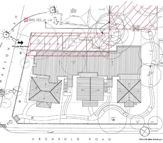
Additionally, under the provisions of Clause 40(4-c) of
State Environmental Planning Policy (Housing for Seniors or People with a
Disability) 2004, a building in the rear 25% area of the site must not exceed 1
storey in height (as the development is being proposed in a residential zone
where residential flat buildings are not permitted). The new dwellings proposed
under this application incorporates two storey elements across 13.04% of the
defined rear area of the site which is more than a 10% breach of the prescribed
development standard. A SEPP1 objection to this development standard has been
provided.
As a variation of more than 10% to a development standard is
sought, the application also needs to be determined by full Council in
accordance with Planning and Infrastructure NSW Circular PS 08-014.
integrated planning and reporting
Places, Spaces and Infrastructure
|
Community Strategic Plan Long Term Objective
|
Delivery Program
Term Achievement
|
Operational Plan
Task
|
|
P3.1 The built environment delivers attractive,
interactive and sustainable living and working environments.
|
A high standard of design quality and building
environmental performance is achieved in new development.
|
Assessment of applications is consistent with Council’s
adopted LEPs and DCPs.
|
Executive Summary
|
Issues:
|
Access to public transport and services
|
|
Submissions:
|
Submissions received from four objectors
|
|
Land and Environment Court:
|
N/A
|
|
Recommendation:
|
Approval
|
History
DA history
|
29 September 2015
|
Section 82A review application
lodged.
|
|
|
|
|
9 October 2015
|
The application was notified for
a period of 30 days. Submissions were received from four objectors.
|
|
|
|
|
30 October 2015
|
Comments were received from the
NSW Roads and Maritime Services. No objection to the proposal was raised.
|
|
|
|
|
18 November 2015
|
The applicant submitted a revised
basement level plan showing compliant car parking dimensions.
|
The Site
Site description
The subject site consists of three separate allotments
being:
- Lot C
in DP340032 (71 Archbold Road)
- Lot D
in DP340032 (69 Archbold Road)
- Lot
20, Section A in DP11626 (67 Archbold Road)
The subject site is an irregular shaped corner allotment
with a primary frontage of approximately 59 metres to Archbold Road, a
secondary frontage of approximately 38 metres to Carnarvon Road and a total
area of 2,456.8m². The site slopes away from the Archbold Road frontage falling
towards the rear boundary by 4.1 metres. The site supports several trees of
varying heights that are concentrated towards the property boundaries. All
three lots are occupied by single storey, detached dwellings. Vehicular access
to 67 Archbold Road and 69 Archbold Road is from Archbold Road. There is no
formal vehicular access to 71 Archbold Road.
The site is also located within the “Earl of Carnarvon”
Heritage Conservation Area as identified by the Ku-ring-gai Planning Scheme
Ordinance.
Surrounding development
The site adjoins three adjacent residential properties (1
Carnarvon Road and 28 Merlin Street to the east and 65 Archbold Road to the
south). These properties contain detached residential dwellings. The general
character of development surrounding the site is of low density dwellings. A
child care centre is located opposite the subject site at 81 Clanville Road
(west).
The Proposal
The physical works of the proposed development as they
relate to No’s 67, 69 and 71 Archbold Road, Roseville remain unchanged. The
only changes made to the proposal as part of the Section 82A review application
relate to the upgrade works required within the adjacent road reservations.
These works are needed to provide compliant access to local public transport
services (bus stops) that will take the residents of the development to the
shops and other facilities prescribed by Clause 26 of State Environmental
Planning Policy (Housing for Seniors or People with a Disability) 2004. The works
to be undertaken on No’s 67, 69 and 71 Archbold Road, Roseville are as follows:
Basement level
- parking for 13 vehicles with storage areas, garbage truck
access, lift and stair access
Alterations to existing dwellings
- modification of the internal floor plans of all three existing
dwellings to provide 3, single storey, 3 bedroom Seniors Living dwellings
New building
- construction
of a new, two storey building attached to the rear (eastern) elevation of the
existing dwellings containing 8 Seniors Living dwellings
- ground
floor: 3 x 2 bedroom units and 1 x 3 bedroom unit
- first
floor: 1 x 1 bedroom unit, 2 x 2 bedroom unit, 1 x 3 bedroom unit
Landscaping works
- letter
box structures
- pathways
- formal
and informal planting areas
- a
communal open space area located towards the rear of the existing site of 67
Archbold Road
- a 0.6
metres high masonry and metal palisade fence aligning the Archbold Road and
Carnarvon Road frontages of the site
Stormwater management works
- on-site
retention and detention tanks within the Carnarvon Road setback of the site
- rainwater
storage tanks to each of the existing dwellings
- stormwater
drainage lines
In order to provide the necessary access to local amenities
via public transport, as required under SEPP (Housing for Seniors or People
with a Disability) 2004 for the residents, works will be required in the road
reservation aligning Archbold Road (and in several private properties adjacent
to the parts of the road reservation to the altered). This would be subject to
a separate application under the Roads Act 1993 if this Development
Application were to be approved (explained in further detail below).
Consultation
Community
In accordance with Development Control Plan No. 56, owners
of surrounding properties were given notice of the application. In response,
submissions from the following were received:
1. Kathryn
Johnson and Robert Stevens, 1 Carnarvon Road, Roseville
2. AW
Mitchell – 65 Archbold Road, Roseville
3. Mr
I R Ney – 30 Merlin Street, Roseville
4. Graham
and Nanae Faber – 28 Merlin Street, Roseville
The submissions raised the following issues:
The consent of neighbouring private property owners to
be affected by the proposed upgrade works within the adjacent road reservations
has not been submitted with the application
The proposed upgrade works necessary to provide a suitable
access pathway from the site to the local public transport services (discussed
in further detail below) will require some alterations to private properties
located along the pathway (being No’s 75, 77 and 79 Archbold Road, Roseville).
This will mainly relate to changes to existing driveway grades inside the
properties.
The applicant has not provided the consent of these property
owners for these works to take place. However, it is recommended that a
deferred commencement development consent be issued requiring that the consent
of the owners be obtained and the necessary upgrade works be completed
(providing a suitable access pathway) prior to the development consent becoming
operable.
Whether the future owners of neighbouring private
properties will be obliged to provide their consent to the proposed upgrade
works within the adjacent road reservations
There is no obligation for neighbouring private property
owners to provide their consent for works to take place on their land in order
to facilitate the necessary upgrade works. However, it is recommended that such
consent must be obtained and the works completed before the development
proposed on the subject site may be undertaken.
The paths of travel to the local public transport
services are dangerous and potentially unusable for mobility challenged persons
Subject to the necessary upgrading works taking place
(discussed in detail below), Council’s Development Engineer is satisfied that a
safe, suitable access pathway will be available to the residents of the
proposal to access the local public transport services.
Restrictions should be placed on truck movements and
vehicle parking in the vicinity of the site during peak hour traffic periods
throughout the construction process
Council’s Development Engineer has recommended appropriate
conditions to control the movement of construction vehicles while the
development is being undertaken (Conditions 12 and13).
The location of the proposed driveway entrance to the
basement parking area conflicts with an existing post box and electricity pole
The consent from the relevant authorities for the
relocation of these facilities has not been provided
The relocation of any existing infrastructure, including
power poles and post boxes, within the road reservation is a matter to be
resolved between the proponent of the development and the responsible service
provider.
Insufficient setback to the proposed driveway and
driveway apron from the boundary shared with No. 1 Carnarvon Road for screen
planting purposes
Council’s Tree and Landscape Assessment Officer is satisfied
that the proposal provides sufficient area within this setback for planting
that will positively contribute to the retention of neighbouring amenity and
the protection of streetscape character. This is to include Dwarf Lillypily and
Blueberry Ash trees that are of a foliage that will provide adequate vegetated
screening of the development from this adjacent property.
The proposed tree removal will reduce the availability
of shade to the subject site and neighbouring properties during the summer
months
Council’s Tree and Landscape Assessment Officer is satisfied
that the proposed tree removal is acceptable and will not unduly detract from
the tree canopy of the area. Additionally, Council’s controls do not prescribe
requirements for the retention of shade to neighbouring properties.
Impacts upon native fauna (bandicoots) and their
habitat
Council’s Ecological Assessment Officer is satisfied that
any impacts on endangered flora or fauna communities can be appropriately
managed, subject to conditions (Conditions 5 and 6).
Visual privacy impacts
Concern has been raised by the owners of No. 1 Carnarvon
Road and No. 28 Merlin Street with regard to potential overlooking from the
development into the sensitive areas of these adjacent sites.
In order to protect the privacy of the open space at the
rear of No. 1 Carnarvon Road, it is recommended that privacy screening be
provided along the eastern edges of the courtyards of Units 3 and 5 (Condition
24). Subject to compliance with this requirement, the proposed development
will not adversely impact upon the visual privacy of adjacent properties. This
conclusion notes that adequate separation (a minimum 6.5 metres) between the
high use areas of the units (such as balconies and living room windows) and the
neighbouring properties will be retained. Additional boundary screen plantings
are also to be introduced which will further contribute to the protection of
visual privacy.
Heritage impacts / the development is inconsistent
with the historical character of the surrounding environment
The proposal will not unduly impact upon any listed heritage
items and has been designed to retain and emphasise the existing dwellings of
the site, whilst ensuring the new dwellings have a harmonious relationship with
the surrounding Heritage Conservation Area.
Inconsistency with the proposed low density zoning of
the site under Draft Ku-ring-gai Local Environmental Plan 2013
The provisions of SEPP (Housing for Seniors or People with a
Disability) 2004 prevail over Council’s controls to facilitate the use and
development of the site for this purpose.
Parking / traffic impacts upon the local road network
Traffic lights should be installed on the corner of
Archbold Road and Carnarvon Road to cater for the additional vehicle movements
Council’s Development Engineer is satisfied that the
proposal provides compliant and sufficient parking to meet the needs of the
development. Council and NSW Roads and Maritimes Services are also satisfied
that the development would not unduly impact upon local traffic flow and that
there is no need to install additional traffic lights at the adjacent
intersection.
Insufficient information in regard to the intended use
of the rear of the site
The use of the communal open space area at the rear of
the property should be regulated
It is not considered that placing a restriction on the use
of the private open space at the rear of the development (at the south-eastern
corner of the property) is necessary or reasonable. This area has been designed
to accommodate passive recreation, consistent with the expected use of private
open space in a low density residential zoning. It is not likely that this area
would be utilised for any activities that will unreasonably impact neighbouring
amenity.
Existing boundary fencing should be upgraded at
expense of the developer to protect neighbouring amenity
The replacement of common boundary fencing is a civil matter
between property owners that is governed by the provisions of the Dividing
Fences Act, 1991. As such, it would not be appropriate for Council to
impose a requirement for the upgrade of any boundary fencing at the cost of the
proponent.
Damage to neighbouring properties caused by
construction impacts
It is recommended that conditions be imposed requiring pre
and post construction dilapidation reports to protect neighbouring private
property and public infrastructure (Condition No’s 10, 11 and 43).
Potential asbestos contamination / asbestos to be
handled appropriately as part of the construction works
It is recommended that a condition
be imposed requiring the safe handling and disposal of any asbestos (Condition
No. 4).
Within Council
Engineering
Council’s Development Engineer commented on the proposal as
follows:
Water management
The BASIX water commitments do
not include retention and re-use of roof water, however the water management
plans show a 3,300 litres rainwater tank for each dwelling and a 10,000 litres
tank for the unit building and a note “Rainwater tanks shall be plumbed to all
garden irrigation, along with toilet and laundry systems”. This will achieve
Council’s streamflow and water quality objectives.
Traffic and parking
The number of bedrooms is 26.
As such, 13 parking spaces are required. The SEPP (Housing for Seniors
or People with a Disability) 2004 requires the spaces to “…comply with
parking for persons with a disability set out in AS2890”. The relevant version
of AS2890 is AS2890.1-1993. This means that parking spaces should be 3.2 metres
wide as shown in Figure 2.6. One space is to be 3.8 metres wide. The proposal
provides 13 spaces.
Waste management
The architectural plans show
that access and headroom are available for the small waste collection vehicle
to carry out the internal collection of waste in the basement.
Council infrastructure
Exhaustive discussions have
been held regarding compliance with Clause 26 of SEPP (Housing for
Seniors or People with a Disability) 2004, culminating in a site meeting
attended by Council’s Director of Operations, where the details of the works on
Council’s land were agreed upon.
As requested by the applicant,
a deferred commencement condition is recommended, requiring submission of the
written consent of the owners of the three separate properties along Archbold Road
to the necessary works inside their properties.
Detailed construction plans for
the footpath works are to be submitted for approval by Council’s Director
Operations prior to the operation of the consent as part of the terms of the
recommended deferred commencement consent.
Conclusion
The application is acceptable,
subject to conditions.
Heritage
Council’s Heritage Advisor was satisfied with of the
proposal as submitted under DA0223/14, subject to a condition requiring he
archival recording of the existing buildings (Condition No 9).
Council’s Heritage Advisor has advised that, as the actual
development has not changed (only the upgrading works within the adjacent road
reservations), no further comment is necessary.
Landscaping
Council’s Landscape and Tree Assessment Officer provided the
following comments:
Tree impacts
Tree 1
Quercus robur (English Oak), located adjacent to the south-western site corner.
The tree is in good health and condition with good vigour and is part of the
streetscape character. The proposed masonry front fence can be redesigned
deleting masonry works within the TPZ to accommodate and retain the tree with
minimal impact (Condition 23).
Tree 3
Quercus robur (English Oak), located adjacent to the western site boundary /
Archbold Road site frontage. The tree is in good health and condition and is
prominent within the existing streetscape and landscape setting. The tree is
proposed to be retained.
Tree 9
Liquidambar styraciflua (Sweet Gum), located adjacent to the north-eastern site
corner. T9 is the most prominent tree located on site. The tree is in good
health and condition, with pruning on its north-western side to accommodate
overhead power lines. The tree is to be removed to accommodate the proposed
basement access ramp. The tree removal is acceptable, subject to tree
replenishment being undertaken to replace the lost tree canopy.
No
objection is raised to the remainder of the nominated tree removal as the trees
have low landscape significance, poor health and structure or are exempt
species.
Landscape plan / tree replenishment
Minor
amendments are required to ensure proposed tree species are located
appropriately to ensure their ongoing health and viability and protection under
Council’s Tree Preservation Order (Condition 22).
The
landscape design encloses a private courtyard garden area within the site
frontage for Unit 7. This is inconsistent with the BASIX certificate and ‘Common
area’ compliance plan which propose this area as common landscape area. It is
recommended that the planting be amended to ensure the layering of planting
faces the common landscape area and not the unit (Condition 22).
The
submitted landscape plan is otherwise acceptable.
Stormwater plan
The
drainage plans are acceptable on landscape grounds.
BASIX
Numerous
landscape area commitments have been made within the submitted BASIX
certificates. Certificate No. A188895 for Unit 1 has no landscape area
commitments. Units 4 and 7 do not have any areas of private garden and lawn
(refer Plan L03A dated 16/10/2014). This is satisfactory.
The
submitted BASIX Certificates are acceptable.
Deep soil
SEPP
Seniors Living requires 15% of the site area to be deep soil area, with 10%
preferably located at the rear. The application is in compliance with the deep
soil standard.
Civil works
The proposed civil works will require the removal of three
existing street trees within Archbold Road. The subject trees are mature
Lophostemon confertus (Brush Box) which, although in good health, have poor
structural form due to repeated lopping and growth in challenging conditions.
Due to the restrictive growing environment and poor structural form, there is
no objection to their removal.
Conclusion
The application is acceptable on landscape grounds, subject
to conditions.
Ecology
Council’s Ecological Assessment Officer provided the
following comments:
During the site inspection remnant native trees were
identified within the rear of the property.
The
remnant native vegetation within the rear of the subject property was
determined to comprise part of Sydney Turpentine Ironbark Forest (STIF) listed
as an Endangered Ecological Community (EEC) under the Threatened Species
Conservation Act 1995. The following trees T26,T27-Eucalyptus pilularis (Blackbutt),
T23 & T23a-Syncarpia glomulifera (Turpentine) and T18, T24-Angophora
costata (Sydney Red Gum) for part of the onsite STIF community.
The
native vegetation (STIF) within the subject property has been mapped as “canopy
remnant” category 5 under the Draft KPSO DCP 2013.
Ecological assessment
An impact assessment (7-part test) has been prepared to
assess the ecological impacts of the development upon the endangered onsite
STIF community in accordance with Section 5a of the Environmental Planning
Assessment Act 1979.
The impact assessment prepared for STIF community has been
prepared in accordance with the threatened species assessment guidelines. The
proposed development is unlikely to require the removal or adversely affect
canopy trees which comprise part of the onsite STIF community, no further
consideration under section 5A of the EP and A Act is deemed necessary. The
following conclusion of the impact assessment is supported.
“No threatened species nor any endangered populations
listed on the TSC Act nor any threatened species, ecological communities or
migratory species listed as Matters of National Environmental Significance on
the EPBC Act were recorded or considered likely to occur at the subject site. A
degraded and isolated remnant of the TSC Act listed endangered ecological
community Sydney Turpentine-Ironbark Forest occurs on site but the impacts on
this community on site are minor and would not have a significant effect on the
community, or its habitat. Similarly the proposal would not remove or
significantly affect any habitats of local, regional, state or national
conservation concern. The undertaking of the proposal would not require the
preparation of a Species Impact Statement or the referral of the matter to the
Federal Minister for the Environment”.
Conclusion
The
application is acceptable on ecological grounds, subject to conditions.
Planning comment:
The conditions referred to by the
Ecological Assessment Officer relate to investigation of the site for the
presence and appropriate relocation of any native fauna by a suitably qualified
person prior to works taking place (Condition No. 5) and the
installation of nest boxes within the trees to be retained on the site (Condition
No. 6).
Building
Council’s Building Surveyor raised no issues with the
proposed development, subject to standard conditions relating to fire safety
and compliance with the Building Code of Australia (Conditions 35, 71 and
79).
Outside Council
NSW Roads and Maritime
Services
The subject site fronts Archbold Road, which is administered
by the NSW Roads and Maritime Services (RMS). As such, the application was
referred to the NSW Roads and Maritime Services (RMS) for comment.
The RMS have no objection to the proposed development.
Statutory Provisions
Environmental
Planning and Assessment Act, 1979
Section 82A – Review of determination
The application has been lodged pursuant to Section 82A of
the Environmental Planning and Assessment Act, 1979 which stipulates the
following:
(1) If
the consent authority is a council, an applicant may request the council to
review a determination of the applicant’s application, other than:
(a) a
determination to issue or refuse to issue a complying development certificate,
or
(b) a
determination in respect of designated development, or
(c) a
determination in respect of integrated development, or
(d) a
determination made by the council under Division 4 in respect of an application
by the Crown.
The application does not relate to a complying development
certificate, designated development or integrated development and is not an
application made by the Crown.
(2) A
council must, on a request made in accordance with this section, conduct a
review.
(2A) A
determination cannot be reviewed:
(a) after
the time limited for the making of an appeal under section 97 expires, if no
such appeal is made against the determination, or
(b) after
an appeal under section 97 against the determination is disposed of by the
Court, if such an appeal is made against the determination.
The application is currently within the time frame in which
a review can be carried out in accordance with Section 97 of the Act (being six
months from the date of determination which was 11 August 2015). The applicant
has not lodged any appeal to the Court under Section 97.
(3) (Repealed)
(3A) In
requesting a review, the applicant may make amendments to the development
described in the original application, subject to subsection (4) (c).
The applicant has not made any amendments to the proposal
that will take place on the land to which the application relates. The only
amendments made relate to the upgrading works required in the adjacent road
reservations. Therefore, the proposal is assessed as being substantially the
same development as that lodged under DA0223/14.
(4) The
council may review the determination if:
(a) it
has notified the request for review in accordance with:
(i) the
regulations, if the regulations so require, or
(ii) a
development control plan, if the council has made a development control plan
that requires the notification or advertising of requests for the review of its
determinations, and
(b) it
has considered any submissions made concerning the request for review within
any period prescribed by the regulations or provided by the development control
plan, as the case may be, and
(c) in
the event that the applicant has made amendments to the development described
in the original application, the consent authority is satisfied that the
development, as amended, is substantially the same development as the
development described in the original application.
The application has been notified accordingly and the issues
raised in the submissions are addressed as part of this report. As noted above,
the proposal is deemed to be substantially the same development as that lodged
under DA0223/14.
(4A) As
a consequence of its review, the council may confirm or change the
determination.
For the reasons outlined in this report, it is considered
that the applicant has satisfactorily addressed the reasons for the refusal of
DA0223/14. It is therefore recommended that the Council now grant consent to
DA0223/14.
(5) (Repealed)
(6) If
the council reviews the determination, the review must be made by:
(a) if
the determination was made by a delegate of the council—the council or another
delegate of the council who is not subordinate to the delegate who made the
determination, or
(b) if
the determination was made by the council—the council.
As noted above, the subject application has been referred to
full Council for consideration as DA0223/14 was determined by full Council.
(7)–(9)
(Repealed)
(10) If
on a review the council grants development consent, or varies the conditions of
a development consent, the council is entitled, with the consent of the
applicant and without prejudice to costs, to have an appeal made under section
97 in respect of its determination withdrawn at any time prior to the
determination of that appeal.
No appeal has been lodged by the applicant.
(11) (Repealed)
(12) This
section does not apply where a regional panel exercises a council’s functions
as the consent authority.
Not applicable – Council is the consent authority for this
application.
State Environmental Planning Policies
State Environmental Planning Policy No. 1 – Development
Standards
The intent of SEPP 1 is to allow
flexibility in the application of a development standard, particularly where
strict application of the standard would unreasonably or unnecessarily
constrain appropriate development.
Clause 40(4-c) of SEPP (Housing for Seniors or People with a
Disability) 2004 stipulates that a building located in the rear 25% area of a
site within a zone where residential flat buildings are not permitted must not
exceed 1 storey in height. Clause 40(4-c) constitutes a development standard
which may only be varied by way of an objection made pursuant to SEPP No.1.
The proposed development contains 2 storey building elements
within the areas of the site identified to constitute the rear 25% of the
property. An assessment of the SEPP1 objection submitted by the applicant in
support of the variation to this development standard is provided below.
State Environmental Planning Policy No. 55 – Remediation
of Land
The provisions of SEPP 55 require Council to consider the
potential for a site to be contaminated. The subject site has a history of
residential use and as such, it is unlikely to contain any contamination.
Further investigation is not warranted in this case.
State Environmental Planning Policy (Building
Sustainability Index: BASIX) 2004
Valid BASIX Certification was submitted with DA0223/14 and
remains relevant to the subject application. The certificate demonstrates
compliance with the provisions of the SEPP.
State Environmental Planning Policy (Housing for Seniors
or People with a Disability) 2004
Clause 2 (Aims of Policy) of SEPP (Housing for
Seniors or People with a Disability) 2004 states the aims of the Policy.
Specifically, the Policy aims to:
· increase the supply of housing
that meets the needs of seniors and people with a disability;
· make efficient use of existing
infrastructure and services; and
· be of a good design.
The manner in which the Aims of the Policy are to be
achieved is defined by the assessment criteria specified within the provisions
of the SEPP. The applicant has successfully demonstrated that the proposal
satisfies the stated aims of the Policy and the specified assessment criteria
therein.
Clause 4 – (Land to which the Policy applies) of SEPP
(Housing for Seniors or People with a Disability) 2004 identifies the land on
which development permissible under the Policy may be carried out.
The Residential 2(a) zoning of the subject site permits
dwelling houses. By virtue of this, development may be carried out on the site
pursuant to SEPP (Housing for Seniors or People with a Disability) 2004.
Clause 13 (Self contained dwellings) specifies the
various types of self contained dwellings permissible as senior’s living
accommodation within the provisions of the SEPP. The proposed development
consists of more than two (2) dwellings and does not provide any services.
Therefore, the proposed development constitutes “in-fill self-care housing” in
accordance with the definition provided by this Clause.
Clauses 15 and16 (Development consent required)
The SEPP states that development may be carried out only
with development consent unless another planning instrument allows the
development without consent. The proposed development requires the consent of
Council pursuant to the provisions of the Ku-ring-gai Planning Scheme
Ordinance.
Clause 18 (Restrictions on occupation of seniors housing
allowed under this Chapter)
The SEPP states that Council must not grant consent to a
development application for senior’s living accommodation made pursuant to
Chapter 3 unless conditions relating to the type of people who may occupy the
development are imposed. Should the application be approved, conditions should
be imposed to ensure the requirements of this Clause are adhered to.
Clause 26 (Location and access to facilities)
The SEPP specifies that Council must not grant consent to a
development application made pursuant to Chapter 3 unless it is satisfied by
written evidence that certain site related requirements have been met.
Compliance with the requirements of Clause 26(1) and (2) is indicated in the
table below.
|
COMPLIANCE
TABLE
|
|
Clause
|
Requirement
|
Compliance
|
|
Clause 26(1)
|
Access to shops, bank service providers, other
retail and commercial services, community services and the practice of a
general medical practitioner.
|
YES – subject to upgrade works
|
|
Clause 26 (2-b)
|
In the case of a proposed development on land in a local
government area within the Sydney Statistical Division (that includes the
Ku-ring-gai LGA), there is a public transport service available to the
residents who will occupy the proposed development:
· That is located a distance of not more than
400 metres from the site of the proposed development and the distance is
accessible by means of a suitable access pathway
· That
will take those residents to a place that is located at a distance of not
more than 400 metres from the facilities and services referred to in
subclause (1)
· That
is available both to and from the proposed development at least once between
8am and 12pm per day and at least once between 12pm and 6pm each day from
Monday to Friday (both days inclusive)
|
YES – subject to upgrade works
YES
YES
|
|
26(3)
|
For the purposes of subclause (2)
(b), the overall average gradient along a pathway from the site of the
proposed development to the public transport services (and from the transport
services to the facilities and services referred to in subclause (1)) is to
be no more than 1:14, although the following gradients along the pathway are
also acceptable:
· a gradient of no more than 1:12
slopes for a maximum of 15 metres at a time
· a gradient of no more than 1:10 for a
maximum length of 5 metres at a time
· a gradient of no more than 1:8 for
distances of no more than 1.5 metres at a time
|
YES – subject to upgrade works
YES – subject to upgrade works
YES – subject to upgrade works
|
The subject site is located within the Sydney Statistical
Division.
In accordance with Clause 26(2-b), there are two bus stops
within a distance of 400 metres from the subject site, one on the western side
of Archbold Road and one on the eastern side of Archbold Road. These stops are
serviced by the 206, 207, 208 and 209 bus routes that travel to a variety of
locations where the facilities prescribed by Clause 26(1) of the SEPP are
available. The bus stops are serviced at least once in the morning and once in
the afternoon, Monday to Friday.
Currently, a suitable access pathway (as defined by the
SEPP) from the site to the abovementioned bus stops is not available. However,
the applicant has proposed to undertake the necessary upgrade works to ensure a
suitable access pathway will be available to the residents before the
development commences. As mentioned by Council’s Development Engineer, the
upgrading works required have been reviewed by Council’s Director of Operations
and are agreed to. These works will take place on public land and are subject
to a separate approval process (pursuant to Section 138 of the Roads Act
1993). Accordingly, it is recommended that a deferred commencement
development consent be issued to ensure the suitable access pathway will be
available to the residents, satisfying the requirements of Clause 26 of the
SEPP.
Clause 28 (Water and sewer), states that consent must
not be granted to a development application made pursuant to Chapter 3 unless
satisfied by written evidence that the housing will be connected to a
reticulated water system and have adequate facilities for the removal or
disposal of sewerage. The site is connected to the sewer system and reticulated
water is provided.
Clause 29 (Consent authority to consider certain site
compatibility criteria for development applications to which clause 24 does not
apply)
Consent must not be granted to a development application
made pursuant to Chapter 3 unless the following has been considered:
- the
natural environment (including known significant environmental values,
resources or hazards) and the existing uses and approved uses of land in the
vicinity of the proposed development
- the
services and infrastructure that are or will be available to meet the demands
arising from the proposed development (particularly, retail, community, medical
and transport services having regard to the location and access requirements
set out in clause 26) and any proposed financial arrangements for
infrastructure provision
- without
limiting any other criteria, the impact that the bulk, scale, built form and
character of the proposed development is likely to have on the existing uses,
approved uses and future uses of land in the vicinity of the development
For the reasons outlined throughout this report, the
proposed development is considered to be consistent with these matters for
consideration. The proposed development:
· will not unduly impact on the
natural environment, including the surrounding bushland
· is compatible with the existing
residential use of the site
· is consistent with the predominantly
residential use of land surrounding the subject site and the likely continuing
use of this land for residential purposes in the future
· has access to sufficient services
and infrastructure, including water and utilities as well as access to
transport services
· is of an acceptable bulk, scale and
built form character in the context of the surrounding development
Clause 30 (Site analysis), requires a site analysis
be carried out and submitted to the consent authority as part of the
Development Application. A site analysis, prepared by an architect, has been
submitted to Council. This analysis, together with the accompanying
documentation, provides all the necessary information for assessment purposes
under this clause.
Clause 31 (Design of in-fill self-care housing), states
that, in the assessment of a development application made pursuant to Chapter 3
for in-fill self-care housing, the consent authority must take into
consideration the provisions of the Seniors Living Policy: Urban Design
Guidelines for Infill Development, published by the Department of
Infrastructure, Planning and Natural Resources in March 2004.
The guidelines contained within this document are designed
to assist applicants and consent authorities in the implementation and
interpretation of the design principles specified by Division 2 of SEPP
(Housing for Seniors or People with a Disability) 2004.
Primarily, these guidelines seek to ensure that new
development provides a high level of amenity for both new and existing
residents. The document requires due consideration be given to:
· streetscape
· local context
· site planning and design
· impacts upon neighbours
· internal amenity
These considerations have been taken into account during the
assessment of the application. The proposed development has sufficiently
demonstrated consistency with the guidelines of this document and therefore, as
outlined below, satisfies the design principles specified by Division 2 of the
SEPP.
Clause 32 (Design of Residential Development), requires
that consent must not be granted unless the consent authority is satisfied that
adequate regard has been given to the following principles:
Neighbourhood amenity and streetscape
The proposed development has been designed to appropriately
respond to the character of the streetscape and the amenity of neighbouring
properties.
In terms of streetscape character, the development has been
designed to ensure the retention of the existing dwellings that are recognised
as contributory to the significance of the surrounding Heritage Conservation
Area. This has been achieved through the placing of the new dwellings at the
rear of the existing buildings, whilst maintaining adequate separation so as
not to dominate their character. Additionally, the bulk and scale of the new
dwellings is comparable to that of surrounding development with any impacts
mitigated through the use of landscape plantings and appropriate building
setbacks. The existing significant trees of the site will also be retained.
In terms of neighbouring amenity, for the reasons outlined
below, the proposed development will retain sufficient solar access and privacy
to adjoining residential dwellings. Generous separation between the proposed
buildings (exceeding 7 metres in all instances) and neighbouring residencies
has been provided to ensure the development does not unduly impact on visual
amenity. Additionally, the proposed development will not unduly impact upon any
existing views.
Visual and acoustic privacy
The proposal has been well designed with regard to visual
privacy and amenity (subject to the above referenced requirement for the
installation of privacy screening to the courtyards of Units 3 and 5). Incorporating
this measure, it is considered that the proposed development will retain
adequate visual privacy between the units of the proposed development and to
the existing surrounding residencies. This conclusion notes the configuration
and location of windows and balconies in a manner that will not afford undue
outlook or cross-looking. This is to be supplemented through the use of privacy
screening and screen plantings where necessary. Generous separation will exist
between the proposed buildings and surrounding residencies.
Moreover, adequate separation
has been achieved between bedrooms and living areas of adjoining dwellings to
maximise acoustic privacy. Separation between bedrooms and driveways / pathways
has also been provided where feasible and practical.
Solar access and design for climate
The proposed development provides compliant solar access to
the units of the development and the associated private open space. The
proposal also retains adequate solar access to neighbouring properties.
Stormwater
Council’s Development Engineer has reviewed the proposal and
is satisfied with the stormwater management measures to be implemented.
Crime prevention
All dwellings of the development have been designed in a
manner that allows for casual surveillance across the site, the approaches to
the new dwellings and to the public areas beyond. The shared entrances to the
buildings will be lockable.
Accessibility
The proposed development provides adequate on-site
accessibility for disabled and movement impaired persons. The occupants of the
development will also have access to the necessary services as is required
under the SEPP.
Waste management
The proposal provides adequate waste management facilities,
including an accessible waste storage room within the building’s basement
level.
Clause 40 states that a consent authority must not
grant consent to a development application made pursuant to Chapter 3 unless
the proposed development complies with the standards specified in this clause.
The compliance demonstrated by the proposal with these standards is indicated
in the table below.
|
COMPLIANCE TABLE
|
|
Development standard
|
Proposed
|
Compliance
|
|
Clause 40 (2) (Site area):
1000m2 (min)
|
2,456.8 m2
|
YES
|
|
Clause 40 (3) (Site frontage):
20m (min)
|
>20m
|
YES
|
|
Clause 40 (4-a) (Height in zones where residential flat
buildings are not permitted): 8m
(max)
|
Maximum ceiling height of 7.5 metres
|
YES
|
|
Clause 40 (4-b) (Height):
2 storey (max) adjacent to a boundary of the site
|
Maximum 2 storeys across the development
|
YES
|
|
Clause 40 (4-c) (Height):
A building located in the rear 25% area of the site must
not exceed 1 storey in height
|
The proposed building to contain the 8 new
units at the rear of the existing dwelling protrudes into the rear 25% area
of the site
|
NO – SEPP1
|
Clause 40(4-c) - Height in zones where residential flat
buildings are not permitted
The Residential 2(a) zoning of
the subject site does not permit the erection of residential flat buildings. As
such, Clause 40(4-c) of the SEPP states that a building located within the rear
25% of the site must not exceed 1 storey in height.
From a practical perspective, as
the development is orientated towards the Archbold Road frontage, the rear area
of the site is logically interpreted as the area adjacent to the eastern
boundary (aligning 1 Carnarvon Road). The proposed development contains two storey
building elements within the rear 25% area of the site and does not comply with
this development standard of the SEPP.
Figure 1: Plan
showing the rear 25% area of the site from Archbold Road (shown hatched).
The applicant has lodged a SEPP1
objection that addresses both scenarios which is assessed against the following
considerations:
Whether
the planning control to be varied is a development standard
Clause 40(4-a) is a development standard as defined by
Section 4 of the Environmental Planning and Assessment Act, 1979.
The
underlying objective or purpose of the standard
There are no objectives specified for Clause 40 (4-c) of the
SEPP. However, the clause in which the development standard is contained
relates to senior’s living developments to be constructed in residential zones
where residential flat buildings are not permitted. In this regard, it is
considered that the intention behind the control is to ensure an appropriate
transition between the likely building heights of surrounding low density
development is provided. Due consideration should also be given to the
acceptability of the development’s bulk, scale, privacy and solar access
impacts as these matters are directly associated with building height.
Whether
compliance with the standard is consistent with the aims of the policy and
whether compliance hinders the attainment of the objectives specified in
Section 5(a) (i) and (ii) of the Environmental Planning and Assessment Act,
1979
The
aim of SEPP 1 is to:
Provide flexibility in the application of planning controls
operating by virtue of development standards in circumstances where strict
compliance with those standards would, in any particular case, be unreasonable
or unnecessary or tend to hinder the attainment of the objectives specified in
Section 5 (a) (i) and (ii) of the Act.
In
this regard, the objects of Section 5 (a) (i) and (ii) of the Act are:
(a) To encourage:
(i) the proper management, development and
conservation of natural and artificial resources, including agricultural land,
natural areas, forests, minerals, water, cities, towns and villages for the
purpose of promoting the social and economic welfare of the community and a
better environment
(ii) the promotion and co-ordination of the orderly and
economic use and development of land
It is concluded that the non-compliance with the development
standard is consistent with the aims of SEPP 1 as compliance is unreasonable
and unnecessary in this instance (as discussed below). In this particular
circumstance, compliance with the development standard would hinder the
attainment of the objectives specified in Section 5(a) (i) and (ii) of the Act.
Whether compliance with the development standard is
unreasonable or unnecessary in the circumstances of the case
The following is a summary of the arguments provided by the
applicant within the submitted SEPP 1 objection in support of the variation to
the development standard:
(i) The
rear eastern projection of the 2 storey building form proposed does not project
past the rear alignment established by the adjoining 2 storey building form at
No. 65 Archbold Road. The living and private open space areas of Apartment 11
have been designed and orientated to the east towards the only boundary not
intersecting a street frontage and accordingly, appropriately defined as the
rear boundary of the site. Such orientation is consistent with that of No. 65
Archbold Road. I further note that a 2.3 metres portion of apartments 8, 9 and
10 are located within the rear 25% area of the site as measured from the
Archbold Road frontage. The 2 storey building form in this location maintains a
7.3 metres setback to the eastern boundary.
(ii) The
side and rear setbacks proposed to the 2 storey building elements are
complimentary and compatible with the setbacks established by dwelling houses
on the 2 immediately adjoining properties while the design outcome afforded
maintains a large landscape open space area at the rear of No. 67 Archbold Road
where it immediately adjoins the rear yards and private open space areas of No.
65 Archbold Road and No. 1 Carnarvon Road. The height, bulk and scale of the
development will not be perceived as inappropriate or jarring as viewed from
the rear of the adjoining properties as a result of building setback, design
and intervening landscape treatments.
(iii) Appropriate
privacy and residential amenity is maintained to No. 65 Archbold Road and No. 1
Carnarvon Road through a combination of building design, spatial separation and
intervening landscape elements.
(iv) The
areas of non-compliance will not give rise to non-compliant shadowing impact.
Further to the points raised by
the applicant, it is noted that the predominant retention of the existing
dwellings of the site (in order to preserve the character of the Heritage
Conservation Area) has resulted in a limited area of the site to provide
additional development. In order to maintain streetscape character,
neighbouring amenity and protect the significance of the HCA, the most logical
place to introduce the additional dwellings is to the rear of the existing
buildings. As a consequence, a minor non-compliance with the development
standard of the SEPP has been created. However, the intended purpose of the
development standard is considered to be achieved as the development provides
good separation between the two storey elements contained within the identified
rear 25% area of the site and the lower density dwellings of neighbouring
properties. These areas will contain a combination of pathways, terraces and
planting areas that are characteristic of the locality. Additionally, for the
reasons outlined within this report, the development will not result in any
undue privacy solar access or general amenity impacts. Therefore, it is
considered unreasonable and unnecessary in this circumstance to comply with the
development standard.
Whether the objection is well founded
The SEPP 1 objection is considered to be well founded and
the development will achieve what are considered to be the underlying
objectives of the standard. It is also concluded that strict compliance with
the prescribed development standard would unnecessarily hinder the attainment
of the objectives specified by Section 5(a) (i) & (ii) of the EP&A Act,
1979.
Whether non-compliance with the development standard
raises any matter of significance for State or regional environmental planning
The non-compliance with the development standard will not
raise any matters of significance for state and regional planning.
Whether there is a public benefit of maintaining the
planning controls adopted by the environmental planning instrument
It is not considered that the development standard has been
virtually abandoned or destroyed through the issuing of consents that
incorporate a variation to the development standard that restricts the
placement of two storey buildings within the rear 25% area of the site.
As demonstrated above, the breach of the control is largely
attributable to the placement of the new development in a location that
protects the significance of the Heritage Conservation Area while also
maintaining neighbouring amenity. Therefore, there is no discernible public
benefit is gained from requiring compliance with the development standard in
this instance.
Part 7 – Development standards that cannot be used as
grounds to refuse consent
Part 7 of SEPP (Housing for Seniors or People with a
Disability) 2004 stipulates standards which cannot be used to refuse
development for residential care facilities. The compliance demonstrated by
the development application with these standards is indicated in the following
table:
Self-contained dwellings
|
Compliance
Table
|
|
Development standard
|
Proposed
|
Compliance
|
|
Clause 50(a) (building height)
Height to be less than 8.0 metres
|
Maximum height of
7.5 metres
|
YES
|
|
Clause 50(b) (density and scale)
0.5:1 (1,228.4m²)
|
0.47:1 (1,162.62m²) – confirmed by submitted
compliance diagrams
|
YES
|
|
Clause 50(c) (landscaped area)
Minimum 30% (737.04m²) of the site to be landscape area
|
Well in excess >30% of the
site is to be landscaped
|
YES
|
|
Clause 50(d) (deep soil zones)
15% site area (368.52m2) with two thirds (245.43m2) preferably being located
at the rear of the site with a minimum dimension of 3m.
|
Calculated to be 26.3%
(647.06m²) of the site is to be deep soil zone
Deep soil zones have a minimum dimension of 3m.
Greater than two thirds of the required area (400m²) is
located at the rear of the site
|
YES
YES
YES
|
|
Clause 50(e) (solar access)
Minimum of 70% of dwellings receive minimum 3 hours
direct sunlight between 9am-3pm in mid-winter.
|
81% (9 units) receive a minimum 3 hours direct sunlight
between 9am-3pm midwinter
|
YES
|
|
Clause 50(f) (private open space)
• Single level or ground floor
dwellings = 15m2 (incl.
Area 3m x 3m accessible from living area)
• All other dwellings = balcony
min. 10m2 (not
less than 2m in length and accessible from a living area)
|
Compliant private open space provided to all
dwellings
Compliant private open space provided to all
dwellings
|
YES
YES
|
|
Clause 50(h) (parking)
(i) 0.5 car spaces for each bedroom where the
application is made by a person other than a social housing provider
- 13 spaces required
|
13 spaces available for resident parking
|
YES
|
Schedule 3 (standards concerning accessibility and
useability for hostels and self-contained dwellings)
This schedule sets out the on-site accessibility standards
that apply to any SEPP Senior’s Living accommodation consisting of
self-contained dwellings. Clause 41 (Standards for hostels and
self-contained dwellings), provides that a consent authority must not
consent to development application made pursuant to Chapter 3 unless the
proposed development complies with the standards specified in Schedule 3 for
such development. Compliance with the requirements of Clause 26(1) and
(2) is indicated in the table below.
|
COMPLIANCE
TABLE
|
|
Development standard
|
Comment
|
Compliance
|
|
Clause (wheelchair access)
· The
percentage of dwellings that must have wheelchair access must equal the
proportion of the site that has a gradient of less than 1:10, or 50%,
whichever is the greater
· The
wheelchair access provided must be by a continuous accessible path of
travel (within the meaning of AS 1428.1) to an adjoining public road or an
internal road or a driveway that is accessible to all residents
· Access must be provided in accordance with AS
1428.1 so that a person using a wheelchair can use common areas and common
facilities associated with the development.
|
The access report confirms that 100% of
dwellings are proposed to have wheelchair access by a continuous path of
travel complying with AS1428.1 to the entrances of the site and links within
the site to common areas and facilities.
|
YES
|
|
Clause 3 (security):
Pathway lighting must be designed and located to avoid
glare.
|
Lighting will be designed and located so as to
avoid glare and provide at least 20 lux at ground level.
|
YES
|
|
Clause 4 (letterboxes):
Must be lockable and situated on a hard standing area and
be wheelchair accessible.
|
The letterboxes are to be provided in a wheelchair
accessible location. The letterboxes will be lockable.
The letterboxes are adjacent to the Archbold
Road street entry and the internal pathways that circulate the site.
|
YES
|
|
Clause 5 (private car accommodation):
Car parking spaces must:
· comply with the requirements for parking for
persons with a disability set out in AS 2890.
· 5% of the total number of car parking spaces
(or one [1] space if fewer than 20 are provided) must be designed to enable
the width to be increased to 3.8m
· any garage must have a power-operated roller
door, or a power point to allow the above at a later date
|
The access report confirms all car spaces meet
the functional requirements for width and length required by AS2890.1.
>5% capable of being increased to 3.8m
Development designed to allow for
implementation of a power operated roller door
|
YES
YES
YES
|
|
Clause 6 (accessible entry):
Every entry must comply with clauses 4.3.1 & 4.3.2 of
AS 4299
|
The access report confirms that the entries to
all units are to include complying accessible paths of travel with clear door
openings to comply with AS1428.1
|
YES
|
|
Clause 7 (interior general):
Widths of internal corridors
and circulation at internal doorways must comply with AS 1428.1
|
The access report
confirms that the proposed dwellings will comply with the width requirements
of the Australian Standard.
|
YES
|
|
Clause 8 (bedroom)
At least one bedroom within the dwelling must
have:
· an area sufficient to accommodate a wardrobe
and a queen sized bed, with an area at least 1200mm wide at the foot of the
bed, 1,000 millimetres wide beside the bed between it and the wall,
wardrobe or any other obstruction and 2
double general power outlets adjacent to the head of the bed
· 1 general power outlet on the wall opposite
the bed
· a telephone outlet and power outlet next to
the bed on the side closest to the door
· wiring to allow a potential illumination of
300 lux
|
The access report confirms that each unit has
a bedroom that complies with these requirements.
|
YES
|
|
Clause 9 (bathroom):
At least one
bathroom within a dwelling must be on the ground (or main) floor and have the
following facilities arranged within an area that provides for circulation
space for sanitary facilities in accordance with AS 1428.1:
• an area that complies with
AS 1428
• a slip resistant floor
• a shower that complies
with AS 1428.1 except that the following must be provided:
- a grab rail
- portable shower head
- folding seat
- can accommodate a folding seat
• an illuminated wall
cabinet
• a double power outlet
beside the mirror
|
The access report confirms that each unit is
to have a bathroom that complies with these requirements.
|
YES
|
|
Clause 10 (toilet):
A dwelling must have at least
one toilet on the ground (or main) floor and be a visitable toilet that
complies with the requirements for sanitary facilities of AS 4299.
|
The access report confirms that each unit has
a toilet that is visitable in accordance with the area and special
requirements of AS 4299.
|
YES
|
|
Clause 11 (surface finishes)
• balconies and external
paved areas must have slip-resistant surfaces
|
The proposed balconies are to incorporate a
slip-resistant surface.
|
YES
|
|
Clause 12 (door hardware)
Door hardware for all doors must be provided in
accordance with AS 4299.
|
The proposed door handles are to be provided
in accordance with AS 4299.
|
YES
|
|
Clause 13 (ancillary items):
Switches and power points must be provided in
accordance with AS 4299.
|
The proposed switches and power points are to
be provided in accordance with AS 4299.
|
YES
|
|
Part 2 Additional Standards for self-contained dwellings
|
|
Clause 15 (living room and dining room):
A living room must have
(a) a circulation space in accordance with clause 4.7.1
of AS 4299 and
(b) a telephone adjacent to a general power outlet
The living and dining rooms must have wiring to allow a
potential illumination level of 300 lux.
|
The access report confirms that the proposed development complies with these
requirements.
|
YES
|
|
Clause 16 (kitchen):
A kitchen in a self contained dwelling must
have:
(a) a circulation space in
accordance with clause 4.5.2 of AS4299
(b) a width at door approaches
complying with clause 7 of this schedule
(c) the following fittings in
accordance with the relevant sub-clauses of clause 4.5 of AS 4299:
(i) benches that include at
least one work surface of at least 800mm in length
(ii) a tap set
(iii) cooktops with an
isolating switch
(iv) an oven
(d) D” pull cupboard handles
(e) general power outlets at
least one is a double outlet within 300mm of the front of a work surface and
one which is for a refrigerator which can be readily accessed once installed
|
The access report confirms that the proposed
development complies with these requirements.
|
YES
|
|
Clause 18 (lifts in multi-storey buildings):
Lift access provided to all dwellings above the ground
level of the building by way of a lift complying with clause E3.6 of the BCA.
|
Lift access is to be provided to all dwellings
and car spaces by way of a lift complying with clause E3.6 of the BCA.
|
YES
|
|
Clause 19 (laundry):
A self contained dwelling must have a laundry which has:
• provision for the
installation of a washing machine and clothes dryer
• a clear space in front of
appliances of 1300mm
• a slip resistant floor
surface
• an accessible
path of travel to any external clothes line
|
The access report confirms that the proposed
development complies with these requirements.
|
YES
|
|
Clause 20 (storage for linen):
A self-contained dwelling must be provided with a linen
cupboard in accordance with clause 4.11.5 of AS 4299.
|
The access report confirms that the proposed
development complies with this requirement.
|
YES
|
|
Clause 21 (garbage):
An outside garbage storage area must be
provided in an accessible location.
|
The access report confirms an accessible path
of travel to the garbage disposal area in the basement is indicated via the
lift and a doorway meting the functional requirements of AS1428.1.
|
YES
|
Local Content
Clause
33 (a) – Aesthetic appearance
Clause 33(a) of the KPSO
requires consideration of the aesthetic appearance of the land the subject of
the proposed works as viewed from public spaces, including County roads (Archbold Road).
Through the assessment of the proposal against the
provisions of SEPP (Housing for Seniors or People with a Disability) 2004,
particularly the design principles outlined by Clause 32 of the SEPP, it is
concluded that the development will be of an acceptable visual presentation to
the roadway.
Clause
38B – Services
Clause 38B states that consent must not be issued to the
carrying out of development on land unless access to a water supply, drainage
and a sewerage system will be available.
The site is connected to the sewer system and reticulated
water is provided.
Clause
61D – Heritage conservation
As
outlined above, Council’s Heritage Advisor is satisfied that the proposed
development is consistent with the character and significance of the heritage
conservation area within which the site is contained. The Heritage Advisor is
also satisfied that the development will not unduly impact upon the character
or significance of any neighbouring listed items.
Schedule
9 – Aims and objectives for residential zones
The ‘Aims and Objectives for
residential zones’ outlined in Schedule 9 of the KPSO essentially seek ensure a
proposed development will retain the streetscape character and amenity to
neighbouring residential properties. The matters for consideration outlined
within these aims and objectives are covered under the provisions SEPP (Housing
for Seniors or People with a Disability) 2004. As the proposed development
satisfies these provisions of the SEPP, it is considered acceptable in this
regard.
Local
Environmental Plan 2013
KLEP 2015 replaced the
Ku-ring-gai Planning Scheme Ordinance as the principal planning instrument for
the Ku-ring-gai Local Government Area. The draft instrument KLEP 2013 was
exhibited and as of 5 March 2015, was gazetted as Ku-ring-gai Local Environmental
Plan 2015. The new LEP came into effect on 2 April 2015. However, it is noted
that the gazetted instrument contains a Savings Provision essentially stating
that any DA lodged before the commencement of the LEP and still under
assessment at the date of this commencement must be determined as if the plan
had not commenced.
The LEP rezoned the subject site to R2 – Low Density
Residential and while the zoning continues to prohibit seniors living
development, the provisions of SEPP (Housing for Seniors or People with a
Disability) 2004, will continue to facilitate the use and development of the
site for this purpose. Similarly, the SEPP contains building height and floor
space ratio provisions that will continue to override the development standards
of the LEP.
The LEP also identifies the site as being located within a
Heritage Conservation Area and as potentially containing bio-diversity
significant vegetation. As outlined within this report, the proposal is
acceptable with regard to these site affectations. Additionally, the proposal
is acceptable with regard to the provisions of the LEP relating to earthworks,
stormwater and water sensitive urban design and the preservation of trees and
vegetation.
Policy Provisions
Development
Control Plan No. 31 Access
The aim of DCP 31 is to ensure
access for all to public buildings, community facilities and new developments,
excluding dwelling houses and dual occupancies but including all buildings and
facilities owned or leased by Council and to ensure that people with a
disability have equal access to employment opportunities by way of affording
access to facilities, services and opportunities to meet their specific needs.
The provisions of SEPP (Housing
for Seniors or People with a Disability) 2004 override Council’s controls with
regard to accessibility. The proposed development complies with the
requirements of the SEPP.
Development
Control Plan No. 40 - Construction and Demolition Waste Management
The key objectives of this DCP
are to encourage building design and construction techniques which will
minimise waste generation, implement the principles of the waste hierarchy of
avoiding, reusing and recycling building and construction materials, and
commercial waste, minimise the environmental impacts of waste, promote the
principles of ecologically sustainable development, meet Council's
responsibilities in relation to the Northern Sydney Regional Waste Plan and
assist in achieving the Federal and State Government's waste minimisation
targets.
A waste management plan
demonstrating compliance with the requirements of the DCP has been submitted
and is deemed to be acceptable.
Development
Control Plan No. 43 - Car Parking
In relation to the number of car parking spaces, the
provisions of SEPP (Housing for Seniors or People with a Disability) 2004
override any other parking requirements where in conflict. As detailed earlier
in this report, the proposed development complies with the relevant provisions
of the SEPP with regard to the number of car parking spaces required and the
dimensions of these spaces.
Council’s Development Engineer has noted that the proposed
development provides adequate vehicle manoeuvrability area.
Development
Control Plan No.47 - Water Management
The proposed development has been assessed against DCP47 and
complies with all relevant provisions.
Section
94 Plan
The development is subject to Section 94
contributions, levied in accordance with Ku-ring-gai
Contributions Plan 2010. A condition is recommended requiring the payment of Section 94 contributions (Condition No. 33).
Likely Impacts
The likely impacts of the
development have been considered within this report and are deemed to be
acceptable, subject to conditions.
Suitability of the Site
The site is suitable for the
proposed development.
Public Interest
The proposal is considered to be
in the public interest.
Conclusion
Having regard to the provisions of section 79C and section
82A of the Environmental Planning and Assessment Act 1979, the proposed
development is considered to be satisfactory.
|
Recommendation:
A. That
Council, as the consent authority, having undertaken a review of the
application in accordance with Section 82A of the Environmental Planning and
Assessment Act, 1979, is satisfied that the reasons for the refusal of
DA0223/14 have been addressed by the applicant.
B. That Council, as the consent authority,
is satisfied that the objection under State Environmental Planning Policy
No. 1 – Development Standards to the maximum building height development
standard of Clause 40 (4-c) of State Environmental Planning Policy
(Housing for Seniors or People with a Disability) 2004 is well founded. Council is also of the opinion that strict
compliance with the development standard is unreasonable and unnecessary in
the circumstances of this case.
C. That Council, as the consent authority and pursuant
to Section 82A of the Environmental Planning and Assessment Act, 1979,
change its determination of DA0223/14 and
grant deferred commencement development consent to DA0223/14 for alterations
and additions to existing 3 dwellings and construction of 8 apartments (to
create 11 dwellings) for Seniors Living including basement parking on land at
67, 69 and 71 Archbold Road, Roseville for a period of two years from the
date of the Notice of Determination, subject to the following conditions:
SCHEDULE A - Deferred
commencement conditions
Evidence required to
satisfy the following conditions must be submitted to Council within twelve
(12) months of the date of the Notice of Determination
is consent.
This consent does not operate
until the following deferred commencement consent terms have been satisfied:
1. Design and
construction of works in public roadway
Prior to the operation of the
consent, engineering plans and specifications, prepared by a qualified
consulting engineer, detailing a ‘suitable access pathway’ (as defined by
Clause 26 - Location and access to facilities of State Environmental Planning
Policy (Housing for Seniors or People with a Disability) 2004) are to be
submitted to and approved by Council’s Development Engineer, as generally as
shown on E2 Civil and Structural Design External Civil Works plans Sheets C1J
(dated 02.09.15), C2J (02.09.15), C3I (dated 02.09.15), C4E (dated 03.06.15)
and C5C (dated 02.09.15) . The engineering plans must be to a detail suitable
for construction issue purposes.
The applicant must obtain a
separate approval under Section 138 and Section 139 of the Roads Act 1993 for
the works in the road reserve required as part of the development. The
consent does not operate until Council has issued a formal written approval
under the Roads Act 1993 and the works required to
provide a ‘suitable access pathway’, road and/or drainage works have been
completed in accordance with the Council’s Roads Act approval and
accompanying drawings, conditions and specifications. The works must be
supervised by the applicant’s designing engineer and completed and approved
to the satisfaction of Ku-ring-gai Council.
The
supervising consulting engineer is to provide certification upon completion
that the works were constructed in accordance with the Council approved
stamped drawings. The works must be subject to inspections by Council at the
hold points noted on the Roads Act approval. All conditions attached to the
approved drawings for these works must be met prior to the operation of the
consent.
The required plans and
specifications are to be designed in accordance with the General Specification
for the Construction of Road and Drainage Works in Ku-ring-gai Council, dated
November 2004. The drawings must detail existing utility services and trees
affected by the works, erosion control requirements and traffic management
requirements during the course of works. Survey must be undertaken as
required. Traffic management is to be certified on the drawings as being in
accordance with the documents SAA HB81.1 - 1996 - Field Guide for Traffic
Control at Works on Roads - Part 1 and RTA Traffic Control at Work Sites
(1998). Construction of the works must proceed only in accordance with any
conditions attached to the Roads Act approval issued by Council.
A minimum of three (3) weeks
will be required for Council to assess the Roads Act application. Early
submission of the Roads Act application is recommended to avoid delays. An
engineering assessment and inspection fee (set out in Council’s adopted fees
and charges) is payable and Council will withhold any consent and approved
plans until full payment of the correct fees. Plans and specifications must
be marked to the attention of Council’s Development Engineers. In addition, a
copy of this condition must be provided, together with a covering letter
stating the full address of the property and the accompanying DA number.
Reason: To provide access to
facilities in order to achieve compliance with Clause 26 of State
Environmental Planning Policy (Housing for Seniors or People with a
Disability) 2004.
2. Owners' consent for
driveway works
Prior to the
operation of the consent, the applicant shall submit to Council the written
agreement of the owners of 75, 77 and 79 Archbold Road, Roseville to the
works inside these properties (such as driveway regrading) required to
provide consistency with the ‘suitable access pathway’ works to take place in
the road reserve. The applicant is to note that development consent for these
works may be required and any such consent is to be obtained accordingly.
Reason: To provide access to facilities in order to
achieve compliance with Clause 26 of State Environmental Planning Policy
(Housing for Seniors or People with a Disability) 2004.
Upon receipt of written
notification from Council that the abovementioned conditions have been
satisfied, the following conditions will apply:
SCHEDULE B - The standard
conditions of consent are set out as follows:
Conditions that identify approved plans:
1. Approved
architectural plans and documentation (new development)
The
development must be carried out in accordance with the following plans and
documentation listed below and endorsed with Council’s stamp, except where
amended by other conditions of this consent:
|
Plan no.
|
Drawn by
|
Dated
|
|
DA01
D, DA03 D, DA04 D, DA05 D, DA06 D, DA12 D
|
Gelder
Architects
|
03/10/2014
|
|
DA02
E
|
Gelder
Architects
|
18/11/2015
|
|
Landscape
Plan L01A
|
Jane
Britt Design
|
16.10.14
|
|
Stormwater
plans SW1, SW2 and SW3 dated 13.10.14
|
E2
Civil and Structural Design
|
13.10.14
|
|
Document(s)
|
Dated
|
|
Schedule
of finishes prepared by Gelder Architects
|
Undated
|
|
Access
Report prepared by Mark Relf
|
30
May 2014
|
|
Basix
certificate No. 547839M
|
26
May 2014
|
|
Basix
certificate No. 188895
|
26
May 2014
|
|
Basix
certificate No. 188901
|
26
May 2014
|
|
Basix
certificate No. 188902
|
26
May 2014
|
Reason: To
ensure that the development is in accordance with the determination.
2. Inconsistency
between documents
In
the event of any inconsistency between conditions of this consent and the
drawings/documents referred to above, the conditions of this consent prevail.
Reason: To
ensure that the development is in accordance with the determination.
3. Approved landscape
plans
Landscape works shall be
carried out in accordance with the following landscape plan(s), listed below
and endorsed with Council’s stamp, except where amended by other conditions
of this consent:
|
Plan no.
|
Drawn by
|
Dated
|
|
L01A
|
Jane Britt
|
16/10/2014
|
Reason: To ensure that the development is in accordance
with the determination.
Conditions
to be satisfied prior to demolition, excavation or construction:
4. Asbestos
works
All
work involving asbestos products and materials, including
asbestos-cement-sheeting (ie. Fibro), must be carried out in accordance with
the guidelines for asbestos work published by WorkCover Authority of NSW.
Reason: To
ensure public safety.
5. Project
ecologist
A
project ecologist shall be commissioned prior to the release of the
construction Certificate, the project ecologist is to investigate the
presence/absence of fauna species within the impact area prior to the
demolition of structures/landscape works being undertaken.
The qualified
ecologist must hold an Animal Ethics Permit from the Office of Environment
& Heritage and a wildlife licence under section 132C of the National
Parks and Wildlife Act 1974 issued by the Office of Environment and
Heritage. In the event that wildlife are encountered within the impact area
the project ecologist is to undertake the necessary relocation of fauna
species in accordance with licensing requirements.
Reason: To ensure the protection of existing
biodiversity values of the site.
6. Installation
of nest boxes
Prior to
works commencing three nest boxes comprising of 1 small mammal, 1 microbat
& 1 medium mammal, shall be installed within the retained trees within
the site. The nest boxes shall be constructed of durable wood material
(marine ply) and installed at a minimum height of 6 metres from the ground
and positioned under the direction of a qualified ecologist.
The qualified
ecologist must hold an Animal Ethics Permit from the Office of Environment
& Heritage and a wildlife licence under section 132C of the National
Parks and Wildlife Act 1974 issued by the Office of Environment and
Heritage.
Reason: To ensure
protection of fauna species.
7. Notice of
commencement
At least 48 hours prior to the
commencement of any development (including demolition, excavation, shoring or
underpinning works), a notice of commencement of building or subdivision work
form and appointment of the principal certifying authority form shall be
submitted to Council.
Reason: Statutory requirement.
8. Notification
of builder’s details
Prior to the commencement of any development or
excavation works, the Principal Certifying Authority shall be notified in
writing of the name and contractor licence number of the owner/builder
intending to carry out the approved works.
Reason: Statutory requirement.
9. Archival recording
of buildings
Prior to the
commencement of any development or excavation works on site, the Principal
Certifying Authority shall be satisfied that an archival report has been
submitted to Council’s Heritage Advisor.
The report must consist of an
archival standard photographic record of the building (internally and
externally), its garden and views of it from the street illustrating its
relationship to neighbouring properties and the streetscape. Recording shall
be undertaken in accordance with the guidelines for “Photographic Recording
of Heritage Items Using Film or Digital Capture (2006)” prepared by the New
South Wales Heritage Office.
Information
shall be bound in an A4 report format. It shall include copies of
photographs, referenced to plans of the site. Two (2) copies (one (1) copy
to include negatives or CD of images shall be submitted to Council's Heritage
Advisor. The recording document will be held in the local studies collection
of Ku-ring-gai Library, the local historical society and Council’s files.
Note: A written acknowledgment from Council must be
obtained (attesting to this condition being appropriately satisfied) and
submitted to the Principal Certifying Authority prior to the commencement of
any works.
Reason: To ensure the proper management of historical
artefacts and to ensure their preservation.
10. Dilapidation photos
(public infrastructure)
Prior to the commencement of
any works on site the applicant must submit to Ku-ring-gai Council and the
Principal Certifying Authority a photographic record on the visible condition
of the existing public infrastructure over the full site frontage (in
colour - preferably saved to cd-rom in ‘jpg’ format). The photos must include
detail of:
· The existing
footpath
· The existing kerb
and gutter
· The existing full
road surface between kerbs
· The existing verge
area
· The existing
driveway and layback where to be retained
· Any existing
drainage infrastructure including pits, lintels, grates.
Particular attention must be
paid to accurately recording any pre-developed damaged areas on the
aforementioned infrastructure so that Council is fully informed when
assessing damage to public infrastructure caused as a result of the
development (which is not to be repaired by the Applicant as part of the
development). The developer may be held liable to all damage to public
infrastructure in the vicinity of the site, where such damage is not
accurately recorded and demonstrated under the requirements of this condition
prior to the commencement of any works.
Reason: To protect public infrastructure.
11. Dilapidation
survey and report (private property)
Prior to the
commencement of any demolition or excavation works on site, the Principal Certifying
Authority shall be satisfied that a dilapidation report on the visible and
structural condition of all structures upon the following lands, has been
completed and submitted to Council:
|
Addresses
· 1
Carnarvon Road
· 65
Archbold Road
|
The dilapidation
report must include a photographic survey of adjoining properties detailing
their physical condition, both internally and externally, including such
items as walls ceilings, roof and structural members. The report must be
completed by a consulting structural/geotechnical engineer as determined
necessary by that professional based on the excavations for the proposal and
the recommendations of the submitted geotechnical report.
In the event that access for
undertaking the dilapidation survey is denied by a property owner, the
applicant must demonstrate in writing to the satisfaction of the Principal
Certifying Authority that all reasonable steps have been taken to obtain
access and advise the affected property owner of the reason for the survey
and that these steps have failed.
Note: A
copy of the dilapidation report is to be provided to Council prior to any
excavation works been undertaken. The dilapidation report is for record keeping
purposes only and may be used by an applicant or affected property owner to
assist in any civil action required to resolve any dispute over damage to
adjoining properties arising from works.
Reason: To
record the structural condition of likely affected properties before works
commence.
12. Construction and
traffic management plan
The applicant must submit to
Council a Construction Traffic Management Plan (CTMP), which is to be
approved prior to the commencement of any works on site.
The plan is to consist of a
report with Traffic Control Plans attached.
The report is to contain
commitments which must be followed by the demolition and excavation
contractor, builder, owner and subcontractors. The CTMP applies to all
persons associated with demolition, excavation and construction of the
development.
The report is to contain
construction vehicle routes for approach and departure to and from all
directions.
The report is to contain a
site plan showing entry and exit points. Swept paths are to be shown on the
site plan showing access and egress for an 11 metre long heavy rigid vehicle.
The Traffic Control Plans are
to be prepared by a qualified person (red card holder). One must be provided
for each of the following stages of the works:
o demolition
o excavation
o concrete pour
o construction of
vehicular crossing and reinstatement of footpath
o traffic control for
vehicles reversing into or out of the site
Traffic controllers must be in
place at the site entry and exit points to control heavy vehicle movements in
order to maintain the safety of pedestrians and other road users.
When a satisfactory CTMP is
received, a letter of approval will be issued with conditions attached.
Traffic management at the site must comply with the approved CTMP as well as
any conditions in the letter issued by Council. Council’s Rangers will be
patrolling the site regularly and fines may be issued for any non-compliance
with this condition.
Reason: To ensure that appropriate measures have been
considered during all phases of the construction process in a manner that
maintains the environmental amenity and ensures the ongoing safety and
protection of people.
13. Work zone
A Works Zone is to be provided
in Carnarvon Road subject to the approval of the Ku-ring-gai Local Traffic
Committee.
No loading or unloading must
be undertaken from the public road or nature strip unless within a Works Zone
which has been approved and paid for.
In the event the work zone is
required for a period beyond that initially approved by the Traffic
Committee, the applicant shall make a payment to Council for the extended
period in accordance with Council’s schedule of fees and charges for work zones
prior to the extended period commencing.
Reason: To ensure that appropriate measures have been
made for the operation of the site during the construction phase.
14. Erosion
and drainage management
Earthworks
and/or demolition of any existing buildings shall not commence until an
erosion and sediment control plan is submitted to and approved by the
Principal Certifying Authority. The plan shall comply with the guidelines
set out in the NSW Department of Housing manual "Managing Urban
Stormwater: Soils and Construction" certificate. Erosion and sediment
control works shall be implemented in accordance with the erosion and
sediment control plan.
Reason: To preserve and enhance the natural environment.
15. Tree protection
fencing
To preserve the following
tree/s, no work shall commence until the area beneath their canopy is fenced
off at the specified radius from the trunk/s to prevent any activities,
storage or the disposal of materials within the fenced area. The fence/s
shall be maintained intact until the completion of all demolition/building
work on site.
|
Tree/Location
|
Radius from trunk
|
|
T1 Quercus robur
(English Oak) Adjacent to south-western site corner
|
4.0m
|
|
T3 Quercus robur
(English Oak) Adjacent to Archbold Rd site frontage
|
5.0m
|
|
T14 Pinus patula
(Mexican Pine) Adjacent to eastern site boundary
|
3.0m north, 4.0m west, 7.5m
elsewhere
|
|
T15 Jacaranda mimosifolia
(Jacaranda) Adjacent to eastern site boundary
|
3.0m
|
|
T17 Banksia integrifolia
(Coast Banksia) Adjacent to eastern site boundary
|
2.0m
|
|
T18 Angophora costata
(Sydney Red Gum) Adjacent to eastern site boundary
|
3.0m west 8.5m elsewhere
|
|
T21 Magnolia grandiflora
(Bull Bay Magnolia) Adjacent to northern site boundary
|
3.5m
|
|
T23 Syncarpia glomulifera
(Turpentine) Adjacent to eastern site boundary
|
7.0m
|
|
T24 Angophora costata
(Sydney Red Gum) Centrally located in rear setback
|
6.5m
|
|
T26 Eucalyptus pilularis
(Blackbutt) Adjacent to eastern site boundary in neighbouring site
|
10.0m
|
|
T27 Eucalyptus pilularis
(Blackbutt) Adjacent to eastern site boundary in neighbouring site
|
7.5m
|
|
T28 Cryptomeria japonica
(Japanese Cedar) Adjacent to southern site boundary in neighbouring site
|
3.0m
|
|
T28a Jacaranda
mimosifolia (Jacaranda) Adjacent to eastern site boundary in
neighbouring site
|
3.0m
|
Reason: To protect existing trees during the
construction phase.
16. Tree
protective fencing type galvanised mesh
The
tree protection fencing shall be constructed of galvanised pipe at 2.4 metres
spacing and connected by securely attached chain mesh fencing to a minimum
height of 1.8 metres in height prior to work commencing.
Reason: To protect existing trees during construction phase.
17. Tree
protection signage
Prior to works commencing, tree protection signage is to
be attached to each tree protection zone, displayed in a prominent position
and the sign repeated at 10 metres intervals or closer where the fence
changes direction. Each sign shall contain in a clearly legible form, the
following information:
Tree protection zone.
(i) This fence has been
installed to prevent damage to the trees and their growing environment both
above and below ground and access is restricted.
(ii) Any encroachment not
previously approved within the tree protection zone shall be the subject of
an arborist's report.
(iii) The arborist's report shall
provide proof that no other alternative is available.
(iv) The Arborist's report shall
be submitted to the Principal Certifying Authority for further consultation
with Council.
(v) The name, address, and
telephone number of the developer.
Reason: To
protect existing trees during the construction phase.
18. Tree protection mulching
Prior to works commencing and throughout construction,
the area of the tree protection zone is to be mulched to a depth of 100mm
with composted organic material being 75% Eucalyptus leaf litter and 25%
wood.
Reason: To
protect existing trees during the construction phase.
19. Tree
fencing inspection
Upon
installation of the required tree protection measures, an inspection of the
site by the Project Arborist and Principal Certifying Authority is required
to verify that tree protection measures comply with all relevant conditions.
Reason: To
protect existing trees during the construction phase.
20. Construction waste
management plan
Prior to the
commencement of any works, the Principal Certifying Authority shall be
satisfied that a waste management plan, prepared by a suitably qualified
person, has been prepared in accordance with Council’s Waste Management
controls in the Ku-ring-gai Development Control Plan.
The plan
shall address all issues identified in DCP 40, including but not limited to:
the estimated volume of waste and method for disposal for the construction
and operation phases of the development.
Note: The plan shall be provided to the Certifying Authority.
Reason: To ensure appropriate
management of construction waste.
21. Noise and vibration
management plan
Prior to the commencement of
any works, a noise and vibration management plan is to be prepared by a
suitably qualified expert addressing the likely noise and vibration from
demolition, excavation and construction of the proposed development and
provided to the Principal Certifying Authority.
The management plan is to identify amelioration measures to achieve the best
practice objectives of AS 2436-2010 and NSW Department of Environment and
Climate Change Interim Construction Noise Guidelines. The report shall be
prepared in consultation with any geotechnical report that itemises equipment
to be used for excavation works.
The management plan shall
address, but not be limited to, the following matters:
· identification of
the specific activities that will be carried out and associated noise sources
· identification of
all potentially affected sensitive receivers, including residences, churches,
commercial premises, schools and properties containing noise sensitive
equipment
· the construction
noise objective specified in the conditions of this consent
· the construction
vibration criteria specified in the conditions of this consent
· determination of
appropriate noise and vibration objectives for each identified sensitive
receiver
· noise and vibration
monitoring, reporting and response procedures
· assessment of
potential noise and vibration from the proposed demolition, excavation and
construction activities, including noise from construction vehicles and any
traffic diversions
· description of
specific mitigation treatments, management methods and procedures that will
be implemented to control noise and vibration during construction
· construction
timetabling to minimise noise impacts including time and duration
restrictions, respite periods and frequency
· procedures for
notifying residents of construction activities that are likely to affect
their amenity through noise and vibration
· contingency plans
to be implemented in the event of non-compliances and/or noise complaints
Reason: To protect the amenity afforded to surrounding
residents during the construction process.
Conditions
to be satisfied prior to the issue of the construction certificate:
22. Amendments to
approved landscape plan
Prior to the issue of a
Construction Certificate, the Principal Certifying Authority shall be
satisfied that the approved landscape plans, listed below and endorsed with
Council’s stamp, have been amended in accordance with the requirements of
this condition as well as other conditions of this consent:
|
Plan no.
|
Drawn by
|
Dated
|
|
L01A
|
Jane Britt
|
16/10/2014
|
The above landscape plan(s)
shall be amended in the following ways:
(i) The proposed planting of an Angophora costata (Sydney Red
Gum) to the north of Unit 1 shall be relocated to the north-western site
corner, with a minimum setback of 5.0m from Unit 1 to ensure its ongoing
health and viability and protection under Council’s Tree Preservation Order
(TPO).
(ii) To enhance the streetscape and landscape character, an additional
small ornamental tree capable of attaining a minimum height of 4.0m shall be
planted to the north of Unit 1 outside of the private courtyard area.
(iii) To enhance the communal landscape setting and define private open
space, the proposed planting of Camellia sasanqua (Chinese Camellia)
to the south-west of Unit 7 shall be relocated to be immediately adjacent to
the proposed terrace and other planting modified to have layering oriented to
the communal area not the private terrace.
(iv) To reduce tree impacts to T1 Quercus robur (English Oak),
the proposed masonry fence is to be deleted within a 5.0m radius of the tree
trunk, and replaced with a lightweight open palisade style fence retaining
existing ground levels.
Prior to the issue of the
Construction Certificate, the Principal Certifying Authority shall be
satisfied that the landscape plan has been amended as required by this
condition.
Note: An amended plan, prepared by a
landscape architect or qualified landscape designer shall be submitted to the
Certifying Authority.
Reason: To ensure
adequate landscaping of the site.
23. Archbold
Road fencing
Prior to the
issue of the Construction Certificate, the Principal Certifying Authority
shall be satisfied that plans showing the proposed masonry fencing works
within 5.0m radius of T1 Quercus robur (English Oak) located adjacent
to the southern site corner has been deleted for a radius of 5.0m around the
tree and replaced with an open palisade style fence, maintaining existing
ground levels and grades.
Reason: To
protect existing trees.
24. Privacy
Prior to the issue of the
Construction Certificate, the following amendments (as shown notated red on
the approved plans) are to be submitted to and approved by the Principal
Certifying Authority:
- Privacy screening, to a height
of 1.6 metres above the finished floor level, is to be incorporated along the
eastern edges of the private courtyards of Units 3 and 5.
Reason: To retain adequate privacy to the neighbouring
property.
25. Long service levy
In accordance with Section
109F(i) of the Environmental Planning and Assessment Act a Construction
Certificate shall not be issued until any long service levy payable under
Section 34 of the Building and Construction Industry Long Service Payments
Act 1986 (or where such levy is payable by instalments, the first instalment
of the levy) has been paid. Council is authorised to accept payment. Where
payment has been made elsewhere, proof of payment is to be provided to
Council.
Reason: Statutory
requirement.
26. Builder’s
indemnity insurance
The
applicant, builder, developer or person who does the work on this
development, must arrange builder’s indemnity insurance and submit the
certificate of insurance in accordance with the requirements of Part 6 of the
Home Building Act 1989 to the Certifying Authority for endorsement of the
plans accompanying the Construction Certificate.
It is the
responsibility of the applicant, builder or developer to arrange the
builder's indemnity insurance for residential building work over the value of
$20,000. The builder's indemnity insurance does not apply to commercial or
industrial building work or to residential work valued at less than $20,000,
nor to work undertaken by persons holding an owner/builder's permit issued by
the Department of Fair Trading (unless the owner/builder's property is sold
within 7 years of the commencement of the work).
Reason: Statutory requirement.
27. Access for people
with disabilities (residential)
Prior to the issue of the
Construction Certificate, the Certifying Authority shall be satisfied that
access for people with disabilities to and from and between the public
domain, residential units and all common open space areas is provided.
Consideration must be given to the means of dignified and equitable access.
Compliant access provisions
for people with disabilities shall be clearly shown on the plans submitted
with the Construction Certificate. All details shall be provided to the
Principal Certifying Authority prior to the issue of the Construction
Certificate. All details shall be prepared in consideration of the Disability
Discrimination Act, and the relevant provisions of AS1428.1, AS1428.2,
AS1428.4 and AS 1735.12.
Reason: To ensure the provision of equitable and
dignified access for all people in accordance with disability discrimination
legislation and relevant Australian Standards.
28. Noise
from plant in residential zone
Where any form of mechanical
ventilation equipment or other noise generating plant is proposed as part of
the development, prior to the issue of the Construction Certificate the
Certifying Authority, shall be satisfied that the operation of an individual
piece of equipment or operation of equipment in combination will not exceed
more than 5dB(A) above the background level during the day when measured at
the site’s boundaries and shall not exceed the background level at night
(10.00pm -6.00 am) when measured at the boundary of the site.
C1. Note: A certificate from an appropriately qualified
acoustic engineer is to be submitted with the Construction Certificate,
certifying that all mechanical ventilation equipment or other noise
generating plant in isolation or in combination with other plant will comply
with the above requirements.
Reason: To comply with best practice standards for
residential acoustic amenity.
29. Driveway crossing
levels
Prior to issue of the
Construction Certificate, driveway and associated footpath levels for any
new, reconstructed or extended sections of driveway crossings between the
property boundary and road alignment must be obtained from Ku-ring-gai
Council. Such levels are only able to be issued by Council under the Roads
Act 1993. All footpath crossings, laybacks and driveways are to be constructed
according to Council's specifications "Construction of Gutter Crossings
and Footpath Crossings".
Specifications are issued with
alignment levels after completing the necessary application form at Customer
Services and payment of the assessment fee. When completing the request for
driveway levels application from Council, the applicant must attach a copy of
the relevant development application drawing which indicates the position and
proposed level of the proposed driveway at the boundary alignment.
This development consent is
for works wholly within the property. Development consent does not imply
approval of footpath or driveway levels, materials or location within the
road reserve, regardless of whether this information is shown on the development
application plans. The grading of such footpaths or driveways outside the
property shall comply with Council's standard requirements. The suitability
of the grade of such paths or driveways inside the property is the sole
responsibility of the applicant and the required alignment levels fixed by
Council may impact upon these levels.
The construction of footpaths
and driveways outside the property in materials other than those approved by
Council is not permitted.
Reason: To
provide suitable vehicular access without disruption to pedestrian and
vehicular traffic.
30. Driveway grades -
basement carparks
Prior to the issue of the
Construction Certificate, longitudinal driveway sections are to be prepared
by a qualified civil/traffic engineer and be submitted for to and approved by
the Certifying Authority. These profiles are to be at 1:100 scale along both
edges of the proposed driveway, starting from the centreline of the frontage
street carriageway to the proposed basement floor level. The traffic engineer
shall provide specific written certification on the plans that:
· vehicular access
can be obtained using grades of 20% (1 in 5) maximum and
· all changes in
grade (transitions) comply with Australian Standard 2890.1 -“Off-street car
parking” (refer clause 2.5.3) to prevent the scraping of the underside of
vehicles.
If a new driveway crossing is
proposed, the longitudinal sections must incorporate the driveway crossing
levels as issued by Council upon prior application.
Reason: To
provide suitable vehicular access without disruption to pedestrian and
vehicular traffic.
31. Basement car parking
details
Prior to issue of the
Construction Certificate, certified parking layout plan(s) to scale showing
all aspects of the vehicle access and accommodation arrangements must be
submitted to and approved by the Certifying Authority. A qualified
civil/traffic engineer must review the proposed vehicle access and
accommodation layout and provide written certification on the plans that:
· all parking space
dimensions, driveway and aisle widths, driveway grades, transitions,
circulation ramps, blind aisle situations and other trafficked areas comply
with Australian Standard 2890.1 - 2004 “Off-street car parking”
· a clear height
clearance of 2.6 metres is provided over the designated garbage
collection truck manoeuvring areas within the basement
· no doors or gates
are provided in the access driveways to the basement carpark which would
prevent unrestricted access for internal garbage collection at any time from
the basement garbage storage and collection area
· the dimensions of
all parking spaces, including lengths and widths, comply with the State
Environmental Planning Policy for Seniors Living relating to height
clearances and space dimensions
· the vehicle access
and accommodation arrangements are to be constructed and marked in accordance
with the certified plans
Reason: To
ensure that parking spaces are in accordance with the approved development.
Conditions
to be satisfied prior to the issue of the construction certificate or prior to demolition, excavation
or construction (whichever comes first):
32. Infrastructure
restorations fee
To ensure that damage to
Council Property as a result of construction activity is rectified in a
timely matter:
a) All work or activity taken in furtherance of
the development the subject of this approval must be undertaken in a manner
to avoid damage to Council Property and must not jeopardise the safety of any
person using or occupying the adjacent public areas.
b) The applicant, builder, developer or any person
acting in reliance on this approval shall be responsible for making good any
damage to Council Property, and for the removal from Council Property of any
waste bin, building materials, sediment, silt, or any other material or
article.
c) The Infrastructure Restoration Fee must be paid
to the Council by the applicant prior to both the issue of the Construction
Certificate and the commencement of any earthworks or construction.
d) In consideration of payment of the
Infrastructure Restorations Fee, Council will undertake such inspections of
Council Property as Council considers necessary and also undertake, on behalf
of the applicant, such restoration work to Council Property, if any, that
Council considers necessary as a consequence of the development. The
provision of such restoration work by the Council does not absolve any person
of the responsibilities contained in (a) to (b) above. Restoration work to be
undertaken by the Council referred to in this condition is limited to work
that can be undertaken by Council at a cost of not more than the
Infrastructure Restorations Fee payable pursuant to this condition.
e) In this condition:
“Council
Property” includes any road, footway, footpath paving, kerbing, guttering,
crossings, street furniture, seats, letter bins, trees, shrubs, lawns,
mounds, bushland, and similar structures or features on any road or public
road within the meaning of the Local Government Act 1993 (NSW) or any public
place; and
“Infrastructure
Restoration Fee” means the Infrastructure Restorations Fee calculated in
accordance with the Schedule of Fees & Charges adopted by Council as at
the date of payment and the cost of any inspections required by the Council
of Council Property associated with this condition.
Reason: To maintain public infrastructure.
33. Section
94 development contributions - other than identified centres
This
development is subject to a development contribution calculated in accordance
with Ku-ring-gai Contributions Plan 2010, being a s94 Contributions Plan in
effect under the Environmental Planning and Assessment Act, as follows:
|
Key
Community Infrastructure
|
Amount
|
|
Local
parks and local sporting facilities
|
$48,913.01
|
|
Local
recreation and cultural facilities; Local social facilities
|
$9,002.99
|
|
Total:
|
$57,916.00
|
The
contribution shall be paid to Council prior to the issue of any Construction
Certificate, Linen Plan, Certificate of Subdivision or Occupation Certificate
whichever comes first in accordance with Ku-ring-gai Contributions
Plan 2010.
The
contributions specified above are subject to indexation and may vary at the
time of payment in accordance with Ku-ring-gai Contributions Plan 2010 to
reflect changes in the consumer price index and housing price index. Prior
to payment, please contact Council directly to verify the current payable
contributions.
Copies
of Council’s Contribution Plans can be viewed at Council Chambers, 818
Pacific Hwy Gordon or on Council’s website at www.kmc.nsw.gov.au.
Notwithstanding the total
above, in accordance with the s94E Direction issued by the Minister for
Planning dated 3 March 2011, for so long as it remains legally in force, the
maximum amount payable for the subject development application shall be
$20,000 x 11 = $220,000.
Reason: To ensure the provision, extension or augmentation of the
Key Community Infrastructure identified in Ku-ring-gai Contributions Plan
2010 that will, or is likely to be, required as a consequence of the
development.
Conditions
to be satisfied during the demolition, excavation and construction phases:
34. Road opening permit
The opening of any footway, roadway, road
shoulder or any part of the road reserve shall not be carried out without a
road opening permit being obtained from Council (upon payment of the required
fee) beforehand.
Reason: Statutory requirement
(Roads Act 1993 Section 138) and to maintain the integrity of Council’s
infrastructure.
35. Prescribed conditions
The applicant shall comply
with any relevant prescribed conditions of development consent under clause
98 of the Environmental Planning and Assessment Regulation. For the purposes
of section 80A (11) of the Environmental Planning and Assessment Act, the
following conditions are prescribed in relation to a development consent for
development that involves any building work:
· The work must be
carried out in accordance with the requirements of the Building Code of
Australia
· In the case of
residential building work for which the Home Building Act 1989 requires there
to be a contract of insurance in force in accordance with Part 6 of that Act,
that such a contract of insurance is in force before any works commence.
Reason: Statutory requirement.
36. Hours
of work
Demolition, excavation,
construction work and deliveries of building material and equipment must not
take place outside the hours of 7.00am to 5.00pm Monday to Friday and 8.00am
to 12 noon Saturday. No work and no deliveries are to take place on Sundays
and public holidays.
Excavation or removal of any
materials using machinery of any kind, including compressors and jack
hammers, must be limited to between 7.30am and 5.00pm Monday to Friday, with
a respite break of 45 minutes between 12 noon 1.00pm.
Where it is necessary for
works to occur outside of these hours (ie) placement of concrete for large
floor areas on large residential/commercial developments or where building
processes require the use of oversized trucks and/or cranes that are
restricted by the RTA from travelling during daylight hours to deliver, erect
or remove machinery, tower cranes, pre-cast panels, beams, tanks or service
equipment to or from the site, approval for such activities will be subject
to the issue of an "outside of hours works permit" from Council as
well as notification of the surrounding properties likely to be affected by
the proposed works.
Note: Failure to obtain a permit to work outside of
the approved hours will result in on the spot fines being issued.
Reason: To ensure reasonable standards of amenity for
occupants of neighbouring properties.
37. Approved plans to be on site
A
copy of all approved and certified plans, specifications and documents
incorporating conditions of consent and certification (including the
Construction Certificate if required for the work) shall be kept on site at
all times during the demolition, excavation and construction phases and must
be readily available to any officer of Council or the Principal Certifying
Authority.
Reason: To
ensure that the development is in accordance with the determination.
38. Engineering fees
For the purpose of any
development related inspections by Ku-ring-gai Council engineers, the
corresponding fees set out in Councils adopted Schedule of Fees and Charges
are payable to Council. A re-inspection fee per visit may be charged where
work is unprepared at the requested time of inspection, or where remedial
work is unsatisfactory and a further inspection is required. Engineering fees
must be paid in full prior to any final consent from Council.
Reason: To protect public infrastructure.
39. Statement of
compliance with Australian Standards
The demolition work shall
comply with the provisions of Australian Standard AS2601: 2001 The Demolition
of Structures. The work plans required by AS2601: 2001 shall be accompanied
by a written statement from a suitably qualified person that the proposal
contained in the work plan comply with the safety requirements of the
Standard. The work plan and the statement of compliance shall be submitted to
the satisfaction of the Principal Certifying Authority prior to the
commencement of any works.
Reason: To ensure compliance with the Australian
Standards.
40. Construction noise
During excavation, demolition
and construction phases, noise generated from the site shall be controlled in
accordance with the recommendations of the approved noise and vibration
management plan.
Reason: To ensure reasonable standards of amenity to
neighbouring properties.
41. Site notice
A site notice shall be erected
on the site prior to any work commencing and shall be displayed throughout
the works period.
The site notice must:
· be prominently
displayed at the boundaries of the site for the purposes of informing the
public that unauthorised entry to the site is not permitted
· display project
details including, but not limited to the details of the builder, Principal
Certifying Authority and structural engineer
· be durable and
weatherproof
· display the
approved hours of work, the name of the site/project manager, the responsible
managing company (if any), its address and 24 hour contact phone number for
any inquiries, including construction/noise complaint are to be displayed on
the site notice
· be mounted at eye
level on the perimeter hoardings/fencing and is to state that unauthorised
entry to the site is not permitted
Reason: To ensure public safety and public information.
42. Dust control
During excavation, demolition
and construction, adequate measures shall be taken to prevent dust from
affecting the amenity of the neighbourhood. The following measures must be
adopted:
· physical barriers
shall be erected at right angles to the prevailing wind direction or shall be
placed around or over dust sources to prevent wind or activity from
generating dust
· earthworks and
scheduling activities shall be managed to coincide with the next stage of
development to minimise the amount of time the site is left cut or exposed
· all materials shall
be stored or stockpiled at the best locations
· the ground surface
should be dampened slightly to prevent dust from becoming airborne but should
not be wet to the extent that run-off occurs
· all vehicles
carrying spoil or rubble to or from the site shall at all times be covered to
prevent the escape of dust
· all equipment
wheels shall be washed before exiting the site using manual or automated
sprayers and drive-through washing bays
· gates shall be
closed between vehicle movements and shall be fitted with shade cloth
· cleaning of
footpaths and roadways shall be carried out daily
Reason: To protect the environment and amenity of
surrounding properties.
43. Post-construction
dilapidation report
The applicant shall engage a
suitably qualified person to prepare a post construction dilapidation report
at the completion of the construction works. This report is to ascertain
whether the construction works created any structural damage to adjoining
buildings, infrastructure and roads. The report is to be submitted to the
Principal Certifying Authority. In ascertaining whether adverse structural
damage has occurred to adjoining buildings, infrastructure and roads, the
Principal Certifying Authority must:
· compare the
post-construction dilapidation report with the pre-construction dilapidation report
· have written
confirmation from the relevant authority that there is no adverse structural
damage to their infrastructure and roads.
A copy of this report is to be
forwarded to Council at the completion of the construction works.
Reason: Management of records.
44. Further geotechnical
input
The geotechnical and
hydro-geological works implementation, inspection, testing and monitoring
program for the excavation and construction works must be in accordance with
the report by Jack Hodgson Consultants dated 30th April 2014. Over the
course of the works, a qualified geotechnical/hydro-geological engineer must
complete the following:
· further
geotechnical investigations and testing recommended in the above report(s)
and as determined necessary
· further monitoring
and inspection at the hold points recommended in the above report(s) and as
determined necessary
· written report(s)
including certification(s) of the geotechnical inspection, testing and
monitoring programs
Reason: To ensure the safety and protection of property.
45. Compliance with
submitted geotechnical report
A contractor with specialist
excavation experience must undertake the excavations for the development and
a suitably qualified and consulting geotechnical engineer must oversee
excavation.
Geotechnical aspects of the
development work, namely:
· appropriate
excavation method and vibration control
· support and
retention of excavated faces
· hydro-geological
considerations
must be undertaken in
accordance with the recommendations of the geotechnical report prepared by Jack
Hodgson Consultants dated 30th April 2014. Approval must be obtained from
all affected property owners, including Ku-ring-gai Council, where rock
anchors (both temporary and permanent) are proposed below adjoining
property(ies).
Reason: To ensure the safety and protection of property.
46. Use
of road or footpath
During
excavation, demolition and construction phases, no building materials, plant
or the like are to be stored on the road or footpath without written approval
being obtained from Council beforehand. The pathway shall be kept in a
clean, tidy and safe condition during building operations. Council reserves
the right, without notice, to rectify any such breach and to charge the cost
against the applicant/owner/builder, as the case may be.
Reason: To ensure safety and amenity of the area.
47. Guarding
excavations
All
excavation, demolition and construction works shall be properly guarded and
protected with hoardings or fencing to prevent them from being dangerous to
life and property.
Reason: To ensure public safety.
48. Toilet
facilities
During
excavation, demolition and construction phases, toilet facilities are to be
provided, on the work site, at the rate of one toilet for every 20 persons or
part of 20 persons employed at the site.
Reason: Statutory requirement.
49. Protection
of public places
If the work
involved in the erection, demolition or construction of the development is
likely to cause pedestrian or vehicular traffic in a public place to be
obstructed or rendered inconvenient, or building involves the enclosure of a
public place, a hoarding or fence must be erected between the work site and
the public place.
If necessary,
a hoarding is to be erected, sufficient to prevent any substance from, or in
connection with, the work falling into the public place.
The work site
must be kept lit between sunset and sunrise if it is likely to be hazardous
to persons in the public place.
Any hoarding,
fence or awning is to be removed when the work has been completed.
Reason: To protect public places.
50. Recycling
of building material (general)
During demolition and
construction, the Principal Certifying Authority shall be satisfied that
building materials suitable for recycling have been forwarded to an
appropriate registered business dealing in recycling of materials. Materials
to be recycled must be kept in good order.
Reason: To facilitate recycling of materials.
51. Construction
signage
All construction signs must
comply with the following requirements:
· are not to cover
any mechanical ventilation inlet or outlet vent
· are not
illuminated, self-illuminated or flashing at any time
· are located wholly
within a property where construction is being undertaken
· refer only to the
business(es) undertaking the construction and/or the site at which the
construction is being undertaken
· are restricted to
one such sign per property
· do not exceed 2.5m2
· are removed within
14 days of the completion of all construction works
Reason: To ensure compliance with Council's controls
regarding signage.
52. Maintenance period
for works in public road
A maintenance period of six
(6) months applies to all work in the public road reserve carried out by the
applicant - after the works have been completed to the satisfaction of
Ku-ring-gai Council. In that maintenance period, the applicant shall be
liable for any section of the public infrastructure work which fails to
perform in the designed manner, or as would reasonably be expected under the
operating conditions. The maintenance period shall commence once the
applicant receives a formal letter from Council stating that the works
involving public infrastructure have been completed satisfactorily.
Reason: To protect public infrastructure.
53. Road reserve safety
All public footways and
roadways fronting and adjacent to the site must be maintained in a safe
condition at all times during the course of the development works.
Construction materials must not be stored in the road reserve. A safe
pedestrian circulation route and a pavement/route free of trip hazards must
be maintained at all times on or adjacent to any public access ways fronting
the construction site. Where public infrastructure is damaged, repair works
must be carried out when and as directed by Council officers. Where
pedestrian circulation is diverted on to the roadway or verge areas, clear
directional signage and protective barricades must be installed in accordance
with AS1742-3 (1996) “Traffic Control Devices for Work on Roads”. If
pedestrian circulation is not satisfactorily maintained across the site
frontage, and action is not taken promptly to rectify the defects, Council
may undertake proceedings to stop work.
Reason: To ensure safe public footways and roadways
during construction.
54. Services
Where required, the adjustment
or inclusion of any new utility service facilities must be carried out by the
applicant and in accordance with the requirements of the relevant utility
authority. These works shall be at no cost to Council. It is the applicants’
full responsibility to make contact with the relevant utility authorities to
ascertain the impacts of the proposal upon utility services (including water,
phone, gas and the like). Council accepts no responsibility for any matter
arising from its approval to this application involving any influence upon
utility services provided by another authority.
Reason: Provision of utility services.
55. Sydney Water Section
73 Compliance Certificate
The applicant must obtain a Section
73 Compliance Certificate under the Sydney Water Act 1994. An
application must be made through an authorised Water Servicing CoOrdinator.
The applicant is to refer to “Your Business” section of Sydney Water’s web
site at www.sydneywater.com.au
<http://www.sydneywater.com.au> then the “e-develop” icon or
telephone 13 20 92. Following application a “Notice of Requirements” will
detail water and sewer extensions to be built and charges to be paid. Please
make early contact with the CoOrdinator, since building of water/sewer
extensions can be time consuming and may impact on other services and
building, driveway or landscape design.
Reason: Statutory requirement.
56. Arborist’s report
The tree/s to be retained
shall be inspected, monitored and treated by a qualified Arborist during and
after completion of development works to ensure their long term survival.
Regular inspections and documentation from the Arborist to the Principal
Certifying Authority are required at the following times or phases of work:
|
Tree/Location
|
Time of inspection
|
|
T1 Quercus robur
(English Oak) Adjacent to south-western site corner
|
* Immediately prior to the
commencement of ANY works on site * At completion of demolition works *
Direct supervision of excavation works within root zones * At completion of
excavation works * At three monthly intervals during construction * At
completion of all works on site
|
|
T3 Quercus robur
(English Oak) Adjacent to Archbold Rd site frontage
|
|
|
T14 Pinus patula
(Mexican Pine) Adjacent to eastern site boundary
|
|
|
T15 Jacaranda mimosifolia
(Jacaranda) Adjacent to eastern site boundary
|
|
|
T17 Banksia integrifolia
(Coast Banksia) Adjacent to eastern site boundary
|
|
|
T18 Angophora costata
(Sydney Red Gum) Adjacent to eastern site boundary
|
|
|
T21 Magnolia grandiflora
(Bull Bay Magnolia) Adjacent to northern site boundary
|
|
|
T23 Syncarpia glomulifera
(Turpentine) Adjacent to eastern site boundary
|
|
|
T24 Angophora costata
(Sydney Red Gum) Centrally located in rear setback
|
|
|
T26 Eucalyptus pilularis
(Blackbutt) Adjacent to eastern site boundary in neighbouring site
|
|
|
T27 Eucalyptus pilularis
(Blackbutt) Adjacent to eastern site boundary in neighbouring site
|
|
|
T28 Cryptomeria japonica
(Japanese Cedar) Adjacent to southern site boundary in neighbouring site
|
|
|
T28a Jacaranda mimosifolia
(Jacaranda) Adjacent to eastern site boundary in neighbouring site
|
|
Reason: To ensure protection of existing trees.
57. Cutting of tree roots
No tree roots of 30mm or
greater in diameter located within the specified radius of the trunk/s of the
following tree/s shall be severed or injured in the process of any works
during the construction period. All pruning works shall be undertaken as
specified in Australian Standard 4373-2007 - Pruning of Amenity Trees:
|
Tree/Location
|
Radius from trunk
|
|
T1 Quercus robur
(English Oak) Adjacent to south-western site corner
|
5.0m
|
|
T3 Quercus robur
(English Oak) Adjacent to Archbold Rd site frontage
|
10.0m
|
|
T14 Pinus patula
(Mexican Pine) Adjacent to eastern site boundary
|
5.0m north, 6.0m west, 7.5m
elsewhere
|
|
T15 Jacaranda mimosifolia
(Jacaranda) Adjacent to eastern site boundary
|
4.5m
|
|
T17 Banksia integrifolia
(Coast Banksia) Adjacent to eastern site boundary
|
2.5m
|
|
T18 Angophora costata
(Sydney Red Gum) Adjacent to eastern site boundary
|
5.0m west 8.5m elsewhere
|
|
T21 Magnolia grandiflora
(Bull Bay Magnolia) Adjacent to northern site boundary
|
3.5m
|
|
T23 Syncarpia glomulifera
(Turpentine) Adjacent to eastern site boundary
|
7.0m
|
|
T24 Angophora costata
(Sydney Red Gum) Centrally located in rear setback
|
6.5m
|
|
T26 Eucalyptus pilularis
(Blackbutt) Adjacent to eastern site boundary in neighbouring site
|
10.0m
|
|
T27 Eucalyptus pilularis
(Blackbutt) Adjacent to eastern site boundary in neighbouring site
|
7.5m
|
|
T28 Cryptomeria japonica
(Japanese Cedar) Adjacent to southern site boundary in neighbouring site
|
3.5m
|
|
T28a Jacaranda
mimosifolia (Jacaranda) Adjacent to eastern site boundary in
neighbouring site
|
3.0m
|
Reason: To protect existing trees.
58. Approved tree works
Approval is given for the
following works to be undertaken to trees on the site:
|
Tree/Location
|
Approved tree works
|
|
T1a Jacaranda mimosifolia
(Jacaranda) Adjacent to south-western site corner
|
Removal
|
|
T2 Jacaranda mimosifolia
(Jacaranda) Adjacent to Archbold Rd site frontage
|
Removal
|
|
T3a Quercus robur
(English Oak) Centrally located on site
|
Removal
|
|
T4 Lagerstroemia indica
(Crepe Myrtle) Adjacent to Archbold Rd site frontage
|
Removal
|
|
T4a Sapium sebiferum
(Chinese Tallow) Within Archbold Rd site frontage
|
Removal
|
|
T7 Jacaranda mimosifolia
(Jacaranda) Adjacent to Carnarvon Rd site frontage
|
Removal
|
|
T8 Lagerstroemia indica
(Crepe Myrtle) Adjacent to Carnarvon Rd site frontage
|
Removal
|
|
T9 Liquidambar
styraciflua (Sweet Gum) Adjacent to north-eastern site corner
|
Removal
|
|
T10 Fraxinus excelsior
(European Ash) Centrally located on site
|
Removal
|
|
T11 Morus nigra
(Mulberry) Adjacent to eastern site boundary
|
Removal
|
|
T12 Melaleuca linarifolia
(Narrow-leaf Paperbark) Adjacent to eastern site boundary
|
Removal
|
|
T13 Agonis flexuosa
(Willow Myrtle) Adjacent to eastern site boundary
|
Removal
|
|
T16 Cinnamomum camphora
(Camphor laurel) Centrally located on site
|
Removal
|
|
T19 Cinnamomum camphora
(Camphor laurel) Adjacent to northern site boundary
|
Removal
|
|
T20 Cinnamomum camphora
(Camphor laurel) Adjacent to northern site boundary
|
Removal
|
|
T23b Olea europaea
Africana (African Olive) Adjacent to eastern site boundary
|
Removal
|
|
T29 Eucalyptus elata
(River Peppermint) Adjacent to southern site boundary
|
Removal
|
|
T30 Juniperous chinensis
(Chinese Juniper) Adjacent to southern site boundary
|
Removal
|
|
T30a Jacaranda
mimosifolia (Jacaranda) Adjacent to southern site boundary
|
Removal
|
|
T31 Quercus robur
(English Oak) Adjacent to southern site boundary
|
Removal
|
|
T25 Phoenix canariensis
(Canary Island Date Palm) Adjacent to eastern site boundary
|
Removal
|
Removal or pruning of any
other tree on the site is not approved, excluding species exempt under
Council’s Tree Preservation Order.
Reason: To ensure that the development is in accordance
with the determination.
59. Hand excavation
All excavation within the
specified radius of the trunk/s of the following tree/s shall be hand dug:
|
Tree/Location
|
Radius from trunk
|
|
T1 Quercus robur
(English Oak) Adjacent to south-western site corner
|
5.0m
|
|
T3 Quercus robur
(English Oak) Adjacent to Archbold Rd site frontage
|
10.0m
|
|
T14 Pinus patula
(Mexican Pine) Adjacent to eastern site boundary
|
5.0m north, 6.0m west, 7.5m
elsewhere
|
|
T15 Jacaranda mimosifolia
(Jacaranda) Adjacent to eastern site boundary
|
4.5m
|
|
T17 Banksia integrifolia
(Coast Banksia) Adjacent to eastern site boundary
|
2.5m
|
|
T18 Angophora costata
(Sydney Red Gum) Adjacent to eastern site boundary
|
5.0m west 8.5m elsewhere
|
|
T21 Magnolia grandiflora
(Bull Bay Magnolia) Adjacent to northern site boundary
|
3.5m
|
|
T23 Syncarpia glomulifera
(Turpentine) Adjacent to eastern site boundary
|
7.0m
|
|
T24 Angophora costata
(Sydney Red Gum) Centrally located in rear setback
|
6.5m
|
|
T26 Eucalyptus pilularis
(Blackbutt) Adjacent to eastern site boundary in neighbouring site
|
10.0m
|
|
T27 Eucalyptus pilularis
(Blackbutt) Adjacent to eastern site boundary in neighbouring site
|
7.5m
|
|
T28 Cryptomeria japonica
(Japanese Cedar) Adjacent to southern site boundary in neighbouring site
|
3.5m
|
|
T28a Jacaranda
mimosifolia (Jacaranda) Adjacent to eastern site boundary in
neighbouring site
|
3.0m
|
Reason: To protect existing trees.
60. No
storage of materials beneath trees
No
activities, storage or disposal of materials shall take place beneath the
canopy of any tree protected under Council's Tree Preservation Order at any
time.
Reason: To
protect existing trees.
61. Removal
of refuse
All
builders' refuse, spoil and/or material unsuitable for use in landscape areas
shall be removed from the site on completion of the building works.
Reason: To
protect the environment.
62. Canopy
replenishment trees to be planted
The
canopy replenishment trees to be planted shall be maintained in a healthy and
vigorous condition until they attain a height of 5.0 metres whereby they will
be protected by Council’s Tree Preservation Order. Any of the trees found
faulty, damaged, dying or dead shall be replaced with the same species.
Reason: To
maintain the treed character of the area.
63. Survey and inspection
of waste collection clearance and path of travel
At the stage when formwork for
the ground floor slab is in place and prior to concrete being poured, a
registered surveyor is to:
· ascertain the
reduced level of the underside of the slab at the driveway entry,
· certify that the
level is not lower than the level shown on the approved DA plans; and
· certify that the
minimum headroom of 2.6 metres will be available for the full path of travel
of the small waste collection vehicle from the street to the collection area.
· This certification
is to be provided to Council’s Development Engineer prior to any concrete
being poured for the ground floor slab.
· No work is to
proceed until Council has undertaken an inspection to determine clearance and
path of travel.
At the stage when formwork for
the ground floor slab is in place and prior to concrete being poured,
Council’s Development Engineer and Manager Waste Services are to carry out an
inspection of the site to confirm the clearance available for the full path
of travel of the small waste collection vehicle from the street to the
collection area. This inspection may not be carried out by a private
certifier because waste management is not a matter listed in Clause 161 of
the Environmental Planning and Assessment Regulation 2000.
Reason: To ensure access will be available for Council’s
contractors to collect waste from the collection point.
64. On site retention of waste dockets
All demolition,
excavation and construction waste dockets are to be retained on site, or at
suitable location, in order to confirm which facility received materials
generated from the site for recycling or disposal.
· Each docket is to
be an official receipt from a facility authorised to accept the material
type, for disposal or processing.
· This information is
to be made available at the request of an Authorised Officer of Council.
Reason: To
protect the environment.
Conditions
to be satisfied prior to the issue of an Occupation Certificate:
65. Easement for waste
collection
Prior to the issue of the Occupation Certificate, an
easement for waste collection is to be created under Section 88B of the
Conveyancing Act 1919. The terms of the easement are to be generally in
accordance with Council's draft terms for an easement for waste collection
and shall be to the satisfaction of Council's Development Engineer.
Reason: To permit legal access for Council, Council's
contractors and their vehicles over the subject site for waste collection.
66. Consolidation of lots
Prior to the
issue of the Occupation Certificate, Lot C in DP340032 (71 Archbold
Road), Lot D in DP340032 (69 Archbold Road) and Lot 20, Section A in DP11626
(67 Archbold Road) are to be consolidated into a single lot.
Reason: To achieve orderly development of the land.
67. Construction
Standards - Housing for Seniors or People with a Disability
Prior to the issue of an
occupation certificate or occupation of the development (whichever comes
first), certification shall be provided from an accredited access consultant
to the certifying authority which demonstrates that the fit out and
construction of the development satisfies the design criteria in Schedule 3 of SEPP
(Housing for Seniors or People with a Disability) 2004.
Reason: To ensure compliance with SEPP (Housing for
Seniors or People with a Disability) 2004.
68. Compliance with BASIX
Certificate
Prior to the issue of an
Occupation Certificate, the Principal Certifying Authority shall be satisfied
that all commitments listed in BASIX Certificate No's 547839M, 188895,
188901, 188902 have been complied with.
Reason: Statutory requirement.
69. Clotheslines
and clothes dryers
Prior
to the issue of the Occupation Certificate, the Principal Certifying
Authority shall be satisfied that the units either have access to an external
clothes line located in common open space or have a mechanical clothes dryer
installed.
Reason: To
provide access to clothes drying facilities.
70. Completion
of landscape works
Prior to the
release of the Occupation Certificate, the Principal Certifying Authority is
to be satisfied that all landscape works, including the removal of all
noxious and/or environmental weed species, have been undertaken in accordance
with the approved plan(s) and conditions of consent.
Reason: To ensure that the landscape works are
consistent with the development consent.
71. Accessibility
Prior to the
issue of an Occupation Certificate, the Principal Certifying Authority shall
be satisfied that:
· the lift design and
associated functions are compliant with AS 1735.12 & AS 1428.2
· the level and
direction of travel, both in lifts and lift lobbies, is audible and visible
· the controls for
lifts are accessible to all persons and control buttons and lettering are
raised
· international
symbols have been used with specifications relating to signs, symbols and
size of lettering complying with AS 1428.2
· the height of
lettering on signage is in accordance with AS 1428.1 - 1993
· the signs and other
information indicating access and services incorporate tactile communication
methods in addition to the visual methods
Reason: Disabled
access & services.
72. Retention and re-use
positive covenant
Prior to issue of the
Occupation Certificate, the applicant must create a positive covenant and
restriction on the use of land under Section 88E of the Conveyancing Act
1919, burdening the property with the requirement to maintain the site
stormwater retention and re-use facilities on the property.
The terms of the instruments
are to be generally in accordance with the Council's "draft terms of
Section 88B instruments for protection of retention and re-use
facilities" and to the satisfaction of Council (refer to Part 25R.9 of
Ku-ring-gai Development Control Plan). For existing titles, the positive
covenant and the restriction on the use of land is to be created through an
application to the Land Titles Office in the form of a request using forms
13PC and 13RPA. The relative location of the reuse and retention facility, in
relation to the building footprint, must be shown on a scale sketch, attached
as an annexure to the request forms.
Registered title documents
showing the covenants and restrictions must be submitted to and approved by
the Principal Certifying Authority prior to issue of an Occupation
Certificate.
Reason: To protect the environment.
73. Certification of
drainage works
Prior to issue of the
Occupation Certificate, the Principal Certifying Authority is to be satisfied
that:
· the stormwater
drainage works have been satisfactorily completed in accordance with the
approved Construction Certificate drainage plans
· the minimum
retention and on-site detention storage volume requirements of Ku-ring-gai
Development Control Plan have been achieved
· retained water is
connected and available for use
· all grates
potentially accessible by children are secured
· components of the
new drainage system have been installed by a licensed plumbing contractor in
accordance with the Plumbing and Drainage Code AS3500.3 2003 and the Building
Code of Australia
· all enclosed floor
areas, including habitable and garage floor levels, are safeguarded from
outside stormwater runoff ingress by suitable differences in finished levels,
gradings and provision of stormwater collection devices
Note: Evidence from a qualified and experienced
consulting civil/hydraulic engineer documenting compliance with the above is
to be provided to Council prior to the issue of an Occupation Certificate.
Reason: To protect the environment.
74. WAE plans for
stormwater management and disposal
Prior to issue of the
Occupation Certificate, a registered surveyor must provide a works as
executed survey of the completed stormwater drainage and management systems.
The survey must be submitted to and approved by the Principal Certifying
Authority prior to issue of the Occupation Certificate. The survey must
indicate:
· as built (reduced)
surface and invert levels for all drainage pits
· gradients of
drainage lines, materials and dimensions
· as built (reduced)
level(s) at the approved point of discharge to the public drainage system
· as built location
and internal dimensions of all detention and retention structures on the
property (in plan view) and horizontal distances to nearest adjacent
boundaries and structures on site
· the achieved
storage volumes of the installed retention and detention storages and
derivative calculations
· as built locations
of all access pits and grates in the detention and retention system(s),
including dimensions
· the size of the
orifice or control fitted to any on-site detention system
· dimensions of the
discharge control pit and access grates
· the maximum depth
of storage possible over the outlet control
· top water levels of
storage areas and indicative RL’s through the overland flow path in the event
of blockage of the on-site detention system
The works as executed plan(s)
must show the as built details above in comparison to those shown on the
drainage plans approved with the Construction Certificate prior to
commencement of works. All relevant levels and details indicated must be
marked in red on a copy of the Principal Certifying Authority stamped
construction certificate stormwater plans.
Reason: To protect the environment.
75. OSD positive
covenant/restriction
Prior to issue of the
Occupation Certificate, the applicant must create a positive covenant and
restriction on the use of land under Section 88E of the Conveyancing Act
1919, burdening the owner with the requirement to maintain the on-site
stormwater detention facilities on the lot.
The terms of the instruments
are to be generally in accordance with the Council's "draft terms of
Section 88B instrument for protection of on-site detention facilities"
and to the satisfaction of Council (refer to Part 25R.9 of Ku-ring-gai DCP).
For existing titles, the positive covenant and the restriction on the use of
land is to be created through an application to the Land Titles Office in the
form of a request using forms 13PC and 13RPA. The relative location of the
on-site detention facility, in relation to the building footprint, must be
shown on a scale sketch, attached as an annexure to the request forms.
Registered title documents,
showing the covenants and restrictions, must be submitted and approved by the
Principal Certifying Authority prior to issue of an Occupation Certificate.
Reason: To protect the environment.
76. Sydney Water Section
73 Compliance Certificate
Prior to issue of an
Occupation Certificate the Section 73 Sydney water Compliance Certificate
must be obtained and submitted to the Principal Certifying Authority
Reason: Statutory requirement.
77. Certification of
as-constructed driveway/carpark
Prior to issue of an
Occupation Certificate, the Principal Certifying Authority is to be satisfied
that:
· the as-constructed
car park complies with the approved Construction Certificate plans
· the completed
vehicle access and accommodation arrangements comply with Australian Standard
2890.1 - 2004 “Off-Street car parking" and the Seniors Living State
Environment Planning Policy in terms of minimum parking space dimensions
· finished driveway
gradients and transitions will not result in the scraping of the underside of
cars
· no doors, gates,
grilles or other structures have been provided in the access driveways to the
basement carpark, which would prevent unrestricted access for internal
garbage collection from the basement garbage storage and collection area
· the vehicular headroom
requirements of:
- Australian Standard 2890.1 - “Off-street car parking”,
- The Seniors Living SEPP (as last amended) for accessible
parking spaces,
- 2.6 metres height clearance for waste collection trucks
are met from the public street into and within the applicable areas of the
basement carpark.
Note: Evidence from a suitably qualified and
experienced traffic/civil engineer indicating compliance with the above is to
be provided to and approved by the Principal Certifying Authority prior to the
issue of an Occupation Certificate.
Reason: To ensure that vehicular access and
accommodation areas are compliant with the consent.
78. Reinstatement of
redundant crossings and completion of infrastructure works
Prior to issue of the
Occupation Certificate, the Principal Certifying Authority must be satisfied
that he or she has received a signed inspection form from Council which
states that the following works in the road reserve have been completed:
· new concrete
driveway crossing in accordance with levels and specifications issued by
Council
· removal of all
redundant driveway crossings and kerb laybacks (or sections thereof) and
reinstatement of these areas to footpath, turfed verge and upright kerb and
gutter (reinstatement works to match surrounding adjacent infrastructure with
respect to integration of levels and materials)
· full repair and
resealing of any road surface damaged during construction
· full replacement of
damaged sections of grass verge to match existing
This inspection may not be
carried out by the Private Certifier because restoration of Council property
outside the boundary of the site is not a matter listed in Clause 161 of the
Environmental Planning and Assessment Regulation 2000.
All works must be completed in
accordance with the General Specification for the Construction of Road and
Drainage Works in Ku-ring-gai Council, dated November 2004. The Occupation
Certificate must not be issued until all damaged public infrastructure caused
as a result of construction works on the subject site (including damage
caused by, but not limited to, delivery vehicles, waste collection,
contractors, sub contractors, concrete vehicles) is fully repaired to the
satisfaction of Council. Repair works shall be at no cost to Council.
Reason: To protect the streetscape.
79. Fire safety
certificate
Prior to the issue of the
Occupation Certificate, the Principal Certifying Authority shall be satisfied
that a Fire Safety Certificate for all the essential fire or other safety
measures forming part of this consent has been completed and provided to Council.
Note: A copy of the Fire Safety Certificate
must be submitted to Council.
Reason: To ensure suitable fire safety measures are in
place.
80. Restriction
on land title – SEPP Seniors Living development
Prior to the
issue of the Occupation Certificate, the Principal Certifying Authority is to
be satisfied that restriction as to use of land under Section 88E of the
Conveyancing Act 1919, has been created restricting the occupation of the
premises to:
· people 55 or over or people who have a disability
· people who live with people 55 or over or people who have a
disability
· staff employed to assist in the administration of and provision of
services to housing provided in this development
Reason: To ensure that the development meets the provisions
of the Seniors Living SEPP.
81. SEPP
Seniors Living advertising
All
advertising, signage, marketing or promotion of the sale of the dwellings in
this development shall make clear reference to the fact that this is a SEPP
Seniors Living development and that at least one occupier shall be aged 55
years or over or have a disability.
Reason: To
ensure that the development meets the provisions of the Seniors Living SEPP.
|
|
Richard Kinninmont
Acting Manager Development Assessment Services
|
Michael Miocic
Director Development & Regulation
|
|
Attachments:
|
A1View
|
Location
sketch
|
|
2015/318633
|
|
|
A2View
|
Zoning
extract
|
|
2015/188355
|
|
|
A3View
|
Architectural
plans
|
|
2015/317688
|
|
|
A4View
|
Landscape
plan
|
|
2015/263333
|
|
|
A5View
|
SEPP1
objection
|
|
2015/262903
|
|
|
A6View
|
DA0223/14
report to Council
|
|
2015/319867
|
|
APPENDIX
No: 1 - Location
sketch
|
|
Item No: GB.2
|
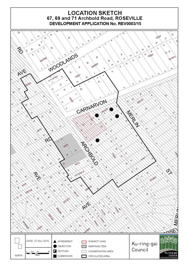
|
APPENDIX No: 2 - Zoning
extract
|
|
Item No: GB.2
|
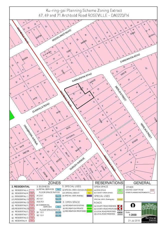
|
APPENDIX No: 3 - Architectural
plans
|
|
Item No: GB.2
|
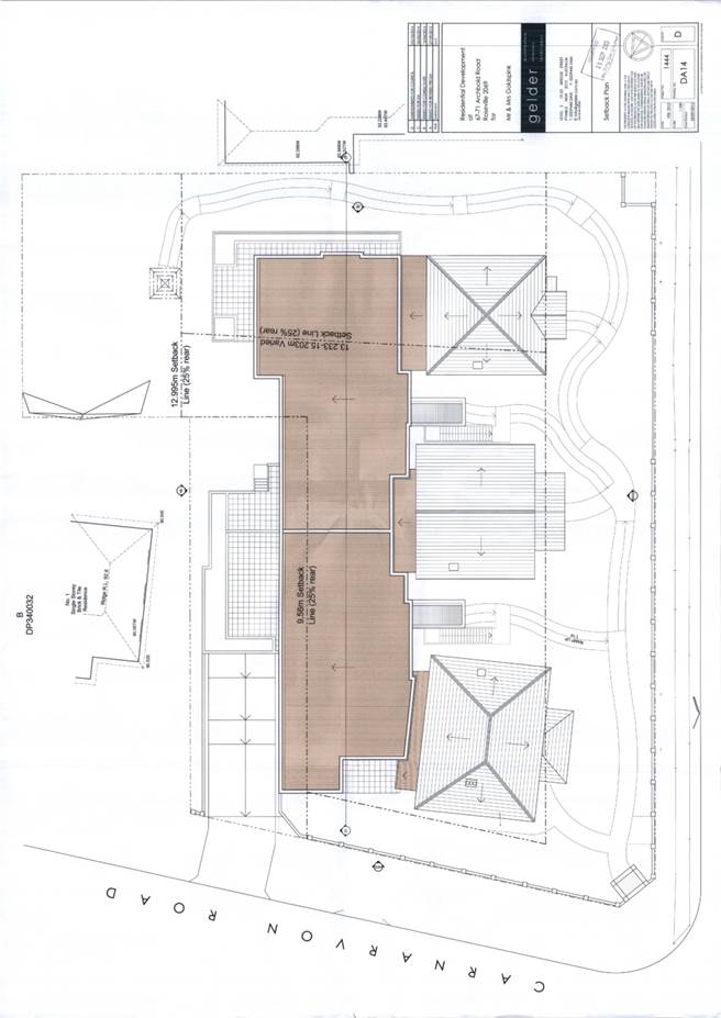

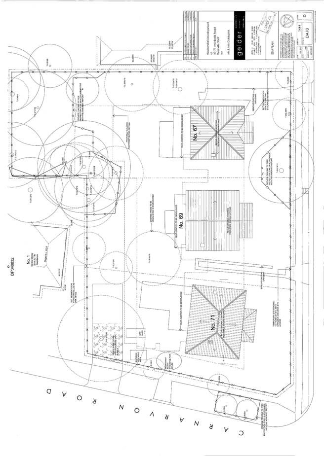
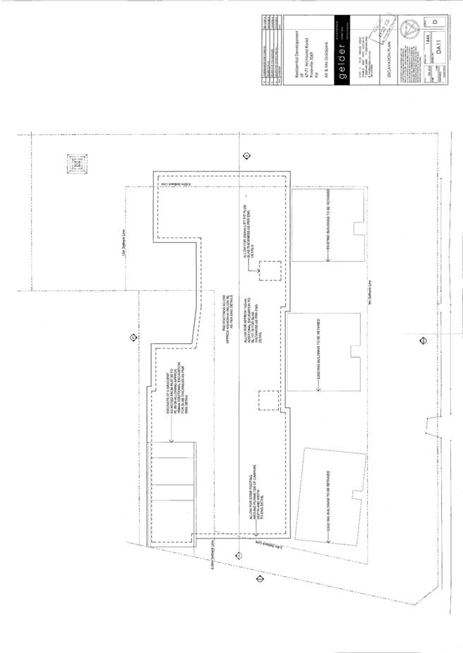
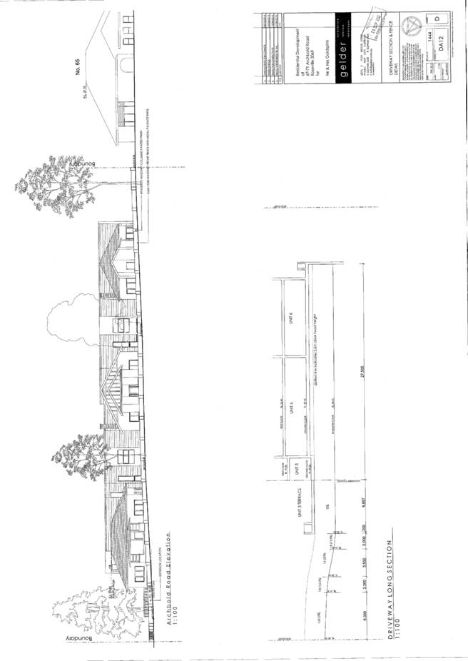
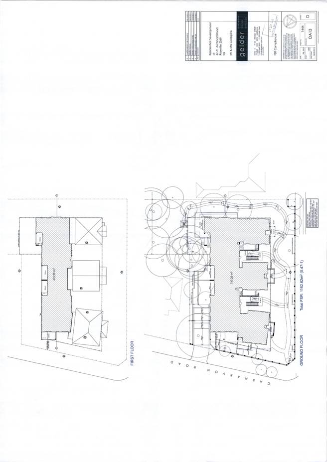
|
APPENDIX No: 4 - Landscape
plan
|
|
Item No: GB.2
|
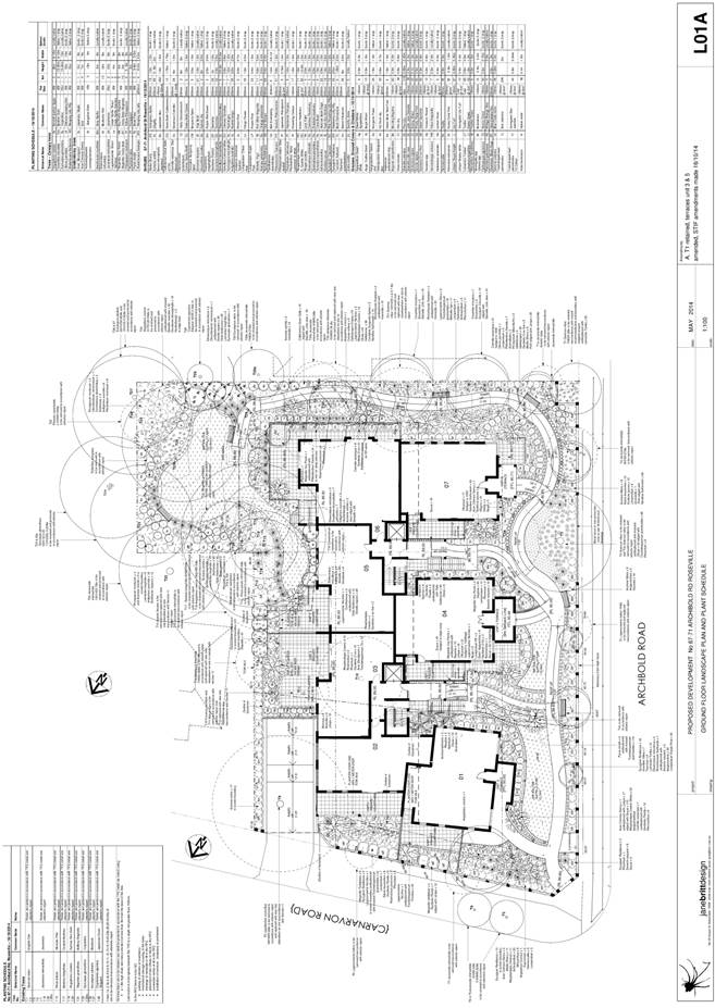
|
APPENDIX No: 5 - SEPP1
objection
|
|
Item No: GB.2
|


|
APPENDIX No: 6 - DA0223/14
report to Council
|
|
Item No: GB.2
|
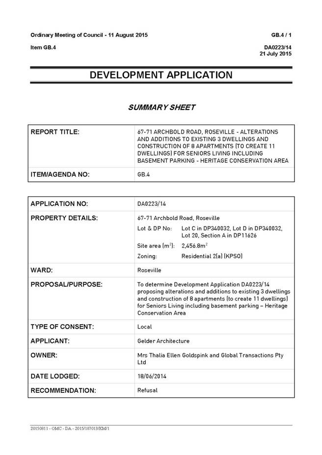

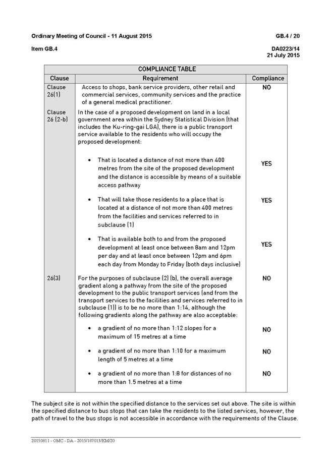
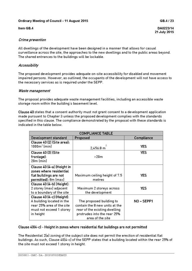
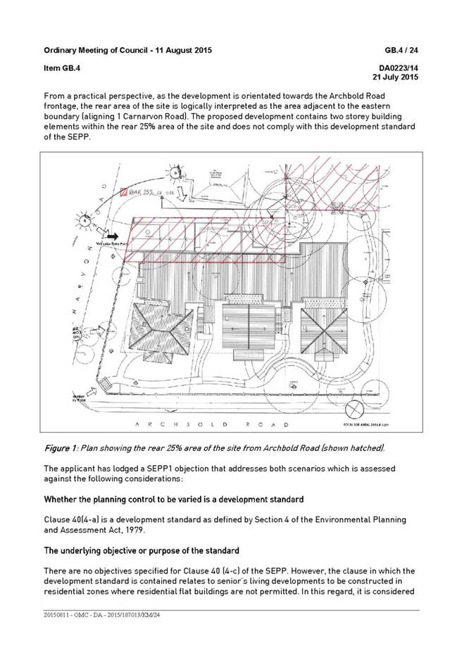
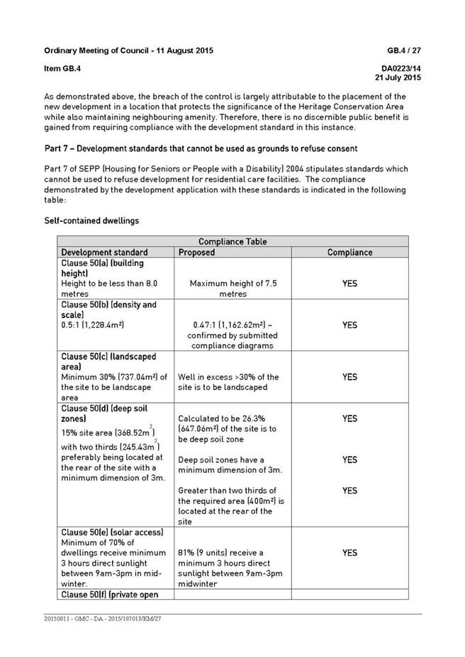
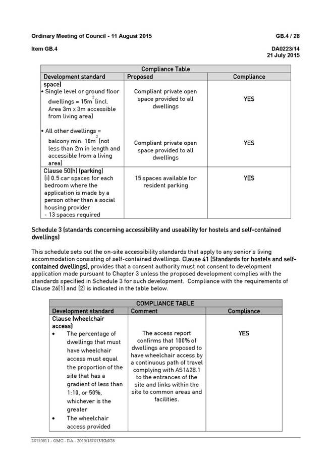
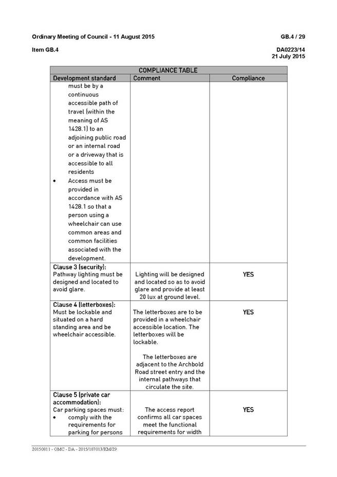

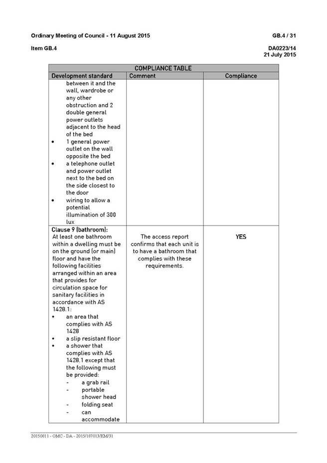
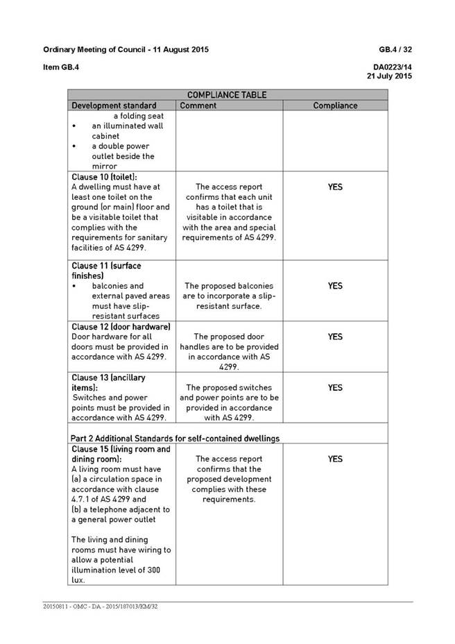
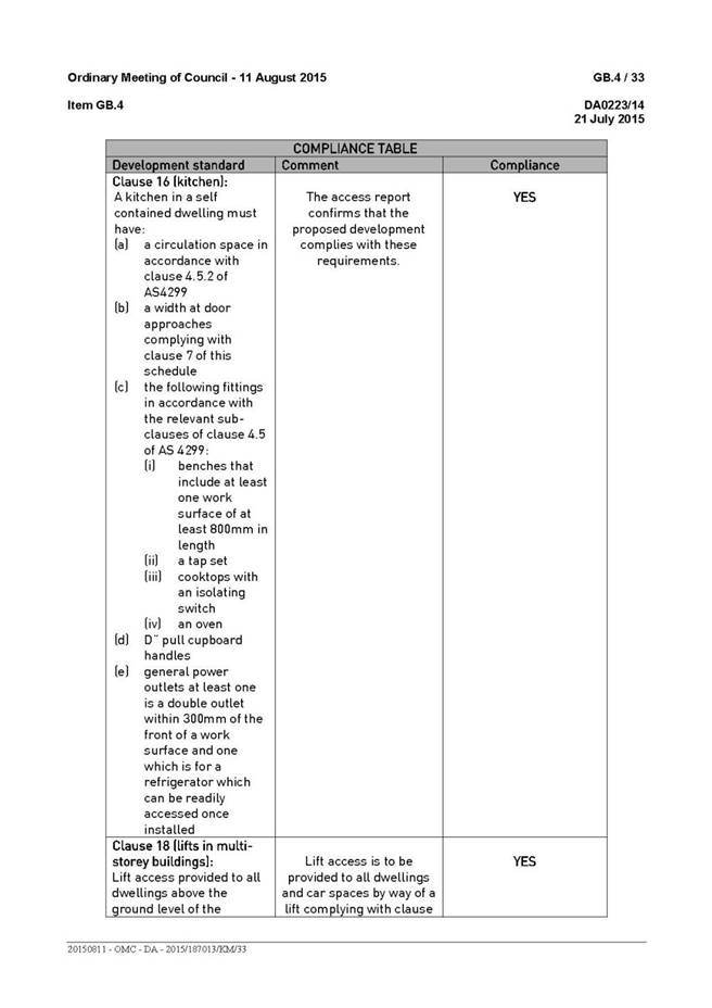
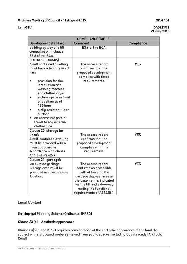
|
Ordinary
Meeting of Council - 8 December 2015
|
GB.3 / 159
|
|
|
|
|
Item
GB.3
|
DA0082/15
|
|
|
20 November 2015
|
Summary
Sheet
|
Report title:
|
1 Tobruk
Avenue, St Ives Chase - Alterations and additions, including garage, swimming
pool, driveway and associated landscaping
|
|
ITEM/AGENDA
NO:
|
GB.3
|
|
Application No:
|
DA0082/15
|
|
Property Details:
|
1 Tobruk Avenue, St Ives Chase NSW 2075
Lot & DP No: Lot 28 DP 218785
Site area (m2): 1,563m²
Zoning: Residential 2(c)
|
|
Ward:
|
St Ives
|
|
Proposal/Purpose:
|
To determine Development Application No. DA0082/15
which seeks consent for alterations and additions, including a garage,
swimming pool, driveway and associated landscaping.
|
|
Type of Consent:
|
Local
|
|
Applicant:
|
Matthew & Emily Crocker
|
|
Owner:
|
Mr MS Crocker & Mrs EKP Crocker
|
|
Date Lodged:
|
20 March 2015
|
|
Recommendation:
|
Approval
|
Purpose of Report
To determine Development Application No. DA0082/15 which
seeks consent for alterations and additions, including a garage, swimming pool,
driveway and associated landscaping.
Council’s attention is directed to the NSW Department of
Planning circular PS 08-014 concerning the determination by Council of
development applications where a variation of a development standard is sought
under the provisions of SEPP No.1.
The circular (Attachment A20) requires all
development applications which involve a variation greater than 10% under the
provisions of SEPP No. 1 to be determined by full Council and not by Council
staff under delegated authority.
Clause 46(2) of the Ku-ring-gai Planning Scheme Ordinance
states that a dwelling house shall not be erected with a height in excess of 8
metres. The alterations and additions will result in a dwelling height on the
subject site of 8.915 metres and therefore a SEPP No. 1 objection is
required. The proposal involves a variation of 11.4% to Council’s maximum
height requirement and is referred to full Council for determination.
integrated planning and reporting
Places, Spaces & Infrastructure
|
Community Strategic Plan Long Term Objective
|
Delivery Program
Term Achievement
|
Operational Plan
Task
|
|
P3.1 The built environment delivers attractive,
interactive and sustainable living and working environments.
|
A high standard of design quality and building environmental
performance is achieved in new development.
|
Assessment of applications is consistent with Council’s
adopted LEPs and DCPs.
|
Executive Summary
Issue: Height
Submissions: Two
submissions received
Land & Environment Court: N/A
Recommendation: Approval
History
Site
Council’s records indicate that the site has historically
been used for residential purposes.
Pre-DA
PRE0124/13 – Alterations and additions
This
meeting was held on 11 November 2013 to discuss the proposed works which are
now the subject of this Development Application. Issues raised by Council
officers during the Pre DA consultation were addressed and appropriate
modifications to the proposal were undertaken as a result of the Pre DA
process.
DA history
There are no previous applications of relevance to the
subject application.
The Site
Site description
The subject site is a corner site of irregular
configuration, with a 12.19 metres frontage to Tobruk Avenue and a curved
frontage of 9.435 metres around the corner to the northern boundary which has a
partial frontage to the western end of Dalton Road. The site has a maximum
depth of 83.63 metres and a total area of 1,563m². The site falls by
approximately 27 metres down from the eastern (front) property boundary to the
western (rear) property boundary. The site is located within a relatively dense
landscaped setting, being an area of biodiversity significance, with many trees
and shrubs to the west of the existing dwelling.
The site is currently occupied by a one and two storey brick
dwelling, with an attached garage/carport which is accessed from Tobruk Avenue.
Surrounding development
The subject site is bounded to
the west and north by Cowan Creek Reserve. It is otherwise surrounded by
allotments zoned for low density residential development which are occupied by
a mixture of single and two (2) storey dwellings of various architectural
styles.
The Proposal
The applicant seeks development consent for alterations and
additions to the existing dwelling comprising:
· closure of existing driveway access to
Tobruk Avenue and construction of a new driveway accessed from Dalton Road
· construction of a new double garage
incorporated into the existing dwelling
· construction of a lower ground floor
level to the rear of the existing dwelling, providing for a rumpus room,
study/bedroom, bathroom, stairs, lower terrace area and above-ground swimming
pool
· demolition of the existing
garage/carport and alterations and additions at the ground floor level to
provide for a living/dining area, WC, study, master bedroom & ensuite,
laundry, link to a new rear kitchen and family room, and upper terrace areas
· retention of the existing three
bedrooms and bathroom/WC at the first floor level
· landscaping of the front (eastern)
portion of the site surrounding the existing dwelling house
Amended plans dated 9 September 2015
Following a preliminary review of
the application, the following issues were identified:
· non-compliant driveway
transition
· lack of detail relating to
ecological management of the site for fire purposes
These issues were conveyed to the
applicant by letter, dated 31 July 2015 and in response the applicant provided
amended plans/information satisfactorily addressing these issues.
Consultation
Community
In accordance with Development Control Plan No. 56, owners
of surrounding properties were given notice of the application. In response,
submissions from the following were received:
1. John
Ginswick, 12 Dalton Road, St Ives Chase NSW 2075
2. Jamie
Cryan, 14 Dalton Road, St Ives Chase NSW 2075
The submissions raised the following issues:
Damage to access road
Concern is raised that the construction vehicles and
increased use of this section of Dalton Road by an additional property will
cause damage to the surface of the privately maintained driveway. This is a
public road and Council’s Development Engineer has recommended a condition
which will ensure that a dilapidation report is provided to Council prior to
the commencement of works and that any damage will be required to be repaired
prior to the issue of a final Occupational Certificate (Condition 8).
Access/damage to services
Concern has been raised regarding potential damage of and
future access to underground services, in the form of the water supply, to
adjoining properties. Council’s Development Engineer has confirmed that a
Council stormwater pipe runs across the frontage of the subject property. A
condition is recommended to ensure that Council is contacted immediately should
a Council stormwater drainage pipe be encountered during the proposed works. In
addition, any damage caused to a Council drainage system is to be repaired
immediately at no cost to Council (Condition 37).
Sightlines approaching new driveway
Concern has been raised regarding the sightlines for
vehicles within Dalton Road approaching the proposed driveway to the subject
site. An inspection of the site was undertaken by Council’s Development
Engineer and further discussion has taken place with Council’s Traffic
Engineers within the Operations Department. It is considered that drivers
reversing from the proposed driveway will have clear sight in both directions
and that, as in any situation where there is driveway access to a public road,
if appropriate care is taken by both parties, the proposal is workable.
Amended plans dated 9 September 2015
The amended plans were not
notified to surrounding residents as the proposed amendments do not result in a
greater environmental impact than the original proposal.
Within Council
Landscaping
Council’s Senior Tree and Landscape Assessment Officer
commented on the proposal as follows:
Tree impacts
There is no
objection to the removal of the following trees: T1, T2, T3, T4, & T5. The
most significant tree is T2 Angophora costata (Sydney Red Gum) located within
the proposed pool footprint. The tree is an endemic species, outwardly in good
health and condition, typical for the species. Beyond conflict with the
development footprint, no justification has been provided for its removal. The
tree while mature is not viewed from the street and hence has lower landscape
prominence. Also refer ecological assessment.
T7 is a
mature Jacaranda mimosifolia (Jacaranda) located within the Dalton Road nature
strip. The tree is in good health and condition not impacted by development
works. The arborists assumption about preferred removal is incorrect and their
discussion about conflicts with the proposed driveway is also incorrect as the
driveway is outside of the TPZ. The tree is to be retained and protected and a
condition is recommended (Condition 16).
T8 is a
grouping of Pittosporum undulatum (Native Daphne) located within the Dalton
Road nature strip. No objection on landscape grounds for their removal, subject
to ecological concurrence. They are not adversely impacted by the proposed
development.
Landscape
plan/tree replenishment
Acceptable
on landscape grounds. Minor changes regarding tree retention and placement is
conditioned (Condition 16).
Stormwater
plan
Acceptable
on landscape grounds
BASIX
No
landscape commitment for low water use/indigenous species has been made.
Fire
The site is
identified as bush fire prone land. Fire safety recommendations include a
requirement that a IPA be maintained surrounding the house, which does not
require further tree removal beyond what is required to accommodate the
development works.
Conclusion
The application is acceptable on landscape grounds, subject to
conditions.”
Ecology
Council’s Ecological Assessment Officer commented on the
proposal as follows:
“This
ecological review of the site was based on the results of a desktop review and
a site inspection by John Whyte, Ecological Assessment Officer of Ku-ring-gai
Council on 2 April
2015.
During the
site inspection, native vegetation was found to dominate a large proportion of
the site, a high number of native flora species were identified. No intensive
targeted searches were conducted for flora or fauna however it was noted that
within and adjacent to the site, suitable habitats were present for a number of
threatened flora and fauna species listed under both Threatened Species
Conservation Act 1995 (TSC Act) and the Environmental Protection and
Biodiversity Conservation Act 1999 (EPBC Act).
The native vegetation, which
occurs primarily within the rear of the site, has been mapped as an area of
biodiversity significance under the LEP 218.
Impacts
from the proposal
The proposal does not propose
the removal of any trees that comprise part of the onsite Sydney Sandstone
Gully Forest or from the area identified as “biodiversity significance”.
The following land use advice
was provided by the Rural Fire Service (RFS)
“At the commencement of
building works and in perpetuity, the property around the building to a
distance of 10 metres, or to the property boundary whichever comes first shall
be managed as an inner protection area (IPA) as outlined within section 4.1.3
and Appendix 5 of Planning for Bush Fire Protection 2006 and the NSW Rural Fire
Service's document Standards for asset protection zones.”
In accordance with Planning for
Bushfire “An IPA should provide a tree canopy cover of less than 15% and should
be located greater than 2 metres from any part of the roofline of a dwelling” (NSW
Rural Fire Service 2006). Canopy trees should have a separation distance
between 2-5 metres.
Native/exotic canopy within the
site is considered to achieve IPA requirements of 15% (NSW Rural Fire Service
2006). The understorey within the rear of the subject property requires minimal
works to achieve management of the understorey as an IPA. This will involve the
removal of noxious & environmental weeds and removal of dead wood. It is
also noted that, due to the extensive occurrence of rock within the proposed
IPA, minimal modification to ground and shrub vegetation is anticipated.”
A condition is recommended
which will effectively address IPA requirements through the removal of noxious
and environmental weeds to satisfy Planning for Bushfire Protection 2006 (Condition
53).
Having consideration to the
clause 61L “Biodiversity protection” of LEP 218 it is concluded that the
proposed development will not have an adverse impact upon the area of
“biodiversity significance” due to the minimal vegetation modification works
required for bushfire protection purposes.”
Engineering
Council’s Development Engineer commented on the proposal as
follows:
“Access to the site will be via a new layback and driveway
crossover. The garage level has been raised by 140mm. The applicant has
submitted documentation from Terraffic Traffic Consultants which confirms that
the driveway gradients provided will allow satisfactory vehicular access and
egress from the development. The garage dimension and driveway gradient,
including headroom, complies with Australian Standard AS2890.1:2004. Guide
posts are to be installed and maintained on the edge of the concrete driveway on
the low side to provide delineation of the driveway (Condition
15).
Council’s approval under the Roads Act is required for the
driveway and new retaining wall on the nature strip. Construction details will
need to be submitted to Council for approval prior to issue of the Construction
Certificate (Condition 20).
The site is Location C under DCP47. The stormwater Plan
prepared by HDG Hydraulic Design Group shows a 5000L bladder type rainwater
tank in the rear of the property. BASIX water commitments are satisfied. Re-use
will be for pool top up as per BASIX requirements. The overflow from the
rainwater tank and grated drain shall be directed to a level spreader at the
rear of the property.
The Stormwater Management Plan; Dwg No: SCP 01, Rev:”A”,
dated August 2014 prepared by HDG Hydraulic Design Group, is considered a
satisfactory system for this type of development.
Concern has been raised regarding the underground services.
There is a Council stormwater pipe across the frontage of the property. For
that reason, a condition is recommended that works
cease and Council must be contacted immediately for advice if a Council
stormwater drainage pipe is encountered. Any damage caused to a Council
drainage system must be immediately repaired in full, as directed, and at no
cost to Council (Condition 37).
Concern has been raised regarding sight distance for
vehicles coming up Dalton Road. The site has been inspected. Vehicles reversing
out can see both directions. If both parties are careful, the situation is feasible.
Concern has also been raised regarding the proposed
driveway access. It was mentioned that the proposed route of access will share
the privately maintained driveway for 12 and 14 Dalton Road and may be damaged
during construction. This is public road and a dilapidation report is to be
provided to Council prior to works being undertaken, which is
conditioned (Condition 8). Any damage will be required to be repaired
before a final Occupational Certificate can be
issued.
From an engineering perspective there are no objections to
approval of this application, subject to conditions.”
Outside Council
Rural Fire Service
In accordance with the
provisions of section 79BA of the Environmental Planning and Assessment Act
1979, Council consulted with the Commissioner of the NSW Rural Fire Service,
concerning measures to be taken with respect to the protection of persons,
property and the environment from danger that may arise from a bush fire. The
comments provided by the Rural Fire Service are as follows:
“Reference is
made to Council’s correspondence dated 30 March 2015 seeking advice regarding
bush fire protection in relation to the above application in accordance with
Section 79BA of the Environmental Planning and Assessment Act 1979.
The New South Wales Rural Fire
Service provides recommended conditions.”
The requirements of the Rural Fire Services are included in Condition
No. 54 of the recommendation.
Statutory Provisions
The proposal is “Local Development” under Part 4 of the Environmental
Planning & Assessment Act 1979 and requires development consent.
State Environmental Planning Policies
State Environmental Planning Policy No. 1 – Development
Standards
SEPP 1 provides flexibility to
development standards and enables Council to vary standards where strict
compliance with a standard would be unnecessary, unreasonable or tend to hinder
the objectives of the Environmental Planning & Assessment Act, 1979.
Clause 46(2) of the Ku-ring-gai
Planning Scheme Ordinance states that a dwelling house shall not be erected
with a height in excess of 8 metres.
The proposed dwelling has a
building height of 8.915 metres at the rear of the dwelling and therefore,
there is a departure from the development standard. Accordingly, a SEPP No. 1
objection has been lodged and is considered below.
State
Environmental Planning Policy No. 55 – Remediation of Land
The provisions of SEPP 55
require Council to consider the potential for a site to be contaminated. The
subject site has a history of residential use and as such, it is unlikely to
contain any contamination and further investigation is not warranted in this
case.
Sydney
Regional Environmental Plan No. 20 – Hawkesbury-Nepean River
SREP 20 applies to land within
the catchment of the Hawkesbury Nepean River. The general aim of the plan is
to ensure that development and future land uses within the catchment are
considered in a regional context. The Plan includes strategies for the
assessment of development in relation to water quality and quantity, scenic
quality, aquaculture, recreation and tourism.
The proposed development is
considered to achieve the relevant aims under this policy.
State
Environmental Planning Policy (Building Sustainability Index: BASIX) 2004
A valid BASIX certificate has
been submitted. The certificate demonstrates compliance with the provisions of
the SEPP and adequately reflects all amendments to the application.
Ku-ring-gai Planning Scheme Ordinance
Part A: Development standards
|
Development standard
|
Proposed
|
Complies
|
|
Site area: 1563 m2
|
|
Minimum size allotments
|
|
|
|
Site area: 929m2 (min)
|
1563m2
|
YES
|
|
Site width: 18m (min)
|
>18m
|
YES
|
|
Building height 8m
(max)
|
8.915m
|
NO
(SEPP
No. 1 objection provided)
|
|
Built upon area
60%(937.8m2)(max)
|
43.3%
(406.102m2)
|
YES
|
Height of buildings (clause
46(2))
Where there is a variation to a development standard, the
application must be accompanied by a SEPP 1 Objection, a written objection that
compliance with that development standard is unreasonable or unnecessary in the
circumstances of the case, and specifying the grounds of that objection.
The proposed alterations and
additions to the existing dwelling have a maximum height of 8.915 metres at the
rear of the dwelling. The proposal does not comply with the 8 metres maximum
height development standard which is exceeded by 915 millimetres (11.4%).
A SEPP No. 1 objection has been
submitted by the applicant and is assessed as follows:
Whether the planning
control to be varied is a development standard
Clause 46 of the Ku-ring-gai
Planning Scheme Ordinance states:
(1) Notwithstanding the provisions of Part III of this
Ordinance, a building shall not be erected to a height, across any point of a
site, which is greater than 7 metres without the consent of the Council.
(2) A person shall not erect a dwelling-house or dual occupancy
building with a height in excess of 8 metres.
(4)
In this clause –
“Ground
level” means the level of a site before development is carried out on the
site under this Ordinance.
“Height”
in relation to a building, means a distance measured vertically from
any point on the ceiling of the topmost floor of the building to the ground
level immediately below that point.
Clause 46(2) of the KPSO
restricts the height to which dwelling houses are constructed to a maximum
height of 8 metres. As the KPSO is a statutory planning instrument, this
control is considered to be a development standard as defined under Section 4
of the Environmental Planning & Assessment Act, 1979.
The underlying objective
or purpose of the standard
The objectives of clause 46 are
unstated in the KPSO.
The relevant specific Aims and
Objectives for Residential Zones as stated in schedule 9 of the KPSO are as
follows:
(e) all new dwelling-houses and additions to existing dwelling-houses
are of a height, size and bulk generally in keeping with that of neighbouring
properties and, where larger buildings are proposed, they are designed so as
not to dominate and so far as possible to harmonise with neighbouring
development;
A similar objective is included
in section 4.2 of DCP No. 38 which states:
To ensure
that the bulk, scale and height of the proposed works do not dominate the
natural landscape, existing streetscape, nor adversely impact on the tree
canopy vista.
Whether compliance with
the development standard is consistent with the aims of the policy and, in
particular, whether compliance with the development standard hinders the
attainment of the objectives specified in Section 5(a)(i) and (ii) of the
Environmental Planning and Assessment Act 1979
SEPP No. 1 provides flexibility in the application of
planning controls operating by virtue of development standards in circumstances
where strict compliance with those standards would, in any particular case, be
unreasonable or unnecessary or tend to hinder the attainment of the objects
specified in section 5 (a) (i) and (ii) of the Act.
The objects
of the Act are:
(i) the
proper management, development and conservation of natural and artificial
resources, including agricultural land, natural areas, forests, minerals,
water, cities, towns and villages for the purpose of promoting the social and
economic welfare of the community and a better environment,
(ii) the
promotion and co-ordination of the orderly and economic use and development of
land,
The proposed development is
consistent with the objects of the Act and represents an orderly and economic
use of the land.
Whether compliance with
the development standard is unreasonable or unnecessary in the circumstances of
the case
The following are extracts from
the applicant’s SEPP No. 1 objection:
“The non-compliance arises due to the slope of the land and is best
illustrated in the following figure:

Figure
1 – Image of height non-compliance
“The
proposal considerably improves the existing amenity for the subject dwelling
and also provides a high quality addition which does not compromise the
streetscape or built/environmental character of the area. The vast majority of
the site will be retained as bushland and the impacts upon neighbouring amenity
are reasonably minimised through a combination of the nature of the site,
context of surrounding development, separation between dwellings and design
measures adopted with the proposal. The scale of the proposal and stepping
nature is compatible and “harmonious”, while the setbacks and siting of the
proposal is sympathetic.”
“The vast
majority of the site is unaffected by the proposal, with modest proposed site
coverage and FSR. The siting is appropriately located towards the front street
and away from natural areas of the site which are also steeper.”
“The
height, bulk and scale are not excessive and are compatible with the
surrounding area. Further, the design has been highly modulated and articulated
to reduce apparent building bulk and also to reduce amenity impacts upon
neighbours.”
“It is
submitted the proposal meets the objectives of the Act, notwithstanding the
non-compliance with the height standard. The proposal will make a superior
contribution to the built environment than the current building, which is in a
state of disrepair, and the natural environment is appropriately protected in
the context of the planning controls which apply to the site. The proposed
development of the site is orderly and rational.”
Whether the objection is well founded
The majority of the proposed
alterations and additions are consistent with the height development standard
and, as can be seen in Figure 1 above, the area of non-compliance is
limited to a small portion towards the rear of the dwelling and arises due to
the slope of the land. Overall, the dwelling is of a building form and scale
which will not significantly impact on the existing
streetscape or natural landscape nor result in any detrimental impacts on the
amenity of adjoining properties. For these reasons and those listed
above, the objection is considered to be well founded and it is agreed that
compliance with the standard is unreasonable and unnecessary in the
circumstances of the case.
Whether non-compliance with the development standard raises
any matter of significance for State or regional environmental planning,
It is
considered that there are no matters of significance for State or regional
environmental planning in this circumstance.
Whether
there is public benefit in maintaining the planning controls adopted by the
environmental planning instrument.
The
development standard for the building height within the site is consistent with
the development outcomes promoted by the Ku-ring-gai Planning Scheme Ordinance.
There is public benefit in maintaining this planning control but, in this
instance, requiring compliance would not be considered reasonable.
Clause 33(a) – aesthetic appearance
Clause 33(a) of
the KPSO requires Council to consider the probable aesthetic appearance of the
proposed works when viewed from a public reserve adjacent to the site.
The proposed
works will not detrimentally affect the visual appearance of the dwelling when
viewed from the public reserve. In this respect, the proposed works are
considered to satisfy the requirements under this clause.
Cl. 61L Biodiversity
The KPSO was last
amended on 5 July 2013 by Local Environmental Plan (LEP) 218 which introduced
planning provisions for biodiversity protection, heritage conservation areas
(HCA) and riparian lands. The subject site is located within an area of
biodiversity identified on the maps. The proposal is considered to meet these
provisions for biodiversity protection.
Part B: Aims and objectives for residential zones:
The
development: (i) provides satisfactory levels of solar access & privacy to
surrounding properties; (ii) is of a bulk, scale and design, characteristic of
the area; (iii) maintains adequate levels of soft landscaping; (iv) provides
suitable egress/ingress for vehicles; and (v) maintains the landscape quality
of the municipality. Consequently, the aims and objectives for residential
development as outlined by Schedule 9 have been satisfied.
Ku-ring-gai Local Environmental Plan 2015
The KLEP 2015 came
into effect on 2 April 2015. The subject site is located within an area
identified on the statutory maps, however, clause 1.8A provides that if a
development application has been made before the commencement of the LEP and
has not been finally determined prior to commencement, the application must be
determined as if the LEP had not commenced. The subject application was lodged
on 20 March 2015 and has therefore been determined according to the provisions
of the Ku-ring-gai Planning Scheme Ordinance which was the instrument in place
at the time that the application was lodged.
Policy Provisions (DCPs, Council policies, strategies and
management plans)
Development Control Plan No.
38 - Ku-ring-gai Residential Design Manual
|
Development Control
|
Proposed
|
Complies
|
|
4.1 Streetscape:
|
|
Building setbacks (s.4.1.3)
|
|
|
|
Front setback:
|
9.3m (no change to existing)
|
N/A
|
|
Side setback:
Lower ground floor: 2m (min)
Ground floor: 2m(min)
1st floor: 2.5m (min)
Corner sites:
3.8m (min)
4.5m (ave)
|
South: 1.535m
South: 1.535m
South: 1.535m
6m
6m
|
NO
NO
NO
YES
YES
|
|
Rear setback: 12m(min)
|
52.5m
|
YES
|
|
Fences (s.4.1.5)
|
None proposed
|
N/A
|
|
4.2 Building form:
|
|
FSR (s.4.2.1) 0.30:1 (482.6m² max)
Height of building (s.4.2.2)
|
0.24:1 (387m²)
|
YES
|
|
2 storey (max) and
8m (site >200 slope) or
7m (site <200 slope)
|
2 storey &
8.915m
|
YES
NO
|
|
Building height plane (s.4.2.3)
450
from horizontal at any point 3m above boundary
|
Breaches at various levels on both sides
|
NO
|
|
First floor (s.4.2.4)
|
|
|
|
FSR: < 40% total FSR
|
The proposed floor space is considered to be
appropriately distributed throughout the dwelling
|
YES
|
|
Roof Line (s.4.2.6)
|
|
|
|
Roof height
(5m – single storey)
(3m – two+ storey)
|
Flat roof
|
YES
|
|
Roof pitch 350 (max)
|
Flat roof
|
YES
|
|
Built-upon area (s.4.2.7)
50% (781.5m2) (max)
|
43.3% (406.102m2)
|
YES
|
|
Unrelieved wall length (s.4.2.8)
12m for walls up to 4m in height
8m
for walls more than 4m in height
|
No excessive unrelieved walls
|
YES
|
|
Solar access (4.2.11)
4h
solar access to adjoining properties between 9am to 3pm
|
Solar access is maintained to adjoining properties
|
YES
|
|
Cut & fill (s.4.2.14)
|
|
|
|
Max cut 900mm
|
1.8m
|
NO
|
|
Max cut & fill across building area of 1800mm
and 900mm
|
Cut of 1.8m
|
YES
|
|
No cut or fill within side setbacks
|
Some cut proposed
|
NO
|
|
4.3 Open space & landscaping:
|
|
Soft landscaping area (4.3.3)
50%
(781.5m2) (min)
|
56.7% (1156.898m2)
|
YES
|
|
Tree replenishment (s.4.3.6)
10
Trees required
|
Tree provision is satisfactory
|
YES
|
|
Landscaping cut & fill (4.3.7)
|
|
|
|
max cut or fill 500mm relative to natural ground
|
<500mm
|
YES
|
|
no cut & fill within 2m of boundary
|
Nominal amount proposed within 2m of boundaries
|
NO
|
|
Useable open space (s.4.3.8)
Min depth 5m and min area 50m2
|
Depth >5m
Area >50m2
|
YES
YES
|
|
4.4 Privacy & security:
|
|
Refer
discussion below.
|
|
4.5 Access & parking:
|
|
No. of car parking spaces (s.4.5.1)
2 spaces behind building line
|
2 spaces behind building line
|
YES
|
|
Size of car parking space (s.4.5.2)
5.6m x 5.4m
|
5.7m x 5.5m
|
YES
|
|
Carport/garage <6m in width or <40% site width
whichever is the lesser
|
<6m in width
|
YES
|
|
Driveway width (s.4.5.6) 3.5m
|
4.5m
|
NO
|
|
4.6 Ancillary facilities:
|
|
Swimming pools (s.4.6.1)
|
|
|
|
Setback from boundary: 2m
|
3m
|
YES
|
|
Pool coping <500mm above ground level
|
6.8m
|
NO
|
|
Pool excavation not below the canopy of trees
|
Canopy trees to be removed
|
YES
|
Streetscape & building form
There
are non-compliances with the side setback controls of DCP 38 on the southern
side. Further, due to the slope of the land, a small section towards the rear
of the dwelling will have a maximum ceiling height of 8.915 metres. This
breaches section 4.2.2 of DCP 38 which provides for a maximum height of 8
metres on sites with slopes of more than 20 degrees. Additionally, the building
height plane is breached marginally at various floors due to the sloping nature
of the site.
The
dwelling has been designed to step down the site and is quite modular in form
and therefore, what constitutes the ground floor at the front of the dwelling becomes
the first floor towards the middle. The dwelling is located on a corner site
and the requirements for additional distances to the secondary road frontage
have been exceeded. Use is made of the current available space to the eastern
end of the site to provide for a footprint which addresses the site’s
constraints more effectively.
The
proposal has also utilised a flat roof design to the new additions to reduce
the overall height of the dwelling. The design of the dwelling additions has
incorporated sufficient architectural relief and open balconies and terraces to
provide for a structure which does not impose on its surroundings and which
makes better use of the sloping lot and minimises any impact on the streetscape
and on adjoining properties. The proposed dwelling integrates with and retains
the character exemplified by dwellings on this side of the street.
The
proposed development will result in excavation for the construction of the
dwelling and to accommodate the driveway access into the garage. The site is
affected by a fall of approximately 11 metres from the eastern (front) property
boundary over the building platform to the rear of the dwelling. The existing
topography of the site has largely been respected and retained with cut and
fill used only where necessary to create a level building platform for the
development. A retaining wall to the eastern side of the driveway access into
the site is proposed but is considered acceptable given the fact that the
western end of Dalton Road only services three other properties with the
subject property being the only one on this southern side of the street. The
excavation will not require the removal of any significant vegetation and will
not impact on existing trees.
Landscaping
and screen planting, canopy trees and open space areas are incorporated into
the design of the overall site, ensuring that the predominant landscape
character of the locality is maintained.
Therefore,
in respect of these factors, it is considered that the proposed development
will satisfy the objectives stated in this part of DCP 38.
Part 4.4 – Privacy and security
Any
potential for overlooking of No. 3 Tobruk Avenue has been addressed in the
proposed design by omitting southern side windows in the new rear addition at ground
and first floor level and by recessing the lower ground floor northern terrace
and restricting the space for standing between the proposed pool and handrail
on that side of the development. Consequently, the aims and objectives of the
controls are considered to be met.
Driveway width
It
is acknowledged that the driveway width, at approximately 4.5 metres, is wider
than would usually be anticipated under the DCP controls. This non-compliance
is considered to be acceptable given the requirement for vehicles to be able to
manoeuvre to a sufficient degree so as to allow easier access reversing, and
for greater visibility by vehicles already within, or approaching the public
road.
Swimming pool
DCP
38 states that the pool coping level must not be more than 500mm above existing
ground level at any point but qualifies this requirement when considering
development on steeply sloping sites, by allowing greater levels, subject to
increased setbacks and landscaping. As a consequence of the slope of the land,
which falls by approximately 27 metres to the rear boundary, the western
elevation presents a coping level of approximately 6.8 metres.
It
is noted that the pool structure is integrated into the design of the dwelling
and that the longest elevation of the pool faces the rear of the site which is
heavily vegetated. Further, the maximum coping level is located approximately
7 metres from the northern side boundary with the nearest adjoining dwelling on
that side. Given the distance from the adjoining dwelling, coupled with the
existing vegetation on the site, the proposed works are considered to integrate
into the landscape and are sited so as to minimise visual impact when viewed
from adjacent properties.
Consequently,
the aims and objectives of the controls are considered to be met.
Development
Control Plan 40 – Construction and Demolition Waste Management
A waste management plan has been
submitted and is deemed to be acceptable, subject to conditions relating to the
management of waste materials. (Condition 14).
Development
Control Plan No. 43 – Car Parking
DCP 43 has been considered under
the assessment of the proposal against the relevant provisions of DCP 38 that
relate to car parking and vehicle access by Council’s Development Engineer. The
application is considered to be acceptable in this regard, subject to
conditions.
Development
Control Plan 47 – Water Management
DCP 47 has been addressed under
the consideration of DCP 38 and by Council’s Development Engineer. Conditions
are recommended to ensure compliance with the provisions of the DCP.
Section
94 Plan
The nature of the proposed
development does not attract the payment of Section 94 contributions under
Council’s current plan.
Likely Impacts
As has been determined through the assessment of the
application, the proposed development is not deemed to be of any unreasonable
impact upon the streetscape, the amenity of neighbouring properties or the
general interests of the community.
Suitability of the Site
The site is considered to be suitable for the proposed
development.
Public Interest
The approval of the application is considered to be in the
public interest.
Conclusion
Having regard to the provisions
of section 79C of the Environmental Planning and Assessment Act 1979, the
proposed development is considered to be satisfactory. Therefore, it is
recommended that the application be approved.
|
Recommendation:
PURSUANT TO SECTION 80(1)
OF THE ENVIRONMENTAL PLANNING AND ASSESSMENT ACT, 1979
THAT the Council, as the
consent authority, is of the opinion that the objection under State Environmental
Planning Policy No. 1 – Development Standards to the building height
standard in clause 46 of the Ku-ring-gai Planning Scheme Ordinance is well
founded. The Council is also of the opinion that strict compliance with the
development standard is unreasonable and unnecessary in the circumstances of
this case.
AND
THAT the Council, as the
consent authority, being satisfied that the objection under SEPP No. 1 is
well founded and also being of the opinion that the granting of consent to
DA0082/15 is consistent with the aims of the Policy, grant development
consent to DA0082/15 for alterations and additions including garage, swimming
pool, driveway and associated landscaping on land at 1 Tobruk Avenue, St Ives
Chase, for a period of two (2) years from the date of the Notice of
Determination, subject to the following conditions:
Conditions
that identify approved plans:
1. Approved
architectural plans and documentation (alterations and additions)
The development must be
carried out in accordance with work shown in colour on the following plans
and documentation listed below and endorsed with Council’s stamp, except
where amended by other conditions of this consent.
|
Plan no.
|
Drawn by
|
Dated
|
|
Dwg. 11171detail Issue 3
Survey
|
C.M.S Surveyors Pty Ltd
|
2/09/13
|
|
DA.01-DA.05, DA.10-DA.16,
DA.28 Issue A
|
Ben Giles Architect
|
20.3.15
|
|
DA.06, DA.17 Issue B
|
Ben Giles Architect
|
9.9.15
|
|
LA - 01 & LA - 02
Landscape plan
|
Paterson Design Studio
|
4.8.14
|
|
Dwg. No. SCP 01 Rev A
Stormwater concept plan
|
HDG Hydraulic Design Group
|
August 2014
|
|
Document(s)
|
Dated
|
|
Basix certificate No.
A195676
|
14 January 2015
|
|
Vehicle access compliance
report, Terraffic Pty Ltd
|
9 September 2015
|
|
Waste management plan
|
1/2/15
|
|
Tree assessment &
preliminary management report, Growing My Way Tree Services
|
September 2013
|
|
Flora & fauna survey,
UBM Ecological Consultants Pty Ltd
|
31 July 2014
|
Reason: To
ensure that the development is in accordance with the determination.
2. Inconsistency
between documents
In
the event of any inconsistency between conditions of this consent and the
drawings/documents referred to above, the conditions of this consent prevail.
Reason: To
ensure that the development is in accordance with the determination.
3. Approved landscape plans
Landscape works shall be
carried out in accordance with the following landscape plan(s), listed below
and endorsed with Council’s stamp, except where amended by other conditions
of this consent:
|
Plan no.
|
Drawn by
|
Dated
|
|
LA-01 & LA-02
|
PDS
|
04/08/14
|
Reason: To ensure that the development is in accordance
with the determination.
4. No demolition of extra fabric
Alterations to, and demolition
of the existing building shall be limited to that documented on the approved
plans (by way of notation). No approval is given or implied for removal
and/or rebuilding of any portion of the existing building which is shown to
be retained.
Reason: To ensure
compliance with the development consent.
Conditions
to be satisfied prior to demolition, excavation or construction:
5. Asbestos
works
All
work involving asbestos products and materials, including
asbestos-cement-sheeting (ie. Fibro), must be carried out in accordance with
the guidelines for asbestos work published by WorkCover Authority of NSW.
Reason: To
ensure public safety.
6. Notice of
commencement
At least 48 hours prior to the
commencement of any development (including demolition, excavation, shoring or
underpinning works), a notice of commencement of building or subdivision work
form and appointment of the principal certifying authority form shall be
submitted to Council.
Reason: Statutory
requirement.
7. Notification of
builder’s details
Prior to the commencement of any development or
excavation works, the Principal Certifying Authority shall be notified in
writing of the name and contractor licence number of the owner/builder
intending to carry out the approved works.
Reason: Statutory requirement.
8. Dilapidation survey
and report (public infrastructure)
Prior to the
commencement of any development or excavation works on site, the Principal
Certifying Authority shall be satisfied that a dilapidation report on the
visible and structural condition of all structures of the following public
infrastructure, has been completed and submitted to Council:
Public infrastructure
· Full road pavement
width, including kerb and gutter, of Dalton Street over the site frontage,
including the full intersection.
· All driveway
crossings and laybacks opposite the subject site.
The report must be completed
by a consulting structural/civil engineer. Particular attention must be paid
to accurately recording (both written and photographic) existing damaged
areas on the aforementioned infrastructure so that Council is fully informed
when assessing any damage to public infrastructure caused as a result of the
development.
The developer may be held
liable to any recent damage to public infrastructure in the vicinity of the
site, where such damage is not accurately recorded by the requirements of
this condition prior to the commencement of works.
Note: A written acknowledgment from Council
must be obtained (attesting to this condition being appropriately satisfied)
and submitted to the Principal Certifying Authority prior to the commencement
of any excavation works.
Reason: To record the structural condition of public
infrastructure before works commence.
9. Structural adequacy
(alterations and additions)
Prior to commencement of any
development or excavation works, the Principal Certifying Authority shall be
satisfied that that those components of the building to be retained and/or
altered will be structurally sound and able to withstand the excavation and
demolition process.
C1. Note: Evidence from a qualified practising structural
engineer, demonstrating compliance with the above and detailing, where
relevant, means of support for those parts of the retained building shall be
provided to the Principal Certifying Authority.
Reason: To ensure that the development can be undertaken in
accordance with accepted construction practices as indicated on the endorsed
development plans, without the need for modification of the consent.
10. Tree protection fencing
To preserve the following
tree/s, no work shall commence until the area beneath their canopy is fenced
off at the specified radius from the trunk/s to prevent any activities,
storage or the disposal of materials within the fenced area. The fence/s
shall be maintained intact until the completion of all demolition/building
work on site.
|
Tree/Location
|
Radius from trunk
|
|
T7 Jacaranda mimosifolia
(Jacaranda) Dalton Rd nature strip
|
5.0m south, 7.0m elsewhere
|
|
Franklinia axillaris
(Gordonia) x 2 Tobruk Ave nature strip
|
Edge of kerb, 2.0m elsewhere
|
Reason: To protect existing trees during the construction
phase.
11. Tree
protective fencing type galvanised mesh
The
tree protection fencing shall be constructed of galvanised pipe at 2.4 metre
spacing and connected by securely attached chain mesh fencing to a minimum
height of 1.8 metres in height prior to work commencing.
Reason: To protect existing trees during construction phase.
12. Tree
protection signage
Prior to works commencing, tree protection signage is to
be attached to each tree protection zone, displayed in a prominent position
and the sign repeated at 10 metres intervals or closer where the fence
changes direction. Each sign shall contain in a clearly legible form, the
following information:
Tree protection zone.
(i) This fence has been installed to prevent damage
to the trees and their growing environment both above and below
ground and access is restricted.
(ii) Any encroachment not previously approved within
the tree protection zone shall be the subject of an arborist's
report.
(iii) The arborist's report shall provide proof that
no other alternative is available.
(iv) The Arborist's report shall be submitted to the
Principal Certifying Authority for further consultation with Council.
(v) The name, address, and telephone number of the
developer.
Reason: To
protect existing trees during the construction phase.
13. Tree
fencing inspection
Upon
installation of the required tree protection measures, an inspection of the
site by the Principal Certifying Authority is required to verify that tree
protection measures comply with all relevant conditions.
Reason: To protect existing trees during the construction
phase.
14. Construction waste
management plan
Prior to the
commencement of any works, the Principal Certifying Authority shall be
satisfied that a waste management plan, prepared by a suitably qualified
person, has been prepared in accordance with Council’s Waste Management
controls in the Ku-ring-gai Development Control Plan.
The plan
shall address all issues identified in DCP 40, including but not limited to:
the estimated volume of waste and method for disposal for the construction
and operation phases of the development.
Note: The
plan shall be provided to the Certifying Authority.
Reason: To
ensure appropriate management of construction waste.
Conditions
to be satisfied prior to the issue of the construction certificate:
15. Driveway guardrail
Where
a drop-off greater than 600mm or batter slope greater than 1:4 adjoins the
proposed driveway and parking space, a suitable vehicle barrier is to be
provided. The design of the barrier, with structural engineer’s
certification, is to be provided with the Construction Certificate drawings
for approval by the Principal Certifying Authority, prior to issue of the
Construction Certificate.
Reason: To ensure safe vehicle manoeuvrability through the site.
16. Amendments to
approved landscape plan
Prior to the issue of a
Construction Certificate, the Principal Certifying Authority shall be
satisfied that the approved landscape plans, listed below and endorsed with
Council’s stamp, have been amended in accordance with the requirements of
this condition as well as other conditions of this consent:
|
Plan no.
|
Drawn by
|
Dated
|
|
LA-01 & LA-02
|
PDS
|
04/08/2015
|
The above landscape plan(s)
shall be amended in the following ways:
(i) T7 Jacaranda
mimosifolia (Jacaranda) located within the Dalton Rd nature strip is to
be shown to be retained.
(ii) Proposed planting
shall be limited to the site. Landscape areas within the road reserve shall
be left as existing.
Prior to the issue of the
Construction Certificate, the Principal Certifying Authority shall be
satisfied that the landscape plan has been amended are required by this
condition.
Note: An amended plan, prepared by a landscape
architect or qualified landscape designer shall be submitted to the Certifying
Authority.
Reason: To ensure
adequate landscaping of the site.
17. Long service levy
In accordance with Section
109F(i) of the Environmental Planning and Assessment Act a Construction
Certificate shall not be issued until any long service levy payable under
Section 34 of the Building and Construction Industry Long Service Payments
Act 1986 (or where such levy is payable by instalments, the first instalment
of the levy) has been paid. Council is authorised to accept payment. Where
payment has been made elsewhere, proof of payment is to be provided to
Council.
Reason: Statutory
requirement.
18. Builder’s indemnity
insurance
The
applicant, builder, developer or person who does the work on this
development, must arrange builder’s indemnity insurance and submit the
certificate of insurance in accordance with the requirements of Part 6 of the
Home Building Act 1989 to the Certifying Authority for endorsement of the
plans accompanying the Construction Certificate.
It is the
responsibility of the applicant, builder or developer to arrange the
builder's indemnity insurance for residential building work over the value of
$20,000. The builder's indemnity insurance does not apply to commercial or
industrial building work or to residential work valued at less than $20,000,
nor to work undertaken by persons holding an owner/builder's permit issued by
the Department of Fair Trading (unless the owner/builder's property is sold
within 7 years of the commencement of the work).
Reason: Statutory requirement.
19. Driveway crossing
levels
Prior to issue of the
Construction Certificate, driveway and associated footpath levels for any
new, reconstructed or extended sections of driveway crossings between the
property boundary and road alignment must be obtained from Ku-ring-gai
Council. Such levels are only able to be issued by Council under the Roads
Act 1993. All footpath crossings, laybacks and driveways are to be
constructed according to Council's specifications "Construction of
Gutter Crossings and Footpath Crossings".
Specifications are issued with
alignment levels after completing the necessary application form at Customer
Services and payment of the assessment fee. When completing the request for
driveway levels application from Council, the applicant must attach a copy of
the relevant development application drawing which indicates the position and
proposed level of the proposed driveway at the boundary alignment.
This development consent is
for works wholly within the property. Development consent does not imply
approval of footpath or driveway levels, materials or location within the
road reserve, regardless of whether this information is shown on the
development application plans. The grading of such footpaths or driveways
outside the property shall comply with Council's standard requirements. The
suitability of the grade of such paths or driveways inside the property is
the sole responsibility of the applicant and the required alignment levels
fixed by Council may impact upon these levels.
The construction of footpaths
and driveways outside the property in materials other than those approved by
Council is not permitted.
Reason: To provide
suitable vehicular access without disruption to pedestrian and vehicular
traffic.
20. Design of works in
public road (Roads Act approval)
Prior to issue of the
Construction Certificate, the Certifying Authority shall be satisfied that
engineering plans and specifications prepared by a qualified consulting
engineer have been approved by Council’s Development Engineer. The plans to
be assessed must be to a detail suitable for construction issue purposes and
must detail the following infrastructure works required in Dalton Street:
· The new driveway crossing and any retaining structures
required on either side of the new driveway.
Development consent does not
give approval to these works in the road reserve. The applicant must obtain
a separate approval under sections 138 and 139 of The Roads Act 1993 for the
works in the road reserve required as part of the development. The Construction
Certificate must not be issued, and these works must not proceed until
Council has issued a formal written approval under the Roads Act 1993.
The required plans and
specifications are to be designed in accordance with the General
Specification for the Construction of Road and Drainage Works in Ku-ring-gai
Council, dated November 2004. The drawings must detail existing utility
services and trees affected by the works, erosion control requirements and
traffic management requirements during the course of works. Survey must be
undertaken as required. Traffic management is to be certified on the drawings
as being in accordance with the documents SAA HB81.1 - 1996 - Field Guide for
Traffic Control at Works on Roads - Part 1 and RTA Traffic Control at Work
Sites (1998). Construction of the works must proceed only in accordance with
any conditions attached to the Roads Act approval issued by Council.
A minimum of three (3) weeks
will be required for Council to assess the Roads Act application. Early
submission of the Roads Act application is recommended to avoid delays in
obtaining a Construction Certificate. An engineering assessment and
inspection fee (set out in Council’s adopted fees and charges) is payable and
Council will withhold any consent and approved plans until full payment of
the correct fees. Plans and specifications must be marked to the attention of
Council’s Development Engineers. In addition, a copy of this condition must
be provided, together with a covering letter stating the full address of the
property and the accompanying DA number.
Reason: To ensure
that the plans are suitable for construction purposes.
Conditions
to be satisfied prior to the issue of the construction certificate or prior to demolition, excavation
or construction (whichever comes first):
21. Infrastructure
restorations fee
To ensure that damage to
Council Property as a result of construction activity is rectified in a
timely matter:
a) All work or activity taken in furtherance of the development
the subject of this approval must be undertaken in a manner to avoid damage
to Council Property and must not jeopardise the safety of any person using or
occupying the adjacent public areas.
b) The applicant, builder, developer or any person acting in
reliance on this approval shall be responsible for making good any damage to
Council Property, and for the removal from Council Property of any waste bin,
building materials, sediment, silt, or any other material or article.
c) The Infrastructure Restoration Fee must be paid to the Council
by the applicant prior to both the issue of the Construction Certificate and
the commencement of any earthworks or construction.
d) In consideration of payment of the Infrastructure Restorations
Fee, Council will undertake such inspections of Council Property as Council
considers necessary and also undertake, on behalf of the applicant, such
restoration work to Council Property, if any, that Council considers
necessary as a consequence of the development. The provision of such
restoration work by the Council does not absolve any person of the
responsibilities contained in (a) to (b) above. Restoration work to be
undertaken by the Council referred to in this condition is limited to work
that can be undertaken by Council at a cost of not more than the
Infrastructure Restorations Fee payable pursuant to this condition.
e) In this condition:
“Council
Property” includes any road, footway, footpath paving, kerbing, guttering,
crossings, street furniture, seats, letter bins, trees, shrubs, lawns,
mounds, bushland, and similar structures or features on any road or public
road within the meaning of the Local Government Act 1993 (NSW) or any public
place; and
“Infrastructure
Restoration Fee” means the Infrastructure Restorations Fee calculated in accordance
with the Schedule of Fees & Charges adopted by Council as at the date of
payment and the cost of any inspections required by the Council of Council
Property associated with this condition.
Reason: To maintain public infrastructure.
Conditions
to be satisfied during the demolition, excavation and construction phases:
22. Road opening permit
The opening of any footway, roadway, road
shoulder or any part of the road reserve shall not be carried out without a
road opening permit being obtained from Council (upon payment of the required
fee) beforehand.
Reason: Statutory requirement
(Roads Act 1993 Section 138) and to maintain the integrity of Council’s
infrastructure.
23. Prescribed conditions
The applicant shall comply
with any relevant prescribed conditions of development consent under clause
98 of the Environmental Planning and Assessment Regulation. For the purposes
of section 80A (11) of the Environmental Planning and Assessment Act, the following
conditions are prescribed in relation to a development consent for
development that involves any building work:
· The work must be
carried out in accordance with the requirements of the Building Code of
Australia
· In the case of
residential building work for which the Home Building Act 1989 requires there
to be a contract of insurance in force in accordance with Part 6 of that Act,
that such a contract of insurance is in force before any works commence.
Reason: Statutory requirement.
24. Hours of work
Demolition, excavation,
construction work and deliveries of building material and equipment must not
take place outside the hours of 7.00am to 5.00pm Monday to Friday and 8.00am
to 12 noon Saturday. No work and no deliveries are to take place on Sundays
and public holidays.
Excavation or removal of any
materials using machinery of any kind, including compressors and jack
hammers, must be limited to between 7.30am and 5.00pm Monday to Friday, with
a respite break of 45 minutes between 12 noon 1.00pm.
Where it is necessary for
works to occur outside of these hours (ie) placement of concrete for large
floor areas on large residential/commercial developments or where building
processes require the use of oversized trucks and/or cranes that are restricted
by the RTA from travelling during daylight hours to deliver, erect or remove
machinery, tower cranes, pre-cast panels, beams, tanks or service equipment
to or from the site, approval for such activities will be subject to the
issue of an "outside of hours works permit" from Council as well as
notification of the surrounding properties likely to be affected by the
proposed works.
Note: Failure to obtain a permit to work outside of
the approved hours will result in on the spot fines being issued.
Reason: To ensure reasonable standards of amenity for
occupants of neighbouring properties.
25. Approved plans to be
on site
A
copy of all approved and certified plans, specifications and documents
incorporating conditions of consent and certification (including the
Construction Certificate if required for the work) shall be kept on site at
all times during the demolition, excavation and construction phases and must
be readily available to any officer of Council or the Principal Certifying
Authority.
Reason: To
ensure that the development is in accordance with the determination.
26. Statement of
compliance with Australian Standards
The demolition work shall
comply with the provisions of Australian Standard AS2601: 2001 The Demolition
of Structures. The work plans required by AS2601: 2001 shall be accompanied
by a written statement from a suitably qualified person that the proposal
contained in the work plan comply with the safety requirements of the
Standard. The work plan and the statement of compliance shall be submitted to
the satisfaction of the Principal Certifying Authority prior to the
commencement of any works.
Reason: To ensure compliance with the Australian Standards.
27. Site notice
A site notice shall be erected
on the site prior to any work commencing and shall be displayed throughout
the works period.
The site notice must:
· be prominently
displayed at the boundaries of the site for the purposes of informing the
public that unauthorised entry to the site is not permitted
· display project
details including, but not limited to the details of the builder, Principal
Certifying Authority and structural engineer
· be durable and
weatherproof
· display the
approved hours of work, the name of the site/project manager, the responsible
managing company (if any), its address and 24 hour contact phone number for
any inquiries, including construction/noise complaint are to be displayed on
the site notice
· be mounted at eye
level on the perimeter hoardings/fencing and is to state that unauthorised
entry to the site is not permitted
Reason: To ensure public safety and public information.
28. Dust control
During excavation, demolition
and construction, adequate measures shall be taken to prevent dust from
affecting the amenity of the neighbourhood. The following measures must be
adopted:
· physical barriers
shall be erected at right angles to the prevailing wind direction or shall be
placed around or over dust sources to prevent wind or activity from
generating dust
· earthworks and
scheduling activities shall be managed to coincide with the next stage of
development to minimise the amount of time the site is left cut or exposed
· all materials shall
be stored or stockpiled at the best locations
· the ground surface
should be dampened slightly to prevent dust from becoming airborne but should
not be wet to the extent that run-off occurs
· all vehicles
carrying spoil or rubble to or from the site shall at all times be covered to
prevent the escape of dust
· all equipment
wheels shall be washed before exiting the site using manual or automated
sprayers and drive-through washing bays
· gates shall be
closed between vehicle movements and shall be fitted with shade cloth
· cleaning of
footpaths and roadways shall be carried out daily
Reason: To protect the environment and amenity of
surrounding properties.
29. Use
of road or footpath
During
excavation, demolition and construction phases, no building materials, plant
or the like are to be stored on the road or footpath without written approval
being obtained from Council beforehand. The pathway shall be kept in a
clean, tidy and safe condition during building operations. Council reserves
the right, without notice, to rectify any such breach and to charge the cost
against the applicant/owner/builder, as the case may be.
Reason: To ensure safety and amenity of the area.
30. Guarding
excavations
All
excavation, demolition and construction works shall be properly guarded and
protected with hoardings or fencing to prevent them from being dangerous to
life and property.
Reason: To ensure public safety.
31. Toilet
facilities
During
excavation, demolition and construction phases, toilet facilities are to be
provided, on the work site, at the rate of one toilet for every 20 persons or
part of 20 persons employed at the site.
Reason: Statutory requirement.
32. Protection
of public places
If the work
involved in the erection, demolition or construction of the development is
likely to cause pedestrian or vehicular traffic in a public place to be
obstructed or rendered inconvenient, or building involves the enclosure of a
public place, a hoarding or fence must be erected between the work site and
the public place.
If necessary,
a hoarding is to be erected, sufficient to prevent any substance from, or in
connection with, the work falling into the public place.
The work site
must be kept lit between sunset and sunrise if it is likely to be hazardous
to persons in the public place.
Any hoarding,
fence or awning is to be removed when the work has been completed.
Reason: To protect public places.
33. Recycling
of building material (general)
During demolition and construction,
the Principal Certifying Authority shall be satisfied that building materials
suitable for recycling have been forwarded to an appropriate registered
business dealing in recycling of materials. Materials to be recycled must be
kept in good order.
Reason: To facilitate recycling of materials.
34. Construction
signage
All construction signs must
comply with the following requirements:
· are not to cover
any mechanical ventilation inlet or outlet vent
· are not
illuminated, self-illuminated or flashing at any time
· are located wholly
within a property where construction is being undertaken
· refer only to the
business(es) undertaking the construction and/or the site at which the
construction is being undertaken
· are restricted to
one such sign per property
· do not exceed 2.5m2
· are removed within
14 days of the completion of all construction works
Reason: To ensure compliance with Council's controls
regarding signage.
35. Road reserve safety
All public footways and
roadways fronting and adjacent to the site must be maintained in a safe
condition at all times during the course of the development works.
Construction materials must not be stored in the road reserve. A safe
pedestrian circulation route and a pavement/route free of trip hazards must
be maintained at all times on or adjacent to any public access ways fronting
the construction site. Where public infrastructure is damaged, repair works
must be carried out when and as directed by Council officers. Where
pedestrian circulation is diverted on to the roadway or verge areas, clear
directional signage and protective barricades must be installed in accordance
with AS1742-3 (1996) “Traffic Control Devices for Work on Roads”. If
pedestrian circulation is not satisfactorily maintained across the site
frontage, and action is not taken promptly to rectify the defects, Council
may undertake proceedings to stop work.
Reason: To ensure safe public footways and roadways during
construction.
36. Services
Where required, the adjustment
or inclusion of any new utility service facilities must be carried out by the
applicant and in accordance with the requirements of the relevant utility
authority. These works shall be at no cost to Council. It is the applicants’
full responsibility to make contact with the relevant utility authorities to
ascertain the impacts of the proposal upon utility services (including water,
phone, gas and the like). Council accepts no responsibility for any matter
arising from its approval to this application involving any influence upon
utility services provided by another authority.
Reason: Provision of utility services.
37. Works near Council's
drainage pipe
Drainage pipes can be damaged
through applying excessive loading (such as construction machinery, material
storage and the like).
If a Council drainage pipeline
is uncovered during construction, all work is to cease and the Principal
Certifying Authority and Council must be contacted immediately for advice.
Any damage caused to a Council drainage system must be immediately repaired
in full as directed and at no cost to Council.
Reason: To protect existing Council infrastructure and
services.
38. Erosion control
Temporary sediment and erosion
control and measures are to be installed prior to the commencement of any
works on the site. These measures must be maintained in working order during
construction works up to completion. All sediment traps must be cleared on a
regular basis and after each major storm and/or as directed by the Principal
Certifying Authority and Council officers.
Reason: To protect the environment from erosion and
sedimentation.
39. Trees on nature strip
Removal/pruning of the
following tree/s from Council's nature strip to permit vehicular access shall
be undertaken at no cost to Council by an experienced tree removal
contractor/arborist holding public liability insurance amounting to a minimum
cover of $20,000,000:
|
Tree/Location
|
|
T5 Jacaranda mimosifolia
(Jacaranda) Dalton Rd nature strip
|
Reason: To ensure protection of existing trees.
40. Treatment
of tree roots
If
tree roots are required to be severed for the purposes of constructing the
approved works, they shall be cut cleanly by hand, by an experienced AQF3
Arborist/Horticulturist. All pruning works shall be undertaken as specified
in Australian Standard 4373-2007 - Pruning of Amenity Trees.
Reason: To
protect existing trees.
41. Cutting of tree roots
No tree roots of 30mm or
greater in diameter located within the specified radius of the trunk/s of the
following tree/s shall be severed or injured in the process of any works
during the construction period. All pruning works shall be undertaken as
specified in Australian Standard 4373-2007 - Pruning of Amenity Trees:
|
Tree/Location
|
Radius from trunk
|
|
T7 Jacaranda mimosifolia
(Jacaranda) Dalton Rd nature strip
|
5.0m south, 7.0m elsewhere
|
|
Franklinia axillaris
(Gordonia) Tobruk Ave nature strip
|
3.0m
|
|
ANY tree protected by
council’s tree preservation order (TPO) On site or neighbouring properties
|
12 x trunk diameter
|
Reason: To protect existing trees.
42. Approved tree works
Approval is given for the
following works to be undertaken to trees on the site:
|
Tree/Location
|
Approved tree works
|
|
T1 Pittosporum undulatum
(Native Daphne) Rear garden
|
Removal
|
|
T2 Angophora costata
(Sydney Red Gum) Rear garden
|
Removal
|
|
T3 Acacia parramattensis
(Parramatta Wattle) Rear garden
|
Removal
|
|
T4 Acacia parramattensis
(Parramatta Wattle) Rear garden
|
Removal
|
|
T5 Jacaranda mimosifolia
(Jacaranda) Dalton Rd nature strip
|
Removal
|
|
T8 Pittosporum undulatum
(Native Daphne) Adjacent to northern site boundary
|
Removal
|
Removal or pruning of any
other tree on the site is not approved, excluding species exempt under Council’s
Tree Preservation Order.
Reason: To ensure that the development is in accordance
with the determination.
43. Hand excavation
All excavation within the
specified radius of the trunk/s of the following tree/s shall be hand dug:
|
Tree/Location
|
Radius from trunk
|
|
T7 Jacaranda mimosifolia
(Jacaranda) Dalton Rd nature strip
|
5.0m south, 7.0m elsewhere
|
|
Franklinia axillaris
(Gordonia) Tobruk Ave nature strip
|
3.0m
|
|
ANY tree protected by
council’s tree preservation order (TPO) On site or neighbouring properties
|
12 x trunk diameter
|
Reason: To protect existing trees.
44. No
storage of materials beneath trees
No
activities, storage or disposal of materials shall take place beneath the
canopy of any tree protected under Council's Tree Preservation Order at any
time.
Reason: To
protect existing trees.
45. Removal
of refuse
All
builders' refuse, spoil and/or material unsuitable for use in landscape areas
shall be removed from the site on completion of the building works.
Reason: To
protect the environment.
46. On site retention of waste dockets
All
demolition, excavation and construction waste dockets are to be retained on
site, or at suitable location, in order to confirm which facility received
materials generated from the site for recycling or disposal.
· Each docket is to
be an official receipt from a facility authorised to accept the material
type, for disposal or processing.
· This information is
to be made available at the request of an Authorised Officer of Council.
Reason: To protect the
environment.
Conditions
to be satisfied prior to the issue of an Occupation Certificate:
47. Compliance with BASIX
Certificate
Prior to the issue of an
Occupation Certificate, the Principal Certifying Authority shall be satisfied
that all commitments listed in BASIX Certificate No. A195676 and dated 14
January 2015 have been complied with.
Reason: Statutory requirement.
48. Completion
of landscape works
Prior to the
release of the Occupation Certificate, the Principal Certifying Authority is
to be satisfied that all landscape works, including the removal of all
noxious and/or environmental weed species, have been undertaken in accordance
with the approved plan(s) and conditions of consent.
Reason: To ensure that the landscape works are consistent with
the development consent.
49. Certification of
drainage works (alterations/additions)
Prior to issue of the
Occupation Certificate, the Principal Certifying Authority is to be satisfied
that:
· the components of
the new drainage system have been installed by a licensed contractor in
accordance with the National Plumbing and Drainage Code AS3500.3 (2003) and
the Building Code of Australia
· the stormwater
drainage works have been completed in accordance with the approved
Construction Certificate drainage plans, the nominated BASIX commitments and
Ku-ring-gai DCP
Note: Evidence from the plumbing contractor or
a qualified civil/hydraulic engineer confirming compliance with this control
is to be provided to Council prior to the issue of an Occupation Certificate.
Reason: To protect the environment.
50. Reinstatement of
redundant crossings and completion of infrastructure works
Prior to issue of the
Occupation Certificate, the Principal Certifying Authority must be satisfied
that he or she has received a signed inspection form from Council which
states that the following works in the road reserve have been completed:
· new concrete
driveway crossing in accordance with levels and specifications issued by
Council
· removal of all
redundant driveway crossings and kerb laybacks (or sections thereof) and
reinstatement of these areas to footpath, turfed verge and upright kerb and
gutter (reinstatement works to match surrounding adjacent infrastructure with
respect to integration of levels and materials)
· full repair and
resealing of any road surface damaged during construction
· full replacement of
damaged sections of grass verge to match existing
This inspection may not be
carried out by the Private Certifier because restoration of Council property
outside the boundary of the site is not a matter listed in Clause 161 of the
Environmental Planning and Assessment Regulation 2000.
All works must be completed in
accordance with the General Specification for the Construction of Road and
Drainage Works in Ku-ring-gai Council, dated November 2004. The Occupation
Certificate must not be issued until all damaged public infrastructure caused
as a result of construction works on the subject site (including damage
caused by, but not limited to, delivery vehicles, waste collection,
contractors, sub-contractors, concrete vehicles) is fully repaired to the
satisfaction of Council. Repair works shall be at no cost to Council.
Reason: To protect the streetscape.
51. Construction of works
in public road - approved plans
Prior to issue of the
Occupation Certificate, the Principal Certifying Authority must be satisfied
that all approved road, footpath and/or drainage works have been completed in
the road reserve in accordance with the Council Roads Act approval and accompanying
drawings, conditions and specifications.
The works must be supervised
by the applicant’s designing engineer and completed and approved to the
satisfaction of Ku-ring-gai Council.
The supervising consulting
engineer is to provide certification upon completion that the works were
constructed in accordance with the Council approved stamped drawings. The
works must be subject to inspections by Council at the hold points noted on
the Roads Act approval. All conditions attached to the approved drawings for
these works must be met prior to the Occupation Certificate being issued.
Reason: To ensure that works undertaken in the road reserve
are to the satisfaction of Council.
52. Swimming pool (part
1)
Prior to the issue of the
Occupation Certificate, the Principal Certifying Authority shall be satisfied
that:
1. Access to the pool/spa shall be restricted by a child
resistant barrier in accordance with the regulations prescribed in the
Swimming Pools Act, 1992:
(a) The pool shall not be filled with water or be allowed to
collect stormwater until the child resistant barrier is installed; and
(b) The barrier is to conform to the requirements of AS 1926-1
2012 Fences and Gates for Private Swimming Pools.
Reason: To ensure
the safety of children.
2. Any mechanical equipment associated with the swimming pool
and/or spa pool shall be located in a sound-attenuating enclosure. The
Principal Certifying Authority shall be satisfied that the sound levels
associated with the swimming pool/spa filtration system and associated
mechanical equipment do not exceed 5dB(A) above the background noise level at
the boundaries of the site.
Reason: To protect
the amenity of surrounding properties.
3. The pool/spa
shall pool shall not be filled with water or be allowed to collect stormwater
until it is registered on the NSW Swimming Pool Register in accordance with
the Swimming Pools Act 1992 (www.swimmingpoolregister.nsw.gov.au
<http://www.swimmingpoolregister.nsw.gov.au>).
Reason: Legislative
requirement.
Conditions
to be satisfied at all times:
53. Removal of noxious
plants & weeds
The following noxious and/or
environmental weed species listed below shall be removed from the property by
a qualified bush regenerator prior to the issue of the Occupation
Certificate:
|
Schedule
|
|
Plant species
|
|
Asparagus
aethiopicus (Asparagus fern)
Asparagus
asparagoides (Bridal Creeper)
Bidens
pilosa (Cobblers Pegs)
Chlorophytum
comosum (Spider Plant)
Cinnamomum
camphora (Camphor Laurel)
Ehrharta
erecta Panic (Veldtgrass)
Hedychium
gardnerianum (Ginger Lily)
Hedera
helix (English Ivy)
Hydrocotyle
bonariensis (Pennywort)
Ipomoea
indica (Morning Glory)
Ipomoea
cairica (Coastal Moring Glory)
Jacarandas
mimosifolia (Jacarandas)
Lantana
camara (Lantana)
Ligustrum
lucidum (Large Leaf Privet)
Ligustrum
sinense (Small Leaf Privet)
Lonicera
japonica (Japanese Honey Suckle)
Monstera
deliciosa (Fruit Salad Plant)
Nephrolepis
cordifolia (Fishbone Fern)
Ochna
serrulata (Ochna)
Plectranthus
verticillatus
Ricinus
communis (Castor Oil Plant)
Senna
pendula (Cassia)
Setaria
incrassate (Pigeon Grass)
Solanum
mauritianum (Wild Tobacco)
Tradescantia
fluminensis (Wandering Jew)
Wisteria
sp. (Chinese wisteria)
|
Reason: To ensure that the landscape works are consistent
with the development consent.
54. Rural Fire Service
(RFS)
Prior to the commencement of
any works, the Principal Certifying Authority shall be satisfied that the
following RFS requirements have been satisfied:
Asset Protection Zones
The intent of measures is to
provide sufficient space and maintain reduced fuel loads so as to ensure
radiant heat levels of buildings are below critical limits and to prevent
direct flame contact with a building. To achieve this, the following
conditions shall apply:
1. At the commencement of building works and in perpetuity, the
property around the building to a distance of 10 metres, or to the property
boundary whichever comes first shall be managed as an inner protection area (IPA)
as outlined within section 4.1.3 and Appendix 5 of Planning for Bush Fire
Protection 2006 and the NSW Rural Fire Service's document Standards
for asset protection zones.
Water and Utilities
The intent of measures is to
provide adequate services of water for the protection of buildings during and
after the passage of a bush fire, and to locate gas and electricity so as not
to contribute to the risk of fire to a building. To achieve this, the
following conditions shall apply:
2. Water, electricity and gas are to comply with section 4.1.3 of
Planning for Bush Fire Protection 2006.
Access
The intent of measures for
property access is to provide safe access to/from the public road system for
fire fighters providing property protection during a bush fire and for
occupants faced with evacuation. To achieve this, the following conditions
shall apply:
3. To aid in fire-fighting activities, unobstructed pedestrian
access to the rear of the property shall be provided and is to be maintained
at all times.
Design and Construction
The intent of measures is that
buildings are designed and constructed to withstand the potential impacts of
bush fire attack. To achieve this, the following conditions shall apply:
4. New construction to the roof and on the northern, southern and
western elevations shall comply with section 9 (BAL FZ) Australian
Standard AS 3959-2009 Construction of buildings in bush fire-prone areas.
However, where any material, element of construction or system when tested to
the method described in Australian Standard AS 1530.8.2 Methods for fire
tests on building materials, components and structures Part 8.2: Tests
on elements of construction for buildings exposed to simulated bushfire
attack-Large flaming sources, it shall comply with Clause 13.8 of the
Standard except that flaming of the specimen is not permitted and there shall
be no exposed timber.
5. Window assemblies on the northern, southern and western
elevations shall comply with one of the following:
a) Clause 9.5.2 of AS 3959-2009 as modified above;
Or
b) They shall comply with the following:
(i) Completely protected by a non-combustible and non-perforated
bushfire shutter that complies with Section 3.7 of AS 3959-2009 excluding
parts (e) & (f).
(ii) Window frames and hardware shall be metal.
(iii) Glazing shall be toughened glass minimum 6mm.
(iv) Seals to stiles, head and sills or thresholds shall be
manufactured from materials having a flammability index no greater than 5 or
from silicone.
(v) The openable portion of the window shall be screened internally
or externally with screens that comply with Clause 9.5.1A.
6. New external doors and door frames (not including garage
doors) on the northern, southern and western elevations shall comply with one
of the following:
a) Clause 9.5.3 or 9.5.4 of AS 3959-2009 as modified above;
Or
b) They shall comply with the following:
(i) Completely protected by a non-combustible and non-perforated
bushfire shutter that complies with Section 3.7 of AS 3959-2009 excluding
parts (e) & (f).
(ii) Doors shall be non-combustible.
(iii) Externally fitted hardware that supports the panel in its
function of opening and closing shall be metal.
(iv) Where doors incorporate glazing, the glazing shall be
toughened glass minimum 6mm.
(v) Seals to stiles, head and sills or thresholds shall be
manufactured from materials having a flammability index no greater than 5 or
from silicone.
(vi) Door frames shall be metal.
(vii) Doors shall be tight fitting to the doorframe and to an
abutting door if applicable.
(viii) Weather strips, draught excluders or draught seals shall be
installed at the base of side-hung external doors.
7. New construction on the eastern elevation shall comply with
section 8 (BAL 40) Australian Standard AS 3959-2009 Construction of
buildings in bush fire-prone areas and section A3.7 of Addendum Appendix
3 of Planning for Bush Fire Protection 2006.
8. The existing dwelling is required to be upgraded to improve
ember protection. This is to be achieved by enclosing all openings (excluding
roof tile spaces) or covering openings with a non-corrosive metal screen mesh
with a maximum aperture of 2mm. Where applicable this includes any sub floor
areas openable windows, vents, weepholes and eaves. External doors are to be
fitted with draft excluders.
9. Roofing shall be gutterless or guttering and valleys are to be
screened to prevent the build-up of flammable material. Any materials used
shall be non-combustible.
Landscaping
10. Landscaping to the site is to comply with the principles of
Appendix 5 of Planning for Bush Fire Protection 2006.
Reason: Statutory requirement.
55. Outdoor lighting
At all times for the life of
the approved development, all outdoor lighting shall not detrimentally impact
upon the amenity of other premises and adjacent dwellings and shall comply
with, where relevant, AS/NZ1158.3: 2005 Pedestrian Area (Category P) Lighting
and AS4282: 1997 Control of the Obtrusive Effects of Outdoor Lighting.
Reason: To protect the amenity of surrounding properties.
56. Swimming pool (part
2)
At all times:
1. Access to the swimming pool must be restricted by fencing or
other measures as required by the Swimming Pools Act 1992.
2. Noise levels associated with spa/pool pumping units shall
not exceed 5dB(A) above the background noise level at the boundaries of the
site.
3. Devices or structures used for heating swimming pool water
must not be placed where they are visible from a public place.
4. For the purpose of health and amenity, the
disposal of backwash and/or the emptying of a swimming pool into a reserve,
watercourse, easement or storm water drainage system is prohibited. These
waters are to discharge via a permanent drainage line into Sydney Water's
sewer in accordance with Australian Standard AS3500.2 section 10.9.
Permission is to be obtained from Sydney Water prior to the emptying of any
pool to the sewer.
5. Lighting from the swimming pool and other communal
facilities shall not detrimentally impact the amenity of other premises and
adjacent dwellings.
Reason: Health and amenity.
|
|
Susan Brown
Development Assessment Officer
|
Shaun Garland
Team Leader Development Assessment Central
|
|
Richard Kinninmont
Acting Manager Development Assessment Services
|
Michael Miocic
Director Development & Regulation
|
|
Attachments:
|
A1View
|
Location
sketch
|
|
2015/317694
|
|
|
A2View
|
Zoning
extract
|
|
2015/317692
|
|
|
A3View
|
Survey
plan
|
|
2015/070252
|
|
|
A4View
|
Site
analysis/site plan
|
|
2015/070243
|
|
|
A5View
|
Proposed
ground floor plan
|
|
2015/070181
|
|
|
A6View
|
Proposed
first floor plan
|
|
2015/070179
|
|
|
A7View
|
Proposed
lower ground floor plan
|
|
2015/070183
|
|
|
A8View
|
North
elevation
|
|
2015/070067
|
|
|
A9View
|
West
elevation
|
|
2015/070069
|
|
|
A10View
|
East
elevation
|
|
2015/070065
|
|
|
A11View
|
South
elevation
|
|
2015/070068
|
|
|
A12View
|
Section
A-A
|
|
2015/070220
|
|
|
A13View
|
Section
B-B
|
|
2015/070222
|
|
|
A14View
|
Section
C-C
|
|
2015/070223
|
|
|
A15View
|
Driveway
sections
|
|
2015/249759
|
|
|
A16View
|
Landscape
plan
|
|
2015/070191
|
|
|
A17View
|
Stormwater
plan
|
|
2015/070251
|
|
|
A18View
|
Tree
assessment report
|
|
2015/070055
|
|
|
A19View
|
Flora
and fauna survey
|
Excluded
|
Click
here to view attachment
|
|
|
A20View
|
Circular
PS 08-014
|
|
2010/129057
|
|
|
A21View
|
SEPP
No. 1 objection
|
|
2015/070224
|
|
APPENDIX
No: 1 - Location
sketch
|
|
Item No: GB.3
|
|
APPENDIX No: 2 - Zoning
extract
|
|
Item No: GB.3
|
|
APPENDIX No: 3 - Survey
plan
|
|
Item No: GB.3
|
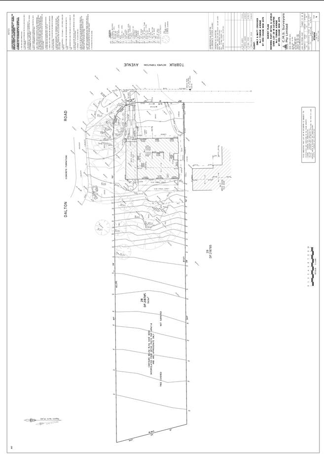
|
APPENDIX No: 4 - Site
analysis/site plan
|
|
Item No: GB.3
|
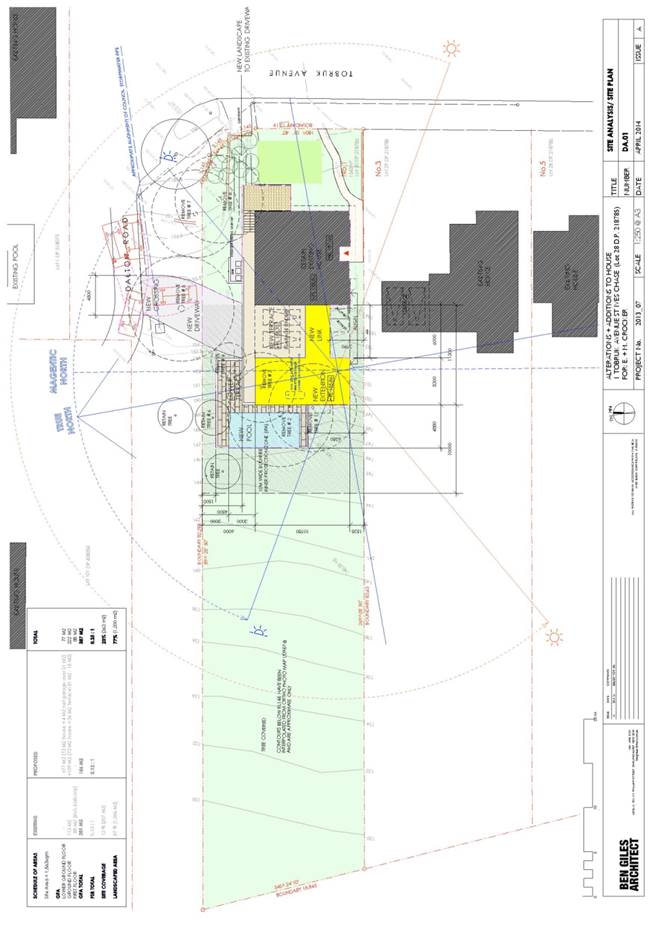
|
APPENDIX No: 5 - Proposed
ground floor plan
|
|
Item No: GB.3
|
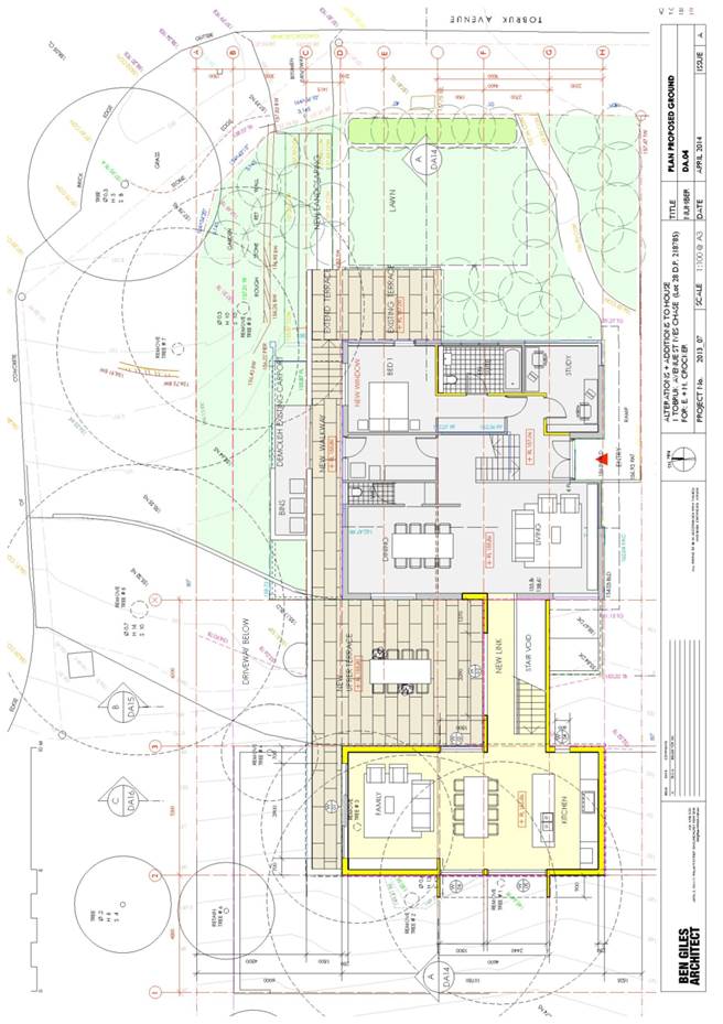
|
APPENDIX No: 6 - Proposed
first floor plan
|
|
Item No: GB.3
|
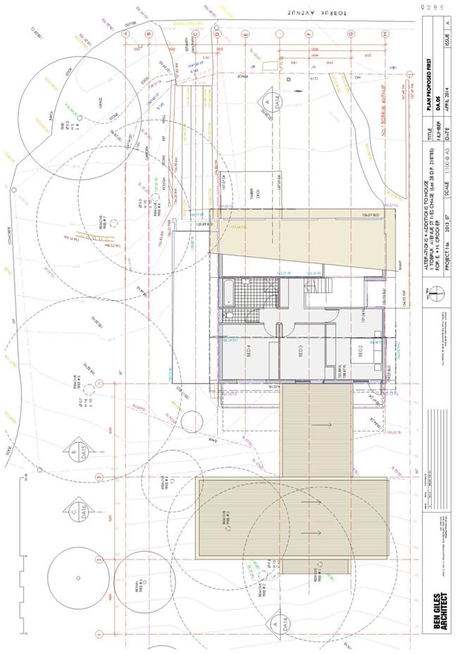
|
APPENDIX No: 7 - Proposed
lower ground floor plan
|
|
Item No: GB.3
|
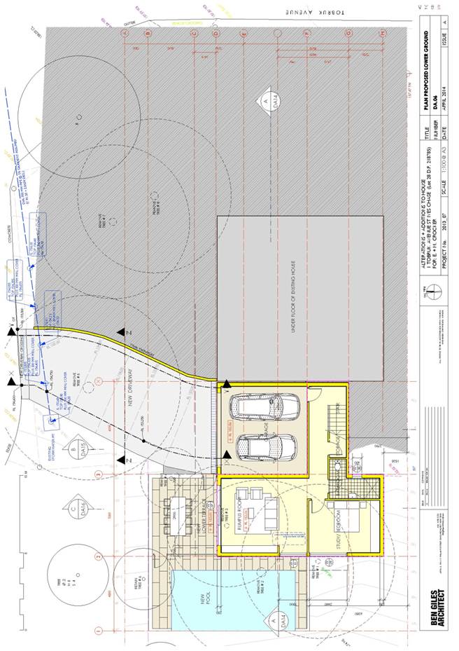
|
APPENDIX No: 8 - North
elevation
|
|
Item No: GB.3
|
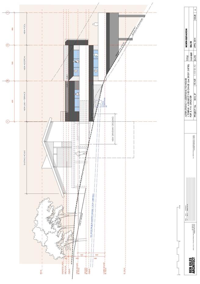
|
APPENDIX No: 9 - West
elevation
|
|
Item No: GB.3
|
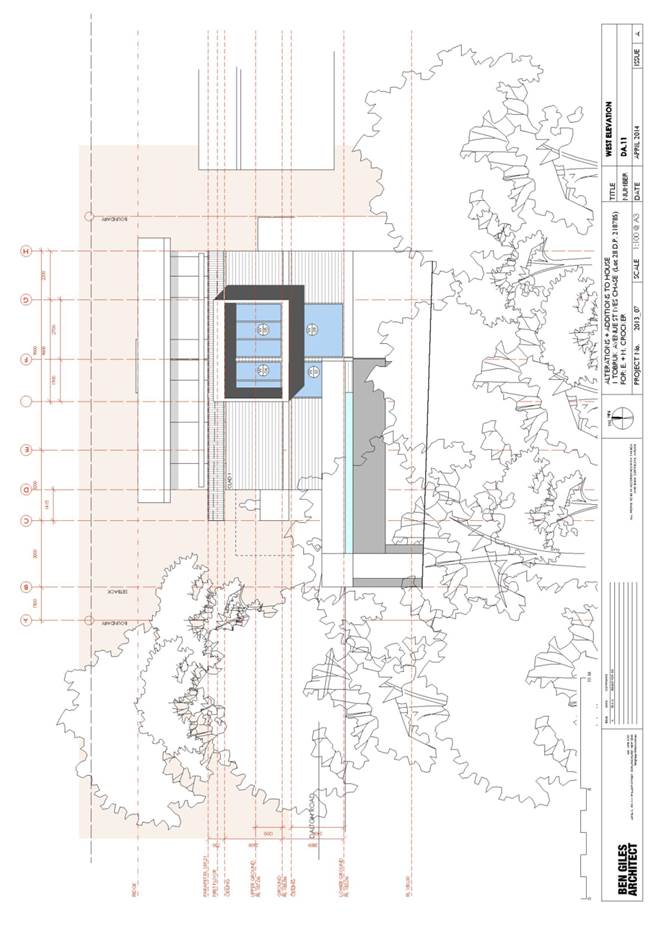
|
APPENDIX No: 10 - East
elevation
|
|
Item No: GB.3
|
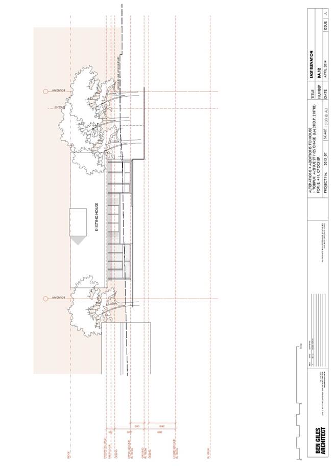
|
APPENDIX No: 11 - South
elevation
|
|
Item No: GB.3
|
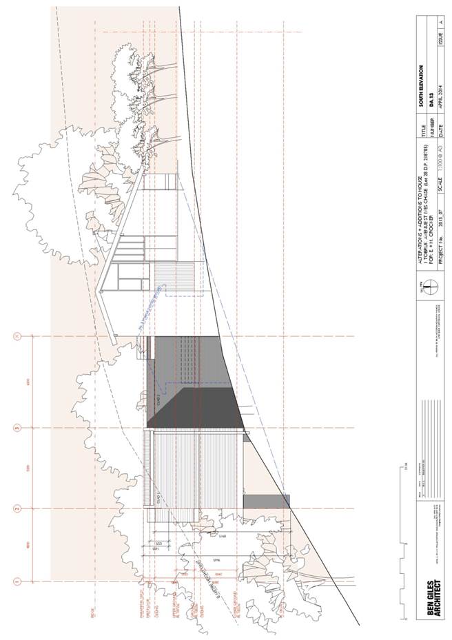
|
APPENDIX No: 12 - Section
A-A
|
|
Item No: GB.3
|

|
APPENDIX No: 13 - Section
B-B
|
|
Item No: GB.3
|
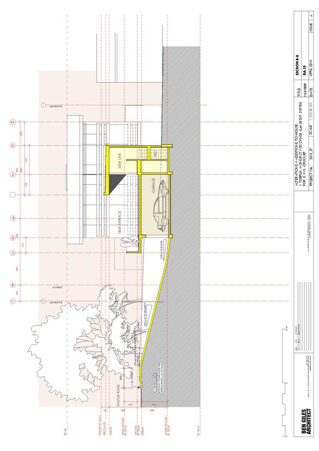
|
APPENDIX No: 14 - Section
C-C
|
|
Item No: GB.3
|
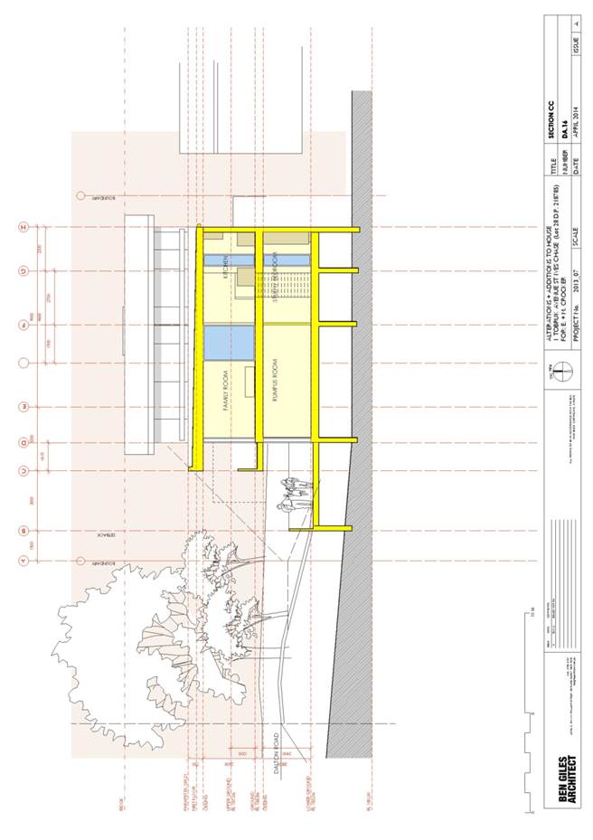
|
APPENDIX No: 15 - Driveway
sections
|
|
Item No: GB.3
|
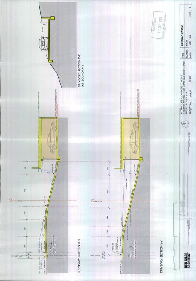
|
APPENDIX No: 16 - Landscape
plan
|
|
Item No: GB.3
|
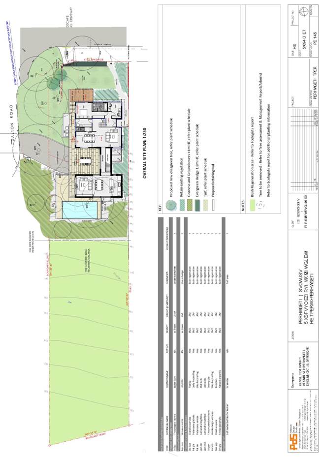
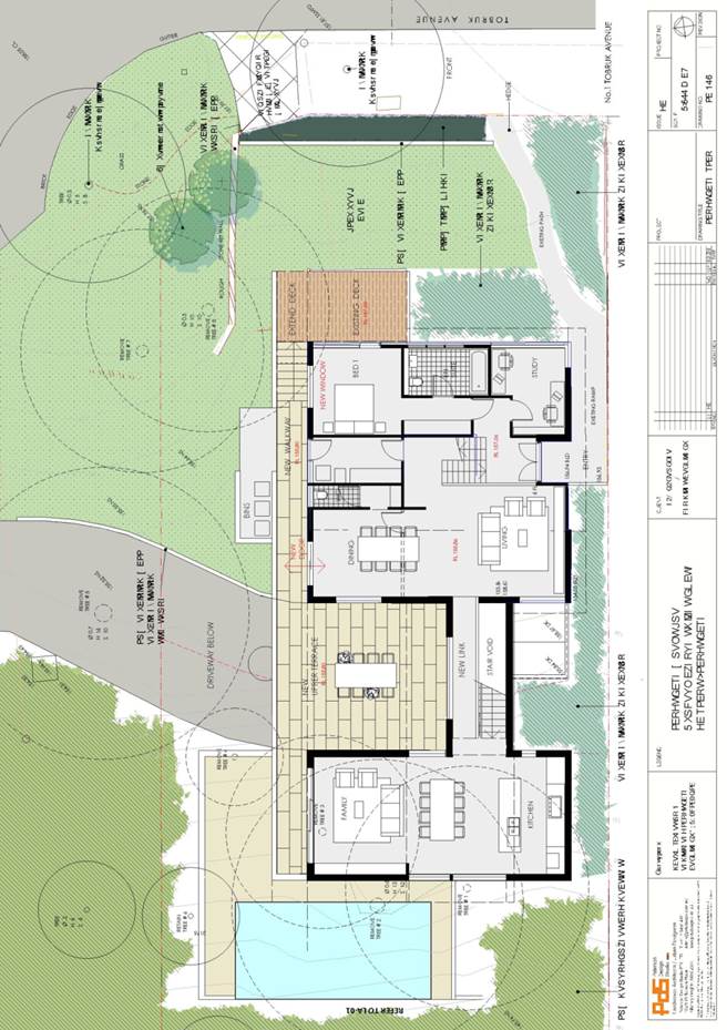
|
APPENDIX No: 17 - Stormwater
plan
|
|
Item No: GB.3
|
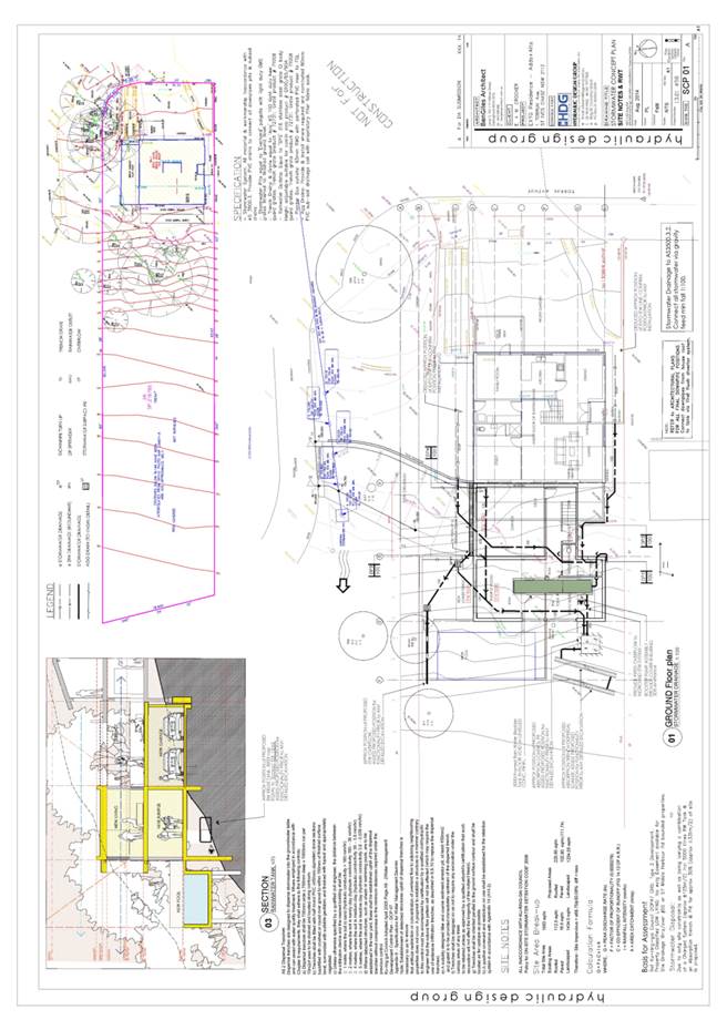
|
APPENDIX No: 18 - Tree
assessment report
|
|
Item No: GB.3
|
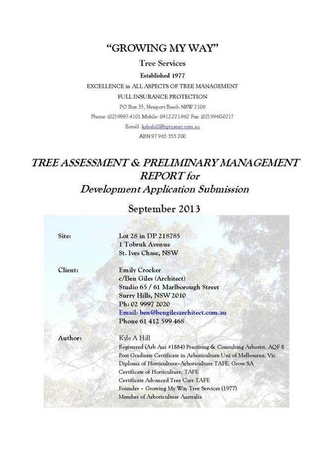

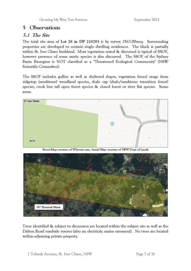

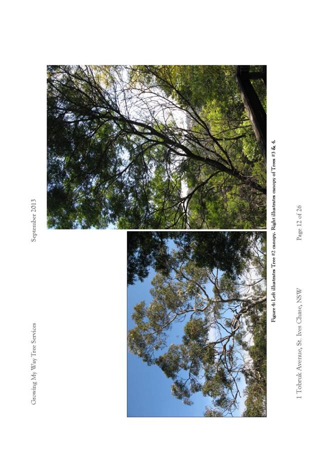
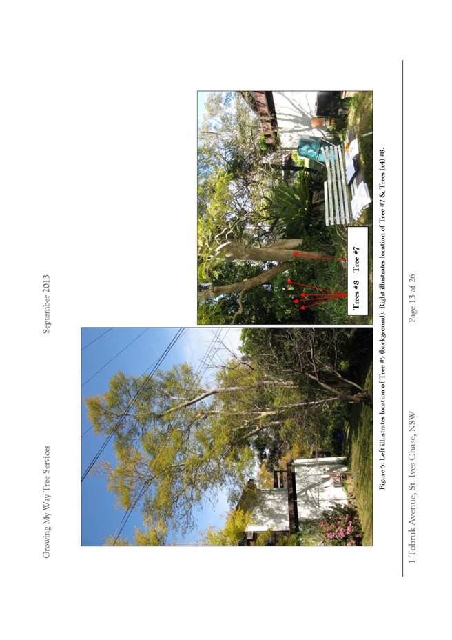
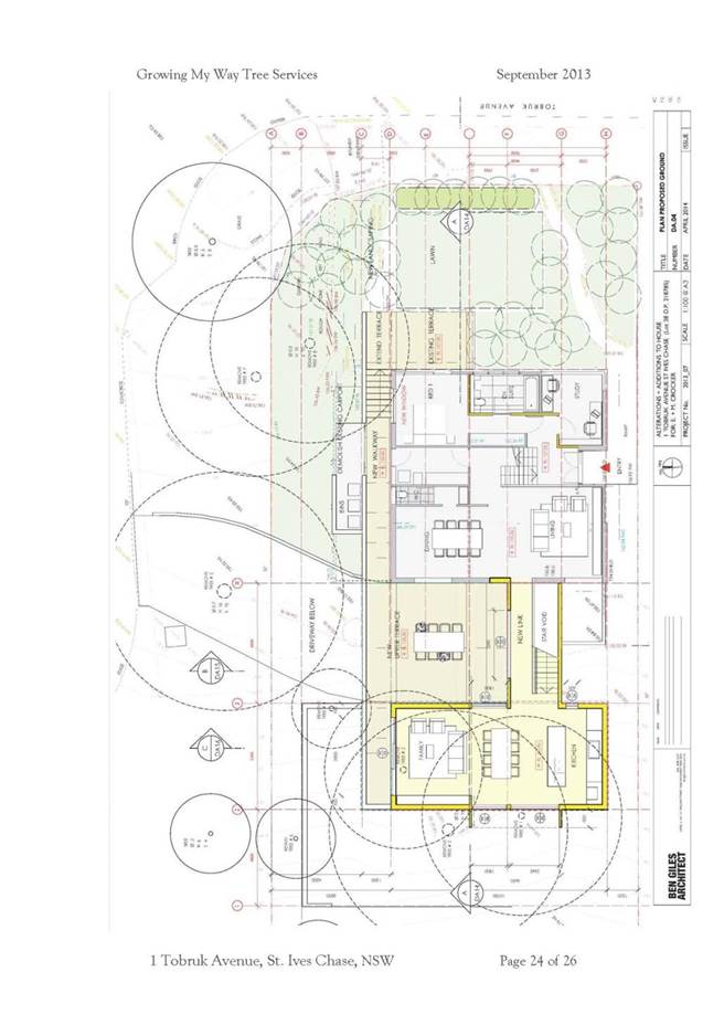
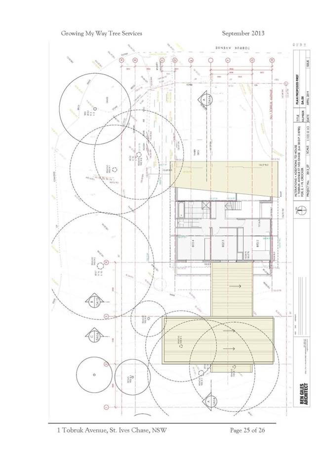
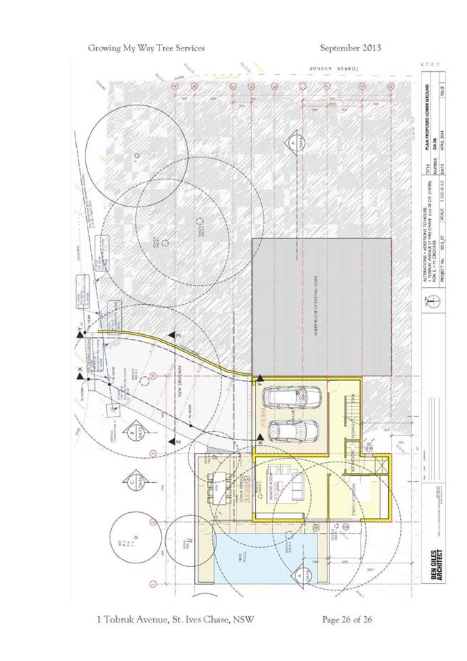
|
APPENDIX
No: 19 - Flora
and fauna survey
|
|
Item No: GB.3
|
This attachment is
circulated separately
|
APPENDIX
No: 20 - Circular
PS 08-014
|
|
Item No: GB.3
|
|
APPENDIX No: 21 - SEPP
No. 1 objection
|
|
Item No: GB.3
|


|
Ordinary
Meeting of Council - 8 December 2015
|
GB.4 / 251
|
|
|
|
|
Item
GB.4
|
DA0109/15
|
|
|
20 November 2015
|
Summary
Sheet
|
Report title:
|
1407 Pacific
Highway, Warrawee - Demolish existing dwelling and construction of a
residential flat building containing 12 units, basement parking, landscaping
and strata subdivision
|
|
ITEM/AGENDA
NO:
|
GB.4
|
|
Application No:
|
DA0109/15
|
|
Property Details:
|
1407 Pacific Highway, Warrawee
Lot & DP No: Part Lot 16, DP 4177
Site area (m2): 1222m2
Zoning: R4 High Density Residential
|
|
Ward:
|
Comenarra
|
|
Proposal/Purpose:
|
Demolition of the existing dwelling and construction
pf a residential flat building containing 12 units, basement parking,
landscaping and strata subdivision
|
|
Type of Consent:
|
Integrated (pursuant to Roads Act 1993)
|
|
Applicant:
|
Australian Consulting Architects P/L
|
|
Owner:
|
Ms C A Chang
|
|
Date Lodged:
|
2 April 2015
|
|
Recommendation:
|
Approval (Deferred Commencement Consent)
|
Purpose of Report
To determine Development Application DA0109/15 for
demolition of the existing dwelling and construction of a residential flat
building containing 12 units, basement parking, landscaping works and strata
subdivision.
integrated planning and reporting
PLACES, SPACES & INFRASTRUCTURE
|
Community Strategic Plan Long Term Objective
|
Delivery Program
Term Achievement
|
Operational Plan
Task
|
|
P2.1 A robust planning framework is in place to deliver
quality design outcomes and maintain the identity and character of
Ku-ring-gai
|
Applications are assessed in accordance with State and
local plans
|
Assessments are of high quality, accurate and consider all
relevant legislative requirements
|
Executive Summary
|
Issues:
|
FSR
Site width
|
|
|
|
Submissions:
|
31 submissions and one petition
|
|
|
|
Land and Environment Court:
|
No
|
|
|
|
Recommendation:
|
Approval
|
History
Site
The site has a history of low density residential use.
Pre-DA
25 March 2015 A
Pre DA consultation was held on 25 March 2014. Issues raised at the meeting
included:
- setbacks
to heritage item at No. 2 Winton Street
- floor
space ratio non-compliance
- retention
of BGHF trees within the rear setback
- potential
impacts on trees on adjoining property
- site
survey to be provided
- site
analysis and design verification statement to be provided
- detailed
architectural plans to be provided (including solar access diagrams)
- landscape
and stormwater plans to be provided
- traffic
impact assessment, arborist’s report, flora and fauna assessment and heritage
impact statement to be provided
1 October 2014 A
follow up meeting was held on 1 October 2014. Issues raised at the meeting
included:
- floor space ratio
- building height and number of storeys
- basement setbacks
- carparking shortfall
- top floor area
- requirement for easement
DA history
2 April 2015 The application was
lodged.
14 April 2015 The
applicant was sent a letter requesting additional information (three
dimensional model and title documents).
28 May 2015 Additional
information, including a flora and fauna impact assessment, title documents and
terms of easement was received. Amended plans (as a result of the flora and
fauna assessment report) were also submitted.
29 May 2015 The
application was notified to the owners and residents of surrounding properties
for a period of 30 days.
21 August 2015 A
preliminary assessment letter requesting additional information with regard to
the following was sent: solar access, building setbacks, internal amenity,
privacy, communal open space, aesthetics, access, deep soil, fill, arborist’s
report, landscape plan, stormwater management, construction management,
geotechnical assessment, heritage impact statement and tree locations.
The Site
Site description
|
Visual character
study category:
|
1920-1945
|
|
Easements/rights
of way:
|
No
|
|
Heritage
Item:
|
No
|
|
Heritage
conservation area:
|
No
|
|
In the
vicinity of a heritage item:
|
Yes – Nos. 2, 4, 6 and 7
Winton Street
|
|
Bush fire prone land:
|
No
|
|
Endangered
species:
|
Yes – part Blue Gum High
Forest
|
|
Urban
bushland:
|
No
|
|
Contaminated
land:
|
No
|
The site
The site is Lot 16 DP 4177 and
is known as No. 1407 Pacific Highway, Warrawee. The site is located on the
northern side of the Pacific Highway. The site is irregular in shape with a
splayed frontage. The site has depths of 51.365 metres to 62.02 metres and a
width of 21.69 metres. The site frontage is 23.975 metres.
The site is situated on the low
side of the street, with a fall of approximately 2.7 metres from the
south-western boundary to the north-western boundary.
Development currently on the
site comprises a part single storey/part two storey dwelling. There is a brick
fence along the front property boundary.
The site is heavily vegetated
across its frontage and along the western side boundary. Vegetation within
includes Blue Gum High Forest which is an Endangered Ecological Community.
Surrounding development
The site is surrounded by
residential development. The adjoining site to the west is known as Nos. 1-3
Eulbertie Avenue and comprises a five storey residential flat building.
The adjoining sites to the east
are known as No. 2A, 2B and 2C Winton Street. Development at Nos. 2A and 2B
Winton Street comprise single dwellings, whilst development at No. 2C Winton
Street comprises a three storey residential flat building.
The adjoining property to the
rear is known as No.2 Winton Street and contains a dwelling house with detached
garage to the rear. This property is a listed heritage item under LEP 2015.
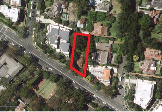
Figure 1: Subject site and surrounding properties
The Proposal
The application proposes
demolition of the existing dwelling and construction of a three storey
residential flat building comprising 12 dwellings over one level of basement
car parking accommodating 17 cars.
Amended
plans and additional information received 21 May 2015
The following was submitted:
· arborist’s report
· flora and fauna assessment report
· title documents
The following changes were proposed:
· amended ground floor plan and landscape plan
· amended stormwater plans
· title documents
Amended
plans and additional information received 13 November 2015
The amended plans proposed the following changes and
additional information:
· amended architectural plans
· amended landscape plan
· amended stormwater plans
Clause 4.6 variations
to site frontage and FSR were submitted.
Amended
information received 20 November 2015
The amended information consisted of the following:
· amended BASIX certificate
· amended heritage statement
· amended access report
Amended plans and information received 26 November 2015
The amended information
and plans consisted of the following:
· amended BASIX certificate
· amended architectural plans showing storage to
Units 1.1 and 2.1 and provision of planters to common areas
Consultation
Community
In accordance with Development Control Plan No. 56, owners
of surrounding properties were given notice of the application. In response, submissions from the following were received:
1. H. Sthalekar and M. Nguyen – No. 10/2C
Winton Street, Warrawee
2. J.
Holmes – No. 4 Winton Street, Warrawee
3. G.
Roberts and S. Schwartz – No.2a Winton Street, Warrawee
4. G.
Cooney – No. 8/1-3 Eulbertie Avenue,
Warrawee
5. H.
Zhou – No. 34/1-3 Eulbertie Avenue
Warrawee
6. G.
and K. Demery – No. 11/10-3 Eulbertie Avenue, Warrawee
7. S.
Laycock – No. 7/1-3 Eulbertie Avenue, Warrawee
8. H.
Yee – No. 27/1-3 Eulbertie Avenue, Warrawee
9. Z.
Zheng – No. 30/1-3 Eulbertie Avenue, Warrawee
10. B.
Gu – No. 19/1-3 Eulbertie Avenue, Warrawee
11. B.
and I. Dickinson - No. 24/1-3 Eulbertie Avenue, Warrawee
12. Y.
S. Chin and C. H. Tao – No. 6/1-3 Eulbertie Avenue, Warrawee
13. A.
Ho – No. 39/1-3 Eulbertie Avenue, Warrawee
14. F.
Son - No. 4/1-3 Eulbertie Avenue, Warrawee
15. Y.
D. Yu - No. 33/1-3 Eulbertie Avenue, Warrawee
16. G.
Wu – No. 18/1-3 Eulbertie Avenue, Warrawee
17. S.
Hoolahan – No. 37/1-3 Eulbertie Avenue, Warrawee
18. H.
Liang and L. Zhong – No. 15/1-3 Eulbertie Avenue, Warrawee
19. H.
Xie – No. 5/1-3 Eulbertie Avenue, Warrawee
20. X.
L. Ding – No. 21/1-3 Eulbertie Avenue, Warrawee
21. J.
and B. Marlborough – No. 13/1-3 Eulbertie Avenue, Warrawee
22. J.
Vijayakumar – No. 25/1-3 Eulbertie Avenue, Warrawee
23. L.
Shao and H. Wang – No. 31/1-3 Eulbertie Avenue, Warrawee
24. M.
Hossain – No. 29/1-3 Eulbertie Avenue, Warrawee
25. W.
B. Cheng – No.10/1-3 Eulbertie Avenue, Warrawee
26. K.
Wong – No. 9/1-3 Eulbertie Avenue, Warrawee
27. D.
Meyerson – No. 22/1-3 Eulbertie Avenue, Warrawee
28. F.
Kong and Z. Ma – No. 72A Houison Street, Westmead
29. K.
M. Wong – No. 26/1-3 Eulbertie Avenue, Warrawee
30. Z.
Huang – No. 28/1-3 Eulbertie Avenue, Warrawee
31. M.
and R. Abrahams – No. 2 Winton Street, Warrawee
A petition containing twelve
signatures was also received from the owners of Units 1, 3, 4, 12, 14, 16, 20,
32, 35, 36 and 40 of No. 1-3 Eulbertie Avenue, Warrawee, which is an adjoining
5 storey residential flat development.
The submissions
and petition raised the following issues:
Privacy
impacts to 10/2C Winton Street, particularly balcony and master bedroom
Not
withstanding that the eastern setback of the development complies with
Council’s controls, amended plans have been submitted proposing a privacy
screen to the eastern elevation of the balconies to Apartments 1.1 (first floor
level) and 2.1 (second floor level). This is considered to adequately address
the above privacy concern.
Noise
impacts to 10/2C Winton Street
Apartments G.1,
1.1 and 2.1 are adjacent to 10/2C Winton Street. The balconies to these
apartments are set back 4 metres from the site boundary and exceed Council’s
minimum side setback requirements.
Loss of outlook from
10/2C Winton Street
The subject
site is zoned R4 High Density Residential Development. There is therefore a
reasonable expectation that the site can be developed for high density residential
use. The proposed residential flat building is adequately set back from the
eastern side boundary and complies with Council’s height controls. Screen
planting, capable of growing to a height of 3-8 metres, is proposed within the
eastern side setback. Once mature, this screen planting will soften the outlook
from 10/2C Winton Street.
Solar
access impacts on 10/2C Winton Street
Amended solar access diagrams,
showing the location of buildings on adjacent properties, have been submitted.
The diagrams show that the proposed development will not affect the building at
2C Winton Street between 9am and 12pm. The proposal therefore complies with
Council’s requirements for solar access to adjoining properties.
Privacy
impacts on 4 Winton Street (to bedroom, kitchen and private open space)
No 4 Winton
Street is located 30 metres from the rear boundary of the subject site. The
proposed building exceeds Council’s rear setback controls and is located 40
metres from the southern boundary of this site. As such, the proposal will not
result in any adverse privacy impacts on this property.
Noise
impacts on 4 Winton Street (to private open space area)
No 4 Winton
Street is located 30 metres from the rear boundary of the subject site. The
proposed building exceeds Council’s rear setback controls and is located 40
metres from the southern boundary of this site. As such, the proposal will not result
in any unreasonable noise impacts on this property.
Privacy impacts on 2
Winton Street (to kitchen, bedroom, family room and private open space)
No 2 Winton Street adjoins the
subject site to the rear. The proposed development is set back a minimum of 10
metres from the rear boundary and substancially exceeds Council’s minimum rear
setback requirement of 6 metres.
Whilst the development as
originally proposed did not provide any screen planting to the rear boundary,
amended plans incorporating screen planting capable of growing to a height of
1.5 to 4 metres have now been submitted. The amended plans also show a canopy
tree with a mature height of 20 metres situated adjacent to the rear boundary.
The generous rear setback, along
with the proposed screen planting, means that the proposed development will not
result in any unreasonable privacy impacts to this property.
Insufficient off street
parking, impacts on Winton Street and Eulbertie Avenue
The proposal complies with
Council’s requirements for off-street carparking as prescribed in Ku-ring-gai
DCP.
Bulk and scale impacts to
adjoining properties (Nos. 2, 2a and 4 Winton Street)
The proposed development
complies with Council’s building height controls and is adequately set back
from the side property boundaries. The proposal a three storey development in a
zone that allows up to five storeys and will not result in any unreasonable
bulk or scale impacts to adjoining properties.
The proposal is
inconsistent with the adjacent land use pattern
The proposed works comprise a
residential flat building which is a permissible use within the R4 High Density
zoning of the site.
Light spill on adjacent
properties
A condition is recommended
regarding light spill. (Condition 25).
Building envelope and
setback non-compliance
The subject site is highly
constrained. The site is an isolated site and is constrained by its narrow
street frontage. It is also constrained by the presence of an Endangered Ecological
Community, Blue Gum High Forest.
Whilst the proposed development
has minor front and side setback non-compliances, it satisfies the objectives
of the DCP. The proposed development will not result in any adverse bulk
impacts to adjoining properties or the streetscape nor will it result in any
unreasonable solar access or privacy impacts.
Excessive stormwater
run-off and impacts on adjoining properties
It is proposed to create a new
drainage connection via a 1 metre wide drainage easement to an existing
stormwater pit within the neighbouring easement that drains to Winton Street.
The design proposes a new 225mm
diameter pipe and associated drainage easement that commences at the rear
boundary of the subject site and runs along to a new pit over the existing
easement that also contains a 225mm pipe. Given that a connection is
proposed to the existing pipe, the hydraulic engineer has demonstrated (using
the rational method) that the pipe within the easement has sufficient hydraulic
capacity to accept the additional flow from the post developed site.
The stormwater plans shows a
combined on-site detention and stormwater tank comprising 15.77m3
and 9,200L of storage, respectively, located under the rear terrace area with
maintenance accessed from the communal open space area. The overflow pipe from
the detention system is directed to the proposed drainage easement, which is
acceptable.
Privacy impacts on No. 4
Winton Street (to bedrooms and private open space)
Request provision of
privacy screens
No 4 Winton
Street is located 30 metres from the rear boundary of the subject site. The
proposed development exceeds Council’s rear setback controls and is located 40
metres from the southern boundary of this site. As such, the proposal will not
result in any adverse privacy impacts to this property.
Noise impacts on No 2a
Winton street (to bedrooms and private open space)
Request provisions of
acoustic screens
Amended
plans, showing provision of an acoustic screen, along the eastern elevation of
Apartment 2.4 (Level 2) have been submitted
Privacy of future
occupants
It is considered that adequate
measures are proposed to ensure the privacy of future residents. Privacy
screens are proposed to above ground level balconies which may be vulnerable to
overlooking from adjoining properties. Screen planting at ground level will
also assist in mitigating potential overlooking.
Tree removal – Tree 4 is
shown for removal on Landscape plan but should be retained for screening
Tree 4 has been identified as an
Acer Negundo (Box Elder) in fair condition. Whilst the tree value as
screening, it has no ecological value or streetscape value. It is also exempt
under Council’s Tree Preservation Order. As such, Council cannot require its
retention.
Replacement screen planting
capable of growing to a height of 1.5 metres to 8 metres has been proposed
along the eastern side boundary. Once established, this screen planting will
assist in softening the view of the proposed development.
Tree removal – Tree 9 is
shown for removal on Landscape plan but should be retained for screening
Tree 9 has been identified a Cinnamomum
camphora (Camphor Laurel). Whilst the tree has value as screening, it has
no ecological value. It is also exempt under Council’s Tree Preservation Order.
As such, Council cannot require its retention.
A replacement canopy tree is
proposed in its place. As the replacement tree does not form part of the Blue
Gum High Forest Community, Council’s Tree and Landscape Assessment Officer has
recommended an alternative species. Condition 22
Inadequate building
separation
Section 7A.1(6) of Ku-ring-gai
DCP allows reduced setbacks for residential flat buildings on small sites which
are three storeys or less in height. These controls are inconsistent with the
building separation controls within the DCP, which are not tailored to small sites.
Privacy impacts to
bedrooms and living areas of Units at No. 1-3 Eulbertie Street from windows on
eastern elevation of building
The proposed development has
been sensitively designed to retain the privacy of adjoining properties.
Windows on the eastern elevation of the building are to ensuites, bedrooms and
lobby areas. The bedroom and ensuite windows are highlight windows and will not
result in any adverse privacy impacts. Likewise, the lobby windows are to
non-habitable, transient spaces and will not result in any unreasonable privacy
impacts.
Retention of 3 hours solar
access to No. 1-3 Eulbertie Street
Amended shadow diagrams have
been submitted, which show that solar access to the adjoining development at
No. 1-3 Eulbertie Street will be largely unaffected by the proposed development
between the hours of 9am and 3pm. Only a small portion of the outer edge of one
balcony will be overshadowed at 9am. As the overshadowing is to the outer edge
of the balcony, there will be no material impacts.
Vehicular access and
safety
The application was referred to
Roads and Maritime Services for concurrence. The RMS granted concurrence,
subject to the imposition of certain conditions (Condition 89).
Tree impacts to gum trees
during construction
Prior to works commencing, tree
protection fencing is to be erected around trees of significance.
Screen planting details
A landscape plan has been
submitted with the application and has been reviewed by Council’s Tree and
Landscape Assessment Officer. The landscape plan shows a variety screen
planting species proposed along the side and rear boundaries. The proposed
species are capable of growing to heights of 1.5 metres to 8 metres. To ensure
consistency with the existing landscape character, some minor changes to
species selection are recommended. Condition 22
Impact on property values
This is not a valid
consideration under section 79C of the Environmental Planning and Assessment
Act 1979.
Amended plans received 21 May 2015
The amended plans were not notified to surrounding
residents as the proposed amendments comprised provision of additional
information and did not result in a greater environmental impact than the
original proposal.
Amended plans received 13
November 2015
Part 26 of Ku-ring-gai DCP specifies that re-notification
of amended plans is not necessary except where, in the opinion of Council’s
Team Leader Development Assessment, owners or occupiers of adjoining properties
would be detrimentally affected in any manner.
The amended plans received 13 November 2015 included the
following changes:
· provision of privacy screens and planter boxes
· relocation of the OSD tank to beneath the
building
· deletion of pathway and provision of access ramp
along eastern setback
· deletion of lobby window and provision of lobby
door at ground floor level
· provision of lobby windows at first and second
floor level
Whilst the changes to access and windows are discernible,
they were not considered to result in any detrimental impacts to the
owners/occupiers of adjoining properties. The access ramp is screened by
proposed screen planting to a height of 3-5 metres and a fence to a height of
1.7 metres. The lobby windows are to non-habitable spaces and have a separation
distance of 10 metres to the building at 1-3 Eulbertie Street. The windows are
a positive feature as they will allow natural light and ventilation to enter
the lobbies.
Amended plans received 20 and
26 November 2015,
The amended plans were not notified to surrounding
residents as the proposed amendments comprised provision of additional
information and did not result in a greater environmental impact than the
original proposal.
Within Council
Urban design
Council's Urban Design Consultant has reviewed the
application against the provisions of SEPP 65 and provided the following
comments:
PRINCIPLE
1: CONTEXT
Good design
responds and contributes to its context. Context can be defined as the key
natural and built features of an area. Responding to context involves
identifying the desirable elements of a location’s current character or, in the
case of precincts undergoing a transition, the desired future character as
stated in planning and design policies. New buildings will thereby contribute
to the quality and identity of the area.
The proposed development will
sit comfortably within the streetscape. It is generally of consistent scale
with the adjoining development. The three storey height provides for a good
transition to the lower scale R2 zoned land that has a two storey height limit.
The proposed external materials
of rendered masonry is consistent with other development in the immediate
vicinity.
PRINCIPLE
2: SCALE
Good design
provides an appropriate scale in terms of the bulk and height that suits the
scale of the street and the surrounding buildings. Establishing an appropriate
scale requires a considered response to the scale of existing development. In
precincts undergoing a transition, proposed bulk and height needs to achieve
the scale identified for the desired future character of the area.
The scale of the proposed
development is appropriate for the context the street and the surrounding
buildings.
PRINCIPLE
3: BUILT FORM
Good design
achieves an appropriate built form for a site and the building’s purpose, in
terms of building alignments, proportions, building type and the manipulation
of building elements. Appropriate built form defines the public domain,
contributes to the character of streetscapes and parks, including views and
vistas, and provides internal amenity and outlook.
The proposal provides a
satisfactory built form outcome. The building is sited comfortably within the
context, and relates well to the neighbours.
The entry to the building is
clearly identifiable.
The balcony elements at the
front have been simplified and the cantilevering element provides some interest
and drama to the front street façade.
The front façade provides a
good balance been shielding the interior from the noise of the highway and
providing windows for visual surveillance and character.
PRINCIPLE
4: DENSITY
Good design
has a density appropriate for a site and its context, in terms of floor space
yields (or number of units or residents). Appropriate densities are sustainable
and consistent with the existing density in an area or, in precincts undergoing
a transition, are consistent with the stated desired future density.
Sustainable densities respond to the regional context, availability of
infrastructure, public transport, community facilities and environmental
quality.
It is noted that the proposed
development exceeds the floor space ratio, however the site is subject to a
reduced floor space ratio as a result of the site area being less than 1800m².
There are no opportunities for site amalgamation.
The bulk and scale of the
proposed development is generally consistent with the adjoining development.
There are no significant overshadowing or privacy impacts that result from the
proposed development – in part due to the orientation of the site.
PRINCIPLE
5: RESOURCE, ENERGY AND WATER EFFICIENCY
Good design
makes efficient use of natural resources, energy and water throughout its full
life cycle, including construction. Sustainability is integral to the design
process. Aspects include demolition of existing structures, recycling of
materials, selection of appropriate and sustainable materials, adaptability and
reuse of buildings, layouts and built form, passive solar design principles,
efficient appliances and mechanical services, soil zones for vegetation and
reuse of water.
It is noted that the BASIX
Certificate indicates a performance for energy and water consumption that is
slightly better than what is required.
The following passive design
principles have been identified:
· The floor plate layout
allows for one apartment in each corner of the building – resulting in good
daylight and ventilation to each apartment
· Awnings are provided to
windows that will reduce summer overheating
· Substantial area is
provided for deep soil landscaping
PRINCIPLE
6: LANDSCAPE
Good design
recognises that together landscape and buildings operate as an integrated and
sustainable system, resulting in greater aesthetic quality and amenity for both
occupants and the adjoining public domain. Landscape design builds on the
site’s natural and cultural features in responsible and creative ways. It
enhances the development’s natural environmental performance by co-ordinating
water and soil management, solar access, micro-climate, tree canopy and habitat
values. It contributes to the positive image and contextual fit of development
through respect for streetscape and neighbourhood character, or desired future
character. Landscape design should optimise usability, privacy and social
opportunity, equitable access and respect for neighbour’s amenity, and provide
for practical establishment and long term management.
The proposed landscape plan
provides for satisfactory communal and private amenity. A generous sized
communal open space is provided for the residents at the rear with a north
facing aspect. Access to this is available from the lift lobby along the side
boundary and also from the basement car park.
Existing mature trees have been
retained on the site.
PRINCIPLE
7: AMENITY
Good design
provides amenity through the physical, spatial and environmental quality of a
development. Optimising amenity requires appropriate room dimensions and
shapes, access to sunlight, natural ventilation, visual and acoustic privacy,
storage, indoor and outdoor space, efficient layouts and service areas, outlook
and ease of access for all age groups and degrees of mobility.
The layout of
the floor plate with one apartment in each corner provides the fundamentals for
a development with good amenity.
Improvements
have been made to the plans during the assessment process, however there
remains some matters that remain unresolved. These can be dealt with by
condition of consent.
SOLAR ACCESS:
Only 8 / 12 (67%) receive 3hrs winter solar access. Apartment 2.2 is on the top
floor and only receives 1hr of solar access. This could be improved by
including highlight windows in the ceiling of the living rooms. This would also
benefit apartment 2.1. This amendment can be made by condition of consent. This
would result in 9/12 (75%) of apartments receiving the required solar access.
STORAGE –
Storage allocation within the units and the basement is insuffient and does not
comply with the DCP or the RFDC. The apartments and the basement are large
enough to accommodate the required storage. This amendment can be made by
condition of consent.
KITCHEN LAYOUT
IN APARTMENTS G.3, 1.3 & 2.3 – For a 2 bedroom apartment the kitchen
provided is very small and located in a dark corner of the apartment. Although
it complies with the 8 metres minimum distance from a window, the window to the
living room is relatively small. The lineal bench space is less than 3.4
metres. There is limited storage space in the kitchen area. The kitchen be
swapped with the dining room and be at least 3.2 metres long. This change can
be accommodated by condition of consent.
PRINCIPLE
8: SAFETY AND SECURITY
Good design
optimises safety and security, both internal to the development and for the
public domain. This is achieved by maximising overlooking of public and
communal spaces while maintaining internal privacy, avoiding dark and
non-visible areas, maximising activity on streets, providing clear, safe access
points, providing quality public spaces that cater for desired recreational uses,
providing lighting appropriate to the location and desired activities, and
clear definition between public and private spaces.
The
development satisfies the requirements of this principle, being of a design
that provides quality space, defined entries, clear sight lines and maximises
surveillance. Good passive surveillance is provided to the communal open
spaces.
PRINCIPLE
9: SOCIAL DIMENSIONS AND HOUSING AFFORDABILITY
Good designs
respond to the social context and needs of the local community in terms of
lifestyles, affordability, and access to social facilities. New developments
should optimise the provision of housing to suit the social mix and needs in
the neighbourhood or, in the case of precincts undergoing transition, provide
for the desired future community. New developments should address housing
affordability by optimising the provision of economic housing choices and
providing a mix of housing types to cater for different budgets and housing
needs.
The
proposed development provides for a good mix of apartment sizes and bedroom
accommodation. The proposed development provides satisfactory communal spaces
for the social benefit of the residents.
PRINCIPLE
10: AESTHETICS
Quality
aesthetics require the appropriate composition of building elements, textures,
materials and colours and reflect the use, internal design and structure of the
development. Aesthetics should respond to the environment and context,
particularly to desirable elements of the existing streetscape or, in precincts
undergoing transition, contribute to the desired future character of the area.
Minor
amendments were requested to the original plans to improve and simplify the
aesthetic treatment of the development. These were carried out and the proposal
is considered satisfactory in the aesthetic resolution of the development.
The
materials, colours and aesthetic treatment is appropriate to the context and
consistent with other development in the streetscape.
Conclusion
There remains some outstanding
amenity matters that can be easily accommodated and can be resolved by
condition of consent.
Improvements have been made to
the proposed development since the original application. It is now considered
to provide a satisfactory architectural and urban design outcome when assessed
against the Design Quality Principles of SEPP 65 and the Residential Flat
Design Code.
Planner’s
comment: Conditions have been recommended concerning provision of
clerestory windows, storage and relocation of the kitchen in apartments G.3,
1.3 and 2.3 Conditions 18-20
Engineering
Council's
Development Engineer commented on the proposal as follows:
The following documents were used for the assessment:
· Statement of Environmental Effects prepared by Planning
Directions Pty Ltd dated April 2015;
· Stormwater Layout Plan prepared by HKMA Engineers Drawing
No. 1898-DA SW001 – SW005 dated 13 November 2015 + Stormwater Quality
Management Plan Rev. ’A’ dated November 2015;
· BASIX Certificate 592802M_02 prepared by Designview dated
16 November 2015;
· Site Survey Plan prepared by C & A Surveyors NSW Pty
Ltd dated 29 March 2014;
· Architectural Plans drawings prepared by Australian
Consulting Architects dated November 2015;
· Traffic & Parking Assessment Report Ref:14804 prepared
by Varga Traffic Planning dated 27 March 2015; and
· Preliminary
Geotechnical Comments & Assessment prepared by GeoEnviro Consultancy Pty
Ltd dated 5 December 2014.
Stormwater disposal
The subject site has a gradual fall away from
Pacific Highway by approximately 2metres towards the rear. It is proposed to
create a new drainage connection via a 1 metre wide drainage easement to an
existing stormwater pit within the neighbouring easement that drains to Winton
Street.
In discussion with the applicant
at the Pre-lodgement meeting, it was understood that negotiations have
commenced with the owner of a neighbouring property, 2 Winton Street, regarding
creation of a new easement, however, no correspondence has been submitted. A
deferred commencement condition has been recommended, with the registration of
the easement as the Schedule A condition.
The
design proposes a new 225mm diameter pipe and associated drainage easement that
commences at the rear boundary of the subject site and runs along to a new pit
over the existing easement which also contains a 225mm pipe. Given that connection
is proposed to the existing pipe, the hydraulic engineer has demonstrated
(using the rational method) that the pipe within the easement has sufficient
hydraulic capacity to accept the additional flow from the post developed site.
The stormwater plans shows a combined on-site detention and
stormwater tank comprising 15.77m3 and 9,200 litres of storage,
respectively, located under the rear terrace area with maintenance accessed
from the communal open area. The overflow pipe from the detention system is
directed to the proposed drainage easement, which is acceptable.
Accompanying the stormwater
plan is a Stormwater Quality Management Plan prepared by HKMA Engineers, which
demonstrates the 50% reduction in runoff days required under Part 25B.3-4
of the Ku-ring-gai DCP being satisfied. A revised
BASIX Certificate has been submitted, with the water commitments requiring a
central water tank (rainwater or stormwater) of 9,000 litres. The tank is
configured to collect runoff from the entire roof area and be re-used for garden irrigation purposes only. The
results confirm that the proposed landscaping and stormwater tank will reduce
site runoff days by 69%.
The
basement pump-out system, with storage capacity of 25m3, is designed
correctly for the 100 year 2 hour storm.
A water
quality model (MUSIC Modelling) has been submitted to investigate stormwater
runoff quality from the subject site. The design has provided a
proprietary gross pollutant trap (GPT) ‘Stormwater 360 – Stormfilter’ located
within the detention and stormwater tank and Enviropods within collection pits
located upstream of the detention system to capture litter, debris and other
pollutants prior to connection into Council’s public drainage system. The
stormwater treatment standards / targets outlined in Ku-ring-gai DCP Part 25B.6
would be achieved by the proposed treatment train.
Vehicle access and accommodation arrangements
The
site is zoned ‘R4’ under the Ku-ring-gai LEP 2015. The parking provisions have
been determined using Ku-ring-gai Council Development Control
Plan for residential flat building. The site is located greater than 400 metres
walking distance from a Railway Station. The following parking provisions have
been adopted:
Ku-ring-gai
Council DCP Volume C Clause 23R.2 ‘Car Parking Rates’
|
Residential Flat Building
|
Parking Space Requirement
|
|
1 bedroom
unit
|
1 space
per unit
|
|
2 bedroom
unit
|
1 space
per unit
|
|
3 bedroom
unit
|
1.5
spaces per unit
|
|
Visitor
car spaces
|
1 space
per 4 units
|
4 x 1 bedroom = 4 x 1 space/unit = 4 spaces
7 x 2 bedrooms = 7 x 1 space/unit = 7 spaces
1 x 3 bedrooms = 1 x 1.5 spaces/unit = 2 spaces
12 units - visitor space/4 dwellings = 3 visitor spaces
Total parking spaces required = 16 spaces.
The development seeks to provide 17 off-street parking
spaces, comprising 14 residents’ spaces (includes 1 adaptable space) and 3
visitor spaces. The parking requirements have been met.
Vehicular access to the car parking facility is to be
provided via a new 5.8m wide entry / exit driveway crossing, which also
provides adequate sightlines for oncoming vehicles and to pedestrians on
footpaths. The driveway clear width satisfies the requirements of Volume C
Clause 2.2 of the DCP.
The basement plan shows the visitor space doubling as a
carwash space and garbage truck loading bay. The minimum
dimension of 3.5m x 6m has been satisfied and as well provides adequate
manoeuvring for a service/removalist vehicle and easily accessible by Council’s
waste collection vehicle.
The disabled visitor and residential parking spaces comply
with AS2890.6:2009 with regards to having a minimum width of 2.4m plus 2.4m
shared area whilst the accessible parking space has been assessed under AS2890.1-1993
which is acceptable under the BCA.
A driveway longitudinal section has been shown on the
architectural plan. The design includes a maximum gradient of 5%
for the first 6 metres from the boundary and a maximum grade of less than 20%. The driveway gradients comply with Australian Standard
2890.1 (2004) “Off-Street car parking” as do the dimensions of the parking bay,
ramp grades and aisle widths.
Waste collection
The development allows a garbage truck to enter and depart
the garbage/room recycle storage area in a forward direction. The driveway
grades and turning manoeuvrability are suitable for the small waste collection
vehicle as shown by the swept paths within the Appendix of the Traffic Report.
A clear head height of 2.6 metres shown on the Driveway
Section plan has been provided to access the basement area and also provided
over the travel path of the waste service vehicle.
The sizing of the garbage collection room is adequate to
provide 12x240L bins for waste, paper and recycling to satisfy the minimum bin
requirements.
The requirements as per Ku-ring-gai DCP Part 24R
have been satisfied.
Construction management
The provision of a Construction
Traffic Management Plan (CTMP) may be conditioned, provided that a suitable
Environmental Site Management Plan is received for DA assessment and is
acceptable to Landscape Services.
A detailed CTMP must be submitted for review by Council
Engineers prior to the commencement of any works on site. The
CTMP should include truck routes to and from the site in all directions and
turning paths for a heavy rigid vehicle to identify any need for construction
stage parking restrictions opposite.
Concurrence from Roads and Maritime Services (RMS) will be
required in particular the potential closure of the kerbside lane off Pacific
highway to facilitate the removal of the redundant layback and driveway
crossover. All demolition and construction vehicles should be contained wholly
within the site as a work zone permit will not be approved on Pacific Highway
by RMS.
RMS raised no objections to the application and conditions
have been provided to be incorporated into the consent if the DA is to be approved.
If the DA is to be approved, a condition will be placed
that NO construction vehicles movements are to occur during the school drop-off
(8.00am to 9.30am) and pick-up hours (2.30pm to 4.00pm) on school days.
Geotechnical investigation
A desktop study of the site, including review of geological
maps and available information presumably in the vicinity of the site, was
submitted. The report states that it is expected that the site to be underlain
by clayey soil overlying shale at depths greater than 3m below existing ground
surfaces.
Additional geotechnical
information can be provided after demolition and before bulk excavation.
As there is only one basement level, it is considered unlikely that permanent
dewatering will be required.
The report states that all other recommendations during the
construction phase shall be carried out as specified within the report that
includes dilapidation reports of nearby structures.
Recommendation
The proposal is acceptable, subject to conditions.
Planner’s comment: The
following conditions have been recommended concerning engineering matters: Conditions
6, 8, 9-11, 31, 32, 34-36, 47, 48, 54, 56, 57, 67-69 and 74-81.
Landscaping
Council's Landscape Officer
commented on the proposal as follows:
Preservation
of trees or vegetation - Clause 5.9, KLEP; Part 20C Section B KDCP 2015
An
Arboricultural Assessment, prepared by Redgum
Horticultural, dated 6 August 2014, has
been submitted with the application. Tree numbers refer to this report.
Trees to
be removed
- Tree 2/ Magnolia x soulangiana (Magnolia) The
tree is located on the eastern boundary. The tree is to be removed for the
proposed basement. There is no objection to the removal of this tree.
- Tree 3/ Castanospermum australe (Moreton Bay Chestnut)
The tree is located on the eastern boundary. The tree is to be removed for the
proposed basement. There is no objection to the removal of this tree.
- Tree 17/ Corymbia citriodora (Lemon Scented
Gum) The tree is located on the front boundary. The tree is to be removed for
the proposed driveway. There is no objection to the removal of this tree.
- Tree 18/ Ulmus procera (Elm) The tree is
located at the north-western corner of the site. The tree is located on the
front boundary. The tree is to be removed for the proposed driveway. There is
no objection to the removal of this tree.
There is
no objection to the removal of the following trees as they are of low landscape
significance (Trees 5, 12) or they are listed as exempt tree species under Part
13.1 Section B KDCP 2015 (Trees 1, 4, 6, 7, 9 and 11).
There are
no street trees located within the Pacific Highway nature strip that are
proposed to be removed.
Trees
to be retained
- Tree 8/ Eucalyptus saligna (Sydney Blue Gum)The
tree is located in the rear yard. This tree is representative of Blue Gum High
Forest community, a critically endangered ecological community, and is
recommended for retention in the arborist report. The impacts would be
acceptable.
- Tree 10/ Eucalyptus saligna (Sydney Blue
Gum)The tree is located on the western boundary, within the adjoining property.
The proposed encroachment is considered acceptable. The proposed stepping
stones within the tree protection zone of Tree 10 do not create an accessible path
and are to be substituted with pavement by condition.
- Tree 13/ Quercus robur (English Oak) The tree
is located on the western boundary of the site, within the adjoining property.
The proposed encroachment is considered acceptable.
- Tree 16/ Corymbia maculata (Spotted Gum)The
tree is located on the southwest corner of the site. The proposed encroachment
is considered acceptable.
Deep soil calculation Part 7A.4 Section A KDCP 2015
Where the site area is less than 1800m2, a
minimum of 40% of the site is to be deep soil landscape area as per definition
in KDCP 2015. The proposed deep soil area is 38% of the site area.
The proposal does not comply with the minimum deep soil
zone requirement. The proposal does not provide a deep soil zone to a 7.5
metres section of the building within the eastern setback. Planters have been
provided along the eastern setback that will support planting that will reduce
the visual dominance of the building.
Communal
open space – Part 7C.1 Section A KDCP 2015
The
development has a principal area of common open space located within the rear,
northern, setback of the site. The proposed location receives adequate solar
access and surveillance and is consistent with the development control requiring
it to be located behind the building line.
Landscape plan
The landscape plan is to be amended to enable assessment.
Refer below.
Screen
planting - Part 7A.4 Section A
KDCP 2015
The proposed screen planting to the front setback, side
boundaries and to the lawn area and drying area in the communal open space is
to be substituted with hardy exotic shrubs and groundcovers by conditions.
Tree replenishment
A minimum of four trees are required for the site. The
proposed canopy tree plantings, in addition to existing trees that are being
retained, are in excess of this number. The proposed planting of Syncarpia glomulifera (Turpentine) in the front setback
and northwest corner are to be substituted by condition with Angophora
floribunda (Rough-Barked Apple).
BASIX
The BASIX certificate is consistent with the development.
Stormwater plan
There is
no landscape objection to the stormwater plan.
Easement
through downstream property
The
proposal includes a drainage easement through the adjoining property to the
north. There are no impacts on existing trees.
Conclusion
The proposal is acceptable, subject to conditions.
Planner’s comments: The following conditions are
recommended with respect to landscaping matters Conditions 12-16, 22, 58-66
and 72.
Heritage
Council's
Heritage Advisor reviewed the original proposal and provided the following
comments:
Heritage status
The site does not contain a
heritage item. The site is within the vicinity of several heritage items and
the northern boundary directly adjoins an item at 2 Winton Street. There are
other heritage items within the vicinity including:
· 4,
6 & 7 Winton Street
The northern boundary and part of
the eastern boundary of the site adjoins a heritage conservation area (HCA) –
Area C-2 in KLEP 2015. The HCA includes most of the land along the Pacific
Highway from Turramurra to Wahroonga east to the railway line. A small part of
the HCA is excluded from this area between Heydon Avenue and Winton Street and
is rezoned to allow medium density development. Most of the other rezoned
sites have been developed.
In relation to heritage the
objectives in Clause 5.10 of the LEP are:
· to conserve the environmental
heritage of Ku-ring-gai;
· to conserve the heritage
significance of heritage items and heritage conservation areas, including
associated fabric, settings and views;
· to conserve archaeological sites;
and
· to conserve Aboriginal objects
and Aboriginal place of heritage significance.
Clause 5.10 (4) of the KLEP
requires that before granting consent to the proposed works Council must
consider the effect of the works on the heritage item, nearby items or conservation
area concerned. Clause 5.10 (5) of the LEP allows Council to require a HIS
before granting consent.
The KLEP 2015 was recently
gazetted. Council has prepared a DCP which also applies to the site.
Demolition of existing house
The existing house on the site is
not considered to have aesthetic or technical heritage significance but would
have a low level of historic significance. It has not previously been
identified as a potential heritage item.
With regard to demolition of the
existing building, the accompanying heritage report finds that the building
displays an eclectic mix of features of the Federation Arts & Crafts and
Inter War periods, makes little contribution to the streetscape of the Pacific
Highway and does not meet the criteria for heritage listing. This assessment
is concurred with. However, before demolition occurs, photographic archival
recording of the house and site will be required.
Comment
This application has unfortunately
not considered the LEP or DCP which applies to the site. The assessment of the
application against the specific objectives and controls in the DCP above
indicates the proposed development does not reach an acceptable level of
compliance. In summary, the following are the main issues:
(i). The
setback from the rear of the proposed development is inadequate to ensure the
new work respects the adjoining heritage item and HCA. The scale and bulk of
the proposal does not provide an appropriate interface and affects the amenity
of the adjoining item and HCA. The proposed development would visually
dominate the adjoining heritage item and HCA.
(ii). It is
likely that the garage/studio on the heritage item would be physically affected
during the construction process. It is also likely that during the construction
phase landscaping and structures in the rear yards of the HCA would be
physically affected.
(iii). The
landscaped character of the HCA would be affected by the loss of trees which
currently screen the site from the HCA and provide a buffer to it. The effect
of the development on the trees within the HCA is unclear as the application
does not provide sufficient information. As proposed the development with its
associated structures, particularly the OSD area, the paths and retaining walls
with planter beds does not provide for sufficient new planting to provide
adequate landscape screening of the development to the heritage item and HCA.
Comment on this issue is also provided by Landscape Services.
(iv). The
proposed metal fencing, screens and masonry walls of the OSD area along the
side boundary with the HCA and the heritage item does not contribute to the
setting of the heritage item and streetscape character of the HCA.
Planner’s
comment: The application has been amended to
address the concerns of Council’s Heritage Adviser. The amended plans show the
following:
- deletion of the on-site
detention basin within the rear setback
- provision of timber
fencing to eastern, northern and western boundaries
- provision of screen
planting to the rear boundary
- provision of an amended
Heritage Impact Statement
It is also noted that the proposed development is set back
10 metres from the rear boundary, which exceeds Council’s minimum rear setback
requirement of 6 metres. As a result of this generous setback, the proposed
development results in a minimum building separation of 14 metres to the
dwelling at 2 Winton Street. In this regard, the proposal is consistent with
the numerical setback requirements for development adjacent to heritage items,
as contained within section 20F.2 of Council’s DCP.
Having regard to the above, the amended proposal is
considered satisfactory with regard to heritage considerations. A condition has
been recommended requiring photographic archival of the existing dwelling. Condition
7
Ecology
Council's
Ecological Assessment Officer commented on the proposal as follows:
The site
contains Blue Gum High Forest, a Critically Endangered Ecological community
listed under the Threatened Species Conservation Act 1995.
The BGHF is
comprised of a canopy dominated by T8 & T10, Eucalyptus saligna (Sydney
Blue Gum) & T5-Brachychiton acerIfolius (Illawarra Flame Tree).
No detailed
flora survey investigation was undertaken at the time of the site inspection,
however, it was noted that residual native grasses and herbs species occurred
within the canopy spread of some of the native canopy trees.
Ecological
constraints/environmental controls
The native
vegetation within the rear of subject property has been mapped as category 5
“Landscape Remnant” under the Ku-ring-gai DCP 2015.
The following
controls are applicable to the area mapped on the greenweb map.
1. Retain
trees identified as Category 5 Canopy Remnant on the Greenweb map. (Refer to
maps in 19.1R.1 of this Part).
2. Planting
within land identified as Category 5 on the Greenweb map is to consist of not
less than 30% locally native species. Species are to reflect the relevant
vegetation communities within the area. A mix of groundcover shrubs and trees
is desirable.
Objectives
1. To protect smaller canopy remnants for habitat,
species diversity and ecosystem services across a range of topographies.
2. To maintain trees for the services they provide to
human well-being.
Ecological
assessment
An ecological
assessment (7-part test) has been submitted within the development application
which assesses the impacts of the proposal upon the threatened BGHF ecological
community and threatened species listed under the Threatened Species
Conservation Act 1995 which are likely to be affected by the proposed
development.
The impact
assessment is considered to be satisfactory and has been prepared in accordance
with the threatened species assessment guidelines “The assessment of
significance” prepared by the Department of Environment and Climate Change NSW
(dated August 2007). The proposed development will not have a significant
impact upon the onsite BGHF community.
Conclusion
The DA is
acceptable on ecological grounds.
Building
Council's Building Surveyor has
commented on the proposal and has no objection to the proposed development
subject to compliance with the BCA. (Conditions 42 and 82).
Roads
and Maritime Services
The application was referred to Roads and Maritime Services
(Roads and Maritime) for concurrence in accordance with section 138 of the
Roads Act, 1993. The Roads and Maritime has reviewed the application and would
provide concurrence to the construction of a vehicular crossing, subject to
conditions. (Condition 89).
Statutory Provisions
Environmental Planning and Assessment Act 1979
The proposed development
constitutes Integrated Development under clause 91 of the Environmental
Planning and Assessment Act 1979. The proposal entails digging up or
disturbance of a public road and therefore necessitates approval under Roads
Act 1993. Consequently, the application was referred to Roads and Maritime
Services for concurrence. Conditions recommended by Roads and Maritime Services
are included elsewhere in this report.
State Environmental Planning Policies
SEPP 65 aims to improve the design quality of residential
flat buildings across NSW and provides an assessment framework, the Residential
Flat Design Code (RFDC), for assessing ‘good design’.
Clause 50(1A) of the EPA Regulation 2000 requires the submission
of a design verification statement from the building designer at lodgement of
the development application. A design verification statement has been submitted
by Aileen Cheah (Registration Number 7728) who is an architect at Australian
Consulting Architects which submits the application has been designed in
accordance with the design quality principles under Part 2 of SEPP 65.
The SEPP requires the assessment of any development
application for residential flat development against 10 principles contained in
Clauses 9-18, which was undertaken by Council’s Urban Design Consultant and
consideration of the matters contained in the publication “Residential Flat
Design Code” which is undertaken below.
Residential Flat Design Code Compliance Table
Pursuant to Clause 30(2) of SEPP 65 in determining a
development application for a residential flat building the consent authority
is to take into consideration the Residential Flat Design Code (RFDC).
The following table is an assessment of the proposal against the guidelines
provided in the RFDC.
|
|
Guideline
|
Consistency with
Guideline
|
|
PART 02
SITE DESIGN
|
|
Site Configuration
|
|
|
|
Deep Soil Zones
|
A minimum of 25 percent of the
open space area of a site should be a deep soil zone.
|
YES
|
|
Open Space
|
The area of communal open space
required should generally be at least between 25% and 30%.
|
YES
|
|
|
The minimum private open space
for each apartment at ground level is 25m2.
|
NO
Apartment G.4
has a private open space of 16m2
|
|
Planting on Structures
|
Medium trees (8 metres canopy diameter at maturity)
- minimum soil volume 35m³
- minimum soil depth 1 metre
- approximate soil area 6m x 6 m or equivalent
|
YES
The proposed
species within the planter boxes are appropriate.
|
|
Visual Privacy
|
The minimum separation between residential buildings on
the development sites and the adjoining sites must be:
Up to 4th storey
12m between habitable rooms/balconies
9m between habitable rooms/balconies and non-habitable
rooms
6m between non-habitable rooms
|
NO
Refer comments
below.
|
|
Pedestrian Access
|
Identify the access
requirements from the street or car parking area to the apartment entrance.
|
YES
|
|
|
Follow the accessibility
standard set out in Australian Standard AS 1428 (parts 1 and 2), as a minimum.
Provide barrier free access to
at least 20 percent of dwellings in the development.
|
YES
|
|
Vehicle Access
|
Generally limit the width of
driveways to a maximum of six metres.
|
YES
|
|
|
Locate vehicle entries away
from main pedestrian entries and on secondary frontages.
|
YES
|
|
PART 03
BUILDING DESIGN
|
|
Building Configuration
|
|
|
|
Apartment layout
|
The back of a kitchen should be
no more than 8 metres from a window
|
YES
|
|
|
1 bed – 50m²
2 bed – 70m²
3 bed – 95m²
|
YES
|
|
Apartment Mix
|
Include a mixture of unit types
for increased housing choice.
|
YES
|
|
Balconies
|
Provide primary balconies for
all apartments with a minimum depth of 2 metres. Developments which
seek to vary from the minimum standards must demonstrate that negative
impacts from the context-noise, wind – can be satisfactorily mitigated with
design solutions.
|
YES
|
|
Ceiling Heights
|
2.7 metres minimum for
all habitable rooms on all floors,
2.4 metres is the preferred
minimum for all non-habitable rooms, however 2.25m is permitted.
|
YES
|
|
Ground Floor Apartments
|
Optimise the number of ground
floor apartments with separate entries and consider requiring an appropriate
percentage of accessible units. This relates to the desired streetscape and
topography of the site.
|
NO
Refer comments
below.
|
|
|
Provide ground floor apartments
with access to private open space, preferably as a terrace or garden.
|
YES
|
|
Internal Circulation
|
In general, where units are
arranged off a double-loaded corridor, the number of units accessible from a
single core/corridor should be limited to eight.
|
YES
|
|
Storage
|
In addition to kitchen
cupboards and bedroom wardrobes, provide accessible storage facilities at the
following rates:
- two-bedroom apartments 8m³
- three plus bedroom apartments
10m³
|
NO
Refer comments
below.
|
|
Building Amenity
|
|
|
|
Daylight Access
|
Living rooms and private open
spaces for at least 70 percent of apartments in a development should receive
a minimum of 3 hours direct sunlight between 9 am and 3 pm in mid winter.
|
NO
Refer
comments below.
|
|
Natural
Ventilation
|
Building depths, which support
natural ventilation typically range from 10 to 18 metres.
|
YES
|
|
|
Sixty percent (60%) of
residential units should be naturally cross ventilated.
|
YES
|
|
Building Performance
|
|
|
|
Waste Management
|
Supply waste management plans
as part of the development application submission as per the NSW Waste Board.
|
YES
|
|
Water Conservation
|
Rainwater is not to be
collected from roofs coated with lead- or bitumen-based paints, or from
asbestos- cement roofs. Normal guttering is sufficient for water collections
provided that it is kept clear of leaves and debris.
|
YES
|
Open space
The RFDC Rule of Thumb for private open space for each
apartment at ground level is 25m2 with a minimum dimension of 4
metres.
Four ground floor units are proposed, two facing the street
frontage and two at the rear of the site. Two apartments comply with the RFDC
rule of thumb (G. 2 and G.3). The remaining apartments are addressed as
follows:
(i). A
courtyard cannot be provided to Apartment G.1, as this apartment is over the
basement entrance. The balcony to this apartment is therefore considered
acceptable.
(ii). Apartment
G.4 has a total private open space of 16m2, comprising a balcony of
4m2 and a terrace of 12m2. Whilst the private open space
does not meet the numerical requirements of the RFDC, the space is north-facing
and will provide a reasonable level of amenity. Provision of a larger courtyard
to this apartment would be undesirable as this would result in a reduction in
the area of common open space. The common open space proposed for the
development is attractive and useable and provides a high level of amenity for
all residents.
Building separation
For buildings up to four storeys in height, the RFDC
requires building separation as follows:
- 12m
between habitable rooms/balconies
- 9m
between habitable rooms/balconies and non-habitable rooms
- 6m
between non-habitable rooms
The objectives of these requirements relate to scale, visual
and acoustic privacy, solar access, provision of open space and provision of
deep soil zones.
A separation of 8.968 metres to 9.826 metres is provided
between the bedrooms and balconies of the proposed development and the
habitable rooms/balconies of the adjoining development at 1-3 Eulbertie Street.
The proposed non-compliance is acceptable for the following reasons:
(i) No
adverse privacy impacts will result as bedroom windows have been directed away
from the side property boundary. In addition, the proposed balconies to G.3,
1.3 and 2.3 are partially enclosed.
(ii) Adequate
solar access is maintained to the adjoining property.
(iii) Sufficient
private open space, common open space and deep soil zones are provided.
Ground floor apartments
The RFDC rule of thumb states that the number of ground
floor apartments with separate entries should be optimised. The objectives of
this requirement relate to the creation of active and safe streets and
provision of housing choice.
The proposed development includes four ground floor
apartments. All apartments are accessed via the primary building entrance. This
is considered acceptable for the following reasons:
(i). The
proposal is for a small development, comprising twelve apartments. Only two
ground floor apartments face the street frontage.
(ii). The
site is narrow in width (21.69 metres) and is constrained in this regard.
Ground floor access to Apartment G.1 cannot be provided as the balcony to this
apartment is located over the driveway to the basement.
(iii). The
site fronts a busy and noisy street, being the Pacific Highway. Consequently,
street activation is less desirable in this location.
Daylight access
The rule of thumb requires living rooms and private open
spaces for at least 70% of apartments to receive a minimum of 3 hours direct sunlight
between 9 am and 3pm in mid-winter. Only eight apartments (67%) receive 3hrs
winter solar access.
The proposal has been considered by Council’s Urban Design
Consultant who has recommended provision of clerestory windows to two
apartments (2.1 and 2.2) to improve solar access. This would result in nine
apartments (75%) receiving the required solar access.
It is also noted that a revised SEPP 65 has been gazetted
which has changed the requirement for daylight access. Although the proposal is
subject to the provisions of the SEPP 65 which has now been superseded, the
changes to the solar access requirements are important in the context of this
development and its site orientation. The solar and daylight access
requirements have been altered to require 70% of apartments to receive solar
access for a minimum of 2 hours at mid-winter. Subject to the
aforementioned condition, the proposal would also comply with these
requirements.
Storage
The rule of thumb requires provision of storage at the
following rate:
- 1 Bed: 6m³
- 2 bed: 8m³
- 3 bed: 10m³
The proposed amount of storage has been assessed as follows:
|
|
External
|
Internal
|
TOTAL
|
COMPLIES
|
|
G.1 (1 bed – 8m3)
|
5.7m3
|
16.47m3
|
22.17m3
|
YES
|
|
G.2 (1 bed – 8m3)
|
5.7m3
|
1.89m3
|
7.59m3
|
NO
|
|
G.3 (2 bed – 10m3)
|
9.6m3
|
2.7m3
|
12.3m3
|
YES
|
|
G.4 (3 bed – 12m3)
|
9.4m3
|
4.99m3
|
14.39m3
|
YES
|
|
1.1 (2 bed – 10m3)
|
4.95m3
|
4.3m3
|
9.25m3
|
NO
|
|
1.2 (1 bed – 8m3)
|
3.9m3
|
4m3
|
7.9m3
|
NO
|
|
1.3 (2 bed – 10m3)
|
5.4m3
|
2.7m3
|
8.1m3
|
NO
|
|
1.4 (3 bed – 12m3)
|
2.7m3
|
4.99m3
|
7.6m3
|
NO
|
|
2.1 (2 bed – 10m3)
|
7.8m3
|
4.3m3
|
12.1m3
|
YES
|
|
2.2 (1 bed – 8m3)
|
3.6m3
|
4m3
|
7.6m3
|
NO
|
|
2.3 (2 bed – 10m3)
|
4.8m3
|
2.7m3
|
7.5m3
|
NO
|
|
2.4 (2 bed – 10m3)
|
4.5m3
|
4.99m3
|
9.49m3
|
NO
|
Four (33%) of the proposed apartments comply with the
minimum storage requirements under SEPP 65. Council’s Urban Design has
considered the proposal and considers that the basement and apartments are
large enough to accommodate the required storage. A condition requiring
provision of additional storage is recommended. (Condition 18).
State Environmental Planning
Policy No. 55 – Remediation of Land
The provisions of SEPP 55 require Council to consider the
potential for a site to be contaminated. The subject site has a history of low
density residential use and as such, it is unlikely to contain any
contamination and further investigation is not warranted in this case.
State Environmental Planning
Policy (Building Sustainability Index: BASIX) 2004
A valid BASIX certificate has
been submitted. The certificate demonstrates compliance with the provisions of
the SEPP and is consistent with the commitments identified in the application
documentation.
State
Environmental Planning Policy (Infrastructure) 2007
The
property has a frontage to a classified road, being Pacific Highway and
consideration is required pursuant to Division 17 Clause 101 and 102 of the
SEPP.
The applicant submitted a road traffic noise assessment
prepared by Rodney Stevens Acoustics, dated 10 February 2015. A condition of
consent is recommended requiring compliance with the recommendations of this
report. Condition 1
Draft State Environmental Planning Policy No.65 - Design
Quality of Residential Flat Development
The draft SEPP was on exhibition from 23 September 2014 to
31 October 2014. The SEPP 2015 was gazetted on 19 June 2015 and takes effect on
17 July 2015. The development application was lodged on 8 May 2015 and the
transitional arrangements of the SEPP indicate applications lodged before 19
June 2015 is subject to the version of the SEPP in force prior to 19 June 2015.
The development has been considered under SEPP 65 above. The proposal has
nevertheless also been assessed against the controls of the Draft SEPP and was
found to be acceptable in this regard.
Sydney
Regional Environmental Planning Policy (Sydney Harbour Catchment) 2005
Matters
for consideration under SREP 2005 include biodiversity, ecology and
environmental protection, public access to and scenic qualities of foreshores
and waterways, maintenance of views, control of boat facilities and maintenance
of a working harbour. The proposal is not in close proximity to, or within
view, of a waterway or wetland and is considered satisfactory. Water re-use
measures will minimise the impact on downstream waterways.
Local Content (LEP, KPSO, etc)
Ku-ring-gai LEP 2015
Zoning and permissibility:
The site is zoned R4 High Density Residential. The proposed
development is defined as a residential flat building.
R4 zone objectives:
· to provide for the housing needs
of the community within a high density residential environment
· to provide a variety of housing
types within a high density residential environment.
· to enable other land uses that
provide facilities or services to meet the day to day needs of residents
· to provide for high density
residential housing close to public transport, services and employment
opportunities
The proposed development upholds the zone objectives as it
provides high density living in a convenient location close to services such as
Warrawee Public School and within a reasonable walking distance of Warrawee
train station and Turramurra local centre. The proposed development includes a
variety of housing types including one, two and three bedroom apartments, as
well as adaptable apartments.
Development standards:
|
Development standard
|
Proposed
|
Complies
|
|
Height of buildings: 11.5m (sites less than
1800m2)
|
11.5m
|
YES
|
|
Floor space ratio (FSR): 0.8:1 (sites less than
1800m2)
|
0.93:1
|
NO
|
|
Site requirements for multi dwelling housing and
residential flat buildings: minimum width 24m (sites less than 1800m2)
|
21.69m
|
NO
|
Clause 4.4 Floor space ratio
For residential flat buildings on sites of less than 1800m2
in area, clause 4.4(2C) limits floor space ratio to 0.8:1.
The LEP defines gross floor area as:
gross floor area means the sum of the floor
area of each floor of a building measured from the internal face of external
walls, or from the internal face of walls separating the building from any
other building, measured at a height of 1.4 metres above the floor, and
includes:
(a) the
area of a mezzanine, and
(b) habitable
rooms in a basement or an attic, and
(c) any
shop, auditorium, cinema, and the like, in a basement or attic,
but excludes:
(d) any
area for common vertical circulation, such as lifts and stairs, and
(e) any
basement:
(i) storage,
and
(ii) vehicular
access, loading areas, garbage and services, and
(f) plant
rooms, lift towers and other areas used exclusively for mechanical services or
ducting, and
(g) car
parking to meet any requirements of the consent authority (including access to
that car parking), and
(h) any
space used for the loading or unloading of goods (including access to it), and
(i) terraces
and balconies with outer walls less than 1.4 metres high, and
(j) voids
above a floor at the level of a storey or storey above.
It is noted that the definition of ‘basement’ only applies
where the basement level is less than 1 metre above existing ground level.
In this instance, part of the proposed basement protrudes
more than 1 metre above natural ground level and cannot be excluded from gross
floor area. The applicant has submitted a plan illustrating the extent of the
non-compliance shown hatched (Figure 2). Whilst garbage rooms, loading
areas and storage can be excluded from gross floor area calculations if
contained wholly within a basement, the aforementioned areas are within the
protruding area and therefore contribute to calculable gross floor area in this
area. The resulting floor space ratio is 0.93:1 , which breaches the
development standard under clause 4.4. The applicant has submitted a clause 4.6
variation which is addressed below.
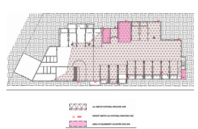
Figure 2: Basement
areas protruding more than 1 metre above ground level
Clause 6.6 Requirements for multi-dwelling housing and
residential flat buildings
Clause 6.6 states that development consent cannot be granted
for a residential flat building for a site with an area of less than 1800m2
unless a minimum width of 24 metres is met.
The subject site has a minimum width of 21.69 metres and
does not comply with the above requirement. This is a variation of 2.31 metres
or 9.6%. A Clause 4.6 variation has been submitted by the applicant and is
addressed below.
Clause 4.6 Exceptions to development standards
The proposed development breaches the site frontage and
floor space ratio development standards contained within the LEP. The applicant
has made two submissions pursuant of Clause 4.6 to vary that development
standard. Clause 4.6 provides flexibility in applying certain development
standards on the following grounds:
(1) The
objectives of this clause are as follows:
(a) to
provide an appropriate degree of flexibility in applying certain development
standards to particular development,
(b) to
achieve better outcomes for and from development by allowing flexibility in
particular circumstances.
(2) Development
consent may, subject to this clause, be granted for development even though the
development would contravene a development standard imposed by this or any
other environmental planning instrument. However, this clause does not apply to
a development standard that is expressly excluded from the operation of this
clause.
(3) Development
consent must not be granted for development that contravenes a development
standard unless the consent authority has considered a written request from the
applicant that seeks to justify the contravention by demonstrating:
(a) that
compliance with the development standard is unreasonable or unnecessary in the
circumstances of the case, and
(b) that
there are sufficient environmental planning grounds to justify contravening the
development standard.
(4) Development
consent must not be granted for development that contravenes a development
standard unless:
(a) the
consent authority is satisfied that:
(i) the
applicant’s written request has adequately addressed the matters required to be
demonstrated by subclause (3), and
(ii) the
proposed development will be in the public interest because it is consistent
with the objectives of the particular standard and the objectives for
development within the zone in which the development is proposed to be carried
out, and
(b) the
concurrence of the Director-General has been obtained.
Floor space ratio
The non-compliance with the FSR standard is assessed
pursuant to Clause 4.6 below:
Whether compliance with the standard is unreasonable
and unnecessary in the circumstances of the case
The applicant has provided justification that strict
compliance with the floor space ratio development standard is unnecessary and
unreasonable for the following reasons:
The subject site is
landlocked. On larger development sites, a FSR of 1:1 to 1.3:1 is promoted
within the R4 High Density Residential zone. The proposed FSR of 0.93:1 is
compatible with the density of development in the area.
The semi basement level arises
from the natural topography of the site that falls away from the street
frontage. The parking is contained within a full basement towards the street
frontage and progresses to a height of more than 1 metre above ground level
towards the rear of the site in response to the fall of the land. This is a
common building design response to the topography of the locality and is
characteristic of other residential flat building development along the Pacific
Highway.
The proposed finished level of
the parking provides an appropriate driveway grade facilitating convenient and
compliant vehicle access for cars and service vehicles including garbage
trucks. This enables the waste storage area and associated loading to be located
in the semi basement.
The proposed finished floor
levels enable compliant disabled access grades to be provided from the street
into the residential foyer/lobby. Lowering the building by cutting further
into the site would lower the lobby level and would be prohibitive to disabled
access (without extensive ramping that would detract from the streetscape).
The
proposed development will not result in any adverse impacts upon the amenity of
adjoining properties or public domain areas. The proposed development is
of a height, bulk and scale that is envisaged by the LEP and is consistent with
the bulk and scale of adjoining developments.
The
proposal is consistent with the zone objectives as previously demonstrated and
the floor space ratio development objectives as contained within clause 4.4 of
the LEP as demonstrated below:
(a) to enable development with a built form
and density that is compatible with the size of the land to be developed, its
environmental constraints and its contextual relationship,
(b) to provide for floor space ratios compatible
with a range of uses.
In
these circumstances, compliance with the development standard would be
unreasonable and unnecessary.
Environmental
planning grounds to justify contravening the development standard
The
applicant has provided sufficient grounds/reasons for the proposed variations
to the development standards as follows:
The
site is constrained by the presence of a Blue Gum High Forest, an Endangered
Ecological Community. The community exists on the subject site, towards the
rear, and on the adjoining site to the west, No. 1-3 Eulbertie Avenue. The
required Tree Protection Zones significantly constrain the available building
footprint on the subject site.
The
development as proposed provides sufficient area within the front setback for
retention of existing canopy trees and provision of additional planting. If the
building were lowered, an extensive network of ramps would be required in order
to achieve disabled access to the foyer. This would result in an adverse
environmental impact and would result in further tree removal and a reduced
area for planting.
It
is proposed to utilise the existing easement on the adjoining site to the rear,
2 Winton Street Warrawee. Lowering the basement further would prevent this
easement from being utilised and would prevent the site from being effectively
drained. This would likely result in adverse stormwater impacts to adjacent
properties 2B, 2A and 2 Winton Street.
Public
interest – development consistent with the zone objectives and objectives of
the development standard
The
zone objectives have already been identified in an earlier section of this
report. The development is consistent with all of the objectives of the
zone:
· to provide for the housing needs of
the community within a high density residential environment
· to provide a variety of housing
types within a high density residential environment
· to enable other land uses that
provide facilities or services to meet the day to day needs of residents
· to provide for high density
residential housing close to public transport, services and employment
opportunities
The proposed development upholds the zone objectives as it
provides high density living in a convenient location close to services such as
Warrawee Public School and within a reasonable walking distance of Warrawee
train station and Turramurra local centre. The proposed development includes a
variety of housing types including one, two and three bedroom apartments, as
well as adaptable apartments. In this regard, the
development is considered to be in the public interest.
Concurrence
of the Director General
Circular
PS 08-003 issued on 9 May 2008 informed Council that it may assume the
Director-General’s concurrence for exceptions to development standards.
Conclusion
The
development satisfies the criteria outlined in Clause 4.6. The variation is
considered acceptable as the proposal has been designed to comply with
provisions of the Ku-ring-gai LEP 2015 and Ku-ring-gai DCP and may be accepted
by Council.
Minimum site width
The non-compliance with the minimum site width standard is
assessed pursuant to Clause 4.6 below;
Whether compliance with the standard is unreasonable
and unnecessary in the circumstances of the case
The applicant has provided justification that strict compliance
with the site frontage development standard is unnecessary and unreasonable for
the following reasons:
The variation of the allotment
width is directly attributable to the fact that the site has been landlocked by
the construction of residential flat buildings on both adjoining side
properties. There are thus no opportunities to consolidate the site with either
of its neighbours to achieve compliance with the allotment width development
standard.
Strict application of the
development standard in this instance would be prohibitive of the development
of the land for the primary purpose for which it is zoned.
The
proposed development will not result in any adverse impacts upon the amenity of
adjoining properties or public domain areas. The proposed development is
of a height, bulk and scale that is envisaged by the LEP.
The
proposal is consistent with the zone objectives as previously demonstrated and
the site requirement development objectives as contained within the LEP as
demonstrated below.
(a) to provide site requirements for
development for the purposes of multi dwelling housing and residential flat
buildings so as to provide for the orderly and economic development of
residential land while maintaining the local character, and
(b) to ensure that lot sizes and
dimensions of medium and high density residential sites allow for generous
landscaped areas and setbacks to ensure the amenity of adjoining properties and
to support the desired future character of these areas.
In
these circumstances, compliance with the development standard would be
unreasonable and unnecessary.
Environmental
planning grounds to justify contravening the development standard
The
applicant has provided sufficient grounds/reasons for the proposed variations
to the development standards as follows:
Development
of the site for high density residential housing will improve the rhythm of the
streetscape by providing a development that is consistent with the mass, scale
and landscaped setting of adjoining properties.
The variation enables the
orderly development of land for high amenity housing that positively responds
to the built character of the locality and that respects the amenity of
neighbours as intended under the prevailing planning controls.
Public interest – development consistent with the zone
objectives and objectives of the development standard
The zone objectives have already been identified in an
earlier section of this report. The development is consistent with all of
the objectives of the zone which are:
· to provide for the housing needs of
the community within a high density residential environment
· to provide a variety of housing
types within a high density residential environment
· to enable other land uses that
provide facilities or services to meet the day to day needs of residents
· to provide for high density
residential housing close to public transport, services and employment
opportunities
In
this regard, the development is considered to be in the public interest.
Concurrence
of the Director General
Circular
PS 08-003 issued on 9 May 2008 informed Council that it may assume the
Director-General’s concurrence for exceptions to development standards.
Conclusion
The
development satisfies the criteria outlined in Clause 4.6. The variation is
considered acceptable as the proposal has been designed to comply with
provisions of the Ku-ring-gai LEP 2015 and Ku-ring-gai DCP and may be accepted
by Council.
Clause 5.9 – Preservation of trees or
vegetation
Council’s Tree and Landscape Assessment
Officer is satisfied that the proposed development will not unduly impact upon
any existing significant trees or vegetation, subject to conditions.
Clause 5.10 – Heritage conservation
Council’s Heritage Advisor has reviewed the proposed
development and considers that it will not result in any adverse impacts on the
adjoining heritage conservation area nor on any heritage item in the vicinity
of the subject site.
Part 6
Additional local provisions
Clause 6.2 – Earthworks
The proposed development will not restrict the existing or
future use of the site, adversely impact on neighbouring amenity, the quality
of the water table or disturb any known relics. Additionally, the fill to be
removed will be disposed of appropriately.
Clause 6.3 - Biodiversity protection
Council’s Ecological Assessment Officer is satisfied that
the proposed development has been designed to minimise impacts on the diversity
and condition of native vegetation, fauna and habitat as per the requirements
of the LEP.
Clause 6.4 – Riparian land and waterways
Council’s Ecological Assessment Officer is satisfied that
the proposed development is designed, sited and will be managed to avoid any
potential adverse environmental impacts as per the requirements of the LEP.
Clause 6.5 - Stormwater and water sensitive urban design
Council’s Development Engineer is satisfied that the
proposed development has been designed to manage urban stormwater run-off as
per the requirements of the LEP, subject to conditions.
Policy Provisions (DCPs, Council policies, strategies and
management plans)
Ku-ring-gai
Development Control Plan (2015)
Section A
|
COMPLIANCE TABLE
|
|
Development control
|
Proposed
|
Complies
|
|
Part 2 Site Analysis
|
|
|
|
Development applications are
to contain a site analysis
|
A site analysis has been submitted.
|
YES
|
|
Part 3 land Consolidation
and Subdivision
|
|
3C – Strata and Community
Title Subdivision
|
|
Whilst the proposal states
that strata subdivision of the proposed building is proposed, no subdivision
plan has been submitted. Therefore strata subdivision of the proposed
development cannot be considered pursuant to the subject application.
|
|
|
|
|
|
|
COMPLIANCE TABLE
|
|
Development control
|
Proposed
|
Complies
|
|
|
|
Part 21 Development Near Road or Rail Noise
|
|
21.1 Development Near Road
or Rail Noise
|
|
Complies
with “Development near Rail Corridors and Busy Roads – Interim Guidelines,
December 2008”
|
A
Road Traffic Noise Assessment has been submitted with the application. The
report notes that windows may need to be closed to meet internal noise
requirements and notes that alternative ventilation methods will be required
to satisfy the requirement of the BCA.
|
YES
|
|
COMPLIANCE TABLE
|
|
Development
control
|
Proposed
|
Complies
|
|
Volume A
|
|
Part 7
Residential flat development controls
|
|
7A – Site
design
|
|
7A.1
Building Setbacks
|
|
Side setback
areas behind the building line are not to be used for driveways or vehicular
access into the building.
|
Side setbacks not used for vehicular access
|
YES
|
|
Driveways
must be set back a minimum of 6m from the side boundary within the street
setback to allow for deep soil planting.
|
1.329m to eastern side boundary
|
NO
|
|
Ground floor
terraces and courtyards must have a minimum setback of 4m from the side and
rear boundaries
|
Balconies to G.2 and G.3 set back 3m from western side boundary
|
NO
|
|
7A.2 Building separation
|
|
Up to fourth
storey:
- 12m
between habitable rooms/balconies
- 9m
between habitable rooms/balconies and non-habitable rooms
- 6m
between non-habitable rooms
|
Minimum separation of 8.968m between proposed building and No. 1-3
Eulbertie Street. Minimum separation of 8.56m to No. 2C Winton Street.
|
NO
|
|
7A.3 Site coverage
|
|
Maximum of
35% of site area, provided that deep soil landscaping requirements are met
|
31% site coverage
|
YES
|
|
7A.4 Deep soil landscaping
|
|
Minimum deep
soil landscaping:
- sites
less than 1800m2 = 40% of the site
|
38% of site area
|
NO
|
|
Lots with the
following sizes are to support a minimum number of tall trees capable or
attaining a mature height of 13m on shale transitional soil and 10m on
sandstone derived soils
1200m2 of
less / 1 per 400m2 of site area
1201-1800m2
/ 1 per 350m2 of site area
1801m2
or more / 1 per 300m2 of site area
|
More than 4 canopy trees proposed.
|
YES
|
|
At least 50%
of all tree plantings are to be locally occurring trees and spread around the
site.
|
At least 50% of proposed plantings are endemic.
|
YES
|
|
7B – Access and parking
|
|
7B.1 Car parking provision
|
|
Basement is
not to project more than 1m above existing ground level
|
Basement projects >1m on eastern side.
|
NO
|
|
Subject site
is not within 400m of railway station.
Carparking is
to be provided as follows:
1 bedroom
unit = 1 space
2 bedroom
unit = 1 space
3 bedroom
unit = 1.5 spaces
Visitor car
spaces = 1 space/4 units
|
4 x
1 bedroom = 4 spaces
7 x
2 bedrooms = 7 spaces
2 x
3 bedrooms = 3 spaces
12
units = 3 visitor spaces
17
spaces are proposed (14 residents’ spaces and 3 visitor spaces)
|
YES
|
|
For every 4
apartments one visitor car space is required. At least one visitor car space
is to comply with the dimensional and location requirements of AS2890.6
|
3 visitor spaces are proposed
|
YES
|
|
One visitor
car space is to be provided with a tap to make provision for on-site car
washing
|
One garbage truck/visitor/car wash bay is proposed.
|
YES
|
|
Each
adaptable housing dwelling is to be provided with at least one car space
which complies with the dimensional and locational requirements of AS2890.6
|
Two adaptable dwellings are proposed (G.4 and 1.4), along with two
adaptable parking spaces.
|
YES
|
|
A space for
the temporary parking of service and revivalist vehicles is to be provided.
The space is to have a minimum dimension of 3.5m x 6m and minimum manoeuvring
area 7m wide.
|
One garbage truck/visitor/car wash bay is proposed.
|
YES
|
|
A minimum of
1 bicycle space per 5 units shall be provided on-site (3 resident bicycle
spaces required)
|
3 resident spaces proposed
|
YES
|
|
A minimum of
1 bicycle space per 10 units shall be provided on-site (2 visitor bicycle
spaces required)
|
2 visitor spaces proposed
|
YES
|
|
7C - Building design and sustainability
|
|
7C.1 - Communal Open Space
|
|
At least 10%
of the site area must be provided as communal open space with a minimum
dimension of 5m
|
The communal open space comprises 10.8% of the site area.
|
YES
|
|
A single parcel of communal open space with a minimum
area of 80m2, minimum dimensions of 8m and 3 hours solar access to
50% of the space on 21 June must be provided.
|
Common open space with an area of 133m2 is proposed to
the rear of the building.
|
YES
|
|
The communal
open space must be provided at ground level behind the building line.
|
Proposed communal open space is at ground level.
|
YES
|
|
Shared
facilities such as BBQs, shade structures, play equipment and seating are to
be provided in the communal open space
|
Shared facilities such as seating are provided.
|
YES
|
|
7C.2 – Private open space
|
|
All apartments are to include private open space with a
minimum area of:
- 10m2 for each one bedroom unit
- 12m2 for each two bedroom unit
- 15m2 for each three bedroom unit
|
Areas of private open space comply with or exceed minimum
requirements.
|
YES
|
|
The primary outdoor open space must have a minimum
dimension of 2.4m
|
Minimum dimension of 2.4m provided to all balconies
|
YES
|
|
Private open space for ground and podium
level apartments is to be differentiated from common areas by:
- A change in level
- Screen planting, such as hedges and
low shrubs
- A fence wall to a maximum height of
1.8m, any solid wall component is to be a maximum height of 1.2m with 30%
transparent component above plus gate to the common area.
|
Screen
planting is provided to differentiate private open space
|
YES
|
|
7C.3 – Solar access
|
|
A minimum of 70% of apartments in each building must
receive at least 3 hours direct sunlight to living rooms and adjacent private
open space between 9am and 3pm on 21 June
|
67% of apartments receive 3 hours solar access. Refer discussion
below.
|
YES
|
|
A minimum of 50% of the common open space for residents
use must receive direct sunlight for 3 hours between 9m and 3pm on 21 June
|
Communal open space receives 6 hours solar access.
|
YES
|
|
All developments must allow the retention of 3 hours sunlight between 9am and 3pm on 21
June to living areas and the principal portion of the private and communal
open space of existing residential flat buildings and multi-dwelling housing
on adjoining lots and any residential development in adjoining lower density
zones
|
Adjoining development at No. 1-3 Eulbertie Street is unaffected by
the proposed development between 9am and 3pm.
Adjoining development at No. 2C Winton Street is unaffected by the
proposed development between 9am and 12pm.
|
YES
|
|
Developments must allow the retention of a minimum 4 hours direct sunlight to all existing
neighbouring solar collectors and solar hot water services
|
No solar collectors or hot water services are apparent.
|
N/A
|
|
All developments must utilise shading and glare control
|
Pergolas are proposed to balconies of top level apartments. Sun
louvres are proposed over windows on the eastern elevation.
|
YES
|
|
7C.4 –
Natural Ventilation
|
|
All habitable
rooms are to have operable windows or doors
|
All habitable rooms have operable windows or doors, with the exception
of the kitchens.
|
YES
|
|
At least 60%
of apartments must have natural cross ventilation
|
All apartments have natural cross-ventilaion.
|
YES
|
|
At least 25%
of kitchens are to be immediately adjacent to an operable window
|
50% of apartments are adjacent to an operable window.
|
NO
|
|
Cross
ventilation is not to be dependent on skylights or open corridors where it
would impact on privacy
|
Cross-ventilation does not impact upon privacy.
|
N/A
|
|
7C.5 – Apartment depth and width
|
|
Dual aspect
apartments are to have a maximum internal plan depth of 18m from glass line
to glass line
|
Dual aspect apartments (G.3, 1.3 and 2.3) comply with this
requirement.
|
YES
|
|
Single aspect apartments are to have a maximum plan depth
of 8m from glass line to internal face of wall
|
Single aspect apartments (G.1, G.2m G.4, 1.1, 1.2, 1.4, 2.1, 2.2
and 2.4) do not comply with this requirement.
|
NO
|
|
All kitchens must not be located more than 8m to the back
wall of the kitchen from an external opening
|
All kitchens are less than 8m to an external opening.
|
YES
|
|
7C.6 – Apartment
mix and sizes
|
|
A range of apartment sizes and types must be included in
the development
|
The proposal includes 4 x 1 bedroom units
6 x 2 bedroom units
2 x 3 bedroom units
|
YES
|
|
At least one
apartments for each 10 apartments is to be designed as adaptable housing
Class C
|
Two adaptable units are required. Apartments G.4 and 1.4 are
adaptable.
|
YES
|
|
At least 70%
of apartments are to be visitable.
|
9 visitable apartments are required
|
YES
|
|
7C.7 – Room sizes
|
|
Living areas
in apartments with two or more bedrooms are to have living areas with a
minimum internal plan dimension of 4m. Minimum dimension of 3.5m required for
all other apartments.
|
Unit
G.1 (one bedroom) has a minimum living room dimension of 3m.
|
NO
|
|
Bedrooms in
one and two bedroom apartments must have minimum internal plan dimension of
3m (excluding wardrobes)
|
All
bedrooms have a minimum bedroom width of 3m.
|
YES
|
|
In apartments
with 3 or more bedrooms at least two bedrooms are to have minimum internal
plan dimension of 3m (excluding wardrobes)
|
Two
bedrooms in each three bedroom apartment comply.
|
YES
|
|
Built in
wardrobes are to be provided to all studio apartments, to all bedrooms in one
and two bedroom apartments and to at least two bedrooms in apartments of
three or more bedrooms
|
Built-in
wardrobes provided to all bedrooms.
|
YES
|
|
7C.8 – Building entries
|
|
Building entry must be integrated with building facade
design. At street level, the entry is to be articulated with awnings,
porticos, recesses or projecting bays for clear identification.
|
Building
entry is integrated.
|
YES
|
|
All entry areas must be well lit and designed to avoid
any concealment or entrapment areas. All light spill is prohibited.
|
The
ground floor lobby is spacious and contains no entrapment areas.
A
condition is recommended concerning light spill.
|
YES
|
|
Lockable mail boxes must be provided close to the street.
They must be at 90 degrees to the street and to Australia Post standards and
integrated with front fences or building entries.
|
Mailboxes
provided adjacent to street entry.
|
YES
|
|
7C.9
Internal Common Circulation
|
|
The design of internal common circulation space must
comply with the provisions in AS1428.1 and AS1428.2 to provide
adequate pedestrian mobility and access.
|
The Access Report states that adequate access is provided from the
entry door to the lift, and within the lobby area.
|
YES
|
|
All common circulation areas including foyers,
lift lobbies and stairways must have:
i) appropriate levels of
lighting with a preference for natural light where possible;
ii) short corridor lengths
that give clear sight lines;
iii) clear signage noting
apartment numbers, common areas and general direction finding;
iv) natural ventilation;
v) low
maintenance and robust materials.
|
Lobby areas at all levels have natural light.
|
YES
|
|
Where artificial lighting is required energy efficient
lights are to be used in conjunction with timers or daylight controls.
|
A valid BASIX certificate has been submitted which addresses
energy efficiency.
|
YES
|
|
7C.10 Building
facades
|
|
Street, side and rear building facades
are to be modulated and articulated with wall planes varying in depth.
Methods of achieving articulation and modulation include:
- defining a base, middle and top
- expressing building layout or
structure such as vertical bays
- expressing the variation in floor
to ceiling height
- using a variety of window types
- using recessed balconies
- using change of material, texture
or colour
|
All elevations are sufficiently modulated and articulated.
|
YES
|
|
No single wall plane is to exceed 81m2
in area
|
|
|
|
Air conditioning units must not be
located on the building façade or with the private open space
|
Air conditioning units are not located within private open space.
|
YES
|
|
Building less is not to exceed 36m
|
The building has an overall length of 35m.
|
YES
|
|
7C.11 Building storeys
|
|
Buildings with a maximum height of 11.5m
are to have a maximum of 3 storeys
|
3-4 storeys
|
NO
|
|
7C.12 Ground floor apartments
|
|
Where the finished ground level outside the living area
at the building line is more than 0.5m, the private open space must be level
for a minimum of 2.4m from the living area.
|
The terrace to apartment G.4 does not comply with this
requirement.
|
NO
|
|
7C.13 Top storey design and roof
forms
|
|
The top storey of a building is to be set back from the
outer face of the floors below on all sides. The GFA is not to exceed 60% of
the GFA of the storey below it.
|
Top floor area equates to 96% of floor below
|
NO
|
|
Service elements are to be integrated into the overall
design of the roof so as not to be visible from the public domain or any
surrounding development. These elements include lift overruns, plant
equipment, chimneys, vent stacks, water storage, communication devices and
signage.
|
Air conditioning units are shown located on the roof however could
be relocated to ‘services’ area in basement.
|
YES
via condition
|
|
Roof design must respond to solar access, for example, by
using eaves and skillion roofs.
|
Pergolas are proposed to top floor balconies to provide shade.
|
YES
|
|
Lightweight pergolas, privacy screens and planters are
permitted on the roof, provided they do not increase the bulk of the
building, create visual clutter or impact on significant views from adjoining
properties.
|
No pergolas or privacy screens are proposed on the roof.
|
N/A
|
|
7C.14 Internal ceiling heights
|
|
The minimum ceiling height for a
habitable room shall be 2.7m
|
Minimum ceiling heights of 2.7m are proposed for habitable rooms.
|
YES
|
|
The minimum ceiling height for a
non-habitable room shall be 2.25m
|
Minimum ceiling heights of 2.4m are proposed for non-habitable
rooms.
|
YES
|
|
7C.15 Visual privacy
|
|
Privacy for ground floor apartments should
be achieved by the use of a change in level and/or screen planting.
|
Screen planting is proposed to ensure privacy to ground floor
|
YES
|
|
Continuous transparent balustrades are not permitted to
balconies or terraces for the lower 3 storeys.
|
Continuous transparent balconies are not proposed.
|
YES
|
|
Screening between apartments must be integrated with the
overall building design.
|
Privacy screens are integrated with the design of the building.
|
YES
|
|
Landscaped screening must be provided to adjoining sites.
|
Screen planting to the satisfaction of Council’s Landscape Officer
is shown on landscape plans.
|
YES
|
|
7C.16 Storage
|
|
Storage space shall be provided at the
following minimum volumes:
- 6m3 for studio and one bedroom
apartments
- 8m3 for two bedroom units
- 10m3 for two bedroom units
- 12m3 for units with three or more
bedrooms
At least 50%
of the required storage space must be provided inside the apartment.
|
Less than required amount of storage provided to all apartments
|
NO
|
|
7C.17
External air clothes drying facilities
|
|
Each apartment is required to have access to an external
air clothes drying area, e.g. a screened balcony, a terrace or common area.
|
Clothes drying facilities provided in common area.
|
YES
|
|
7C.18 Fencing
|
|
Front fences and walls (to a public street)
and side fences in the street setback must not be higher than:
i) 0.9m if of closed construction (such
as masonry, lapped and capped timber or brushwood fences); or
ii) 1.2m if of
open construction (such as open paling and picket fences).
Note: Open fencing includes: panels set into a
timber frame or between brick piers, where any solid base is not taller than
0.9m, and panels are spaced pickets, palings, or lattice.
|
900mm high masonry front fence
|
YES
|
|
Closed front fences with a maximum height of 1.8m may be
considered where the site fronts a busy road or other sources of undesirable
noise. These fences are to be set back at least 2m from the front boundary
and screened by landscaping.
Note: Rendered masonry boundary walls are
generally inappropriate to the landscape character of Ku-ring-gai.
|
Proposed fence is 900mm high and complies with maximum fence
height requirements.
|
N/A
|
|
All fencing must be designed to highlight entrances, and
be compatible with buildings, letterboxes and garbage storage areas.
|
Fence is designed to highlight pedestrian and vehicular entrances.
|
YES
|
|
External
finishes for fencing must be robust and graffiti resistant.
|
The proposed masonry front fence can be re/painted if graffiti
occurs.
|
YES
|
|
COMPLIANCE TABLE
|
|
Development control
|
Proposed
|
Complies
|
|
|
|
Part 22 General Site
Design
|
|
22.1 Earthworks and Slope
|
|
- Buildings should be stepped down a site
- Finished floor level as close to existing ground
level as possible
- Landscape cut and fill <600mm
- 0.6m width between retaining walls
- Cut and fill within building footprint max 1.0m
maximum level difference 1.8m
- Retaining walls max height 1.0m
|
Cut and fill is minimised by the proposed design.
|
YES
|
|
22.2 Landscape Design
|
|
- Site planning and design must retain and enhance
vegetation and biodiversity corridors.
|
Blue Gum High Forest on the subject site and
adjoining site is to be retained and protected.
|
YES
|
An assessment of the variations
to the controls identified in the compliance table is provided below.
7A.1
Building setbacks (front)
Clause 7A.1
states that residential flat buildings are to be set back a minimum of 10m from
the street boundary. Building lines are to be parallel to the prevailing
building line.. Balconies at ground floor level may also encroach to a minimum
setback of 8 metres. The relevant objectives of the building setback provisions
are as follows:
1. To ensure buildings are set within a garden
setting dominated by canopy trees which soften the built form and maintain the
garden character of Ku-ring-gai.
6. To reduce the visual bulk of buildings from the
street.
7. To maintain the rhythm of the built form on the
street.
The subject
site has an angled frontage, with the proposed building set back between 9
metres and 16.4 metres from the street frontage. It therefore entails a minor
non-compliance with Council’s minimum building setback control (see red area in
Figure 3). The proposal also entails a minor non-compliance with the
balcony encroachment control (see orange area in Figure 3). The
easternmost balcony is set back a minimum of 6.189m at ground level, instead of
the required 8 metres. This non-compliance continues at first and second floor
level where the balconies encroach to a minimum of 7.922 metres instead of the
required 10 metres setback.
The proposed
numerical non-compliances are considered to be acceptable for the following
reasons:
(i) Whilst the façade of the building has not been
“stepped” along the street frontage as suggested by the DCP, it is adequately
articulated and modulated.
(ii) The building has not been “stepped” along the site
frontage due to presence of Blue Gum High Forest, an Endangered Ecological
Community, in the north-western (rear) corner of the site.
(iii) The balconies on the western side of the building
are parallel with the site frontage and provide an interesting design feature.
(iv) The proposal complies with Council’s 12 metres
articulation zone, with only 22% of the building encroaching beyond the 12
metres setback line (see blue line in Figure 3).
(v) The proposal satisfies the objectives of the
building setback controls and is appropriate in terms of bulk and mass. The
proposal maintains the rhythm of the streetscape and presents an intermediate
setback between the buildings at 1-3 Eulbertie Street and 2C Winton Street.
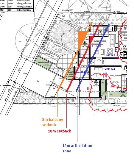
Figure 3: Front setback non-compliance
7A. 1 Building Setbacks (Side)
Control 6
states that buildings of three storeys or less on sites of less than 1800m2
should be set back a minimum of 3 metres from the side boundaries. Control 8
requires driveways to be set back a minimum of 6 metres from side boundaries.
2. To ensure adequate space between sites to
enable effective landscaping and tree planting.
3. To ensure adequate separation between
buildings on different sites to alleviate amenity impacts, including privacy,
daylight access, acoustic control and natural ventilation.
4. To provide a transition to adjoining lower
scale development on lower density zones.
7. To maintain the rhythm of the built form on
the street.
8. To ensure driveways do not compromise the
landscape setting or neighbouring amenity.
The proposed
development entails the following technical non-compliances with the above
controls:
- The basement is set
back a minimum of 2.4 metres from the western side boundary and a minimum of
600mm from the western side boundary.
- The setback of 2.4
metres is for a length of 13 metres. The remainder of the western elevation is
set back 3 metres or more. Screen planting at grade is proposed adjacent to
this boundary.
- The setback of 600mm is
for a length of 8.2 metres. The remainder of the eastern elevation is set back
between 1.329 metres and 2 metres. Screen planting at grade and within generous
planter boxes is proposed along this boundary.
The
non-compliances are a result of the narrow site width and small site area which
renders provision of a two level basement uneconomic. The design of the
basement is also heavily constrained by the presence of Blue Gum High Forest on
the subject site and adjoining site to the west, No. 1-3 Eulbertie Avenue.
Council’s Landscape Officer has reviewed the proposal and has advised that the
proposed planter boxes are capable of supporting screen planting to a height of
4 metres. Therefore, the proposal satisfies the objective in relation to
provision of landscaping.
Despite the
non-compliances at basement and ground floor level, the proposed development
complies with the numerical setback controls at first and second floor level.
As such, the proposal ensures adequate building separation and maintains the
rhythm of the streetscape, thereby satisfying the objectives.
The proposed
driveway non-compliance is also the result of the narrow site width. The
specific objective relating to driveway location aims to ensure that driveways
do not compromise landscape setting or neighbouring amenity. The proposed
minimum driveway setback of 1.329 metres allows for the provision of screen
planting capable of growing to a height of 3 to 8 metres. This is considered
sufficient to maintain amenity to the neighbouring property, 2C Winton Street.
It is also noted that the driveway setback at the street frontage is greater
and provides ample room for a canopy tree with groundcover beneath. Therefore
the proposal maintains the landscape character of the locality.
7A.2
Building separation
As noted above,
specific building setback controls exist for residential flat buildings of
three storeys or less on small sites. The building separation controls are
inconsistent with these controls and cannot reasonably be applied to the
proposed development. Nonetheless, it is noted that the proposed development
has been sensitively designed with regard to privacy and includes measures such
as highlight windows and privacy screens to balconies.
7A.4 Deep
soil landscaping
Control 1
specifies that residential flat buildings on sites of less than 1800m2
should have deep soil landscaping for a minimum of 40% of the site area. The
relevant objectives are as follows:
1. To provide consolidated deep soil zones in
all residential development sites through careful planning and building design.
2. To provide landscaped areas that are
appropriate to the scale and context of the development.
3. To retain areas that provide habitat for
native indigenous plants and animals and contributes to biodiversity in the
area.
4. To create high quality landscaped areas
through retention and/or planting of large and medium sized trees.
5. To ensure landscape areas contribute to the
garden character of the locality and help to protect neighbouring amenity.
6. To ensure that most of the deep soil
landscaping is within the common areas.
The development
proposes a deep soil area of 38% of the site area (464m2). The
proposal therefore represents a minor numerical non-compliance, which is
supported for the following reasons:
(i) The proposal enables retention of existing Blue
Gum High Forest vegetation on site, which is an Endangered Ecological
Community.
(ii) The proposal provides adequate screen planting and
canopy trees so as to maintain the garden character of the locality. The site
supports in excess of the minimum required four canopy trees.
(iii) Most of the deep soil landscaping is contained
within the communal open space area to the rear of the site. This is beneficial
in terms of its long term retention as it is preferable for landscaped areas to
be within common ownership, rather than private ownership.
7B.1 Car
parking provision
The proposed
basement protrudes more than 1m above existing natural ground level and
therefore does not comply with Control 3. The proposal results in the
basement protruding up to 2.16 metres above natural ground level on its eastern
side. The applicant has submitted a Clause 4.6 variation which has been
considered above and found to be acceptable on merit.
7C.3 Solar
access
The proposal
is acceptable with respect of solar access for the reasons detailed under the
SEPP 65 discussion above in this report.
7C.5
Apartment depth and width
Controls 1 and
2 specify a maximum depth of 18m for dual aspect apartments and 8m for single
aspect apartments. The objective of the controls is to provide apartments with
good amenity for occupants in terms of daylight access and natural ventilation.
The proposed
development contains a combination of dual and single aspect apartments. Whilst
the dual aspect apartments comply with Council’s maximum apartment length
requirements, nine of the single aspect apartments do not comply. The depth of
the non-compliant apartments ranges from 10 metres to 16 metres Council’s Urban
Design Cosnultant has reviewed the development and considers the proposal
adequate in terms of cross-ventilation and daylight. The proposed numerical
non-compliances are therefore acceptable.
7C.7 Room
sizes
Control 1
specifies that living rooms of apartments with one bedroom are to have a
minimum internal dimension of 3.5m. The objective of this requirement is to
provide well proportioned and functional rooms.
The living room
of Apartment G.1 has a minimum internal dimension of 3 metres and does not
comply with this requirement. Nevertheless, the room is an L-shaped room and is
considered to be of a functional size for a one bedroom apartment. The proposed
numerical non-compliance is therefore considered acceptable.
7C.11
Building storeys
Control 1 specifies that buildings with a maximum
height of 11.5 metres are to comprise a maximum of three storeys. The
objectives of this control are to ensure buildings respond to the site and to maximise
amenity through the provision of adequate ceiling heights, daylight, sunlight
and ventilation.
As noted previously, the basement of the proposed
building protrudes more than 1 metre above natural ground level and therefore
constitutes a storey. Consequently, the proposed building is technically four
storeys high at its eastern elevation. Nonetheless, the proposed building
comprises three storeys of habitable spaces, with each floor having compliant
ceiling heights. The proposed dwellings offer good amenity and are acceptable
with regard to solar access and ventilation.
The proposed building has the appearance of a three
storey building with the basement protrusion camouflaged through the provision
of generous planter boxes (Figure 4). The basement protrusion is
considered acceptable and is discussed in detail elsewhere in this report.
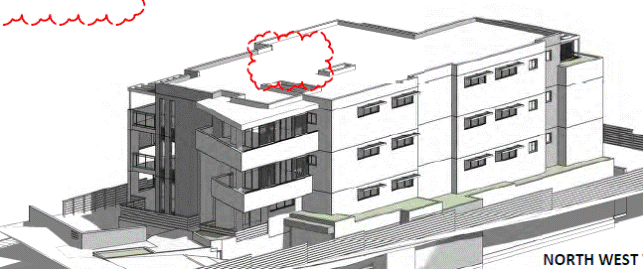
Figure 4: Perspective drawing showing
number of storeys
7C.12 Ground
floor apartments
Control 3
states that where the finished ground level outside the living area is more
than 0.5 metres above ground level, the private open space is to be level for a
minimum of 2.4 metres from the living area. The objective of this control is
presumably to ensure a high level of residential amenity.
All but one
apartment has an area of private open space that complies with control.
Apartment G.4 has a multi-level terrace that is 0.5 metres in width adjacent to
the living room. The lower portion of the terrace has a minimum dimension of
2.7 metres and provides a sufficient area of private open space. The proposed
non-compliance is therefore considered acceptable.
7C.13 Top
storey design and roof forms
Control 1
states that the top storey of a residential flat building should not exceed 60%
of the gross floor area of the storey immediately below it.
The relevant
objectives are to:
1. Ensure that the design of the top floor of buildings
minimises visual bulk.
2. To ensure that the design and location of
the top floor minimises any increased overshadowing.
3. To contribute to the overall design and
environmental performance of buildings.
The proposed
development does not comply with this requirement, with the second floor having
a gross floor area of 96% of the area of the floor below it. In this instance,
the proposed variation is considered satisfactory having regard to the site
constraints which result in a reduced building footprint.
The proposed
development satisfies the objectives of the control for the following reasons:
(i) The proposal will not result in any adverse bulk
impacts bulk impacts to the street or adjoining properties. The proposed
building is modest in height (Figure 5), being three to four storeys in
a zone that permits buildings of up to five storeys. The finished height of the
building will be between approximately 7 metres lower than the adjoining
building at 1-3 Eulbertie Street and approximately 2 metres higher than the
building at 2C Winton Street.
(ii) Given that the top floor is at third storey
height, the proposed non-compliance will not result in any unreasonable
overshadowing impacts to adjoining properties.
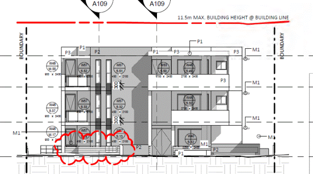
Figure 5: Southern elevation of proposed development
7C.16 Storage
Subject to
conditions, the proposal is acceptable with respect of storage for the reasons
detailed under the SEPP 65 assessment above in this report. Condition 18
Part 15 and 25 – Water
management
Council’s Development Engineer
is satisfied that the proposed development has been designed to manage urban
stormwater run-off as per the requirements of the DCP, subject to conditions.
Part 26 – Notification
The application has been
notified in accordance with the requirements of the DCP. The submissions
received are addressed above.
Section 94 Plan
The development
attracts a section 94 contribution of $160,737.77, which is required to be paid by Condition 40.
Likely Impacts
The proposed development will not result in any unreasonable
impacts with regard to streetscape, visual bulk, privacy or solar access. The
proposed development will not result in any unreasonable impacts to existing
trees on the subject and adjoining sites, nor will it result in any detrimental
impacts to the endangered ecological community located on site.
Further, the proposal will not result in any adverse impacts
to the adjoining heritage item or development within the adjacent Heritage
Conservation Area. The proposal also includes adequate stormwater disposal and
will not result in any adverse impacts in this regard.
Suitability of the Site
The site is zoned for high density residential purposes and
is suitable for the proposed development, being construction of a residential
flat building. Whilst the site is heavily constrained by its narrow frontage,
topography and presence of an Endangered Ecological Community, the proposed
development represents an appropriate design response and is suitable for the
site.
Public Interest
The proposal is considered to be
in the public interest.
Conclusion
Having regard to the provisions of
section 79C of the Environmental Planning and Assessment Act 1979, the proposed
development is considered to be satisfactory.
|
Recommendation:
A. THAT
Council, as the consent authority, is satisfied that the request under Clause
4.6 of Ku-ring-gai Local Environmental Plan 2015 to vary the Minimum Site
Width and Floor Space Ratio development standards is well founded. Council is
also satisfied that the proposed development will be in the public interest
and is consistent with the objectives of the development standard and the R4
High Density Residential zone.
B. THAT Council, as the consent authority, grant deferred commencement development consent to DA0109/15
for demolition of the existing dwelling and
construction of a residential flat building containing 12 units, basement
parking and landscaping works at No. 1407 Pacific Highway Warrawee for a period of two years from the date of the Notice of
Determination.
SCHEDULE A: Deferred
Commencement - Terms to be satisfied prior to the consent becoming operable
The
following deferred commencement term must be complied with to the
satisfaction of Council within 24 months of the date of the Notice of
Determination:
Deferred commencement term:
1. Drainage
easement
The applicant shall submit
documentary evidence that the property benefits from a drainage easement over
the downstream properties and including all sites burdened by the easement as
far as the public drainage system. This consent will not operate until the
documentary evidence has been submitted to and approved by Council’s
Development Engineer.
Reason: To ensure that provision is made for stormwater
drainage from the site in a proper manner that protects adjoining properties.
Once the deferred commencement term has
been satisfied, the consent becomes operable, and the conditions in Schedule
B will apply.
SCHEDULE B:
Conditions
that identify approved plans:
1. Approved architectural plans and documentation
(new development)
The
development must be carried out in accordance with the following plans and
documentation listed below and endorsed with Council’s stamp, except where
amended by other conditions of this consent:
|
Plan no.
|
Drawn by
|
Dated
|
|
A100 Site Plan Rev C
|
Australian Consulting Architects
|
November 2015
|
|
A102 Basement Plan Rev C
|
Australian Consulting Architects
|
November 2015
|
|
A103 Ground floor plan Rev C
|
Australian Consulting Architects
|
November 2015
|
|
A104 Level 1 plan Rev C
|
Australian Consulting Architects
|
November 2015
|
|
A105 Level 2 plan Rev C
|
Australian Consulting Architects
|
November 2015
|
|
A106 Roof plan Rev B
|
Australian Consulting Architects
|
November 2015
|
|
A107 East & west elevations & Finishes Schedule
Rev B
|
Australian Consulting Architects
|
November 2015
|
|
A108 Elevations & sections; Front fence elevation
Rev B
|
Australian Consulting Architects
|
November 2015
|
|
A109 Sections Rev B
|
Australian Consulting Architects
|
November 2015
|
|
A110 Driveway Section Rev B
|
Australian Consulting Architects
|
November 2015
|
|
A400 Post adaptation layouts
|
Australian Consulting Architects
|
November 2015
|
|
Landscape Concept Plan 14231 DA 1 Rev D
|
Vision Dynamics
|
11 November 2015
|
|
Stormwater and Environmental Site Management Plans 1898
DA SW001-SW004 ER001
|
HKMA Engineers
|
13 November 2015
|
|
Document(s)
|
Dated
|
|
Colours and finishes schedule A113 Rev B
|
November 2015
|
|
Basix certificate No. 592802M_04
|
26 November 2015
|
|
Access report prepared by Wall to Wall Design &
Consulting
|
17 November 2015
|
|
Geotechnical report, prepared by GeoEnviro Consultancy
|
5 December 2014
|
|
Road Traffic Noise Assessment, prepared by Rodney
Stevens Acoustcs
|
10 February 2015
|
Reason: To
ensure that the development is in accordance with the determination.
2. Inconsistency
between documents
In
the event of any inconsistency between conditions of this consent and the
drawings/documents referred to above, the conditions of this consent prevail.
Reason: To
ensure that the development is in accordance with the determination.
Conditions
to be satisfied prior to demolition, excavation or construction:
3. Asbestos
works
All
work involving asbestos products and materials, including
asbestos-cement-sheeting (ie. Fibro), must be carried out in accordance with
the guidelines for asbestos work published by WorkCover Authority of NSW.
Reason:
To ensure public safety
4. Notice of
commencement
At least 48 hours prior to the
commencement of any development (including demolition, excavation, shoring or
underpinning works), a notice of commencement of building or subdivision work
form and appointment of the principal certifying authority form shall be
submitted to Council.
Reason: Statutory
requirement.
5. Notification
of builder’s details
Prior to the commencement of any development or
excavation works, the Principal Certifying Authority shall be notified in
writing of the name and contractor licence number of the owner/builder
intending to carry out the approved works.
Reason: Statutory requirement.
6. Dilapidation survey
and report (public infrastructure)
Prior to the
commencement of any development or excavation works on site, the Principal
Certifying Authority shall be satisfied that a dilapidation report on the visible
and structural condition of all structures of the following public
infrastructure, has been completed and submitted to Council:
Public infrastructure
· full road pavement
width, including kerb and gutter, of Pacific Highway over the site frontage
The report must be completed
by a consulting structural/civil engineer. Particular attention must be paid
to accurately recording (both written and photographic) existing damaged
areas on the aforementioned infrastructure so that Council is fully informed
when assessing any damage to public infrastructure caused as a result of the
development.
The developer may be held
liable to any recent damage to public infrastructure in the vicinity of the
site, where such damage is not accurately recorded by the requirements of
this condition prior to the commencement of works.
Note: A written acknowledgment from Council must be
obtained (attesting to this condition being appropriately satisfied) and
submitted to the Principal Certifying Authority prior to the commencement of
any excavation works.
Reason: To record the structural condition of public
infrastructure before works commence.
7. Archival recording
of buildings
Prior to the
commencement of any development or excavation works on site, the Principal
Certifying Authority shall be satisfied that an archival report has been
submitted to Council’s Heritage Advisor.
The report must consist of an
archival standard photographic record of the building (internally and
externally), its garden and views of it from the street illustrating its
relationship to neighbouring properties and the streetscape. Recording shall
be undertaken in accordance with the guidelines for “Photographic Recording
of Heritage Items Using Film or Digital Capture (2006)” prepared by the New
South Wales Heritage Office.
Information
shall be bound in an A4 report format. It shall include copies of
photographs, referenced to plans of the site. Two (2) copies (one (1) copy
to include negatives or CD of images shall be submitted to Council's Heritage
Advisor. The recording document will be held in the local studies collection
of Ku-ring-gai Library, the local historical society and Council’s files.
Note: A written acknowledgment from Council must be
obtained (attesting to this condition being appropriately satisfied) and
submitted to the Principal Certifying Authority prior to the commencement of
any works.
Reason: To ensure the proper management of historical
artefacts and to ensure their preservation.
8. Dilapidation
survey and report (private property)
Prior to the
commencement of any demolition or excavation works on site, the Principal
Certifying Authority shall be satisfied that a dilapidation report on the
visible and structural condition of all structures upon the following lands,
has been completed and submitted to Council:
|
Addresses
|
|
· 1 - 3
Eulbertie Avenue (eastern side of units)
|
|
· 2 Winton
Street (garage)
|
|
· 2C
Winton Street (western side of units)
|
|
|
|
|
The
dilapidation report must include a photographic survey of adjoining
properties detailing their physical condition, both internally and
externally, including such items as walls ceilings, roof and structural
members. The report must be completed by a consulting structural/geotechnical
engineer as determined necessary by that professional based on the
excavations for the proposal and the recommendations of the submitted
geotechnical report.
In the event that access for
undertaking the dilapidation survey is denied by a property owner, the
applicant must demonstrate in writing to the satisfaction of the Principal
Certifying Authority that all reasonable steps have been taken to obtain
access and advise the affected property owner of the reason for the survey
and that these steps have failed.
Note: A
copy of the dilapidation report is to be provided to Council prior to any
excavation works been undertaken. The dilapidation report is for record
keeping purposes only and may be used by an applicant or affected property
owner to assist in any civil action required to resolve any dispute over
damage to adjoining properties arising from works.
Reason: To
record the structural condition of likely affected properties before works
commence.
9. Construction and
traffic management plan
The applicant must submit to
Council a Construction Traffic Management Plan (TMP), which is to be approved
prior to the commencement of any works on site.
The plan is to consist of a
report with Traffic Control Plans attached.
The report is to contain
commitments which must be followed by the demolition and excavation
contractor, builder, owner and subcontractors. The TMP applies to all
persons associated with demolition, excavation and construction of the
development.
The report is to contain
construction vehicle routes for approach and departure to and from all
directions.
NO
construction vehicles movements are to occur during the school drop-off
(8.00am to 9.30am) and pick-up hours (2.30pm to 4.00pm) on school days.
The report is to contain a
site plan showing entry and exit points. Swept paths are to be shown on the
site plan showing access and egress for the longest heavy rigid vehicle.
The Traffic Control Plans are
to be prepared by a qualified person (red card holder). One must be provided
for each of the following stages of the works:
· Demolition
· Excavation
· Concrete pour
· Construction of vehicular
crossing and reinstatement of footpath
· Traffic control for
vehicles reversing into or out of the site.
Traffic controllers must be in
place at the site entry and exit points to control heavy vehicle movements in
order to maintain the safety of pedestrians and other road users.
When a satisfactory TMP is
received, a letter of approval will be issued with conditions attached.
Traffic management at the site must comply with the approved TMP as well as
any conditions in the letter issued by Council. Council’s Rangers will be
patrolling the site regularly and fines will be issued for any non-compliance
with this condition.
Reason: To ensure that appropriate measures have been
considered during all phases of the construction process in a manner that
maintains the environmental amenity and ensures the ongoing safety and
protection of people.
10. Sediment
controls
Prior to any
work commencing on site, sediment and erosion control measures shall be
installed along the contour immediately downslope of any future disturbed
areas.
The form of
the sediment controls to be installed on the site shall be determined by
reference to the Landcom manual ‘Managing Urban Stormwater: Soils and
Construction’. The erosion controls shall be maintained in an operational
condition until the development activities have been completed and the site
fully stabilised. Sediment shall be removed from the sediment controls
following each heavy or prolonged rainfall period.
Reason: To preserve
and enhance the natural environment.
11. Erosion
and drainage management
Earthworks
and/or demolition of any existing buildings shall not commence until an
erosion and sediment control plan is submitted to and approved by the
Principal Certifying Authority. The plan shall comply with the guidelines
set out in the NSW Department of Housing manual "Managing Urban
Stormwater: Soils and Construction" certificate. Erosion and sediment
control works shall be implemented in accordance with the erosion and
sediment control plan.
Reason: To preserve and enhance the natural environment.
12. Tree
protection fencing excluding structure
To
preserve the following tree/s, no work shall commence until the area beneath
their canopy excluding that area of the approved building shall be fenced off
for the specified radius from the trunk to prevent any activities, storage or
the disposal of materials within the fenced area. The fence/s shall be
maintained intact until the completion of all demolition/building work on
site:
|
Schedule
|
|
Tree/Location
|
Radius
from trunk
|
|
Tree
8/ Eucalyptus saligna (Sydney Blue Gum) located on the western
boundary, within the adjoining property
|
6.2m
|
|
Tree
10/ Eucalyptus saligna (Sydney Blue Gum) located on the western
boundary, within the adjoining property
|
15m
|
|
Tree
13/ Quercus robur (English Oak) located on the western boundary of
the site, within the adjoining property.
|
5.3m
|
|
Tree
16/ Corymbia maculata (Spotted Gum) located on the southwest corner
of the site.
|
4.8m
|
Reason: To protect existing trees during the construction
phase.
13. Tree
protective fencing type galvanised mesh
The
tree protection fencing shall be constructed of galvanised pipe at 2.4 metre
spacing and connected by securely attached chain mesh fencing to a minimum
height of 1.8 metres in height prior to work commencing.
Reason: To protect existing trees during construction phase.
14. Tree
protection signage
Prior to works commencing, tree protection signage is to
be attached to each tree protection zone, displayed in a prominent position
and the sign repeated at 10 metres intervals or closer where the fence
changes direction. Each sign shall contain in a clearly legible form, the
following information:
Tree protection zone.
· This fence has been installed to prevent
damage to the trees and their growing environment both above and below ground
and access is restricted.
· Any encroachment not previously approved
within the tree protection zone shall be the subject of an arborist's report.
· The arborist's report shall provide proof that
no other alternative is available.
· The Arborist's report shall be submitted to
the Principal Certifying Authority for further consultation with Council.
· The name, address, and telephone number of the
developer.
Reason: To
protect existing trees during the construction phase.
15. Tree protection - avoiding soil
compaction
To
preserve the following tree/s and avoid soil compaction, no work shall
commence until temporary measures to avoid soil compaction (eg rumble boards)
beneath the canopy of the following tree/s is/are installed:
|
Schedule
|
|
Tree/Location
|
|
Tree
8/ Eucalyptus saligna (Sydney Blue Gum) located on the western
boundary, within the adjoining property
|
|
Tree
10/ Eucalyptus saligna (Sydney Blue Gum) located on the western
boundary, within the adjoining property
|
|
Tree
13/ Quercus robur (English Oak) located on the western boundary of
the site, within the adjoining property.
|
|
Tree
16/ Corymbia maculata (Spotted Gum) located on the southwest corner
of the site.
|
Reason: To
protect existing trees during the construction phase.
16. Tree
fencing inspection
Upon
installation of the required tree protection measures, an inspection of the
site by the Principal Certifying Authority is required to verify that tree
protection measures comply with all relevant conditions.
Reason: To protect existing trees during the construction
phase.
Conditions
to be satisfied prior to the issue of the construction certificate:
17. Amendments to
architectural plans - general
Prior to issue of the
Construction Certificate, the Principal Certifying Authority is to be
satisfied that the following amendments have been made to the approved
architectural plans:
a) Boundary fencing to the eastern, northern and southern boundaries
is to be shown as 1.7m high lapped and capped timber fencing on all
elevations.
b) The air conditioning units on the roof are to be deleted.
c) The notation referring to the OSD basin within the rear setback is
to be deleted from the elevations.
Reason: To ensure consistency amongst documents and to maintain
residential amenity.
18. Amendments to
architectural plans - storage
Amended plans showing
provision of storage at the following rates are to be submitted to the
satisfaction of the Principal Certifying Authority, prior to issue of the
Construction Certificate.
a. 1 Bed: 6m³,
b. 2 bed: 8m³,
c. 3 bed: 10m³, and
No less than
50% of the required amount is to be provided inside the apartment and not
located within bedrooms or in the kitchen.
Reason: To ensure adequate residential amenity.
19. Amendments to
architectural plans - clerestory windows
Clerestory windows are to be
incorporated to the living rooms of Apartments 2.1 and 2.2. They are to be
located to the northern edge of the living room. They are to have an area of
at least 2m² and a height not less than 0.6m. Amended plans
demonstrating compliance with this condition are to be submitted to the
satisfaction of the Principal Certifying Authority, prior to issue of the
Construction Certificate.
Reason: To ensure adequate daylight access.
20. Amendments to
architectural plans - relocation of kitchens
The kitchen
in units G.3, 1.3 and 2.3 is to be swapped with the dining room. The kitchen
is to have a width of no less than 3.4m. Amended plans demonstrating
compliance with this condition are to be submitted to the satisfaction of the
Principal Certifying Authority, prior to issue of the Construction
Certificate.
Reason: To ensure adequate internal amenity.
21. Visitable dwellings
Prior to issue of the
Construction Certificate, the Principal Certifying Authority is to be
satisfied that compliance with Council’s visitable housing requirements
contained within Ku-ring-gai DCP is achieved.
A visitable dwelling is a
dwelling that can be accessed by people who use wheelchairs in that there
must be at least one accessible entry and accessible path of travel to the
living area and to a toilet that is either accessible or visitable as defined
by AS 4299.
At least 70% of dwellings
within the development must be visitable.
Reason: To ensure equitable access.
22. Amendments
to approved landscape plan
Prior
to the issue of a Construction Certificate, the Certifying Authority shall be
satisfied that the approved landscape plans, listed below and endorsed with
Council’s stamp, have been amended in accordance with the requirements of
this condition as well as other conditions of this consent:
|
Plan no.
|
Title
|
Drawn by
|
Dated
|
|
14231
DA1 Revision D
|
Landscape Plan
|
Vision
Dynamics
|
11/11/15
|
The
above landscape plan(s) shall be amended in the following ways:
1. The proposed screen planting to the
front setback, side boundaries and to the lawn area and drying area in the
communal open space is to be substituted with hardy exotic shrubs and
groundcovers such as Photinia glabra ‘Rubens’ or similar.
2. The proposed planting of Glochidion
ferdinandi (Cheese tree) is to be substituted with a more upright species
Eleaocarpus reticulatus (Blueberry Ash) or similar. Proposed planting
of nine Ozothamnus diosmifolia are to be substituted with four Eleaocarpus
reticulatus (Blueberry Ash) or similar.
3. The proposed planting of Syncarpia
glomulifera (Turpentine) is to be substituted with Angophora
floribunda (Rough-barked Apple).
Prior
to the issue of the Construction Certificate, the Principal Certifying
Authority shall be satisfied that the amended landscape plan has been
submitted as required by this condition.
Note: An
amended landscape plan shall be submitted to the Certifying Authority.
Reason: To ensure that the development is in accordance with
the
determination.
23. Long service levy
In accordance with Section
109F(i) of the Environmental Planning and Assessment Act a Construction
Certificate shall not be issued until any long service levy payable under
Section 34 of the Building and Construction Industry Long Service Payments
Act 1986 (or where such levy is payable by instalments, the first instalment
of the levy) has been paid. Council is authorised to accept payment. Where
payment has been made elsewhere, proof of payment is to be provided to
Council.
Reason: Statutory
requirement.
24. Builder’s
indemnity insurance
The
applicant, builder, developer or person who does the work on this
development, must arrange builder’s indemnity insurance and submit the
certificate of insurance in accordance with the requirements of Part 6 of the
Home Building Act 1989 to the Certifying Authority for endorsement of the
plans accompanying the Construction Certificate.
It is the
responsibility of the applicant, builder or developer to arrange the
builder's indemnity insurance for residential building work over the value of
$20,000. The builder's indemnity insurance does not apply to commercial or
industrial building work or to residential work valued at less than $20,000,
nor to work undertaken by persons holding an owner/builder's permit issued by
the Department of Fair Trading (unless the owner/builder's property is sold
within 7 years of the commencement of the work).
Reason: Statutory requirement.
25. Outdoor lighting
Prior to the issue of a
Construction Certificate, the Certifying Authority shall be satisfied that
all outdoor lighting will comply with AS/NZ1158.3: 1999 Pedestrian Area
(Category P) Lighting and AS4282: 1997 Control of the Obtrusive Effects of
Outdoor Lighting.
Note: Details demonstrating compliance with these
requirements are to be submitted prior to the issue of a Construction
Certificate.
Reason: To provide high quality external lighting for
security without adverse affects on public amenity from excessive
illumination levels.
26. Air
drying facilities
Prior to the issue of the
Construction Certificate, the Certifying Authority shall be satisfied that a
common open space area dedicated for open air drying of clothes is provided.
This area is to be located at ground level behind the building line and in a
position not visible from the public domain.
In
lieu of the above, written confirmation that all units will be provided with
internal clothes drying facilities prior to the Occupation Certificate is to
be submitted to the Certifying Authority prior to the issue of the
Construction Certificate.
Reason: Amenity
& energy efficiency.
27. Access for people
with disabilities (residential)
Prior to the issue of the
Construction Certificate, the Certifying Authority shall be satisfied that
access for people with disabilities to and from and between the public
domain, residential units and all common open space areas is provided.
Consideration must be given to the means of dignified and equitable access.
Compliant access provisions
for people with disabilities shall be clearly shown on the plans submitted
with the Construction Certificate. All details shall be provided to the
Principal Certifying Authority prior to the issue of the Construction
Certificate. All details shall be prepared in consideration of the Disability
Discrimination Act, and the relevant provisions of AS1428.1, AS1428.2,
AS1428.4 and AS 1735.12.
Reason: To ensure the provision of equitable and dignified
access for all people in accordance with disability discrimination
legislation and relevant Australian Standards.
28. Adaptable
units
Prior to the issue of the Construction Certificate, the Certifying
Authority shall be satisfied that the nominated adaptable units within the
development application, [enter unit nos.], are designed as adaptable housing
in accordance with the provisions of Australian Standard AS4299-1995:
Adaptable Housing.
Note: Evidence from an appropriately qualified
professional demonstrating compliance with this control is to be submitted to
and approved by the Certifying Authority prior to the issue of the Construction
Certificate.
Reason: Disabled access & amenity.
29. Excavation
for services
Prior
to the issue of the Construction Certificate, the Principal Certifying
Authority shall be satisfied that no proposed underground services (ie:
water, sewerage, drainage, gas or other service) unless previously approved
by conditions of consent, are located beneath the canopy of any tree
protected under Council’s Tree Preservation Order, located on the subject
allotment and adjoining allotments.
Note: A
plan detailing the routes of these services and trees protected under the
Tree Preservation Order shall be submitted to the Principal Certifying
Authority.
Reason: To
ensure the protection of trees.
30. Location
of plant (residential flat buildings)
Prior to the issue of the
Construction Certificate, the Certifying Authority shall be satisfied that
all plant and equipment (including but not limited to air conditioning
equipment) is located within the basement.
C1. Note: Architectural plans identifying the location of
all plant and equipment shall be provided to the Certifying Authority.
Reason: To minimise impact on surrounding properties,
improved visual appearance and amenity for locality.
31. Driveway crossing
levels
Prior to issue of the
Construction Certificate, driveway and associated footpath levels for any
new, reconstructed or extended sections of driveway crossings between the
property boundary and road alignment must be obtained from Ku-ring-gai
Council. Such levels are only able to be issued by Council under the Roads
Act 1993. All footpath crossings, laybacks and driveways are to be
constructed according to Council's specifications "Construction of
Gutter Crossings and Footpath Crossings".
Specifications are issued with
alignment levels after completing the necessary application form at Customer
Services and payment of the assessment fee. When completing the request for
driveway levels application from Council, the applicant must attach a copy of
the relevant development application drawing which indicates the position and
proposed level of the proposed driveway at the boundary alignment.
This development consent is
for works wholly within the property. Development consent does not imply approval
of footpath or driveway levels, materials or location within the road
reserve, regardless of whether this information is shown on the development
application plans. The grading of such footpaths or driveways outside the
property shall comply with Council's standard requirements. The suitability
of the grade of such paths or driveways inside the property is the sole
responsibility of the applicant and the required alignment levels fixed by
Council may impact upon these levels.
The construction of footpaths
and driveways outside the property in materials other than those approved by
Council is not permitted.
Reason: To
provide suitable vehicular access without disruption to pedestrian and
vehicular traffic.
32. Basement car parking
details
Prior to issue of the
Construction Certificate, certified parking layout plan(s) to scale showing
all aspects of the vehicle access and accommodation arrangements must be
submitted to and approved by the Certifying Authority. A qualified
civil/traffic engineer must review the proposed vehicle access and
accommodation layout and provide written certification on the plans that:
· all parking space
dimensions, driveway and aisle widths, driveway grades, transitions,
circulation ramps, blind aisle situations and other trafficked areas comply
with Australian Standard 2890.1 - 2004 “Off-street car parking”
· a clear height
clearance of 2.6 metres is provided over the designated garbage
collection truck manoeuvring areas within the basement
· no doors or gates
are provided in the access driveways to the basement carpark which would
prevent unrestricted access for internal garbage collection at any time from
the basement garbage storage and collection area
· the vehicle access
and accommodation arrangements are to be constructed and marked in accordance
with the certified plans
Reason: To
ensure that parking spaces are in accordance with the approved development.
33. Number of bicycle
spaces
Five bicycle spaces must be
provided on site in accordance with Ku-ring-gai DCP. The bicycle parking
spaces shall be designed in accordance with AS2890.3. Details shall be
submitted to the satisfaction of the Certifying Authority prior to the issue
of a Construction Certificate.
Reason: To provide alternative modes of transport to and
from the site.
34. Energy Australia
requirements
Prior to issue of the
Construction Certificate, the applicant must contact Energy Australia regarding
power supply for the subject development. A written response detailing the
full requirements of Energy Australia (including any need for underground
cabling, substations or similar within or in the vicinity the development)
shall be submitted to the Principal Certifying Authority for approval prior
to issue of the Construction Certificate.
Any structures or other
requirements of Energy Australia shall be indicated on the plans issued with
the Construction Certificate, to the satisfaction of the Principal Certifying
Authority and Energy Australia. The requirements of Energy Australia must be
met in full prior to issue of the Occupation Certificate.
Reason: To
ensure compliance with the requirements of Energy Australia.
35. Utility provider requirements
Prior to issue of the
Construction Certificate, the applicant must make contact with all relevant
utility providers whose services will be impacted upon by the development. A
written copy of the requirements of each provider, as determined necessary by
the Certifying Authority, must be obtained. All utility services or
appropriate conduits for the same must be provided by the developer in
accordance with the specifications of the utility providers.
Reason: To
ensure compliance with the requirements of relevant utility providers.
36. Underground
services
All electrical services
(existing and proposed) shall be undergrounded from the proposed building on
the site to the appropriate power pole(s) or other connection point.
Undergrounding of services must not disturb the root system of existing trees
and shall be undertaken in accordance with the requirements of the relevant
service provided. Documentary evidence that the relevant service provider has
been consulted and that their requirements have been met are to be provided
to the Certifying Authority prior to the issue of the Construction
Certificate. All electrical and telephone services to the subject property
must be placed underground and any redundant poles are to be removed at the
expense of the applicant.
Reason: To provide infrastructure that facilitates the
future improvement of the streetscape by relocation of overhead lines below
ground.
37. Noise from plant in
residential zone
Where any form of mechanical
ventilation equipment or other noise generating plant is proposed as part of
the development, prior to the issue of the Construction Certificate the
Certifying Authority, shall be satisfied that the operation of an individual
piece of equipment or operation of equipment in combination will not exceed
more than 5dB(A) above the background level during the day when measured at
the site’s boundaries and shall not exceed the background level at night
(10.00pm -6.00 am) when measured at the boundary of the site.
C1. Note: A certificate from an appropriately qualified
acoustic engineer is to be submitted with the Construction Certificate,
certifying that all mechanical ventilation equipment or other noise
generating plant in isolation or in combination with other plant will comply with
the above requirements.
Reason: To comply with best practice standards for
residential acoustic amenity.
38. Car parking
allocation
Car parking within the
development shall be allocated in the following way:
|
Resident car spaces
|
14
|
|
Visitor spaces
|
3
|
|
Total spaces
|
17
|
Each adaptable dwelling must
be provided with car parking complying with the dimensional and location
requirements of AS2890.1 - parking spaces for people with disabilities.
At least one visitor space
shall also comply with the dimensional and location requirements of AS2890.1
- parking spaces for people with disabilities.
Consideration must be given to
the means of access from disabled car parking spaces to other areas within
the building and to footpath and roads and shall be clearly shown on the
plans submitted with the Construction Certificate.
Reason: To ensure equity of access and appropriate
facilities are available for people with disabilities in accordance with
federal legislation.
Conditions
to be satisfied prior to the issue of the construction certificate or prior to demolition, excavation
or construction (whichever comes first):
39. Infrastructure
restorations fee
To ensure that damage to
Council Property as a result of construction activity is rectified in a
timely matter:
a) All work or activity taken in furtherance of the development
the subject of this approval must be undertaken in a manner to avoid damage
to Council Property and must not jeopardise the safety of any person using or
occupying the adjacent public areas.
b) The applicant, builder, developer or any person acting in
reliance on this approval shall be responsible for making good any damage to
Council Property, and for the removal from Council Property of any waste bin,
building materials, sediment, silt, or any other material or article.
c) The Infrastructure Restoration Fee must be paid to the Council
by the applicant prior to both the issue of the Construction Certificate and
the commencement of any earthworks or construction.
d) In consideration of payment of the Infrastructure Restorations
Fee, Council will undertake such inspections of Council Property as Council
considers necessary and also undertake, on behalf of the applicant, such
restoration work to Council Property, if any, that Council considers
necessary as a consequence of the development. The provision of such
restoration work by the Council does not absolve any person of the
responsibilities contained in (a) to (b) above. Restoration work to be
undertaken by the Council referred to in this condition is limited to work
that can be undertaken by Council at a cost of not more than the
Infrastructure Restorations Fee payable pursuant to this condition.
e) In this condition:
“Council
Property” includes any road, footway, footpath paving, kerbing, guttering,
crossings, street furniture, seats, letter bins, trees, shrubs, lawns,
mounds, bushland, and similar structures or features on any road or public
road within the meaning of the Local Government Act 1993 (NSW) or any public
place; and
“Infrastructure
Restoration Fee” means the Infrastructure Restorations Fee calculated in
accordance with the Schedule of Fees & Charges adopted by Council as at
the date of payment and the cost of any inspections required by the Council
of Council Property associated with this condition.
Reason: To maintain
public infrastructure.
40. Section
94 development contributions - other than identified centres
(For DAs
determined on or after 19 December 2010).
This
development is subject to a development contribution calculated in accordance
with Ku-ring-gai Contributions Plan 2010, being a s94 Contributions Plan in
effect under the Environmental Planning and Assessment Act, as follows:
|
Key Community Infrastructure
|
Amount
|
|
Local parks and local sporting facilities
|
$137,250.02
|
|
Local recreation and cultural facilities; Local social
facilities
|
$23,487.75
|
|
Total:
|
$160,737.77
|
The
contribution shall be paid to Council prior to the issue of any Construction
Certificate, Linen Plan, Certificate of Subdivision or Occupation Certificate
whichever comes first in accordance with Ku-ring-gai Contributions
Plan 2010.
The
contributions specified above are subject to indexation and may vary at the
time of payment in accordance with Ku-ring-gai Contributions Plan 2010 to
reflect changes in the consumer price index and housing price index. Prior
to payment, please contact Council directly to verify the current payable
contributions.
Copies
of Council’s Contribution Plans can be viewed at Council Chambers, 818
Pacific Hwy Gordon or on Council’s website at www.kmc.nsw.gov.au.
Reason: To ensure the provision, extension or augmentation of the
Key Community Infrastructure identified in Ku-ring-gai Contributions Plan
2010 that will, or is likely to be, required as a consequence of the
development.
Conditions
to be satisfied during the demolition, excavation and construction phases:
41. Road opening permit
The opening of any footway, roadway, road
shoulder or any part of the road reserve shall not be carried out without a
road opening permit being obtained from Council (upon payment of the required
fee) beforehand.
Reason: Statutory requirement
(Roads Act 1993 Section 138) and to maintain the integrity of Council’s
infrastructure.
42. Prescribed conditions
The applicant shall comply
with any relevant prescribed conditions of development consent under clause
98 of the Environmental Planning and Assessment Regulation. For the purposes
of section 80A (11) of the Environmental Planning and Assessment Act, the following
conditions are prescribed in relation to a development consent for
development that involves any building work:
· The work must be
carried out in accordance with the requirements of the Building Code of
Australia
· In the case of
residential building work for which the Home Building Act 1989 requires there
to be a contract of insurance in force in accordance with Part 6 of that Act,
that such a contract of insurance is in force before any works commence.
Reason: Statutory requirement.
43. Hours of work
Demolition, excavation,
construction work and deliveries of building material and equipment must not
take place outside the hours of 7.00am to 5.00pm Monday to Friday and 8.00am
to 12 noon Saturday. No work and no deliveries are to take place on Sundays
and public holidays.
Excavation or removal of any
materials using machinery of any kind, including compressors and jack
hammers, must be limited to between 7.30am and 5.00pm Monday to Friday, with
a respite break of 45 minutes between 12 noon 1.00pm.
Where it is necessary for
works to occur outside of these hours (ie) placement of concrete for large
floor areas on large residential/commercial developments or where building
processes require the use of oversized trucks and/or cranes that are restricted
by the RTA from travelling during daylight hours to deliver, erect or remove
machinery, tower cranes, pre-cast panels, beams, tanks or service equipment
to or from the site, approval for such activities will be subject to the
issue of an "outside of hours works permit" from Council as well as
notification of the surrounding properties likely to be affected by the
proposed works.
Note: Failure to obtain a permit to work outside of
the approved hours will result in on the spot fines being issued.
Reason: To ensure reasonable standards of amenity for
occupants of neighbouring properties.
44. Approved plans to be on site
A
copy of all approved and certified plans, specifications and documents
incorporating conditions of consent and certification (including the
Construction Certificate if required for the work) shall be kept on site at
all times during the demolition, excavation and construction phases and must
be readily available to any officer of Council or the Principal Certifying
Authority.
Reason: To
ensure that the development is in accordance with the determination.
45. Site notice
A site notice shall be erected
on the site prior to any work commencing and shall be displayed throughout
the works period.
The site notice must:
· be prominently
displayed at the boundaries of the site for the purposes of informing the
public that unauthorised entry to the site is not permitted
· display project
details including, but not limited to the details of the builder, Principal
Certifying Authority and structural engineer
· be durable and
weatherproof
· display the
approved hours of work, the name of the site/project manager, the responsible
managing company (if any), its address and 24 hour contact phone number for
any inquiries, including construction/noise complaint are to be displayed on
the site notice
· be mounted at eye
level on the perimeter hoardings/fencing and is to state that unauthorised
entry to the site is not permitted
Reason: To ensure public safety and public information.
46. Dust control
During excavation, demolition
and construction, adequate measures shall be taken to prevent dust from
affecting the amenity of the neighbourhood. The following measures must be
adopted:
· physical barriers
shall be erected at right angles to the prevailing wind direction or shall be
placed around or over dust sources to prevent wind or activity from
generating dust
· earthworks and
scheduling activities shall be managed to coincide with the next stage of
development to minimise the amount of time the site is left cut or exposed
· all materials shall
be stored or stockpiled at the best locations
· the ground surface
should be dampened slightly to prevent dust from becoming airborne but should
not be wet to the extent that run-off occurs
· all vehicles carrying
spoil or rubble to or from the site shall at all times be covered to prevent
the escape of dust
· all equipment
wheels shall be washed before exiting the site using manual or automated
sprayers and drive-through washing bays
· gates shall be
closed between vehicle movements and shall be fitted with shade cloth
· cleaning of
footpaths and roadways shall be carried out daily
Reason: To protect the environment and amenity of
surrounding properties.
47. Post-construction
dilapidation report
The applicant shall engage a
suitably qualified person to prepare a post construction dilapidation report
at the completion of the construction works. This report is to ascertain
whether the construction works created any structural damage to adjoining
buildings, infrastructure and roads. The report is to be submitted to the
Principal Certifying Authority. In ascertaining whether adverse structural
damage has occurred to adjoining buildings, infrastructure and roads, the
Principal Certifying Authority must:
· compare the
post-construction dilapidation report with the pre-construction dilapidation
report
· have written
confirmation from the relevant authority that there is no adverse structural
damage to their infrastructure and roads.
A copy of this report is to be
forwarded to Council at the completion of the construction works.
Reason: Management of records.
48. Compliance with
submitted geotechnical report
A contractor with specialist
excavation experience must undertake the excavations for the development and
a suitably qualified and consulting geotechnical engineer must oversee
excavation.
Geotechnical aspects of the
development work, namely:
· appropriate
excavation method and vibration control
· support and
retention of excavated faces
· hydro-geological
considerations
must be undertaken in
accordance with the recommendations of the Preliminary Geotechnical
Comments & Assessment prepared by GeoEnviro Consultancy Pty Ltd
dated 5 December 2014. Approval must be obtained from all affected property
owners, including Ku-ring-gai Council, where rock anchors (both temporary and
permanent) are proposed below adjoining property(ies).
Reason: To ensure the safety and protection of property.
49. Use
of road or footpath
During
excavation, demolition and construction phases, no building materials, plant
or the like are to be stored on the road or footpath without written approval
being obtained from Council beforehand. The pathway shall be kept in a
clean, tidy and safe condition during building operations. Council reserves
the right, without notice, to rectify any such breach and to charge the cost
against the applicant/owner/builder, as the case may be.
Reason: To ensure safety and amenity of the area.
50. Guarding
excavations
All excavation,
demolition and construction works shall be properly guarded and protected
with hoardings or fencing to prevent them from being dangerous to life and
property.
Reason: To ensure public safety.
51. Toilet
facilities
During
excavation, demolition and construction phases, toilet facilities are to be
provided, on the work site, at the rate of one toilet for every 20 persons or
part of 20 persons employed at the site.
Reason: Statutory requirement.
52. Protection
of public places
If the work
involved in the erection, demolition or construction of the development is
likely to cause pedestrian or vehicular traffic in a public place to be
obstructed or rendered inconvenient, or building involves the enclosure of a
public place, a hoarding or fence must be erected between the work site and
the public place.
If necessary,
a hoarding is to be erected, sufficient to prevent any substance from, or in
connection with, the work falling into the public place.
The work site
must be kept lit between sunset and sunrise if it is likely to be hazardous
to persons in the public place.
Any hoarding,
fence or awning is to be removed when the work has been completed.
Reason: To protect public places.
53. Recycling
of building material (general)
During demolition and
construction, the Principal Certifying Authority shall be satisfied that
building materials suitable for recycling have been forwarded to an
appropriate registered business dealing in recycling of materials. Materials
to be recycled must be kept in good order.
Reason: To facilitate recycling of materials.
54. Road reserve safety
All public footways and
roadways fronting and adjacent to the site must be maintained in a safe
condition at all times during the course of the development works.
Construction materials must not be stored in the road reserve. A safe
pedestrian circulation route and a pavement/route free of trip hazards must
be maintained at all times on or adjacent to any public access ways fronting
the construction site. Where public infrastructure is damaged, repair works
must be carried out when and as directed by Council officers. Where
pedestrian circulation is diverted on to the roadway or verge areas, clear
directional signage and protective barricades must be installed in accordance
with AS1742-3 (1996) “Traffic Control Devices for Work on Roads”. If
pedestrian circulation is not satisfactorily maintained across the site
frontage, and action is not taken promptly to rectify the defects, Council
may undertake proceedings to stop work.
Reason: To ensure safe public footways and roadways
during construction.
55. Services
Where required, the adjustment
or inclusion of any new utility service facilities must be carried out by the
applicant and in accordance with the requirements of the relevant utility
authority. These works shall be at no cost to Council. It is the applicants’
full responsibility to make contact with the relevant utility authorities to
ascertain the impacts of the proposal upon utility services (including water,
phone, gas and the like). Council accepts no responsibility for any matter
arising from its approval to this application involving any influence upon
utility services provided by another authority.
Reason: Provision of utility services.
56. Erosion control
Temporary sediment and erosion
control and measures are to be installed prior to the commencement of any
works on the site. These measures must be maintained in working order during
construction works up to completion. All sediment traps must be cleared on a
regular basis and after each major storm and/or as directed by the Principal
Certifying Authority and Council officers.
Reason: To protect the environment from erosion and
sedimentation.
57. Sydney Water Section
73 Compliance Certificate
The applicant must obtain a Section
73 Compliance Certificate under the Sydney Water Act 1994. An
application must be made through an authorised Water Servicing CoOrdinator.
The applicant is to refer to “Your Business” section of Sydney Water’s web
site at www.sydneywater.com.au then the “e-develop” icon
or telephone 13 20 92. Following application a “Notice of Requirements” will
detail water and sewer extensions to be built and charges to be paid. Please
make early contact with the CoOrdinator, since building of water/sewer
extensions can be time consuming and may impact on other services and
building, driveway or landscape design.
Reason: Statutory requirement.
58. Project arborist
An
Arboricultural Assessment, prepared by Redgum Horticultural, dated 6 August
2014, has been submitted with the application. Tree numbers refer to this
report.
A suitably qualified project
arborist (AQF level 5) is to be engaged to advise the Principal
Certifying Authority on the protection of trees at the site and to
supervise the installation and maintenance of tree protection measures
required by this consent.
Prior to the commencement of
any works including demolition on the site in areas required to be protected
by this consent, the project arborist shall inspect the site and satisfy
himself/herself that the protection measures are in accordance with the
approved design and must provide a written certification to the Principal
Certifying Authority to that effect.
If not satisfied, the project
arborist must provide to the Principal Certifying Authority a list of works
that are to be completed to ensure compliance with all conditions of consent
relating to the protection of trees at the site. Those works must be
undertaken to the satisfaction of the project arborist.
Reason: To ensure
protection of existing trees
59. Arborist’s report
All trees to be retained shall
be inspected and monitored by an AQF Level 5 Arborist in accordance with
AS4970-2009 during and after completion of development works to ensure their
long term survival. Regular inspections and documentation from the project
arborist to the Principal Certifying Authority are required during all works
within the canopy spread of all existing trees on site and overhanging from
adjoining sites, including date, brief description of the works inspected,
and any mitigation works prescribed.
All monitoring shall be
provided to the Principal Certifying Authority prior to issue of the
Occupation Certificate.
All works as recommended by
the project arborist are to be undertaken by an experienced arborist with a
minimum AQF Level 3 qualification.
Reason: To ensure protection of existing trees.
60. Canopy/root
pruning
Canopy
and/or root pruning of the following tree/s which is necessary to accommodate
the approved building works shall be undertaken by an experienced
Arborist/Horticulturist, with a minimum qualification of the Horticulture
Certificate or Tree Surgery Certificate. All pruning works shall be
undertaken as specified in Australian Standard 4373-2007 - Pruning of Amenity
Trees.
|
Schedule
|
|
Tree/Location
|
Tree
works
|
|
Tree
8/ Eucalyptus saligna (Sydney Blue Gum) located on the western
boundary, within the adjoining property
|
Minor
root pruning
|
|
Tree
10/ Eucalyptus saligna (Sydney Blue Gum) located on the western
boundary, within the adjoining property
|
Minor
root pruning
|
|
Tree
13/ Quercus robur (English Oak) located on the western boundary of
the site, within the adjoining property.
|
Minor
root and canopy pruning to provide clearance to building
|
|
Tree
16/ Corymbia maculata (Spotted Gum) located on the southwest corner
of the site.
|
Minor
root pruning
|
Reason: To protect the environment.
61. Treatment
of tree roots
If
tree roots are required to be severed for the purposes of constructing the
approved works, they shall be cut cleanly by hand, by an experienced
Arborist/Horticulturist with a minimum qualification of Horticulture
Certificate or Tree Surgery Certificate. All pruning works shall be
undertaken as specified in Australian Standard 4373-2007 – Pruning of Amenity
Trees.
Reason: To
protect existing trees.
62. Excavation
near trees
No
mechanical excavation shall be undertaken within the specified radius of the
trunk/s of the following tree/s until root pruning by hand along the
perimeter line of such works is completed:
|
Schedule
|
|
Tree/Location
|
Radius
from trunk
|
|
Tree
8/ Eucalyptus saligna (Sydney Blue Gum) located on the western
boundary, within the adjoining property
|
6.2m
|
|
Tree
10/ Eucalyptus saligna (Sydney Blue Gum) located on the western
boundary, within the adjoining property
|
15m
|
|
Tree
13/ Quercus robur (English Oak) located on the western boundary of
the site, within the adjoining property.
|
5.3m
|
|
Tree
16/ Corymbia maculata (Spotted Gum) located on the southwest corner
of the site.
|
4.8m
|
Reason: To protect existing trees.
63. Hand
excavation
All
excavation, except for the basement and driveway ramp, within the specified
radius of the trunk(s) of the following tree(s) shall be hand dug:
|
Schedule
|
|
Tree/Location
|
Radius
from trunk
|
|
Tree
8/ Eucalyptus saligna (Sydney Blue Gum) located on the western
boundary, within the adjoining property
|
6.2m
|
|
Tree
10/ Eucalyptus saligna (Sydney Blue Gum) located on the western
boundary, within the adjoining property
|
15m
|
|
Tree
13/ Quercus robur (English Oak) located on the western boundary of
the site, within the adjoining property.
|
5.3m
|
|
Tree
16/ Corymbia maculata (Spotted Gum) located on the southwest corner
of the site.
|
4.8m
|
Reason: To protect existing trees.
64. No
storage of materials beneath trees
No
activities, storage or disposal of materials shall take place beneath the
canopy of any tree protected under Council's Tree Preservation Order at any
time.
Reason: To
protect existing trees.
65. Removal
of refuse
All
builders' refuse, spoil and/or material unsuitable for use in landscape areas
shall be removed from the site on completion of the building works.
Reason: To
protect the environment.
66. Canopy
replenishment trees to be planted
The
canopy replenishment trees to be planted shall be maintained in a healthy and
vigorous condition until they attain a height of 5.0 metres whereby they will
be protected by Council’s Tree Preservation Order. Any of the trees found
faulty, damaged, dying or dead shall be replaced with the same species.
Reason: To
maintain the treed character of the area.
67. Survey and inspection
of waste collection clearance and path of travel
At the stage when formwork for
the ground floor slab is in place and prior to concrete being poured, a
registered surveyor is to:
· ascertain the
reduced level of the underside of the slab at the driveway entry,
· certify that the
level is not lower than the level shown on the approved DA plans; and
· certify that the
minimum headroom of 2.6 metres will be available for the full path of travel
of the small waste collection vehicle from the street to the collection area.
· This certification
is to be provided to Council’s Development Engineer prior to any concrete
being poured for the ground floor slab.
· No work is to
proceed until Council has undertaken an inspection to determine clearance and
path of travel.
At the stage when formwork for
the ground floor slab is in place and prior to concrete being poured,
Council’s Development Engineer and Manager Waste Services are to carry out an
inspection of the site to confirm the clearance available for the full path
of travel of the small waste collection vehicle from the street to the
collection area. This inspection may not be carried out by a private
certifier because waste management is not a matter listed in Clause 161 of
the Environmental Planning and Assessment Regulation 2000.
Reason: To ensure access will be available for Council’s
contractors to collect waste from the collection point.
68. On site retention of waste dockets
All
demolition, excavation and construction waste dockets are to be retained on
site, or at suitable location, in order to confirm which facility received
materials generated from the site for recycling or disposal.
· each docket is to
be an official receipt from a facility authorised to accept the material
type, for disposal or processing.
· this information is
to be made available at the request of an authorised officer of Council.
Reason: To
protect the environment.
Conditions
to be satisfied prior to the issue of an Occupation Certificate:
69. Easement for waste
collection
Prior to issue of the
Occupation Certificate, an easement for waste collection is to be created
under Section 88B of the Conveyancing Act 1919. This is to permit legal
access for Council, Council’s contractors and their vehicles over the subject
property for the purpose of collecting waste from the property. The terms of
the easement are to be generally in accordance with Council’s draft terms for
an easement for waste collection and shall be to the satisfaction of
Council’s Development Engineer.
Reason: To permit
legal access for Council, Council’s contractors and their vehicles over the
subject site for waste collection.
70. Compliance with BASIX
Certificate
Prior to the issue of an
Occupation Certificate, the Principal Certifying Authority shall be satisfied
that all commitments listed in BASIX Certificate No. 592802M_04
have been complied with.
Reason: Statutory requirement.
71. Completion
of landscape works
Prior
to the release of the Occupation Certificate, the Principal Certifying
Authority is to be satisfied that all landscape works, including the removal
of all noxious and/or environmental weed species, have been undertaken in
accordance with the approved plan(s) and conditions of consent.
Reason: To ensure that the landscape works are consistent
with the development consent.
72. Completion
of tree works
Prior
to the release of the Occupation Certificate, the Principal Certifying
Authority is to be satisfied that all tree works, including pruning in
accordance with AS4373-2007 or remediation works in accordance with
AS4370-2009, have been undertaken in accordance with the approved plan(s) and
conditions of consent.
Reason: To ensure that the tree works are consistent with the
development consent.
73. Accessibility
Prior to the issue of an Occupation Certificate, the Principal
Certifying Authority shall be satisfied that:
· the lift design and
associated functions are compliant with AS 1735.12 & AS 1428.2
· the level and
direction of travel, both in lifts and lift lobbies, is audible and visible
· the controls for
lifts are accessible to all persons and control buttons and lettering are
raised
· international
symbols have been used with specifications relating to signs, symbols and
size of lettering complying with AS 1428.2
· the height of
lettering on signage is in accordance with AS 1428.1 - 1993
· the signs and other
information indicating access and services incorporate tactile communication
methods in addition to the visual methods
Reason: Disabled
access & services.
74. Retention and re-use
positive covenant
Prior to issue of the
Occupation Certificate, the applicant must create a positive covenant and
restriction on the use of land under Section 88E of the Conveyancing Act
1919, burdening the property with the requirement to maintain the site
stormwater retention and re-use facilities on the property.
The terms of the instruments
are to be generally in accordance with the Council's "draft terms of
Section 88B instruments for protection of retention and re-use
facilities" and to the satisfaction of Council (refer to Ku-ring-gai DCP
Part 25R.9.2). For existing titles, the positive covenant and the restriction
on the use of land is to be created through an application to the Land Titles
Office in the form of a request using forms 13PC and 13RPA. The relative
location of the reuse and retention facility, in relation to the building
footprint, must be shown on a scale sketch, attached as an annexure to the
request forms.
Registered title documents
showing the covenants and restrictions must be submitted to and approved by
the Principal Certifying Authority prior to issue of an Occupation
Certificate.
Reason: To protect the environment.
75. Certification of
drainage works
Prior to issue of the
Occupation Certificate, the Principal Certifying Authority is to be satisfied
that:
· the stormwater
drainage works have been satisfactorily completed in accordance with the
approved Construction Certificate drainage plans
· the minimum
retention and on-site detention storage volume requirements of BASIX and
Ku-ring-gai DCP Part 25B.5 respectively, have been achieved
· retained water is
connected and available for use
· all grates
potentially accessible by children are secured
· components of the
new drainage system have been installed by a licensed plumbing contractor in
accordance with the Plumbing and Drainage Code AS3500.3 2003 and the Building
Code of Australia
· all enclosed floor
areas, including habitable and garage floor levels, are safeguarded from
outside stormwater runoff ingress by suitable differences in finished levels,
gradings and provision of stormwater collection devices
Note: Evidence from a qualified and experienced
consulting civil/hydraulic engineer documenting compliance with the above is
to be provided to Council prior to the issue of an Occupation Certificate.
Reason: To protect the environment.
76. WAE plans for
stormwater management and disposal (dual occupancy and above)
Prior to issue of the
Occupation Certificate, a registered surveyor must provide a works as
executed survey of the completed stormwater drainage and management systems.
The survey must be submitted to and approved by the Principal Certifying
Authority prior to issue of the Occupation Certificate. The survey must
indicate:
· as built (reduced)
surface and invert levels for all drainage pits
· gradients of
drainage lines, materials and dimensions
· as built (reduced)
level(s) at the approved point of discharge to the public drainage system
· as built location
and internal dimensions of all detention and retention structures on the
property (in plan view) and horizontal distances to nearest adjacent
boundaries and structures on site
· the achieved
storage volumes of the installed retention and detention storages and
derivative calculations
· as built locations
of all access pits and grates in the detention and retention system(s),
including dimensions
· the size of the
orifice or control fitted to any on-site detention system
· dimensions of the
discharge control pit and access grates
· the maximum depth
of storage possible over the outlet control
· top water levels of
storage areas and indicative RL’s through the overland flow path in the event
of blockage of the on-site detention system
The works as executed plan(s)
must show the as built details above in comparison to those shown on the
drainage plans approved with the Construction Certificate prior to
commencement of works. All relevant levels and details indicated must be
marked in red on a copy of the Principal Certifying Authority stamped
construction certificate stormwater plans.
Reason: To protect the environment.
77. Basement pump-out
maintenance
Prior to issue of the
Occupation Certificate, the Principal Certifying Authority shall be satisfied
that a maintenance regime has been prepared for the basement stormwater
pump-out system.
Note: A maintenance regime specifying that the
system is to be regularly inspected and checked by qualified practitioners is
to be prepared by a suitable qualified professional and provided to the
Principal Certifying Authority.
Reason: To protect the environment.
78. OSD positive
covenant/restriction
Prior to issue of the
Occupation Certificate, the applicant must create a positive covenant and
restriction on the use of land under Section 88E of the Conveyancing Act
1919, burdening the owner with the requirement to maintain the on-site
stormwater detention facilities on the lot.
The terms of the instruments
are to be generally in accordance with the Council's "draft terms of
Section 88B instrument for protection of on-site detention facilities"
and to the satisfaction of Council (refer to Ku-ring-gai DCP Part 25R.9.1).
For existing titles, the positive covenant and the restriction on the use of
land is to be created through an application to the Land Titles Office in the
form of a request using forms 13PC and 13RPA. The relative location of the
on-site detention facility, in relation to the building footprint, must be
shown on a scale sketch, attached as an annexure to the request forms.
Registered title documents,
showing the covenants and restrictions, must be submitted and approved by the
Principal Certifying Authority prior to issue of an Occupation Certificate.
Reason: To protect the environment.
79. Easement drainage
line construction
Prior to issue of the
Occupation Certificate, the Principal Certifying Authority shall be satisfied
that the required interallotment drainage system has been installed and
surveyed under the supervision of a designing engineer or equivalent
professional.
Note: At the completion of the interallotment
works, the following must be submitted to the Principal Certifying Authority
for approval:
· details from the
supervising engineer that that the as-constructed works comply with the
approved interallotment design documentation
· a full works as executed
drawing of the as built interallotment drainage line (dimensions, grades,
materials, invert levels) prepared by a registered surveyor, and details from
the surveyor that all drainage structures are wholly contained within existing
drainage easement(s)
Reason: To protect the environment.
80. Sydney Water Section
73 Compliance Certificate
Prior to issue of an
Occupation Certificate the Section 73 Sydney water Compliance Certificate
must be obtained and submitted to the Principal Certifying Authority
Reason: Statutory requirement.
81. Infrastructure repair
Prior to issue of the
Occupation Certificate, the Principal Certifying Authority must be satisfied
that any damaged public infrastructure caused as a result of construction
works (including damage caused by, but not limited to, delivery vehicles,
waste collection, contractors, sub contractors, concrete vehicles) is fully
repaired to the satisfaction of Council Development Engineer and at no cost
to Council.
Reason: To protect public infrastructure.
82. Fire safety
certificate
Prior to the issue of the Occupation
Certificate, the Principal Certifying Authority shall be satisfied that a
Fire Safety Certificate for all the essential fire or other safety measures
forming part of this consent has been completed and provided to Council.
Note: A copy of the Fire Safety Certificate must be
submitted to Council.
Reason: To ensure suitable fire safety measures are in
place.
83. Clotheslines and
clothes dryers
Prior
to the issue of the Occupation Certificate, the Principal Certifying
Authority shall be satisfied that the units either have access to an external
clothes line located in common open space or have a mechanical clothes dryer
installed.
Reason: To provide access to clothes drying facilities.
84. Mechanical
ventilation
Following
completion, installation and testing of all the mechanical ventilation
systems, the Principal Certifying Authority shall be satisfied of the
following prior to the issue of any Occupation Certificate:
1. The installation and performance of
the mechanical systems complies with:
· The Building Code of Australia
· Australian Standard AS1668
· Australian Standard AS3666 where applicable
2. The mechanical ventilation system in
isolation and in association with other mechanical ventilation equipment,
when in operation will not be audible within a habitable room in any
other residential premises before 7am and after 10pm Monday to Friday and
before 8am and after 10pm Saturday, Sunday and public holidays. The operation
of the unit outside these restricted hours shall emit a noise level of not
greater than 5dbA above the background when measured at the nearest adjoining
boundary.
Note: Written confirmation from an acoustic engineer that
the development achieves the above requirements is to be submitted to the
Principal Certifying Authority prior to the issue of the Occupation
Certificate.
Reason: To protect the amenity of surrounding properties.
Conditions
to be satisfied at all times:
85. Outdoor lighting
At all times for the life of
the approved development, all outdoor lighting shall not detrimentally impact
upon the amenity of other premises and adjacent dwellings and shall comply
with, where relevant, AS/NZ1158.3: 2005 Pedestrian Area (Category P) Lighting
and AS4282: 1997 Control of the Obtrusive Effects of Outdoor Lighting.
Reason: To protect the amenity of surrounding properties.
86. No door restricting
internal waste collection in basement
At all times, the basement
garbage storage and collection area is to be accessible by Council’s Waste
Collection Services. No doors, grilles, gates or other devices shall be
provided in any location which would prevent this service. Where a gate, door
or the like is to be erected, unimpeded access to the garbage collection
point is to be provided by other means through written agreement with
Council’s Waste Collection Services.
Reason: To facilitate access to the garbage collection
point.
87. Noise control - plant
and machinery
All noise generating equipment
associated with any proposed mechanical ventilation system/s shall be located
and/or soundproofed so the equipment is not audible within a habitable room
in any other residential premises before 7am and after 10pm Monday to Friday
and before 8am and after 10pm Saturday, Sunday and public holidays. The
operation of the unit outside these restricted hours shall emit a noise level
of not greater than 5dbA above the background when measured at the nearest
boundary.
Reason: To protect the amenity of surrounding residents.
88. Car parking
At all times, the visitor car
parking spaces are to be clearly identified and are to be for the exclusive
use of visitors to the site. On site permanent car parking spaces are not to
be used by those other than an occupant or tenant of the subject building.
Any occupant, tenant, lessee or registered proprietor of the development site
or part thereof shall not enter into an agreement to lease, license or
transfer ownership of any car parking spaces to those other than an occupant,
tenant or lessee of the building. These requirements are to be enforced
through the following:
· restrictive covenant
placed on title pursuant to Section 88B of the Conveyancing Act, 1919
·
restriction on use under Section 68 of the Strata Schemes (Leasehold
Development) Act, 1986 to all lots comprising in part or whole car parking
spaces
Reason: To ensure adequate provision of visitor parking
spaces.
INTEGRATED REFERRAL CONDITIONS
89. Roads and Maritime
Services
1. A strip of land has previously been vested as road along
the Pacific Highway frontage of the subject property,
as shown by grey colour on the attached Aerial
- "X".
All buildings and structures (other
than pedestrian footpath awnings), together with any improvements integral to the future
use of the site are to be wholly within the freehold property (unlimited in height
of depth),
along the Pacific
Highway boundary.
2. The redundant driveway on the Pacific
Highway shall be removed and
replaced with kerb
and gutter to match existing.
3. The design and construction of the kerb and gutter
on
the Pacific Highway shall
be in accordance with
Roads and Maritime requirements. Details of these requirements should be obtained from
Roads and Maritime Manager Developer Works,
Statewide Delivery, Parramatta
(telephone 8849 2138).
Detailed design
plans of the proposed gutter
crossing are to be submitted to Roads and
Maritime for approval
prior to the issue of a Construction Certificate and commencement of any road works.
A plan checking fee (amount to be advised) and lodgement of a performance bond may be required from the applicant prior
to the release of the approved road design plans by Roads and Maritime.
4. Council should ensure that post development of any changes to the stormwater drainage system are to be submitted to Roads
and Maritime for approval, prior
to the commencement of any works.
Detailed design plans and hydraulic calculations of any changes to the stormwater drainage system are to be submitted to Roads and Maritime for approval, prior
to the commencement of any works.
Details
should be forwarded to:
The Sydney Asset Management
Roads and Maritime Services
PO Box 973 Parramatta CBD 2124.
A plan checking fee will be payable and a performance bond may be required before
Roads and Maritime approval is issued. With
regard to the Civil Works requirement
please contact the
Roads and Maritime Project Engineer, External Works Ph: 8849 2114
or Fax: 8849 2766.
5. The developer is to submit design
drawings and documents relating to the excavation of the site and support structures to Roads and Maritime for assessment,
in accordance with Technical Direction GTD2012/001.
The developer is to submit
all documentation at least six (6) weeks
prior to commencement of construction and is to meet
the full cost
of the assessment by Roads
and Maritime.
The report and any enquiries should be forwarded to:
Project Engineer, External Works
Sydney Asset Management
Roads and Maritime Services
PO Box 973 Parramatta CBD
2124.
Telephone 8849 2114
Fax 8849 2766
If it is necessary to excavate below the level of the base of the footings of the adjoining roadways,
the person acting
on the consent
shall ensure that
the owner/s of the roadway is/are given at least seven
(7) days notice
of the intention to excavate below
the base of the footings. The notice is to include complete details of the work.
6. The proposed development should be designed such
that road traffic noise from Pacific
Highway is mitigated by durable materials in order to satisfy the requirements for habitable rooms
under Clause 102 (3) of State Environmental Planning Policy (Infrastructure) 2007.
7. A Construction Traffic
Management Plan detailing construction vehicle routes, number of trucks, hours of operation, access
arrangements and traffic control should be submitted to Council for approval prior to the issue of a Construction Certificate.
8. All vehicles are to enter
and leave the site in a forward
direction.
9. All vehicles are to be wholly contained on site before being
required to stop.
10. A Road
Occupancy Licence should
be obtained from Transport Management Centre for any
works that may impact on traffic flows on Pacific Highway during construction activities.
11. All demolition and construction vehicles are to be contained wholly within the site and vehicles
must enter the site before
stopping. A construction zone
will not be permitted on Pacific
Highway.
Reason: Integrated
referral condition.
|
|
Brodee Gregory
Senior Assessment Officer
|
Richard Kinninmont
Acting Manager Development Assessment Services
|
|
Michael Miocic
Director Development & Regulation
|
|
|
Attachments:
|
A1View
|
Location
sketch
|
|
2015/314847
|
|
|
A2View
|
Zoning
extract
|
|
2015/314839
|
|
|
A3View
|
Site
plan
|
|
2015/316544
|
|
|
A4View
|
Basement
plan
|
|
2015/316536
|
|
|
A5View
|
Ground
floor plan
|
|
2015/316537
|
|
|
A6View
|
First
floor plan
|
|
2015/316538
|
|
|
A7View
|
Second
floor plan
|
|
2015/316539
|
|
|
A8View
|
Roof
plan
|
|
2015/316540
|
|
|
A9View
|
Eastern
and western elevations
|
|
2015/316541
|
|
|
A10View
|
Northern
and southerns elevations; Sections
|
|
2015/316542
|
|
|
A11View
|
Landscape
plan
|
|
2015/308152
|
|
|
A12View
|
Clause
4.6 Variation - Site width
|
|
2015/308146
|
|
|
A13View
|
Clause
4.6 Variation - Floor Space Ratio
|
|
2015/308145
|
|
APPENDIX
No: 1 - Location
sketch
|
|
Item No: GB.4
|
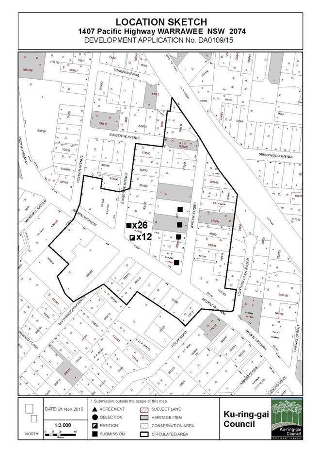
|
APPENDIX No: 2 - Zoning
extract
|
|
Item No: GB.4
|
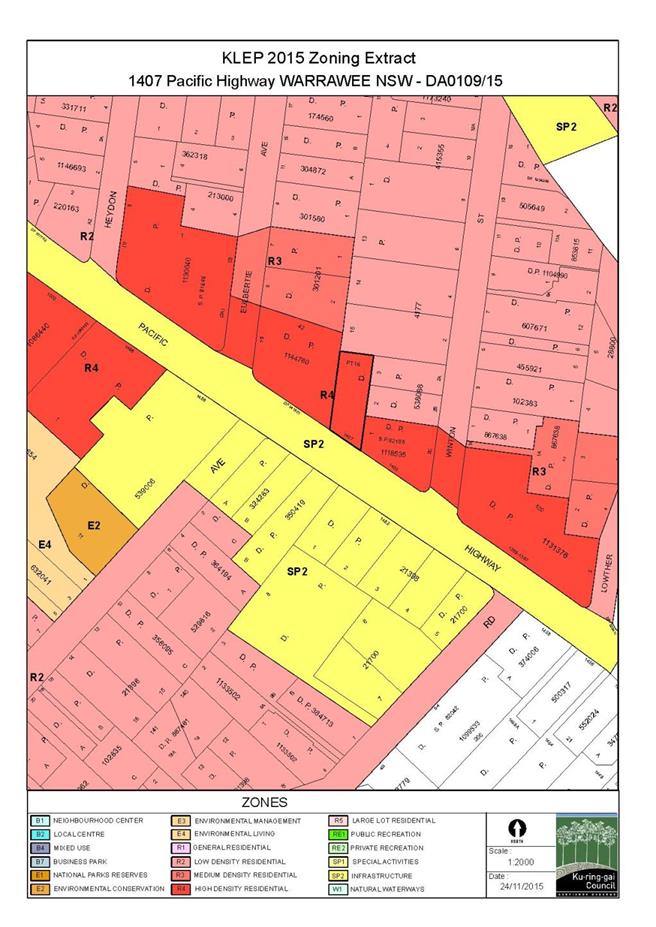
|
APPENDIX No: 3 - Site
plan
|
|
Item No: GB.4
|
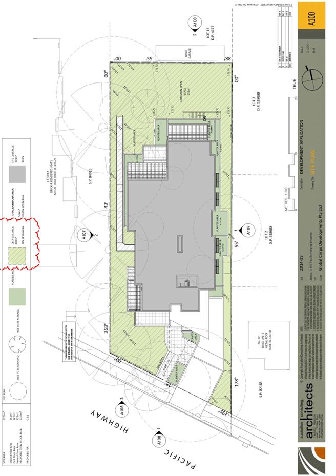
|
APPENDIX No: 4 - Basement
plan
|
|
Item No: GB.4
|
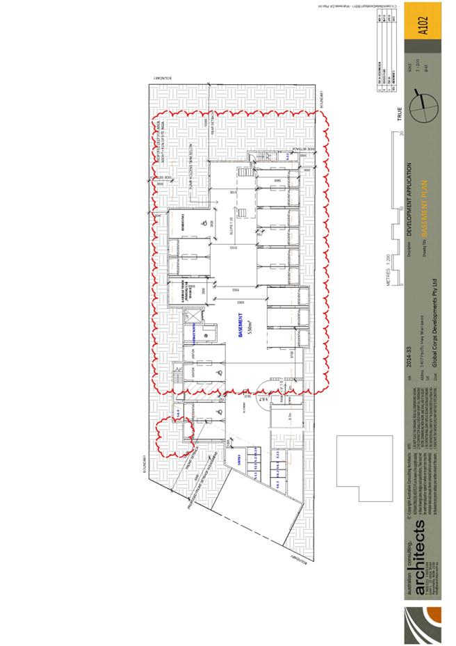
|
APPENDIX No: 5 - Ground
floor plan
|
|
Item No: GB.4
|
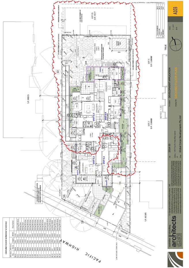
|
APPENDIX No: 6 - First
floor plan
|
|
Item No: GB.4
|
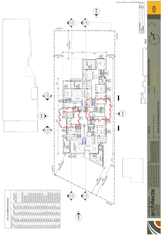
|
APPENDIX No: 7 - Second
floor plan
|
|
Item No: GB.4
|
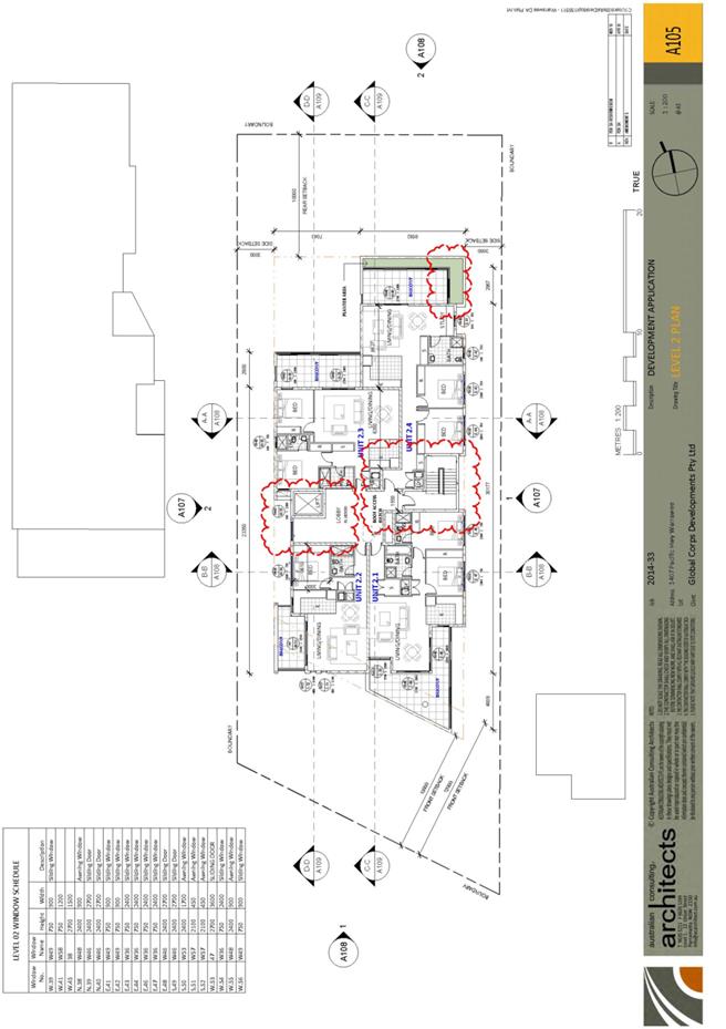
|
APPENDIX No: 8 - Roof
plan
|
|
Item No: GB.4
|
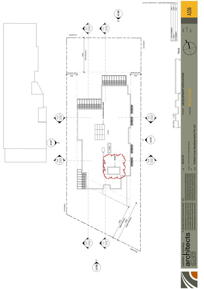
|
APPENDIX No: 9 - Eastern
and western elevations
|
|
Item No: GB.4
|
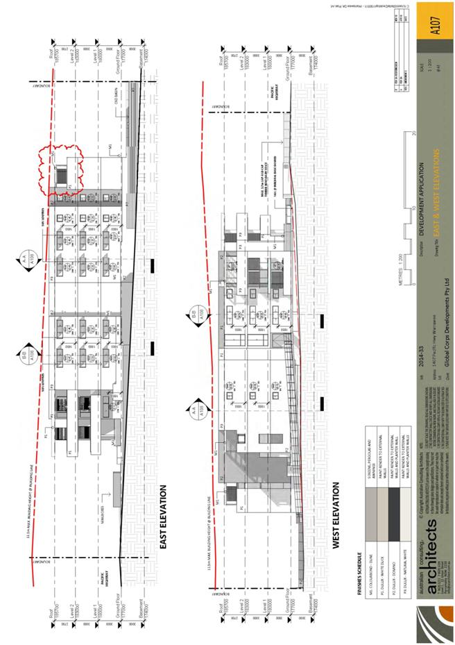
|
APPENDIX No: 10 - Northern
and southerns elevations; Sections
|
|
Item No: GB.4
|
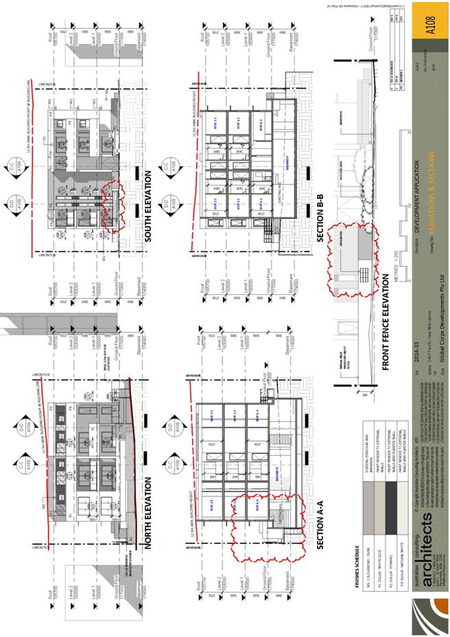
|
APPENDIX No: 11 - Landscape
plan
|
|
Item No: GB.4
|
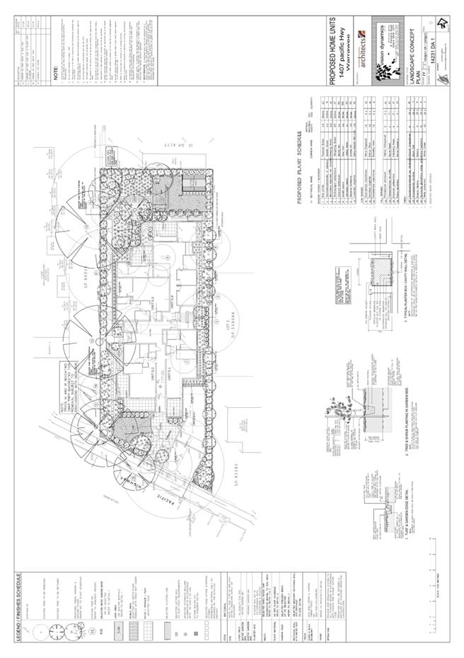
|
APPENDIX No: 12 - Clause
4.6 Variation - Site width
|
|
Item No: GB.4
|

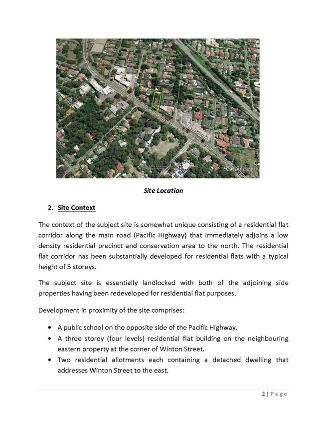
|
APPENDIX No: 13 - Clause
4.6 Variation - Floor Space Ratio
|
|
Item No: GB.4
|


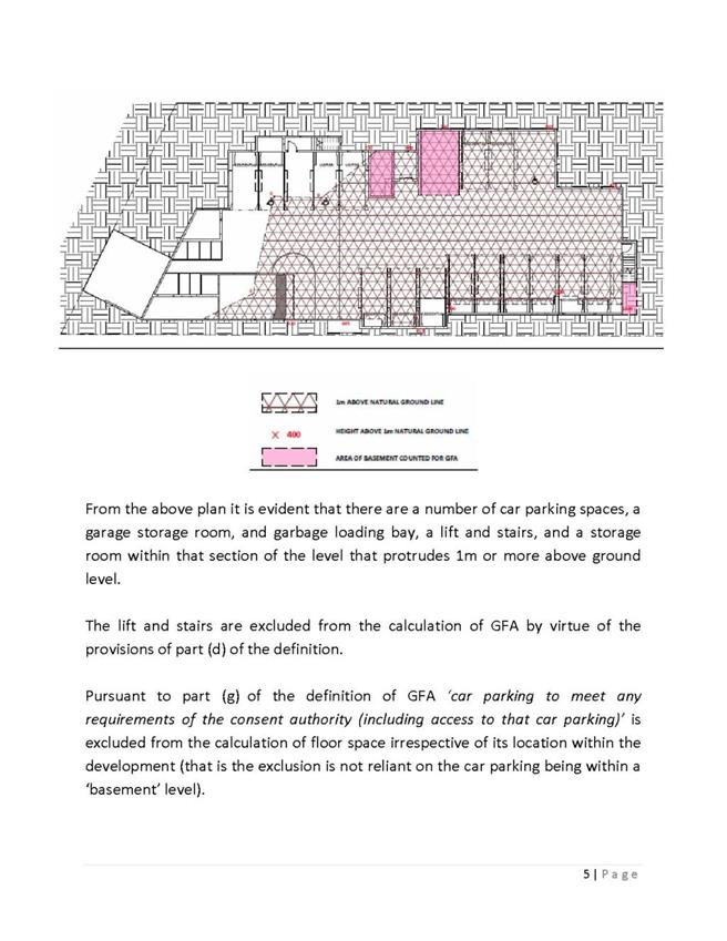
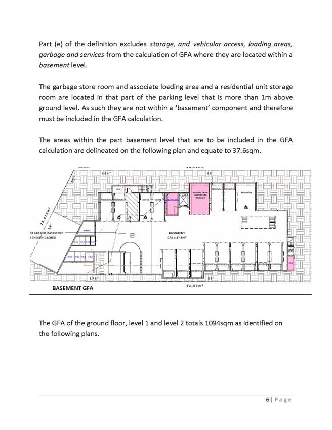
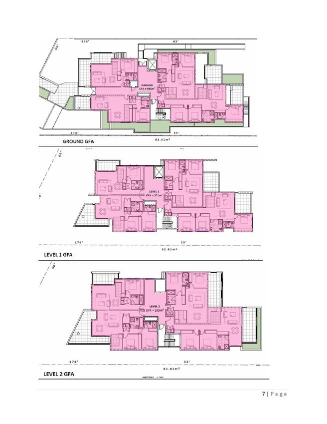


|
Ordinary
Meeting of Council - 8 December 2015
|
GB.5 / 371
|
|
|
|
|
Item
GB.5
|
S10467
|
|
|
29 May 2015
|
Turramurra Community Hub - update report
EXECUTIVE
SUMMARY
|
purpose of report:
|
The purpose of this report is to update Council on the
progress of the Turramurra Community Hub Master Plan.
|
|
|
|
|
background:
|
In December 2014 Council resolved to
adopt Design Option 2CA as the preferred land use scenario for the purposes
of public exhibition. Council also resolved to prepare a draft master plan
including exhibition material (detailed plans, sections and perspective
views) and that the draft master plan be placed on exhibition for a month in
the first half of 2015.
|
|
|
|
|
comments:
|
During the last12 months architectural consultants
were engaged to prepare a master plan as per Council’s resolution. This work
is now largely complete and ready for exhibition. At the same time a number
of other studies have been prepared and completed including:
- economic feasibility
study;
- peer review of economic
feasibility study;
- estimate of construction
costs;
- review of construction
costs for community facilities.
More recently a traffic and transport study has
commenced for Turramurra local centre. This is anticipated to be completed in
April 2016.
|
|
|
|
|
recommendation:
|
That the current draft master plan be refined to be
consistent with the findings of recent studies and that the draft master plan
is placed on public exhibition within the first half of 2016.
That the existing Planning Proposal applying to 5 Ray
Street and 12 William Street, Turramurra be amended to include the rezoning
and reclassification of the Turramurra Village Park site at 1275 Pacific
Highway, Turramurra.
|
Purpose of Report
The purpose of this report is to update Council on the
progress of the Turramurra Community Hub Master Plan.
Background
The preparation of a master plan for this site was triggered
in July 2013 when Council considered a report on the future of its landholdings
within the Ray Street Precinct in Turramurra, in light of a supermarket
redevelopment proposal by Coles Group Property Developments Ltd. At the time,
the matter was deferred for a Councillor briefing and a meeting with
representatives from Coles.
At the Ordinary Meeting of Council (OMC) held on 9 December
2014 Council resolved unanimously:
A. That
Council adopt Design Option 2CA as the preferred option for the purposes of
public exhibition and that the consultants are instructed to prepare a draft
master plan on that basis including exhibition material (detailed plans,
sections and perspective views).
B. That the
draft master plan be placed on exhibition for a month in the first half of
2015.
C. That
following completion of the exhibition a report be brought back to Council
with:
i. a
summary of submissions and community feedback from the exhibition; and
ii. recommendation
for a final master plan; and
iii. recommended
next steps.
D. That
staff and consultants meet with private property owners within the master plan
site boundary to present the draft master plan as resolved by Council.
E. That a
decision in relation to the location of a new library and community centre be
delayed pending community input and comment on the draft Turramurra Community
Facilities Study recommendations.
Resolutions A and D have been completed as set out in this
report.
Resolution B has been delayed due to the outcomes of
feasibility studies discussed in this report.
Resolution E is addressed in the draft master plan by
providing optional locations for community facilities so that the community
will be able to vote on their preferences.
Resolution C has been transferred to the recommendations in
this report.
Comments
During the last12 months
architectural consultants were engaged to prepare a master plan as per
Council’s resolution. This work is now largely complete and ready for
exhibition. At the same time a number of other studies have been prepared and
completed including:
· estimate of construction costs;
· review
of construction costs for community facilities
· estimate
Report - Proposed Turramurra Railway Overbridge;
· Turramurra
Community Hub - Retail Assessment;
· Turramurra
Community Hub - Economic Feasibility Study;
· Turramurra
Community hub - Peer Review of Retail Assessment and Feasibility Analysis;
· survey
of usage of Turramurra Village Park;
· Turramurra Local Centre Traffic and
Transport Study.
An outline of the studies is set out below. The full studies
are available as attachments.
1. Estimate of construction costs
Quantity surveyors were engaged to prepare an estimate of
construction costs to guide preparation of the master plan and feasibility
analysis. A key finding of this study is the high cost of basement parking due
to the proximity of the site to the rail line.
Refer Draft Turramurra Community Hub – Concept Design
Stage Estimate Report, Rider Levett Bucknall, May 2015 Confidential
Attachment A1.
2. Review of construction costs for community
facilities (including fit out)
Quantity surveyors were engaged to provide advice on
appropriate construction cost rate for community facilities. The study was
prepared for the Lindfield Community hub project but is directly applicable to
the Turramurra Hub. The study finds:
· To construct facilities that include
high quality feature facades, information technology facilities, audio visual
facilities and spaces that can be adopted for large and small groups a budget
for construction cost rate of $4,500.00/m2 is recommended. This rate
would include the construction of internal walls, glazed screens, floor and
ceiling finishes and specialised facilities such as computer data points, WIFI
networks, security and audio visual systems.
· Fit out costs including items such as
loose fittings and equipment e.g. table, chairs, shelving, appliances such as
refrigerators, microwave ovens to staff facility areas. An additional allowance
of $1,500/m2 is recommended
This study has identified an increase in overall
construction costs when compared to the original budget estimate. These additional
amounts have not been incorporated into the current feasibility analysis.
Refer Lindfield Community Hub – Peer Review Paper, Rider
Levett Bucknall, June 2015 Confidential Attachment A2.
3. Estimate Report - Proposed Turramurra Railway Overbridge
Quantity surveyors were engaged to prepare an estimate of
construction costs for a possible Turramurra Railway Overbridge which would be
located at the end of Ray Street connecting to Rohini Street. The study gives
an indicative construction cost of $8.6 million.
Refer Estimate Report- Proposed Turramurra Railway
Overbridge, Rider Levett Bucknall, June 2015 Attachment A3.
4. Turramurra Community Hub - Retail Assessment
A retail consultant was commissioned to undertake a retail
demand and impact study. The purpose of this study is to provide Council with a
better understanding of the quantum of retail floor space that could be
supported within the Turramurra Community Hub.
The study finds that:
· There is a large undersupply of retail
floor space within Turramurra Centre, particularly in supermarket space.
· The quantum of floor space demanded by
residents of the Main Trade Area (MTA) is sufficient for the development of a
4,000m2 supermarket. The unique characteristics of Turramurra centre
would also lend weight to the argument that development of a full-line
supermarket in this location would be a positive outcome for the surrounding
residents (especially north of the Pacific Highway).
· The addition of up to a further 3,200m2
of specialty retail floor space to complement the supermarket is supportable.
Given the quantum of supportive retail floor space proposed, there is the
possibility for the inclusion of a mini-major to further strengthen the retail
offer of the centre.
· Overall the proposed retail would
constitute a positive contribution to the economic health of Turramurra Centre
as a whole.
Refer Turramurra Community Hub Retail Assessment,
HillPDA, January 2015, Attachment A4.
5. Turramurra Community Hub - Economic Feasibility
Study
Land economists were engaged to provide economic feasibility
and market research advice as well as assisting with the identification of
barriers and risks to a successful financial and development outcome for the
Turramurra Community Hub.
The study finds that the draft master plan has a positive
residual land value which could give incentive for a developer to purchase and
redevelop the land in accordance with the master plan. However HILLPDA
conditioned this finding with a number of key risks which led them to recommend
Council consider a higher floor space ratio on the site to improve feasibility.
As this recommendation was not consistent with Council’s
resolution of 11 November 2013 (which requires the master plan to be consistent
with current LEP controls) and there is a lack of clarity around the report
findings it was decided to undertake a peer review of this study.
Refer Turramurra Community Hub - Development Proposal
Feasibility Analysis, HillPDA, June 2015, Confidential Attachment A5.
6. Turramurra
Community hub - Peer Review of Retail Assessment and Feasibility Analysis
Land Economists together with retail specialists were
commissioned by Council to undertake a high-level peer review of the
feasibility analysis and retail assessment carried out as part of the
Masterplan development by HillPDA.
The purpose of the Peer Review is to test the
strength/robustness of the Feasibility Analysis from first principles by:
· examining the appropriateness of the
methods and techniques employed; and
· considering the appropriateness of
assumptions made.
The review finds the original feasibility analysis lacking
in clarity and logic. Key issues include:
· estimated sales rates;
· background and property market
research;
· premise/logic of feasibility modelling;
and
· Council development contributions.
The peer review finds that the master plan is broadly
feasible with the contribution of allocated S94 funds by Council (which is the
same basis on which Council has moved forward on the Lindfield Community Hub).
The report identifies a number of risk inherent in the preferred Masterplan
option and recommends further refinement of the master plan prior to public
exhibition.
Refer Turramurra Community Hub - Peer Review of Retail
Assessment and Feasibility Analysis, AEC Group and Location IQ, November 2015, Confidential
Attachment A6.
7. Survey of usage Turramurra Village Park
Council engaged a specialist to
survey the number of people who use Turramurra Village Park over a 5 day period
(Wednesday, Thursday, Friday, Saturday and Sunday). The method used was to
place a small camera in the park (not concealed) and desk top analysis of the
film footage. The results are tabulated below.
In total 207 people used the park
over this period with 51% (105 people) walking through the park with an average
duration of stay of 1.5 minutes; 21% (44 people) stopped to take rest with an
average duration of 20 minutes. One person spent 48 minutes in the park feeding
the birds; a further 3% used the park to wait for/meet someone with an average
duration 17 minutes; the remainder of people used the park for unidentified
reasons with stays of between 4 minutes-12 minutes.
|
Walking through the park
|
Exercise
|
Taking a rest
|
Wait/Meet someone
|
Other
|
Unknown
|
|
Category of use ->
|
1
|
2
|
3
|
4
|
5
|
|
|
qty
|
105
|
0
|
44
|
6
|
34
|
18
|
|
%
|
51%
|
0%
|
21%
|
3%
|
16%
|
9%
|
|
Avg Dur (hr:mins:s)
|
0:01:31
|
|
0:20:00
|
0:17:00
|
0:04:00
|
0:12:00
|
|
incl feeding birds
|
|
|
0:48:00
|
|
|
|
These numbers represent not
insignificant usage rates and it is clear that future planning for the park
must retain a path through the site with seats and shade and landscape gardens.
This would cater for about 75% or more of current users of the park. The
additional parklands proposed within the master plan will cater for existing
users of the park as well as a range of new users who currently do not visit
the area for recreation.
8. Turramurra Local Centre Traffic and Transport
Study
More recently a traffic and transport study has commenced
for Turramurra Local Centre. This is anticipated to be completed by April 2016.
A key part of the study will be to test the capacity of the
site to support the level of development proposed in the master plan. The study
will also determine whether a railway overbridge would be required connecting
Ray Street to Rohini Street. Tidal flow operation on the Pacific Highway would
also be important considerations within this study.
The study will examine all modes of transport within the
area but also specifically consider the role of the existing bus interchange
off Rohini Street.
The traffic surveys (Intersection Counts & Travel Time
Surveys) were undertaken during the week beginning October 2015 and it is
planned to complete the base traffic model by the end of 2015.
9. Summary and Recommendations
During 2015 a considerable amount of work has been
undertaken to prepare a draft master plan for the Turramurra Community Hub,
this includes:
· Preparation of architectural plans,
sections, models and renderings;
· Feasibility analyses including a peer
review; and
· Cost estimate reports by quantity
surveyors.
Chrofi Architects commenced preparation of a master plan for
the Turramurra Community Hub in early 2015 following the resolution of Council
in December 2014 to proceed with a preferred option. A draft master plan was
completed in June 2015 which is consistent with Design Option 2CA and is
consistent with the development standards within the Ku-ring-gai LEP (Local
Centres) 2013 i.e. maximum building height of 5 storeys (17.5 metres) and FSR
of 1.8:1. Figure 1 shows the draft master plan.

Figure 1 - Draft Turramurra Community Hub Master Plan
(not exhibited)
Feasibility analysis has found that the master plan is
broadly feasible with the contribution of allocated S94 funds by Council (which
is the same basis upon which Council has progressed the Lindfield Community
Hub). However further refinements are recommended prior to public exhibition.
Additional refinements recommended before public exhibition
include:
· incorporation of the revised
construction costs for community facility construction and fit out as
recommended in the Lindfield Community Hub – Peer Review Paper, Rider Levett
Bucknall, June 2015; and
· completion of the Turramurra Transport
Study to ensure the mix and quantum of floor space within the master plan will
not have serious negative impacts on the traffic network and to determine
whether a railway overbridge connecting Ray Street to Rohini Street would be
required to service the site and if it necessary how it might be funded.
integrated planning and reporting
Council has adopted the Revised Delivery
Program 2013-2017 and Draft Operational Plan 2015-2016; this plan commits
Council to master planning for the revitalisation of the Turramurra Local
Centre and surrounding precincts.
Theme 3 - Places, Spaces and Infrastructure
|
Community Strategic Plan Long Term Objective
|
Delivery Program
Term Achievement
|
Operational Plan
Task
|
|
A range of well planned, clean and safe neighbourhoods and
public spaces designed with a strong sense of identity and place.
|
4.1.1
Plans to revitalise local centres are being progressively
implemented and achieve quality design outcomes in collaboration with key
agencies, landholders and the community.
|
Progress master planning for the Turramurra Centre and
surrounding precincts.
Engage with key community stakeholders to identify the
requirements for new community facilities and infrastructure.
Finalise the reclassification of identified lands as
resolved by Council.
|
|
A healthy, safe, and diverse community that respects our
history, and celebrates our differences in a vibrant culture of learning.
|
C4.1.2
New and enhanced open space and recreational facilities
have been delivered to increase community use and enjoyment.
|
Undertake acquisitions for new parks.
Undertake assessment and identify locations for new parks
Complete the design for identified parks and include
design principles which facilitate passive recreation activities.
Construct parks at identified locations and include design
principles which facilitate passive recreation activities
|
FIT FOR THE FUTURE IMPROVEMENT ACTION
PLAN
The NSW Government's Fit for the Future initiative required
all Councils to prepare an Improvement Proposal and supporting Implementation
Plan demonstrating how all seven Fit for the Future benchmarks would be met by
2016/17, and maintained or improved thereafter.
Council's Fit For the Future Improvement Proposal and
supporting Implementation Plan underpins the decision to stand alone and
not merge with Hornsby Council. The objectives established in the Improvement
Proposal and Implementation Plan are embedded in Council's adopted Integrated
Planning and Reporting documents including the Revised Delivery Program
2013-2017 and Operational Plan 2015-2016, Long Term Financial Plan
2015/16 to 2024/25 and Asset Management Strategy 2015/16 to 2024/25.
Council’s Fit For the Future Improvement Proposal
sets out the following strategies and outcomes to meet the State governments Efficiency
criteria:
|
EFFICIENCY
|
|
Objective
|
Strategies
|
Key milestones
|
Outcome
|
|
Major
Local and Town Centres projects i.e. Community hub projects are commercially
feasible in their own
right
|
Projects
should include commercial opportunities for Council to offset ongoing
operational costs (life cycle costs) of the public benefits provided
|
Masterplans
adopted for Local and Town Centres 2015/2016
EOI for the
redevelopment of Turramurra Local Centre 2015/2016.
Redevelopment of
Turramurra Local Centre 2016/2017.
|
Masterplans
adopted for the Local and Town Centres with development options substantially
progressed to deliver community facilities and public benefits.
|
Governance Matters
In November 2013 Council resolved to reclassify its land
holdings at 5 Ray Street and 12 William Street, Turramurra, to remove the RE-1
zone from the precinct and commence preparation of a master plan. At the OMC
held on 9 December 2014, Council resolved to adopt Option 2CA as the preferred
option for purposes of public exhibition, and the basis on which to prepare a
Draft Master Plan for the site.
A key aspect of Option 2CA is the proposal to relocate
Turramurra Village Park and utilise the existing park site for a community
building. The current draft master plan is consistent with this proposal and it
is now timely to commence reclassification and amending the LEP standards to
facilitate Council’s vision. Section 45 of the Local Government Act, 1993
prevents Council from selling; exchanging, or otherwise disposing of Community classified
land.
A Planning proposal to reclassify 5 Ray Street and 12
William Street from Community land to Operational land and to remove RE1 zone
from the precinct and replace it with a B2 Local centre zone via an amendment
to Ku-ring-gai Local Centres LEP (2012) has been prepared in accordance with Section
55, Environmental Planning and Assessment Act, 1979 and submitted to the
Department of Planning and Environment for a Gateway determination. A Gateway
determination has yet to be issued for the Planning Proposal.
Under section 58 of the EP&A Act, Council may, at any
time, vary its proposals as a consequence of its consideration of any
submission or report during community consultation or for any other reason. If
it does so, a revised Planning Proposal is to be forwarded to the Minister.
Given that a gateway determination has yet to be issued for the existing
Planning Proposal the opportunity exists to seek to amend the existing planning
proposal to also incorporate the Turramurra Village Park rather than prepare a
new separate planning proposal. This would also have the benefit of having
only one Planning Proposal applying to the whole master plan area.
In terms of Floor Space Ratio provision the park is 870m2
in area and a 3 storey community building with 2,250 GFA is proposed. The
master plan provides for a path and landscape gardens on the eastern side so
the building does not have full site coverage. Given this an FSR of 2.5:1 is
appropriate.
It is therefore proposed that the existing planning proposal
applying to 5 Ray Street and 12 William Street be varied as follows:
i. incorporate
the site 1275 Pacific Highway, Turramurra (Turramurra Village Park) (Lot 1 DP
81994);
ii. reclassify
the site from Community land to Operational land and extinguish any necessary
interest applying to the land to enable the implementation of the Turramurra
Community Hub Master Plan; and
iii. rezone
the site from RE1 Public Recreation to B2 –Local centres with a maximum
building height of 17.5m and FSR of 2.5:1.
Risk Management
The major risk to Council at this point in time is
reputational.
While the draft master plan could be publicly
exhibited in its current form (as it is consistent with all Council’s
resolutions and it is feasible) it is considered prudent to undertake a number
of refinements as recommended in this report as well as complete the Turramurra
local centre traffic and transport study prior to public exhibition. This will
ensure that when the master plan is exhibited the plan will be robust, feasible,
meet the likely market demand as well as community expectations.
Financial Considerations
If Council adopts the recommendations in this report, the
draft master plan will progress to public exhibition in the first half of 2016.
There are currently adequate funds available within the project account to
cover the costs of this work.
To date Council has expended over $400,000.00 on this
project including salaries and consultancies. These funds have been taken from
development contributions 2010 Plan Recreational, Cultural & Social
Facilities. It is important that Council continues to progress this project, if
not Council may be required to repay part of the S94 funds spent to date if the
works are not delivered.
Council’s Long Term Financial Plan (LTFP) identifies a total
of approximately $26 million allocated from S94 Ku-ring-gai Contributions Plan,
2010 for works associated with the Turramurra Community Hub. These funds will
be Council’s contribution toward the project and have been taken into account
when preparing the preliminary economic
feasibility assessment.
Social Considerations
Council’s Community Strategic Plan 2030, recognises
the community’s vision for Ku-ring-gai as
a place with infrastructure and facilities which accommodate the needs of the
community. The plan further emphasises the desire for an adopted program for
the implementation of new facilities, identified funding sources and a program
to maintain Council’s assets at a sustainable standard.
Currently the precinct is utilised for car parking by
shoppers, commuters and local business owners. Beyond this function the site
provides very little social benefit to the community and is very much an
under-utilised asset for Council. The site has the potential to provide new
community buildings and open space which will provide a high level of social
benefit to the community. If Council were to actively participate in
redevelopment within this precinct it would present new opportunities to bring
forward the delivery of public infrastructure or facilities by many years.
Environmental Considerations
The following environmental studies have been undertaken to
date:
· Stage 1 preliminary site investigation
(to assess the likelihood of contamination to be present on the site);
· Initial geotechnical site assessment;
and
· Dial before you dig.
Community Consultation
To date the draft master plan has not been publicly
exhibited. Targeted stakeholder consultation has occurred as follows:
- landowner
meeting - 16 February 2015 – all landowners within the precinct were
invited to attend a briefing and question and answer session;
- meetings
on 12 February 2015, 2 April 2015 and 16 June 2015 between Coles representatives,
Council staff and Council’s architects to discuss for working inputs around
design matters, details of Coles design requirements and examples of similar mixed-use
projects Coles have previously undertaken;
- ongoing
discussions and meetings with representatives from Beautify Turramurra and
Support Turramurra;
- meeting
with Turramurra HACC service providers on 12 May 2015; and
- meetings
and discussions with representatives from Transport for NSW and Sydney Trains
regarding re-alignment of railway fences on Rohini Street and William Street.
Internal Consultation
A Project Control Group [PCG] has been established for the
major projects within the local centres; the PCG meets bi-monthly and forms the
primary management entity for the duration of the project, comprising the
project manager and the relevant discipline project team leaders from across
Council. The PCG will vary its composition during the different phases of the
project, depending on the skills and expertise required. Three (3) PCG meetings
have been held to date during 2015.
Six information sessions have been held for Councillors:
· a briefing was held on 8 October
2014 at which consultants presented a draft site analysis, design principles,
preliminary design options and financial assessment;
· the draft design options were
presented to Councillors at two site inspections held on 22 and 28 October
2014. At the final site inspection chalk markings were provided around the site
to assist Councillors in understanding the design options;
· consultants briefed Councillors on 1
December 2014 on the draft Turramurra Community Facilities Study as well as the
Ku-ring-gai Community Facilities Strategy (LGA wide);
· a briefing session was held on 4
June 2015 to update councillors on the Draft Master Plan for the site; and
· a briefing session was held on 4
August to present to Councillors the completed draft master plan and model.
Summary
This report finds that the Turramurra Community Hub Master
Plan is broadly feasible with the contribution of allocated S94 funds by
Council, subject to ongoing review of costs.
The report also notes that the draft master plan is
consistent with Design Option 2CA and is consistent with the development
standards within the Ku-ring-gai LEP (Local Centres) 2012 i.e. maximum building
height of 5 storeys (17.5 metres) and FSR of 1.8:1.
The Turramurra Community Hub - Peer Review of Retail
Assessment and Feasibility Analysis prepared by AEC Group recommends
further refinement of the master plan prior to public exhibition
to ensure the plan is robust and will meet the likely market demand.
In addition to the above this report recommends the
following be undertaken prior to public exhibition:
· Modifications to the feasibility model
to incorporate the revised construction costs for community facility
construction and fit out as recommended in the Lindfield Community Hub –
Peer Review Paper, Rider Levett Bucknall, June 2015;
· Completion of the Turramurra Transport
Study to ensure the mix and quantum of floor space within the master plan will
not have serious negative impacts on the traffic network and to determine
whether a railway overbridge connecting Ray Street to Rohini Street would be
required to service the site and if it necessary how it might be funded.
It is further proposed that the existing planning proposal
applying to 5 Ray Street and 12 William Street, Turramurra be varied to also
incorporate the Turramurra Village Park site at 1275 Pacific Highway,
Turramurra (Lot 1 DP 81994). That the site be reclassified from community land
to operational land and rezoned to B2 Local centre so as to facilitate the
implementation of the Council’s vision.
|
Recommendation:
That:
A. The draft master plan be
refined to take into account the findings of the Turramurra Community Hub
- Peer Review of Retail Assessment and Feasibility Analysis, December 2015;
B. The project construction
estimates be updated to reflect the refinements to the master plan and the
updated cost estimates for the construction and fit-out of community
facilities;
C. The feasibility modelling
and analysis be updated to take into account the refinements to the master
plan and the updated cost estimates;
D. The Turramurra local
centre traffic and transport study be completed and consideration given to
the implications for the master plan prior to exhibition;
E. The refined draft master
plan is publicly exhibited within the first half of the year 2016;
F. The refined draft master
plan be reported back to Council prior to public exhibition if the above
amendments cannot be made within the current LEP provisions or within the
scope of Council’s resolutions in relation to the project;
G. That
following completion of the exhibition a report be brought back to Council
with:
i. a
summary of submissions and community feedback from the exhibition;
ii. recommendation
for a final master plan; and
iii. recommendations
on the next steps.
H. That
the existing Planning Proposal applying to the 5 Ray Street and 12 William
Street, Turramurra be varied in accordance with section 58 of the EP&A
Act as follows:
i. incorporate
the site 1275 Pacific Highway, Turramurra (Turramurra Village Park) (Lot 1 DP
81994);
ii. reclassify the site from
Community land to Operational land and formally seek to discharge all
necessary interests applying to the land to enable the implementation of the
Turramurra Community Hub Master Plan; and
iii. rezone
the site from RE1 Public Recreation to B2 Local Centres with a maximum
building height of 17.5m and FSR of 2.5:1.
|
|
Sarah Koshy
Senior Urban Designer
|
Bill Royal
Team Leader Urban Design
|
|
Antony Fabbro
Manager Urban & Heritage Planning
|
Andrew Watson
Director Strategy & Environment
|
|
Attachments:
|
A1
|
Draft
Turramurra Community Hub - Concept Design Stage Estimate Report, Rider Levett
Bucknall, May 2015
|
|
Confidential
|
|
|
A2
|
Lindfield
Community Hub - Peer Review Paper, Rider Levett Bucknall, June 2015
|
|
Confidential
|
|
|
A3View
|
Estimate
Report - Proposed Turramurra Railway Overbridge, Rider Levett Bucknall, June
2015
|
|
2015/137422
|
|
|
A4View
|
Turramurra
Community Hub Retail Assessment, Hill PDA, January 2015
|
|
2015/154945
|
|
|
A5
|
Turramurra
Community Hub - Development Proposal Feasibility Analysis, Hill PDA, June
2015
|
|
Confidential
|
|
|
A6
|
Turramurra
Community Hub - Peer Review of Retail Assessment and Feasibility Analysis,
AEC Group and Location IQ, November 2015
|
|
Confidential
|
|
APPENDIX
No: 3 - Estimate
Report - Proposed Turramurra Railway Overbridge, Rider Levett Bucknall, June
2015
|
|
Item No: GB.5
|
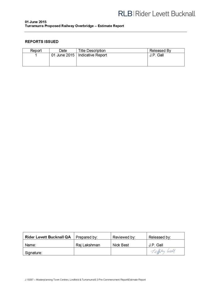
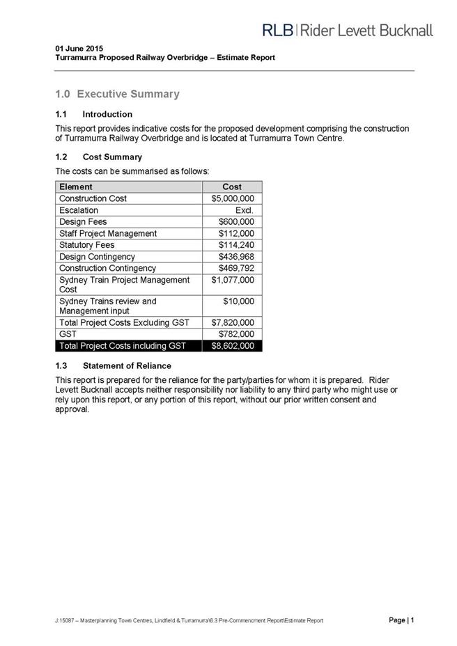
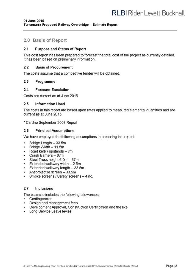
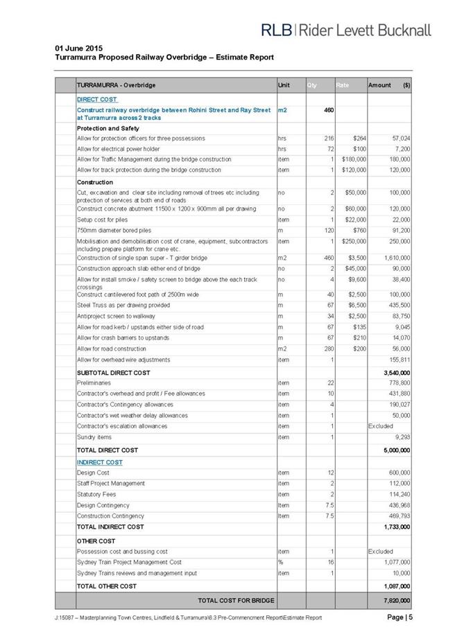

|
APPENDIX No: 4 - Turramurra
Community Hub Retail Assessment, Hill PDA, January 2015
|
|
Item No: GB.5
|

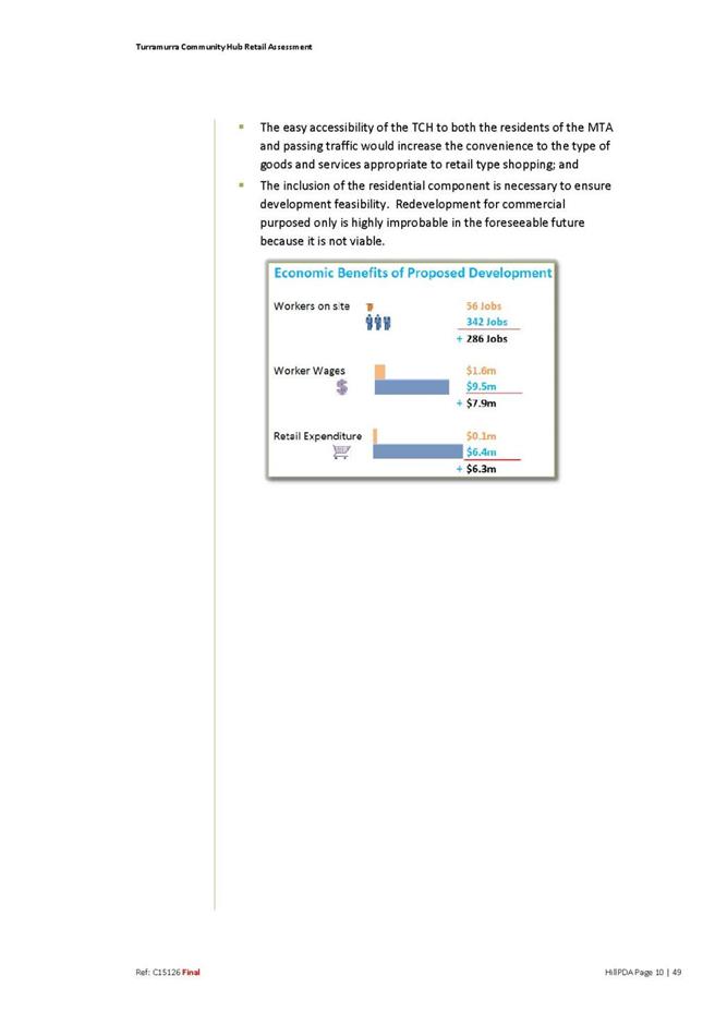

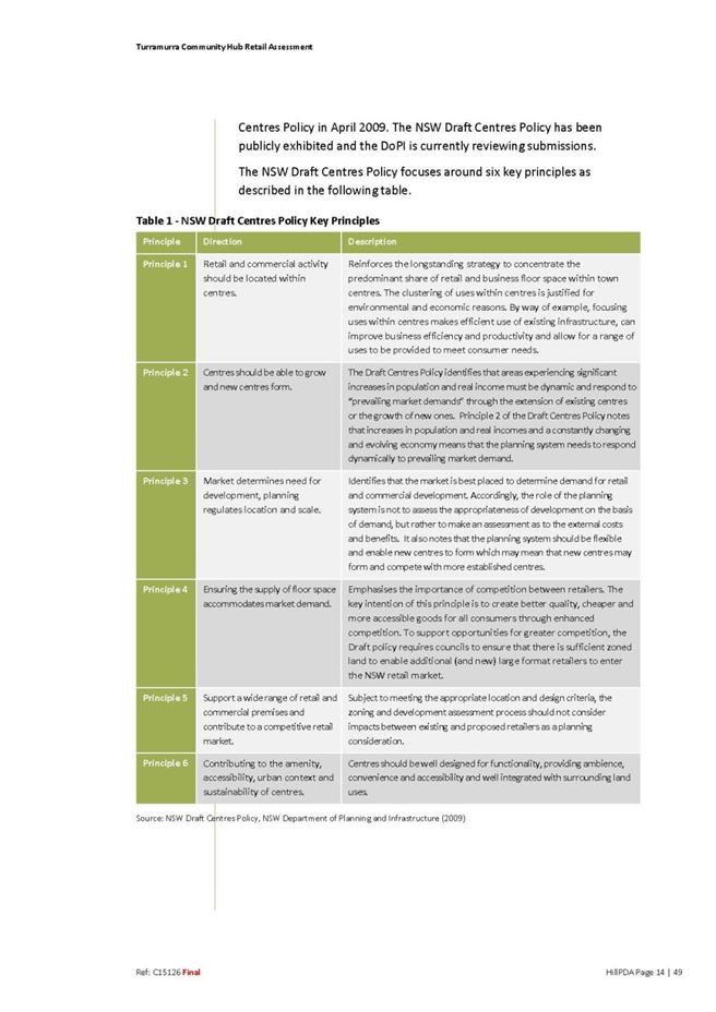

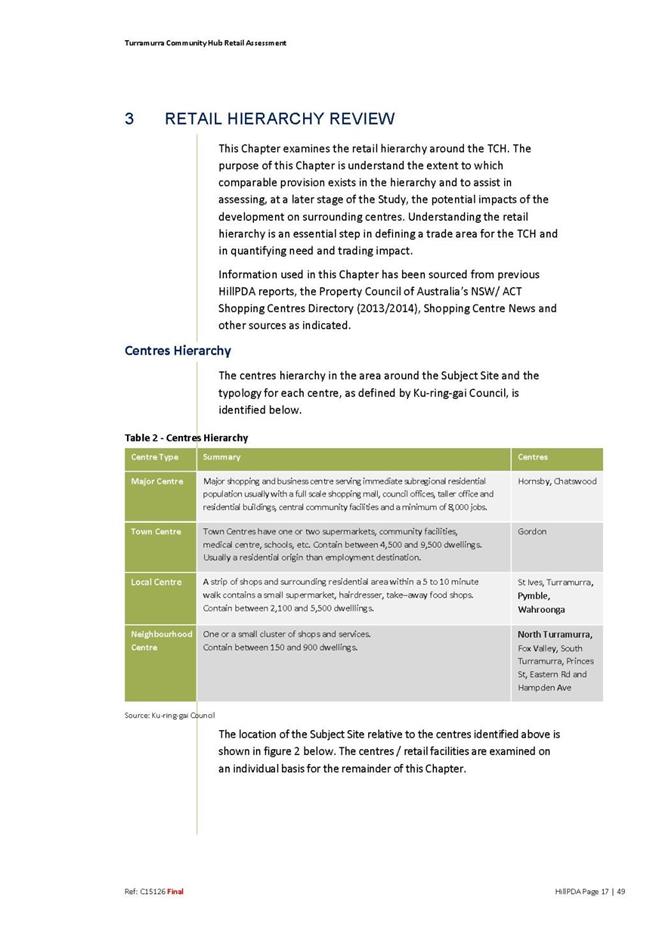
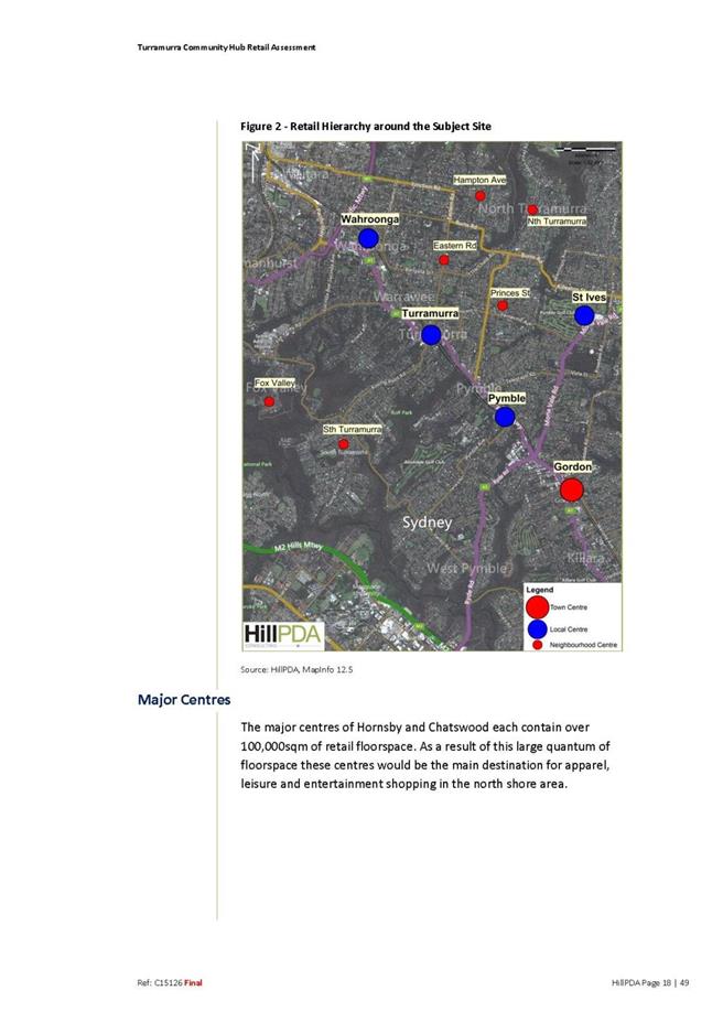
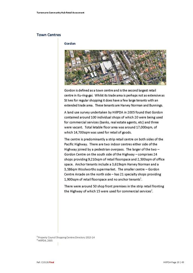
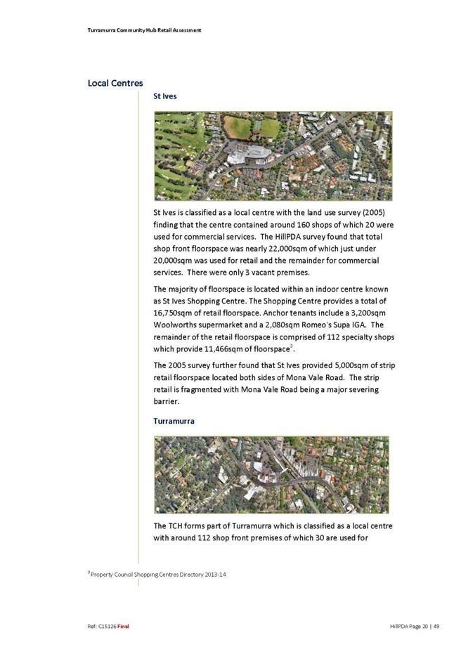

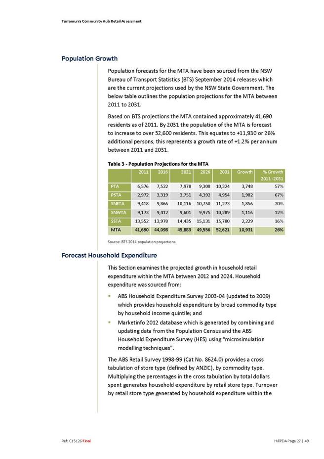
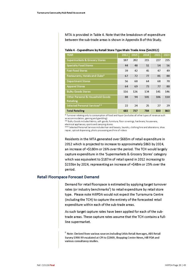
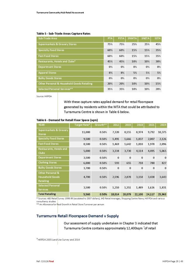
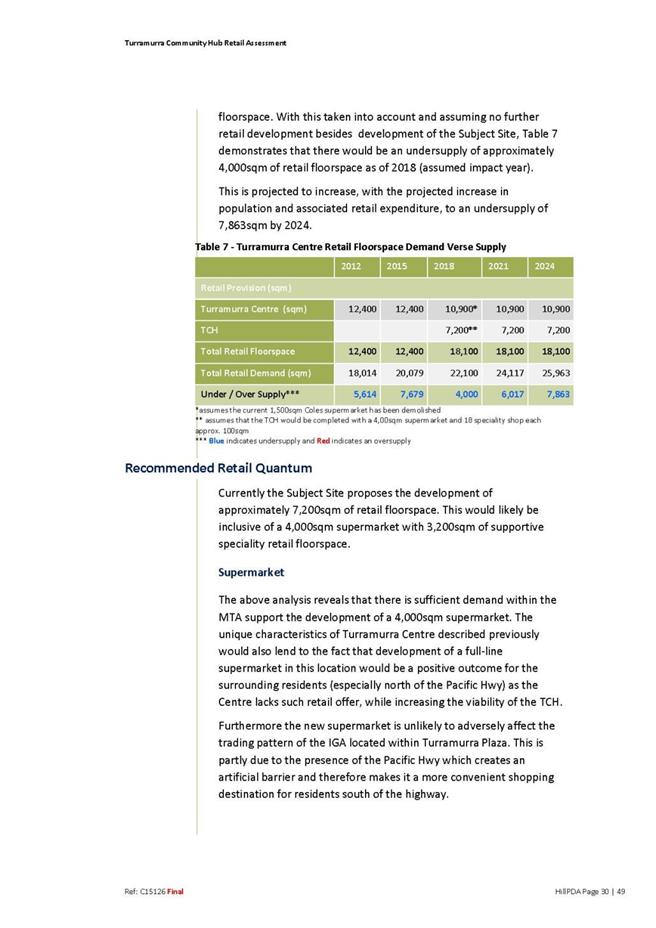
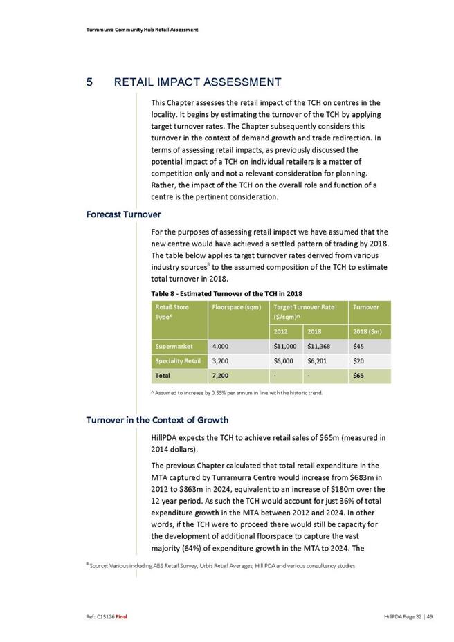
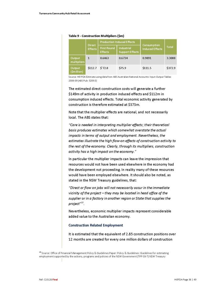

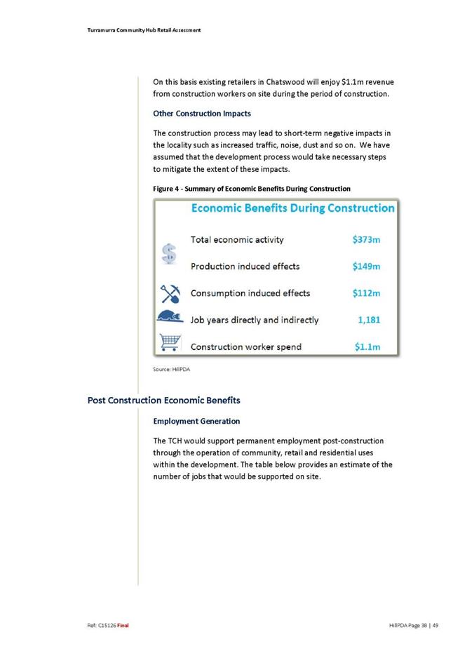
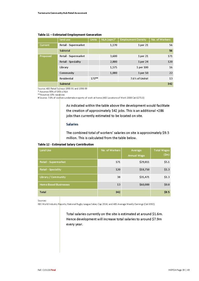
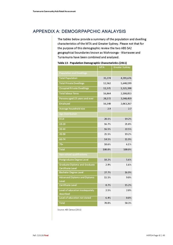
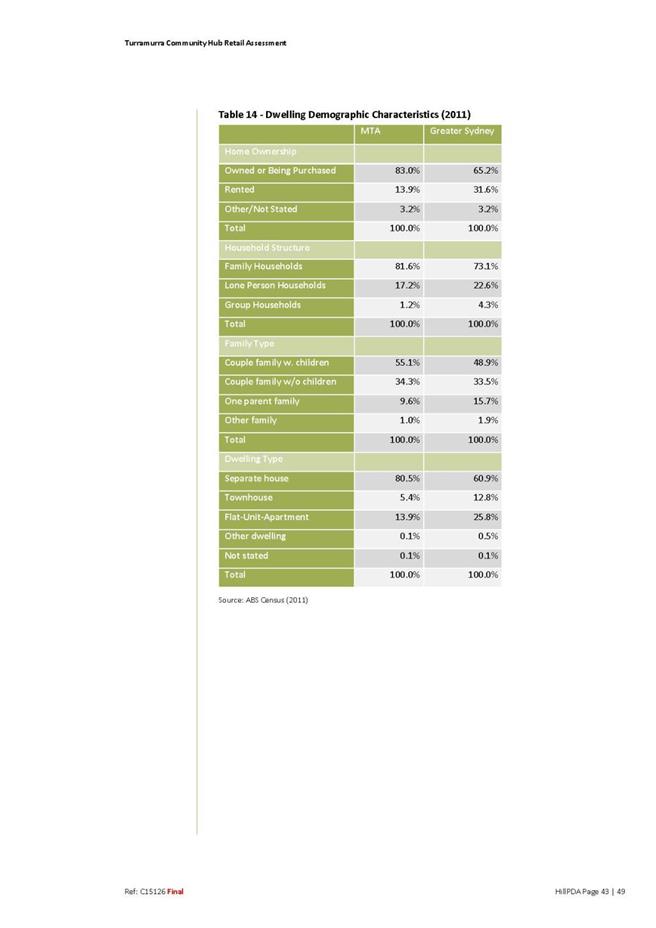
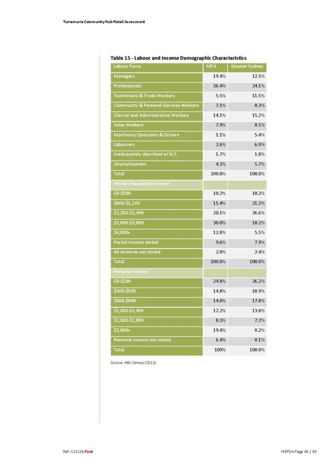
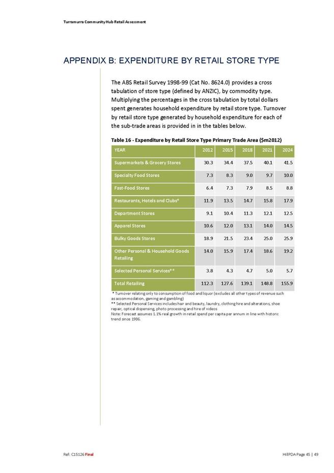

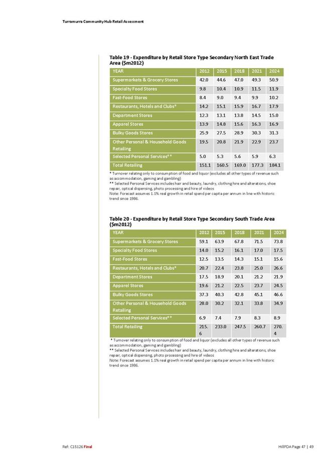


|
Ordinary
Meeting of Council - 8 December 2015
|
GB.6 / 442
|
|
|
|
|
Item
GB.6
|
S10748
|
|
|
21 September 2015
|
Planning Proposal for 45-47 Tennyson
Avenue and 105 Eastern Road Turramurra to amend the Ku-ring-gai Local Environmental
Plan 2015
EXECUTIVE
SUMMARY
|
purpose of report:
|
For Council to consider a Planning Proposal for 45-47
Tennyson Avenue and 105 Eastern Road, Turramurra.
|
|
|
|
|
background:
|
The Planning Proposal was lodged on 12 August 2015 and
seeks to amend the KLEP 2015 as follows:
· Rezone the subject sites from R2 Low
Density Residential to B1 Neighbourhood Centre;
· Amend the Floor Space Ratio applying
to the subject sites from 0.3: 1 to 0.75 :1; and
· Amendment
to Schedule 1 – Additional Permitted Uses to allow a gross floor area of
1,955sqm for the purposes of an Aldi store and speciality shops on the
subject sites.
|
|
|
|
|
comments:
|
The purpose of this report is to determine whether the
Planning Proposal should be submitted to the Department of Planning and
Environment for a Gateway Determination and proceed to public exhibition.
|
|
|
|
|
recommendation:
|
That Council notifies the applicant that it will not
support the Planning Proposal.
|
Purpose of Report
For Council to consider a Planning Proposal for 45-47 Tennyson
Avenue and 105 Eastern Road, Turramurra.
Background
A Pre- Planning Proposal meeting was held with the
proponents and Council staff on 27 May 2015.
The Planning Proposal was submitted to Council on 12 August
2015, which seeks to make the following amendments to the KLEP 2015:
· rezone the subject sites from R2 Low
Density Residential to B1 Neighbourhood Centre;
· amend the Floor Space Ratio applying to
the subject sites from 0.3: 1 to 0.75 :1; and
· amendment to Schedule 1 – Additional
Permitted Uses to allow a gross floor area of 1,955sqm for the purposes of an
Aldi store and speciality shops on the subject sites.
The documents submitted were not in accordance with
Council’s requirements. Following the submission of additional documentation,
the review of the Planning Proposal formally commenced on 2 September 2015. A
copy of the Planning Proposal and appendices are included at Attachments A1
– A10.
A copy of the Planning Proposal and appendices were made
available on Council’s website mid November 2015. It should be noted that there
is no requirement to make these documents publically available until the
proposal proceeds to public exhibition, after a Gateway Determination is
issued.
A flow chart of the Planning Proposal process is included at
Attachment A11.
Site Description and Local Context
The sites that are the subject of this Planning Proposal
are:
· 45-47 Tennyson Avenue, Turramurra (Lot
1 DP 4323 and Lot 2 DP 515147); and
· 105 Eastern Road, Turramurra (Lot 1 DP
515147).
The sites have frontages to Eastern Road, Tennyson Avenue
and Alice Street, with combined area of approximately 5,120sqm.
The sites are currently occupied by Parkers Nursery and the
GRD Automotive Services’ Service Station.
The sites are currently zoned R2 Low Density Residential
under the Ku-ring-gai Local Environmental Plan 2015 (KLEP 2015).
The KLEP 2015 was largely a translation of the
Ku-ring-gai Planning Scheme Ordinance (KPSO) into the form of the
Standard Instrument LEP. Under the KPSO the subject sites were zoned
Residential 2(C), and were translated to the comparable Standard Instrument LEP
zoning of R2 Low Density Residential zone within the KLEP 2015.
The subject sites are located within a predominantly low
density residential area. To the south of the subject sites is the Eastern Road
neighbourhood centre shops – which consist of a small IGA supermarket, BWS
liquor store, pharmacy, butcher, fruit shop, café and drycleaner. This group of
shops is currently zoned B1 Neighbourhood Centre under the KLEP 2015.
Image 1: Location –
45 -47 Tennyson Avenue and 105 Eastern Road Turramurra
Image 2: Zoning
Extract from KLEP 2015 – R2 Low Density Residential (pink) and B1 Neighbourhood
Centre (blue)
Planning Proposal – Amendments to the KLEP 2015
The Planning Proposal seeks to make the following amendments
to the KLEP 2015:
· rezone the subject sites from R2 Low
Density Residential to B1 Neighbourhood Centre;
· amend the Floor Space Ratio applying to
the subject sites from 0.3: 1 to 0.75 :1; and
· amendment to Schedule 1 – Additional
Permitted Uses to allow a gross floor area of 1,955sqm for the purposes of an
Aldi store and speciality shops on the subject sites.
These amendments to the KLEP 2015 are intended to facilitate
the development of an Aldi supermarket and two (2) speciality shops on the
subject sites. Consent for the construction of an Aldi supermarket would be
required through a future Development Application should the rezoning be
finalised.
The applicant’s justifications for the proposed amendments
to the KLEP 2015 are as follows:
· Ku-ring-gai is the largest council per
capita in NSW without an Aldi supermarket;
· Ku-ring-gai has undersupply of
supermarket floorspace, with 12,000sqm additional supermarket floorspace being
able to be “comfortably supported” in the local government area;
· increased competition resulting in
lower prices for shoppers;
· local employment opportunities; and
· increased construction activity and the
revitalisation of the existing adjacent centre.
A Planning Proposal is not a Development Application and
does not consider the specific detailed matters for consideration under section
79C of Environmental Planning and Assessment Act 1979. A Planning
Proposal relates only to an LEP amendment and the proposed amendments need to
be acceptable as an outcome on the sites, regardless of the subsequent approval
or refusal of any future Development Application.
Comments
A Planning Proposal must demonstrate the strategic merit of
the proposed amendments to a Local Environmental Plan. The Planning Proposal
has been assessed against the provisions of the Department of Planning and
Environment’s “A Guide to Preparing Planning Proposals” and
section 55 of the Environmental Planning and Assessment Act 1979.
The following is an assessment of the relevant merits of the amendments
proposed to the KLEP 2015.
Zoning
As detailed above, the subject sites are currently zoned R2
Low Density Residential under the KLEP 2015, and this zoning is a result of the
translation of the KPSO zoning into the comparable zoning in the Standard
Instrument LEP.
The current land uses – service station and nursery - are
prohibited by the R2 zoning, however as these uses were established prior to
the KLEP 2015 coming into effect on 2 April 2015, they may be able to continue
to operate under existing use rights. Clause 41 of the Environmental
Planning and Assessment Regulation 2000 outlines that the existing use
rights applying to the sites do not allow for significant intensification of
the existing uses or an increase of more than 10% of the floor area.
The Planning Proposal seeks to amend the zoning of the sites
to B1 Neighbourhood Centre. The rezoning is required as the use of the sites
for “shops” is a prohibited land use under the current R2 Low Density
Residential zone.
Under the KLEP 2015 “shops” are defined as:
“premises that sell merchandise
such as groceries, personal care products, clothing, music, homewares,
stationary, electrical goods or the like or that hire any such merchandise,
includes a neighbourhood shop, but does not include a food and drink premises
or restricted premises”
Within the Ku-ring-gai local government area, there are
numerous centres zoned B1 Neighbourhood Centre. These neighbourhood centres are
generally comprised of a small cluster of retail and commercial businesses that
service the convenience needs of residents and workers in the immediate
surrounds (i.e. small trade area).
An analysis of the centres zoned B1 Neighbourhood Centre
within Ku-ring-gai was undertaken to compare the number and type of shops and
the floor space within each centre. The following is a summary of some of
surrounding centres that are also zoned B1 Neighbourhood Centre.
|
Centre
|
No. of shops
|
Type
|
Supermarket
Floorspace
(based on NLA from 2005 Hill PDA Retail Study)
|
Floorspace
(based on NLA from 2005 Hill PDA Retail Study)
|
average
floorspace per shop within centre
|
|
Princes Street Turramurra
|
9
|
Café – newsagent –
hairdresser – vet – bottle shop
|
242sqm
|
1112sqm approx.
|
123sqm
|
|
Eastern Road Turramurra
|
7
|
Small supermarket –
chemist – café – butcher
|
295sqm
|
1065sqm approx.
|
152sqm
|
|
Bobbin Head Road North Turramurra
|
22
|
Butcher – cafes –bakery – dentist - small IGA
|
508sqm*
|
2443sqm approx.
|
111sqm
|
|
Hampden Avenue Wahroonga
|
9
|
Dentist – small
supermarket – newsagent
|
190sqm
|
1190sqm approx.
|
132sqm
|
Table 1 – Analysis of
B1 Neighbourhood Centres
*508sqm based on DA approval for IGA retail floor space
Note: NLA – Net Lettable Area is the area leased or
potentially leased to a store operator and includes back of house storage and
office and excludes common areas, plant rooms and loading docks. As a rule –
the NLA is generally 80% of the gross floor area when calculated using the
Property Council of Australia’s guidelines.
The permitted land uses within the B1 Neighbourhood Centre
zone primarily provide for small scale retail and business uses such as
chemists, bakeries, café’s and newsagents. An excerpt from the KLEP 2015 Land
Use Table is included at Attachment A12 which details all permitted and
prohibited land uses applying to the proposed B1 Neighbourhood Centre zone.
It is acknowledged that the existing and preceding land uses
on the subject sites are of a commercial nature, and in this regard are more
aligned to a business zone than the current residential zoning.
However when assessing the proposal as a whole – the
rezoning, the FSR and amendment to Schedule 1 to allow a gross floor area of
1,955sqm– the proposal will be inconsistent with the objective of the B1
Neighbourhood Centre zone, which is:
· To provide a range of small-scale
retail, business and community uses that serve the needs of people who live or
work in the surrounding neighbourhood.
The proposal will allow for the development of approximately
an additional 2,000sqm of floorspace within the neighbourhood centre. The
addition of this amount of floorspace will bring the total floorspace of the
centre to approximately 3000sqm – making the centre the largest neighbourhood
centre in terms of floorspace. The addition of the proposed 1,955sqm of
floorspace will effectively triple the existing amount of floorspace within the
existing Eastern Road neighbourhood centre.
As shown in Table 1 above, the supermarkets that are located
within neighbourhood centres are of a small size between 200-500sqm. The
provisions of the KLEP 2015 allow a commercial development of up to 1,000sqm in
neighbourhood centres. In this regard, the proposal to allow a
supermarket/retailer of approximately 2,000sqm is inconsistent with the size of
supermarkets located within the neighbourhood centres.
It should also be noted that the whole amount of the
1,955sqm of additional floorspace could be used for a single retailer. A
single retailer of this size is inconsistent with the general size of retail
tenancies within the neighbourhood centres. As shown above in Table 1 – the
average size of a tenancy is less than 150sqm. In this regard, the proposal
will allow for future retail development within the neighbourhood centre that
could not be considered “small-scale”.
Concern is raised that the proposal will allow for retail
development of a size that will no longer just “serve the needs of the
people who live or work in the surrounding neighbourhood”. This is
demonstrated by the trade area diagram (see Image 4 under “Retail Impact
Assessment”) which shows the extent of the estimated trade area. The estimated
trade area will service a much wider population that just the immediate area
surrounding the neighbourhood centre.
The independent review of the Retail Impact Assessment by
Leyshon Consulting also notes “an Aldi in this centre effectively would
expand the centre’s trade area well beyond its present boundaries”
In this regard, the proposal is inconsistent with the
objective of the B1 Neighbourhood Centre zone relating to the provision of
small scale retail with a small trade area. The planning proposal is contrary
to the strategic direction in terms of the objectives and intended outcomes of
the KLEP 2015 for the neighbourhood centre zone.
Floor Space Ratio
The existing Floor Space Ratio applying to the subject sites
is 0.3:1. This is consistent with the floor space ratio applied to other sites
zoned R2 Low Density Residential within the surrounding area. The Planning
Proposal seeks to amend the Floor Space Ratio to 0.75:1.
The proposed Floor Space Ratio of 0.75:1 is consistent with
the Floor Space Ratio that applies to other parcels of land zoned B1
Neighbourhood Centre within Ku-ring-gai, including the adjoining Eastern Road
shops. Despite the floor space ratio applying to land zoned B1 Neighbourhood
Centre, Clause 6.9 of the KLEP 2015 limits the gross floor area for development
to 1,000sqm.
In itself the proposed floor space ratio of 0.75:1 is not
without merit, noting that it is consistent with the floor space ratio applied
to the adjoining Eastern Road neighbourhood centre. However, concern is raised
that the proposal is seeking to overcome the 1,000sqm gross floor area limit
under Clause 6.9 through the inclusion of site specific provisions within
Schedule 1. This is discussed in more detail below.
Amendment to Schedule 1 – Additional Permitted Uses
The proposal seeks to make a site specific amendment to
Schedule 1 – Additional Permitted Uses to allow a gross floor area of 1,955sqm
for the purposes of an Aldi store and specialty shops on the subject sites.
The proposal is seeking this amendment to Schedule 1 as
Clause 6.9 of the KLEP 2015 applies to development on land zoned B1
Neighbourhood Centre.
In order to ensure retail development is of an appropriate
scale within neighbourhood centres, Clause 6.9(2) limits the development of
commercial premises to a maximum 1,000sqm gross floor area. Clause 6.9(3)
requires that any development for the purposes of a commercial premises with a
gross floor area greater than 500sqm (either one tenancy or a number of
tenancies) the economic impact of the development must be considered.
The Planning Proposal outlines that the intended use of the
site as an Aldi supermarket with two (2) speciality stores would require a
gross floor area of approximately 1,955sqm – nearly double the maximum
allowable gross floor area for the proposed neighbourhood centre zoning.
The Planning Proposal is therefore seeking the site specific
provision within Schedule 1 as a way to overcome the requirement of Clause 6.9
and allow future development on the sites with a gross floor area that exceeds
1,000sqm.
Commercial Hierarchy
Commercial hierarchy is an important planning tool, as each
level in the hierarchy relates to centres with different roles and functions.
The hierarchy helps to identify where particular types of retail should be
encouraged to be located.
Council has two adopted studies which have established the
strategic direction for the role and function of centres within Ku-ring-gai.
These studies are:
· Ku-ring-gai Retail Centres Study - 2005
- Hill PDA; and
· Ku-ring-gai & Hornsby Subregional
Employment Study - 2008 - SGS Economics and Planning.
These studies were based on the population projections under
the Metropolitan Strategy 2036 for the North Subregion and therefore have taken
into consideration the future growth in housing and employment currently
accommodated for by KLEP (Local Centres) 2012 and KLEP 2015. These studies
helped to inform the zoning and planning controls for Ku-ring-gai’s commercial
centres. These studies are still relevant and valid, noting that there has been
very limited growth within the retail centres since these studies were
completed.
Ku-ring-gai Retail Centres Study - 2005 – Hill PDA
This study looks at the demand for retail centres within
Ku-ring-gai and established a retail hierarchy within the existing retail
centres and considers options for expansion. The study recommends expanding
Gordon to the principal retail centre, with the remaining centres retaining
their existing functions.
It should be noted that this study used different terms to
that used in the Sydney Metro Strategy 2036 – but the established retail
hierarchy is still relevant.
Image 3 – Retail
Hierarchy recommended in Ku-ring-gai Retail Centres Study 2005 – Hill PDA
Note: Eastern Road
shops are identified as a “Local Centre” (circled in black for ease of
reference)
The Eastern Road neighbourhood shops are identified as a
local centre within the retail hierarchy – which is the lowest tier in the
hierarchy. The study defines local centres as having a general size less than
2,500sqm (lettable area) and containing a mini supermarket/local convenience
store or no anchor tenant. The study outlines that the primary role and
function of these centres in the retail hierarchy is to provide local
convenience retail for the immediate residential area.
The study measures floorspace by lettable area (the area
leased or potentially leased to a store operator and includes back of house
storage and office) and excludes common areas, plant rooms and loading docks.
The study recommended the following development principles
to guide planning and management of retail and commercial centres:
· Protect the integrity and viability
of existing centres from threats generated by new centres, expansion of
existing centres , changes in the retail hierarchy, “out-of-centre” and other
forms of retailing
· Encourage the development of
convenient and price competitive supermarkets in neighbourhood centres that
lack such offer.
(Note: This study
identified neighbourhood centres as the centres located along the train line and
Pacific Highway including Wahroonga, Turramurra, Pymble, Lindfield, Roseville-
refer to Image 3 above)
Ku-ring-gai & Hornsby Subregional Employment Study
– 2008 – SGS Economics and Planning
The study provides strategic direction for the future role
and function of centres and employment lands, including the application of
zones from the Standard LEP and the confirmation of the commercial centre
hierarchy contained in the (then) Sydney Metropolitan Strategy 2036.
The Eastern Road neighbourhood shops are identified as a
neighbourhood centre within the retail hierarchy, again the lowest tier in the
hierarchy. The study identifies neighbourhood centres as consisting of a small
cluster of shops and services and hosting predominantly local service functions
with a very small trade area. The study recommended zoning the Eastern Road
neighbourhood shops B1 Neighbourhood Centre.
The study made the following recommendation for centres
zoned B1 Neighbourhood Centre:
· Range of services should be limited
so as not to detract draw activity away from higher order centres
The study also outlined the following strategic direction
for neighbourhood centres:
· Strategic Direction – Reinforce the
local service role of villages, small villages and neighbourhood centres
This strategic direction was the result of the issue where
significant higher order retail and employment uses were existing in some
smaller centres and that these uses would be more appropriate at town and major
centres. In order to enforce the strategic direction, the study recommended
that action be taken to limit development capacity at village, small village
and neighbourhood centres that have very high excess supply.
While it is not disputed that there is some need and demand
for additional supermarket floorspace within the whole of the Ku-ring-gai local
government area, the additional floorspace needs to be appropriately located
and have regard to the established commercial hierarchy.
Clause 6.9 was specifically included as an additional local
provision within the KLEP 2015 as a planning measure to uphold the local
service role and function of neighbourhood centres within the commercial
hierarchy in Ku-ring-gai. The 1,000sqm maximum gross floor area is a way to
ensure that larger scale retail is located within the higher order town
centres.
The proposed amendment to Schedule 1 in order to allow a
development of 1,955sqm seeks to effectively double the size of what is
permitted within a neighbourhood centre zone. Concern is raised that this may
create a precedent to be applied to other neighbourhood centres and undermine
the existing commercial hierarchy.
The proposal will allow for the development of a single
retail store with a gross floor area of nearly 2,000sqm – and in this regard
could no longer be considered “small-scale” or an appropriate scale within a
neighbourhood centre, as demonstrated by the analysis of floorspace within
Table 1 above.
It should be noted that the LEP will not be able to limit
this gross floor area on the sites for the specific use of an Aldi store – as
this would be contrary to s117 direction 6.3 relating to site specific
provisions which seek to discourage unnecessarily restrictive site specific planning
controls. The assessment needs to assume that any supermarket or larger
retailer could be developed on the site.
As described above under “zoning” the proposal will result
in an expansion to the trade area of the neighbourhood centre, so that it will
no longer be considered to just serve the immediate surrounding residential
area and expand the centres local service role and function.
The Planning Proposal is inconsistent with the
recommendations and strategic directions identified in the two Council adopted
studies. These recommended the retention of the local service role and function
of the existing neighbourhood centres by limiting development capacity and
encouraging larger retailers within the higher order centres.
Concern is raised that by allowing larger retailers (like
medium to large supermarkets) to be located outside of the higher order town
centres, this will compromise the ability of these higher order centres to
attract additional supermarket floorspace in the future. The higher order town
centres have been identified as the areas for growth in order to provide local
employment and services that are accessible by the train line.
In this regard, the Planning Proposal is inconsistent with
local service role and function of neighbourhood centres within the commercial
hierarchy of Ku-ring-gai. The Planning Proposal is inconsistent with the
objective of Clause 6.9 which is to maintain the commercial hierarchy of
Ku-ring-gai by encouraging retail development of an appropriate scale within
neighbourhood centres.
Retail Impact Assessment
A Retail Impact Assessment
(RIA) was submitted with the Planning Proposal, which assesses the need and
demand for an Aldi supermarket and the likely trading impacts on other centres.
Council had the RIA independently reviewed by Leyshon
Consulting in order to determine the adequacy and accuracy of the assessment. A
copy of the independent review is included at Attachment A13.
Trade Area
Leyshon Consulting considers the extent of the estimated
trade area in the submitted RIA (see Image 4 below) to be realistic having
regard to the location of other Aldi supermarkets in the surrounding region,
the location and nature of major centres containing supermarkets in the
surrounding region and the road system in Turramurra and surrounding suburbs.
Image 4 – Trade Area
Aldi Turramurra (Source – Deep End Services RIA August 2015)
Existing Supermarket Floorspace Supply
The Planning Proposal makes the point that the Ku-ring-gai
local government area in general currently has a significant under-supply of
supermarket floorspace when measured on a per capita basis. This general
conclusion was also reached in the Ku-ring-gai Retail Centres Study prepared
by Hill PDA in 2005. Since this time, no substantial addition of supermarket
floorspace has occurred in Ku-ring-gai.
Leyshon Consulting estimate that the trade area could
theoretically support up to 20,000sqm of supermarket floorspace and on this
basis has an existing shortfall of around 10,600sqm.
The significant under-supply of supermarket floor space
within Ku-ring-gai reduces the overall economic impact of the proposal on the
existing centres.
Impact on Centres
Leyshon Consulting agree with the submitted RIA in that it
is expected that the Aldi would primarily attract sales away from those centres
which contain national chain supermarkets at present – being Hornsby, St Ives
and Turramurra. The submitted RIA forecasts an impact of -$12million on these
three major centres.
Leyshon Consulting have estimated a higher annual sales
figure for the proposal than what is estimated in the submitted RIA, and
accordingly consider the impacts projected on the three major centres of
Hornsby, St Ives and Turramurra slightly too low and estimates the percentage
impacts on the three centres as follows:
· Westfield Hornsby -0.8%
· Turramurra -2.4%
· St Ives -2.0%
The submitted RIA estimates the impact on the existing
Eastern Road centre to be $0.8million per annum, equating to 5% of the centres
estimated annual turnover.
Leyshon Consulting advises that it is difficult to assess
the likely impact on the IGA with any precision, however in their experience,
the impact depends significantly on the relationship the IGA operator has with
residents of the surrounding area and their skills (and resources) as a
retailer. For example – if the IGA is well regarded in the community and
provides excellent service – then it could retain a large proportion of its
patronage by existing customers.
Leyshon Consulting is of the opinion that the impact of an
Aldi supermarket on the Eastern Road Centre may be greater than the 5%
estimated in the submitted RIA, and predicts it could be up to 9.7%. It is
noted that it is expected that this rate would decline in future years due to
growth in available spending and the benefits of Aldi on the centre through
increased patronage and higher total centre sales.
Implications of Impact
The general agreement between Australian retail analysts is
that impacts of less than 5% fall within the “very low” category of impact. As
noted above, the percentage impacts on Hornsby, Turramurra and St Ives are all
less than 5%.
Impacts in the range of 5% to 10% are regarded as being in
the low/medium range of impact. The potential impact of 9.7% on the Eastern
Road centre is considered at the top end of the ‘low/medium’ category of
impact. Leyshon Consulting concludes that such an impact would not threaten the
overall viability of the centre and should not lead to the closure of the
centres IGA supermarket. In their experience, impacts of less than -10% seldom
result in existing businesses (particularly supermarkets) ceasing to operate.
Net Community Benefit
Leyshon Consulting notes that if viewed objectively, an Aldi
is likely to create a positive net community benefit through addressing the
shortfall in the provision of supermarket floor space in the trade area and
LGA, reducing the need to travel to more distant centres to undertake regular
food/grocery shopping trips, improve price competition in the supermarket
sector in the LGA in general.
Leyshon Consulting concludes that the estimated impacts of
the proposal are not of an order which would warrant refusal of the application
on economic impact grounds.
Traffic
A traffic report was submitted with the Planning Proposal,
which examines the traffic implications of an Aldi supermarket on the subject
sites and to the surrounding local area. Council had the traffic report
independently reviewed by Traffix in order to determine the adequacy and
accuracy of the assessment. A copy of the independent traffic report is
included at Attachment A14.
Traffic Generation/Environmental Capacity/Impacts to
Local Road Network
The peer review found that
weekday evening peak trip rates as adopted are about 50% lower than Roads and
Maritime Services (RMS) trip rates, and suggests further survey data is
required to justify any deviation from these RMS rates. This is considered to
be critical and may have implications in the assessment of intersection
performances and environmental amenity impacts along nearby local roads and
Tennyson Avenue in particular.
The weekend trip rates have been
underestimated by about 14% based on RMS trip rates. However, the peer review
suggests this does not give rise to any significant issues. No assessment has
been made of critical intersections along Eastern Road, particularly at Burns
Road and Junction Road, during the weekday evening or on Saturdays.
No information is available to
enable an understanding of the adopted trip distributions, with particular
concern expressed over possible impacts on the amenity on local streets if
future traffic volumes exceed the environmental capacity as suggested in the
RTA (now RMS) Guide to Traffic Generating Developments. However, if the
environmental capacity for local streets such as Tennyson Road is exceeded as a
result of this proposal, the RTA Guide to Traffic Generating Developments
suggests that the environmental capacity of a street could be increased if a reduction
in traffic speed could be achieved (such as through traffic calming).
By virtue of the fact that if
the environmental capacity of local streets could be increased when the
environmental capacity is otherwise exceeded as a result of this proposal, this
suggests the site would not be incompatible with the proposed zoning and
intensification of development on the site. Similarly, if levels of service of
nearby intersections are found to be affected by the proposal, improvements
could be undertaken (such as a new roundabout or other higher form of
intersection traffic management)
However, the risk if a series of
traffic calming measures are proposed on those local roads is that because the
proposal is the subject of objection by surrounding residents, this may result
in the measures not being installed and the proposal having a substantial
impact to amenity on those local roads if the development proceeds.
Therefore, if the Planning
Proposal was to proceed, as part of a formal public exhibition of the planning
proposal, the applicant should undertake further surveys and investigation work
to determine the impacts to nearby intersections and local roads. If surveys
and investigations find that traffic calming is necessary on local roads, the
applicant should be required to undertake all the necessary technical
investigations and resident consultation in the preparation of a traffic
calming scheme to support the public exhibition.
Site Access Arrangements
The site access arrangements are
considered to be unsupportable in terms of their location onto Eastern Road on
safety grounds. No assessment has been made of the performance of the access
driveway and the resultant queuing and delays. No assessment has been made of
the impacts of bus operations on site access and associated delays. The
proposed service vehicle access arrangements are considered unsatisfactory.
Pedestrian safety across the two adjacent driveways would also be unacceptably
compromised.
However, these are matters that
would be assessed during the development application stage and are not a
relevant matter for consideration at the Planning Proposal stage. Should
alternative access arrangements be developed to address these issues, the
proposed zoning and use of the site would not be incompatible with the sounding
traffic network.
Parking
The proposed parking provision
would be significantly lower than Council’s DCP and the peer review found that
the available survey data that seeks to justify this is not available, not
explained, and not rigorous. It also appears to be inconsistent with very
recent observations. It is recommended that further survey data is required to
justify the substantial deviation sought from the DCP.
Again, this is a matter that
would be assessed during the development application stage and is not a
relevant matter for consideration at the planning proposal stage. Additional
parking could be provided (possibly underground) to meet the requirements of
the DCP. Therefore, this would not be incompatible with the proposal.
Conclusion
The traffic study submitted with the proposal is considered
to be inadequate in a number of areas including potential traffic generation
and resulting impacts to the local road network. As a result of these
inadequacies in the traffic study, it is not possible to assess the capacity of
the existing local road infrastructure to accommodate the proposal and what
additional infrastructure, if any, may be required.
Should the Planning Proposal proceed to gateway approval, a
revised traffic study, addressing the identified short comings, should be
submitted by applicant prior to any formal exhibition of the planning proposal.
Biodiversity
The subject sites contain 4
native canopy trees, being, Eucalyptus saligna (x2) and Syncarpia
glomulifera (x2) which are endangered ecological communities being Sydney
Turpentine – Ironbark Forest (STIF) and Blue Gum High Forest (BGHF).
The preliminary plans and flora constraints report submitted
with the Planning Proposal indicate the removal of one tree, Tree 37, which is
a large Blue Gum (Eucalyptus saligna). A Planning Proposal cannot give
consent to the removal of any vegetation on the sites. The removal of trees and
impact of future development would be assessed and determined through a future
development application.
Council’s Team Leader Natural Areas has reviewed the report
and has advised that future development on the site could be designed
and constructed to ensure the retention of all the STIF/BGHF on the site, and
that the sites are capable of supporting the proposed B1 Neighbourhood Centre
zone.
The presence of the STIF/GBHF does not make the subject
sites incompatible with the proposal.
Contamination
State Environmental Planning Policy No.55 Remediation of
Land (SEPP 55) requires consideration of contamination issues when rezoning
land.
A Phase 1 Environmental Site Assessment Report was
submitted, which establishes whether activities have occurred on the sites
which may have resulted in contamination.
The report identifies that the following potentially
contaminating activities have occurred the subject sites:
· service station with mechanics
workshop;
· orcharding, market gardening and use a
retail nursery;
· bus depot with mechanical maintenance
activities; and
· demolition of former structures.
Given the history of the sites there is potential for
contamination, and further investigation would be required to assess the
presence or otherwise of such contamination.
If the sites are found to be contaminated – remediation would
be required prior to any future development being undertaken on the sites.
The potential for contamination on the sites does not make
them incompatible with the proposal.
Requirements under Section 55 of the Environmental
Planning and Assessment Act 1979
The following is an assessment of the adequacy of the
Planning Proposal under Section 55 of the Environmental Planning and Assessment
Act 1979 and the Department of Planning and Environments “A Guide to
Preparing Planning Proposals” (2012).
Objective and Intended Outcomes
The proposal’s stated objective is to facilitate the
development of an Aldi store and two speciality shops.
This section includes discussion of specific components for
the development of an Aldi store (including demolition and construction) and
how the objectives would be achieved. Should the proposal progress, the
specific development application matters should be removed and the discussion
on how the objectives are to be achieved should be included in “explanation of
provisions”.
Explanation of Provisions
The proposal seeks to achieve the objectives by:
· rezoning the subject sites to B1
Neighbourhood Centre;
· amendment to the floorspace ratio to
0.75:1; and
· amendment to Schedule 1 – Additional
Permitted Uses to allow a gross floor area of 1,955sqm for the purposes of an
Aldi store and specialty shops on the subject sites as follows:
Schedule 1 – Additional
Permitted Uses
52 Use of certain land at
45-47 Tennyson Avenue and 105 Eastern Road, Turramurra
(1) This
clause applies to land at 45-47 Tennyson Avenue and 105 Eastern Road,
Turramurra, being Lot 1 DP 515147, Lot 2 DP515147 and Lot 1 DP 4323
(2) Development
for the purposes of an ALDI store and speciality shops with a combined maximum
gross floor area of 1,955sqm is permitted with consent
Concern is raised with the proposed amendment to Schedule 1,
including the use of overly specific and restrictive terms ie “ALDI store” and
“Speciality shops”. The terms used should be terms used within the Land Use
Table and defined within the Standard Instrument LEP, as it cannot be limited
to a specific retailer. In this regard, “ALDI store” and “Speciality shops”
fall under the definition of “Shop” – which is defined as “a premises that
sell merchandise such as groceries, personal care products, clothing, music,
homewares, stationary, electrical goods or the like or that hire any such
merchandise, and includes a neighbourhood shop but does not include a food a
drink premises or restricted premises”.
It is noted that “Shops” are already a permitted uses within
the Land Use Table for land zoned B1 Neighbourhood Centre, and accordingly this
is an inappropriate use of Schedule 1.
As the proposal is seeking to overcome the 1,000sqm gross
floor area maximum required by Clause 6.9(2) of the KLEP 2015, the amendment
sought should be to Clause 6.9 of the KLEP 2015.
Justification
Q1. Is the planning proposal a result of any strategic
study or report?
The proposal is not the result of a strategic study or
report and was initiated by the applicant – not Council.
A number of reports and studies have been prepared on behalf
of the applicant in order to justify the proposal, including a retail impact
assessment, traffic report, contamination, biodiversity and urban design.
Council had the Retail Impact Assessment and Traffic Report independently
reviewed.
Council has two adopted studies which have established the
strategic direction for the role and function of centres within Ku-ring-gai.
These studies are:
· Ku-ring-gai Retail Centres Study - 2005
- Hill PDA; and
· Ku-ring-gai & Hornsby Subregional
Employment Study - 2008 - SGS Economics and Planning.
These studies helped to inform the zoning and planning
controls for Ku-ring-gai’s commercial centres. These studies are still relevant
and valid noting that there has been limited growth within the retail centres
since these studies were completed.
The studies have identified the primary role and function of
neighbourhood centres within the hierarchy is to provide local convenience
retail for the immediate residential area. The Planning Proposal is
inconsistent with the recommendations and strategic directions identified in
the two Council adopted studies which recommended the retention of the local
service role and function of the existing neighbourhood centres by limiting
development capacity and encouraging larger retail within the higher order
centres
Q2. Is
the planning proposal the best means of achieving the objectives or intended
outcomes, or is there a better way?
Yes, a Planning Proposal is the best means of achieving the
outcomes sought by the applicant for the sites.
Q3. Is
the planning proposal consistent with the objectives and actions of the
applicable regional or sub-regional strategy (including the Sydney Metropolitan
Strategy and exhibited draft strategies)?
· Metropolitan Strategy - A Plan for
Growing Sydney
The proposal is inconsistent with the following directions
and actions contained the Metropolitan Strategy – A Plan for Growing Sydney:
- Direction
1.7: Grow strategic centres – providing more jobs closer to home
- Action
1.7.1: Invest in strategic centres across Sydney to grow jobs and
housing and create vibrant hubs of activity
The proposal seeks to provide employment and retail growth
within a location that is not supported by high density housing and in an area
outside of an identified strategic centre. The plan identifies strategic
centres as priority locations for employment and retail activity.
- Direction
2.2: Accelerate urban renewal across Sydney – providing homes closer to jobs
- Action
2.2.2: Undertake urban renewal in transport corridors which are being
transformed by investment, and around strategic centres
The proposal seeks to provide growth in a location that is
situated away from the main transport corridor of the North Shore train line
and the Pacific Highway and in a location that is not serviced by other high
frequency public transport.
- Direction
3.1: Revitalise existing suburbs
- Action
3.1.1: Support urban renewal by directing local infrastructure to centres
where there is growth
The proposal’s provision of growth in this location is
considered to be unsuitable having regard for its context, which is away from
the main transport corridor of the Pacific Highway and Northern train line, and
away from areas of high density development and outside of the higher order
town centres where growth is being directed in Council’s LEP and in the metro
strategy A Plan for Growing Sydney.
- Urban
renewal corridor is identified in Figure 30 along the North Shore rail line
between North Sydney and Hornsby
The plan specifically identifies that within the North
District there is an urban renewal corridor along the North Shore rail line
between North Sydney and Hornsby. In this regard, the proposal is inconsistent
with this priority as it seeks to provide growth within an area that has not
been identified for future growth and is not supported by higher density
housing or the main transport corridor of the Pacific Highway and train line.
Q4. Is
the planning proposal consistent with a Council’s local strategy or other local
strategic plan?
Community Strategic Plan 2030 -
The community strategic plan is the long term strategic plan
for the future of the Ku-ring-gai local government area.
The proposal is inconsistent with the following objectives
and achievements contained in the Ku‑ring-gai Strategic Plan 2030:
· Strategies, plans and processes are
in place to effectively manage the impact of new development
The planning proposal seeks an amendment to Councils
planning measures that were specifically included within the KLEP 2015 to
uphold the role and function of neighbourhood centres within the commercial
hierarchy of Ku-ring-gai and as a way to manage the impact of new development
within neighbourhood centres.
· Plans to revitalise local centres
are being progressively implemented and achieve quality design outcomes in
collaboration with key agencies, landholders and the community
· Opportunities are pursued to
strengthen our local and neighbourhood centres to promote small and medium
businesses in Ku-ring-gai
The planning proposal will conflict with the commercial
hierarchy by seeking to establish large scale retail development outside of the
higher order local centres which have been identified in the community
strategic plan as areas for revitalisation and growth.
Ku-ring-gai Local Environmental Plan 2015
The proposal is inconsistent with the following aims and
objectives of the Ku-ring-gai Local Environmental Plan 2015:
1.2 Aims of Plan
(g) to ensure that
development does not conflict with the hierarchy of commercial centres in
Ku-ring-gai
The proposal is inconsistent with the local service role and
function of neighbourhood centres within the centre hierarchy in Ku-ring-gai.
The proposal conflicts with the established hierarchy of commercial centres in
Ku-ring-gai.
Zone B1 Neighbourhood Centre
1 Objectives of zone
· To provide a range of small-scale
retail, business and community uses that serve the needs of people who live or
work in the surrounding neighbourhood
As described previously in this report, the Planning
Proposal will allow for the development of a single retail store of nearly
2,000sqm – which could no longer be considered small scale. The estimated
trading area as a result of the proposal services a much wider catchment than
just the immediate surrounding neighbourhood. In this regard the proposal fails
to satisfy the objective of the B1 Neighbourhood Centre zone.
6.9 Development in Zone B1
(1) The objective of this clause is to maintain the
commercial hierarchy of Ku-ring-gai by encouraging retail development of an
appropriate scale within neighbourhood centres
The proposal will allow for the development of a single
retail store of nearly 2,000sqm which is an inappropriate scale within a
neighbourhood centre. The proposal is also inconsistent with the local service
role and functions of a neighbourhood centre zone, and will conflict with the
commercial centres hierarchy in Ku-ring-gai. In this regard, the proposal fails
to satisfy the objective of the Clause 6.9.
Q5. Is the planning proposal consistent with
applicable State Environmental Planning Policies
The proposal is not inconsistent with any of the applicable
State Environmental Planning Policies.
Q6. Is the planning proposal consistent with
applicable Ministerial Directions (s.117 directions)?
|
Direction and objectives
|
Comment
|
|
1.1 Business
and Industrial Zones
(a) Encourage
employment growth in suitable locations
(b) Protect
employment land in business and industrial zones
(c) Support
the viability of identified strategic centres
|
Consistent.
The existing commercial uses on the sites provide for some
employment generation. The proposal will not result in a reduction to the
total potential floorspace for employment uses or employment generation.
Some concern is raised regarding the suitability of the
location in terms of growth.
|
|
2.1 Environment Protection Zones
The objective of this direction is to protect and
conserve environmentally sensitive areas
|
Consistent.
The sites the subject of the Planning Proposal have been
identified as containing STIF/BGHF, and have been identified on the KLEP 2015
Biodiversity map –requiring the protection and maintenance of native
vegetation and habitat.
The proposal is not inconsistent with the objective of
this direction in that future development of the site could be designed and
constructed to ensure the retention of the STIF/BGHF.
Councils LEP and DCP contain numerous controls and
requirements to ensure the protection and conservation of these
environmentally significant vegetation.
The proposal is considered to be not inconsistent with
this direction.
|
|
3.1 Residential Zones
(a) to
encourage a variety and choice of housing types to provide for existing and future
housing needs
(b) to
make efficient use of existing infrastructure and services and ensure that
new housing has appropriate access to infrastructure and services
(c) to
minimise the impact of residential development on the environment and
resource lands
|
Justifiably Inconsistent.
The proposal is considered to be justifiably inconsistent
with the terms of this direction, as it results in the re-zoning of
residential zoned land to business zoned land.
The inconsistency is considered to be of minor consequence
noting that the subject sites are currently and have historically been
utilised for commercial purposes –not aligned with the residential zoning.
|
|
3.4 Integrating Land Use and Transport
The objective of this direction is to ensure that urban
structures, building forms, land use locations, development designs,
subdivision and street layouts achieve the following planning objectives:
(a) improving
access to housing, jobs and services by walking, cycling and public transport
(b) increasing
the choice of available transport and reducing dependence on cars
(c) reducing
travel demand including the number of trips generated by development and the
distances travelled, especially by car
(d) support
the efficient and viable operation of public transport services
(e) providing
for the efficient movement of freight
|
Inconsistent.
The proposal is isolated from higher density residential
areas and the major transport corridor of the Pacific Highway and train line.
The proposal is likely to result in a car orientated
development as a result of the assessed trade area.
The location is does not have the sufficient residential
density to promote access to housing, jobs and services by means other than
car. The area is not an area that is targeted for growth.
In this regard, the proposal is unlikely to improve access
to housing jobs and services by walking, cycling or public transport.
A site that is within the existing local centres that is
supported by the train line and has existing and planned higher density
residential will reduce the potential for traffic – compared to the sites the
subject of the proposal.
|
|
6.3 Site Specific Provisions
The objective of this direction is to discourage
unnecessarily restrictive site specific planning controls
|
Inconsistent.
The proposal is inconsistent with this direction as it
proposes to include a site specific provision through an amendment to
Schedule 1 of the KLEP 2015. The proposal seeks to allow development for the
purposes of an Aldi store and specialty shops with a maximum gross floor area
of 1,955sqm.
The proposal is seeking this site specific amendment as
Clause 6.9 of the KLEP 2015 applies to development within B1 Neighbourhood
Centres and limits the gross floor area to 1,000sqm.
The site specific amendment to Schedule 1 is proposed as
way to overcome the requirement of Clause 6.9 and allow future development on
the sites with a gross floor area that exceeds 1,000sqm
The proposed use of the term “Aldi” within the amendment
to Schedule 1 is overly specific and restrictive – noting that it limits the
expanded use to a specific retailer.
The proposed amendment may create a precedent to be
applied to other neighbourhood centres within Ku-ring-gai, which will result
in undermining the commercial hierarchy.
|
|
7.1 Implementation of A Plan For Growing Sydney
The objective of this direction is to give legal effect
to the planning principles; directions and priorities for subregions,
strategic centres and transport gateways contain in A Plan For Growing Sydney
|
Inconsistent.
The proposal is inconsistent with the following directions
and actions contained within A Plan for Growing Sydney as discussed
in Q3 above:
- Direction
1.7: Grow strategic centres – providing more jobs closer to home
- Action
1.7.1 : Invest in strategic centres across Sydney to grow jobs and housing
and create vibrant hubs of activity
- Direction
2.2: Accelerate urban renewal across Sydney – providing homes closer to jobs
- Action
2.2.2: Undertake urban renewal in transport corridors which are being
transformed by investment, and around strategic centres
- Direction
3.1: Revitalise existing suburbs
- Action
3.1.1: Support urban renewal by directing local infrastructure to centres
where there is growth
- Urban
renewal corridor is identified in Figure 30 along the North Shore rail line
between North Sydney and Hornsby
|
Q7. Is
there any likelihood that critical habitat or threatened species, populations
or ecological communities, or their habitats, will be adversely affected as a
result of the proposal?
The subject sites contain 4 native canopy trees, being, Eucalyptus
saligna (x2) and Syncarpia glomulifera (x2) which are endangered
ecological communities being Sydney Turpentine – Ironbark Forest (STIF) and
Blue Gum High Forest (BGHF). The presence of the STIF/GBHF does not make the
subject sites incompatible with the proposed B1 Neighbourhood Centre zoning,
noting that future development on the sites could be designed and constructed
to ensure the retention of the STIF/BGHF.
Q8. Are
there any other likely environmental effects as a result of the planning
proposal and how are they proposed to be managed?
The subject sites are not identified as flood prone land,
land at risk of land slip, or identified as being bushfire prone land.
The biodiversity mapping over the subject sites is not
proposed to be amended as part of the proposal and in this regard, the sites
will continue to have protection under the controls and provisions of the KLEP
2015 and DCP relating to protection of biodiversity.
Q9. Has the planning proposal adequately addressed any
social and economic effects?
The proposal included a Retail Impact Assessment, which
assesses the need and demand for an Aldi supermarket and the likely trading
impacts on other centres. Council had the Retail Impact Assessment
independently reviewed by Leyshon Consulting. Leyshon Consulting have advised
that the estimated impacts of the proposal are not of an order which would
warrant refusal of the application on economic impact grounds.
The proposal argues that it will result in the creation of
34 full time equivalent jobs to benefit the local economy.
The independent review of the Retail Impact Assessment by
Leyshon Consulting notes that the potential job creation is a positive benefit
– although it is relatively insignificant in terms of the overall size of the
employed labour force in Ku-ring-gai LGA, which was 27,512 (2011 Census).
Q10. Is there adequate public infrastructure for the
planning proposal?
As discussed previously in this report, insufficient
information has been submitted with regard to the traffic impacts in order to
determine whether there is adequate public infrastructure, such as roads, for
the planning proposal.
Q11. What
are the views of state and commonwealth public authorities consulted in
accordance with the Gateway Determination?
Should the Planning Proposal receive a Gateway Determination
and proceed to public exhibition, consultation will be undertaken with the
State and Commonwealth agencies as required in the Gateway Determination.
Mapping
The proposal contains indicative maps showing the amendment
sought the zoning map and floorspace ratio map.
Community Consultation
In the event that the Planning Proposal is granted a Gateway
Determination by the Department of Planning and Environment, the Planning
Proposal would be placed on a statutory public exhibition in accordance with
the requirements of the Gateway and the Departments publication A Guide to
Preparing Planning Proposals.
Despite the Planning Proposal not being formally placed on
public exhibition, numerous submissions were received.
The submissions raised the following concerns:
· inappropriate location for Aldi within
predominantly low density residential area – should be in local centres;
· existing supermarkets in Hornsby,
Turramurra and St Ives to service community;
· increase in traffic associated with
Aldi supermarket, including trucks;
· existing infrastructure unable to cope
with development of this size and scale;
· impact on parking in surrounding area;
· additional traffic danger to children;
· local village shops currently provide
for needs of residents;
· supermarket would destroy village
atmosphere;
· impact on local businesses;
· decrease in value to surrounding
houses;
· re-zoning at odds with recently
finalised KLEP2015;
· impact on amenity of residential
properties; and
· loss of sense of community.
Many of the concerns raised in the submissions have been
addressed in this report or are matters that would be considered at the
Development Application stage, and are not relevant to consideration or
assessment of the Planning Proposal.
integrated planning and reporting
Places, Spaces and Infrastructure
|
Community Strategic Plan Long Term Objective
|
Delivery Program
Term Achievement
|
Operational Plan
Task
|
|
P2.1 A robust planning framework is in place to deliver
quality design outcomes and maintain the identity and character of Ku-ring-gai
|
P1.1.2 Strategies plans and processes are in place to
protect and enhance Ku-ring-gai’s unique landscape character
|
Continue to review existing strategies and plans
|
Governance Matters
The process for the preparation and implementation of
Planning Proposals is governed by the provisions contained within the Environmental
Planning and Assessment Act 1979 and the Environmental Planning and
Assessment Regulation 2000.
The process involves the applicant requesting Council to
consider an amendment to an LEP. If Council fails make a decision within 90
days or if Council makes a decision not to support the Planning Proposal, the
proponent can request the Department of Planning and Environment for a
Pre-Gateway Review.
The Pre-Gateway Review process is a mechanism which allows
the applicant to request an independent body review Council’s decision. The
Department of Planning and Environment will undertake an assessment to determine
whether the proposal has merit. If the Department of Planning and Environment
determines that the proposal has merit, it will be forwarded to the Joint
Regional Planning Panel who will then make a recommendation on whether the
proposal has merit and should proceed to Gateway. The Minister for Planning
will make the final decision in respect to a Pre-Gateway Review and whether the
Planning Proposal has sufficient merit to proceed to Gateway.
Attachment A11 includes a flow chart of the Planning
Proposal and Pre-Gateway Review processes.
Risk Management
This is a privately initiated Planning Proposal. Council
needs to determine its position on the matter as to whether the Planning
Proposal should be sent to the Department of Planning and Environment for
Gateway Determination and proceed to public exhibition.
Council risks damage to its reputation if it does not
undertake strategic land use planning in an effective and timely manner.
Financial Considerations
The Planning Proposal was subject to the relevant
application fee under Council’s 2015/2016 Fees and Charges schedule. The cost
of the review and assessment of the Planning Proposal is covered by this fee.
Social Considerations
Social issues cover all aspects of human life including how
we live, our culture, our community, health, wellbeing and aspirations.
Part 3 Q9 requires the social considerations relating to the
proposal to be assessed and in this regard, the potential job creation is a
positive social benefit arising from the proposal.
Environmental Considerations
The sites contain endangered ecological communities
STIF/BGHF and there is potential for contamination on the sites. These
environmental constraints do not make the sites incompatible with the proposal.
Community Consultation
In the event that the Planning Proposal is granted a Gateway
Determination by the Department of Planning and Environment, the planning
proposal would be placed on a statutory public exhibition in accordance with
the requirements of the Gateway and the Departments publication A Guide to
Preparing Planning Proposals. This would include notification to the
surrounding community and state agency consultation.
To date, information regarding the Planning Proposal process
and a copy of the Planning Proposal documents have been placed on Councils
website.
Internal Consultation
Internal Consultation with Council’s Strategic Traffic
Engineer and Team Leader Natural Areas was undertaken.
Summary
A Planning Proposal has been lodged for 45-47 Tennyson
Avenue and 105 Eastern Road Turramurra which seeks to make the following
amendments to the KLEP 2015:
· rezone the subject sites from R2 Low
Density Residential to B1 Neighbourhood Centre;
· amend the Floor Space Ratio applying to
the subject sites from 0.3:1 to 0.75:1; and
· amendment to Schedule 1 – Additional
Permitted Uses to allow a gross floor area of 1,955sqm for the purposes of an
Aldi store and speciality shops on the subject sites.
The Planning Proposal has been assessed in accordance with
the requirements of Section 55 of the Environmental Planning and Assessment
Act 1979, Section 117 Ministerial Directions, State Environmental Planning
Policies, as well as Council’s plans, policies and strategies.
Council has had the Retail Impact Assessment and Traffic
Assessment independently reviewed. The impacts of the proposal are not of an
order which would warrant refusal of the application on economic grounds.
Insufficient information has been submitted with regard to the traffic impacts
in order to determine the impacts of the Planning Proposal on the surrounding
road network.
The amendments sought by the Planning Proposal are
inconsistent with the terms of the objective the B1 Neighbourhood Centre zone
and intended outcomes of the KLEP 2015 for this zone relating to the provision
of small scale retail that services the surrounding residential area.
The Planning Proposal is inconsistent with the local service
role and function of the neighbourhood centre within the commercial hierarchy
in Ku-ring-gai. The Planning Proposal is inconsistent with the aim of KLEP 2015
and the objective of Clause 6.9 of the KLEP 2015 which seeks to maintain the
commercial hierarchy and ensure new development will not conflict with this
hierarchy.
The Planning Proposal is inconsistent with the directions
and actions contained in the Sydney Metropolitan Strategy which outlines urban
renewal is to be undertaken in transport corridors and strategic centres.
The proposal is inconsistent with the s117 Ministerial
Directions 3.4 Integrating Land Use and Transport, 6.3 Site Specific Provisions
and 7.1 Implementation of “A Plan for Growing Sydney”.
The proposal is inconsistent with the objectives of
Council’s community strategic plan relating to the revitalisation of local
centres and managing the impacts of new development.
|
Recommendation:
A. That
Council not support the Planning Proposal for 45-47 Tennyson Avenue and 105
Eastern Road Turramurra to amend the KLEP 2015 to re-zone the sites to B1
Neighbourhood Centre, amend the floor space ratio to 0.75:1 and amend Schedule
1 –to allow a gross floor area of 1,955sqm for the purposes of an Aldi store
and speciality shops for the following reasons:
1. The
proposal is inconsistent with directions and actions in the Metropolitan
Strategy “A Plan for Growing Sydney” which seek to undertake urban
renewal and growth within transport corridors and strategic centres in order
to create jobs that are closer to home. Specifically Directions 1.7, 2.2, 3.1
and Actions 1.7.1, 2.2.2, and 3.1.1.
2. The
proposal is inconsistent with s117 Directions under the Environmental
Planning and Assessment Act 1979, specifically:
· 3.4 Integrating Land Use and
Transport
· 6.3 Site Specific Provisions
· 7.1 Implementation of “A Plan for
Growing Sydney”
3. The
proposal is inconsistent with the objectives of Ku-ring-gai Council’s
Community Strategic Plan 2030 relating to the revitalisation of local centres
and managing the impacts of new development within centres.
4. The
proposal is inconsistent with the local service role and functions of
neighbourhood centres and will conflict with the hierarchy of commercial
centres in Ku-ring-gai.
5. The
proposal is inconsistent with the strategic directions and development
principles within the Ku-ring-gai Retail Centres Study 2005 (Hill PDA) and
Ku-ring-gai and Hornsby Subregional Employment Study 2008 (SGS Economics and
Planning) which seek to retain of the local service role and function of the
existing neighbourhood centres by limiting development capacity and encouraging
larger retail within the higher order centres.
6. The
proposal is inconsistent with the aims and objectives of the Ku-ring-gai
Local Environmental Plan 2015, specifically aim 1.2(g), objective of Clause
6.9(1) and the objective of the B1 Neighbourhood Centre zone in that the
proposal is of a scale that is inappropriate for a neighbourhood centre, will
service a wider catchment than the surrounding residential area and will
conflict with the commercial hierarchy in Ku-ring-gai.
B. The
applicant be advised of Council’s decision.
|
|
Alexandra Plumb
Urban Planner
|
Craige Wyse
Team Leader Urban Planning
|
|
Antony Fabbro
Manager Urban & Heritage Planning
|
Andrew Watson
Director Strategy & Environment
|
|
Attachments:
|
A1View
|
Planning
Proposal - 45 - 47 Tennyson Avenue and 105 Eastern Road Turramurra
|
|
2015/217498
|
|
|
A2View
|
Planning
Proposal Appendix B - Preliminary Plans (circulated separately)
|
Excluded
|
Click
here to view attachment
|
|
|
A3View
|
Planning
Proposal Appendix C - Photomontage (circulated separately)
|
Excluded
|
Click
here to view attachment
|
|
|
A4View
|
Planning
Proposal Appendix D - Urban Design Statement (circulated separately)
|
Excluded
|
Click
here to view attachment
|
|
|
A5View
|
Planning
Proposal Appendix E - Retail Impact Assessment (circulated separately)
|
Excluded
|
Click
here to view attachment
|
|
|
A6View
|
Planning
Proposal Appendix F - Traffic Report (circulated separately)
|
Excluded
|
Click here
to view attachment
|
|
|
A7View
|
Planning
Proposal Appendix G - Assessment of flora constraints and Assessment of
Significance (circulated separately)
|
Excluded
|
Click
here to view attachment
|
|
|
A8View
|
Planning
Proposal Appendix H - Stormwater Management Report (circulated separately)
|
Excluded
|
Click
here to view attachment
|
|
|
A9View
|
Planning
Proposal Appendix I - Phase 1 Environmental Site Assessment Report for 105
Eastern Road (circulated separately)
|
Excluded
|
Click
here to view attachment
|
|
|
A10View
|
Planning
Proposal Appendix J - Phase 1 Environmental Site Assessment Report for 45 to
47 Tennyson Avenue (circulated separately)
|
Excluded
|
Click
here to view attachment
|
|
|
A11View
|
Flow
chart of Planning Proposal and Pre-Gateway Review process
|
|
2015/269225
|
|
|
A12View
|
Zone
B1 - Excerpt from KLEP 2015 - Land Use Table
|
|
2015/281498
|
|
|
A13View
|
Independent
Review Retail Impact Assessment - Leyshon Consulting
|
|
2015/303282
|
|
|
A14View
|
Independent
Peer Review - Traffic - Aldi PP - Traffix
|
|
2015/309010
|
|
APPENDIX
No: 1 - Planning
Proposal - 45 - 47 Tennyson Avenue and 105 Eastern Road Turramurra
|
|
Item No: GB.6
|

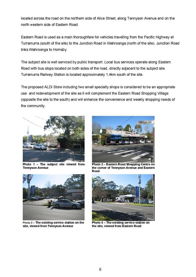
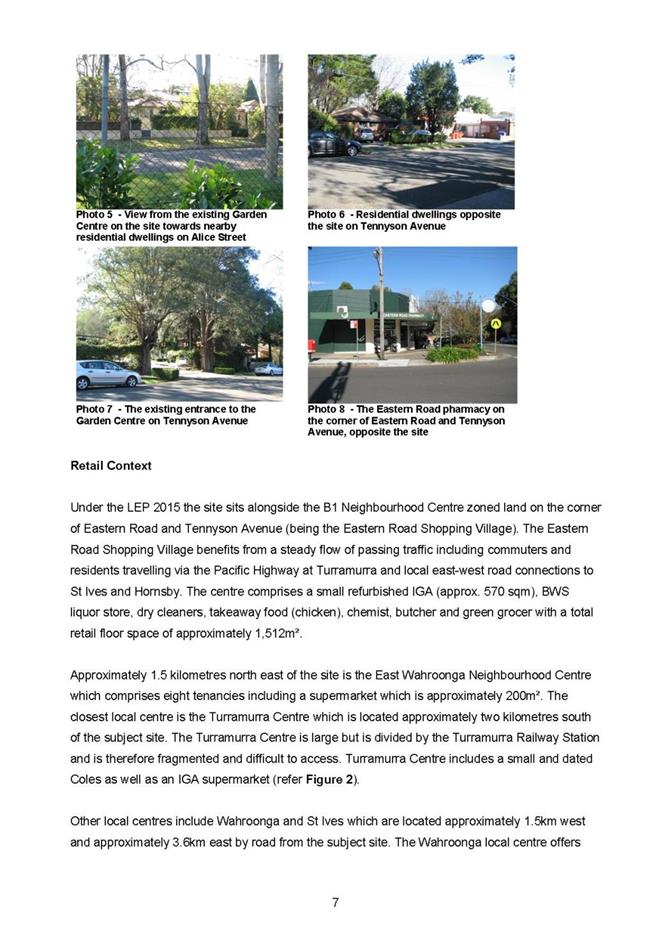
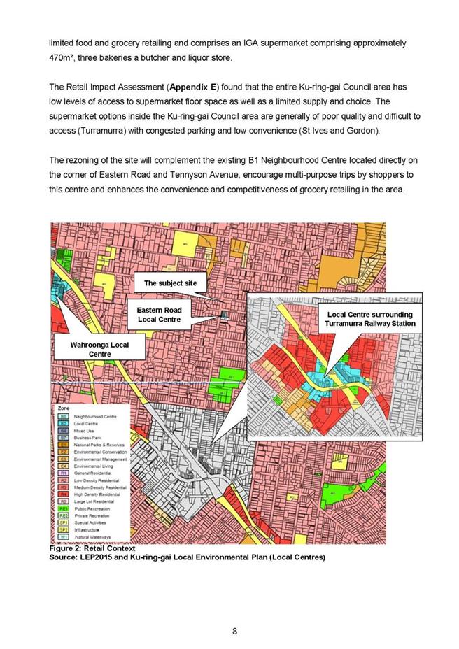
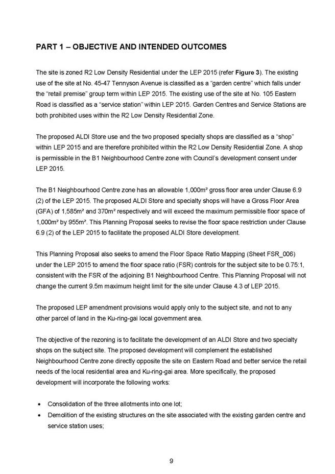
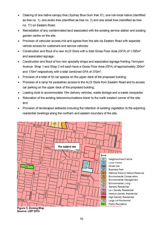

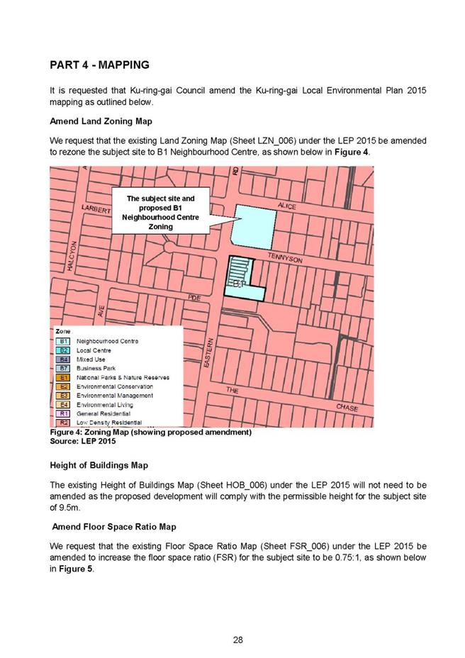
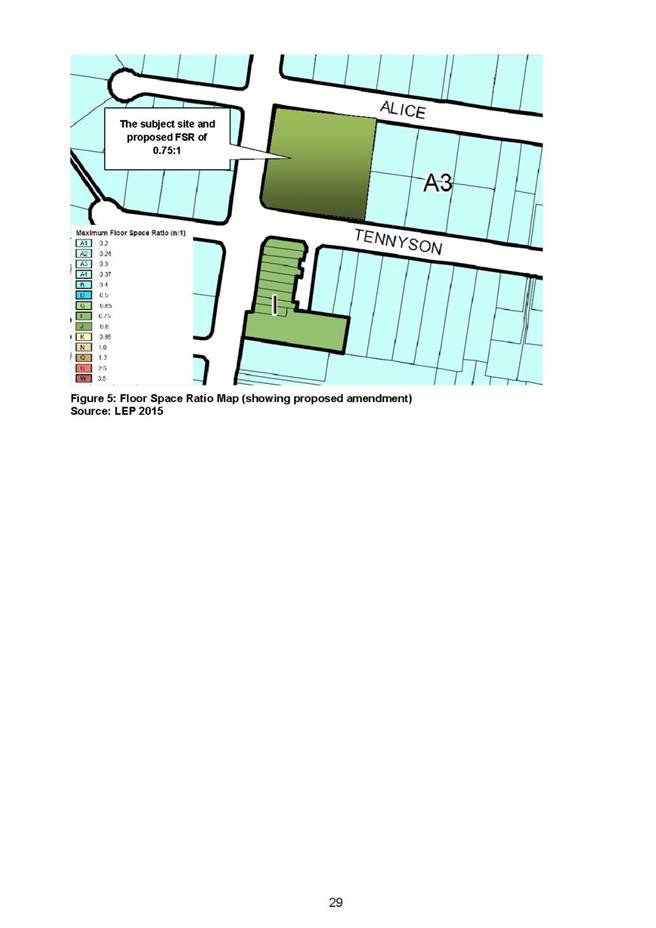
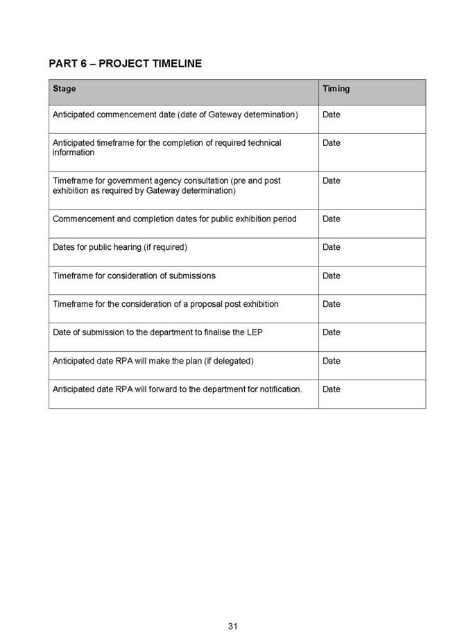
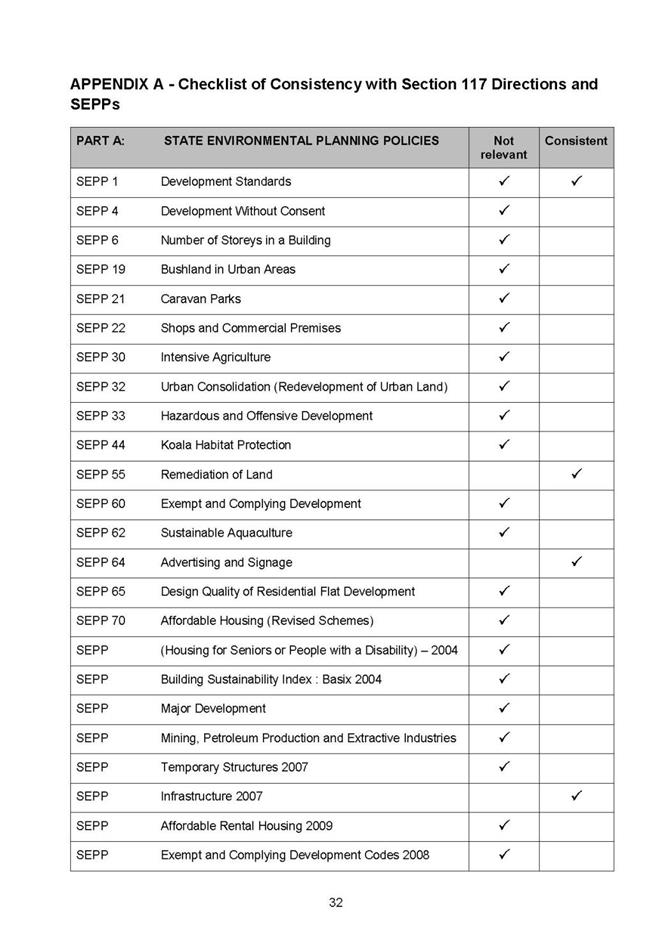
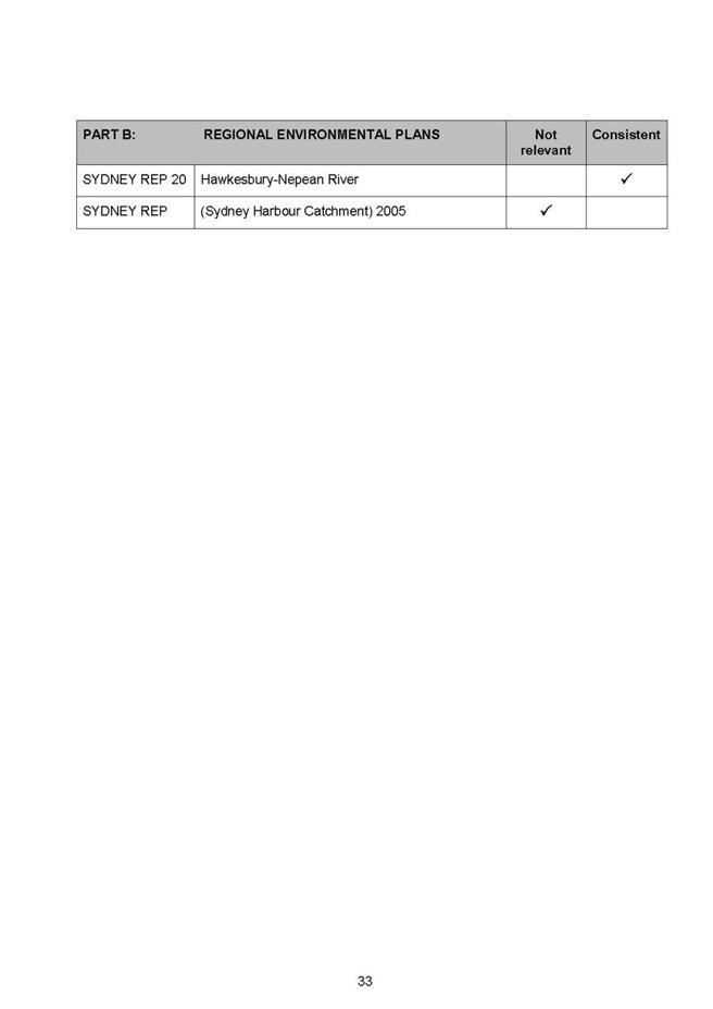
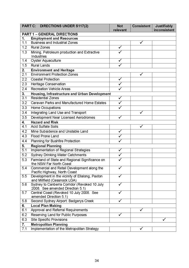

|
APPENDIX No: 2 - Planning
Proposal Appendix B - Preliminary Plans (circulated separately)
|
|
Item No: GB.6
|
Planning Proposal for
45-47 Tennyson Avenue and 105 Eastern Road Turramurra to amend the Ku-ring-gai Local
Environmental Plan 2015.DOC
Planning Proposal
Appendix B - Preliminary Plans (circulated separately)
|
APPENDIX No: 3 - Planning
Proposal Appendix C - Photomontage (circulated separately)
|
|
Item No: GB.6
|
Planning Proposal for
45-47 Tennyson Avenue and 105 Eastern Road Turramurra to amend the Ku-ring-gai
Local Environmental Plan 2015.DOC
Planning Proposal
Appendix C - Photomontage (circulated separately)
|
APPENDIX No: 4 - Planning
Proposal Appendix D - Urban Design Statement (circulated separately)
|
|
Item No: GB.6
|
Planning Proposal for
45-47 Tennyson Avenue and 105 Eastern Road Turramurra to amend the Ku-ring-gai
Local Environmental Plan 2015.DOC
Planning Proposal
Appendix D - Urban Design Statement (circulated separately)
|
APPENDIX No: 5 - Planning
Proposal Appendix E - Retail Impact Assessment (circulated separately)
|
|
Item No: GB.6
|
Planning Proposal for
45-47 Tennyson Avenue and 105 Eastern Road Turramurra to amend the Ku-ring-gai
Local Environmental Plan 2015.DOC
Planning Proposal
Appendix E - Retail Impact Assessment (circulated separately)
|
APPENDIX No: 6 - Planning
Proposal Appendix F - Traffic Report (circulated separately)
|
|
Item No: GB.6
|
Planning Proposal for
45-47 Tennyson Avenue and 105 Eastern Road Turramurra to amend the Ku-ring-gai
Local Environmental Plan 2015.DOC
Planning Proposal
Appendix F - Traffic Report (circulated separately)
|
APPENDIX No: 7 - Planning
Proposal Appendix G - Assessment of flora constraints and Assessment of
Significance (circulated separately)
|
|
Item No: GB.6
|
Planning Proposal for
45-47 Tennyson Avenue and 105 Eastern Road Turramurra to amend the Ku-ring-gai
Local Environmental Plan 2015.DOC
Planning Proposal
Appendix G - Assessment of flora constraints and Assessment of Significance
(circulated separately)
|
APPENDIX No: 8 - Planning
Proposal Appendix H - Stormwater Management Report (circulated separately)
|
|
Item No: GB.6
|
Planning Proposal for
45-47 Tennyson Avenue and 105 Eastern Road Turramurra to amend the Ku-ring-gai
Local Environmental Plan 2015.DOC
Planning Proposal
Appendix H - Stormwater Management Report (circulated separately)
|
APPENDIX No: 9 - Planning
Proposal Appendix I - Phase 1 Environmental Site Assessment Report for 105
Eastern Road (circulated separately)
|
|
Item No: GB.6
|
Planning Proposal for
45-47 Tennyson Avenue and 105 Eastern Road Turramurra to amend the Ku-ring-gai
Local Environmental Plan 2015.DOC
Planning Proposal
Appendix I - Phase 1 Environmental Site Assessment Report for 105 Eastern Road
(circulated separately)
|
APPENDIX No: 10 - Planning
Proposal Appendix J - Phase 1 Environmental Site Assessment Report for 45 to
47 Tennyson Avenue (circulated separately)
|
|
Item No: GB.6
|
Planning Proposal for
45-47 Tennyson Avenue and 105 Eastern Road Turramurra to amend the Ku-ring-gai
Local Environmental Plan 2015.DOC
Planning Proposal
Appendix J - Phase 1 Environmental Site Assessment Report for 45 to 47 Tennyson
Avenue (circulated separately)
|
APPENDIX No: 11 - Flow
chart of Planning Proposal and Pre-Gateway Review process
|
|
Item No: GB.6
|
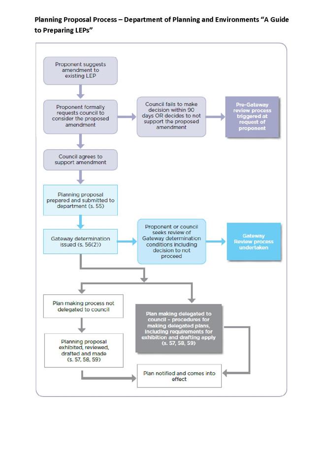
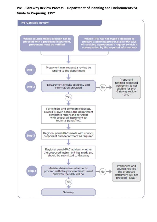
|
APPENDIX No: 12 - Zone
B1 - Excerpt from KLEP 2015 - Land Use Table
|
|
Item No: GB.6
|
|
APPENDIX No: 13 - Independent
Review Retail Impact Assessment - Leyshon Consulting
|
|
Item No: GB.6
|
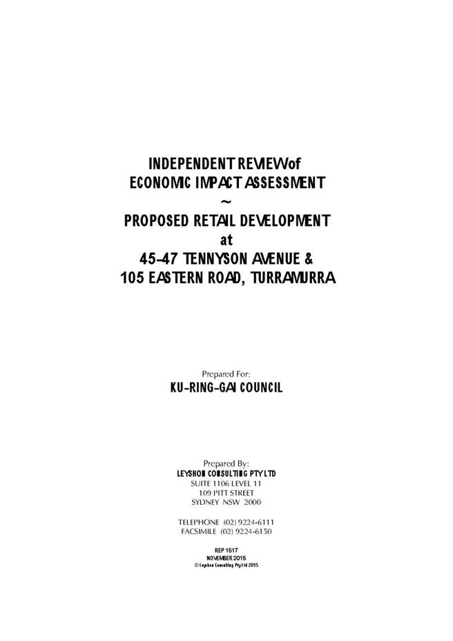


|
APPENDIX No: 14 - Independent
Peer Review - Traffic - Aldi PP - Traffix
|
|
Item No: GB.6
|
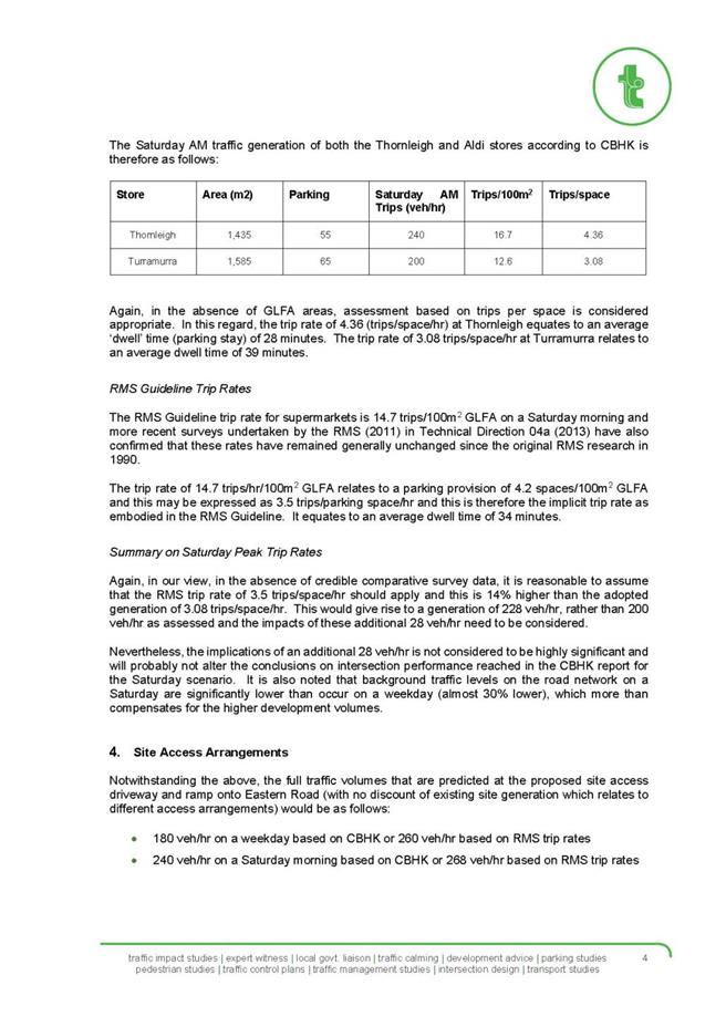
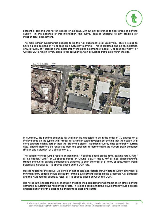
|
Ordinary
Meeting of Council - 8 December 2015
|
GB.7 / 556
|
|
|
|
|
Item
GB.7
|
S10611
|
|
|
22 October 2015
|
Deferred Areas Planning Proposal
EXECUTIVE
SUMMARY
|
purpose of report:
|
For Council to consider a Planning Proposal to amend
the Ku-ring-gai Local Environmental Plan 2015 to include 13 Deferred
Areas.
|
|
|
|
|
background:
|
13 areas within Ku-ring-gai were
deferred from inclusion within the Ku-ring-gai Local Environmental Plan
2015 when it commenced on 2 April 2015.
These areas had been
identified as areas of high bushfire evacuation risk, and were deferred to
allow Council to undertake a re-assessment of the bushfire evacuation risks
and zoning within these areas.
|
|
|
|
|
comments:
|
The purpose of this report is to progress the Planning
Proposal to the next stage in the process – where it will be submitted to the
Department of Planning and Environment for a Gateway Determination and
proceed to public exhibition.
|
|
|
|
|
recommendation:
|
That the Planning Proposal be forwarded to the
Department of Planning and Environment for a Gateway Determination.
|
Purpose of Report
For Council to consider a Planning Proposal to amend the Ku-ring-gai
Local Environmental Plan 2015 to include 13 Deferred Areas.
Background
On 26 November 2013, in considering a report on the
submissions made in response to the public exhibition of the then Draft
Ku-ring-gai Local Environmental Plan 2013, Council resolved the following:
B. That
Council request the Minister, under S59(4) of the EP&A Act, defer the
inclusion of the 13 areas identified on the maps at Attachment A14 and that
Council resolve to prepare a planning proposal in accordance with section 55 of
the EP&A Act to re-exhibit these areas within the proposed zoning outlined
in the body of this report. This planning proposal then be forwarded to the
DoPI for a Gateway Determination in accordance with the provision of the
EP&A Act and Regulations.
Accordingly, when the Ku-ring-gai Local Environmental
Plan 2015 commenced on the 2 April 2015, the 13 areas were deferred from
inclusion within the plan. The Ku-ring-gai Planning Scheme Ordinance currently
applies to land within these 13 deferred areas.
These 13 areas were identified as areas of high bushfire
evacuation risk, and were deferred from the KLEP 2015 to allow Council
to undertake re-assessment of the bushfire evacuation risk and proposed zoning
within these areas.
The 13 deferred areas are as follows:
· Area 1 – North Turramurra
· Area 2 – North Wahroonga
· Area 3 – Warrimoo Avenue
· Area 4 – Campbell Drive
· Area 5 – Browns Road, Fox Valley Road,
Jordan Avenue
· Area 6 – Howson Avenue
· Area 7 – Eastern Arterial Road
· Area 8 – Parker Avenue, Evans Street
· Area 9 – Bowen Avenue
· Area 10 – Ashburton Avenue
· Area 11 – Boronga Avenue, Gloucester
Avenue
· Area 12 – East Killara
· Area 13 – Bradfield Road
Council also made the following resolution with regard to
South Turramurra and bushfire on 26 November 2013:
K. That
further consultation occur with the NSW Rural Fire Service and other relevant
state agencies to investigate the incidence of fire and the implications on
evacuation risks for South Turramurra with the view of identifying an
appropriate planning response for the area, including potential further
amendments to the KLEP to address bushfire issues.
Bushfire Evacuation Risk
As part of the preparation for the Ku-ring-gai Local
Environmental Plan 2015, Council prepared a background study – Managing
Bushfire Risk, Now and Into the Future, March 2012. A copy of the
background study is included at Attachment A2. One of the aims of this
background study was to better understand the future risk of bushfire in the
Ku-ring-gai local government area.
In order to reduce the risks to people and property from
bushfire, the background study made a number of recommendations which focused
on the use of land use planning and development controls, such as zoning, lots
sizes and lot depths.
In order to assess bushfire evacuation risk, the background
study considered research undertaken by Thomas Cova (2005) Public Safety in
the Urban – Wildland Interface: Should Fire-Prone Communities Have a Maximum
Occupancy?
This research identified a range of factors that affect the
capacity of evacuate from areas with a high bushfire risk, which include the
capacity of the road, type of land use and the number and location of exits.
The research proposes that fire prone communities at the
bushland interface should have a maximum occupancy rate dependent on the above
factors. Cova (2005) recommends a minimum number of exit roads based on the
number of households in a sensitive area – this is shown in the table below.
|
Number of
households
|
Minimum Number
of Exit Roads
|
Maximum Number
of Households per exit
|
|
1 – 50
|
1
|
50
|
|
51 - 300
|
2
|
150
|
|
300 – 600
|
3
|
200
|
|
601+
|
4
|
|
The background study – Managing Bushfire Risk, Now and
Into the Future - notes: “Development has also occurred in a number of
locations where the local community is surrounded by extensive areas of
bushfire prone vegetation, often with inadequate road networks to enable safe
evacuation. Pressure to increase development in these areas has led to
increasing evacuation risk to residents and workers, including a high number of
elderly and very young residents.”
Environmental zoning
The background study – Managing Bushfire Risk, Now and
Into the Future – identified zoning as a mechanism for managing the risks
associated with bushfire and evacuation. The background study recommended that
environmental zones – such as E3 Environmental Management and E4 Environmental
Living – could be applied to properties as a way to reduce the risks from
bushfire as these zones would limit or exclude incompatible development within
areas where it is likely to be difficult to evacuate during a bushfire.
The environmental zones – E3 and E4- permit residential
development, but exclude development types, such as childcare centres – which
would lead to increased evacuation risks to vulnerable groups of people.
Prohibited uses include those uses identified as “special fire protection
purposes” under s100B of the Rural Fires Act 1997.
Draft Ku-ring-gai Local Environmental Plan 2013
The background study – Managing Bushfire Risk, Now and
Into the Future – made the following recommendation for land use in the
then Draft Ku-ring-gai Local Environmental Plan 2013:
b. Apply
the E3 – Environmental Management to sites that are both:
· identified as extreme bushfire risk
using the Bushfire Risk Management Plan 2010 (Hornsby and Ku-ring-gai
Councils) as a guide; and
· within the evacuation risk zones
identified by the Rural Fire Service ‘Bushfire Prone Land Map and Bushfire
Evacuation Risk Map’ that do not meet the exit criteria identified by research
by Cova (2005).
Based on the above recommendation, the then Draft
Ku-ring-gai Local Environmental Plan 2013 was exhibited between 25 March
2013 and 6 May 2013 with the E3 Environmental Management zone applying to
properties that were identified at extreme bushfire risk, within a bushfire
evacuation risk area and did not meet the exit criteria as specified by Cova
(2005).
The “Bushfire Prone Land Map and Bushfire Evacuation Risk
Map” has a category which is linked to the SEPP (Housing for Seniors or People
with a Disability) 2004. This category is an exclusion zone with areas being
identified as having an evacuation risk. Accordingly, there are restrictions on
further development of housing for seniors or people with a disability (such as
retirement villages and nursing homes) within these areas of evacuation risk.
Changes to methodology
During the exhibition of the Draft Ku-ring-gai Local
Environmental Plan 2013, a number of submissions were made regarding the
application of the E3 zone in areas of high bushfire evacuation risk. The
issues raised in the submissions questioned the methodology and the consistency
of the application of the methodology.
Consultation was undertaken with the Rural Fire Services and
NSW Police, and based on the discussions the following change was made to the
methodology:
· apply the environmental zoning to all
land in the evacuation risk zones (as identified on the Bushfire Evacuation
Risk Map) that do not meet the exit criteria.
This was due to advice from the emergency services that in
the event of a bushfire, they would be looking at evacuating more than those
properties identified as extreme bushfire risk under the Bushfire Risk Management
Plan 2010 (Hornsby and Ku-ring-gai).
Council undertook a re-assessment against the revised
methodology (above). As a result, additional streets and catchments were found
not to satisfy the minimum number of exit roads criteria, and therefore should
have the environmental zone applied. There were also areas identified that did
satisfy the minimum number of exit roads, and therefore should not be subject
to the environmental zoning.
Changes to zoning
Also as a result of the consultation with the RFS and
Police, it was advised that secondary dwellings (granny flats) do not pose a
great evacuation risk. Accordingly, the following change was proposed:
· permit secondary dwellings within the
bushfire evacuation risk areas.
Secondary Dwellings are not a permissible development type
within the E3 zone – which was applied to land within the bushfire evacuation
risk areas within the Draft KLEP 2013. Secondary Dwellings are a permissible
development type within the E4 zone.
Accordingly, it was recommended to zone all the properties
within the bushfire evacuation risk areas (as identified on the Bushfire
Evacuation Risk Map), which do not meet the exit criteria as specified by
Cova(2005), E4 Environmental Living.
Deferred from KLEP 2015
Due to the extent of the changes to the methodology and
zoning, Council requested that the 13 areas be deferred from inclusion within
the KLEP 2015, in order to allow further assessment and further community
consultation, which will allow Council to re-exhibit the proposed changes prior
to making a final decision on the zoning within these areas.
KLEP 2015 Amendment No. 5
On 23 October 2015 KLEP 2015 Amendment No. 5 was gazetted.
This amendment included the provision of Complying Development provisions for
Dwelling Houses within Zone E4 Environmental Living. This amendment allows for
complying development to be carried out under Schedule 3 of the KLEP 2015 on
land zoned E4 – where the State Environmental Planning Policy (Exempt and
Complying Development Codes) 2008 does not apply.
The amendment includes appropriate standards and exclusions,
such as for landscaped area, riparian and biodiversity, to ensure that the
objectives of the E4 Environmental Living zone can still be met.
In line with the recommendation to zone properties
identified in bushfire evacuation risk areas that is E4 Environmental Living,
the Amendment No.5 to the KLEP 2015 also included inserting the following
bushfire zone objectives from the E3 zone to the E4 zone:
· To minimise direct and indirect
risks to life property and the environment from bushfire events.
· To ensure development in this zone
on land that adjoins land in Zone E1 National Parks and Nature Reserves or Zone
E2 Environmental Conservation is compatible with the objectives of those zones
· To enable other land uses that
provide facilities or services to meet the day to day needs of residents
Comments
The following section details information regarding the
re-assessment of the deferred areas and the Planning Proposal.
Consultation with emergency services
As part of the re-assessment of all the deferred areas and
as required by Council resolution K with regard to South Turramurra, Council
meet with representatives from the Rural Fire Service, NSW Police, Fire and
Rescue, State Emergency Service and National Parks and Wildlife Service on
12 August 2015 to discuss the evacuation risks within the 13 deferred
areas and Council’s proposed planning measures to prevent significant increases
in density and development types that would increase evacuation risks. Also
discussed were the implications on evacuation risks for South Turramurra.
Some of matters discussed by the representatives included
what are the evacuation issues and how would emergency services evacuate these
areas, views on the methodology and whether the proposed planning measures were
supported.
The emergency services advised that the area to be evacuated
would depend on the incident, the fire, conditions and available resources.
They advised that evacuation from some areas, such as North Turramurra, were
further complicated by the number of Special Fire Protection Purpose
developments with vulnerable people including retirement villages, schools,
hospitals and nursing homes.
It was agreed that excluding land uses that provide for
vulnerable groups (children, elderly, infirmed) in evacuation risk areas was a
reasonable approach as it would ease the number of resources and co-ordination
required by the emergency services.
It was also noted that these areas generally adjoin wider
bushland areas, including national parks, which is a fact that is not going to
change in the future, and that it is likely that a fire event will impact these
areas eventually.
With regards to South Turramurra it was noted that South
Turramurra does not contain the types of developments as North Turramurra, such
as nursing homes, retirement villages, limited childcare centres and one high
school. It was noted that the bushland surrounding the area is not as extensive
as that surrounding North Turramurra, however it was noted due to the narrow
nature of the valley, this could make the fire behaviour unpredictable. It was
also noted that the area had a number of bushfires in the past.
The full notes from the meeting are included at Attachment
A3.
Following on from the meeting, Council sought written
feedback to the following questions:
· What are the issues for evacuation
within these 13 areas?
· What are your views on the
methodologies and assumptions that Council has used to inform the decisions?
· Based on the methodology and
assumptions, is Council making responsible, reasonable and realistic decisions?
· Are Council’s proposed planning
measures to prevent increase in density and development types that increase
evacuation risks supported?
· What are the evacuation risks for
South Turramurra as a whole? Would the proposed planning response be necessary
or appropriate for the whole of the South Turramurra peninsular?
The responses from the Police and RFS generally advised that
the concepts adopted by Council are supported and noted that increasing
population densities and certain land uses in these areas may be problematic
and require more resources to evacuate them.
With regards to South Turramurra, the RFS advised that the
NSW RFS is proposing to undertake an evacuation risk modelling study which is
intended to be used to assess evacuation risk issues and may be applied to
areas such as South Turramurra. It is hoped that this will be undertaken in the
next 12 months. Accordingly, it is recommended that at this stage Council take
no further planning response for the whole of the South Turramurra area with
regards to addressing bushfire issues and wait for the NSW RFS evacuation risk
modelling study.
Copies of the written responses from the NSW Police and RFS
are included in Appendix B of the Planning Proposal which is included at Attachment
A1.
Proposed zoning
A summary of the proposed zoning in each of the 13 deferred
areas is provided below:
Deferred Area 1 – North Turramurra
All land to be zoned E4 Environmental Living except for:
· 245-247, 261-265, 270, 272-274, 276,
278-280, 284, 286, 288 and 290 Bobbin Head Road to be zoned B1 Neighbourhood
Centre
· 243 Bobbin Head Road to be zoned SP2
Infrastructure
· 24 Apps Avenue, 16A Allara Avenue, Lot
34 DP206882, Lot 3 DP557349, Lot 34 DP710498 zoned RE1 Public Recreation
· Lot 323 DP752031 (part of Glengarry)
zoned RE2 Private Recreation
· Knox Curagul Playing Fields 408, 410-412
Bobbin Head Road North Turramurra – RE2 Private Recreation
North Turramurra is proposed to be zoned E4
Environmental Living as the area is within an identified bushfire evacuation
risk area and does not meet the require number of exit roads required for the
number of dwellings – leading to increased evacuation risk in the event of
bushfire. The table below provides an assessment of the number of exit roads
and dwellings within the North Turramurra area in accordance with Cova (2005).
|
No. Exits
|
No.
Dwellings
|
Recommended
Max. Dwellings
|
No.
over recommended
|
|
2
|
1325
|
300
|
1025
|
|
1
(north of 359A Bobbin Head)
|
256
|
50
|
206
|
It should be noted there is a high proportion of
Special Fire Protection Purpose developments, such as schools, nursing homes
and retirement villages, already existing within this area.
The neighbourhood centre zoning, the
infrastructure zoning and the public recreation zoning to be applied to lots
along Bobbin Head Road, Apps Avenue and Allara Avenue are a translation of the
KPSO zoning into the comparable Standard LEP zoning.
Knox Curagul Playing Fields 408, 410-412 Bobbin
Head Road North Turramurra
During the exhibition of the then Draft KLEP 2013,
a submission was received on behalf of Knox Grammar School. The submission
noted that the proposed zoning of the playing fields under the Draft KLEP 2013
was E3 Environmental Management, and requested the site be zoned SP2
Infrastructure. The submission raised concern that the E3 does not reflect the
purpose for which Knox uses the land. Concern was also raised that the E3
zoning prohibits educational establishments, and the E3 zone is not a
prescribed zone under the Infrastructure SEPP, and in this regard there would
be no avenue for obtaining consent to develop the site.
The Council comments on the submission by Knox
were included in a report to Council on 26 November 2013. The Council
report acknowledged that the Draft KLEP 2013 and Infrastructure SEPP prohibit
school uses within the E3 zoning. The Council report noted that whilst E3 might
restrict uses, the reasoning behind its allocation is sound, noting the site is
located within a bushfire evacuation risk area and the zone limits the density
of the population and developments which cater for vulnerable groups of people,
including schools, nursing homes and childcare centres.
As part of the re-assessment of the North
Turramurra deferred area, further consideration was given to the zoning of this
site. It is acknowledged that an SP2 Infrastructure zoning would be consistent
with the zoning of other school sites across the LGA. However, a zoning of SP2
Infrastructure on the site would allow the site to be further developed and its
use intensified under the provisions of the Infrastructure SEPP. In this
regard, the further intensification of the use of the site for a school campus
is not compatible with the aims of the Planning Proposal or the surrounding
area. The North Turramurra area is identified as a bushfire evacuation risk
area, and the Planning Proposal is seeking to exclude land uses such as
schools, retirement villages and childcare centres, which area identified as
Special Fire Protection Purposes under s100B of the Rural Fires Act 1997. These
uses will lead to increased excavation risks to vulnerable groups of people and
in this regard are incompatible.
The Knox Curagul Playing Fields are recommended to
be zoned RE2 Private Recreation. The Department of Planning and Environments
LEP Practice Note PN11-002 outlines that the RE2 Private Recreation zone “is
generally intended to cover a wide range of recreation areas and facilities on
land that is privately owned or managed. The use of facilities developed on
this land may be open to the general public or restricted e.g. to registered
members only. Private recreation may include racecourses, golf clubs, bowling
clubs, rifle ranges, speedways, tennis complexes and other sporting or
recreational facilities which may be on significant parcels of privately owned
land or on land leased from councils or state authorities”
In this regard, the proposed RE2 Private
Recreation zoning is consistent with the current use of the site. This zoning
will facilitate the ongoing use of the site for its current purposes for
private recreation and will not permit further intensification of the use for
school purposes.
Lot 323 DP752031 (part of Glengarry)
Lot 323 DP752031 which is part of
Glengarry is proposed to be zoned RE2 Private Recreation. The lot is currently
zoned part residential 2(c) and part recreation 6(a) under the KPSO. The Lot
was exhibited with part RE2 and part E3 zoning under the Draft KLEP 2013. A
submission was received from the Girl Guides NSW/Act which requested that the
whole of Lot 323 DP752031 be zoned RE2. It was acknowledged that the RE2 zoning
across the whole of the lot would better facilitate the ongoing use of the site
for its current purposes and is therefore supported.
9, 9a and 11-15 Curagul Road, North
Turramurra
These 3 properties are located at the
north-eastern end of North Turramurra. Due to an error they were not included
within the boundary of the North Turramurra Deferred Area. The properties are
currently zoned E3 under the KLEP 2015. The planning proposal seeks to amend
the zoning of these 3 properties from E3 to E4, consistent with the zoning for
the rest of North Turramurra.
Deferred Area 2 – North Wahroonga
All land to be zoned E4 Environmental Living
except for:
· 29 Scullin Place and 2A Holt Avenue to
be zoned E2 Environmental Conservation as these are Council reserves
categorised and managed as natural areas.
North Wahroonga is proposed to be zoned E4
Environmental Living as the area is within an identified bushfire evacuation
risk area and does not meet the number of exit roads required for the number of
dwellings – leading to increased evacuation risk in the event of bushfire. The
table below provides an assessment of the number of exit roads and dwellings within
the North Wahroonga area in accordance with Cova (2005).
|
No.
Exits
|
No.
Dwellings
|
Recommended
Max. Dwellings
|
No.
over recommended
|
|
1
|
487
|
50
|
437
|
Deferred Area 3 – Warrimoo
Avenue

All land to be zoned E4 Environmental Living except for:
· 2, 4, 6, 8, 10, 12, 14, 16, 18 Waipori
Street to be zoned R2 Low Density Residential;
· 149B,151,153 Warrimoo Avenue to be
zoned R2 Low Density Residential;
· 1, 2, 3, 4, 5, 6, 7, 8, 9, 10, 11, 11A,
12, 14, 15, 17 Ovens Place to be zoned R2 Low Density Residential.
The above properties are proposed to be zoned R2 Low Density
Residential as they fall outside of the catchments and therefore do not rely on
the identified exits for evacuation in the event of bushfire.
Warrimoo Avenue is proposed to be zoned E4 Environmental
Living as the area is within an identified bushfire evacuation risk area and
does not meet the number of exit roads required for the number of dwellings –
leading to increased evacuation risk in the event of bushfire. The table below
provides an assessment of the number of exit roads and dwellings within the
Warrimoo Avenue area in accordance with Cova (2005).
|
No. Exits
|
No. Dwellings
|
Recommended Max. Dwellings
|
No. over recommended
|
|
2
|
526
|
300
|
226
|
|
1 (Warrimoo)
|
438
|
50
|
388
|
|
1 (Waipori)
|
88
|
50
|
38
|
In this area, there are two separate catchments, each with
one exit road – Warrimoo Avenue and Waipori Street.
Deferred Area 4 – Campbell Drive
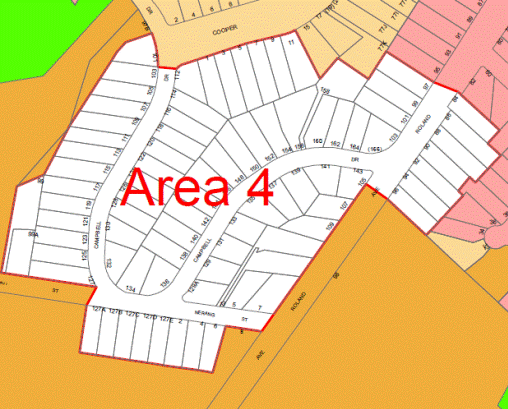
All land to be zoned R2 Low Density Residential except for:
· 1, 3, 5, 7, 9, 11 Cooper Crescent to be
zoned E4 Environmental Living;
· 112 Campbell Drive to be zoned E4
Environmental Living.
Campbell Drive is proposed to be zoned R2 Low Density
Residential as the area meets the required number of exit roads for the number
of dwellings. No.’s 1-11 Cooper Crescent and 112 Campbell Drive are proposed to
be zoned E4 Environmental Living due to the riparian and biodiversity values
mapped across these properties. The application of the E4 Environmental Living
zone on these properties is not due to bushfire evacuation risk.
The table below provides an assessment of the number of exit
roads and dwellings within the Campbell Drive area in accordance with Cova
(2005).
|
No. Exits
|
No. Dwellings
|
Recommended Max.
Dwellings
|
No. over recommended
|
|
2
|
83
|
300
|
-217
|
Deferred Area 5 – Browns
Road – Fox Valley Road – Jordan Avenue
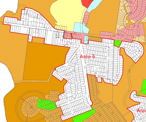
All land to be zoned E4 Environmental Living except for:
· 198, 200, 206, 208, 208A The Comenarra
Parkway to be zoned R2 Low Density Residential.
This area has a frequent fire history, with
more than 2 fires in 30 years. The area is proposed to be zoned E4
Environmental Living as the area is within an identified bushfire evacuation
risk area and does not meet the required number of exit roads for the number of
dwellings – leading to increased evacuation risk in the event of bushfire.
198-208A The Comenarra Parkway are
proposed to be zoned R2 Low Density Residential as they are not located within
the catchment area, and do not have a direct interface within the bushland.
The table below provides an assessment of
the number of exit roads and dwellings within the Browns Road-Fox Valley
Road-Jordan Avenue area in accordance with Cova (2005).
|
No. Exits
|
No. Dwellings
|
No. Recommended
Dwellings
|
No. over recommended
|
|
1 to 2
|
381
|
50 to 300
|
331 to 81
|
|
1 (Browns)
|
72
|
50
|
22
|
|
1 (The Broadway)
|
249
|
50
|
199
|
|
1 (Jordan)
|
60
|
50
|
10
|
There are three catchments within this
area, with all exit roads exiting on The Comenarra Parkway, both to the north
and south. Due to the bushland to the north and south it is likely that only
one exit would be feasible. Accordingly, a maximum of two exit roads have been
included in the assessment.
Deferred Area 6 – Howson Avenue
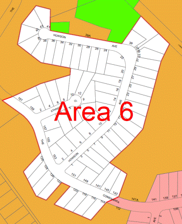
All land to be zoned E4 Environmental Living
The area of Howson Avenue is proposed to be zoned E4
Environmental Living as it is located within an identified bushfire evacuation
risk area and does not meet the required number of exit roads for the number of
dwellings – leading to increased evacuation risk in the event of bushfire. The
table below provides an assessment of the number of exit roads and dwellings
within the Howson Avenue area in accordance with Cova (2005).
|
No. Exits
|
No. Dwellings
|
No. Recommended
Dwellings
|
No. over recommended
|
|
1
|
67
|
50
|
17
|
Both exits out of this area exit onto The Comenarra Parkway,
however, as the exit to the north goes into bushland – in the event of a
bushfire the only feasible evacuation option would be to the south.
Accordingly, only one exit onto The Comenarra Parkway has been included in the
assessment.
Deferred Area 7 – Eastern Arterial Road
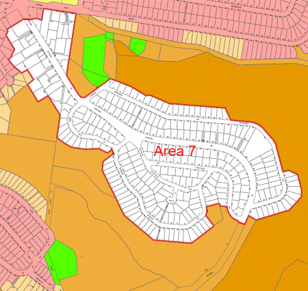
All land to be zoned E4 Environmental Living except for:
· A9, A11, A15, A17, A19, A21, A23 Hunter
Avenue to be zoned R2 Low Density Residential.
The area of Eastern Arterial Road is proposed to be zoned E4
Environmental Living as it is located within an identified bushfire evacuation
risk area and does not meet the required number of exit roads for the number of
dwellings – leading to increased evacuation risk in the event of bushfire.
A9-A23 Hunter Avenue is proposed to be zoned R2 Low Density
Residential as these properties are not located within the catchment area and
have numerous exit road options in the event of an evacuation.
The table below provides and assessment of the number of
exit roads and dwellings within the Eastern Arterial Road area in accordance
with Cova (2005).
|
No. Exits
|
No. Dwellings
|
No. Recommended
Dwellings
|
No. over recommended
|
|
1
|
305
|
50
|
255
|
Both exits out of this area are onto Eastern Arterial Road
(to the north and south), however due to the bushland to the south, in the
event of a bushfire the only feasible evacuation option would be to the north.
Accordingly, only one exit has been included in the assessment.
Deferred Area 8 – Parker Avenue
– Evans Street
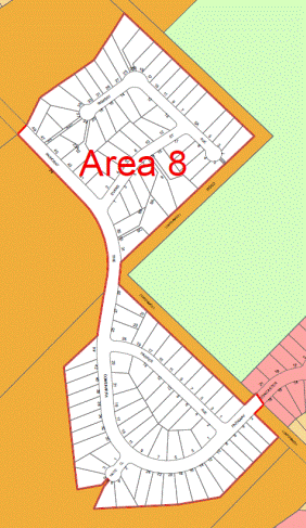
All land to be zoned E4 Environmental Living.
This area of Parker Avenue and Evans Street has a frequent
fire history, with more than 2 fires in 30 years.
The area is proposed to be zoned E4 Environmental Living as
it is located within an identified bushfire evacuation risk area and does not
meet the required number of exit roads for the number of dwellings – leading to
increased evacuation risk in the event of bushfire.
The table below provides an assessment of the number of exit
roads and dwellings within the Parker Avenue-Evans Street area in accordance
with Cova (2005).
|
No. Exits
|
No. Dwellings
|
No. Recommended
Dwellings
|
No. over recommended
|
|
1
|
105
|
50
|
55
|
Due to the exit through bushland to the north, it is likely
that only the exit to the south will be feasible in the event of a bushfire.
Accordingly, only one exit has been included in the assessment.
Deferred Area 9 – Bowen Avenue
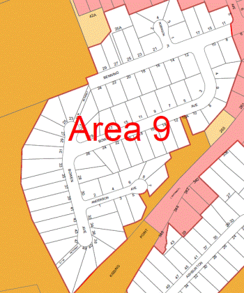
All land to be zoned E4 Environmental Living.
This area has a frequent fire history with more than 2 fires
in 30 years.
This area of Bowen Avenue is proposed to be zoned E4
Environmental Living as it is located within an identified bushfire evacuation risk
area and does not meet the required number of exit roads for the number of
dwellings – leading to increased evacuation risk in the event of bushfire.
The table below provides an assessment of the number of exit
roads and dwellings within the Bowen Avenue area in accordance with Cova
(2005).
|
No. Exits
|
No. Dwellings
|
No. Recommended Dwellings
|
No. over recommended
|
|
1
|
70
|
50
|
20
|
Deferred Area 10 – Ashburton Avenue
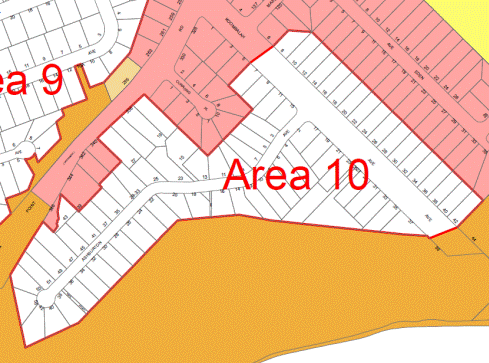
All land to be zoned E4 Environmental Living.
This area has a frequent fire history, with more than 2
fires in 30 years and has been the subject of arson attempts.
This area of Ashburton Avenue is proposed to be zoned E4
Environmental Living as it is located within an identified bushfire evacuation risk
area and does not meet the required number of exit roads for the number of
dwellings – leading to increased evacuation risk in the event of bushfire.
The table below provides an assessment of the number of exit
roads and dwellings within the Ashburton Avenue area in accordance with Cova
(2005).
|
No. Exits
|
No. Dwellings
|
No. Recommended
Dwellings
|
No. over recommended
|
|
1
|
78
|
50
|
28
|
Deferred Area 11 – Boronga Avenue – Gloucester Avenue
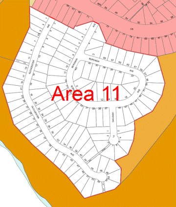
All land to be zoned E4 Environmental Living.
This area has a frequent fire history, with more than 2
fires in 30 years.
This area of Boronga Avenue and Gloucester Avenue are
proposed to be zoned E4 Environmental Living as the area is located within an
identified bushfire evacuation risk area and does not meet the required number
of exit roads for the number of dwellings – leading to increased evacuation
risk in the event of bushfire.
The table below provides an assessment of the number of exit
roads and dwellings within the Boronga Avenue-Gloucester Avenue area in
accordance with Cova (2005).
|
No. Exits
|
No. Dwellings
|
No. Recommended Dwellings
|
No. over recommended
|
|
2
|
112
|
300
|
-188
|
|
1 (Gloucester)
|
54
|
50
|
4
|
|
1 (Boronga)
|
58
|
50
|
8
|
This area is unusual in that it is made up of two separate
cul-de-sac catchments – which means each street only has one exit. If each
catchment (street) is considered separately the number of dwellings exceeds the
required number of exit roads.
Deferred Area 12 – East Killara
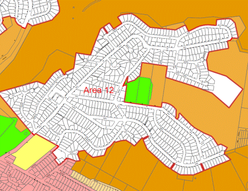
All land to be zoned E4 Environmental Living except:
· 20 Kanowar Avenue to be zoned E2
Environmental Conservation;
· 56-58 Koola Avenue to be zoned part E4
Environmental Living and part B1 Neighbourhood Centre;
· 23 Wentworth Avenue to be zoned R2 Low
Density Residential;
· 18 and 20 Fairbairn Avenue to be zoned
R2 Low Density Residential; and
· Lot 32 DP28795 in Redfield Road to be
zoned E2 Environmental Conservation.
20 Kanowar Avenue East Killara
20 Kanowar Avenue covers an area of approximately 2.8ha.
This area was originally Crown Land and was the subject of Aboriginal Land
Claim 6039, which was granted in 2000 by the then Minister for Agriculture and
Minister for Land and Water Conservation. A Torrens title redefinition plan was
registered on the 26 June 2012 which defined the land to be granted under
Section 36 of the Aboriginal Land Rights Act, 1983. The site is currently owned
by the Metropolitan Local Aboriginal Land Council.
The site was zoned Residential 2(b) under the KPSO. The site
was exhibited with a draft zoning of E2 Environmental Conservation in the Draft
KLEP 2013.
As part of the re-assessment of the zoning within the East
Killara deferred area, Council engaged independent consultants to undertake an
ecological assessment of the site. The assessment evaluated the site in terms
of its ecological condition and determined its potential use as a biobank
offset site in order to inform the future land use as zoning. The full
ecological assessment report is included at Attachment A4.
The ecological report included
assessment of onsite vegetation in accordance with the Biobanking Assessment
Methodology (OEH 2014). The site was found to
support over 95% native vegetation with the remainder made up of exotic turf
surrounding residential properties as well as access and fire trails (See table
below).
|
Vegetation
Community
|
% cleared since European settlement
|
Approximate area (ha)
|
Legal status
|
Status
|
|
Red Bloodwood –
Scribbly Gum Woodland on the Sydney Sandstone Plateaux of the Sydney Basin
Bioregion
|
25%
|
2
|
not listed as threatened under State or Commonwealth
Legislation
|
The substantial proportion of younger trees and small
occurrences of scattered older growth trees, indicate that these communities
are regrowth woodland.
|
|
Sydney Peppermint –
Smooth-barked Apple – Red Bloodwood shrubby open forest on slopes &
gullies of the Eastern Sydney Basin Bioregion.
|
30%
|
1
|
Fauna habitat within the site
included five hollow bearing trees and over 25 metres of fallen logs (providing
foraging and shelter for a wide range vertebrate species including bird,
mammals, amphibians and reptiles). Records of threatened fauna include a potential
call from a Red Crowned Toadlet and potential feather from a Powerful Owl (both
species are vulnerable under the Threatened Species Conservation Act 1995).
This site is proposed to be zoned E2 Environmental
Conservation. The Department of Planning and Environment’s LEP Practice Note PN
11-002 regarding the use of standard zones outlines that the E2 Environmental
Conservation zone “is generally intended to protect land that has high
conservation values outside the national parks and nature reserves system. The
use of this zone needs to be justified by appropriate evaluation of the area in
term of meeting the core objectives of having high ecological, scientific,
cultural or aesthetic values.”
The site has high ecological value, containing bushland in
good condition with only minor weed infestation. It adjoins other more
extensive vegetation which together provide important wildlife connectivity
between larger areas of bushland from Garigal National Park and Ku-ring-gai
Chase National park to the north to Middle Cove in the south. It was mapped as
forming part of the then Sydney Metropolitan Catchment Management Authority
Regional Fauna Habitat with ‘Highest Fauna Values’ (DECC 2008). It also forms
part of the Regional Fauna Habitat within the Middle Harbour Valley, one of
three key areas of regional fauna habitat identified by Ku-ring-gai Council
(Ku-ring-gai 2013). The site is identified as Biodiversity lands on the
Terrestrial Biodiversity Map under the KLEP 2015 and Core Biodiversity Lands
with the Greenweb mapping of the KDCP 2015.
The site is proposed to be zoned E2 Environmental
Conservation instead of translating the existing Residential 2(b) zone to the
equivalent standard instrument LEP zone, which is E4 Environmental Living.
Development on the site under an E4 zoning would be severely constrained by the
bushfire planning requirements, which would require limiting the Asset
Protection Zone* to within the site which would in turn require construction to
BAL40**.
*An asset protection zone is a
buffer zone between bushfire hazard and buildings, which is managed to minimise
fuel loads and reduce the potential radiant heat levels, flame contact, ember
and smoke attack on life and property.
*** The Rural Fire Service defines
BAL40 bushfire attack level as increased attack from burning debris with
significant radiant heat and the potential for flame contact, which could
threaten building integrity. This requires buildings to be designed and
constructed in a manner that can withstand the extreme heat and potential flame
contact.
The Department of Planning and Environment’s LEP practice
note PN 09-002 outlines that there are no mandatory permitted uses within the
E2 Environmental Conservation zone, and the uses Council choses should protect
the high conservation value of the land and avoid adverse effect in relation to
natural hazards.
LEP practice note PN 09-002 outlines that with the permitted
uses chosen for the E2 zone;
“Council’s should be aware that uses should not be drawn
too restrictively as they may, depending on circumstances, invoke the Land
Acquisition (Just Terms Compensation) Act 1991 and the need for the Minister to
designate a relevant acquiring authority”
Currently within the KLEP 2015 the following uses are
permitted within the E2 zone:
Environmental protection works; Environmental facilities;
Flood mitigation works; Roads; Water storage facilities.
As the site is currently within private ownership and in
order not to expose Council to a potential claim under the Land Acquisition
(Just Terms Compensation) Act 1991, it is recommended that “Eco tourist
facility” also be included as a permitted use specifically for 20 Kanowar
Avenue. This will be achieved through an amendment to Schedule 1 – Additional
Permitted Uses within the KLEP 2015. “Eco tourist facility” means “a
building or place that:
(a) Provides
temporary or short-term accommodation to visitors on a commercial basis, and
(b) Is
located in or adjacent to an area with special ecological or cultural features,
and
(c) Is
sensitively designed and located so as to minimise bulk, scale and overall
physical footprint and any ecological or visual impact
It may include facilities that are used to provide information
or education to visitors and to exhibit or display items”
Clause 5.13 of the Standard LEP Template outlines the
requirements in relation to the granting of development consent for eco-tourist
facilities. The requirements include conservation of the natural environment,
design and construction requirements, infrastructure requirements and
requirements for the monitoring and review of the development on the natural
environment. The Planning Proposal will seek an amendment to the KLEP 2015 to
include this standard clause relating to the development of eco tourist
facilities.
The additional permitted use on the site for “Eco tourist
facilities” is well-suited for the site, noting that objective of the use is to
maintain the environment and cultural values of land on which development is to
be carried out which is compatible with the high ecological values assessed on
the site.
The inclusion of “Eco tourist facility” is an additional
commercial use of site and in this regard the use of the E2 zoning on the site
provides a reasonable range of uses.
Additionally the site is of sufficient size and quality that
a Biobanking site (under the Threatened Species Conservation Act 1995)
may also be considered. The ecological assessment (Attachment A4) generated
a total of 24 ecosystem credits for the
proposal site. This may be increased through improved site management or by
creating species credits (should further work confirm the presence of selected
threatened species).
Further information on the creation of biobanking site
within lands owned by aboriginal land council’s is available at: http://www.alc.org.au/land-rights/biobanking.aspx
56-58 Koola Avenue East Killara
56-58 Koola Avenue covers an area of 3,276.4sqm and
currently operates as a communal carpark, natural area (Warrington Avenue
Reserve) and park (Reading Avenue Reserve) surrounding the East Killara
neighbourhood shops.
The site was zoned part B1 Neighbourhood Centre (part of the
site fronting Koola Avenue) and part RE1 Public Recreation (part of the site
fronting Warrington Avenue) under the Draft KLEP 2013.
Council made the following resolution regarding 56-58 Koola
Avenue East Killara on the 26 May 2015 after considering a report following the
public hearing into the proposed re-classification of four properties in St
Ives, East Killara, Roseville Chase and Wahroonga:
Recommendations relating to Part 56-58 Koola Avenue East
Killara
H. That
Part 56-58 Koola Avenue (being Lot 3 DP 588630) be classified as operational
land and the zoning unchanged.
I. That,
following gazettal of the reclassification for Part 56-58 Koola Avenue, that
the General Manager be authorised to proceed with the preparation and lodgement
of a subdivision plan for the property to divide the property along the present
zoning.
J. That
the appropriate zoning and classification for each of the new allotments under
the standard template be considered as part of the Planning Proposal for the
whole of surrounding area which was also deferred from Ku-ring-gai Local
Environmental Plan 2015.
K. That
the area fronting Warrington Avenue be considered as part of the Planning
Proposal referred to in J above be investigated for a potential residential
zoning and the lot facing Koola Avenue be considered for a Neighbourhood
Business zone.
A Planning Proposal for the reclassification of the site is
currently with the Department of Planning and Environment awaiting gazettal.
As part of the investigation for the zoning, Council engaged
independent consultants to carry out a biodiversity assessment of the subject
sites. The biodiversity assessment evaluated the site conditions and potential
ecological constraints on the site in order to inform the future land use and
zoning. The full copy of the biodiversity site condition report for 56-58 Koola
Avenue is included at Attachment A5.
The biodiversity assessment
included assessment of onsite vegetation in
accordance with the Biobanking Assessment Methodology (OEH 2014).
The site was found to contain Red Bloodwood – Scribbly
Gum Woodland on the Sydney Sandstone Plateaux of the Sydney Basin Bioregion.
This vegetation community is common in the greater Sydney area. It is estimated
that this vegetation type has only been cleared by 25% since European
settlement (OEH, 2015) and as such, is not listed as endangered or threatened
under State or Commonwealth Legislation.
Vegetation communities at the site were also assigned a
vegetation condition as per the Biobanking Assessment Methodology (OEH 2014),
which compared onsite data against benchmark data for that community. Under the
methodology native vegetation is either in low condition or moderate to good
condition.
Whilst the site was determined to be in good to moderate
condition, all values scored below the bench mark; within the exception of
native over-storey and native grass ground cover (See Table 1). The decreased
species diversity, lack of mid-storey and dominance of grass within the ground
cover rather than shrubs or herbs, are a result of past and ongoing impacts
(including edge effects, clearing, hydrological changes, weed invasion, time
since fire).
Table 1 Comparison of site obtained data against the
benchmark data
|
|
Native plant species
|
Native over-storey cover
|
Native mid-storey cover
|
Native ground cover (grass)
|
Native ground cover (shrubs)
|
Native ground cover (other)
|
# trees with hollows
|
Over-storey regeneration
|
Total length of fallen logs
|
|
Bechmark data
|
≥39
|
17 to 27
|
75 to 85
|
1 to 10
|
7 to 11
|
13 to 17
|
≥1
|
1
|
≥30
|
|
Site data
|
23
|
17
|
6
|
22
|
2
|
9
|
0
|
0
|
18
|
Fauna habitat observed on site
included several arboreal termite mounds
(which may provide habitat for avian fauna) and fallen logs (provides foraging
and shelter for a wide range vertebrate species including bird, mammals,
amphibians and reptiles). Considering the lack of important habitat features
(such as hollows, caves, bush rock etc) and the small patch size, which is
impacted by edge effects, the proposal site only provides minor disturbed
habitat and is more likely to be used by highly mobile fauna species able to
withstand high levels of disturbances. The proposal site is therefore not
considered vital in maintaining habitat connectivity or providing
breeding/foraging habitat for native species in a local or regional context.
Funding allocation within
Council’s bush regeneration program is directed through a bushland
prioritisation matrix. This matrix is currently limited to reserves containing
threatened species or threatened ecological communities and as such does not
include Warrington Avenue Reserve. Due to resource constraints this is unlikely
to change in the foreseeable future.
Over the past 6 years, works
within the site have included reactive requests to clear the reserve of
rubbish, fallen branches and debris listed as potential fire hazards and minor
targeting of noxious weeds. The site has however been
actively regenerated since 2005 by a local bush care group (which is
currently listed as inactive).
The entire site is identified as
“Biodiversity” lands on the Terrestrial Biodiversity Map under the KLEP 2015
and Core Biodiversity Lands with the Greenweb mapping of the KDCP 2015. The
intent is to retain the application of the Terrestrial Biodiversity Map and
associated LEP provisions within the site.
The part of the site which has a frontage to Warrington
Avenue is currently zoned 6(a) Open Space under the KPSO and has an area of
approximately 2,709sqm. The Council resolution K above required the
investigation of a potential residential zoning for this part of the site.
Having regard for the findings of the biodiversity assessment, it is proposed
to zone this part of the site E4 Environmental Living due to its location
within an identified bushfire evacuation risk area and which does not meet the
required number of exit roads for the number of dwellings – leading to increased
evacuation risk in the event of bushfire.
E4 Environmental Living zone has a minimum lot size
requirement of 1,500sqm. Accordingly, the site only has capacity for 1
allotment that meets the minimum lot size requirements of Clause 4.1 of the
KLEP 2015.
Any future development of the site
would require considerations of:
· Bushfire planning requirements in
accordance with Planning for Bushfire Protection 2006 (as the site is located
within bushfire prone lands). This will include the management of onsite
vegetation/ gardens as asset protection zones.
· Section
3A General Controls for Consolidation and Subdivision (KDCP 2015)
· Section 22 - 22.1 Earthworks and Slope
(KDCP 2015)
· Biodiversity
provisions within Section 6.3 KLPE 2015 and Section 19 KDCP 2015. Including
(but not limited to):
- minimising disturbance
and adverse impacts on remnant vegetation communities and habitat; and
- no net loss of significant vegetation and habitat. Where proposed works
will impact vegetation on site, offsetting
will be required. These offsetting requirements are to be determined at
subdivision stage and are to be partially funded through sale of the site.
· The potential for unrecorded sites
within sandstone outcrops in the western part of the reserve was noted. Should
future development affected this sandstone, the Aboriginal Heritage Office
recommend that further Aboriginal heritage assessment be undertaken (including
removal of all on ground debris). If these outcrops are not impacted, then
no further assessment is required. See Attachment A6 for full copy of
advice from the Aboriginal Heritage Office.
The part of the site which has a frontage to Koola Avenue
which is currently used as a communal carpark is recommended to be zoned B1
Neighbourhood Centre which is consistent with its current zoning and the zoning
of the adjoining neighbourhood centre shops and carpark.
23 Wentworth Avenue and 18
and 20 Fairbairn Avenue
These properties are located
on the edge of the deferred area boundary and are proposed to be zoned R2 Low
Density Residential as there is numerous exit options in the event of bushfire
for these properties.
This deferred area of East Killara is proposed to be mostly
zoned E4 Environmental Living as it is located within an identified bushfire
evacuation risk area and does not meet the required number of exit roads for
the number of dwellings – leading to increased evacuation risk in the event of
bushfire.
The below table provides an assessment of the number of exit
roads and dwellings within the East Killara area in accordance with Cova
(2005).
|
No. Exits
|
No. Dwellings
|
No. Recommended
Dwellings
|
No. over recommended
|
|
2 to 3
|
651
|
300 to 600
|
351 to 51
|
Deferred Area 13 – Bradfield Road
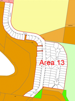
All land to be zoned E4 Environmental Living.
Houses were lost in this part of Bradfield Road in the 1994
bushfire.
This area of Bradfield Road is proposed to be zoned E4
Environmental Living as it is located within an identified bushfire evacuation
risk area and does not meet the required number of exit roads for the number of
dwellings – leading to increased evacuation risk in the event of bushfire.
The table below provides an assessment of the number of exit
roads and dwellings within the Bradfield Road area in accordance with Cova
(2005).
|
No. Exits
|
No. Dwellings
|
No. Recommended
Dwellings
|
No. over recommended
|
|
1
|
95
|
50
|
45
|
The proposal to apply the E4 Environmental Living zone
within the deferred areas is a planning measure to prevent development types
that will result in an increase to the evacuation risk.
Proposed zoning maps for each of the 13 deferred areas are
included in Part 4 of the Planning Proposal which is included at attachment
A1.
Complying Development - KLEP 2015 Amendment No. 5
During the exhibition of the Draft KLEP 2013, a number of
submissions raised concern that the proposed Environmental zoning (E3 and E4)
meant that they would not be able to rely on the State Environmental Planning
Policy (Exempt and Complying Development Codes) 2008 to undertake complying
development.
Under the provisions of the General Housing Code within the
SEPP, complying development can only be carried out on land zoned R1, R2, R3,
R4 and R5.
It was assessed that it was not unreasonable to allow
complying development in the Environmental zones (E3 and E4), as the main land
use within these zones is dwelling houses, the same as R2 Low Density
Residential.
On 23 October 2015 KLEP 2015 Amendment No. 5 was gazetted.
This amendment includes the provision of Complying Development provisions for
Dwelling Houses within Zone E4 Environmental Living. This amendment allows for
complying development to be carried out under Schedule 3 of the KLEP 2015 on
land zoned E4 – where the Codes SEPP does not apply.
The amendment includes appropriate standards and exclusions,
such as for landscaped area, riparian and biodiversity, to ensure that the
objectives of the E4 Environmental Living zone can still be met.
In this regard, the proposed E4 Environmental Living zoning
to the majority of properties within the deferred areas will not adversely
impact on the ability to undertake complying development.
integrated planning and reporting
Places, Spaces and Infrastructure
|
Community Strategic Plan Long Term Objective
|
Delivery Program
Term Achievement
|
Operational Plan
Task
|
|
P2 – Managing Urban Change
|
Land use strategies, plan and process are in place to
effectively manage the impact of new development
|
P2.1.1.1.2 Implement and monitor the Local Environmental
Plans and supporting Development Control Plans
|
Governance Matters
The process for preparation and implementation of Planning
Proposal is governed by the provision contained within the Environmental
Planning and Assessment Act 1979 and the Environmental Planning and
Assessment Regulation 2000.
Council should seek the plan-making delegation under Section
23 of the EP&A Act to finalise the Planning Proposal. This involves
Council taking on the Director General’s function under s59(1) of the Act in
liaising with the Parliamentary Counsel’s Office (PCO) to draft the required
local environmental plan to give effect to the Planning Proposal as well the
Minister’s function under s59(2) of the Act in making the Plan.
Risk Management
The 13 deferred areas are still subject to the Ku-ring-gai
Planning Scheme Ordinance, which as a planning document is out dated in its
approach to zoning, land use controls and is difficult to interpret. This
Planning Proposal seeks to include the 13 deferred areas into the KLEP 2015.
There is a risk that if Council does not progress the amendment to the KLEP
2015 to include these 13 deferred areas there could be ongoing uncertainty
for both staff and the general public.
There is a risk that if the permitted land uses are too
restrictive within the E2 zone applying to 20 Kanowar Avenue, East
Killara, they may depending on circumstances invoke the Land Acquisition
(Just Terms Compensation) Act 1991 and the need for the Minister to
designate a relevant acquiring authority, which under the circumstances would
be Council. There is no identified funding source for such an acquisition.
Financial Considerations
The cost for the preparation of this Planning Proposal and
additional supporting studies is covered by the Strategy and Environment
operational budget.
Social Considerations
Social issues cover all aspects of human life, including how
we live, our culture, our community, health, wellbeing and aspirations.
It is not expected that the Planning Proposal will result in
any adverse social impacts.
Environmental Considerations
The Planning Proposal and the use of the proposed E4 zoning
is a proactive approach to both the management of natural resources and the
management of the environmental hazards caused by bushfire risk. The risks
result from the historical development patterns in Ku-ring-gai which has seen
fingers of bushland into residential areas protected from development and large
residential sites which support an extensive tree canopy and areas of remnant
bushland.
Biodiversity assessments of 56-58 Koola Avenue and 20
Kanowar Avenue, East Killara were undertaken by independent consultants in
order to evaluate the site conditions and potential ecological constraints on
the site in order to inform the future land use and zoning on the sites.
20 Kanowar Avenue, East Killara is proposed to be zoned E2
Environmental Conservation as the site has high ecological values.
Community Consultation
Should the Planning Proposal be granted a Gateway
Determination by the Department of Planning and Environment, the Planning
Proposal will be placed on statutory public exhibition in accordance with the
requirements of the Gateway Determination and the Departments publication A
Guide to Preparing Planning Proposals.
During the statutory public exhibition the community will be
invited to make submissions on the proposal.
Internal Consultation
Council officers from Development and Regulation and
Strategy and Environment have been consulted with during the preparation of the
Planning Proposal and this report.
Council officers also held a workshop on the deferred areas
with representatives from the Rural Fire Service, NSW Police, Fire and Rescue,
State Emergency Service and National Parks and Wildlife Service on 12 August
2015.
Summary
13 areas within Ku-ring-gai were deferred from inclusion
within the KLEP 2015 when it came into effect on 2 April 2015. These areas were
identified as bushfire evacuation risk areas, and were deferred to allow
Council to re-assess the evacuation risks and zoning within these areas.
The deferred areas that are located within bushfire
evacuation risk areas and that do not meet the number of exit road requirements
as per the Cova (2005) research are proposed to be zoned E4 Environmental
Living. The E4 zoning is a planning measure to prevent increases in density and
development types that would increase evacuation risks within these areas.
|
Recommendation:
A. That
the Planning Proposal (Attachment A1) be forwarded to the Department
of Planning and Environment for a Gateway Determination in accordance with
the provisions of the EP&A Act and Regulations.
B. That
delegation be granted to the General Manager to make any necessary
corrections and amendments for drafting inconsistencies, or minor amendments
as necessary to ensure consistency with NSW Standard Order Template and
Department of Planning & Environment Policy.
C. That
Council request the plan making delegation under Section 23 of the EP&A
Act for this Planning Proposal.
D. That
upon receipt of a Gateway Determination, the exhibition and consultation
process is carried out in accordance with the requirements of the EP&A
Act and with the Gateway Determination requirements.
E. That a
report be brought back to Council at the conclusion of the exhibition period.
F. That
Council wait for the NSW Rural Fire Service evacuation risk modelling study
to be completed prior to further investigating a planning response for the
whole of the South Turramurra area with the aim of addressing bushfire
issues.
|
|
Alexandra Plumb
Urban Planner
|
Craige Wyse
Team Leader Urban Planning
|
|
Antony Fabbro
Manager Urban & Heritage Planning
|
Andrew Watson
Director Strategy & Environment
|
|
Attachments:
|
A1View
|
Deferred
Areas Planning Proposal
|
|
2015/318887
|
|
|
A2View
|
Planning
Proposal Appendix A - Managing Bushfire Risk, Now and into the Future
|
|
2015/078565
|
|
|
A3View
|
12
August Meeting Notes - Deferred Areas Bushfire Evacuation Risk
|
|
2015/222172
|
|
|
A4View
|
Ecological
constraints report 20 Kanowar Avenue East Killara
|
|
2015/317652
|
|
|
A5View
|
Biodiversity
Site Condition Report - 56-58 Koola Avenue East Killara
|
|
2015/313448
|
|
|
A6View
|
Advice
from Aboriginal Heritage Office - 56-58 Koola Avenue East Killara (Warrington
Reserve)
|
|
2015/317689
|
|
APPENDIX
No: 1 - Deferred
Areas Planning Proposal
|
|
Item No: GB.7
|
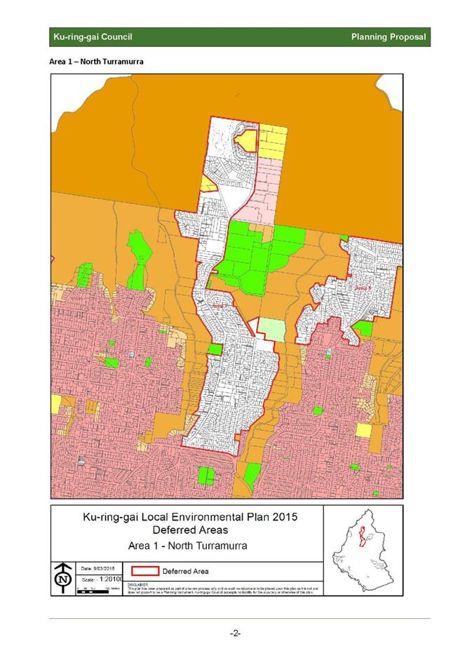
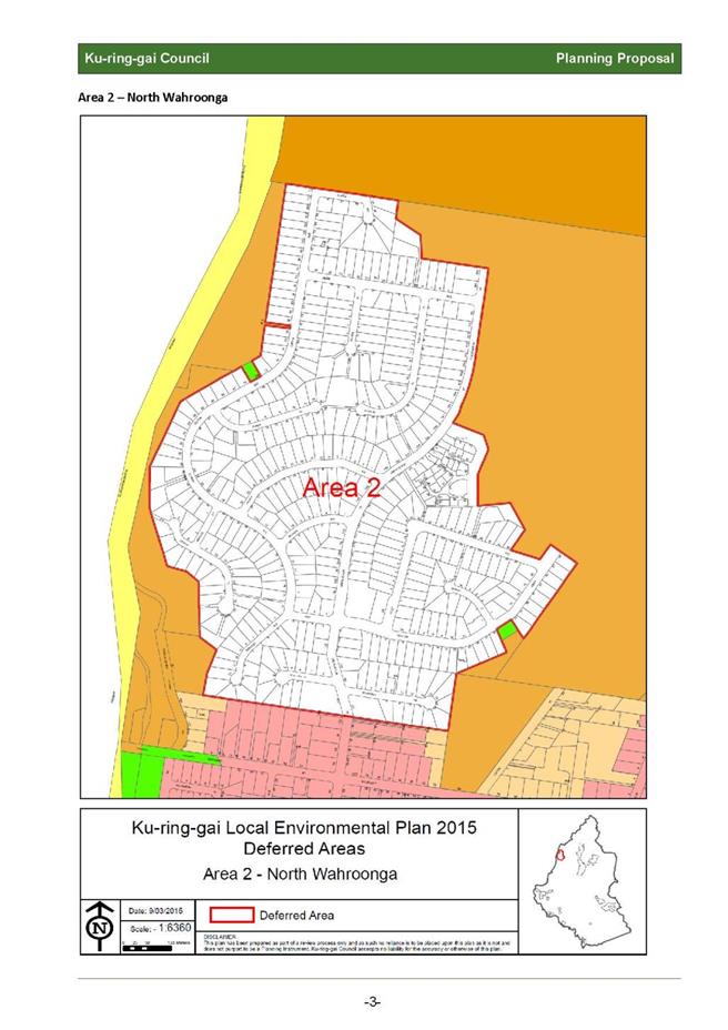
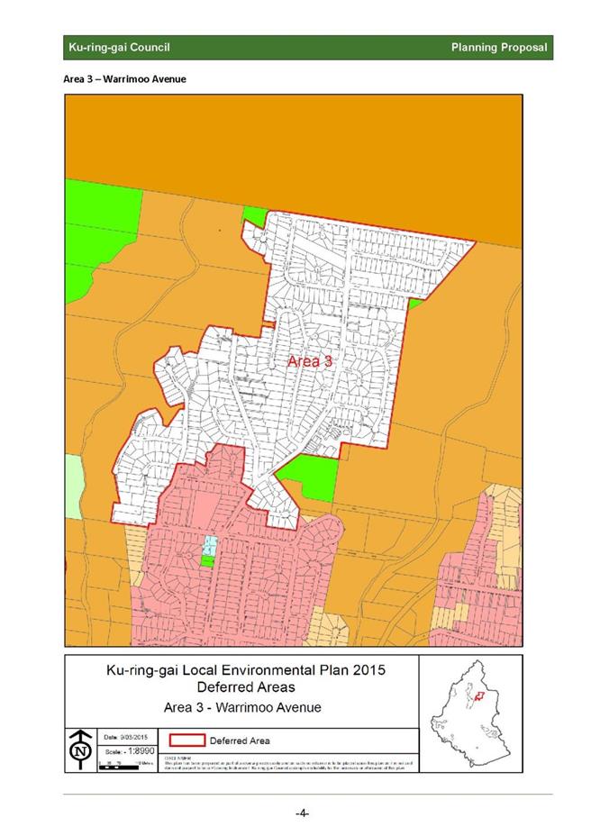
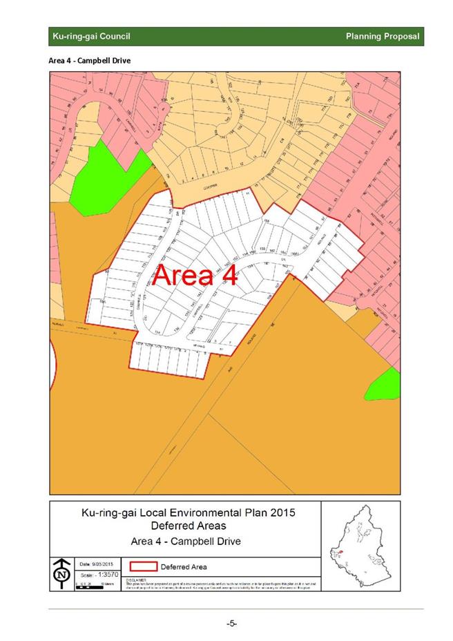
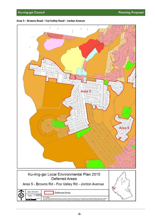
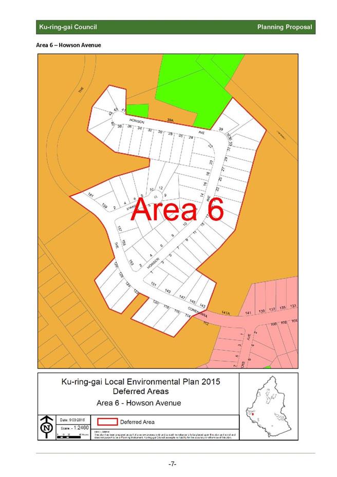
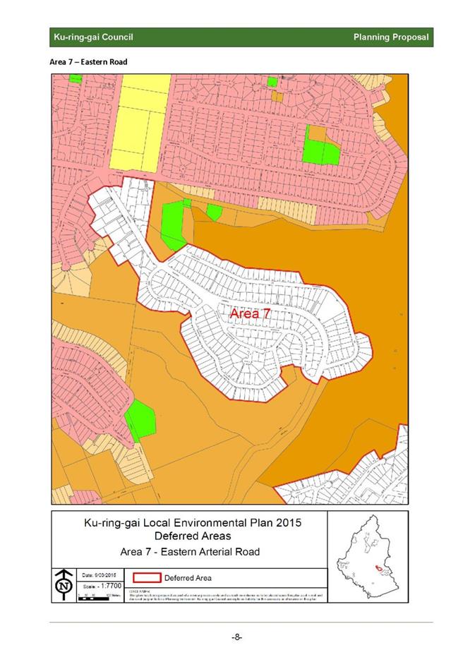
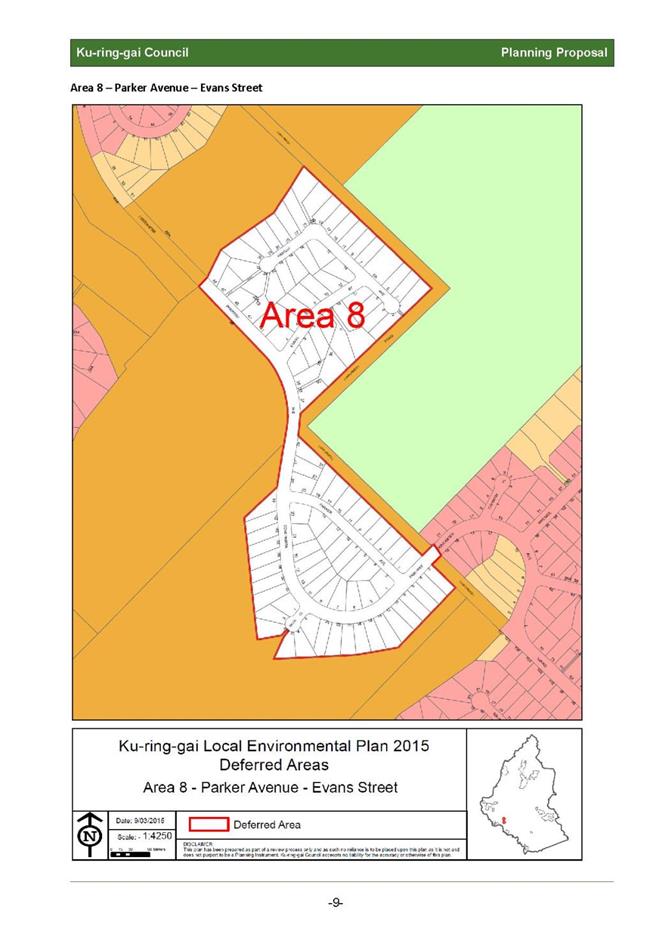
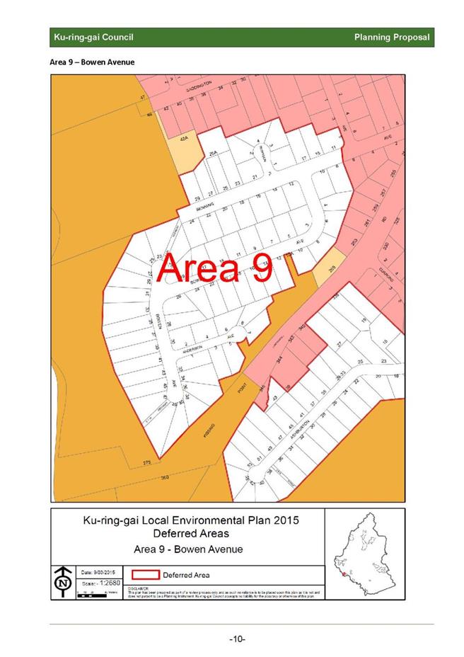
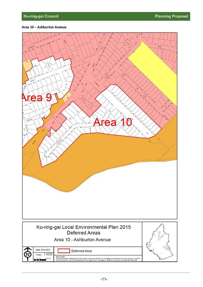
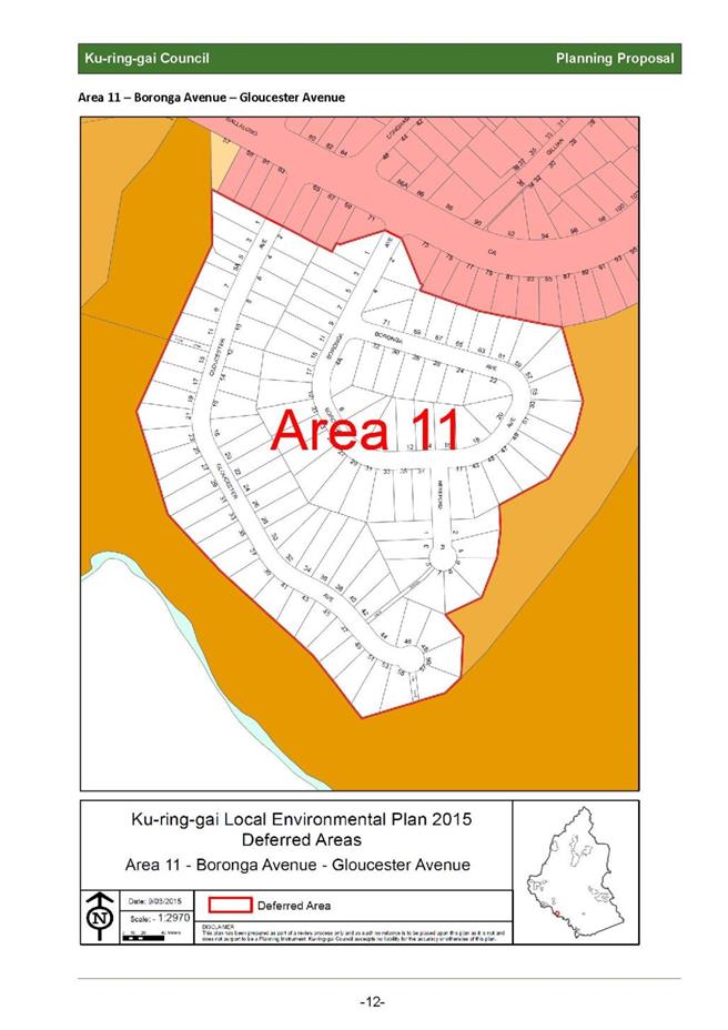
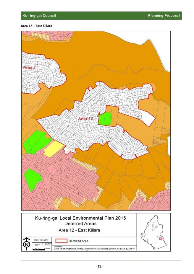
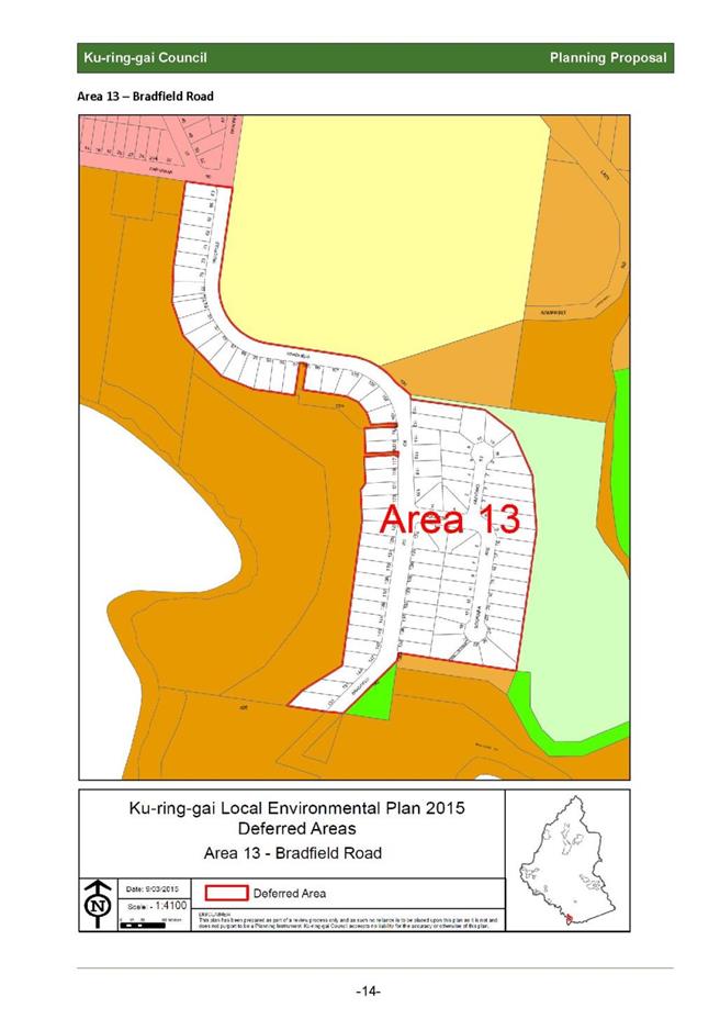

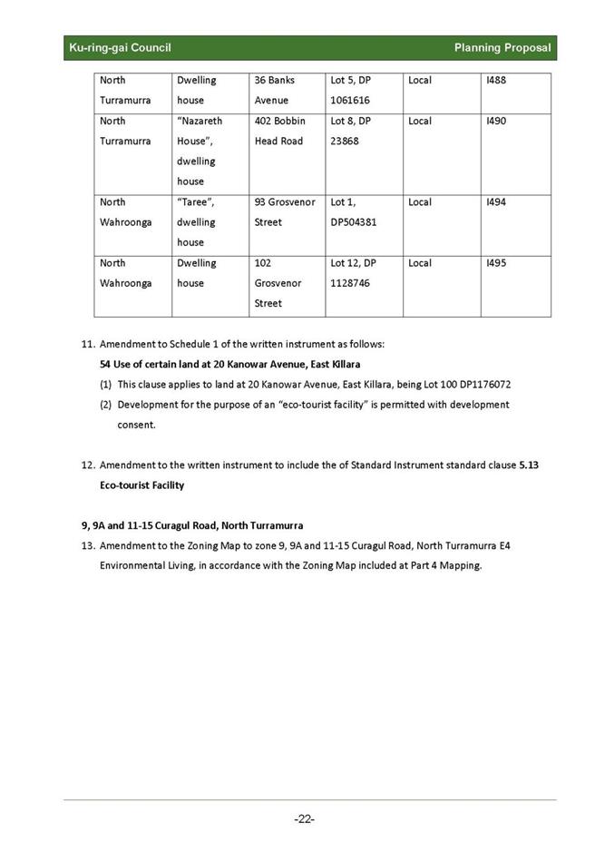
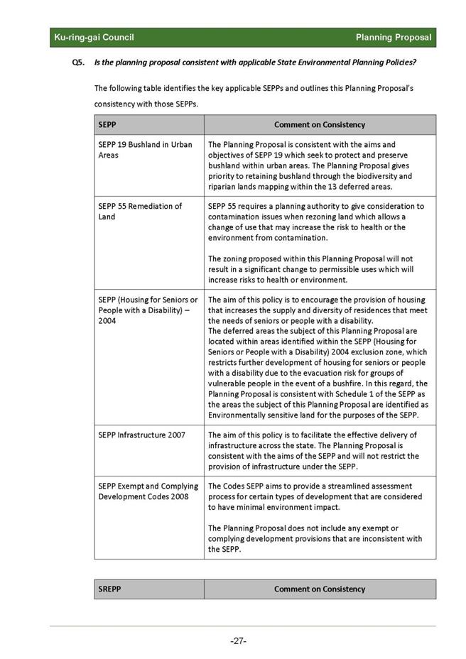
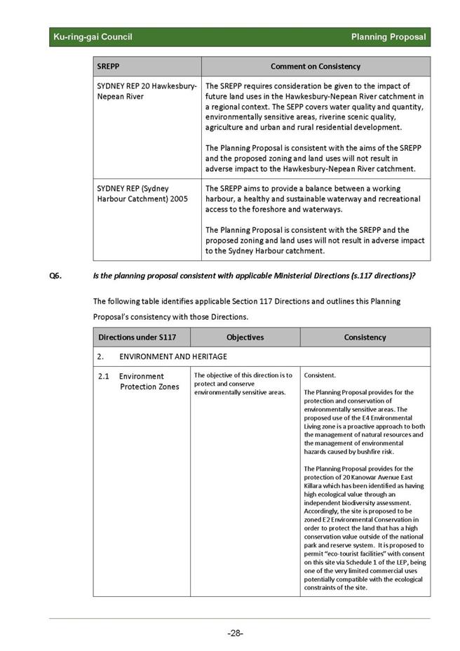
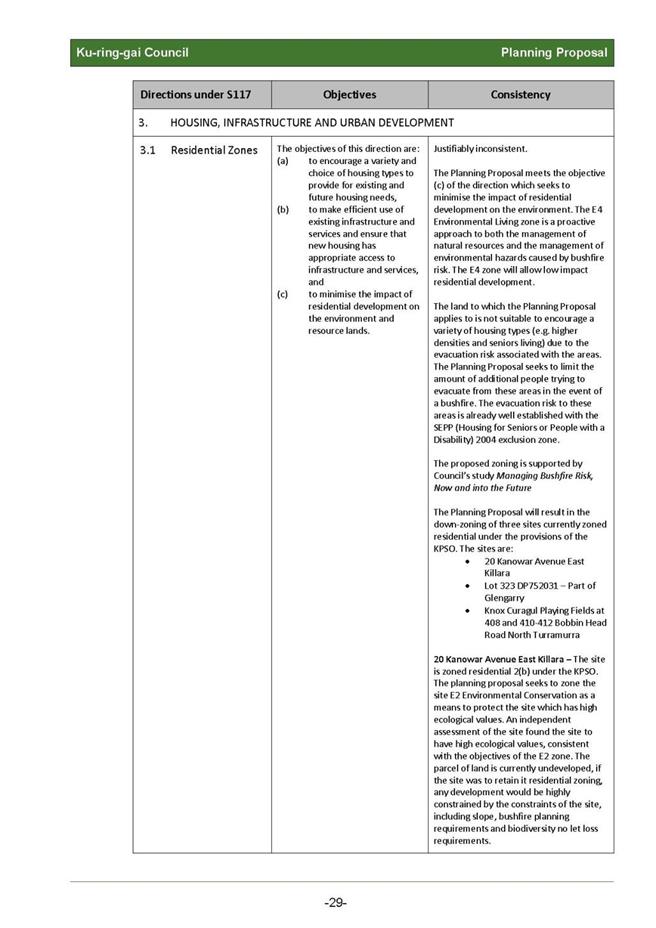


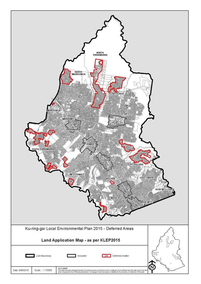
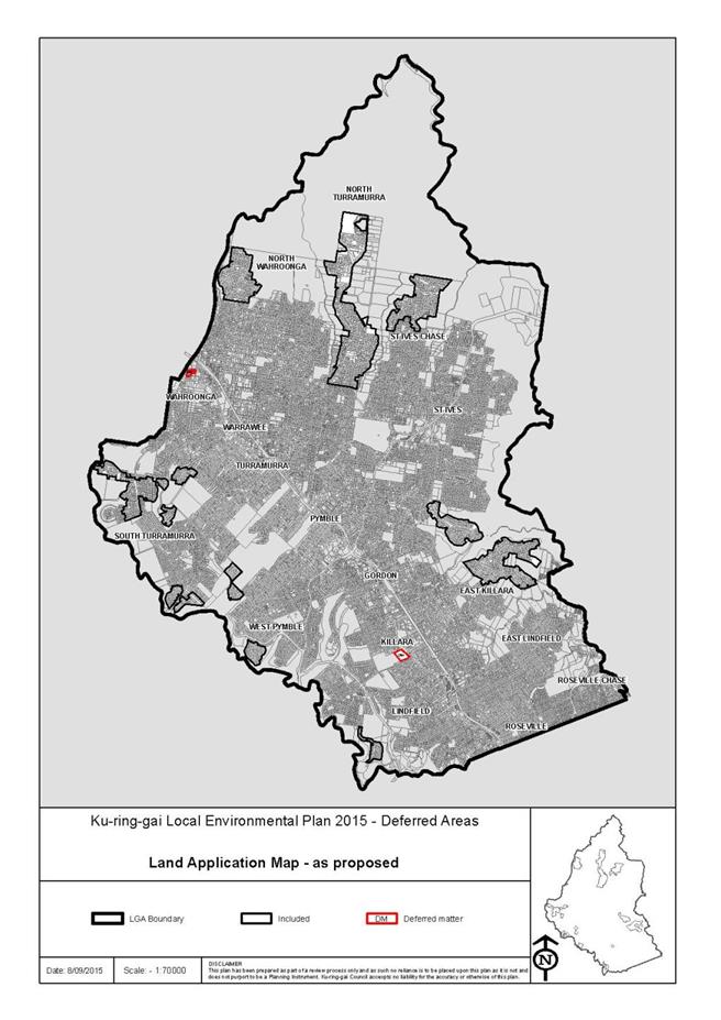
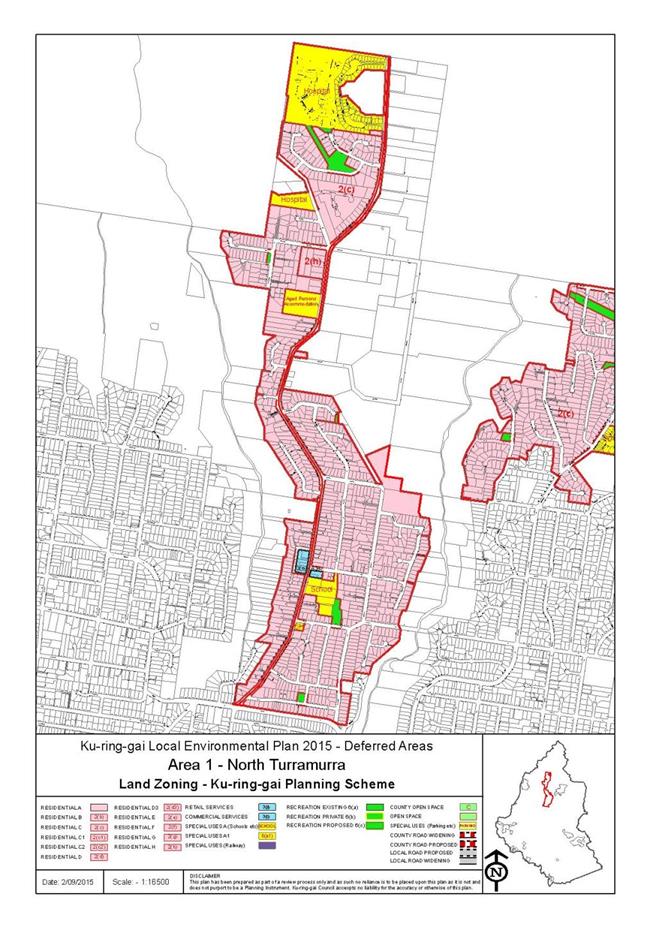
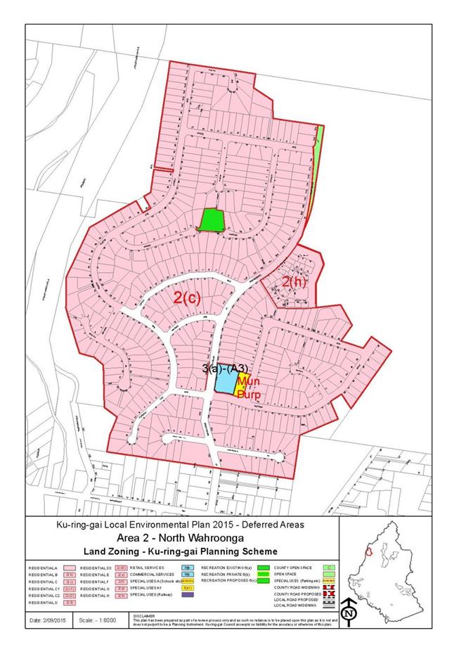

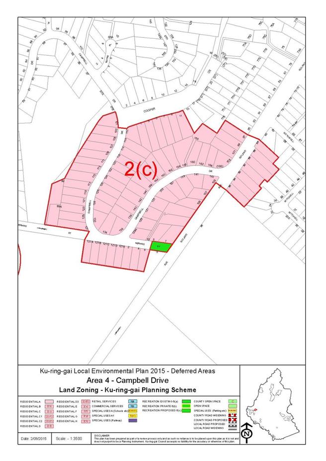
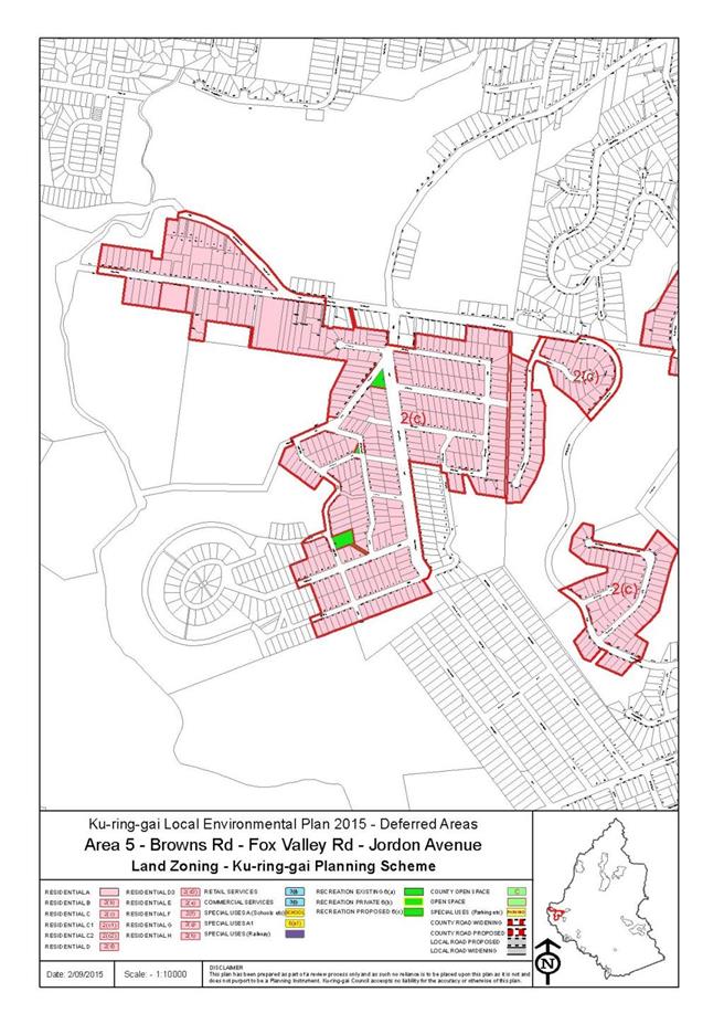
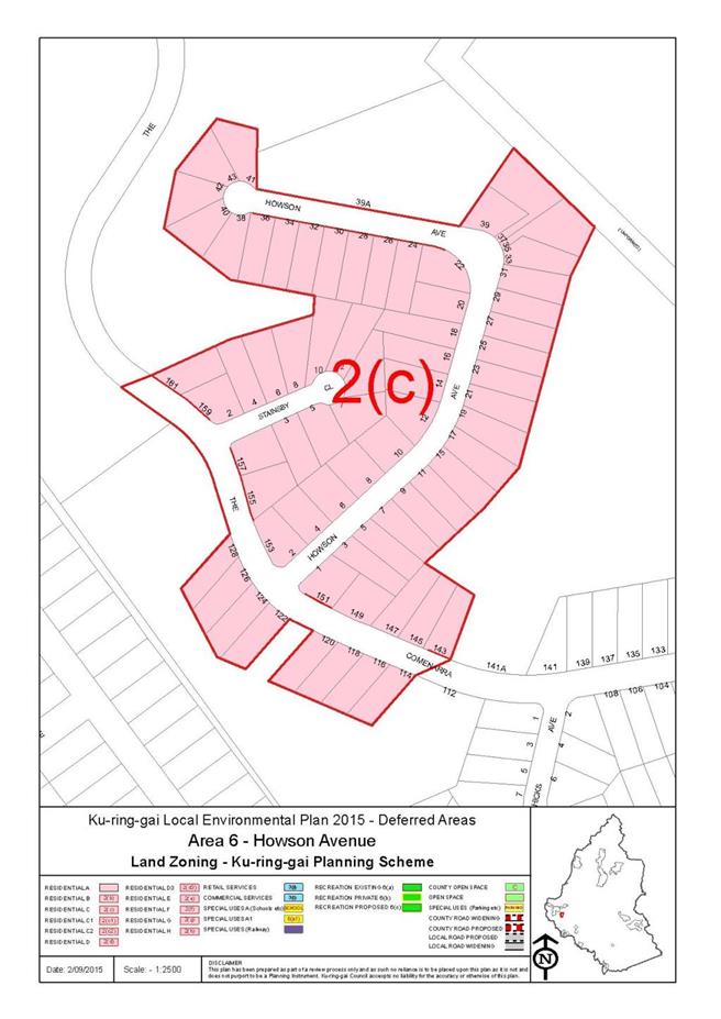
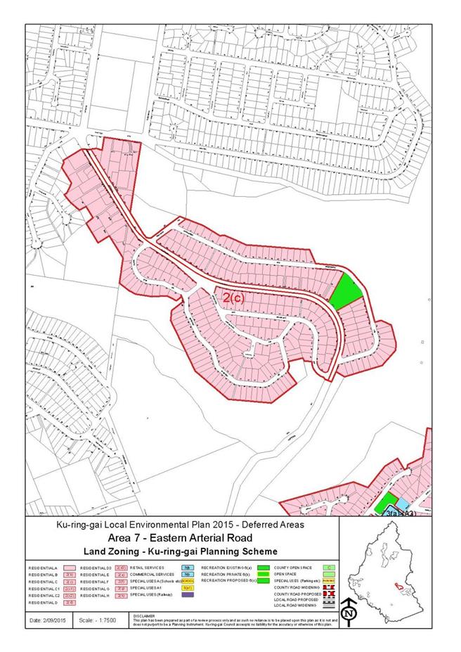
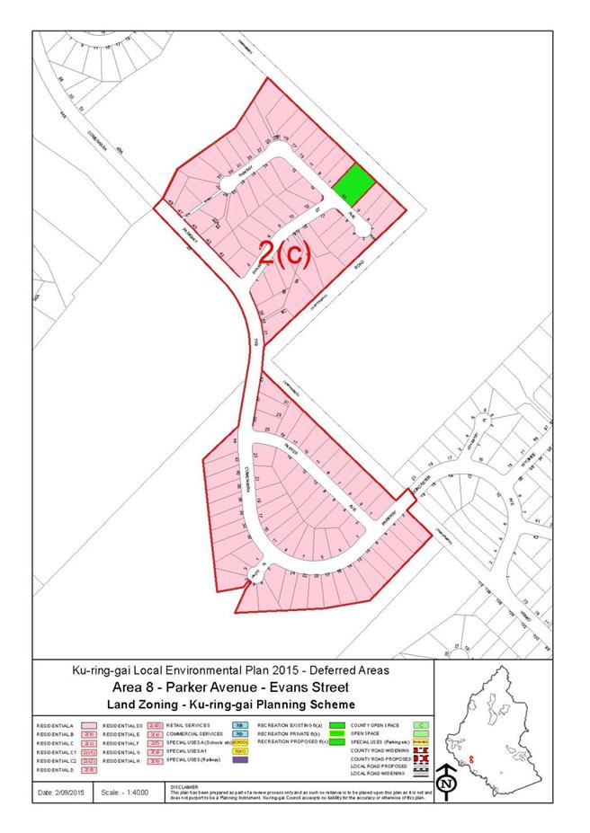
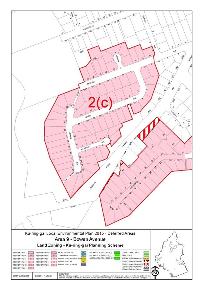
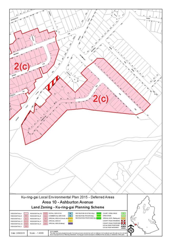
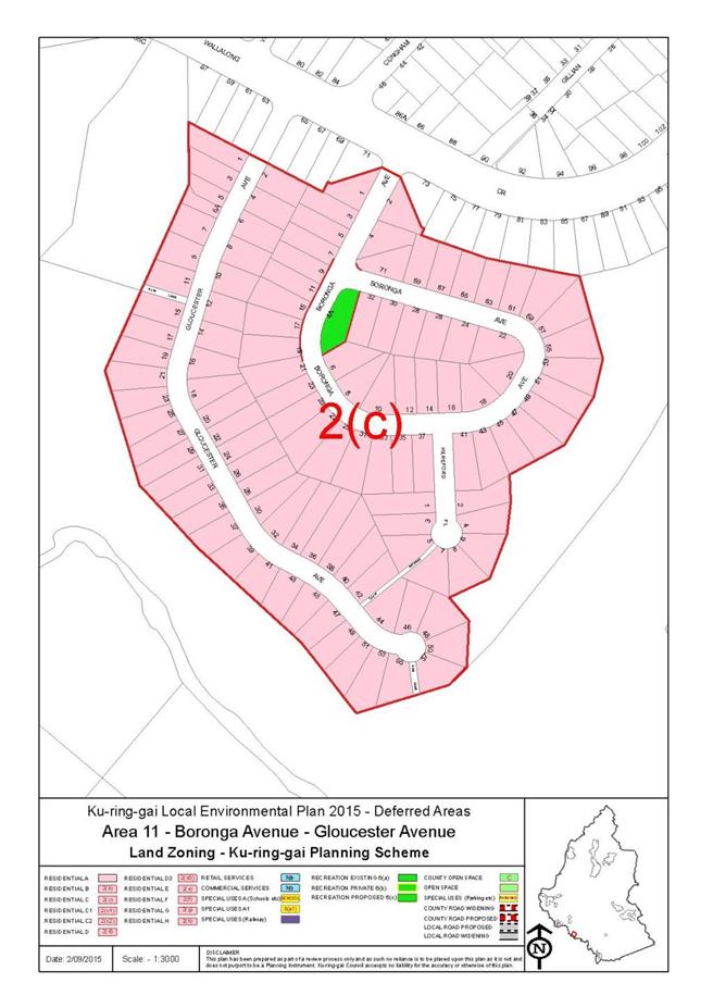
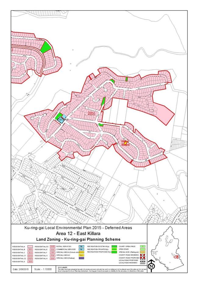
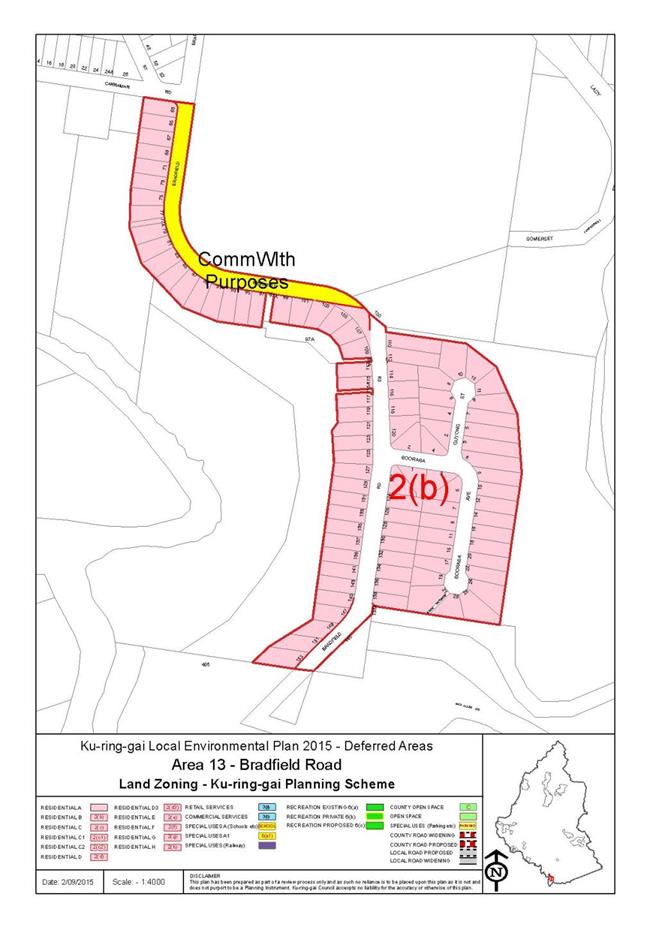

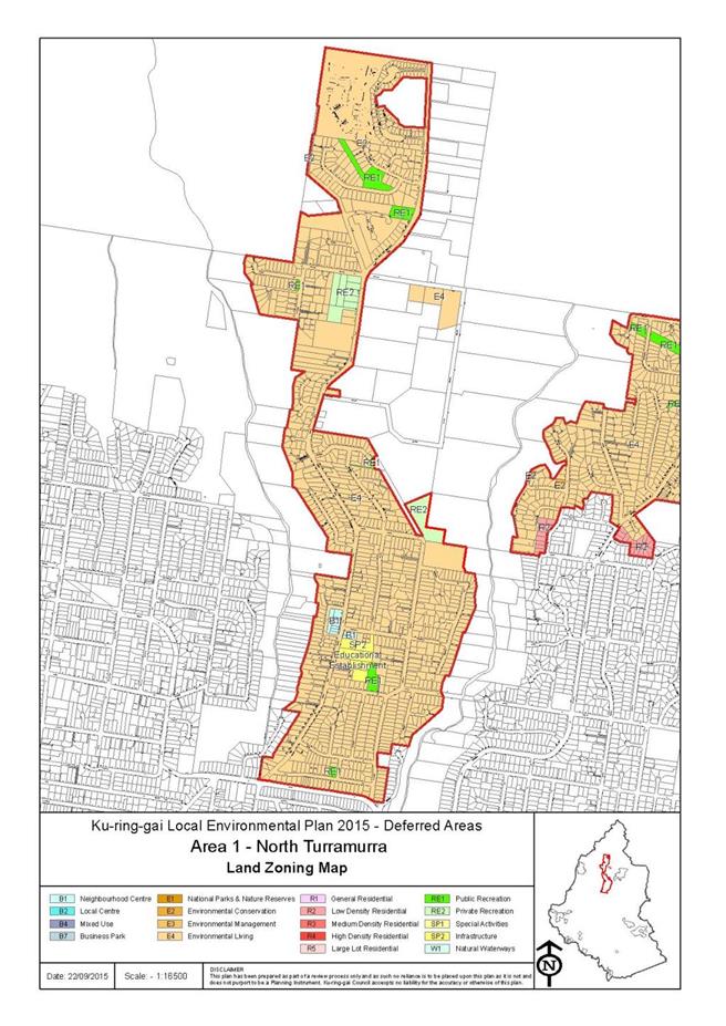
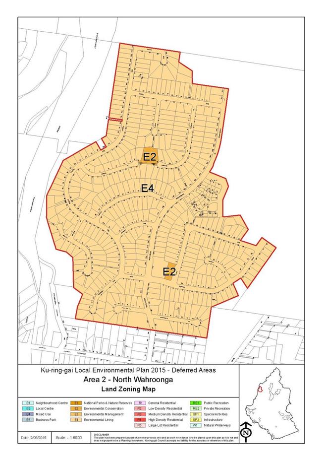
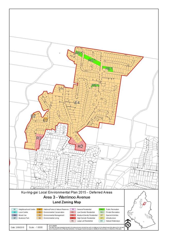


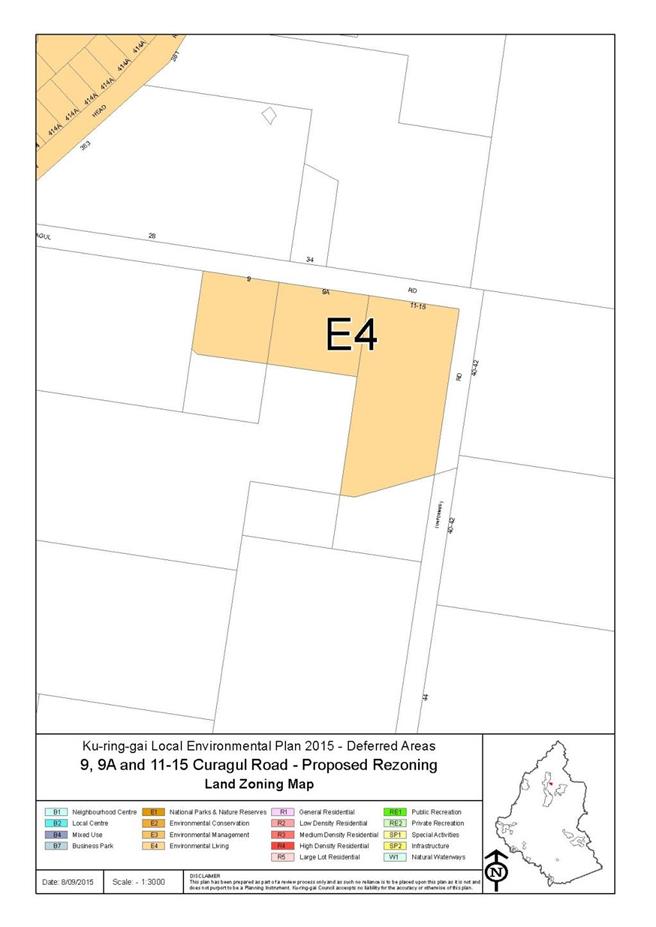

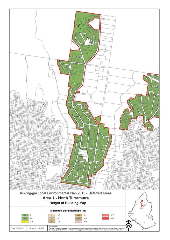
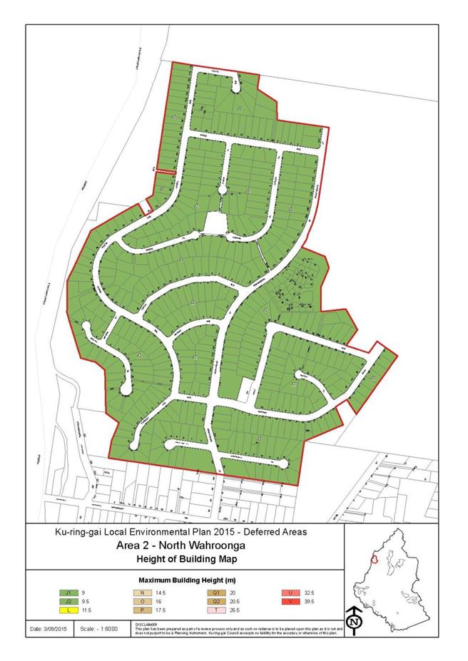
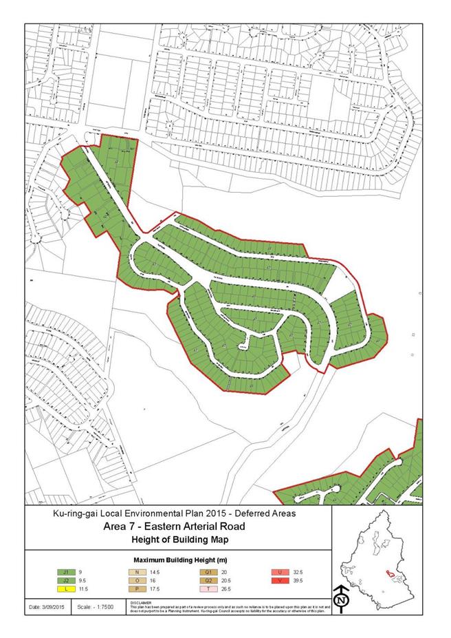
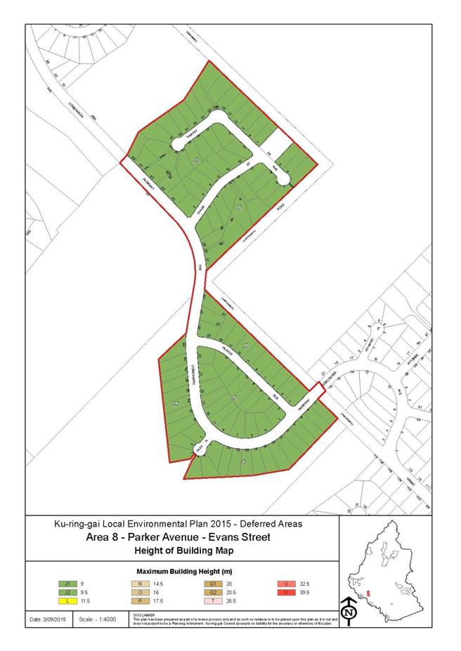
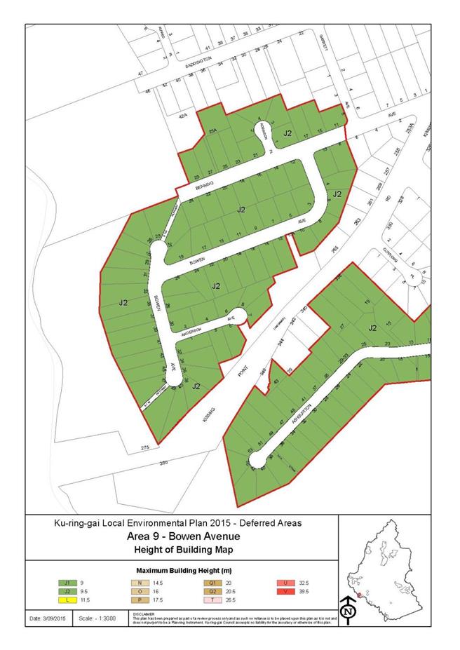
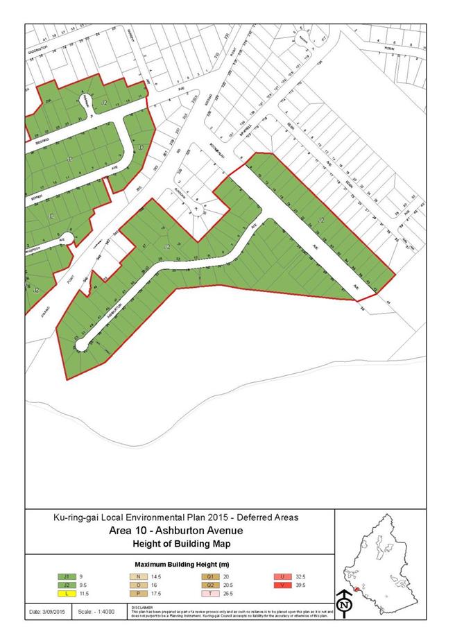
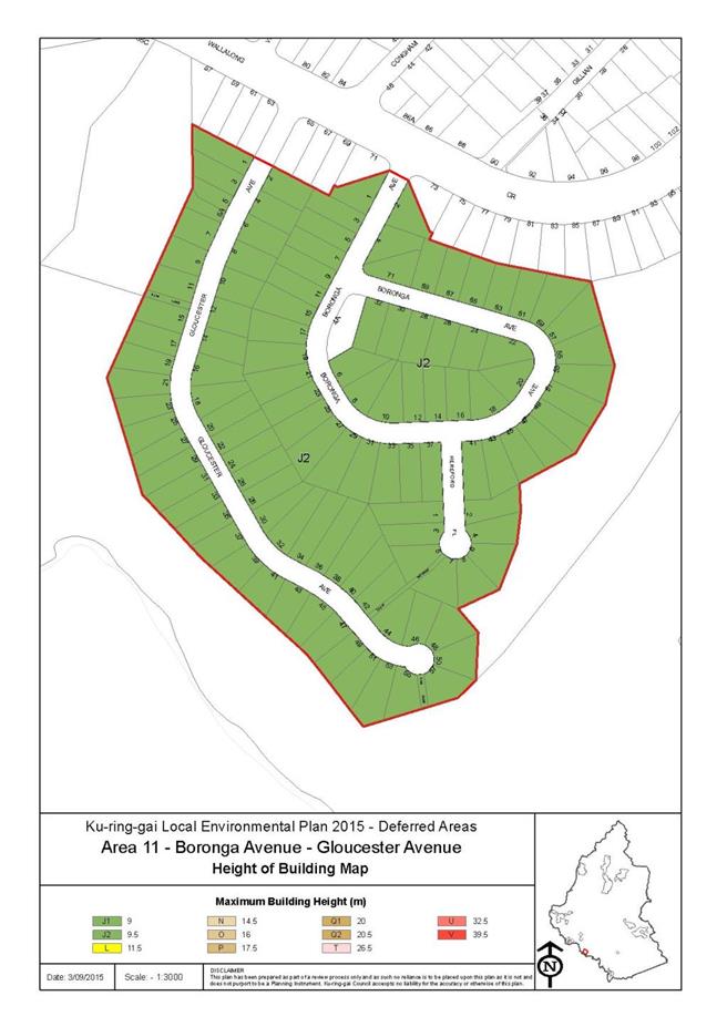
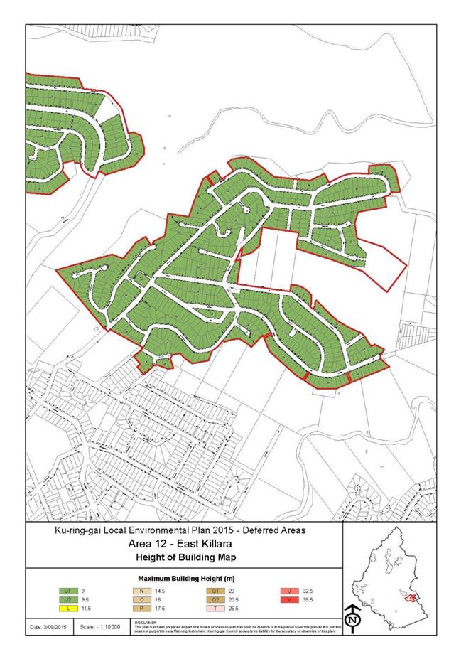
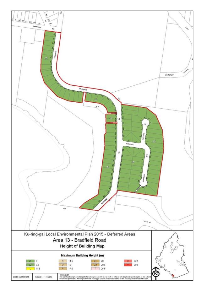
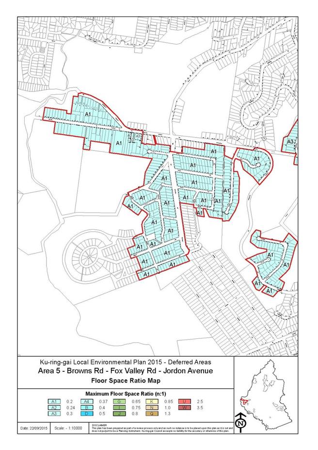
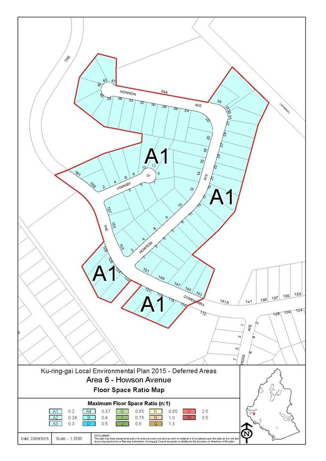
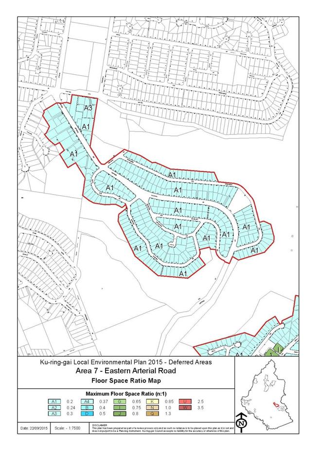
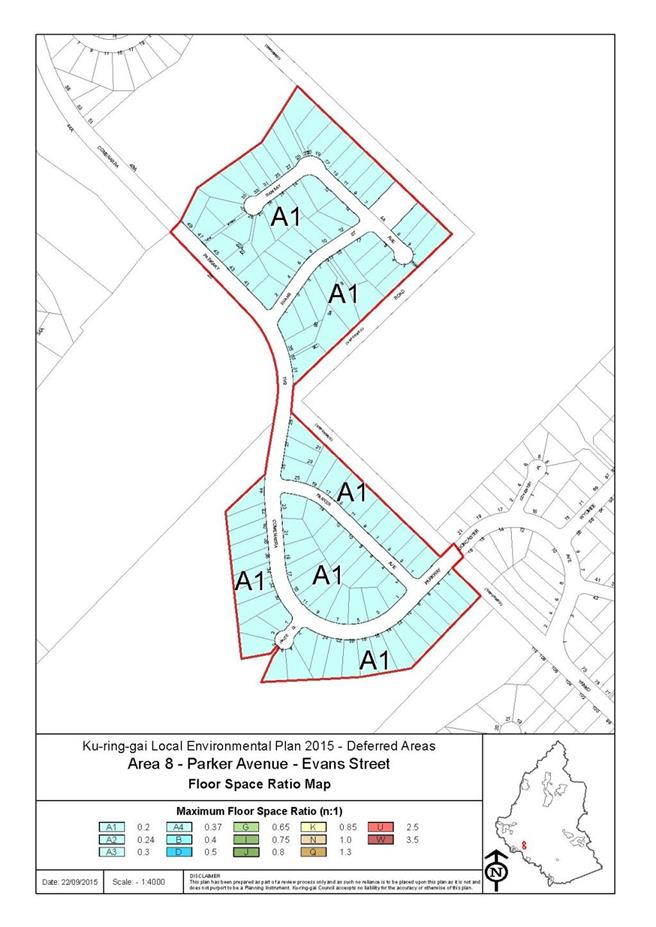
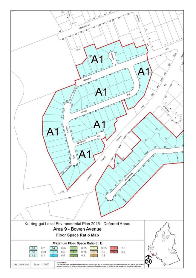
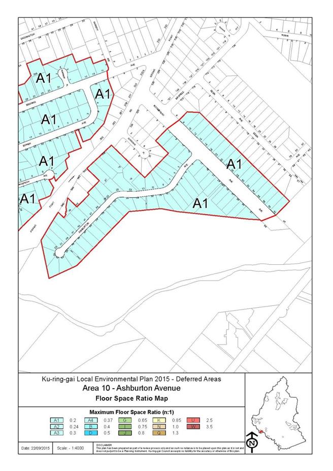
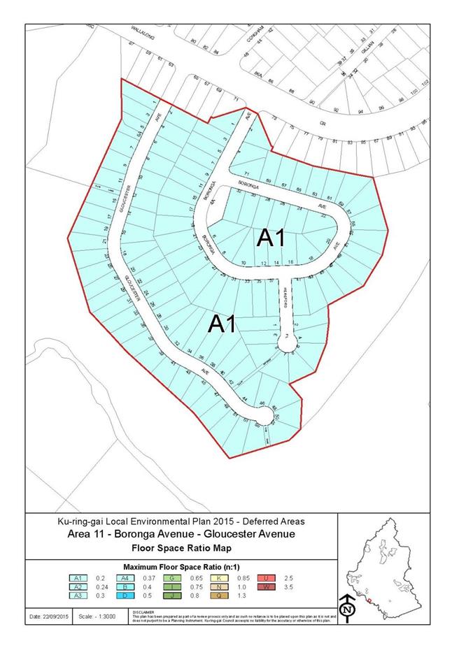

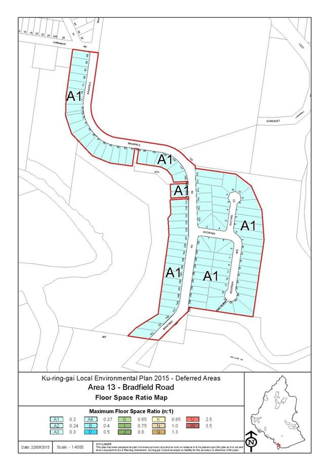
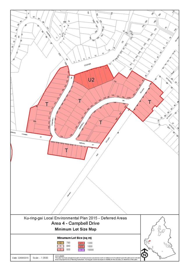
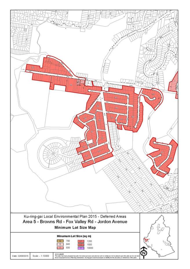
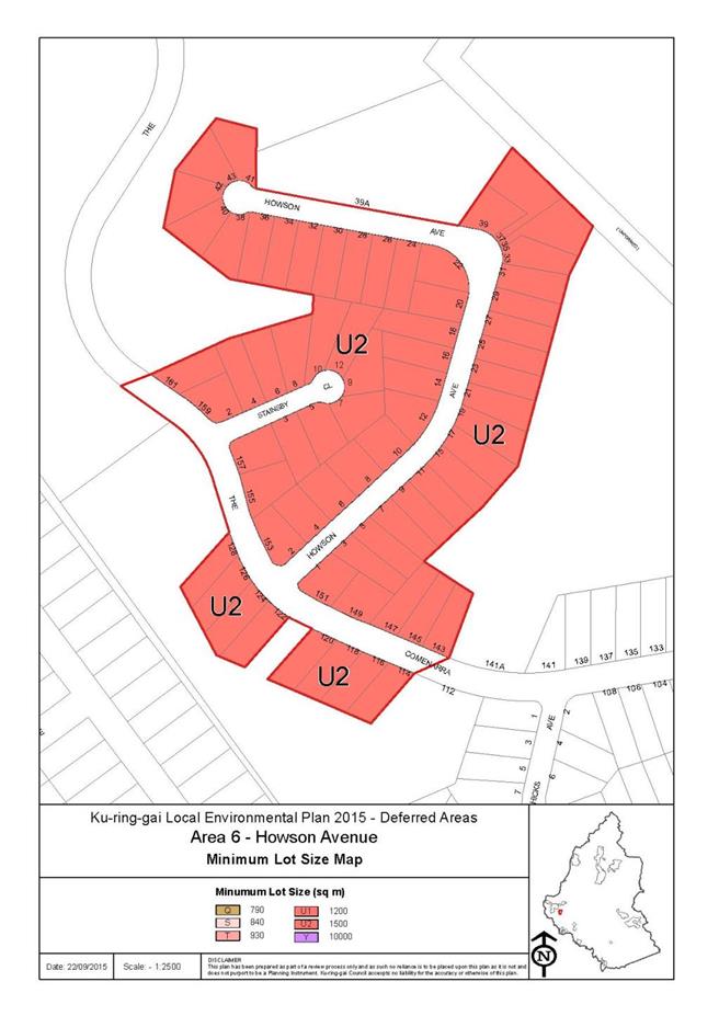
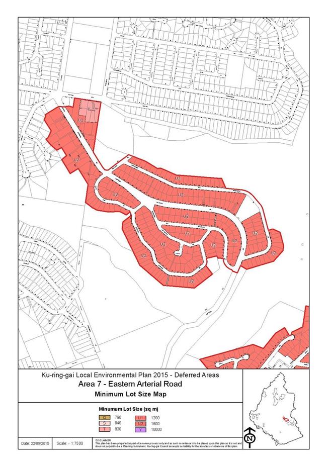
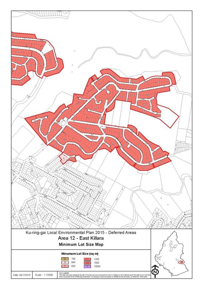
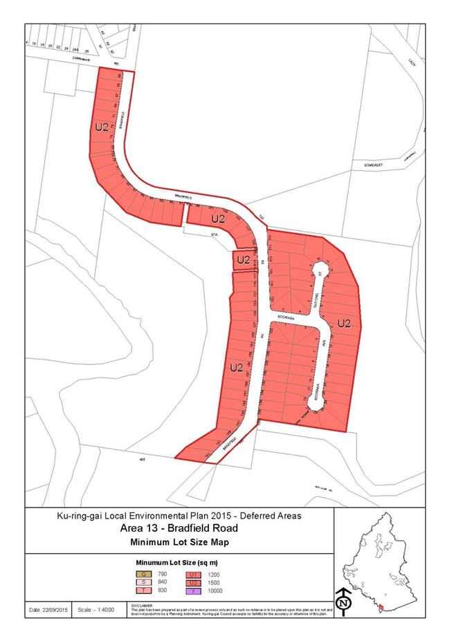
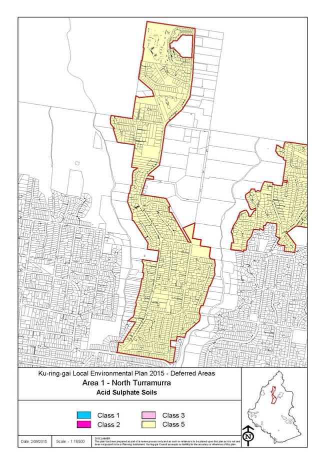
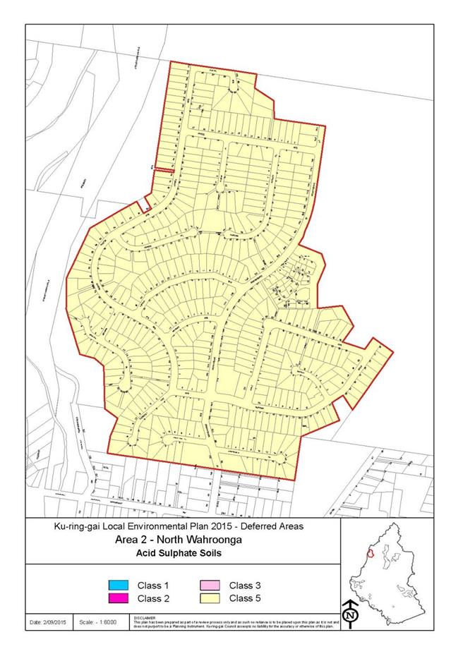
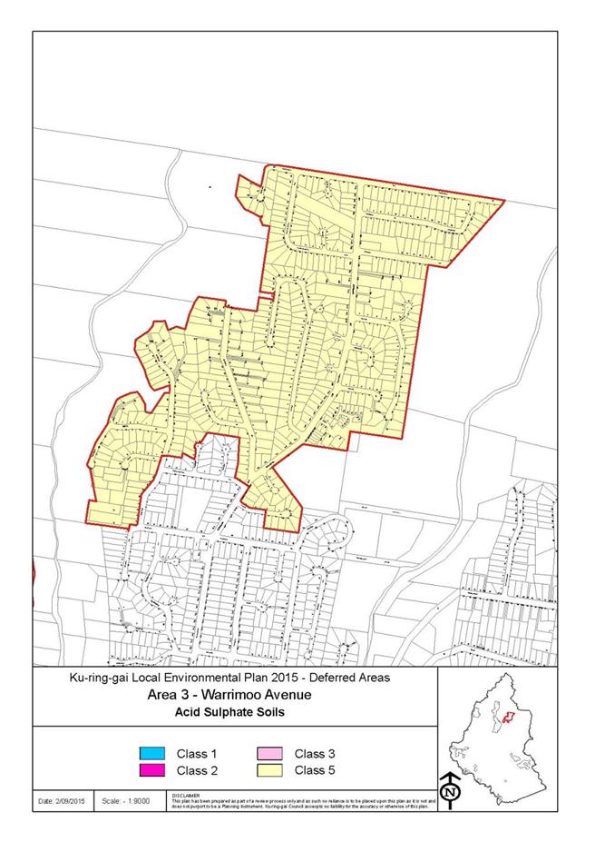
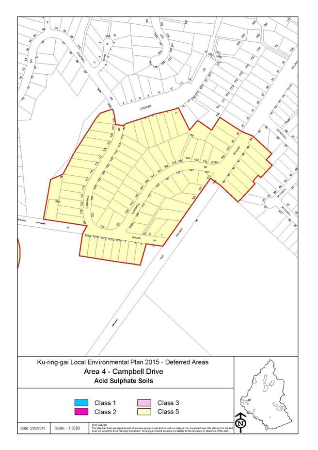
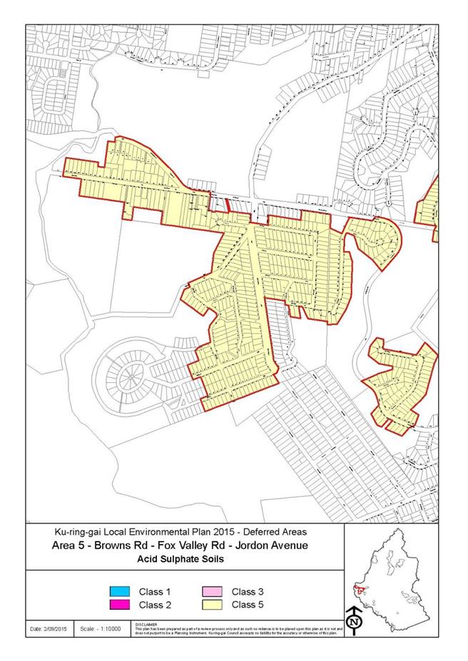
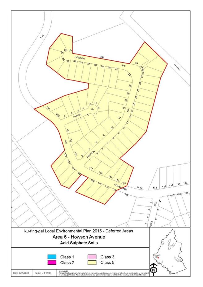
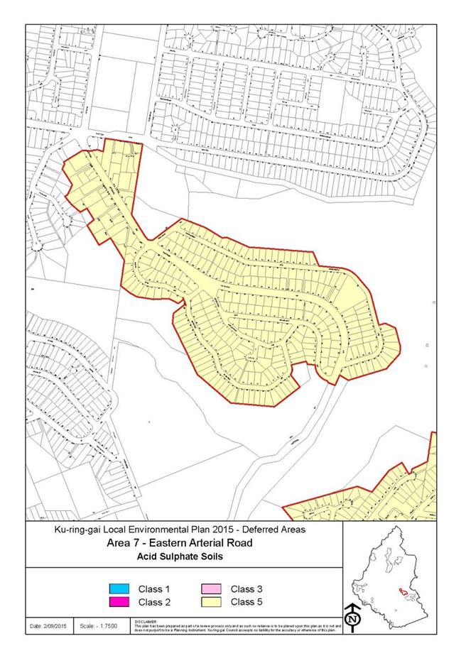
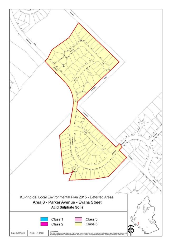
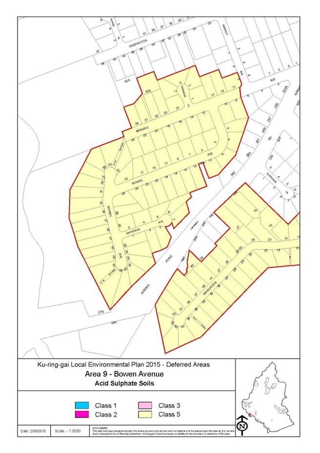

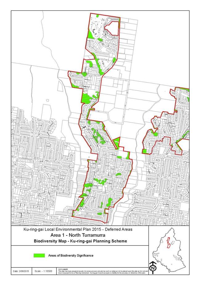
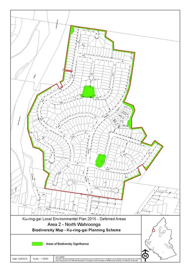
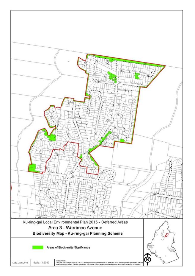
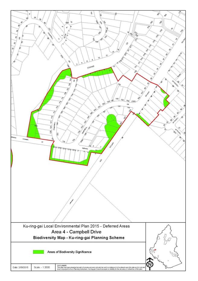
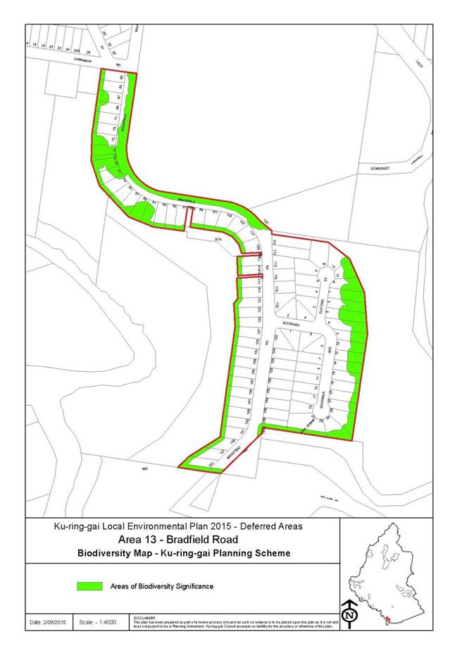


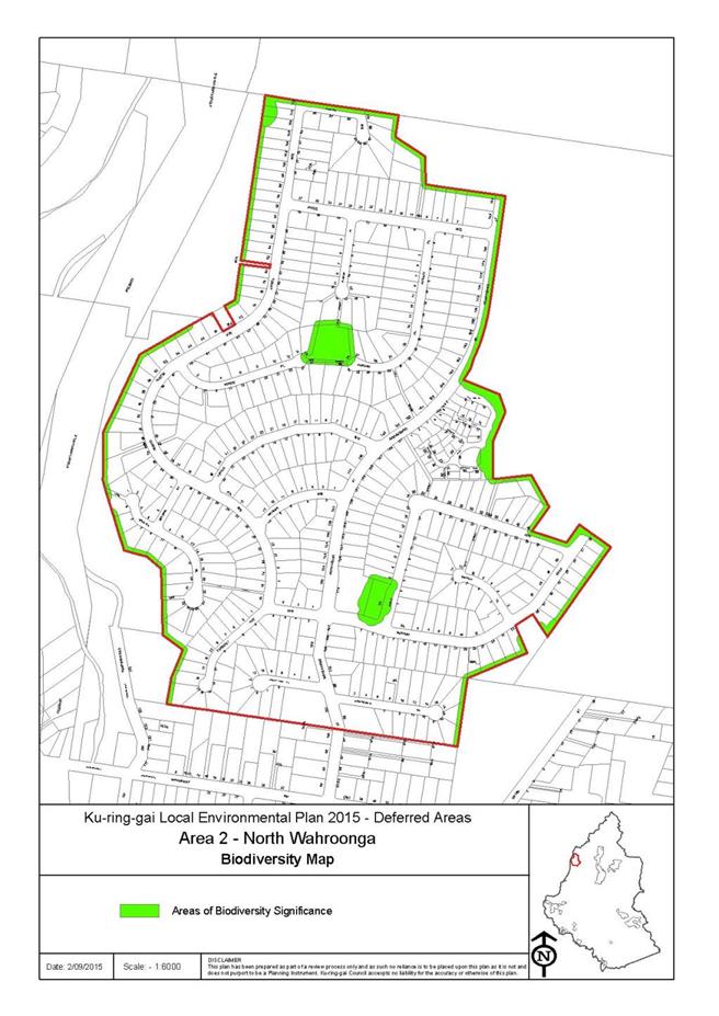
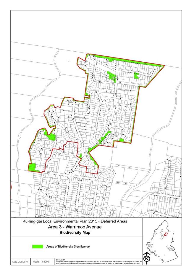
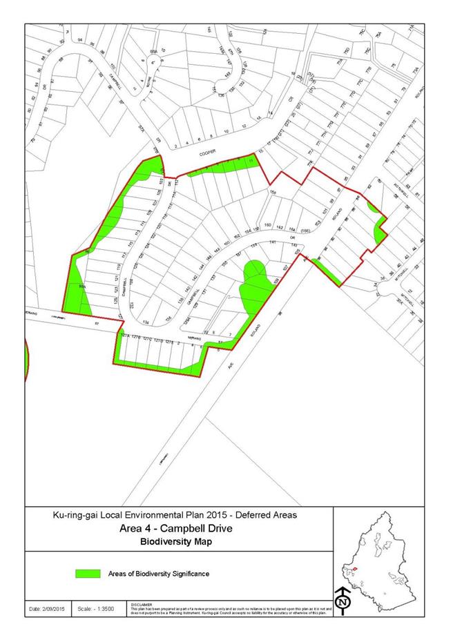
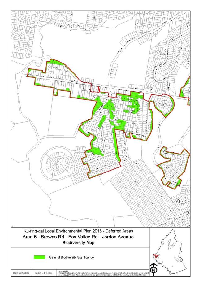
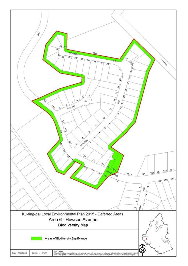
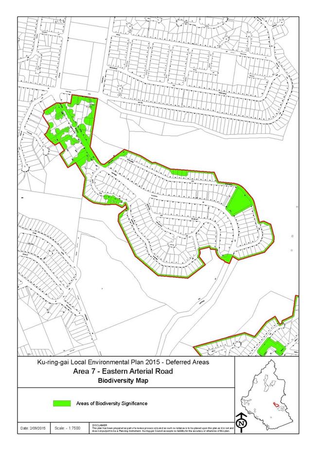
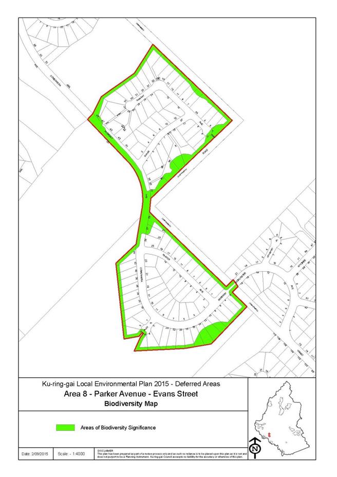


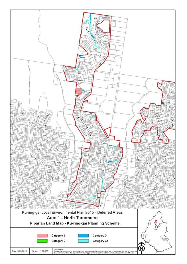
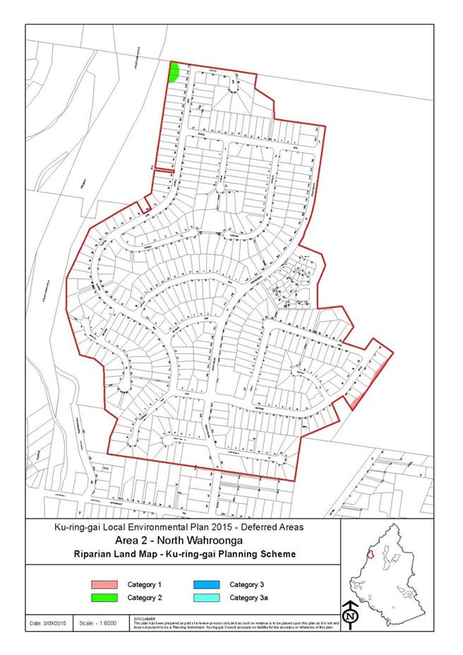
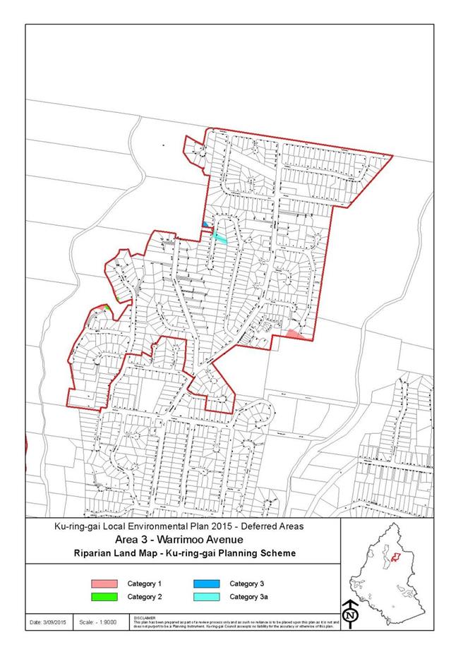
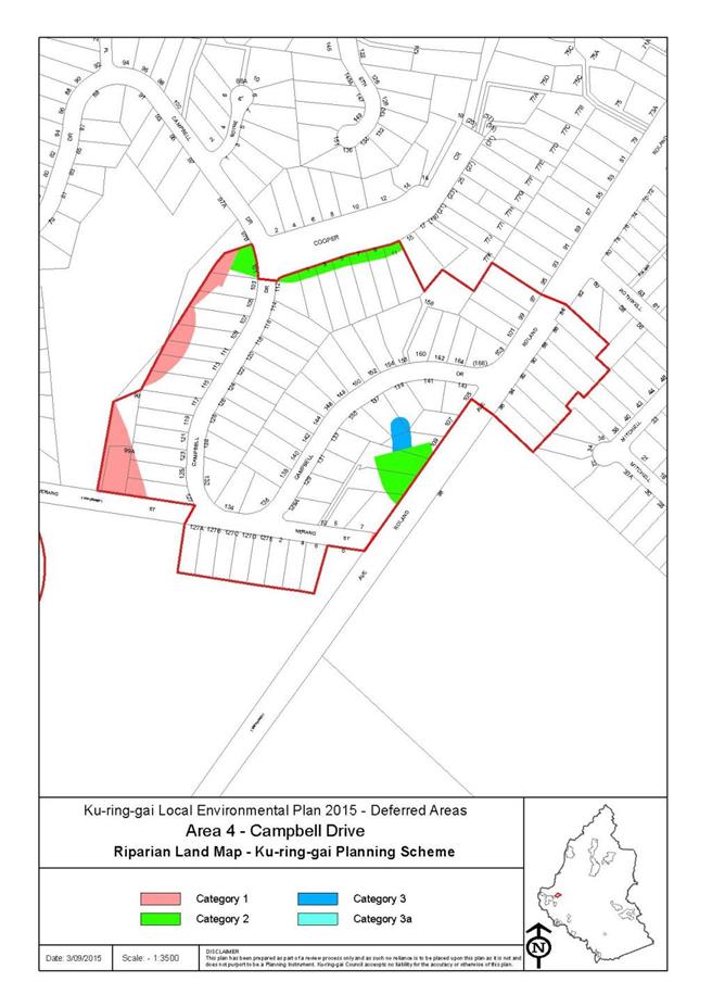
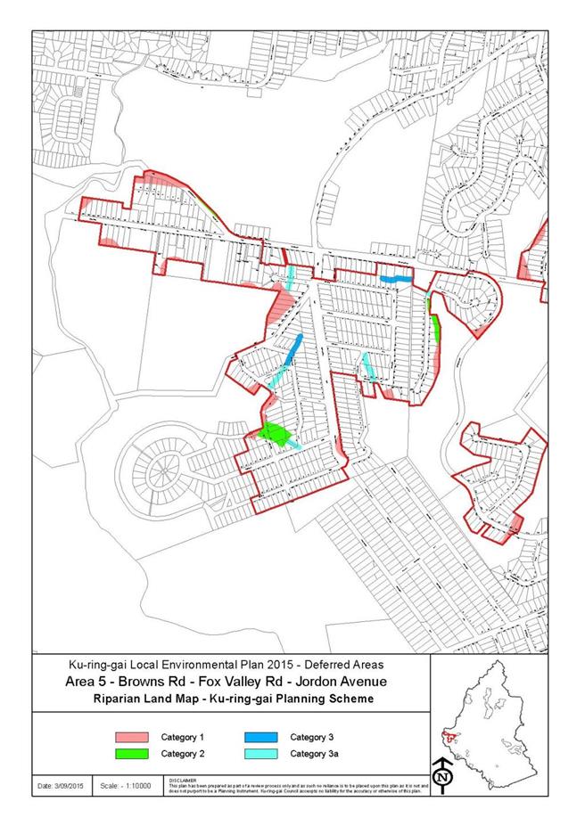
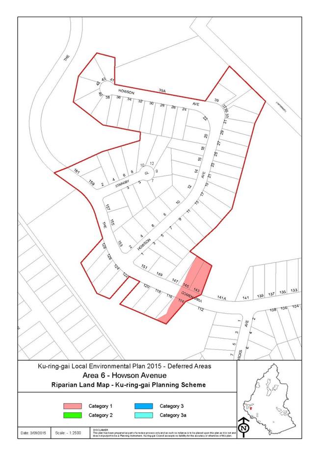
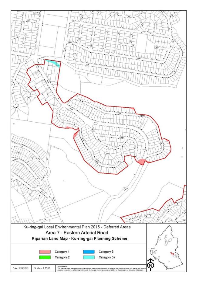
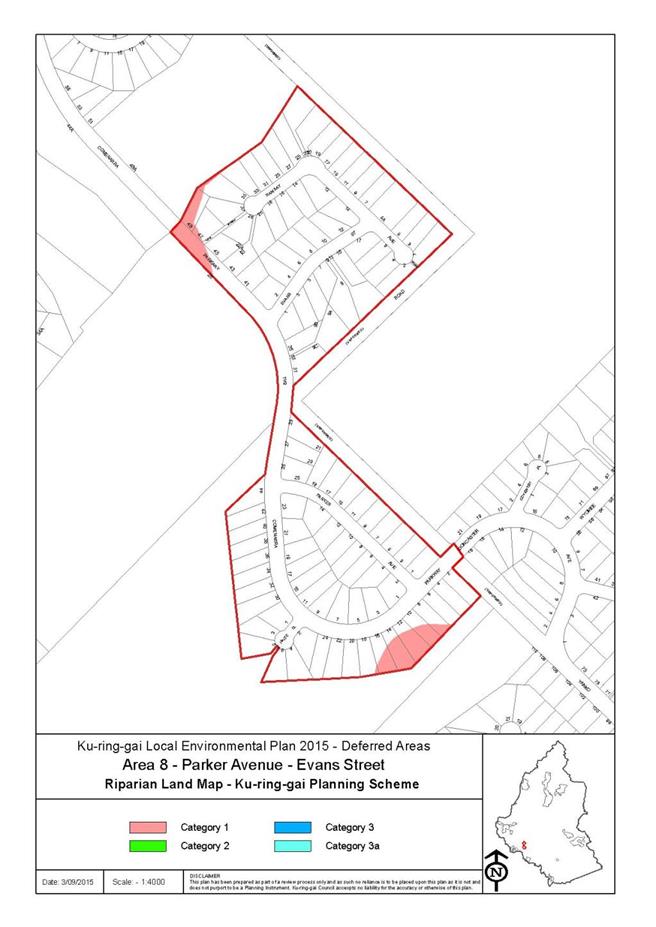
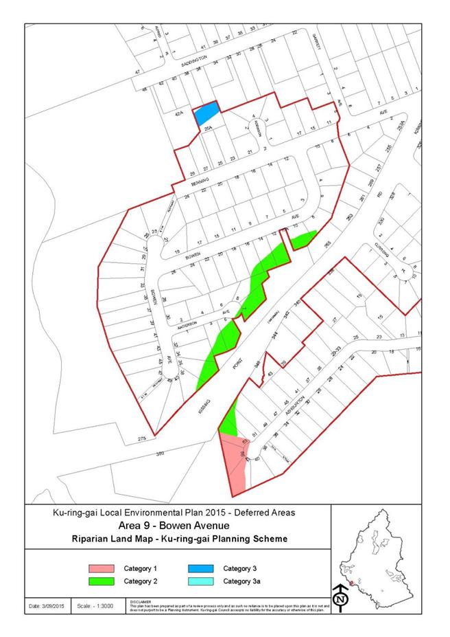

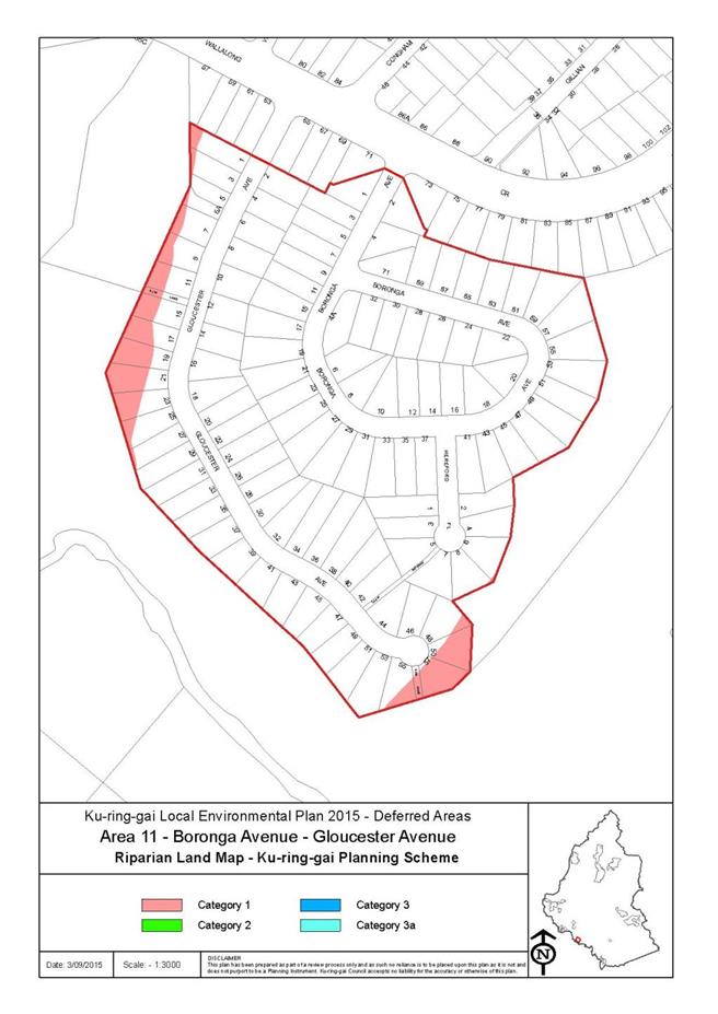
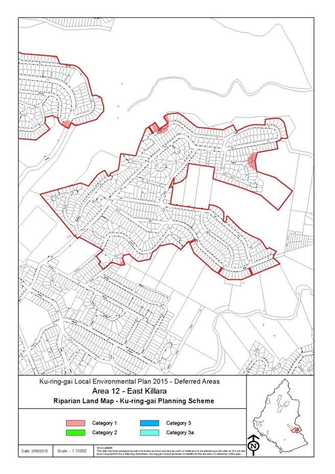
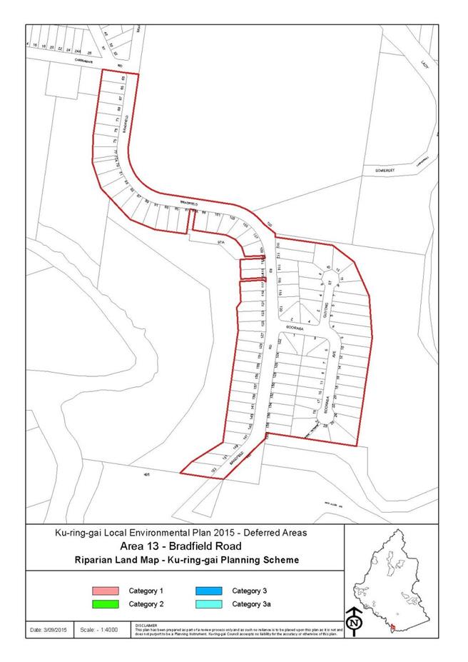

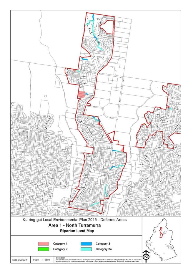
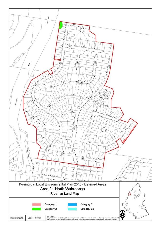
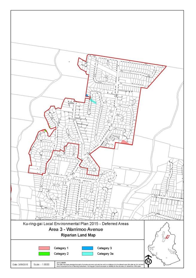
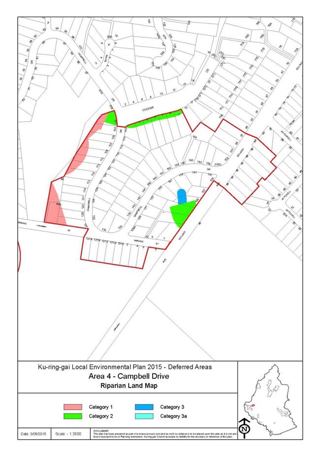
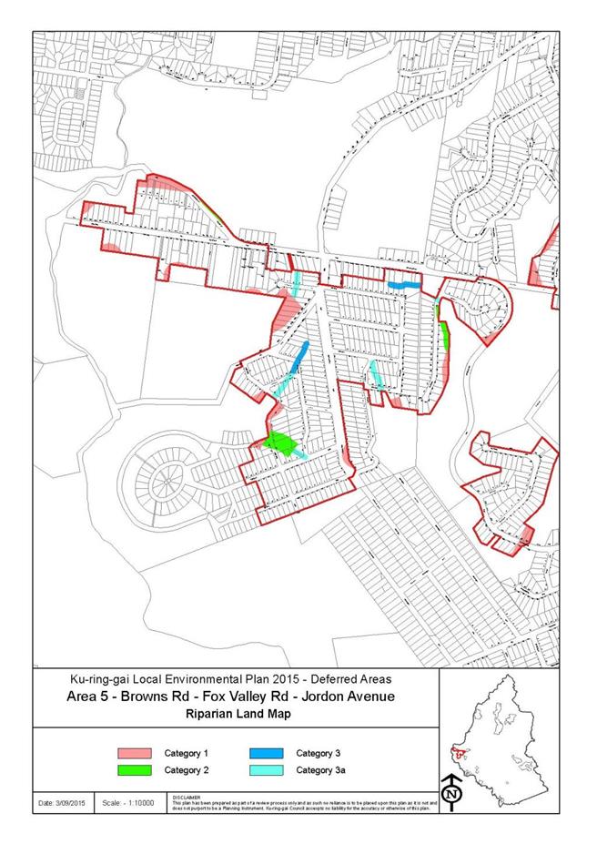
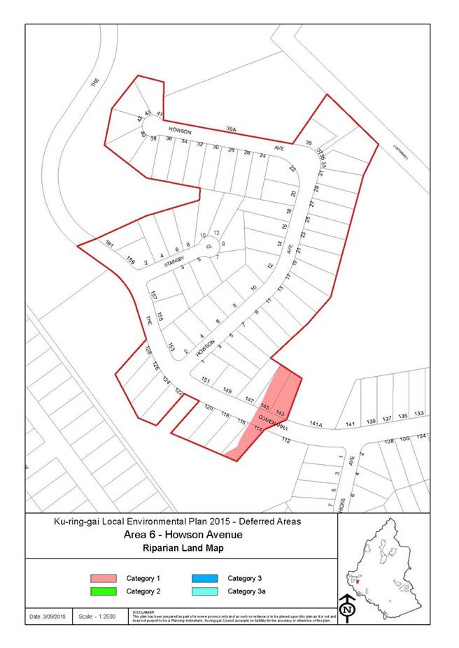
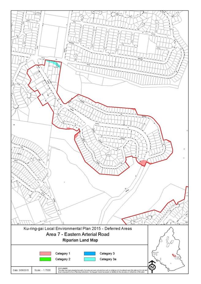
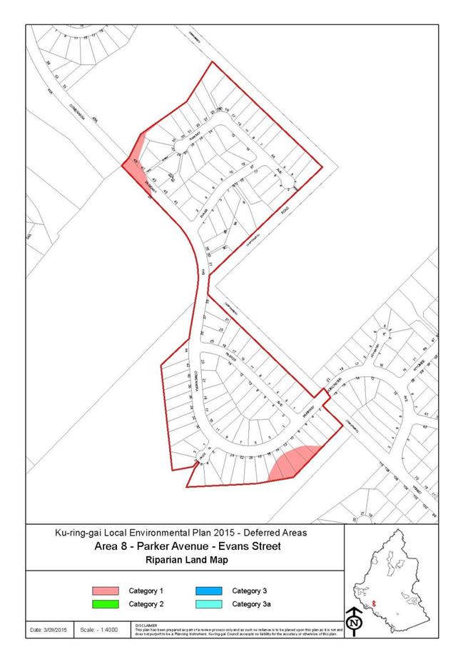
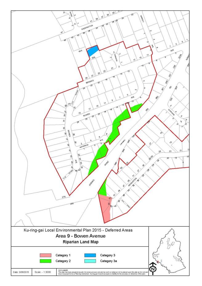
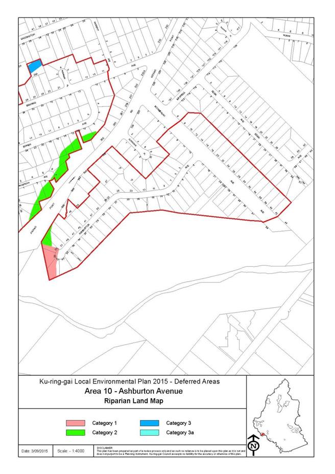
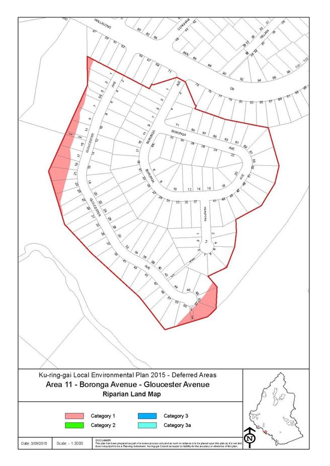
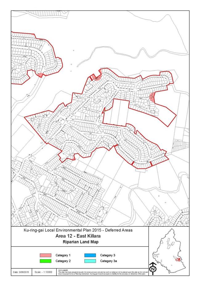


|
APPENDIX No: 2 - Planning
Proposal Appendix A - Managing Bushfire Risk, Now and into the Future
|
|
Item No: GB.7
|


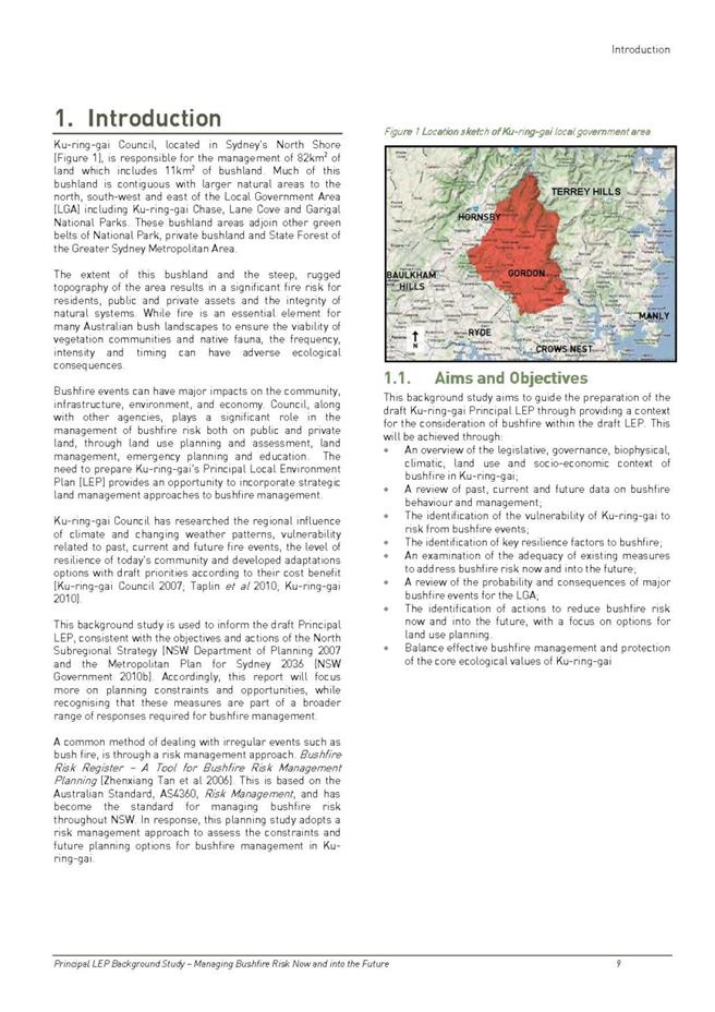
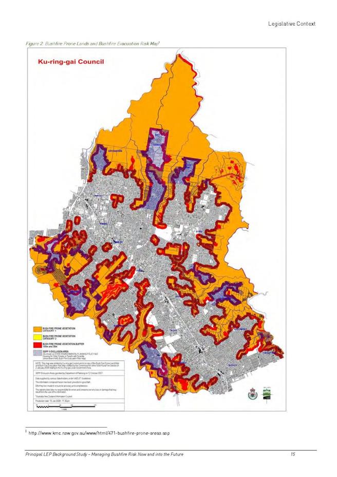
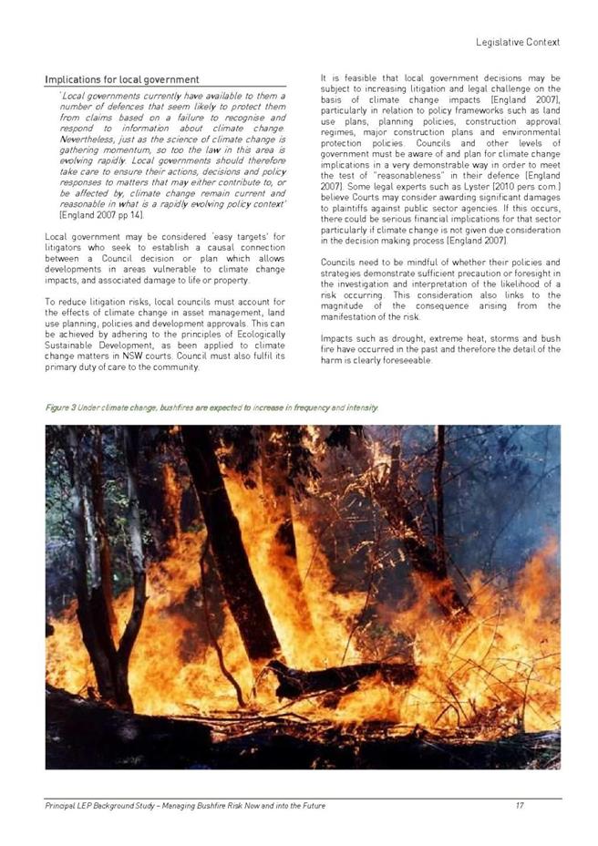
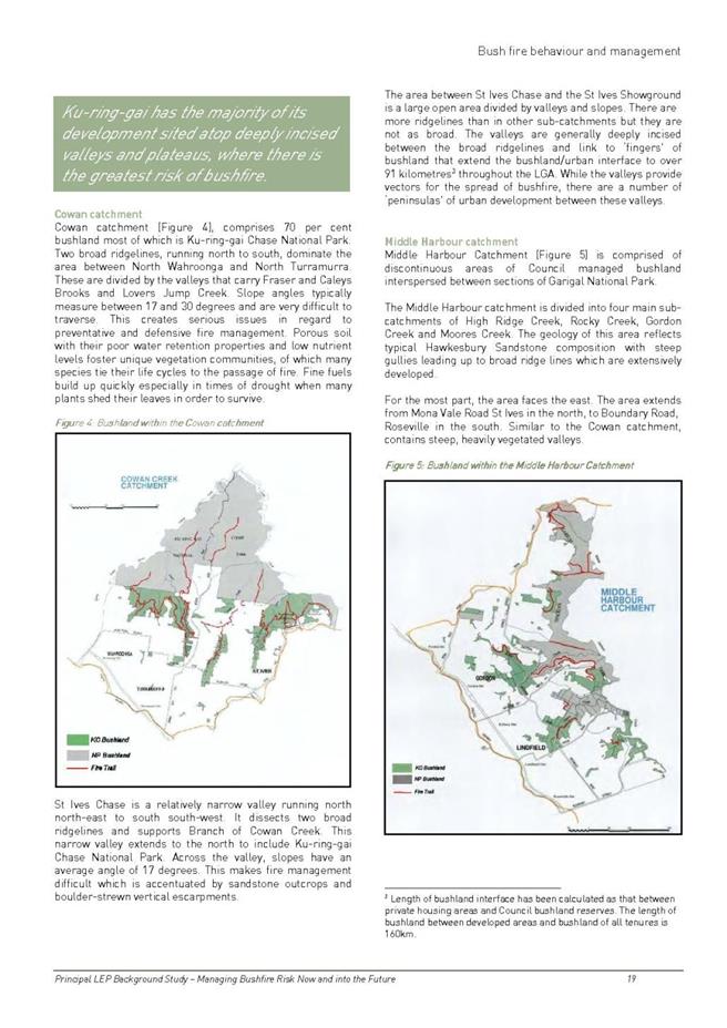
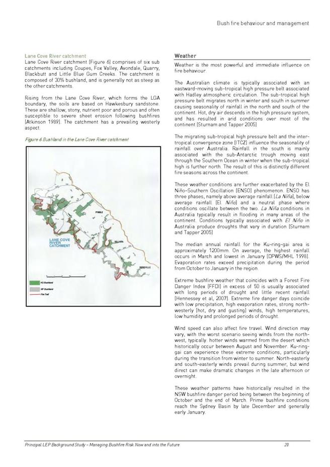
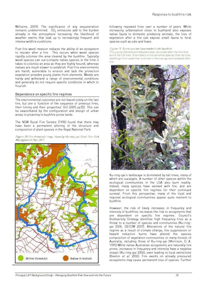
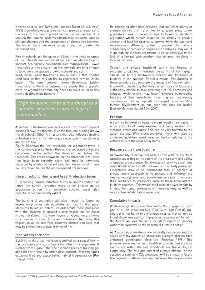

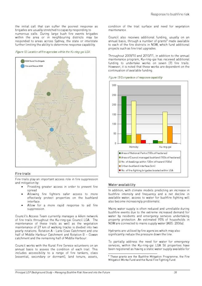
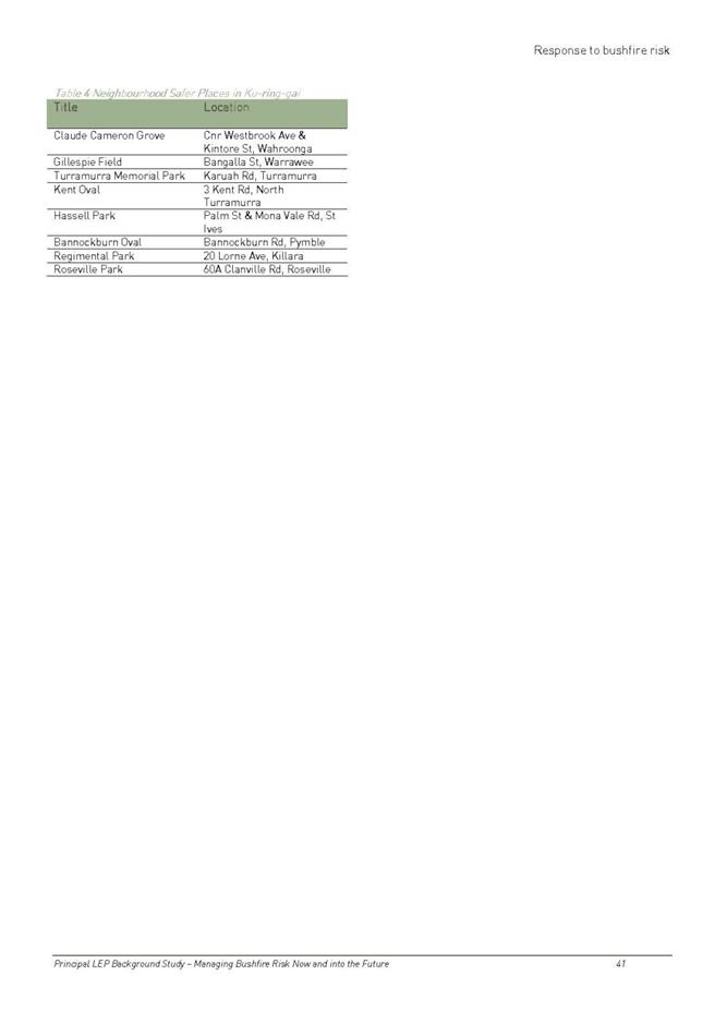

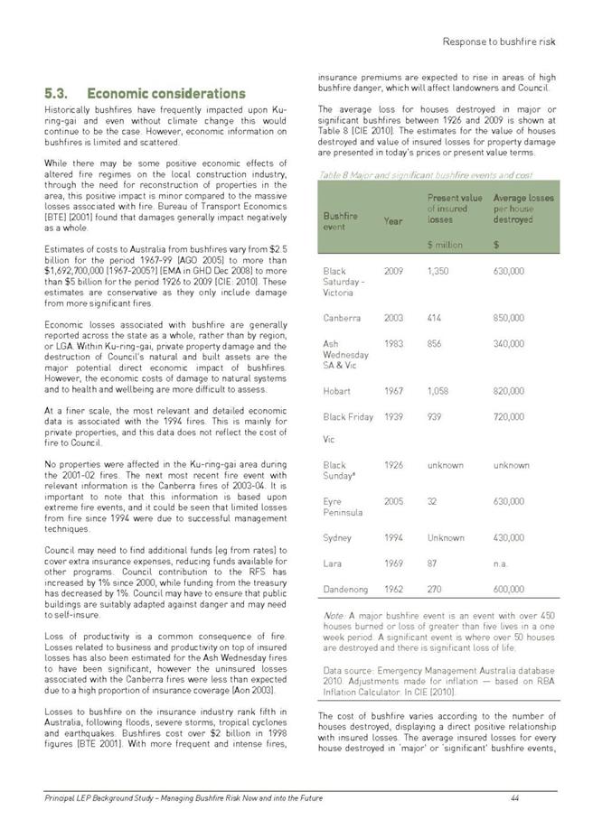
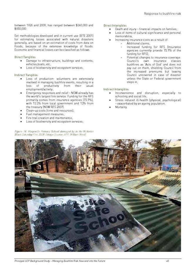


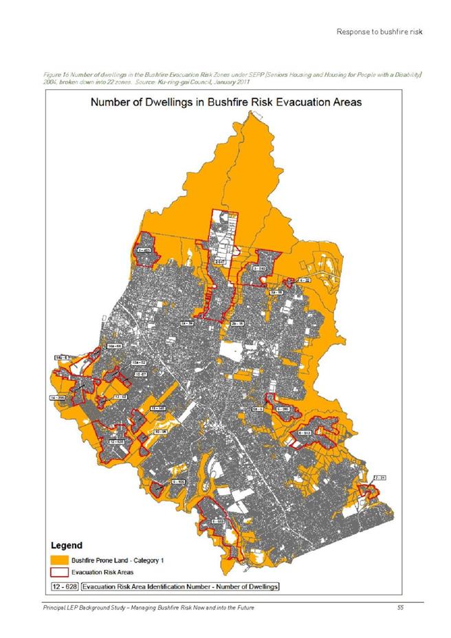
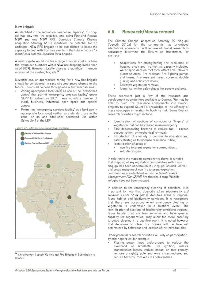


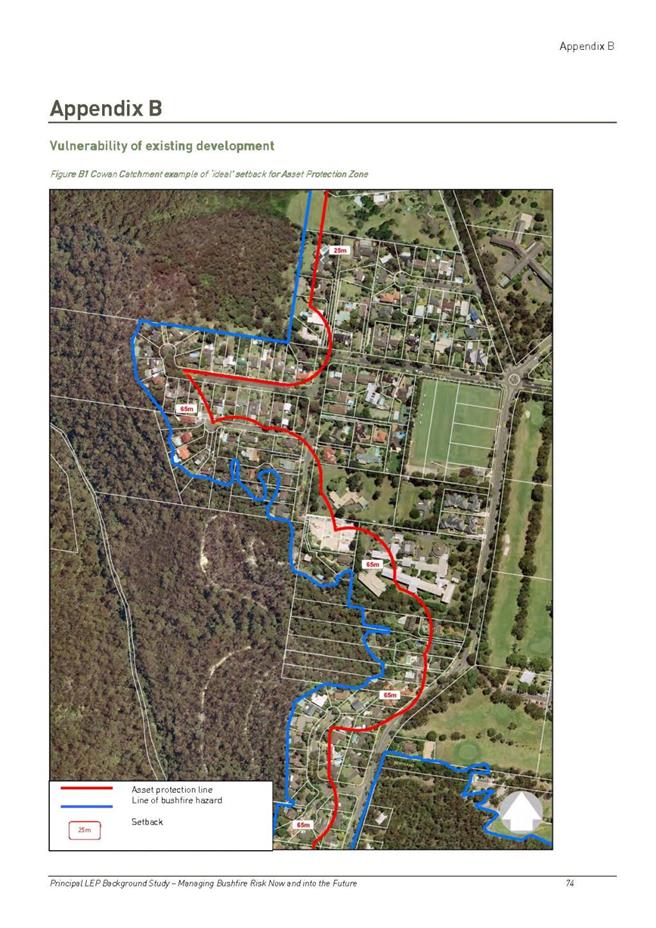
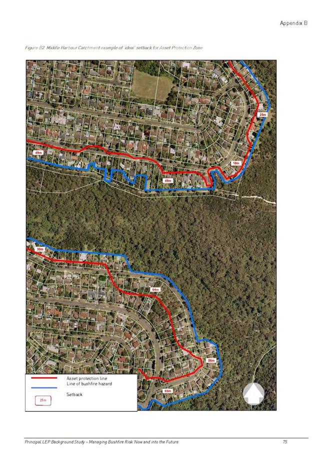
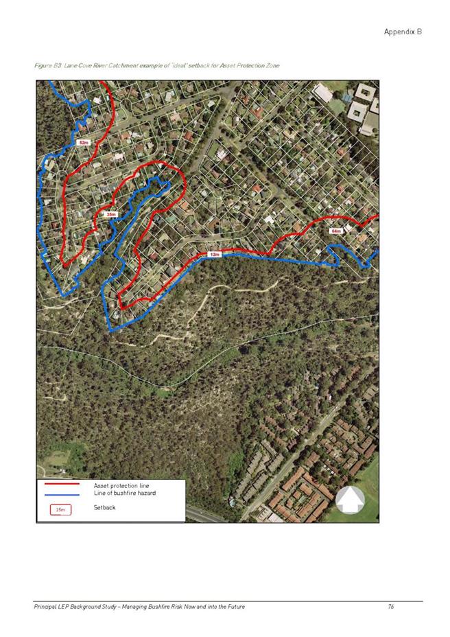
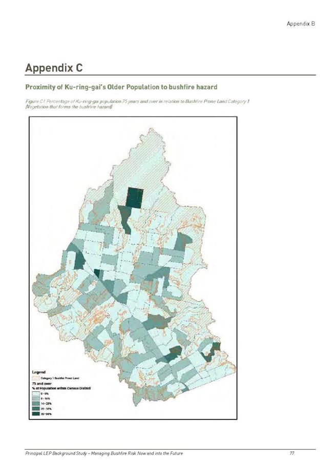
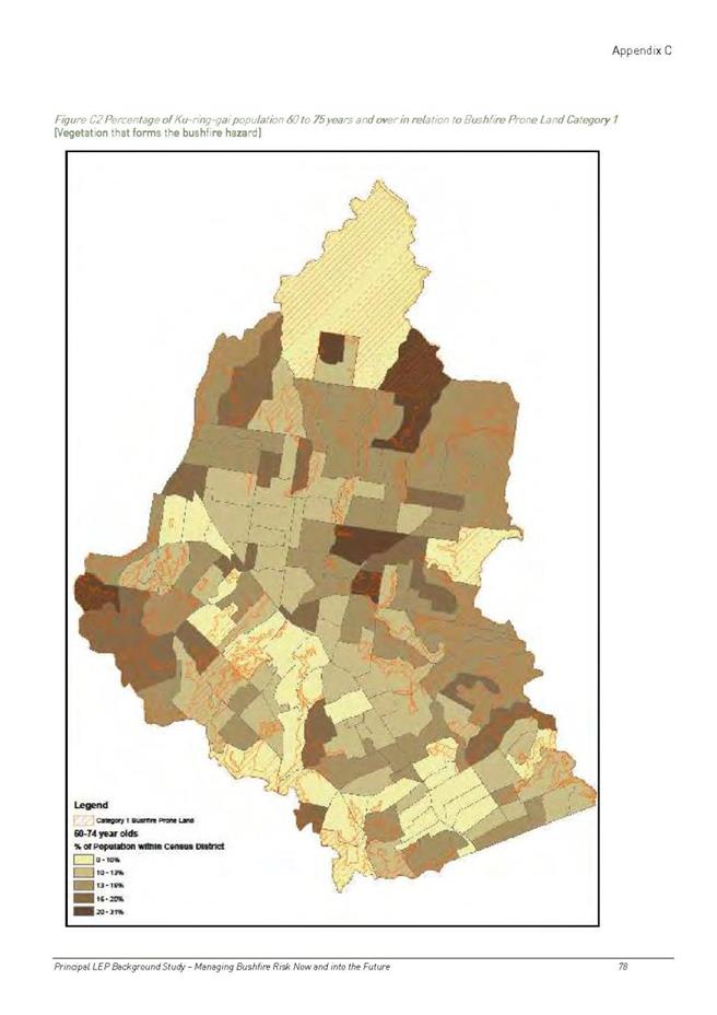
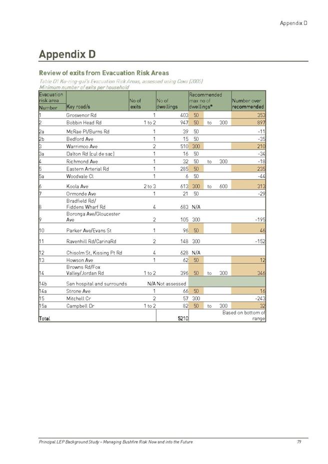
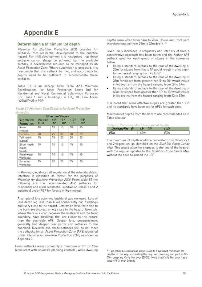
|
APPENDIX No: 3 - 12
August Meeting Notes - Deferred Areas Bushfire Evacuation Risk
|
|
Item No: GB.7
|

|
APPENDIX No: 4 - Ecological
constraints report 20 Kanowar Avenue East Killara
|
|
Item No: GB.7
|


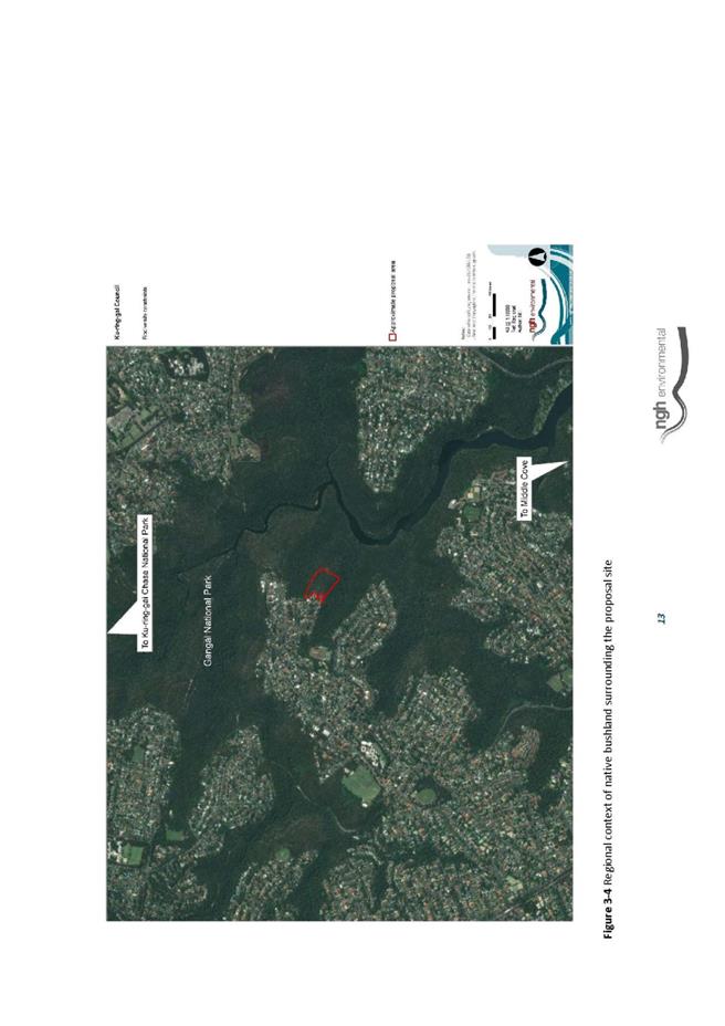
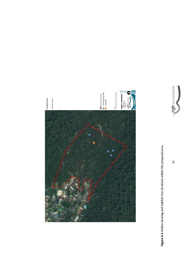
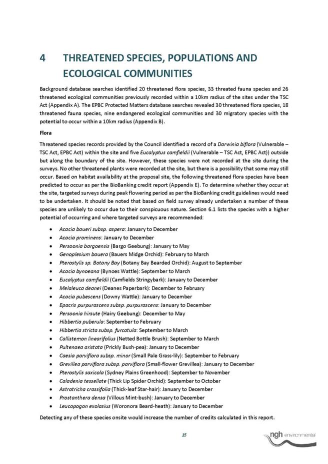


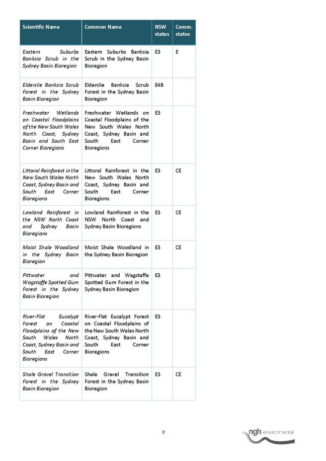
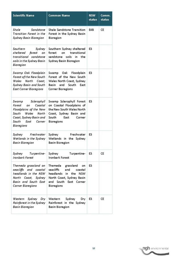

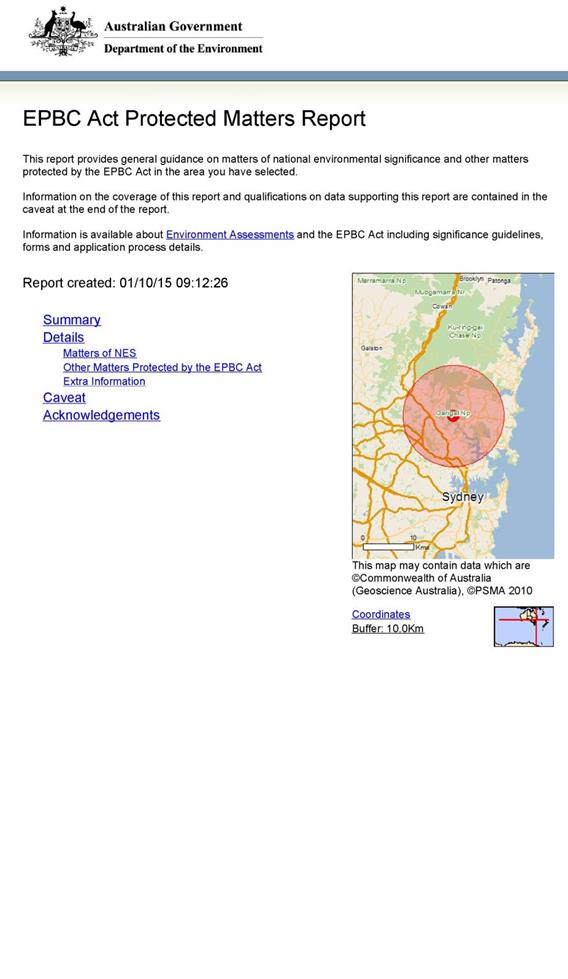

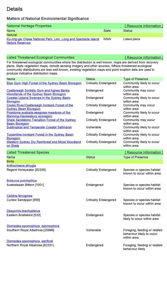

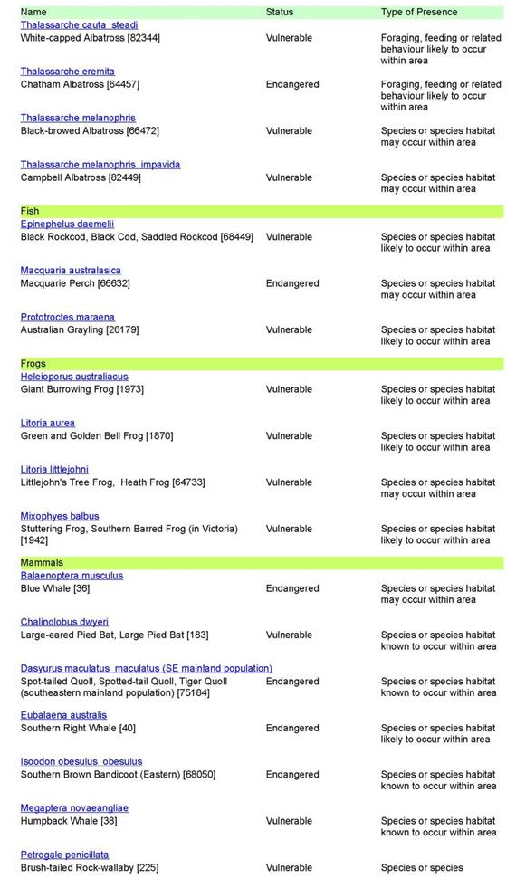
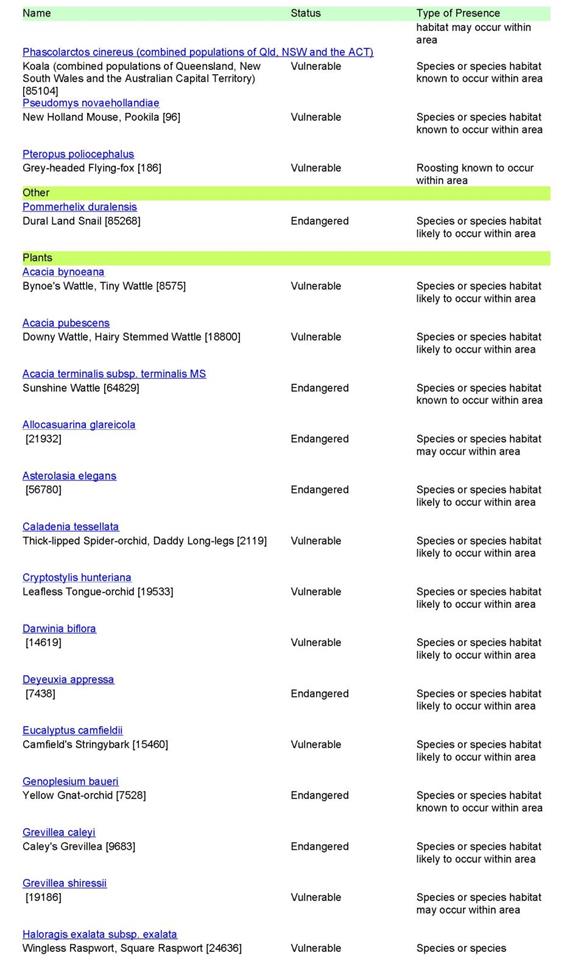

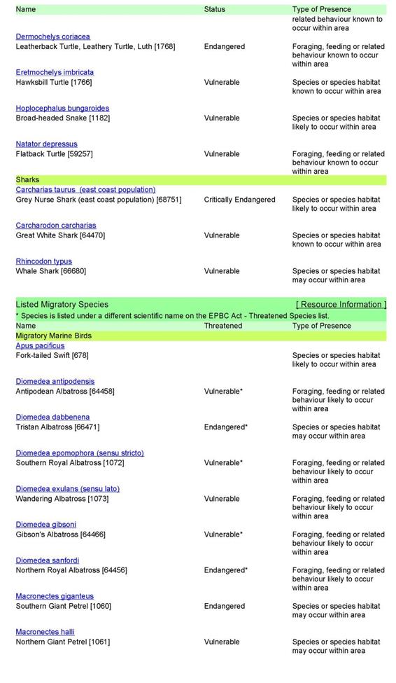
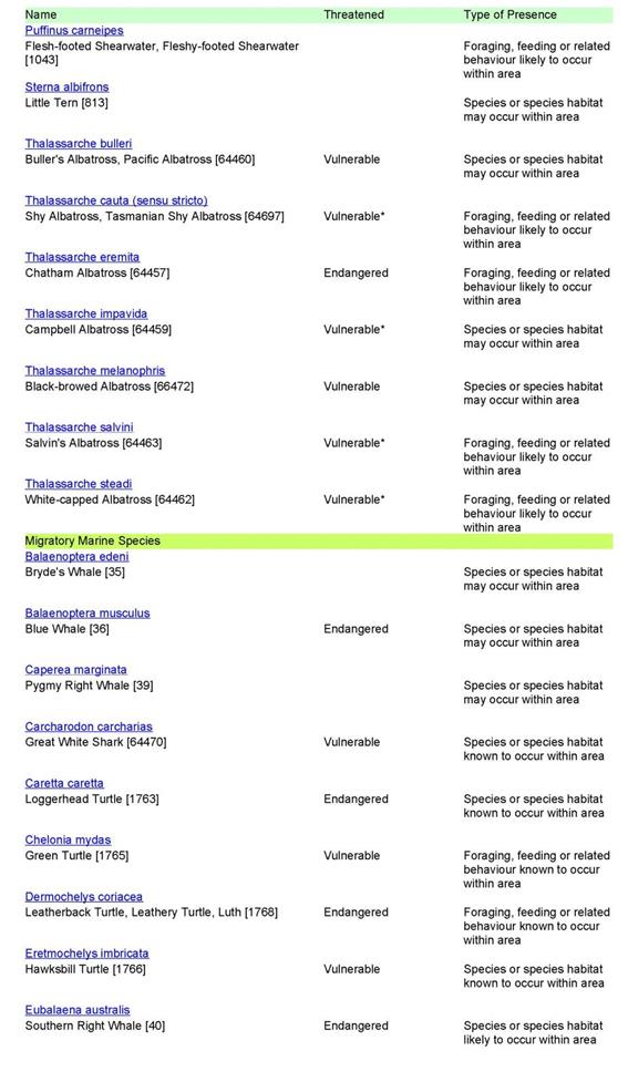
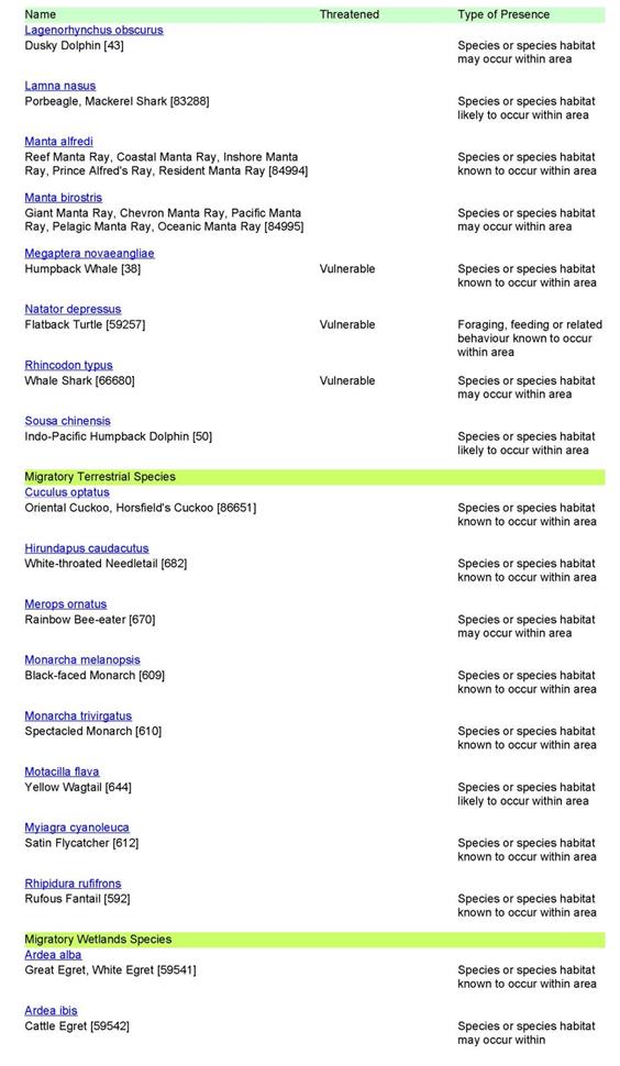

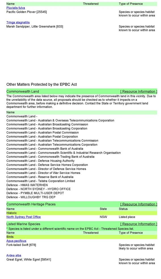
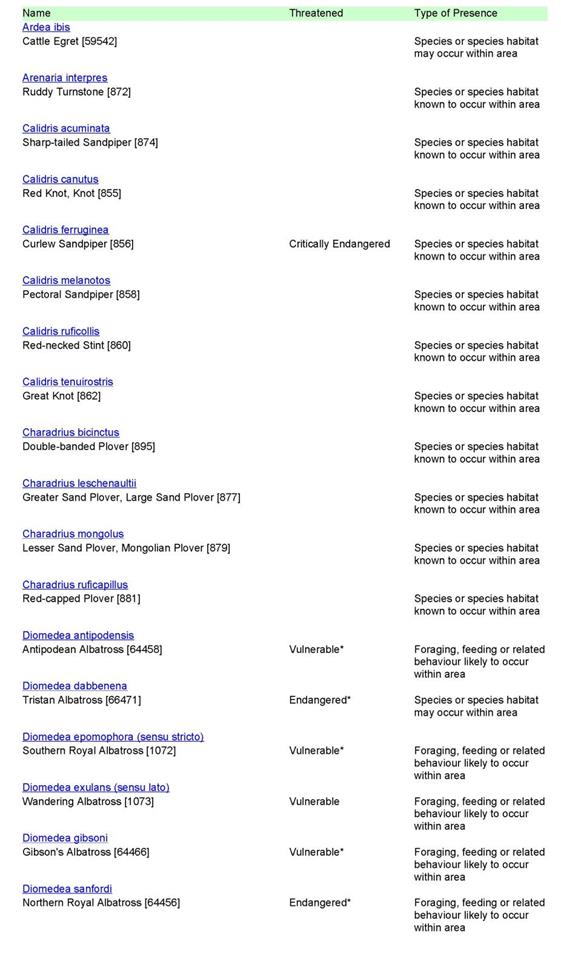
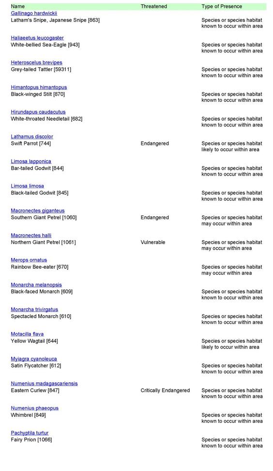

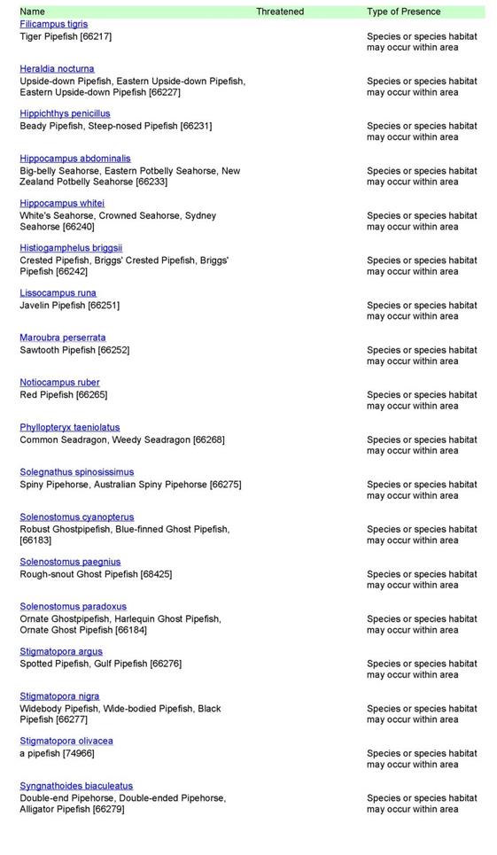
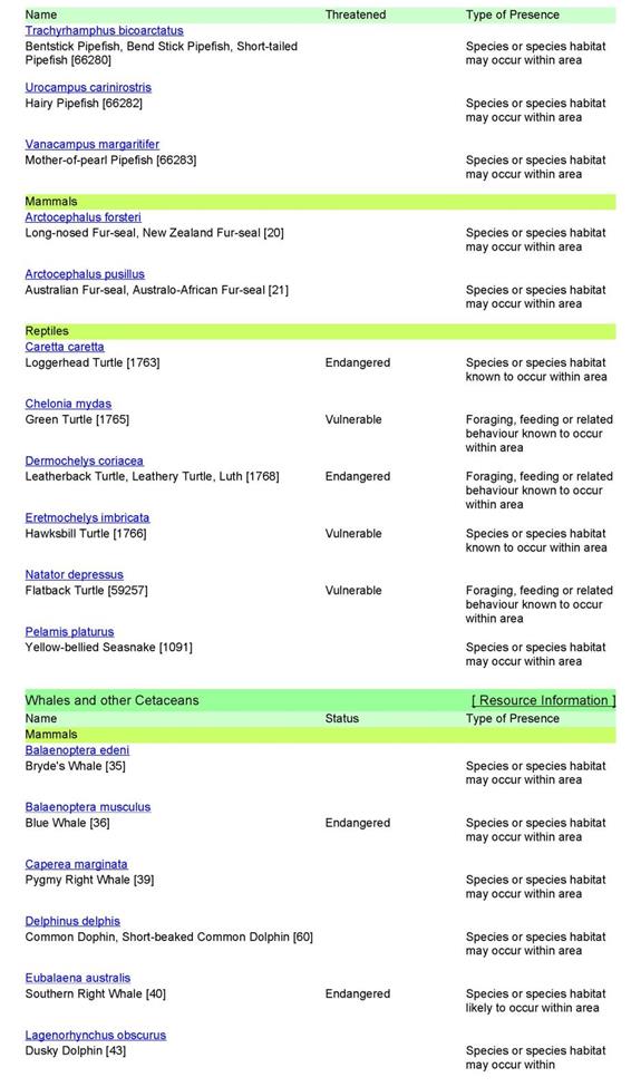
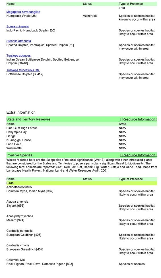
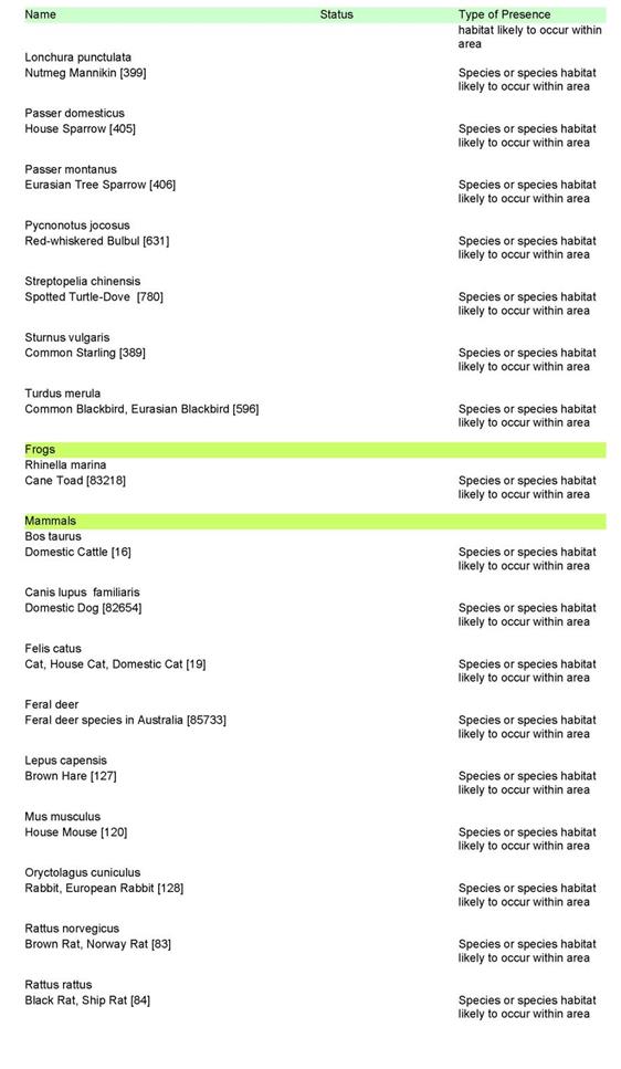

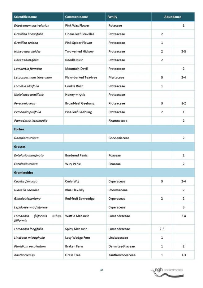

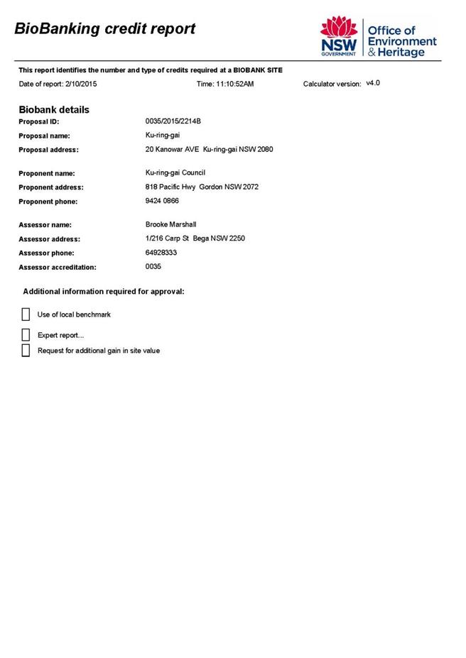
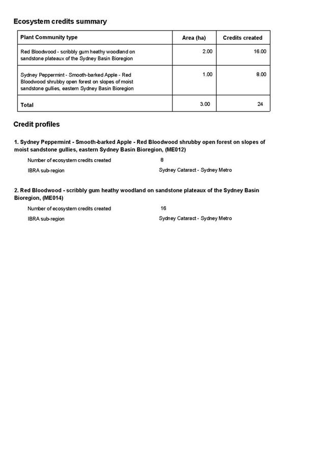
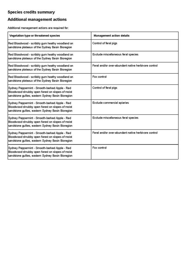

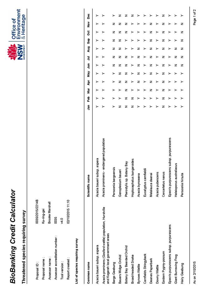
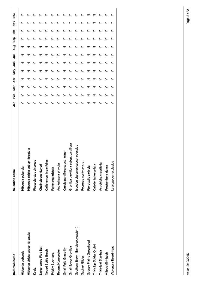


|
APPENDIX No: 5 - Biodiversity
Site Condition Report - 56-58 Koola Avenue East Killara
|
|
Item No: GB.7
|


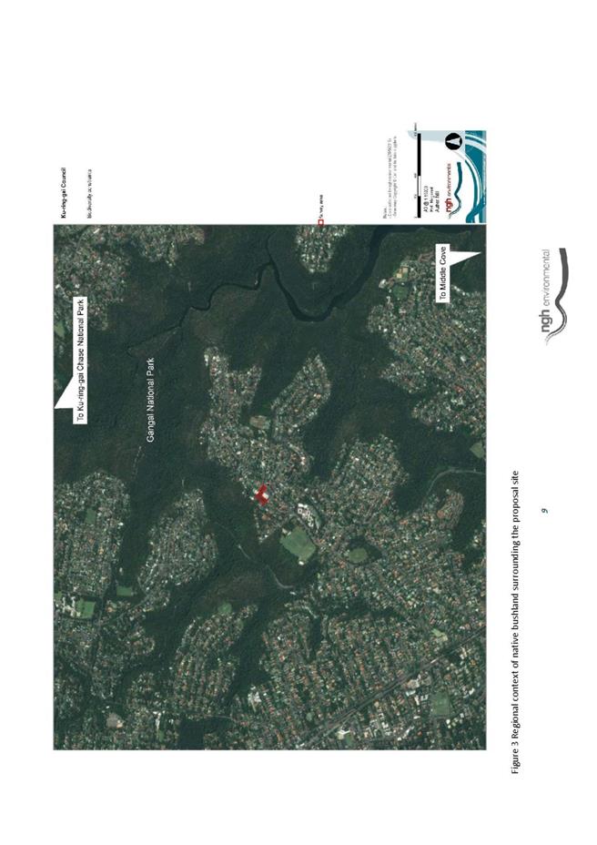
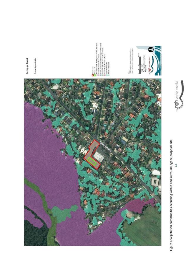
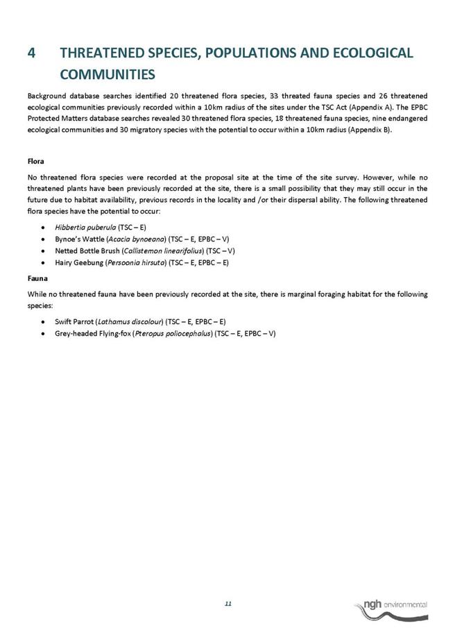

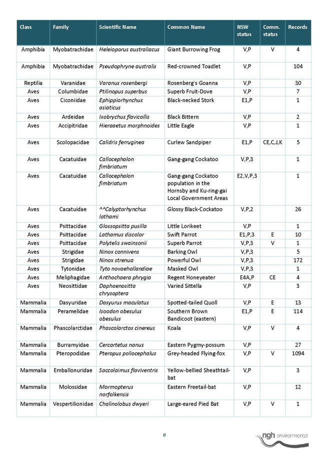
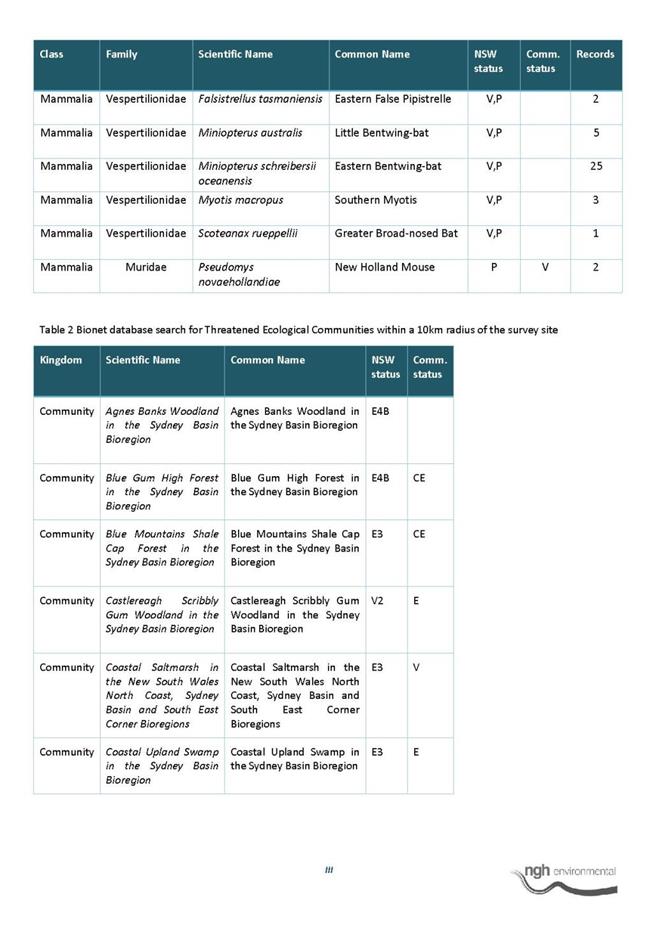
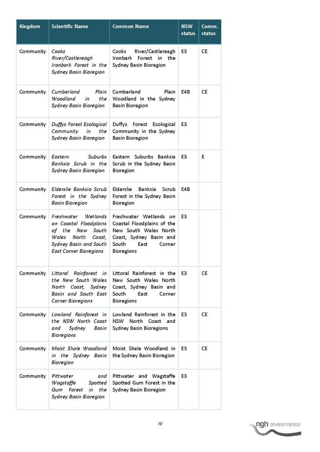
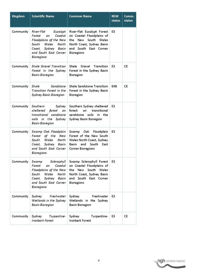
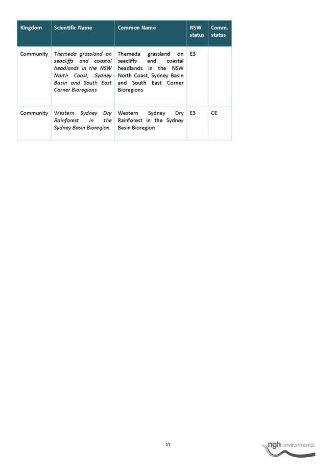

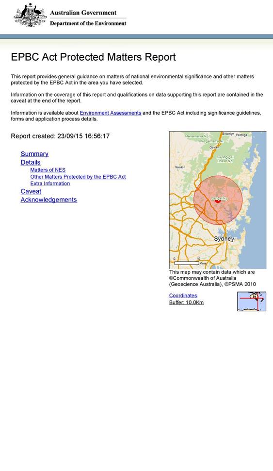


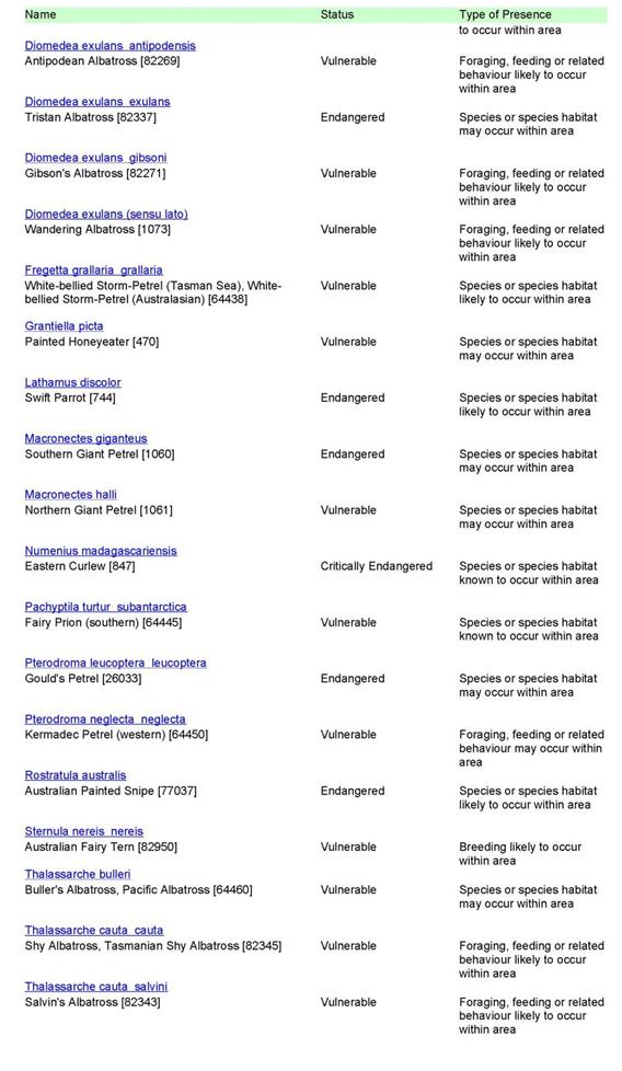
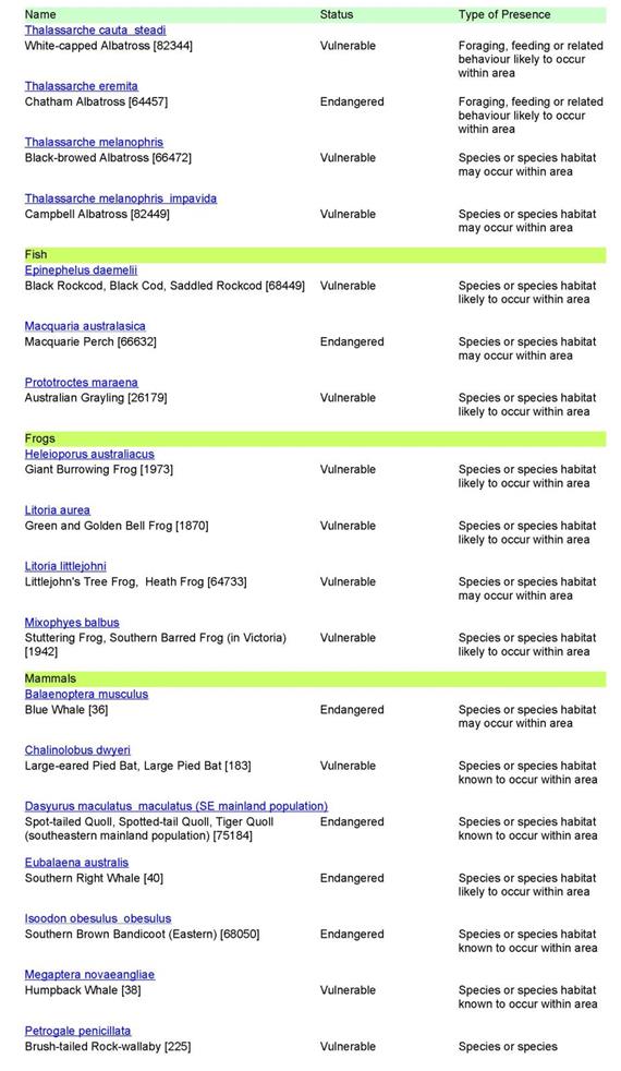
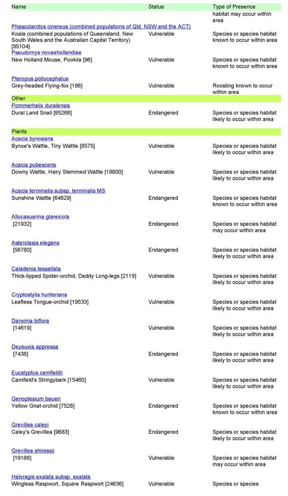
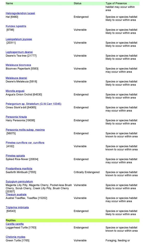
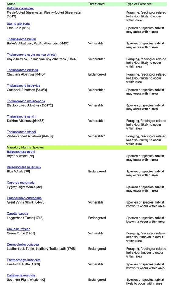
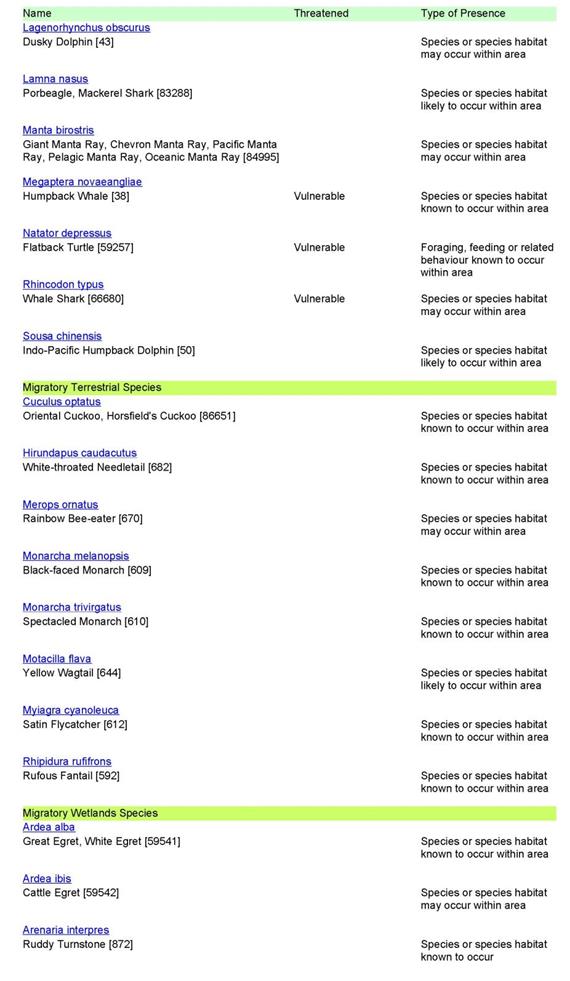
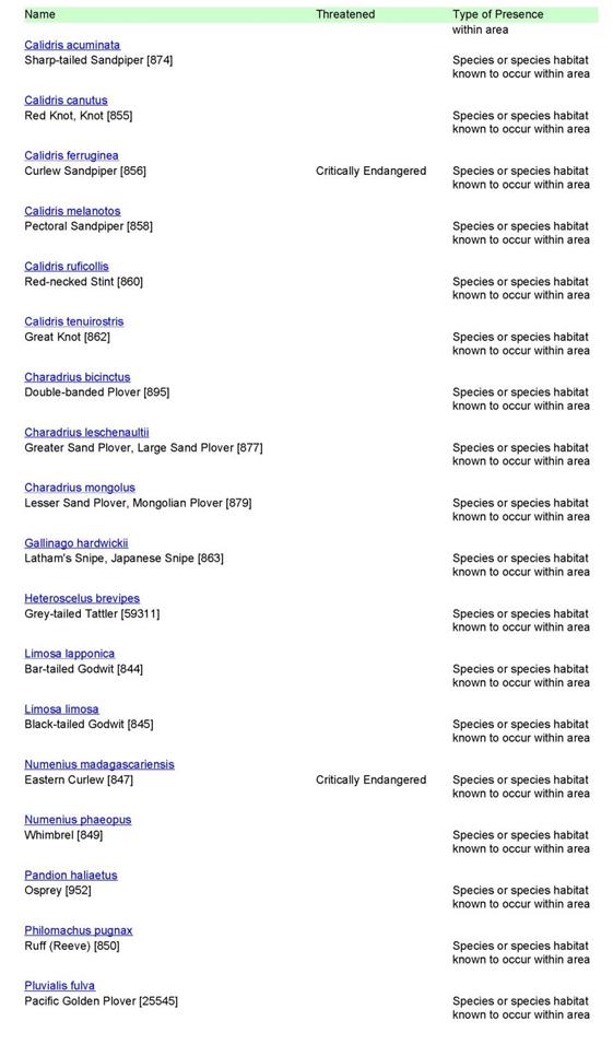
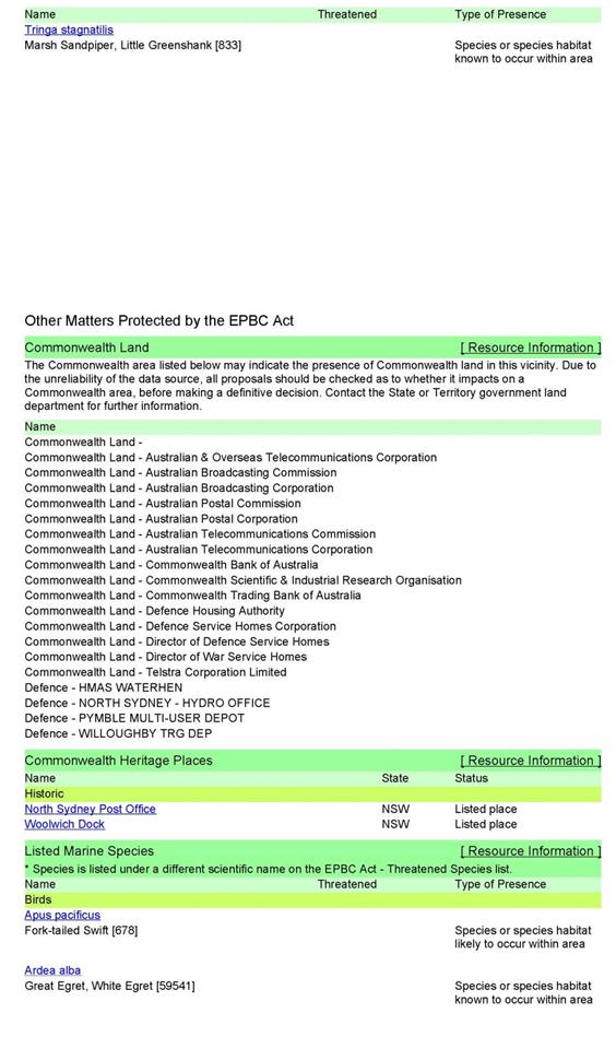
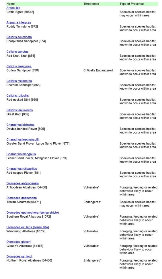
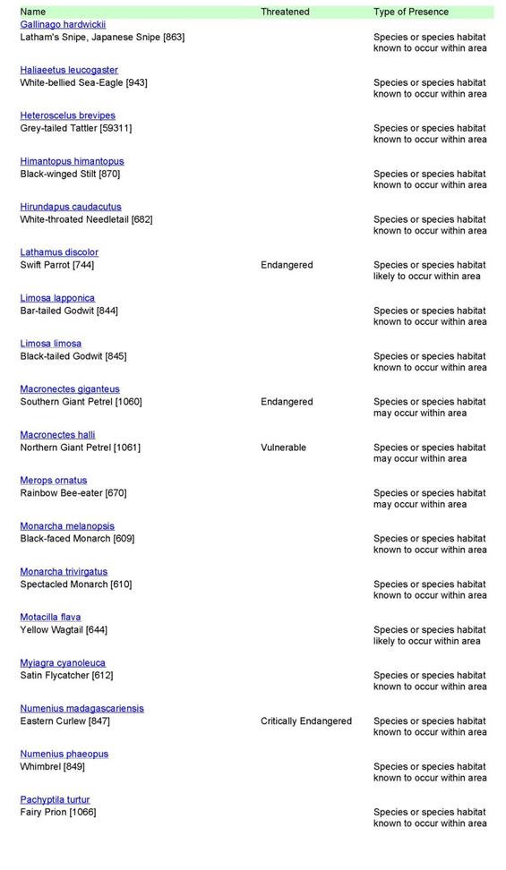
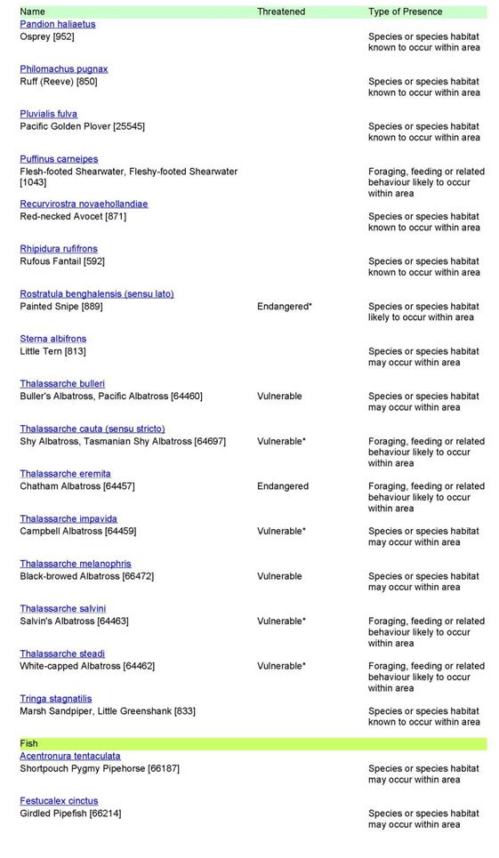
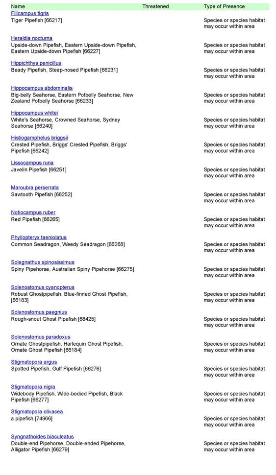
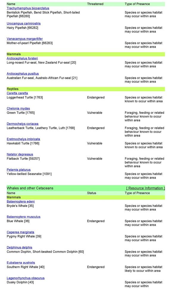
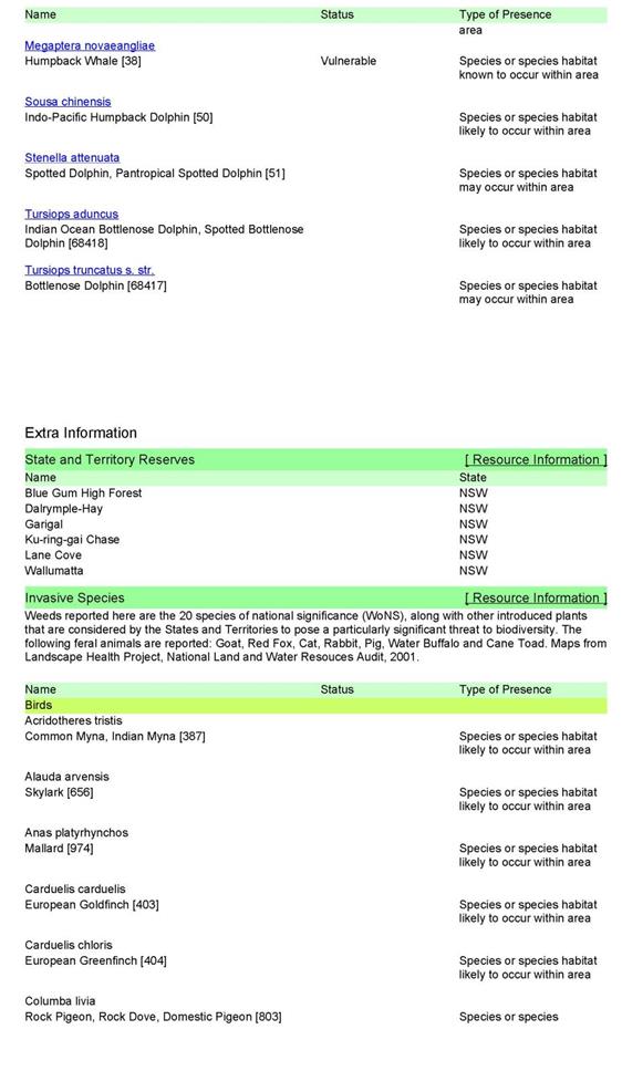
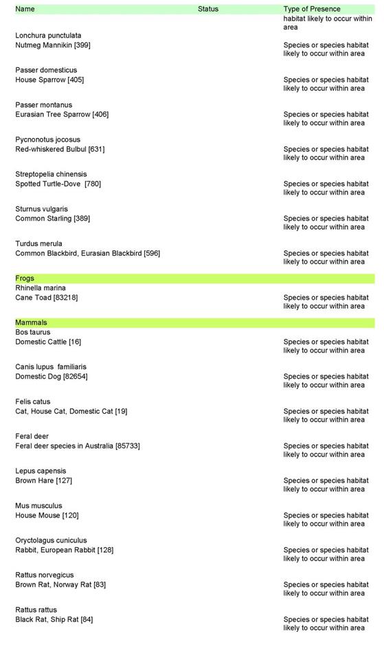
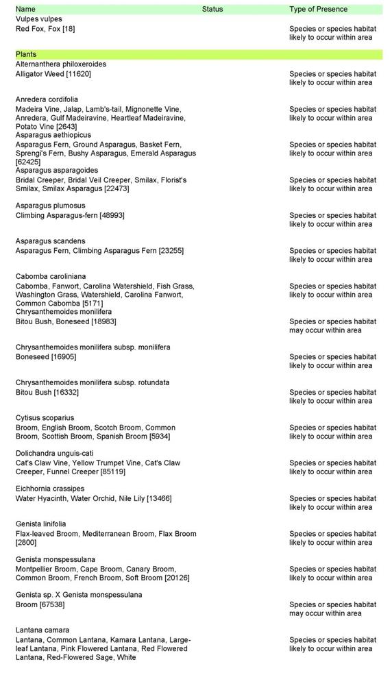
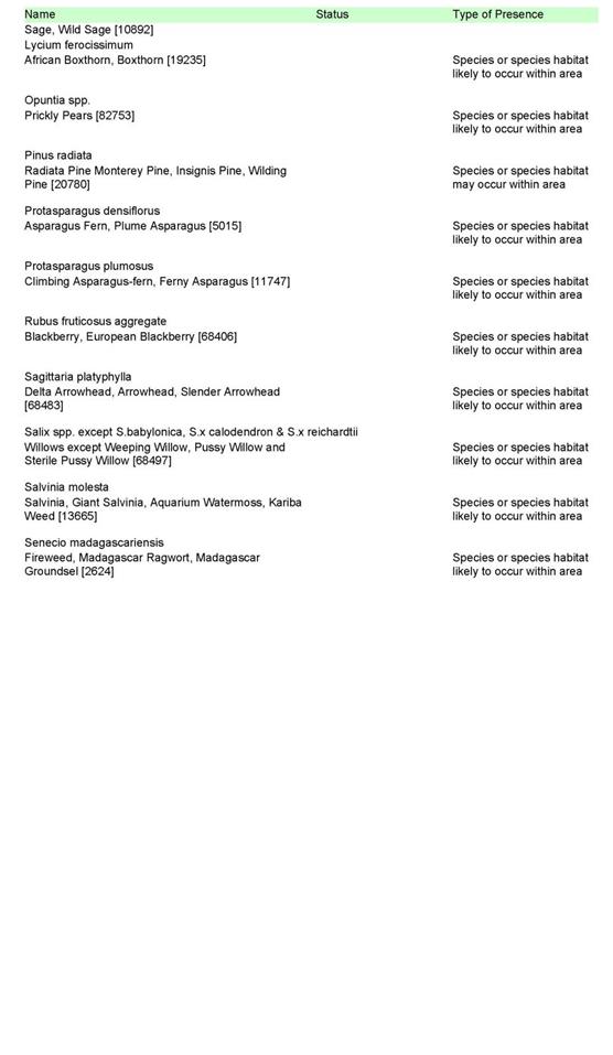
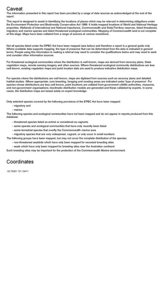
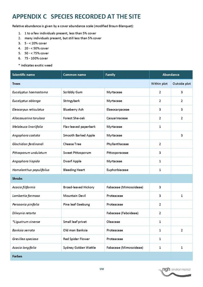
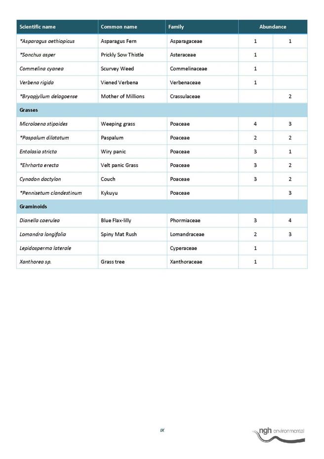
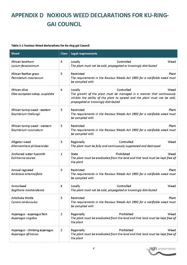
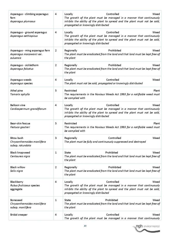

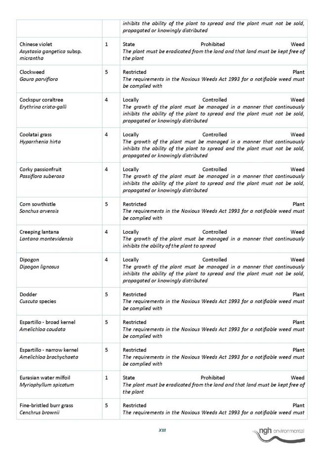
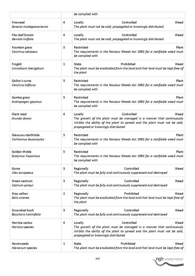
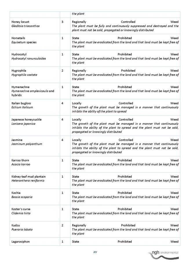
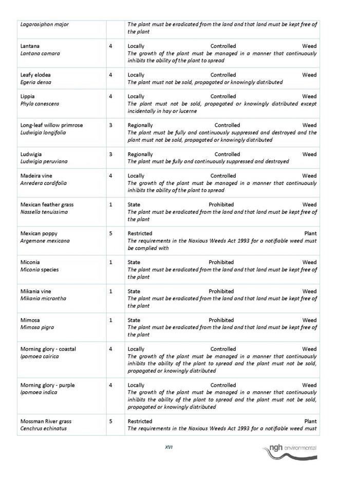
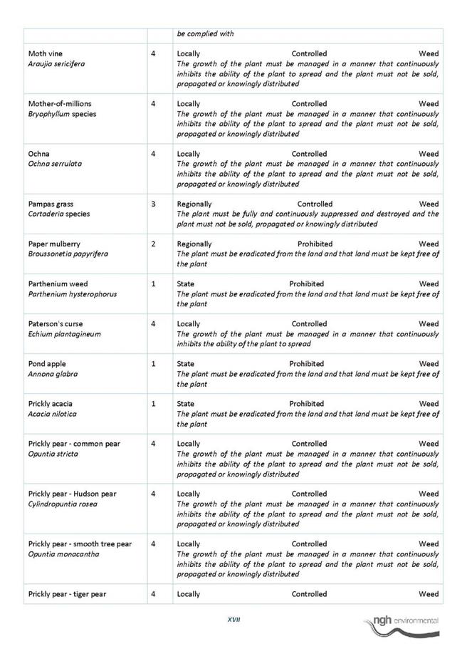
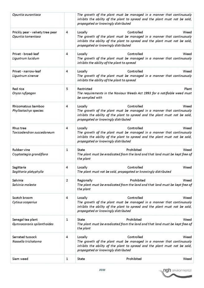
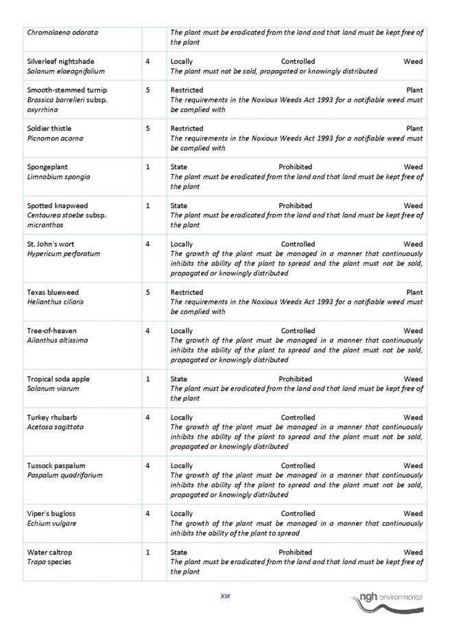
|
APPENDIX No: 6 - Advice
from Aboriginal Heritage Office - 56-58 Koola Avenue East Killara (Warrington
Reserve)
|
|
Item No: GB.7
|
|
Ordinary
Meeting of Council - 8 December 2015
|
GB.8 / 986
|
|
|
|
|
Item
GB.8
|
S10750
|
|
|
10 November 2015
|
Lindfield Community Hub: Project Delivery
EXECUTIVE
SUMMARY
|
purpose of report:
|
To advise Council on the most appropriate delivery
mechanism for the Lindfield Community Hub Project (Project).
|
|
|
|
|
background:
|
At OMC of 6 October 2015,
Council resolved in part to advertise an EOI seeking proposals from
development companies based on Option 2 (revised EOI version); and to advertise
an EOI by end October 2015 and select a preferred development company by
early 2016.
|
|
|
|
|
comments:
|
Further legal advice was sought on the most
appropriate delivery mechanism for the Project. Spark Helmore Lawyers
recommend that the most appropriate delivery method for the Project is a
Public Private Partnership (PPP). This advice has triggered a series of new
actions, and has necessitated an amendment to Council’s adopted timeframe for
the Project.
|
|
|
|
|
recommendation:
|
That Council resolve to deliver the project by way of
a Public Private Partnership (PPP), in accordance with Local Government Act
and PPP Guidelines.
|
Purpose of Report
To advise Council on the most appropriate delivery mechanism
for the Lindfield Community Hub Project (Project).
Background
At OMC of 6 October 2015, GB.10, Lindfield Community Hub
Update Report, Council resolved the following:
A.
That Council adopts Option 2 (as exhibited) with a maximum building height of 7
(seven) storeys as the preferred option for the Lindfield Community Hub
project;
B.
That Council adopts a variation of Option 2, with a maximum building height of
7 (seven) storeys, for the purposes of an Expression of Interest (EOI), which
excludes Scouts Association land located at 1A Beaconsfield Parade, Lindfield
(Lot 2 of DP184154; Lot C of DP 399995; and Lot A of 327729) and AUSGRID land
located at 1 Beaconsfield Parade, Lindfield (Lot 1 of DP184042);
C.
That Council advertises an Expression of Interest (EOI) seeking proposals from
development companies based on option 2 (revised EOI version) as described in
resolution B;
D.
That in order to encourage innovation Council will accept non-conforming bids
from the EOI process on the condition that a fully conforming bid is submitted.
Where a non-conforming bid is submitted the proposal must describe in detail
all the benefits and costs; the financial impacts; and potential impacts on the
project risk profile
E.
That Council adopts the following community infrastructure elements as
mandatory requirements for any bid arising from EOI to be considered as
conforming:
|
LINDFIELD COMMUNITY HUB
– PROJECT SCOPE/MANDATORY ELEMENTS
|
|
Category of works
|
Items of inclusion
|
Location and extent
|
Minimum requirements
|
Relevant guidelines and
controls
|
|
General
|
Mix
of residential, retail and commercial uses
|
_
|
_
|
_
|
|
Streetscape works
|
-New footpaths
-Underground power lines
-LED street lighting
-Street trees and tree grates
-Landscaping of verges
-Installation of street furniture such as benches,
litter bins and bike racks, on strategic locations
|
Bent Lane
Bent Street
Woodford Lane Beaconsfield
Parade
|
_
|
Ku-ring-gai Town Centres
Public Domain Plan, 2010
Ku-ring-gai Contributions
Plan, 2010
Council’s streetscape
technical manual
|
|
Road and transport works
|
-Road realignment
and
resurfacing
-Kerb and gutter realignment
|
Bent Lane
Woodford Lane
|
_
|
Ku-ring-gai Town Centres
Public Domain Plan , 2010
Ku-ring-gai Contributions
Plan, 2010
Lindfield Local Centre
Transport Network Model Study Report 2013-14
|
|
|
-Construction of new public street (realignment and
extension of Drovers Way)
-Formal closure of existing Drovers Way road reserve
|
Between Bent Street and
Beaconsfield Parade
|
_
|
Ku-ring-gai Town Centres
Public Domain Plan, 2010
Ku-ring-gai Contributions
Plan, 2010
Lindfield Local Centre
Transport Network Model Study Report 2013-14
|
|
|
-Construction of new kiss & ride zone
- Construction
of taxi rank with shelters and signage
|
Woodford Lane
|
_
|
Ku-ring-gai Contributions
Plan, 2010
|
|
|
-Modifications to traffic signals
|
Intersection of Pacific
Highway and Balfour Street/Havilah Road
|
_
|
Lindfield Local Centre
Transport Network Model Study Report 2013-14
|
|
|
-Installation of new traffic signals
|
Intersection of Beaconsfield
Parade and Pacific Highway
|
_
|
Lindfield Local Centre
Transport Network Model Study Report 2013-14
|
|
Public Domain Works
|
-Construction of new public park
-Construction of new urban plaza
|
Fronting Bent Street
|
Minimum size of consolidated
green open space 3,000m2
|
Ku-ring-gai Town Centres
Public Domain Plan, 2010
Ku-ring-gai Contributions
Plan, 2010
Design specifications as
provided by Council
|
|
|
-Construction of new pedestrian plaza on Bent Street
|
Within road reserve between
Bent Lane and Pacific Highway
|
|
Design specifications as
provided by Council
|
|
Community building
|
-Construction of a community hub building comprising
a café, new branch library, community centre and child care centre with roof
garden
|
Corner of Bent Street and
new street (realigned Drovers Way)
|
-Minimum size 2,950m2
-High design quality
- Iconic
|
Lindfield
Community Facilities Study, Elton consulting, 2013
Design
specifications as provided by Council
|
|
|
-Full internal fit-out of branch library (turn-key)
|
Level 1 of community hub
building
|
Minimum size 1,250 m2
|
Lindfield
Community Facilities Study, Elton consulting, 2013
Design
specifications as provided by Council
|
|
|
-Full internal fit-out of community centre (turn-key)
|
Level 2 of community hub
building
|
Minimum size 1,200 m2
|
Lindfield
Community Facilities Study, Elton consulting, 2013
Design
specifications as provided by Council
|
|
|
-Full internal fit-out of childcare centre (turn-key)
|
Level 3 of community hub
building
|
Minimum size 500 m2
with external roof top
garden area
|
Design
specifications as provided by Council
Council’s
DCP
|
|
Car parking
|
-Council car parking for community uses
|
Basement car park
|
Minimum of 55 spaces
|
Australian Standards and
Building Code of Australia
|
|
|
-Public parking (Commuter)
|
Basement car park
|
Minimum of 140 spaces
|
Australian Standards and
Building Code of Australia
|
|
|
-Council car parking (replacement of existing
at-grade spaces)
|
Basement car park
|
Minimum of 112 spaces
|
Australian Standards and
Building Code of Australia
|
|
|
-Private parking (retail and commercial)
|
Basement car park
|
_
|
Local Centres DCP, 2012
Lindfield Community Hub -
Site specific DCP
|
|
|
-Private parking (residential)
|
Basement car park
|
_
|
Local Centres DCP, 2012
Lindfield Community Hub -
Site specific DCP
|
|
Retail & Commercial
uses
|
-Supermarket
-Commercial & Retail (including supermarket)
|
Basement and ground level
|
Minimum supermarket size
3,000 m2
Maximum retail (including
supermarket) + commercial floor space 5,000m2
|
Local Centres DCP, 2012
Lindfield Community Hub -
Site specific DCP
|
F.
That Council adopts the following general programme for the next phase of the
Lindfield Community Hub project:
§ advertise EOI by end October 2015;
§ EOI submissions close by December
2015;
§ EOI evaluation period January 2016;
§ selection of preferred development
company by early 2016;
§ negotiation with preferred
development company completed by mid-2016; and
§ submission of development application
by late 2016.
G.
That Council writes to the Office of Local Government advising them of the
Lindfield Community Hub project and noting that Council intends to submit a
report that responds to the requirements of the Office of Local Government
Capital Expenditure Guidelines, 2010;
H.
That Council staff report back to Council at the Ordinary Meeting of Council
(OMC) on 27 October 2015 regarding a planning proposal and a
site-specific DCP in support of the preferred option; and
I.
That Council staff report back to Council on the findings of the Lindfield
Local Centre Transport Network Model Study with a view to seeking concurrence
from Roads and Maritime Services (RMS).
J.
That all EOI submissions should wherever practicable incorporate the principles
of low energy-use design, sustainability and environmental sensitivity and
describe how they will deliver sustainable outcomes consistent Ku-ring-gai
Council policies.
The full list of Council reports which pertain to the
Lindfield Hub project have been set out below for reference:
1. OMC –
26 June 2012 – GB.9 - Council Car Park – Woodford Lane, Lindfield –
Reclassification
2. OMC –
26 February 2013 – GB.16 - Woodford Lane, Lindfield Commuter Car Park
3. OMC –
28 May 2013 – GB.10 - Lindfield Community Hub and Commuter Car Park – Next
Steps
4. OMC –
30 July 2013 – GB.5 – Proposed Reclassification of 1B Beaconsfield Parade and
19 Drovers Way, Lindfield (Woodford Lane Car Park) to Operational Land
Following the Exhibition and Public Hearing Process
5. OMC –
12 November 2013 – C.1 - Potential Property Acquisition – Lindfield
6. OMC -
10 December 2013 - GB.19 - Lindfield Village Green - Tryon Road - Project
Update
7. OMC –
24 June 2014 – C.1 - Property Acquisition - Lindfield
8. OMC – 9
September 2014 – GB.4 – Lindfield Community Hub – Woodford Lane – Report on
Progress
9. OMC -
11 November 2014 – GB.7 – Lindfield Community Hub – Probity Matters
10. OMC – 25
November 2014 – GB.8 – Lindfield Community Hub – Probity Management Plan
11. OMC – 9
December 2014 – Tender No. RFT22/2014 – Lindfield Community Hub – Tender For
Consultants to Prepare Illustrative Development Options and Master Plan
12. OMC – 21
April 2015 – GB.5 – Compulsory Acquisition of Roads – Lindfield
13. OMC – 8
September 2015 – GB.9 – Lindfield Community Hub Preferred Option
14. OMC – 6
October 2015 – GB. 10 – Lindfield Community Hub Update Report
15. OMC – 10
November 2015 – GB .11 – Lindfield Community Hub - Planning Proposal and
Site-Specific DCP
Comments
1. Summary
The report to Council of 6 October 2015 GB.10
assumed that the project delivery mechanism for the Project would be a
Voluntary Planning Agreement (VPA). Since that time legal advice has been
received from Spark Helmore Lawyers (SHL) with respect to the most appropriate
delivery mechanism for the Project.
In summary, SHL recommend that the Lindfield Hub
project is best delivered through a PPP rather than through a VPA arrangement.
Their full report can be viewed at Confidential Attachment A1: Project
Delivery Mechanism by Spark Helmore Lawyers (trim link: 2015/315466).
2. Reasons
for Recommending a PPP
Several compelling reasons were cited in the SHL
report for recommending a PPP over a VPA. These have been summarised below.
· Contributions made by Council: The
arrangement involves contributions made not only by the developer but by
Council for an amount of $15 million (from section 94).
· Council Involvement: Council
wishes to be involved with and have a certain amount of control over the design
and development of the proposed facilities that will ultimately be dedicated to
Council. The project is also envisaged to be marketed as a Council initiative.
Both of these points do not occur in a VPA arrangement.
· Ongoing Obligations: There may
be ongoing maintenance requirements or management obligations associated with
Council-owned facilities. A VPA can require maintenance contributions or a lump
sum payment towards ongoing maintenance, however where another party may be
responsible for managing Council facilities, a PPP is the preferred option.
· Non-Conforming Submissions: Non-conforming
submissions can be accepted under a PPP arrangement without seeking further
review by the Office of Local Government or additional submissions from
proponents.
· Perceived Avoidance of Legislative
Provisions: Attempting to establish a VPA arrangement may appear artificial
or perceived as an attempt to avoid the PPP requirements under the LG Act.
3. Process
for PPPs
The Office of Local Government (OLG) issued PPP guidelines
in accordance with section 400C of the LG Act, which sets out the procedures
and processes to be followed by Council when entering into and carrying out
projects under a PPP.
A summary of this process is given below:
· Step 1: Concept Approval by Council
A decision to enter
into a PPP may only be made by resolution of Council.
· Step 2- Council must provide
assessment to OLG
A formal Project
Proposal has to be developed and submitted for initial assessment by OLG.
· Step 3: Initial Assessment
Having
regard to the information submitted by Council and based on the level of risk
that is assessed, the Departmental Chief Executive will determine whether the
proposal should be referred to the Project Review Committee for review.
· Step 4: Where referral to Committee
not required
If referral to the
Committee is not required, Council can then proceed to receive expressions of
interest, determine an appropriate management structure for the PPP, and once a
suitable partner is found, commence negotiating contracts for the project.
· Step 5: Review by Committee –
Pre-expression of interest/market testing
If
the proposal must be submitted to the Committee for review, it will be
considered in two stages as follows:
1. Pre
expression of interest and market testing stage; and
2. Pre-contract
signing stage
Once the Committee has
assessed all of the information submitted by Council, it will advise the
Council whether it can proceed to carry out the expression of interest/market
testing stage, or whether any other matters are required to be addressed.
· Step 6: Expression of Interest stage
Once
Council receives confirmation from the Committee that is has satisfied the
criteria set out in Step 5, it may commence the EOI process.
· Step 7: The
pre-contract signing stage
The
established evaluation panel is to assess the EOIs and rank the proposals on
relative merit and create a shortlist of partners. Once a preferred partner is
identified for the PPP, Council may enter into negotiations regarding the terms
of the contract for the project. However, before the contracts are signed the
Committee will undertake its next review. Council is to provide comprehensive
documentation to the Committee for its review.
· Step 8: Entering into the PPP
contracts
Once
the Committee is satisfied that the PPP complies with the Guidelines, it will
advise Council that it can proceed with the PPP. Council may then pass a
resolution to enter into the PPP and subsequently sign the contracts.
integrated planning and reporting
Places, Spaces and Infrastructure
- P4 Revitalisation of our centres
Community, People and Culture - C4
Healthy lifestyles
|
Community Strategic Plan Long Term Objective
|
Delivery Program
Term Achievement
|
Operational Plan
Task
|
|
A range of well planned, clean and safe neighbourhoods and
public spaces designed with a strong sense of identity and place.
|
P4.1.1
Plans to revitalise local centres are being progressively
implemented and achieve quality design outcomes in collaboration with key
agencies, landholders and the community.
P4.1.4
An improvement plan for Lindfield centre is being
progressively implemented in collaboration with owners, businesses and state
agencies.
|
Implement a place management approach for the local centre
improvements to coordinate works and achieve quality outcomes.
Engage with relevant
stakeholders to establish timing, extent and partnership opportunities.
Undertake due diligence and
undertake project scope.
Identify and engage with the key stakeholders.
|
|
A healthy, safe, and diverse community that respects our
history, and celebrates our differences in a vibrant culture of learning.
|
C4.1.2
New and enhanced open space and recreational facilities
have been delivered to increase community use and enjoyment.
|
Undertake acquisitions for new parks.
Undertake assessment and identify locations for new parks
Complete the design for identified parks and include
design principles which facilitate passive recreation activities.
Construct parks at identified locations and include design
principles which facilitate passive recreation activities
|
FIT FOR THE FUTURE IMPROVEMENT ACTION
PLAN
The NSW Government's Fit for the Future initiative required
all Councils to prepare an Improvement Proposal and supporting Implementation
Plan demonstrating how all seven Fit for the Future benchmarks would be met by
2016/17, and maintained or improved thereafter.
Council's Fit For the Future Improvement Proposal and
supporting Implementation Plan underpins the decision to stand alone and
not merge with Hornsby Council. The objectives established in the Improvement
Proposal and Implementation Plan are embedded in Council's adopted Integrated
Planning and Reporting documents including the Revised Delivery Program
2013-2017 and Operational Plan 2015-2016, Long Term Financial Plan
2015/16 to 2024/25 and Asset Management Strategy 2015/16 to 2024/25.
Council’s Fit For the Future Improvement Proposal
sets out the following strategies and outcomes to meet the State governments Efficiency
criteria:
|
Objective
|
Strategies
|
Key milestones
|
Outcome
|
|
Major
Local and Town Centres projects i.e. Community hub projects are commercially
feasible in their own
right
|
Projects
should include commercial opportunities for Council to offset ongoing
operational costs (life cycle costs) of the public benefits provided
|
Masterplans
adopted for Local and Town Centres 2015/2016
EOI for the
redevelopment of Lindfield Local Centre 2015/2016
Redevelopment of Lindfield
Local Centre 2016/2017
EOI for the redevelopment of
Turramurra Local Centre 2015/2016.
Redevelopment of Turramurra
Local Centre 2016/2017.
EOI
for the redevelopment of Gordon Town Centre 2015/2016.
|
Masterplans
adopted for the Local and Town Centres with development options substantially
progressed to deliver community facilities and public benefits.
|
Governance
Matters
The following set of
governance documents for the Lindfield Community Hub Project have been
completed and reported to Council. These documents are intended to guide the
day-to-day management of the project:
· Governance Structure;
· Probity Management Framework;
· Probity Plan & Market Sounding
Probity Protocol; and
· Project Decision Making Framework.
Risk Management
1. Risk Management Plan
A Risk Management Plan for the Lindfield Community Hub
Project was adopted by Council on 8 September 2015. A project-specific Risk
Management Matrix is currently being prepared in conjunction with Council’s
risk officer. The details of this Plan will be reported to Council once
finalised.
2. Project Resourcing
There is an acute shortage of suitably qualified and
experienced resources within Council to deliver major projects in the LGA. This
fact has been long-identified and unanimously agreed. Accordingly, a human
resources consultant has been engaged to assess the resourcing requirements of
the team and the required future structure for a major projects delivery team
within Council. This work is currently underway.
3. Financial Risk Considerations
A total of $851,000.00 has been spent during the financial
years 2013/14 and 2014/15 on this project. It is noted that this represents a
considerable amount of expenditure on staff salaries and consultants, although
not uncommon for a project of this value of approximately $120M. The funding
sources have been from development contributions including the 2010 Plan as
well as earlier Plans. During this time the work undertaken has included project
scoping, preliminary project feasibility, master plan options, exhibition,
community engagement and assessment of options. A possible result of any
failure to progress the project could mean that Council will be required to
repay the S94 funds spent to date because the community infrastructure will not
be delivered. Delays also lead to escalation in construction costs, which are
out of the control of Council.
Therefore, it is recommended that all effort is to be taken
to progress the major projects to implementation.
4. Council’s Reputation
Council has consulted extensively with the community
regarding this project. In addition, the private sector has also been consulted
with during the market sounding meetings held in October 2015. Should the
project not progress as planned, it will lead to irreparable damage to
Council’s reputation with the community and with the market.
Financial Considerations
The funding sources have been from development contributions
including the 2010 Plan as well as earlier Plans. Approximately $14 million in
funds (2014/2015 dollars) have been allocated to this project in Council’s Long
Term Financial Plan (LTFP). This represents Council’s contribution to the costs
of streetscape works, road and transport works, public domain, community
buildings and car parking identified in the project scope earlier in this
report. Council’s LTFP also includes financial contributions from ‘development
partners’ where Council is unable to fund certain facilities such as community
buildings and car parking due to apportionment rates within the development
contributions plan or a lack of nexus. The funds are identified as expenditure
for the years 2017 through to 2021. In order for Council to spend these funds
in a timely manner, it will be necessary to progress the project expeditiously.
Social Considerations
Council, as part of the Delivery
Program 2013-2017 and Operational Plan 2013-2014, seeks to revitalise the
Lindfield local centre to improve the vitality and liveability. The key objective
of the project is to create a vibrant community hub for Lindfield incorporating
a new branch library and community centre, town centre park, commuter and
community parking with other uses such as retail and residential spaces.
Council envisages this to be a rare opportunity to create a precinct which will
be a valuable asset to the residents of Lindfield and the wider Ku-ring-gai
community to gather in a quality urban environment. The provision of additional
community infrastructure providing both outdoor and indoor community spaces
will continue to support this process and help Ku-ring-gai continue to be a
vibrant and popular place to live for all ages.
Environmental Considerations
A Design Specifications Report for the project is currently
being prepared by ROOT Projects Australia, in conjunction with Council staff.
This report outlines the environmental and sustainability requirements of the
project, and clearly illustrates Council’s strong intent to be market leaders
in this area. Recommendations include a minimum of 5-star Green star rating for
the buildings, the use of solar photovoltaics, use of energy-efficient
appliances, LED lighting for community buildings, green roofs, minimising water
usage, rainwater harvesting, etc.
Community Consultation
Community consultation is not required in the preparation or
reporting of this matter.
INTERNAL CONSULTATION
Internal consultation for this project is prescribed by the
Governance Structure (decision-making framework/hierarchy) for the project which
is as follows:
· Councillors;
· Executive Steering Committee (GMD);
· Project Sponsor - Director Strategy
and Environment;
· Project Manager - Team Leader Urban
Design;
· Project Control Group (PCG) (meetings
are currently held bi-monthly);
· Project Working Group (PWG); and
· Tender Review Committee (various).
Summary
Based on recent legal advice received from Spark Helmore
Lawyers, it has been concluded that the most appropriate delivery mechanism for
the Lindfield Hub project is a Public Private Partnership (PPP), as opposed to
a Voluntary Planning Agreement (VPA). In the interests of project progress and
in order to take advantage of favourable market conditions, it is imperative to
commence the PPP process at the earliest, and to amend the project timeline in
light of this recent advancement. It is proposed to work with Council’s lawyers
over the next month to develop a new project program (which will supersede the
6 October 2015 Council resolution) and report this to Council in early 2016.
|
Recommendation:
A. That
Council proceeds with the Lindfield Community Hub Project as a PPP in
accordance with the provisions of the Local Government Act 1993 and,
before seeking any Expressions of Interest (EOI), undertakes the actions and
processes required to establish a PPP under the Act and the Public Private
Partnership Guidelines issued by the Offoce of Local Government.
B. That a
revised program for the project be prepared in light of PPP requirements and
reported to Council in the new year 2016, which will supersede the 6 October
2015 Council resolution with respect to project program.
|
|
Bill Royal
Team Leader Urban Design
|
Sarah Koshy
Senior Urban Designer
|
|
Antony Fabbro
Manager Urban & Heritage Planning
|
Andrew Watson
Director Strategy & Environment
|
|
Attachments:
|
A1
|
Lindfield
Hub_Spark Helmore Legal Advice on PPPs_23 November 2015
|
|
Confidential
|
|
Ordinary
Meeting of Council - 8 December 2015
|
GB.9 / 997
|
|
|
|
|
Item
GB.9
|
S10520
|
|
|
11 November 2015
|
The Mall Shops, Warrimoo Avenue, St Ives
Chase - Neighbourhood Centre Upgrade
EXECUTIVE
SUMMARY
|
purpose of report:
|
To
seek Council's endorsement of the final concept design for the upgrade to
Warrimoo Avenue Neighbourhood Centre (The Mall Shops) located at St Ives
Chase.
|
|
|
|
|
background:
|
As part of the
Ku-ring-gai Revised Delivery Program 2013-2017 and Operational Plan
2015-2016, improvements and upgrades are planned to a number of neighbourhood
shopping centres across Ku-ring-gai over the coming years.
Warrimoo
Neighbourhood Centre has been
identified as a priority in Ku-ring-gai Council’s Neighbourhood Centres
Revitalisation Program. Council
officers have prepared a concept design, cost estimates, and
undertaken community consultation seeking comment on a range of proposed
improvements.
|
|
|
|
|
comments:
|
A draft concept design,
based on site analysis, an assessment of design opportunities and
constraints, and initial stakeholder discussions, was sent out for comment to
over 1,086 local property owners, shopkeepers and residents within St Ives
Chase. A plan of the draft concept design was also exhibited for public
comment on Council’s website and on-site.
A total of eight (8)
written responses and one verbal response were received and the majority of
comments indicate general public support for the planned upgrade. It can be
assumed that the other residents and stakeholders that were given opportunity
to respond either liked the design or did not feel strongly enough to make
comment against it.
The range of improvements
proposed are an opportunity to provide Warrimoo
Neighbourhood Centre with a safer,
secure and more accessible pedestrian environment which will better meet the
needs of shop owners, operators and the local community.
It
is proposed that detailed design plans and specifications be prepared,
tenders called and construction commenced by mid-2016.
|
|
|
|
|
recommendation:
|
That
Council endorse the final concept design for the upgrade to Warrimoo
Neighbourhood Centre, as the basis on which staff undertake design
development and prepare construction documentation for the calling of
tenders.
|
Purpose of Report
To seek Council's endorsement
of the final concept design for the upgrade to Warrimoo Avenue Neighbourhood
Centre (The Mall Shops) located at St Ives Chase.
Background
As part of the Ku-ring-gai Revised Delivery Program
2013-2017 and Operational Plan 2015-2016, improvements and upgrades are planned
to a number of neighbourhood shopping centres across Ku-ring-gai over the
coming years.
At the Ordinary Meeting of Council on 10 June 2014 (minute
no. 180) Council resolved:
A. That
Warrimoo Avenue Shops in St Ives Chase will be the next centre to be
revitalised under the Neighbourhood Centres Revitalisation Program.
B. That a meeting of Councillors
and Staff be held to discuss the prioritisation matrix results for the
remainder of the neighbourhood centres and reprioritise when necessary based on
community and business interest and input.
C. That
unspent funds within the Neighbourhood Centres Revitalisation Program be
returned to the Infrastructure and Facilities Reserve for reallocation in
future years to other projects within the Program.
Part A of this resolution has been progressed with the
preparation of a final concept design plan, estimates and public consultation
as outlined for consideration in this report.
Part B of this resolution was undertaken at a meeting of
Councillors and staff held on Tuesday 27 January 2015 to discuss the
prioritisation matrix results for the remainder of the neighbourhood centres.
The results were further considered and endorsed at the
Ordinary Meeting of Council held on 11 August 2015 at which the Babbage
Road Shops at Roseville were adopted as the next priority neighbourhood centre
following completion of the Warrimoo Neighbourhood Centre project.
Part C of the resolution has been noted for implementation
as the program progresses.
Comments
Council officers have undertaken a design process that has
included:
· site survey and analysis;
· initial consultation with shopkeepers
and internal stakeholders;
· preparation of draft concept design and
cost estimates;
· community consultation;
· review of comments; and
· preparation of a final draft concept
design plan and estimates.
1. Site analysis
Warrimoo Neighbourhood Centre
services the daily convenience shopping needs of the local community of St Ives
Chase and is variously referred to as The Mall Shops, Warrimoo Shops or
St Ives Chase Shopping Centre.
The building complex is
surrounded by a Council road named The Mall which provides parking and access
to the shops. Pedestrians and vehicles access the centre via Warrimoo Avenue
and Dalton Road, and public transport is available from a bus stop located
directly in front of the centre on Warrimoo Avenue.
The centre adjoins residential
properties, a local service station / motor mechanic workshop and a local park
known as The Mall Reserve. Pedestrian access to shop fronts is via a standard
concrete footpath which fronts the building on two sides. Service access is
located to the rear of the building complex. There are two distinct carpark
areas with a total of 39 spaces, currently available without time restrictions.
Council’s assets and the general
condition of the centre is good/average however overall presentation and
amenity is low. Carpark line marking has been recently reinstated; however,
parts of the carpark surface appear to be in poor condition and in need of
renewal. Carpark landscape areas and signage would also benefit from some rationalisation
and renewal. There is no accessible pathway link to adjoining streets and
parkland, and no accessible parking space is provided.
2. Design Opportunities and Constraints.
Given the existing carpark
configuration and access arrangements, there is limited scope to improve
amenity by providing additional landscaping or widening of the existing
shopfront footpath. However, opportunity does exist for the use of alternative
paving materials and to rationalise access and parking requirements to improve
the overall accessibility, appearance and amenity of the centre.
The Warrimoo Neighbourhood Centre adjoins The Mall Reserve.
The shops and the park are currently separated by a driveway, a fence and a
retaining wall, with no clear connection between them. There is opportunity for
the park to be better used as a community space and act as a ’village green‘
provided that access between the two is improved.
In support of this proposal two grants from the NSW
Government totalling $30,000 have been received to assist with upgrading the
adjoining park playground [works already completed] and with construction of a
new accessible link between the shops and the park.
Budgetary constraints do not allow for provision of a public
toilet as part of this project.
3. Stakeholder
consultation
A preliminary concept design was
prepared for initial consultation with shopkeepers via their Strata Management.
Comments were also canvassed from internal stakeholders regarding the
preliminary design proposals. Where possible the comments received were
incorporated as part of a developed draft concept design plan which was
subsequently sent out for comment to over 1,086 local property owners,
shopkeepers and residents within St Ives Chase. The draft concept design plan
was also exhibited for public review and comment on Council’s website and
on-site.
Refer to Community Consultation
section later in this report.
4. Final
design concept plan
The final concept design plan (Attachment A1) is
based on staff site analysis, an assessment of design opportunities and
constraints, stakeholder discussions, and a review of feedback from community
consultation. Following is a description of the concept design.
a) Design
objective
The objective of the design is to provide an upgraded
neighbourhood centre which adds value to the streetscape and character of the
area, assists the business viability of shopkeepers, and provides an inclusive,
engaging community space for local residents to shop and recreate.
b) Proposed
improvements
The proposed upgrade will
include improvements to the footpath adjacent to shopfronts with new unit
pavers, rubbish bins, bicycle racks, a seat and refreshed planting and signage
used to improve user amenity and the appearance of the centre.
Access and parking arrangements
will be rationalised to enable construction of a dedicated accessible car space
and a compliant accessible ramp to the rear carpark area. If possible existing
clothing bins will also be relocated to reduce visual clutter and improve sightlines
for pedestrian safety along Warrimoo Avenue.
The proposed upgrade will also provide an accessible link
between the shops and the park with a new raised pedestrian threshold and
walkway.
The character and use of the existing park and playground
will be retained and upgraded. Open grassed play areas will be maintained and
park amenity enhanced. A permanent fixed shelter with picnic table seating and
a new bubbler will be provided with connecting pathways to the recently
upgraded playground. These areas will be visible from the street, adjoining
carpark and shops to encourage casual use and provide for safe passive
surveillance.
New landscaping including planting, fencing and low walls
along park frontages to the street, carpark and shops are also proposed.
c) Vegetation
and planting design
The proposed design aims to retain existing significant
trees and shrubs, but will require the removal of some existing problematic
species and trees in poor condition. The design will also open up sightlines
between the shops and the park and provide for passive surveillance.
A range of robust native and exotic understorey plantings
will be selected to provide seasonal character and interest. Plants will be
selected for their hardiness to prevailing site conditions.
d) Access and parking
A range of access
improvements are proposed. The existing pedestrian footpath to shopfronts will
be renewed, seating will be installed and a new bike rack will be provided to
encourage local bicycle use. Renewal of the footpath also provides an
opportunity to eliminate threshold steps at shop entries wherever possible so
as to eliminate barriers to access.
A dedicated accessible car space will be provided and a compliant
accessible ramp will be constructed to the rear carpark area.
The condition of the existing carpark surface will be
separately assessed by Council’s Operations Department and if needed the
carpark surface will be programmed for renewal as part of established
maintenance programs.
At the request of the shopping centre Strata Management,
Council’s Manager of Traffic and Transport is separately investigating ways to
improve the availability of shopper parking by possibly introducing time
restrictions. To promote turnover of parking spaces a 1hour time limit on the
front carpark and a 3 hour time limit on the rear carpark are currently being
considered.
A new accessible link between the shops and the park will
also be created with a raised pedestrian threshold and walkway proposed between
the two. An accessible drinking fountain, picnic table and paths will also be
provided within the park to complement the newly completed inclusive
playground.
integrated planning and reporting
Theme 3 Places, Spaces and Infrastructure – A range of well
planned, clean and safe neighbourhoods and public places designed with a strong
sense of identity and place.
P1. Preserving the unique visual character of Ku-ring-gai.
|
Community Strategic Plan Long Term Objective
|
Delivery Program
Term Achievement
|
Operational Plan
Task
|
|
P1.1 - Ku-ring-gai’s unique visual character and identity
is maintained
|
P1.1.1 - Opportunities are provided to our community to
contribute to plans for enhancing the local area and visual amenity of our
centres.
P1.1.3 - Place making programs are being implemented for
selected Council owned areas.
|
P1.1.1.1.1 - Engage with key stakeholders and the
community in the revitalisation of our neighbourhood centres and local areas.
P1.1.1.1.2 - Implement neighbourhood centres programs.
P1.1.1.2.1 - Develop concept plans for the neighbourhood
centres informed by community engagement.
P1.1.3.1.1 - Report quarterly on established project teams
and status of milestones for improvement works for neighbourhood centres
consistent with place making.
|
Theme 5 Local Economy and Employment – Creating economic
employment opportunities through vital, attractive centres, business innovation
and technology.
E1. Promoting Ku-ring-gai’s businesses and employment
opportunities
|
Community Strategic Plan Long Term Objective
|
Delivery Program
Term Achievement
|
Operational Plan
Task
|
|
E1.1 - Ku-ring-gai is an attractive location for business
investment
|
E1.1.2 - Opportunities are pursued to strengthen our local
and neighbourhood centres to promote small and medium sized businesses in
Ku-ring-gai.
|
E1.1.2.1.2 - Engage with businesses to identify needs and
opportunities for public domain and neighbourhood improvement plans.
|
Governance Matters
Under the Disability Discrimination Act 1992, with
each neighbourhood centre upgrade Council is required, wherever possible, to
provide a continual accessible path of travel. This is a key consideration with
the Warrimoo Neighbourhood Centre upgrade. As part of the upgrade Council will
provide an accessible car space to service the centre and improve overall
access by constructing a compliant accessible ramp to the rear carpark area and
eliminating threshold steps at shop entries where possible. The upgrade will
also provide a new accessible link between the shops and park and provide
accessible facilities within the park to enable inclusive community recreation.
Environmental approval for the proposed upgrade works will
entail preparation of a Potential Impacts Assessment (PIA) to be approved and signed
by Council’s Director Operations and Director Strategy and Environment, prior
to tender.
Risk Management
All contractors engaged to undertake construction works on
the Warrimoo Neighbourhood Centre upgrade will be required to carry appropriate
insurances, including Public Liability, Professional Indemnity and Workers
Compensation Insurance. Contractors will also be required to have construction
methodologies and safe works method statements approved by Council prior to
commencing construction.
To minimise its financial exposure Council also conducts an
independent financial assessment of any proposed contractor for any works
valued over $150,000 requiring a tender process.
Decreasing the risk to Council from degraded public
infrastructure and asset condition will be a positive outcome from the centre
improvements.
Financial
Considerations
An initial program budget of
$242,400 was allocated in the Capital Works Program as part of the Operational
Plan 2015/16. In addition two grants totalling $30,000 have also been received
from the NSW Government to assist with upgrading the adjoining park playground
[works already completed] and for construction of a new accessible link between
the shops and the park.
A preliminary project estimate of $358,000 was reported to
Councillors at the Capital Works Program Project Updates Presentation held on 6
October 2015. At that time there was an available budget of $750,400 including
carry forwards for the Neighbourhood Centres Revitalisation Program including
the proposed works to Warrimoo Neighbourhood Centre. Subsequent to this the
program was reduced by $300,000 at the 1st Quarter Quarterly Budget
Review in order to cover other Council expenses.
Currently there is $421,119 in funding available for the
Neighbourhood Centres Revitalisation Program consisting of:
· PJ104327 – $4,938 - Neighbourhood
Business Centres Design Warrimoo Avenue Shops
· PJ105155 - $241,477 - Warrimoo Avenue
Shops Streetscape Upgrade
· PJ105159 – $117,400 - Neighbourhood
Centres Streetscape Improvements Construction
· PJ106224 - $57,304 - Neighbourhood
Centres Improvement Program Design & Consult
The Probable Cost Estimate for the final draft concept
indicates that the scope of work proposed is within the available budget. The
estimate includes suitable additional allowances for design development,
detailed documentation, tendering, project management and a contingency amount,
but does not include any allowance for maintenance renewal of the carpark
surface which would require a separate funding source.
Project documentation is planned to be completed for
tendering during early-2016 with construction works proposed to commence by
mid-2016. The costs associated with the project are entirely funded from the
Infrastructure and Facilities Reserve and the grant, and the final budget
amount required to be allocated to this project will be advised when the Tender
Acceptance Report is considered by Council.
Any unspent funds within the Neighbourhood Centres
Revitalisation Program will be carried forward for re-allocation to other
projects within the program. Further funding for the Neighbourhood Centres
Revitalisation Program is listed in the Revised Delivery Program 2013-2017 and
Operational Plan 2016-2017 which includes amounts of $44,047 for project design
and documentation, and $509,848 for project construction.
Based on the above, there will be sufficient funds to
undertake the scope of works currently proposed at Warrimoo Neighbourhood
Centre and to continue with the design of the next adopted priority
neighbourhood centre – Babbage Road Shops at Roseville - as planned.
Construction of the latter would be during the 2016/17 financial year.
Social Considerations
An upgrade of the Warrimoo Neighbourhood Centre will assist
to build an inclusive community and strengthen local businesses. By improving
the centre and the connection to the local park, more people may use the area
and new business may be attracted to the area. A wider range of services and
greater shopper activity will enhance the business viability of the centre. The
improvement of the centre can also help build a positive relationship between
local business owners, residents and Council.
By upgrading and strengthening the connection between the
shops and park, the park will be activated as a ‘village green’ to function as
a community space that encourages users of the neighbourhood centre to engage
in passive and active outdoor recreation, as well as providing valuable open
space for local community events. The new accessible paths, park shelter,
picnic table, seating and bubbler will add to the amenity of the park and
complement the recently installed inclusive playground.
The use of neighbourhood centres by the general public
assists to provide local employment and income within the Ku-ring-gai area.
Environmental Considerations
The physical upgrade of neighbourhood centres can improve
sustainability and energy efficiency of a centre by using new technology and
also by providing microclimate improvements in the vicinity such as increasing
shade to reduce heat island effects.
The Warrimoo Neighbourhood Centre upgrade will include
changes in surface treatments to shopfront footpaths which will serve to reduce
glare. New tree planting within the park to replace existing problematic
species and trees in poor condition will also increase shade.
The improved visual appearance of the centre will add value
to the streetscape and character of the area. Hard surface materials will be
selected to be sympathetic to the local character and to create a sense of
place. The concrete footpath to the shops will be upgraded to unit paving.
Garden beds will be created at the park entrance and at the connection to the
shops creating a cohesive and inviting community space. Weed species will be
removed and carpark planting will be refreshed with appropriate plant species
which improve Ku-ring-gai’s landscape and reduce maintenance obligations.
Environmental issues will be considered in detail as part of
the design development process. To ensure Council meets its legislative
requirements a Potential Impacts Assessment (PIA) will be prepared and approved
by Director Strategy and Environment and Director Operations, prior to tender.
During construction the site will be subject to an environmental
management plan which will ensure appropriate controls are in place such as,
erosion control, silt fencing, runoff protection, tree protection, recycling
appropriate materials, and dust and noise abatement.
Community Consultation
A range of community information and consultation activities
were undertaken that involved engagement with project stakeholders.
A preliminary concept design was
prepared for initial consultation with shopkeepers via their Strata Management.
Comments were also canvassed from internal stakeholders regarding the
preliminary design proposals. Where possible the comments received were
incorporated as part of a developed draft concept design plan which was
subsequently sent out for comment to over 1,086 local property owners,
shopkeepers and residents within St Ives Chase. The draft concept design plan
was also exhibited for public review and comment on Council’s website and
on-site.
A total of eight (8) written
responses and one verbal response were received. The key results of the
stakeholder engagement are outlined below:
(a) Strong
support for the proposed upgrade
The majority of respondents were
pleased with the proposed upgrade project and supportive of the concept design.
Typical comments include:
· “I'm positively delighted by your and
Council's vision.”
· “I was delighted to hear of the
proposed upgrade of the Mall Shops on Warrimoo Ave. The plans look great.”
· “…thank you to the council for the
plan to upgrade the local shops off Warrimoo. I have been a resident in the
area since 2008 and feel the area around the shops could definitely do with
some development”
· “…the proposed upgrade would be
welcomed and I look forward to seeing this all happen in 2016.”
· “The upgrade to Warrimoo Park is
fantastic. It is a huge improvement and the little ones have such a great time”
(b) Suggestions
for improvements to concept plan
A number of
respondents suggested extra features or raised issues that warrant discussion:
Additional landscaping to
corner of Warrimoo Avenue and Dalton Road
One submission asked that street
front landscaping along Warrimoo Avenue be continued along the frontages to the
adjoining service station.
This request would entail
landscaping of privately owned land and is considered to be outside the current
project scope and budget.
Bus shelter
One submission requested that the
existing brick bus shelter be replaced with a modern glass and metal shelter.
This idea has been considered
however the current shelter is functional and priority for replacement is
considered low when compared to other sites across Ku-ring-gai. As such
replacement of the shelter is not proposed as part of this program and is
considered to be outside the current project scope and budget.
Pedestrian crossing
Two submissions requested
installation of a pedestrian crossing to reduce the danger of pedestrians
crossing Warrimoo Avenue.
Council’s Manager of Traffic and
Transport has advised that this matter has been previously investigated and
rejected by Roads and Maritime Services as it currently does not meet their set
minimum requirements for the installation of a pedestrian crossing or refuge.
It is considered that existing circumstances and pedestrian desire lines may
change following the construction of the new accessible walkway link to the
park entry off Warrimoo Avenue. The provision of a pedestrian crossing or
refuge could be further reviewed following completion of the upgrade.
Skateboard or similar area
One submission requested that a
skateboard or similar area be provided for local teenagers.
This request is considered to be
outside the current project scope and budget. Construction of a skate facility
within a small local park is considered inappropriate. The respondent has been
advised of Council’s plans to incorporate this type of facility as part of a
new recreation area at St Ives Village Green.
Junior bike track
One submission requested that a
junior bike track be provided within the park.
This request may have some merit
but is considered to be outside the current project scope and budget. The major
focus of the Neighbourhood Centres Revitalisation Program is to help build an
inclusive community and strengthen local businesses. At the Warrimoo
Neighbourhood Centre this will be achieved by improving the amenity, appearance
and accessibility of the shopping area and by creating a new accessible link to
new facilities within the park which will act as a ‘village green’ drawcard for
the local community. The pathways proposed within the park will not provide a
continuous circuit however they will provide access to the new inclusive
playground and can still be used for junior bike riding.
Car parking
One submission requested that
Council introduce time limited parking to the carpark areas to improve availability
for shop patrons over all day commuters. Also that Council review the width of
existing car spaces.
At the request of the shopping
centre Strata Management, Council’s Manager of Traffic and Transport is
separately investigating ways to improve the availability of shopper parking by
possibly introducing time restrictions. To promote turnover of parking spaces a
1hour time limit on the front carpark and a 3 hour time limit on the rear
carpark are currently being considered.
Existing carapaces are marginally
narrower than current standards however they are in accordance with the
standards that were applicable at the time that they were constructed.
Adjustment of existing widths to meet current standards would entail
re-linemarking with a resultant reduction in the number of available car
spaces. Alternatively the removal of existing mature shade trees and the
reconstruction of kerbs and carpark pavement would be required to achieve no
net loss of parking spaces.
The first option is counterproductive
and contrary to previous requests from the Strata Management and shoppers that
availability of car parking be maximised. The second option cannot be justified
on a cost benefit basis and is contrary to the landscape guidelines and design
principles outlined in Council’s adopted Landscape Management Policy and in the
Ku-ring-gai Development Control Plan 2015.
The proposed new accessible
parking space will be fully compliant with current standard requirements.
Dog signage
One submission requested that
Council install signs within the park area to prohibit dogs off-leash as there
have been a number of incidents with young children and uncontrolled dogs in
and around the new playground.
To address immediate concerns,
signs requiring dogs to be on a leash have now been installed at the existing
park entries. As part of the upgrade, similar signage will be installed at the
new park entries.
(c) Non-support for the
proposed upgrade
There was only one submission
expressing non-support.
This submission requested that
youth oriented facilities be provided within the park in lieu of those
proposed. The respondent was advised of Council’s plans to incorporate youth
oriented facilities as part of a new recreation area at St Ives Village Green.
(d) Findings
from the community consultation
Despite the very low response
Council can be reasonably assured the local community are pleased with the
concept design. Nearly all comments were positive of the design and the other
residents that were mailed the design package either liked the design or did
not feel strongly enough to comment against it.
Internal Consultation
Consultation has been held with officers within the Strategy
& Environment, Operations and Finance Departments regarding design
proposals and funding options. The draft concept design, budgets and timing of
the project was also presented to Councillors at the Capital Works Project
Update Presentation held 6 October 2015.
The next step is for the Strategy & Environment
Department to commence design development and the preparation of construction
documentation including detailed plans, cost estimates and specifications for
tender, in consultation with the Operations Department.
Summary
As part of the Ku-ring-gai Revised Delivery Program
2013-2017 and Operational Plan 2015-2016, improvements and upgrades are planned
to a number of neighbourhood shopping centres across Ku-ring-gai over the
coming years.
The Warrimoo Neighbourhood Centre has been identified as a
priority in Ku-ring-gai Council’s Neighbourhood Centres Revitalisation Program.
Council officers have prepared a concept design, estimates and undertaken
consultation seeking comment on a range of proposed improvements.
A draft concept design, based on site analysis, an
assessment of design opportunities and constraints, and initial stakeholder
discussions, was sent out for comment to over 1,086 local property owners,
shopkeepers and residents within St Ives Chase. A plan of the draft concept
design was also exhibited for public comment on Council’s website and on-site.
A total of eight (8) written responses and one verbal response were received.
The majority of comments indicate general public support for
the planned upgrade. It can be assumed that the other residents and
stakeholders that were given opportunity to respond either liked the design or
did not feel strongly enough to make comment against it.
The range of works proposed in the final concept design will
improve the overall accessibility, appearance and amenity of the Warrimoo Neighbourhood
Centre. The upgrade is an opportunity to provide a safer, secure and more
accessible pedestrian environment which will better meet the needs of shop
owners, operators and the local community.
There will be sufficient funds to undertake the scope of
works currently proposed at Warrimoo Neighbourhood Centre and to continue with
the design of the next adopted priority neighbourhood centre – Babbage Road
Shops at Roseville - as planned.
If the final concept plan is adopted by Council then the
Strategy & Environment Department will commence design development and the
preparation of construction documentation including detailed plans, cost
estimates and specifications for the calling of tenders, in consultation with
the Operations Department.
It is proposed that plans be prepared, tenders called and
construction commenced by mid-2016.
|
Recommendation:
A. That
Council endorses the final concept design plan for the upgrade to the
Warrimoo Avenue Neighbourhood Centre, St Ives Chase, as the basis on which
staff undertake design development and the preparation of construction
documentation including detailed plans, cost estimates and specifications for
the calling of tenders.
B. That
Council authorises the General Manager to allow minor changes to the plan
during the design development process where budget or other constraints
warrant amendments.
C. That
the provision of a pedestrian crossing or refuge across Warrimoo Avenue be
further investigated following completion of the upgrade.
|
|
Lino Querin
Landscape Planner
|
Marissa Gidall
Landscape Architect
|
|
Roger Faulkner
Team Leader Sport & Recreation Planning
|
Ian Dreghorn
Manager Strategic Projects
|
|
Andrew Watson
Director Strategy & Environment
|
|
|
Attachments:
|
A1View
|
Warrimoo
Neighbourhood Centre - Final Draft Concept Plan
|
|
2015/316524
|
|
APPENDIX
No: 1 - Warrimoo
Neighbourhood Centre - Final Draft Concept Plan
|
|
Item No: GB.9
|

|
Ordinary
Meeting of Council - 8 December 2015
|
GB.10 / 1010
|
|
|
|
|
Item
GB.10
|
CY00470/2
|
|
|
12 November 2015
|
Creation of Right of Way on
Council Land - St Ives
EXECUTIVE
SUMMARY
|
purpose of report:
|
To obtain approval to create a Right of Way on Council
land benefitting a private property at 15 Stratford Place St Ives.
|
|
|
|
|
background:
|
Since its construction in 1969, a residential property
situated at 15 Stratford Place St Ives has accessed a portion of adjacent
Council land, being Lot 36 DP226375 to access the premises. Access has, to
date, been formalised through a Deed and Caveat arrangement granting the
property owners non-exclusive use of part of Lot 36 for pedestrian and
vehicular access to their land.
The existing Deed and Caveat arrangement is an out
dated property practice which becomes problematic each time a transaction
occurs that requires a notion on title such as a sale or mortgage.
Solicitors representing the property owners have requested that Council grant
an easement in lieu of the current access arrangements.
|
|
|
|
|
comments:
|
The creation of an easement, in the form of a Right of
Way, represents a more contemporary approach to addressing access
arrangements of this nature.
|
|
|
|
|
recommendation:
|
That Council resolve to grant the current property
owners a Right of Way over Council land as set out in this report.
|
Purpose of Report
To obtain approval to create a Right of Way on Council land
benefitting a private property at 15 Stratford Place St Ives.
Background
Since the construction of a residential property at 15
Stratford Place St Ives (Lot 2 DP 525518) in 1969 access over a portion of
adjacent Council land (access track), being Lot 36 DP226375, part of a bushland
reserve known as Degotardi Park has been formally provided to the property
owners. The access track is approximately 59 metres (refer to Attachments A1
& A2).
The original 1960 subdivision also saw the creation of a
Right of Way over Lot 2 for five newly created allotments being 3, 5, 7, 9 and
11 Stratford Place St Ives. The northern boundary of the property is a 9.6
metre arc on Stratford Place. The residence faces the eastern boundary with the
garage at the southern end of the premises. The property is landlocked for
vehicular access due to the topography of the land.
Since that time Council has granted the previous and current
property owners access over Council land on a non-exclusive basis formalised
through a Deed and registered Caveat on the title of Lot 2.
On 13 August 1987, Council agreed to grant the current
property owners a similar Deed to traverse Council’s land for pedestrian and
vehicular access to the property. The Deed also enabled a Caveat (X225689) to
be secured over the title of (Lot 2 DP 525518) to protect Council’s interest.
The enactment of the Local Government Act 1993 had
unintended consequences for the property owners. The Deed entered into with
the property owners granted them non-exclusive use of the access track which is
in the nature of a licence. The lands were classified as community lands and,
as the category of Degotardi Park is bushland, any new interest in the form of
a lease, licence or other estate could only be dealt with in accordance with
section 46 of the Local Government Act 1993 (the Act). In particular,
section 46(1)(b) provides that leases, licences or other estate may only be granted in accordance with an express
authorisation in the Plan of Management.
These legislative requirements, in
effect, prevented the property owners from being able to sell their land due to
the inability to grant any new owner formal access rights.
The current property owners are an elderly couple in their
late 70’s who acquired the property in August 1987. The
property owners also faced significant difficulties re-financing their loan
with the bank as a consequence of the caveat over the property. The resultant
constraints and uncertainty attached to the property has caused the elderly
property owners, who are in a poor state of health, to experience severe stress
and anxiety.
In 2000, Council sought legal advice on options to resolve
the impasse over legal access to the property. The options ranged from the
property owners making an application under Section 88K of the Conveyancing Act
1919 for the Supreme Court to order a Right of Way,
reclassification and sale and having a Plan of Management in place which
expressly permits private access. Subsequently, in 2002, solicitors
representing the property owners proposed that the access track be declared a
public road. This latter option was not feasible as section 47F (1) of the Act
prohibited such a dedication as the purpose would conflict with the object to
facilitate enjoyment of the community land.
On 23 December 2002, Council staff advised the property
owners’ solicitors of the options that might be feasible to formalise ongoing
access to the property over Council’s land but no response was received. In the
subsequent years, the property owners regularly sought Council’s approval to
withdraw the caveat which was not given. It is important to note that the
caveat is not, in itself, the impediment to the owners being able to sell their
home.
In 2009, the Ku-ring-gai Council
Bushland Reserves Plan of Management was reviewed and adopted and expressly
permitted the grant of easements to individuals in favour of private land on
the condition that Council is satisfied there are no reasonable alternatives,
that appropriate benefits are obtained for the use of community land and any
adverse impacts on the bushland is remedied at the cost of the easement
holder. The current 2013 Plan of Management contains identical provisions.
Comments
Access to15 Stratford Place St Ives has, to date, been
formalised through a Deed and Caveat arrangement granting the property owners
non-exclusive use of a portion of Council’s land. The property is landlocked
for vehicular access due to the topography of the land and there is no
practical alternate means of access to the property.
The existing Deed and Caveat arrangement is an out dated
property practice which became especially problematic for the property owners
following the enactment of the Local Government Act 1993. In essence,
the access track and adjacent bushland were classified as community land which
meant that any new interest in the form of a lease, licence or other estate
could only be dealt with in accordance with section 46 of the Act once it was expressly authorised in a plan of management.
These legislative requirements had
the effect of preventing the property from being able to be sold due to the
inability to grant any new owner formal access rights until a Plan of
Management was adopted which expressly permitted the grant of access rights.
The uncertainty surrounding their main asset of value caused the elderly
property owners, who are in a poor state of health, to experience severe stress
and anxiety.
In 2014, Council’s solicitors
provided advice on a way forward to resolve this long outstanding matter (Confidential
A3).
Since the adoption of the Plan of
Management, several issues have served to delay resolution of the matter
including the form of tenure to be granted, survey, valuations and agreement on
the payment of compensation.
In May 2015, solicitors
representing the property owners made a formal application for a Right of Way
in favour of their clients’ land. The creation of an easement, in the
form of a Right of Way, represents a more contemporary approach to addressing
access arrangements of this nature and is supported by Council officers. All
costs associated with the Right of Way is to be met by the property owners
including the payment of compensation.
integrated planning and reporting
Theme – Leadership and Governance - L2 Financial capacity
and sustainability
|
Community Strategic Plan Long Term Objective
|
Delivery Program
Term Achievement
|
Operational Plan
Task
|
|
Council rigorously manages its financial resources and
assets to maximise service delivery
|
Council maintains and improves its long term financial
position and performance
|
Continue to analyse opportunities to expand the revenue
base of Council
|
Governance Matters
Council is permitted to deal
with property, including easements, in accordance with the Local Government
Act 1993.
Section 6.4 of the Ku-ring-gai Bushland Reserves Plan of
Management also has an express provision enabling the grant of an easement for
individuals in favour of private lands over lands identified in the plan where
there is no reasonable alternative, that appropriate benefits are obtained for
the community land and any adverse impacts on the bushland is remedied at the
cost of the easement holder. The property owners do not have alternate access
to their property and have agreed to pay compensation for the Right of Way.
Additionally, the access track is already formed in bitumen and will not result
in any adverse impacts on the bushland.
Section 47 of the Local Government Act 1993 provides
that the grant of leases, licences and other estates in respect of community
land for a term greater than 5 years must be publicly notified for at least 28
days and allow for public submissions to be made and considered before any
lease, licence or other estate is granted. Section 47(5) further provides that
if a person makes a submission by way of objection to the proposal, Council
will only be able to grant the Right of Way with the Minister’s consent.
In the event any public submissions are received which
object to the proposal, Council will be notified of the results along with an
assessment of the comments made for further consideration.
In relation to applications for easements over Council
lands, Council’s adopted Easement Management Policy 2013, outlines the
processes and requirements for both internal and external parties. The policy
has been provided to the solicitors representing the property owners to ensure
that they have been informed of Council’s requirements and that dealings would
be conducted consistent with the terms of the policy.
Risk Management
Subject to Council resolution, the Right of Way will be
prepared by Council’s solicitors and include the appropriate protections for
Council such as indemnities and remediation obligations.
Financial Considerations
The property owners will be responsible for all costs
associated with the creation of the Right of Way, including legal, valuation
costs, lodgement and registration fees etc., and payment of final compensation.
In line with the adopted Easement Management Policy and
established procedure, Council staff have commissioned an independent valuation
report to assess fair compensation. The valuer’s report (Confidential Attachment
A4) recognises the nature of the benefit conferred to the property owners
is solely for the purpose of providing pedestrian and vehicular access to the
residence.
The solicitors representing the property owners have
confirmed that the property owners are prepared to pay the compensation
assessed by Council’s valuer.
Social Considerations
The property that is the subject of this report is
landlocked and requires Council’s approval to legally access their property.
Council would be acting in a socially responsible manner if it contemporised
the nature of the access arrangements from the existing Deed and Caveat to a
Right of Way.
Council and its officers also have a responsibility to the
community to only dispose of Council’s interests in property in an objective
and fair manner.
Environmental Considerations
The Right of Way replaces the formalisation of existing
access rights to the property through a Deed and Caveat arrangement. There are
no detrimental environmental impacts associated with the creation of the Right
of Way in favour of the property owners.
Community Consultation
Public notification of the proposed Right of Way will be
undertaken in accordance with section 47 of the Local Government Act
1993 and the public will have a minimum of 28 days to lodge a submission.
At the conclusion of the public notification process any
submissions received must be considered by Council prior to granting the Right
of Way. Section 47(5) provides that if a person makes a submission by way of
objection to the proposal, Council can only grant the Right of Way with the
Minister’s consent.
Internal Consultation
Consultation has been held with staff from Council’s
Operations and Strategy and Environment Departments.
Summary
The property owners of 15
Stratford Place, St Ives currently access their property over Council land (Lot
36 DP226375) pursuant to a Deed and Caveat entered into between the parties on
13 August 1987.
The existing Deed and Caveat arrangement is an out dated
property practice which becomes problematic each time a transaction occurs that
requires a notion on title such as a sale or mortgage. The creation of an
easement, in the form of a Right of Way, represents a more contemporary
approach to addressing access arrangements of this nature and enables the right
of access to be noted on the title of the land that is benefitted by the Right
of Way. In this way successive owners of the property do not need to enter into
separate arrangements with Council for future access.
The solicitors acting on behalf of the property owners have
made a formal application to Council to surrender the existing Deed and Caveat
in favour of the grant of a Right of Way. The property owners have been
advised of Council’s requirements to progress the application and have paid the
required application fee and submitted written confirmation agreeing to
Council’s requirements set out in Council’s adopted Easement Management Policy.
A Right of Way would burden Council’s land (Lot 36 DP226375)
to benefit 15 Stratford Place, St Ives (Lot 2 DP 525518) for pedestrian and
vehicular access purposes only. In all respects, Council will still retain
ownership and control of the land. The Right of Way will also be conditioned to
protect Council’s interests including indemnities and remediation obligations.
The current 2013 Ku-ring-gai
Bushland Reserves Plan of Management has an express provision enabling the
grant of an easement for individuals in favour of private lands over lands
identified in the plan where there is no reasonable alternative access
available. The subject property is landlocked and has no other practical means
of access.
Council and Council staff have an obligation to deal with
real property in a commercially transparent, fair and proper manner. The
conventional practice for the landowners who are “burdened” by an easement is
to secure compensation reflecting the nature of the burden and impact on the
land. Council has obtained independent valuation advice to assess fair
compensation and the property owners have agreed to pay the amount assessed.
Subject to Council resolving to grant the Right of Way,
section 47 of the Local Government Act 1993 provides that the grant of
leases, licences and other estates in respect of community land for a term greater
than 5 years must be publicly notified for at least 28 days and allow for
public submissions to be made and considered before any lease, licence or other
estate is granted. Section 47(5) further provides that if a person makes a
submission by way of objection to the proposal, Council will only be able to
grant the Right of Way with the Minister’s consent.
Council’s approval is sought to progress the application
process and endorse the General Manager as the delegated authority to conclude
the required statutory procedural steps including advertising of the intent to
grant a Right of Way over Council land to benefit 15 Stratford Place,
St Ives and the execution of the Right of Way and all associated
documentation including survey plans.
In the event that public submissions are received which
object to the proposal, Council will be notified of the results along with an
assessment of the comments made for Council’s further consideration.
|
Recommendation:
A. That
Council approve of a Right of Way being granted in favour of 15 Stratford
Place, St Ives (Lot 2 DP 525518) over Council’s land (Lot 36 DP226375)
for pedestrian and vehicular access only subject to the payment of
compensation as assessed by Council’s valuer. The current Deed and Caveat
(X225689) will be rescinded on the registration of the Right of Way.
B. That
the Mayor and General Manager be delegated authority to execute all
documentation associated with the Right of Way including the signing survey
plans and administration sheets.
C. That
public notification of the proposed Right of Way be undertaken in accordance
with section 47 of the Local Government Act 1993.
D. That,
in the event no public submissions are received objecting to the proposal, the
General Manager or his delegate be authorised to negotiate the final terms of
the Right of Way consistent with this report.
E. That,
pursuant to section 47(5) of the Local Government Act 1993, if a
person makes a submission by way of objection to the proposal, Council note
that it will only be able to grant the Right of Way with the Minister’s
consent.
|
|
Vince Rago
Property Program Co-ordinator
|
Deborah Silva
Manager Integrated Planning, Property & Assets
|
|
Andrew Watson
Director Strategy & Environment
|
|
|
Attachments:
|
A1View
|
A1
- 15 Stratford Place St Ives - aerial
|
|
2015/320242
|
|
|
A2View
|
A2
- 15 Stratford Place St Ives - location sketch
|
|
2015/320251
|
|
|
A3
|
A3
- Letter - Legal Advice - 15 Stratford Place St Ives
|
|
Confidential
|
|
|
A4
|
A4
- Valuation - assessment of compensation for easement for access - 15
Stratford Place
|
|
Confidential
|
|
APPENDIX
No: 1 - A1
- 15 Stratford Place St Ives - aerial
|
|
Item No: GB.10
|
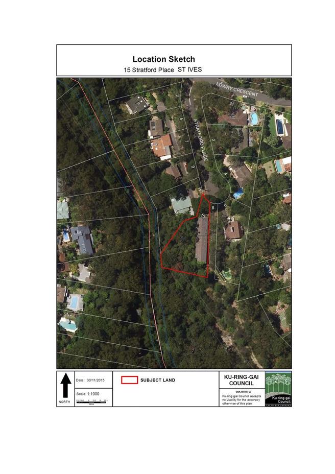
|
APPENDIX No: 2 - A2
- 15 Stratford Place St Ives - location sketch
|
|
Item No: GB.10
|
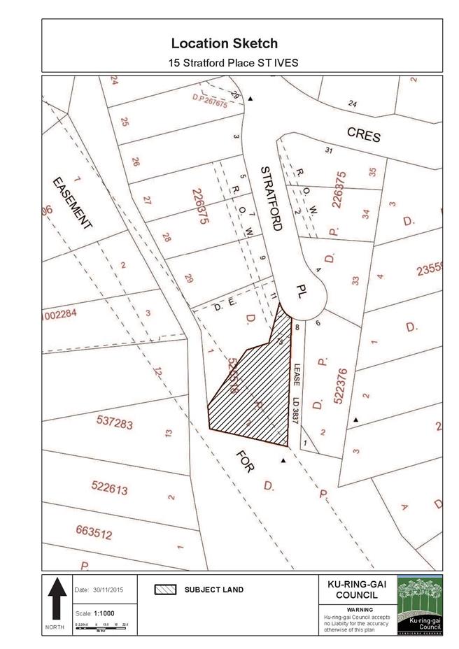
|
Ordinary
Meeting of Council - 8 December 2015
|
GB.11 / 1019
|
|
|
|
|
Item
GB.11
|
CY00413/3
|
|
|
16 November 2015
|
Heritage Reference Committee Meeting
Minutes
EXECUTIVE
SUMMARY
|
purpose of report:
|
Council to consider the minutes of the Heritage
Reference Committee (HRC) meetings held on 15 June 2015, 14 September
2015 and 19 October 2015.
|
|
|
|
|
background:
|
The minutes were taken at three meetings. The minutes
taken at the meeting held on 15 June 2015, were confirmed and accepted at the
HRC meeting held on 14 September 2015. The minutes taken at the meeting
on 14 September 2015 were confirmed and accepted at the HRC held on 19
October 2015. The minutes taken at the meeting on 19 October 2015 were
confirmed and accepted at the HRC held on 11 November 2015.
|
|
|
|
|
comments:
|
A number of issues regarding heritage items and
policies were discussed at the HRC’s meetings on 15 June 2015, 14 September
2015 and 19 October 2015.
|
|
|
|
|
recommendation:
|
That Council receive and note the Heritage Reference
Committee meeting minutes from 15 June 2015, 14 September 2015 and 19
October 2015.
|
Purpose of Report
Council to consider the minutes of the Heritage Reference
Committee (HRC) meetings held on 15 June 2015, 14 September 2015 and 19
October 2015.
Background
The Ku-ring-gai Heritage Reference Committee was re-formed
in August 2014 in accordance with Council’s requirements.
Comments
A range of heritage issues were
discussed at the HRC meeting of 16 June 2015 (Attachment A1).
Items discussed included an update on the heritage assessments for 28 Cook
Road, Killara and 140 Pentecost Avenue, Turramurra. It was recommended that a
systematic approach to identifying properties that were overlooked in previous
studies be developed.
At the 14 September 2015 meeting (Attachment A2) the
HRC discussed the draft inventory sheets for Pymble, Lindfield and Roseville
Railway Stations. The progress of the heritage assessments for the interim
heritage orders were again discussed and the HRC were also updated on the
progress of the Wahroonga Heritage Walk.
At the meeting held on 19 October 2015 (Attachment A3)
a guest speaker Margaret Middleton addressed the HRC with regards to the
heritage significance of 6 Caithness Street, Killara.
With regards to Council’s Heritage Fund the HRC adopted a
resolution to recommend Council as a guide have a minimum grant of $1,000 and a
maximum grant of $5,000. The HRC also adopted a resolution to endorse Council’s
recommendation to heritage list the garden and components of 140 Pentecost
Avenue, Turramurra. The HRC discussed the membership of the committee and
endorsed a recommendation to change the membership to include one additional
community member.
integrated planning and reporting
Heritage conservation
|
Community Strategic Plan Long Term Objective
|
Delivery Program
Term Achievement
|
Operational Plan
Task
|
|
Strategies, plans and processes are in place to
effectively protect and preserve Ku-ring-gai’s heritage assets
|
Implement, monitor and review Ku-ring-gai’s heritage
planning provisions
|
Identify gaps in existing strategies and plans
|
Governance Matters
Consisting of five members, the Heritage Reference Committee
includes Councillors, community representatives and heritage practitioners.
The HRC provides advice on heritage matters and assists with
the promotion, understanding and appreciation of heritage. While not a
decision-making body, the HRC nevertheless plays an important function in
shaping Ku-ring-gai's future. This HRC is also an important link in Council's
communication strategy with the community.
Risk Management
In providing advice and recommendations to Council on the
management of strategic heritage issues in Ku-ring-gai, this Committee assists
in the future management of Ku-ring-gai’s cultural heritage.
Financial Considerations
The costs of running the HRC are
covered by the Strategy and Environment Department budget.
Social Considerations
The aims of the HRC are to provide advice to Council on
heritage matters and to provide assistance to Council in promoting an
understanding and appreciation of heritage, including matters of social
heritage significance.
Environmental Considerations
A role of the HRC is to support Council in identifying and
managing Ku-ring-gai’s Cultural Heritage.
Community Consultation
The HRC meets on a monthly basis and notification of
meetings is provided on Council’s website.
Internal Consultation
The HRC includes Councillors and heritage practitioners and
is facilitated by Council staff. Where relevant,
consultation with other Departments may occur.
Summary
The HRC held its meeting on 15
June 2015. The Committee reviewed and discussed
current interim heritage orders.
At the meeting on 14 September
2015 the committee discussed the draft inventory sheets for Pymble,
Lindfield and Roseville Railway Stations, existing
IHOs and the Wahroonga Heritage Walk.
At the meeting on 19 October 2015
the committee discussed 6 Caithness Street, Killara, the Heritage Fund, IHOs
and the committee membership.
|
Recommendation:
A. That
Council receive and note the Heritage Reference Committee meeting minutes of
15 June 2015, 14 September 2015 and 19 October 2015.
B. That
as a guide the minimum grant for the Heritage Fund is $1,000 and the maximum
is $5,000.
C. That a
report be prepared for Council to consider changing the membership of the
Heritage Reference Committee to include one additional community
representative.
|
|
Andreana Kennedy
Heritage Specialist Planner
|
Antony Fabbro
Manager Urban & Heritage Planning
|
|
Andrew Watson
Director Strategy & Environment
|
|
|
Attachments:
|
A1View
|
Heritage
Reference Committee Minutes - 15 June 2015
|
|
2015/150445
|
|
|
A2View
|
Heritage
Reference Committee Minutes - 14 September 2015
|
|
2015/247597
|
|
|
A3View
|
Heritage
Reference Committee Minutes - 19 October 2015
|
|
2015/292620
|
|
APPENDIX
No: 1 - Heritage
Reference Committee Minutes - 15 June 2015
|
|
Item No: GB.11
|
|
APPENDIX No: 2 - Heritage
Reference Committee Minutes - 14 September 2015
|
|
Item No: GB.11
|
|
APPENDIX No: 3 - Heritage
Reference Committee Minutes - 19 October 2015
|
|
Item No: GB.11
|
|
Ordinary
Meeting of Council - 8 December 2015
|
GB.12 / 1030
|
|
|
|
|
Item
GB.12
|
S09362
|
|
|
24 November 2015
|
Human Dimensions in Wildland Fire
Management Conference
EXECUTIVE
SUMMARY
|
purpose of report:
|
For Council to note the outcomes of staff member
attendance and contribution to the 13th International Wildland Fire Safety
Summit & 4th Human Dimensions of Wildland Fire Conference (IAWF
Conference) held in Boise, Idaho, USA on 20 – 24 April 2015.
|
|
|
|
|
background:
|
Ku-ring-gai Council began implementing a community
resilience program called Climate Wise Communities (CWC) in 2012. This
program has been improving community preparation and response to the
increasing risks of extreme weather events including bushfire.
Council was invited by the NSW Rural Fire Service to
submit an abstract on the CWC project to the IAWF conference. Jennie Cramp,
Council’s Bush Fire Technical Officer was approved to attend the conference
to present Council’s research.
|
|
|
|
|
comments:
|
The IAWF conference presented a forum to share
knowledge of the importance of human dimensions in wildfire management
including community engagement and risk management. The benefits to Council
of Jennie’s attendance at the conference included the collaborative nature,
and a focus on best practice community engagement and other social aspects of
fire management. These elements will assist to inform the future direction of
Council’s bushfire risk management processes. Council officers have also
written and submitted a research paper for publication in the Conference
Proceedings.
|
|
|
|
|
recommendation:
|
That Council receives and notes the outcomes arising
from attendance at the IAWF Conference.
|
Purpose of Report
For Council to note the outcomes of staff member attendance
and contribution to the 13th International Wildland Fire Safety Summit &
4th Human Dimensions of Wildland Fire Conference (IAWF Conference) held in
Boise, Idaho, USA on 20 – 24 April 2015.
Background
The International Association of Wildland Fire (IAWF)
facilitates communication and best practice in wildfire scientific and
technical knowledge, education, networking and professional development across
the world. Over the past decade fire researchers and practitioners have
developed a significant body of knowledge about many of the social aspects of
fire management. This has led to the establishment of a conference series
called Human Dimensions of Wildland Fire Conference where past experience and
lessons learned can be showcased, and emerging ideas/technology presented.
Since 2012, Ku-ring-gai Council has been implementing a
community resilience program called Climate Wise Communities (CWC). This program
has been improving community preparation and response to the increasing risks
of extreme weather events including bushfire. Council was invited by the NSW
Rural Fire Service to submit an abstract on the CWC project to the joint 13th
International Wildland Fire Safety Summit and 4th Human Dimensions
of Wildland Fire Conference held in Boise, Idaho, USA. Jennie Cramp, Council’s
Bush Fire Technical Officer was approved to attend the conference to present
Council’s research.
Comments
Council’s attendance at the IAWF conference presented a
unique opportunity to present our local research to a global scale forum. Other
benefits to Council included:
· Access to relevant socio-ecological
research and bush fire behaviour science to inform the development of Council’s
Community Bush Fire Education Strategy, the Hornsby Ku-ring-gai Bush Fire Risk
Management Plan, and Council’s emergency and risk management processes.
· Access to best practice community
engagement methods, community resilience projects, bush fire risk management
and bush fire evacuation planning; to inform the future direction of Council’s
CWC program and to enhance program outcomes.
· Networking opportunities with other
professionals, facilitating sharing of ideas and knowledge in relation to bush
fire management and community resilience.
· An introduction to new technology
trends and techniques that could be used to inform fire behaviour modelling,
scenario planning and incident management training both internally and with other
emergency management agencies.
· International recognition for Council’s
work in the area of climate change adaptation and disaster resilience
management.
Parts of the USA and Australia share similar climates, fire
weather, hazard mitigation techniques and societal values. During the visit,
Jennie:
· Attended a one day training workshop
around the assessment of residential wildfire hazards. Discussion centred
around the physical science of structure ignition as well as the social science
processes and models that facilitate behaviour change.
· Along with a small group of Australian
delegates from a range of agencies including the NSW Rural Fire Service,
Tasmanian Fire Service, RMIT University and University of Western Australia
also visited a community-led fire group located at Warm Springs Mesa. This
community included a community of similar demographic to Ku-ring-gai living in
a ridgetop location. The residents shared their neighbourhood and fire
mitigation experiences with us.
Other key learnings and outcomes included:
· Hearing from the Principal of
Strathewen Primary School on the social and economic challenges of recovery and
renewal.
· New approaches for managing wildfire
risk such as incorporating community adaptive capacity (communities ability to
self-organise) into policies and programs.
· Challenges with information flow to and
throughout communities during bushfires.
· Ways that local governments and
communities may work together to better utilise existing information networks
within communities during disasters.
· Emphasis on social and ecological
resilience and a re-prioritisation of funding towards risk and preparedness to
strengthen the resilience of buildings on the interface.
· Risk tolerance and decisions around
evacuation. A binary approach of ‘stay and defend or leave early’ strategies
does not reflect the reality of what people do during bushfires. This is
informing further study around sheltering practices and strengthening of
standards.
· Complexity of decision-making required in
an emergency and measuring psychological preparedness.
· Research on fire management decision
making and risk, public perceptions and trade-offs.
· Fuel modification to achieve risk
reduction and better ecological outcomes.
· Dealing with preparedness fatigue.
Upon return, Council staff have written a research paper to
be published in the Conference Proceedings. A copy of the paper as submitted
for peer review is provided as Attachment A1.
integrated planning and reporting
Natural Environment
|
Community Strategic Plan Long Term Objective
|
Delivery Program
Term Achievement
|
Operational Plan
Task
|
|
N4.1 A community addressing and responding
to the impacts of climate change and extreme
weather events.
|
Council’s vulnerability to climate change is reduced.
|
Develop initiatives to build Council’s capacity to
prepare, respond and recover to the increasing severity and frequency of
extreme weather events as a result of a changing climate.
|
|
|
The community is effectively
informed and engaged on climate change issues.
|
Deliver the Climate Wise Communities program.
|
Governance Matters
The conference provided opportunities for sharing knowledge
and accessing best practice community engagement methods. By sharing our
research, Council is promoting participatory community engagement methods and
an ability to incorporate research into its programs in order to better serve
the community.
Risk Management
From a litigation perspective, Councils are advised that
they need to take steps to demonstrate that they have investigated the risks
posed to their communities from climate change related extreme weather events
and put plans in place and undertake actions to reduce the risk exposure.
Council is implementing the CWC program to reduce community vulnerability to
extreme weather events and has chosen to share its knowledge around the
successes and challenges to inform future risk management processes.
Financial Considerations
Council sponsored the cost of the conference attendance and
accommodation. All other expenses including airfare and all in country travel,
food and associated expenses was covered by Jennie
Social Considerations
Council has responsibilities under the Local Government Act
1993 and Rural Fires Act 1997 to take steps to reduce the risk of bush fire to
the community. The Principles of Ecologically Sustainable Development must be
considered in public decision-making at the local level. The CWC program was
developed from a model that based on social, environmental and economic
considerations.
Environmental Considerations
Fire management practices are often focused on actions
within the physical environment that can reduce the risk. Research is
indicating that these approaches are failing to sufficiently reduce risks
during extreme events and can cause detrimental environmental impacts. The CWC
program developed and presented, aims to strengthen existing fire management
with thorough community engagement to encourage greater preparedness,
decision-making capacity and resilience.
Community Consultation
Climate Wise Communities is a community engagement program
based on the principles of shared responsibility, collaboration and
empowerment. Its aims are to improve community resilience to extreme weather
events through facilitated community workshops. By presenting, Councils
research and experiences we hope that others can adapt the techniques used and
developed in collaboration with their own communities around the globe.
Internal
Consultation
The learnings from the
conference have been shared with the Strategy and Environment team and are
where applicable are being incorporated into the development of future policies,
programs and strategies.
Summary
Attendance at the 13th International Wildland
Fire Safety Summit & 4th Human Dimensions of Wildland Fire
Conference (IAWF Conference), Boise, Idaho, USA presented a unique opportunity
to showcase Ku-ring-gai Council’s Climate Wise Communities Program on an
international platform. This forum facilitated a shared knowledge of the
importance of human dimensions of wildfire management including community
engagement and risk management. The benefits to Council of Jennie’s attendance
at the conference included access to relevant socio-ecological research, bush
fire behaviour science and best practice community engagement methods. Through
the networking opportunities provided, the knowledge and ideas gleaned will
assist to inform the future direction of Council’s bushfire risk management
processes.
|
Recommendation:
A. That
Council receives and notes the outcomes arising from attendance at the IAWF
Conference.
|
|
Jennie Cramp
Technical Officer - Bushfire
|
Penny Colyer
Team Leader - Natural Areas
|
|
Marnie Kikken
Manager Environment & Sustainability
|
Andrew Watson
Director Strategy & Environment
|
|
Attachments:
|
A1View
|
Conference
proceedings: Climate Wise Communities research paper submitted for peer
review
|
|
2015/317297
|
|
APPENDIX
No: 1 - Conference
proceedings: Climate Wise Communities research paper submitted for peer
review
|
|
Item No: GB.12
|


|
Ordinary
Meeting of Council - 8 December 2015
|
GB.13 / 1046
|
|
|
|
|
Item
GB.13
|
S10066
|
|
|
25 November 2015
|
Planning Proposal to Heritage List 24
Dudley Avenue, Roseville
EXECUTIVE
SUMMARY
|
purpose of report:
|
To have Council consider 24 Dudley Avenue, Roseville
as a potential heritage item under the Ku-ring-gai Local Environmental Plan
2015 and also request the Minister for Heritage to make an interim heritage
order over 24 Dudley Avenue, Roseville.
|
|
|
|
|
background:
|
A development application to remove and harm
significant fabric at the property is being considered by Council.
24 Dudley Avenue, Roseville has potential heritage significance for its
historical association with renowned photographer Harold Cazneaux.
|
|
|
|
|
comments:
|
A preliminary heritage assessment has been prepared
for 24 Dudley Avenue, Roseville.
|
|
|
|
|
recommendation:
|
That a planning proposal be prepared to list 24 Dudley
Avenue, Roseville as an item of local heritage significance under KLEP 2015
and a letter be sent to the Minister for heritage requesting a state interim
heritage order be placed over the property.
|
Purpose of Report
To have Council consider 24 Dudley Avenue, Roseville as a
potential heritage item under the Ku-ring-gai Local Environmental Plan 2015 and
also request the Minister for Heritage to make an interim heritage order over
24 Dudley Avenue, Roseville.
Background
24 Dudley Avenue, Roseville is located within the Clanville
Conservation Area (C32), a heritage conservation area (HCA) under KLEP 2015. As
such, any development applications within the HCA require a heritage impact
statement (HIS).
A development application was received for alterations and
additions to 24 Dudley Avenue. No Pre Development Application meeting was
held. The detailed history in the HIS identified the property as the former
long-time home and workplace of renowned photographer and artist
Harold Cazneaux. A comparison of recent and historic photographs
identified extant heritage fabric at the rear and the interior of the property.
This fabric is not protected under the HCA designation and is threatened by the
current development application. A preliminary heritage assessment suggests the
property warrants investigation for potential local and/or state heritage
listing.
Council does not have authority under s.25 of the Heritage
Act delegation to make an interim heritage order on the property. Schedule 2 of
the Ministerial Order published in the NSW Government Gazette on 12 July 2013
states:
“Council must not make an IHO
where….the item is within a heritage conservation area identified in an
environmental planning instrument”.
Comments
Heritage significance of 24 Dudley Avenue, Roseville
A preliminary heritage assessment of 24 Dudley Avenue,
Roseville can be found at Attachment A1. The property including the
house, garden and studio may have local or state cultural significance based
upon the historical association with Harold Cazneaux. During his life Cazneaux
was an accomplished and recognised Sydney artist, photographer and social
demographer. Celebrated Sydney photographer Max Dupain described Cazneaux as
the father of modern Australian photography.
“Ambleside” at 24 Dudley Avenue Roseville was the home of
Harold Cazneaux from 1915 until his death in 1953. In the book “Cazneaux:
The quiet observer” Helen Ennis describes the felicitous marriage of
Cazneaux’s domestic and professional life when he started working from his home
in Roseville in the 1920s. Images of family parties, Christmases and daily
domestic family life at Ambleside were captured by Cazneaux and are conserved
today in depositories at the National Library of Australia, the NSW State
Library and Ku-ring-gai Library. The house, studio and many of the interiors
captured in these images are still present today.
As the home and workplace of a highly significant Australian
artist, Ambleside should be protected to allow investigation of its
significance. As Council is unable to make an interim heritage order over 24
Dudley Avenue, Roseville (Lot 1, DP 209190) the power to protect the heritage
values of the property and make an IHO resides with the Minister for Heritage,
pursuant to s. 24 of the Heritage Act.
In support of the recognised heritage value, above and
beyond that of a contributory building within a heritage conservation area, it
is also recommended that Council prepare a planning proposal to include 24
Dudley Avenue, Roseville on schedule 5 and the heritage map of KLEP 2015. To
support the planning proposal a state heritage inventory form will also be
prepared for Ambleside.
integrated planning and reporting
Theme 3: Places, Spaces and Infrastructure
|
Community Strategic Plan Long Term Objective
|
Delivery Program
Term Achievement
|
Operational Plan
Task
|
|
Ku-ring-gai’s heritage is protected, promoted and
responsibly managed.
|
Strategies, plans and
processes are in place to effectively protect and preserve Ku-ring-gai’s
heritage assets.
|
Identify gaps in existing strategies and plans.
|
Governance Matters
This report addresses the first stage in obtaining a gateway
for a Planning Proposal which seeks to list an item of local heritage
significance under an amendment to the KLEP 2015.
If the Planning Proposal is supported by the Department, the
draft plan will be placed on exhibition seeking further State agency and
stakeholder feedback prior to being reported back to Council.
The process for the preparation and implementation of
planning proposals is governed by the provisions of the Environmental
Planning and Assessment Act, 1979.
Council will seek the plan-making delegation under Section
23 of the EP&A Act to finalise the Planning Proposal. This involves Council
taking on the Director General’s function under s59(1) of the Act in liaising
with the Parliamentary Counsel’s Office (PCO) to draft the required local
environment plan to give effect to the Planning Proposal as well the Minister’s
function under s59(2) of the Act in making the Plan.
Risk Management
There is a community expectation that places of heritage
significance within the Ku-ring-gai Council LGA will be identified and
protected. There is a strategic risk of damaging the reputation of Council if
these culturally significant places are not identified and considered for
protection.
Financial Considerations
The cost of preparing this report is covered by the
Ku-ring-gai draft Principal Local Environmental Plan - Urban Planning &
Heritage Budget – Strategy and Environment Department.
Social Considerations
The identification and protection of Ku-ring-gai’s heritage
places contributes to the ongoing conservation of Ku-ring-gai’s
community-valued historic landscape and garden suburbs.
Environmental Considerations
The retention and conservation of heritage places has an
important role in protecting the environment. The environmental sustainability
benefits afforded by the retention of heritage places includes the substantial
reduction in building demolition and new construction waste, and the
conservation of embodied energy in the existing buildings.
Community Consultation
The affected property owner will be notified of this report
going to Council and will be further notified and have the opportunity to
provide feedback during the formal exhibition period.
Should the Planning Proposal receive a favourable Gateway
Determination, it will be exhibited in accordance with the Department’s Gateway
Determination requirements and with explanatory heritage information. This will
involve appropriate notification and receipt of submissions on the draft plan
from the relevant State agencies and the general community and a further report
back to Council
Internal Consultation
Consultation with relevant Departments of Council has taken
place in preparing this report, in particular, Development and Regulation. In
addition, Council’s Heritage Reference Committee has reviewed the proposed
heritage item.
Summary
A preliminary assessment of heritage significance suggests
that 24 Dudley Avenue, Roseville is worthy of further heritage assessment. The
purpose of this report is to have Council consider requesting the Minister for
Heritage place an interim heritage order on 24 Dudley Avenue, Roseville and
that Council commence a planning proposal to include Ambleside as a heritage
item under the Ku-ring-gai Local Environmental Plan 2015.
|
Recommendation:
A. That
Council requests the Minister for Heritage make an Interim Heritage Order
(IHO) over 24 Dudley Avenue, Roseville (Lot 1, DP 209190), pursuant to s. 24
of the Heritage Act.
B. That
Council proceeds to prepare a planning proposal to amend KLEP 2015 to
include:
· 24 Dudley Avenue, Roseville (Lot 1, DP 209190) as a potential heritage
item in Schedule 5 and on the Heritage Map.
C. That
the Planning Proposal be forwarded to the Department of Planning and
Environment for a Gateway Determination in accordance with the provisions of
the EP&A Act and Regulations.
D. That
in order to facilitate an expedient gateway determination, the NSW Heritage
Office be consulted prior to submitting the Planning Proposal to the
Department of Planning and Environment. Should comments not be received
within 21 days, the planning proposal is to be submitted regardless.
E. That
Council requests the plan making delegation under Section 23 of the EP&A
Act for this planning proposal.
F. That
upon receipt of a Gateway Determination, the exhibition and consultation
process is carried out in accordance with the requirements of the
Environmental Planning and Assessment Act, 1979 and with the Gateway
Determination requirements.
G. That a
report be brought back to Council at the conclusion of the exhibition period.
|
|
Andreana Kennedy
Heritage Specialist Planner
|
Antony Fabbro
Manager Urban & Heritage Planning
|
|
Andrew Watson
Director Strategy & Environment
|
|
|
Attachments:
|
A1View
|
Preliminary
heritage assessment of 24 Dudley Avenue, Roseville
|
|
2015/303394
|
|
APPENDIX
No: 1 - Preliminary
heritage assessment of 24 Dudley Avenue, Roseville
|
|
Item No: GB.13
|
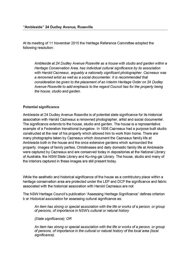

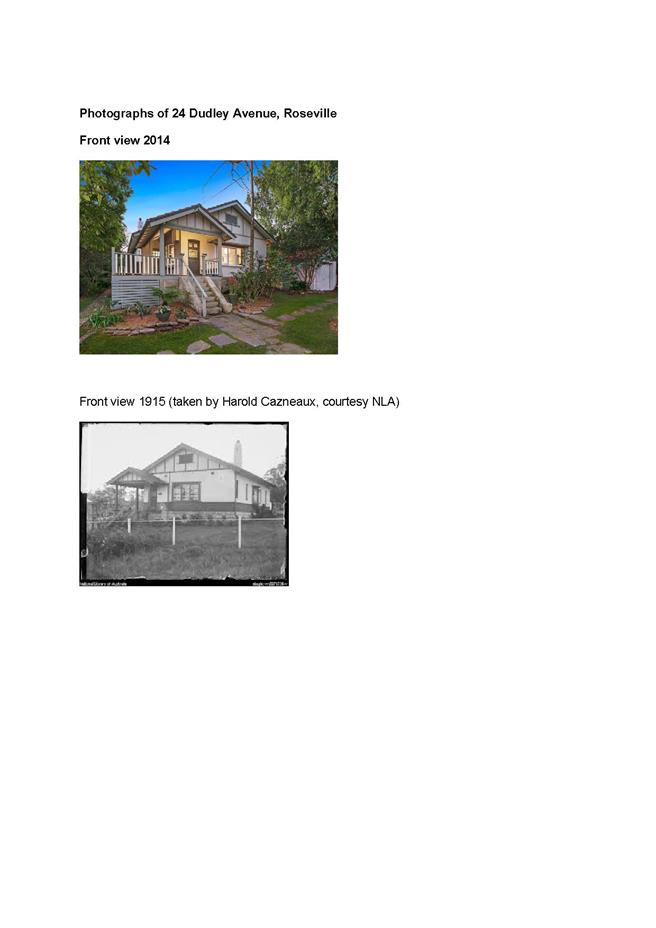
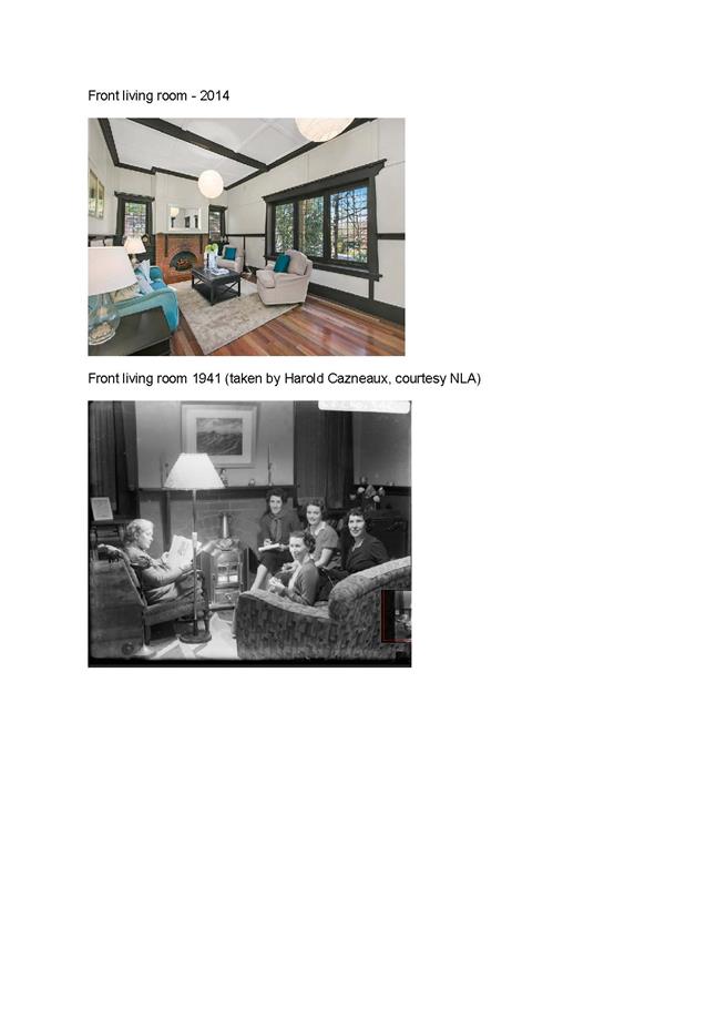
|
Ordinary
Meeting of Council - 8 December 2015
|
GB.14 / 1056
|
|
|
|
|
Item
GB.14
|
S03151
|
|
|
17 November 2015
|
Proposal to re-establish alcohol free
zones
EXECUTIVE
SUMMARY
|
purpose of report:
|
To consider the re-establishment of alcohol free zones
in South Turramurra Shopping Centre, South Turramurra, Wade Lane car park,
Gordon and St Ives Village Green, St Ives.
|
|
|
|
|
background:
|
The existing alcohol free zones have expired and
Council is requested whether it wishes the areas to be re-established.
|
|
|
|
|
comments:
|
In accordance with Section 644 of The Local
Government Act, Council can re-establish an alcohol free zone subject to
advertising and consultation process.
|
|
|
|
|
recommendation:
|
That Council proceed with the proposal to re-establish
the alcohol free zones in South Turramurra Shopping Centre, South Turramurra,
Wade Lane car park, Gordon and St Ives Village Green, St Ives by notification
and invitation for public comment in accordance with Section 644A of The
Local Government Act 1993. Council endorsed community events are to be
excluded from the Alcohol Free Zone requirements.
|
Purpose of Report
To consider the re-establishment of alcohol free zones in
South Turramurra Shopping Centre, South Turramurra, Wade Lane car park, Gordon
and St Ives Village Green, St Ives.
Background
In 2010, at the request of local
residents, Council re-established the alcohol free zones in the South
Turramurra Shopping Centre, South Turramurra, and Wade Lane car park, Gordon
and St Ives Village Green, St Ives under Section 644 of The Local Government
Act.
Under the Act, alcohol free zones may only be
established for a period not exceeding four (4) years.
Attachments A1, A2 and A3 are maps identifying the
respective locations.
Comments
To renew the alcohol free zones as required in the Section
644A of The Local Government Act and in accordance with the Ministerial
Guideline on Alcohol Free Zones 2009, Council must publish, by notice, in a
local newspaper indicating the following:
· Declare
it proposes to re-establish alcohol free zones, indicating the location of the
zone, and the proposed period;
· State
the place at which, the date on which and the times during which the copy of
the proposal may be inspected;
· Invite representations and
objections from persons and groups within the area indicating that any
representations or objections by them must be made within thirty (30) days
after the date on which the notice is published.
Council must also give a copy of the proposal for alcohol
free zones to:
· The
officer in charge of the police station within or nearest to the alcohol free
zone;
· Liquor
licenses, whose premises border on, adjoin or are adjacent to the proposed
alcohol free zone;
· Secretaries of registered clubs that
border on, adjoin or is adjacent to the proposed alcohol free zone.
Should Council adopt this
report, advertising and notification to renew the zones, will be undertaken as
outlined above. If no substantial objections are received, signs will be
erected and the zones will remain valid for four (4) years from the date of
declaration in accordance with the provisions of The Local Government Act (Ministerial
Guideline on Alcohol Free Zones) 2009.
Attachment A4 is a copy of the confirmation of
support from the police at the Ku-ring-gai Local Area Command.
However, at St Ives Village
Green, Council has a number of community events that may involve the
consumption of alcohol and the re-establishment of Alcohol Free Zones is not
intended to deter the use of alcohol during these events. Therefore, it is
considered that community events be excluded from the Alcohol Free Zone
requirements at all sites.
integrated planning and reporting
Community, People and Culture
|
Community Strategic Plan Long Term Objective
|
Delivery Program
Term Achievement
|
Operational Plan
Task
|
|
C3.1.1
Our community is engaged in shaping the identity of their
local areas and feel secure and socially connected.
|
Facilitate and promote community safety and social
initiatives.
|
Resource and support local community safety and crime
prevention initiatives.
|
Governance Matters
Section 644 A of the Local Government Act 1993
sets out the requirements for re-establishing Alcohol Fee Zones.
Risk Management
The inclusion of Alcohol Free Zones is intended to reduce
the risk of use at the sites nominated.
Financial Considerations
Administrative costs for the public consultation process and
the supply of signage will be met from existing budgets within Operations
Department.
Social Considerations
Consumption of alcohol in public places is considered to
result in anti-social behaviour and alcohol free zones help improve the amenity
of the area.
Environmental Considerations
Not applicable
Community Consultation
Support has been received from the Police at the Ku-ring-gai
Local Area Command.
Internal Consultation
The Development and Regulation
Department and the Community Department have been consulted and both support
the proposal to renew the alcohol free zones.
Summary
The Alcohol Free Zones at South
Turramurra Shopping Centre, South Turramurra, Wade Lane car park, Gordon and St
Ives Village Green, St Ives are due to be renewed.
The Local Government Act 1993
requires advertising and notification to renew the zones, which will be
undertaken should Council adopt this report. Should no substantial objections
be received, signs will be erected and valid for four (4) years.
However, at St Ives Village
Green, Council has a number of community events that may involve the consumption
of alcohol and the re-establishment of Alcohol Free Zones is not intended to
deter the use of alcohol during these events. Therefore, it is considered that
community events be excluded from the Alcohol Free Zone requirements at all
sites.
|
Recommendation:
A. That Council proceeds with the proposal to renew the alcohol
free zones in South Turramurra Shopping Centre, South Turramurra, Wade Lane
car park, Gordon and St Ives Village Green, St Ives by notification and
invitation for public comment in accordance with Section 644A of The Local
Government Act 1993.
B. That should there be no substantial objections, the General
Manager be authorised to implement the operation of the alcohol free zones.
C. That the alcohol free zones be established for a period of four
(4) years from the date of declaration in accordance with the provisions of The
Local Government Act (Ministerial Guideline on Alcohol Free Zones
) 2009.
D. That Council endorsed community events be excluded from the
Alcohol Free Zone requirements at all sites.
|
|
Greg Piconi
Director Operations
|
|
|
Attachments:
|
A1View
|
Proposed
alcohol free zone - St Ives
|
|
2015/183541
|
|
|
A2View
|
Proposed
alcohol free zone - Gordon
|
|
2015/183544
|
|
|
A3View
|
Proposed
alcohol free zone - South Turramurra
|
|
2015/183550
|
|
|
A4View
|
Confirmation
of continual support from the NSW Police
|
|
2015/319766
|
|
APPENDIX
No: 1 - Proposed
alcohol free zone - St Ives
|
|
Item No: GB.14
|
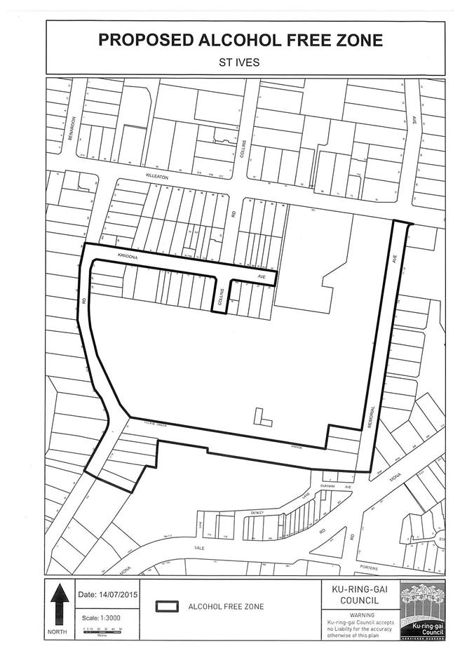
|
APPENDIX No: 2 - Proposed
alcohol free zone - Gordon
|
|
Item No: GB.14
|
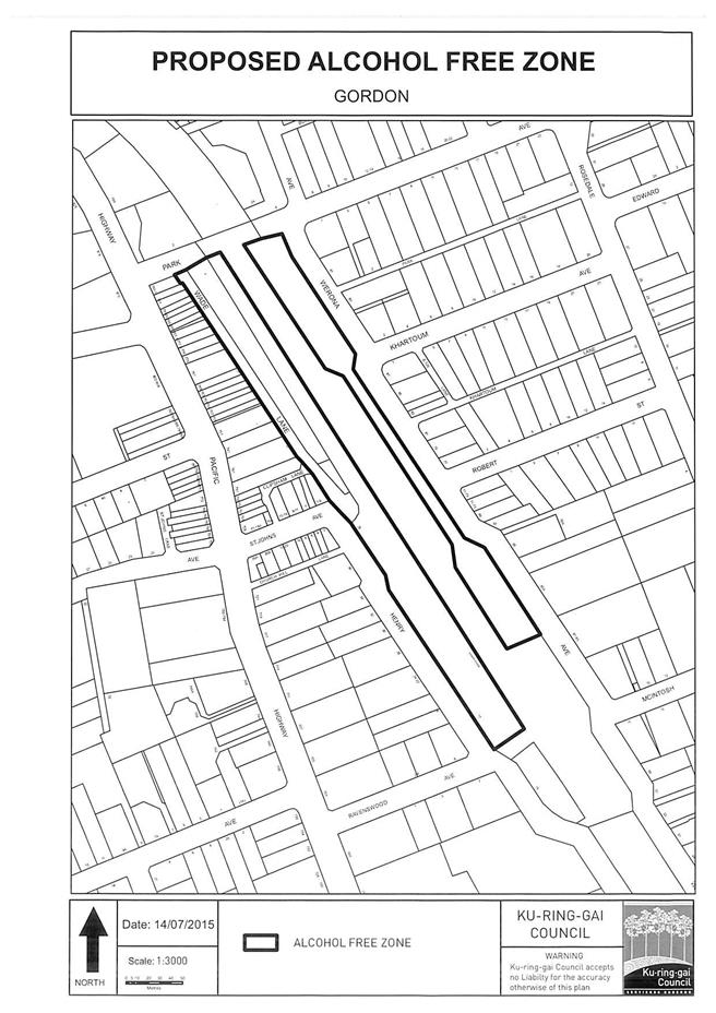
|
APPENDIX No: 3 - Proposed
alcohol free zone - South Turramurra
|
|
Item No: GB.14
|
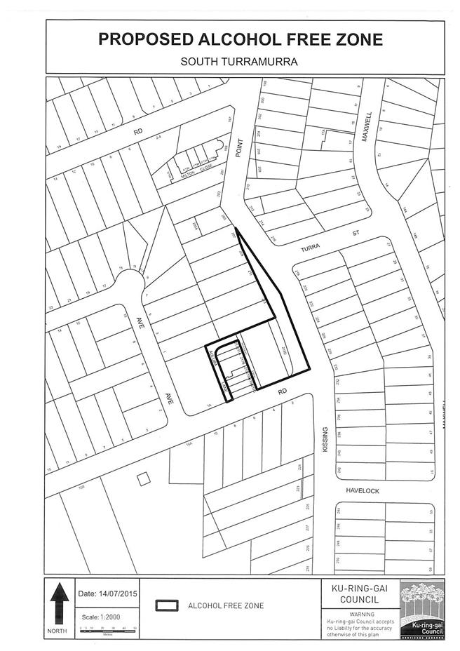
|
APPENDIX No: 4 - Confirmation
of continual support from the NSW Police
|
|
Item No: GB.14
|
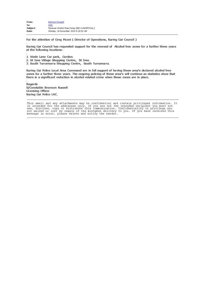
|
Ordinary
Meeting of Council - 8 December 2015
|
GB.15 / 1064
|
|
|
|
|
Item
GB.15
|
S09881
|
|
|
26 November 2015
|
T15-2015 - NTRA - Stage 4C Synthetic
Sportsfield
EXECUTIVE
SUMMARY
|
purpose of report:
|
To consider the tenders received for the construction
of North Turramurra Recreation Area (NTRA) Stage 4C Synthetic Sportsfield and
appoint the preferred tenderer.
|
|
|
|
|
background:
|
The Master Plan for the development of a new
recreation facility at North Turramurra was adopted in 2007. The staged
construction of works consistent with the adopted masterplan has seen the former landfill site rehabilitated and the
pre-existing golf course reconfiguration and extension. The next stage of
works is the construction of new sportsfields and facilities for North
Turramurra Recreational Area (NTRA).
|
|
|
|
|
comments:
|
Tender documents were produced with five (5)
submissions received. The submissions were assessed using agreed criteria to
identify the best value to Council.
|
|
|
|
|
recommendation:
|
In accordance with Section 55 of the Local Government Act and Tender Regulations, and following the
request for tender, it is recommended that Council accepts the tender
submitted by tender ‘D’ as indicated in the confidential attachment by the
Tender Evaluation Committee.
|
Purpose of Report
To consider the tenders received for the construction of
North Turramurra Recreation Area (NTRA) Stage 4C Synthetic Sportsfield and
appoint the preferred tenderer.
Background
The Master Plan for the development of a new recreation
facility at North Turramurra was adopted in 2007. The features of the North
Turramurra Recreation Area (NTRA) works include the rehabilitation of
the former landfill site, the redevelopment of the existing golf course and the
provision of new sportsfields and recreation facilities to contribute towards
meeting a growing demand for recreation facilities in general and playing
fields in particular, in the Ku-ring-gai Local Government Area.
The next stage of the
NTRA works is the design and construction of the synthetic sportsfield,
stormwater and sub-soil drainage and associated works known as NTRA
Stage 4C Synthetic Sportsfield.
The tender documents for the construction of a synthetic
Sportsfield were released through Tenderlink on 10 October 2015. The closing
date for receipt of tenders was 6 November 2015.
As the estimate of the construction works is over $150,000,
tenders were called using Tenderlink in accordance with the tender requirements
of the Local Government Act and Tender Regulations.
Comments
Five (5) tenders were received and recorded in accordance
with Council’s tendering policy. Tenders were received from the following
companies:
Court Craft Australia Pty Ltd
Greenplay Australia Pty Ltd
Landscape Solutions Australia Pty
Limited
Turf One Pty Ltd
TigerTurf NZ Ltd Hargraves Urban
Pty Ltd
It should be noted the order above is alphabetical and does
not correspond to the order of the list of tenderers named from ‘A’ to ‘E’ in
the confidential attachment.
A Tender Evaluation Panel consisting of staff from the
Operations Department, and Strategy & Environment Department was formed to
assess the five (5) tenders received.
The evaluation took into
account:
· Conformity
of submission,
· Lump sum
fee,
· Company
Experience/Personnel Experience and Qualifications,
· Construction
Methodology,
· Program of
Works / timeline
· Environmental
Risk; and
· Risk
Management
The confidential attachments to
this report include:
· List of
tenders received and additional financial information
· Tender
Evaluation Panel’s comments and recommendation
integrated planning and reporting
Enhance Recreation, Sporting and
Leisure Facilities. Community Strategic Plan Long Term Objective Delivery
Program Term Achievement Operational Plan Task P6.1 Recreation, sporting and
leisure facilities are available to meet the community’s diverse and changing
needs.
A program is being implemented
to improve existing recreational, sporting and leisure facilities and
facilitate the establishment of new facilities and deliver park asset
refurbishment program at priority locations.
|
Community Strategic Plan Long Term Objective
|
Delivery Program
Term Achievement
|
Operational Plan
Task
|
|
P6.1 Recreation, sporting and leisure facilities are
available to meet the community’s diverse and changing needs.
|
A program is being implemented to improve existing
recreational, sporting and leisure facilities and facilitate the
establishment of new facilities.
|
Deliver sports fields, facilities and park asset
refurbishment program at priority locations.
|
FIT FOR THE FUTURE IMPROVEMENT ACTION
PLAN
The NSW Government's Fit for the Future initiative required
all councils to prepare an Improvement Proposal and supporting Implementation
Plan demonstrating how all seven Fit for the Future benchmarks would be met by
2016/17, and maintained or improved thereafter.
Council's Fit For the Future Improvement Proposal and
supporting Implementation Plan underpins the decision to stand alone and
not merge with Hornsby Council. The objectives established in the Improvement
Proposal and Implementation Plan are embedded in Council's adopted Integrated
Planning and Reporting documents including the Revised Delivery Program
2013-2017 and Operational Plan 2015-2016, Long Term Financial Plan
2015/16 to 2024/25 and Asset Management Strategy 2015/16 to 2024/25.
The requirements for Council being Fit for the Future do not
impact on this project as funding is already committed and not related to asset
sales to address Council’s infrastructure backlog.
Governance Matters
Tender documents were prepared
and released through Tenderlink on 10 October 2015 with a closing date of 6
November 2015. At the close of tender, five (5) tenders were received. All
submissions were recorded in accordance with Council’s tendering policy. A
Tender Evaluation Panel consisting of staff from Operations and Strategy &
Environment Departments was formed to assess the five (5) tenders received.
The evaluation took into account the evaluation methodology, criteria and
weighting as predetermined by the Tender Evaluation Committee:
The Confidential Attachments to
this report includes the list of tenders received and the Tender Evaluation
Panel’s comments and recommendation. The attachments are considered to be
confidential in accordance with Section 10A (2)(d)(iii) of The Local Government Act 1993 as they are considered to contain commercial
in confidence information.
Risk Management
Three (3) key areas of risk were
identified in relation to the proposed work:
· That work
needed to be carried out under the contract should be done by a suitably
qualified company with experience in synthetic sport field construction and
knowledge of the proposed synthetic product.
· That the
company was available to commence work within a few weeks of the work being
awarded and has the resources to complete the work quickly and efficiently and
without major delays.
· That Council
should not be exposed to financial risk.
An independent Performance and
Financial Assessment has been carried out on the preferred tenderer to ensure
they are trading responsibly and have the financial capacity to undertake the
work as detailed within the tender documents and or negotiated.
The independent Performance and
Financial Assessment examines the following areas:
· The
tenderer’s financial capacity to undertake the proposed value of work;
· That the
tenderer has been trading in a profitable and responsible manner during the
last three (3) years; and
· That the
tenderer has sufficient assets/reserves to cover all possible debts during the
period of work.
A copy of the
financial assessment is included in the confidential attachments.
Financial Considerations
This project is currently listed
in Council’s 2014/15 Delivery Program and Operational Plan – project numbers
and present available funds are detailed in the Confidential Attachments.
In accordance with statutory obligations, at the
finalisation of the project, all unspent funds will be returned to appropriate
plan.
There are sufficient funds provided in the Long Term
Financial Plan and Delivery Program to fund the works under this contract.
Social Considerations
Over the last few years with the
increased use by a growing number of sporting users, it has been identified the
need for additional sportsfields to meet the ever growing demand.
The upgrade of the present
facilities with an addition of sportsfields, it is expected to enhance the
recreational and sports value of the site and provide greater access for sports
clubs and casual users.
The proposed upgrade and
expansion of the present facilities is in line with Council’s Community
Strategic Plan 2030 and the Plan’s long term directions, including the
objective to have a community embrace healthier lifestyle choices and
practices; and to provide quality open space, community and recreational
facilities to meet the needs of our changing community.
Environmental Considerations
Prior to tender, the project was
subject to a Review of Environmental Factors which determined as follows:
· The proposal
is unlikely to have significant impact upon species, populations or ecological
communities listed under the NSW Threatened Species Conservation Act and
a Species Impact Statement is not required.
· The proposal
will not affect any matters of National Environmental Significance listed under
the Commonwealth Environment Protection and Biodiversity Conservation Act
1999.
· The proposal
will include mitigation measures and methods to avoid a significant impact on
the environment should it proceed.
Community Consultation
Community consultation has been
carried out prior to finalising the NTRA Master Plan in 2007 for the
development of a new recreation facility at North Turramurra.
The project has been developed
in response to a steadily growing demand within the LGA for new recreational
facilities.
A communications action plan has
been prepared to inform the community and stakeholders on the progress of the
proposed works. The action plan outlines the communication goals, provides a
list of the target audience and sets out the key messages that are to be
provided to the community and stakeholders by a variety of strategies over the
length of the project.
Council has a dedicated website
updated every three (3) months informing the public of any updates regarding
the project.
Prior to the commencement of
on-site works, local residents, schools and businesses will be advised of the
commencement of works and be provided with a time estimate for the completion.
During the construction period,
the sportsfield site will be closed to the public. However, the golf course and
the carpark will remain open for use.
Internal Consultation
Community consultation has been
carried out prior to finalising the NTRA Master Plan in 2007 for the
development of a new recreation facility at North Turramurra. The project has
been developed in response to a steadily growing demand within the LGA for new
recreational facilities.
A communications action plan has
been prepared to inform the community and stakeholders on the progress of the
proposed works. The action plan outlines the communication goals, provides a
list of the target audience and sets out the key messages that are to be
provided to the community and stakeholders by a variety of strategies over the
length of the project.
Council has a dedicated website
updated every three (3) months informing the public of any updates regarding
the project.
Prior to the commencement of
on-site works, local residents, schools and businesses will be advised of the
commencement of works and be provided with a time estimate for the completion.
During the construction period,
the sportsfield site will be closed to the public. However, the golf course and
the carpark will remain open for use.
Summary
Council, as part of the
2014/2015 Open Space Capital Works Program, approved funding for the North Turramurra Recreation Area (NTRA)
Following internal and community
consultation, tender documentation was produced with tenders being called on 10
October 2015 with a closing date of 6 November 2015.
A Tender Evaluation Panel was
formed consisting of representatives from Operations and Strategy &
Environment Departments. At the close of tender, five (5) tenders were
received.
All tenders were recorded in accordance with Council’s
tendering policy. At the conclusion of the evaluation process a tender
assessment and recommendation report was prepared for presentation to Council.
|
Recommendation:
A. That
Council accepts the tender from Tenderer ‘D’ as listed in the confidential
attachment from the Tender Evaluation Committee to award a contract for
T15-2015 Stage 4C Synthetic Sportsfield.
B. That the
tender documents be referred to Council’s solicitor to assist in preparing contract
documents that is in Council’s best interest.
C. That the
Mayor and General Manager be delegated authority to execute all tender
documents on Council’s behalf in relation to the contract.
D. That the
Seal of Council be affixed to all necessary documents.
E. That That
all tenderers be advised of Council’s decision in accordance with Clause 178
of the Local Government Tendering Regulations.
|
|
Phillip Beninati
Contracts Supervisor Strategic Projects
|
Greg Piconi
Director Operations
|
|
Attachments:
|
A1
|
Tender
Assessment and Recommendation Report
|
|
Confidential
|
|
|
A2
|
Pre
Tender Estimate (Appendix 1 to above report)
|
|
Confidential
|
|
|
A3
|
Tender
Weighted Criteria (Appendix 2 to above report)
|
|
Confidential
|
|
|
A4
|
Tender
Evaluation Scorecard (Appendix 3 to above report)
|
|
Confidential
|
|
|
A5
|
Independent
financial assessment (Appendix 4 to above report)
|
|
Confidential
|