|
APPENDIX No: 1 - Local Government Remuneration Tribunal - Annual Report and Determination - 29 March 2016 |
|
Item No: GB.2 |
Ordinary Meeting of Council
TO BE HELD ON Tuesday, 28 June 2016 AT 7:00 pm
Level 3, Council Chamber
Agenda
** ** ** ** ** **
NOTE: For Full Details, See Council’s Website –
www.kmc.nsw.gov.au under the link to business papers
DECLARATIONS OF INTEREST
Confirmation of Reports to be Considered in Closed Meeting
NOTE:
That in accordance with the provisions of Section 10 of the Local Government Act 1993, all officers’ reports be released to the press and public, with the exception of confidential attachments to the following General Business reports:
GB.1 Annual Report on Contractual Conditions of Senior Staff 2015 / 2016
Attachment A1: Confidential - Annual Report on Contractual Conditions of Senior Staff 2015 / 2016
In accordance with s10(2)(a).
GB.6 Turramurra Community Hub Master Plan - Post Exhibition
Attachment A1: RLB - Concept Design Stage Estimate - Turramurra Community Hub - FINAL
In accordance with s10(2)(d)(ii).
Attachment A2: Turramurra Community Hub - Peer Review of Feasibility Analysis Final - Addendum 6 - April 2016
In accordance with s10(2)(d)(ii).
GB.10 Tender T12-2016 - Roseville Chase Community Hall Roofing and Building Upgrades
Attachment A1: List of tenders received and additional financial information
In accordance with s10(2)(d)(ii).
Attachment A2: ..... Tender Evaluation Panel Report
In accordance with s10(2)(d)(ii).
Attachment A3: ............ Independant Financial and Performance Assessment
In accordance with s10(2)(d)(ii).
GB.11 Tender RFT10-2016 - Golden Jubilee and Lofberg Playground Upgrades
Attachment A1: ................................................. List of Tenders received
In accordance with s10(2)(d)(iii).
Attachment A2: ....................... Tender Evaulation Panel's recommendation
In accordance with s10(2)(d)(iii).
Attachment A3: ...................... Corporate Scorecard's Financial Assessment
In accordance with s10(2)(d)(iii).
Address the Council
NOTE: Persons who address the Council should be aware that their address will be tape recorded.
Documents Circulated to Councillors
CONFIRMATION OF MINUTEs
Minutes of Ordinary Meeting of Council 7
File: S02131
Meeting held 14 June 2016
Minutes numbered 117 to 140
minutes from the Mayor
Petitions
PT.1 Gum Tree on North-Western Corner of Burgoyne Street and Pearson Avenue, Gordon 29
File: RT1/08
“We, the undersigned petition the Council to have the above-mentioned tree cut down and removed. (Eighteen (18) signatures).”
Over the last decade, and especially over the last few years, this tree has caused considerable damage to resident and passing cars [notably child care and commuter] [in Burgoyne Street], a power pole [in Burgoyne Street], Foxtel services [to 10 Pearson Avenue], electricity service wires [to three houses in Burgoyne Street and Pearson Avenue], and street lighting [in Burgoyne Street].
Last Saturday, a very big branch came down without any warning and crushed some mature native plants with a street care programme assigned to Richard Brady, a long time resident in Burgoyne Street. Half the road was obstructed. And on 27th February, 2016, a very big branch came down over Burgoyne Street, snapping a power pole into 2 and totally closing the road until police and emergency services arrived. These incidents, along with others, are on Council records.
Because the car park to the nearby pre-school in Park Avenue/Pearson Avenue is now inadequate, many mothers use this end of Burgoyne Street for casual parking before 9am and around 3pm. As do employees of Lifeline during the week. A not insignificant number have expressed their concern, especially when debris from the subject tree is all too often found lying on the road [or on car roofs].
We shouldn’t have to live in fear that a tree will, sooner or later, destroy a car or damage a house. Or worse, possible injure or kill somebody.
We ask that the Council address our concerns. The tree needs to be cut down and removed.
GENERAL BUSINESS
i. The Mayor to invite Councillors to nominate any item(s) on the Agenda that they wish to have a site inspection.
ii. The Mayor to invite Councillors to nominate any item(s) on the Agenda that they wish to adopt in accordance with the officer’s recommendation allowing for minor changes without debate.
GB.1 Annual Report on Contractual Conditions of Senior Staff 2015 / 2016 30
File: S10214
To report on the contractual conditions of senior staff in accordance with section 339 of the Local Government Act 1993.
Recommendation:
That Council receive and note the report.
GB.2 Mayor and Councillor Fees for 2016 / 2017 - Local Government Remuneration Tribunal Report and Determination 34
File: S03158/2
To determine the mayor and councillor fees for the 2016/17 financial year.
Recommendation:
That effective 1 July 2016:
the annual councillor fee be set at $18,840; and the annual mayoral fee to be set at $41,090, in addition to the Councillor fee.
GB.3 Investment Report as at 31 May 2016 50
File: S05273
To present Council’s investment portfolio performance for May 2016.
Recommendation:
That the summary of investments performance for May 2016 be received and noted; and that the Certificate of the Responsible Accounting Officer be noted and report adopted.
GB.4 17 Ancona Road & 25 Trentino Road, Turramurra - boundary adjustment between two lots and associated site works - DA0073/16 60
File: DA0073/16
Ward: Wahroonga
Applicant: Glendinning Minto & Associates Pty Ltd
Owner: M Webster & E Vickery
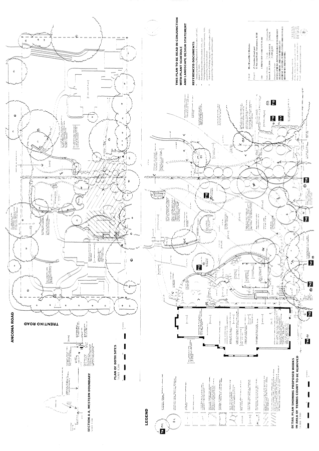
Boundary adjustment between 17 Ancona Road and 25 Trentino Road, Turramurra including associated site works
Recommendation:
Approval
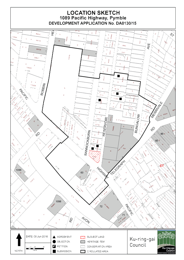
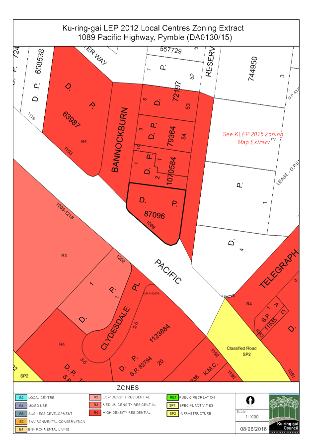
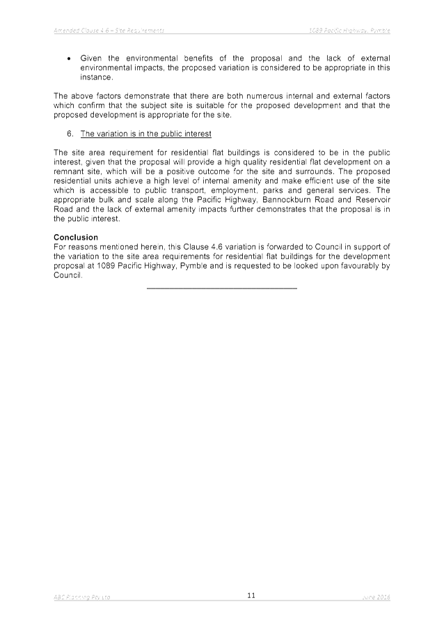
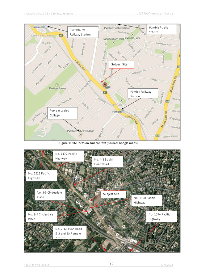
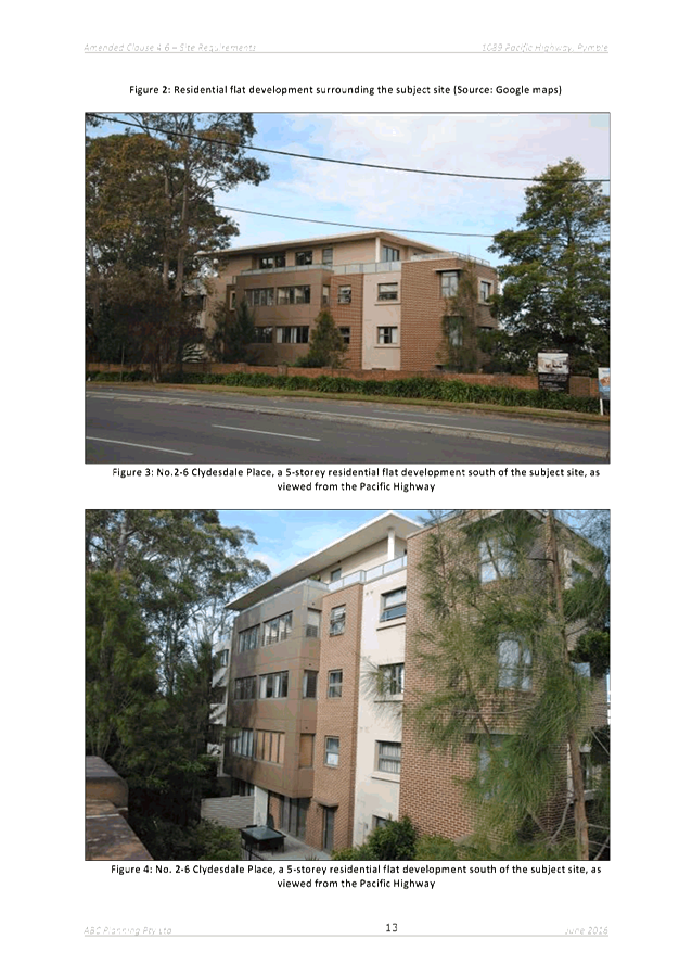
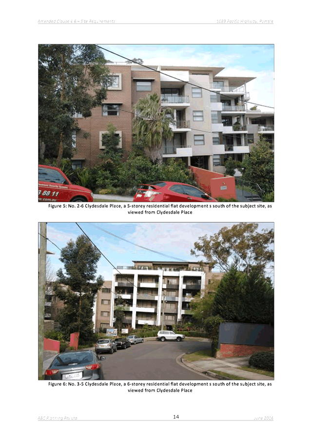
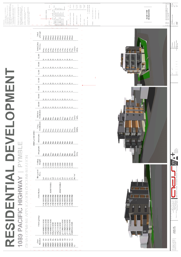
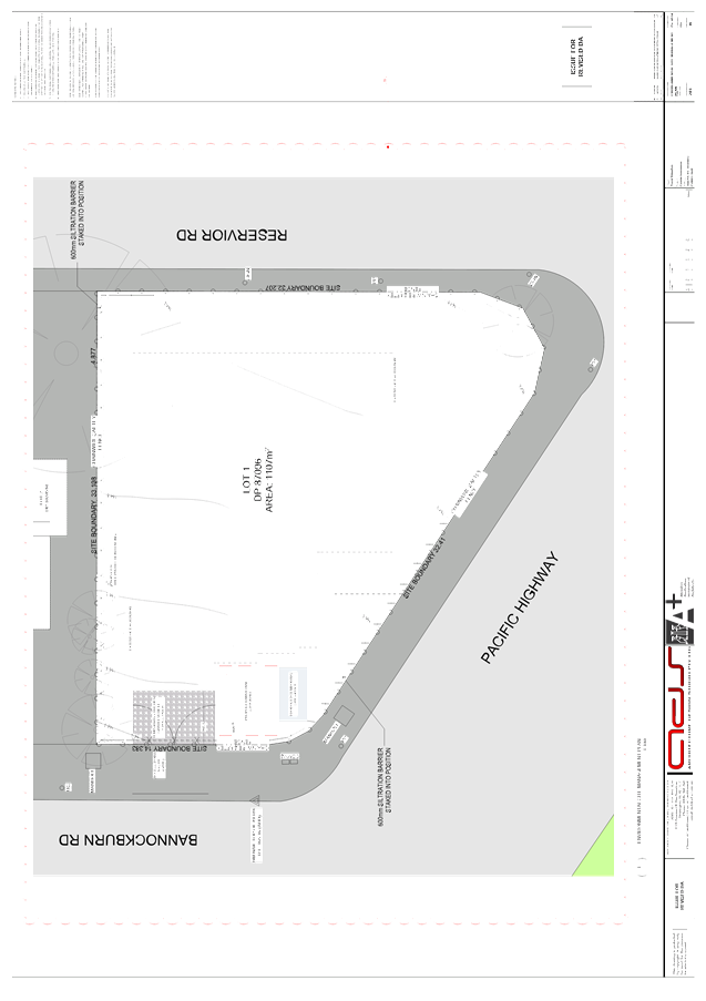
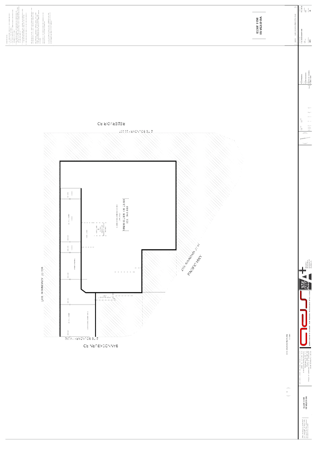
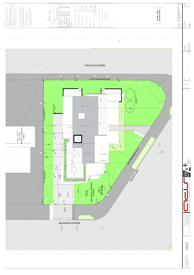
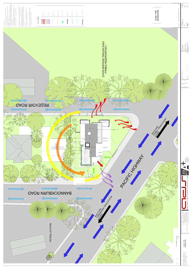
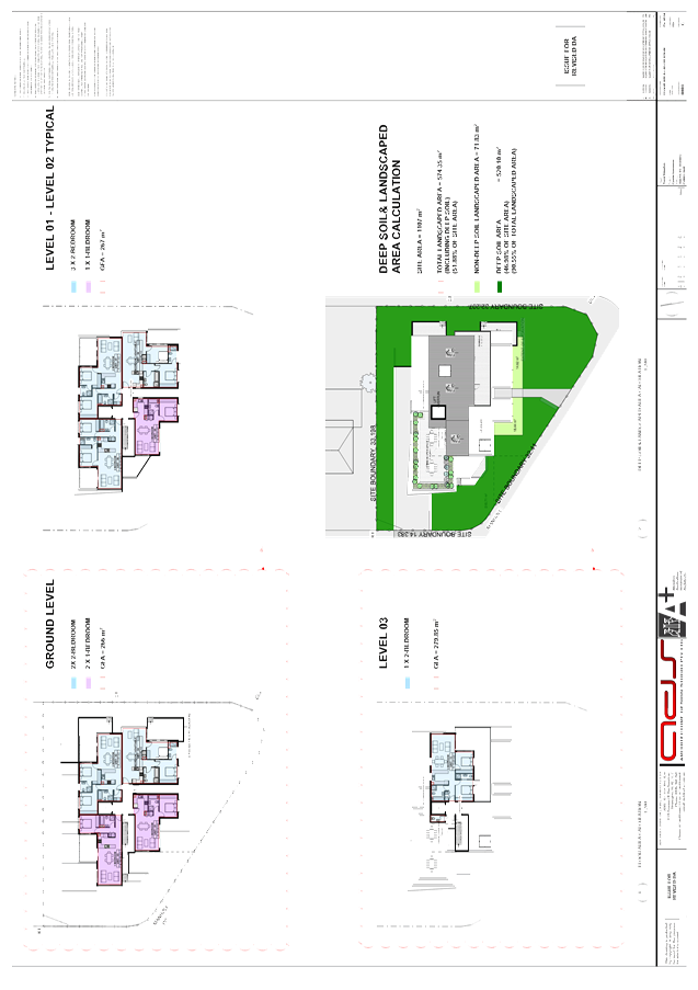
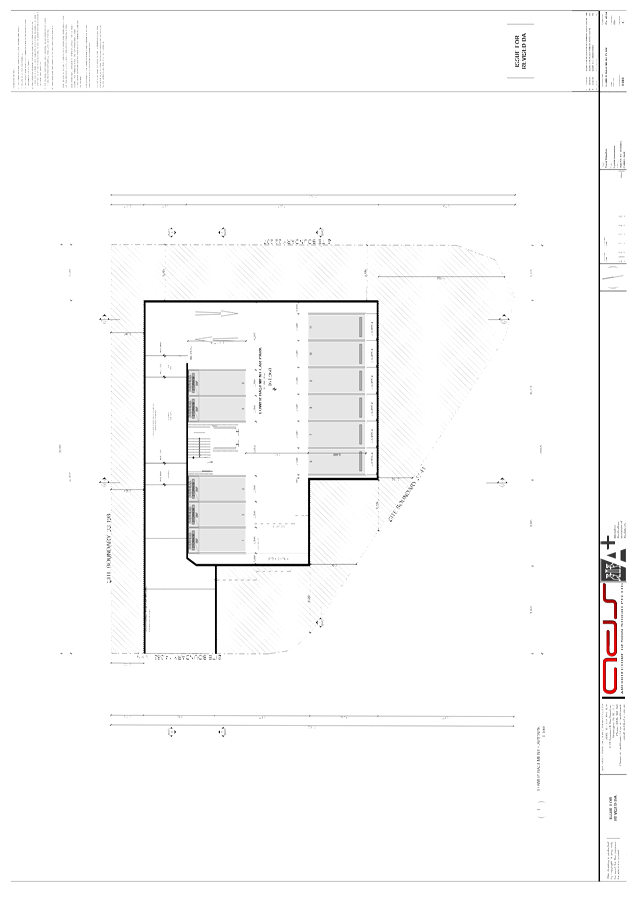
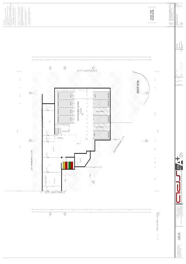
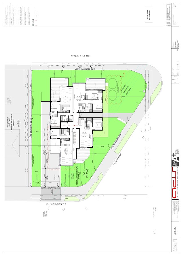
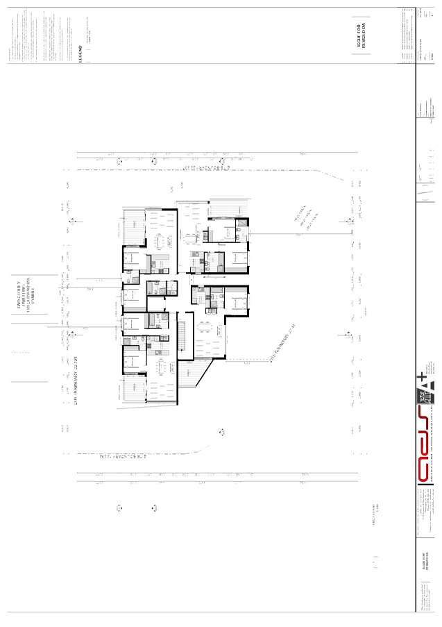
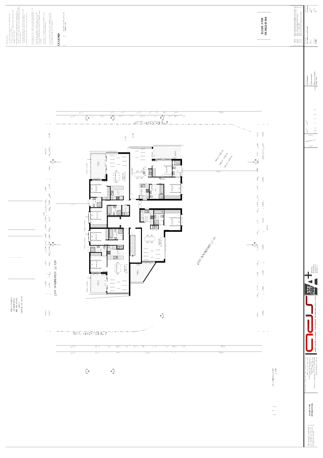
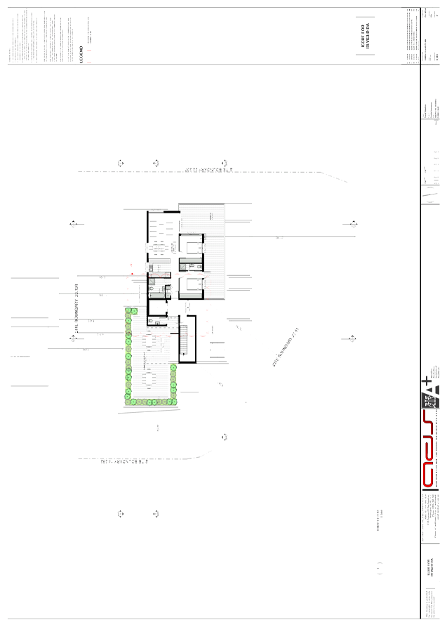
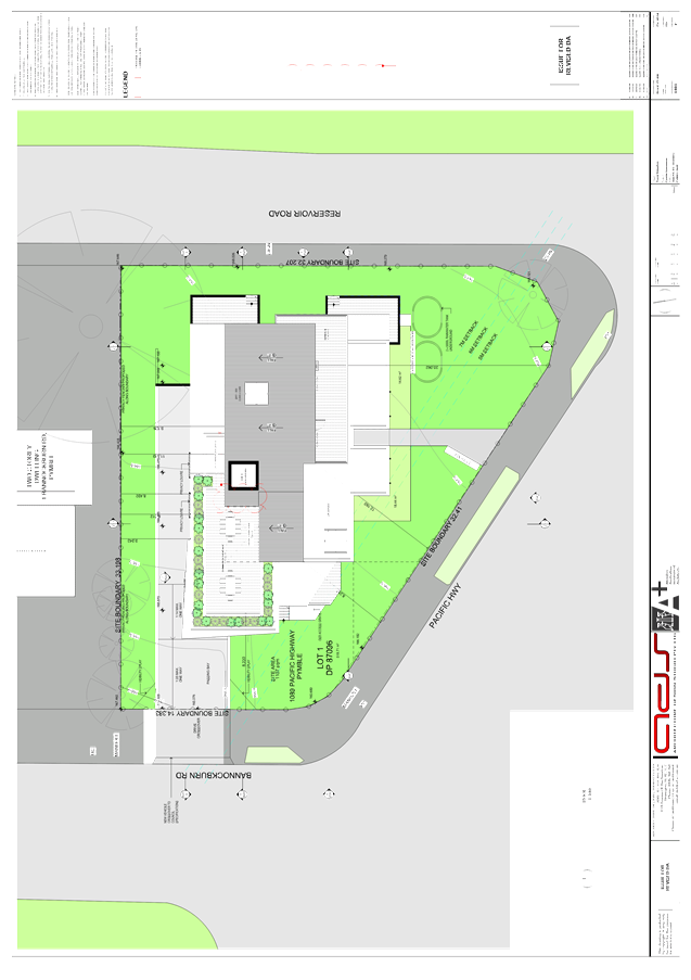
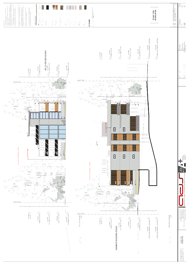
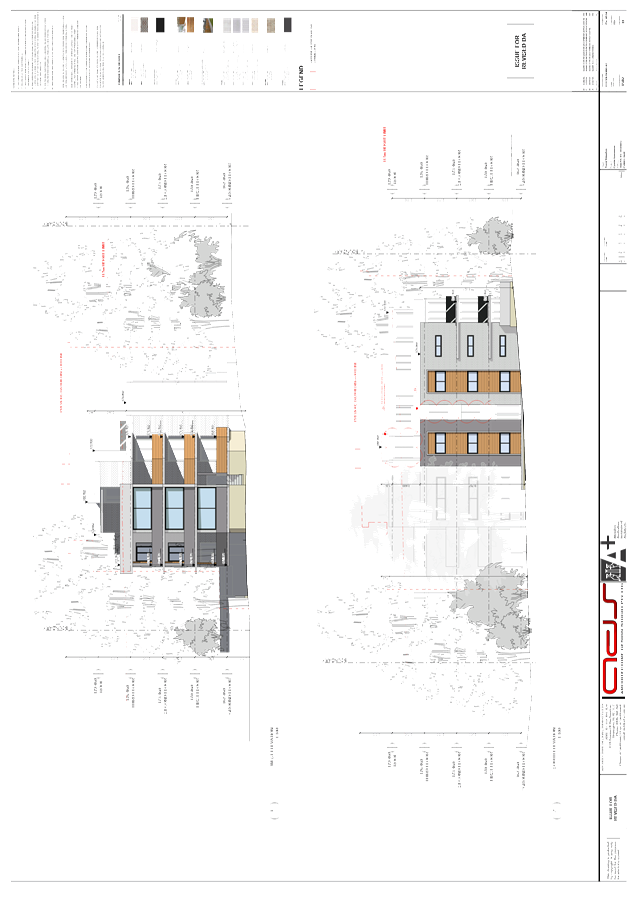
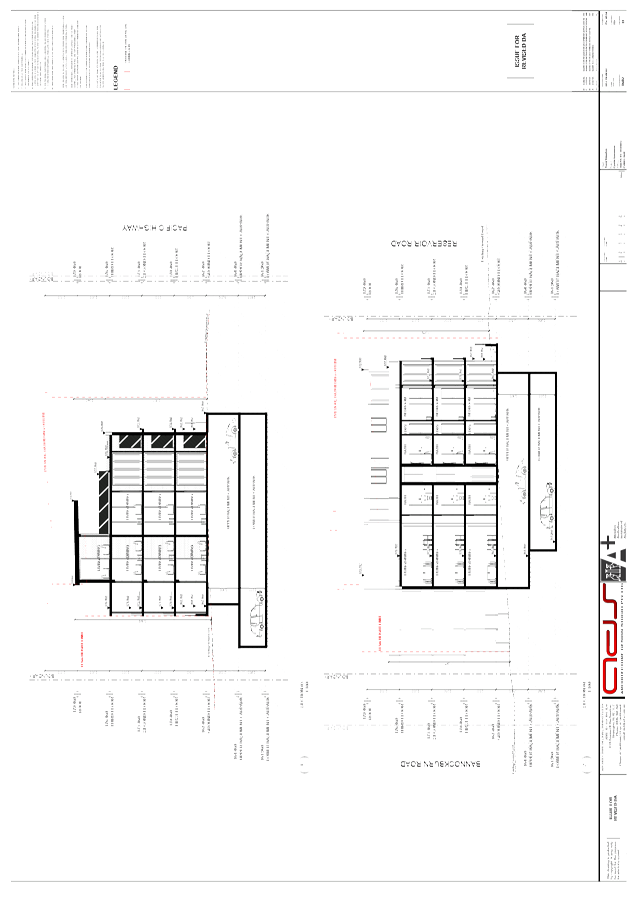
GB.5 1089 Pacific Highway, Pymble - construct residential flat building comprising 13 units, including basement parking, landscaping and strata subdivision 96
File: DA0130/15
Ward: Wahroonga
Applicant: Architecture Design Studio Pty Ltd
Owner: Kys Properties
Construct residential flat building comprising 13 units, including basement parking, landscaping and strata subdivision
Recommendation:
Approval
GB.6 Turramurra Community Hub Master Plan - Post Exhibition 249
File: S10467
To report to Council the results of the public exhibition of the draft Turramurra Community Hub Master Plan.
Recommendation:
This report recommends that the Turramurra Community Hub Master Plan (as exhibited) be adopted as Council’s preferred master plan and that Council undertake investigations to determine the most appropriate delivery mechanism for the project and report the findings to Council.
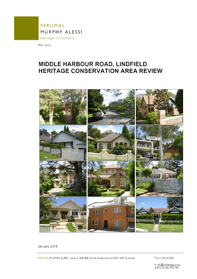
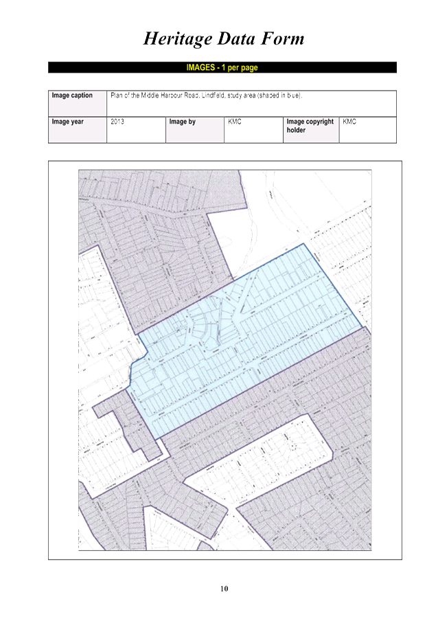
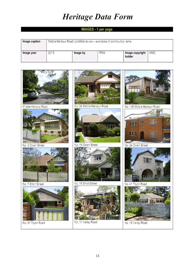
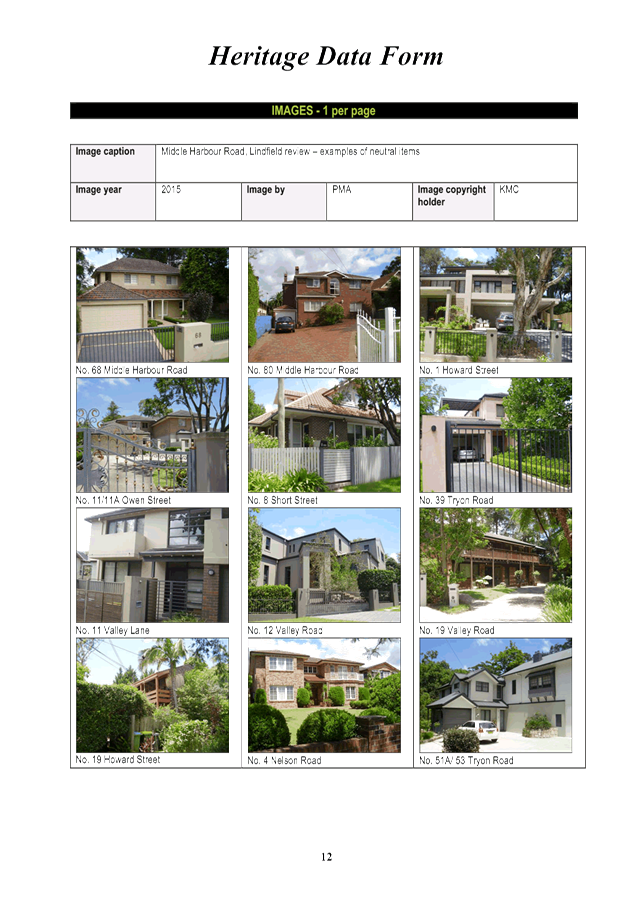
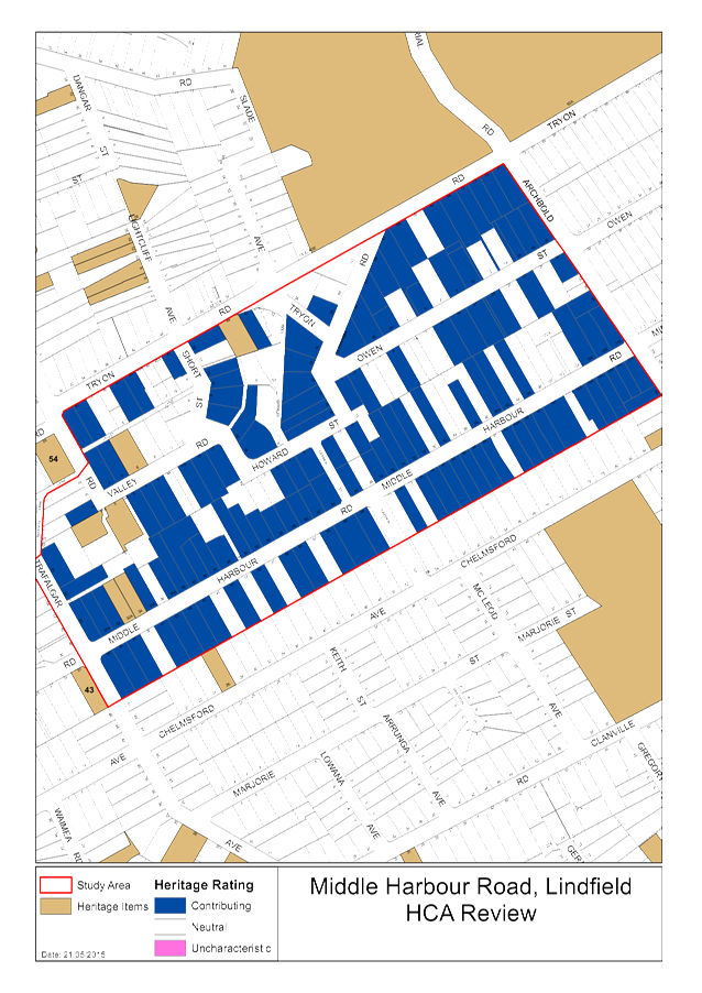
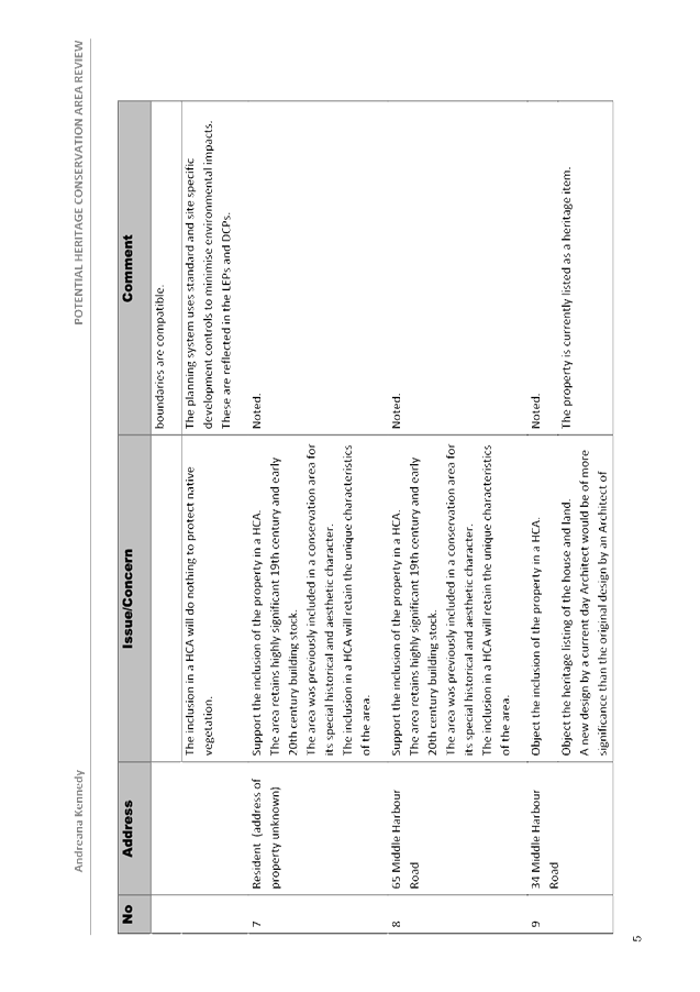
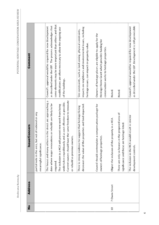
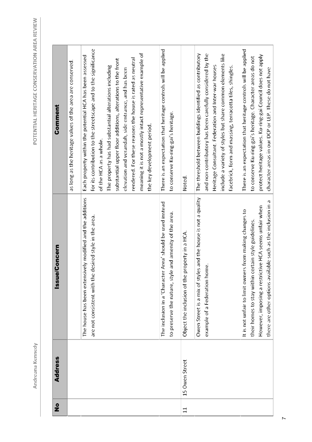
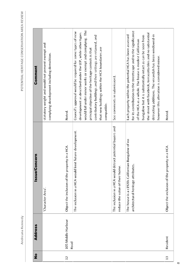
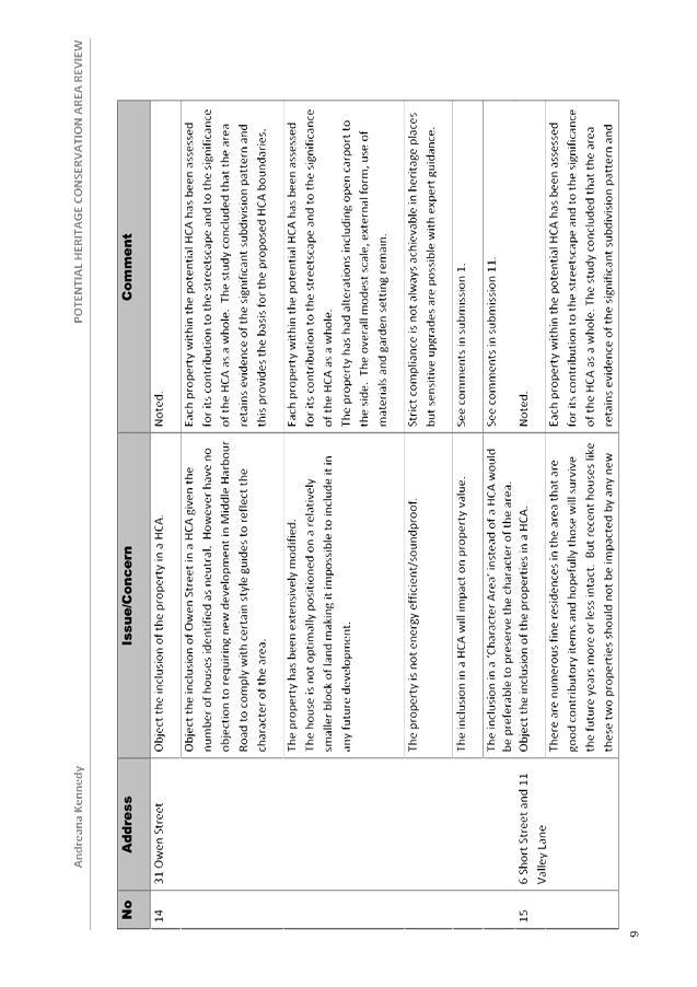
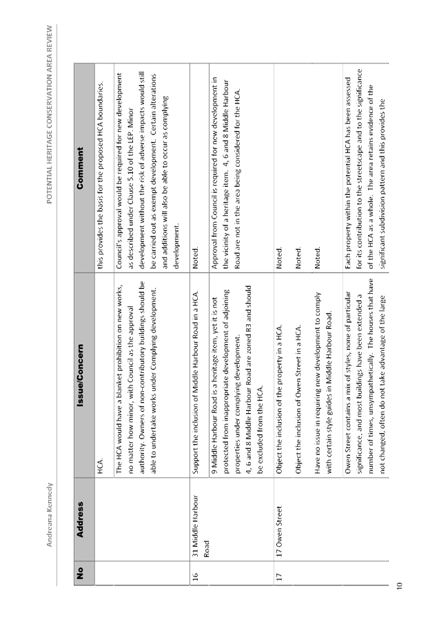
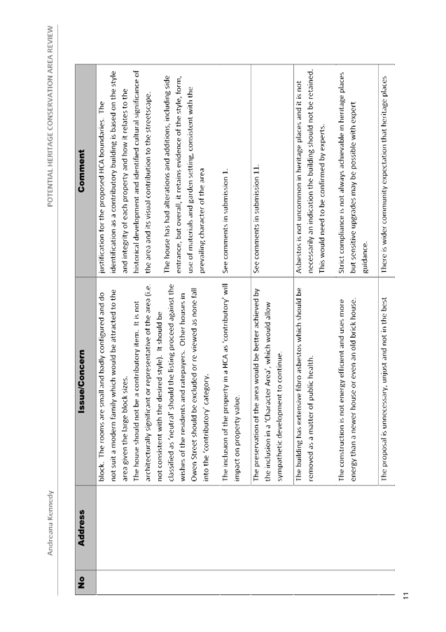
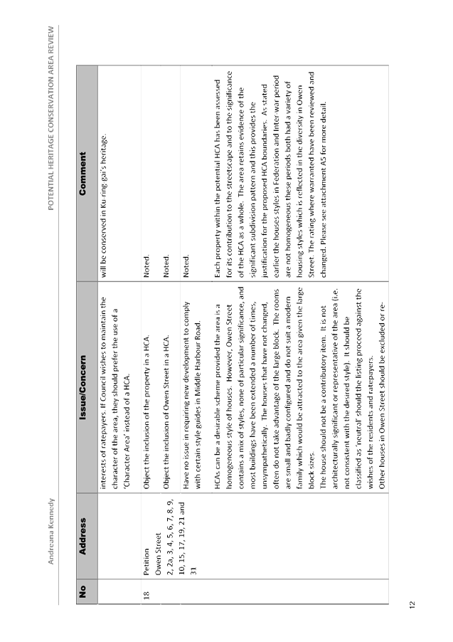
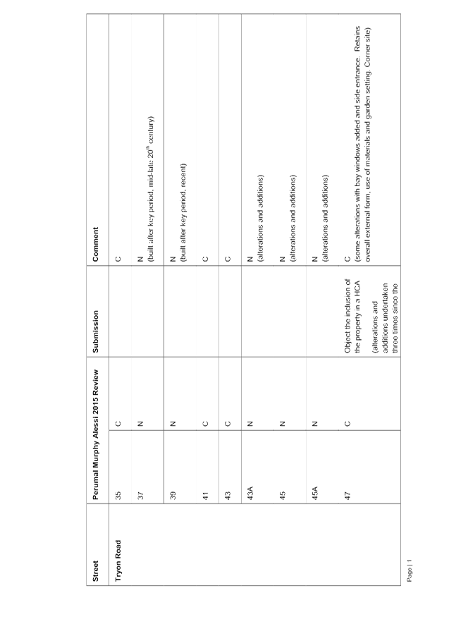
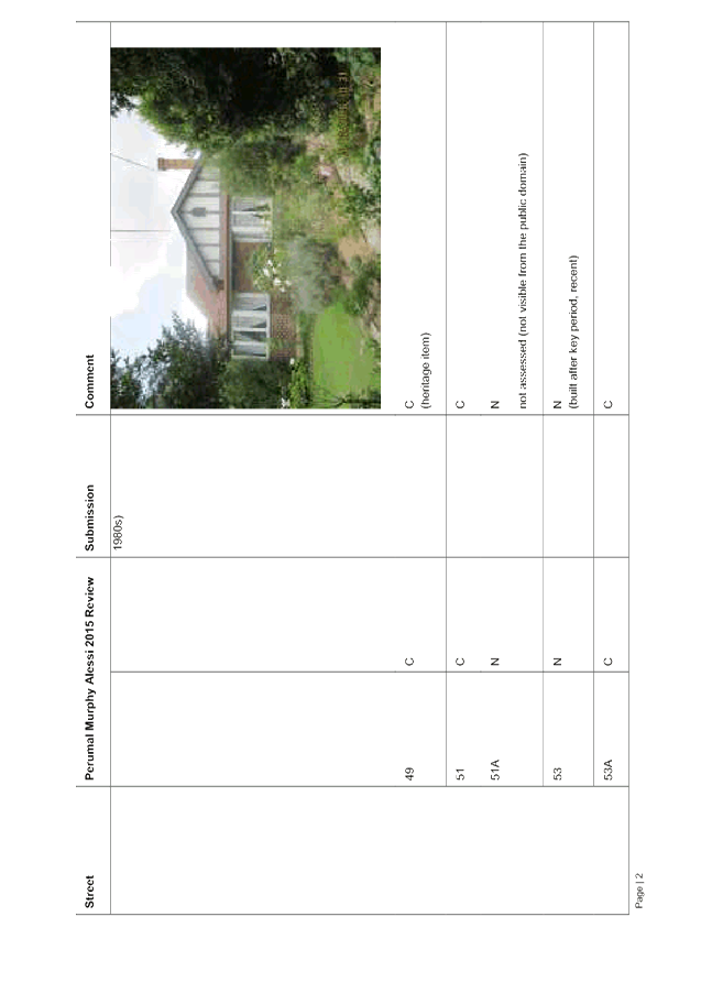
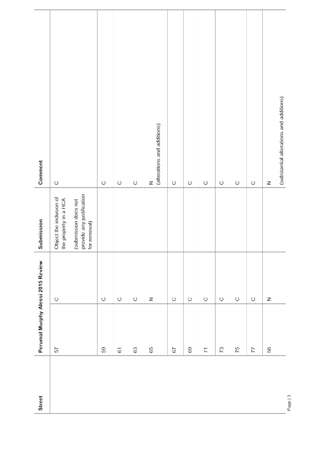
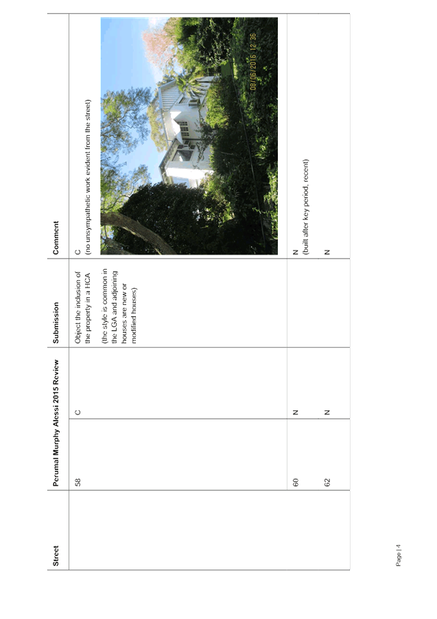
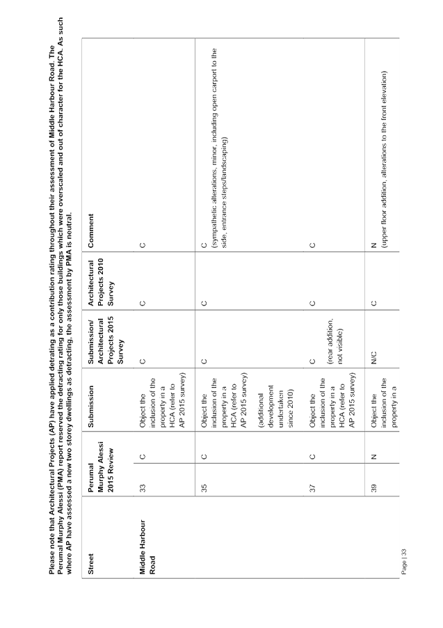
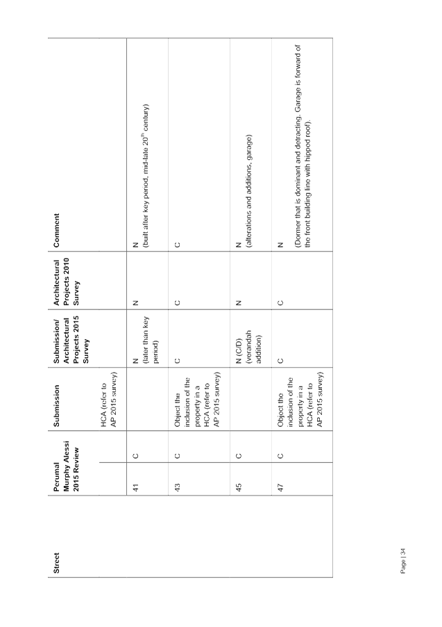
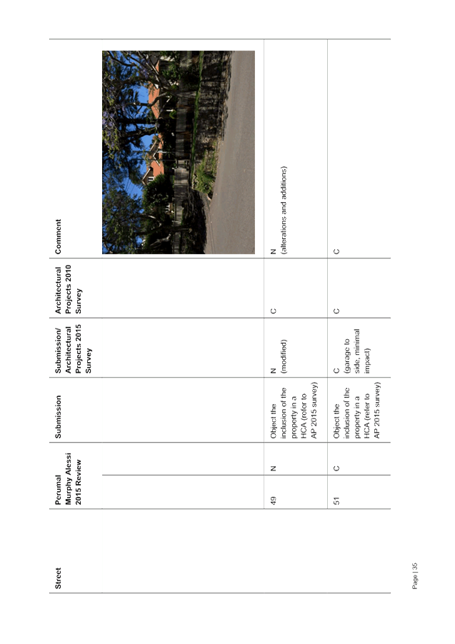
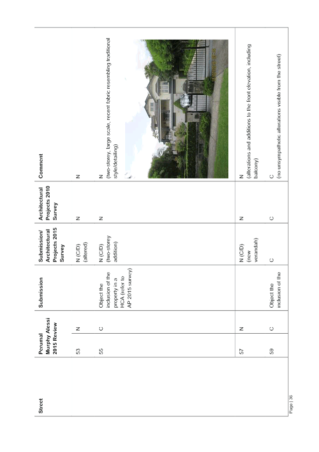
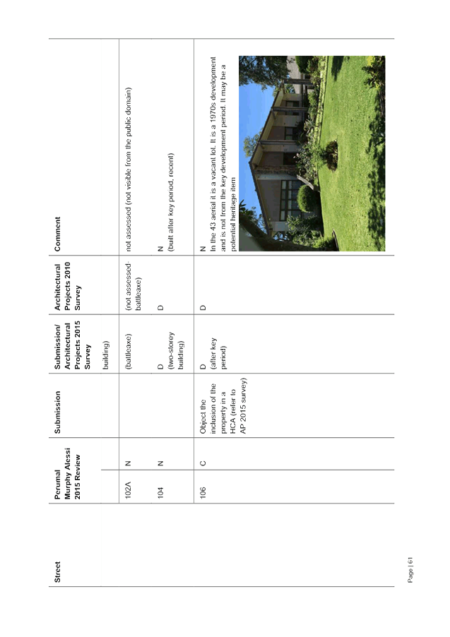
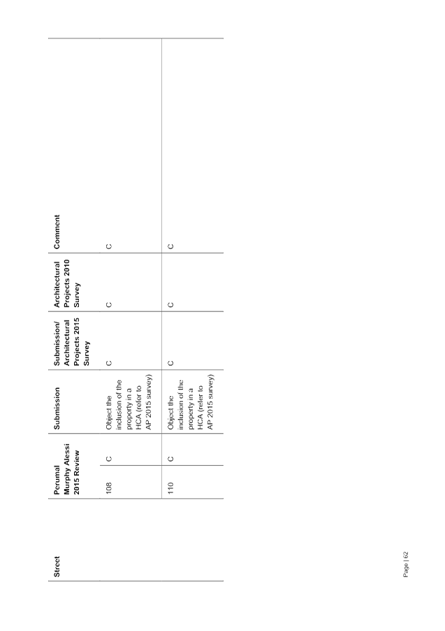
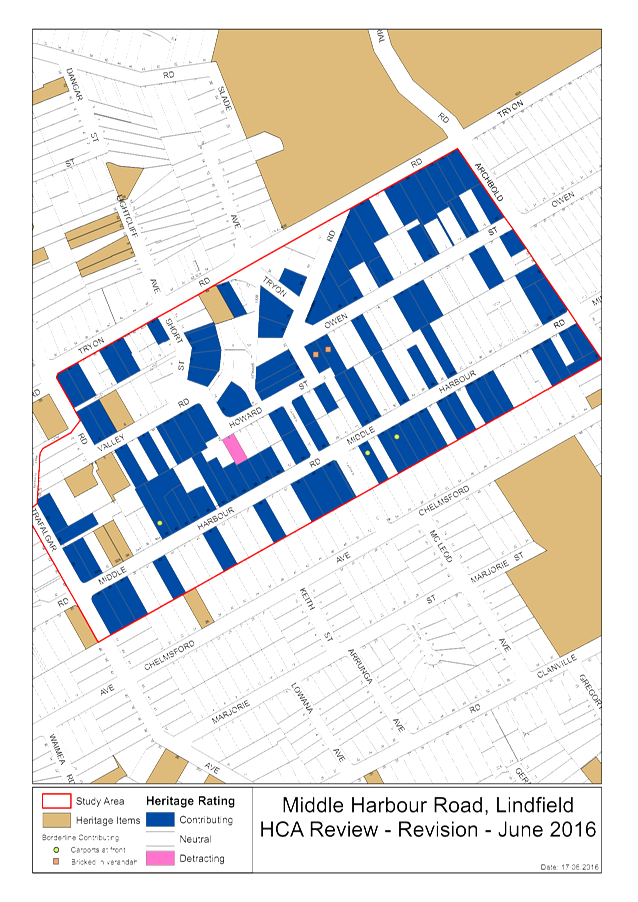
GB.7 Consideration of Submissions on the Non-Statutory Exhibition of the Middle Harbour Road, Lindfield - Potential Heritage Conservation Area Review 391
File: S10099
For Council to consider the comments received during the non-statutory exhibition of the Middle Harbour Road, Lindfield, Potential Heritage Conservation Area (HCA) Review, undertaken by Perumal Murphy Alessi Heritage Consultants (PMA).
Recommendation:
It is recommended a planning proposal be prepared and submitted to the Department of Planning and Environment for Gateway Determination to include Middle Harbour Road HCA in schedule 5 and on the Heritage Map of KLEP 2015
GB.8 202020 Vision - Council Partnership 506
File: S04601/8
To seek Council’s approval to become a partner organisation to the 202020 Vision campaign.
Recommendation:
That Council become a partner organisation to the 202020 Vision campaign.
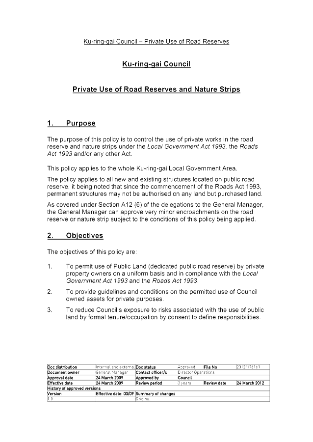
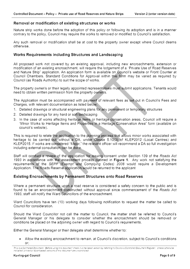
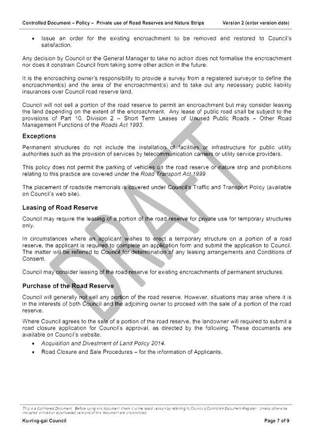
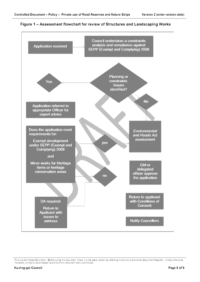
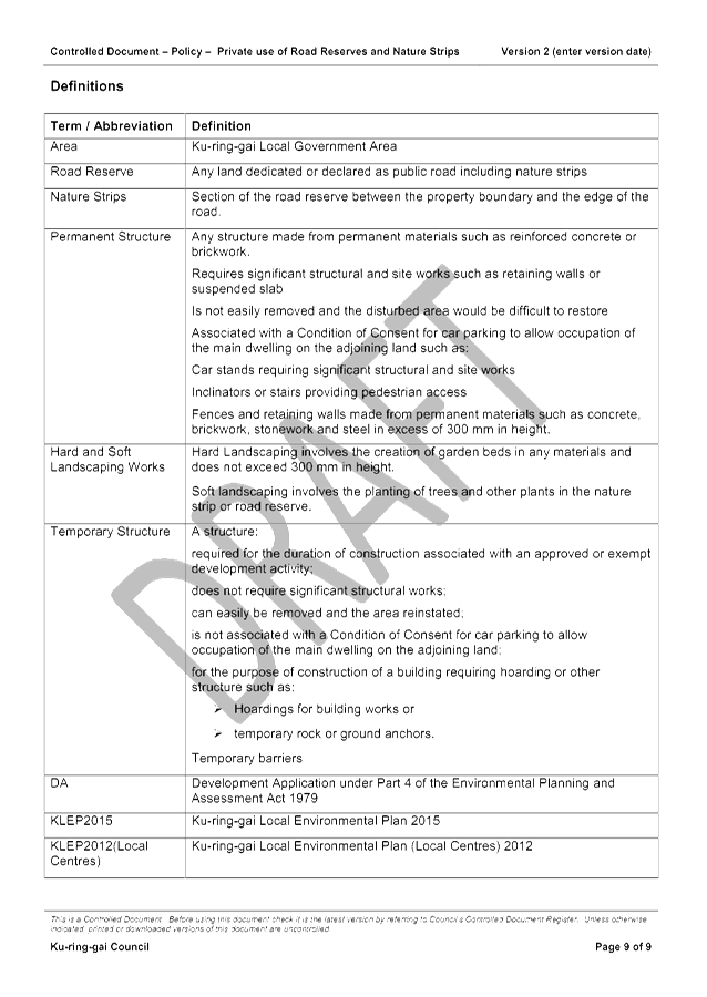
GB.9 Policy on Private Use of Road Reserves 512
File: S03467
For Council to adopt a review of the Private Use of Road Reserves and Nature Strips Policy.
Recommendation:
That Council adopt the review of the Private Use of Road Reserves and Nature Strips Policy.
GB.10 Tender T12-2016 - Roseville Chase Community Hall Roofing and Building Upgrades 543
File: S11018
To consider the tenders received for the undertaking of major roofing and building upgrades to the Roseville Chase Community Hall Roseville, and to appoint the preferred tenderer.
Recommendation:
In accordance with Section 55 of the Local Government Act and Tender Regulations, and following the request for tender, it is recommended that Council accepts the tender submitted by tender ‘A’.
GB.11 Tender RFT10-2016 - Golden Jubilee and Lofberg Playground Upgrades 549
File: S10800
To consider the tenders received for the construction/ upgrade of children’s playgrounds at Golden Jubilee and Lofberg, and appoint the preferred tenderer.
Recommendation:
In accordance with Section 55 of the Local Government Act and Tender Regulations, it is recommended that Council accept the tender submitted by Tenderer ‘A’.
Extra Reports Circulated to Meeting
BUSINESS WITHOUT NOTICE – SUBJECT TO CLAUSE 241 OF GENERAL REGULATIONS
Questions Without Notice
Inspections Committee – SETTING OF TIME, DATE AND RENDEZVOUS
** ** ** ** ** **
Minute Ku-ring-gai Council Page
MINUTES
OF Ordinary Meeting of Council
HELD ON Tuesday, 14 June 2016
|
Present: |
The Mayor, Councillor C Szatow (Chairperson) (Gordon Ward) Councillors E Malicki & J Pettett (Comenarra Ward) Councillor D Citer (Gordon Ward) Councillors C Berlioz & D Ossip (St Ives Ward) Councillors J Anderson (Roseville Ward) Councillors C Fornari-Orsmond & D McDonald (Wahroonga Ward) |
|
|
|
|
Staff Present: |
General Manager (John McKee) Director Corporate (David Marshall) Director Development & Regulation (Michael Miocic) Director Operations (Greg Piconi) Director Strategy & Environment (Andrew Watson) Director Community (Janice Bevan) Corporate Lawyer (Jamie Taylor) Manager Records and Governance (Amber Moloney) Minutes Secretary (Christine Dunand) Minutes Secretary (Sandy Ryrie) |
|
|
|
|
Others Present: |
Manager Urban & Heritage Planning (Antony Fabbro) Manager Finance (Angela Apostol)
|
The Meeting commenced at 7:00 pm
The Mayor offered the Prayer
|
117 |
Apologies
File: S02194
Councillor Armstrong tendered an apology for non-attendance (ill health) and requested leave of absence.
|
|
|
Resolved:
(Moved: Councillors Berlioz/McDonald)
That the apology for Councillor Armstrong be accepted and leave of absence granted. CARRIED UNANIMOUSLY |
DECLARATIONS OF INTEREST
The Mayor adverted to the necessity for Councillors and staff to declare a Pecuniary Interest/Conflict of Interest in any item on the Business Paper.
No Interest was declared.
|
118 |
CONFIRMATION OF REPORTS TO BE CONSIDERED IN CLOSED MEETING
File: S02499/9
|
|
|
Resolved:
(Moved: Councillors Berlioz/McDonald)
That in accordance with the provisions of Section 10 of the Local Government Act 1993, all officers’ reports be released to the press and public, with the exception of:
Refer C.1 Optus Mobile Pty Ltd - Renewal of lease and licence for telecommunications facility at Warrimoo Oval
Attachment A1 Site plan - Telecommunications facility at Warrimoo Oval and Optus lease area Attachment A2 Confidential Heads of Agreement between Ku-ring-gai Council and Optus Mobile Pty - Warrimoo Oval In accordance with s10A(2)(d)
Refer C.2 Provision for Doubtful Debt of Hutchison 3G Australia Ltd Attachment A1 Letter from Council to Hutchison 3G In accordance with s10A(2)(d) and s10A(2)(g)
CARRIED UNANIMOUSLY |
Address the Council
The following member(s) of the public address Council on items not on the agenda:
G Hosier Democracy in Local Government
J Harwood Biodiversity
DOCUMENTS CIRCULATED TO COUNCILLORS
The Mayor adverted to the documents circulated in the Councillors’ papers and advised that the following matters would be dealt with at the appropriate time during the meeting:
|
Late Items: |
MM.1 International Reporting Award for Ku-ring-gai Council Report by Mayor 14 June 2016 MM.2 Queen's Birthday Honours 2016 Report by Mayor dated 14 June 2016 GB.13 Consideration of Submissions - Ku-ring-gai Development Control Plan and Ku-ring-gai Local Centres Development Control Plan Review Report by Manager Urban & Heritage Planning dated 27 May 2016 with attachments. GB.14 Proposed Special Resolution Regarding Amending the NSROC Constitution Report by Director Corporate dated 10 June 2016 an attachment. |
|
Councillors Information: |
QWN Code of Conduct Matter Memo from Director Operations dated 2 June 2016 responding to a Question without Notice from Councillor Citer regarding a Code of Conduct matter. GB.5 St Ives Village Green – New Recreation Precinct Memo from Director Strategy & Environment dated 7 June 2016 with A3 copies of Attachment A1 to the report (hard copy given to Councillors) GB.13 Consideration of Submissions – Ku-ring-gai DCP and Ku-ring-gai Local Centres DCP Review Memo from Director Strategy & Environment dated 7 June 2016 advising that attachments A4 and A5 to the report have been provided to Councillors on a CD. GB.5 St Ives Village Green – New Recreation Precinct Memo from Director Strategy & Environment dated 10 June 2016 with enclosed indicative 3D renders of the St Ives Village Green – New Recreation Precinct to assist with understanding of the project. |
|
Late Councillor Information |
GB.13 Consideration of Submissions – Ku-ring-gai DCP and Ku-ring-gai Local Centres DCP Review Memo from Director Strategy & Environment dated 14 June 2016 advising an additional part E. to the recommendation. GB.13 Consideration of Submissions – Ku-ring-gai DCP and Ku-ring-gai Local Centres DCP Review Memo from Manager Urban Planning and Heritage dated 14 June 2016 advising additional parts F. and G. to the recommendation. |
Councillor Ossip withdrew during discussion
CONFIRMATION OF MINUTEs
|
119 |
Minutes of Ordinary Meeting of Council File: S02131
|
|
|
Meeting held 24 May 2016 Minutes numbered 100 to 116
|
|
|
Resolved:
(Moved: Councillors Berlioz/Malicki)
That Minutes numbered 100 to 116 circulated to Councillors were taken as read and confirmed as an accurate record of the proceedings of the Meeting.
CARRIED UNANIMOUSLY |
Councillor Ossip returned
minutes from the Mayor
|
120 |
Queen's Birthday Honours 2016
File: S02767 Vide: MM.2
|
|
|
I am pleased to inform you that 10 Ku-ring-gai citizens, through their outstanding achievements and services to the community, have been awarded 2016 Queen’s Birthday Honours.
We are very proud to have these dedicated and talented Australians as members of the Ku-ring-gai community.
I would like to read to you the names of these special Ku-ring-gai citizens and, on behalf of Council, congratulate them on their excellent contributions to Australian society.
Richard Allan BRYANT AC of East Killara, for eminent service to medical research in the field of psychotraumatology, as a psychologist and author, to the study of Indigenous mental health, as an advisor to a range of government and international organisations, and to professional societies
Ronald David DYER OAM of Wahroonga, for service to the people and Parliament of New South Wales
Margot Louise LANDER OAM of Warrawee, for service to the community of Ku-ring-gai
Nyunggai Warren MUNDINE AO of Roseville Chase, for distinguished service to the community as a leader in Indigenous affairs and advocate for enhancing economic and social public policy outcomes for Aboriginal and Torres Straits Islander people
Maithri Hemachandra PANAGODA AM of St Ives, for significant service to the Sri Lankan community in New South Wales, and to the law, particularly in litigation and dispute resolution
Anne Miriam ROBINSON AM of Roseville, for significant service to the community through regulatory and governance reform in the not-for-profit and charitable sectors, and to the law
Maree Carol RYAN AM of North Turramurra, for significant service to music as a classical mezzo-soprano, and to music education through roles as a teacher, mentor and researcher
Maria Teresa SAVIO HOOKE OAM of Killara, for service to psychoanalysis through roles with professional organisations
David Maxwell SCARLETT OAM of Killara, for service to the law, and to the community
Iven Hunter YOUNG AM of St Ives, for significant service to respiratory and sleep medicine as a clinician, administrator, researcher and mentor, and to professional societies.
On behalf of Council, I congratulate all these award winners on their outstanding achievements.
Ku-ring-gai should be proud that it has so many citizens being recognised at the highest levels for their selfless dedication, commitment and contribution to local, national and international communities.
|
|
|
Resolved:
A. That Council acknowledge the outstanding contribution made by these recipients of 2016 Queen’s Birthday Honours to the Ku-ring-gai community and to the well-being of our society.
B. That the Mayor, on behalf of Council, write to the recipients to congratulate them.
CARRIED UNANIMOUSLY |
|
121 |
International Reporting Award for Ku-ring-gai Council
File: S07209/2 Vide: MM.1
|
|
|
I am delighted to announce that the Council has won a gold award in the government reporting category of the 2016 Australasian Annual Reporting Awards. This is the second gold award in two years that Ku-ring-gai Council has won, and was awarded for the 2014-2015 annual report.
The Awards are hosted each year by Australasian Reporting Awards Limited, an independent not-for-profit organisation supported by volunteer professionals from the business community and professional bodies concerned about the quality of financial and business reporting.
Each year the Awards attract hundreds of entries from organisations and businesses across Australia, New Zealand and South East Asia. The Awards provide an opportunity for organisations to benchmark their annual reports against internationally recognised criteria and for our part, I am particularly pleased that our Council has been able to demonstrate a philosophy of continuous improvement in the compilation of our report.
An annual report is the most objective benchmark of how an organisation is travelling in terms of its overall performance and communication with its stakeholders. I believe our award-winning report demonstrates two key things; adherence to the NSW Government’s guidelines of transparency and openness in local government annual reporting and secondly, consistency and timeliness.
NSW councils are required to prepare and submit their annual reports to the state government by the end of November each year. I am proud to say that we have never missed that deadline. In this we are aided by the speedy and efficient preparation of the annual accounts by the Council’s finance team.
This award also demonstrates that, despite the turmoil created by the prospect of a forced merger with Hornsby Council, our council continues to demonstrate excellence in all areas of service. I commend the staff involved in the preparation of the 2014-2015 annual report and I encourage ratepayers and the public to view the report on our website at kmc.nsw.gov.au/annualreport
|
|
|
Resolved:
That the Mayoral Minute be received and noted.
CARRIED UNANIMOUSLY |
GENERAL BUSINESS
|
122 |
Revised Delivery Program 2013-2017 and Operational Plan 2016-2017 - Post Exhibition
File: FY00382/8 Vide: GB.1
|
|
|
For Council to adopt the revised Delivery Program 2013 – 2017 and Operational Plan 2016 – 2017, incorporating the Budget, Capital Works Program, Statement of Revenue Policy and Fees and Charges for 2016 – 2017.
|
|
|
Resolved:
(Moved: Councillors Malicki/McDonald)
A. That Council adopts the revised Delivery Program 2013 - 2017 and Operational Plan 2016 - 2017, incorporating the Budget, Capital Works Program, Statement of Revenue Policy and Fees and Charges for 2016 - 2017.
B. That an ordinary rate in the dollar of $0.00090331 on the unimproved capital value of all rateable land categorised as residential in the Council area be made for the period of 1 July 2016 to 30 June 2017.
C. That an ordinary rate in the dollar of $0.00585944 on the unimproved capital value of all rateable land categorised as business in the Council area be made for the period of 1 July 2016 to 30 June 2017.
D. That the minimum ordinary rate for both residential and business be set at $506.00 for the period 1 July 2016 to 30 June 2017.
E. That an infrastructure - primary rate in the dollar of $0.00040683 on the unimproved capital value of all rateable land categorised as residential or business in the Council area, with a $265 base amount be made for the period of 1 July 2016 to 30 June 2017.
F. That an infrastructure special rate in the dollar of $0.00005394 on the unimproved capital value of all rateable land categorised as residential or business in the Council area, with a $30 base amount be made for the period of 1 July 2016 to 30 June 2017.
G. That an environmental special rate in the dollar of $0.00009724 on the unimproved capital value of all rateable land categorised as residential or business in the Council area, with a zero base amount, be made for the period of 1 July 2016 to 30 June 2017.
H. That the voluntary pensioner rebate be granted to all eligible pensioners as a flat percentage of 8.5% of total rates and charges in 2016 - 2017.
I. That Council transfer to the Infrastructure and Facilities Reserve the net annual income (gross income less maintenance expenses) from synthetic sportsfields for the purpose of future capital renewal and that projects for capital renewal of synthetic sportsfields be included in the LTFP when it is next reviewed.
J. That Council writes to all residents and groups that made submissions in relation to the Revised 2013 - 2017 Delivery Program and draft Operational Plan 2016 - 2017 and respond to the authors with the outcomes.
CARRIED UNANIMOUSLY |
|
123 |
Pymble Presbytery - Withdrawal of Offer to Lease - Smart School of Music and Art Pty Ltd
File: S10015 Vide: GB.2
|
|
|
For Council to consider the withdrawal of the lease offer to Smart School of Music and Art Pty Ltd for the Pymble Presbytery, located at 1188 Pacific Highway Pymble.
|
|
|
Resolved:
(Moved: Councillors Malicki/McDonald)
That Council not proceed with the leasing of the Pymble Presbytery, and that all previous approvals for direct lease negotiations with Smart School of Music and Art Pty Ltd be rescinded.
CARRIED UNANIMOUSLY |
|
124 |
Implementation of legislation to manage boat trailer parking
File: S04442 Vide: GB.3
|
|
|
To seek Council’s endorsement in applying to the Office of Local Government for permission to implement the Impounding Amendment (Unattended Boat Trailers) Act 2015
|
|
|
Resolved:
(Moved: Councillors Malicki/McDonald)
A. That Council applies to the Office of Local Government declaring Ku-ring-gai Council as an interested entity in implementing the Impounding Amendment (Unattended Boat Trailers) Act 2015. B. That Council consult with its community and all neighbouring councils regarding its intention to implement the legislation. C. That Council write to IPART bringing their attention to this cumbersome style of legislation implementation.
CARRIED UNANIMOUSLY |
|
125 |
90-92 Eton Road Lindfield - Extinguishment and relocation of Council stormwater drainage easement
File: CY00066/8 Vide: GB.4
|
|
|
To consider a request to relocate Council’s stormwater infrastructure and to extinguish an existing Council drainage easement over the subject property.
|
|
|
Resolved:
(Moved: Councillors Malicki/Berlioz)
A. That the General Manager or his delegate be authorised to negotiate Council’s requirements including compensation for the extinguishment of part of the existing easement J744469 at 10-12 Eaton Road, Lindfield over Lot 5 DP270770 and the relocation of replacement drainage infrastructure on another part of the property approved by Council.
B. That subject to the General Manager or his delegate completing negotiations on the basis set out in the report that Council grants approval for the extinguishment of part the existing easement.
C. That Council approves of a section 88B Instrument or similar instrument being created in favour of Council over part of the freehold location depicted in Attachment A1, for a new drainage easement subject to survey.
D. That Council authorises the Mayor and General Manager to affix the Common Seal of the Council to the instrument for the release of the easement and the creation of a new easement and execute all associated documentation.
E. That all costs associated with the extinguishment of part of the existing easement and the creation of a new easement in favour of Council, including legal and survey costs and all costs associated with the new drainage works be borne by the Applicant.
CARRIED UNANIMOUSLY |
|
126 |
Bush Fire Prone Land Mapping 2016
File: S06342/3 Vide: GB.6
|
|
|
To seek Council's approval to exhibit the draft 2016 Bush Fire Prone Land Map for the Ku-ring-gai Local Government Area (LGA).
|
|
|
Resolved:
(Moved: Councillors Malicki/McDonald)
A. That Council approves the public exhibition of the draft 2016 Bush Fire Prone Land Map.
B. That a further report be presented to Council following the public exhibition period outlining any changes and recommended amendments to the 2016 Bush Fire Prone Land Map for final endorsement.
CARRIED UNANIMOUSLY |
|
127 |
Draft Planning Agreement Policy - report following exhibition
File: S06198 Vide: GB.7
|
|
|
The purpose of this report is for Council to consider any submissions received during the public exhibition of the draft Ku-ring-gai Council Planning Agreement Policy 2016.
|
|
|
Resolved:
(Moved: Councillors Malicki/McDonald)
That Council adopts the draft Ku-ring-gai Planning Agreement Policy 2016.
CARRIED UNANIMOUSLY |
|
128 |
Contaminated Land Policy - Final
File: S02694 Vide: GB.8
|
|
|
For Council to adopt the exhibited Contaminated Land Policy 2016.
|
|
|
Resolved:
(Moved: Councillors Malicki/McDonald)
A. That Council adopts the Contaminated Land Policy 2016.
B. That a copy of the Contaminated Land Policy 2016 is placed on Council’s website.
CARRIED UNANIMOUSLY |
|
129 |
Ku-ring-gai Wildflower Garden Education Centre - Concept Plan
File: S10531 Vide: GB.9
|
|
|
To seek Council’s endorsement of the concept design plan for a cultural and environmental education centre at the Ku-ring-gai Wildflower Garden.
|
|
|
Resolved:
(Moved: Councillors Malicki/Berlioz)
A. That Council endorse the concept design plan for a cultural and environmental education centre at the Ku-ring-gai Wildflower Garden, in order for the project to progress to the detailed design and costing phase. B. That a final concept design plan and detailed cost estimate report is presented to Council for endorsement following the detailed design and costing phase. C. That a briefing be held for any interested Councillors prior to the report coming back to Council. CARRIED UNANIMOUSLY
|
|
130 |
Draft Environmental Policies and Strategy for Public Exhibition
File: S09069/6 Vide: GB.10
|
|
|
To seek Council’s endorsement of the Draft Bushland Dumping and Encroachment Policy 2016, Draft Fauna Management Policy 2016, Draft Biodiversity Policy 2016, Draft Water Sensitive City Policy 2016 and Draft Climate Change Adaptation Strategy 2016 for public exhibition.
|
|
|
Resolved:
(Moved: Councillors Malicki/McDonald)
A. That Council endorses the Draft Bushland Dumping and Encroachment Policy 2016 for public exhibition.
B. That Council endorses the Draft Fauna Management Policy 2016 for public exhibition.
C. That Council endorses the Draft Biodiversity Policy 2016 for public exhibition.
D. That Council endorses the Draft Water Sensitive City Policy 2016 for public exhibition.
E. That Council endorses the Draft Climate Change Adaptation Strategy 2016 for public exhibition.
F. That following the close of the public exhibition / consultation period a report be brought back to Council to consider any submissions received for these policies and strategy.
CARRIED UNANIMOUSLY |
|
131 |
Creation of Biobanking sites within Natural Areas for the purpose of offsetting NorthConnex
File: S06758 Vide: GB.12
|
|
|
To seek Council’s endorsement for the creation of Biobanking sites on Council land currently managed as Natural Areas under the NSW Local Government Act 1993, through offsetting requirements of the NorthConnex project.
|
|
|
Resolved:
(Moved: Councillors Malicki/McDonald)
A. That Council enters into a Memorandum of Understanding with Lend Lease in relation to a proposed Biobanking Agreement/s under Part 7A of the Threatened Species Conservation Act 1995 for suitable Natural Area site/s, if deemed appropriate.
B. That Council authorises the Mayor and General Manager to execute all documentation in relation to the Memorandum of Understanding with Lend Lease in relation to a proposed Biobanking Agreement/s, should the MoU proceed.
C. That Council authorises the Mayor and General Manager to execute all documentation in relation to the proposed Biobanking Agreement/s, should the MoU proceed.
CARRIED UNANIMOUSLY |
|
132 |
Consideration of Submissions - Ku-ring-gai Development Control Plan and Ku-ring-gai Local Centres Development Control Plan Review
File: S11037 Vide: GB.13
|
|
|
To have Council consider amendments made to the draft Ku-ring-gai Development Control Plan and the draft Ku-ring-gai Local Centres Development Control Plan arising from public exhibition.
|
|
|
Resolved:
(Moved: Councillors Malicki/McDonald)
A. That Council adopts the Ku-ring-gai Development Control Plan and the Ku-ring-gai Local Centres Development Control Plan.
B. That the Ku-ring-gai Development Control Plan and the Ku-ring-gai Local Centres Development Control Plan come into effect immediately upon the notification of advertisement of adoption by Council in the local press.
C. That the Director of Strategy and Environment be given delegation to approve the amendment of minor inconsistencies and errors in the Ku-ring-gai Development Control Plan and the Ku-ring-gai Local Centres Development Control Plan following adoption.
D. That the adopted Ku-ring-gai Development Control Plan and the Ku-ring-gai Local Centres Development Control Plan be forwarded to the Department of Infrastructure and Planning in accordance with the Environmental Planning and Assessment Regulation 2000.
E. That Part 6 Multi- dwelling Housing – Part 6A.6 Deep Soil Landscaping be amended to read Multi-dwelling housing development is to have a minimum deep soil landscaping area of 40% of the site area provided within common areas only.
F. That the Ku-ring-gai Local Centres Development Control Plan be amended to read as follows: Part 1A Preliminary – Part 1A.5 General aims of the DCP The general aims of this DCP are as follows: i) Establish a future character for Ku-ring-gai’s Local Centres, and ensures that a development across the Local Government Area positively contributes to the existing character. G. That the Ku-ring-gai Development Control Plan be amended to read as follows: Part 1A Preliminary –Part 1A.5 General aims of the DCP The General aims of this DCP are as follows: i) Establish a future character for Ku-ring-gai, and ensure that development across the Local Government Area positively contributes to the existing character of the residential areas. CARRIED UNANIMOUSLY |
|
133 |
Optus Mobile Pty Ltd - Renewal of lease and licence for telecommunications facility at Warrimoo Oval
File: S02297/9 Vide: C.1
|
|
|
In accordance with the Local Government Act 1993 and the Local Government (General) Regulation 2005, in the opinion of the General Manager, the following business is of a kind as referred to in section 10A(2)(d)(ii), of the Act, and should be dealt with in a part of the meeting closed to the public.
Section 10A(2)(d) of the Act permits the meeting to be closed to the public for business relating to commercial information of a confidential nature that would, if disclosed:
(i) prejudice the commercial position of the person who supplied it, or (ii) confer a commercial advantage on a competitor of Council, or (iii) reveal a trade secret.
This matter is classified confidential under section 10A(2)(d)(ii) because it would confer a commercial advantage on a competitor of the Council.
Report by Director Strategy & Environment dated 23 May 2016
|
|
|
Resolved:
(Moved: Councillors Malicki/McDonald)
A. That Council grants a lease and licence to Optus Mobile Pty Ltd over a portion of Warrimoo Oval for the installation of a low impact telecommunication facility on the terms set out in the confidential Heads of Agreement including the tenure period and the market rent.
B. That Council undertake Public Notification as prescribed by section 47 of the Local Government Act 1993.
C. That Council authorises the Mayor and General Manager to sign all documentation associated with the lease and licence.
D. That the Council Seal be affixed to the lease and licence.
CARRIED UNANIMOUSLY |
Motions of which due Notice has been given
|
134 |
Centenary of the Battle of Pozieres
File: S10661 Vide: NM.1
|
|
|
Notice of Motion from Councillor Anderson dated 2 June 2016
The Centenary Commemorative Service of the Battle of Pozières will be held in Pozières, France on Saturday, 23rd July 2016.
The French village of Pozières was the site of a major battle during the First World War, which involved Ku-ring-gai’s 18th Battalion. Between the 23rd July 1916 and 3rd September 1916 Australia suffered 23,000 casualties and more than 6,700 deaths there. Australia’s official WWI historian, Ku-ring-gai resident, Charles W. Bean, wrote that the Pozières Ridge “is more densely sown with Australian sacrifice than any other place on earth”. It is the final resting place of many of Ku-ring-gai’s young men.
The historic link between Pozières and Ku-ring-gai was officially recognised with a Sister City Agreement in June 2014.
It was my great honour to visit Pozières in July 2015 during a personal trip to England and France, and whilst there, to attend the ninety-ninth Commemoration of the Battle of Pozières. Along side the Mayor of Pozières, Monsieur Bernard Delattre, and Australian Government and Armed Forces officials, I laid a floral tribute on behalf of the Council and People of Ku-ring-gai. I was approached numerous times by Ku-ring-gai residents who were visiting Pozières and the battlefields of The Somme at the time. Without exception, they expressed their pleasure at Ku-ring-gai continuing to honour its ties with Pozières.
Thousands more Australians will be visiting Pozières this year for the Centenary Commemoration of the Battle, including representatives from St John’s Church Gordon, which houses the Pozières Cross, a relic from the battlefield. I am aware the Mayor is officially farewelling that group here at Council Chambers.
The Centenary Commemoration in Pozières is an opportunity for our Council to further strengthen our Sister City relationship with Pozières in remembrance of the sacrifice of thousands and as a gesture of friendship for the future.
I move that: A. Ku-ring-gai Council arrange a floral tribute to be laid at the Centenary Commemoration of the Battle of Pozières in Pozières, France on Saturday, 23rd July 2016. B. Ku-ring-gai Council, with advice from the Ku-ring-gai Historical Society, prepare a suitably framed calligraphic Commemorative message marking the Centenary, to be gifted to the Pozières Council and the People of Pozières.
|
|
|
Resolved:
(Moved: Councillors Anderson/McDonald)
That the above Notice of Motion as printed be adopted.
CARRIED UNANIMOUSLY |
|
135 |
Ku-ring-gai Council’s submission to Eurobodalla Council regarding proposed Flying-fox dispersal
File: CY00416/4 Vide: NM.2
|
|
|
Notice of Motion from Councillor Anderson dated 2 June 2016
Ku-ring-gai Council officers have made a submission, dated 27/05/16, to Eurobodalla Council regarding the Bateman’s Bay Flying-Fox Dispersal Plan (Attachment 1).
The submission identifies potential impacts of the Plan within the Ku-ring-gai LGA and, accordingly, I believe it should be sent to relevant Members of Parliament to ensure they are directly made aware of the contents.
I move that:
A. A copy of the submission be sent to the Federal Minister for the Environment, Greg Hunt. B. A copy of the submission be sent to the Federal Member for Bradfield, Paul Fletcher. C. A copy of the submission be sent to the State Minister for the Environment, Mark Speakman. D. A copy of the submission be sent to the State MP for Ku-ring-gai, Alister Henskens, and the State MP for Davidson, Jonathan O’Dea. E. A copy of the submission be sent to Ku-ring-gai residents who have been liaising with Council officers over time in relation to significant bat activity locally.
|
|
|
Resolved:
(Moved: Councillors Anderson/McDonald)
That the above Notice of Motion as printed be adopted.
CARRIED UNANIMOUSLY |
Standing Orders were suspended to deal with items
where there are speakers first after a
Motion moved by Councillors McDonald and Berlioz
was CARRIED UNANIMOUSLY
|
136 |
St Ives Village Green - New Recreation Precinct
File: S07533 Vide: GB.5
|
|
|
To seek Council's endorsement of the final concept design for the new recreation precinct at St Ives Village Green. The following members of the public addressed Council on this item:
C Ghatt L Jones
|
|
|
Resolved:
(Moved: Councillors Berlioz/Ossip)
A. That Council endorses the final concept design for the new recreation precinct at St Ives Village Green.
B. That staff proceed with design development and the preparation of construction documentation including detailed plans, cost estimates and specifications for public tender.
C. That Council authorises the General Manager to allow minor changes to the concept plan during the design development process where budget or other constraints warrant amendments.
D. That provision of CCTV be considered further as part of the tender report to Council so that the cost benefit of this additional feature can be fully assessed.
CARRIED UNANIMOUSLY |
|
137 |
Consideration of Submissions on Planning Proposal to heritage list 27 Finlay Road, Warrawee
File: S11014 Vide: GB.11
|
|
|
For Council to consider the submissions received during the public exhibition of the Planning Proposal to heritage list 27 Finlay Road, Warrawee.
The following members of the public address Council on this item:
S Smith J Berwick
|
|
|
Resolved:
(Moved: Councillors Anderson/Berlioz)
A. That the Planning Proposal to list the property known as ‘Exley House’ at 27 Finlay Road, Warrawee as a local heritage item under the Ku-ring-gai Local Environmental Plan 2015 proceed without variation.
B. That Council proceeds to make the Plan, using its delegated authority, under Section 59(2) of the Environmental Planning & Assessment Act 1979.
C. That those who made submissions be notified of Council’s decision.
For the Resolution: The Mayor, Councillor Szatow, Councillors , Citer, McDonald, Berlioz and Anderson
Against the Resolution: Councillors Pettett, Malicki, Fornari-Orsmond and Ossip
|
|
138 |
Training for Mayor: Effective and Fair Meeting Procedures Course
File: FY00581 Vide: NM.3
|
|
|
Notice of Motion from Councillors Fornari-Orsmond, Pettett, Citer, Anderson and Ossip dated 6 June 2016
Council currently supports training programs for newly elected Mayors and Deputy Mayors to assist with personal development of leadership skills. With this in mind, further specific training for first term Mayors is important as they publicly chair the Ordinary Meetings of Council.
Local Government NSW provides training courses specifically designed for this type of development, namely Effective and Fair Meeting Procedures (Attachment 1: Course outline).
We move:
A. That
future first-term Mayors undertake training for chairing meetings, namely via
the LGNSW Course “Effective and Fair Meeting Procedure”, as soon
as practicable after the start of their term and that the costs thereof be
met by Council. B. That the current Mayor should attend the above course within the next two months, with the costs thereof met by Council.
The following members of the public addressed Council on this item:
C Smallbone J Kitson
|
|
|
Resolved:
(Moved: Councillors Fornari-Orsmond/Citer)
That the above Notice of Motion as printed be adopted.
CARRIED UNANIMOUSLY |
Councillor Ossip withdrew during discussion
Councillor Ossip returned
Councillor Citer withdrew during discussion
Councillor Citer returned
Councillor Ossip withdrew during discussion
Councillor Ossip returned
|
139 |
Proposed Special Resolution Regarding Amending the NSROC Constitution
File: CY00430/4 Vide: GB.14
|
|
|
To seek Council’s resolution regarding the proposed amendments to the NSROC Constitution, as well as its nomination of delegates to be Council’s representatives should Clause 5 of the NSROC Constitution come in to effect.
|
|
|
Resolved:
(Moved: Councillors Malicki/Berlioz)
That Council:
A. Endorse the proposed amendment to the Constitution of the Northern Sydney Regional Organisation of Councils and direct Ku-ring-gai Council representatives on the NSROC Board to support this decision at the Extraordinary NSROC Board meeting; and B. Retain the two (2) current delegates as Council’s representatives on the NSROC Board should Clause 5 of the NSROC Constitution come into effect.
For the Resolution: The Mayor, Councillor Szatow, Councillors , McDonald, Pettett, Malicki, Berlioz, Fornari-Orsmond and Ossip
Against the Resolution: Councillors Citer and Anderson
The above Resolution was subject to an Amendment which was LOST. The Lost Amendment was:
(Moved Councillors Anderson/Fornari-Orsmond)
That Ku-ring-gai Council endorse the amendment of the NSROC constitution to include 4(i)(h) and 4(ii)(a) only.
For the Resolution: Councillors Citer, Anderson, Fornari-Orsmond and Ossip
Against the Resolution: The Mayor, Councillor Szatow, Councillors McDonald, Pettett, Malicki and Berlioz
No decision was taken in respect of the above matter as the Motion when put to the vote was LOST
|
Council resolved
itself into Closed Meeting
with the Press and Public Excluded to deal with the following item
after a Motion moved by Councillors Malicki and Berlioz and was
CARRIED UNANIMOUSLY
|
140 |
Provision for Doubtful Debt of Hutchison 3G Australia Ltd
File: S05273 Vide: C.2
|
|
|
In accordance with the Local Government Act 1993 and the Local Government (General) Regulation 2005, in the opinion of the General Manager, the following business is of a kind as referred to in sections 10A(2)(d)(i) 10A(2)(d)(ii) & 10A(2)(g), of the Act, and should be dealt with in a part of the meeting closed to the public.
Section 10A(2)(d) of the Act permits the meeting to be closed to the public for business relating to commercial information of a confidential nature that would, if disclosed:
(i) prejudice the commercial position of the person who supplied it, or (ii) confer a commercial advantage on a competitor of Council, or (iii) reveal a trade secret.
This matter is classified confidential under section 10A(2)(d)(i) because it deals with tenders. Tender details, should they be revealed, may result in commercial disadvantage to parties involved in the tender process. Some information provided to Council by tenderers is provided on the basis that Council will treat it as commercial in confidence.
It is not in the public interest to reveal details of these tenders or the assessment process. Tenderers have provided sensitive information about their operations in the confidence that their details will not be made public by Council. The practice of publication of sensitive information provided by tenderers could result in the withholding of such information by tenderers and reduction in the provision of information relevant to Council’s decision.
Section 10A(2)(d) of the Act permits the meeting to be closed to the public for business relating to commercial information of a confidential nature that would, if disclosed:
(iv) prejudice the commercial position of the person who supplied it, or (v) confer a commercial advantage on a competitor of Council, or (vi) reveal a trade secret.
This matter is classified confidential under section 10A(2)(d)(ii) because it would confer a commercial advantage on a competitor of the Council.
Section 10A(2)(g) of the Act permits the meeting to be closed to the public for business relating to advice concerning litigation, or advice that would otherwise be privileged from production in legal proceedings on the ground of legal professional privilege.
This matter is classified confidential under section 10A(2)(g) because it contains advice concerning a legal matter that:
(a) is a substantial issue relating to a matter in which the Council is involved (b) is clearly identified in the advice, and (c) is fully discussed in that advice.
It is not in the public interest to release details of the legal advice as it would prejudice Council’s position in court proceedings.
Report by Director Corporate dated 6 June 2016
|
|
|
Resolved:
(Moved: Councillors Malicki/McDonald)
That Council writes-off doubtful debt of $103,605.59 for Hutchison 3G Australia Ltd account number 975026.
CARRIED UNANIMOUSLY |
Council resolved
to return to Open Council
after a Motion moved by Councillors Berlioz and Fornari-Orsmond
was CARRIED UNANIMOUSLY
The General Manager adverted to the consideration of the matter referred to in the Minute numbered 140, and to the resolution contained in such Minute.
The Meeting closed at 9.12 pm
The Minutes of the Ordinary Meeting of Council held on 14 June 2016 (Pages 1 - 28) were confirmed as a full and accurate record of proceedings on 28 June 2016.
__________________________ __________________________
General Manager Mayor / Chairperson
|
Ordinary Meeting of Council - 28 June 2016 |
PT.1 / 28 |
|
|
|
|
Item PT.1 |
RT1/08 |
|
|
20 June 2016 |
Petition
Gum Tree on North-Western Corner of Burgoyne Street and Pearson Avenue, Gordon
“We, the undersigned petition the Council to have the above-mentioned tree cut down and removed. (Eighteen (18) signatures).”
Over the last decade, and especially over the last few years, this tree has caused considerable damage to resident and passing cars [notably child care and commuter] [in Burgoyne Street], a power pole [in Burgoyne Street], Foxtel services [to 10 Pearson Avenue], electricity service wires [to three houses in Burgoyne Street and Pearson Avenue], and street lighting [in Burgoyne Street].
Last Saturday, a very big branch came down without any warning and crushed some mature native plants with a street care programme assigned to Richard Brady, a long time resident in Burgoyne Street. Half the road was obstructed. And on 27th February, 2016, a very big branch came down over Burgoyne Street, snapping a power pole into 2 and totally closing the road until police and emergency services arrived. These incidents, along with others, are on Council records.
Because the car park to the nearby pre-school in Park Avenue/Pearson Avenue is now inadequate, many mothers use this end of Burgoyne Street for casual parking before 9am and around 3pm. As do employees of Lifeline during the week. A not insignificant number have expressed their concern, especially when debris from the subject tree is all too often found lying on the road [or on car roofs].
We shouldn’t have to live in fear that a tree will, sooner or later, destroy a car or damage a house. Or worse, possible injure or kill somebody.
We ask that the Council address our concerns. The tree needs to be cut down and removed.
|
That the petition be received and referred to the appropriate Officer of Council for attention.
|
|
Ordinary Meeting of Council - 28 June 2016 |
GB.1 / 29 |
|
|
|
|
Item GB.1 |
S10214 |
|
|
16 June 2016 |
Annual Report on Contractual Conditions of Senior Staff 2015 / 2016
EXECUTIVE SUMMARY
Purpose of Report
To report on the contractual conditions of senior staff in accordance with section 339 of the Local Government Act 1993.
Background
Section 339 of the Local Government Act 1993 (the Act) states:
The General Manager must, at least once annually, report to Council on the contractual conditions of senior staff.
Comments
Section 339 of the Act requires the General Manager to report to Council annually on the contractual conditions of senior staff. The following five positions are identified as senior staff for this purpose:
|
Position |
Present Incumbent |
|
General Manager |
John McKee |
|
Director Community |
Janice Bevan |
|
Director Corporate |
David Marshall |
|
Director Development & Regulation |
Michael Miocic |
|
Director Operations |
Greg Piconi |
|
Director Strategy & Environment |
Andrew Watson |
Full contractual conditions for each of the above positions are contained in Confidential Attachment A1.
In accordance with the Act and the Local Government (General) Regulation 2005, in the opinion of the General Manager, the Attachment A1 relates to business of a kind referred to in Section 10A(2)(a), of the Act, and should be dealt with in a part of the meeting closed to the media and public.
Section 10A(2)(a) of the Act permits the meeting to be closed to the public for business relating to personnel matters concerning particular individuals (other than Councillors).
This report also confirms that five (5) Directors have had their performance assessments undertaken in a timely manner and that all Directors are considered to be performing at a satisfactory level or above. Additionally it is noted that the next round of performance assessments for the Directors are due to be completed between 1 July 2016 and 30 September 2016.
integrated planning and reporting
Leadership and Governance.
|
Community Strategic Plan Long Term Objective |
Delivery Program Term Achievement |
Operational Plan Task |
|
The organisation is recognised and distinguished by its ethical decision making, efficient management, innovation and quality customer service. |
Council’s governance framework is developed to ensure probity, transparency and the principles of sustainability are integrated and applied into our policies, plans, guidelines and decision making processes. |
Compliance with the Local Government Act and Regulations.
|
Governance Matters
This report is submitted for Council’s consideration in accordance with Section 339 of the Local Government Act 1993.
Risk Management
Nil.
Financial Considerations
Nil.
Social Considerations
Nil.
Environmental Considerations
Nil.
Community Consultation
None undertaken or required.
Internal Consultation
None undertaken or required.
Summary
This report provides Council with details regarding the contractual conditions of senior staff, as required by section 339 of the Local Government Act 1993.
|
That Council receive and note the report.
|
|
Amber Moloney Manager Records and Governance |
David Marshall Director Corporate |
|
Confidential - Annual Report on Contractual Conditions of Senior Staff 2015 / 2016 |
Excluded |
Confidential |
|
Ordinary Meeting of Council - 28 June 2016 |
GB.2 / 33 |
|
|
|
|
Item GB.2 |
S03158/2 |
|
|
15 June 2016 |
Mayor and Councillor Fees for 2016 / 2017 - Local Government Remuneration Tribunal Report and Determination
EXECUTIVE SUMMARY
|
purpose of report: |
To determine the mayor and councillor fees for the 2016/17 financial year.
|
|
|
|
|
background: |
Pursuant to section 241 of the Local Government Act 1993, the Local Government Remuneration Tribunal determines the minimum and maximum amount of fees to be paid to mayors and councillors of NSW councils. Section 248 of the Local Government Act 1993 requires that councils either fix an annual fee in accordance with the appropriate determination of the Remuneration Tribunal or pay the minimum fee determined by the Remuneration Tribunal. |
|
|
|
|
comments: |
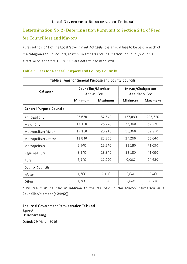
The Local Government Remuneration Tribunal has released its annual review of the minimum and maximum fees that apply to mayors and councillors for 2016/17 [Attachment A1]. The Tribunal has determined that mayor and councillor fees may be increased by no more than 2.5 per cent. |
|
|
|
|
recommendation: |
That effective 1 July 2016: the annual councillor fee be set at $18,840; and the annual mayoral fee to be set at $41,090, in addition to the Councillor fee.
|
Purpose of Report
To determine the mayor and councillor fees for the 2016/17 financial year.
Background
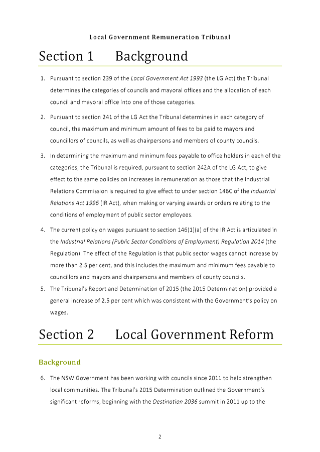
Pursuant to s.241 of the Local Government Act 1993 (the Act), the Local Government Remuneration Tribunal determines the minimum and maximum amount of fees to be paid to mayors and councillors of NSW councils. In accordance with s.239 of the Act, the Tribunal is also responsible for determining the categories of councils on which the mayor and councillor fee model is based.
S.248 of the Act requires that councils either fix an annual fee in accordance with the appropriate determination of the Remuneration Tribunal or pay the minimum fee determined by the Remuneration Tribunal.
Comments
The Local Government Remuneration Tribunal has released its annual review of the minimum and maximum fees that apply to mayors and councillors for 2016/17 [Attachment A1]. The Tribunal has determined that mayor and councillor fees may be increased by no more than 2.5 per cent from the 2015/16 minimum and maximum fees.
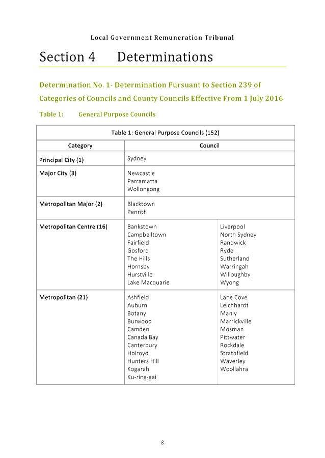
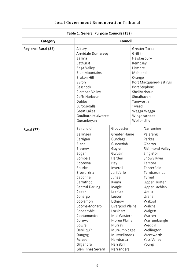
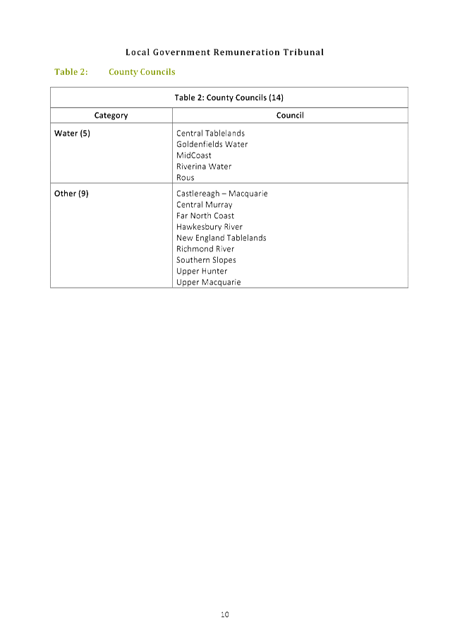
Ku-ring-gai Council is categorised as a Metropolitan Council under the Tribunal’s Determination of Categories of Council and County Councils effective from 1 July 2016, in accordance with s.239 of the Local Government Act 1993.
Pursuant to s.241 of the Act, the minimum and maximum fees for the Ku-ring-gai Council mayor and councillors have been determined as follows:
|
Category |
Councillor Annual Fee |
Mayor Additional Fee |
||
|
Minimum |
Maximum |
Minimum |
Maximum |
|
|
Metropolitan |
$8,540 |
$18,840 |
$18,180 |
$41,090 |
integrated planning and reporting
Leadership and Governance
|
Community Strategic Plan Long Term Objective |
Delivery Program Term Achievement |
Operational Plan Task |
|
The organisation is recognised and distinguished by its ethical decision making, efficient management, innovation and quality customer service. |
Council’s governance framework is developed to ensure probity, transparency and the principles of sustainability are integrated and applied into our policies, plans, guidelines and decision making processes. |
Compliance with the Local Government Act and Regulations.
|
Governance Matters
The Report and Determination of the Local Government Remuneration Tribunal is made in accordance with s.239 and s.241 of the Act.
S.248 of the Act requires that councils must either fix an annual fee in accordance with the appropriate determination of the Remuneration Tribunal or pay the minimum fee determined by the Remuneration Tribunal.
Risk Management
Should Council decide not to increase the annual fee payable to the mayor and councillors there is some risk that Council’s ability to attract candidates at local government elections could be impeded as a result of remuneration levels being below the maximum amount available as defined in the Report and Determination of the Tribunal.
Financial Considerations
An amount of $233,400 has been provided in the 2016/2017 budget for mayor and councillor fees. A total amount of $229,490 is required to fund the maximum permitted fees.
The Ku-ring-gai Council’s current annual fees are $18,380 for councillors and an additional $40,090 for the mayor.
Social Considerations
There are no social considerations associated with the recommendation in this report
Environmental Considerations
There are no environmental considerations associated with the recommendation in this report.
Community Consultation
None undertaken or required.
Internal Consultation
None undertaken or required.
Summary
Pursuant to section 241 of the Local Government Act 1993, the Local Government Remuneration Tribunal determines the minimum and maximum amount of fees to be paid to mayors and councillors of NSW councils.
Section 248 of the Local Government Act 1993 requires that Councils either fix an annual fee in accordance with the appropriate determination of the Remuneration Tribunal or pay the minimum fee determined by the Remuneration Tribunal.
The Local Government Remuneration Tribunal has released its annual review of the minimum and maximum fees that apply to mayors and councillors for 2016/17 [Attachment A1].
Pursuant to s.241 of the Act, the minimum and maximum fees for the Ku-ring-gai Council mayor and councillors have been determined as follows:
|
Category |
Councillor Annual Fee |
Mayor Additional Fee |
||
|
Minimum |
Maximum |
Minimum |
Maximum |
|
|
Metropolitan |
$8,540 |
$18,840 |
$18,180 |
$41,090 |
|
That effective 1 July 2016: A. the annual Councillor fee be set at $18,840; and B. the annual Mayoral fee to be set at $41,090, in addition to the Councillor fee.
|
|
Amber Moloney Manager Records and Governance |
David Marshall Director Corporate |
|
Local Government Remuneration Tribunal - Annual Report and Determination - 29 March 2016 |
|
2016/158812 |
|
APPENDIX No: 1 - Local Government Remuneration Tribunal - Annual Report and Determination - 29 March 2016 |
|
Item No: GB.2 |
|
Ordinary Meeting of Council - 28 June 2016 |
GB.3 / 49 |
|
|
|
|
Item GB.3 |
S05273 |
|
|
17 June 2016 |
Investment Report as at 31 May 2016
EXECUTIVE SUMMARY
|
purpose of report: |
To present Council’s investment portfolio performance for May 2016.
|
|
|
|
|
background: |
Council’s investments are reported monthly to Council in accordance with the Local Government Act 1993, the Local Government (General) Regulation 2005 and Council’s Investment Policy. |
|
|
|
|
comments: |
The net return on investments for the financial year to May 2016 was $3,712,000 against a revised budget of $3,461,000 giving a YTD favourable variance of $251,000. |
|
|
|
|
recommendation: |
That the summary of investments performance for May 2016 be received and noted; and that the Certificate of the Responsible Accounting Officer be noted and report adopted.
|
Purpose of Report
To present Council’s investment portfolio performance for May 2016.
Background
Council’s investments are reported monthly to Council in accordance with the Local Government Act 1993, the Local Government (General) Regulation 2005 and Council’s Investment Policy.
Comments
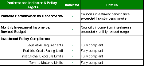
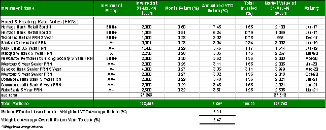
Investment Portfolio Performance Snapshot
The table below provides the investments portfolio performance against targets identified in Council’s Investment Policy as well as other key performance indicators based on industry benchmarks.
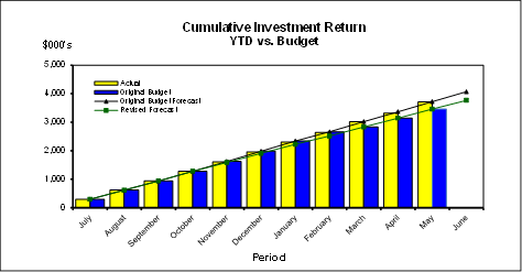
Cumulative Investment Returns against Revised Budget
The net return on investments for the financial year to May 2016 was $3,712,000 against a revised budget of $3,461,000 giving a YTD favourable variance of $251,000.
The total return on investments (interest and net capital gain) for the month of May is provided below.

A comparison of the cumulative investment returns against year to date revised budget is shown in the Chart below.
Cash Flow and Investment Movements
Council’s total cash and investment portfolio at the end of May 2016 was $128,459,000, compared to $125,723,000 at the end of April 2016, a net cash inflow of $2,736,000. The cash inflow was mainly due to the fourth instalment of rates income.
Two investments have matured in May 2016, one new investment was made during the month. Table 1 below provides detailed movements of investments by institution name, investment rating and interest rate.
Table 1 – Investment Movements – May 2016

Investment Performance against Industry Benchmarks
Overall during the month of May the investment performance was well above the industry benchmark. The benchmark is specific to the type of investment and the details are provided below.
Ø AusBond Bank Bill Index is used for all Council’s investments
A comparison of the portfolio returns against the investment benchmark is provided in Table 2 below.
Table 2 - Investments Performance against Industry Benchmarks

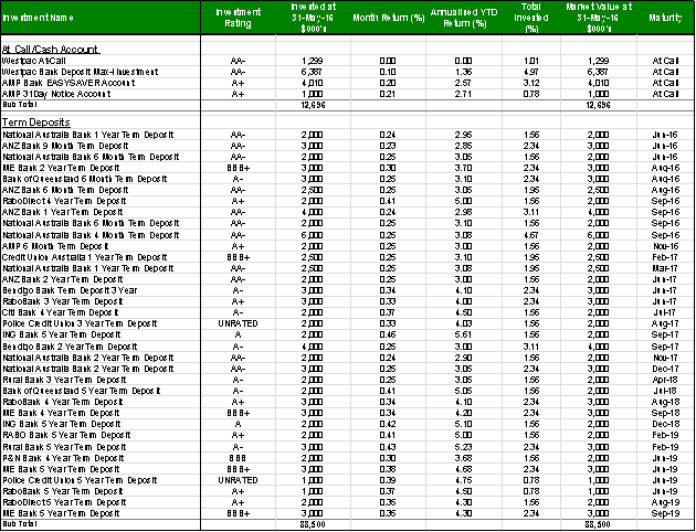
Table 3 below provides a summary of all investments by type and performance during the month.
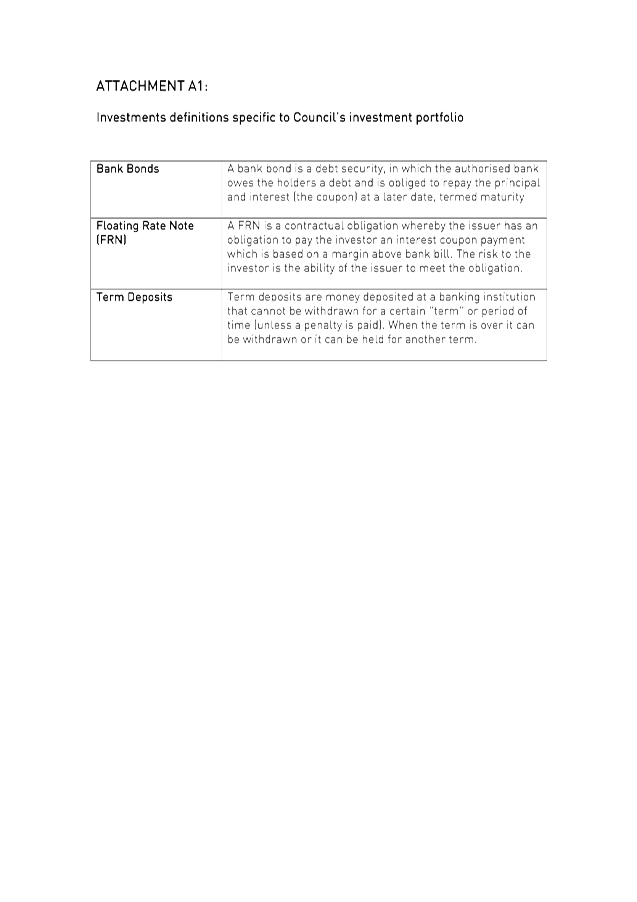
Attachment A1 provides definitions in relation to different types of investments.
Table 3 - Investments Portfolio Summary during May 2016
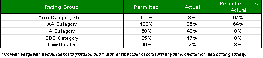
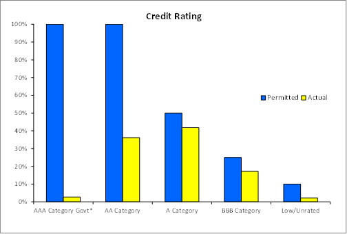
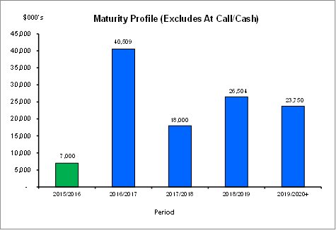
Investment by Credit rating and Maturity Profile
The allocation of Council’s investments by credit rating and the maturity profile are shown below:
integrated planning and reporting
Leadership & Governance
|
Community Strategic Plan Long Term Objective |
Delivery Program Term Achievement |
Operational Plan Task |
|
L2.1 Council rigorously manages its financial resources and assets to maximise delivery of services |
Council maintains and improves its long term financial position and performance |
Continue to analyse opportunities to expand the revenue base of Council |
FIT FOR THE FUTURE IMPROVEMENT ACTION PLAN
The NSW Government's Fit for the Future initiative required all councils to prepare an Improvement Proposal and supporting Implementation Plan demonstrating how all seven Fit for the Future benchmarks would be met by 2016/17, and maintained or improved thereafter.
Council's Fit For the Future Improvement Proposal and supporting Implementation Plan underpins the decision to stand alone and not merge with Hornsby Council. The objectives established in the Improvement Proposal and Implementation Plan are embedded in Council's adopted Integrated Planning and Reporting documents including the Revised Delivery Program 2013-2017 and Operational Plan 2015-2016, Long Term Financial Plan 2015/16 to 2024/25 and Asset Management Strategy 2015/16 to 2024/25.
|
SUSTAINABILITY |
|||||
|
Objective |
Action |
Timeframe |
Target |
Measure |
Link to Term Achievement |
|
Maintain a strong level of own source operating revenue |
Monitor Investments portfolio to maximise interest earnings |
Monthly |
Outperform Investments benchmark (UBS Bank Bill Index) |
Meet budget & investments benchmark |
L2.1.1 Council maintains and improves its long term financial position and performance |
Under Sustainability of the Improvement Action Plan, Council will monitor its investments portfolio on a monthly basis and aim to maximise the interest earnings. The target is to outperform the investment benchmark (AusBond Bank Bill Index) and meet the income revised budget. Council’s investments portfolio has exceeded the benchmark for the past three years.
Governance Matters
Council’s investments are made in accordance with the Local Government Act (1993), the Local Government (General) Regulation 2005 and Council’s Investment Policy.
A revised Investment Policy was adopted by Council on 10 December 2013.
Section 212 of the Local Government (General) Regulation 2005 states:
(1) The responsible accounting officer of a council:
(a) must provide the council with a written report (setting out details of all money that the council has invested under section 625 of the Act) to be presented:
(i) if only one ordinary meeting of the council is held in a month, at that meeting, or
(ii) if more than one such meeting is held in a month, at whichever of those meetings the council by resolution determines, and
(b) must include in the report a certificate as to whether or not the investment has been made in accordance with the Act, the regulations and the council’s investment policies.
(2) The report must be made up to the last day of the month immediately preceding the meeting.
Risk Management
Council manages the risk associated with investments by diversifying the types of investment, credit quality, counterparty exposure and term to maturity profile.
Council invests its funds in accordance with The Ministerial Investment Order.
All investments are made with consideration of advice from Council’s appointed investment advisor, CPG Research & Advisory.
Financial Considerations
The revised budget for interest on investments for the financial year 2015/2016 is $3,768,000. Of this amount approximately $2,605,000 is restricted for the benefit of future expenditure relating to development contributions, $687,400 transferred to the internally restricted Infrastructure & Facility Reserve, and the remainder of $475,600 is available for operations.
Social Considerations
Not applicable.
Environmental Considerations
Not applicable.
Community Consultation
None undertaken or required.
Internal Consultation
None undertaken or required.
Certification - Responsible Accounting Officer
I hereby certify that the investments listed in the attached report have been made in accordance with Section 625 of the Local Government Act 1993, clause 212 of the Local Government General Regulation 2005 and Council’s Investment Policy.
Summary
As at 31 May 2016:
· Council’s total cash and investment portfolio is $128,459,000.
· The net return on investments for the financial year to May 2016 was $3,712,000 against a revised budget of $3,461,000, giving a YTD favourable variance of $251,000.
|
A. That the summary of investments and performance for May 2016 be received and noted.
B. That the Certificate of the Responsible Accounting Officer be noted and the report adopted.
|
|
Tony Ly Financial Accounting Officer |
Angela Apostol Manager Finance |
|
David Marshall Director Corporate |
|
|
Investments definitions specific to Council’s investment portfolio |
|
2016/124274 |
|
Ordinary Meeting of Council - 28 June 2016 |
GB.4 / 58 |
|
|
|
|
Item GB.4 |
DA0073/16 |
|
|
14 June 2016 |
development application
Summary Sheet
|
Report title: |
17 Ancona Road & 25 Trentino Road, Turramurra - boundary adjustment between two lots and associated site works - DA0073/16 |
|
ITEM/AGENDA NO: |
GB.4 |
|
Application No: |
DA0073/16 |
|
Property Details: |
17 Ancona Road and 25 Trentino Road, Turramurra Lot & DP No: 134 & 135 DP 623002 Site area (m2): 4043.9m2 Zoning: R2 |
|
Ward: |
|
|
Proposal/Purpose: |
Boundary adjustment between 17 Ancona Road and 25 Trentino Road, Turramurra including associated site works
|
|
Type of Consent: |
Local |
|
Applicant: |
Glendinning Minto & Associates Pty Ltd |
|
Owner: |
M Webster & E Vickery |
|
Date Lodged: |
19 February 2016 |
|
Recommendation: |
Approval
|
integrated planning and reporting
Places, Spaces & Infrastructure
|
Community Strategic Plan Long Term Objective |
Delivery Program Term Achievement |
Operational Plan Task |
|
P2.1 A robust planning framework is in place to deliver quality design outcomes and maintain the identity and character of Ku-ring-gai |
Applications are assessed in accordance with State and local plans |
Assessments are of a high quality, accurate and consider all relevant legislative requirements |
Purpose of Report
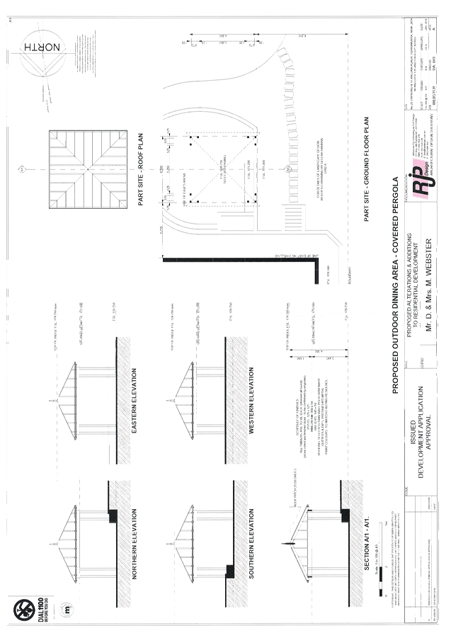
To determine Development Application No.0073/16 for an adjustment of the common boundary between 25 Trentino Road and 17 Ancona Road and ancillary site works, including the demolition of a tennis court, construction of a new gazebo and associated landscaping works. The matter is reported to Council for determination as the proposed technically constitutes subdivision of a heritage item.
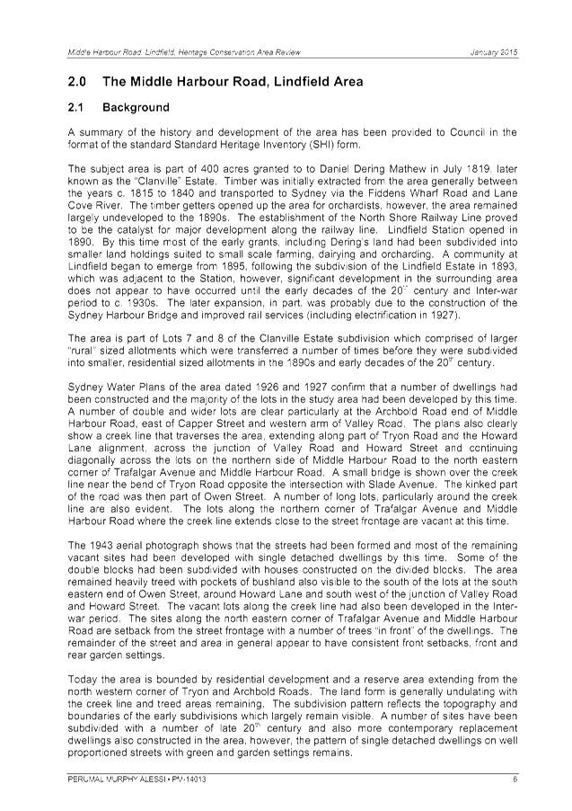
THE SITE AND SURROUNDING AREA
Site description
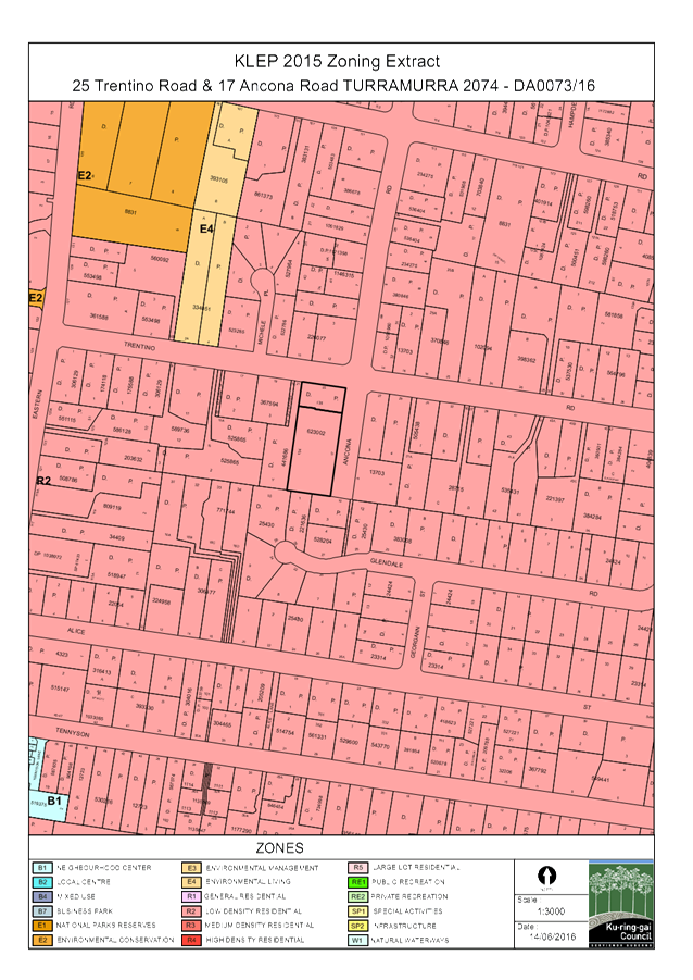
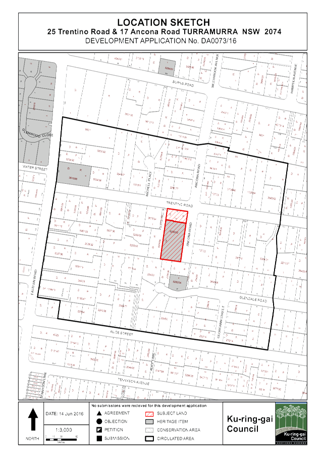
The two properties that comprise the development site are located on the south-western intersection of Trentino Road and Ancona Road.
Currently, 25 Trentino Road is a 929m2 allotment that contains a modest two storey dwelling, pool and landscaped gardens. No. 17 Ancona Road is heritage listed property, 3115m2 in area, that contains a ‘Tudor’ style dwelling, extensive cottage gardens and a tennis court that straddles the boundary with 25 Trentino Road. Both properties fall to the north towards Trentino Road, with the dwelling on 17 Ancona Road located on the highest point of the subject site.
A review of Council’s records indicates that 25 Trentino Road was subdivided from 17 Ancona Road in the early 1980’s, prior to the its heritage listing. Both properties remain in common (family) ownership.
Surrounding development
Surrounding development consists of large, contemporary dwelling houses on large allotments characterised by dense stands of trees. It is noted that the prevailing subdivision pattern is of a grid arrangement, with generally uniform allotment sizes, widths and depths.
Pre-DA
A Pre-DA consultation was undertaken on 25 September 2015. That consultation related to a 3 lot subdivision of a combined 17 Ancona and 25 Trentino Road rather than a boundary adjustment between the two existing properties, as currently proposed. Accordingly, the Pre DA is of little relevance to the assessment of this application.
DA history
|
19 February 2016 |
Application lodged. |
|
|
|
|
26 February 2016 |
The application was notified to owners of neighbouring properties for a period of 30 days. |
|
|
|
|
18 May 2016 |
A letter was sent to the applicant seeking additional information. |
|
|
|
|
30 May 2016 |
Amended plans received. |
|
|
|
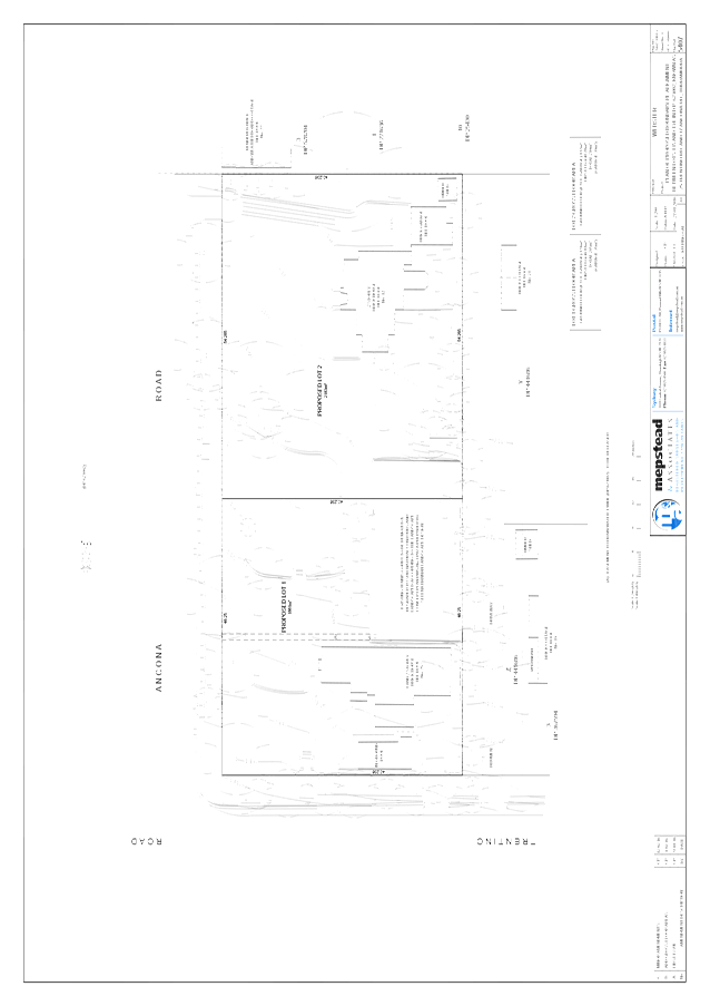
THE PROPOSAL
The proposal seeks consent for the adjustment of the common (northern) boundary between 25 Trentino Road and 17 Ancona Road, Turramurra. It is proposed to move the boundary 24m to the south, into 17 Ancona Road (the heritage listed property). In addition to the boundary adjustment, it is proposed to demolish the tennis court currently located on 17 Ancona Road and undertake new landscaping works in and around the area of the demolished tennis court, including the construction of a new gazebo on 25 Trentino Road.
CONSULTATION
Community
In accordance with the notification controls of the Ku-ring-gai Development Control Plan 2015, owners of surrounding properties were given notice of the application. No submissions were received.
Internal referrals
Heritage
Council's Heritage Advisor commented on the proposal as follows:
Heritage status
The property known as 17 Ancona Road is a heritage item in KLEP 2015. It is not located within a HCA. The item was listed in the former KPSO in 1989. The item is within the vicinity of a Heritage Item at No 27 Glendale Road. There is an item at No 127 Eastern Road, which is out of the immediate setting of the site.
Clause 5.10 (2) (f) of the KLEP requires development for consent subdividing land on which an item is located. Clause (4) of the KLEP 2015 requires that before granting consent to the proposed works Council must consider the effect of the works on the heritage item, nearby items or conservation area concerned. Clause 5.10 (5) allows Council to require a HIS before granting consent.
Statement of significance
The statement of significance held by Council is minimal and states:
Listed for architectural, municipal (local) significance and substantially intact.
Heritage management document
The application includes a well considered HIS prepared by a recognised heritage consultant. It is prepared in accordance with the NSW Heritage Office guidelines for such a document. It concludes:
· 17 Ancona Road, Turramurra, which forms part of the subject site , is listed as an item of local heritage significance in Schedule 5 of the KLEP 2015;
· the subject site is located in the vicinity of the listed heritage item at 27 Glendale Road, Turramurra;
· 17 Ancona Road was subdivided in 1982, with the current lot boundary curtilage established;
· the existing gardens on the northern part of the property do not contribute to the primary significance of 17 Ancona Road, which is the architectural and aesthetic qualities of the property.
· the heritage listed dwelling faces east-west, with the land proposed as garden space for 25 Trentino Road located to the side of the listed item’s grounds;
· the significance of the listed dwelling at 17 Ancona Road, and its ability to contribute to the streetscape will be retained;
· the proposed boundary adjustment will not have an adverse impact on the heritage significance of the nearby listed property at 27 Glendale Road; and
· the proposed development is consistent with the heritage requirements and guidelines of the KLEP 2015 and the KDCP.
The HIS recommends that Council should have no hesitation, from a heritage perspective, in approving the application and suggests a copy of the report be lodged in the local studies library.
The history in the report suggests that the heritage dwelling appears to be constructed by the noted architect John Brogan about 1941, but speculates that Brogan was not the designer and the building might have been copied from his 1935 pattern-book, “101 Australian Homes”. The dwelling is shown on the 1943 aerial photograph, located towards the southern end of its site with a lawn area close to the dwelling, with the bulk of the site treed. The report notes that, by 1970, the vegetation had been cleared and the tennis court and path system were in place.
The report states the second dwelling on the site was constructed in 1982 by John Brogan for the daughter of the Gee family. The garden spaces were shared by the family.
The HIS established the following statement of significance:
The property at 17 Ancona Road, Turramurra, contains a two storey Stockbroker Tudor residence designed in the style of John Brogan and constructed c1941-42. Its development formed part of the suburban consolidation of the area during the interwar period and the early 1940s, and reflects the pattern of subdivision and development in the first half of the twentieth century.
The building has significance at a local level as a good and relatively intact Stockbrokers Tudor dwelling, one of several in the Turramurra area. As such it is neither uncommon, rare or endangered in the LGA. It is a modest example of its type but features the key architectural details associated with the style.
The property is not associated with individuals or groups of significance in the local area. As the first building to be erected on the site, it is not expected to have high archaeological potential.
The report suggests the tennis court, 1950s garden landscaping and garden elements have little significance.
The report suggests the existing lot is an example of a reduced lot curtilage as it was subdivided in 1982 and developed after the main construction period.
With regard to the KDCP it states no direct comment is provided other than the above conclusions.
Controls
The Ku-ring-gai Development Control Plan 2015 Section 20A.2 provides objectives and controls for subdivision and site consolidation of a heritage item.
|
|
|
|
20A.2 Subdivision and site consolidation of a heritage item |
Complies |
|
1 Subdivision of a Heritage Item will only be supported where: i) the subdivision does not adversely affect the cultural significance of the Heritage Item; ii) evidence of the historical setting, landscape and subdivision pattern can be recognised and/or retained. |
Yes Yes |
|
2 Subdivision or consolidation will not generally be permitted where the curtilage and setting of a Heritage Item and significant buildings within or adjoining the site, would be compromised. Note: Applications for subdivision and site consolidation of a Heritage Item will require a curtilage analysis within the Heritage Impact Statement with particular emphasis on the potential impact on garden settings |
Yes
|
|
Partial demolition of a heritage item |
Complies |
|
3. In considering applications for partial demolition of a Heritage Item (including parts of a building and other structures, trees and landscape features), Council will assess: i) the significance of the building part or structure and/or landscape features and whether its retention is considered necessary; ii) its contribution to the significance of the Heritage Item as a whole; and iii) whether all alternatives to demolition have been considered with reasons provided as to why the alternatives are not acceptable. |
Yes
Yes No
|
|
Archival recordings |
Complies |
|
4. If development consent is granted for demolition of whole or part or all of a Heritage Item, Council may require an archival and photographic record of the building and grounds (in accordance with the NSW Heritage Branch guidelines) before and during works. |
No
|
Comments on DCP controls
whether all alternatives to demolition have been considered with reasons provided as to why the alternatives are not acceptable.
The application does not provide alternatives to the demolition of the tennis court and garden elements. It simply states they are later elements and of little significance.
It is considered that the tennis court is not essential to the dwelling’s heritage significance as if was constructed c1970 as demonstrated in the application. Considering this, there is no heritage reason why the tennis court or garden elements proposed to be removed cannot be demolished or removed.
If development consent is granted for demolition of whole or part or all of a Heritage Item, Council may require an archival and photographic record of the building and grounds (in accordance with the NSW Heritage Branch guidelines) before and during works.
No archival recording has been provided with this application. The application suggests that the HIS is sufficient to provide a recording of the site before the works commence.
Conclusion
The Proposed re-subdivision is considered acceptable from a heritage perspective provided archival recording of the grounds, including the tennis court, paths and garden elements is provided. A condition to this effect is recommended, Condition 7.
Landscaping
Council's Landscape and Tree Assessment Officer commented on the proposal as follows:
An arborist report prepared by Tristan Bradshaw dated 3/02/16 has been submitted with the application. Tree numbers refer to this report.
There are no significant trees indicated for removal as part of the proposal.
Trees to be retained
The removal and regrading of the tennis court has been considered in regard to potential impacts to the following six (6) existing trees located on the western boundary, within the adjoining property. It is understood from the report that the owner installed a root barrier along the southern and western sides of the tennis court, approximately 1 metre from the western boundary. Several roots of Trees 39 and 42 were exposed under the surface of the tennis court and the arborist considers that, as the majority of roots have been restricted by the root barrier, only the roots of Tree 42 will be subject to excavation and the impact is considered minor and satisfactory.
Tree 39/ Cedrus deodara (Himalayan Cedar)
Tree 40/ Macadamia tetraphylla (Macadamia)
Tree 41/ Fraxinus augustifolia (Narrow-leafed Ash)
Tree 42/ Jacaranda mimosifolia (Jacaranda)
Tree 43/ Acer palmatum (Japanese Maple)
Tree 44/ Quercus palustris (Pin Oak)
Several small trees adjacent to the tennis court are to be retained and protected (Trees 12 and 16). A mature conifer will require minor crown lifting to enable site access.
Landscape plan
The existing northern pedestrian path within the property at 17 Ancona Road is to be modified by condition to provide access to Ancona Road.
Stormwater
The proposal includes the release of an existing easement between the tennis court and Ancona Road to which there is no objection on landscape grounds.
Environmental site management plan
The proposed site access is via an existing gate off Ancona Road. An amended environmental site management plan has been provided.
Engineering
Council's Development Engineer commented on the proposal as follows:
For development engineering perspective, the proposal is equivalent to a subdivision, since the registration of the boundary adjustment is by means of a Subdivision Certificate.
Each dwelling and lot will continue to have gravity drainage to and vehicular access from a public road. Stormwater runoff from the new gazebo on No. 25 Trentino Road may be directed to the existing drainage system which drains to Trentino Road.
The existing tennis court and retaining walls located within 1m of the house on No. 25 Trentino Road will be demolished and replaced by landscaping. This will make the drainage easement redundant and it can be released as part of the issue and registration of the subdivision documents.
A Section 73 Certificate from Sydney Water will be required to confirm that each new lot will have legal sewer and water services, Condition 46.
STATUTORY PROVISIONS
State Environmental Planning Policy No. 55 – Remediation of Land
The provisions of SEPP 55 require Council to consider the potential for a site to be contaminated. The subject site has a history of residential use and as such, it is unlikely to contain any contamination and further investigation is not warranted in this case
Sydney Regional Environmental Plan No. 20 – Hawkesbury-Nepean River
SREP 20 applies to land within the catchment of the Hawkesbury Nepean River. The general aim of the plan is to ensure that development and future land uses within the catchment are considered in a regional context. The Plan includes strategies for the assessment of development in relation to water quality and quantity, scenic quality, aquaculture, recreation and tourism.
The proposed development achieves the relevant aims under this policy as water re-use will minimise the impact on downstream waterways.
Local Content
Ku-ring-gai LEP 2015
Zoning and permissibility:
The site is zoned Residential R2. The proposed development is defined as subdivision, which is a permissible form of development within the residential zone.
R2 zone objectives:
· To provide for the housing needs of the community within a low density residential environment.
· To enable other land uses that provides facilities or services to meet the day to day needs of the residents.
· To provide for housing that is compatible with the existing environmental and built character of Ku-ring-gai.
The development:
· Maintains the low density character of the locality; and
· Maintains the existing environmental and built form character of the immediate area and that of Ku-ring-gai in general.
The proposed development therefore upholds the zone objectives.
Development standards:
|
Development standard |
Proposed |
Complies |
|
Height of buildings: Max 9.5m |
Lot 1: 8.96m Lot 2: 9m |
YES YES |
|
Floor space ratio (FSR): 0.3:1 |
Lot 1: 0.1:1 Lot 2: 0.096:1 |
YES YES |
|
Minimum subdivision lot size: 930sqm |
Lot 1: 1861sqm Lot 2: 2183sqm |
YES YES |
Part 5 Miscellaneous provisions
Clause 5.9 – Preservation of trees or vegetation
Council’s Tree and Landscape Assessment Officer is satisfied that the proposed development will not unduly impact upon any existing significant trees or vegetation, subject to
Conditions 9 - 13 .
Clause 5.10 – Heritage conservation
Council’s Heritage Advisor has considered the development and is satisfied that the proposal has a satisfactory heritage impact, consistent with the discussions elsewhere in this report.
Part 6 Additional local provisions
Clause 6.2 – Earthworks
The proposed development will not restrict the existing or future use of the site, adversely impact on neighbouring amenity, the quality of the water table or disturb any known relics. Additionally, the fill to be removed will be disposed of appropriately.
Clause 6.3 - Biodiversity protection
Council’s Ecological Assessment Officer is satisfied that the proposed development has been designed to minimise impacts on the diversity and condition of native vegetation, fauna and habitat as per the requirements of the LEP.
Clause 6.5 - Stormwater and water sensitive urban design
Council’s Development Engineer is satisfied that the proposed development has been designed to manage urban stormwater run-off as per the requirements of the LEP, subject to Condition 32.
Policy Provisions (DCPs, Council policies, strategies and management plans)
Ku-ring-gai Development Control Plan (2015)
Section A
|
COMPLIANCE TABLE |
||||
|
Development control |
Proposed |
Complies |
||
|
Part 2 Site Analysis |
|
|
||
|
Development applications are to contain a site analysis |
Provided |
Yes |
||
|
Part 3 land Consolidation and Subdivision |
||||
|
3A – General Controls for Consolidation and Subdivision |
||||
|
3A.1 Lot Shape, Orientation and Design |
|
|
||
|
Lot shape to support development permitted by zoning and be consistent with the subdivision pattern of the surrounding area |
The repositioning of the common boundary between the two properties is representative of the subdivision pattern and an overall improvement to 25 Trentino Road. |
Yes |
||
|
|
|
|
||
|
3A.3 Building Footprint |
|
|
||
|
Building footprint to be provided to each lot in accordance with the prescribed setbacks and retaining significant vegetation |
Both building footprints to remain; position of existing dwellings to common boundary in accordance with the requirements of DCP
|
Yes |
||
|
3A.4 Trees and Vegetation |
|
|
||
|
Subdivision to facilitate the retention of significant trees and vegetation |
Boundary adjustment and associated site works allow for the retention of significant trees on site. |
Yes |
||
|
3A.5 Access |
||||
|
Each lot is to be provided with vehicular access |
Existing lot access arrangements to be maintained. |
Yes |
||
|
3A.6 Infrastructure |
||||
|
Each lot is to be serviced |
Existing services to each lot to be maintained. |
Yes |
||
|
COMPLIANCE TABLE |
||||
|
Development control |
Proposed |
Complies / Acceptable |
||
|
|
||||
|
Part 4 Dwelling Houses |
||||
|
4A – Site Design |
||||
|
4A.1 Local Character and Streetscape |
||||
|
Visual Character
- Design components are based on existing predominant visual character of the local neighbourhood - Consideration to be given to visibility of on site development and relationship to scale, layout and character of streetscape |
Visual character contributions made by both properties to the streetscape retained and enhanced by boundary adjustment.
|
Yes |
||
|
4A.2 Building Setbacks |
||||
|
Building Line (Front Setback)
Two storey Low side – 9m (11m average) High side – 12m (14m average)
75% front elevation average setback |
Both Lot 1 and 2 existing street setbacks to remain unaltered from existing. |
Yes |
||
|
Building Line (Rear Setbacks)
- 12 minimum for depths >48m - 25% of average of site depth is <48m |
Both Lot 1 and 2 existing rear setbacks boundaries to remain unaltered |
Yes |
||
|
Building Line (Side Setbacks)
<20m width - 1.5m single storey elements - 2m two storey <20m width - 9% of site width (single storey) - 12% of site width (double storey) Secondary street frontage 3.8m minimum, 4.5m average |
The existing dwellings on Lot 1 and 2 to the modified common side boundary exceed the minimum side setback prescribed by the DCP. All other setbacks to remain as existing. |
Yes |
||
|
4A.3 Built-Upon Area |
||||
|
Max BUA for each Lot 50% |
Lot 1: 15% Lot 2: 17% |
Yes |
||
|
4A.4 Landscaping |
||||
|
Tree replenishment
|
See comments of Council’s landscape assessment officer |
Yes |
||
|
4B – Access and Parking |
||||
|
4B.1 Vehicle Access |
||||
|
Driveways - <18m frontage 1 driveway - 3.5m crossing - Driveways designed in accordance with AS 2890.1 (2004) Off Street Car Parking |
Lot 1 and 2 – no change to existing |
Yes |
||
|
4B.2 Car Parking Provision |
||||
|
- 2 on-site parking spaces - Open carport 2.7 x 5.4m - Unobstructed garage 3.0 x 5.4m - Double 5.4 x 5.4m |
Lot 1 and 2 – no change to existing |
Yes |
||
|
4B.3 Carports and Garages |
||||
|
- 2 spaces behind building line - Works should not prevent ability to provide 2 spaces behind building line - Width <6m as viewed from street - Detached carports single storey, set back 0.6m from side and rear boundaries - Detached garage, single storey set back 1.5 (from side/rear boundaries |
Lot 1 and 2 – no change to existing |
Yes |
||
|
4C – Building Design and Sustainability |
||||
|
4C.1 Building Envelopes |
||||
|
- 2 storeys - 9.5m height - 3.5m @45° |
Lot 1 and 2 – no change to existing |
Yes |
||
|
4C.2 Building facades |
||||
|
- Unrelieved wall length <12m - Unrelieved wall length (4m high) <8m |
Lot 1 and 2 – no change to existing |
Yes |
||
|
4C.3 First Floor Design and Roof Forms |
||||
|
First floor design - Upper levels stepped back Attic rooms - Avoid increasing bulk, undue overshadowing, significant loss of views excessive scale and bulk - Windows respect privacy of neighbours - Retain streetscape appearance |
Lot 1 and 2 – no change to existing |
Yes |
||
|
Roof line - Minimise bulk and overshadowing by selection of material, colour and roof pitch, low angled pitched roofs, inclusion of habitable rooms within roof space |
Lot 1 and 2 – no change to existing |
Yes |
||
|
Clerestory windows and skylights - Sympathetic to overall design of dwelling and streetscape
Gables - 0.2m below main roof ridge - <40% of gable wall and <20% of face of roof or slope for gable window Dormers - 0.2m below main roof ridge - not extend beyond external wall - set back from sides of roof by minimum 0.5m |
Lot 1 and 2 – no change to existing |
Yes |
||
|
4C.4 Private Open Space |
||||
|
- Min depth 5m and area of 50m² - At least one north facing area |
Lot 1 and 2 >50sqm at 5m dimensions |
Yes |
||
|
4C.5 Solar Access |
||||
|
- 4hrs between 9am – 3pm on June 22 to north facing windows and all living areas and POS - To neighbouring properties and dwelling itself - Where existing non-compliance reduction limited to 20% |
Lot 1 and 2 – no change to existing |
Yes |
||
|
4C.6 Natural Ventilation |
||||
|
- Buildings designed to incorporate natural cross ventilation |
Lot 1 and 2 – no change to existing |
Yes |
||
|
4C.8 Fencing |
||||
|
Side and rear fences
- 1.2m with front setback - 1.8m |
1.2m high palisade fence on the proposed common boundary |
Yes |
||
|
4C.9 Waste Management |
||||
|
- All waste recycling storage containers stored on site - Located at rear of site a min 3m from openable windows |
Lot 1 and 2 existing arrangements satisfactory |
Yes |
||
Part 19 – Biodiversity
The site is located in an area identified and mapped as Greenweb land in the DCP. Council’s Ecological Assessment Officer is satisfied that the proposal will have an acceptable impact and will result in no net loss of biodiversity on the site.
Part 20 – Heritage Items and Heritage Conservation Areas
The site is heritage listed, and subject of the controls in Part 20 of the DCP. Consistent with the earlier discussions of Council’s Heritage Advisor no objection is raised to the proposal.
|
COMPLIANCE TABLE |
||
|
Development control |
Proposed |
Complies |
|
|
||
|
Part 22 General Site Design |
||
|
22.1 Earthworks and Slope |
||
|
- Buildings should be stepped down a site - Finished floor level as close to existing ground level as possible - Landscape cut and fill <600mm - 0.6m width between retaining walls - Cut and fill within building footprint max 1.0m maximum level difference 1.8m - Retaining walls max height 1.0m |
Earthworks associated with the demolition of the tennis court and subsequent regrading of the site for landscaping within tolerances of DCP, works reinstate natural slope of land |
Yes |
|
22.2 Landscape Design |
||
|
- Site planning and design must retain and enhance vegetation and biodiversity corridors. |
Landscape plan associated with the site works retains significant trees and enhances the landscape setting |
Yes |
Part 15 and 25 – Water management
Council’s Development Engineer is satisfied that the proposed development has been designed to manage urban stormwater run-off as per the requirements of the DCP, subject to Condition 32.
Part 26 – Notification
The application has been notified in accordance with the requirements of the DCP. No submissions were received.
Section 94 Development Contributions Plan 2010
The development does not attract a section 94 contribution, as it relates to a boundary adjustment only and does not result in an increase in density. It is also noted that both allotments are occupied by established dwellings.
Likely Impacts
The likely impacts of the development have been considered within this report and are deemed to be acceptable, subject to conditions.
Suitability of the Site
The site is suitable for the proposed development.
Public Interest
The proposal is considered to be in the public interest.
Conclusion
Having regard to the provisions of section 79C of the Environmental Planning and Assessment Act 1979, the proposed development is considered to be satisfactory.
|
PURSUANT TO SECTION 80(1) OF THE ENVIRONMENTAL PLANNING AND ASSESSMENT ACT, 1979
THAT the Council, as the consent authority, grant development consent to DA0073/16 for a boundary adjustment between 25 Trentino Road and 17 Ancona Road, the demolition of the existing tennis court on 17 Ancona Road and landscaping works, including construction of a new gazebo on land at 25 Trentino Road and 17 Ancona Road, Turramurra for a period of two (2) years from the date of the Notice of Determination, subject to the following conditions:
Conditions that identify approved plans:
1. Approved architectural plans and documentation
The development must be carried out in accordance with the following plans and documentation listed below and endorsed with Council’s stamp, except where amended by other conditions of this consent:
Reason: To ensure that the development is in accordance with the determination.
2. Inconsistency between documents
In the event of any inconsistency between conditions of this consent and the drawings/documents referred to above, the conditions of this consent prevail.
Reason: To ensure that the development is in accordance with the determination.
3. No demolition of extra fabric
Alterations to, and demolition of the existing building shall be limited to that documented on the approved plans (by way of notation). No approval is given or implied for removal and/or rebuilding of any portion of the existing building which is shown to be retained.
Reason: To ensure compliance with the development consent.
Conditions to be satisfied prior to demolition, excavation or construction:
4. Asbestos works
All work involving asbestos products and materials, including asbestos-cement-sheeting (ie. Fibro), must be carried out in accordance with the guidelines for asbestos work published by WorkCover Authority of NSW.
Reason: To ensure public safety
5. Notice of commencement
At least 48 hours prior to the commencement of any development (including demolition, excavation, shoring or underpinning works), a notice of commencement of building or subdivision work form and appointment of the principal certifying authority form shall be submitted to Council.
Reason: Statutory requirement.
6. Notification of builder’s details
Prior to the commencement of any development or excavation works, the Principal Certifying Authority shall be notified in writing of the name and contractor licence number of the owner/builder intending to carry out the approved works.
Reason: Statutory requirement.
7. Photographic archival recording
Prior to any works commencing, an archival recording of the tennis court, paths and garden elements proposed to be removed is provided.
Reason: To ensure the proper management of historical artefacts and to ensure their preservation.
8. Tree protection fencing
To preserve the following tree/s, no work shall commence until the area beneath their canopy is fenced off at the specified radius from the trunk/s to prevent any activities, storage or the disposal of materials within the fenced area. The fence/s shall be maintained intact until the completion of all demolition/building work on site.
Reason: To protect existing trees during the construction phase.
9. Tree protective fencing type galvanised mesh
The tree protection fencing shall be constructed of galvanised pipe at 2.4 metre spacing and connected by securely attached chain mesh fencing to a minimum height of 1.8 metres in height prior to work commencing.
Reason: To protect existing trees during construction phase.
10. Tree protection signage
Prior to works commencing, tree protection signage is to be attached to each tree protection zone, displayed in a prominent position and the sign repeated at 10 metres intervals or closer where the fence changes direction. Each sign shall contain in a clearly legible form, the following information:
Tree protection zone.
· This fence has been installed to prevent damage to the trees and their growing environment both above and below ground and access is restricted. · Any encroachment not previously approved within the tree protection zone shall be the subject of an arborist's report. · The arborist's report shall provide proof that no other alternative is available. · The Arborist's report shall be submitted to the Principal Certifying Authority for further consultation with Council. · The name, address, and telephone number of the developer.
Reason: To protect existing trees during the construction phase.
11. Tree protection - avoiding soil compaction
To preserve the following tree/s and avoid soil compaction, no work shall commence until temporary measures to avoid soil compaction (eg rumble boards) beneath the canopy of the following tree/s is/are installed:
Reason: To protect existing trees during the construction phase.
12. Trunk protection
To preserve the following tree/s, no work shall commence until the trunk/s are protected by the placement of 2.0 metres lengths of 50 x 100mm hardwood timbers spaced at 150mm centres and secured by 2mm wire at 300mm wide spacing over suitable protective padding material. The trunk protection shall be maintained intact until the completion of all work on site.
Any damage to the tree/s shall be treated immediately by an experienced Horticulturist/Arborist, with minimum qualification of Horticulture Certificate or Tree Surgery Certificate and a report detailing the works carried out shall be submitted to the Principal Certifying Authority:
Reason: To protect existing trees during the construction phase.
13. Tree fencing inspection
Upon installation of the required tree protection measures, an inspection of the site by the Principal Certifying Authority is required to verify that tree protection measures comply with all relevant conditions.
Reason: To protect existing trees during the construction phase.
Conditions to be satisfied prior to the issue of the construction certificate:
14. Amendments to approved landscape plan
Prior to the issue of a Construction Certificate, the Principal Certifying Authority shall be satisfied that the approved landscape plans, listed below and endorsed with Council’s stamp, have been amended in accordance with the requirements of this condition as well as other conditions of this consent:
The following changes are required to the Landscape Plan:
1. The existing northern pedestrian path within the property at 17 Ancona Road is to be modified to provide access to Ancona Road.
Prior to the issue of the Construction Certificate, the Principal Certifying Authority shall be satisfied that the landscape plan has been amended are required by this condition.
Note: An amended plan, prepared by a landscape architect or qualified landscape designer shall be submitted to the Certifying Authority.
Reason: To ensure adequate landscaping of the site
15. Long service levy
In accordance with Section 109F(i) of the Environmental Planning and Assessment Act a Construction Certificate shall not be issued until any long service levy payable under Section 34 of the Building and Construction Industry Long Service Payments Act 1986 (or where such levy is payable by instalments, the first instalment of the levy) has been paid. Council is authorised to accept payment. Where payment has been made elsewhere, proof of payment is to be provided to Council.
Reason: Statutory requirement.
16. Builder’s indemnity insurance
The applicant, builder, developer or person who does the work on this development, must arrange builder’s indemnity insurance and submit the certificate of insurance in accordance with the requirements of Part 6 of the Home Building Act 1989 to the Certifying Authority for endorsement of the plans accompanying the Construction Certificate.
It is the responsibility of the applicant, builder or developer to arrange the builder's indemnity insurance for residential building work over the value of $20,000. The builder's indemnity insurance does not apply to commercial or industrial building work or to residential work valued at less than $20,000, nor to work undertaken by persons holding an owner/builder's permit issued by the Department of Fair Trading (unless the owner/builder's property is sold within 7 years of the commencement of the work).
Reason: Statutory requirement.
17. Excavation for services
Prior to the issue of the Construction Certificate, the Principal Certifying Authority shall be satisfied that no proposed underground services (ie: water, sewerage, drainage, gas or other service) unless previously approved by conditions of consent, are located beneath the canopy of any tree protected under Council’s Tree Preservation Order, located on the subject allotment and adjoining allotments.
Note: A plan detailing the routes of these services and trees protected under the Tree Preservation Order shall be submitted to the Principal Certifying Authority.
Reason: To ensure the protection of trees.
Conditions to be satisfied prior to the issue of the construction certificate or prior to demolition, excavation or construction (whichever comes first):
18. Infrastructure restorations fee
To ensure that damage to Council Property as a result of construction activity is rectified in a timely matter:
a) All work or activity taken in furtherance of the development the subject of this approval must be undertaken in a manner to avoid damage to Council Property and must not jeopardise the safety of any person using or occupying the adjacent public areas.
b) The applicant, builder, developer or any person acting in reliance on this approval shall be responsible for making good any damage to Council Property, and for the removal from Council Property of any waste bin, building materials, sediment, silt, or any other material or article.
c) The Infrastructure Restoration Fee must be paid to the Council by the applicant prior to both the issue of the Construction Certificate and the commencement of any earthworks or construction.
d) In consideration of payment of the Infrastructure Restorations Fee, Council will undertake such inspections of Council Property as Council considers necessary and also undertake, on behalf of the applicant, such restoration work to Council Property, if any, that Council considers necessary as a consequence of the development. The provision of such restoration work by the Council does not absolve any person of the responsibilities contained in (a) to (b) above. Restoration work to be undertaken by the Council referred to in this condition is limited to work that can be undertaken by Council at a cost of not more than the Infrastructure Restorations Fee payable pursuant to this condition.
e) In this condition:
“Council Property” includes any road, footway, footpath paving, kerbing, guttering, crossings, street furniture, seats, letter bins, trees, shrubs, lawns, mounds, bushland, and similar structures or features on any road or public road within the meaning of the Local Government Act 1993 (NSW) or any public place; and
“Infrastructure Restoration Fee” means the Infrastructure Restorations Fee calculated in accordance with the Schedule of Fees & Charges adopted by Council as at the date of payment and the cost of any inspections required by the Council of Council Property associated with this condition.
Reason: To maintain public infrastructure.
Conditions to be satisfied during the demolition, excavation and construction phases:
19. Road opening permit
The opening of any footway, roadway, road shoulder or any part of the road reserve shall not be carried out without a road opening permit being obtained from Council (upon payment of the required fee) beforehand.
Reason: Statutory requirement (Roads Act 1993 Section 138) and to maintain the integrity of Council’s infrastructure.
20. Prescribed conditions
The applicant shall comply with any relevant prescribed conditions of development consent under clause 98 of the Environmental Planning and Assessment Regulation. For the purposes of section 80A (11) of the Environmental Planning and Assessment Act, the following conditions are prescribed in relation to a development consent for development that involves any building work:
· The work must be carried out in accordance with the requirements of the Building Code of Australia · In the case of residential building work for which the Home Building Act 1989 requires there to be a contract of insurance in force in accordance with Part 6 of that Act, that such a contract of insurance is in force before any works commence.
Reason: Statutory requirement.
21. Hours of work
Demolition, construction work and deliveries of building material and equipment must not take place outside the hours of 7.00am to 5.00pm Monday to Friday and 8.00am to 12 noon Saturday. No work and no deliveries are to take place on Sundays and public holidays.
Excavation using machinery must be limited to between 7.00am and 5.00pm Monday to Friday, with a respite break of 45 minutes between 12 noon and 1.00pm. No excavation using machinery is to occur on Saturdays, Sundays or public holidays.
Where it is necessary for works to occur outside of these hours (ie) placement of concrete for large floor areas on large residential/commercial developments or where building processes require the use of oversized trucks and/or cranes that are restricted by the RTA from travelling during daylight hours to deliver, erect or remove machinery, tower cranes, pre-cast panels, beams, tanks or service equipment to or from the site, approval for such activities will be subject to the issue of an "outside of hours works permit" from Council as well as notification of the surrounding properties likely to be affected by the proposed works.
Note: Failure to obtain a permit to work outside of the approved hours will result in on the spot fines being issued.
Reason: To ensure reasonable standards of amenity for occupants of neighbouring properties.
22. Approved plans to be on site
A copy of all approved and certified plans, specifications and documents incorporating conditions of consent and certification (including the Construction Certificate if required for the work) shall be kept on site at all times during the demolition, excavation and construction phases and must be readily available to any officer of Council or the Principal Certifying Authority.
Reason: To ensure that the development is in accordance with the determination.
23. Statement of compliance with Australian Standards
The demolition work shall comply with the provisions of Australian Standard AS2601: 2001 The Demolition of Structures. The work plans required by AS2601: 2001 shall be accompanied by a written statement from a suitably qualified person that the proposal contained in the work plan comply with the safety requirements of the Standard. The work plan and the statement of compliance shall be submitted to the satisfaction of the Principal Certifying Authority prior to the commencement of any works.
Reason: To ensure compliance with the Australian Standards.
24. Site notice
A site notice shall be erected on the site prior to any work commencing and shall be displayed throughout the works period.
The site notice must:
· be prominently displayed at the boundaries of the site for the purposes of informing the public that unauthorised entry to the site is not permitted · display project details including, but not limited to the details of the builder, Principal Certifying Authority and structural engineer · be durable and weatherproof · display the approved hours of work, the name of the site/project manager, the responsible managing company (if any), its address and 24 hour contact phone number for any inquiries, including construction/noise complaint are to be displayed on the site notice · be mounted at eye level on the perimeter hoardings/fencing and is to state that unauthorised entry to the site is not permitted
Reason: To ensure public safety and public information.
25. Use of road or footpath
During excavation, demolition and construction phases, no building materials, plant or the like are to be stored on the road or footpath without written approval being obtained from Council beforehand. The pathway shall be kept in a clean, tidy and safe condition during building operations. Council reserves the right, without notice, to rectify any such breach and to charge the cost against the applicant/owner/builder, as the case may be.
Reason: To ensure safety and amenity of the area.
26. Guarding excavations
All excavation, demolition and construction works shall be properly guarded and protected with hoardings or fencing to prevent them from being dangerous to life and property.
Reason: To ensure public safety.
27. Toilet facilities
During excavation, demolition and construction phases, toilet facilities are to be provided, on the work site, at the rate of one toilet for every 20 persons or part of 20 persons employed at the site.
Reason: Statutory requirement.
28. Recycling of building material (general)
During demolition and construction, the Principal Certifying Authority shall be satisfied that building materials suitable for recycling have been forwarded to an appropriate registered business dealing in recycling of materials. Materials to be recycled must be kept in good order.
Reason: To facilitate recycling of materials.
29. Road reserve safety
All public footways and roadways fronting and adjacent to the site must be maintained in a safe condition at all times during the course of the development works. Construction materials must not be stored in the road reserve. A safe pedestrian circulation route and a pavement/route free of trip hazards must be maintained at all times on or adjacent to any public access ways fronting the construction site. Where public infrastructure is damaged, repair works must be carried out when and as directed by Council officers. Where pedestrian circulation is diverted on to the roadway or verge areas, clear directional signage and protective barricades must be installed in accordance with AS1742-3 (1996) “Traffic Control Devices for Work on Roads”. If pedestrian circulation is not satisfactorily maintained across the site frontage, and action is not taken promptly to rectify the defects, Council may undertake proceedings to stop work.
Reason: To ensure safe public footways and roadways during construction.
30. Services
Where required, the adjustment or inclusion of any new utility service facilities must be carried out by the applicant and in accordance with the requirements of the relevant utility authority. These works shall be at no cost to Council. It is the applicants’ full responsibility to make contact with the relevant utility authorities to ascertain the impacts of the proposal upon utility services (including water, phone, gas and the like). Council accepts no responsibility for any matter arising from its approval to this application involving any influence upon utility services provided by another authority.
Reason: Provision of utility services.
31. Erosion control
Temporary sediment and erosion control and measures are to be installed prior to the commencement of any works on the site. These measures must be maintained in working order during construction works up to completion. All sediment traps must be cleared on a regular basis and after each major storm and/or as directed by the Principal Certifying Authority and Council officers.
Reason: To protect the environment from erosion and sedimentation.
32. Drainage to existing system
Stormwater runoff from all new impervious areas and subsoil drainage systems shall be piped to the existing site drainage system. The installation of new drainage components must be completed by a licensed contractor in accordance with AS3500.3 (Plumbing Code) and the BCA. No stormwater runoff is to be placed into the Sydney Water sewer system. If an illegal sewer connection is found during construction, the drainage system must be rectified to the satisfaction of Council and Sydney Water.
Reason: To protect the environment.
33. Sydney Water Section 73 Compliance Certificate
The applicant must obtain a Section 73 Compliance Certificate under the Sydney Water Act 1994. An application must be made through an authorised Water Servicing CoOrdinator. The applicant is to refer to “Your Business” section of Sydney Water’s web site at www.sydneywater.com.au <http://www.sydneywater.com.au> then the “e-develop” icon or telephone 13 20 92. Following application a “Notice of Requirements” will detail water and sewer extensions to be built and charges to be paid. Please make early contact with the CoOrdinator, since building of water/sewer extensions can be time consuming and may impact on other services and building, driveway or landscape design.
Reason: Statutory requirement.
34. Project arborist
A suitably qualified project arborist (AQF level 5) is to be engaged to advise the Principal Certifying Authority on the protection of trees at the site and to supervise the installation and maintenance of tree protection measures required by this consent.
Prior to the commencement of any works including demolition on the site in areas required to be protected by this consent, the project arborist shall inspect the site and satisfy himself/herself that the protection measures are in accordance with the approved design and must provide a written certification to the Principal Certifying Authority to that effect.
If not satisfied, the project arborist must provide to the Principal Certifying Authority a list of works that are to be completed to ensure compliance with all conditions of consent relating to the protection of trees at the site. Those works must be undertaken to the satisfaction of the project arborist.
Reason: To ensure protection of existing trees
35. Arborist’s report
All trees to be retained shall be inspected and monitored by an AQF Level 5 Arborist in accordance with AS4970-2009 and recommendations in Arboricultural Impact Assessment prepared by Tristan Bradshaw dated 3/02/16, during and after completion of development works to ensure their long term survival. Regular inspections and documentation from the project arborist to the Principal Certifying Authority are required during all works within the canopy spread of all existing trees on site and overhanging from adjoining sites, including date, brief description of the works inspected, and any mitigation works prescribed.
All monitoring shall be provided to the Principal Certifying Authority prior to issue of the Occupation Certificate.
· All works as recommended by the project arborist are to be undertaken by an experienced arborist with a minimum AQF Level 3 qualification.
Reason: To ensure protection of existing trees.
36. Canopy/root pruning
Canopy and/or root pruning of the following tree/s which is necessary to accommodate the approved works shall be undertaken by an experienced Arborist/Horticulturist, with a minimum qualification of the Horticulture Certificate or Tree Surgery Certificate. All pruning works shall be undertaken as specified in Australian Standard 4373-2007 - Pruning of Amenity Trees.
Reason: To protect the environment.
37. Treatment of tree roots
If tree roots are required to be severed for the purposes of constructing the approved works, they shall be cut cleanly by hand, by an experienced Arborist/Horticulturist with a minimum qualification of Horticulture Certificate or Tree Surgery Certificate. All pruning works shall be undertaken as specified in Australian Standard 4373-2007 – Pruning of Amenity Trees.
Reason: To protect existing trees.
38. Hand excavation
All excavation within the specified radius of the trunk/s of the following tree/s shall be hand dug:
Reason: To protect existing trees.
39. No storage of materials beneath trees
No activities, storage or disposal of materials shall take place beneath the canopy of any tree protected under Council's Tree Preservation Order at any time.
Reason: To protect existing trees.
40. Removal of refuse
All builders' refuse, spoil and/or material unsuitable for use in landscape areas shall be removed from the site on completion of the building works.
Reason: To protect the environment.
41. Canopy replenishment trees to be planted
The canopy replenishment trees to be planted shall be maintained in a healthy and vigorous condition until they attain a height of 5.0 metres whereby they will be protected by Council’s Tree Preservation Order. Any of the trees found faulty, damaged, dying or dead shall be replaced with the same species.
Reason: To maintain the treed character of the area.
42. On site retention of waste dockets
All demolition, excavation and construction waste dockets are to be retained on site, or at suitable location, in order to confirm which facility received materials generated from the site for recycling or disposal.
· Each docket is to be an official receipt from a facility authorised to accept the material type, for disposal or processing. · This information is to be made available at the request of an Authorised Officer of Council.
Reason: To protect the environment.
Conditions to be satisfied prior to the issue of an Occupation Certificate:
43. Completion of landscape works
Prior to the release of the Subdivision Certificate, the Principal Certifying Authority is to be satisfied that all landscape works, including the removal of all noxious and/or environmental weed species, have been undertaken in accordance with the approved plan(s) and conditions of consent.
Reason: To ensure that the landscape works are consistent with the development consent.
44. Completion of tree works
Prior to the release of the Subdivision Certificate, the Principal Certifying Authority is to be satisfied that all tree works, including pruning in accordance with AS4373-2007 or remediation works in accordance with AS4370-2009, have been undertaken in accordance with the approved plan(s) and conditions of consent.
Reason: To ensure that the tree works are consistent with the development consent.
45. Infrastructure repair
Prior to issue of the Occupation Certificate, the Principal Certifying Authority must be satisfied that any damaged public infrastructure caused as a result of construction works (including damage caused by, but not limited to, delivery vehicles, waste collection, contractors, sub contractors, concrete vehicles) is fully repaired to the satisfaction of Council Development Engineer and at no cost to Council.
Reason: To protect public infrastructure.
Conditions to be satisfied prior to the issue of a Subdivision certificate:
46. Sydney Water Section 73 Compliance Certificate
Prior to release of the linen plan/issue of the subdivision certificate, the Section 73 Sydney Water compliance certificate which refers to the subdivision application must be obtained and submitted to the Council.
Reason: Statutory requirement.
47. Submission of 88b instrument
Prior to the issue of the Subdivision Certificate, the applicant must submit an original instrument under Section 88B of the Conveyancing Act with the plan of subdivision, plus six (6) copies to Council. Ku-ring-gai Council must be named as the authority whose consent is required to release, vary or modify the burdens.
Reason: To create all required easements, rights-of-carriageway, positive covenants, restrictions-on-use or other burdens/benefits as may be required.
48. Submission of plans of subdivision (Torrens title)
For endorsement of the subdivision certificate, the applicant shall submit an original plan of subdivision plus 6 copies, suitable for endorsement by Council. The following details must be submitted with the plan of subdivision and its copies:
a) the endorsement fee current a the time of lodgement b) the 88B instrument plus 6 copies c) a copy of the Final Certificate issued for DA0073/16 d) all surveyor’s and/or consulting engineers’ certification(s) required under this subdivision consent e) The Section 73 (Sydney Water) Compliance Certificate for the subdivision.
Council will check the consent conditions on the subdivision. Failure to submit the required information will delay endorsement of the linen plan and may require payment of rechecking fees. Plans and copies of subdivision must not be folded. Council will not accept bonds in lieu of completing subdivision works.
Reason: Statutory requirement.
49. General easement/R.O.W. provision and certification
Prior to issue of the Subdivision Certificate, a registered surveyor is to provide details to Council that all physical structures are fully contained within the proposed allotments or will be fully covered by the proposed burdens upon registration of the final plan of subdivision. Alternatively, where the surveyor is of the opinion that creation of burdens and benefits is not required, then proof to this effect must be submitted to the Principal Certifying Authority.
Reason: To ensure that all physical structures are fully contained within the proposed allotments or will be fully covered by the proposed burdens upon registration of the final plan of subdivision.
|
|||||||||||||||||||||||||||||||||||||||||||||||||
|
Adam Richardson Executive Assessment Officer |
Richard Kinninmont Team Leader - Development Assessment North |
|
Corrie Swanepoel Manager Development Assessment Services |
Michael Miocic Director Development & Regulation |
|
Zoning map |
|
2016/156707 |
||
|
|
Location sketch |
|
2016/156708 |
|
|
|
Proposed boundary adjustment |
|
2016/046719 |
|
|
|
Proposed landscape plan |
|
2016/046721 |
|
|
|
Proposed cabana on 25 Trentino Road |
|
2016/046724 |
|
Ordinary Meeting of Council - 28 June 2016 |
GB.5 / 92 |
|
|
|
|
Item GB.5 |
DA0130/15 |
|
|
27 May 2016 |
development application
Summary Sheet
|
Report title: |
1089 Pacific Highway, Pymble - construct residential flat building comprising 13 units, including basement parking, landscaping and strata subdivision |
|
ITEM/AGENDA NO: |
GB.5 |
|
Application No: |
DA130/15 |
|
Property Details: |
1089 Pacific Highway, Pymble Lot & DP No: Lot 1 DP87096 Site area (m2): 1,107m2 Zoning: R4 High Density Residential |
|
Ward: |
Wahroonga
|
|
Proposal/Purpose: |
Construct residential flat building comprising 13 units, including basement parking, landscaping and strata subdivision
|
|
Type of Consent: |
Local |
|
Applicant: |
Architecture Design Studio Pty Ltd |
|
Owner: |
Kys Properties |
|
Date Lodged: |
17 April 2015 |
|
Recommendation: |
Approval
|
Purpose of Report
The purpose of this report is to determine DA0130/15. The application is reported to Council as the proposal is for a residential flat building development comprising three or more units that is recommended for approval.
integrated planning and reporting
PLACES, SPACES & INFRASTRUCTURE
|
Community Strategic Plan Long Term Objective |
Delivery Program Term Achievement |
Operational Plan Task |
|
P2.1 A robust planning framework is in place to deliver quality design outcomes and maintain the identity and character of Ku-ring-gai |
Applications are assessed in accordance with State and local plans
|
Assessments are of high quality, accurate and consider all relevant legislative requirements
|
Executive Summary
|
Issues |
· building height · minimum site requirements for residential flat building · land contamination – environmental management · setbacks to street frontages · driveway setback encroachment · basement setback encroachment · terrace setback encroachment · basement projection · location of communal open space · apartment mix · apartment sizes · apartment layout · visual privacy
|
|
Submissions |
· 6 submissions to original application · 1 submission to amended application
|
|
Land & Environment Court |
No
|
|
Recommendation |
Approval
|
|
|
|
|
LEGISLATIVE REQUIREMENTS: |
|
|
|
|
|
Zoning |
R4 High Density Residential |
|
Permissible under |
Ku-ring-gai Local Environmental Plan 2015 |
|
Relevant legislation |
· State Environmental Planning Policy No. 55 – Remediation of Land · State Environmental Planning Policy 65 – Design Quality of Residential Flat Development, Residential Flat Design Code and draft SEPP 65 Amendment No. 3 · State Environmental Planning Policy (Infrastructure) 2007 · State Environmental Planning Policy (Building Sustainability Index: BASIX) 2004 · Sydney Regional Environmental Plan No 20—Hawkesbury-Nepean River · Ku-ring-gai Local Environmental Plan 2015
|
|
Integrated Development |
No |
History
Site
DA1215/05
On 24 January 2006, Council approved the demolition of existing buildings and remediation of the site which was previously used as a service station.
MOD0051/13
On 24 June 2013, Council approved a modification application to DA1215/05, proposing amended remediation works including installation of vapour abatement system and amendment to Condition 6 to refer to the site being remediated to a standard suitable for ‘residential flat development’ rather than for ‘residential land use’.
Pre-DA
On 25 November 2013, a Pre DA consultation was undertaken for a proposal to construct a residential flat building on the site.
DA history
|
17 April 2015 |
DA lodged |
|
28 April 2015 |
DA notified and advertised for 30 days |
|
28 April 2015 |
DA referred to internal and external referral bodies |
|
30 July 2015
|
Preliminary assessment letter issued to applicant raising the following issues to be addressed: · evidence of negotiations to acquire adjoining properties · building height · floor space ratio · building setbacks · building separation and visual privacy · top storey design and roof forms · heritage conservation · deep soil landscaping · basement design · impact on trees on adjoining land · land contamination · solar access to proposed apartments · communal open space · private open space · apartment depth and width · apartment mix and sizes · building entries · building facades · storage · external air clothes drying facilities · excavation and groundwater · impact of road noise on residential development · traffic and parking · water management · location of OSD pits and rainwater tank · waste management · landscaping · accuracy of photomontages · insufficient information |
|
21 August 2015 |
Meeting held with applicant to discuss issues and conceptual amended plans. |
|
25 September 2015 |
Amended draft architectural drawings submitted for feedback. |
|
30 September 2015 |
Meeting held with applicant to discuss draft architectural drawings. |
|
16 December 2015 |
Amended plans lodged, including the following modifications: · deletion of 6 units from development, (from 19 units to 13 units) increase in setbacks and reduction in FSR and height · subsequent modifications to landscaping, water management and parking arrangements · amended suite of drawings and technical reports · copies of correspondence to neighbouring properties detailing attempts to negotiate acquiring adjoining properties. |
|
23 December 2015 |
Applicant confirms strata subdivision forms part of the DA. |
|
14 January 2016 |
Amended plans referred to internal and external referral bodies. |
|
15 January 2016 |
Amended plans notified and advertised for 30 days. |
|
19 January 2016 |
Strata subdivision plans submitted. |
|
5 April 2016 |
Further issues letter sent to applicant raising the following issues: · floor space ratio · private open space · fencing · air conditioning units · impact on Tree 1 · BASIX certificate · environmental site management plan · impact of road noise on residential development · separate sanitary compartment · waste management · contamination and groundwater management. |
|
12 April 2016 |
Amended draft architectural drawings submitted for feedback. |
|
19 April 2016 |
Meeting held with applicant to discuss draft architectural drawings. |
|
24 May 2016 |
Further amended plans submitted, including the following modifications: · deletion of a bedroom from Unit 2 and fixed open louvre system to common lobbies to comply with FSR · increase in size of private open space to Units 1, 8 and 12 · 1.8m privacy fence along northern boundary, no fencing proposed to street frontages · air-conditioning condenser units located within the designated area on the roof · relocation of underground rainwater tanks · additional contamination and groundwater information · amended suite of drawings and technical reports. |
The Site
Site description
The site is identified as Lot 1 DP 87096 and is known as No. 1089 Pacific Highway, Pymble. The site is on the northern side of the Pacific Highway.
The site is irregular in shape and has three street frontages.
The site has a Pacific Highway frontage of 32.4 metres, a Bannockburn Road frontage of 14.4 metres, a Reservoir Road frontage of 32.2 metres and a rear, northern, boundary of 38.1 metres.
The site is 1,107 square metres in area and has a fall of 3 metres from the higher, south eastern corner, at Reservoir Road, to the lower, north western corner, at Bannockburn Road.
The site is currently vacant and accommodates concrete retaining walls and 3 trees near the site boundaries; a Sydney Red Gum, a Canary Island Palm and a Jacaranda.
Three vehicular crossings exist; two on the Pacific Highway frontage and one on the Bannockburn Road frontage.
The public domain adjacent to the site comprises of grass verges, vehicular crossings and utilities. No street trees exist in the vicinity of the site.
Surrounding development
Adjoining the site to the north, is a two storey dual occupancy development at 1 and 1A Bannockburn Road. A significant Sydney Blue Gum tree exists on 1 Bannockburn Road, close to the common boundary.
On the opposite side of Reservoir Road, to the east of the site, is a heritage item, Pymble Reservoir.
On the opposite side of Bannockburn Road, to the west of the site, is a BP service station.
On the opposite side of the Pacific Highway, to the south of the site, is a locally listed heritage item at 1202 Pacific Highway, “Colinroobie” a Federation period house.
The surrounding locality is characterised by low scale residential dwellings, with pockets of medium to high density residential development along the Pacific Highway corridor.
The Proposal
The proposal as amended is for the following works:
· construction of a 3 and 4 storey residential flat building comprising of 13 units, including:
o 9 x 2 bedroom apartments (2 x adaptable)
o 4 x 1 bedroom apartments
· 2 levels of basement car park, including:
o total 19 basement car spaces – (13 x residential and 6 visitor spaces)
o 3 accessible spaces – (2 x residential and 1 x visitor)
o garbage room
o 13 storage spaces
o plant rooms
o OSD tank
· new 2-way vehicular crossover off Bannockburn Road, concrete driveway and passing bay
· excavation to a depth of 6.8 metres for a basement level and lift pit
· landscaping, side boundary fence, ramping, retaining walls and courtyards
· removal of 3 Swamp Oak trees within the site (T3, T6 and T7)
· strata subdivision
Consultation
Community
In accordance with the notification requirements of the Ku-ring-gai DCP 2015, the application was notified to owners and occupants of surrounding properties and advertised in the local newspaper for a period of 30 days, between 28 April 2015 and 1 June 2015. In response, Council received submissions from the following:
|
· NJ & CR Allen |
22 Bungalow Avenue, Pymble (7 Reservoir Road) |
|
· D Landers |
7 Reservoir Road, Pymble |
|
· S & W Cho |
1A Bannockburn Rd, Pymble |
|
· E Spencer |
5 Reservoir Road, Pymble |
|
· A & J Robinson |
21 Bannockburn Rd, Pymble |
|
· D Minus |
acting on behalf residents of 1 Bannockburn Rd, Pymble |
The submissions raised the following issues:
The proposal is in breach of height, FSR, minimum lot size, setbacks, is excessively high and excessively bulky and would be a gross overdevelopment of the site.
The application was amended to reduce the height from 4-5 storeys to 3-4 storeys, comply with FSR and reduce number of units from 19 to 13. The amended design breaches the height limit by up to 2.7 metres. This assessment finds that the breach is acceptable in this circumstance given that the site is constrained by the controls for large deep soil setbacks to the three site frontages, the bulk and scale of the building is suitable in the context and the amenity to surrounding land is maintained.
The building would be almost on the edge of Reservoir Road and too close to No.1 Reservoir Road and impact on amenity.
The application was amended to increase the setback to Reservoir Road from 2 metres to 4.2 metres - 5.2 metres and, in conjunction with the proposed landscaping in this setback, is considered acceptable.
The building would result in a significant loss of privacy, views and natural light to residents of 1 and 1A Bannockburn Rd. Setbacks to northern boundary are inadequate and allow the common roof top terrace to overlook the neighbours.
The proposal was amended to increase setback to the driveway and building from northern boundary and provide privacy screens to northern elevation bedroom windows and balconies. The development provides a complying 6m setback to the northern boundary. The proposed parapet edge of the roof terrace is 8.5 metres - 10 metres from the elevated terrace above the garage at 1 Bannockburn Road. Overlooking and view angles are limited by a 1.4 metres wide by 1 metre deep planter box and landscaping. The separation, in conjunction with landscaped planter and level difference, will minimise overlooking to the occupants of 1 Bannockburn Road.
The proposal is not suitable and incompatible with 3 storey apartments visible along the highway.
The proposal was amended to reduce the bulk and scale of the building to a 3 and 4 storey building and is assessed as compatible with residential flat development in the vicinity of the site and along the Pacific Highway corridor.
The development does not comply with private open space requirements.
The proposal was amended to provide complying private open space areas to all units.
The driveway is only 2m from the boundary.
The proposal was amended to provide a 3 metres setback to the driveway from the northern boundary. The setback is considered acceptable as it enables sufficient width for deep soil landscaping to soften the visual impacts of the built form and maintain the rhythm setbacks between built form along the street.
The application does not address issues raised in the Site Audit Statement.
During the assessment, additional information was submitted relating the current remediated state of the site and details of the vapour abatement system. Vapour management and permanent dewatering measures must be implemented in the construction of the building and ongoing monitoring and maintenance are required to achieve the recommendations of the Site Audit Statement and Environmental Management Plan. Conditions are recommended to ensure the relevant information, certification and ongoing monitoring and maintenance obligations are undertaken (Conditions 24, 25, 74, 90, 91, 92 and 104).
The photomontages are false and misleading.
The proposal was amended to provide accurate photomontages.
The development will significantly impact Tree 1 at 1 Bannockburn Road.
The proposal was amended to delete the basement and water storage tank, such that encroachments into the tree protection zone now at an acceptable level. A condition is also recommended requiring the protection of the tree (Condition 18).
The development would result in a higher level of noise during the construction and following the completion and would be an extreme disturbance.
Standard conditions are recommended to ensure that the construction noise and vibration as well as the ongoing residential use of the building do not exceed maximum noise criteria (Conditions 22, 36, 48, 95 and 100).
There will be a lack of on street parking along Reservoir Road and Bannockburn Road during and after construction.
There is no parking for construction vehicles and visitors to the development.
Parking restrictions along Reservoir Road during the construction phase should be lifted.
A condition is recommended that requires a Construction Traffic Management Plan (CTMP), to be submitted and approved by Council prior to the commencement of any works on site (Condition 15). Considerations, such as construction vehicle routes, entry and exit points, construction vehicle parking and work zones will be undertaken once the CTMP is submitted and guided by advice sought from RMS at that time.
The development has a lack of area for landscaping.
The proposal was amended to increase landscape area to 51.88% of the site area and increase deep soil area to 46.98% of the site area, exceeding the Residential Flat Design Code and KDCP 2015 minimum requirements for landscaping and deep soil zones.
It is requested Council impose and monitor strict conditions relating to noise and air/dust pollution, and to ensure that work is only undertaken during permitted hours.
Conditions are recommended requiring implementation of a Noise and Vibration Management Plan, measures are adopted to control dust and hours of construction (Conditions 22, 44, 48 and 50).
It is requested that Council impose requirements for the contractor to be responsible for keeping the streets clean of all construction debris, including rubbish discarded by construction workers.
A standard condition is recommended requiring the pathway to be kept in a clean, tidy and safe condition during building operations (Condition 53).
Amended plans received 16 December 2015
The amended plans were notified to surrounding residents for a period of 30 days between 15 January 2016 and 15 February 2016. In response, Council received a submission from the following:
|
· D Minus |
acting on behalf residents of 1 Bannockburn Rd, Pymble |
The submission raised the following additional issues:
The lot size is only 1,107m2 less than the minimum required. It is appropriate, given the small size of the proposed development block, that it be consolidated with 1, 1A and 3 Bannockburn Road for proposed high rise development. The statements about attempted discussions regarding acquiring the neighbouring properties conflict.
The applicant submitted copies of letters offering to purchase the properties at 1, 1A and 3 Bannockburn Road and registered post receipts. The attempts to contact the adjoining land owners occurred between December 2013 and October 2015. Based on the information available, no formal written response was received. It is considered that an attempt to discuss acquiring neighbouring land was made. Under Part 3B of KDCP 2015, there is no requirement for forced consolidation of sites when the development occurs wholly within one site and the development does not create an isolated site. The proposed development does not occur over two sites and does not preclude the consolidation of 1, 1A, 3 and 5 Bannockburn Road and redevelopment for high density development in the future. As such, consolidation is not warranted.
The roof terrace is accessible to all residents and will overlook its balcony area of 1 Bannockburn Road.
The parapet edge of the proposed roof terrace is 8.5 metres - 10 metres from the elevated terrace above the garage at 1 Bannockburn Road. Overlooking and view angles are limited by a 1.4 metres wide by 1 metre deep planter box and landscaping. The separation, in conjunction with the landscaped planter and level difference, would minimise overlooking of 1 Bannockburn Road.
The excavation for the basement car park entry in this specific area will be very intrusive to the mature Blue Gum.
The application was amended to delete the extent of basement and water storage tank encroachments into the tree protection zone to an acceptable level. A condition is also recommended requiring the protection of the tree (Condition 18).
Amended plans received 24 May 2016
The amended plans were not notified to surrounding residents as the proposed amendments do not result in a greater environmental impact than the previously notified proposal.
Within Council
Landscaping
Council's Landscape Assessment Officer assessed the original and initially amended proposals and identified a number of issues including tree impacts, insufficient deep soil and inadequate information. Additional information and amendments were requested.
Council's Landscape Assessment Officer also assessed the current amended proposal and commented as follows:
“Preservation of trees or vegetation - Clause 5.9, KLEP; Part 20C Section B KDCP 2015
An amended Arboricultural Assessment, prepared by Redgum Horticultural, dated 3/12/15, has been submitted with the application. Tree numbers refer to this report.
Trees to be removed
Tree 3/ Casuarina glauca (Swamp Oak)
The tree is located on the northern boundary. The tree is to be removed for the proposed driveway. There is no objection to the removal of this tree.
Tree 6/ Casuarina glauca (Swamp Oak)
The tree is located on the northern boundary. The tree is to be removed for the proposed building. There is no objection to the removal of this tree.
Tree 7/ Casuarina glauca (Swamp Oak)
The tree is located on the northern boundary. The tree is to be removed for the proposed building. There is no objection to the removal of this tree.
Trees to be retained
Tree 1/ Eucalyptus saligna (Sydney Blue Gum)
This tree is located on the north western corner of the site, within the adjoining property. The proposed excavation for the basement is assessed as 14.5% of the tree protection zone. The encroachment is outside of the structural root zone and is able to be compensated elsewhere. The impact is considered acceptable, subject to conditions. The recommended root mapping prior to excavation is unlikely to ensure basement modification and would be better achieved through a condition hand excavation to minimum 700mm depth along the line of the basement excavation prior to mechanical excavation. All other arboricultural recommendations are supported.
Tree 2/ Angophora costata (Sydney Red Gum)
This tree is located off the south-eastern corner of the site. The proposed development is not within the tree protection zone. The tree is to be retained and protected during the works.
Tree 4/ Phoenix canariensis (Canary Island Palm)
This palm is located on the northern boundary of the site. The proposed excavation for the driveway is approximately 3.0m from the tree. The impacts are considered acceptable.
Tree 5/ Jacaranda mimosifolia (Jacaranda)
This tree is located at the north-western corner of the site. The proposed excavation for the driveway is approximately 3.0m from the tree. The impacts are considered acceptable.
Deep soil calculation - Part 7A.4 Section A KDCP 2015
Where the site area is less than 1800m2, a minimum of 40% of the site is to be deep soil landscape area as per definition in KDCP 2015. The proposed deep soil area is 46.98% of the site area.
Areas to be excluded:
· Areas of lower basement at north-eastern corner of the site (approx. 11.7m2)
· Composting and worm farm (approx. 8m2)
· Retaining walls and planter beds within southern frontage (approx. 8.1m2)
Excluding the above, the proposal will comply with the minimum deep soil zone requirement.
Communal open space – Part 7C.1 Section A KDCP 2015
The development has a principal area of communal open space located on the fourth floor. The area (100m2) has good solar access, outlook, accessibility, a shade structure in association with a BBQ facility and is edged with a landscaped planter. The communal open space is considered acceptable.
Landscape plan
The landscape plan is considered satisfactory.
BASIX Certificate
The BASIX certificate is consistent with the landscape plan.
Stormwater plan
The stormwater plan is considered acceptable on landscape grounds.
Conclusion
The proposal is acceptable, subject to conditions.”
Engineering
Council's Development Engineer assessed the original and initial amended proposal and identified a number of issues relating to stormwater management, parking, access and traffic, waste collection and contamination. Additional information and amendments were requested.
Council's Development Engineer also assessed the current amended proposal and commented follows:
The water management plans are satisfactory.
The basement parking layout is satisfactory and provides 13 resident and 6 visitor spaces. Only 4 visitor spaces are required. This could be amended for Construction Certificate if desired.
A longitudinal section through the entry driveway has been provided which demonstrates that a maximum gradient of 20% and minimum headroom of 2.6 metres will be provided. The small waste collection vehicle will stand temporarily in front of the waste storage area, since no separate marked bay is shown on the plans, however, there is a large area available for manoeuvring and passing and this is considered adequate.
The information submitted regarding vapour protection does not address previous concern about dewatering, however, a condition is recommended for a tanked basement (Condition 25). This will avoid any necessity for pumping of contaminated groundwater into Council’s stormwater system. If this is not consistent with the vapour management measures, then the applicant will have to apply to have the consent modified.
Initially it was recommended that a grassed swale should be constructed in Reservoir Road by the developer, however, it is likely that roadworks will be done in the future under Council’s pavement management system and any edge treatment would be best done by Council at that stage.
The proposal is acceptable, subject to recommended conditions.
Heritage
Council's Heritage Advisor assessed the original application and identified concerns with the scale of the development and impacts on the curtilage of the Pymble Reservoir on the opposite side of Reservoir Road. Amendments to the design to reduce bulk and scale were requested and submitted.
Council's Heritage Advisor also assessed the current amended proposal and commented as follows:
The proposal has been reduced in height to 3 storeys with a recessed 4th storey ,consisting of a single penthouse unit and is acceptable.
The amended proposal has increased setbacks to the street frontages ensuring suitable landscape areas are achieved. The additional height of the penthouse on the 4th level will not have any adverse impact on shadowing or privacy and is acceptable.
Reservoir Road setbacks will be increased from 2m to 5.2 and 4.2m providing adequate separation between street and built form. The increased setback will provide extra landscaping and is acceptable.
The Pacific Highway elevation has been amended to provide greater articulation, including a light shaft to the lobby separating the building into 2 forms and is acceptable.
The proposed driveway will have an increased setback and will be integrated within the building and is acceptable.
Conclusion
The proposed amendments will have minimal impact on the visual separation between the Pymble Reservoir and the proposal and is acceptable on heritage grounds.
Building
Council's Building Surveyor also assessed the original and initial amended proposal and identified concerns with the exit travel distances and separate sanitary compartment. Amendments to the design were requested.
Council's Building Surveyor assessed the current amended proposal and commented as follows:
The proposed building design complies in general with the BCA requirements. Detail fire safety assessment will be undertaken by the Principal Certifying Authority at the CC stage. The proposal is acceptable subject, to conditions.
Urban design
Council’s Urban Design Consultant assessed the original proposal and initial amended proposal and identified a number of design issues including bulk and scale, setbacks, internal unit amenity, building facades and aesthetics. Amendments to the design were requested.
Council's Urban Design Consultant also assessed the current amended proposal and commented as follows:
Assessment against SEPP 65 design quality principles
Context and neighbourhood character
· The immediate locality is characterised by a variety of detached dwellings on large allotments and higher density residential flat buildings. The surrounding area is undergoing a transition towards medium to high density residential development, with residential flat buildings recently constructed along Pacific Highway to the north-west and south-east of the site and on Clydesdale Place to the south of the site.
· The proposed development is consistent with the context and neighbourhood character.
Built form & scale
· The proposed development provides an acceptable activation to the street frontages. Private open spaces are provided to the side streets and smaller windows are provided in the masonry façade to the Pacific Highway. The frontage does not strictly comply with the street setback, however it is modulated.
· Pedestrian access is provided from the Pacific Highway frontage and provides a clear circulation path around the front of the building.
· The car park entrance is appropriately located and is partially concealed under the building. It is partially located within the side setback. This is not ideal, however the site constraints do not allow any other viable alternatives.
Density
· The density of the proposal is appropriate for the site constraints and context.
Sustainability
· The proposed development demonstrates solid sustainable design principles. The development maximises opportunities for solar access and cross ventilation. Daylight has been well considered in the development.
· There are not exceptional sustainability features, however, the development achieves the required BASIX targets for energy and water consumption.
Landscape
· The proposed development is set within a landscape setting, appropriate for the context. Although the street setbacks do not comply with the setbacks contained within the DCP, there are larger areas available for large tree planting along the street frontage. This will ensure the character along the Pacific Highway is enhanced.
· The planter boxes indicated on the landscape plans that are proposed on either side of the pedestrian entry have not been detailed correctly on the architectural plans. The planters are located over the protruding basement carpark. A better solution would be to reduce the retaining walls to run parallel to the side streets and to raise the ground level and batter into the planter box. This will visually extend the landscape and hide the basement. This is important given the reduced setback along this frontage. It is recommended that this change be made by condition of consent.
Amenity
· The proposed development provides apartments with generally good amenity. Each apartment has good access to daylight. The apartments that due to their south western orientation would not receive solar access have large windows to the living rooms providing excellent daylight quality.
· The apartment layouts are generally very efficient. Three apartments (3, 7 & 11) do not achieve the minimum internal area however internal room sizes are satisfactory and circulation space is minimised.
· Some bedrooms do not meet the minimum internal area and dimensions – the areas indicated on plan include the wardrobe space. Although not meeting the minimum standards the rooms are regular in shape and functional for the small apartments.
Safety
· The proposed development provides clear and identifiable entries to the building that allow passive surveillance of the communal spaces around the development.
· Public and private spaces are secure and clearly defined.
· Passive surveillance is provided to communal and public areas of the building from the apartments that have windows on all facades.
Housing diversity and social interaction
· The proposed development has a mix of apartment types. Some of the apartments are on the small side and will provide an affordable alternative in close proximity to the train station.
· The communal roof terrace provides a positive contribution to the potential social interaction opportunities within the building.
Aesthetics
· The aesthetic composition has improved with subsequent amendments. The proposed development is well resolved and provides facades, proportion and composition.
· The use of face brick and limited render will provide a development that is robust and easy to maintain.
· The projecting slabs to the balconies provide articulation and shadow.
· The chamfered balconies to Units 1, 5 and 9 are not consistent with the detailing and articulation in the remainder of the development and are highly visible when travelling along the Pacific Highway. These balconies should be squared off and reduced in depth. Although they will protrude further into the setback at some points, overall they will be a less bulky element in the building. A solid wall to the southern edge of the balcony would also reduce the noise from the highway and provide screening to the balcony.
Recommended design changes
The design of the building is to be modified as follows:
1. PACIFIC HIGHWAY PLANTER
a. A planter is to be provided over the protruding basement along the Pacific Highway frontage with a minimum depth of 500mm.
b. The retaining walls are to be provided as indicated on the stamped approved plans.
c. Any exposed basement walls are to be clad in face brick to match the walls over.
d. The southern edge of the planter is to batter to the site boundary.
2. BALCONIES TO UNITS 1, 5 and 9
a. To remove the chamfer and square off the balconies to Units 1, 5 and 9. The Unit 1 balcony will have a dimension of approximately 3.3 x 4.1. The balconies to Units 5 and 9 will have dimensions of approximately 4.6 x 2.6m
b. The southern wall of the balcony will be solid and rendered and painted to match the northern wall.
Planner’s comment
It is recommended that the planter condition be modified to avoid the requirement for additional visible retaining walls and enable battering of the land between the southern boundary and the protruding basement edge. An amended condition is recommended which has been drafted in conjunction with Council’s Landscape Officer and Urban Design Consultant (Condition 5).
A condition is recommended to ensure that the balconies to Units 1, 5 and 9 are amended prior to issue of a construction certificate to improve the modulation across the southern and western elevations (Condition 2(a).
Outside Council
Roads and Maritime Services
The application was referred to Roads and Maritime Services (RMS) for concurrence in accordance with Section 138 of the Roads Act, 1993.
Roads and Maritime has reviewed the proposal as amended and advised that concurrence would be provided under Section 138 of the Roads Act 1993, subject to certain conditions being included in any consent issued by Council:
The concurrence conditions form part of the recommended consent conditions (Condition 10). In addition, the Roads and Maritime requested Council's consideration of the layout of the proposed car parking areas and provision of a Construction Traffic Management Plan (CTMP). The layout has been assessed as satisfactory by Council’s Development Engineer and a condition is recommended requiring submissions and approval for a CTMP prior to the issue of a Construction Certificate (Condition 15).
Statutory provisions
Acts
The proposal is “Local Development” under Part 4 of the Environmental Planning and Assessment Act, 1979, as amended, and requires development consent.
The relevant provisions of environmental planning instruments, proposed instruments, DCPs, the regulations and policies are addressed below. The likely impacts, suitability of the site and public interest are also addressed.
State Environmental Planning Policies
State Environmental Planning Policy No. 55 – Remediation of Land (SEPP 55)
The aim of SEPP 55 is to reduce the risk of harm to human health or any other aspect of the environment arising from contaminated land. Under clause 7 of SEPP 55, a consent authority must not consent to the carrying out of any development on land unless:
· it has considered whether the land is contaminated, and
· if the land is contaminated, it is satisfied that the land is suitable in its contaminated state (or will be suitable, after remediation) for the purpose for which the development is proposed to be carried out, and
· if the land requires remediation to be made suitable for the purpose for which the development is proposed to be carried out, it is satisfied that the land will be remediated before the land is used for that purpose
The land was formerly used as a service station, which is a contaminating land use.
Approval to undertake remediation works and demolition of the service station was granted under a previous development consent (DA1215/05).
A site audit statement (SAS), prepared by Graeme Nyland EPA Accredited Site Auditor 9808, was issued in March 2013 advising that the site is suitable for residential land use with minimal access to soil (including units) and subject to implementation of the long term Environmental Management Plan (EMP) prepared by Coffey dated December 2012 requiring ongoing management of residual contamination (potential vapour impacts).
The consent to DA1215/05 was modified under MOD0051/13 on 24 June 2013, proposing a change to the remediation strategy on the site. The modified consent allowed for a vapour abatement system to be installed as part of any new residential flat building on the site and enable remediation to a standard suitable for residential flat development.
The remediation works were completed in May 2013.
During the assessment of the current application, additional information was submitted relating the current remediated state of the site and the vapour abatement system. Vapour management and permanent dewatering measures must be implemented in the construction of the building and ongoing monitoring and maintenance are required to achieve the recommendations of the SAS and EMP. The responsibility for implementation of the EMP will rest with the site owner/occupier (the developer during the construction phase and the body corporate following occupation of the site).
To ensure that the EMP is implemented during the design, construction and occupation of the residential flat building development, the following conditions are recommended:
· The building is to be designed in accordance with the EMP, to be satisfied prior to issue of a construction certificate(Condition 24).
· The basement is to be designed to be tanked, to avoid any necessity for pumping of contaminated groundwater into Council’s stormwater system, to be satisfied prior to issue of a construction certificate (Condition 25).
· The site controls set out in Section 8 of the EMP are implemented to address environmental hazards and risks that may arise during the construction phase, to be satisfied prior to any works commencing on site (Condition 74).
· The installation of the vapor abatement system is to be validated by a suitably qualified Environmental Consultant, the validation be certified by the Site Auditor and a site audit statement is to be issued by the site auditor indicating that the site is suitable for the proposed use, prior to the issue of any Occupation certificate or Strata Subdivision Certificate, whichever occurs first (Condition 90).
· A positive covenant is to be registered on the title of the land requiring that the approved EMP is implemented at all times to ensure that all obligations, requirements and recommendations are carried out in accordance with the EMP, to be registered prior to issue of any Occupation Certificate or Strata Subdivision Certificate, whichever comes first (Condition 91).
· A by-law is to be created identifying to the future owners and occupiers that they are to comply with the terms and conditions of all positive covenants and restrictions as to use applying to the property, to be registered prior to issue of the Strata Subdivision Certificate (Condition 92).
· The development and on-going management is carried out in accordance with the approved EMP, to be satisfied at all times (Condition 104).
Subject to these recommended conditions, Council can be satisfied that the land is suitable, for the proposed use and satisfy clause 7 of SEPP 55.
State Environmental Planning Policy No 65—Design Quality of Residential Flat Development (SEPP 65)
SEPP 65 aims to improve the design quality of residential flat buildings across NSW and provides an assessment framework, the Residential Flat Design Code (RFDC), for assessing ‘good design’.
Clause 50(1A) of the EPA Regulation 2000 requires the submission of a design verification statement from the building designer at lodgement of the development application. A design verification statement has been submitted by Pavlo Doroch (NSW Board of Architects No. 9170) who is the Director of Architecture design studio Pty Ltd (ADS). The statement provides that the proposal has been designed in accordance with the design quality principles under Part 2 of SEPP 65.
SEPP 65 requires the assessment of any development application for residential flat development against 10 principles contained in Clauses 9-18 and the RFDC. Council’s Urban Design Consultant considered the application against the provisions and guidelines and provided detailed comment earlier in this report.
Residential Flat Design Code Compliance Table
Under Clause 30(2) of SEPP 65 in determining a development application for a residential flat building, the consent authority is to take into consideration the Residential Flat Design Code (RFDC). The following table is an assessment of the proposal against the guidelines provided in the RFDC.
|
|
Guideline |
Consistency with Guideline |
|
PART 02 SITE DESIGN |
||
|
Site Configuration |
||
|
Deep Soil Zones |
A minimum of 25 percent of the open space area of a site should be a deep soil zone. |
YES
|
|
Open Space |
The area of communal open space required should generally be at least between 25% and 30%. |
YES
|
|
The minimum private open space for each apartment at ground level is 25m2. |
YES
|
|
|
Planting on Structures |
Shrubs · minimum soil depths 500-600mm |
YES
|
|
Visual Privacy |
The minimum separation between residential buildings on the development sites and the adjoining sites must be:
Up to 4th storey · 12m between habitable rooms/balconies · 9m between habitable rooms/balconies and non-habitable rooms · 6m between non-habitable rooms |
NO
The proposed roof terrace is 8.5m - 10m from the elevated terrace at 1 Bannockburn Road.
Refer to discussion later in this report.
YES
The windows and balconies on the northern elevation are 6m from the boundary and screened by privacy louvres. |
|
Pedestrian Access
|
Identify the access requirements from the street or car parking area to the apartment entrance. |
YES
|
|
Follow the accessibility standard set out in Australian Standard AS 1428 (parts 1 and 2), as a minimum.
Provide barrier free access to at least 20 percent of dwellings in the development. |
YES
|
|
|
Vehicle Access
|
Generally limit the width of driveways to a maximum of six metres. |
YES
|
|
Locate vehicle entries away from main pedestrian entries and on secondary frontages. |
YES
|
|
|
PART 03 BUILDING DESIGN |
||
|
Building Configuration |
||
|
Apartment layout |
The back of a kitchen should be no more than 8 metres from a window |
YES |
|
· 1 bed – 50m² · 2 bed – 80m² corner (70 m² for housing affordability) |
YES NO 70m² - 80m²
Refer to discussion later in this report. |
|
|
Single aspect apartments max depth 8m |
YES
|
|
|
Apartment Mix |
Include a mixture of unit types for increased housing choice. |
YES
|
|
Balconies |
Provide primary balconies for all apartments with a minimum depth of 2 metres. |
YES
|
|
Ceiling Heights |
2.7 metres minimum for all habitable rooms on all floors, 2.4 metres is the preferred minimum for all non-habitable rooms, however 2.25m is permitted. |
YES
|
|
Ground Floor Apartments |
Optimise the number of ground floor apartments with separate entries and consider requiring an appropriate percentage of accessible units. This relates to the desired streetscape and topography of the site. |
YES
|
|
Provide ground floor apartments with access to private open space, preferably as a terrace or garden. |
YES
|
|
|
Internal Circulation |
In general, where units are arranged off a double-loaded corridor, the number of units accessible from a single core/corridor should be limited to eight. |
YES
|
|
Storage |
In addition to kitchen cupboards and bedroom wardrobes, provide accessible storage facilities at the following rates: · One bed 6m³ · Two bed apartments 8m³ |
YES
|
|
Building Amenity |
||
|
Daylight Access |
Living rooms and private open spaces for at least 70 percent of apartments in a development should receive a minimum of 3 hours direct sunlight between 9 am and 3 pm in mid-winter. |
YES 85%
|
|
Building depths, which support natural ventilation typically, range from 10 to 18 metres. |
YES |
|
|
Sixty percent (60%) of residential units should be naturally cross ventilated. |
YES 100% |
|
|
Building Performance |
||
|
Waste Management |
Supply waste management plans as part of the development application submission as per the NSW Waste Board. |
YES
|
|
Water Conservation |
Rainwater is not to be collected from roofs coated with lead- or bitumen-based paints, or from asbestos- cement roofs. Normal guttering is sufficient for water collections provided that it is kept clear of leaves and debris. |
YES
|
Despite the inconsistency of the development with the minimum apartment size and privacy standards (discussed on Page 52), the proposal achieves the design quality principles in that the built form and scale is consistent with the context and neighbourhood character, the unit’s offer a good level of internal amenity, an appropriate level of external amenity is maintained to adjoining properties and an enhanced landscape outcome is provided. Overall, the development is considered to meet the aims of SEPP 65, subject to providing additional planting area within the Pacific Highway frontage to conceal the protruding basement wall and squaring off of the chamfered balconies to Units 1, 5 and 9 (Conditions 5 and 2(a)).
Draft State Environmental Planning Policy No 65—Design Quality of Residential Flat Development (SEPP 65 Amendment No. 3)
SEPP 65 Amendment No. 3 was publically exhibited from 23 September 2014 to 31 October 2014. SEPP 65 Amendment No. 3 was gazetted on 19 June 2015 and took effect on 17 July 2015. The development application was lodged on 8 May 2015 and the transitional arrangements of SEPP 65 Amendment No. 3 indicate applications lodged before 19 June 2015 are subject to the version of the SEPP in force prior to 19 June 2015 (SEPP 65 Amendment No. 2). The development has been considered under SEPP 65 Amendment No. 2 above. The proposal has nevertheless also been considered against the principles in SEPP 65 Amendment No. 3 and was found to be acceptable in this regard.
State Environmental Planning Policy (Infrastructure) 2007 (ISEPP)
Clause 102 of ISEPP applies to the development as it is on land adjacent to a road with an annual average daily traffic volume of more than 40,000 vehicles (Pacific Highway). The provisions require the consent authority to consider the likely effect of road noise or vibration on a building for residential use.
A consent authority must not grant consent to the development unless it is satisfied that appropriate measures will be taken to ensure that the following LAeq levels are not exceeded:
· in any bedroom in the building—35 dB(A) at any time between 10 pm and 7 am,
· anywhere else in the building (other than a garage, kitchen, bathroom or hallway)—40 dB(A) at any time.
An Acoustic Report, prepared by Acoustic Noise and Vibration Solutions P/L, was submitted outlining measures to meet the relevant criteria in clause 102 of ISEPP and guidelines. Conditions are recommended to ensure that the recommendations in the report are implemented prior to issue of a construction certificate and certification provided that the measures are implemented prior to issue of an occupation certificate (Conditions 21, 35 and 95(c).
State Environmental Planning Policy (Building Sustainability Index: BASIX) 2004
Amended BASIX Certificate (No. 610248M_03 dated 12 May 2016) was submitted in accordance with requirements in SEPP BASIX and the EP&A Regulation 2000. The BASIX commitments are incorporated in to the drawings and are achievable, subject to conditions (Condition 76).
Sydney Regional Environmental Plan No 20—Hawkesbury-Nepean River
The aim of the plan is to protect the environment of the Hawkesbury-Nepean River system by ensuring that the impacts of future land uses are considered in a regional context. The proposed residential flat development is not located in scenic areas of the riverine corridor and is considered to be consistent with the aims of the plan.
Local Content
Ku-ring-gai Local Environmental Plan 2015 (KLEP 2015)
Zoning and permissibility:
The site is located within the R4 High Density Residential zone. The proposed development is characterised as a residential flat building, and permissible with development consent.
Residential zone objectives:
The objectives for the R4 High Density Residential zone are:
· To provide for the housing needs of the community within a high density residential environment
· To provide a variety of housing types within a high density residential environment
· To enable other land uses that provide facilities or services to meet the day to day needs of residents
· To provide for high density residential housing close to public transport, services and employment opportunities
The proposal provides for a suitable mix of apartment types and sizes for the development size. The proposal includes 1 and 2 bedroom apartments and adaptable apartments. The site is located approximately 420 metres from Pymble train station and close to public transport and a range of services. The development is consistent with the objectives of the R4 High Density Residential zone.
Development standards:
|
Development standard |
Proposed |
Complies |
|
4.3 Height of buildings: maximum 11.5m
|
12.8m - 14.2m
The applicant seeks to vary the development standard under clause 4.6 of KLEP 2015. Refer to discussion below. |
NO |
|
4.4 Floor Space Ratio: maximum 0.8:1
|
GFA – 874 FSR - 0.79:1 |
YES
|
|
6.6 Requirements for multi dwelling housing and residential flat buildings: |
The applicant seeks to vary the development standard under clause 4.6 of KLEP 2015. Refer to discussion below. |
NO |
|
Minimum lot size - 1,200m² |
1,107m² |
|
|
Minimum lot width – 24m |
5m - 38m (average 21.5m) |
|
|
Minimum lot depth – 24m |
14.4m - 36.6m (average 25.5m) |
Clause 4.3 Height of buildings
Under clause 4.3(2A) of KLEP 2015, a maximum height of 11.5 metres is permitted on the site.
The proposed maximum building height is 14.2 metres.
The development results in a 2.7 metres or 23% contravention of the building height development standard. The contravening height is located to part of the third storey including the top part of Unit 13, the lift core, fire stairs and shade structure over the common open space.
Clause 4.6 of KLEP 2015 allows Council to vary development standards in certain circumstances and provides an appropriate degree of flexibility to achieve better design outcomes. The Council may grant the exception as the Director-General’s concurrence can be assumed where Clause 4.6 is adopted in accordance with the Department of Planning Circular PS 08–003, dated 9 May 2008.
A request to vary the building height development standard, prepared by ABC Planning and dated June 2016, has been submitted addressing the provisions of clause 4.6 of KLEP 2015 (Attachment A3).
In order to demonstrate whether flexibility in applying the development standard is appropriate in this instance, the request has been considered against the provisions of Clause 4.6 below:
|
Clause 4.6 provision |
Assessment |
|
|
Is the proposed development consistent with the objectives of the particular standard? |
Yes
The proposal is consistent with the objectives of the standard in that it represents a compatible built form within the varied low to high scale residential context and provides a complying density for the site. |
|
|
Is the proposed development consistent with the objectives for development within the zone? |
Yes
The proposal is consistent with the objectives of the zone in that it contributes a variety of higher density housing close to public transport, services and employment opportunities. |
|
|
Is compliance with the development standard unreasonable or unnecessary in the circumstances of the case? |
Yes
The applicant provides that compliance is unreasonable and unnecessary as all clause 4.6 criteria are satisfied, being that the development achieves the objectives of both the standard and zone and there are sufficient environmental planning grounds to justify the variation.
|
|
|
Are there sufficient environmental planning grounds to justify contravening the development standard? |
Yes
The applicant provides that there are site specific and development specific environmental planning ground/s for the proposed variation, namely:
· The site is uniquely shaped, with three street frontages. The three frontages severely limit the footprint and arrangement of built form on the site. Large setbacks are required to all frontages, pushing back the built form on three sides leading to a breach of the height plane. · There is a 3m fall in the land from the higher eastern side, to the lower western side. The bulk of the height exceedance occurs on the western side where the lift core, fire access stairs and shade structure to the common open space are located. The majority of the third storey unit is below the 11.5m height plane. · The site is a remnant site and there is no immediate opportunity for land consolidation with properties to the north. However, if the site were to amalgamate with adjoining properties at 1 and 1A Bannockburn Road a building height of up to 17.5m would be permitted on the site. |
|
|
Is the proposed development in the public interest? |
Yes
The proposal is considered to be in the public interest as it is consistent with the zone and development standard objectives. |
The submitted request to vary the development standard is supported and flexibility in applying the building height development standard is considered appropriate in this circumstance.
Clause 5.9 Preservation of trees or vegetation
The proposal involves the retention of 4 trees and the removal of 3 trees from the site. The impacts of the proposal on the trees to be retained have been assessed as acceptable, subject to conditions for protection measures to be implemented. The removal has been assessed as acceptable given that the trees do not have broader landscape significance and provide limited landscape amenity. It is proposed to replenish the site with new canopy trees and vegetation.
The development is consistent with the objectives of the clause to preserve trees and other vegetation that contribute to the amenity of the area.
Clause 5.10 Heritage conservation
The site is not a heritage item and is not located within a heritage conservation area. The proposed works do not affect any archaeological or Aboriginal objects or Aboriginal places of heritage significance.
The site is adjacent to a state listed heritage item, Pymble Reservoir, on the opposite side of Reservoir Road. The amended design has been assessed by Council’s Heritage Advisor as having adequate visual separation and minimal impacts on the curtilage of Pymble Reservoir and as being acceptable on heritage grounds.
The development maintains the views and setting of the heritage item and is consistent with the provisions of Clause 5.10.
Clause 6.1 Acid sulphate soils
The site is located within a Class 5 Acid Sulphate Soil zone and the works are not within 500 metres of adjacent Class 1, 2, 3 or 4 land that is below 5 metres Australian Height Datum. The works are unlikely to lower the water table and therefore no further investigation is considered necessary.
Clause 6.2 Earthworks
The application involves earthworks, including excavation up to 6.8 metres for the basement levels and lift pit and retaining walls up to 1 metre high.
The proposed excavation facilitates the provision of a basement levels for required parking and ancillary areas and the retaining walls facilitate a level courtyard areas for two of the units.
The proposed earthworks have been assessed against the relevant matters and are considered to be consistent with the provisions for the following reasons:
· the earthworks do not cause disruption of drainage patterns and soil stability or impacts on, any waterway, drinking water catchment or environmentally sensitive area
· the earthworks facilitate redevelopment of the land for residential purposes
· the earthworks do not adversely impact on the existing amenity of adjoining properties
· the excavated material is to be reused on site for cut and fill landscaping and the remaining material is to be appropriately disposed of
· given the developed residential context, it is unlikely that the proposed excavation will disturb relics
· a condition is recommended to ensure that the site is stabilised during construction works mitigating the potential impacts of soil erosion (Condition 17)
Clause 6.5 Stormwater and water sensitive urban design
The application involves the collection and discharge of all roof water to a combined below ground on-site detention tank and retention tank. The application also involves the provision of water quality measures consistent with KDCP 2015 controls. The proposed water management measures are incorporated into the design and achieve the BASIX water commitments and KDCP 2015 controls. It is considered that the development incorporates water sensitive urban design principles and is consistent with the objective of the clause to minimise the adverse impacts of urban stormwater.
Clause 6.6 Site requirements for multi dwelling housing and residential flat buildings
Clause 6.6(2) of KLEP 2015 establishes that a minimum 1,200 square metres site area and minimum 24 metres width and depth dimension is required to support a residential flat building. The lot size and irregular shape does not satisfy the minimum dimensions:
(i) The site has an area of 1,107 square metres and the 93 square metres shortfall equates to a 7.8% contravention of the minimum 1,200 square metres development standard contained in clause 6.6(2) of KLEP 2015.
(ii) The site has a lot width between 5 metres and 38 metres and equates to a 79.2% contravention of the minimum 24 metres development standard contained in clause 6.6(2)(a) of KLEP 2015.
(iii) The site has a lot depth between 14.4 metres and 36.6 metres and equates to a 40% contravention of the 24 metres development standard contained in clause 6.6(2)(a) of KLEP 2015.
Clause 4.6 of KLEP 2015 allows Council to vary development standards in certain circumstances and provides an appropriate degree of flexibility to achieve better design outcomes. The Council may grant the exception as the Director-General’s concurrence can be assumed where Clause 4.6 is adopted in accordance with the Department of Planning Circular PS 08–003, dated 9 May 2008.
A request to except the minimum site requirements development standard, prepared by ABC Planning and dated June 2016, has been submitted addressing the provisions of clause 4.6 of KLEP 2015 (Attachment A4).
In order to demonstrate whether flexibility in applying the development standard is appropriate in this instance, the request has been considered against the provisions of Clause 4.6 below:
|
Clause 4.6 provision |
Assessment |
|
|
Is the proposed development consistent with the objectives of the particular standard? |
Yes
The proposal is consistent with the objectives of the standard in that it represents an orderly and economic development of residential land while maintaining the local character and allows for:
· generous landscaped areas · adequate setbacks to maintain amenity of adjoining properties, particularly visual privacy, solar access and outlook amenity · contribution to the desired future character envisaged for the high density residential zone along the Pacific Highway corridor. |
|
|
Is the proposed development consistent with the objectives for development within the zone? |
Yes
The proposal is consistent with the objectives of the zone in that it contributes a variety of higher density housing close to public transport, services and employment opportunities. |
|
|
Is compliance with the development standard is unreasonable or unnecessary in the circumstances of the case? |
Yes
The applicant provides that compliance is unreasonable and unnecessary as all clause 4.6 criteria are satisfied, being the development achieves the objectives of both the standard and zone and there are sufficient environmental planning grounds to justify the variation. |
|
|
Are there sufficient environmental planning grounds to justify contravening the development standard? |
Yes
The applicant provides that there are site specific and development specific environmental planning ground/s for the proposed variation, namely:
· The site is a remnant site as there is no immediate opportunity for land consolidation with properties to the north. Attempts to negotiate amalgamation with adjoining properties at 1, 1A and 3 Bannockburn Road have been unsuccessful. A recently constructed dual occupancy development exists at 1 and 1A Bannockburn Road and was subdivided to create two dwelling houses. This indicates that these properties are likely to remain in situ in the short to medium term. · The site is irregular in shape, however, the average dimensions (average lot width is 21.5m and the average lot depth is 25.5m) and street frontages (Pacific Highway is 32.41m and Reservoir Road is 32.21m) support a compatible development on the site. |
|
|
Is the proposed development in the public interest? |
The proposal is considered to be in the public interest as the zone and development standard objectives are satisfied. |
The submitted request to vary the development standard is supported and flexibility in applying the minimum site requirements development standard is considered appropriate in this circumstance.
Policy Provisions
Ku-ring-gai Development Control Plan 2015 (KDCP 2015)
|
COMPLIANCE TABLE |
||
|
Development control |
Proposed |
Complies |
|
Section A |
||
|
Part 2 Site Analysis |
||
|
Development applications are to contain a site analysis, site plan and statement of environmental effects that show how the proposed development responds to the site analysis. |
A satisfactory site analysis, site plan and statement of environmental effects were provided with the application. |
YES |
|
Part 7 Residential flat buildings |
||
|
7A Site design |
||
|
7A.1 Building Setbacks |
||
|
On corner sites a minimum street setback of 10m is required on both street frontages. |
Pacific Highway: · Levels G/1/2 - 5m to 13.5m · Level 3 – 8.3m to 17m
Bannockburn Road: · Levels G/1/2 – 6.8m to 10.8m · Level 3 – 12.7m to 17.6m
Reservoir Road: · Levels G/1/2/3 – 4.2m to 5.2m · Level 3 – 5.2m to 8.2m
The setbacks to the three street frontages do not comply with the minimum 10m control.
Refer to discussion later in this report. |
NO |
|
A 2m articulation zone must be provided behind the street setback with no more than 40% of the zone occupied by the building. |
All frontages have a sufficient level of articulation with no more than 40% of the zone occupied by the building. |
YES |
|
The building line is to be parallel to the prevailing building line in the street. For angled sites, a stepped façade may be appropriate. |
The building line is parallel to Bannockburn Road and Reservoir Road. The building line steps along the southern façade and is appropriate for the angled Pacific Highway frontage. |
YES |
|
Reduced setbacks may be considered where the driveway and building entry appear as a secondary visual element. |
Reduced setbacks to the street frontages are considered acceptable in this instance given that the driveway has been located as far away from the primary frontage and are a secondary visual element within the building when viewed from Bannockburn Road. |
YES |
|
Side setback up to fourth storey - 6 metres |
Side/rear northern setback: · Levels G/1/2 – 6m · Level 3 – 9m |
YES |
|
Side setback areas behind the building line are not to be used for driveways or vehicular access into the building. Driveways must be set back a minimum of 6m from the side boundary within the street setback to allow for deep soil planting. |
The driveway is setback 3m from the side northern boundary, within the side setback and does not comply with the control.
Refer to discussion later in this report. |
NO |
|
Rear setback up to fourth storey - 6 metres |
Side/rear northern setback: · Levels G/1/2 – 6m · Level 3 – 9m |
YES |
|
Basements must not encroach into the street, side and rear setbacks. |
The basement extends outside the building footprint on the northern side and within the Pacific Highway frontage.
Refer to discussion later in this report. |
NO |
|
Ground floor terraces and courtyards must have a minimum setback of 8m from the street boundary. |
The ground floor terraces along Reservoir Road are 2.5m from the eastern boundary.
Refer to discussion later in this report. |
NO |
|
Ground floor terraces and courtyards must have a minimum setback of 4m from the side and rear boundaries. |
6m |
YES |
|
A maximum of 15% of the total area of the street setback is to be occupied by private terraces and courtyards. |
<15% |
YES |
|
7A.2 Building separation |
||
|
The minimum separation between residential buildings on the development sites and the adjoining sites must be:
Up to 4th storey · 12m between habitable rooms/balconies · 9m between habitable rooms/balconies and non-habitable rooms · 6m between non-habitable rooms |
8.5m- 10m to terrace at 1 Bannockburn Road >9m
>6m
Refer to Visual privacy discussion later in this report. |
NO
YES
YES
|
|
7A.3 Site coverage |
|
|
|
The site coverage may be up to a maximum of 35% of the site area providing that the deep soil landscaping requirements in Part 7A.4 can be met. |
340m2 or 30.7% |
YES |
|
7A.4 Deep soil landscaping |
||
|
Residential flat development must have a minimum deep soil landscaping area of 40% for a site area less than 1800m2 and 50% for a site area of 1800m2 or more. |
520m2 or 47% |
YES |
|
Lots with the following sizes are to support a minimum number of tall trees capable or attaining a mature height of 13m on shale transitional soil and 10m on sandstone derived soils
· 1200m2 of less / 1 per 400m2 of site area · 1201-1800m2 / 1 per 350m2 of site area · 1801m2 or more / 1 per 300m2 of site area |
The site area is 1,107m2. A minimum of 3 trees capable with a mature height of at least 13m are proposed. |
YES |
|
At least 50% of all tree plantings are to be locally occurring trees and spread around the site. |
At least 50% of the proposed tree plantings are locally occurring trees. |
YES |
|
7B Access and parking |
||
|
7B.1 Car Parking Provision |
||
|
Residential flat developments must provide on-site car parking within basements. |
A basement car park is proposed. |
YES |
|
Basement car park areas must be consolidated under building footprints. |
The basement partly extends beyond the building footprint.
Refer to discussion later in this report. |
NO |
|
The basement car park must not project more than 1m above existing ground level to the floor level of the storey immediately above. |
Part of the garbage room and OSD tank on the Upper Basement Level, projects up to 1.5m above the ground level on the Bannockburn Road and Pacific Highway frontage.
Refer to discussion later in this report. |
NO |
|
Direct internal access must be provided from the basement car park to each level of the building. |
Lift access from the basement to all floors of the residential flat building has been provided. |
YES |
|
Car parking spaces, circulation areas, roadways and ramps are to comply with AS2890.1. |
Council’s Development Engineer is satisfied that the development can comply with AS2890.1. |
YES |
|
For residential flat developments not within 400m of a railway station the car parking rates for the following apartment types apply:
· One bedroom: 0.7-1 spaces · Two bedroom:1-1.25 spaces |
In the basement of the development 13 resident parking spaces including 2 accessible have been provided. |
YES |
|
For every 4 apartments one visitor car space is required. At least one visitor car space is to comply with the dimensional and location requirements of AS2890.6 – 3.25 spaces required |
6 visitor parking spaces have been provided in the upper basement. |
YES |
|
At least one visitor parking space is to be adaptable by complying with the dimensional and locational requirements of AS2890.6. |
One visitor space is accessible. |
YES |
|
One visitor car space is to be provided with a tap to make provision for on-site car washing. |
No car washing bay has been nominated on the plans. A condition is recommended requiring deletion of a visitor space and provision of a shared car wash bay/service space (Condition 2(f)). |
YES |
|
Each adaptable housing dwelling is to be provided with at least one car space which complies with the dimensional and locational requirements of AS2890.6. |
Each adaptable dwelling has a car space which complies with the dimensional and locational requirements of AS2890.6 |
YES |
|
A space to the temporary parking of service and removalist vehicles is to be provided. The space is to have a minimum dimension of 3.5m x 6m and minimum manoeuvring area 7m wide. |
Service loading area not provided. A condition is recommended requiring deletion of a visitor space and provision of a shared car wash bay/service space (Condition 2(f)). |
YES |
|
7B.2 Bicycle Parking Provision |
||
|
A minimum of 1 bicycle space per 5 units shall be provided within the residential car park area – 3 required |
Bicycle storage available within basement storage. |
YES |
|
A minimum of 1 bicycle space per 10 units shall be provided for visitors in the visitor car park area – 1 required |
A condition is recommended requiring 1 visitor bicycle rack within a publically accessible area within the site (Condition 2(g)). |
YES |
|
7C Building design and sustainability |
||
|
7C.1 Communal Open Space |
||
|
At least 10% of the site area must be provided as communal open space with a minimum dimension of 5m (min 110.70m2). |
Greater than 10% provided in the form of a roof top terrace and ground level deep soil areas within the street setbacks. |
YES |
|
A single parcel of communal open space with a minimum area of 80m2, minimum dimensions of 8m and 3 hours solar access to 50% of the space on 21 June must be provided. |
92.6m2 of communal open space is provided on a roof top terrace with a minimum dimension of 8m. More than 46m2 of the space receive 3 hours solar access on 21 June. |
YES |
|
The communal open space must be provided at ground level behind the building line. |
The principal communal open space is located on the roof top and not at ground level.
Refer to discussion later in this report. |
NO |
|
Access to communal open space is to be provided for people with a disability in accordance with Part 2 Section 7 of AS 1428. Access within the largest area of communal open space is to be provided for people with a disability. |
The communal open space is accessed via a lift from all levels of the development. |
YES |
|
The location and design of communal open space is to optimise opportunities for social and recreation activities, solar access and orientation, summer shade, outlook and maintain the privacy of residents on adjoining R3, R2 and E4 sites. |
The location and design of the communal open space is optimal for solar access and outlook and provides shade and facilities for social and recreation activities. |
YES |
|
The communal open space is to be capable of surveillance from the street and/or at least two apartments for safety reasons. |
Passive surveillance of the communal open space is available from Unit 13.
|
YES |
|
Concealment or entrapment areas are not to be created within the communal open space. |
No concealment or entrapment areas are proposed. |
YES |
|
Communal open space is to be well lit with an energy efficient lighting system to be used in conjunction with timers or daylight controls. All light spill is prohibited. |
A condition is recommended to ensure outdoor lighting complies with the Australian Standard (Conditions 28 and 98).
Energy efficient lighting is addressed within the BASIX commitments. |
YES |
|
Shared facilities such as barbecue facilities, shade structures, play equipment and seating, are to be provided within the communal open space. |
Barbecue facilities and shade structures are provided. |
YES |
|
Garden maintenance storage areas and connections to water and drainage are to be provided to communal open space. |
A condition is recommended requiring a garden maintenance storage area and connection to water within the communal open space (Condition 2(b)). |
YES |
|
7C.2 Private open space |
||
|
Ground floor and podium apartments are to have a terrace or private courtyard with a minimum area of 25m2 |
Ground floor units: · Unit 3 – 28m2 · Unit 4 – 25m2
Note: Unit 1 and Unit 2 are elevated above ground level, 15m2 in size and not considered to be ground floor units. |
YES |
|
All apartments not at the ground floor or podium level are to include private open space with a minimum area (internal dimension) of: · 10m2 – 1 bedroom apartment · 12m2 – 2 bedroom apartment All private open space area requirements are exclusive of any areas for the provision of services, eg. external clothes drying facilities, air conditioners. |
· 1 bedroom - minimum 10m2 · 2 bedroom - minimum 12m2 |
YES YES
|
|
The primary outdoor open space must have a minimum dimension of 2.4m. |
All units exceed the minimum requirement. |
YES |
|
The primary private open space is to have direct access from the main living areas. |
All private open spaces are accessed from the main living area. |
YES |
|
Balcony or terrace design may incorporate building elements such as pergolas, sun screens, shutters, operable walls and the like to respond to the street context, building orientation and residential amenity. The use of such building elements are not to enable the balcony or terrace to be used as a habitable room. |
Some balconies incorporate privacy louvers. These balconies retain a permanent opening to one side of the balcony and cannot be enclosed to be used as a habitable room. |
YES |
|
Private open space for ground and podium level apartments is to be differentiated from common areas by: · A change in level · Screen planting, such as hedges and low shrubs · A fence wall to a maximum height of 1.8m, any solid wall component is to be a maximum height of 1.2m with 30% transparent component above plus gate to the common area. |
Changes in level and planting are proposed to differentiate ground level private open space from common areas. |
YES |
|
A water outlet is to be provided to the primary private open space. |
A condition is recommended requiring a water outlet is to be provided to the primary private open space (Condition 2(c)). |
YES |
|
7C.3 Solar access |
||
|
Buildings are to be oriented to optimise the northern aspect. |
The building responds to the northerly aspect. |
YES |
|
A minimum of 70% of apartments in each building are to receive at least 3 hours direct sunlight to living rooms and adjacent private open space between 9am and 3pm on 21 June. |
11 of 13 units or 85% receive at least 3 hours direct sunlight to living rooms and adjacent private open space between 9am and 3pm on 21 June. |
YES |
|
A minimum of 50% of the common open space for residents use must receive direct sunlight for 3 hours between 9am and 3pm on 21 June. |
More than 50% of the common open space will receive 3 hours of solar access between 9am and 3pm on 21 June. |
YES |
|
The number of single aspect apartments with a southerly aspect (SW to SE) is limited to 10% of the total number of apartments proposed in each building. |
None proposed. |
YES |
|
Use light shelves, reflectors, lightwells, skylights, atriums and clerestories where possible to maximise the quantity and quality of natural light within internal areas. |
Skylights are proposed above the living rooms of Unit 9 and Unit 13 to maximise the quantity and quality of natural light. |
YES |
|
The use of lightwells/skylights as a primary source of daylight in habitable rooms is prohibited. |
None proposed as primary source of daylight. |
YES |
|
All developments must allow the retention of 3 hours sunlight between 9am and 3pm on 21 June to living areas and the principal portion of the private and communal open space of existing residential flat buildings and multi-dwelling housing on adjoining lots and any residential development in adjoining lower density zones. |
The development does not overshadow private open space or living room windows on any residential development on adjoining land. |
YES |
|
Overshadowing is not to compromise the development potential of the adjoining yet to be redeveloped sites. |
The development mostly overshadows surrounding roads and does not compromise the development potential of the adjoining sites. |
YES |
|
Developments must allow the retention of a minimum 4 hours direct sunlight to all existing neighbouring solar collectors and solar hot water services. |
No impact on neighbouring solar collectors and solar hot water services |
YES |
|
All developments must utilise shading and glare control. All devices are to be integrated with building facade design. |
Shading and glare control are integrated into the building facade. |
YES |
|
7C.4 Natural Ventilation |
||
|
All habitable rooms are to have operable windows or doors. |
Operable windows and doors provided. |
YES |
|
At least 60% of apartments must have natural cross ventilation. |
100% of units are dual aspect and achieve natural cross ventilation. |
YES |
|
At least 25% of kitchens are to be immediately adjacent to an operable window. |
Only 5 or 38% of unit kitchens are immediately adjacent to an operable window. |
YES |
|
The building layout and section design are to increase the potential for cross ventilation. |
100% of units have a dual aspect with minimal interruptions and achieve natural cross ventilation which is an optimal outcome. |
YES |
|
Cross ventilation is not to be dependent on skylights or open corridors where it would impact on privacy. |
The proposal does not rely on windows to open corridors or skylights. |
YES |
|
Doors and operable windows are to be selected to maximise natural ventilation opportunities. |
Sufficient openings of varied sizes are provided to maximise natural ventilation opportunities. |
YES |
|
The use of light wells/skylights as a primary source of ventilation in habitable rooms is prohibited. |
The proposal does not rely on skylights as a primary source of ventilation. |
YES |
|
7C.5 Apartment depth and width |
||
|
Dual aspect apartments are to have a maximum internal plan depth of 18m from glass line to glass line. |
All apartments have maximum internal plan depth of 12m. |
YES |
|
Single aspect apartments are to have a maximum internal plan depth of 8m from glass line to internal face of wall of habitable area. |
No single aspect apartments proposed. |
YES |
|
The width of dual aspect apartments over 15m deep must be 4m or greater to avoid deep narrow apartment layouts. |
No apartment has a depth over 15m. |
YES |
|
All kitchens must not be located more than 8m to the back wall of the kitchen from an external opening. |
Maximum 8m provided. |
YES |
|
7C.6 Apartment mix and sizes |
||
|
A range of apartment sizes and types must be included in the development. |
A mix of 1 and 2 bedroom apartments are proposed. This is considered to be a suitable mix given that the size of the development. |
YES |
|
One bedroom and studio apartments are to have a minimum floor area of 38.5m2 |
Minimum 50.34m2. |
YES |
|
Two bedroom apartments are to have a minimum floor area of 70m2 |
Minimum 71m2. |
YES |
|
A mix of 1, 2 and 3 bedroom apartments are to be provided on the ground level. |
A mix of 1 and 2 bedroom apartments are proposed at ground level.
Refer to discussion later in this report. |
NO |
|
At least one apartment for each 10 apartments is to be designed as Adaptable Housing Class C. Each adaptable housing apartment is to be provided with at least one disabled car parking space designed in accordance with AS2890.6. |
2 adaptable apartments have been provided (Units 4 and 8). A condition is recommended to ensure Units 4 and 8 are designed as adaptable housing prior to issue of a CC (Condition 32). |
YES |
|
At least 70% of apartments in the development are to be visitable. |
10 units of 77% of units are visitable. |
YES |
|
7C.7 Room sizes |
||
|
Living areas in apartments with two or more bedrooms are to have living areas with a minimum internal plan dimension of 4m. |
Living areas have minimum dimension of 4m except Units 4, 8 and 12.
Refer to discussion later in this report. |
NO |
|
Living areas in one bedroom apartments are to have a minimum internal plan dimension of 3.5m. |
Living areas have minimum dimension of 4m. |
YES |
|
Bedrooms in one and two bedroom apartments must have minimum internal plan dimension of 3m (excluding wardrobes). |
All bedrooms have minimum dimension of 3m except for the second bedroom in Units 3, 7 and 11.
Refer to discussion later in this report. |
NO |
|
Built in wardrobes are to be provided to all studio apartments, to all bedrooms in one and two bedroom apartments and to at least two bedrooms in apartments of three or more bedrooms. |
Built in wardrobes with a minimum depth of 600mm have been provided. |
YES |
|
7C.8 Building entries |
||
|
Buildings must address the street either: · with main entrances to lift lobbies directly accessible and visible from the street; or · with the path to the building entry readily visible from the street where site configuration is conducive to having a side entry. |
The main entry to the building addresses the Pacific Highway. |
YES |
|
Buildings with facades over 18m long must have multiple entries. |
The building does not have a facade greater than 18m in length. |
YES |
|
Building entry must be integrated with building facade design. At street level, the entry is to be articulated with awnings, porticos, recesses or projecting bays for clear identification. |
The entry to the building is identified by a deep recess over all levels of the building. |
YES |
|
All entry areas must be well lit and designed to avoid any concealment or entrapment areas. All light spill is prohibited. |
The entry area does not contain concealment or entrapment areas. |
YES |
|
Lockable mail boxes must be provided close to the street. They must be at 90 degrees to the street and to Australia Post standards and integrated with front fences or building entries.
|
The mail boxes are proposed at 90 degrees to the Pacific Highway frontage integrated with the front fence. |
YES |
|
7C.9 Internal Common Circulation |
||
|
The design of internal common circulation space must comply with the provisions in AS1428.1 and AS1428.2 to provide adequate pedestrian mobility and access. |
The access report provides that development is capable of compliance with AS1428.2. |
YES |
|
All common circulation areas including foyers, lift lobbies and stairways must have: · appropriate levels of lighting with a preference for natural light where possible; · short corridor lengths that give clear sight lines; · clear signage noting apartment numbers, common areas and general direction finding; · natural ventilation; · low maintenance and robust materials. |
All common circulation areas have natural lighting and ventilation. All corridors are short in length and provide clear sight lines. |
YES
|
|
Where artificial lighting is required energy efficient lights are to be used in conjunction with timers or daylight controls. |
Energy efficient lighting is addressed within the BASIX commitments. |
YES |
|
All single common corridors must: · serve a maximum of 8 units · min 1.5m wide · min 1.8m wide at lift lobbies |
The corridors serve no more than 4 units. All corridors are 2m wide at lift lobbies and 1.6m wide elsewhere. |
YES
|
|
Buildings are to be designed to avoid blind corners or dark alcoves near lifts and stairwells, at the entrances, along corridors and walkways, and within car parks. |
The corridors are short and wide and do not create blind corners or dark alcoves.
|
YES |
|
7C.10 Building facades |
||
|
Street, side and rear building facades must be modulated and articulation with wall planes varying in depth by not less than 0.6m. No single wall plane is to exceed 81m2 in area. |
The facades have areas of less than 81m2.
The chamfered balconies of the units 1, 5 and 9 are not consistent with the detailing and articulation in the remainder of the development.
A condition is recommended that these balconies are squared off and reduced in depth and be a less bulky element of the building (Condition 2(a)). |
YES |
|
The continuous length of a single building on any elevation must not exceed 36m. |
The maximum continuous length of the building is 26m.
|
YES |
|
Building facades are to be designed to respond to solar access by using solar protection elements such as eaves, louvres and other sun shading devices as environmental controls. |
The building facades integrate eaves, louvres and overhangs as environmental controls. |
YES |
|
All building elements including shading devices, signage, drainage pipes awnings/colonnades and communication devices are to be coordinated and integrated with the overall facade design. |
All building elements are coordinated and integrated with the overall facade design. |
YES |
|
Air conditioning units must not be located on the building façade or with the private open space. |
The air conditioning units are located in an enclosure on the third level and integrated into the building. |
YES |
|
Balconies that run the full length of the building façade are not permitted. |
No balconies that run the full length of the building façade are proposed. |
YES |
|
Balconies must not project more than 1.5m from the outermost wall of the building façade. |
The balconies do not project more than 1.5m from the outermost wall of the building façade. |
YES |
|
Windows to a habitable room are to be situated to encourage opportunities for passive surveillance to the site and on site areas surrounding the building. |
Windows to habitable rooms are located to provide for passive surveillance to the site and areas surrounding the building. |
YES |
|
Street corners are to be emphasised by accentuating parts of the building facade, such as a change in building articulation, material or colour, roof expression or height. |
The street corners are to be emphasised by a range of techniques including a change in building articulation, materials and colours, and roof expression. |
YES |
|
Corner buildings are to address both street frontages. |
The building addresses all three street frontages. |
YES |
|
7C.11 Building storeys |
||
|
Sites with the following maximum building heights under the KLEP 2015 are to have a maximum number of storeys above the basement as follows: · 11.5m = 3 storeys · 14.5m = 4 storeys · 17.5m = 5 storeys · 23.5m = 7 storeys |
The maximum building height is 14.2m and translates to a part 3 storey, mostly 4 storey building due to the fall in land and protrusion of the basement along the western side of the building. When read in conjunction with the proposed landscaping, the overall presentation of the building from the public domain is 3 storeys with a recessed 4th storey.
Refer to discussion regarding building height earlier in this report. |
YES |
|
7C.12 Ground floor apartments |
||
|
The finished ground level outside the living area at the building line of a ground level apartment must not be more than 0.9m below existing ground level. |
The finished ground level is not more than 0.9m below existing ground level. |
YES |
|
Where the finished ground level outside the living area at the building line is more than 0.5m, the private open space must be level for a minimum of 2.4m from the living area. |
The finished ground level outside the living area is level for a minimum distance of 2.4m. |
YES |
|
No obstructions, such as retaining walls or fences, are permitted to project beyond a 45˚ control plane, (10am sun angle at 23 March) drawn from the finished ground level outside the living area at the building line to the end of the private open space. Plants may project beyond the 45˚ control plane. |
No obstruction is proposed beyond a 45˚ control plane. |
YES |
|
7C.13 Top storey design and roof forms |
||
|
The gross floor area of the top storey is not to exceed 60% of the gross floor area of the storey immediately below. |
The gross floor area of the top storey is 24% of the GFA of the storey immediately below. |
YES |
|
The top storey of a building is to be set back from the outer face of the floors below on all sides (roof projection is allowed beyond the outer face of the top storey). |
The top storey is set back on all sides. |
YES |
|
The upper storeys of residential buildings are to be articulated with differentiated roof forms, maisonettes or mezzanine penthouses and the like. |
The top storey has a skillion roof form. |
YES |
|
Service elements are to be integrated into the overall design of the roof so as not to be visible from the public domain or any surrounding development. These elements include lift overruns, plant equipment, chimneys, vent stacks, water storage, communication devices and signage. |
The lift overrun is integrated into the building and the projection above the roof will not be readily visible given the setbacks from the boundaries. |
YES |
|
Roof design must respond to solar access, for example, by using eaves and skillion roofs. |
The 4th storey roof design is a skillion roof with varied eaves to respond to solar access. |
YES |
|
Where solar panels are provided they must be integrated into the roof line. |
Solar panels are not proposed. |
YES |
|
Lightweight pergolas, privacy screens and planters are permitted on the roof, provided they do not increase the bulk of the building, create visual clutter or impact on significant views from adjoining properties. |
A lightweight timber pergola and planters are located on the roof of the 3rd storey component. The elements are setback from the street frontages, integrated into the building design and do not cause visual clutter or impact on significant views from adjoining properties. |
YES |
|
7C.14 Internal ceiling heights |
||
|
The minimum ceiling height for a habitable room shall be 2.7m. |
Minimum 2.7m provided. |
YES |
|
The minimum ceiling height for a non-habitable room shall be 2.25m. |
Minimum 2.7m provided. |
YES |
|
7C.15 Visual privacy |
||
|
Buildings must be designed to ensure privacy for residents of the development and of the neighbouring site. The use of offset balconies, recessed balconies, vertical fins, solid and semi-transparent balustrades, louvres/screen panels and planter boxes is encouraged. |
Privacy for residents of the development is achieved through recessed balconies.
Privacy for residents of the neighbouring sites is achieved through solid balustrades, louvres/screen panels, planter boxes and separation. |
YES |
|
Privacy for ground floor apartments should be achieved by the use of a change in level and/or screen planting. |
Changes in level, fencing and landscaping is proposed to achieve privacy for ground floor apartments. |
YES |
|
Continuous transparent balustrades are not permitted to balconies or terraces for the lower 3 storeys. |
No continuous transparent balustrades are proposed. |
YES |
|
Screening between apartments must be integrated with the overall building design. |
Screening devices are integrated into the design of the building. |
YES |
|
Landscaped screening must be provided to adjoining sites. |
Landscape planting is proposed adjacent to the site boundaries. |
YES |
|
7C.16 Storage |
||
|
Storage space shall be provided at the following minimum volumes: · 6m3 for studio and one bedroom apartments · 8m3 for two bedroom units · 10m3 for two bedroom units At least 50% of the required storage space must be provided inside the apartment. |
Minimum storage requirements are provided within the apartments and basement.
|
YES |
|
7C.17 External air clothes drying facilities |
||
|
Each apartment is required to have access to an external air clothes drying area, e.g. a screened balcony, a terrace or common area. |
All apartments incorporate solid elements to the balcony balustrades to enable an external air clothes drying area to be screened from the public domain. |
YES |
|
External air clothes drying areas must be screened from public and common open space areas. |
External air clothes drying areas are capable of being screened behind solid elements within the façade. |
YES |
|
Where space is provided in common areas clothes lines are to be provided. |
A drying area within the communal open space area is not considered necessary for the size of the development. |
YES |
|
Part 13 Tree and Vegetation Preservation |
||
|
13.1 Tree and Vegetation Works |
||
|
The injury of any tree or other vegetation protected under this DCP is prohibited without the written consent of Council. |
The proposal involves the removal of 3 Swamp Oak trees. Council’s Landscape Officer is satisfied that the proposal will retain and protect important vegetation. |
YES |
|
Section B |
||
|
Part 15 Site Design for Water Management |
|
|
|
15.3 Locating the Development on Site |
||
|
The development must not be located so as to impede, divert or increase the rate or concentration of stormwater flow across a boundary onto adjoining private property (eg. by placing a solid wall along a boundary). |
Council’s Development Engineer is satisfied that the development satisfies the control. |
YES |
|
Sufficient space must be allowed on the property for the installation and operation of water management measures as required in this Part and Part 25 of this DCP. |
The proposal integrates water management measures on the site. |
YES |
|
No more than 10,000 litres of rainwater tank storage may be located above ground. |
The common rainwater tank system is located below ground. |
YES |
|
Stormwater management devices such as on site detention systems and large water tanks, should be located within the basement or beneath other impermeable areas. eg - driveways. |
The proposed on site detention system and retention tank is located within the basement and within the Pacific Highway frontage. |
YES |
|
Where there is more than one dwelling, stormwater management devices should be located in common areas. |
The stormwater management devices are located in common areas. |
YES |
|
The stormwater management system must not result in changes to the existing ground levels within the dripline of trees to be retained. |
The proposed stormwater infrastructure does not result in changes to the existing ground levels within the dripline of the street trees. |
YES |
|
Part 16 Land Contamination |
|
|
|
The site may be considered ‘potentially contaminated land’, and have requirements for development applications and remediation works on contaminated land. |
The site is identified as being previously in a contaminated state. The site is currently in a remediated state and the site suitability was verified in a SAS dated March 2013 subject to implementation of an EMP dated December 2012. Vapour management and permanent dewatering measures must be implemented in the construction of the building and ongoing monitoring and maintenance are required to achieve the recommendations of the EMP dated December 2012.
Conditions are recommended requiring the development is carried out in accordance with the approved EMP and a further SAS is submitted prior to issue of any occupation certificate or strata certificate (Conditions 24, 25, 74, 90, 91, 92 and 104). |
YES |
|
Part 20 Heritage and Conservation Areas |
|
|
|
Ensure new development in the vicinity of Heritage Items respect the heritage context and is sympathetic in terms of form, scale, character, bulk, orientation, setback, colours and textures and does not mimic or adversely affect the significance of Heritage Items and their settings. |
The amended design has been assessed by Council’s Heritage Conservation Officer as having adequate visual separation and minimal impacts on the Pymble Reservoir and acceptable on heritage grounds. |
YES |
|
Section C |
||
|
Part 22 General Site Design |
||
|
22.1 Earthworks and Slope |
||
|
Development must be accommodated within the natural slope of the land. Level changes across the site are to be primarily resolved within the building footprint. |
The site experiences a slope from the Reservoir Road frontage to the Bannockburn Road frontage. The level change is resolved through the design of the building with a small portion of the garbage room along the Bannockburn Road frontage being elevated above ground level. |
YES |
|
Landscape cut or fill should not be more than 600mm above or below natural ground line. |
The landscape cut and fill is generally no more than 600mm above or below natural ground line. |
YES |
|
A minimum 0.6m width is required between retaining walls to provide adequate soil area and depth to ensure that they do not read as a single level change, and for the viability of landscaping. |
Greater than 0.6m width is provided between retaining walls.
|
YES |
|
Existing ground level is to be maintained for a distance of 2m from any boundary. |
Existing ground level is generally maintained for a distance of 2m from all boundaries. |
YES |
|
Retaining walls, excavated and filled areas shall be located and constructed to have no adverse impact on: · structures on adjacent public or private land; · trees to be retained on site or on adjoining sites. |
Retaining walls, excavated and filled areas have no adverse impact on structures on adjacent public or private land or trees to be retained on site or on adjoining sites. |
YES |
|
22.2 Landscape Design |
||
|
To ensure landscape design contributes to the landscape character of Ku-ring-gai. |
Council’s Landscape Officer has assessed the landscape plan and is satisfied that the design and plantings are acceptable. |
YES |
|
Part 23 General Access and Parking |
||
|
23.1 Equitable Access |
||
|
Applications must demonstrate how access to and within development meets the requirements of the Disability Discrimination Act 1992 (DDA). |
An access report was submitted demonstrating that access to and within development meets the requirements of the Disability Discrimination Act 1992 (DDA).
Conditions are recommended to ensure equitable access is provided (Conditions 23 and 31). |
YES |
|
Entry access ramps for people with a disability must be located within the site and must not dominate the front façade. |
Proposed entry access ramps do not dominate the front façades. |
YES |
|
Building entries are to be clearly visible from the street. Where site configuration is conducive to having a side entry, the path to the entry must be obvious from the street. |
The building entry is clearly visible from the Pacific Highway frontage. |
YES |
|
Ensure pedestrian areas have clear sightlines, are appropriately lit and overlooked by buildings that provide street level activity. |
The pedestrian areas have clear sightlines within the site and to the street. |
YES |
|
Access ways for pedestrians and for vehicles are to be separated. |
Access for pedestrians and vehicles are separated. |
YES |
|
23.2 General Vehicle Access |
||
|
Car park entry and egress, for developments other than low density residential, must be provided from secondary streets or lanes where these are available. |
Council’s Development Engineer is satisfied that the proposed vehicular access has been adequately designed to achieve the control requirements. |
YES |
|
Vehicle access driveways must be set back a minimum of 10m from street intersections or as specified in Clause 3.2.3 of AS2890.1 (whichever is the greater). Refer to Figure 23.2-1. |
The driveway is set back a minimum of 10m from the intersection. |
YES |
|
Vehicle and pedestrian access to buildings must be separated and clearly distinguished. Vehicle access must be located a minimum of 3m from pedestrian entrances. Refer to Figure 23.2-1. |
Vehicle and pedestrian access is separated. |
YES |
|
Provide clear sight lines at pedestrian and vehicle crossings. |
Clear sight lines provided. |
YES |
|
Driveway width – 3.7m – 6m
|
The driveway width is 6m and complies. |
YES |
|
Vehicles must be able to enter and leave the site in a forward direction. |
Provided. |
YES |
|
Vehicle entries and service areas are to be set back or recessed from the main facade line and integrated into the overall façade design, so as not to dominate the building elevation. |
The entry is recessed and service areas contained within the basement. |
YES |
|
Service ducts, pipes and storage facilities must not be visible from the street. |
A condition is recommended (Condition 30). |
YES |
|
23.3 Basement Car Parking |
||
|
A logical and efficient structural grid must be provided to the basement car park areas. |
Council’s Development Engineer is satisfied that the proposed vehicular access has been adequately designed to achieve the control requirements. |
YES |
|
The minimum height between floor level and an overhead obstruction is to be 2.2m, except for the following: i) 2.5m for parking area for people with a disability; ii) 2.6m for residential waste collection and manoeuvring area; and |
Minimum clearances are provided. |
YES |
|
Where natural ventilation is not possible, a ventilation system for the basement car park is to be provided and designed in accordance with AS1668.2 The use of ventilation and air conditioning in buildings - Ventilation design for indoor air contaminant control. Monitoring of CO2 and variable speed fans are to be provided with any basement car park mechanical ventilation systems. |
A condition is recommended for a ventilation system for the basement car park is to be provided and designed in accordance with AS1668.2 The use of ventilation and air conditioning in buildings - Ventilation design for indoor air contaminant control (Conditions 78 and 88). |
YES |
|
Unimpeded access to visitor parking and waste and recycling rooms located within a secure basement parking must be maintained. |
A condition is recommended (Condition 99). |
YES |
|
Vehicle access ways to basement car parking must not be located in direct proximity to doors or windows of habitable rooms. |
Doors or windows of habitable rooms do not affect the operation of the driveway. |
YES |
|
Where visitor parking is situated behind a security screen or grille, intercom access for visitors must be provided in a safe location within the driveway. |
A condition is recommended (Condition 2(h)). |
YES |
|
23.4 Visitor Parking |
||
|
Where visitor parking is required by this DCP, the spaces are to be provided on site and clearly marked. |
Complying visitor parking provided. |
YES |
|
23.5 Parking for People with a Disability |
||
|
Accessible car parking spaces are to be level and have a continuous path of travel to the building’s principal entrance or lift. |
Complying accessible parking capable of being provided, a condition is recommended (Condition 80). |
YES |
|
23.7 Bicycle Parking and Facilities |
||
|
Bicycle parking and storage facilities are to be designed in accordance with AS2890.3 . |
Capable. |
YES |
|
Part 24 General Building Design And Sustainability |
||
|
24.3 Building Services |
||
|
All applicants must consult with service providers such as energy, electricity, gas, water, telephone and fire. |
A condition is recommended to ensure that service and utilities are contacted prior to issue of a construction certificate (Condition 60). |
YES |
|
Services and structures required by the providers are to be located within basements, or concealed within the facade, with appropriate access. |
Services and structures are capable of being located within the basement or concealed within the façade. |
YES |
|
Ventilation stacks are to be concealed within the building. Where they exhaust at street level (eg. from basements) they should be integrated within the design of the site. |
Ventilation is integrated within the building. |
YES |
|
With the exception of dwelling houses, all buildings must accommodate proposed or future air conditioning units within the basement or on rooftops, with provision of associated vertical/ horizontal stacks to all sections of the building. |
The air conditioning units are located on Level 3 and concealed form view. |
YES |
|
Air conditioning units located on the roof will only be permitted where they are well screened, integrated into the building form and do not result in adverse noise impacts on neighbouring occupants. |
The air conditioning units are located in an enclosure on the third level. They are enclosed in an integrated structure and concealed by the parapet, minimising visual and noise impacts to occupants and neighbouring properties. |
YES |
|
24.4 Waste Management |
||
|
All waste and recycling storage containers must be stored within the boundary of the subject site. |
All waste and recycling storage containers are to be stored within the boundaries. |
YES |
|
24.5 General Acoustic Privacy |
||
|
Development is to be designed to minimise the impact of external noise sources (eg busy roads, railways, swimming pools, heavy vehicle entries) on the internal and external spaces used by occupants. |
An Acoustic Report prepared by Acoustic Noise and Vibration Solutions P/L was submitted outlining measures to meet the relevant criteria in clause 102 of ISEPP and guidelines. A condition is recommended to ensure that the recommendations in the report are implemented into the design prior to issue of a construction certificate and certification provided that the measures are implemented prior to issue of an occupation certificate (Conditions 21, 35 and 95(c)). |
YES |
|
Balconies and other external building elements are to be designed and located to minimise infiltration and reflection of noise onto the facade. |
The balconies are recessed and minimise reflection of noise onto the façade. |
YES |
|
When designing and siting active open space areas (eg BBQ areas, swimming pools, communal areas etc) regard must be paid to potential noise impacts on adjacent rooms and buildings, such as bedrooms. |
The BBQ area is located a minimum 12m from the neighbouring property and separated by planter boxes. It is also separated by the corridor and lobby to Unit 13 and does not share a common wall with the unit. |
YES |
|
The noise level from air conditioning systems is not to exceed the Laeq 15 minute by 5dBA measured at any bedroom window. |
A condition is recommended to ensure that noise from machinery does not exceed maximum criteria (Condition 95 and 100). |
YES |
|
24.6 General Visual Privacy |
||
|
Private open spaces and principal living spaces of the proposed dwelling/s and adjacent dwellings are to be protected from direct or unreasonable overlooking.
|
The proposed roof terrace is 8.5m - 10m from the elevated terrace at 1 Bannockburn Road. Overlooking and view angles are limited by a 1.4m wide by 1m deep planter box and landscaping, providing sufficient separation and protection of users of the terrace. The balconies and windows on the northern elevation are treated with privacy louvers to minmise overlooking.
|
YES |
|
24.7 Sustainability of Building Materials |
||
|
Development proposals must consider the following in the selection of building materials: · recycled or recyclable materials with low embodied energy; · materials that come from renewable sources; · materials that generate a lower environmental cost over time; · materials with a low life cycle cost and/or high durability; · production methods with a low environmental impact. |
The building is constructed from the following building materials, concrete, brick, stone, tiles, metal sheeting and wood. These materials are considered to have low embodied energy and high durability. |
YES |
|
24.8 Materials and Finishes |
||
|
External walls must be constructed of high quality and durable materials and finishes. |
The external walls are face brick and painted brick and stone. |
YES |
|
Large, unbroken expanses of any single material and finish (rendered or not) to building facades must be avoided. |
No large unbroken expanse of a single material is proposed. |
YES |
|
New development is to avoid extensive use of highly reflective or gloss materials on the exterior of buildings. |
The exterior of building will take on a matte finish through the use of face brick and stone. |
YES |
|
For buildings of 3 storeys and above, a large expanse of sandstone or face brick is not to be used on the upper levels of the buildings. |
The 4th storey only incorporates small portions of brick. |
YES |
|
The exterior finish material (eg. sandstone or brick) must be integral to the overall building façade design and must not appear to be cosmetic. |
The materials are integral to the overall building façade design. |
YES |
|
Highly contrasting coloured bricks are to be restricted to use on building elements such as sills, window heads, string courses and to assist in the division of the building into bays. |
Contrasting coloured bricks are used to assist in the division of the building into bays. |
YES |
|
For buildings of 3 storeys and above, lightweight materials and finishes (eg. timber and copper/steel) are encouraged for the upper levels of buildings to assist in minimising the bulk and scale of the building. |
Lightweight timber and glass elements are proposed on the top storey to assist in minimising the bulk and scale of the building. |
YES |
|
Where louvres are used, they are to be an integral element in the building façade design (e.g. west facing windows). |
The proposed privacy louvres are an integral element in the building façade design. |
YES |
|
Where building cladding is used, consider dual purpose solutions. For example, use of photovoltaic cells mounted on panels used for cladding. |
No cladding proposed. |
YES |
|
For buildings of 3 storeys or above, recessive colours are encouraged for the upper levels of buildings to assist in minimising the bulk and scale of the building. |
Recessive dark tones are proposed to assist in minimising the bulk and scale of the building. |
YES |
|
24.9 Roof Terraces and Podiums |
||
|
All roof terraces and podiums must provide appropriate building systems to make them trafficable, and to support landscaping. |
The roof terrace is of a construction to make it trafficable and support landscaping within planters. |
YES |
|
Roof and terrace common open areas must incorporate sun shading devices, wind screens and facilities such as BBQ and kitchenette area to encourage usage. |
The roof terrace includes a sun shading device. |
YES |
|
Where artificial lighting is required, energy efficient lights must be used in conjunction with timers or daylight controls. All light spill is prohibited. |
This is covered by the BASIX commitments (Condition 76). |
YES |
|
Roof terraces and podiums must provide soft landscaping areas that complement the appearance of the building, soften the edges of the building, and reduce the scale of raised terraces and other built elements such as services. |
The roof terrace incorporates landscaping within planters. |
YES |
|
Robust and drought tolerant plant material must be used to minimise maintenance and ensure long term survival. |
Robust and drought tolerant plant material is proposed. |
YES |
|
Roof terraces and podiums are to be designed for optimum conditions for plant growth by appropriate solar access, soil mix, and the provision of water connections and drainage. |
A condition is recommended requiring provision of water connections (Condition 2(b)). |
YES |
|
Minimum soil provision for a range of plant sizes must be provided. |
Minimum soil provision is capable within the planters. |
YES |
|
24.10 Construction, Demolition and Disposal |
||
|
Site disturbance during construction or demolition must be minimised. A site management plan showing tree protection areas, machinery usage zones, storage areas, dust sheets and location of stormwater pollution barriers may be required. |
A site management plan was submitted. |
YES |
|
Part 25 Water Management Controls |
||
|
Stormwater must be discharged and managed in accordance with the controls in Part 15 and part 25 of KDCP 2015. |
Council’s Development Engineer is satisfied that the proposal has been designed to manage urban stormwater run-off as per the control requirements of the DCP, subject to conditions. |
YES |
Setbacks to Pacific Highway, Bannockburn Road and Reservoir Road
The setbacks to the three street boundaries vary between 5 metres and 17.6 metres and do not comply with the minimum 10 metres control in Part 7A.1of KDCP 2015. Specifically, the setbacks to the Pacific Highway range from 5 metres to 17 metres, the setbacks to Bannockburn Road range from 6.8 metres to 17.6 metres and the setbacks to Reservoir Road range from 4.2 metres to 8.2 metres.
It is considered that the street setbacks are acceptable in this circumstance for the following reasons:
(i) Large setbacks are required to three of the four boundaries and this in combination with the irregular site shape causes a unique constraint for development. Complying with the 10 metres control to the three street frontages would limit the building to an unfeasible development footprint.
(ii) The setbacks are sufficient to enable deep soil planting for effective landscaping and tree planting to soften the built form and enable the enhancement of the landscape character along the adjoining streets.
(iii) The non-complaint setbacks do not affect the amenity of neighbouring properties. The development is a minimum 6 metres from the northern boundary and maintains amenity to 1 Bannockburn Road.
(iv) The setbacks to Bannockburn Road and Reservoir Road generally align to existing development that addresses these streets.
(v) The development has been amended to delete one and half storeys and provide a recessed fourth storey. The setback to the fourth storey is between 8.3 metres and 17 metres from Pacific Highway and is sufficiently setback so that it is not readily visible from the main view corridor when travelling east along the Pacific Highway.
(vi) The development complies with the floor space ratio, indicating that the building mass is consistent with the density envisaged for the site.
(vii) The design has been substantially amended to introduce further articulation and refined aesthetics along the street facades.
(viii) The objectives of the control are achieved.
Driveway setback encroachment
The driveway is set back 3 metres from the side northern, boundary within the side setback and does not comply with the 6 metres control under 7A.1 of KDCP 2015.
The encroachment is acceptable in this instance as the proposal achieves the objectives of the control, in that:
(i) The 3 metres setback enables sufficient width for deep soil landscaping to soften the visual impacts of the built form when viewed from the street and 1 and 1A Bannockburn Road.
(ii) The location of the driveway and 6m setback to the building wall maintains the rhythm of built form along Bannockburn Road.
(iii) The driveway location does not affect views through the site.
Basement setback encroachment
The basement extends outside the building footprint on the northern side and within the Pacific Highway frontage and does not comply with the control under 7A.1 of KDCP 2015.
The encroachment is acceptable in this instance as the areas that encroach are minimal, the setbacks vary between 3 metres and 12 metres and are sufficient to provide a complying level of deep soil area and landscaping.
Terrace setback encroachment
The ground floor terraces along Reservoir Road are 2.5 metres from the eastern boundary and do not comply with the minimum 8 metre setback under 7A.1 of KDCP 2015.
The encroachment is acceptable in this instance for the following reasons:
(i) The site has three frontages and provision of complying setbacks is unfeasible on the site.
(ii) The setback non-compliance is confined to a 12 metres length of the average 37 metres frontage.
(iii) The ground level terraces are at existing ground level and 1 metre below the road reserve level along Reservoir Road.
(iv) The setback will still enable sufficient width for deep soil landscaping to soften the visual impacts of the built form when viewed from the street.
Basement projection
Part of the garbage room and on-site detention tank on the Upper Basement Level, projects up to 1.5 metres above the ground level on the Bannockburn Road and Pacific Highway frontage and does not comply with 7B.1 of KDCP 2015.
The projection is acceptable in this instance given:
· the slope of the land
· the projection is limited to a 7 metre length along the western elevation
· the projection is a maximum 1.5 metres above the ground level
· conditions are recommended requiring additional battering and landscaping, and any exposed basement walls to be clad in face brick to match the walls over (Conditions 5 and 2(d)
Location of communal open space
The principal communal open space is located on the roof top and not at ground level and does not comply with 7C.1 of KDCP 2015. The provision of communal open space above ground level is appropriate in this instance given that:
(i) The site is constrained by three street frontages, limiting any area at ground level behind the building line available for shared facilities for recreation and social activities.
(ii) Communal open space within the ground level street setbacks would affect deep soil landscaping.
(iii) The proposed communal open space provides safe, useable, attractive and accessible area that facilitates social interaction.
(iv) The roof top terrace has been designed to protect the privacy of neighbouring residents.
Apartment mix
A mix of one and two bedroom apartments are proposed at ground level. No three bedroom apartments are proposed on ground level and this does not comply with 7C.6 of KDCP 2015. However, provision of a three bedroom unit on ground level is not considered necessary given that the overall size of the development being 13 units.
Apartment sizes
All living areas have minimum dimension of 4 metres except for Units 4, 8 and 12 and this does not comply with 7C.7 of KDCP 2015. The units have a minimum width dimension of 3.3 metres in the dining room where the laundry is located. The non-compliance is acceptable in this instance given that the minimum dimension is isolated to a length of 1.5 metres and the majority of the living/dining area is 4 metres wide and 6.5 metres in length.
All bedrooms have minimum dimension of 3 metres, except for the second bedroom in Units 3, 7 and 11 and this does not comply with 7C.7 of KDCP 2015. The units have a minimum dimension of 2.9 metres from the window to the wardrobe, 3 metres is provided in the opposite direction. The non-compliance is acceptable in this instance given that the internal room shapes are satisfactory and circulation space is minimised.
Apartment layout
The two bedroom units are less than 80 square metres and do not comply with the minimum guideline in the RFDC. The sizes of the 2 bedroom units are none the less acceptable given that:
(i) They exceed 70 square metres and comply with the affordable sized units stipulated in the RFDC.
(ii) The layouts are functional.
(iii) A good standard of internal amenity is provided to the units.
Visual privacy
The proposed roof terrace is 8.5 metres to 10 metres from the elevated terrace at 1 Bannockburn Road, where generally 12 metres is required between habitable balconies/areas under the RFDC guidelines and KDCP 2015.
The separation between the two habitable areas is considered acceptable for the following reasons:
(i) The perimeter of the roof terrace is a 1.4 metres wide by 1m deep planter box that ensures that the edge of the terrace is not trafficable and useable common open space.
(ii) The planter and landscaping ameliorate overlooking by limiting downward view angles towards at 1 Bannockburn Road.
(iii) The usable areas of both terraces are separated by 12 metres.
Ku-ring-gai Contributions Plan 2010
The development involves the construction of 13 units on a vacant lot.
The site is located within the Pymble Local Centre catchment under Ku-ring-gai Contributions Plan 2010 and development is subject to Section 94 contributions, levied in accordance with the plan.
A condition is recommended requiring the payment of Section 94 contributions (Condition 41).
Likely Impacts
The likely impacts of the development have been considered within this report and are deemed to be acceptable, subject to conditions.
Suitability of the Site
The site is suitable for the proposed development.
Public Interest
The proposal is considered to be in the public interest.
Conclusion
Having regard to the provisions of section 79C of the Environmental Planning and Assessment Act 1979, the proposed development is considered to be satisfactory.
|
PURSUANT TO SECTION 80(1) OF THE ENVIRONMENTAL PLANNING AND ASSESSMENT ACT, 1979
THAT Council, as the consent authority, is of the opinion that the requests submitted under clause 4.6 of KLEP 2015 to vary the building height and minimum site requirements development standards have met the requirements of clause 4.6(3) of KLEP 2015. Council is also of the opinion that strict compliance with the development standards is unreasonable and unnecessary in the circumstances of the case and that there are sufficient environmental planning grounds to justify the variations to the development standards.
AND
THAT Council, as the consent authority, being satisfied that the proposed development will be in the public interest, grant development consent to DA0130/15 for the construction of a residential flat building comprising 13 units, including basement parking, landscaping and strata subdivision at 1089 Pacific Highway for a period of two (2) years from the date of the Notice of Determination, subject to the following conditions
Conditions that identify approved plans:
1. Approved architectural plans and documentation (new development)
The development must be carried out in accordance with the following plans and documentation listed below and endorsed with Council’s stamp, except where amended by other conditions of this consent:
Reason: To ensure that the development is in accordance with the determination.
2. Amended architectural plans
Prior to the issue of the Construction Certificate, the Principal Certifying Authority shall be satisfied that the approved plans listed in Condition 1 above and endorsed with Council’s stamp, have been amended in accordance with the requirements of this condition as well as other conditions of this consent:
(a) The chamfer is to be removed from the balconies to Units 1, 5 and 9. The balconies are to be squared off and have the following dimensions:
(i) Unit 1 balcony - 3.3m deep by 4.1m long (ii) Units 5 and 9 balconies – 2.6m deep by 4.6m long
The southern balustrade wall of the balconies must be solid, rendered and painted to match the finish of the northern wall.
(b) A garden maintenance storage area and connection to water must be provided within the communal roof top terrace area. The storage area is to be low scale storage area and not visible from the public domain.
(c) A water outlet is to be provided to the primary private open space (balcony or terrace) of each unit.
(d) Any exposed basement walls must be clad in face brick to match the walls over.
(e) The basement must be designed as a tanked structure.
(f) A visitor car parking space must be deleted from the basement and replaced with a shared service vehicle and car wash space.
(g) A bicycle rack must be provided for visitors and located in an accessible area close to the building entry.
(h) Intercom access for visitors must be provided in a safe location within the driveway.
Reason: To ensure that the development is in accordance with the determination.
3. Amended strata plans
Prior to the issue of the Subdivision Certificate, the Principal Certifying Authority shall be satisfied that the approved architectural plans listed below and endorsed with Council’s stamp, have been amended in accordance with the requirements of this condition as well as other conditions of this consent:
The above plans shall be amended in the following ways:
(a) To reflect the amendments to the development as illustrated in the approved architectural plans.
Reason: To ensure that the development is in accordance with the determination.
4. Approved landscape plans
Landscape works shall be carried out in accordance with the following landscape plan(s), listed below and endorsed with Council’s stamp, except where amended by other conditions of this consent:
Reason: To ensure that the development is in accordance with the determination.
5. Amendments to approved landscape plans
Prior to the issue of a Construction Certificate, the Principal Certifying Authority shall be satisfied that the approved landscape plans, listed below and endorsed with Council’s stamp, have been amended in accordance with the requirements of this condition as well as other conditions of this consent:
The above landscape plan(s) shall be amended in the following ways:
(a) The proposed ground levels within the front setback of Pacific Highway and in the vicinity of Unit 1 are to be shown to be modified so as to create a batter that meets the approximate level at the top of the protruding basement (RL.167.36) The proposed vegetated embankment is to be planted with soil stabilising species and is not to exceed a 1:3 slope.
Prior to the issue of the Construction Certificate, the Principal Certifying Authority shall be satisfied that the landscape plan has been amended are required by this condition.
Note: An amended plan, prepared by a landscape architect or qualified landscape designer shall be submitted to the Certifying Authority.
Reason: To ensure adequate landscaping of the site.
6. Inconsistency between documents
In the event of any inconsistency between conditions of this consent and the drawings/documents referred to above, the conditions of this consent prevail.
Reason: To ensure that the development is in accordance with the determination.
Conditions to be satisfied prior to demolition, excavation or construction:
7. Asbestos works
All work involving asbestos products and materials, including asbestos-cement-sheeting (ie. Fibro), must be carried out in accordance with the guidelines for asbestos work published by WorkCover Authority of NSW.
Reason: To ensure public safety.
8. Notice of commencement
At least 48 hours prior to the commencement of any development (including demolition, excavation, shoring or underpinning works), a notice of commencement of building or subdivision work form and appointment of the principal certifying authority form shall be submitted to Council.
Reason: Statutory requirement.
9. Notification of builder’s details
Prior to the commencement of any development or excavation works, the Principal Certifying Authority shall be notified in writing of the name and contractor licence number of the owner/builder intending to carry out the approved works.
Reason: Statutory requirement.
10. RMS concurrence conditions
(a) Roads and Maritime has previously vested a strip of land as road along the Pacific Highway frontage of the subject property, as shown by grey colour on the attached Aerial - “X”.
All buildings and structures, together with any improvements integral to the future use of the site. are to be wholly within the freehold property (unlimited in height or depth), along the Pacific Highway boundary.
(b) The redundant driveways on Pacific Highway shall be removed and replaced with kerb and gutter to match existing.
(c) The design and construction of the kerb and gutter on Pacific Highway shall be in accordance with Roads and Maritime requirements. Details of these requirements should be obtained from Roads and Maritime Project Services Manager. Traffic Projects Section. Parramatta (telephone 88492138).
Detailed design plans of the proposed kerb and gutter are to be submitted to Roads and Maritime for approval prior to the issue of a Construction Certificate and commencement of any road works.
A plan checking fee (amount to be advised) and lodgement of a performance bond may be required from the applicant prior to the release of the approved road design plans by Roads and Maritime.
(d) Detailed design plans and hydraulic calculations of any changes to the stormwater drainage system are to be submitted to Roads and Maritime for approval, prior to the commencement of any works.
Details should be forwarded to: The Sydney Asset Management Roads and Maritime Services P0 Box 973 Parramatta CBD 2124.
A plan checking fee will be payable and a performance bond may be required before Roads and Maritime approval is issued. With regard to the Civil Works requirement please contact the Roads and Maritime Project Engineer, External Works Ph: 8849 2114 or Fax: 8849 2766.
(e) The proposed development should be designed such that road traffic noise from Pacific Highway is mitigated by durable materials in order to satisfy the requirements for habitable rooms under Clause 102 (3) of State Environmental Planning Policy (Infrastructure) 2007.
(f) The developer is to submit design drawings and documents relating to the excavation of the site and support structures to Roads and Maritime for assessment, in accordance with Technical Direction GTD201 2/001.
The developer is to submit all documentation at least six (6) weeks prior to commencement of construction and is to meet the full cost of the assessment by Roads and Maritime.
The report and any enquiries should be forwarded to: Project Engineer, External Works Sydney Asset Management Roads and Maritime Services PO Box 973 Parramatta CBD 2124. Telephone 8849 2114 Fax 8849 2766
If it is necessary to excavate below the level of the base of the footings of the adjoining roadways, the person acting on the consent shall ensure that the owner/s of the roadway is/are given at least seven (7) days notice of the intention to excavate below the base of the footings. The notice is to include complete details of the work.
(g) All demolition and construction vehicles are to be contained wholly within the site and vehicles must enter the site before stopping. A construction zone will not be permitted on Pacific Highway.
Reason: Statutory requirement.
11. Notice of proposed work (contaminated land)
A notice of proposed work form must be given to Council’s Development Assessment Officer, in accordance with SEPP 55, Clause 16. Note: At least 30 days notice is required, except in the case of work required to be carried out immediately under the terms of remediation order (in which case, at least 1 days notice is required).
SEPP 55, Clause 16 requires that the notice must:
(a) be in writing (b) provide the name, address and telephone number of the person who has the duty of ensuring that the notice is given (c) briefly describe the remediation work (d) show why the person considers that the work is category 2 remediation work by reference to Clause 9, 14 and (if it applies) 15(1) (e) specify, by reference to its property description and street address (if any), the land on which the work is to be carried out (f) provide a map of the location of the land (g) provide estimates of the dates for the commencement and completion of the work
The following additional information must be submitted with the notice to Council:
(h) copies of any preliminary investigation, detailed investigation and remediation action plan for the site (i) contact details for the remediation contractor and any other party responsible for ensuring compliance of remediation work with regulatory requirements
Reason: Protection of the environment and compliance with SEPP 55.
12. Dilapidation survey and report (public infrastructure)
Prior to the commencement of any development or excavation works on site, the Principal Certifying Authority shall be satisfied that a dilapidation report on the visible and structural condition of all structures of the following public infrastructure, has been completed and submitted to Council:
Public infrastructure
(a) Full road pavement width, including kerb and gutter, of Bannockburn Road, Reservoir Road and Pacific Highway southbound over the site frontage, including the intersections. (b) All driveway crossings and laybacks opposite the subject site.
The report must be completed by a consulting structural/civil engineer. Particular attention must be paid to accurately recording (both written and photographic) existing damaged areas on the aforementioned infrastructure so that Council is fully informed when assessing any damage to public infrastructure caused as a result of the development.
The developer may be held liable to any recent damage to public infrastructure in the vicinity of the site, where such damage is not accurately recorded by the requirements of this condition prior to the commencement of works.
Note: A written acknowledgment from Council must be obtained (attesting to this condition being appropriately satisfied) and submitted to the Principal Certifying Authority prior to the commencement of any excavation works.
Reason: To record the structural condition of public infrastructure before works commence.
13. Dilapidation survey and report (private property)
Prior to the commencement of any demolition or excavation works on site, the Principal Certifying Authority shall be satisfied that a dilapidation report on the visible and structural condition of all structures upon the following lands, has been completed and submitted to Council:
(a) 1 Bannockburn Road (b) 1A Bannockburn Road
The dilapidation report must include a photographic survey of adjoining properties detailing their physical condition, both internally and externally, including such items as walls ceilings, roof and structural members. The report must be completed by a consulting structural/geotechnical engineer as determined necessary by that professional based on the excavations for the proposal and the recommendations of the submitted geotechnical report.
In the event that access for undertaking the dilapidation survey is denied by a property owner, the applicant must demonstrate in writing to the satisfaction of the Principal Certifying Authority that all reasonable steps have been taken to obtain access and advise the affected property owner of the reason for the survey and that these steps have failed.
Note: A copy of the dilapidation report is to be provided to Council prior to any excavation works been undertaken. The dilapidation report is for record keeping purposes only and may be used by an applicant or affected property owner to assist in any civil action required to resolve any dispute over damage to adjoining properties arising from works.
Reason: To record the structural condition of likely affected properties before works commence.
14. Geotechnical report
Prior to the commencement of any bulk excavation works on site, the applicant shall submit to the Principal Certifying Authority, the results of a detailed geotechnical investigation comprising a minimum of three cored boreholes to at least 1 metre below the proposed basement level. The report is to address such matters as:
(a) appropriate excavation methods and techniques (b) vibration management and monitoring (c) dilapidation survey (d) support and retention of excavated faces (e) hydrogeological considerations
The recommendations of the report are to be implemented during the course of the works.
Reason: To ensure the safety and protection of property.
15. Construction and traffic management plan
The applicant must submit to Council a Construction Traffic Management Plan (CTMP), which is to be approved prior to the commencement of any works on site.
The plan is to consist of a report with Traffic Control Plans attached.
The report is to contain commitments which must be followed by the demolition and excavation contractor, builder, owner and subcontractors. The CTMP applies to all persons associated with demolition, excavation and construction of the development.
The report is to contain construction vehicle routes for approach and departure to and from all directions.
The report is to contain a site plan showing entry and exit points. Swept paths are to be shown on the site plan showing access and egress for an 11 metre long heavy rigid vehicle.
The Traffic Control Plans are to be prepared by a qualified person (red card holder). One must be provided for each of the following stages of the works:
(a) Demolition (b) Excavation (c) Concrete pour (d) Construction of vehicular crossing and reinstatement of footpath (e) Traffic control for vehicles reversing into or out of the site.
Traffic controllers must be in place at the site entry and exit points to control heavy vehicle movements in order to maintain the safety of pedestrians and other road users.
When a satisfactory CTMP is received, a letter of approval will be issued with conditions attached. Traffic management at the site must comply with the approved CTMP as well as any conditions in the letter issued by Council. Council’s Rangers will be patrolling the site regularly and fines may be issued for any non-compliance with this condition.
Reason: To ensure that appropriate measures have been considered during all phases of the construction process in a manner that maintains the environmental amenity and ensures the ongoing safety and protection of people.
16. Work zone
If a works zone is proposed, an application must be made to Council, and installation of the Works Zone will be subject to the approval of the Ku-ring-gai Local Traffic Committee.
No loading or unloading must be undertaken from the public road or nature strip unless within a Works Zone which has been approved and paid for.
In the event the work zone is required for a period beyond that initially approved by the Traffic Committee, the applicant shall make a payment to Council for the extended period in accordance with Council’s schedule of fees and charges for work zones prior to the extended period commencing.
Reason: To ensure that appropriate measures have been made for the operation of the site during the construction phase.
17. Erosion and drainage management
Earthworks and/or demolition of any existing buildings shall not commence until an erosion and sediment control plan is submitted to and approved by the Principal Certifying Authority. The plan shall comply with the guidelines set out in the NSW Department of Housing manual "Managing Urban Stormwater: Soils and Construction". Erosion and sediment control works shall be implemented in accordance with the erosion and sediment control plan.
Reason: To preserve and enhance the natural environment.
18. Tree protection fencing excluding structure
To preserve the following tree/s, no work shall commence until the area beneath their canopy excluding that area of the approved building and basement shall be fenced off for the specified radius from the trunk to prevent any changes in soil levels, activities, storage or the disposal of materials within the fenced area. The fence/s shall be maintained intact until the completion of all demolition/building work on site:
Reason: To protect existing trees during the construction phase.
19. Tree protection signage
Prior to works commencing, tree protection signage is to be attached to each tree protection zone, displayed in a prominent position and the sign repeated at 10 metres intervals or closer where the fence changes direction. Each sign shall contain in a clearly legible form, the following information:
Tree protection zone.
(a) This fence has been installed to prevent damage to the trees and their growing environment both above and below ground and access is restricted. (b) Any encroachment not previously approved within the tree protection zone shall be the subject of an arborist's report. (c) The arborist's report shall provide proof that no other alternative is available. (d) The Arborist's report shall be submitted to the Principal Certifying Authority for further consultation with Council. (e) The name, address, and telephone number of the developer.
Reason: To protect existing trees during the construction phase.
20. Tree fencing inspection
Upon installation of the required tree protection measures, an inspection of the site by the Principal Certifying Authority is required to verify that tree protection measures comply with all relevant conditions.
Reason: To protect existing trees during the construction phase.
Conditions to be satisfied prior to the issue of the construction certificate:
21. Noise control measures
Prior to commencement of any works the Principal Certifying Authority shall be satisfied that suitable acoustic measures have been employed in the design of the project to ensure that recommendations as provided for in the Noise Assessment (Ref 206-237) prepared by Acoustic Noise and Vibration Solutions P/L dated 6 May 2016 as submitted with this application, and that the requirements of Section F Health and Amenity Clause F4.5 Ventilation of rooms of the Building Code of Australia are met.
Note: Plans, specifications and certifications of the proposed acoustic measures (including but not limited to acoustic barriers/screens) to achieve the recommendations of the Noise Assessment (Ref 2016-237) prepared by Acoustic Noise and Vibration Solutions P/L dated 6 May 2016 are to be submitted for consideration and approval prior to the issue of the Construction Certificate.
Reason: To ensure adequate levels of health and amenity to the occupants of the building.
22. Noise and vibration management plan
Prior to commencement of any works the Principal Certifying Authority shall be satisfied that a noise and vibration management plan is prepared to ensure noise generated during excavation, demolition and construction phases is minimised and reasonable standards of amenity to neighbouring properties is provided.
Reason: To ensure reasonable standards of amenity to neighbouring properties.
23. Visitable dwellings
Plans demonstrating compliance with Council's visitable housing requirements contained within Part 23.1 of KDCP 2015 are to be submitted to the satisfaction of the Principal Certifying Authority, prior to issue of the Construction Certificate.
A visitable dwelling is a dwelling that can be accessed by people who use wheelchairs in that there must be at least one accessible entry and accessible path of travel to the living area and to a toilet that is either accessible or visitable as defined by AS 4299.
At least 70% of dwellings within the development must be visitable.
Reason: To ensure equitable access.
24. Building design - environmental management plan
Prior to the issue of the Construction Certificate, the Principal Certifying Authority shall be satisfied that the building is designed in accordance with the approved environmental management plan ENVIRHOD00876AB, prepared by Coffey Environments Australia Pty Ltd, dated 21 December 2012.
Reason: SEPP 55 and environmental safety.
25. Tanked basement design
Prior to the issue of the Construction Certificate, the Principal Certifying Authority shall be satisfied that the basement is designed as a tanked structure.
Reason: To protect the environment and prevent the discharge of contaminated groundwater into Council's stormwater system.
26. Long service levy
In accordance with Section 109F(i) of the Environmental Planning and Assessment Act a Construction Certificate shall not be issued until any long service levy payable under Section 34 of the Building and Construction Industry Long Service Payments Act 1986 (or where such levy is payable by instalments, the first instalment of the levy) has been paid. Council is authorised to accept payment. Where payment has been made elsewhere, proof of payment is to be provided to Council.
Reason: Statutory requirement.
27. Builder’s indemnity insurance
The applicant, builder, developer or person who does the work on this development, must arrange builder’s indemnity insurance and submit the certificate of insurance in accordance with the requirements of Part 6 of the Home Building Act 1989 to the Certifying Authority for endorsement of the plans accompanying the Construction Certificate.
It is the responsibility of the applicant, builder or developer to arrange the builder's indemnity insurance for residential building work over the value of $20,000. The builder's indemnity insurance does not apply to commercial or industrial building work or to residential work valued at less than $20,000, nor to work undertaken by persons holding an owner/builder's permit issued by the Department of Fair Trading (unless the owner/builder's property is sold within 7 years of the commencement of the work).
Reason: Statutory requirement.
28. Outdoor lighting
Prior to the issue of a Construction Certificate, the Certifying Authority shall be satisfied that all outdoor lighting will comply with AS/NZ1158.3: 1999 Pedestrian Area (Category P) Lighting and AS4282: 1997 Control of the Obtrusive Effects of Outdoor Lighting.
Note: Details demonstrating compliance with these requirements are to be submitted prior to the issue of a Construction Certificate.
Reason: To provide high quality external lighting for security without adverse affects on public amenity from excessive illumination levels.
29. Air drying facilities
Prior to the issue of the Construction Certificate, the Certifying Authority shall be satisfied that a common open space area dedicated for open air drying of clothes is provided. This area is to be located at ground level behind the building line and in a position not visible from the public domain.
In lieu of the above, written confirmation that all units will be provided with internal clothes drying facilities prior to the Occupation Certificate is to be submitted to the Certifying Authority prior to the issue of the Construction Certificate.
Reason: Amenity & energy efficiency.
30. External service pipes and the like prohibited
Proposed water pipes, waste pipes, stack work, duct work, mechanical ventilation plant and the like must be located within the building. Details confirming compliance with this condition must be shown on construction certificate plans and detailed with construction certificate specifications. Required external vents or vent pipes on the roof or above the eaves must be shown on construction certificate plans and detailed with construction certificate specifications. External vents or roof vent pipes must not be visible from any place unless detailed upon development consent plans. Where there is any proposal to fit external service pipes or the like this must be detailed in an amended development (S96) application and submitted to Council for determination.
Vent pipes required by Sydney Water must not be placed on the front elevation of the building or front roof elevation. The applicant, owner and builder must protect the appearance of the building from the public place and the appearance of the streetscape by elimination of all external services excluding vent pipes required by Sydney Water and those detailed upon development consent plans.
Reason: To protect the streetscape and the integrity of the approved development.
31. Access for people with disabilities (residential)
Prior to the issue of the Construction Certificate, the Certifying Authority shall be satisfied that access for people with disabilities to and from and between the public domain, residential units and all common open space areas is provided. Consideration must be given to the means of dignified and equitable access.
Compliant access provisions for people with disabilities shall be clearly shown on the plans submitted with the Construction Certificate. All details shall be provided to the Principal Certifying Authority prior to the issue of the Construction Certificate. All details shall be prepared in consideration of the Disability Discrimination Act, and the relevant provisions of AS1428.1, AS1428.2, AS1428.4 and AS 1735.12.
Reason: To ensure the provision of equitable and dignified access for all people in accordance with disability discrimination legislation and relevant Australian Standards.
32. Adaptable units
Prior to the issue of the Construction Certificate, the Certifying Authority shall be satisfied that the nominated adaptable units within the development application, Units 4 and 8, are designed as adaptable housing in accordance with the provisions of Australian Standard AS4299-1995: Adaptable Housing.
Note: Evidence from an appropriately qualified professional demonstrating compliance with this control is to be submitted to and approved by the Certifying Authority prior to the issue of the Construction Certificate.
Reason: Disabled access & amenity.
33. Excavation for services
Prior to the issue of the Construction Certificate, the Principal Certifying Authority shall be satisfied that no proposed underground services (ie: water, sewerage, drainage, gas or other service) unless previously approved by conditions of consent, are located beneath the canopy of any tree protected under Council’s Tree Preservation Order, located on the subject allotment and adjoining allotments.
Note: A plan detailing the routes of these services and trees protected under the Tree Preservation Order shall be submitted to the Principal Certifying Authority.
Reason: To ensure the protection of trees.
34. Recycling and waste management
Prior to the issue of the Construction Certificate, the Certifying Authority shall be satisfied that the development provides a common garbage collection/separation area sufficient in size to store all wheelie garbage bins and recycling bins provided by Council for the number of units in the development in accordance with Council’s DCP. The garbage collection point is to be accessible by Council’s Waste Collection Services.
The responsibility for:
(a) the cleaning of waste rooms and waste service compartments; and (b) the transfer of bins within the property, and to the collection point once the development is in use;
shall be determined when designing the system and clearly stated in the Waste Management Plan.
Note: The architectural plans are to be amended and provided to the Certifying Authority.
Reason: Environmental protection.
35. Noise from road and rail (residential only)
Prior to the issue of the Construction Certificate, the Certifying Authority shall submit evidence to Council demonstrating that the development will be acoustically designed and constructed to ensure that the following LAeq levels are not exceeded: (a) in any bedroom in the building-35 dB(A) at any time between 10 pm and 7 am, (b) anywhere else in the building (other than a garage, kitchen, bathroom or hallway)-40 dB(A) at any time.
Plans and specifications of the required acoustic design shall be prepared by a practicing acoustic engineer and shall be submitted to the Principal Certifying Authority.
Reason: To minimise the impact of noise from the adjoining road or rail corridor on the occupants of the development.
36. Noise from plant in residential zone
Where any form of mechanical ventilation equipment or other noise generating plant is proposed as part of the development, prior to the issue of the Construction Certificate the Certifying Authority, shall be satisfied that the operation of an individual piece of equipment or operation of equipment in combination will not exceed more than 5dB(A) above the background level during the day when measured at the site’s boundaries and shall not exceed the background level at night (10.00pm –6.00 am) when measured at the boundary of the site.
C1. Note: A certificate from an appropriately qualified acoustic engineer is to be submitted with the Construction Certificate, certifying that all mechanical ventilation equipment or other noise generating plant in isolation or in combination with other plant will comply with the above requirements.
Reason: To comply with best practice standards for residential acoustic amenity.
37. Driveway crossing levels
Prior to issue of the Construction Certificate, driveway and associated footpath levels for any new, reconstructed or extended sections of driveway crossings between the property boundary and road alignment must be obtained from Ku-ring-gai Council. Such levels are only able to be issued by Council under the Roads Act 1993. All footpath crossings, laybacks and driveways are to be constructed according to Council's specifications "Construction of Gutter Crossings and Footpath Crossings".
Specifications are issued with alignment levels after completing the necessary application form at Customer Services and payment of the assessment fee. When completing the request for driveway levels application from Council, the applicant must attach a copy of the relevant development application drawing which indicates the position and proposed level of the proposed driveway at the boundary alignment.
This development consent is for works wholly within the property. Development consent does not imply approval of footpath or driveway levels, materials or location within the road reserve, regardless of whether this information is shown on the development application plans. The grading of such footpaths or driveways outside the property shall comply with Council's standard requirements. The suitability of the grade of such paths or driveways inside the property is the sole responsibility of the applicant and the required alignment levels fixed by Council may impact upon these levels.
The construction of footpaths and driveways outside the property in materials other than those approved by Council is not permitted.
Reason: To provide suitable vehicular access without disruption to pedestrian and vehicular traffic.
38. Driveway grades - basement carparks
Prior to the issue of the Construction Certificate, longitudinal driveway sections are to be prepared by a qualified civil/traffic engineer and be submitted for to and approved by the Certifying Authority. These profiles are to be at 1:100 scale along both edges of the proposed driveway, starting from the centreline of the frontage street carriageway to the proposed upper basement floor level. The traffic engineer shall provide specific written certification on the plans that:
(a) vehicular access can be obtained using grades of 20% (1 in 5) maximum and (b) all changes in grade (transitions) comply with Australian Standard 2890.1 -“Off-street car parking” (refer clause 2.5.3) to prevent the scraping of the underside of vehicles.
If a new driveway crossing is proposed, the longitudinal sections must incorporate the driveway crossing levels as issued by Council upon prior application.
Reason: To provide suitable vehicular access without disruption to pedestrian and vehicular traffic.
39. Basement car parking details
Prior to issue of the Construction Certificate, certified parking layout plan(s) to scale showing all aspects of the vehicle access and accommodation arrangements must be submitted to and approved by the Certifying Authority. A qualified civil/traffic engineer must review the proposed vehicle access and accommodation layout and provide written certification on the plans that:
(a) all parking space dimensions, driveway and aisle widths, driveway grades, transitions, circulation ramps, blind aisle situations and other trafficked areas comply with Australian Standard 2890.1 - 2004 “Off-street car parking” (b) a clear height clearance of 2.6 metres (required for waste collection trucks) is provided over the designated garbage collection truck manoeuvring areas within the basement (c) no doors or gates are provided in the access driveways to the basement carpark which would prevent unrestricted access for internal garbage collection at any time from the basement garbage storage and collection area (d) the vehicle access and accommodation arrangements are to be constructed and marked in accordance with the certified plans
Reason: To ensure that parking spaces are in accordance with the approved development.
Conditions to be satisfied prior to the issue of the construction certificate or prior to demolition, excavation or construction (whichever comes first):
40. Infrastructure restorations fee
To ensure that damage to Council Property as a result of construction activity is rectified in a timely matter:
(a) All work or activity taken in furtherance of the development the subject of this approval must be undertaken in a manner to avoid damage to Council Property and must not jeopardise the safety of any person using or occupying the adjacent public areas. (b) The applicant, builder, developer or any person acting in reliance on this approval shall be responsible for making good any damage to Council Property, and for the removal from Council Property of any waste bin, building materials, sediment, silt, or any other material or article. (c) The Infrastructure Restoration Fee must be paid to the Council by the applicant prior to both the issue of the Construction Certificate and the commencement of any earthworks or construction. (d) In consideration of payment of the Infrastructure Restorations Fee, Council will undertake such inspections of Council Property as Council considers necessary and also undertake, on behalf of the applicant, such restoration work to Council Property, if any, that Council considers necessary as a consequence of the development. The provision of such restoration work by the Council does not absolve any person of the responsibilities contained in (a) to (b) above. Restoration work to be undertaken by the Council referred to in this condition is limited to work that can be undertaken by Council at a cost of not more than the Infrastructure Restorations Fee payable pursuant to this condition. (e) In this condition:
“Council Property” includes any road, footway, footpath paving, kerbing, guttering, crossings, street furniture, seats, letter bins, trees, shrubs, lawns, mounds, bushland, and similar structures or features on any road or public road within the meaning of the Local Government Act 1993 (NSW) or any public place; and
“Infrastructure Restoration Fee” means the Infrastructure Restorations Fee calculated in accordance with the Schedule of Fees & Charges adopted by Council as at the date of payment and the cost of any inspections required by the Council of Council Property associated with this condition.
Reason: To maintain public infrastructure.
41. Section 94 contributions - centres
This development is subject to a development contribution calculated in accordance with Ku-ring-gai Contributions Plan 2010, being a s94 Contributions Plan in effect under the Environmental Planning and Assessment Act, as follows (based on the December Quarter 2015 figures):
Infrastructure type Total LGA Wide Local Recreational & Cultural $23,179.30 Pymble TC New Roads & Road Modifications $33,366.77 Pymble TC Local Parks & Sporting Facilities $197,165.40 Pymble TC Townscape Transport & Pedestrian Facilities $90,764.94
Development Contributions Total $344,476.41
The contribution shall be paid to Council prior to the issue of any Construction Certificate, Linen Plan, Certificate of Subdivision or Occupation Certificate whichever comes first in accordance with Ku-ring-gai Contributions Plan 2010.
The contributions specified above are subject to indexation and will continue to be indexed to reflect changes in the consumer price index and housing price index until they are paid in accordance with Ku-ring-gai Contributions Plan 2010 to reflect changes in the consumer price index and housing price index. Prior to payment, please contact Council directly to verify the current payable contributions.
Copies of Council’s Contribution Plans can be viewed at Council Chambers, 818 Pacific Hwy Gordon or on Council’s website at www.kmc.nsw.gov.au.
Reason: To ensure the provision, extension or augmentation of the Key Community Infrastructure identified in Ku-ring-gai Contributions Plan 2010 that will, or is likely to be, required as a consequence of the development.
Conditions to be satisfied during the demolition, excavation and construction phases:
42. Road opening permit
The opening of any footway, roadway, road shoulder or any part of the road reserve shall not be carried out without a road opening permit being obtained from Council (upon payment of the required fee) beforehand.
Reason: Statutory requirement (Roads Act 1993 Section 138) and to maintain the integrity of Council’s infrastructure.
43. Prescribed conditions
The applicant shall comply with any relevant prescribed conditions of development consent under clause 98 of the Environmental Planning and Assessment Regulation. For the purposes of section 80A (11) of the Environmental Planning and Assessment Act, the following conditions are prescribed in relation to a development consent for development that involves any building work:
(a) The work must be carried out in accordance with the requirements of the Building Code of Australia. (b) In the case of residential building work for which the Home Building Act 1989 requires there to be a contract of insurance in force in accordance with Part 6 of that Act, that such a contract of insurance is in force before any works commence.
Reason: Statutory requirement.
44. Hours of work
Demolition, construction work and deliveries of building material and equipment must not take place outside the hours of 7.00am to 5.00pm Monday to Friday and 8.00am to 12 noon Saturday. No work and no deliveries are to take place on Sundays and public holidays.
Excavation using machinery must be limited to between 7.00am and 5.00pm Monday to Friday, with a respite break of 45 minutes between 12 noon and 1.00pm. No excavation using machinery is to occur on Saturdays, Sundays or public holidays.
Where it is necessary for works to occur outside of these hours (ie) placement of concrete for large floor areas on large residential/commercial developments or where building processes require the use of oversized trucks and/or cranes that are restricted by the RTA from travelling during daylight hours to deliver, erect or remove machinery, tower cranes, pre-cast panels, beams, tanks or service equipment to or from the site, approval for such activities will be subject to the issue of an "outside of hours works permit" from Council as well as notification of the surrounding properties likely to be affected by the proposed works.
Note: Failure to obtain a permit to work outside of the approved hours will result in on the spot fines being issued.
Reason: To ensure reasonable standards of amenity for occupants of neighbouring properties.
45. Approved plans to be on site
A copy of all approved and certified plans, specifications and documents incorporating conditions of consent and certification (including the Construction Certificate if required for the work) shall be kept on site at all times during the demolition, excavation and construction phases and must be readily available to any officer of Council or the Principal Certifying Authority.
Reason: To ensure that the development is in accordance with the determination.
46. Engineering fees
For the purpose of any development related inspections by Ku-ring-gai Council engineers, the corresponding fees set out in Councils adopted Schedule of Fees and Charges are payable to Council. A re-inspection fee per visit may be charged where work is unprepared at the requested time of inspection, or where remedial work is unsatisfactory and a further inspection is required. Engineering fees must be paid in full prior to any final consent from Council.
Reason: To protect public infrastructure.
47. Statement of compliance with Australian Standards
The demolition work shall comply with the provisions of Australian Standard AS2601: 2001 The Demolition of Structures. The work plans required by AS2601: 2001 shall be accompanied by a written statement from a suitably qualified person that the proposal contained in the work plan comply with the safety requirements of the Standard. The work plan and the statement of compliance shall be submitted to the satisfaction of the Principal Certifying Authority prior to the commencement of any works.
Reason: To ensure compliance with the Australian Standards.
48. Construction noise
During excavation, demolition and construction phases, noise generated from the site shall be controlled in accordance with the recommendations of the approved noise and vibration management plan.
Reason: To ensure reasonable standards of amenity to neighbouring properties.
49. Site notice
A site notice shall be erected on the site prior to any work commencing and shall be displayed throughout the works period.
The site notice must:
(a) be prominently displayed at the boundaries of the site for the purposes of informing the public that unauthorised entry to the site is not permitted (b) display project details including, but not limited to the details of the builder, Principal Certifying Authority and structural engineer (c) be durable and weatherproof (d) display the approved hours of work, the name of the site/project manager, the responsible managing company (if any), its address and 24 hour contact phone number for any inquiries, including construction/noise complaint are to be displayed on the site notice (e) be mounted at eye level on the perimeter hoardings/fencing and is to state that unauthorised entry to the site is not permitted
Reason: To ensure public safety and public information.
50. Dust control
During excavation, demolition and construction, adequate measures shall be taken to prevent dust from affecting the amenity of the neighbourhood. The following measures must be adopted:
(a) physical barriers shall be erected at right angles to the prevailing wind direction or shall be placed around or over dust sources to prevent wind or activity from generating dust (b) earthworks and scheduling activities shall be managed to coincide with the next stage of development to minimise the amount of time the site is left cut or exposed (c) all materials shall be stored or stockpiled at the best locations (d) the ground surface should be dampened slightly to prevent dust from becoming airborne but should not be wet to the extent that run-off occurs (e) all vehicles carrying spoil or rubble to or from the site shall at all times be covered to prevent the escape of dust (f) all equipment wheels shall be washed before exiting the site using manual or automated sprayers and drive-through washing bays (g) gates shall be closed between vehicle movements and shall be fitted with shade cloth (h) cleaning of footpaths and roadways shall be carried out daily
Reason: To protect the environment and amenity of surrounding properties.
51. Further geotechnical input
The geotechnical and hydro-geological works implementation, inspection, testing and monitoring program for the excavation and construction works must be in accordance with the report submitted prior to the commencement of works. Over the course of the works, a qualified geotechnical/hydro-geological engineer must complete the following:
(a) further geotechnical investigations and testing recommended in the above report(s) and as determined necessary (b) further monitoring and inspection at the hold points recommended in the above report(s) and as determined necessary (c) written report(s) including certification(s) of the geotechnical inspection, testing and monitoring programs
Reason: To ensure the safety and protection of property.
52. Compliance with submitted geotechnical report
A contractor with specialist excavation experience must undertake the excavations for the development and a suitably qualified and consulting geotechnical engineer must oversee excavation.
Geotechnical aspects of the development work, namely:
(a) appropriate excavation method and vibration control (b) support and retention of excavated faces (c) hydro-geological considerations
must be undertaken in accordance with the recommendations of the geotechnical report prepared prior to commencement of works. Approval must be obtained from all affected property owners, including Ku-ring-gai Council, where rock anchors (both temporary and permanent) are proposed below adjoining property(ies).
Reason: To ensure the safety and protection of property.
53. Use of road or footpath
During excavation, demolition and construction phases, no building materials, plant or the like are to be stored on the road or footpath without written approval being obtained from Council beforehand. The pathway shall be kept in a clean, tidy and safe condition during building operations. Council reserves the right, without notice, to rectify any such breach and to charge the cost against the applicant/owner/builder, as the case may be.
Reason: To ensure safety and amenity of the area.
54. Guarding excavations
All excavation, demolition and construction works shall be properly guarded and protected with hoardings or fencing to prevent them from being dangerous to life and property.
Reason: To ensure public safety.
55. Toilet facilities
During excavation, demolition and construction phases, toilet facilities are to be provided, on the work site, at the rate of one toilet for every 20 persons or part of 20 persons employed at the site.
Reason: Statutory requirement.
56. Protection of public places
If the work involved in the erection, demolition or construction of the development is likely to cause pedestrian or vehicular traffic in a public place to be obstructed or rendered inconvenient, or building involves the enclosure of a public place, a hoarding or fence must be erected between the work site and the public place.
If necessary, a hoarding is to be erected, sufficient to prevent any substance from, or in connection with, the work falling into the public place.
The work site must be kept lit between sunset and sunrise if it is likely to be hazardous to persons in the public place.
Any hoarding, fence or awning is to be removed when the work has been completed.
Reason: To protect public places.
57. Construction signage
All construction signs must comply with the following requirements:
(a) are not to cover any mechanical ventilation inlet or outlet vent (b) are not illuminated, self-illuminated or flashing at any time (c) are located wholly within a property where construction is being undertaken (d) refer only to the business(es) undertaking the construction and/or the site at which the construction is being undertaken (e) are restricted to one such sign per property (f) do not exceed 2.5m2 (g) are removed within 14 days of the completion of all construction works
Reason: To ensure compliance with Council's controls regarding signage.
58. Approval for rock anchors
Approval is to be obtained from the property owner for any anchors proposed beneath adjoining private property. If such approval cannot be obtained, then the excavated faces are to be shored or propped in accordance with the recommendations of the geotechnical and structural engineers.
Reason: To ensure the ongoing safety and protection of property.
59. Road reserve safety
All public footways and roadways fronting and adjacent to the site must be maintained in a safe condition at all times during the course of the development works. Construction materials must not be stored in the road reserve. A safe pedestrian circulation route and a pavement/route free of trip hazards must be maintained at all times on or adjacent to any public access ways fronting the construction site. Where public infrastructure is damaged, repair works must be carried out when and as directed by Council officers. Where pedestrian circulation is diverted on to the roadway or verge areas, clear directional signage and protective barricades must be installed in accordance with AS1742-3 (1996) “Traffic Control Devices for Work on Roads”. If pedestrian circulation is not satisfactorily maintained across the site frontage, and action is not taken promptly to rectify the defects, Council may undertake proceedings to stop work.
Reason: To ensure safe public footways and roadways during construction.
60. Services
Where required, the adjustment or inclusion of any new utility service facilities must be carried out by the applicant and in accordance with the requirements of the relevant utility authority. These works shall be at no cost to Council. It is the applicants’ full responsibility to make contact with the relevant utility authorities to ascertain the impacts of the proposal upon utility services (including water, phone, gas and the like). Council accepts no responsibility for any matter arising from its approval to this application involving any influence upon utility services provided by another authority.
Reason: Provision of utility services.
61. Temporary rock anchors
If the use of temporary rock anchors extending into the road reserve is proposed, then approval must be obtained from Council and/or Roads and Maritime Services in accordance with Section 138 of the Roads Act 1993. The Applicant is to submit details of all the work that is to be considered, and the works are not to commence until approval has been granted. The designs are to include details of the following:
(a) How the temporary rock anchors will be left in a way that they will not harm or interfere with any future excavation in the public road. (b) That the locations of the rock anchors are registered with Dial Before You Dig (c) That approval of all utility authorities likely to use the public road has been obtained. All temporary rock anchors are located outside the allocations for the various utilities as adopted by the Streets Opening Conference. (d) That any remaining de-stressed rock anchors are sufficiently isolated from the structure that they cannot damage the structure if pulled during future excavations or work in the public road. (e) That signs will be placed and maintained on the building stating that de-stressed rock anchors remain in the public road and include a contact number for the building manager. The signs are to be at least 600mm x 450mm with lettering on the signs is to be no less than 75mm high. The signs are to be at not more than 60m spacing. At least one sign must be visible from all locations on the footpath outside the property. The wording on the signs is to be submitted to Council’s Director Operations for approval before any signs are installed.
Permanent rock anchors are not to be used where any part of the anchor extends outside the development site into public areas or road reserves.
All works in the public road are to be carried out in accordance with the Conditions of Construction issued with any approval of works granted under Section 138 of the Roads Act 1993.
Reason: To ensure the ongoing safety and protection of property.
62. Sydney Water Section 73 Compliance Certificate
The applicant must obtain a Section 73 Compliance Certificate under the Sydney Water Act 1994. An application must be made through an authorised Water Servicing Coordinator. The applicant is to refer to “Your Business” section of Sydney Water’s web site at www.sydneywater.com.au <http://www.sydneywater.com.au> then the “e-develop” icon or telephone 13 20 92. Following application a “Notice of Requirements” will detail water and sewer extensions to be built and charges to be paid. Please make early contact with the Coordinator, since building of water/sewer extensions can be time consuming and may impact on other services and building, driveway or landscape design.
Reason: Statutory requirement.
63. Project arborist
A suitably qualified project arborist (AQF level 5) is to be engaged to advise the Principal Certifying Authority on the protection of trees at the site and to supervise the installation and maintenance of tree protection measures required by this consent.
Prior to the commencement of any works including demolition on the site in areas required to be protected by this consent, the project arborist shall inspect the site and satisfy himself/herself that the protection measures are in accordance with the approved design and must provide a written certification to the Principal Certifying Authority to that effect.
If not satisfied, the project arborist must provide to the Principal Certifying Authority a list of works that are to be completed to ensure compliance with all conditions of consent relating to the protection of trees at the site. Those works must be undertaken to the satisfaction of the project arborist.
Reason: To ensure protection of existing trees
64. Arborist’s report
All trees to be retained shall be inspected and monitored by an AQF Level 5 Arborist in accordance with AS4970-2009 and recommendations in the Arboricultural Impact Assessment, prepared by Redgum Horticultural, dated 3/12/15, during and after completion of development works to ensure their long term survival. Regular inspections and documentation from the project arborist to the Principal Certifying Authority are required during all works within the canopy spread of all existing trees on site and overhanging from adjoining sites, including date, brief description of the works inspected, and any mitigation works prescribed.
All monitoring shall be provided to the Principal Certifying Authority prior to issue of the Occupation Certificate.
All works as recommended by the project arborist are to be undertaken by an experienced arborist with a minimum AQF Level 3 qualification.
Reason: To ensure protection of existing trees.
65. Canopy/root pruning
Canopy and/or root pruning of the following tree/s which is necessary to accommodate the approved works shall be undertaken by an experienced Arborist/Horticulturist, with a minimum qualification of the AQF3. All pruning works shall be undertaken as specified in Australian Standard 4373-2007 - Pruning of Amenity Trees.
Reason: To protect the environment.
66. Treatment of tree roots
If tree roots are required to be severed for the purposes of constructing the approved works, they shall be cut cleanly by hand, by an experienced Arborist/Horticulturist with a minimum qualification of Horticulture Certificate or Tree Surgery Certificate. All pruning works shall be undertaken as specified in Australian Standard 4373-2007 – Pruning of Amenity Trees.
Reason: To protect existing trees.
67. Excavation near trees
No mechanical excavation for the basement and driveway shall be undertaken within the specified radius of the trunk/s of the following tree/s until root pruning by hand to a minimum 700mm depth along the perimeter line of such works is completed:
Reason: To protect existing trees.
68. Hand excavation
All excavation, excluding for the approved basement, within the specified radius of the trunk(s) of the following tree(s) shall be hand dug:
Reason: To protect existing trees.
69. No storage of materials beneath trees
No activities, storage or disposal of materials shall take place beneath the canopy of any tree protected under Council's Tree Preservation Order at any time.
Reason: To protect existing trees.
70. Removal of refuse
All builders' refuse, spoil and/or material unsuitable for use in landscape areas shall be removed from the site on completion of the building works.
Reason: To protect the environment.
71. Canopy replenishment trees to be planted
The canopy replenishment trees to be planted shall be maintained in a healthy and vigorous condition until they attain a height of 5.0 metres whereby they will be protected by Council’s Tree Preservation Order. Any of the trees found faulty, damaged, dying or dead shall be replaced with the same species.
Reason: To maintain the treed character of the area.
72. Survey and inspection of waste collection clearance and path of travel
At the stage when formwork for the ground floor slab is in place and prior to concrete being poured, a registered surveyor is to:
(a) Ascertain the reduced level of the underside of the slab at the driveway entry. (b) Certify that the level is not lower than the level shown on the approved DA plans. (c) Certify that the minimum headroom of 2.6 metres will be available for the full path of travel of the small waste collection vehicle from the street to the collection area. (d) This certification is to be provided to Council’s Development Engineer prior to any concrete being poured for the ground floor slab. (e) No work is to proceed until Council has undertaken an inspection to determine clearance and path of travel.
At the stage when formwork for the ground floor slab is in place and prior to concrete being poured, Council’s Development Engineer and Manager Waste Services are to carry out an inspection of the site to confirm the clearance available for the full path of travel of the small waste collection vehicle from the street to the collection area. This inspection may not be carried out by a private certifier because waste management is not a matter listed in Clause 161 of the Environmental Planning and Assessment Regulation 2000.
Reason: To ensure access will be available for Council’s contractors to collect waste from the collection point.
73. On site retention of waste dockets
All demolition, excavation and construction waste dockets are to be retained on site, or at suitable location, in order to confirm which facility received materials generated from the site for recycling or disposal.
(a) Each docket is to be an official receipt from a facility authorised to accept the material type, for disposal or processing. (b) This information is to be made available at the request of an authorised officer of Council.
Reason: To protect the environment.
74. Contamination management
The site controls set out in Section 8 of the environmental management plan ENVIRHOD00876AB, prepared by Coffey Environments Australia Pty Ltd, dated 21 December 2012, must be implemented to address environmental hazards and risks that may arise during the construction phase of works.
Any variation to the Environmental Management Plan shall be approved in writing by the site auditor accredited under the Contaminated Land Management Act 1997 and Council prior to the commencement of such work.
Reason: SEPP 55 and environmental safety.
Conditions to be satisfied prior to the issue of an Occupation Certificate:
75. Easement for waste collection
Prior to the issue of the Occupation Certificate, an easement for waste collection is to be created under Section 88B of the Conveyancing Act 1919. The terms of the easement are to be generally in accordance with Council's draft terms for an easement for waste collection and shall be to the satisfaction of Council's Development Engineer.
Reason: To permit legal access for Council, Council's contractors and their vehicles over the subject site for waste collection.
76. Compliance with BASIX Certificate
Prior to the issue of an Occupation Certificate, the Principal Certifying Authority shall be satisfied that all commitments listed in BASIX Certificate No. 610248M_03 dated 12 May 2016 have been complied with.
Reason: Statutory requirement.
77. Clotheslines and clothes dryers
Prior to the issue of the Occupation Certificate, the Principal Certifying Authority shall be satisfied that the units either have access to an external clothes line located in common open space or have a mechanical clothes dryer installed.
Reason: To provide access to clothes drying facilities.
78. Mechanical ventilation
Following completion, installation and testing of all the mechanical ventilation systems, the Principal Certifying Authority shall be satisfied of the following prior to the issue of any Occupation Certificate:
(a) The installation and performance of the mechanical systems complies with:
(i) The Building Code of Australia (ii) Australian Standard AS1668 (iii) Australian Standard AS3666 where applicable
(b) The mechanical ventilation system in isolation and in association with other mechanical ventilation equipment, when in operation will not be audible within a habitable room in any other residential premises before 7am and after 10pm Monday to Friday and before 8am and after 10pm Saturday, Sunday and public holidays. The operation of the unit outside these restricted hours shall emit a noise level of not greater than 5dbA above the background when measured at the nearest adjoining boundary.
Note: Written confirmation from an acoustic engineer that the development achieves the above requirements is to be submitted to the Principal Certifying Authority prior to the issue of the Occupation Certificate.
Reason: To protect the amenity of surrounding properties.
79. Completion of landscape works
Prior to the release of the Occupation Certificate, the Principal Certifying Authority is to be satisfied that all landscape works, including the removal of all noxious and/or environmental weed species, have been undertaken in accordance with the approved plan(s) and conditions of consent.
Reason: To ensure that the landscape works are consistent with the development consent.
80. Accessibility
Prior to the issue of an Occupation Certificate, the Principal Certifying Authority shall be satisfied that:
(a) the lift design and associated functions are compliant with AS 1735.12 & AS 1428.2 (b) the level and direction of travel, both in lifts and lift lobbies, is audible and visible (c) the controls for lifts are accessible to all persons and control buttons and lettering are raised (d) international symbols have been used with specifications relating to signs, symbols and size of lettering complying with AS 1428.2 (e) the height of lettering on signage is in accordance with AS 1428.1 – 1993 (f) the signs and other information indicating access and services incorporate tactile communication methods in addition to the visual methods
Reason: Disabled access and services.
81. Retention and re-use positive covenant
Prior to issue of the Occupation Certificate, the applicant must create a positive covenant and restriction on the use of land under Section 88B or 88E of the Conveyancing Act 1919, burdening the property with the requirement to maintain the site stormwater retention and re-use facilities on the property.
The terms of the instruments are to be generally in accordance with the Council's "draft terms of Section 88B instruments for protection of retention and re-use facilities" and to the satisfaction of Council (refer to appendices of Ku-ring-gai Development Control Plan). For existing titles, the positive covenant and the restriction on the use of land is to be created through an application to the Land Titles Office in the form of a request using forms 13PC and 13RPA. The relative location of the reuse and retention facility, in relation to the building footprint, must be shown on a scale sketch, attached as an annexure to the request forms.
Registered title documents showing the covenants and restrictions must be submitted to and approved by the Principal Certifying Authority prior to issue of an Occupation Certificate.
Reason: To protect the environment.
82. Certification of drainage works
Prior to issue of the Occupation Certificate, the Principal Certifying Authority is to be satisfied that:
(a) the stormwater drainage works have been satisfactorily completed in accordance with the approved Construction Certificate drainage plans (b) the minimum retention and on-site detention storage volume requirements of BASIX and Ku-ring-gai Development Control Plan have been achieved (c) retained water is connected and available for use (d) all grates potentially accessible by children are secured (e) components of the new drainage system have been installed by a licensed plumbing contractor in accordance with the Plumbing and Drainage Code AS3500.3 2003 and the Building Code of Australia (f) all enclosed floor areas, including habitable and garage floor levels, are safeguarded from outside stormwater runoff ingress by suitable differences in finished levels, gradings and provision of stormwater collection devices
Note: Evidence from a qualified and experienced consulting civil/hydraulic engineer documenting compliance with the above is to be provided to Council prior to the issue of an Occupation Certificate.
Reason: To protect the environment.
83. WAE plans for stormwater management and disposal
Prior to issue of the Occupation Certificate, a registered surveyor must provide a works as executed survey of the completed stormwater drainage and management systems. The survey must be submitted to and approved by the Principal Certifying Authority prior to issue of the Occupation Certificate. The survey must indicate:
(a) as built (reduced) surface and invert levels for all drainage pits (b) gradients of drainage lines, materials and dimensions (c) as built (reduced) level(s) at the approved point of discharge to the public drainage system (d) as built location and internal dimensions of all detention and retention structures on the property (in plan view) and horizontal distances to nearest adjacent boundaries and structures on site (e) the achieved storage volumes of the installed retention and detention storages and derivative calculations (f) as built locations of all access pits and grates in the detention and retention system(s), including dimensions (g) the size of the orifice or control fitted to any on-site detention system (h) dimensions of the discharge control pit and access grates (i) the maximum depth of storage possible over the outlet control (j) top water levels of storage areas and indicative RL’s through the overland flow path in the event of blockage of the on-site detention system
The works as executed plan(s) must show the as built details above in comparison to those shown on the drainage plans approved with the Construction Certificate prior to commencement of works. All relevant levels and details indicated must be marked in red on a copy of the Principal Certifying Authority stamped construction certificate stormwater plans.
Reason: To protect the environment.
84. OSD positive covenant/restriction
Prior to issue of the Occupation Certificate, the applicant must create a positive covenant and restriction on the use of land under Section 88B or 88E of the Conveyancing Act 1919, burdening the owner with the requirement to maintain the on-site stormwater detention facilities on the lot.
The terms of the instruments are to be generally in accordance with the Council's "draft terms of Section 88B instrument for protection of on-site detention facilities" and to the satisfaction of Council (refer to appendices of Ku-ring-gai DCP). For existing titles, the positive covenant and the restriction on the use of land is to be created through an application to the Land Titles Office in the form of a request using forms 13PC and 13RPA. The relative location of the on-site detention facility, in relation to the building footprint, must be shown on a scale sketch, attached as an annexure to the request forms.
Registered title documents, showing the covenants and restrictions, must be submitted and approved by the Principal Certifying Authority prior to issue of an Occupation Certificate.
Reason: To protect the environment.
85. Sydney Water Section 73 Compliance Certificate
Prior to issue of an Occupation Certificate the Section 73 Sydney water Compliance Certificate must be obtained and submitted to the Principal Certifying Authority
Reason: Statutory requirement.
86. Certification of as-constructed driveway/carpark
Prior to issue of an Occupation Certificate, the Principal Certifying Authority is to be satisfied that:
(a) the as-constructed car park complies with the approved Construction Certificate plans (b) the completed vehicle access and accommodation arrangements comply with Australian Standard 2890.1 - 2004 “Off-Street car parking" in terms of minimum parking space dimensions (c) finished driveway gradients and transitions will not result in the scraping of the underside of cars (d) no doors, gates, grilles or other structures have been provided in the access driveways to the basement carpark, which would prevent unrestricted access for internal garbage collection from the basement garbage storage and collection area (e) the vehicular headroom requirements of:
(i) Australian Standard 2890.1 - “Off-street car parking”, (ii) 2.6 metres height clearance for waste collection trucks are met from the public street into and within the applicable areas of the basement carpark.
Note: Evidence from a suitably qualified and experienced traffic/civil engineer indicating compliance with the above is to be provided to and approved by the Principal Certifying Authority prior to the issue of an Occupation Certificate.
Reason: To ensure that vehicular access and accommodation areas are compliant with the consent.
87. Reinstatement of redundant crossings and completion of infrastructure works
Prior to issue of the Occupation Certificate, the Principal Certifying Authority must be satisfied that he or she has received a signed inspection form from Council which states that the following works in the road reserve have been completed:
(a) new concrete driveway crossing in accordance with levels and specifications issued by Council (b) removal of all redundant driveway crossings and kerb laybacks (or sections thereof) and reinstatement of these areas to footpath, turfed verge and upright kerb and gutter (reinstatement works to match surrounding adjacent infrastructure with respect to integration of levels and materials) (c) full repair and resealing of any road surface damaged during construction (d) full replacement of damaged sections of grass verge to match existing
This inspection may not be carried out by the Private Certifier because restoration of Council property outside the boundary of the site is not a matter listed in Clause 161 of the Environmental Planning and Assessment Regulation 2000.
All works must be completed in accordance with the General Specification for the Construction of Road and Drainage Works in Ku-ring-gai Council, dated November 2004. The Occupation Certificate must not be issued until all damaged public infrastructure caused as a result of construction works on the subject site (including damage caused by, but not limited to, delivery vehicles, waste collection, contractors, sub contractors, concrete vehicles) is fully repaired to the satisfaction of Council. Repair works shall be at no cost to Council.
Reason: To protect the streetscape.
88. Mechanical ventilation
Prior to the issue of the Occupation Certificate, the Principal Certifying Authority shall be satisfied that all mechanical ventilation systems are installed in accordance with Part F4.5 of the Building Code of Australia and comply with Australian Standards AS1668.2 and AS3666 Microbial Control of Air Handling and Water Systems of Building.
Reason: To ensure adequate levels of health and amenity to the occupants of the building.
89. Fire safety certificate
Prior to the issue of the Occupation Certificate, the Principal Certifying Authority shall be satisfied that a Fire Safety Certificate for all the essential fire or other safety measures forming part of this consent has been completed and provided to Council.
Note: A copy of the Fire Safety Certificate must be submitted to Council.
Reason: To ensure suitable fire safety measures are in place.
90. Soil vapour abatement system
Prior to the release of any Occupation certificate or Strata Certificate, whichever occurs first, a soil vapour abatement system around the basement is to be installed in accordance with the Environmental Management Plan ENVIRHOD00876AB, prepared by Coffey Environments Australia Pty Ltd dated 21 December 2012, with the installation to be validated by a suitably qualified Environmental Consultant. A validation report shall be prepared by the consultant, with the report to detail the installation works conducted, the validation findings, and conclusions regarding the site’s suitability for its proposed use. The validation report is to be submitted to the site auditor, the Principal Certifying Authority, and Council, prior to the release of any Occupation Certificate or Strata Certificate, whichever occurs first.
Design, installation, and validation of the soil vapour abatement system is to be reviewed and verified by a site auditor accredited under the Contaminated Land Management Act 1997. A site audit statement, issued by the site auditor, is to be submitted to Council, clearly indicating that the site is suitable for the proposed use, prior to the release of any Occupation certificate or Strata Certificate, whichever occurs first. Any conditions of the site audit statement shall form part of this consent.
Reason: SEPP 55 and environmental safety.
91. Positive Covenant - environmental management plan
Prior to the issue of any Occupation Certificate or any Strata Subdivision Certificate (whichever comes first), a positive covenant must be registered, against the title of the property, in accordance with Section 88E of the Conveyancing Act 1919, to ensure that all obligations, requirements and recommendations are carried out in accordance with the environmental management plan ENVIRHOD00876AB, prepared by Coffey Environments Australia Pty Ltd, dated 21 December 2012.
Documents giving effect to the creation of the positive covenant must be submitted to the Council for prior to lodging with Land and Property Information NSW. The terms of the instrument are to be to the satisfaction of Council.
Registered title documents showing the covenants and restrictions must be submitted to and approved by Council prior to the issue of any Occupation Certificate or any Strata Subdivision Certificate (whichever comes first).
The positive covenant and any associated documentation must be prepared and registered at the sole cost of the applicant, including the reasonable costs of Council in obtaining legal advice on the restriction terms, the cost and expense of negotiating the terms and conditions of the restriction, producing documents or otherwise facilitating the preparation and registration of the required documents.
Reason: To ensure that the owners are aware of and comply with the ongoing obligations outlined in the environmental management plan.
92. By-laws
Prior to the issue of the issuing of any Strata Subdivision Certificate, the proposed by-laws must incorporate the following requirement:
(a) All owners and occupiers are to comply with the terms and conditions of all positive covenants and restrictions as to use applying to the property which covenants and conditions may not be modified without the consent of Council. The by-law may not be amended without prior approval of Council.
Reason: Statutory requirement.
Conditions to be satisfied prior to the issue of a Subdivision certificate:
93. Submission of certification of as-constructed development (strata)
Prior to the issue of the Subdivision Certificate, the applicant is to submit a survey report and surveyor’s certificate which confirms that
(a) The floors, external walls and ceilings depicted in the proposed strata plan for the building correspond to those of the building as constructed; (b) The floors, external walls and ceilings of the building as constructed correspond to those depicted in the building plans that accompanied the construction certificate for the building; and (c) Any facilities required by the development consent for the building (such as parking spaces, terraces and courtyards) have been provided in accordance with those requirements.
Reason: To ensure that the as-constructed development is consistent with the approval.
94. Submission of plans of subdivision (strata)
For issue of the subdivision certificate, the applicant shall submit an original plan of subdivision plus 6 copies suitable for endorsement by the consent authority. The following details must be submitted with the plan of subdivision and its copies, where Council is the consent authority:
(a) the endorsement fee current at the time of lodgement (b) the 88B instrument (if required) plus 6 copies (c) all surveyors and/or consulting engineers’ certification(s) required under this subdivision consent (d) Proof of payment of S94 contributions
All parking spaces and all areas of common property, including visitor car parking spaces and on-site detention facilities, which are to be common property, must be included on the final plans of strata subdivision. Where Council is the certifying authority, officers will check the consent conditions on the subdivision. Failure to submit the required information will delay endorsement of the linen plan and may require payment of re-checking fees.
Plans (and copies) of subdivision must not be folded. Council will not accept bonds in lieu of completing subdivision works. If the certifying authority is not Council, then a copy of all of the above must be provided to Council.
Reason: Statutory requirement.
Conditions to be satisfied prior to the issue of either an Occupation or Subdivision Certificate (which comes first):
95. Noise
(a) All noise generating equipment associated with the use of the premises including but not limited to air conditioning systems, mechanical exhaust and ventilation systems, security gates, lift motors and the like must not exceed the background noise level by more than 5 decibels between 7am and 10pm when measured at the nearest affected residence and property boundary.
Note: Written confirmation from a suitably qualified acoustic consultant that the development achieves compliance with this noise criteria is to be submitted to the Principal Certifying Authority prior to the release of the Occupation Certificate.
Reason: To protect the residential amenity.
(b) All noise generating equipment associated with the use of the premises, including but not limited to air conditioning systems, mechanical exhaust and ventilation systems, security gates, lift motors and the like must not exceed the background noise level at all between 10pm and 7am at the nearest affected residence and property boundary.
Note: Written confirmation from a suitably qualified acoustic consultant that the development achieves compliance with this noise criteria is to be submitted to the Principal Certifying Authority prior to the release of the Occupation Certificate.
Reason: To protect the residential amenity.
(c) Written confirmation is to be submitted to the Principal Certifying Authority from a suitably qualified acoustic consultant that the development complies with Australian Standard AS3671-1989; AS2107-2000; BCA noise requirements between occupancy types; the NSW Planning ‘Development Near Rail Corridors and Busy Roads - Interim Guidelines December 2008’ (DNRCBR 2008) and noise reduction recommendations of the acoustic consultant report prior to the release of the Occupation Certificate.
Reason: To protect the residential amenity.
96. Street number required
A street number must be clearly displayed at ground level of each frontage of the building prior to the issue of an Occupation Certificate.
Reason: To identify the lot.
97. Privacy screens and fixed louvers
(a) Privacy screens must not be a solid structure and must not enable the enclosure of a balcony to be weatherproof.
(b) Fixed louvers must not be operable or enable the enclosure of the lobbies to be weatherproof.
Reason: To ensure that balconies and lobbies are external spaces that cannot be enclosed and amount to gross floor area.
Conditions to be satisfied at all times:
98. Outdoor lighting
At all times for the life of the approved development, all outdoor lighting shall not detrimentally impact upon the amenity of other premises and adjacent dwellings and shall comply with, where relevant, AS/NZ1158.3: 2005 Pedestrian Area (Category P) Lighting and AS4282: 1997 Control of the Obtrusive Effects of Outdoor Lighting.
Reason: To protect the amenity of surrounding properties.
99. No door restricting internal waste collection in basement
At all times, the basement garbage storage and collection area is to be accessible by Council’s Waste Collection Services. No doors, grilles, gates or other devices shall be provided in any location which would prevent this service. Where a gate, door or the like is to be erected, unimpeded access to the garbage collection point is to be provided by other means through written agreement with Council’s Waste Collection Services.
Reason: To facilitate access to the garbage collection point.
100. Noise control - plant and machinery
All noise generating equipment associated with any proposed mechanical ventilation system/s shall be located and/or soundproofed so the equipment is not audible within a habitable room in any other residential premises before 7am and after 10pm Monday to Friday and before 8am and after 10pm Saturday, Sunday and public holidays. The operation of the unit outside these restricted hours shall emit a noise level of not greater than 5dbA above the background when measured at the nearest boundary.
Reason: To protect the amenity of surrounding residents.
101. Loading and unloading
At all times, all loading and unloading of service vehicles in connection with the use of the premises shall be carried out wholly within the site.
Reason: To ensure safe traffic movement.
102. Unobstructed driveways and parking areas
At all times, all driveways and parking areas shall be unobstructed. Driveways and car spaces shall not be used for the manufacture, storage or display of goods, materials or any other equipment and shall be used solely for vehicular access and for the parking of vehicles associated with the use of the premises.
Reason: To ensure safe traffic movement.
103. Annual Fire Safety Statement
Each 12 months after the installation of essential fire or other safety measures, the owner of a building must cause the Council to be given an Annual Fire Safety Statement for the building. In addition a copy of the statement must be given to the NSW Fire Commissioner and a copy displayed prominently in the building.
Reason: To ensure statutory maintenance of essential fire safety measures.
104. Environmental management plan
The obligations, requirements and recommendations contained in the environmental management plan ENVIRHOD00876AB, prepared by Coffey Environments Australia Pty Ltd, dated 21 December 2012 must be complied with at all times.
Reason: SEPP 55 and environmental safety.
|
|||||||||||||||||||||||||||||||||||||||||||||||||||||||||||||||||||||||||||||||||||||||||||||||||||||||||||||||||||||||||||||||||||||||||||||||
|
Amy Allen Executive Assessment Officer |
Richard Kinninmont Team Leader - Development Assessment North |
|
Corrie Swanepoel Manager Development Assessment Services |
Michael Miocic Director Development & Regulation |
|
Location Sketch |
|
2016/156813 |
||
|
|
Zoning Extract |
|
2016/156812 |
|
|
|
Clause 4.6 - Height |
|
2016/156824 |
|
|
|
Clause 4.6 - Site Requirements |
|
2016/156825 |
|
|
|
Architectural Plans |
|
2016/136272 |
|
|
|
Landscape Plan |
|
2016/136274 |
|
Ordinary Meeting of Council - 28 June 2016 |
GB.6 / 238 |
|
|
|
|
Item GB.6 |
S10467 |
|
|
26 May 2016 |
Turramurra Community Hub Master Plan - Post Exhibition
EXECUTIVE SUMMARY
|
purpose of report: |
To report to Council the results of the public exhibition of the draft Turramurra Community Hub Master Plan.
|
|
|
|
|
background: |
In December 2015 Council resolved that a draft master plan be refined to take into the account the findings of the Turramurra Community Hub – Peer Review of Retail Assessment & Feasibility Analysis, December 2015; and that the refined draft master plan was to be publicly exhibited within the first half of the year 2016. |
|
|
|
|
comments: |
Work undertaken to refine the draft master plan included updating project construction estimates to reflect the refinements to the master plan; updating cost estimates for the construction and fit out of community facilities; refining feasibility modelling and analysis to take into account the amendments to the master plan and the updated cost estimates; and finalising the Turramurra local centre traffic and transport study and assessing the implications for the master plan on the local traffic networks. A refined draft master plan was exhibited between 30 April and 29 May 2016. The community and all key stakeholders were extensively consulted during this period. |
|
|
|
|
recommendation: |
This report recommends that the Turramurra Community Hub Master Plan (as exhibited) be adopted as Council’s preferred master plan and that Council undertake investigations to determine the most appropriate delivery mechanism for the project and report the findings to Council.
|
Purpose of Report
To report to Council the results of the public exhibition of the draft Turramurra Community Hub Master Plan.
Background
Council has prepared a set of comprehensive and integrated planning documents for Turramurra Local Centre; these plans propose a range of uses for the different parts of the centre.
The Ku-ring-gai Local Centres LEP 2012 aims:
· to establish a hierarchy of centres for Ku-ring-gai;
· to guide the future development of land and the management of environmental, social, economic, heritage and cultural resources in Ku-ring-gai for the benefit of present and future generations;
· to facilitate the development of the centres to enhance Ku-ring-gai’s economic role and cater to the retail and commercial needs of the local community;
· to provide a variety of housing choice within and adjacent to the centres;
· to encourage a diversity of employment in Ku-ring-gai;
· to achieve land use relationships that promote the efficient use of infrastructure; and
· to facilitate good management of public assets and promote opportunities for social, cultural and community activities.
The Ku-ring-gai Development Control Plan 2013 sets out specific objectives for Turramurra Local centre which are:
· to create distinct retail precincts providing a range of services, facilities and experiences;
· to create a ‘civic heart’ for Turramurra;
· to provide enhanced shopping precincts anchored by modern supermarkets;
· to retain the distinctive scale and character of Rohini Street as a local shopping street;
· to encourage residential apartments in mixed use buildings to support viability of the retail uses; and
· to provide opportunities for new speciality retail, cafes and restaurants to be located away from the highway.
The preparation of a master plan for this site was triggered in July 2013 when Council considered a report on the future of its landholdings within the Ray Street Precinct in Turramurra, in light of a supermarket redevelopment proposal by Coles Group Property Developments (CGPD). At the time, the matter was deferred for a Councillor briefing and a meeting with representatives from CGPD.
At the Ordinary Meeting of Council (OMC) held on 9 December 2014 Council resolved unanimously to adopt Design Option 2CA as the preferred option for the purposes of public exhibition and to prepare a draft master plan on that basis including exhibition material.
During 2015 consultants were engaged to prepare a master plan as per Council’s resolution; at the same time a number of other studies were prepared and completed.
A draft master plan was put to Council at the Ordinary Meeting of Council 8 December 2015 where it was resolved that:
A. The draft master plan be refined to take into account the findings of the Turramurra Community Hub - Peer Review of Retail Assessment and Feasibility Analysis, December 2015;
B. The project construction estimates be updated to reflect the refinements to the master plan and the updated cost estimates for the construction and fit-out of community facilities;
C. The feasibility modelling and analysis be updated to take into account the refinements to the master plan and the updated cost estimates;
D. The Turramurra local centre traffic and transport study be completed and consideration given to the implications for the master plan prior to exhibition;
E. The refined draft master plan is publicly exhibited within the first half of the year 2016;
F. The refined draft master plan be reported back to Council prior to public exhibition if the above amendments cannot be made within the current LEP provisions or within the scope of Council’s resolutions in relation to the project;
G. That following completion of the exhibition a report be brought back to Council with:
i. a summary of submissions and community feedback from the exhibition;
ii. recommendation for a final master plan; and
iii. recommendations on the next steps.
H. That the existing Planning Proposal applying to the 5 Ray Street and 12 William Street, Turramurra be varied in accordance with section 58 of the EP&A Act as follows:
I. incorporate the site 1275 Pacific Highway, Turramurra (Turramurra Village Park) (Lot 1 DP 81994);
II. reclassify the site from Community land to Operational land and formally seek to discharge all necessary interests applying to the land to enable the implementation of the Turramurra Community Hub Master Plan; and
III. rezone the site from RE1 Public Recreation to B2 Local Centres with a maximum building height of 17.5m and FSR of 2.5:1.
In accordance with resolutions A-D from December 2015 the draft master plan was refined to take into account the findings of the following studies:
· a revised estimate of construction costs, dated April 2016, prepared by Rider Levett Bucknall (RLB) quantity surveyors; Refer Confidential Attachment A1;
· a peer review by AEC Group consultants, April 2016, of an earlier retail assessment and feasibility analysis prepared by Hill PDA; Refer Confidential Attachment A2; and
· the Turramurra Community Hub Transport Scenario Testing Study, Progress Note, dated April 2016, prepared by Peopletrans and Metis consultants. Refer Attachment A3.
In accordance with resolution E from December 2015 the refined draft master plan was placed on public exhibition for a period of one month between 30 April and 29 May 2016, along with the following documents:
· Turramurra Community Hub Transport Scenario Testing Study, Progress Note, Peopletrans and Metis, April 2016;
· Draft Turramurra Community Services Facility Study Report, Elton Consulting, June 2015;
· Turramurra Community Facilities Study Report, Elton Consulting, February 2015; and
· Turramurra Community Hub Draft Masterplan Design Report, CHROFI architects, April 2016.
In accordance with resolution H an amended Planning Proposal was placed on public exhibition for the period from Friday, 29 April 2016 to Friday, 27 May 2016. A formal public hearing for the proposed reclassification of 1275 Pacific Highway, Turramurra (Turramurra Village Park) (Lot 1 DP 81994) is being scheduled to be held in July 2016. The submissions from the exhibition of the Planning Proposal and the report from the public hearing will be reported back to Council.
Comments
1. Amendments to master plan prior to exhibition
Following the Ordinary Meeting of Council 8 December 2015 amendments were made to the master plan prior to placing it on public exhibition. The amendments are minor in nature and did not require reporting to Council prior to public exhibition as they could be made within the current LEP provisions and within the scope of Council’s resolutions in relation to the project (with reference to resolution F).
The nature and scope of the amendments are noted below in relation to the recommendations made in the relevant study - Turramurra Community Hub Peer Review of Retail Assessment & Feasibility Analysis, 2016:
· new supermarket floor space – ensure that the new supermarket within the master plan accommodates at least 4000sqm GLA;
· staging & potential disruption to supermarket trading – enable existing supermarket to operate as seamlessly as possible during construction;
· retail car space provision – ensure enough parking is provided for all proposed retail uses;
· operation of car spaces – several entry points for retail & residential users of the car park is preferred and would alleviate congestion;
· exposure of proposed specialty retail – consider the layout and configuration of the trailing retail facilities in the context of drawing pedestrian traffic in from the surrounding streets; and
· validation of community facilities and car parking spaces – update cost estimates to reflect the refined master plan.
Refer Confidential Attachment A2 - Turramurra Community Hub Peer Review of Retail Assessment & Feasibility Analysis, prepared by AEC Group.
2. Outcomes of public exhibition
The community consultation period was between 30 April and 29 May 2016 and included a range of engagement and communications techniques to ensure maximum input and participation (refer Community Consultation section of this report for further detail). The community stakeholders are wide and varied. The stakeholders include but are not limited to the following groups:
· local residents;
· local business owners and operators;
· users of the centre;
· commuters; and
· local community groups and chambers of commerce.
During the consultation period, Council staff engaged face to face with over 500 people, of those nearly 60 attended workshops, with the remainder attending the exhibition launch event and on-site drop in sessions. A dedicated web portal garnering over 1,000 visits and a YouTube video had over 1,300 views (second highest hit rate of all Ku-ring-gai’s videos on YouTube since set up over 5 years ago).
A key outcome of the exhibition is that the community are broadly supportive of the draft Masterplan. The demographically representative recruited workshop scored the masterplan 3.7 (74%) out of 5; the opt-in workshop scored 3.3 (66%) out of 5; the youth workshop scored the draft Masterplan 4.75 (95%) out of 5. Survey respondents were also generally positive with minimal negative comments.
Community feedback raised a number of key issues which will need to be addressed and further investigated for the development to be successful. These issues are detailed later in this report in the Community Consultation section.
With regards to the preferential location of the community building (which includes a new branch library and multipurpose community facility), two options were outlined in the masterplan and the community was asked to select one. Option 1 - a four-storey high building located on Turramurra Village Park (Pacific Highway) and Option 2 - a two-storey high building located on Forbes Lane, adjacent to the proposed town square. Option 2 was consistently selected as the preferred option by all engagement participants.
The community provided well-considered and innovative ideas and identified important issues for consideration in subsequent stages of the project. In summary, vehicular, pedestrian and cycle movements in and around the site was a major issue as well as provision for enough car parking for centre users and commuters alike.
Feedback indicated a preference for passive recreational facilities within the new open spaces as well as a desire to create a contemporary, well-designed and connected urban space with a variety of leisure and retail opportunities. The thoughts and ideas collected have been collated to assist in developing a comprehensive platform of local knowledge upon which more detailed designs can evolve during the next phase of investigation. A complete summary of the feedback received is in Attachment A4 – Turramurra Community Hub Community Engagement Output Report.
In addition to the community feedback received through the aforementioned methods, a number of detailed submissions were received from individual stakeholders/members of the community, as summarised in the table in Attachment A5 – Summary of Submissions.
A number of salient points were raised, including the following:
· support for ‘density done right’, suggesting that additional floor space and/or height may assist council in funding for public benefit;
· that the study area be expanded to include properties that have Pacific Highway frontage and rear lane access to Forbes Lane;
· concern raised over the number of apartments proposed – that it represents over-development of the site;
· concern that Council has not considered the whole of Turramurra;
· that the master plan is not giving enough due consideration to Turramurra’s natural and built heritage;
· concern raised over the loss of the existing Village Park;
· vehicular access to the Turramurra Lookout Community Garden could be compromised by the proposed traffic modifications;
· potential conflict of land uses on site between the supermarket operations [i.e plant & equipment, acoustic separation, airflow] and adjacent residential [existing/proposed];
· question the size/configuration and subterranean location of the supermarket, vertical movement of pedestrians from the basement car park and quantity of proposed car parking; and
· support for a pedestrian underpass under the Pacific Highway to facilitate safer movement of pedestrians, particularly in the vicinity of Kissing Point Road.
These ideas and concerns will be explored further as part of the ongoing development and refinement of the master plan.
3. Other Opportunities
During the exhibition period people where asked “what else they would like if funding was available”. The key suggestions are listed below:
· pedestrian and cycle bridge under or over the Pacific Highway to connect with Kissing Point Road;
· consider other precincts in Turramurra for master planning;
· new vehicular/pedestrian bridge over the rail line connecting Ray Street with Rohini Street;
· continuous cycle and walk way through the site connecting to Boyd Street;
· heritage walk through whole centre;
· bus interchange upgrade;
· centrally located stairs over the rail line similar to the temporary structure installed during the station upgrade some years ago;
· upgrade of Rohini Street/Bus Interchange;
· aquatic centre;
· multi sports indoor centre/gym;
· art gallery;
· theatre space/concert hall;
· ‘men’s shed’;
· occasional child care facility and/or long day care centre;
· youth centre;
· conference centre; and
· Aboriginal heritage museum.
These opportunities will be prioritised and explored further as part of the ongoing development and refinement of the master plan during the delivery phase of the project.
Refer to Attachment A4 - Turramurra Community Hub Community Engagement Output Report, for the complete summary of the feedback received.
integrated planning and reporting
The Revised Delivery Program 2013-2017 and Operational Plan 2015-2016 commits Council to master planning for the revitalisation of the Turramurra Local Centre and surrounding precincts.
Theme 3 - Places, Spaces and Infrastructure
|
Community Strategic Plan Long Term Objective |
Delivery Program Term Achievement |
Operational Plan Task |
|
A range of well planned, clean and safe neighbourhoods and public spaces designed with a strong sense of identity and place. |
4.1.1 Plans to revitalise local centres are being progressively implemented and achieve quality design outcomes in collaboration with key agencies, landholders and the community.
|
Progress master planning for the Turramurra Centre and surrounding precincts.
Engage with key community stakeholders to identify the requirements for new community facilities and infrastructure.
Finalise the reclassification of identified lands as resolved by Council. |
|
A healthy, safe, and diverse community that respects our history, and celebrates our differences in a vibrant culture of learning. |
C4.1.2 New and enhanced open space and recreational facilities have been delivered to increase community use and enjoyment.
|
Undertake acquisitions for new parks.
Undertake assessment and identify locations for new parks
Complete the design for identified parks and include design principles which facilitate passive recreation activities.
Construct parks at identified locations and include design principles which facilitate passive recreation activities |
FIT FOR THE FUTURE IMPROVEMENT ACTION PLAN
The NSW Government's Fit for the Future initiative required all councils to prepare an Improvement Proposal and supporting Implementation Plan demonstrating how all seven Fit for the Future benchmarks would be met by 2016/17, and maintained or improved thereafter.
Council's Fit For the Future Improvement Proposal and supporting Implementation Plan underpins the decision to stand alone and not merge with Hornsby Council.
The objectives established in the Improvement Proposal and Implementation Plan are embedded in Council's adopted Integrated Planning and Reporting documents including the Revised Delivery Program 2013-2017 and Operational Plan 2015-2016, Long Term Financial Plan 2015/16 to 2024/25 and Asset Management Strategy 2015/16 to 2024/25.
Council’s Fit For the Future Improvement Proposal sets out the following strategies and outcomes to meet the State governments Efficiency criteria:
|
EFFICIENCY |
|||
|
Objective |
Strategies |
Key milestones |
Outcome |
|
Major Local and Town Centres projects i.e. Community hub projects are commercially feasible in their own right |
Projects should include commercial opportunities for Council to offset ongoing operational costs (life cycle costs) of the public benefits provided |
Masterplans adopted for Local and Town Centres 2015/2016
EOI for the redevelopment of Turramurra Local Centre 2015/2016. Redevelopment of Turramurra Local Centre 2016/2017. |
Masterplans adopted for the Local and Town Centres with development options substantially progressed to deliver community facilities and public benefits. |
It is noted in the NSW Government publication Merger Proposal – Hornsby Shire Council (part) Ku‑ring-gai Council dated January 2016, that specific reference is made to the proposed merger and the ability to provide the services and infrastructure to the community including the revitalisation of Lindfield, Turramurra and Gordon Town Centres.
Governance Matters
The planning proposal to rezone and reclassify Council land at 5 Ray Street, 12 William Street and 1275 Pacific Highway, Turramurra was put on exhibition from Friday 29 April – Friday 27 May 2016.
The planning proposal seeks to make the following amendments to the Ku-ring-gai Local Environmental Plan (Local Centres) 2012 these are consistent with the proposed Master plan:
· reclassification of 5 Ray Street, 12 William Street and 1275 Pacific Highway, Turramurra from ‘community’ to ‘operational’;
· rezoning of part of 5 Ray Street, the adjoining William Street road reserve and 1275 Pacific Highway from RE1 Public Recreation zone to B2 Local Centre zone;
· amending the Floor Space Ratio applying to 5 Ray Street and the William Street Road Reserve to 1.8 : 1 and 1275 Pacific Highway to 2.5 : 1; and
· amending the Height applying to 5 Ray Street and the William Street Road Reserve to 17.5m (5 storeys) and 1275 Pacific Highway to 14.5m (4 storeys).
A public hearing will be held in accordance with Section 57(6) of the Environmental Planning & Assessment Act in July 2016. All submissions on the Planning Proposal and to the Public Hearing will be reported to Council later in 2016.
Risk Management
The major risk to Council at this point in time is the proposed amalgamation with Hornsby Shire Council. The uncertainty surrounding the pending proclamation could potentially delay necessary investigations into how the master plan may be best delivered.
A secondary risk to Council is reputational. The planning for Turramurra local centre commenced in 2010 with the drafting of the Local Centres LEP; Council has taken almost 6 years to get to this point. Based on the positive reception the master plan received during exhibition, and the good will established as a result; Council needs to be aware of the potential negative effect any delays to the project would have on its reputation.
Financial Considerations
If Council adopts the recommendations in this report, the draft master plan will progress to the next stage of the project which is Project Delivery. There are currently adequate funds available within the project account to cover the costs of this work.
To date Council has expended over $400,000.00 on this project including salaries and consultancies. These funds have been taken from development contributions 2010 Plan Recreational, Cultural & Social Facilities. It is important that Council continues to progress this project, if not Council may be required to repay part of the S94 funds spent to date if the works are not delivered.
Council’s Long Term Financial Plan (LTFP) identifies a total of approximately $26 million allocated from the S94 Ku-ring-gai Contributions Plan, 2010 for works associated with the Turramurra Community Hub. These funds will be Council’s contribution toward the project and have been taken into account when preparing the preliminary economic feasibility assessment.
The funds allocated to this project represent only a proportion of the total development contribution funds that will be available for the Turramurra Local Centre as a whole. In the future Council will be undertaking master plans for the other key precincts as funds become available.
Social Considerations
Council’s Community Strategic Plan 2030, recognises the community’s vision for Ku-ring-gai as a place with infrastructure and facilities which accommodate the needs of the community. The plan further emphasises the desire for an adopted program for the implementation of new facilities, identified funding sources and a program to maintain Council’s assets at a sustainable standard.
Currently the precinct is utilised for car parking by shoppers, commuters and local business owners. Beyond this function the site provides very little social benefit to the community and is considered an under-utilised asset for Council. The site has the potential to provide new community buildings and open space which will provide a high level of social benefit to the community. If Council were to actively participate in redevelopment within this precinct it would present new opportunities to bring forward the delivery of public infrastructure or facilities by many years. The provision of additional community infrastructure providing both outdoor and indoor community spaces will continue to support this process and help Ku-ring-gai continue to be a vibrant and popular place to live for all ages.
Environmental Considerations
A number of environmental studies have been undertaken to date for this site. Further necessary due–diligence studies will be undertaken in due course as part of the next phase.
Community Consultation
The engagement and communications methodology for the exhibition period was designed to be robust and transparent, ensuring where reasonably practicable that all community stakeholders would have ample opportunity to provide comment and input. A complete summary of the feedback received is in Attachment A4 – Turramurra Community Hub Community Engagement Output Report.
The key objectives of community engagement are:
· to inform the community about Council’s adopted preferred option for the Turramurra Community Hub;
· to explain the prioritisation of the Community Hub site over other areas in Turramurra with a historical and planning context;
· to ensure that the community is broadly supportive of draft Masterplan;
· to ascertain the community’s preference for the location of the integrated community building within the Hub site; and
· to hear the community’s opinions and ideas about:
- what facilities and activities should be considered on the new open space;
- what activities and features the new community facilities should accommodate;
- transport and parking – local knowledge to inform future planning for traffic and people movement on and around the site; and
- any ideas or opportunities they may have for the site, not currently under consideration.
Community feedback was acquired in a number of ways. A range of engagement methods were employed during the exhibition period as detailed in the table below.
Table 1 – Engagement and communications methods employed.
|
Engagement Action |
Details |
Level of engagement (IAP2 spectrum) |
When/Where |
Relevant numbers |
|
On-site community event |
To provide information to the public and discuss the project. Event included video presentation, information boards/leaflets, graphics and a model. Council staff were on hand to answer questions and discuss the project. A complementary sausage sizzle was also provided to encourage participation. |
Consult |
Saturday 30 April 2016 from 10am – 2 pm at Ray Street Carpark, Turramurra |
Approx. 300 attended |
|
On site drop-in ‘information kiosk’ |
Temporary building installed and attended by Council staff to allow the community (including shoppers and commuters) to drop in and find out more about the project and speak with staff. Feedback forms/survey were available for people to make comments and share ideas |
Consult |
Tuesdays from 11am-3pm and Thursday from 3pm –pm during exhibition period |
Approx. 200 visitors |
|
Opt-in Community Workshop |
Workshop to present detailed information to local people and hear their opinions and ideas about the Plan. Workshops consisted of presentations by Council staff and the project architects plus round table discussions. Feedback captured via butchers paper notes and surveys |
Involve |
Thursday 19 May from 6.30 – 8.30pm at Turramurra Masonic Hall |
23 attendees |
|
Recruited Community Workshop |
Independently recruited, demographically representative sample of the local community. Council staff and consultants attended |
Involve |
Wednesday 18 May from 6.30 – 8.30pm at Turramurra Masonic Hall |
32 attendees |
|
Youth Workshop |
To discuss the Hub design and undertake vision exercise looking at future scenarios to young people’s future needs/aspirations at the site |
Involve |
Tuesday 17 May – 5pm- 7.30pm at Turramurra Library |
4 attendees |
|
Letters and information sent to local residents and businesses |
To inform the community about the Draft Masterplan Exhibition |
Inform |
Letter sent w/c 25 April 2016 |
|
|
Dedicated online community engagement portal |
Detailed background information including reports, plans/images and a video, online discussion forums, feedback forms/survey and Q&A.
Page on Council’s website created to direct people to the online portal. |
Consult |
Open from Friday 29 April to Sunday 29 May 2016 |
1060 visits to the website, with 307 people downloading documents. The maximum daily visits was 110. |
|
Dedicated Activate Turramurra E-newsletter |
To keep interested parties informed about the project via email and developed prior to the exhibition period with subscribers sourced from previous community engagement regarding Turramurra |
Inform |
3 e-newsletters sent between 28 April and 26 May 2016 |
147 subscribers |
|
Meetings with businesses and community groups |
Meetings offered to discuss the project with local community groups including Friends of Ku-ring-gai, Beautify Turramurra, Friends of Turramurra, Eastern Road action group and Turramurra Chamber of Commerce. Turramurra Chamber of Commerce and Beautify Turramurra were the only groups to request a meeting. Members from other groups attended workshops and the information kiosk. |
Involve |
One meeting held on 26 May with representatives from Turramurra Chamber of Commerce and Beautify Turramurra |
5 attendees plus two council staff members |
|
Social Media (including Facebook, Twitter and YouTube) |
A video, links to the engagement website and information about meeting Council staff face to face to find out more and have a say. |
Inform |
Ongoing |
Youtube video – over 1,300 views (second highest hit rate of all Ku-ring-gai’s videos on Youtube since set up over 5 years ago). Facebook – 4 posts – approx. 100 likes shares and comments Twitter - 3 posts |
|
Printed Media |
Advertisements, media release and information in Council’s corporate advertisement |
Inform |
Mid-April to early June 2016 |
1 media release, 1 standalone newspaper advertisement and 4 references in the corporate advertisement |
|
Opt-in online survey |
Survey designed to capture feedback about preferred location of the community facility building, community facilities and open space, including feedback on the masterplan overall. A hard copy was on display at the drop-in information kiosk. |
Consult |
Accessed via online engagement portal. |
22 completed surveys received |
|
Opt-in hard copy survey |
Survey designed to capture feedback about preferred location of the community facility building, community facilities and open space, including feedback on the masterplan overall. A hard copy was on display at the drop-in information kiosk. |
Consult |
Available at the on-site information Kiosk and at the Community Event |
33 completed surveys received |
1. Summary of Feedback
To meet the objectives of this engagement process, similar questions were posed to participants across all engagement techniques (i.e. recruited workshop, opt-in workshop, youth workshop, on site drop in sessions & surveys). The objective of which was to ensure that the community understood the key aspects of the master plan and to provide a forum to share their ideas about proposed uses, features and activities. The community were asked to provide feedback about the following key elements of the master plan, namely:
a) Community Facilities - new, larger branch library & multi-purpose community building
· Indicate preference for location of community facilities building:
The table below summarises the community’s preference for the location of the community building, being Option 2 – a two storey high building located on Forbes Lane, adjacent to the proposed town square, including a library on the ground floor, a community centre on the upper floor, with a roof garden and all public car parking in the basement below. The consensus being that Option 2 provides a better ‘town centre’ or heart, co-located with other uses and services. And that this option allows the library to be more integrated with the community and surrounding uses. And that the surrounding open space could be better utilised for outdoor music, performance and/or cinema events.
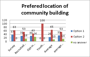
Table 2 – Preferred Location of the proposed Community Building
· Suggestions and ideas for activities within the community facility:
Overall, participants were supportive of the proposed community facility, including a larger branch library, co-located with a multi-purpose community building providing flexible spaces, with superior acoustic properties, for use by a variety of user groups (eg. yoga, dance classes/rehearsal, art/craft/language/cooking classes and/or workshops). Feedback was particularly positive about the concept of these facilities being incorporated into one building, creating a new civic heart for Turramurra, where people could participate in a variety of activities in one location, in close proximity to extensive public open space, public transport and a diversity of retail offerings, fostering a sense of community and social interaction, not social isolation. The community have expressed a desire for a community building that is welcoming, inviting and of an architectural vernacular that is cohesive and conducive to contributing to the village feel of the area. Facilities for the youth population should be a priority, including a technology hub and free WIFI incorporated into the library facility. The community building should also incorporate vertical gardens and a café to encourage social interaction. The building should also include opportunities for local artisans and emerging artists to exhibit. Due consideration should also be given to noise attenuation, lighting, signage and safety, to encourage use of the facility, especially in the evenings.
b) Open Space - linear park & gardens, town square, Forbes Lane shared zone and a rooftop garden
· Facilities/features/activities to be accommodated in the open space:
The proposed open spaces should cater for a wide range of ages [ie. not be dominated by facilities just for one particular demographic], be predominantly for passive recreation, be accessible and designed to discourage anti-social behaviour, particularly afterhours.
There should be recognition of both Aboriginal and European heritage in the design of the open spaces. Native planting should be encouraged, whilst safeguarding existing mature trees for ambience and a leafy outlook. Ensure adequate shading and shelter structures are provided. The idea that Forbes Lane could become more of a shared zone, allowing for farmers markets, annual fairs and/or food festivals on a week-end, resonated with the community. The proposed open spaces should also consider including outdoor activities such as an outdoor cinema, giant chess, Tai Chi classes, bocce/boules, picnic facilities, and opportunities for quiet reflection. A well-considered lighting strategy should be created – both for dramatic effect and to ensure public safety. If a roof garden is to be incorporated, consider a community garden and or a tennis/basketball/futsal court. The open spaces should also cater for civic events, space for music busking (controlled with licences) and permanent memorials.
· Issues or concerns regarding new open space:
It is imperative that the material palette selected for the public domain is of a high quality/durability and well-maintained by Council. Suitable noise attenuation measures should also be considered, given the site’s proximity to the Pacific Highway, to ensure that the open spaces are pleasant environments to be in. Connectivity of the open space to surrounding road networks, cycle ways, the train station and kiss & ride need careful consideration, as there are already existing vehicular/pedestrian conflicts. Overcoming visual blight and minimising opportunities for graffiti was also a priority. There is also a need to better reconcile the site’s level changes, to ensure highest and best use of the proposed open spaces. Include public art/sculptures in the open space, as there is currently a distinct lack of it.
Concern was raised that the bulk of the proposed residential buildings will dominate/overshadow the adjacent open space - this will need further consideration.
c) Overall Master Plan - including residential apartments, speciality retail/leisure retail and a supermarket in addition to the community facility and open spaces
· General comments:
The community have commented that the site as is, is currently under-utilised, run down, tired and outdated. And that people are of the opinion that the Community Hub site should have a ‘vibe’, sense of place, be inspiring, interesting and a place for people to gather and socialise. A majority of participants welcome the plans for ‘urban renewal’ and are of the opinion that the proposed master plan is moving in the right direction to achieving a hub that will encourage activity, greater social interaction and pedestrian movement.
· Concerns or issues:
Some people expressed some concern with the proposed increase in development on the site; over the quantity of public and commuter parking proposed; and whether adequate provision for circulation and movement of delivery trucks serving the full line supermarket has been duly considered (including appropriate vehicular and safe pedestrian connectivity of the site with its surroundings, particularly development on and around Kissing Point Road).
· Ideas for further improvements or enhancements:
Residents identified a need to carefully consider the architectural style promoted. Concern has been raised about an overtly contemporary built form and that this is not considered to be in keeping with the village style of development characteristic of Rohini Street and surrounds.
Below is a table illustrating the ratings out of five (5) for the master plan provided by the workshop participants. The figures demonstrate a consistently positive response to the current proposal.
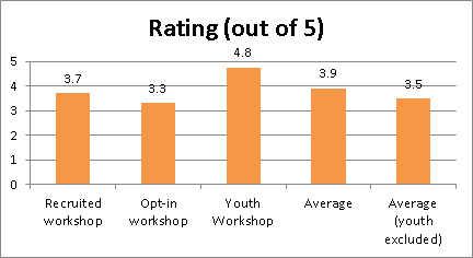
Table 3 - Rating of Master Plan (only asked at workshops). NOTE – the youth workshop had low attendance hence the average shown on the right of the table excludes the youth score.
d) Transport & Parking - workshop participants also specifically discussed transport and parking issues associated with the site.
· With local knowledge, what are the perceived main transport challenges:
Residents expressed concern about the increase in traffic in the local area as a result of increased development on the site.
The community commented on the need for a ‘kiss & ride’ to be provided on Rohini Street.
People also noted that here is not enough existing commuter parking; commuter parking on local streets is an issue, as a large majority come from outside the local area, such as the Northern Beaches and Central Coast.
Coles Group Property Development raised concern regarding the future servicing of the proposed supermarket and retail tenancies onsite; noting there will be a need to carefully consider delivery truck movements/frequencies servicing the supermarket and retail tenancies, including appropriate acoustic attenuation measures in relation to the proposed residential units and existing residences on Ray Street.
Residents said that the population on the southern side of the Pacific Highway is disconnected from the Turramurra Local Centre, as the Pacific Highway is a significant barrier.
Concern has also been raised about the impact on local residences by diverting traffic down Turramurra Avenue. This requires further investigation.
· Ideas to manage/mitigate challenges:
Community feedback indicates that the proposed ‘Ray Street Bridge’ is generally supported on the basis that it would alleviate existing pressures on the local road network, improve vehicular circulation and better connect pedestrians/cyclists with Rohini Street. Residents suggested that the bridge is to be an appropriate width to allow for vehicular, cyclist and pedestrian movements. More cycle links are also needed to connect the centre with surrounding areas. It is imperative to plan for these from the outset of the master planning process.
People noted that Turramurra Station is a fast train stop and that additional commuter parking is therefore required in the centre. There is a need to minimise the pedestrian/vehicular conflict at the existing kiss and ride. Similarly, there should be an increase in bus and train services commensurate with the increase in proposed resident numbers, including improved taxi stop provisions near the station.
The community would like to see improved connectivity between Turramurra Local Centre and Kissing Point Road and surrounds with a pedestrian overpass catering for cyclists too. Encourage walking and the use of bikes throughout the centre and surrounds, to reduce the reliance on vehicles and commuter car parking. Many participants were of the opinion that the Pacific Highway requires widening, particularly at the juncture of Kissing Point Road and the Pacific Highway to alleviate acute congestion in this area.
Feedback captured via the various engagement processes has been collated and are included verbatim in Attachment A4 - Turramurra Community Hub Community Engagement Output Report.
2. Planning Proposal Submissions on the master plan
Below is a list of key issues raised regarding the masterplan, as contained in the submissions made to the Planning Proposal (via the ‘Have your Say’ forum), which was concurrently exhibited during May. Five (5) submissions were received.
Key issues/concerns raised include:
· support for option 1 as the location of the community building, as it would block the traffic noise coming from Pacific Highway;
· widen Pacific Highway to 6 lanes and 1 lane for cars to turn left into Kissing Point Road;
· pedestrian underground access under Pacific Highway;
· support for railway overpass joining Ray Street and Rohini Street;
· expand commuter car parking;
· objection to 5 storey apartments;
· concerns on the impact of proposed bridge on Ray Street residents; and
· support for supermarket upgrade.
All submissions on the Planning Proposal will be reviewed in detail and reported to Council later in 2016.
Internal Consultation
This report was prepared by the Strategy & Environment Department in consultation with staff from other Departments where relevant.
Since 2014, six (6) information sessions have been held for Councillors:
· a briefing was held on 8 October 2014 at which consultants presented a draft site analysis, design principles, preliminary design options and financial assessment;
· the draft design options were presented to Councillors at two site inspections held on 22 and 28 October 2014. At the final site inspection chalk markings were provided around the site to assist Councillors in understanding the design options;
· consultants briefed Councillors on 1 December 2014 on the draft Turramurra Community Facilities Study as well as the Ku-ring-gai Community Facilities Strategy (LGA wide);
· a briefing session was held on 4 June 2015 to update councillors on the Draft Master Plan for the site;
· a briefing session was held on 4 August 2015 to present to Councillors the completed draft master plan and model; and
· a Question and Answer session was held on 8th December 2015 to present to Councillors the refined master plan, taking into account AEC’s recommendations, prior to the council meeting.
Summary
This report provides a summary to Council of the community feedback and submissions received in response to the exhibition of the draft master plan for the Turramurra Community Hub during May 2016.
In accordance with resolution A of the OMC of 8th December, 2015, the Turramurra Community Hub‑- Peer Review of Retail Assessment and Feasibility Analysis prepared by the AEC Group recommended a number of matters for further consideration, forming the basis of the master plan refinements prior to public exhibition to ensure the plan is robust and will meet the likely market demand.
It is also noted that the draft master plan is consistent with the development standards within the Ku-ring-gai LEP (Local Centres) 2012 i.e. maximum building height of 5 storeys (17.5 metres) and FSR of 1.8:1.
A comprehensive strategy of community engagement was undertaken during May 2016 to ensure that the local Turramurra community was suitably informed and able to have a say about the draft Turramurra Community Hub Master Plan in a range of ways. The engagement process was purposefully designed to capture significant volumes of qualitative data. Council recognises the importance of ‘grass roots’ community knowledge about how spaces are used and function (or not) and sought to capture this information to help it to best understand how to progress the project through future phases, including design and construction. Council has captured and recorded all community viewpoints for reference as the project moves forward.
The community have shown strong support for the master plan with average levels of support being 3.5 out of 5 or 70%. Based on the results of the recruited workshop (which provides statistically reliable results) Council can be confident that a high percentage of local residents would also support the development, if a broader survey was to be undertaken. A question frequently asked during the public exhibition was “When will the project be built?” which indicates support for the revitalisation of Turramurra. Based on these results it is recommended that Council adopt the master plan as exhibited as the basis for moving forward to the delivery phase.
The next steps will involve the following:
a) Determining an appropriate delivery mechanism
Land owned and controlled by a Council is a public asset to be held, administered and used for the benefit of the public/local community and to assist the Council in providing the services and facilities it is charged to provide for the community. As the project may involve some form of co-operation or partnership with the private sector to deliver the project there are specific requirements in the Local Government Act 1993 (the Act) for Council in relation to such projects. Legal advice will be required with regard the best mechanism to deliver the project and this will be reported to Council in due course.
b) Establishing a Community Reference Group
It is recommended that Council convenes an Activate Turramurra project working party. This group will meet as needed on a finite basis during the Activate Turramurra project to provide advice to Council regarding the implementation of the Community Hub masterplan and other upgrades and improvements to Turramurra Centre. Membership will ideally consist of local community groups, residents, businesses and other interested parties. A maximum of 12 citizen members will be recruited using an expression of interest process and selected based on their level of appropriate skills, experience and interest to ensure they can have meaningful involvement.
The group would not have decision making powers and a Terms of Reference, including roles and responsibilities will be drafted to ensure participants are clearly informed of the objectives and limitations of the group.
c) Finalising the location of the community hub building
Overall the community has indicated a preference for Option 2 – a two storey high building located on Forbes Lane. To ensure Council is able to make the best decision it is recommended that Council undertake a detailed assessment based on best practice principles and report back to Council before a final decision is made in this regard.
d) Seeking Roads and Maritime (RMS) concurrence for the Turramurra Traffic and Transport Study
It is recommended that a separate report be prepared and reported to Council on the Turramurra Traffic and Transport Study with a view to council adopting the study in principle, allowing it to be submitted to the RMS for formal concurrence.
e) Making the results of the public exhibition available to the public
Finally, it is also recommended that the results and findings of the exhibition be made publicly available via Council’s website.
|
A. That the Turramurra Community Hub Master Plan (as exhibited) be adopted as Council’s preferred master plan.
B. On the basis of the preferred master plan Council undertake investigations to determine the most appropriate delivery mechanism for the project and report the findings to Council.
C. That Council adopts the Turramurra Community Facility Study, 2015 as the basis for ongoing planning and design of the proposed library and community centre facilities.
D. That a separate report be prepared and reported to Council on the Turramurra Traffic and Transport Study with a view to council adopting the study in principle, allowing it to be submitted to the RMS for formal concurrence.
E. That Council convenes an Activate Turramurra project working party to meet as needed on a finite basis during the Activate Turramurra project to provide advice to Council regarding the implementation of the Community Hub masterplan and other upgrades and improvements to Turramurra Centre.
F. That the results and findings of the exhibition be made publicly available via Council’s website.
|
|
Louise Drum Senior Urban Designer |
Bill Royal Team Leader Urban Design |
|
Antony Fabbro Manager Urban & Heritage Planning |
Andrew Watson Director Strategy & Environment |
|
RLB - Concept Design Stage Estimate - Turramurra Community Hub - FINAL |
|
Confidential |
||
|
|
Turramurra Community Hub - Peer Review of Feasibility Analysis Final - Addendum 6 - April 2016 |
|
Confidential |
|
|
|
Turramurra Community Hub - Traffic Scenario Testing - Progress Note - final |
|
2016/158700 |
|
|
|
Activate Turramurra - engagement output report - final |
|
2016/160445 |
|
|
|
Summary of submissions |
|
2016/159384 |
|
APPENDIX No: 3 - Turramurra Community Hub - Traffic Scenario Testing - Progress Note - final |
|
Item No: GB.6 |
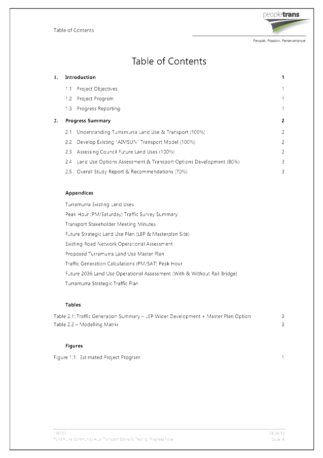
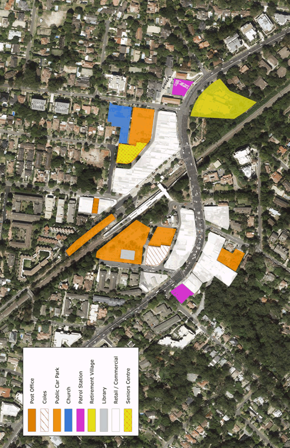

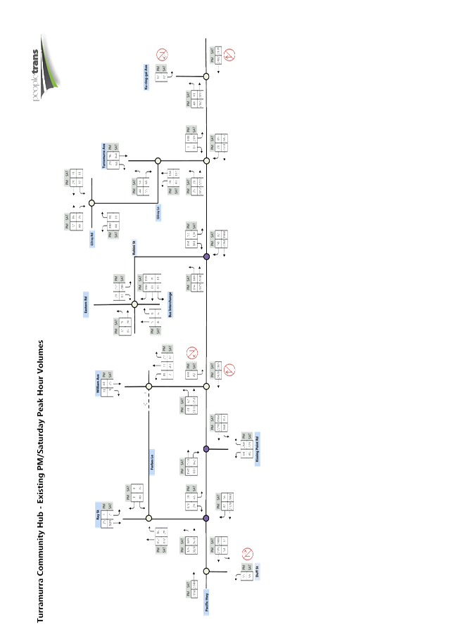
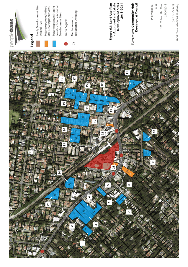

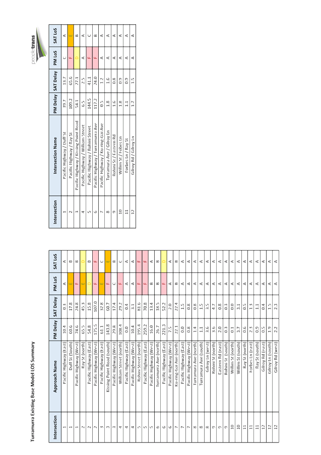
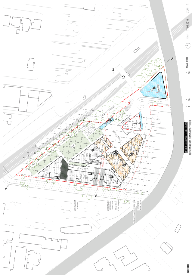
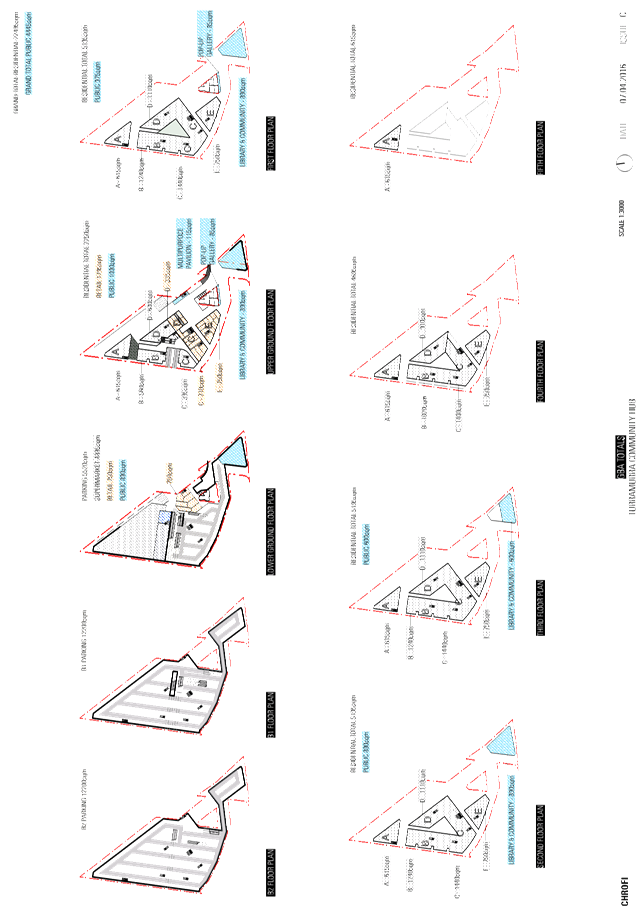
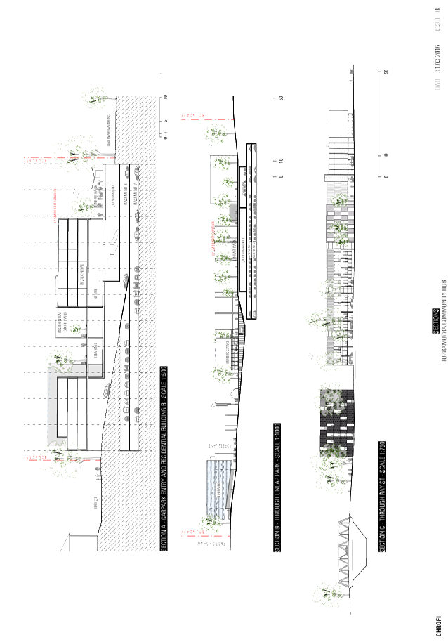
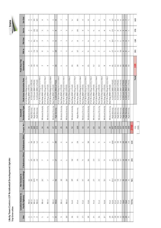
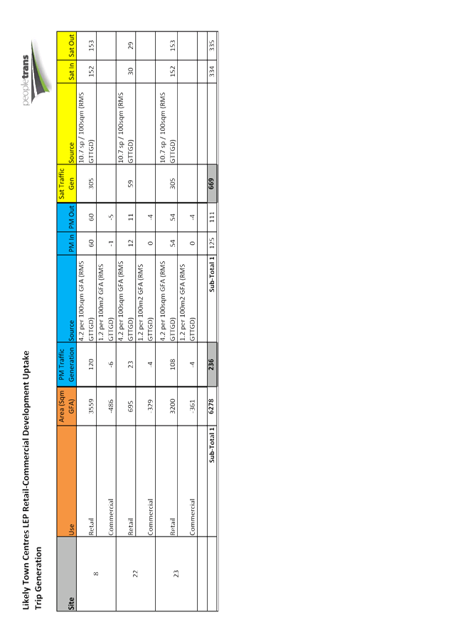
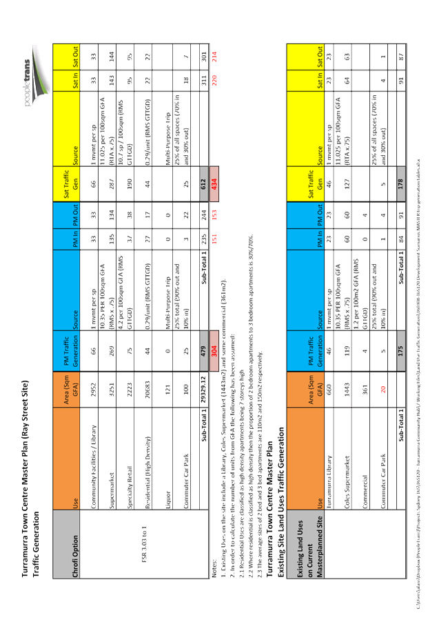
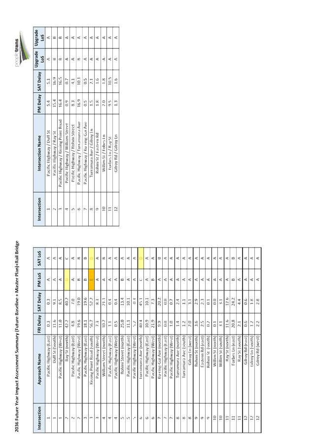
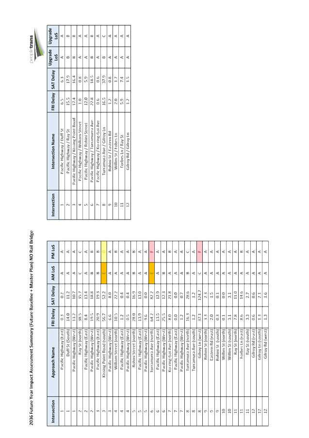
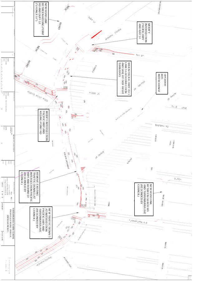
|
Ordinary Meeting of Council - 28 June 2016 |
GB.7 / 378 |
|
|
|
|
Item GB.7 |
S10099 |
|
|
31 May 2016 |
Consideration of Submissions on the Non-Statutory Exhibition of the Middle Harbour Road, Lindfield - Potential Heritage Conservation Area Review
EXECUTIVE SUMMARY
|
purpose of report: |
For Council to consider the comments received during the non-statutory exhibition of the Middle Harbour Road, Lindfield, Potential Heritage Conservation Area (HCA) Review, undertaken by Perumal Murphy Alessi Heritage Consultants (PMA).
|
|
|
|
|
background: |
Council resolved on 10 March 2015, to proceed with a non-statutory exhibition in respect to the potential inclusion of the properties surrounding Middle Harbour Road, Lindfield, in a HCA. The document was placed on non-statutory public exhibition from 20 March to 15 May 2015. |
|
|
|
|
comments: |
The heritage assessment undertaken by PMA concluded that the area has heritage significance. As a result of the non-statutory exhibition, a total of 29 submissions were received. This report provides the outcomes of the exhibition and the recommendations. |
|
|
|
|
recommendation: |
It is recommended a planning proposal be prepared and submitted to the Department of Planning and Environment for Gateway Determination to include Middle Harbour Road HCA in schedule 5 and on the Heritage Map of KLEP 2015
|
Purpose of Report
For Council to consider the comments received during the non-statutory exhibition of the Middle Harbour Road, Lindfield, Potential Heritage Conservation Area (HCA) Review, undertaken by Perumal Murphy Alessi Heritage Consultants (PMA).
Background
The 2010 HCA studies provided the basis for the boundaries of the HCAs listed on Council’s LEP. Further to the adoption of the draft KLEP 2013 on 26 November 2013, Council resolved
To review the area around Middle Harbour Road, Lindfield [Archbold/Tryon/Middle Harbour and Trafalgar] as shown in the 2010 South HCA review within the Clanville Estate HCA3A-6A], with the view to its re-inclusion as a potential HCA or to identify and assess potential new Heritage Items within the area.
On 10 March 2015 Council resolved the following:
A. That the Middle Harbour Road, Lindfield, Potential Heritage Conservation Area Review, prepared by Perumal Murphy Alessi Heritage Consultants be placed on non-statutory public exhibition for 28 days after being amended in accordance with the Manager Urban and Heritage Planning’s memorandum dated 10 March 2015 regarding the deletion of bullet point 7 Protect curtilage and element within Swain Gardens and Killara Park from page 8 of Attachment 2 to the report namely PMA – Middle Harbour Road Heritage Inventory Sheet.
B. That a report be brought to Council at the conclusion of the exhibition period.
Comments
The heritage assessment prepared by PMA concluded that the area has heritage significance and it should be considered for inclusion in a HCA.
PMA provides the following Summary Statement of Heritage Significance for the study area:
The Middle Harbour Road [Potential] Heritage Conservation Area is of local historic and aesthetic significance as a good and largely intact residential precinct characterised by streetscapes of good, high quality examples of single detached houses primarily from the Federation and Inter-war period with some good examples of mid to late 20th century dwellings.
The built context is enhanced by the street proportions and character, street plantings and garden settings including remnant and planted native trees, creek line and neighbouring reserve areas.
The area is significant as part of Dering’s Clanville Estate and subdivision and represents the late 19th and early 20thh century development of the area. The predominant early 20th century development also reflects the evolution of rail and road networks and particularly improvements of the rail network in the late 1920s and early 1930s. Some re-subdivision and redevelopment has also occurred in the area. Despite these changes the area significantly retains its early subdivision and streetscape pattern of single detached houses within a ‘green’ setting.
PMA provides the following recommendations for the study area:
The area currently has six heritage listed items, however, the area should be recognised as a conservation area, possibly as an extension of the Clanville Heritage Conservation Area. The land was part of the Clanville Estate and subsequent, early subdivision patterns remain visible and area retains good and intact late 19th and early to mid-20th century detached dwellings enhanced by garden settings, wide street proportions, street trees and plantings, creek line and remnant native trees and plantings. The area should continue to include reserve areas and deep grassed verges and remnant Blue Gum forest to protect, reinforce and enhance the values of the place.
The PMA study is included at Attachments A1-A3.
The subject area is currently zoned R2—Low Density Residential.
As a result of the non-statutory public exhibition, a total of 29 submissions were received. 23 submissions were against the HCA proceeding. This including two petitions:
1. 15 signatories from Owen Street; and
2. 53 signatories from Middle Harbour Road.
6 submission were in support of the HCA proceeding. The issues considered varied, with many expressing concerns over the potential impacts of heritage listing, and others over the need for the protection and retention of the significant building and garden stock. Six submissions were in favour of the proposal. A summary of the submissions is included at Attachment A4.
A summary of the common issues discussed in the submissions is included below.
· Council should disclose to owners the intention to investigate the area as a potential HCA or should allow owners to undertake works under the conditions prevailing at the time of purchase.
Adequate research and consultation need to be completed before any new HCA can be made. The purpose of the non-statutory exhibition was to seek initial comment from owners and the wider community early in the process as part of transparent decision-making. The proposal was notified in the local press and notification letters were provided to the subject properties and the adjacent properties inviting submissions.
· Council should contemplate a compensation package for owners of heritage properties bearing the cost for the benefit of the overall community.
It is recognised that undertaking conservation works to a heritage property, including maintenance, requires specialist skills. Council currently offers pre-application specialist advisory services to assist owners of heritage properties with proposed changes. There are heritage grants available for owners of heritage items and contributory items in a HCA for conservation works up to $5,000.
· The heritage listing would impact on the cost of development.
The inclusion of the property in a HCA may result in the requirement for a Development Application. However, this does not necessarily make the process more expensive. Listing does not impose an obligation on owners to rectify previous unsympathetic work. Minor building works or maintenance may be undertaken as minor works, without the need to obtain development consent.
· The listing of some properties and not others is discriminatory.
Council’s decisions are based on the advice of independent Heritage Consultants skilled in the application of heritage management standards set by the NSW Heritage Council and the Burra Charter and Council’s Heritage Officers.
In NSW, heritage items of local significance are assessed against 7 criteria. The consistency in the application of the standard criteria reduces uncertainty for both owners and Council.
a) Historical significance – an item is important in the course, or pattern, of the cultural or natural history of the local area;
b) Historical association significance – an item has strong or special association with the life or works of a person, or group of persons, of importance to the local area’s cultural or natural history;
c) Aesthetic significance – an item is important in demonstrating aesthetic characteristics and/or a high degree of creative or technical achievement in the local area;
d) Social significance – an item has a strong or special association with a particular community or cultural group in the local area, for social, cultural or spiritual reasons;
e) Technical/research significance – an item has potential to yield information that will contribute to an understanding of the local area scientific, cultural or natural history;
f) Rarity – an item possesses uncommon, rare or endangered aspects of the local area’s cultural or natural history; and
g) Representativeness - an item is important in demonstrating the principal characteristics of a class of the local area’s cultural or natural places; or cultural or natural environments.
· The heritage listing would detract potential buyers and impact on property value.
Site constraints, such as land zoning, physical constraints, impacts on neighbours and environmental issues, including heritage issues, can impact on property value.
Numerous studies have been undertaken that have found no significant price effect resulting from heritage designation, including The Economics of Heritage: Integrating the costs and benefits of heritage into government decision making by the Department of Sustainability, Environment, Water, Population and Community.
· The heritage listing does not necessarily retain the character/appeal of the area.
The NSW planning system uses standard and site specific development controls to minimise environmental impacts, including heritage impacts. This is reflected in Council’s recently gazetted LEPs and adopted DCPs. The principal objective is that contributory buildings and their settings are retained, and that new buildings within the HCA boundaries are compatible.
The heritage controls in the DCP aim to:
i. retain, conserve and enhance the Heritage Items, HCAs and their associated settings;
ii. ensure the heritage significance, streetscape and landscape character of HCAs are maintained;
iii. ensure alterations and additions to Heritage Items and within HCAs respect those buildings and do not compromise the significance and character of the individual Heritage Items or the HCAs;
iv. ensure new development in the vicinity of Heritage Items and HCAs respects the heritage context and is sympathetic in terms of form, scale, character, bulk, orientation, setback, colours and textures and does not mimic or adversely affect the significance of Heritage Items or HCAs and their settings.
· Disagree with the assessment that the property and the area have heritage significance due to alterations and additions.
Some re-subdivision and redevelopment has occurred in the area. Some dwellings are new, altered or have had unsympathetic work undertaken. Council considers every application on a case-by-case basis and there are other matters for consideration in addition to heritage. Listing does not impose an obligation on owners to rectify previous unsympathetic work.
· The heritage listing would impact on the ability to make improvements/The houses are approaching a date when major renovations or rebuilds are likely to be required and the inclusion in a HCA would prevent these from being undertaken expeditiously as Complying Development.
The inclusion in a HCA does not preclude future development. However, Council’s approval would be required for new development. Council’s LEP has provisions for minor works which can be undertaken without formal consent.
· The property is not uncommon and makes a little contribution to the amenity of the area, therefore is not suitable for heritage listing.
Each property within the potential HCA has been assessed for its contribution to the streetscape and to the significance of the HCA as a whole as described in the Statement of Heritage Significance.
· Imposing a restrictive HCA seems unfair when there are other options such as the inclusion in a ‘Character Area’.
The two options have different meanings and objectives. Heritage has an established framework (i.e. the Burra Charter). There is an expectation that heritage controls will be applied to conserve Ku-ring-gai’s environmental heritage. Ku-ring-gai Council does not have provisions for character areas in the development control plan or the local environmental plan. As such character areas do not have any statutory weight and would not protect a heritage area from unsympathetic complying development.
· New houses should not be included in a HCA.
The threshold between buildings identified as contributory and non-contributory has been considered by the Heritage Consultant. The study concluded that the area retains the significant subdivision pattern and this provides the basis for the proposed HCA boundaries.
· The proposal should not proceed against the wishes of the ratepayers and residents.
Council has an obligation to protect Ku-ring-gai’s environmental heritage and this is reflected in the recently gazetted LEPs and adopted DCPs. Should the proposed HCA proceed to the next stages, further public consultation will be conducted, including another round of submissions.
· The review is inaccurate and provides no substantial justification for inclusion
The overall basis of the review relies on a physical inspection of each property from the street and its rating as being a ‘contributory’, ‘neutral’ or ‘detracting’ building to the streetscape and area. PMA provides the following definitions.
Contributory buildings- The identification of contributory items is based on the style, condition and integrity of each property and how it relates to the historical development and identified cultural significance of the area…The visibility and visual contribution and presentation to the streetscape and area in particular were noted…Consideration has been given to this requirement for change and the contributory items have been assessed with consideration of the degree of change and its impact on the historical and visual character of the item and its contribution to the area when viewed from a public place.
Neutral buildings- are those which do not relate to the primary period of development of the area.
Detracting buildings- are those which are out-of-character in terms of scale, bulk, form, style.
A visual inspection (from the street) was undertaken by Council Officers to provide a recommendation for those properties with submissions based on recent alterations/additions or where new houses have replaced old houses to confirm the extent of change (eg modifications which have occurred under complying development).
These issues have been individually addressed in the attached summary table and map (Attachments A5 and A6).
|
Contributory |
Total |
Percentage |
|
|
Archbold Road |
2 |
4 |
50.00 |
|
Howard Street |
8 |
18 |
44.44 |
|
Middle Harbour Road |
47 |
88 |
53.41 |
|
Nelson Road |
0 |
3 |
0.00 |
|
Owen Street |
13 |
28 |
46.43 |
|
Short Street |
4 |
8 |
50.00 |
|
Trafalgar Avenue |
3 |
6 |
50.00 |
|
Tryon Road |
18 |
29 |
62.01 |
|
Valley Road/Lane |
11 |
24 |
45.83 |
|
Total |
106 |
208 |
50.96 |
The total number of contributory buildings has to be at least greater than 50% for the area to be considered for inclusion in a HCA. The study area retains around 51% contributory buildings. This assessment includes those buildings which are borderline such as those who have undertaken changes which may be reversible, like infill of verandahs and the inclusion of unattached carports forward of the front building line. These changes, however, cannot be ignored as they can be used in court by appellants to demonstrate changes that Council deems acceptable to contributory places even when they are contradictory to Council’s development controls.
For this reason those places with clearly unsympathetic alterations like dormer windows on the front façade, and additions to the rear which are clearly visible to the street and dominate the roofline of what would have been a modest single storey bungalow, have been rated as neutral.
If those places tagged as borderline were to be rated as neutral, the overall percentage of contributory buildings falls to 48%. On review of the mapping it is clear there are clusters of contributory and neutral buildings in the proposed HCA. One option may be to identify smaller intact areas as individual HCAs.
As a non-statutory exhibition not all those affected owners who may make submission to a statutory exhibition have taken the opportunity to have their say. Given the borderline nature of this heritage conservation area it is recommended to proceed to statutory exhibition to further gauge the community opinion and through this process potentially garner more information about the properties within the HCA.
integrated planning and reporting
Theme 3: Places, Spaces and Infrastructure
|
Delivery Program Term Achievements 4 Years |
Delivery Program Critical Actions |
Operational Plan Tasks |
|
Strategies, Plans and Processes are in place to effectively protect and preserve Ku-ring-gai’s heritage assets |
Implement, monitor and review Ku-ring-gai’s heritage planning provisions |
Identify gaps in existing strategies and plans |
Governance Matters
This report addresses issues of heritage protection in line with Council’s recently gazetted LEPs. Should the recommendation to proceed with a Planning Proposal be adopted by Council, then comment from stakeholders and the wider community in respect to the listing of the subject area as a HCA on Council’s LEP will be sought, in accordance with the requirements of the EP&A Act.
Risk Management
This report provides the level of detail and the justification, including preliminary community consultation.
Financial Considerations
The costs associated with this matter are covered by the Strategy and Environment Department, Urban and Heritage Planning budget.
Social Considerations
There is a community expectation that places of heritage significance within the Ku-ring-gai Council local government area will be identified and protected.
Environmental Considerations
Council is responsible for the identification and management of Ku-ring-gai’s environmental heritage. Consideration of this matter will assist Council in meeting this requirement.
Community Consultation
The proposal was exhibited from 20 March until 15 May 2015. It was advertised on Council’s website, the North Shore Times and letters were sent to the owners of affected and adjacent properties inviting submissions.
Should the recommendation to proceed with a Planning Proposal be adopted by Council, a formal process of further statutory public consultation will be sought in accordance with the requirements under the EP&A Act.
Internal Consultation
This report has been referred to the relevant sections of Council for comment.
Summary
The heritage assessment prepared by PMA concluded that the area has heritage significance and should be considered for inclusion in a HCA. Council resolved on 10 March 2015, to proceed with a non-statutory exhibition in respect to the potential inclusion of the properties surrounding Middle Harbour Road, Lindfield, excluded from the draft KLEP 2013, in a HCA. The document was placed on public exhibition from 20 March to 15 May 2015. It is recommended a planning proposal be prepared and submitted to the Department of Planning and Environment for Gateway Determination to include Middle Harbour Road HCA in schedule 5 and on the Heritage Map of KLEP 2015
|
A. That a Planning Proposal be prepared in accordance with s55 of the EP&A Act to amend KLEP 2015 to include Middle Harbour Road Heritage Conservation Area as a potential heritage conservation area in Schedule 5 and on the Heritage Map.
B. That the Planning Proposal be forwarded to the Department of Planning and Environment for a Gateway Determination in accordance with the provisions of the EP&A Act and Regulations.
C. That in order to facilitate an expedient Gateway Determination, the NSW Heritage Office be consulted prior to submitting the Planning Proposal to the Department of Planning and Environment. Should comments not be received within 21 days, the Planning Proposal is to be submitted regardless.
D. That Council requests the plan making delegation under Section 23 of the EP&A Act for this Planning Proposal.
E. That upon receipt of a Gateway Determination, the exhibition and consultation process is carried out in accordance with the requirements of the Environmental Planning and Assessment Act, 1979 and with the Gateway Determination requirements. |
|
Andreana Kennedy Heritage Specialist Planner |
Craige Wyse Team Leader Urban Planning |
|
Antony Fabbro Manager Urban & Heritage Planning |
Andrew Watson Director Strategy & Environment |
|
PMA Review - Report |
|
2015/048880 |
||
|
|
PMA Review - Heritage Inventory Sheets |
|
2015/059057 |
|
|
|
PMA Review - Maps |
|
2015/125173 |
|
|
|
Summary of submissions table |
|
2016/160217 |
|
|
|
Comparison of contribution ratings - Table |
|
2016/160224 |
|
|
|
Revised contribution ratings - Map |
|
2016/160586 |
|
Ordinary Meeting of Council - 28 June 2016 |
GB.8 / 493 |
|
|
|
|
Item GB.8 |
S04601/8 |
|
|
16 June 2016 |
202020 Vision - Council Partnership
EXECUTIVE SUMMARY
|
purpose of report: |
To seek Council’s approval to become a partner organisation to the 202020 Vision campaign. |
|
|
|
|
background: |
The 202020 Vision is a campaign involves collaboration between business, government, universities and non-profit organisations across Australia working towards a 20% increase in urban green space by 2020.
The campaign is an ideal platform for Council to promote its award winning Open Space Acquisition Programme. |
|
|
|
|
comments: |
202020 Vision has invited Ku-ring-gai Council to become a partner organisation.
202020 Vision is particularly interested in local government partnerships and has been highly impressed to date with recent Ku-ring-gai projects including Greengate Park, Killara and Council’s Open Space Acquisition Programme.
202020 Vision would also like Ku-ring-gai Council to list additional local green space projects on the 202020 Vision map. |
|
|
|
|
recommendation: |
That Council become a partner organisation to the 202020 Vision campaign. |
Purpose of Report
To seek Council’s approval to become a partner organisation to the 202020 Vision campaign.
Background
The 202020 Vision is a campaign involving collaboration between business, government, universities and non-profit organisations across Australia working towards a 20% increase in urban green space by 2020.
A similar report to this one was submitted to the Ordinary Meeting of Council held on 18 March 2014. At that time Council was concerned that the proposed master plan for Gordon Golf Course, which proposed residential land uses, would see a reduction of open green space within the LGA; and that becoming a partner organisation of 202020 Vision could be seen as contradictory and potentially impact on Council’s reputation. As a result Council resolved:
“That Council does not become a partner organisation to the 202020 Vision campaign which is working towards a 20% increase in urban green space by 2020”
Council has subsequently resolved not to progress the master plan for Gordon Golf Course and as a partner organisation to the 202020 Vision Council would have an ideal platform to promote its open space projects.
The 202020 Vision campaign would offer Council a number of promotional opportunities which could provide the community with information about what Council is doing via national and local media including:
· the inclusion of Council and any of its green space projects and initiatives on the 202020 website;
· showcasing any new projects and initiatives on social media channels; and
· pitching to the media - the more interesting and innovative our story is the more chance it has of being profiled.
Comments
The 202020 Vision campaign is a collaboration involving business, government, universities and non-profit organisations across Australia working towards a 20% increase in urban green space by 2020. The campaign was initiated, and is funded, by the Nursery and Garden Industry of Australia.
202020 Vision aims to:
· raise awareness of the need for green space in our cities, and the benefits they provide to our health, communities, economy and the environment;
· increase understanding of the current state of green space in Australian cities;
· share best practice about projects, policies and initiatives that are already contributing to greening our cities; and
· raise the profile of people and organisations leading the way to greening our cities and encourage others to do the same.
The campaign was launched in November 2013 in Sydney. Since launching, the organisation has over 90 partner organisations and over 25 high profile advocates who have signed up to support the initiative. It has more than 80 green space projects listed on the 202020 Vision map. Amongst the councils who have signed up to the 202020 Vision are the City of Melbourne, City of Vincent, City of Fremantle. Moreland City Council and the NSW Office of Environment and Heritage are also partners.
More information on the campaign can be found on the website www.202020Vision.com.au
202020 Vision is seeking Ku-ring-gai Council’s support for their campaign for a 20% increase in urban green space across Australia by 2020. The organisation has invited Council to become a partner organisation. 202020 Vision is particularly interested in local government partnerships and has been highly impressed to date with recent Ku-ring-gai projects.
In addition, 202020 Vision would also like Ku-ring-gai Council to list additional local green space projects on the 202020 Vision map. These may include the new parks such as Cameron Park, Balcombe Park and Curtilage Park.
Two of Council’s projects have already been listed on the 202020 Vision website namely, the Open Space Acquisition Program (http://202020vision.com.au/project/?id=266) and Greengate Park, Killara (http://202020vision.com.au/project/?id=265). Both these projects promote Council’s hard work and innovation in this area, and support the objectives of the campaign.
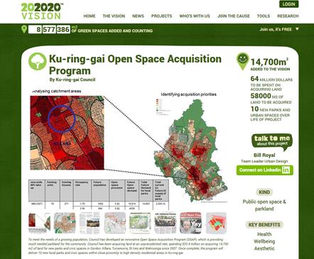
Figure 1: Excerpts from the 202020 Vision web site – Ku-ring-gai Open Space Acquisition Strategy
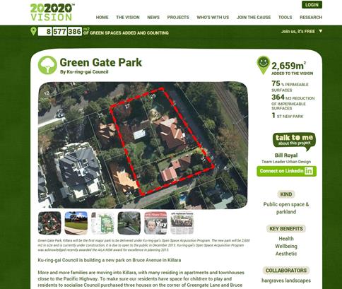
Figure 1: Excerpts from the 202020 Vision web site – Greengate Park, Killara
In order to become a partner organisation 202020 Vision asks that Council:
1. support the aspiration to see more green spaces in cities, and
2. is willing to be part of a community working to make this happen.
There are a number of potential benefits for Council involvement including:
· becoming part of a growing community of businesses and government organisations looking to green our cities;
· gaining access to best practice tools and research including information on setting policies and introducing initiatives to increase green space; and
· opportunities to have projects and initiatives profiled in national and local media.
integrated planning and reporting
Community, People and Culture
|
Community Strategic Plan Long Term Objective |
Delivery Program Term Achievement |
Operational Plan Task |
|
A healthy, safe, and diverse community that respects our history, and celebrates our differences in a vibrant culture of learning. |
New and enhanced open space and recreational facilities have been delivered to increase community use and enjoyment. |
Continue to deliver the objectives of Council’s Open Space Strategy and Open Space Acquisition Strategy. |
Governance Matters
There are no policy implications if Council were to decide to become a partner organisation.
Risk Management
There are no notable risks to Council if it were to decide to become a partner organisation.
Partner organisations are asked to commit to the 202020 Vision for 12 months, this involves agreeing to Council projects, or the organisation itself, being profiled through advertising, PR and speaking events in order to inspire others to create more green spaces.
Financial Considerations
There are no financial implications for Council if it were to decide to become a partner organisation. The 202020 Vision is 100% funded by the Australian Nursery Industry from sales of trees and plants.
Any tasks arising would fall within the normal operational roles of staff in the Strategy and Environment Department.
Social Considerations
202020 Visions objectives are strongly aligned to the visions and values in Council’s Community Strategic Plan.
202020 Vision promotes the social benefits of trees and open space in terms of human health, productivity, community, commerce, bio-philia, and wellbeing.
Environmental Considerations
202020 Vision’s objectives are strongly aligned to the visions and values in Council’s Community Strategic Plan.
202020 Vision promotes the environmental benefits of trees and open space in terms of biodiversity, heat effects, C02, water runoff & pollution.
Community Consultation
No community consultation has been undertaken in relation to this report.
Internal Consultation
Consultation has occurred within the Strategy and Environment Department.
Summary
The 202020 Vision is a campaign involving collaboration between business, government, universities and non-profit organisations across Australia working towards a 20% increase in urban green space by 2020.
The campaign was initiated, and is funded, by the Nursery and Garden Industry of Australia.
202020 Vision has invited Ku-ring-gai Council to become a partner organisation. 202020 Vision is particularly interested in local government partnerships and has been highly impressed to date with recent Ku-ring-gai projects including Greengate Park, Killara and Council’s Open Space Acquisition Program.
In order to become a partner organisation 202020 Vision asks that Council:
1. support the aspiration to see more green spaces in cities; and
2. is willing to be part of a community working to make this happen.
There are no financial implications for Council if it were to decide to become a partner organisation. Any tasks arising from the commitment would fall within the normal operational roles of staff within the Strategy and Environment Department.
202020 Visions objectives are strongly aligned to the visions and values in Council’s Community Strategic Plan. As a partner organisation 202020 Vision offers a number of promotional opportunities for the work Council is doing on creating new parks.
As a partner organisation Council could promote its open space projects using national and local media; the 202020 Vision website; and social media channels.
It is recommended that that Council become a partner organisation to the 202020 Vision campaign.
|
A. That Council become a partner organisation to the 202020 Vision campaign that is working towards a 20% increase in urban green space by 2020. |
|
Bill Royal Team Leader Urban Design |
Antony Fabbro Manager Urban & Heritage Planning |
|
Andrew Watson Director Strategy & Environment |
|
|
Ordinary Meeting of Council - 28 June 2016 |
GB.9 / 499 |
|
|
|
|
Item GB.9 |
S03467 |
|
|
2 June 2016 |
Policy on Private Use of Road Reserves
EXECUTIVE SUMMARY
|
purpose of report: |
For Council to adopt a review of the Private Use of Road Reserves and Nature Strips Policy.
|
|
|
|
|
background: |
On 24 March 2009, Council resolved to adopt the policy on Private Use of Road Reserves and Nature Strips. When the Ku-ring-gai Local Environmental Plan (KLEP) 2015 was made effective in April 2015, road reserves/nature strips had land zonings applied to them. They are to be considered in a planning context which can trigger the requirement for a Development Application submission. The Policy is due for review and updating into the new policy format and approval process. |
|
|
|
|
comments: |
Since adoption, Council has received an average of ten (10) applications per year. Section 139 of the Roads Act 1993, requires Council to approve structures on the road reserve. The road reserve is the area between property boundaries and includes the verge or nature strip area. As a consequence of the KLEP2015, additional assessments are needed under Environmental Planning &Assessment Act 1979 for works in public roads. The process is more rigorous in the context of environmental and heritage considerations. |
|
|
|
|
recommendation: |
That Council adopt the review of the Private Use of Road Reserves and Nature Strips Policy.
|
Purpose of Report
For Council to adopt a review of the Private Use of Road Reserves and Nature Strips Policy.
Background
At Council’s meeting of 24 March 2009, Council adopted the policy on the private use of Council’s road reserve and nature strips.
Since adoption, Council has received an average of ten (10) applications per year.
Section 139 of the Roads Act 1993, requires Council to approve structures on the road reserve. The road reserve is essentially the area between property boundaries and includes the verge or nature strip area. There are a number of areas where residents have used the nature strip or road reserve for landscaping or installed structures such as retaining walls. Some residents have done so with Council approval and others without.
The Policy aims to provide residents with guidance on what Council will allow and to provide Council with the necessary powers should structures be installed without Council approval. As such, the purpose of this policy is to control the use of private works in the road reserve and nature strips under the Local Government Act 1993, and the Roads Act 1993.
Road reserves were unzoned under the Ku-ring-gai Planning Scheme Ordinance (KPSO). When the Ku-ring-gai Local Environmental Plan (KLEP) 2015 was made effective from 2nd April 2015, road reserves/nature strips had land zonings applied to them. They are to be considered in a planning context which can trigger the requirement for a Development Application submission.
Comments
An objective of the Policy is to provide conditions on the permitted use of the nature strip by property owners.
As an outcome of processing applications, the Policy unintentionally overlooked provision of guidelines on access rights by Service Authorities. The Policy has been updated with additional guidelines under Intent, Service Authority Access rights and Reinstatement. These aim to better clarify and raise awareness for the residents on responsibilities and risks when constructing structures on the nature strip.
As a consequence of the KLEP2015, additional assessments are needed under Environmental Planning &Assessment Act 1979 (EP&A) for works in public roads. The process and details of assessments are outlined in the table below.
|
Process Stage |
Process |
Detail |
|
1 |
Run a Constraints Analysis on Council’s GIS |
This will flag any planning related constraints/issues on the site (Heritage Conservation Area, Heritage Item, Aboriginal Heritage, Archaeology, Biodiversity, Riparian, Endangered Species, Contamination etc). This helps to determine if the works are Exempt or Minor or Major.
|
|
2 |
Check for Exempt works against · State Environmental Planning Policy (Infrastructure ) 2007 · State Environmental Planning Policy (Exempt and Complying Development Codes) 2008 |
Even if the works are ‘Exempt’, if the ‘Potential Impact Assessment’ flags any heritage, environmental or other issues, the responsible officer should forward the ‘Minor Impacts Assessment Form’ and discuss the development with the relevant Council officer/expert in that field prior to authorising any works.
If the works are considered “Major” the relevant officer will recommend a DA so full investigation, including external consultation, can be done.
|
|
3 |
Complete Minor Works Assessment form for all development |
Filling in the form provides a consistent record of assessment across all works and is available in the instance of any GIPA or legal dispute.
|
|
4 |
Heritage Aspects |
In the case of works affecting heritage aspects, the officer will request the applicant to provide a signed application for “Minor Works to Heritage Items and Properties in a Heritage Conservation Area”.
The purpose is works associated with heritage are rarely out of the DA loop; but, under Council’s KLEP (Local Centres) 2012 and KLEP2015 Clause 5.10(3), there is a clause that allows minor works associated with heritage to be carried out without a DA. The sign of in the form by the applicant ties them to that planning process.
|
|
5 |
Notification |
Application is returned is to the applicant with conditions
Councillors are advised of application approval for permanent structures. |
A flowchart of the revised process is contained in Figure 1.0 in the updated policy.
Attachment A1 is the existing policy.
Attachment A2 is the draft revised policy.
Attachment A3 is the revised application form which is updated with the relevant fee required each financial year.
integrated planning and reporting
Theme 6 – Leadership and Governance
|
Community Strategic Plan Long Term Objective |
Delivery Program Term Achievement |
Operational Plan Task |
|
L3.1 The organisation is recognised and distinguished by its ethical decision-making, efficient management, innovation and quality customer service |
L3.1.3 Council’s Governance framework is developed to ensure probity, transparency and the principles of sustainability are integrated and applied into our policies, plans, guidelines and decisions making processes. |
Assess
need for new policies and undertake regular policy reviews Continue to refine and enhance internal Council policies to accord with legislation |
Governance Matters
Section 139 of the Roads Act 1993, requires Council to approve structures on the road reserve.
At Council’s meeting of 24 March 2009, Council adopted the policy on the Private Use of Council’s Road Reserve and Nature Strips.
The KLEP2015 triggers additional assessments needed under EP&A Act for works in public roads, incorporating assessment against SEPP’s and internal analysis processes.
The purpose of the revised policy is to provide greater guidance to residents on Council’s requirements for private works on road reserves and nature strips and meet compliance with external and internal planning and environmental requirements.
Risk Management
The reviewed policy enables improved risk management of structures on the nature strip by property owners by clarifying the process and implementation requirements. Inclusion of additional information under the headings, Service Authority Access Rights and Reinstatement, has added clarification of other stakeholders that otherwise can be unintentionally not be considered.
Performing a constraints analysis will identify any planning related constraint /issues on the site (Heritage Conservation Area, Heritage Item, Aboriginal Heritage, Archaeology, Biodiversity, Riparian, Endangered Species) to address and manage impacts by proposed works.
Financial Considerations
There are no direct financial implications to Council Budget. Applications are charged for administration and assessment only under Council listed Fes & Charges.
Social Considerations
The policy seeks to ensure public safety by managing development on the nature strip. To assess the type or form of development maintains safety and access for pedestrians, Services Authorities and Council.
Environmental Considerations
The policy has no direct impacts on the environment.
Community Consultation
Community notification will be undertaken when a development application is received.
Internal Consultation
Extensive internal consultation was undertaken with Strategy & Environment Department regarding the revised process requirements under KLEP 2015.
Summary
Council adopted the Private Use of Council’s Road Reserve and Nature Strips Policy in March 2009 that provides residents with guidance and necessary requirements for the permitted use of development or encroachments on the nature strip by private owners.
When the Ku-ring-gai Local Environmental Plan 2015 was made effective from 2nd April 2015, road reserves/nature strips had land zonings applied to them, requiring additional assessments (SEPP’s and internal analysis) that are needed under EP&A Act for works in public roads.
The reviewed policy includes the provision of guidelines on access rights by Service Authorities and processes in a planning context which can trigger the requirement for a Development Application submission in order to clarify responsibilities and risks for private owners when developing on nature strips.
The reviewed policy is managed in the corporate system, MyCouncil as Controlled Document No 62.
|
That Council adopts the revised Private Use of Road Reserves and Nature Strips Policy.
|
|
Ian Taylor Manager Engineering Operations |
Greg Piconi Director Operations |
|
Private use of Road Reserves and Nature Strips Policy |
|
2016/163173 |
||
|
|
Draft Private Use of Road Reserves and Nature Strips Policy |
|
2016/163168 |
|
|
|
Application form for consent for work to occupy road reserve under Section 139 - Roads Act 1993 |
|
2016/163176 |
|
APPENDIX No: 3 - Application form for consent for work to occupy road reserve under Section 139 - Roads Act 1993 |
|
Item No: GB.9 |
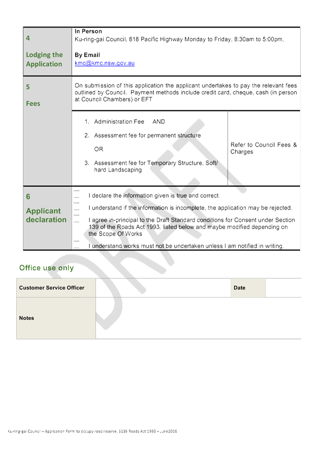
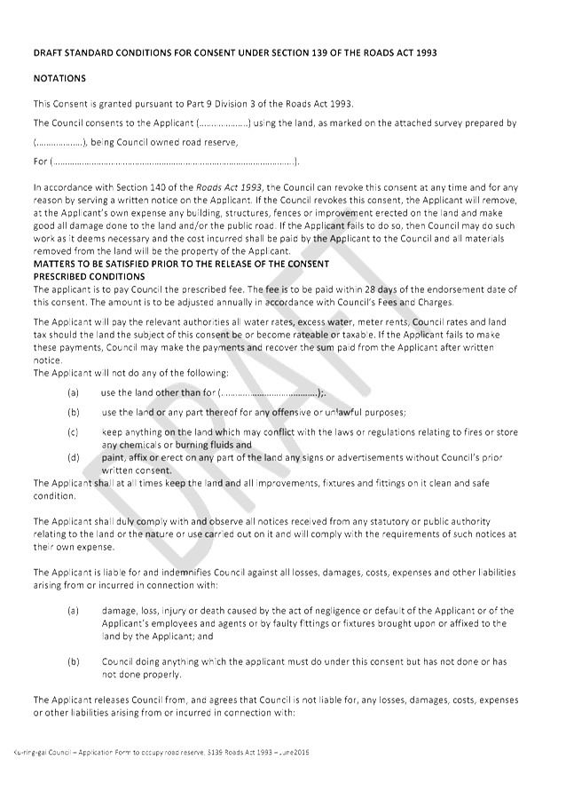
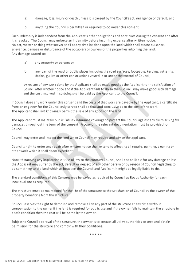
|
Ordinary Meeting of Council - 28 June 2016 |
GB.10 / 529 |
|
|
|
|
Item GB.10 |
S11018 |
|
|
16 June 2016 |
Tender T12-2016 - Roseville Chase
Community Hall Roofing and Building Upgrades
EXECUTIVE SUMMARY
|
purpose of report: |
To consider the tenders received for the undertaking of major roofing and building upgrades to the Roseville Chase Community Hall Roseville, and to appoint the preferred tenderer. |
|
|
|
|
background: |
Ku-ring-gai Council is proposing to upgrade the existing dual usage community hall which is located at the corner of Park Avenue, Addison Avenue and Babbage Road Roseville. The planned upgrades will address water ingress issues affecting the premises. The planned upgrades will provide improved drainage and energy efficient lighting. Tender documents were released through Tenderlink on 10 May 2016 and closed on 31May 2016. |
|
|
|
|
comments: |
Tender documents were produced with four (4) submissions received. The submissions were assessed using agreed criteria which identified the best value to Council. |
|
|
|
|
recommendation: |
In accordance with Section 55 of the Local Government Act and Tender Regulations, and following the request for tender, it is recommended that Council accepts the tender submitted by tender ‘A’. |
Purpose of Report
To consider the tenders received for the undertaking of major roofing and building upgrades to the Roseville Chase Community Hall Roseville, and to appoint the preferred tenderer.
Background
Council approved funding for Roofing and Building Upgrades to the Roseville Chase Community Hall as part the Capital Works Program in the 2015/2016 Delivery Program and Operational Plan for Community Centres and Halls.
Tender documents were released through Tenderlink on 10 May 2016, with a closing date of
31May 2016.
Comments
Tenders were received from the following four (4) tenders companies:
Progroup Management Pty Ltd;
Tecorp Pty Ltd;
Westbury Constructions Pty Ltd; and
Murphy’s Group Services Pty Ltd.
It should be noted the order above does not correspond to the order of the list of tenderers named from ‘A’ to ‘D’ in the confidential attachment. A Tender Evaluation Panel consisting of staff from the different sections of the Operations Department was formed to assess the four (4) tenders received. The evaluation took into account:
· Conformity of submission;
· Lump sum fee;
· Company and staff experience;
· Ability to provide the full range of services required;
· Work program, construction methodology and availability;
· Previous performance in relation to similar type work; and
· Risk management.
Confidential attachments to this report include:
· List of tenders received and additional financial information (Attachment 1).
· Tender Evaluation Panel’s comments and recommendation (Attachment 2).
· Corporate Scorecard Report – Tenderer ‘A’ – Financial and Performance Assessment (Attachment 3).
integrated planning and reporting
Places, Spaces and Infrastructure
|
Community Strategic Plan Long Term Objective |
Delivery Program Term Achievement |
Operational Plan Task |
|
P7.1.1 Standards are developed to improve the condition and functionality of existing and new assets. |
A prioritised program of improvements to community meeting rooms, halls, buildings and facilities being implemented. |
Implement an improvement program for renewal and upgrade of Council’s buildings.
|
Governance Matters
Tender documents were prepared and released through Tenderlink on 10 May 2016 with a closing date of 31 May 2016.
At the close of tender, four (4) tenders were received.
All submissions were recorded in accordance with Council’s tendering policy. A Tender Evaluation Panel consisting of staff from the different sections of the Operations Department was formed to assess the four (4) tenders received. The evaluation took into account:
· Conformity of submission;
· Lump sum fee;
· Company and staff experience;
· Ability to provide the full range of services required;
· Work program, construction methodology and availability;
· Previous performance in relation to similar type work; and
· Risk management.
Confidential attachments to this report include the list of tenders received, the Tender Evaluation Panel’s comments and recommendation. The attachments are considered to be confidential in accordance with Section 10A (2)(d)(iii) of The Local Government Act 1993 as they are considered to contain commercial in confidence information.
Risk Management
Following evaluation, including an independent Performance and Financial Assessment by Corporate Scorecard Pty Ltd, the tenderer assessed as providing the best value for money for Council was Tenderer ‘A’.
Three (3) key areas of risk were identified in relation to the proposed work:
1. That work needed to be carried out by a suitably qualified company with experience in projects of similar scale.
2. That the company was available to commence work as stipulated by Council and has the resources to complete the work within 14 weeks or less, subject to weather delays and delays by external organisations outside their control.
3. That Council should not be exposed to financial risk. As part of the evaluation process an independent Performance and Financial Assessment was carried out by Corporate Scorecard Pty Ltd, the tenderer assessed as providing the best value and quality to Council was Tenderer ‘A’.
As part of the independent Performance and Financial Assessment the following areas were examined:
· That Tenderer ‘A’ has the financial capacity to undertake the proposed value of work;
· That Tenderer ‘A’ has been trading in a profitable and responsible manner during the last three (3) years; and
· That Tenderer ‘A’ has sufficient assets/reserves to cover all possible debts during the period of work.
The financial aspect of the independent assessment shows Tenderer ‘A’ is able to satisfy all requirements and is unlikely to expose Council to financial risk if awarded the tender as detailed within Council’s tender documents.
Financial Considerations
This project is currently listed in Council’s 2015/2016 Capital Works Delivery Program and Operational Plan as Council Buildings / Community Centre & Halls
In order to minimise impact on internal hirers, such as KU and After School Care Children Services, Council has scheduled the upgrade works to commence on 11July 2016.
This will require current funding to be rolled over to the 2016/2017 Capital Works allocations to cover actual expenditures.
Social Considerations
Roseville Chase Community Hall is a multi-use facility which is heavily used by permanent hirers, local residents, community and visitors.
The upgrades will address ongoing water ingress and drainage issues affecting the functional usage of the centre and will improve drainage and sewer services, eliminating ongoing maintenance.
Ancillary works outside the scope of this tender planned to be undertaken concurrently with the upgrades consists of a new ramp / deck adjoining a newly constructed playground area. This will provide accessible entry to the playground areas which will improve the function and usability of the premises.
The Community Hall has been a source of complaints due to the ongoing water ingress issues. The planned upgrades will resolve existing ongoing maintenance relating to water ingress. It will provide improved natural and energy efficient lighting which meets current standards. This will result in energy efficient savings.
Environmental Considerations
Prior to tender, a Potential Environmental Impact Assessment was prepared to determine the impact on the environment by the works. It was determined to of a minor impact.
During construction, the site will be subject to an environmental management plan which will ensure appropriate controls are maintained for the following:
· Erosion control;
· Silt fencing;
· Water runoff protection;
· Tree protection;
· Recycling appropriate materials; and
· Dust and noise abatement.
Community Consultation
User groups, clubs and local residents will be advised of the start and estimated completion date of the works once this is known.
It is envisaged there will be minimal disruption to local residents during the construction period. Users of the site are already aware of the pending works.
Internal Consultation
Consultation was undertaken by staff from the Operations and Community Departments who assisted with relocation of permanent hires and use for events and casual bookings.
Summary
Tender documents were released through Tenderlink on 10 May and closed on 31 May 2016.
A Tender Evaluation Panel consisting of staff from the different sections of the Operations Department was formed to assess the four (4) tenders received
All tenders were recorded in accordance with Council’s tendering policy.
Following the evaluation and independent performance and financial check, it is recommended Tenderer ‘A’ be appointed on the basis of providing the best value to Council.
|
A. That Council accept the tender submission from Tenderer ‘A’ as listed in the confidential attachment for the undertaking of major roofing and building upgrades to the Roseville Chase Community Hall Roseville.
B. That the Mayor and General Manager be delegated authority to execute all tender documentation on Council’s behalf in relation to the contract.
C. That the Seal of Council be affixed to the contract documents.
D. That all tenderers be advised of Council’s decision in accordance with Clause 178 of the Local Government Tendering Regulations.
|
|
Ian Taylor Manager Engineering Operations |
Greg Piconi Director Operations |
|
List of tenders received and additional financial information |
|
Confidential |
||
|
|
Tender Evaluation Panel Report |
|
Confidential |
|
|
|
Independant Financial and Performance Assessment |
|
Confidential |
|
Ordinary Meeting of Council - 28 June 2016 |
GB.11 / 534 |
|
|
|
|
Item GB.11 |
S10800 |
|
|
17 June 2016 |
Tender RFT10-2016 - Golden Jubilee and Lofberg Playground Upgrades
EXECUTIVE SUMMARY
|
purpose of report: |
To consider the tenders received for the construction/ upgrade of children’s playgrounds at Golden Jubilee and Lofberg, and appoint the preferred tenderer.
|
|
|
|
|
background: |
Council, as part of the Open Space Capital Works Program, approved funding for the construction/upgrade of children’s playgrounds at Golden Jubilee Field, Esk Street, Wahroonga, and Lofberg Bicentennial Park, Lofberg Road, West Pymble, including new play equipment, hard and soft landscaping works and landscape furniture. Tender documents were prepared and released through Tenderlink on 28 April 2016 with a closing date of 26 May 2016. |
|
|
|
|
comments: |
Tender documents were produced with four (4) submissions received. The submissions were assessed using agreed criteria which identified the best value to Council. |
|
|
|
|
recommendation: |
In accordance with Section 55 of the Local Government Act and Tender Regulations, it is recommended that Council accept the tender submitted by Tenderer ‘A’.
|
Purpose of Report
To consider the tenders received for the construction/ upgrade of children’s playgrounds at Golden Jubilee and Lofberg, and appoint the preferred tenderer.
Background
Council, as part of the Open Space Capital Works Program, approved funding for the construction/ upgrade of children’s playgrounds at Golden Jubilee Field, Esk Street Wahroonga and Lofberg Bicentennial Park, Lofberg Road, West Pymble, including new play equipment, hard and soft landscaping works and landscape furniture. Following this approval staff undertook consultation and preparation of tender documents which were released through Tenderlink on 28 April 2016 with a closing date of 26 May 2016.
As the cost of the works was estimated to be over $150,000, Tenders were called using Tenderlink in accordance with the tender requirements of the Local Government Act and Regulation.
Comments
Four (4) tenders were received and recorded in accordance with Council’s tendering policy. Tenders were received from the following companies:
· Regal Innovations Pty Ltd
· Quality Management & Construction Pty Ltd
· Go Gardening Pty Ltd
· Furnass Landscaping Pty Ltd
It should be noted the order above does not correspond to the order of the list of tenderers named from ‘A’ to ‘D’ in Attachment 1.
A Tender Evaluation Panel consisting of staff from the Operations and Strategy & Environment Departments was formed to assess the four (4) tenders received. The evaluation took into account:
· Conformity of submission
· lump sum fee,
· company and staff experience,
· ability to provide the full range of services required,
· work program, and availability,
· previous performance in relation to similar type work, and
· Company’s financial capacity.
Confidential attachments to this report include:
· List of tenders received and additional financial information (Attachment 1),
· Tender Evaluation Panel’s assessment and recommendation (Attachment 2), and
· An independent Performance and Financial Assessment which was carried out by Corporate Scorecard Pty Ltd (Attachment 3).
From the four (4) submissions received and the available information taken into account during the evaluation and scoring of each element of the assessment, Tenderer ‘A’ was identified as providing the best value to Council.
In order to ensure Council is not exposed to financial risk and Tenderer ‘A’ is trading in a sound and profitable manner, an independent Performance and Financial Assessment was carried out by Corporate Scorecard Pty Ltd. Tenderer ‘A’ was identified as providing the ‘best value’ to Council.
integrated planning and reporting
Enhance Recreation, Sporting and Leisure Facilities. Community Strategic Plan Long Term Objective Delivery Program Term Achievement Operational Plan Task P6.1 Recreation, sporting and leisure facilities are available to meet the community’s diverse and changing needs.
A program is being implemented to improve existing recreational, sporting and leisure facilities and facilitate the establishment of new facilities and deliver park asset refurbishment program at priority locations.
|
Community Strategic Plan Long Term Objective |
Delivery Program Term Achievement |
Operational Plan Task |
|
P6.1 Recreation, sporting and leisure facilities are available to meet the community’s diverse and changing needs.
|
A program is being implemented to improve existing recreational, sporting and leisure facilities and facilitate the establishment of new facilities. |
Deliver park asset refurbishment program at priority locations.
|
Governance Matters
Tender documents were prepared and released through Tenderlink on 28 April 2016 with a closing date of 26 May 2016. At the close of tender, four (4) tenders were received. All submissions were recorded in accordance with Council’s Tendering Policy. A Tender Evaluation Panel consisting of staff from the Operations and Strategy & Environment Departments was formed to assess the four (4) tenders received. The evaluation took into account:
· Conformity of submission
· lump sum fee,
· company and staff experience,
· ability to provide the full range of services required,
· work program, and availability,
· previous performance in relation to similar type work, and
· Company’s financial capacity.
Confidential attachments to this report include the list of tenders received, the Tender Evaluation Panel’s comments and recommendation and the independent Performance and Financial Assessment carried out by Corporate Scorecard Pty Ltd. The attachments are considered to be confidential in accordance with Section 10A (2)(d)(iii) of The Local Government Act 1993 as they are considered to contain commercial in confidence information.
Risk Management
Three (3) key areas of risk were identified in relation to the proposed work:
· That work needed to be carried out by a suitably qualified company with experience of landscape/urban work.
· Availability – the company was available to commence work within a few weeks of the work being awarded and has the resources to complete the work at both sites within 26 weeks or less, subject to weather delays.
· That Council should not be exposed to financial risk - as part of the evaluation process, tenderers were assessed on providing all information and costs requested within the tender document and an independent Performance and Financial Assessment was carried out on the preferred tenderer to ensure that they were trading responsibly and had the financial capacity to undertake the work as detailed within the tender documents.
Following evaluation, including an independent Performance and Financial Assessment of Tenderer ‘A’ by Corporate Scorecard Pty Ltd, the tenderer assessed as providing the best value and quality to Council was Tenderer ‘A’. As part of the independent Financial and Performance Assessment the following areas were examined:
· Tenderer ‘A’ has the financial capacity to undertake the proposed value of work;
· That Tenderer ‘A’ has been trading in a profitable and responsible manner during the last three (3) years; and
· That Tenderer ‘A’ has sufficient assets/reserves to cover all possible debts during the period of work.
The financial aspect of the assessment shows Tenderer ‘A’ is able to satisfy all requirements and is unlikely to expose Council to any financial risk if awarded the tender as detailed within Council’s tender documents.
Financial Considerations
As this project proposes the engagement of one contractor to undertake two (2) playground upgrades concurrently as a single project, it is recommended the funds in project numbers PJ103184 – Golden Jubilee Field Playground Upgrade and PJ 104254 – Lofberg Road Playground Upgrade, Bicentennial Park be combined into one project for efficient administrative purposes. PJ104252 will become the overall project number and PJ103184 can be closed.
Any unspent funds at the completion of the project will be reported to Council at a Quarterly Budget Review for re-allocation to other projects under Council’s Playgrounds Development Program or Parks Development Program.
Social Considerations
Both playgrounds will provide much needed facilities for children of a wide age group and associated facilities for adults of all ages.
On completion, the proposed work at both sites will provide facilities which are in line with Council’s Community Strategic Plan 2030 and the Plan’s long term directions including the objective to have a community embrace healthier lifestyle choices and practices; and to provide quality open space, community and recreational facilities to meet the needs of a changing community.
Environmental Considerations
Prior to tender, the project was subject to a Potential Environmental Impact Assessment which determined the impact on the environment by the works is minor.
Community Consultation
The Strategy & Environment Department, as part of the design process, carried out community consultation prior to finalising the present proposed designs.
The designs aim to provide a range of recreational and children’s play facilities which can be utilised and enjoyed by a wide range of age groups. Prior to the commencement of on-site works, local residents and businesses will be advised of the commencement of works and be provided with a time estimate for the completion of the works.
During construction, the playgrounds will be closed and unavailable for use, however access will be maintained to the remainder of the park at both sites.
Internal Consultation
Consultation was undertaken by officers from Strategy & Environment Department for the proposed works with staff from the Operations and Community Departments being consulted.
Summary
Following internal and external consultation, final preparation of plans and specifications took place with tender documents being released through Tenderlink on 28 April 2016 with a closing date for receipt of tenders of 26 May 2016.
A Tender Evaluation Panel was formed consisting of representatives from Operations and Strategy & Environment Departments. At the close of tender, four (4) tenders were received. All tenders were recorded in accordance with Council’s tendering policy.
Following the evaluation and independent performance and financial check, it is recommended Tenderer ‘A’ be appointed on the basis of providing the best value to Council.
|
A. That Council accept the tender submission from Tenderer ‘A’ to carry out the construction/upgrade of the playgrounds and associated landscape works at Golden Jubilee Field, Wahroonga and Lofberg, Bicentennial Park, West Pymble.
B. That Council approve the transfer of funds as detailed on the confidential attachment to this report.
C. That the Mayor and General Manager be delegated authority to execute all tender documents on Council’s behalf in relation to the contract.
D. That the Seal of Council be affixed to all necessary documents.
E. That all tenderers be advised of Council’s decision in accordance with Clause 178 of the Local Government Tendering Regulation.
|
|
David Morris Manager Projects |
Greg Piconi Director Operations |
|
List of Tenders received |
|
Confidential |
||
|
|
Tender Evaulation Panel's recommendation |
|
Confidential |
|
|
|
Corporate Scorecard's Financial Assessment |
|
Confidential |