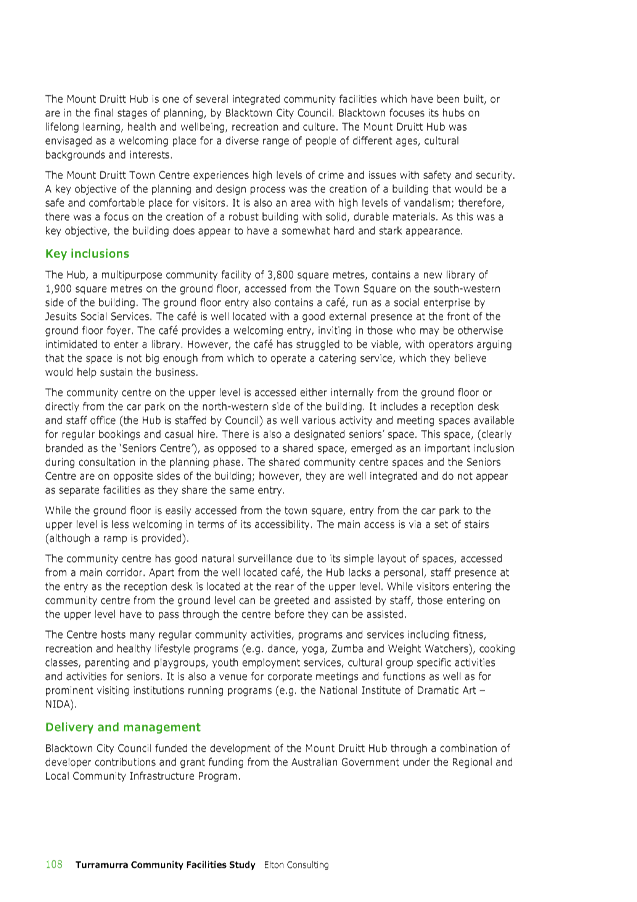
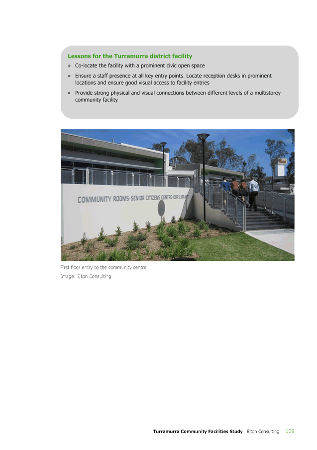
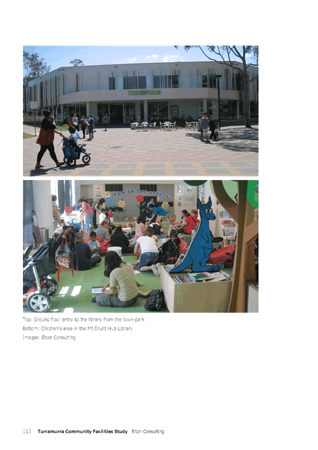
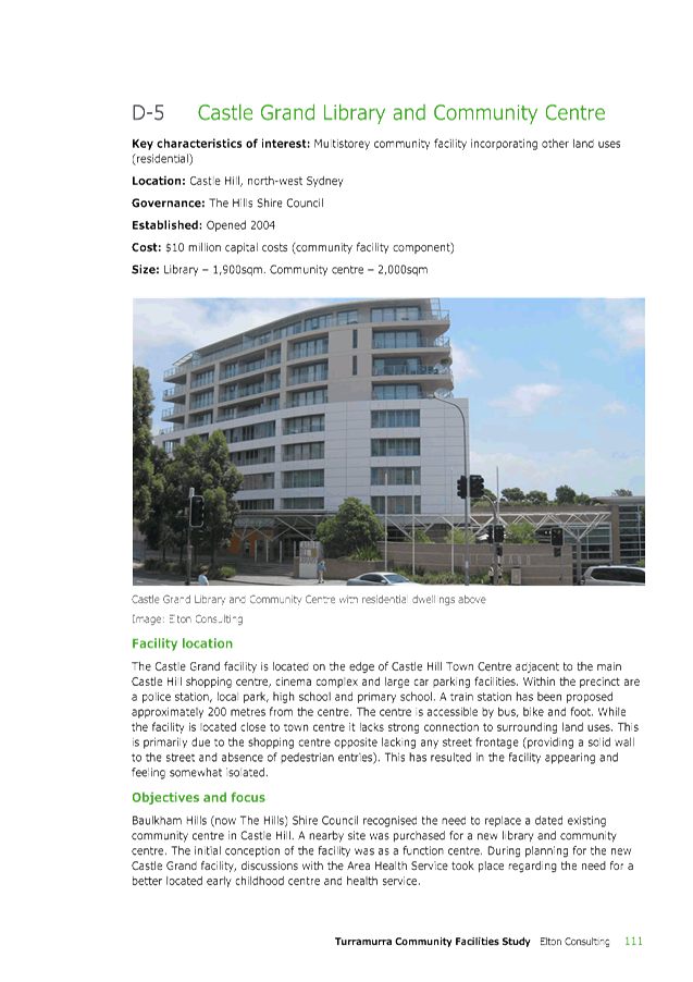
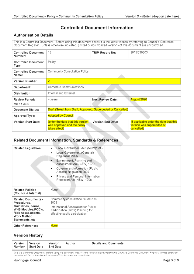
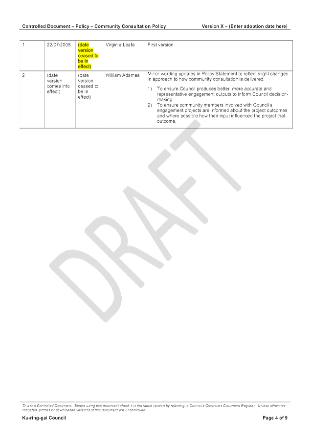
|
APPENDIX No: 1 - Draft Community Consultation Policy |
|
Item No: GB.2 |
Ordinary Meeting of Council
TO BE HELD ON Tuesday, 6 September 2016 AT 7:00 pm
Council Chambers
Agenda
** ** ** ** ** **
NOTE: For Full Details, See Council’s Website –
www.kmc.nsw.gov.au under the link to business papers
DECLARATIONS OF INTEREST
Address the Council
NOTE: Persons who address the Council should be aware that their address will be tape recorded.
Documents Circulated to Councillors
CONFIRMATION OF MINUTEs
Minutes of Ordinary Meeting of Council 10
File: S02131
Meeting held 23 August 2016
Minutes numbered 206 to 221
minutes from the Mayor
Petitions
GENERAL BUSINESS
i. The Mayor to invite Councillors to nominate any item(s) on the Agenda that they wish to have a site inspection.
ii. The Mayor to invite Councillors to nominate any item(s) on the Agenda that they wish to adopt in accordance with the officer’s recommendation allowing for minor changes without debate.
GB.1 Tulkiyan Heritage House - Historic Houses of Australia Association Inc - Management Proposal 79
File: S08172/4
For Council to approve an agreement with the Historic Houses Association of Australia Inc to manage Tulkiyan Heritage House, and for necessary works to be undertaken to enable Tulkiyan to be open to the public.
Recommendation:
That Council approve an agreement with the HHAA for the management of Tulkiyan Heritage House, that necessary building works be undertaken to enable Tulkiyan to be open to the public, and that funds be identified for building works and annual management and maintenance costs for Tulkiyan.
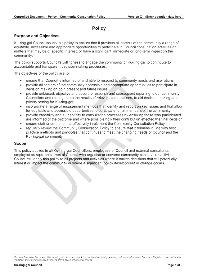
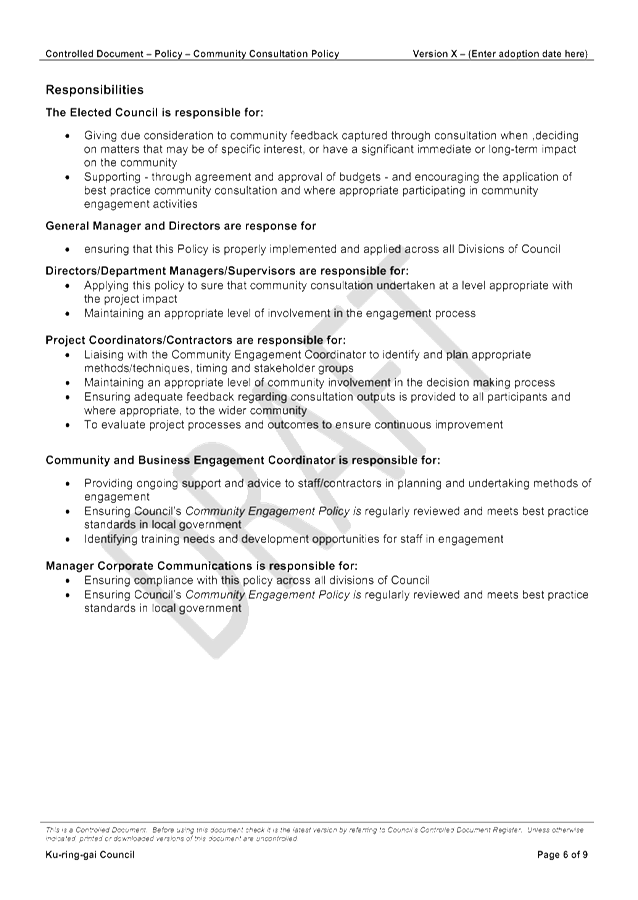
GB.2 Draft Community Consultation Policy 86
File: S02090
To seek Council’s endorsement for the draft Community Consultation Policy 2016 and to place the draft policy on public exhibition.
Recommendation:
That Council endorse the draft Community Consultation Policy 2016 and the draft policy be placed on public exhibition.
GB.3 Draft Media and Communications Policy 102
File: S07349
To seek Council’s endorsement for the draft Media and Communications Community Policy 2016 and to place the draft policy on public exhibition.
Recommendation:
That Council adopt the draft That Council endorse the draft Media and Communications Policy 2016 and the draft policy be placed on public exhibition.
GB.4 Council Sponsorship Proposals 2016-2017 118
File: S05650
To advise Council of the sponsorship requests received under Council’s Sponsorship Policy for 2016/2017, and for Council to approve all sponsorship requests over $5,000.
Recommendation:
That Council approve all sponsorship requests over $5,000 as outlined in this report.
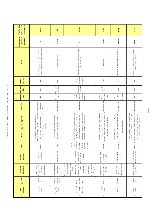
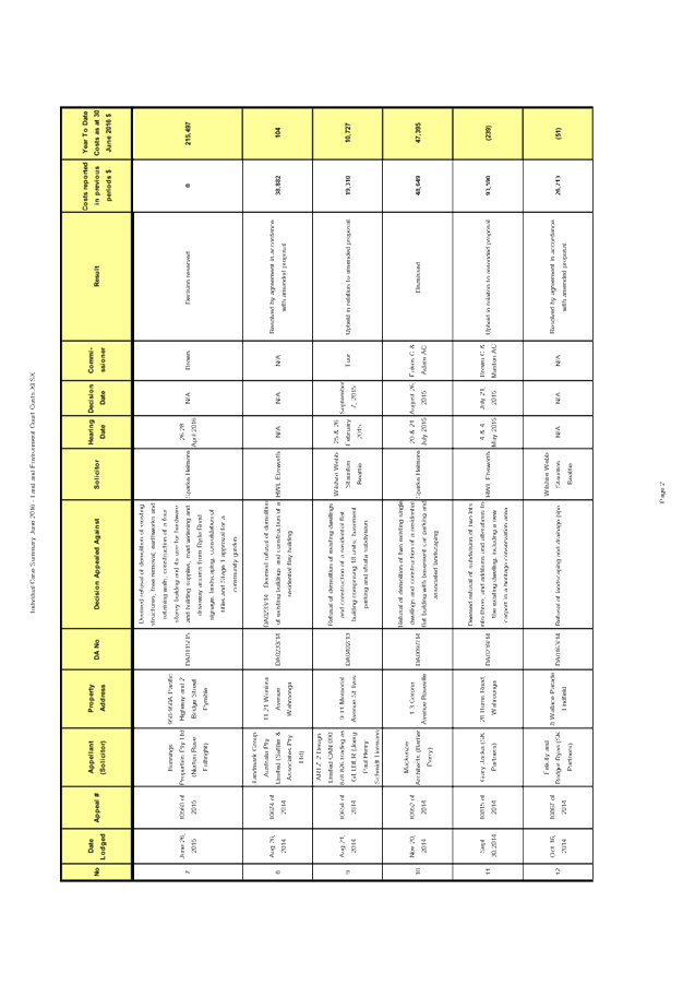
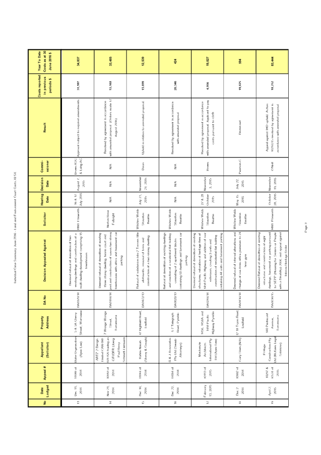
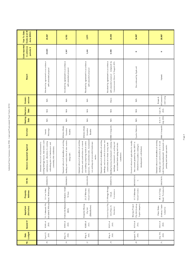
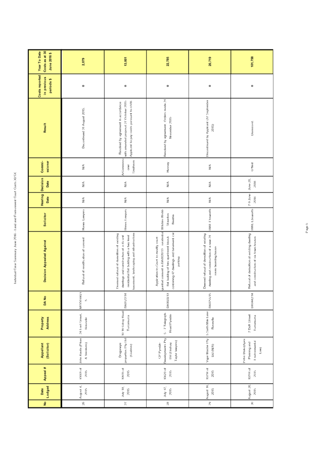
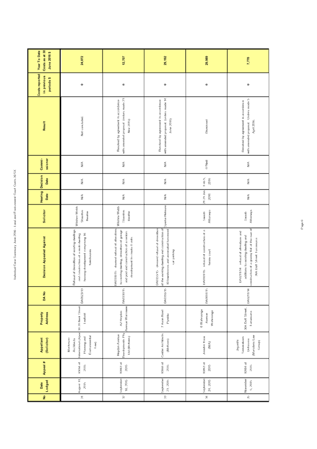
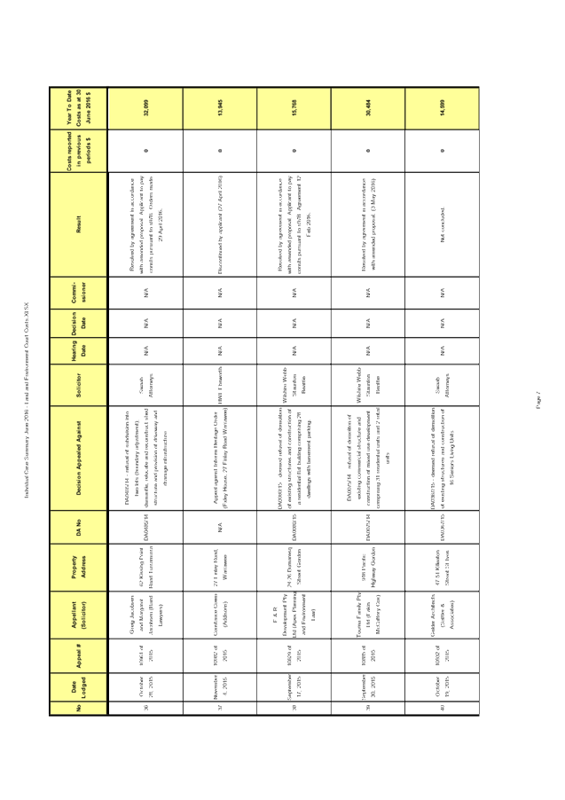
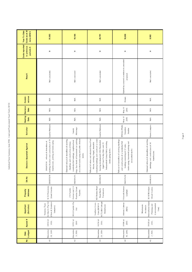
GB.5 Analysis of Land and Environment Court Costs - 4th Quarter 2015 to 2016 122
File: S05273
To report legal costs in relation to development control matters in the Land and Environment Court for year ended 30 June 2016.
Recommendation:
That the analysis of Land and Environment Court costs for the year ended 30 June 2016 be received and noted.
GB.6 16th International Cities, Town Centres and Communities Conference 138
File: CY00212/8
To inform Councillors of the 16th International Cities, Town Centres and Communities Conference being held in Launceston, Tasmania on 9-11 November 2016.
Recommendation:
That any Councillors wishing to attend the 16th International Cities, Town Centres and Communities Conference notify the General Manager by Friday 7th October 2016.
GB.7 27 Finlay
Road, Warrawee -
revocation of Interim Heritage Order 159
File: S10066
To have Council consider the revoking of the Interim Heritage Order for 27 Finlay Road, Warrawee.
Recommendation:
That Council revokes the Interim Heritage Order for 27 Finlay Road, Warrawee.
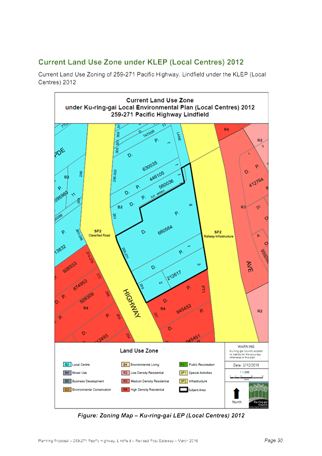
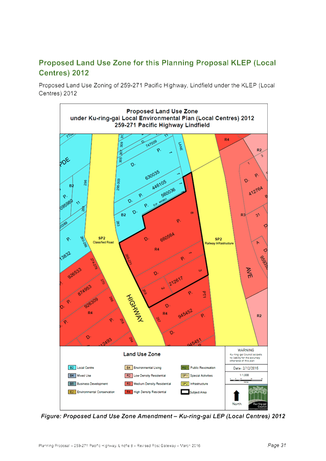
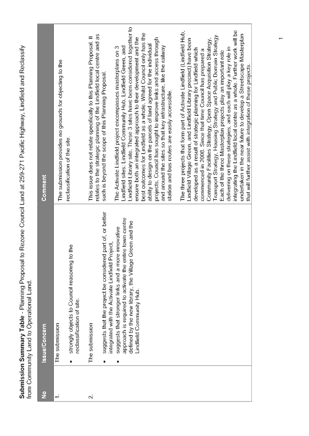
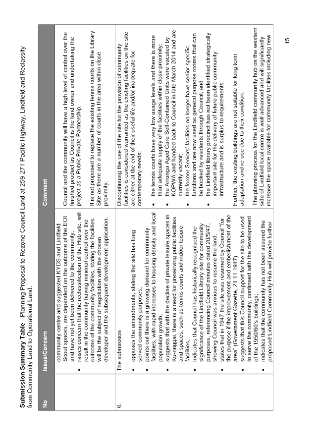
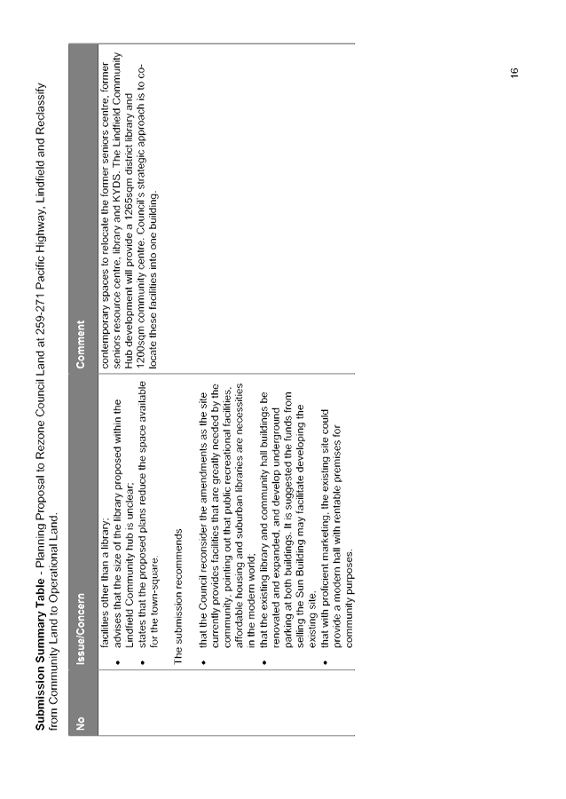
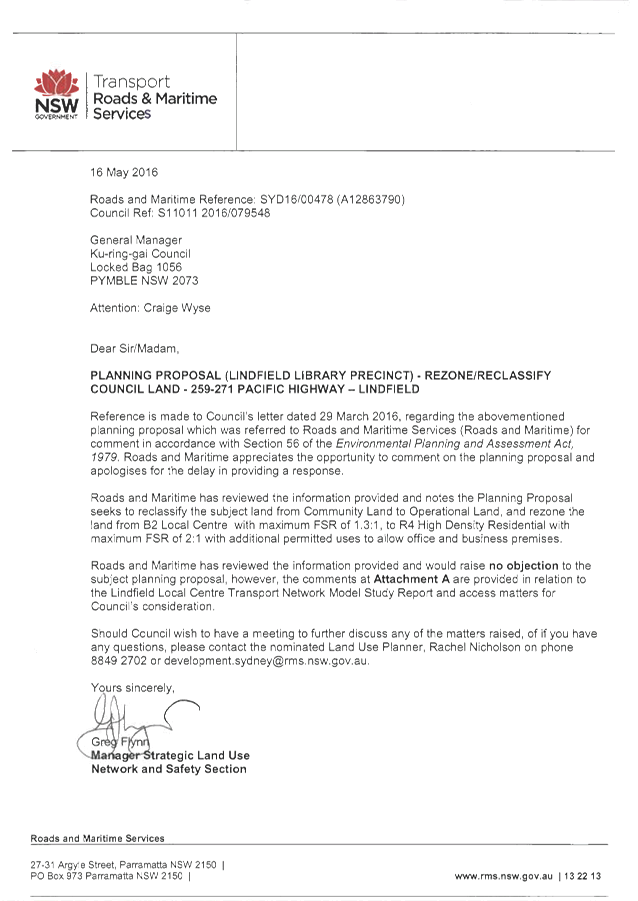
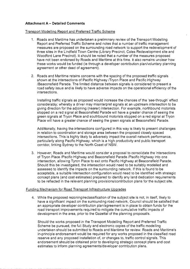
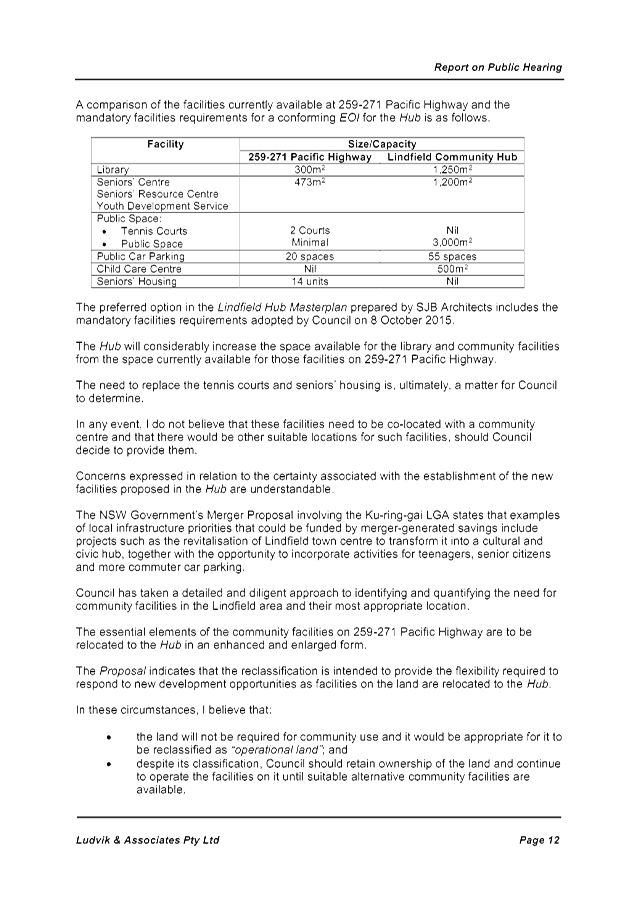
GB.8 Consideration of submissions to the exhibition and Public Hearing of Planning Proposal to Rezone and Reclassify land at 259-271 Pacific Highway Lindfield 163
File: S11011
To have Council consider the feedback following the exhibition and public hearing for the Planning Proposal to amend KLEP (Local Centres) 2012 to rezone Council land at 259-271 Pacific Highway, Lindfield and reclassify the land from Community Land to Operational Land.
Recommendation:
That Council adopts the Planning Proposal to amend KLEP (Local Centres) 2012 to rezone Council land at 259-271 Pacific Highway, Lindfield and reclassify the land from Community Land to Operational Land
That Council continues to operate the community facilities currently provided in the at 259-271 Pacific Highway, Lindfield until suitable alternative facilities are available
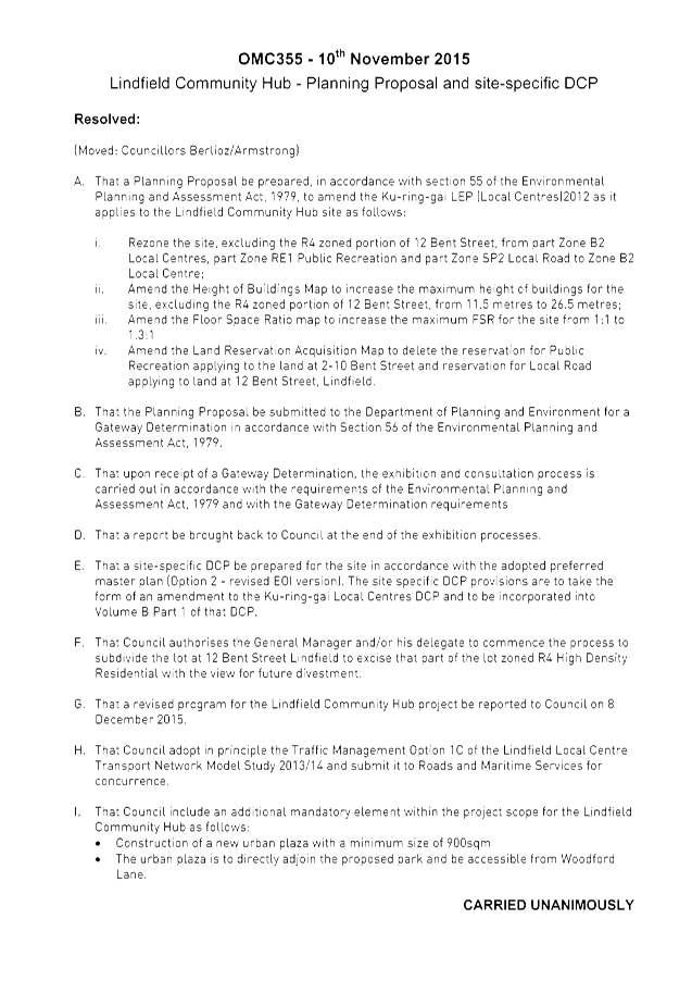
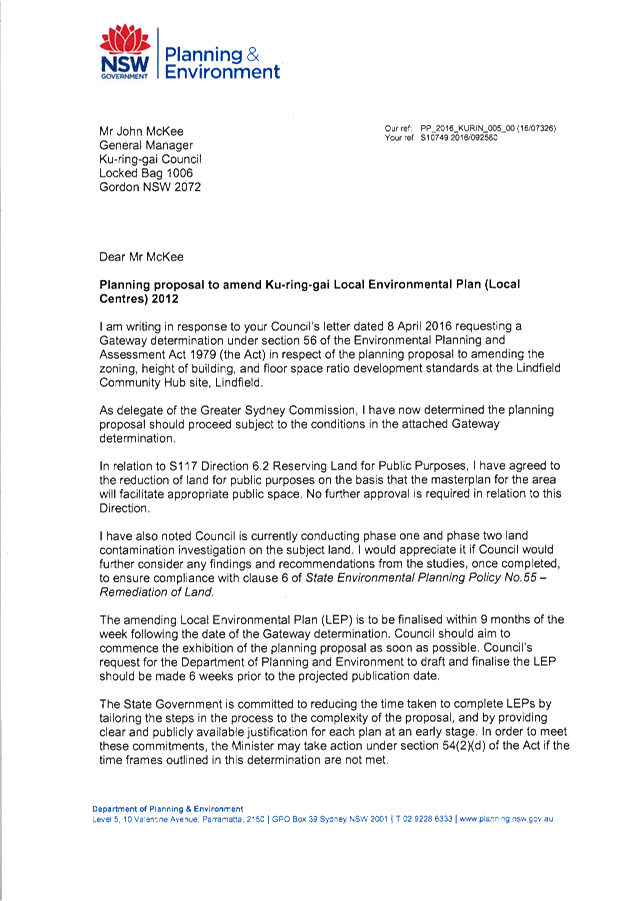
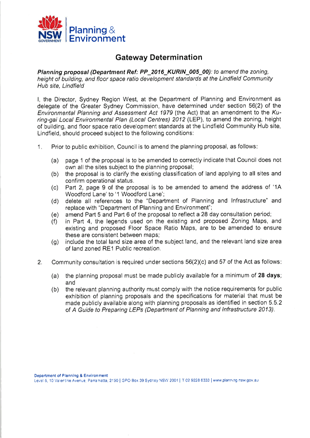
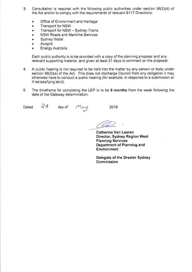
GB.9 Consideration of Submissions - Planning Proposal to amend KLEP(LC) 2012 to change the Zoning, Height, FSR at Woodford Lane and Drovers Way, Lindfield - Lindfield Community Hub site 270
File: S11057
To report back to Council on submissions received during the exhibition of the Planning Proposal to amend the Ku-ring-gai Local Environmental Plan (Local Centres) 2012 to modify the zoning, height and FSR of land parcels within the Lindfield Hub site at Woodford Lane and Drovers Way.
Recommendation:
That Council adopts the Planning Proposal to amend the Ku-ring-gai Local Environmental Plan (Local Centres) 2012 to modify the zoning, height and FSR on the Lindfield Hub site subject to a variation.
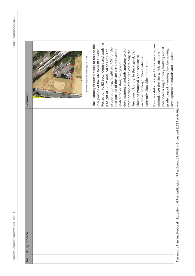
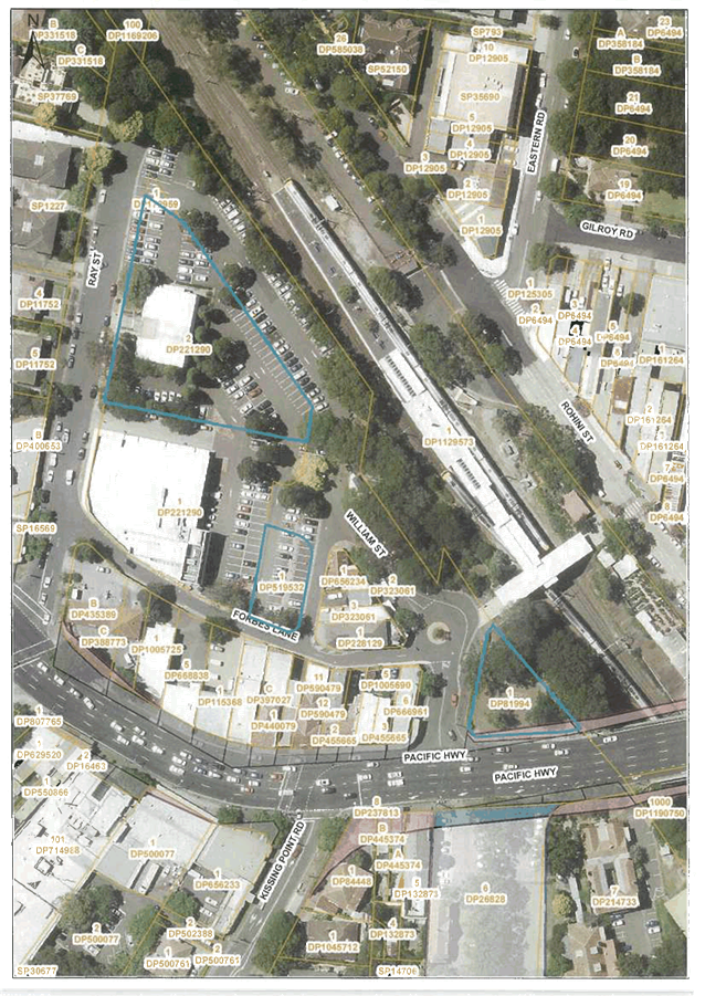
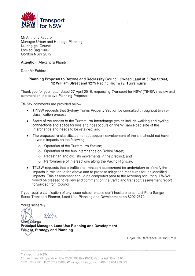
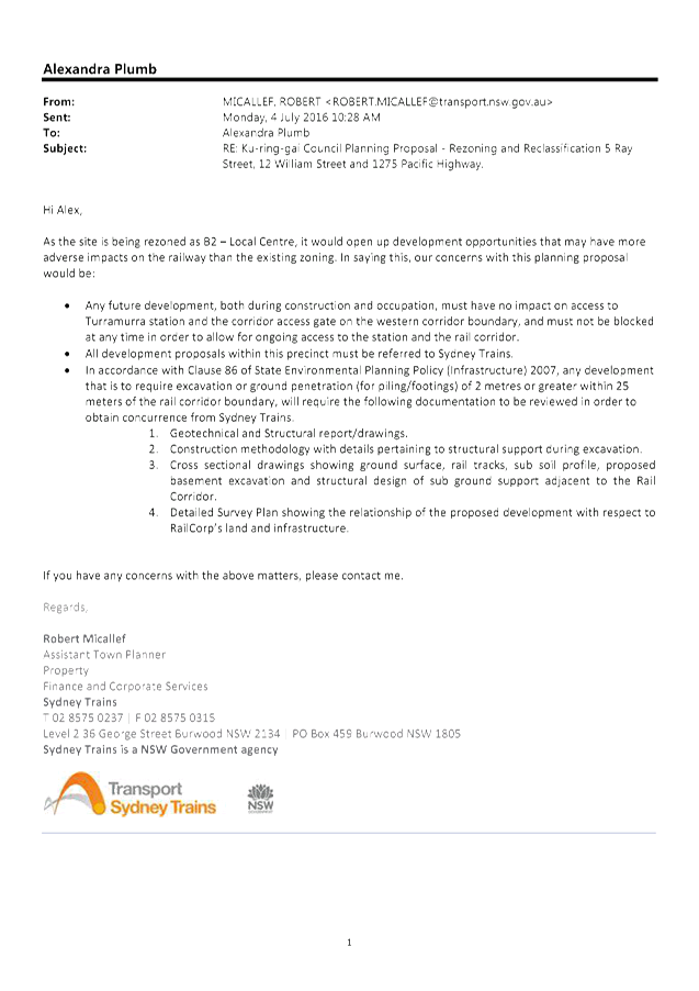
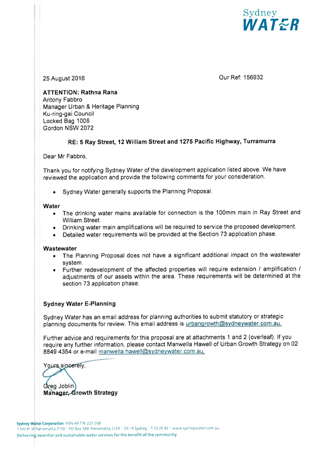
GB.10 Exhibition and Public Hearing - Planning Proposal to rezone and reclassify Council owned land at 5 Ray Street, 12 William Street and 1275 Pacific Highway, Turramurra 304
File: S11073
For Council to consider the feedback following the exhibition and public hearing for the Planning Proposal to rezone and reclassify Council owned land at 5 Ray Street, 12 William Street and 1275 Pacific Highway, Turramurra
Recommendation:
That Council proceeds with Planning Proposal to reclassify and rezone 5 Ray Street and 12 William Street Turramurra.
That 1275 Pacific Highway, Turramurra (Village Park) be deferred from the Planning Proposal.
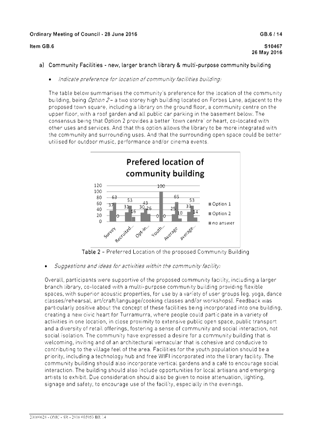
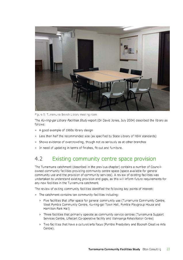
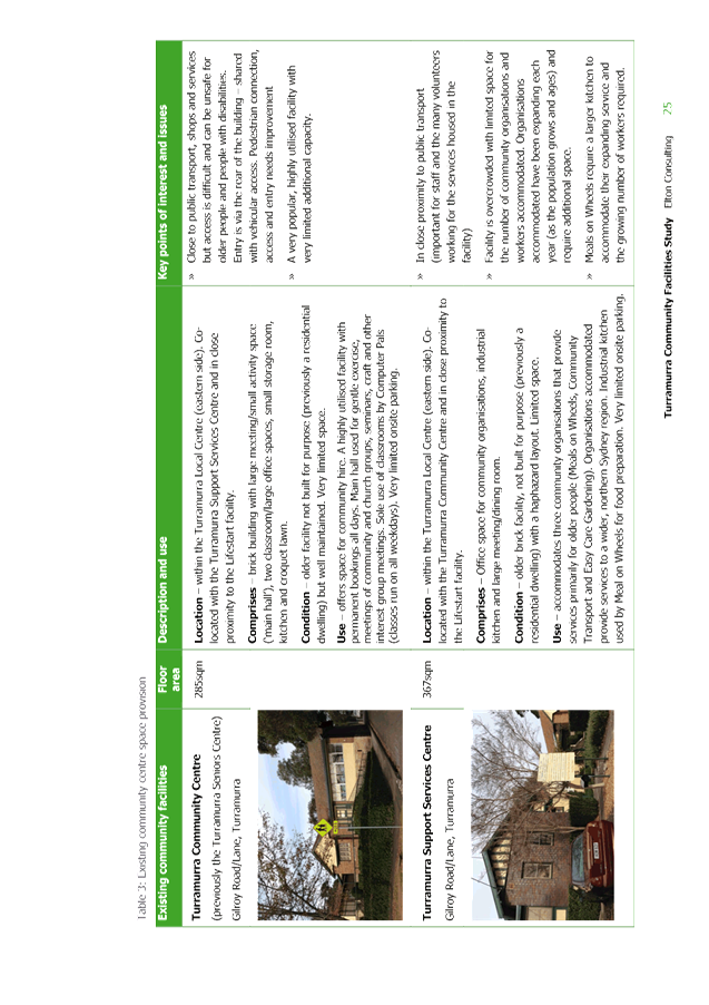
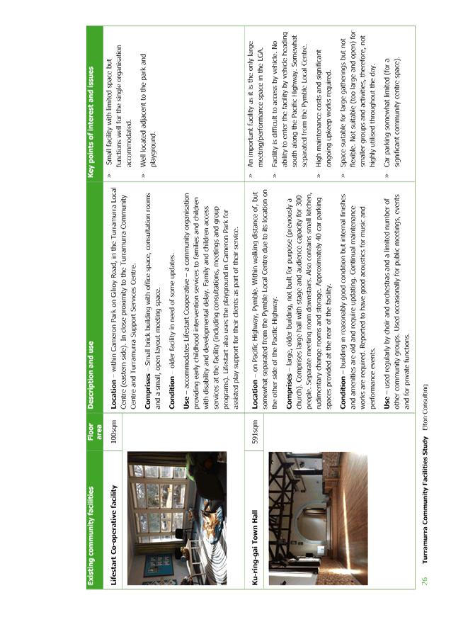
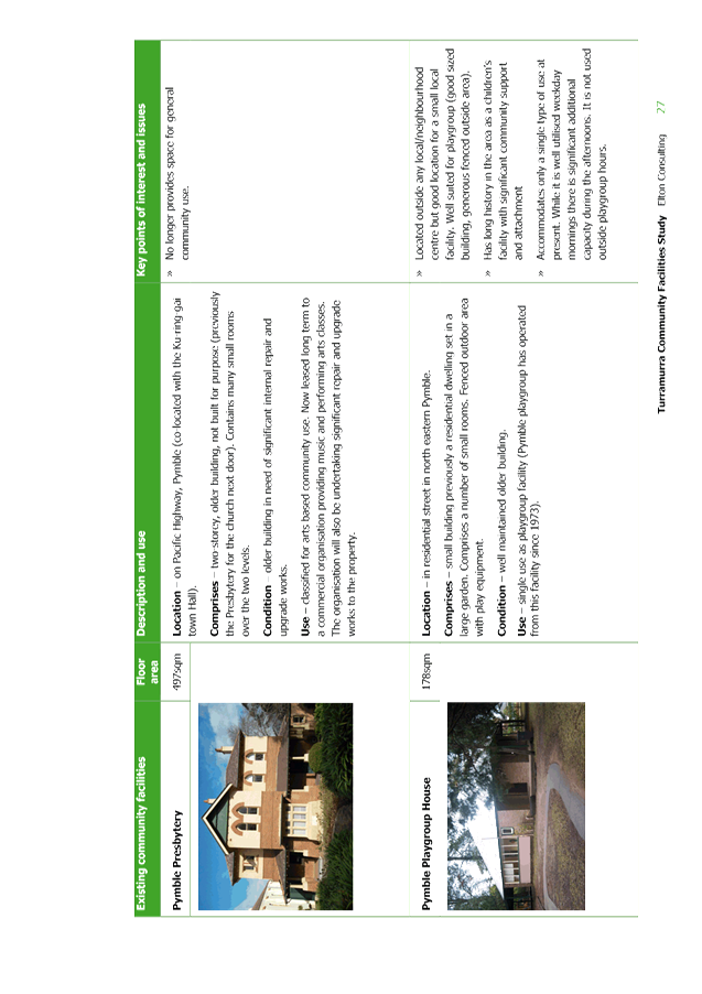
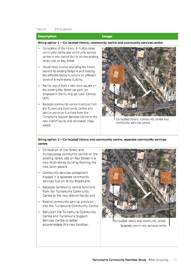
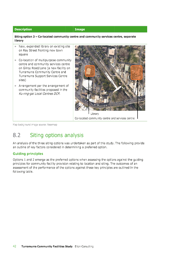
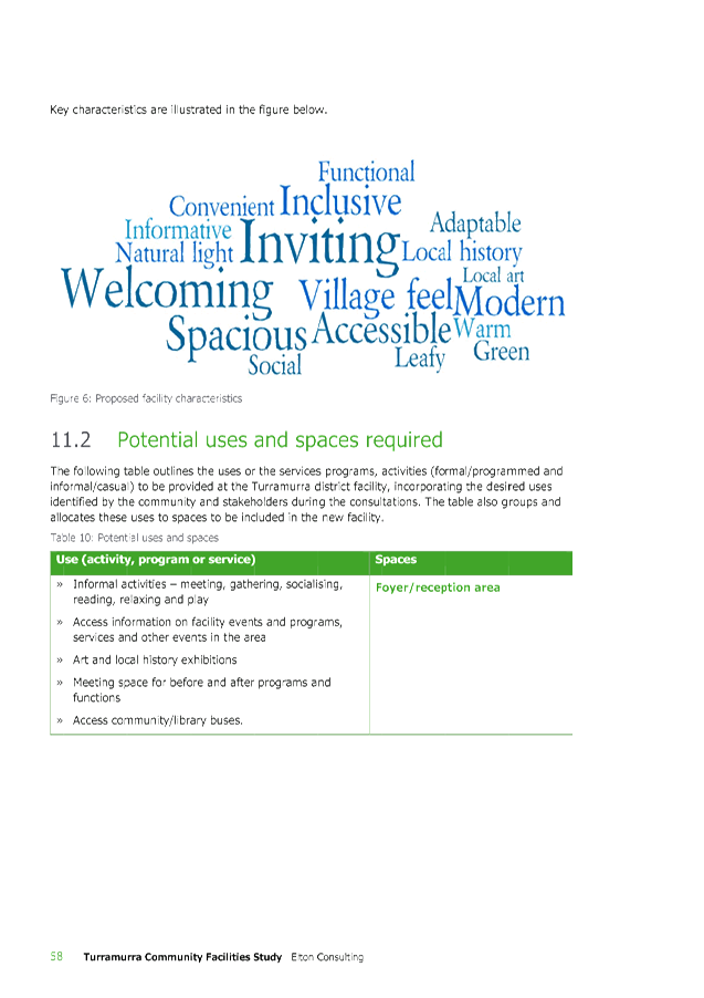
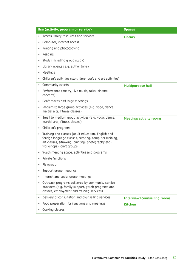
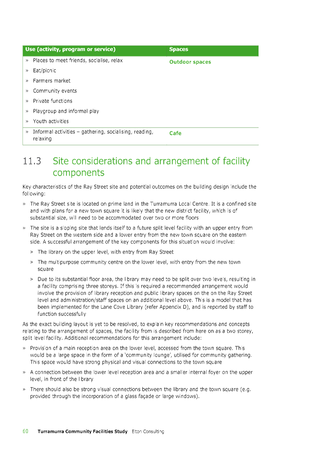
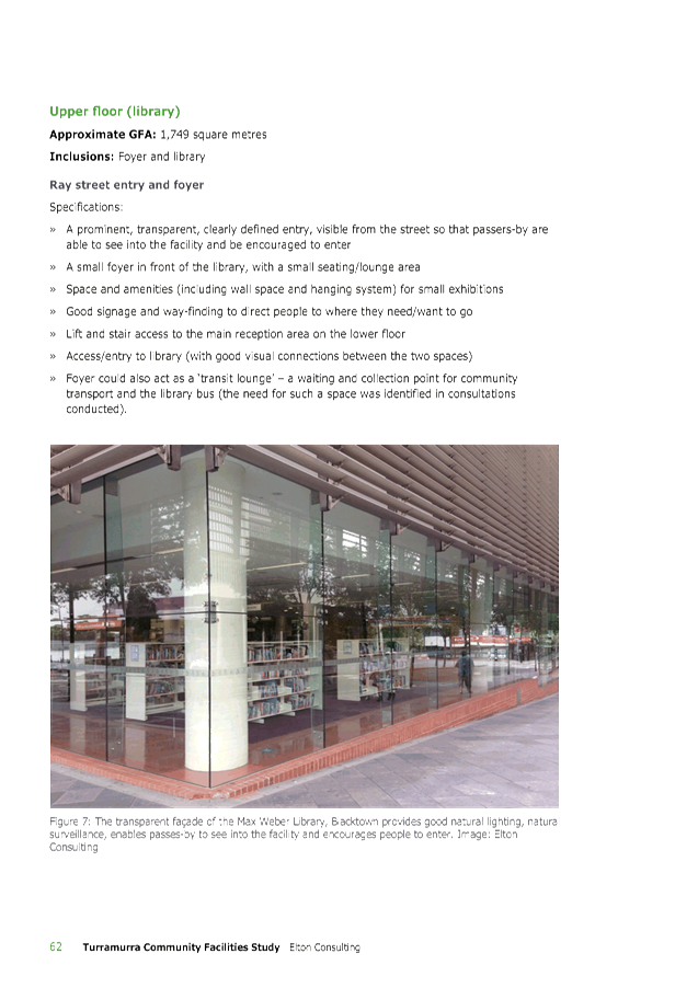
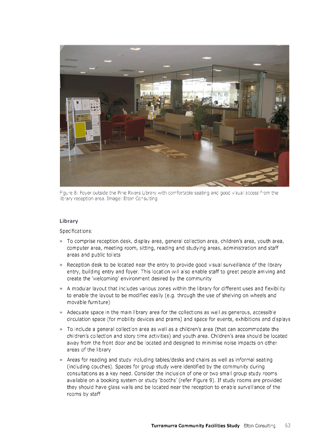
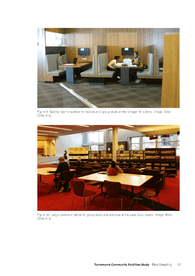
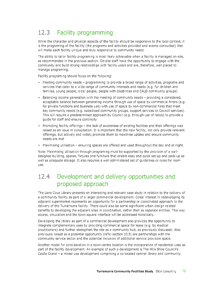
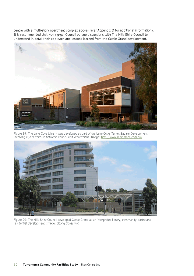
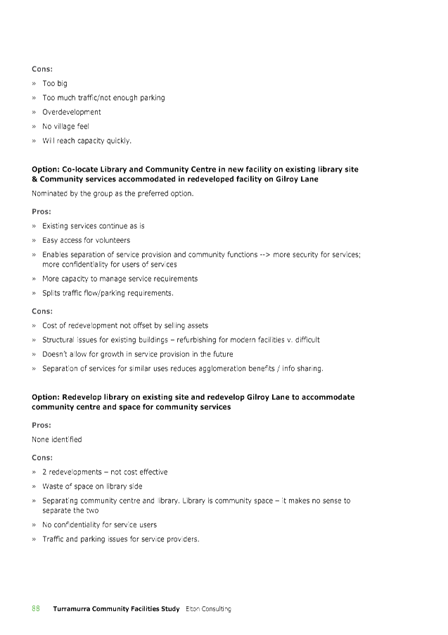
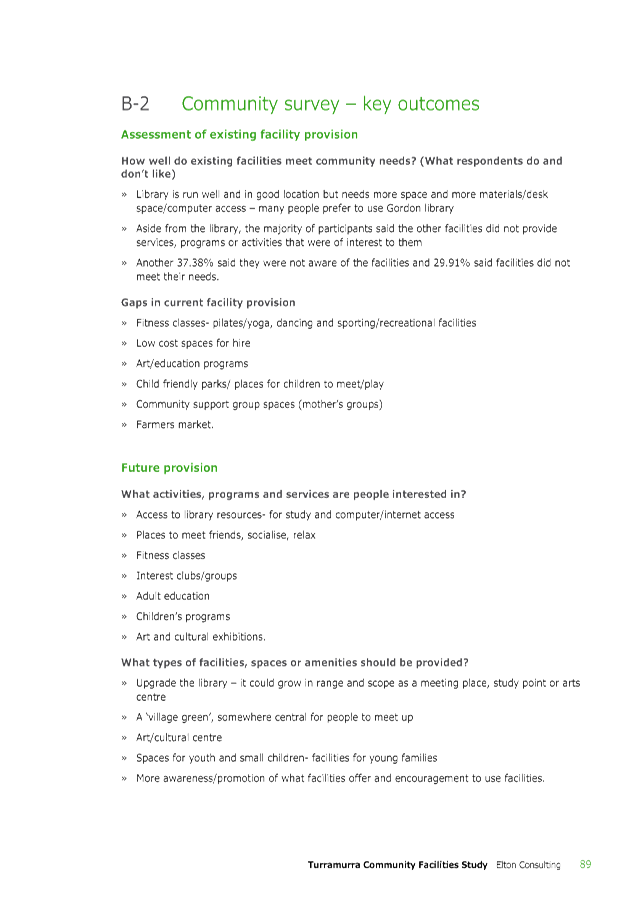
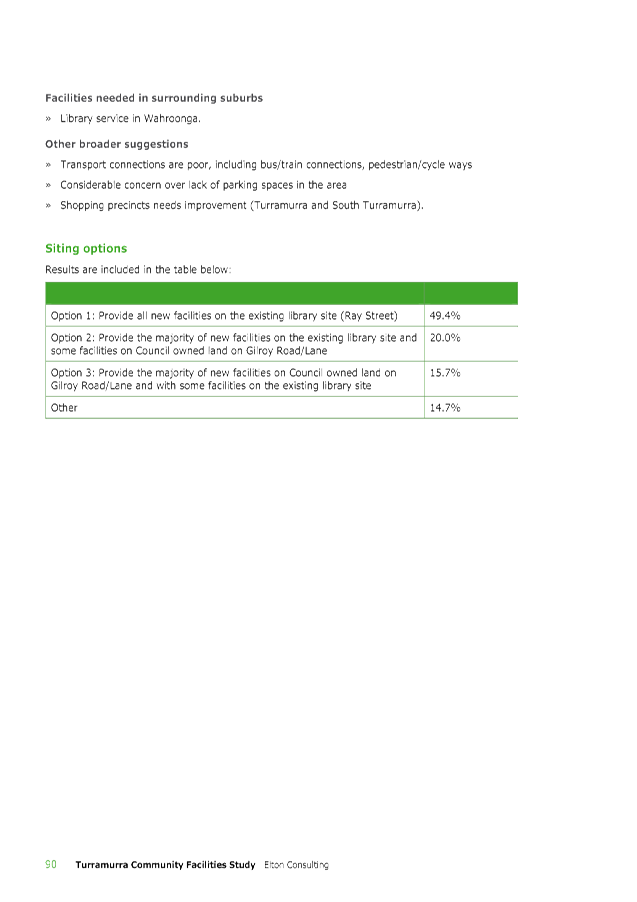
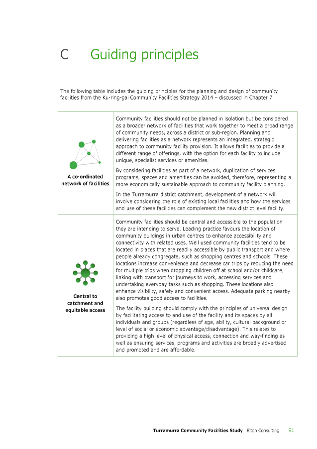
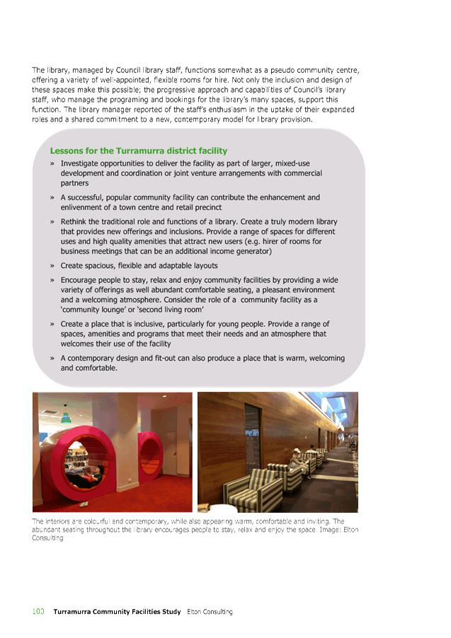
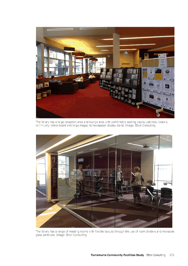
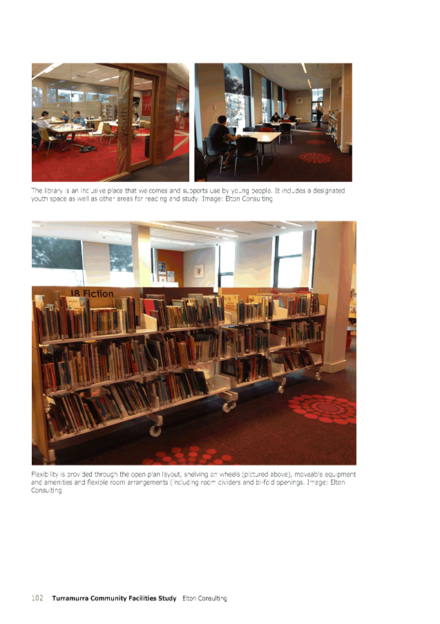
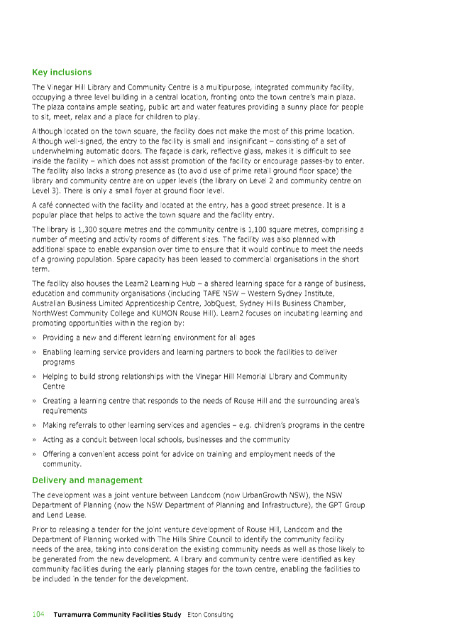
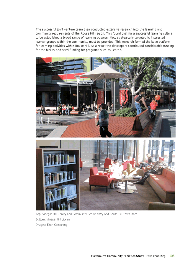
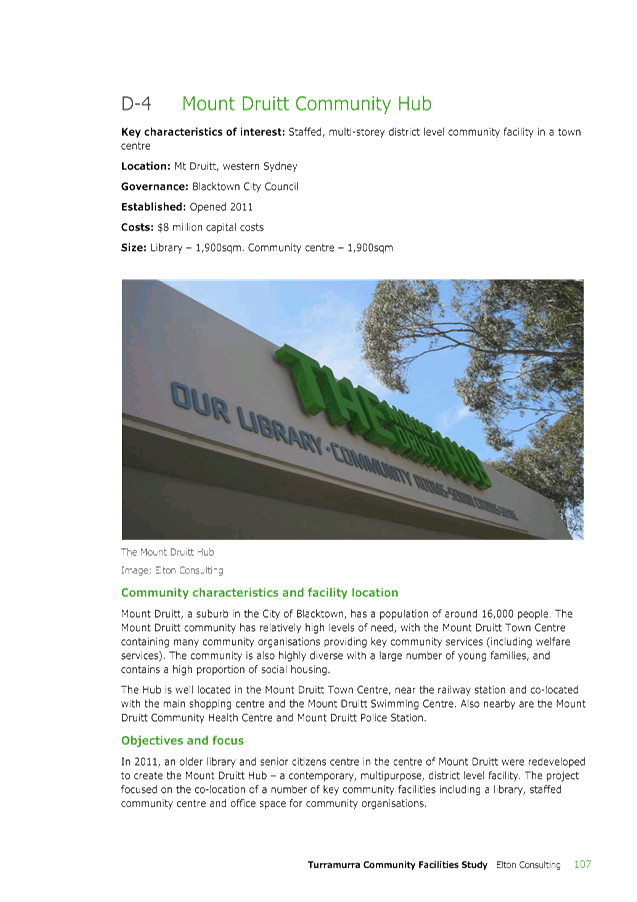
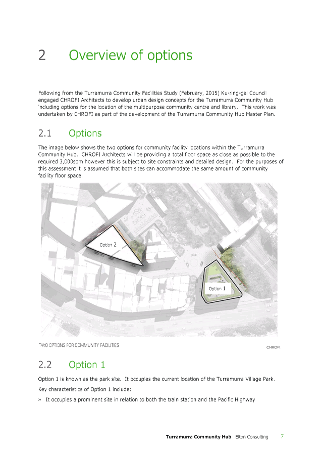
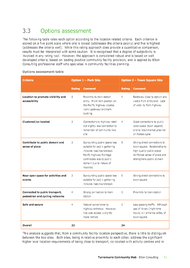
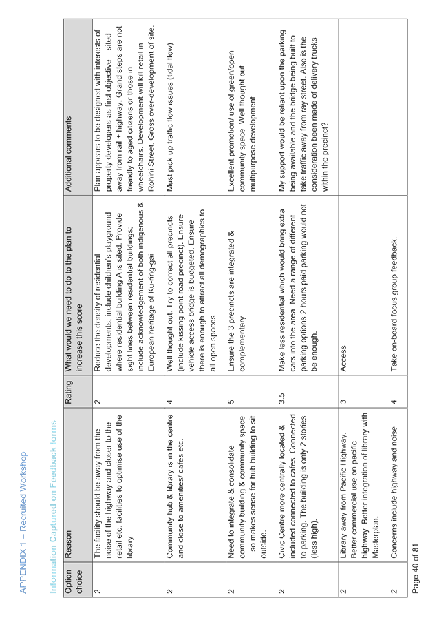
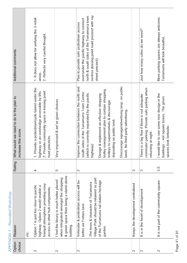
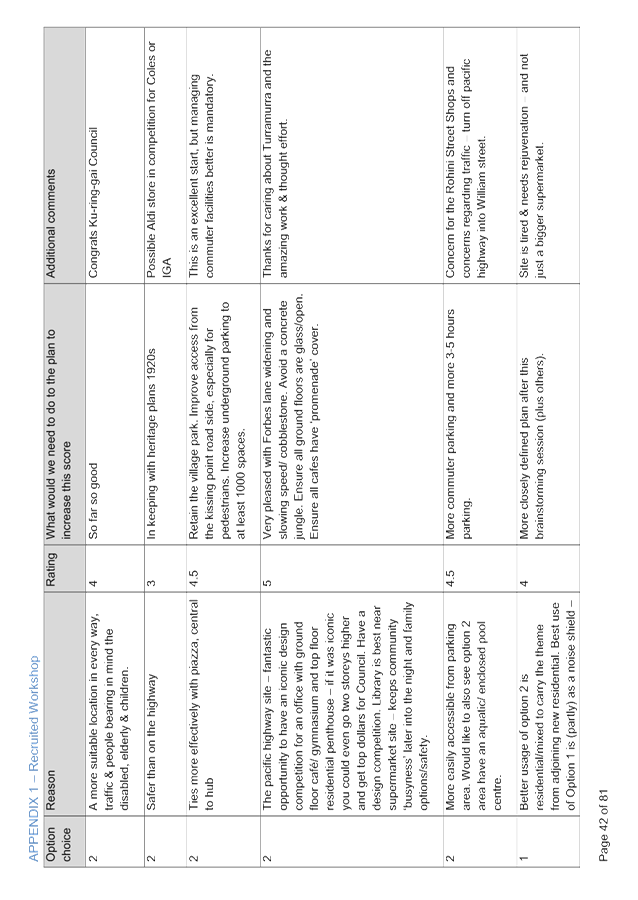
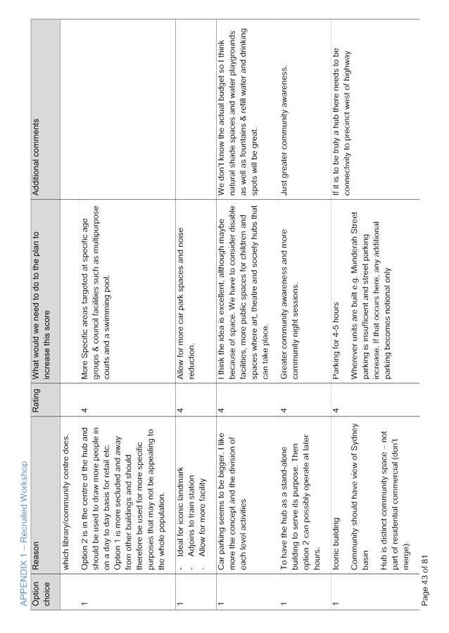
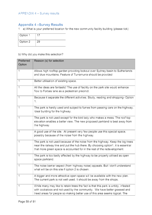
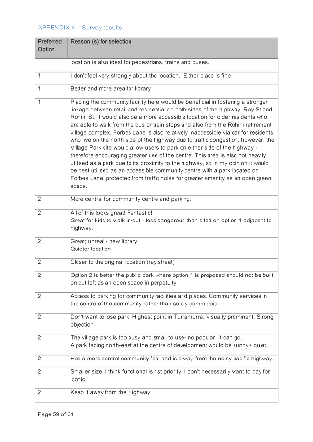
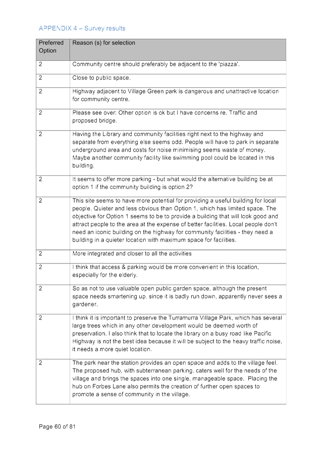
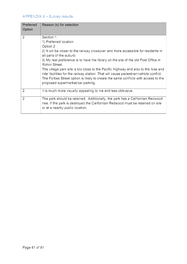
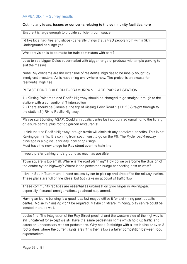
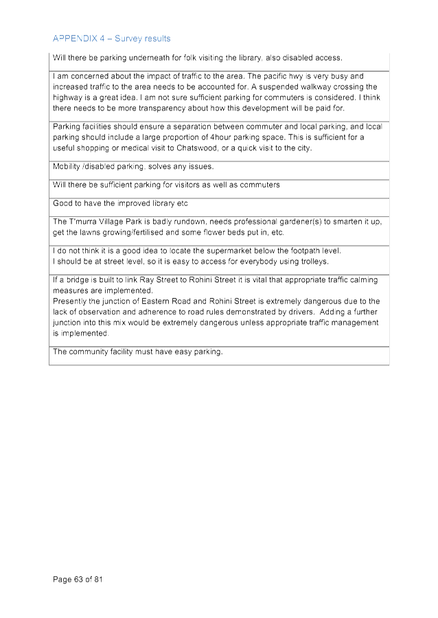
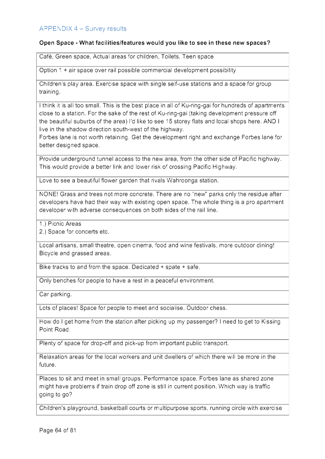
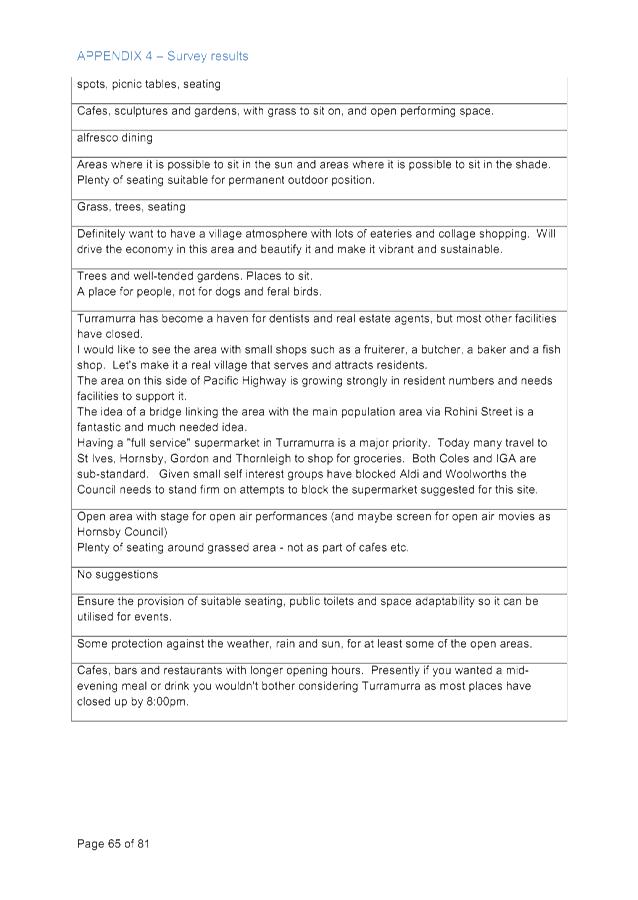
GB.11 Turramurra Community Hub Master Plan - Community Facilities 383
File: S10467
The purpose of this report is to recommend to Council the preferred location for a new Turramurra community building comprising a branch library and community centre.
Recommendation:
That Council adopts the Turramurra Community Facilities Study, 2015 as the basis for ongoing planning and design of the proposed Turramurra Community Building and that
Council adopts the Turramurra Village Park as the preferred site for the location of the proposed Community Building.
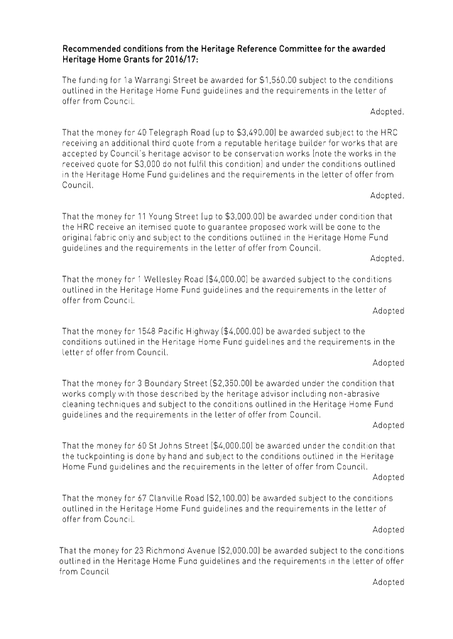
GB.12 Heritage Reference Committee Recommendation for Heritage Home Grants 651
File: S11080
For Council to consider the recommendations from the Heritage Reference Committee (HRC) regarding the allocation of the Heritage Home Grants for 2016/17.
Recommendation:
That Council receive and note the HRC recommendations and approve the grant applications for the Heritage Home Fund 2016/17.
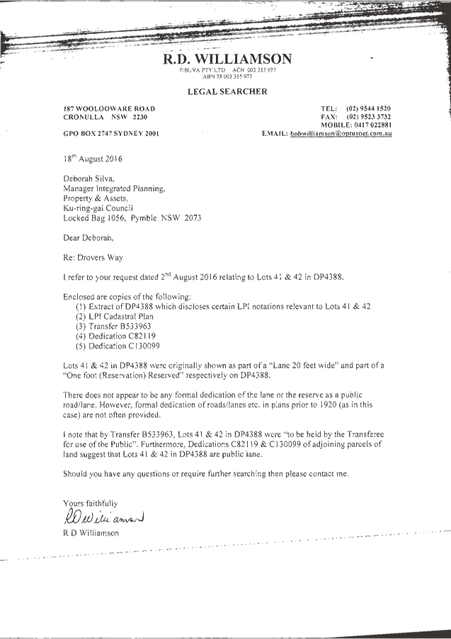
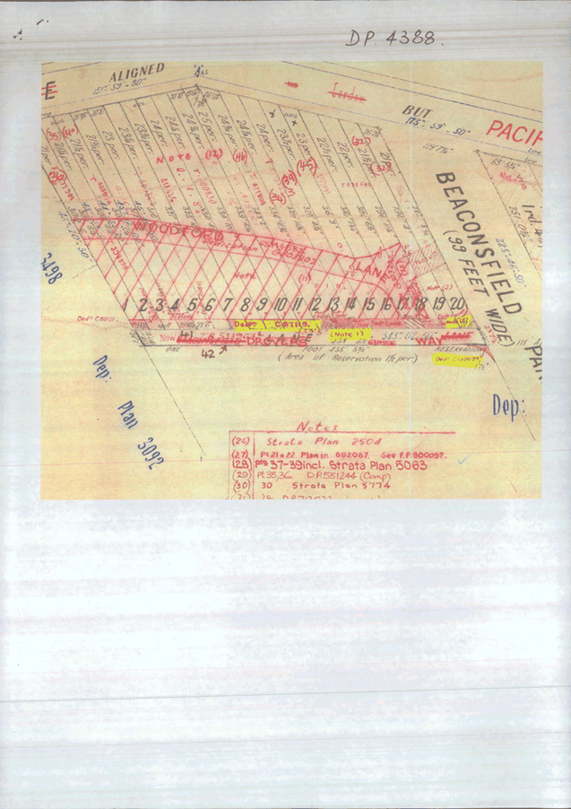
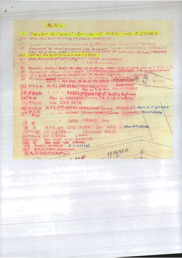
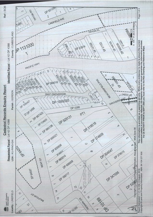
GB.13 Public Roads within Lindfield Major Project Sites 657
File: S10973
To seek Council approval to formally resolve the status of land within the Lindfield Village Green and the Lindfield Community Hub sites as a public road.
Recommendation:
A. That Council formally gazette Lot 41 DP4388 and Lot 42 DP4388 as a public road in accordance with Section 10 Roads Act 1993.
B. That Council compulsory acquire Lot 21 DP1223433 for a future public road in accordance with Section 177 Roads Act 1993.
GB.14 Turramurra Local Centre - Traffic and Transport Study 686
File: S10467
To consider the Turramurra Community Hub Transport Scenario Testing study.
Recommendation:
A. That Council adopt the Turramurra traffic and transport study (with the rail bridge option) in principle, and forward the proposal to Roads and Maritime Services for formal concurrence.
B. The property No. 12 Turramurra Avenue (Lot 2 DP983832), Turramurra be divested by in accordance with Council’s – Acquisition and Divestment of Land Policy 2014 and the funds returned to the Ku-ring-gai Contributions Plan 2010 Section 94 reserves.
GB.15 North
Turramurra Recreation Area
Funding review and options 695
File: S10894/2
To advise Council of the current funding shortfall for the completion of the sports fields car park at North Turramurra Recreation Area and provide options for the funding of the car park.
Recommendation:
That the current capital works budget for 2016/2017 be adjusted to transfer $550,000 from the Neighbourhood Centres Program to the North Turramurra Recreation Area to allow the calling of tenders for the construction of the sports field car park.
Extra Reports Circulated to Meeting
Motions of which due Notice has been given
NM.1 Fencing around bushland areas 702
File: S07967
Notice of Motion from Councillor Malicki dated 29 August 2016
Council owns many areas of very special vegetation and over the past years much of this is being individually fenced, in particular in Comenarra Ward.
I have been concerned that fencing of several of these areas has brought considerable distress to residents and that in most areas there has been no consultation and no consideration of the views of residents.
The Blue Gum High Forest adjacent to The Glade Oval was fenced several years ago. Residents felt that they had been cut off from bushland to which they had always had access, and they were unhappy with the type of fencing chosen which they felt was inappropriate to the area.
In South Turramurra between Auluba Ovals 2 and 3, bushland previously accessible to all residents was fenced off with just a narrow pathway between. Residents said they felt "alienated" from the bushland and that the fencing was far too high and visually dominating. They felt there were safety issues because of the narrow walkway through an area previously unfenced.
Similarly fencing has been installed around bushland at Mimosa Oval and just two weeks ago adjacent to the beautiful Sheldon Forest.
The Warragal Rd frontage to Sheldon Forest is around a hundred metres in length and although local residents were notified that fencing was to be installed, it was to be "strategic installation of non intrusive timber fencing". There was no consultation about location or type of fence to be installed either with residents or Ward Councillors.
In fact the fencing at Sheldon forest is extremely intrusive and completely changes the character of the forest as seen from the roadway. It is located at the top of a steep slope and as no one accesses the forest here due to the slope I have questioned the necessity for any fence.
Each of the fences installed around bushland in Comenarra was of a different height, style and materials.
I move:
1. That for all future fencing around council owned bushland advance consultation must occur with local residents and Ward Councillors.
2. That residents in the streets surrounding the Warragal Road frontage to Sheldon Forest all be sent a letter asking for their views on the new fencing and similarly those properties and streets adjoining the forest on the Pymble side. The results of this late consultation be sent to Councillors by memo.
3. That in future all fencing around council's bushland be of a consistent height, style and materials.
4. That the cost of the fencing in South Turramurra, Mimosa Oval and on both sides of Sheldon Forest be reported back to Councillors by Memorandum.
NM.2 Traffic Management 704
File: TM9/08
Notice of Motion from Councillor Ossip dated 29 August 2016
St Ives, more than any other suburb in Ku-ring-gai, has suffered the adverse consequences of overdevelopment over the past decade. Extrapolating data from the 2011 census, there was an 8% increase in the amount of dwellings in St Ives between 2006-2011. Accompanying this increase in dwellings was an increase in population of 1,311 over that same time period. Of course, both of these figures don’t take into account the substantial development and population growth which has taken place since the census was conducted and the development which is still scheduled to take place.
The determination to cram hundreds more dwellings into St Ives has not been accompanied by adequate planning and necessary investments in infrastructure. Consequently, existing infrastructure is under greater strain than ever before. Of particular concern to residents is the increased traffic congestion being experienced in St Ives – not surprising given that St Ives does not have a train station and has a high level of car ownership and usage.
I am regularly contacted by residents of St Ives who are concerned with traffic issues in local streets surrounding the St Ives town centre and near new multi residential developments. I note that existing traffic conditions in Stanley Street, Yarrabung Road, Memorial Avenue, Cowan Road, Porters Lane, Shinfield Avenue and Killeaton Street are of particular concern to residents.
Council staff undertook traffic and speed counts last year at various locations in St Ives around the town centre and concluded that there were increases in traffic volumes at most intersections, with the following intersections showing greater than expected increases:
1. Memorial Avenue at Village Green Parade and Killeaton Street
2. Cowan Road at Village Green Parade and Kanoona Avenue
3. Stanley Street at Horace Street/Link Road and Lancaster Avenue
4. Carbeen Avenue at Killeaton Street and Mungarra Avenue
Background
In 2005, Council commissioned a traffic study for each of the Town Centres to assess the traffic impacts of proposed development under both LEP 194 and the proposed Town Centres LEP. The study was to assess the likely traffic impacts of current and future development around the town centres and provide recommendations for improvements to be approved by the Roads and Traffic Authority (now Roads and Maritime Services) under a Section 62 notification process and included in the Contributions Plan.
Council adopted the St Ives Town Centre Traffic Improvement Plan at its meeting of 25 August 2005.
The estimated total cost of the Traffic Improvement Plan is approximately $1.6 million of which $762,000 has been included in the Contributions Plan.
Council staff have previously noted that Council does not have sufficient funds to implement the traffic management proposals. Some of the proposed works are considered to have a direct relationship to development under the Town Centres LEP and are accordingly reliant upon developer contributions for funding. At this stage, there has been limited development works commenced in St Ives under the Town Centres LEP. Additionally, a significant proportion of the proposed funding for the plan is contingent on the redevelopment of the St Ives Shopping Village. Therefore, Council has not collected significant funding for any of the proposed works.
Finally, Council only provides approximately $150,000 for traffic capital improvement works. These are prioritised under Council’s adopted Traffic and Transport Policy and Ten Year Traffic Plan.
Recommendation
It is accordingly apparent that whilst the traffic situation in St Ives is deteriorating, there is no definite timeframe on implementing the St Ives Town Centre Traffic Improvement Plan. This is of great concern given that the existing traffic congestion will only be exacerbated as constructed dwellings become fully occupied and further development takes place.
Therefore, it is of crucial importance that Council takes action to address existing and anticipated traffic issues within St Ives. Failure to fund traffic management in St Ives will significantly reduce resident amenity now and in the future.
I accordingly move that:
1. A report be brought back to Council which examines alternate sources of funding for the St Ives Town Centre Traffic Improvement Plan.
2. The report provide short-term options for alleviating traffic congestion in Stanley Street, Yarrabung Road, Memorial Avenue, Cowan Road, Porters Lane, Shinfield Avenue and Killeaton Street.
BUSINESS WITHOUT NOTICE – SUBJECT TO CLAUSE 241 OF GENERAL REGULATIONS
Questions Without Notice
Inspections Committee – SETTING OF TIME, DATE AND RENDEZVOUS
** ** ** ** ** **
Minute Ku-ring-gai Council Page
MINUTES
OF Ordinary Meeting of Council
HELD ON Tuesday, 23 August 2016
|
Present: |
The Mayor, Councillor C Szatow (Chairperson) (Gordon Ward) Councillors E Malicki & J Pettett (Comenarra Ward) Councillor D Citer (Gordon Ward) Councillors C Berlioz & D Ossip (St Ives Ward) Councillors J Anderson & D Armstrong (Roseville Ward) Councillor D McDonald (Wahroonga Ward) |
|
|
|
|
Staff Present: |
General Manager (John McKee) Director Corporate (David Marshall) Director Development & Regulation (Michael Miocic) Director Operations (Greg Piconi) Director Strategy & Environment (Andrew Watson) Director Community (Janice Bevan) Corporate Lawyer (Jamie Taylor) Manager Records and Governance (Amber Moloney) Minutes Secretary (Sigrid Banzer) Project Leader (Dean Payne) |
The Meeting commenced at 7:00 pm
The Mayor offered the Prayer
|
206 |
Apologies
File: S02194
|
|
|
Resolved:
(Moved: Councillors Anderson/McDonald)
Councillor Fornari-Orsmond tendered an apology for non-attendance (work commitments) and requested leave of absence.
The Mayor noted that Councillor Ossip had not yet arrived.
That the apology for Councillor Fornari-Orsmond be accepted and leave of absence granted.
CARRIED UNANIMOUSLY |
DECLARATIONS OF INTEREST
The Mayor adverted to the necessity for Councillors and staff to declare a Pecuniary Interest/Conflict of Interest in any item on the Business Paper.
No Interest was declared.
|
|
CONFIRMATION OF REPORTS TO BE CONSIDERED IN CLOSED MEETING
File: S02499/9
|
|
|
|
|
|
That in accordance with the provisions of Section 10 of the Local Government Act 1993, all officers’ reports be released to the press and public, with the exception of confidential attachments to the following General Business reports:
GB.4 Lindfield Village Green - Final Concept Design Attachment A2: JLL market report In accordance with 10A2(c) and (d)(i)
Attachment A3: Cost estimate In accordance with 10A2(c), (d)(i) and (d)(ii)
|
DOCUMENTS CIRCULATED TO COUNCILLORS
The Mayor adverted to the documents circulated in the Councillors’ papers and advised that the following matters would be dealt with at the appropriate time during the meeting:
|
Late Items: |
MM.1 - Proposed Alternate Resolution to Amend the NSROC Constitution – Mayoral Minute by Mayor Councillor Cheryl Szatow dated 16 August 2016 |
|
Memorandums: |
GB.5 – Lindfield Village Green Final Concept Design Memorandum from Manager Urban & Heritage Planning dated 16 August 2016 advising large attachment has been circulated separately. GB.5 – Lindfield Village Green – Final Concept Design – additional information Memorandum from the Director Strategy & Environment dated 22 August 2016 with a map attached showing proposed future traffic upgrades for the road network within the vicinity of Lindfield Village Green. GB.5 – Lindfield village Green – Final Concept Design – amendment to Part C of the Recommendation. Memorandum from Director Strategy & Environment dated 23 August 2016 advising of a minor amendment to Part C of the Recommendation. |
CONFIRMATION OF MINUTEs
|
207 |
Minutes of Ordinary Meeting of Council File: S02131
|
|
|
Meeting held 9 August 2016 Minutes numbered 185 to 205
|
|
|
Resolved:
(Moved: Councillors McDonald/Pettett)
That Minutes numbered 185 to 205 circulated to Councillors were taken as read and confirmed as an accurate record of the proceedings of the Meeting with a minor correction to the Declaration of Interest by Councillor McDonald in relation to Hornsby Ku-ring-gai Community Aged/Disabled Transport Service Inc. this declaration of interest should read:
Councillor McDonald declared a less than significant, non-pecuniary conflict of interest in respect to GB.4 – Hornsby Ku-ring-gai Community Aged/Disabled Transport Service Inc – Renewal of Licence, which is also present in the same building as GB.3 above. Councillor McDonald advised he would stay in the chamber during discussion and voting on this item.
CARRIED UNANIMOUSLY |
minutes from the Mayor
|
208 |
Proposed Alternate Resolution to Amend the NSROC Constitution
File: CY00430/4 Vide: MM.1
|
|
|
Background
Over the last few months the Northern Sydney Regional Organisation of Councils (NSROC) Board has considered the options for the operation of NSROC in the context of the Local Government reform agenda, including the receipt of legal advice and weighing various options for the organisation over the coming year.
A component of that consideration has been potential amendments to the NSROC Constitution to alter the member representation on the Board in the event that councils are dissolved by amalgamation or otherwise.
The following points are relevant:
· At its meeting on 5 May 2016, the NSROC Board resolved to take steps to amend the NSROC Constitution by way of changing the member representatives on the NSROC Board, to take effect in the event that councils are dissolved as part of the ‘Fit for the Future’ local government reform process. Such changes required an amendment to the NSROC Constitution;
· Throughout May and June 2016 individual member councils considered the proposed Constitutional amendments required to give effect to the decision of 5 May 2016. In this regard, Ku-ring-gai Council, at its meeting of 14 June 2016, resolved:-
That Council: A. Endorse the proposed amendment to the Constitution of the Northern Sydney Regional Organisation of Councils and direct Ku-ring-gai Council representatives on the NSROC Board to support this decision at the Extraordinary NSROC Board meeting; and B. Retain the two (2) current delegates as Council’s representatives on the NSROC Board should Clause 5 of the NSROC Constitution come into effect.
· On 7 July 2016 an Extraordinary Meeting of the NSROC Board was held to consider the proposed amendment to the NSROC Constitution. At that meeting the motion to amend the Constitution was lost.
· At the NSROC Board meeting of 11 August 2016, the Board further considered the issue and resolved:-
To undertake appropriate actions to amend the NSROC Constitution so that in the event that current member councils are dissolved as a result of action under the Local Government Act 1993, an Administrator acting for newly constituted Councils will be able to nominate two representatives to populate the NSROC board.
· The proposed amendment to the Constitution is to be heard at an Extraordinary meeting of the Board to be arranged as soon as possible, likely to be mid-September after 21 days’ notice is provided to members.
Discussion
The Reason for Amending the Constitution
This NSROC Constitution requires that the Governing Board of the organisation is populated by two ‘delegates’ from each Council, who must be the Mayor and a Councillor. Legal advice has been obtained which states that in the event that elected Councillors are not in place there would be no person qualified to sit on the Board in accordance with the wording of the Association’s Constitution. As a result, the operations of NSROC would be limited to matters already approved by a duly constituted Board (that is, approved before any proclamation to abolish councils is made) or able to be put into effect under delegated decision-making by staff or others such as General Managers.
The legal advice notes that a potential solution to this situation is that the NSROC Constitution be amended so that the Board could be populated by alternate delegates in the event that role of Mayors and Councillors are extinguished. At the NSROC Board meeting of 11 August 2016, the Board determined that, in the event that Councils are dissolved, the appropriate way forward would be for the Administrator of newly constituted councils to nominate two delegates to the Board.
The Proposed Constitutional Amendment
A summary of the proposed amendments are shown below in italic underline.
· Amendments to Clause 4:
“4. Membership
(i) Membership of the Organisation shall be open to, but not restricted to, the following Councils:
a. The Council of the Shire of Hornsby b. The Council of the Municipality of Hunters Hill c. The Council of the Municipality of Ku-ring-gai d. The Council of Lane Cove e. The Council of North Sydney f. The Council of the City of Ryde g. The Council of the City of Willoughby h. Any Council newly constituted by amalgamation or otherwise that includes any area formerly within the area of any of the above Councils.
ii) If any existing member Council is dissolved, amalgamated or otherwise ceases to exist:
a. the Council (whether newly formed or otherwise) that becomes the Council for any area within the existing member Council’s area automatically becomes a member of the Organisation upon becoming the Council for that area; and
b. unless and until the new or continuing member Councils are constituted by elected Councillors, the representation in respect of such member Councils is to be determined in accordance with clause 5.vii) below.”
· Amendments to Clause 5:
“5. Representation
i) A member Council will be represented on the Organisation as follows:
The Mayor and one other Councillor.
ii) A member Council shall, at its first ordinary meeting after any Council election, appoint delegates from the Council membership to the Organisation, one of whom shall be the Mayor. Each such delegate shall hold office until the appointment of a successor.
iii) The office of delegate shall become vacant if the delegate:
a. ceases to hold the office as a Councillor; b. resigns by letter addressed to the member Council; or c. is absent from three (3) consecutive meetings of the Organisation without having obtained leave of absence from the Organisation; d. is replaced by the member Council at any time.
iv) Where the office of a delegate becomes vacant, the member Council concerned, at the first convenient ordinary meeting held after such vacancy occurs, should appoint another delegate.
v) Where the Mayor of a Council is unable to attend a meeting of the Organisation, the Council may only be represented by the Acting Mayor for the purpose of being an alternative delegate.
vi) Where any delegate, not being the Mayor, of a Council is unable to attend a meeting of the Organisation, the Council may be represented by another member of the Council duly appointed for the purpose of being an alternative delegate.
vii) Despite clauses 5.i) to 5.vi) above, in the event that a member Council is not constituted by elected Councillors, and the functions of the Council are being undertaken by an Administrator, the representation in respect of such member Councils is to be determined by the Administrator of that Council who may nominate two (2) delegates to the Organisation to populate the Board.
The effect of the proposed amendments is:
• Whilst ever the current councils remain in place, the current Board arrangements will prevail (i.e. the Board will be populated by the Mayor and one other Councillor from each member Council); • If councils are dissolved by proclamation, or there is no Mayor/Councillors holding office, an Administrator of a Council will be required to nominate two delegates to populate the Board; and • Once council elections are held, and new Mayor/Councillors are in place, the organisation will revert to the current Board selection arrangements (i.e. the Board will be populated by the Mayor and one other Councillor).
|
|
|
Resolved:
That Council endorse the proposed amendment to the Constitution of the Northern Sydney Regional Organisation of Councils (NSROC) and direct its representatives on the NSROC Board to support this decision at the upcoming Extraordinary NSROC Board meeting called to consider this matter.
CARRIED UNANIMOUSLY |
GENERAL BUSINESS
|
209 |
Investment Report as at 31 July 2016
File: S05273 Vide: GB.1
|
|
|
To present Council’s investment portfolio performance for July 2016.
|
|
|
Resolved:
(Moved: Councillors McDonald/Pettett)
A. That the summary of investments and performance for July 2016 be received and noted.
B. That the Certificate of the Responsible Accounting Officer be noted and the report adopted.
CARRIED UNANIMOUSLY |
|
210 |
Lindfield Village Green - Final Concept Design
File: S10654 Vide: GB.5
|
|
|
To present to Council the final concept plan for the Lindfield Village Green.
|
|
|
Resolved:
(Moved: Councillors McDonald/Berlioz)
That:
A. Council adopts the final concept design for the Lindfield Village Green as presented in this report as the basis for preparing a development application for the project.
B. The final design is made available to the public.
C. That the General Manager be given delegation to grant Owner’s Consent for all necessary planning approval applications and associated documents.
CARRIED UNANIMOUSLY |
|
211 |
Delivery Program 2013-2017 and Operational Plan 2015-2016 - Bi-annual Report
File: FY00382/8 Vide: GB.7
|
|
|
To report to Council on the progress of the Revised Delivery Program 2013-2017 and Operational Plan 2015-2016, for the period January to June 2016.
|
|
|
Resolved:
(Moved: Councillors McDonald/Berlioz)
A. That the report on the six (6) monthly progress review of the Revised Delivery Program, 2013-2017 and Operational Plan 2015/2016 for the period of January 2016 to June 2016 be received and noted.
B. That 2015-2016 Tasks as listed in the report be carried over and included for completion in Council’s 2016-2017 Operational Plan.
CARRIED UNANIMOUSLY |
Standing Orders
were suspended to deal with items
where there are speakers first.
|
212 |
10 Bobbin Head Road, Pymble - demolish existing structures and construct town-houses comprising 9 single attached dwellings with underground parking and associated landscaping
File: DA0567/15 Vide: GB.3
|
||||||||||||||||||||||||||||||||||||||||||||||||||||||||||||||||||||||||||||||||||||||||||||||||||||||||||||||||||||||||||||||||||||||
|
|
Demolish existing structures and construct town-houses comprising 9 single attached dwellings with underground parking and associated landscaping
The following member of the public address Council on this item:
D Prowse
|
||||||||||||||||||||||||||||||||||||||||||||||||||||||||||||||||||||||||||||||||||||||||||||||||||||||||||||||||||||||||||||||||||||||
|
|
Resolved:
(Moved: Councillors McDonald/Armstrong)
THAT Council, as the consent authority, being satisfied that the proposed development will be in the public interest, grant development consent to DA0567/15 for the demolition of the existing structures and construction of a town-house development comprising of 9 single attached dwellings with underground parking and associated landscaping at 10 Bobbin Head Road, Pymble for a period of two (2) years from the date of the Notice of Determination, subject to the following conditions
1. Approved architectural plans and documentation (new development)
The development must be carried out in accordance with the following plans and documentation listed below and endorsed with Council’s stamp, except where amended by other conditions of this consent:
Reason: To ensure that the development is in accordance with the determination.
2. Amended architectural plans
Prior to the issue of the Construction Certificate, the Principal Certifying Authority shall be satisfied that the approved plans listed in Condition 1 above and endorsed with Council’s stamp, have been amended in accordance with the requirements of this condition as well as other conditions of this consent:
(a) The height of the side boundary fencing between the front boundary and front of the building must be a maximum 1.2m in height. (b) The paved areas adjacent to the courtyards of Dwellings 8 and 9 are to be removed and replaced with soft landscaping. (c) The visitor parking space at the rear of the basement is to be deleted and one of the residential parking spaces re-allocated as a visitor space. (d) The air conditioning units are to be re-located from the courtyards to the basement level. (e) A water outlet must be provided in the primary private open space of each dwelling. (f) Intercom access for visitors must be provided in a safe location within the driveway.
Reason: To ensure that the development is in accordance with the determination.
3. Approved landscape plans
Landscape works shall be carried out in accordance with the following landscape plan(s), listed below and endorsed with Council’s stamp, except where amended by other conditions of this consent:
Reason: To ensure that the development is in accordance with the determination.
4. Inconsistency between documents
In the event of any inconsistency between conditions of this consent and the drawings/documents referred to above, the conditions of this consent prevail.
Reason: To ensure that the development is in accordance with the determination.
Conditions to be satisfied prior to demolition, excavation or construction:
5. Asbestos works
All work involving asbestos products and materials, including asbestos-cement-sheeting (ie. Fibro), must be carried out in accordance with the guidelines for asbestos work published by WorkCover Authority of NSW.
Reason: To ensure public safety
6. Notice of commencement
At least 48 hours prior to the commencement of any development (including demolition, excavation, shoring or underpinning works), a notice of commencement of building or subdivision work form and appointment of the principal certifying authority form shall be submitted to Council.
Reason: Statutory requirement.
7. Notification of builder’s details
Prior to the commencement of any development or excavation works, the Principal Certifying Authority shall be notified in writing of the name and contractor licence number of the owner/builder intending to carry out the approved works.
Reason: Statutory requirement.
8. Dilapidation survey and report (public infrastructure)
Prior to the commencement of any development or excavation works on site, the Principal Certifying Authority shall be satisfied that a dilapidation report on the visible and structural condition of all structures of the following public infrastructure, has been completed and submitted to Council:
Public infrastructure
(a) Full road pavement width, including kerb and gutter, of Bobbin head Road over the site frontage, including the full intersection. (b) All driveway crossings and laybacks opposite the subject site.
The report must be completed by a consulting structural/civil engineer. Particular attention must be paid to accurately recording (both written and photographic) existing damaged areas on the aforementioned infrastructure so that Council is fully informed when assessing any damage to public infrastructure caused as a result of the development.
The developer may be held liable to any recent damage to public infrastructure in the vicinity of the site, where such damage is not accurately recorded by the requirements of this condition prior to the commencement of works.
Note: A written acknowledgment from Council must be obtained (attesting to this condition being appropriately satisfied) and submitted to the Principal Certifying Authority prior to the commencement of any excavation works.
Reason: To record the structural condition of public infrastructure before works commence.
9. Archival recording of buildings
Prior to the commencement of any development or excavation works on site, the Principal Certifying Authority shall be satisfied that an archival report has been submitted to Council’s Heritage Advisor.
The report must consist of an archival standard photographic record of the building (internally and externally), its garden and views of it from the street illustrating its relationship to neighbouring properties and the streetscape. Recording shall be undertaken in accordance with the guidelines for “Photographic Recording of Heritage Items Using Film or Digital Capture (2006)” prepared by the New South Wales Heritage Office.
Information shall be bound in an A4 report format. It shall include copies of photographs, referenced to plans of the site. Two (2) copies (one (1) copy to include negatives or CD of images shall be submitted to Council's Heritage Advisor. The recording document will be held in the local studies collection of Ku-ring-gai Library, the local historical society and Council’s files.
Note: A written acknowledgment from Council must be obtained (attesting to this condition being appropriately satisfied) and submitted to the Principal Certifying Authority prior to the commencement of any works.
Reason: To ensure the proper management of historical artefacts and to ensure their preservation.
10. Dilapidation survey and report (private property)
Prior to the commencement of any demolition or excavation works on site, the Principal Certifying Authority shall be satisfied that a dilapidation report on the visible and structural condition of all structures upon the following lands, has been completed and submitted to Council:
(a) 4-8 Bobbin Head Road, Pymble (northern side of front building) (b) 12 Bobbin Head Road, Pymble
The dilapidation report must include a photographic survey of adjoining properties detailing their physical condition, both internally and externally, including such items as walls ceilings, roof and structural members. The report must be completed by a consulting structural/geotechnical engineer as determined necessary by that professional based on the excavations for the proposal and the recommendations of the submitted geotechnical report.
In the event that access for undertaking the dilapidation survey is denied by a property owner, the applicant must demonstrate in writing to the satisfaction of the Principal Certifying Authority that all reasonable steps have been taken to obtain access and advise the affected property owner of the reason for the survey and that these steps have failed.
Note: A copy of the dilapidation report is to be provided to Council prior to any excavation works been undertaken. The dilapidation report is for record keeping purposes only and may be used by an applicant or affected property owner to assist in any civil action required to resolve any dispute over damage to adjoining properties arising from works.
Reason: To record the structural condition of likely affected properties before works commence.
11. Construction and traffic management plan
The applicant must submit to Council a Construction Traffic Management Plan (TMP), which is to be approved prior to the commencement of any works on site.
The plan is to consist of a report with Traffic Control Plans attached.
The report is to contain commitments which must be followed by the demolition and excavation contractor, builder, owner and subcontractors. The TMP applies to all persons associated with demolition, excavation and construction of the development.
The report is to contain construction vehicle routes for approach and departure to and from all directions.
The report is to contain a site plan showing entry and exit points. Swept paths are to be shown on the site plan showing access and egress for the longest heavy rigid vehicle.
The Traffic Control Plans are to be prepared by a qualified person (red card holder). One must be provided for each of the following stages of the works:
(a) Demolition (b) Excavation (c) Concrete pour (d) Construction of vehicular crossing and reinstatement of footpath (e) Traffic control for vehicles reversing into or out of the site.
Traffic controllers must be in place at the site entry and exit points to control heavy vehicle movements in order to maintain the safety of pedestrians and other road users.
NO construction vehicles movements are to occur during the school drop-off (8.00am to 9.30am) and pick-up hours (2.30pm to 4.00pm) on school days.
When a satisfactory TMP is received, a letter of approval will be issued with conditions attached. Traffic management at the site must comply with the approved TMP as well as any conditions in the letter issued by Council. Council’s Rangers will be patrolling the site regularly and fines will be issued for any non-compliance with this condition.
Reason: To ensure that appropriate measures have been considered during all phases of the construction process in a manner that maintains the environmental amenity and ensures the ongoing safety and protection of people.
12. Work zone
A works zone shall be provided along the site frontage. The applicant must make a written application to the Ku-ring-gai Local Traffic Committee to install the work zone. Work zones are provided specifically for the set down and pick up of materials and not for the parking of private vehicles associated with the site. Work zones will generally not be approved where there is sufficient space on-site for the setting down and picking up of goods being taken to or from a construction site.
If the work zone is approved by the Local Traffic Committee, the applicant must obtain a written copy of the related resolution from the Ku-ring-gai Local Traffic Committee and submit this to the Principal Certifying Authority prior to commencement of any works on site.
Where approval of the work zone is resolved by the Committee, the necessary work zone signage shall be installed (at the cost of the applicant) and the adopted fee paid prior to commencement of any works on site. At the expiration of the work zone approval, the applicant is required to remove the work zone signs and reinstate any previous signs at their expense.
In the event the work zone is required for a period beyond that initially approved by the Traffic Committee, the applicant shall make a payment to Council for the extended period in accordance with Council’s schedule of fees and charges for work zones prior to the extended period commencing.
Reason: To ensure that appropriate measures have been made for the operation of the site during the construction phase.
13. Sediment controls
Prior to any work commencing on site, sediment and erosion control measures shall be installed along the contour immediately downslope of any future disturbed areas.
The form of the sediment controls to be installed on the site shall be determined by reference to the Landcom manual ‘Managing Urban Stormwater: Soils and Construction’. The erosion controls shall be maintained in an operational condition until the development activities have been completed and the site fully stabilised. Sediment shall be removed from the sediment controls following each heavy or prolonged rainfall period.
Reason: To preserve and enhance the natural environment.
14. Tree protection fencing
To preserve the following tree/s, no work shall commence until the area beneath their canopy is fenced off at the specified radius from the trunk/s to prevent any activities, storage or the disposal of materials within the fenced area. The fence/s shall be maintained intact until the completion of all demolition/building work on site.
Reason: To protect existing trees during the construction phase.
15. Tree protective fencing type galvanised mesh
The tree protection fencing shall be constructed of galvanised pipe at 2.4 metre spacing and connected by securely attached chain mesh fencing to a minimum height of 1.8 metres in height prior to work commencing.
Reason: To protect existing trees during construction phase.
16. Tree protection signage
Prior to works commencing, tree protection signage is to be attached to each tree protection zone, displayed in a prominent position and the sign repeated at 10 metres intervals or closer where the fence changes direction. Each sign shall contain in a clearly legible form, the following information:
Tree protection zone
(a) This fence has been installed to prevent damage to the trees and their growing environment both above and below ground and access is restricted. (b) Any encroachment not previously approved within the tree protection zone shall be the subject of an arborist's report. (c) The arborist's report shall provide proof that no other alternative is available. (d) The Arborist's report shall be submitted to the Principal Certifying Authority for further consultation with Council. (e) The name, address, and telephone number of the developer.
Reason: To protect existing trees during the construction phase.
17. Tree protection mulching
Prior to works commencing and throughout construction, the area of the tree protection zone is to be mulched to a depth of 100mm with composted organic material being 75% Eucalyptus leaf litter and 25% wood.
Reason: To protect existing trees during the construction phase.
18. Tree protection - avoiding soil compaction
To preserve the following tree/s and avoid soil compaction, no work shall commence until temporary measures to avoid soil compaction (eg rumble boards) beneath the canopy of the following tree/s is/are installed:
Reason: To protect existing trees during the construction phase.
19. Tree fencing inspection
Upon installation of the required tree protection measures, an inspection of the site by the Principal Certifying Authority is required to verify that tree protection measures comply with all relevant conditions.
Reason: To protect existing trees during the construction phase.
20. Construction waste management plan
Prior to the commencement of any works, the Principal Certifying Authority shall be satisfied that a waste management plan, prepared by a suitably qualified person, has been prepared in accordance with Council’s Waste Management controls in the Ku-ring-gai Development Control Plan.
The plan shall address all issues identified in Ku-ring-gai DCP Part 24.5, including but not limited to: the estimated volume of waste and method for disposal for the construction and operation phases of the development.
Note: The plan shall be provided to the Certifying Authority.
Reason: To ensure appropriate management of construction waste.
Conditions to be satisfied prior to the issue of the construction certificate:
21. Roof tiles
The proposed roof tiles are to be Marseille pattern tiles.
Reason: To protect heritage items and heritage conservation areas.
22. Noise and vibration management plan
Prior to commencement of any works the Principal Certifying Authority shall be satisfied that a noise and vibration management plan is prepared to ensure noise generated during excavation, demolition and construction phases is minimised and reasonable standards of amenity to neighbouring properties is provided.
Reason: To ensure reasonable standards of amenity to neighbouring properties.
23. Visitable dwellings
Plans demonstrating compliance with Council's visitable housing requirements contained within Part 23.1 of KDCP 2015 are to be submitted to the satisfaction of the Principal Certifying Authority, prior to issue of the Construction Certificate.
A visitable dwelling is a dwelling that can be accessed by people who use wheelchairs in that there must be at least one accessible entry and accessible path of travel to the living area and to a toilet that is either accessible or visitable as defined by AS 4299.
At least 70% of dwellings within the development must be visitable.
Reason: To ensure equitable access. 24. Amendments to approved landscape plan
Prior to the issue of a Construction Certificate, the Principal Certifying Authority shall be satisfied that the approved landscape plans, listed below and endorsed with Council’s stamp, have been amended in accordance with the requirements of this condition as well as other conditions of this consent:
The above landscape plan(s) shall be amended in the following ways:
(a) The proposed stepping stone paving adjacent to the northern side of the proposed terrace is to be deleted and the area planted out with small ornamental shrubs, groundcovers and/or ornamental grasses. (b) Proposed courtyard fencing for Dwellings 1 & 2 within the eastern setback/site frontage shall be detailed to provide notation that the fencing is to be a metal open palisade style to a maximum height of 1.2m. (c) Notation is to be placed on plan that the proposed pedestrian path within a 6.0m radius of T4 is to be constructed on top of existing grade with no excavation.
Prior to the issue of the Construction Certificate, the Principal Certifying Authority shall be satisfied that the landscape plan has been amended are required by this condition.
Note: An amended plan, prepared by a landscape architect or qualified landscape designer shall be submitted to the Certifying Authority.
Reason: To ensure adequate landscaping of the site
25. Long service levy
In accordance with Section 109F(i) of the Environmental Planning and Assessment Act a Construction Certificate shall not be issued until any long service levy payable under Section 34 of the Building and Construction Industry Long Service Payments Act 1986 (or where such levy is payable by instalments, the first instalment of the levy) has been paid. Council is authorised to accept payment. Where payment has been made elsewhere, proof of payment is to be provided to Council.
Reason: Statutory requirement.
26. Builder’s indemnity insurance
The applicant, builder, developer or person who does the work on this development, must arrange builder’s indemnity insurance and submit the certificate of insurance in accordance with the requirements of Part 6 of the Home Building Act 1989 to the Certifying Authority for endorsement of the plans accompanying the Construction Certificate.
It is the responsibility of the applicant, builder or developer to arrange the builder's indemnity insurance for residential building work over the value of $20,000. The builder's indemnity insurance does not apply to commercial or industrial building work or to residential work valued at less than $20,000, nor to work undertaken by persons holding an owner/builder's permit issued by the Department of Fair Trading (unless the owner/builder's property is sold within 7 years of the commencement of the work).
Reason: Statutory requirement.
27. Outdoor lighting
Prior to the issue of a Construction Certificate, the Certifying Authority shall be satisfied that all outdoor lighting will comply with AS/NZ1158.3: 1999 Pedestrian Area (Category P) Lighting and AS4282: 1997 Control of the Obtrusive Effects of Outdoor Lighting.
Note: Details demonstrating compliance with these requirements are to be submitted prior to the issue of a Construction Certificate.
Reason: To provide high quality external lighting for security without adverse affects on public amenity from excessive illumination levels.
28. Air drying facilities
Prior to the issue of the Construction Certificate, the Certifying Authority shall be satisfied that a common open space area dedicated for open air drying of clothes is provided. This area is to be located at ground level behind the building line and in a position not visible from the public domain.
In lieu of the above, written confirmation that all units will be provided with internal clothes drying facilities prior to the Occupation Certificate is to be submitted to the Certifying Authority prior to the issue of the Construction Certificate.
Reason: Amenity & energy efficiency.
29. External service pipes and the like prohibited
Proposed water pipes, waste pipes, stack work, duct work, mechanical ventilation plant and the like must be located within the building. Details confirming compliance with this condition must be shown on construction certificate plans and detailed with construction certificate specifications. Required external vents or vent pipes on the roof or above the eaves must be shown on construction certificate plans and detailed with construction certificate specifications. External vents or roof vent pipes must not be visible from any place unless detailed upon development consent plans. Where there is any proposal to fit external service pipes or the like this must be detailed in an amended development (S96) application and submitted to Council for determination.
Vent pipes required by Sydney Water must not be placed on the front elevation of the building or front roof elevation. The applicant, owner and builder must protect the appearance of the building from the public place and the appearance of the streetscape by elimination of all external services excluding vent pipes required by Sydney Water and those detailed upon development consent plans.
Reason: To protect the streetscape and the integrity of the approved development.
30. Access for people with disabilities (residential)
Prior to the issue of the Construction Certificate, the Certifying Authority shall be satisfied that access for people with disabilities to and from and between the public domain, residential units and all common open space areas is provided. Consideration must be given to the means of dignified and equitable access.
Compliant access provisions for people with disabilities shall be clearly shown on the plans submitted with the Construction Certificate. All details shall be provided to the Principal Certifying Authority prior to the issue of the Construction Certificate. All details shall be prepared in consideration of the Disability Discrimination Act, and the relevant provisions of AS1428.1, AS1428.2, AS1428.4 and AS 1735.12.
Reason: To ensure the provision of equitable and dignified access for all people in accordance with disability discrimination legislation and relevant Australian Standards.
31. Adaptable units
Prior to the issue of the Construction Certificate, the Certifying Authority shall be satisfied that the nominated adaptable units within the development application, Dwelling No. 3, are designed as adaptable housing in accordance with the provisions of Australian Standard AS4299-1995: Adaptable Housing.
Note: Evidence from an appropriately qualified professional demonstrating compliance with this control is to be submitted to and approved by the Certifying Authority prior to the issue of the Construction Certificate.
Reason: Disabled access & amenity.
32. Recycling and waste management
Prior to the issue of the Construction Certificate, the Certifying Authority shall be satisfied that the development provides a common garbage collection/separation area sufficient in size to store all wheelie garbage bins and recycling bins provided by Council for the number of units in the development in accordance with Council’s DCP. The garbage collection point is to be accessible by Council’s Waste Collection Services.
The responsibility for:
(a) the cleaning of waste rooms and waste service compartments; and (b) the transfer of bins within the property, and to the collection point once the development is in use;
shall be determined when designing the system and clearly stated in the Waste Management Plan.
Note: The architectural plans are to be amended and provided to the Certifying Authority.
Reason: Environmental protection.
33. Noise from road and rail (residential only) Prior to the issue of the Construction Certificate, the Certifying Authority shall submit evidence to Council demonstrating that the development will be acoustically designed and constructed to ensure that the following LAeq levels are not exceeded:
(a) in any bedroom in the building—35 dB(A) at any time between 10 pm and 7 am, (b) anywhere else in the building (other than a garage, kitchen, bathroom or hallway)—40 dB(A) at any time.
Plans and specifications of the required acoustic design shall be prepared by a practicing acoustic engineer and shall be submitted to the Principal Certifying Authority.
Reason: To minimise the impact of noise from the adjoining road or rail corridor on the occupants of the development.
34. Noise from plant in residential zone
Where any form of mechanical ventilation equipment or other noise generating plant is proposed as part of the development, prior to the issue of the Construction Certificate the Certifying Authority, shall be satisfied that the operation of an individual piece of equipment or operation of equipment in combination will not exceed more than 5dB(A) above the background level during the day when measured at the site’s boundaries and shall not exceed the background level at night (10.00pm –6.00 am) when measured at the boundary of the site.
C1. Note: A certificate from an appropriately qualified acoustic engineer is to be submitted with the Construction Certificate, certifying that all mechanical ventilation equipment or other noise generating plant in isolation or in combination with other plant will comply with the above requirements.
Reason: To comply with best practice standards for residential acoustic amenity.
35. Driveway crossing levels
Prior to issue of the Construction Certificate, driveway and associated footpath levels for any new, reconstructed or extended sections of driveway crossings between the property boundary and road alignment must be obtained from Ku-ring-gai Council. Such levels are only able to be issued by Council under the Roads Act 1993. All footpath crossings, laybacks and driveways are to be constructed according to Council's specifications "Construction of Gutter Crossings and Footpath Crossings".
Specifications are issued with alignment levels after completing the necessary application form at Customer Services and payment of the assessment fee. When completing the request for driveway levels application from Council, the applicant must attach a copy of the relevant development application drawing which indicates the position and proposed level of the proposed driveway at the boundary alignment.
This development consent is for works wholly within the property. Development consent does not imply approval of footpath or driveway levels, materials or location within the road reserve, regardless of whether this information is shown on the development application plans. The grading of such footpaths or driveways outside the property shall comply with Council's standard requirements. The suitability of the grade of such paths or driveways inside the property is the sole responsibility of the applicant and the required alignment levels fixed by Council may impact upon these levels.
The construction of footpaths and driveways outside the property in materials other than those approved by Council is not permitted.
Reason: To provide suitable vehicular access without disruption to pedestrian and vehicular traffic.
36. Driveway grades - basement carparks
Prior to the issue of the Construction Certificate, longitudinal driveway sections are to be prepared by a qualified civil/traffic engineer and be submitted for to and approved by the Certifying Authority. These profiles are to be at 1:100 scale along both edges of the proposed driveway, starting from the centreline of the frontage street carriageway to the proposed basement floor level. The traffic engineer shall provide specific written certification on the plans that:
(a) vehicular access can be obtained using grades of 20% (1 in 5) maximum and (b) all changes in grade (transitions) comply with Australian Standard 2890.1 -“Off-street car parking” (refer clause 2.5.3) to prevent the scraping of the underside of vehicles.
If a new driveway crossing is proposed, the longitudinal sections must incorporate the driveway crossing levels as issued by Council upon prior application.
Reason: To provide suitable vehicular access without disruption to pedestrian and vehicular traffic.
37. Basement car parking details
Prior to issue of the Construction Certificate, certified parking layout plan(s) to scale showing all aspects of the vehicle access and accommodation arrangements must be submitted to and approved by the Certifying Authority. A qualified civil/traffic engineer must review the proposed vehicle access and accommodation layout and provide written certification on the plans that:
(a) all parking space dimensions, driveway and aisle widths, driveway grades, transitions, circulation ramps, blind aisle situations and other trafficked areas comply with Australian Standard 2890.1 - 2004 “Off-street car parking” (b) a clear height clearance of 2.6 metres is provided over the designated garbage collection truck manoeuvring areas within the basement (c) no doors or gates are provided in the access driveways to the basement carpark which would prevent unrestricted access for internal garbage collection at any time from the basement garbage storage and collection area (d) the vehicle access and accommodation arrangements are to be constructed and marked in accordance with the certified plans (e) the visitor parking space located at the western end of the basement is to be deleted. A total of 3 visitor spaces are to be provided with one of the residential spaces being reallocated to a visitor space.
Reason: To ensure that parking spaces are in accordance with the approved development.
38. Car parking allocation
Car parking within the development shall be allocated in the following way:
Each adaptable dwelling must be provided with car parking complying with the dimensional and location requirements of AS2890.1 - parking spaces for people with disabilities.
At least one visitor space shall also comply with the dimensional and location requirements of AS2890.1 - parking spaces for people with disabilities.
Consideration must be given to the means of access from disabled car parking spaces to other areas within the building and to footpath and roads and shall be clearly shown on the plans submitted with the Construction Certificate.
Reason: To ensure equity of access and appropriate facilities are available for people with disabilities in accordance with federal legislation.
39. Number of bicycle spaces
The approved bicycle parking spaces in the basement shall be designed in accordance with AS2890.3. Details shall be submitted to the satisfaction of the Certifying Authority prior to the issue of a Construction Certificate.
Reason: To provide alternative modes of transport to and from the site.
40. Energy Australia requirements
Prior to issue of the Construction Certificate, the applicant must contact Energy Australia regarding power supply for the subject development. A written response detailing the full requirements of Energy Australia (including any need for underground cabling, substations or similar within or in the vicinity the development) shall be submitted to the Principal Certifying Authority for approval prior to issue of the Construction Certificate.
Any structures or other requirements of Energy Australia shall be indicated on the plans issued with the Construction Certificate, to the satisfaction of the Principal Certifying Authority and Energy Australia. The requirements of Energy Australia must be met in full prior to issue of the Occupation Certificate.
Reason: To ensure compliance with the requirements of Energy Australia.
41. Utility provider requirements
Prior to issue of the Construction Certificate, the applicant must make contact with all relevant utility providers whose services will be impacted upon by the development. A written copy of the requirements of each provider, as determined necessary by the Certifying Authority, must be obtained. All utility services or appropriate conduits for the same must be provided by the developer in accordance with the specifications of the utility providers.
Reason: To ensure compliance with the requirements of relevant utility providers.
42. Underground services
All electrical services (existing and proposed) shall be undergrounded from the proposed building on the site to the appropriate power pole(s) or other connection point. Undergrounding of services must not disturb the root system of existing trees and shall be undertaken in accordance with the requirements of the relevant service provided. Documentary evidence that the relevant service provider has been consulted and that their requirements have been met are to be provided to the Certifying Authority prior to the issue of the Construction Certificate. All electrical and telephone services to the subject property must be placed underground and any redundant poles are to be removed at the expense of the applicant.
Reason: To provide infrastructure that facilitates the future improvement of the streetscape by relocation of overhead lines below ground.
Conditions to be satisfied prior to the issue of the construction certificate or prior to demolition, excavation or construction (whichever comes first):
43. Infrastructure damage security bond and inspection fee
To ensure that any damage to Council property as a result of construction activity is rectified in a timely matter:
(a) All work or activity undertaken pursuant to this development consent must be undertaken in a manner to avoid damage to Council property and must not jeopardise the safety of any person using or occupying the adjacent public areas.
(b) The applicant, builder, developer or any person acting in reliance on this consent shall be responsible for making good any damage to Council property and for the removal from Council property of any waste bin, building materials, sediment, silt, or any other material or article.
(c) The Infrastructure damage security bond and infrastructure inspection fee must be paid to Council by the applicant prior to both the issue of the Construction Certificate and the commencement of any earthworks or construction.
(d) In consideration of payment of the infrastructure damage security bond and infrastructure inspection fee, Council will undertake such inspections of Council Property as Council considers necessary and will also undertake, on behalf of the applicant, such restoration work to Council property, if any, that Council considers necessary as a consequence of the development. The provision of such restoration work by the Council does not absolve any person of the responsibilities contained in (a) to (b) above. Restoration work to be undertaken by Council referred to in this condition is limited to work that can be undertaken by Council at a cost of not more than the Infrastructure damage security bond payable pursuant to this condition.
(e) In this condition:
a. “Council property” includes any road, footway, footpath paving, kerbing, guttering, crossings, street furniture, seats, letter bins, trees, shrubs, lawns, mounds, bushland, and similar structures or features on any road or public road within the meaning of the Local Government Act 1993 (NSW) or any public place; and
b. “Infrastructure damage security bond and infrastructure inspection fee” means the Infrastructure damage security bond and infrastructure inspection fee as calculated in accordance with the Schedule of Fees & Charges adopted by Council as at the date of payment and the cost of any inspections required by the Council of Council property associated with this condition.
Reason: To maintain public infrastructure.
44. Section 94 development contributions - other than identified centres
This development is subject to a development contribution calculated in accordance with Ku-ring-gai Contributions Plan 2010, being a s94 Contributions Plan in effect under the Environmental Planning and Assessment Act, as follows (based on the March 2016 Quarter figures):
The contribution shall be paid to Council prior to the issue of any Construction Certificate, Linen Plan, Certificate of Subdivision or Occupation Certificate whichever comes first in accordance with Ku-ring-gai Contributions Plan 2010.
The contributions specified above are subject to indexation and may vary at the time of payment in accordance with Ku-ring-gai Contributions Plan 2010 to reflect changes in the consumer price index and housing price index. Prior to payment, please contact Council directly to verify the current payable contributions.
Copies of Council’s Contribution Plans can be viewed at Council Chambers, 818 Pacific Hwy Gordon or on Council’s website at www.kmc.nsw.gov.au.
Contributions outside the designated centres may be subject to a maximum contribution total in accordance with the s94E Direction issued by the Minister for Planning dated 21 August 2012, for so long as it remains legally in force. If the total amount above is an exact multiple of $20,000 then the contributions calculated in accordance with Ku-ring-gai Contributions Plan 2010 exceeded the maximum contribution payable and have been capped. If the process of inflation carries the contribution above over the maximum amount permitted by the s94E Direction prior to payment, the amount will be limited at time of receipt. Please contact Council to verify the total contributions payable prior to payment.
Reason: To ensure the provision, extension or augmentation of the Key Community Infrastructure identified in Ku-ring-gai Contributions Plan 2010 that will, or is likely to be, required as a consequence of the development.
Conditions to be satisfied during the demolition, excavation and construction phases:
45. Road opening permit
The opening of any footway, roadway, road shoulder or any part of the road reserve shall not be carried out without a road opening permit being obtained from Council (upon payment of the required fee) beforehand.
Reason: Statutory requirement (Roads Act 1993 Section 138) and to maintain the integrity of Council’s infrastructure.
46. Prescribed conditions
The applicant shall comply with any relevant prescribed conditions of development consent under clause 98 of the Environmental Planning and Assessment Regulation. For the purposes of section 80A (11) of the Environmental Planning and Assessment Act, the following conditions are prescribed in relation to a development consent for development that involves any building work:
(a) The work must be carried out in accordance with the requirements of the Building Code of Australia (b) In the case of residential building work for which the Home Building Act 1989 requires there to be a contract of insurance in force in accordance with Part 6 of that Act, that such a contract of insurance is in force before any works commence.
Reason: Statutory requirement.
47. Hours of work
Demolition, construction work and deliveries of building material and equipment must not take place outside the hours of 7.00am to 5.00pm Monday to Friday and 8.00am to 12 noon Saturday. No work and no deliveries are to take place on Sundays and public holidays.
Excavation using machinery must be limited to between 7.00am and 5.00pm Monday to Friday, with a respite break of 45 minutes between 12 noon and 1.00pm. No excavation using machinery is to occur on Saturdays, Sundays or public holidays.
Where it is necessary for works to occur outside of these hours (ie) placement of concrete for large floor areas on large residential/commercial developments or where building processes require the use of oversized trucks and/or cranes that are restricted by the RTA from travelling during daylight hours to deliver, erect or remove machinery, tower cranes, pre-cast panels, beams, tanks or service equipment to or from the site, approval for such activities will be subject to the issue of an "outside of hours works permit" from Council as well as notification of the surrounding properties likely to be affected by the proposed works.
Note: Failure to obtain a permit to work outside of the approved hours will result in on the spot fines being issued.
Reason: To ensure reasonable standards of amenity for occupants of neighbouring properties.
48. Approved plans to be on site
A copy of all approved and certified plans, specifications and documents incorporating conditions of consent and certification (including the Construction Certificate if required for the work) shall be kept on site at all times during the demolition, excavation and construction phases and must be readily available to any officer of Council or the Principal Certifying Authority.
Reason: To ensure that the development is in accordance with the determination.
49. Statement of compliance with Australian Standards
The demolition work shall comply with the provisions of Australian Standard AS2601: 2001 The Demolition of Structures. The work plans required by AS2601: 2001 shall be accompanied by a written statement from a suitably qualified person that the proposal contained in the work plan comply with the safety requirements of the Standard. The work plan and the statement of compliance shall be submitted to the satisfaction of the Principal Certifying Authority prior to the commencement of any works.
Reason: To ensure compliance with the Australian Standards.
50. Construction noise
During excavation, demolition and construction phases, noise generated from the site shall be controlled in accordance with the recommendations of the approved noise and vibration management plan.
Reason: To ensure reasonable standards of amenity to neighbouring properties.
51. Site notice
A site notice shall be erected on the site prior to any work commencing and shall be displayed throughout the works period.
The site notice must:
(a) be prominently displayed at the boundaries of the site for the purposes of informing the public that unauthorised entry to the site is not permitted (b) display project details including, but not limited to the details of the builder, Principal Certifying Authority and structural engineer (c) be durable and weatherproof (d) display the approved hours of work, the name of the site/project manager, the responsible managing company (if any), its address and 24 hour contact phone number for any inquiries, including construction/noise complaint are to be displayed on the site notice (e) be mounted at eye level on the perimeter hoardings/fencing and is to state that unauthorised entry to the site is not permitted
Reason: To ensure public safety and public information.
52. Dust control
During excavation, demolition and construction, adequate measures shall be taken to prevent dust from affecting the amenity of the neighbourhood. The following measures must be adopted:
(a) physical barriers shall be erected at right angles to the prevailing wind direction or shall be placed around or over dust sources to prevent wind or activity from generating dust (b) earthworks and scheduling activities shall be managed to coincide with the next stage of development to minimise the amount of time the site is left cut or exposed (c) all materials shall be stored or stockpiled at the best locations (d) the ground surface should be dampened slightly to prevent dust from becoming airborne but should not be wet to the extent that run-off occurs (e) all vehicles carrying spoil or rubble to or from the site shall at all times be covered to prevent the escape of dust (f) all equipment wheels shall be washed before exiting the site using manual or automated sprayers and drive-through washing bays (g) gates shall be closed between vehicle movements and shall be fitted with shade cloth (h) cleaning of footpaths and roadways shall be carried out daily
Reason: To protect the environment and amenity of surrounding properties.
53. Post-construction dilapidation report
The applicant shall engage a suitably qualified person to prepare a post construction dilapidation report at the completion of the construction works. This report is to ascertain whether the construction works created any structural damage to adjoining buildings, infrastructure and roads. The report is to be submitted to the Principal Certifying Authority. In ascertaining whether adverse structural damage has occurred to adjoining buildings, infrastructure and roads, the Principal Certifying Authority must:
(a) compare the post-construction dilapidation report with the pre-construction dilapidation report (b) have written confirmation from the relevant authority that there is no adverse structural damage to their infrastructure and roads.
A copy of this report is to be forwarded to Council at the completion of the construction works.
Reason: Management of records.
54. Compliance with submitted geotechnical report
A contractor with specialist excavation experience must undertake the excavations for the development and a suitably qualified and consulting geotechnical engineer must oversee excavation.
Geotechnical aspects of the development work, namely:
(a) appropriate excavation method and vibration control (b) support and retention of excavated faces (c) hydro-geological considerations
must be undertaken in accordance with the recommendations of the Geotechnical report 2897-R1 dated February 2015 prepared by Asset Geotechnical. Approval must be obtained from all affected property owners, including Ku-ring-gai Council, where rock anchors (both temporary and permanent) are proposed below adjoining property(ies).
Reason: To ensure the safety and protection of property.
55. Use of road or footpath
During excavation, demolition and construction phases, no building materials, plant or the like are to be stored on the road or footpath without written approval being obtained from Council beforehand. The pathway shall be kept in a clean, tidy and safe condition during building operations. Council reserves the right, without notice, to rectify any such breach and to charge the cost against the applicant/owner/builder, as the case may be.
Reason: To ensure safety and amenity of the area.
56. Guarding excavations
All excavation, demolition and construction works shall be properly guarded and protected with hoardings or fencing to prevent them from being dangerous to life and property.
Reason: To ensure public safety.
57. Toilet facilities
During excavation, demolition and construction phases, toilet facilities are to be provided, on the work site, at the rate of one toilet for every 20 persons or part of 20 persons employed at the site.
Reason: Statutory requirement.
58. Protection of public places
If the work involved in the erection, demolition or construction of the development is likely to cause pedestrian or vehicular traffic in a public place to be obstructed or rendered inconvenient, or building involves the enclosure of a public place, a hoarding or fence must be erected between the work site and the public place.
If necessary, a hoarding is to be erected, sufficient to prevent any substance from, or in connection with, the work falling into the public place.
The work site must be kept lit between sunset and sunrise if it is likely to be hazardous to persons in the public place.
Any hoarding, fence or awning is to be removed when the work has been completed.
Reason: To protect public places.
59. Recycling of building material (general)
During demolition and construction, the Principal Certifying Authority shall be satisfied that building materials suitable for recycling have been forwarded to an appropriate registered business dealing in recycling of materials. Materials to be recycled must be kept in good order.
Reason: To facilitate recycling of materials.
60. Construction signage
All construction signs must comply with the following requirements:
(a) are not to cover any mechanical ventilation inlet or outlet vent (b) are not illuminated, self-illuminated or flashing at any time (c) are located wholly within a property where construction is being undertaken (d) refer only to the business(es) undertaking the construction and/or the site at which the construction is being undertaken (e) are restricted to one such sign per property (f) do not exceed 2.5m2 (g) are removed within 14 days of the completion of all construction works
Reason: To ensure compliance with Council's controls regarding signage.
61. Maintenance period for works in public road
A maintenance period of six (6) months applies to all work in the public road reserve carried out by the applicant - after the works have been completed to the satisfaction of Ku-ring-gai Council. In that maintenance period, the applicant shall be liable for any section of the public infrastructure work which fails to perform in the designed manner, or as would reasonably be expected under the operating conditions. The maintenance period shall commence once the applicant receives a formal letter from Council stating that the works involving public infrastructure have been completed satisfactorily.
Reason: To protect public infrastructure.
62. Road reserve safety
All public footways and roadways fronting and adjacent to the site must be maintained in a safe condition at all times during the course of the development works. Construction materials must not be stored in the road reserve. A safe pedestrian circulation route and a pavement/route free of trip hazards must be maintained at all times on or adjacent to any public access ways fronting the construction site. Where public infrastructure is damaged, repair works must be carried out when and as directed by Council officers. Where pedestrian circulation is diverted on to the roadway or verge areas, clear directional signage and protective barricades must be installed in accordance with AS1742-3 (1996) “Traffic Control Devices for Work on Roads”. If pedestrian circulation is not satisfactorily maintained across the site frontage, and action is not taken promptly to rectify the defects, Council may undertake proceedings to stop work.
Reason: To ensure safe public footways and roadways during construction.
63. Services
Where required, the adjustment or inclusion of any new utility service facilities must be carried out by the applicant and in accordance with the requirements of the relevant utility authority. These works shall be at no cost to Council. It is the applicants’ full responsibility to make contact with the relevant utility authorities to ascertain the impacts of the proposal upon utility services (including water, phone, gas and the like). Council accepts no responsibility for any matter arising from its approval to this application involving any influence upon utility services provided by another authority.
Reason: Provision of utility services.
64. Erosion control
Temporary sediment and erosion control and measures are to be installed prior to the commencement of any works on the site. These measures must be maintained in working order during construction works up to completion. All sediment traps must be cleared on a regular basis and after each major storm and/or as directed by the Principal Certifying Authority and Council officers.
Reason: To protect the environment from erosion and sedimentation.
65. Sydney Water Section 73 Compliance Certificate
The applicant must obtain a Section 73 Compliance Certificate under the Sydney Water Act 1994. An application must be made through an authorised Water Servicing CoOrdinator. The applicant is to refer to “Your Business” section of Sydney Water’s web site at www.sydneywater.com.au <http://www.sydneywater.com.au> then the “e-develop” icon or telephone 13 20 92. Following application a “Notice of Requirements” will detail water and sewer extensions to be built and charges to be paid. Please make early contact with the CoOrdinator, since building of water/sewer extensions can be time consuming and may impact on other services and building, driveway or landscape design.
Reason: Statutory requirement.
66. Arborist’s report
The tree/s to be retained shall be inspected, monitored and treated by a qualified Arborist during and after completion of development works to ensure their long term survival. Regular inspections and documentation from the Arborist to the Principal Certifying Authority are required at the following times or phases of work:
Reason: To ensure protection of existing trees.
67. Treatment of tree roots
If tree roots are required to be severed for the purposes of constructing the approved works, they shall be cut cleanly by hand, by an experienced Arborist/Horticulturist with a minimum qualification of Horticulture Certificate or Tree Surgery Certificate. All pruning works shall be undertaken as specified in Australian Standard 4373-2007 – Pruning of Amenity Trees.
Reason: To protect existing trees.
68. Cutting of tree roots
No tree roots of 30mm or greater in diameter located within the specified radius of the trunk/s of the following tree/s shall be severed or injured in the process of any works during the construction period. All pruning works shall be undertaken as specified in Australian Standard 4373-2007 - Pruning of Amenity Trees:
Reason: To protect existing trees.
69. Approved tree works
Approval is given for the following works to be undertaken to trees on the site:
Removal or pruning of any other tree on the site is not approved, excluding species exempt under Council’s Tree Preservation Order.
Reason: To ensure that the development is in accordance with the determination.
70. Hand excavation
All excavation within the specified radius of the trunk/s of the following tree/s shall be hand dug:
Reason: To protect existing trees.
71. No storage of materials beneath trees
No activities, storage or disposal of materials shall take place beneath the canopy of any tree protected under Council's Tree Preservation Order at any time.
Reason: To protect existing trees.
72. Removal of refuse
All builders' refuse, spoil and/or material unsuitable for use in landscape areas shall be removed from the site on completion of the building works.
Reason: To protect the environment.
73. Canopy replenishment trees to be planted
The canopy replenishment trees to be planted shall be maintained in a healthy and vigorous condition until they attain a height of 5.0 metres whereby they will be protected by Council’s Tree Preservation Order. Any of the trees found faulty, damaged, dying or dead shall be replaced with the same species.
Reason: To maintain the treed character of the area.
74. Survey and inspection of waste collection clearance and path of travel
At the stage when formwork for the ground floor slab is in place and prior to concrete being poured, a registered surveyor is to:
(a) ascertain the reduced level of the underside of the slab at the driveway entry, (b) certify that the level is not lower than the level shown on the approved DA plans; and (c) certify that the minimum headroom of 2.6 metres will be available for the full path of travel of the small waste collection vehicle from the street to the collection area. (d) This certification is to be provided to Council’s Development Engineer prior to any concrete being poured for the ground floor slab. (e) No work is to proceed until Council has undertaken an inspection to determine clearance and path of travel.
At the stage when formwork for the ground floor slab is in place and prior to concrete being poured, Council’s Development Engineer and Manager Waste Services are to carry out an inspection of the site to confirm the clearance available for the full path of travel of the small waste collection vehicle from the street to the collection area. This inspection may not be carried out by a private certifier because waste management is not a matter listed in Clause 161 of the Environmental Planning and Assessment Regulation 2000.
Reason: To ensure access will be available for Council’s contractors to collect waste from the collection point.
75. On site retention of waste dockets
All demolition, excavation and construction waste dockets are to be retained on site, or at suitable location, in order to confirm which facility received materials generated from the site for recycling or disposal.
(a) Each docket is to be an official receipt from a facility authorised to accept the material type, for disposal or processing. (b) This information is to be made available at the request of an Authorised Officer of Council.
Reason: To protect the environment.
Conditions to be satisfied prior to the issue of an Occupation Certificate:
76. Easement for waste collection
Prior to issue of the Occupation Certificate, an easement for waste collection is to be created under Section 88B of the Conveyancing Act 1919. This is to permit legal access for Council, Council’s contractors and their vehicles over the subject property for the purpose of collecting waste from the property. The terms of the easement are to be generally in accordance with Council’s draft terms for an easement for waste collection and shall be to the satisfaction of Council’s Development Engineer.
Reason: To permit legal access for Council, Council’s contractors and their vehicles over the subject site for waste collection.
77. Compliance with BASIX Certificate
Prior to the issue of an Occupation Certificate, the Principal Certifying Authority shall be satisfied that all commitments listed in BASIX Certificate No. 687139M_02 have been complied with.
Reason: Statutory requirement.
78. Mechanical ventilation
Following completion, installation and testing of all the mechanical ventilation systems, the Principal Certifying Authority shall be satisfied of the following prior to the issue of any Occupation Certificate:
(a) The installation and performance of the mechanical systems complies with: a. The Building Code of Australia b. Australian Standard AS1668 c. Australian Standard AS3666 where applicable
(b) The mechanical ventilation system in isolation and in association with other mechanical ventilation equipment, when in operation will not be audible within a habitable room in any other residential premises before 7am and after 10pm Monday to Friday and before 8am and after 10pm Saturday, Sunday and public holidays. The operation of the unit outside these restricted hours shall emit a noise level of not greater than 5dbA above the background when measured at the nearest adjoining boundary.
Note: Written confirmation from an acoustic engineer that the development achieves the above requirements is to be submitted to the Principal Certifying Authority prior to the issue of the Occupation Certificate.
Reason: To protect the amenity of surrounding properties.
79. Completion of landscape works
Prior to the release of the Occupation Certificate, the Principal Certifying Authority is to be satisfied that all landscape works, including the removal of all noxious and/or environmental weed species, have been undertaken in accordance with the approved plan(s) and conditions of consent.
Reason: To ensure that the landscape works are consistent with the development consent.
80. Accessibility
Prior to the issue of an Occupation Certificate, the Principal Certifying Authority shall be satisfied that:
(a) the lift design and associated functions are compliant with AS 1735.12 & AS 1428.2 (b) the level and direction of travel, both in lifts and lift lobbies, is audible and visible (c) the controls for lifts are accessible to all persons and control buttons and lettering are raised (d) international symbols have been used with specifications relating to signs, symbols and size of lettering complying with AS 1428.2 (e) the height of lettering on signage is in accordance with AS 1428.1 – 1993 (f) the signs and other information indicating access and services incorporate tactile communication methods in addition to the visual methods
Reason: Disabled access & services.
81. Retention and re-use positive covenant
Prior to issue of the Occupation Certificate, the applicant must create a positive covenant and restriction on the use of land under Section 88E of the Conveyancing Act 1919, burdening the property with the requirement to maintain the site stormwater retention and re-use facilities on the property.
The terms of the instruments are to be generally in accordance with the Council's "draft terms of Section 88B instruments for protection of retention and re-use facilities" and to the satisfaction of Council (refer to Ku-ring-gai DCP Part 25R.9.2). For existing titles, the positive covenant and the restriction on the use of land is to be created through an application to the Land Titles Office in the form of a request using forms 13PC and 13RPA. The relative location of the reuse and retention facility, in relation to the building footprint, must be shown on a scale sketch, attached as an annexure to the request forms.
Registered title documents showing the covenants and restrictions must be submitted to and approved by the Principal Certifying Authority prior to issue of an Occupation Certificate.
Reason: To protect the environment.
82. Certification of drainage works
Prior to issue of the Occupation Certificate, the Principal Certifying Authority is to be satisfied that:
(a) the stormwater drainage works have been satisfactorily completed in accordance with the approved Construction Certificate drainage plans (b) the minimum retention and on-site detention storage volume requirements of BASIX and Ku-ring-gai DCP Part 25B.5 respectively, have been achieved (c) retained water is connected and available for use (d) all grates potentially accessible by children are secured (e) components of the new drainage system have been installed by a licensed plumbing contractor in accordance with the Plumbing and Drainage Code AS3500.3 2003 and the Building Code of Australia (f) all enclosed floor areas, including habitable and garage floor levels, are safeguarded from outside stormwater runoff ingress by suitable differences in finished levels, gradings and provision of stormwater collection devices
Note: Evidence from a qualified and experienced consulting civil/hydraulic engineer documenting compliance with the above is to be provided to Council prior to the issue of an Occupation Certificate.
Reason: To protect the environment.
83. WAE plans for stormwater management and disposal (dual occupancy and above)
Prior to issue of the Occupation Certificate, a registered surveyor must provide a works as executed survey of the completed stormwater drainage and management systems. The survey must be submitted to and approved by the Principal Certifying Authority prior to issue of the Occupation Certificate. The survey must indicate:
(a) as built (reduced) surface and invert levels for all drainage pits (b) gradients of drainage lines, materials and dimensions (c) as built (reduced) level(s) at the approved point of discharge to the public drainage system (d) as built location and internal dimensions of all detention and retention structures on the property (in plan view) and horizontal distances to nearest adjacent boundaries and structures on site (e) the achieved storage volumes of the installed retention and detention storages and derivative calculations (f) as built locations of all access pits and grates in the detention and retention system(s), including dimensions (g) the size of the orifice or control fitted to any on-site detention system (h) dimensions of the discharge control pit and access grates (i) the maximum depth of storage possible over the outlet control (j) top water levels of storage areas and indicative RL’s through the overland flow path in the event of blockage of the on-site detention system
The works as executed plan(s) must show the as built details above in comparison to those shown on the drainage plans approved with the Construction Certificate prior to commencement of works. All relevant levels and details indicated must be marked in red on a copy of the Principal Certifying Authority stamped construction certificate stormwater plans.
Reason: To protect the environment.
84. Basement pump-out maintenance
Prior to issue of the Occupation Certificate, the Principal Certifying Authority shall be satisfied that a maintenance regime has been prepared for the basement stormwater pump-out system.
Note: A maintenance regime specifying that the system is to be regularly inspected and checked by qualified practitioners is to be prepared by a suitable qualified professional and provided to the Principal Certifying Authority.
Reason: To protect the environment.
85. OSD positive covenant/restriction
Prior to issue of the Occupation Certificate, the applicant must create a positive covenant and restriction on the use of land under Section 88E of the Conveyancing Act 1919, burdening the owner with the requirement to maintain the on-site stormwater detention facilities on the lot.
The terms of the instruments are to be generally in accordance with the Council's "draft terms of Section 88B instrument for protection of on-site detention facilities" and to the satisfaction of Council (refer to Ku-ring-gai DCP Part 25R.9.1). For existing titles, the positive covenant and the restriction on the use of land is to be created through an application to the Land Titles Office in the form of a request using forms 13PC and 13RPA. The relative location of the on-site detention facility, in relation to the building footprint, must be shown on a scale sketch, attached as an annexure to the request forms.
Registered title documents, showing the covenants and restrictions, must be submitted and approved by the Principal Certifying Authority prior to issue of an Occupation Certificate.
Reason: To protect the environment.
86. Sydney Water Section 73 Compliance Certificate
Prior to issue of an Occupation Certificate the Section 73 Sydney water Compliance Certificate must be obtained and submitted to the Principal Certifying Authority
Reason: Statutory requirement.
87. Certification of as-constructed driveway/carpark - RFB
Prior to issue of an Occupation Certificate, the Principal Certifying Authority is to be satisfied that:
(a) the as-constructed car park complies with the approved Construction Certificate plans
(b) the completed vehicle access and accommodation arrangements comply with Australian Standard 2890.1 - 2004 “Off-Street car parking" in terms of minimum parking space dimensions
(c) finished driveway gradients and transitions will not result in the scraping of the underside of cars
(d) no doors, gates, grilles or other structures have been provided in the access driveways to the basement carpark, which would prevent unrestricted access for internal garbage collection from the basement garbage storage and collection area
(e) the vehicular headroom requirements of: a. Australian Standard 2890.1 - “Off-street car parking”, b. 2.6 metres height clearance for waste collection trucks are met from the public street into and within the applicable areas of the basement carpark.
Note: Evidence from a suitably qualified and experienced traffic/civil engineer indicating compliance with the above is to be provided to and approved by the Principal Certifying Authority prior to the issue of an Occupation Certificate.
Reason: To ensure that vehicular access and accommodation areas are compliant with the consent.
88. Reinstatement of redundant crossings and completion of infrastructure works
Prior to issue of the Occupation Certificate, the Principal Certifying Authority must be satisfied that he or she has received a signed inspection form from Council which states that the following works in the road reserve have been completed:
(a) new concrete driveway crossing in accordance with levels and specifications issued by Council (b) removal of all redundant driveway crossings and kerb laybacks (or sections thereof) and reinstatement of these areas to footpath, turfed verge and upright kerb and gutter (reinstatement works to match surrounding adjacent infrastructure with respect to integration of levels and materials) (c) full repair and resealing of any road surface damaged during construction (d) full replacement of damaged sections of grass verge to match existing
This inspection may not be carried out by the Private Certifier because restoration of Council property outside the boundary of the site is not a matter listed in Clause 161 of the Environmental Planning and Assessment Regulation 2000.
All works must be completed in accordance with the General Specification for the Construction of Road and Drainage Works in Ku-ring-gai Council, dated November 2004. The Occupation Certificate must not be issued until all damaged public infrastructure caused as a result of construction works on the subject site (including damage caused by, but not limited to, delivery vehicles, waste collection, contractors, sub contractors, concrete vehicles) is fully repaired to the satisfaction of Council. Repair works shall be at no cost to Council.
Reason: To protect the streetscape.
89. Infrastructure repair
Prior to issue of the Occupation Certificate, the Principal Certifying Authority must be satisfied that any damaged public infrastructure caused as a result of construction works (including damage caused by, but not limited to, delivery vehicles, waste collection, contractors, sub contractors, concrete vehicles) is fully repaired to the satisfaction of Council Development Engineer and at no cost to Council.
Reason: To protect public infrastructure.
90. Mechanical ventilation
Prior to the issue of the Occupation Certificate, the Principal Certifying Authority shall be satisfied that all mechanical ventilation systems are installed in accordance with Part F4.5 of the Building Code of Australia and comply with Australian Standards AS1668.2 and AS3666 Microbial Control of Air Handling and Water Systems of Building.
Reason: To ensure adequate levels of health and amenity to the occupants of the building.
91. Fire safety certificate
Prior to the issue of the Occupation Certificate, the Principal Certifying Authority shall be satisfied that a Fire Safety Certificate for all the essential fire or other safety measures forming part of this consent has been completed and provided to Council.
Note: A copy of the Fire Safety Certificate must be submitted to Council.
Reason: To ensure suitable fire safety measures are in place.
Conditions to be satisfied at all times:
92. Outdoor lighting
At all times for the life of the approved development, all outdoor lighting shall not detrimentally impact upon the amenity of other premises and adjacent dwellings and shall comply with, where relevant, AS/NZ1158.3: 2005 Pedestrian Area (Category P) Lighting and AS4282: 1997 Control of the Obtrusive Effects of Outdoor Lighting.
Reason: To protect the amenity of surrounding properties.
93. Noise control – plant and machinery
All noise generating equipment associated with any proposed mechanical ventilation system/s shall be located and/or soundproofed so the equipment is not audible within a habitable room in any other residential premises before 7am and after 10pm Monday to Friday and before 8am and after 10pm Saturday, Sunday and public holidays. The operation of the unit outside these restricted hours shall emit a noise level of not greater than 5dbA above the background when measured at the nearest boundary.
Reason: To protect the amenity of surrounding residents.
94. Car parking
At all times, the visitor car parking spaces are to be clearly identified and are to be for the exclusive use of visitors to the site. On site permanent car parking spaces are not to be used by those other than an occupant or tenant of the subject building. Any occupant, tenant, lessee or registered proprietor of the development site or part thereof shall not enter into an agreement to lease, license or transfer ownership of any car parking spaces to those other than an occupant, tenant or lessee of the building.
Reason: To ensure adequate provision of visitor parking spaces.
95. Loading and unloading
At all times, all loading and unloading of service vehicles in connection with the use of the premises shall be carried out wholly within the site.
Reason: To ensure safe traffic movement.
96. Unobstructed driveways and parking areas
At all times, all driveways and parking areas shall be unobstructed. Driveways and car spaces shall not be used for the manufacture, storage or display of goods, materials or any other equipment and shall be used solely for vehicular access and for the parking of vehicles associated with the use of the premises.
Reason: To ensure safe traffic movement.
97. Annual Fire Safety Statement
Each 12 months after the installation of essential fire or other safety measures, the owner of a building must cause the Council to be given an Annual Fire Safety Statement for the building. In addition a copy of the statement must be given to the NSW Fire Commissioner and a copy displayed prominently in the building.
Reason: To ensure statutory maintenance of essential fire safety measures.
CARRIED UNANIMOUSLY |
Councillor Ossip arrived
|
213 |
85-87 Douglas Street, St Ives - Demolition of existing structures and Torrens Title subdivision of 2 lots into 5 lots
File: DA0376/15 Vide: GB.4
|
||||||||||||||||||||||||||||||||||||||||||||||||||||||||||||||||
|
|
To determine Development Application No. DA0376/15 for demolition of existing structures and Torrens title subdivision of 2 lots into 5 lots. The following members of the public addressed Council on this item:
D Beck D Wong
|
||||||||||||||||||||||||||||||||||||||||||||||||||||||||||||||||
|
|
Resolved:
(Moved: Councillors Berlioz/Armstrong)
That Council, as the consent authority, grant development consent to DA0376/15 for the demolition of existing structures and Torrens title subdivision of 2 lots into 5 lots on land at 85-87 Douglas Street, St Ives for a period of two (2) years from the date of the Notice of Determination, subject to the following conditions:
Conditions that identify approved plans:
1. Approved architectural plans and documentation (Torrens title subdivision)
The development must be carried out in accordance with the following plans and documentation listed below and endorsed with Council’s stamp, except where amended by other conditions of this consent:
Reason: To ensure that the development is in accordance with the determination.
2. Indicative building footprints and driveways
No approval is granted for the indicative building footprints and driveways on each lot, with the exception of the length of the common access driveway enclosed in bold lines and titled "Proposed Right of Way shown shaded" on the approved Subdivision Plan (this area is to be part of Lot 2).
Reason: To ensure that the development is in accordance with the determination.
3. Inconsistency between documents
In the event of any inconsistency between conditions of this consent and the drawings/documents referred to above, the conditions of this consent prevail.
Reason: To ensure that the development is in accordance with the determination.
Conditions to be satisfied prior to demolition, excavation or construction:
4. Asbestos works
All work involving asbestos products and materials, including asbestos-cement-sheeting (ie. Fibro), must be carried out in accordance with the guidelines for asbestos work published by WorkCover Authority of NSW.
Reason: To ensure public safety
5. Notice of commencement
At least 48 hours prior to the commencement of any development (including demolition, excavation, shoring or underpinning works), a notice of commencement of building or subdivision work form and appointment of the principal certifying authority form shall be submitted to Council.
Reason: Statutory requirement.
6. Notification of builder’s details
Prior to the commencement of any development or excavation works, the Principal Certifying Authority shall be notified in writing of the name and contractor licence number of the owner/builder intending to carry out the approved works.
Reason: Statutory requirement.
7. Dilapidation photos (public infrastructure)
Prior to the commencement of any works on site the applicant must submit to Ku-ring-gai Council and the Principal Certifying Authority a photographic record on the visible condition of the existing public infrastructure over the full site frontage (in colour - preferably saved to cd-rom in ‘jpg’ format). The photos must include detail of: · The existing footpath · The existing kerb and gutter · The existing full road surface between kerbs · The existing verge area · The existing driveway and layback where to be retained · Any existing drainage infrastructure including pits, lintels, grates. Particular attention must be paid to accurately recording any pre-developed damaged areas on the aforementioned infrastructure so that Council is fully informed when assessing damage to public infrastructure caused as a result of the development (which is not to be repaired by the Applicant as part of the development). The developer may be held liable to all damage to public infrastructure in the vicinity of the site, where such damage is not accurately recorded and demonstrated under the requirements of this condition prior to the commencement of any works.
Reason: To protect public infrastructure.
8. Dilapidation survey and report (private property)
Prior to the commencement of works on the interallotment drainage system through the downstream properties, the Principal Certifying Authority shall be satisfied that a dilapidation report on the visible and structural condition of all structures upon the following lands, has been completed and submitted to Council:
The dilapidation report must include a photographic survey of adjoining properties detailing their physical condition, both internally and externally, including such items as walls ceilings, roof and structural members.
In the event that access for undertaking the dilapidation survey is denied by a property owner, the applicant must demonstrate in writing to the satisfaction of the Principal Certifying Authority that all reasonable steps have been taken to obtain access and advise the affected property owner of the reason for the survey and that these steps have failed.
Note: A copy of the dilapidation report is to be provided to Council prior to any interallotment drainage works being undertaken. The dilapidation report is for record keeping purposes only and may be used by an applicant or affected property owner to assist in any civil action required to resolve any dispute over damage to adjoining properties arising from works.
Reason: To record the structural condition of likely affected properties before works commence.
9. Erosion and drainage management
Earthworks and/or demolition of any existing buildings shall not commence until an erosion and sediment control plan is submitted to and approved by the Principal Certifying Authority. The plan shall comply with the guidelines set out in the NSW Department of Housing manual "Managing Urban Stormwater: Soils and Construction". Erosion and sediment control works shall be implemented in accordance with the erosion and sediment control plan.
Reason: To preserve and enhance the natural environment.
10. Tree protection fencing
To preserve the following tree/s, no work shall commence until the area beneath their canopy is fenced off at the specified radius from the trunk/s to prevent any activities, storage or the disposal of materials within the fenced area. The fence/s shall be maintained intact until the completion of all demolition/building work on site.
Reason: To protect existing trees during the construction phase.
11. Tree protective fencing type galvanised mesh
The tree protection fencing shall be constructed of galvanised pipe at 2.4 metres spacing and connected by securely attached chain mesh fencing to a minimum height of 1.8 metres in height prior to work commencing.
Reason: To protect existing trees during construction phase.
12. Tree protection signage
Prior to works commencing, tree protection signage is to be attached to each tree protection zone, displayed in a prominent position and the sign repeated at 10 metres intervals or closer where the fence changes direction. Each sign shall contain in a clearly legible form, the following information:
Tree protection zone.
· This fence has been installed to prevent damage to the trees and their growing environment both above and below ground and access is restricted. · Any encroachment not previously approved within the tree protection zone shall be the subject of an arborist's report. · The arborist's report shall provide proof that no other alternative is available. · The Arborist's report shall be submitted to the Principal Certifying Authority for further consultation with Council. · The name, address, and telephone number of the developer.
Reason: To protect existing trees during the construction phase.
13. Tree protection - avoiding soil compaction
To preserve the following tree/s and avoid soil compaction, no work shall commence until temporary measures to avoid soil compaction (eg rumble boards) beneath the canopy of the following tree/s is/are installed:
Reason: To protect existing trees during the construction phase.
14. Trunk protection
To preserve the following tree/s, no work shall commence until the trunk/s are protected by the placement of 2.0 metres lengths of 50 x 100mm hardwood timbers spaced at 150mm centres and secured by 2mm wire at 300mm wide spacing over suitable protective padding material. The trunk protection shall be maintained intact until the completion of all demolition works on site.
Any damage to the tree/s shall be treated immediately by an experienced AQF3 Horticulturist/Arborist and a report detailing the works carried out shall be submitted to the Principal Certifying Authority:
Reason: To protect existing trees during the construction phase.
15. Tree fencing inspection
Upon installation of the required tree protection measures, an inspection of the site by the Principal Certifying Authority is required to verify that tree protection measures comply with all relevant conditions.
Reason: To protect existing trees during the construction phase.
Conditions to be satisfied prior to the issue of the construction certificate:
16. Submission of construction level drawings for subdivision works
Prior to the issue of the Construction Certificate, construction drawings are to be submitted for the following:
1. New interallotment drainage pipe through 42 and 44 Flinders Avenue, including provision for overland flow and protection of existing services and structures. 2. Stormwater drainage pits and pipes for each lot, including overland flow management for times of system blockage or infrequent extreme rain events. 3. New driveway in the access handle. 4. Pits and pipework, detention tank and water quality device for treatment of driveway runoff.
Design details along the southern boundary and at Pit P4 must show how overflows and surface flows from the upstream catchment are to be managed and controlled. Refer Ku-ring-gai DCP Part 24R.6 for controls.
Reason: To protect the environment.
17. Drainage easement
Prior to the issue of the Construction Certificate, the certifying authority is to be provided with evidence that appropriate rights of easement exist to enable installation of the new interallotment drainage pipe within 42 and 44 Flinders Avenue.
Reason: To protect the environment.
18. Long service levy
In accordance with Section 109F(i) of the Environmental Planning and Assessment Act a Construction Certificate shall not be issued until any long service levy payable under Section 34 of the Building and Construction Industry Long Service Payments Act 1986 (or where such levy is payable by instalments, the first instalment of the levy) has been paid. Council is authorised to accept payment. Where payment has been made elsewhere, proof of payment is to be provided to Council.
Reason: Statutory requirement.
19. Builder’s indemnity insurance
The applicant, builder, developer or person who does the work on this development, must arrange builder’s indemnity insurance and submit the certificate of insurance in accordance with the requirements of Part 6 of the Home Building Act 1989 to the Certifying Authority for endorsement of the plans accompanying the Construction Certificate.
It is the responsibility of the applicant, builder or developer to arrange the builder's indemnity insurance for residential building work over the value of $20,000. The builder's indemnity insurance does not apply to commercial or industrial building work or to residential work valued at less than $20,000, nor to work undertaken by persons holding an owner/builder's permit issued by the Department of Fair Trading (unless the owner/builder's property is sold within 7 years of the commencement of the work).
Reason: Statutory requirement.
20. Excavation for services
Prior to the issue of the Construction Certificate, the Principal Certifying Authority shall be satisfied that no proposed underground services (ie: water, sewerage, drainage, gas or other service) unless previously approved by conditions of consent, are located beneath the canopy of any tree protected under Council’s Tree Preservation Order, located on the subject allotment and adjoining allotments.
Note: A plan detailing the routes of these services and trees protected under the Tree Preservation Order shall be submitted to the Principal Certifying Authority.
Reason: To ensure the protection of trees.
21. Driveway crossing levels
Prior to issue of the Construction Certificate, driveway and associated footpath levels for any new, reconstructed or extended sections of driveway crossings between the property boundary and road alignment must be obtained from Ku-ring-gai Council. Such levels are only able to be issued by Council under the Roads Act 1993. All footpath crossings, laybacks and driveways are to be constructed according to Council's specifications "Construction of Gutter Crossings and Footpath Crossings".
Specifications are issued with alignment levels after completing the necessary application form at Customer Services and payment of the assessment fee. When completing the request for driveway levels application from Council, the applicant must attach a copy of the relevant development application drawing which indicates the position and proposed level of the proposed driveway at the boundary alignment.
This development consent is for works wholly within the property. Development consent does not imply approval of footpath or driveway levels, materials or location within the road reserve, regardless of whether this information is shown on the development application plans. The grading of such footpaths or driveways outside the property shall comply with Council's standard requirements. The suitability of the grade of such paths or driveways inside the property is the sole responsibility of the applicant and the required alignment levels fixed by Council may impact upon these levels.
The construction of footpaths and driveways outside the property in materials other than those approved by Council is not permitted.
Reason: To provide suitable vehicular access without disruption to pedestrian and vehicular traffic.
22. Design of works in public road (Roads Act approval)
Prior to issue of the Construction Certificate, the Certifying Authority shall be satisfied that engineering plans and specifications prepared by a qualified consulting engineer have been approved by Council’s Development Engineer. The plans to be assessed must be to a detail suitable for construction issue purposes and must detail the following infrastructure works required in Flinders Avenue:
· Launch pit excavation in Flinders Avenue · Thrust boring of pipes in both directions as shown on Drawing SW01B, and construction of Pits P6 and P7. All underground services are to be clearly marked on the plans.
Development consent does not give approval to these works in the road reserve. The applicant must obtain a separate approval under sections 138 and 139 of The Roads Act 1993 for the works in the road reserve required as part of the development. The Construction Certificate must not be issued, and these works must not proceed until Council has issued a formal written approval under the Roads Act 1993.
The required plans and specifications are to be designed in accordance with the General Specification for the Construction of Road and Drainage Works in Ku-ring-gai Council, dated November 2004. The drawings must detail existing utility services and trees affected by the works, erosion control requirements and traffic management requirements during the course of works. Survey must be undertaken as required. Traffic management is to be certified on the drawings as being in accordance with the documents SAA HB81.1 - 1996 - Field Guide for Traffic Control at Works on Roads - Part 1 and RTA Traffic Control at Work Sites (1998). Construction of the works must proceed only in accordance with any conditions attached to the Roads Act approval issued by Council.
A minimum of three (3) weeks will be required for Council to assess the Roads Act application. Early submission of the Roads Act application is recommended to avoid delays in obtaining a Construction Certificate. An engineering assessment and inspection fee (set out in Council’s adopted fees and charges) is payable and Council will withhold any consent and approved plans until full payment of the correct fees. Plans and specifications must be marked to the attention of Council’s Development Engineers. In addition, a copy of this condition must be provided, together with a covering letter stating the full address of the property and the accompanying DA number.
Reason: To ensure that the plans are suitable for construction purposes.
23. Utility provider requirements
Prior to issue of the Construction Certificate, the applicant must make contact with all relevant utility providers whose services will be impacted upon by the development. A written copy of the requirements of each provider, as determined necessary by the Certifying Authority, must be obtained. All utility services or appropriate conduits for the same must be provided by the developer in accordance with the specifications of the utility providers.
Reason: To ensure compliance with the requirements of relevant utility providers.
Conditions to be satisfied prior to the issue of the construction certificate or prior to demolition, excavation or construction (whichever comes first):
24. Infrastructure damage security bond and inspection fee
To ensure that any damage to Council property as a result of construction activity is rectified in a timely matter:
(a) All work or activity undertaken pursuant to this development consent must be undertaken in a manner to avoid damage to Council property and must not jeopardise the safety of any person using or occupying the adjacent public areas.
(b) The applicant, builder, developer or any person acting in reliance on this consent shall be responsible for making good any damage to Council property and for the removal from Council property of any waste bin, building materials, sediment, silt, or any other material or article.
(c) The Infrastructure damage security bond and infrastructure inspection fee must be paid to Council by the applicant prior to both the issue of the Construction Certificate and the commencement of any earthworks or construction.
(d) In consideration of payment of the infrastructure damage security bond and infrastructure inspection fee, Council will undertake such inspections of Council Property as Council considers necessary and will also undertake, on behalf of the applicant, such restoration work to Council property, if any, that Council considers necessary as a consequence of the development. The provision of such restoration work by the Council does not absolve any person of the responsibilities contained in (a) to (b) above. Restoration work to be undertaken by Council referred to in this condition is limited to work that can be undertaken by Council at a cost of not more than the Infrastructure damage security bond payable pursuant to this condition.
(e) In this condition:
“Council property” includes any road, footway, footpath paving, kerbing, guttering, crossings, street furniture, seats, letter bins, trees, shrubs, lawns, mounds, bushland, and similar structures or features on any road or public road within the meaning of the Local Government Act 1993 (NSW) or any public place; and
“Infrastructure damage security bond and infrastructure inspection fee” means the Infrastructure damage security bond and infrastructure inspection fee as calculated in accordance with the Schedule of Fees & Charges adopted by Council as at the date of payment and the cost of any inspections required by the Council of Council property associated with this condition.
Reason: To maintain public infrastructure.
25. Section 94 development contributions - other than identified centres (For DAs determined on or after 19 December 2010).
This development is subject to a development contribution calculated in accordance with Ku-ring-gai Contributions Plan 2010, being a s94 Contributions Plan in effect under the Environmental Planning and Assessment Act, as follows:
Infrastructure Type Total LGA Wide Local Recreational & Cultural $8,985.42 Northern Area Local Parks & Sporting Facilities $66,126.54
Development Contributions Total $75,111.96
The contribution shall be paid to Council prior to the issue of any Construction Certificate, Linen Plan, Certificate of Subdivision or Occupation Certificate whichever comes first in accordance with Ku-ring-gai Contributions Plan 2010.
The contributions specified above are subject to indexation and may vary at the time of payment in accordance with Ku-ring-gai Contributions Plan 2010 to reflect changes in the consumer price index and housing price index. Prior to payment, please contact Council directly to verify the current payable contributions.
Copies of Council’s Contribution Plans can be viewed at Council Chambers, 818 Pacific Hwy Gordon or on Council’s website at www.kmc.nsw.gov.au.
Contributions outside the designated centres may be subject to a maximum contribution total in accordance with the s94E Direction issued by the Minister for Planning dated 21 August 2012, for so long as it remains legally in force. If the total amount above is an exact multiple of $20,000 then the contributions calculated in accordance with Ku-ring-gai Contributions Plan 2010 exceeded the maximum contribution payable and have been capped. If the process of inflation carries the contribution above over the maximum amount permitted by the s94E Direction prior to payment, the amount will be limited at time of receipt. Please contact Council to verify the total contributions payable prior to payment.
Reason: To ensure the provision, extension or augmentation of the Key Community Infrastructure identified in Ku-ring-gai Contributions Plan 2010 that will, or is likely to be, required as a consequence of the development.
Conditions to be satisfied during the demolition, excavation and construction phases:
26. Road opening permit
The opening of any footway, roadway, road shoulder or any part of the road reserve shall not be carried out without a road opening permit being obtained from Council (upon payment of the required fee) beforehand.
Reason: Statutory requirement (Roads Act 1993 Section 138) and to maintain the integrity of Council’s infrastructure.
27. Prescribed conditions
The applicant shall comply with any relevant prescribed conditions of development consent under clause 98 of the Environmental Planning and Assessment Regulation. For the purposes of section 80A (11) of the Environmental Planning and Assessment Act, the following conditions are prescribed in relation to a development consent for development that involves any building work:
· The work must be carried out in accordance with the requirements of the Building Code of Australia · In the case of residential building work for which the Home Building Act 1989 requires there to be a contract of insurance in force in accordance with Part 6 of that Act, that such a contract of insurance is in force before any works commence.
Reason: Statutory requirement.
28. Hours of work
Demolition, construction work and deliveries of building material and equipment must not take place outside the hours of 7.00am to 5.00pm Monday to Friday and 8.00am to 12 noon Saturday. No work and no deliveries are to take place on Sundays and public holidays.
Excavation using machinery must be limited to between 7.00am and 5.00pm Monday to Friday, with a respite break of 45 minutes between 12 noon and 1.00pm. No excavation using machinery is to occur on Saturdays, Sundays or public holidays.
Where it is necessary for works to occur outside of these hours (ie) placement of concrete for large floor areas on large residential/commercial developments or where building processes require the use of oversized trucks and/or cranes that are restricted by the RTA from travelling during daylight hours to deliver, erect or remove machinery, tower cranes, pre-cast panels, beams, tanks or service equipment to or from the site, approval for such activities will be subject to the issue of an "outside of hours works permit" from Council as well as notification of the surrounding properties likely to be affected by the proposed works.
Note: Failure to obtain a permit to work outside of the approved hours will result in on the spot fines being issued.
Reason: To ensure reasonable standards of amenity for occupants of neighbouring properties.
29. Internal subdivision works not to commence until interallotment drainage infrastructure is in place
Construction of the common access driveway and installation of drainage infrastructure within the site is not to commence until a suitable interallotment drainage system is installed and certified within the downstream properties and public roadway.
Prior to the commencement of works within the site the certifier is to be satisfied that plans for the interallotment drainage works have been prepared, the works have been completed, and engineer's certification and works-as-executed plans prepared. A closed circuit television recording of the installed pipeline is to be undertaken and submitted to the certifier.
The pipe may be thrust bored along the existing line of pipes or installed in a new easement. The existing connection(s) from 42 Flinders Avenue is not to be adversely affected by this work and if a new easement is required, this is to be registered as necessary.
Reason: To provide for adequate disposal of runoff from the development site and to protect neighbouring properties.
30. Approved plans to be on site
A copy of all approved and certified plans, specifications and documents incorporating conditions of consent and certification (including the Construction Certificate if required for the work) shall be kept on site at all times during the demolition, excavation and construction phases and must be readily available to any officer of Council or the Principal Certifying Authority.
Reason: To ensure that the development is in accordance with the determination.
31. Statement of compliance with Australian Standards
The demolition work shall comply with the provisions of Australian Standard AS2601: 2001 The Demolition of Structures. The work plans required by AS2601: 2001 shall be accompanied by a written statement from a suitably qualified person that the proposal contained in the work plan comply with the safety requirements of the Standard. The work plan and the statement of compliance shall be submitted to the satisfaction of the Principal Certifying Authority prior to the commencement of any works.
Reason: To ensure compliance with the Australian Standards.
32. Site notice
A site notice shall be erected on the site prior to any work commencing and shall be displayed throughout the works period.
The site notice must:
· be prominently displayed at the boundaries of the site for the purposes of informing the public that unauthorised entry to the site is not permitted · display project details including, but not limited to the details of the builder, Principal Certifying Authority and structural engineer · be durable and weatherproof · display the approved hours of work, the name of the site/project manager, the responsible managing company (if any), its address and 24 hour contact phone number for any inquiries, including construction/noise complaint are to be displayed on the site notice · be mounted at eye level on the perimeter hoardings/fencing and is to state that unauthorised entry to the site is not permitted
Reason: To ensure public safety and public information.
33. Dust control
During excavation, demolition and construction, adequate measures shall be taken to prevent dust from affecting the amenity of the neighbourhood. The following measures must be adopted:
· physical barriers shall be erected at right angles to the prevailing wind direction or shall be placed around or over dust sources to prevent wind or activity from generating dust · earthworks and scheduling activities shall be managed to coincide with the next stage of development to minimise the amount of time the site is left cut or exposed · all materials shall be stored or stockpiled at the best locations · the ground surface should be dampened slightly to prevent dust from becoming airborne but should not be wet to the extent that run-off occurs · all vehicles carrying spoil or rubble to or from the site shall at all times be covered to prevent the escape of dust · all equipment wheels shall be washed before exiting the site using manual or automated sprayers and drive-through washing bays · gates shall be closed between vehicle movements and shall be fitted with shade cloth · cleaning of footpaths and roadways shall be carried out daily
Reason: To protect the environment and amenity of surrounding properties.
34. Use of road or footpath
During excavation, demolition and construction phases, no building materials, plant or the like are to be stored on the road or footpath without written approval being obtained from Council beforehand. The pathway shall be kept in a clean, tidy and safe condition during building operations. Council reserves the right, without notice, to rectify any such breach and to charge the cost against the applicant/owner/builder, as the case may be.
Reason: To ensure safety and amenity of the area.
35. Guarding excavations
All excavation, demolition and construction works shall be properly guarded and protected with hoardings or fencing to prevent them from being dangerous to life and property.
Reason: To ensure public safety.
36. Toilet facilities
During excavation, demolition and construction phases, toilet facilities are to be provided, on the work site, at the rate of one toilet for every 20 persons or part of 20 persons employed at the site.
Reason: Statutory requirement.
37. Protection of public places
If the work involved in the erection, demolition or construction of the development is likely to cause pedestrian or vehicular traffic in a public place to be obstructed or rendered inconvenient, or building involves the enclosure of a public place, a hoarding or fence must be erected between the work site and the public place.
If necessary, a hoarding is to be erected, sufficient to prevent any substance from, or in connection with, the work falling into the public place.
The work site must be kept lit between sunset and sunrise if it is likely to be hazardous to persons in the public place.
Any hoarding, fence or awning is to be removed when the work has been completed.
Reason: To protect public places.
38. Recycling of building material (general)
During demolition and construction, the Principal Certifying Authority shall be satisfied that building materials suitable for recycling have been forwarded to an appropriate registered business dealing in recycling of materials. Materials to be recycled must be kept in good order.
Reason: To facilitate recycling of materials.
39. Road reserve safety
All public footways and roadways fronting and adjacent to the site must be maintained in a safe condition at all times during the course of the development works. Construction materials must not be stored in the road reserve. A safe pedestrian circulation route and a pavement/route free of trip hazards must be maintained at all times on or adjacent to any public access ways fronting the construction site. Where public infrastructure is damaged, repair works must be carried out when and as directed by Council officers. Where pedestrian circulation is diverted on to the roadway or verge areas, clear directional signage and protective barricades must be installed in accordance with AS1742-3 (1996) “Traffic Control Devices for Work on Roads”. If pedestrian circulation is not satisfactorily maintained across the site frontage, and action is not taken promptly to rectify the defects, Council may undertake proceedings to stop work.
Reason: To ensure safe public footways and roadways during construction.
40. Services
Where required, the adjustment or inclusion of any new utility service facilities must be carried out by the applicant and in accordance with the requirements of the relevant utility authority. These works shall be at no cost to Council. It is the applicants’ full responsibility to make contact with the relevant utility authorities to ascertain the impacts of the proposal upon utility services (including water, phone, gas and the like). Council accepts no responsibility for any matter arising from its approval to this application involving any influence upon utility services provided by another authority.
Reason: Provision of utility services.
41. Sydney Water Section 73 Compliance Certificate
The applicant must obtain a Section 73 Compliance Certificate under the Sydney Water Act 1994. An application must be made through an authorised Water Servicing Coordinator. The applicant is to refer to “Your Business” section of Sydney Water’s web site at www.sydneywater.com.au <http://www.sydneywater.com.au> then the “e-develop” icon or telephone 13 20 92. Following application a “Notice of Requirements” will detail water and sewer extensions to be built and charges to be paid. Please make early contact with the Coordinator, since building of water/sewer extensions can be time consuming and may impact on other services and building, driveway or landscape design.
Reason: Statutory requirement.
42. Cutting of tree roots
No tree roots of 30mm or greater in diameter located within the specified radius of the trunk/s of the following tree/s shall be severed or injured in the process of any works during the construction period. All pruning works shall be undertaken as specified in Australian Standard 4373-2007 - Pruning of Amenity Trees:
Reason: To protect existing trees.
43. Approved tree works
Approval is given for the following works to be undertaken to trees on the site:
Removal or pruning of any other tree on the site is not approved, excluding species exempt under Council’s Tree Preservation Order.
Reason: To ensure that the development is in accordance with the determination.
44. Hand excavation
All excavation within the specified radius of the trunk/s of the following tree/s shall be hand dug:
Reason: To protect existing trees.
45. Thrust boring
Excavation for the installation of any services within the specified radius of the trunk/s of the following tree/s shall utilise the thrust boring/directional drilling methods. Thrust boring shall be carried out at least 600mm beneath natural ground level, and any launch pits shall be located outside of the tree protection zone as specified by AS4970-2009, to minimise damage to tree/s root system:
Reason: To protect existing trees.
46. No storage of materials beneath trees
No activities, storage or disposal of materials shall take place beneath the canopy of any tree protected under Council's Tree Preservation Order at any time.
Reason: To protect existing trees.
47. Removal of refuse
All builders' refuse, spoil and/or material unsuitable for use in landscape areas shall be removed from the site on completion of the building works.
Reason: To protect the environment.
48. On site retention of waste dockets
All demolition, excavation and construction waste dockets are to be retained on site, or at suitable location, in order to confirm which facility received materials generated from the site for recycling or disposal.
· Each docket is to be an official receipt from a facility authorised to accept the material type, for disposal or processing. · This information is to be made available at the request of an Authorised Officer of Council.
Reason: To protect the environment.
Conditions to be satisfied prior to the issue of a Subdivision certificate:
49. Easement drainage line construction
Prior to issue of the Subdivision Certificate, the Principal Certifying Authority shall be satisfied that the required interallotment drainage system has been installed and surveyed under the supervision of a designing engineer or equivalent professional.
Note: At the completion of the interallotment works, the following must be submitted to the Principal Certifying Authority for approval:
· details from the supervising engineer that that the as-constructed works comply with the approved interallotment design documentation · a full works as executed drawing of the as built interallotment drainage line (dimensions, grades, materials, invert levels) prepared by a registered surveyor, and details from the surveyor that all drainage structures are along the line of existing pipes or wholly contained within a new registered drainage easement(s)
Reason: To protect the environment.
50. OSD positive covenant
Prior issue of the Subdivision Certificate, the applicant shall create a positive covenant and restriction on the use of land under Section 88B of the Conveyancing Act 1919, burdening the Lots with the benefit of the right of way with the requirement to maintain the on-site stormwater detention tank in the driveway. The terms of the instruments are to be generally in accordance with the Council's "terms of Section 88B instrument for protection of on-site detention facilities" and to the satisfaction of Council (refer to Part 24R.8 of Ku-ring-gai DCP). The location of the on-site detention tank is to be noted on the final plan of subdivision.
Reason: To ensure maintenance of on site stormwater detention facilities.
51. Sydney Water Section 73 Compliance Certificate
Prior to release of the linen plan/issue of the subdivision certificate, the Section 73 Sydney Water compliance certificate which refers to the subdivision application must be obtained and submitted to the Council.
Reason: Statutory requirement.
52. Requirements of public authorities for connection to services
Prior to the issue of the Subdivision Certificate, the Principal Certifying Authority shall be satisfied that the applicant has complied with the requirements of any public authorities (e.g. Energy Australia, Sydney Water, Telstra Australia, AGL, etc) in regard to the connection, relocation and/or adjustment of the services affected by the proposed subdivision. All costs related to the relocation, adjustment or support of services are the responsibility of the applicant.
Note: Details of compliance with the requirements of any relevant public authorities are to be submitted to the Principal Certifying Authority.
Reason: To ensure that services are available to the allotments of land.
53. Reinstatement of crossings
Prior to issue of the Subdivision Certificate, the principal Certifying Authority is to be satisfied that following works have been completed:
· construction of the new common access driveway crossing and layback in accordance with the levels and specifications issued by Council · removal of all redundant driveway crossings, pipe crossing and/or kerb laybacks. Full reinstatement of these sections to footway, and/or turfed verge and/or kerb and gutter to the satisfaction of Council · reinstatement works match surrounding adjacent infrastructure with respect to marrying of levels and materials · any sections of damaged grass verge are to be replaced with a non-friable turf of native variety to match existing · any damaged public infrastructure caused as a result of construction works on the subject site (including damage caused by, but not limited to, delivery vehicles, waste collection, contractors, sub contractors, concrete vehicles) has been repaired to the satisfaction of Council and at no cost to Council
Reason: To protect public infrastructure and the streetscape.
54. Construction of works in public road
Prior issue of the Subdivision Certificate all road, footpath and/or drainage works in the public road must be completed in full, inspected and approved by Council. The applicant’s designing engineer is to provide certification upon completion that the works were constructed in accordance with the Council approved drawings. This certification shall be provided prior to release of the linen plan/issue of the Subdivision Certificate. The completed works are to be approved by Council’s Development Engineer prior to release of the linen plan/issue of the Subdivision Certificate.
Reason: To ensure completion of all road, footpath and/or drainage works in the public road.
55. Infrastructure repair - subdivision works
Prior to issue of the Subdivision Certificate, any infrastructure within the road reserve along the frontage of the subject site or within close proximity, which has been damaged as a result of subdivision works, must be fully repaired to the satisfaction of Council’s Development Engineer and at no cost to Council.
Reason: To protect public infrastructure.
56. Provision of services
Prior to issue of the Subdivision Certificate, separate underground electricity, gas (if available) and phone or appropriate conduits for the same, must be provided to each allotment to the satisfaction of the utility provider. A suitably qualified and experienced engineer or surveyor is to provide certification that all new lots have ready underground access to the services of electricity, gas (if available) and phone. Alternatively, a letter from the relevant supply authorities stating the same may be submitted to satisfy this condition.
Reason: Access to public utilities.
57. Issue of Subdivision Certificate
The Subdivision Certificate must not be issued until all conditions of development consent have been satisfied and an Occupation Certificate/ Final Certificate of Compliance has been issued by the Certifying Authority.
Reason: To ensure that the development is completed prior to transfer of responsibility for the site and development to another person.
58. Submission of 88b instrument
Prior to the issue of the Subdivision Certificate, the applicant must submit an original instrument under Section 88B of the Conveyancing Act with the plan of subdivision, plus six (6) copies to Council. Ku-ring-gai Council must be named as the authority whose consent is required to release, vary or modify the burdens.
Reason: To create all required easements, rights-of-carriageway, positive covenants, restrictions-on-use or other burdens/benefits as may be required.
59. Submission of plans of subdivision (Torrens title)
For endorsement of the subdivision certificate, the applicant shall submit an original plan of subdivision plus 6 copies, suitable for endorsement by Council.
The Subdivision Plan is to incorporate the following - the land dedicated to the right of way (common access driveway enclosed in bold lines and titled "Proposed Right of Way shown shaded" on the approved Subdivision Plan) is to be part of Lot 2.
The following details must be submitted with the plan of subdivision and its copies:
a) the endorsement fee current at the time of lodgement b) the 88B instrument plus 6 copies c) a copy of the Occupation Certificate or Final Certificate of Compliance for the subdivision works (driveway and stormwater drainage) d) all surveyor’s and/or consulting engineers’ certification(s) required under this subdivision consent e) The Section 73 (Sydney Water) Compliance Certificate for the subdivision. f) Proof of payment of S94 contribution
Council will check the consent conditions on the subdivision. Failure to submit the required information will delay endorsement of the linen plan and may require payment of rechecking fees. Plans and copies of subdivision must not be folded. Council will not accept bonds in lieu of completing subdivision works.
Reason: Statutory requirement.
60. General easement/R.O.W. provision and certification
Prior to issue of the Subdivision Certificate, a registered surveyor is to provide details to Council that all physical structures are fully contained within the proposed allotments or will be fully covered by the proposed burdens upon registration of the final plan of subdivision. Alternatively, where the surveyor is of the opinion that creation of burdens and benefits is not required, then proof to this effect must be submitted to the Principal Certifying Authority.
Reason: To ensure that all physical structures are fully contained within the proposed allotments or will be fully covered by the proposed burdens upon registration of the final plan of subdivision.
For the Resolution: The Mayor, Councillor Szatow, Councillors McDonald, Pettett, Malicki, Armstrong, Berlioz, Anderson and Ossip
Against the Resolution: Councillor Citer
|
||||||||||||||||||||||||||||||||||||||||||||||||||||||||||||||||
|
214 |
Local Government NSW Annual Conference 2016 - Confirmation of Motions
File: S02046/9 Vide: GB.2
|
|
|
To confirm any motions that Council wishes to submit to the 2016 Local Government NSW Annual Conference.
|
|
|
Resolved:
(Moved: Councillors Szatow/Berlioz)
That Council submit the following 3 motions to the Local Government NSW Annual Conference:
Heading or Title: Voluntary Mentoring Relationships between Councils – Technology and Innovation Details of Issue: Councils are being urged to become more innovative - particularly technologically. Many Councils still rely on outmoded and inefficient ways of managing data, Development Applications, auditing processes, customer services, resident complaints, payroll, rates payments, environmental and sustainability programs and project needs analyses, for example. Partnering with another Council in a Mentor/Mentored relationship has the potential to deliver more efficient, higher quality services at the same time as facilitating an exchange of ideas, which in turn, would work towards stimulating the economies and broadening the scope of disadvantaged areas. Commonwealth grants funding would facilitate the purchase of advanced electronic equipment. In the 21st century, as the electronic revolution exponentially accelerates growth opportunities for those who have the means and structures to support and cumulatively build on their expertise, there is the real likelihood that less advanced council areas will fall further and further behind. This will lead to fewer jobs, fewer opportunities and lower living standard in those areas, creating an Australia of disparate societies rather than a nationally cohesive Australian community. Local Councils, as the third tier of government and that which is closest to the people, has a unique opportunity to contribute to social cohesiveness and the advancement of knowledge. Knowledge sharing builds relationships and leads to what are often limited resources being freed up for community building projects and enterprises which will stimulate a local economy. In short, mentoring relationships between Councils such as described in the motion, have the advantage of stimulating innovation and providing more reliable, tested and flexible services at the local level. The beauty of incorporating the Council mentoring relationship model into a Commonwealth grants funding model is that it utilises and extends existing solutions, with outcomes which benefit both entities: the mentor, the mentored and, ultimately, the Commonwealth. Motion or Proposed Solution: That more technologically advanced Councils, who use, for example, electronically advanced hardware and software computer programs and apps which provide swift and efficient pathways to service residents' needs, enter into voluntary mentoring relationships with less innovative Councils, assisted by Commonwealth Grants Funding. The focus is to utilise and extend existing solutions in collegiate ways, to the financial and social benefit of both entities: the mentor and the mentored and, ultimately, the Commonwealth.
Heading or Title: Abolition of Rates Capping Details of Issue: NSW Councils are disadvantaged because their rates are capped by the state government. This is patently unfair. NSW is the most populous state, and growing, yet Councils are hampered in their ability to deliver services and infantilised by forever having their rates set by the state. This causes uncertainty, stymies service delivery and increases workloads. It is an outmoded and cumbersome way of dealing with Councils. The Commonwealth Government should direct all state governments to abolish rates capping. NSW is the only state with a rates capping system, with Victoria and South Australia set to introduce a cap in 2016/17. Rates capping is not consistent with the principles of democracy and accountability of local government. By imposing a rates cap an artificial constraint is placed on the planning and decision making by elected councils. Rates capping restricts the capacity of local councils to provide services and meet infrastructure needs required by the community. Rates capping also pressures councils to increase fees and charges to offset inadequacies in rates income, leading to pricing inequities in some cases. The Final Report of the NSW Independent Local Government Review Panel (October 2013) found that that rates capping has had significant unintended consequences, in particular: Unrealistic expectations in the community (and on the part of some councillors) that somehow rates should be contained indefinitely, even though other household expenditures are rising Excessive cuts in expenditure on infrastructure maintenance and renewal, leading to a mounting infrastructure backlog Under-utilisation of borrowing due (in part) to uncertainty that increases in rates needed to repay loans will be granted Reluctance to apply for Special Rate Variations (SRVs) even when clearly necessary, because exceeding the rate peg is considered politically risky, or because the process is seen as too complex and requiring a disproportionate effort for an uncertain gain. The NSW Independent Local Government Review Panel also note that the rates capping system is highly complex, is very costly relative to the benefits it delivers, impacts adversely on sound financial management and creates unwarranted political difficulties for councils that really can and should raise rates above the peg to meet genuine expenditure needs and ensure their long-term sustainability. Motion or Proposed Solution: That a rating system for Local Government be levied uniformly, with Rates Capping to be abolished across Australia.
Heading or Title: Extension of Existing Levies Details of Issue: Levies, such as environmental levies, provide councils with significantly more resources to deliver a range of initiatives and programs that build more sustainable communities. The technical knowledge and specialist skills of staff hired under levy programs, and the partnerships activities that ensue with universities, Cooperative Research Centres (CRCs) and government agencies facilitate innovation in service delivery and foster leading practice in the management of issues for local communities. In addition, levies enable councils to leverage state and federal grants to further research and to deliver outcomes of value to the local community and to the wider Australian community. As a case in point, Ku-ring-gai Council's Environmental Levy, in place since 2005, funds the annual delivery of $2.6 million of both nationally and locally important environmental initiatives within the Local Government Area (LGA) and to date has leveraged at least $9.35 million in federal and state grants to augment the delivery of the Levy program. Key environmental benefits of the Environmental Levy program are the reduction of urban impacts of stormwater on riparian zones, a reduction in potable water use, improvements to the condition of streams and creeks, regeneration of bushland and the control of dumping and encroachment into bushland and a reduction in Council's energy use and greenhouse gas emissions. In addition, the Levy program has played a vital role in building the capacity of the Ku-ring-gai community to take action on a range of local and national environmental issues and in doing so create a more sustainable future. The Environmental Levy funds or partly funds a number of staff who have technical knowledge and specialist skills in a range of disciplines, including bushfire management, catchment management, natural areas management, land use planning, community engagement, biodiversity and conservation management and environmental engineering. These staff not only deliver the Levy program but provide expert guidance and advice for a number of sections across Council, enhancing Council's overall service delivery. Through the Environmental Levy Council partners with a number of universities, the Cooperative Research Centre (CRC) for Water Sensitive Cities and a number of government agencies on research programs and on-ground projects, facilitating innovation in service delivery and leading practice in environmental management. For example, Council's climate change adaptation planning model has been adopted by the governments of China, Korea and France and the United Nations Economic and Social Development Program for the Asia Pacific region. Motion or proposed solution: That Councils with existing levies in New South Wales be given the opportunity to extend these levies so that the good work they are doing is not curtailed by the proposal to "freeze" rating increases for the next four years.
For the Resolution: The Mayor, Councillor Szatow, Councillors Citer, McDonald, Malicki, Armstrong, Berlioz and Anderson
Against the Resolution: Councillors Pettett and Ossip .
|
|
215 |
Public
exhibition submissions - Proposed closure of public pathway -
File: S11074 Vide: GB.6
|
|
|
To update Council on submissions received on the proposed closure and relocation of the public pathway located between Newhaven Place and Link Road St Ives.
|
|
|
Resolved:
(Moved: Councillors Berlioz/Szatow)
A. That Council acknowledges the submissions relevant to the closure and relocation of the pathway and submits a formal road closure application for the unnamed pathway between 10 and 12 Newhaven Place St Ives, to the Department of Primary Industries – Lands.
B. That upon closure and issuance of the Certificate of Title for the unnamed pathway between 10 -12 Newhaven Place St Ives the land be classified as Operational Land.
C. In the event a Development Application is submitted for the redevelopment of the properties 10 and 12 Newhaven Place St Ives, that Council provides owner’s consent to consider the integration of the pathway as part of the proposed redevelopment.
D. The public pathway is to be retained or relocated and kept in Council ownership as per the resolution of 9 February 2016.
CARRIED UNANIMOUSLY |
PETITIONS
|
216 |
Killara Public School Road Safety
File: TM5/08 Vide: PT.1
|
|
|
‘We the undersigned, (one hundred and seventy two
[172] signatures) electors of the City of
1. Better road signage and markings in the streets surrounding Killara Public School. 2. Appropriate signage for the bus stop on Calvert Avenue and grates on the stormwater drain at the bus stop. 3. Rectify the school crossing to meet safety standards. 4. Rectify the school drop off zone to allow more than two cars to stop in the zone. 5. Address the three (3) dangerous intersections along Spender Road, intersecting with Calvert Avenue, Norfolk and Warwick Streets. 6. Increase surveillance/enforcement in school zone by Rangers and Police.
These urgent road safety measures are required to keep our primary school children and local community safe on the roads adjacent to Killara Public School.’
|
|
|
Resolved:
(Moved: Councillors Citer/Armstrong)
That the petition be received and referred to the appropriate Officer of Council for attention. CARRIED UNANIMOUSLY |
QUESTIONS WITHOUT NOTICE
|
217 |
Angle Parking St Ives Village Green
File: S07533 Vide: QN.1
|
|
|
Question Without Notice from Councillor Christiane Berlioz.
|
|
|
At the Council meeting of 25 August 2015 a resolution was
passed for a comparative study of 3 parking scenarios on Memorial Avenue and
Cowan Road
My understanding is that the comparative studies have been done. Is this correct?
When is the report Council expected to come to Council?
Answered by Director Strategy and Environment
The Director Strategy and Environment advised he would take the question on notice.
|
|
218 |
Consultation on Fencing of Sheldon Forest
File: S07967 Vide: QN.2
|
|
|
Question Without Notice from Councillor Elaine Malicki
|
|
|
Was there neighbour or any other, consultation on the fence along the Warragal Road frontage of Sheldon Forest, if not, why not?
If yes, why were Ward Councillors not consulted?
Answered by Director Operations
The Director Operations advised he would take the question on notice.
|
|
219 |
Cost to fence Sheldon Forest along Warragal Road
File: S07967 Vide: QN.3
|
|
|
Question Without Notice from Councillor Elaine Malicki
|
|
|
What was the cost of the fencing along the Warragal Road frontage to Sheldon Forest, and is any more fencing proposed in or around Sheldon Forest?
Answered by Director Operations
The Director Operations advised he would take the question on notice.
|
|
220 |
Line marking at Bi-Centennial Park and Pool Carpark
File: TM7/08 Vide: QN.4
|
|
|
Question Without Notice from Councillor David Armstrong
|
|
|
In regards to the line marking at the car park at Bicentennial Park and Aquatic Centre, are there any further development in relation to getting the funds to, and the time, to mark the lines in the carpark down there.
Answered by Director Operations
The Director Operations advised he would take the question on notice and check the delivery program.
|
|
221 |
Push Bike Etiquette
File: S02777/10 Vide: QN.5
|
|
|
Question Without Notice from Councillor Duncan McDonald
|
|
|
Can the General Manager, or the appropriate director, please inform the Roads and Traffic Authority (RMS) that along Mona Vale Road cyclists’ behaviour is increasingly attempting fate with the way they are riding. And again, there was an accident the other day, and I am worried that the way they are riding is causing more and more problems.
I am not sure how this can be addressed other than through this question.
Answered by Director Operations
The Director Operations advised he would take the question on notice and take it up with the RMS and possibly the police.
|
The Meeting closed at 7.50 pm
The Minutes of the Ordinary Meeting of Council held on 23 August 2016 (Pages 1 - 78) were confirmed as a full and accurate record of proceedings on 6 September 2016.
__________________________ __________________________
General Manager Mayor / Chairperson
|
Ordinary Meeting of Council - 6 September 2016 |
GB.1 / 75 |
|
|
|
|
Item GB.1 |
S08172/4 |
|
|
5 July 2016 |
Tulkiyan Heritage House - Historic Houses of Australia Association Inc - Management Proposal
EXECUTIVE SUMMARY
Purpose of Report
For Council to approve an agreement with the Historic Houses Association of Australia Inc to manage Tulkiyan Heritage House, and for necessary works to be undertaken to enable Tulkiyan to be open to the public.
Background
An Expression of Interest process, to identify a suitable organisation to manage Tulkiyan Heritage House, was conducted in 2015. The only submission received through the EOI process was from the Historic Houses Association of Australia Inc.
On 5 April 2016 Council resolved:
A. That Council note the outcome of the Expressions of Interest process for the management of Tulkiyan Heritage House, and that Council reject the submission from the Historic Houses Association of Australia Inc. and not proceed to tender.
B. That staff negotiate directly with Historic Houses Association of Australia Inc. to determine the best possible management model for Tulkiyan Heritage House in terms of preservation of the building, improved public access and cost effectiveness to Council.
C. That a report come to Council providing details of re-negotiated management fees with the Historic Houses Association of Australia Inc., capital works repairs required, the cost of any proposed alterations to the building, and ongoing costs for maintenance of the property and the garden.
Comments
HHAA Discussions with Council
Council staff conducted discussions with HHAA representatives following the April 2016 resolution, with the latest discussions being held on Monday 27 June 2016. This also included a site inspection of Tulkiyan Heritage House. Outcomes from the discussions with the HHAA are as follows:
.
1. The HHAA confirmed that a management fee of $75,000 p.a. (plus GST) is essential to enable the HHAA to professionally manage Tulkiyan to a suitable operational standard.
2. Council would be required to undertake the necessary repairs to achieve BCA standards to allow HHAA to occupy the property and open it to the public.
3. Council to contribute approximately $37,000 annually for maintenance and associated costs
Essential Building Works
The estimate for essential building works has been established as $25,275. An added contingency of 15% has been included to cover increases in building costs or unforeseen building requirements. In addition to these costings, an allowance of $7,500 for a heritage architect to supervise the building works before and during the upgrade process. A further amount should be allocated for this purpose.
Financial Summary of Building Works
Initial Building Establishment Costs to achieve BCA compliance and to open Tulkiyan to the public are as follows:
|
Contractor |
$ ex GST |
|
|
|
|
Heritage Builder Essential Repairs (includes 15% additional contingency) |
$26,424 |
|
Heritage Architect Supervision |
$7,500 |
|
Emergency Exit Lighting |
$12,000 |
|
Fire Safety/Extinguishers |
$20,000 |
|
Electrical/Re-wiring |
$35,000 |
|
TOTAL ESTABLISHMENT COSTS |
$100,924 |
In addition to the initial building establishment costs of $100,924, the following annual costs for HHAA fees, along with estimated maintenance and other associated items are as follows:
|
Historic Houses Association Annual fee |
ex GST |
Council contribution Annual maintenance and other costs |
ex GST |
|
|
|
||
|
Staffing |
$75,000 |
Major building maintenance |
$25,000 |
|
Consultation with industry experts |
$50,000 |
Minor building maintenance |
$10,000 |
|
Equipment hire/event expenditure |
$15,000 |
Security (included in current budget) |
$1,200 |
|
Student scholarly research for Tulkiyan |
$20,000 |
Technology (Internet/phone) |
$1,500 |
|
Garden care and maintenance |
$20,000 |
||
|
Cleaning and preventative conservation |
$20,000 |
||
|
Management fees |
$75,000 |
||
|
TOTAL p.a. |
$275,000 |
|
|
|
Less absorbed by Historic Houses Assn. |
$200,000 |
||
|
TOTAL HISTORIC HOUSES ASSN. FEES per annum |
$75,000 |
TOTAL COUNCIL COSTS per annum. |
$37,700 |
integrated planning and reporting
Community, People and Culture
|
Community Strategic Plan Long Term Objective |
Delivery Program Term Achievement |
Operational Plan Task |
|
C1 - Community Wellbeing
C2 - Cultural Diversity and Creativity
C4 - Healthy Lifestyles
P7 Enhancing community buildings and facilities
P8 Improving the standard of our infrastructure
E3 Visitation opportunities
|
C1.1 An equitable and inclusive community that cares and provides for its members.
C2.1 A harmonious community that respects, appreciates, celebrates and learns from each other and values our evolving cultural identity.
C4.1 A community that embraces healthier lifestyle choices and practices.
P7.1 Multipurpose community buildings and facilities are available to meet the community’s diverse and changing needs.
P8.1 An improved standard of infrastructure that meets the community’s service level standards and Council’s Obligations as the custodian of our community assets.
E3.1 Ku-ring-gai has a range of activities and experiences that attract visitors.
|
Our community facilities are accessible and function as cultural hubs to attract a range of users.
Ku-ring-gai's rich cultural diversity and creativity is celebrated through programs and events.
A range of cultural, recreational and leisure facilities and activities are available to encourage social interaction and stimulate everyday wellbeing.
Standards are developed to improve the condition and functionality of existing and new assets.
Usage of existing community buildings and facilities is optimised.
Our public infrastructure and assets are planned, managed and funded to meet community expectations, defined levels of service and address inter-generational equity.
Tourism business has been strengthened and expanded.
Ku-ring-gai is marketed as a provider of a range of visitor activities and experiences. |
Governance Matters
An Expression of Interest process, to identify a suitable organisation to manage Tulkiyan Heritage House, was conducted in 2015. The only submission received through the EOI process was from the Historic Houses Association of Australia Inc. Council resolved on 5 April 2016 that staff negotiate directly with the HHAA about management fees, capital works repairs required, the cost of any proposed alterations to the building, and ongoing costs for maintenance of the property and the garden.
Risk Management
Tulkiyan was closed in 2012 because of public safety and non-compliance issues. Should Council determine to re-open Tulkiyan as a House Museum, all Building Code of Australia (BCA) requirements and public safety matters would need to be rectified.
Financial Considerations
The estimate for essential building works for Tulkiyan to become BCA compliant, and to open to the public is $100,924.
The HHAA has proposed an annual fee of $75,000 for management fees for Tulkiyan Heritage House and staff have estimated $37,700 for maintenance and associated costs. Total estimate $112,700 per annum.
Neither the initial expense of $100,924, nor the annual amount of $112,700 has been included in the 2016/17 budget, nor Council’s Long Term Financial Plan.
To fund the initial building works, and to provide annual management and maintenance funding, Council would need to identify funding sources from General Funds or the Infrastructure Reserve. Services that would need to be cut may include public toilets, roads, footpaths and drainage. Alternatively there may need to be a series of service cuts across the organisation that would result in a combination of the above plus a reduction of services in areas such as libraries, youth services, seniors’ programs or economic development.
It is recommended that staff identify such service cuts to fund the operation of Tulkiyan at the September quarterly review.
Social Considerations
Tulkiyan presents a complete and rare insight into earlier ways of living in Australia. The property was completed in 1914 and remains largely as it was at this time, with its integrity and intactness providing value to both the local and broader community. It is a living history time capsule of early 20th century life in Sydney. Period furniture remains present throughout the house, with the wood fire oven still operational from 1914.
As the owner of Tulkiyan, Council is entrusted by the community to provide a stewardship and a duty of care to ensure the property’s efficient and effective management. This is in keeping with the State significance heritage status and in the spirit of the 1985 Deed of Gift “to use the property which shall be in the best interests of the residents of Ku-ring-gai Municipality as a worthwhile community exercise”.
Museum practice today has shifted from an emphasis on collections to a focus on audience links between objects and storytelling. Tulkiyan has many extraordinary stories, from those of the early Donaldson family history to the Great War and to the social interplay of the Donaldson children who never married and remained tied to the house during most of the 20th century.
It is expected that professional management of Tulkiyan house would also make a contribution to the local economy and cultural tourism in the Sydney region. HHAA considers that Tulkiyan has the potential to deliver a memorable 21st century museum experience to the Ku-ring-gai community and to a broader audience.
Tulkiyan is highly regarded as a heritage asset with the capacity to be developed as a cultural resource that compliments and works closely with nearby house museums, whilst also providing enjoyment and engagement in its own right.
The property also has the potential to make an active contribution to local economic development through its professional approach to visitor experience. This builds new employment opportunities through contracts with local service providers (e.g. catering, specialist property maintenance, promotion etc) and the purchase by museum visitors of ancillary services such as petrol, accommodation, cafes and retail products within the Gordon precincts.
For Tulkiyan Heritage House to provide the above benefits to the community, Council will need to commit to substantial funding for its management and maintenance.
Environmental Considerations
There are no environmental issues associated with the writing of this report.
Community Consultation
There was no community consultation required with the writing of this report.
Internal Consultation
Staff from Council’s Operations department have been consulted in the writing of this report.
Summary
The best management model for the preservation and accessibility of Tulkiyan has been identified with the Historic Houses Association of Australia Inc. (HHAA). As custodian managers HHAA has the staff, resourcing and programs suitable for achieving participation and engagement with this significant heritage property.
A heritage builder was engaged to provide a quotation for the cost of essential building repairs suitable for HHAA to commence management of the building. Additional on-going costs have been identified for building and grounds maintenance.
Under this arrangement, HHAA would take a leading role in the promotion and arrangement of public tours and general administration with on-going Tulkiyan management. A term management agreement between Council and HHAA would be established, covering all aspects of the roles of responsibility.
In order to achieve to this outcome, Council will need to commit funding for the HHAA management fees, plus funding for the satisfactory ongoing reactive maintenance and capital program of the Tulkiyan building.
The professional management of Tulkiyan by the HHAA will also support future grant opportunities that will enhance the preservation and interpretation of the building and its gardens.
|
A. That Council approve an agreement up to ten (10) years with the Historic Houses Association of Australia for the management of Tulkiyan Heritage House.
B. That the Mayor and General Manager or their delegate be authorised to execute the necessary documentation.
C. That Council authorise the affixing of the Common Seal of Council to the contract Agreement.
D. That Council approve additional funding of $100,924 for the necessary initial building works to be undertaken at Tulkiyan Heritage House.
E. That the Historic Houses of Australia receive $75,000 pa (ex GST) as management fees for the management of Tulkiyan Heritage House.
F. That Council approve an ongoing maintenance budget $37,700 pa for Tulkiyan Heritage House.
G. That staff identify the amount of $100,924 for initial building works, and $112,700 for annual management and maintenance costs, in the September 2016 quarterly budget review.
|
|
Michael New Property Officer Recreational Facilities |
Mark Taylor Manager Community & Recreation Services |
|
Janice Bevan Director Community |
|
|
Ordinary Meeting of Council - 6 September 2016 |
GB.2 / 82 |
|
|
|
|
Item GB.2 |
S02090 |
|
|
6 July 2016 |
Draft Community Consultation Policy
EXECUTIVE SUMMARY
|
purpose of report: |
To seek Council’s endorsement for the draft Community Consultation Policy 2016 and to place the draft policy on public exhibition. |
|
|
|
|
background: |
Council first introduced a Community Consultation Policy in 2001. The policy was further reviewed in 2008. Minor alterations have been made to the 2008 policy reflecting a slight change in approach to community consultation. |
|
|
|
|
comments: |
The draft Community Consultation Policy 2016 has been developed according to Council’s practice of regular policy review to ensure the policy is current and reflects best practice in community in engagement. |
|
|
|
|
recommendation: |
That Council endorse the draft Community Consultation Policy 2016 and the draft policy be placed on public exhibition. |
Purpose of Report
To seek Council’s endorsement for the draft Community Consultation Policy 2016 and to place the draft policy on public exhibition.
Background
Council adopted its first Community Consultation Policy in May 2001. The original policy recommended regular reporting of the results of all consultations to Council - this practice was later incorporated into the standard Council report template - the Community Consultation section. The policy was reviewed and updated again in 2008.
The purpose of the draft Community Consultation Policy 2016 (See Attachment 1) has not changed since its last iteration in 2008 i.e. the policy is issued by Council to:
Ensure that it provides all sectors of the community a range of equitable, accessible and appropriate opportunities to participate in Council consultation activities on matters that may be of specific interest, or have a significant immediate or long-term impact on the community.
Minor alterations have been made to the draft policy since its last iteration, reflecting a slight change in approach to community consultation by:
· ensuring Council takes into account the needs and motivations of relevant stakeholders and acting on these to produce better, more accurate and representative outcomes to inform Council decision-making.
· ensuring community members who are involved with Council’s engagement projects are informed about the outcomes and, where possible, how their input affects the output.
These changes have been added to the draft policy in response to learnings gained from working with specialist community engagement consultants, and feedback from the community. These learnings have now been applied to Council projects over the past 18 months.
Comments
The inclusion of more active community consultation has provided Council with the opportunity to engage with the community in a more meaningful and inclusive way. Council has actively taken steps to engage with those who do not usually participate by being more active in the community rather than expecting people to come to Council. This has been enhanced by adopting best practice community engagement of random recruitment and incentivising participation, to enable a more accurate representative sample.
This approach helps increase participation, particularly by those less inclined to have fixed views or particular interests. Therefore the outcomes are likely to more accurately represent the views of the broader local community rather than those of self-selected and/or opt-in attendees.
Anecdotally, community members have been positive about the process, appreciating the time spent to explain complex issues and the environment and constraints within which Council often has to operate.
This improved process has been a useful tool in building bridges and creating goodwill between the community and Council. To ensure that these relationships are maintained and enhanced, it is important for Council to understand that the outputs from consultation are appropriately considered and participants see that their time has been well spent and has had an impact.
As per the community consultation policy, Council is dedicated to delivering best practice community consultation and engagement. This is evident in the time and resources dedicated to engaging the community via a wide range of approaches to involve community stakeholders in decision making. Council understands, particularly in relation to major projects, the importance of understanding the views of the wider community, not just those residents who are typically more vocal and already engaged.
Since early 2014 Council has committed time and resources to capture this wider community viewpoint, employing engagement methods to make it easier and more attractive for those with less time, interest or inclination, to have a say.
This approach has reaped dividends for Council and the community, helping to shift what could be sometimes negative, suspicious and confrontational discussions, to more positive solutions and opportunity focused conversations.
Since 2015 Council has undertaken a number of large scale engagement projects where a wide range of consultation processes have been employed.
|
Project |
Engagement undertaken included |
Engaged |
|
Activate Lindfield – Lindfield Village Green |
· Exhibition launch event · On site information kiosk · Lindfield Village Green Survey · 2 deliberative workshops · Online survey · Dedicated online engagement portal · Mail out (hard and soft copy) · Newspaper advertising and media releases · Social media |
· Nearly 700 face to face engagements · 181 surveys completed · Over 1000 online visitors
|
|
Activate Lindfield – Community Hub |
· Exhibition launch event · On site information kiosk · Online survey · 2 deliberative workshops · Mail out (hard and soft copy) · Newspaper advertising and media releases · Social media |
· Nearly 250 face to face engagements · 206 survey responses · Over 1000 online engagement via website |
|
Activate Turramurra |
· 3 community workshops · Online and hard copy survey · Exhibition launch event · On site information kiosk · Dedicated online engagement portal · Mail out (hard and soft copy) · Newspaper advertising and media releases · Social media · Community interest group workshop/meeting |
· Nearly 600 face to face engagements · Over 1000 online engagement via website |
|
Marian Street Theatre |
· 2 deliberative workshops (externally facilitated) · Face to face stakeholder/interest group meetings · Online survey · Random telephone survey · Dedicated online engagement portal · Newspaper advertising and media releases · Social media |
· Over 60 face to face engagements · Approx. 430 survey responses · Over 900 online engagements via e-newsletters website |
|
Gordon Golf Course (2015 consultation) |
· 2 deliberative workshops (externally facilitated) · Community interest group workshop/meetings · Dedicated online engagement portal · Random telephone survey · Newspaper advertising and media releases · Social media · Mail out (hard and soft copy) |
· Over 80 face to face engagements · Approx. 500 survey responses · Online engagement with 4050 people via e-newletters and website visits |
|
Fit for the Future |
· Demographically representative sample survey · Opt in survey · Dedicated online engagement portal · Information brochure sent to all households · E-newsletters · Community meeting · Community drop in sessions |
· Approx. 2,500 survey responses · Information sent to all households (36,000) · Online engagement with approx. 32,000 people (via e-newsletters) · Approx. 40 face to face engagements |
Pilot projects and approaches
Council continues to investigate new methods for community engagement. One such approach is establishing project specific working parties - groups consisting of community members who provide advice to Council about major projects, and assist as needed by giving grassroots input into projects.
These working parties will meet as needed on a finite basis to provide advice to Council. Membership will consist of local community groups, residents, businesses and other interested parties. Citizen members will be recruited using an Expression of Interest process and will be selected based on their level of appropriate skills, experience and interest, to ensure they can have meaningful involvement.
It is anticipated that project working parties will be included in 2016/17 calendar year.
integrated planning and reporting
Leadership
|
Community Strategic Plan Long Term Objective |
Delivery Program Term Achievement |
Operational Plan Task |
|
L4.1 The community is informed and engaged in decision-making |
Community engagement utilises effective and varied communication channels to reach all sections of the community. |
Promote Council's adopted Engagement Policy throughout the organisation.
|
Governance Matters
Ku-ring-gai Council’s commitment to effective community consultation and engagement recognises the important connection between elected representatives, staff and the community and potential benefits derived by using these to make better decisions. This approach is in line with the increased use of participatory democracy techniques by leading international, federal, state and local government agencies.
Risk Management
If Council does not consult its community and chooses not to really listen to their concerns, or to not act on their input, Council projects can be derailed because of community opposition.
Financial Considerations
There are no financial considerations associated with the writing of this report. Individual Council departments budget for specialist consultation processes within specific projects.
Social Considerations
Council actively seeks the involvement and input of all sectors of the community in the decision making process. These sectors include residents, interest groups, businesses, commercial property owners and others. Council needs to employ a diverse range of consultation and engagement techniques to ensure community consultation and engagement remains equitable, accessible and appropriate. These techniques must take into account the needs and motivations of relevant stakeholders to and act on these to produce better, more accurate and representative outputs to inform Council decision-making.
Environmental Considerations
There are no environmental considerations associated with the writing of this report.
Community Consultation
This is a policy update containing only minor changes. These changes have been made to reflect the best practice community engagement already being delivered, and as such it has not been necessary to consult in the development of the updated draft policy.
Following Council endorsement of the draft Community Consultation Policy however, it is recommended that the draft policy be placed on public exhibition for 28 days and that, should any submissions be received, a report come back to Council for consideration.
Internal Consultation
Internal consultation was not undertaken as this is an updated policy.
Summary
The updated draft Community Consultation Policy has been prepared to replace the current policy adopted by Council in 2008. The draft Policy contains minor changes and builds on Council’s continued support for community consultation in decision making. The draft policy seeks to optimise the use of traditional and emerging technologies and to build community interest and confidence in the decision making processes and associated outcomes.
|
A. That Council endorse the draft Community Consultation Policy.
B. That the draft Community Consultation Policy be placed on public exhibition and, that following the exhibition period, should any submissions be received, a report be brought back to Council for consideration.
|
|
William Adames Community - Community Engagement Officer |
Virginia Leafe Manager Corporate Communications |
|
Janice Bevan Director Community |
|
|
Draft Community Consultation Policy |
|
2016/235891 |
|
Ordinary Meeting of Council - 6 September 2016 |
GB.3 / 98 |
|
|
|
|
Item GB.3 |
S07349 |
|
|
8 August 2016 |
Draft Media and Communications Policy
EXECUTIVE SUMMARY
|
purpose of report: |
To seek Council’s endorsement for the draft Media and Communications Community Policy 2016 and to place the draft policy on public exhibition. |
|
|
|
|
background: |
The draft Media and Communications Policy has been developed to ensure Ku-ring-gai Council is transparent, fair, consistent and timely in the way it communicates with the media, the public and other stakeholders. The media and communications policy complements other Council policies dealing with community. |
|
|
|
|
comments: |
The draft Media and Communications Policy provides an updated framework for Council to respond to media enquiries and communicate matters in the public interest. It outlines key expectations in the distribution of information to the media and other stakeholders. It also takes account of changing communications needs in the community and the media. |
|
|
|
|
recommendation: |
That Council adopt the draft That Council endorse the draft Media and Communications Policy 2016 and the draft policy be placed on public exhibition. |
Purpose of Report
To seek Council’s endorsement for the draft Media and Communications Community Policy 2016 and to place the draft policy on public exhibition.
Background
Ku-ring-gai Council is committed to maintaining a positive working relationship with the media and keeping its community informed and engaged through open, consistent, timely and transparent communication.
The draft Media and Communications Policy (Attachment 1) is an important statement of Council’s intent and sets out guidelines by which Council staff and Councillors can uphold this commitment.
Proactive media liaison is an important element of the policy, as we recognise that the media now operates on ever shorter deadlines, multiple platforms and with a greatly reduced workforce.
The policy also acknowledges the need for Council to observe the expectations of the community in relation to social media as an alternative means of generating news, obtaining news and communicating with Council.
Comments
The draft Media and Communications Policy provides an updated framework for Council to respond to media enquiries and to communicate matters in the public interest. It outlines key expectations in the distribution of information to the media and other stakeholders. It also takes account of changing communications needs in the community and the media.
integrated planning and reporting
Leadership
|
Community Strategic Plan Long Term Objective |
Delivery Program Term Achievement |
Operational Plan Task |
|
L4 Community Engagement |
Contribute to enhancing and protecting Council’s reputation and public image. |
Proactively publicise Council's services, programs, policies and achievements via all forms of media. Monitor and apply corporate communications and visual design standards to Council's communication materials, products and website. Monitor media and public comment and coordinate Council’s response. Maintain Council’s website and monitor and report on usage. |
Governance Matters
The policy is in keeping with the Council’s commitment to open and transparent government. Keeping the community regularly informed in a timely fashion of Council decisions and operations is assisted by good relationships and responsive liaison with local media.
Risk Management
Reputational risk is an important consideration for all councils. A strong Media and Communications policy means that Council staff and Councillors have clearly defined guidelines to observe and act upon in their interactions with the media.
Financial Considerations
There is no perceived impact on the existing communications budget by adoption of this policy.
Social Considerations
A media and communications policy is an important statement of intent for any council. The policy gives our organisation a framework for increasing awareness of Council activities, processes and projects through positive and timely interactions with the media.
Environmental Considerations
There are no environmental considerations associated with this report.
Community Consultation
Following Council endorsement of the draft Media and Communications Policy it is recommended that the draft policy be placed on public exhibition for 28 days and that, should any submissions be received, a report come back to Council for consideration.
Internal Consultation
Consultation has been undertaken with the General Manager and Director’s group, Managers across Council and other staff involved in dealing with the media and communicating with the community.
Summary
Ku-ring-gai Council is committed to maintaining a positive working relationship with the media. The Council will proactively issue media releases to local and/or metropolitan media on a regular basis as a method of keeping the community informed about key Council decisions, programs, services and initiatives. It will also proactively use other forms of media such as social networking to keep the community informed and aware, and invite feedback when appropriate.
|
A. That Council endorse the draft Media and Communications Policy.
B. That the draft Media and Communications Policy be placed on public exhibition and, that following the exhibition period, should any submissions be received, a report be brought back to Council for consideration.
|
|
Virginia Leafe Manager Corporate Communications |
Janice Bevan Director Community |
|
Draft Media and Communications Policy |
|
2016/235903 |
|
Ordinary Meeting of Council - 6 September 2016 |
GB.4 / 114 |
|
|
|
|
Item GB.4 |
S05650 |
|
|
17 August 2016 |
Council Sponsorship Proposals 2016-2017
EXECUTIVE SUMMARY
|
purpose of report: |
To advise Council of the sponsorship requests received under Council’s Sponsorship Policy for 2016/2017, and for Council to approve all sponsorship requests over $5,000. |
|
|
|
|
background: |
Council sponsors public and private sector activities through direct funds and in-kind support according to the Sponsorship Policy. In the 2016/17 financial year Council sponsored a number of organisations including Carols in the Park, Welcome Basket, the Ku-ring-gai Arts Society, the St Ives Food and Wine Festival and the Ku-ring-gai Chase Fun Run. |
|
|
|
|
comments: |
Council has recently undertaken an Expressions of Interest process inviting submissions for sponsorship proposals for 2016/2017. A number of requests for sponsorship have been received and according to Council’s Sponsorship Policy all proposals over $5,000 are to be approved by Council. |
|
|
|
|
recommendation: |
That Council approve all sponsorship requests over $5,000 as outlined in this report. |
Purpose of Report
To advise Council of the sponsorship requests received under Council’s Sponsorship Policy for 2016/2017, and for Council to approve all sponsorship requests over $5,000.
Background
Council sponsors a number of public and private sector activities through direct funding and in-kind support according to the Sponsorship Policy. In turn, sponsorships provide a range of benefits to Council such as Council logos on promotional material, community information stalls, signage, and recognition of Council sponsorship in speeches and media releases.
The range of sponsorship is varied – some of the organisations sponsored by Council include Carols in the Park, Ku-ring-gai Chase Fun Run, The Welcome Basket for new residents, St Ives Food and Wine Festival and the Ku-ring-gai Philharmonic Orchestra.
Comments
As a result of the Expressions of Interest process, the following requests for sponsorship were received for 2016/2017:
|
Organisation |
Sponsorship amount $ |
|
Ku-ring-gai Art Society |
2,000 |
|
St Ives Bowling Club |
991 |
|
Wahroonga Food and Wine Festival |
8,000 |
|
St Ives Food and Wine Festival |
8,303 |
|
The Welcome Basket |
7,732 |
|
Bobbin Head Cycle Classic |
5,000 |
|
Ku-ring-gai Chase Event |
5,000 |
|
Ku-ring-gai Philharmonic Orchestra |
25,000 |
|
Carols in the Park |
15,000 |
|
Northside Radio |
1,000 |
|
Turramurra Rotary Graffiti Removal Program |
5,000 |
|
Total |
$83,026 |
Council’s budget for sponsorship for 2016/17 is $70,000. Under Council’s Sponsorship Policy, all requests under $5,000 can be assessed and determined by staff, however Council is required to formally resolve all sponsorship requests over $5,000. This year the requests that are $5,000 or over are:
· The Welcome Basket for $7,732
· Wahroonga Food and Wine Festival for $8,000
· Bobbin Head Cycle Classic for $5,000.
· Ku-ring-gai Chase Event for $5,000.
· Ku-ring-gai Philharmonic Orchestra for $25,000.
· Carols in the Park for $15,000.
· Turramurra Rotary Graffiti Removal Program for $5,000
· St Ives Food and Wine Festival for $8,303 including cost of hall and venue hire and waste removal.
As the amount requested for sponsorship exceeds the budget allocated it is recommended that the request from:
· Carols in the Park be reduced from $15,000 to $10,000 in with line the usual allocation received.
· The Welcome Basket be reduced from $7,732 to $5,000 which is the usual allocation.
· The Turramurra Rotary Graffiti Removal program of $5,000 be funded by the Operations budget as agreed by the Director of Operations.
Factoring in these adjustments and deductions, the sponsorship allocated for 2016/17 would then be $70,294.
integrated planning and reporting
Community, People and Culture
|
Community Strategic Plan Long Term Objective |
Delivery Program Term Achievement |
Operational Plan Task |
|
C2.1 A harmonious community that respects, appreciates, celebrates and learns from each other and values our evolving cultural identity.
|
Opportunities are identified, provided and promoted for the community to share cultural experiences.
|
To stage events consistent with Council’s Sponsorship policy.
|
Governance Matters
Sponsorship proposals comply with Council’s Sponsorship and Donations Policy. Council is required to approve all sponsorship requests over $5,000.
Risk Management
Prospective recipients will need to address set criteria when applying for sponsorship, and will be required to report on how sponsorship funds were spent.
Financial Considerations
The total amount requested for sponsorship for 2016/17 is $83,026. It is recommended that the Carols in the Park be reduced to $10,000, the Welcome Basket be reduced to $5,000 and the Turramurra Rotary Graffiti Removal Program be funded from Operations, resulting in a reduction of $12,732.
The total amount recommended for sponsorship allocation for 2015/16 would therefore be $70,294.
Social Considerations
Many of the groups that have requested sponsorship provide important social and cultural events, and raise money for charities. Through sponsorship of these events Council is supporting organisations to identify and promote opportunities for these shared experiences within the community.
Environmental Considerations
There are no environmental considerations associated with this report.
Community Consultation
Community consultation is not required for this report.
Internal Consultation
Consultation was undertaken with the Director of Operations
Summary
Council has a budget of $70,000 for sponsorship for 2016/17. This year Council has received requests for sponsorship that total $80,932. All requests have been satisfied through the sponsorship budget this year, although the total amount requested has been reduced for 3 organisations and the Graffiti removal project will be funded out of the Operations budget as it has been in the past.
Council is required to formally approve all sponsorship requests over $5,000. It is recommended that Council support the following requests over $5,000:
· The Welcome Basket - $5,000.
· Bobbin Head Cycle Classic - $5,000.
· Ku-ring-gai Chase Event - $5,000.
· Ku-ring-gai Philharmonic Orchestra - $25,000.
· Carols in the Park - $10,000.
· Wahroonga Food and Wine Festival -$8,000
· St Ives Food and Wine Festival - $8,303
|
That Council approve all sponsorship requests over $5,000 as outlined in this report. |
|
Virginia Leafe Manager Corporate Communications |
Janice Bevan Director Community |
|
Ordinary Meeting of Council - 6 September 2016 |
GB.5 / 118 |
|
|
|
|
Item GB.5 |
S05273 |
|
|
14 August 2016 |
Analysis of Land and Environment Court Costs - 4th Quarter 2015 to 2016
EXECUTIVE SUMMARY
|
purpose of report: |
To report legal costs in relation to development control matters in the Land and Environment Court for year ended 30 June 2016. |
|
|
|
|
background: |
A person may commence proceedings in the Land and Environment Court in relation to a development application which has either been refused by Council or is deemed to have been refused. An appeal may also be commenced in relation to conditions of development consent and the issue of building certificates and orders |
|
|
|
|
comments: |
For the financial year ended 30 June 2016, Council’s legal and associated payments in relation to the Land and Environment Court were $1,256,887. This compares with the annual revised budget of $1,195,350. |
|
|
|
|
recommendation: |
That the analysis of Land and Environment Court costs for the year ended 30 June 2016 be received and noted. |
Purpose of Report
To report legal costs in relation to development control matters in the Land and Environment Court for year ended 30 June 2016.
Background
A person may commence proceedings in the Land and Environment Court in relation to a development application which has either been refused by Council or is deemed to have been refused (a development application is deemed to have been refused if it has not been determined within a period of 40 days or such longer period that may be calculated in accordance with the Act). An appeal may also be commenced in relation to conditions of development consent and the issue of building certificates and orders. Council is a respondent to such proceedings.
Comments
Appeals Lodged
In quarter ended 30 June 2016, there were eight new appeals lodged with the Land and Environment Court, bringing the total number of appeals commenced in the financial year to 38. The number of appeals received in prior years is as follows:
|
Financial year |
Number of appeals received (whole year) |
|
2011/2012 |
33 |
|
2012/2013 |
25 |
|
2013/2014 |
16 |
|
2014/2015 |
31 |
|
2015/2016 |
38 |
The appeals commenced during the three months ended 30 June 2016 concerned the following subject matters:
· Residential apartment building
· Subdivision
· Seniors housing
· New dwelling
· Additions and alterations
· Modification of existing development consent
costs
For the year ended 30 June 2016, Council made payments of $1,256,887 on appeals and associated expenses in relation to Land & Environment Court matters. This compares with the annual revised budget of $1,195,350.
In addition to expenditure on appeals, a further amount of $64,650 was spent in obtaining expert advice regarding development assessment matters.
|
Land & Environment Court Costs 2012/2013 - 2015/2016 |
|||||
|
Financial Year |
Total Costs |
1st quarter September |
2nd quarter December |
3rd quarter March |
4th quarter June |
|
2012/2013* (25 appeals lodged) |
$827,038 |
$172,245 |
$322,751 |
$180,126 |
$151,916 |
|
2013/2014* (16 appeals lodged) |
$481,043 |
$42,412 |
$124,001 |
$104,095 |
$210,535 |
|
2014/2015* (31 appeals lodged) |
$1,153,612 |
$186,803 |
$407,603 |
$194,103 |
$365,103 |
|
Financial Year |
Total Costs |
1st quarter September |
2nd quarter December |
3rd quarter March |
4th quarter June |
|
2015/2016 (38 appeals lodged) |
$1,256,887 |
$264,263 |
$290,099 |
$303,122 |
$399,403 |
* Costs reported to Council in previous reports
The costs incurred in the twelve months to 30 June 2016 were 5.15% more than the annual revised budget of $1,195,350. As noted above, the number of appeals in recently reported periods has been high compared to historical averages. The number of appeals received by Council is a matter that does not lie within the control of Council, however the main factor appears to have been the amendment to the Environmental Planning and Assessment Act made in 2013 which reduced the timeframe for lodgement of an appeal from twelve months to six months. This has had the undesired effect of applicants for more substantial and complex development proposals lodging appeals for no other reason than as a mechanism to preserve early appeal rights. Notwithstanding, Council’s overall success rate in appeals is high.
In relation to costs recovered, the amount of $222,968 had been recovered as at the end of the twelve months to 30 June 2016. This compares to an annual revised budget for costs recovered of $58,000.
The net outcome against budget of costs and costs recovered was therefore favourable to the extent of $103,431.
SUMMARY BY WARD
A summary of the above Land & Environment Court costs by Ward for nine months ended 30 June 2016 is shown in the following table:

Outcomes
At an early stage of each appeal, Council as respondent, is required to file with the Court a Statement of Facts and Contentions outlining the grounds which Council asserts as warranting refusal of a development, or alternatively, that may be addressed by way of conditions of consent.
In cases where issues raised by Council are capable of resolution by the provision by the applicant of additional information or amendment of the proposal, it is the Court’s expectation that this should occur. The Court’s current practice of listing appeals for a preliminary mediation conference before a Commissioner of the Court pursuant to section 34 of the Land & Environment Court Act, strongly encourages this.
In this context, any of three outcomes can be regarded as favourable, namely:
1. If the appeal is in relation to a deemed refusal of an application which, upon assessment, is appropriate for approval: that the development is determined by Council, allowing the appeal to be discontinued by the applicant and avoiding as much as is practicable the incurring of unnecessary legal costs;
2. If the issues raised by Council are capable of resolution by the applicant providing further information, or amending the proposal: that this occurs, so that development consent should be granted, either by Council or the Court;
3. If the issues raised by Council are either not capable of resolution or the applicant declines to take the steps that are necessary to resolve them: that the appeal is either discontinued by the applicant, or dismissed (refused) by the Court.
Five matters were concluded during the quarter. A wholly or substantially favourable outcome was achieved in all matters.
· One matter was dismissed by the Court;
· Four matters were resolved by agreement in relation to an amended proposal.
integrated planning and reporting
Leadership & Governance
|
Community Strategic Plan Long Term Objective |
Delivery Program Term Achievement |
Operational Plan Task |
|
L2.1 Council rigorously manages its financial resources and assets to maximise delivery of services. |
Achieve financial sustainability targets identified in the Long Term Financial Plan. |
Undertake quarterly reporting to Council on the financial performance of the organisation. |
Governance Matters
Under Section 428 of the Local Government Act 1993, Council is required to report legal costs, and the outcome of each case in its Annual Report.
Risk Management
Quarterly reporting of legal costs to Council together with information about the number, character and outcomes of proceedings enable ongoing oversight of this area of Council’s activity.
Financial Considerations
Land & Environment Court legal costs form part of Council’s recurrent operating revised budget.
Social Considerations
None undertaken or required.
Environmental Considerations
None undertaken or required.
Community Consultation
None undertaken or required.
Internal Consultation
This report has been developed with input from Council’s Corporate Lawyer, Director Corporate and Director Development & Regulation.
Summary
For the financial year ended June 2016, Council made payments of $1,256,887 on Land & Environment Court appeals and other development control matters. This compares with the annual revised budget of $1,195,400.
The net outcome against budget of costs and costs recovered was favourable to the extent of $103,431.
|
That the analysis of Land and Environment Court costs for the year ended 30 June 2016 be received and noted.
|
|
Tony Ly Financial Accounting Officer |
Angela Apostol Manager Finance |
|
Jamie Taylor Corporate Lawyer |
David Marshall Director Corporate |
|
Michael Miocic Director Development & Regulation |
|
|
Individual Case Summary June 2016 - Land and Environment Court Costs |
|
2016/236036 |
|
Ordinary Meeting of Council - 6 September 2016 |
GB.6 / 134 |
|
|
|
|
Item GB.6 |
CY00212/8 |
|
|
16 August 2016 |
16th International Cities, Town Centres and Communities Conference
EXECUTIVE SUMMARY
|
purpose of report: |
To inform Councillors of the 16th International Cities, Town Centres and Communities Conference being held in Launceston, Tasmania on 9-11 November 2016. |
|
|
|
|
background: |
The 16th International Cities, Town Centres and Communities Conference features over 80 presentations from city planning, place making, economic development and innovation specialists. Presenters come from Australia, Europe, UK, New Zealand and USA. |
|
|
|
|
comments: |
The theme for this years’ conference is Future Places: Conflict in Harmony. The full program and registration brochure is attached (Attachment A1). |
|
|
|
|
recommendation: |
That any Councillors wishing to attend the 16th International Cities, Town Centres and Communities Conference notify the General Manager by Friday 7th October 2016. |
Purpose of Report
To inform Councillors of the 16th International Cities, Town Centres and Communities Conference being held in Launceston, Tasmania on 9-11 November 2016.
Background
The 16th International Cities, Town Centres and Communities Conference features over 80 presentations from city planning, place making, economic development and innovation specialists. Presenters come from Australia, Europe, UK, New Zealand and USA.
Comments
The theme for this years’ conference is Future Places: Conflict in Harmony. The full program and registration brochure is attached (Attachment A1).
integrated planning and reporting
Leadership and Governance
|
Community Strategic Plan Long Term Objective |
Delivery Program Term Achievement |
Operational Plan Task |
|
Council leads the community by advocating, influencing and participating in policy development to the benefit of the local area |
Council actively engages with stakeholders to inform the development of Council’s strategies and plans as appropriate |
Pursue opportunities to contribute to policy development affecting Ku-ring-gai at state and regional levels
|
Governance Matters
The Payment of Expenses and Provision of Facilities to Councillors Policy provides for Council to meet the reasonable costs of Councillors attending conferences, authorised by resolution of Council.
Risk Management
Nil.
Financial Considerations
Registration costs for the Conference are as follows:
Full registration: $1195 (+GST)
Day registration: $605 (+GST)
Travel and accommodation costs are additional.
Council has an annual budget of $30,700 for Councillors’ attendance at conferences, with $29,848 remaining in the 2016/17 financial year.
Social Considerations
Nil.
Environmental Considerations
Nil.
Community Consultation
Nil.
Internal Consultation
Nil.
Summary
The 16th International Cities, Town Centres and Communities Conference is being held in Launceston, Tasmania on 9-11 November 2016. The Conference features over 80 presentations from city planning, place making, economic development and innovation specialists. Presenters come from Australia, Europe, UK, New Zealand and USA.
The theme for this years’ conference is Future Places: Conflict in Harmony. The full program and registration brochure is attached (Attachment A1).
In accordance with Council’s Payment of Expenses and Provision of Facilities to Councillors Policy, Council is asked to authorise the registration and payment of associated costs for any Councillors wishing to attend the Conference.
|
That any Councillors wishing to attend the 16th International Cities, Town Centres and Communities Conference notify the General Manager by Friday 7th October 2016.
|
|
Amber Moloney Manager Records and Governance |
David Marshall Director Corporate |
|
16th International Cities, Town Centres and Communities Conference - Program and Registration Brochure |
|
2016/223049 |
|
APPENDIX No: 1 - 16th International Cities, Town Centres and Communities Conference - Program and Registration Brochure |
|
Item No: GB.6 |
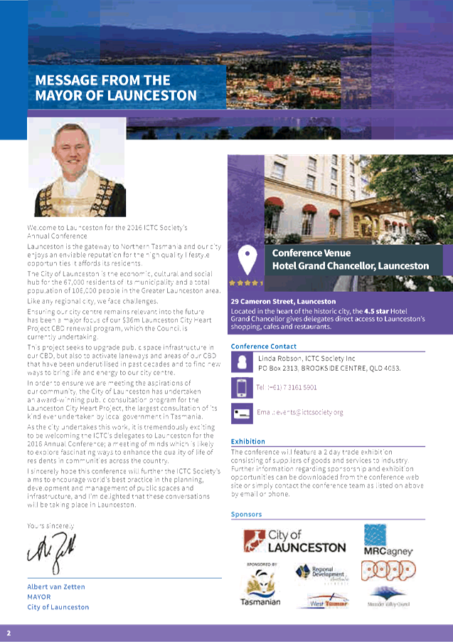

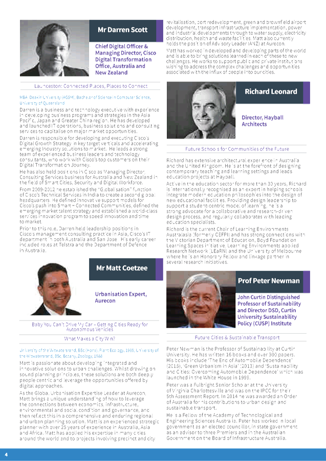


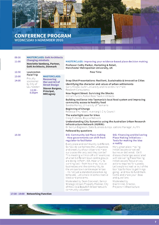
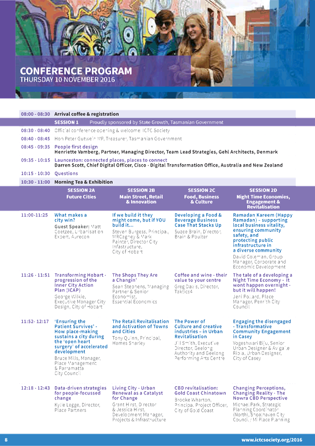
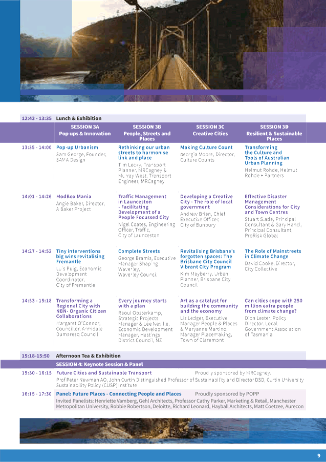
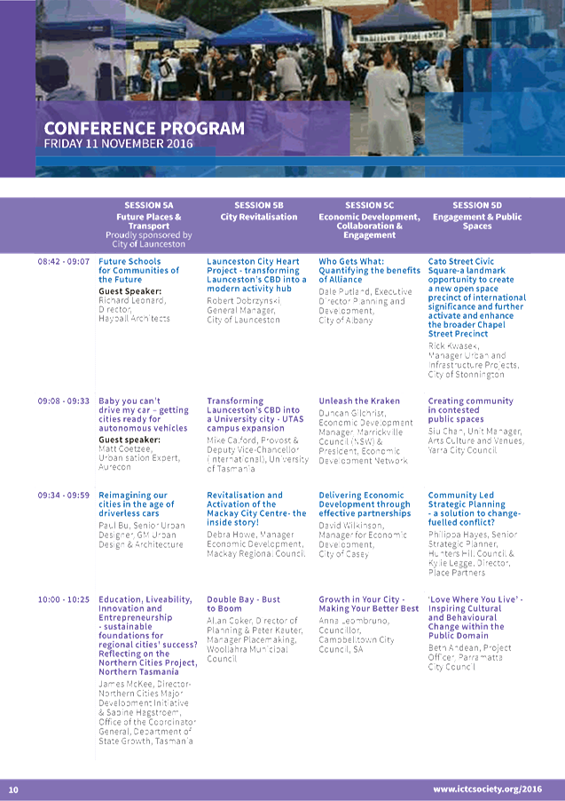
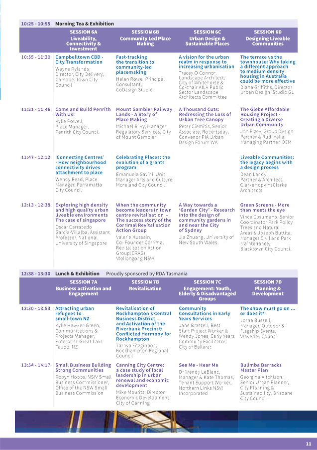
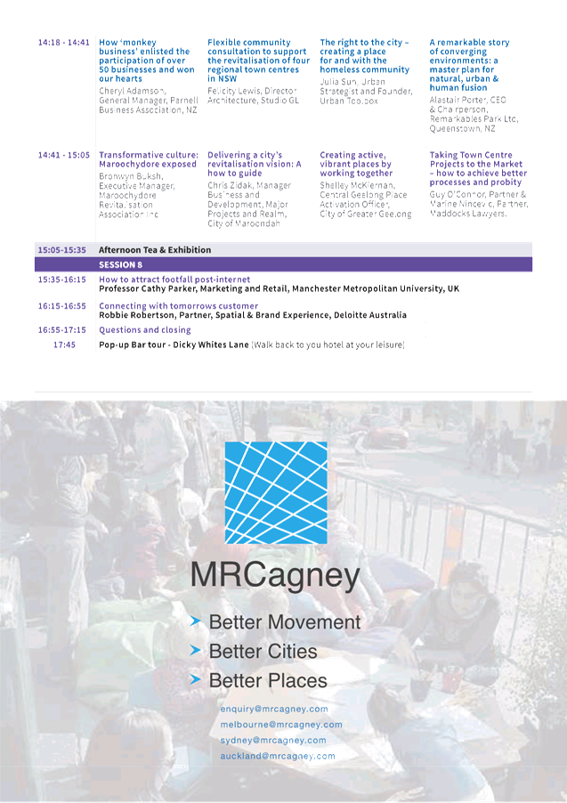
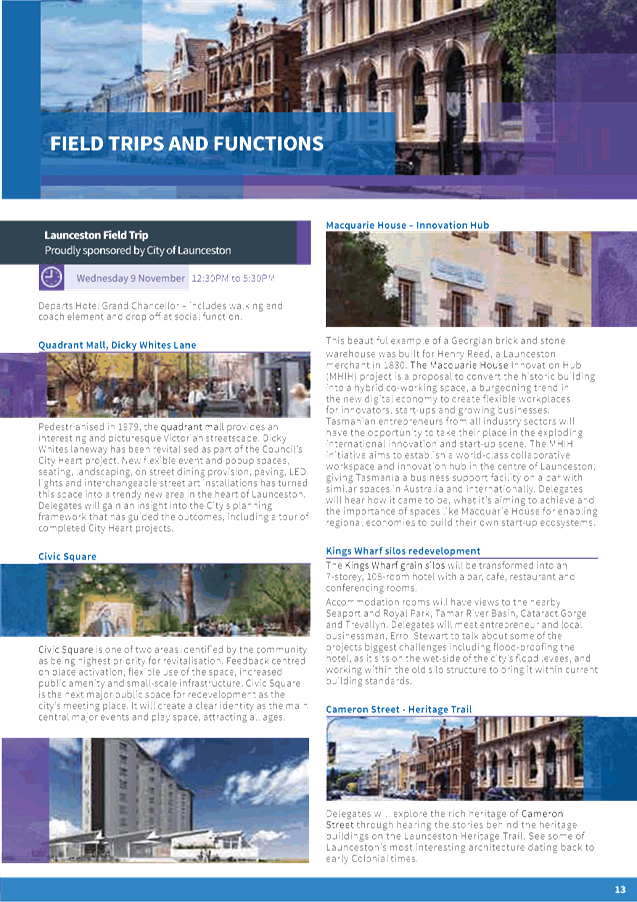
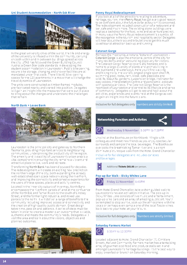


|
Ordinary Meeting of Council - 6 September 2016 |
GB.7 / 155 |
|
|
|
|
Item GB.7 |
S10066 |
|
|
16 August 2016 |
27 Finlay Road, Warrawee -
revocation of Interim Heritage Order
EXECUTIVE SUMMARY
|
purpose of report: |
To have Council consider the revoking of the Interim Heritage Order for 27 Finlay Road, Warrawee. |
|
|
|
|
background: |
On 9 October 2015 an Interim Heritage Order came into effect for 27 Finlay Road, Warrawee. On 8 July 2016, the property was listed as a heritage item in Schedule 5. A request has been received to revoke the Interim Heritage order as the property has now been listed as a Heritage Item. |
|
|
|
|
comments: |
The property is now formally listed under schedule 5 of KLEP 2015 as a heritage item, and the IHO has served its purpose. Council can now consider removal of the Interim Heritage Order. |
|
|
|
|
recommendation: |
That Council revokes the Interim Heritage Order for 27 Finlay Road, Warrawee. |
Purpose of Report
To have Council consider the revoking of the Interim Heritage Order for 27 Finlay Road, Warrawee.
Background
On 6 October 2015 council resolved “That Council resolve to place an Interim Heritage Order under Section 25 of the NSW Heritage Act 1977, for 27 Finlay Road, Warrawee (Lot 5B D.P. 4076), to enable full and proper evaluation of the heritage significance and prevent any harm to the site in the interim.”
On 9 October 2015 the Interim Heritage Order came into effect and will expire on 9 October 2016.
The IHO provided interim protection while the heritage significance of the site could be assessed. The site was established to have heritage significance to warrant a formal heritage listing, and a Planning Proposal was prepared and exhibited.
On 8 July 2016, Ku-ring-gai Local Environmental Plan 2015 (Amendment No 11) was made listing “Exley House”, dwelling house and interior, 27 Finlay Road, Warrawee as a heritage item in Schedule 5.
On 12 July 2016, Council received a request from the property owners to have the IHO revoked, as the property is already listed as a heritage item in schedule 5 of KLEP 2015.
Comments
The purpose of the Interim Heritage Order was to provide temporary protection for the site, while further heritage research and assessments took place. This work has now been completed by Council, and the property is formally listed as a heritage item.
Council made the original Interim Heritage Order and now under section 29 of the NSW Heritage Act 1977 (4) “Council may revoke an Interim Heritage Order that it has made but not one made by the Minister.”
It is now appropriate for Council to revoke the Interim Heritage Order.
The ongoing heritage management of the property will now rest with Council as a heritage item listed in Schedule 5 of KLEP 2015 and will continue to be subject to the heritage conservation provisions in clause 5.10 of KLEP 2015 and the Ku-ring-gai Development Control Plan 2016.
Integrated planning and reporting
Theme 3: Places, Spaces and Infrastructure
|
Community Strategic Plan Long Term Objective |
Delivery Program Term Achievement |
Operational Plan Task |
|
Strategies, Plans and Processes are in place to effectively protect and preserve Ku-ring-gai’s heritage assets |
Implement, monitor and review Ku-ring-gai’s heritage planning provisions |
Identify gaps in existing strategies and plans |
Governance Matters
Ku-ring-gai Council has the ability to revoke Interim Heritage Orders under the NSW Heritage Act 1977. This report sets out the case for Council to exercise its powers to revoke the Interim Heritage Order.
Risk Management
Council is responsible for the identification and management of Ku-ring-gai’s environmental heritage, in this case Council has identified and protected 27 Finlay Road, Warrawee.
Financial Considerations
The cost of preparing this report and the process to revoke the heritage Item is covered by the Urban Planning Strategy & Environment Budget.
Social Considerations
Council is responsible for the identification and management of Ku-ring-gai’s environmental heritage. Consideration of this matter will assist Council in meeting this requirement.
Environmental Considerations
Council is responsible for the identification and management of Ku-ring-gai’s environmental heritage. Consideration of this matter will assist Council in meeting this requirement.
Community Consultation
Community consultation took place during the Planning Proposal Phase of the project, no additional consultation is required for this report.
Internal Consultation
Consultation with other Departments where relevant, has been undertaken for the preparation of this report.
Summary
On 9 October 2015 an Interim Heritage Order came into effect for 27 Finlay Road, Warrawee. On 8 July 2016, the property was listed as a heritage item in Schedule 5. A request has been received to revoke the Interim Heritage order as the property has been listed as a heritage item under schedule 5 of KLEP 2015. The ongoing heritage planning management of the item will remain with Council. The IHO has served its purpose and Council can now remove the Interim Heritage Order.
|
That Council under Section 29 of the NSW Heritage Act 1977, revokes the Interim Heritage Order for 27 Finlay Road, Warrawee.
|
|
Antony Fabbro Manager Urban & Heritage Planning |
Andreana Kennedy Heritage Specialist Planner |
|
Andrew Watson Director Strategy & Environment |
|
|
Ordinary Meeting of Council - 6 September 2016 |
GB.8 / 159 |
|
|
|
|
Item GB.8 |
S11011 |
|
|
7 June 2016 |
Consideration of submissions to the exhibition and Public Hearing of Planning Proposal to Rezone and Reclassify land at 259-271 Pacific Highway Lindfield
EXECUTIVE SUMMARY
|
purpose of report: |
To have Council consider the feedback following the exhibition and public hearing for the Planning Proposal to amend KLEP (Local Centres) 2012 to rezone Council land at 259-271 Pacific Highway, Lindfield and reclassify the land from Community Land to Operational Land. |
|
|
|
|
background: |
The Planning Proposal and supporting documents, including the urban design study and masterplan, were placed on public exhibition from 24 March 2016 to 2 May 2016. A Public Hearing on the reclassification of the site was held on 6 June in accordance with Section 57(6) of the EP&A Act. |
|
|
|
|
comments: |
A total of 6 submissions were received as a result of the Public Exhibition. The Public Hearing Report recommends that it is appropriate for the land at 259-271 Pacific Highway, Lindfield, to be reclassified as "operational land" under the terms of the LG Act 1993. However, Council should retain ownership of the land and continue to operate the community facilities on it until suitable alternative facilities are available for use by the local community. |
|
|
|
|
recommendation: |
That Council adopts the Planning Proposal to amend KLEP (Local Centres) 2012 to rezone Council land at 259-271 Pacific Highway, Lindfield and reclassify the land from Community Land to Operational Land That Council continues to operate the community facilities currently provided in the at 259-271 Pacific Highway, Lindfield until suitable alternative facilities are available. |
Purpose of Report
To have Council consider the feedback following the exhibition and public hearing for the Planning Proposal to amend KLEP (Local Centres) 2012 to rezone Council land at 259-271 Pacific Highway, Lindfield and reclassify the land from Community Land to Operational Land.
Background
At the Ordinary Meeting of Council on 11 November 2014 Council resolved to commence the reclassification process for Council land at 259-271 Pacific Highway, Lindfield, also known as the ‘Lindfield library precinct’, from Community to Operational land and increase the maximum FSR from 1.3:1 to 2.0:1. At the same meeting Council resolved to prepare built form options for their approval prior to placing it on public exhibition.
Consultants were engaged to prepare a number of studies to further the planning for the site, including:
· urban design / architectural consultants to prepare built form options;
· heritage consultants to undertake an Historical Archaeological Assessment (HAA);
· land economists to advise on market demand and financial feasibility; and
· geo-technical and land contamination specialists to advise on any potential sub-surface limitations of the site.
At its Ordinary meeting of Council on 28 July 2015 Council considered a further report on various built form options for the future redevelopment of the site. Council resolved to adopt a particular built form option for the site and to prepare an illustrated concept design of that option for public exhibition in conjunction with the reclassification process. Council also resolved to vary the existing planning proposal to incorporate the necessary planning provisions into the KLEP (Local Centres) 2012 to facilitate the redevelopment of the site in accordance with the adopted concept design. The Council resolution was as follows:
A. That Council adopts for the site at 259-271 Pacific Highway, Lindfield:
b) Built Form Option 3 with an FSR of 2.0:1 and a building height of between 4-7 storeys
B. That Council proceed to prepare an illustrated concept design of the selected option for public exhibition in conjunction with the reclassification exhibition.
C. That the existing Planning Proposal applying to the site be varied in accordance with section 58 of the EP&A Act as follows:
b) To facilitate built form Option 3 by:
- Zoning of the site changed from Zone B2 Local Centre to Zone R4 high Density Residential
- Maximum building height increased from 17.5metres to 23.5 metres
- Office and business premises included as addition permitted uses under Schedule 1 of KLEP (Local Centres) 2012
A Gateway Determination for the Planning Proposal was issued by the Department of Planning and Environment on 5 February 2016. Conditions included 28 day exhibition period and to be completed within 9 months i.e. October 2016. A copy of the Gateway Determination is included as Attachment A1.
The Planning Proposal and supporting documents, including the urban design study and masterplan, were placed on public exhibition from 24 March 2016 to 2 May 2016. A copy of the exhibited Planning Proposal is included as Attachment A2. The Appendices to the Planning Proposal are Attachment A3 (circulated separately).
A Public Hearing on the reclassification of the site was held on 6 June 2016 in accordance with Section 57(6) of the Environmental Planning & Assessment Act 1979 and Section 29(1) of the Local Government Act 1993.
What is Community classified land?
Community classified land is a land classification that essentially holds land in a restrictive trust. Community classification prohibits a Council from selling, exchanging or granting an interest to another party other than in accordance with the provisions of the Local Government Act 1993.
What is Operational classified land?
Operational classified land is a land classification that facilitates active management of land for a variety of purposes. An operational classification permits Council to sell, exchange, or grant an interest – including a longer term lease – to another party other than in accordance with the provisions of the Local Government Act 1993.
Comments
Exhibition of the Planning Proposal
The Planning Proposal and supporting documents, including the urban design study and masterplan, were placed on public exhibition from 24 March 2016 to 2 May 2016. A total of 6 submissions were received as a result of the exhibition of the Planning Proposal. A summary of the submissions and responses to the issues raised are included as Attachment A4.
The main issues raised with the Planning Proposal covered the following areas:
· urban design;
· provisions of community facilities in Lindfield;
· increased dwelling provision; and
· traffic
· Impact of Council Amalgamation
Urban Design
Issue
Concerns were raised with the proposed increase in height to 7 storeys and the impact that this would have on adjoining development on the interface.
Response
The site is located on a block that incorporates a range of heights which respond to the local centre location and character. At the northern end of the block, closest to the station, the maximum height under the KLEP (Local Centres) 2012 is 23.5 metres (7 storeys), which forms a key gateway site. This height is proposed to extend through to the subject site.
To the south of the site, the height control is 11.5 metres (3 storeys). Therefore the site has a role to play in providing transition from the local centre to the residential areas to the south.
The master plan provides for a mix of building heights ranging from 4-7 storeys. The proposed heights on the site have been organised in a way to take advantage of the topography and ensure impacts to the residential dwellings to the south are mitigated This includes a 6 storey built form along the Pacific Highway frontage, consistent with the building height on the adjoining site to the north, and 7 storeys along the lower rear portion of the site along the railway line.
The master plan details have now been included in the Local Centres DCP which provides greater certainty regarding the layout of the built form on the site and permissible building heights. The master plan provides for deep soil setbacks along the Pacific Highway and to the southern and rear boundaries of 6 – 10 metres. These setbacks are consistent with the setbacks required on other R4 zoned land adjacent to the centres.
Provisions of community facilities in Lindfield
Issue
Concern was expressed that the existing community facilities provided in the Lindfield library precinct would not be replaced within the proposed Lindfield Community Hub. It was claimed that the facilities to be included in the Community Hub are still under review and are dependent on the EOI, which is still underway and that the community has not been assured the proposed Hub will provide further facilities other than a library.
A number of submissions recommended that the site should not be sold until replacement facilities are operational.
It was also noted that given the future population growth approved in Lindfield there is an increasing need for community facilities, provided by the current Library site and that the existing buildings and public facilities be renovated, adapted and improved at a lesser cost, and be leased to the community.
Response
A significant amount of work has been undertaken to plan for the future of Lindfield. This includes a Ku-ring-gai wide Community Facilities Study and a Lindfield Community Facilities Study (Elton Consulting 2014). The study considered the facility catchments, existing facility provision and gaps, population growth and rates of provision. The study recommends that the existing library and Seniors’ Centre facilities be replaced with new facilities co-located in a community hub situated on the western side of Lindfield with a total area of over 2,455sqm. This recommendation is based on the fact that the current Lindfield Library and associated facilities are old, outdated, no longer fit-for-purpose and not suitable for long term adaptation and re-use due to their condition.
The planning process for the Lindfield Community Hub on the western side of Lindfield local centre is well advanced and will significantly increase the space available for community facilities including new contemporary spaces to relocate the former seniors’ centre, former seniors’ resource centre, library and KYDS. The Lindfield Community Hub development will provide a 1265sqm district library and 1200sqm community centre. Council’s strategic approach is to co-locate these facilities into one building. Council and the community will have a high level of control over the finished product as Council is the land owner and undertaking the project as a Public Private Partnership.
The concern regarding the matter of not selling the site or ceasing operation of the existing community facilities on the site until the new facilities are operational is a valid one. This issue was also acknowledged by the Chairperson of the Public Hearing into the reclassification of the site. The Public Hearing report recommends that Council should retain ownership of the land and continue to operate the community facilities on it until suitable alternative facilities are available for use by the local community.
The reclassification of the land to “operational land” does not require Council to sell the land. Council can continue with the provision of community facilities on operational land and only procced to sale of the land at some stage in the future once replacement facilities have been provided.
In regard to the continued operation of the facilities on the Library site it has already been established that the existing buildings are not appropriate or capable of meeting the needs of the future population.
As identified in previous reports to Council, discontinuing the use of the site for the provision of community facilities is considered warranted as the existing facilities on the site are either at the end of their useful life and/or inadequate for contemporary needs:
· the tennis courts have very low usage levels and there is more than adequate supply of the facilities within close proximity;
· the Arrunga Aged Care Self-Contained Units were vacated by KOPWA and handed back to Council in late March 2014 and are currently fully tenanted at full market rent;
· the former Seniors’ facilities no longer have senior specific functions and are now used as general purpose rooms that can be booked by residents through Council; and
· the Lindfield library precinct has not been identified as a strategically important site for the delivery of future public community infrastructure and is surplus to requirements.
It is recommended that Council continue to operate the community facilities currently provided on the site until suitable alternative facilities are available.
Increased dwelling provision
Issue
The proposed residential development on the site will significantly expand the 10,000 new dwellings target which was set for Ku-ring-gai. The NSW Government has not requested to expand the target of the 10,000 new dwellings to 2031.
Response
The 10,000 new dwellings target was set for Ku-ring-gai under the previous Government’s 2005 Metropolitan Strategy.
A Plan for Growing Sydney was released by the current NSW Department of Planning and Environment in December 2014 and is the current NSW Government’s 20-year plan for the Sydney Metropolitan Area and supersedes the previous Metropolitan Strategy. One of the three planning principles guiding A Plan for Growing Sydney is: Principal 1 - “Increasing housing choice around all centres through urban renewal in established areas” The Planning Proposal is consistent with this principal as it will provide for additional housing on an underdeveloped site within the Lindfield centre and in close proximity to the Lindfield Railway Station.
Traffic
Issue
Concern was raised regarding the proposed traffic movements through the site as shown in the master plan implying the issues of traffic congestion and pedestrian safety require further evaluation.
It was also pointed out that the additional residential units will intensify existing traffic congestion and increase parking difficulty, which has been caused by the rapid increase of R4 high density unit development within 800m of the rail line.
Response
The master plan incorporates a new one-way road system with ingress from the Pacific Highway and egress from a new signalised intersection at Tryon Place adjacent to the Lindfield Station. Roads and Maritime Services have expressed support for the proposed extension of Tryon Place and new connecting road to the Pacific Highway on the basis the road is one-way only and is left-in only from the Pacific Highway. The master plan is consistent with this position.
A microsimulation transport assessment of the road network in the Lindfield local centre has been undertaken, taking into account the cumulative impacts of expected development in the Lindfield local centre including the proposals for the Library, Community Hub and Village Green sites, as well as background growth.
Council has assessed a considerable range of traffic options for the Lindfield centres as a whole in the Lindfield Local Centre Transport Network Model Study prepared by People Trans. The preferred option offers the best Pacific Highway performance whilst also supporting and complementing the proposed redevelopment sites in the Lindfield local centre. Council and RMS are in ongoing discussions regarding the proposed new traffic signals and modifications to traffic signals proposed on Pacific Highway.
Council Amalgamations
Issue
Concerns were raised that with the potential amalgamation of Council, it is unrealistic to expect the proposed Lindfield Community Hub facilities or alternative community facilities will be funded under a merged council and that Council not move assets during this period of uncertainty.
Response
The proposed amalgamation of Ku-ring-gai Council with Hornsby is not considered to be a barrier to the provision of new community facilities in Lindfield. The NSW Government’s Merger Proposal involving Ku-ring-gai and Hornsby states that examples of local infrastructure priorities that could be funded by merger-generated savings include projects such as the revitalisation of Lindfield town centre to transform it into a cultural and civic hub, together with the opportunity to incorporate activities for teenagers, senior citizens and more commuter car parking. Further, the project has been designed to be self-funding or funded from specifically hypothecated development contributions.
Submissions from Public Agencies
The Gateway Determination for the Proposal issued by the DPE on 5 February 2016 required Council to consult with the following public authorities under the terms of Section 56(2)(d) of the EP&A Act:
· Aboriginal Land Council of NSW;
· Transport for NSW;
· Transport for NSW - Roads & Maritime Services;
· Transport for NSW - Sydney Trains;
· Ausgrid; and
· Sydney Water.
Responses were received from:
· Transport for NSW (TfNSW);
· Transport for NSW - Roads & Maritime Services (RMS); and
· Sydney Water.
Copies of these submissions are included as Attachment A5.
Transport for NSW
TfNSW raised no objection to the planning proposal. However it commented that access roadways and traffic management measures required to support future developments on the site as outlined in the Lindfield Network Study (PeopleTrans 2014) requires approval of Roads and Maritime Service and Council through the Local Traffic Committee. Council should ensure appropriate planning and funding mechanisms are in place to provide timely delivery of traffic and transport measures.
RMS have been a key stakeholder in the development of the proposed traffic and transport scheme outlined in the Lindfield Local Centre Transport Network Model Study. The proposed traffic and transport scheme for the Lindfield local centre has been formally submitted to RMS, for in-principle concurrence. Ku-ring-gai Council and RMS are in ongoing discussions regarding the proposed new traffic signals and modifications to traffic signals proposed on Pacific Highway. RMS will continue to be involved in the proposed transport scheme, particularly in relation to design and construction of new or modified traffic signal control sites.
Some of the proposed traffic signal sites, modifications to existing signals, and traffic management measures would be part funded by developer contributions and part funded by Council. The proposed traffic signals at the intersection of Pacific Highway and Beaconsfield Parade, and modifications to existing signals at intersection Pacific Highway and Tryon Place, and various traffic management measures would be project funded.
Roads & Maritime Services (RMS)
RMS raised no objection to the planning proposal, however, provided comments in relation to the Lindfield Local Centre Transport Network Model Study Report and access matters for Council's consideration.
Sydney Water
Sydney Water raised no objection to the Planning Proposal, noting that there is sufficient water and waste water trunk capacity to accommodate the proposed increase in density.
Public Hearing
A Public Hearing was held on 6 June 2016 in relation to the proposal to reclassify the land at 259‑271 Pacific Highway, Lindfield, from “community land” to “operational land” under the terms of the Local Government Act 1993 (LGA 1993).
The Gateway Determination indicated that a public hearing was not required to be held under Section 56(2)(e) of the EP&A Act, i.e. in relation to the zoning and development standards included in the Proposal, but that this did not discharge Council from any obligation it may otherwise have to conduct a hearing in relation to the proposed reclassification of the land. Consequently, the hearing was conducted in accordance with Section 29(1) of LGA 1993 and related solely to the proposed reclassification and not to any issues relating to the land’s zoning or the development standards to be applied to any future development that may be proposed on it.
A copy of the Chairpersons report from the public hearing is included as Attachment A6.
The report acknowledges that the concerns expressed by the community in relation to the certainty associated with the establishment of the new facilities proposed in the Hub are understandable. However, it notes that Council has taken a detailed and diligent approach to identifying and quantifying the need for community facilities in the Lindfield area and their most appropriate location and that the essential elements of the community facilities on 259-271 Pacific Highway are to be relocated to the Hub in an enhanced and enlarged form. The report states that:
The Proposal indicates that the reclassification is intended to provide the flexibility required to respond to new development opportunities as facilities on the land are relocated to the Hub.
In these circumstances, I believe that:
· the land will not be required for community use and it would be appropriate for it to be reclassified as “operational land”; and
· despite its classification, Council should retain ownership of the land and continue to operate the facilities on it until suitable alternative community facilities are available.
In regard to the potential sale of land once it has been reclassified the report states:
While reclassification to “operational land” is likely to lead to the eventual sale of the land, it does not require the land to be sold.
This is exemplified by the Woodford Lane car park which Council resolved to reclassify from “community land” to “operational land” on 30 July 2013 and which is still owned by Council and used as a public car park.
The land can be retained in Council’s ownership as “operational land” and can continue to be used and managed by Council for the community purposes for which it is currently used until alternative facilities are developed.
The reclassification would provide flexibility and a level of certainty which would enable Council to plan the future use of this land.
In regard to the proceeds of any future sale of the land, the report notes:
The manner in which Council uses any proceeds, should the land be sold, is not relevant to its need to be retained for community purposes or its classification.
The recommendations of the Public Hearing Report are as follows:
It is appropriate for the land at 259-271 Pacific Highway, Lindfield, to be reclassified as "operational land" under the terms of the Local Government Act 1993.
However, despite its reclassification, Council should retain ownership of the land and continue to operate the community facilities on it until suitable alternative facilities are available for use by the local community.
A copy of this report should be made available for public inspection as required by Section 47G of the Local Government Act 1993.
People who made submissions concerning the proposed reclassifications should be advised accordingly.
The Public Hearing report was received by Council in 27 June 2016 and made available on Council’s website on 29 June 2016.
integrated planning and reporting
Theme 3 - Places, Spaces and Infrastructure
Theme 6 – Leadership and Governance
|
Community Strategic Plan Long Term Objective |
Delivery Program Term Achievement |
Operational Plan Task |
|
A range of well planned, clean and safe neighbourhoods and public spaces designed with a strong sense of identity and place. |
P4.1.1 Plans to revitalise local centres are being progressively implemented and achieve quality design outcomes in collaboration with key agencies, landholders and the community. |
- Implement a place management approach for the local centre improvements to coordinate works and achieve quality outcomes. |
|
|
P4.1.4 An improvement plan for Lindfield centre is being progressively implemented in collaboration with owners, businesses and state agencies. |
- Engage with relevant stakeholders to establish timing, extent and partnership opportunities. - Develop and finalise project scope. - Maintain engagement with the key stakeholders. |
|
Ku-ring-gai is well led, managed and supported by ethical organisations which deliver projects and services to the community by listening, advocating and responding to their needs. |
L2.1.1 Council maintains and improves its long term financial position and performance. |
- Review Long Term Financial Plan (LTFP) each year based on 10 year forecasts - Undertake quarterly reporting to Council on the financial performance of the organisation. - Assets are identified for disposal to discharge the Services Relocation Loan by 2016 - 2017. - Review opportunities for sustainable and Assets equitable increases to Council’s income supported by the community. - Continue to analyse opportunities to expand the revenue base of Council. - Ensure the commercial property portfolio provides market returns. Manager Integrated Planning, Property |
|
|
L2.1.4 Council has increased its commitment to infrastructure asset management priorities. |
- Identify available funding sources in the LTFP and allocate to priority projects. - Funding strategies are developed and implemented in line with Council’s Assets adopted Asset Management Strategy. - Regularly revise Council’s strategic asset management plans and integrate with financial planning processes. - Continually improve the integrity of asset data and asset registers. - Implement asset management plans and progress improvement plans for each asset class. - Implement an integrated corporate asset management system for all asset classes. |
Governance Matters
Section 45 of the Local Government Act, 1993 prevents Council from selling; exchanging, or otherwise disposing of Community classified land. This report deals with the feedback on the proposal to reclassify the site from Community Land to Operational Land in accordance with Section 27 of the Act.
The Planning Proposal and supporting documents, including the urban design study and masterplan, were placed on public exhibition from 24 March 2016 to 2 May 2016 under the provisions of the Environmental planning and Assessment Act & Regulations.
A separate Public Hearing on the reclassification of the site was held on 6 June in accordance with Section 57(6) of the Environmental Planning & Assessment Act.
Risk Management
The main risk for Council of undertaking the reclassification process is community concern about the loss of community assets. This can impact on Council’s reputation. The case of the library precinct is different to other sites Council has put forward for reclassification because:
· Council has clearly articulated its intention to create a new community hub on the western side of Lindfield local centre which will replace the existing facilities with new, larger purpose-built facilities.
The submissions to the public hearing have reiterated the above concerns and the Chairperson’s recommendation includes the following-
It is appropriate for the land at 259-271 Pacific Highway, Lindfield, to be reclassified as "operational land" under the terms of the Local Government Act 1993.
However, despite its reclassification, Council should retain ownership of the land and continue to operate the community facilities on it until suitable alternative facilities are available for use by the local community.
There are significant risks for Council in relation to any decisions it makes regarding zoning, reclassification, planning controls, and/or divestment for any of its town centre sites or “hub” projects. These risks are potential loss of revenue in the event a site is sold with lesser development yield than might reasonably expected under a new regime of dwelling targets and where a purchaser subsequently comes back to Council with a planning proposal for an uplift in controls, and/or that the “opportunity” for greater dwelling production on key town centre sites is simply lost by development at lesser height and density.
Financial Considerations
There are no direct financial impacts to Council as a result of this report.
If reclassification was to proceed and Council resolved to reclassify the site from Community Land to Operational Land this would facilitate potential future sale of the Lindfield library precinct.
The proceeds of the sale of the site could be used in two ways:
· to address the asset renewal gap (funding shortfall) by returning the funds to reserves for expenditure on new assets or major asset refurbishment in accordance with the Long Term Financial Plan guiding principles; or
· to fund Council’s co-contribution for projects identified in the Development Contributions Plan 2010. The Long Term Financial Plan proposes that asset sales from rationalisation of property assets commence in 2015/16 and continue over a 10 year period as Contribution Plan projects proceed. (LTFP, page 23).
Social Considerations
It is noted the Library and community meeting spaces have provided an important social functions since the 1950’s. These activities will be relocated to the Lindfield Community Hub in new contemporary designed community spaces.
Environmental Considerations
The planning proposal for the reclassification will not result in any additional environmental effects to those considered during the preparing of the draft Local Centres LEP. The Planning proposal variation to the zone, building height and FSR have been assessed and addressed through the detailed master planning process. Due-diligence studies have been also completed in relation to geo-technical site conditions and any potential land contamination issues.
Community Consultation
The Planning Proposal was exhibited in accordance with the requirements the Gateway Determination, the Environmental Planning and Assessment Act 1979 (EP&A Act) and the relevant Department of Planning Guidelines including A Guide to Preparing Local Environmental Plans and A Guide to Preparing Planning Proposals as well as the Planning Practice Note PN09-003 Classification and reclassification of public land through a local environmental plan.
· Notification letters were sent to landowners within the precinct advising of the exhibition of the planning proposal.
· An advertisement regarding the Planning Proposal exhibition was placed in the local press on 25 March 2016.
· The Planning Proposal was placed on public exhibition from 24 March 2016 to 2 May 2016 on Council’s website and at the Council’s customer service centre Gordon and the Lindfield Branch Library. Both exhibition sites included large A0 sized display panels providing information and graphics on the proposed master plan and the rationale behind it.
· The state agency consultation was carried out in accordance with the requirements of the gateway determination.
Public Hearing
· Notification was placed in the local press on 13 May 2016 advising of the public hearing for the proposed reclassification of the site.
· A Public Hearing on the reclassification form Community land to Operational land status for the site was held at Council on Monday 6 June 2016.
· In accordance with the NSW Local Government Act 47G (3) the public hearing report was made available to the public on 29 June 2016.
All persons who made a submission on the Planning Proposal or to the Public Hearing were notified of this matter coming back to Council.
Internal Consultation
This report was prepared by the Strategy & Environment Department in consultation with staff from other Departments where relevant.
Summary
The Planning Proposal and supporting documents, including the urban design study and masterplan, were placed on public exhibition from 24 March 2016 to 2 May 2016. A total of 6 submissions were received as a result of the exhibition of the Planning Proposal.
The main issues raised with the Planning Proposal covered the following areas:
· urban design;
· provision of community facilities in Lindfield;
· increase dwelling provision; and
· traffic.
A Public Hearing on the reclassification of the site was held on 6 June in accordance with Section 57(6) of the Environmental Planning & Assessment Act and Section 29(1) of the Local Government Act 1993.
The Public Hearing Report recommends that it is appropriate for the land at 259-271 Pacific Highway, Lindfield, to be reclassified as "operational land" under the terms of the Local Government Act 1993. However, despite its reclassification, Council should retain ownership of the land and continue to operate the community facilities on it until suitable alternative facilities are available for use by the local community.
|
A. That Council adopts the Planning Proposal to amend Ku-ring-gai Local Environmental Plan (Local Centres) 2012 to rezone Council land at 259-271 Pacific Highway, Lindfield and reclassify the land from Community Land to Operational Land.
B. That Planning Proposal be submitted to the Department of Planning and Environment in accordance with Section 59 of the Environmental Planning and Assessment Act 1979, and that the Greater Sydney Commission be requested to make the plan.
C. That Council continue to operate the community facilities currently provided in the Lindfield Library Precinct until suitable alternative facilities are available.
D. That those who made submissions be notified of Council’s decision.
|
|
Craige Wyse Team Leader Urban Planning |
Antony Fabbro Manager Urban & Heritage Planning |
|
Andrew Watson Director Strategy & Environment |
|
|
Gateway Determination |
|
2016/070307 |
||
|
|
Exhibited Planning Proposal |
|
2016/068768 |
|
|
|
Appendices 1-8 to Exhibited Planning Proposal |
2016/237197 |
||
|
|
Summary of Public Submissions |
|
2016/235211 |
|
|
|
State Agency Submissions |
|
2016/235182 |
|
|
|
Public Hearing - Chairperson's Report |
|
2016/171419 |
|
Ordinary Meeting of Council - 6 September 2016 |
GB.9 / 265 |
|
|
|
|
Item GB.9 |
S11057 |
|
|
29 July 2016 |
Consideration of Submissions - Planning Proposal to amend KLEP(LC) 2012 to change the Zoning, Height, FSR at Woodford Lane and Drovers Way, Lindfield - Lindfield Community Hub site
EXECUTIVE SUMMARY
|
purpose of report: |
To report back to Council on submissions received during the exhibition of the Planning Proposal to amend the Ku-ring-gai Local Environmental Plan (Local Centres) 2012 to modify the zoning, height and FSR of land parcels within the Lindfield Hub site at Woodford Lane and Drovers Way. |
|
|
|
|
background: |
On 10 November 2015 Council resolved to prepare a Planning Proposal to amend the Ku-ring-gai Local Environmental Plan (Local Centres) 2012 to change the zoning, height and floor space ratio across the Lindfield Hub site. This amendment will enable a consolidated site with consistent development standards that facilitate the delivery of the Lindfield Hub Masterplan. The Masterplan was considered and adopted by Council on 8 September 2015 and 6 October 2015. The 28 day public exhibition and the 21 day State Agency consultation has been completed in accordance with the Gateway Determination. |
|
|
|
|
comments: |
A total of four submissions from the public were received in response to the exhibition. Comments from the public and from the State Agencies have been considered in this Report. |
|
|
|
|
recommendation: |
That Council adopts the Planning Proposal to amend the Ku-ring-gai Local Environmental Plan (Local Centres) 2012 to modify the zoning, height and FSR on the Lindfield Hub site subject to a variation. |
Purpose of Report
To report back to Council on submissions received during the exhibition of the Planning Proposal to amend the Ku-ring-gai Local Environmental Plan (Local Centres) 2012 to modify the zoning, height and FSR of land parcels within the Lindfield Hub site at Woodford Lane and Drovers Way.
Background
On 10 November 2015 Council resolved to prepare a Planning Proposal to amend the Ku‑ring-gai Local Environmental Plan (Local Centres) 2012 to change the zoning, height and floor space ratio across the Lindfield Hub site. The Planning Proposal may be viewed at Attachment A1.
The proposed amendments, subject of the Planning Proposal, will facilitate the progress of Council’s adopted Masterplan for the Lindfield Hub site which has been the result of extensive investigation and community consultation which commenced in 2012.
This report deals with the next steps to progress the Planning Proposal as resolved by Council.
The specific resolutions from the 10th November 2015 Council meeting relating to this Planning Proposal are listed below. A complete list of the resolutions is included in Attachment A2 of this Report.
A. That a Planning Proposal be prepared, in accordance with section 55 of the Environmental Planning and Assessment Act, 1979, to amend the Ku-ring-gai LEP (Local Centres)2012 as it applies to the Lindfield Community Hub site as follows:
i. Rezone the site, excluding the R4 zoned portion of 12 Bent Street, from part Zone B2 Local Centres, part Zone RE1 Public Recreation and part Zone SP2 Local Road to Zone B2 Local Centre;
ii. Amend the Height of Buildings Map to increase the maximum height of buildings for the site, excluding the R4 zoned portion of 12 Bent Street, from 11.5 metres to 26.5 metres;
iii. Amend the Floor Space Ratio map to increase the maximum FSR for the site from 1:1 to 1.3:1
iv. Amend the Land Reservation Acquisition Map to delete the reservation for Public Recreation applying to the land at 2-10 Bent Street and reservation for Local Road applying to land at 12 Bent Street, Lindfield.
B. That the Planning Proposal be submitted to the Department of Planning and Environment for a Gateway Determination in accordance with Section 56 of the Environmental Planning and Assessment Act, 1979.
C. That upon receipt of a Gateway Determination, the exhibition and consultation process is carried out in accordance with the requirements of the Environmental Planning and Assessment Act, 1979 and with the Gateway Determination requirements
D. That a report be brought back to Council at the end of the exhibition processes.
The Planning Proposal received a Gateway Determination (Attachment A3) on 24 May 2016. The Gateway Determination required the following amendments to be made to the Planning
Proposal being exhibited:
· inclusion of the following statements in the Introduction: “All the land is in Council ownership with the exception of Drovers Way whose acquisition is currently being negotiated. All parcels of land comprising the Lindfield Hub site are classified as Operational including the sites currently zoned RE1 Public Recreation at 1 Woodford Lane, 2, 4, 6, 8, 10, 12 Bent St, Lindfield. These sites became Operational at the time of their acquisition by Council.” and “The total land area for the Lindfield Hub Site is 10551.51sqm including 3952.9sqm of land currently zoned RE1 Public Recreation.”
· correction to amend the address of '1A Woodford Lane' to '1 Woodford Lane';
· amendment to reflect a 28 day public consultation period;
· amendment to the mapping to ensure the legends are consistent between the existing and proposed maps;
· inclusion of all findings from the Phase I Preliminary Site Investigation, completed prior to the exhibition, to ensure compliance with clause 6 of State Environmental Planning Policy No. 55 – Remediation of Land.
The 28 day public exhibition (24 June to 22 July 2016) and the 21 day State Agency consultation has been completed in accordance with the Gateway Determination.
Comments
Following receipt of the Gateway Determination, the exhibition of the Planning Proposal was advertised in the North Shore Times (24 June 2016), with all exhibition documents being made available to the public at Council’s Chambers, Lindfield Library, and on Council’s website for the required 28 days. In accordance with the Gateway Determination, due consultation with State Agencies and with the public has been completed and is reported below.
State Agency Consultation
The Gateway Determination required the following agencies to be consulted:
· Transport for NSW (TfNSW)
· Roads & Maritime Services (RMS)
· Sydney Trains
· Ausgrid
· Energy Australia
· Office of Environment & Heritage (OEH)
· Sydney Water
Comment has been received and addressed as below.
1. Transport for NSW (TfNSW)
TfNSW has no issues with the Planning Proposal provided the following measures are addressed in both the Planning Proposal and the Lindfield Hub development delivery:
· that there be no adverse resultant impacts from the development on the bus operation on the Pacific Highway, pedestrian and cyclists movements in the precinct, and on performance of intersections along the Pacific Highway;
· that Sydney Trains and Roads and Maritime Services (RMS) be consulted on this Planning Proposal;
· that RMS approve the traffic management measures to support future developments on the site as outlined in the Lindfield Local Centre, Transport Network Model Study (PeopleTrans 2014);
· that the proposed traffic management be implemented in consultation with RMS, TfNSW and Sydney Trains;
· that Council ensure appropriate planning and funding mechanisms are in place to provide timely delivery of the proposed traffic management measures.
The full submission may be seen at Attachment A4.
Discussion
Council have engaged specialist transport consultants PeopleTrans to prepare a microsimulation transport model (Lindfield Local Centre Transport Network Model Study) of the Lindfield local centre. This study includes all the potential redevelopment in the Lindfield local centre as well as Council’s major project sites (Lindfield Community Hub, Lindfield Village Green, Lindfield Library site). The resulting proposed traffic and transport scheme seeks to minimise the impacts to traffic flow and bus operation on Pacific Highway. Additional signalised intersections and a potential pedestrian bridge over Pacific Highway will also improve pedestrian access across Pacific Highway
Both Sydney Trains and RMS have been consulted on the Planning Proposal. RMS have been a key stakeholder in the development of the proposed traffic and transport scheme outlined in the Lindfield Local Centre Transport Network Model Study. The proposed traffic and transport scheme for the Lindfield local centre has been formally submitted to RMS for in-principle concurrence. Ku-ring-gai Council and RMS are in ongoing discussions regarding the proposed new traffic signals and modifications to traffic signals proposed on Pacific Highway. RMS will continue to be involved in the proposed transport scheme, particularly in relation to design and construction of new or modified traffic signal control sites.
Some of the proposed traffic signal sites, modifications to existing signals, and traffic management measures are expected to be part funded by developer contributions and part funded by Council. Project funding is expected for: the proposed traffic signals at the intersection of Pacific Highway and Beaconsfield Parade; the modifications to existing signals at the intersection of Pacific Highway and Tryon Place; and various traffic management measures.
Recommendation
No change to the Planning Proposal is recommended; however, it is recommended that Council continue to develop transport solutions in the Lindfield local centre in conjunction with RMS and Transport for NSW.
2. Roads & Maritime Services (RMS)
RMS provided the following comments:
· whilst recognising that Council has engaged PeopleTrans Ltd to assess traffic impacts and identify traffic and transport upgrades within and adjacent to the Lindfield Town Centre, concern is raised with regard to the cumulative traffic impacts of this proposed development and other current and future development in Lindfield Town Centre on the adjacent road network;
· requests the subject Planning Proposal not be gazetted until such time that the full scope of the road transport infrastructure upgrades are identified, cost estimates undertaken and appropriate funding mechanism put in place;
· confirms a meeting is being held on 7th September 2016 between Council, Roads and Maritime, TfNSW and PeopleTrans to work in collaboration to reach common agreement and understanding on the proposed mitigation measures put forward by PeopleTrans in 'Lindfield Local Centre Transport Model Study Report'.
The full submission may be seen at Attachment A4.
Discussion
The issues raised by RMS are very similar to those raised by TfNSW. For this reason Council officers will continue discussions with both RMS and TfNSW in joint sessions to clarify the concerns and ensure appropriate solutions are developed in collaboration with both Agencies.
Council have engaged specialist transport consultants PeopleTrans to prepare a microsimulation transport model (Lindfield Local Centre Transport Network Model Study) of the Lindfield local centre. This study includes all the potential redevelopment in the Lindfield local centre as well as Council’s major project sites (Lindfield Community Hub, Lindfield Village Green, Lindfield Library site). The resulting proposed traffic and transport scheme seeks to minimise the impacts to traffic flow and pedestrian access at Pacific Highway.
RMS has been a key stakeholder in the development of the proposed traffic and transport scheme outlined in the Lindfield Local Centre Transport Network Model Study. The proposed traffic and transport scheme for the Lindfield local centre was formally submitted to RMS for in-principle concurrence. Ku-ring-gai Council and RMS are in ongoing discussions regarding the proposed new traffic signals and modifications to traffic signals proposed on Pacific Highway. RMS will continue to be involved in the proposed transport scheme, particularly in relation to design and construction of new or modified traffic signal control sites.
Some of the proposed traffic signal sites, modifications to existing signals, and traffic management measures are expected to be part funded by developer contributions and part funded by Council. Project funding is expected for: the proposed traffic signals at the intersection of Pacific Highway and Beaconsfield Parade; the modifications to existing signals at the intersection of Pacific Highway and Tryon Place; and various traffic management measures.
Recommendation
No change to the Planning Proposal is recommended; however, it is recommended that Council continue to develop transport solutions in the Lindfield local centre in conjunction with RMS and Transport for NSW.
3. Sydney Trains
Sydney Trains has responded with no issue regarding the Planning Proposal as the site location is distant from the railway operational corridor.
The full submission may be seen at Attachment A4.
4. Ausgrid
Ausgrid provided the following comments:
· electrical load details are to be provided to enable their assessment of any augmentation works required as a result of this development;
· all connection works, including substations and high voltage networks resulting from the development are to be funded by the developer;
· the provision of areas within the Lindfield Hub site for new Ausgrid assets, such as substations and high voltage cables which may be required for additional power supply to the development;
· the treatment of existing Ausgrid assets within the development site should comply with Ausgrid Network Standards and Policies if they are going to be impacted by the development; and, if the existing Ausgrid assets require relocation, then all the works associated with relocation would be funded by the developer and undertaken by Accredited Service Providers.
The full submission may be seen at Attachment A4.
Discussion
This Planning Proposal seeks to facilitate the Council approved Lindfield Hub Masterplan through the application of consistent zoning, height and FSR across the site. As such, it only considers planning outcomes and not the final design outcomes for the site. For this reason, the Planning Proposal does not have the scope to address the issues raised by Ausgrid as they are design and development related. Therefore, the points made by Ausgrid are noted and will be dealt with through the separate process of the development of the Lindfield Hub Masterplan, its detailed design and the final development application stages.
Recommendation
No change to the Planning Proposal is recommended; however, it is recommended that the issues raised by Ausgrid be considered and accommodated during the detailed design and development application process.
5. Sydney Water
Sydney Water provided the following comments:
· generally supports the Planning Proposal;
· states that for both water and wastewater there is sufficient trunk water capacity within the mains surrounding the proposed rezoning;
· highlights that any detailed requirements including any amplification of the local reticulation water and wastewater will be provided at the Section 73 Phase at detailed design and development application stages.
The full submission may be seen at Attachment A4.
Discussion
The points raised by Sydney water are noted. As the points are design and development related, they will be dealt with through the separate process of the development of the Lindfield Hub Masterplan, its detailed design and the final development application stages.
Recommendation
No change to the Planning Proposal is recommended; however, it is noted that further consultation will occur with the design development of the Masterplan.
6. Office of Environment & Heritage (OEH)
OEH provided the following comments:
· the site neither contains, nor is in the vicinity of any items of State or local heritage significance; therefore, no comment is required from the Heritage Council in this instance;
· the proposal will result in the removal of approximately 2,160 m2 of the Sydney Turpentine-lronbark Forest endangered ecological community and notes Council’s approach of preparing an assessment of impacts (and proposed offset strategy) to support a section 91 licence application under the Threatened Species Conservation Act 1995;
· requests the biodiversity assessment be undertaken in accordance with the draft Threatened Biodiversity Survey and Assessment: Guidelines for Developments and Activities (November 2004) and that in determining an appropriate offset strategy, the OEH principles for the use of biodiversity offsets in NSW be applied.
The full submission may be seen at Attachment A4.
Discussion
The works addressed within the Planning Proposal will result in the removal of trees and vegetation on site, including:
· 0.216 hectares (13 trees) of Sydney Turpentine-Ironbark Forest (STIF);
· one threatened flora species (Wallangarra White Gum - this species is outside its natural distribution range and is likely to have been planted);
· two hollow bearing trees and 14 foraging habitat trees (7 of which belong to the STIF community).
The removal of this vegetation is to be assessed through a Part 5 approval under the NSW Environmental Planning and Assessment Act 1979, in lieu of a Section 91 licence which the OEH declined to process, despite it being Council’s preference to have this matter independently assessed.. A draft Assessment of Significance and a draft Biodiversity Offset Strategy has been prepared and will form part of the Review of Environmental Factors (REF) required under Part 5. Field assessment and assessment of significance has been undertaken in accordance with the Threatened Biodiversity Survey and Assessment: Guidelines for Developments and Activities (November 2004) and the Biobanking Assessment Methodology (2014).
The draft Biodiversity Offset Strategy provides credit calculations (using the Biobanking Assessment Methodology, 2014) and offsets these credits through the transfer of funds into a dedicated fund for the purchase of STIF biobanking credits (credits price has been determined from Council’s biobanking site [Biobanking agreement no 132], at a rate above previous STIF market sales).
The Office of Environment and Heritage (regional operations) have reviewed the assessment of significance and the draft Biodiversity Offset Strategy for the proposed vegetation removal works and as has provided written correspondence in support of both the methodology and conclusions.
Recommendation
No change to the Planning Proposal is recommended.
Public Submissions to the exhibition
A total of four submissions were received in response to the public exhibition. A detailed summary and comment of these submissions is provided in the Submissions Summary Table at Attachment A5.
The four submissions raised three areas of concern as considered below:
1. Community facilities
One submission raised the following issue:
· the Lindfield Hub proposes a greater amount of residential development than necessary, and will not be able to provide the diversity of facilities required for the growing community or to create a village centre to this side of Lindfield.
Discussion
The concerns regarding the provision and use of community facilities are design or operation related, and as such is beyond the scope of this Planning Proposal; nevertheless, a detailed response is provided in the table at Attachment 5.
This Planning Proposal only seeks to make the zoning, height and FSR consistent across the Lindfield Hub site so as to facilitate the progress of Council’s adopted Masterplan. The Council adopted Masterplan considers the orderly and economic development of the site, proposing significant improvement and community benefit on the use of the land. No additional commercial or residential development is proposed beyond Council’s previously adopted Masterplan.
Recommendation
Given that the issues raised are beyond the scope of this Planning Proposal, no change is recommended.
2. Integration with Activate Lindfield project
One submission suggested a more innovative approach and better integration of the Lindfield Hub site with the Activate Lindfield project.
Discussion
This issue does not relate to this Planning Proposal. It relates to the strategic planning of the Lindfield local centre and as such is beyond the scope of this Planning Proposal. A detailed response is provided in the table at Attachment 5.
This Planning Proposal only seeks to make the zoning, height and FSR consistent across the Lindfield Hub site so as to facilitate the progress of Council’s adopted Masterplan. In addition, this Planning Proposal is the result of Council’s resolution to proceed with the Council adopted Masterplan for the Lindfield Hub. As such, it solely deals with the Lindfield Hub site and does not have the scope to amend the Council approved Masterplan, nor re-visit the other Activate Lindfield masterplanning proposals.
Recommendation
Given that the issue raised is beyond the scope of this Planning Proposal, no change is recommended.
3. Traffic and parking
One submission raised the following concerns:
· the development will divert traffic and exacerbate existing heavy school related and general traffic congestion, increasing frequency of accidents at the intersection of Bent St and Balfour St, and increasing risk to pedestrians;
· amendment should be made to the traffic management plan to incorporate alternate traffic movements which pose a lesser risk than the existing proposal which will deflect traffic issues to other surrounding roads creating greater risk at those locations;
· traffic will shift to Bent St, Balfour St, Wallace St, Highfield St and therefore the right turn from Havilah St onto the Pacific Hwy should not be prohibited.
The submission made by Coles Group Property Developments Ltd, who owns the site at corner of Pacific Highway and Balfour Street, Lindfield (Balfour Site), submitted the following:
· points out differences in the floor areas quoted in the PeopleTrans study and in Council’s resolution dated 6/10/15, and how final numbers may result in traffic intensification and adverse traffic conditions;
· requests Council confirm that the phasing diagrams provided within the Traffic Management Plan are incorrect and will be amended to reflect that the existing right hand turn from Balfour Street/Balfour Street West onto the Pacific Highway will be maintained;
· requests Council to adopt a two-way flow of traffic along Bent Lane, as a one-way flow of traffic does not facilitate the ease of movement of vehicle within the local centre precinct;
· requests Council's confirmation that road widening will not occur to facilitate the left turn bay extension on Balfour Street, approaching the Pacific Highway; and
· requests clarification from Council in relation to the extent of works associated with the proposed lane extension, including the number of on-street parking spaces that will be lost as a result, and that any proposed works should be reflected in an updated version of the PeopleTrans Report.
Discussion
The concerns raised are discussed below with a detailed response provided in the Submissions Summary Table at Attachment 5.
In the most recent five years of recorded crash history, there has been one recorded crash at the intersection of Bent St and Balfour St. This indicates motorists are using the intersection with due care.
The modelling outputs in the PeopleTrans study, which has informed the masterplanning of the Lindfield Hub site, indicate that performance of the intersection of Bent St/Balfour St/Newark Cr is expected to change only modestly during the weekday am and pm peaks, and that motorists would continue to use the Havilah Rd/Balfour St/Bent St/Wallace Pde route as they do currently. During the Saturday peak, modelling outputs in the study indicate overall performance at this intersection would reduce, however the Balfour St leg would remain relatively stable. In light of this, the proposed right turn restriction from Havilah Rd onto the Pacific Hwy is not expected to have a significant impact on traffic conditions in this vicinity.
Traffic volumes and conditions could be monitored at the intersection of Bent St/Balfour St/Newark Cr following the proposed changes to traffic signal phasing at the intersection of Pacific Highway and Balfour Street, and consideration could be given to improvements to pedestrian accessibility at the Bent St / Balfour St / Newark Cr intersection if warranted.
It is acknowledged, as stated in the Coles submission, that if the supermarket area increases substantially beyond the 3,000sqm GFA allocated to it in Council adopted Masterplan, then the impacts would have to be re-analysed; however, first principles analysis conducted by Council’s Traffic Engineer indicates that once these additional trips are distributed to the surrounding road network, the impacts are likely to be minimal with possible operating levels suggesting there is some spare capacity to accommodate additional traffic from an increased supermarket capacity.
Even though it has not explicitly been shown on the phasing diagram within the PeopleTrans report, there is no proposal to remove the right turn movement from Balfour Street (west) to Pacific Highway.
The transport plan notes the potential widening of Bent Lane to accommodate a footpath only; however, this is unlikely to happen in the short to medium term due to land acquisition requirements. Heavy vehicles servicing the Lindfield Community Hub site are expected to use the Lane as part of the access route. The close proximity of Bent Lane to the signalised intersection of Pacific Highway and Balfour Street/Havilah Road means that continued northbound travel in Bent Lane would likely cause conflicts along the Lane and congestion at the nearby signalised intersection. The alternative route from the south would be via Bent Street and Balfour Street.
The extension of the left turn lane is expected to be achieved by increasing the length of ‘No Stopping’ restrictions westerly into Balfour Street. No impact to the footpath area or the Coles site is anticipated. On-street parking spaces that will be lost as a result of the left turn lane will be finalised in the detailed traffic design and is anticipated to be in the region of three spaces to enable the improved traffic flow out of Balfour St onto Pacific Highway.
Recommendation
No change to the Planning Proposal is recommended; however, it is recommended that Council continue to develop transport solutions in the Lindfield local centre in conjunction with RMS and Transport for NSW.
Additional Consideration
This Planning Proposal seeks to make the zoning and the development standards consistent across the entire Lindfield Hub site. It proposes to apply the B2 (Local Centre) zoning to all parts of the site and amend the height and FSR to facilitate the progress of Council’s adopted Masterplan which forms Appendix D of the Planning Proposal.
The concurrent progression of the Lindfield Hub masterplanning process has indicated an issue of consistency that requires an amendment to this Planning Proposal prior to its return to the Department of Planning and Environment. This amendment is to ensure the intention of this Planning Proposal, to facilitate the Council approved Masterplan, is upheld.
The B2 (Local Centre) zoning permits housing above retail and commercial premises, known as shop top housing. However, the Council adopted Masterplan includes ground floor apartments to a small portion to the south of the site. In total the ground floor apartments have a total of under 1000sqm which is less than 10% of the total site. The buildings with ground floor apartments would not be a permissible use in the B2 zone as they would be deemed a ‘residential flat building’ and would not satisfy the definition of ‘shop top housing’. As such, in order to facilitate the full implementation of Council’s adopted master plan for the Lindfield Hub, this Planning Proposal requires a variation that will permit ground floor apartments within the B2 (Local Centre) zoning at that specific location on the site.
It is therefore recommended that this Planning Proposal include a Schedule 1 amendment to the Ku-ring-gai Local Environmental Plan (Local Centres) 2012 which stipulates the affected parcels of land as follows:
Schedule 1 Additional permitted uses
29 Use of certain land at the Lindfield Hub site, being land at Drovers Way, Woodford Lane, Beaconsfield Parade and Bent St, Lindfield.
(1) This clause applies to land at 1B Beaconsfield Parade, Lot 1 DP 929131; 19 Drovers Way, Lot 1-16 DP 1099330; existing Drovers Way road reserve between Beaconsfield Parade and rear of 6 Bent St (Lot 3 DP 667420); and land described as Lot 42 DP 4388.
(2) Development for the following purposes is permitted with development consent:
(a) residential flat building.
INTEGRATED PLANNING AND REPORTING
Places, Spaces and Infrastructure - P4 Revitalisation of our centres
Community, People and Culture - C4 Healthy lifestyles
|
Community Strategic Plan Long Term Objective |
Delivery Program Term Achievement |
Operational Plan Task |
|
A range of well planned, clean and safe neighbourhoods and public spaces designed with a strong sense of identity and place. |
P4.1.1 Plans to revitalise local centres are being progressively implemented and achieve quality design outcomes in collaboration with key agencies, landholders and the community.
P4.1.4 An improvement plan for Lindfield centre is being progressively implemented in collaboration with owners, businesses and state agencies. |
Implement a place management approach for the local centre improvements to coordinate works and achieve quality outcomes.
Engage with relevant stakeholders to establish timing, extent and partnership opportunities.
Undertake due diligence and undertake project scope.
Identify and engage with the key stakeholders. |
|
A healthy, safe, and diverse community that respects our history, and celebrates our differences in a vibrant culture of learning. |
C4.1.2 New and enhanced open space and recreational facilities have been delivered to increase community use and enjoyment.
|
Undertake acquisitions for new parks.
Undertake assessment and identify locations for new parks
Complete the design for identified parks and include design principles which facilitate passive recreation activities.
Construct parks at identified locations and include design principles which facilitate passive recreation activities |
GOVERNANCE MATTERS
The following set of governance documents for the Lindfield Community Hub Project have been completed and reported to Council. These documents are intended to guide the day-to-day management of the project, including the EOI phase:
· Governance Structure;
· Probity Management Framework;
· Probity Plan & Market Sounding Probity Protocol; and
· Project Decision Making Framework.
The Planning Proposal reporting process has been consistent with the above mentioned governance management documents.
RISK MANAGEMENT
A Risk Management Plan for the Lindfield Community Hub Project was adopted by Council on 8 September 2015 A comprehensive due diligence checklist has been prepared and the documentation is being finalised including a topographic survey, geotechnical survey, environmental assessments (contamination) and an arboricultural assessment.
FINANCIAL CONSIDERATIONS
The cost of preparing and reporting this Planning Proposal is covered by the Urban Planning, Strategy & Environment Departmental budget. The over-riding EOI financial considerations have been previously reported to Council.
Social Considerations
The Activate Lindfield program will revitalise the Lindfield local centre to improve the vitality and liveability. The key objective of the project is to create a vibrant community hub for Lindfield incorporating a new branch library and community centre, town centre park, commuter and community parking with other uses such as retail and residential spaces.
The proposed Planning Proposal amendments will enable a consolidated site with consistent development standards that facilitate the delivery of the Masterplan for the Lindfield Community Hub.
Environmental Considerations
The key environmental controls for this site were established and set in place by the Ku-ring-gai (Local Centres) LEP, 2012. This proposed planning proposal does not change the existing biodiversity provisions or mapping identified in the Ku-ring-gai (Local Centres) LEP, 2012. Council as part of its overall due diligence work has prepared a Phase 1 Site Investigation Report prepared by ADE Consulting Group June 2016, this report was included in the exhibition material for the Planning Proposal.
Community Consultation
The Lindfield Community Hub Masterplan was considered and adopted by Council on 8th September 2015 and 6th October 2015.
The Planning Proposal was exhibited in accordance with the requirements the Gateway Determination, Environmental Planning and Assessment Act 1979 (EP&A Act) and the relevant Department of Planning Guidelines including A Guide to Preparing Local Environmental Plans and A Guide to Preparing Planning Proposals. Specifically:
· Notification letters were sent to landowners within the precinct advising of the exhibition of the Planning Proposal.
· An advertisement regarding the Planning Proposal exhibition was placed in the local press on 24 June 2016.
· The Planning Proposal was placed on public exhibition from 24th June to 22nd July 2016 on Council’s website and at the Council’s customer service centre Gordon and the Lindfield Branch Library.
· The state agency consultation was carried out in accordance with the requirements of the gateway determination.
· All persons who made a submission have been notified of this matter coming back to Council.
Internal Consultation
The relevant internal consultation has taken place with other Departments for the preparation of this report. On 16 August 2016 a Councillor briefing was held with staff to advise of the updated business case for the Lindfield Community Hub, taking into account the amendments proposed by the Planning Proposal.
Summary
Council received a Gateway Determination from the Department of Planning and Environment on 24 May 2016. The Planning Proposal was publically exhibited from 24 June to 22 July 2016. A total of four submissions were received from members of the public. Due consultation with State Agencies was completed in accordance with the Gateway Determination. Submissions from the public and from State Agencies have been assessed and presented in this report.
The issues raised in the submissions do not hinder the progress of this Planning Proposal as the majority are related to the design and development of the Council adopted Masterplan for the site. As such, where appropriate, those concerns will be further considered during that separate design and development process.
The amendments sought in this Planning Proposal, including the insertion of the Schedule 1 amendment, are a necessary step in Council progressing its adopted Masterplan for the Lindfield Hub site. In accordance with Council’s resolution of 10 November 2015, this Planning Proposal facilitates the Council adopted Lindfield Hub Masterplan and enables the improvement of the site for the provision of new public infrastructure and facilities for the community.
|
A. That Council adopt the Planning Proposal to amend the Ku-ring-gai Local Environmental Plan (Local Centres) 2012 to modify the zoning, height and FSR on the Lindfield Hub site, subject to the following variation:
The Planning Proposal include an amendment to Schedule 1 of the Ku-ring-gai Local Environmental Plan (Local Centres) 2012 includes as follows:
Schedule 1 Additional permitted uses 29 Use of certain land at the Lindfield Hub site, being land at Drovers Way, Woodford Lane, Beaconsfield Parade and Bent St, Lindfield. (1) This clause applies to land at 1B Beaconsfield Parade, Lot 1 DP 929131; 19 Drovers Way, Lot 1-16 DP 1099330; existing Drovers Way road reserve between Beaconsfield Parade and rear of 6 Bent St (Lot 3 DP 667420); and land described as Lot 42 DP 4388.
(2) Development for the following purposes is permitted with development consent: a. residential flat building.
B. That the Planning Proposal be submitted to the Department of Planning and Environment in accordance with section 59 of the Environmental Planning and Assessment Act 1979, and that the Greater Sydney Commissionbe requested to make the plan.
C. That those who made submissions be notified of Council’s decision.
|
|
Rathna Rana Senior Urban Planner |
Craige Wyse Team Leader Urban Planning |
|
Antony Fabbro Manager Urban & Heritage Planning |
Andrew Watson Director Strategy & Environment |
|
Attachment 1- Planning Proposal (Exhibited) Lindfield Community Hub |
2016/234511 |
|||
|
|
Attachment 2-Council Resolution 10/11/15-Lindfield Community Hub |
|
2016/234167 |
|
|
|
Attachment 3- Gateway Determination- Lindfield Community Hub |
|
2016/234163 |
|
|
|
Attachment 4- State Agency Submissions Lindfield Community Hub |
|
2016/234613 |
|
|
|
Attachment 5- Public Submission Summary Table Lindfield Community Hub |
|
2016/234579 |
|
APPENDIX No: 5 - Attachment 5- Public Submission Summary Table Lindfield Community Hub |
|
Item No: GB.9 |
|
Ordinary Meeting of Council - 6 September 2016 |
GB.10 / 297 |
|
|
|
|
Item GB.10 |
S11073 |
|
|
1 August 2016 |
Exhibition and Public Hearing - Planning Proposal to rezone and reclassify Council owned land at 5 Ray Street, 12 William Street and 1275 Pacific Highway, Turramurra
EXECUTIVE SUMMARY
|
purpose of report: |
For Council to consider the feedback following the exhibition and public hearing for the Planning Proposal to rezone and reclassify Council owned land at 5 Ray Street, 12 William Street and 1275 Pacific Highway, Turramurra. |
|
|
|
|
background: |
On 12 November 2013 Council resolved to prepare a Planning Proposal to reclassify 5 Ray Street and 12 William Street, Turramurra and to rezone from RE1 Public Recreation to B2 Local Centre. On 8 December 2015 Council resolved to amend the above Planning Proposal to also incorporate 1275 Pacific Highway, Turramurra (Turramurra Village Park) and to reclassify and rezone the site from RE1 Public Recreation to B2 Local Centre. |
|
|
|
|
comments: |
The Planning Proposal was placed on public exhibition from 29 April – 27 May 2016. A Public Hearing into the reclassification of 5 Ray Street and 12 William Street was held on 25 July 2016. |
|
|
|
|
recommendation: |
That Council proceeds with Planning Proposal to reclassify and rezone 5 Ray Street and 12 William Street Turramurra. That 1275 Pacific Highway, Turramurra (Village Park) be deferred from the Planning Proposal. |
Purpose of Report
For Council to consider the feedback following the exhibition and public hearing for the Planning Proposal to rezone and reclassify Council owned land at 5 Ray Street, 12 William Street and 1275 Pacific Highway, Turramurra
Background
On 12 November 2013 after considering a report on its future landholdings within the Ray Street Precinct and in light of a supermarket development application by Coles, Council resolved to prepare a Planning Proposal to reclassify 5 Ray Street and 12 William Street, Turramurra from ‘Community’ to ‘Operational’ land, and to rezone part of 5 Ray Street from the RE1 Public Recreation zone to B2 Local Centre zone. Council also resolved to prepare a masterplan for the precinct.
On 9 December 2014 Council resolved to adopt the preferred design option for the ‘Turramurra Community Hub’ for public exhibition and that a draft masterplan be prepared. The adopted preferred design option relocated the Turramurra Village Park (1275 Pacific Highway) and utilised the existing park site for a community building.
On 8 December 2015 Council resolved to amend the existing Planning Proposal for 5 Ray Street and 12 William Street to also incorporate 1275 Pacific Highway, Turramurra (Village Park). Council resolved to reclassify the park site from ‘Community’ to ‘Operational’ and rezone part of the site from RE1 Public Recreation to B2 Local Centre.
What is Community classified land?
Community classified land is a land classification that essentially holds the land in a restrictive trust. Community classification prohibits a Council from selling, exchanging or granting an interest to another party other than in accordance with the provisions of the Local Government Act 1993.
What is Operational classified land?
Operational classified land is a land classification that facilitates active management of land for a variety of purposes. An operational classification permits Council to sell, exchange or grant an interest – including a longer term lease – to another party other than in accordance with the provision of the Local Government Act 1993.
Gateway Determination
The Planning Proposal was submitted to the Department of Planning and Environment for a Gateway Determination on 19 February 2016. The Department of Planning and Environment issued a Gateway Determination on 5 April 2016 (Attachment A1). The Gateway Determination included conditions which required Council to amend the Planning Proposal prior to public exhibition in order to clarify aspects of the proposal applying to 12 William Street and 1275 Pacific Highway, as well as mapping amendments.
Public exhibition
The Planning Proposal (amended as per the conditions of the Gateway Determination) was publically exhibited between 29 April 2016 and 27 May 2016. The exhibition of the Planning Proposal ran concurrently with the public exhibition of the Turramurra Community Hub Masterplan. The Planning Proposal is included at Attachment A2. The Planning Proposal Appendices A-I are included at Attachment A3, however due to the size of this attachment it is circulated separately.
Council Resolution 28 June 2016
On 28 June 2016 after considering a report on the outcomes of the public exhibition of the draft Turramurra Community Hub Masterplan, Council resolved:
A. That the decision on the Turramurra community hub master plan as exhibited be deferred for further meetings with councillors within the next 2 weeks on a Tuesday on aspects of concern. A further meeting be held with Coles within one month.
B. That prior to any decision being made on the Turramurra community hub master plan as exhibited, a report should be brought to council to determine the location of the library and community Centre facilities within the Ray Street precinct taking into account all previous resolutions of council on these facilities.
C. That all action cease on the reclassification and rezoning of the Turramurra Village Park until after a decision has been made to determine the location of the library and community Centre facilities within the Ray Street precinct.
D. That a separate report be prepared and reported to council on the Turramurra traffic and transport study with a view to council adopting the study in principle.
Public Hearing
A public hearing was held on 25 July 2015 with Ms Kara Krason presiding as Independent Chairperson. In accordance with the Council resolution of 28 June 2016, the public hearing only considered the reclassification of 5 Ray Street and 12 William Street, Turramurra. Accordingly, should Council later resolve to proceed with the reclassification of 1275 Pacific Highway, a new public hearing for the reclassification will be required to be held for this site.
The Chairpersons report is included at Attachment A4.
The Chairpersons report makes the following recommendations:
“It is considered appropriate that the land reclassification as described in the Planning Proposal referred to throughout this report proceed under the terms of the LG Act 1993 and that the land be reclassified as “Operational Land”.
I support Council’s strategic reasons for the proposed reclassification of 5 Ray Street and 12 William Street, Turramurra.
Despite the reclassification of this land, it is recommended that Council continue to operate the land for the purposes of public car parking and the Turramurra Branch Library until such time as a development application has been prepared and approved for a new redevelopment scheme for this precinct.”
Comments
Submissions
A total of 8 submissions were received in response to the public exhibition of the Planning Proposal. A summary of the submissions received and Council comment to the matters raised is included at Attachment A5.
Matters raised in the submissions that were related to issues specific to this Planning Proposal to rezone and reclassify Council owned land at 5 Ray Street, 12 William Street and 1275 Pacific Highway include:
· Objection to the construction of 5 storey apartments on the Turramurra Library site
The existing site of the Turramurra Library (5 Ray Street) is currently part zoned B2 Local Centre (front part of site) and part RE1 Public Recreation (rear part of site). The front part of the site currently has a maximum building height of 17.5m (5 storeys). The Planning Proposal seeks to match the current zoning, height and FSR development standards applying to the front part of the site to the rear part of site. In this regard, the Planning Proposal is not seeking an increase in height to what is currently allowable on the site.
· Objection to the amendment to rezone and reclassify Council land at Turramurra Village Park (1275 Pacific Highway)
On 28 June 2016 Council resolved that all action cease on the reclassification and rezoning of the Turramurra Village Park until after a decision has been made to determine the location of the library and community centre facilities within the precinct. Accordingly, the public hearing held on 25 July 2016 did not consider the reclassification of 1275 Pacific Highway (Turramurra Village Park).
Should Council later resolve to proceed with the reclassification of the Turramurra Village Park –a new public hearing for the reclassification will be required for this site.
· Loss of publically owned car park and library
The rezoning and reclassification of the car park and library sites within the Ray Street precinct seeks to provide an opportunity for a future integrated redevelopment of the precinct which will include the replacement and enhancement of the existing public car parking and community facilities – including the library.
The Independent Chairpersons report into the reclassification of 5 Ray Street and 12 William Street (Turramurra Library and carpark sites) has recommended that Council continue to operate the library and carpark until such a time that a development application for the redevelopment of the precinct has been approved.
Other matters raised in the submissions include:
· No references to other precincts in Turramurra e.g. Kissing Point Road, Hill View, Rohini Street
· Support for Coles supermarket expansion
· Current commuter car parking facilities need to be expanded
· Recommendations for opportunities to provide for healthy eating and physical activity
State Agency Consultation
The Gateway Determination required Council to consult with the following public authorities under section 56(2)(d) of the Environmental Planning and Assessment Act 1979 and/or comply with the requirements of relevant S117 Directions:
· Transport for NSW
· Transport for NSW – Roads and Maritime Services
· Transport for NSW – Sydney Trains
· Energy Australia
· Sydney Water
The Planning Proposal was sent to the above agencies for comment under section 56(2)(d) of the Environmental Planning and Assessment Act 1979.
Transport for NSW, Roads and Maritime Services, Sydney Trains and Sydney Water provided submissions which are included at Attachment A6.
The following is a summary of the matters raised in the State Agency Submissions and Councils response:
|
Agency |
Agency Comments |
Council Response |
|
Transport for NSW |
· Requests Sydney Trains Property Section be consulted with throughout the reclassification process. · Some access to Turramurra Interchange (walking and cycling connections, spaces for kiss and ride) occurs on the William Street side of the Interchange needs to be retained. · Reclassification and subsequent development should not result in adverse impacts on the operation of Turramurra Station, bus interchange on Rohini Street, pedestrian and cycling movements in precinct and performance of intersections along the Pacific Highway. · Requests that a traffic and transport assessment be undertaken to identify the impacts in relation to the above and propose mitigation measures for any identified impacts. This should be completed prior to the rezoning. |
Sydney Trains Property Section has been consulted with on the Planning Proposal for the reclassification of 5 Ray Street, 12 William Street and 1275 Pacific Highway, Turramurra (see response provided from Sydney Trains Property below).
A microsimulation transport assessment of the road network in the Turramurra local centre has been undertaken, taking into account the cumulative impacts of expected development in the Turramurra local centre as well as background growth.
A transport scheme that mitigates the impacts of development is being developed in consultation with key transport stakeholders including Transport for NSW and Roads and Maritime Services.
Council’s proposed masterplan and transport plan for the Ray Street and William Street site allows for the continued (and improved) walking and cycling access to the William Street side of the station. |
|
Roads and Maritime Services |
· No objection to reclassification and rezoning subject to a traffic and transport assessment being undertaken to identify impacts, including adjacent signalized intersections on the Pacific Highway and associated mitigation measures. This should be undertaken prior to the gazettal. · The existing reservation should retain the existing SP2 classified road zoning on 1275 Pacific Highway and no infrastructure integral to any redevelopment of the site shall be located in the existing reservation |
A microsimulation transport assessment of the road network in the Turramurra local centre has been undertaken, taking into account the cumulative impacts of expected development in the Turramurra local centre as well as background growth.
A transport scheme that mitigates the impacts of development is being developed in consultation with key transport stakeholders including Transport for NSW and Roads and Maritime Services.
The RMS road reservation on 1275 Pacific Highway is currently zoned SP2 Infrastructure Classified Road and identified on the KLEP (Local Centres) 2012 Land Reservation and Acquisition map. The Planning Proposal will retain the existing zoning and identification on the reservation and acquisition map. |
|
Sydney Trains |
· The rezoning to B2 will open up development opportunities that may have more adverse impacts on the railway than the existing zoning · Any future development must not impact on access to Turramurra station and the corridor access gate on the western corridor boundary, and must not be blocked at any time to ensure ongoing access to the station and rail corridor · All Development Application must be referred to Sydney Trains · In accordance with Clause 86 of Infrastructure SEPP, any development that requires excavation or ground penetration of 2m or greater within 25m of the rail corridor boundary will require the following documentation to be reviewed in order to obtain concurrence from Sydney Trains: o Geotechnical and structural report/drawings o Construction methodology – details of structural support during excavation o Cross section drawings to show ground surface, rail tracks, sub soil profile, proposed basement excavation and structural design of sub ground support adjacent to rail corridor · Detail survey plan showing relationship of proposed development with respect to RailCorp’s land and infrastructure |
It is noted there are 2 access gates to the rail corridor along the William Street frontage. The first (northernmost) gate appears to be about 1m wide, enough for a person to pass through (presumable to access the signal equipment just beyond the gate). The future development of the site would maintain pedestrian access to the gate, but at this stage it is not yet possible to determine whether vehicle access in close proximity to the gate will be maintained. The closest vehicle parking would be kerbside parking on Ray Street on the proposed underground carpark.
The second gate is a double gate and appears to be about 2.5m wide. It is understood that this gate provides light vehicle access to the railway gardens area, generally for Ku-ring-gai Council to maintain the railway gardens and not necessarily for Sydney Trains maintenance/service vehicles to access the rail corridor. Heavy vehicle access to the rail corridor appears to be via the gate on the eastern side of the corridor, at the southern end of Rohini Street Bus Interchange area. Also Ku-ring-gai Council staff are in discussions with Sydney Trains regarding the relocation of the railway fence so that the railway gardens could be incorporated as part of the public domain to be delivered in the Turramurra Community Hub draft master plan.
Any future development application for the sites would be referred to Sydney Trains.
The comments regarding the requirements under Clause 86 of the Infrastructure SEPP are noted and any future development application for the site would be sent to Sydney Trains with the required documentation for concurrence. |
|
Sydney Water |
· Sydney Water generally supports the Planning Proposal · Water – drinking mains available for connection in Ray Street and William Street. Water main amplifications will be required to service any redevelopment · Wastewater – the planning proposal does not have a significant additional impact on the wastewater system. Further redevelopment will require amplification of Sydney Water assets within the area · Detailed requirements for water and wastewater to be determined at Section 73 application phase |
The comments made by Sydney Water are noted. The issues raised by Sydney Water are design and development related and will be dealt with through the separate process of the development of the Turramurra Masterplan, its detailed design and the final development application stages. |
integrated planning and reporting
Theme 3: Places, Spaces and Infrastructure
|
Community Strategic Plan Long Term Objective |
Delivery Program Term Achievement |
Operational Plan Task |
|
P.1.1 Ku-ring-gai’s unique visual character and identity is maintained
|
Opportunities are provided to our community to contribute to plans for enhancing the local area and visual amenity of our centres |
Develop concept plans for neighbourhood centres informed by community engagement consistent with the adopted program |
|
P4.1 Our Centres offer a broad range of shops and services and contain lively urban village spaces and places where people can live, work, shop, meet and spend leisure time |
Plans to revitalise local centres are being progressively implemented and achieve quality design outcomes in collaboration with key agencies, landholders and the community |
Progress delivery of the Turramurra Community Hub |
FIT FOR THE FUTURE IMPROVEMENT ACTION PLAN
The NSW Government's Fit for the Future initiative required all councils to prepare an Improvement Proposal and supporting Implementation Plan demonstrating how all seven Fit for the Future benchmarks would be met by 2016/17, and maintained or improved thereafter.
Council's Fit For the Future Improvement Proposal and supporting Implementation Plan underpins the decision to stand alone and not merge with Hornsby Council. The objectives established in the Improvement Proposal and Implementation Plan are embedded in Council's adopted Integrated Planning and Reporting documents including the Revised Delivery Program 2013-2017 and Operational Plan 2015-2016, Long Term Financial Plan 2015/16 to 2024/25 and Asset Management Strategy 2015/16 to 2024/25.
Council’s Fit For the Future Improvement Proposal set out the following strategies and outcomes to meet the State Governments Efficiency criteria:
|
EFFICIENCY |
|||
|
Objective |
Strategies |
Key Milestones |
Outcome |
|
Major Local and Town Centres projects i.e. Community Hub projects are commercially feasible in their own right |
Projects should include commercial opportunities for Council to offset ongoing operational costs (life cycle costs) of public benefits provided |
Masterplans adopted for the Local and Town Centres 2015/2016
EOI for the redevelopment of Turramurra Local Centre 2016/2017
Redevelopment of Turramurra Local Centre 2016/2017 |
Masterplans adopted for the Local and Town Centres with development options substantially progressed to deliver community facilities and public benefits |
Governance Matters
The Planning Proposal has been prepared in accordance with Section 55 of the Environmental Planning and Assessment Act 1979.
Section 45 of the Local Government Act 1993 prevents Council from selling, exchanging or otherwise disposing of Community classified land.
A public hearing for the reclassification of Council owned land at 5 Ray Street and 12 William Street Turramurra was conducted in accordance with Section 29(1) of the Local Government Act 1993 and Section 57(6) of the Environmental Planning and Assessment Act 1979.
As no public hearing has been held into the reclassification of 1275 Pacific Highway (Village Park),Turramurra it is recommended that Council request the Greater Sydney Commission under Section 59(3) of the Environmental Planning and Assessment Act 1979 defer the inclusion of this site from the planning proposal. This will allow the planning proposal for 5 Ray Street and 12 William Street to proceed. Should Council later resolve to proceed with the reclassification of 1275 Pacific Highway, a public hearing will be required to be held in accordance with Section 29(1) of the Local Government Act 1993 and Section 57(6) of the Environmental Planning and Assessment Act 1979.
Risk Management
The risk to Council is reputational. The planning for Turramurra local centre commenced in 2010 with the drafting of the Local Centres LEP. It has taken Council almost 6 years to get to this point. Council needs to be aware of the potential negative effect any delays to the project would have on its reputation.
Financial Considerations
The proposed reclassification and rezoning will allow Council to effectively manage its financial position to meet community expectations for projects and service delivery. The reclassification of the land to an operational status will assist Council in the development of a community hub for Turramurra. Council has an adopted 20 year long-term financial model to assist in the financial planning and delivery of strategic projects.
Social Considerations
The rezoning and reclassification of the sites which are the subject of this Planning Proposal have the potential to provide increased social benefits to the surrounding community, through the provision of new community buildings and open space. By Council actively participating in the redevelopment of this precinct it will present opportunities to bring forward the delivery of public infrastructure by many years.
Environmental Considerations
The sites the subject of the Planning Proposal are not identified as areas of Biodiversity significance within the KLEP (Local Centres) 2012.
There are no likely impacts on threatened species or ecological communities that would preclude the rezoning and reclassification of the sites.
A Phase One (1) Environmental Site Assessment has been undertaken for the subject sites, which notes that there is a low to medium likelihood of contamination to be present as a result of past and present land use activities.
Community Consultation
The Planning Proposal was placed on public exhibition in accordance with the Gateway Determination from 29 April - 27 May 2016. Advertisements were placed on Council’s website and the North Shore Times. The adjoining and surrounding property owners were notified in writing and had the opportunity to provide feedback during the exhibition period.
A public hearing into reclassification of 5 Ray Street and 12 William Street was held on 25 July 2016 in accordance with the requirements of the Local Government Act 1993.
All persons who made a submission have been notified of this matter coming back to Council.
Internal Consultation
Consultation with the relevant internal sections of Council has been undertaken where required for this report.
Summary
On 5 April 2016 the Department of Planning and Environment issued a Gateway Determination. The Planning Proposal was publically exhibited between 29 April and 27 May 2016. A total of 8 submissions were received.
A public hearing was held into the reclassification of 5 Ray Street and 12 William Street on 25 July 2016. The Independent Chairpersons report considers the reclassification of these two (2) sites from “Community” to “Operational” land appropriate. It is therefore recommended that the Planning Proposal for the reclassification and rezoning of 5 Ray Street and 12 William Street proceed.
As a result of the Council resolution of 28 June 2016, no public hearing has been held into the proposed reclassification of 1275 Pacific Highway (Village Park) and accordingly, Council cannot currently proceed with the reclassification for this site. It is therefore recommended that 1275 Pacific Highway be deferred from the Planning Proposal so as to not delay the finalisation of the plan for 5 Ray Street and 12 William Street. Should Council later resolve to proceed with the reclassification of 1275 Pacific Highway, Turramurra (Turramurra Village Park) a new public hearing will be required for this site.
The reclassification and rezoning of the sites the subject of this Planning Proposal are a necessary step in Council participating in the redevelopment of the Ray Street Precinct and for the provision of new public infrastructure and facilities for the community.
|
A. That Council adopts the Planning Proposal to rezone and reclassify 5 Ray Street, Turramurra (Lot 2 DP221290) and 12 William Street, Turramurra (Lot 1 DP519532).
B. That Council requests the Greater Sydney Commission under Section 59(3) of EP&A Act to defer the inclusion of 1275 Pacific Highway, Turramurra from the Planning Proposal.
C. That Planning Proposal be submitted to the Department of Planning and Environment in accordance with section 59 of the Environmental Planning and Assessment Act 1979, and that the Greater Sydney Commission be requested to make the plan.
D. That those who made submissions be notified of Council’s decision.
|
|
Alexandra Plumb Urban Planner |
Craige Wyse Team Leader Urban Planning |
|
Antony Fabbro Manager Urban & Heritage Planning |
Andrew Watson Director Strategy & Environment |
|
Gateway Determination - Turramurra |
|
2016/102085 |
||
|
|
Planning Proposal - Turramurra - Rezone and Reclassify 5 Ray Street, 12 William Street and 1275 Pacific Highway - Amended as per Gateway Determination Conditions for Exhibition |
|
2016/106297 |
|
|
|
Combined Appendices - Planning Proposal to rezone and reclassify 5 Ray Street, 12 William Street and 1275 Pacific Highway, Turramurra |
2016/222317 |
||
|
|
Public Hearing Final Report August 2016 |
|
2016/221659 |
|
|
|
PDF Submission Summary Table - Turramurra Planning Proposal |
|
2016/228508 |
|
|
|
Combined State Agency Submissions - Turramurra |
|
2016/231063 |

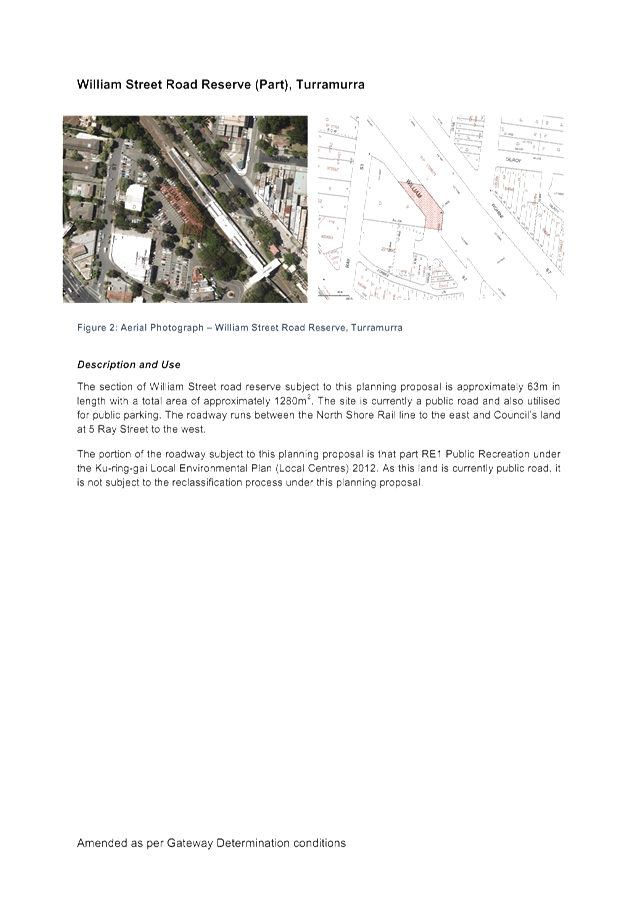
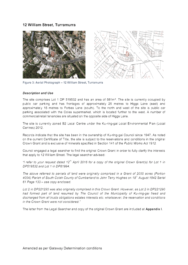
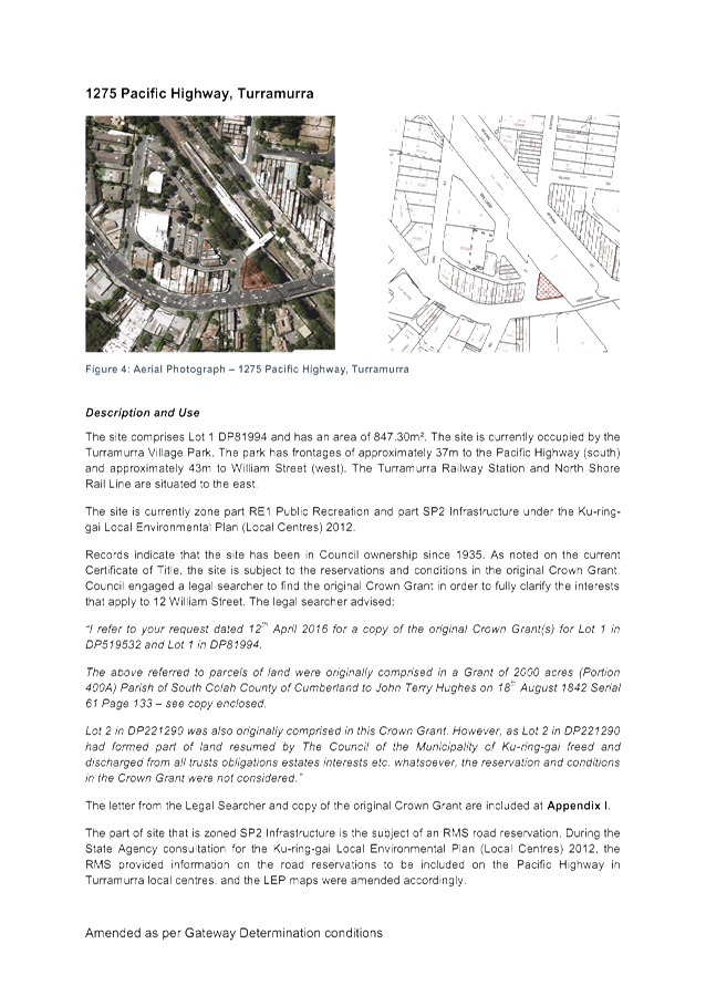
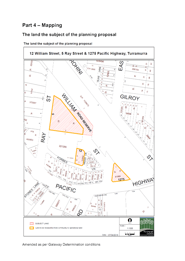
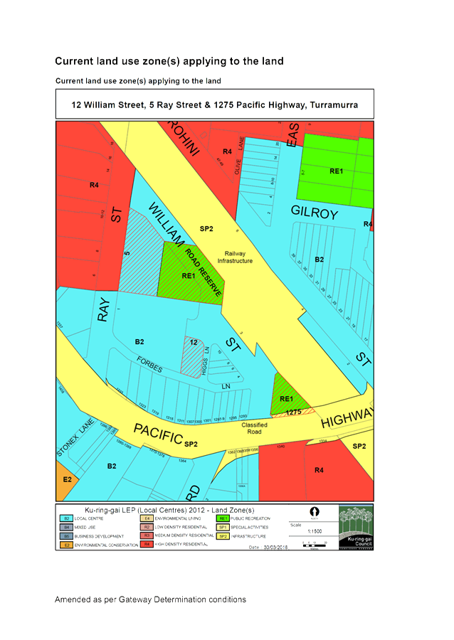
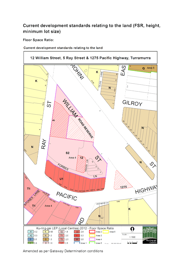
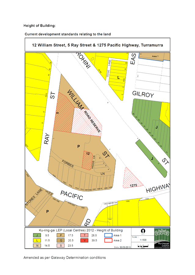
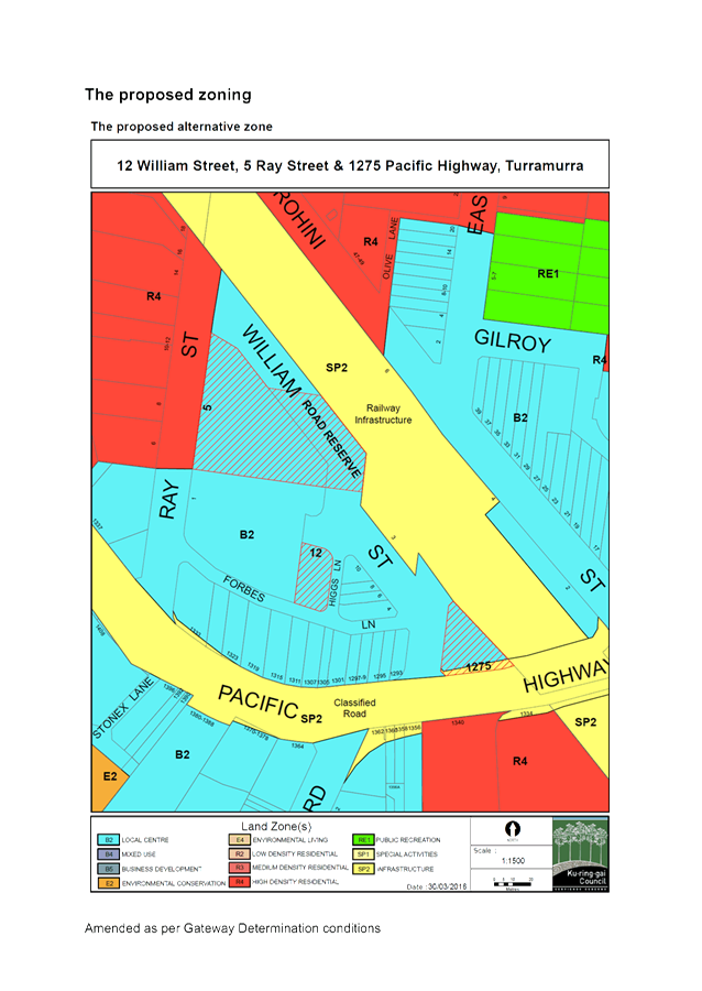
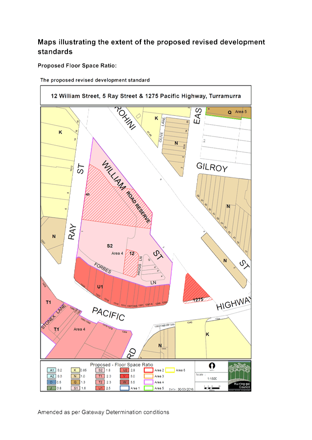
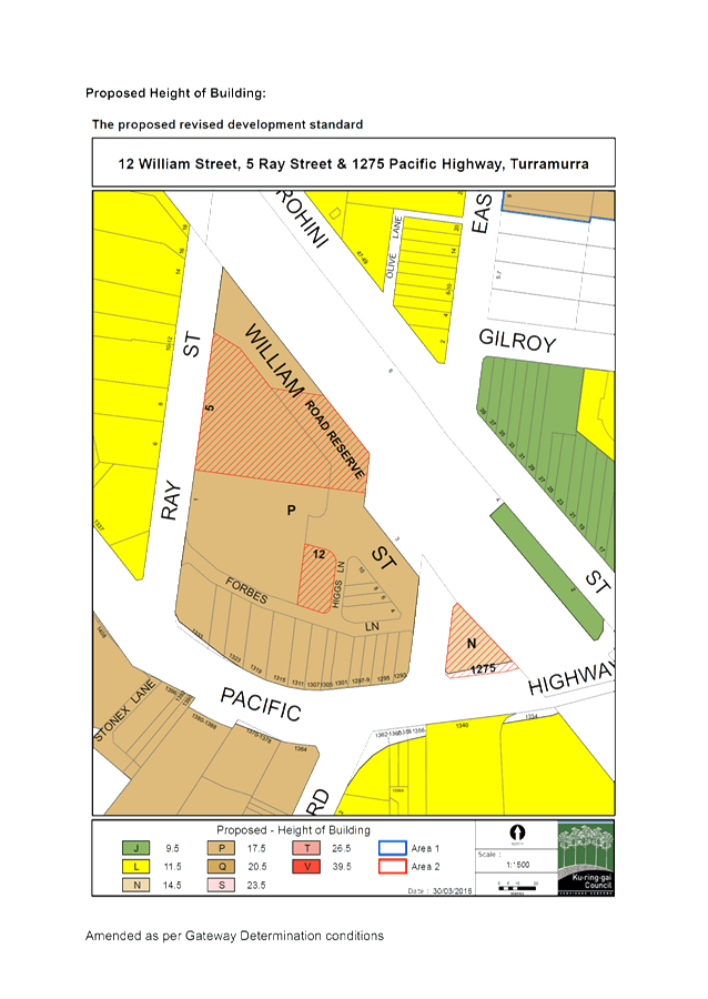
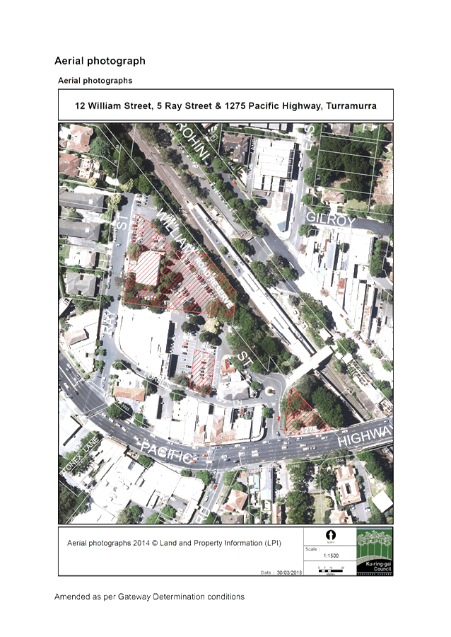
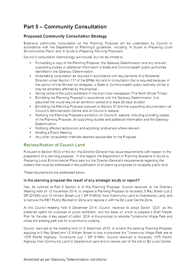

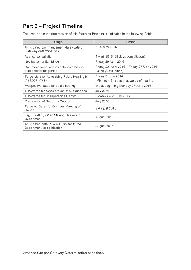

|
Ordinary Meeting of Council - 6 September 2016 |
GB.11 / 375 |
|
|
|
|
Item GB.11 |
S10467 |
|
|
3 August 2016 |
Turramurra Community Hub Master Plan - Community Facilities
EXECUTIVE SUMMARY
|
purpose of report: |
The purpose of this report is to recommend to Council the preferred location for a new Turramurra community building comprising a branch library and community centre. |
|
|
|
|
background: |
At OMC 28 June 2016 GB.6, the results of the public exhibition of the draft Turramurra Community Hub Master Plan were reported to Council. At that meeting Council resolved that prior to any decision being made on the Turramurra community hub master plan as exhibited a report should be brought to Council to determine the location of the library and community centre facilities within the Ray Street precinct taking into account all previous resolutions of council on these facilities. |
|
|
|
|
comments: |
Since 2014 there has been ongoing discussion on the location of a new Community Building in Turramurra Local Centre. This report considers a number of matters relevant to determining a preferred including:
· the findings of the Turramurra Community Facilities Study, 2015; · the development of the master plan and decisions made by full Council; · the communities preference; · best practice assessment; and · urban design and feasibility considerations.
This report will address these matters and recommend a way forward. |
|
|
|
|
recommendation: |
That Council adopts the Turramurra Community Facilities Study, 2015 as the basis for ongoing planning and design of the proposed Turramurra Community Building and that Council adopts the Turramurra Village Park as the preferred site for the location of the proposed Community Building.
|
Purpose of Report
The purpose of this report is to recommend to Council the preferred location for a new Turramurra community building comprising a branch library and community centre.
Background
Turramurra Community Hub - Preferred Design Option
At OMC 9 December 2014 GB.13, Council was presented with a preferred design option for the Turramurra Community Hub for public exhibition. At that meeting it was resolved:
A. That Council adopt Design Option 2CA as the preferred option for the purposes of public exhibition and that the consultants are instructed to prepare a draft master plan on that basis including exhibition material (detailed plans, sections and perspective views).
B. That the draft master plan be placed on exhibition for a month in the first half of 2015.
C. That following completion of the exhibition a report be brought back to Council with:
i. a summary of submissions and community feedback from the exhibition; and
ii. recommendation for a final master plan; and
iii. recommended next steps.
D. That staff and consultants meet with private property owners within the master plan site boundary to present the draft master plan as resolved by Council.
E. That a decision in relation to the location of a new library and community centre be delayed pending community input and comment on the draft Turramurra Community Facilities Study recommendations.
In relation to the above:
· Resolutions A, B &C are complete. The Turramurra Community Hub Master plan was publicly exhibited in May 2016. The results were reported to Council at OMC 28 June 2016 and included a summary of submissions and community feedback from the exhibition; recommendation for a final master plan; and recommended next steps.
· Resolution D has been completed and reported to Council previously.
This report addresses Resolution E which is outstanding.
Turramurra Community Hub - update report
At OMC 8 December 2015 GB.5, Council was updated on the progress of the Turramurra Community Hub Master Plan.
At that meeting Council resolved that:
A. The draft master plan be refined to take into account the findings of the Turramurra Community Hub - Peer Review of Retail Assessment and Feasibility Analysis, December 2015;
B. The project construction estimates be updated to reflect the refinements to the master plan and the updated cost estimates for the construction and fit-out of community facilities;
C. The feasibility modelling and analysis be updated to take into account the refinements to the master plan and the updated cost estimates;
D. The Turramurra local centre traffic and transport study be completed and consideration given to the implications for the master plan prior to exhibition;
E. The refined draft master plan is publicly exhibited within the first half of the year 2016;
F. The refined draft master plan be reported back to Council prior to public exhibition if the above amendments cannot be made within the current LEP provisions or within the scope of Council’s resolutions in relation to the project;
G. That following completion of the exhibition a report be brought back to Council with:
i. a summary of submissions and community feedback from the exhibition;
ii. recommendation for a final master plan; and
iii. recommendations on the next steps.
H. That the existing Planning Proposal applying to the 5 Ray Street and 12 William Street, Turramurra be varied in accordance with section 58 of the EP&A Act as follows:
- incorporate the site 1275 Pacific Highway, Turramurra (Turramurra Village Park) (Lot 1 DP 81994);
- reclassify the site from Community land to Operational land and formally seek to discharge all necessary interests applying to the land to enable the implementation of the Turramurra Community Hub Master Plan; and
- rezone the site from RE1 Public Recreation to B2 Local Centres with a maximum building height of 14.5m and FSR of 2.5:1.
In relation to the above:
· Resolutions A - G are complete. The Turramurra Community Hub Master plan was publicly exhibited in May 2016. The results were reported to Council at OMC 28 June 2016.
· Resolution H is deferred as per Council resolution June 2016.
OMC 28 June 2016 GB.6 - Turramurra Community Hub Master Plan - Post Exhibition
At OMC 28 June 2016 GB.6 the results of the public exhibition of the draft Turramurra Community Hub Master Plan were reported to Council (refer Attachment A1 – OMC report 28 June 2016). At that meeting it was resolved:
A. That the decision on the Turramurra community hub master plan as exhibited be deferred for further meetings with councillors within the next 2 weeks on a Tuesday on aspects of concern. A further meeting be held with Coles within one month.
B. That prior to any decision being made on the Turramurra community hub master plan as exhibited, a report should be brought to council to determine the location of the library and community centre facilities within the Ray Street precinct taking into account all previous resolutions of council on these facilities.
C. That all action cease on the reclassification and rezoning of the Turramurra Village Park until after a decision has been made to determine the location of the library and community Centre facilities within the Ray Street precinct.
D. That a separate report be prepared and reported to council on the Turramurra traffic and transport study with a view to council adopting the study in principle.
In relation to the above:
· resolution A is partly complete. A meeting with Councillors, Council staff and external consultants was held on Tuesday, 2 August 2016; a preliminary meeting with representatives of Coles Property Development Group (CPDG) was held on 11 August 2016; further meetings are proposed prior to reporting back to Council on this matter;
· this report addresses Resolution B and makes recommendations in this regard;
· resolution C has been actioned; and
· resolution D is subject to a separate report to Council for OMC 6 September 2016.
Comments
Since 2014 there has been ongoing debate on the location of a new community building in Turramurra Local Centre. The relevant resolutions are as follows:
· “That a decision in relation to the location of a new library and community centre be delayed pending community input and comment on the draft Turramurra Community Facilities Study recommendations.”
· “That prior to any decision being made on the Turramurra community hub master plan as exhibited a report should be brought to council to determine the location of the library and community centre facilities within the Ray Street precinct taking into account all previous resolutions of council on these facilities.”
· “That all action cease on the reclassification and rezoning of the Turramurra Village Park until after a decision has been made to determine the location of the library and community Centre facilities within the Ray Street precinct.”
There are a number of considerations in order to determine the preferred location for a new community building in Turramurra:
· the findings of the Turramurra Community Facilities Study, 2015;
· the development of the master plan and decisions made by full Council;
· the communities preference;
· best practice assessment; and
· urban design and feasibility considerations.
This report will address these matters and recommend a way forward.
1. Turramurra Community Facilities Study, 2015
The Turramurra Community Facilities Study 2015 (refer Attachment A2) documents the outcomes of a study undertaken to determine community facility provision for Turramurra and surrounding areas. The study was undertaken to develop a strategy for future community facility provision within the area, including the potential development of a new district level community centre and branch library in the Turramurra local centre.
The Turramurra Community Facilities Study involved:
· a review of previous studies, strategies and council plans and decisions to gain an understanding of the study context, set project parameters and identify opportunities;
· determining population catchments and an analysis of the existing population, community needs, existing facility provision and gaps;
· examining future population growth and change within the population catchment;
· considering contemporary trends in community facility provision;
· undertaking consultation to gain stakeholder and community input;
· developing recommendations for the arrangement of community facilities across the Turramurra catchment (including recommendations for existing facilities);
· assessing site options for the new district facility [i.e. branch library & community facility] and determining a preferred option;
· developing a vision for the facilities, which included determining required/desired uses, characteristics and the spaces/amenities required; and
· compiling study findings which will inform the Turramurra local centre master planning process, including a design brief for the proposed district facility.
The study identified a number of factors that have been found to influence the success of community facilities, considered in terms of achieving high levels of utilisation, being well recognised as a source of social support in their community and contributing to the identity and sense of place of an area. The principles were derived from the lessons learnt from case study research, including the consultant’s direct experience with community facility planning and conducting case studies and literature reviews over many years.
The principles listed below, derived from the lessons learnt from case study research, were used to inform the development of recommendations for new facilities in the Turramurra catchment:
· a co-ordinated network of facilities;
· central to catchment and equitable access;
· location to promote visibility and accessibility;
· clustered/co-located;
· flexibility and multiple use;
· serving identified social needs;
· inclusive and welcoming;
· contribute to public domain and sense of place;
· near open space for activities and events;
· connected to public transport, pedestrian & cycling networks;
· of sufficient size and design to enable expansion adaptation;
· financially and environmentally sustainable;
· safe and secure; and
· avoidance of conflict with neighbouring uses.
The study findings can be summarised as follows:
· the future needs of the community based on predicted catchment population growth will create demand for library with a floor space of 1,749sqm GFA;
· the future needs of the community based on predicted catchment population growth will create demand for a community centre with a floor space of 1,400sqm GFA;
· co-locate the library and community centre in a single building with a total GFA in the order of 3,000sqm GFA optimising shared use of spaces, facilities and amenities; and
· the preferred location for the library and community centre within Turramurra Local Centre is in the Ray Street Precinct.
2. Master Plan Development
In December 2014 Council resolved to adopt Design Option 2CA as the preferred land use scenario for the purposes of public exhibition. This option locates the multi-purpose community centre and library on the Turramurra Village Park (refer Figure 1).
Figure 1 – Design Option 2CA adopted by Council December 2014
Based on this resolution and the findings of the Turramurra Community Facilities Study 2015, architectural consultants (CHROFI) were engaged to prepare a master plan for the Ray Street precinct. Three briefing sessions were held for Councillors during the development of the master plan:
· a briefing session was held on 4 June 2015 to update councillors on the Draft Master Plan for the site;
· a briefing session was held on 4 August 2015 to present to Councillors the completed draft master plan and model; and
· a Question and Answer session was held on 8 December 2015 to present to Councillors the refined master plan.
In December 2015 Council adopted the final master plan for exhibition and resolved to commence reclassification of land to facilitate the master plan.
In summary Council has consistently supported the multi-purpose community centre and library being located on the Turramurra Village Park.
3. Community preference for location of community building
In accordance with Council’s resolution the Turramurra Community Hub master plan was exhibited for the period 30 April and 29 May 2016. Two location options were presented to the community for a new community building (which includes a new branch library and multi-purpose community facility) and the community were asked to select a preferred option. The options are:
· Option 1 –Turramurra Village Park; and
· Option 2 – Town Square Site.
Figure 2 indicates the community’s preference for the location of the community building across the various engagement methods utilised by Council. It is noted that the sample sizes are small for the survey results however the results of the recruited workshop could be considered reasonably representative. Option 2 was consistently selected as the preferred option by all engagement participants.
In summary residents preferred Option 2 because:
· provides a better ‘town centre’ or heart, co-located with other uses and services;
· that the library would be more integrated with the community and surrounding uses; and
· that the surrounding open space could be better utilised for outdoor music, performance and/or cinema events.
Figure 2 – Community Preference for Location of the proposed Community Building
4. Best Practice Options Assessment - July 2016
Elton Consulting were engaged in July 2016 to undertake an assessment of the two community building options presented in the Turramurra Community Hub Master Plan. The full study is in Attachment A3 – Turramurra Community Hub Community Facilities Options Assessment and a summary of findings is presented below.
The assessment focuses on location (i.e. central, visible and accessible to a full range of community members, close to public transport) and considers the various locational attributes of both sites and assesses the relative suitability as community facility locations. A further consideration is the capacity of each of the sites to accommodate the required floor space area for community uses - namely community centre and library.
The assessment follows the same process used and adopted by Council for the Lindfield Community Hub. As with Lindfield, this assessment utilised principles from the original Turramurra Community Facilities Study Report, 2015 as criteria for the options assessment. Table 1 sets out the ratings for each option according to the location related criteria.
Table 1 – Community Building Location Assessment
|
Criteria |
Option 1 – Park Site |
Option 2 – Town Square Site |
||
|
|
Rating |
Comment |
Rating |
Comment |
|
Location to promote visibility and accessibility |
5 |
Proximity to train station entry. Prominent position on the Pacific Highway creates iconic gateway/landmark building |
4 |
Relatively close to station and visible from entry/exit. Lack of visibility from highway |
|
Clustered/co-located |
3 |
Connections to highway retail but slightly less connection to remainder of community hub site |
4 |
Good connections to public open space (town square) and to retail/market precinct on Forbes Lane |
|
Contribute to public domain and sense of place |
3 |
Surrounding public space less suitable for public gathering includes road/roundabout. Pacific Highway frontage contributes less to public domain due to nature of roadway |
5 |
Strong direct connections to town square. Relationship to high quality public space reinforces sense of place and strengthens public domain |
|
Near open space for activities and events |
3 |
Surrounding public space less suitable for public gathering includes road/roundabout. |
5 |
Strong direct connections to town square |
|
Connected to public transport, pedestrian and cycling networks |
4 |
Strong connection to train station |
3 |
Proximity to train station |
|
Safe and secure |
4 |
Natural surveillance to highway entrance. However, hub side access is slightly more remote |
3 |
Less passing traffic. Although use of library (night time hours) will enhance safety of town square |
|
Overall |
22 |
|
24 |
|
The analysis suggests that, from a community facility location perspective, there is little to distinguish between the two sites. Both sites, being in relative proximity to each other, address the significant higher level location requirements of being close to transport, co-located with activity centres and in prominent, community focused locations.
The key distinction between Options 1 and 2, which results in a higher rating for Option 2 (town square site), is its stronger, more direct relationship to quality public open space and its more central location within the Turramurra Community Hub master plan area.
The scoring of the two options indicated that both locations are seen as good community facility locations however the location on the town square (Option 2) has a slight advantage from a community facilities perspective.
5. Urban Design and Financial Feasibility Considerations
A meeting was held with Councillors, council staff and external consultants on Tuesday, 2 August 2016, to address a number of ‘aspects of concern’ raised by Councillors. At that meeting CHROFI architects presented options for locating the community building. The options are:
· Option 1 – library & community facility on the park site;
· Option 2 – library & community facility adjacent to the proposed town square and the park developed for mixed use; and
· Option 3 - library & community facility adjacent to the proposed town square, with the park retained.
The options are shown in Figure 3.
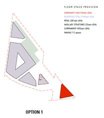
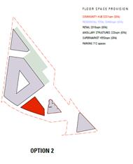
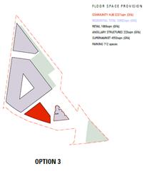
Figure 3 – Community Building Locations – Urban Design Considerations
Option 1 – Village Park Site
· community building on the village park site with a potential for about 3,150sqm GFA;
· capacity to support the minimum floor space requirement for a community building; and
· consolidation of retail uses and shop-top housing around the town square.
Option 2 – Town Square Site
· community building adjoining the proposed town square with a potential for about 3,200sqm GFA;
· Capacity to support the minimum floor space requirement for a community building; and
· retail uses and shop-top housing are transferred to the village park site to retain overall project viability.
Option 3 - Town Square Site (Village Park retained as open space)
· community building adjoining the proposed town square with a potential for about 3,200sqm GFA;
· capacity to support the minimum floor space requirement for a community building;
· retail floor space component reduced across the site from 2,300sqm to 1,670sqm;
· residential component increased which in turn reduces the dimensions of the linear park in the northern portion of the site to retain overall project viability;
· would require amendments to KLEP 2012 to increase the FSR across the site to allow additional residential floor space.
A high level feasibility assessment of the abovementioned options was undertaken and concluded that both Options 1 & 2 do not compromise Council’s objectives of achieving a cost neutral outcome.
Option 3 (retention of the Village Park site), under the current LEP provisions, would however necessitate Council contributing additional funds to account for the financial shortfall associated with retaining the Village Park.
6. Summary of Findings
· Throughout the development of the master plan elected Council has consistently supported multi-purpose community centre and library being located on the Turramurra Village Park.
· During public exhibition of the Master Plan Option 2 – Town Square Site was consistently selected as the preferred option by the majority of engagement participants. It is noted that this results, other than those from the recruited workshop, are not a representative sample.
· A best practice assessment of the two options indicates that both locations would be good community facility locations however the location on the town square (Option 2) has a slight advantage due to proximity to the town square.
· Retention of the Village Park as open space would have financial impacts for Council (under the current LEP provisions) as this would necessitate Council contributing additional funds to account for the financial shortfall associated with retaining the Park.
Based on the preceding assessment there is not a strong case to move away from elected Council’s preferred position which is to locate the new Community Building on the Turramurra Village Park.
integrated planning and reporting
The Revised Delivery Program 2013-2017 and Operational Plan 2015-2016 commits Council to master planning for the revitalisation of the Turramurra Local Centre and surrounding precincts.
Theme 3 – Place, Spaces and Infrastructure
|
Community Strategic Plan Long Term Objective |
Delivery Program Term Achievement |
Operational Plan Task |
|
A range of well planned, clean and safe neighbourhoods and public spaces designed with a strong sense of identity and place. |
4.1.1 Plans to revitalise local centres are being progressively implemented and achieve quality design outcomes in collaboration with key agencies, landholders and the community.
|
Progress master planning for the Turramurra Centre and surrounding precincts.
Engage with key community stakeholders to identify the requirements for new community facilities and infrastructure.
Finalise the reclassification of identified lands as resolved by Council. |
|
A healthy, safe, and diverse community that respects our history, and celebrates our differences in a vibrant culture of learning. |
C4.1.2 New and enhanced open space and recreational facilities have been delivered to increase community use and enjoyment.
|
Undertake acquisitions for new parks.
Undertake assessment and identify locations for new parks
Complete the design for identified parks and include design principles which facilitate passive recreation activities.
Construct parks at identified locations and include design principles which facilitate passive recreation activities |
FIT FOR THE FUTURE IMPROVEMENT ACTION PLAN
The NSW Government's Fit for the Future initiative required all councils to prepare an Improvement Proposal and supporting Implementation Plan demonstrating how all seven Fit for the Future benchmarks would be met by 2016/17, and maintained or improved thereafter.
Council's Fit for the Future Improvement Proposal and supporting Implementation Plan underpins the decision to stand alone and not merge with Hornsby Council. The objectives established in the Improvement Proposal and Implementation Plan are embedded in Council's adopted Integrated Planning and Reporting documents including the Revised Delivery Program 2013-2017 and Operational Plan 2015-2016, Long Term Financial Plan 2015/16 to 2024/25 and Asset Management Strategy 2015/16 to 2024/25.
Council’s Fit for the Future Improvement Proposal sets out the following strategies and outcomes to meet the State governments Efficiency criteria:
|
EFFICIENCY |
|||
|
Objective |
Strategies |
Key milestones |
Outcome |
|
Major Local and Town Centres projects i.e. Community hub projects are commercially feasible in their own right |
Projects should include commercial opportunities for Council to offset ongoing operational costs (life cycle costs) of the public benefits provided |
Master plans adopted for Local and Town Centres 2015/2016
EOI for the redevelopment of Turramurra Local Centre 2015/2016.
Redevelopment of Turramurra Local Centre 2016/2017. |
Master plans adopted for the Local and Town Centres with development options substantially progressed to deliver community facilities and public benefits. |
It is noted in the NSW Government publication Merger Proposal – Hornsby Shire Council (part) Ku-ring-gai Council dated January 2016, that specific reference is made to the proposed merger and the ability to provide the services and infrastructure to the community including the revitalisation of Lindfield, Turramurra and Gordon Town Centres.
Governance Matters
On 28 June 2016 Council resolved that, prior to any decision being made on the Turramurra community hub master plan, a report should be brought to council to determine the location of the library and community centre facilities within the Ray Street precinct. It also resolved that all action cease on the reclassification and rezoning of the Turramurra Village Park until after a decision has been made to determine the location of the library and community Centre facilities within the Ray Street precinct.
A public hearing into the reclassification of 5 Ray Street and 12 William Street was held on 25 July 2015. As a result of Council’s resolutions on the 28 June 2016, the proposed reclassification of 1275 Pacific Highway was not considered as part of that public hearing. The matter of the rezoning and reclassification of 5 Ray Street and 12 William Street will be the subject of a separate report to Council.
Risk Management
The major risk to Council at this point in time is the proposed amalgamation with Hornsby Shire Council. The uncertainty surrounding the pending proclamation could potentially delay necessary investigations into how the master plan may be best delivered.
A secondary risk to Council is reputational. The planning for Turramurra local centre commenced in 2010 with the drafting of the Local Centres LEP. Council has taken almost 6 years to get to this point. Based on the positive reception the master plan received during the exhibition and the good will established as a result, Council needs to be aware of the potential negative effect any delays to the project would have on its reputation.
Financial Considerations
If Council adopts the recommendations in this report, the draft master plan will progress to the next stage of the project which is investigation of preferred project delivery mechanisms. There are currently adequate funds available within the project account to cover the costs of this work.
To date Council has expended over $400,000.00 on this project including salaries and consultancies. These funds have been taken from development contributions 2010 Plan Recreational, Cultural & Social Facilities. It is important that Council continues to progress this project, if not Council may be required to repay part of the S94 funds spent to date if the works are not delivered.
Council’s Long Term Financial Plan (LTFP) identifies a total of approximately $26 million allocated from the S94 Ku-ring-gai Contributions Plan, 2010 for works associated with the Turramurra Community Hub. These funds will be Council’s contribution toward the project and have been taken into account when preparing the preliminary economic feasibility assessment.
The funds allocated to this project represent only a proportion of the total development contribution funds that will be available for the Turramurra Local Centre as a whole. In the future Council will be undertaking master plans for the other key precincts as funds become available.
Social Considerations
Council’s Community Strategic Plan 2030, recognises the community’s vision for Ku-ring-gai as a place with infrastructure and facilities which accommodate the needs of the community. The plan further emphasises the desire for an adopted program for the implementation of new facilities, identified funding sources and a program to maintain Council’s assets at a sustainable standard.
Environmental Considerations
A number of environmental studies have been undertaken to date for this site. Further necessary due–diligence studies will be undertaken in due course as part of the next phase.
Community Consultation
1. Outcomes of public exhibition of draft Turramurra Community Hub master plan
The community consultation period was between 30 April and 29 May 2016 and included a range of engagement and communications techniques to ensure maximum input and participation (refer Community Consultation section of this report for further detail). The community stakeholders are wide and varied. The stakeholders include but are not limited to the following groups:
· local residents;
· local business owners and operators;
· users of the centre;
· commuters; and
· local community groups and chambers of commerce.
During the consultation period, Council staff engaged face-to-face with over 500 people, of those nearly 60 attended workshops, with the remainder attending the exhibition launch event and on-site drop in sessions. A dedicated web portal garnering over 1,000 visits and a YouTube video had over 1,300 views (second highest hit rate of all Ku-ring-gai’s videos on YouTube since set up over 5 years ago).
A key outcome of the exhibition is that the community are broadly supportive of the draft Master plan. The demographically representative recruited workshop scored the master plan 3.7 (74%) out of 5; the opt-in workshop scored 3.3 (66%) out of 5; the youth workshop scored the draft Master plan 4.75 (95%) out of 5. Survey respondents were also generally positive with minimal negative comments.
The community provided well-considered and innovative ideas and identified important issues for consideration in subsequent stages of the project. In summary, vehicular, pedestrian and cycle movements in and around the site was a major issue as well as provision for enough car parking for centre users and commuters alike.
Feedback indicated a preference for passive recreational facilities within the new open spaces as well as a desire to create a contemporary, well-designed and connected urban space with a variety of leisure and retail opportunities. The thoughts and ideas collected have been collated to assist in developing a comprehensive platform of local knowledge upon which more detailed designs can evolve during the next phase of investigation. A complete summary of the feedback received is in Attachment A5 – Turramurra Community Hub Community Engagement Output Report.
In addition to the community feedback received through the aforementioned methods, a number of detailed submissions were received from individual stakeholders/members of the community, as summarised in the table in Attachment A6 – Summary of Submissions.
A number of salient points were raised, including the following:
· support for ‘density done right’, suggesting that additional floor space and/or height may assist Council in funding for public benefit;
· that the study area be expanded to include properties that have Pacific Highway frontage and rear lane access to Forbes Lane;
· concern raised over the number of apartments proposed – that it represents over-development of the site;
· concern that Council has not considered the whole of Turramurra;
· that the master plan is not giving enough due consideration to Turramurra’s natural and built heritage;
· concern raised over the loss of the existing Village Park;
· vehicular access to the Turramurra Lookout Community Garden could be compromised by the proposed traffic modifications;
· potential conflict of land uses on site between the supermarket operations [i.e plant & equipment, acoustic separation, airflow] and adjacent residential [existing/proposed];
· question the size/configuration and subterranean location of the supermarket, vertical movement of pedestrians from the basement car park and quantity of proposed car parking; and
· support for a pedestrian underpass under the Pacific Highway to facilitate safer movement of pedestrians, particularly in the vicinity of Kissing Point Road.
These ideas and concerns will be explored further as part of the ongoing development and refinement of the master plan.
2. Other Opportunities
During the exhibition period people where asked “what else they would like if funding was available”. The key suggestions are listed below:
· pedestrian and cycle bridge under or over the Pacific Highway to connect with Kissing Point Road;
· consider other precincts in Turramurra for master planning;
· new vehicular/pedestrian bridge over the rail line connecting Ray Street with Rohini Street;
· continuous cycle and walk way through the site connecting to Boyd Street;
· heritage walk through whole centre;
· bus interchange upgrade;
· centrally located stairs over the rail line similar to the temporary structure installed during the station upgrade some years ago;
· upgrade of Rohini Street/Bus Interchange;
· aquatic centre;
· multi-sports indoor centre/gym;
· art gallery;
· theatre space/concert hall;
· ‘mens’ shed’;
· occasional child care facility and/or long day care centre;
· youth centre;
· conference centre; and
· Aboriginal heritage museum.
These opportunities will be prioritised and explored further as part of the ongoing development and refinement of the master plan during the delivery phase of the project.
Refer to Attachment A5 - Turramurra Community Hub Community Engagement Output Report, for the complete summary of the feedback received and Attachment A1 – OMC report 28 June 2016.
3. Engagement & Communications Methods
The engagement and communications methodology for the exhibition period was designed to be robust and transparent, ensuring where reasonably practicable that all community stakeholders would have ample opportunity to provide comment and input. A complete summary of the feedback received is in Attachment A5 – Turramurra Community Hub Community Engagement Output Report.
The key objectives of community engagement are:
· to inform the community about Council’s adopted preferred option for the Turramurra Community Hub;
· to explain the prioritisation of the Community Hub site over other areas in Turramurra with a historical and planning context;
· to ensure that the community is broadly supportive of draft Master plan;
· to ascertain the community’s preference for the location of the integrated community building within the Hub site; and
· to hear the community’s opinions and ideas about:
- what facilities and activities should be considered on the new open space;
- what activities and features the new community facilities should accommodate;
- transport and parking – local knowledge to inform future planning for traffic and people movement on and around the site; and
- any ideas or opportunities they may have for the site, not currently under consideration.
Community feedback was acquired in a number of ways. A range of engagement methods were employed during the exhibition period as detailed in the table below.
Table 2 – Engagement and communications methods employed.
|
Engagement Action |
Details |
Level of engagement (IAP2 spectrum) |
When/Where |
Relevant numbers |
|
On-site community event |
To provide information to the public and discuss the project. Event included video presentation, information boards/leaflets, graphics and a model. Council staff were on hand to answer questions and discuss the project. A complementary sausage sizzle was also provided to encourage participation. |
Consult |
Saturday 30 April 2016 from 10am – 2 pm at Ray Street Carpark, Turramurra |
Approx. 300 attended |
|
On site drop-in ‘information kiosk’ |
Temporary building installed and attended by Council staff to allow the community (including shoppers and commuters) to drop in and find out more about the project and speak with staff. Feedback forms/survey were available for people to make comments and share ideas |
Consult |
Tuesdays from 11am-3pm and Thursday from 3pm –pm during exhibition period |
Approx. 200 visitors |
|
Opt-in Community Workshop |
Workshop to present detailed information to local people and hear their opinions and ideas about the Plan. Workshops consisted of presentations by Council staff and the project architects plus round table discussions. Feedback captured via butchers paper notes and surveys |
Involve |
Thursday 19 May from 6.30 – 8.30pm at Turramurra Masonic Hall |
23 attendees |
|
Recruited Community Workshop |
Independently recruited, demographically representative sample of the local community. Council staff and consultants attended |
Involve |
Wednesday 18 May from 6.30 – 8.30pm at Turramurra Masonic Hall |
32 attendees |
|
Youth Workshop |
To discuss the Hub design and undertake vision exercise looking at future scenarios to young people’s future needs/aspirations at the site |
Involve |
Tuesday 17 May – 5pm- 7.30pm at Turramurra Library |
4 attendees |
|
Letters and information sent to local residents and businesses |
To inform the community about the Draft Master plan Exhibition |
Inform |
Letter sent w/c 25 April 2016 |
|
|
Dedicated online community engagement portal |
Detailed background information including reports, plans/images and a video, online discussion forums, feedback forms/survey and Q&A.
Page on Council’s website created to direct people to the online portal. |
Consult |
Open from Friday 29 April to Sunday 29 May 2016 |
1060 visits to the website, with 307 people downloading documents. The maximum daily visits was 110. |
|
Dedicated Activate Turramurra E-newsletter |
To keep interested parties informed about the project via email and developed prior to the exhibition period with subscribers sourced from previous community engagement regarding Turramurra |
Inform |
3 e-newsletters sent between 28 April and 26 May 2016 |
147 subscribers |
|
Meetings with businesses and community groups |
Meetings offered to discuss the project with local community groups including Friends of Ku-ring-gai, Beautify Turramurra, Friends of Turramurra, Eastern Road action group and Turramurra Chamber of Commerce. Turramurra Chamber of Commerce and Beautify Turramurra were the only groups to request a meeting. Members from other groups attended workshops and the information kiosk. |
Involve |
One meeting held on 26 May with representatives from Turramurra Chamber of Commerce and Beautify Turramurra |
5 attendees plus two council staff members |
|
Social Media (including Facebook, Twitter and YouTube) |
A video, links to the engagement website and information about meeting Council staff face to face to find out more and have a say. |
Inform |
Ongoing |
Youtube video – over 1,300 views (second highest hit rate of all Ku-ring-gai’s videos on Youtube since set up over 5 years ago). Facebook – 4 posts – approx. 100 likes shares and comments Twitter - 3 posts |
|
Printed Media |
Advertisements, media release and information in Council’s corporate advertisement |
Inform |
Mid-April to early June 2016 |
1 media release, 1 standalone newspaper advertisement and 4 references in the corporate advertisement |
|
Opt-in online survey |
Survey designed to capture feedback about preferred location of the community facility building, community facilities and open space, including feedback on the master plan overall. A hard copy was on display at the drop-in information kiosk. |
Consult |
Accessed via online engagement portal. |
22 completed surveys received |
|
Opt-in hard copy survey |
Survey designed to capture feedback about preferred location of the community facility building, community facilities and open space, including feedback on the master plan overall. A hard copy was on display at the drop-in information kiosk. |
Consult |
Available at the on-site information Kiosk and at the Community Event |
33 completed surveys received |
4. Summary of Feedback
To meet the objectives of this engagement process, similar questions were posed to participants across all engagement techniques (i.e. recruited workshop, opt-in workshop, youth workshop, on site drop in sessions & surveys). The objective of which was to ensure that the community understood the key aspects of the master plan and to provide a forum to share their ideas about proposed uses, features and activities. The community were asked to provide feedback about the following key elements of the master plan, namely:
a) Community Facilities - new, larger branch library & multi-purpose community building
Suggestions and ideas for activities within the community facility:
Overall, participants were supportive of the proposed community facility, including a larger branch library, co-located with a multi-purpose community building providing flexible spaces, with superior acoustic properties, for use by a variety of user groups (eg. yoga, dance classes/rehearsal, art/craft/language/cooking classes and/or workshops). Feedback was particularly positive about the concept of these facilities being incorporated into one building, creating a new civic heart for Turramurra, where people could participate in a variety of activities in one location, in close proximity to extensive public open space, public transport and a diversity of retail offerings, fostering a sense of community and social interaction, not social isolation.
The community have expressed a desire for a community building that is welcoming, inviting and of an architectural vernacular that is cohesive and conducive to contributing to the village feel of the area. Facilities for the youth population should be a priority, including a technology hub and free WIFI incorporated into the library facility. The community building should also incorporate vertical gardens and a café to encourage social interaction. The building should also include opportunities for local artisans and emerging artists to exhibit. Due consideration should also be given to noise attenuation, lighting, signage and safety, to encourage use of the facility, especially in the evenings.
b) Open Space - linear park & gardens, town square, Forbes Lane shared zone and a rooftop garden
Facilities/features/activities to be accommodated in the open space:
The proposed open spaces should cater for a wide range of ages [ie. not be dominated by facilities just for one particular demographic], be predominantly for passive recreation, be accessible and designed to discourage anti-social behaviour, particularly afterhours.
There should be recognition of both Aboriginal and European heritage in the design of the open spaces. Native planting should be encouraged, whilst safeguarding existing mature trees for ambience and a leafy outlook. Ensure adequate shading and shelter structures are provided. The idea that Forbes Lane could become more of a shared zone, allowing for farmers markets, annual fairs and/or food festivals on a week-end, resonated with the community. The proposed open spaces should also consider including outdoor activities such as an outdoor cinema, giant chess, Tai Chi classes, bocce/boules, picnic facilities, and opportunities for quiet reflection. A well-considered lighting strategy should be created – both for dramatic effect and to ensure public safety. If a roof garden is to be incorporated, consider a community garden and or a tennis/basketball/futsal court. The open spaces should also cater for civic events, space for music busking (controlled with licences) and permanent memorials.
Issues or concerns regarding new open space:
It is imperative that the material palette selected for the public domain is of a high quality/durability and well-maintained by Council. Suitable noise attenuation measures should also be considered, given the site’s proximity to the Pacific Highway, to ensure that the open spaces are pleasant environments to be in. Connectivity of the open space to surrounding road networks, cycle ways, the train station and kiss & ride need careful consideration, as there are already existing vehicular/pedestrian conflicts. Overcoming visual blight and minimising opportunities for graffiti was also a priority. There is also a need to better reconcile the site’s level changes, to ensure highest and best use of the proposed open spaces. Include public art/sculptures in the open space, as there is currently a distinct lack of it.
Concern was raised that the bulk of the proposed residential buildings will dominate/overshadow the adjacent open space - this will need further consideration.
c) Overall Master Plan - including residential apartments, speciality retail/leisure retail and a supermarket in addition to the community facility and open spaces
General comments:
The community have commented that the site as is, is currently under-utilised, run down, tired and outdated. People are of the opinion that the Community Hub site should have a ‘vibe’, sense of place, be inspiring, interesting and a place for people to gather and socialise. A majority of participants welcome the plans for ‘urban renewal’ and are of the opinion that the proposed master plan is moving in the right direction to achieving a hub that will encourage activity, greater social interaction and pedestrian movement.
Concerns or issues:
Some people expressed some concern with the proposed increase in development on the site; over the quantity of public and commuter parking proposed; and whether adequate provision for circulation and movement of delivery trucks serving the full line supermarket has been duly considered (including appropriate vehicular and safe pedestrian connectivity of the site with its surroundings, particularly development on and around Kissing Point Road).
Ideas for further improvements or enhancements:
Residents identified a need to carefully consider the architectural style promoted. Concern has been raised about an overtly contemporary built form and that this is not considered to be in keeping with the village style of development characteristic of Rohini Street and surrounds.
Below is a table illustrating the ratings out of five (5) for the master plan provided by the workshop participants. The figures demonstrate a consistently positive response to the current proposal.
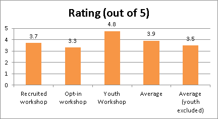
Figure 2 - Rating of Master Plan (only asked at workshops).
NOTE – the youth workshop had low attendance hence the average shown on the right of the table excludes the youth score.
5. Transport & Parking - workshop participants also specifically discussed transport and parking issues associated with the site.
With local knowledge, what are the perceived main transport challenges
Residents expressed concern about the increase in traffic in the local area as a result of increased development on the site.
The community commented on the need for a ‘kiss & ride’ to be provided on Rohini Street.
People also noted that here is not enough existing commuter parking. Commuter parking on local streets is an issue, as a large majority come from outside the local area, such as the Northern Beaches and Central Coast.
Coles Group Property Development raised concern regarding the future servicing of the proposed supermarket and retail tenancies onsite; noting there will be a need to carefully consider delivery truck movements/frequencies servicing the supermarket and retail tenancies, including appropriate acoustic attenuation measures in relation to the proposed residential units and existing residences on Ray Street.
Residents said that the population on the southern side of the Pacific Highway is disconnected from the Turramurra Local Centre, as the Pacific Highway is a significant barrier.
Concern has also been raised about the impact on local residences by diverting traffic down Turramurra Avenue. This requires further investigation.
Ideas to manage/mitigate challenges:
Community feedback indicates that the proposed ‘Ray Street Bridge’ is generally supported on the basis that it would alleviate existing pressures on the local road network, improve vehicular circulation and better connect pedestrians/cyclists with Rohini Street. Residents suggested that the bridge is to be an appropriate width to allow for vehicular, cyclist and pedestrian movements. More cycle links are also needed to connect the centre with surrounding areas. It is imperative to plan for these from the outset of the master planning process.
People noted that Turramurra Station is a fast train stop and that additional commuter parking is therefore required in the centre. There is a need to minimise the pedestrian/vehicular conflict at the existing kiss and ride. Similarly, there should be an increase in bus and train services commensurate with the increase in proposed resident numbers, including improved taxi stop provisions near the station.
The community would like to see improved connectivity between Turramurra Local Centre and Kissing Point Road and surrounds with a pedestrian overpass catering for cyclists too. Encourage walking and the use of bikes throughout the centre and surrounds, to reduce the reliance on vehicles and commuter car parking. Many participants were of the opinion that the Pacific Highway requires widening, particularly at the juncture of Kissing Point Road and the Pacific Highway to alleviate acute congestion in this area.
Feedback captured via the various engagement processes has been collated and are included verbatim in Attachment A5 - Turramurra Community Hub Community Engagement Output Report.
6. Planning Proposal Submissions on the master plan
Below is a list of key issues raised regarding the master plan, as contained in the submissions made to the Planning Proposal (via the ‘Have your Say’ forum), which was concurrently exhibited during May. Five (5) submissions were received.
Key issues/concerns raised include:
· support for Option 1 as the location of the community building, as it would block the traffic noise coming from Pacific Highway;
· widen Pacific Highway to 6 lanes and 1 lane for cars to turn left into Kissing Point Road;
· pedestrian underground access under Pacific Highway;
· support for railway overpass joining Ray Street and Rohini Street;
· expand commuter car parking;
· objection to 5 storey apartments;
· concerns on the impact of proposed bridge on Ray Street residents; and
· support for supermarket upgrade.
All submissions on the Planning Proposal will be reviewed in detail and reported to Council later in 2016.
Internal Consultation
This report was prepared by the Strategy & Environment Department in consultation with staff from other Departments where relevant.
Since 2014, seven (7) information sessions have been held for Councillors:
· a briefing was held on 8 October 2014 at which consultants presented a draft site analysis, design principles, preliminary design options and financial assessment;
· the draft design options were presented to Councillors at two site inspections held on 22 and 28 October 2014. At the final site inspection chalk markings were provided around the site to assist Councillors in understanding the design options;
· consultants briefed Councillors on 1 December 2014 on the draft Turramurra Community Facilities Study as well as the Ku-ring-gai Community Facilities Strategy (LGA wide);
· a briefing session was held on 4 June 2015 to update councillors on the Draft Master Plan for the site;
· a briefing session was held on 4 August 2015 to present to Councillors the completed draft master plan and model; and
· a Question and Answer session was held on 8 December 2015 to present to Councillors the refined master plan, taking into account AEC’s recommendations, prior to the council meeting;
· a meeting with Councillors, staff and consultants was convened on 2 August 2016 to discuss Councillor’s ‘aspects of concern’ regarding the exhibited draft master plan. A number of questions were raised by Councillors both before and after OMC 28 June 2016 and were largely centred around the issues of the location of community facilities within the Ray Street Precinct, the built form and height of proposed development, Turramurra Village Park and traffic and transport - each of which was comprehensively addressed at this meeting.
Summary
Elected Council has previously resolved that the preferred location for a new community building in Turramurra is on the Turramurra Village Park Site. During exhibition of the draft Master Plan the community indicated a preference for the building to be located on a site close to the proposed town square
In accordance with resolution E of the OMC of 9 December 2014, comment on the draft Turramurra Community Facilities Study recommendations has been provided in this report, including findings regarding the optimal location and size of a new community facility and library within the Ray Street precinct. It is recommended that Council resolve to adopt the Turramurra Community Facilities Study, 2015 as the basis for future planning for community facilities in Turramurra. It is also recommended that Council resolve to plan for a single community building with a total GFA in the order of 3,000sqm and comprising a library and community centre.
In accordance with resolution B of the OMC 28 June 2016, a number of considerations have been discussed in order to determine the preferred location for a new community building in Turramurra. Based on the assessment in this report there is not a strong case to move away from elected Council’s preferred position which is to locate the new Community Building on the Turramurra Village Park.
The next steps will involve further meetings between representatives of CPDG to work through the matters raised in their submission to the master plan. Once resolved the results will be reported to Council as the final master plan for Council adoption.
|
That:
A. Council adopts the Turramurra Community Facilities Study, 2015 as the basis for ongoing planning and design of the proposed Turramurra Community Building comprising a library and community centre with a total GFA of 3,000sqm;
B. Council adopts the Turramurra Village Park as the preferred site for the location of the proposed Community Building;
C. Council receive and note the results of the public exhibition of the draft Turramurra Community Hub master plan.
|
|
Louise Drum Senior Urban Designer |
Bill Royal Team Leader Urban Design |
|
Antony Fabbro Manager Urban & Heritage Planning |
Andrew Watson Director Strategy & Environment |
|
OMC 28 June 2016 Turramurra Report |
|
2016/232787 |
||
|
|
Turramurra Community Facilities Study Report |
|
2015/033273 |
|
|
|
Turramurra Community Hub Options Assessment |
|
2016/210108 |
|
|
|
Turramurra Community Hub - Community Engagement Output Report |
|
2016/160445 |
|
|
|
Turramurra Community Hub - Summary of Submissions table |
|
2016/159384 |
|
Ordinary Meeting of Council - 6 September 2016 |
GB.12 / 641 |
|
|
|
|
Item GB.12 |
S11080 |
|
|
24 August 2016 |
Heritage Reference Committee Recommendation for Heritage Home Grants
EXECUTIVE SUMMARY
|
purpose of report: |
For Council to consider the recommendations from the Heritage Reference Committee (HRC) regarding the allocation of the Heritage Home Grants for 2016/17. |
|
|
|
|
background: |
The minutes taken at the meeting on 24 August 2016 included the recommendations for the Heritage Home Fund 2016/17. |
|
|
|
|
comments: |
At the meeting on 24 August 2016 the HRC reviewed the applications for the Heritage Home Fund 2016/17. |
|
|
|
|
recommendation: |
That Council receive and note the HRC recommendations and approve the grant applications for the Heritage Home Fund 2016/17. |
Purpose of Report
For Council to consider the recommendations from the Heritage Reference Committee (HRC) regarding the allocation of the Heritage Home Grants for 2016/17.
Background
The Ku-ring-gai HRC was re-formed in August 2014 in accordance with Council’s requirements.
Comments
At the meeting held on 23 August 2016 the HRC reviewed the applications for the Heritage Home Fund 2016/17.
For the 2016/17 funding round 14 applications were received requesting a total of $55, 935. The grant pool available is $26, 500. Following the review of the applications, 9 grants have been recommended by the HRC. The amounts for most are less than those requested to allow for a more equitable distribution of funds across the 9 heritage places. Reasons for unsuccessful applications included: work was considered to be regular maintenance, the work did not fulfil the criteria of conservation work as defined by the Burra Charter, or the work did not fulfil the criteria for eligibility under the fund guidelines (for example the funding is not retrospective).
A summary table of the works and recommended funding can be found in Attachment A1.
With regards to Council’s Heritage Home Grants, the HRC has recommended several conditions to apply to the grants, which are detailed in Attachment A2.
All works will need to be completed and final claims on funding made by 1 May 2017.
integrated planning and reporting
Heritage conservation.
|
Community Strategic Plan Long Term Objective |
Delivery Program Term Achievement |
Operational Plan Task |
|
Strategies, plans and processes are in place to effectively protect and preserve Ku-ring-gai’s heritage assets |
Implement, monitor and review Ku-ring-gai’s heritage planning provisions
|
Identify gaps in existing strategies and plans
|
Governance Matters
Consisting of five members, the Heritage Reference Committee includes Councillors, community representatives and heritage practitioners.
The HRC provides advice on heritage matters and assists with the promotion, understanding and appreciation of heritage. While not a decision-making body, the HRC nevertheless plays an important function in shaping Ku-ring-gai's future. This HRC is also an important link in Council's communications with the community.
Risk Management
In providing advice and recommendations to Council on the management of strategic heritage issues in Ku-ring-gai, the HRC assists in the management of Ku-ring-gai’s cultural heritage.
Financial Considerations
The costs of running the HRC are covered by the Strategy and Environment departmental budget. The costs of the Heritage Home Fund are covered by the Urban and Heritage Planning budget and through a heritage assistance grant from OEH. The grant from OEH is for $6,500 funded on a dollar for dollar basis.
Social Considerations
The aims of the HRC are to provide advice to Council on heritage matters and to provide assistance to Council in promoting an understanding and appreciation of heritage, including matters of social heritage significance.
Environmental Considerations
A role of the HRC is to support Council in identifying and managing Ku-ring-gai’s cultural heritage.
Community Consultation
The HRC meets on a monthly basis and notification of meetings is provided on Council’s website.
Internal Consultation
The HRC includes Councillors and heritage practitioners and is facilitated by Council staff. Where relevant, consultation with other departments may occur.
Summary
The HRC held its meeting on 23 August 2016. The HRC reviewed the applications for the Heritage Home Fund 2016/17.
|
That Council approves the grant applications summarised in Attachment A1 for the Heritage Home Fund 2016/17 under the conditions outlined in the Heritage Home Fund guidelines, the requirements in the letter of offer from Council and the additional conditions in Attachment A2. |
|
Louisa McMullan Assistant Heritage Planner |
Andreana Kennedy Heritage Specialist Planner |
|
Antony Fabbro Manager Urban & Heritage Planning |
Andrew Watson Director Strategy & Environment |
|
Recommended funding and description of works |
|
2016/234439 |
||
|
|
Recommendations for conditions on Heritage Home Grants |
|
2016/233771 |
|
Ordinary Meeting of Council - 6 September 2016 |
GB.13 / 647 |
|
|
|
|
Item GB.13 |
S10973 |
|
|
26 August 2016 |
Public Roads within Lindfield Major Project Sites
EXECUTIVE SUMMARY
|
purpose of report: |
To seek Council approval to formally resolve the status of land within the Lindfield Village Green and the Lindfield Community Hub sites as a public road. |
|
|
|
|
background: |
This report seeks to resolve the status of land within the Lindfield Village Green and Lindfield Community Hub sites. |
|
|
|
|
comments: |
In the preparation of the compulsory acquisition application to the Office of Local Government a number of statutory investigations have been completed. |
|
|
|
|
recommendation: |
A. That Council formally gazette Lot 41 DP4388 and Lot 42 DP4388 as a public road in accordance with Section 10 Roads Act 1993.
B. That Council compulsory acquire Lot 21 DP1223433 for a future public road in accordance with Section 177 Roads Act 1993. |
Purpose of Report
To seek Council approval to formally resolve the status of land within the Lindfield Village Green and the Lindfield Community Hub sites as a public road.
Background
On 21 April 2015, Council considered a report on the compulsory acquisition of public roads to enable the delivery of the Lindfield Village Green and the Lindfield Community Hub projects.
At which time Council unanimously resolved as follows:
A. That Council proceed with the compulsory acquisition of the unnamed public road shaded in grey and marked as ‘Proposed partial road closure’ in Figure 1 of the report to the Council dated 21 April 2015 for the purpose of creating the Lindfield Village Green in accordance with the Land Acquisition (Just Terms Compensation) Act 1991.
B. That Council make an application to the Minister and the Governor for approval to acquire the portion of the unnamed public road shaded in grey and marked as ‘Proposed partial road closure’ in Figure 1 of the report to the Council dated 21 April 2015 by compulsory process under section [186(1) and 187(1) of the Local Government Act 1993.
C. That for the purposes of section 30 of the Land Acquisition (Just Terms Compensation) Act 1991, the Council, as the owner of the road, agrees to the road being acquired for compensation in the amount of $1.00.
D. That the land is to be classified as Operational land.
E. Council requests the Minister for Local Government approve a reduction in the notification period from 90 days to 30 days.
F. That Council proceed with the compulsory acquisition of the portion of Drovers Way Lindfield north of Beaconsfield Parade in Figure 2 of the report dated 21 April 2015 for the purpose of creating the Lindfield Community Hub in accordance with the Land Acquisition (Just Terms Compensation) Act 1991.
G. That Council make an application to the Minister and the Governor for approval to acquire the portion of Drovers Way Lindfield north of Beaconsfield Parade by compulsory process under section [186(1) and 187(1) of the Local Government Act 1993.
H. That for the purposes of section 30 of the Land Acquisition (Just Terms Compensation) Act 1991, the Council, as the owner of the road, agrees to the road being acquired for compensation in the amount of $1.00.
I. That the land is to be classified as Operational land.
J. Council requests the Minister for Local Government approve a reduction in the notification period from 90 days to 30 days.
K. That Council delegate to the General Manager or his delegate the power to do anything further as necessary to give effect to the compulsory acquisition including obtaining any necessary approvals and publishing any necessary notices in the Gazette.
In the preparation of the compulsory acquisition application to the Office of Local Government a number of statutory investigations are required to be completed. It is through these investigative processes that some anomalies have been revealed.
This report seeks to resolve the status of land within the Lindfield Village Green and Lindfield Community Hub sites.
Comments
In preparation of the compulsory acquisition application to the Office of Local Government a number of statutory investigations have been completed, and it is through these processes that some anomalies have been identified. These are discussed for each site below.
Lindfield Community Hub
Council is the owner of all lands within the Lindfield Community Hub site. The only remaining requirement for Council to fully consolidate the site into one lot is the closure of the portion of Drovers Way north of Beaconsfield Parade. Council’s DCP and contribution plan proposes to replace this road with a new public road along the western boundary of the site. The section of road is shown below.
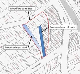
In establishing whether Native Title had been extinguished at the Lindfield Community Hub site a parcel of land Lot 42 DP4388 was identified as a potential “spite” strip. Further investigation into DP4388 also identified Drovers Way as Lot 41 DP4388.
Council staff then engaged a Legal Title Searcher to investigate the history of Lots 41 & 42 DP4388 to establish whether they had been formally dedicated as a public road.
Council’s Title Searcher has established that although there does not appear to be any formal dedication, Lots 41 & 42 DP4388 are a public lane (Attachment A1).
To reinforce the public road status it is recommended that Council formally gazette Lots 41 & 42 DP4388 as a public road in accordance with Section 10, Roads Act 1993.
Lindfield Village Green
On the Lindfield Village Green site the unnamed lane which runs east-west across the site and currently forms part of the car park circulation will partially close and realign local public roads as shown below.
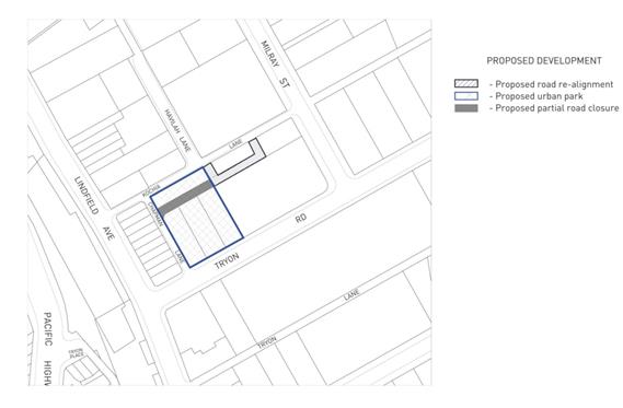
In order to deliver the Lindfield Village Green, Council has resolved to consolidate various properties owned by Council fronting Kochia Lane, Chapman Lane and Tryon Road and compulsorily acquire part of “unnamed lane”.
A requirement of the compulsory acquisition process is to prepare a Plan of Acquisition for registration with the LPI NSW, as supporting documentation for the application to the OLG.
The attached Plan of Acquisition (Attachment A2) identifies Lot 23 part of the unnamed land and Lot 21 DP1223433 to be compulsorily acquired.
Lot 21 is located within Council land fronting Kochia Lane (Lot 12 DP225925). The compulsory acquisition of proposed Lot 21 is to expedite the future dedication of land as a public road and avoids the lengthy subdivision process.
It is recommended that Council compulsorily acquire Lot 21 DP1223433 for a future public road in accordance with Section 177, Roads Act 1993.
integrated planning and reporting
Places, Spaces & Infrastructure
|
Community Strategic Plan Long Term Objective |
Delivery Program Term Achievement |
Operational Plan Task |
|
Our centres offer a broad range of shops and services and contain lively urban village spaces and places where people can live, work, shop, meet and spend leisure time. |
Plans to revitalise local centres are being progressively implemented and achieve quality design outcomes in collaboration with key agencies, landholders and the community |
Implement a place management approach for the local centre improvements to coordinate works and achieve quality outcomes |
|
|
An improvement plan for Lindfield Centre is being progressively implemented in collaboration with owners, businesses and state agencies |
Engage with relevant stakeholders to establish timing, extent and partnership opportunities |
|
|
|
Develop and finalise project scope |
|
|
|
Maintain engagement with key stakeholders |
Governance Matters
The process of dedicating land for public road is carried out in accordance with Section 10 Roads Act 1993;
Section 10 Land held by RMS or by councils
(1) RMS or a council may, by notice published in the Gazette, dedicate any land held by it (including land acquired by it under Division 1 of Part 12) as a public road.
(2) On the publication of the notice, the land is dedicated as a public road.
The process of acquiring land for public road is carried out in accordance with Section 177 Roads Act 1993;
177 Power to acquire land generally
(1) The Minister, RMS or a council may acquire land for any of the purposes of this Act.
(2) Without limiting subsection (1), the Minister, RMS or a council may acquire:
(a) land that is to be made available for any public purpose for which it is reserved or zoned under an environmental planning instrument, or
(b) land that forms part of, or adjoins or lies in the vicinity of, other land proposed to be acquired for the purpose of opening, widening or constructing a road or road work.
(3) Without limiting subsection (1), RMS may also acquire land that it proposes to declare to be RMS development land.
Risk Management
In the preparation of the compulsory acquisition application to the Office of Local Government a number of statutory investigations are required to be completed.
The Office of Local Government and the LPI NSW have advised that a registered Plan of Acquisition is required to support each compulsory acquisition application.
Resolving the status of lands within the Lindfield Village Green and Lindfield Community Hub sites is imperative to progress the compulsory acquisitions and ensure delivery of the projects.
Financial Considerations
There are nominal administrative costs to register Plans and publish in the Government Gazette. These costs will be borne within existing budget allocations.
Social Considerations
The delivery of the Lindfield Village Green and Lindfield Community Hub projects are strongly supported by the community as evidenced from the results of the community engagement and consultation.
Environmental Considerations
There are no environmental impacts associated with this report.
Community Consultation
A number of consultation and engagement activities have been undertaken with the community on the Lindfield revitalisation projects in pursuit of achieving the best community outcomes.
Particularly in relation to site re-development, design concepts and facilities delivered and the requirement to realign roads and road closures.
Consultation is planned for all stages of the development process and an engagement strategy has been prepared by Council’s community engagement and research planner for these projects.
Internal Consultation
Staff from Strategy & Environment have contributed to the content of this report.
Summary
On 21 April 2015, Council resolved to commence the compulsory acquisition of part of “unnamed lane” as part of the Lindfield Village Green project and a portion of Drovers Way north of Beaconsfield Parade for the purpose of creating the Lindfield Community Hub.
In the preparation of the compulsory acquisition application to the Office of Local Government a number of statutory investigations have been completed and through these processes some anomalies have been identified which this report seeks to resolve.
Namely, that lands and roads within the sites are in place to ensure the successful delivery of the project.
At the Lindfield Community Hub site a parcel of land Lot 42 DP4388 was identified as a potential spite strip and further investigation into DP4388 also identified Drovers Way as Lot 41 DP4388. A Legal Title Search was completed to investigate the history of Lots 41 & 42 DP4388 to establish whether they had been formally dedicated as a public road. Although Council’s Title Searcher confirmed that both Lots 41 & 42 DP4388 are a public lane there does not appear to be any formal dedication.
To reinforce the public road status it is recommended that Council formally gazette Lots 41 & 42 DP4388 as a public road in accordance with Section 10, Roads Act 1993.
In order to deliver the Lindfield Village Green, Council has resolved to develop various properties owned by Council fronting Kochia Lane, Chapman Lane and Tryon Road, and to compulsorily acquire part of an unnamed lane within the site.
A requirement of the compulsory acquisition process is to prepare a Plan of Acquisition for registration with the LPI NSW, as supporting documentation for the application to the OLG.
However, the proposed Lot 21 is located within Council land fronting Kochia Lane (Lot 12 DP225925). In order to expedite the delivery of the project it is recommended that the compulsory acquisition of proposed Lot 21, to avoid the lengthy subdivision process for the future dedication of land as public road in accordance with Section 177 Roads Act 1993.
|
A. That Council formally gazette Lot 41 DP4388 and Lot 42 DP4388 as a public road in accordance with Section 10 Roads Act 1993.
B. That Council compulsorily acquire Lot 21 DP1223433 for a future public road in accordance with Section 177 Roads Act 1993.
|
|
Deborah Silva Manager Integrated Planning, Property & Assets |
Andrew Watson Director Strategy & Environment |
|
Title Searcher's Report Drovers Way - Lots 41 and 42 in DP4388 |
|
2016/236235 |
||
|
|
Lindfield Village Green Plan of Acquisition |
|
2016/236233 |
|
Ordinary Meeting of Council - 6 September 2016 |
GB.14 / 676 |
|
|
|
|
Item GB.14 |
S10467 |
|
|
17 August 2016 |
Turramurra Local Centre -
Traffic and Transport Study
EXECUTIVE SUMMARY
|
purpose of report: |
To consider the Turramurra Community Hub Transport Scenario Testing study. |
|
|
|
|
background: |
The Turramurra Community Hub Transport Scenario Testing study was prepared to assess the cumulative transport impacts of the Turramurra Community Hub project and other expected developments in the Turramurra local centre based on the Ku-ring-gai LEP (Local Centres) 2012. |
|
|
|
|
comments: |
The preferred strategic traffic and transport plan for Turramurra includes a series of intersection modifications/ improvements, and the proposed rail bridge linking Ray Street to Rohini Street. This would provide the most efficient intersection operation in the network and has support from RMS. |
|
|
|
|
recommendation: |
That Council adopts the Turramurra Community Hub Transport Scenario Testing study (with the rail bridge option) and submit it to Roads and Maritime Services for concurrence. |
Purpose of Report
To consider the Turramurra Community Hub Transport Scenario Testing study.
Background
The Turramurra Community Hub Transport Scenario Testing study was prepared by consultants PeopleTrans to assess the cumulative transport impacts of the Turramurra Community Hub project and other expected developments in the Turramurra local centre based on the Ku-ring-gai LEP (Local Centres) 2012.
On 28 June 2016, Council considered a report on the results of the public exhibition of the draft Turramurra Community Hub Master Plan. In the report, an update was given on the work undertaken to refine the draft master plan, including updated project construction estimates to reflect the refinements to the master plan, updated cost estimates for the construction and fit out of community facilities refining feasibility modelling and analysis to take into account the amendments to the master plan and the updated cost estimates, and finalising the Turramurra local centre traffic and transport study and assessing the implications for the master plan on the local traffic networks.
Council resolved (in part):
D.` That a separate report be prepared and reported to council on the Turramurra traffic and transport study with a view to council adopting the study in principle.
Comments
The methodology adopted for Turramurra Community Hub Transport Scenario Testing study includes the 5 key steps below, with some commentary on each step:
1. Understand Turramurra Population, Land Use and Transport
This section focuses on:
· the Turramurra population and their travel characteristics;
· the public transport services available to the population of Turramurra;
· the active travel options available to the population of Turramurra;
· the Rohini Street bus interchange, to understand the current operational issues and constraints; and
· initial transport stakeholder consultation, to gain feedback from relevant transport related state agencies and transport providers about current operational issues and future needs.
2. Develop Existing Base Transport Model
Traffic volume data was collected for the Thursday pm peak hour and the Saturday peak hour, which were used as the inputs into the microsimulation traffic modelling software (accepted by RMS). This model was then calibrated to closely resemble actual traffic conditions on the ground. RMS validated the model as fit for the purposes of scenario option modelling.
The existing road network operation results in Step 2 shows delays on Pacific Highway during the PM peak period in both directions, with the queue of northbound traffic extended back to Ku-ring-gai Avenue and that the queue of southbound traffic extended back to Cherry Street. The northbound delays on Pacific Highway within the study area was largely as a result of delays originating further north on Pacific Highway. The delays for southbound traffic was as a result of the current 4-2 tidal flow traffic management scheme which results in the road network reaching capacity within the study area. The side streets at the traffic signals on Pacific Highway (i.e. Ray Street, Kissing Point Road and Rohini Street) also experience significant delays as a result of traffic conditions on Pacific Highway.
Modelling results demonstrate that general traffic conditions during Saturday peak period were better than the weekday PM peak period. The isolated delays at the intersection of Rohini Street and Pacific Highway extended back to Ku-ring-gai Avenue for northbound traffic and at the intersection of Ray Street and Pacific Highway the queues extended back to Cherry Street for southbound traffic during the Saturday peak period, which were consistent with the observations on site. In addition to this the queues on the northbound approach to Rohini Street extended back to Eastern Road. This also happened occasionally during the weekday PM peak, primarily due to the green phase time favouring the Pacific Highway.
3. Prepare Demands for Future Land Use & Assess Impacts of Various Land Use Options
The traffic generation of the expected future retail, business and residential developments in the Turramurra local centre (based on Ku-ring-gai LEP Local Centres (2012) were calculated and assigned to the road network and tested under existing and future road infrastructure improvements. The information in Step 1 provided guidance on the contribution of public transport, walking and cycling in the assessment of transport impacts.
Applying the above traffic generation to the existing road network layout and operation shows substantial deterioration of road network performance in the weekday pm peak. On the local roads, increased delays would be experienced in Rohini Street/Eastern Road, and Kissing Point Road. The impacts to the Saturday peak hour would be slightly less than the weekday PM peak, although performance at all intersections along Pacific Highway would still deteriorate.
In Step 3, the road infrastructure improvement plan (previously presented to RMS during the preparation of the Ku-ring-gai LEP 2012 (Local Centres)) was introduced into the model and tested. The road infrastructure improvements consisted of:
· widening of Pacific Highway between Ray Street and Turramurra Avenue, to accommodate 3 lanes in each direction;
· right turn lane provision (side by side) on Pacific Highway between Ray Street and Kissing Point Road;
· modification of the intersection of Ray Street and Pacific Highway, to include 2 right turn lanes and 1 left turn lane on Ray Street;
· modification of the intersection of Kissing Point Road and Pacific Highway, to include 2 right turn lanes and 1 left turn lane on Kissing Point Road;
· modification of the intersection of William Street and Pacific Highway;
· removal of the traffic signals at the intersection of Rohini Street and Pacific Highway and signalisation of the intersection of Turramurra Avenue and Pacific Highway;
· right turn bay provision on Pacific Highway, at the intersection of Turramurra Avenue;
· new road link between Kissing Point Road and Duff Street; and
· new road link between Turramurra Avenue and Gilroy Road.
The above road infrastructure improvements were also tested with the option of a new road bridge connecting Ray Street with Rohini Street. The results testing (without the rail bridge) indicate that the proposed road infrastructure would perform well with the future traffic demands. Performance of Pacific Highway generally improves compared to the current conditions, with no extensive delays/queues on Pacific Highway. Traffic conditions on local roads were good, except that queues developed on Turramurra Avenue due to insufficient storage on the north approach.
Results for the Saturday peak hour (without the rail bridge) are similar, although longer travel distance is required for traffic travelling from Eastern Road to Pacific Highway east (north) via Turramurra Avenue. Also, the northbound carriageway on Ray Street between the Pacific Highway and Forbes Lane has only one lane which may cause delays in the Saturday peak hour when right turning vehicles wait for gaps.
Review of Rohini Street bus interchange
PeopleTrans undertook an audit of the existing Rohini Street bus interchange. The audit included aspects such as pedestrian accessibility, bus operations, passenger waiting areas, taxi facilities and bicycle access/parking. The key findings of the audit were that the space available is inadequate to accommodate all bus operations and layovers. Wayfinding signage is absent, as well as driver amenities. DDA compliance is also not met. Issues that have been identified would need addressing as part of any upgrade to the bus interchange area.
4. Determine Preferred Land Use for Community Hub Site and Prepare An Updated Traffic Management Plan
Following Step 3, the traffic generation of the draft masterplan for the Turramurra Community Hub (retail, community and residential land uses) were added to the above model to create a cumulative assessment of all expected redevelopment in the Turramurra local centre, and tested against existing and future road infrastructure improvements (with and without a rail bridge).
Without Rail Bridge
The results of the Master Plan Option (without the rail bridge) indicate that the impacts of the Master Plan Option traffic demands are worse than Step 3 above, as expected. In particular, traffic conditions at the intersection of Turramurra Avenue/ Pacific Highway and the intersection of Gilroy Lane/ Turramurra Avenue deteriorated in terms of Level of Service. The distance on Turramurra Avenue between the Pacific Highway and Gilroy Lane is less than 40m. When queues extended back to Gilroy Lane, traffic had difficulty seeking gaps from Gilroy Lane. In the Saturday model, the queuing issues are more significant. However overall traffic performance was good and there were no extensive delays/queues along the Pacific Highway. In this option without the rail bridge, traffic would increase on Ray Street and Turramurra Avenue, with a resulting decrease in traffic on Rohini Street. Two-way traffic volumes on Ray Street and Turramurra Avenue would increase beyond the environmental performance standards stipulated by RMS for these types of roads both for the PM and Saturday peak hours. (i.e. in excess of 700 vehicles per hour).
With Rail Bridge
The results of the Master Plan Option (with the rail bridge) assessment indicate that the overall performance of the model for both the PM and Saturday peak was good. There would be no extensive delays /queues along the Pacific Highway in the model. There would be minor queues on the side roads which were deemed to be acceptable. The rail bridge option also has the effect of reducing the right turning traffic (from southerly in Turramurra Avenue to westerly on Pacific Highway) at the Turramurra Avenue / Pacific Highway intersection. As a result, it has solved the issue of limited queue storage on Turramurra Avenue in the option without the rail bridge.
With the rail bridge, traffic would further increase on Ray Street for both the PM and Saturday peak hours. The expected two-way traffic volumes on Ray Street would exceed the environmental performance standards for the current road category of Ray Street.
To address this, Council would need to alter the road hierarchy to remove the current regional road status of Rohini Street (between Pacific Highway and Eastern Road), and add regional road status to Ray Street, the new rail bridge and Rohini Street (from the railway bridge to Eastern Road). To address the amenity impacts of the increased traffic flows on Ray Street, streetscape works and pedestrian/cycling accessibility would need to be incorporated into the project.
Although the northbound traffic volumes on Turramurra Avenue would increase during both the PM and Saturday peak hours, the southbound traffic volumes would decrease. Overall the bi-directional traffic volumes on Turramurra Avenue would remain the same as existing. Traffic on Rohini Street would decrease as a result of the proposed changes at the intersection of Rohini Street and Pacific Highway.
5. Findings and recommendations
To convey in a simple manner the relative benefits of including or excluding the rail bridge in the future road infrastructure improvement plan, the following multi-criteria analysis table was prepared by PeopleTrans:
|
|
Assessment Criteria |
|||||
|
|
Intersection Operation |
Local accessibility (walking, bicycle, car) |
Bus access |
Cost |
Public domain opportunities (Rohini Street) |
Transport Stakeholder support |
|
Road network improvements with rail bridge |
ÖÖ |
ÖÖ |
ÖÖ |
Ö |
ÖÖ |
ÖÖ |
|
Road network improvements without rail bridge |
Ö |
Ö |
Ö |
ÖÖ |
Ö |
Ö |
The preferred strategic traffic plan for Turramurra includes the proposed rail bridge linking Ray Street to Rohini Street. The key advantages of this strategic traffic plan (highlighted in the multi-criteria analysis table above) is that it would provide the most efficient intersection operation network wide and has support from RMS since it would assist with removing traffic from the Pacific Highway. A new rail bridge would also improve accessibility to the Turramurra Community Hub site for north Turramurra residents, and buses could also be redirected to better service the Turramurra Community Hub. The diversion of traffic via Eastern Road and the new rail bridge will also open up opportunities for public domain improvements on Rohini Street providing a much more pleasant pedestrian environment on this street.
The cost of a new rail bridge would be high, but the proposed road link between Gilroy Road and Turramurra Avenue could be abandoned with little effect on the overall network performance. Council currently owns part of this link at No. 12 Turramurra Avenue (Lot 2 DP983832), Turramurra. The site is zoned Residential R4 High density under KLEP 2012 and is no longer required as a link under this scenario and is recommended to be divested in accordance with Council’s – Acquisition and Divestment of Land Policy 2014.
Future public transport demand analysis
As part of the future transport demand analysis, PeopleTrans assessed potential future public transport demand generated from new residents, as well as from future employees of additional retail, commercial and community uses in the Turramurra local centre. The analysis was based on average number of people per dwelling and working population (Australian Bureau of Statistics) and Turramurra residents travel mode to work/Turramurra workers travel mode from home (NSW Bureau of Transport Statistics).
The analysis found that the majority of future public transport demand would depend on trains, with an estimated additional 400 daily trips. Bus use is expected to increase only minimally (up to approximately 10 daily trips), and at this stage would not warrant the provision of extra seating capacity due to current spare capacity.
integrated planning and reporting
The Revised Delivery Program 2013-2017 and Operational Plan 2015-2016 commits Council to master planning for the revitalisation of the Turramurra Local Centre and surrounding precincts, as well as
Theme 4 – Access Traffic and Transport
|
Community Strategic Plan Long Term Objective |
Delivery Program Term Achievement |
Operational Plan Task |
|
The local road network is managed to achieve a safe and effective local road network. |
T2.2.1 Road network safety and efficiency are improved and traffic congestion is reduced. |
Implement the 10 year Traffic and Transport Program. |
|
An accessible public transport and regional road network that meets the diverse and changing needs of the community. |
T3.1.1 A strategic access, traffic and transport plan is being implemented for the Northern Sydney Region. |
Plan for works in response to development in local centres. |
Governance Matters
Council is required to work with Roads and Maritime Services and Transport for NSW to ensure that the long term transport planning for Turramurra local centre is consistent with the State Government requirements.
Risk Management
If Council does not adequately plan for transport improvements, traffic conditions on Pacific Highway and local roads such as Rohini Street and Turramurra Avenue are likely to deteriorate further and the opportunity to remove the tidal flow arrangements on Pacific Highway would be significantly compromised. This would not only affect through traffic on Pacific Highway but also local access across the Pacific Highway for residents of Turramurra. It would also restrict the potential for improvements to pedestrian safety and amenity in Rohini Street and accessibility to Turramurra railway station.
Financial Considerations
The road infrastructure improvement plan mentioned in Step 3 above have been included in Council’s Long Term Financial Plan.
Based on preliminary costings, a new rail bridge between Ray Street and Rohini Street is approximately $10,000,000 (subject to further investigation and feasibility analysis).
The property No. 12 Turramurra Avenue (Lot 2 DP983832), Turramurra is recommended to be divested by in accordance with Council’s –Acquisition and Divestment of Land Policy 2014 and the funds returned to the Ku-ring-gai Contributions Plan 2010 Section 94 reserves.
Social Considerations
Removing the traffic signals from Rohini Street (at Pacific Highway) would have a very positive impact on the pedestrian amenity and safety in the area, and allow the street to be redesigned, so as to focus on improvements to the transport interchange and the streetscape.
Environmental Considerations
The current tidal flow on Pacific Highway through Turramurra causes congestion during peak periods, therefore improvements to traffic flow through this area would lead to less stop-start conditions resulting in reduced fuel use and improved air quality.
A new rail bridge would also improve accessibility to the Turramurra Community Hub site for residents on the northern/eastern side of the North Shore railway line, and buses could also be redirected to better service the Turramurra Community Hub. A new bridge would also encourage walking and cycling to the Turramurra Community Hub for residents on the northern/eastern side of the North Shore railway line.
Community Consultation
During the public exhibition of the draft Turramurra Community Hub Master Plan, a traffic and transport working paper was included as supporting material, covering the high level outcomes of the transport modelling.
The material publicly exhibited for the draft Turramurra Community Hub Master Plan also included the potential for a new rail bridge between Ray Street and Rohini Street, although the impacts of this had not been analysed at the time.
Internal Consultation
Staff from the Strategy department and Operations department have contributed to development of the transport improvements for Turramurra.
Summary
The Turramurra Community Hub Transport Scenario Testing study was prepared to assess the cumulative transport impacts of the Turramurra Community Hub project and other expected developments in the Turramurra local centre based on the Ku-ring-gai LEP (Local Centres) 2012.
The preferred strategic traffic plan for Turramurra includes a series of intersection modifications/ improvements, and the proposed rail bridge linking Ray Street to Rohini Street, Turramurra. This would provide the most efficient intersection operation network-wide, and has support from RMS since it would assist with removing traffic from the Pacific Highway.
|
A. That Council adopt the Turramurra traffic and transport study (with the rail bridge option) in principle, and forward the proposal to Roads and Maritime Services for formal concurrence.
B. The property No. 12 Turramurra Avenue (Lot 2 DP983832), Turramurra be divested by in accordance with Council’s – Acquisition and Divestment of Land Policy 2014 and the funds returned to the Ku-ring-gai Contributions Plan 2010 Section 94 reserves.
|
|
Joseph Piccoli Strategic Traffic Engineer |
Antony Fabbro Manager Urban & Heritage Planning |
|
Andrew Watson Director Strategy & Environment |
|
|
Turramurra Community Hub - Traffic Scenario Testing - Final Report |
2016/224259 |
|
Ordinary Meeting of Council - 6 September 2016 |
GB.15 / 684 |
|
|
|
|
Item GB.15 |
S10894/2 |
|
|
18 August 2016 |
North Turramurra Recreation Area
Funding review and options
EXECUTIVE SUMMARY
|
purpose of report: |
To advise Council of the current funding shortfall for the completion of the sports fields car park at North Turramurra Recreation Area and provide options for the funding of the car park. |
|
|
|
|
background: |
Work on the North Turramurra Recreation Area commenced in 2010 and the overall cost of the project was approximately $28.5 million. The works involved the construction of a dam and sewer mining plant for ongoing water supply of the golf course and the playing fields, landfill works to rehabilitate the former landfill site, the creation of 11 new golf holes and the construction of 3 new sports fields. |
|
|
|
|
comments: |
Works at North Turramurra Recreation Area are nearing completion and approximately $1.75 million is available in the 2016/17 program for the completion of the remaining works. However, there is a current shortfall of approximately $540,000 to enable completion of the sports fields car park. |
|
|
|
|
recommendation: |
That the current capital works budget for 2016/2017 be adjusted to transfer $550,000 from the Neighbourhood Centres Program to the North Turramurra Recreation Area to allow the calling of tenders for the construction of the sports field car park. |
Purpose of Report
To advise Council of the current funding shortfall for the completion of the sports fields car park at North Turramurra Recreation Area and provide options for the funding of the car park.
Background
Work on the North Turramurra Recreation Area commenced in 2010 and the overall cost of the project was approximately $28.5 million. The works involved the construction of a dam and sewer mining plant for ongoing water supply of the golf course and the playing fields, landfill works to rehabilitate the former landfill site, the creation of 11 new golf holes and the construction of 3 new sports fields.
During the course of the project, additional works and costs have been incurred due to site conditions and contractual issues. Some examples of additional costs incurred that were not estimated or included in the masterplan are as follows:
· Increased costs for sewer mining due to piping of sewer offtake due to methane release and unsuitable ground conditions - $285,000.
· Additional geotechnical investigation and advice due to land slips - $225,000.
· Inclusion of golf separation fences to protect property and users - $200,000.
· Additional drainage in swales to prevent course damage by golf carts - $50,000.
· Power supply upgrade for floodlights and sewer mining plant - $250,000.
· Contractual dispute on landfill works - $750,000.
· Sewer extension to new amenities building - $60,000.
· Lowering system for floodlights for future maintenance - $40,000.
· Design and construction of suitable bio-retention and detention system - $52,000.
· Additional drainage for synthetic field due to water infiltration $50,000
Comments
Works at North Turramurra Recreation Area are nearing completion and approximately $1.75 million is available in the 2016/17 program for the completion of the remaining works.
However, there is a current shortfall of approximately $540,000 to enable completion of the sports fields car park and no further funds have been allocated in the Long Term Financial Plan for this project. The sports fields car park caters for 200 vehicles which is considered necessary to support 3 playing fields.
As all of the Section 94 contribution plan funds that could be allocated to this project has been allocated, the only source of funds that can be used for the shortfall are general funds or infrastructure reserves.
Consequently, in order to complete the car park, any additional funding will need to be provided by either deferring projects or cutting allocations in other various programs that utilise these funding sources.
With the sports fields nearing completion, the only obligation for Council is to pay the outstanding monies under the contract to complete the works. The amenities building construction has commenced and expected to be on target within the accepted contract value.
A summary of the funds required to complete the various works components is listed below:
|
North Turramurra Recreation Area |
Amount |
CF funds |
2016/17 |
Shortfall |
Comments |
|
Outstanding works |
|
|
|
|
|
|
Completion of turf fields |
$320,000 |
$715,743 |
$1,029,200 |
|
Nearing completion and contract obligation |
|
Completion of synthetic field |
$272,000 |
|
|
|
Nearing completion and contract obligation |
|
Amenities and cart shed |
$940,000 |
|
|
|
Work started and contract obligation |
|
Sportsfields car park |
$750,000 |
|
|
|
Design complete work not started |
|
Total |
$2,282,000 |
$715,743 |
$1,029,200 |
$537,057 |
$1.75m allocated in 2016/17 |
The car park for the sports fields as shown on the attached layout plan is vital for the efficient operation of the playing fields and reduces the impact on the local streets. With the success of the golf course upgrade there is now more need for car parking for golfers.
There are two (2) options available to Council to fund the car park but will still result in the deferral of other projects.
Option 1:
Defer the construction of the car park until 2017/18 and stage the open of the playing fields.
An allocation will be included in the 2017/18 Delivery Program and other program allocations would be adjusted in order to fund these works.
In the interim, a temporary car park can be created next to the synthetic playing field for about 40 cars and only open the synthetic field for soccer use and close the turf playing fields until March 2018 for play when the car park would be completed.
Option 2:
Defer works on the Neighbourhood Centres Program until 2017/18 and reallocate $550,000 to the North Turramurra Recreation Area to allow tenders to be called in September for the construction of the car park.
This would allow the car park to be completed for winter play on the sports fields and netball training in the car park.
There is a current resolution of Council to defer the upgrade works at Babbage Road due to a possible boundary change proposed by Willoughby Council.
At this stage, there is insufficient time and resources available to undertake design, consultation and construction in this financial year to expend the entire allocation. The removal of $550,000 will leave $171,400 which can be allocated to the works proposed for the various centres.
It is important to have the car park in use as soon as possible, therefore, it is considered the most appropriate option is to defer the Neighbourhood Centres Program to allow for design and consultation works only this financial year and for works to commence in 2017/18.
integrated planning and reporting
Places, Spaces and Infrastructure
|
Community Strategic Plan Long Term Objective |
Delivery Program Term Achievement |
Operational Plan Task |
|
P6.1.2 A program is being implemented to improve existing recreation, sporting and leisure facilities and facilitate the establishment of new facilities.
|
Deliver Councils adopted open space capital works program.
|
Designs are prepared and environmental approvals obtained for the delivery of the open space capital works program.
|
Governance Matters
To enable tenders to be called for the construction of the sports fields car park at North Turramurra Recreation Area in accordance with the requirements under the Local Government Act, additional funds are required to be allocated to the project.
The amount of funds required to be reallocated is below the threshold allowed under the Guidelines on Council decisions during merger proposals.
Risk Management
Once the playing fields have been completed, there will be an expectation on Council to open the fields as soon as practical to the public for sporting activities.
If the fields are open and parking is not available, the users will park in the surrounding streets. This will have impacts on the local residents.
Therefore, it is considered appropriate to complete the sports field car parks as soon as possible to allow full use of the facilities.
To close the fields and defer the car park may create a reputational risk for Council.
Financial Considerations
There is a funding shortfall of approximately $540,000 to allow for the calling of tenders for the sports fields car park.
The options available to Council to complete the work are to defer the works until 2017/18 and adjust the funding under the Long Term Financial Plan or reallocate funds in the 2016/17 program by deferring the Neighbourhood Centres Program and transfer $550,000 from this program to the North Turramurra Recreation Area project.
There will be a remaining allocation of $171,400 in the Neighbourhood Centres Revitalisation Program to allow for consultation and design works this financial year for the various Centres.
Social Considerations
The completion of the North Turramurra Recreation Area project is an important social consideration as it allows for more active recreation for the community given the growing population in the area.
The addition of 3 sporting fields will help meet the increasing demand for playing fields from sporting clubs.
Environmental Considerations
All environmental considerations have been taken into account in the various project designs and incorporated in the works.
Community Consultation
Consultation has taken place with the various user groups who indicate the need for additional fields as soon as practical to meet their current demands.
Internal Consultation
Internal consultation has taken place with staff from Strategy and Environment, Corporate and Community on the options associated with the funding of the car park at North Turramurra Recreation Area.
Summary
Works at North Turramurra Recreation Area are nearing completion and approximately $1.75 million is available in the 2016/17 program for the completion of the remaining works.
However, there is a current shortfall of approximately $540,000 to enable completion of the sports fields car park and no further funds have been allocated in the Long Term Financial Plan for this project. The sports fields car park caters for 200 vehicles which is considered necessary to support 3 playing fields.
There are a two (2) options available to Council to fund the car park but will still result in the deferral of other projects.
Option1:
Defer the construction of the car park until 2017/18 and stage the open of the playing fields.
An allocation will then be included in the 2017/18 Delivery Program and other program allocations would be adjusted in order to fund these works.
In the interim, a temporary car park can be created next to the synthetic playing field for about 40 cars and only open the synthetic field for soccer use and close the turf playing fields until March 2018 for play when the car park would be completed.
Option 2:
Defer works on the Neighbourhood Centres Program until 2017/18 and reallocate $550,000 to the North Turramurra Recreation Area to allow tenders to be called in September for the construction of the car park. This would allow the car park to be completed for winter play on the sports fields and netball training in the car park.
There is a current resolution of Council to defer the upgrade works at Babbage Road due to a possible boundary change proposed by Willoughby Council.
At this stage, there is insufficient time and resources available to undertake design, consultation and construction in this financial year to expend the entire allocation. The removal of $550,000 will leave $171,400 which can be allocated to the works proposed for the various centres.
It is important to have the car park in use as soon as possible; therefore, it is considered the most appropriate option is to defer the Neighbourhood Centres Program to allow for design and consultation works only this financial year and for works to commence in 2017/18.
It is recommended that $550,000 be transferred from the 2016/17 Neighbourhood Centres Program to the North Turramurra Recreation Project to allow for tenders to be called for the construction of the car park this financial year.
|
That the current capital works budget for 2016/2017 be adjusted to transfer $550,000 from the Neighbourhood Centres Revitalisation Program to the North Turramurra Recreation Area to allow the calling of tenders for the construction of the sports field car park. |
|
Greg Piconi Director Operations |
|
|
NTRA - car park and sportsfield - play layout |
|
2016/230284 |
|
Ordinary Meeting of Council - 6 September 2016 |
NM.1 / 691 |
|
|
|
|
Item NM.1 |
S07967 |
|
|
29 August 2016 |
Notice of Motion
Fencing around bushland areas
Notice of Motion from Councillor Malicki dated 29 August 2016
Council owns many areas of very special vegetation and over the past years much of this is being individually fenced, in particular in Comenarra Ward.
I have been concerned that fencing of several of these areas has brought considerable distress to residents and that in most areas there has been no consultation and no consideration of the views of residents.
The Blue Gum High Forest adjacent to The Glade Oval was fenced several years ago. Residents felt that they had been cut off from bushland to which they had always had access, and they were unhappy with the type of fencing chosen which they felt was inappropriate to the area.
In South Turramurra between Auluba Ovals 2 and 3, bushland previously accessible to all residents was fenced off with just a narrow pathway between. Residents said they felt "alienated" from the bushland and that the fencing was far too high and visually dominating. They felt there were safety issues because of the narrow walkway through an area previously unfenced.
Similarly fencing has been installed around bushland at Mimosa Oval and just two weeks ago adjacent to the beautiful Sheldon Forest.
The Warragal Rd frontage to Sheldon Forest is around a hundred metres in length and although local residents were notified that fencing was to be installed, it was to be "strategic installation of non intrusive timber fencing". There was no consultation about location or type of fence to be installed either with residents or Ward Councillors.
In fact the fencing at Sheldon forest is extremely intrusive and completely changes the character of the forest as seen from the roadway. It is located at the top of a steep slope and as no one accesses the forest here due to the slope I have questioned the necessity for any fence.
Each of the fences installed around bushland in Comenarra was of a different height, style and materials.
I move:
1. That for all future fencing around council owned bushland advance consultation must occur with local residents and Ward Councillors.
2. That residents in the streets surrounding the Warragal Road frontage to Sheldon Forest all be sent a letter asking for their views on the new fencing and similarly those properties and streets adjoining the forest on the Pymble side. The results of this late consultation be sent to Councillors by memo.
3. That in future all fencing around council's bushland be of a consistent height, style and materials.
4. That the cost of the fencing in South Turramurra, Mimosa Oval and on both sides of Sheldon Forest be reported back to Councillors by Memorandum.
|
That the above Notice of Motion as printed be adopted.
|
|
Councillor Elaine Malicki Councillor for Comenarra Ward |
|
|
Ordinary Meeting of Council - 6 September 2016 |
NM.2 / 693 |
|
|
|
|
Item NM.2 |
TM9/08 |
|
|
29 August 2016 |
Notice of Motion
Traffic Management
Notice of Motion from Councillor Ossip dated 29 August 2016
St Ives, more than any other suburb in Ku-ring-gai, has suffered the adverse consequences of overdevelopment over the past decade. Extrapolating data from the 2011 census, there was an 8% increase in the amount of dwellings in St Ives between 2006-2011. Accompanying this increase in dwellings was an increase in population of 1,311 over that same time period. Of course, both of these figures don’t take into account the substantial development and population growth which has taken place since the census was conducted and the development which is still scheduled to take place.
The determination to cram hundreds more dwellings into St Ives has not been accompanied by adequate planning and necessary investments in infrastructure. Consequently, existing infrastructure is under greater strain than ever before. Of particular concern to residents is the increased traffic congestion being experienced in St Ives – not surprising given that St Ives does not have a train station and has a high level of car ownership and usage.
I am regularly contacted by residents of St Ives who are concerned with traffic issues in local streets surrounding the St Ives town centre and near new multi residential developments. I note that existing traffic conditions in Stanley Street, Yarrabung Road, Memorial Avenue, Cowan Road, Porters Lane, Shinfield Avenue and Killeaton Street are of particular concern to residents.
Council staff undertook traffic and speed counts last year at various locations in St Ives around the town centre and concluded that there were increases in traffic volumes at most intersections, with the following intersections showing greater than expected increases:
1. Memorial Avenue at Village Green Parade and Killeaton Street
2. Cowan Road at Village Green Parade and Kanoona Avenue
3. Stanley Street at Horace Street/Link Road and Lancaster Avenue
4. Carbeen Avenue at Killeaton Street and Mungarra Avenue
Background
In 2005, Council commissioned a traffic study for each of the Town Centres to assess the traffic impacts of proposed development under both LEP 194 and the proposed Town Centres LEP. The study was to assess the likely traffic impacts of current and future development around the town centres and provide recommendations for improvements to be approved by the Roads and Traffic Authority (now Roads and Maritime Services) under a Section 62 notification process and included in the Contributions Plan.
Council adopted the St Ives Town Centre Traffic Improvement Plan at its meeting of 25 August 2005.
The estimated total cost of the Traffic Improvement Plan is approximately $1.6 million of which $762,000 has been included in the Contributions Plan.
Council staff have previously noted that Council does not have sufficient funds to implement the traffic management proposals. Some of the proposed works are considered to have a direct relationship to development under the Town Centres LEP and are accordingly reliant upon developer contributions for funding. At this stage, there has been limited development works commenced in St Ives under the Town Centres LEP. Additionally, a significant proportion of the proposed funding for the plan is contingent on the redevelopment of the St Ives Shopping Village. Therefore, Council has not collected significant funding for any of the proposed works.
Finally, Council only provides approximately $150,000 for traffic capital improvement works. These are prioritised under Council’s adopted Traffic and Transport Policy and Ten Year Traffic Plan.
Recommendation
It is accordingly apparent that whilst the traffic situation in St Ives is deteriorating, there is no definite timeframe on implementing the St Ives Town Centre Traffic Improvement Plan. This is of great concern given that the existing traffic congestion will only be exacerbated as constructed dwellings become fully occupied and further development takes place.
Therefore, it is of crucial importance that Council takes action to address existing and anticipated traffic issues within St Ives. Failure to fund traffic management in St Ives will significantly reduce resident amenity now and in the future.
I accordingly move that:
1. A report be brought back to Council which examines alternate sources of funding for the St Ives Town Centre Traffic Improvement Plan.
2. The report provide short-term options for alleviating traffic congestion in Stanley Street, Yarrabung Road, Memorial Avenue, Cowan Road, Porters Lane, Shinfield Avenue and Killeaton Street.
|
That the above Notice of Motion as printed be adopted.
|
|
Councillor David Ossip Councillor for St Ives Ward |
|