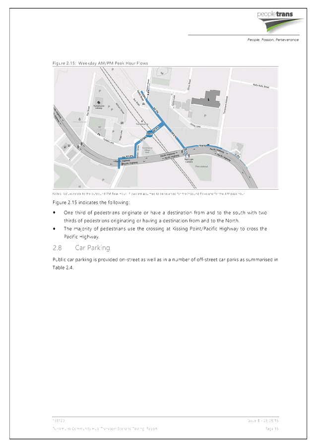
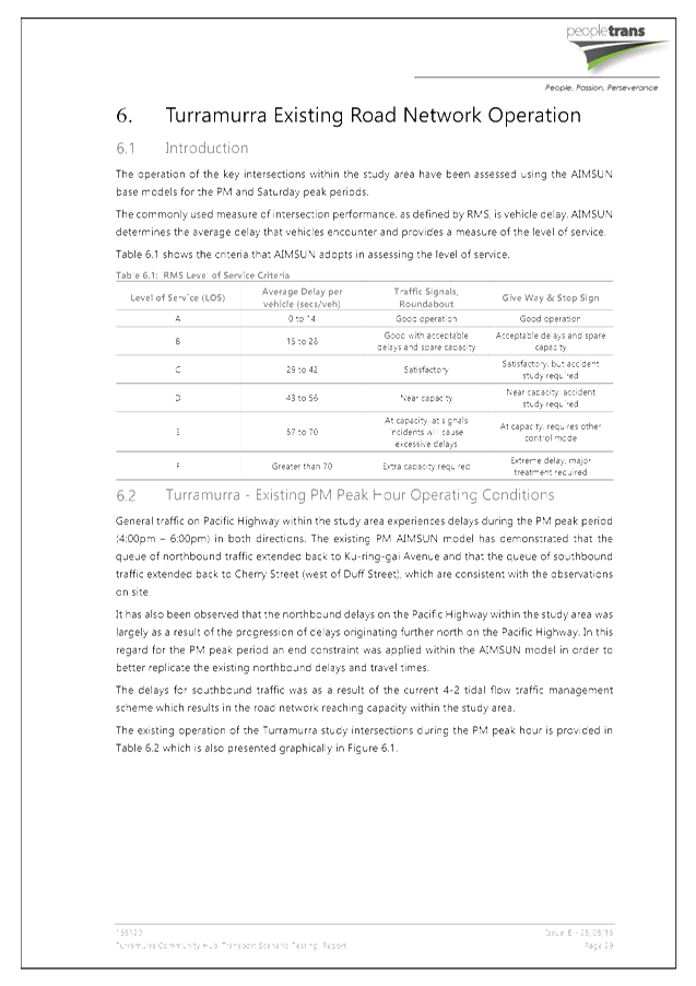
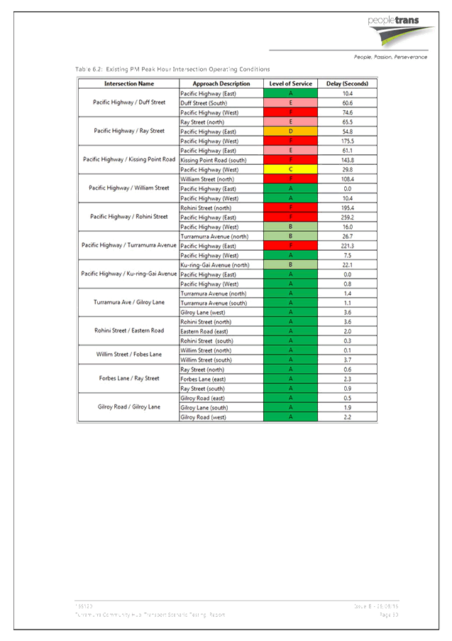
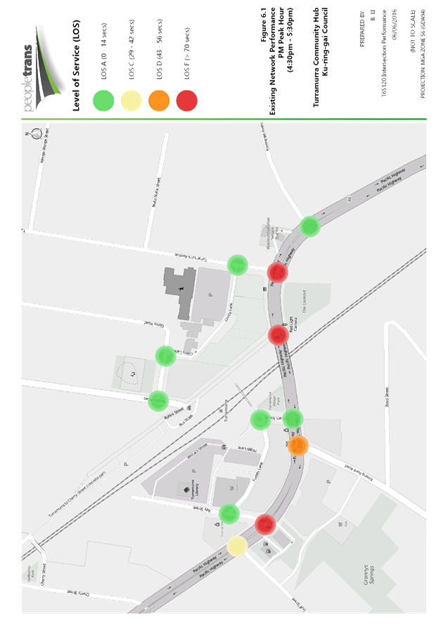
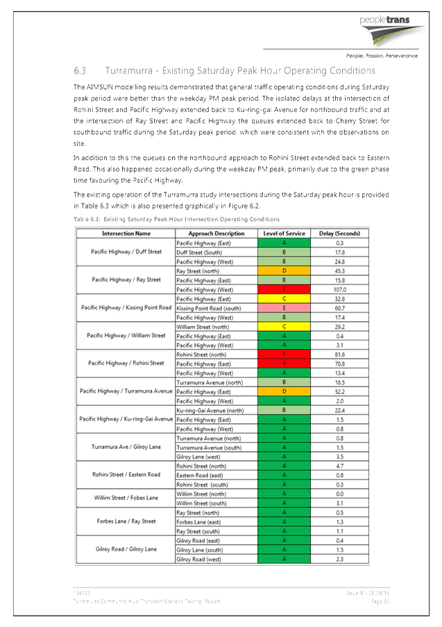
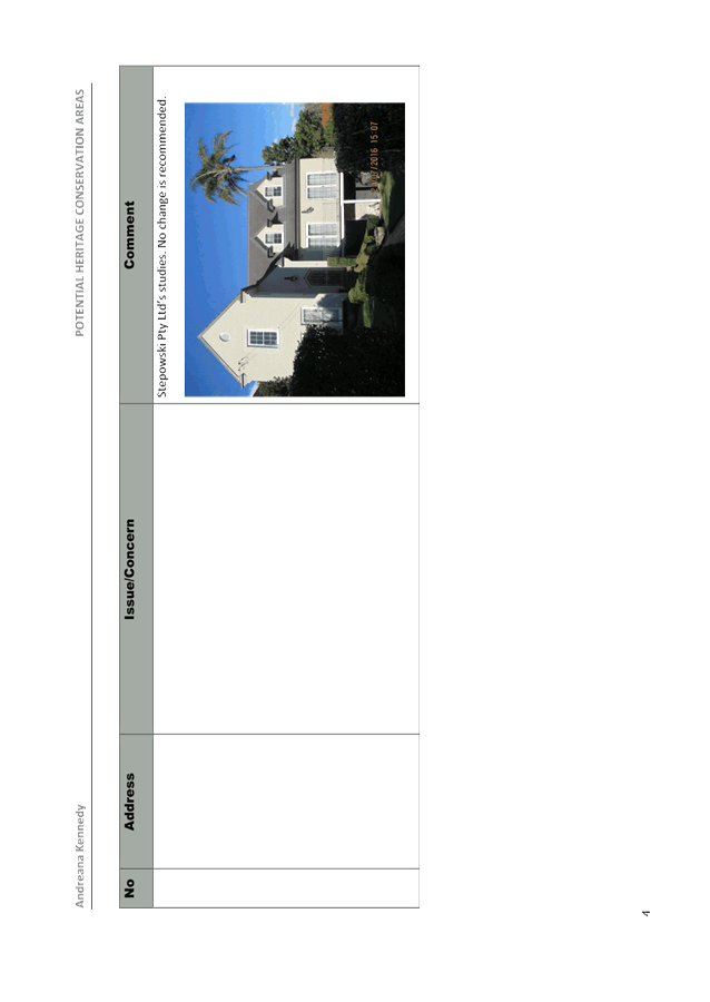
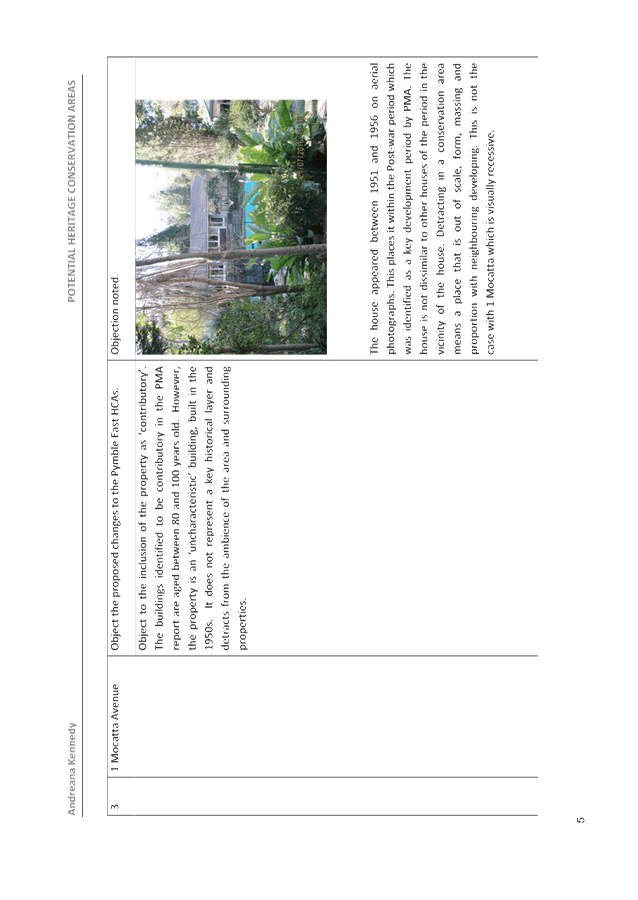
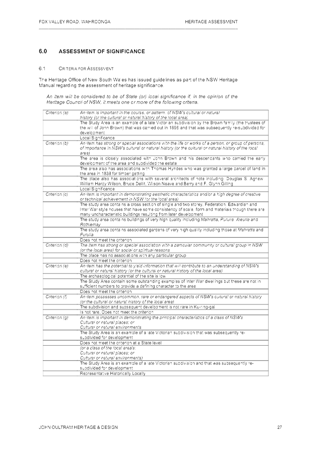
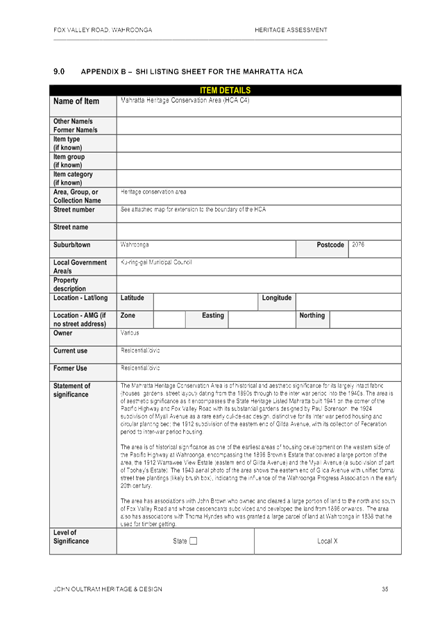
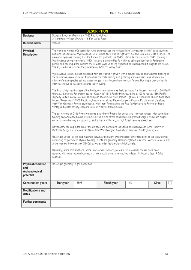
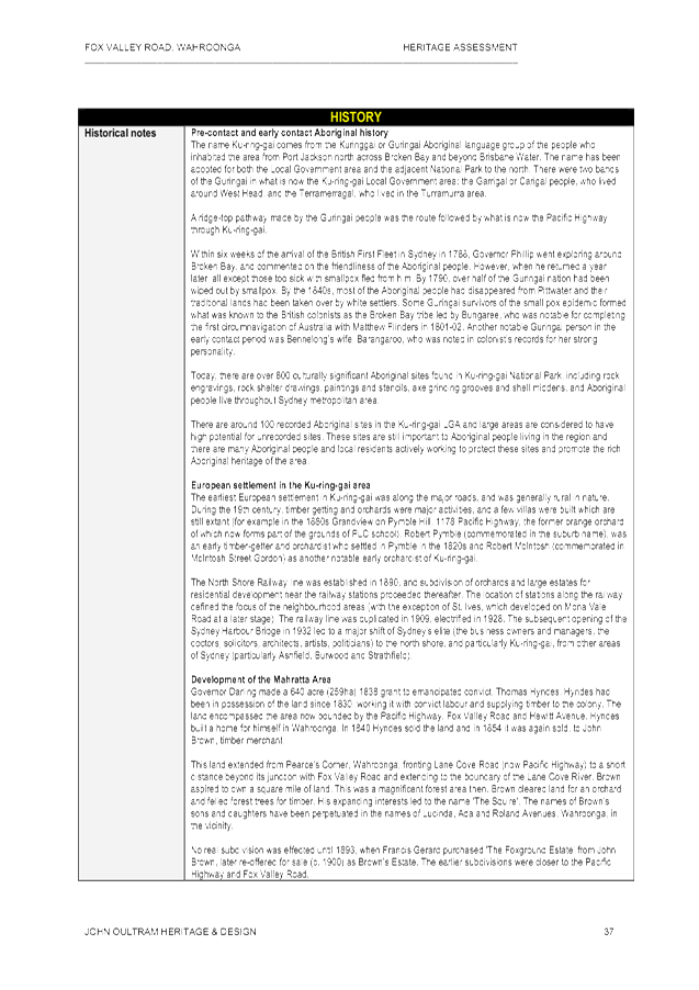
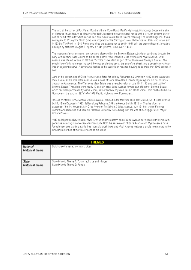
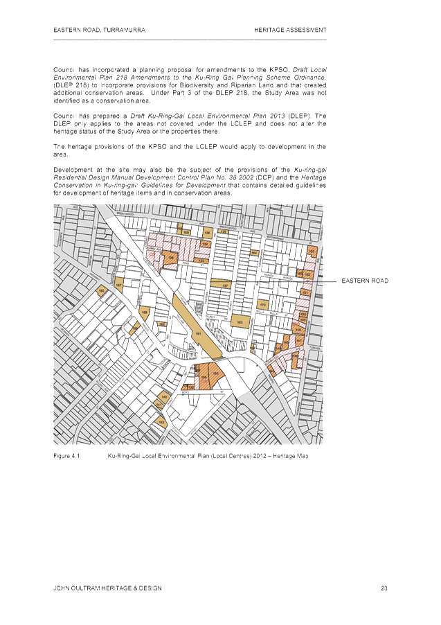
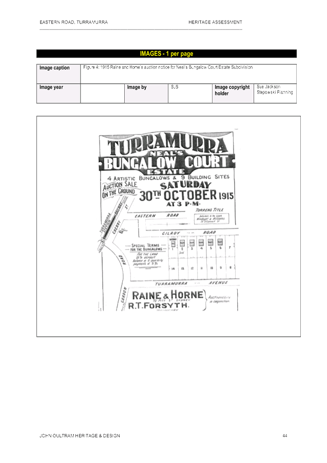
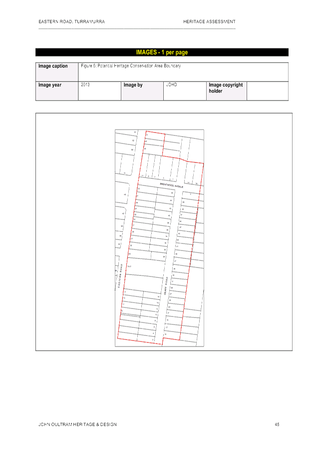
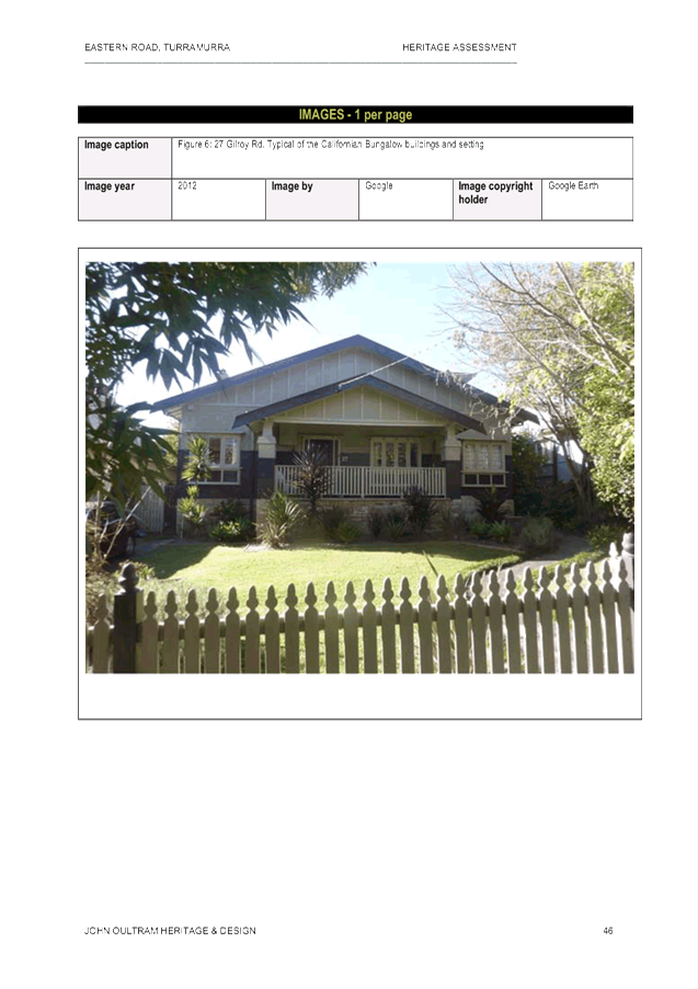
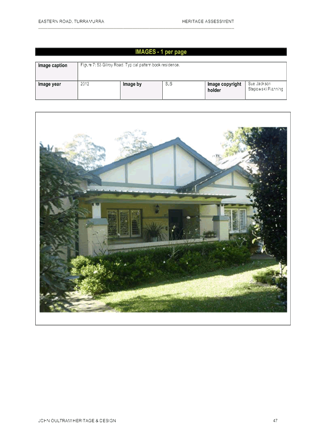
|
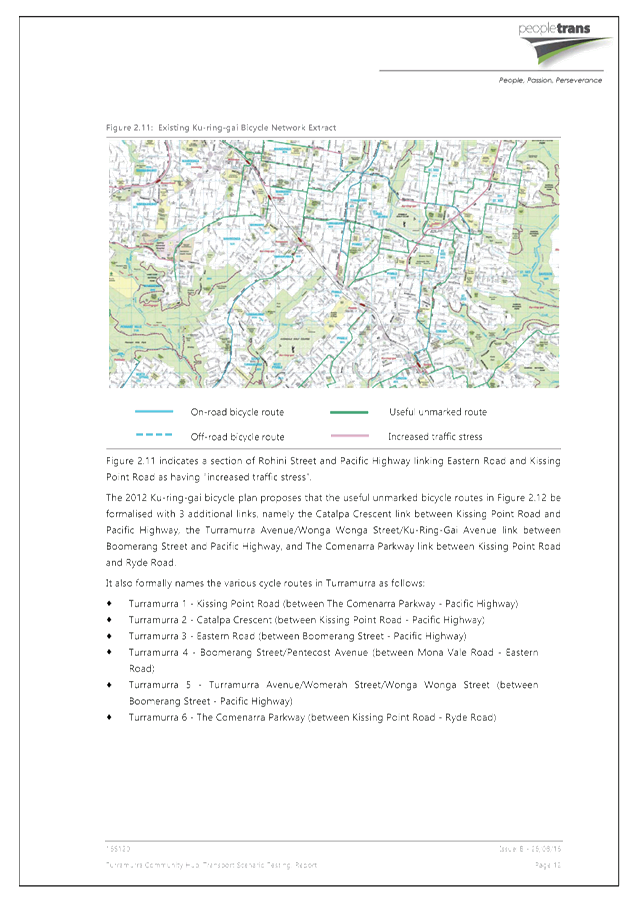
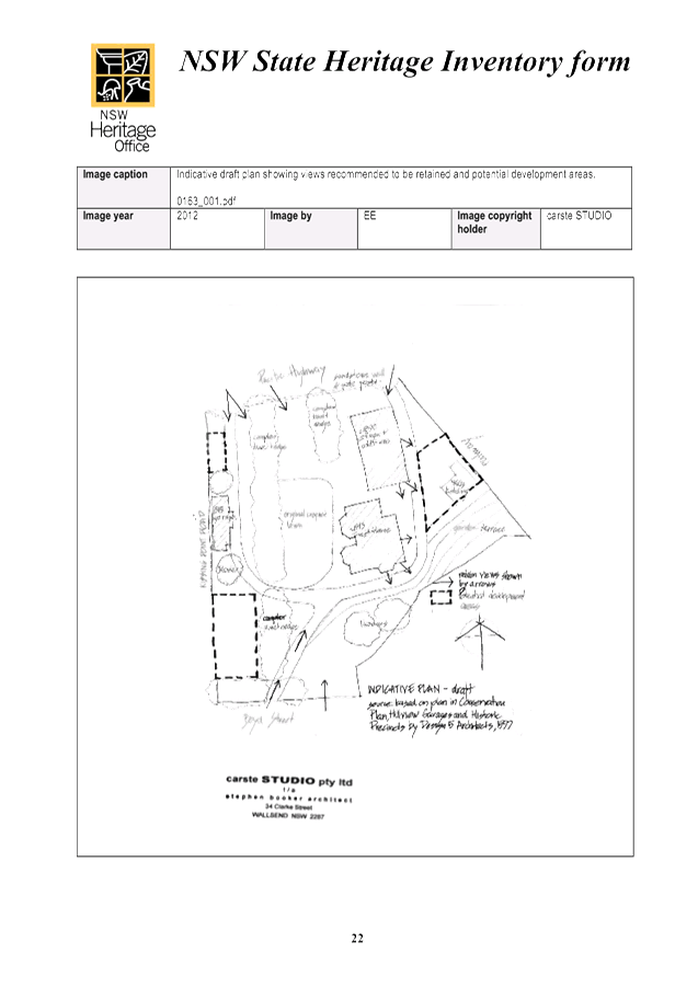
APPENDIX No: 1 - Concept design plan - St Ives Showground Inclusive Playground |
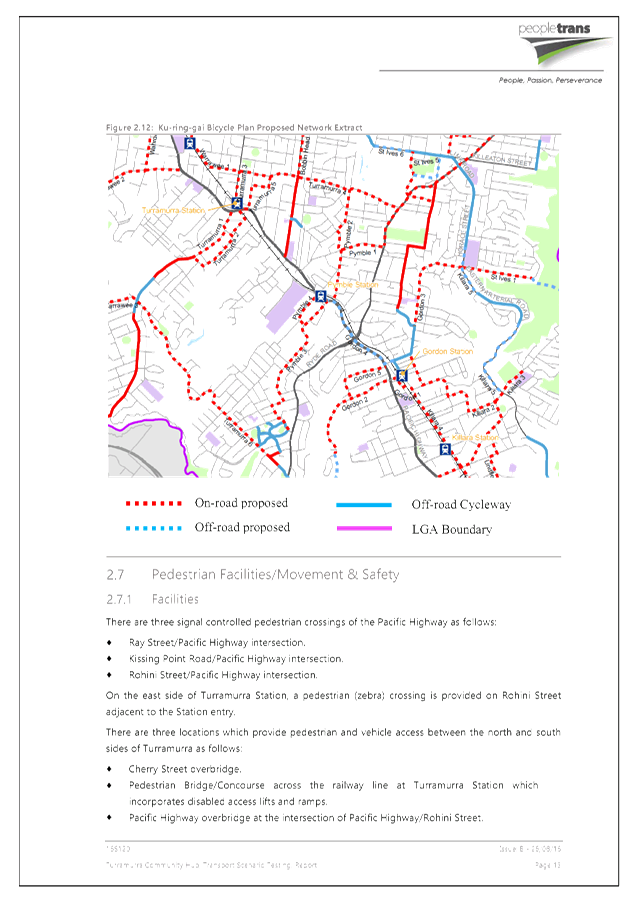
|
Item No: GB.1 |
Ordinary Meeting of Council
TO BE HELD ON Tuesday, 6 December 2016 AT 7:00 pm
Level 3, Council Chamber
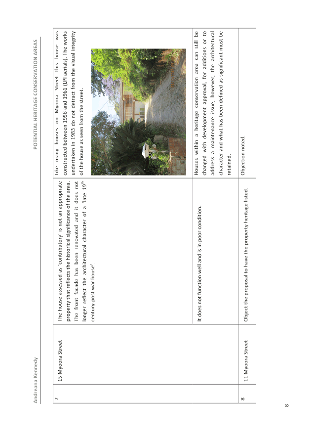
Agenda
** ** ** ** ** **
NOTE: For Full Details, See Council’s Website –
www.kmc.nsw.gov.au under the link to business papers
DECLARATIONS OF INTEREST
CONFIRMATION OF REPORTS TO BE CONSIDERED IN CLOSED MEETING
A. That in accordance with the provisions of Section 10 of the Local Government Act , all officers’ reports be released to the press and public, with the exception of confidential reports and respective attachments:
C.1 2017 General Manager's Performance Agreement - Monitoring Review
In accordance with 10A(2)(a)
B. That in accordance with the provisions of Section 10 of the Local Government Act , all officers’ reports be released to the press and public, with the exception of confidential attachments to the following General Business Reports:
GB.7 Tender RFT11/2016 - Printer and Multifunction Device Replacement
Attachment A1: Evaluation Committee Report
In accordance with s10A(2)(d)(iii)
Attachment A2: Evaluation Worksheet - All Submissions
In accordance with s10A(2)(d)(iii)
Attachment A3: Evaluation Worksheet - Shortlisted Submissions
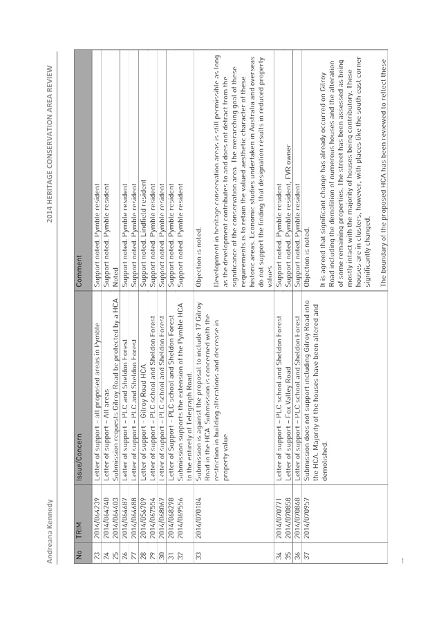
In accordance with s10A(2)(d)(iii)
GB.9 Tender RFT14/2016 - Drainage Construction at 90 Babbage Road, Roseville Chase
Attachment A1: Tender Evaluation Panel Summary
In accordance with s10A(2)(d)(iii)
Attachment A2: Financial Considerations Summary
In accordance with s10A(2)(d)(iii)
Attachment A3: Tenderer A - Corporate Scorecard
In accordance with s10A(2)(d)(iii)
Attachment A4: Tenderer B - Corporate Scorecard
In accordance with s10A(2)(d)(iii)
Attachment A5: Valuation Report 1
In accordance with s10A(2)(d)(iii)
Attachment A6: Valuation Report 2
In accordance with s10A(2)(d)(iii)
Attachment A7: Valuation Report 3
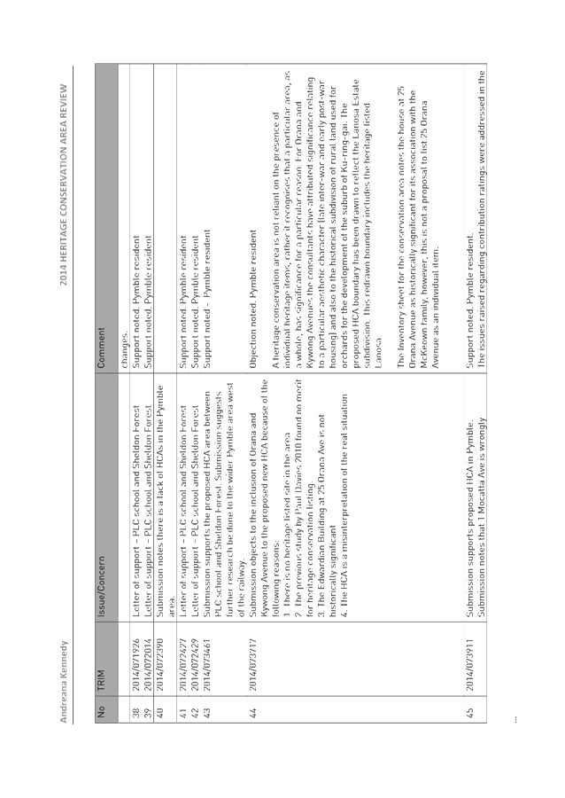
In accordance with s10A(2)(d)(iii)
Address the Council
NOTE: Persons who address the Council should be aware that their address will be tape recorded.
Documents Circulated to Councillors
CONFIRMATION OF MINUTEs
Minutes of Ordinary Meeting of Council 9
File: S02131
Meeting held 22 November 2016
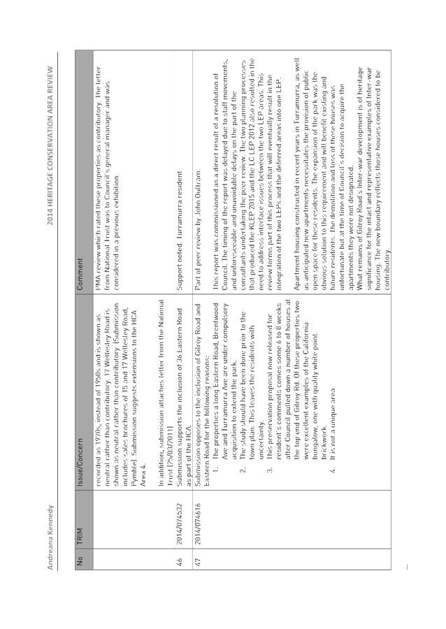
Minutes numbered 303 to 318
minutes from the Mayor
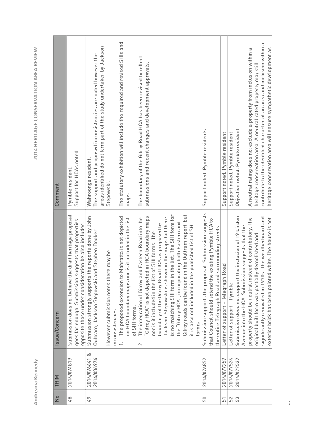
Petitions
GENERAL BUSINESS
i. The Mayor to invite Councillors to nominate any item(s) on the Agenda that they wish to have a site inspection.
ii. The Mayor to invite Councillors to nominate any item(s) on the Agenda that they wish to adopt in accordance with the officer’s recommendation allowing for minor changes without debate.
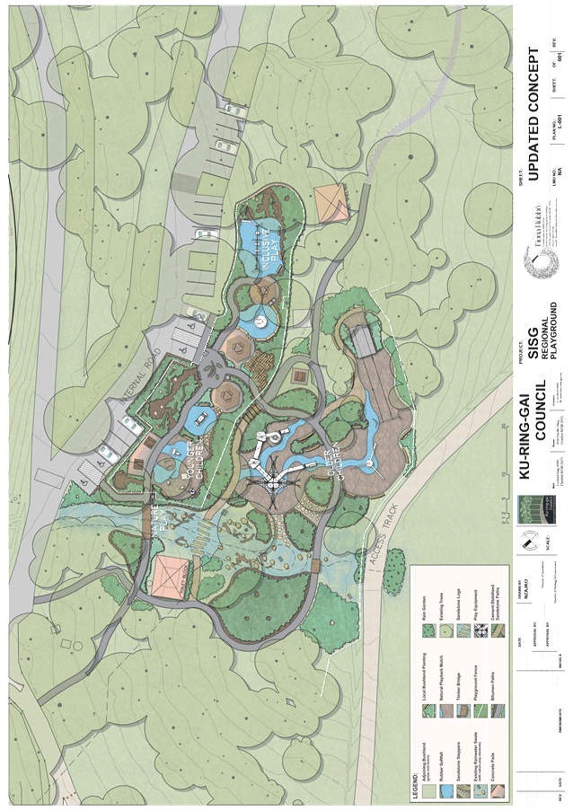
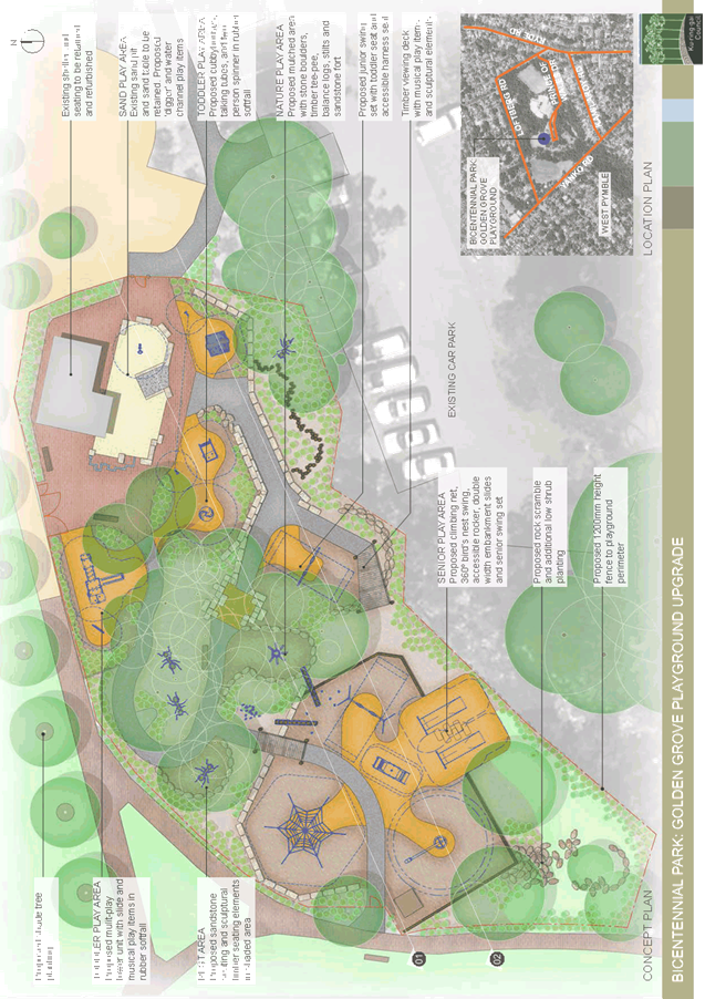
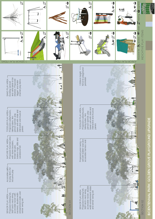
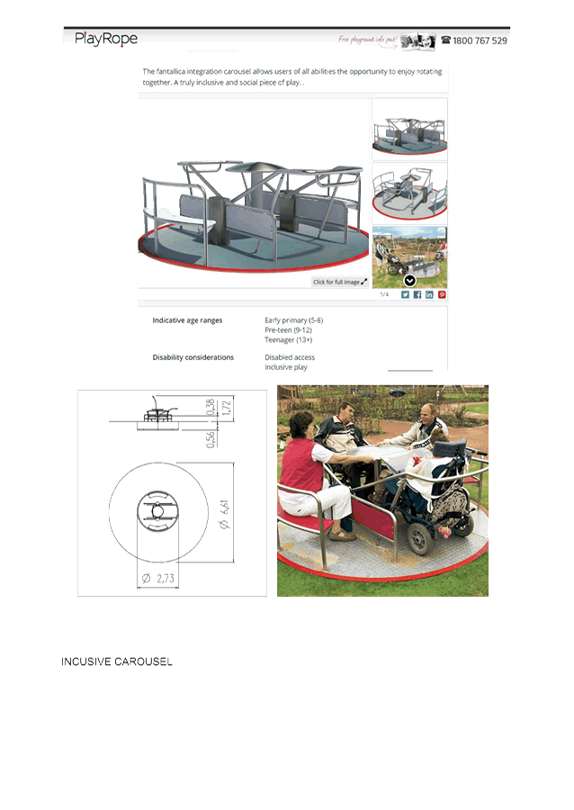
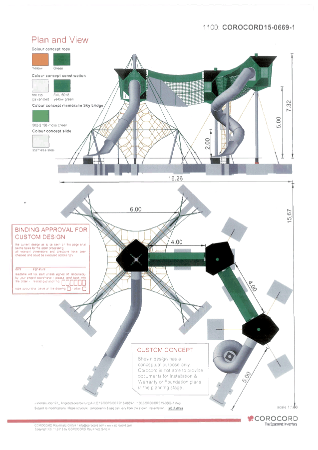
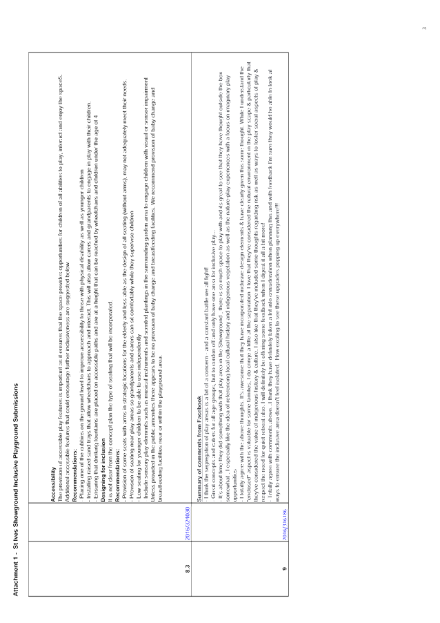
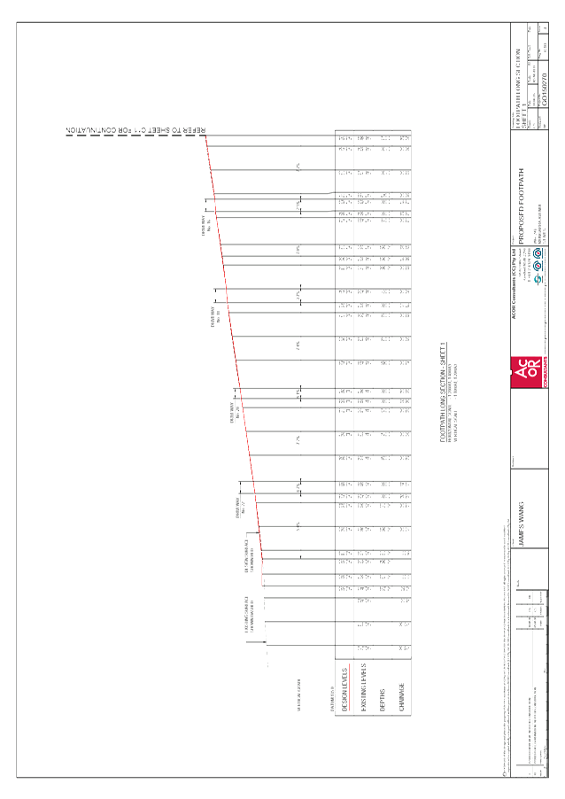
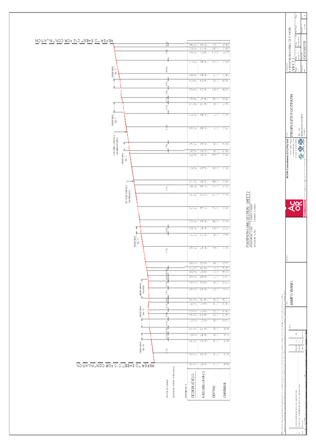
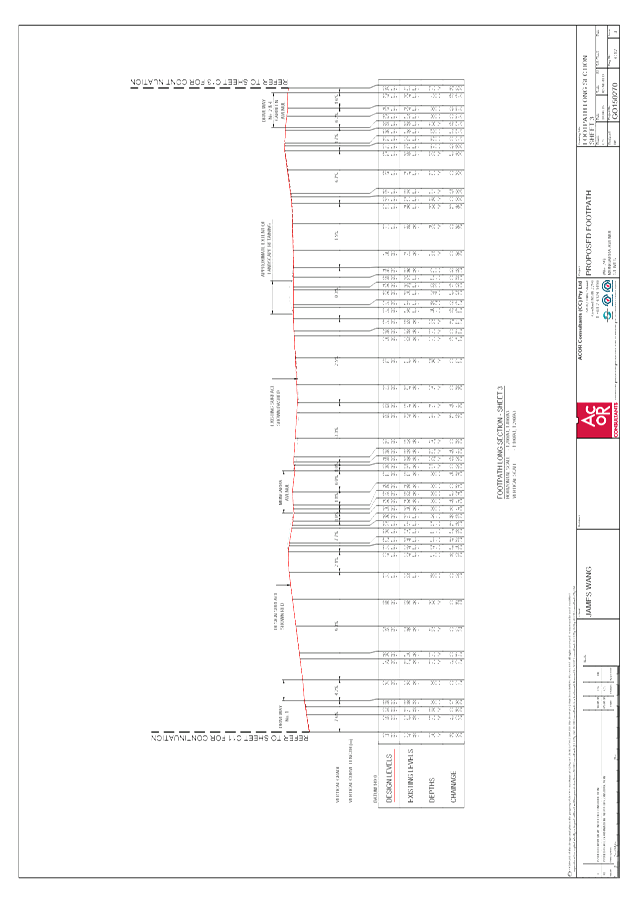
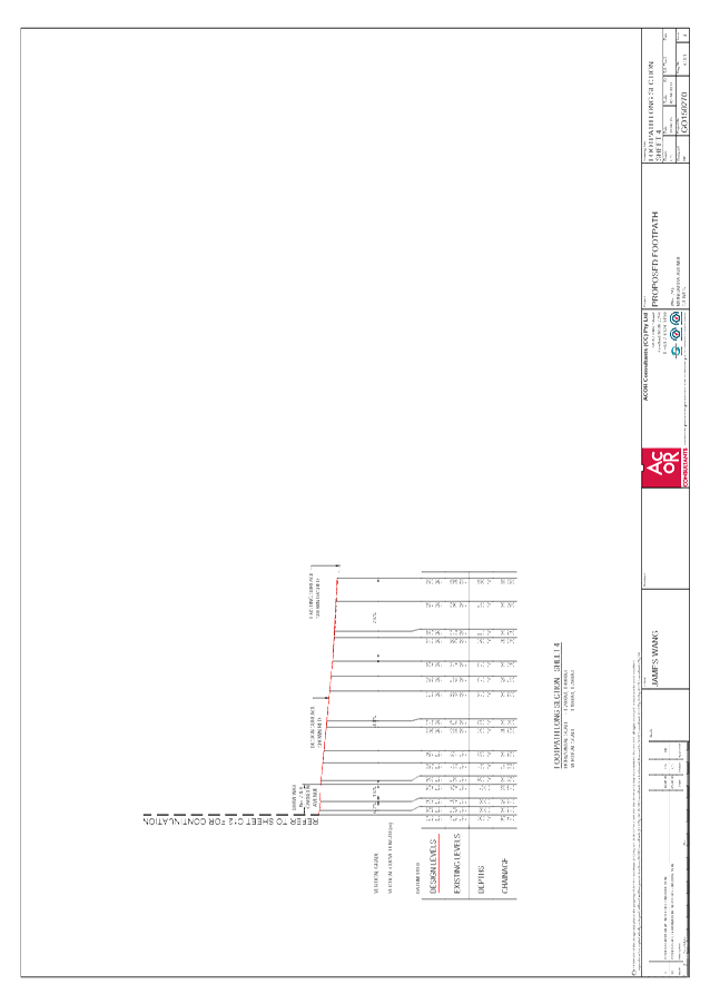
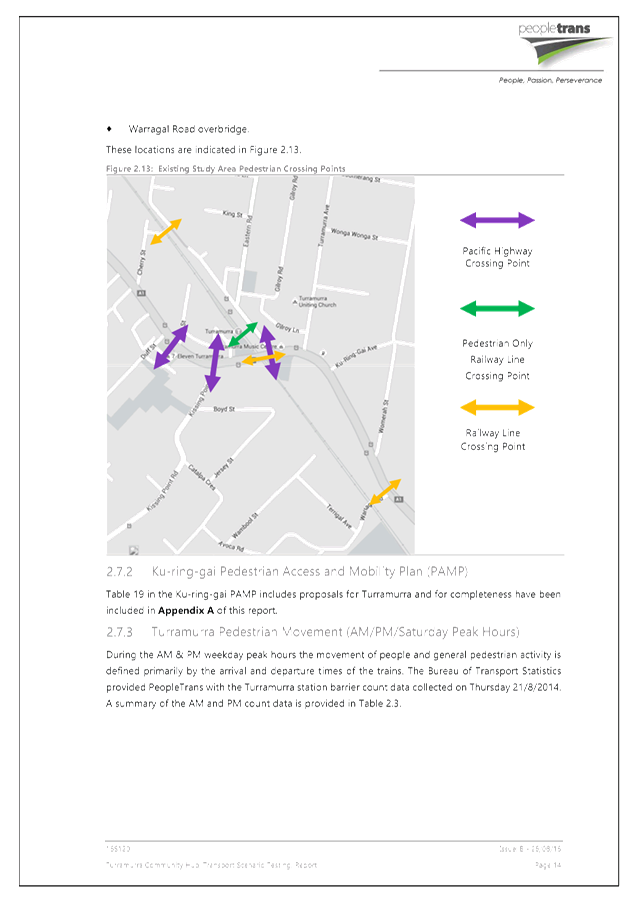
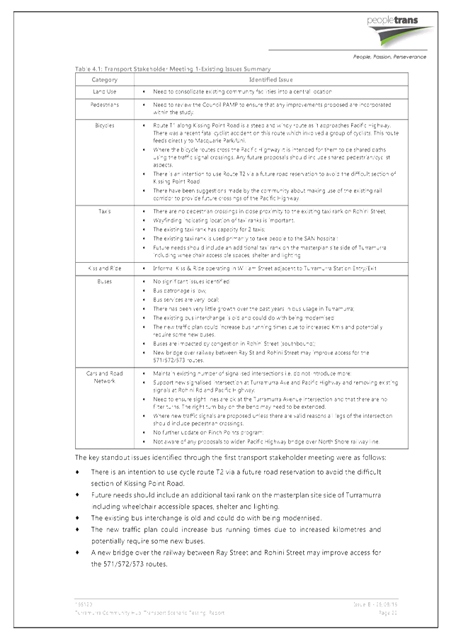
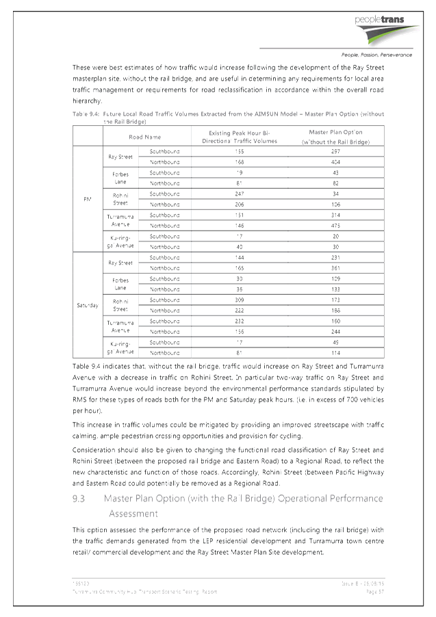
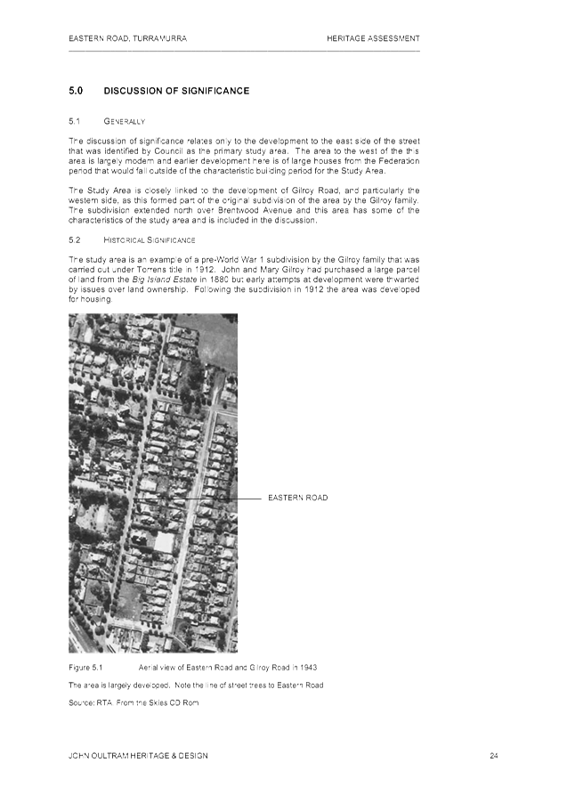
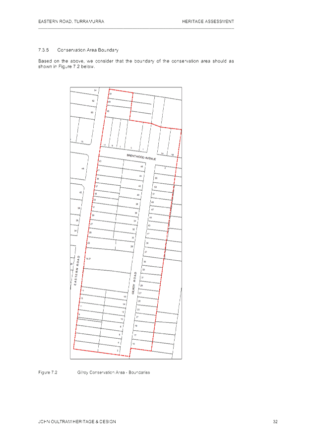
GB.1 St Ives Showground New Inclusive Playground and Golden Grove Inclusive Playground Upgrade 57
File: S02621
To seek Council's endorsement of the final concept designs for the inclusive playgrounds at Council’s Regional Parks - St Ives Showground at Picnic Area 7 and at Ku-ring-gai Bicentennial Park at Golden Grove and proceed to document for tender.
Recommendation:
A. That Council endorses the final concept designs for the new upgraded inclusive playgrounds in St Ives Showground in Picnic Area 7, and in Ku-ring-gai Bicentennial Park at Golden Grove.
B. That design and construction documentation, including detailed plans, cost estimates, environmental assessment and specifications for both projects based on the final concept designs, be completed for public tender.
C. That Council authorises the General Manager to allow minor changes to the concept plans during the design development process where budget or other constraints warrant amendments.
D. That the specialised custom built play equipment items listed in the report be authorised for pre-order by the General Manager to ensure the long lead time does not delay the project implementation.
E. That any increased maintenance costs associated with the new regional playground upgrades be included in the draft 2017/18 recurrent budget.
GB.2 Code of Conduct - Complaint Statistics 87
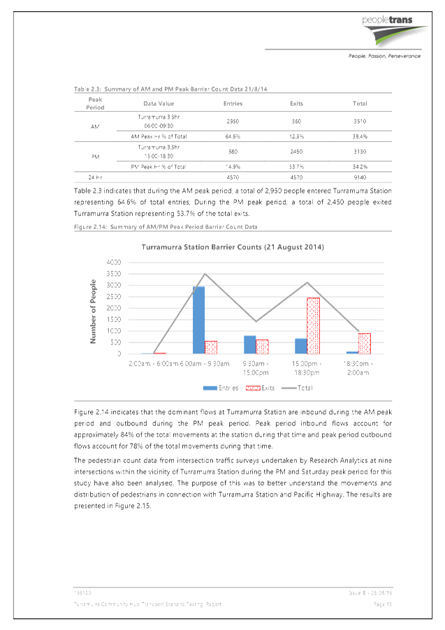
File: S08447
To report statistics in relation to complaints as required by the Procedures for the Administration of the Model Code of Conduct for Local Councils in NSW for the twelve months to 31 August 2016.
Recommendation:
That the report under Part 12 of the Procedures for the Administration of the Model Code of Conduct for Local Councils in NSW be received and noted.
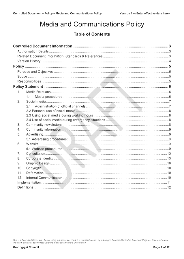
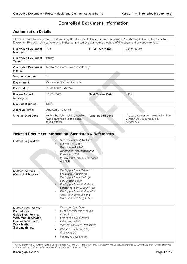
GB.3 Draft Media and Communications Policy 92
File: S07349
For Council to adopt the draft Media and Communications Community Policy 2016.
Recommendation:
That Council adopt the draft Media and Communications Policy 2016.
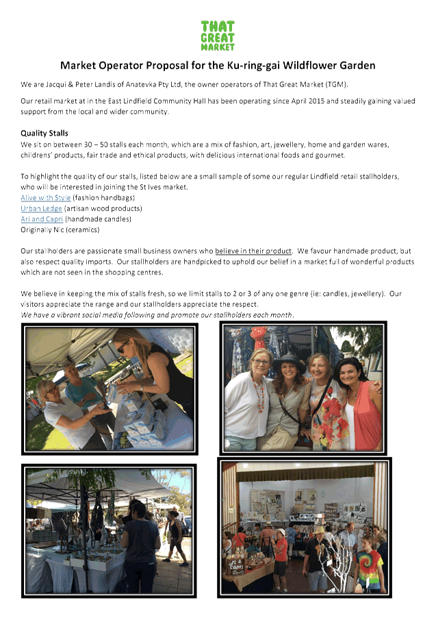
GB.4 St Ives Precinct - Temporary Markets 108
File: S10920
To advise Council of a temporary booking for Anatevka Pty Ltd to conduct monthly Sunday markets at the St. Ives Precinct, for a12 month trial period.
Recommendation:
That Council receive and note this report.
GB.5 Draft Community Consultation Policy 120
File: S02090
For Council to adopt the draft Community Consultation Policy 2016.
Recommendation:
That Council adopt the draft Community Consultation Policy 2016.
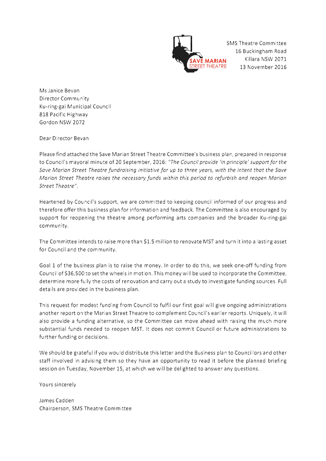
GB.6 Save Marian Street Theatre Group - Business Plan 133
File: S10577
To present to Council a Business Plan prepared by the Save Marian Street Theatre Group.
Recommendation:
That Council undertake an independent Probity and Risk Review on the Save Marian Street Theatre group Business Plan, and that a report containing analysis of the Business Plan and recommendations from the review, including strategies on managing any risks, come to Council for further determination.
GB.7 Tender RFT11/2016 - Printer and Multifunction Device Replacement 252
File: S11009
To report on the results of the open tender for the supply and installation of printers, multifunction devices and a print management solution and to seek approval to accept the tender from the preferred tenderer.
Recommendation:
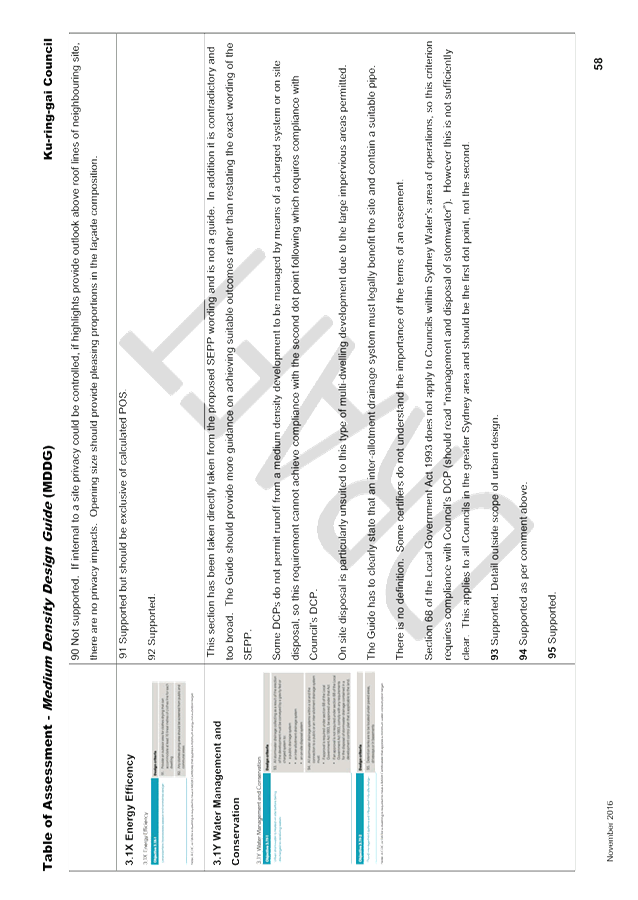
That Council approve the recommendation of the Tender Evaluation Committee included in attachment A1 and that Council authorises the Mayor and General Manager to execute all documents and affix the Council seal to all contract documents.
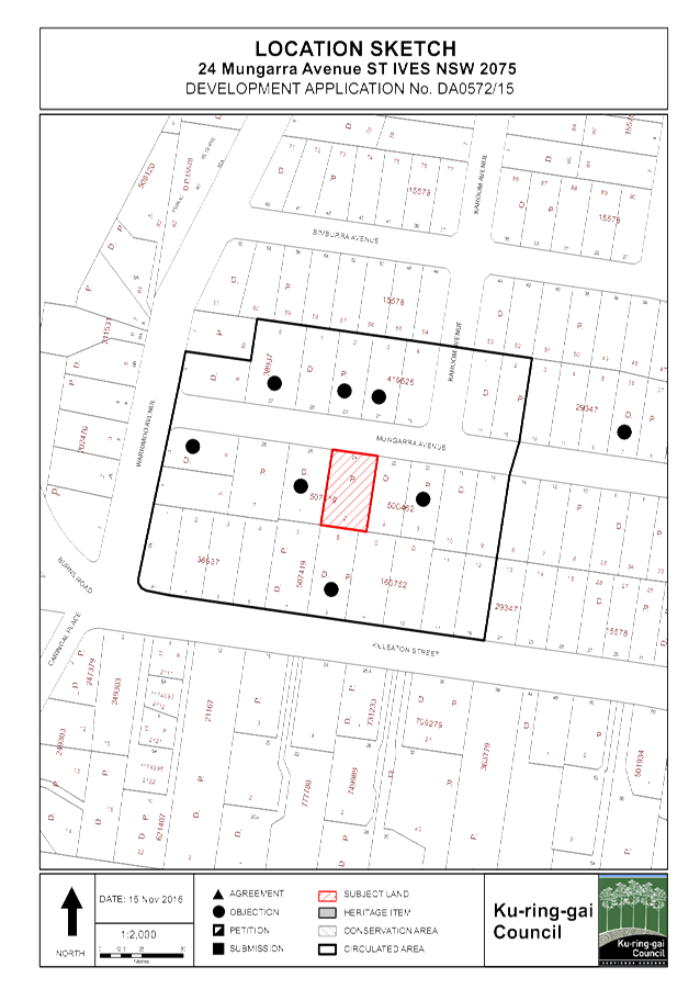
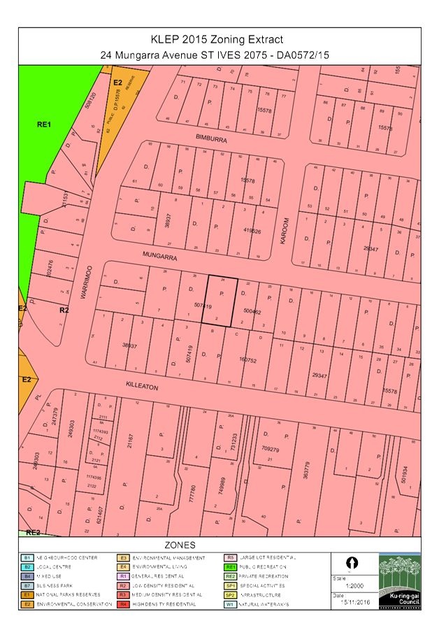
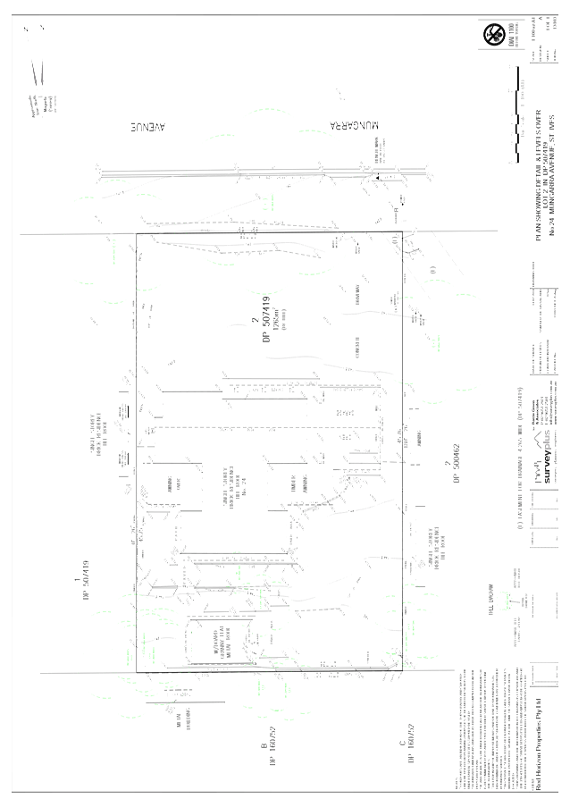
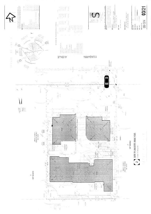
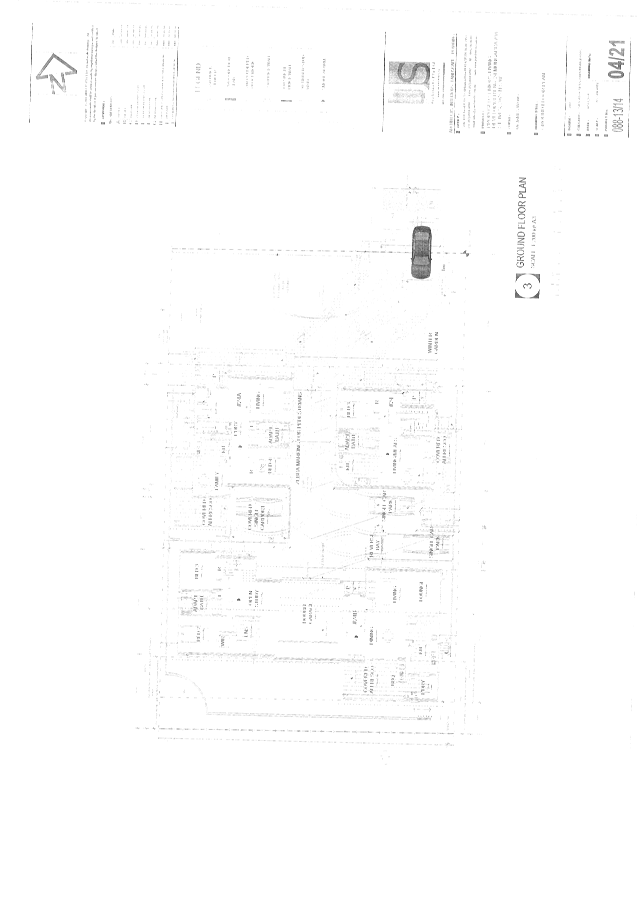
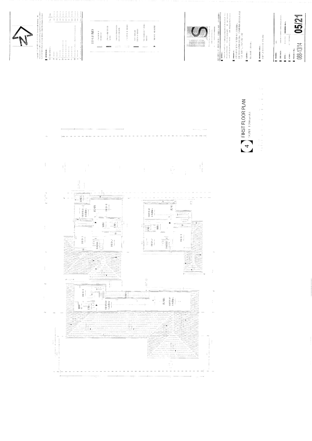
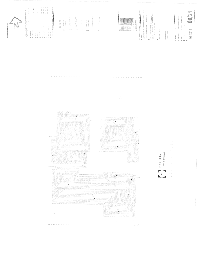
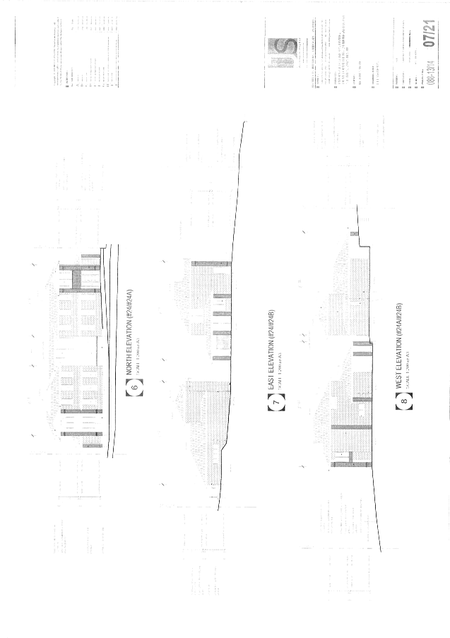
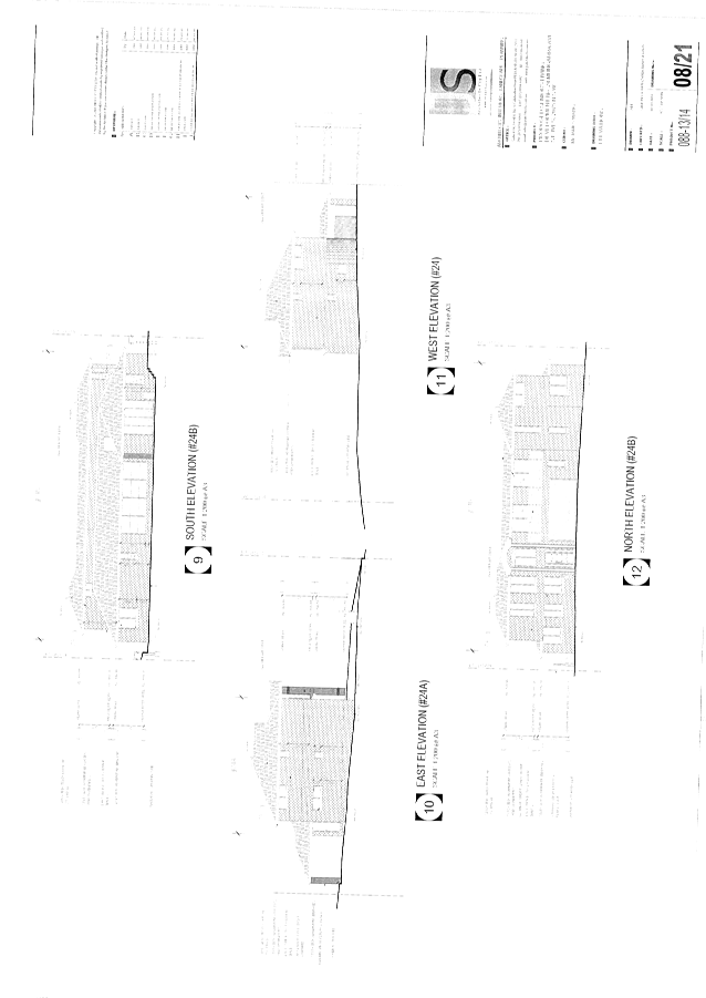
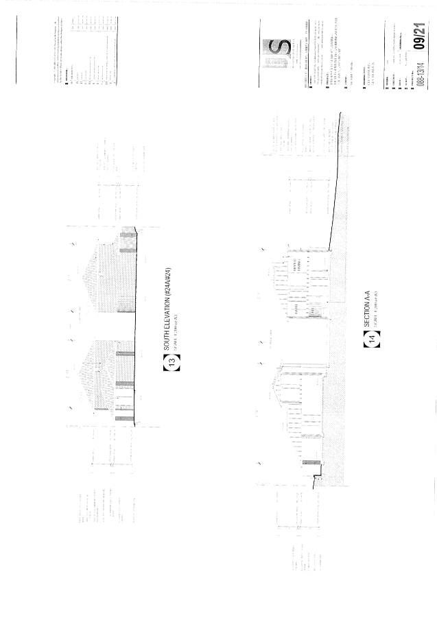
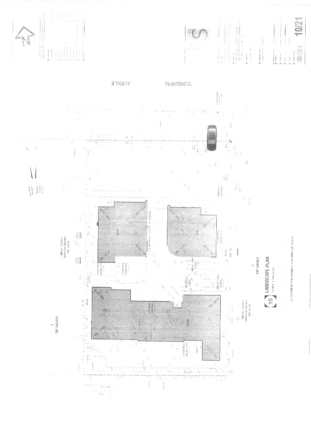
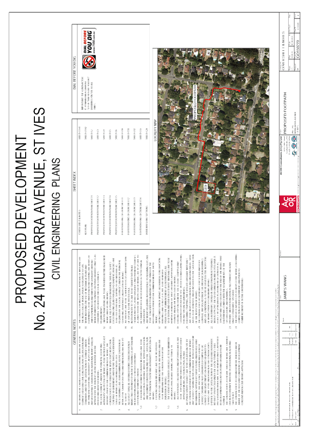
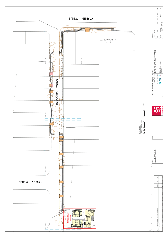
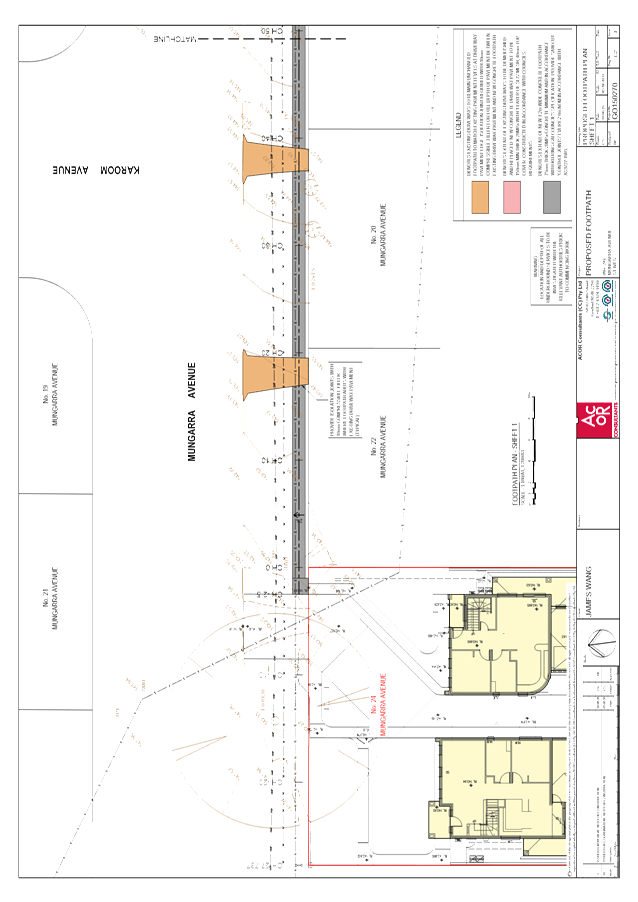
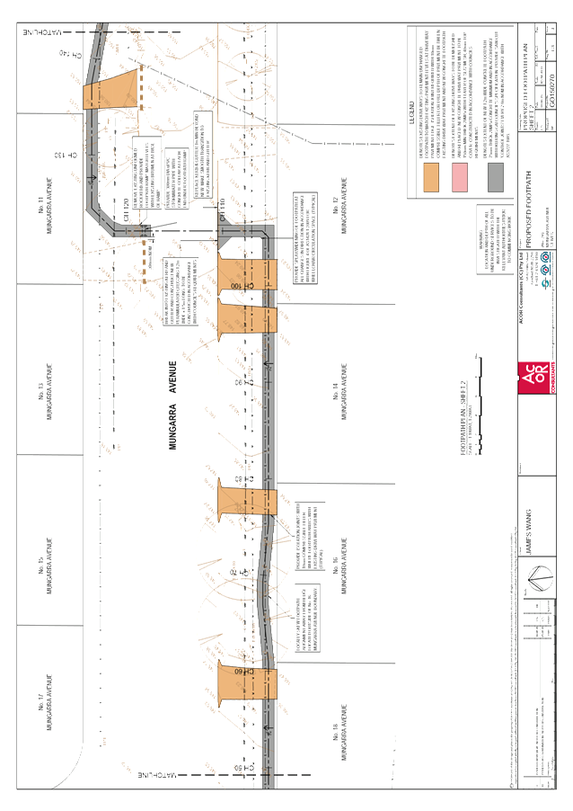
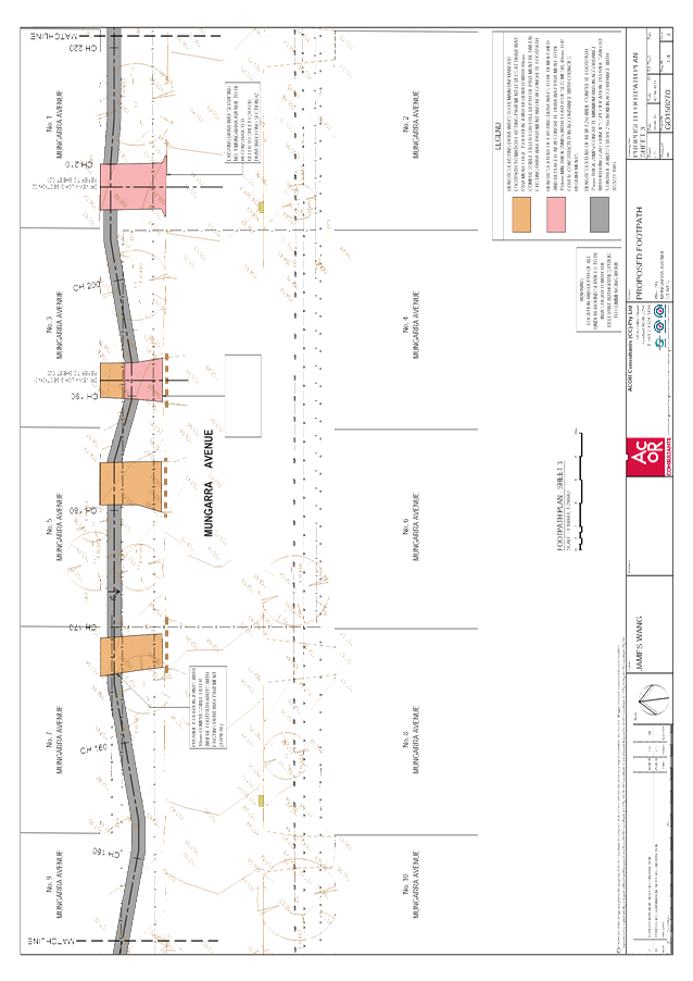
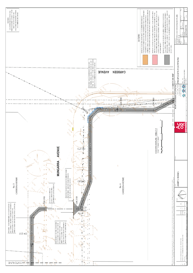
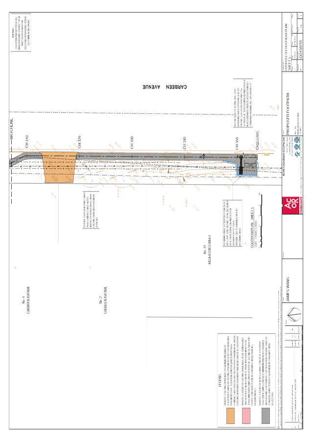
GB.8 24 Mungarra Avenue, St Ives - demolition of existing structures and construction of 3 seniors living dwellings and associated works 257
File: DA0572/15
Ward: St Ives
Applicant: JS Architects Pty Ltd
Owner: Red Horizon Properties Pty Ltd
Demolition of existing structures and construction of 3 seniors living dwellings and associated works
Recommendation:
Approval
GB.9 Tender RFT14/2016 - Drainage Construction at 90 Babbage Road, Roseville Chase 345
File: S11081
To consider tenders received for the construction of stormwater drainage works in 90 Babbage Road, Roseville Chase and appoint the preferred tenderer
Recommendation:
In accordance with Section 55 of the Local Government Act and Tender Regulations, it is recommended Council accept the recommendation of the Tender Evaluation as identified in the Confidential Summary.
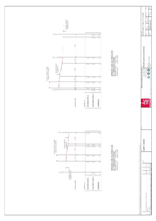
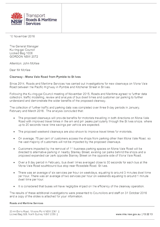
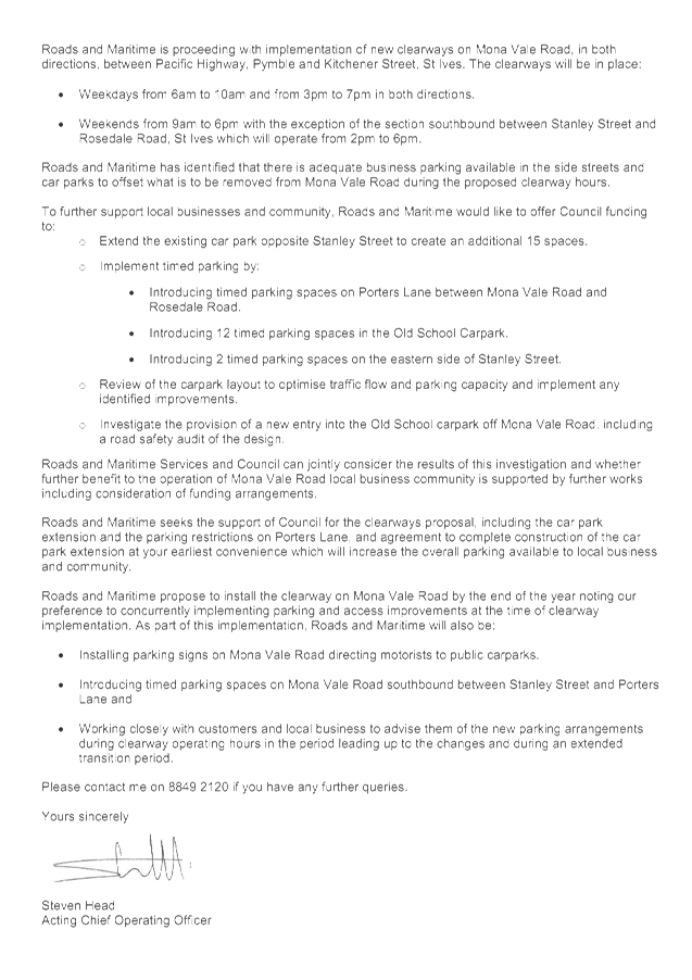
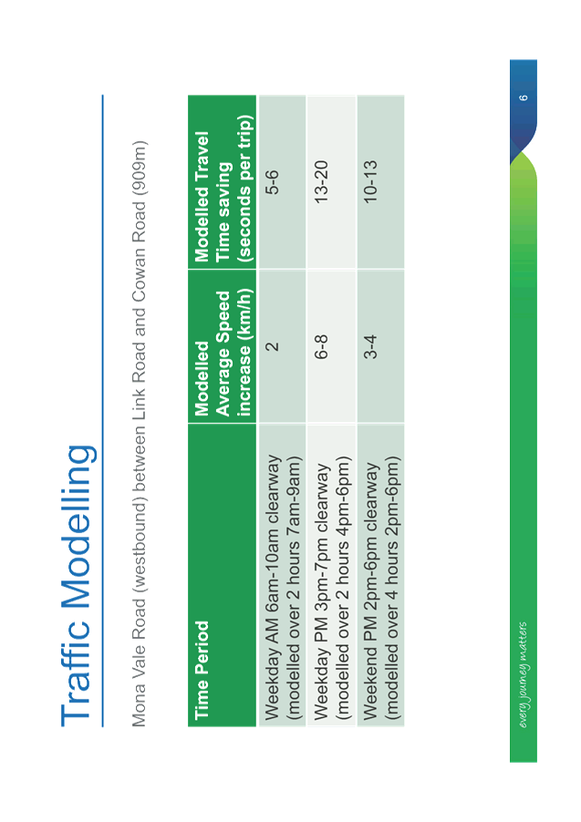
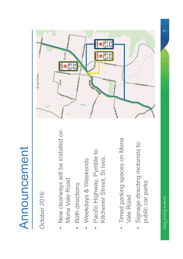
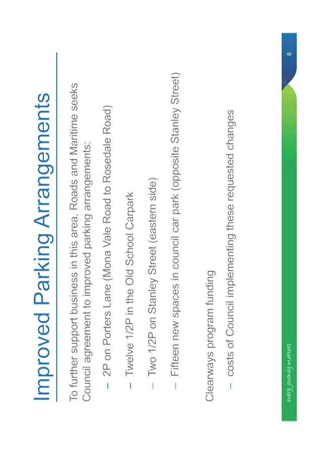
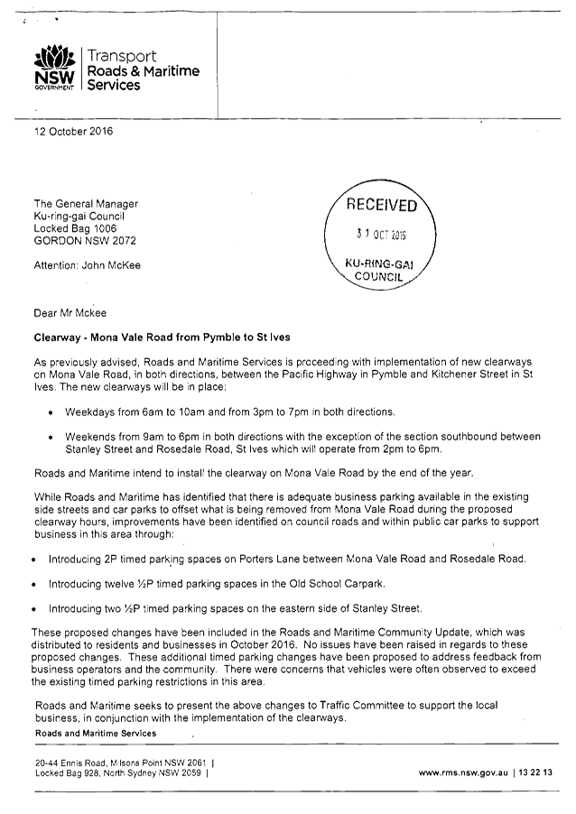
GB.10 Clearway - Mona Vale Road from Pymble to St Ives 351
File: TM3/08
To provide Council with a further update by the Roads and Maritime Services on the implementation of the clearways along Mona Vale Road.
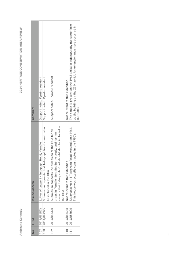
Recommendation:
That Council accept the offer of funding from the RMS for additional parking in the car park opposite the entrance to Stanley Street, St Ives at 208-210 Mona Vale Road St Ives.
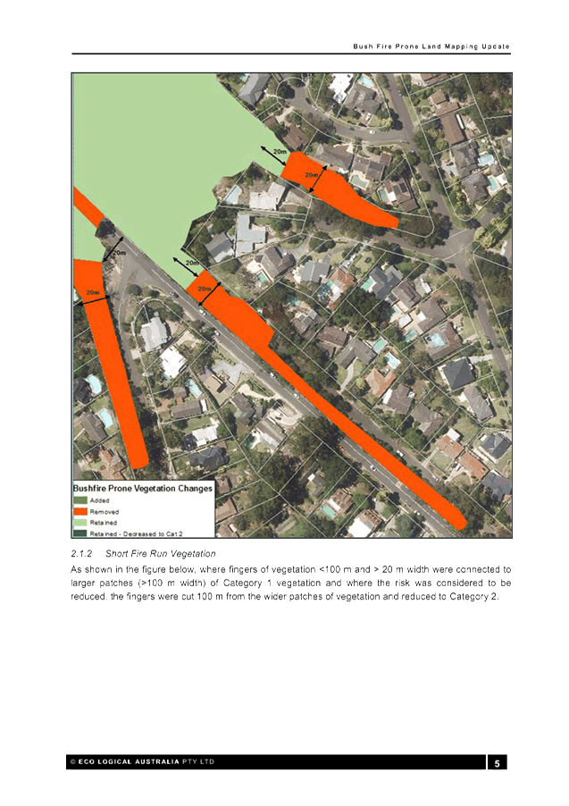
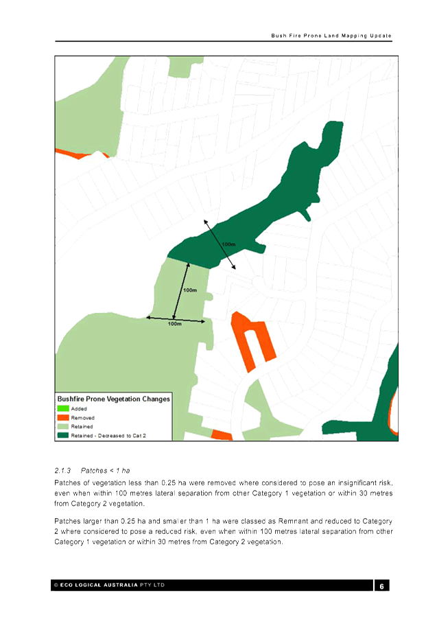
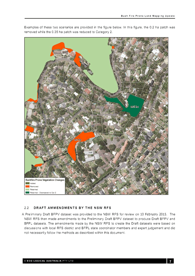
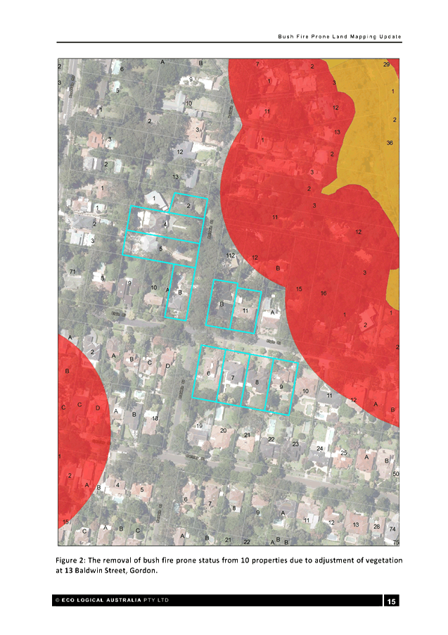
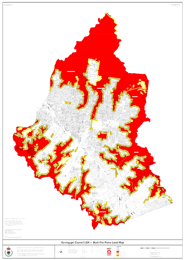
GB.11 Ku-ring-gai Bush fire prone land map 2016 - finalisation 367
File: S10627
For Council to adopt the exhibited 2016 Ku-ring-gai Bush Fire Prone Land Map (BFPLM) which was placed on public exhibition between 24 June 2016 and 21 July 2016, with amendments as outlined in this report, for lodgement to the Commissioner of the NSW Rural Fire Service for certification.
Recommendation:
That Council endorses the final Ku-ring-gai 2016 BFPL Map, with amendments as outlined in this report, for lodgement to the Commissioner of the NSW Rural Fire Service for certification.
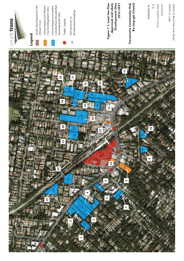
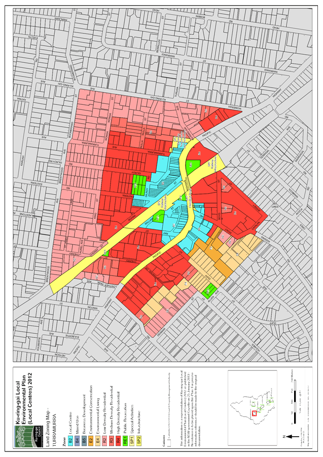
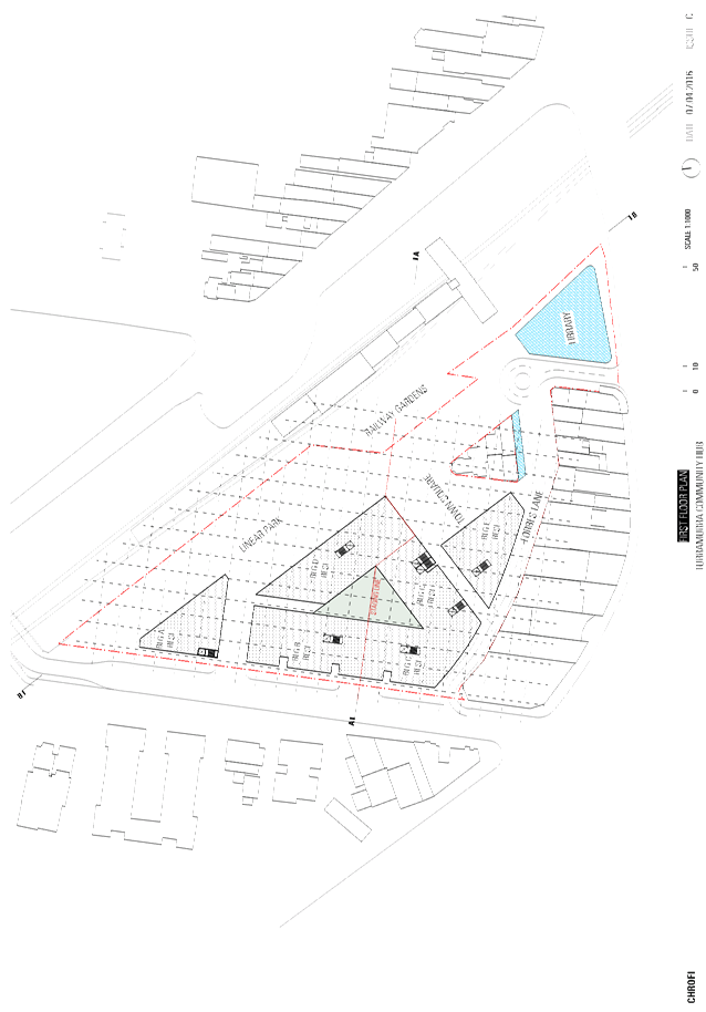
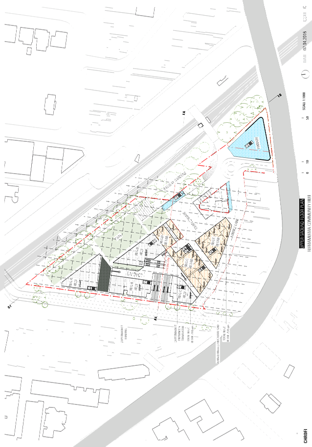
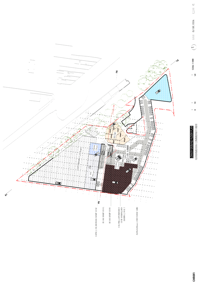
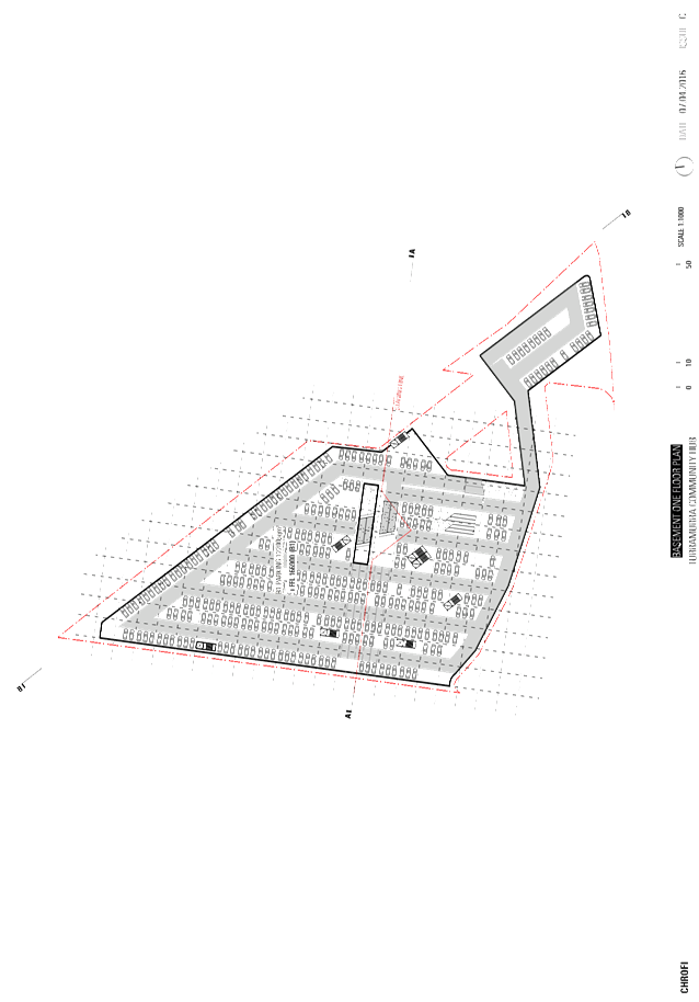
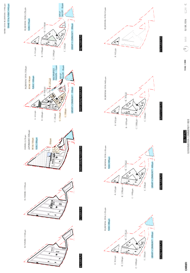
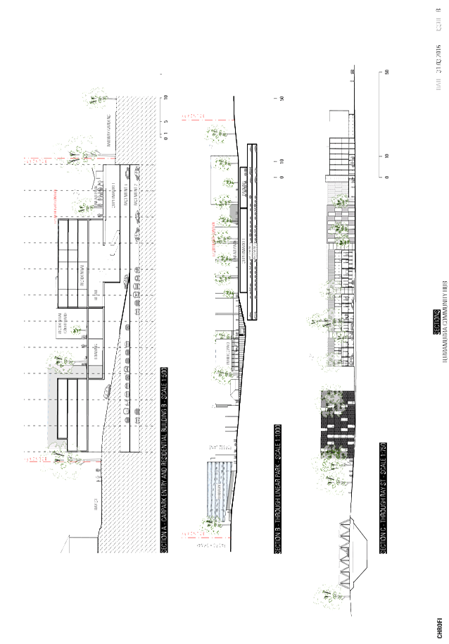
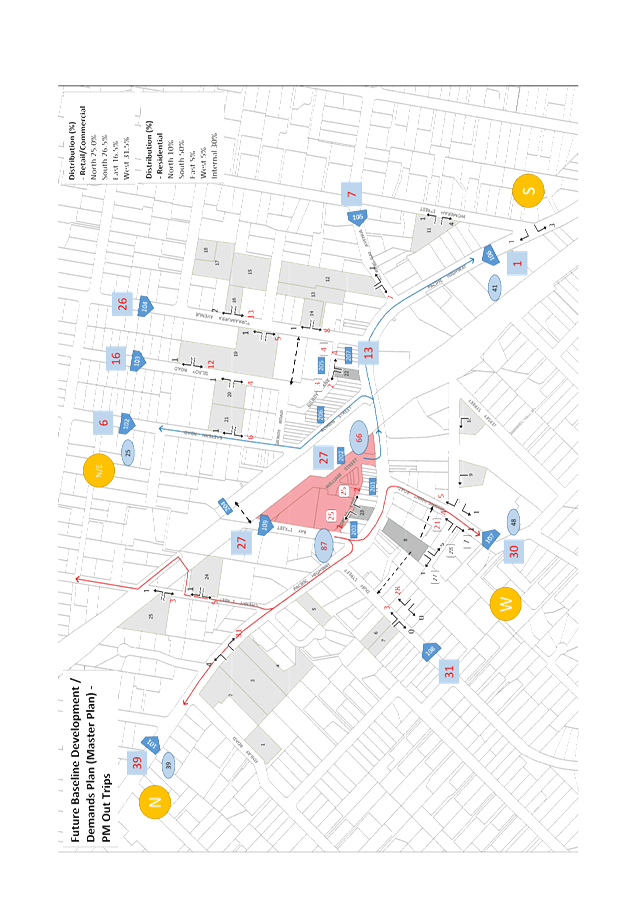
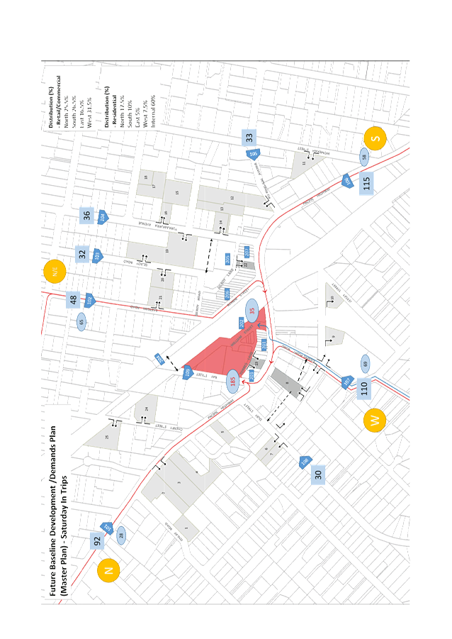
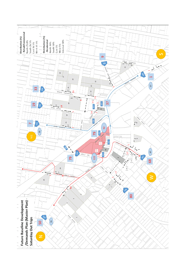
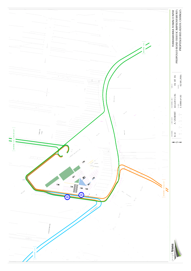
GB.12 Turramurra Community Hub Master Plan - Update on discussions with Coles Property Development Group 395
File: S10467
The purpose of this report is to recommend amendments to the draft Turramurra Community Hub Master Plan (as exhibited) based on recent discussions with Coles Property Development Group (Coles).
Recommendation:
This report recommends that the draft Turramurra Community Hub Master Plan (as exhibited) be amended to take into account agreed outcomes as a result of recent discussions with Coles.
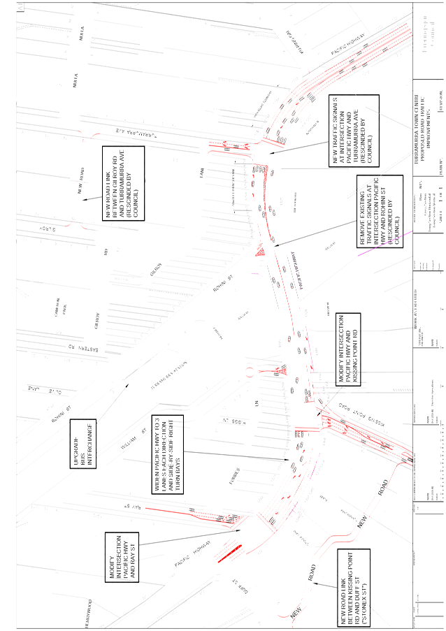
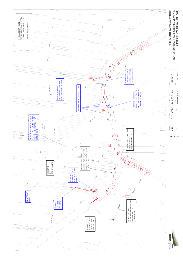
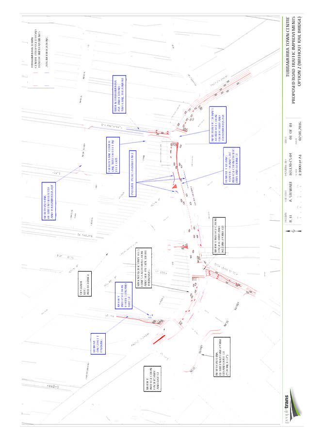
GB.13 Turramurra
Local Centre -
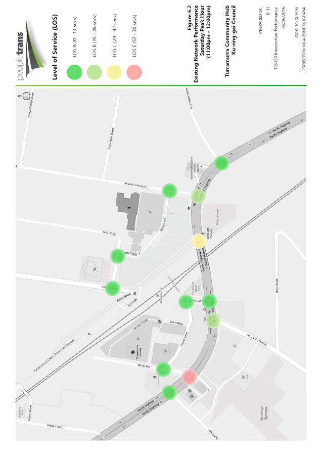
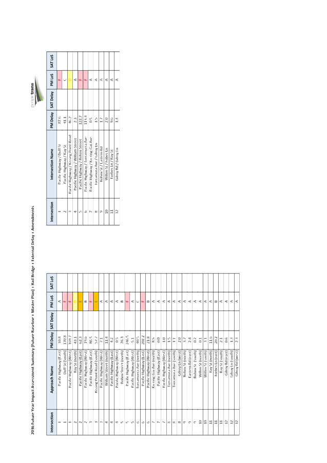
Traffic and Transport Study 409
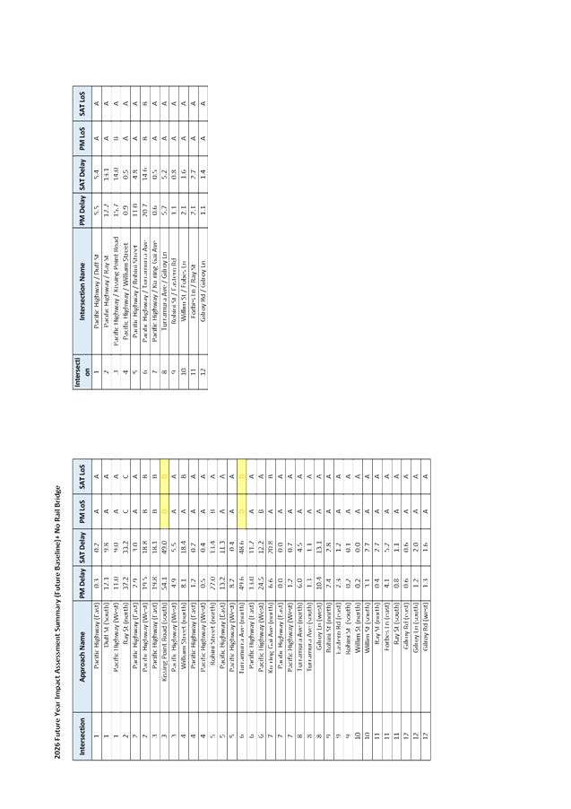
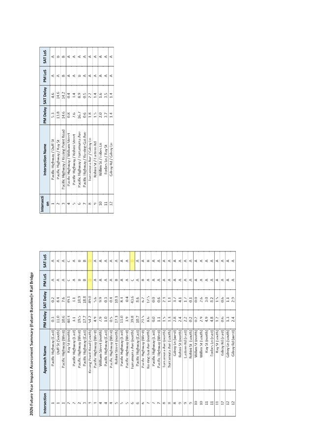
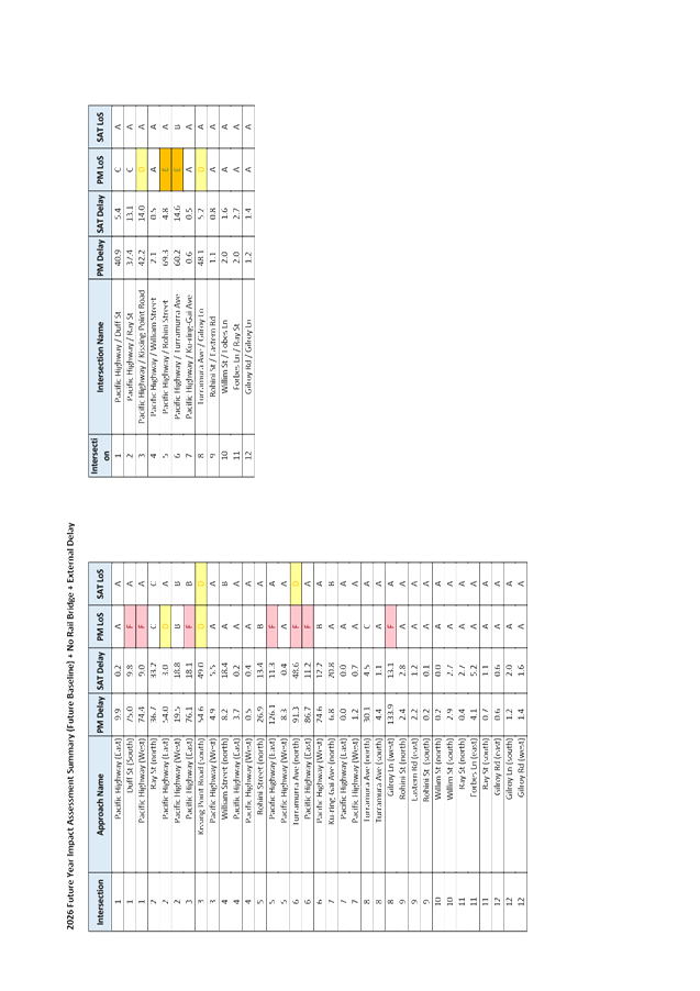
File: S10467
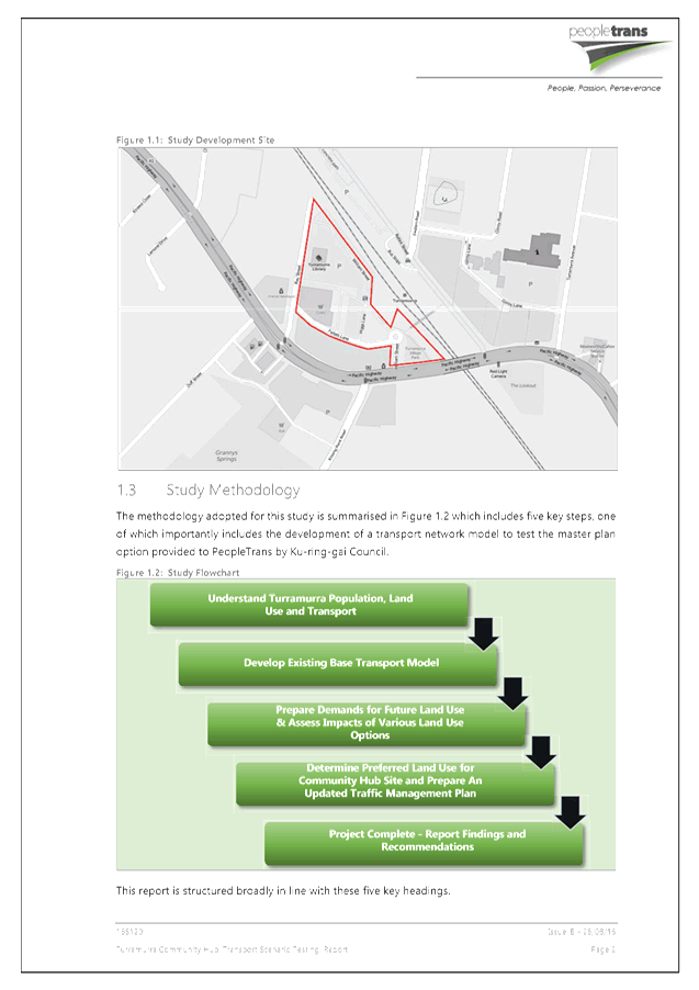
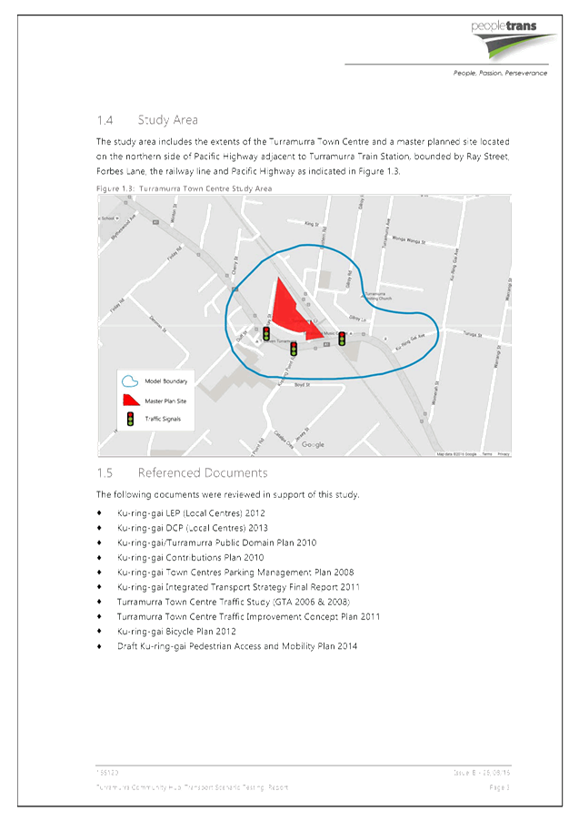
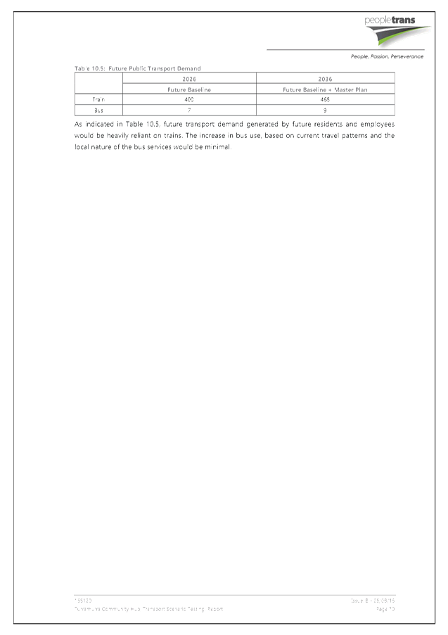
To consider the Turramurra Community Hub Transport Scenario Testing Study, 2016.
Recommendation:
GB.14 Fitzsimons Lane Gordon - Voluntary Planning Agreements 552
File: S10147
To provide an update on the progress of the draft Planning Agreements for the Development Applications that front both the Pacific Highway and Fitzsimons Lane Gordon – the lane frontage being subject to a land dedication for widening. This report also recommends the statutory exhibition of one of the draft Planning Agreements.
Recommendation:
That the draft Planning Agreement together with its Explanatory Note be placed on statutory public exhibition and reported back to Council after the close of the exhibition in 2017.
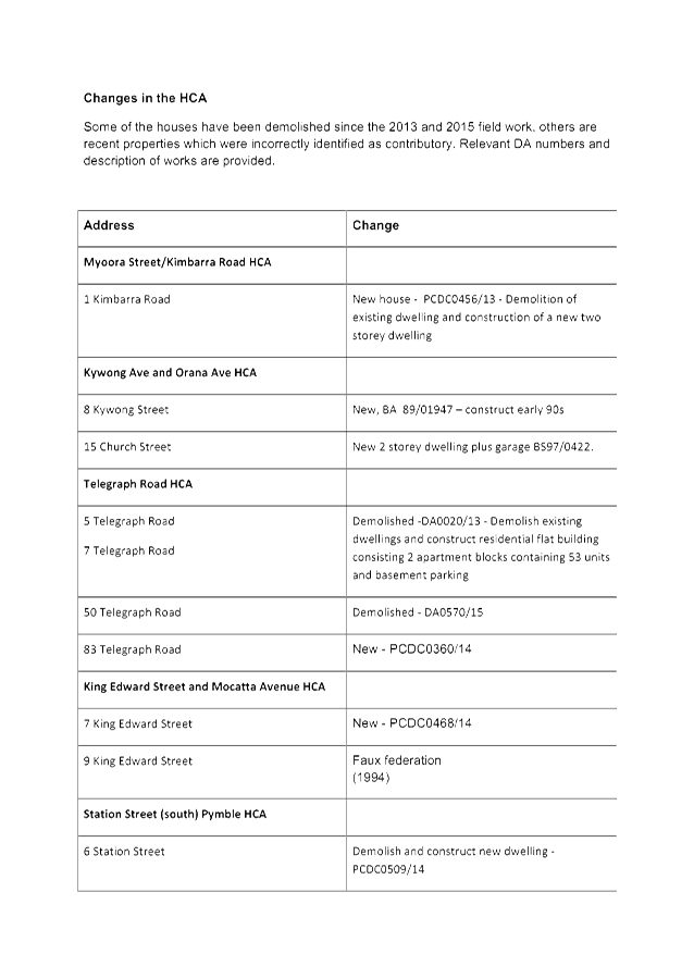
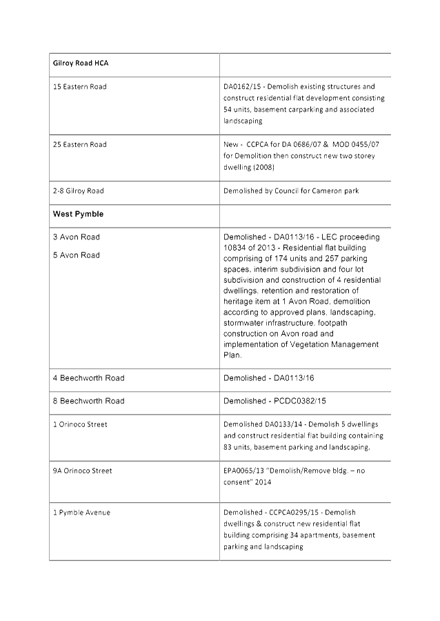
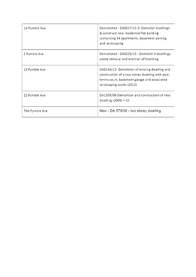
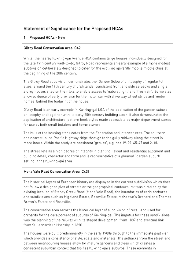
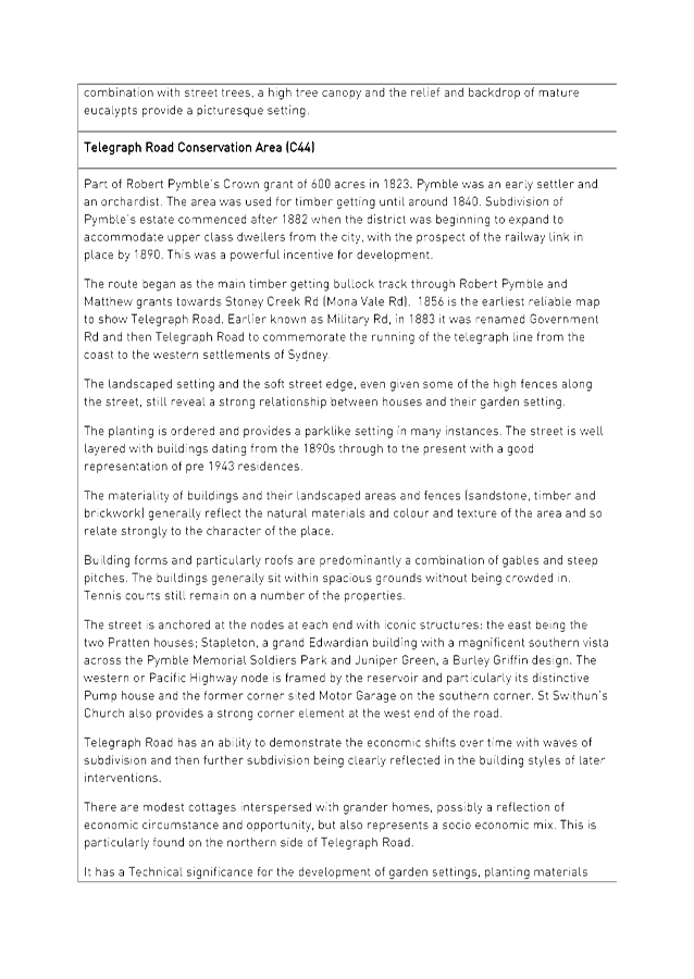
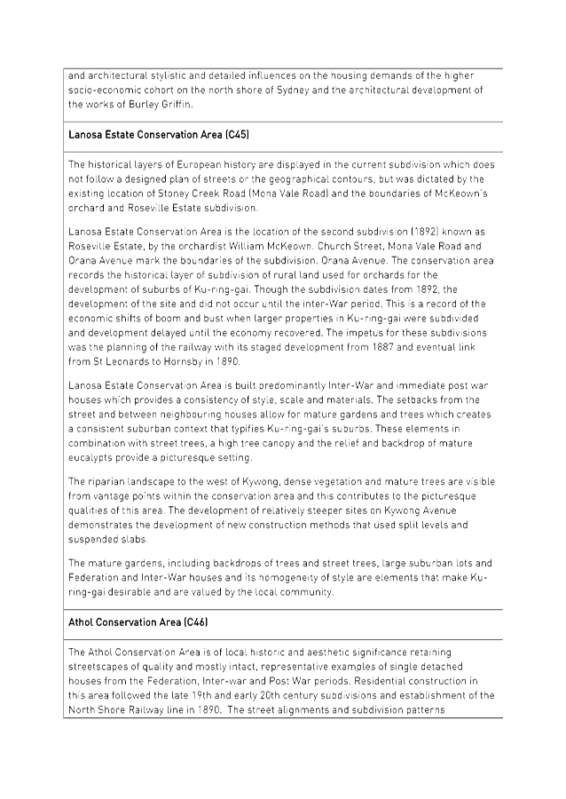
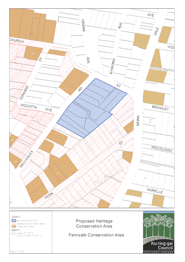
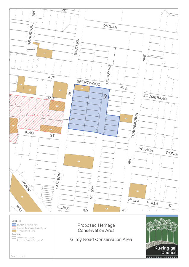
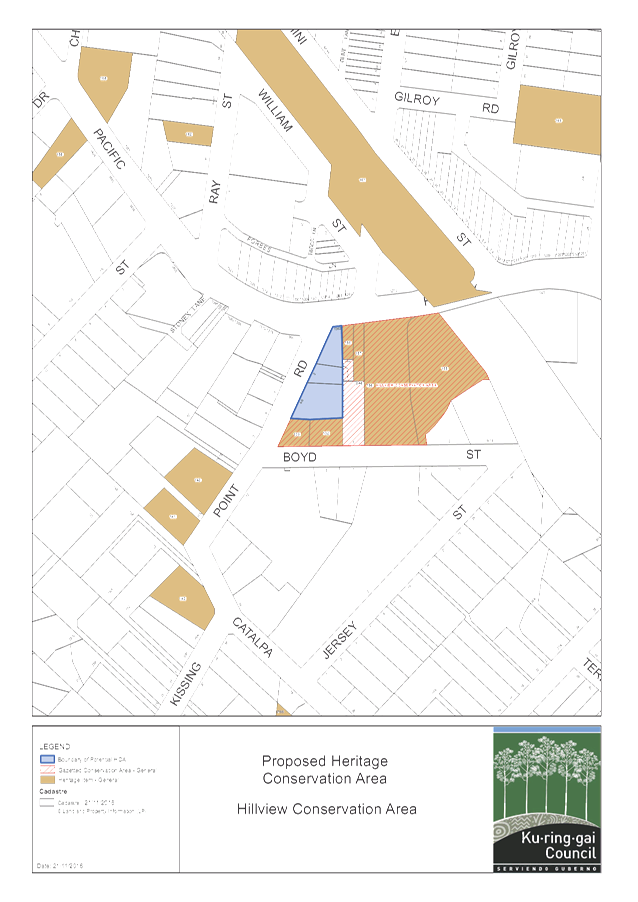
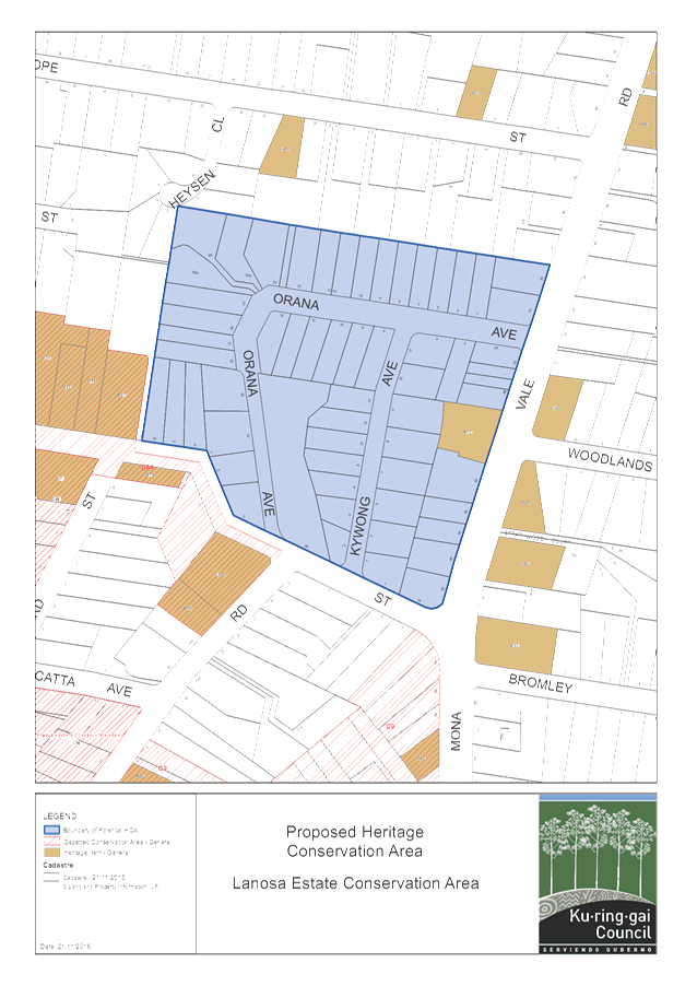
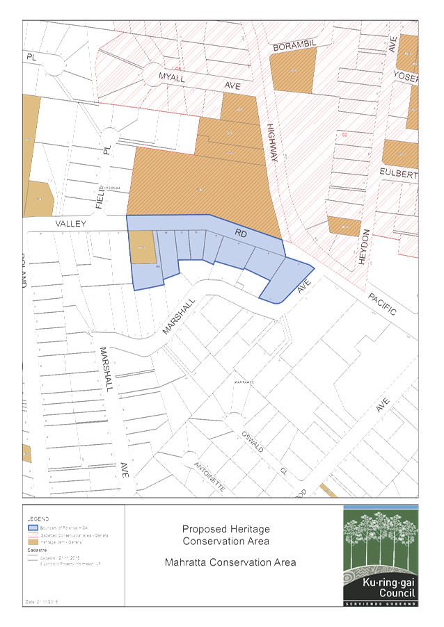
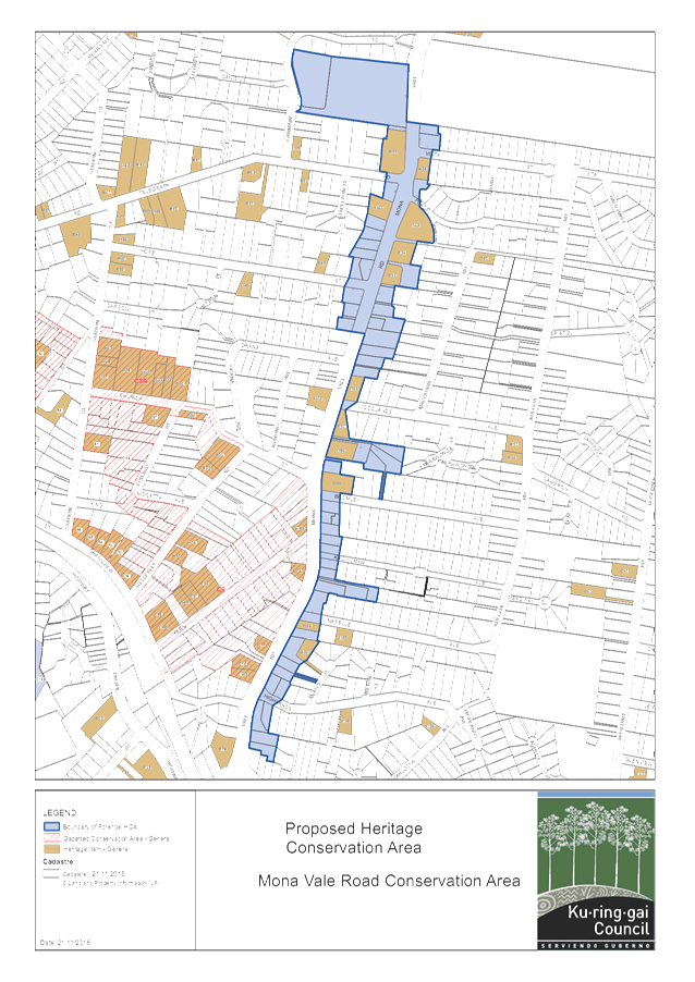
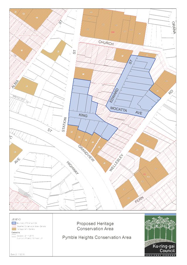
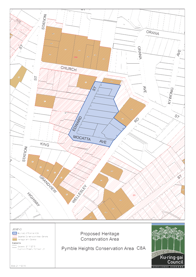
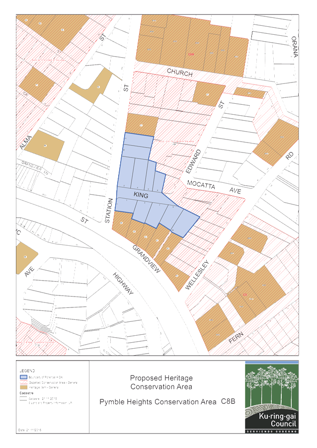
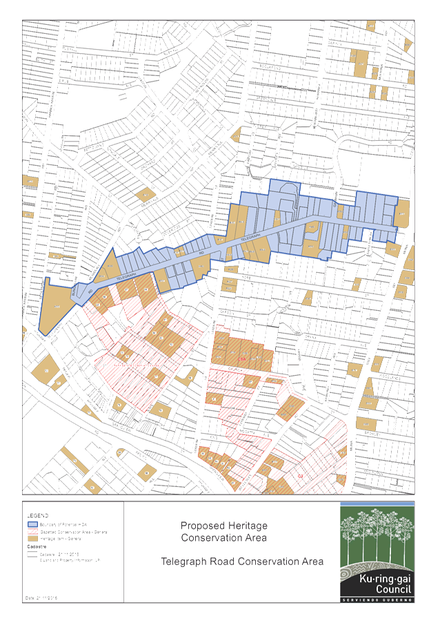
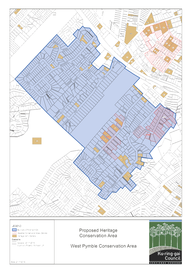
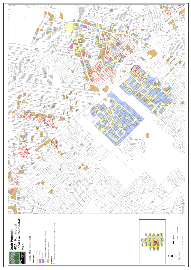
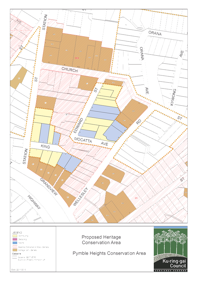
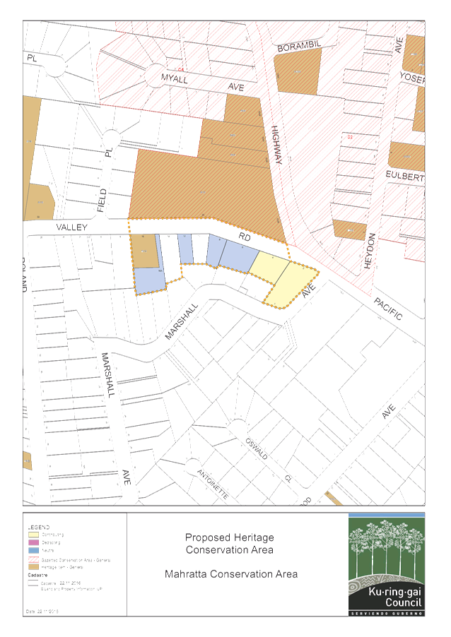
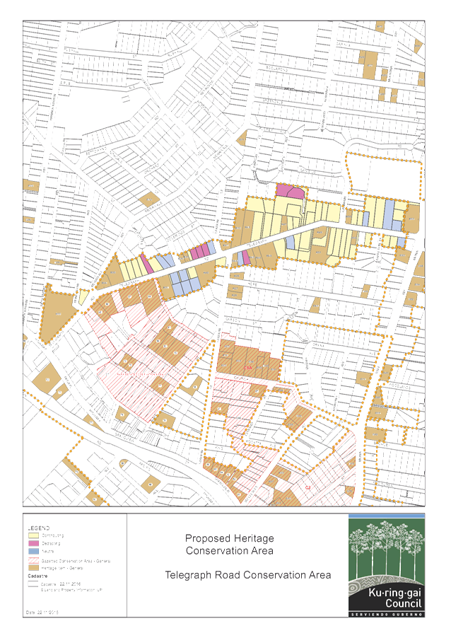
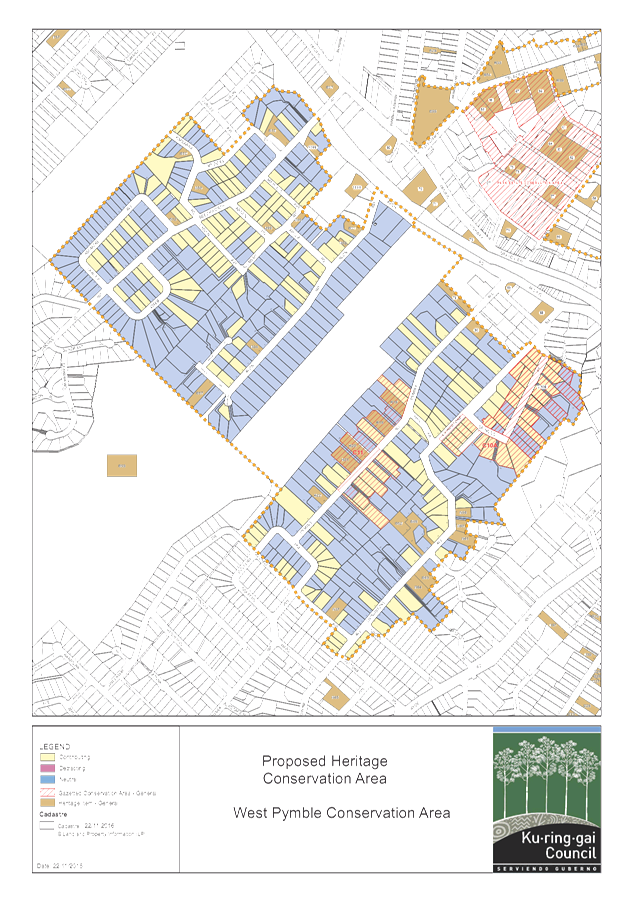
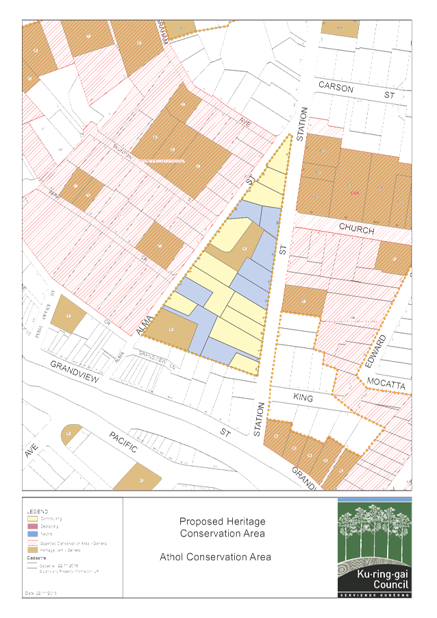
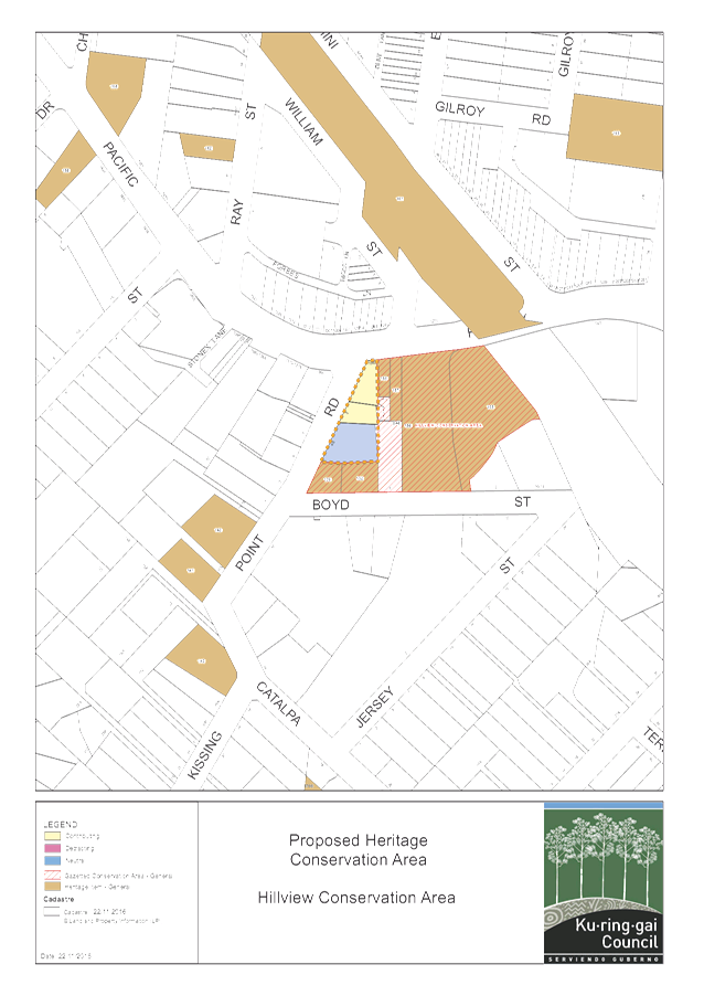
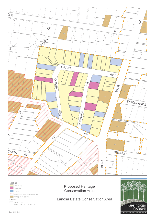
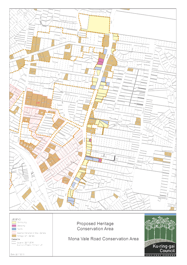
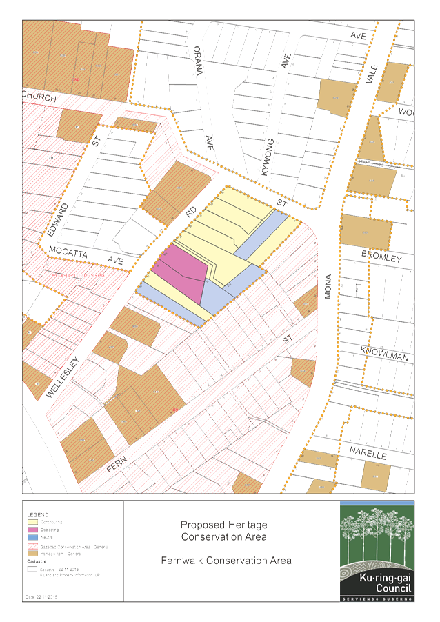
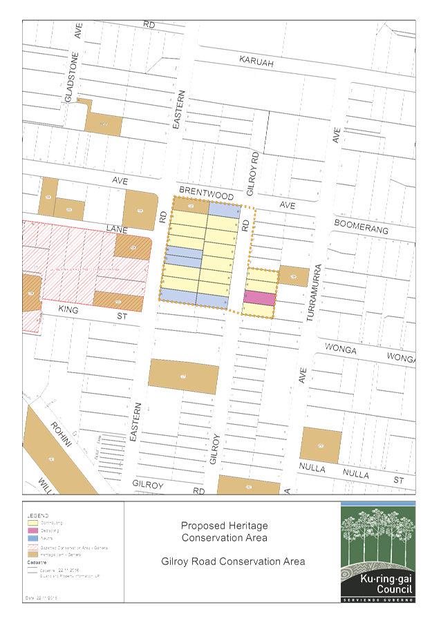
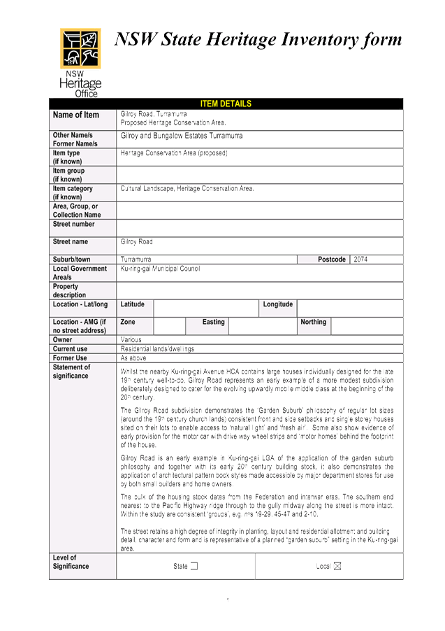
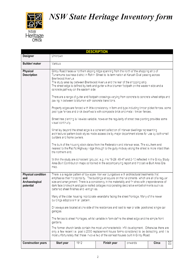
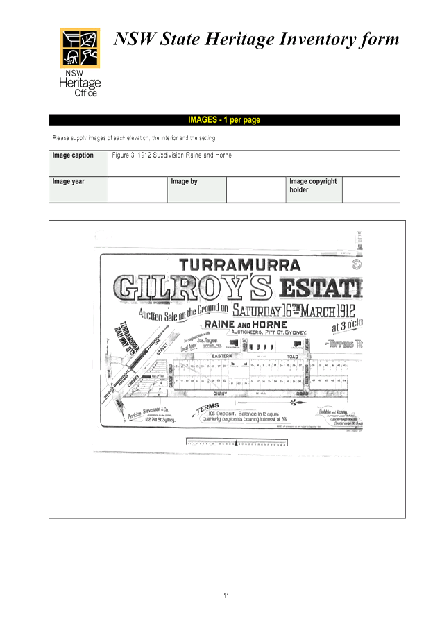
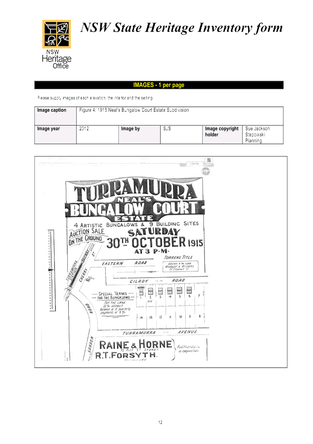
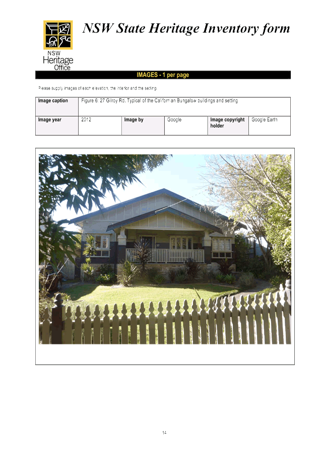
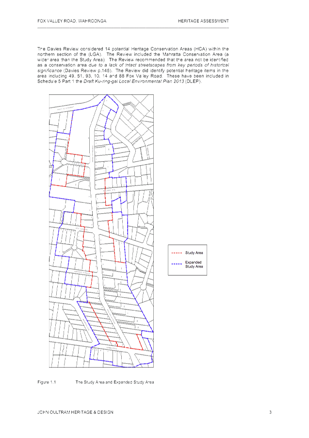
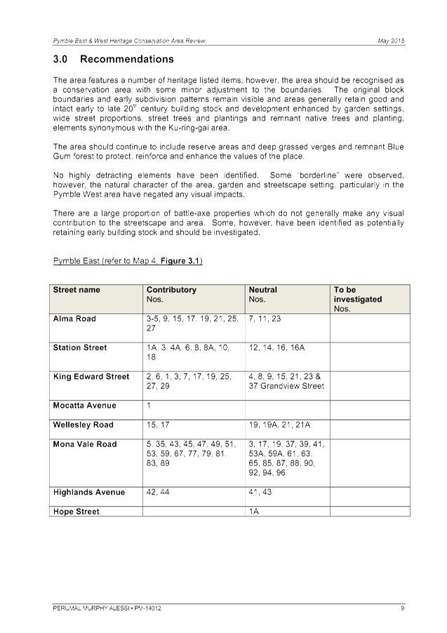
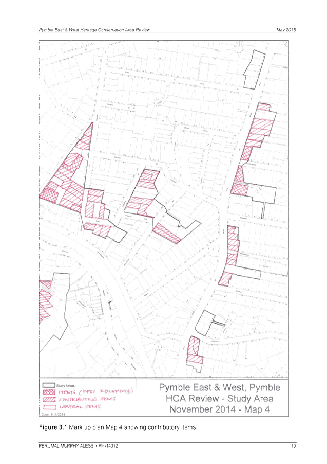
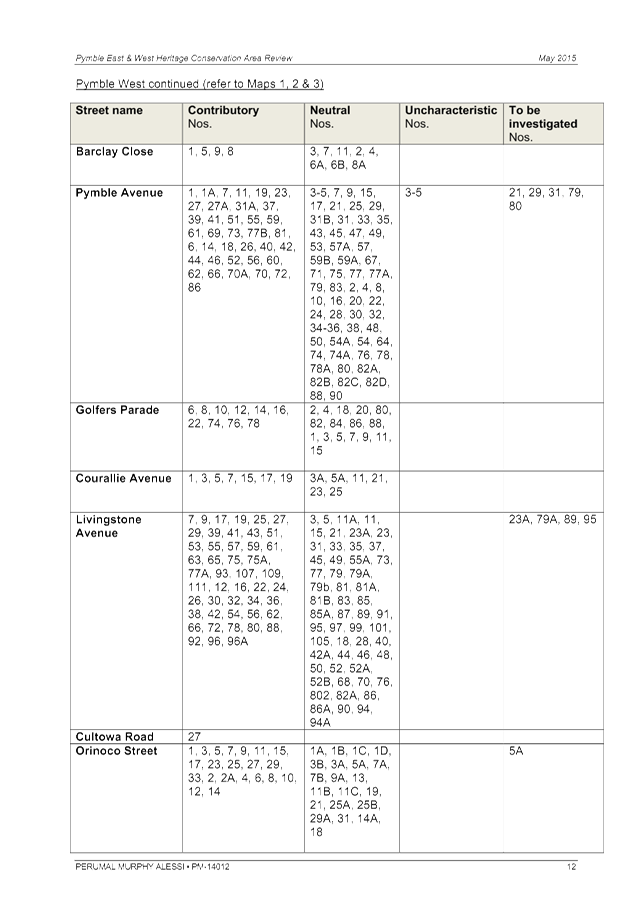
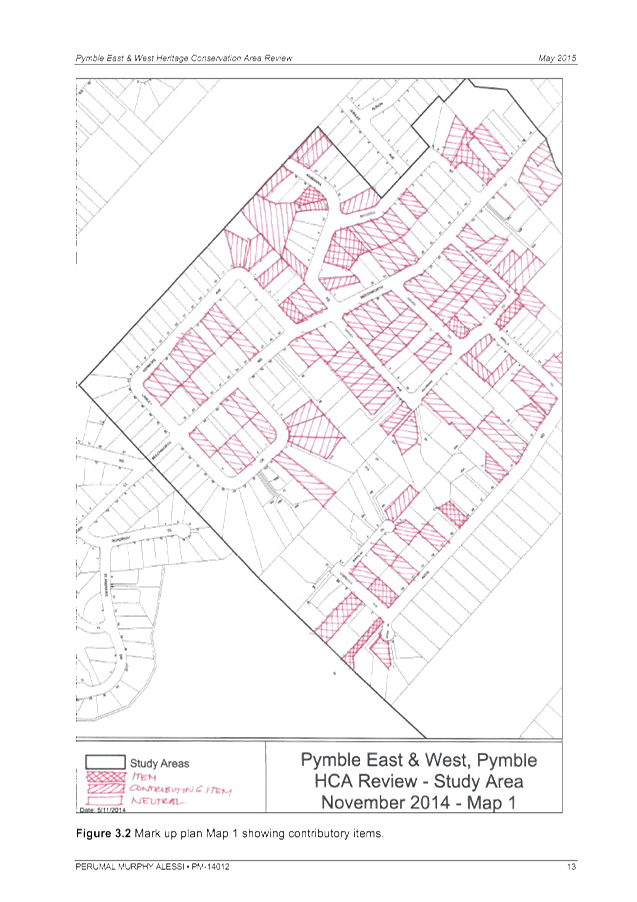
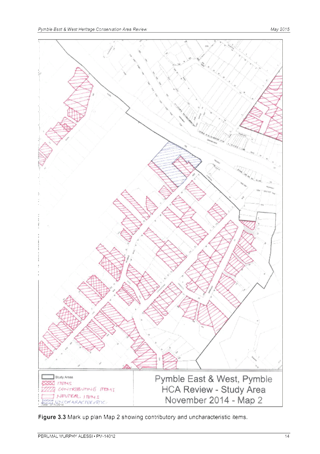
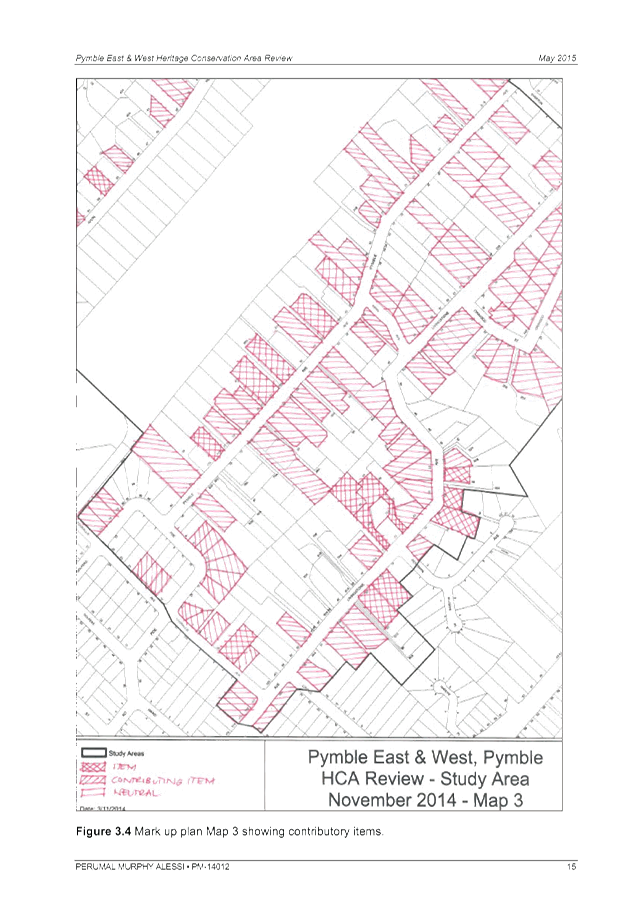
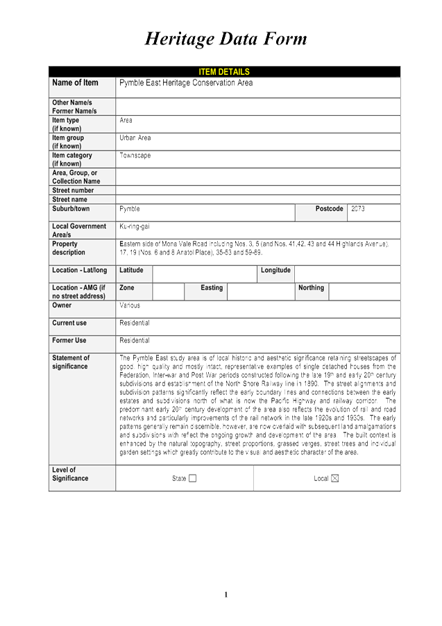
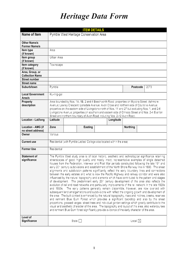
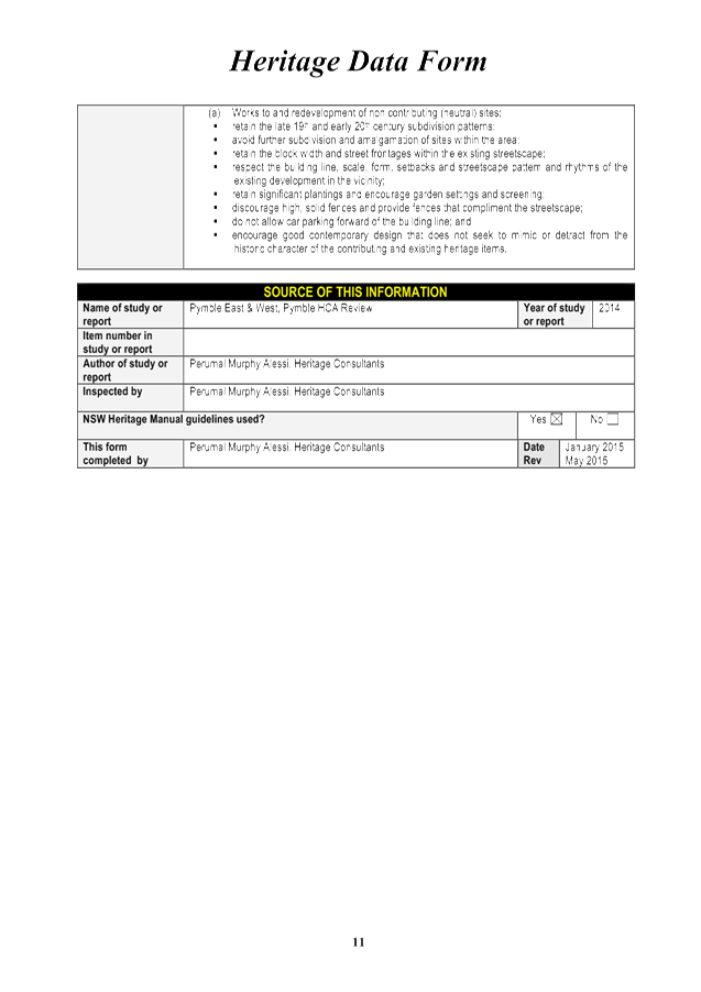
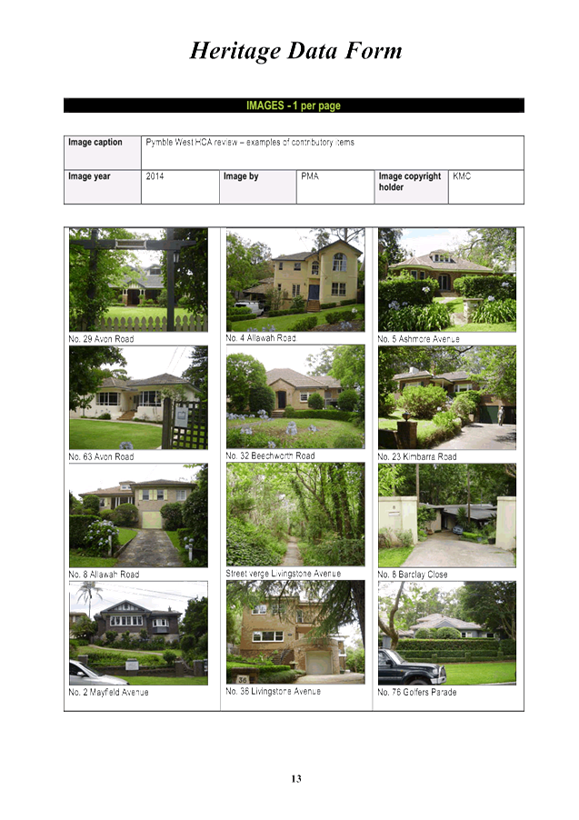
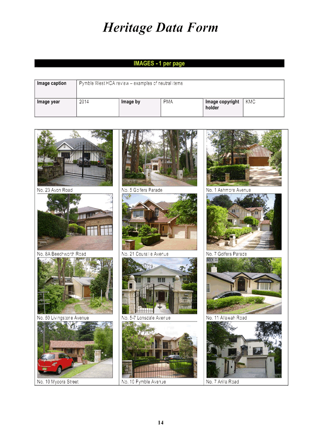
GB.15 Potential Heritage Conservation Areas in Pymble, Turramurra and Wahroonga 587
File: S10051
To have Council consider potential heritage conservation areas for inclusion under the Ku-ring-gai Local Environmental Plan 2015 and the Ku-ring-gai Local Environmental Plan (Local Centres) 2012.
Recommendation:
That several new heritage conservation areas be included in a planning proposal to amend KLEP 2015 and the KLEP (Local Centres) 2012 and be forwarded to the Department of Planning and Environment for a Gateway Determination.
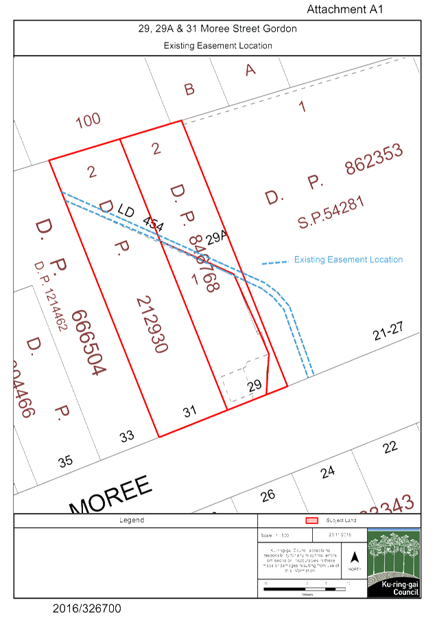
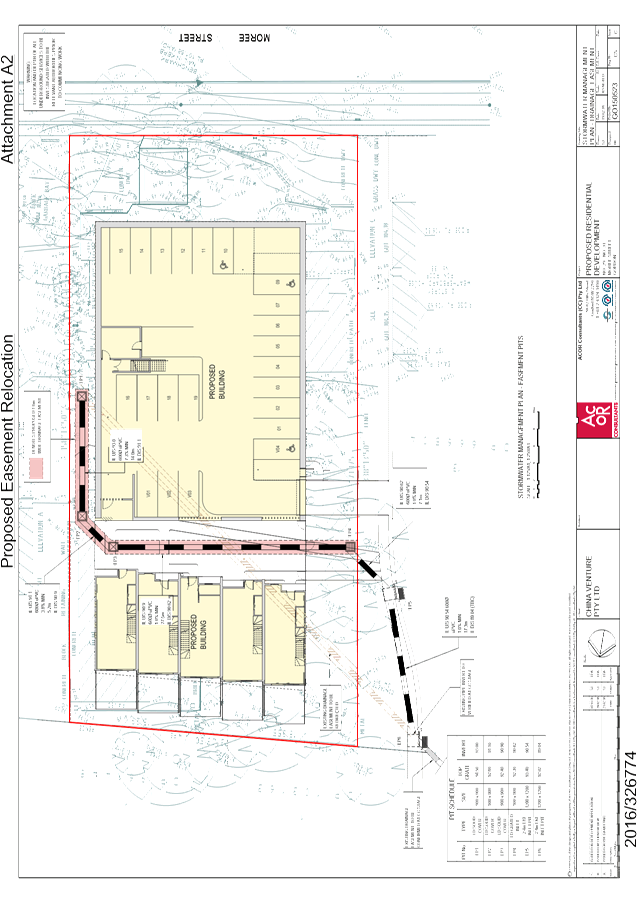
GB.16 Extinguishment/modification of Council Easement - 29, 29A and 31 Moree Street Gordon 954
File: CY00066/8
To consider a request for the extinguishment/modification of an existing stormwater drainage easement over Lot 2 DP 212930 and Lots 1 and 2 DP 846768, being 29, 29A and 31 Moree Street benefiting Council and the creation of a new easement in an alternate location on the land.
Recommendation:
That Council approves of the extinguishment/modification of the existing easement and creation of a new easement at 29, 29A and 31 Moree Street Gordon on the terms set out in this report.
GB.17 Medium Density Housing Code Exhibition - Submission to Department of Planning and Environment 962
File: S10990
To present to Council the assessment and submission on the Explanation of Intended Effect - Medium Density Housing Code and Draft Medium Density Design Guide exhibited by the Department of Planning and Environment.
Recommendation:
That Council endorse the content of the submission and it be submitted to the Department of Planning and Environment.
Extra Reports Circulated to Meeting
BUSINESS WITHOUT NOTICE – SUBJECT TO CLAUSE 241 OF GENERAL REGULATIONS
Questions Without Notice
Inspections Committee – SETTING OF TIME, DATE AND RENDEZVOUS
Confidential Business to be dealt with in Closed Meeting
C.1 2017 General Manager's Performance Agreement - Monitoring Review
File: CY00254/9
In accordance with the Local Government Act 1993 and the Local Government (General) Regulation 2005, in the opinion of the General Manager, the following business is of a kind as referred to in section 10A(2)(a), of the Act, and should be dealt with in a part of the meeting closed to the public.
Section 10A(2)(a) of the Act permits the meeting to be closed to the public for business relating to personnel matters concerning particular individuals (other than Councillors).
Report by Mayor, Councillor Jennifer Anderson dated 28 November 2016
John McKee
General Manager
** ** ** ** ** **
Minute Ku-ring-gai Council Page
MINUTES
OF Ordinary Meeting of Council
HELD ON Tuesday, 22 November 2016
|
Present: |
The Mayor, Councillor J Anderson (Chairperson) Councillors E Malicki & J Pettett (Comenarra Ward) Councillor C Szatow (Gordon Ward) Councillors C Berlioz & D Ossip (St Ives Ward) Councillors C Fornari-Orsmond & D McDonald (Wahroonga Ward) |
|
|
|
|
Staff Present: |
General Manager (John McKee) Director Corporate (David Marshall) Director Development & Regulation (Michael Miocic) Director Operations (Greg Piconi) Acting Director Strategy & Environment (Ian Dreghorn) Director Community (Janice Bevan) Corporate Lawyer (Jamie Taylor) Manager Urban & Heritage Planning (Antony Fabbro) Manager Records and Governance (Amber Moloney) Community Volunteer Program Coordinator (Peter Clarke) Minutes Secretary (Christine Dunand) |
The Meeting commenced at 7:00 pm
The Mayor offered the Prayer
|
303 |
Apologies
File: S02194
Councillor Armstrong tendered an apology for non-attendance (illness) and requested leave of absence.
Councillor Citer tendered an apology for non-attendance (illness) and requested leave of absence.
|
|
|
Resolved:
(Moved: Councillors Fornari-Orsmond/McDonald)
That the apologies for Councillors Armstrong and Citer be accepted and leave of absence granted. CARRIED UNANIMOUSLY
|
The General Manager advised that Director Strategy & Environment Andrew Watson is unwell and Mr Dreghorn will be Acting Director Strategy & Environment for this meeting.
DECLARATIONS OF INTEREST
The Mayor adverted to the necessity for Councillors and staff to declare a Pecuniary Interest/Conflict of Interest in any item on the Business Paper.
No Interest was declared.
|
304 |
CONFIRMATION OF REPORTS TO BE CONSIDERED IN CLOSED MEETING
File: S02499/9
|
|
|
Resolved:
(Moved: Councillors McDonald/Fornari-Orsmond)
A. That in accordance with the provisions of Section 10 of the Local Government Act , all officers’ reports be released to the press and public, with the exception of the following confidential report and respective attachments:
C.1 Ku-ring-gai Fitness & Aquatic Centre - Legal proceedings update Attachment A1: Without prejudice offer Attachment A2: Legal advice In accordance with s10A(2)(g)
B. That in accordance with the provisions of Section 10 of the Local Government Act , all officers’ reports be released to the press and public, with the exception of confidential attachments to the following General Business report:
GB.10 Gordon Hub Master Plan - Update Attachment A1: Coles letter dated 20 October 2016 and attachment In accordance with s10A(2)(d)(i) and s10A(2)(d)(ii)
CARRIED UNANIMOUSLY
|
SPECIAL PRESENTATION TO COUNCIL – REMEMBRANCE DAY – MATTHEW CLEWORTH, KILLARA HIGH SCHOOL
The Mayor invited Matthew Cleworth, from Killara High School, to present his Remembrance Day speech to Council and, congratulated him on behalf of Council and the residents of Ku-ring-gai.
Councillor Ossip withdrew during discussion
Councillor Ossip returned
PRESENTATION OF CHEQUES FOR ENVIRONMENTAL LEVY SMALL GRANTS SCHEME – ROUND 18
The Mayor presented cheques to recipients of the Environmental Levy Small Grants
Scheme – Round 18, and congratulated them.
Address the Council
The following members of the public addressed Council on items not on the agenda:
J Keefe Planning
A Keefe Planning
B Gray Planning
L Wilson Ku-ring-gai Philharmonic Orchestra
DOCUMENTS CIRCULATED TO COUNCILLORS
The Mayor adverted to the documents circulated in the Councillors’ papers:
|
Late Councillors Information: |
Road Naming – Lionel Price Road Memorandum from Director Operations dated 21 November 2016 advising the proposed road name for proposed new road connecting Dumaresq Street and Moree Street Gordon. |
CONFIRMATION OF MINUTEs
|
305 |
Minutes of Ordinary Meeting of Council File: S02131
|
|
|
Meeting held 8 November 2016 Minutes numbered 295 to 302
|
|
|
Resolved:
(Moved: Councillors McDonald/Pettett)
That Minutes numbered 295 to 302 circulated to Councillors were taken as read and confirmed as an accurate record of the proceedings of the Meeting.
CARRIED UNANIMOUSLY |
GENERAL BUSINESS
|
306 |
Audit and Risk Committee Minutes
File: CY00458/4 Vide: GB.2
|
|
|
To provide Council with a copy of the Minutes from the meetings of the Audit and Risk Committee held in August 2016.
|
|
|
Resolved:
(Moved: Councillors McDonald/Szatow)
That Council receives and notes the report
CARRIED UNANIMOUSLY |
|
307 |
2016 - 2017 Budget Review - 1st Quarter ended September 2016
File: S09112/5 Vide: GB.3
|
|
|
To inform Council of the results of the 1st quarter budget review of 2016/17 and seek approval to adjust the annual budget based on the actual financial performance and trend for the period 1 July 2016 to 30 September 2016.
|
|
|
Resolved:
(Moved: Councillors McDonald/Szatow)
That Council receive and note the September 2016 Quarterly Budget Review and adopt the recommended changes to the 2016/17 budget.
CARRIED UNANIMOUSLY |
|
308 |
Investment Report as at 31 October 2016
File: S05273 Vide: GB.4
|
|
|
To present Council’s investment portfolio performance for October 2016.
|
|
|
Resolved:
(Moved: Councillors McDonald/Malicki)
A. That the summary of investments and performance for October 2016 be received and noted.
B. That the Certificate of the Responsible Accounting Officer be noted and the report adopted.
CARRIED UNANIMOUSLY |
|
309 |
Analysis of Land and Environment Court Costs - 1st Quarter 2016 to 2017
File: S05273 Vide: GB.5
|
|
|
To report legal costs in relation to development control matters in the Land and Environment Court for the quarter ended 30 September 2016.
|
|
|
Resolved:
(Moved: Councillors McDonald/Szatow)
That the analysis of Land and Environment Court costs for the quarter ended 30 September 2016 be received and noted.
CARRIED UNANIMOUSLY |
|
310 |
Christmas/New Year Recess Delegations 2016/2017
File: CY00259/8 Vide: GB.6
|
|
|
To grant appropriate Delegations during the Christmas/New Year recess period for 2016/2017.
|
|
|
Resolved:
(Moved: Councillors McDonald/Szatow)
A. That the following Delegations of Authority be granted to the Mayor, Deputy Mayor and the General Manager for the Christmas/New Year recess period for 2016/2017 as follows;
1. That the Mayor (Councillor Jennifer Anderson), the Deputy Mayor (Councillor David Ossip), and the General Manager (John McKee), be granted authority to exercise all powers, authorities, duties and functions of Council except those set out in Section 377 of the Local Government Act 1993 during the period 7 December 2016 to 6 February 2017, subject to the following conditions:
a. Such powers, authorities and functions may only be exercised by unanimous agreement between the Mayor, Deputy Mayor and General Manager.
b. Any such power, authority, duty or function shall only be exercised by the Mayor, Deputy Mayor and General Manager jointly where they are of the opinion that the exercise of any such power, authority, duty or function could not be deferred until the meeting of Council on 7 February 2017.
B. That consultation, subject to their availability, be held with Ward Councillors on matters where they would normally be contacted, before delegation is exercised.
CARRIED UNANIMOUSLY |
|
311 |
Update Report on the Development Contributions System
File: S06785/3 Vide: GB.9
|
|
|
The purpose of this report is to provide Council with an overview of key activities and highlights in the development contributions system over the past six months and anticipated actions and highlights for the coming twelve months.
|
|
|
Resolved:
(Moved: Councillors McDonald/Szatow)
A. That the update report on the development contributions system in Ku-ring-gai be received and noted.
B. That Ku-ring-gai s94A Contributions Plan 2015 be amended as follows:
a) to increase the cost threshold at which a Quantity Surveyors Report is technically required to $1.2 million; b) to permit the payment of s94A contributions by credit card in line with other similar amounts payable to Council for other purposes in the ordinary course of business on the same terms and in addition to current payment options; c) to remove references to the revoked s94E Directions and to accurately reflect the current s94E Direction published in the Government Gazette on 14 October 2016 as well as all current legislation; d) to specifically cross reference clause 25J of the Environmental Planning and Assessment Regulation 2000 within the two cost templates and to provide scope within the template to identify any works for which costs have been duly excluded from the total; e) to objectively review the wording and definitions of applicability of s94A for any scope for perceived lack of clarity, as well as correctly referencing the current s94E Direction and legislation; and f) correction of any other typographical errors that may be identified while implementing the text changes listed above.
C. That the amended s94A contributions plan be placed on public exhibition as Draft Amendment One to Ku-ring-gai s94A Contributions Plan 2015 and be reported back to Council after the close of the exhibition period.
CARRIED UNANIMOUSLY |
|
312 |
Correction to Schedule 5 of KLEP 2015
File: S10051 Vide: GB.11
|
|
|
For Council to consider amendments to Schedule 5 of the KLEP 2015 to correct erroneous heritage listings.
|
|
|
Resolved:
(Moved: Councillors McDonald/Szatow)
A. That a Planning Proposal be prepared, in accordance with section 55 of the Environmental Planning and Assessment Act, 1979, to amend the Ku-ring-gai Local Environmental Plan 2015 to remove the following properties from Schedule 5:
· 36A and 36B Carlotta Avenue, Gordon (Lot B, DP 366349); · “Edelstein” 7 Grosvenor Street, Wahroonga (Lot D, DP 330058); · 17 Bangalla Street, Warrawee (Lot 14, DP 14753); · 14 Warrangi Street, Turramurra (Lot 2, DP 542710).
B. That the Planning Proposal be submitted to the Department of Planning and Infrastructure for a Gateway Determination in accordance with Section 56 of the Environmental Planning and Assessment Act, 1979.
C. That Council request the plan-making delegation under Section 23 of the EP&A Act for this planning proposal.
D. That upon receipt of a Gateway Determination, the exhibition and consultation process is carried out in accordance with the requirements of the Environmental Planning and Assessment Act, 1979 and with the Gateway Determination requirements.
E. That a report be brought back to Council at the end of the exhibition processes.
CARRIED UNANIMOUSLY |
|
313 |
Ku-ring-gai Fitness & Aquatic Centre - Legal proceedings update
File: S10420 Vide: C.1
|
|
|
In accordance with the Local Government Act 1993 and the Local Government (General) Regulation 2005, in the opinion of the General Manager, the following business is of a kind as referred to in section 10A(2)(g), of the Act, and should be dealt with in a part of the meeting closed to the public.
Section 10A(2)(g) of the Act permits the meeting to be closed to the public for business relating to advice concerning litigation, or advice that would otherwise be privileged from production in legal proceedings on the ground of legal professional privilege.
This matter is classified confidential under section 10A(2)(g) because it contains advice concerning a legal matter that:
(a) is a substantial issue relating to a matter in which the Council is involved (b) is clearly identified in the advice, and (c) is fully discussed in that advice.
It is not in the public interest to release details of the legal advice as it would prejudice Council’s position in court proceedings.
Report by Manager Strategic Projects dated 31 October 2016
|
|
|
Resolved:
(Moved: Councillors McDonald/Szatow)
That Council approves the actions outlined in the Proposed forward path outlined in this report.
CARRIED UNANIMOUSLY |
Standing Orders were suspended to deal with items
where there are speakers first after a
Motion moved by Councillors McDonald and Pettett
was CARRIED UNANIMOUSLY
|
314 |
DA0171/16 5 - 7 Eulbertie Avenue, Warrawee - demolition of existing structures and construction of 14 townhouses and basement car park
File: DA0171/16 Vide: GB.8
|
|||||||||||||||||||||||||||||||||||||||||||||||||||||||||||||||||||||||||||||||||||||||||||||||||||||||||||||||||||||||||||||||||||||||||||||||||||||||||||||||||||||||
|
|
Demolition of existing structures and construction of 14 townhouses, basement car park and site landscaping works.
The following members of the public addressed Council on this matter:
J Holmes J Holmes (for M and R Abrahams) A Green
|
|||||||||||||||||||||||||||||||||||||||||||||||||||||||||||||||||||||||||||||||||||||||||||||||||||||||||||||||||||||||||||||||||||||||||||||||||||||||||||||||||||||||
|
|
Resolved:
(Moved: Councillors Pettett/Malicki)
THAT Council, as the consent authority, being satisfied that the proposed development will be in the public interest, grant deferred development consent to DA0171/16 for the demolition of the existing structures and construction of a townhouse development comprising of 14 dwellings with underground parking and associated landscaping at 5 – 7 Eulbertie Avenue, Warrawee for a period of two (2) years from the date on which the consent becomes operable.
Schedule A - Deferred commencement term – to be satisfied prior to the consent becoming operable
The following deferred commencement term must be complied with to the satisfaction of Council within 24 months of the date of issue this deferred commencement consent:
1. Drainage easement (deferred commencement)
The applicant shall submit documentation from Land and Property Information that the property benefits from a registered drainage easement or easements over all downstream properties as far as the public drainage system. This consent will not operate until proof of registration of an easement(s) to and approved by Council’s Development Engineer. This documentation must include evidence that the easement has been registered with NSW land and Property Information.
Reason: To ensure that provision is made for stormwater drainage from the site in a proper manner that protects adjoining properties.
Once the consent becomes operable, the conditions in Schedule B will apply. Upon written receipt from Council that the demonstrated condition in Schedule A has been satisfied, the following conditions will apply:
Schedule b – Conditions of development consent
1. Approved architectural plans and documentation (new development)
The development must be carried out in accordance with the following plans and documentation listed below and endorsed with Council’s stamp, except where amended by other conditions of this consent:
Reason: To ensure that the development is in accordance with the determination.
2. Inconsistency between documents
In the event of any inconsistency between conditions of this consent and the drawings/documents referred to above, the conditions of this consent prevail.
Reason: To ensure that the development is in accordance with the determination.
3. Amended architectural plans
Prior to the issue of the Construction Certificate, the Principal Certifying Authority shall be satisfied that the approved plans listed in Condition 1 above and endorsed with Council’s stamp, have been amended in accordance with the requirements of this condition as well as other conditions of this consent:
(a) A water outlet must be provided in the primary private open space of each dwelling. (b) Intercom access for visitors must be provided in a safe location within the driveway. (c) The driveway at the basement entry shall be a minimum width of 3.7m.
Reason: To ensure consistency with the DCP.
4. Approved landscape plans
Landscape works shall be carried out in accordance with the following landscape plan(s), listed below and endorsed with Council’s stamp, except where amended by other conditions of this consent:
Reason: To ensure that the development is in accordance with the determination.
Conditions to be satisfied prior to demolition, excavation or construction:
5. Asbestos works
All work involving asbestos products and materials, including asbestos-cement-sheeting (ie. Fibro), must be carried out in accordance with the guidelines for asbestos work published by WorkCover Authority of NSW.
Reason: To ensure public safety
6. Nest boxes
Prior to works commencing and/or tree removal works being undertaken two nest boxes comprising of (1 microbat & 1 small mammal shall be installed in retained trees within the site. The nest boxes shall be constructed of durable wood material (marine ply), installed at a minimum height of 6 metres from the ground and positioned under the direction of a qualified ecologist.
The qualified ecologist must hold an Animal Ethics Permit from the Office of Environment & Heritage and a wildlife licence under section 132C of the National Parks and Wildlife Act 1974 <http://www.legislation.nsw.gov.au/viewtop/inforce/act+80+1974+first+0+N> issued by the Office of Environment and Heritage.
Reason: To ensure protection of fauna species which could be potentially displaced by the removal of a trees/native vegetation.
7. Fauna protection
Prior to works commencing and/or tree removal works a qualified ecologist shall investigate Tree 21 for fauna occupation. In accordance with appropriate licensing requirements the ecologist shall supervise the relocation of any fauna found within the trees approved for removal into installed nest boxes.
The qualified ecologist must hold an Animal Ethics Permit from the Office of Environment & Heritage and a wildlife licence <http://www.environment.nsw.gov.au/wildlifelicences/ScientificResearchLicences.htm> under section 132C of the National Parks and Wildlife Act 1974 <http://www.legislation.nsw.gov.au/viewtop/inforce/act+80+1974+first+0+N> issued by the Office of Environment and Heritage.
Evidence of engagement of the qualified ecologist and the required licensing must be provided to the Private Certifying Authority with a copy to Council prior to the trees being removed.
Reason: To ensure protection of fauna species.
8. Tree identification
Prior to works commencing the existing trees shall be numbered in accordance with the arborists report and/or the approved plans. Trees shall be clearly tagged with confirmation from the project arborist that all marked trees correspond with those shown on the approved plan.
Reason: To protect existing trees during the construction phase.
9. Tree protection plan
Prior to works commencing tree protection works shall be carried out in accordance with the following approved tree protection plan(s), listed below and endorsed with Council’s stamp, except where amended by other conditions of this consent:
Reason: To protect existing trees during the demolition and construction phase
10. Notice of commencement
At least 48 hours prior to the commencement of any development (including demolition, excavation, shoring or underpinning works), a notice of commencement of building or subdivision work form and appointment of the principal certifying authority form shall be submitted to Council.
Reason: Statutory requirement.
11. Notification of builder’s details
Prior to the commencement of any development or excavation works, the Principal Certifying Authority shall be notified in writing of the name and contractor licence number of the owner/builder intending to carry out the approved works.
Reason: Statutory requirement.
12. Dilapidation survey and report (public infrastructure)
Prior to the commencement of any development or excavation works on site, the Principal Certifying Authority shall be satisfied that a dilapidation report on the visible and structural condition of all structures of the following public infrastructure, has been completed and submitted to Council:
Public infrastructure
· Full road pavement width, including kerb and gutter, of Eulbertie Avenue over the site frontage. · All driveway crossings and laybacks opposite the subject site.
The report must be completed by a consulting structural/civil engineer. Particular attention must be paid to accurately recording (both written and photographic) existing damaged areas on the aforementioned infrastructure so that Council is fully informed when assessing any damage to public infrastructure caused as a result of the development.
The developer may be held liable to any recent damage to public infrastructure in the vicinity of the site, where such damage is not accurately recorded by the requirements of this condition prior to the commencement of works.
Note: A written acknowledgment from Council must be obtained (attesting to this condition being appropriately satisfied) and submitted to the Principal Certifying Authority prior to the commencement of any excavation works.
Reason: To record the structural condition of public infrastructure before works commence.
13. Archival recording of buildings
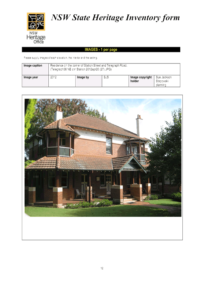
Prior to the commencement of any development or excavation works on site, the Principal Certifying Authority shall be satisfied that an archival report has been submitted to Council’s Heritage Advisor.
The report must consist of an archival standard photographic record of the building (internally and externally), its garden and views of it from the street illustrating its relationship to neighbouring properties and the streetscape. Recording shall be undertaken in accordance with the guidelines for “Photographic Recording of Heritage Items Using Film or Digital Capture (2006)” prepared by the New South Wales Heritage Office.
Information shall be bound in an A4 report format. It shall include copies of photographs, referenced to plans of the site. Two (2) copies (one (1) copy to include negatives or CD of images shall be submitted to Council's Heritage Advisor. The recording document will be held in the local studies collection of Ku-ring-gai Library, the local historical society and Council’s files.
Note: A written acknowledgment from Council must be obtained (attesting to this condition being appropriately satisfied) and submitted to the Principal Certifying Authority prior to the commencement of any works.
Reason: To ensure the proper management of historical artefacts and to ensure their preservation.
14. Dilapidation survey and report (private property)
Prior to the commencement of any demolition or excavation works on site, the Principal Certifying Authority shall be satisfied that a dilapidation report on the visible and structural condition of all structures upon the following lands, has been completed and submitted to Council:
The dilapidation report must include a photographic survey of adjoining properties detailing their physical condition, both internally and externally, including such items as walls ceilings, roof and structural members. The report must be completed by a consulting structural/geotechnical engineer as determined necessary by that professional based on the excavations for the proposal and the recommendations of the submitted geotechnical report.
In the event that access for undertaking the dilapidation survey is denied by a property owner, the applicant must demonstrate in writing to the satisfaction of the Principal Certifying Authority that all reasonable steps have been taken to obtain access and advise the affected property owner of the reason for the survey and that these steps have failed.
Note: A copy of the dilapidation report is to be provided to Council prior to any excavation works been undertaken. The dilapidation report is for record keeping purposes only and may be used by an applicant or affected property owner to assist in any civil action required to resolve any dispute over damage to adjoining properties arising from works.
Reason: To record the structural condition of likely affected properties before works commence.
15. Construction and traffic management plan
The applicant must submit to Council a Construction Traffic Management Plan (TMP), which is to be approved prior to the commencement of any works on site.
The plan is to consist of a report with Traffic Control Plans attached.
The report is to contain commitments which must be followed by the demolition and excavation contractor, builder, owner and subcontractors. The TMP applies to all persons associated with demolition, excavation and construction of the development.
The report is to contain construction vehicle routes for approach and departure to and from all directions.
The report is to contain a site plan showing entry and exit points. Swept paths are to be shown on the site plan showing access and egress for an 12.5 metre long heavy rigid vehicle and 19 metre long articulated vehicle..
The Traffic Control Plans are to be prepared by a qualified person (red card holder). One must be provided for each of the following stages of the works:
· Demolition · Excavation · Concrete pour · Construction of vehicular crossing and reinstatement of footpath · Traffic control for vehicles reversing into or out of the site.
Traffic controllers must be in place at the site entry and exit points to control heavy vehicle movements in order to maintain the safety of pedestrians and other road users.
When a satisfactory TMP is received, a letter of approval will be issued with conditions attached. Traffic management at the site must comply with the approved TMP as well as any conditions in the letter issued by Council. Council’s Rangers will be patrolling the site regularly and fines will be issued for any non-compliance with this condition.
Reason: To ensure that appropriate measures have been considered during all phases of the construction process in a manner that maintains the environmental amenity and ensures the ongoing safety and protection of people.
16. Work zone
If a works zone is proposed, the applicant must make a written application to the Ku-ring-gai Local Traffic Committee to install the work zone. Work zones are provided specifically for the set down and pick up of materials and not for the parking of private vehicles associated with the site. Work zones will generally not be approved where there is sufficient space on-site for the setting down and picking up of goods being taken to or from a construction site.
If the work zone is approved by the Local Traffic Committee, the applicant must obtain a written copy of the related resolution from the Ku-ring-gai Local Traffic Committee and submit this to the Principal Certifying Authority prior to commencement of any works on site.
Where approval of the work zone is resolved by the Committee, the necessary work zone signage shall be installed (at the cost of the applicant) and the adopted fee paid prior to commencement of any works on site. At the expiration of the work zone approval, the applicant is required to remove the work zone signs and reinstate any previous signs at their expense.
In the event the work zone is required for a period beyond that initially approved by the Traffic Committee, the applicant shall make a payment to Council for the extended period in accordance with Council’s schedule of fees and charges for work zones prior to the extended period commencing.
Reason: To ensure that appropriate measures have been made for the operation of the site during the construction phase.
17. Sediment controls
Prior to any work commencing on site, sediment and erosion control measures shall be installed along the contour immediately downslope of any future disturbed areas.
The form of the sediment controls to be installed on the site shall be determined by reference to the Landcom manual ‘Managing Urban Stormwater: Soils and Construction’. The erosion controls shall be maintained in an operational condition until the development activities have been completed and the site fully stabilised. Sediment shall be removed from the sediment controls following each heavy or prolonged rainfall period.
Reason: To preserve and enhance the natural environment.
18. Erosion and drainage management
Earthworks and/or demolition of any existing buildings shall not commence until an erosion and sediment control plan is submitted to and approved by the Principal Certifying Authority. The plan shall comply with the guidelines set out in the NSW Department of Housing manual "Managing Urban Stormwater: Soils and Construction" certificate. Erosion and sediment control works shall be implemented in accordance with the erosion and sediment control plan.
Reason: To preserve and enhance the natural environment.
19. Tree protection fencing
To preserve the following tree/s, no work shall commence until the tree protection zone is fenced off at the specified radius from the trunk/s to prevent any activities, storage or the disposal of materials within the fenced area. The fence/s shall be maintained intact until the completion of all development work on site.
Reason: To protect existing trees during the construction phase.
20. Tree protective fencing type galvanised mesh
The tree protection fencing shall be constructed of galvanised pipe at 2.4 metre spacing and connected by securely attached chain mesh fencing to a minimum height of 1.8 metres in height prior to work commencing.
Reason: To protect existing trees during construction phase.
21. Tree protection signage
Prior to works commencing, tree protection signage is to be attached to each tree protection zone, displayed in a prominent position and the sign repeated at 10 metres intervals or closer where the fence changes direction. Each sign shall contain in a clearly legible form, the following information:
· Tree protection zone/No access · This fence has been installed to prevent damage to the tree/s and their growing environment both above and below ground · The name, address, and telephone number of the developer/builder and project arborist
Reason: To protect existing trees during the construction phase.
22. Tree protection measures inspection
Upon installation of the required tree protection measures, an inspection of the site by the project arborist and/or the Principal Certifying Authority is required to verify that tree protection measures comply with all relevant conditions.
Reason: To protect existing trees during the construction phase.
23. Construction waste management plan
Prior to the commencement of any works, the Principal Certifying Authority shall be satisfied that a waste management plan, prepared by a suitably qualified person, has been prepared in accordance with Council’s Waste Management controls in the Ku-ring-gai Development Control Plan.
The plan shall address all issues identified in DCP 40, including but not limited to: the estimated volume of waste and method for disposal for the construction and operation phases of the development.
Note: The plan shall be provided to the Certifying Authority.
Reason: To ensure appropriate management of construction waste.
24. Noise and vibration management plan
Prior to the commencement of any works, a noise and vibration management plan is to be prepared by a suitably qualified expert addressing the likely noise and vibration from demolition, excavation and construction of the proposed development and provided to the Principal Certifying Authority. The management plan is to identify amelioration measures to achieve the best practice objectives of AS 2436-2010 and NSW Department of Environment and Climate Change Interim Construction Noise Guidelines. The report shall be prepared in consultation with any geotechnical report that itemises equipment to be used for excavation works.
The management plan shall address, but not be limited to, the following matters:
· identification of the specific activities that will be carried out and associated noise sources · identification of all potentially affected sensitive receivers, including residences, churches, commercial premises, schools and properties containing noise sensitive equipment · the construction noise objective specified in the conditions of this consent · the construction vibration criteria specified in the conditions of this consent · determination of appropriate noise and vibration objectives for each identified sensitive receiver · noise and vibration monitoring, reporting and response procedures · assessment of potential noise and vibration from the proposed demolition, excavation and construction activities, including noise from construction vehicles and any traffic diversions · description of specific mitigation treatments, management methods and procedures that will be implemented to control noise and vibration during construction · construction timetabling to minimise noise impacts including time and duration restrictions, respite periods and frequency · procedures for notifying residents of construction activities that are likely to affect their amenity through noise and vibration · contingency plans to be implemented in the event of non-compliances and/or noise complaints
Reason: To protect the amenity afforded to surrounding residents during the construction process.
Conditions to be satisfied prior to the issue of the construction certificate:
25. Basement excavation to be fully tanked
Prior to issue of the Construction Certificate, the PCA is to be satisfied that the basement has been designed as a fully tanked structure as per the requirement of Part 24 C.3(8) of the Ku-ring-gai DCP.
If groundwater is encountered, a referral to the NSW DPI Water is required, due to the need for construction dewatering which would require an aquifer interference approval. All requirements of NSW DPI Water are to be met during design, excavation and construction.
Reason: To protect the environment.
26. Project arborist
A project Arborist shall be commissioned prior to the release of the Construction Certificate to ensure all tree protection measures are carried out in accordance with the conditions of consent.
The project arborist shall have a minimum AQF Level 5 qualification with a minimum of 5 years experience. Details of the arborist including name, business name and contact details shall be provided to the Principal Certifying Authority with a copy to Council.
Reason: To ensure the protection of existing trees
27. Amendments to approved landscape plan
Prior to the issue of a Construction Certificate, the Principal Certifying Authority shall be satisfied that the approved landscape plans, listed below and endorsed with Council’s stamp, have been amended in accordance with the requirements of this condition as well as other conditions of this consent:
The above landscape plan(s) shall be amended in the following ways:
· To minimise impacts on the heritage conservation area the Pittosporum revolutum within the northern side boundary is be replaced with species that will provide a denser screen.
Prior to the issue of the Construction Certificate, the Principal Certifying Authority shall be satisfied that the landscape plan has been amended as required by this condition.
Note: An amended plan, prepared by a landscape architect or qualified landscape designer shall be submitted to the Principal Certifying Authority.
Reason: To ensure adequate landscaping of the site.
28. Long service levy
In accordance with Section 109F(i) of the Environmental Planning and Assessment Act a Construction Certificate shall not be issued until any long service levy payable under Section 34 of the Building and Construction Industry Long Service Payments Act 1986 (or where such levy is payable by instalments, the first instalment of the levy) has been paid. Council is authorised to accept payment. Where payment has been made elsewhere, proof of payment is to be provided to Council.
Reason: Statutory requirement.
29. Builder’s indemnity insurance
The applicant, builder, developer or person who does the work on this development, must arrange builder’s indemnity insurance and submit the certificate of insurance in accordance with the requirements of Part 6 of the Home Building Act 1989 to the Certifying Authority for endorsement of the plans accompanying the Construction Certificate.
It is the responsibility of the applicant, builder or developer to arrange the builder's indemnity insurance for residential building work over the value of $20,000. The builder's indemnity insurance does not apply to commercial or industrial building work or to residential work valued at less than $20,000, nor to work undertaken by persons holding an owner/builder's permit issued by the Department of Fair Trading (unless the owner/builder's property is sold within 7 years of the commencement of the work).
Reason: Statutory requirement.
30. Air drying facilities
Prior to the issue of the Construction Certificate, the Certifying Authority shall be satisfied that a common open space area dedicated for open air drying of clothes is provided. This area is to be located at ground level behind the building line and in a position not visible from the public domain.
In lieu of the above, written confirmation that all units will be provided with internal clothes drying facilities prior to the Occupation Certificate is to be submitted to the Certifying Authority prior to the issue of the Construction Certificate.
Reason: Amenity & energy efficiency.
31. External service pipes and the like prohibited
Proposed water pipes, waste pipes, stack work, duct work, mechanical ventilation plant and the like must be located within the building. Details confirming compliance with this condition must be shown on construction certificate plans and detailed with construction certificate specifications. Required external vents or vent pipes on the roof or above the eaves must be shown on construction certificate plans and detailed with construction certificate specifications. External vents or roof vent pipes must not be visible from any place unless detailed upon development consent plans. Where there is any proposal to fit external service pipes or the like this must be detailed in an amended development (S96) application and submitted to Council for determination.
Vent pipes required by Sydney Water must not be placed on the front elevation of the building or front roof elevation. The applicant, owner and builder must protect the appearance of the building from the public place and the appearance of the streetscape by elimination of all external services excluding vent pipes required by Sydney Water and those detailed upon development consent plans.
Reason: To protect the streetscape and the integrity of the approved development.
32. Access for people with disabilities (residential)
Prior to the issue of the Construction Certificate, the Certifying Authority shall be satisfied that access for people with disabilities to and from and between the public domain, residential units and all common open space areas is provided. Consideration must be given to the means of dignified and equitable access.
Compliant access provisions for people with disabilities shall be clearly shown on the plans submitted with the Construction Certificate. All details shall be provided to the Principal Certifying Authority prior to the issue of the Construction Certificate. All details shall be prepared in consideration of the Disability Discrimination Act, and the relevant provisions of AS1428.1, AS1428.2, AS1428.4 and AS 1735.12.
Reason: To ensure the provision of equitable and dignified access for all people in accordance with disability discrimination legislation and relevant Australian Standards.
33. Adaptable units
Prior to the issue of the Construction Certificate, the Certifying Authority shall be satisfied that the nominated adaptable dwelling within the development application, dwellings 10 and 14, are designed as adaptable housing in accordance with the provisions of Australian Standard AS4299-1995: Adaptable Housing.
Note: Evidence from an appropriately qualified professional demonstrating compliance with this control is to be submitted to and approved by the Certifying Authority prior to the issue of the Construction Certificate.
Reason: Disabled access & amenity.
34. Excavation for services
Prior to the issue of the Construction Certificate, the Principal Certifying Authority shall be satisfied that no proposed underground services (ie: water, sewerage, drainage, gas or other service) unless previously approved by conditions of consent, are located within the canopy spread of any tree protected under Council’s Tree Preservation Order, located on the subject allotment and adjoining allotments.
Alternatively if underground services must be located within the canopy spread of any protected tree/s the plan shall be endorsed by the project arborist outlining any tree protection measures required. A plan detailing the routes of these services and trees protected under Council’s Tree Preservation Order shall be submitted to the Principal Certifying Authority.
Reason: To ensure the protection of trees.
35. Landscape plan
Prior to the issue of the Construction Certificate, the Principal Certifying Authority shall be satisfied that a landscape plan has been completed in accordance with Council’s DA Guide, relevant development control plans and the conditions of consent by a Landscape Architect or qualified Landscape Designer.
Note: The Landscape Plan must be submitted to the Principal Certifying Authority.
Reason: To ensure adequate landscaping of the site.
36. Noise from plant in residential zone
Where any form of mechanical ventilation equipment or other noise generating plant is proposed as part of the development, prior to the issue of the Construction Certificate the Certifying Authority, shall be satisfied that the operation of an individual piece of equipment or operation of equipment in combination will not exceed more than 5dB(A) above the background level during the day when measured at the site’s boundaries and shall not exceed the background level at night (10.00pm –6.00 am) when measured at the boundary of the site.
C1. Note: A certificate from an appropriately qualified acoustic engineer is to be submitted with the Construction Certificate, certifying that all mechanical ventilation equipment or other noise generating plant in isolation or in combination with other plant will comply with the above requirements.
Reason: To comply with best practice standards for residential acoustic amenity.
37. Driveway crossing levels
Prior to issue of the Construction Certificate, driveway and associated footpath levels for any new, reconstructed or extended sections of driveway crossings between the property boundary and road alignment must be obtained from Ku-ring-gai Council. Such levels are only able to be issued by Council under the Roads Act 1993. All footpath crossings, laybacks and driveways are to be constructed according to Council's specifications "Construction of Gutter Crossings and Footpath Crossings".
Specifications are issued with alignment levels after completing the necessary application form at Customer Services and payment of the assessment fee. When completing the request for driveway levels application from Council, the applicant must attach a copy of the relevant development application drawing which indicates the position and proposed level of the proposed driveway at the boundary alignment.
This development consent is for works wholly within the property. Development consent does not imply approval of footpath or driveway levels, materials or location within the road reserve, regardless of whether this information is shown on the development application plans. The grading of such footpaths or driveways outside the property shall comply with Council's standard requirements. The suitability of the grade of such paths or driveways inside the property is the sole responsibility of the applicant and the required alignment levels fixed by Council may impact upon these levels.
The construction of footpaths and driveways outside the property in materials other than those approved by Council is not permitted.
Reason: To provide suitable vehicular access without disruption to pedestrian and vehicular traffic.
38. Basement car parking details
Prior to issue of the Construction Certificate, certified parking layout plan(s) to scale showing all aspects of the vehicle access and accommodation arrangements must be submitted to and approved by the Certifying Authority. A qualified civil/traffic engineer must review the proposed vehicle access and accommodation layout and provide written certification on the plans that:
· all parking space dimensions, driveway and aisle widths, driveway grades, transitions, circulation ramps, blind aisle situations and other trafficked areas comply with Australian Standard 2890.1 - 2004 “Off-street car parking” · a clear height clearance of 2.6 metres is provided over the designated garbage collection truck manoeuvring areas within the basement · no doors or gates are provided in the access driveways to the basement carpark which would prevent unrestricted access for internal garbage collection at any time from the basement garbage storage and collection area · the vehicle access and accommodation arrangements are to be constructed and marked in accordance with the certified plans
Reason: To ensure that parking spaces are in accordance with the approved development.
39. Car parking allocation
Car parking within the development shall be allocated in the following way:
Each adaptable dwelling must be provided with car parking complying with the dimensional and location requirements of AS2890.1 - parking spaces for people with disabilities.
At least one visitor space shall also comply with the dimensional and location requirements of AS2890.1 - parking spaces for people with disabilities.
Consideration must be given to the means of access from disabled car parking spaces to other areas within the building and to footpath and roads and shall be clearly shown on the plans submitted with the Construction Certificate.
Reason: To ensure equity of access and appropriate facilities are available for people with disabilities in accordance with federal legislation.
40. Number of bicycle spaces
The basement car park shall be adapted to provide 5 bicycle spaces in accordance with the DCP. The bicycle parking spaces shall be designed in accordance with AS2890.3. Details shall be submitted to the satisfaction of the Certifying Authority prior to the issue of a Construction Certificate.
Reason: To provide alternative modes of transport to and from the site.
41. Energy Australia requirements
Prior to issue of the Construction Certificate, the applicant must contact Energy Australia regarding power supply for the subject development. A written response detailing the full requirements of Energy Australia (including any need for underground cabling, substations or similar within or in the vicinity the development) shall be submitted to the Principal Certifying Authority for approval prior to issue of the Construction Certificate.
Any structures or other requirements of Energy Australia shall be indicated on the plans issued with the Construction Certificate, to the satisfaction of the Principal Certifying Authority and Energy Australia. The requirements of Energy Australia must be met in full prior to issue of the Occupation Certificate.
Reason: To ensure compliance with the requirements of Energy Australia.
42. Utility provider requirements
Prior to issue of the Construction Certificate, the applicant must make contact with all relevant utility providers whose services will be impacted upon by the development. A written copy of the requirements of each provider, as determined necessary by the Certifying Authority, must be obtained. All utility services or appropriate conduits for the same must be provided by the developer in accordance with the specifications of the utility providers.
Reason: To ensure compliance with the requirements of relevant utility providers.
43. Underground services
All electrical services (existing and proposed) shall be undergrounded from the proposed building on the site to the appropriate power pole(s) or other connection point. Undergrounding of services must not disturb the root system of existing trees and shall be undertaken in accordance with the requirements of the relevant service provided. Documentary evidence that the relevant service provider has been consulted and that their requirements have been met are to be provided to the Certifying Authority prior to the issue of the Construction Certificate. All electrical and telephone services to the subject property must be placed underground and any redundant poles are to be removed at the expense of the applicant.
Reason: To provide infrastructure that facilitates the future improvement of the streetscape by relocation of overhead lines below ground.
Conditions to be satisfied prior to the issue of the construction certificate or prior to demolition, excavation or construction (whichever comes first):
44. Infrastructure damage security bond and inspection fee
To ensure that any damage to Council property as a result of construction activity is rectified in a timely matter:
(a) All work or activity undertaken pursuant to this development consent must be undertaken in a manner to avoid damage to Council property and must not jeopardise the safety of any person using or occupying the adjacent public areas.
(b) The applicant, builder, developer or any person acting in reliance on this consent shall be responsible for making good any damage to Council property and for the removal from Council property of any waste bin, building materials, sediment, silt, or any other material or article.
(c) The Infrastructure damage security bond and infrastructure inspection fee must be paid to Council by the applicant prior to both the issue of the Construction Certificate and the commencement of any earthworks or construction.
(d) In consideration of payment of the infrastructure damage security bond and infrastructure inspection fee, Council will undertake such inspections of Council Property as Council considers necessary and will also undertake, on behalf of the applicant, such restoration work to Council property, if any, that Council considers necessary as a consequence of the development. The provision of such restoration work by the Council does not absolve any person of the responsibilities contained in (a) to (b) above. Restoration work to be undertaken by Council referred to in this condition is limited to work that can be undertaken by Council at a cost of not more than the Infrastructure damage security bond payable pursuant to this condition.
(e) In this condition:
“Council property” includes any road, footway, footpath paving, kerbing, guttering, crossings, street furniture, seats, letter bins, trees, shrubs, lawns, mounds, bushland, and similar structures or features on any road or public road within the meaning of the Local Government Act 1993 (NSW) or any public place; and
“Infrastructure damage security bond and infrastructure inspection fee” means the Infrastructure damage security bond and infrastructure inspection fee as calculated in accordance with the Schedule of Fees & Charges adopted by Council as at the date of payment and the cost of any inspections required by the Council of Council property associated with this condition.
Reason: To maintain public infrastructure.
45. Section 94 development contributions - other than identified centres
This development is subject to a development contribution calculated in accordance with Ku-ring-gai Contributions Plan 2010, being a s94 Contributions Plan in effect under the Environmental Planning and Assessment Act, as follows:
The contribution shall be paid to Council prior to the issue of any Construction Certificate, Linen Plan, Certificate of Subdivision or Occupation Certificate whichever comes first in accordance with Ku-ring-gai Contributions Plan 2010.
The contributions specified above are subject to indexation and may vary at the time of payment in accordance with Ku-ring-gai Contributions Plan 2010 to reflect changes in the consumer price index and housing price index. Prior to payment, please contact Council directly to verify the current payable contributions.
Copies of Council’s Contribution Plans can be viewed at Council Chambers, 818 Pacific Hwy Gordon or on Council’s website at www.kmc.nsw.gov.au.
Contributions outside the designated centres may be subject to a maximum contribution total in accordance with the s94E Direction issued by the Minister for Planning dated 21 August 2012, for so long as it remains legally in force. If the total amount above is an exact multiple of $20,000 then the contributions calculated in accordance with Ku-ring-gai Contributions Plan 2010 exceeded the maximum contribution payable and have been capped. If the process of inflation carries the contribution above over the maximum amount permitted by the s94E Direction prior to payment, the amount will be limited at time of receipt. Please contact Council to verify the total contributions payable prior to payment.
Reason: To ensure the provision, extension or augmentation of the Key Community Infrastructure identified in Ku-ring-gai Contributions Plan 2010 that will, or is likely to be, required as a consequence of the development.
Conditions to be satisfied during the demolition, excavation and construction phases:
46. Road opening permit
The opening of any footway, roadway, road shoulder or any part of the road reserve shall not be carried out without a road opening permit being obtained from Council (upon payment of the required fee) beforehand.
Reason: Statutory requirement (Roads Act 1993 Section 138) and to maintain the integrity of Council’s infrastructure.
47. Prescribed conditions
The applicant shall comply with any relevant prescribed conditions of development consent under clause 98 of the Environmental Planning and Assessment Regulation. For the purposes of section 80A (11) of the Environmental Planning and Assessment Act, the following conditions are prescribed in relation to a development consent for development that involves any building work:
· The work must be carried out in accordance with the requirements of the Building Code of Australia · In the case of residential building work for which the Home Building Act 1989 requires there to be a contract of insurance in force in accordance with Part 6 of that Act, that such a contract of insurance is in force before any works commence.
Reason: Statutory requirement.
48. Hours of work
Demolition, construction work and deliveries of building material and equipment must not take place outside the hours of 7.00am to 5.00pm Monday to Friday and 8.00am to 12 noon Saturday. No work and no deliveries are to take place on Sundays and public holidays.
Excavation using machinery must be limited to between 7.00am and 5.00pm Monday to Friday, with a respite break of 45 minutes between 12 noon and 1.00pm. No excavation using machinery is to occur on Saturdays, Sundays or public holidays.
Where it is necessary for works to occur outside of these hours (ie) placement of concrete for large floor areas on large residential/commercial developments or where building processes require the use of oversized trucks and/or cranes that are restricted by the RTA from travelling during daylight hours to deliver, erect or remove machinery, tower cranes, pre-cast panels, beams, tanks or service equipment to or from the site, approval for such activities will be subject to the issue of an "outside of hours works permit" from Council as well as notification of the surrounding properties likely to be affected by the proposed works.
Note: Failure to obtain a permit to work outside of the approved hours will result in on the spot fines being issued.
Reason: To ensure reasonable standards of amenity for occupants of neighbouring properties.
49. Visitable dwellings
Plans demonstrating compliance with Council's visitable housing requirements contained within Part 23.1 of KDCP 2015 are to be submitted to the satisfaction of the Principal Certifying Authority, prior to issue of the Construction Certificate.
A visitable dwelling is a dwelling that can be accessed by people who use wheelchairs in that there must be at least one accessible entry and accessible path of travel to the living area and to a toilet that is either accessible or visitable as defined by AS 4299.
At least 70% of dwellings within the development must be visitable.
Reason: To ensure that the minimum number of visitable dwellings is provided within the development.
50. Approved plans to be on site
A copy of all approved and certified plans, specifications and documents incorporating conditions of consent and certification (including the Construction Certificate if required for the work) shall be kept on site at all times during the demolition, excavation and construction phases and must be readily available to any officer of Council or the Principal Certifying Authority.
Reason: To ensure that the development is in accordance with the determination.
51. Statement of compliance with Australian Standards
The demolition work shall comply with the provisions of Australian Standard AS2601: 2001 The Demolition of Structures. The work plans required by AS2601: 2001 shall be accompanied by a written statement from a suitably qualified person that the proposal contained in the work plan comply with the safety requirements of the Standard. The work plan and the statement of compliance shall be submitted to the satisfaction of the Principal Certifying Authority prior to the commencement of any works.
Reason: To ensure compliance with the Australian Standards.
52. Construction noise
During excavation, demolition and construction phases, noise generated from the site shall be controlled in accordance with the recommendations of the approved noise and vibration management plan.
Reason: To ensure reasonable standards of amenity to neighbouring properties.
53. Site notice
A site notice shall be erected on the site prior to any work commencing and shall be displayed throughout the works period.
The site notice must:
· be prominently displayed at the boundaries of the site for the purposes of informing the public that unauthorised entry to the site is not permitted · display project details including, but not limited to the details of the builder, Principal Certifying Authority and structural engineer · be durable and weatherproof · display the approved hours of work, the name of the site/project manager, the responsible managing company (if any), its address and 24 hour contact phone number for any inquiries, including construction/noise complaint are to be displayed on the site notice · be mounted at eye level on the perimeter hoardings/fencing and is to state that unauthorised entry to the site is not permitted
Reason: To ensure public safety and public information.
54. Dust control
During excavation, demolition and construction, adequate measures shall be taken to prevent dust from affecting the amenity of the neighbourhood. The following measures must be adopted:
· physical barriers shall be erected at right angles to the prevailing wind direction or shall be placed around or over dust sources to prevent wind or activity from generating dust · earthworks and scheduling activities shall be managed to coincide with the next stage of development to minimise the amount of time the site is left cut or exposed · all materials shall be stored or stockpiled at the best locations · the ground surface should be dampened slightly to prevent dust from becoming airborne but should not be wet to the extent that run-off occurs · all vehicles carrying spoil or rubble to or from the site shall at all times be covered to prevent the escape of dust · all equipment wheels shall be washed before exiting the site using manual or automated sprayers and drive-through washing bays · gates shall be closed between vehicle movements and shall be fitted with shade cloth · cleaning of footpaths and roadways shall be carried out daily
Reason: To protect the environment and amenity of surrounding properties.
55. Post-construction dilapidation report
The applicant shall engage a suitably qualified person to prepare a post construction dilapidation report at the completion of the construction works. This report is to ascertain whether the construction works created any structural damage to adjoining buildings, infrastructure and roads. The report is to be submitted to the Principal Certifying Authority. In ascertaining whether adverse structural damage has occurred to adjoining buildings, infrastructure and roads, the Principal Certifying Authority must:
· compare the post-construction dilapidation report with the pre-construction dilapidation report · have written confirmation from the relevant authority that there is no adverse structural damage to their infrastructure and roads.
A copy of this report is to be forwarded to Council at the completion of the construction works.
Reason: Management of records.
56. Compliance with submitted geotechnical report
A contractor with specialist excavation experience must undertake the excavations for the development and a suitably qualified and consulting geotechnical engineer must oversee excavation.
Geotechnical aspects of the development work, namely:
· appropriate excavation method and vibration control · support and retention of excavated faces · hydro-geological considerations
must be undertaken in accordance with the recommendations of the Geotechnical Investigation Report prepared by JK Geotechnics dated 29 February 2016 and Groundwater Modelling Report prepared by JK Geotechnics dated 4 August 2016. Approval must be obtained from all affected property owners, including Ku-ring-gai Council, where rock anchors (both temporary and permanent) are proposed below adjoining property(ies).
Reason: To ensure the safety and protection of property.
57. Use of road or footpath
During excavation, demolition and construction phases, no building materials, plant or the like are to be stored on the road or footpath without written approval being obtained from Council beforehand. The pathway shall be kept in a clean, tidy and safe condition during building operations. Council reserves the right, without notice, to rectify any such breach and to charge the cost against the applicant/owner/builder, as the case may be.
Reason: To ensure safety and amenity of the area.
58. Toilet facilities
During excavation, demolition and construction phases, toilet facilities are to be provided, on the work site, at the rate of one toilet for every 20 persons or part of 20 persons employed at the site.
Reason: Statutory requirement.
59. Recycling of building material (general)
During demolition and construction, the Principal Certifying Authority shall be satisfied that building materials suitable for recycling have been forwarded to an appropriate registered business dealing in recycling of materials. Materials to be recycled must be kept in good order.
Reason: To facilitate recycling of materials.
60. Road reserve safety
All public footways and roadways fronting and adjacent to the site must be maintained in a safe condition at all times during the course of the development works. Construction materials must not be stored in the road reserve. A safe pedestrian circulation route and a pavement/route free of trip hazards must be maintained at all times on or adjacent to any public access ways fronting the construction site. Where public infrastructure is damaged, repair works must be carried out when and as directed by Council officers. Where pedestrian circulation is diverted on to the roadway or verge areas, clear directional signage and protective barricades must be installed in accordance with AS1742-3 (1996) “Traffic Control Devices for Work on Roads”. If pedestrian circulation is not satisfactorily maintained across the site frontage, and action is not taken promptly to rectify the defects, Council may undertake proceedings to stop work.
Reason: To ensure safe public footways and roadways during construction.
61. Services
Where required, the adjustment or inclusion of any new utility service facilities must be carried out by the applicant and in accordance with the requirements of the relevant utility authority. These works shall be at no cost to Council. It is the applicants’ full responsibility to make contact with the relevant utility authorities to ascertain the impacts of the proposal upon utility services (including water, phone, gas and the like). Council accepts no responsibility for any matter arising from its approval to this application involving any influence upon utility services provided by another authority.
Reason: Provision of utility services.
62. Erosion control
Temporary sediment and erosion control and measures are to be installed prior to the commencement of any works on the site. These measures must be maintained in working order during construction works up to completion. All sediment traps must be cleared on a regular basis and after each major storm and/or as directed by the Principal Certifying Authority and Council officers.
Reason: To protect the environment from erosion and sedimentation.
63. Sydney Water Section 73 Compliance Certificate
The applicant must obtain a Section 73 Compliance Certificate under the Sydney Water Act 1994. An application must be made through an authorised Water Servicing CoOrdinator. The applicant is to refer to “Your Business” section of Sydney Water’s web site at www.sydneywater.com.au then the “e-develop” icon or telephone 13 20 92. Following application a “Notice of Requirements” will detail water and sewer extensions to be built and charges to be paid. Please make early contact with the CoOrdinator, since building of water/sewer extensions can be time consuming and may impact on other services and building, driveway or landscape design.
Reason: Statutory requirement.
64. Arborist’s report
The tree/s to be retained shall be inspected and monitored by an AQF Level 5 Arborist in accordance with AS4970-2009 during and after completion of development works to ensure their long term survival. Regular inspections and documentation from the project arborist to the Principal Certifying Authority are required at the following times or phases of work including date, brief description of the works inspected, and any mitigation works prescribed.
All monitoring shall be provided to the Principal Certifying Authority prior to issue of the Occupation Certificate.
All works as recommended by the project arborist are to be undertaken by an experienced arborist with a minimum AQF Level 3 qualification.
Reason: To ensure protection of existing trees.
65. Treatment of tree roots
If tree roots and branches are required to be severed for the purposes of constructing the approved works, they shall be cut cleanly by hand, by an experienced Arborist/Horticulturist with a minimum AQF Level 3 qualification. All root and branch pruning works shall be undertaken as specified in AS 4373-2007 - Pruning of Amenity Trees.
Reason: To protect existing trees.
66. Cutting of tree roots
Tree roots of 50mm or greater in diameter located within the specified radius of the trunk/s of the following tree/s shall not be severed or injured in the process of any works during the construction period. All root pruning works shall be undertaken by an experienced Arborist/Horticulturist, with a minimum AQF Level 3 qualification as specified in AS 4373-2007 - Pruning of Amenity Trees:
Reason: To protect existing trees.
67. Approved tree works
Prior to works commencing the following works shall be undertaken to the specified trees;
All trees are to be clearly tagged and identified as per the arborist report prior to the removal/pruning of any tree/s on site.
Removal or pruning of any other tree on the site is not approved, excluding species and works exempt under Council’s Tree Preservation Order.
Reason: To ensure that the development is in accordance with the determination.
68. Excavation near trees
No mechanical excavation shall be undertaken within the specified radius of the trunk/s of the following tree/s until root pruning is carried out by hand digging and/or air knife to a depth of 600 mm along the perimeter line of such works:
Reason: To protect existing trees.
69. Hand excavation for stormwater works
All excavation within the specified radius of the trunk/s of the following tree/s shall be carried out by hand digging and/or using an air knife.
Reason: To protect existing trees.
70. No storage of materials beneath trees
No activities, storage or disposal of materials shall take place beneath the canopy of any tree protected under Council's Tree Preservation Order at any time.
Reason: To protect existing trees.
71. Removal of refuse
All builders' refuse, spoil and/or material unsuitable for use in landscape areas shall be removed from the site on completion of the building works.
Reason: To protect the environment.
72. Canopy replenishment trees to be planted
The canopy replenishment trees to be planted shall be maintained in a healthy and vigorous condition until they attain a height of 5.0 metres whereby they will be protected by Council’s Tree Preservation Order. Any of the trees found faulty, damaged, dying or dead shall be replaced with the same species.
Reason: To maintain the treed character of the area.
73. Survey and inspection of waste collection clearance and path of travel
At the stage when formwork for the ground floor slab is in place and prior to concrete being poured, a registered surveyor is to:
· ascertain the reduced level of the underside of the slab at the driveway entry, · certify that the level is not lower than the level shown on the approved DA plans; and · certify that the minimum headroom of 2.6 metres will be available for the full path of travel of the small waste collection vehicle from the street to the collection area. This certification is to be provided to Council’s Development Engineer prior to any concrete being poured for the ground floor slab. · no work is to proceed until Council has undertaken an inspection to determine clearance and path of travel.
At the stage when formwork for the ground floor slab is in place and prior to concrete being poured, Council’s Development Engineer and Manager Waste Services are to carry out an inspection of the site to confirm the clearance available for the full path of travel of the small waste collection vehicle from the street to the collection area. This inspection may not be carried out by a private certifier because waste management is not a matter listed in Clause 161 of the Environmental Planning and Assessment Regulation 2000.
Reason: To ensure access will be available for Council’s contractors to collect waste from the collection point.
74. On site retention of waste dockets
All demolition, excavation and construction waste dockets are to be retained on site, or at suitable location, in order to confirm which facility received materials generated from the site for recycling or disposal.
· Each docket is to be an official receipt from a facility authorised to accept the material type, for disposal or processing. · This information is to be made available at the request of an Authorised Officer of Council.
Reason: To protect the environment.
Conditions to be satisfied prior to the issue of an Occupation Certificate:
75. Easement for waste collection
Prior to issue of the Occupation Certificate, an easement for waste collection is to be created under Section 88B of the Conveyancing Act 1919. This is to permit legal access for Council, Council’s contractors and their vehicles over the subject property for the purpose of collecting waste from the property. The terms of the easement are to be generally in accordance with Council’s draft terms for an easement for waste collection and shall be to the satisfaction of Council’s Development Engineer.
Reason: To permit legal access for Council, Council’s contractors and their vehicles over the subject site for waste collection.
76. Compliance with BASIX Certificate
Prior to the issue of an Occupation Certificate, the Principal Certifying Authority shall be satisfied that all commitments listed in BASIX Certificate No. 715243M_02 have been complied with.
Reason: Statutory requirement.
77. Completion of landscape works
Prior to the release of the Occupation Certificate, the Principal Certifying Authority is to be satisfied that all landscape works, including the removal of all noxious and/or environmental weed species, have been undertaken in accordance with the approved plan(s) and conditions of consent.
Reason: To ensure that the landscape works are consistent with the development consent.
78. Retention and re-use positive covenant
Prior to issue of the Occupation Certificate, the applicant must create a positive covenant and restriction on the use of land under Section 88E of the Conveyancing Act 1919, burdening the property with the requirement to maintain the site stormwater retention and re-use facilities on the property.
The terms of the instruments are to be generally in accordance with the Council's "draft terms of Section 88B instruments for protection of retention and re-use facilities" and to the satisfaction of Council (refer to Ku-ring-gai DCP Part 25R.9.2). For existing titles, the positive covenant and the restriction on the use of land is to be created through an application to the Land Titles Office in the form of a request using forms 13PC and 13RPA. The relative location of the reuse and retention facility, in relation to the building footprint, must be shown on a scale sketch, attached as an annexure to the request forms.
Registered title documents showing the covenants and restrictions must be submitted to and approved by the Principal Certifying Authority prior to issue of an Occupation Certificate.
Reason: To protect the environment.
79. Certification of drainage works
Prior to issue of the Occupation Certificate, the Principal Certifying Authority is to be satisfied that:
· the stormwater drainage works have been satisfactorily completed in accordance with the approved Construction Certificate drainage plans · the minimum retention and on-site detention storage volume requirements of BASIX and Ku-ring-gai DCP Part 25B.5 respectively, have been achieved · retained water is connected and available for use · all grates potentially accessible by children are secured · components of the new drainage system have been installed by a licensed plumbing contractor in accordance with the Plumbing and Drainage Code AS3500.3 2003 and the Building Code of Australia · all enclosed floor areas, including habitable and garage floor levels, are safeguarded from outside stormwater runoff ingress by suitable differences in finished levels, gradings and provision of stormwater collection devices
Note: Evidence from a qualified and experienced consulting civil/hydraulic engineer documenting compliance with the above is to be provided to Council prior to the issue of an Occupation Certificate.
Reason: To protect the environment.
80. WAE plans for stormwater management and disposal
Prior to issue of the Occupation Certificate, a registered surveyor must provide a works as executed survey of the completed stormwater drainage and management systems. The survey must be submitted to and approved by the Principal Certifying Authority prior to issue of the Occupation Certificate. The survey must indicate:
· as built (reduced) surface and invert levels for all drainage pits · gradients of drainage lines, materials and dimensions · as built (reduced) level(s) at the approved point of discharge to the public drainage system · as built location and internal dimensions of all detention and retention structures on the property (in plan view) and horizontal distances to nearest adjacent boundaries and structures on site · the achieved storage volumes of the installed retention and detention storages and derivative calculations · as built locations of all access pits and grates in the detention and retention system(s), including dimensions · the size of the orifice or control fitted to any on-site detention system · dimensions of the discharge control pit and access grates · the maximum depth of storage possible over the outlet control · top water levels of storage areas and indicative RL’s through the overland flow path in the event of blockage of the on-site detention system
The works as executed plan(s) must show the as built details above in comparison to those shown on the drainage plans approved with the Construction Certificate prior to commencement of works. All relevant levels and details indicated must be marked in red on a copy of the Principal Certifying Authority stamped construction certificate stormwater plans.
Reason: To protect the environment.
81. Basement pump-out maintenance
Prior to issue of the Occupation Certificate, the Principal Certifying Authority shall be satisfied that a maintenance regime has been prepared for the basement stormwater pump-out system.
Note: A maintenance regime specifying that the system is to be regularly inspected and checked by qualified practitioners is to be prepared by a suitable qualified professional and provided to the Principal Certifying Authority.
Reason: To protect the environment.
82. OSD positive covenant/restriction
Prior to issue of the Occupation Certificate, the applicant must create a positive covenant and restriction on the use of land under Section 88E of the Conveyancing Act 1919, burdening the owner with the requirement to maintain the on-site stormwater detention facilities on the lot.
The terms of the instruments are to be generally in accordance with the Council's "draft terms of Section 88B instrument for protection of on-site detention facilities" and to the satisfaction of Council (refer to Ku-ring-gai DCP Part 25R.9.1). For existing titles, the positive covenant and the restriction on the use of land is to be created through an application to the Land Titles Office in the form of a request using forms 13PC and 13RPA. The relative location of the on-site detention facility, in relation to the building footprint, must be shown on a scale sketch, attached as an annexure to the request forms.
Registered title documents, showing the covenants and restrictions, must be submitted and approved by the Principal Certifying Authority prior to issue of an Occupation Certificate.
Reason: To protect the environment.
83. Easement drainage line construction
Prior to issue of the Occupation Certificate, the Principal Certifying Authority shall be satisfied that the required interallotment drainage system has been installed and surveyed under the supervision of a designing engineer or equivalent professional.
Note: At the completion of the interallotment works, the following must be submitted to the Principal Certifying Authority for approval:
· details from the supervising engineer that that the as-constructed works comply with the approved interallotment design documentation · a full works as executed drawing of the as built interallotment drainage line (dimensions, grades, materials, invert levels) prepared by a registered surveyor, and details from the surveyor that all drainage structures are wholly contained within existing drainage easement(s)
Reason: To protect the environment.
84. Sydney Water Section 73 Compliance Certificate
Prior to issue of an Occupation Certificate the Section 73 Sydney water Compliance Certificate must be obtained and submitted to the Principal Certifying Authority
Reason: Statutory requirement.
85. Reinstatement of redundant crossings and completion of infrastructure works
Prior to issue of the Occupation Certificate, the Principal Certifying Authority must be satisfied that he or she has received a signed inspection form from Council which states that the following works in the road reserve have been completed:
· new concrete driveway crossing in accordance with levels and specifications issued by Council · removal of all redundant driveway crossings and kerb laybacks (or sections thereof) and reinstatement of these areas to footpath, turfed verge and upright kerb and gutter (reinstatement works to match surrounding adjacent infrastructure with respect to integration of levels and materials) · full repair and resealing of any road surface damaged during construction · full replacement of damaged sections of grass verge to match existing
This inspection may not be carried out by the Private Certifier because restoration of Council property outside the boundary of the site is not a matter listed in Clause 161 of the Environmental Planning and Assessment Regulation 2000.
All works must be completed in accordance with the General Specification for the Construction of Road and Drainage Works in Ku-ring-gai Council, dated November 2004. The Occupation Certificate must not be issued until all damaged public infrastructure caused as a result of construction works on the subject site (including damage caused by, but not limited to, delivery vehicles, waste collection, contractors, sub contractors, concrete vehicles) is fully repaired to the satisfaction of Council. Repair works shall be at no cost to Council.
Reason: To protect the streetscape.
86. Infrastructure repair
Prior to issue of the Occupation Certificate, the Principal Certifying Authority must be satisfied that any damaged public infrastructure caused as a result of construction works (including damage caused by, but not limited to, delivery vehicles, waste collection, contractors, sub contractors, concrete vehicles) is fully repaired to the satisfaction of Council Development Engineer and at no cost to Council.
Reason: To protect public infrastructure.
87. Mechanical ventilation
Prior to the issue of the Occupation Certificate, the Principal Certifying Authority shall be satisfied that all mechanical ventilation systems are installed in accordance with Part F4.5 of the Building Code of Australia and comply with Australian Standards AS1668.2 and AS3666 Microbial Control of Air Handling and Water Systems of Building.
Reason: To ensure adequate levels of health and amenity to the occupants of the building.
88. Fire safety certificate
Prior to the issue of the Occupation Certificate, the Principal Certifying Authority shall be satisfied that a Fire Safety Certificate for all the essential fire or other safety measures forming part of this consent has been completed and provided to Council.
Note: A copy of the Fire Safety Certificate must be submitted to Council.
Reason: To ensure suitable fire safety measures are in place.
Conditions to be satisfied at all times:
89. Outdoor lighting
At all times for the life of the approved development, all outdoor lighting shall not detrimentally impact upon the amenity of other premises and adjacent dwellings and shall comply with, where relevant, AS/NZ1158.3: 2005 Pedestrian Area (Category P) Lighting and AS4282: 1997 Control of the Obtrusive Effects of Outdoor Lighting.
Reason: To protect the amenity of surrounding properties.
90. Noise control – plant and machinery
All noise generating equipment associated with any proposed mechanical ventilation system/s shall be located and/or soundproofed so the equipment is not audible within a habitable room in any other residential premises before 7am and after 10pm Monday to Friday and before 8am and after 10pm Saturday, Sunday and public holidays. The operation of the unit outside these restricted hours shall emit a noise level of not greater than 5dbA above the background when measured at the nearest boundary.
Reason: To protect the amenity of surrounding residents.
91. Annual fire safety statement
Each 12 months after the installation of essential fire or other safety measures, the owner of a building must cause the Council to be given an Annual Fire Safety Statement for the building. In addition a copy of the statement must be given to the NSW Fire Commissioner and a copy displayed prominently in the building.
Reason: To ensure statutory maintenance of essential fire safety measures.
CARRIED UNANIMOUSLY
The above Resolution was CARRIED as an Amendment to the
Original Motion. The Original Motion was: (Moved: Councillors Malicki/McDonald)
A. That the matter be deferred for a site inspection.
B. That the matter be determined under delegation by the Mayor, Deputy Mayor, General Manager and Ward Councillors.
|
Standing Orders were suspended to deal with item GB.1
as the last item
on the Agenda after a
Motion moved by Councillors Ossip and Malicki
was CARRIED UNANIMOUSLY
|
315 |
Taldumande Youth Services 2017 Charity Dinner
File: CY00043/8 Vide: GB.7
|
|
|
To inform Councillors of the Taldumande Youth Services 2017 Charity Dinner being held on 22 March 2017 at Luna Park, Sydney.
|
|
|
Resolved:
(Moved: Councillor Anderson/Fornari-Orsmond)
That Councillors notify the General Manager if they wish to purchase a ticket to attend the 2017 Taldumande Youth Services Charity Dinner.
For the Resolution: The Mayor, Councillor Anderson, Councillors , McDonald, Fornari-Orsmond and Ossip
Against the Resolution: Councillors Pettett, Malicki, Berlioz and Szatow
The voting being EQUAL, the Mayor exercised her Casting Vote IN FAVOUR of the Resolution
The above Resolution was CARRIED as a Foreshadowed Motion to the Original Motion. The Original Motion was:
That Council does not purchase tickets for the 2017 Taldumande Youth Services 2017 Charity Dinner.
For the Motion: Councillors Pettett, Malicki, Berlioz and Szatow
Against the Motion: The Mayor, Councillor Anderson, Councillors McDonald, Fornari-Orsmond and Ossip
The voting being EQUAL, the Mayor exercised her Casting Vote AGAINST the Motion
|
Councillor Ossip withdrew during discussion
Councillor Ossip returned
|
316 |
Gordon Hub Master Plan - Update
File: S10376 Vide: GB.10
|
|
|
To seek Council approval to re-commence the master planning process for a Cultural Hub in Gordon.
|
|
|
Resolved:
(Moved: Councillors Fornari-Orsmond/Ossip)
That:
A. Council resolves to re-commence the master planning process for Cultural Hub in Gordon.
B. Council prepare illustrative master plan options for public exhibition in the first half of 2017.
C. That following public exhibition of the master plan options the results are reported to Council recommending a preferred option.
D. A Planning Proposal is to be prepared, in accordance with section 55 of the Environmental Planning and Assessment Act, 1979, to reclassify Lot A in DP355615 and Lots C and D in DP 386283, known as 9, 15 & 17 Dumaresq Street, Gordon from Community land to Operational land.
E. Council formally seeks to discharge all necessary interests for Lot A in DP 355615 and Lots C and D in DP 386283, known as 9, 15 & 17 Dumaresq Street, Gordon.
F. The Planning Proposal be submitted to the Department of Planning and Environment for a Gateway Determination in accordance with Section 56 of the Environmental Planning and Assessment Act, 1979.
G. Upon receipt of the Gateway Determination, the exhibition and consultation process is carried out in accordance with the requirements of the Environmental Planning and Assessment Act, 1979 and with the Gateway Determination requirements.
H. Council undertakes a public hearing under the provisions of the Local Government Act, 1993 for the proposed reclassification of Lot A in DP355615 and Lots C and D in DP 386283, known as 9, 15 and 17 Dumaresq Street, Gordon from Community land to Operational Land.
I. A report is to be brought back to Council at the end of the exhibition and public hearing process.
For the Resolution: The Mayor, Councillor Anderson, Councillors , McDonald, Pettett, Fornari-Orsmond and Ossip
Against the Resolution: Councillors Malicki, Berlioz and Szatow
The above Resolution was subject to an Amendment which was LOST. The Lost Amendment was:
That:
A. Council resolves to re-commence the master planning process for Cultural Hub in Gordon involving local residents.
B. Council prepare illustrative master plan options for public exhibition in the first half of 2017.
C. A further report outlining the options be brought back to Council prior to the exhibition period in part B above.
D. Until the illustrative master plan options have been reported to Council and ratified, Council does not reclassify Lot A in DP355615 and Lots C and D in DP 386283, known as 9, 15 & 17 Dumaresq Street, Gordon from Community land to Operational land.
E. Council does not sell of any of our assets in order to fund a cultural hub in Gordon.
F. A tour of cultural and civic facilities around Sydney be organised for Councillors.
For the Amendment: Councillors McDonald, Malicki, Berlioz and Szatow
Against the Amendment: The Mayor, Councillor Anderson, Councillors Pettett, Fornari-Orsmond and Ossip
The voting being EQUAL, the Mayor exercised her Casting Vote AGAINST the Amendment
During debate Councillors Fornari-Orsmond/Ossip moved that the Motion be Put as there had been 2 speakers For and 2 Against which was carried UNANIMOUSLY
|
Council resolved
that the meeting be closed during the discussion of the matter GB.1
2016 Ku-ring-gai Community Grants Program in accordance with section
10A(2)(g) of the Local Government Act 1993 on the basis that the item involves
the receipt and discussion of information that would be privileged from
production in legal proceedings on the grounds of legal professional privilege.
This resolution was moved by Councillors Ossip and Fornari-Orsmond and was
CARRIED UNANIMOUSLY
Council resolved
to return to Open Council
after a Motion moved by Councillors Szatow and Ossip
was CARRIED UNANIMOUSLY
A Motion moved by
Councillors Ossip and McDonald
that voting on the following Item -
GB.1 - 2016 Ku-ring-gai Community Grants Program
be in seriatum
For the Motion: The Mayor, Councillor Anderson, Councillors , McDonald, Pettett, Fornari-Orsmond and Ossip
Against the Motion: Councillors Malicki, Berlioz and Szatow
|
317 |
2016 Ku-ring-gai Community Grants Program
File: FY00430/8 Vide: GB.1
|
|||||||||||||||||||||||||||||||||||||||||||||||||||||||||||||||||||||||||||||||||||||||||||||||||||||||||||||||||||||||||||||||||||||||||||||||||||||||||||||||
|
|
To advise Council of applications received from community groups for the 2016 Ku-ring-gai Community Grants program, and to recommend subsequent funding allocations.
|
|||||||||||||||||||||||||||||||||||||||||||||||||||||||||||||||||||||||||||||||||||||||||||||||||||||||||||||||||||||||||||||||||||||||||||||||||||||||||||||||
|
|
Resolved:
(Moved: Councillors Ossip/McDonald)
A. That all community and cultural groups (with the exception of Blaxland and Daughter, together with St Ives Progress Association) be granted.
1. Category: Small Equipment
*not including St Ives Progress Association, which will be determined in Resolution C.
2. Category: Community Development
3. Category: Arts/Cultural
*not including Blaxland and Daughter, which will be determined in Resolution B.
D. That $8,800 of unspent returned funds from the 2015 Ku-ring-gai Community Grants program be included in the 2016 Community Grants program for distribution to community groups.
Resolution A and D were CARRIED UNANIMOUSLY
B. That Blaxland and Daughter receive the recommended amount of $3000.
For the Resolution: The Mayor, Councillor Anderson, Councillors , McDonald, Berlioz, Szatow, Fornari-Orsmond and Ossip
Against the Resolution: Councillors Pettett and Malicki
Resolution B was CARRIED
C. That St Ives Progress Association receive the recommended amount of $2000.
For the Resolution: The Mayor, Councillor Anderson, Councillors , Malicki and Berlioz
Against the Resolution: Councillors McDonald, Pettett, Szatow, Fornari-Orsmond and Ossip
No decision was taken in respect Resolution C as the Motion when put to the vote was LOST |
QUESTIONS WITHOUT NOTICE
|
318 |
Taldumande Youth Services 2017 Charity Dinner
File: CY00043/8 Vide: QN.1
|
|
|
Question Without Notice from Councillor Elaine Malicki
How did the Taldumande Youth Services 2017 Charity Dinner request come Council, that is, how was it raised with staff?
Answered by the Mayor, Councillor Jennifer Anderson
The Mayor advised that she received an invitation by email and forwarded it to staff to be brought before Council.
|
The Meeting closed at 10:07 pm
The Minutes of the Ordinary Meeting of Council held on 22 November 2016 (Pages 1 - 4) were confirmed as a full and accurate record of proceedings on 6 December 2016.
__________________________ __________________________
General Manager Mayor / Chairperson
|
Ordinary Meeting of Council - 6 December 2016 |
GB.1 / 55 |
|
|
|
|
Item GB.1 |
S02621 |
|
|
14 November 2016 |
St Ives Showground New Inclusive Playground and Golden Grove Inclusive Playground Upgrade
EXECUTIVE SUMMARY
Purpose of Report
To seek Council's endorsement of the final concept designs for the inclusive playgrounds at Council’s Regional Parks - St Ives Showground at Picnic Area 7 and at Ku-ring-gai Bicentennial Park at Golden Grove and proceed to document for tender.
Background
St Ives Showground Precinct and Ku-ring-gai Bicentennial Park are Council’s two Regional Parks in the Open Space classification hierarchy. Regional parks are defined as large public reserves that provide multiple recreation opportunities and attract out-of-area visitors. They are associated with unique attractions, e.g. a showground, visitors centre, aquatic centre.
Regional parks are able to accommodate large numbers of visitors and have the potential to cater for visitors to annual special events and festivals. The regional parks are managed under an adopted Plan of Management for each site in the Ku-ring-gai Council Local Government Area (LGA).
· Ku-ring-gai Bicentennial Park, Plan of Management adopted 20 September 2011;
· St Ives Showground and Precinct Lands Plan of Management adopted 26 May 2015.
Both adopted Plans of Management support the works that are contained in the attached playground upgrade concept plans. The Showground playground at Picnic Area 7 is identified for replacement “Upgrade existing main playground to Regional play space” and Golden Grove playground is part of the prioritised program of capital improvements that will maximise capacity and potential of the site and identified as “Refurbish and embellish existing assets to a routine prioritised program”. This program is part of the adopted Integrated Planning and Reporting Framework.
At the OMC of 19 July 2016, a Notice of Motion (NOM) was adopted by Council for Inclusive Playgrounds:
“That Council:
A. Ensure that new major playgrounds and those undergoing upgrades provide accessible and inclusive areas and equipment that enable children of all abilities to play along-side each other and interact.
B. Ensure Accessible and Inclusive design is the starting point for new playground developments and upgrades with consultation from representatives of children with disabilities, such as parents, children users, and advocates from special needs schools and/or organisations.
C. Representatives should be selected to inform the range of disabilities including learning, physical and sensory.
D. Consider the allocation of additional funding, if necessary, for accessible and inclusive design playground elements that specifically supports the integration of children with additional needs into the play space.
E. A meeting be organised between representatives from Playground for All (sic) with the General Manager or his delegate, key staff and interested Councillors to advise on the design of the next scheduled, new playground or upgrade.”
As a result of the NOM, a workshop was held at Council on 11 October 2016 with Council staff from Community, Operations and Strategy and Environment Departments and invited representatives of children with disabilities, such as parents, users, and advocates from special needs schools and organisations, to advise on the design of the next scheduled new playground or upgrade (which is Allan Avenue Reserve in Turramurra).
From this successful workshop, general and specific community needs and issues were addressed and the definition of inclusive play was agreed as “A place where everyone is welcome regardless of age, gender and ability and an environment that enables children to make friends and parents to build networks”.
Although neither of these regional playground planned upgrades is a new site, they are major upgrades in Ku-ring-gai LGA. A second workshop was held with a similar group on 9 November 2016 to discuss the inclusive play concept plan developed for St Ives Showground in detail. Using the informative feedback from the both workshops and feedback from the consultation process, including correspondence, websites and email, the attached concept plans for both sites have been fine-tuned and are presented for adoption to progress for construction plans and tender.
St Ives Showground
In 2010 after undertaking extensive community consultation, Council adopted the SISG and Precinct Lands Options Paper master planning, which then informed Plan of Management adopted in 2015. These documents provide a long term vision for SISG developed in collaboration with the community to guide future improvements, address environmental priorities, recognise cultural heritage and increase appropriate use.
The playground equipment existing at Picnic Area 7 was installed in 1995 and serves only able bodied children from 2 – 10 years old. As a single piece of equipment, it is neither accessible nor inclusive, and requires replacement to bring it up to current standards as well as redesign to enable inclusive play. Spare parts are not available as the supplier has long since ceased trading. The surrounding site is open grass with trees and adjacent to Duffy’s Forest EEC which has been identified for regeneration and recovery. The existing site drainage is poor and will be rectified as part of this project.
The showground site is a popular meeting and activity area.The objective is to provide an inclusive regional playground into a suitably sized space that can accommodate outdoor and nature play and value-add to other existing recreational opportunities and facilities. This playground will sensitively blend with the Showground’s character, referencing its cultural history and indigenous vegetation. The play area will not only be a destination place for children and their families, but also add to the experience and recreational value of the Showground’s diverse mix of existing open space opportunities. In 2013/14, Council was successful in receiving a Metropolitan Greenspace Grant from NSW Department of Planning and Environment for $250,000 (to be matched with Council funding) for an inclusive regional playground at the showground. This grant has been extended to June 2017.
Council’s Operations Services, Bushland and Technical staff have been extensively consulted to determine the available site extents for the playground that will not impact on the adjoining EEC. From this, Consultants were appointed in late 2015 to prepare draft designs for this project. Following consultation with 20 local schools, special needs schools and organisations as well as stakeholders, community members through the Northshore Mums Facebook Page and Play for All, a targeted workshop for special needs parents and support organisations and advertising on Council’s webpage and Mayoral Column, a final concept design has now been amended based on positive feedback and is attached for Council endorsement. (Attachment 1)
Golden Grove Playground
In 2011, Council adopted the revised Ku-ring-gai Bicentennial Park Plan of Management. This plan supports the existing infrastructure and activities, including the regional accessible playground at Golden Grove which was built in 2003 adjacent to support infrastructure of accessible toilets, paths, parking and picnic area. This playground, designed in collaboration with Fiona Robbé Landscape Architects, was the winner of the inaugural Kidsafe National Playground Conference 2004 Design Award for Excellence (Public Open Space up to $200,000).
The playground equipment and site was designed to be inclusive and has provided this much needed infrastructure for 12 years. It is now worn to a state of disrepair and requires replacement to bring it up to current standards as well as redesign to enable inclusive play in a new and challenging way. The surrounding site is open grass with trees and adjacent to Sydney Turpentine Ironbark Forest EEC and adjacent to the smaller quarry cliff retained from the original use of the site as Lofberg Quarry.
The Golden Grove site is a popular meeting and activity area, adjacent to the Ku-ring-gai Fitness and Aquatic Centre and the Golden Grove Amphitheatre. The objective is to refurbish the inclusive regional playground and increase the fenced area to provide a suitably sized space that can value-add to outdoor and natural play and extend existing recreational opportunities and facilities. This playground will sensitively be refurbished in the existing footprint referencing its quarrying history and vegetation. The play area continues to be a destination place for children and their families, but with renewed imaginative play opportunities and challenges.
In 2014/15 Council was successful in receiving a Community Building Partnership 2014 Grant from NSW Family and Community Services for $33,000 for additional inclusive softfall areas and a grant extension has been lodged.
Council’s Operations Services, Bushland and Technical staff have been extensively consulted about this proposal. From this, a concept plan has been developed by Council’s Landscape Architects for the project. Following extensive consultation with a mail out of 443 letters to stakeholders, surrounding community and advice on Northshore Mums Facebook Page and advertising on Council’s webpage and Mayoral Column, a final concept design has now been prepared for Council endorsement. (Attachment 2)
Comments
1. Design Process
In preparing the final concept designs for both sites, a thorough design process was undertaken which included the following:
· site survey and analysis;
· consultation with Council’s internal stakeholders;
· review of relevant park management / policy documents;
· research of current access and inclusion needs and playground trends;
· preparation of a preliminary draft concept design and cost estimates;
· application for grant funding based on concept design;
· design review and preparation of a draft concept design and cost estimates;
· consultation with various stakeholders, targeted groups and the broader community;
· assessment of submissions and review of the draft design;
· preparation of a final concept design and estimates
The feedback received from stakeholder and community engagement has guided the final design plans, as well as standards requirements, environmental and cultural heritage and available resources. Whilst it is not possible to implement all of the community’s ideas, the final concept designs have been revised to incorporate valuable community input relating to inclusivity needs. The final plan represents a balanced solution for community needs, inclusive play requirements and affordable outcomes.
The key objectives considered in the development of these two inclusive playgrounds include:
· The regional scale of both sites in Council’s Open Space hierarchy requires play space that can cater for large numbers of users and a larger site to accommodate this.
· The play spaces link to the surrounding parkland to add to the experience and recreational value of existing open space areas and activities.
· The playgrounds focus on inclusion - suitable for a range of ages and abilities and providing a place that can encourage meeting and networking between carers/parents
· The play spaces include nature play elements to encourage children to better engage with outdoor places and loose materials.
· The provision of support elements (shade, seats, bubblers, toilets) and clear travel routes between them can welcome adults to the playgrounds to build social capital, trust and shared values between generations.
· The play space is fenced where possible to provide observation reassurance for carers/parents who require assistance with supervision.
· The play spaces incorporate indigenous shade trees, water sensitive urban design and where possible, public art.
· Risk management and safety are managed by application of Crime Prevention through Environmental Design [CPTED] principles, and certification and compliance with Australian Standards for Playgrounds and Softfall and other relevant standards.
· The playgrounds maintenance and management may require adequate resourcing to meet mandatory, required and expected standards.
2. Final Concept Designs
St Ives Showground Playground
The final concept design primarily involves inclusion - that there is something fun or challenging for everyone somewhere in the playground with plenty of opportunities to play alongside others and for social interaction. The other focus for play is creating nature play opportunities to encourage children to spend more time playing outdoors using their imaginations in a natural setting. The design inspires open-ended possibilities for self-designed play, creativity, learning and socialising.
The concept design plan is tailored to combine these two play options with the requirements of both the available funding and site constraints such as slope, the surrounding Endangered Ecological Community of Duffy’s Forest and associated soils, existing site drainage and infrastructure, cultural heritage from previous site uses and the rural character of the landscape. Funding limits may require some of the elements to be provided in stages should funds become available.
The major play areas are the 'Nature play zone' and the 'Structured play areas'.
· Nature play zone
The Nature play zone is for unstructured play and offers timber, rocks, and shipping rope play, loose materials (mud, dirt, pebbles, twigs, leaves and sand) intermingled with plants. The natural setting enables children to explore beyond play equipment and use their curiosity for creative and imaginative play activities, to play without formal structure and within their own capabilities. The adjoining Showground site offers further nature exploration opportunities. Site rocks and trees that may require removal will be used on the site as low play elements and seats.
· Structured play areas
There are two play spaces proposed in the design:
Inclusive
fenced play area for everyone (all ages, all abilities)
Play begins simply and grows more complex as a child grows. This play area is for structured play involving a range of inclusive equipment for a range of ages and abilities. This area is fenced with a visible entry gateway, is relatively level and is close to parking and amenities. There are a variety of swing seats for everyone and waiting benches, a spinner that caters for everyone including wheelchairs, balancing logs and an embankment climb with a variety of grades, a multi rocker that takes a large group of children and includes back support, musical chimes, samba drums and speaking tubes. There will be some quieter places created within a planted natural landscape using existing shade trees supplemented with new tree planting. This area also has a place designed for smaller children with play choice including a small spinning spring rocker for two, cubby houses, a low slide, shop nooks, and an imaginative farm/showground play setting including a windmill and carved log animals and painted rock houses.
The scale of play elements is challenging for brain development, motor-skills and developing social, cognitive and emotional capabilities. There will also be some places for quiet retreat and a variety of sensory play opportunities in different locations that can be discovered and explored.
This area has picnic tables, wayfinding signs, an arbour, a drinking fountain with bottle tap and a community notice board. There are gated accessible pathways linking with toilets and parking, other adjacent play areas and surrounding bushland. Children with varying abilities can be empowered to find their own challenge and comfort level, and develop at their own pace and within their capabilities. There is variety and choice catering to a broad user group with diverse needs.
Unfenced
children’s play area (6 years and older)
Fun and challenge are encouraged by the ‘Skywalk’ which includes rope climbing nets, high slides, elevated enclosed rope walkways set 5m above ground. A double flying fox and a giant bird’s nest swing complete this active area which will be fenced off from the adjoining bushland. The play elements are linked with accessible paths and planting. Children can test themselves, meet challenges, expend energy and take risks, or just watch the action, but always in safety.
· Other considerations
Accessibility
Natural slopes and existing barriers to bushland or heritage items prevent the whole site from being fully accessible. The fenced inclusive play area is designed running along the slope to create a flatter terrace. Barrier free access is provided for accessible parking, toilets, picnic areas, pathways and play space wherever possible .Wayfinding assistance and simple guidance for use of the area will be provided with a range of signage. Planning for future link paths to other activity zones in the Showground is included in the design.
Shade
and fencing issues
The site is well shaded by existing mature trees with play areas carefully integrated among them. Additional trees will be planted to maintain the forest character and create shade, within the constraints of bushfire management.
The large top level of the playground will be securely fenced with see-through fences 1.2m high and gates with latches compliant with disability access needs and appropriate measures to encourage gate closing. A fence will be installed around the Duffy’s Forest recovery area adjacent to the lower road to prevent damage to the vegetation and also slow down children at this far boundary of the play space. Playground ‘rules’ signage will be installed advising that supervision of children by parents or carers is always a requirement in Council’s playgrounds.
Facilities
The design caters for children and their carers/parents. Supporting facilities include parking, seats with backs and armrests and of different scales, picnic tables that encourage social interaction, picnic shelters, unisex accessible toilet, bubbler and bottle filling tap, bins, bike racks, clear wayfinding, community noticeboard, information signs, and sightlines for supervision. The toilet block will incorporate a water tank for using available recycled roof water for flushing.
Natural
and cultural heritage
The playground design is respectful of the natural landscape as well as responding sensitively to the history of the site.
The Showground site contains remnant vegetation from the Duffy’s Forest Community EEC which has been delineated with the existing playground located in a mown area with no understorey planting. The new play space is designed in the available open area. There are a number of mature trees within the plays pace which are being assessed for safety and risk management by a consultant Arborist for review by Council’s Arborist. Where possible, the playground construction will retain and protect healthy trees, any removals will be off-set with additional tree planting, and felled timber made available for use on site for seating and nature play. Duffy’s Forest Community EEC beyond the site will benefit from protection and staged regeneration of forest trees, diverse shrub layers and grassy ground layer over the long term.
The site works will remediate current uncontrolled runoff and erosion by providing resilient surfaces and revegetation and structures and car park area runoff will be drained into a rain garden as part of a system of improved site drainage.
The St Ives Showground’s cultural heritage has been carefully considered in the playground design. The site’s potential for Aboriginal heritage has been investigated and none has been linked to the area. Play equipment such as windmills and timber animal sculptures, materials and fences, will reflect the showground’s agricultural history. Existing army building remains remnants will be unaffected by the new playground, and will be interpreted as part of the site history.
Golden Grove Playground
The primary objective informing the playground concept design is renewing and improving the existing inclusive playground to enable continuing social inclusion of children and carers/parents, and ensuring existing social networking can be maintained. The playground design aims to create a varied play experience that allows children of all ages and abilities to play alongside each other and provide ample opportunities for social interaction, whilst retaining and refreshing the existing key support elements such as the shelter, bubblers, seats and tables, sandpit and water-play, fence and path network. The nearby accessible toilet and picnic area are linked with accessible pathways to the playground and recent improvements now link paths from the playground and internal bus stop through to the KFAC.
A secondary objective is to develop and enhance nature play opportunities at this playground to encourage children to spend more time playing outdoors using their imaginations in a shaded, planted setting. A series of nature-based elements aims to inspire open-ended possibilities for self-designed play, creativity, learning and socialising. Timber teepees, logs, steppers and sculptures, a sandstone block fort and loose materials (dirt, pebbles, twigs and leaves) set into existing native planting enables children to explore beyond play equipment and use their curiosity for creative and imaginative play activities and to play without formal structure. The extended nature play opportunities in the surrounding parkland can further build this connection to nature for children as they travel to the playground.
The concept design plan is tailored to combine inclusive play options with the requirements of both the available funding and site constraints. Existing play space infrastructure will be retained, refurbished and enhanced. Existing play areas are to be upgraded with new safety softfall surfaces, nature play items and a new suite of play equipment. The existing playground fence will be extended to encompass the entire play space to assist with inclusive use and supervision.
· Play areas
There are two linked play spaces proposed in the design. Both include nature play opportunities.
Younger children’s play area (6 years and under)
Play begins simply and grows more complex as a child grows. Designed specifically for this age group and catering for a variety of abilities, this area offers play items including a junior swing frame with seat choice, shop cubby house and music panel, a sandpit digger, a new hand water pump and channel to the sandpit, a play unit with junior slide, a carousel and talking tubes. The paths will be colourfully decorated for games and the existing rocks and trees will be given imaginative embellishment such as houses, doors and faces. The existing frog sculpture will be given a new lily pad and timber critters will be added. There are natural play element including a stone fort, stilts and a teepee, and log steppers for balance all surrounded by lomandra planting and additional shade trees. The assortment of play opportunities can empower children to find their own challenge and comfort level, use their imagination, and develop at their own pace, and within their capabilities.
The younger children’s play area is fenced, accessible, close to parking, existing shelter and seating, and located amongst existing shade trees. The existing sandpit will be refreshed and the accessible sandpit ramp will be renewed. The scale of play elements is smaller but challenging for brain development and motor-skills and helps in the development of social, cognitive and emotional capabilities. The pathway that links through the playground has a viewing platform for a quieter retreat for watching the action.
Older children’s play area (6 years and over)
Fun and challenge are encouraged in the older children’s play area which contains a 6m height climbing net, a variety of swings, embankment slides and associated rock climbing batters, all surrounded by stone seating edges and shaded by existing trees. Children can test themselves, meet challenges, expend energy and take risks, but always in safety. The perimeter fence separates the children from the nearby quarry face but the visual enclosure and interesting backdrop that the rock face creates retains links with past land uses.
· Other considerations
Accessibility
The existing playground was sited to ensure the playground is fully accessible and has path links with the surrounding parking and recreation areas. The playground, nearby picnic area and toilets are linked to the greater parkland and pool complex by a network of accessible paths. This barrier free access to the playground and within the playground is to be maintained. The existing accessible parking spaces will be refurbished to meet current standards, signage and layout. Signs to prohibit long term trailer parking close to the playground which inconveniences access for carers/parents with prams will be installed.
Shade
and fencing issues
The site is well shaded by existing mature trees with play areas carefully integrated among them. Some trees that are failing to thrive may be removed, and additional indigenous trees will be planted to compensate this removal and added in strategic locations to increase canopy cover and shade. There are no additional shade structures proposed for the site.
The entire playground will be securely fenced by retaining the existing see-through fence 1.2m high and matching it with additional fencing to the newly identified perimeter. The existing gate will be relocated to a more accessible position and two additional self-closing gates, compliant with disability access needs, will be added with signage to ensure they are kept closed. Supervision by carers/parents is a requirement in all of Council’s playgrounds.
Facilities
The design caters for children and their carers/parents. Supporting facilities to be upgraded include accessible parking, additional seats for children, refurbished bubbler and bottle filling tap, clear wayfinding, information signs, and sightlines for supervision. The existing drainage system will be reused. Existing lighting at the park will be refurbished as a separate project should funding be allocated in the future, although use of the playground at night is not encouraged.
Natural
and cultural heritage
The playground design is respectful of the natural and built landscape at Bicentennial Park as well as responding sensitively to the history of the site as a quarry. The site’s potential for Aboriginal heritage has been investigated and none has been linked to the area.
3. Safety and security
The current security measures at both Showground and Bicentennial Park are not expected to change because of these playground embellishment projects. These measures are managed through our Operations Department who have not indicated any changes are expected. The projects may assist with the decline of vandalism for a period. “Through good design, management and maintenance, when parks are redesigned or improvement measures involving local people are implemented, crime and anti-social behaviour usually diminishes.” (www.cabe.org.uk). This is in part because of the increased number of users increases visibility and passive surveillance, encourages legitimate use of the area, and this in turn promotes a safer public environment.
The 1.2m high playground fences are designed to provide safety and security for carers/parents only in that they will deter children or slow them down should they try to run off. They are not designed to be completely childproof, and are not a mandatory requirement such as pool fences. The type of fence will match those already used at each site to fit the context of the landscape character. Feedback from the consultation has recommended the attachment of ‘stop’ signs inside gates may assist to discourage children from leaving the playgrounds without permission. This will be trialled in these playgrounds.
Signs listing playground ‘rules’ to advise carers/parents will be installed, similar to all playgrounds in Ku-ring-gai (Attachment 3). To assist with inclusion and clarify the message, multi-lingual signs translated into Simplified Chinese and Korean, our largest non-English speaking groups will be trialled.
4. Access and Inclusion
Council’s Access and Disability Inclusion Plan 2014–2018 outlines its obligations under relevant disability inclusion legislation and its commitment to equitable access. The Plan states:
“These principles promote the development of buildings, spaces and facilities that are better designed to be inclusive of the needs, abilities and barriers faced by the whole community, without segregating disability. Access issues are therefore considered in terms of ‘community inclusion’, as opposed to ‘disability discrimination”. (p19)
The adopted NOM of OMC 19 July 2016 commits Council to “A. Ensure that new major playgrounds and those undergoing upgrades provide accessible and inclusive areas and equipment that enable children of all abilities to play along-side each other and interact”. The playground design concept plans for St Ives Showground and Golden Grove meet this requirement.
The adopted NOM of OMC 19 July 2016 also commits Council to “D. Consider the allocation of additional funding, if necessary, for accessible and inclusive design playground elements that specifically supports the integration of children with additional needs into the play space.” Although the playground design concept plans for St Ives Showground and Golden Grove have been designed to a set upper budget limit, additional funding may be required to deliver all of the elements that specifically support inclusion, such as additional fencing. The completion of the tender documents will clarify any needs for additional funding and this will be reported to Council for consideration as part of the tender process.
5. Community engagement
An extensive and thorough consultation process was undertaken seeking community comment to assist in the preparation of the final concept design plans for each site. An analysis of submissions is discussed in the Community Consultation section of this report.
integrated planning and reporting
Access and Disability Inclusion Plan 2014 – 2018
|
Area |
Action |
Outcome |
|
Playgrounds |
Ensure all new playgrounds and major playground upgrades comply with relevant playground standards and legislations for safety and access. An inclusive recreational environment is provided for children and adults with disabilities. |
Play equipment is provided to meet the needs of children of varying abilities. • Recreation areas promote inclusion. • Recreation settings provide accessible pathways, rest areas, shelter, facilities and structures. • Accessible playground information is made available on the Council website |
|
St Ives Showground |
Implement plans to upgrade access across the showground, including providing accessible toilets, accessible car parking spaces across the Showground, improved access to main arena, improved road and pathway surfaces, and an accessible playground. |
The showground provides an environment where all people can visit and participate in community events and activities. |
REVISED DELIVERY PROGRAM 2013 – 2017 and OPERATIONAL PLAN 2016 - 2017
Theme 1 Community, People and Culture
|
DELIVERY PROGRAM TERM ACHIEVEMENTS 4 YEARS |
DELIVERY PROGRAM CRITICAL ACTIONS |
OPERATIONAL PLAN TASKS YEAR 4 |
|
C4.1.2 |
|
|
|
New and enhanced open space and recreational facilities have been delivered to increase community use and enjoyment. |
Continue to deliver the objectives of Council’s Open Space Strategy and Open Space Acquisition Strategy |
Construct a Regional Playground at St Ives Showground. |
Theme 3 – Places, Spaces and Infrastructure
|
P6.1.2 |
|
|
|
A program is being implemented to improve existing recreation, sporting and leisure facilities and facilitate the establishment of new facilities.
|
Deliver Councils adopted open space capital works program.
|
Designs are prepared and environmental approvals obtained for the delivery of the open space capital works program.
Report on compliance with environmental approvals for open space capital works projects.
Conduct appropriate consultation; identify outcomes of community consultation and actions to address community concerns.
Report on completed concept designs and acceptance by the community and Council. |
REVISED DELIVERY PROGRAM 2013-2017 & OPERATIONAL PLAN 2014-2015 JUNE 2015
Operational Plan Tasks
|
Code |
Description |
Comments |
|
P6.1.1.1.1 |
Pursue improvement of facilities through partnerships and external funding opportunities |
Public Reserves Management Fund Program competitive grant of $50,000 received for St Ives Showground accessible toilet, seats and shelters at regional playground. |
|
P6.1.1.1.2 |
Investigate and apply for grant funding opportunities to improve recreational facilities. |
Community Building Partnership competitive grant of $33,000 received for Ku-ring-gai Bicentennial Park Regional Playground upgrade. |
Governance Matters
Council’s Access and Disability Inclusion Plan 2014–2018 outlines its obligations under relevant disability inclusion legislation and its commitment to equitable access. Under the Disability Discrimination Act 1992, Council must provide ‘equitable and dignified access’ as part of a new facility. Both these obligations are addressed and provided in the concept design plans for the playgrounds.
Environmental approval for proposed works will entail preparation of a Potential Impacts Assessment (PIA) to be approved and signed by Council’s Director Operations and Director Strategy and Environment, prior to tender.
The playgrounds and their surrounding facilities and support infrastructure are being designed and will be constructed in accordance with relevant Australian Playground Standards:
· AS/NZS
4486.1: Playgrounds and playground equipment
Part 1: Development, installation, inspection, maintenance and operation;
· AS/NZS 4422: Playground surfacing - Specifications, requirements and test methods;
· AS 4685.1: Playground equipment and Surfacing.
Risk Management
The existing trees on the two sites to be upgraded are being assessed by an independent arborist for tree health and safety and these reports will be reviewed by Council’s Tree Management Co‑ordinator to ensure any risk and safety issues related to trees and can be addressed as part of the project design.
All contractors engaged to undertake construction works associated with this project will be required to carry appropriate insurances, including Public Liability, Professional Indemnity and Workers Compensation Insurance. Contractors will also be required to have construction methodologies, environmental site management processes and safe works method statements approved by Council prior to commencing construction.
To minimise its financial exposure Council also conducts an independent financial assessment of any proposed contractor for any works valued over $150,000 requiring a tender process.
Decreasing the risk to Council from degraded public infrastructure and asset condition at the existing playground sites will also be a positive outcome from the proposed improvements.
Financial Considerations
An initial program budget for each project is listed below:
|
Available funds 2016-17 budget |
St Ives Showground Playground and Toilet |
Available funds |
Golden Grove Playground |
|
PJ 104341 |
$207,631.00 |
PJ105144 |
$416,025.00 |
|
PJ 105142 |
$673,253.00 |
PJ106039 |
$22,550.00 |
|
PJ105149 |
$158,438.00 |
|
|
|
MG Grant |
$250,000.00 |
|
|
|
TOTAL |
$1,289,322.00 |
TOTAL |
$538,575.00 |
|
Preliminary Project estimate |
$1,190,000.00 |
Preliminary Project Estimate |
$533,289.24 |
This funding is allocated in the Capital Works Program as part of the Delivery Program and Operational Plan 2016-2017. This table includes the NSW Planning and Environment Metropolitan Greenspace competitive grant of $250,000 received for the St Ives Showground Regional Inclusive Playground Upgrade. An agreement has been signed but the grant funding is not paid to Council until expenditure for the construction of the project has been substantially completed. The grant requires the project funding to be committed by June 2017.
These preliminary estimates include a project management cost of 5% and a contingency of 10%.
Any increased maintenance costs associated with the new regional playground upgrades will be included in the draft 2017/18 recurrent budget for consideration.
Special Custom-made Playground Items
The playgrounds will include some specially selected custom items which will take a minimum of 16 weeks to be fabricated. This includes the large ‘Skywalk’ play unit from Kompan (Attachment 4), the accessible carousel from Playrope and timber sculptural elements such as timber farm animals and critters, and carved sandstone rocks for imaginative nature play.
Other current projects under construction have been delayed by long lead times for customised equipment to be fabricated by equipment suppliers. To ensure the projects can be delivered in a reasonable timeframe to comply with the construction period available, it is proposed that the specialised custom built play equipment items identified above be authorised for pre-order by the General Manager to ensure the long lead time does not delay the project implementation. These items will not be delivered to Council until required for the projects. Items will be made available for installation by the Contractor as part of the ‘items supplied by Council’ in the contract documents which is standard practice with specialist items.
Program
St Ives Showground Inclusive Playground
Project documentation is planned to be completed for tendering during February 2017, with a tender report to be brought back to Council for approval and the successful tenderer appointed by June 2017 for construction works to commence after the 2017 St Ives Show in late May. The final budget amount required to be allocated to this project will be advised when the Tender Acceptance Report is considered by Council.
Golden Grove Inclusive Playground
Project documentation is planned to be completed for tendering during February 2017, with a tender report to be brought back to Council for approval and the successful tenderer appointed by June 2017 for construction works to commence over the winter period when the site is less visited. The final budget amount required to be allocated to this project will be advised when the Tender Acceptance Report is considered by Council.
Social Considerations
The play space upgrades are located in established playground areas, recognised already by children as ‘their place’ that is visible and approachable. The playground designs provide overlapping territories for each age/ability group to encourage social inclusion. The playground layouts provide graduated challenges and opportunities to self-initiate and learn through practice, and aim to empower children to develop the bodily competence it takes to master the equipment or activity and feel independence and sense of achievement. The play space design plans contain facilities for carers/parents to actively supervise and be involved in the play activities of their charges, to promote social interaction that can increases trust and shared values between generations. The inclusion of quiet areas may assist children who can't cope with the chaos in the playground to choose time-out, which encourages calmness and supports emotional development
The play spaces are well integrated into the surrounding parkland settings and designed to provide an inviting family-friendly space with meeting areas under shelters and seats located to facilitate passive surveillance.
The playground upgrades will be of sufficient size to meet the anticipated level of demand expected for a regional park facility of this nature and are in close proximity to natural shade/ shelter, car parking and amenities.
The addition of these playground upgrades at Council’s two regional parks will improve equality of access at these important sites and encourage community inclusion play opportunities. By improving visitor experiences and recreational value, additional visitors will be drawn to the regional parks where a diverse mix of open space opportunities already exist, and can be further enhanced to meet demand for open space from a growing population.
Environmental Considerations
Under Part 5 of the Environmental Planning and Assessment Act 1979 (EPA Act), Council has a responsibility to consider the likely environmental impact of any proposed activity.
Preliminary environmental site analyses have been carried out at each site with staff from Strategy and Environment and Operations Departments to determine site constraints early in the design process, and ensure any the playgrounds have minimal or positive impacts on the environment and heritage. Positive impacts include improving existing erosion, runoff and drainage; constructing bio-filtration gardens; fencing some areas of EEC to support restoration; planting indigenous canopy trees; defining parking areas to prevent bushland encroachment;
Both playground projects are listed as exempt development under SEPP – Infrastructure, Clause 66 a) (iv). Council’s environmental assessment processes will be followed as determined by site requirements and the Preliminary Impact Assessment (PIA) will address all relevant environmental impact issues, including bushfire risk. The PIA will be prepared by Councils Natural Areas Officers and approved by Director Strategy and Environment and Director Operations, prior to tender.
During construction the sites will be subject to legislative and contractual obligations such as an environmental management plan which will ensure appropriate controls are in place and maintained during the works, such as, boundary fencing, erosion control, silt fencing, runoff protection, tree protection, recycling appropriate materials, dust and noise abatement, and weed and waste control.
Building the new play space areas will involve the dismantling of existing playground equipment, edges and softfall. Where possible and appropriate, all materials will be recycled on site or removed to an appropriate recycling facility, although rubber softfall must be tipped.
Construction will require the removal of a number of mature trees in poor condition that can be retained as usable timber on site for seats, nature play and edges. Extensive replacement tree planting is proposed in and around the children’s play spaces to provide shade and re-establish canopy habitat.
Community Consultation
The consultation process was undertaken from 26 October 2016 to 18 November 2016, seeking community comment to assist in the preparation of the final concept designs. This has included:
· 443 letters with concept plans sent to local residents and stakeholder groups around Ku‑ring-gai Bicentennial Park in West Pymble;
· 20 targeted letters sent to local schools and Disability Services in Northern Sydney;
· Plans and design rationale statements advertised on ‘North Shore Mums’ Facebook page linked to Council’s website;
· A posting on Play for All Facebook page linking to both projects on Council’s website;
· Targeted user workshop held 11 October 2016 at Council to help develop a new play space in Turramurra that was also valuable for staff gather information, receive feedback and listen to special disability services and parents of children with special needs discuss their needs for inclusive play opportunities in Ku-ring-gai;
· Targeted user workshop inviting 34 special disability services and parents of children with special needs, held 9 November 2016 at Ku-ring-gai Library to discuss the St Ives Showground Inclusive Playground, receive feedback and listen to comments about inclusive play and other support infrastructure needs and ideas;
· Draft concept plans and design statement for public comment were available for comment for 4 weeks on Council’s website for both sites for comment ending 18 November 2016; This information is still available on the Council Website for information;
· Local press promotion in the Mayoral Column in the North Shore Times on 3 November 2016 and Council’s November E-newsletter;
· Exhibition at Council’s St Ives ‘Festival on the Green’ event held 1 May 2016.
Community consultation generated the following level of response:
· Direct response – 9 submissions for St Ives Showground Playground with the majority extremely supportive of the upgrades (Attachment 5);
· Direct Response - 3 submissions for Golden Grove Playground, supportive of the upgrades (Attachment 6);
· Targeted user workshop – 3 attendees who were extremely helpful with advice for amending the concept plan. Although this was a poor response, the interaction between staff and attendees was very useful for developing understanding and guiding changes to the plans.
All comments and submissions received provided valuable insight and offered perspectives from many angles and levels of use. The community feedback received helped guide the development of the final concept designs. It was not possible to implement all of the community’s ideas when they were related to other types of recreation facilities, but this information may be considered for future capital works upgrades.
Respondents were generally pleased with the proposed projects and offered suggestions which have been acknowledged. Typical comments include:
· “It’s about time they did something with that play area in the Showground , there is so much space to play with and it’s great to see that they have thought outside the box somewhat “
· “It's awesome that they have incorporated inclusive design elements & have clearly given this some thought”.
· ”Is there enough car parking? Can gas BBQs be considered? Look forward to seeing the new playground”
· “Any up-grade of the playground facilities at the St Ives Showground is good news.”
· “Big kids love to climb, but also to run, time each other and have a challenge! Thank you so much for taking on board people's opinions. Look forward to the final result.”
· “Think that your plans for the Golden Grove inclusive playground at the Bicentennial Park all look very good and will be appreciated by the residents and visitors”.
Internal Consultation
Consultation has been held with officers within the Strategy & Environment, Operations, Community and Finance Departments regarding the projects and the associated site and ongoing asset and maintenance issues. The Operations Department has agreed that maintenance costs may require a review for these projects and that any increased maintenance costs associated with the new regional playground upgrades be included in the draft 2017/18 recurrent budget.
The draft concept design, budgets and timing of the St Ives Showground Playground project was also presented to available Councillors at a briefing held in February 2016.
The next step is for the Strategy & Environment Department to oversee the completion of construction documentation including detailed plans, cost estimates, environmental assessments and specifications for tender, in consultation with the Community and Operations Departments.
Summary
The provision of new inclusive playgrounds at Council’s two regional parks is an important outcome for Council to meet its obligations for inclusion for the Ku-ring-gai Community and beyond, and meet the requirements of recent legislation and the adopted Integrated Planning and Reporting Framework.
In preparing the final concept designs for two projects at St Ives Showground Picnic Area 7 and Golden Grove in Ku-ring-gai Bicentennial Park, a thorough design process was undertaken.
Feedback from stakeholder and community engagement assisted to guide the final design plans presented in this report.
The final concept designs involve the creation of children’s inclusive play spaces linking into the surrounding parkland, with associated fences, pathways, seats, shelters, picnic facilities, toilets, shade tree planting and landscaping. Issues surrounding wayfinding, nature play, safety and security, access and inclusion, natural and cultural heritage, existing vegetation and planting have also been considered and addressed in the final concept design plans.
The range of works proposed in the final concept design plans will improve the overall accessibility, inclusivity, appearance and amenity of Council’s two regional parks as well as providing expanded recreation opportunities for everyone. Matters relating to governance, risk management, and social environmental considerations have similarly been suitably addressed and funding is available for the project under Council’s DP&OP 2016/17, with funds available to undertake the scope of works currently proposed. Any increased maintenance costs associated with the new regional playground upgrades will be included in the draft 2017/18 recurrent budget.
Following endorsement by Council, Strategy & Environment Department will co-ordinate the preparation of construction documentation including detailed plans, cost estimates and specifications for the calling of tenders, in consultation with the Community and Operations Departments.
|
A. That Council endorses the final concept designs for the new upgraded inclusive playgrounds in St Ives Showground in Picnic Area 7, and in Ku-ring-gai Bicentennial Park at Golden Grove.
B. That design and construction documentation, including detailed plans, cost estimates, environmental assessment and specifications for both projects based on the final concept designs, be completed for public tender.
C. That Council authorises the General Manager to allow minor changes to the concept plans during the design development process where budget or other constraints warrant amendments.
D. That the specialised custom built play equipment items listed in the report be authorised for pre-order by the General Manager to ensure the long lead time does not delay the project implementation.
E. That any increased maintenance costs associated with the new regional playground upgrades be included in the draft 2017/18 recurrent budget.
|
|
Alison Walker Principal Landscape Architect |
Ian Dreghorn Acting Director Strategy & Environment |
|
Concept design plan - St Ives Showground Inclusive Playground |
|
2016/327519 |
||
|
|
Concept design plan - Golden Grove Inclusive Playground Upgrade |
|
2016/290811 |
|
|
|
Playground Rules Advisory Sign |
|
2016/327846 |
|
|
|
Pre-order custom play equipment items |
|
2016/331417 |
|
|
|
St Ives Show Ground comments |
|
2016/324099 |
|
|
|
Golden Grove Comments |
|
2016/324170 |
|
Ordinary Meeting of Council - 6 December 2016 |
GB.2 / 84 |
|
|
|
|
Item GB.2 |
S08447 |
|
|
25 November 2016 |
Code of Conduct - Complaint Statistics
EXECUTIVE SUMMARY
|
purpose of report: |
To report statistics in relation to complaints as required by the Procedures for the Administration of the Model Code of Conduct for Local Councils in NSW for the twelve months to 31 August 2016. |
|
|
|
|
background: |
Under the Procedures, a report on a range of complaints statistics must be provided the Division of Local Government and reported to Council. |
|
|
|
|
comments: |
The relevant statistics are contained in this report. |
|
|
|
|
recommendation: |
That the report under Part 12 of the Procedures for the Administration of the Model Code of Conduct for Local Councils in NSW be received and noted. |
Purpose of Report
To report statistics in relation to complaints as required by the Procedures for the Administration of the Model Code of Conduct for Local Councils in NSW for the twelve months to 31 August 2016.
Background
Under the Procedures for the Administration of the Model Code of Conduct for Local Councils in NSW, a report on a range of complaints statistics must be provided to Council and the Division of Local Government.
Part 12 of the Procedures provides:
PART 12 REPORTING ON COMPLAINTS STATISTICS
12.1 The complaints coordinator must arrange for the following statistics to be reported to the council within 3 months of the end of September of each year:
a) the total number of code of conduct complaints made about councillors and the general manager under the code of conduct in the year to September,
b) the number of code of conduct complaints referred to a conduct reviewer,
c) the number of code of conduct complaints finalised by a conduct reviewer at the preliminary assessment stage and the outcome of those complaints,
d) the number of code of conduct complaints investigated by a conduct reviewer,
e) the number of code of conduct complaints investigated by a conduct review committee,
f) without identifying particular matters, the outcome of code of conduct complaints investigated by a conduct reviewer or conduct review committee under these procedures,
g) the number of matter reviewed by the Division and, without identifying particular matters, the outcome of the reviews, and
h) The total cost of dealing with code of conduct complaints made about councillors and the general manager in the year to September, including staff costs.
12.2 The council is to provide the Division with a report containing the statistics referred to in clause 12.1 within 3 months of the end of September of each year.
Comments
Following are the categories of statistics required by the Division to be reported, followed in each case by the relevant statistic within brackets.
Number of Complaints
1 a The total number of complaints received in the period about councillors and the general manager under the code of conduct [8]
b The total number of complaints finalised in the period about councillors and the general manager under the code of conduct [7]
Overview of Complaints and Cost
2 a The number of complaints finalised at the outset by alternative means by the general manager or Mayor [6]
b The number of complaints referred to the Office of Local Government under a special complaints management arrangement [0]
c The number of code of conduct complaints referred to a conduct reviewer [1]
d The number of code of conduct complaints finalised at preliminary assessment by conduct reviewer [0]
e The number of code of conduct complaints referred back to GM or Mayor for resolution after preliminary assessment by conduct reviewer [0]
f The number of finalised code of conduct complaints investigated by a conduct reviewer [0]
g The number of finalised code of conduct complaints investigated by a conduct review committee [0]
h Number of finalised complaints investigated where there was found to be no breach [0]
i Number of finalised complaints investigated where there was found to be a breach [0]
j Number of complaints referred by the GM or Mayor to another agency or body such as the ICAC, the NSW Ombudsman, the Office or the Police [1]
k Number of complaints being investigated that are not yet finalised [1]
l The total cost of dealing with code of conduct complaints within the period made about councillors and the general manager including staff costs [12,071]
Preliminary Assessment Statistics
3 The number of complaints determined by the conduct reviewer at the preliminary assessment stage by each of the following actions:
a To take no action [0]
b To resolve the complaint by alternative and appropriate strategies [0]
c To refer the matter back to the general manager or the Mayor, for resolution by alternative and appropriate strategies [0]
d To refer the matter to another agency or body such as the ICAC, the NSW Ombudsman, the Office or the Police [0]
e To investigate the matter [0]
f To recommend that the complaints coordinator convene a conduct review committee to investigate the matter [0]
Investigation Statistics
4 The number of investigated complaints resulting in a determination that there was no breach, in which the following recommendations were made:
a That the council revise its policies or procedures [0]
b That a person or persons undertake training or other education [0]
5 The number of investigated complaints resulting in a determination that there was a breach in which the following recommendations were made:
a That the council revise any of its policies or procedures [0]
b That the subject person undertake any training or other education relevant to the conduct giving rise to the breach [0]
c That the subject person be counselled for their conduct [0]
d That the subject person apologise to any person or organisation affected by the breach [0]
e That findings of inappropriate conduct be made public [0]
f In the case of a breach by the general manager, that action be taken under the general manager’s contract for the breach [0]
g In the case of a breach by a councillor, that the councillor be formally censured for the breach under section 440G of the Local Government Act 1993 [0]
h In the case of a breach by a councillor, that the matter be referred to the Office for further action [0]
6 Matter referred or resolved after commencement of an investigation under clause 8.20 of the Procedures [0]
Categories of misconduct
7 The number of investigated complaints resulting in a determination that there was a breach with respect to each of the following categories of conduct:
a General conduct (Part 3) [0]
b Conflict of interest (Part 4) [0]
c Personal benefit (Part 5) [0]
d Relationship between council officials (Part 6) [0]
e Access to information and resources (Part 7) [0]
Outcome of determinations
8 The number of investigated complaints resulting in a determination that there was a breach in which the council failed to adopt the conduct reviewer’s recommendation [0]
9 The number of investigated complaints resulting in a determination that there was a breach in which the council's decision was overturned following a review by the Office [0]
The above statistics have been provided to the Division of Local Government in accordance with clause 12.2 of the Procedures
integrated planning and reporting
Leadership & Governance
|
Community Strategic Plan Long Term Objective |
Delivery Program Term Achievement |
Operational Plan Task |
|
L3.1.3. Council’s Governance framework is developed to ensure probity, transparency and the principles of sustainability are integrated and applied into our policies, plans, guidelines and decision-making processes.
|
Compliance with the requirements of relevant Acts and Regulations.
|
Comply with the requirements of the Local Government Act and Regulations.
|
Governance Matters
The provision of this report and the provision of information to the Division of Local Government is a requirement of Clause 12.1 of the Procedures for the Administration of the Model Code of Conduct for Local Councils in NSW.
Risk Management
Matters relating to the administration of Council’s Code of Conduct have potential to affect the reputation of Council.
Financial Considerations
There were no complaints about Councillors or the General Manager made under the Code of Conduct during the period accordingly, and accordingly, no relevant costs.
Social Considerations
Not relevant
Environmental Considerations
Not relevant
Community Consultation
Not relevant
Internal Consultation
Not relevant
Summary
Under the Model Code of Conduct framework, a report on a range of complaints statistics must be provided to Council and the Division of Local Government. The relevant statistics are contained in this report.
The statistics contained in this report have been provided to the Division of Local Government in accordance with clause 12.2 of the Procedures for the Administration of the Model Code of Conduct for Local Councils in NSW.
|
That the report pursuant to Part 12 of the Procedures for the Administration of the Model Code of Conduct for Local Councils in NSW be received and noted.
|
|
Jamie Taylor Corporate Lawyer |
John McKee General Manager |
|
Ordinary Meeting of Council - 6 December 2016 |
GB.3 / 89 |
|
|
|
|
Item GB.3 |
S07349 |
|
|
24 November 2016 |
Draft Media and Communications Policy
EXECUTIVE SUMMARY
|
purpose of report: |
For Council to adopt the draft Media and Communications Community Policy 2016.
|
|
|
|
|
background: |
The draft Media and Communications Policy 2016 was reported to Council on 6 September 2016. Council endorsed the policy to be placed on public exhibition which occurred between 23 September and 21 October 2016. |
|
|
|
|
comments: |
The draft Media and Communications Policy provides an updated framework for Council to respond to media enquiries and communicate matters in the public interest. It outlines key expectations in the distribution of information to the media and other stakeholders. It also takes account of changing communications needs in the community and the media. One submission was received during the exhibition period. |
|
|
|
|
recommendation: |
That Council adopt the draft Media and Communications Policy 2016. |
Purpose of Report
For Council to adopt the draft Media and Communications Community Policy 2016.
Background
The draft Media and Communications Policy 2016 was reported to Council on 6 September 2016. Council endorsed the policy to be placed on public exhibition which occurred between 23 September and 21 October 2016.
Comments
The draft Media and Communications Policy provides an updated framework for Council to respond to media enquiries and to communicate matters in the public interest. It outlines key expectations in the distribution of information to the media and other stakeholders. It also takes account of changing communications needs in the community and the media.
The policy was placed on public exhibition between 23 September and 21 October 2016. The community were notified of the public exhibition through advertisement in the North Shore Times and Council’s webpage.
One submission was received during this exhibition period:
|
Submission number |
Submission type |
Response type |
Comments |
|
1 |
|
Email response |
What is the nature of the 'contract' or the placing of material (advertising) in the North Shore Times? The Local Government Act (1993) currently requires advertising in local newspapers for items such as development consents and development applications. It is unclear at this stage what changes to this requirement will be made in the impending review of the Local Government Act by the NSW Government. With regards to the North Shore Times, Council does have an advertising contract with News Corp that is negotiated annually. Advertising rates are in line with other NSW Councils under an agreement reached through the Department of Local Government. |
integrated planning and reporting
Leadership
|
Community Strategic Plan Long Term Objective |
Delivery Program Term Achievement |
Operational Plan Task |
|
L4 Community Engagement |
Contribute to enhancing and protecting Council’s reputation and public image. |
Proactively publicise Council's services, programs, policies and achievements via all forms of media. Monitor and apply corporate communications and visual design standards to Council's communication materials, products and website. Monitor media and public comment and coordinate Council’s response. Maintain Council’s website and monitor and report on usage. |
Governance Matters
The draft policy is in keeping with the Council’s commitment to open and transparent government. Keeping the community regularly informed in a timely fashion of Council decisions and operations is assisted by good relationships and responsive liaison with local media.
Risk Management
Reputational risk is an important consideration for all Councils. A strong Media and Communications policy means that Council staff and Councillors have clearly defined guidelines to observe and act upon in their interactions with the media.
Financial Considerations
There are no anticipated impacts on the existing communications budget with the adoption of this draft policy.
Social Considerations
A Media and Communications policy is an important statement of intent for any Council. The policy gives an organisation a framework for increasing awareness of Council activities, processes and projects through positive and timely interactions with the media.
Environmental Considerations
There are no environmental considerations associated with this report.
Community Consultation
The draft Media and Communications Policy 2016 was placed on public exhibition from 23 September to 21 October 2016. One submission was received.
Internal Consultation
Consultation has been undertaken with the General Manager and Director’s group, managers across Council and other staff involved in dealing with the media and communicating with the community.
Summary
Ku-ring-gai Council is committed to maintaining a positive working relationship with the media. The Council will proactively issue media releases to local and/or metropolitan media on a regular basis as a method of keeping the community informed about key Council decisions, programs, services and initiatives. It will also proactively use other forms of media such as social networking to keep the community informed and aware, and invite feedback when appropriate.
|
That Council adopt the draft Media and Communications Policy 2016.
|
|
Virginia Leafe Manager Corporate Communications |
Sally Williams Media Advisor |
|
Janice Bevan Director Community |
|
|
Draft Media and Communications Policy |
|
2016/235903 |
|
Ordinary Meeting of Council - 6 December 2016 |
GB.4 / 105 |
|
|
|
|
Item GB.4 |
S10920 |
|
|
23 November 2016 |
St Ives Precinct - Temporary Markets
EXECUTIVE SUMMARY
|
purpose of report: |
To advise Council of a temporary booking for Anatevka Pty Ltd to conduct monthly Sunday markets at the St. Ives Precinct, for a12 month trial period. |
|
|
|
|
background: |
At the Council Meeting of 26 October 2016, Council resolved, in part, for a report be brought back to Council on the operation of a market within the St Ives Precinct. |
|
|
|
|
comments: |
After viewing both the St Ives Showground and Ku-ring-gai Wildflower Garden sites and discussing possibilities with council staff, Anatevka Pty Ltd has proposed a temporary monthly Sunday market at the at Ku-ring-gai Wildflower Garden, to commence in March 2017, for a trial period of 12 months. |
|
|
|
|
recommendation: |
That Council receive and note this report.
|
Purpose of Report
To advise Council of a temporary booking for Anatevka Pty Ltd to conduct monthly Sunday markets at the St. Ives Precinct, for a12 month trial period.
Background
The recommendation at the Council meeting of 26 October 2016, GB 1 St Ives Precinct - Expression of Interest for potential tourism partners, was for Council to consider the Expression of Interest submissions from potential tourism partners for the provision of tourism, cultural, sporting or lifestyle related activity at the St Ives Precinct.
Council subsequently resolved as follows:
A. That Council receive and note the Expressions of Interest submissions received for the St Ives Precinct, and that Council reject all submissions and not proceed to tender, as it is not expected that any further proposals would be received by a select tender process.
B. That under the provisions of the Local Government Act 1993 Section 55 Part 3 Council resolves that a satisfactory result would not be achieved by inviting tenders given the lack of responses received, and that each of the responses are for a unique recreation activity and are not in competition with each other.
C. That Council delegate the General Manager to conduct further “without prejudice” negotiations Ecoline Pty Ltd to develop appropriate draft Heads of Agreement with the proponent.
D. That a further report comes to Council providing details of the negotiations with Ecoline Pty Ltd.
E. That a further report be brought back to Council on the operation of a market within the St Ives Precinct.
This report addresses part E of the above resolution.
Comments
According to the Expressions of Interest (EOI) submission from Anatevka Pty Ltd, a general market with approximately 120 stalls was proposed. The plan would build upon the current model of That Great Market, which has been operating at the East Lindfield Community Centre since April 2015.
Overall the Anatevka Pty Ltd submission scored lower than others received for the EOI, and it was recommended that rather than the EOI be accepted, an initial hire arrangement be considered, which would enable the market to grow over time, as with their previous successful start-up experience in East Lindfield.
After viewing both the St Ives Showground and Ku-ring-gai Wildflower Garden sites and discussing possibilities with council staff, Anatevka Pty Ltd has proposed a temporary monthly Sunday market at the at Ku-ring-gai Wildflower Garden, to commence in March 2017, for a trial period of 12 months. (Attachment A).
integrated planning and reporting
Places, Spaces and Infrastructure
|
Community Strategic Plan Long Term Objective |
Delivery Program Term Achievement |
Operational Plan Task |
|
Usage of existing community buildings and facilities is optimised
|
Review utilisation and determine expansion opportunities St Ives Precinct. |
Implement programs and events to expand usage at the Wildflower Garden and St Ives Showground. |
|
Usage of existing community buildings and facilities is optimised. |
Review utilisation and determine expansion opportunities St Ives Precinct. |
Develop business models for new recreation and business opportunities identified in Plan of Management. |
|
|
|
Implement programs and events to expand usage at the Wildflower Garden and St Ives Showground |
Local, Economy and Employment
|
Community Strategic Plan Long Term Objective |
Delivery Program Term Achievement |
Operational Plan Task |
|
Ku-ring-gai is marketed as a provider of a range of visitor activities and experiences. |
Work with partners to develop a marketing program that recognises, promotes and supports local activities, both new and existing. |
Facilitate opportunities for organisations to stage events. |
Governance Matters
The EOI proposal from Anatevka Pty. Ltd. was received and evaluated in accordance with Council’s tendering policy and recommendations from Council staff were reported to Council on 26 October 2016.
Council’s Management of Community Land and Facilities Policy allows for permanent and temporary bookings for hirers at the St Ives Precinct. The proposal from Anatevka Pty Ltd for monthly markets constitutes a casual hire, which unlike a lease or tender, does not require Council approval, as would be the case with, for example, the Ecoline High Ropes proposal.
Additionally, this activity is permissible Council’s Plan of Management for the St Ives Precinct.
Risk Management
Anatevka Pty Ltd will be required to prepare an Event Risk Management Plan for the casual hire of the Wildflower Garden in accordance with Council’s Management of Community Land and Facilities Policy.
Financial Considerations
A rate for the hire will be negotiated and applied in accordance with Council’s adopted Fees and Charges.
Social Considerations
Monthly markets and small events including stall holders have been successfully held at St Ives Precinct in the past. Indeed well run monthly markets are of great social benefit to the community, providing a fun, family-friendly activity to complement other family activities on site.
Anatevka Pty Ltd is currently presenting a successful market, That Great Market, at East Lindfield. The operators will build on their success and solid reputation in providing a variety of stalls and quality products that will attract many customers to the precinct.
The annual Wildflower Art and Garden Festival at the Wildflower Garden includes a successful market component, and stallholder feedback for this event has been very positive. Anatevka Pty Ltd and staff are confident that the unique attractive ambience of the Ku-ring-gai Wildflower Garden will prove popular for market visitors.
Environmental Considerations
As the market proposal will use an area currently used for events and daily visitation including Caley’s Pavilion, Caley’s Pavilion garden and car parking areas, there will be minimal impacts on the environment.
Community Consultation
There is no community consultation required with the writing of this report.
Internal Consultation
There is no internal consultation required with the writing of this report.
Summary
The St Ives Precinct is a significant recreation facility for Ku-ring-gai and the wider northern Sydney region that offers a range of passive and active recreation activities in a bushland setting.
This report is to advise Council of a casual booking for Anatevka Pty Ltd to conduct monthly Sunday markets at the St Ives Wildflower Garden, commencing in March 2017, for a12 month trial period.
A regular market will provide a social and financial benefit to Council and the community and the proposed markets will enhance the visitor experience and increase the suite of activities currently offered at St Ives Precinct.
|
That Council receive and note this report.
|
|
|
|
|
|
|
Les Currie Team Leader - Tourism and Visitation St.Ives Precinct |
Patrick Corrigan St Ives Precinct Co-ordinator |
|
Mark Taylor Manager Community & Recreation Services |
Janice Bevan Director Community |
|
Anatevka Pty Ltd - Proposed St Ives Precinct Market - Attachment to Report |
|
2016/327807 |
|
APPENDIX No: 1 - Anatevka Pty Ltd - Proposed St Ives Precinct Market - Attachment to Report |
|
Item No: GB.4 |
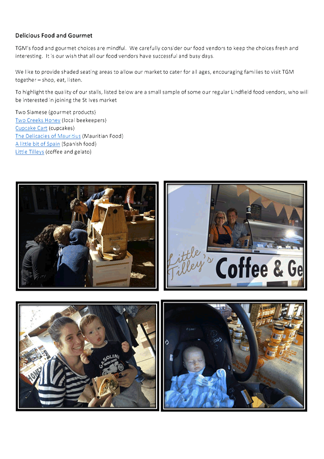
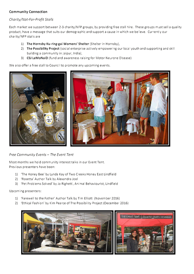
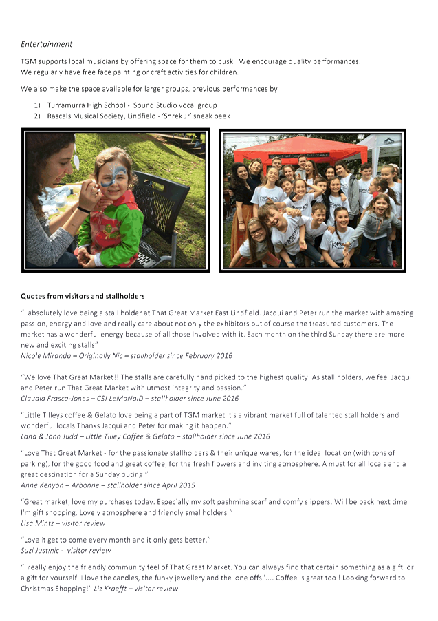
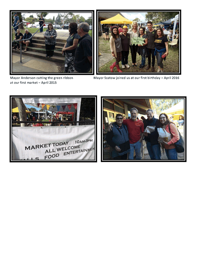
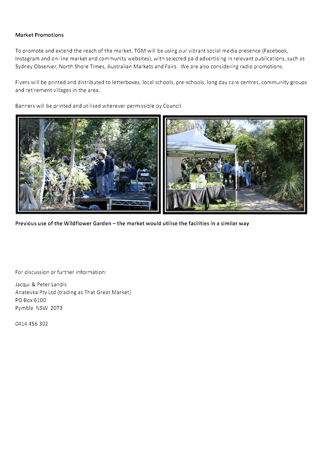
|
Ordinary Meeting of Council - 6 December 2016 |
GB.5 / 117 |
|
|
|
|
Item GB.5 |
S02090 |
|
|
17 November 2016 |
Draft Community Consultation Policy
EXECUTIVE SUMMARY
|
purpose of report: |
For Council to adopt the draft Community Consultation Policy 2016. |
|
|
|
|
background: |
The draft Community Consultation Policy 2016 was reported to Council on 6 September 2016. Council endorsed the policy to be placed on public exhibition which occurred between 23 September and 21 October 2016. |
|
|
|
|
comments: |
The draft Community Consultation Policy 2016 has been developed according to Council’s practice of regular policy review to ensure the policy is current and reflects best practice in community in engagement. One submission was received during the exhibition period which resulted in a minor change in a position title to ensure consistency. |
|
|
|
|
recommendation: |
That Council adopt the draft Community Consultation Policy 2016. |
Purpose of Report
For Council to adopt the draft Community Consultation Policy 2016.
Background
Council staff reported the draft Community Consultation Policy to Council on 6 September 2016. Council endorsed the policy to be placed on public exhibition which occurred between 23 September and 21 October 2016.
Comments
The draft Community Consultation Policy 2016 (Attachment 1) has been developed according to Council’s practice of regular policy review to ensure the policy is current and reflects best practice in community engagement.
The policy was placed on public exhibition between 23 September and 21 October 2016. The community was notified of the public exhibition through advertisement in the North Shore Times and Council’s webpage. One submission was received during this exhibition period. In response to the submission a minor change in a position title has been made to ensure consistency:
|
Submission number |
Submission type |
Response type |
Comments |
|
1 |
|
Email response |
Please advise the advantages of having the Resident Feedback Register. Was the review missed in 2012? Clarify Community Engagement Co-ordinator and Community and Business Co-ordinator difference.
Response The Residents Feedback Register was established in early 2005, with an aim to have a demographically representative register of up to 500 residents who could be surveyed regularly on major issues and initiatives. The advantages of a representative register are that it gives a truly representative viewpoint of the community, many of whom rarely or never contact the Council. This viewpoint could be considered along with feedback collected from individuals and groups within the community who regularly engage and share their views. The register evolved to an e-news register of residents in 2011 which is still used to provide regular updates on all council matters, including consultation opportunities. The list currently has just under 8000 subscribers. The evolution the register meant that no review was undertaken in 2012. In recent years Council has focused its consultation on a project by project basis, with engagement and communications being tailored to ensure the consultation is delivered in an appropriate way for the scale and impact of each project. Multiple consultation, communications and engagement techniques are employed to ensure the community are able to participate where appropriate. The Community and Business Engagement Coordinator is one position. There is no longer a Community Engagement Coordinator position in Council. Thanks for pointing out the inconsistency in wording, we’ll adjust this in the policy.
|
integrated planning and reporting
Leadership
|
Community Strategic Plan Long Term Objective |
Delivery Program Term Achievement |
Operational Plan Task |
|
L4.1 The community is informed and engaged in decision-making |
Community engagement utilises effective and varied communication channels to reach all sections of the community. |
Promote Council's adopted Engagement Policy throughout the organisation.
|
Governance Matters
Ku-ring-gai Council’s commitment to effective community consultation and engagement recognises the important connection between elected representatives, staff and the community and potential benefits derived by using these to make better decisions. This approach is in line with the increased use of participatory democracy techniques by leading international, federal, state and local government agencies.
Risk Management
If Council does not consult its community and chooses not to really listen to their concerns, or to not act on their input, Council projects can be derailed through community opposition.
Financial Considerations
There are no financial considerations associated with the writing of this report. Individual Council departments budget for specialist consultation processes within specific projects.
Social Considerations
Council actively seeks the involvement and input of all sectors of the community in the decision making process. These sectors include residents, interest groups, businesses, commercial property owners and others.
Council employs a diverse range of consultation and engagement techniques to ensure community consultation and engagement remains equitable, accessible and appropriate. These techniques must take into account the needs and motivations of relevant stakeholders to and act on these to produce better, more accurate and representative outputs to inform Council decision-making.
Environmental Considerations
There are no environmental considerations associated with the writing of this report.
Community Consultation
The draft Community Consultation Policy 2016 was placed on public exhibition from 23 September to 21 October 2016. One submission was received.
Internal Consultation
Internal consultation was not necessary as this is an updated policy.
Summary
The draft Community Consultation Policy 2016 has been prepared to replace the current policy adopted by Council in 2008. The policy contains minor changes and builds on Council’s continued support for community consultation in decision making. The policy seeks to optimise the use of traditional and emerging technologies and to build community interest and confidence in the decision making processes and associated outcomes.
|
That Council adopt the draft Community Consultation Policy 2016.
|
|
William Adames Community & Business Engagement Co-ordinator |
Virginia Leafe Manager Corporate Communications |
|
Janice Bevan Director Community |
|
|
Attachment A1 - Draft Community Consultation Policy |
|
2016/328795 |
|
Ordinary Meeting of Council - 6 December 2016 |
GB.6 / 130 |
|
|
|
|
Item GB.6 |
S10577 |
|
|
10 November 2016 |
Save Marian Street Theatre Group - Business Plan
EXECUTIVE SUMMARY
|
purpose of report: |
To present to Council a Business Plan prepared by the Save Marian Street Theatre Group. |
|
|
|
|
background: |
On 20 September 2016, following a Mayoral Minute from Cr Cheryl Szatow, Council resolved to provide “in principal” support to the Save Marian Street Theatre fund raising initiative, for a period of up to 3 years, to raise sufficient funds to refurbish and re-open the Marian Street Theatre in Killara. |
|
|
|
|
comments: |
The SMS theatre group has prepared a Business Plan which outlines their fund raising strategy. The SMS theatre group has requested that the Business Plan, along with a request for seed funding of $36,000 for a feasibility study, be presented to Council. |
|
|
|
|
recommendation: |
That Council undertake an independent Probity and Risk Review on the Save Marian Street Theatre group Business Plan, and that a report containing analysis of the Business Plan and recommendations from the review, including strategies on managing any risks, come to Council for further determination. |
Purpose of Report
To present to Council a Business Plan prepared by the Save Marian Street Theatre Group.
Background
On 20 September 2016, following a Mayoral Minute from Cr Cheryl Szatow, Council resolved to provide “in principal” support to the Save Marian Street (SMS) Theatre group for a period of up to 3 years, to raise sufficient funds to refurbish and reopen the Marian Street Theatre:
That Council provide “in principle” support for the Save Marian Street Theatre fund raising initiative for up to 3 years, with the intent that Save Marian Street Theatre raises the necessary funds, within this period of time, to refurbish and re-open the MST.
Comments
The SMS group has prepared a Business Plan that outlines their proposed fundraising strategy.
The SMS group has requested that the Business Plan, along with a request for seed funding for a feasibility study of $36,000 (Attachment A), be presented to Council.
The Business Plan sets out the vision for SMS as:
To enable Marian Street Theatre to become again a professional performance venue that will attract and accommodate entertainment and exhibitions of the highest standard.
And a mission statement as:
To work with the Council, arts worlds, community and donors to create and sustain a cultural and community hub at Marian Street Theatre that will again attract entertain and stimulate audiences from the entire North Shore and beyond.
The three goals that SMS have set are:
1. Raising awareness within the community to achieve the necessary financial support.
2. Re-opening the theatre as a safe, functional and welcoming community cultural hub with a target date of September 2018.
3. Overseeing the continuance of this community cultural hub, ensuring high quality and professional excellence that appeals to audiences on the North Shore, Greater Sydney and beyond.
At this stage Council has provided “in principle” support for a fund raising initiative for up to 3 years with the intent that the SMS group raises the necessary funds, within this period of time, to refurbish and re-open the Marian Street Theatre. (Mayoral Minute 26 September 2016)
Council has now received the SMS Business Plan and is in a position to more closely consider the proposal. The Business Plan proposes to establish a company limited by guarantee for the purpose of raising funds specifically for the restoration of the Marian Street Theatre. The SMS group also plans to seek registration on the federal government Register of Cultural Organisations and receive tax deductible status.
In the short term, the Business Plan seeks seed funding of $36,500 from Council to conduct a fundraising feasibility study and obtain legal advice about the organisational structure.
Subsequently, the Business Plan proposes the use of a professional fundraising organisation to raise funds for the restoration. According to the Business Plan, the SMS group aims to raise $1.5 million to $3.0 million to restore the theatre. As the SMS group would be raising funds specifically to restore a Council building, the governance arrangements and implications require careful consideration.
Should Council agree to the intent of the SMS Business Plan, Council would essentially be authorising an independent community group to raise funds on Council’s behalf via donations and sponsorship. This contrasts with another possible approach whereby funds could be raised more generically for a community theatre group rather than a Council asset, thus requiring less governance involvement from Council’s perspective.
Council would also need to consider issues arising from providing a commitment to the SMS group that would satisfy the requirements of their goals, as stated in the Business Plan. This would include a long term commitment from Council to the retention of the building, the future management model for the theatre, and the raising of donations and sponsorship for that purpose.
Appropriate consideration would also need to be given to risk and probity issues associated with providing consent to an independent community group to raise funds on Council’s behalf for a Council asset. It is also anticipated that the SMS group would participate in the refurbishment of the theatre and its future management.
As such, the SMS group would essentially be operating outside of Council’s control, and therefore would not be accountable to Council or any associated local government legislation, policies and procedures.
It is therefore recommended that, before this matter is progressed, an independent Probity and Risk Review be undertaken on the SMS Business Plan. This review would identify relevant probity and risk matters and provide measures and solutions that Council could put in place to address and manage them.
integrated planning and reporting
Community, People and Culture
|
Community Strategic Plan Long Term Objective |
Delivery Program Term Achievement |
Operational Plan Task |
|
C1 - Community Wellbeing |
C1.1 An equitable and inclusive community that cares and provides for its members. |
Our community facilities are accessible and function as cultural hubs to attract a range of users |
|
C2 - Cultural Diversity and Creativity |
C2.1 A harmonious community that respects, appreciates, celebrates and learns from each other and values our evolving cultural identity. |
Ku-ring-gai's rich cultural diversity and creativity is celebrated through programs and events. |
|
C4 - Healthy Lifestyles |
C4.1 A community that embraces healthier lifestyle choices and practices. |
A range of cultural, recreational and leisure facilities and activities are available to encourage social interaction and stimulate everyday wellbeing. |
|
P8 Improving the standard of our infrastructure |
P8.1 An improved standard of infrastructure that meets the community’s service level standards and Council’s obligations as the custodian of our community assets. |
Our public infrastructure and assets are planned, managed and funded to meet community expectations, defined levels of service and address inter-generational equity. |
|
|
|
Programs for infrastructure and asset maintenance management are delivered in accordance with the adopted Asset Management Strategy and Plans. |
Governance Matters
This report follows a Mayoral Minute from OMC on 20 September 2016 from Cr Szatow, where Council resolved to provide “in principle” support to the Save Marian Street Theatre fund raising initiative.
Risk Management
There are no direct risk management matters associated with the writing of this report, however there are possible risks associated with a community group raising funds for a Council asset, and the long term management of this asset, which could lead to other probity matters for Council to consider prior to progressing this matter.
Financial Considerations
It is anticipated that a Probity and Risk Review would cost between $5,000 and $10,000. There are sufficient funds within the Community budget to cover this amount.
Social Considerations
Council engaged consultants Straight Talk to undertake community engagement based on what the community thinks the future of live performance in Ku-ring-gai should be. The Straight Talk report (August 2015) indicated strong support within the community for live theatre in Ku-ring-gai.
Conclusions from the Straight Talk community engagement included:
· Live theatre and performance is important. There is strong support for live performance in Ku-ring-gai
· Most people attend live performance at least once or twice a year and most people identify Art and Culture as important elements for a community
· There is a high degree of awareness of the Marian Street Theatre and most people have attended a performance there
· Most people believe they would attend live performances in the LGA should they be available
According to SMS Business Plan, re-opening Marian Street Theatre means both performing arts companies and the community will benefit from having a local, professional performing arts hub.
SMS feels that the building has huge potential because it is the only professional theatre on the upper North Shore - an area with a high population of theatre-goers.
Environmental Considerations
There are no direct environmental considerations associated with this report.
Community Consultation
There is no community consultation associated with this report. Previous community consultation conducted by Straight Talk in 2015, on live theatre in Ku-ring-gai, indicated a high level of support for live theatre in Ku-ring-gai, and a high level of awareness of the Marian Street Theatre in Killara.
Internal Consultation
This matter has been discussed with the General Manager and all Directors.
Summary
Council has provided “in principle” support to a community based group, SMS, to raise funds to re-open the Marian Street Theatre. SMS has developed a Business Plan containing proposed plans and scope for a fund raising process, capital works and possible future management of the Marian Street Theatre.
The SMS Business Plan also includes a proposal for a feasibility study, and SMS has requested $36,000 as seed funding from Council to fund the feasibility study.
This report recommends that Council undertake an independent Probity and Risk Review on the Save Marian Street Theatre group Business Plan, and that a report containing an analysis of the Business Plan and recommendations and strategies from the review come to Council for further determination.
|
A. That Council engage an independent consultant to conduct a Probity and Risk Review of the Save Marian Street Theatre Business Plan.
B. That a report come to Council containing analysis of the SMS Business Plan along with recommendations and strategies from the independent Probity and Risk Review.
|
|
Janice Bevan Director Community |
|
|
Business Plan - Save Marian Street Theatre Committee - Report Attachment |
|
2016/320158 |
|
APPENDIX No: 1 - Business Plan - Save Marian Street Theatre Committee - Report Attachment |
|
Item No: GB.6 |


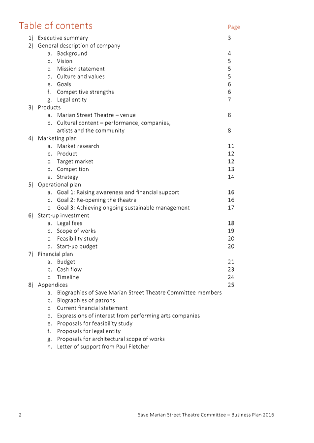


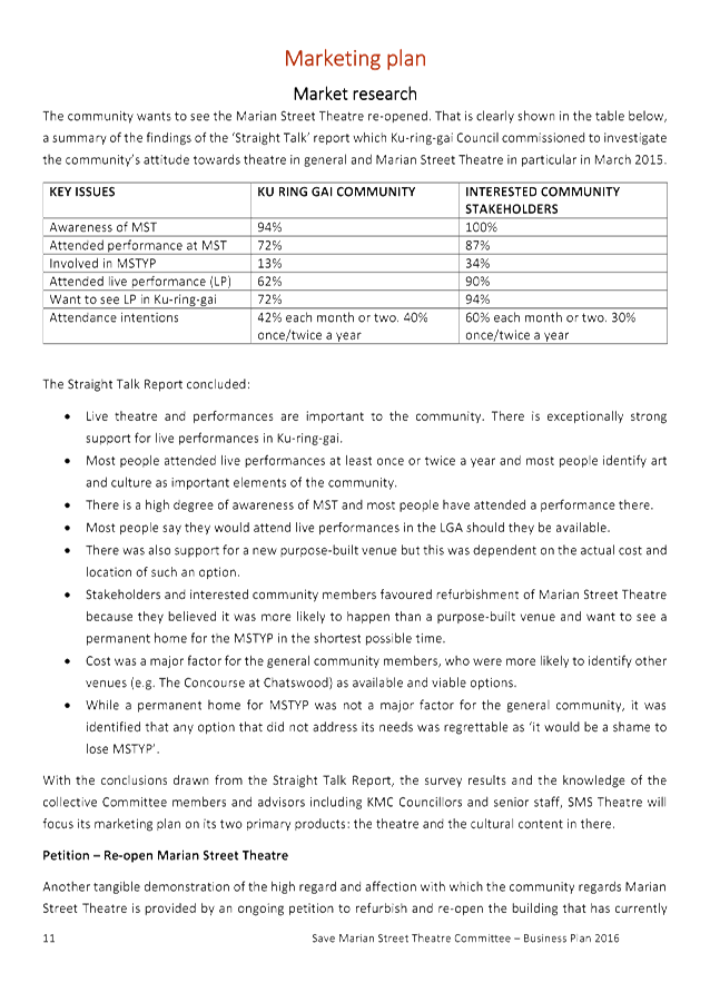

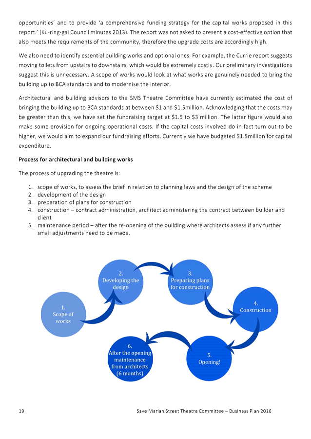
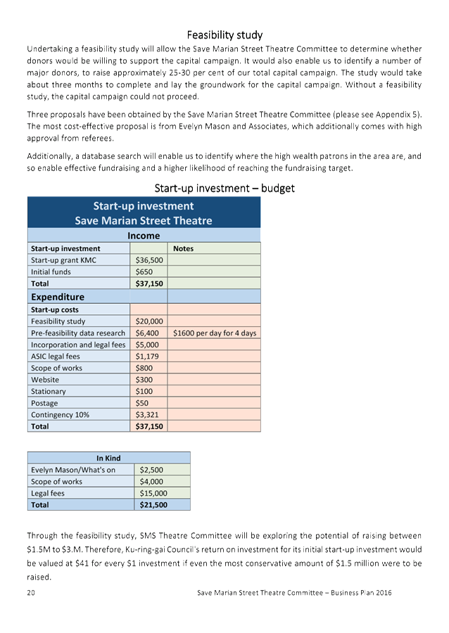
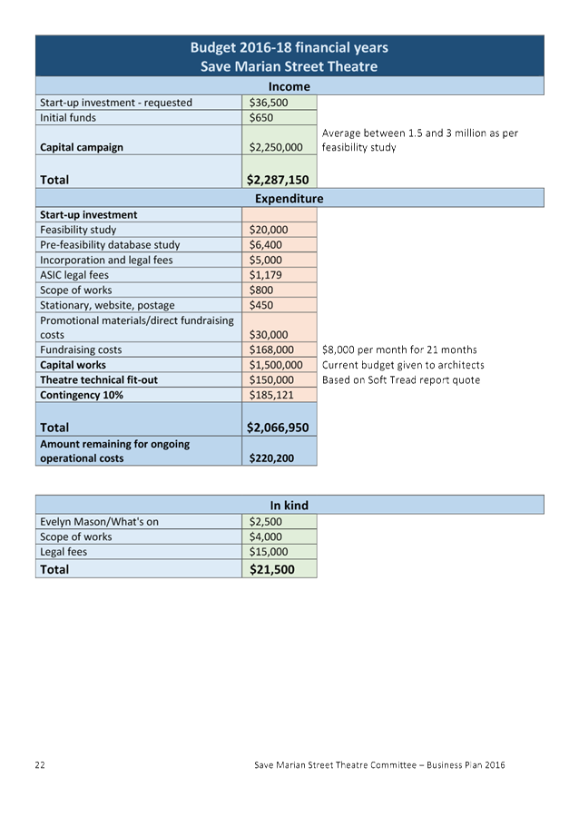
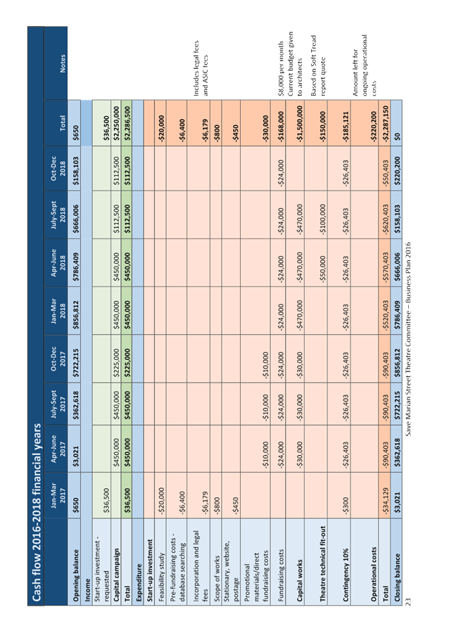
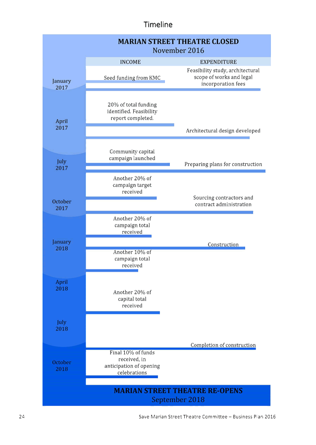

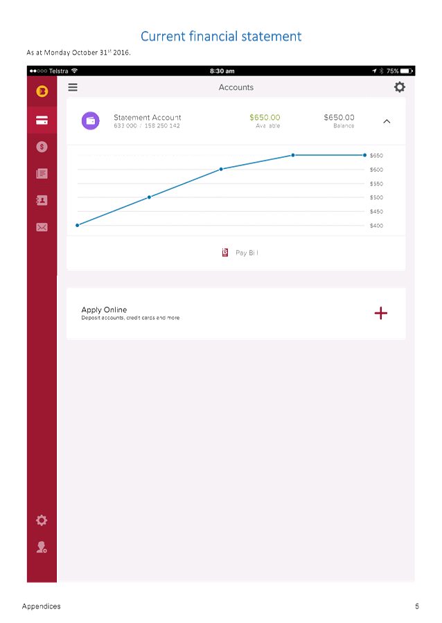
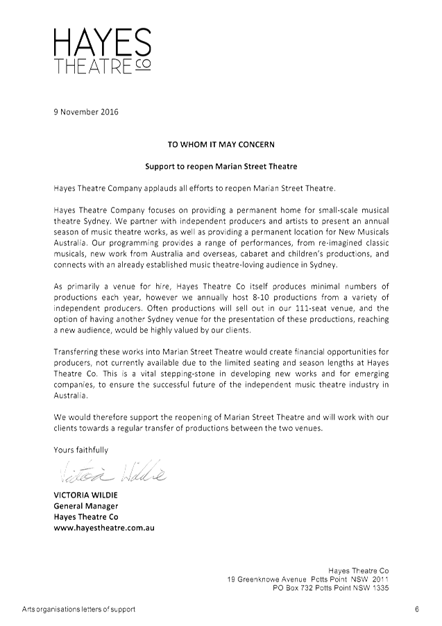
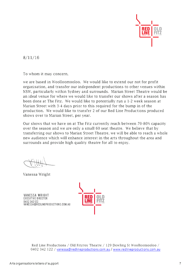
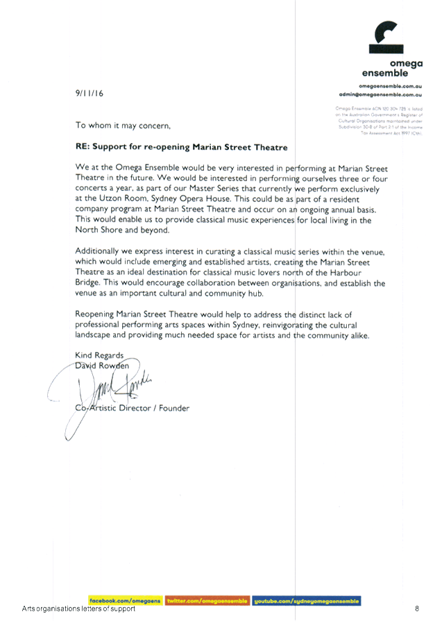


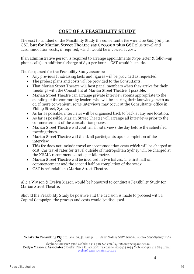
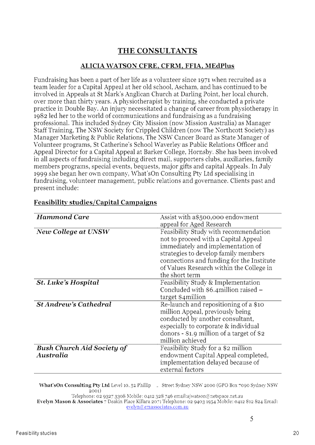
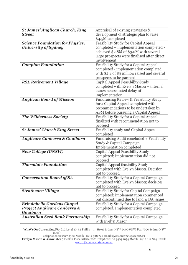
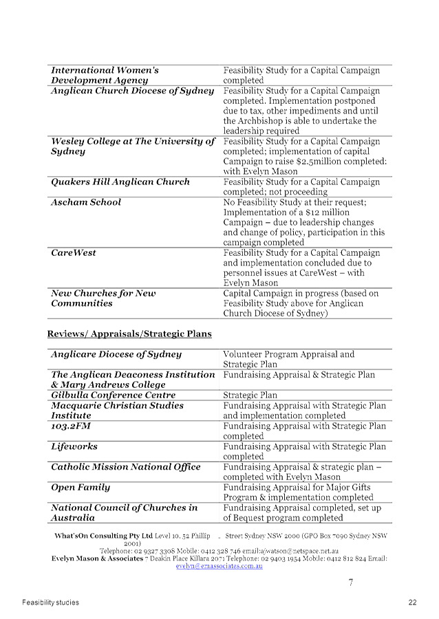
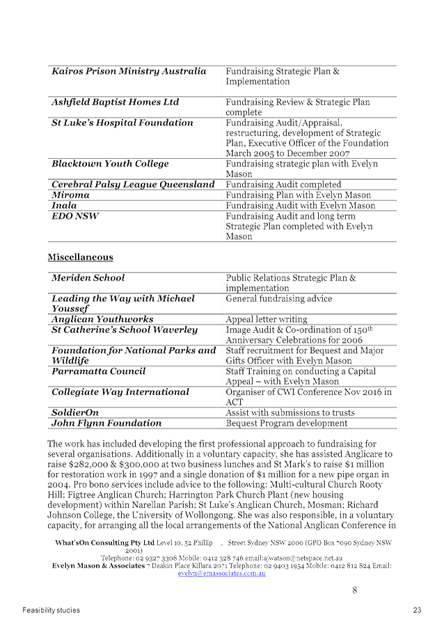
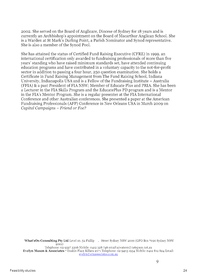
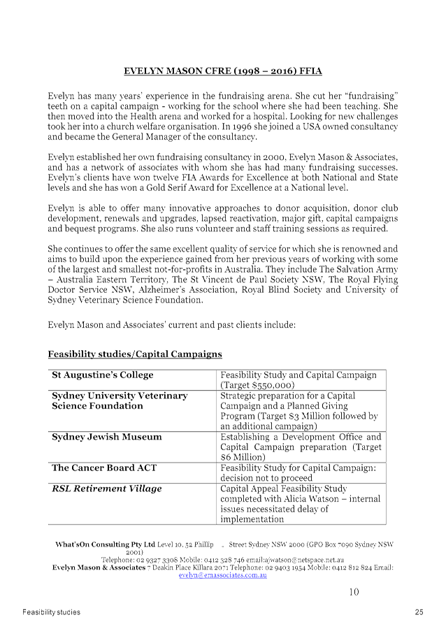
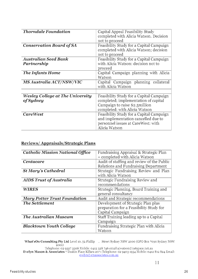
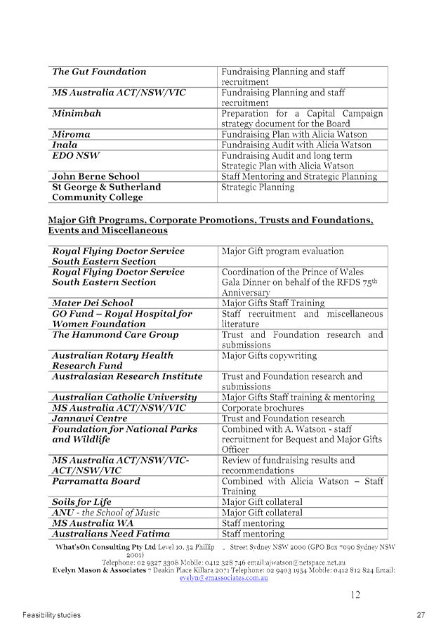
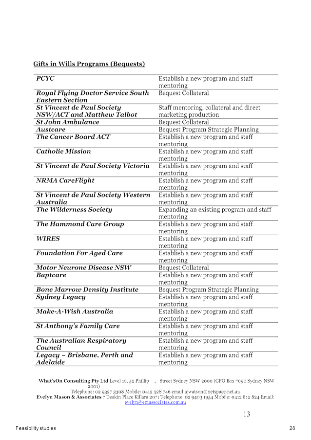
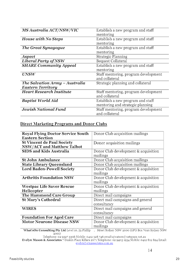
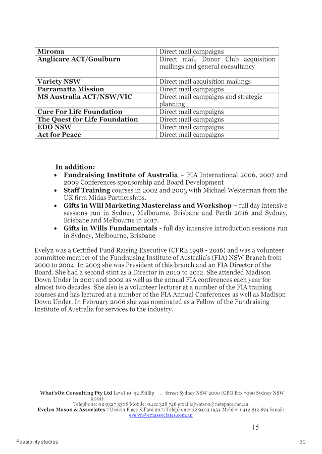
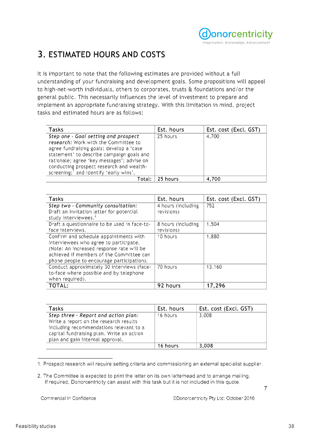


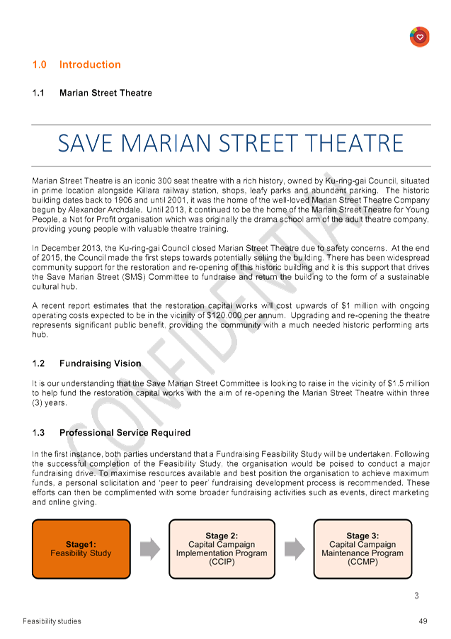

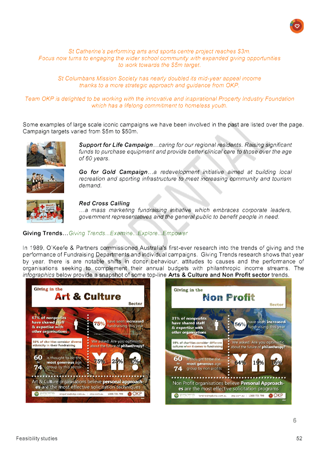
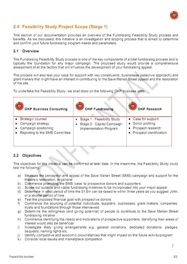
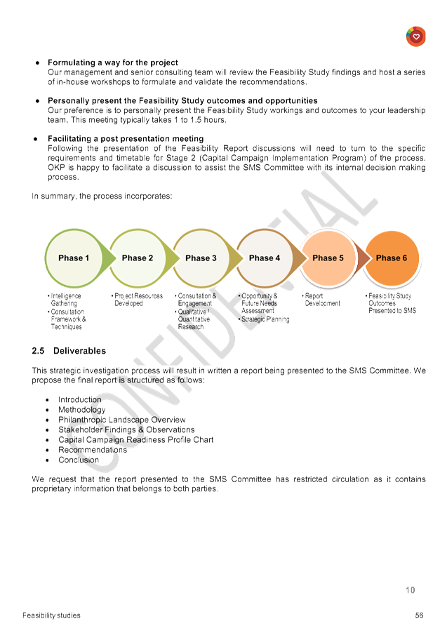
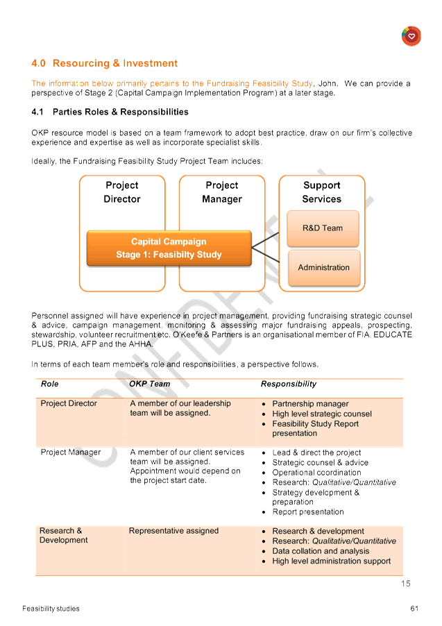

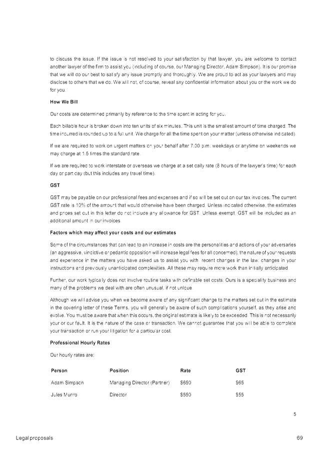
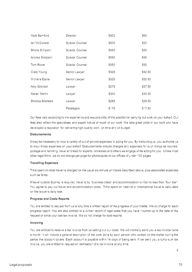
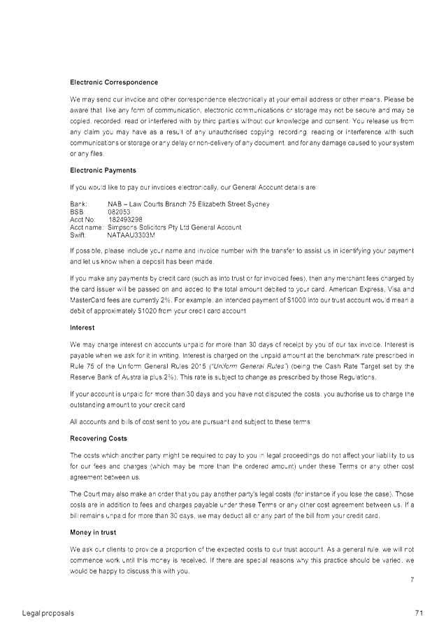
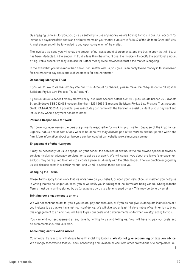
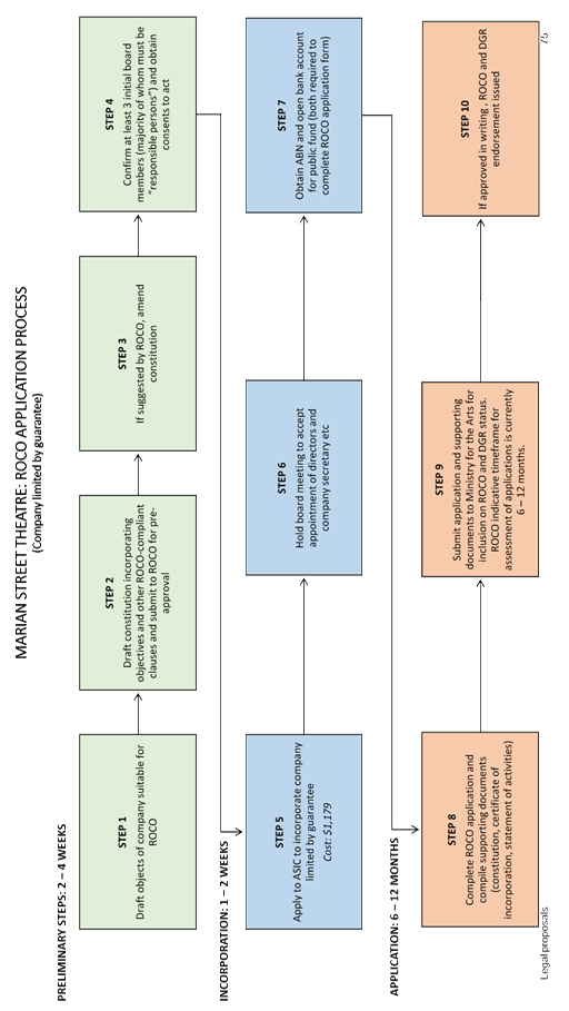
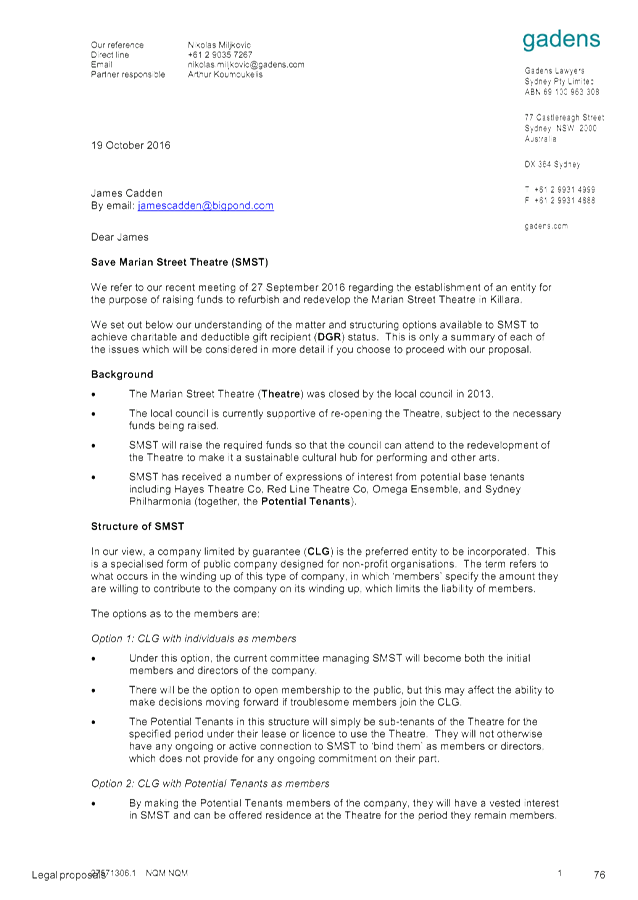

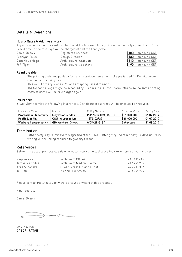
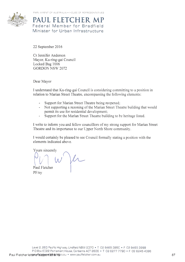
|
Ordinary Meeting of Council - 6 December 2016 |
GB.7 / 248 |
|
|
|
|
Item GB.7 |
S11009 |
|
|
16 November 2016 |
Tender RFT11/2016 - Printer and Multifunction Device Replacement
EXECUTIVE SUMMARY
|
purpose of report: |
To report on the results of the open tender for the supply and installation of printers, multifunction devices and a print management solution and to seek approval to accept the tender from the preferred tenderer. |
|
|
|
|
background: |
All existing leases for printers and multifunction devices have expired and all devices are nearing the end of their useful life. In April 2016 a printer review and consultation process was conducted across the whole of Council resulting in documentation detailing current printer usage and outlining future requirements. In June 2016 Council called for open tenders for the supply and installation of printers, multifunction devices and a print management solution. |
|
|
|
|
comments: |
Tenders closed on 12 July 2016 and ten submissions were received. The evaluation was undertaken by a Tender Evaluation Committee comprising of Council staff. The replacement will be funded from the Information Management operational budget. |
|
|
|
|
recommendation: |
That Council approve the recommendation of the Tender Evaluation Committee included in attachment A1 and that Council authorises the Mayor and General Manager to execute all documents and affix the Council seal to all contract documents. |
Purpose of Report
To report on the results of the open tender for the supply and installation of printers, multifunction devices and a print management solution and to seek approval to accept the tender from the preferred tenderer.
Background
Council currently uses Lexmark printers and multifunction devices to provide print, scan, copy and fax services to staff and Councillors. Council maintains a fleet of approximately 66 devices which are leased for a period of three years, a third of which are replaced each year.
In November 2013 a review of printing costs and leasing arrangements concluded that Council would benefit from consolidating the entire fleet into a single lease and extending it to 4 years. The three existing leases were then allowed to expire in December 2013, February 2014 and December 2015.
In 2013 a whole of Council staff survey was conducted on sustainability in the workplace. A total of 116 staff responded to the survey, with good representation across departments and roles. As part of the survey staff were asked what was the biggest change they could make in order to engage in more sustainable practices at work. ‘Reduce paper use and printing’ was by far the most frequent response amongst respondents. In addition, Council’s Corporate Sustainability Action Plan 2014-2017 identifies the procurement of new printer equipment which handles recycled paper and reports on and manages paper use, through Follow Me Printing, as a key management action.
In April 2016 a review and consultation process was conducted across the whole of Council to review usage data as well as gauging staff satisfaction with the level of functionality and service. The results of the review and consultation process were used to determine the features and capacity for the replacement devices and well as the number of devices required to service all Council areas.
In June 2016 Tender RFT 11/2016 called for open tenders for the following four components;
· Supply and installation of 8 printers and 39 multifunction devices
· Cost Per Copy maintenance agreement covering all devices
· Print Management Solution
· Disposal of existing devices
The tender document also included a provision to increase the number of multifunction devices by five to cover the replacement of the Toshiba multifunction devices in the Council libraries which are used by the public. These devices are also off lease and require replacement. The replacement of these devices is dependent on the preferred devices being compatible with the existing library system, card readers and library cards.
Comments
Tenders closed on 12 July 2016 and ten submissions were received from the following seven companies;
1. Enigma Business Solutions
2. Fuji Xerox Australia (x2)
3. Konica Minolta Business Solutions Australia
4. Ricoh Australia
5. Sharp Corporation of Australia
6. Staples Australia
7. Upstream Solutions (x3)
The evaluation was undertaken by a Tender Evaluation Committee (TEC) comprising of staff from the Corporate department and the Strategy & Environment department. The TEC assessed the submissions for compliance against the published evaluation criteria. The TEC assessment results and recommendation is in Confidential Attachment 1.
integrated planning and reporting
Leadership and Governance
|
Community Strategic Plan Long Term Objective |
Delivery Program Term Achievement |
Operational Plan Task |
|
L3.1 The organisation is recognised and distinguished by its ethical decision-making, efficient management, innovation and quality customer service.
|
Council services and programs are provided on the basis of equity, community priorities, and best value for money within available resources.
|
Council's information systems and technology infrastructure is maintained, updated and supported.
|
Governance Matters
Open tenders were called as prescribed by Section 55 of the Local Government Act and by the Regulation as the estimated expenditure exceeds the threshold of $150,000.
Tenderlink was used for managing the operation of the tender, comprising matters such as management of documents, forum questions and submissions.
Confidential attachments to this report include the Tender Evaluation Committee assessment and recommendation.
The attachments are considered to be confidential in accordance with Section 10A (2)(d)(iii) of The Local Government Act 1993 as they are considered to contain commercial in confidence information.
Risk Management
The risks identified for this project relate to maintaining the status quo rather than proceeding with the replacement.
Failure of the existing devices is one of the key risks if the replacement does not proceed. The current fleet of 66 devices range in age from 4 to 6 years and the failure rate has already started to increase. Although the devices are covered for all maintenance and repairs under their respective agreements there is still an impact to operations when a device is out of order for any length of time. Sourcing of parts invariable gets more difficult for older devices which in turn also increases repair times.
Another key risk is the financial impact of the higher running costs that we are currently paying compared to the tendered rates. We currently have 17 different Cost Per Print (CPP) rates across all of the agreements for the existing devices. This is a legacy of the staggered replacement program that we historically followed. Replacing all the devices in one batch and standardising on just three device models will reduce this to five CPP rates. The new rates are also significantly lower than existing rates as the new devices are more efficient and cost less to run and maintain.
Financial Considerations
Refer to Confidential Attachment 1 for details.
The replacement will be funded from the Information Management operating budget.
Social Considerations
The replacement devices and implementation of a print management solution will have an impact on the way staff use print, copy, scan & fax services. Training has been included in the tender and will be made available to all staff.
Environmental Considerations
In assessing the tenders, a number of environmental considerations were considered, to ensure that the replacement and management of Council’s new printers and multifunction devices enhanced Council’s sustainability performance. These included;
i. the energy performance and / or recycled content of the hardware devices and consumables
ii. the print management solution
iii. recycling / re-manufacturing programs for devices and consumables and
iv. the disposal method for current devices (including the sale of devices with a remaining useful life, charitable donation, recycling or a combination of these).
The print management solution accompanying the new devices, including Follow Me Printing (a roaming print service that allows print jobs to find users based on their physical location and releases print jobs through a swipe and release mechanism), has significant environmental benefits, namely reduced paper and consumables wastage and the associated reduction in energy use resulting from machines not operating to print unwanted print jobs.
Tenderers were also assessed on the sustainability of their business operations and environmental risk management processes, including their environmental management systems, environmental and waste policies, environmental auditing and monitoring programs and environmental staff training programs.
Community Consultation
Not required.
Internal Consultation
A consultation process was conducted across the whole of Council. Staff were consulted about their use of current devices, their level of satisfaction with existing devices and service levels as well as any additional requirements they may have.
Summary
All existing leases for printers and multifunction devices have expired and all devices are nearing the end of their useful life.
A printer review and consultation process was conducted across the whole of Council resulting in documentation detailing current printer usage and outlining future requirements.
Open tenders for RFT 11/2016 were called via Tenderlink and closed on 12 July 2016, ten submissions were received and evaluated and a preferred tenderer has been recommended.
|
A. That Council approve the recommendation of the Tender Evaluation Committee included in attachment A1. B. That Council authorises the Mayor and General Manager to execute all documents and affix the Council seal to all contract documents.
|
|
John Giovinazzo Manager Information Management |
David Marshall Director Corporate |
|
Evaluation Committee Report |
|
Confidential |
||
|
|
Evaluation Worksheet - All Submissions |
|
Confidential |
|
|
|
Evaluation Worksheet - Shortlisted Submissions |
|
Confidential |
|
Ordinary Meeting of Council - 6 December 2016 |
GB.8 / 253 |
|
|
|
|
Item GB.8 |
DA0572/15 |
|
|
7 November 2016 |
development application
Summary Sheet
|
Report title: |
24 Mungarra Avenue, St Ives - demolition of existing structures and construction of 3 seniors living dwellings and associated works |
|
ITEM/AGENDA NO: |
GB.8 |
|
Application No: |
DA0572/15 |
|
Property Details: |
24 Mungarra Avenue, St Ives Lot & DP No: Lot 2 DP 507419 Site area (m2): 1265m2 Zoning: R2 Low Density Residential |
|
Ward: |
|
|
Proposal/Purpose: |
Demolition of existing structures and construction of 3 seniors living dwellings and associated works. |
|
Type of Consent: |
Local |
|
Applicant: |
JS Architects Pty Ltd |
|
Owner: |
Red Horizon Properties Pty Ltd |
|
Date Lodged: |
9 December 2015 |
|
Recommendation: |
Approval |
Purpose of Report
To determine Development Application No. DA0572/15 for demolition of existing structures and construction of 3 seniors living dwellings and associated works on land at 24 Mungarra Avenue, St Ives.
integrated planning and reporting
Places, Spaces & Infrastructure
|
Community Strategic Plan Long Term Objective |
Delivery Program Term Achievement |
Operational Plan Task |
|
P3.1 The built environment delivers attractive, interactive and sustainable living and working environments
|
A high standard of design quality and building environmental performance is achieved in new development.
|
Assessment of applications is consistent with Council’s adopted LEP’s and DCP’s.
|
Executive Summary
Issues: Landscape amenity, solar access, accessibility
Submissions: Original proposal: 7 submissions; amended proposal: 3 submissions
Land & Environment Court: N/A
Recommendation: Approval
History
Site
The site has a history of residential use.
Pre-DA (PRE0047/14)
On 20 May 2014, a pre DA consultation was undertaken for a proposal for demolition of the existing structures and construction of 4 seniors living dwellings and associated works. The applicant was advised of the following key issues:
· building front setback exceeds the prevailing setback pattern on Mungarra Avenue and is out of character with the surrounding landscaped setting (proposal not supported);
· recommended re-consideration of number of dwellings and bedroom mix in terms of addressing environmental and amenity issues raised;
· excessive floor area (exceeds maximum requirement of 0.5:1);
· provision of accessible paths from the subject site to public transportation;
· up-to-date survey plan required;
· front setback analysis;
· boundary fence out-of-character with the streetscape;
· accurate solar access diagrams required;
· private open space amenity;
· internal pedestrian accessibility from the street frontage and within the communal open spaces to dwelling houses; and
· compliance
diagrams required.
Previous DA (DA0356/14)
A development application was lodged on 4 September 2014 for demolition of the existing structures and construction of 4 seniors living dwellings and associated works. A preliminary assessment of the application identified that the application was unsatisfactory in a number of respects, including:
· proposed path of travel to public transport unsatisfactory with regard to Clause 26 of the SEPP (Housing for Seniors or People with a Disability) 2004: site-related requirements;
· stormwater management;
· car parking;
· deep soil zone;
· tree impacts and landscaping;
· site and neighbourhood amenity;
· streetscape character (front setback); and
· insufficient information.
As a consequence of the above issues, the application was withdrawn on 9 February 2015.
Subject DA History
9 December 2015 The application was lodged.
18 December 2015 The application was advertised and notified to neighbouring property owners for a period of 30 days. A total of 7 submissions were received.
22 March 2016 A letter was sent to the applicant advising that the application is unsatisfactory in a number of respects, including:
· accessibility (pedestrian path of travel to public transport);
· neighbourhood amenity and streetscape;
· setbacks;
· building facades;
· vehicle access;
· solar access;
· stormwater management;
· parking, access and traffic;
· landscaping, including deep soil zones;
· tree impacts
3 June 2016 The applicant submitted amended plans and further information in response to Council’s letter of 22 March 2016.
9 June 2016 The amended plans were notified to neighbouring property owners for a period of 14 days. A total of 3 submissions were received.
9 September 2016 A further letter was sent to the applicant advising of a number of remaining issues, including:
· parking, access and traffic
· accessibility statement;
· solar access
· landscaping amenity, including screen planting, excess excavation, tree impacts; and
· insufficient information.
18 October 2016 The applicant submitted further amended plans and further information in response to Council’s letter of 9 September 2016.
26 October 2016 The applicant provided a final set of amended plans.
The Site
Site Description
The site is a rectangular shaped allotment legally described as Lot 2 DP 507419 and known as 24 Mungarra Avenue, St Ives. The site has a 27.735 metres wide frontage to the southern side of Mungarra Avenue and depth of 45.76 metres, comprising an area of 1265m2. The site has a gradual fall to the street frontage of approximately 3 metres.
The site contains a single storey dwelling house, with an attached double garage and a granny flat to the rear. Vehicular access is provided by a concrete driveway to Mungarra Avenue. The existing structures are situated within a landscaped setting, featuring a number of substantial trees.
The site includes a drainage easement in its north-eastern corner. The site is identified as Category 3 and 3a riparian land. A portion of the site’s north-eastern corner adjacent to the easement is also identified as biodiversity significant.
The site does not contain a heritage item, is not within the vicinity of a heritage item and is not located within a heritage conservation area.
Surrounding Development
The site is located within a low density residential area and is adjoined by four allotments of similar configuration containing single dwelling houses.
Development on the surrounding lots generally consists of brick dwelling houses of a mixture of styles, typically being one or two storeys, with associated structures such as garages, outbuildings and swimming pools. Building footprints are generally located within substantial landscaped settings, including a reasonably consistent front setback pattern in the immediate streetscape.
In addition to dwelling houses, a childcare centre is also evident approximately 100 metres to the east of the subject site at No. 12 Mungarra Avenue.
The Proposal
The proposal is for the demolition of existing structures and construction of 3 seniors living dwellings pursuant to State Environmental Planning Policy (Housing for Seniors or People with a Disability) 2004 (SEPP Seniors 2004) and associated works. In particular, the proposal includes the following works:
· Demolition of the existing dwelling and associated structures.
· Construction of 3 detached two-storey seniors living dwellings (24, 24A and 24B). Dwellings 24 and 24A are located in parallel alignment to the front of the site and Dwelling 24B is located to the rear.
· Dwelling 24 (eastern side dwelling)
- ground floor: front porch, living/dining room, kitchen, laundry, bedroom and bathroom
- first floor: 2 bedrooms (1 with ensuite), bathroom and upper living room
- rear private open space/covered alfresco area accessible from the ground floor living room
- carport to the rear of the dwelling
· Dwelling 24A (western side dwelling)
- ground floor: front porch, living room, family/dining room, kitchen, laundry, bedroom and bathroom
- first floor: 3 bedrooms (1 with ensuite), bathroom, upper living room and balcony
- rear private open space/covered alfresco area accessible from the ground floor family room
- 2 hardstand car spaces to the rear of the dwelling
· Dwelling 24B (rear dwelling)
- ground floor: kitchen, laundry, combined living, dining and lounge to the eastern wing and 2 bedrooms (1 with ensuite), bathroom and open study to the western wing
- first floor: upper living room to the eastern wing, balcony accessible from the central hallway and bedroom with ensuite and upper study to the western wing
- rear covered alfresco area and landscaped private open space accessible from the living/dining room
- integrated double garage centrally located on the ground floor
· Associated vehicular and pedestrian access is provided at the eastern side of the frontage.
· Landscaping works including new screen planting and the removal of 2 small trees within the rear of the site.
· The proposal includes details of a pedestrian path to be constructed for access from the site to the nearest public transport service being a bus stop located approximately 350 metres to the east of the site in Carbeen Avenue, which provides access to the services and facilities as required by SEPP Seniors 2004.
Amended plans
The amended plans proposed a number of changes, in particular:
· pedestrian path details for access to the nearest bus stop
· increased front and side setbacks to dwellings
· reduced driveway width
· reduced number of bedrooms
· parking spaces and dimensions amended
· details of proposed landscaping, including site levels and provision of screen planting
Consultation
Community
In accordance with the Ku-ring-gai Development Control Plan, owners of surrounding properties were given notice of the application. In response, submissions from the following were received:
1. Mr C N & Mrs K E Kennedy – 26 Mungarra Avenue, St Ives
2. Ms A Chan – 20 Mungarra Avenue, St Ives
3. Mrs M M Buson – 21 Mungarra Avenue, St Ives
4. Mr C M Ng – 23 Mungarra Avenue, St Ives
5. Mr J P Hall – 9 Killeaton Street, St Ives
6. Mr S Lewis – 7 Mungarra Avenue, St Ives
7. Mr G Holdsworth – 27 Mungarra Avenue, St Ives
The submissions raised the following issues:
Privacy loss
Visual and acoustic privacy impacts on neighbouring properties have been assessed with respect to the applicable planning provisions (as below) and are considered acceptable, subject to conditions. In particular, the application was amended to include increased side setbacks for Dwelling 24 and 24A to facilitate additional landscaped area for the establishment of screen planting adjacent to the boundaries. The roofs to the alfresco areas for these dwellings are to be deleted by condition to support screen planting and residential amenity in this regard (Condition 2).
Additional privacy measures include privacy screens to first floor balconies (Dwellings 24A and 24B) and the placement and orientation of windows to minimise potential for overlooking. The development is not of a density that would likely generate excessive noise levels.
View loss
The proposed development will not result in any significant view loss, noting there are no iconic or significant views across the subject site. Furthermore, the proposal complies with the applicable height, FSR and landscaping provisions of SEPP Seniors 2004.
Loss of trees and existing screening along rear boundary
Council’s Landscape Assessment Officer has indicated that there are no significant trees located within the site that are proposed to be removed. The two trees proposed to be removed are small trees located within the rear yard and their removal is accepted as discussed below. Additionally, the landscape plan proposes screen planting along the rear boundary and will assist in the protection of landscaping and neighbouring amenity.
Protection of two palm trees located on a neighbouring property
The protection of any significant trees worthy of retention, including those on neighbouring properties, is required by condition as recommended by Council’s Landscape Assessment Officer (Conditions 12 -17 and 55-58).
Stormwater impacts/flooding
Council’s Development Engineer has considered potential stormwater impacts to neighbouring properties and concludes that the proposal is acceptable in this regard, subject to conditions.
Proposed 11 bedrooms are excessive for 3 units
The proposal as amended includes 10 bedrooms in total (2 x 3 bedroom dwellings and 1 x 4 bedrooms dwelling) and does not contravene any applicable planning provision in this respect, noting that it complies with the applicable height, FSR, car parking and landscaping provisions of SEPP Seniors 2004.
The proposed development would be uncharacteristic in the streetscape
Dwellings 24 and 24A are to be located in a parallel alignment and Dwelling 24B is to be located to the rear. The two storey form and height is not inconsistent with the existing streetscape and recently approved development, noting the approval granted for the adjoining site at 26 Mungarra Avenue. Additionally, the front setbacks to Dwelling 24 and 24A as amended (being approximately 12-12.5 metres) are compatible with those of neighbouring development and others in the streetscape.
Compliance concerns regarding the Seniors Living development being occupied by non-senior residents/families
In accordance with SEPP Seniors 2004, a condition is recommended to restrict the occupation of the premises to:
· people 55 or over or people who have a disability
· people who live with people 55 or over or people who have a disability
· staff employed to assist in the administration of and provision of services to housing provided in this development
The condition requires a restriction registered against the title of the property, in accordance with section 88E of the Conveyancing Act 1919 (Condition 76).
Inadequate parking
The proposal as amended satisfies the car parking provision required by SEPP Seniors 2004 being 5 off-street parking spaces for residents. Council’s Development Engineer is satisfied with the proposal in respect of car parking, dimensions and manoeuvrability.
Traffic, safety and noise during construction and operation
Council’s Development Engineer is satisfied that the development will not generate significant additional traffic levels or associated safety and noise implications, either during construction or operation phases of the development. Condition 8 requires that a construction traffic management plan will be implemented during construction. In addition, a construction works zone will be required along the site frontage. This will assist in minimising impacts in relation to vehicle sight lines, general road safety and conflicts with construction related vehicles (Condition 9).
Inadequate access to public transport/facilities
The amended proposal satisfies the site-related requirements of SEPP Seniors 2004, including the site location and access to facilities provisions specified by Clause 26. In particular:
(i) Public transport access to the required services and facilities at St Ives Shopping Village is provided from a bus stop located in Carbeen Avenue, St Ives (approximately 350 metres from the subject site), which is serviced by route 195-197.
(ii) The bus provides services to St Ives Village Shopping Centre, in excess of once in the morning and once in the afternoon, Monday to Friday.
(iii) The pathway does not exceed 1:24 gradient with 2 kerb ramps of less than 1:10 gradient.
(iv) Compliance with AS1428.1, DDA Transport Standards and Clause 26(1) and (2) and Clause 38 of the SEPP Seniors 2004 is conditioned (Conditions 25 and 30).
Excessive bulk and scale of the development
The site satisfies the required site area and frontage provisions of SEPP Seniors 2004 and the proposed design complies with the applicable height, FSR and landscaping provisions. Additionally, the design has been amended several times during the assessment process to incorporate increased front and side setbacks and provide additional landscaping/screening. Accordingly, the amended proposal is acceptable in terms of its scale and bulk.
Impacts on a significant street tree
Council’s Landscape Assessment Officer has recommended that the significant street tree (Cottonwood) located adjacent to the property frontage be retained and protected in addition to other trees as required by conditions (Conditions 12 -17 and 55-58).
Urban design guidelines
The amended proposal satisfies the aims and provisions of the Seniors Living Policy: Urban Design Guideline for Infill Development. In particular, the proposal is acceptable with respect to the key issues as outlined by the policy guideline, including:
· responding to context
· site planning and design
· impact on streetscape
· impacts on neighbours
· internal site amenity
Landscaping, deep soil zone and tree planting
Council’s Landscape Assessment Officer has assessed the application with respect to the required landscaping provisions, including deep soil zones and tree canopy replenishment planting. The proposal as amended is considered to be acceptable in these regards, subject to conditions. The proposal satisfies the deep soil zone requirement of SEPP Seniors 2004. Additionally, 2 canopy trees will be planted on the site (within the front setback) to satisfy tree replenishment requirements (Conditions 19 and 60). Moreover, the proposed development is consistent with the applicable landscaping objectives of the SEPP and will preserve significant trees that contribute to the amenity of the area.
Inadequate setbacks/provision for screen planting
The proposed design has been amended during the assessment process to incorporate increased front and side setbacks and provide additional landscaping/screening therein to suitably ameliorate impacts of the proposed building form as viewed from neighbouring properties and the street. Additionally, conditions include the requirement for an increased planting area within side setbacks involving relocation of retaining walls and deletion of the roofs over the proposed alfresco areas of the two front dwellings (Conditions 2 and 19).
Discrepancies in development indices table on plans
The amended plans submitted provide development indices that reflect the proposed development sufficiently to inform assessment.
Manageability and accessibility of development for seniors
The application includes an access report which responds to aspects relating to manageability and accessibility of the proposed development for the purposes of SEPP Seniors 2004. Compliance with the access and construction standards of the SEPP is required by conditions, including access to public transport and facilities as discussed above (Conditions 25, 30 and 78).
Earthworks
The proposed development does not involve earthworks that would likely incur any significant impacts with respect to trees/landscaping, neighbour amenity and stormwater effects. Council’s Landscape Assessment Officer and Development Engineer have not raised any objections to the amended proposal in this respect. Moreover, any impacts on trees are avoided through measures set out in Conditions 12 -17 and 55-58.
Property devaluation
The devaluation of property is not a consideration under Section 79C (1) of the Environmental Planning and Assessment Act 1979.
Amended plans
Amended plans received on 3 June 2016 were also notified to surrounding properties. In response, submissions from the following were received:
1. Mr C M Ng – 23 Mungarra Avenue, St Ives
2. Mr C N & Mrs K E Kennedy – 26 Mungarra Avenue, St Ives
3. Mr B & Mrs L Moo – 3 Warrimoo Avenue, St Ives
The submissions raised the following additional issues:
Overshadowing of neighbouring living areas and recreation spaces
In accordance with the solar access requirements of SEPP Seniors 2004 (clause 35), submitted shadow diagrams indicate that the proposal will maintain adequate daylight to the main living areas and substantial areas of private open space of neighbours in the vicinity.
Insufficient street drainage/lack of gutters
Council’s Development Engineer has not raised any objections in relation to drainage aspects of the proposed development and considers the stormwater management plan to be acceptable.
Final amended plans
The final amended plans were not required to be notified in accordance with the Ku-ring-gai DCP as the environmental impact associated with the amended plans is no greater than that of the previously notified proposal.
Within Council
Engineering
Council's Development Engineer commented on the amended proposal as follows:
Water management
The amended stormwater design shows all roof water to be directed to 3 x 2,000L aboveground rainwater tanks, with the overflow directed to a belowground detention tank of 18m3 beneath the proposed driveway. There is sufficient gravity fall from the detention facility to the street kerb and gutter.
According to the Stormwater Quality Report, dated 15 August 2016 and prepared by ACOR Consultants, the 6,000L rainwater storage volume required by BASIX would satisfy the 50% reduction in runoff days required under Part 24C.3 of the Ku-ring-gai DCP. Re-use of stored rainwater will be for irrigation and toilet flushing. This will satisfy Council’s streamflow objectives.
Water quality measures using MUSIC Modelling have been implemented into the design. The design engineer has proposed proprietary gross pollutant traps (GPT) ‘Stormwater360 - Enviropod’ to be located within the stormwater pits to capture litter, debris and other pollutants prior to connection into Council’s public drainage system. It will be conditioned that the water quality measures are to be shown on the stormwater plan.
The stormwater treatment standards / targets outlined in Part 24C.6 of the Ku-ring-gai DCP would be achieved by the proposed treatment train.
The Stormwater drainage layout plan issue ‘C’ dated 29 May 2016 prepared by VNK Consulting is acceptable.
Vehicular access and accommodation arrangements
According to the SEPP (Housing for Seniors or People with a Disability) 2004, Schedule 3, Clause 50 (h) and 38(b), the parking requirements for the 3 seniors living dwelling houses (2 x 3 bedrooms and 1 x 4 bedrooms) are as follows:
2 x 3 bedrooms plus 1 x 4 bedrooms = 10 x 0.5 = 5 spaces.
According to the SEPP requirements above, the proposal needs 5 resident spaces. The SEPP is silent on visitor parking. The development provides 5 off-street parking spaces.
A car swept path access assessment has been submitted to confirm that the parking space dimensions are compliant with Schedule 3 Part 1 5(a) and 5(b) of the SEPP (Housing for Seniors or People with a disability) 2004 and that the carpark complies with the manoeuvrability requirements of AS2890.1:2004 Off-street car parking.
Vehicular access to the car park is to be provided via a new 6m wide entry / exit driveway from the Mungarra Avenue frontage. The access point also provides adequate sightlines for oncoming vehicles and to pedestrians on footpaths. The driveway clear width satisfies the requirements of Part 22.2 of the Ku-ring-gai DCP.
Waste collection
Given that there are not more than four units, an internal bin storage area is not required. The occupants of each dwelling are required to manage the waste and garbage bins by delivering them to the street on the day of pickup. This satisfies the requirements outlined in Part 23.7 of the KDCP 2015.
A garbage storage area provided in an accessible location is not required.
Construction management
Based on the scale of works and expected construction vehicle movements, a detailed construction traffic management plan (CTMP) must be submitted for review by Council Engineers prior to the commencement of any works on site. The CTMP would need to show truck routes and turning path diagrams demonstrating how construction vehicles for all stages of development will turn into the site. The use of the existing driveway crossing off Mungarra Avenue for construction access is encouraged.
Impacts on Council infrastructure
The Civil engineering plan, prepared by ACOR Engineering Consultants, for the accessible footpath to the bus stop has been amended as per the walkover site inspection on 30 June 2016 carried out by Council’s engineers, the applicant’s consulting design engineer and by the applicant.
Condition 30 requires that the civil engineering plans are endorsed by the access consultant to confirm compliance with AS1428.1, DDA Transport Standards and Clause 26(1) and (2) and Clause 38 of the Seniors Living SEPP prior to the issue of the construction certificate.
The applicant’s consulting design engineer has shown that all affected private driveway crossovers will be retained, with the exception of two driveway crossings servicing No. 1 and No. 3 Mungarra Ave to be reconstructed to ensure compliance with clause 26(3) of the SEPP. Owners’ consent is not required given that the driveway levels at the property boundary of all affected private properties will be retained.
The recommendations within the updated Arboricultural Impact Assessment, prepared by MacKay Tree Management, have now been noted on the civil plans. Council’s Landscape Officer raises no concerns to the proposed accessible path from the site to the bus stop in Carbeen Avenue.
The subject site is located approximately 350 metres to the bus stops on Carbeen Avenue. The bus route No. 195 travels from St Ives Shopping Centre and enters Carbeen Avenue from Killeaton Street. The bus makes a return journey back to the St Ives Shops. On the return journey, the bus re-enters Killeaton Street via Collins Street, south of the Carbeen Avenue bus stop. The loop journey satisfies the SEPP requirements.
Conclusion
The proposal is acceptable, subject to conditions.
Landscaping
Council's Landscape Assessment Officer commented on the amended proposal as follows:
Landscaped area (Clause 50c, SEPP Seniors 2004)
The required landscape area is a minimum 30% of site area (379.5m2). The proposed landscape area is 34.5% (436m2) of the site area.
The proposal complies with the landscape area under the SEPP.
Deep soil zones (Clause 50d, SEPP Seniors 2004)
Deep soil zones are to be located where they will provide privacy between new and existing dwellings. The deep soil area is to be minimum 15% of site area = 189.7m2 (min 3m width, preferable that 10% of site area (126.5m2) of deep soil area shall be located at the rear or middle of site).
The proposal indicates 34.5% (436m2) deep soil zone and complies with the standard, despite some areas which are excluded (areas less than 3 metres width between proposed paths and site boundaries, between retaining walls and boundaries/dwellings).
Tree impacts (Clause 33(f), SEPP Seniors 2004,)
To preserve streetscape or neighbour amenity, significant trees located within the front or rear of the property are to be retained. An arborist report, prepared by MacKay Tree Management, dated 23/10/15, has been submitted with the application. Tree numbers refer to this report.
Significant trees to be removed
There are no significant trees located within the site that are proposed to be removed. Both of the two trees to be removed are small trees located within the rear yard.
Trees to be retained
Tree 3/ Melaleuca quinquenervia (Broad Leaved Paperbark) - this tree is located at the south-eastern corner of the site, within the adjoining property. Excavation for Unit 24B along the eastern boundary is 2.0m from the tree and will result in a major encroachment (20%), within the tree protection zone (Table 5.2, Mackay, 23/10/15). Root mapping along the line of the proposed excavation for the dwelling has been provided.
Tree 8/ Jacaranda mimosifolia (Jacaranda) - this tree is located at the south-western corner of the site, within the adjoining property. The tree is recommended by the arborist as a priority for retention. Excavation for the private courtyard with associated retaining wall is approximately 3.5 metres from the tree. This is considered an acceptable impact.
Tree 1/ Populus deltoides (Cottonwood) - this tree is located on the nature reserve on Mungarra Avenue. The existing rock batter along the front boundary is to be retained and the proposed driveway is approximately 5 metres from the tree and will result in an encroachment of less than 10% of the tree protection zone. This is considered an acceptable impact.
An arborist assessment, prepared by MacKay Tree Management and dated 15/08/16 has been undertaken in respect of the level changes required for the proposed accessible footpath from the site along Mungarra Avenue to the nearest bus stop. The arborist has recommended tree protection measures that are concurred with.
Impacts on neighbours (Clause 34(a), SEPP Seniors 2004)
The proposed development should provide adequate screen planting to preserve the local character and neighbour amenity. The proposed setbacks to alfresco areas along the eastern and western boundary are to be widened to minimum 600mm width (Condition 19).
Tree replenishment
The site should support four canopy trees, capable of attaining a minimum height of 13.0m as required. Two additional trees are to be planted forward to Dwelling 24 and adjacent to the mail box (Condition 19).
BASIX
The Basix Certificate has been amended. Compliance with the associated commitments is required by Condition 62.
Conclusion - the proposal is acceptable, subject to conditions.
Ecology
Council's Ecological Assessment Officer commented on the proposal as follows:
This ecological review of the site was based on the results of a desktop review and a site inspection by John Whyte, Council’s Ecological Assessment Officer, on 20 January 2016. During the site inspection the vegetation was inspected to determine the presence/ absence of native plant communities. No native vegetation comprising that of an endangered ecological community (EEC) was identified within the subject property.
The north-eastern corner of the subject property has been mapped as an area of biodiversity significance under the KLEP 2015, however an inspection of the area mapped revealed no vegetation of biodiversity significance.
A category 3A watercourse has been mapped under the KLEP DCP 2015 along the north-eastern boundary of the subject property. The proposed development is partially within the setback of category 3a watercourse.
The proposal will not result in the direct removal of trees/vegetation nor will it have an adverse impact upon the category 3 watercourse.
The application is acceptable without conditions.
Building
Council's Senior Building Surveyor commented on the proposal as follows:
The proposal is for Class 1a buildings.
The DA plans in general comply with the Building Code of Australia requirements. Standard building conditions are applicable (Condition 37 and 67).
Statutory Provisions
Acts
Environmental Planning and Assessment Act 1979 (EP&A Act)
The provisions of Section 79C (1) of the EP&A Act determine the matters for consideration in assessing a development application as stated below:
(a) The provisions of:
(i) any environmental planning instrument, and
(ii) any proposed instrument that is or has been the subject of public consultation under this Act and that has been notified to the consent authority (unless the Director General has notified the consent authority that the making of the proposed instrument has been deferred indefinitely or has not been approved), and
(iii) any development control plan; and
(iv) any planning agreement that has been entered into under section 93F, or any draft planning agreement that a developer has offered to enter into under section 93F, and
(v) the regulations (to the extent that they prescribe matters for the purposes of this paragraph), and
(vi) any coastal zone management plan (within the meaning of the Coastal Protection Act 1979), that apply to the land to which the development application relates.
(b) the likely impacts of that development, including environmental impacts on both the natural and built environments, and social and economic impacts in the locality,
(c) the suitability of the site for the development,
(d) any submissions made in accordance with this Act or the regulations,
(e) the public interest.
The relevant provisions of environmental planning instruments, proposed instruments, DCPs, the regulations and policies are addressed in the following sections of this report. The likely impacts, suitability of the site and public interest are also addressed below and the submissions received have previously been addressed.
State Environmental Planning Policies
Sydney Regional Environmental Plan No. 20 – Hawkesbury-Nepean River (SREP 20)
SREP 20 applies to land within the catchment of the Hawkesbury Nepean River. The general aim of the plan is to ensure that development and future land uses within the catchment are considered in a regional context. The Plan includes strategies for the assessment of development in relation to water quality and quantity, scenic quality, aquaculture, recreation and tourism.
The proposed development achieves the relevant aims under this policy as it includes stormwater measures to manage runoff volumes and water quality to the satisfaction of Council’s Development Engineer, subject to conditions. Council’s Ecological Assessment Officer is also satisfied with the proposal having regard to riparian considerations as discussed above.
State Environmental Planning Policy No. 55 - Remediation of Land (SEPP 55)
The provisions of SEPP 55 require Council to consider the potential for a site to be contaminated. The subject site has a history of residential use and, as such, it is unlikely to contain any contamination. Accordingly, further investigation is not warranted in this case.
State Environmental Planning Policy (BASIX): 2004
A BASIX certificate was lodged with the application as required and a revised certificate was submitted with the amended plans. The certificate demonstrates compliance with the provisions of the SEPP and is consistent with commitments identified in the application documentation.
State Environmental Planning Policy (Housing for Seniors or People with a Disability) 2004 (SEPP Seniors 2004)
The application seeks consent for a Seniors Living development under the provisions of SEPP Seniors 2004. SEPP Seniors 2004 applies to the land as the site is zoned primarily for urban purposes and dwelling houses are permitted on the land.
The aims of SEPP Seniors 2004 are to increase the supply and diversity of residences that meet the needs of seniors or people with a disability, make efficient use of existing infrastructure and services and be of good design. This assessment finds that the proposal is consistent with the aims of the policy. The following aspects of the proposed development are noted in particular:
· it provides three additional residences for seniors or people with a disability
· the site is located to make efficient use of existing infrastructure and services accessible by public transport
· the proposed design is consistent with the relevant urban design principles and guidelines
The relevant matters to be considered under SEPP Seniors 2004 for the proposed development are set out below.
|
Clause |
Provision |
Comment |
Complies |
|
Chapter 2 – Key Concepts |
|||
|
13 Self-contained dwellings |
In-fill self-care housing: Seniors living development that consists of 2 or more self-contained dwellings where none of the following services are provided on site as part of the development: meals, cleaning services, personal care, nursing care. |
The proposal is classified as a group of three self-contained dwellings (in-fill self-care housing) used permanently for seniors or people with a disability. |
YES |
|
Chapter 3 – Development for Seniors Housing |
|||
|
Part 1 - General |
|||
|
14 Objectives |
The objective of this chapter is to create opportunities for the development of housing that is located and designed in a manner particularly suited to both those seniors who are independent, mobile and active as well as those who are frail, and other people with a disability regardless of their age. |
The development is located and designed in a manner particularly suited to those seniors who are independent, mobile and active as well as other people with a disability regardless of their age. |
YES
|
|
15 What Chapter does |
Despite the provisions of any other environmental planning instrument, any form of seniors housing is allowed subject to the development being carried out in accordance with this Policy and the development is on land zoned primarily for urban purposes. |
Seniors housing is not a permitted land use under KLEP 2015, however, clause 15 of SEPP Seniors 2004 permits seniors housing on the site and prevails over the provisions of KLEP 2015. |
YES |
|
16 Development consent required |
Development allowed by this Chapter may be carried out only with the consent of the relevant consent authority unless another environmental planning instrument allows that development without consent. |
The proposed seniors living development requires consent from Ku-ring-gai Council, being the relevant consent authority. |
YES |
|
18 Restrictions on occupation of seniors housing |
A consent authority must not consent to a development application made pursuant to this Chapter unless: · a condition is imposed by the consent authority to the effect that only seniors or people who have a disability may occupy any accommodation to which the application relates, · the consent authority is satisfied that a restriction as to user will be registered against the title of the property on which development is to be carried out, in accordance with section 88E of the Conveyancing Act 1919 , limiting the use of any accommodation to seniors or people who have a disability. |
An appropriate condition is recommended to ensure the proposal is consistent with the requirements of Clause 18 (Condition 76). |
YES |
|
Part 2 - Site-related requirements |
|||
|
26 Location and access facilities |
The consent authority must be satisfied, by written evidence, that residents of the proposed development will have compliant access to: (a) shops, bank service providers and other retail and commercial services that residents may reasonably require, and (b) community services and recreation facilities, and (c) the practice of a general medical practitioner.
Access complies with this clause if: · the site is within 400 metres of a public transport service and the distance is accessible by means of a suitable access pathway. · The public transport service will take those residents to a place that is located at a distance of not more than 400 metres from the facilities and services. · it is available both to and from the proposed development at least once between 8am and 12pm per day and at least once between 12pm and 6pm each day from Monday to Friday (both days inclusive), · the gradient along the pathway from the site to the public transport services and from the public transport services to the facilities and services complies with subclause (3). |
The proposal is capable of satisfying the requirements of the provision, in that:
· Public transport access to the required services and facilities at St Ives Shopping Village is provided from a bus stop located in Carbeen Avenue, St Ives (approximately 350 metres from the subject site), which is serviced by route 195-197. · The bus provides services to St Ives Village Shopping Centre, in excess of once in the morning and once in the afternoon, Monday to Friday. · The pathway does not exceed 1:24 gradient with 2 kerb ramps of less than 1:10 gradient. · Compliance with AS1428.1, DDA Transport Standards and Clause 26(1) and (2) and Clause 38 of the SEPP Seniors 2004 is required by Condition 30.
|
YES |
|
28 Water and Sewer |
The consent authority must be satisfied by written evidence, that the housing will be connected to a reticulated water system and have adequate facilities for the removal or disposal of sewage. |
A stormwater management plan provides for an integrated rainwater retention reuse system.
The development is proposed to be connected to the existing sewer line. |
YES |
|
29 Site compatibility criteria to which clause 24 does not apply |
A consent authority must take into consideration and have regard for the criteria referred to in clause 25 (5) (b) (i), (iii) and (v) which states:
· 25(b)(i) the natural environment (including known significant environmental values, resources or hazards) and the existing uses and approved uses of land in the vicinity of the proposed development, · 25(b)(iii) the services and infrastructure that are or will be available to meet the demands arising from the proposed development (particularly, retail, community, medical and transport services having regard to the location and access requirements set out in clause 26) and any proposed financial arrangements for infrastructure provision, · 25(b)(v) without limiting any other criteria, the impact that the bulk, scale, built form and character of the proposed development is likely to have on the existing uses, approved uses and future uses of land in the vicinity of the development. |
The criteria in clause 25 are satisfied, in that:
· the natural environment is generally maintained and where impacted, replenished with new vegetation; · there are services and infrastructure available to meet the demands arising from the development as discussed above; and · the development is of a design, scale and character that is compatible with existing uses and future uses of land in the vicinity of the development.
|
YES |
|
Part 3 – Design requirements |
|||
|
30 Site analysis |
The consent authority must not grant consent unless satisfied applicant taken into account a site analysis prepared by the applicant in accordance with this clause. |
A site analysis plan and written documentation, explaining how the design has regard for the site analysis has been provided. |
YES |
|
31 Design of in-fill self-care housing |
The consent authority must take into consideration (in addition to any other matters that are required to be, or may be, taken into consideration) the provisions of the Seniors Living Policy: Urban Design Guideline for Infill Development published by the Department of Infrastructure, Planning and Natural Resources in March 2004.
This policy aims to promote a balance between need for greater housing choice and the need to safeguard the character of residential neighbourhoods. |
The proposal is consistent with the aims and provisions of the Seniors Living Policy: Urban Design Guideline for Infill Development.
The proposal is acceptable with respect to the key issues for designing infill development as outlined by the policy guideline, including: · responding to context; · site planning and design; · impact on streetscape; · impacts on neighbours; and · internal site amenity.
The proposal provides a satisfactory response pursuant to the aims of the policy. |
YES |
|
32 Design of residential development |
A consent authority must not consent to a development application unless satisfied that the proposed development demonstrates that adequate regard has been given to the principles set out in Division 2. |
The proposal has adequate regard to the principles.
Each principle is addressed in Clauses 33 – 39 below. |
YES |
|
33 Neighbour-hood amenity and streetscape |
The proposed development should:
· contribute to the quality and identity of the area · maintain reasonable neighbourhood amenity · provide front building of the development set back in sympathy with the existing building line · embody planting that is in sympathy with other planting in the streetscape · retain, wherever reasonable, major existing trees. |
The proposed built form as amended is compatible with the residential character of the locality by providing acceptable front, side and rear setbacks with provision for screen panting therein and a maximum 2 storey appearance.
The proposal was amended to provide increased front and side setbacks sympathetic to that of the existing streetscape and allows the retention of a significant tree at the frontage, in addition to providing appropriate screen planting and canopy replenishment plantings as required by Conditions 2 and 19.
Overall, the development has an acceptable impact upon the streetscape and visual amenity of the locality, including that of neighbouring properties. |
YES |
|
34 Visual and acoustic privacy |
The proposed development should consider the visual and acoustic privacy of neighbours in the vicinity and residents by:
· appropriate site planning, the location and design of windows and balconies, the use of screening devices and landscaping, and · ensuring acceptable noise levels in bedrooms of new dwellings by locating them away from driveways, parking areas and paths.
|
The application was amended to include provision of increased side setbacks for Dwelling 24 and 24A to facilitate additional landscaped area for the establishment of screen planting adjacent to the boundaries. The roofs over the alfresco areas to these two dwellings are to be deleted (Condition 2).
The amended proposal responds adequately to neighbouring privacy and amenity considerations given site planning and design details, including privacy screens to first floor balconies Dwellings(24A and 24B) and the placement and orientation of windows to minimise potential for overlooking, in addition to the existing visual separation provided by setbacks, boundary fencing and provision for screening vegetation.
The development is not of a scale or density to generate undue noise levels.
|
YES |
|
35 Solar access and design for climate |
The proposed development should: · ensure adequate daylight to the main living areas of neighbours in the vicinity and residents and adequate sunlight to substantial areas of private open space, and · involve site planning, dwelling design and landscaping that reduces energy use and makes the best practicable use of natural ventilation solar heating and lighting by locating the windows of living and dining areas in a northerly direction. |
Shadow diagrams submitted demonstrate that the proposal ensures adequate daylight and solar access is maintained to the main living areas and private open space of neighbours.
The site planning and dwelling design facilitates optimal daylight and solar access by the northern orientation of proposed dwellings and their main living spaces, subject to conditions. |
YES |
|
36 Stormwater |
The proposed development should: · control and minimise the disturbance and impacts of stormwater runoff on adjoining properties and receiving waters by, for example, finishing driveway surfaces with semi-pervious material, minimising the width of paths and minimising paved areas, and · include, where practical, on-site stormwater detention or re-use for second quality water uses. |
The proposal provides for satisfactory stormwater management by virtue of the below ground on-site detention tank and rainwater re-use tank in accordance with the Ku-ring-gai DCP objectives, thereby minimising impacts to adjoining properties. The amended design involved a reduction in driveway width consistent with this control and to maintain streetscape amenity.
|
YES |
|
37 Crime Prevention |
The proposed development should provide personal property security for residents and visitors and encourage crime prevention by: · site planning that allows observation of the approaches to a dwelling entry from inside each dwelling and general observation of public areas, driveways and streets from a dwelling that adjoins any such area, driveway or street, and · where shared entries are required, providing shared entries that serve a small number of dwellings and that are able to be locked, and · providing dwellings designed to allow residents to see who approaches their dwellings without the need to open the front door. |
The proposal provides pathways to each dwelling and facilitates suitable passive surveillance by allowing observation from the dwelling entries.
Viewing windows are proposed to be incorporated in the front/entry doors of each dwelling.
|
YES |
|
38 Accessibility |
The proposed development should: · have obvious and safe pedestrian links from the site that provide access to public transport services or local facilities, and · provide attractive, yet safe, environments for pedestrians and motorists with convenient access and parking for residents and visitors.
|
An Access Report prepared by Ergon Consulting, dated 2 December 2015, was submitted with the application.
The report provides that safe and convenient pedestrian links are available to and from the site.
The proposal involves separate pedestrian and driveway entries to the site for safety of the residents and a landscaped buffer between, appropriately located to facilitate required view lines. |
YES |
|
39 Waste Management |
The proposed development should be provided with waste facilities that maximise recycling by the provision of appropriate facilities. |
Waste and recycling areas are designated in each dwelling in accordance with the local waste management requirements under KDCP 2015. Given that there are not more than four units, an internal bin storage area is not required. The occupants of each dwelling are required to manage the waste and garbage bins for kerbside collection.
|
YES |
|
Part 4 – Development Standards to be complied with |
|||
|
40 Development standards – minimum sizes and building height |
A consent authority must not consent to a development application made pursuant to this Chapter unless the proposed development complies with the standards specified in this clause. |
||
|
Site size The size of the site must be at least 1,000 square metres. |
The site has an area of 1,265m2. |
YES |
|
|
Site frontage The site frontage must be at least 20 metres wide measured at the building line. |
The site has a frontage of 27.735 metres. |
YES |
|
|
Height in zones where residential flat buildings are not permitted: |
|||
|
The height of all buildings in the proposed development must be 8 metres or less, and
|
The proposal has a maximum building height of 5.8 metres. |
YES |
|
|
A building that is adjacent to a boundary of the site (being the site, not only of that particular development, but also of any other associated development to which this Policy applies) must be not more than 2 storeys in height |
The buildings are no more than 2 storeys in height adjacent to the side boundaries.
|
YES |
|
|
A building located in the rear 25% area of the site must not exceed 1 storey in height. |
The building located within the rear 25% of the site is not greater than 1 storey in height |
YES |
|
|
41 Standards for hostels and self-contained dwellings |
A consent authority must not consent to a development application made pursuant to this Chapter to carry out development for the purpose of a hostel or self-contained dwelling unless the proposed development complies with the standards specified in Schedule 3 for such development.
|
An Accessibility Report was submitted with the application. The report provides that the dwellings are capable of complying with the accessibility and useability standards specified in Schedule 3.
Refer to Schedule 3 assessment at the end of this compliance table. |
YES |
|
Part 7 – Development standards that cannot be used as grounds to refuse consent |
|||
|
46 Inter-relationship of Part with design principles in Part 3 |
Nothing in this Part permits the granting of consent to a development application made pursuant to this Chapter if the consent authority is satisfied that the proposed development does not demonstrate that adequate regard has been given to the principles set out in Division 2 of Part 3. |
The principles have been addressed in the application documentation and assessed in detail in this report. Adequate regard has been given to each of the principles set out in Division 2 of Part 3. |
YES |
|
50 Standards that cannot be used to refuse development consent for self-contained dwellings |
A consent authority must not refuse consent to a development application made pursuant to this chapter for the carrying out of development for the purpose of a self-contained dwelling (including in-fill self-care housing) on any of the following grounds: |
||
|
Building Height: if all proposed buildings are 8 metres or less in height (and regardless of any other standard specified by another environmental planning instrument limiting development to 2 storeys) |
The proposal has a maximum building height of 5.8 metres. |
YES |
|
|
Density and Scale: if the density and scale of the buildings when expressed as a floor space ratio is 0.5:1 or less |
The proposal has a FSR of 0.48:1.
|
YES |
|
|
Landscaped Area: minimum of 30% of the area of the site is to be landscaped |
The proposal provides a minimum landscaped area of 34.5% (436m2). |
YES |
|
|
Deep Soil Zones: Minimum of 15% of the area of the site |
The proposal provides a minimum deep soil zone of 23.9% (302m2). |
YES |
|
|
Solar Access: living rooms and private open spaces receive a minimum of 3 hours direct sunlight between 9am and 3pm in mid-winter to 70% of the dwellings of the development |
The living rooms of all dwellings and the private open space of Dwellings 24B are projected to receive a minimum of 3 hours direct sunlight between 9am and 3pm in mid-winter. The private open spaces/alfresco areas of Dwelling 24 & 24A are covered and it is not demonstrated that 3 hours direct sunlight would be received to these areas. Overall solar access to the development is acceptable as discussed below, including the recommended deletion of the roofs to the aforementioned alfresco areas, which will optimise available solar access to these spaces pursuant to the requirement of this provision (Condition 2). |
NO |
|
|
Private Open Space for In-Fill Self-Care Housing: minimum 15 square metres per dwelling is provided and, of this open space, one area is not less than 3 metres wide and 3 metres long and is accessible from a living area located on the ground floor |
Each dwelling provides in excess of the minimum private open space requirement and are accessed directly from the living area. |
YES |
|
|
Parking: minimum of 5 (0.5 car spaces for each bedroom) where the development application is made by a person other than a social housing provider. |
The proposal as amended provides a total of 5 spaces. |
YES |
|
|
Schedule 3 – Standards concerning accessibility and useability for hostels and self-contained dwellings |
|||
|
2 Siting standards |
Wheelchair access |
100% of the dwellings have wheelchair access by a continuous accessible path of travel to the Mungarra Avenue boundary. |
YES
|
|
Common areas |
Compliant access is provided to the common garden area to the front of the site as per the submitted accessibility report. |
YES |
|
|
3 Security |
Pathway lighting: · must be designed and located so as to avoid glare for pedestrians and adjacent dwellings, and · must provide at least 20 lux at ground level. |
It is recommended that certification is provided demonstrating that compliance is achieved (Conditions 22 and 79). |
YES |
|
4 Letterboxes |
Letterboxes: · must be situated on a hard standing area and have wheelchair access and circulation by a continuous accessible path of travel (within the meaning of AS 1428.1), and · must be lockable, and · must be located together in a central location adjacent to the street entry or, in the case of self-contained dwellings, must be located together in one or more central locations adjacent to the street entry. |
Letterboxes are located together in one central position adjacent to the street entry that satisfies accessibility provisions.
It is recommended that certification is provided prior to issue of an occupation certificate demonstrating that compliance is achieved in this regard (Conditions 25 and 78). |
YES |
|
5 Private car accommodation |
If car parking (not being car parking for employees) is provided: · car parking spaces must comply with the requirements for parking for persons with a disability set out in AS 2890, and · 5% of the total number of car parking spaces (or at least one space if there are fewer than 20 spaces) must be designed to enable the width of the spaces to be increased to 3.8 metres, and · any garage must have a power-operated door, or there must be a power point and an area for motor or control rods to enable a power-operated door to be installed at a later date. |
The application as amended proposes a total of 5 parking spaces.
The car parking arrangement involves 2 single hardstand car spaces (Dwelling 24), 1 carport space with width in excess of 3.8 metres (Dwelling 24A) and a double garage (Dwelling 24B).
The garage (Dwelling 24B) has a power-operated door.
|
YES |
|
6 Accessible entry |
Every entry (whether a front entry or not) to a dwelling, not being an entry for employees, must comply with clauses 4.3.1 and 4.3.2 of AS 4299.
|
The Accessibility Report provides that all main entries are capable of compliance or have a satisfactory performance-based solution. It is recommended that certification is provided prior to issue of an occupation certificate demonstrating that compliance is achieved (Condition 78). |
YES |
|
7 Interior: general |
Widths of internal corridors and circulation at internal doorways must comply with AS 1428.1.
|
The Accessibility Report provides that internal doorways and corridors can comply with the minimum dimensions required or have a satisfactory performance-based solution. It is recommended that certification is provided prior to issue of an occupation certificate demonstrating that compliance is achieved (Condition 78). |
YES |
|
8 Bedroom |
At least one bedroom within each dwelling must have: · an area sufficient to accommodate a wardrobe and a queen-size bed, and · 2 double general power outlets on the wall where the head of the bed is likely to be, and · at least one general power outlet on the wall opposite the wall where the head of the bed is likely to be, and · a telephone outlet next to the bed on the side closest to the door and a general power outlet beside the telephone outlet, and · wiring to allow a potential illumination level of at least 300 lux. |
The Accessibility Report confirms that the main bedroom within each dwelling is provided with a sufficient area to accommodate the required features. It is recommended that certification is provided prior to issue of an occupation certificate demonstrating that compliance is achieved (Condition 78). |
YES |
|
9 Bathroom |
At least one bathroom within a dwelling must be on the ground (or main) floor and have the following facilities arranged within an area that provides for circulation space for sanitary facilities in accordance with AS 1428.1 : · a slip-resistant floor surface, · a washbasin with plumbing that would allow, either immediately or in the future, clearances that comply with AS 1428.1 , · a shower that complies with AS 1428.1 , except that the following must be accommodated either immediately or in the future · a wall cabinet that is sufficiently illuminated to be able to read the labels of items stored in it, · a double general power outlet beside the mirror. |
The Accessibility Report confirms that the bathroom on the ground floor of each dwelling is capable of accommodating the required facilities within the area provided. It is recommended that certification is provided prior to issue of an occupation certificate demonstrating that compliance is achieved (Condition 78). |
YES |
|
10 Toilet |
A dwelling must have at least one toilet on the ground (or main) floor and be a visitable toilet that complies with the requirements for sanitary facilities of AS 4299. |
The Accessibility Report provides that the ground floor toilet in each dwelling is to be designed as a 'Visitable' toilet, complying with clearances in accordance with AS 4299. It is recommended that certification is provided prior to issue of an occupation certificate demonstrating that compliance is achieved (Condition 78). |
YES |
|
11 Surface finishes |
Balconies and external paved areas must have slip-resistant surfaces. |
The proposed external paved areas are capable of compliance. It is recommended that certification is provided prior to issue of an occupation certificate demonstrating that compliance is achieved (Condition 78). |
YES |
|
12 Door hardware |
Door handles and hardware for all doors (including entry doors and other external doors) must be provided in accordance with AS 4299.
|
The development is capable of compliance. It is recommended that certification is provided prior to issue of an occupation certificate demonstrating that compliance is achieved (Condition 78). |
YES |
|
13 Ancillary items |
Switches and power points must be provided in accordance with AS 4299.
|
The development is capable of compliance. It is recommended that certification is provided prior to issue of an occupation certificate demonstrating that compliance is achieved (Condition 78). |
YES |
|
15 Living room and dining room |
A living room in a self-contained dwelling must have: · a circulation space in accordance with clause 4.7.1 of AS 4299 , and · a telephone adjacent to a general power outlet.
A living room and dining room must have wiring to allow a potential illumination level of at least 300 lux. |
Each residence has a living room capable of compliance for circulation space as provided by the Accessibility Report. It is recommended that certification is provided prior to issue of an occupation certificate demonstrating that compliance is achieved (Condition 78). |
YES |
|
16 Kitchen |
A kitchen in a self-contained dwelling must have: · a circulation space in accordance with clause 4.5.2 of AS 4299 , and · a circulation space at door approaches that complies with AS 1428.1, and · the following fittings in accordance with the relevant subclauses of clause 4.5 of AS 4299 · “D” pull cupboard handles that are located towards the top of below-bench cupboards and towards the bottom of overhead cupboards, and · general power outlets. |
The proposed kitchen within each dwelling development is capable of compliance as indicated in the Accessibility Report. It is recommended that certification is provided prior to issue of an occupation certificate demonstrating that compliance is achieved (Condition 78). |
YES |
|
17 Access to kitchen, main bedroom, bathroom and toilet |
In a multi-storey self-contained dwelling, the kitchen, main bedroom, bathroom and toilet must be located on the entry level. |
The proposed three dwellings are each two storey. The kitchen, main bedroom, bathroom and toilet are located on the entry level for each of the dwellings. |
YES |
|
18 Lifts in multi-storey buildings |
In a multi-storey building containing separate self-contained dwellings on different storeys, lift access must be provided to dwellings above the ground level of the building by way of a lift complying with clause E3.6 of the Building Code of Australia. |
The application does not propose a multi-storey building containing separate self-contained dwellings on different storeys. |
N/A |
|
19 Laundry |
A self-contained dwelling must have a laundry that has: · a circulation space at door approaches that complies with AS 1428.1, and · provision for the installation of an automatic washing machine and a clothes dryer, and · a clear space in front of appliances of at least 1,300 millimetres, and · a slip-resistant floor surface, and · an accessible path of travel to any clothes line provided in relation to the dwelling. |
The Accessibility Report indicates that the proposed laundry within each dwelling is capable of compliance with the relevant requirements. It is recommended that certification is provided prior to issue of an occupation certificate demonstrating that compliance is achieved (Condition 78).
|
YES |
|
20 Storage for linen |
A self-contained dwelling must be provided with a linen storage in accordance with clause 4.11.5 of AS 4299. |
The Accessibility Report indicates that the dwellings are capable of providing linen storage with the required circulation space. It is recommended that certification is provided prior to issue of an occupation certificate demonstrating that compliance is achieved (Condition 78). |
YES |
|
21 Garbage |
A garbage storage area must be provided in an accessible location. |
The submitted plans show the provision of garbage storage areas for each dwelling, which are capable of compliance as indicated by the Accessibility Report. It is recommended that certification is provided prior to issue of an occupation certificate demonstrating that compliance is achieved (Condition 78). |
YES |
Standards that cannot be used to refuse development consent for self-contained dwellings:
Clause 50(e) Solar access
The living rooms of all dwellings and private open space of Dwelling 24B will receive a minimum of 3 hours direct sunlight between 9am and 3pm in mid-winter in accordance with Clause 50(e). However, the private open spaces/alfresco areas of Dwelling 24 and Dwelling 24A are covered and it is not demonstrated that 3 hours direct sunlight would be received to these areas. Accordingly, deletion of the roofs to the alfresco areas is recommended by condition which will optimise solar access to these spaces pursuant to the requirement of this control (Condition 2).
Overall, solar access to the development is considered acceptable, particularly given the following factors:
· solar availability is optimised by the northerly aspect of the site and dwellings and their main living rooms
· each dwelling includes a north-facing upper living room (in addition to a ground floor primary living room) to their respective frontages
· Dwellings 24 and 24A will benefit from good solar access to their ground floor porches/entrance areas and the adjacent landscaped open space (‘winter garden’) forward of the dwellings, which will have unrestricted solar access
· Dwellings 24A and 24B will also benefit from solar access to north-facing upper balconies
Local Environmental Planning Policies
Ku-ring-gai Local Environmental Plan 2015 (KLEP 2015)
Zoning and permissibility:
The site is located within the R2 Low Density Residential zone. The proposed development is characterised as ‘seniors housing’, which is prohibited development within the R2 zone. Notwithstanding, clause 15 of SEPP Seniors 2004 permits seniors housing on the site and prevails over the provisions of KLEP 2015.
Zone objectives:
In response to the zone objectives, the proposed development:
· provides for the housing needs of the community within a low density residential environment
· enables other land uses that provide facilities or services to meet the day to day needs of residents
· provides for housing that is compatible with the existing environmental and built character of Ku-ring-gai
The proposed development provides housing for seniors or people with a disability (pursuant to SEPP Seniors 2004) that is not inconsistent with the objectives of the zone.
Development standards:
|
Development standard |
Proposed |
Complies |
|
Building height: 9.5m |
7.8m |
YES |
|
Floor space ratio: 0.3 :1 |
0.48:1 |
NO |
Clause 4.4- Floor Space Ratio
The proposal exceeds the maximum specified floor space ratio for the R2 Low Density Residential zoning. Clause 5(3) of SEPP Seniors 2004 stipulates that, where any inconsistencies occur between Environmental Planning Instruments, the SEPP will prevail. The SEPP further indicates that a proposal cannot be refused in relation to floor space should the development not exceed 0.5:1. The proposal meets the floor space ratio provisions of the SEPP which prevail over the FSR standard in Council’s LEP.
Clause 5.9 Preservation of trees or vegetation
The removal of 2 trees on site has been assessed as acceptable given that the subject trees do not have broader landscape significance, are of poor health or provide limited landscape amenity. The significant street tree, located adjacent to the property frontage, is to be retained and protected, in addition to other trees adjacent to the proposed accessible footpath along Mungarra Avenue.
An additional 2 canopy trees will be required to be planted on the site (within the front setback) to satisfy tree replenishment requirements (Conditions 19 and 60).
The proposed development is consistent with the objectives of the clause to preserve trees and other vegetation that contribute to the amenity of the area.
Clause 5.10 Heritage conservation
The subject site does not contain a heritage item, is not located within close proximity to an item nor is it within a heritage conservation area. The proposed works do not affect any archaeological or Aboriginal objects or Aboriginal places of heritage significance.
Clause 6.1 Acid sulphate soils
The site is located within a Class 5 Acid Sulphate Soil zone and the works are unlikely to lower the water table. As such, no further investigation is considered necessary.
Clause 6.2 Earthworks
The proposal involves minimal excavation (approximately 0.9 metres) to the rear of the site in response to the gradual fall of the site towards the frontage. The excavation is set back sufficiently from the site boundaries and will not significantly impact adjoining properties or the site and its surrounding environment, subject to conditions. The proposed development will not restrict the existing or future use of the site, or impact the quality of the water table or disturb any known relics. The proposal is considered to be satisfactory in this respect.
Clause 6.3 Biodiversity protection
The north-eastern corner of the site (within the property frontage) has been mapped as an area of biodiversity significance under KLEP 2015. However, a site inspection revealed no vegetation of biodiversity significance in this area. Accordingly, there are no likely impacts in this regard and the proposal is satisfactory with respect to Clause 6.3.
Clause 6.4 Riparian land and adjoining waterways
A category 3A watercourse has been mapped under the KLEP DCP 2015 along the north-eastern boundary of the subject property. The proposed development is partially within the setback of category 3A watercourse, however the subject area is currently occupied by the existing driveway and the proposal will not result in the direct removal of significant trees/vegetation nor will it have an adverse impact upon the category 3 watercourse as considered by Council’s Ecological Assessment Officer. Therefore it is considered that the proposal is acceptable with respect to Clause 6.4.
Clause 6.5 Stormwater and water sensitive urban design
The application involves the collection and discharge of all roof water to rainwater tanks with the overflow directed to a below ground detention tank. Rainwater re-use for toilet flushing and irrigation, as well as water quality measures are incorporated in the design, which achieves the BASIX water commitments and KDCP 2015 controls.
Council’s Development Engineer is satisfied that the proposed development has been designed to control stormwater run-off as per Council’s requirements, subject to conditions. Accordingly, it is considered that the development incorporates water sensitive urban design principles and is consistent with the objective of the clause to minimise the adverse impacts of urban stormwater.
Policy Provisions (DCPs, Council policies, strategies and management plans)
Ku-ring-gai Development Control Plan 2015 (KDCP 2015)
The built form, siting and design controls are addressed above having regard to SEPP Seniors 2004. There are relevant additional general matters for consideration under KDCP 2015 such as tree preservation, water management, earthworks, landscaping and vehicle access. These matters are addressed in the following compliance table.
|
COMPLIANCE TABLE |
||||
|
Development control |
Proposed |
Complies |
||
|
SECTION A |
||||
|
Part 13 Tree and Vegetation Preservation |
||||
|
13.1 Tree and Vegetation Works |
||||
|
The injury of any tree or other vegetation protected under this DCP is prohibited without the written consent of Council. |
The proposal involves the removal of 2 trees. Council’s Landscape Officer is satisfied that the proposal will retain and protect significant vegetation, subject to conditions. |
YES |
||
|
SECTION C |
||||
|
Part 21 General Site Design |
||||
|
21.1 Earthworks and Slope |
||||
|
Development must be accommodated within the natural slope of the land. Level changes across the site are to be primarily resolved within the building footprint. |
The site experiences a gradual slope from the rear boundary to the front boundary and the development responds appropriately with a single storey building form to the rear and two storey to the front. |
YES |
||
|
Landscape cut or fill should not be more than 600mm above or below natural ground line.
A minimum 0.6m width is required between retaining walls to provide adequate soil area and depth to ensure that they do not read as a single level change, and for the viability of landscaping.
Retaining walls on low and medium residential density sites must not exceed 1m in height above existing ground level. |
The proposal does not involve any significant landscape cut or fill.
The proposed retaining walls do not exceed 1m in height above existing ground level in accordance with this Part.
Sufficient width (0.6 metres) will be provided adjacent to retaining walls for adequate planting areas as required by Condition 19.
|
YES |
||
|
Existing ground level is to be maintained for a distance of 2m from any boundary. |
Retaining walls are proposed within 2 metres of the rear and side boundaries. However, this aspect is considered acceptable as discussed below the compliance table. |
NO |
||
|
21.2 Landscape Design |
||||
|
Site Planning and Design, Planting |
Council’s Landscape Officer has assessed the landscape plan and is satisfied that the design and plantings are acceptable, subject to condition. |
YES |
||
|
22.2 General Vehicle Access |
||||
|
Provide well located and designed vehicle entrances that facilitate streetscape continuity and a high quality and amenity of the public domain. |
Council’s Development Engineer is satisfied that the proposed vehicular access has been adequately designed to achieve the control requirements. |
YES |
||
|
Part 23 General Building Design and Sustainability |
||||
|
23.3 Sustainability of Building Materials |
||||
|
Consideration given to building materials that are recycled or recyclable, from renewable sources, durable, and, construction methods with low environmental impact
|
The application proposes building materials that are acceptable having regard to sustainability considerations. Condition 47 requires recycling of building materials wherever possible. |
YES |
||
|
23.4 Materials and Finishes |
||||
|
Comprehensive details provided with application to complement the streetscape and natural environment.
|
Proposed finishes and materials are satisfactory and consistent with the character of the surrounding environment. External walls are considered to be of suitable durability and quality. |
YES |
||
|
23.6 Building Services |
||||
|
All applicants must consult with service providers.
Services and structures required by the providers are to be located within basements, or concealed within the façade, with appropriate access.
|
Standard consent conditions will ensure that building service requirements are complied with.
Service elements will not be visually intrusive to the streetscape or neighbouring properties in accordance with the objectives of this Part. |
YES |
||
|
23.7 Waste Management |
||||
|
All waste and recycling facilities must comply with the BCA and all relevant Australian Standards
All waste and recycle to be stored within site
Suitable access to collection point |
A suitable waste storage area is provided adjacent to each dwelling, with access to the street collection point by pathways.
Council’s Development Engineer is satisfied with waste management aspects of the proposal, including access, subject to conditions. |
YES |
||
|
23.8 General Acoustic Privacy |
||||
|
High standards of acoustic privacy to be provided for occupants of the development and neighbouring properties |
Suitable acoustic privacy will be provided to the occupants of the development and neighbouring properties commensurate with that of a residential context given the site planning, building setbacks and architectural design considerations.
The shared access path is not expected to result in excessive noise levels given it is only shared by two dwellings, being Dwellings 24 and 24B. Dwelling 24A has its own dedicated access path to the street. |
YES |
||
|
23.9 General Visual Privacy |
||||
|
Private open spaces and principle living spaces of the proposed dwellings and adjacent dwellings to be protected from direct or unreasonable overlooking |
As discussed above, the application was amended to include provision of increased side setbacks for Dwelling 24 and 24A to facilitate additional landscaped area for the establishment of screen planting adjacent to the boundaries.
The proposal as amended is duly sympathetic to the visual privacy of neighbouring properties having regard to site and dwelling configurations, building setbacks, window placement (including high sill windows), floor plan layouts and screen planting. Privacy screens are also proposed to first floor balconies (Dwellings 24A and 24B) to minimise potential for overlooking.
The proposal will not result in any direct or unreasonable overlooking to neighbouring properties. |
YES
|
||
|
23.10 Construction, Demolition and Disposal |
||||
|
Construction waste management and environmental site management plans required to address aspects of construction, demolition and disposal, including environmental protection.
|
Construction waste management and environmental site management plans were submitted as part of the proposed development. It is considered that the construction waste management plan meets the underlying objectives of waste management as required under the KDCP.
Environmental protection measures are incorporated in the proposed works, including material stock pile locations (avoiding inner tree protection zones).
Standard sediment and erosion control measures are required by Conditions 10 and 50. |
YES |
||
|
Part 24 Site Design for Water Management |
||||
|
24A.3 Locating the Development on Site |
||||
|
The development must not be located so as to impede, divert or increase the rate or concentration of stormwater flow across a boundary onto adjoining private property (eg. by placing a solid wall along a boundary). |
Council’s Development Engineer is satisfied that the development is located appropriately and satisfies the control. |
YES
|
||
|
Sufficient space must be allowed on the property for the installation and operation of water management measures as required in this Part of this DCP. |
The proposal satisfactorily integrates water management measures on the site. |
YES
|
||
|
No more than 10,000 litres of rainwater tank storage may be located above ground. |
The proposal involves 3 x 2,000 litres above ground rainwater tanks and therefore complies with the control. |
YES |
||
|
Stormwater management devices such as on site detention systems and large water tanks, should be located within the basement or beneath other impermeable areas. eg - driveways. |
The proposed location of the rainwater tank beneath the driveway is in accordance with the control. |
YES |
||
|
Where there is more than one dwelling, stormwater management devices should be located in common areas. |
The stormwater management devices are located in common areas. |
YES |
||
|
The stormwater management system must not result in changes to the existing ground levels within the dripline of trees to be retained. |
The proposed stormwater infrastructure does not result in changes to the existing ground levels within the dripline of significant trees to be retained. |
YES |
||
Part 21 General Site Design – Earthworks and Slope
Retaining walls are proposed within 2 metres of the rear and side boundaries in response to the gradual fall towards the front of the site. Specifically, new (lowered) ground levels are proposed at the outer edge of the respective retaining walls at a distance of 1.5 metres from the rear boundary and 0.6 metres from the side boundaries (behind the front building line). This non-compliance is considered acceptable, subject to a condition requiring that retaining walls to side boundaries are to be set back a minimum of 0.6 metres (to the inside edge of the wall) (Condition 19). This is to ensure appropriate width for screen planting therein to soften the appearance of the development and protect neighbouring privacy and amenity. Overall, existing ground level is generally maintained around the site perimeter and landscape amenity is maintained to the satisfaction of Council’s Landscape Development Officer. The proposed development will not unduly impact the streetscape or any neighbouring properties and is acceptable having regard to the objectives of this Part.
Part 25 Notification
The proposed development has been notified in accordance with the requirements of Part 25 of the KDCP 2015.
Ku-ring-gai Contributions Plan 2010
The development attracts a section 94 contribution of $12,723.55 which is required to be paid prior to the issue of the Construction Certificate (Condition 35).
Likely Impacts
The likely impacts of the development have been considered within this report and are deemed to be acceptable, subject to conditions.
Suitability of the Site
The site is suitable for the proposed development.
Public Interest
The approval of the application is considered to be in the public interest.
Conclusion
Having regard to the provisions of section 79C of the Environmental Planning and Assessment Act 1979, the proposed development is considered to be satisfactory.
|
That Council, as the consent authority, grant development consent to DA0572/15 for the demolition of existing structures and construction of 3 seniors living dwellings and associated works on land at 24 Mungarra Avenue, St Ives for a period of two (2) years from the date of the Notice of Determination, subject to the following conditions:
Conditions that identify approved plans:
1. Approved architectural plans and documentation
The development must be carried out in accordance with the following plans and documentation listed below and endorsed with Council’s stamp, except where amended by other conditions of this consent:
Reason: To ensure that the development is in accordance with the determination.
2. Alfresco areas (Dwellings 24 and 24A) - roofs to be deleted
The roof structures over the proposed alfresco areas to Dwellings 24 and 24A are to be deleted.
Reason: To improve solar access.
3. Inconsistency between documents
In the event of any inconsistency between conditions of this consent and the drawings/documents referred to above, the conditions of this consent prevail.
Reason: To ensure that the development is in accordance with the determination.
Conditions to be satisfied prior to demolition, excavation or construction:
4. Asbestos works
All work involving asbestos products and materials, including asbestos-cement-sheeting (ie. Fibro), must be carried out in accordance with the guidelines for asbestos work published by WorkCover Authority of NSW.
Reason: To ensure public safety.
5. Notice of commencement
At least 48 hours prior to the commencement of any development (including demolition, excavation, shoring or underpinning works), a notice of commencement of building or subdivision work form and appointment of the principal certifying authority form shall be submitted to Council.
Reason: Statutory requirement.
6. Notification of builder’s details
Prior to the commencement of any development or excavation works, the Principal Certifying Authority shall be notified in writing of the name and contractor licence number of the owner/builder intending to carry out the approved works.
Reason: Statutory requirement.
7. Dilapidation survey and report (public infrastructure)
Prior to the commencement of any development or excavation works on site, the Principal Certifying Authority shall be satisfied that a dilapidation report on the visible and structural condition of all structures of the following public infrastructure, has been completed and submitted to Council:
Public infrastructure
· Full road pavement width, including kerb and gutter, of Mungarra Avenue over the site frontage, · All driveway crossings and laybacks opposite the subject site.
The report must be completed by a consulting structural/civil engineer. Particular attention must be paid to accurately recording (both written and photographic) existing damaged areas on the aforementioned infrastructure so that Council is fully informed when assessing any damage to public infrastructure caused as a result of the development.
The developer may be held liable to any recent damage to public infrastructure in the vicinity of the site, where such damage is not accurately recorded by the requirements of this condition prior to the commencement of works.
Note: A written acknowledgment from Council must be obtained (attesting to this condition being appropriately satisfied) and submitted to the Principal Certifying Authority prior to the commencement of any excavation works.
Reason: To record the structural condition of public infrastructure before works commence.
8. Construction and traffic management plan
The applicant must submit to Council a Construction Traffic Management Plan (TMP), which is to be approved prior to the commencement of any works on site.
The plan is to consist of a report with Traffic Control Plans attached.
The report is to contain commitments which must be followed by the demolition and excavation contractor, builder, owner and subcontractors. The TMP applies to all persons associated with demolition, excavation and construction of the development.
The report is to contain construction vehicle routes for approach and departure to and from all directions.
The report is to contain a site plan showing entry and exit points. Swept paths are to be shown on the site plan showing access and egress for the longest heavy rigid vehicle.
The Traffic Control Plans are to be prepared by a qualified person (red card holder). One must be provided for each of the following stages of the works:
· Demolition · Excavation · Concrete pour · Construction of vehicular crossing and reinstatement of footpath · Traffic control for vehicles reversing into or out of the site.
Traffic controllers must be in place at the site entry and exit points to control heavy vehicle movements in order to maintain the safety of pedestrians and other road users.
When a satisfactory TMP is received, a letter of approval will be issued with conditions attached. Traffic management at the site must comply with the approved TMP as well as any conditions in the letter issued by Council. Council’s Rangers will be patrolling the site regularly and fines will be issued for any non-compliance with this condition.
Reason: To ensure that appropriate measures have been considered during all phases of the construction process in a manner that maintains the environmental amenity and ensures the ongoing safety and protection of people.
9. Work zone
A works zone is required along the site frontage. The applicant must make a written application to the Ku-ring-gai Local Traffic Committee to install the work zone. Work zones are provided specifically for the set down and pick up of materials and not for the parking of private vehicles associated with the site. Work zones will generally not be approved where there is sufficient space on-site for the setting down and picking up of goods being taken to or from a construction site.
If the work zone is approved by the Local Traffic Committee, the applicant must obtain a written copy of the related resolution from the Ku-ring-gai Local Traffic Committee and submit this to the Principal Certifying Authority prior to commencement of any works on site.
Where approval of the work zone is resolved by the Committee, the necessary work zone signage shall be installed (at the cost of the applicant) and the adopted fee paid prior to commencement of any works on site. At the expiration of the work zone approval, the applicant is required to remove the work zone signs and reinstate any previous signs at their expense.
In the event the work zone is required for a period beyond that initially approved by the Traffic Committee, the applicant shall make a payment to Council for the extended period in accordance with Council’s schedule of fees and charges for work zones prior to the extended period commencing.
Reason: To ensure that appropriate measures have been made for the operation of the site during the construction phase.
10. Erosion and drainage management
Earthworks and/or demolition of any existing buildings shall not commence until an erosion and sediment control plan is submitted to and approved by the Principal Certifying Authority. The plan shall comply with the guidelines set out in the NSW Department of Housing manual "Managing Urban Stormwater: Soils and Construction" certificate. Erosion and sediment control works shall be implemented in accordance with the erosion and sediment control plan.
Reason: To preserve and enhance the natural environment.
11. Marking of trees to be removed
All trees that are to be removed within the development area, are to be clearly marked on site by the Project Arborist in accordance with the approved plans. All other trees are to be retained.
Reason: To protect existing trees during the construction phase.
12. Tree protection fencing
To preserve the following tree/s, no work shall commence until the area beneath their canopy is fenced off at the specified radius from the trunk/s to prevent any activities, storage or the disposal of materials within the fenced area. The fence/s shall be maintained intact until the completion of all demolition/building work on site.
Reason: To protect existing trees during the construction phase.
13. Tree protection fencing excluding structure
To preserve the following tree/s, no work shall commence until the area beneath their canopy excluding that area of the approved driveway shall be fenced off for the specified radius from the trunk to prevent any activities, storage or the disposal of materials within the fenced area. The fence/s shall be maintained intact until the completion of all demolition/building work on site:
Reason: To protect existing trees during the construction phase.
14. Tree protective fencing type galvanised mesh
The tree protection fencing shall be constructed of galvanised pipe at 2.4 metre spacing and connected by securely attached chain mesh fencing to a minimum height of 1.8 metres in height prior to work commencing.
Reason: To protect existing trees during construction phase.
15. Tree protection signage
Prior to works commencing, tree protection signage is to be attached to each tree protection zone, displayed in a prominent position and the sign repeated at 10 metres intervals or closer where the fence changes direction. Each sign shall contain in a clearly legible form, the following information:
Tree protection zone.
· This fence has been installed to prevent damage to the trees and their growing environment both above and below ground and access is restricted. · Any encroachment not previously approved within the tree protection zone shall be the subject of an arborist's report. · The arborist's report shall provide proof that no other alternative is available. · The Arborist's report shall be submitted to the Principal Certifying Authority for further consultation with Council. · The name, address, and telephone number of the developer.
Reason: To protect existing trees during the construction phase.
16. Tree protection - avoiding soil compaction
To preserve the following tree/s and avoid soil compaction, no work shall commence until temporary measures to avoid soil compaction beneath the canopy of the following tree/s is/are installed:
Reason: To protect existing trees during the construction phase.
17. Tree fencing inspection
Upon installation of the required tree protection measures, an inspection of the site by the Principal Certifying Authority is required to verify that tree protection measures comply with all relevant conditions.
Reason: To protect existing trees during the construction phase.
18. Construction waste management plan
Prior to the commencement of any works, the Principal Certifying Authority shall be satisfied that a waste management plan, prepared by a suitably qualified person, has been prepared in accordance with Council’s Waste Management controls in the Ku-ring-gai Development Control Plan.
The plan shall address all issues identified in the DCP, including but not limited to: the estimated volume of waste and method for disposal for the construction and operation phases of the development.
Note: The plan shall be provided to the Certifying Authority.
Reason: To ensure appropriate management of construction waste.
Conditions to be satisfied prior to the issue of the construction certificate:
19. Amendments to approved landscape plan
Prior to the issue of a Construction Certificate, the Principal Certifying Authority shall be satisfied that the approved landscape plans, listed below and endorsed with Council’s stamp, have been amended in accordance with the requirements of this condition as well as other conditions of this consent:
The following changes are required to the Landscape Plan:
1. An additional canopy tree is to be planted forward of Dwelling 24 and an additional canopy tree is to be planted adjacent to the mail box.
2. The correct width of the existing rock batter located along the front boundary is to be shown with proposed planting along the upper edge.
3. To provide neighbour amenity, all retaining walls to side boundaries are be set back a minimum of 600mm (to inside edge of wall) with adequate screen planting provision therein.
Prior to the issue of the Construction Certificate, the Principal Certifying Authority shall be satisfied that the landscape plan has been amended as required by this condition.
Note: An amended plan, prepared by a landscape architect or qualified landscape designer shall be submitted to the Certifying Authority.
Reason: To ensure adequate landscaping of the site.
20. Long service levy
In accordance with Section 109F(i) of the Environmental Planning and Assessment Act a Construction Certificate shall not be issued until any long service levy payable under Section 34 of the Building and Construction Industry Long Service Payments Act 1986 (or where such levy is payable by instalments, the first instalment of the levy) has been paid. Council is authorised to accept payment. Where payment has been made elsewhere, proof of payment is to be provided to Council.
Reason: Statutory requirement.
21. Builder’s indemnity insurance
The applicant, builder, developer or person who does the work on this development, must arrange builder’s indemnity insurance and submit the certificate of insurance in accordance with the requirements of Part 6 of the Home Building Act 1989 to the Certifying Authority for endorsement of the plans accompanying the Construction Certificate.
It is the responsibility of the applicant, builder or developer to arrange the builder's indemnity insurance for residential building work over the value of $20,000. The builder's indemnity insurance does not apply to commercial or industrial building work or to residential work valued at less than $20,000, nor to work undertaken by persons holding an owner/builder's permit issued by the Department of Fair Trading (unless the owner/builder's property is sold within 7 years of the commencement of the work).
Reason: Statutory requirement.
22. Outdoor lighting
Prior to the issue of a Construction Certificate, the Certifying Authority shall be satisfied that all outdoor lighting will comply with AS/NZ1158.3: 1999 Pedestrian Area (Category P) Lighting and AS4282: 1997 Control of the Obtrusive Effects of Outdoor Lighting.
Note: Details demonstrating compliance with these requirements are to be submitted prior to the issue of a Construction Certificate.
Reason: To provide high quality external lighting for security without adverse effects on public amenity from excessive illumination levels.
23. Air drying facilities
Prior to the issue of the Construction Certificate, the Certifying Authority shall be satisfied that a common open space area dedicated for open air drying of clothes is provided. This area is to be located at ground level behind the building line and in a position not visible from the public domain.
In lieu of the above, written confirmation that all units will be provided with internal clothes drying facilities prior to the Occupation Certificate is to be submitted to the Certifying Authority prior to the issue of the Construction Certificate.
Reason: Amenity & energy efficiency.
24. External service pipes and the like prohibited
Proposed water pipes, waste pipes, stack work, duct work, mechanical ventilation plant and the like must be located within the building. Details confirming compliance with this condition must be shown on construction certificate plans and detailed with construction certificate specifications. Required external vents or vent pipes on the roof or above the eaves must be shown on construction certificate plans and detailed with construction certificate specifications. External vents or roof vent pipes must not be visible from any place unless detailed upon development consent plans. Where there is any proposal to fit external service pipes or the like this must be detailed in an amended development (S96) application and submitted to Council for determination.
Vent pipes required by Sydney Water must not be placed on the front elevation of the building or front roof elevation. The applicant, owner and builder must protect the appearance of the building from the public place and the appearance of the streetscape by elimination of all external services excluding vent pipes required by Sydney Water and those detailed upon development consent plans.
Reason: To protect the streetscape and the integrity of the approved development.
25. Access for people with disabilities (residential)
Prior to the issue of the Construction Certificate, the Certifying Authority shall be satisfied that access for people with disabilities to and from and between the public domain, residential units and all common open space areas is provided. Consideration must be given to the means of dignified and equitable access.
Compliant access provisions for people with disabilities shall be clearly shown on the plans submitted with the Construction Certificate. All details shall be provided to the Principal Certifying Authority prior to the issue of the Construction Certificate. All details shall be prepared in consideration of the Disability Discrimination Act, and the relevant provisions of AS1428.1, AS1428.2, AS1428.4 and AS 1735.12.
Reason: To ensure the provision of equitable and dignified access for all people in accordance with disability discrimination legislation and relevant Australian Standards.
26. Adaptable units
Prior to the issue of the Construction Certificate, the Certifying Authority shall be satisfied that the nominated adaptable units within the development application are designed as adaptable housing in accordance with the provisions of Australian Standard AS4299-1995: Adaptable Housing.
Note: Evidence from an appropriately qualified professional demonstrating compliance with this control is to be submitted to and approved by the Certifying Authority prior to the issue of the Construction Certificate.
Reason: Disabled access & amenity.
27. Excavation for services
Prior to the issue of the Construction Certificate, the Principal Certifying Authority shall be satisfied that no proposed underground services (ie: water, sewerage, drainage, gas or other service) unless previously approved by conditions of consent, are located beneath the canopy of any tree protected under Council’s Tree Preservation Order, located on the subject allotment and adjoining allotments.
Note: A plan detailing the routes of these services and trees protected under the Tree Preservation Order shall be submitted to the Principal Certifying Authority.
Reason: To ensure the protection of trees.
28. Noise from plant in residential zone
Where any form of mechanical ventilation equipment or other noise generating plant is proposed as part of the development, prior to the issue of the Construction Certificate the Certifying Authority, shall be satisfied that the operation of an individual piece of equipment or operation of equipment in combination will not exceed more than 5dB(A) above the background level during the day when measured at the site’s boundaries and shall not exceed the background level at night (10.00pm –6.00 am) when measured at the boundary of the site.
C1. Note: A certificate from an appropriately qualified acoustic engineer is to be submitted with the Construction Certificate, certifying that all mechanical ventilation equipment or other noise generating plant in isolation or in combination with other plant will comply with the above requirements.
Reason: To comply with best practice standards for residential acoustic amenity.
29. Driveway crossing levels
Prior to issue of the Construction Certificate, driveway and associated footpath levels for any new, reconstructed or extended sections of driveway crossings between the property boundary and road alignment must be obtained from Ku-ring-gai Council. Such levels are only able to be issued by Council under the Roads Act 1993. All footpath crossings, laybacks and driveways are to be constructed according to Council's specifications "Construction of Gutter Crossings and Footpath Crossings".
Specifications are issued with alignment levels after completing the necessary application form at Customer Services and payment of the assessment fee. When completing the request for driveway levels application from Council, the applicant must attach a copy of the relevant development application drawing which indicates the position and proposed level of the proposed driveway at the boundary alignment.
This development consent is for works wholly within the property. Development consent does not imply approval of footpath or driveway levels, materials or location within the road reserve, regardless of whether this information is shown on the development application plans. The grading of such footpaths or driveways outside the property shall comply with Council's standard requirements. The suitability of the grade of such paths or driveways inside the property is the sole responsibility of the applicant and the required alignment levels fixed by Council may impact upon these levels.
The construction of footpaths and driveways outside the property in materials other than those approved by Council is not permitted.
Reason: To provide suitable vehicular access without disruption to pedestrian and vehicular traffic.
30. Design of works in public road (Roads Act approval)
Prior to issue of the Construction Certificate, the Certifying Authority shall be satisfied that the Civil engineering Plans GO150270 Dwg. No. C1.01, C1.02, C2-C20 all issue ‘J’ dated 16 August 2016 prepared by ACOR Consultants have been approved by Council’s Development Engineer. The plans to be assessed must be to a detail suitable for construction issue purposes and have been endorsed by the access consultant to confirm compliance with AS1428.1, DDA Transport Standards and Clause 26(1) and (2) and Clause 38 of the Seniors Living SEPP.
Development consent does not give approval to these works in the road reserve. The applicant must obtain a separate approval under sections 138 and 139 of The Roads Act 1993 for the works in the road reserve required as part of the development. The Construction Certificate must not be issued, and these works must not proceed until Council has issued a formal written approval under the Roads Act 1993.
The required plans and specifications are to be designed in accordance with the General Specification for the Construction of Road and Drainage Works in Ku-ring-gai Council, dated November 2004. The drawings must detail existing utility services and trees affected by the works, erosion control requirements and traffic management requirements during the course of works. Survey must be undertaken as required. Traffic management is to be certified on the drawings as being in accordance with the documents SAA HB81.1 - 1996 - Field Guide for Traffic Control at Works on Roads - Part 1 and RTA Traffic Control at Work Sites (1998). Construction of the works must proceed only in accordance with any conditions attached to the Roads Act approval issued by Council.
A minimum of three (3) weeks will be required for Council to assess the Roads Act application. Early submission of the Roads Act application is recommended to avoid delays in obtaining a Construction Certificate. An engineering assessment and inspection fee (set out in Council’s adopted fees and charges) is payable and Council will withhold any consent and approved plans until full payment of the correct fees. Plans and specifications must be marked to the attention of Council’s Development Engineers. In addition, a copy of this condition must be provided, together with a covering letter stating the full address of the property and the accompanying DA number.
Reason: To ensure that the plans are suitable for construction purposes.
31. Energy Australia requirements
Prior to issue of the Construction Certificate, the applicant must contact Energy Australia regarding power supply for the subject development. A written response detailing the full requirements of Energy Australia (including any need for underground cabling, substations or similar within or in the vicinity the development) shall be submitted to the Principal Certifying Authority for approval prior to issue of the Construction Certificate.
Any structures or other requirements of Energy Australia shall be indicated on the plans issued with the Construction Certificate, to the satisfaction of the Principal Certifying Authority and Energy Australia. The requirements of Energy Australia must be met in full prior to issue of the Occupation Certificate.
Reason: To ensure compliance with the requirements of Energy Australia.
32. Utility provider requirements
Prior to issue of the Construction Certificate, the applicant must make contact with all relevant utility providers whose services will be impacted upon by the development. A written copy of the requirements of each provider, as determined necessary by the Certifying Authority, must be obtained. All utility services or appropriate conduits for the same must be provided by the developer in accordance with the specifications of the utility providers.
Reason: To ensure compliance with the requirements of relevant utility providers.
33. Underground services
All electrical services (existing and proposed) shall be undergrounded from the proposed building on the site to the appropriate power pole(s) or other connection point. Undergrounding of services must not disturb the root system of existing trees and shall be undertaken in accordance with the requirements of the relevant service provided. Documentary evidence that the relevant service provider has been consulted and that their requirements have been met are to be provided to the Certifying Authority prior to the issue of the Construction Certificate. All electrical and telephone services to the subject property must be placed underground and any redundant poles are to be removed at the expense of the applicant.
Reason: To provide infrastructure that facilitates the future improvement of the streetscape by relocation of overhead lines below ground.
Conditions to be satisfied prior to the issue of the construction certificate or prior to demolition, excavation or construction (whichever comes first):
34. Infrastructure damage security bond and inspection fee
To ensure that any damage to Council property as a result of construction activity is rectified in a timely matter:
(a) All work or activity undertaken pursuant to this development consent must be undertaken in a manner to avoid damage to Council property and must not jeopardise the safety of any person using or occupying the adjacent public areas.
(b) The applicant, builder, developer or any person acting in reliance on this consent shall be responsible for making good any damage to Council property and for the removal from Council property of any waste bin, building materials, sediment, silt, or any other material or article.
(c) The Infrastructure damage security bond and infrastructure inspection fee must be paid to Council by the applicant prior to both the issue of the Construction Certificate and the commencement of any earthworks or construction.
(d) In consideration of payment of the infrastructure damage security bond and infrastructure inspection fee, Council will undertake such inspections of Council Property as Council considers necessary and will also undertake, on behalf of the applicant, such restoration work to Council property, if any, that Council considers necessary as a consequence of the development. The provision of such restoration work by the Council does not absolve any person of the responsibilities contained in (a) to (b) above. Restoration work to be undertaken by Council referred to in this condition is limited to work that can be undertaken by Council at a cost of not more than the Infrastructure damage security bond payable pursuant to this condition.
(e) In this condition:
“Council property” includes any road, footway, footpath paving, kerbing, guttering, crossings, street furniture, seats, letter bins, trees, shrubs, lawns, mounds, bushland, and similar structures or features on any road or public road within the meaning of the Local Government Act 1993 (NSW) or any public place; and
“Infrastructure damage security bond and infrastructure inspection fee” means the Infrastructure damage security bond and infrastructure inspection fee as calculated in accordance with the Schedule of Fees & Charges adopted by Council as at the date of payment and the cost of any inspections required by the Council of Council property associated with this condition.
Reason: To maintain public infrastructure.
35. Section 94 development contributions - other than identified centres
This development is subject to a development contribution calculated in accordance with Ku-ring-gai Contributions Plan 2010, being a s94 Contributions Plan in effect under the Environmental Planning and Assessment Act, as follows:
Infrastructure Type Total LGA Wide Local Recreational & Cultural $1,502.33 Northern Area Local Parks & Sporting Facilities $11,221.22
Development Contributions Total $12,723.55
The contribution shall be paid to Council prior to the issue of any Construction Certificate, Linen Plan, Certificate of Subdivision or Occupation Certificate whichever comes first in accordance with Ku-ring-gai Contributions Plan 2010.
The contributions specified above are subject to indexation and may vary at the time of payment in accordance with Ku-ring-gai Contributions Plan 2010 to reflect changes in the consumer price index and housing price index. Prior to payment, please contact Council directly to verify the current payable contributions.
Copies of Council’s Contribution Plans can be viewed at Council Chambers, 818 Pacific Hwy Gordon or on Council’s website at www.kmc.nsw.gov.au.
Contributions outside the designated centres may be subject to a maximum contribution total in accordance with the s94E Direction issued by the Minister for Planning dated 21 August 2012, for so long as it remains legally in force. If the total amount above is an exact multiple of $20,000 then the contributions calculated in accordance with Ku-ring-gai Contributions Plan 2010 exceeded the maximum contribution payable and have been capped. If the process of inflation carries the contribution above over the maximum amount permitted by the s94E Direction prior to payment, the amount will be limited at time of receipt. Please contact Council to verify the total contributions payable prior to payment.
Reason: To ensure the provision, extension or augmentation of the Key Community Infrastructure identified in Ku-ring-gai Contributions Plan 2010 that will, or is likely to be, required as a consequence of the development.
Conditions to be satisfied during the demolition, excavation and construction phases:
36. Road opening permit
The opening of any footway, roadway, road shoulder or any part of the road reserve shall not be carried out without a road opening permit being obtained from Council (upon payment of the required fee) beforehand.
Reason: Statutory requirement (Roads Act 1993 Section 138) and to maintain the integrity of Council’s infrastructure.
37. Prescribed conditions
The applicant shall comply with any relevant prescribed conditions of development consent under clause 98 of the Environmental Planning and Assessment Regulation. For the purposes of section 80A (11) of the Environmental Planning and Assessment Act, the following conditions are prescribed in relation to a development consent for development that involves any building work:
· The work must be carried out in accordance with the requirements of the Building Code of Australia · In the case of residential building work for which the Home Building Act 1989 requires there to be a contract of insurance in force in accordance with Part 6 of that Act, that such a contract of insurance is in force before any works commence.
Reason: Statutory requirement.
38. Hours of work
Demolition, construction work and deliveries of building material and equipment must not take place outside the hours of 7.00am to 5.00pm Monday to Friday and 8.00am to 12 noon Saturday. No work and no deliveries are to take place on Sundays and public holidays.
Excavation using machinery must be limited to between 7.00am and 5.00pm Monday to Friday, with a respite break of 45 minutes between 12 noon and 1.00pm. No excavation using machinery is to occur on Saturdays, Sundays or public holidays.
Where it is necessary for works to occur outside of these hours (ie) placement of concrete for large floor areas on large residential/commercial developments or where building processes require the use of oversized trucks and/or cranes that are restricted by the RTA from travelling during daylight hours to deliver, erect or remove machinery, tower cranes, pre-cast panels, beams, tanks or service equipment to or from the site, approval for such activities will be subject to the issue of an "outside of hours works permit" from Council as well as notification of the surrounding properties likely to be affected by the proposed works.
Note: Failure to obtain a permit to work outside of the approved hours will result in on the spot fines being issued.
Reason: To ensure reasonable standards of amenity for occupants of neighbouring properties.
39. Approved plans to be on site
A copy of all approved and certified plans, specifications and documents incorporating conditions of consent and certification (including the Construction Certificate if required for the work) shall be kept on site at all times during the demolition, excavation and construction phases and must be readily available to any officer of Council or the Principal Certifying Authority.
Reason: To ensure that the development is in accordance with the determination.
40. Statement of compliance with Australian Standards
The demolition work shall comply with the provisions of Australian Standard AS2601: 2001 The Demolition of Structures. The work plans required by AS2601: 2001 shall be accompanied by a written statement from a suitably qualified person that the proposal contained in the work plan complies with the safety requirements of the Standard. The work plan and the statement of compliance shall be submitted to the satisfaction of the Principal Certifying Authority prior to the commencement of any works.
Reason: To ensure compliance with the Australian Standards.
41. Site notice
A site notice shall be erected on the site prior to any work commencing and shall be displayed throughout the works period.
The site notice must:
· be prominently displayed at the boundaries of the site for the purposes of informing the public that unauthorised entry to the site is not permitted · display project details including, but not limited to the details of the builder, Principal Certifying Authority and structural engineer · be durable and weatherproof · display the approved hours of work, the name of the site/project manager, the responsible managing company (if any), its address and 24 hour contact phone number for any inquiries, including construction/noise complaint are to be displayed on the site notice · be mounted at eye level on the perimeter hoardings/fencing and is to state that unauthorised entry to the site is not permitted
Reason: To ensure public safety and public information.
42. Dust control
During excavation, demolition and construction, adequate measures shall be taken to prevent dust from affecting the amenity of the neighbourhood. The following measures must be adopted:
· physical barriers shall be erected at right angles to the prevailing wind direction or shall be placed around or over dust sources to prevent wind or activity from generating dust · earthworks and scheduling activities shall be managed to coincide with the next stage of development to minimise the amount of time the site is left cut or exposed · all materials shall be stored or stockpiled at the best locations · the ground surface should be dampened slightly to prevent dust from becoming airborne but should not be wet to the extent that run-off occurs · all vehicles carrying spoil or rubble to or from the site shall at all times be covered to prevent the escape of dust · all equipment wheels shall be washed before exiting the site using manual or automated sprayers and drive-through washing bays · gates shall be closed between vehicle movements and shall be fitted with shade cloth · cleaning of footpaths and roadways shall be carried out daily
Reason: To protect the environment and amenity of surrounding properties.
43. Use of road or footpath
During excavation, demolition and construction phases, no building materials, plant or the like are to be stored on the road or footpath without written approval being obtained from Council beforehand. The pathway shall be kept in a clean, tidy and safe condition during building operations. Council reserves the right, without notice, to rectify any such breach and to charge the cost against the applicant/owner/builder, as the case may be.
Reason: To ensure safety and amenity of the area.
44. Guarding excavations
All excavation, demolition and construction works shall be properly guarded and protected with hoardings or fencing to prevent them from being dangerous to life and property.
Reason: To ensure public safety.
45. Toilet facilities
During excavation, demolition and construction phases, toilet facilities are to be provided, on the work site, at the rate of one toilet for every 20 persons or part of 20 persons employed at the site.
Reason: Statutory requirement.
46. Protection of public places
If the work involved in the erection, demolition or construction of the development is likely to cause pedestrian or vehicular traffic in a public place to be obstructed or rendered inconvenient, or building involves the enclosure of a public place, a hoarding or fence must be erected between the work site and the public place.
If necessary, a hoarding is to be erected, sufficient to prevent any substance from, or in connection with, the work falling into the public place.
The work site must be kept lit between sunset and sunrise if it is likely to be hazardous to persons in the public place.
Any hoarding, fence or awning is to be removed when the work has been completed.
Reason: To protect public places.
47. Recycling of building material (general)
During demolition and construction, the Principal Certifying Authority shall be satisfied that building materials suitable for recycling have been forwarded to an appropriate registered business dealing in recycling of materials. Materials to be recycled must be kept in good order.
Reason: To facilitate recycling of materials.
48. Road reserve safety
All public footways and roadways fronting and adjacent to the site must be maintained in a safe condition at all times during the course of the development works. Construction materials must not be stored in the road reserve. A safe pedestrian circulation route and a pavement/route free of trip hazards must be maintained at all times on or adjacent to any public access ways fronting the construction site. Where public infrastructure is damaged, repair works must be carried out when and as directed by Council officers. Where pedestrian circulation is diverted on to the roadway or verge areas, clear directional signage and protective barricades must be installed in accordance with AS1742-3 (1996) “Traffic Control Devices for Work on Roads”. If pedestrian circulation is not satisfactorily maintained across the site frontage, and action is not taken promptly to rectify the defects, Council may undertake proceedings to stop work.
Reason: To ensure safe public footways and roadways during construction.
49. Services
Where required, the adjustment or inclusion of any new utility service facilities must be carried out by the applicant and in accordance with the requirements of the relevant utility authority. These works shall be at no cost to Council. It is the applicants’ full responsibility to make contact with the relevant utility authorities to ascertain the impacts of the proposal upon utility services (including water, phone, gas and the like). Council accepts no responsibility for any matter arising from its approval to this application involving any influence upon utility services provided by another authority.
Reason: Provision of utility services.
50. Erosion control
Temporary sediment and erosion control and measures are to be installed prior to the commencement of any works on the site. These measures must be maintained in working order during construction works up to completion. All sediment traps must be cleared on a regular basis and after each major storm and/or as directed by the Principal Certifying Authority and Council officers.
Reason: To protect the environment from erosion and sedimentation.
51. Drainage to existing system
Stormwater runoff from all new impervious areas and subsoil drainage systems shall be piped to the existing site drainage system. The installation of new drainage components must be completed by a licensed contractor in accordance with AS3500.3 (Plumbing Code) and the BCA. No stormwater runoff is to be placed into the Sydney Water sewer system. If an illegal sewer connection is found during construction, the drainage system must be rectified to the satisfaction of Council and Sydney Water.
Reason: To protect the environment.
52. Sydney Water Section 73 Compliance Certificate
The applicant must obtain a Section 73 Compliance Certificate under the Sydney Water Act 1994. An application must be made through an authorised Water Servicing Coordinator. The applicant is to refer to “Your Business” section of Sydney Water’s web site at www.sydneywater.com.au then the “e-develop” icon or telephone 13 20 92. Following application a “Notice of Requirements” will detail water and sewer extensions to be built and charges to be paid. Please make early contact with the Coordinator, since building of water/sewer extensions can be time consuming and may impact on other services and building, driveway or landscape design.
Reason: Statutory requirement.
53. Project arborist
A suitably qualified project arborist (AQF level 5) is to be engaged to advise the Principal Certifying Authority on the protection of trees at the site and to supervise the installation and maintenance of tree protection measures required by this consent.
Prior to the commencement of any works including demolition on the site in areas required to be protected by this consent, the project arborist shall inspect the site and satisfy himself/herself that the protection measures are in accordance with the approved design and must provide a written certification to the Principal Certifying Authority to that effect.
If not satisfied, the project arborist must provide to the Principal Certifying Authority a list of works that are to be completed to ensure compliance with all conditions of consent relating to the protection of trees at the site. Those works must be undertaken to the satisfaction of the project arborist.
Reason: To ensure protection of existing trees.
54. Arborist’s report
All trees to be retained shall be inspected and monitored by an AQF Level 5 Arborist in accordance with AS4970-2009 and recommendations in Tree Assessment and Development Impact Report prepared by MacKay Tree Management for the site dated 23/10/15 and for the pedestrian pathway dated and 15/08/16, during and after completion of development works to ensure their long term survival. Regular inspections and documentation from the project arborist to the Principal Certifying Authority are required during all works within the canopy spread of all existing trees on site and overhanging from adjoining sites, including date, brief description of the works inspected, and any mitigation works prescribed.
All monitoring shall be provided to the Principal Certifying Authority prior to issue of the Occupation Certificate.
· All works as recommended by the project arborist are to be undertaken by an experienced arborist with a minimum AQF Level 3 qualification.
Reason: To ensure protection of existing trees.
55. Canopy/root pruning
Canopy and/or root pruning of the following tree/s which is necessary to accommodate the approved works shall be undertaken by an experienced Arborist/Horticulturist, with a minimum qualification of the AQF5. All pruning works shall be undertaken as specified in Australian Standard 4373-2007 - Pruning of Amenity Trees.
Reason: To protect the environment.
56. Treatment of tree roots
If tree roots are required to be severed for the purposes of constructing the approved works, they shall be cut cleanly by hand, by an experienced Arborist/Horticulturist with a minimum qualification of Horticulture Certificate or Tree Surgery Certificate. All pruning works shall be undertaken as specified in Australian Standard 4373-2007 – Pruning of Amenity Trees.
Reason: To protect existing trees.
57. Hand excavation
All excavation, within the specified radius of the trunk(s) of the following tree(s) shall be hand dug:
Reason: To protect existing trees.
58. No storage of materials beneath trees
No activities, storage or disposal of materials shall take place beneath the canopy of any tree protected under Council's Tree Preservation Order at any time.
Reason: To protect existing trees.
59. Removal of refuse
All builders' refuse, spoil and/or material unsuitable for use in landscape areas shall be removed from the site on completion of the building works.
Reason: To protect the environment.
60. Canopy replenishment trees to be planted
The canopy replenishment trees to be planted shall be maintained in a healthy and vigorous condition until they attain a height of 5.0 metres whereby they will be protected by Council’s Tree Preservation Order. Any of the trees found faulty, damaged, dying or dead shall be replaced with the same species.
Reason: To maintain the treed character of the area.
61. On site retention of waste dockets
All demolition, excavation and construction waste dockets are to be retained on site, or at suitable location, in order to confirm which facility received materials generated from the site for recycling or disposal.
· Each docket is to be an official receipt from a facility authorised to accept the material type, for disposal or processing. · This information is to be made available at the request of an Authorised Officer of Council.
Reason: To protect the environment.
Conditions to be satisfied prior to the issue of an Occupation Certificate:
62. Compliance with BASIX Certificate
Prior to the issue of an Occupation Certificate, the Principal Certifying Authority shall be satisfied that all commitments listed in BASIX Certificate No. 570459M_04 have been complied with.
Reason: Statutory requirement.
63. Clotheslines and clothes dryers
Prior to the issue of the Occupation Certificate, the Principal Certifying Authority shall be satisfied that the units either have access to an external clothes line located in common open space or have a mechanical clothes dryer installed.
Reason: To provide access to clothes drying facilities.
64. Mechanical ventilation
Following completion, installation and testing of all the mechanical ventilation systems, the Principal Certifying Authority shall be satisfied of the following prior to the issue of any Occupation Certificate:
1. The installation and performance of the mechanical systems complies with:
· The Building Code of Australia · Australian Standard AS1668 · Australian Standard AS3666 where applicable
2. The mechanical ventilation system in isolation and in association with other mechanical ventilation equipment, when in operation will not be audible within a habitable room in any other residential premises before 7am and after 10pm Monday to Friday and before 8am and after 10pm Saturday, Sunday and public holidays. The operation of the unit outside these restricted hours shall emit a noise level of not greater than 5dbA above the background when measured at the nearest adjoining boundary.
Note: Written confirmation from an acoustic engineer that the development achieves the above requirements is to be submitted to the Principal Certifying Authority prior to the issue of the Occupation Certificate.
Reason: To protect the amenity of surrounding properties.
65. Completion of landscape works
Prior to the release of the Occupation Certificate, the Principal Certifying Authority is to be satisfied that all landscape works, including the removal of all noxious and/or environmental weed species, have been undertaken in accordance with the approved plan(s) and conditions of consent.
Reason: To ensure that the landscape works are consistent with the development consent.
66. Completion of tree works
Prior to the release of the Occupation Certificate, the Principal Certifying Authority is to be satisfied that all tree works, including pruning in accordance with AS4373-2007 or remediation works in accordance with AS4370-2009, have been undertaken in accordance with the approved plan(s) and conditions of consent.
Reason: To ensure that the tree works are consistent with the development consent.
67. Accessibility
Prior to the issue of an Occupation Certificate, the Principal Certifying Authority shall be satisfied that where applicable:
· international symbols have been used with specifications relating to signs, symbols and size of lettering complying with AS 1428.2 · the height of lettering on signage is in accordance with AS 1428.1 – 1993 · the signs and other information indicating access and services incorporate tactile communication methods in addition to the visual methods
Reason: Disabled access & services.
68. Retention and re-use positive covenant
Prior to issue of the Occupation Certificate, the applicant must create a positive covenant and restriction on the use of land under Section 88E of the Conveyancing Act 1919, burdening the property with the requirement to maintain the site stormwater retention and re-use facilities on the property.
The terms of the instruments are to be generally in accordance with the Council's "draft terms of Section 88B instruments for protection of retention and re-use facilities" and to the satisfaction of Council (refer to Ku-ring-gai DCP Part 24R.8.2). For existing titles, the positive covenant and the restriction on the use of land is to be created through an application to the Land Titles Office in the form of a request using forms 13PC and 13RPA. The relative location of the reuse and retention facility, in relation to the building footprint, must be shown on a scale sketch, attached as an annexure to the request forms.
Registered title documents showing the covenants and restrictions must be submitted to and approved by the Principal Certifying Authority prior to issue of an Occupation Certificate.
Reason: To protect the environment.
69. Certification of drainage works
Prior to issue of the Occupation Certificate, the Principal Certifying Authority is to be satisfied that:
· the stormwater drainage works have been satisfactorily completed in accordance with the approved Construction Certificate drainage plans · the minimum retention and on-site detention storage volume requirements of BASIX and Ku-ring-gai DCP Part 24 respectively, have been achieved · retained water is connected and available for use · all grates potentially accessible by children are secured · components of the new drainage system have been installed by a licensed plumbing contractor in accordance with the Plumbing and Drainage Code AS3500.3 2003 and the Building Code of Australia · all enclosed floor areas, including habitable and garage floor levels, are safeguarded from outside stormwater runoff ingress by suitable differences in finished levels, gradings and provision of stormwater collection devices
Note: Evidence from a qualified and experienced consulting civil/hydraulic engineer documenting compliance with the above is to be provided to Council prior to the issue of an Occupation Certificate.
Reason: To protect the environment.
70. WAE plans for stormwater management and disposal (dual occupancy and above)
Prior to issue of the Occupation Certificate, a registered surveyor must provide a works as executed survey of the completed stormwater drainage and management systems. The survey must be submitted to and approved by the Principal Certifying Authority prior to issue of the Occupation Certificate. The survey must indicate:
· as built (reduced) surface and invert levels for all drainage pits · gradients of drainage lines, materials and dimensions · as built (reduced) level(s) at the approved point of discharge to the public drainage system · as built location and internal dimensions of all detention and retention structures on the property (in plan view) and horizontal distances to nearest adjacent boundaries and structures on site · the achieved storage volumes of the installed retention and detention storages and derivative calculations · as built locations of all access pits and grates in the detention and retention system(s), including dimensions · the size of the orifice or control fitted to any on-site detention system · dimensions of the discharge control pit and access grates · the maximum depth of storage possible over the outlet control · top water levels of storage areas and indicative RL’s through the overland flow path in the event of blockage of the on-site detention system
The works as executed plan(s) must show the as built details above in comparison to those shown on the drainage plans approved with the Construction Certificate prior to commencement of works. All relevant levels and details indicated must be marked in red on a copy of the Principal Certifying Authority stamped construction certificate stormwater plans.
Reason: To protect the environment.
71. OSD positive covenant/restriction
Prior to issue of the Occupation Certificate, the applicant must create a positive covenant and restriction on the use of land under Section 88E of the Conveyancing Act 1919, burdening the owner with the requirement to maintain the on-site stormwater detention facilities on the lot.
The terms of the instruments are to be generally in accordance with the Council's "draft terms of Section 88B instrument for protection of on-site detention facilities" and to the satisfaction of Council (refer to Ku-ring-gai DCP Part 24R8.1). For existing titles, the positive covenant and the restriction on the use of land is to be created through an application to the Land Titles Office in the form of a request using forms 13PC and 13RPA. The relative location of the on-site detention facility, in relation to the building footprint, must be shown on a scale sketch, attached as an annexure to the request forms.
Registered title documents, showing the covenants and restrictions, must be submitted and approved by the Principal Certifying Authority prior to issue of an Occupation Certificate.
Reason: To protect the environment.
72. Sydney Water Section 73 Compliance Certificate
Prior to issue of an Occupation Certificate the Section 73 Sydney water Compliance Certificate must be obtained and submitted to the Principal Certifying Authority
Reason: Statutory requirement.
73. Infrastructure repair
Prior to issue of the Occupation Certificate, the Principal Certifying Authority must be satisfied that any damaged public infrastructure caused as a result of construction works (including damage caused by, but not limited to, delivery vehicles, waste collection, contractors, sub-contractors, concrete vehicles) is fully repaired to the satisfaction of Council Development Engineer and at no cost to Council.
Reason: To protect public infrastructure.
74. Mechanical ventilation
Prior to the issue of the Occupation Certificate, the Principal Certifying Authority shall be satisfied that all mechanical ventilation systems are installed in accordance with Part F4.5 of the Building Code of Australia and comply with Australian Standards AS1668.2 and AS3666 Microbial Control of Air Handling and Water Systems of Building.
Reason: To ensure adequate levels of health and amenity to the occupants of the building.
75. Fire safety certificate
Prior to the issue of the Occupation Certificate, the Principal Certifying Authority shall be satisfied that, if applicable, a Fire Safety Certificate for any essential fire or other safety measures forming part of this consent has been completed and provided to Council.
Reason: To ensure suitable fire safety measures are in place.
76. Restriction on land title - seniors living development
Prior to the issue of the Occupation Certificate, the Principal Certifying Authority is to be satisfied that restriction as to use of land under Section 88E of the Conveyancing Act 1919, has been created restricting the occupation of the premises to:
· people 55 or over or people who have a disability · people who live with people 55 or over or people who have a disability · staff employed to assist in the administration of and provision of services to housing provided in this development
Reason: To ensure that the development meets the provisions of the Seniors Living SEPP.
77. SEPP Seniors Living Advertising
All advertising, signage, marketing or promotion of the sale of the dwellings in this development shall make clear reference to the fact that this is a SEPP Seniors Living development and that at least one occupier shall be aged 55 years or over or have a disability.
Reason: To ensure that the development meets the provisions of the Seniors Living SEPP.
78. Construction Standards - Housing for Seniors or People with a Disability
Prior to the issue of an occupation certificate or occupation of the development (whichever comes first), certification shall be provided from an accredited access consultant to the certifying authority which demonstrates that the fit out and construction of the development satisfies the design criteria in Schedule 3 of SEPP (Housing for Seniors or People with a Disability) 2004.
Reason: To ensure compliance with SEPP (Housing for Seniors or People with a Disability) 2004.
Conditions to be satisfied at all times:
79. Outdoor lighting
At all times for the life of the approved development, all outdoor lighting shall not detrimentally impact upon the amenity of other premises and adjacent dwellings and shall comply with, where relevant, AS/NZ1158.3: 2005 Pedestrian Area (Category P) Lighting and AS4282: 1997 Control of the Obtrusive Effects of Outdoor Lighting.
Reason: To protect the amenity of surrounding properties.
80. Noise control – plant and machinery
All noise generating equipment associated with any proposed mechanical ventilation system/s shall be located and/or soundproofed so the equipment is not audible within a habitable room in any other residential premises before 7am and after 10pm Monday to Friday and before 8am and after 10pm Saturday, Sunday and public holidays. The operation of the unit outside these restricted hours shall emit a noise level of not greater than 5dbA above the background when measured at the nearest boundary.
Reason: To protect the amenity of surrounding residents.
81. Loading and unloading
At all times, all loading and unloading of service vehicles in connection with the use of the premises shall be carried out wholly within the site.
Reason: To ensure safe traffic movement.
82. Unobstructed driveways and parking areas
At all times, all driveways and parking areas shall be unobstructed. Driveways and car spaces shall not be used for the manufacture, storage or display of goods, materials or any other equipment and shall be used solely for vehicular access and for the parking of vehicles associated with the use of the premises.
Reason: To ensure safe traffic movement.
|
|||||||||||||||||||||||||||||||||||||||||||||||||||||||||||||||||||
|
Joshua Daniel Executive Assessment Officer |
Shaun Garland Team Leader Development Assessment Central |
|
Corrie Swanepoel Manager Development Assessment Services |
Michael Miocic Director Development & Regulation |
|
Location sketch |
|
2016/317521 |
||
|
|
Zoning extract |
|
2016/317526 |
|
|
|
Survey |
|
2015/333961 |
|
|
|
Site plan/analysis |
|
2016/313188 |
|
|
|
Floor plans and elevations |
|
2016/313191 |
|
|
|
Landscape plan |
|
2016/313192 |
|
|
|
Footpath plan |
|
2016/319724 |
|
Ordinary Meeting of Council - 6 December 2016 |
GB.9 / 336 |
|
|
|
|
Item GB.9 |
S11081 |
|
|
10 November 2016 |
Tender RFT14/2016 - Drainage Construction
at 90 Babbage Road, Roseville Chase
EXECUTIVE SUMMARY
|
purpose of report: |
To consider tenders received for the construction of stormwater drainage works in 90 Babbage Road, Roseville Chase and appoint the preferred tenderer. |
|
|
|
|
background: |
In a report to Council 10 November 2015, Council resolved to divest 90 Babbage Road, Roseville Chase. The report indicated the requirement to construct stormwater drainage and create an easement over the land prior to sale. Conceptual plans and hydraulic studies were initially carried out by an independent consultant. Council’s engineers conducted detail surveys and design including documentation for the purposes of construction. |
|
|
|
|
comments: |
Tender documents were produced with two (2) submissions received. The submissions were assessed using agreed criteria which identified the best value to Council. Construction will be funded from Infrastructure and Facilities Reserve. Three (3) market valuation reports have been received. |
|
|
|
|
recommendation: |
In accordance with Section 55 of the Local Government Act and Tender Regulations, it is recommended Council accept the recommendation of the Tender Evaluation as identified in the Confidential Summary. |
Purpose of Report
To consider tenders received for the construction of stormwater drainage works in 90 Babbage Road, Roseville Chase and appoint the preferred tenderer
Background
In February 2012, Council resolved to prepare a planning proposal for parcels of land, one being 90 Babbage Road, Roseville Chase, allowing its rezoning and reclassification, with the aim of disposing. This culminated in a subsequent report 10 November 2015, in which the Council resolved, in part, to divest 90 Babbage Road, Roseville Chase.
The report on 10 November 2015 indicated the absence of suitable drainage infrastructure as well as overland flow from public land impacting on residential properties. To address the issues of site drainage and overland flow, a requirement to construct stormwater drainage and create an easement over was made on the land prior to sale.
The report advised that the proposed works do not require a development application and have been approved by way of a Potential Impact Assessment under Part 5 of the Environmental Planning and Assessment Act 1979.
Conceptual plans and hydraulic studies were initially carried out by an independent consultant. Council’s engineers conducted detail surveys and design including documentation for the purposes of construction.
Open tenders were called via Tenderlink for the construction of stormwater drainage system in 90 Babbage Road, Roseville Chase. Advertisements were placed in print media as required by the Procurement Policy.
Tenderlink was used for managing the operation of the tender
Tenders were initially called on 23 August 2016 for RFT 14/2016, and closed on 13 September 2016. One (1) company submitted their tender on time, and one (1) submitted after the close.
Comments
Two (2) tenders were received and recorded in accordance with Council’s tendering policy. Tenders were received from the following companies:
1. Mikcon Pty Ltd
2. Celtic Civil Pty Ltd
It should be noted the order above does not correspond to the order of the list of tenderers named in the confidential attachment. A Tender Evaluation Panel consisting of staff from the Operations Department, and Strategy & Environment Department was formed to assess the two (2)) tenders received. The evaluation took into account:
· Conformity of submission,
· lump sum fee,
· company and staff experience,
· ability to provide the full range of services required,
· work program and availability,
· previous performance in relation to similar type work, and
· risk management.
Confidential attachments to this report include:
· Tender Evaluation Panel Summary (Attachment 1)
· Financial Considerations Summary (Attachment 2)
· Corporate Scorecard – Financial and Performance Assessment – Tendered A (Attachment 3)
· Corporate Scorecard – Financial and Performance Assessment – Tendered B (Attachment 4)
· Market Valuation – Report 1 (Attachment 5)
· Market Valuation – Report 2 (Attachment 6)
· Market Valuation – Report 3 (Attachment 7)
In order that Council is not exposed to financial risk and ensure that both companies are trading in a sound and profitable manner an independent ‘Detailed Financial and Performance Assessment’ was carried out by Corporate Scorecard Pty Ltd.
integrated planning and reporting
Places, Spaces and Infrastructure
|
Community Strategic Plan Long Term Objective |
Delivery Program Term Achievement |
Operational Plan Task |
|
P8.1 An improved standard of infrastructure that meets the community’s service level standards and Council’s obligations as the custodian of our community assets
|
Programs for infrastructure and asset maintenance management are delivered in accordance with the adopted Asset Management Strategy and Plans.
|
Deliver annual capital works program on time and within budget.
|
Governance Matters
Tender documents were prepared and released through Tenderlink on 23 August 2016 with a closing date of 13 September 2016. At the close of tender, two (2) tenders were received. All submissions were recorded in accordance with Council’s tendering policy. A Tender Evaluation Panel consisting of staff from the Operations Department and Strategy & Environment Department was formed to assess the two (2) received. The evaluation took into account:
· Conformity of submission,
· lump sum fee,
· company and staff experience,
· ability to provide the full range of services required,
· work program and availability,
· previous performance in relation to similar type work, and
· risk management.
Confidential attachments to this report include the list of tenders received, the Tender Evaluation Panel’s comments and recommendation.
The attachments are considered to be confidential in accordance with Section 10A (2)(d)(iii) of The Local Government Act 1993 as they are considered to contain commercial in confidence information.
Risk Management
A key risk is to the project, is that the preferred contractor fails to complete the works. To address this risk, independent performance and financial assessments are carried out by Corporate Scorecard Pty Ltd which examines key performance indicators. Key indicators include financial capacity, trading profitability, and check for sufficient assets to cover possible debts for the period of work.
A second risk involves infrastructure performance due to construction complexity and terrain. The pipeline incorporates concrete anchor collars to mitigate movement on the steep slope, and lined overland flow structure. The lining prevents scouring and the channel conveys runoff in the event the pipe becomes blocked or if the pipe reaches capacity.
Financial Considerations
Construction is to be funded from the Infrastructure and Facilities Reserve – see Confidential Attachment 2.
Three (3) Land Valuations are attached in Confidential Attachments 5, 6 and 7.
The report identifies additional expenditure is required above the current budget allocation which will be borrowed from the Infrastructure Facilities Reserve.
Social Considerations
The infrastructure will mitigate some of the overland flow issues for affected residents.
Outlined in the report to Council 10 November 2015, (net) sale proceeds will go to Council’s Infrastructure and Facilities reserve, providing facilities for the community.
Environmental Considerations
A Potential Impact Assessment under Part 5 of the Environmental Planning and Assessment Act 1979 has been carried out for the proposed works at 90 Babbage Road.
Hours of operation will be consistent with hours consented for developments.
Where available, aggregate material is to be delivered and stockpiled in 1 tonne bags for ease of handling and storage.
Community Consultation
Stakeholder consultation has been conducted with Utilities and residences involving design for protection of infrastructure and access requirements respectively.
Residents will be advised of the starting date for the construction and duration, based upon submitted information and program.
Internal Consultation
Extensive consultation with Council’s specialist environmental and engineering officers has taken place with staff from across Operations and Strategy & Environment with regards to design, as well as the Corporate Department in regard to probity.
Summary
In a report 10 November 2015, Council resolved to divest 90 Babbage Road, Roseville Chase, also requiring construction of stormwater drainage and creation of an easement over this prior to sale, to address overland flow from public land impacting on residential properties
The proposed works do not require a development application and have been approved by way of a Potential Impact Assessment under Part 5 of the Environmental Planning and Assessment Act 1979.
Utilising conceptual plans and hydraulic studies that were initially carried out by an independent consultant, Council’s engineers conducted detail surveys and design including documentation for the purposes of construction.
For the construction of stormwater drainage system in 90 Babbage Road, Roseville Chase, open tenders for RFT 14/2016 were called via Tenderlink on 23 August 2016 and closed on 13 September 2016. Two (2) company submitted their tenders and were evaluated
|
A. That Council approve the recommendation of the Tender Evaluation Panel for the construction of the stormwater drainage in 90 Babbage Road, Roseville Chase.
B. That Council approve an increase to the current budget of $480,000 to be allocated from the Infrastructure Facilities Reserve.
C. That the Mayor and General Manager be delegated authority to execute all tender documents on Council’s behalf in relation to the contract.
D. That the Seal of Council be affixed to all necessary documents.
E. That all tenderers be advised of Councils decision in accordance with Clause 178 of the Local Government Act and Tender Regulation . |
|
Ian Taylor Manager Engineering Operations |
Greg Piconi Director Operations |
|
Tender Evaluation Panel Summary |
|
Confidential |
||
|
|
Financial Considerations Summary |
|
Confidential |
|
|
|
Tenderer A - Corporate Scorecard |
|
Confidential |
|
|
|
Tenderer B - Corporate Scorecard |
|
Confidential |
|
|
|
Valuation Report 1 |
|
Confidential |
|
|
|
Valuation Report 2 |
|
Confidential |
|
|
|
Valuation Report 3 |
|
Confidential |
|
Ordinary Meeting of Council - 6 December 2016 |
GB.10 / 341 |
|
|
|
|
Item GB.10 |
TM3/08 |
|
|
22 November 2016 |
Clearway - Mona Vale Road from Pymble to St Ives
EXECUTIVE SUMMARY
|
purpose of report: |
To provide Council with a further update by the Roads and Maritime Services on the implementation of the clearways along Mona Vale Road. |
|
|
|
|
background: |
The installation of clearways along Mona Vale Road was announced by the State Government in 2013. Council resolved in 2015 to oppose the installation of the clearway from Stanley Street to Rosedale Avenue, St Ives and sought further information from the Roads and Maritime Services (RMS) on traffic data to justify the need for the clearways along this section. Council considered the matter of the clearway along Mona Vale Road at its meeting of 25 October 2016 and deferred the matter for a briefing with the RMS. |
|
|
|
|
comments: |
Council has been advised that the RMS intends to proceed with the clearways along Mona Vale Road from 6am to 10am weekdays and 9am to 6pm on weekends with the exception of the section southbound between Stanley Street and Rosedale Road, St Ives which will operate from 2pm to 6pm. The RMS has offered Council funding for the introduction of additional parking. |
|
|
|
|
recommendation: |
That Council accept the offer of funding from the RMS for additional parking in the car park opposite the entrance to Stanley Street, St Ives at 208-210 Mona Vale Road St Ives. |
Purpose of Report
To provide Council with a further update by the Roads and Maritime Services on the implementation of the clearways along Mona Vale Road.
Background
The installation of clearways along Mona Vale Road was announced by the State Government in late 2013 under the Roads and Maritime Services (RMS) Clearway Strategy. In March 2015, the RMS undertook community consultation on the proposed clearways along Mona Vale Road.
Following consultation, the matter was reported to the Ku-ring-gai Traffic Committee. No objections were raised by the committee on the clearway.
A Notice of Motion was considered by Council in November 2015. Council resolved to advise the RMS to abandon plans for a clearway between Stanley Street and Rosedale Road, St Ives and requested further details of the traffic modelling undertaken to justify the need for the clearway.
A report was presented to Council at its meeting of 25 October 2016 and Council resolved as follows:
A. That the matter relating to the funding of the additional car parking associated with the Clearway be deferred until a briefing is held with the RMS on the traffic, parking modelling and funding methodology, and a further report is to come back to Council.
B. That Council request the RMS release the traffic modelling information, if not all, then as much as possible, to the public.
C. That Council write to the Minister for Roads (the Hon. Duncan Gay, MLC), and, the relevant State Member, (Jonathan O’Dea, MP) reiterating Council’s position, and inviting them to attend a meeting outlined in A. above.
Comments
A briefing was held on 31 October 2016 with RMS representatives and the Local Member for Davidson, Mr Jonathan O’Dea.
The RMS have provided Council with further details on the traffic modelling and provided traffic data that is available as public information.
A copy of the letter and the traffic modelling data is attached as Attachment 1 and Attachment 2 of this report.
Also attached as Attachment 3, is a letter from the RMS regarding the proposed changes to the parking in the public carpark and roads.
It should be noted that the RMS still intends to proceed with the clearways along Mona Vale Road from 6am to 10am weekdays and 9am to 6pm on weekends with the exception of the section southbound between Stanley Street and Rosedale Road, St Ives which will operate from 2pm to 6pm.
The RMS, in its letter, has offered Council funding for the installation of an additional 15 parking spaces in Council’s car park opposite Stanley Street, St Ives. The estimated cost of this work is approximately $150,000.
integrated planning and reporting
Access, Traffic and Transport
|
Community Strategic Plan Long Term Objective |
Delivery Program Term Achievement |
Operational Plan Task |
|
Council engages with the State Government to upgrade regional roads and reduce congestion in the local road network. |
A program of prioritised works has been developed and is being implemented in partnership with State Government to improve the efficiency of major roads.
|
Pursue funding opportunities with Roads and Maritime Services (RMS) for improvement works on regional roads and at blackspot locations.
|
Governance Matters
Not applicable
Risk Management
The RMS has offered funding for additional car parking in Council’s car park at St Ives. If Council not accept the funds, the loss of parking could impact on the viability of the strip shops in Mona Vale Road between Stanley Street and Rosedale Road, St Ives.
Financial Considerations
The funding for the additional car parking in Council’s car park is to be fully funded by the RMS.
Social Considerations
The introduction of the clearway in St Ives will have an impact on the strip shops along Mona Vale Road. Additional car parking will assist in improving the patronage of the shops.
Environmental Considerations
Environmental considerations will be taken into account prior to undertaking any works in the car park. Council staff has prepared a design for the additional car parking spaces. No significant trees will be impacted by the extension to the car park.
Community Consultation
Community consultation was undertaken by the Roads and Maritime Services.
Internal Consultation
Not applicable
Summary
The installation of clearways along Mona Vale Road was announced by the State Government in late 2013 under the Roads and Maritime Services (RMS) Clearway Strategy. In March 2015, the RMS undertook community consultation on the proposed clearways along Mona Vale Road.
Council has been advised the RMS intends to proceed with the clearways along Mona Vale Road from 6am to 10am weekdays and 9am to 6pm on weekends with the exception of the section southbound between Stanley Street and Rosedale Road, St Ives which will operate from 2pm to 6pm.
A briefing was held on 31 October with RMS representatives, the Local Member for Davidson, Councillors and staff. The RMS presented background information on the traffic modelling and has now made certain parts of the presentation public.
The RMS has offered Council funding for the installation of an additional 15 parking spaces in Council’s car park opposite Stanley Street, St Ives. The estimated cost of this work is approximately $150,000.
|
A. That Council accept the offer of funding from the RMS for additional parking in the car park opposite the entrance to Stanley Street, St Ives at 208-210 Mona Vale Road St Ives. B. That Council advises the RMS of its acceptance to the proposed time parking changes in the adjoining car park and surrounding roads.
|
|
Greg Piconi Director Operations |
|
|
Letter from Roads & Maritime Services |
|
2016/325541 |
||
|
|
Traffic modelling data as provided by Roads & Maritime Services |
|
2016/325538 |
|
|
|
Letter from Roads & Maritime Services - proposed changes to car parking |
|
2016/301499 |
|
APPENDIX No: 3 - Letter from Roads & Maritime Services - proposed changes to car parking |
|
Item No: GB.10 |
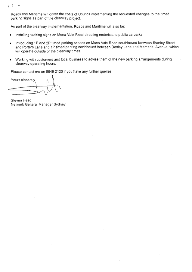
|
Ordinary Meeting of Council - 6 December 2016 |
GB.11 / 357 |
|
|
|
|
Item GB.11 |
S10627 |
|
|
23 August 2016 |
Ku-ring-gai Bush fire prone land map 2016 - finalisation
EXECUTIVE SUMMARY
|
purpose of report: |
For Council to adopt the exhibited 2016 Ku-ring-gai Bush Fire Prone Land Map (BFPLM) which was placed on public exhibition between 24 June 2016 and 21 July 2016, with amendments as outlined in this report, for lodgement to the Commissioner of the NSW Rural Fire Service for certification. |
|
|
|
|
background: |
The Rural Fires and Environmental Assessment Legislation Amendment Act 2002 necessitates the submission of a Bush Fire Prone Land Map for certification by the NSW RFS Commissioner. This map must be reviewed every five (5) years. A BFPLM formally identifies land affected by a bush fire hazard and acts as a legislative trigger for the consideration of appropriate planning and development controls. It is a requirement of the NSW RFS that the BFPLM be prepared according to specifications contained in the Guide for Bush Fire Prone Land Mapping (NSW RFS 2015). |
|
|
|
|
comments: |
The draft 2016 Ku-ring-gai BFPLM, based on the latest mapping methodology, was publicly exhibited from 24 June to 21 July 2016. Thirteen submissions were received as a result of the exhibition. Following a review of these submissions, amendments are proposed as outlined in this report. The final BFPLM identifies 5,447 hectares of Bush Fire Prone Land in the Ku-ring-gai LGA, resulting in 12,011 bush fire prone properties. |
|
|
|
|
recommendation: |
That Council endorses the final Ku-ring-gai 2016 BFPL Map, with amendments as outlined in this report, for lodgement to the Commissioner of the NSW Rural Fire Service for certification. |
Purpose of Report
For Council to adopt the exhibited 2016 Ku-ring-gai Bush Fire Prone Land Map (BFPLM) which was placed on public exhibition between 24 June 2016 and 21 July 2016, with amendments as outlined in this report, for lodgement to the Commissioner of the NSW Rural Fire Service for certification.
Background
The Rural Fires and Environmental Assessment Legislation Amendment Act 2002 was introduced to ensure that people, property and the environment are better protected against bush fire. This legislation amends both the Environmental Planning and Assessment Act 1979 [EP&A Act] and the Rural Fires Act 1997 [RF Act] and requires the submission of a map of Bush Fire Prone Land for certification by the Commissioner of the NSW Rural Fire Service (RFS). This map must be reviewed every five (5) years.
It is a requirement of the NSW RFS that the BFPLM be prepared according to specifications contained in the Guide for Bush Fire Prone Land Mapping (NSW RFS 2015). The purpose of a BFPLM is to identify vegetation within the LGA that has the potential to support a bush fire and accordingly trigger legislative planning and development controls for land that is at risk from bush fire attack. Development on this land must comply with the requirements of RFS’s Planning for Bushfire Protection (2006) and the Building Code of Australia’s Australian Standard AS 3959-2009 ‘Construction of Buildings in Bush Fire Prone Areas’.
Section 146 of the EP&A Act requires Council to make the BFPLM available for public inspection. Section 149 of the EP&A requires Council to include advice on relevant matters affecting a parcel of land on the planning certificate, including bush fire prone land, as specified in Schedule 4 of the Environmental Planning and Assessment Regulation 2000. The section 149 certificate is an important mechanism for councils to inform people living in or looking to purchase in a bush fire prone area, so that bush fire is a consideration.
Comments
Ku-ring-gai’s first BFPLM was approved by the Commissioner of the NSW RFS in 2002 and revised in January 2008. Council previously attempted to amend the 2008 BFPLM within the 5 year review period, as reported to Council at its Ordinary Meeting of Council on 7 March 2011. However, changes to bush fire prone lands provisions in the EP&A Act, 10/50 reviews and subsequent amendments to the mapping methodology have delayed this 2011 re-certification attempt.
At the Ordinary Meeting of Council on 31 March 2015 Council approved the draft 2015 Bush Fire Prone Land Map for public exhibition, based on the Guide for Bush Fire Prone Land Mapping released in September 2014. During the public exhibition period, however, the NSW RFS advised Council staff to discontinue the certification process due to an impending further review of the mapping methodology which was subsequently released in November 2015. This new guide contained amendments to Category 2 vegetation and the inclusion of a new Category 3 vegetation class.
Council once again engaged the consultant Eco Logical Australia to validate and update the Ku‑ring-gai BFPLM in line with the release of the November 2015 methodology. It also offered the opportunity for limited assessment of previous public submissions against the new parameters.
At the Ordinary Meeting of Council on 14 June 2016 Council endorsed the public exhibition of the draft 2016 Ku-ring-gai BFPLM.
integrated planning and reporting
Community, People and Culture
|
Community Strategic Plan Long Term Objective |
Delivery Program Term Achievement |
Operational Plan Task |
|
An aware community able to prepare and respond to the risk to life and property from emergency events.
|
Plans are developed in partnership with emergency service agencies and key stakeholders and implemented.
|
Review, implement and report on the Bush Fire Risk Management Plan in consultation with the Hornsby / Ku-ring-gai Bush Fire Risk Management Committee. |
Governance Matters
The Rural Fires and Environmental Assessment Legislation Amendment Act 2002 requires councils to map bushfire prone land within their Local Government Area. The Ku-ring-gai Bushfire Prone Land Map has been prepared in accordance with the ‘Guide for Bush Fire Prone Land Mapping’ (NSW RFS 2015).
The Ku-ring-gai Bushfire Prone Land Map triggers Section B Part 16 of the Ku-ring-gai Development Control Plan - Bushfire Risk. Land to be developed to which this control applies must comply with the requirements of Planning for Bushfire Protection (2006) for all development, designed and constructed, within in bush fire prone areas to ensure bush fire safety controls are integrated.
Risk Management
It is a requirement of the Rural Fires and Environmental Assessment Legislation Amendment Act 2002 for councils to map Bush Fire Prone Land within their LGA to ensure that people are better informed, and that people, property and the environment are better protected against bush fire. The BFPLM serves as an important planning mechanism for Council to alert people living or looking to live or develop in areas prone to bush fire attack and to plan development that minimises their bush fire risk.
Financial Considerations
In relation to development within Bush Fire Prone Land, there will be an economic impact in terms of permissible standards of construction, design and layout related to each site. This will only affect new dwellings, alterations and additions and not current buildings.
Social Considerations
Council has responsibilities under the Local Government Act 1993, the Rural Fires Act 1997 and the Fires and Environmental Assessment Legislation Amendment Act 2002 to manage public land to protect and preserve the bushland, minimise the occurrence and spread of bush fire on land under its care and control, and reduce the risk of bush fire to the community. The BFPLM assists in ensuring that bush fire safety provisions are incorporated into new development where that development is identified as being located in an area of risk.
Environmental Considerations
As noted above, development on properties that are located in a Bush Fire Prone Area is subject to additional development and planning controls. This includes compliance with Planning for Bushfire Protection (2006) and the Building Code of Australia, and documentation in Section 149 certificates.
In addition to these controls, the RFS’s 10/50 Vegetation Clearing Entitlement Area is triggered by inclusion as a Bush Fire Prone Area. The Entitlement Area is governed by the RFS and allows clearing of land in specific circumstances. Currently the Entitlement Area is aligned to Category 1 (100m) and Category 3 (30m) Bush Fire Prone Area buffers.
Community Consultation
The draft 2016 Ku-ring-gai BFPLM was placed on public exhibition from 24 June 2016 to 21 July 2016. Consultation was conducted as follows:
· letters were sent to owners and residents affected by the proposed changes;
· letters were sent to previous respondents to the draft 2015 mapping (with an invitation to re-submit);
· displays in Council Chambers and at Council’s four (4) libraries;
· Council’s website, social media platforms and online e-news communications; and
· an advertisement in the North Shore Times.
Council received thirteen (13) submissions which were reviewed by the consultant Ecological Australia, in collaboration with Council staff and the head and district office (Hornsby Ku-ring-gai) of the RFS, as to an area’s classification, declassification, retention or adjustment, due to managed fuel loads. Final recommendations as to an area’s status were determined by the RFS.
The RFS’ determination relating to the thirteen (13) submissions is provided in Table 1 below.
|
Case
|
Area of concern |
Number of submissions received in relation to this matter |
Public exhibition status |
RFS determination |
Effect on properties |
|
1. |
Riparian vegetation at Merrivale Lane, Pymble (back of Pymble Golf Course) |
3 |
No classification |
Classification to Category 2. |
The addition of bush fire prone status to 21 nearby properties |
|
2. |
Clive Evatt and Turiban Reserves, Wahroonga |
2 |
Category 2 |
Retention as Category 2 |
No change |
|
3. |
Boronga Avenue, West Pymble |
1 |
Category 2 |
Retention as Category 2 |
No change |
|
4. |
13 Baldwin Street, Gordon. |
1 |
Category 1 |
Retention as Category 1 with boundary adjustment as per consultant’s data – privately managed reduced fuel loads. |
The removal of bush fire prone status from 10 nearby properties |
|
5. |
78 and 80 Finlay Rd, Turramurra |
1 |
Category 2 |
Retention as Category 2 with boundary adjustment – privately managed reduced fuel loads. |
No change |
|
6.* |
North Turramurra deferred area - SEPP5 Exclusion Areas* |
5 |
No classification |
This layer is made under SEPP (Housing for Seniors or People with a Disability) 2004 and will be superimposed by Council for planning purposes as required and therefore does not need to be shown for the purpose of the BFPLM. |
No change |
Table 1: Review of submissions received
In relation to Case 1:
· Category 2 bush fire prone status was triggered due to vegetation connectivity; large proximate parcels of Category 1 bushland and a vegetation management plan incumbent on Pymble Golf Course. The new Category 2 classification will affect 21 nearby properties (see Attachment A1).
In relation to Case 4:
· the removal of Category 1 bush fire prone status from 10 nearby properties is due to large-scale privately managed fuel reduction certified by a bush-fire consultant (see Attachment A1).
In relation to Case 6:
· the North Turramurra SEPP5 Exclusion Area was previously exhibited cross-hatched on the 2008 BFPL map as State Environmental Planning Policy No5 (Housing for Older People or People with Disability). This SEPP has changed to SEPP (Housing for Seniors or People with a Disability) 2004 and the same areas will continue to be subject to the criteria and assessment requirements of the Planning for Bushfire Protection guidelines and section 100B of the Rural Fires Act 1997. Because this layer is made under different legislation it will be superimposed by Council for planning purposes as required and therefore does not need to be shown for the purpose of the BFPLM.
The final BFPLM identifies 5,447 hectares of Bush Fire Prone Land in the Ku-ring-gai LGA (Category 1 vegetation, Category 2 vegetation and the buffer zone), resulting in 12,011 bush fire prone properties. This is a slight change from the draft BFPLM, which identified 5,441 hectares of Bush Fire Prone Land in the Ku-ring-gai LGA, resulting in 12,000 bush fire prone properties.
[Please note that the OMC 14 June 2016 report notes that the draft BFPLM contained 3,210 hectares of Bush Fire Prone Land in the Ku-ring-gai LGA, resulting in 12,045 bush fire prone properties. These figures have since been corrected].
All property owners who made a submission received confirmation of the outcome of the review. However, it was made clear that the Commissioner may amend the 2016 Ku-ring-gai Bushfire Prone Land Map during the certification process.
The final 2016 Ku-ring-gai Bush Fire Prone Land Map is included as Attachment A2.
Internal Consultation
Internal consultation was not required during this final review process. Final determination was contingent on RFS recommendations.
Summary
The Rural Fires and Environmental Assessment Legislation Amendment Act 2002 necessitates the submission of a Bush Fire Prone Land Map for certification by the NSW RFS Commissioner. This map must be reviewed every five (5) years. A BFPLM formally identifies land affected by a bush fire hazard and acts as a legislative trigger for the consideration of appropriate planning and development controls. It is a requirement of the NSW RFS that the BFPLM be prepared according to specifications contained in the Guide for Bush Fire Prone Land Mapping (NSW RFS 2015).
At the Ordinary Meeting of Council on 31 March 2015 Council approved the draft 2015 Bush Fire Prone Land Map for public exhibition, based on the Guide for Bush Fire Prone Land Mapping released in September 2014. During the public exhibition period, however, the NSW RFS advised Council staff to discontinue the certification process due to an impending further review of the mapping methodology which was subsequently released in November 2015.
Following the release of the Guide for Bush Fire Prone Land Mapping (NSW RFS 2015) and the associated metadata, Eco Logical Australia were again contracted to validate and update the Ku‑ring-gai BFPLM in line with the new methodology, to enable Council to seek certification of its updated mapping from the NSW RFS and thus meet its statutory obligations in regard to maintaining the currency of the mapping.
The Draft Ku-ring-gai 2016 Bushfire Prone Land Map was placed on public exhibition from 24 June to 21 July 2016. Thirteen (13) submissions were received as a result of the exhibition period and field investigations undertaken by Council staff, Eco Logical and both the Head Office and District Office (Hornsby – Ku-ring-gai) of the NSW Rural Fire Service in response to these submissions (between August and October 2016). The matters identified along with the responses are summarised in this report.
The final BFPLM identifies 5,447 hectares of Bush Fire Prone Land in the Ku-ring-gai LGA, resulting in 12,011 bush fire prone properties.
All property owners who sought amendment to the draft mapping have been informed of the results of the review.
The Commissioner of the NSW Rural Fire Service is required to certify the 2016 Ku-ring-gai Bushfire Prone Land Map. Upon certification of the map Ku-ring-gai Council will be required to amend section 149 certificates of newly affected properties.
|
That Council endorses the final 2016 Ku-ring-gai 2016 Bush Fire Prone Land Map, with amendments as outlined in this report, for lodgement to the Commissioner of the NSW Rural Fire Service for certification. |
|
Suzy Lykos Natural Areas Team Leader |
Marnie Kikken Manager Environment & Sustainability |
|
Ian Dreghorn Acting Director Strategy & Environment |
|
|
Consultant's report - bush fire prone land methodology |
|
2016/326014 |
||
|
|
Final 2016 Ku-ring-gai Bush Fire Prone Land Map |
|
2016/326015 |
|
Ordinary Meeting of Council - 6 December 2016 |
GB.12 / 385 |
|
|
|
|
Item GB.12 |
S10467 |
|
|
9 November 2016 |
Turramurra Community Hub Master Plan - Update on discussions with Coles Property Development Group
EXECUTIVE SUMMARY
|
purpose of report: |
The purpose of this report is to recommend amendments to the draft Turramurra Community Hub Master Plan (as exhibited) based on recent discussions with Coles Property Development Group (Coles). |
|
|
|
|
background: |
At OMC 28 June 2016 GB.6 the results of the public exhibition of the draft Turramurra Community Hub Master Plan were reported to Council. At that meeting Council resolved to defer their decision subject to:
· further meetings on aspects of concern raised by Councillors; · a further meeting with Coles; and · a report to determine the location of the library and community centre facilities within the Ray Street precinct. |
|
|
|
|
comments: |
This report addresses the resolution from OMC 28 June 2016 GB.6 in relation to further meetings with Coles; describes the outcomes of the meetings; and proposes amendments to the exhibited master plan. |
|
|
|
|
recommendation: |
This report recommends that the draft Turramurra Community Hub Master Plan (as exhibited) be amended to take into account agreed outcomes as a result of recent discussions with Coles. |
Purpose of Report
The purpose of this report is to recommend amendments to the draft Turramurra Community Hub Master Plan (as exhibited) based on recent discussions with Coles Property Development Group (Coles).
Background
OMC 28 June 2016 GB.6 - Turramurra Community Hub Master Plan - Post Exhibition
At OMC 28 June 2016 GB.6 the results of the public exhibition of the draft Turramurra Community Hub Master Plan were reported to Council. At that meeting it was resolved:
A. That the decision on the Turramurra community hub master plan as exhibited be deferred for further meetings with councillors within the next 2 weeks on a Tuesday on aspects of concern. A further meeting be held with Coles within one month.
B. That prior to any decision being made on the Turramurra community hub master plan as exhibited, a report should be brought to council to determine the location of the library and community centre facilities within the Ray Street precinct taking into account all previous resolutions of council on these facilities.
C. That all action cease on the reclassification and rezoning of the Turramurra Village Park until after a decision has been made to determine the location of the library and community Centre facilities within the Ray Street precinct.
D. That a separate report be prepared and reported to council on the Turramurra traffic and transport study with a view to council adopting the study in principle.
In relation to the above:
· Resolution A is complete. A meeting with Councillors, Council staff and external consultants was held on Tuesday, 2 August 2016; a preliminary meeting with representatives of Coles Property Development Group (CPDG) was held on 11 August 2016; with subsequent meetings held with Coles on 29 August 2016 and 28 October 2016 – the issues raised and outcomes of these meetings are addressed in the ‘Comments’ section of this report.
· Resolution B is complete; this was reported and resolved at OMC 6 September 2016.
· Resolution C has been actioned; refer Notice of Rescission NM.1 of OMC 20 September 2016.
· In relation to Resolution D a separate report went to OMC 6 September 2016 and Council resolved to defer their decision subject to a Councillor briefing. Two meetings have been held the first a Councillor update on 31 October 2016 attended by RMS and consultants; the second a Councillor briefing attended by staff and consultants on 8 November 2016.
OMC 6 September 2016 GB.11 - Turramurra Community Hub Master Plan – Community Facilities
At OMC 6 September 2016 GB.11 the preferred location for a new Turramurra community building comprising branch library and community centre was reported to Council. At that meeting it was resolved:
A. Council adopts the Turramurra Community Facilities Study, 2015, as the basis for ongoing planning and design of the proposed Turramurra Community Building comprising a library and community centre with a GFA of 3,000m2. Council also recognises the need for and desirability of retaining some of the present facilities in the Gilroy Road Precinct.
B. The proposed Turramurra Community Building is to be located within the Turramurra Community Hub as supported by the Elton Facilities Study stakeholder consultation and the Turramurra Community Hub Masterplan community engagement.
C. The Turramurra Village Park is to remain as a unique green park for the Turramurra Centre with no further action to be taken on reclassification.
D. That Option 3 (p 392) be the preferred option for all future master planning.
In relation to the above:
· With regards to Resolution C, a Notice of Rescission NM.1 of OMC 20 September 2016 moved that Council adopts the Planning Proposal to rezone and reclassify 5 Ray Street, Turramurra (Lot 2 DP221290) and 12 William Street, Turramurra (Lot 1 DP519532).
OMC 20 September 2016 – Notices of Rescission
At OMC 20 September 2016, two Notices of Rescission were passed. NM.1 - to rescind the motion resolved by Council on 6 September 2016 regarding GB.10 Exhibition and Public Hearing – Planning Proposal to rezone and reclassify Council owned land at 5 Ray Street, 12 William Street and 1275 Pacific Highway, Turramurra.
A. That Council adopts the Planning Proposal to rezone and reclassify 5 Ray Street, Turramurra (Lot 2 DP221290) and 12 William Street, Turramurra (Lot 1 DP519532).
B. That Council requests the Greater Sydney Commission under Section 59(3) of EP&A Act to defer the inclusion of 1275 Pacific Highway, Turramurra from the Planning Proposal.
C. That Planning Proposal be submitted to the Department of Planning and Environment in accordance with section 59 of the Environmental Planning and Assessment Act 1979, and that the Greater Sydney Commission be requested to make the plan.
D. That those who made submissions be notified of Council’s decision.
NM.2 - to rescind the motion resolved by Council on 6 September 2016 regarding GB.11 Turramurra Community Hub Master Plan – Community Facilities.
A. That Council adopts the Turramurra Community Facilities Study, 2015 as the basis for ongoing planning and design of the proposed Turramurra Community Building comprising a library and community centre with a total GFA of 3,000m2.
B. That the Council adopts the Turramurra Town Square site as the preferred site for the location of the proposed Community Building.
C. That Council receive and note the results of the public exhibition of the draft Turramurra Community Hub master plan.
Comments
The preparation of a master plan for the Turramurra Community Hub site was triggered in July 2013 when Council considered a report on the future of its landholdings within the Ray Street Precinct in Turramurra, in light of a supermarket redevelopment proposal by Coles Group Property Developments (CGPD). At the time, the matter was deferred for a Councillor briefing and a meeting with representatives from CGPD.
At the Ordinary Meeting of Council (OMC) held on 9 December 2014, Council resolved unanimously to adopt Design Option 2CA as the preferred option for the purposes of public exhibition and to prepare a draft master plan on that basis including exhibition material.
During 2015 consultants were engaged to prepare a master plan as per Council’s resolution; at the same time a number of other studies were prepared and completed. The draft Turramurra Community Hub Master Plan was publicly exhibited for a period of one month from 30 April until 29 May, 2016. On 28 June 2016 the results of the public exhibition of the draft Turramurra Community Hub Master Plan were reported to Council and the exhibited master plan was recommended for adoption. At that meeting Council resolved to defer their decision subject to:
· further meetings on aspects of concern raised by Councillors;
· a further consultation with Coles; and
· a report to determine the location of the library and community centre facilities within the Ray Street precinct.
This report addresses the resolution from OMC 28 June 2016 GB.6 in relation to further meetings with Coles; describes the outcomes of the meetings; and proposes amendments to the exhibited master plan. As the proposed supermarket is located on the lower ground floor there are no further changes to the master plan proposed at this stage.
The amended lower ground floor plan has been provided in Attachment A1– Amended Lower Ground Floor Plan.
Consultation with Coles
As requested by Council, staff met with representatives of Coles; a total of three (3) meetings were convened. Council’s Probity consultants have been informed of the meetings and were in attendance at meeting no. 3. A summary of each meeting is provided below:
Meeting no.1 – 11 August, 2016:
· The key concerns raised by Coles in relation to the exhibited draft master plan include:
- The shape of the box – opposed to the triangular configuration and size is too small;
- Residential lift core location – this will have a large impact on operational requirements;
- Impacts of servicing on residential amenity;
- The ability to stage the redevelopment to enable continuation of Coles trade;
- Location of retail car parking in relation to the Coles trading level; and
- Impact of supporting retail not being directly adjacent to the supermarket.
· Coles is still supportive in principle of the redevelopment of the Hub site, but must resolve the abovementioned issues before they are able to proceed;
· Coles reiterated that they are keen to maintain an open dialogue with Council to achieve the best possible outcome for both parties; and
· It was agreed that Council staff would meet with Coles again, to further ascertain and understand what points of concern Coles has with the draft exhibited master plan.
Meeting no.2 – 29 August, 2016
· Coles reiterated the concerns they have with the draft master plan as exhibited;
· Coles indicated the ideal size for a supermarket in this location would be:
- 4,000m2 GFA including back of house.
- The configuration to be circa 75m x 50m;
- A 200m2 GFA liquor store – preferably backing onto the Coles tenancy; and
- External loading area circa 200-300m2 depending on location & access.
· Coles stated that if the supermarket is to be subterranean, then the size of floor plate would need to be increased, to offset the lack of exposure at street level;
· Four (4) basic sketch options were tabled for Coles to consider, which would achieve a more rectangular floor plate configuration, revised access and servicing arrangements and less intrusive location of residential lift cores in relation to the specific operational requirements of Coles. Of these four options two options were preferred and given further consideration (refer Figure 1).
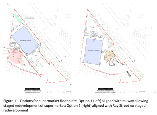
· Post the meeting on 29 August, 2016 Coles reviewed the four (4) options presented to them by KMC staff, advising that ‘Option 1 – Staged’ option most closely represented Coles’ preference, albeit with revisions to better reflect the operational needs of Coles. An assessment of the two options is provided below in Table 1.
|
Option 1 - Staged |
|
|
PROS |
CONS |
|
· Optimal location of supermarket for structure. Structural grid will align with supermarket grid; · Optimal location of vehicle ramp on Ray St; · Optimal location to avoid residential lift cores; · Expansion options for Coles; · Supermarket has access to day light; and · Simple supermarket loading arrangement. |
· Staging requires either a temporary ramp or partial demolition of existing Coles; and · Grand Stair on the linear park must be amended - to occupy a portion of railway gardens. |
|
Option 2 – Non Staged |
|
|
PROS |
CONS |
|
· Potential for more generous 'lower ground plaza'; · Good relationship with trailing retail; and · Opportunity for deeper planting 'pots' for trees in linear park. |
· Viability of turn table in loading dock needs further investigation; · Car parking separated from town centre; · Residential lift cores interrupt floorplate; · Additional pressure placed on apartment planning due to necessary core arrangement; · Trading through construction not possible; · Trading floor is underneath Community Hub Building, restricting basement; · Impacts on building appearance from Ray St; and · Impacts on permeability between proposed Buildings A & B. |
Table 1 – Assessment of supermarket layout options
Meeting no.3 – 28 October, 2016
· The purpose of this meeting was primarily to consider any outstanding design issues regarding preferred Option 1 – Staged;
· Coles were generally supportive of the revised Option 1 – Staged. Coles requested that Chrofi prepare a pedestrian flow diagram (for lower & upper ground floors), a vehicular movement plan and solar access diagram for their consideration; and
· Council’s probity consultants were in attendance at this meeting.
On the basis of the abovementioned, recent dialogue with Coles, a letter of support has been submitted to Council, stating that Coles are “encouraged by the direction the Hub is taking and on the basis its objectives are met, remains eager to work together with Council and the community to develop a shared vision for the precinct”. The letter has been provided in Attachment A2 - Coles Letter of Support.
The lower ground floor plan of the exhibited master plan has been amended to reflect the outcome of these deliberations (refer Attachment A1). Figure 2 shows the difference between the layout of the lower ground floor in the exhibited master plan compared to the amended master plan. The amended layout clearly shows a larger and more regular rectangular shape for the sales area.
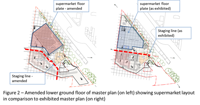
integrated planning and reporting
The Revised Delivery Program 2013-2017 and Operational Plan 2016-2017 commits Council to master planning for the revitalisation of the Turramurra Local Centre and surrounding precincts.
|
Community Strategic Plan Long Term Objective |
Delivery Program Term Achievement |
Operational Plan Task |
|
A range of well planned, clean and safe neighbourhoods and public spaces designed with a strong sense of identity and place.
|
4.1.1- Plans to revitalise local centres are being progressively implemented and achieve quality design outcomes in collaboration with key agencies, landholders and the community.
|
Progress master planning for the Turramurra Centre and surrounding precincts.
Engage with key community stakeholders to identify the requirements for new community facilities and infrastructure.
Finalise the reclassification of identified lands as resolved by Council. |
|
A healthy, safe, and diverse community that respects our history, and celebrates our differences in a vibrant culture of learning.
|
C4.1.2- New and enhanced open space and recreational facilities have been delivered to increase community use and enjoyment.
|
Undertake acquisitions for new parks.
Undertake assessment and identify locations for new parks
Complete the design for identified parks and include design principles which facilitate passive recreation activities.
Construct parks at identified locations and include design principles which facilitate passive recreation activities |
FIT FOR THE FUTURE IMPROVEMENT ACTION PLAN
The NSW Government's Fit for the Future initiative required all councils to prepare an Improvement Proposal and supporting Implementation Plan demonstrating how all seven Fit for the Future benchmarks would be met by 2016/17, and maintained or improved thereafter.
Council's Fit for the Future Improvement Proposal and supporting Implementation Plan underpins the decision to stand alone and not merge with Hornsby Council. The objectives established in the Improvement Proposal and Implementation Plan are embedded in Council's adopted Integrated Planning and Reporting documents including the Revised Delivery Program 2013-2017 and Operational Plan 2015-2016, Long Term Financial Plan 2015/16 to 2024/25 and Asset Management Strategy 2015/16 to 2024/25.
Council’s Fit for the Future Improvement Proposal sets out the following strategies and outcomes to meet the State governments Efficiency criteria:
|
EFFICIENCY |
|||
|
Objective |
Strategies |
Key milestones |
Outcome |
|
Major Local and Town Centres projects i.e. Community hub projects are commercially feasible in their own right |
Projects should include commercial opportunities for Council to offset ongoing operational costs (life cycle costs) of the public benefits provided |
Master plans adopted for Local and Town Centres 2015/2016
EOI for the redevelopment of Turramurra Local Centre 2015/2016.
Redevelopment of Turramurra Local Centre 2016/2017. |
Master plans adopted for the Local and Town Centres with development options substantially progressed to deliver community facilities and public benefits. |
It is noted in the NSW Government publication Merger Proposal – Hornsby Shire Council (part) and Ku-ring-gai Council dated January 2016, that specific reference is made to the proposed merger and the ability to provide the services and infrastructure to the community including the revitalisation of Lindfield, Turramurra and Gordon Town Centres.
Governance Matters
To ensure that the KLEP (Local Centres) will accommodate the masterplan, Council prepared a Planning Proposal for the rezoning and reclassification of three sites - 5 Ray Street, 12 William Street and 1275 Pacific Highway. This Planning Proposal was publically exhibited between, 29 April – 27 May 2016.
On 28 June 2016 after considering a report on the outcomes of the public exhibition of the draft Turramurra Community Hub Masterplan, Council resolved that all action cease on the reclassification and rezoning of 1275 Pacific Highway, Turramurra (Turramurra Village Park) until a decision was made on the location of the library and community facilities within the precinct. Council resolved on 20 September 2016 that the location for the library and community facilities within the precinct is to be within the Turramurra Town Square site and to continue the process into the reclassification and rezoning of 1275 Pacific Highway, Turramurra (Turramurra Village Park).
A Public Hearing into the reclassification of 5 Ray Street and 12 William Street, Turramurra was held on 25 July 2016. Council considered a report on the exhibition and public hearing on 6 September 2016 and resolved to adopt the planning proposal to rezone and reclassify 5 Ray Street and 12 William Street and to defer the inclusion of 1275 Pacific Highway. The planning proposal has been submitted to the Department and is waiting to be made.
A separate Public Hearing into the reclassification of 1275 Pacific Highway was held on 26 October 2016. The Chairpersons report on the Public Hearing was received by Council on 23 November 2016 and made available to the public and on Council’s website on 25 November 2016 . The Chairperson’s findings on the public hearing , will be the subject of a separate report to Council once staff have had the opportunity to give it full consideration. This future report will also cover the outcomes of the community consultation on the Planning Proposal to rezone and reclassify 1275 Pacific Highway, Turramurra.
Risk Management
The major risk to Council at this point in time is the proposed amalgamation with Hornsby Shire Council. The uncertainty surrounding the pending proclamation could potentially delay necessary investigations into how the master plan may be best delivered.
A further risk to Council is reputational. The planning for Turramurra local centre commenced in 2010 with the drafting of the Local Centres LEP; Council has taken almost 6 years to get to this point. Based on the positive community consultation the master plan received during exhibition, and the good will established as a result; Council needs to be aware of the potential negative effect any further delays to the project would have on its reputation, given the amount of resources expended to date and the Turramurra Community’s expectations.
Financial Considerations
To date Council has expended over $400,000.00 on this project including salaries and consultancies. These funds have been sourced from development contributions 2010 Plan Recreational, Cultural & Social Facilities. It is important that Council continues to progress this project, if not Council may be required to repay part of the S94 funds spent to date if the works are not delivered.
Council’s Long Term Financial Plan (LTFP) identifies a total of approximately $26 million allocated from the S94 Ku-ring-gai Contributions Plan, 2010 for works associated with the Turramurra Community Hub. These funds will be Council’s contribution toward the project and have been taken into account when preparing the preliminary economic feasibility assessment.
The funds allocated to this project represent only a proportion of the total development contribution funds that will be available for the Turramurra Local Centre as a whole. In the future Council will be undertaking master plans for the other key precincts as funds become available.
Social Considerations
Council’s Community Strategic Plan 2030, recognises the community’s vision for Ku-ring-gai as a place with infrastructure and facilities which accommodate the needs of the community. The plan further emphasises the desire for an adopted program for the implementation of new facilities, identified funding sources and a program to maintain Council’s assets at a sustainable standard.
Environmental Considerations
A number of environmental studies have been undertaken to date for this site. Further necessary due–diligence studies will be undertaken in due course as part of the next phase.
Community Consultation
The community consultation period was between 30 April and 29 May 2016 and included a range of engagement and communications techniques to ensure maximum input and participation. The results of the exhibition were reported to council at OMC 28 June 2016 and OMC 6 September 2016.
A key outcome of the exhibition is that the community are broadly supportive of the draft Master plan. The demographically representative recruited workshop scored the master plan 3.7 (74%) out of 5; the opt-in workshop scored 3.3 (66%) out of 5; the youth workshop scored the draft Master Plan 4.75 (95%) out of 5. Survey respondents were also generally positive with minimal negative comments.
Internal Consultation
This report was prepared by the Strategy & Environment Department in consultation with staff from other Departments where relevant.
Since 2014, ten (10) information sessions have been held for Councillors:
1. Briefing on 8 October 2014 at which consultants presented a draft site analysis, design principles, preliminary design options and financial assessment.
2. Presentation of draft design options to Councillors at two site inspections held on 22 and 28 October 2014. At the final site inspection chalk markings were provided around the site to assist Councillors in understanding the design options.
3. Briefing to Councillors on 1 December 2014 on the draft Turramurra Community Facilities Study as well as the Ku-ring-gai Community Facilities Strategy (LGA wide).
4. Briefing session was held on 4 June 2015 to update councillors on the Draft Master Plan for the site.
5. Briefing session was held on 4 August 2015 to present to Councillors the completed draft master plan and model.
6. Question and Answer session was held on 8 December 2015 to present to Councillors the refined master plan, taking into account AEC’s recommendations, prior to the council meeting.
7. Meeting with Councillors, staff and consultants was convened on 2 August 2016 to discuss Councillor’s ‘aspects of concern’ regarding the exhibited draft master plan. A number of questions were raised by Councillors both before and after OMC 28 June 2016 and were largely centred around the issues of the location of community facilities within the Ray Street Precinct, the built form and height of proposed development, Turramurra Village Park and traffic and transport - each of which was comprehensively addressed at this meeting.
8. Briefing to Councillors on 8 November 2016 on the Turramurra Transport Management Plan by consultants and staff.
9. Councillor update on 31 October 2016 attended by RMS and consultants.
10. Question and Answer session was held on 22 November 2016 to update Councillors on the discussions with Coles to date and the subsequent amendments to the draft master plan as exhibited, addressing a number of design and operational concerns raised by Coles during recent discussions.
Summary
At OMC 28 June 2016 GB.6 the results of the public exhibition of the draft Turramurra Community Hub Master Plan were reported to Council. At that meeting Council resolved to defer their decision subject to further meetings and reporting.
This report documents meetings with Coles representatives, as requested by Council, and addresses design and operational concerns raised by Coles, with respect to the draft master plan as exhibited for the Turramurra Community Hub. These issues have been taken into account and the draft Master Plan revised accordingly. The changes pertain to the lower ground level (subterranean) only and as such the draft master plan, as exhibited, is not materially different from the ground level and above.
A letter of support has been submitted to Council from Coles, stating that they are “encouraged by the direction the Hub is taking and on the basis its objectives are met, remains eager to work together with Council and the community to develop a shared vision for the precinct”.
The lower ground level floor plan of the draft Turramurra Community Hub Master Plan has been provided as a hard copy version (separately circulated) to all Councillors and in Attachment A1–draft Turramurra Community Hub Master Plan – amended lower ground floor plan.
|
A. That the amended lower ground floor plan of the draft Turramurra Community Hub Master Plan be adopted by Council.
B. That the letter of support from Coles to Ku-ring-gai Council be received and noted.
C. That a report be brought back to Council in early 2017 documenting the Chairperson’s findings on the public hearing and recommending a final master plan. |
|
Louise Drum Senior Urban Designer |
Bill Royal Team Leader Urban Design |
|
Craige Wyse Team Leader Urban Planning |
Antony Fabbro Acting Director Strategy & Environment |
|
Amended Lower Ground Floor Plan |
|
2016/331718 |
||
|
|
Coles - Letter of Support |
|
2016/325020 |
|
Ordinary Meeting of Council - 6 December 2016 |
GB.13 / 398 |
|
|
|
|
Item GB.13 |
S10467 |
|
|
26 October 2016 |
Turramurra Local Centre -
Traffic and Transport Study
EXECUTIVE SUMMARY
|
purpose of report: |
To consider the Turramurra Community Hub Transport Scenario Testing Study, 2016. |
|
|
|
|
background: |
The Turramurra Community Hub Transport Scenario Testing study was prepared to assess the cumulative transport impacts of the Turramurra Community Hub project and other expected developments in the Turramurra local centre based on the Ku-ring-gai LEP (Local Centres) 2012. |
|
|
|
|
comments: |
A preferred strategic traffic and transport plan for Turramurra has been developed that includes a series of intersection modifications/improvements, and a new rail bridge linking Ray Street to Rohini Street. The preferred plan would provide the most efficient intersection operation in the network and has support from the Roads and Maritime Service (RMS). |
|
|
|
|
recommendation: |
That Council adopts the Turramurra Community Hub Transport Scenario Testing study (with the rail bridge option) and submit it to the RMS for their concurrence. |
Purpose of Report
To consider the Turramurra Community Hub Transport Scenario Testing Study, 2016.
Background
Council currently does not have a strategic transport management plan for Turramurra local centre. Given the amount of development that has occurred and will continue to occur over the next 20 years it is of paramount importance that Council addresses this matter.
On 19 September 2013 the transport planning section of Roads and Maritime Services (RMS) wrote to the General Manager raising concern over the alterations to the Turramurra Local Centre Traffic Management Plan made by Council. The changes were made at the Extraordinary Meeting of Council - 31 July 2012 when considering the Ku-ring-gai Local Centres Planning Proposal - Post Exhibition. In relation to Turramurra, Council resolved that:
· The property at 12 Turramurra Avenue is no longer required for a Local Road and is to be disposed of. The property at 15 Gilroy Road is no longer required for a Local Road and is to be removed from the Land Acquisition Map. These two properties are to be zoned in accordance with adjoining property.
· There will be no major revision of current traffic management in the Rohini Street/Gilroy Road/Turramurra Avenue precinct and traffic lights will remain at the intersection of Rohini Street and Pacific Highway.
· The Bus Interchange is to be upgraded.
· A turning circle and Drop off Point will be retained adjacent to the station entrance in William Street. Any future taxi stand will avoid this area.
The letter from RMS provides comments in relation to alterations made to the plan by Council since RMS were last requested to review and make comment on the plan in 2012.
RMS requested that a traffic assessment be undertaken regarding the current Turramurra traffic plan to determine the full impacts of Council’s amendments to the plan. RMS gave strong support for the proposed widening of the Pacific Highway to three lanes in each direction between Duff Street and the railway bridge with side-by-side right turn bays at Ray Street and Kissing Point Road.
In order to provide enough space for this future road widening, RMS required that this land be zoned SP2 Classified Road and included as a reservation on the Land Reservation Acquisition Map in the Ku-ring-gai LEP (Local Centres) 2012.
The RMS concerns were reported to Council at the Ordinary Meeting of Council – 12 November 2013 - Turramurra Local Centre Traffic Management Plan. At that meeting Council resolved
A. That Council defers consideration of this matter until there is a firm funded proposal to widen the road bridge over the railway at Turramurra.
B. That Council approach the Premier requesting that plans be made to widen the road bridge at Turramurra.
A letter was sent from the then Mayor to the then Premier in December 2013, but no response as received.
At the Ordinary Meeting of Council – 9 December 2014 A Notice of Motion was tabled stating:
“That the Mayor write to The Premier, Mr Mike Baird MP, and the Local Member for Ku-ring-gai, Mr Barry O’Farrell MP, and the Minister for Transport requesting details from Transport for NSW and the Roads and Maritime Services on the current status of plans being developed to improve pinch points in Ku-ring-gai, particularly through Turramurra, Pymble and Wahroonga/Warrawee.”
A response was received from the Hon Duncan Gay MLC and Minister for Roads (see Attachment A1).
At the Ordinary Meeting of Council 28 June 2016, Council considered a report on the results of the public exhibition of the draft Turramurra Community Hub Master Plan. In the report, an update was given on the work undertaken to refine the draft master plan, including updated project construction estimates to reflect the refinements to the master plan, updated cost estimates for the construction and fit out of community facilities refining feasibility modelling and analysis to take into account the amendments to the master plan and the updated cost estimates, and finalising the Turramurra local centre traffic and transport study and assessing the implications for the master plan on the local traffic networks.
Council resolved (in part):
“That a separate report be prepared and reported to council on the Turramurra traffic and transport study with a view to council adopting the study in principle.”
On 6 September 2016, a report was brought to Council on the Turramurra traffic and transport study. Council resolved:
“That the matter be deferred for a further briefing to deal with the concerns of Councillors.”
Following this Resolution two meetings have been held: the first, a Councillor update on 31 October 2016 attended by RMS and consultants; the second, a Councillor briefing attended by staff and consultants on 8 November 2016.
Table 1 provides a summary of Council’s decisions with regard traffic and transport management in Turramurra local centre
|
Council meeting date |
Recommendation |
Resolution |
|
Extraordinary Meeting of Council 31 July 2012 |
In relation to land use zoning |
Various - related to no major revision of current traffic management |
|
Ordinary Meeting of Council 12 November 2013 |
For Council to note RMS concern regarding Council resolutions of OMC 31 July 2012 |
Defer decision |
|
Ordinary Meeting of Council 8 December 2015 |
To update Council on progress of master plan |
That a traffic study be completed and consideration given to the implications |
|
Ordinary Meeting of Council 28 June 2016 |
To adopt Turramurra Community Hub Master Plan (traffic study provided as background) |
That a separate report be prepared on traffic and transport |
|
Ordinary Meeting of Council 6 September 2016 |
To adopt preferred traffic management plan for Turramurra local centre |
Deferred for further briefings |
|
Ordinary Meeting of Council 6 December 2016 |
To adopt preferred traffic management plan for Turramurra local centre |
pending |
Table 1 - Summary of Council’s decisions with regard traffic and transport management in Turramurra local centre
Comments
The Turramurra Community Hub Transport Scenario Testing Study, 2016 was prepared by consultants PeopleTrans to assess the cumulative transport impacts of the Turramurra Community Hub project, and other expected developments in the Turramurra local centre based on the Ku-ring-gai LEP (Local Centres) 2012.
The methodology adopted for Turramurra Community Hub Transport Scenario Testing study includes the 5 key steps below, with some commentary on each step:
1. Understand Turramurra Population, Land Use and Transport
This section focuses on:
· the Turramurra population and their travel characteristics;
· the public transport services available to the population of Turramurra;
· the active travel options available to the population of Turramurra;
· the Rohini Street bus interchange, to understand the current operational issues and constraints; and
· initial transport stakeholder consultation, to gain feedback from relevant transport related state agencies and transport providers about current operational issues and future needs.
2. Develop Existing Base Transport Model
Traffic volume data was collected for the Thursday pm peak hour and the Saturday peak hour, which were used as the inputs into the microsimulation traffic modelling software (accepted by RMS). This model was then calibrated to closely resemble actual traffic conditions on the ground. RMS validated the model as fit for the purposes of scenario option modelling.
The existing road network operation results in Step 2 shows delays on Pacific Highway during the PM peak period in both directions, with the queue of northbound traffic extended back to Ku-ring-gai Avenue and that the queue of southbound traffic extended back to Cherry Street. The northbound delays on Pacific Highway within the study area was largely as a result of delays originating further north on Pacific Highway. The delays for southbound traffic was as a result of the current 4-2 tidal flow traffic management scheme which results in the road network reaching capacity within the study area. The side streets at the traffic signals on Pacific Highway (i.e. Ray Street, Kissing Point Road and Rohini Street) also experience significant delays as a result of traffic conditions on Pacific Highway.
Modelling results demonstrate that general traffic conditions during Saturday peak period were better than the weekday PM peak period. The isolated delays at the intersection of Rohini Street and Pacific Highway extended back to Ku-ring-gai Avenue for northbound traffic and at the intersection of Ray Street and Pacific Highway the queues extended back to Cherry Street for southbound traffic during the Saturday peak period, which were consistent with the observations on site. In addition to this, the queues on the northbound approach to Rohini Street extended back to Eastern Road. This also happened occasionally during the weekday PM peak, primarily due to the green phase time favouring the Pacific Highway.
3. Prepare Demands for Future Land Use & Assess Impacts of Various Land Use Options
The traffic generation of the expected future retail, business and residential developments in the Turramurra local centre (based on Ku-ring-gai LEP Local Centres (2012) were calculated and assigned to the road network and tested under existing and future road infrastructure improvements. The information in Step 1 provided guidance on the contribution of public transport, walking and cycling in the assessment of transport impacts.
Applying the above traffic generation to the existing road network layout and operation shows substantial deterioration of road network performance in the weekday pm peak. On the local roads, increased delays would be experienced in Rohini Street/Eastern Road, and Kissing Point Road. The impacts to the Saturday peak hour would be slightly less than the weekday PM peak, although performance at all intersections along Pacific Highway would still deteriorate.
In Step 3, the road infrastructure improvement plan (previously presented to RMS during the preparation of the Ku-ring-gai LEP 2012 (Local Centres)) was introduced into the model and tested. The road infrastructure improvements consisted of:
· widening of Pacific Highway between Ray Street and Turramurra Avenue, to accommodate 3 lanes in each direction;
· right turn lane provision (side-by-side) on Pacific Highway between Ray Street and Kissing Point Road;
· modification of the intersection of Ray Street and Pacific Highway, to include 2 right turn lanes and 1 left turn lane on Ray Street;
· modification of the intersection of Kissing Point Road and Pacific Highway, to include 2 right turn lanes and 1 left turn lane on Kissing Point Road;
· modification of the intersection of William Street and Pacific Highway;
· removal of the traffic signals at the intersection of Rohini Street and Pacific Highway and signalisation of the intersection of Turramurra Avenue and Pacific Highway;
· right turn bay provision on Pacific Highway, at the intersection of Turramurra Avenue;
· new road link between Kissing Point Road and Duff Street; and
· new road link between Turramurra Avenue and Gilroy Road.
The above road infrastructure improvements were also tested with the option of a new road bridge connecting Ray Street with Rohini Street. The results testing (without the rail bridge) indicate that the proposed road infrastructure would perform well with the future traffic demands. Performance of the Pacific Highway generally improves compared to the current conditions, with no extensive delays/queues on the Pacific Highway. Traffic conditions on local roads were good, except that queues developed on Turramurra Avenue due to insufficient storage on the north approach.
Results for the Saturday peak hour (without the rail bridge) are similar, although longer travel distance is required for traffic travelling from Eastern Road to Pacific Highway east (north) via Turramurra Avenue. Also, the northbound carriageway on Ray Street between the Pacific Highway and Forbes Lane has only one lane which may cause delays in the Saturday peak hour when right turning vehicles wait for gaps.
Review of Rohini Street bus interchange
PeopleTrans undertook an audit of the existing Rohini Street bus interchange. The audit included aspects such as pedestrian accessibility, bus operations, passenger waiting areas, taxi facilities and bicycle access/parking.
The key findings of the audit were that the space available is inadequate to accommodate all bus operations and layovers. Wayfinding signage is absent, as well as driver amenities. DDA compliance is also not met. Issues that have been identified would need to be addressed as part of any upgrade to the bus interchange area.
4. Determine Preferred Land Use for Community Hub Site and Prepare An Updated Traffic Management Plan
Following Step 3, the traffic generation of the draft masterplan for the Turramurra Community Hub (retail, community and residential land uses) were added to the above model to create a cumulative assessment of all expected redevelopment in the Turramurra local centre, and tested against existing and future road infrastructure improvements (with and without a rail bridge).
Without Rail Bridge
The results of the Master Plan Option (without the rail bridge) indicate that the impacts of the Master Plan Option traffic demands are worse than Step 3 above, as expected. In particular, traffic conditions at the intersection of Turramurra Avenue/Pacific Highway and the intersection of Gilroy Lane/Turramurra Avenue deteriorated in terms of Level of Service. The distance on Turramurra Avenue between the Pacific Highway and Gilroy Lane is less than 40m. When queues extended back to Gilroy Lane, traffic had difficulty seeking gaps from Gilroy Lane.
In the Saturday model, the queuing issues are more significant. However overall traffic performance was good and there were no extensive delays/queues along the Pacific Highway. In this option without the rail bridge, traffic would increase on Ray Street and Turramurra Avenue, with a resulting decrease in traffic on Rohini Street. Two-way traffic volumes on Ray Street and Turramurra Avenue would increase beyond the environmental performance standards stipulated by RMS for these types of roads both for the PM and Saturday peak hours. (i.e. in excess of 700 vehicles per hour).
With Rail Bridge
The results of the Master Plan Option (with the rail bridge) assessment indicate that the overall performance of the model for both the PM and Saturday peak was good. There would be no extensive delays/queues along the Pacific Highway in the model. There would be minor queues on the side roads which were deemed to be acceptable. The rail bridge option also has the effect of reducing the right turning traffic (from south in Turramurra Avenue to west on the Pacific Highway) at the Turramurra Avenue/Pacific Highway intersection. As a result, it has solved the issue of limited queue storage on Turramurra Avenue in the option without the rail bridge.
With the rail bridge, traffic would further increase on Ray Street for both the PM and Saturday peak hours. The expected two-way traffic volumes on Ray Street would exceed the environmental performance standards for the current road category of Ray Street.
To address this, Council may need to consider altering the road hierarchy to remove the current regional road status of Rohini Street (between Pacific Highway and Eastern Road), and add regional road status to Ray Street, the new rail bridge and Rohini Street (from the railway bridge to Eastern Road). To address the amenity impacts of the increased traffic flows on Ray Street, streetscape works and pedestrian/cycling accessibility would need to be incorporated into the project.
Although the northbound traffic volumes on Turramurra Avenue would increase during both the PM and Saturday peak hours, the southbound traffic volumes would decrease. Overall the bi-directional traffic volumes on Turramurra Avenue would remain the same as existing. Traffic on Rohini Street would decrease as a result of the proposed changes at the intersection of Rohini Street and Pacific Highway.
5. Findings and recommendations
To convey in a simple manner the relative benefits of including or excluding the rail bridge in the future road infrastructure improvement plan, the following multi-criteria analysis table was prepared by PeopleTrans:
|
|
Assessment Criteria |
|||||
|
|
Intersection Operation |
Local accessibility (walking, bicycle, car) |
Bus access |
Cost |
Public domain opportunities (Rohini Street) |
Transport Stakeholder support |
|
Road network improvements with rail bridge |
ÖÖ |
ÖÖ |
ÖÖ |
Ö |
ÖÖ |
ÖÖ |
|
Road network improvements without rail bridge |
Ö |
Ö |
Ö |
ÖÖ |
Ö |
Ö |
The preferred strategic traffic plan for Turramurra includes the proposed rail bridge linking Ray Street to Rohini Street. The key advantages of this strategic traffic plan (highlighted in the multi-criteria analysis table above) is that it would provide the most efficient intersection operation network wide and has support from RMS since it would assist with removing traffic from the Pacific Highway.
A new rail bridge would also improve accessibility to the Turramurra Community Hub site for north Turramurra residents, and buses could also be redirected to better service the Turramurra Community Hub. The diversion of traffic via Eastern Road and the new rail bridge will also open up opportunities for public domain improvements on Rohini Street providing a much more pleasant pedestrian environment on this street.
The cost of a new rail bridge would be high, but the proposed road link between Gilroy Road and Turramurra Avenue could be abandoned with little effect on the overall network performance. Council currently owns part of this link at No. 12 Turramurra Avenue (Lot 2 DP983832), Turramurra. The site is zoned Residential R4 High density under KLEP 2012 and is no longer required as a link under this scenario and is recommended to be divested in accordance with Council’s – Acquisition and Divestment of Land Policy 2014.
Future public transport demand analysis
As part of the future transport demand analysis, PeopleTrans assessed potential future public transport demand generated by new residents, as well as from future employees of additional retail, commercial and community uses in the Turramurra local centre. The analysis was based on the average number of people per dwelling and working population (Australian Bureau of Statistics) and Turramurra residents travel mode to work/Turramurra workers travel mode from home (NSW Bureau of Transport Statistics).
The analysis found that the majority of future public transport demand would depend on trains, with an estimated additional 400 daily trips. Bus use is expected to increase only minimally (up to approximately 10 daily trips), and at this stage would not warrant the provision of extra seating capacity due to current spare capacity.
Pinch Points Program update – RMS
On 31 October 2016, RMS General Manager Journey Management provided Councillors in attendance with a brief update on the Pinch Points Program. The RMS representative advised that 30 road corridors in Sydney are being targeted, including Pacific Highway. Pinch points projects were described as relatively minor projects that would provide improved efficiency at key intersections, and include (where feasible) treatments such as minor road widening, new/extended right turn bays and additional capacity on side streets. New road bridges are not projects under consideration.
In terms of improvements in Turramurra, RMS advised that removal of the tidal flow arrangements on Pacific Highway and provision of 3 traffic lanes in each direction was a highly desirable outcome, and the RMS representative offered to collaborate with Council in achieving this.
Councillor update 31 October 2016
On 31 October 2016 an update presentation on the transport study for Turramurra was provided by transport consultants PeopleTrans to Councillors in attendance.
Issues raised by Councillors, and responses, are set out below:
· New bridge integration with Rohini Street
In 2008, Cardno (on behalf of Coles Group) prepared a concept report and design for a railway overbridge between Ray Street and Rohini Street. This concept shows the kerbs returns connecting the bridge deck with Rohini Street and Ray Street to be of a radius that would accommodate a 12.5m large rigid truck. This would cater for the longest vehicle expected to be using these roads.
· Turramurra Avenue width/traffic flow/ease of access
Under the recommended scheme, traffic volumes on Turramurra Avenue are expected to remain relatively stable. Typically, commuters’ vehicles park on both sides of Turramurra Avenue on weekdays, and while car parking could be restricted on one side, this would have the effect of increasing speeds along Turramurra Avenue, which is undesirable.
· Eastern Road/Rohini Street intersection, turning paths for buses/larger vehicles
Under the recommended scheme, bus turning movements into and out of the bus interchange area would not be affected by the existing layout of the intersection. The current intersection layout is such that left turn movement from Rohini Street (southbound) to Eastern Road (northbound) and vice-versa can be accommodated for vehicles at least up to a 12.5m large rigid truck. This would cater for the longest vehicle expected to be using these roads.
· RMS road widening reservations on Pacific Highway, particularly on southern side through Hillview and heritage shops/old bank site.
During the Section 62 consultation with state agencies (which was required for the preparation of the Ku-ring-gai LEP (Local Centres) 2012), RMS requested Council include in the LEP strips of road widening on various sections of Pacific Highway through Turramurra, presumably to assist with removal of the tidal flow arrangements and the provision of 3 traffic lanes in each direction. These have been incorporated into the gazetted LEP maps for Land Zoning, and Land Reservation Acquisition. The road reservation/widening strip affects the Pacific Highway frontage of the Hillview site and 1356-1362 Pacific Highway (which includes the old bank site).
Councillor briefing 8 November 2016
On 8 November 2016 a formal Councillor briefing on the transport study for Turramurra was provided by transport consultants PeopleTrans, in response to the Council resolution of 6 September 2016.
During this briefing, Councillors raised the issue of previous resolutions relating to traffic management in Turramurra, including the 31 July 2012 decision which was that there will be no major revision of current traffic management in the Rohini Street/Gilroy Road/Turramurra Avenue precinct and traffic lights will remain at the intersection of Rohini Street and Pacific Highway.
Transport network modelling work done by PeopleTrans included a scenario where the peak hour traffic generation of all the expected future residential/retail/business development in Turramurra was added to the existing peak hour traffic flows, and tested against existing traffic management measures (which includes traffic signals at the intersection of Pacific Highway and Rohini Street and no changes to local roads in the Rohini Street/Gilroy Road/Turramurra Avenue precinct). This resulted in significant impacts to the road network operation, with performance of a number of key intersections reducing considerably.
integrated planning and reporting
The Revised Delivery Program 2013-2017 and Operational Plan 2015-2016 commits Council to master planning for the revitalisation of the Turramurra Local Centre and surrounding precincts, as well as
Theme 4 – Access Traffic and Transport
|
Community Strategic Plan Long Term Objective |
Delivery Program Term Achievement |
Operational Plan Task |
|
The local road network is managed to achieve a safe and effective local road network. |
T2.2.1 Road network safety and efficiency are improved and traffic congestion is reduced. |
Implement the 10 year Traffic and Transport Program. |
|
An accessible public transport and regional road network that meets the diverse and changing needs of the community. |
T3.1.1 A strategic access, traffic and transport plan is being implemented for the Northern Sydney Region. |
Plan for works in response to development in local centres. |
Governance Matters
Council is required to work with Roads and Maritime Services and Transport for NSW to ensure that the long term transport planning for Turramurra local centre is consistent with the State Government requirements , whilst recognising and planning for local transport requirements.
Risk Management
If Council does not adequately plan for transport improvements, traffic conditions on the Pacific Highway and on local roads such as Rohini Street and Turramurra Avenue are likely to deteriorate further and the opportunity to remove the tidal flow arrangements on the Pacific Highway would be significantly compromised. This would not only affect through traffic on the Pacific Highway but also local access across the Pacific Highway for residents of Turramurra. It would also restrict the potential for improvements to pedestrian safety and amenity in Rohini Street and accessibility to Turramurra railway station.
Financial Considerations
The road infrastructure improvement plan mentioned in Step 3 above has been included in Council’s Long Term Financial Plan.
Based on preliminary costings, a new rail bridge between Ray Street and Rohini Street is approximately $10,000,000 (subject to further investigation and feasibility analysis).
The property No. 12 Turramurra Avenue (Lot 2 DP983832), Turramurra is recommended to be divested by in accordance with Council’s –Acquisition and Divestment of Land Policy 2014 and the funds returned to the Ku-ring-gai Contributions Plan 2010 Section 94 reserves.
Social Considerations
Removing the traffic signals from Rohini Street (at Pacific Highway) would have a very positive impact on the pedestrian amenity and safety in the area, and allow the street to be redesigned, in order to focus on improvements to the transport interchange and the streetscape.
Environmental Considerations
The current tidal flow on Pacific Highway through Turramurra causes congestion during peak periods, therefore improvements to traffic flow through this area would lead to less stop-start conditions resulting in reduced fuel use and improved air quality.
A new rail bridge would also improve accessibility to the Turramurra Community Hub site for residents on the northern/eastern side of the North Shore railway line, and buses could also be redirected to better service the Turramurra Community Hub. A new bridge would also encourage walking and cycling to the Turramurra Community Hub for residents on the northern/eastern side of the North Shore railway line.
Community Consultation
During the public exhibition of the draft Turramurra Community Hub Master Plan, a traffic and transport working paper was included as supporting material, covering the high level outcomes of the transport modelling.
The material publicly exhibited for the draft Turramurra Community Hub Master Plan also included the potential for a new rail bridge between Ray Street and Rohini Street, although the impacts of this had not been analysed at the time.
Internal Consultation
Staff from the Strategy department and Operations department have contributed to development of the transport improvements for Turramurra. A series of briefings with Councillors has also been completed as part the process.
Summary
Council currently does not have a strategic transport management plan for Turramurra local centre. Given the amount of development that has occurred and will continue to occur over the next 20 years it is of paramount importance that Council addresses this matter.
On 19 September 2013 the Roads and Maritime Services (RMS) wrote to the General Manager raising concern over the alterations to the Turramurra Local Centre Traffic Management Plan made by Council. The changes were made at the Extraordinary Meeting of Council - 31 July 2012 when considering the Ku-ring-gai Local Centres Planning Proposal - Post Exhibition.
In 2015 Council commenced preparation of a Turramurra Community Hub Transport Scenario Testing study. The study was prepared to assess the cumulative transport impacts of the Turramurra Community Hub project and other expected developments in the Turramurra local centre based on the Ku-ring-gai LEP (Local Centres) 2012.
The preferred strategic traffic plan for Turramurra includes a series of intersection modifications/ improvements, and the proposed rail bridge linking Ray Street to Rohini Street, Turramurra. This would provide the most efficient intersection operation network-wide, and has support from RMS since it would assist with removing traffic from the Pacific Highway.
This study has now been reported to Council on two separate occasions – the Ordinary Meeting of Council 6 September 2016 and this meeting – the Ordinary Meeting of Council 6 December 2016.
Councillors have also been given a number of briefings including the two most recent, namely a Councillor update on 31 October 2016 and a Councillor briefing on 8 November 2016.
|
A. That Council adopt the Turramurra traffic and transport study (with the rail bridge option) in principle, and forward the proposal to Roads and Maritime Services for formal concurrence.
B. The property No. 12 Turramurra Avenue (Lot 2 DP983832), Turramurra be divested by in accordance with Council’s – Acquisition and Divestment of Land Policy 2014 and the funds returned to the Ku-ring-gai Contributions Plan 2010 Section 94 reserves. C. |
|
Joseph Piccoli Strategic Traffic Engineer |
Bill Royal Team Leader Urban Design |
|
Antony Fabbro Acting Director Strategy & Environment |
|
|
Minister for Roads response to NoM |
|
2015/023173 |
||
|
|
Turramurra Community Hub - Traffic Scenario Testing - Final Report |
|
2016/224259 |
|
Ordinary Meeting of Council - 6 December 2016 |
GB.14 / 540 |
|
|
|
|
Item GB.14 |
S10147 |
|
|
22 September 2016 |
Fitzsimons Lane Gordon - Voluntary Planning Agreements
EXECUTIVE SUMMARY
|
purpose of report: |
To provide an update on the progress of the draft Planning Agreements for the Development Applications that front both the Pacific Highway and Fitzsimons Lane Gordon – the lane frontage being subject to a land dedication for widening. This report also recommends the statutory exhibition of one of the draft Planning Agreements. |
|
|
|
|
background: |
The Local Centres Development Control Plan and Public Domain Plan make provision for the widening of Fitzsimons Lane for improved vehicular access and pedestrian amenity. Ku-ring-gai Contributions Plan 2010 makes provision for the completion of the streetscape works but not the acquisition of the land because it minimises the costs of acquisition to enable the developments to retain the potential to utilise the floor space of the sliver of land involved and to dedicate the residual portion free of cost. |
|
|
|
|
comments: |
This report provides a general overview of the Fitzsimons Lane widening with its proposed public domain improvements and recommends the exhibition of the draft Planning Agreement for 904-914 Pacific Highway Gordon for the purposes of formalising the land dedication to facilitate the widening of Fitzsimons Lane. It canvasses the appropriate timing of the delivery of the public domain works by Council. |
|
|
|
|
recommendation: |
That the draft Planning Agreement together with its Explanatory Note be placed on statutory public exhibition and reported back to Council after the close of the exhibition in 2017. |
Purpose of Report
To provide an update on the progress of the draft Planning Agreements for the Development Applications that front both the Pacific Highway and Fitzsimons Lane Gordon – the lane frontage being subject to a land dedication for widening. This report also recommends the statutory exhibition of one of the draft Planning Agreements.
Background
Planning for Gordon Local Centre
As part of the strategic planning framework for Gordon, provisions were made for the rather angular Fitzsimons Lane – which narrows near the intersection with Merriwa Street – to be widened and realigned to provide improved vehicular access and pedestrian amenity to this area of Gordon. The area around Fitzsimons Lane is undergoing significant urban renewal with ten consolidated properties either under construction, under DA or pre-DA.
Until recently this area was primarily commercial in nature, with multi-storey corporate offices. The redevelopment of this mixed-use zoned area has seen primarily residential redevelopment including mainly ground floor non-residential floor space for professional consulting rooms, cafés, small convenience retail uses and local service uses.
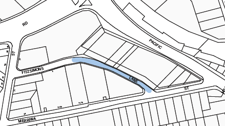
Extract from the Public Domain Plan 2010 showing the location of the area targeted for widening
Comments
Overview of the Strategic Planning Concept
The widening, adjusted alignment and pedestrian improvement works to Fitzsimons Lane involve the dedication of a narrow sliver of land from the rear frontage to Fitzsimons Lane of three consolidated development sites (numbered from 870 to 914 Pacific Highway Gordon) being 870-898; 900 and 904-914 Pacific Highway Gordon.
The strategic planning documents including the Local Centres Development Control Plan, the Public Domain Plan and the supporting Contributions Plan, collectively envisaged that the development potential of that narrow sliver of land would be available to the development site, stripping its market value and facilitating its dedication in the most cost effective manner – enabling the contribution plan to focus on the delivery of high quality public domain works.
As the land itself is therefore not valued by the contribution plan, a Planning Agreement approach is triggered to facilitate the dedication. The first draft Planning Agreement is proposed for exhibition as part of this report and it is anticipated that at least one more will be in a similar position early in 2017.
Council contracted a surveyor to identify the precise areas of land sought to facilitate the widening and pedestrian activation of Fitzsimons Lane (Attachment A1). This survey plan is also an attachment to the draft Planning Agreement itself in Annexure 1 to that document. The intention of the dedications is to facilitate the widening of Fitzsimons Lane to 15 metres where it currently narrows close to the intersection with Merriwa Street to facilitate traffic and pedestrian improvements – particularly the latter – to activate the lane.
The draft planning agreement itself is a relatively straightforward document compared to planning agreements that facilitate the delivery of works and infrastructure; this agreement relates only to the dedication, free of cost, of a sliver of land along the frontage of Fitzsimons Lane.
Council endorsement to proceed with the negotiation of the draft Planning Agreement
At the OMC of 24 November 2015, arising from an update report on a number of prospective VPAs some with and some without formal requests to commence, Council endorsed staff taking an active role in bringing the Fitzsimons Lane matters to the point of reporting for exhibition:
B. That Council endorses staff undertaking an active role to facilitate the dedication of land for road widening along Fitzsimons Lane as identified in Ku-ring-gai Local Centres Development Control Plan 2013 and the subsequent co-ordinated delivery of the public domain improvements in Fitzsimons Lane in view of the rapid delivery of a high proportion of the development in the area.
Status of the draft planning agreements for each affected site
904-914 Pacific Highway, Gordon – draft VPA including proposed subdivision plan and Explanatory Note recommended for statutory exhibition as part of this report (Attachment A1 and Attachment A3);
900 Pacific Highway, Gordon – formal offer to enter into a VPA dated 4 November 2016 is attached to this report (Attachment A2) with a recommendation to proceed along the same lines as for the adjoining property;
870-898 Pacific Highway, Gordon – an updated formal offer to enter into a VPA was received on 19 November 2015 but discussions stalled with concerns about the design of the development. The JRPP approved the Development Application with the requirement that the VPA be formalised in accordance with the terms of the formal offer to enter into the VPA. In a complicating factor, however, it appears that site has recently been on-sold and approaches now need to be made to the new owner to complete the draft VPA for 870-898 Pacific Highway, Gordon for exhibition. This is intended to be pursued concurrent with the draft VPA for 900 Pacific Highway for which the offer to enter into a VPA is attached to this report at Attachment A2.
Concurrent with pursuing the final dedications for the delivery of the widening of Fitzsimons Lane Gordon, Council should be commencing the detailed design process. This will enable Council to commence delivery of the revitalised Fitzsimons Lane concurrent with the final developments along the Lane.
The draft Planning Agreement for 904-914 Pacific Highway Gordon
The draft Planning Agreement (Attachment A3) and the associated Explanatory Note (included within the document) are relatively straightforward documents in that they simply facilitate and explain the dedication of an identified area of land free-of-cost to council. They record the nature of the understanding between the developer and Council – for example, Council can only use the land for the purposes of works to the carriageway – both vehicular and pedestrian and associated street landscaping works – in Fitzsimons Lane. This is in accordance with the Local Centres DCP and Public Domain Plan.
Importantly the draft Planning Agreement does not include works to deliver the public domain improvements; however, Council should instigate the design process early in 2017 given the progress of a substantial percentage of the anticipated redevelopment in the Fitzsimons Lane precinct, preparatory to commencing the delivery phase.
Delivery of the works in Fitzsimons Lane
It is not effective to deliver the improvement works to the pedestrian environment of Fitzsimons Lane in a piecemeal manner, and this work is also more effectively co-ordinated with road resurfacing which will be necessitated following the intensive concurrent redevelopment of a number of nearby properties.
However, it is also timely for Council to commence the design work and scheduling of the works in anticipation of the key dedications.
Much of the redevelopment in the area bounded by the Pacific Highway, Ryde Road, Ridge Street and Merriwa Street with Fitzsimons Lane passing through, is either nearing completion, recently commenced construction, under DA-approval, a DA under assessment or under pre-DA – a total of nine Development Applications and one pre-DA.
There are three remaining properties. Of these, the largest property at 7,411sqm with frontages to the Pacific Highway, Ryde Road (the longest frontage), Ridge Street and Fitzsimons Lane, and incorporating four separate commercial strata plans, is considered very unlikely to redevelop at this time. The property at 1 – 5 Merriwa Street on the corner of Fitzsimons Lane is a relatively new building, barely ten years old, and also considered unlikely to redevelop at this time. The future of 7 – 9 Merriwa Street is unknown at this time other than that there has been no recent pre-DA.
With redevelopment well underway, once the targeted dedications along Fitzsimons Lane have been formalised, Council can consider instigating the works listed in the contributions plan to deliver the improvements supported by nearby developments as part of their development contributions under their various consents. Delivery should be timed to match completions along Fitzsimons Lane with a view to minimising construction damage.
Summary
This report provides an overview of the status of the draft VPAs for the Fitzsimons Lane developments in relation to the implementation of the Local Centres Development Control Plan, the Public Domain Plan and the Ku-ring-gai Contributions plan 2010 which involve the dedication of a sliver of land to facilitate future public domain improvements.
The report proposes that the first of these draft VPAs be placed on public exhibition and that the remaining two, including one for which the letter of offer has recently been received, be actively progressed to the stage of being likewise reported for exhibition.
The report also recommends that the design process for the works in Fitzsimons Lane be commenced.
integrated planning and reporting
Theme Three: Places, Spaces and Infrastructure
|
Community Strategic Plan Long Term Objective |
Delivery Program Term Achievement |
Operational Plan Task |
|
P2.1 A robust planning framework is in place to deliver quality design outcomes and maintain the identity and character of Ku-ring-gai |
Strategies, plans and processes are in place to effectively manage the impact of new development |
P8.1.1.1.1.1-2 Ku-ring-gai Contributions Plan 2010 ensures new development contributes towards the cost of delivering supporting infrastructure. |
|
P4.1 Our centres offer a broad range of shops and services and contain lively urban village spaces where people can live, work, shop, meet and spend leisure time |
Plans to revitalise local centres are being progressively implemented and achieve quality design outcomes in collaboration with key agencies, landholders and the community |
C6.1.2.1.2; C4.1.2.1.3 New public infrastructure is planned to support new development and ensure that everyone who lives and works in Ku-ring-gai continues to enjoy access to public facilities. |
|
P8.1 An improved standard of infrastructure that meets the community’s service level standards and Council’s obligations as the custodian of our community’s assets |
Our public infrastructure and assets are planned, managed and funded to meet community expectations, defined levels of service and address inter-generational equity |
C6.1.2.1.2; C4.1.2.1.3 New public infrastructure is planned to support new development and ensure that everyone who lives and works in Ku-ring-gai continues to enjoy access to public facilities. |
Theme Four: Access, Traffic and Transport
|
Community Strategic Plan Long Term Objective |
Delivery Program Term Achievement |
Operational Plan Task |
|
T1.1 A range of integrated transport choices are available to enable effective movement to, from and around Ku-ring-gai.
T3.1 An accessible public transport and regional road network that meets the diverse and changing needs of the community. |
A network of safe and convenient links to local centres, major land uses and recreational opportunities is in place
A strategic access, traffic and transport plan is being implemented for the Northern Sydney Region |
T 1.1.3.1.1 Link roads and road widening. |
Theme Six: Leadership and Governance
|
Community Strategic Plan Long Term Objective |
Delivery Program Term Achievement |
Operational Plan Task |
|
L2.1 Council rigorously manages its financial resources and assets to maximise delivery of services |
Council expenditure satisfies the needs of the community and Council has increased its commitment to infrastructure asset management priorities |
C6.1.1.1.2 Council is leveraging the value of its assets to combine with contributions to deliver major community assets. |
Governance Matters
The negotiation of the draft Planning Agreement was commenced under the Planning Agreement Policy 2008. Since then, the Planning Agreement Policy 2016 has been exhibited and adopted.
The draft Planning Agreements have been prepared with input from Urban Planning, the Property Unit and the Corporate Lawyer. Council appointed Wiltshire Webb Staunton Beattie Lawyers to act on their behalf. The developers for the first draft Planning Agreement that is proposed to be exhibited were represented by Addisons Lawyers.
Risk Management
Council has commissioned an external legal team to assist with the drafting of the Planning Agreements.
Financial Considerations
The strategic planning for the widening of Fitzsimons Lane foreshadowed that the associated developments would retain the opportunity to utilise the floor space potential of the land to be dedicated thus negating its market. This is a cost-effective means of facilitating the dedication of land free of cost.
There is a cost in terms of the recommended scheduling of the design and delivery of the works in the 2017/2018 to 2018/2019 financial year in the Long Term Financial Plan however, it should be noted, that with ten out of thirteen properties with frontage to Fitzsimons Lane being the subject of development proposals and many nearing completion of construction, that the development contributions for the delivery of this work have been received and, as such, it is timely to schedule the delivery of this work in the near future.
Social Considerations
The dedication of these narrow strips of residual portions of land along Fitzsimons lane, facilitate the public domain improvements foreshadowed in the Local Centres Development Control Plan and the Public Domain Plan.
Environmental Considerations
The draft Planning Agreement for exhibition involves only the dedication of land for the purposes of the laneway widening. The design of the public domain improvements should be instigated in parallel with these latest redevelopments ready to commence delivery concurrent with their completion. Environmental considerations are a core component of the detailed design of all Council’s public domain improvement works.
Community Consultation
The relevant legislation governing Planning Agreements falls under the Environmental Planning and Assessment Act 1979 (Division 6 Development Contributions - Subdivision 2 Planning Agreements) and the Environmental Planning and Assessment Regulation 2000 (Part 4 Development Contributions - Division 1A Planning Agreements).
All draft planning agreements are to be exhibited for a minimum of 28 days for public comments and in the interests of openness and transparency before being reported back to Council for the purposes of being entered into.
This report proposes the statutory public exhibition of one draft Planning Agreement together with its Explanatory Note for public comment. It is intended that the statutory period should be extended in view of the Christmas-New Year Holiday period. A report will be brought back to Council following the completion of that exhibition early in 2017.
Internal Consultation
Staff members from Urban Planning, the Property Unit and the Corporate Lawyer have been directly involved in this matter. Council appointed Wiltshire Webb Staunton Beattie Lawyers to act on their behalf. The developers for the first draft Planning Agreement that is proposed to be exhibited were represented by Addisons Lawyers.
Summary
That the draft planning agreement and its explanatory note relating to the property at 904‑914 Pacific Highway Gordon which also has frontage to Fitzsimons Lane, is recommended to be placed on public exhibition for comment – with exhibition to be extended in view of the Christmas-New Year period.
The subject draft Planning Agreement relates only to land dedication and does not include works to the carriageway, accordingly no requirements related to a tendering process are triggered.
Council should however commence the design process for the public domain works with a view to calling for quotations/tenders in a timely manner noting the well-advanced state of redevelopment in the vicinity of Fitzsimons Lane.
The receipt of a letter of offer in similar terms for the adjoining property at 900 Pacific Highway Gordon is also attached and it is recommended that council staff pursue this matter with a view to reporting another draft VPA (and explanatory note) to Council early in 2017.
|
A. That public notice of the exhibition of the draft Planning Agreement and Explanatory Note relating to the property at 904-914 Pacific Highway Gordon for the purposes of facilitating a land dedication along the frontage to Fitzsimons Lane be duly given, and a copy of those documents be made available for inspection, in accordance with the Environmental Planning and Assessment Act 1979 and the Environmental Planning and Assessment Regulation 2000.
B. That a report be brought back to Council following the statutory exhibition process.
C. That delegation be granted to the General Manager or his delegate to make any administrative changes to the document that do not alter the overall intent in order to facilitate exhibition and to protect Council’s interests.
D. That the letter of offer to enter into a planning agreement for the dedication of land along the frontage to Fitzsimons Lane of the property located at 900 Pacific Highway Gordon in association with DA0226/16 be noted and authority be delegated to the General Manager or his delegate to progress the draft planning agreement in discussions with the applicant.
E. That the design process for the Fitzsimons Lane public domain improvements commence as soon as practicable in 2017.
F. That the General Manager or his delegate to authorised to proactively pursue the completion of the negotiations for the draft planning agreement for the remaining property at 870-898 Pacific Highway which also has rear frontage to Fitzsimons Lane which has recently been on-sold, in line with the original letters of offer from the former property owner, with a view to enabling the public domain works to Fitzsimons Lane to be delivered concurrently and in the short term.
|
|
Kate Paterson Infrastructure Co-ordinator |
Antony Fabbro Manager Urban & Heritage Planning |
|
Ian Dreghorn Acting Director Strategy & Environment |
|
|
Survey Plan for prospective dedications of land along Fitzsimons Lane Gordon |
|
2016/319459 |
||
|
|
Letter of Offer to enter into a VPA to dedicate land free of cost - 900 Pacific Highway Gordon |
|
2016/319452 |
|
|
|
Draft Planning Agreement 904-914 Pacific Highway Gordon including Explanatory Note |
|
2016/330008 |
|
APPENDIX No: 1 - Survey Plan for prospective dedications of land along Fitzsimons Lane Gordon |
|
Item No: GB.14 |
|
APPENDIX No: 2 - Letter of Offer to enter into a VPA to dedicate land free of cost - 900 Pacific Highway Gordon |
|
Item No: GB.14 |
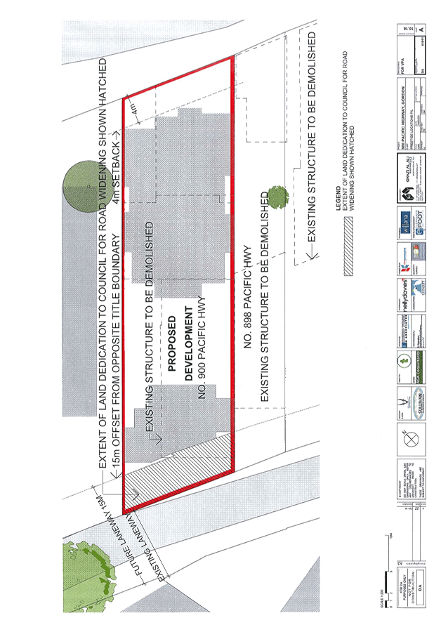
|
APPENDIX No: 3 - Draft Planning Agreement 904-914 Pacific Highway Gordon including Explanatory Note |
|
Item No: GB.14 |


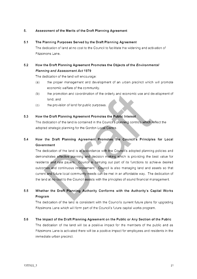
|
Ordinary Meeting of Council - 6 December 2016 |
GB.15 / 574 |
|
|
|
|
Item GB.15 |
S10051 |
|
|
22 September 2016 |
Potential Heritage Conservation Areas in Pymble, Turramurra and Wahroonga
EXECUTIVE SUMMARY
|
purpose of report: |
To have Council consider potential heritage conservation areas for inclusion under the Ku-ring-gai Local Environmental Plan 2015 and the Ku-ring-gai Local Environmental Plan (Local Centres) 2012.
|
|
|
|
|
background: |
On 26 November 2013 Council resolved to place 14 potential heritage conservation areas on non-statutory exhibition. These were exhibited from 7 March 2014 to 7 April 2014. On 26 May 2015 Council resolved to place a further 2 potential heritage conservation areas on non-statutory exhibition. These were exhibited from 5 June 2015 to 3 July 2015. |
|
|
|
|
comments: |
This report puts forward the additional potential heritage conservation areas for Council’s consideration to include in a planning proposal. |
|
|
|
|
recommendation: |
That several new heritage conservation areas be included in a planning proposal to amend KLEP 2015 and the KLEP (Local Centres) 2012 and be forwarded to the Department of Planning and Environment for a Gateway Determination.
|
Purpose of Report
To have Council consider potential heritage conservation areas for inclusion under the Ku-ring-gai Local Environmental Plan 2015 and the Ku-ring-gai Local Environmental Plan (Local Centres) 2012.
Background
On 26 November 2013 Council resolved to place 14 potential heritage conservation areas on non-statutory exhibition. This was a peer review of the areas reviewed by Paul Davies Pty Ltd in 2010. These reviewed HCAs were exhibited from 7 March 2014 to 7 April 2014. This work was undertaken by Heritage Consultants Sue Jackson-Stepowski Pty Ltd, Carste Studios and John Oultram.
On 26 November 2013, members from the Pymble community addressed Council regarding the heritage significance of Pymble. Council resolved to seek quotations from a heritage consultant to undertake a further heritage review of Pymble.
Perumal Murphy Alessi Pty Ltd were engaged to undertake this review. On 26 May 2015 Council resolved to place this review of the Pymble East and West HCAs on exhibition. These were exhibited for a non-statutory period from 5 June 2015 to 3 July 2015.
Comments
Heritage Conservation Areas (HCAs) are areas identified as having recognised cultural significance and may include built and natural landscapes containing significant fabric, settings and views.
In NSW, HCAs are assessed against 7 criteria:
a) Historical significance – an area is important in the course, or pattern, of the cultural or natural history of the local area;
b) Historical association significance – an area has strong or special association with the life or works of a person, or group of persons, of importance to the local area’s cultural or natural history;
c) Aesthetic significance – an area is important in demonstrating aesthetic characteristics and/or a high degree of creative or technical achievement locally;
d) Social significance – an area has a strong or special association with a particular community or cultural group in the locally, for social, cultural or spiritual reasons;
e) Technical/research significance – an area has potential to yield information that will contribute to an understanding of the local area scientific, cultural or natural history;
f) Rarity – an area possesses uncommon, rare or endangered aspects of the local area’s cultural or natural history; and
g) Representativeness - an area is important in demonstrating the principal characteristics of a class of the local area’s cultural or natural places; or cultural or natural environments.
The Heritage Consultants Perumal Murphy Alessi Pty Ltd’s (PMA) heritage assessment substantially reviewed the same Pymble areas as Sue Jackson-Stepowski Pty Ltd (SJS) and Caste Studios in Pymble. The recommendations of the two studies vary. SJS had a targeted approach creating HCAs where there were clusters of contributory properties and the historic key development layers were visually apparent. PMA took a broader approach embracing all development periods from the Victorian era to the present and tying the boundary of the HCA to that which was in the brief from Council and derived from a report commissioned by Pymble residents and produced by Architectural Projects- Heritage consultants.
As a result of the exhibition of the Sue Jackson-Stepowski Pty Ltd (SJS), Caste Studios and John Oultram heritage review there were one hundred and eleven (111) community submissions, seventy one (71) of these were in support and thirty eight (38) against, (two) 2 were comments neither in support nor against (Attachment A1). As a result of the exhibition of the Perumal Murphy Alessi heritage review there were seventeen (17) community submissions. Three (3) of these were in support and twelve (12) against, and 2 were comments about individual properties neither in support nor against (Attachment A2).
Key issues
The main themes of the submissions were:
· Support for the West Pymble HCA
The majority of submissions were in support of the HCA proceeding for west Pymble. The submissions cited the heritage significance of the area and the relationship of the houses with the established blue gum canopy.
· Building restrictions
Several submissions expressed concern over the development restrictions placed on properties within HCAs. Places within heritage conservation areas can still have alterations and additions subject to Council approval. New development is required to conserve the heritage significance of the heritage conservation area. For many places this means retaining and conserving original fabric that can be viewed from the street, with any new approved development responding to the context of the original buildings in terms of materials, form and scale. There are many buildings within heritage conservation areas in Ku-ring-gai that have through Council approved additions and modifications become contemporary family homes.
· Lost property value
Rezoning from Residential High Density R4 to Residential Low Density R2 means lost development potential and will have a very real and immediate impact on property value. Many of the areas in Turramurra and Pymble that have been zoned R4 Residential High Density already have residential flat development or development approval. Development of these sites cannot be retrospectively downgraded to single dwellings. For those R4 sites without development approval the existing Local Environmental Plans and their current zoning were the result of long planning proposal processes informed by extensive strategic planning studies and the involvement of the community in the consultation and Council resolutions.
Any changes which would downzone the R4 Residential High Density zoning of these sites would require state government approval and if granted Council would need to find other areas to upzone to R4 Residential High Density. For these reasons it is not recommended to include R4 zones within the proposed HCAs.
For single dwellings various studies have found the loss of property value when included in heritage conservation is negligible (see Attachment A4). This finding reflects that the factors which have the greatest impact on house pricing tend to be locational (proximity to schools and transport) and attributes like number of bedrooms and bathrooms, and land size.
· Gilroy Road, Turramurra
There were several submissions against the Gilroy Road HCA proceeding. Many noted the impact of the new residential flat buildings on the dwelling houses and the subsequent loss in value if parts of the street were to be downzoned from R2 to R4. It is not recommended to include those areas zoned currently as R4. Instead the boundary will reflect the current zoning and provide a buffer between the R4 zoning and the proposed HCA. The proposed HCA is much reduced in size.
· Property not within the key development period
Several submissions objected to the designation of an area as an HCA due to the absence of Federation and Victorian era properties.
A few of these submissions quoted PMA and the reference to the following quote:
“Many of the identified contributory items within this study are aged between 80 and 100 years old” with the qualifying statement their house was not contributory because it was built in a period after this time i.e. the 1950s.
The section of the PMA report from which this quote was obtained is entitled Basis of assessment and conclusions. It makes reference to the significance of buildings from the Victorian through to the Post-war and the above quote taken out of context misrepresents the intent of the author.
PMA’s assessment of the east and west Pymble areas described the key development periods as:
“streetscapes of good, high quality and mostly intact, representative examples of single detached houses from the Federation, Inter-war and Post War periods constructed following the late 19th and early 20th century subdivisions and establishment of the North Shore Railway line in 1890”
Similarly SJS’s assessments acknowledged the predominance of inter-war and post-war housing.
These assessments acknowledge the significance of the Inter-war and Post-war housing layers. These are not hard boundaries that end on a given date but instead are representative of housing type over an approximate time period. For example Apperly, Irving and Reynolds in their book A Pictorial Guide to Identifying Australian Architecture: Styles and Terms from 1788 to the Present define the Inter-war period as c.1915 to c.1940. Buildings early in this period may be described as transitional while those after 1940 may be described as late Inter-war.
Several houses from the Late Twentieth Century Period (post 1960) have been identified as contributory. In particular houses from the 1970s exhibiting characteristics of the Sydney Regional style. These houses have been described by SJS as “typical of the ‘Nuts and Berries’ Sydney style of the late 60s and 70s”.
Boundaries of proposed heritage conservation areas
A recent inspection of the proposed areas by staff has found that several properties have been demolished since the field work for the heritage studies was undertaken. The mapping has been amended to change the rating of the demolished properties from contributory to neutral. In addition where a submission has claimed the contribution rating of a property is wrong and further research supports this claim the rating has been changed. A list of changes can be found in Attachment A3.
There are ten (10) proposed heritage conservation areas. Five of these are extensions of existing conservation areas. Table 1 below summarises the HCA names, their proposed numbers in the amended LEPs and the consultant’s report on which these areas are based. It should be noted that the more recent studies have been given precedence, as such where Sue Jackson-Stepowski and Perumal Murphy Alessi have made recommendations over the same area, preference has been given to the Perumal Murphy Alessi review. Attachment A6 has the proposed boundary maps, and includes existing heritage items and HCAS, and Attachment A7 has the amended contribution rating maps.
Where R4 zoning was on the edge of the proposed HCA, this area has been excised. The objective of the R4 High Density Residential zone is to facilitate a change in housing stock to provide a variety of housing types in a high density residential environment close to public transport, services and employment. The future built form envisaged within the R4 zone is incompatible with the outcomes sought by the implementation of an HCA which is to preserve existing character with a built form compatible to the existing housing stock. The application of the HCA on the R4 land would also be inconsistent with ministerial Direction 4.1 under s117 (2) of the EP& A Act as it would potentially reduce the permissible residential density of land.
The boundaries of the proposed HCAs in east Pymble do vary from those in the report. The PMA report recommended one large HCA which rolled existing HCAS into the new area. Instead separate HCAs have been created. The new boundaries exist for the following conservation areas: Athol Conservation Area, Lanosa Estate Conservation Area and Mona Vale Road Conservation Area. The Statements of Significance (see Attachment A5) have been drafted to reflect the work and assessments by the consultants. Inventory sheets for the proposed HCAs can be found in Attachments A8-A17.
Table 1: Proposed HCAs
|
Type (new/extension) |
Proposed name |
Proposed number |
LEP |
Consultant |
|
Extension |
Mahratta Conservation Area |
C4 extension |
KLEP |
John Oultram |
|
New |
Gilroy Road Conservation Area |
C42 |
LCLEP |
SJS and John Oultram |
|
Extension |
Hillview Conservation Area |
C40 extension |
LCLEP |
SJS |
|
New |
Mona Vale Road Conservation Area |
C43 |
KLEP |
SJS and PMA |
|
New |
Telegraph Road Conservation Area |
C44 |
LCLEP |
SJS |
|
New |
Lanosa Estate Conservation Area |
C45 |
KLEP |
SJS |
|
New |
Athol Conservation Area |
C46 |
LCLEP |
PMA |
|
Extension |
Pymble Heights Conservation Area |
C8A and C8B extension |
KLEP and LCLEP |
PMA |
|
Extension |
Fern Walk Conservation Area |
C9 extension |
KLEP |
PMA |
|
New |
West Pymble Conservation Area |
Includes · C10A and C10B extension – Orinoco Street Conservation Area · C11extension – Pymble Avenue Conservation Area |
KLEP and LCLEP |
PMA |
integrated planning and reporting
Theme 3: Places, Spaces and Infrastructure
|
Community Strategic Plan Long Term Objective |
Delivery Program Term Achievement |
Operational Plan Task |
|
Heritage that is protected and responsibly managed
|
Implement, monitor and review Ku-ring-gai’s heritage planning provisions |
Identify gaps in existing strategies and plans
|
Governance Matters
The Greater Sydney Commission released draft District Plans on 21 November 2016 for exhibition to March 2017. The draft North District Plan maps a 20-year vision for the North District of Greater Sydney which includes the LGA’s of Ku-ring-gai, Hornsby, Hunter’s Hill, Lane Cove, Mosman, Northern Beaches, North Sydney, Ryde and Willoughby
Councils are required to give effect to the District Plans as soon as practicable after they are made (finalised). Importantly the draft District Plans are also a consideration for planning proposals during the period that they are in draft. This is established by the Department of Planning and Environment’s Guide to Preparing Planning Proposals (August 2016).
Liveability Priority 7: Conserve heritage and unique local characteristics of the draft north district plan requires relevant planning authorities to protect “aboriginal, cultural and natural heritage and places, spaces and qualities valued by the local community”. The proposal to introduce additional HCA’s is consistent with this priority under the draft North District Plan.
Risk Management
This report provides the level of detail and the justification, including preliminary community consultation to ensure Council is meeting its requirements to identify and manage Ku-ring-gai’s environmental heritage.
Financial Considerations
The costs associated with this matter are covered by the Strategy and Environment Department, Urban and Heritage budget.
Social Considerations
There is a community expectation that places of heritage significance within the Ku-ring-gai Council local government area will be identified and protected.
Environmental Considerations
Council is responsible for the identification and management of Ku-ring-gai’s environmental heritage. Consideration of this matter will assist Council in meeting this requirement.
Community Consultation
The proposal was exhibited from 20 March until 15 May 2015. It was advertised on Council’s website, the North Shore Times and letters were sent to the owners of affected and adjacent properties inviting submissions.
Should the recommendation to proceed with a Planning Proposal be adopted by Council, a formal process of further statutory public consultation will be sought in accordance with the requirements under the EP&A Act. This will include notification, advertisements, display and information Council’s website.
Internal Consultation
This report has been referred to the relevant sections of Council for comment.
Summary
Heritage assessments for the proposed areas have been prepared by Sue Jackson-Stepowski Pty Ltd, Carste Studios, John Oultram and Perumal Murphy Alessi Pty Ltd. On 26 November 2013 Council resolved to place 14 potential heritage conservation areas on non-statutory exhibition. These were exhibited from 7 March 2014 to 7 April 2014. On 26 May 2015 Council resolved to place a further 2 on exhibition. These were exhibited from 5 June 2015 to 3 July 2015. It is recommended a planning proposal be prepared and submitted to the Department of Planning and Environment for Gateway Determination to include several heritage conservation areas in schedule 5 and the heritage map of KLEP 2015 and the KLEP (Local Centres) 2012.
|
A. That a Planning Proposal be prepared in accordance with s55 of the EP&A Act to amend KLEP 2015 and KLEP (Local Centres) 2012 to include several proposed conservation areas as potential heritage conservation areas in Schedule 5 and on the Heritage Map.
B. That the Planning Proposal be forwarded to the Department of Planning and Environment for a Gateway Determination in accordance with the provisions of the EP&A Act and Regulations.
C. That in order to facilitate an expedient Gateway Determination, the NSW Heritage Office be consulted prior to submitting the Planning Proposal to the Department of Planning and Environment. Should comments not be received within 21 days, the Planning Proposal is to be submitted regardless.
D. That Council requests the plan making delegation under Section 23 of the EP&A Act for this Planning Proposal.
E. That upon receipt of a Gateway Determination, the exhibition and consultation process is carried out in accordance with the requirements of the Environmental Planning and Assessment Act, 1979 and with the Gateway Determination requirements.
F. A further report be brought back to Council at the end of the exhibition period.
|
|
Andreana Kennedy Heritage Specialist Planner |
Antony Fabbro Acting Director Strategy & Environment |
|
Submission summary table - HCA review 2014 |
|
2015/207850 |
||
|
|
Submission summary table - East and West Pymble - 2015 |
|
2016/268875 |
|
|
|
Changes in the HCA |
|
2016/324216 |
|
|
|
Brief literature review - effect heritage listing on house prices |
|
2016/260958 |
|
|
|
Statement of Significance for the Proposed HCAs - Review 2016 |
|
2016/325997 |
|
|
|
Maps - proposed HCA boundaries |
|
2016/327664 |
|
|
|
Maps - proposed HCAs with contribution ratings |
|
2016/327658 |
|
|
|
Gilroy Avenue Turramurra HCA - inventory sheet |
|
2013/188150 |
|
|
|
Hillview HCA - inventory sheet |
|
2013/168743 |
|
|
|
Telegraph Road - inventory sheet |
|
2013/168740 |
|
|
|
Mona Vale HCA4 - inventory sheet (area proposed to be Lanosa Estate Conservation Area) |
|
2013/168772 |
|
|
|
Combined Mona Vale Road HCA (1, 2, 3 and 5) - inventory sheets - HCA Inventory Sheets |
|
2016/327560 |
|
|
|
Fox Valley Road HCA - Report and inventory sheet |
|
2013/215787 |
|
|
|
Eastern Road HCA - report and inventory sheet |
|
2013/215784 |
|
|
|
Report - Potential HCA - Pymble East and West 2015 |
|
2015/112003 |
|
|
|
Pymble East Conservation Area - inventory sheet (includes proposed Athol Conservation Area and extensions to Pymble Heights and Fern Walk HCAs) |
|
2015/112021 |
|
|
|
Pymble West Conservation Area - inventory sheet |
|
2015/112030 |
|
APPENDIX No: 11 - Mona Vale HCA4 - inventory sheet (area proposed to be Lanosa Estate Conservation Area) |
|
Item No: GB.15 |
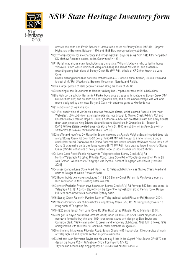
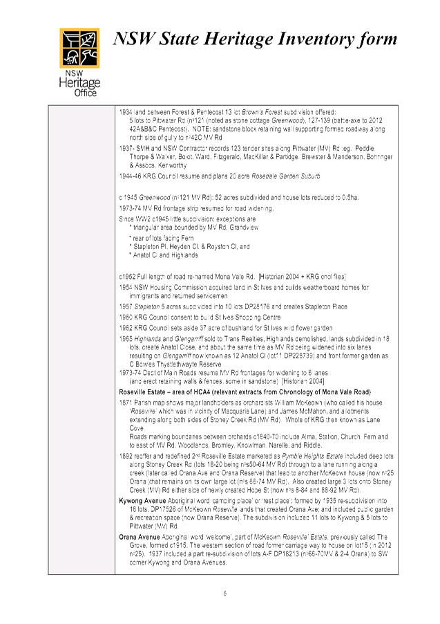
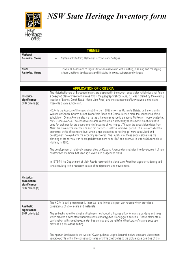
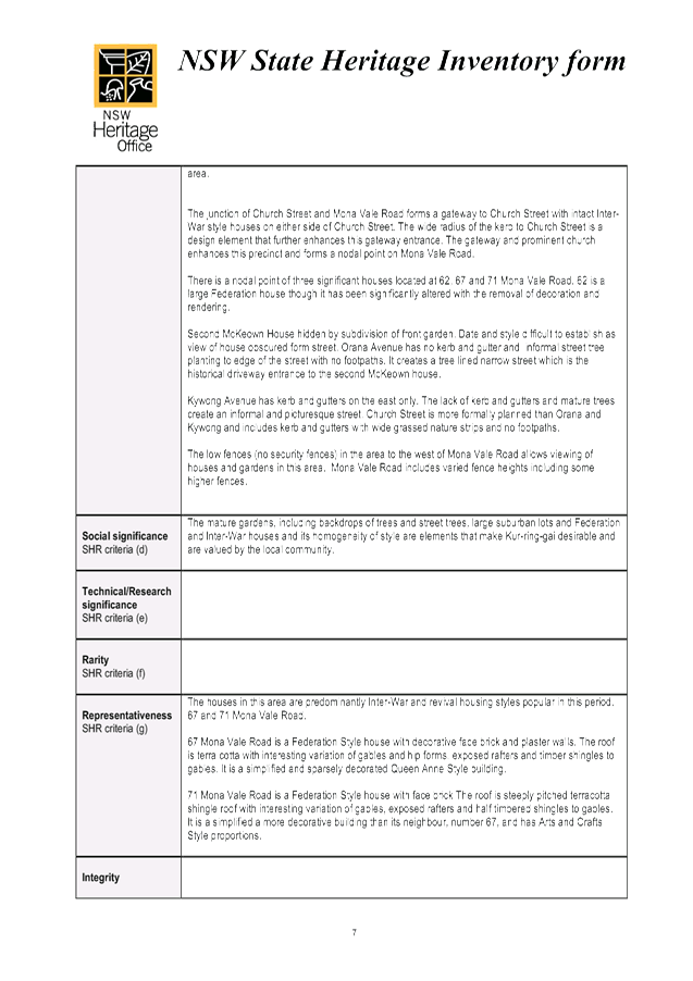
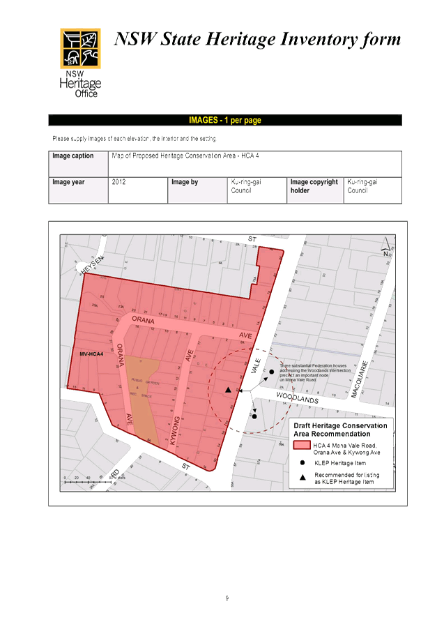
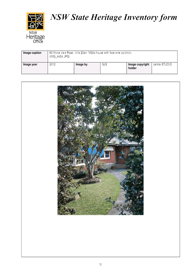
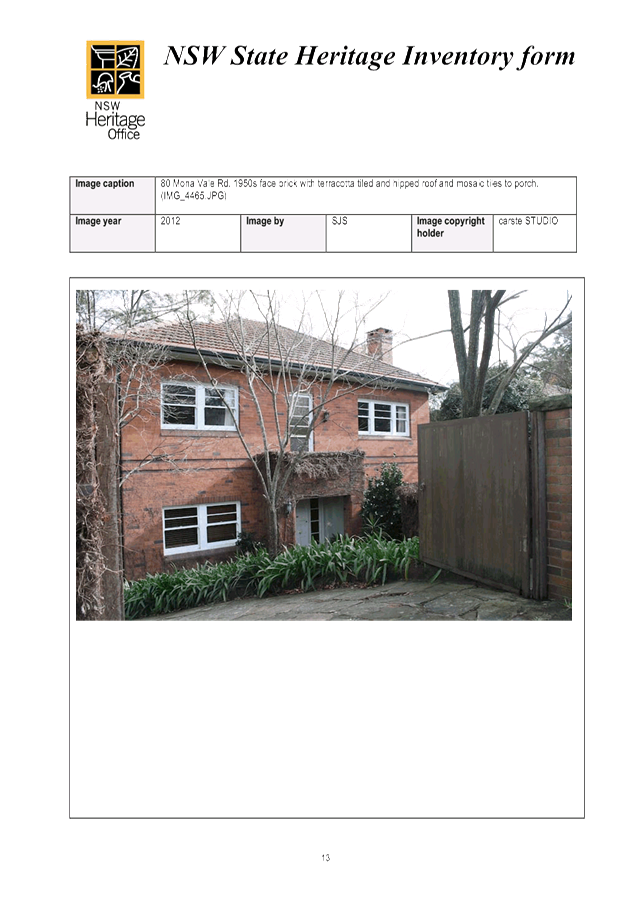
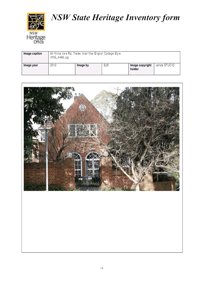
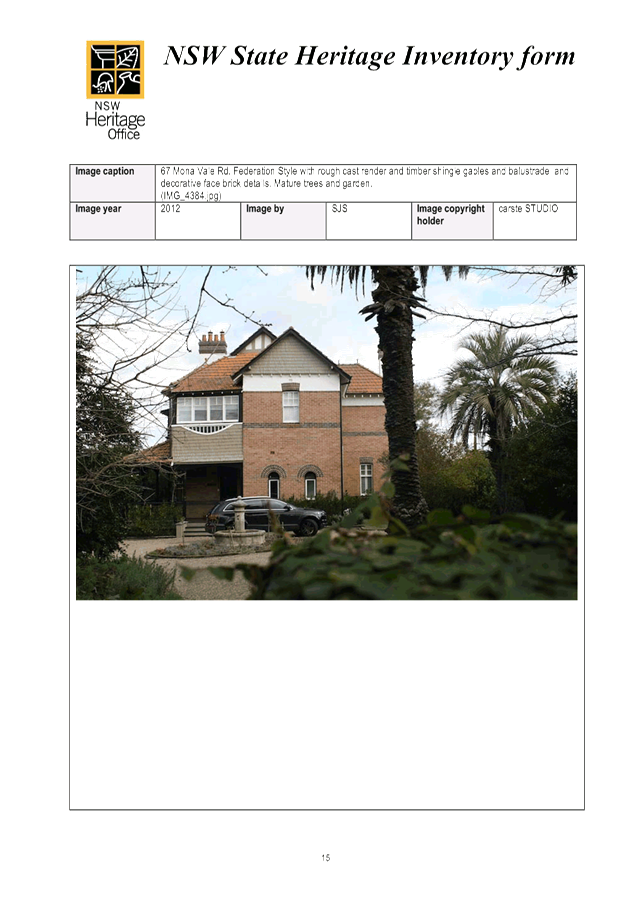
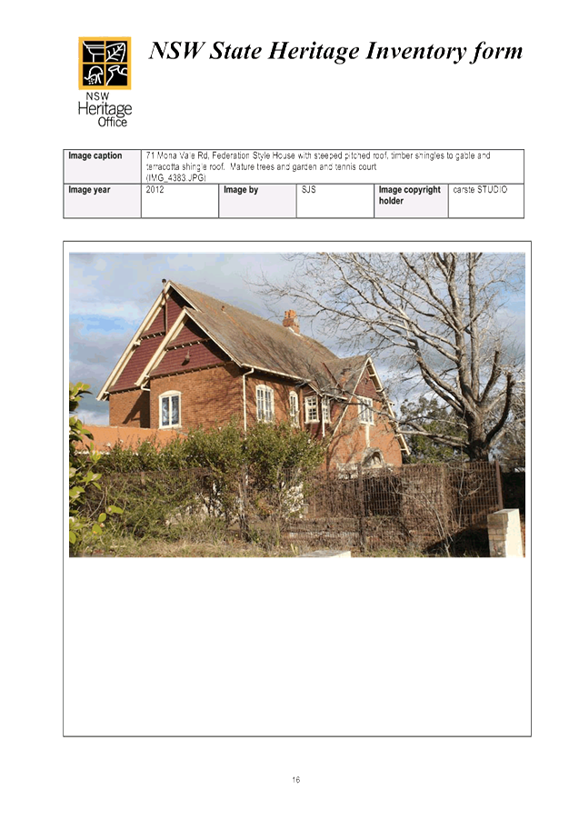
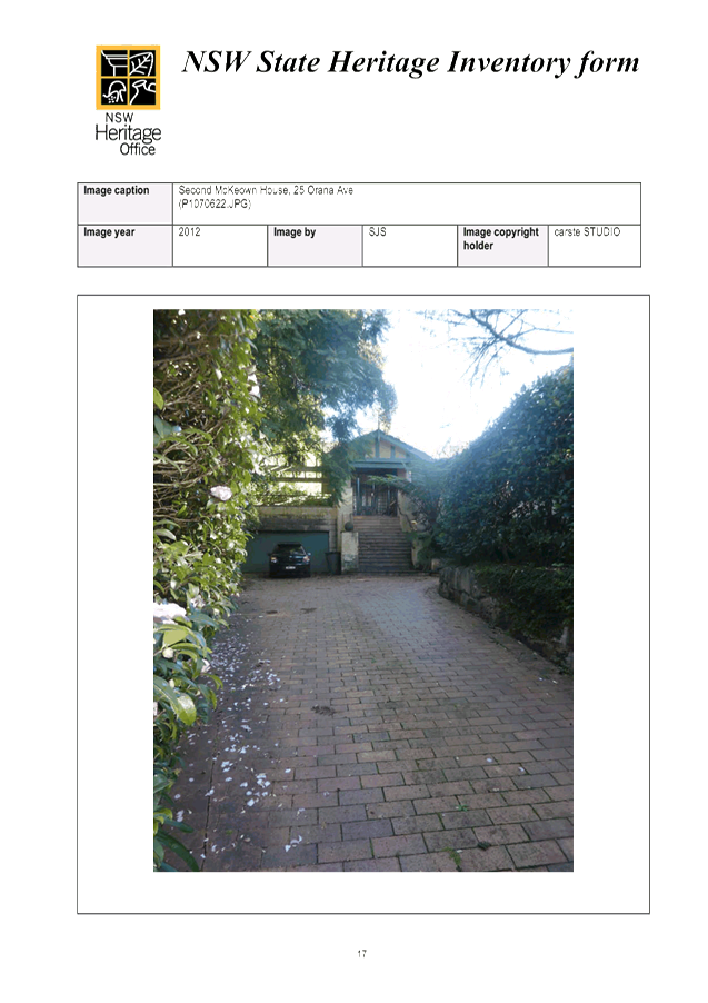
|
APPENDIX No: 12 - Combined Mona Vale Road HCA (1, 2, 3 and 5) - inventory sheets - HCA Inventory Sheets |
|
Item No: GB.15 |
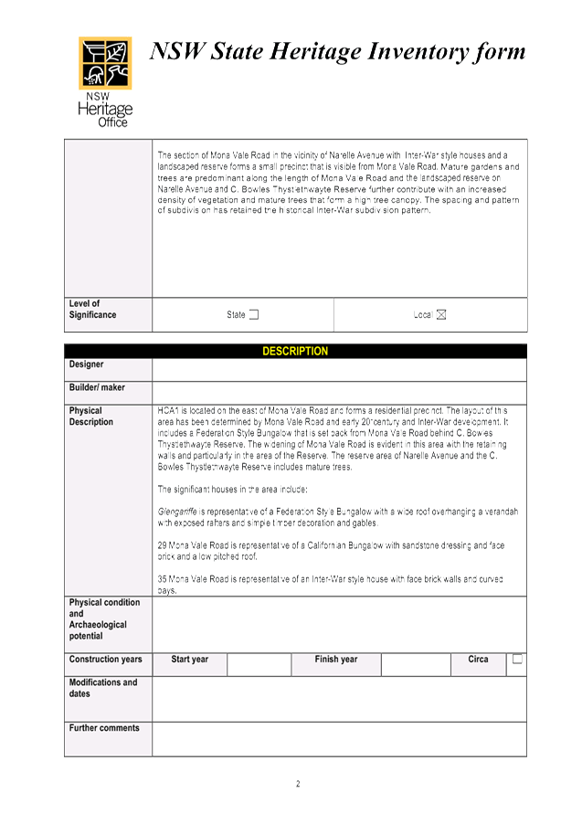
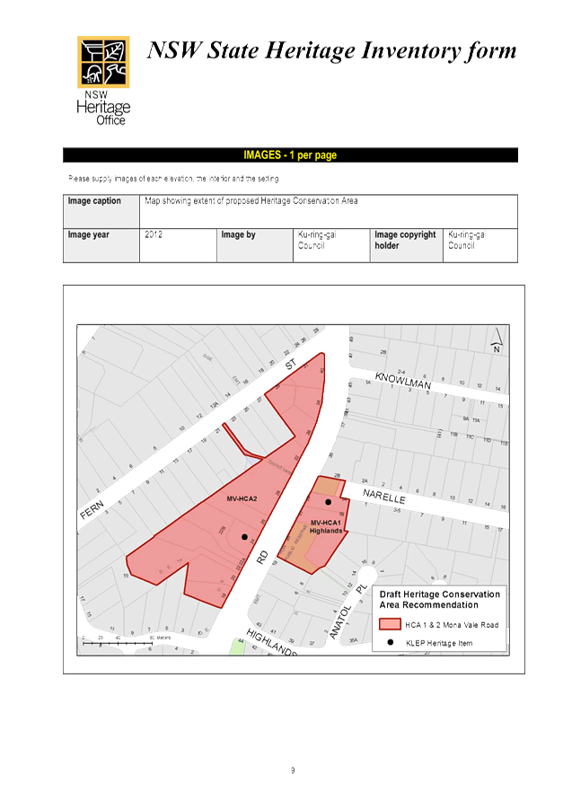
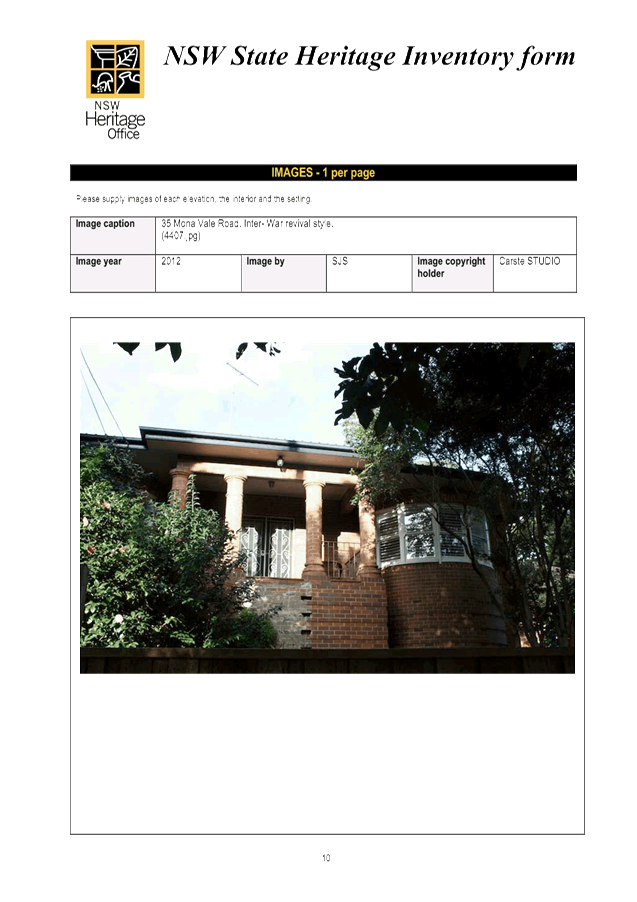
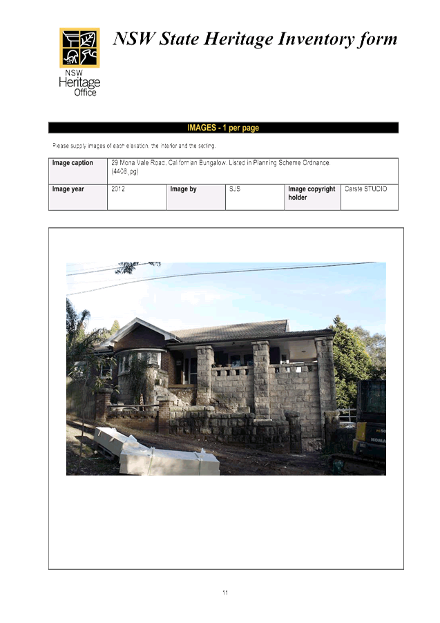
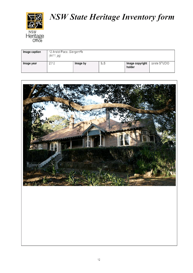
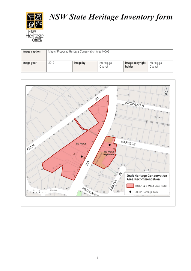
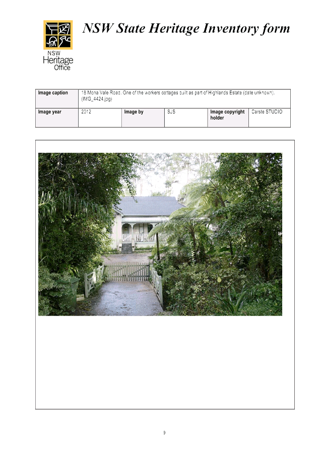
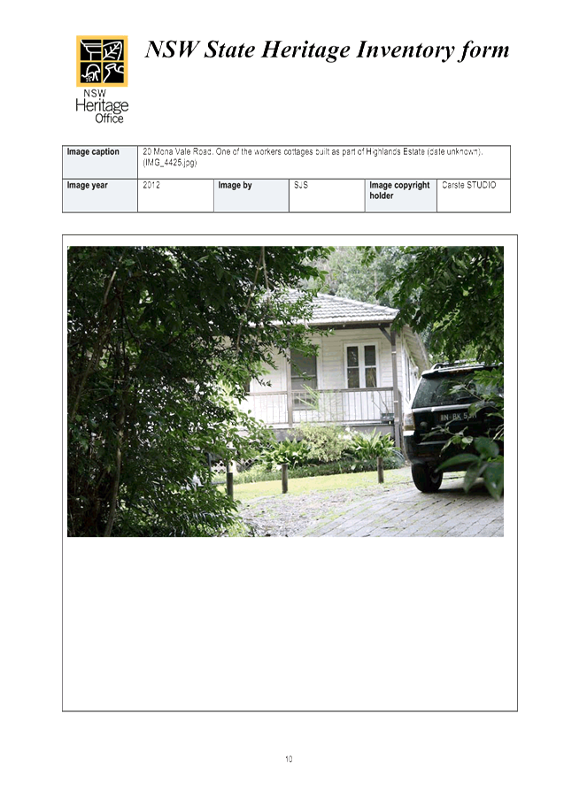
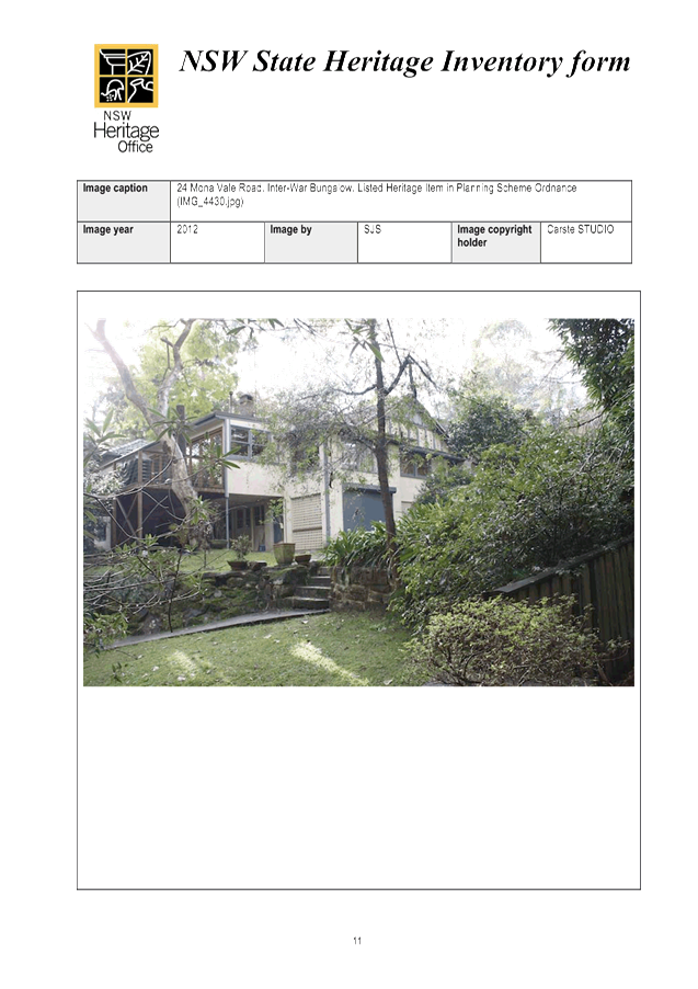
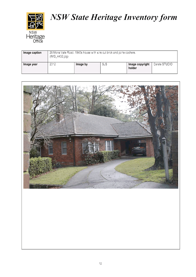
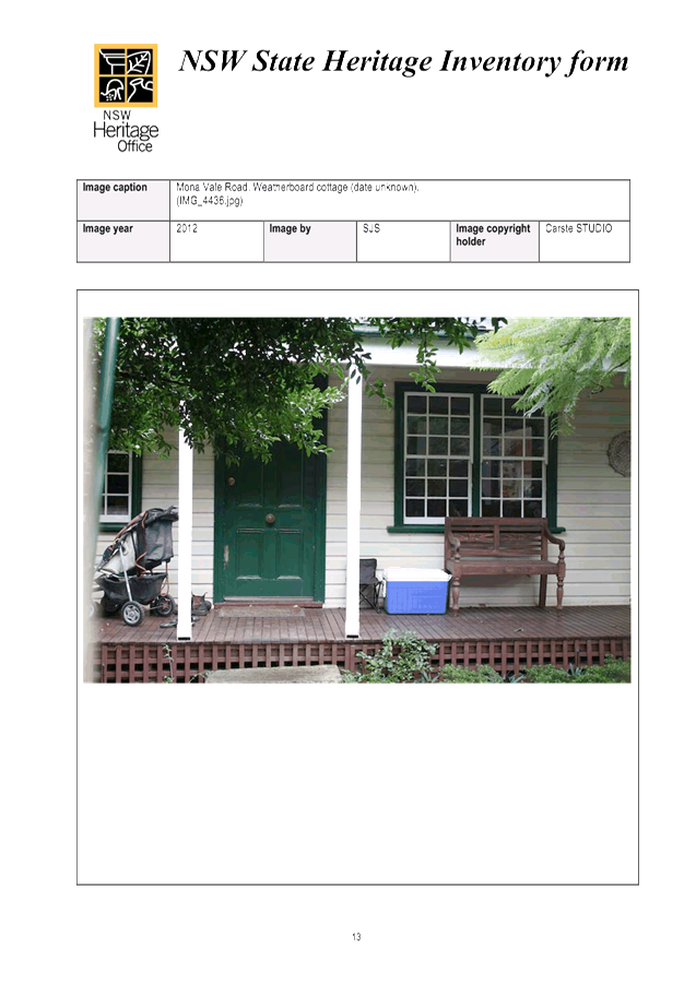


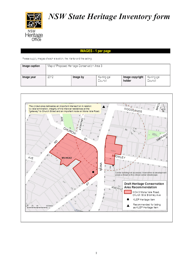
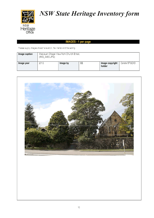
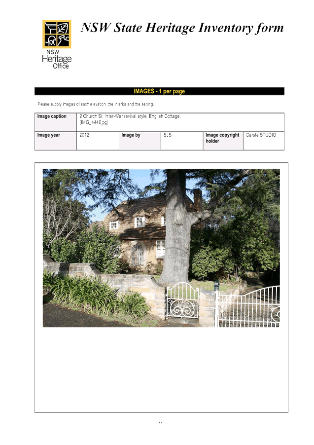
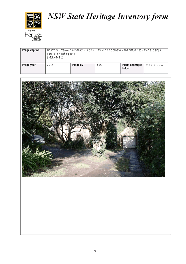
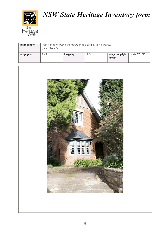
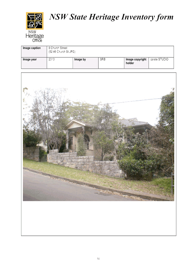
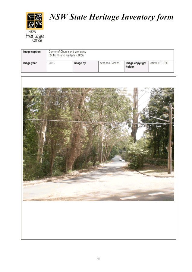

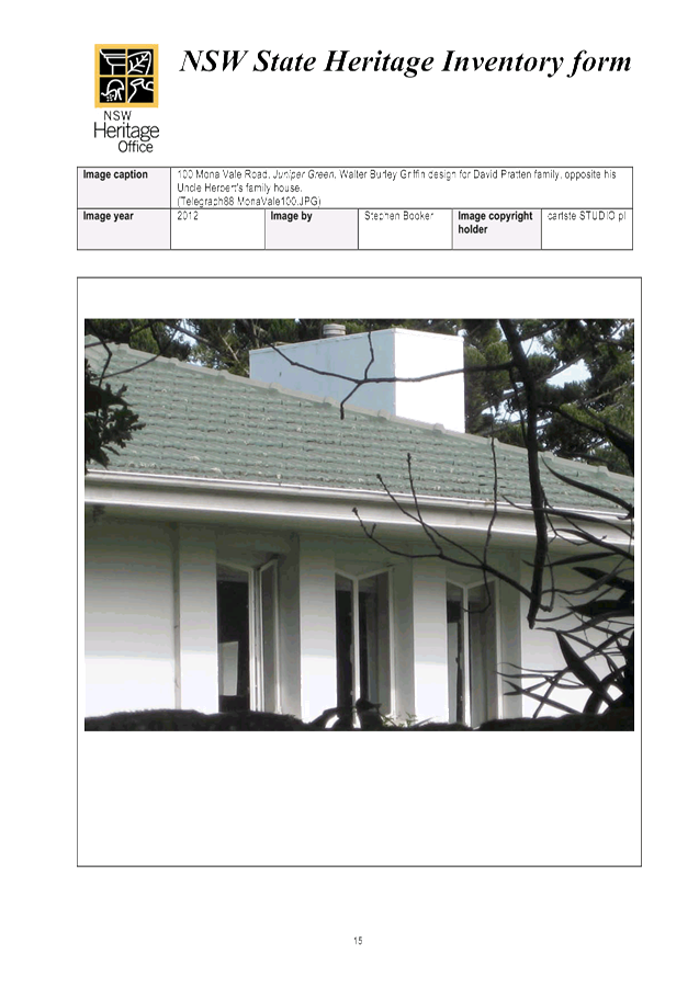
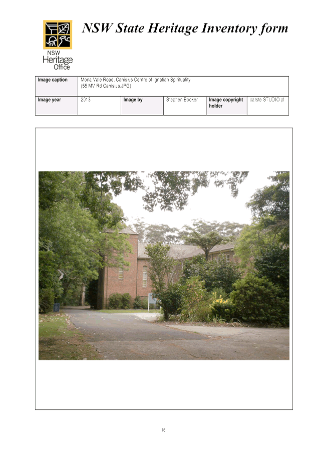
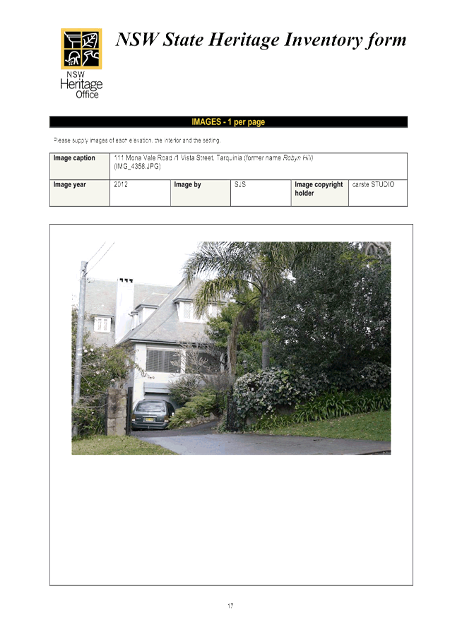
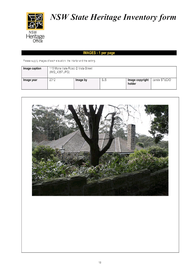
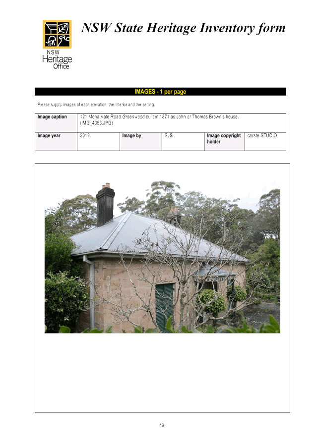
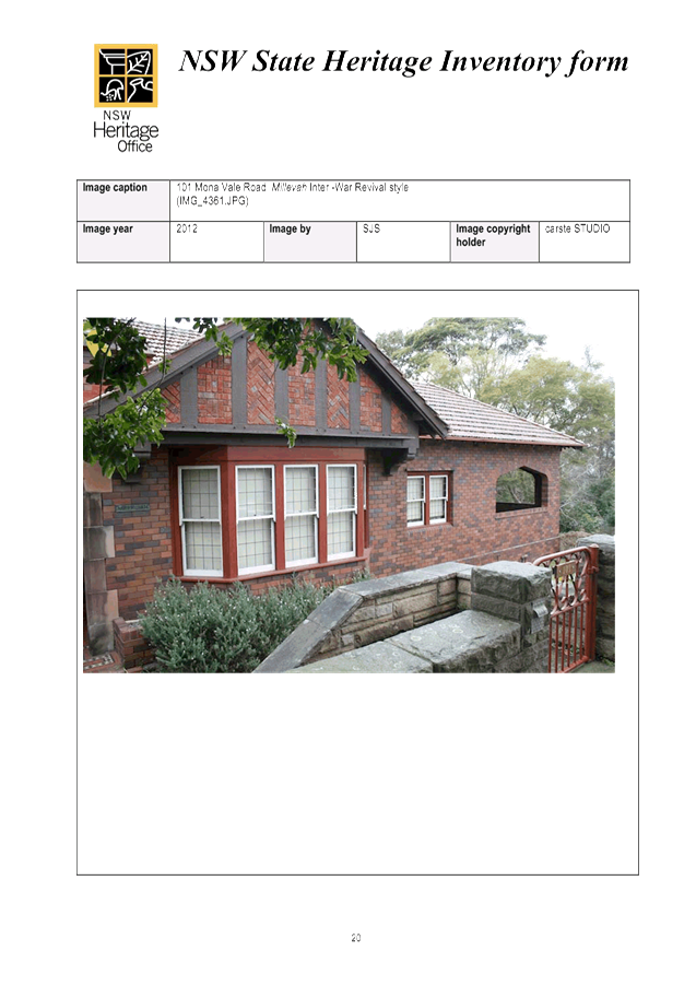
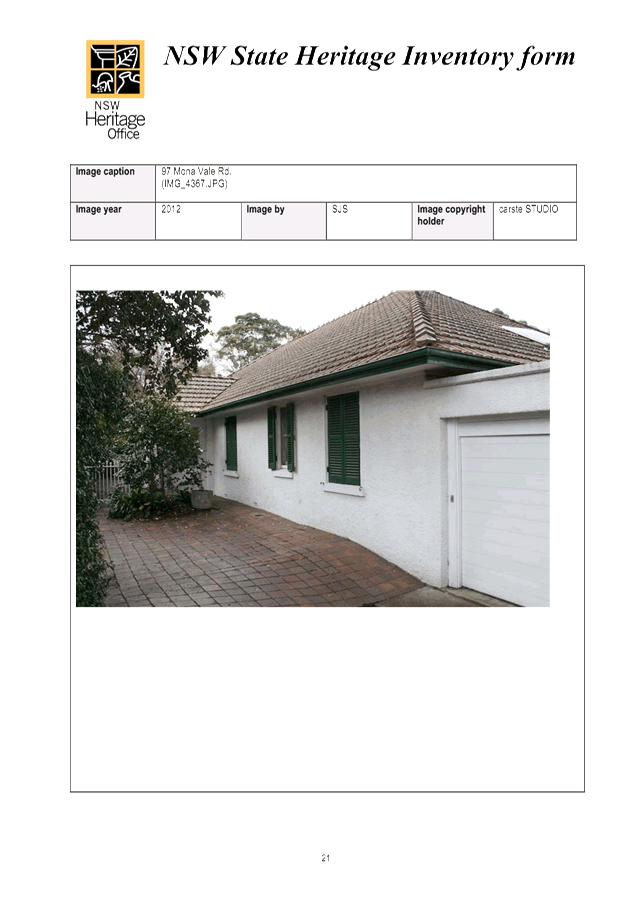
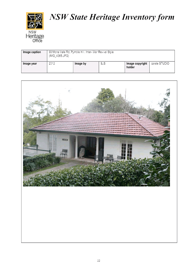
|
APPENDIX No: 16 - Pymble East Conservation Area - inventory sheet (includes proposed Athol Conservation Area and extensions to Pymble Heights and Fern Walk HCAs) |
|
Item No: GB.15 |
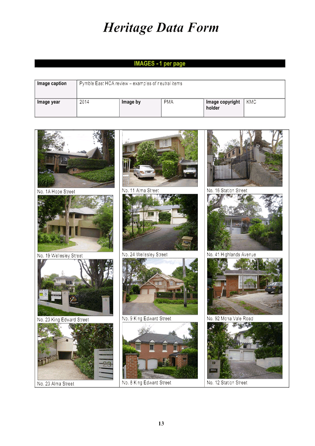
|
Ordinary Meeting of Council - 6 December 2016 |
GB.16 / 940 |
|
|
|
|
Item GB.16 |
CY00066/8 |
|
|
23 November 2016 |
Extinguishment/modification of Council Easement - 29, 29A and 31 Moree Street Gordon
EXECUTIVE SUMMARY
|
purpose of report: |
To consider a request for the extinguishment/modification of an existing stormwater drainage easement over Lot 2 DP 212930 and Lots 1 and 2 DP 846768, being 29, 29A and 31 Moree Street benefiting Council and the creation of a new easement in an alternate location on the land. |
|
|
|
|
background: |
The Developer has lodged a Development Application with Council seeking development consent to construct a multi-dwelling housing development comprising 15 dwellings on the development site. The Developer is seeking the relocation of an existing stormwater drainage easement and associated infrastructure benefiting Council in order to undertake the proposed development.
The Developer has also been in discussion with Council staff in relation to entering into a Voluntary Planning Agreement (VPA) to facilitate the construction of a road link between Moree and Dumaresq Streets on Council land on 33 Moree Street Gordon concurrent with the Developer’s proposed adjoining development. This matter is the subject of a separate report to Council. The development and the road design inclusive of the position of the culvert are, in part, contingent on the relocation of Council’s existing drainage easement. |
|
|
|
|
comments: |
Due to the location of the existing easement the development would impact on Council’s drainage system. The Developer is therefore seeking Council’s approval to relocate the easement in order for the development to proceed subject to DA approval. |
|
|
|
|
recommendation: |
That Council approves of the extinguishment/modification of the existing easement and creation of a new easement at 29, 29A and 31 Moree Street Gordon on the terms set out in this report. |
Purpose of Report
To consider a request for the extinguishment/modification of an existing stormwater drainage easement over Lot 2 DP 212930 and Lots 1 and 2 DP 846768, being 29, 29A and 31 Moree Street benefiting Council and the creation of a new easement in an alternate location on the land.
Background
The Developer has lodged a Development Application (DA0095/16) with Council seeking development consent to construct a multi-dwelling housing development comprising 15 dwellings on the development site, being 29, 29A and 31 Moree Street, Gordon.
Concurrent with the development, the Developer and Council staff have been in discussions in relation to a VPA which, if approved, would see the Developer constructing a local road link between Moree and Dumaresq Street, Gordon, on Council’s adjoining land, being 33 Moree Street Gordon, subject to a number of conditions. The Local Centres Development Control Plan and Public Domain Plan makes provision for new local road links between the Pacific Highway and Vale Street to facilitate traffic and pedestrian circulation as part of the redevelopment of the Gordon local centre.
In 2014/15 Council delivered Beans Farm Road between McIntyre Street and Dumaresq Street.
A separate Council report will be submitted on the proposed road link between Moree Street and Dumaresq Street and the proposed draft VPA.
Irrespective of the proposed VPA, the development and the road design inclusive of the position of the culvert are, in part, contingent on the relocation of Council’s existing drainage easement.
A resolution of Council is required to release, modify, extinguish or enter into a new easement.
Comments
The proposed development involves the extinguishment/modification of an existing Council easement which traverses over the location of a number of the proposed dwellings (Attachment A1). A new easement is to be created in an alternate position (Attachment A2). For any approval to become operative, the Developer must, among other things, obtain a resolution from Council, as the asset owner, that it will consent to the relocation of the existing Council easement for drainage and underground pipe. The relocation of the drainage infrastructure away from the building footprint to the new proposed location also creates development uplift in the value of the property.
An easement is a valuable property right and an asset of Council. Accordingly, there is a responsibility, on Council’s part, to dispose of Council’s interests in property in a commercially transparent, fair and proper manner. This includes extinguishing/modifying easements for fair value. The most objective manner for Council to ensure that this occurs is to obtain an independent valuation of the easement to be extinguished/modified based on the circumstances of each case.
The Developer has submitted the required application for the relocation of the existing easement and the creation of a new replacement easement to benefit Council in accordance Council’s adopted Easement Management Policy. The policy sets out the formal process and requirements to release, modify and create Council easements on private lands including the payment of Council’s legal costs and compensation in the event the release of the easement is approved by Council.
The acceptance of the application and the accompanying assessment fee does not confirm that the easement request will be approved, and this is clearly stated in the Easement Management Policy.
This report seeks Council’s approval to progress the application process and endorse the General Manager as the delegated authority to conclude future negotiations with the Developer in relation to securing fair compensation for the extinguishment of the existing easement based strictly on the valuation advice that Council receives from its expert independent Valuer.
integrated planning and reporting
Theme – Leadership and Governance - L2 Financial capacity and sustainability
|
Community Strategic Plan Long Term Objective |
Delivery Program Term Achievement |
Operational Plan Task |
|
Council rigorously manages its financial resources and assets to maximise service delivery
|
Council maintains and improves its long term financial position and performance |
Continue to analyse opportunities to expand the revenue base of Council
|
Governance Matters
Council is permitted to dispose, or deal with property, including easements, in accordance with the Local Government Act 1993.
The existing easement is a valuable proprietary right that benefits Council. The Council can only agree to extinguish/modify the easement by a resolution of Council.
Council’s adopted Easement Management Policy 2013, outlines processes and requirements for both internal and external parties. The Policy has been provided to the Applicant to ensure that all parties are informed of Council’s requirements and dealings are consistent with its terms.
The compensation to be paid by the Developer to Council will be based on independent expert advice provided by Council’s Valuer.
Risk Management
Council has formally approved a number of similar requests for the release or modification of easements in the past. Approval has been conditional on the Developer providing alternate infrastructure to Council’s specifications and paying the commercial consideration assessed by independent valuation. The same conditions will apply to this application, if approved.
Subject to Council’s resolution, the appropriate legal documentation to extinguish the easement and create a new easement will be reviewed by Council’s solicitors.
Financial Considerations
The Developer will be responsible for all costs associated with the relocation of the easement, including but not limited to construction of new drainage works, relocation and de-commissioning of infrastructure, valuation, legal, survey, stamp duty, registration etc., and payment of final compensation.
Council staff will commission an expert independent Valuer to assess fair compensation for extinguishing/modifying Council’s existing easement over this site. The appointed Valuer will be instructed to take into account all relevant circumstances, including the location of the new stormwater drainage easement being over another part of the Developer’s land and the associated infrastructure being provided to Council at no cost. The Valuer will also be instructed to give consideration to the “uplift to the Developer” of the property to allow development due to Council approving the relocation.
In line with the adopted Easement Management Policy and, subject to Council resolution, the quantum of compensation to be negotiated with the Developer will be strictly based on the valuation advice that Council receives from its independent expert Valuer.
Social Considerations
Council and its officers have a responsibility to the community to only dispose of Council’s interests in property in an objective and fair manner.
Environmental Considerations
Environmental impacts for the easement will be determined and mitigated through the development assessment and approval process.
Community Consultation
There has been no specific community consultation undertaken in relation to the specific easement request contained in this report.
Internal Consultation
Consultation has also been held with staff from Council’s Development and Regulation, Operations and Strategy and Environment Departments.
Summary
The Developer seeks to extinguish/modify an existing stormwater drainage easement that benefits Council over Lot 2 DP 212930 and Lots 1 and 2 DP 846768, being 29, 29 and 31 Moree Street Gordon and to replace Council’s drainage infrastructure in an alternate location on the property which is acceptable to Council. The replacement drainage infrastructure is to be provided at no cost to Council and subject to Council’s specifications which will be determined through the DA process.
The Developer has been advised of Council’s requirements to progress the relocation of the existing easement and has paid the required application fee and submitted written confirmation agreeing to Council’s requirements set out in Council’s adopted Easement Management Policy.
Easements are a valuable property right and an asset of Council which are required to be disposed of in a commercially transparent, fair and proper manner.
The most objective manner for Council to ensure that this occurs is to obtain an independent valuation of the easement to be extinguished which takes into account all relevant circumstances, including any “uplift” in the value of the property and the enhanced development potential of the site due to the relocation of the drainage easement.
Council’s approval is sought to progress the application process and endorse the General Manager as the delegated authority to conclude future negotiations with the Developer in relation to securing fair compensation for the relocation of the existing easement based strictly on the valuation advice that Council receives from its expert independent Valuer.
|
A. That the General Manager or his delegate be authorised to negotiate Council’s requirements including compensation for the relocation of the existing easement that benefits Council over Lot 2 DP 212930 and Lots 1 and 2 DP 846768 (29, 29A and 31 Moree Street Gordon) and the creation of a new easement on another part of the property approved by Council.
B. Subject to the General Manager or his delegate completing negotiations strictly on the basis set out in this report that Council grant approval for the extinguishment of the existing easement and creation of the new easement on the development site in accordance with Council’s requirements and the future Development Consent.
C. That Council authorises the Mayor and General Manager to affix the Common Seal of the Council to the instrument for the release of the easement and the creation of a new easement and execute all associated documentation.
D. That all costs associated with the extinguishment of part of the existing easement and the creation of a new easement in favour of Council, including legal and survey costs and all costs associated with the new drainage works be borne by the Developer.
|
|
Vince Rago Property Program Co-ordinator |
Deborah Silva Manager Integrated Planning, Property & Assets |
|
Ian Dreghorn Acting Director Strategy & Environment |
|
|
Existing easement |
|
2016/326700 |
||
|
|
Proposed easement relocation |
|
2016/326774 |
|
Ordinary Meeting of Council - 6 December 2016 |
GB.17 / 947 |
|
|
|
|
Item GB.17 |
S10990 |
|
|
17 November 2016 |
Medium Density Housing Code Exhibition - Submission to Department of Planning and Environment
EXECUTIVE SUMMARY
|
purpose of report: |
To present to Council the assessment and submission on the Explanation of Intended Effect - Medium Density Housing Code and Draft Medium Density Design Guide exhibited by the Department of Planning and Environment. |
|
background: |
In November 2015 the Department of Planning and Environment (DPE) exhibited a Discussion Paper on the inclusion of Medium Density Housing in the State Environmental Planning Policy (Exempt and Complying Development Codes) 2008. Council prepared and sent a submission to that Paper on 24 Feb 2016. Council’s submission raised a number of concerns regarding the ability to conduct Medium Density Housing via the complying development route. On 12 October 2016 DPE exhibited the Explanation of Intended Effect - Medium Density Housing Code (MDH Code) and Draft Medium Density Design Guide (MDDG) and invited submissions on that exhibition. This Report puts forward the response to that exhibition. |
|
comments: |
The content of the exhibition has been analysed and the majority of concerns raised in Council’s initial submission to the Discussion Paper have not been addressed nor justified. An experienced architect was engaged to provide a detailed analysis of the two exhibited documents (Explanation of Intended Effect - Medium Density Housing Code (MDH Code) and Draft Medium Density Design Guide (MDDG)), and comment on the impact that the proposed pathway and standards would have on Ku-ring-gai. It is clear that the proposal for medium density housing via complying development, bypassing Council’s development assessment process, will have a detrimental impact on the Ku-ring-gai character of built form within a landscaped setting with canopy trees. Further, the fast-track approach with minimal consideration of aspects beyond the limits of the site will result in a significant burden on Council who will be required to address the negative impacts of developments that have not been integrated with Council’s or other local infrastructure and resources. |
|
recommendation: |
That Council endorse the content of the submission and it be submitted to the Department of Planning and Environment. |
Purpose of Report
To present to Council the assessment and submission on the Explanation of Intended Effect - Medium Density Housing Code and Draft Medium Density Design Guide exhibited by the Department of Planning and Environment.
Background
Complying Development
In February 2009 the Department of Planning and Environment (DPE) brought into effect the State Environmental Planning Policy (Exempt and Complying Development Codes) 2008 (Codes SEPP). The Codes SEPP applies State wide and includes a number of Codes which allow for certain types of development to be carried out as exempt development (without approval) or complying development (a fast-track approvals process) where the development could be certified by Council or a private certifier.
Since the Codes SEPP was introduced, the Government has increased the range of development types that the Codes SEPP covered. In general, the complying development pathway has been enabled for residential, commercial and industrial developments that meet specific standards and land requirements which the Department consider straight forward and low impact.
Single dwelling complying development in Ku-ring-gai
For the most part, developers have chosen private certifiers to issue the Complying Development Certificate, and for the most part the developments delivered have had little to no consideration of site features or aspects beyond the site confines.
As a result, Ku-ring-gai is now seeing houses that lack site integration, make very little meaningful contribution to the established streetscapes or to the overall Ku-ring-gai character of built form within a landscaped garden setting including canopy trees. In addition, Ku-ring-gai is seeing instances where tree removal is being requested to pave the way for the complying development houses and pools being developed under a SEPP which overrides local controls.
Further to this, a growing burden is being placed on Council where there is an expectation for Council to fix the problems that have been created by complying development which has not considered impact beyond the site, such as issues around stormwater discharge. In addition, Council is being expected, by a dissatisfied community, to account for and check non-compliant development due to the weak avenue of accountability and meaningful penalty through State level channels on misuse of the complying development pathway. Council, has neither the staff nor resources to check or correct development that has been ill-considered, nor is there any avenue to seek funding from the State Government to perform this role.
A key problem around complying development that has been repeatedly raised, is development being certified by private certifiers who often may lack legal or town planning qualifications to fully assess, verify and question the developments they are certifying. A fast-track process can potentially by-pass what actually needs to be checked and verified through formal rigorous independent assessment.
Medium Density Housing complying development
In November 2015 the Department of Planning and Environment (DPE) exhibited a Discussion Paper on the inclusion of Medium Density Housing in the State Environmental Planning Policy (Exempt and Complying Development Codes) 2008. Council responded to the exhibition in a submission forwarded to DPE on 24 February 2016. Council’s submission raised a number of concerns regarding the ability to develop Medium Density Housing via the complying development route. That previous submission is contained at Attachment A4 of this Council Report.
On 12 October 2016 DPE invited submissions to the exhibition of the progression of the original Discussion Paper and presented the following documents for comment:
· Explanation of Intended Effects (Proposed Medium Density Housing Code);
· Draft Medium Density Design Guide;
· Medium Density Design Guide and Medium Density Housing Code – Frequently Asked Questions, Oct 2016.
This Council Report puts forward the Council’s Submission to this exhibition.
Comments
The proposed structure of the Medium Density Housing Code (MDH Codes SEPP) and the associated Draft Medium Density Design Guide (MDDG) proposes to enable 3 types of medium density development through complying development, and the ability for those developments to concurrently seek either Strata or Torrens Title subdivision.
The Medium Density Housing Code (MDH Codes SEPP) and the associated Draft Medium Density Design Guide (MDDG) may be viewed at the following link:
http://planspolicies.planning.nsw.gov.au/index.pl?action=view_job&job_id=8016
The types of development are:
· Dual Occupancy two dwellings side by side (attached or detached) with concurrent Strata or Torrens Title subdivision on those sites within R2 zoned land where dual occupancies are permitted under Schedule 1 of the KLEPs;
· Multi-dwelling Housing (Terraces) with concurrent Strata or Torrens Title subdivision on R3 zoned land;
· Manor houses (up to 4 dwellings within a building) on R3 zoned land, and attached dual occupancies (one over the other) with concurrent Strata Title subdivision within R2 zoned land where dual occupancies are permitted under Schedule 1 of the KLEPs.
The content of the exhibition documents have been analysed in detail and presented in the tables attached Explanation of Intended Effect - Medium Density Housing Code (MDH Code) Attachment A2 and Draft Medium Density Design Guide (MDDG) Attachment A3.
It is noted that the majority of concerns raised in Council’s previous 24 February 2016 submission, also echoed in submissions by other groups, to the Department’s Discussion Paper have not been addressed nor justified in this exhibition.
Analysis of exhibited documents
Detailed input regarding current development issues around complying development within Ku‑ring-gai and the implications of the proposed addition of medium density housing to the Codes SEPP was sought and received from Council’s Development Assessment team, Council’s Compliance team, Council’s Corporate Lawyer, and from Council’s Environment and Sustainability team.
In addition, consultants Hill Thallis Architecture + Urban Projects was engaged to provide a detailed analysis of the two exhibited documents, and comment on the urban impact that the proposed complying development pathway and development standards would have on Ku-ring-gai and across Sydney and NSW.
It is clear from discussions held and analyses conducted that this proposal for medium density housing as complying development will exacerbate issues, that are already being experienced through the single dwelling complying development pathway, and will have widespread detrimental impacts on the Ku-ring-gai locality and on swathes of Sydney suburbs in general. The key concerns are
· erosion of the established and widely valued local character of quality built form within a landscaped garden setting of substantial vegetation including tree canopy;
· significant burden on Council to assist and resolve problems resulting from developments that have not been integrated into Council’s local systems or other infrastructure;
· generational impacts of poorly considered development only delivering on dwelling numbers with no alignment to State and National policy and direction.
Council’s Submission in response to the exhibition is structured as follows:
· Executive Summary Attachment A1;
· Key concerns and recommendations Attachment A1;
· Appendix 1 – Table of Assessment on Explanation of Intended Effect - Medium Density Housing Code (MDH Codes SEPP) Attachment A2;
· Appendix 2 – Table of Assessment on Draft Medium Density Design Guide (MDDG) Attachment A3;
· Appendix 3 – Council’s Submission 24 Feb 2016 to the original Discussion Paper Attachment A4.
Key issues
Whilst the Department’s initiative to promote the “missing middle” is supported in that the medium density typology (smaller houses with smaller gardens) is in short supply and its provision would enable more housing choice, the method of delivery through complying development is not supported.
The fundamental concerns regarding the exhibited documents are listed below and elaborated in the attached submission at Attachment A1.
1. Probity and transparency of process and delivery;
2. Delivery pathway through complying development;
3. Burden placed on local Councils;
4. Torrens Title subdivision;
5. Ambiguity, inconsistencies, lack of clarity.
The proposed “one size fits all” being demonstrated in the exhibited documents is highly unlikely to deliver good outcomes to every locality across NSW, and definitely will not support the context of established high quality areas such as Ku-ring-gai. For this reason the key recommendations put forward in the Submission are:
· Remove the complying development pathway for all medium density housing and implement a new SEPP Design Quality for Medium Density Housing that operates in the same way as SEPP 65 and ADG.
· Require all medium density housing to be designed by a registered architect and suitable qualified and regulated professionals for other disciplines to be independently verified by a design review panel.
· Ensure all multi-dwelling development is assessed by Councils with their qualified team of professionals engaged in accountable and transparent process of assessment.
integrated planning and reporting
P2 - Managing Urban Change
|
Community Strategic Plan Long Term Objective |
Delivery Program Term Achievement |
Operational Plan Task |
|
P2.1 A robust planning framework is in place to deliver quality design outcomes and maintain the identity and character of Ku-ring-gai. |
Land use strategies, plans and processes are in place to effectively manage the impact of new development.
|
Respond to State Government Planning initiatives and reforms – including the new Planning Legislation. |
Governance Matters
State Environmental Planning Policy (Exempt and Complying Development Codes) 2008 (Codes SEPP) came into effect in February 20019. The Codes SEPP applies statewide and includes a number of Codes which allow for certain types of development to be carried out as exempt development (without approval) or complying development (a fast-track approvals process) where the development could be certified by Council or a private certifier.
Since the Codes SEPP was introduced, the State Government has increased the range of development types that the Codes SEPP covered. This latest proposal is to further expand the Codes SEPP to allow 3 forms of medium density development as complying development on land where the development types are permissible uses under and existing LEP.
The types of development are:
· Dual Occupancy two dwellings side by side (attached or detached);
· Multi-dwelling Housing (Terraces);
· Manor houses (up to 4 dwellings within a building).
The proposed amendments will also provide for the ability for those developments to concurrently seek either Strata or Torrens Title subdivision.
Risk Management
The proposal for medium density housing via complying development, bypassing Council’s development assessment process, proposes a risk to Council as it will potentially have a detrimental impact on the Ku-ring-gai character of built form within a landscaped setting with canopy trees. Further, the fast-track approach with minimal consideration of aspects beyond the limits of the site will result in a significant burden on Council who will be required to address the negative impacts of developments that have not been integrated with Council’s or other local infrastructure and resources.
Financial Considerations
The costs associated with the preparation of the submission are covered by the Strategy and Environment Department, Urban and Heritage budget.
Social Considerations
The State Government’s initiative to promote the “missing middle” is supported in that the medium density typology (smaller houses with smaller gardens) is in short supply in Ku-ring-gai and more broadly across Sydney. While the greater provision of this form of housing would enable more housing choice, the method of delivery through complying development is not supported. The implementation of the policy would have a significant burden on Council to assist and resolve problems resulting from developments that have not been integrated into Council’s local systems or other infrastructure. It would also result in generational impacts of poorly considered development only delivering on dwelling numbers with no alignment to State and National policy and direction.
Environmental Considerations
The proposal to further expand the Codes SEPP to allow forms of medium density development as complying development would have significant negative environmental out comes for Ku-ring-gai including the erosion of the established and widely valued local character of quality built form within a landscaped garden setting of substantial vegetation including tree canopy.
Community Consultation
On 12 October 2016 the Department of Planning and Environment placed on public exhibited the Explanation of Intended Effect - Medium Density Housing Code (MDH Code) and Draft Medium Density Design Guide (MDDG) and invited submissions on that exhibition. Submissions to the exhibition close on 12 December 2016. This Report puts forward the response to the exhibition.
Internal Consultation
Council’s Development Assessment team, Council’s Compliance team, Council’s Corporate Lawyer, and from Council’s Environment and Sustainability team.
In addition, consultants Hill Thallis Architecture + Urban Projects was engaged to provide a detailed analysis of the two exhibited documents, and comment on the urban impact that the proposed complying development pathway and development standards would have on Ku-ring-gai and across Sydney and NSW.
Summary
The Department of Planning and Environment has exhibited draft documents proposing the delivery of certain types of medium density housing through the complying development pathway utilising designers and private certifiers to deliver through the process.
A submission to the exhibition has been prepared. It raises key concerns on the delivery mechanism and associated issues of probity of process, impact on the established character of the Ku-ring-gai area, burdens placed on Council through the inadequacy of the complying development pathway, and long term generational impacts on the local and wider environment with associated social and economic impacts.
|
A. That Council endorse the content of the submission and it be submitted to the Department of Planning and Environment.
B. That Council authorise the Director Strategy and Environment to amend Council’s submission to improve clarity and strengthen arguments prior to its issue.
C. That Council forward its final submission to interested State agencies and individuals to engage them in the proposed directions for medium density housing.
|
|
Rathna Rana Senior Urban Planner |
Craige Wyse Team Leader Urban Planning |
|
Antony Fabbro Acting Director Strategy & Environment |
|
|
Submission to Medium Density Complying Development SEPP |
|
2016/332261 |
||
|
|
Appendix 1 – Table of Assessment on Explanation of Intended Effect - Medium Density Housing Code (MDH Codes SEPP) |
|
2016/331891 |
|
|
|
Appendix 2 -Table of Assessment on Draft Medium Density Design Guide (MDDG) |
|
2016/332010 |
|
|
|
Appendix 3 - Council’s Submission 24th Feb 2016 to the original Discussion Paper |
|
2016/332025 |
|
APPENDIX No: 2 - Appendix 1 – Table of Assessment on Explanation of Intended Effect - Medium Density Housing Code (MDH Codes SEPP) |
|
Item No: GB.17 |


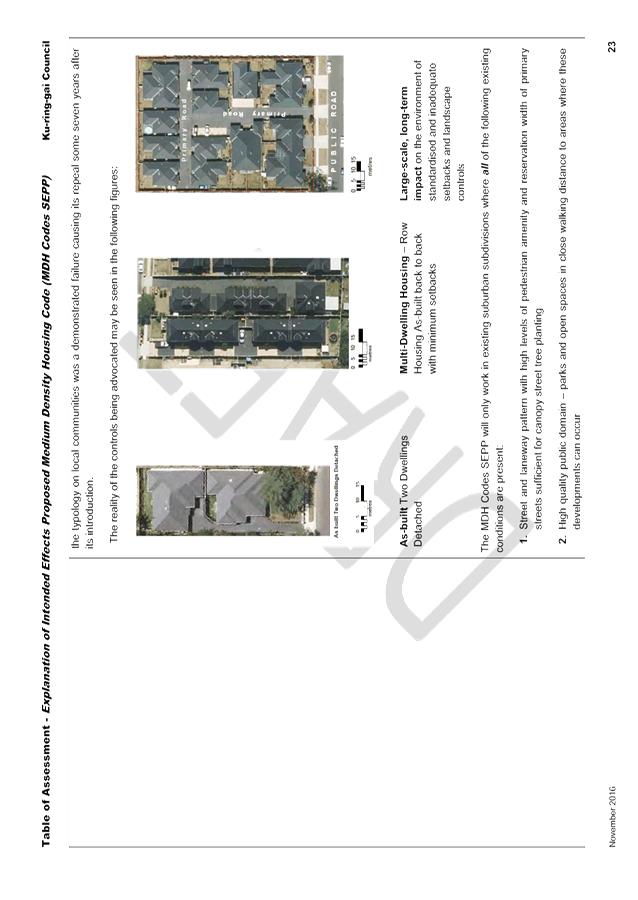

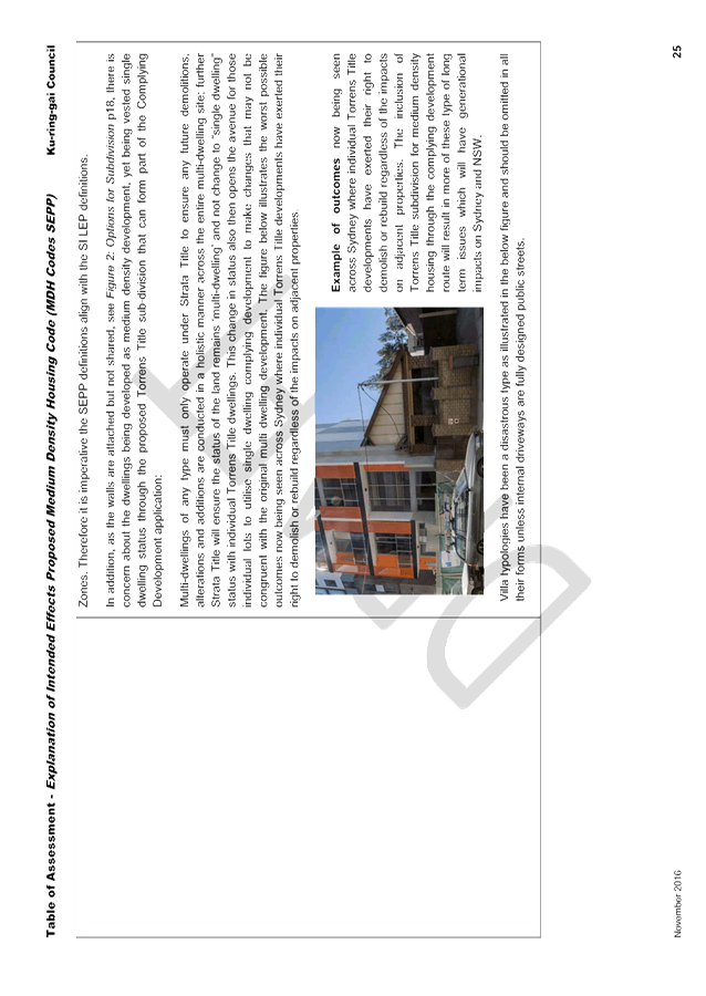
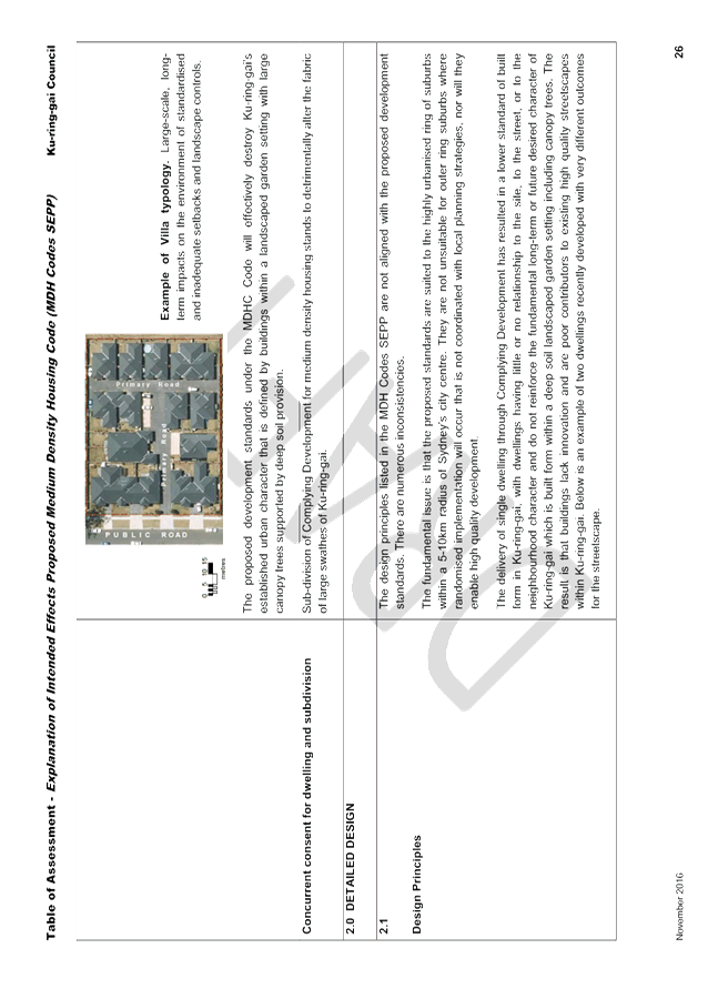
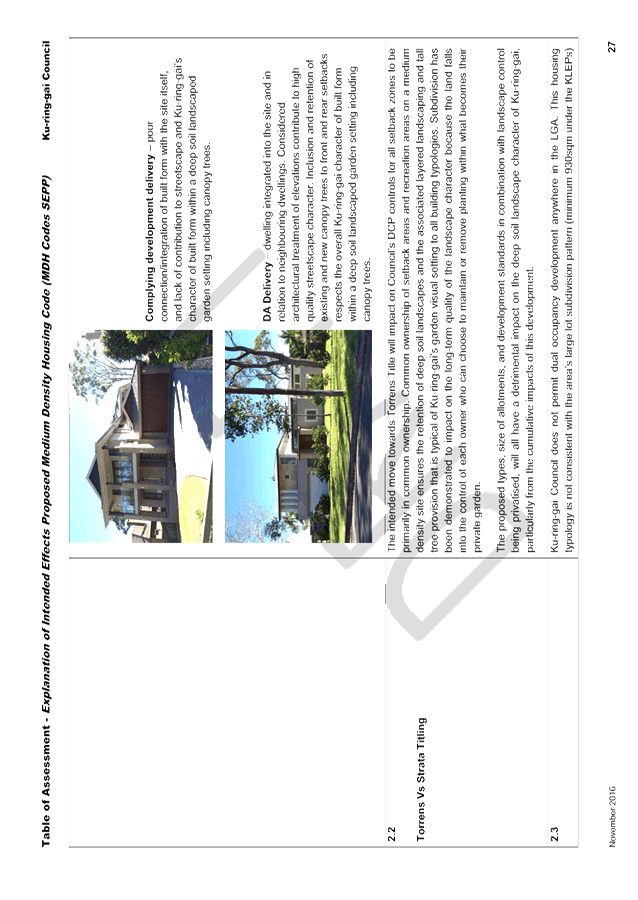
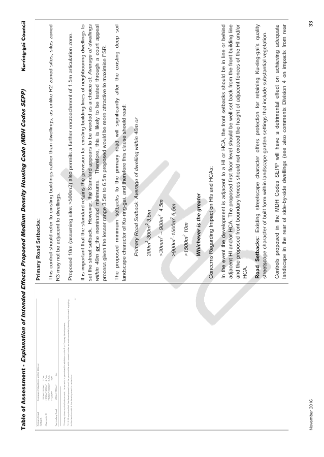


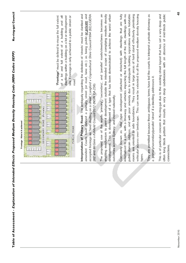


|
APPENDIX No: 3 - Appendix 2 -Table of Assessment on Draft Medium Density Design Guide (MDDG) |
|
Item No: GB.17 |