Ordinary
Meeting of Council
TO
BE HELD ON Tuesday, 7 February 2017 AT 7:00 pm
Level
3, Council Chamber
Agenda
** ** ** ** ** **
NOTE:
For Full Details, See Council’s Website –
www.kmc.nsw.gov.au
under the link to business papers
APOLOGIEs
DECLARATIONS OF INTEREST
Confirmation of Reports to be
Considered in Closed Meeting
NOTE:
That in
accordance with the provisions of Section 10 of the Local Government Act 1993,
all officers’ reports be released to the press and public, with the
exception of confidential attachments to the following General Business
reports:
GB.9 Turramurra
Community Hub Masterplan and Rezoning & Reclassification of 1275 Pacific
Highway, Turramurra
Attachment A6: ................................................................ Legal
Advice
In accordance with s10A(2)(g)
GB.11 Tender T06/2016 - NTRA
Sportsfield Car Park and Landscape Works
Attachment
A1: ................................................. List of Tenders received
In accordance with s10A(2)(d)(iii)
Attachment
A2: ....................... Tender Evaluation Panel's recommendation
In accordance with s10A(2)(d)(iii)
Attachment
A3: Corporate Scorecard Assessments
In accordance with s10A(2)(d)(iii)
Address the Council
NOTE: Persons
who address the Council should be aware that their address will be tape
recorded.
Documents Circulated to Councillors
CONFIRMATION OF MINUTEs
Minutes of Ordinary Meeting of Council 8
File: S02131
Meeting held 6 December 2016
Minutes numbered 320 to 344
minutes from the Mayor
MM.1 2017
Australia Day Honours and Citizen of the Year Awards 54
File: S07765/8
I am pleased to inform you that
12 Ku-ring-gai citizens, through their outstanding achievements and services to
the community, have been awarded 2017 Australia Day Honours.
We are very proud to have these
dedicated and talented Australians as members of the Ku-ring-gai community.
I would like to read to you the
names of these special Ku-ring-gai citizens and, on behalf of Council,
congratulate them on their excellent contributions to Australian society.
David Timothy CHEN
OAM of Killara, for service to medicine, and to professional
associations
Michael John McEWEN
OAM of St Ives, for service to the community through a range of
organisations
Helen Elaine MILLER
OAM of Turramurra, for service to veterans and their families
Yair Phillip MILLER
OAM of St Ives, for service to the community through a range of
organisations, and to interfaith relations
Susan Lesley NURSE OAM
of Pymble, for service to the Uniting Church in Australia
Geoffrey Thomas PAINTER
AM of Warrawee, for significant service to medicine in the field of
ophthalmology, and to international relations, particularly to eye health in
Asia and he Pacific
Richard John SCHLOEFFEL
OAM of Gordon, for service to medicine in the field of chronic and
infectious disease
Owen Bruce SLEE AM
Late of Turramurra, for significant service to science, particularly in the
field of radio astronomy, as a researcher, author and mentor of young
scientists
Patricia Whitmore
SPOONER OAM of North Turramurra, for service to the community
through volunteer roles
Tiffany THOMAS KANE
OAM of Killara, for service to sport as a gold medallist at the Rio
2016 Paralympic Games
Pamela Joy WALKER
OAM of Pymble, for service to the Uniting Church in Australia, and to
pastoral care programs
Adrian Anthony UNGER
OAM of East Lindfield, for service to people with Parkinson’s
disease
I also congratulate
Ku-ring-gai’s Citizen of the Year winners for 2017:
|
Citizen of the Year
|
- Dr
Zeny Edwards
|
|
Young Citizen of the Year
|
- David
Taylor
|
|
Outstanding Service to the
Community
(Individual)
|
- Helen
Wortham
|
|
Outstanding Service to the
Community
(Group)
|
- WW1
Writers’ Group
|
On behalf of Council, I
congratulate all these award winners on their outstanding achievements.
Ku-ring-gai should be proud that
it has so many citizens being recognised at the highest level for their
selfless dedication, commitment and contribution to local, national and
international communities.
Petitions
PT.1 Request
for Concrete Footpath on
Junction Road Wahroonga 56
File:
88/05589/01
“We, the undersigned,
request the Mayor and Councillors of Ku-ring-gai to consider building a
concrete sidewalk on Junction Road, Wahroonga – specifically from 105 Junction
Road to 33 Junction Road (Junction Road and Grosvenor Street) during the next
year. (Thirty Five [35] Signatures)
We do not know why the Council
has not built a sidewalk on our side of Junction Road, as this is a busy street
with cars driving by on an ongoing basis, with bus stops, and with senior
housing next to our house. We can think of a number of reasons why building a
sidewalk is important, our top five reasons are:
1. Sidewalks
provide a safe and level walkway – especially during wet weather and for
people using wheelchairs, the elderly, or people pushing a cart of stroller.
2. Sidewalks
provide safe places for children to walk from and to schools and school bus
stops.
3. Sidewalks
improve the ability for people to get around by providing ways for them to get
wherever they need to go: work, parks, schools, shopping areas, transit stops,
and home without using cars (sidewalks benefits less traffic and reduced
noise).
4. Sidewalks
enhance the appearance of individual properties, neighbourhoods, and the entire
community.
5. Sidewalks
help protect property frontage from damage due to erosion and parking.
Of course, walking is the most
democratic way to get around. It is the oldest mode of transport, it’s
free, and it may even help us burn a few calories. We hope the Council supports
our desire to shift back to pedestrian – friendly streets. We firmly
believe enhancing the quality of sidewalks not only attracts more pedestrians,
but also helps to enjoy public spaces more where people want to spend time
outdoors.”
GENERAL BUSINESS
i.
The Mayor to invite Councillors to
nominate any item(s) on the Agenda that they wish to have a site inspection.
ii.
The Mayor to invite Councillors to
nominate any item(s) on the Agenda that they wish to adopt in accordance with
the officer’s recommendation allowing for minor changes without debate.
GB.1 Investment
Report as at 30 November 2016 57
File: S05273
To present Council’s
investment portfolio performance for November 2016.
Recommendation:
That the summary of investments
performance for November 2016 be received and noted; and that the Certificate
of the Responsible Accounting Officer be noted and report adopted.
GB.2 Review of
Council's Investment Policy 66
File: S05273
To review and adopt Council's
revised Investment Policy.
Recommendation:
That the attached revised
Investment Policy, endorsed by the Audit & Risk Committee, be adopted by
Council.
GB.3 Investment
Report as at 31 December 2016 84
File: S05273
To present Council’s
investment portfolio performance for December 2016.
Recommendation:
That the summary of investments
performance for December 2016 be received and noted; and that the Certificate
of the Responsible Accounting Officer be noted and report adopted.
GB.4 Business
Approved under Authority Delegated to the Mayor, Deputy Mayor and General
Manager for the Christmas/New Year recess period 2016/2017 94
File: CY00259/9
To inform Councillors of any
business approved under delegated authority during the 2016/17 recess period.
Recommendation:
That Council receives and notes
the report.
GB.5 Election
of Council Representative on
Ku-ring-gai Youth Development Service (KYDS) Committee 100
File: S03662
To advise Council of the
resignation of Councillor Citer as Council’s representative on the KYDS
Management Committee, and seek a resolution regarding the appointment of a new
representative and alternate representative.
Recommendation:
That Council appoints its
representative and alternate representative on the KYDS Management Committee.
GB.6 2017 MAV
Smart Futures National Conference: Building Liveable, Walkable, Sustainable
Communities 103
File: FY00581/2
To advise Council of the 2017 MAV
Smart Futures National Conference.
Recommendation:
That any
Councillors interested in attending the 2017 MAV Smart Futures National
Conference advise the General Manager by Friday, 24 February 2017.
GB.7 1 Milray
Street and 12 - 14 Kochia Lane Lindfield - Demolition of existing structures
and construction of a multi-dwelling development consisting of 16 townhouses,
basement parking, landscaping works and amalgamation of three lots into one 111
File: DA0158/16
Ward: Roseville
Applicant:
Urbanesque Planning Pty Ltd
Owner: Rudder
Development One Pty Ltd
Demolition of existing structures
and construction of a multi-dwelling development consisting of 16 townhouses,
basement parking, landscaping works and amalgamation of three lots into one
Recommendation:
Approval
GB.8 Planning
Proposal - Rezoning 21 Lorne Avenue, Killara 189
File: S11257
For Council to consider a
Planning Proposal for 21 Lorne Avenue, Killara.
Recommendation:
That the Planning Proposal be
sent to the Department of Planning and Environment for a Gateway Determination.
GB.9 Turramurra
Community Hub Masterplan and Rezoning & Reclassification of 1275 Pacific
Highway, Turramurra 279
File: S09969
For Council to consider the
feedback following the public hearing for the Planning Proposal to rezone and
reclassify Council owned land at 1275 Pacific Highway, Turramurra and for
Council to adopt the Turramurra Community Hub Master Plan.
Recommendation:
This report recommends that the
land at 1275 Pacific Highway, Turramurra be rezoned and reclassified and that
the Turramurra Community Hub Master Plan, as described in this report, be
adopted.
GB.10 Fitzsimons
Lane Gordon - Draft Voluntary Planning Agreement for 904-914 Pacific Highway
Gordon - Post Exhibition Report 385
File: S10147
To report back following the
exhibition of the Draft Planning Agreement for 904-914 Pacific Highway Gordon.
Recommendation:
That Council resolves to enter
into the Planning Agreement with WN Developments Pty Ltd as specified within
the attached document to facilitate the dedication of land for the purposes of
widening Fitzsimons Lane Gordon and delegation be granted to the General
Manager and Mayor to execute the Planning Agreement, under Common Seal.
GB.11 Tender
T06/2016 - NTRA Sportsfield Car Park and Landscape Works 417
File: S10894/2
To consider the tenders received
for the construction of NTRA Sportsfield Car Park and Landscape works and
appoint the preferred tenderer.
Recommendation:
In accordance with Section 55 of
the Local Government Act and Tender Regulations, it is recommended that Council
accept the tender submitted by Tenderer ‘A’.
GB.12 Council
Sponsorship -Turramurra Rotary Graffiti Removal Program 2016/2017 423
File: S05650
To seek Council’s
endorsement to provide additional funding to Turramurra Rotary for the cleaning
of graffiti from business and private property in the Turramurra and St Ives
area.
Recommendation:
That Council approve the request
from Turramurra Rotary for $5,000 with funds to be provided from the Building
Maintenance Recurrent Budget.
Extra Reports Circulated to Meeting
BUSINESS WITHOUT NOTICE – SUBJECT TO CLAUSE 241 OF
GENERAL REGULATIONS
Questions Without Notice
Inspections Committee – SETTING OF TIME, DATE AND
RENDEZVOUS
** ** ** ** ** **
Minute Ku-ring-gai
Council Page
MINUTES
OF Ordinary Meeting of Council
HELD ON Tuesday, 6 December 2016
|
Present:
|
The Mayor, Councillor J Anderson (Chairperson)
Councillors E Malicki & J Pettett (Comenarra Ward)
Councillors C Szatow & D Citer (Gordon Ward)
Councillors C Berlioz & D Ossip (St Ives Ward)
Councillor D Armstrong (Roseville Ward)
Councillors C Fornari-Orsmond & D McDonald (Wahroonga
Ward)
|
|
|
|
|
Staff Present:
|
General Manager (John McKee)
Director Corporate (David Marshall)
Director Development & Regulation (Michael Miocic)
Director Operations (Greg Piconi)
Acting Director Strategy & Environment (Antony Fabbro)
Director Community (Janice Bevan)
Corporate Lawyer (Jamie Taylor)
Manager Strategic Projects (Ian Dreghorn)
Manager Corporate Communications (Virginia Leafe)
Manager Records and Governance (Amber Moloney)
Team Leader Urban Design (Bill Royal)
Strategic Traffic Engineer (Joseph Piccoli)
Contract Urban Designer (Louise Drum)
Principal Landscape Architect (Alison Walker)
Minutes Secretary (Christine Dunand)
|
The Meeting
commenced at 7:00 pm
The Mayor offered
the Prayer
Apologies
The General Manager advised that
Director Strategy and Environment Andrew Watson is unwell and Mr Fabbro
will be Acting Director Strategy and Environment.
DECLARATIONS
OF INTEREST
The Mayor
adverted to the necessity for Councillors and staff to declare a Pecuniary
Interest/Conflict of Interest in any item on the Business Paper.
The Mayor, Councillor Anderson
declared a conflict of interest in item GB.13 Turramurra Local Centre
- Traffic and Transport Study, as she has recently moved to rental premises
in Turramurra Avenue, and advised she would leave the Chamber during the
debate.
Councillor Berlioz arrived
The General Manager advised
staff declarations of interest in item C.1 2017 General Manager's
Performance Agreement - Monitoring Review and advised that the General
Manager and staff would leave the Chamber during the debate.
|
319
|
CONFIRMATION
OF REPORTS TO BE CONSIDERED IN CLOSED MEETING
File: S02499/9
|
|
|
Resolved:
(Moved: Councillors Fornari-Orsmond/McDonald)
That in accordance with the provisions of Section 10 of
the Local Government Act 1993, all officers’ reports be released to the
press and public, with the exception of:
A. That
in accordance with the provisions of Section 10 of the Local Government Act ,
all officers’ reports be released to the press and public, with the
exception of confidential reports and respective attachments:
C.1 2017
General Manager's Performance Agreement - Monitoring Review
In
accordance with 10A(2)(a)
B. That
in accordance with the provisions of Section 10 of the Local Government Act ,
all officers’ reports be released to the press and public, with the
exception of confidential attachments to the following General Business
Reports:
GB.7 Tender
RFT11/2016 - Printer and Multifunction Device Replacement
Attachment
A1: Evaluation Committee Report
In accordance with
s10A(2)(d)(iii)
Attachment
A2: Evaluation Worksheet - All Submissions
In accordance with
s10A(2)(d)(iii)
Attachment
A3: Evaluation Worksheet - Shortlisted Submissions
In accordance with
s10A(2)(d)(iii)
GB.9 Tender
RFT14/2016 - Drainage Construction at 90 Babbage Road, Roseville Chase
Attachment
A1: Tender Evaluation Panel Summary
In accordance with
s10A(2)(d)(iii)
Attachment
A2: Financial Considerations Summary
In accordance with
s10A(2)(d)(iii)
Attachment
A3: Tenderer A - Corporate Scorecard
In accordance with
s10A(2)(d)(iii)
Attachment
A4: Tenderer B - Corporate Scorecard
In accordance with
s10A(2)(d)(iii)
Attachment
A5: Valuation Report 1
In accordance with s10A(2)(d)(iii)
Attachment
A6: Valuation Report 2
In accordance with
s10A(2)(d)(iii)
Attachment
A7: Valuation Report 3
In
accordance with s10A(2)(d)(iii)
CARRIED
UNANIMOUSLY
|
Address
the Council
The following member(s) of the
public address Council on items not on the agenda:
E Gross Request
for Enforcement Action
J Harwood Identity
in the 21st Century
DOCUMENTS
CIRCULATED TO COUNCILLORS
The Mayor adverted to the
documents circulated in the Councillors’ papers and advised that the
following matters would be dealt with at the appropriate time during the
meeting:
|
Memorandums:
|
GB.1 St Ives Showground New Inclusive Playground and
Golden Grove Inclusive Playground Upgrade
Memorandum from Acting
Director Strategy & Environment dated 29 November 2016 advising a full
sized set of all attachments to this reports are available in the
Councillors’ room.
|
|
Late Councillors Information:
|
GB.13 Turramurra Local Centre - Traffic and Transport
Study
Memorandum from Acting
Director Strategy and Environment dated 6 December 2016 answering Councillor
questions regarding the Turramurra Local Centre - Traffic and Transport Study
|
CONFIRMATION
OF MINUTEs
|
320
|
Minutes
of Ordinary Meeting of Council
File: S02131
|
|
|
Meeting held 22 November 2016
Minutes numbered 303 to 318
|
|
|
Resolved:
(Moved: Councillors Szatow/Fornari-Orsmond)
That Minutes numbered 303 to 318 circulated to Councillors
were taken as read and confirmed as an accurate record of the proceedings of
the Meeting.
CARRIED
UNANIMOUSLY
|
GENERAL
BUSINESS
|
321
|
St
Ives Showground New Inclusive Playground and Golden Grove Inclusive
Playground Upgrade
File: S02621
Vide: GB.1
|
|
|
To seek Council's endorsement
of the final concept designs for the inclusive playgrounds at Council’s
Regional Parks - St Ives Showground at Picnic Area 7 and at Ku-ring-gai
Bicentennial Park at Golden Grove and proceed to document for tender.
|
|
|
Resolved:
(Moved: Councillors Szatow/McDonald)
A. That
Council endorses the final concept designs for the new upgraded inclusive
playgrounds in St Ives Showground in Picnic Area 7, and in Ku-ring-gai
Bicentennial Park at Golden Grove.
B. That
design and construction documentation, including detailed plans, cost
estimates, environmental assessment and specifications for both projects
based on the final concept designs, be completed for public tender.
C. That
Council authorises the General Manager to allow minor changes to the concept
plans during the design development process where budget or other constraints
warrant amendments.
D. That
the specialised custom built play equipment items listed in the report be
authorised for pre-order by the General Manager to ensure the long lead time
does not delay the project implementation.
E. That
any increased maintenance costs associated with the new regional playground
upgrades be included in the draft 2017/18 recurrent budget.
CARRIED
UNANIMOUSLY
|
|
322
|
Code
of Conduct - Complaint Statistics
File: S08447
Vide: GB.2
|
|
|
To report statistics in relation to complaints as required
by the Procedures for the Administration of the Model Code of Conduct for
Local Councils in NSW for the twelve
months to 31 August 2016.
|
|
|
Resolved:
(Moved: Councillors Szatow/McDonald)
That the report pursuant to Part 12 of the Procedures
for the Administration of the Model Code of Conduct for Local Councils in
NSW be received and noted.
CARRIED
UNANIMOUSLY
|
|
323
|
Draft
Media and Communications Policy
File: S07349
Vide: GB.3
|
|
|
For Council to adopt the draft Media and Communications
Community Policy 2016.
|
|
|
Resolved:
(Moved: Councillors Szatow/McDonald)
That Council adopt the draft Media and Communications
Policy 2016.
CARRIED
UNANIMOUSLY
|
|
324
|
St
Ives Precinct - Temporary Markets
File: S10920
Vide: GB.4
|
|
|
To advise Council of a temporary booking for Anatevka Pty
Ltd to conduct monthly Sunday markets at the St. Ives Precinct, for a12 month
trial period.
|
|
|
Resolved:
(Moved: Councillors
Szatow/Pettett)
That Council receive and note this report.
CARRIED
UNANIMOUSLY
|
|
325
|
Draft
Community Consultation Policy
File: S02090
Vide: GB.5
|
|
|
For Council to adopt the draft Community Consultation
Policy 2016.
|
|
|
Resolved:
(Moved: Councillors Szatow/McDonald)
That Council adopt the draft Community Consultation Policy
2016.
CARRIED
UNANIMOUSLY
|
|
326
|
Tender
RFT11/2016 - Printer and Multifunction Device Replacement
File: S11009
Vide: GB.7
|
|
|
To report on the results of the open tender for the supply
and installation of printers, multifunction devices and a print management
solution and to seek approval to accept the tender from the preferred
tenderer.
|
|
|
Resolved:
(Moved: Councillors Szatow/McDonald)
A. That
Council approve the recommendation of the Tender Evaluation Committee
included in attachment A1.
B. That
Council authorises the Mayor and General Manager to execute all documents and
affix the Council seal to all contract documents.
CARRIED
UNANIMOUSLY
|
|
327
|
Ku-ring-gai
Bush fire prone land map 2016 - finalisation
File: S10627
Vide: GB.11
|
|
|
For Council to adopt the exhibited 2016 Ku-ring-gai Bush
Fire Prone Land Map (BFPLM) which was placed on public exhibition between 24
June 2016 and 21 July 2016, with amendments as outlined in this report, for
lodgement to the Commissioner of the NSW Rural Fire Service for
certification.
|
|
|
Resolved:
(Moved: Councillors Szatow/Berlioz)
That Council endorses the final 2016 Ku-ring-gai 2016
Bush Fire Prone Land Map, with amendments as outlined in this report, for lodgement
to the Commissioner of the NSW Rural Fire Service for certification.
CARRIED
UNANIMOUSLY
|
|
328
|
Fitzsimons
Lane Gordon - Voluntary Planning Agreements
File: S10147
Vide: GB.14
|
|
|
To provide an update on the progress of the draft Planning
Agreements for the Development Applications that front both the Pacific
Highway and Fitzsimons Lane Gordon – the lane frontage being subject to
a land dedication for widening. This report also recommends the
statutory exhibition of one of the draft Planning Agreements.
|
|
|
Resolved:
(Moved: Councillors Szatow/Pettett)
A. That
public notice of the exhibition of the draft Planning Agreement and
Explanatory Note relating to the property at 904-914 Pacific Highway Gordon
for the purposes of facilitating a land dedication along the frontage to
Fitzsimons Lane be duly given, and a copy of those documents be made
available for inspection, in accordance with the Environmental Planning and
Assessment Act 1979 and the Environmental Planning and Assessment Regulation
2000.
B. That
a report be brought back to Council following the statutory exhibition
process.
C. That
delegation be granted to the General Manager or his delegate to make any
administrative changes to the document that do not alter the overall intent
in order to facilitate exhibition and to protect Council’s interests.
D. That
the letter of offer to enter into a planning agreement for the dedication of
land along the frontage to Fitzsimons Lane of the property located at 900
Pacific Highway Gordon in association with DA0226/16 be noted and authority
be delegated to the General Manager or his delegate to progress the draft
planning agreement in discussions with the applicant.
E. That
the design process for the Fitzsimons Lane public domain improvements
commence as soon as practicable in 2017.
F. That
the General Manager or his delegate to authorised to proactively pursue the
completion of the negotiations for the draft planning agreement for the
remaining property at 870-898 Pacific Highway which also has rear frontage to
Fitzsimons Lane which has recently been on-sold, in line with the original
letters of offer from the former property owner, with a view to enabling the
public domain works to Fitzsimons Lane to be delivered concurrently and in
the short term.
CARRIED
UNANIMOUSLY
|
|
329
|
Potential
Heritage Conservation Areas in Pymble, Turramurra and Wahroonga
File: S10051
Vide: GB.15
|
|
|
To have Council consider potential heritage conservation
areas for inclusion under the Ku-ring-gai Local Environmental Plan 2015 and
the Ku-ring-gai Local Environmental Plan (Local Centres) 2012.
|
|
|
Resolved:
(Moved: Councillors Szatow/Berlioz)
A. That a
Planning Proposal be prepared in accordance with s55 of the EP&A Act to
amend KLEP 2015 and KLEP (Local Centres) 2012 to include several proposed
conservation areas as potential heritage conservation areas in Schedule 5 and
on the Heritage Map.
B. That the
Planning Proposal be forwarded to the Department of Planning and Environment
for a Gateway Determination in accordance with the provisions of the EP&A
Act and Regulations.
C. That in order
to facilitate an expedient Gateway Determination, the NSW Heritage Office be
consulted prior to submitting the Planning Proposal to the Department of
Planning and Environment. Should comments not be received within 21 days, the
Planning Proposal is to be submitted regardless.
D. That Council
requests the plan making delegation under Section 23 of the EP&A Act for
this Planning Proposal.
E. That upon
receipt of a Gateway Determination, the exhibition and consultation process
is carried out in accordance with the requirements of the Environmental
Planning and Assessment Act, 1979 and with the Gateway Determination
requirements.
F. A further
report be brought back to Council at the end of the exhibition period.
CARRIED
UNANIMOUSLY
|
|
330
|
Extinguishment/modification
of Council Easement - 29, 29A and 31 Moree Street Gordon
File: CY00066/8
Vide: GB.16
|
|
|
To consider a request for the extinguishment/modification
of an existing stormwater drainage easement over Lot 2 DP 212930 and Lots 1
and 2 DP 846768, being 29, 29A and 31 Moree Street benefiting Council and the
creation of a new easement in an alternate location on the land.
|
|
|
Resolved:
(Moved: Councillors Szatow/Citer)
A. That
the General Manager or his delegate be authorised to negotiate
Council’s requirements including compensation for the relocation of the
existing easement that benefits Council over Lot 2 DP 212930 and Lots 1 and 2
DP 846768 (29, 29A and 31 Moree Street Gordon) and the creation of a new
easement on another part of the property approved by Council.
B. Subject
to the General Manager or his delegate completing negotiations strictly on
the basis set out in this report that Council grant approval for the
extinguishment of the existing easement and creation of the new easement on
the development site in accordance with Council’s requirements and the
future Development Consent.
C. That
Council authorises the Mayor and General Manager to affix the Common Seal of
the Council to the instrument for the release of the easement and the
creation of a new easement and execute all associated documentation.
D. That
all costs associated with the extinguishment of part of the existing easement
and the creation of a new easement in favour of Council, including legal and
survey costs and all costs associated with the new drainage works be borne by
the Developer.
CARRIED
UNANIMOUSLY
|
|
331
|
Medium
Density Housing Code Exhibition - Submission to Department of Planning and
Environment
File: S10990
Vide: GB.17
|
|
|
To present to Council the assessment and submission on the
Explanation of Intended Effect - Medium Density Housing Code and
Draft Medium Density Design Guide exhibited by the Department of Planning
and Environment.
|
|
|
Resolved:
(Moved: Councillors Szatow/Berlioz)
A. That
Council endorse the content of the submission and it be submitted to the
Department of Planning and Environment.
B. That
Council authorise the Director Strategy and Environment to amend
Council’s submission to improve clarity and strengthen arguments prior
to its issue.
C. That
Council forward its final submission to interested State agencies and
individuals to engage them in the proposed directions for medium density
housing.
CARRIED
UNANIMOUSLY
|
|
332
|
2017
General Manager's Performance Agreement - Monitoring Review
File: CY00254/9
Vide: C.1
|
|
|
In accordance with the Local
Government Act 1993 and the Local Government (General) Regulation 2005,
in the opinion of the General Manager, the following business is of a kind as
referred to in section 10A(2)(a), of the Act, and should be dealt with in a
part of the meeting closed to the public.
Section 10A(2)(a) of the Act
permits the meeting to be closed to the public for business relating to
personnel matters concerning particular individuals (other than Councillors).
Report by Mayor, Councillor Jennifer Anderson dated 28
November 2016
|
|
|
Resolved:
(Moved: Councillors Szatow/McDonald )
A. That Council receive
and accept the report.
B. That the General
Manager be officially advised by the Mayor of the outcome of the Performance
Review.
C. That the General
Manager and his staff be commended for their good work.
D. That Council continue
the facilitation contract with Ptok Consulting Pty Ltd as outlined in
Attachment 2.
CARRIED
UNANIMOUSLY
|
Councillor Ossip
withdrew during discussion
Councillor Ossip
returned
Standing Orders
were suspended to deal with items
where there are speakers first after a
Motion moved by Councillors Armstrong and McDonald
was CARRIED UNANIMOUSLY
|
333
|
Save
Marian Street Theatre Group - Business Plan
File: S10577
Vide: GB.6
|
|
|
To present to Council a Business Plan prepared by the Save
Marian Street Theatre Group.
The following members of the public addressed Council on
this matter:
J Townend
J Cadden
|
|
|
Resolved:
(Moved: Councillors McDonald/Malicki)
A. That
Council engage an independent consultant to conduct a Probity and Risk Review
of the Save Marian Street Theatre Business Plan.
B. That
a report come to Council containing analysis of the SMS Business Plan along
with recommendations and strategies from the independent Probity and Risk
Review.
C. That
the Probity report come back to Council by the end of February 2017.
For the
Resolution: The
Mayor, Councillor Anderson, Councillors , Citer, McDonald, Pettett, Malicki,
Berlioz, Szatow, Fornari-Orsmond and Ossip
Against
the Resolution: Councillor
Armstrong
The above Resolution was CARRIED as an Amendment to the
Original Motion.
For the
Amendment: The
Mayor, Councillor Anderson, Councillors , McDonald, Pettett, Malicki,
Berlioz, Fornari-Orsmond and Ossip
Against
the Amendment: Councillors Citer,
Armstrong and Szatow
The Original Motion was:
(Moved: Councillors Szatow/Citer)
A.
That Council engage an independent consultant to conduct a
Probity and Risk Review of the Save Marian Street Theatre Business Plan.
B.
That a report come to Council containing analysis of the SMS
Business Plan along with recommendations and strategies from the independent
Probity and Risk Review.
C.
That Council approve $36,500 seed funding to the Save Marian
Street Theatre Committee in order that they can continue with a feasibility
study at the same time as Council's undertaking of a Probity and Risk Review
of their Business Plan.
During debate Councillors Fornari-Orsmond/McDonald
moved that the Motion be PUT as there had been 2 speakers For and 2 Against.
For the
Resolution: The
Mayor, Councillor Anderson, Councillors , McDonald, Pettett, Malicki,
Berlioz, Fornari-Orsmond and Ossip
Against
the Resolution: Councillors
Citer, Armstrong and Szatow
|
|
334
|
24
Mungarra Avenue, St Ives - demolition of existing structures and construction
of 3 seniors living dwellings and associated works
File: DA0572/15
Vide: GB.8
|
|
|
Demolition of existing structures and construction of 3
seniors living dwellings and associated works
The following members of the public addressed Council on
this matter:
K Kennedy
G Holdsworth
|
|
|
Resolved:
(Moved: Councillors Berlioz/Pettett)
That Council, as the consent authority, grant development
consent to DA0572/15 for the demolition of existing structures and
construction of 3 seniors living dwellings and associated works on land at 24
Mungarra Avenue, St Ives for a period of two (2) years from the date of the
Notice of Determination, subject to the following conditions:
Conditions
that identify approved plans:
1. Approved
architectural plans and documentation
The development must be
carried out in accordance with the following plans and documentation listed
below and endorsed with Council’s stamp, except where amended by other
conditions of this consent:
|
Plan no.
|
Drawn by
|
Dated
|
|
02/21 – 12/21
(Revision J)
|
JS Architects Pty Ltd
|
08/11/16
|
|
Stormwater drainage layout
plan (Issue C)
|
VNK Consulting
|
29/05/16
|
|
Document(s)
|
Dated
|
|
Exterior Finishes Schedule
(JS Architects Pty Ltd)
|
9 December 2015
|
|
Basix certificate No.
570459M_04
|
27 September 2016
|
|
Access report, Revision B
(Ergon Consulting)
|
2 December 2015
|
Reason: To
ensure that the development is in accordance with the determination.
2. Alfresco
areas (Dwellings 24 and 24A) - roofs to be deleted
The roof structures over the
proposed alfresco areas to Dwellings 24 and 24A are to be deleted.
Reason: To improve solar
access.
3. Inconsistency
between documents
In the event of any
inconsistency between conditions of this consent and the drawings/documents
referred to above, the conditions of this consent prevail.
Reason: To
ensure that the development is in accordance with the determination.
Conditions
to be satisfied prior to demolition, excavation or construction:
4. Asbestos
works
All
work involving asbestos products and materials, including asbestos-cement-sheeting
(ie. Fibro), must be carried out in accordance with the guidelines for
asbestos work published by WorkCover Authority of NSW.
Reason: To
ensure public safety.
5. Notice
of commencement
At least 48 hours prior to the
commencement of any development (including demolition, excavation, shoring or
underpinning works), a notice of commencement of building or subdivision work
form and appointment of the principal certifying authority form shall be
submitted to Council.
Reason: Statutory
requirement.
6. Notification
of builder’s details
Prior to the commencement of any development or
excavation works, the Principal Certifying Authority shall be notified in
writing of the name and contractor licence number of the owner/builder
intending to carry out the approved works.
Reason: Statutory
requirement.
7. Dilapidation
survey and report (public infrastructure)
Prior to the
commencement of any development or excavation works on site, the Principal
Certifying Authority shall be satisfied that a dilapidation report on the
visible and structural condition of all structures of the following public
infrastructure, has been completed and submitted to Council:
Public infrastructure
· Full
road pavement width, including kerb and gutter, of Mungarra Avenue over the
site frontage,
· All
driveway crossings and laybacks opposite the subject site.
The report must be completed
by a consulting structural/civil engineer. Particular attention must be paid
to accurately recording (both written and photographic) existing damaged
areas on the aforementioned infrastructure so that Council is fully informed
when assessing any damage to public infrastructure caused as a result of the
development.
The developer may be held
liable to any recent damage to public infrastructure in the vicinity of the
site, where such damage is not accurately recorded by the requirements of
this condition prior to the commencement of works.
Note: A
written acknowledgment from Council must be obtained (attesting to this
condition being appropriately satisfied) and submitted to the Principal
Certifying Authority prior to the commencement of any excavation works.
Reason: To
record the structural condition of public infrastructure before works
commence.
8. Construction
and traffic management plan
The applicant must submit to
Council a Construction Traffic Management Plan (TMP), which is to be approved
prior to the commencement of any works on site.
The plan is to consist of a
report with Traffic Control Plans attached.
The report is to contain
commitments which must be followed by the demolition and excavation
contractor, builder, owner and subcontractors. The TMP applies to all
persons associated with demolition, excavation and construction of the
development.
The report is to contain
construction vehicle routes for approach and departure to and from all
directions.
The report is to contain a
site plan showing entry and exit points. Swept paths are to be shown on
the site plan showing access and egress for the longest heavy rigid vehicle.
The Traffic Control Plans are
to be prepared by a qualified person (red card holder). One must be
provided for each of the following stages of the works:
· Demolition
· Excavation
· Concrete
pour
· Construction
of vehicular crossing and reinstatement of footpath
· Traffic
control for vehicles reversing into or out of the site.
Traffic controllers must be in
place at the site entry and exit points to control heavy vehicle movements in
order to maintain the safety of pedestrians and other road users.
When a satisfactory TMP is
received, a letter of approval will be issued with conditions attached.
Traffic management at the site must comply with the approved TMP as well as
any conditions in the letter issued by Council. Council’s Rangers
will be patrolling the site regularly and fines will be issued for any
non-compliance with this condition.
Reason: To ensure that
appropriate measures have been considered during all phases of the
construction process in a manner that maintains the environmental amenity and
ensures the ongoing safety and protection of people.
9. Work
zone
A works zone is required along
the site frontage. The applicant must make a written application to the
Ku-ring-gai Local Traffic Committee to install the work zone. Work zones are
provided specifically for the set down and pick up of materials and not for
the parking of private vehicles associated with the site. Work zones will
generally not be approved where there is sufficient space on-site for the
setting down and picking up of goods being taken to or from a construction
site.
If the work zone is approved
by the Local Traffic Committee, the applicant must obtain a written copy of
the related resolution from the Ku-ring-gai Local Traffic Committee and
submit this to the Principal Certifying Authority prior to commencement of
any works on site.
Where approval of the work
zone is resolved by the Committee, the necessary work zone signage shall be
installed (at the cost of the applicant) and the adopted fee paid prior to
commencement of any works on site. At the expiration of the work zone
approval, the applicant is required to remove the work zone signs and
reinstate any previous signs at their expense.
In the event the work zone is
required for a period beyond that initially approved by the Traffic
Committee, the applicant shall make a payment to Council for the extended
period in accordance with Council’s schedule of fees and charges for
work zones prior to the extended period commencing.
Reason: To
ensure that appropriate measures have been made for the operation of the site
during the construction phase.
10. Erosion
and drainage management
Earthworks
and/or demolition of any existing buildings shall not commence until an
erosion and sediment control plan is submitted to and approved by the
Principal Certifying Authority. The plan shall comply with the
guidelines set out in the NSW Department of Housing manual "Managing
Urban Stormwater: Soils and Construction" certificate. Erosion and
sediment control works shall be implemented in accordance with the erosion
and sediment control plan.
Reason: To
preserve and enhance the natural environment.
11. Marking
of trees to be removed
All
trees that are to be removed within the development area, are to be clearly
marked on site by the Project Arborist in accordance with the approved plans.
All other trees are to be retained.
Reason: To protect existing trees during the construction phase.
12. Tree
protection fencing
To
preserve the following tree/s, no work shall commence until the area beneath
their canopy is fenced off at the specified radius from the trunk/s to
prevent any activities, storage or the disposal of materials within the
fenced area. The fence/s shall be maintained intact until the
completion of all demolition/building work on site.
|
Schedule
|
|
Tree/Location
|
Radius
from trunk
|
|
Tree
8/ Jacaranda mimosifolia (Jacaranda)
This
tree is located at the south-west corner of the site, within the adjoining
property
|
3.5m
|
Reason: To
protect existing trees during the construction phase.
13. Tree
protection fencing excluding structure
To
preserve the following tree/s, no work shall commence until the area beneath
their canopy excluding that area of the approved driveway shall be fenced off
for the specified radius from the trunk to prevent any activities, storage or
the disposal of materials within the fenced area. The fence/s shall be
maintained intact until the completion of all demolition/building work on
site:
|
Schedule
|
|
Tree/Location
|
Radius
from trunk
|
|
Tree
1/ Populus deltoides (Cottonwood)
This
tree is located on the nature reserve on Mungarra Avenue
|
9.8m
|
Reason: To
protect existing trees during the construction phase.
14. Tree
protective fencing type galvanised mesh
The
tree protection fencing shall be constructed of galvanised pipe at 2.4 metre
spacing and connected by securely attached chain mesh fencing to a minimum
height of 1.8 metres in height prior to work commencing.
Reason: To protect existing trees during construction phase.
15. Tree
protection signage
Prior to works commencing, tree protection signage is to
be attached to each tree protection zone, displayed in a prominent position
and the sign repeated at 10 metres intervals or closer where the fence
changes direction. Each sign shall contain in a clearly legible form,
the following information:
Tree protection zone.
· This fence has been installed to prevent
damage to the trees and their growing environment both above and below ground
and access is restricted.
· Any encroachment not previously approved
within the tree protection zone shall be the subject of an arborist's report.
· The arborist's report shall provide proof that
no other alternative is available.
· The Arborist's report shall be submitted to
the Principal Certifying Authority for further consultation with Council.
· The name, address, and telephone number of the
developer.
Reason: To
protect existing trees during the construction phase.
16. Tree
protection - avoiding soil compaction
To
preserve the following tree/s and avoid soil compaction, no work shall
commence until temporary measures to avoid soil compaction beneath the canopy
of the following tree/s is/are installed:
|
Schedule
|
|
Tree/Location
|
|
Tree
2/ Quercus palustris (Pin Oak)
This
tree is located at the north-east corner of the site, within the adjoining
property
|
|
Tree
3/ Melaleuca quinquenervia (Broad Leaved Paperbark)
This
tree is located at the south-east corner of the site, within the adjoining
property
|
Reason: To
protect existing trees during the construction phase.
17. Tree
fencing inspection
Upon
installation of the required tree protection measures, an inspection of the
site by the Principal Certifying Authority is required to verify that tree
protection measures comply with all relevant conditions.
Reason: To
protect existing trees during the construction phase.
18. Construction
waste management plan
Prior to the
commencement of any works, the Principal Certifying Authority shall be
satisfied that a waste management plan, prepared by a suitably qualified
person, has been prepared in accordance with Council’s Waste Management
controls in the Ku-ring-gai Development Control Plan.
The plan
shall address all issues identified in the DCP, including but not limited to:
the estimated volume of waste and method for disposal for the construction
and operation phases of the development.
Note: The
plan shall be provided to the Certifying Authority.
Reason: To
ensure appropriate management of construction waste.
Conditions
to be satisfied prior to the issue of the construction certificate:
19. Amendments
to approved landscape plan
Prior
to the issue of a Construction Certificate, the Principal Certifying
Authority shall be satisfied that the approved landscape plans, listed below
and endorsed with Council’s stamp, have been amended in accordance with
the requirements of this condition as well as other conditions of this
consent:
|
Plan
no.
|
Drawn
by
|
Date
|
|
10/21 (Revision J)
|
JS Architects Pty Ltd
|
08/11/16
|
The
following changes are required to the Landscape Plan:
1. An
additional canopy tree is to be planted forward of Dwelling 24 and an
additional canopy tree is to be planted adjacent to the mail box.
2. The correct width of
the existing rock batter located along the front boundary is to be shown with
proposed planting along the upper edge.
3. To provide neighbour
amenity, all retaining walls to side boundaries are be set back a minimum of
600mm (to inside edge of wall) with adequate screen planting provision
therein.
Prior
to the issue of the Construction Certificate, the Principal Certifying
Authority shall be satisfied that the landscape plan has been amended as
required by this condition.
Note: An amended plan, prepared by a
landscape architect or qualified landscape designer shall be submitted to the
Certifying Authority.
Reason: To
ensure adequate landscaping of the site.
20. Long
service levy
In accordance with Section
109F(i) of the Environmental Planning and Assessment Act a Construction
Certificate shall not be issued until any long service levy payable under
Section 34 of the Building and Construction Industry Long Service Payments
Act 1986 (or where such levy is payable by instalments, the first instalment
of the levy) has been paid. Council is authorised to accept payment. Where
payment has been made elsewhere, proof of payment is to be provided to
Council.
Reason: Statutory
requirement.
21. Builder’s
indemnity insurance
The
applicant, builder, developer or person who does the work on this
development, must arrange builder’s indemnity insurance and submit the
certificate of insurance in accordance with the requirements of Part 6 of the
Home Building Act 1989 to the Certifying Authority for endorsement of the
plans accompanying the Construction Certificate.
It is the
responsibility of the applicant, builder or developer to arrange the
builder's indemnity insurance for residential building work over the value of
$20,000. The builder's indemnity insurance does not apply to commercial or
industrial building work or to residential work valued at less than $20,000,
nor to work undertaken by persons holding an owner/builder's permit issued by
the Department of Fair Trading (unless the owner/builder's property is sold
within 7 years of the commencement of the work).
Reason: Statutory
requirement.
22. Outdoor
lighting
Prior to the issue of a
Construction Certificate, the Certifying Authority shall be satisfied that
all outdoor lighting will comply with AS/NZ1158.3: 1999 Pedestrian Area
(Category P) Lighting and AS4282: 1997 Control of the Obtrusive Effects of
Outdoor Lighting.
Note: Details
demonstrating compliance with these requirements are to be submitted prior to
the issue of a Construction Certificate.
Reason: To
provide high quality external lighting for security without adverse effects
on public amenity from excessive illumination levels.
23. Air drying
facilities
Prior to the issue of the
Construction Certificate, the Certifying Authority shall be satisfied that a
common open space area dedicated for open air drying of clothes is provided.
This area is to be located at ground level behind the building line and in a
position not visible from the public domain.
In
lieu of the above, written confirmation that all units will be provided with
internal clothes drying facilities prior to the Occupation Certificate is to
be submitted to the Certifying Authority prior to the issue of the Construction
Certificate.
Reason: Amenity
& energy efficiency.
24. External
service pipes and the like prohibited
Proposed water pipes, waste
pipes, stack work, duct work, mechanical ventilation plant and the like must
be located within the building. Details confirming compliance with this
condition must be shown on construction certificate plans and detailed with
construction certificate specifications. Required external vents or
vent pipes on the roof or above the eaves must be shown on construction
certificate plans and detailed with construction certificate
specifications. External vents or roof vent pipes must not be visible
from any place unless detailed upon development consent plans. Where
there is any proposal to fit external service pipes or the like this must be
detailed in an amended development (S96) application and submitted to Council
for determination.
Vent pipes required by Sydney
Water must not be placed on the front elevation of the building or front roof
elevation. The applicant, owner and builder must protect the appearance
of the building from the public place and the appearance of the streetscape
by elimination of all external services excluding vent pipes required by
Sydney Water and those detailed upon development consent plans.
Reason: To protect the streetscape and the integrity
of the approved development.
25. Access for
people with disabilities (residential)
Prior to the issue of the
Construction Certificate, the Certifying Authority shall be satisfied that
access for people with disabilities to and from and between the public
domain, residential units and all common open space areas is provided.
Consideration must be given to the means of dignified and equitable access.
Compliant access provisions
for people with disabilities shall be clearly shown on the plans submitted
with the Construction Certificate. All details shall be provided to the
Principal Certifying Authority prior to the issue of the Construction
Certificate. All details shall be prepared in consideration of the Disability
Discrimination Act, and the relevant provisions of AS1428.1, AS1428.2,
AS1428.4 and AS 1735.12.
Reason: To
ensure the provision of equitable and dignified access for all people in
accordance with disability discrimination legislation and relevant Australian
Standards.
26. Adaptable
units
Prior to the issue of the Construction Certificate, the Certifying
Authority shall be satisfied that the nominated adaptable units within the
development application are designed as adaptable housing in accordance with
the provisions of Australian Standard AS4299-1995: Adaptable Housing.
Note: Evidence
from an appropriately qualified professional demonstrating compliance with
this control is to be submitted to and approved by the Certifying Authority
prior to the issue of the Construction Certificate.
Reason: Disabled
access & amenity.
27. Excavation
for services
Prior
to the issue of the Construction Certificate, the Principal Certifying
Authority shall be satisfied that no proposed underground services (ie:
water, sewerage, drainage, gas or other service) unless previously approved
by conditions of consent, are located beneath the canopy of any tree protected
under Council’s Tree Preservation Order, located on the subject
allotment and adjoining allotments.
Note: A
plan detailing the routes of these services and trees protected under the
Tree Preservation Order shall be submitted to the Principal Certifying
Authority.
Reason: To
ensure the protection of trees.
28. Noise
from plant in residential zone
Where any form of mechanical
ventilation equipment or other noise generating plant is proposed as part of
the development, prior to the issue of the Construction Certificate the
Certifying Authority, shall be satisfied that the operation of an individual
piece of equipment or operation of equipment in combination will not exceed
more than 5dB(A) above the background level during the day when measured at
the site’s boundaries and shall not exceed the background level at
night (10.00 pm –6.00 am) when measured at the boundary of the site.
C1. Note: A certificate from an
appropriately qualified acoustic engineer is to be submitted with the
Construction Certificate, certifying that all mechanical ventilation
equipment or other noise generating plant in isolation or in combination with
other plant will comply with the above requirements.
Reason: To
comply with best practice standards for residential acoustic amenity.
29. Driveway
crossing levels
Prior to issue of the
Construction Certificate, driveway and associated footpath levels for any
new, reconstructed or extended sections of driveway crossings between the
property boundary and road alignment must be obtained from Ku-ring-gai
Council. Such levels are only able to be issued by Council under the Roads
Act 1993. All footpath crossings, laybacks and driveways are to be
constructed according to Council's specifications "Construction of
Gutter Crossings and Footpath Crossings".
Specifications are issued with
alignment levels after completing the necessary application form at Customer
Services and payment of the assessment fee. When completing the request for
driveway levels application from Council, the applicant must attach a copy of
the relevant development application drawing which indicates the position and
proposed level of the proposed driveway at the boundary alignment.
This development consent is
for works wholly within the property. Development consent does not imply
approval of footpath or driveway levels, materials or location within the
road reserve, regardless of whether this information is shown on the
development application plans. The grading of such footpaths or driveways
outside the property shall comply with Council's standard requirements.
The suitability of the grade of such paths or driveways inside the property
is the sole responsibility of the applicant and the required alignment levels
fixed by Council may impact upon these levels.
The construction of footpaths
and driveways outside the property in materials other than those approved by
Council is not permitted.
Reason: To
provide suitable vehicular access without disruption to pedestrian and
vehicular traffic.
30. Design of
works in public road (Roads Act approval)
Prior to issue of the
Construction Certificate, the Certifying Authority shall be satisfied that
the Civil engineering Plans GO150270 Dwg. No. C1.01, C1.02, C2-C20 all
issue ‘J’ dated 16 August 2016 prepared by
ACOR Consultants have been approved by Council’s Development
Engineer. The plans to be assessed must be to a detail suitable for
construction issue purposes and have been endorsed by
the access consultant to confirm compliance with AS1428.1, DDA Transport
Standards and Clause 26(1) and (2) and Clause 38 of the Seniors Living SEPP.
Development consent does not
give approval to these works in the road reserve. The applicant must
obtain a separate approval under sections 138 and 139 of The Roads Act 1993
for the works in the road reserve required as part of the development. The
Construction Certificate must not be issued, and these works must not proceed
until Council has issued a formal written approval under the Roads Act 1993.
The required plans and
specifications are to be designed in accordance with the General
Specification for the Construction of Road and Drainage Works in Ku-ring-gai
Council, dated November 2004. The drawings must detail existing utility
services and trees affected by the works, erosion control requirements and
traffic management requirements during the course of works. Survey must
be undertaken as required. Traffic management is to be certified on the
drawings as being in accordance with the documents SAA HB81.1 - 1996 - Field
Guide for Traffic Control at Works on Roads - Part 1 and RTA Traffic Control
at Work Sites (1998). Construction of the works must proceed only in
accordance with any conditions attached to the Roads Act approval issued by
Council.
A minimum of three (3) weeks
will be required for Council to assess the Roads Act application. Early
submission of the Roads Act application is recommended to avoid delays in
obtaining a Construction Certificate. An engineering assessment and
inspection fee (set out in Council’s adopted fees and charges) is
payable and Council will withhold any consent and approved plans until full
payment of the correct fees. Plans and specifications must be marked to the
attention of Council’s Development Engineers. In addition, a copy of
this condition must be provided, together with a covering letter stating the
full address of the property and the accompanying DA number.
Reason: To
ensure that the plans are suitable for construction purposes.
31. Energy
Australia requirements
Prior to issue of the
Construction Certificate, the applicant must contact Energy Australia
regarding power supply for the subject development. A written response
detailing the full requirements of Energy Australia (including any need for
underground cabling, substations or similar within or in the vicinity the
development) shall be submitted to the Principal Certifying Authority for
approval prior to issue of the Construction Certificate.
Any structures or other
requirements of Energy Australia shall be indicated on the plans issued with
the Construction Certificate, to the satisfaction of the Principal Certifying
Authority and Energy Australia. The requirements of Energy Australia must be
met in full prior to issue of the Occupation Certificate.
Reason: To
ensure compliance with the requirements of Energy Australia.
32. Utility
provider requirements
Prior to issue of the
Construction Certificate, the applicant must make contact with all relevant
utility providers whose services will be impacted upon by the development. A
written copy of the requirements of each provider, as determined necessary by
the Certifying Authority, must be obtained. All utility services or
appropriate conduits for the same must be provided by the developer in
accordance with the specifications of the utility providers.
Reason: To
ensure compliance with the requirements of relevant utility providers.
33. Underground
services
All electrical services
(existing and proposed) shall be undergrounded from the proposed building on
the site to the appropriate power pole(s) or other connection point.
Undergrounding of services must not disturb the root system of existing trees
and shall be undertaken in accordance with the requirements of the relevant
service provided. Documentary evidence that the relevant service provider has
been consulted and that their requirements have been met are to be provided
to the Certifying Authority prior to the issue of the Construction Certificate.
All electrical and telephone services to the subject property must be placed
underground and any redundant poles are to be removed at the expense of the
applicant.
Reason: To
provide infrastructure that facilitates the future improvement of the streetscape
by relocation of overhead lines below ground.
Conditions
to be satisfied prior to the issue of the construction certificate or prior to demolition, excavation
or construction (whichever comes first):
34. Infrastructure
damage security bond and inspection fee
To ensure that any damage to
Council property as a result of construction activity is rectified in a
timely matter:
(a) All work or activity undertaken
pursuant to this development consent must be undertaken in a manner to avoid
damage to Council property and must not jeopardise the safety of any person
using or occupying the adjacent public areas.
(b) The applicant, builder, developer or
any person acting in reliance on this consent shall be responsible for making
good any damage to Council property and for the removal from Council property
of any waste bin, building materials, sediment, silt, or any other material
or article.
(c) The Infrastructure damage security
bond and infrastructure inspection fee must be paid to Council by the applicant
prior to both the issue of the Construction Certificate and the commencement
of any earthworks or construction.
(d) In consideration of payment of the
infrastructure damage security bond and infrastructure inspection fee,
Council will undertake such inspections of Council Property as Council
considers necessary and will also undertake, on behalf of the applicant, such
restoration work to Council property, if any, that Council considers
necessary as a consequence of the development. The provision of such
restoration work by the Council does not absolve any person of the
responsibilities contained in (a) to (b) above. Restoration work to be
undertaken by Council referred to in this condition is limited to work that
can be undertaken by Council at a cost of not more than the Infrastructure
damage security bond payable pursuant to this condition.
(e) In this condition:
“Council
property” includes any road, footway, footpath paving, kerbing,
guttering, crossings, street furniture, seats, letter bins, trees, shrubs,
lawns, mounds, bushland, and similar structures or features on any road or
public road within the meaning of the Local Government Act 1993 (NSW) or any
public place; and
“Infrastructure
damage security bond and infrastructure inspection fee” means the
Infrastructure damage security bond and infrastructure inspection fee as
calculated in accordance with the Schedule of Fees & Charges adopted by
Council as at the date of payment and the cost of any inspections required by
the Council of Council property associated with this condition.
Reason: To maintain
public infrastructure.
35. Section
94 development contributions - other than identified centres
This
development is subject to a development contribution calculated in accordance
with Ku-ring-gai Contributions Plan 2010, being a s94 Contributions Plan in
effect under the Environmental Planning and Assessment Act, as follows:
Infrastructure
Type Total
LGA Wide
Local Recreational & Cultural $1,502.33
Northern
Area Local Parks & Sporting Facilities $11,221.22
Development
Contributions Total $12,723.55
The
contribution shall be paid to Council prior to the issue of any Construction
Certificate, Linen Plan, Certificate of Subdivision or Occupation Certificate
whichever comes first in accordance with Ku-ring-gai Contributions
Plan 2010.
The
contributions specified above are subject to indexation and may vary at the
time of payment in accordance with Ku-ring-gai Contributions Plan 2010 to
reflect changes in the consumer price index and housing price index.
Prior to payment, please contact Council directly to verify the current
payable contributions.
Copies
of Council’s Contribution Plans can be viewed at Council Chambers, 818
Pacific Hwy Gordon or on Council’s website at www.kmc.nsw.gov.au.
Contributions outside the
designated centres may be subject to a maximum contribution total in
accordance with the s94E Direction issued by the Minister for Planning dated
21 August 2012, for so long as it remains legally in force. If the total
amount above is an exact multiple of $20,000 then the contributions
calculated in accordance with Ku-ring-gai Contributions Plan 2010 exceeded
the maximum contribution payable and have been capped. If the process
of inflation carries the contribution above over the maximum amount permitted
by the s94E Direction prior to payment, the amount will be limited at time of
receipt. Please contact Council to verify the total contributions
payable prior to payment.
Reason: To ensure the provision, extension or augmentation of the
Key Community Infrastructure identified in Ku-ring-gai Contributions Plan
2010 that will, or is likely to be, required as a consequence of the
development.
Conditions
to be satisfied during the demolition, excavation and construction phases:
36. Road opening permit
The opening of any footway, roadway, road
shoulder or any part of the road reserve shall not be carried out without a
road opening permit being obtained from Council (upon payment of the required
fee) beforehand.
Reason: Statutory requirement (Roads Act 1993 Section 138) and to maintain
the integrity of Council’s infrastructure.
37. Prescribed
conditions
The applicant shall comply
with any relevant prescribed conditions of development consent under clause
98 of the Environmental Planning and Assessment Regulation. For the purposes
of section 80A (11) of the Environmental Planning and Assessment Act, the
following conditions are prescribed in relation to a development consent for
development that involves any building work:
· The
work must be carried out in accordance with the requirements of the Building
Code of Australia
· In
the case of residential building work for which the Home Building Act 1989
requires there to be a contract of insurance in force in accordance with Part
6 of that Act, that such a contract of insurance is in force before any works
commence.
Reason: Statutory
requirement.
38. Hours of
work
Demolition, construction work
and deliveries of building material and equipment must not take place outside
the hours of 7.00am to 5.00pm Monday to Friday and 8.00am to 12 noon
Saturday. No work and no deliveries are to take place on Sundays and public
holidays.
Excavation using machinery
must be limited to between 7.00am and 5.00pm Monday to Friday, with a respite
break of 45 minutes between 12 noon and 1.00pm. No excavation using
machinery is to occur on Saturdays, Sundays or public holidays.
Where it is necessary for
works to occur outside of these hours (ie) placement of concrete for large
floor areas on large residential/commercial developments or where building
processes require the use of oversized trucks and/or cranes that are
restricted by the RTA from travelling during daylight hours to deliver, erect
or remove machinery, tower cranes, pre-cast panels, beams, tanks or service
equipment to or from the site, approval for such activities will be subject
to the issue of an "outside of hours works permit" from Council as
well as notification of the surrounding properties likely to be affected by
the proposed works.
Note: Failure
to obtain a permit to work outside of the approved hours will result in on
the spot fines being issued.
Reason: To ensure
reasonable standards of amenity for occupants of neighbouring properties.
39. Approved
plans to be on site
A
copy of all approved and certified plans, specifications and documents
incorporating conditions of consent and certification (including the
Construction Certificate if required for the work) shall be kept on site at
all times during the demolition, excavation and construction phases and must
be readily available to any officer of Council or the Principal Certifying
Authority.
Reason: To
ensure that the development is in accordance with the determination.
40. Statement
of compliance with Australian Standards
The demolition work shall
comply with the provisions of Australian Standard AS2601: 2001 The Demolition
of Structures. The work plans required by AS2601: 2001 shall be accompanied
by a written statement from a suitably qualified person that the proposal
contained in the work plan complies with the safety requirements of the
Standard. The work plan and the statement of compliance shall be submitted to
the satisfaction of the Principal Certifying Authority prior to the
commencement of any works.
Reason: To
ensure compliance with the Australian Standards.
41. Site notice
A site notice shall be erected
on the site prior to any work commencing and shall be displayed throughout
the works period.
The site notice must:
· be
prominently displayed at the boundaries of the site for the purposes of
informing the public that unauthorised entry to the site is not permitted
· display
project details including, but not limited to the details of the builder,
Principal Certifying Authority and structural engineer
· be
durable and weatherproof
· display
the approved hours of work, the name of the site/project manager, the
responsible managing company (if any), its address and 24 hour contact phone
number for any inquiries, including construction/noise complaint are to be
displayed on the site notice
· be
mounted at eye level on the perimeter hoardings/fencing and is to state that
unauthorised entry to the site is not permitted
Reason: To
ensure public safety and public information.
42. Dust control
During excavation, demolition
and construction, adequate measures shall be taken to prevent dust from
affecting the amenity of the neighbourhood. The following measures must be
adopted:
· physical
barriers shall be erected at right angles to the prevailing wind direction or
shall be placed around or over dust sources to prevent wind or activity from
generating dust
· earthworks
and scheduling activities shall be managed to coincide with the next stage of
development to minimise the amount of time the site is left cut or exposed
· all
materials shall be stored or stockpiled at the best locations
· the
ground surface should be dampened slightly to prevent dust from becoming
airborne but should not be wet to the extent that run-off occurs
· all
vehicles carrying spoil or rubble to or from the site shall at all times be
covered to prevent the escape of dust
· all
equipment wheels shall be washed before exiting the site using manual or
automated sprayers and drive-through washing bays
· gates
shall be closed between vehicle movements and shall be fitted with shade
cloth
· cleaning
of footpaths and roadways shall be carried out daily
Reason: To
protect the environment and amenity of surrounding properties.
43. Use
of road or footpath
During excavation,
demolition and construction phases, no building materials, plant or the like
are to be stored on the road or footpath without written approval being
obtained from Council beforehand. The pathway shall be kept in a clean,
tidy and safe condition during building operations. Council reserves
the right, without notice, to rectify any such breach and to charge the cost
against the applicant/owner/builder, as the case may be.
Reason: To
ensure safety and amenity of the area.
44. Guarding
excavations
All
excavation, demolition and construction works shall be properly guarded and
protected with hoardings or fencing to prevent them from being dangerous to
life and property.
Reason: To
ensure public safety.
45. Toilet
facilities
During
excavation, demolition and construction phases, toilet facilities are to be
provided, on the work site, at the rate of one toilet for every 20 persons or
part of 20 persons employed at the site.
Reason: Statutory
requirement.
46. Protection
of public places
If the work
involved in the erection, demolition or construction of the development is
likely to cause pedestrian or vehicular traffic in a public place to be
obstructed or rendered inconvenient, or building involves the enclosure of a
public place, a hoarding or fence must be erected between the work site and
the public place.
If necessary,
a hoarding is to be erected, sufficient to prevent any substance from, or in
connection with, the work falling into the public place.
The work site
must be kept lit between sunset and sunrise if it is likely to be hazardous
to persons in the public place.
Any hoarding,
fence or awning is to be removed when the work has been completed.
Reason: To
protect public places.
47. Recycling
of building material (general)
During demolition and
construction, the Principal Certifying Authority shall be satisfied that
building materials suitable for recycling have been forwarded to an
appropriate registered business dealing in recycling of materials. Materials
to be recycled must be kept in good order.
Reason: To
facilitate recycling of materials.
48. Road
reserve safety
All public footways and
roadways fronting and adjacent to the site must be maintained in a safe
condition at all times during the course of the development works. Construction
materials must not be stored in the road reserve. A safe pedestrian
circulation route and a pavement/route free of trip hazards must be
maintained at all times on or adjacent to any public access ways fronting the
construction site. Where public infrastructure is damaged, repair works
must be carried out when and as directed by Council officers. Where
pedestrian circulation is diverted on to the roadway or verge areas, clear
directional signage and protective barricades must be installed in accordance
with AS1742-3 (1996) “Traffic Control Devices for Work on Roads”.
If pedestrian circulation is not satisfactorily maintained across the site
frontage, and action is not taken promptly to rectify the defects, Council
may undertake proceedings to stop work.
Reason: To
ensure safe public footways and roadways during construction.
49. Services
Where required, the adjustment
or inclusion of any new utility service facilities must be carried out by the
applicant and in accordance with the requirements of the relevant utility
authority. These works shall be at no cost to Council. It is the applicants’
full responsibility to make contact with the relevant utility authorities to
ascertain the impacts of the proposal upon utility services (including water,
phone, gas and the like). Council accepts no responsibility for any matter
arising from its approval to this application involving any influence upon
utility services provided by another authority.
Reason: Provision
of utility services.
50. Erosion
control
Temporary sediment and erosion
control and measures are to be installed prior to the commencement of any
works on the site. These measures must be maintained in working order during
construction works up to completion. All sediment traps must be cleared on a
regular basis and after each major storm and/or as directed by the Principal
Certifying Authority and Council officers.
Reason: To
protect the environment from erosion and sedimentation.
51. Drainage to
existing system
Stormwater runoff from all new
impervious areas and subsoil drainage systems shall be piped to the existing
site drainage system. The installation of new drainage components must be
completed by a licensed contractor in accordance with AS3500.3 (Plumbing
Code) and the BCA. No stormwater runoff is to be placed into the Sydney Water
sewer system. If an illegal sewer connection is found during construction,
the drainage system must be rectified to the satisfaction of Council and
Sydney Water.
Reason: To
protect the environment.
52. Sydney
Water Section 73 Compliance Certificate
The applicant must obtain a Section
73 Compliance Certificate under the Sydney Water Act 1994. An
application must be made through an authorised Water Servicing Coordinator.
The applicant is to refer to “Your Business” section of Sydney
Water’s web site at www.sydneywater.com.au
then the “e-develop” icon or telephone 13 20 92. Following
application a “Notice of Requirements” will detail water and
sewer extensions to be built and charges to be paid. Please make early
contact with the Coordinator, since building of water/sewer extensions can be
time consuming and may impact on other services and building, driveway or
landscape design.
Reason: Statutory
requirement.
53. Project
arborist
A
suitably qualified project arborist (AQF level 5) is to be engaged to advise
the Principal Certifying Authority on the protection of trees at the site and
to supervise the installation and maintenance of tree protection measures
required by this consent.
Prior
to the commencement of any works including demolition on the site in areas
required to be protected by this consent, the project arborist shall inspect
the site and satisfy himself/herself that the protection measures are
in accordance with the approved design and must provide a written
certification to the Principal Certifying Authority to that effect.
If
not satisfied, the project arborist must provide to the Principal Certifying
Authority a list of works that are to be completed to ensure compliance with
all conditions of consent relating to the protection of trees at the site.
Those works must be undertaken to the satisfaction of the project arborist.
Reason: To
ensure protection of existing trees.
54. Arborist’s
report
All
trees to be retained shall be inspected and monitored by an AQF Level 5
Arborist in accordance with AS4970-2009 and recommendations in Tree
Assessment and
Development
Impact Report prepared by MacKay Tree Management for the site dated 23/10/15
and for the pedestrian pathway dated and 15/08/16, during and after
completion of development works to ensure their long term survival.
Regular inspections and documentation from the project arborist to the
Principal Certifying Authority are required during all works within the
canopy spread of all existing trees on site and overhanging from adjoining
sites, including date, brief description of the works inspected, and any
mitigation works prescribed.
All
monitoring shall be provided to the Principal Certifying Authority prior to
issue of the Occupation Certificate.
· All works as recommended by the project arborist are to
be undertaken by an experienced arborist with a minimum AQF Level 3
qualification.
Reason: To
ensure protection of existing trees.
55. Canopy/root
pruning
Canopy
and/or root pruning of the following tree/s which is necessary to accommodate
the approved works shall be undertaken by an experienced
Arborist/Horticulturist, with a minimum qualification of the AQF5. All
pruning works shall be undertaken as specified in Australian Standard
4373-2007 - Pruning of Amenity Trees.
|
Schedule
|
|
Tree/Location
|
Tree
works
|
|
Tree
1/ Populus deltoides (Cottonwood)
This
tree is located on the nature reserve on Mungarra Avenue
|
Minor
root pruning
|
|
Tree
2/ Quercus palustris (Pin Oak)
This
tree is located at the north-east corner of the site, within the adjoining
property
|
Minor
root pruning
|
|
Tree
3/ Melaleuca quinquenervia (Broad Leaved Paperbark)
This
tree is located at the south-east corner of the site, within the adjoining
property
|
Minor
root pruning and branch reduction as per Root Mapping Report prepared by
Cheryl Mackay, dated 26/09/16.
|
|
Tree
8/ Jacaranda mimosifolia (Jacaranda)
This
tree is located at the south-west corner of the site, within the adjoining
property
|
Minor
root pruning
|
|
Trees
26- 33 as listed in Arborist report, prepared by MacKay Tree Management,
dated 15/08/16
|
Minor
root pruning
|
Reason: To
protect the environment.
56. Treatment
of tree roots
If
tree roots are required to be severed for the purposes of constructing the
approved works, they shall be cut cleanly by hand, by an experienced
Arborist/Horticulturist with a minimum qualification of Horticulture
Certificate or Tree Surgery Certificate. All pruning works shall be
undertaken as specified in Australian Standard 4373-2007 – Pruning of
Amenity Trees.
Reason: To
protect existing trees.
57. Hand
excavation
All
excavation, within the specified radius of the trunk(s) of the following
tree(s) shall be hand dug:
|
Schedule
|
|
Tree/Location
|
Radius
from trunk
|
|
Tree
1/ Populus deltoides (Cottonwood)
This
tree is located on the nature reserve on Mungarra Avenue
|
9.8m
|
|
Tree
2/ Quercus palustris (Pin Oak)
This
tree is located at the north-east corner of the site, within the adjoining
property
|
7.8m
|
|
Tree
3/ Melaleuca quinquenervia (Broad Leaved Paperbark)
This
tree is located at the south-east corner of the site, within the adjoining
property
|
5.4m
|
|
Tree
8/ Jacaranda mimosifolia (Jacaranda)
This
tree is located at the south-west corner of the site, within the adjoining
property
|
7.2m
|
|
Trees
26 - 33 as listed in Arborist report, prepared by MacKay Tree Management,
dated 15/08/16
|
Tree
protection zone as listed
|
Reason: To
protect existing trees.
58. No
storage of materials beneath trees
No
activities, storage or disposal of materials shall take place beneath the
canopy of any tree protected under Council's Tree Preservation Order at any
time.
Reason: To
protect existing trees.
59. Removal
of refuse
All
builders' refuse, spoil and/or material unsuitable for use in landscape areas
shall be removed from the site on completion of the building works.
Reason: To
protect the environment.
60. Canopy
replenishment trees to be planted
The
canopy replenishment trees to be planted shall be maintained in a healthy and
vigorous condition until they attain a height of 5.0 metres whereby they will
be protected by Council’s Tree Preservation Order. Any of the
trees found faulty, damaged, dying or dead shall be replaced with the same
species.
Reason: To
maintain the treed character of the area.
61. On site retention of waste dockets
All
demolition, excavation and construction waste dockets are to be retained on
site, or at suitable location, in order to confirm which facility received
materials generated from the site for recycling or disposal.
· Each
docket is to be an official receipt from a facility authorised to accept the
material type, for disposal or processing.
· This
information is to be made available at the request of an Authorised Officer
of Council.
Reason: To protect the environment.
Conditions
to be satisfied prior to the issue of an Occupation Certificate:
62. Compliance
with BASIX Certificate
Prior to the issue of an
Occupation Certificate, the Principal Certifying Authority shall be satisfied
that all commitments listed in BASIX Certificate No. 570459M_04 have been
complied with.
Reason: Statutory
requirement.
63. Clotheslines
and clothes dryers
Prior
to the issue of the Occupation Certificate, the Principal Certifying
Authority shall be satisfied that the units either have access to an external
clothes line located in common open space or have a mechanical clothes dryer
installed.
Reason: To
provide access to clothes drying facilities.
64. Mechanical
ventilation
Following
completion, installation and testing of all the mechanical ventilation
systems, the Principal Certifying Authority shall be satisfied of the
following prior to the issue of any Occupation Certificate:
1. The
installation and performance of the mechanical systems complies with:
·
The Building Code of
Australia
· Australian Standard AS1668
· Australian Standard AS3666 where applicable
2. The
mechanical ventilation system in isolation and in association with other
mechanical ventilation equipment, when in operation will not be audible within a habitable room in any other residential
premises before 7am and after 10pm Monday to Friday and before 8am and after
10pm Saturday, Sunday and public holidays. The operation of the unit outside
these restricted hours shall emit a noise level of not greater than 5dbA
above the background when measured at the nearest adjoining boundary.
Note: Written
confirmation from an acoustic engineer that the development achieves the
above requirements is to be submitted to the Principal Certifying Authority
prior to the issue of the Occupation Certificate.
Reason: To
protect the amenity of surrounding properties.
65. Completion
of landscape works
Prior
to the release of the Occupation Certificate, the Principal Certifying
Authority is to be satisfied that all landscape works, including the removal
of all noxious and/or environmental weed species, have been undertaken in
accordance with the approved plan(s) and conditions of consent.
Reason: To
ensure that the landscape works are consistent with the development consent.
66. Completion
of tree works
Prior
to the release of the Occupation Certificate, the Principal Certifying
Authority is to be satisfied that all tree works, including pruning in
accordance with AS4373-2007 or remediation works in accordance with
AS4370-2009, have been undertaken in accordance with the approved plan(s) and
conditions of consent.
Reason: To
ensure that the tree works are consistent with the development consent.
67. Accessibility
Prior to the issue of an Occupation Certificate, the Principal
Certifying Authority shall be satisfied that where applicable:
· international
symbols have been used with specifications relating to signs, symbols and
size of lettering complying with AS 1428.2
· the
height of lettering on signage is in accordance with AS 1428.1 – 1993
· the
signs and other information indicating access and services incorporate
tactile communication methods in addition to the visual methods
Reason: Disabled
access & services.
68. Retention
and re-use positive covenant
Prior to issue of the
Occupation Certificate, the applicant must create a positive covenant and
restriction on the use of land under Section 88E of the Conveyancing Act
1919, burdening the property with the requirement to maintain the site
stormwater retention and re-use facilities on the property.
The terms of the instruments
are to be generally in accordance with the Council's "draft terms of
Section 88B instruments for protection of retention and re-use
facilities" and to the satisfaction of Council (refer to Ku-ring-gai DCP
Part 24R.8.2). For existing titles, the positive covenant and the restriction
on the use of land is to be created through an application to the Land Titles
Office in the form of a request using forms 13PC and 13RPA. The relative location
of the reuse and retention facility, in relation to the building footprint,
must be shown on a scale sketch, attached as an annexure to the request
forms.
Registered title documents
showing the covenants and restrictions must be submitted to and approved by
the Principal Certifying Authority prior to issue of an Occupation
Certificate.
Reason: To
protect the environment.
69. Certification
of drainage works
Prior to issue of the
Occupation Certificate, the Principal Certifying Authority is to be satisfied
that:
· the
stormwater drainage works have been satisfactorily completed in accordance
with the approved Construction Certificate drainage plans
· the
minimum retention and on-site detention storage volume requirements of BASIX
and Ku-ring-gai DCP Part 24 respectively, have been achieved
· retained
water is connected and available for use
· all
grates potentially accessible by children are secured
· components
of the new drainage system have been installed by a licensed plumbing
contractor in accordance with the Plumbing and Drainage Code AS3500.3 2003
and the Building Code of Australia
· all
enclosed floor areas, including habitable and garage floor levels, are
safeguarded from outside stormwater runoff ingress by suitable differences in
finished levels, gradings and provision of stormwater collection devices
Note: Evidence
from a qualified and experienced consulting civil/hydraulic engineer
documenting compliance with the above is to be provided to Council prior to
the issue of an Occupation Certificate.
Reason: To
protect the environment.
70. WAE plans
for stormwater management and disposal (dual occupancy and above)
Prior to issue of the
Occupation Certificate, a registered surveyor must provide a works as
executed survey of the completed stormwater drainage and management systems.
The survey must be submitted to and approved by the Principal Certifying
Authority prior to issue of the Occupation Certificate. The survey must
indicate:
· as
built (reduced) surface and invert levels for all drainage pits
· gradients
of drainage lines, materials and dimensions
· as
built (reduced) level(s) at the approved point of discharge to the public
drainage system
· as
built location and internal dimensions of all detention and retention
structures on the property (in plan view) and horizontal distances to nearest
adjacent boundaries and structures on site
· the
achieved storage volumes of the installed retention and detention storages
and derivative calculations
· as
built locations of all access pits and grates in the detention and retention
system(s), including dimensions
· the
size of the orifice or control fitted to any on-site detention system
· dimensions
of the discharge control pit and access grates
· the
maximum depth of storage possible over the outlet control
· top
water levels of storage areas and indicative RL’s through the overland
flow path in the event of blockage of the on-site detention system
The works as executed plan(s)
must show the as built details above in comparison to those shown on the
drainage plans approved with the Construction Certificate prior to
commencement of works. All relevant levels and details indicated must be
marked in red on a copy of the Principal Certifying Authority stamped
construction certificate stormwater plans.
Reason: To
protect the environment.
71. OSD
positive covenant/restriction
Prior to issue of the
Occupation Certificate, the applicant must create a positive covenant and
restriction on the use of land under Section 88E of the Conveyancing Act
1919, burdening the owner with the requirement to maintain the on-site
stormwater detention facilities on the lot.
The terms of the instruments
are to be generally in accordance with the Council's "draft terms of
Section 88B instrument for protection of on-site detention facilities"
and to the satisfaction of Council (refer to Ku-ring-gai DCP Part 24R8.1).
For existing titles, the positive covenant and the restriction on the use of
land is to be created through an application to the Land Titles Office in the
form of a request using forms 13PC and 13RPA. The relative location of the
on-site detention facility, in relation to the building footprint, must be
shown on a scale sketch, attached as an annexure to the request forms.
Registered title documents,
showing the covenants and restrictions, must be submitted and approved by the
Principal Certifying Authority prior to issue of an Occupation Certificate.
Reason: To
protect the environment.
72. Sydney
Water Section 73 Compliance Certificate
Prior to issue of an
Occupation Certificate the Section 73 Sydney water Compliance Certificate
must be obtained and submitted to the Principal Certifying Authority
Reason: Statutory
requirement.
73. Infrastructure
repair
Prior to issue of the
Occupation Certificate, the Principal Certifying Authority must be satisfied
that any damaged public infrastructure caused as a result of construction
works (including damage caused by, but not limited to, delivery vehicles,
waste collection, contractors, sub-contractors, concrete vehicles) is fully
repaired to the satisfaction of Council Development Engineer and at no cost
to Council.
Reason: To
protect public infrastructure.
74. Mechanical
ventilation
Prior to the issue of the
Occupation Certificate, the Principal Certifying Authority shall be satisfied
that all mechanical ventilation systems are installed in accordance with Part
F4.5 of the Building Code of Australia and comply with Australian Standards
AS1668.2 and AS3666 Microbial Control of Air Handling and Water Systems of
Building.
Reason: To
ensure adequate levels of health and amenity to the occupants of the
building.
75. Fire safety
certificate
Prior to the issue of the
Occupation Certificate, the Principal Certifying Authority shall be satisfied
that, if applicable, a Fire Safety Certificate for any essential fire or
other safety measures forming part of this consent has been completed and provided
to Council.
Reason: To
ensure suitable fire safety measures are in place.
76. Restriction
on land title - seniors living development
Prior to the
issue of the Occupation Certificate, the Principal Certifying Authority is to
be satisfied that restriction as to use of land under Section 88E of the
Conveyancing Act 1919, has been created restricting the occupation of the
premises to:
· people 55 or over or people who have a disability
· people who live with people 55 or over or people who have a disability
· staff employed to assist in the administration of and provision of
services to housing provided in this development
Reason: To
ensure that the development meets the provisions of the Seniors Living SEPP.
77. SEPP
Seniors Living Advertising
All
advertising, signage, marketing or promotion of the sale of the dwellings in
this development shall make clear reference to the fact that this is a SEPP
Seniors Living development and that at least one occupier shall be aged 55
years or over or have a disability.
Reason: To
ensure that the development meets the provisions of the Seniors Living SEPP.
78. Construction
Standards - Housing for Seniors or People with a Disability
Prior to the issue of an
occupation certificate or occupation of the development (whichever comes
first), certification shall be provided from an accredited access consultant
to the certifying authority which demonstrates that the fit out and
construction of the development satisfies the design criteria in Schedule 3 of SEPP
(Housing for Seniors or People with a Disability) 2004.
Reason: To
ensure compliance with SEPP (Housing for Seniors or People with a Disability)
2004.
Conditions
to be satisfied at all times:
79. Outdoor
lighting
At all times for the life of
the approved development, all outdoor lighting shall not detrimentally impact
upon the amenity of other premises and adjacent dwellings and shall comply
with, where relevant, AS/NZ1158.3: 2005 Pedestrian Area (Category P) Lighting
and AS4282: 1997 Control of the Obtrusive Effects of Outdoor Lighting.
Reason: To
protect the amenity of surrounding properties.
80. Noise
control – plant and machinery
All noise
generating equipment associated with any proposed mechanical ventilation
system/s shall be located and/or soundproofed so the equipment is not audible
within a habitable room in any other residential premises before 7am and
after 10pm Monday to Friday and before 8am and after 10pm Saturday, Sunday
and public holidays. The operation of the unit outside these restricted
hours shall emit a noise level of not greater than 5dbA above the background
when measured at the nearest boundary.
Reason: To
protect the amenity of surrounding residents.
81. Loading and
unloading
At all times, all loading and
unloading of service vehicles in connection with the use of the premises
shall be carried out wholly within the site.
Reason: To
ensure safe traffic movement.
82. Unobstructed
driveways and parking areas
At all times, all driveways
and parking areas shall be unobstructed. Driveways and car spaces shall not
be used for the manufacture, storage or display of goods, materials or any
other equipment and shall be used solely for vehicular access and for the
parking of vehicles associated with the use of the premises.
Reason: To
ensure safe traffic movement.
For the
Resolution: The
Mayor, Councillor Anderson, Councillors , McDonald, Pettett, Malicki,
Armstrong, Berlioz, Szatow, Fornari-Orsmond and Ossip
Against
the Resolution: Councillor
Citer
|
Councillor Szatow
withdrew during discussion
Councillor Szatow
returned
Councillor Citer
withdrew during discussion
Councillor Citer
returned
|
335
|
Turramurra
Community Hub Master Plan - Update on discussions with Coles Property
Development Group
File: S10467
Vide: GB.12
|
|
|
The purpose of this report is to recommend amendments to
the draft Turramurra Community Hub Master Plan (as exhibited) based on recent
discussions with Coles Property Development Group (Coles).
The following members of the public addressed Council on
this matter:
J Harwood
M Burgess
|
|
|
Resolved:
(Moved: Councillors Malicki/McDonald)
A. That
the amended lower ground floor plan of the draft Turramurra Community Hub
Master Plan as it applies to all aspects of the supermarket component be
adopted by Council.
B. That
the letter of support from Coles to Ku-ring-gai Council be received and noted.
C. That
a report be brought back to Council in early 2017 documenting the
Chairperson’s findings on the public hearing and recommending a final
master plan.
CARRIED
UNANIMOUSLY
|
Mayor Councillor
Anderson withdrew during discussion
Deputy Mayor Councillor
David Ossip assumed the Chair
|
336
|
Turramurra
Local Centre - Traffic and Transport Study
File: S10467
Vide: GB.13
|
|
|
To consider the Turramurra Community Hub Transport
Scenario Testing Study, 2016.
The following members of the public addressed Council on
this matter:
J Dailey
D McGilvray
M Burgess
A Parker
|
|
|
Resolved:
(Moved:
Councillors Fornari-Orsmond/McDonald)
A. That
Council adopt the Turramurra traffic and transport study (with the rail
bridge option) in principle, and forward the proposal to Roads and Maritime
Services for formal concurrence.
B. The
property No. 12 Turramurra Avenue (Lot 2 DP983832), Turramurra be divested by
in accordance with Council’s – Acquisition and Divestment of Land
Policy 2014 and the funds returned to the Ku-ring-gai Contributions Plan 2010
Section 94 reserves.
For the
Resolution: Councillors
Citer, McDonald, Pettett, Szatow, Fornari-Orsmond and Ossip
Against
the Resolution: Councillors
Malicki, Armstrong and Berlioz
The above Resolution was CARRIED as an Amendment to the
Original Motion. The Original Motion was:
(Moved: Councillors Malicki/McDonald)
A. That
consultation be undertaken with residents of every street mentioned in the
PeopleTrans Report where relevant to ensure these residents are aware of the
impacts of the options on them and to allow them to comment on the proposals.
B. Consultation
to extend to community user groups within the centre including the Uniting
Church, Meals on Wheels, Computer Pals for Seniors, the Turramurra Community
Garden. Local action groups also to be asked for comment.
C. Councillors
to be given a peak time site inspection prior to the matter coming back to
council.
D.
Following consultation a report be brought back to council for
determination.
|
Deputy Mayor
Councillor Ossip vacated the Chair
Mayor Councillor
Anderson returned to Chair
|
337
|
Tender
RFT14/2016 - Drainage Construction at 90 Babbage Road, Roseville Chase
File: S11081
Vide: GB.9
|
|
|
To consider tenders received for the construction of
stormwater drainage works in 90 Babbage Road, Roseville Chase and
appoint the preferred tenderer
|
|
|
Resolved:
(Moved: Councillors Berlioz/Armstrong)
A. That
Council approve the recommendation of the Tender Evaluation Panel for the
construction of the stormwater drainage in 90 Babbage Road, Roseville Chase.
B. That
Council approve an increase to the current budget of $480,000 to be allocated
from the Infrastructure Facilities Reserve.
C. That
the Mayor and General Manager be delegated authority to execute all tender
documents on Council’s behalf in relation to the contract.
D. That
the Seal of Council be affixed to all necessary documents.
E. That
all tenderers be advised of Councils decision in accordance with Clause 178
of the Local Government Act and Tender Regulation
For the
Resolution: The
Mayor, Councillor Anderson, Councillors , Citer, McDonald, Pettett, Malicki,
Szatow, Fornari-Orsmond and Ossip
Against
the Resolution: Councillors
Armstrong and Berlioz
|
|
338
|
Clearway
- Mona Vale Road from Pymble to St Ives
File: TM3/08
Vide: GB.10
|
|
|
To provide Council with a further update by the Roads and
Maritime Services on the implementation of the clearways along Mona Vale
Road.
|
|
|
Resolved:
(Moved: Councillors Berlioz/McDonald)
A. That
Council accept the offer of funding from the RMS for additional parking in
the car park opposite the entrance to Stanley Street, St Ives at 208-210 Mona
Vale Road St Ives.
B. That
Council advises the RMS of its acceptance to the proposed time parking
changes in the adjoining car park and surrounding roads.
C. That
the RMS be formally contacted to review the old school site carpark for
reconfiguration for increased car parking spaces, and the outcome reported
back to Council, and that Council seek the RMS to fund the outcome.
CARRIED
UNANIMOUSLY
|
QUESTIONS WITHOUT
NOTICE
|
339
|
DA
of 64 Townhouses at Gladstone Parade Lindfield
File: DA0481/16
Vide: QN.1
|
|
|
Question Without Notice from
Councillor David Armstrong
|
|
|
In relation to a DA for 64 townhouses at Gladstone Parade
Lindfield across the road from Lindfield Primary School, is there a briefing
or any information about this DA?
Answered
by Director Development and Regulation
The Director Development and Regulation advised that any
Councillor is welcome to ask for a briefing through the Director, and upon
request, that briefing will be provided.
|
|
340
|
Marion
Street Theatre - Letter from the Mayor Councillor Jennifer Anderson to Paul
Fletcher, MP
File: S10095/3
Vide: QN.2
|
|
|
Question Without Notice from
Councillor Cheryl Szatow
|
|
|
To Mayor Councillor Jennifer Anderson, in your response to
a letter from Paul Fletcher, MP – asking for confirmation that
Ku-ring-gai Council supports the Marian Street Theatre buildings to be
heritage listed, you replied that an independent heritage assessment in 2015
had been carried out and did not even recommend a local heritage listing.
Who wrote this independent report?
Would you please furnish the report to Council within the
week, as to date, it has not been located.
Answered
by Mayor, Councillor Jennifer Anderson
The Mayor, Councillor Jennifer Anderson advised the staff
from various departments are looking for subject document that she personally
recalls reading because as you would know she is chair of Council’s
Heritage Committee, and has been for a considerable length of time, and she
is always very interested in the reports on the heritage merits of any
building, and she particularly remembers reading that report saying it
didn’t have a recommendation for local listing. The Director of
Strategy also recalls reading that document. Council officers are attempting
to find out what it was in relation to, it may not have been the town
centres, it may have been to do with the investigations on redeveloping the
building for accessibility, etc., but will endeavour to find that and provide
a fulsome response to Councillor Szatow.
|
|
341
|
Misquote
from Mayor to North Shore Times of 2 December 2016 re Culworth Avenue Carpark
File: S09878
Vide: QN.3
|
|
|
Question Without Notice from
Councillor Cheryl Szatow
|
|
|
To the Mayor, Councillor Jennifer Anderson, in reference
to the article in the North Shore Times of 2 December 2016 you misquoted the
letter from the Department of Planning and the Environment regarding the
Culworth Avenue Carpark, Killara.
Would you please explain the reason for your misquote?
The letter said: ‘The reason the Department
refused the reclassification was because Council had not provided adequate
parking, there is uncertainty about any multi-level development and there was
community concern.’
The North Shore Times reported, and they may have
misquoted you, ‘That the reclassification was refused until a multi
storey carpark would be erected.’
Would you please explain the reason for that misquote?
Answered by Mayor, Councillor Jennifer Anderson
The Mayor, Councillor Jennifer Anderson advised she
didn’t think it was a misquote, that is our understanding of the
rationale for the decision not to continue with the reclassification at this
stage because the government hasn’t funded their proposed multi-storey
carpark. As you would know council staff, at the request of Council, wrote
several times asking the Minister and the Department to purchase the site if
it felt it was needed for resident carparking for the commuters, the train
commuters. The answers in writing, which you would have seen Councillor
Szatow, were that the Minister and the Department were satisfied that the
site they had acquired would be sufficient with a multi-storey deck with the
required capacity for the commuter carparking.
I am happy to provide a more fulsome report in writing.
|
|
342
|
Progress
on the No Right Turn Eastern Road and Burns Road Wahroonga
File: TM11/08
Vide: QN.4
|
|
|
Question Without Notice from
Councillor Duncan McDonald
|
|
|
In relation to progress on the no right turn at Eastern
Road/Burns Road Wahroonga at peak periods. It does cause considerable
congestion along Eastern Road running south, and it is an issue, and I would
just like to know if that has gone through to the Traffic Committee, has there
any been anything discussed on that?
Answered by Director Operations
The Director Operations advised he would follow it up with
the Traffic staff, but he recalls following up with the RMS and thought there
was a response to that particular matter, but will respond.
|
|
343
|
Comments
at North Turramurra Community Meeting (NTAG) Praising Council Staff for
National Award
File: S08662
Vide: QN.5
|
|
|
Question Without Notice from
Councillor Duncan McDonald
|
|
|
This question is to you Madam Mayor, regarding a comment
made at the North Turramurra Community Meeting (NTAG), a comment was raised
by the designated District Commissioner of the Northern Region, Dr Dearing,
she praised Ku-ring-gai Council staff regarding planning, where they were
recognised at a national level. Can you explain more about what this is
referring to in terms of planning?
Answered by Mayor, Councillor Jennifer Anderson
The Mayor, Councillor Jennifer Anderson advised that Dr
Dearing and her staff from the Greater Sydney Commission have been working
with council officers across councils in the northern district, and they were
very much wishing to praise our council for its town centres work,
particularly in relation to Turramurra, but not only there, Lindfield etc.
Dr Dearing mentioned this in several briefings that have
been open to Councillors and council officers in the last few weeks. Mr
Fabbro attended some of the aforementioned and may wish to add to that.
Answered by Acting Director Strategy and Environment
(Antony Fabbro)
The Acting Director Strategy and Environment advised the
award related to a national award for urban design and the patron of the
award is the Prime Minister and Lucy Turnbull. The award was for the
masterplanning we have done with Chrofi Architects, under Major Projects
Urban Design, which is a national award.
Answered by Mayor Councillor Jennifer Anderson
Dr Dearing’s comments haven’t been only
related to that award, she particularly praised council’s ability to
keep our tree canopy and character within the new masterplanning processes,
that she has been impressed with.
|
|
344
|
Bi-Centennial
Park Carpark Line Marking Status
File: S02243/8
Vide: QN.6
|
|
|
Question Without Notice from
Councillor David Armstrong
|
|
|
Is the line marking for the Bi-Centennial Park carpark
near the pool on the agenda for next year, or next financial year?
Answered by Director Operations
The Director Operations advised the issue, which was
raised in the budget meeting, is the pavement in that carpark is not at a
standard that would justify proper line marking, it would just deteriorate
very quickly. So it is probably a matter that is a budget bit item and it
needs to be resurfaced before any line marking can be done.
|
The Meeting closed
at 9:54 pm
The Minutes of the
Ordinary Meeting of Council held on 6 December 2016 (Pages 1 - 453) were
confirmed as a full and accurate record of proceedings on 7 February 2017.
__________________________ __________________________
General
Manager Mayor
/ Chairperson
|
Ordinary
Meeting of Council - 7 February 2017
|
MM.1 / 52
|
|
|
|
|
Item
MM.1
|
S07765/8
|
|
|
27 January 2017
|
2017
Australia Day Honours and Citizen of the Year Awards
I am pleased to inform you that 12 Ku-ring-gai citizens,
through their outstanding achievements and services to the community, have been
awarded 2017 Australia Day Honours.
We are very proud to have these dedicated and talented
Australians as members of the Ku-ring-gai community.
I would like to read to you the names of these special
Ku-ring-gai citizens and, on behalf of Council, congratulate them on their
excellent contributions to Australian society.
David Timothy CHEN OAM of Killara, for
service to medicine, and to professional associations
Michael John McEWEN OAM of St Ives, for
service to the community through a range of organisations
Helen Elaine MILLER OAM of Turramurra,
for service to veterans and their families
Yair Phillip MILLER OAM of St Ives, for
service to the community through a range of organisations, and to interfaith
relations
Susan Lesley NURSE OAM of Pymble, for
service to the Uniting Church in Australia
Geoffrey Thomas PAINTER AM of Warrawee, for
significant service to medicine in the field of ophthalmology, and to
international relations, particularly to eye health in Asia and he Pacific
Richard John SCHLOEFFEL OAM of Gordon, for
service to medicine in the field of chronic and infectious disease
Owen Bruce SLEE AM Late of Turramurra, for
significant service to science, particularly in the field of radio astronomy,
as a researcher, author and mentor of young scientists
Patricia Whitmore SPOONER OAM of North
Turramurra, for service to the community through volunteer roles
Tiffany THOMAS KANE OAM of Killara, for
service to sport as a gold medallist at the Rio 2016 Paralympic Games
Pamela Joy WALKER OAM of Pymble, for
service to the Uniting Church in Australia, and to pastoral care programs
Adrian Anthony UNGER OAM of East Lindfield, for
service to people with Parkinson’s disease
I also congratulate Ku-ring-gai’s Citizen of the Year
winners for 2017:
|
Citizen of the Year
|
- Dr Zeny
Edwards
|
|
Young Citizen of the Year
|
- David Taylor
|
|
Outstanding Service to the Community
(Individual)
|
- Helen
Wortham
|
|
Outstanding Service to the Community
(Group)
|
- WW1
Writers’ Group
|
On behalf of Council, I congratulate all these award winners
on their outstanding achievements.
Ku-ring-gai should be proud that it has so many citizens
being recognised at the highest level for their selfless dedication, commitment
and contribution to local, national and international communities.
|
Recommendation:
A. That
Council acknowledge the outstanding contribution made by these recipients of
2017 Australia Day Honours to the Ku-ring-gai community and to the well-being
of our society.
B. That
the Mayor write to the recipients on behalf of Council to congratulate them
on receiving their award, including a copy of this Mayoral Minute.
|
|
Ordinary
Meeting of Council - 7 February 2017
|
/ 54
|
|
|
|
|
Item
|
88/05589/01
|
|
|
4 January 2017
|
Request
for Concrete Footpath on
Junction Road Wahroonga
“We, the undersigned, request the Mayor and
Councillors of Ku-ring-gai to consider building a concrete sidewalk on Junction
Road, Wahroonga – specifically from 105 Junction Road to 33 Junction Road
(Junction Road and Grosvenor Street) during the next year. (Thirty Five [35]
Signatures)
We do not know why the Council has not built a sidewalk on
our side of Junction Road, as this is a busy street with cars driving by on an
ongoing basis, with bus stops, and with senior housing next to our house. We
can think of a number of reasons why building a sidewalk is important, our top
five reasons are:
1. Sidewalks provide a
safe and level walkway – especially during wet weather and for people
using wheelchairs, the elderly, or people pushing a cart of stroller.
2. Sidewalks provide safe
places for children to walk from and to schools and school bus stops.
3. Sidewalks improve the
ability for people to get around by providing ways for them to get wherever
they need to go: work, parks, schools, shopping areas, transit stops, and home
without using cars (sidewalks benefits less traffic and reduced noise).
4. Sidewalks enhance the
appearance of individual properties, neighbourhoods, and the entire community.
5. Sidewalks
help protect property frontage from damage due to erosion and parking.
Of course, walking is the most democratic way to get around.
It is the oldest mode of transport, it’s free, and it may even help us
burn a few calories. We hope the Council supports our desire to shift back to
pedestrian – friendly streets. We firmly believe enhancing the quality of
sidewalks not only attracts more pedestrians, but also helps to enjoy public
spaces more where people want to spend time outdoors.”
|
Recommendation:
That the petition be received and referred to the
appropriate Officer of Council for attention.
|
|
Ordinary
Meeting of Council - 7 February 2017
|
GB.1 / 55
|
|
|
|
|
Item
GB.1
|
S05273
|
|
|
17 January 2017
|
Investment Report as at 30 November 2016
EXECUTIVE
SUMMARY
|
purpose of report:
|
To present
Council’s investment portfolio performance for November 2016.
|
|
|
|
|
background:
|
Council’s investments are reported monthly to Council
in accordance with the Local Government Act 1993, the Local Government
(General) Regulation 2005 and Council’s Investment Policy.
|
|
|
|
|
comments:
|
The net return on investments for the financial year
to November 2016 was $1,846,000 against a revised budget of $1,823,000 giving
a YTD favourable variance of $23,000.
|
|
|
|
|
recommendation:
|
That the summary of
investments performance for November 2016 be received and noted; and that the
Certificate of the Responsible Accounting Officer be noted and report
adopted.
|
Purpose of Report
To present Council’s investment portfolio performance
for November 2016.
Background
Council’s investments are reported monthly to Council
in accordance with the Local Government Act 1993, the Local Government
(General) Regulation 2005 and Council’s Investment Policy.
Comments
Investment Portfolio Performance Snapshot
The table below provides the investments portfolio
performance against targets identified in Council’s Investment Policy as
well as other key performance indicators based on industry benchmarks.

* As at end of November, Council had a slight overweight
position to Bendigo-Adelaide Bank due to its combined investment allocation
with Rural Bank, a subsidiary of Bendigo-Adelaide Bank. Council’s
Investment Policy restricts exposure to individual financial institutions by
their rating so that single entity exposure is limited. The current limit for
the “A” rated institutions allowed by the Policy is 15%. The
total funds invested in Bendigo & Rural Banks represent 17.0% of the total investment
portfolio ($24m out of total portfolio of $141.2m).The overinvestment of
$2.85m (or 2.0%) in Bendigo/Rural Bank is not significant compared to
total investment portfolio with minimum risk exposure. This will decrease
further with one investment of $2m maturing in December. Council has reviewed
its Investment Policy (proposed for adoption at Ordinary Meeting of Council on
7 February 2017), and as part of this process, the counter party investment
limits have been revised as well.
Cumulative Investment Returns against
Revised Budget
The net return on investments
for the month of November 2016 was $1,846,000 against a revised budget of
$1,823,000 giving a YTD favourable variance of $23,000.
The total return on
investments for the month of November is provided below.

A comparison of the cumulative investment returns against
year to date revised budget is shown in the Chart below.
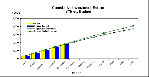
Cash Flow and Investment Movements
Council’s total cash and
investment portfolio at the end of November 2016 was $141,198,000, compared to
$135,962,000 at the end of October 2016, a net cash inflow of $5,236,000. The
cash inflow was mainly due to second instalment of rates income.
One investment has matured, and
two new investments were made during the month of November 2016.
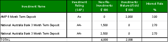
Investment Performance against Industry
Benchmarks
Overall during the month of
November the investment performance was well above the industry benchmark.
The benchmark is specific to the
type of investment and the details are provided below.
Ø AusBond Bank Bill Index is used for all
Council’s investments
Table 1 - Investments Performance against Industry
Benchmarks

Table 2 below provides a summary
of all investments by type and performance during the month.
Attachment A1 provides definitions
in relation to different types of investments.
Table
2 - Investments Portfolio Summary during November 2016
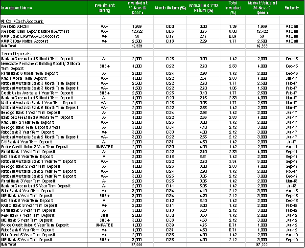
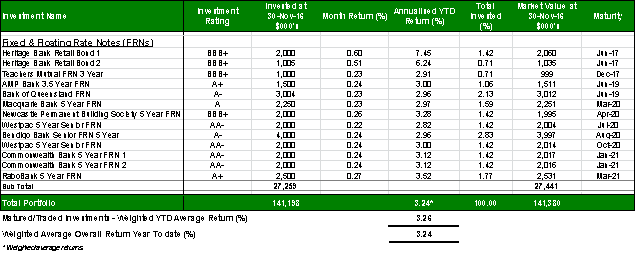
Investment by Credit rating and Maturity
Profile
The allocation of Council’s investments by credit
rating and the maturity profile are shown below:
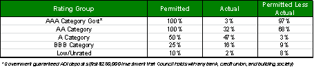

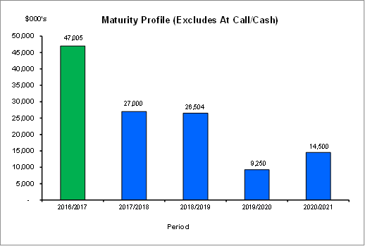
integrated planning and reporting
Leadership & Governance
|
Community Strategic Plan Long Term Objective
|
Delivery Program
Term Achievement
|
Operational Plan
Task
|
|
L2.1 Council rigorously manages its financial
resources and assets to maximise delivery of
services
|
Council maintains and improves its long term financial
position and performance
|
Continue to analyse opportunities to expand the revenue
base of Council
|
Governance Matters
Council’s investments are made in accordance with the
Local Government Act (1993), the Local Government (General) Regulation 2005 and
Council’s Investment Policy.
Section 212 of the Local Government (General) Regulation
2005 states:
(1) The
responsible accounting officer of a council:
(a) must
provide the council with a written report (setting out details of all money
that the council has invested under section 625 of the Act) to be presented:
(i) if
only one ordinary meeting of the council is held in a month, at that meeting,
or
(ii) if
more than one such meeting is held in a month, at whichever of those meetings
the council by resolution determines, and
(b) must
include in the report a certificate as to whether or not the investment has
been made in accordance with the Act, the regulations and the council’s
investment policies.
(2) The report must be made
up to the last day of the month immediately preceding the meeting.
Risk Management
Council manages the risk associated with investments by
diversifying the types of investment, credit quality, counterparty exposure and
term to maturity profile.
Council invests its funds in accordance with The Ministerial
Investment Order.
All investments are made with consideration of advice from
Council’s appointed investment advisor, CPG Research & Advisory.
Financial Considerations
The revised budget for interest on investments for the
financial year 2016/2017 is $4,080,900. Of this amount approximately $2,454,000
is restricted for the benefit of future expenditure relating to development
contributions, $555,800 transferred to the internally restricted Infrastructure
& Facility Reserve, and the remainder of $1,071,100 is available for
operations.
Social Considerations
Not applicable.
Environmental Considerations
Not applicable.
Community Consultation
None undertaken or required.
Internal Consultation
None undertaken or required.
Certification - Responsible Accounting
Officer
I hereby certify that the investments listed in the attached
report have been made in accordance with Section 625 of the Local Government
Act 1993, clause 212 of the Local Government General Regulation 2005 and
Council’s Investment Policy.
Summary
As at 30
November 2016:
· Council’s
total cash and investment portfolio is $141,198,000.
· The net return
on investments for the financial year to November 2016 was $1,846,000 against a
revised budget of $1,823,000, giving a YTD favourable variance of $23,000.
|
Recommendation:
A. That
the summary of investments and performance for November 2016 be received and
noted.
B. That
the Certificate of the Responsible Accounting Officer be noted and the report
adopted.
|
|
Tony Ly
Financial Accounting Officer
|
Angela Apostol
Manager Finance
|
|
David Marshall
Director Corporate
|
|
|
Attachments:
|
A1
|
Investments
definitions specific to Council’s investment portfolio
|
|
2016/124274
|
|
APPENDIX No: 1 - Investments
definitions specific to Council’s investment portfolio
|
|
Item No: GB.1
|
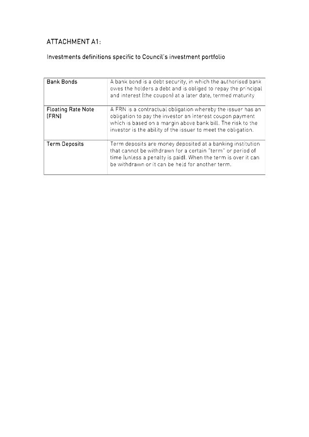
|
Ordinary
Meeting of Council - 7 February 2017
|
GB.2 / 63
|
|
|
|
|
Item
GB.2
|
S05273
|
|
|
19 January 2017
|
Review of Council's Investment Policy
EXECUTIVE
SUMMARY
|
purpose of report:
|
To review and adopt Council's revised Investment
Policy.
|
|
|
|
|
background:
|
Council’s current Investment Policy was adopted
in December 2013. Council periodically reviews and updates its Investment
Policy.
|
|
|
|
|
comments:
|
Council has sought the advice of CPG Research &
Advisory Pty Ltd in reviewing the Investment Policy.
The revised Investments Policy was reviewed and
endorsed by the internal Audit & Risk Committee.
|
|
|
|
|
recommendation:
|
That the attached revised
Investment Policy, endorsed by the Audit & Risk Committee, be adopted by
Council.
|
Purpose of Report
To review and adopt Council's revised Investment Policy.
Background
Council’s current Investment Policy was adopted in
December 2013.
Council currently has an investment portfolio of $138
million. Investment earnings are a significant source of revenue for Council
and it is important that Council maximises returns on investments, whilst having
due consideration of risk tolerance, liquidity and security.
Comments
Council has utilised its investment advisory firm CPG
Research & Advisory in reviewing and updating the Investment Policy. A
presentation by the investment advisors to the Audit and Risk Committee was
held on 8 December 2016. Council’s revised Policy is attached to this
report
(Attachment A1).
Council must invest its funds in accordance with the
Ministerial Investment Order. The Investment policy specifically lists the
authorised and prohibited investments.
Authorised Investments are limited to those allowed by the
Ministerial Investment Order as follows:
· Commonwealth
/ State / Territory Government securities e.g. bonds;
· Interest
bearing deposits / senior securities issued by an eligible ADI;
· Bills of
Exchange (no more than 200 days duration) guaranteed by an ADI;
· Debentures
issued by a NSW Council under Local Government Act (1993);
· Deposits
with T-Corp &/or Investments in T-Corp Hour-Glass Facility; and
While Council may only invest in the above types of
investment, for clarity the proposed investment policy prohibits the following
types of new investment:
· Derivative
based instruments;
· Principal
only investments or securities that provide potentially nil or negative cash
flow; and
· Standalone
securities issued that have underlying futures, options, forwards contracts and
swaps of any kind.
· Other investments
excluded by the Ministerial Investment Order.
Changes to the revised Investment Policy are:
· Authorised
investments - Grandfathered Investments have been removed from the Policy
due to Council no longer holding these investments. The last Grandfathered
investment was sold in April 2016.
· Credit
ratings:
o Ratings have been reviewed and
it is proposed to increase the maximum holding in “A” Category to
70% (from 50%). The change is partially due to credit rating movements over
recent years (e.g. Rabobank’s split rating resulted in downgrade to
“A+” (from “AA” range), while Bank of Queensland (BoQ)
upgraded to “A-” from “BBB+”). In addition Floating
Rate Notes (FRNs) are also looking more attractive, as investment issues are
mainly dominated by the “AA” and “A” rated banks. On a
relative basis, “A” rated FRNs are attractive as spreads have not
contracted as much as the “AA” rated FRNs. In turn, this could
potentially see a reduction in the total investment allocation to
“BBB” and unrated ADIs.
o “Lower, and
Unrated” Rating - A definition of “Lower, and Unrated”
institutions has been included in the Policy:” The lower and unrated
ADIs represents the banks, credit unions and building societies that are
regulated by Australia’s banking regulator, the Australian Prudential
Regulation Authority (APRA), consistent with the higher rated ADIs. These ADIs
are officially “not rated” by the ratings agencies as they are
relatively small (asset size). Despite not having an official credit rating,
they generally remain financially solid and tend to hold higher levels of
capital adequacy compared to the higher rated ADIs. Overall, they are not
speculative institutions and are not associated as being high risk,
particularly for the purposes of Council’s investments, which would
predominately only be invested in short-dated fixed term deposits amongst these
ADIs”
· Counterparty
Limits – Exposure to individual Counterparties/financial
institutions has been reviewed and it is proposed to increase the
following limits:
o AA Category – 30% (from
25%)
o A Category - 20% (from 15%)
During periods where specials are
not offered, or at times where there is capacity issues, a higher ceiling on
the counterparty limits with the “AA” (proposed 30%) and
“A” (proposed 20%) rated banks does not force Council to invest
with the worst rates in that space.
· Performance
benchmark - The Performance benchmark has changed to AusBond Bank Bill
Index (formerly the UBS Bank Bill Index (BBI)). The UBS Australia index family
was acquired by Bloomberg from Q3 2014, and while branding changed the
benchmark is unaltered. The Bank Bill Index represents the performance of a
notional rolling parcel of bills averaging 45 days and is the widely used
benchmark for local councils and other institutional cash investments
· Investment
Timeframes – investment timeframes have been reviewed. Minimum
allocations have been removed for working capital and short term investments as
they are made in the context of meeting cash flow and operational requirements.
Governance Matters
Council’s Investments are made in accordance with the
Local Government Act (1993), the Local (General) Regulation 2005, the
Ministerial Investment Order and Council’s Investment Policy.
Risk Management
Council is required to adopt an Investment Policy consistent
with the Ministerial Investment Order. The Ministerial Investments Order
prescribes the forms of investment that Council can invest in.
The Investment Policy should identify all types of risks associated
with making investment decisions. The Risk Management Guidelines section of the
proposed Investment Policy identifies and defines these risks as follows:
credit risk, liquidity risk, market risk, maturity risk, interest risk.
All investments are made in accordance with Council’s
Investment Policy with consideration of advice from Council’s appointed
investment advisory, CPG Research & Advisory.
Financial Considerations
Investment income is a significant revenue source for
Council and it is important that returns are
maximised, whilst having due consideration of risk
tolerance, liquidity and security.
Social Considerations
Not applicable.
Environmental Considerations
Not applicable.
Community Consultation
None undertaken or required.
Internal Consultation
None undertaken or required.
Summary
Council’s Investment Policy
has been reviewed in consultation with Council’s investment advisors, CPG
Research & Advisory Pty Ltd. The revised Investment Policy has also been
reviewed and endorsed by the Audit and Risk Committee on 8 December 2016.
The revised Investment Policy is
attached to this report (Attachment A1).
|
Recommendation:
That the attached revised Investment Policy be adopted by
Council.
|
|
Angela Apostol
Manager Finance
|
David Marshall
Director Corporate
|
|
Attachments:
|
A1
|
Investment
Policy - February 2017
|
|
2017/021545
|
|
APPENDIX No: 1 - Investment
Policy - February 2017
|
|
Item No: GB.2
|
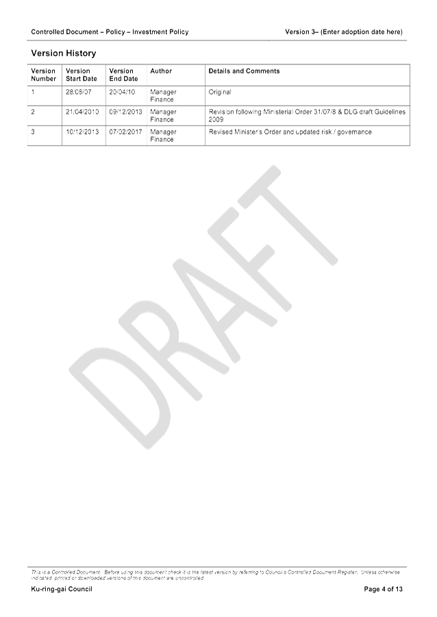
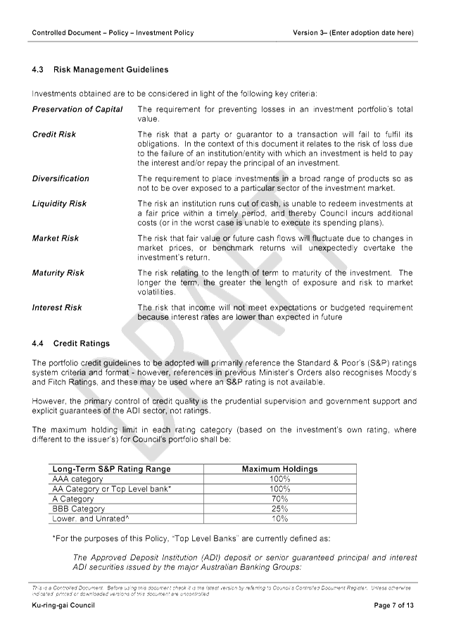
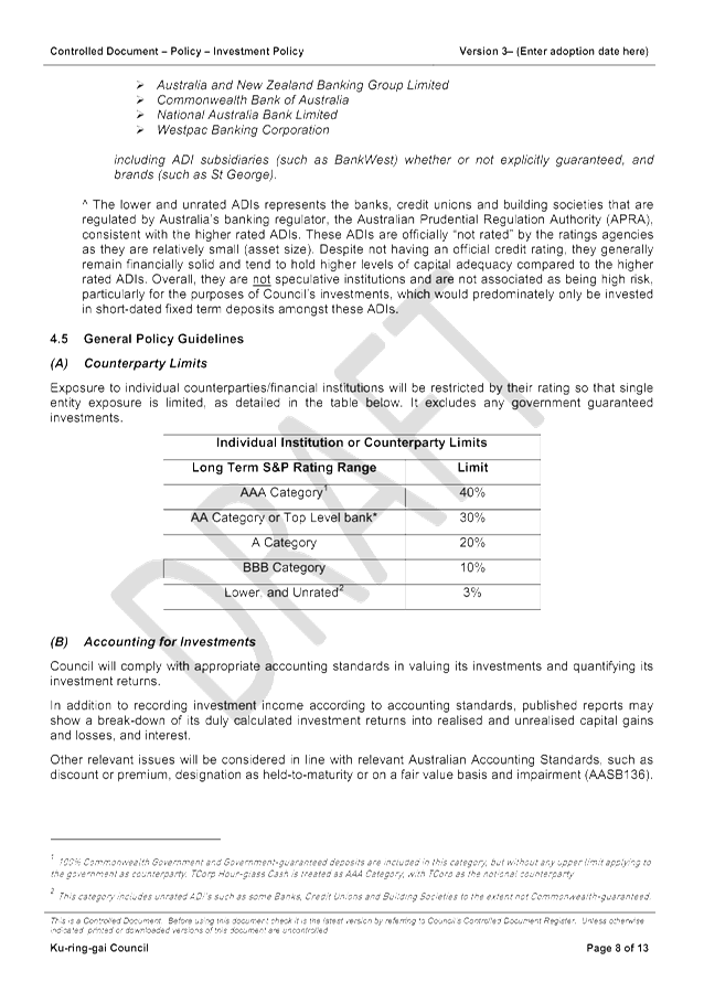
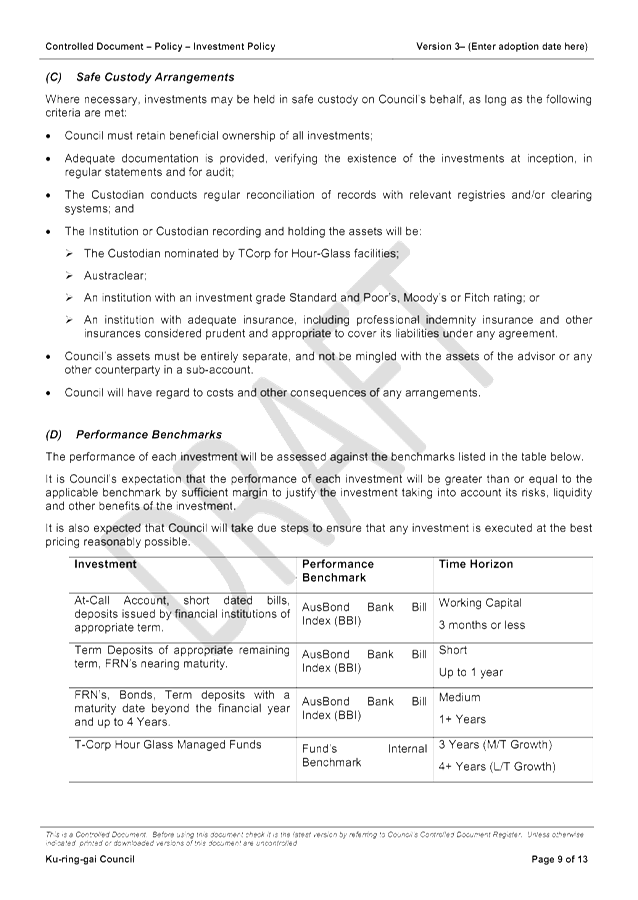
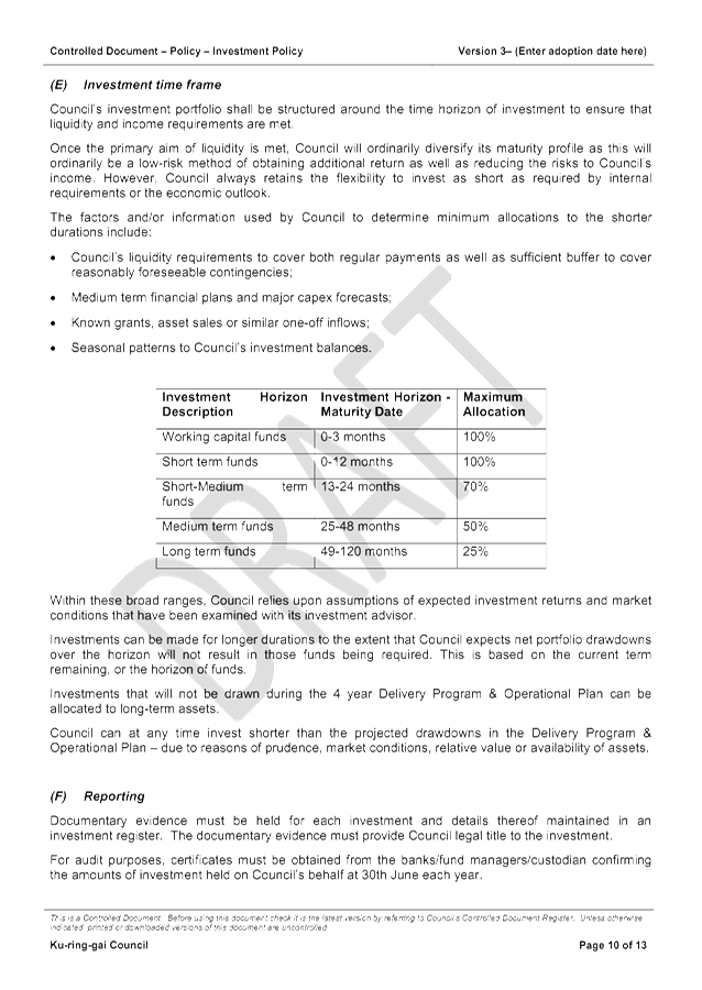
|
Ordinary
Meeting of Council - 7 February 2017
|
GB.3 / 80
|
|
|
|
|
Item
GB.3
|
S05273
|
|
|
20 January 2017
|
Investment Report as at 31 December 2016
EXECUTIVE
SUMMARY
|
purpose of report:
|
To present Council’s investment portfolio
performance for December 2016.
|
|
|
|
|
background:
|
Council’s investments are reported monthly to
Council in accordance with the Local Government Act 1993, the Local
Government (General) Regulation 2005 and Council’s Investment Policy.
|
|
|
|
|
comments:
|
The net return on investments for the financial year
to December 2016 was $2,228,000 against a revised budget of $2,178,000 giving
a YTD favourable variance of $50,000.
|
|
|
|
|
recommendation:
|
That the summary of investments performance for
December 2016 be received and noted; and that the Certificate of the
Responsible Accounting Officer be noted and report adopted.
|
Purpose of Report
To present Council’s investment portfolio performance
for December 2016.
Background
Council’s investments are reported monthly to Council
in accordance with the Local Government Act 1993, the Local Government
(General) Regulation 2005 and Council’s Investment Policy.
Comments
Investment Portfolio Performance Snapshot
The table below provides the investments portfolio
performance against targets identified in Council’s Investment Policy as
well as other key performance indicators based on industry benchmarks.
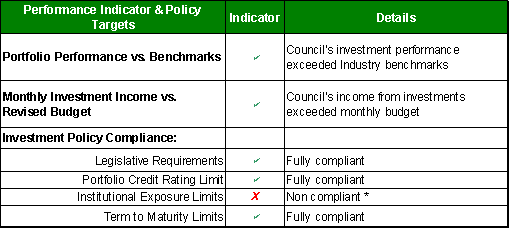
* As at end of December, Council had a slight overweight
position to Bendigo-Adelaide Bank due to its combined investment allocation
with Rural Bank, a subsidiary of Bendigo-Adelaide Bank. Council’s
Investment Policy restricts exposure to individual financial institutions by
their rating so that single entity exposure is limited. The current limit for
the “A” rated institutions allowed by the Policy is 15%. The
total funds invested in Bendigo & Rural Banks represent 15.9% of the total
investment portfolio ($22m out of total portfolio of $138.7m).The
overinvestment of $1.2m (or 0.9%) in Bendigo/Rural Bank is not
significant compared to total investment portfolio with minimum risk exposure.
Council has reviewed its Investment Policy
(proposed for adoption at Ordinary Meeting of Council on 7 February 2017), and
as part of this process, the counter party investment limits have been revised
as well.
Cumulative
Investment Returns against Revised Budget
The net return on investments for the month of December 2016
was $2,228,000 against a revised budget of $2,178,000 giving a YTD favourable
variance of $50,000.
The total return on
investments for the month of December is provided below.

A comparison of the cumulative investment returns against
year to date revised budget is shown in the Chart below.
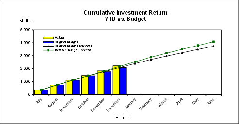
Cash Flow and Investment Movements
Council’s total cash and
investment portfolio at the end of December 2016 was $138,694,000, compared to
$141,198,000 at the end of November 2016, a net cash outflow of $2,504,000. The
cash outflow were mainly due to loan repayments & creditor payments.
Three investments have matured,
and four new investments were made during the month of December 2016.
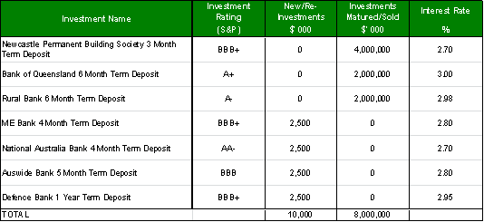
Investment Performance against Industry
Benchmarks
Overall during the month of
December the investment performance was well above the industry benchmark.
The benchmark is specific to the
type of investment and the details are provided below.
Ø AusBond Bank Bill Index is used for all
Council’s investments
Table 1 - Investments Performance against Industry
Benchmarks

Table 2
below provides a summary of all investments by type and performance during the
month.
Attachment
A1 provides definitions in relation to different types of investments.
Table 2 - Investments Portfolio Summary during December
2016
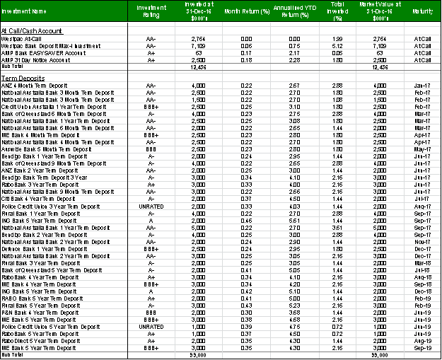
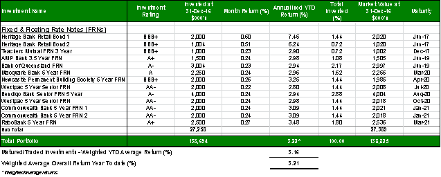
Investment by Credit rating and Maturity
Profile
The allocation of Council’s investments by credit
rating and the maturity profile are shown below:
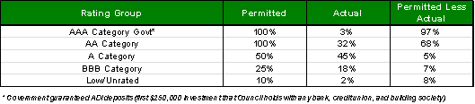
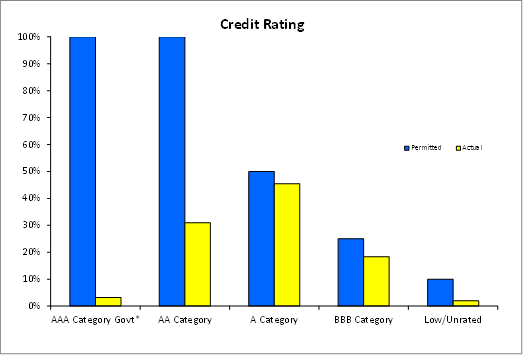
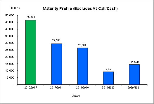
integrated planning and reporting
Leadership & Governance
|
Community Strategic Plan Long Term Objective
|
Delivery Program
Term Achievement
|
Operational Plan
Task
|
|
L2.1 Council rigorously manages its financial
resources and assets to maximise delivery of
services
|
Council maintains and improves its long term financial
position and performance
|
Continue to analyse opportunities to expand the revenue
base of Council
|
Governance Matters
Council’s investments are made in accordance with the
Local Government Act (1993), the Local Government (General) Regulation 2005 and
Council’s Investment Policy.
Section 212 of the Local Government (General) Regulation
2005 states:
(1) The
responsible accounting officer of a council:
(a) must
provide the council with a written report (setting out details of all money
that the council has invested under section 625 of the Act) to be presented:
(i) if
only one ordinary meeting of the council is held in a month, at that meeting,
or
(ii) if
more than one such meeting is held in a month, at whichever of those meetings
the council by resolution determines, and
(b) must
include in the report a certificate as to whether or not the investment has
been made in accordance with the Act, the regulations and the council’s
investment policies.
(2) The report must be made
up to the last day of the month immediately preceding the meeting.
Risk Management
Council manages the risk associated with investments by
diversifying the types of investment, credit quality, counterparty exposure and
term to maturity profile.
Council invests its funds in accordance with The Ministerial
Investment Order.
All investments are made with consideration of advice from
Council’s appointed investment advisor, CPG Research & Advisory.
Financial Considerations
The revised budget for interest on investments for the
financial year 2016/2017 is $4,080,900. Of this amount approximately $2,454,000
is restricted for the benefit of future expenditure relating to development
contributions, $555,800 transferred to the internally restricted Infrastructure
& Facility Reserve, and the remainder of $1,071,100 is available for
operations.
Social Considerations
Not applicable.
Environmental Considerations
Not applicable.
Community Consultation
None undertaken or required.
Internal Consultation
None undertaken or required.
Certification - Responsible Accounting
Officer
I hereby certify that the investments listed in the attached
report have been made in accordance with Section 625 of the Local Government
Act 1993, clause 212 of the Local Government General Regulation 2005 and
Council’s Investment Policy.
Summary
As at 31
December 2016:
· Council’s
total cash and investment portfolio is $138,694,000.
· The
net return on investments for the financial year to December 2016 was
$2,228,000 against a revised budget of $2,178,000, giving a YTD favourable
variance of $50,000.
|
Recommendation:
A. That
the summary of investments and performance for December 2016 be received and
noted.
B. That
the Certificate of the Responsible Accounting Officer be noted and the report
adopted.
|
|
Tony Ly
Financial Accounting Officer
|
Angela Apostol
Manager Finance
|
|
David Marshall
Director Corporate
|
|
|
Attachments:
|
A1
|
Investments
definitions specific to Council’s investment portfolio
|
|
2016/124274
|
|
APPENDIX No: 1 - Investments
definitions specific to Council’s investment portfolio
|
|
Item No: GB.3
|

|
Ordinary
Meeting of Council - 7 February 2017
|
GB.4 / 89
|
|
|
|
|
Item
GB.4
|
CY00259/9
|
|
|
10 January 2017
|
Business Approved under Authority
Delegated to the Mayor, Deputy Mayor and General Manager for the Christmas/New Year
recess period 2016/2017
EXECUTIVE
SUMMARY
|
purpose of report:
|
To inform Councillors of any business approved under
delegated authority during the 2016/17 recess period.
|
|
|
|
|
background:
|
At its meeting on 22 November 2016, Council resolved
to delegate authority to exercise all powers, authorities, duties and
functions of Council except those set out in Section 377 of the Local
Government Act 1993 during the period 7 December 2016 to 6 February 2017 to
the Mayor, Deputy Mayor and General Manager.
|
|
|
|
|
comments:
|
Council was required to deal with 4 matters that could
not be deferred during the recess period.
|
|
|
|
|
recommendation:
|
That Council receives and notes the report.
|
Purpose of Report
To inform Councillors of any business approved under
delegated authority during the 2016/17 recess period.
Background
At its meeting on 22 November 2016, Council resolved to
delegate authority to exercise all powers, authorities, duties and functions of
Council except those set out in Section 377 of the Local Government Act 1993
during the period 7 December 2016 to 6 February 2017 to the Mayor, Deputy Mayor
and General Manager, subject to the following conditions:
a. Such
powers, authorities and functions may only be exercised by unanimous agreement
between the Mayor, Deputy Mayor and General Manager.
b. Any
such power, authority, duty or function shall only be exercised by the Mayor,
Deputy Mayor and General Manager jointly where they are of the opinion that the
exercise of any such power,
authority, duty or function could not be deferred until the meeting
of Council on 7 February 2017.
c. That
consultation, subject to their availability, be held with Ward Councillors on
matters where they would normally be contacted, before delegation is exercised.
Comments
Council was required to deal with 4 matters that could not
be deferred during the recess period.
a) Registration
for the 2017 Local Government NSW Tourism Conference. Resolved, as follows,
on the 23 December 2016:
That any Councillors
interested in attending the LGNSW 2017 Tourism Conference advise the General
Manager by Wednesday, 11 January 2017.
b) Council’s
submission to the Office of Local Government regarding the development of a
Model Code of Meeting Practice. Resolved, as follows, on the 23 January
2017:
That, in relation to the call
from the Office of Local Government for submissions regarding the development
of a Model Code of Meeting Practice, Council makes the following submission:
Council
supports the proposal for a Model Code of Meeting Practice. Council would, in
particular, support the standardisation of procedural matters such as rules of
debate and the moving of motions and amendments. The Model Code of Meeting
Practice should ensure clear definitions of terminology and a solid framework
for meeting procedure to ensure that meetings can be easily followed and
understood by members of the public across different Council areas. Council
requests that once drafted the proposed Model Code of Meeting Practice be
forwarded to all Councils for comment.
c) Council’s
submission to the 2017 Local Government Remuneration Tribunal. Resolved, as
follows, on the 30 January 2017:
That, in
relation to the call for submissions regarding the 2017 Local Government
Remuneration Tribunal, Council makes the following submission:
Council is
of the opinion that Ku-ring-gai Council is better suited to the category of
“Metropolitan Centre” than “Metropolitan”, due to the
scale and diversity of services provided and the added responsibility that this
places on Councillors. Some of the reasons for this are outlined below.
Major
Projects
In the next
5-10 years, Ku-ring-gai Council is expecting to deliver several extraordinary
projects for development of spaces and social capacity-building services for
its community. This will entail almost $500 million worth of projects for
creation of new capital assets and services including libraries, child care
facilities, parking areas, green space, community hub projects and associated
retail, residential and transport development.
This is the
equivalent of almost six times Council’s current annual operational
expenditure and about eight times its average annual capital works expenditure.
The projects are also more complex than
normal capital works in terms of the array of skills, financial structuring and partnerships that will be
required for delivery.
These projects aim to activate 3 of the 6 existing local
centres, and will provide new community facilities as well as increased
commercial and residential opportunities.
Environment and Sustainability
Ku-ring-gai Council’s Environmental Levy program, in
place since 2005, funds the annual delivery of $2.6 million of environmental
initiatives within the Ku-ring-gai Local Government Area (LGA) and to date has
leveraged $9.6 million in federal and state grants to augment the delivery of
the Levy program. Council’s environmental service delivery is
significantly enhanced through the Environmental Levy in areas including stormwater
filtration and harvesting, renewable energy and energy efficiency, fire trails
and fire breaks, weed control and bushland regeneration, community
environmental education and volunteer programs and environmental monitoring.
Unique environmental services provided by Ku-ring-gai
Council include:
· Environmental volunteering program (Ku-ring-gai Council is
the 3rd largest Bushcare program in NSW with comparable numbers to
Sutherland and Hornsby Councils, who have the 1st and
2nd largest programs)
· Pool to Pond program (over 80 pool conversions) and native
bee hive program (over 1,000 bee hives distributed), enhancing urban
biodiversity and unique to Ku-ring-gai
· Large urban water management program (including 16
stormwater harvesting systems, 2 sewer mining systems and 2 leachate systems)
· Managing over 1,1000 hectares of bushland
Community
Ku-ring-gai Council has a broad demographic
spread – with a higher than average number of residents aged over 60 and
under 19 years – which requires us to deliver a more diverse range of
services to meet the needs of the community. The Ku-ring-gai community has a
long history of expecting high levels of service from Council, and this is
reflected in the diversity and scope of services we provide.
Ku-ring-gai has a large population of 122,859 spread over
86km2, and high levels of community involvement. Council
currently has 4 libraries, a hospital, and has one of the highest numbers of
schools, including state and private schools, in a local government area. It
provides a significant children’s services function including family day
care, vacation care, after school care and the running of a 0-5 year old
childcare centre. Ku-ring-gai also has a recognised cultural, ecological, heritage
and tourism program.
Infrastructure Assets
Ku-ring-gai Council’s infrastructure assets represent
a vast investment over many generations that support modern living in the
community. The cost, condition and value of assets are reported each year in
financial statements within the Annual Report. The infrastructure assets are
valued at $927Million and the carrying amount (WDV) is $518Million.
Heritage and Urban Design
Ku-ring-gai contains a significant amount of striking
residential architecture, with houses designed by many of Australia’s
prominent twentieth century architects such as John Sulman, Howard Joseland,
Hardy Wilson, Leslie Wilkinson, Ken Woolley, Russell Jack and Harry Seidler.
The area is also undergoing significant revitalisation and urban renewal - this
requires Council particular expertise and knowledge to maintain the appropriate
balance between change and retaining the original character of the area. The
community is actively involved in heritage matters and are highly articulate,
resourced and demanding – meaning that Ku-ring-gai Councillors must be
well informed of heritage matters and accept a higher level of responsibility
in relation to these issues.
Ku-ring-gai also has a number of significant Aboriginal
heritage sites, which we are helping to protect by supporting the Aboriginal
Heritage Office and raising awareness through the annual Guringai festival and
Naidoc Week.
d) Council’s
submission to the Office of Local Government regarding proposed regulations for
induction and ongoing professional development for Mayors and Councillors.
At the time of writing the following recommendation is being circulated to
Councillors for comment. The matter is to be resolved by 3 February 2017. If a
resolution other than the following recommendation is moved, Councillors will
be notified via a late attachment to this report.
That, in
relation to the call for submissions regarding the proposed regulations for
induction and ongoing professional development for Mayors and Councillors,
Council makes the following submission:
Council supports the proposed
regulations in relation to Councillor induction and ongoing professional
development programs. In meeting these obligations, it would be helpful to have
access to some standard induction and professional development resources
– such as eLearning modules, training materials, and templates
– covering the basic skills, knowledge and processes that are common
across the local government industry, including:
· Disclosure of interests and pecuniary interest returns
· Code of Meeting Practice (based on the Model Code that is
currently being developed)
· Basic financial skills for Councillors
· The roles and responsibilities of Councillors and the Mayor
· Code of Conduct (based on the existing Model Code).
Standardised, freely accessible
materials and templates would both reduce potential resourcing burdens for
Councils, and ensure a consistent standard of training and professional
development across all NSW Councils. This would in turn enable Councils to
focus resources on supplementing the generic program and providing training and
professional development opportunities pertinent to the specific needs of the
local area and the individual Councillors.
integrated planning and reporting
Leadership and Governance
|
Community Strategic Plan Long Term Objective
|
Delivery Program
Term Achievement
|
Operational Plan
Task
|
|
The organisation is recognised and distinguished by its
ethical decision-making, efficient management, innovation and quality
customer service.
|
Council's Governance framework is developed to ensure
probity, transparency and the principles of sustainability are integrated and
applied into our policies, plans, guidelines and decision-making processes.
|
Ensure effective and efficient conduct of Council and
committee meetings for the benefit of councillors and the community.
|
Governance Matters
It is Council’s usual practice to grant delegated
authority to exercise all powers, authorities, duties and functions of Council,
except those set out in Section 377 of the Local Government Act 1993,
during the Christmas/New Year period.
Risk Management
Nil.
Financial Considerations
Nil.
Social Considerations
Nil.
Environmental Considerations
Nil.
Community Consultation
Nil.
Internal Consultation
All matters resolved under delegated authority during the
2016/17 recess period were circulated to all Councillors and executive staff
for comment prior to approval.
Summary
At its meeting on 22 November 2016, Council resolved to
delegate authority to exercise all powers, authorities, duties and functions of
Council except those set out in Section 377 of the Local Government Act 1993
during the period 7 December 2016 to 6 February 2017 to the Mayor, Deputy Mayor
and General Manager.
Council was required to deal with 4 matters that could not
be deferred during the recess period.
|
Recommendation:
That Council receives and notes the report.
|
|
Amber Moloney
Manager Records and Governance
|
David Marshall
Director Corporate
|
|
Ordinary
Meeting of Council - 7 February 2017
|
GB.5 / 95
|
|
|
|
|
Item
GB.5
|
S03662
|
|
|
10 January 2017
|
Election of Council Representative on
Ku-ring-gai Youth Development Service (KYDS) Committee
EXECUTIVE
SUMMARY
|
purpose of report:
|
To advise Council of the resignation of Councillor
Citer as Council’s representative on the KYDS Management Committee, and
seek a resolution regarding the appointment of a new representative and
alternate representative.
|
|
|
|
|
background:
|
On 15 September 2017, Councillor Citer was elected as
Council’s representative on the KYDS Management Committee. Councillor
Fornari-Orsmond was elected as an alternative representative.
|
|
|
|
|
comments:
|
On Friday 9 December 2016, Councillor Citer notified
staff and KYDS of his resignation from this position. As the elected
alternative, Councillor Fornari-Orsmond has assumed this role.
|
|
|
|
|
recommendation:
|
That Council appoints its representative and alternate
representative on the KYDS Management Committee.
|
Purpose of Report
To advise Council of the resignation of Councillor Citer as Council’s
representative on the KYDS Management Committee, and seek a resolution
regarding the appointment of a new representative and alternate representative.
Background
On 15 September 2017, Councillor Citer was elected as
Council’s representative on the KYDS Management Committee. Councillor
Fornari-Orsmond was elected as an alternative representative.
Comments
On Friday 9 December 2016, Councillor Citer notified staff
and KYDS of his resignation from this position. As the elected alternative,
Councillor Fornari-Orsmond has assumed this role.
The purpose of this report is to seek a resolution regarding
the appointment of a new representative and alternate representative.
integrated planning and reporting
Leadership and Governance
|
Community Strategic Plan Long Term Objective
|
Delivery Program
Term Achievement
|
Operational Plan
Task
|
|
The organisation is recognised and distinguished by its
ethical decision making, efficient management, innovation and quality
customer service.
|
Council’s governance framework is developed to
ensure probity, transparency and the principles of sustainability are
integrated and applied into our policies, plans, guidelines and decision
making processes.
|
Comply with the requirements of the Local Government Act
and Regulations.
|
Governance Matters
Councillor representation on the external committees and
organisations identified in this report is an important component of
representing Council and understand the community’s views on a range of
matters relevant to Ku-ring-gai.
Risk Management
Nil.
Financial Considerations
Nil.
Social Considerations
Nil.
Environmental Considerations
Nil.
Community Consultation
Nil.
Internal Consultation
Nil.
Summary
On 15 September 2017, Councillor Citer was elected as
Council’s representative on the KYDS Management Committee. Councillor
Fornari-Orsmond was elected as an alternative representative. On Friday 9
December 2016, Councillor Citer notified staff and KYDS of his resignation from
this position. As the elected alternative, Councillor Fornari-Orsmond has
assumed this role.
The purpose of this report is to seek a resolution regarding
the appointment of a new representative and alternate representative.
|
Recommendation:
That Council appoints its representative and alternate
representative on the KYDS Management Committee.
|
|
Amber Moloney
Manager Records and Governance
|
David Marshall
Director Corporate
|
|
Ordinary
Meeting of Council - 7 February 2017
|
GB.6 / 98
|
|
|
|
|
Item
GB.6
|
FY00581/2
|
|
|
30 January 2017
|
2017 MAV Smart Futures National
Conference: Building Liveable, Walkable, Sustainable Communities
EXECUTIVE
SUMMARY
|
purpose of report:
|
To advise Council of the 2017 MAV Smart Futures
National Conference.
|
|
|
|
|
background:
|
The 2017 Smart Urban Futures National Conference,
presented by the Municipal Association of Victoria (MAV) and Victoria Walks,
will be held on Tuesday March 28 and Wednesday March 29, 2017 at The Royal
Australasian College of Surgeons Conference Centre, 250-290 Spring Street,
Melbourne.
|
|
|
|
|
comments:
|
The theme for the 2017 conference is ‘Building
Liveable, Walkable, Sustainable Communities’.
|
|
|
|
|
recommendation:
|
That any Councillors interested in attending the 2017
MAV Smart Futures National Conference advise the General Manager by Friday,
24 February 2017.
|
Purpose of Report
To advise Council of the 2017 MAV Smart Futures National
Conference.
Background
The 2017 Smart Urban Futures National Conference, presented
by the Municipal Association of Victoria (MAV) and Victoria Walks, will be held
on Tuesday March 28 and Wednesday March 29, 2017 at The Royal Australasian
College of Surgeons Conference Centre, 250-290 Spring Street, Melbourne.
Comments
The Key conference themes are:
· Preparing
for an uncertain future – what might it look like? How do we position our
communities to be resilient and adaptable to whatever comes our way?
· Healthy
communities and street design that works for everyone – designing for the
young and the old, gender and diversity
· Building
community support – how to get councillors, traders, stakeholders and the
public on-side
· Development
we can be proud of – building new suburbs and major infill that really
work
· Integrated
transport planning – transport projects that work for local communities
· Bringing
economic development and urban design together – selling sustainable
urban change as an economic development path.
The full conference program is attached (Attachment A1).
integrated planning and reporting
Leadership and Governance
|
Community Strategic Plan Long Term Objective
|
Delivery Program
Term Achievement
|
Operational Plan
Task
|
|
Council leads the community by advocating, influencing and
participating in policy development to the benefit of the local area
|
Council actively engages with stakeholders to inform the
development of Council’s strategies and plans as appropriate
|
Pursue opportunities to contribute to policy development
affecting Ku-ring-gai at state and regional levels
|
Governance Matters
The Payment of Expenses and Provision of Facilities to
Councillors Policy provides for Council to meet the reasonable costs of
Councillors attending conferences authorised by resolution of Council.
Risk
Management
There are no risk management
considerations associated with the recommendation in this report.
Financial Considerations
The cost of attending the conference is $594 per person
(incl. GST). Travel and accommodation costs will be additional.
Attendance is provided for in the Councillor’s
conference budget in accordance with the Payment of Expenses and Provision of
Facilities Policy.
Council has an annual budget of $30,700 for
Councillors’ attendance at conferences with $25,973 remaining in the
2016/2017 financial year.
Social Considerations
Nil.
Environmental Considerations
Nil.
Community Consultation
Nil.
Internal Consultation
Nil.
Summary
The 2017 Smart Urban Futures National Conference, presented
by the Municipal Association of Victoria (MAV) and Victoria Walks, will be held
on Tuesday March 28 and Wednesday March 29, 2017 at The Royal Australasian
College of Surgeons Conference Centre, 250-290 Spring Street, Melbourne.
The theme for the 2017 conference is ‘Building
Liveable, Walkable, Sustainable Communities’.
|
Recommendation:
That any Councillors interested in attending the 2017
MAV Smart Futures National Conference advise the General Manager by Friday,
24 February 2017.
|
|
Amber Moloney
Manager Records and Governance
|
David Marshall
Director Corporate
|
|
Attachments:
|
A1
|
2017
MAV Smart Urban Futures National Conference Program
|
|
2017/021144
|
|
APPENDIX No: 1 - 2017 MAV
Smart Urban Futures National Conference Program
|
|
Item No: GB.6
|

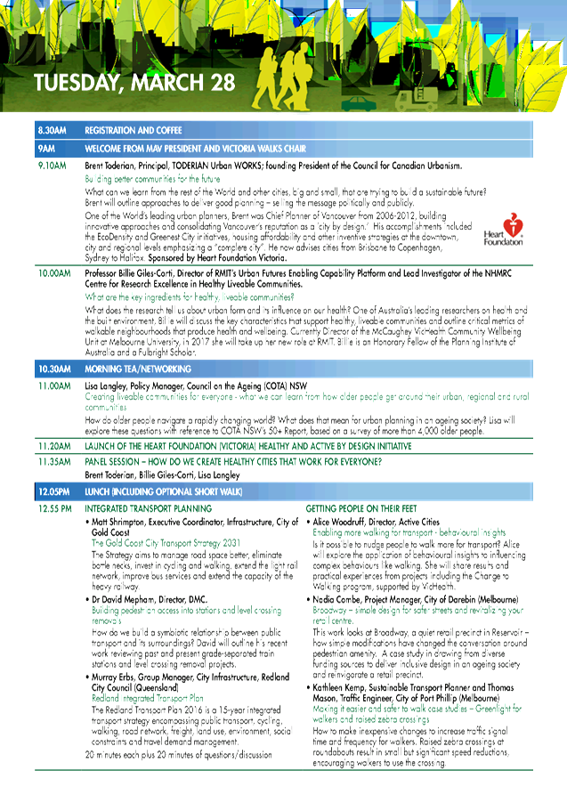

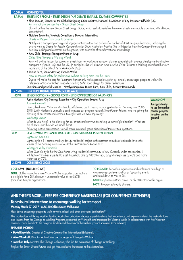
|
Ordinary
Meeting of Council - 7 February 2017
|
GB.7 / 105
|
|
|
|
|
Item
GB.7
|
DA0158/16
|
|
|
13 October 2016
|
Summary
Sheet
|
Report title:
|
1 Milray Street
and 12 - 14 Kochia Lane Lindfield - Demolition of existing structures and
construction of a multi-dwelling development consisting of 16 townhouses,
basement parking, landscaping works and amalgamation of three lots into one
|
|
ITEM/AGENDA
NO:
|
GB.7
|
|
Application No:
|
DA0158/16
|
|
Property Details:
|
1 Milray Street and 12 – 14 Kochia Lane,
Lindfield
Lot & DP No: Lot X
DP 406932 and Lots 1 and 2 DP 1182693
Site area (m2): 2564m²
Zoning: R4
High Density Residential
|
|
Ward:
|
Roseville
|
|
Proposal/Purpose:
|
Demolition of existing structures and construction of
a multi-dwelling development consisting of 16 townhouses, basement parking,
landscaping works and amalgamation of three lots into one
|
|
Type of Consent:
|
Local
|
|
Applicant:
|
Urbanesque Planning Pty Ltd
|
|
Owner:
|
Rudder Development One Pty Ltd
|
|
Date Lodged:
|
11 April 2016
|
|
Recommendation:
|
Approval
|
Purpose of Report
To determine Development Application No. DA0158/16 for
demolition of existing structures and construction of a multi-dwelling
development consisting of 16 townhouses, basement parking, landscaping works
and amalgamation of three lots into one.
integrated planning and reporting
Places, Spaces & Infrastructure
|
Community Strategic Plan Long Term Objective
|
Delivery Program
Term Achievement
|
Operational Plan
Task
|
|
P3.1 The built environment delivers attractive,
interactive and sustainable living and working environments
|
A high standard of design quality and building
environmental performance is achieved in new development
|
Assessment of applications is consistent with
Council’s adopted LEP’s and DCP’s.
|
Executive Summary
Issues: Secondary
front setback
Building separation
Basement projection and elevated
terraces
Top storey floor area
Submissions: Yes
– 2 submissions
Land & Environment Court: N/A
Recommendation: Approval
History
Site
The
site is legally described as Lot X within DP 406932, Lot 1 and Lot 2 within DP
1182693 and is known as 1 Milray Street and 12 and 14 Kochia Lane, Lindfield.
The site is located on the corner of Milray Street and Kochia Lane. The site
has an area of 2564m². The site is regular in shape with a frontage of
22.86 metres to Milray Street and a frontage of 112.4 metres to Kochia Lane.
Pre-DA
A Pre-DA consultation was undertaken with Council on13
October 2015. The proposal was for ten (10) town houses and related to 1 Milray
Street only. Issues raised related to streetscape presentation, setbacks,
repetitive design, building separation and landscape design.
A follow up Pre-DA consultation was undertaken on 7 December
2015 which proposed 17 townhouses and included 12 – 14 Kochia Lane.
Issues raised included setbacks, landscape outcome, reconfiguration of
townhouse to front Milray Street and to be adaptable and built form responding
to site topography.
DA History
|
11 April 2016
|
Application lodged.
|
|
|
|
|
22 April – 22 May 2016
|
The application was notified to neighbouring property
owners for a period of 30 days. Two (2) submissions were received.
|
|
|
|
|
7 June 2016
|
A preliminary assessment
letter was sent to the applicant seeking additional information.
|
|
|
|
|
27 June 2016
|
Applicant and experts meet with Council officers to
discuss preliminary assessment letter.
|
|
|
|
|
15 August 2016
|
Applicant formally submits amended plans and information.
|
|
|
|
|
1 September 2016
|
Council advised the applicant concerns requiring amended
plans.
|
|
|
|
|
12 September 2016
|
Applicant met with team leader and landscape assessment
officer.
|
|
|
|
|
22 September 2016
|
Applicant submits amended plans and information.
|
|
|
|
|
22 September 2016
|
Council advises of engineering concerns with the amended
information.
|
|
|
|
|
14 October 2016
|
Applicant submits amended plans and information.
|
|
|
|
|
27 October 2016
|
Council officers meet with applicant and architect to
discuss outstanding issues.
|
|
|
|
|
11th November 2016
|
Applicant submits amended plans.
|
|
|
|
|
21 November 2016
|
Applicant submits further amended plans
|
|
|
|
|
21 December 2016
|
Applicant submits further amended plans.
|
|
|
|
|
23 January 2017
|
Applicant submits further amended plans
|
The Site
Site Description
No, 1 Milray Street contains a
rendered brick dwelling and mature landscaping within the frontage. The site
has vehicular access from Kochia Lane to a detached garage located at the
eastern corner of the site. The allotment has an area of 1732m².
Nos. 12 and 14 Kochia Lane
contain an existing two storey dual occupancy development. No. 12 Kochia Lane
has an area of 400m² and 14 Kochia Lane has an area of 473m². Both
properties have vehicular access from Kochia Lane. No. 14 Kochia Lane has a 1 metre
wide easement along the rear boundary to drain water and for services.
Surrounding Development
The
site is surrounded to the west and north by high density residential
development, with the area under going transition with some single dwelling
houses still present in the streetscape.
The
property to the north of the site is 3 Milray Street and is a single storey
dwelling. This site is zoned R4 for high density development. On the western
side of Milray Street is a 5 storey residential flat building.
To the
east of the site, the rear boundary is shared with 12 Nelson Road which
contains a single dwelling.This site is zoned R2 Low Density Residential.
Opposite
the site on Kochia Lane is a 5 storey residential flat buildings which fronts
Tryon Road. Further to the east, the Cromehurst School is located on the corner
of Tryon Road and Nelson Road and also has a frontage to Kochia Lane. This site
is zoned SP 2 Infrastructure.
To the
west of the site are the Lindfield Town Centre and Lindfield Railway Station,
construction is under way on properties fronting Lindfield Avenue which
includes mixed use development.
The Proposal
The application proposed demolition
of existing structures and construction of 17 town houses, basement parking and
landscaping works. The proposed works include:
Basement RL86.30
· 20
residential parking spaces and 2 visitor parking spaces
· Vehicle
access ramp, turning bay, delivery/garbage truck parking area
· Waste
storage room
· 3
access stairways to ground floor common areas
· Lift
access
Ground floor RL89.50/89.00
· 1
adaptable visitor parking space located at the eastern corner of the site
· Open
plan family, dining, kitchen and WC
· Lift
access
· Rear
alfresco area
· Front
porch as main entry from Kochia Lane with additional side porches to Townhouses
1 and 16
First floor RL93.05
· Master
bedroom 1 with ensuite and walk in robe, access to rear balcony.
· Townhouses
1 and 16 have side balconies
· Maintain
bathroom and study nook
· Bedroom
2 with front balcony access
· Lift
access
Second floor RL96.10
· Living
rooms with rear balcony access
· Bathroom
· Front
balcony
· Lift
access
Vehicular access is proposed
from Kochia Lane adjacent to the eastern boundary.
Amended
plans and additional information dated 22 September and 14 October 2016
The amended plans proposed the
following changes to the application and additional information:
· deletion of one
townhouse (16 townhouses now proposed)
· increase
separation between townhouses
· deletion of off
load area and adaptable visitor space adjacent to eastern side boundary
· increase in
setbacks from the east and northern boundaries
· lowering of the
development by maximum of 500mm
· reconfiguration of
basement and car parking layout
· reconfiguration of
townhouse to front Milray Street
· changes to fire
stairs
· details of
proposed lifts
· amended landscape
plan and arborist report
· updated BASIX
Certificate
· updated stormwater
management plans
· reduction in
Kochia Lane front setback to 3.8 metres
· fencing along
Kochia Lane reduced to 1.2 metres
· changes to private
open space
· access report
· adaptable layout
plan
· indicative construction
and traffic management plan
· traffic and
parking assessment report
Amended plans and information dated 11 November 2016
· amended
BASIX certificate
· amended
landscape plan
· amended
stormwater plan
· front fence
details
· architectural
plans updated with fence changes
Amended plans and information 21 November 2016
· corrected
levels on northern elevation
· townhouses 5
-12 lowered by 500mm
· western and
eastern internal elevations provided
Amended plans 21 December 2016
· the FFL of
Block B reduced by 500mm
· the FFL of
Block C reduced by 887mm
· the FFL of
the basement reduced at various points from RL86.30 to RL85.43
Amended plans 23 January 2017
· levels shown
on updated plans
Consultation
Community
In
accordance with the notification controls of the Ku-ring-gai Local Centres
Development Control Plan, owners of surrounding properties were given notice of
the application. In response, submissions from the following were
received.
1. Adrienne
McGilvery - 38/9 Milray Street, Lindfield
2. CJ
and LJ Andrew – PO Box 263 Lindfield
The submissions raised the
following issues:
Insufficient car parking and impacts upon Milray Street
The proposal provides for a
compliant number of parking spaces in accordance with the Ku-ring-gai
Development Control Plan.
Traffic impacts on Milray Street
The proposal is not considered
to result in any adverse impacts upon traffic within Milray Street. The
proposal provides for the minimum required number off street parking spaces.
Loss of trees
The trees proposed to be removed have low retention value, are
exempt species or are centrally located where they unreasonably prevent
development.
A landscape plan which includes the provision of new trees
and plantings is recommended for approval which ensures replacement vegetation
is provided on site.
Amended plans dated 22
September, 14 October, 11 November 2016 and 21 November 2016
The amended plans were not
notified to surrounding residents as the proposed amendments do not result in a
greater environmental impact than the original proposal.
Within Council
Urban Design
Council's urban design
consultant commented on the proposal as follows:
“Given the isolated
nature of the site with another DA submitted for 3-5 Milray, some leniency
could be applied to certain aspects of the application – notably the
front setback. There are some minor non compliances with Council setback
requirements, notably at the rear of the site where a 6 metre setback would
ordinarily be required, and to several elevated ground floor terraces due to
the topography of the site.
While the proposal would be
assessed under Council’s multi-dwelling provisions, the building typology
is more closely aligned with terrace (row) housing (albeit over a basement
carpark) and accordingly a strategy that provides individual gardens instead of
a centralised communal space (which would be required under Council’s
controls for multi-unit developments for proposals with more than 10 dwellings)
would be appropriate due to the long proportion of the site.
While the scale of the
development and approach to providing multiple individual addresses on the
laneway is inconsistent with the existing subdivision pattern and pattern of
recently amalgamated development sites, the multi-dwelling housing approach is
a suitable building type for redevelopment of the isolated lot.
There are some issues that
remain despite several amendments to the proposal and similar commentary
provided in earlier advice. The outstanding issues:
· Privacy
across the northern boundary remains a concern with the ‘ground floor’
terraces of units 1-5 and 15-16 exceeding 1.5 metres above the immediately
adjoining ground level. With the terraces orientated north and with only 4
metres from the northern boundary, there is potential for overlooking and
privacy to be compromised. The proposed vegetation along the northern boundary
of 1 Milray Street (as indicated on the landscape plan) will assist with
ameliorating the impacts.
· There is
some opportunity to decrease the height of the eastern (townhouses 13-16) by
grading the carpark at 1:20 to reduce the height of the rear terraces and
living areas (without reducing the kitchen/entry level) but the western end of
the building cannot be readily reduced due to the already maximum grade of the
ramp and its relationship to the carpark and the building over. To address the
privacy issues at the western end of the building would require more
substantial reconfiguration, which it appears the applicant is reluctant to
undertake, and may result in the further loss of an apartment.
· Inconsistencies
remain between landscape plans (unnumbered) the ground floor plan (drawing
DA02[4]) and fence details provided. These inconsistencies should be addressed
to facilitate future approvals (CC & OC) but could be conditioned pending
the desired fence line location along Kochia Lane.
Visual privacy –
separation distances from the building (typically elevated balconies) to the
northern boundary are 6 metres providing equity in sharing of building
separation required by the Apartment Design Guide across the northern boundary.
However, the elevated nature of the rear “alfresco” for townhouses
1 through 5 and 15 ad 16 (due to the site’s topography) creates a privacy
issue across the northern (and to a lesser extent the eastern) boundary. In
some cases the Alfresco is elevated 2 metres above ground and in all instances
only 4 metres from the northern boundary.
Furthermore, the windows to
the townhouse across each of the external basement stair links look directly
into each other and would benefit from being staggered.
Solar and daylight access
– With the living rooms of all the townhouses facing north, the applicant
has demonstrated that solar access can be achieved for at least the 2 hour
prescribed minimum. The adjoining development proposal at 3-5 Milray Street may
compromise solar access, but the opportunities for solar gain have been
maximised by orienting the living rooms north and the provision of a second
elevated living room.
Private open space and
balconies – it appears the ground floor terrace (16.3m²) provides an
appropriate depth for furnishing but does not provide the 20m² required by
Council’s DCP as the primary private open space. While SEPP 65 (which is
intended for apartment design) states 15m² for ground floor apartments,
there is an expectation for a larger uesable area more consistent with
Council’s requirements, particularly given the lack of any suitable
communal open space and market expectations associated with row housing.
The elevated balcony (at the
second floor) provides a furnishable dimension.
Planner’s comments: Control 4 of Part 6A.2
Building setbacks states that where dwellings are orientated towards side
boundaries, the setback is to be at least 6 metres. Control 3 requires a
minimum setback of 3.0 metres from any side boundary. The proposal provides a
3.1 metres setback from the eastern boundary. The townhouses achieve a 6 metres
setback from the northern boundary with the allowable 4 metres encroachment of
terraces. The proposal is consistent with the setback requirements in this
regard.
Control C.1 Communal Open Space in control 1 states where
more than 10 dwellings are proposed that do not address the street, communal
open space is to be provided in accordance with the provisions of this control.
Each townhouse fronts Kochia Lane and the proposal is not required to provided
a communal open space area. In the amendments to the DCP in June 2016, the
communal open space control was altered to apply to all development where more
than 10 dwellings are proposed. The proposal is being considered against the
earlier revision of the DCP.
The proposal has been amended by lowering the basement
grades which has resulted in an overall reduction in the height of Block B by
500mm and Block C by 887mm which ensures that the private open space of the
townhouses are located closer to natural ground level.
The proposal has been amended to reduce the height of the
development above natural ground ranging between 500mm – 887mm. The
proposal is not considered to result in an unacceptable relationship with the
northern boundary. Council has undertaken a Pre DA at 3-5 Milray Street of
which a residential flat building is proposed. There were several fundamental
issues identified in this proposal including a non compliant setback.
Council has been provided with front fence detail plans
which shows a 1.2 metres high slatted fence along the Milray Street and Kochia
Lane. The landscape plan notates the 1.2 metres high slatted fence to
Archtiect’s elevations along the Kochia Lane and Milray Street frontages.
Landscape
Council's
Landscape and Tree Assessment Officer commented on the proposal as follows:
“Tree impacts
Numerous
trees are proposed to be removed across the site. An arboricultural impact
assessment report has been submitted with the application.
· The
removal of T3, 4, 5,
9, 10, 11, 12, 13 14, 15, 16, 17, 18, 19, 20, 21, 22, 27, 32, 23, 24, 28,
31, 44, 45, 46, 48, 49, and 50,
is accepted. The identified trees have low retention value, are exempt species
or are centrally located where they unreasonably inhibit development works as
proposed by the zoning.
· T8 Washingtonia robusta (Washington
Palm) located within the site frontage and within a proposed
soft landscape area, can be retained despite the proposed encroachment of
development works as the species is tolerant of development impact due to its
root structure.
· T25 Taxodium distichum (Swamp Cypress)
despite its previously identified landscape value and significance the tree has
been removed.
· T26 Ginkgo biloba (Maidenhair Tree)
located adjacent to the northern site boundary is assessed as having good
vigour and moderate landscape significance despite having an infestation of
English Ivy (that should be removed) and medium ULE (Useful Life Expectancy).
The trees location adjacent to the northern site boundary ensures that with
design consideration it can be retained, in accordance with the KLCDCP6A.5 Objectives.
· T45 Araucaria columnaris (Cook’s
Pine) located
adjacent to the northeast site corner. The tree is assessed as being in good
health and condition with a phototrophic lean to the north. The tree is shown
to be removed as it conflicts with proposed drainage works. The trees removal
is accepted.
· The
development will result in the removal of three street trees within the Milray
St road reserve, T3
& T4
Callistemon viminalis (Weeping Bottlebrush) & T5 Liquidambar styraciflua
(Sweet Gum). The removal of these trees is accepted as they
do not have broader landscape significance and have been previously lopped for
overhead wires resulting in poor structural form.
Landscape plan/tree replenishment
· Planting
within the eastern setback is restricted to a single row planting. This is
inadequate to provide amenity to the site and neighbouring properties. It is
recommended the planting proposed be supplemented with fastigiate medium sized
trees. This is conditioned.
· The
planting of Blueberry Ash as a specimen tree along the Kochia Lane site
frontage is not supported. The species is an understorey tree species and not
generally used as a specimen tree due to its open form and habit. It is
assessed there are more appropriate specimen tree species that would contribute
positively to the streetscape and landscape character such as Manchurian Pear,
or Crepe Myrtle.
An amended
landscape plan addressing the above requirements is required to be submitted
prior to the issue of the Construction Certificate (Condition 20).
Stormwater plan
This is
acceptable on landscape grounds with the current proposed design.
BASIX
Numerous
landscape area requirements are detailed within the submitted BASIX certificate
#715306M_07 dated 30/10/2016. The proposal is consistent with the BASIX
certificate.
Deep soil
KLCDCP2012
and KLCDCP (amended 24/06/2016) defines deep soil landscaping as the soft
landscaped part of the site area that is not occupied by any structure, whether
above or below ground, except for minor structures such as paths to 1.2 metres,
pipes of 300mm or less, lightweight fences, drainage pits <1m², has a minimum
width of 2.0 metres, is not used for car parking, and can include water
sensitive urban design.
KLCDCP6A.5
requires a minimum 40% of the site area to be deep soil. For a site of
2,564m², a minimum 1,025.6m² is required. By the applicant’s
calculations the proposed development will result in a deep soil landscape area
of 1025.8m².
KLCDCP6A.6
as amended in June 2016, (control 1) requires multi-dwelling housing
development to have a minimum deep soil landscaping area of 40% of the site
area provided within common areas only. The amended proposal is inconsistent
with this control as deep soil landscape area located within private courtyards
has been included within the calculable area. This differs from the previous
DCP Deep Soil Area Control which included landscape areas within private
courtyards.
The assessing landscape officer is in disagreement with the areas
included within the deep soil calculations. The areas in dispute include:
· Garden
beds between entry porches for Units 2-16 <2.0m wide (as per definition/approx.
11m²)
· The
proposed retaining walls (considered a structure as per definition)
These areas
total approximately 14m² and result in a non-compliance with the minimum
deep soil landscape area as required by KLCDCP2012 of some 0.6%.
Notwithstanding,
the non-compliance with the DCP numeric control is minor and is acceptable as
the objectives of the control are satisfied.
Conclusion
The
proposal is acceptable on landscape grounds, subject to recommended conditions.
Engineering
Council's Development Engineer
commented on the proposal as follows:
“Water management
The
subject site is relatively flat with a moderate cross fall of approximately
1.5m. Whilst a portion of the site has access to a drainage easement at the
rear northern boundary through the downstream property to Council’s
public drainage system, the applicant has opted to drain the development site
to Kochia Lane. Given that the discharge to the kerb and gutter is not directly
outside the frontage of the development, a minor variation to the Ku-ring-gai
Local Centres DCP Part 24B.2(4) would be accepted in this instance. This would
allow sufficient gravity fall from the detention facility to the street kerb
and gutter.
The stormwater plans show
all roof areas to be collected and conveyed to two (2) separate combined
detention / retention tanks comprising a total of 51.1m3 and
20,000L, respectively, located 2.7m above the basement floor level.
The on-site detention requirements described
in Volume C Part 24C.5 of the DCP have been
satisfied.
According
to the Stream Flow Control & Stormwater Quality Report, dated
12 October 2016 and prepared by ACOR
Consultants, a 10,500L rainwater storage volume would be
adequate to satisfy the 50% reduction in runoff days required under Part
24C.3 of the Ku-ring-gai Local Centres DCP. The design provides a 20,000L
rainwater tank which also satisfies the BASIX Certificate water commitments. Re-use
of stored rainwater will be for toilet use and irrigation of 960 square metres
of common landscaped area on the site. This will satisfy Council’s
streamflow objectives.
Water
quality measures are provided and MUSIC Modelling has been submitted. The
stormwater treatment standards / targets outlined in Part 24C.6 of the
Ku-ring-gai DCP would be achieved by the proposed treatment train.
Vehicular access and
accommodation arrangements
The
site is zoned ‘R4’ under the Local Centres LEP. The parking
provisions have been determined using Ku-ring-gai Council Local
Centres Development Control Plan for a residential flat building. The site is
located within 400m walking distance from Lindfield Railway Station. According
to the Ku-ring-gai Council Local Centres DCP Volume A Part 7B.1-9‘Car
Parking Rates’, the total parking
spaces required would be a minimum 15 spaces and maximum 19 spaces.
The development seeks to provide 30 off-street parking
spaces, comprising 26 residents’ spaces (including 2 adaptable spaces)
and 4 visitor spaces (includes 1 accessible visitor). The parking
requirements have been met.
A temporary service /car wash
bay space has been provided within the basement and satisfies the minimum
dimension of 3.5m x 6m as required in Part 6B.2 of the Local Centres DCP. This
space is also doubles up as a disabled visitor space, which is acceptable.
The disabled visitor parking space width of 2.4m plus 2.4m
shared area complies with AS2890.6:2009 as well as the dimensions of the
designated accessible car space referred to by the Access Consultant being a
minimum of 3.8m to comply with AS4299-1995.
Vehicular access to the car park is to be
provided via a new single 3.8m wide entry / exit driveway which satisfies the
requirements of Volume C Part 22.2 of the DCP. The use of the single lane
driveway and ramp is also compliant with Clause 3.2.2 of AS2890.1:2004 given
that the traffic flows will be in the order of 4 peak hour vehicle movements
which are significantly low.
Condition 10 requires that ‘No Parking’ restrictions be
introduced along the site frontage of Milray Street adjacent to the driveway
crossing to ensure pedestrian safety and provide vehicle
sightlines.
The dimensions of the parking bays, ramp grades, aisle
widths and driveway gradients comply with Australian Standard 2890.1 (2004)
“Off-Street car parking”. The parallel parking spaces
are also compliant with AS2890.1:2004 Section 2.4.4 (b) (iii) ‘Parallel
parking in parking aisles’.
Waste collection
The development allows a garbage truck to enter and depart
the garbage/room recycle storage area in a forward direction. The turning
manoeuvrability is suitable for the small waste collection vehicle as shown by
the swept paths within the Appendix of the Traffic Report.
A driveway longitudinal section has been submitted which
demonstrates the minimum head height of 2.6m to access the basement area. The
driveway grade of 20% shown for the small waste collection vehicle also
complies with requirements of Volume C Part 23.7 of the Local
Centres DCP.
The proposed 16x240L bins for waste, paper and recycling
satisfy the minimum bin requirements.
Construction management
An indicative construction management plan has been
submitted which is to be amended prior to the commencement of any works on
site. The vehicle access routes would need to be modified. Access is proposed
via Kochia Lane from Nelson Road and exit onto Milray Street. The use of Kochia
Lane during all stages of construction activity is not supported. Given
the narrow width of the laneway and disruption to residential driveways and
school play area, it is required that the CTMP be amended to show a temporary
driveway off Milray Street in the location of the new driveway access for the
use of construction related vehicles.
The CTMP
would need to show truck routes and turning path diagrams demonstrating how
construction vehicles for all stages of development will turn into and out of
the site.
A Works Zone will be required along the Milray
Street frontage, and a condition is recommended to that effect, including the
need for approval by Councils Traffic Committee and the payment of the
necessary fees (Condition 10).
Further, Condition 9 requires
that no construction vehicles movements are to occur during the school drop-off
(8.00am to 9.30am) and pick-up hours (2.30pm to 4.00pm) on school days.
Impacts on Council
infrastructure
The existing footpath along the frontage of Milray Street
is in a satisfactory condition. The applicant will be required to construct a
new footpath along the Kochia Lane site frontage.
Geotechnical investigation
A geotechnical site assessment has been carried out which
comprised drilling of boreholes to depths of 6 metres.
Subsurface conditions comprised fill up to a depth of 0.4m
was measured. Residual clay was encountered below fill/topsoil in all
boreholes. Weathered shale bedrock was encountered beneath the shaly clay at
2.5m and 2.95m with sandstone bedrock encountered below the shale at depths of
5.5m and 5.0m respectively within the boreholes. No groundwater was encountered
during and on completion of drilling.
The
geotechnical recommendations regarding excavation support, vibration
monitoring, dilapidation reporting of adjoining buildings and foundation design
shall be carried out during construction as specified
within the report. It is also recommended that further geotechnical input be
obtained in particular groundwater monitoring, prior to commencement of bulk
excavation (Conditions 7, 8 and 48).
Conclusion
The application is acceptable on engineering
grounds, subject to conditions.”
Planner’s comment: The amended plans were
referred to Council’s Development Engineer who also found them to be
satisfied, subject to conditions of consent.
Statutory Provisions
Environmental Planning and Assessment Act 1979
Clause 5 establishes the objects of the Act, which includes
under Clause 5(a)(ii) the promotion and coordination of the orderly and
economic use and development of land. The proposal seeks to consolidate three
allotments into one and construct 16 townhouses. Condition 18 is
recommended requiring the lot consolidation prior to the issue of the
construction certificate and the proposal is considered to be consistent with
the Objects of the Act.
State Environmental Planning
Policy No. 55 – Remediation of Land
The provisions of SEPP 55
require Council to consider the potential for a site to be contaminated. The
subject site has a history of residential use and as such, it is unlikely to
contain any contamination and further investigation is not warranted in this
case
Sydney
Regional Environmental Planning Policy (Sydney Harbour Catchment) 2005
Matters
for consideration under SREP 2005 include biodiversity, ecology and
environmental protection, public access to and scenic qualities of foreshores
and waterways, maintenance of views, control of boat facilities and maintenance
of a working harbour. The proposal is not in close proximity to, or within
view, of a waterway or wetland and is considered satisfactory. Water re-use
measures will minimise the impact on downstream waterways.
State Environmental Planning
Policy (Building Sustainability Index: BASIX) 2004
A valid BASIX certificate has
been submitted. The certificate demonstrates compliance with the provisions of
the SEPP and adequately reflects all amendments to the application.
Local Content (LEP, KPSO, etc)
Ku-ring-gai LEP (Local
Centres) 2012
Zoning and permissibility:
The
site is zoned R4 High Density Residential. The proposed development is defined
as multi dwelling housing and is permissible in the zone.
multi dwelling housing
means 3 or more dwellings (whether attached or detached) on one lot of
land, each with access at ground level, but does not include a residential flat
building.
Residential zone objectives:
The
objectives for the R4 High Density Residential Zone are:
· To provide for the housing needs of the community within a
high density residential environment.
· To provide a variety of housing types within a high density
residential environment.
· To enable other land uses that provides facilities or
services to meet the day to day needs of residents.
· To provide for high density residential housing close to
public transport, services and employment opportunities.
The proposed development upholds the zone objectives.
Development standards:
|
Development standard
|
Proposed
|
Complies
|
|
Height of buildings: 17.5m
|
12.82m
|
YES
|
|
Floor space ratio (FSR): 1.3:1(3339.1m²)
|
1.0:1 (2560.97m²)
|
YES
|
|
Site requirements for multi dwelling housing and
residential flat buildings: 30m width and 2400m²
|
112.4 metres and 2564m²
|
YES
|
Part 5
Miscellaneous provisions
Clause 5.9 – Preservation of trees
or vegetation
Council’s Landscape Development
Officer is satisfied that the proposed development will not unduly impact upon
any existing significant trees or vegetation, subject to conditions.
Part 6
Additional local provisions
Clause 6.1 – Earthworks
The proposed development will not restrict the existing or
future use of the site, adversely impact on neighbouring amenity, the quality
of the water table or disturb any known relics. Additionally, the fill to be
removed will be disposed of appropriately.
Clause 6.2 - Stormwater and water sensitive urban design
Council’s Development Engineer is satisfied that the
proposed development has been designed to manage
urban stormwater as per the
requirements of the LEP, subject to conditions.
Clause 6.5 – Site requirements for
multi dwelling housing and residential flat buildings
The subject site has an area of 2564m2 and a frontage of 112.4 metres to Kochia Lane. The site meets the
1800m2 minimum site requirement and the 33
metres minimum frontage requirement for multi dwelling development.
Policy Provisions (DCPs, Council policies, strategies and
management plans)
Ku-ring-gai
Local Centres Development Control Plan
Volume A
The
development application was lodged on 11 April 2016. The Local Centres DCP was
amended and came into effect on 24 June 2016. There are no savings provisions
in the amended DCP for applications already lodged and under assessment. As
such, the proposal has been designed and the preliminary assessment was made
against the now superseded Development Control Plan. The proposal has been
assessed against the amended DCP. Where there is a significant departure
between the superseded and amended DCP controls it has been discussed.
|
COMPLIANCE TABLE
|
|
Development control
|
Proposed
|
Complies
|
|
Volume A
|
|
Part 6 Multi Dwelling
Housing Controls
|
|
Part 6A Site Design
|
|
6A.1 Local Character and Streetscape
|
|
All multi dwelling housing
developments are to be designed by an architect registered with the NSW
Architects Registration Board.
|
Giles
Tribe Architects – Stuart Hill 6459
|
YES
|
|
All multi dwelling housing
developments are to demonstrate how they provide:
i) a garden setting with
buildings surrounded by landscaped gardens, including canopy trees, on all
sides;
ii) a transition in built form
between single dwelling residential buildings and high density apartment
buildings.
|
The
proposal provides for an acceptable landscape setting to each boundary and
provides an acceptable transition to the adjoining R2 land.
|
YES
|
|
The appearance of the
development is to maintain the local visual character by considering the
following elements:
i) visibility of on-site
development when viewed from the street, public reserves and adjacent
properties; and
ii) relationship to the scale,
layout and character of the tree dominated streetscape of Ku-ring-gai.
|
The
proposal provides for a three storey scale which is sympathetic to the
adjoining R2 land.
|
YES
|
|
6A.2 - Site layout
|
|
Site layout responds to site
analysis
|
|
YES
|
|
Dwelling with a frontage to
the street must address the street
|
Townhouses
front Kochia Lane. Corner apartment frontage to Milray Street
|
YES
|
|
Where a site has two or more
frontages, the buildings are to address and provide dwelling door entry
points from all street frontages.
|
Dwellings
front Milray Street and Kochia Lane
|
YES
|
|
Soft landscaping, including canopy trees,
is to be provided between onsite buildings, fences and courtyard walls
|
Landscaping
and planter boxes provided between buildings, fences and courtyard walls
|
YES
|
|
Hard surface areas minimised
to maximise landscaping
|
Hard
surfaces have been minimised.
|
YES
|
|
No long straight driveways
and buildings and fences are staggered
|
Driveway from Milray Street
|
YES
|
|
Single pedestrian entry
provided from street level
|
Individual
entry points provided to each dwelling in addition to two common entrances
from Kochia Lane as a result of the 112.4 metres frontage.
|
NO
|
|
Building layout based on
either Figure 6A.1-1, Figure 6A.2-1 or Figure 6A.2-3
|
The
site dimensions result in a narrow but long site which is inconsistent with
the figures but necessitates site specific design.
|
NO
|
|
All development is to have a
building alignment parallel to the street, or in alignment with existing
setback patterns where the pattern is not likely to change, as in Figure
6A.2-5.
|
Setback
complies with Milray Street and is consistent with the setback pattern to
Kochia Lane.
The
remaining property fronts Nelson Road and zoned R2 and Kochia Lane would be
the secondary frontage in which a setback of 3.8m would be required. The
proposal matches this control requirement.
|
YES
|
|
Stair lifts and inclinators
are not permitted in any setback area and are not to be visible to any street
frontage or public domain area.
|
None
proposed
|
YES
|
|
6A.3 Building setback
|
|
10m from primary street boundary (min)
|
12.2m
from Milray Street and 3.8 metres from Kochia Lane
|
YES
|
|
8m from the secondary street boundary on corner sites
within a 6-8m articulation zone
No more than 40% of building occupies articulation zone
|
3.8m
from Kochia Lane
Non
compliant setback proposal therefore unable to achieve 40% compliance
|
NO
NO
|
|
A minimum setback of 3.0m is
to be provided from any side boundary where the side elevation has
non-habitable rooms only.
Where a pedestrian pathway is
located within this type of side setback, the minimum side setbacks are to be
increased by the width of that path.
|
3.1m from eastern
side
|
NO
|
|
Where
the dwellings are oriented towards side boundaries and/or have openings to
habitable rooms towards side boundaries, the setback is to be a minimum of
6.0m.
|
3.1m from eastern side with habitable rooms
|
NO
|
|
6m rear setback (min) For
corner sites one boundary is to be nominated as a rear boundary.
|
The northern
boundary is considered to be the rear
|
NO
|
|
Basement areas are to be
consolidated under the building footprint and meet the same building setback
|
Basement
is consolidated beneath building footprint
|
YES
|
|
No driveways are to be located
in side or rear setback areas including within the side setback areas in
front of the building line.
|
Driveway
located within rear setback
|
NO
|
|
Ground floor private terraces/courtyards
may encroach into the required street, side and rear setback areas only where
deep soil landscaping requirements are met. The encroachments are to retain a
minimum setback to the courtyard wall of:
i) 8.0m from the Primary street boundary;
ii) 4.0m from the Secondary street
boundary;
iii) 3.0m from any side boundary; and
iv)
4.0m from the rear boundary;
|
>8m
1.0m
3.1m
4m from north
Private terraces proposed to
northern boundary but proposal does not meet deep soil requirement.
|
YES
NO
YES
YES
NO
|
|
Balconies may encroach only
into front and rear setbacks provided they project no more than 1.5m from the
building line.
|
Rear
terraces project 3m
|
NO
|
|
6A.4 Building separation
|
|
The minimum separation between
residential buildings on the same development site is to comply with the
following controls, as in
Figure 6A.4-1:
i) 12.0m between habitable
rooms/balconies;
ii) 9.0m between habitable room/balcony
and non-habitable room;
iii) 6.0m between a habitable room and a
blank wall;
iv) 6.0m between non-habitable rooms;
v) 6.0m between a blank wall and a
non-habitable room;
vi) 4.0m between blank walls.
|
4.0m between ensuites at common corridor
4.0m between bedroom 2 windows
4.0m
4.0m
|
YES
NO
NO
YES
YES
|
|
6A.4 Site coverage
|
|
40%(1025.6m²)
|
46.9%(1203m²)
|
NO
|
|
6A.5 Deep soil
landscaping
|
|
Deep
soil landscaping area of min 40% provided within common areas only
|
39.4%
|
NO
|
|
Deep soil areas provided:
· To all
side boundaries
· Of min 4m
width along rear boundary within common area (northern boundary)
|
Deep
soil provided to each boundaries. 4 metres depth from northern boundary.
|
YES
YES
|
|
Deep soil landscaping is to
support the planting of substantial trees to the streetscape.
|
Substantial
trees provided to streetscape
|
YES
|
|
Screen planting is to soften and
reduce dominance of walls and fences.
|
Screen
planting softens proposed walls and fences
|
YES
|
|
Driveways are not to dominate
the street setback area. Deep soil landscaping areas in the street setback
are to be maximised.
|
Proposed
driveway does not dominate and appropriate landscaping provided
|
YES
|
|
Lots with the following sizes
are to support a minimum number of tall trees capable of attaining a mature
height of 13m on shale, transitional soils or 10m on sandstone derived soils:
1801m2 or more: 1
per 300m2 of site area or part thereof
|
9
trees required.
|
YES
|
|
Part 6B Access and Parking
|
|
6B.1 Vehicle access
|
|
Driveway located 3m (min) from
side boundary and separated by a continuous landscaped verge & screen
planting to the neighbouring development
|
3.0m
from north
|
YES
|
|
One driveway (max)
|
One
from Milray Street
|
YES
|
|
Driveway designed to avoid
straight, long gun barrel appearance by use of landscaping and variations in
alignment
|
Yes
length of 12.2 metres only.
|
YES
|
|
Driveways are to be designed
to avoid a straight, gun barrel appearance by using appropriate landscaping
and variations in
alignment.
|
Driveway
length kept to a minimum to avoid gun barrel appearance
|
YES
|
|
On-site
vehicle turning areas designed to permit turning in a single reversing
movement
|
Turning areas permit turning in single movement
|
YES
|
|
On-site vehicle turning areas
located within the basement
|
Within
basement
|
YES
|
|
Waste and recycling rooms are to be provided within the
basement, with a 2.6m (min) ceiling height along path of travel from street
to residential waste collection and manoeuvring area and kept free of
overhead ducts, services or other obstructions
|
Bin
enclosure provided with 2.6m ceiling
|
YES
|
|
6B.2 Car parking provision
|
|
All multi dwelling housing
development is to provide on-site parking within the basement.
|
Parking
provided within basement
|
YES
|
|
Basement car parking
consolidated under building footprint
|
Under
footprint
|
YES
|
|
The basement car park does not
project more than 1m above existing ground level
|
Basement
protrudes 2.4metres
|
NO
|
|
The use of single lane tunnels
and single lane spiral ramps is not permitted. Double lane spiral ramps may
be allowed where there are no other options, but can only link a maximum of 2
basement levels.
|
Single
level basement 6.3m in width
|
YES
|
|
Single lane aisles, straight
ramps and tunnels are to be a maximum of 12.0m in length
|
6.3m
aisle width
|
YES
|
|
Direct access is to be
provided from basement car parks to dwelling entry points; and, wherever
possible direct access is to be provided from basement parking into each
individual dwelling.
|
Lifts
provided to each townhouse
|
YES
|
|
Car park entry is to be
integrated within the building and located behind the building line.
|
Integrated
and behind building line
|
YES
|
|
Car parking spaces,
circulation areas, roadways and ramps comply with AS2890.1
|
Proposal
complies with AS2890.1
|
YES
|
|
Car parking rates:
Within 400m of a railway
station:
1 bedroom unit: 1 space min, 1
space max
2 bedroom unit: 1 space min,
1.5 spaces max
3 or more bedroom unit: 1
space min, 2 spaces max
For all other locations, see
parking rates at Volume C Part 2R.2
|
The development provides 30
off-street parking spaces, comprising 26 residents’ spaces (including 2
adaptable spaces) and 4 visitor spaces (includes 1 accessible visitor).
|
YES
|
|
Visitor parking: 1 space per 4
dwellings or part thereof
1 visitor space to be adaptable by complying with
dimensional and locational requirements of AS2890.6.
One visitor space to be
provided with tap to make provision for on-site car washing
|
4
required and 4 provided
|
YES
YES
YES
|
|
Clearly signposted space for
temporary parking of service and removalist vehicles with min. dimension of
3.5m x 6m and min. manoeuvring area 7m wide (where not provided, one of
visitor spaces may be used if it meets these dimensions)
|
Loading
and adaptable visitor provided within basement
|
YES
|
|
6B.3 Bicycle parking provision
|
|
Where basement parking is
provided:
1 bicycle parking space per 5
units (or part thereof) for residents within residential car park area; and
1 bicycle parking space (in
the form of a bicycle rail) per 10 units (or part thereof) for visitors
within visitor car park area
|
Bicycle
area provided -6 required
|
YES
|
|
Part 6C. Building Design and Sustainability
|
|
6C.1 Communal open space
|
|
Where more than 10 dwellings
are proposed, one Primary communal open space is to be provided as follows,
and as in Figure 6C1.-1:
i) have a minimum area of
72.0m2 ; and
ii) have a minimum dimension
of 8.0m.
|
No
communal open space is proposed
|
NO
|
|
Shared facilities such as barbecue
facilities, shade structures, play equipment and seating, are to be provided
within the Primary communal open space. Placement of these facilities are to
consider the privacy and amenity of dwellings adjacent to the communal open
space. Seating is to be provided within the Secondary communal open space.
|
No
communal open space is proposed
|
NO
|
|
All communal open space is to be located
at ground level behind the building line and be screened from the street by
the built form.
|
No
communal open space is proposed
|
NO
|
|
At least 50% of the area of
the Primary and Secondary communal open space is to receive direct sunlight
for at least three hours between 9am and 3pm at mid winter.
|
No
communal open space is proposed
|
NO
|
|
6C.2 Private open space
|
|
A minimum private open space
of 25.0m2 internal dimension is to be
provided to each dwelling within the multi-dwelling housing
development, as in Figure
6C.2-2. The private open space is to:
i) have a minimum internal
dimension of 4.0m;
ii) have direct level access
from the living/dining area;
iii) provide a consolidated
paved area of 12.0m2 and a minimum width
of 3.0m to accommodate a table and 6 chairs directly accessible from the
living/dining area;
iv) provide a 4.0m2 minimum landscaped area/planter bed for
gardening.
|
32m²
16.3m²
5m
Directly accessible
from living area
3m
|
YES
YES
YES
|
|
The private open space to each dwelling
may be provided as a maximum of 2 separate spaces only if the Primary private
open
space is a minimum 20m2 in area, and
meets all the criteria in 6C.2(1)i-iv. The remaining Secondary private open
space is to have
a minimum internal dimension of 2m.
|
>20m²
|
YES
|
|
Private open space (outdoor)
for ground floor dwellings is differentiated from common areas by:
i) change in level and/or:
ii) screen planting such as hedges or shrubs and/or;
iii) fence/wall to max height of 1.8m. Any solid wall
component to have max 1.2m height with at least 30% transparent component
above
|
Terraces
are elevated between 730mm – 2.2m
Planting
proposed to differentiate and privacy screens
|
YES
|
|
Gates provided to common area
|
|
N/A
|
|
Private open space, courtyard
and terrace wall and fence heights are not to exceed:
i) 1.2m to any street
frontage;
ii) 1.8m to any side or rear
boundary, with a maximum 1.2m high solid component and a minimum 30%
transparent component
above.
|
1.6m
above alfresco dining area
|
YES
|
|
6C.3 Solar access
|
|
Buildings are to be oriented
to optimise the northern aspect.
|
Rear
living areas and POS orientated towards north
|
YES
|
|
Dwellings receive min 3 hours
direct sunlight to at least one living room & primary private open space
between 9am - 3pm on 21st June
|
Living
rooms at second floor
|
YES
|
|
All habitable rooms are to have
a window in an external wall that is directly visible from every part of the
room. Snorkel windows are not permitted.
|
No
snorkel windows proposed. Habitable rooms have window.
|
YES
|
|
Min. 3 hours between 9am
– 3pm on 21st June to living areas and principal portion of
private open space of existing residential flat buildings and multi-dwelling
housing on adjoining lots and residential development in adjoining lower
density zones
|
Due
to north-south orientation of the allotment, the adjoining R2 property at 12
Nelson Road is maintained with 3 hours of solar access
|
YES
|
|
Overshadowing does not
compromise the development potential of the adjoining under-developed site(s)
|
The
site does not overshadow 3 Milray Street which is zoned R4 and contains a
single dwelling.
|
YES
|
|
All development utilise
shading and glare control
|
|
YES
|
|
6C.4 Natural ventilation
|
|
All dwellings have natural
cross ventilation
|
Cross
ventilation achieved
|
YES
|
|
All habitable rooms have
windows or doors that can be opened and closed
|
Windows
and doors provided
|
YES
|
|
At least 25% of all kitchens
are immediately adjacent to an operable window
|
All
kitchens
|
YES
|
|
All habitable rooms are
naturally ventilated without relying solely on lightwells or skylights
|
Windows
and doors provided
|
YES
|
|
6C.5 Dwelling mix and
accessibility
|
|
A range of
dwelling sizes and a mix of types which includes two, three and four bedroom
dwellings are to be provided within the
development
|
All townhouses are 2 bedroom
|
NO
|
|
All multi-dwelling housing
development is to be designed to Silver Level under the Livable Housing
Design Guidelines.
|
|
NO
|
|
At least 15% or part thereof,
of all multi-dwelling housing are to be designed to Platinum Level under the Livable
Housing Design
Guidelines.
|
2
townhouses designed as adaptable 14 and 4.
|
NO
|
|
At least 70% of all dwellings
are to be visitable.
|
>70%
|
YES
|
|
6C.6 Dwelling placement and room design
|
|
Subterranean rooms are not
permitted to any part of the dwelling. The floor level of all rooms is to be
located above finished ground
level.
|
No
subterranean rooms proposed
|
YES
|
|
No dwellings are to be
accommodated as a result of excavation.
|
No
townhouses occur as a result of excavation
|
YES
|
|
The maximum habitable room
depth is 8.0m from a window in an external wall.
|
<8m
|
YES
|
|
Maximum internal plan depth of
a dwelling is to be 14m from glass line to glass line
|
12.2m
|
YES
|
|
Living areas has a 4m
dimension (min)
|
Min
5m
|
YES
|
|
Dining area has 4m internal
plan dimension (min)
|
>4m
|
YES
|
|
Where living and dining rooms
are combined in an open plan, a minimum internal plan dimension of 8.0m is to
be provided across both areas, with the secondary plan dimension remaining at
4.0m as in Figure 6C.6-2 to Figure 6C.6-4.
|
8m
|
YES
|
|
Where kitchen areas are
included within open plan dining and living areas, the kitchen area and the
circulation area for the kitchen is to be separate and excluded from the
measurement of living room and dining room area dimensions in 6C.6(14).
|
Kitchen
separate to living and dining
|
YES
|
|
All
bedrooms are to have a minimum internal plan dimension of 3.0m, as in Figure
6C.6-3.
|
3m
|
YES
|
|
2 bedrooms –
min 95m² and 2 bathrooms
|
>75m²
and two bathrooms
|
YES
|
|
Where more than one bathroom
is provided, one bathroom is to be fitted with a bathtub.
|
Bathtub
provided first floor ensuite
|
YES
|
|
All kitchens are to provide a
minimum clear workbench surface of 0.6x2.0m. This may be provided as two
surfaces of minimum 0.6x1.0m each.
|
0.6m
x 2 x 1.0m
|
YES
|
|
6C.7 Building entries and internal pathways
|
|
Entry path is directly
accessible and visible from the street
|
Each
townhouse has own street entrance plus 2 communal from Kochia Lane
|
YES
|
|
All ground floor entries to
dwellings are to be located no more than 1.0m above natural ground level. Any
falls in the ground level are to be accommodated within the design of the
dwelling by utilising split levels.
|
<1m
above ground entries
|
YES
|
|
Building entry pathways are to
be minimum 1.2m wide and located within the common area with a minimum
dimension of 1.2m on either side for landscape planting. All other internal
pathways are to be minimum 1.2m wide with a minimum dimension of 0.6m on
either side for landscape planting.
|
>1.2m
in width
|
YES
|
|
Building
entry is integrated with building facade design. At street level, the entry
is to be articulated with awnings, porticos, recesses or projecting bays for
clear identification
|
The
communal entrances are sandstone classed and roofed providing separation of
built form to clearly identify entrances
|
YES
|
|
All
entries are well lit and designed to avoid any concealment or entrapment
areas
|
4.0m
wide entrance
|
YES
|
|
Designed
to avoid light spill
|
|
YES
|
|
6C.8 Building facades and articulation
|
|
Buildings are to express the
scale and mass of townhouse and villa development.
|
Townhouse
scale proposed
|
YES
|
|
Building design and finish is
to provide a variety of architectural character within the streetscape
|
Design
provides for architectural character consistent with streetscape
|
YES
|
|
All facades are to achieve
well-proportioned compositions utilising suitable architectural elements and
treatments, including a variety of window openings
|
|
YES
|
|
Building
length does not exceed 36m
|
32m
|
YES
|
|
All external walls longer than
14.0m are to be articulated by having a minimum 0.6m step in the building
facade alignment (projection or indentation). Facades consisting of a single
predominant finish or material and/or limited articulation will not be
accepted.
|
Articulated
and modulated built form
|
YES
|
|
Building
facades are designed to respond to solar access by using solar protection
elements such as eaves and louvres as environmental controls
|
|
YES
|
|
All
building elements including shading devices and awnings are coordinated and
integrated within the overall façade design
|
Integrated
in design
|
YES
|
|
Air
conditioning units are not located on the building façade or on
balconies or terraces
|
None
shown on plans
|
N/A
|
|
No
balconies run the full length of the building façade
|
Balconies do not
run entire length of façade
|
YES
|
|
Balconies do not project more
than 1.5m from the outermost wall of the building façade
|
Balconies
at first floor 1.2m projection from external wall
|
YES
|
|
Blade
walls are not the sole element used to provide articulation
|
The
proposal provides for two 4 metre separations in the built form
|
YES
|
|
Street corners are addressed by giving
visual
prominence to parts of building façade eg. Change in building
articulation, material or colour, roof expression or height
|
Proposal has been designed to address the corner with
townhouse
1 presenting to Milray Street
|
YES
|
|
6C.9 Building storeys
|
|
Multi-dwelling housing is to have a
maximum of 3 storeys as illustrated in Figure 6C.9-1.
|
4 storeys
including basement protrusion
|
NO
|
|
6C.10
Top Storey design and roof forms
|
|
The top storey of the building
is to be incorporated into the roof space to make an attic floor level where
possible. Where a flat roof is proposed, the design is not to resemble a
residential apartment building form.
|
Top storey not within roof space to create attic
|
NO
|
|
Service elements eg. Drainage pipes and communication
devices are integrated into the overall design of the roof so as not to be
visible from the public domain or any surrounding development
|
Condition 25
|
YES
|
|
Roof design responds to solar access by using eaves or
skillion roofs
|
Skillion roofs
|
YES
|
|
Roof forms are modulated or broken, especially for long
facades
|
Varied roof form and 4m break in building massing
|
YES
|
|
Solar panels are integrated into the roof line (where
provided)
|
|
N/A
|
|
Balconies and terraces are not
permitted above the ground and first floor levels of the building except to
the street frontage.
|
Balconies at first and second levels
|
NO
|
|
Where the top storey is not incorporated
within the roof form, it is to step back as follows:
i) a minimum of 2.0m from the front and
rear building line of the floor below;
ii) a minimum of 0.6m from the building
line of the floor below at the end walls, where the end walls at the top
storey has no openings;
where end walls have openings, the step
back is to be a minimum
of 2.0m from the building line of the
floor below;
iii) access to balconies or terraces at
the top storey may only be provided to the street elevation.
|
Level two not stepped back
|
NO
|
|
6C.11 Internal ceiling
heights
|
|
Ceiling height for habitable room: 2.7m min (3.1)
|
3m
|
YES
|
|
Ceiling height for non-habitable room: 2.4m min (2.8m)
|
3m
|
YES
|
|
6C.12 Visual and acoustic
privacy
|
|
Buildings designed to ensure
privacy
|
Provision
of obscure glazing, screening and off setting windows
|
YES
|
|
No continuous transparent
balustrades to balconies/terraces
|
Solid
balustrades to balconies
|
YES
|
|
Screening between dwellings is
integrated into the overall building design
|
Screening
proposed at second level associated with balconies
|
YES
|
|
Landscaped screening is
provided to adjoining sites
|
Landscape
screening provided within setbacks
|
YES
|
|
6C.13 Storage
|
|
Storage space is provided at
the following minimum volumes:
10m³ for two bedroom
dwellings
12m³ for dwellings with
three or more bedrooms
|
Storage
provided at first floor and basement of each townhouse
|
YES
|
|
At least 50% of storage space
is provided within the dwelling. Remaining storage space outside
dwellings is separately allocated to relevant dwellings
|
Each
townhouse has storage in first floor level in addition to private storage
within individual garages within the basement
|
YES
|
|
6C.14 External air
clothes drying facilities
|
|
One
external air clothes drying area provided for each dwelling
|
Clothes drying area capable of being provided at
ground floor of each of the townhouses
|
YES
|
|
External air clothes drying
areas are screened from public areas and common areas
|
Capable
of not being visible from public domain
|
YES
|
|
6C.15 Fencing
|
|
Front fences and walls (to
public street) and side fences in the street setback are not higher than:
i) 0.9m closed construction (masonry,
lapped and capped timber or brushwood fences)
ii) 1.2m open construction (open paling and
picket fences)
Closed
front fences with a max height of 1.8m and set back at least 2m from the
front boundary will be considered where the site fronts a busy road.
|
1.2m
aluminium slatted fence
1.264m
at southern driveway entrance
|
NO
|
|
Fences and walls step down and
follow natural contours of the site
|
Fences
transitions in height in response to sites topography
|
YES
|
|
All fences to highlight
entrances and one compatible with buildings, letterboxes and garbage storage
areas
|
|
YES
|
|
External finishes are robust
and graffiti resistant
|
|
YES
|
|
|
|
|
6A.1 Site layout
The proposal provides for individual street entrances in
addition to two communal pedestrian points which is non compliant with the
control requirement of a single pedestrian entry. The street frontage to Kochia
Lane is 112.4 metres in length and the provision of two communal pedestrian
entrances in considered reasonable on a site with such a long frontage. The
proposed width of the property provides an opportunity to achieve
individualised entrance points which will improve casual surveillance to Kochia
Lane.
Control 6 identifies the preferred layouts for
multi-dwelling housing. The proposal is non compliant in terms of the
secondary frontage setback to Kochia Lane. The control requires a setback of 6
metres with an articulation zone. The proposal provides for a 3.8 metres
setback. The reduced setback is considered acceptable on merit for the reasons
detailed below. The proposal provides for a specific design in response to the
site dimensions which results in a narrow but long site which is not consistent
with the sites represented in the preferred building layouts of the DCP.
6A.3 Building setback
The control requires the
secondary street frontage to have a minimum setback of 6 metres. Kochia Lane is
the secondary street frontage and the proposal provides for a 3.8 metres
setback. The control requires corner sites to have a 6 – 8 metres
articulation zone in which no more than 40% of the building occupies this
articulation zone. Given the setback variation, the proposal cannot comply with
this requirement.
The proposed setback of 3.8 metres is considered acceptable
for the following reasons:
i) The
subject site occupies the entire frontage of Kochia Lane, with the exception of
12 Nelson Road which is zoned Residential R2 Low Density and also a corner
allotment.
ii) The
applicable secondary frontage control for 12 Nelson Road is 3.8 metres with an
average of 4.5 metres.
iii) The
proposed setback is consistent with the established and expected alignment of
development on both the northern and southern side of Kochia Lane.
iv) The
proposal provides for landscaping within the Kochia Lane frontage to achieve
the desired landscape outcome for the site.
v) As
Kochia Lane is the southern elevation of the property, the townhouses have been
designed with north facing locate habitable rooms and private open spaces and
the reduced setback does not lead to any adverse amenity impacts to the development
on the southern side of Kochia Lane at 20-22 and 24 Tryon Road.
vi) The
proposal has a floor space ratio at 1.0:1 and is well below the 1.3:1 allowed
and to require fully compliant setbacks would unreasonably limit the
development potential of the site (the depth of townhouses would be limited
between 8.8 metres and 10.8 metres).
vii) The
proposal does not result in any significant amenity impacts as a result of the
non compliant front setback.
The amendments to the DCP in June 2016 made the following
changes:
· A minimum
setback of 3.0 metres to side boundaries only where non habitable rooms are
proposed. Previously the control did not differentiate between the room type
and just required a 3 metres setback
· Where
habitable rooms are towards the side boundaries the side setback is a minimum
of 6 metres. Previously the controls did not distinguish the setback according
room use.
· A
requirement for a nominated rear boundary on corner allotments. Previously,
corner sites were assessed as having two front boundaries and two side
boundaries
· No driveway
to be located within the rear or side setbacks areas. As there was previously
no requirement for a rear setback the driveway was compliant with the required
driveway setback of 3.0 metres.
· Balconies
may encroach only into front and rear setbacks provided they project no more
than 1.5 metres from the building line. This would permit a rear setback of 4.5
metres. The proposed balconies encroach into the rear setback providing for a
setback of 4.0 metres which was previously compliant.
As a result of the changes to controls, the proposal is non
compliant with the required side and rear setback. The northern boundary is
identified as the rear boundary and the proposal is setback a minimum of 4.0
metres to the elevated terraces. The side boundary to the east, is setback 3.1
metres and contains habitable rooms and therefore does not comply with the 6.0
metres setback requirement. The non compliances occur as a result of the
amendments to the applicable control and do not result in any adverse impacts.
It would be unreasonable to require a design to achieve compliance given the
application was lodged and preliminary assessment undertaken under now
superseded controls.
The control permits ground floor terraces and courtyards to
encroach within the minimum setback areas. The control allows for a 4 metres
encroachment from the secondary frontage. Given that the proposal provides for
a 3.8 metres setback, the proposed building entrances and private terraces are
set back 1 metre and do not comply with the control requirement. Nevertheless,
the proposed setback is considered acceptable on merit for the reasons
discussed above.
Private terraces/courtyards are permitted to encroach within
the side setbacks only if deep soil planting requirements are met. Private
terraces encroach within the side setbacks and the proposal does not meet deep
soil requirement. The proposal does not comply as a result of the new
definition of areas which are included in deep soil landscape area.
Notwithstanding, the proposal achieves an acceptable landscape outcome on the
site.
6A.4 Building separation
The control requires a minimum separation up to the second
storey of 6 metres between rooms and balconies and at the third storey it
requires 12 metres separation between habitable rooms and balconies.
The proposal provides for 4.0 metres separation between
Bedroom 2 of Townhouses 6 and 7, Townhouses 12 and 13 at Level One and 4 metres
separation between balconies associated with Townhouses 6 and 7, 12 and 3 at
Level Two. The proposal is therefore non compliant with the required building
separation.
The window associated with Bedroom 2 of Townhouses 6 and 7
and 12 and 13 at Level One is a highlight window and does not result in a loss
of visual privacy. The window has a sill height of 1.6 metres and is
acceptable.
The eastern elevation of Block A and B and the western
elevation of Block B and C is provided with a 600mm screen above the solid balustrade
to prevent direct overlooking and this is considered acceptable.
The windows within the balcony recess achieve a separation
distance of 10.1 metres from the adjoining window and this is satisfactory.
6A.5 Site coverage
The site is subject to a site coverage control of 40%
(1025.6m²). The proposal results in a site coverage of 46.9% (1203m²)
and does not comply. The objectives of the control are to ensure development is
consistent with the landscape character of the area, to protect and improve
tree canopy, to provide adequate space for planting of tall trees and other
landscaping, to provide a balance of built form and soft landscaping and the
minimise impervious surfaces that generate stormwater runoff.
The development achieves consistency with the landscape
character of the area, provides for a satisfactory level of tree canopy and
space for planting of trees and landscaping on site. Areas which are included
in the site coverage calculation also contain landscape elements, in the communal
access points the proposal provides for large planter boxes which whilst not
excluded from the site coverage calculation, they do contribute to the balance
sought between built form and soft landscaping. The proposal is considered
acceptable with respect to stormwater management. The non compliance is not
considered to be excessive and the proposal is acceptable on merit.
6A.6 Deep soil landscape
The control requires a minimum deep soil landscape area of
40% of the site area (1025.6m²). The applicant claims a deep soil
landscape area of 1025.8m² is provided and the proposal satisfies the
control requirement. Council does not agree with the calculation provided. The
following areas should have been excluded but have not been:
· Garden
beds between entry porches for Units 2-16 <2.0m wide (as per
definition/approx. 11m²)
· The
proposed retaining walls (considered a structure as per definition)
These areas occupy approximately
14m² which is greater than the available 0.2m² indicated by the
applicant’s calculation. The proposal therefore provides a deep soil
landscape area at 39.4%. However, this quantum, of deep soil area is considered
acceptable on merit for the following reasons:
i) The proposal provides for consolidated deep soil
zones in the front and rear of the site
ii) The proposal provides for quality landscaping that
contributes to the garden character of Ku-ring-gai.
iii) Most of the deep soil landscape area is provided within common
areas.
iv) The proposal provides for a mixture of medium and large trees
which provide amenity, soften built form and contribute to the tree canopy.
v) The non compliance is minor at 14m² on a site which
is 2564m² in area and will not be discernible.
6B.2 Car parking provision
Control 2 requires the basement car park to not project more
than 1m above existing ground level to the floor level of the storey
immediately above. The proposed basement protrudes up to 2.4m above ground at
the entrance to the basement and 44% of the basement projects more than 1 metre
above the natural ground. This occurs as a result of the required grades to
enter the basement, the required 2.6 metres clearance height for waste
collection vehicles to enter the basement and the site’s topography. The
basement protrusion occurs as a result of the site circumstances and is
acceptable on merit.
6C.1 Communal open space
The control requires a minimum communal open space of
70m² where more than 10 dwellings are provided. This control amended the
previous control which only related to multi unit dwellings which do not front
the streetscape. The proposal had been designed, lodged and the preliminary
assessment undertaken with respect of the now superseded controls. As such,
given the advanced state of the design and assessment it would be unreasonable
to require the provision of communal open space which was not previously
required.
6C.5 Dwelling mix and accessibility
The control requires a mixture of dwelling types and for
these to be designed in accordance with the Silver Level under the Livable
Housing Design Guidelines. These controls previously did not apply to the
development when it was lodged and forms part of the June amendments to the
DCP. The proposal has been designed to provide 2 adaptable townhouses which
complied with the previous requirement. It is considered unreasonable to
require such redesign given the advanced stage of the application when the new
DCP was adopted.
6C.9 Building storeys
The control restricts multi-dwelling development to a
maximum of 3 storeys. The proposal technically results in a four storey
building due to the basement protrusion which occurs due to the sites
topography. This is a new control is part of the June amendments to the DCP.
Given the proposal is of a compliant height and does not result in any adverse
impacts the proposal despite the non compliance is acceptable on merit.
6C.10 Top storey design and roof forms
The proposed top storey is not within an attic roof form.
The superseded DCP had a 60% top storey floor area requirement. The amendments
to the DCP in June 2016, the 60% requirement has been removed and replaced with
requiring minimum 2.0 metres setback from the front and rear building line of
the storey below and a minimum 600mm where end walls have no openings. The
objective of the control is to minimise visual bulk and ensure multi dwelling
development does not have the appearance of a 3 storey residential flat
building.
The proposal has been designed to achieve a reduced floor
area at the second storey through a series of balconies at the rear northern
elevation and in the south-eastern front corner of the built form. The
centralised townhouses are stepped in from the floor level below 1.2 metres
with the corner apartments having balconies extending to the building line
below.
The amended controls also state that balconies and terraces
are not permitted above the ground and first floor levels. The proposal has
been designed to provide a 500mm balcony at the second storey. Given the
balcony’s limited depth it is not considered to result in any adverse
impacts.
The proposal is acceptable in this respect on merit.
6C.15 Fencing
The control limits the height of fencing to 1.2 metres. The
proposed fencing along Kochia Lane is 1.2 metres in height. The proposal
results in a minor non compliance at a height of 1.264 metres at the southern
driveway entrance at the Milray Street frontage. This height non compliance is
minimal and will not be discernible to the public domain. The non compliance
occurs as a result of maintaining the existing levels within the Milray Street
frontage and achieving a consistent fence height along the frontage.
Ku-ring-gai Local Centres Development
Control Plan
Volume B
Part 2
– Site Design for Water Management
Council’s
Development Engineer is satisfied that the proposed development has been
designed to control stormwater run-off as per the requirements of the DCP,
subject to conditions.
Part 3 – Land
Contamination
The site has a history of
residential use and as such, it is unlikely to contain any contamination and
further investigation is not warranted in this case.
Ku-ring-gai Local Centres Development Control Plan
Volume C
|
Development control
|
Proposed
|
Complies
|
|
Part
1 Site Design
|
|
1.2 Earthworks and slope
|
|
Development consider site
topography, drainage, soli landscapes, flora, fauna and bushfire hazard by:
· Stepping
buildings down the site
· Locate
finished ground level as close to the natural ground level as practicable
· Level
changes to occur primarily within building footprint
· Minimum
0.6 metres width between retaining walls
· Maintain
existing ground level within 2m from any boundary
· Limit
slope for embankments to 1:6 (grassed) and 1:3 (soil stabilising vegetation)
· No fill
and excavation within sensitive environments
· Minimise
altered groundwater flows
|
|
YES
|
|
1.3 – Landscape
Design
|
|
|
|
Appropriate and sensitive site
planning and design
|
Landscape plan submitted and
subject to further amendments required by Condition 20 is acceptable
and consistent with control objectives.
|
YES
|
|
Planting between 100m –
300m from bushland
· 50%
of trees and shrubs local native species
|
|
YES
|
|
Part 2 – Access and
parking
|
|
2.1 Equitable Access
|
|
Compliance
with DDA demonstrated
|
|
YES
|
|
Residential only
· 70%
of dwellings in mixed use or high density developments must be visitable
· Accommodation
for > 10 persons other than sole occupancy units accessibility must be
provided as follows:
|
No of beds
|
Minimum no of accessible beds &
associated facilities
|
|
10-20
|
2
|
|
21-49
|
3
|
|
50-99
|
5
|
|
100 or more
|
6
|
|
|
|
|
The proposal provides at grade
access from Kochia Lane Townhouse 4 and 14 are identified as adaptable
townhouses.
|
YES
|
|
2.2 Vehicle Access
|
|
· Minimise
width and number of vehicle access points
· Access
driveways set back at least 10m from street intersections
· Vehicle
and pedestrian access to buildings clearly distinguished and separated at l
· Vehicle
crossing width is acceptable for intensity of use proposed
· Vehicles
must exit in a forward direction
· Vehicle
entries are integrated into the external façade and are finished in a
high quality material
· Retaining
walls associated with driveways maximum height of 1.2m
|
Single vehicle entrance from
Milray Street
|
YES
|
|
2.3 Basement and visitor car parking
|
|
Logical and efficient basement
design AS2890.1
|
|
YES
|
|
Appropriate ceiling floor to
ceiling heights and ventilation provided
|
Appropriate heights provided
to facilitate access and ventilation
|
YES
|
|
Basement is fully tanked
|
Basement is tanked
|
YES
|
|
Unimpeded access to visitor
parking and waste recycling rooms
|
Unimpeded access provided
|
YES
|
|
Ventilation grilles and
screening devices are integrated into the landscape design
|
|
YES
|
|
Vehicles access ways are not
in close proximity to doors and windows of habitable rooms
|
Driveway not located within
close proximity of windows
|
YES
|
|
Safe and accessible intercom
access provided
|
Requirements
of development consent
|
YES
|
|
Visitors’ parking is
finished appropriately and is safe
|
|
YES
|
|
At least one visitor space is
accessible and designed in accordance with AS2890.6
|
Visitor
space is accessible
|
YES
|
|
2.5 Parking for people with a disability
|
|
Accessible spaces
are signposted and have a continuous path of travel to the principal entrance
or a lift
|
Requirements of development
consent
|
YES
|
|
Each adaptable unit
has at least one accessible car space
|
Town
house 4 and 14 are nominated with accessible spaces
|
YES
|
|
2.6 Pedestrian Movement within Car Parks
|
|
Designed
in accordance with AS1428.1
|
Access
report provided
|
YES
|
|
Marked
pedestrian pathways have clear sightlines, appropriate lighting, are visible,
conveniently located and constructed of non-slip material
|
Requirements of development
consent
|
YES
|
|
2.6 Bicycle Parking and facilities
|
|
Bicycle
parking and storage facilities satisfy AS2890.3
|
Bicycle parking provided within
basement
|
YES
|
|
Bicycle
access paths have a minimum width of 1.5metres
|
Minimum width achieved
|
YES
|
|
Part 3 – Building
Design and Sustainability
|
|
3.2 Social Impact
|
|
Social Impact Statement
required/lodged
|
|
N/A
|
|
3.3 Building Services
|
|
Services and related
structures are appropriately located to minimise streetscape impact
|
Condition 25
|
YES
|
|
Air-conditioning
units are well screened and do not create adverse noise impacts
|
Condition 87
|
YES
|
|
3.4 Waste Management
|
|
Efficient, effective and sustainable waste management
practices
|
Waste
management plan submitted
|
YES
|
|
3.5 Acoustic Privacy
|
|
Design
minimises impact of internal and external noise sources
|
Condition 87
|
YES
|
|
3.6 Visual Privacy
|
|
Visual
privacy maintained for occupants and for neighbouring dwellings
|
Refer to discussion
|
YES
|
|
3.7 Materials, Finishes and Colours
|
|
External
walls constructed of high quality and durable materials
|
Sandstone cladding and
rendered masonry
|
YES
|
|
Use
of materials and colours creates well-proportioned facades and minimises
visual bulk
|
Sandstone cladding, rendered
masonry and vertical seam pressed zinc cladding
|
YES
|
|
3.9 Construction, Demolition and Disposal
|
|
Satisfactory
Environmental Site Management Plan
|
Environmental and site
management plan submitted
|
YES
|
3.6 Visual Privacy
As a result of the required
driveway grades and clearance height to the basement, the site’s cross
fall and the at grade entrance from Kochia Lane, the proposal results in
elevated north facing terraces. The balcony floor level for Block A (Townhouses
1-6) and B (Townhouses 7-12) is RL89.40. The balcony floor level for Block C
(Townhouses 13-16) is RL88.53.
The proposed terraces associated
with Townhouses 6 – 16 are within 1 metre of the natural ground level,
while Townhouses 1-5 are greater than 1 metre above natural ground level. The
maximum projection is 2.4 metres associated with Unit 1, which immediately
adjoins Milray Street and where the basement entrance is located.
The site to the north is zoned
R4 high density residential and to the east by a property zoned R2 Low Density
Residential. The proposal provides for a 4 metres setback to the northern boundary
and 3.1 metres to the eastern boundary.
The elevated nature of the
terraces occurs where there is a change in the natural topography of the site
and is greatest within Block A in the north-western corner of the development.
The proposal provides for a 4 metres setback and is adjoined to the north by a
site capable of being developed for a residential flat building, whereby a 6
metres side setback would be required. Reasonable separation can therefore be
achieved between properties.
Townhouse 16 in the
north-eastern corner of the site and is set back 3.1 metres from the eastern
boundary. The north facing elevated terrace is 830mm above natural ground and
the proposal has been designed to provide for a blade wall 1.2 metres in depth
and then the terrace is setback 5.0 metres from the eastern boundary. The
adjoining property contains a single storey garage accessed from Kochia Lane
and is set back approximately 2.5 metres from the shared boundary. The property
contains a swimming pool adjacent to the northern boundary and extends in an
eastern direction. The garage’s siting towards Kochia Lane aligns with
the south-eastern corner of Townhouse 16. The garage has a ridge height of
RL91.71. Townhouse 16 contains the following openings in the eastern elevation:
· at
ground floor (RL88.63) are associated with the kitchen, dining room and family
room
· at
first floor (RL92.18) are associated with bedroom 2 and an ensuite
· at
second floor (RL95.23) are associated with a living room and contains a balcony
The windows at ground floor have
a sill height of 1.2 metres (RL89.83). The garage aligns with the kitchen and
dining room and the proposal does not result in a privacy impact due to the
height of the garage and relative level of the windows.
Between the garage and swimming
pool is a pedestrian walkway. The family room window aligns with this area
between the garage and swimming pool and is not considered to result in any
adverse privacy impacts.
The bedroom 2 window is a
highlight window and will not result in any adverse impact upon privacy to the
adjoining property. The ensuite window, given the use of the room is not
considered likely to result in any loss of visual privacy.
The living room window at second
floor has a sill height of 1.2 metres. Therefore a condition is recommended
requiring the window to be a highlight window to minimise any privacy impacts. (Condition
19)
The proposed balcony has an
eastern orientation. It is recommended that a screen 600mm in height be
provided on top of the solid balustrade in order to maintain visual privacy to
the adjoining property. (Condition 19)
Part 4 – Water
management
Council’s Development
Engineer is satisfied that the proposed development has been designed to manage urban stormwater as per the requirements of the DCP, subject to
conditions.
Part 5 – Notification
The application has been
notified in accordance with the requirements of the DCP. The submissions
received are addressed above.
Section 94
Development Contributions Plan 2010
The development attracts a section
94 contribution of $411,871.82 which is
required to be paid prior to the issue of the Construction Certificate (Condition
No. 37). The second floor living rooms have been calculated as third
bedrooms for the purpose of this calculation.
Likely Impacts
The likely impacts of the
development have been considered within this report and are deemed to be
acceptable, subject to conditions.
Suitability of the Site
The site is suitable for the proposed development.
Public Interest
The public
interest is best served by the consistent application of the requirements of
the relevant Environmental Planning Instruments, and by Council ensuring that
any adverse effects on the surrounding area and the environment are minimised.
The proposal has been assessed against the relevant environmental planning
instruments and is deemed to be acceptable. On this basis, the proposal is not
considered to raise any issues that would be contrary to the public interest.
Conclusion
Having regard to the provisions of
section 79C of the Environmental Planning and Assessment Act 1979, the proposed
development is considered to be satisfactory.
|
Recommendation:
That Council as the consent authority, grant development
consent to Development Application DA0158/16 for demolition of existing
structures and construction of a multi-dwelling development consisting of 16
townhouses, basement parking, landscaping works and amalgamation of three
lots into one on land at 1 Milray Street and 12 and 14 Kochia Lane, Lindfield
subject to Conditions. Pursuant to Section 95(2) of the Environmental
Planning and Assessment Act 1979, this consent lapses if the approved works
are not physically commenced within two years of the date of the Notice of
Determination.
Conditions
that identify approved plans:
1. Approved
architectural plans and documentation (new development)
The development must be
carried out in accordance with the following plans and documentation listed
below and endorsed with Council’s stamp, except where amended by other
conditions of this consent:
|
Plan no.
|
Drawn by
|
Dated
|
|
Cover Sheet DA00 [4]
|
Giles Tribe Architects
|
20/12/2016
|
|
Site Plan DA01[4]
|
Giles Tribe Architects
|
20/12/2016
|
|
Basement & Ground Floor
Plans DA02[8]
|
Giles Tribe Architects
|
20/01/2017
|
|
Upper Floors & Roof Plan
DA03[6]
|
Giles Tribe Architects
|
20/01/2017
|
|
Elevations & Finishes
DA04[8]
|
Giles Tribe Architects
|
20/01/2017
|
|
Sections - Sheet 1 DA05[4]
|
Giles Tribe Architects
|
20/12/2016
|
|
Sections - Sheet 1 DA05[5]
|
Giles Tribe Architects
|
20/01/2017
|
|
Sections - Sheet 2 DA06[6]
|
Giles Tribe Architects
|
20/12/2016
|
|
Adaptable Layouts DA08[3]
|
Giles Tribe Architects
|
20/12/2016
|
|
Front Garden Fence Detail
DA10[1]
|
Giles Tribe Architects
|
04/11/2016
|
|
Front Garden Fence - Milray
Street DA11[1]
|
Giles Tribe Architects
|
04/11/2016
|
|
Front Garden Fence - Kochia
Lane DA12[1]
|
Giles Tribe Architects
|
04/11/2016
|
|
Landscape plan 16-004/1
Issue I (2 plans)
|
Jocelyn Ramsay & Assoc.
Pty Ltd
|
19.12.2016
|
|
Stormwater Management Plans
drawings C1 Issue H
|
ACOR consultants
|
03.11.2016
|
|
Stormwater Management Plans
drawings C2 - C9 inclusive Issue G
|
ACOR consultants
|
03.11.2016
|
|
Stormwater Management Plan
C10 and C11 Issue F
|
ACOR consultants
|
03.11.2016
|
|
Stream Flow Control and
Stormwater Quality Report drawings 1.01 to 1.07 Issue B
|
ACOR consultants
|
12.10.16
|
|
Excavation Cut & Fill
Plan DA24.1
|
Hugh Gordon Architect
|
03/29/16
|
|
Erosion, Sediment Control
& External Lighting Plan DA20.1
|
Hugh Gordon Architect
|
03/21/16
|
|
Document(s)
|
Dated
|
|
Arborist Report (Earthscape
Horticultural Services)
|
July 2016
|
|
Basix certificate No.
715306M_07
|
30 October 2016
|
|
Access/Compliance report
(PSE Access Consulting)
|
26 July 2016
|
|
Traffic & Parking
Assessment Report (Winning Traffic Solutions)
|
Revised July 2016
|
|
Geotechnical Report (JK
Geotechnics) Ref: 29157Zrpt
|
4 March 2016
|
|
Waste Management Plan
(Urbanesque Planning Pty Ltd)
|
6 April 2016
|
Reason: To
ensure that the development is in accordance with the determination.
2. Inconsistency
between documents
In the event of any
inconsistency between conditions of this consent and the drawings/documents
referred to above, the conditions of this consent prevail.
Reason: To
ensure that the development is in accordance with the determination.
3. Approved
landscape plans
Landscape works shall be
carried out in accordance with the following landscape plan(s), listed below and
endorsed with Council’s stamp, except where amended by other conditions
of this consent:
|
Plan no.
|
Drawn by
|
Dated
|
|
16-004/1 L01 & L02 Rev I
|
Jocelyn Ramsay & Assoc.
|
19/12/2016
|
Reason: To
ensure that the development is in accordance with the determination.
Conditions
to be satisfied prior to demolition, excavation or construction:
4. Asbestos
works
All
work involving asbestos products and materials, including
asbestos-cement-sheeting (ie. Fibro), must be carried out in accordance with
the guidelines for asbestos work published by WorkCover Authority of NSW.
Reason: To
ensure public safety.
5. Notice
of commencement
At least 48 hours prior to the
commencement of any development (including demolition, excavation, shoring or
underpinning works), a notice of commencement of building or subdivision work
form and appointment of the principal certifying authority form shall be
submitted to Council.
Reason: Statutory
requirement.
6. Notification
of builder’s details
Prior to the commencement of any development or
excavation works, the Principal Certifying Authority shall be notified in
writing of the name and contractor licence number of the owner/builder
intending to carry out the approved works.
Reason: Statutory
requirement.
7. Dilapidation
survey and report (public infrastructure)
Prior to the
commencement of any development or excavation works on site, the Principal
Certifying Authority shall be satisfied that a dilapidation report on the visible
and structural condition of all structures of the following public
infrastructure, has been completed and submitted to Council:
Public infrastructure
· Full
road pavement width, including kerb and gutter, of Milray Street and Kochia
Lane over the site frontage.
· All
driveway crossings and laybacks opposite the subject site.
The report must be completed
by a consulting structural/civil engineer. Particular attention must be paid
to accurately recording (both written and photographic) existing damaged
areas on the aforementioned infrastructure so that Council is fully informed
when assessing any damage to public infrastructure caused as a result of the
development.
The developer may be held
liable to any recent damage to public infrastructure in the vicinity of the
site, where such damage is not accurately recorded by the requirements of
this condition prior to the commencement of works.
Note: A
written acknowledgment from Council must be obtained (attesting to this
condition being appropriately satisfied) and submitted to the Principal
Certifying Authority prior to the commencement of any excavation works.
Reason: To
record the structural condition of public infrastructure before works
commence.
8. Dilapidation
survey and report (private property)
Prior to the
commencement of any demolition or excavation works on site, the Principal
Certifying Authority shall be satisfied that a dilapidation report on the
visible and structural condition of all structures upon the following lands,
has been completed and submitted to Council:
|
Address:
|
|
· 12
Nelson Road (garage only)
|
The
dilapidation report must include a photographic survey of adjoining
properties detailing their physical condition, both internally and
externally, including such items as walls ceilings, roof and structural
members. The report must be completed by a consulting structural/geotechnical
engineer as determined necessary by that professional based on the
excavations for the proposal and the recommendations of the submitted
geotechnical report.
In the event that access for
undertaking the dilapidation survey is denied by a property owner, the
applicant must demonstrate in writing to the satisfaction of the Principal
Certifying Authority that all reasonable steps have been taken to obtain
access and advise the affected property owner of the reason for the survey
and that these steps have failed.
Note: A
copy of the dilapidation report is to be provided to Council prior to any
excavation works been undertaken. The dilapidation report is for record
keeping purposes only and may be used by an applicant or affected property
owner to assist in any civil action required to resolve any dispute over
damage to adjoining properties arising from works.
Reason: To
record the structural condition of likely affected properties before works
commence.
9. Construction
and traffic management plan
The applicant must submit to
Council a Construction Traffic Management Plan (TMP), which is to be approved
prior to the commencement of any works on site.
The plan is to consist of a
report with Traffic Control Plans attached.
The report is to contain
commitments which must be followed by the demolition and excavation
contractor, builder, owner and subcontractors. The TMP applies to all
persons associated with demolition, excavation and construction of the
development.
The report is to contain
construction vehicle routes for approach and departure to and from all
directions.
The report is to contain a
site plan showing entry and exit points. Swept paths are to be shown on
the site plan showing access and egress for a 12.5 metre long heavy rigid
vehicle and if required for demolition and excavation stages a 19.0 metre
long articulated vehicle are to be shown.
The Traffic Control Plans are
to be prepared by a qualified person (red card holder). One must be
provided for each of the following stages of the works:
· Demolition
· Excavation
· Concrete
pour
· Construction
of vehicular crossing and reinstatement of footpath
· Traffic
control for vehicles reversing into or out of the site
· Pedestrian
safety measures to be shown.
The
use of Kochia Lane during all stages of construction activity is not
supported. Given the narrow width of the laneway and disruption to
residential driveways and school play area, it is required that the CTMP show
a temporary driveway off Milray Street in the location of the new driveway
access for the use of construction related vehicles.
Traffic controllers must be in
place at the site entry and exit points to control heavy vehicle movements in
order to maintain the safety of pedestrians and other road users.
NO
construction vehicles movements are to occur during the school drop-off
(8.00am to 9.30am) and pick-up hours (2.30pm to 4.00pm) on school days.
When a satisfactory TMP is
received, a letter of approval will be issued with conditions attached.
Traffic management at the site must comply with the approved TMP as well as
any conditions in the letter issued by Council. Council’s Rangers
will be patrolling the site regularly and fines will be issued for any
non-compliance with this condition.
Reason: To ensure that
appropriate measures have been considered during all phases of the
construction process in a manner that maintains the environmental amenity and
ensures the ongoing safety and protection of people.
10. Work zone
A works zone shall be provided
along the Milray street frontage. The applicant must make a written
application to the Ku-ring-gai Local Traffic Committee to install the work
zone and 'No Parking' restriction. Work zones are provided specifically for
the set down and pick up of materials and not for the parking of private
vehicles associated with the site. Work zones will generally not be approved
where there is sufficient space on-site for the setting down and picking up
of goods being taken to or from a construction site.
A ‘No
Parking’ restrictions shall be introduced along the site frontage of
Milray Street adjacent to the driveway crossing to ensure pedestrian
safety and providing vehicle sightlines.
If the work zone is approved
by the Local Traffic Committee, the applicant must obtain a written copy of
the related resolution from the Ku-ring-gai Local Traffic Committee and
submit this to the Principal Certifying Authority prior to commencement of
any works on site.
Where approval of the work
zone is resolved by the Committee, the necessary work zone signage shall be
installed (at the cost of the applicant) and the adopted fee paid prior to
commencement of any works on site. At the expiration of the work zone
approval, the applicant is required to remove the work zone signs and
reinstate any previous signs at their expense.
In the event the work zone is
required for a period beyond that initially approved by the Traffic
Committee, the applicant shall make a payment to Council for the extended
period in accordance with Council’s schedule of fees and charges for
work zones prior to the extended period commencing.
Reason: To
ensure that appropriate measures have been made for the operation of the site
during the construction phase.
11. Sediment
controls
Prior to any
work commencing on site, sediment and erosion control measures shall be
installed along the contour immediately downslope of any future disturbed
areas.
The form of
the sediment controls to be installed on the site shall be determined by reference
to the Landcom manual ‘Managing Urban Stormwater: Soils and
Construction’. The erosion controls shall be maintained in an
operational condition until the development activities have been completed
and the site fully stabilised. Sediment shall be removed from the sediment
controls following each heavy or prolonged rainfall period.
Reason: To
preserve and enhance the natural environment.
12. Tree
protection fencing
To preserve the following
tree/s, no work shall commence until the area beneath their canopy is fenced
off as detailed within Appendix 6 (Tree Protection Plan) DWG No. T16-030702
within the arboricultural impact assessment report by Earthscape
Horticultural services dated July 2016 to prevent any activities, storage or
the disposal of materials within the fenced area. The fence/s shall be
maintained intact until the completion of all demolition/building work on
site.
|
Tree/Location
|
Radius in metres
|
|
T1, T2, T26, T29, T30, and
T40 Milray St road reserve, site, and adjacent to northern site boundary in
neighbouring site
|
As per Appendix 6 (Tree
Protection Plan) DWG No. T16-030702 within the arboricultural impact
assessment report by Earthscape Horticultural services, dated July 2016
|
|
T8 Washingtonia robusta
(Washington Palm)
Site frontage
|
1.0m
|
Reason: To
protect existing trees during the construction phase.
13. Tree
protective fencing type galvanised mesh
The
tree protection fencing shall be constructed of galvanised pipe at 2.4 metres
spacing and connected by securely attached chain mesh fencing to a minimum
height of 1.8 metres in height prior to work commencing.
Reason: To protect existing trees during construction phase.
14. Tree
protection signage
Prior to works commencing, tree protection signage is to
be attached to each tree protection zone, displayed in a prominent position
and the sign repeated at 10 metres intervals or closer where the fence
changes direction. Each sign shall contain in a clearly legible form,
the following information:
Tree protection zone.
· This fence has been installed to prevent
damage to the trees and their growing environment both above and below ground
and access is restricted.
· Any encroachment not previously approved
within the tree protection zone shall be the subject of an arborist's report.
· The arborist's report shall provide proof that
no other alternative is available.
· The Arborist's report shall be submitted to
the Principal Certifying Authority for further consultation with Council.
· The name, address, and telephone number of the
developer.
Reason: To
protect existing trees during the construction phase.
15. Tree protection mulching
Prior to works commencing and throughout construction,
the area of the tree protection zone is to be mulched to a depth of 100mm
with composted organic material being 75% Eucalyptus leaf litter and 25%
wood.
Reason: To
protect existing trees during the construction phase.
16. Tree protection - avoiding soil compaction
To preserve the following
tree/s and avoid soil compaction, no work shall commence until temporary
measures to avoid soil compaction (eg rumble boards) between the specified
tree protection fencing and the basement footprint of the following tree/s is
installed:
|
Tree/Location
|
|
T26 Ginkgo biloba
(Maidenhair Tree) Northern site boundary
|
Reason: To
protect existing trees during the construction phase.
17. Tree
fencing inspection
Upon
installation of the required tree protection measures, an inspection of the
site by the Principal Certifying Authority is required to verify that tree
protection measures comply with all relevant conditions.
Reason: To
protect existing trees during the construction phase.
Conditions
to be satisfied prior to the issue of the construction certificate:
18. Lot
consolidation
Prior to the commencement of
works, the applicant must consolidate Lot X within DP 406932, Lot 1 and Lot 2
within DP 1182693 which will form the development site. Evidence of lot
consolidation, in the form of a plan registered with Land and Property
Information, must be submitted to the Principal Certifying Authority prior to
the issue of the Construction Certificate.
Reason: To facilitate
the orderly development of land.
19. Privacy
Amended plans and specifications are to be submitted to
the Principal Certifying Authority prior to the issue of a Construction
Certificate showing the following:
· The living room window in the eastern
elevation of Townhouse 16 at second floor shall be a highlight window with a
sill height of 1.6 metres above the finished floor level
· A 600mm high screen on top of the balustrade
to the second storey balcony of Townhouse 16 shall be provided. The screening
should be similar to that shown on Block A & B East Elevation on drawing
DA04[6].
Reason: To
maintain visual privacy to neighbouring properties.
20. Amendments
to approved landscape plan
Prior to the issue of a
Construction Certificate, the Principal Certifying Authority shall be
satisfied that the approved landscape plans, listed below and endorsed with
Council’s stamp, have been amended in accordance with the requirements
of this condition as well as other conditions of this consent:
|
Plan no.
|
Drawn by
|
Dated
|
|
16-004/1 L01 & L02 Rev I
|
Jocelyn Ramsay & Assoc
|
19/12/2016
|
The above landscape plan(s)
shall be amended as follows:
· The
proposed avenue planting of Elaeocarpus reticulatus (Blueberry Ash)
adjacent to the Kochia Lane/south-east site frontage shall be amended to
alternate plantings of Pyrus usseriensis (Manchurian Pear) and Lagerstroemia
indica (Crepe Myrtle) with a minimum pot size of 45 litres at planting.
· Three
45 litres Pyrus calleryana ‘Capital’ shall be planted at
equal spacing within the north-eastern setback mid-way between the building
and site boundary.
Prior to the issue of the
Construction Certificate, the Principal Certifying Authority shall be
satisfied that the landscape plan has been amended as required by this
condition.
Note: An
amended plan, prepared by a landscape architect or qualified landscape
designer shall be submitted to the Certifying Authority.
Reason: To ensure adequate landscaping of the site.
21. Long
service levy
In accordance with Section
109F(i) of the Environmental Planning and Assessment Act a Construction
Certificate shall not be issued until any long service levy payable under
Section 34 of the Building and Construction Industry Long Service Payments
Act 1986 (or where such levy is payable by instalments, the first instalment
of the levy) has been paid. Council is authorised to accept payment. Where
payment has been made elsewhere, proof of payment is to be provided to
Council.
Reason: Statutory
requirement.
22. Builder’s
indemnity insurance
The
applicant, builder, developer or person who does the work on this
development, must arrange builder’s indemnity insurance and submit the
certificate of insurance in accordance with the requirements of Part 6 of the
Home Building Act 1989 to the Certifying Authority for endorsement of the
plans accompanying the Construction Certificate.
It is the
responsibility of the applicant, builder or developer to arrange the
builder's indemnity insurance for residential building work over the value of
$20,000. The builder's indemnity insurance does not apply to commercial or
industrial building work or to residential work valued at less than $20,000,
nor to work undertaken by persons holding an owner/builder's permit issued by
the Department of Fair Trading (unless the owner/builder's property is sold
within 7 years of the commencement of the work).
Reason: Statutory
requirement.
23. Outdoor
lighting
Prior
to the issue of a Construction Certificate, the Certifying Authority shall be
satisfied that all outdoor lighting will comply with AS/NZ1158.3: 1999
Pedestrian Area (Category P) Lighting and AS4282: 1997 Control of the
Obtrusive Effects of Outdoor Lighting.
Note: Details
demonstrating compliance with these requirements are to be submitted prior to
the issue of a Construction Certificate.
Reason: To
provide high quality external lighting for security without adverse affects
on public amenity from excessive illumination levels.
24. Air drying
facilities
Prior to the issue of the
Construction Certificate, the Certifying Authority shall be satisfied that a
common open space area dedicated for open air drying of clothes is provided.
This area is to be located at ground level behind the building line and in a
position not visible from the public domain.
In
lieu of the above, written confirmation that all units will be provided with
internal clothes drying facilities prior to the Occupation Certificate is to
be submitted to the Certifying Authority prior to the issue of the
Construction Certificate.
Reason: Amenity
& energy efficiency.
25. External
service pipes and the like prohibited
Proposed water pipes, waste
pipes, stack work, duct work, mechanical ventilation plant and the like must
be located within the building. Details confirming compliance with this
condition must be shown on construction certificate plans and detailed with
construction certificate specifications. Required external vents or
vent pipes on the roof or above the eaves must be shown on construction
certificate plans and detailed with construction certificate
specifications. External vents or roof vent pipes must not be visible
from any place unless detailed upon development consent plans. Where
there is any proposal to fit external service pipes or the like this must be
detailed in an amended development (S96) application and submitted to Council
for determination.
Vent pipes required by Sydney
Water must not be placed on the front elevation of the building or front roof
elevation. The applicant, owner and builder must protect the appearance
of the building from the public place and the appearance of the streetscape
by elimination of all external services excluding vent pipes required by
Sydney Water and those detailed upon development consent plans.
Reason: To protect the streetscape and the integrity
of the approved development.
26. Access for
people with disabilities (residential)
Prior to the issue of the
Construction Certificate, the Certifying Authority shall be satisfied that
access for people with disabilities to and from and between the public
domain, residential units and all common open space areas is provided.
Consideration must be given to the means of dignified and equitable access.
Compliant access provisions
for people with disabilities shall be clearly shown on the plans
submitted with the Construction Certificate. All details shall be
provided to the Principal Certifying Authority prior to the issue of the
Construction Certificate. All details shall be prepared in consideration of
the Disability Discrimination Act, and the relevant provisions of AS1428.1,
AS1428.2, AS1428.4 and AS 1735.12.
Reason: To
ensure the provision of equitable and dignified access for all people in
accordance with disability discrimination legislation and relevant Australian
Standards.
27. Adaptable
units
Prior to the issue of the Construction Certificate, the Certifying
Authority shall be satisfied that the nominated adaptable units within the
development application, Townhouses 4 and 14, are designed as adaptable
housing in accordance with the provisions of Australian Standard AS4299-1995:
Adaptable Housing.
Note: Evidence
from an appropriately qualified professional demonstrating compliance with
this control is to be submitted to and approved by the Certifying Authority
prior to the issue of the Construction Certificate.
Reason: Disabled
access & amenity.
28. Location of
plant (multi dwelling buildings)
Prior to the issue of the
Construction Certificate, the Certifying Authority shall be satisfied that
all plant and equipment (including but not limited to air conditioning
equipment) is located within the basement.
C1. Note: Architectural plans
identifying the location of all plant and equipment shall be provided to the
Certifying Authority.
Reason: To
minimise impact on surrounding properties, improved visual appearance and
amenity for locality.
29. Driveway
crossing levels
Prior to issue of the
Construction Certificate, driveway and associated footpath levels for any
new, reconstructed or extended sections of driveway crossings between the
property boundary and road alignment must be obtained from Ku-ring-gai
Council. Such levels are only able to be issued by Council under the Roads
Act 1993. All footpath crossings, laybacks and driveways are to be
constructed according to Council's specifications "Construction of
Gutter Crossings and Footpath Crossings".
Specifications are issued with
alignment levels after completing the necessary application form at Customer
Services and payment of the assessment fee. When completing the request for
driveway levels application from Council, the applicant must attach a copy of
the relevant development application drawing which indicates the position and
proposed level of the proposed driveway at the boundary alignment.
This development consent is
for works wholly within the property. Development consent does not imply
approval of footpath or driveway levels, materials or location within the
road reserve, regardless of whether this information is shown on the
development application plans. The grading of such footpaths or driveways
outside the property shall comply with Council's standard requirements.
The suitability of the grade of such paths or driveways inside the property
is the sole responsibility of the applicant and the required alignment levels
fixed by Council may impact upon these levels.
The construction of footpaths
and driveways outside the property in materials other than those approved by
Council is not permitted.
Reason: To
provide suitable vehicular access without disruption to pedestrian and
vehicular traffic.
30. Driveway
grades - basement carparks
Prior to the issue of the
Construction Certificate, longitudinal driveway sections are to be prepared
by a qualified civil/traffic engineer and be submitted for to and approved by
the Certifying Authority. These profiles are to be at 1:100 scale along both
edges of the proposed driveway, starting from the centreline of the frontage
street carriageway to the proposed basement floor level. The traffic engineer
shall provide specific written certification on the plans that:
· vehicular
access can be obtained using grades of 20% (1 in 5) maximum and
· all
changes in grade (transitions) comply with Australian Standard 2890.1
-“Off-street car parking” (refer clause 2.5.3) to prevent the
scraping of the underside of vehicles.
If a new driveway crossing is
proposed, the longitudinal sections must incorporate the driveway crossing
levels as issued by Council upon prior application.
Reason: To
provide suitable vehicular access without disruption to pedestrian and
vehicular traffic.
31. Basement
car parking details
Prior to issue of the
Construction Certificate, certified parking layout plan(s) to scale showing
all aspects of the vehicle access and accommodation arrangements must be
submitted to and approved by the Certifying Authority. A qualified
civil/traffic engineer must review the proposed vehicle access and
accommodation layout and provide written certification on the plans that:
· all
parking space dimensions, driveway and aisle widths, driveway grades,
transitions, circulation ramps, blind aisle situations and other trafficked
areas comply with Australian Standard 2890.1 - 2004 “Off-street car
parking”
· a
clear height clearance of 2.6 metres (Volume C Part 23.7 of the Local
Centres DCP for waste collection trucks) is provided over the designated garbage
collection truck manoeuvring areas within the basement
· no
doors or gates are provided in the access driveways to the basement carpark
which would prevent unrestricted access for internal garbage collection at
any time from the basement garbage storage and collection area
· the
vehicle access and accommodation arrangements are to be constructed and
marked in accordance with the certified plans
Reason: To
ensure that parking spaces are in accordance with the approved development.
32. Design of
works in public road (Roads Act approval)
Prior to issue of the
Construction Certificate, the Certifying Authority shall be satisfied
that engineering plans and specifications prepared by a qualified
consulting engineer have been approved by Council’s Development
Engineer. The plans to be assessed must be to a detail suitable for
construction issue purposes and must detail the following infrastructure
works required in Kochia Lane:
· A new concrete footpath along the Kochia Lane site
frontage in accordance with Council's standard drawing 2003-004 Rev.'B'.
Development consent does not
give approval to these works in the road reserve. The applicant must
obtain a separate approval under sections 138 and 139 of The Roads Act 1993
for the works in the road reserve required as part of the development. The
Construction Certificate must not be issued, and these works must not proceed
until Council has issued a formal written approval under the Roads Act 1993.
The required plans and
specifications are to be designed in accordance with the General
Specification for the Construction of Road and Drainage Works in Ku-ring-gai
Council, dated November 2004. The drawings must detail existing utility
services and trees affected by the works, erosion control requirements and
traffic management requirements during the course of works. Survey must
be undertaken as required. Traffic management is to be certified on the
drawings as being in accordance with the documents SAA HB81.1 - 1996 - Field
Guide for Traffic Control at Works on Roads - Part 1 and RTA Traffic Control
at Work Sites (1998). Construction of the works must proceed only in
accordance with any conditions attached to the Roads Act approval issued by
Council.
A minimum of three (3) weeks
will be required for Council to assess the Roads Act application. Early
submission of the Roads Act application is recommended to avoid delays in
obtaining a Construction Certificate. An engineering assessment and
inspection fee (set out in Council’s adopted fees and charges) is
payable and Council will withhold any consent and approved plans until full
payment of the correct fees. Plans and specifications must be marked to the
attention of Council’s Development Engineers. In addition, a copy of
this condition must be provided, together with a covering letter stating the
full address of the property and the accompanying DA number.
Reason: To
ensure that the plans are suitable for construction purposes.
33. Energy
Australia requirements
Prior to issue of the
Construction Certificate, the applicant must contact Energy Australia
regarding power supply for the subject development. A written response
detailing the full requirements of Energy Australia (including any need for
underground cabling, substations or similar within or in the vicinity the
development) shall be submitted to the Principal Certifying Authority for
approval prior to issue of the Construction Certificate.
Any structures or other
requirements of Energy Australia shall be indicated on the plans issued with
the Construction Certificate, to the satisfaction of the Principal Certifying
Authority and Energy Australia. The requirements of Energy Australia must be
met in full prior to issue of the Occupation Certificate.
Reason: To
ensure compliance with the requirements of Energy Australia.
34. Utility
provider requirements
Prior to issue of the
Construction Certificate, the applicant must make contact with all relevant
utility providers whose services will be impacted upon by the development. A
written copy of the requirements of each provider, as determined necessary by
the Certifying Authority, must be obtained. All utility services or
appropriate conduits for the same must be provided by the developer in
accordance with the specifications of the utility providers.
Reason: To
ensure compliance with the requirements of relevant utility providers.
35. Underground
services
All electrical services
(existing and proposed) shall be undergrounded from the proposed building on
the site to the appropriate power pole(s) or other connection point.
Undergrounding of services must not disturb the root system of existing trees
and shall be undertaken in accordance with the requirements of the relevant
service provided. Documentary evidence that the relevant service provider has
been consulted and that their requirements have been met are to be provided
to the Certifying Authority prior to the issue of the Construction
Certificate. All electrical and telephone services to the subject property
must be placed underground and any redundant poles are to be removed at the
expense of the applicant.
Reason: To
provide infrastructure that facilitates the future improvement of the
streetscape by relocation of overhead lines below ground.
Conditions
to be satisfied prior to the issue of the construction certificate or prior to demolition, excavation
or construction (whichever comes first):
36. Infrastructure
damage security bond and inspection fee
To ensure that any damage to
Council property as a result of construction activity is rectified in a
timely matter:
(a) All work or activity undertaken
pursuant to this development consent must be undertaken in a manner to avoid
damage to Council property and must not jeopardise the safety of any person
using or occupying the adjacent public areas.
(b) The applicant, builder, developer or
any person acting in reliance on this consent shall be responsible for making
good any damage to Council property and for the removal from Council property
of any waste bin, building materials, sediment, silt, or any other material
or article.
(c) The Infrastructure damage security
bond and infrastructure inspection fee must be paid to Council by the
applicant prior to both the issue of the Construction Certificate and the
commencement of any earthworks or construction.
(d) In consideration of payment of the
infrastructure damage security bond and infrastructure inspection fee,
Council will undertake such inspections of Council Property as Council
considers necessary and will also undertake, on behalf of the applicant, such
restoration work to Council property, if any, that Council considers
necessary as a consequence of the development. The provision of such
restoration work by the Council does not absolve any person of the
responsibilities contained in (a) to (b) above. Restoration work to be
undertaken by Council referred to in this condition is limited to work that
can be undertaken by Council at a cost of not more than the Infrastructure
damage security bond payable pursuant to this condition.
(e) In this condition:
“Council
property” includes any road, footway, footpath paving, kerbing,
guttering, crossings, street furniture, seats, letter bins, trees, shrubs,
lawns, mounds, bushland, and similar structures or features on any road or
public road within the meaning of the Local Government Act 1993 (NSW) or any
public place; and
“Infrastructure
damage security bond and infrastructure inspection fee” means the
Infrastructure damage security bond and infrastructure inspection fee as
calculated in accordance with the Schedule of Fees & Charges adopted by
Council as at the date of payment and the cost of any inspections required by
the Council of Council property associated with this condition.
Reason: To maintain
public infrastructure.
37. Section
94 Contributions - Centres.
(For
DAs determined on or after 19 December 2010)
This
development is subject to a development contribution calculated in accordance
with Ku-ring-gai Contributions Plan 2010, being a s94 Contributions Plan in
effect under the Environmental Planning and Assessment Act, as follows:
|
Key Community Infrastructure
|
Amount
|
|
Local recreation and cultural facilities; Local
social facilities
|
$31,151.93
|
|
Local roads, local bus facilities & local drainage
facilities (new roads and road modifications)
|
$39,195.63
|
|
Local parks and local sporting facilities
|
$219,216.21
|
|
Local roads, local bus facilities & local drainage
facilities (townscape, transport & pedestrian facilities)
|
$122,308.05
|
|
Total:
|
$411,871.82
|
The
contribution shall be paid to Council prior to the issue of any Construction
Certificate, Linen Plan, Certificate of Subdivision or Occupation Certificate
whichever comes first in accordance with Ku-ring-gai Contributions
Plan 2010.
The
contributions specified above are subject to indexation and will continue to
be indexed to reflect changes in the consumer price index and housing price
index until they are paid in accordance with Ku-ring-gai Contributions Plan
2010 to reflect changes in the consumer price index and housing price
index. Prior to payment, please contact Council directly to verify the
current payable contributions.
Copies
of Council’s Contribution Plans can be viewed at Council Chambers, 818
Pacific Hwy Gordon or on Council’s website at www.kmc.nsw.gov.au.
Reason: To ensure the provision, extension or augmentation of the
Key Community Infrastructure identified in Ku-ring-gai Contributions Plan
2010 that will, or is likely to be, required as a consequence of the
development.
Conditions
to be satisfied during the demolition, excavation and construction phases:
38. Road opening permit
The opening of any footway, roadway, road
shoulder or any part of the road reserve shall not be carried out without a
road opening permit being obtained from Council (upon payment of the required
fee) beforehand.
Reason: Statutory requirement (Roads Act 1993 Section 138) and to maintain
the integrity of Council’s infrastructure.
39. Prescribed
conditions
The applicant shall comply
with any relevant prescribed conditions of development consent under clause
98 of the Environmental Planning and Assessment Regulation. For the purposes
of section 80A (11) of the Environmental Planning and Assessment Act, the following
conditions are prescribed in relation to a development consent for
development that involves any building work:
· The
work must be carried out in accordance with the requirements of the Building
Code of Australia
· In
the case of residential building work for which the Home Building Act 1989
requires there to be a contract of insurance in force in accordance with Part
6 of that Act, that such a contract of insurance is in force before any works
commence.
Reason: Statutory
requirement.
40. Hours of
work
Demolition, construction work
and deliveries of building material and equipment must not take place outside
the hours of 7.00am to 5.00pm Monday to Friday and 8.00am to 12 noon
Saturday. No work and no deliveries are to take place on Sundays and public
holidays.
Excavation using machinery
must be limited to between 7.00am and 5.00pm Monday to Friday, with a respite
break of 45 minutes between 12 noon and 1.00pm. No excavation using
machinery is to occur on Saturdays, Sundays or public holidays.
Where it is necessary for
works to occur outside of these hours (ie) placement of concrete for large
floor areas on large residential/commercial developments or where building
processes require the use of oversized trucks and/or cranes that are
restricted by the RTA from travelling during daylight hours to deliver, erect
or remove machinery, tower cranes, pre-cast panels, beams, tanks or service
equipment to or from the site, approval for such activities will be subject
to the issue of an "outside of hours works permit" from Council as
well as notification of the surrounding properties likely to be affected by
the proposed works.
Note: Failure
to obtain a permit to work outside of the approved hours will result in on
the spot fines being issued.
Reason: To
ensure reasonable standards of amenity for occupants of neighbouring
properties.
41. Approved
plans to be on site
A
copy of all approved and certified plans, specifications and documents
incorporating conditions of consent and certification (including the
Construction Certificate if required for the work) shall be kept on site at
all times during the demolition, excavation and construction phases and must
be readily available to any officer of Council or the Principal Certifying
Authority.
Reason: To
ensure that the development is in accordance with the determination.
42. Engineering
fees
For the purpose of any
development related inspections by Ku-ring-gai Council engineers, the
corresponding fees set out in Councils adopted Schedule of Fees and Charges
are payable to Council. A re-inspection fee per visit may be charged where
work is unprepared at the requested time of inspection, or where remedial
work is unsatisfactory and a further inspection is required. Engineering fees
must be paid in full prior to any final consent from Council.
Reason: To
protect public infrastructure.
43. Statement
of compliance with Australian Standards
The demolition work shall
comply with the provisions of Australian Standard AS2601: 2001 The Demolition
of Structures. The work plans required by AS2601: 2001 shall be accompanied
by a written statement from a suitably qualified person that the proposal contained
in the work plan comply with the safety requirements of the Standard. The
work plan and the statement of compliance shall be submitted to the
satisfaction of the Principal Certifying Authority prior to the commencement
of any works.
Reason: To ensure
compliance with the Australian Standards.
44. Construction
noise
During excavation, demolition
and construction phases, noise generated from the site shall be controlled in
accordance with the recommendations of the approved noise and vibration management
plan.
Reason: To
ensure reasonable standards of amenity to neighbouring properties.
45. Site notice
A site notice shall be erected
on the site prior to any work commencing and shall be displayed throughout
the works period.
The site notice must:
· be
prominently displayed at the boundaries of the site for the purposes of
informing the public that unauthorised entry to the site is not permitted
· display
project details including, but not limited to the details of the builder,
Principal Certifying Authority and structural engineer
· be
durable and weatherproof
· display
the approved hours of work, the name of the site/project manager, the
responsible managing company (if any), its address and 24 hour contact phone
number for any inquiries, including construction/noise complaint are to be
displayed on the site notice
· be
mounted at eye level on the perimeter hoardings/fencing and is to state that
unauthorised entry to the site is not permitted
Reason: To
ensure public safety and public information.
46. Dust
control
During excavation, demolition
and construction, adequate measures shall be taken to prevent dust from
affecting the amenity of the neighbourhood. The following measures must be
adopted:
· physical
barriers shall be erected at right angles to the prevailing wind direction or
shall be placed around or over dust sources to prevent wind or activity from
generating dust
· earthworks
and scheduling activities shall be managed to coincide with the next stage of
development to minimise the amount of time the site is left cut or exposed
· all
materials shall be stored or stockpiled at the best locations
· the
ground surface should be dampened slightly to prevent dust from becoming
airborne but should not be wet to the extent that run-off occurs
· all
vehicles carrying spoil or rubble to or from the site shall at all times be
covered to prevent the escape of dust
· all
equipment wheels shall be washed before exiting the site using manual or
automated sprayers and drive-through washing bays
· gates
shall be closed between vehicle movements and shall be fitted with shade
cloth
· cleaning
of footpaths and roadways shall be carried out daily
Reason: To
protect the environment and amenity of surrounding properties.
47. Post-construction
dilapidation report
The applicant shall engage a
suitably qualified person to prepare a post construction dilapidation report
at the completion of the construction works. This report is to ascertain
whether the construction works created any structural damage to adjoining
buildings, infrastructure and roads. The report is to be submitted to the
Principal Certifying Authority. In ascertaining whether adverse structural
damage has occurred to adjoining buildings, infrastructure and roads, the
Principal Certifying Authority must:
· compare
the post-construction dilapidation report with the pre-construction
dilapidation report
· have
written confirmation from the relevant authority that there is no adverse
structural damage to their infrastructure and roads.
A copy of this report is to be
forwarded to Council at the completion of the construction works.
Reason: Management
of records.
48. Compliance
with submitted geotechnical report
A contractor with specialist
excavation experience must undertake the excavations for the development and
a suitably qualified and consulting geotechnical engineer must oversee
excavation.
Geotechnical aspects of the
development work, namely:
· appropriate
excavation method and vibration control
· support
and retention of excavated faces
· hydro-geological
considerations
must be undertaken in
accordance with the recommendations of the Geotechnical Assessment prepared
by JK Geotechnics Ref. 29157Zrpt, dated
4 March 2016. Approval must be obtained from all affected property
owners, including Ku-ring-gai Council, where rock anchors (both temporary and
permanent) are proposed below adjoining property(ies).
Reason: To
ensure the safety and protection of property.
49. Use
of road or footpath
During
excavation, demolition and construction phases, no building materials, plant
or the like are to be stored on the road or footpath without written approval
being obtained from Council beforehand. The pathway shall be kept in a
clean, tidy and safe condition during building operations. Council
reserves the right, without notice, to rectify any such breach and to charge
the cost against the applicant/owner/builder, as the case may be.
Reason: To
ensure safety and amenity of the area.
50. Guarding
excavations
All
excavation, demolition and construction works shall be properly guarded and
protected with hoardings or fencing to prevent them from being dangerous to
life and property.
Reason: To
ensure public safety.
51. Toilet
facilities
During
excavation, demolition and construction phases, toilet facilities are to be
provided, on the work site, at the rate of one toilet for every 20 persons or
part of 20 persons employed at the site.
Reason: Statutory
requirement.
52. Protection
of public places
If the work
involved in the erection, demolition or construction of the development is
likely to cause pedestrian or vehicular traffic in a public place to be
obstructed or rendered inconvenient, or building involves the enclosure of a
public place, a hoarding or fence must be erected between the work site and
the public place.
If necessary,
a hoarding is to be erected, sufficient to prevent any substance from, or in
connection with, the work falling into the public place.
The work site
must be kept lit between sunset and sunrise if it is likely to be hazardous
to persons in the public place.
Any hoarding,
fence or awning is to be removed when the work has been completed.
Reason: To
protect public places.
53. Recycling
of building material (general)
During demolition and construction,
the Principal Certifying Authority shall be satisfied that building materials
suitable for recycling have been forwarded to an appropriate registered
business dealing in recycling of materials. Materials to be recycled must be
kept in good order.
Reason: To
facilitate recycling of materials.
54. Construction
signage
All construction signs must
comply with the following requirements:
· are
not to cover any mechanical ventilation inlet or outlet vent
· are
not illuminated, self-illuminated or flashing at any time
· are
located wholly within a property where construction is being undertaken
· refer
only to the business(es) undertaking the construction and/or the site at
which the construction is being undertaken
· are
restricted to one such sign per property
· do
not exceed 2.5m2
· are
removed within 14 days of the completion of all construction works
Reason: To
ensure compliance with Council's controls regarding signage.
55. Maintenance
period for works in public road
A maintenance period of six
(6) months applies to all work in the public road reserve carried out by the
applicant - after the works have been completed to the satisfaction of
Ku-ring-gai Council. In that maintenance period, the applicant shall be
liable for any section of the public infrastructure work which fails to
perform in the designed manner, or as would reasonably be expected under the
operating conditions. The maintenance period shall commence once the
applicant receives a formal letter from Council stating that the works
involving public infrastructure have been completed satisfactorily.
Reason: To
protect public infrastructure.
56. Road
reserve safety
All public footways and
roadways fronting and adjacent to the site must be maintained in a safe
condition at all times during the course of the development works.
Construction materials must not be stored in the road reserve. A safe
pedestrian circulation route and a pavement/route free of trip hazards must
be maintained at all times on or adjacent to any public access ways fronting
the construction site. Where public infrastructure is damaged, repair
works must be carried out when and as directed by Council officers. Where
pedestrian circulation is diverted on to the roadway or verge areas, clear
directional signage and protective barricades must be installed in accordance
with AS1742-3 (1996) “Traffic Control Devices for Work on Roads”.
If pedestrian circulation is not satisfactorily maintained across the site
frontage, and action is not taken promptly to rectify the defects, Council
may undertake proceedings to stop work.
Reason: To
ensure safe public footways and roadways during construction.
57. Services
Where required, the adjustment
or inclusion of any new utility service facilities must be carried out by the
applicant and in accordance with the requirements of the relevant utility
authority. These works shall be at no cost to Council. It is the applicants’
full responsibility to make contact with the relevant utility authorities to
ascertain the impacts of the proposal upon utility services (including water,
phone, gas and the like). Council accepts no responsibility for any matter
arising from its approval to this application involving any influence upon
utility services provided by another authority.
Reason: Provision
of utility services.
58. Erosion
control
Temporary sediment and erosion
control and measures are to be installed prior to the commencement of any
works on the site. These measures must be maintained in working order during
construction works up to completion. All sediment traps must be cleared on a
regular basis and after each major storm and/or as directed by the Principal
Certifying Authority and Council officers.
Reason: To
protect the environment from erosion and sedimentation.
59. Sydney
Water Section 73 Compliance Certificate
The applicant must obtain a Section
73 Compliance Certificate under the Sydney Water Act 1994. An
application must be made through an authorised Water Servicing CoOrdinator.
The applicant is to refer to “Your Business” section of Sydney
Water’s web site at www.sydneywater.com.au
then the “e-develop” icon or telephone 13 20 92. Following
application a “Notice of Requirements” will detail water and
sewer extensions to be built and charges to be paid. Please make early
contact with the CoOrdinator, since building of water/sewer extensions can be
time consuming and may impact on other services and building, driveway or
landscape design.
Reason: Statutory
requirement.
60. Arborist’s
report
The tree/s to be retained
shall be inspected, monitored and treated by a qualified Arborist during and
after completion of development works to ensure their long term
survival. Regular inspections and documentation from the Arborist to
the Principal Certifying Authority are required at the following times or
phases of work:
|
Tree/Location
|
Time of inspection
|
|
T1, T2, T8, T26, T29, T30,
and T40 Milray St road reserve, site, and adjacent to northern site
boundary in neighbouring site
|
*1 Week prior to the
commencement of any works on site. *Certification of tree protection
requirements as per the consent conditions *At three monthly intervals
during construction *At the completion of all works on site
|
|
T26 Ginkgo biloba
(Maidenhair Tree) Northern site boundary
|
*Direct supervision of
excavation and root pruning within a 6.0m radius
|
Reason: To
ensure protection of existing trees.
61. Trees on
nature strip
Removal/pruning of the
following tree/s from Council's nature strip to permit vehicular access shall
be undertaken at no cost to Council by an experienced tree removal
contractor/arborist holding public liability insurance amounting to a minimum
cover of $20,000,000:
|
Tree/Location
|
|
T3, T4 and T5 Milray St road
reserve
|
Reason: To
ensure protection of existing trees.
62. Treatment
of tree roots
If
tree roots are required to be severed for the purposes of constructing the
approved works, they shall be cut cleanly by hand, by an experienced AQF3
Arborist/Horticulturist under the direct supervision of an AQF5 arborist. All
pruning works shall be undertaken as specified in Australian Standard
4373-2007 - Pruning of Amenity Trees.
Reason: To
protect existing trees.
63. Cutting of
tree roots
No tree roots of 30mm or
greater in diameter located within the specified radius of the trunk/s of the
following tree/s shall be severed or injured in the process of any works
during the construction period. All pruning works shall be undertaken
as specified in Australian Standard 4373-2007 - Pruning of Amenity Trees:
|
Tree/Location
|
Radius from trunk
|
|
T1 Cedrus deodar
(Himalayan Cedar) Milray St road reserve
|
8.0m
|
|
T2 Leptospermum
petersonii (Lemon scented tea tree) Milray St road reserve
|
2.5m
|
|
T8 Washingtonia robusta
(Washington Palm) Site frontage
|
1.0m
|
|
T26 Ginkgo biloba
(Maidenhair Tree) Northern site boundary
|
3.5m south-east, 6.0m
elsewhere
|
|
T29 Lagerstroemia indica
(Crepe Myrtle) Northern site boundary
|
3.5m
|
|
T30 Jacaranda mimosifolia
(Jacaranda) Northern site boundary
|
3.0m
|
|
T40 Schinus areira
(Peppercorn Tree) Northern site boundary in neighbouring site
|
6.0m south-east, 8.5m
elsewhere
|
Reason: To
protect existing trees.
64. Approved
tree works
Approval is given for the
following works to be undertaken to trees on the site:
|
Tree/Location
|
Approved tree works
|
|
T3, T4, T5, T9, T10, T11,
T12, T13 T14, T15, T16, T17, T18, T19, T20, T21, T22, T23, T24,T27, T32,
T23, T24, T27, T28, T31, T32, T44, T45, T46, T48, T49, and T50
|
Removal
|
All trees shall be clearly
tagged and identified consistent with the Arboricultural Impact Assessment
Report by Earthscape Horticultural services dated July 2016.
Removal or pruning of any
other tree on the site is not approved.
Reason: To
ensure that the development is in accordance with the determination.
65. Excavation
near trees
No mechanical excavation shall
be undertaken within the specified radius of the trunk/s of the following
tree/s until root pruning by hand under the direct supervision of the Project
Arborist along the perimeter line of such works is completed:
|
Tree/Location
|
Radius from trunk
|
|
T26 Ginkgo biloba
(Maidenhair Tree)
Northern site boundary
|
6.0m
|
|
T40 Schinus areira
(Peppercorn Tree)
Northern site boundary in
neighbouring site
|
6.0m south-east, 8.5m
elsewhere
|
Reason: To
protect existing trees.
66. Hand
excavation
All excavation within the
specified radius of the trunk/s of the following tree/s shall be hand dug:
|
Tree/Location
|
Radius from trunk
|
|
T1 Cedrus deodar
(Himalayan Cedar)
Milray St road reserve
|
8.0m
|
|
T2 Leptospermum
petersonii (Lemon scented tea tree) Milray St road reserve
|
2.5m
|
|
T8 Washingtonia robusta
(Washington Palm)
Site frontage
|
1.0m
|
|
T26 Ginkgo biloba
(Maidenhair Tree)
Northern site boundary
|
3.5m south-east, 6.0m
elsewhere
|
|
T29 Lagerstroemia indica
(Crepe Myrtle)
Northern site boundary
|
3.5m
|
|
T30 Jacaranda mimosifolia
(Jacaranda)
Northern site boundary
|
3.0m
|
|
T40 Schinus areira
(Peppercorn Tree)
Northern site boundary in
neighbouring site
|
6.0m south-east, 8.5m
elsewhere
|
Reason: To
protect existing trees.
67. Thrust
boring/directional drilling
Excavation for the
installation of any services within the specified radius of the trunk/s of
the following tree/s shall utilise directional drilling or thrust boring
method. Directional drilling/Thrust boring shall be carried out at
least 600mm beneath natural ground level to minimise damage to tree/s root
system:
|
Tree/Location
|
Radius from trunk
|
|
T26 Ginkgo biloba
(Maidenhair Tree)
Northern site boundary
|
3.5m south-east, 6.0m
elsewhere
|
|
T29 Lagerstroemia indica
(Crepe Myrtle)
Northern site boundary
|
3.5m
|
|
T30 Jacaranda mimosifolia
(Jacaranda)
Northern site boundary
|
3.0m
|
|
T40 Schinus areira
(Peppercorn Tree)
Northern site boundary in
neighbouring site
|
6.0m south-east, 8.5m
elsewhere
|
Reason: To
protect existing trees.
68. No
storage of materials beneath trees
No
activities, storage or disposal of materials shall take place beneath the canopy
of any tree protected under Council's Tree Preservation Order at any time.
Reason: To
protect existing trees.
69. Tree
removal on nature strip
Following removal of T3, T4
and T5 from Council's nature strip, the nature strip shall be rehabilitated
to the satisfaction of Council’s Landscape Assessment Officer at no
cost to Council.
Reason: To
protect the streetscape.
70. Removal
of refuse
All
builders' refuse, spoil and/or material unsuitable for use in landscape areas
shall be removed from the site on completion of the building works.
Reason: To
protect the environment.
71. Replenishment trees to be planted
The
replenishment trees to be planted shall be maintained in a healthy and
vigorous condition until they attain a height of 5.0 metres whereby they will
be protected by Council’s Tree Preservation Order. Any of the
trees found faulty, damaged, dying or dead shall be replaced with the same
species.
Reason: To
maintain the treed character of the area.
72. Survey and
inspection of waste collection clearance and path of travel
At the stage when formwork for
the ground floor slab is in place and prior to concrete being poured, a
registered surveyor is to:
· ascertain
the reduced level of the underside of the slab at the driveway entry,
· certify
that the level is not lower than the level shown on the approved DA plans;
and
· certify
that the minimum headroom of 2.6 metres will be available for the full path
of travel of the small waste collection vehicle from the street to the
collection area.
· This
certification is to be provided to Council’s Development Engineer prior
to any concrete being poured for the ground floor slab.
· No
work is to proceed until Council has undertaken an inspection to determine
clearance and path of travel.
At the stage when formwork for
the ground floor slab is in place and prior to concrete being poured,
Council’s Development Engineer and Manager Waste Services are to carry
out an inspection of the site to confirm the clearance available for the full
path of travel of the small waste collection vehicle from the street to the
collection area. This inspection may not be carried out by a private
certifier because waste management is not a matter listed in Clause 161 of
the Environmental Planning and Assessment Regulation 2000.
Reason: To ensure access
will be available for Council’s contractors to collect waste from the
collection point.
73. On site retention of waste dockets
All
demolition, excavation and construction waste dockets are to be retained on
site, or at suitable location, in order to confirm which facility received
materials generated from the site for recycling or disposal.
· Each
docket is to be an official receipt from a facility authorised to accept the
material type, for disposal or processing.
· This
information is to be made available at the request of an Authorised Officer
of Council.
Reason: To protect the environment.
Conditions
to be satisfied prior to the issue of an Occupation Certificate:
74. Easement
for waste collection
Prior to issue of the
Occupation Certificate, an easement for waste collection is to be created
under Section 88B of the Conveyancing Act 1919. This is to permit legal
access for Council, Council’s contractors and their vehicles over the
subject property for the purpose of collecting waste from the property.
The terms of the easement are to be generally in accordance with
Council’s draft terms for an easement for waste collection and shall be
to the satisfaction of Council’s Development Engineer.
Reason: To permit
legal access for Council, Council’s contractors and their vehicles over
the subject site for waste collection.
75. Compliance
with BASIX Certificate
Prior to the issue of an
Occupation Certificate, the Principal Certifying Authority shall be satisfied
that all commitments listed in BASIX Certificate No. 715306M_07 and dated 30
October 2016 have been complied with.
Reason: Statutory
requirement.
76. Completion
of landscape works
Prior to the
release of the Occupation Certificate, the Principal Certifying Authority is
to be satisfied that all landscape works, including the removal of all
noxious and/or environmental weed species, have been undertaken in accordance
with the approved plan(s) and conditions of consent.
Reason: To
ensure that the landscape works are consistent with the development consent.
77. Retention
and re-use positive covenant
Prior to issue of the
Occupation Certificate, the applicant must create a positive covenant and
restriction on the use of land under Section 88E of the Conveyancing Act
1919, burdening the property with the requirement to maintain the site
stormwater retention and re-use facilities on the property.
The terms of the instruments
are to be generally in accordance with the Council's "draft terms of
Section 88B instruments for protection of retention and re-use
facilities" and to the satisfaction of Council (refer to Council’s
Local Centres DCP Volume C Part 24R.8). For existing titles, the positive
covenant and the restriction on the use of land is to be created through an
application to the Land Titles Office in the form of a request using forms
13PC and 13RPA. The relative location of the reuse and retention facility, in
relation to the building footprint, must be shown on a scale sketch, attached
as an annexure to the request forms.
Registered title documents
showing the covenants and restrictions must be submitted to and approved by
the Principal Certifying Authority prior to issue of an Occupation
Certificate.
Reason: To
protect the environment.
78. Certification
of drainage works
Prior to issue of the
Occupation Certificate, the Principal Certifying Authority is to be satisfied
that:
· the
stormwater drainage works have been satisfactorily completed in accordance
with the approved Construction Certificate drainage plans
· the
minimum retention and on-site detention storage volume requirements of BASIX
and Ku-ring-gai Local Centres DCP Volume C Part 24C.5 respectively, have been
achieved
· retained
water is connected and available for use
· basement
and subsoil areas are able to drain via a pump/sump system installed in
accordance with AS3500.3 and Ku-ring-gai Local Centres DCP Volume C Part
24R.6
· all
grates potentially accessible by children are secured
· components
of the new drainage system have been installed by a licensed plumbing
contractor in accordance with the Plumbing and Drainage Code AS3500.3 2003
and the Building Code of Australia
· all
enclosed floor areas, including habitable and garage floor levels, are
safeguarded from outside stormwater runoff ingress by suitable differences in
finished levels, gradings and provision of stormwater collection devices
Note: Evidence
from a qualified and experienced consulting civil/hydraulic engineer
documenting compliance with the above is to be provided to Council prior to
the issue of an Occupation Certificate.
Reason: To
protect the environment.
79. WAE plans
for stormwater management and disposal
Prior to issue of the
Occupation Certificate, a registered surveyor must provide a works as
executed survey of the completed stormwater drainage and management systems.
The survey must be submitted to and approved by the Principal Certifying
Authority prior to issue of the Occupation Certificate. The survey must
indicate:
· as
built (reduced) surface and invert levels for all drainage pits
· gradients
of drainage lines, materials and dimensions
· as
built (reduced) level(s) at the approved point of discharge to the public
drainage system
· as
built location and internal dimensions of all detention and retention
structures on the property (in plan view) and horizontal distances to nearest
adjacent boundaries and structures on site
· the
achieved storage volumes of the installed retention and detention storages
and derivative calculations
· as
built locations of all access pits and grates in the detention and retention
system(s), including dimensions
· the
size of the orifice or control fitted to any on-site detention system
· dimensions
of the discharge control pit and access grates
· the
maximum depth of storage possible over the outlet control
· top
water levels of storage areas and indicative RL’s through the overland
flow path in the event of blockage of the on-site detention system
The works as executed plan(s)
must show the as built details above in comparison to those shown on the
drainage plans approved with the Construction Certificate prior to
commencement of works. All relevant levels and details indicated must be
marked in red on a copy of the Principal Certifying Authority stamped construction
certificate stormwater plans.
Reason: To
protect the environment.
80. Basement
pump-out maintenance
Prior to issue of the
Occupation Certificate, the Principal Certifying Authority shall be satisfied
that a maintenance regime has been prepared for the basement stormwater
pump-out system.
Note: A
maintenance regime specifying that the system is to be regularly inspected
and checked by qualified practitioners is to be prepared by a suitable
qualified professional and provided to the Principal Certifying Authority.
Reason: To
protect the environment.
81. OSD
positive covenant/restriction
Prior to issue of the
Occupation Certificate, the applicant must create a positive covenant and
restriction on the use of land under Section 88E of the Conveyancing Act
1919, burdening the owner with the requirement to maintain the on-site
stormwater detention facilities on the lot.
The terms of the instruments
are to be generally in accordance with the Council's "draft terms of
Section 88B instrument for protection of on-site detention facilities"
and to the satisfaction of Council (refer to Council’s Local Centres DCP
Volume C Part 24R.8). For existing titles, the positive covenant and the
restriction on the use of land is to be created through an application to the
Land Titles Office in the form of a request using forms 13PC and 13RPA. The
relative location of the on-site detention facility, in relation to the
building footprint, must be shown on a scale sketch, attached as an annexure
to the request forms.
Registered title documents,
showing the covenants and restrictions, must be submitted and approved by the
Principal Certifying Authority prior to issue of an Occupation Certificate.
Reason: To
protect the environment.
82. Sydney
Water Section 73 Compliance Certificate
Prior to issue of an
Occupation Certificate the Section 73 Sydney water Compliance Certificate must
be obtained and submitted to the Principal Certifying Authority
Reason: Statutory
requirement.
83. Certification
of as-constructed driveway/carpark – RFB
Prior to issue of an
Occupation Certificate, the Principal Certifying Authority is to be satisfied
that:
· the
as-constructed car park complies with the approved Construction Certificate
plans
· the
completed vehicle access and accommodation arrangements comply with
Australian Standard 2890.1 – 2004 “Off-Street car parking"
and the Seniors Living State Environment Planning Policy in terms of minimum
parking space dimensions
· finished
driveway gradients and transitions will not result in the scraping of the
underside of cars
· no
doors, gates, grilles or other structures have been provided in the access
driveways to the basement carpark, which would prevent unrestricted access
for internal garbage collection from the basement garbage storage and
collection area
· the
vehicular headroom requirements of:
- Australian Standard 2890.1 –
“Off-street car parking”,
- The Seniors Living SEPP (as last
amended) for accessible parking spaces,
- 2.6 metres height clearance for
waste collection trucks (refer DCP 40) are met from the public street into
and within the applicable areas of the basement carpark.
Note: Evidence
from a suitably qualified and experienced traffic/civil engineer indicating
compliance with the above is to be provided to and approved by the Principal
Certifying Authority prior to the issue of an Occupation Certificate.
Reason: To ensure
that vehicular access and accommodation areas are compliant with the consent.
84. Reinstatement
of redundant crossings and completion of infrastructure works
Prior to issue of the
Occupation Certificate, the Principal Certifying Authority must be satisfied
that he or she has received a signed inspection form from Council which
states that the following works in the road reserve have been completed:
· new
concrete driveway crossing in accordance with levels and specifications
issued by Council
· removal
of all redundant driveway crossings and kerb laybacks (or sections thereof)
and reinstatement of these areas to footpath, turfed verge and upright kerb
and gutter (reinstatement works to match surrounding adjacent infrastructure
with respect to integration of levels and materials)
· full
repair and resealing of any road surface damaged during construction
· full
replacement of damaged sections of grass verge to match existing
This inspection may not be
carried out by the Private Certifier because restoration of Council property
outside the boundary of the site is not a matter listed in Clause 161 of the
Environmental Planning and Assessment Regulation 2000.
All works must be completed in
accordance with the General Specification for the Construction of Road and
Drainage Works in Ku-ring-gai Council, dated November 2004. The Occupation
Certificate must not be issued until all damaged public infrastructure caused
as a result of construction works on the subject site (including damage
caused by, but not limited to, delivery vehicles, waste collection,
contractors, sub-contractors, concrete vehicles) is fully repaired to the
satisfaction of Council. Repair works shall be at no cost to Council.
Reason: To
protect the streetscape.
85. Construction
of works in public road - approved plans
Prior to issue of the
Occupation Certificate, the Principal Certifying Authority must be satisfied
that all approved road, footpath and/or drainage works have been completed in
the road reserve in accordance with the Council Roads Act approval and
accompanying drawings, conditions and specifications.
The works must be supervised
by the applicant’s designing engineer and completed and approved to the
satisfaction of Ku-ring-gai Council.
The supervising consulting
engineer is to provide certification upon completion that the works were
constructed in accordance with the Council approved stamped drawings.
The works must be subject to inspections by Council at the hold points noted
on the Roads Act approval. All conditions attached to the approved
drawings for these works must be met prior to the Occupation Certificate
being issued.
Reason: To
ensure that works undertaken in the road reserve are to the satisfaction of
Council.
86. Infrastructure
repair
Prior to issue of the
Occupation Certificate, the Principal Certifying Authority must be satisfied
that any damaged public infrastructure caused as a result of construction
works (including damage caused by, but not limited to, delivery vehicles,
waste collection, contractors, sub-contractors, concrete vehicles) is fully
repaired to the satisfaction of Council Development Engineer and at no cost
to Council.
Reason: To
protect public infrastructure.
Conditions
to be satisfied at all times:
87. Noise
control – plant and machinery
All noise
generating equipment associated with any proposed mechanical ventilation
system/s shall be located and/or soundproofed so the equipment is not audible
within a habitable room in any other residential premises before 7am and
after 10pm Monday to Friday and before 8am and after 10pm Saturday, Sunday
and public holidays. The operation of the unit outside these restricted
hours shall emit a noise level of not greater than 5dbA above the background
when measured at the nearest boundary.
Reason: To
protect the amenity of surrounding residents.
88. Car parking
At all times, the visitor car
parking spaces are to be clearly identified and are to be for the exclusive
use of visitors to the site. On site permanent car parking spaces are not to
be used by those other than an occupant or tenant of the subject building.
Any occupant, tenant, lessee or registered proprietor of the development site
or part thereof shall not enter into an agreement to lease, license or
transfer ownership of any car parking spaces to those other than an occupant,
tenant or lessee of the building. These requirements are to be enforced
through the following:
· restrictive
covenant placed on title pursuant to Section 88B of the Conveyancing Act,
1919
· restriction
on use under Section 68 of the Strata Schemes (Leasehold Development) Act,
1986 to all lots comprising in part or whole car parking spaces
Reason: To
ensure adequate provision of visitor parking spaces.
|
|
Kimberley Kavwenje
Executive Assessment Officer
|
Selwyn Segall
Team Leader - Development Assessment South
|
|
Corrie Swanepoel
Manager Development Assessment Services
|
Michael Miocic
Director Development & Regulation
|
|
Attachments:
|
A1
|
Location
Map
|
|
2016/325757
|
|
|
A2
|
Zoning
Extract
|
|
2016/325759
|
|
|
A3
|
Survey
|
|
2016/095536
|
|
|
A4
|
Site
Plan
|
|
2017/017499
|
|
|
A5
|
Basement
Garage and Ground Floor Plan
|
|
2017/016526
|
|
|
A6
|
Upper
Floor and Roof Plan
|
|
2017/016527
|
|
|
A7
|
Elevations
|
|
2017/016528
|
|
|
A8
|
Sections
Sheet 1
|
|
2017/016529
|
|
|
A9
|
Sections
Sheet 2
|
|
2017/017543
|
|
APPENDIX No: 1 - Location
Map
|
|
Item No: GB.7
|
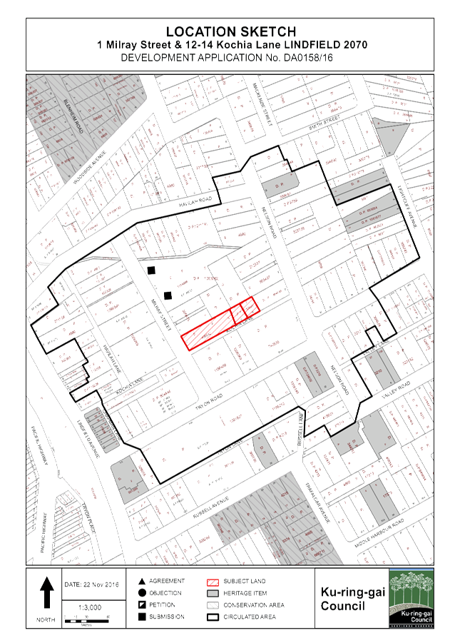
|
APPENDIX
No: 2 - Zoning
Extract
|
|
Item No: GB.7
|
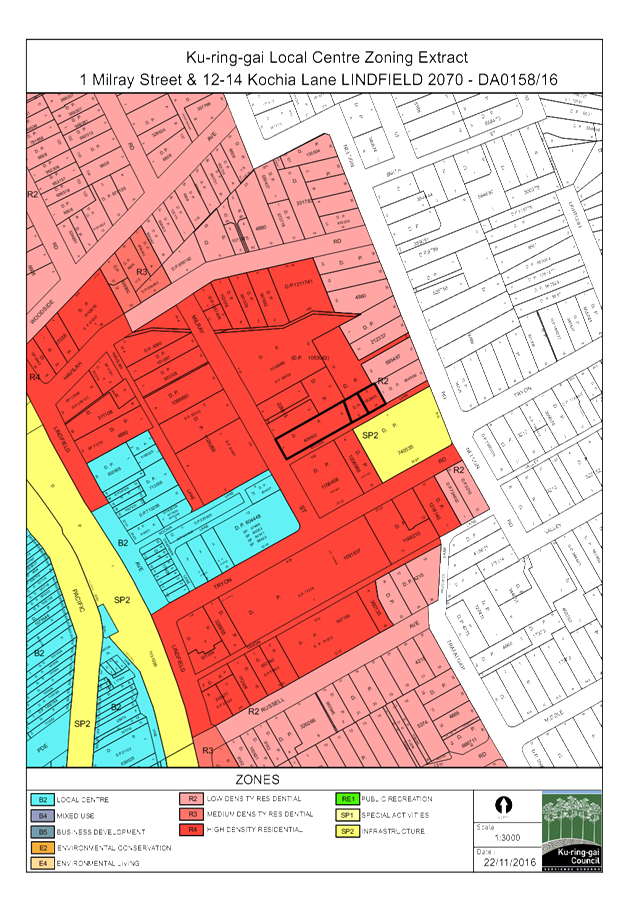
|
APPENDIX
No: 3 - Survey
|
|
Item No: GB.7
|
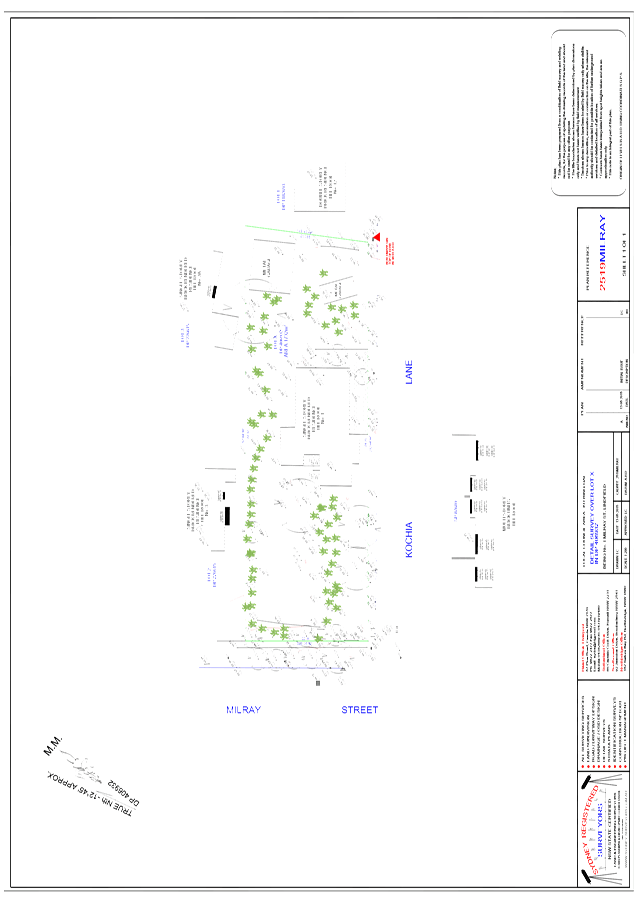
|
APPENDIX
No: 4 - Site
Plan
|
|
Item No: GB.7
|
|
APPENDIX
No: 5 - Basement
Garage and Ground Floor Plan
|
|
Item No: GB.7
|
|
APPENDIX
No: 6 - Upper
Floor and Roof Plan
|
|
Item No: GB.7
|
|
APPENDIX
No: 7 - Elevations
|
|
Item No: GB.7
|
|
APPENDIX
No: 8 - Sections
Sheet 1
|
|
Item No: GB.7
|
|
APPENDIX
No: 9 - Sections
Sheet 2
|
|
Item No: GB.7
|
|
Ordinary
Meeting of Council - 7 February 2017
|
GB.8 / 177
|
|
|
|
|
Item
GB.8
|
S11257
|
|
|
23 November 2016
|
Planning Proposal - Rezoning 21 Lorne
Avenue, Killara
EXECUTIVE
SUMMARY
|
purpose of report:
|
For Council to consider a Planning Proposal for 21
Lorne Avenue, Killara.
|
|
|
|
|
background:
|
The Planning Proposal was submitted to Council on 29
August 2016. The Planning Proposal was incomplete. Following the submission
of additional documentation, the review of the Planning Proposal formally
commenced on 4 November 2016.
The Planning Proposal seeks to amend the Ku-ring-gai
Local Environmental Plan as follows:
· Rezone
the site from R2 Low Density Residential to R4 High Density Residential
· Amend
the Floor Space Ratio applying to the subject site from 0.3 : 1 to 1.3 :1
· Amend
the Height of Building applying to the site from 9.5m to 17.5m
· Amend
the Lot Size applying to the site from 840sqm to 1200sqm
|
|
|
|
|
comments:
|
The purpose of this report is to determine whether the
Planning Proposal should be submitted to the Department of Planning and
Environment for a Gateway Determination and proceed to public exhibition.
|
|
|
|
|
recommendation:
|
That the Planning Proposal be sent to the Department
of Planning and Environment for a Gateway Determination.
|
Purpose of Report
For Council to consider a Planning Proposal for 21 Lorne
Avenue, Killara.
Background
A Pre-Planning Proposal meeting was held with the proponents
and Council staff on 3 May 2016.
The Planning Proposal was submitted to Council on 29 August
2016, which seeks to make the following amendments to the KLEP 2015:
· rezone
the site from R2 Low Density Residential to R4 High Density Residential;
· amend
the Floor Space Ratio applying to the subject site from 0.3 : 1 to 1.3 :1;
· amend
the Height of Building applying to the site from 9.5m to 17.5m; and
· amend
the Lot Size applying to the site from 840sqm to 1200sqm.
The Planning Proposal as submitted was incomplete. Following
the submission of additional documentation, the review of the Planning Proposal
formally commenced on 4 November 2016. The submitted Planning Proposal and
Appendices are included at Attachments A1 – A4.
Site Description and Local Context
The site that is the subject of
this Planning Proposal is 21 Lorne Avenue Killara (Lot 1 DP409107). The site
has an area of 1005sqm and is located on the northern side of Lorne Avenue,
Killara. Currently existing on the site is a two storey residential dwelling
house. A Complying Development Certificate under Part 4A of the
Environmental Planning and Assessment Act 1979 was issued on 1 December
2016 for the demolition of the dwelling.
Image 1 –
Aerial Photo – 21 Lorne Avenue, Killara
The site is currently zoned R2 Low Density Residential under
the KLEP 2015. The sites adjoining 21 Lorne Avenue to the north, west and east
are currently zoned R4 High Density Residential. Opposite the site there are a
group of properties (6-16 Lorne Avenue) zoned R2 Low Density Residential.
Image 2- Zoning Map
Extract KLEP 2015
The site is located within the vicinity of heritage items
I306 (20 Lorne Avenue, Reservoir pump station), I305 (14 Lorne Avenue, Dwelling
House), I304 (10 Lorne Avenue, Dwelling House), I303 (8 Lorne Avenue,
‘Windermere’ Dwelling House), I302 (6 Lorne Avenue, Dwelling
House). The site is also located opposite Heritage Conservation Area C24 Marian
Street.
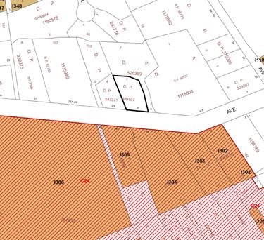
Image 3 –
Heritage Map Extract – KLEP 2015
History of zoning
The surrounding sites to the North, East and West were all
up- zoned in 2004 under LEP 194 which allowed for high density residential
development of up to 5 storeys to occur on land zoned 2(d3).
The subject site was not included within the up-zoning under
LEP 194 due to the site being identified as a heritage item under the KPSO. In
investigating the implications of the 2(d3) zone, Council engaged consultants
Perumal Murphy Alessi (PMA) to review the heritage status of a number of
heritage interface sites impacted by adjoining 2(d3) zones. The PMA review
found that in the context of the 2(d3) zoning and potential development
surrounding 21 Lorne Avenue, the heritage listing should be removed. The
heritage listing on the subject site was subsequently removed during the
preparation of the KLEP 2015. See Attachment A5 PMA Heritage
Consultants Review 21 Lorne Avenue, Killara.
When KLEP 2015 was made, the subject sites Residential 2(b)
zoning under the KPSO was translated to R2 Low Density Residential under the
KLEP 2015. The property was removed from Schedule 5 (Heritage Listing) of the
KLEP 2015 as a result of Council’s resolution from OMC 26 November
2013.
Comments
A Planning Proposal must demonstrate the strategic merit of
the proposed amendments to a Local Environmental Plan. The Planning Proposal
has been assessed against the provisions of the Department of Planning and
Environment’s A Guide to Preparing Planning Proposals and Section
55 of the Environmental Planning and Assessment Act 1979. The following
is an assessment of the relevant merits of the amendments proposed to the KLEP
2015:
Zoning
The KLEP 2015 was a translation of the KPSO into the
standard instrument format. Accordingly, the subject sites Residential 2(b)
zoning under the KPSO was translated to R2 Low Density Residential under the
KLEP 2015.
The Planning Proposal seeks to amend the zoning of the
subject site from R2 Low Density Residential to R4 High Density Residential.
The subject site is currently an isolated R2 Low Density zoned site, with the
surrounding sites to the north, east and west all zoned R4 High Density
Residential.
The development of residential flat buildings on the
surrounding R4 High Density sites will result in the subject site being
significantly compromised in terms of overshadowing and overlooking, should it
be left an isolated R2 Low Density Residential site.
The proposed rezoning to R4 High Density Residential will
remove an isolated site and is a logical extension of the existing R4 zoning.
The proposed rezoning to R4 High Density Residential will
create a consistent zoning and development controls for the northern side of
Lorne Avenue.
Should the site be rezoned to R4 High Density Residential,
consolidation with an adjoining site would be required in order to develop
multi dwelling housing or a residential flat building, noting that Clause 6.6
of the KLEP 2015 requires a minimum lot size of 1200sqm for these development
types. It is stated within the Planning Proposal that the intention is to
develop the subject site in conjunction 9 Lorne Avenue.
Floor Space Ratio, Height and Lot Size
The Planning Proposal seeks to amend the Development
Standards (Height, FSR and Lot Size) applying to the site so that they are
consistent with the proposed R4 High Density Residential zone and the
development standards applying to the surrounding sites. The Planning Proposal
seeks the following amendments to the Development Standards:
· amend
the Floor Space Ratio applying to the subject site from 0.3 : 1 to 1.3 :1;
· amend
the Height of Building applying to the site from 9.5m to 17.5m; and
· amend
the Lot Size applying to the site from 840sqm to 1200sqm
The Development Standards proposed for the subject site within
the Planning Proposal are commensurate with the Development Standards applying
the surrounding R4 High Density zoned sites to the north, east and west of the
site. The proposed Development Standards will allow for the orderly development
of the site and surrounding properties.
Heritage
The subject site is located within the vicinity of the
following heritage items:
· 20 Lorne
Avenue, Killara – Reservoir Pump Station – I306;
· 14 Lorne
Avenue, Killara – Dwelling House – I305;
· 10 Lorne
Avenue, Killara – Dwelling House – I304;
· 8 Lorne
Avenue, Killara – ‘Windermere’ Dwelling House – I303;
and
· 6 Lorne
Avenue, Killara – Dwelling House – I302.
The site is also located opposite Heritage Conservation Area
C24 Marian Street.
The proposed R4 zoning on the subject site will not result
in adverse impacts to the heritage items or HCA located within the surrounding
vicinity.
Any future development on the site would be required to
comply with the controls within Part 19F of the DCP - Development in the
Vicinity of Heritage Items or Heritage Conservation Areas (HCAs).
Traffic and Transport
The subject site is located within 300m (or 4 minutes’
walk) of Killara Train Station but access to other transport modes (buses) and
basic shops and services is relatively low.
From the information submitted with the Planning Proposal,
there is the potential yield of 20 dwellings resulting from the upzoning of 21
Lorne Avenue to R4, the amalgamation with 9 Lorne Avenue and potential
development for residential flat buildings on the sites (9 and 21 Lorne
Avenue).
Assuming a conservation traffic generation rate of 0.3 trips
per dwelling (2 way) during peak hour, the potential peak hour traffic
generation for the potential development on 9 and 21 Lorne Avenue would be 6
trips, or 1 additional trip every 10 minutes. This is not a high traffic
generation rate.
In Council’s experience, this is not an area with
significant traffic congestion issues compared to other areas in Ku-ring-gai,
such as the Pacific Highway through Gordon or Turramurra. The traffic
generation of 6 trips is unlikely to have significant additional impact on the
surrounding road network. Surveys conducted at Killara railway station show a
high level of access to the station by walking, which may indicate that the
assumed traffic generation may be lower.
Council monitoring of traffic volumes in Lorne Avenue show
that average weekday traffic flows have increased from approximately 1,850
vehicles per day (in 2010), to approximately 2,350 vehicles per day (in 2015).
The recorded 85% speed in Lorne Avenue was 54Km/h (average, 2-way), which
indicates the majority of vehicles travelling in Lorne Avenue travel at around
(or below) the sign posted speed limit of 50km/h. The changes in traffic flow
may be related to additional high density residential dwellings constructed
between 2010 and 2015, as well as modifications to the commuter parking area in
Culworth Avenue by Transport for NSW.
Lorne Avenue is a local road, and the RMS Guide to Traffic
Generating Developments suggests that the desirable environmental capacity for
local roads is 200 vehicles per hour, and the maximum environmental capacity is
300 vehicles per hour. Based on the recorded weekday traffic volumes in 2015,
the peak hour volume would be approximately 235 vehicles per hour which is
below the maximum environmental capacity of a local road. The addition of 6
trips in the peak hour from the potential redevelopment of 9 and 21 Lorne
Avenue, would still result in a peak traffic flow of less than 300 vehicles per
hour in Lorne Avenue.
Urban Design and Local Context
An Urban Design Study and Analysis was submitted with the
Planning Proposal. The Urban Design Study notes that the subject site is
currently occupied by a 2 storey brick residence, and the surrounding sites are
predominately 5 storey residential flat buildings – or could be developed
as such. It notes that unless the site is rezoned and amalgamated, the site
will be an isolated site and will be left as the only 2 storey residential
building along the street frontage.
Currently along the northern side of Lorne Avenue:
· 33a and 31
Lorne Avenue are older 2 storey walk-up flats
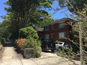
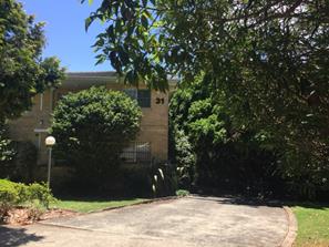
· Sites at
25a-29 Lorne Avenue have been amalgamated and redeveloped into a 5 storey
residential flat building
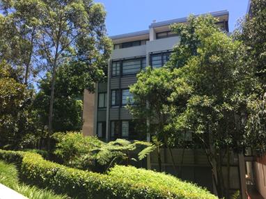
· 9, 21, 23,
25 Lorne Avenue are 2 storey dwellings houses – these sites have yet to
be amalgamated and developed.
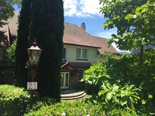
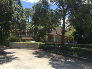
· Sites at 3-7
Lorne Avenue have been amalgamated and redeveloped into a 5 storey residential
flat building.
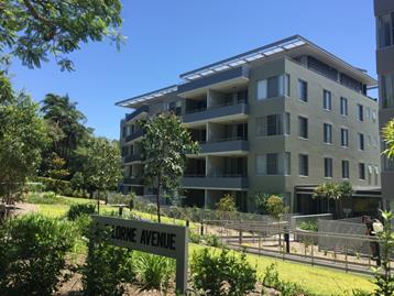
The proposed rezoning to R4 high density will remove the
isolated R2 low density zoned site. The rezoning will allow for the orderly
development of residential flat buildings along the northern side of Lorne
Avenue.
Matters associated with the design of a potential building,
are to be appropriately addressed via the development assessment process and
the public exhibition of any subsequent development application.
Requirements under Section 55 of the Environmental
Planning and Assessment Act 1979
The following is an assessment of the adequacy of the
Planning Proposal under Section 55 of the Environmental Planning and
Assessment Act 1979:
(a) Statement
of objectives or intended outcomes of the proposed instrument
The objective of the Planning Proposal is to amend the
Ku-ring-gai Local Environmental Plan 2015 to enable the development of high
density residential on the subject site.
(b) Explanation
of the provisions that are to be included in the proposed instrument
To achieve the intended outcome of the Planning Proposal,
amendments are required to the KLEP 2015 zoning, floor space ratio, height of
buildings and lot size maps.
The Planning Proposal currently states the amendments sought
are “in accordance with the illustrations under Part 4”.
Part 2 of the Planning Proposal should be amended to detail the exact
amendments sought (e.g. rezone the site from R2 Low Density Residential to R4
High Density Residential).
(c) Justification
The Planning Proposal is not
the result of any strategic study or report.
The Planning Proposal meets the objectives and directions of
A Plan for Growing Sydney by facilitating urban renewal and new housing
opportunities for a site within close proximity to Killara Train Station and
Pacific Highway – close to existing infrastructure. The Planning Proposal
is consistent with the following directions and actions:
- Direction
2.1: Accelerate housing supply across Sydney
- Action
2.1.1: Accelerate housing supply and local housing choices
- Direction
2.2: Accelerate urban renewal across Sydney – providing homes closer to
jobs
- Action
2.2.2: Undertake urban renewal in transport corridors which are being
transformed by investment, and around strategic centres
- Direction
2.3: Improve housing choice to suit different needs and lifestyles
- Direction
3.1: Revitalise existing suburbs
The Planning Proposal is consistent with the objectives and
actions within the recently exhibited Draft North District Plan, specifically:
- Action
L4: Encourage housing diversity
- Liveability
Priority 2: Deliver housing diversity
The Planning Proposal is consistent with the following s117
Directions:
- 2.3
Heritage Conservation
- 3.1
Residential Zones
- 3.4
Integrating Land Use and Transport
- 6.1
Approval and referral requirements
- 7.1
Implementation of the Metropolitan Strategy
The Planning Proposal is consistent with the following
objectives of the Ku-ring-gai Community Strategic Plan 2030:
- C6.1
Housing diversity, adaptability and affordability is increased to support the
needs of a changing community
- P2.1
A robust planning framework is in place to deliver quality design outcomes and
maintain the identity and character of Ku-ring-gai
The Planning Proposal is consistent with the following Aims
of the KLEP 2015:
- Clause
1.2(i) to encourage a variety of housing types within Ku-ring-gai
- Clause
1.2(j) to achieve land use relationships that promote the efficient use of
infrastructure
The submitted Planning Proposal has not identified any State
Environmental Planning Policies (SEPPs) and being relevant.
It is unlikely that the Planning Proposal will result in any
adverse environmental, social and economic impacts. The subject site is not
mapped as Biodiversity Significant or Riparian under the KLEP 2015. The
Planning Proposal will has positive social and economic effects such as the increased
housing choice for people seeking to down-size within the area, and
economically the proposal (should it result in high density development) will
extract development contributions that will assist in the local area
infrastructure provision, and will introduce new population that can contribute
to the local economy.
There is adequate existing public infrastructure and
services available to support the proposed increase in residential density. The
site has ready access to public transport, local schools and parks.
It is recommended that the following amendments be made to
Part 3 – Justification of the Planning Proposal:
- Amend
Planning Proposal to identify specific objectives and actions within A Plan
for Growing Sydney
- Amend
Planning Proposal should be amended to demonstrate consistency with Draft North
District Plan.
- Amend
Planning Proposal to include reference to Urban Design Study as part of
justification, and include the Urban Design Study in appendix
(d) Maps
The mapping included in the Planning Proposal identifies the
relevant aspects of the proposal including:
· The
currently zone applying to the site and surrounding area
· The current
development standard applying to the site and surrounding area
· The proposed
zoning to apply to the site
· The proposed
development standards to apply to the site
The mapping should be amended to clearly identify the land
to which the planning proposal applies – this could be done through a
bold outline around the subject site.
(e) Community
Consultation
The Gateway Determination will specify the community
consultation that must be undertaken on the Planning Proposal, with an
exhibition period of either 14 or 28 days.
The public exhibition of the planning proposal is generally
undertaken in the following manner:
· Notification
in local newspaper
· Notification
on Councils website
· Notification
in writing to affected and adjoining landowners
During the exhibition period, the Planning Proposal and
appendices would be made available for inspection.
integrated planning and reporting
Places, Spaces and Infrastructure
|
Community Strategic Plan Long Term Objective
|
Delivery Program
Term Achievement
|
Operational Plan
Task
|
|
P2.1 A robust planning framework is in place to deliver
quality design outcomes and maintain the identify and character of
Ku-ring-gai
|
Strategies, plans and process are in place to effectively
manage the impact of new development
|
Continue to review existing strategies and plans
|
Governance Matters
The process for the preparation and implementation of
Planning Proposal is governed by the provisions contained within the Environmental
Planning and Assessment Act 1979 and the Environmental Planning and
Assessment Regulation 2000.
If Council fails to make a decision within 90 days (from the
commencement of the review of the application) or if Council makes a decision
to not support the Planning Proposal, the proponent can request the Department
of Planning and Environment for a Rezoning Review.
Risk Management
This is a privately initiated Planning Proposal. Council
needs to determine its position on the matter as to whether the Planning
Proposal should be sent to the Department of Planning and Environment for a
Gateway Determination and proceed to public exhibition.
Council risks damage to its reputation is if does not
undertake strategic land use planning in an effective and timely manner.
Financial Considerations
The Planning Proposal was subject to the relevant
application fee under Council’s 2015/2016 Fees and Charges schedule. The
cost of the review and assessment of the Planning Proposal is covered by this
fee.
Social Considerations
The site is well integrated with the surrounding public
transport and pedestrian routes. The site is located within close proximity to
the North Shore Railway Line and Killara Station. In addition, there are
retail, educational and recreational facilities close by. The increase in
residential density will have access to facilities shared by the local
community.
Environmental
Considerations
The site is not identified as
having Biodiversity or Riparian mapping under the KLEP 2015.
Community Consultation
In the event that the Planning Proposal is granted a Gateway
Determination by the Department of Planning and Environment, the Planning
Proposal would be placed on a statutory public exhibition in accordance with
the requirements of the Gateway and the Department of Planning and Environments
publication A Guide to Preparing Planning Proposals.
The public exhibition would include notification to the
surrounding properties and advertisement within the North Shore Times and on
Council’s website.
Internal Consultation
This report has been referred to the relevant sections of
Council for comment.
Summary
A Planning Proposal has been lodged for 21 Lorne Avenue,
Killara which seeks to make the following amendments to the KLEP 2015:
· rezone
the site from R2 Low Density Residential to R4 High Density Residential;
· amend
the Floor Space Ratio applying to the subject site from 0.3 : 1 to 1.3 :1;
· amend
the Height of Building applying to the site from 9.5m to 17.5m; and
· amend
the Lot Size applying to the site from 840sqm to 1200sqm
The Planning Proposal has been assessed against the Department
of Planning and Environment’s A Guide to Preparing Planning Proposals and
Section 55 of the Environmental Planning and Assessment Act 1979, and
there is sufficient strategic merit in the Planning Proposal to enable it to
proceed to Gateway Determination.
|
Recommendation:
A. That
the Planning Proposal to rezone 21 Lorne Avenue, Killara be sent to the
Department of Planning and Environment for a Gateway Determination.
B. That
prior to being sent for a Gateway Determination, the Planning Proposal be
amended by the applicant as outlined in the body of this report.
C. That
Council requests the plan-making delegation under Section 23 of the Environmental
Planning and Assessment Act 1979 for this Planning Proposal.
D. That
upon receipt of a Gateway Determination, the exhibition and consultation
process be carried out in accordance with the requirements of the Environmental
Planning and Assessment Act 1979 and the requirement of the Gateway
Determination.
E. That
a report be brought back to Council at the conclusion of the exhibition
period.
|
|
Alexandra Plumb
Urban Planner
|
Craige Wyse
Team Leader Urban Planning
|
|
Antony Fabbro
Manager Urban & Heritage Planning
|
Andrew Watson
Director Strategy & Environment
|
|
Attachments:
|
A1
|
Amended
Planning Proposal - 21 Lorne Avenue Killara - Submitted 11 October 2016
|
|
2016/284596
|
|
|
A2
|
Heritage
Impact Statement - 21 Lorne Avenue Killara
|
|
2016/305168
|
|
|
A3
|
Development
Yield Analysis - 21 and 9 Lorne Avenue Killara - Planning Proposal rezoning
21 Lorne Avenue to R4
|
|
2016/284594
|
|
|
A4
|
Urban
Design Study and Analysis - 21 Lorne Avenue Killara - 2 Nov 2016
|
|
2016/304798
|
|
|
A5
|
PMA
Heritage Consultants Review - 21 Lorne Avenue - Killara
|
|
2013/233256
|
|
APPENDIX No: 1 - Amended
Planning Proposal - 21 Lorne Avenue Killara - Submitted 11 October 2016
|
|
Item No: GB.8
|
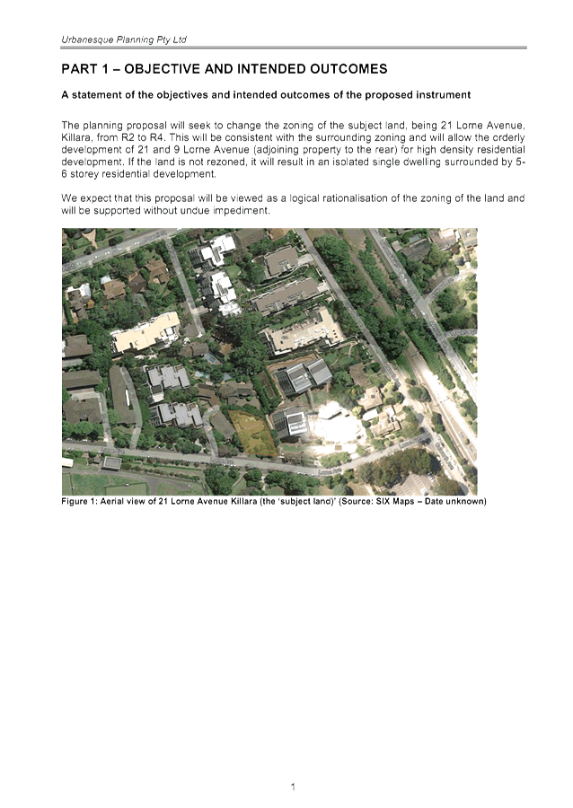
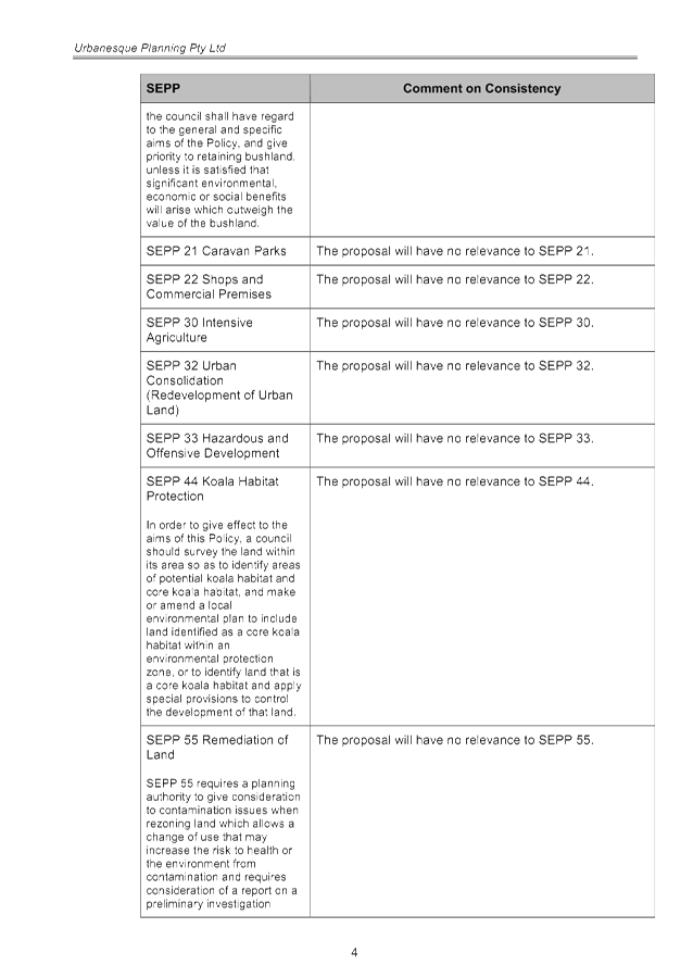
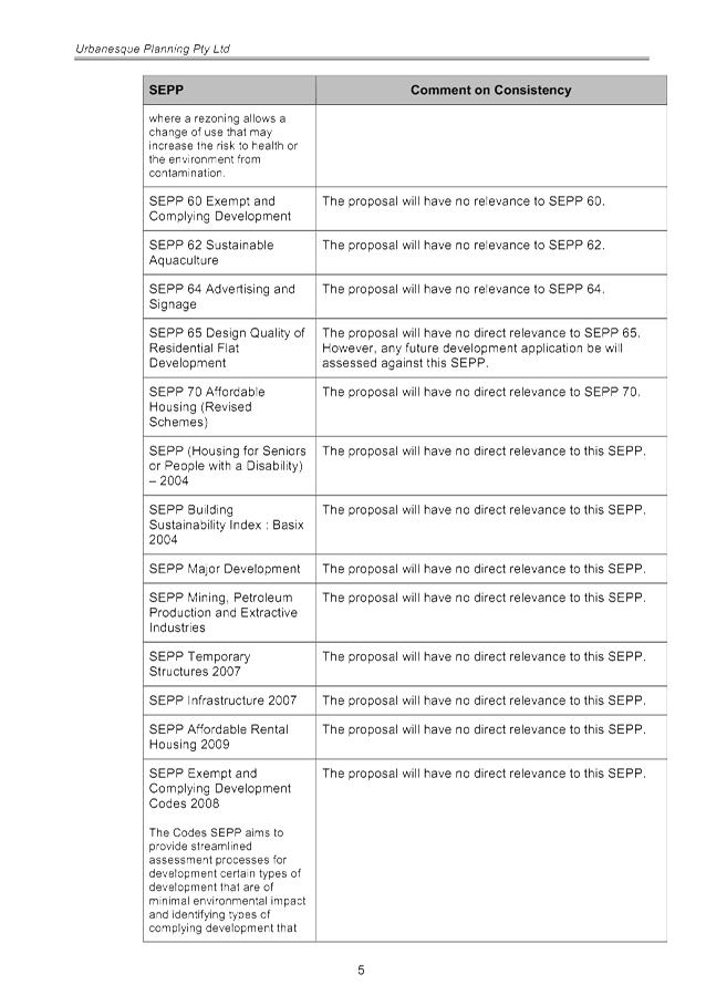
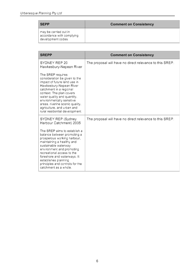
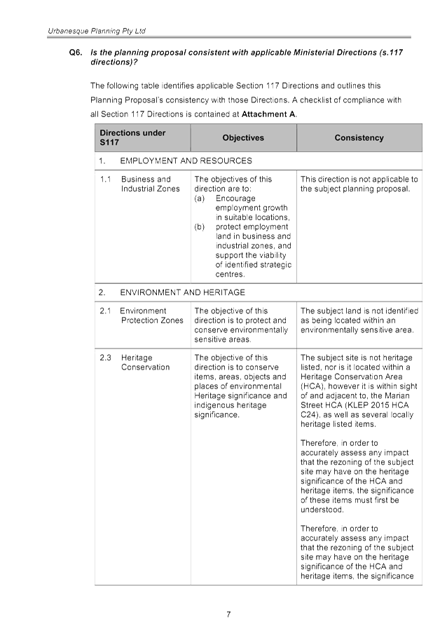
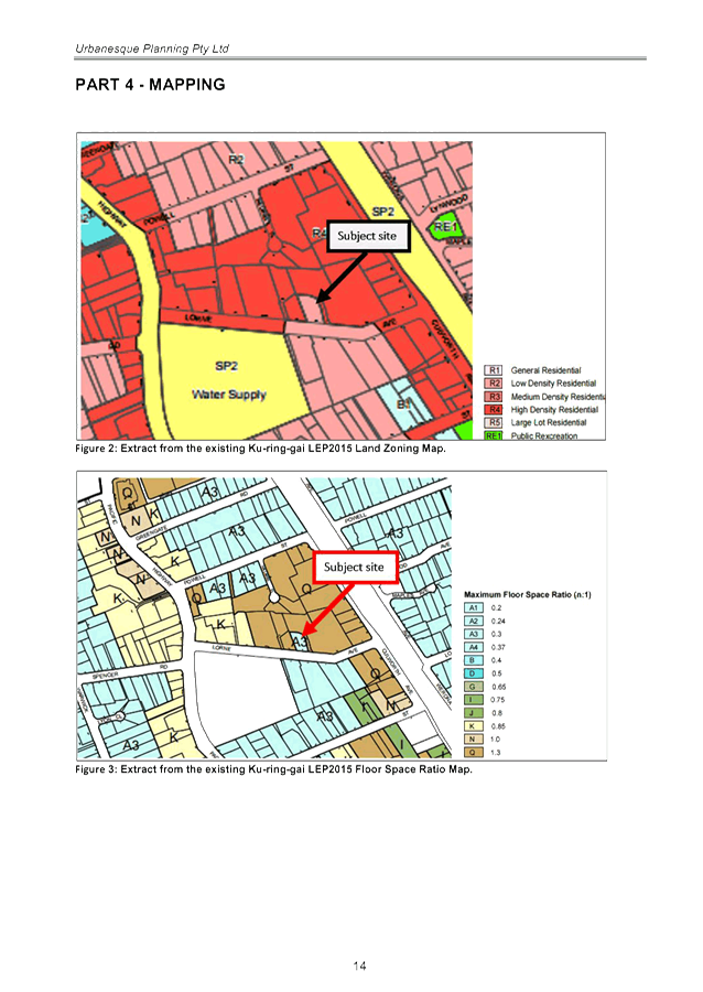
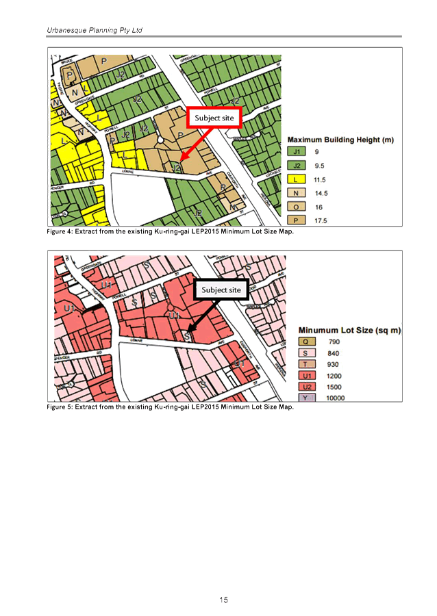
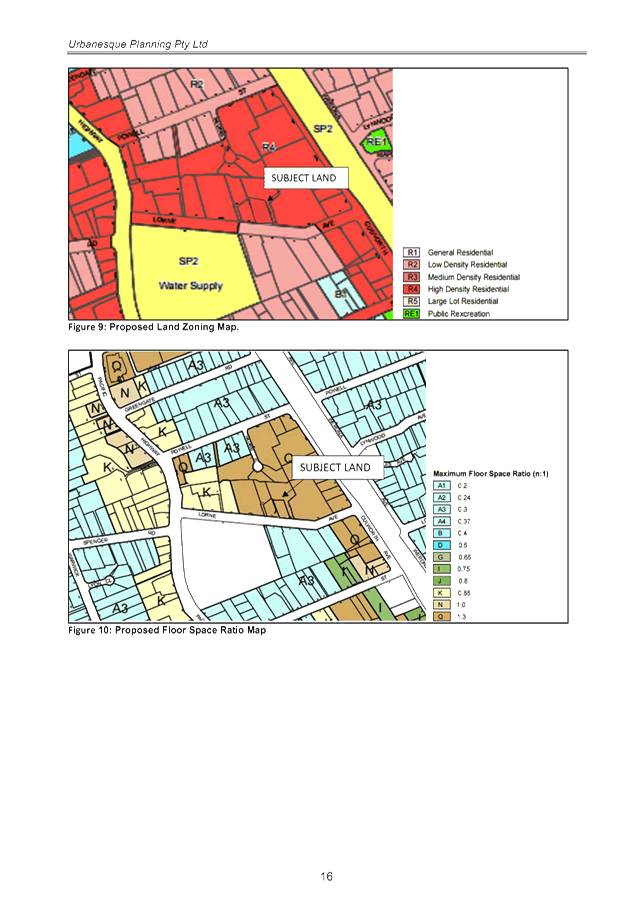
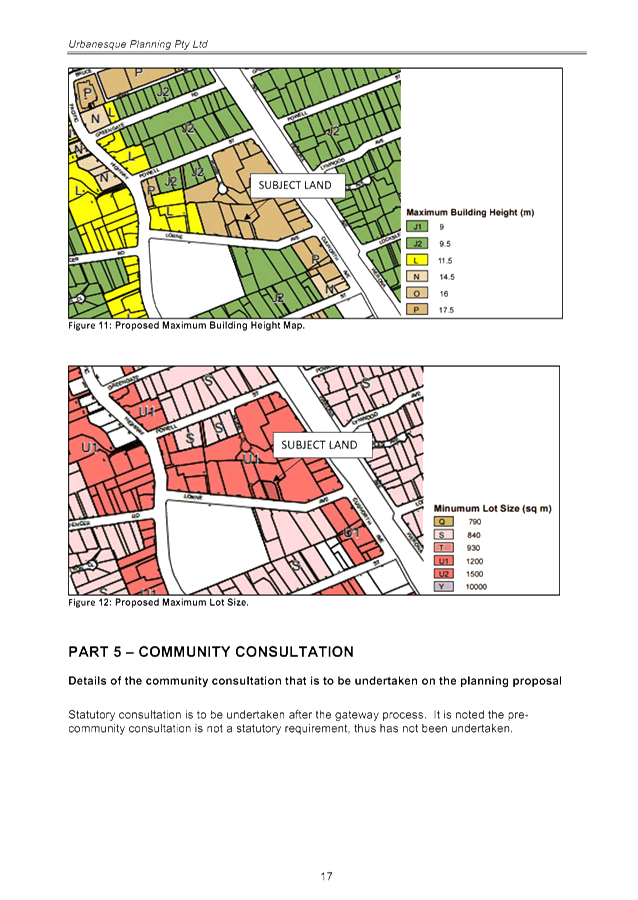
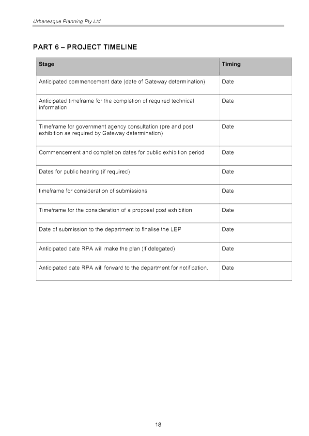
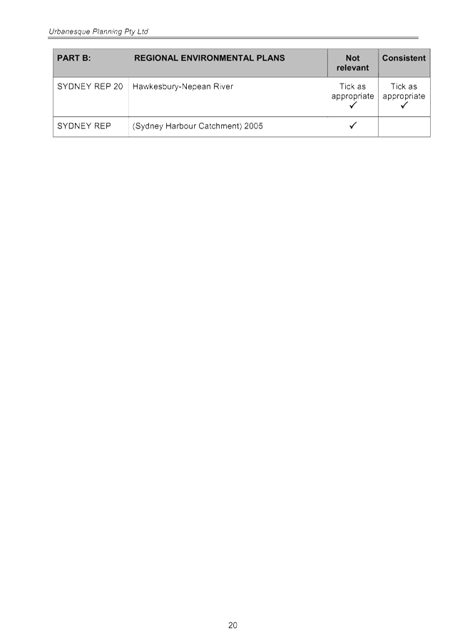
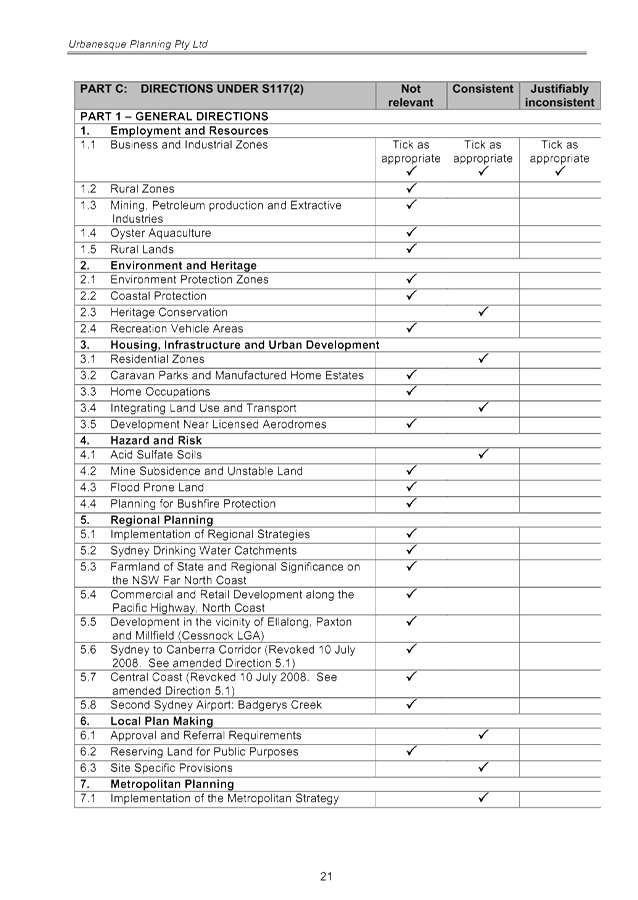


|
APPENDIX
No: 2 - Heritage
Impact Statement - 21 Lorne Avenue Killara
|
|
Item No: GB.8
|
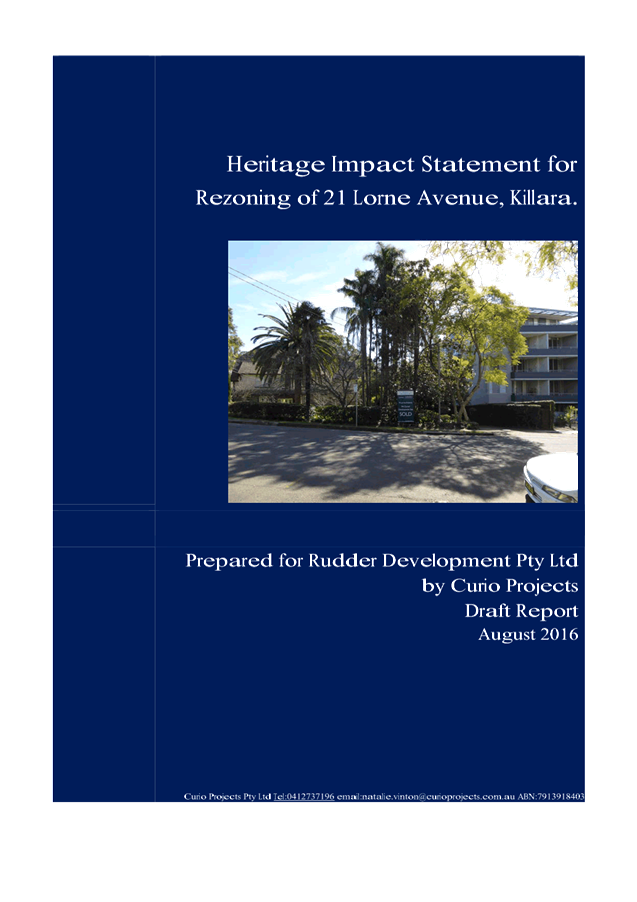

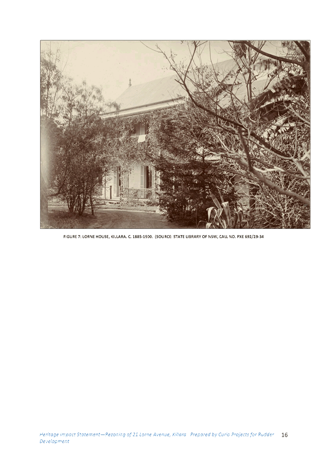
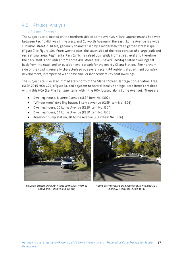
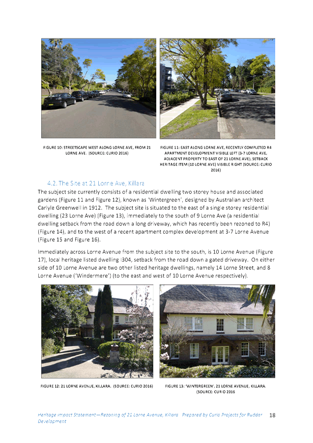
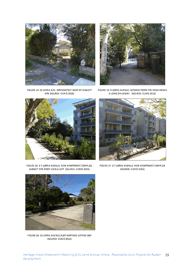
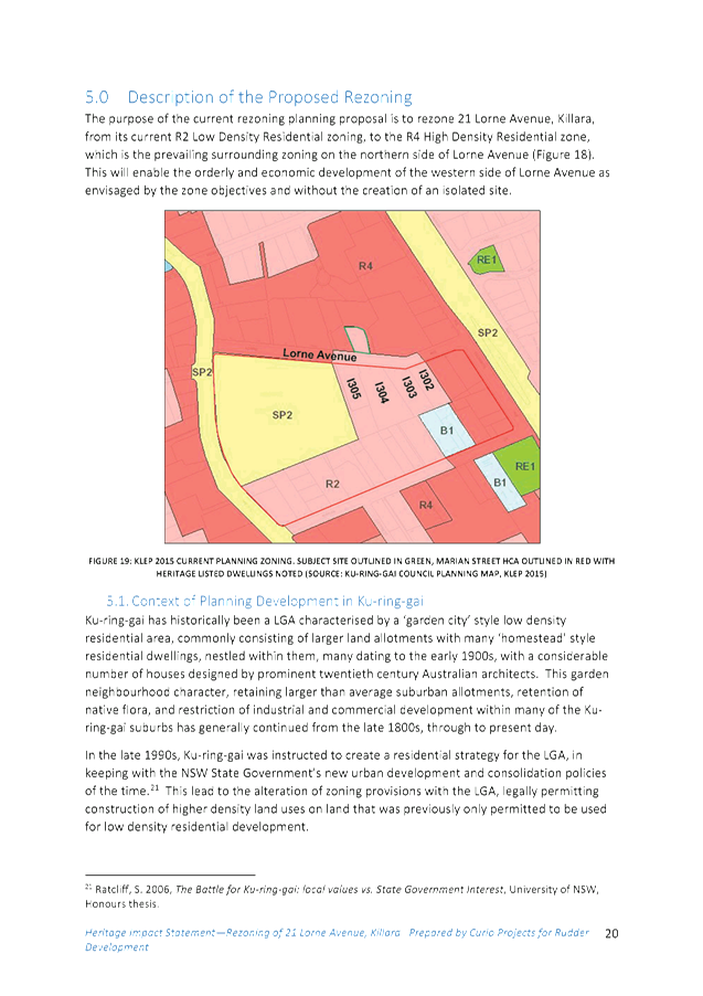
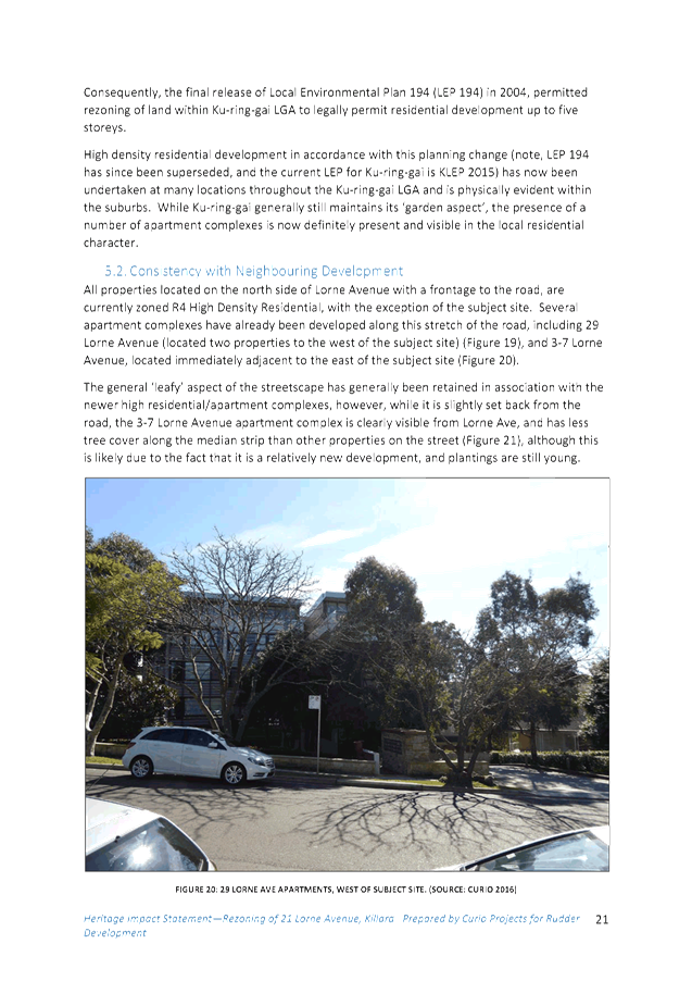
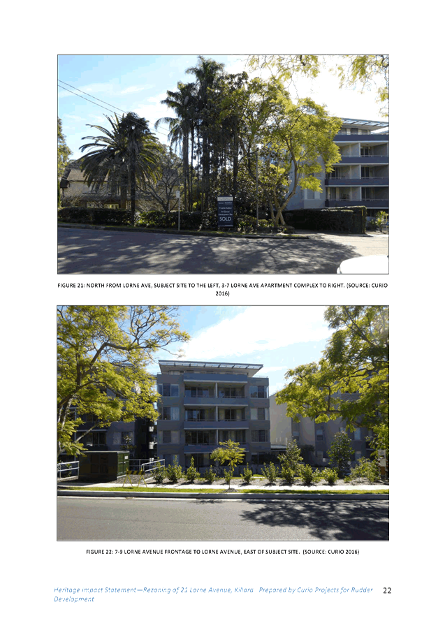
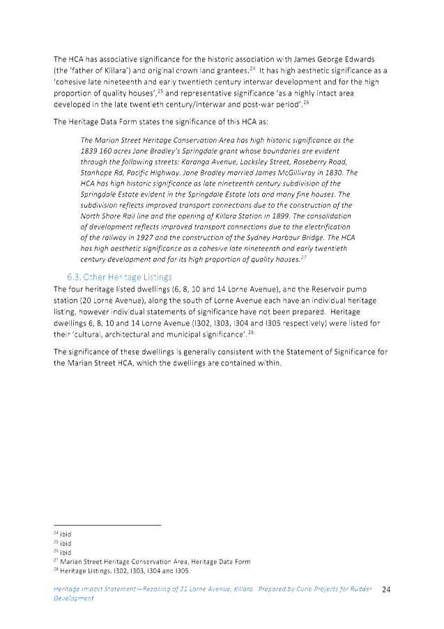
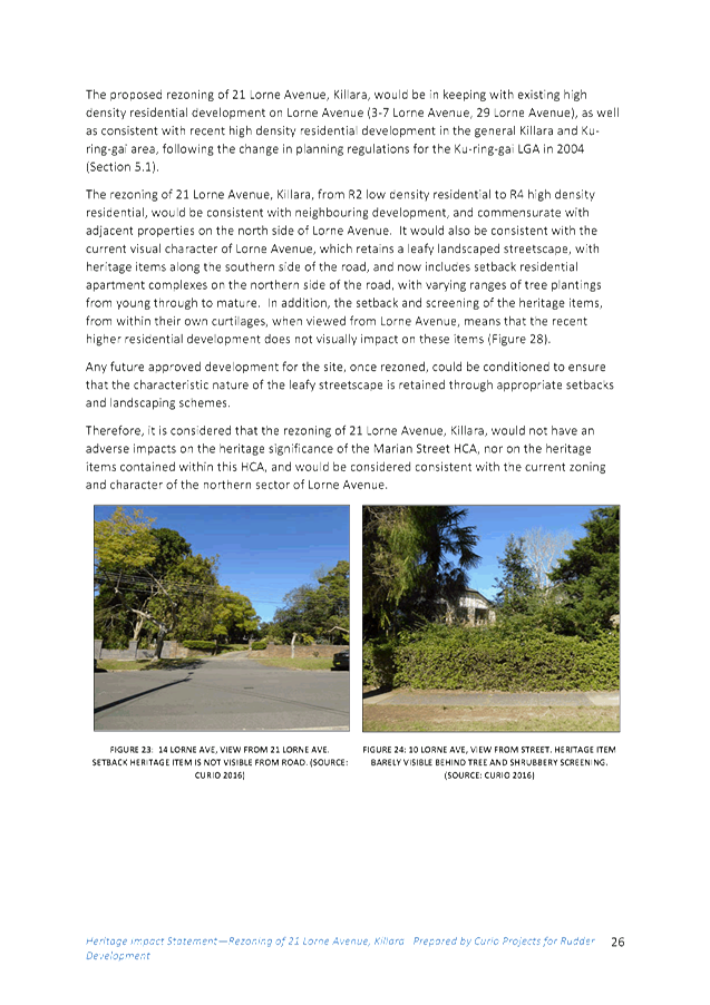
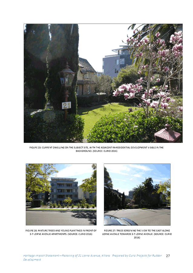
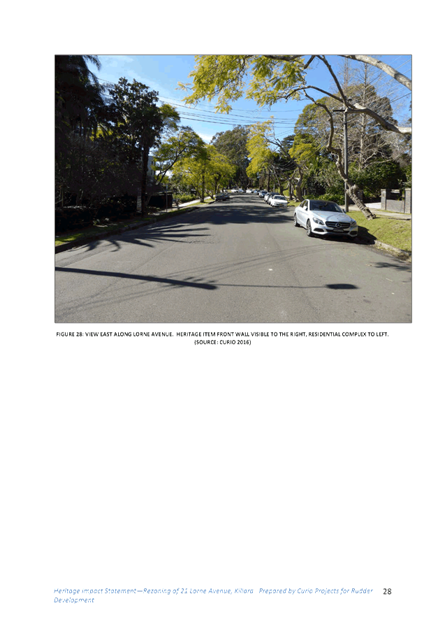


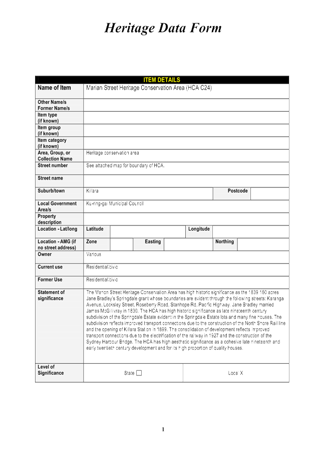
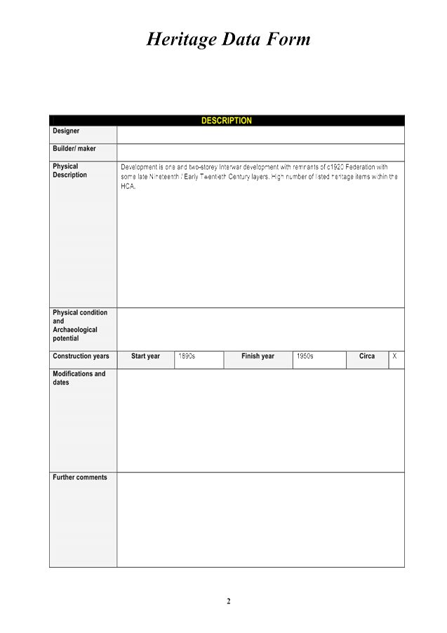


|
APPENDIX
No: 3 - Development
Yield Analysis - 21 and 9 Lorne Avenue Killara - Planning Proposal rezoning
21 Lorne Avenue to R4
|
|
Item No: GB.8
|
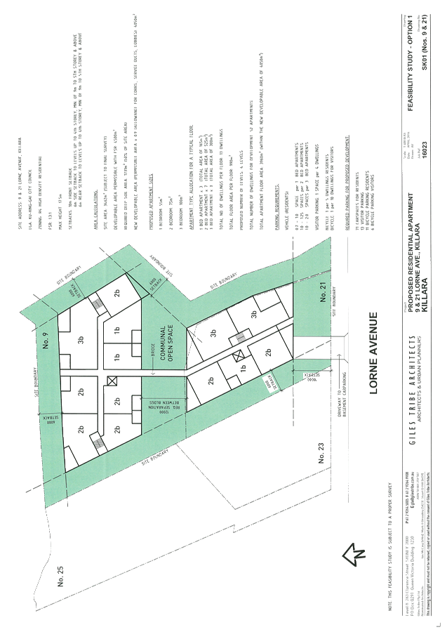
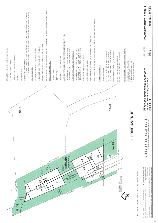
|
APPENDIX
No: 4 - Urban
Design Study and Analysis - 21 Lorne Avenue Killara - 2 Nov 2016
|
|
Item No: GB.8
|
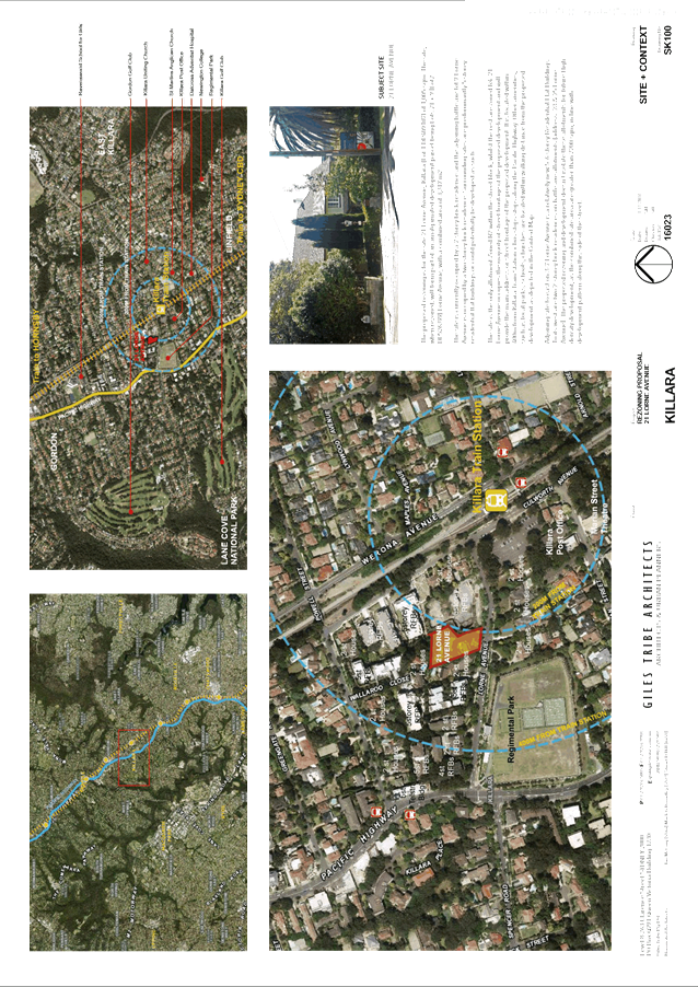
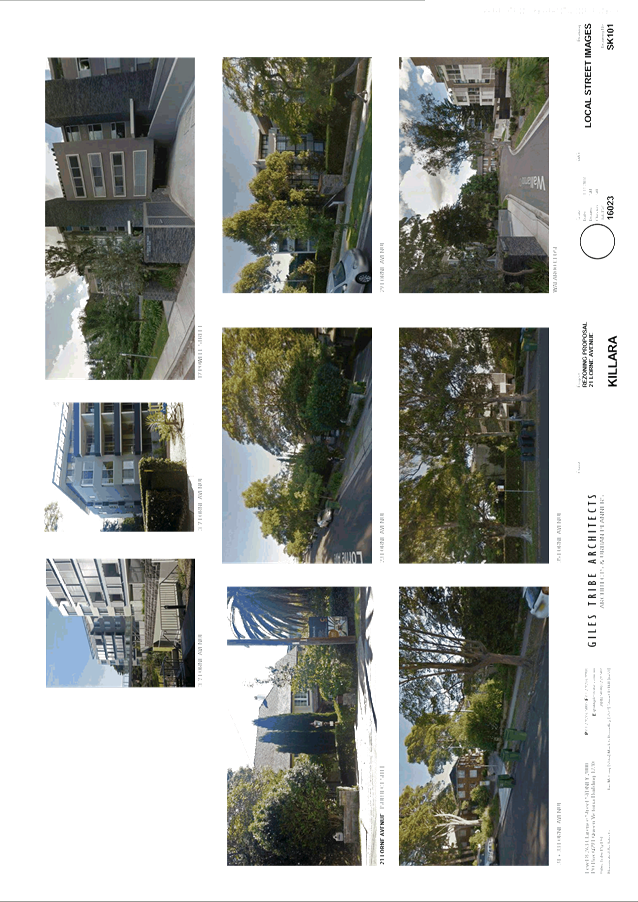
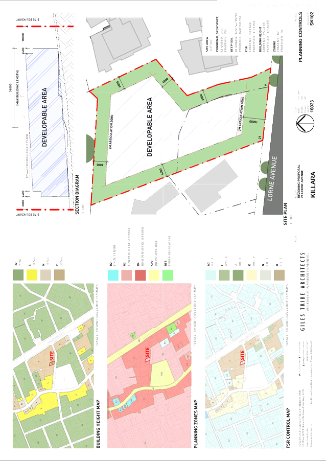
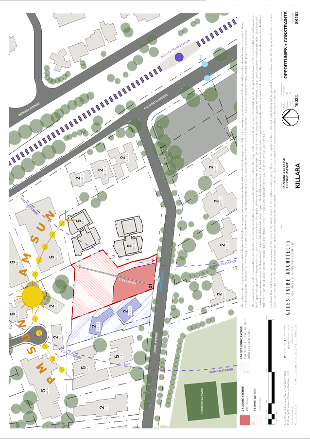
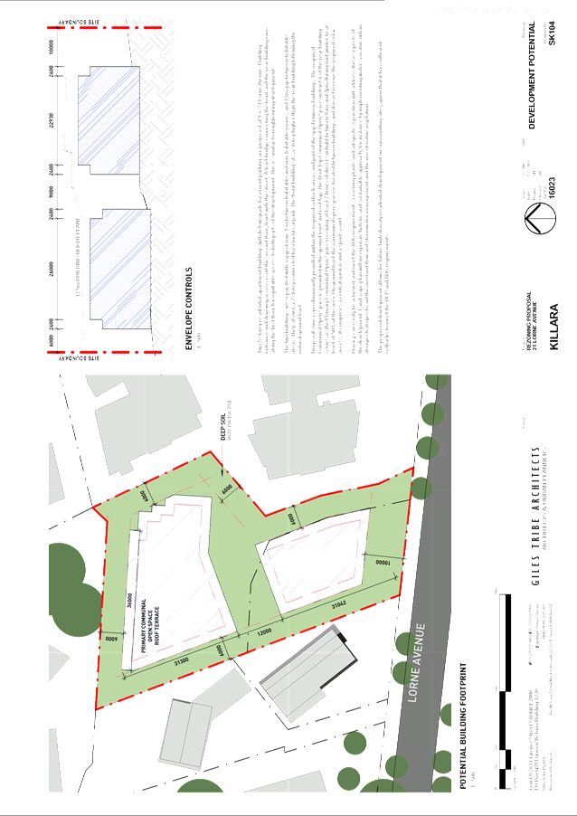
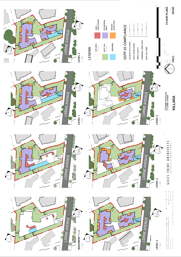
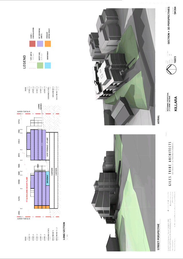
|
APPENDIX
No: 5 - PMA
Heritage Consultants Review - 21 Lorne Avenue - Killara
|
|
Item No: GB.8
|
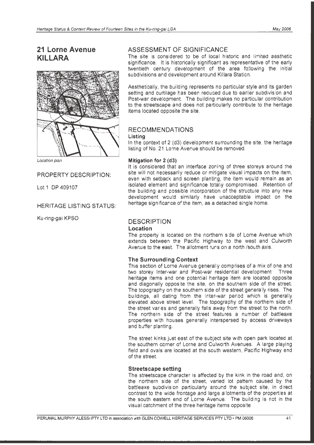
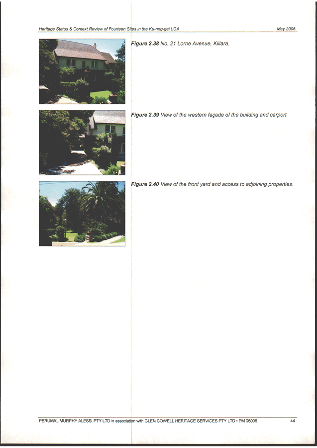
|
Ordinary
Meeting of Council - 7 February 2017
|
GB.9 / 266
|
|
|
|
|
Item
GB.9
|
S09969
|
|
|
12 December 2016
|
Turramurra Community Hub Masterplan and
Rezoning & Reclassification of 1275 Pacific Highway, Turramurra
EXECUTIVE
SUMMARY
|
purpose of report:
|
For Council to consider the feedback following the
public hearing for the Planning Proposal to rezone and reclassify Council
owned land at 1275 Pacific Highway, Turramurra and for Council to adopt the
Turramurra Community Hub Master Plan.
|
|
|
|
|
background:
|
The Planning Proposal was placed on Public Exhibition
from 29 April 2016 – 27 May 2016. A Public Hearing into the
reclassification of 1275 Pacific Highway, Turramurra (Turramurra Village
Park) was held on 26 October 2016.
The Master Plan for the Turramurra Community Hub was
placed on exhibition 30 April 2016 – 29 May 2016. To date Council has
not adopted a final master plan.
|
|
|
|
|
comments:
|
This report addresses the resolution from OMC 6
December, 2016 to report back to Council the Chairperson’s findings on
the public hearing and a make a recommendation for a final master plan.
|
|
|
|
|
recommendation:
|
This report recommends that the land at 1275 Pacific
Highway, Turramurra be rezoned and reclassified and that the Turramurra
Community Hub Master Plan, as described in this report, be adopted.
|
Purpose of Report
For Council to consider the feedback following the public
hearing for the Planning Proposal to rezone and reclassify Council owned land
at 1275 Pacific Highway, Turramurra and for Council to adopt the Turramurra
Community Hub Master Plan.
Background
1. Planning Proposal to
rezone and reclassify Council owned land at 5 Ray Street,
12 William Street and 1275 Pacific Highway, Turramurra
On 12 November 2013 after considering a report on its future
landholdings within the Ray Street Precinct and in light of a supermarket
development application by Coles, Council resolved to prepare a Planning
Proposal to reclassify 5 Ray Street and 12 William Street, Turramurra from
‘Community’ to ‘Operational’ land, and to rezone part
of 5 Ray Street from the RE1 Public Recreation zone to B2 Local Centre zone.
Council also resolved to prepare a masterplan for the precinct.
The proposed reclassification of Council owned sites within
the precinct is considered necessary to facilitate a comprehensive
redevelopment plan for the precinct, as Council is a significant landowner
within the precinct. In order to achieve the Turramurra Community Hub, Council
needs to include its land in the redevelopment project. The reclassification
will allow Council more flexibility to plan and deliver the proposed community
facilities within the precinct.
On 9 December 2014 Council resolved to adopt the preferred
design option for the ‘Turramurra Community Hub’ for public
exhibition and that a draft masterplan be prepared. The adopted preferred design
option relocated the Turramurra Village Park (1275 Pacific Highway) and
utilised the existing park site for a community building.
On 8 December 2015 Council resolved to amend the existing
Planning Proposal for 5 Ray Street and 12 William Street to also incorporate
1275 Pacific Highway, Turramurra (Village Park). Council resolved to reclassify
the park site from ‘Community’ to ‘Operational’ and
rezone part of the site from RE1 Public Recreation to B2 Local Centre.
On 28 June 2016 Council considered a report that documented
the results of the public exhibition of the Community Hub Master Plan.
Following high levels of community support the report recommended that council
adopt the master plan however Council resolved that all action cease on
the reclassification and rezoning of the Turramurra Village Park until after a
decision had been made to determine the location of the library and Community
Centre facilities within the Ray Street precinct.
On 6 September 2016, Council resolved to adopt the Planning
Proposal to reclassify 5 Ray Street and 12 William Street and submit the Plan
to the Department of Planning and Environment. Council also resolved to take no
further action on the reclassification of 1275 Pacific Highway (Turramurra
Village).
On 20 September 2016 Council moved to rescind the
abovementioned motion from the 6 September 2016. Resolving to adopt the
Turramurra Town Square site as the preferred site for the location of the
proposed Community Building and recommence the rezoning and reclassification of
Council owned land at 1275 Pacific Highway, Turramurra.
On 8 December 2016 Council resolved to amend the draft
Turramurra Community Hub Master Plan (as exhibited) to take into account
amendments to the lower ground floor plan made in consultation with Coles.
Council also asked that a report be brought back to Council in early 2017
documenting the Chairperson’s findings on the public hearing and
recommending a final master plan.
2. Gateway Determination
relating to 5 Ray Street, 12 William Street and
1275 Pacific Highway, Turramurra
The Planning Proposal to reclassify 5 Ray Street, 12 William
Street, and 1275 Pacific Highway Turramurra was submitted to the Department of
Planning and Environment for a Gateway Determination on 19 February 2016. The
Department of Planning and Environment issued a Gateway Determination on 5
April 2016. Refer Attachment A1. The Gateway Determination included
conditions which required Council to amend the Planning Proposal prior to
public exhibition in order to clarify aspects of the proposal applying to 12
William Street and 1275 Pacific Highway, as well as mapping amendments.
3. Exhibition of Planning
Proposal and Submissions relating to 1275 Pacific Highway, Turramurra
The Planning Proposal (amended as per the conditions of the
Gateway Determination) was publically exhibited between 29 April 2016 and 27
May 2016. The exhibition of the Planning Proposal ran concurrently with the
public exhibition of the Turramurra Community Hub Masterplan. The Planning
Proposal is included at Attachment A2. Due to the size of the Planning
Proposal Appendices (A-I) they are not included as an attachment and will
instead be circulated separately.
a. Public submissions
A total of seven (7) submissions were received in response
to the public exhibition of the Planning Proposal. A summary of the submissions
received and Council comment on the matters raised in the submissions are
included at Attachment A3. The matters raised in these submissions were
addressed in the Council report on 6 September 2016 on the exhibition of the
Planning Proposal and the Public Hearing into the reclassification of 5 Ray
Street and 12 William Street, Turramurra.
Only one submission specifically commented on the rezoning
and reclassification of land at 1275 Pacific Highway, Turramurra. The comments
are as follows:
I. Opposes
amendment to KLEP (Local Centres) 2012 to rezone and reclassify Council land at
Turramurra Village Park (1275 Pacific Highway) as it will destroy heritage view
lines to ‘Hillview’ one of Turramurra’s most significant
heritage items in addition to the loss of the publically owned Ray Street carpark
and Turramurra Library.
II. Requests adaptive
reuse of Turramurra’s historic buildings and protection of heritage
landscape for future.
III. Requests Council to revise
masterplan and planning proposal to sensitively plan for all four of
Turramurra’s village precincts and keep Turramurra to a human scale.
In relation to
comment ‘i’ above it is acknowledged that 1275 Pacific Highway,
Turramurra is within the vicinity of the heritage listed “Hillview”
on the southern side of the Pacific Highway. The subject site of
this Planning Proposal is not heritage listed or included within a HCA.
The rezoning and
reclassification of the site will not have any direct impact on the heritage
significance of Hillview. Any potential heritage impacts associated with the
future development on 1275 Pacific Highway, Turramurra would be considered in
the design of any building proposed for the site and be assessed as part of any
development application of the site.
The reclassification and rezoning of the
Council owned land within the Ray Street Precinct seeks to provide an
opportunity for a future integrated development redevelopment of the precinct
– which will include the replacement and enhancement of the existing
public car parking and community facilities, as well as new areas of public
open space.
In relation comment
‘ii’ above the DCP controls for the Hill View precinct require the
existing heritage listed buildings to be adaptively re-used. The subject sites
of this Planning Proposal are not heritage listed or included within a HCA.
Finally in relation to
comment ‘iii’ above the Local Centres DCP contains building
controls for the four precincts in Turramurra (Ray Street, Kissing Point Road,
Hill View and Rohini Street). Council is focusing on the masterplan for the Ray
Street precinct at this time. In due course the remaining Turramurra Local
Centre precincts will also be further master planned, supported by the
objectives in the KLEP (Local Centres) 2012 and Local Centres DCP.
b. State Agency comments
The Gateway Determination required Council to consult with
the following public authorities under section 56(2)(d) of the Environmental
Planning and Assessment Act 1979 and/or comply with the requirements of
relevant S117 Directions:
· Transport for NSW;
· Transport for NSW – (RMS)
Roads and Maritime Services;
· Transport for NSW – Sydney
Trains;
· Energy Australia; and
· Sydney Water.
The Planning Proposal was sent to the above agencies for
comment under section 56(2)(d) of the Environmental Planning and Assessment
Act 1979.
Transport for NSW (TfNSW), Roads and Maritime Services
(RMS), Sydney Trains and Sydney Water provided submissions in response to the
request for comment under s56(2)(d). Additional submissions from NSW Health
(Northern Sydney Local Health District) and Ausgrid were also received. There
were no objections to the Planning Proposal. A summary of the State Agency
submissions received and Council comment is included at Attachment A4.
The submissions from Transport for NSW and RMS requested
that a traffic and transport assessment be undertaken to identify impacts and
mitigation measures to be completed prior to the rezoning being gazetted.
Council has undertaken a microsimulation transport assessment of the road
network in Turramurra taking into account the cumulative impacts of expected
development in the Turramurra Local Centre as well as background growth.
A transport scheme is being developed in consultation with
key transport stakeholders, including Transport for NSW and RMS. Council
adopted a transport Management Plan for Turramurra local centre on 6 December
2016.
Transport for NSW and Sydney Trains both requested that
access to the Turramurra Interchange be retained and that no future development
is to impact on access. Council’s proposed Masterplan and transport plan
for Ray Street and William Street allows for the continued and improved access
to the William Street side of the Station.
The comments raised by NSW Health (Northern Sydney Local
Health District), Ausgrid, Sydney Water and Sydney Trains Property are design
and development related, or beyond the scope of the Planning Proposal and
master planning process. Where applicable, the matters raised will be
considered during the detailed design phase of the Master Plan or through the
development application process.
Comments
1. Public Hearing –
Reclassification 1275 Pacific Highway, Turramurra
A Public Hearing was held on 26 October 2016 into the
proposed reclassification under the terms of the Local Government Act 1993. Ms
Kara Krason presided as an independent Chairperson. At the Public Hearing, six
(6) people gave oral submissions:
· Janet Harwood;
· Janine
Kitson;
· Scott
Marshall;
· Paul Cooper;
· Maire
Burgess; and
· Elaine
Malicki.
Seven (7) written submissions were received in response to
the advertising of the public hearing. Both the oral and written submissions
have been considered by the Independent Chairperson in their report.
A copy of the Chairpersons report from the public hearing is
included as Attachment A5. The report was received by Council on
23 November 2016 and made available on Council’s website on 25 November
2016.
The report concludes that land reclassification for 1275
Pacific Highway, Turramurra not proceed at this point in time and recommends
that Council engage and consult with the community as follows:
“that Council engage and
consult with the community to discuss any required updates to the draft
Turramurra Community Hub Master Plan, DCP and Planning Proposal to reflect
Council’s chosen location for the future library and community centre on
the town square site and any effects the retention of 1275 Pacific Highway
(Turramurra Village Park site) as Community land may have on the planning
provisions for the new Turramurra Town Centre as a whole”.
The reasons for the Chairperson making this recommendation
are outlined below along with Council officer’s responses to the reasons
given:
A. Chairperson Reason
There are differences between the character and function
of the existing park at 1275 Pacific Highway which incorporates deep soil
landscaping with tall trees and largely passive use and established scenic
qualities, compared with the proposed new urban open space areas outlined in
the Master Plan, the playground at Cameron Park and Community Garden which all
have more active uses.
Council
Response
While the park at 1275 Pacific Highway, Turramurra may be
designed for passive use, the poor amenity created by the adjoining Pacific
Highway greatly compromises its functionality. In addition the park is on
sloping land with difficult access conditions for pedestrians. These are
reflected in the very low user rates recorded for the park (reported to Council
8 December 2015).
The park is also of a very small size, with an area of
847sqm it is significantly smaller than Council’s preferred park size of
3,000sqm, adopted as part of the Ku-ring-gai Open Space Strategy, 2006. In
addition there is no opportunity to expand the size of this park through
acquisition to meet these criteria.
The master plan proposes a new linear park with an area of
2780sqm which is over three times the size of the existing park; in addition
the master plan proposes a town square with a total area of 2300sqm. The total
area proposed is 5,080sqm-combined it is almost 6 times the size of the
existing park. The linear park, whilst atop a podium, has been designed to
allow for a root ball depth/depth of soil which includes mounding for
significant trees.
Importantly the new linear park does not include the
landscape areas within TfNSW ownership – these are potential additional
areas of open space. Negotiations are currently underway with TfNSW to realign
the existing fencing to enable the railway gardens to become publicly
accessible. Public use of the railway gardens will retain the existing
significant deep soil planting characteristic of this open space. Similarly,
the deep soil planting of mature trees on the eastern boundary of Turramurra
Village Park will also be retained as part of the master plan. Refer Figure
3.
Further to this, the new park and town square will be at
grade and universally accessible – one of the major constraints for the
current park is that it does not meet current accessibility standards.
Figure
1: Master Plan extract showing areas
of open space proposed on Council land.
Council has also recently acquired over 2,500sqm of land on
Gilroy Road, Turramurra to expand an existing park, known as Cameron Park to
over 5,000sqm; this park is within a 5 minute walk of the subject site. The
Chairperson’s comments could be misinterpreted in implying that the
primary function of Cameron Park is as a playground. The expanded and upgraded
Cameron Park will actually provide for a multiple of uses including a greater
quantity and quality of space for passive recreation than currently exists at
1275 Pacific Highway, Turramurra. Refer Figures 1 and 2.
Figure 2:
Concept plan for Cameron Park expansion.
It is considered that the public will not be disadvantaged
by the reclassification of 1275 Pacific Highway, Turramurra as claimed by the
chairperson. Given that it has been made clear that the reclassification of all
Council lands is necessary to move forward with the master plan as exhibited,
the public would gain significant benefit through a six-fold increase in open
space in the precinct with minor disadvantage in relation to the loss of the
park.
Similarly, the chairperson does not acknowledge the public
benefits of the proposal in relation to public safety and Crime Prevention
through Environmental Design (CPTED). A new mixed use building on 1275 Pacific
Highway, Turramurra would provide ground level shops and upper level residences
or offices that would provide “eyes on the street” significantly
enhancing the safety of the western station entry precinct.
B. Chairperson Reason
The value of the land and open space should not be
assessed only by the amount of people who actively use it. The prominent
location of this park on the highway with canopy trees and vegetation has a
scenic quality that contributes to the character of the area and provides
community benefits.
Council
Response
The chairperson has failed to acknowledge that only a
portion of the green space is subject to the reclassification; about 560sqm of
land is owned by TfNSW and is therefore not proposed for redevelopment. The
portion of land owned by TfNSW contains the majority of the significant
trees/deep soil planting on the site and will be retained as park and thus
provide a vegetated physical and visual connection between the Pacific Highway
and the train station. TfNSW have indicated that they have no plans to change
this area.
A visual analysis has been undertaken and the results are
shown below in Figure 3. Figure 3 shows the proposed
footprint of a mixed use building, the remaining green space (as owned by
TfNSW) and the relative areas of each. The proposed building footprint takes
into account a setback along the Pacific Highway for future road widening and
does not encroach into adjacent William Street carriageway.
Figure 3:
Proposed mixed use building footprint on 1275 Pacific Highway
Figure 4 below shows an aerial view of the 4 storey
building envelope when viewed from the northern side looking to the south over
the Pacific Highway. The diagram shows the broad landscaped area that would
remain on the eastern side of the proposed building.
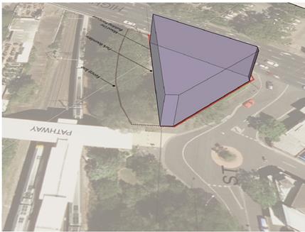
Figure 4:
Proposed mixed use building footprint on 1275 Pacific Highway.
C. Chairperson Reason
The draft Master Plan documentation, DCP and Council
reports do not clearly articulate a planned or future alternative proposed use
for 1275 Pacific Highway should this site not be adopted as the site for the
future community building. It is noted that a number of survey responses that
selected Option 2 – the Town Square site as the preferred location of the
future community building sought the retention of the Turramurra Village Park.
Council
Response
Extensive community consultation undertaken on the
development of the master plan has been comprehensively captured in the
“Turramurra Community Hub – Community Engagement Output
Report”, June 2016. The findings of which were reported to Council on 28
June 2016. A large majority of participants in both the recruited and opt-in
workshops supported the location of the proposed community facilities on the
town square site (Option 2), with a number of people stating that a building on
the Village Park site is more conducive to commercial uses fronting the Pacific
Highway; that the opportunity for an iconic mixed use building on this site is
preferable; and that the Village Park site is largely underutilised and was better
suited to residential use on the basis that an equivalent area of open space
was provided elsewhere within the master plan. No major objections were raised
on this proposal during exhibition.
D. Chairperson Reason
It is clear from the context provided by the DCP,
Planning Proposal and draft Master Plan that the intention of reclassifying the
subject site was to relocate Turramurra Village Park in order to accommodate a
new community building and library in its place. There is a distinct difference
and measure of public benefit between redeveloping a park for a community
building that would retain a public function and redeveloping a park for a
potential commercial or residential use.
Council
Response
The scope and basis for the public hearing would typically
be premised on the exhibited Planning Proposal to rezone and reclassify Council
land at 1275 Pacific Highway, Turramurra.
The reclassification of the 3 sites (including the Village
Park at 1275 Pacific Highway, Turramurra) within the master plan area should
not be considered in isolation, but rather needs to be considered in the
context of the whole planning proposal, including the proposed rezoning
and associated justifications. The proposal to rezone 1275 Pacific Highway from
RE1 Public Recreation to B2 Local Centre and to relocate the open space is
clearly stated throughout the Planning Proposal.
It is considered that the Chairperson has erred in linking
the decision to reclassify the site to the perceived inconsistency of the
planning proposal with the current version of the master plan.
As stated in the Planning Proposal:
“The objective of this
Planning Proposal is to rezone and reclassify Council owned land so as to provide flexibility to implement the
future master plan for the Ray Street Precinct, Turramurra”.
The emphasis is on facilitating a “future master
plan”. At no stage does the Planning Proposal seek to rezone and
reclassify the land to facilitate the implementation of a particular version of
the master plan, but rather to provide the flexibility for the masterplan to
evolve within the context of the proposed zoning and LEP provisions.
This intent is clear from Council’s resolution to
include 1275 Pacific Highway, Turramurra in the planning proposal to rezoning
of the site from RE1 Public recreation to B2 Local Centre:
“That the existing
Planning Proposal applying to the 5 Ray Street and 12 William Street,
Turramurra be varied in accordance with section 58 of the EP&A Act as
follows:
i. incorporate
the site 1275 Pacific Highway, Turramurra (Turramurra Village Park) (Lot 1 DP
81994);
ii. reclassify
the site from Community land to Operational land and formally seek to discharge
all necessary interests applying to the land to enable the implementation of
the Turramurra Community Hub Master Plan; and
iii. rezone
the site from RE1 Public Recreation to B2 Local Centres with a maximum building
height of 17.5m and FSR of 2.5:1”.
The Planning Proposal clearly and consistently indicates
that the Turramurra Village Park, regardless of its end use e.g. as community
building/ commercial/ mixed use site, was always intended to be reclassified
and developed as part of the overall master plan. There is no statement or
option contained in the Planning Proposal or associated master plan to indicate
that if the site was not used for a community building/purpose that it would
revert to public park use or a public recreation zoning.
Throughout the process it has been explicitly clear that it
is Council’s intention to remove the public recreation reserve status
that currently applies to 1275 Pacific Highway, Turramurra.
The Planning Proposal states the following on page 20 -
against Section 117 Direction 6.2 – Reserving Land for Public Purposes:
“Although the Planning
Proposal includes the removal of an RE1 Public Recreation zone from 5 Ray
Street and 1275 Pacific Highway, this does not mean there will not be open
space provided in the Turramurra centre. The preferred development option 2CA
for the Ray Street Precinct shows provision of at least 4,000 square metres of
town square and linear park in a similar location to that envisaged in the
Local Centres LEP. The precise location for this open space will be firmed up
as part of the detailed design of the Turramurra Community Hub. The current
strict RE1 zoning applying to these two sites is likely to prevent locating the
open space in the optimum location bordering the adjoining retail and
residential redevelopment. The current Community Land classification on
Council’s land prevents Council offering its land assets into a
comprehensive redevelopment scheme involving the private sector”.
In fact, if the only options being considered for the use of
1275 Pacific Highway, Turramurra was for the site to remain as open space or to
have a community facility such as a public library, there would be no need for
Council to seek to rezone and reclassify this site as both these uses would be
permissible within the existing RE1 zone.
The publicly available information consistently establishes
the use of the Village Park as a development site within the master plan to
retain the overall viability of the project. Councillors were briefed on this
matter on 2 August 2016 and the details were reported to Council on 6 September
2016. In summary it was found that under the current LEP controls, if Council
were to leave the Village Park undeveloped, Council would be required to
contribute additional funds (which are currently not available) to account for
the financial shortfall.
Although not considered relevant to Council’s decision
on the reclassification of the site, the chairperson is correct in identifying
that the Ku-ring-gai Local Centres DCP is inconsistent with the current version
of the masterplan. The DCP controls in Section B, Part 14 1B – Turramurra
Centre still show a new Turramurra branch library and community centre on the
site of the Turramurra Village Park.
This inconsistency has eventuated because Council adopted
the DCP on 14 June 2016 and the decision to relocate the community facilities
to the to the town square location occurred on 20 September 2016. As with the
master planning process at Lindfield, however, the process is iterative, with
both DCP and amendments to statutory planning occurring after masterplan
adoption to ensure all relevant documents are consistent.
It is entirely appropriate to amend the DCP to now make it
consistent with Council’s adopted master plan. The EP&A Act requires
any amendment to a DCP to go through a further and separate statutory
consultation process. This matter is discussed further below.
It is also worth noting that no decisions have been made by
Council about the ownership of various elements of the project or the delivery
method. Retaining some elements of the site as Community Classified land may
impede delivery of all or parts of the project by a private sector partner.
E. Chairperson Reason
Further public consideration should be undertaken prior
to any reclassification of the Turramurra Village Park site to Operational
land, which recognises the relocation of the park is no longer required to
accommodate a new community building for which the incorporation of this site
into the planning proposal was originally intended.
Council
Response
Additional public engagement prior to making a decision on
the reclassification of 1275 Pacific Highway, Turramurra is not considered
necessary.
In addition to the extensive community engagement program
undertaken to inform the development of the master plan for the entire
precinct, the Planning Proposal for reclassification and rezoning has undergone
all necessary statutory consultation.
As discussed above, further consultation is required to
amend the DCP to incorporate the revised master plan, showing the relocated
community facilities. This necessitates another statutory exhibition and
consultation process under the EP&A Act.
Conclusion
in relation to reclassification 1275 Pacific Highway, Turramurra
For the reasons outlined above,
the chairperson’s recommendation to not proceed with the reclassification
at this stage, is not supported.
Council has obtained legal advice
verifying that Council is not bound by the Public Hearing Chairperson’s
recommendations and is able to determine otherwise. Refer Confidential
Attachment A6- Legal Advice.
This is on the basis that under
Section 54 of the EP&A Act, Council is the nominated Relevant Planning
Authority (RPA) for the Planning Proposal and the chairperson, as an
independent party, cannot fetter Councils authority on making a decision on
whether the Planning Proposal should proceed or not. In this instance this
report will therefore recommend to proceed with finalising the Planning
Proposal to reclassify the site at 1275 Pacific Highway, Turramurra.
2. DCP and Master Plan
Integration
As discussed above, the current DCP provisions applying to
the Ray Street Precinct in Part 14 of the Ku-ring-gai Local Centres DCP
are inconsistent with the latest version of the Turramurra Community Hub Master
Plan presented to Council. Upon adoption of a final Master Plan for the
precinct it would be appropriate to amend that section of the DCP to align it
with the adopted master plan
The approach taken in the DCP in relation to Council’s
other major projects sites where Council does have an adopted master plan, such
as the Lindfield Village Green, Lindfield Community Hub and Lindfield Library
Sites, has been to align the relevant sections of Part 14 of the DCP with the
adopted master plans by including pictorial insertions from the master plans
and attachment of masterplan within Part 14R of the DCP.
The advantage of embedding the master plan within the DCP is
that not only does it provide greater certainty in regard to the development
outcomes on these master planned sites, any future amendments to the master
plan will trigger a statutory public consultation process to undertake the
parallel amendments to the DCP.
It should also be noted that the public will again be
comprehensively consulted as a part of the DCP amendment process. The draft
amendment to the Ku-ring-gai Centres Development Control Plan will be placed on
public exhibition in accordance with the requirements of the EP & A Act
1979 and Regulations.
3. Master Plan
The draft master plan as exhibited in May 2016 has since
been refined to reflect subsequent Council resolutions – the most notable
amendment being the location of the proposed community building (including new
branch library) on the town square site, denoted as ‘12’ in Figure
5 below.
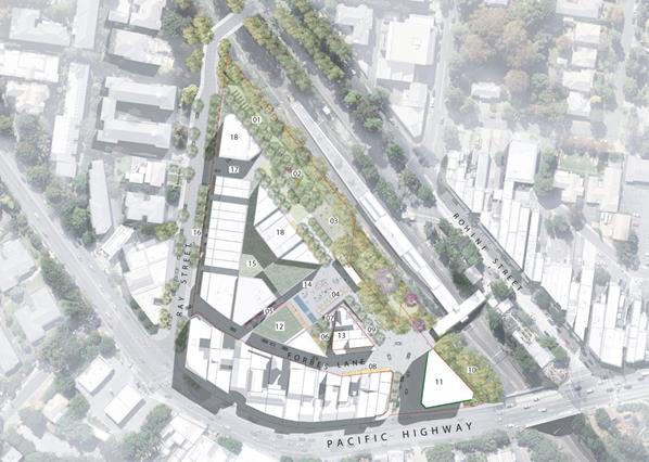
Figure
5 – Revised Master Plan for
adoption.
Key attributes of the master plan include:
· a branch
library (1,750 GFA);
· a community
building (1,500 GFA);
· linear
gardens, leisure gardens and connecting gardens (2,780sqm);
· town square
(2,300sqm);
· a new mixed
use building on the Village Park site with a footprint of approximately 695sqm.
Note - this building does not infringe on the William Street road
reserve;
· retail floor
space of 6,400 GFA comprising supermarket, supermarket back of house and
trailing retail;
· residential
floor space of 18,600 GFA;
· basement car
parking comprising 712 spaces - for use by the public, new residential tenants,
supermarket, trailing retail, commuter parking (dependant on finance by TfNSW)
and community hub; and
· on grade car
parking comprising ten (10) spaces on Forbes Lane.
Adoption of the revised master plan will form the basis for
proceeding to the next phase of the project, namely preparing a business case
and determining the most appropriate delivery method, particularly in relation
to the inclusion of a bridge over the rail line now that the traffic study has
been adopted (refer OMC 6th December 2016).
Refer Attachment A7 – Revised Master Plan for
adoption.
integrated planning and reporting
The Revised Delivery Program 2013-2017 and Operational Plan
2016-2017 commits Council to master planning for the revitalisation of the
Turramurra Local Centre and surrounding precincts.
|
Community Strategic Plan Long Term Objective
|
Delivery Program
Term Achievement
|
Operational Plan
Task
|
|
A range of well planned,
clean and safe neighbourhoods and public spaces designed with a strong sense
of identity and place.
|
4.1.1-
Plans to revitalise local
centres are being progressively implemented and achieve quality design
outcomes in collaboration with key agencies, landholders and the community.
|
Progress master planning
for the Turramurra Centre and surrounding precincts.
Engage with key community
stakeholders to identify the requirements for new community facilities and
infrastructure.
Finalise the
reclassification of identified lands as resolved by Council.
|
|
A healthy, safe, and diverse community that respects our
history, and celebrates our differences in a vibrant culture of learning.
|
C4.1.2-
New and enhanced open space and recreational facilities
have been delivered to increase community use and enjoyment.
|
Undertake acquisitions for new parks.
Undertake assessment and identify locations for new parks
Complete the design for identified parks and include
design principles which facilitate passive recreation activities.
Construct parks at identified locations and include design
principles which facilitate passive recreation activities
|
FIT FOR THE FUTURE IMPROVEMENT ACTION
PLAN
The NSW Government's Fit for the Future initiative required
all councils to prepare an Improvement Proposal and supporting Implementation
Plan demonstrating how all seven Fit for the Future benchmarks would be met by
2016/17, and maintained or improved thereafter.
Council's Fit For the Future Improvement Proposal and
supporting Implementation Plan underpins the decision to stand alone and
not merge with Hornsby Council. The objectives established in the Improvement
Proposal and Implementation Plan are embedded in Council's adopted Integrated
Planning and Reporting documents including the Revised Delivery Program
2013-2017 and Operational Plan 2015-2016, Long Term Financial Plan
2015/16 to 2024/25 and Asset Management Strategy 2015/16 to 2024/25.
Council’s Fit For the Future Improvement Proposal set
out the following strategies and outcomes to meet the State Governments Efficiency
criteria:
|
EFFICIENCY
|
|
Objective
|
Strategies
|
Key Milestones
|
Outcome
|
|
Major Local and Town Centres projects i.e. Community Hub
projects are commercially feasible in their own right
|
Projects should include commercial opportunities for
Council to offset ongoing operational costs (life cycle costs) of public
benefits provided
|
Masterplans adopted for the Local and Town Centres
2015/2016
EOI for the redevelopment of Turramurra Local Centre
2016/2017
Redevelopment of Turramurra Local Centre 2016/2017
|
Masterplans adopted for the Local and Town Centres with
development options substantially progressed to deliver community facilities
and public benefits
|
It is noted in the NSW Government publication Merger
Proposal – Hornsby Shire Council (part) and Ku-ring-gai Council
dated January 2016, that specific reference is made to the proposed merger and
the ability to provide the services and infrastructure to the community
including the revitalisation of Lindfield, Turramurra and Gordon Town Centres.
Governance Matters
Planning
Proposal
The Planning Proposal has been prepared in accordance with
Section 55 of the Environmental Planning and Assessment Act 1979.
Section 45 of the Local Government Act 1993 prevents
Council from selling, exchanging or otherwise disposing of Community classified
land.
A public hearing for the reclassification of Council owned
land at 1275 Pacific Highway, Turramurra was conducted in accordance with
Section 29(1) of the Local Government Act 1993 and Section 57(6) of the Environmental
Planning and Assessment Act 1979.
Council has obtained legal advice verifying that Council is
not bound by the Public Hearing Chairperson’s recommendations and is able
to recommend otherwise. Refer Confidential Attachment A6 –
Legal Advice.
This is on the basis that under
Section 54 of the EP&A Act, Council is the nominated Relevant Planning
Authority (RPA) for the Planning Proposal and the chairperson, as an
independent party, cannot fetter Councils authority on making a decision on
whether the Planning proposal should proceed or not.
Ku-ring-gai
Local Centres DCP Amendment
It is noted, that the
Chairperson’s report recommends that the reclassification of 1275 Pacific
Highway not proceed until Council “engage and consult with the
Community to discuss any required updates to the draft Turramurra Community Hub
Master Plan, DCP and Planning Proposal to reflect Council’s chosen
location for the future library and community centre on the town square site”.
Consistent with the
chairperson’s recommendation, this report presents a revised masterplan
that shows the library and community centre on the town square and clarifies
the proposed future development of the village park site at 1275 Pacific
Highway. The community’s views on this proposal will be sought as part of
the exhibition of the suggested draft DCP amendments.
In order to provide additional certainty that the Community
Hub will be developed in accordance with Council’s adopted masterplan, it
is proposed that the controls in Part 14B (Urban Precincts - Turramurra) of
Ku-ring-gai Local Centres Development Control Plan be amended to align with the
adopted masterplan. This is consistent with the recently adopted DCP amendments
to incorporate the Lindfield Village Green, Lindfield Community Hub and
Lindfield Library Site Masterplans within Part 14E, including pictorial
insertions from the masterplans and attachment of masterplan within Part 14R.
The process for the preparation and implementation of
development controls is governed by the provisions of the Environmental
Planning and Assessment Act 1979 (EP&A Act) and associated Regulations.
Council may amend a development control plan by a subsequent development
control plan. A new draft development control plan must be publicly exhibited
for at least 28 days
While the purpose of a DCP is to provide more detailed
provision with respect to development permitted by a LEP, the EP&A Act
requires that a DCP cannot be inconsistent with any provisions of the LEP.
Risk Management
The major risk to Council is reputational. The planning for
Turramurra local centre commenced in 2010 with the drafting of the Local
Centres LEP; Council has taken 6 years to get to this point. Based on the
positive community consultation the master plan received during the public
exhibition period and the good will established as a result, Council needs to
be aware of the potential negative effect any further delays to the project
would have on its reputation, given the amount of resources expended to date
and the Turramurra Community’s expectations.
A further risk to Council at this point in time is the
proposed amalgamation with Hornsby Shire Council. The uncertainty surrounding
the pending proclamation could potentially delay necessary investigations into
how the master plan may be best delivered.
Financial Considerations
To date Council has expended over $450,000.00 on this
project including salaries and consultancies. These funds have been sourced
from development contributions 2010 Plan Recreational, Cultural & Social
Facilities. It is important that Council continues to progress this project, if
not Council may be required to repay part of the S94 funds spent to date if the
works are not delivered.
Council’s Long Term Financial Plan (LTFP) identifies a
total of approximately $26 million allocated from the S94 Ku-ring-gai
Contributions Plan, 2010 for works associated with the Turramurra Community
Hub. These funds will be Council’s contribution toward the project and
have been taken into account when preparing the preliminary
economic feasibility assessment.
The funds allocated to this project represent only a
proportion of the total development contribution funds that will be available
for revitalising the Turramurra local centre as a whole. In
the future Council will be undertaking master plans for the other key precincts
as funds become available.
Social Considerations
Council’s Community Strategic Plan 2030, recognises
the community’s vision for Ku-ring-gai as a place with infrastructure and
facilities which accommodate the needs of the community. The plan further
emphasises the desire for a an adopted program for the implementation of new
facilities, identified funding sources and a program to maintain
Council’s assets at a sustainable standard.
Environmental Considerations
A number of environmental studies have been undertaken to
date for this site. Further necessary due- diligence studies will be undertaken
in due course as part of the next phase.
Community Consultation
The Planning Proposal was placed on public exhibition in
accordance with the Gateway Determination from 29 April - 27 May 2016.
Advertisements were placed on Council’s website and in the North Shore
Times. Information was also made available at Council’s customer service
centre at 818 Pacific Highway Gordon, the Turramurra Branch Library and Council
Website. The adjoining and surrounding property owners were notified in writing
and were given the opportunity to provide feedback during the exhibition
period.
A public hearing into the reclassification of 1275 Pacific
Highway, Turramurra was held on 26 October 2016 in accordance with the
requirements of the Local Government Act 1993. All persons who made a
submission to the planning proposal or public hearing were notified of this
matter being reported back to Council.
In addition to this, the master plan has been the subject of
rigorous community consultation during 2016.
Turramurra Community Hub - Draft Masterplan communication
summary:
· Exhibition
Period - 30th April to 29th May
2016, including an on-site information kiosk (demountable) available during the
first 3 weeks of the exhibition period, with information also available at the
Turramurra Branch Library and on the Council Website;
· Launch
Event – on site, Saturday 30th April 2016.
· Drop
in Sessions - on
site information kiosk in the carpark on William Street Turramurra open/staffed
at the following dates/times:
o Tuesdays 3,10, 17 May, 2016 - 11am-3.00pm
o Thursdays 5,12, 19 May, 2016 -
3pm-7pm
· Workshops
- at the Turramurra Masonic Hall:
o Recruited Workshop - Tuesday 17th May 2016;
and
o Opt
In Workshop - Thursday 19th May
2016.
o Youth Workshop – Turramurra
Library (Lower Meeting Room) May 2016.
· Consultation
Website – Have
your Say/Activate Turramurra. These sites include:
o Detailed background
information including reports, plans/images and video;
o Online discussion forums;
o Feedback/suggestion forms; and
o Q&A.
· Community
Group Meetings –
offer to local interest groups including Support Turramurra, Beautify
Turramurra and Eastern Road Group for face to face briefings;
· Media
Release Media release issued 22/4/2016 - Community Information
Day for the Turramurra Community Hub Master plan;
· North
Shore Times North Shore Times article 27/05/2016.
· Councillor
information Turramurra Community Hub Master plan 2/5/2016 -
Consultation - information to councillors.
· Information
available at Council’s customer service centre at 818 Pacific
Highway, Gordon and the Turramurra Branch Library & the Council Website.
Internal Consultation
This report was prepared by the Strategy & Environment
Department in consultation with staff from other Departments where relevant.
Since 2014, ten (10) information sessions have been held for
Councillors, namely:
1. Briefing
on 8 October 2014 at which consultants presented a draft site analysis, design principles,
preliminary design options and financial assessment.
2. Presentation
of draft design options to Councillors at two site inspections held on 22 and
28 October 2014. At the final site inspection chalk markings were provided
around the site to assist Councillors in understanding the design options.
3. Briefing
to Councillors on 1 December 2014 on the draft Turramurra Community Facilities
Study as well as the Ku-ring-gai Community Facilities Strategy (LGA wide).
4. Briefing
session was held on 4 June 2015 to update councillors on the Draft Master Plan
for the site.
5. Briefing
session was held on 4 August 2015 to present to Councillors the completed draft
master plan and model.
6. Question
and Answer session was held on 8 December 2015 to present to Councillors the
refined master plan, taking into account AEC’s recommendations, prior to
the council meeting.
7. Meeting
with Councillors, staff and consultants was convened on 2 August 2016 to
discuss Councillor’s ‘aspects of concern’ regarding the
exhibited draft master plan. A number of questions were raised by Councillors
both before and after OMC 28 June 2016 and were largely centred around the
issues of the location of community facilities within the Ray Street Precinct,
the built form and height of proposed development, Turramurra Village Park and
traffic and transport - each of which was comprehensively addressed at this
meeting.
8. Briefing
to Councillors on 8 November 2016 on the Turramurra Transport Management Plan
by consultants and staff.
9. Councillor
update on 31 October 2016 attended by RMS and consultants.
10. Question
and Answer session was held on 22 November 2016 to update Councillors on the
discussions with Coles to date and the subsequent amendments to the draft
master plan as exhibited, addressing a number of design and operational
concerns raised by Coles during recent discussions.
Summary
Council commenced a Planning Proposal to rezone and
reclassify its lands within the Ray Street Precinct on 12 November 2013 after
considering a report on its future landholdings in light of a supermarket
development application by Coles Property Development Group.
The Planning Proposal was placed on public exhibition from
19 April 2016 to 27 May 2016. A Public Hearing on the reclassification of 1275
Pacific Highway, Turramurra was held on 26 October 2016 in accordance with
Section 57(6) of the Environmental Planning and Assessment Act 1979 and
Section 29 (1) of the Local Government Act 1993.
The Chairperson’s report on the reclassification of
the Turramurra Village Park (1275 Pacific Highway) recommended that the
reclassification not proceed until the community have been consulted on a
revised masterplan and amended DCP controls that reflect Council’s
adopted location for the future library and community centre on the town square
site.
This report examines the
Chairperson’s reasons for not proceeding with reclassification at this
stage and the reasons why Council officers do not support the
Chairperson’s recommendations. Council has obtained legal advice
confirming that Council is not bound by the Public Hearing Chairperson’s
recommendations and is able to recommend otherwise.
Accordingly this report presents a revised masterplan that
takes into account Council’s resolutions to date in relation to the
location of the proposed community building on the town square site, including
modifications to the proposed lower ground floor; and clarifies the proposed
development footprint and envelope at 1275 Pacific Highway - this amendment involves
a reduction of the proposed building footprint on the Park site so as not to
impact on the William Street road reserve when compared to the draft master
plan as exhibited.
This report recommends amended DCP controls, that would
facilitate the implementation of the revised master plan, be placed on public
exhibition providing the community the opportunity to have further input into
the master plan outcomes.
|
Recommendation:
A. That
Council adopts the Planning Proposal to amend the Ku-ring-gai Local Environmental
Plan (Local Centres) 2012 to rezone and reclassify Council owned land at 1275
Pacific Highway, Turramurra.
B. That
the Planning Proposal be submitted to the Department of Planning and
Environment in accordance with Section 59 of the Environmental Planning
and Assessment Act 1979, and the Greater Sydney Commission be requested
to make the plan.
C. That
those who made submissions be notified of Councils decision.
D. Council
adopt the Turramurra Community Hub Master Plan as described in this report
and attached and in summary includes:
I. a
Community Building comprising a community centre and branch library located
adjoining the proposed town square site with a total area of - minimum
3000sqm;
II. open
space (linear/leisure gardens) – 2780sqm;
III. town
square – 2300sqm;
IV. residential
– 18,600sqm;
V. retail
– 6,360sqm; and
VI. streetscape
improvements – Forbes Lane, Ray Street and William Street.
E. That
Section B, Part 14 1B – Turramurra Centre of Ku-ring-gai Local Centres
Development Control Plan be amended to be consistent with the Council’s
adopted master plan.
F. That
the draft amendment to the Ku-ring-gai Local Centres Development Control Plan
be placed on public exhibition in accordance with the requirements of the
EP&A Act 1979 and Regulations.
G. That
a report be brought back to Council after the exhibition.
H. Council
proceed to the next phase of the Turramurra Community Hub project which
involves the preparation of a business case and investigation of preferred
delivery method.
|
|
Bill Royal
Team Leader Urban Design
|
Alexandra Plumb
Urban Planner
|
|
Louise Drum
Senior Urban Designer
|
Craige Wyse
Team Leader Urban Planning
|
|
Antony Fabbro
Manager Urban & Heritage Planning
|
Andrew Watson
Director Strategy & Environment
|
|
Attachments:
|
A1
|
Gateway
Determination - Turramurra
|
|
2016/102085
|
|
|
A2
|
Planning
Proposal - Turramurra - Rezone and Reclassify 5 Ray Street, 12 William Street
and 1275 Pacific Highway - Amended as per Gateway Determination Conditions
for Exhibition
|
|
2016/106297
|
|
|
A3
|
Submission
Summary Table - 1275 Pacific Highway Turramurra
|
|
2016/359154
|
|
|
A4
|
Summary
State Agency Submissions
|
|
2016/359160
|
|
|
A5
|
KMC
Public Hearing Report 1275 Pacific Highway Turramurra
|
|
2016/329839
|
|
|
A6
|
Legal
Advice
|
|
Confidential
|
|
|
A7
|
Turramurra
Master Plan - prepared by Chrofi
|
|
2017/016980
|
|
APPENDIX No: 1 - Gateway
Determination - Turramurra
|
|
Item No: GB.9
|
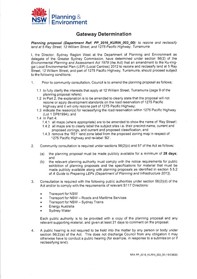
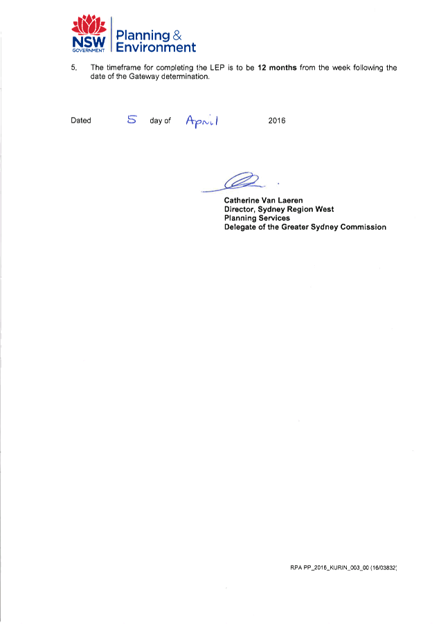
|
APPENDIX
No: 2 - Planning
Proposal - Turramurra - Rezone and Reclassify 5 Ray Street, 12 William Street
and 1275 Pacific Highway - Amended as per Gateway Determination Conditions
for Exhibition
|
|
Item No: GB.9
|
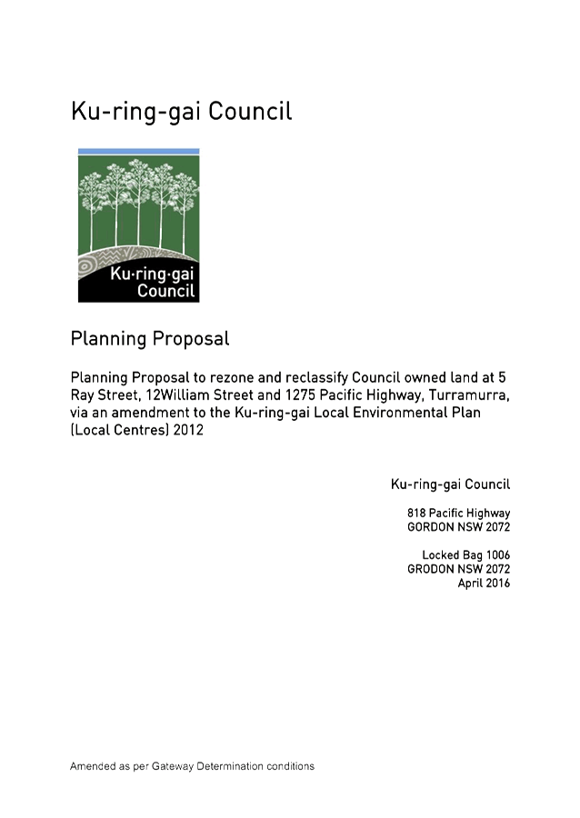

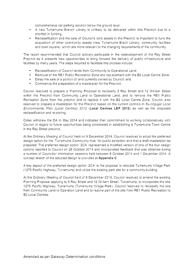
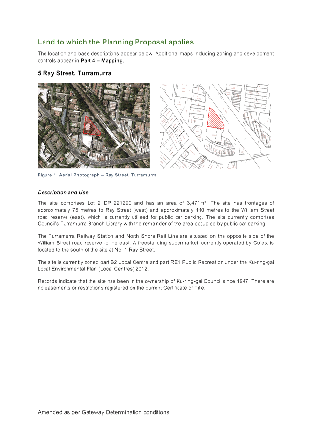
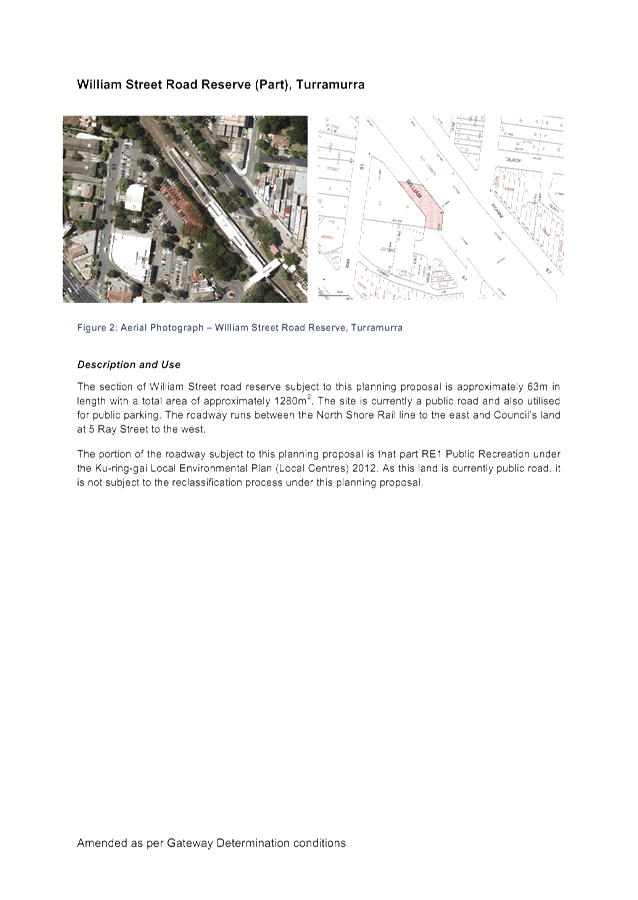
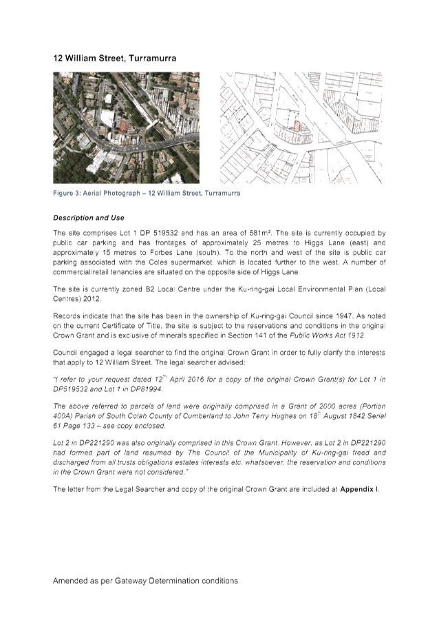
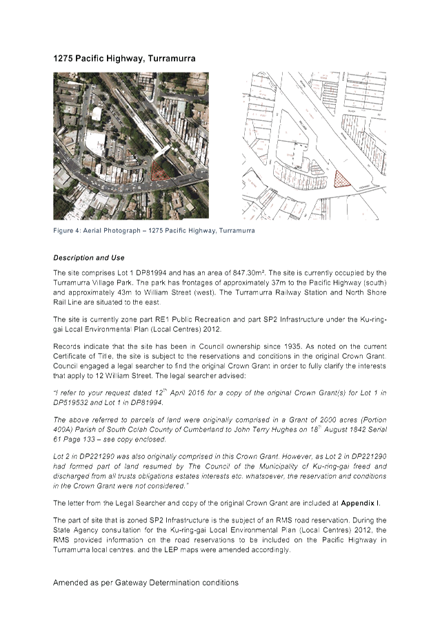
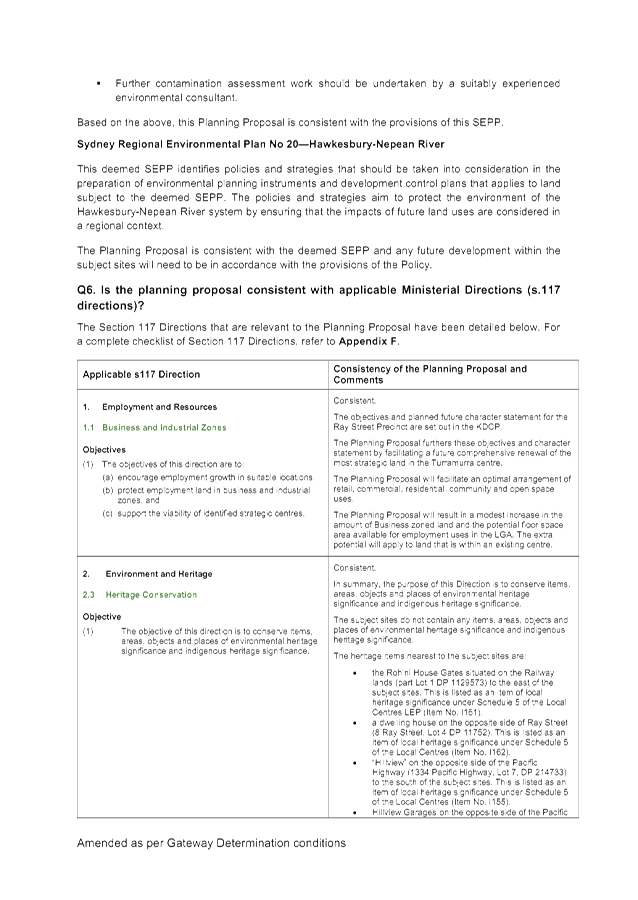
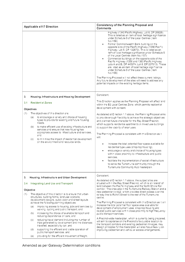
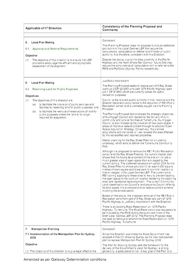
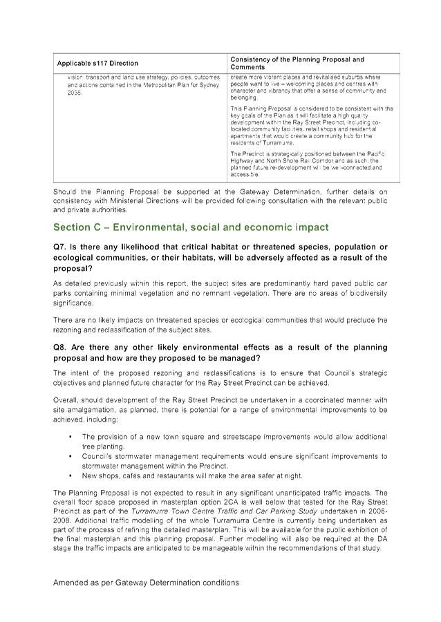
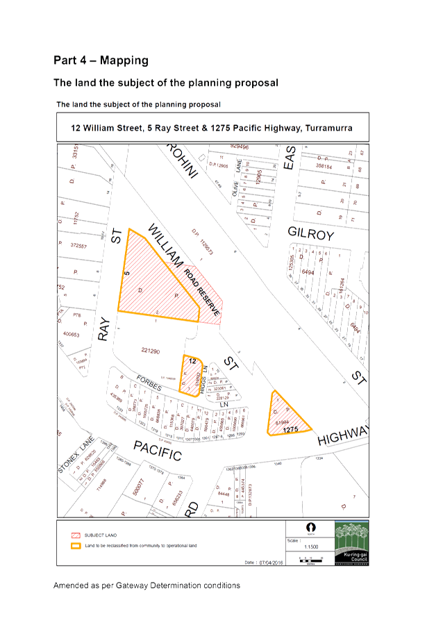
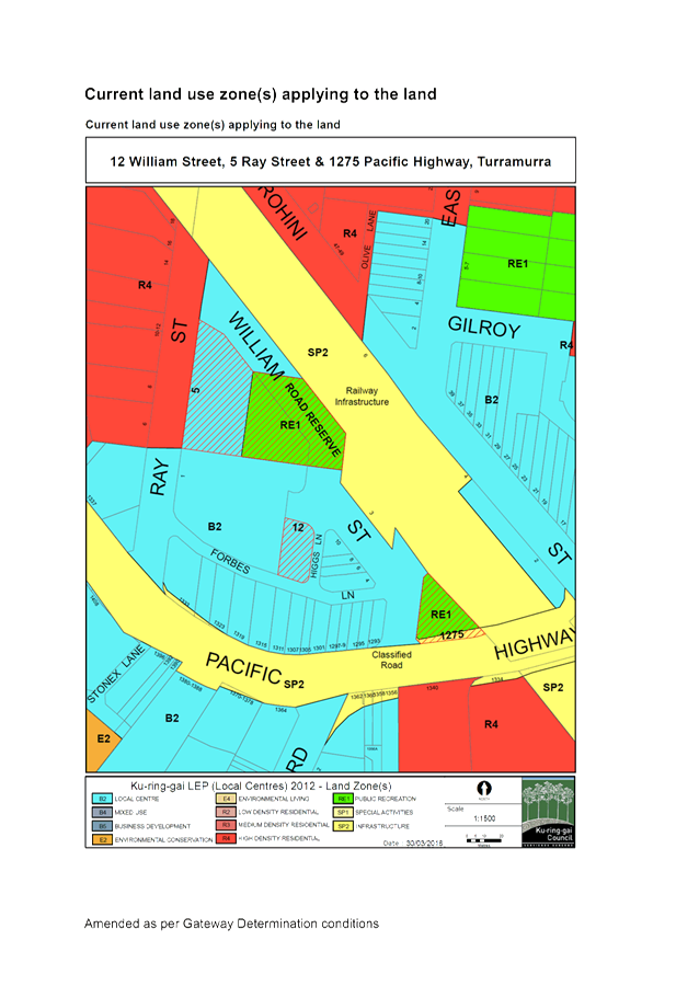
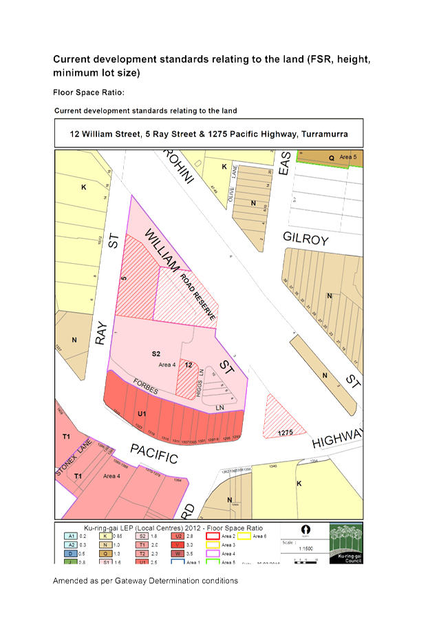
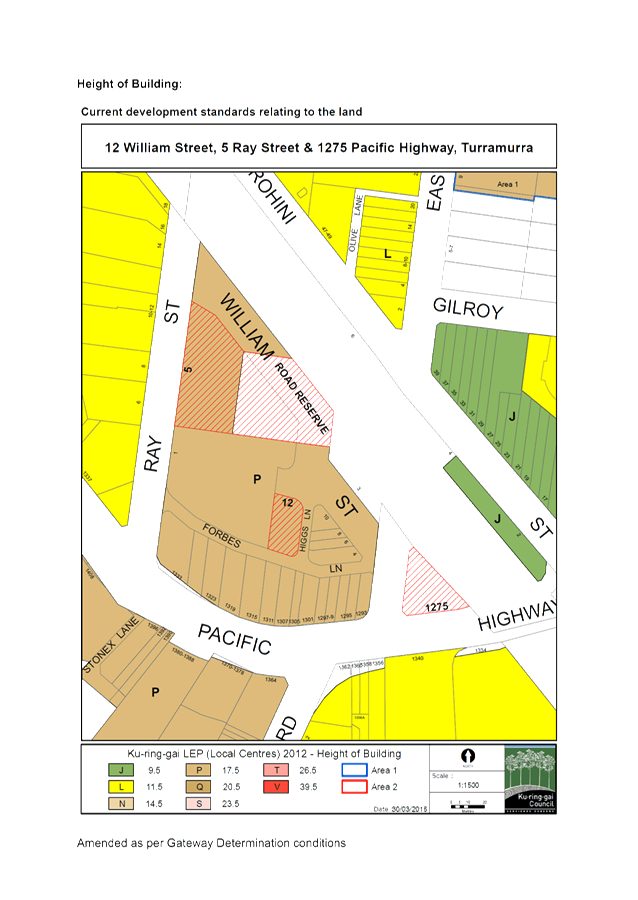
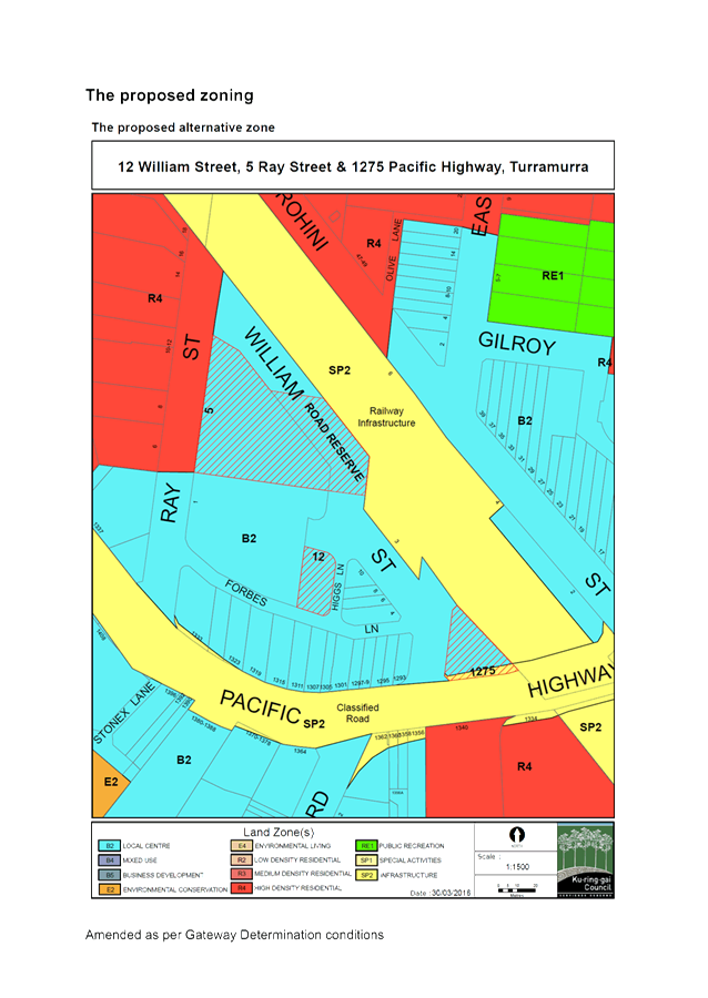
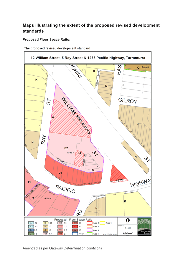
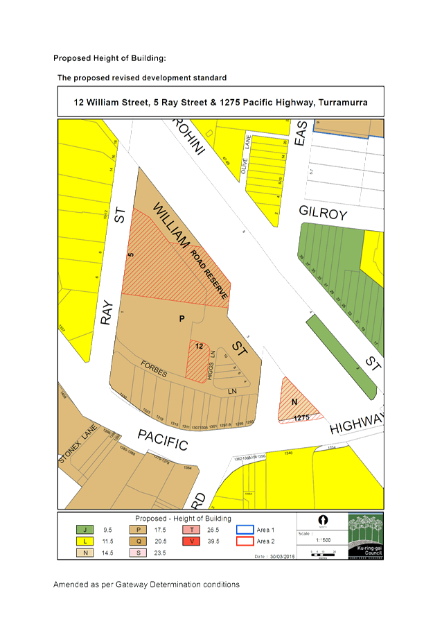
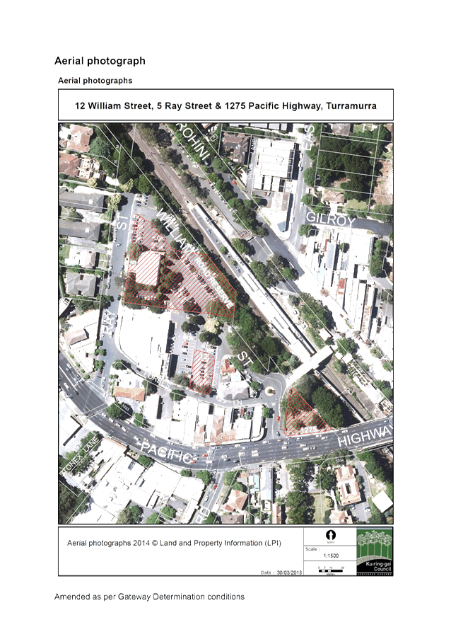
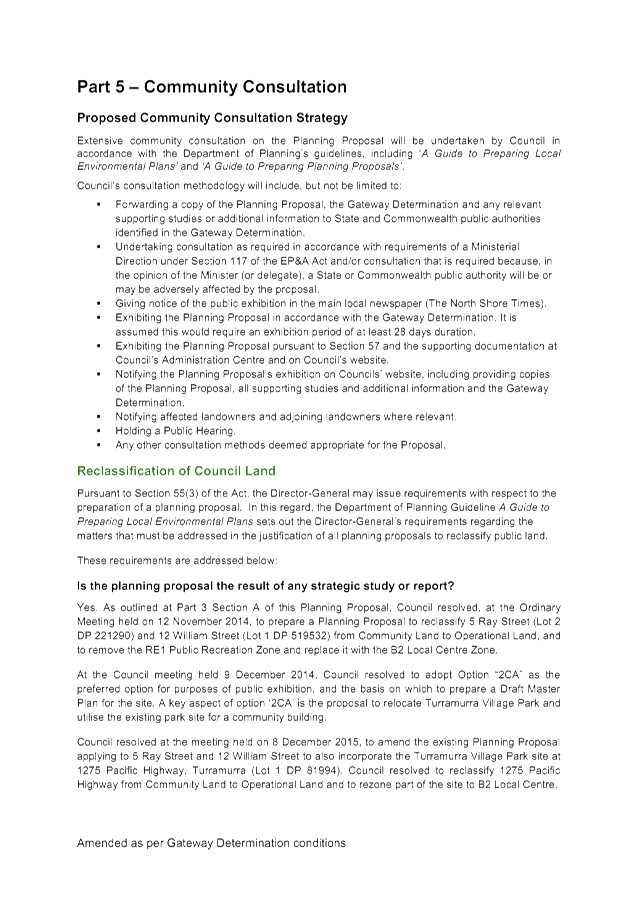


|
APPENDIX
No: 3 - Submission
Summary Table - 1275 Pacific Highway Turramurra
|
|
Item No: GB.9
|
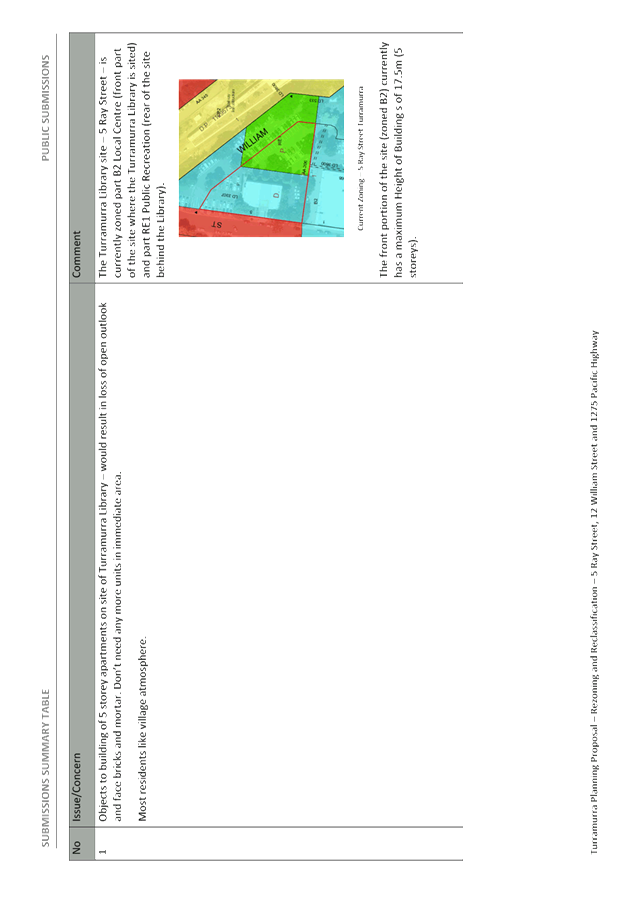
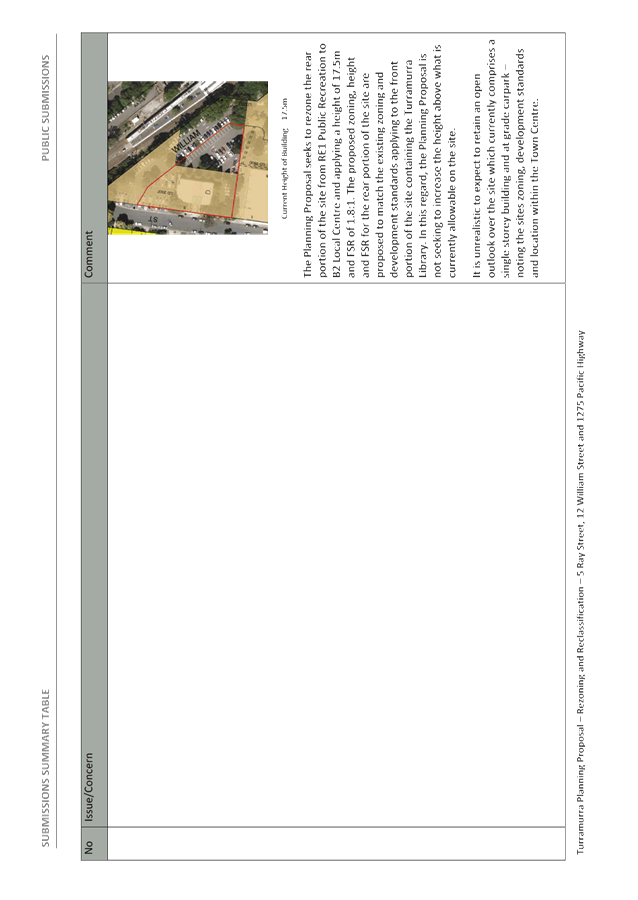
|
APPENDIX
No: 4 - Summary
State Agency Submissions
|
|
Item No: GB.9
|

|
APPENDIX
No: 5 - KMC
Public Hearing Report 1275 Pacific Highway Turramurra
|
|
Item No: GB.9
|

|
APPENDIX
No: 7 - Turramurra
Master Plan - prepared by Chrofi
|
|
Item No: GB.9
|
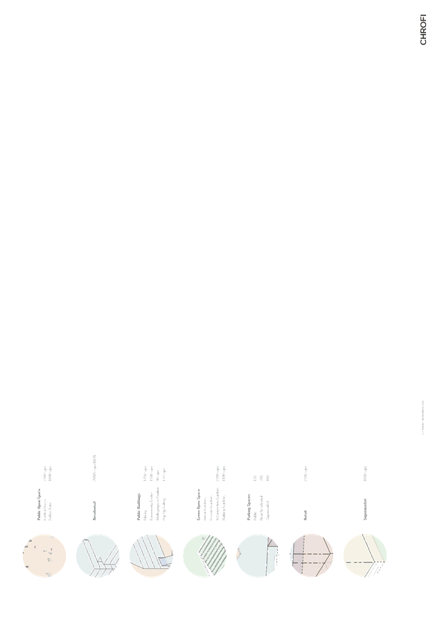
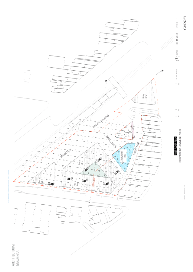
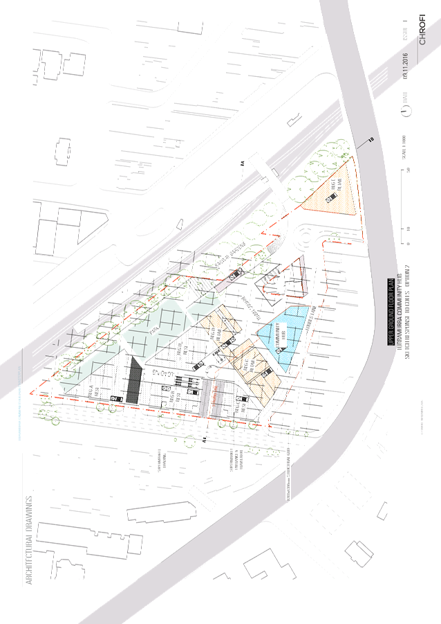
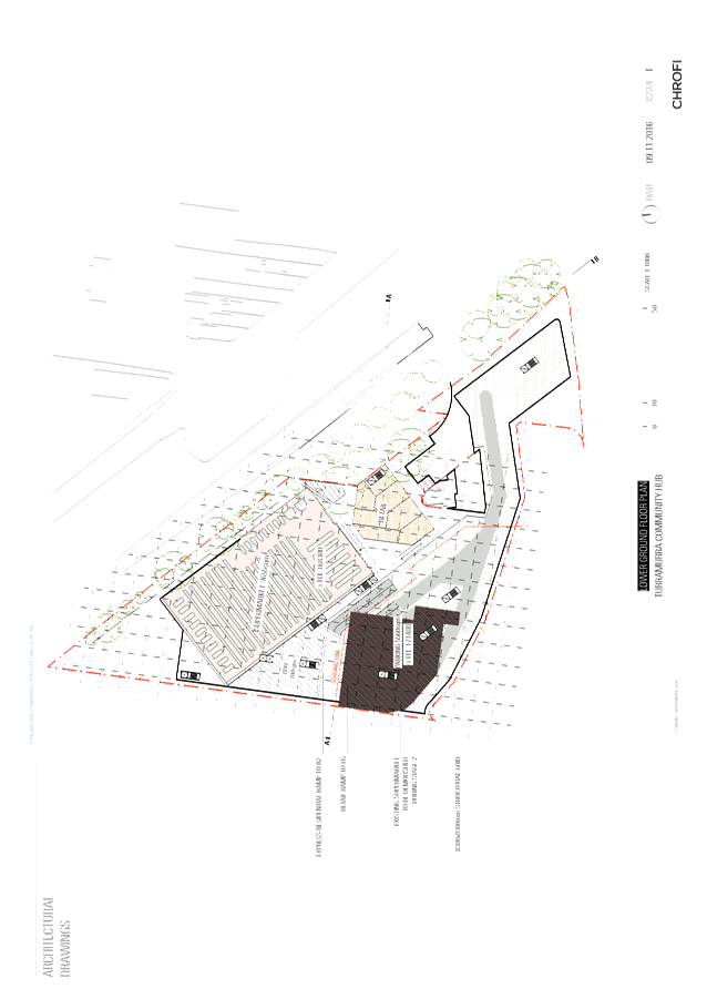
|
Ordinary
Meeting of Council - 7 February 2017
|
GB.10 / 371
|
|
|
|
|
Item
GB.10
|
S10147
|
|
|
15 December 2016
|
Fitzsimons Lane Gordon - Draft Voluntary
Planning Agreement for 904-914 Pacific Highway Gordon - Post Exhibition Report
EXECUTIVE
SUMMARY
|
purpose of report:
|
To report back following the exhibition of the Draft
Planning Agreement for 904-914 Pacific Highway Gordon.
|
|
|
|
|
background:
|
The Local Centres Development Control Plan and Public Domain
Plan make provision for the widening of Fitzsimons Lane for improved
vehicular access and pedestrian amenity. Ku-ring-gai Contributions Plan
2010 makes provision for the completion of the streetscape works but not the
acquisition of the land because it minimises the costs of acquisition to
enable the developments to retain the potential to utilise the floor space of
the sliver of land involved and to dedicate the residual portion free of
cost.
|
|
|
|
|
comments:
|
Following the extended statutory exhibition period,
the Draft Planning Agreement is now being reported back to Council for
approval to execute it and complete the dedication process.
|
|
|
|
|
recommendation:
|
That Council resolves to enter into the Planning Agreement
with WN Developments Pty Ltd as specified within the attached document to
facilitate the dedication of land for the purposes of widening Fitzsimons
Lane Gordon and delegation be granted to the General Manager and Mayor to
execute the Planning Agreement, under Common Seal.
|
Purpose of Report
To report back following the exhibition of the Draft
Planning Agreement for 904-914 Pacific Highway Gordon.
Background
This report follows the statutory exhibition of the Draft
Planning Agreement for 904-914 Pacific Highway Gordon for the purposes of
dedicating land along the Fitzsimons Lane frontage. The intention is to
allow for the widening Fitzsimons Lane and the delivery of future public domain
improvements including improvements to the pedestrian environment.
This is the first of three current or prospective planning
agreements allowing for land dedication to facilitate the widening of
Fitzsimons Lane and future public domain improvements. Letters of offer have
been received for the other two properties.
Planning
for Gordon Local Centre
As part of the strategic planning framework for Gordon,
provisions were made for the rather angular Fitzsimons Lane, which narrows near
the intersection with Merriwa Street, to be widened and realigned to provide
improved vehicular access and pedestrian amenity to this area of Gordon.
The area around Fitzsimons Lane is undergoing significant urban renewal with
ten consolidated properties either under construction, under DA or
pre-DA.
Until recently this area was primarily commercial in nature,
with multi-storey corporate offices. The redevelopment of this mixed-use
zoned area has seen primarily residential redevelopment including mainly ground
floor non-residential floor space for professional consulting rooms,
cafés, small convenience retail uses and local service uses.
Extract from the Public Domain Plan 2010 showing the
location of the area targeted for widening
The strategic planning documents including the Local Centres
Development Control Plan, the Public Domain Plan and the supporting
Contributions Plan, collectively envisaged that the development potential of
that narrow sliver of land would be available to the development site,
stripping its market value and facilitating its dedication in the most cost
effective manner – enabling the contribution plan to focus on the
delivery of high quality public domain works.
As the land itself is therefore not valued by the
contribution plan, a Planning Agreement approach is triggered to facilitate the
dedication. This is the first Draft Planning Agreement reported for
adoption and execution as part of this process.
The intention of the dedications is to facilitate the widening
of Fitzsimons Lane to 15 metres where it currently narrows close to the
intersection with Merriwa Street to facilitate traffic and pedestrian
improvements, particularly the latter to activate the lane.
The Draft Planning Agreement itself is a relatively
straightforward document compared to planning agreements that facilitate the
delivery of works and infrastructure; this agreement relates only to the
dedication, free of cost, of a sliver of land in a triangular shape, totalling
82.5sqm, and stretching 34.69 metres along the Fitzsimons Lane frontage.
Comments
Previous Council Report
and Exhibition
At the Ordinary Meeting of Council on Tuesday 6 December
2016, Council resolved as follows:-
A. That
public notice of the exhibition of the draft Planning Agreement and
Explanatory Note relating to the property at 904-914 Pacific Highway Gordon for
the purposes of facilitating a land dedication along the frontage to Fitzsimons
Lane be duly given, and a copy of those documents be made available for inspection,
in accordance with the Environmental Planning and Assessment Act 1979 and the
Environmental Planning and Assessment Regulation 2000.
B. That
a report be brought back to Council following the statutory exhibition process.
C. That
delegation be granted to the General Manager or his delegate to make any
administrative changes to the document that do not alter the overall intent in
order to facilitate exhibition and to protect Council’s interests.
D. That
the letter of offer to enter into a planning agreement for the dedication of
land along the frontage to Fitzsimons Lane of the property located at 900
Pacific Highway Gordon in association with DA0226/16 be noted and authority be
delegated to the General Manager or his delegate to progress the draft planning
agreement in discussions with the applicant.
E. That
the design process for the Fitzsimons Lane public domain improvements commence
as soon as practicable in 2017.
F. That
the General Manager or his delegate be authorised to proactively pursue the
completion of the negotiations for the draft planning agreement for the
remaining property at 870-898 Pacific Highway which also has rear frontage to
Fitzsimons Lane which has recently been on-sold, in line with the original
letters of offer from the former property owner, with a view to enabling the
public domain works to Fitzsimons Lane to be delivered concurrently and in the
short term.
The first three resolutions relate to the Draft Planning
Agreement for 904-914 Pacific Highway Gordon that is the subject of this
report.
The Draft
Planning Agreement for 904-914 Pacific Highway Gordon
The Draft Planning Agreement Attachment A1 and the
associated Explanatory Note (included within the document) are relatively
straightforward documents in that they simply facilitate and explain the
dedication of an identified area of land free-of-cost to council. They
record the nature of the understanding between the developer and Council.
For example, Council can only use the land for the purposes of works to the
carriageway, both vehicular and pedestrian and associated street landscaping
works in Fitzsimons Lane. This is in accordance with the Local Centres
DCP and Public Domain Plan.
Importantly the Draft Planning Agreement does not include
works to deliver the public domain improvements; however, Council should
instigate the design process early in 2017 given the progress of a substantial
percentage of the anticipated redevelopment in the Fitzsimons Lane precinct,
preparatory to commencing the delivery phase.
Extended Exhibition
In accordance with the resolution, the Draft Planning
Agreement and accompanying Explanatory Note was placed on public exhibition
from Thursday 15 December 2016 to Tuesday 24 January 2017 inclusive. At
the close of the exhibition period, no submissions were received.
Attached Plan of
Subdivision
In view of the time constraints and the importance of
exhibiting this Draft Planning Agreement prior to the end of the year, the
attachment to the exhibition was a plan of subdivision including all three
development sites affected by the Fitzsimons Lane widening. This
necessitated clarification that the Draft Planning Agreement related to only
one of the three properties.
Council’s surveyor has now distilled this single
survey plan of three properties into three separate survey plans so that each
affected property has a separate survey plan. Other than the division of
the properties, the details remain the same as exhibited for the sole property
that is the subject of this VPA being 904-914 Pacific Highway Gordon.
The legal teams representing both Council and the developer
are in general agreement that the plan relating only to the relevant property
and including the same details as exhibited in the larger plan can be included
at this juncture. Now that a separate plan exists, it would be
inappropriate to include a survey plan illustrating other properties that are
still the subject of negotiations.
Minor amendments could still be made to the survey plan
prior to lodgement to satisfy any additional requirements of the subdivision
process including ensuring that the land becomes part of a public road and into
Council’s ownership on registration.
integrated
planning and reporting
Theme Three:
Places, Spaces and Infrastructure
|
Community
Strategic Plan
Long Term Objective
|
Delivery
Program
Term Achievement
|
Operational Plan
Task
|
|
P2.1 A robust planning framework
is in place to deliver
quality design outcomes and maintain the identity and character of Ku-ring-gai
|
Strategies,
plans and processes are in place to
effectively manage the impact of new development
|
P8.1.1.1.1.1-2
Ku-ring-gai Contributions Plan
2010 ensures new development
contributes towards the cost of delivering supporting
infrastructure.
|
|
P4.1 Our centres offer a broad
range of shops and
services and
contain lively urban village spaces where people can live,
work, shop,
meet and spend leisure time
|
Plans to revitalise local
centres are being progressively implemented and achieve quality design outcomes in collaboration with key
agencies,
landholders and
the
community
|
C6.1.2.1.2; C4.1.2.1.3
New public infrastructure is planned to support
new development and ensure that everyone who lives and works in Ku-ring-gai
continues to
enjoy access to public facilities.
|
|
P8.1 An
improved standard of infrastructure that meets the community’s service
level standards and Council’s obligations as the custodian of our
community’s assets
|
Our public
infrastructure and assets are planned, managed and funded to meet community
expectations, defined levels of service and address inter-generational equity
|
C6.1.2.1.2; C4.1.2.1.3
New public infrastructure is planned to support
new development and ensure that everyone who lives and works in Ku-ring-gai
continues to
enjoy access to public facilities.
|
Theme Four: Access, Traffic and Transport
|
Community
Strategic
Plan
Long Term Objective
|
Delivery Program
Term Achievement
|
Operational Plan
Task
|
|
T1.1 A range of integrated transport choices are available to enable effective movement to,
from and around
Ku-ring-gai.
T3.1 An accessible public transport and
regional
road network that meets the diverse and changing needs of the community.
|
A network of safe and
convenient links to local centres,
major land uses and
recreational opportunities is
in place
A strategic
access, traffic
and
transport plan is being implemented for the
Northern Sydney Region
|
T 1.1.3.1.1
Link roads
and road widening.
|
Theme Six:
Leadership and Governance
|
Community
Strategic
Plan
Long Term Objective
|
Delivery Program
Term Achievement
|
Operational Plan
Task
|
|
L2.1 Council rigorously
manages its financial resources and assets to
maximise delivery of services
|
Council expenditure satisfies
the needs of the community and Council has
increased its commitment to infrastructure asset management priorities
|
C6.1.1.1.2
Council is leveraging the value of its assets to
combine with contributions to deliver major community assets.
|
FIT FOR THE FUTURE IMPROVEMENT ACTION
PLAN
This matter relates to
‘business as usual’ for Ku-ring-gai Council continuing to work
towards the delivery of infrastructure to support redevelopment in the LGA.
Governance Matters
The negotiation of the Draft Planning Agreement was
commenced under the Planning Agreement Policy 2008. Since then, the
Planning Agreement Policy 2016 has been exhibited and adopted.
The Draft Planning Agreements have been prepared with input
from Urban Planning, the Property Unit and the Corporate Lawyer. Council
appointed Wiltshire Webb Staunton Beattie Lawyers to act on their behalf.
The developers for the first Draft Planning Agreement that is proposed to be
exhibited were represented by Addisons Lawyers.
Risk Management
Council has commissioned an external legal team to assist
with the drafting of the Planning Agreements.
Financial Considerations
The strategic planning for the widening of Fitzsimons Lane
foreshadowed that the associated developments would retain the opportunity to
utilise the floor space potential of the land to be dedicated thus negating its
market. This is a cost-effective means of facilitating the dedication of
land free of cost. The land area is very small, only 82.5sqm, but its
dedication will enhance the pedestrian presentation of the new development to
Fitzsimons Lane.
There is a cost in terms of the recommended scheduling of
the design and delivery of the works in the 2017/2018 to 2018/2019 financial
year in the Long Term Financial Plan however, it should be noted, that with ten
out of thirteen properties with frontage to Fitzsimons Lane being the subject
of development proposals and many nearing completion of construction, that the
development contributions for the delivery of this work have been received and,
as such, it is timely to schedule the delivery of this work in the near future.
Social Considerations
The widening of Fitzsimons Lane will facilitate an improved
vehicular and pedestrian environment as this area rapidly transitions from an
employment area to a mixed use zone featuring predominantly residential
development. These improvements have long been envisaged in the original
Local Centres Development Control Plan and the Public Domain Plan and are now
coming to fruition concurrent with redevelopment under the Local Centres LEP.
Environmental Considerations
The Draft Planning Agreement that is the subject of this
report involves land dedication only. The design of the public domain
improvements should be instigated in parallel with these latest redevelopments
ready to commence delivery concurrent with their completion.
Environmental considerations are a core component of the detailed design of all
Council’s public domain improvement works.
Community Consultation
The Draft Planning Agreement together with its explanatory
note and draft plan of subdivision was placed on statutory exhibition on Thursday
15 December 2016. The exhibition was extended in view of the holiday
period and concluded on Tuesday 24 January 2017.
The exhibition was advertised in the North Shore Times and a
letter was sent to all the properties that had been notified as part of the
original Development Application on the subject property but with updated
details from the current property database. This process resulted in 762
letters being sent to owners and occupiers of surrounding properties. At
the close of the extended exhibition period, no submissions had been received.
Internal Consultation
The Draft Planning Agreement has been prepared in
consultation between officers of Urban Planning and the Property Unit and
Council’s Corporate Lawyer. Council engaged additional legal
support from Wiltshire Webb as well as the services of a surveyor.
Summary
It is recommended that the Draft Planning Agreement be
adopted unchanged from the exhibition version with one exception. It is
recommended that the draft survey plan illustrating the Fitzsimons Lane
frontage of three separate properties which are each the subject of three
separate negotiation processes, be replaced by the survey plan showing only the
property that is the subject of this Planning Agreement.
It is noted that, in respect of this property, the
information shown on each survey plan in relation to the wedge-shaped sliver of
land of 82.5sqm to be dedicated along 34.69m of the present Fitzsimons Lane
boundary is essentially the same. The more detailed plan is able to
include additional details relating to the property as a whole. This
facilitates the next processes that are intended to shortly follow execution,
which are the subdivision and the dedication of Lot 1 to Council as that takes
effect.
|
Recommendation:
A. That
Council resolve to enter into the Planning Agreement with WN Developments Pty
Ltd as specified within Attachment A1 to facilitate the dedication of
land for the purposes of widening Fitzsimons Lane Gordon.
B. That
the Council grant delegation to the General Manager and Mayor to execute the
Planning Agreement, under Common Seal.
C. That
delegation be granted to the General Manager or his delegate to make any
minor administrative changes to the document that do not alter the overall
intent in order to protect Council’s interests.
D. That
delegation be granted to the General Manager or his delegate to authorise any
minor changes to the survey drawing and associated administration sheets to
ensure the objectives of the VPA are fulfilled in the most practical and
efficient manner.
E. That
the Planning Agreement register be updated to include the Planning Agreement
for 904-914 Pacific Highway Gordon on execution.
|
|
Kate Paterson
Infrastructure Co-ordinator
|
Antony Fabbro
Manager Urban & Heritage Planning
|
|
Andrew Watson
Director Strategy & Environment
|
|
|
Attachments:
|
A1
|
Draft
Planning Agreement as Exhibited
|
|
2016/330008
|
|
|
A2
|
Draft
Plan of Submission for Attachment to Planning Agreement
|
|
2017/018292
|
|
APPENDIX No: 1 - Draft
Planning Agreement as Exhibited
|
|
Item No: GB.10
|

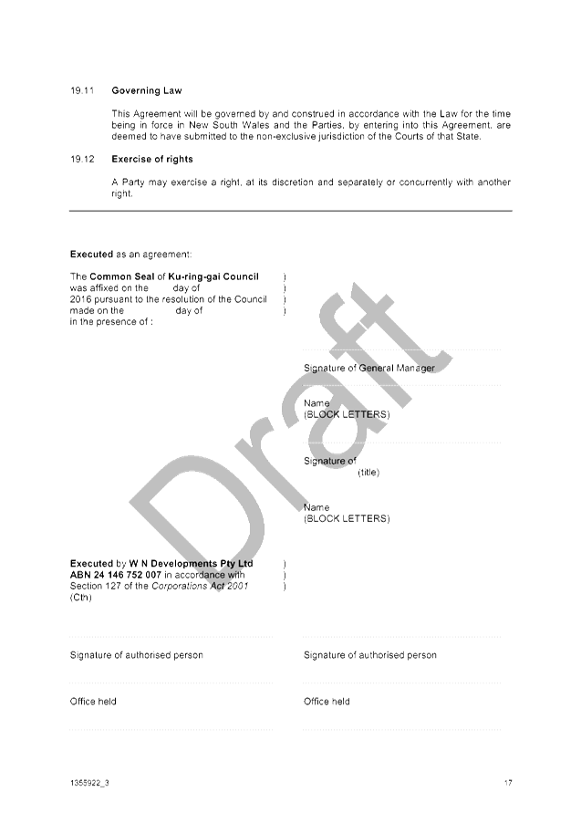


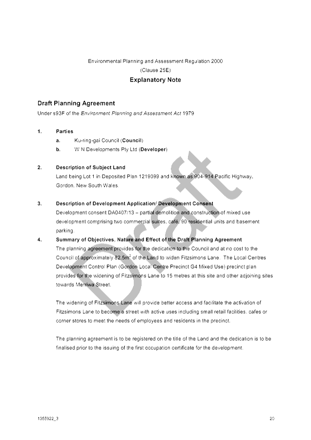
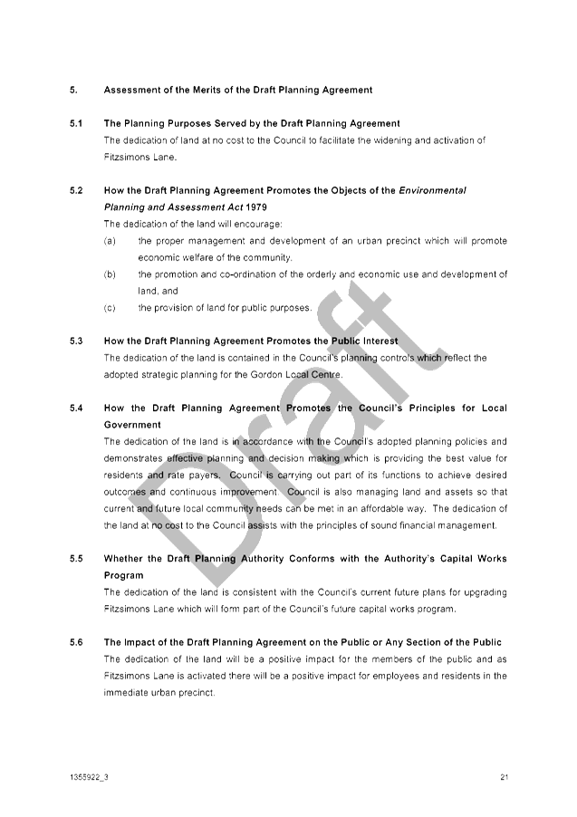
|
APPENDIX
No: 2 - Draft
Plan of Submission for Attachment to Planning Agreement
|
|
Item No: GB.10
|
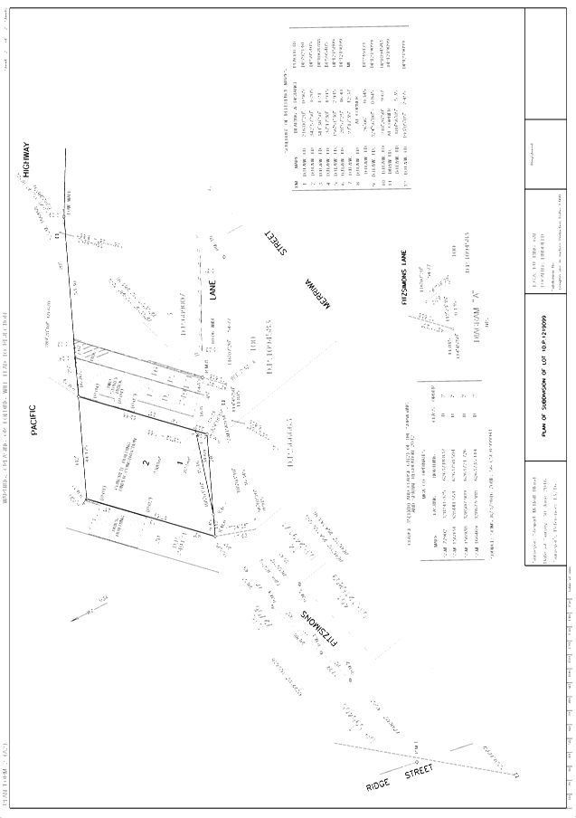
|
Ordinary
Meeting of Council - 7 February 2017
|
GB.11 / 403
|
|
|
|
|
Item
GB.11
|
S10894/2
|
|
|
12 December 2016
|
Tender T06/2016 - NTRA Sportsfield Car
Park and Landscape Works
EXECUTIVE
SUMMARY
|
purpose of report:
|
To consider the tenders received for the construction
of NTRA Sportsfield Car Park and Landscape works and appoint the preferred
tenderer.
|
|
|
|
|
background:
|
Council as part of the Open Space Capital Works
Program approved funding for the redevelopment of NTRA including the
construction of a new car park which will also provide additional netball
training facilities adjacent to the newly constructed sports fields. Tender
documents were prepared and released through Tenderlink on 1 November 2016
with a closing date of 6 December 2016.
|
|
|
|
|
comments:
|
Tender documents were produced with four (4)
submissions received. The submissions were assessed using agreed
criteria which identified the best value to Council.
|
|
|
|
|
recommendation:
|
In accordance with Section 55 of the Local Government
Act and Tender Regulations, it is recommended that Council accept the tender
submitted by Tenderer ‘A’.
|
Purpose of Report
To consider the tenders received for the construction of
NTRA Sportsfield Car Park and Landscape works and appoint the preferred
tenderer.
Background
Council as part of the Open
Space Capital Works Program approved funding for the redevelopment of NTRA
including the construction of a new car park which will also provide additional
netball training facilities adjacent to the newly constructed sports fields.
Following consultation with internal and external stakeholders, designs and
specifications were finalised with Tender documents being prepared by the
Operations Department and released through Tenderlink on 1 November 2016 with a
closing date of 6 December 2016.
As the cost of the works was
estimated to be over $150,000, Tenders were called using Tenderlink in
accordance with the tender requirements of the Local Government Act and Regulation.
Comments
Four (4) tenders were received
and recorded in accordance with Council’s tendering policy.
Tenders were received from the
following companies:
· All
Civil Solutions Group Pty Ltd
· North
Shore Paving Co Pty Ltd
· Romba
Pty Ltd
· Wade
Civil Engineering Pty Ltd
It should be noted the order
above does not correspond to the order of the list of tenderers named from
‘A’ to ‘D’ in the list of tenders received. (Attachment
1)
A Tender Evaluation Panel
consisting of staff from the Operations and Strategy & Environment
Departments was formed to assess the four (4) tenders received. The
evaluation took into account:
· Conformity
of submission
· lump
sum fee,
· company
and staff experience,
· ability
to provide the full range of services required,
· work
program, and availability,
· previous
performance in relation to similar type work, and
· company’s
financial capacity.
Confidential attachments to this
report include:
· List
of tenders received and additional financial information (Attachment 1),
· Tender
Evaluation Panel’s comments and recommendation (Attachment 2), and
· an
independent Performance and Financial Assessment which was carried out by
Corporate Scorecard Pty Ltd (Attachment 3).
From the four (4) submissions
received and the available information taken into account during the evaluation
and scoring of each element of the assessment, Tenderer ‘A’ was
identified as providing the best value to Council.
In order to ensure Council is
not exposed to financial risk and confirm that Tenderer ‘A’ is
trading in a sound and profitable manner, an independent Performance and
Financial Assessment was carried out by Corporate Scorecard Pty Ltd. The
independent report concluded that Tenderer ‘A’ scored at a level
that was a low risk to Council and are considered to be financially sound and
capable of carrying out these works.
Tenderer ‘A’ was
identified as providing the ‘best value’ to Council.
integrated planning and reporting
Enhance Recreation, Sporting and
Leisure Facilities. Community Strategic Plan Long Term Objective Delivery
Program Term Achievement Operational Plan Task P6.1 Recreation, sporting and
leisure facilities are available to meet the community’s diverse and changing
needs.
A program is being implemented
to improve existing recreational, sporting and leisure facilities and
facilitate the establishment of new facilities and deliver park asset
refurbishment program at priority locations.
|
Community Strategic Plan Long Term Objective
|
Delivery Program
Term Achievement
|
Operational Plan
Task
|
|
P6.1 Recreation, sporting and leisure facilities are
available to meet the community’s diverse and changing needs.
|
A program is being implemented to improve existing recreational,
sporting and leisure facilities and facilitate the establishment of new
facilities.
|
Deliver park asset refurbishment program at priority
locations.
|
Governance Matters
Tender documents were prepared
and released through Tenderlink on 1 November 2016 with a closing date of 6
December 2016. At the close of tender, four (4) tenders were received. All
submissions were recorded in accordance with Council’s tendering policy.
A Tender Evaluation Panel consisting of staff from the Operations Department
and Strategy & Environment Department was formed to assess the four (4)
tenders received. The evaluation took into account:
· Conformity
of submission
· lump
sum fee,
· company
and staff experience,
· ability
to provide the full range of services required,
· work
program, and availability,
· previous
performance in relation to similar type work, and
· company’s
financial capacity.
Confidential attachments to this report include the list of
tenders received, the Tender Evaluation Panel’s comments and
recommendation and the independent Performance and Financial Assessment carried
out by Corporate Scorecard Pty Ltd. The attachments are considered to be
confidential in accordance with Section 10A (2)(d)(iii) of The Local Government Act 1993 as they are considered to contain commercial
in confidence information.
Risk Management
Four (4) key areas of risk were
identified in relation to the proposed work:
· That
work needed to be carried out by a suitably qualified company with experience
of Car park construction.
· Availability
– the company was available to commence work within a few weeks of the
work being awarded.
· Ability
and previous experience of working in close proximity to environmentally
sensitive areas.
· That
Council should not be exposed to financial risk - as part of the evaluation
process, tenderers were assessed on providing all information and costs
requested within the tender document and an independent Performance and
Financial Assessment was carried out on the preferred tenderer to ensure that
they were trading responsibly and had the financial capacity to undertake the
work as detailed within the tender documents.
Following evaluation, including
an independent Performance and Financial Assessment of Tenderer ‘A’
by Corporate Scorecard Pty Ltd, the tenderer assessed as providing the best
value and quality to Council was Tenderer ‘A’. As part of the
independent Financial and Performance Assessment the following areas were
examined:
· Tenderer
‘A’ has the financial capacity to undertake the proposed value of
work;
· that
Tenderer ‘A’ has been trading in a profitable and responsible
manner during the last three (3) years; and
· that
Tenderer ‘A’ has sufficient assets/reserves to cover all possible
debts during the period of work.
The financial aspect of the assessment shows Tenderer
‘A’ is able to satisfy all requirements and is unlikely to expose
Council to any financial risk if awarded the tender as detailed within
Council’s tender documents.
Financial Considerations
Council’s allocated funds within the Capital Works
Program 2016/2017 for the construction of a new car park at NTRA Sportfields
which has been designed to allow on completion additional facilities for
netball training when not in use as a car park. The proposed is essential to
provide parking facilities for the newly completed sports and training fields,
these consisting of both natural turf and synthetic fields.
During the planning and design stages of NTRA, it was always
identified that additional parking would be required for the new sportsfields.
Following the tender assessment additional funding will be required over the
present available funds. The additional funding required will be allocated from
the 2017 / 2018 budget.
A breakdown of the proposed funds required for the project
is shown on the confidential attachment - Tender Evaluation Panel’s
comments and recommendation (Attachment 2).
Social Considerations
Following the redevelopment of the North Turramurra
Recreational Area which includes three new sports fields and training areas
there is an expectation that it will be extensively used by the local
community. The new facilities have been designed to provide for families,
individuals, schools and club use and to provide for both social and
competition sport at many levels. As part of expected increased use of the site
it has been identified that the existing parking facilities need to be
extended.
The proposed works are in accordance with Council’s
adopted plan for NTRA. The proposed works will substantially improve the
recreational value, improve general access and safety and create greater
opportunities for social interaction as well as providing health and wellbeing.
Public access and use of the new sports field will be impacted during the
construction although it will not be necessary to completely close the sports
field during the construction period.
Environmental Considerations
The construction works are
being carried out as part of the redevelopment works of North Turramurra
Recreational Area and will not impact on the surrounding areas. The proposed
works aim to provide not only car park facilities but also provide additional
netball training facilities. As part of standard construction works and
practices, suitable environmental management controls will be implemented by
the appointed contractor during the works. All works will be undertaken in
accordance with already prepared environmental assessments.
Community Consultation
As part of the redevelopment of NTRA community and sports
club consultation has been carried out prior to finalising the present proposed
design.
The design aims to provide improved additional car parking
facilities which will also double up as netball training facilities. Prior to
the commencement of on-site works, local residents and user groups will be
advised of the commencement of works and be provided with a time estimate for
the completion of the works.
Internal Consultation
Consultation was undertaken and included officers from
Strategy & Environment Department, Operations and Community Departments all
being consulted.
Summary
Following internal and external consultation, final
preparation of plans and specification took place with tender documents being
released through Tenderlink on 1 November 2016 with a closing date for receipt
of tenders of 6 December 2016.
A Tender Evaluation Panel was formed consisting of
representatives from Operations Department and Strategy & Environment
Department. At the close of tender, four (4) tenders were received. All tenders
were recorded in accordance with Council’s tendering policy.
Following the evaluation and independent performance and
financial check, it is recommended Tenderer ‘A’ be appointed on the
basis of providing the best quality and value to Council.
|
Recommendation:
A. That
Council accept the tender submission from Tenderer ‘A’ to carry
out the construction of the NTRA Sportsfield Car Park and Landscape works, Bobbin Head Road, North Turramurra.
B. That
the Mayor and General Manager be delegated authority to execute all tender
documents on Council’s behalf in relation to the contract.
C. That
the Seal of Council be affixed to all necessary documents.
D. That
all tenderers be advised of Council’s decision in accordance with
Clause 178 of the Local Government Tendering Regulation.
|
|
David Morris
Manager Projects
|
Matthew Drago
Acting Director Operations
|
|
Attachments:
|
A1
|
List
of Tenders received
|
|
Confidential
|
|
|
A2
|
Tender
Evaluation Panel's recommendation
|
|
Confidential
|
|
|
A3
|
Corporate
Scorecard Assessments
|
|
Confidential
|
|
Ordinary
Meeting of Council - 7 February 2017
|
GB.12 / 409
|
|
|
|
|
Item
GB.12
|
S05650
|
|
|
12 December 2016
|
Council Sponsorship -Turramurra Rotary
Graffiti Removal Program 2016/2017
EXECUTIVE
SUMMARY
|
purpose of report:
|
To seek Council’s endorsement to provide
additional funding to Turramurra Rotary for the cleaning of graffiti from
business and private property in the Turramurra and St Ives area.
|
|
|
|
|
background:
|
Turramurra Rotary established a volunteer graffiti
removal service to assist the community with the cleaning of graffiti from
businesses and private property in the Turramurra area. They are now also
assisting St Ives Rotary with the cleaning of graffiti in the St Ives area.
|
|
|
|
|
comments:
|
Turramurra Rotary is seeking additional funding of
$5,000 to help continue their service. As there is no funding available in
the sponsorship budget, the funding will need to be provided from the
Building Maintenance Budget.
|
|
|
|
|
recommendation:
|
That Council approve the request from Turramurra
Rotary for $5,000 with funds to be provided from the Building Maintenance
Recurrent Budget.
|
Purpose of Report
To seek Council’s endorsement to provide additional
funding to Turramurra Rotary for the cleaning of graffiti from business and
private property in the Turramurra and St Ives area.
Background
Turramurra Rotary established a volunteer graffiti removal
service to assist the community with the cleaning of graffiti from businesses
and private property in the Turramurra area. They are now also assisting St
Ives Rotary with the cleaning of graffiti in the St Ives area.
Comments
Turramurra Rotary is seeking additional funding of $5,000 to
help continue their service. As there is no funding available in the
sponsorship budget, the funding will need to be provided from the Building
Maintenance Recurrent Budget.
integrated planning and reporting
A range of well planned, clean
and safe neighbourhoods and public spaces designed with a strong sense of
identity and place.
|
Community Strategic Plan Long Term Objective
|
Delivery Program
Term Achievement
|
Operational Plan
Task
|
|
Opportunities are provided to
our community to contribute to plans for enhancing the local area and visual
amenity of our centres.
|
Develop an agreed level of
service for removal of graffiti and cleaning of areas to instil community
pride.
|
Oversee graffiti removal
response and report six monthly on actual vs targets for removal of graffiti
on public land.
|
Governance Matters
Not applicable
Risk Management
The funding is required to assist with the continuation of
the cleaning of graffiti from businesses and private property. If funding is
not available, the service would be able to continue.
Financial Considerations
As there are no funds available in the sponsorship budget
for 2016/17, funding will need to be provided from the Building Maintenance
Recurrent Budget.
Social Considerations
The regular cleaning of graffiti by Council and the Service
groups helps to deter vandalism and also improves the appearance of the area.
Environmental Considerations
Cleaning of graffiti on a regular basis helps deter
vandalism and improves the amenity and environment of the area.
Community Consultation
Not applicable
Internal Consultation
Consultation has taken place with staff from Community who
have advised there is no funding available in the sponsorship budget for the
request.
Summary
Turramurra Rotary established a volunteer graffiti removal
service to assist the community with the cleaning of graffiti from businesses
and private property in the Turramurra area. They are now also assisting St
Ives Rotary with the cleaning of graffiti in the St Ives area.
Turramurra Rotary is seeking additional funding of $5,000 to
help continue their service. As there is no funding available in the
sponsorship budget, the funding will need to be provided from the Building
Maintenance Recurrent Budget.
|
Recommendation:
That Council approve the request from Turramurra Rotary
for $5,000 with funds to be provided from the Building Maintenance Recurrent
Budget.
|
|
Greg Piconi
Director Operations
|
|
|
Attachments:
|
A1
|
Sponsorship
Agreement - Turramurra Rotary Graffiti Removal Program
|
|
2016/354138
|
|
APPENDIX No: 1 - Sponsorship
Agreement - Turramurra Rotary Graffiti Removal Program
|
|
Item No: GB.12
|