Ordinary
Meeting of Council
TO
BE HELD ON Tuesday, 27 June 2017 AT 7:00 pm
Level
3, Council Chamber
Agenda
** ** ** ** ** **
NOTE:
For Full Details, See Council’s Website –
www.kmc.nsw.gov.au
under the link to business papers
APOLOGIEs
DECLARATIONS OF INTEREST
Confirmation of Reports to be
Considered in Closed Meeting
NOTE:
A That in accordance
with the provisions of Section 10 of the Local Government Act 1993, all
officers’ reports be released to the press and public, with the exception
of the confidential attachment to the following General Business report:
GB.8 259-271 Pacific Highway, Lindfield - Lindfield
Library Site
Attachment A1: Valuation of Lindfield Library site
In accordance with s10A(2)(c)
B That in accordance
with the provisions of Section 10 of the Local Government Act 1993, all
officers’ reports be released to the press and public, with the exception
of the following confidential report and its attachment:
C.1 General
Manager Performance Review
In
accordance with s10A(2)(a)
Attachment A1: GM Performance
Agreement - 2017 Annual Report - Final version for report to Council
In accordance s10A(2)(a)
Address the Council
NOTE: Persons
who address the Council should be aware that their address will be tape
recorded.
Documents Circulated to Councillors
CONFIRMATION OF MINUTEs
Minutes of Ordinary
Meeting of Council 10
File:
S02131
Meeting
held 13 June 2017
Minutes
numbered 123 to 140
minutes from the Mayor
MM.1 Queen's
Birthday Honours 2017 22
File: S02767
I am pleased to inform you that13
Ku-ring-gai citizens, through their outstanding achievements and services to
the community, have been awarded 2017 Queen’s Birthday Honours.
We are very proud to have these
dedicated and talented Australians as members of the Ku-ring-gai community.
I would like to read to you the
names of these special Ku-ring-gai citizens and, on behalf of Council,
congratulate them on their excellent contributions to Australian society.
Richard James ALCOCK AO of
Warrawee, for distinguished service to the community, particularly through
health management roles, and to the law, corporate governance, and higher
education organisations
Ian Clifton CARROLL AM of
Killara, for significant service to conservation, particularly through
management of the built, cultural and natural heritage sector
Valerie Marie DOYLE OAM
of Turramurra, for service to the community through the Australian Red Cross
Joan Helen HARRIS OAM of
Wahroonga, for service to community history
Paul Ronald HEATHER
AM of North Turramurra, for significant service to the building and
construction industry through leadership of professional bodies, and to
industry based education
Ian Perry HYMAN OAM of
Warrawee, for service to people with disability
Victoria Eva KVISLE OAM
of Killara, for service to cancer research organisations, and to the
community
Robert Allan LOVE AM of
South Turramurra, for significant service to the performing arts,
particularly in Western Sydney, as an administrator, and as a supporter of
independent artists
Ashak Nanji NATHWANI
AM of Wahroonga, for significant service to the Ismaili community in
Australia, to tertiary education in the area of sustainable design, and to
engineering.
David Robert RICHES PSM
of Lindfield, for outstanding public service to the built infrastructure in
New South Wales
Reginald Phillip ST LEON
OAM of Wahroonga, for service to the multicultural community, and to
education
Antony John VARRALL OAM
of Turramurra, for service to people with a disability
Bann Myra YOUL OAM of
East Killara, for service to the community through a range of organisations
On behalf of Council, I
congratulate all these award winners on their outstanding achievements.
Ku-ring-gai should be proud that
it has so many citizens being recognised at the highest levels for their
selfless dedication, commitment and contribution to local, national and
international communities.
Petitions
GENERAL BUSINESS
i.
The Mayor to invite Councillors to
nominate any item(s) on the Agenda that they wish to have a site inspection.
ii.
The Mayor to invite Councillors to
nominate any item(s) on the Agenda that they wish to adopt in accordance with
the officer’s recommendation allowing for minor changes without debate.
GB.1 Northern
Sydney Science Hub 24
File: S11581
To seek endorsement from Council
for Ku-ring-gai Council to become a member of the Northern Sydney Science Hub.
Recommendation:
That Council endorse membership
of the Northern Sydney Science Hub as outlined in this report.
GB.2 Investment
Report as at 31 May 2017 29
File: S05273
To present Council’s
investment portfolio performance for May 2017.
Recommendation:
That the summary of investments
performance for May 2017 be received and noted; and that the Certificate of the
Responsible Accounting Officer be noted and report adopted.
GB.3 9, 11
& 11A Livingstone Ave, Pymble - Demolition of existing structures and
construction of a residential flat development containing 22 units, basement
parking and landscaping works 37
File: DA0115/16
Ward: Comenarra
Applicant:
Brewster Murray Pty Ltd
Owner: Pymble
Livingstone Pty Ltd
Demolition of existing structures
and construction of a residential flat development containing 22 units,
basement parking and landscaping works
Recommendation:
Approval
GB.4 Planning
Proposal - Deferred Area 15 - Killara Golf Club 133
File: S11324
For Council to consider a
Planning Proposal for the north-eastern part of the Killara Golf Club known as
Deferred Area 15 under the Ku-ring-gai Local Environmental Plan 2015.
Recommendation:
That
the Planning Proposal be amended and forwarded to the Department of Planning
and Environment for a Gateway Determination in accordance with section 56 of
the Environmental Planning and Assessment Act 1979.
GB.5 Draft
Revised Bush Fire Environmental Assessment Code and Draft Planning for Bush
Fire Protection 2017 154
File: S06649
To seek endorsement of the proposed contents of a Council
submission to the NSW Rural Fire Service (RFS) on the draft Revised Bush
Fire Environmental Assessment Code and supporting documents, and for
Council to note that no submission is to be put forward by Council in regards
to draft Planning for Bush Fire Protection 2017.
Recommendation:
That Council endorses the
submission as provided within Attachment A1, on the Draft Bush Fire
Environmental Assessment Code and supporting documents.
That Council notes a submission
in regards to the Draft Planning for Bush Fire Protection 2017
will not be submitted.
That Council undertakes a review
of all relevant spatially identified land management agreements, for provision
to the RFS and that conditions relating to these agreements be stored within an
accessible location to enable provision of conditions within 3 working days.
GB.6 Revised
Delivery Program and Operational Plan 2017-2018 - Post Exhibition 163
File: FY00382/9
For Council to adopt the revised
Delivery Program 2013 – 2017 and Operational Plan 2017 – 2018,
incorporating the Budget, Capital Works Program, Statement of Revenue Policy
and Fees and Charges for 2017 – 2018.
Recommendation:
That pursuant to Sections 404 and
405 of the Local Government Act, 1993 Council adopts the revised
Delivery Program 2013 – 2017 and Operational Plan 2017 – 2018
incorporating the Budget, Capital Works Program, Statement of Revenue and Fees
and Charges for 2017 – 2018.
GB.7 Public
Roads within Major Projects Sites 184
File: S10973
To seek Council approval to
formally resolve the status of land within the Lindfield Village Green and the
Lindfield Community Hub sites as public roads.
Recommendation:
That Council proceed with the
compulsory acquisition of land and roads as outlined in the report.
GB.8 259-271
Pacific Highway, Lindfield -
Lindfield Library Site 192
File: S10468
To seek the
approval of Council to prepare and lodge a Development Application for
redevelopment of the existing Lindfield Library Precinct at 259-271 Pacific
Highway, Lindfield.
Recommendation:
That
Council grants Owner’s Consent for the preparation and lodgement of a
Development Application (DA) at 259-271 Pacific Highway, Lindfield.
That Council continues to operate
the community facilities currently provided at 259-271 Pacific Highway,
Lindfield until suitable alternative facilities are available.
GB.9 Consideration
of Submissions - Planning Proposal to amend the KLEP 2015 for the rezoning of
21 Lorne Avenue, Killara 204
File: S11257
For Council to consider the
submissions received in response to the exhibition of the Planning Proposal to
amend to the KLEP 2015 for the rezoning of 21 Lorne Avenue, Killara.
Recommendation:
That Council adopts the Planning
Proposal and makes the plan under delegation.
GB.10 Biodiversity
Conservation Act and regulation and Vegetation SEPP 214
File: S11550
To seek Council’s endorsement for two
submissions to the NSW Government on the currently exhibited draft Regulations
and other key products which support the Government’s new Biodiversity
Conservation Act 2016 and Local Land Services Amendment Act 2016.
Recommendation:
GB.11 Theatre
Facilities in Ku-ring-gai - Visioning and Feasibility Study 220
File: S10376-10
This report sets out a process
for Council to resolve its intention for the future use of the Marian Street
Theatre site and theatre facilities in Ku-ring-gai generally.
Recommendation:
It is recommended that Council proceeds
with a Visioning and Feasibility Study for theatre in Ku-ring-gai prior to
Council determining whether to proceed with the Save Marian Street Theatre
fundraising initiative.
GB.12 Lindfield
Community Hub - update 228
File: S10973-4
The purpose of this report is to
update Council on the development of the technical and design aspects of the
master plan for the Lindfield Community Hub (the Project).
Recommendation:
That Council adopts minor changes
to the mandatory project requirements for the Lindfield Community Hub project.
GB.13 St Ives
Village Green Master Plan - Angle Parking Options 247
File: S07533
To consider the various impacts
and benefits of angle parking scenarios around the perimeter of the St Ives
Village Green and Cowan Oval.
Recommendation:
GB.14 NSW
Department of Education
and Ku-ring-gai Council
Joint Use Project Proposals 257
File: S08640/3
To advise Council of the status
of discussions with the NSW Department of Education on the Joint Use Project
Proposals for community use of school facilities at Ku-ring-gai High School and
St Ives High School and to seek “in-principle” support for the
Joint Use Project Proposals.
Recommendation:
That Council advise the NSW
Department of Education of its “in-principle” support for the Joint
Use Project Proposals subject to further negotiations on funding, size and
scale of the projects and community consultation.
GB.15 Lindfield
Learning Village
Updated Heads of Agreement 262
File: S08640/3
To advise Council on the status
of planning and progression of the Heads of Agreement between Council and the
NSW Department of Education on the joint use agreement for the Lindfield
Learning Village.
Recommendation:
That Council continue to
negotiate with the NSW Department of Education on the capital and operational
costs associated with public use of the facilities at the Lindfield Learning
Village before finalising the Heads of Agreement.
Extra Reports Circulated to Meeting
Motions
of which due Notice has been given
NM.1 10 - 12
Newhaven Place, St Ives 267
File: S11074
Notice of Motion from Councillor
Berlioz dated 19 June 2017
In April
2016 residents of Newhaven Place were consulted and advised by Council staff
that Council was considering the divestment of the public path between Newhaven
Place and Link Road to allow the amalgamation of two sites at 10 and 12
Newhaven Place to facilitate development by the owner of the two sites.
Residents were advised that the pathway would be relocated on the boundary of
the amalgamated site. This created an expectation that Council would (a) retain
a public pathway and that (b) the pathway would be relocated on the boundary of
the site not integrated with the future development.
In May
2017 the developer of the site submitted a Letter of Offer to enter into a VPA
that does not relocate the pathway as previously advised. This letter of offer
was subject of GB5 at the Ordinary Meeting of Council on 13 June 2017.
To
complicate the matter there are three DAs currently lodged for the site,
delivering two different development proposals with neither relocating the
pathway as previously advised
For the
sake of transparency and clarity, I move that all property owners of Newhaven
Place and all those that made submissions in regard to relocation and
divestment of the path be advised of:
1. The status of the DAs for the site.
2. The
reasons for the inconsistency between the consultation and advice for
relocation of the path.
3. All
options available for the divestment and/ or retention of the public pathway in
its present location or relocated.
4. At
what step in the process of DAs, VPA and divestment of land will residents have
an opportunity to make submissions.
NM.2 Proposed
aged care facility - 25, 25A, 27 Bushlands Avenue Gordon 268
File: DA0418/15
Notice of Motion from Councillor
Malicki dated 19 June 2017
I move that Council makes a
submission to the Northern Sydney Planning Panel objecting to the proposal for
the Bushlands Ave Aged Care Facility.
The objection should use the grounds
for refusal recommended by Development Control staff and issues raised by
residents but not yet resolved as a basis for the submission.
BUSINESS WITHOUT NOTICE – SUBJECT TO CLAUSE 241 OF
GENERAL REGULATIONS
Questions Without Notice
Inspections Committee – SETTING OF TIME, DATE AND
RENDEZVOUS
Confidential Business to be
dealt with in Closed Meeting
C.1 General
Manager's Performance Review
File: CY00254/9
In accordance
with the Local Government Act 1993 and the Local Government (General)
Regulation 2005, in the opinion of the General Manager, the following
business is of a kind as referred to in section 10A(2)(a), of the Act, and
should be dealt with in a part of the meeting closed to the public.
Section 10A(2)(a) of the Act permits
the meeting to be closed to the public for business relating to personnel
matters concerning particular individuals (other than Councillors).
Report by Mayor
PA dated 19 June 2017
John McKee
General
Manager
** ** ** ** ** **
Minute Ku-ring-gai
Council Page
MINUTES
OF Ordinary Meeting of Council
HELD ON Tuesday, 13 June 2017
|
Present:
|
The Mayor, Councillor J Anderson (Chairperson)
Councillors E Malicki & J Pettett (Comenarra Ward)
Councillor C Szatow (Gordon Ward)
Councillor C Berlioz (St Ives Ward)
Councillors C Fornari-Orsmond & D McDonald (Wahroonga
Ward)
|
|
|
|
|
Staff Present:
|
General Manager (John McKee)
Director Corporate (David Marshall)
Director Development & Regulation (Michael Miocic)
Director Operations (Greg Piconi)
Director Strategy & Environment (Andrew Watson)
Director Community (Janice Bevan)
Corporate Lawyer (Jamie Taylor)
Manager Open Space Operations (Matthew Drago)
Manager Corporate Communications (Virginia Leafe)
Manager Records and Governance (Amber Moloney)
Senior Urban Planner (Rathna Rana)
Minutes Secretary (Christine Dunand)
|
The Meeting
commenced at 7:00 pm
The Mayor offered
the Prayer
|
123
|
Apologies
File: S02194
|
|
|
Resolved:
(Moved: Councillors Fornari-Orsmond/Malicki)
Councillor Ossip tendered an apology for non-attendance
(unwell) and requested leave of absence.
Councillor Citer tendered an apology for non-attendance
(overseas) and requested leave of absence.
Councillor Armstrong tendered an apology for
non-attendance (unwell) and requested leave of absence.
That the apologies from Councillors Ossip, Citer and
Armstrong be accepted and leave of absence granted.
CARRIED
UNANIMOUSLY
|
DECLARATIONS
OF INTEREST
The Mayor
adverted to the necessity for Councillors and staff to declare a Pecuniary
Interest/Conflict of Interest in any item on the Business Paper.
Councillor
Szatow declared a less than significant non pecuniary interest in item GB.5
Planning Proposal – deferred Area 15 – Killara Golf Club, as
her husband plays tennis at the club.
|
124
|
CONFIRMATION
OF REPORTS TO BE CONSIDERED IN CLOSED MEETING
File: S02499/9
That in accordance with the
provisions of Section 10 of the Local Government Act 1993, all
officers’ reports be released to the press and public, with the
exception of the following Confidential reports and its attachments:
C.1 Ku-ring-gai
fitness & Aquatic Centre - Legal Proceedings Update
Attachments: A1
BCP letter dated 23 May 2017
A2 letter to BCP dated 26 May
2017
A3
HWL legal advice dated 1 June 2017
In accordance with s10A(2)(g)
|
|
|
Resolved:
(Moved: Councillors Fornari-Orsmond/McDonald)
That in accordance with the provisions of Section 10 of
the Local Government Act 1993, all officers’ reports be released to the
press and public, with the exception of the following Confidential report and
its attachments:
C.1 Ku-ring-gai
fitness & Aquatic Centre - Legal Proceedings Update
Attachments: A1
BCP letter dated 23 May 2017
A2 letter to BCP dated 26 May
2017
A3
HWL legal advice dated 1 June 2017
In accordance with s10A(2)(g)
CARRIED
UNANIMOUSLY
|
Address
the Council
The following members of the public
addressed Council on items not on the agenda:
M Davey Bushlands
Avenue
J Harwood Protecting
Ku-ring-gai
DOCUMENTS
CIRCULATED TO COUNCILLORS
The Mayor adverted to the
documents circulated in the Councillors’ papers and advised that the
following matters would be dealt with at the appropriate time during the
meeting:
|
Late Councillor Agenda Information:
|
GB.10 - Hornsby Ku-ring-gai Hospital and
Hornsby Ku-ring-gai Women's Shelter Benefit - Once Upon a Christmas - 15 July
2017
Memorandum from Manager Records and Governance dated 9
June 2017 advising the event has been cancelled and a new
recommendation should read:
‘That Council notes the withdrawal of the report,
due to cancellation of the event by the event organisers.’
|
|
Councillors Information:
|
Minute number 122 OMC 23 May 2017 - QN.1
Sundance the Horse is Missing
Memorandum from Director
Development and Regulation dated 2 June 2017 in response to a Question
without Notice from Councillor David Citer.
|
|
Late Councillors Information:
|
Minute Number 43 OMC 28 February 2017
– QN.1 Plastics – Taking a Lead at Local Level
Memorandum
from Director Strategy & Environment dated 8 June 2017 responding to a
Question without Notice from Councillor McDonald.
|
CONFIRMATION
OF MINUTEs
|
125
|
Minutes
of Ordinary Meeting of Council
File: S02131
|
|
|
Meeting held 23 May 2017
Minutes numbered 102 to 122
|
|
|
Resolved:
(Moved: Councillors McDonald/Szatow)
That Minutes numbered 102 to 122 circulated to Councillors
were taken as read and confirmed as an accurate record of the proceedings of
the Meeting.
CARRIED
UNANIMOUSLY
|
minutes
from the Mayor
|
126
|
Parks
& Leisure Australia Award of Excellence
File: S08662
Vide: MM.1
|
|
|
I am very pleased to advise Councillors and our Community
that Ku-ring-gai Council has been recognised by Parks & Leisure Australia
at their 2017 PLA NSW/ACT Awards of Excellence.
Ku-ring-gai Council won the Leisure and/or Open Space
Planning Award for the Activate Ku-ring-gai program of urban renewal and
transformation. This award recognises “well planned open space or
leisure facilities by rewarding outstanding examples of strategic planning
that have enriched and revitalised a community”.
The PLA Awards of Excellence showcase the excellent works
of the parks and leisure professionals who deliver enormous benefit to our
communities and recognises outstanding performance by both organisations and
individuals contributing to the sector.
Being recognised as one of NSW and ACT’s best
performing councils in this area is a huge honour, and I would like to
congratulate the Council’s strategic planning staff and the consultants
who have been engaged by Council to work on the project.
Our Council prides itself on taking the time to listen to
our community and actively involving them in decision making for our area,
and the Active Ku-ring-gai project is no exception. Earlier this year,
Activate Ku-ring-gai was commended by the Greater Sydney Commission through
their Greater Sydney Planning Awards. The Lindfield Community Hub Master Plan
was also commended by the Commission.
From the outset, this project has been intended to enhance
our local centres in a positive and lasting way, and this latest award is yet
another indication that our aim is being realised.
|
|
|
Resolved:
A. That Council receive
and note the Mayoral Minute.
B. That
the General Manager convey Council’s congratulations to staff for this
outstanding achievement.
CARRIED
UNANIMOUSLY
|
GENERAL
BUSINESS
|
127
|
Planning
Proposal - Deferred Area 15 - Killara Golf Club
File: S11324
Vide: GB.5
|
|
|
For Council to consider a Planning Proposal for the
north-eastern part of the Killara Golf Club known as Deferred Area 15 under
the Ku-ring-gai Local Environmental Plan 2015.
|
|
|
Resolved:
(Moved: Councillors Szatow/Malicki)
That the matter be deferred pending a site inspection.
CARRIED
UNANIMOUSLY
|
|
128
|
NSROC
- Notice of Special Resolution to Amend Constitution
File: CY00430/5
Vide: GB.1
|
|
|
To inform Councillors of a Notice of Special Resolution
from Northern Sydney Regional Organisation of Councils (NSROC), proposing an
amendment of the NSROC constitution.
|
|
|
Resolved:
(Moved: Councillors McDonald/Szatow)
That Council endorse the proposed amendment to the
Constitution of the Northern Sydney Regional Organisation of Councils (NSROC)
and direct its representatives on the NSROC Board to vote accordingly at the
NSROC Board meeting when this matter is considered.
CARRIED
UNANIMOUSLY
|
|
129
|
Mayor
and Councillor Fees - 2017/2018 Local Government Remuneration Tribunal Report
and Determination
File: S03158/2
Vide: GB.2
|
|
|
To determine the Mayor and Councillor fees for the 2017/18
financial year.
|
|
|
Resolved:
(Moved: Councillors
McDonald/Pettett)
That effective 1 July 2017:
A. the
annual Councillor fee be set at $24,550; and
B. the
annual Mayoral fee to be set at $65,230, in addition to the Councillor fee.
CARRIED UNANIMOUSLY
|
|
130
|
Companion
Animals Management Plan 2017 - 2020 - Post Exhibition report
File: S02613
Vide: GB.3
|
|
|
To present to Council the draft Ku-ring-gai Companion
Animals Management Plan 2017 to 2020.
|
|
|
Resolved:
(Moved: Councillors McDonald/Pettett)
That the draft Ku-ring-gai
Companion Animals Management Plan 2017 to 2020 be adopted by Council.
CARRIED
UNANIMOUSLY
|
|
131
|
Divestment
of Council Land
File: S09878
Vide: GB.4
|
|
|
For Council to resolve to divest of surplus Operational
lands.
|
|
|
Resolved:
(Moved: Councillors McDonald/Pettett)
A. That
Council approves the divestment of the following Operational Lands:
1. 19 Hughes Place, East Lindfield (Lot 23, DP
28233);
2. 62 Pacific Highway Roseville (Lot 2, DP 202148);
3. 6A Peace Avenue, Pymble (Lot 2, DP 202873);
4. 97 Babbage Road Roseville Chase (Lot 47, DP 13444).
B. That Council approve $150,000 funding
from the Infrastructure and Facilities Reserve to prepare these lands for divestment.
C. That further reports be brought back to
Council as these lands become available for divestment.
CARRIED
UNANIMOUSLY
|
|
132
|
Special
Rate Variation for the Continuation of the Environmental Levy
File: S11574
Vide: GB.7
|
|
|
To seek Council’s support for the preparation of a
Special Rate Variation (SRV) application to IPART under section 508(2) of the
Local Government Act 1993, for the permanent continuation of the
Environmental Levy at a rate of five per cent above
the ordinary rate, commencing on 1 July 2019.
|
|
|
Resolved:
(Moved: Councillors McDonald/Szatow)
A. That
Council resolves to prepare a Special Rate Variation application to IPART
under section 508(2) of the Local Government Act 1993 for the
permanent continuation of the Environmental Levy at
a rate of five per cent above the ordinary rate, commencing on 1 July
2019.
B. That
Council conducts extensive community consultation to determine community
support for the ongoing Special Rate Variation for environmental and
sustainability programs and initiatives.
C. That
Council conducts community, Councillor and staff
consultation to develop an Environmental Levy program to support
Council’s Special Rate Variation application.
D. That
the outcomes of (B) and (C) are reported back to Council, prior to Council
notifying IPART of its decision to apply for a Special Rate Variation.
CARRIED
UNANIMOUSLY
|
|
133
|
Golden
Jubilee Oval (front field) - Extension of floodlights for Friday night competition
File: S10119
Vide: GB.8
|
|
|
To seek approval from Council to place a draft amendment
to the Sports Facilities Plan of Management for the Ku-ring-gai
Stealers Baseball Club at Golden Jubilee (Front Field on public exhibition.
|
|
|
Resolved:
(Moved: Councillors McDonald/Fornari-Orsmond)
A. That Council approves the placing on
Public Exhibition a proposal to amend the Sports
Facilities Plan of Management to permit the Ku-ring-gai Stealers Baseball Club to trial
floodlights until 10.30pm only on Friday nights at Golden Jubilee (Front
Field) for the summer season from September 2017 to March 2018.
B. That the draft amendment to the Sports
Facilities Plan of Management is exhibited for a minimum of 28 days in
accordance with the Local Government Act 1993.
C. That a further report is submitted
to Council at the conclusion of the exhibition period.
D. That
a review be taken at the close of 2017/18 summer season to evaluate the trial
lighting extension including community consultation.
CARRIED
UNANIMOUSLY
|
|
134
|
Hornsby
Ku-ring-gai Hospital and Hornsby Ku-ring-gai Women's Shelter Benefit - Once
Upon a Christmas - 15 July 2017
File: CY00043/9
Vide: GB.10
|
|
|
To advise Council of an invitation from the Hornsby Ku‑ring-gai
Hospital and Hornsby Ku‑ring-gai Women’s Shelter to purchase
tickets for their benefit event, Once Upon a Christmas, being held on
Saturday 15 July 2017 at Pymble Golf Club.
|
|
|
Resolved:
(Moved: Councillors McDonald/Pettett)
That Council notes the withdrawal of the report, due to
cancellation of the event by event organisers.
CARRIED
UNANIMOUSLY
|
|
135
|
Ku-ring-gai
fitness & Aquatic Centre - Legal Proceedings Update
File: S10420
Vide: C.1
|
|
|
In accordance with the Local
Government Act 1993 and the Local Government (General) Regulation 2005,
in the opinion of the General Manager, the following business is of a kind as
referred to in sections 10A(2)(d)(i) & 10A(2)(g), of the Act, and should be
dealt with in a part of the meeting closed to the public.
Section 10A(2)(d) of the Act
permits the meeting to be closed to the public for business relating to
commercial information of a confidential nature that would, if disclosed:
(i) prejudice
the commercial position of the person who supplied it, or
(ii) confer
a commercial advantage on a competitor of Council, or
(iii) reveal
a trade secret.
This matter is classified
confidential under section 10A(2)(d)(i) because it deals with tenders.
Tender details, should they be revealed, may result in commercial
disadvantage to parties involved in the tender process. Some
information provided to Council by tenderers is provided on the basis that
Council will treat it as commercial in confidence.
It is not in the public
interest to reveal details of these tenders or the assessment process.
Tenderers have provided sensitive information about their operations in the
confidence that their details will not be made public by Council. The
practice of publication of sensitive information provided by tenderers could
result in the withholding of such information by tenderers and reduction in
the provision of information relevant to Council’s decision.
Section 10A(2)(g) of the Act
permits the meeting to be closed to the public for business relating to
advice concerning litigation, or advice that would otherwise be privileged
from production in legal proceedings on the ground of legal professional
privilege.
This matter is classified
confidential under section 10A(2)(g) because it contains advice concerning a
legal matter that:
(a) is
a substantial issue relating to a matter in which the Council is involved
(b) is
clearly identified in the advice, and
(c) is
fully discussed in that advice.
It is not in the public interest
to release details of the legal advice as it would prejudice Council’s
position in court proceedings.
Report by Manager Strategic Projects dated 26 May 2017
|
|
|
Resolved:
(Moved: Councillors McDonald/Szatow)
That Council approves the actions outlined in the proposed
forward path outlined in this report.
CARRIED
UNANIMOUSLY
|
|
136
|
Biobanking
within Council Owned and Managed Land
File: S06758
Vide: GB.6
|
|
|
To seek Council’s support for the adoption of the
Biodiversity Banking and Offsets Scheme (BioBanking) as an ongoing
biodiversity management approach within Council owned or managed land
classified as Community Land under the Local Government Act 1993, for
public consultation.
|
|
|
Resolved:
(Moved: Councillors Malicki/McDonald)
A. That
Council resolves to adopt BioBanking as an ongoing biodiversity management
approach within Council owned or managed land classified as Community Land
under the Local Government Act 1993 , for public exhibition;
B. That
Council consults with the community on the ongoing use of BioBanking as a
biodiversity management approach across the Ku-ring-gai Local Government Area
(LGA);
C. That
following the close of the public exhibition / consultation period a report
be brought back to Council to consider any submissions received on a Proposal
for the creation of BioBanking sites within Council owned or managed land in
the Ku-ring-gai LGA.
CARRIED
UNANIMOUSLY
|
|
137
|
Stanhope
Road Killara - "Avenue of Trees"
File: RT2/09
Vide: GB.9
|
|
|
To report to Council on the resolutions passed at
Council’s meeting of 2 May 2017 relating to the avenue of trees in
Stanhope Road, Killara
|
|
|
Resolved:
(Moved: Councillors Szatow/Berlioz)
A.
That the fig trees at 11 and 19A Stanhope Road be removed and replaced
as per the independent arborist’s report (Graham Brooks
Arboricultural Tree Services Pty Ltd) with 2 advanced Ficus macrocarpa var
Hillii (Hill’s Figs) in the same locations as those removed, to
maintain the local amenity which is the Stanhope Road HCA (HCA C25A). The
replacement trees must be chosen in accordance with the guidelines provided
in AS2303-2015 Tree stock for landscape use.
B. Should
the community wish to nominate the avenue as a significant streetscape to the
National Trust, that council provide a letter of support for the nomination.
CARRIED
UNANIMOUSLY
|
QUESTIONS WITHOUT
NOTICE
|
138
|
Killara
Golf Course Excluded Attachments book to be retained
File: S11324
Vide: QN.1
|
|
|
Question Without Notice
from Councillor Elaine Malicki
|
|
|
Can Councillors be asked to retain their books of
attachments on the Killara Golf Course for when the matter returns to Council
please, to save paper?
Answered by the Mayor, Councillor Jennifer Anderson
The Mayor, Councillor Jennifer Anderson, acknowledged this
would be a very good idea.
|
|
139
|
Details
of Proposed Precincts at Killara Golf Course
File: S11324
Vide: QN.2
|
|
|
Question Without Notice
from Councillor Elaine Malicki
|
|
|
Can we have details of the developments proposed for each
precinct at the Killara Golf Course site inspection, so we can fully
understand heights, and so on, proposed by the Golf Club?
Answered by Director Strategy & Environment
The Director Strategy & Environment advised that as
far as he is aware there is nothing specific proposed, but the Golf
Club’s proposal was for a uniform height for example across the whole
of the R4, which the staff recommended not proceed.
Clarified by Councillor Malicki
What was in the report, so that we understand what staff
want?
Director Strategy & Environment
We can go to some attempt to do that, I am not sure how
receptive the Golf Club is with our proposals, but we will do our best, I now
understand what Councillors are seeking.
|
|
140
|
Report
to Council of Parking Options in Memorial Avenue and Cowan Road St Ives
File: TM9/09
Vide: QN.3
|
|
|
Question Without Notice
from Councillor Christiane Berlioz
|
|
|
When will the report, raised at the meeting of 29 August
2015 and September 2016, requesting the outcomes of the investigation of
three (3) parking options in Memorial Avenue and Cowan Road St Ives come to
Council?
Answered by Director Strategy & Environment
The Director Strategy & Environment advised there was
a Question without Notice raised about this a couple of weeks ago, and the
answer was ‘before the end of the financial year’, and
that is still the understanding.
|
Inspections
Committee – SETTING OF TIME, DATE AND RENDEZVOUS
GB.5 Planning Proposal - Deferred
Area 15 - Killara Golf Club
The Director Strategy and
Environment advised he would confirm with Killara Golf Club regarding a site
inspection during daylight hours due to safety reasons. Councillors will be
notified of the date and time.
The Meeting closed
at 8:02 pm
The Minutes of the
Ordinary Meeting of Council held on 13 June 2017 (Pages 1 - 4) were confirmed
as a full and accurate record of proceedings on 27 June 2017.
__________________________ __________________________
General
Manager Mayor
/ Chairperson
|
Ordinary
Meeting of Council - 27 June 2017
|
MM.1 / 22
|
|
|
|
|
Item
MM.1
|
S02767
|
|
|
13 June 2017
|
Queen's
Birthday Honours 2017
I am pleased to inform you that13 Ku-ring-gai citizens,
through their outstanding achievements and services to the community, have been
awarded 2017 Queen’s Birthday Honours.
We are very proud to have these dedicated and talented
Australians as members of the Ku-ring-gai community.
I would like to read to you the names of these special
Ku-ring-gai citizens and, on behalf of Council, congratulate them on their
excellent contributions to Australian society.
Richard James ALCOCK AO of Warrawee, for
distinguished service to the community, particularly through health management
roles, and to the law, corporate governance, and higher education organisations
Ian Clifton CARROLL AM of Killara, for significant
service to conservation, particularly through management of the built, cultural
and natural heritage sector
Valerie Marie DOYLE OAM of Turramurra, for
service to the community through the Australian Red Cross
Joan Helen HARRIS OAM of Wahroonga, for service
to community history
Paul Ronald HEATHER AM of North Turramurra, for
significant service to the building and construction industry through
leadership of professional bodies, and to industry based education
Ian Perry HYMAN OAM of Warrawee, for service to
people with disability
Victoria Eva KVISLE OAM of Killara, for service
to cancer research organisations, and to the community
Robert Allan LOVE AM of South Turramurra, for
significant service to the performing arts, particularly in Western Sydney, as
an administrator, and as a supporter of independent artists
Ashak Nanji NATHWANI AM of Wahroonga, for
significant service to the Ismaili community in Australia, to tertiary
education in the area of sustainable design, and to engineering.
David Robert RICHES PSM of
Lindfield, for outstanding public service to the built infrastructure in
New South Wales
Reginald Phillip ST LEON OAM of Wahroonga, for
service to the multicultural community, and to education
Antony John VARRALL OAM of Turramurra, for
service to people with a disability
Bann Myra YOUL OAM of East Killara, for service
to the community through a range of organisations
On behalf of Council, I congratulate all these award winners
on their outstanding achievements.
Ku-ring-gai should be proud that it has so many citizens
being recognised at the highest levels for their selfless dedication,
commitment and contribution to local, national and international communities.
|
Recommendation:
A. That
Council acknowledge the outstanding contribution made by these recipients of
2017 Queen’s Birthday Honours to the Ku-ring-gai community and to the
well-being of
our society.
B. That
the Mayor, on behalf of Council, write to the recipients to congratulate
them.
|
|
Ordinary
Meeting of Council - 27 June 2017
|
GB.1 / 24
|
|
|
|
|
Item
GB.1
|
S11581
|
|
|
15 June 2017
|
Northern Sydney Science Hub
EXECUTIVE
SUMMARY
|
purpose of report:
|
To seek endorsement from Council for Ku-ring-gai Council
to become a member of the Northern Sydney Science Hub.
|
|
|
|
|
background:
|
With the recent inclusion
of Science, Technology, Engineering and Maths (STEM) education, as part of the ‘National
Innovation and Science Agenda’ by the Australian Government, CSIRO
Lindfield has established the Northern Sydney Science Hub. The Hub is seeking
Ku-ring-gai Council’s involvement in the project to strengthen
focus, and increase uptake and community awareness of Science, Technology,
Engineering and Mathematics.
|
|
|
|
|
comments:
|
Ku-ring-gai currently delivers a number of STEM related
education and awareness activities through libraries and environmental
education programs. Joining the Northern Sydney Hub will provide an
opportunity to better promote these activities to a wider audience, access
support and resources from the Hub, whilst aligning them with other
organisations also involved in the Hub.
|
|
|
|
|
recommendation:
|
That Council
endorse membership of the Northern Sydney Science Hub as outlined in this
report.
|
Purpose of Report
To seek endorsement from Council for Ku-ring-gai Council to
become a member of the Northern Sydney Science Hub.
Background
With the recent inclusion of
STEM education as part of the ‘National Innovation and Science
Agenda’ by the Australian Government, CSIRO Lindfield has established the
Northern Sydney Science Hub. The Hub is seeking Ku-ring-gai Council’s
involvement in the project to strengthen the focus, and to increase
uptake and community awareness of Science, Technology, Engineering and
Mathematics.
The Hub is a collaborative network of organisations that
have been established to support and encourage education and engagement in
Science, Technology, Engineering and Maths (STEM) in the Northern Sydney
community through the delivery of events and education initiatives.
Ku-ring-gai currently delivers a number of STEM related
education and awareness activities through libraries and environmental
education programs, as such joining the Hub will provide an opportunity to
better promote these activities to a wider audience whilst aligning them with
other organisations involved in the Hub.
Comments
This report seeks endorsement for Ku-ring-gai Council to
become a member of the Northern Sydney Science Hub (the Hub). The Hub has been
set up by CSIRO Lindfield and involves other organisations including:
• Australian
Astronomical Observatory
• Ku-ring-gai
Council
• Laboratories
Credit Union (LCU)
• Macquarie
University
• National
Measurement Institute (NMI)
• Northern
Beaches Council
• Willoughby
City Council Library
The Hub broadly aims to achieve the following:
1) Promote
Science in the Community - strive to ensure that everyone who wants to be
involved in the hub has the chance to. We want to bring together people from
all backgrounds and walks of life to share in the excitement of science and
technology.
2) Organise
Events - co-ordinate a group of organisations to ensure there are engaging
science-themed events near you throughout the year. We want our events to
stimulate and inspire – but most of all be fun!
3) Show
how Science and Technology impacts Everyday Life - Science and
technology is all around us, and influences our daily lives. We want to
share how new discoveries and technologies will play a part in the lives of
everyone in the community.
Ku-ring-gai Council has become involved in the Hub through
its strong relationship with CSIRO Lindfield. This has developed via its
business engagement program - inclusion in the Hub further builds on this
valuable relationship.
To this point the Hub and its membership have come together
in an impromptu manner. However, with the launch of a new Hub website
(www.northernsydneysciencehub.org), as well as CSIRO successfully acquiring two
grants from Inspiring Australia NSW to fund Hub activities during National
Science week (12- 20 August 2017), along with other Hub events in the next 12
months, a Memorandum of Understanding (MOU) has been developed to formalise
membership and associated responsibilities.
Details of the commitments are outlined in the attached MOU.
(Attachment A1)
The MOU commits council to support the Hub and to contribute
by promoting and/or running STEM related Hub events. Due to grant funding and
the fact that Council already delivers a number of STEM related education and
awareness activities through libraries and sustainability education programs,
minimal additional resources are needed to meet the requirement of being
members of the Hub.
Membership of the Hub will afford Council a number of
opportunities – it will:
1) Assist
to promote existing activities relating to STEM education to a wider audience
through the Hub (eg exiting library and sustainability/environmental education)
2) Align
Council’s activities with other organisation and their reputation for
excellence in the STEM field (eg CSIRO)
3) Provide
access to additional resources and experience to deliver better quality
programs
Joining the Hub will require use of Council’s logo on
the Hub website and other promotional materials, and a commitment to promote
Hub events and where appropriate to run events to support the objective of the
Hub to promote STEM education and awareness.
integrated planning and reporting
Theme 2: Natural Environment
|
Community Strategic
Plan Long Term Objective
|
Delivery Program
Term Achievement
|
Operational Plan
Task
|
|
N4.1.1 The community is effectively informed and engaged
on climate change issues.
|
Programs are being implemented to build community
resilience to the impacts of climate change and extreme weather events.
|
Deliver the Climate Wise Communities program.
|
|
N5.1.2 The community is responsible and engaged in energy
and water conservation and efficiency programs.
|
Implement educational programs to assist the community to
reduce energy and water
|
Deliver community energy reduction and water conservation
programs.
|
Theme 6: Leadership and
Governance
|
Community Strategic
Plan Long Term Objective
|
Delivery Program
Term Achievement
|
Operational Plan
Task
|
|
L1.1.3 Partnerships are
established with government agencies, regional and local organisations and
community groups and are working to achieve Ku-ring-gai’s community
outcomes.
|
Pursue new opportunities
for partnership arrangements with other agencies, organisations and community
groups to achieve community outcomes.
|
Pursue priority areas where
partnership arrangements will provide tangible benefits to the local area.
|
Governance Matters
Membership of the Hub will
require the GM’s or his delegate’s signature and Council’s
logo to be used on the website and other promotional materials.
Risk Management
No
specific risks have been identified with becoming a member of the Hub.
Financial Considerations
There are no significant financial impacts associated with
becoming a member of the Hub.
Social Considerations
The aim of the Northern Sydney
Science Hub is to support and encourage education and engagement in
Science, Technology, Engineering and Maths (STEM) in the Northern Sydney
community. Increased awareness and participation in these areas will provide
better opportunities in educational and employment context.
Environmental Considerations
There
are no specific environmental considerations associated with this report.
Additionally, the Hub will further support Council’s existing program of
environmental and sustainability education.
Community Consultation
No community consultation is
required for this report.
Internal Consultation
The General Manager and
Directors were briefed on this proposal. The Hub has also been discussed with
staff in the Strategy and Environment, and Community departments.
Summary
With
the recent inclusion of Science, Technology, Engineering and Maths
(STEM) education as part of the ‘National
Innovation and Science Agenda’ by the Australian Government, CSIRO
Lindfield has established the Northern Sydney Science Hub.
The
Hub is seeking Ku-ring-gai Council’s involvement in the project to
strengthen focus, and increase uptake and community awareness of
Science, Technology, Engineering and Mathematics.
This report is recommending that Council endorse membership
of the Northern Sydney Science Hub. Joining the Hub will require use of
Council’s logo on the Hub website and other promotional materials, and a
commitment to promote Hub events, and where appropriate, to run events to
support the objective of the Hub to promote STEM education and awareness.
|
Recommendation:
That Council endorse membership
of the Northern Sydney Science Hub as outlined in this report.
|
|
William Adames
Community & Business Engagement Co-ordinator
|
Virginia Leafe
Manager Corporate Communications
|
|
Janice Bevan
Director Community
|
|
|
Attachments:
|
A1
|
Northern
Sydney Science Hub MOU
|
|
2017/162986
|
|
Ordinary
Meeting of Council - 27 June 2017
|
GB.2 / 29
|
|
|
|
|
Item
GB.2
|
S05273
|
|
|
15 June 2017
|
Investment Report as at 31 May 2017
EXECUTIVE
SUMMARY
|
purpose of report:
|
To present Council’s investment portfolio
performance for May 2017.
|
|
|
|
|
background:
|
Council’s investments are reported monthly to
Council in accordance with the Local Government Act 1993, the Local
Government (General) Regulation 2005 and Council’s Investment Policy.
|
|
|
|
|
comments:
|
The net return on investments for the financial year
to May 2017 was $4,124,000 against a revised budget of $3,764,000 giving a
YTD favourable variance of $360,000.
|
|
|
|
|
recommendation:
|
That the summary of investments performance for May
2017 be received and noted; and that the Certificate of the Responsible
Accounting Officer be noted and report adopted.
|
Purpose of Report
To present Council’s investment portfolio performance for
May 2017.
Background
Council’s investments are reported monthly to Council
in accordance with the Local Government Act 1993, the Local Government
(General) Regulation 2005 and Council’s Investment Policy.
Comments
Investment Portfolio Performance Snapshot
The table below provides the investments portfolio
performance against targets identified in Council’s Investment Policy as
well as other key performance indicators based on industry benchmarks.
Cumulative
Investment Returns against Revised Budget
The net return on investments for the month of May 2017 was
$4,124,000 against a revised budget of $3,764,000 giving a YTD favourable
variance of $360,000.
The total return on
investments for the month of May is provided below.

A comparison of the cumulative investment returns against
year to date revised budget is shown in the Chart below.
Cash Flow and Investment Movements
Council’s total cash and
investment portfolio at the end of May 2017 was $145,058,000, compared to
$137,961,000 at the end of April 2017, a net cash inflow of $7,097,000. The
cash inflow was mainly due to last instalment of rates income of 2016/2017.
One investment has matured, and
there was one new investment made during the month of May 2017.

Investment Performance against Industry
Benchmarks
Overall during the month of May
the investment performance was well above the industry benchmark.
The benchmark is specific to the
type of investment and the details are provided below.
· AusBond Bank Bill Index is used for all
Council’s investments
Table 1 - Investments Performance against Industry
Benchmarks

Table 2 below provides a summary
of all investments by type and performance during the month.
Attachment A1 provides
definitions in relation to different types of investments.
Table
2 - Investments Portfolio Summary during May 2017
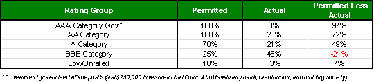
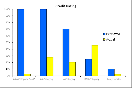
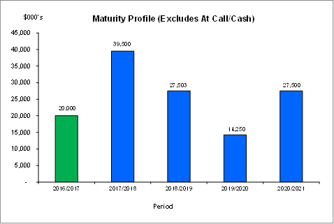
Investment by Credit rating and Maturity
Profile
The allocation of Council’s investments by credit
rating and the maturity profile are shown below:
integrated planning and reporting
Leadership & Governance
|
Community Strategic Plan Long Term Objective
|
Delivery Program
Term Achievement
|
Operational Plan
Task
|
|
L2.1 Council rigorously manages its financial
resources and assets to maximise delivery of
services
|
Council maintains and improves its long term financial
position and performance
|
Continue to analyse opportunities to expand the revenue
base of Council
|
Governance Matters
Council’s investments are made in accordance with the
Local Government Act (1993), the Local Government (General) Regulation 2005 and
Council’s Investment Policy.
Section 212 of the Local Government (General) Regulation
2005 states:
(1) The
responsible accounting officer of a council:
(a) must
provide the council with a written report (setting out details of all money
that the council has invested under section 625 of the Act) to be presented:
(i) if
only one ordinary meeting of the council is held in a month, at that meeting,
or
(ii) if
more than one such meeting is held in a month, at whichever of those meetings
the council by resolution determines, and
(b) must
include in the report a certificate as to whether or not the investment has
been made in accordance with the Act, the regulations and the council’s
investment policies.
(2) The report must be made
up to the last day of the month immediately preceding the meeting.
Risk Management
Council manages the risk associated with investments by
diversifying the types of investment, credit quality, counterparty exposure and
term to maturity profile.
Council invests its funds in accordance with The Ministerial
Investment Order.
All investments are made with consideration of advice from
Council’s appointed investment advisor, CPG Research & Advisory.
Financial Considerations
The revised budget for interest on investments for the
financial year 2016/2017 is $4,080,900. Of this amount approximately $2,454,000
is restricted for the benefit of future expenditure relating to development contributions,
$555,800 transferred to the internally restricted Infrastructure & Facility
Reserve, and the remainder of $1,071,100 is available for operations.
Social Considerations
Not applicable.
Environmental Considerations
Not applicable.
Community Consultation
None undertaken or required.
Internal Consultation
None undertaken or required.
Certification - Responsible Accounting
Officer
I hereby certify that the investments listed in the attached
report have been made in accordance with Section 625 of the Local Government
Act 1993, clause 212 of the Local Government General Regulation 2005 and
Council’s Investment Policy.
Summary
As at 31
May 2017:
· Council’s
total cash and investment portfolio is $145,058,000.
· The
net return on investments for the financial year to May 2017 was $4,124,000 against
a revised budget of $3,764,000, giving a YTD favourable variance of $360,000.
|
Recommendation:
A. That
the summary of investments and performance for May 2017 be received and
noted.
B. That
the Certificate of the Responsible Accounting Officer be noted and the report
adopted.
|
|
Tony Ly
Financial Accounting Officer
|
Angela Apostol
Manager Finance
|
|
David Marshall
Director Corporate
|
|
|
Attachments:
|
A1
|
Investments
definitions specific to Council’s investment portfolio
|
|
2016/124274
|
|
Ordinary
Meeting of Council - 27 June 2017
|
GB.3 / 36
|
|
|
|
|
Item
GB.3
|
DA0115/16
|
|
|
30 May 2017
|
Summary
Sheet
|
Report title:
|
9, 11 & 11A
Livingstone Ave, Pymble - Demolition of existing structures and construction
of a residential flat development containing 22 units, basement parking and
landscaping works
|
|
ITEM/AGENDA
NO:
|
GB.3
|
|
Application No:
|
DA0115/16
|
|
Property Details:
|
9, 11 & 11A Livingstone Ave, Pymble
Lot & DP No: Lot C DP 391729 & Lot 2 DP 540437
& Lot 1 DP 540437
Site area (m2): 3614.5m2
Zoning: R4 High Density Residential
|
|
Ward:
|
Comenarra
|
|
Proposal/Purpose:
|
Demolition of existing structures and construction of
a residential flat development containing 22 units, basement parking and
landscaping works
|
|
Type of Consent:
|
Local
|
|
Applicant:
|
Brewster Murray Pty Ltd
|
|
Owner:
|
Pymble Livingstone Pty Ltd
|
|
Date Lodged:
|
16 March 2016
|
|
Recommendation:
|
Approval
|
Purpose of Report
To determine Development Application No. DA0115/16 which
seeks to demolish the existing structures on site and construct a residential
flat development containing 22 units, basement parking and landscaping works.
integrated planning and reporting
Places, Spaces & Infrastructure
|
Community Strategic Plan Long Term Objective
|
Delivery Program
Term Achievement
|
Operational Plan
Task
|
|
P3.1 The built environment delivers attractive,
interactive and sustainable living and working environments
|
A high standard of design quality and building
environmental performance is achieved in new development.
|
Assessment of applications is consistent with
Council’s adopted LEP’s and DCP’s.
|
Executive Summary
Issues: Building
height, side setbacks
Submissions: Original
proposal: 6 submissions; amended proposal: 5 submissions
Land & Environment Court: N/A
Recommendation: Approval
History
Site
The site has a history of residential use.
Pre-DA
On 21 July 2015, a Pre DA consultation was undertaken for
the proposed demolition of the existing structures and construction of a residential
flat building and multi-dwelling housing development comprising 24 units and
basement car parking. The applicant was advised of the following key issues:
· side
and rear setbacks (6 metres required for residential flat building)
· excessive
density given site constraints
· building
bulk/scale impacts to south-western side, including location of elevated access
paths/ramps, Units 08 & 09
· building
separation
· riparian
and biodiversity land constraints
· heritage
impacts (adjoining property)
· relationship
with existing ground levels/topography
· unit
amenity (rear RFB units and living spaces to Units 06 & 07)
· tree
protection
· water
management/engineering
DA History
16 March 2016 The
application was lodged.
1 April 2016 The
application was notified to neighbouring property owners and advertised for a
period of 30 days.
20 July 2016 A
letter was sent to the applicant advising of issues relating to:
Planning & urban design
- height
- building
storeys
- top
storey design
- Side/rear
setbacks and building separation
- Relationship
to ground line
- Apartment
mix and accessibility
- Building
entries, building form and facades
Heritage
- roof
design and finishes
Engineering
- water
management
- driveway
gradient
- waste
collection
- construction
vehicle access
Landscaping
- deep
soil landscape area
- building
setbacks
- tree
impacts
- private
open space
- insufficient/unclear
information
- BASIX
inconsistencies
Neighbour amenity
- privacy/overlooking
- visual
impacts (height, bulk and scale)
- density
- solar
access
- setbacks
- traffic,
parking and safety issues
- streetscape
impacts
- tree
impacts
8 September
2016 A
meeting was held with the applicant to discuss the issues identified in
Council’s letter and amendments required to enable further assessment.
The applicant submitted conceptual amended plans.
29 September
2016 Council
sent a response to the applicant detailing outstanding assessment issues
(unresolved by draft amended plans) and inviting submission of amended plans
13 October 2016 Amended
plans and information were submitted.
28 October 2016 Council
sent a response to the applicant advising further detailed resolution and
information was required in response to issues relating to:
- driveway
and bridge design
- accessibility
- private
open space
- urban
design
- external
form and aesthetics
- landscaping
The applicant was offered a final
opportunity to amend their plans.
12 December 2016 Final
amended plans and information were submitted.
22 December
2016 The
amended application was notified to neighbouring property owners for a period
of 21 days.
12 May 2017 The
applicant provided written clarification on landscaping and architectural
details and a revised BASIX Certificate in response to Council’s request.
The Site
Site description
The subject site comprises Lot C DP 391729, Lot 2 DP 540437
and Lot 1 DP 540437 and is known as Nos. 9, 11 and 11A Livingstone Avenue,
Pymble. The three lots form an L-shaped site arrangement located on the
north-western side of Livingstone Avenue, approximately 130 metres from its
intersection with the Pacific Highway.
The site has a total area of 3614.5m2, comprising
a variable width from 44.395 metres at the front (south-eastern) boundary to
25.395 metres at the rear (north-western) boundary. The site depth ranges from 103.285
metres along the south-western side boundary to 50.83 metres along the
north-eastern side boundary.
The topography of the site is marked by a significant
depression that is centrally located and traverses the width of the site. The
site slopes by approximately 5-7 metres from the street frontage to the
depression and rises steeply to the rear. An easement for drainage exists
within this depression, which is identified as a Category 3a riparian corridor
on Council’s mapping system and. The site also exhibits a notable
cross-fall of approximately 6.7 metres, representing a grade of 15%.
Existing features on the subject allotments are identified
below.
|
Property address:
|
Site configuration:
|
Existing development:
|
Other features:
|
|
9 Livingstone Ave
|
Rectangular-shaped
|
Two storey brick dwelling
|
Drainage easement across rear of site
|
|
11 Livingstone Ave
|
Battleaxe-shaped (rear of No. 11A)
|
Two storey brick dwelling
|
Swimming pool
|
|
11A Livingstone Ave
|
Rectangular-shaped
|
Two storey brick dwelling
|
Swimming pool and drainage easement across site rear
|
Each lot benefits from individual driveway access to
Livingstone Avenue. Development on each lot is sited within a landscaped
setting, which contains a number of significant trees and
biodiversity-significant land. South-eastern portions of the site are also
identified as containing vegetation characteristic of an endangered ecological
community, Blue Gum High Forest (BGHF).
The site does not contain a heritage item but its
north-western (rear) corner adjoins a heritage item at No. 14 Pymble Avenue.
The site is also within the vicinity of other heritage listed items at No. 1
Livingstone Avenue, No. 7 Pymble Avenue and No. 1116 Pacific Highway. The
Orinoco Street Heritage Conservation Area is identified on the opposite side of
Livingstone Avenue, however the site is located outside of this area.
Surrounding development
The site is located within an
area zoned for high density residential development. This area broadly
encompasses adjoining sites to the north (towards the Pacific Highway and
Pymble local centre). The prevailing area to the south is broadly characterised
by low density residential development, and also includes sites zoned E4
(Environmental Living), which adjoin the site to the south-west. The site is
therefore in an area of transitional density, including a number of sites that
are under-developed having regard to their zoning. Notwithstanding, a number of
residential flat buildings exist in the vicinity, including 6-7 storey
buildings under construction to the north in Everton Street and north-east in
Livingstone Avenue.
Specifically, the site is immediately adjoined by
neighbouring lots each containing single dwelling houses. Notably, the
adjoining properties to the north-east at No. 7 Livingstone Avenue and Nos. 8
& 10 Pymble Avenue are zoned R4 - High density. The adjoining properties to
the south-west are zoned E4 - Environmental living, and the heritage listed
property adjoining the subject site’s north-western corner, No. 14 Pymble
Avenue is zoned R2 – Low density. The properties on the south-eastern
side of Livingstone Avenue, opposite the site, are zoned R2 – Low
density.
The Proposal
The proposal, as amended, involves the demolition of the
existing dwellings and associated structures on site and construction of a
residential flat development containing 22 units, basement parking and
landscaping works as follows:
· Two distinct
building blocks (‘Building A’ and ‘Building B’) sited
in response to the L-shaped site configuration.
· Building A
is located within the site frontage (parallel to the street alignment) and
consists of three storeys containing eight three-bedroom units and one
two-bedroom unit.
· Building B
is located within the narrow portion of the site’s rear (perpendicular to
the street alignment) and consists of four storeys containing eight
three-bedroom units and five two-bedroom units.
· Basement car
parking consisting of 33 car spaces (including visitor spaces) is provided
beneath the building footprints with driveway access to Livingstone Avenue at
the south-western side of the frontage. The basement also incorporates waste
storage areas, bicycle parking racks and a loading bay.
· Associated
stormwater management and landscaping works are also proposed, including
communal open space and a riparian vegetation area within
biodiversity-significant land.
Amended plans
Amended plans were received in response to Council’s
issues letter (refer to above DA history), which involved a number of design
changes, including:
· number of
units reduced from 23 to 22
· building
height and top storey floor space reduced
· rear and
side setbacks increased
· unit mix
increased from entirely three-bedroom units to include six (6) two-bedroom
units
· saw-tooth
roof design amended in response to heritage comments
· building
form and facades redesigned
· waste
storage area relocated
· deep soil
landscape area increased
· building
footprint amendments to reduce encroachment in tree protection areas
Consultation
Community
In accordance with the Ku-ring-gai Local Centres DCP, owners
of surrounding properties were notified of the application. In response,
submissions from the following were received:
1. J Bai - 17
Livingstone Avenue, Pymble
2. P Buzacott - 4
Orinoco Street, Pymble
3. J Yi & J Mai
– 15 Livingstone Avenue, Pymble
4. D & V Ming
– 5 Livingstone Avenue, Pymble
5. Y D Forsyth
– 7 Livingstone Avenue, Pymble
6. C Bold - 75
Livingstone Avenue, Pymble
The submissions
raised the following issues:
Loss of privacy and amenity (including overlooking and
acoustic/noise impacts)
Potential visual and acoustic privacy impacts to
neighbouring properties have been assessed with respect to the applicable
planning provisions (as below) and are considered acceptable, subject to
conditions. The development as amended, will not significantly impact the
acoustic privacy of neighbouring properties having regard to the transitional
density context of the area, site layout and design considerations including
building setbacks. Additional residential and traffic noise associated with the
development will be minimal and no greater than that envisaged given the site
zoning.
Visual privacy to neighbouring properties will be suitably
protected by dwelling configurations, building setbacks, window placement,
floor plan layouts and screen planting. The proposal will maintain appropriate
visual privacy to neighbouring properties by orientating principle living
spaces and associated windows of dwellings towards their respective private
open spaces, with adequate building separation and the use of privacy measures
such as screens, fencing and vegetation.
Devaluation of property
Devaluation of property is not a consideration under Section
79C (1) of the Environmental Planning and Assessment Act 1979.
Loss of security
The proposal is not expected to result in a loss of security
for neighbouring properties. Suitable passive surveillance of the street and
communal areas will be provided by the development and privacy aspects are
acceptable as discussed above.
Impacts to significant trees and biodiversity
The proposal involves retention and protection of
significant trees to the satisfaction of Council’s Landscape Assessment
Officer, subject to conditions. Additionally, Council’s Ecological
Assessment Officer has assessed the application with respect to biodiversity,
including threatened species. The proposal is also considered to be acceptable
in these respects, subject to Conditions 2, 5, 25, 87 and 88.
Loss of solar access
The proposal will maintain no less than 3 hours of solar
access to the living rooms and principal private open space of adjoining
properties between 9am and 3pm in midwinter. The proposal therefore complies
with the Ku-ring-gai Local Centres DCP solar access control.
Overdevelopment & excessive built form and
overbearing including height (visually overbearing/dominant)
The amended proposal is for 22 units across two distinct
buildings, which are predominantly three storeys in height. The design complies
with the floor space ratio development standard of the Ku-ring-gai LEP (Local
Centres) 2012 and the proposed height as amended is considered acceptable as
discussed below in relation to clause 4.6 of the LEP. Overall, the proposal
demonstrates a building form compatible with that envisaged for the site given
its high density zone and transitional context, and is sympathetic to the
visual amenity of neighbouring properties and the streetscape. Additionally,
the landscaping provision for the development, including canopy trees, will
soften the appearance of built form as viewed from neighbouring properties and
the street.
Design inappropriate and out of character with
neighbouring properties (single dwellings)
The proposal is permissible within the R4 - High density
residential zone and is consistent with the zone objectives. Aspects of design,
including with respect to neighbourhood character, have been assessed by
Council’s Urban Design Consultant having regard to the SEPP 65 Design
Quality Principles and the proposal is considered to be acceptable, subject
to conditions.
Heritage impacts
The site of the proposed development does not contain any
heritage listed items, however the application was referred to Council’s
Heritage Advisor in respect of potential impacts to heritage items in the
vicinity of the site, including a conservation area opposite the site. In this
regard it is concluded that impacts on the conservation area are minor and
acceptable. Photographic archival recording of the existing structures on the
site will be required by Condition 11.
Insufficient front setback
Building A has a relatively uniform front setback of 10
metres, which complies with the minimum street setback requirement of the DCP
and is acceptable having regard to the transitional context of the site and
neighbouring development. The building does not provide a 2 metres articulation
zone beyond the front building alignment as also required by the DCP.
Nonetheless, the proposal is acceptable having regard to its relationship with
the streetscape by virtue of the substantial soft landscaped area within the
front setback, which includes provision for existing and proposed trees and
vegetation to soften the appearance of the built form. Additionally, the site
falls considerably from the front boundary to the depression across the centre
of the site, such that the building form is recessive as viewed from the
street.
Insufficient parking
The proposal provides 33 car
spaces (including visitor spaces) in accordance with the requirements of the
DCP and to the satisfaction of Council’s Development Engineer.
Accordingly, adequate car parking is proposed.
Pollution, including dust
The proposed development is unlikely to result in any
significant pollution. Stormwater management measures will minimise runoff in
accordance with DCP requirements and to the satisfaction of Council’s
Development Engineer, subject to conditions. Aspects of demolition and
construction management may be suitably managed by conditions of consent,
including dust control and environmental site management measures (Conditions
61 and 29).
Noise
Construction noise will be suitably addressed via noise and
vibration management plan to be prepared in accordance with AS2436 - 2010 and
with the Office of Environment and Heritage Interim Construction Noise
Guidelines (Condition 21). Construction work will also be restricted to
suitable daytime hours (Condition 55).
Traffic congestion (including construction
traffic/vehicles) and related safety issues, including pedestrian safety
The application is accompanied by
a detailed traffic report demonstrating that the development will not have an
adverse impact upon traffic flows and movements within the local area. Council’s
Development Engineer is satisfied with traffic aspects of the proposal, subject
to conditions. The engineering assessment has had due regard to aspects
relating to driveway access, egress, manoeuvring and related safety
implications and no objections are raised to the proposal in these respects. A
Construction Traffic Management Plan will address vehicular traffic during the
construction phase of the development as required by Condition 13.
Cumulative impacts associated with neighbouring flat
building developments
The proposed development has been assessed on its own merits
against the provisions of the Environmental Planning and Assessment Act 1979
and is considered to be acceptable, subject to conditions. Broader impacts
associated with increased residential density were anticipated as part of the
rezoning of this locality.
Proposal may contravene the Federal Human Rights
Act/rights of the aged
Matters raised in the above respects include standard of
living, physical health and privacy. The proposed development has been assessed
as required having regard to the relevant matters for consideration under the
Environmental Planning and Assessment Act 1979 and is considered to be
acceptable in so far as it relates to residential amenity, subject to
conditions.
Amended plans
Amended plans received on 12 December 2016 were also
notified to surrounding properties. In response, additional submissions from
the following were received:
1. P
Buzacott - 4 Orinoco Street, Pymble
2. D & V Ming
– 5 Livingstone Avenue, Pymble
3. Y D Forsyth
– 7 Livingstone Avenue, Pymble
4. JP & LD Rasmussen – 10 Orinoco Street, Pymble
5. BA
Smith – 204/9 Everton Street, Pymble
The submissions
raised the following additional issues:
Notification unjust and unfair over Christmas –
new year period
The original proposal and amended plans were notified in
accordance with the provisions of the Local Centres DCP as required.
Housing affordability not addressed
The proposal is not for affordable housing.
Housing mix and accessibility is unsatisfactory
The proposed development as amended provides a reasonable
mix of two and three bedroom units with accessibility provision, subject to
conditions. A market assessment has been submitted in support of the proposed
unit mix. Whilst this is not a development under SEPP Seniors Living, the
proposal provides suitable access for the ageing demographic has been provided,
including at grade access from the street to both buildings via pedestrian
footbridges and communal lifts from the basement car parks. Suitable access
provision is required by Conditions 28, 36 & 98.
Stormwater management, including impacts of overland
water flow and easement ownership issues
Aspects relating to stormwater management are considered to
be satisfactory by Council’s Development Engineer with respect to the
Local Centres DCP. The establishment of easement rights is the subject of a
deferred commencement condition (Schedule A Condition)
Loss of community
Community/social interaction aspects of the proposal are to
the satisfaction of Council’s Urban Design Consultant. The development
includes provision of a large communal open space area located centrally on the
site for social interaction and recreational opportunities, including BBQ
facilities. This will be improved by providing access to this area from the
main entry bridge as required by Condition 23.
Loss of amenity/health impacts
The proposed development has been designed sympathetically
with regard to the amenity of neighbouring properties, including provision of
solar access.
View loss
The proposal as amended
constitutes an acceptable building form, which will not result in any
unreasonable loss of views, noting there are no iconic views across the subject
site.
Within Council
Engineering
Council's Development Engineer
commented on the amended proposal as follows:
Water management
The existing stormwater pipe
through the property has been plotted on the survey plan. This is satisfactory.
The submitted title certificate
and DP712641 only describe the easement over 15 Livingstone Avenue which
benefits 17 Livingstone Avenue. The development will not drain into this
easement, but into the 3.05 metres wide easement over the trunk drainage system
within 15, 17, 19 and 21 Livingstone Avenue.
A copy of DP1132255 and the
Instrument AE272172V has been obtained. The only properties which benefit
from the easement are 2 Pymble Avenue and 2 – 4 Everton Street. The
establishment of easement rights is the subject of a deferred commencement
condition (Schedule A Condition).
The plans show the structure
over the easement to be readily removable as requested.
The water management plans have
been amended but do not contain any further detail on the re-use of the stored
rainwater. The required modelling to demonstrate that Council’s target of
a 50% reduction in runoff days conditioned to be carried out prior to
Construction Certificate issue (Condition 30).
Traffic and parking
Car stackers are proposed for 5
units, which is acceptable. The plans show 29 resident and 4 visitor
parking spaces. This satisfies the range of resident and visitor spaces
required under the Local Centres DCP for the proposed unit mix.
Waste management
The waste collection area has
been relocated inside the basement entry by amended plans as required. A
longitudinal section has been provided along the entry driveway demonstrating a
compliant minimum headroom of 2.6 metres – Drawing DA300 Section 03.
The application is acceptable,
subject to conditions.
Landscaping
Council's Landscape
Assessment Officer commented on the amended proposal as follows:
Impacts
on significant existing trees
An
amended Arboricultural Impact Assessment, prepared by Advanced Treescape Consulting (dated 25/11/16), has been submitted with the application. Tree numbers refer
to this report.
Tree
removal
Significant trees to be removed:
Tree 25/ Angophora floribunda(Rough barked Apple) - This
tree is located at the south-western corner of the site. The tree is in poor
condition. There is no objection to the removal of this tree.
Tree 26/
Liquidambar styraciflua (Liquidambar) - This tree that is incorrectly identified as a Jacaranda mimosifolia (Jacaranda) is located at the south-western corner of the
site, on the front boundary. The tree has a significant ivy infestation. There
is no objection to the removal of this tree.
Tree 41/
Liquidambar styraciflua (Liquidambar) - This tree is located on the south-western boundary, within
the centre of the site. The tree is in good health and condition. The tree is
to be removed for the basement of the rear building. There is no objection to
the removal of this tree.
Tree 43/ Cornus sp.
- This tree is located
within the centre of the site. The tree is in good health and condition,
however is required to be removed for the rear building. There is no objection
to the removal of this tree.
Tree 48/ Cedrus
deodara (Himalayan Cedar) -
This tree is located at the north-eastern corner of the site. The tree has a
suppressed form due to the canopy of Tree 49. The tree is to be removed for the
rear building. There is no objection to the removal of this tree.
Tree 51/
Liquidambar styraciflua (Liquidambar) - This tree is located at the north-eastern corner of the
site. The tree is a fair specimen. The tree is to be removed for the rear
building. There is no objection to the removal of this tree.
The application proposes the removal of 23 trees of
moderate to low retention value. Two of these trees are exempt species under Cl 1.3 Volume C Ku-ring-gai Local Centres DCP. Trees 31
-36, located on the south-western boundary, are in good condition and provide
existing neighbouring amenity. These trees are to be retained and protected (Condition
28). The arborist recommendations for removal of the remaining trees
are considered satisfactory and there is no objection to their removal.
Street trees to be removed
There
are no street trees to be removed as part of this application.
Trees to be retained
Tree 1/ Eucalyptus saligna (Sydney Blue Gum)
- This tree is located within the centre of the site. This tree is to be
retained and protected. The proposed impacts are considered acceptable.
Tree 2/ Eucalyptus saligna (Sydney Blue Gum) - This tree is
located within the centre of the site. This tree is to be retained and
protected. The proposed excavation for the basement in association with the
proposed building will be approximately 6% of the tree protection zone. The
majority of the encroachment is within existing built structures and the level
of impact is therefore considered acceptable.
The proposed ground floor decking and access paths for
private courtyards of Apartments 1-5 will cover a further approximately 9% of
the tree protection zone.
The proposed impacts are considered acceptable.
Tree 3/ Eucalyptus saligna (Sydney Blue Gum) - This tree is
located within the centre of the site. This tree is to be retained and
protected. The proposed impacts are considered acceptable.
Tree 4/ Eucalyptus saligna (Sydney Blue Gum) - This tree is
located within the front setback of the site. This tree is to be retained and
protected. The proposed excavation for the basement in association with the
existing house footprint will be in excess of 10% of the tree protection zone.
The proposed lawn area as common open space will adversely impact Tree 4 and is
not supported. Existing levels are to be retained in association with planting
similar to south of Tree 4 (Condition 28). The majority of the
encroachment is within existing built structures and the level of impact is
therefore considered acceptable.
Tree 5/ Angophora
floribunda (Rough barked Apple) - This
tree is located within the front setback of the site. This tree is to be
retained and protected. The proposed excavation for the private courtyards will
be less than 10% of the tree protection zone. The proposed impacts are
considered acceptable.
Tree 6/ Angophora
floribunda (Rough barked Apple) - This
tree is located within the front setback of the site. This tree is to be
retained and protected. The proposed excavation for the private courtyards will
be less than 10% of the tree protection zone. The proposed impacts are
considered acceptable.
Tree 30/ Angophora
floribunda (Rough barked Apple) - This
tree is located at the south-western corner of the site, within the adjoining
property. The tree has a
significant ivy infestation. The
proposed driveway impacts will be less than 10% of the tree protection zone.
The proposed impacts are considered acceptable.
Tree 37 - 40/ Backhousia myrtifolia (Ironwood),
B. myrtifolia (Ironwood), Pittosporum undulatum (Native Daphne), P.
undulatum (Native Daphne) - These trees are
located along the south-western boundary. The proposed impacts are considered
acceptable.
Tree 49/ Syzygium paniculatum (Brush Cherry) - This tree is
located at the north-eastern
corner of the site. The proposed
excavation for the basement will be less than 10% of the tree protection zone.
The proposed impacts are considered acceptable.
Tree 50/ Cinnamomum camphora (Camphor laurel) - This tree
is located at the
north-eastern corner of the site. The
proposed excavation for the basement will be less than 10% of the tree
protection zone. The proposed impacts are considered acceptable.
Deep
soil landscaping
The minimum deep soil landscaping requirement for these
properties is: 40% of the site area
(where basement parking is provided).
Site
area: 3614.5m2
Numerical
compliance: 50% (1807.25m2)
Proposed
total deep soil area: 51.18% (1850m2)
The proposal will comply with the minimum deep soil zone
requirement.
Tree
replenishment
The
site should support a minimum 11 trees that can attain 13 metres in height. The
proposal provides 14 trees and is therefore satisfactory in this respect.
Communal open space
A communal open space has been provided at the centre of
the site within the core riparian zone. The area includes a lawn area, a BBQ
and some seating. The access report has not verified the provision of access to
any one communal open space at ground level. To this effect, the BBQ area is to
be relocated to the western end of the communal open space with an accessible
path from Building A provided from the basement lift (Condition 28).
Private open space
To ensure sufficient space for deep soil planting within
the adjoining common areas, the proposed private open space at ground floor are
to be consistent with the controls.
Clotheslines are not to be located within private open
space within the front setback of Apartments A01-A06 (Condition 28).
Landscape plan
The landscape plan is to be amended by Condition 28 :
Cut and
fill
Landscape
cut or fill should not be more than 600mm above or below the natural ground
line as required by the DCP. To maintain existing levels to garden bed
along eastern boundary of Block B, a retaining wall is to be provided along the
access path by (Condition 28). Additionally, as required by Condition
28, access from B10 to the maintenance path is to be relocated to the
northern boundary of the private open space to allow for stairs (RL115.20) and
a path to the communal open space (RL112.73). Similarly, the central
communal lawn area is to keep to existing grade. The BBQ area is to be
relocated in association with entrance path.
Basix
The
amended Basix certificate is acceptable.
Environmental
site management plan
The ESMP is to be amended to include tree protection that
allows for construction access (Condition 29). Tree protection fencing
is to be provided for street trees and the riparian zone. Ground
protection is to be provided where access or storage is required within tree
protection zones of trees to be retained.
Conditions have also been recommended to resolve drawing
inaccuracies/inconsistencies.
The amended proposal is acceptable, subject to conditions.
Ecology
Council's Ecological Assessment Officer commented on the
amended proposal as follows:
The vegetation on site was
inspected to determine the presence/absence of native plant communities. Areas
of vegetation towards the front of the site and within the rear was determined
to be representative of Blue Gum High Forest (BGHF), which is listed as a
Critically Endangered Ecological Community (CEEC) under the Threatened Species
Conservation Act 1995.
Ecological
constraints/environmental controls
The native vegetation (BGHF)
within the site has been mapped as an area of “biodiversity
significance” under the under the KLEP (Local Centres) (2012).
Ecological impacts
A detailed flora and fauna
investigation and assessment of the impact of the proposal upon threatened
species, endangered ecological communities and endangered populations has been
prepared by Keystone Ecological.
A review of the arborist report
has identified 10 BGHF canopy trees, including 4 Eucalyptus saligna (Sydney
Blue Gum), 2 Pittosporum undulatum (Sweet Pittosporum), 4 Angophora floribunda
(Rough-barked Apple). One Rough-barked Apple identified (T25), representative
of BGHF is proposed for removal due to poor condition.
The impacts of the proposal
upon the onsite BGHF community are proposed to be mitigated by the retention
and enhancement of BGHF under a vegetation management plan.
An impact assessment (7-part
test) has been prepared in accordance with section 5a of the Environmental
Planning & Assessment Act 1979 to assess the impacts of the proposal upon
the BGHF community. The impact assessment conclusion that the proposed
development will not result in a significant impact upon the BGHF community is
supported.
The application is acceptable,
subject to conditions.
Heritage
Council's Heritage Advisor commented on the amended proposal
as follows:
Heritage
status
The site
is not a heritage item but adjoins a heritage item at 14 Pymble Avenue and is
within the vicinity of the following items:
No 1 Livingstone Avenue
(Church);
No 7 Pymble Avenue; and
No 1116 Pacific Highway (former
Police Station).
Clause 5.10 (4) of the (Local
Centres) 2012 LEP requires Council to consider the effect of the proposed
development on the heritage significance of the item or the area
concerned. Clause 5.10 (5) allows Council to require a heritage
management document (HMD) before granting consent.
Statement of significance
The following is the Statement
of Significance for the adjoining heritage item:
Reason for listing; cultural,
architectural, municipal significance.
Note: the information states it
has been altered or extended unsympathetically (possibly the garage/studio
addition).
The following is the statement for the Orinoco Street HCA
which is located opposite the site:
Historical significance:
The
Orinoco Street HCA is of historical significance as a highly intact area of
Federation and Inter-war housing, representative of the development of the
Hamilton Estate after the opening of the North Shore railway line in
1890. A significant portion of the houses, (six houses) were designed
between 1913 and 1930 by a single architectural firm, and therefore illustrate
changing designs from the same firm over this period.
Aesthetic significance:
The
Orinoco Street HCA is considered to be of high aesthetic significance for its
concentration of architect-designed houses (seven in total in the area).
The street contains six houses designed by the architectural firm Peddle Thorp
or Peddle Thorp & Walker between 1913 and 1930, and these houses illustrate
changing designs from a single prominent Sydney architectural firm over this
period.
Demolition
The dwellings proposed to be
demolished are all post war dwellings. The HIS states that No 9
Livingstone Avenue was constructed by a Chatswood builder- F. A. Nielson in
1955 and completed by 1956. It claims that the lots now forming Nos 11
& 11A Livingstone Avenue were subdivided in 1970 and the existing houses
were built shortly later.
The existing dwellings on the
site are considered to have no significant heritage values and no heritage
objections are raised with their demolition. However, photographic
recording to archival standards is recommended (Condition 11).
Heritage management document
A Statement of Heritage impact
(HIS) was submitted with the application and prepared by an experienced
heritage consultant. It is generally prepared in accordance with the
guidelines prepared by the NSW Heritage Council and has considered the Local
Centres LEP & DCP. Consideration of the DCP is minimal and it simply
states the proposal is considered to be consistent with the guidelines without
any discussion on the objectives or controls.
Of relevance, in relation to
potential heritage impacts the SHI states:
The proposal provides two zones
of garden area (public and private) onto the street. This is in-keeping
with the character of the surrounding neighbourhood.
The proposed dwellings do not
alter or obscure any views or understanding of the Orinoco Conservation Area.
The proposal is set beyond, and
to the west of the rear boundary of the heritage item, and is generally
screened by the existing cabana/garage structure. The setting of the
heritage item is not altered.
The proposal does not impact on
any views of the heritage item from Pymble Avenue.
The SHI concludes:
The proposed works described
above do not adversely affect the identified significance of the heritage item
at 14 Pymble Road (sic), Pymble, or the Orinoco Street Conservation Area.
Council should have no hesitation, from a heritage perspective, in approving
the application.
Controls
The Ku-ring-gai Development
Control Plan (Local Centres) 2012 Volume B Section 7 provides objectives and
controls for development within the vicinity a Heritage Item. The
following controls are relevant and apply to the site;
|
7.3 DEVELOPMENT IN THE VICINITY OF A
HERITAGE ITEM
|
|
Development Control
|
Complies
|
|
General
|
|
1 Development in the vicinity of a
heritage item is to be sympathetic to the heritage item having regard to
form, proportions, materials and colours, siting and orientation; setting and
context and streetscape patterns
|
Partially
|
|
2 An applicant’s Statement of
Environmental Effects or Heritage Impact Statement must discuss the effect
that the proposed development will have on a heritage item, including its
garden.
|
Yes
|
|
3 Significant views to and from
heritage items are to be protected.
|
Yes
|
|
4 Development in the vicinity of a
heritage item must respect the curtilage and setting of that item.
|
Yes
|
|
5 An application for development in
the vicinity of a heritage item must demonstrate that the construction
process will not result in damage to the heritage item or its setting.
|
No
|
|
Residential Context
|
|
New development adjacent to a
heritage item must comply with the following:
iii) must have a minimum 12m
building separation to the heritage,
iv) must not exceed a facade height
of 8m from existing ground level;
v) any building mass above 8m high
from existing ground level must be stepped back an additional 6m from the
heritage item;
vi) front setbacks must be at least
2m more than the front setback of the adjoining heritage item, for that
portion of the new building whose height exceeds the height of the heritage
item.
vii) where variations in setbacks
exist the larger setback will apply;
viii) any new development must have
a maximum 36m wall length to any boundary.
|
No
Yes
No
N/A
N/A
Yes
|
|
7 Screen planting on side and rear
boundaries adjoining a heritage item site is to achieve a minimum mature
height of 4m
|
Yes
|
|
8 Front and side fences are to be no
higher than the fence of the adjoining heritage item. Front fences must be
open and transparent such a timber picket or metal palisade. Side fences are
to be timber.
|
Yes
|
|
7.6 DEVELOPMENT IN THE VICINITY OF A HERITAGE CONSERVATION AREA
|
|
Development Controls
|
Complies
|
|
General This part
applies to development on sites that directly adjoin a heritage conservation
area (HCA) or are within close proximity to the HCA.
|
|
|
1 Development in the vicinity of a conservation area is to be
sympathetic to the HCA by having regard to:
i) siting and orientation;
ii) materials and colours;
iii) setting and context;
iv) streetscape patterns;
v) form of the buildings in the HCA including height, roofline,
setbacks and building alignment; and
vi) proportions including door and window openings, bays, floor to
ceiling heights and coursing levels.
|
Yes
Yes
Yes
Yes
Partially
N/A
|
|
2 An applicant’s Statement of Environmental Effects or Heritage
Impact Statement must discuss the effect that the proposed development will
have on the HCA, including the setting and streetscape.
|
Yes
|
|
3 Significant views to and from the HCA are to be protected.
|
Yes
|
|
4 Development in the vicinity of an HCA must respect the curtilage and
setting of the HCA.
|
Yes
|
|
5 The treatment of the facade of new development adjacent to the
conservation area should relate to the dominant architectural cues which
characterise the HCA such as horizontal lines and vertical segmentation.
|
N/A
|
|
6 An application for development in the vicinity of the HCA must
demonstrate that the construction process will not result in damage to places
within the HCA or its setting.
|
N/A
|
Comments
on DCP controls
1 Development in the vicinity of a heritage item is to
be sympathetic to the heritage item having regard to form, proportions,
materials and colours, siting and orientation; setting and context and
streetscape patterns
The
proposed development is set behind the heritage item on land that falls below
the level of the item. The form of the proposed development is
contemporary which does not conflict with the form of the heritage item.
The proportions are contemporary although the saw toothed proportion of the
roof is not complimentary to the adjoining item and has an almost industrial
appearance, not considered appropriate in a residential setting. The dark
colour to the upper floors is not considered appropriate in a residential
context although might be proposed to reduce visual impacts. The siting
of the proposed buildings is reflective of the exiting lot boundaries.
Planner’s
comment: amendments have been made in response to the above and the saw-tooth
design has been replaced with a slanting flat-roof design with tapered edges.
5. An application for development in
the vicinity of a heritage item must demonstrate that the construction process will
not result in damage to the heritage item or its setting.
The
applicant has prepared a geotechnical assessment of the site. The
recommendations in the report are extensive and include groundwater controls,
temporary shoring, permanent shoring and permanent retaining. A series of
recommendations are provided for the design and construction phase is provided
in the report. Provided these recommendations are undertaken, any damage
to the heritage item should be appropriately managed via standard conditions in
any future consent.
New
development adjacent to a heritage item must comply with the following:
iii) must have a minimum 12m building
separation to the heritage item;
The new
development is about 11m from the garage/cabana and is less than the required
setback. The proposed rear building is roughly set out to the 6m building
setback line, however, due to the shape of the rear lot boundary, only
partially achieves the minimum 6m setback. The non-compliance is
considered minimal and acceptable.
New development
adjacent to a heritage item must comply with the following:
iv) must not exceed a facade height
of 8m from existing ground level;
The
drawings indicate that the wall height to the rear building near the adjoining
heritage item is about 7.2m, and has a satisfactory relationship with the
adjoining item. However, the ground level appears to be raised at this
point and it is unclear if it achieves a façade height of 8m.
New
development adjacent to a heritage item must comply with the following:
v) any building mass above 8m high
from existing ground level must be stepped back an additional 6m from the
heritage item;
The height
of the floor above the 8m level is only set back 4.200m (scaled) and does not
comply with this control.
1. Development
in the vicinity of a conservation area is to be sympathetic to the HCA by
having regard to:
v) form of
the buildings in the HCA including height, roofline, setbacks and building
alignment; and
vi) proportions including door and
window openings, bays, floor to ceiling heights and coursing levels.
The form of
the propose buildings is contemporary and not related to the Inter War
character of the nearby HCA. On balance, it is not considered necessary
to follow the form, proportions or fenestrations, floor to ceiling heights or
coursing levels in the nearby HCA. The subject site is located at a lower
ground level, the existing and proposed landscaping and separation of the
roadway will assist in mitigating any visual impacts or impacts. It
should also be noted the HCA precinct is oriented towards Orinoco Street but
partially extends to a small portion of Livingstone Avenue opposite the subject
site. The heritage impacts on the HCA are thus considered to be within
acceptable limits.
Comments
The subject site is a difficult
site to develop to achieve the expectations envisaged in the re-zoning.
It has difficult topographical features and a riparian zone running roughly
through the centre of the site. The proposal is considered to be an acceptable
response to the natural features on the site.
The garage/cabana of the
adjoining heritage item is located approximately 5m (scaled) from the rear
boundary of the subject site. However, it is considered that the
visual impacts on the partially adjoining heritage item are limited.
Other nearby heritage items are
on the opposite side of Everton Street with frontage to the Pacific Highway,
1116 Pacific Highway (former police station) and Church at 1082- 1084 Pacific
Highway and are out of the immediate visual setting of the site. There is
also a heritage item at No 7 Pymble Avenue (to the north-west), also out of the
immediate visual setting of the site.
The immediate vicinity of the
site, particularly the area to the north in Pymble Avenue/Avon Road and to the
east, is undergoing considerable change and no longer represents a low scale
residential area. The adjoining sites to the west in Livingstone Avenue
are zoned E4 – Environmental Living.
Conclusion
and recommendations
There are
minor non-compliances with the DCP objectives and controls in the Local Centres
DCP. These non-compliances mainly affect the relationship of the proposed
development to a later garage/cabana structure on the adjoining heritage
item’s site.
Impacts on
the HCA and other nearby heritage items are considered to be acceptable.
Photographic archival recording
of the existing structures on the site is recommended (Condition 11).
Building
Council's Senior Building Surveyor commented on the proposal
as follows:
The DA plans in general comply
with the Building Code of Australia requirements. The following standard
Building conditions apply;
1. Compliance
with the Building Code of Australia.
2. Copy
of the final fire safety certificate to be submitted with the final occupation
certificate to the Council.
3. Comply
with the access to premises standards at the CC stage.
The above conditions will be applied to the development (Conditions
54, 110 & 36).
Outside Council
Urban design
Council’s urban design consultant commented on the
amended proposal as follows:
Assessment against SEPP 65
Design Quality Principles
Context and
neighbourhood character
The proposed development is a
'transitional' site from the R4 zoned high density residential to the north and
east of the site and the lower density single dwelling character to the south
and west of the site.
The area is characterised by
steep topography with single dwellings on large lots. The tall trees and
generous setback establish a character defined by dwellings in a landscape.
To the north and east of the
proposed development a recent approval of a residential flat development
comprises 6-7 storeys. The massing of this development was resolved to ensure
solar access is available to this site.
The proposed development is
sensitive to the riparian zone that traverses the site.
Further to the south, the
riparian zone moves closer to Livingstone Ave resulting in substantial setbacks
from Livingstone Ave.
This large setback gives
additional prominence to the Livingstone Ave building – this corner has
been discussed at length and meetings with the architect and applicant.
This corner is dominated by the
driveway entrance that passes under the corner of the building and ramps below,
improvements have been made in this area - specifically by reducing the width
of the driveway to a single carriageway.
Articulation to the southern
boundary has improved with blades, Juliet balconies and changes in material.
Built form and scale
The site has a significant
change in grade from the east and west to the riparian zone in the centre. The
building mass has been articulated and formed with consideration to the impacts
on the adjoining properties - particularly with respect to preserving adequate
solar access to the dwelling at the south of the site.
The development has been
orientated to the north-east away from the single dwelling at the south. Common
access balconies are provided with 1650mm high screening to preserve the
privacy on the adjoining site.
The frontage to Livingstone Ave
provides an activated edge with individual pedestrian entrances from the
'terrace' style dwellings that front it.
Access to the remainder of the
site is through a communal entrance that connects to the building at the rear
by a bridge.
The orientation of the
buildings and apartments in the development respond to the context, site
geometry, constraints and maximises northern solar access to living rooms.
Density
The density and form of the
development for the site is satisfactory given the proximity to Pymble Train
Station.
Sustainability
The proposed development
responds well to the context and responds to passive solar design principles,
with good orientation, cross ventilation and shading provided over windows.
Landscape
The site contains significant
landscaped areas that are concentrated in the middle of the site. Grassed areas
are provided for more active recreation - however it is unclear how the central
area is to be accessed (this is addressed by Condition 28 to ensure
access).
Amenity
The layout of the proposed
development provides for apartments with satisfactory amenity. Some of the
bedrooms have been provided with minimum dimensions below the 3m required by
the design criteria in the ADG, however the dimension in the other direction
and the area far exceed the minimum requirements. The rooms remain functional
and can be furnished appropriately. This is with the exception of Unit 21. The
bedroom to the south should be increased in size - this can be achieved by
reducing the size of the bedrooms to the north (Condition 23).
A generous quantity of storage
is provided in the basement.
Many of the units have a
maisonette / townhouse format with good size living areas on the ground floor
that open to private courtyards.
Safety
The common spaces provide good
visual connections between them and the units and the public domain to provide
safety and security for the residents.
Housing diversity and social
interaction
The majority of the development
is provided with 2 and 3 bedroom dwellings. This has been supported by a market
assessment.
The central communal space if
accessible form the main entry bridge would provide a successful communal open
space that would contribute to opportunities for social interaction for people
living in the development.
Aesthetics
The proposed development has
seen an improvement in the overall presentation and articulation of the built
form. The top floor is expressed as a 'mansard' style roof that assists in
breaking down the scale, this combined with the dormer style windows assist in
making this a successful development that transitions from the high to the low
density development.
The pedestrian bridge that
links the two buildings has been refined and the location
amended to reduce the impact on
adjoining development. The 3 dimensional views indicate that has a perforated
balustrade to about 1.5-1.8 metres high. This restricts views from the
pedestrian bridge - given the distance from the boundary this is considered
unnecessary and increases the bulk of this element. This should be reduced in
height of a maximum of 1.1 metres (Condition 23).
The balustrades on the unit 9
appear to have a height greater than 1 metre. There is no need for privacy at
this location as the dwelling house is located away from this part of the
development and it overlooks the street. This should be reduced to 1.1 metres
to provide the rooms with an outlook to the street (Condition 23).
Department of Primary Industries – Water
The application was referred to the Department of Primary
Industries – Water with respect to the drainage line that traverses the
site and any controlled activity approval that may be required for the
development under the Water Management Act 2000.
The Department of Primary Industries (DPI) Water provided
the following comments in response:
DPI Water (formerly the NSW
Office of Water) has reviewed documents for the above development application
and considers that, for the purposes of the Water Management Act 2000 (WM Act),
a controlled activity approval is not required and no further assessment by
this agency is necessary for one of the following reasons.
· The
proposed activity is not occurring on waterfront land (which includes (i) the
bed of
any river together with any land
within 40 metres inland of the highest bank of the river, or (ii) the bed of
any lake, together with any land within 40 metres of the shore of the lake, or
(iii) the bed of any estuary, together with any land within 40 metres inland of
the mean high water mark of the estuary).
Please note: Temporary
dewatering of an amount above 3 ML may require a water licence to
be obtained from DPI Water
before construction commences.
Please note that the proposal
must not incorporate provision for the permanent or semi-
permanent pumping of
groundwater seepage from below-ground areas. A fully tanked
structure must be used.
Should the proposed development
be varied in any way that results in development extending onto land that is
waterfront land, or encompassing works that are defined as controlled
activities, then DPI Water should be notified.
Statutory Provisions
Acts
Environmental Planning and Assessment Act 1979 (EP&A
Act)
The proposal is ‘Local Development’ under Part 4
of the EP&A Act and requires development consent.
The provisions of Section 79C (1)
of the EP&A Act determine the matters for consideration in assessing a
development application as stated below:
(a) The provisions of:
(i) any environmental planning instrument, and
(ii) any proposed instrument that is or has been the subject of
public consultation under this Act and that has been notified to the consent
authority (unless the Director General has notified the consent authority that
the making of the proposed instrument has been deferred indefinitely or has not
been approved), and
(iii) any development control plan; and
(iv) any planning agreement that has been entered into under
section 93F, or any draft planning agreement that a developer has offered to enter
into under section 93F, and
(v) the regulations (to the extent that they prescribe matters
for the purposes of this paragraph), and
(vi) any coastal zone management plan (within the meaning of the
Coastal Protection Act 1979), that apply to the land to which the development
application relates.
(b) the likely impacts of that development, including
environmental impacts on both the natural and built environments, and social
and economic impacts in the locality,
(c) the suitability of the site for the development,
(d) any submissions made in accordance with this Act or the
regulations,
(e) the public interest.
The relevant provisions of
environmental planning instruments, proposed instruments, DCPs, the regulations
and policies are addressed in the following sections of this report. The likely
impacts, suitability of the site and public interest are also addressed below.
State Environmental Planning Policies
Sydney Regional Environmental Planning Policy (Sydney
Harbour Catchment) 2005
SREP 2005 applies to the site as it is located in the Sydney
Harbour Catchment. The Planning Principles in Part 2 of the SREP must be
considered in the preparation of environmental planning instruments,
development control plans, environmental studies and master plans. However, the
proposal is not affected by the provisions of the SREP that relate to the
assessment of development applications as the site is not located in the
Foreshores and Waterways Area as defined by the Foreshores and Waterways Area
Map.
State Environmental
Planning Policy No. 55 - Remediation of Land (SEPP 55)
The provisions of SEPP 55
require Council to consider the potential for a site to be contaminated. The
subject site has a history of residential use and, as such, it is unlikely to
contain any contamination. Accordingly, further investigation is not warranted
in this case.
State Environmental Planning Policy (BASIX): 2004
A BASIX certificate was lodged with the application as
required and a revised certificate was submitted with the amended plans. The
revised certificate demonstrates compliance with the provisions of the SEPP and
is consistent with commitments identified in the application documentation,
subject to conditions.
State Environmental Planning Policy No.65 - Design
Quality of Residential Flat Development
SEPP 65 aims to improve the design quality of residential
flat buildings across NSW and provides an assessment framework, the Apartment
Design Guide, for assessing ‘good design’.
Clause 50(1A) of the Environmental Planning and Assessment
Regulation 2000 requires the submission of a design verification statement from
the Architect at lodgement of the development application. This documentation
has been submitted and is satisfactory.
The SEPP requires the assessment of any development
application for residential flat development against the design quality
principles contained in the SEPP which has been undertaken by Council’s
Urban Design Consultant. The SEPP also requires consideration of the matters
contained in the publication Apartment Design Guide. As such, the following
consideration has been given to the requirements of the Apartment Design Guide.
Pursuant to Clause 30(2) of
SEPP 65 in determining a development application for a residential flat
building the consent authority is to take into consideration the Apartment
Design Guide (ADG). The following table is an assessment of the proposal
against the guidelines provided in the ADG.
|
ADG COMPLIANCE TABLE
|
|
|
Guideline
|
Compliance Y/N
|
|
Objective
3A-1
Site
analysis illustrates that design decisions have been based on opportunities
and constraints of the site conditions and their relationship to the
surrounding context
|
YES
|
|
Objective
3B-1
Building
types and layouts respond to the streetscape and site while optimising solar
access within the development
|
YES
|
|
Objective
3B-2
Overshadowing
of neighbouring properties is minimised during mid-winter
|
YES
|
|
Objective
3C-1
Transition
between private and public domain is achieved without compromising safety and
security
|
YES
|
|
Objective
3C-2
Amenity
of the public domain is retained and enhanced
|
YES
|
|
Objective
3D-1
An
adequate area of communal open space is provided to enhance residential
amenity and to provide opportunities for landscaping
|
YES
|
|
Design
criteria
|
|
1.
|
Communal
open space has a minimum area equal to 25% of the site (see figure 3D.3)
|
|
2.
|
Developments
achieve a minimum of 50% direct sunlight to the principal usable part of
the communal open space for a minimum of 2 hours between 9 am and 3 pm on
21 June (mid-winter)
|
|
NO
(20%)
YES
|
|
Objective
3D-2
Communal
open space is designed to allow for a range of activities, respond to site
conditions and be attractive and inviting
|
YES
|
|
Objective
3D-3
Communal
open space is designed to maximise safety
|
YES
|
|
Objective
3D-4
Public
open space, where provided, is responsive to the existing pattern and uses of
the neighbourhood
|
N/A
|
|
Objective
3E-1
Deep
soil zones provide areas on the site that allow for and support healthy plant
and tree growth. They improve residential amenity and promote management of
water and air quality
|
YES
|
|
Design criteria
|
|
Deep soil zones are to meet the following minimum
requirements:
|
Site area
|
Minimum dimensions
|
Deep soil zone (% of site area)
|
|
less than 650m2
|
-
|
7%
|
|
650m2 - 1,500m2
|
3m
|
7%
|
|
greater than 1,500m2
|
6m
|
7%
|
|
greater than 1,500m2 with
significant existing tree cover
|
6m
|
7%
|
|
YES
(41%)
|
|
Objective
3F-1
Adequate
building separation distances are shared equitably between neighbouring
sites, to achieve reasonable levels of external and internal visual privacy
|
YES
|
|
Design
criteria
|
|
Separation
between windows and balconies is provided to ensure visual privacy is
achieved. Minimum required separation distances from buildings to the side
and rear boundaries are as follows:
|
Building height
|
Habitable rooms and balconies
|
Non-habitable rooms
|
Proposal
|
|
|
up to 12m (4 storeys)
|
6m
|
3m
|
5.7m
|
|
|
up to 25m (5-8 storeys)
|
9m
|
4.5m
|
N/A
|
|
|
over 25m (9+ storeys)
|
12m
|
6m
|
N/A
|
|
|
|
|
|
|
|
|
Note:
|
Separation distances between buildings on the same site should
combine required building separations depending on the type of room (see
figure 3F.2)
Gallery access circulation should be treated as habitable
space when measuring privacy separation distances between neighbouring
properties
|
|
|
|
|
|
|
|
NO
|
|
Objective
3F-2
Site
and building design elements increase privacy without compromising access to
light and air and balance outlook and views from habitable rooms and private
open space
|
YES
|
|
Objective
3G-1
Building
entries and pedestrian access connects to and addresses the public domain
|
YES
|
|
Objective
3G-2
Access,
entries and pathways are accessible and easy to identify
|
YES
|
|
Objective
3G-3
Large
sites provide pedestrian links for access to streets and connection to
destinations
|
YES
|
|
Objective
3H-1
Vehicle
access points are designed and located to achieve safety, minimise conflicts
between pedestrians and vehicles and create high quality streetscapes
|
YES
|
|
Design guidance
|
|
Car park access should be integrated with the
building’s overall facade. Design solutions may include:
· the materials and colour palette to minimise
visibility from the street
· security doors or gates at entries that
minimise voids in the facade
· where doors are not provided, the visible interior
reflects the facade design and the building services, pipes and ducts are
concealed
|
YES
|
|
Objective 3J-1
|
1.
|
Car parking is provided based on proximity to public
transport in metropolitan Sydney and centres in regional areas
|
|
YES
|
|
Design
criteria
|
|
1.
|
For
development in the following locations:
· on sites that are within 800 metres of a
railway station or light rail stop in the Sydney Metropolitan Area; or
· on land zoned, and sites within 400 metres
of land zoned, B3 Commercial Core, B4 Mixed Use or equivalent in a
nominated regional centre the minimum car
parking requirement for residents and visitors is set out in the Guide to
Traffic Generating Developments, or the car parking requirement prescribed
by the relevant council, whichever is less.
The
car parking needs for a development must be provided off street
|
|
YES
|
|
Objective
3J-2
Parking
and facilities are provided for other modes of transport
|
YES
|
|
Objective
3J-3
Car
park design and access is safe and secure
|
YES
|
|
Objective
3J-4
Visual
and environmental impacts of underground car parking are minimised
|
YES
|
|
Objective
4A-1
To
optimise the number of apartments receiving sunlight to habitable rooms,
primary windows and private open space
|
YES
|
|
Design criteria
|
|
1
|
Living rooms and private open spaces of at least 70% of
apartments in a building receive a minimum of 2 hours direct sunlight
between 9 am and 3 pm at mid-winter in the Sydney Metropolitan Area and in
the Newcastle and Wollongong local government areas
|
|
2
|
In all other areas, living rooms and private open
spaces of at least 70% of apartments in a building receive a minimum of 3
hours direct sunlight between 9 am and 3 pm at mid-winter
|
|
3
|
A maximum of 15% of apartments in a building receive no
direct sunlight between 9 am and 3 pm at mid-winter
|
|
YES
(100%)
N/A
YES
(0%)
|
|
Objective
4A-3
Design
incorporates shading and glare control, particularly for warmer months
|
YES
|
|
Objective
4B-1
All
habitable rooms are naturally ventilated
|
YES
|
|
Objective
4B-2
The
layout and design of single aspect apartments maximises natural ventilation
|
YES
|
|
Objective
4B-3
The
number of apartments with natural cross ventilation is maximised to create a comfortable
indoor environment for residents
|
YES
|
|
Design
criteria
|
|
1
|
At
least 60% of apartments are naturally cross ventilated in the first nine
storeys of the building. Apartments at ten storeys or greater are deemed to
be cross ventilated only if any enclosure of the balconies at these levels
allows adequate natural ventilation and cannot be fully enclosed
|
|
2
|
Overall
depth of a cross-over or cross-through apartment does not exceed 18m,
measured glass line to glass line
|
|
YES
(91%)
YES
(11.6m)
|
|
Objective
4C-1
Ceiling
height achieves sufficient natural ventilation and daylight access
|
YES
|
|
Design criteria
|
|
Measured from finished floor level to finished ceiling level,
minimum ceiling heights are:
|
Minimum ceiling height for apartment
and mixed use buildings
|
Proposal
|
|
Habitable rooms
|
2.7m
|
2.7m
|
|
Non-habitable
|
2.4m
|
2.7m
|
|
For 2 storey apartments
|
2.7m for main living area floor
2.4m for second floor, where its area
does not exceed 50% of the apartment area
|
N/A
|
|
Attic spaces
|
1.8m at edge of room with a 30 degree
minimum ceiling slope
|
N/A
|
|
If located in mixed used areas
|
3.3m for ground and first floor to
promote future flexibility of use
|
N/A
|
|
YES
|
|
Objective
4C-2
Ceiling
height increases the sense of space in apartments and provides for well-proportioned
rooms
|
YES
|
|
Objective
4C-3
Ceiling
heights contribute to the flexibility of building use over the life of the
building
|
YES
|
|
Objective
4D-1
The
layout of rooms within an apartment is functional, well organised and
provides a high standard of amenity
|
YES
|
|
Design
criteria
|
|
Apartments are required to have the following minimum internal
areas:
|
Apartment type
|
Minimum internal area
|
Proposal
|
|
Studio
|
35m2
|
N/A
|
|
1 bedroom
|
50m2
|
N/A
|
|
2 bedroom
|
70m2
|
75m2 min
|
|
3 bedroom
|
90m2
|
110m2 min
|
|
YES
|
|
The minimum
internal areas include only one bathroom. Additional bathrooms increase the
minimum internal area by 5m2 each
|
YES
|
|
Every
habitable room must have a window in an external wall with a total minimum
glass area of not less than 10% of the floor area of the room. Daylight and
air may not be borrowed from other rooms
|
YES
|
|
Objective
4D-2
Environmental
performance of the apartment is maximised
|
YES
|
|
Design
criteria
|
|
1
|
Habitable
room depths are limited to a maximum of 2.5 x the ceiling height
|
|
2
|
In
open plan layouts (where the living, dining and kitchen are combined) the
maximum habitable room depth is 8m from a window
|
|
YES
YES
|
|
Objective
4D-3
Apartment
layouts are designed to accommodate a variety of household activities and
needs
|
YES
|
|
Design
criteria
|
|
1
|
Master
bedrooms have a minimum area of 10m2 and other bedrooms 9m2
(excluding wardrobe space)
|
|
2
|
Bedrooms
have a minimum dimension of 3m (excluding wardrobe space)
Proposed
non-compliances:
2.7m
width (Unit 21) and 2.8m width (Units 07 & 08)
|
|
3
|
Living
rooms or combined living/dining rooms have a minimum width of:
· 3.6m for studio and 1 bedroom apartments
(N/A)
· 4m for 2 and 3 bedroom apartments
Proposed
non-compliances:
2.8m
width (Units 01, 02, 03 & 04)
|
|
4
|
The
width of cross-over or cross-through apartments are at least 4m internally
to avoid deep narrow apartment layouts
|
|
YES
NO
NO
YES
|
|
Objective
4E-1
Apartments
provide appropriately sized private open space and balconies to enhance
residential amenity
|
YES
|
|
Design
criteria
|
|
All
apartments are required to have primary balconies as follows:
|
Dwelling type
|
Minimum area
|
Minimum depth
|
|
Studio apartments
|
4m2
|
N/A
|
|
1 bedroom apartments
|
8m2
|
N/A
|
|
2 bedroom apartments
|
10m2
|
2m
|
|
3+ bedroom apartments
|
12m2
|
2.4m
|
|
The minimum Balcony depth to be counted as
contributing to the balcony area is 1m
|
|
|
|
NO
(9m2 and 2.3m min width)
|
|
For apartments at ground level or on a podium or similar
structure, a private open space is provided instead of a balcony. It must
have a minimum area of 15m2 and a minimum depth of 3m
|
NO
(11m2 and 2.7m min depth)
|
|
Objective 4E-2
Primary
private open space and balconies are appropriately located to enhance
liveability for residents
|
YES
|
|
Objective
4E-3
Private
open space and balcony design is integrated into and contributes to the
overall architectural form and detail of the building
|
YES
|
|
Objective
4E-4
Private
open space and balcony design maximises safety
|
YES
|
|
Objective
4F-1
Common
circulation spaces achieve good amenity and properly service the number of
apartments
|
YES
|
|
Design
criteria
|
|
1.
|
The
maximum number of apartments off a circulation core on a single level is
eight
|
|
2.
|
For
buildings of 10 storeys and over, the maximum number of apartments sharing
a single lift is 40
|
|
YES
|
|
Objective
4F-2
Common
circulation spaces promote safety and provide for social interaction between
residents
|
YES
|
|
Objective
4G-1
Adequate,
well designed storage is provided in each apartment
|
YES
|
|
Design
criteria
|
|
In
addition to storage in kitchens, bathrooms and bedrooms, the following
storage is provided:
|
Dwelling type
|
Storage size volume
|
|
Studio apartments
|
4m3
|
|
1 bedroom apartments
|
6m3
|
|
2 bedroom apartments
|
8m3
|
|
3+ bedroom apartments
|
10m3
|
|
YES
|
|
At
least 50% of the required storage is to be located within the apartment.
|
Dwelling type
|
Storage size volume
|
|
Studio apartments
|
4m3
|
|
1 bedroom apartments
|
3m3
|
|
2 bedroom apartments
|
4m3
|
|
3+ bedroom apartments
|
5m3
|
|
YES
(Condition 24)
|
|
Objective
4G-2
Additional
storage is conveniently located, accessible and nominated for individual
apartments
|
YES
|
|
Objective
4H-1
Noise
transfer is minimised through the siting of buildings and building layout
|
YES
|
|
Objective
4H-2
Noise
impacts are mitigated within apartments through layout and acoustic
treatments
|
YES
|
|
Objective
4J-1
In
noisy or hostile environments the impacts of external noise and pollution are
minimised through the careful siting and layout of buildings
|
N/A
|
|
Objective
4J-2
Appropriate
noise shielding or attenuation techniques for the building design,
construction and choice of materials are used to mitigate noise transmission
|
YES
|
|
Objective
4K-1
A
range of apartment types and sizes is provided to cater for different
household types now and into the future
|
YES
|
|
Objective
4K-2
The
apartment mix is distributed to suitable locations within the building
|
YES
|
|
Objective
4L-1
Street
frontage activity is maximised where ground floor apartments are located
|
YES
|
|
Objective
4L-2
Design
of ground floor apartments delivers amenity and safety for residents
|
YES
|
|
Objective
4M-1
Building
facades provide visual interest along the street while respecting the
character of the local area
|
YES
|
|
Objective
4M-2
Building
functions are expressed by the facade
|
YES
|
|
Objective
4N-1
Roof
treatments are integrated into the building design and positively respond to
the street
|
YES
|
|
Objective
4N-2
Opportunities
to use roof space for residential accommodation and open space are maximised
|
YES
|
|
Objective
4N-3
Roof
design incorporates sustainability features
|
YES
|
|
Objective
4O-1
Landscape
design is viable and sustainable
|
YES
|
|
Objective
4O-2
Landscape
design contributes to the streetscape and amenity
|
YES
|
|
Objective
4P-1
Appropriate
soil profiles are provided
|
YES
|
|
Objective
4P-2
Plant
growth is optimised with appropriate selection and maintenance
|
YES
|
|
Objective
4P-3
Planting
on structures contributes to the quality and amenity of communal and public
open spaces
|
YES
|
|
Objective
4Q-1
Universal
design features are included in apartment design to promote flexible housing
for all community members
|
YES
|
|
Objective
4Q-2
A
variety of apartments with adaptable designs are provided. Adaptable housing
should be provided in accordance with the relevant council policy (acceptable
as discussed below)
|
YES
|
|
Objective
4Q-3
Apartment
layouts are flexible and accommodate a range of lifestyle needs
|
YES
|
|
Objective
4R-1
New
additions to existing buildings are contemporary and complementary and
enhance an area's identity and sense of place
|
N/A
|
|
Objective
4R-2
Adapted
buildings provide residential amenity while not precluding future adaptive
reuse
|
N/A
|
|
Objective
4S-1
Mixed
use developments are provided in appropriate locations and provide active
street frontages that encourage pedestrian movement
|
N/A
|
|
Objective
4S-2
Residential
levels of the building are integrated within the development, and safety and
amenity is maximised for residents
|
YES
|
|
Objective
4T-1
Awnings
are well located and complement and integrate with the building design
|
YES
|
|
Objective
4T-2
Signage
responds to the context and desired streetscape character
|
N/A
|
|
Objective
4U-3
Development
incorporates passive environmental design
|
YES
|
|
Objective
4U-1
|
|
|
Objective
4U-2
Development
incorporates passive solar design to optimise heat storage in winter and
reduce heat transfer in summer
Adequate
natural ventilation minimises the need for mechanical ventilation
|
YES
|
|
Objective
4V-1
Potable
water use is minimised
|
YES
|
|
Objective
4V-2
Urban
stormwater is treated on site before being discharged to receiving waters
|
YES
|
|
Objective
4V-3
Flood
management systems are integrated into site design
|
YES
|
|
Objective
4W-1
Waste
storage facilities are designed to minimise impacts on the streetscape,
building entry and amenity of residents
|
YES
|
|
Objective
4W-2
Domestic
waste is minimised by providing safe and convenient source separation and
recycling
|
YES
|
|
Objective
4X-1
Building
design detail provides protection from weathering
|
YES
|
|
Objective
4X-2
Systems
and access enable ease of maintenance
|
YES
|
|
Objective
4X-3
Material
selection reduces ongoing maintenance costs
|
YES
|
|
|
|
|
An assessment of the variations to the design controls
identified in the compliance table is provided below.
Communal open space
A central communal open space area is proposed as part of
the development however the area represents 20% of the site, being less than
the 25% minimum proportion specified by the design guidance. Notwithstanding,
as stated by Council’s Urban Design Consultant, 690m2 is a
significant quantity of common area for the proposed 22 units. The subject area
is centrally located on site, includes a lawn area, BBQ and seating and is
considered to provide good amenity, including solar access. As required by Condition
28, an accessible path from Building A is to be provided from the basement
lift. Council’s Landscape Assessment Officer is satisfied with the
communal open space area, which will enhance
residential amenity and provide opportunities for landscaping in accordance
with the objective of 3D-1, subject to conditions.
Building separation
Building B is oriented towards the north-eastern side
boundary and provides a setback of 5.7 metres to this boundary, which does not
meet the 6 metres specified by the design criteria. Notwithstanding, the
separation provided is considered acceptable given the existing dwelling on the
adjoining property (8 Pymble Ave) is set back approximately 11 metres from the
subject boundary and the approved residential flat building on that property
(DA0145/15) indicates a setback of 24 metres. Therefore, the total building
separation provided in the case of the existing scenario and future envisaged
buildings are well in excess of the required 12m, being 16.7 metres and 29.7
metres. Council’s urban design consultant is satisfied with the building
separation provided and the proposal meets the objective of the control to achieve reasonable levels of external and internal
visual privacy. Building A is oriented to the street and rear open space/communal
area and does not pose any building separation or significant privacy issues
having regard to its side elevations.
Apartment layouts
Several proposed units provide
room dimensions that do not meet the minimum internal dimensions specified by
the design guidance as indicated in the above table. In particular, Unit 21
provides a bedroom width of 2.7 metres and Units 07 and 08 provide widths of
2.8 metres, which do not meet the specified 3 metres minimum dimension.
Additionally, Units 01, 02, 03 and 04 provide
living rooms with widths of 2.8 metres, which do not meet the specified 4
metres minimum dimension.
As required by Condition 23, the
subject bedroom of Unit 21 is to be increased in area to achieve the minimum 3
metres dimension in any direction and minimum area of 9m², which can be
achieved by moving the hallway further to the north. Council’s Urban
Design Consultant has advised that the other proposed variations are
satisfactory with respect to internal amenity, given the sufficient overall areas
provided in the subject rooms, which remain functional and can be furnished
appropriately. As such, subject to the abovementioned condition, the apartment
layouts are designed to accommodate a variety of household activities and needs
in accordance with the objective 4D-3.
Private open space
The proposal provides private open space areas to the rear
of all units, however some represent minor non-compliances with respect to the
numerical areas/dimensions specified by the design guidance as indicated in the
above table. The extent of the departures is negligible in all cases and the
areas are supplemented by secondary open space areas provided at the unit
frontages. The primary private open space areas are usable and accessible from
the main living areas of the units and have northerly orientation such that
good solar amenity is achieved. Additionally, generous open space area is
provided for recreation opportunities and landscaping amenity within the common
open space provided between the buildings. Overall, the proposed units provide appropriately sized private open space and
balconies to enhance residential amenity in accordance with the objective of
4E-1.
Storage
The proposal does not provide the required internal storage
area for each unit as specified by the design guideline (50% of the required
storage is to be located within the apartment). Substantial
basement/external storage is provided for each unit in excess of the overall
storage area requirements, however internal storage for all units is also
required to be demonstrated by Condition 24 in accordance with the
guideline. Overall, the unit sizes are sufficient to accommodate
required storage as advised by Council’s urban design consultant.
Local Content
Ku-ring-gai Local Environmental Plan (Local Centres) 2012
Zoning and permissibility:
Ku-ring-gai Local Environmental Plan 2015
The site is zoned R4- High Density Residential. The proposed
development is defined as a residential flat building, a form of
development permissible in the zone.
The zone objectives are:
§ To provide for the housing needs
of the community within a high density residential environment.
§ To provide a variety of housing
types within a high density residential environment.
§ To enable other land uses that
provide facilities or services to meet the day to day needs of residents.
§ To provide for high density
residential housing close to public transport, services and employment
opportunities.
The proposal will provide additional housing in the form of
22 apartments. A mix of 6 x two bedroom and 16 x three bedroom apartments is
proposed and has been supported by a market assessment submitted with the
application. The three bedroom apartments have suitable courtyards/private open
spaces and will provide an alternative form of housing for families, including
those with children. In addition, the development provides a central common
open space area for outdoor recreation between the buildings. The proposal
complies with landscaping requirements subject to conditions, including deep
soil areas for the provision of tall trees to balance the built form with the
natural landscape. The site is within close proximity of the Pymble train
station and the associated services of Pymble local centre. Overall, the
proposal achieves a high standard of urban and architectural design and is
supported by a BASIX certificate which demonstrates the achievement of
sustainability objectives. The proposed development therefore upholds the zone
objectives.
Development standards:
|
Development standard
|
Proposed
|
Complies
|
|
Clause 4.3 Height of buildings: 11.5m
|
12.8m (Building A)
13.2m (Building B)
|
NO
|
|
Clause 4.4 Floor space ratio (FSR): 0.8:1
Max allowable Gross Floor Area (GFA): 2891.6m2
|
0.77:1 (proposed GFA: 2795m2)
|
YES
|
|
Clause 6.5 Site requirements for multi dwelling housing
and residential flat buildings:
Minimum 1200m2 site area and
1 street frontage of 30m for sites ≥1800m2
|
3614.5m2
44.395m
|
YES
YES
|
Clause 4.3
Height of buildings
Under Clause
4.3 of the LEP, the height of a building on the site is not to exceed 11.5
metres. Design amendments were made to reduce the building height during the
assessment of the application as recommended by Council officers.
Notwithstanding, the proposed development as amended has a building height of
up to 12.8 metres for Building A and 13.2 metres for Building B. The extent of
the proposed variation is up to 1.7 metres (14.8%) and as a percentage of the
entire volume of the development, the exceedance represents approximately 2.2%
of the development. The breaches arise largely as a consequence of the
topography, in particular the depression (drainage line/riparian area) that
traverses the width of the site.
Clause 4.6
“Exceptions to development standards” of the LEP allows Council to
vary development standards in certain circumstances and provides an appropriate
degree of flexibility to achieve better design outcomes. Council may grant the
exception as the Director-General’s concurrence can be assumed where
Clause 4.6 is adopted in accordance with the Department of Planning Circular PS
08–003, dated 9 May 2008.
Accordingly,
the applicant has made a submission pursuant to Clause 4.6 requesting a
variation to the building height development standard. In order to demonstrate
whether flexibility in applying the development standard is appropriate in this
instance, the request has been considered against the provisions of Clause 4.6
below:
|
Clause 4.6 provision
|
Assessment
|
|
|
Whether the proposed development is consistent with the
objectives of the particular standard.
|
Yes
The proposal is consistent with the objectives of the
standard in that it presents a building
height appropriate for the scale of the site’s immediate context within
the streetscape and that within the Pymble local centre and broader locality.
The proposal establishes a transition in scale between the centres and the adjoining lower density residential zones
to protect local amenity, and also provides a built form that is compatible
with the size of the land.
The proposal presents a scale and built form that is also acceptable
having regard to the applicable assessment criteria prescribed by the SEPP 65
ADG and KDCP, including building separation, setbacks and site coverage. The
proposed height is also responsive to local amenity by maintaining suitable
soft landscaping space, including deep soil area to enable the retention and
planting of tall trees, characteristic of the locality.
|
|
|
Whether the proposed
development is consistent with the objectives for development within the
zone.
|
Yes
The proposal is consistent with the objectives of the R4
zone. In particular, the proposal provides for the housing needs of the
community within a high density residential environment, and includes a
variety of housing types by providing 22 units comprising a mix of 2 and 3
bedroom apartments. The site is within close proximity to the public
transport, services and employment opportunities provided within Pymble local
centre. Pymble railway station is approximately 200 metres walking distance
from the site.
|
|
|
Whether compliance with the development standard
unreasonable or unnecessary in the circumstances of the case.
|
Yes
The applicant provides that compliance is unreasonable and
unnecessary as all clause 4.6 criteria are satisfied, being that the
development achieves the objectives of both the standard and zone and there
are sufficient environmental planning grounds to justify the variation. In
particular:
i. The
proposed variation of the development standard will not result in any
significant adverse impacts on the amenity of the neighbouring buildings in
terms of overshadowing, privacy, outlook and amenity when compared to a
complying scheme.
ii. The
proposed variation will have no significant impact on the streetscape or on
the visual privacy and solar access of neighbouring developments.
iii. Geographically,
the proposal is located in a low-lying area of the locality with limited
opportunities for significant views. The proposed building elements above the
height limit will not obscure any significant view lines and respects the
values of view sharing.
|
|
|
Whether there are sufficient environmental planning
grounds to justify contravening the development standard.
|
Yes
The applicant provides that there are site specific and
development specific environmental planning ground/s for the proposed
variation, namely:
i. The
site contains unique characteristics in terms of its gradient and natural
constraints with an RL ranging from 111.6m to 124.2m. The development has
been ‘stepped’ in response to the topography. As a result, the
elements of the roofscape that protrude above the maximum building height - resulting
in a variation - are directly related to the slope of the site.
ii. A
riparian zone bisects the site at its lowest point, which is maintained and
enhanced by the proposed development, having a 20 metres wide buffer zone
between Building A and Building B and suspended access way between the
buildings.
iii. There
are a number of significant trees, biodiversity and ecological values on the
site which are preserved by the proposal by a restricted development
footprint.
iv. The
proposed exceedances of the height of buildings development standard respond
to the unique environmental characteristics of the site and allow high level
solar access where ground level access would not otherwise have been
attainable due to the topography. When viewed from Livingstone Avenue the
proposed development will not noticeably breach the height of building
development standard.
|
|
|
|
Whether the proposed development is in the public
interest.
|
Yes
The proposal is considered to be in the public interest as
it is consistent with the zone and development standard objectives.
|
|
|
Whether the proposed development is consistent with
objectives of clause 4.6, being, whether by allowing flexibility in the
particular circumstances a better outcome for and from the development is
achieved.
|
Yes
The applicant has demonstrated that the proposal is
consistent with the objectives of clause 4.6 and that allowing an appropriate
degree of flexibility to permit a contravention of the height of buildings
development standard will achieve a better outcome for and from the
development.
In particular, strict compliance with the building height
development standard whilst providing a development envisaged by the zone
would involve a substantially increased building footprint that would have
adverse environmental and amenity outcomes with respect to the natural
topography of the site, riparian area, significant trees, biodiversity and
ecological values.
|
|
The submitted
request to vary the development standard is supported and flexibility in
applying the height of buildings development standard is considered appropriate
in this circumstance.
Clause 5.9 – Preservation of trees
or vegetation
Council’s Landscape and Tree
Assessment Officer is satisfied that the proposed tree removal is acceptable
and that the development will not unduly impact upon any existing significant
trees or vegetation that is to be retained, subject to conditions.
Clause 5.10 – Heritage
conservation
Council’s Heritage Advisor is satisfied with the
proposed development, subject to conditions.
Clause 6.1 – Earthworks
Proposed earthworks for the development, including
excavation for the basement, will not restrict the existing or future use of
the site, adversely impact on neighbouring amenity, the quality of the water
table or disturb any known relics. Additionally, the fill to be removed will be
disposed of appropriately.
Clause 6.2 - Stormwater and water sensitive urban design
Council’s Development Engineer has given consideration
to the objective of this clause which seeks to minimise the adverse impacts of
urban water on the site and within the catchment. The stormwater design
adequately manages water quality and control discharge volumes and frequency,
subject to conditions.
Policy Provisions (DCPs, Council policies, strategies and
management plans)
Ku-ring-gai Local Centres Development Control Plan
The proposed development as amended has been assessed
against the aims of the policy and is found to be acceptable.
Since the date of the application lodgement (16 March 2016),
the Ku-ring-gai Local Centres Development Control Plan (DCP) was amended and came
into effect on 24 June 2016. The amended DCP does not include any savings or
transitional provisions for applications that were under assessment at that
time. Accordingly, the below compliance table reflects the controls of the DCP
as amended.
|
COMPLIANCE TABLE
|
|
|
Development
control
|
Proposed
|
Complies
|
|
|
Part 3
Land Consolidation and Subdivision
|
|
|
3A.1 – Lot shape, orientation and design
|
|
|
The lot shape, orientation and design of consolidated and
subdivided lots is to demonstrate the following:
· Ability for
the lot to support the land use permitted under the zoning
· Protection
of habitat and distinctive environmental features
· Sharing of
views
· Avoiding
the location of development on steep lands
· Protection
and enhancement of the amenity, solar access, privacy, open space and views
of the neighbouring lots
· Minimisation
of impacts of the development (including any asset protection zones required)
on riparian or Greenweb lands
· Incorporation
of the principles of water sensitive urban design
· Easements
and servicing requirements
· Vehicular,
pedestrian and bicycle access
· Respect
for and conservation of cultural heritage including any Aboriginal place or
site of heritage significance
· Minimisation
of the need for bush fire hazard reduction, while protecting life and
property.
|
The shape, orientation and design of the amalgamated lots is acceptable
having regard to the relevant matters for consideration.
The site is able to support the land use permitted by the zone and the
proposed development design is sympathetic to the amenity of locality and
neighbouring properties, including solar access, privacy and visual impacts.
The proposal involves the protection of distinctive environmental
features on the site, including the riparian area, and significant
biodiversity and ecological values.
The proposal is designed in response to the topography of the site with
the separate building footprints and the building height stepped down with
the natural grade.
Associated servicing has been appropriately incorporated with the
development, including access and parking, stormwater management to minimise
runoff.
|
YES
|
|
|
The block width, dimension, orientation and layout are to
consider the existing subdivision pattern of the locality.
New lot/s created are to be such that each lot with street
frontage allows for the siting of a development which will address the
street.
Gated communities will not be permitted.
|
The amalgamated lots are acceptable having regard to the subdivision
pattern of the locality and the prevailing dimensions, orientation and
layout.
The development has a suitable interface to the street.
|
YES
|
|
|
3B – Land consolidation
|
|
|
Land consolidation is to increase the width of the street
frontage and avoid irregular lot configuration.
|
The land consolidation increases site width appropriately and forms an
acceptable configuration having regard to surrounding allotments and zoning.
|
YES
|
|
|
Where development is proposed to cross lot boundaries,
consolidation of the subject lots will be required.
|
Lot consolidation is required by Condition 4.
|
YES
|
|
|
Sites are to be consolidated to avoid isolating an
adjoining site or sites. In particular potential redevelopment of the
adjoining site or sites in accordance with its zoning must
not be compromised.
|
The proposal does not result in isolation of adjoining sites with
respect to zoning and redevelopment potential.
|
YES
|
|
|
Part 7
Residential Flat Buildings
|
|
|
7A.1 – Local character and streetscape
|
|
|
Provide a garden setting with buildings surrounded by landscaped
gardens, including canopy trees, on all sides.
|
The landscape plan demonstrates provision of a garden setting with
buildings surrounded by landscaped gardens as required, including canopy
trees. The high quality characteristics of the locality are maintained by the
development.
|
YES
|
|
|
7A.2 – Site layout
|
|
|
Site layout responds to site analysis
Buildings with a frontage to the street must address the
street
Buildings address and provide building entry points to all
site frontages
Soft landscaping, including canopy trees, provided between
onsite buildings, fences and courtyard walls
Hard surface areas minimised to maximise landscaping
No long straight driveways / driveways designed to
minimise visual impact
Single pedestrian entry point provided from each street.
Other entries permitted for several buildings addressing the street.
Three hours of direct sunlight between 9am and 3pm on 21st
June is maintained to:
· existing
residential flat buildings and multi-dwelling housing on adjoining lots
· residential
development in adjoining lower density zones
Overshadowing does not compromise the development
potential of adjoining sites.
|
YES
YES
YES
YES
YES
YES
Multiple entry points (3) provided from street frontage
YES
|
YES
YES
YES
YES
YES
YES
NO
YES
|
|
YES/NO
|
|
7A.3 Building setbacks
|
|
|
Street setback
10.0m from the street boundary
|
10m
|
YES
|
|
|
2m articulation zone behind
street setback and <40% occupied by building
|
Uniform front setback (2m
articulation not provided)
|
NO
|
|
|
Side
and rear setbacks
· 6m for all
levels up to the fourth storey
· 9m to the
fifth storey and above (N/A)
|
Side – north-east:
3m (Bldg A) & 5.6m (Bldg
B)
Rear: 6m
|
NO
YES
|
|
|
Side
and rear setbacks at a zone interface
· 9m from
the side and rear boundary up to the fourth storey
· 12m from
the side and rear boundary for the fifth storey and above (N/A)
|
Side – south-west (E4
Environmental Living / R2 Low Density Residential zone interfaces):
6.3m (Bldg A) & 5.9m (Bldg
B)
|
NO
|
|
|
Driveway set back a minimum of 6m from the side boundary
within the street setback to allow for deep soil planting
|
4m
|
NO
|
|
|
Encroachments
|
|
|
Basements are
not to encroach into any setback areas
|
Basement set back 4m from
south-western side boundary/zone interface (5m encroachment given zone
interface requires 9m setback)
|
NO
|
|
|
Ground floor terrace/courtyards
may encroach into the setback area provided there is a minimum setback to the
terrace edge/courtyard wall of:
o 8m
to street boundary
o 4m
to rear & side boundaries
o 7m
from side and rear boundaries of land zoned for lower density
|
Street: 7.5m
Rear: 4m
Side – north-east:
3m (Bldg A & Bldg B)
Side – south-west (zone
interface): 5.9m
|
NO
YES
NO
NO
|
|
|
No encroachments where minimum
setbacks have not been achieved.
|
Side setbacks not achieved as
above
|
NO
|
|
|
<15% of the street setback
area occupied by terraces/courtyards
|
<15%
|
YES
|
|
|
7A.4 Building separation
|
|
|
The minimum separation between
residential buildings on the development site is:
Up to 4th storey:
· 12m
between habitable rooms/balconies
· 9m
between habitable rooms/balconies and non-habitable rooms
· 6m
between non-habitable rooms
|
>23m separation in all
cases between Bldg A & Bldg B
|
YES
|
|
|
7A.5 Site coverage
|
|
|
Max 30% of the site area
|
28.3%
|
YES
|
|
|
7A.6 Deep soil landscaping
|
|
|
A minimum deep soil
landscaping area of 50% is required.
|
51.2%
|
YES
|
|
|
Tree replenishment and
planting: 11 trees required
|
>11 trees retained/proposed
|
YES
|
|
|
At least 50% of all tree
plantings are to be locally occurring trees and spread around the site.
|
>50%
|
YES
|
|
|
7B – Access and
parking
|
|
|
7B.1 Car parking provision
|
|
|
Design
All parking within basement
|
Parking within basement
|
YES
|
|
|
Car parking does not project
more than 1 metre above natural ground level
|
Partial basement projection
>1m above ground level
|
NO
|
|
|
Single lane aisles, straight
ramps and tunnels max 12.0m in length
|
YES
|
YES
|
|
|
Direct and continuous internal
pedestrian access from basement car park is provided to each level of the
building
|
YES
|
YES
|
|
|
Car parking to comply with
AS2890.1
|
YES
|
YES
|
|
|
Car parking rates:
|
Two bedrooms
|
1.0 spaces
|
1.25 spaces
|
|
Three or more bedrooms
|
1.4 spaces
|
2 spaces
|
Required range: 29 to 40
spaces
Visitors: 1 per 6 units
Required visitor spaces: 4
spaces
|
29 resident spaces
4 visitor spaces
|
YES
YES
|
|
|
At least one visitor parking
space is to comply with the dimensional and locational requirements of
AS2890.6.
|
YES
|
YES
|
|
|
Temporary service/removalist
vehicle space provided
|
YES
|
YES
|
|
|
7B.2 Bicycle parking and support facilities provision
|
|
|
- A minimum of 1
bicycle space per 5 units provided within the residential car park area
- A minimum of 1
bicycle space per 10 units provided for visitors in the visitor car park area
|
YES
YES
|
YES
YES
|
|
|
7C – Building design
and sustainability
|
|
|
7C.2 – Communal open space
|
|
|
At least 10% of the site area
must be provided as communal open space
|
20%
|
YES
|
|
|
A single parcel of communal
open space (COS) with a minimum area of 80m2, minimum dimensions
of 8m and 3 hours solar access to 50% of the space on 21 June is provided
|
COS located in central area
between buildings (690m2 area and >8m minimum dimension), which
will receive more than 3 hours solar access as required
|
YES
|
|
|
Communal
open space located behind building line at ground level
Secondary
communal open space has a minimum dimension of 5.0m and may be located on
roof tops.
|
COS located behind building
line
N/A (secondary COS not
required)
|
YES
N/A
|
|
|
Shared facilities such as BBQs,
shade structures, play equipment and seating provided in the communal open
space
|
The COS area includes a lawn area, a BBQ and seating. The
BBQ area is to be relocated to the western end of the communal open space
with an accessible path from Building A provided from the basement lift as
required by Condition 28.
|
YES
|
|
|
Access for people with a
disability is provided to and within communal open space
|
Disabled access as required by
Condition 28.
|
YES
|
|
|
Capable of
surveillance from 2 apartments, no entrapment areas and well lit
|
YES
|
YES
|
|
|
Garden
maintenance storage, water and drainage connections provided
|
As maintenance is likely to be
undertaken by a contractor storage for equipment is not required. The
provision of taps for irrigation is a requirement of the BASIX Certificate.
|
YES
|
|
|
7C.3 Ground floor apartments
|
|
|
Gates from each ground floor
apartment private open space into common areas where practical
|
YES
|
YES
|
|
|
No subterranean rooms to any
part of any apartment
|
YES
|
YES
|
|
|
No ground floor apartments
created as a result of excessive excavation.
|
YES
|
YES
|
|
|
No dwelling walls have direct
contact to soil and below the adjacent ground level
|
YES
|
YES
|
|
|
Internal finished floor level
and private open space is not to be more than 0.9m below existing ground
level
|
YES
|
YES
|
|
|
Ground level adjacent to the
building levelled to the finished floor level for a distance of 3.0m from the
building line
|
YES
|
YES
|
|
|
7C.4 Apartment mix and accessibility
|
|
|
Range of apartment sizes
included within the development
|
YES
|
YES
|
|
|
Mix of 1, 2 & 3 bedroom
apartments located on the ground level.
|
2 and 3 bedroom apartments at
the ground floor level.
|
NO
|
|
|
All
apartments meet the Silver Level under the Livable Housing Design Guidelines
|
82% (18 units) - The
application was submitted prior to the commencement of this requirement.
|
NO
|
|
|
15%
of the dwellings meet the Platinum Level under the Livable Housing Design
Guidelines.
|
13.6% (3 units) - The application was submitted prior to
the commencement of this requirement.
|
NO
|
|
|
At
least 70% of all dwellings are visitable
|
82% (18 units)
|
YES
|
|
|
7C.5
– Building entries
|
|
|
Buildings address the street either:
· with main entrances to lift lobbies directly accessible
and visible from the street; or
· with the path to the building entry readily visible from
the street where site configuration is conducive to having a side entry.
|
The main accessible and visible pedestrian entrance to the
site is provided by a footbridge from the street to Bldg A lift lobby/foyer
and extending to the rear as a footbridge to Bldg B. Two additional access
points are provided, adjacent to each of the side boundaries.
|
YES
|
|
|
Entry
foyers no more than 1m above ground level.
|
Main entry foyer at ground level
|
YES
|
|
|
All
entry areas are well lit and designed to avoid any concealment or entrapment
areas; with no light spill.
|
YES
|
YES
|
|
|
Lockable
mail boxes are provided close to the street; at 90 degrees to the street,
meet Australia Post standards and integrated with front fences or building
entries.
|
YES - required by Condition 23
|
YES
|
|
|
Buildings
are to have a clearly visible building entry for each vertical circulation
core with clear way-finding signs integrated into the external circulation
pathway system.
|
YES
|
YES
|
|
|
Building
entry paths min 1.2m wide, within the common area with 1.2m on either side
for landscape planting
|
YES – landscape planting by Condition 28
|
YES
|
|
|
1.5m
wide common circulation corridors and 1.8m wide at lifts
|
YES – sufficient widths for circulation corridors
and lifts
|
YES
|
|
|
7C.6 Building form and
facades
|
|
|
· Designed to
avoid entrapment areas
· Modulated and
designed to avoid:
o large flat walls
undifferentiated
o window openings applied
treatments
o one single predominant
finish or material
· No single wall plane
exceeds 81m2
· Air conditioning units
not located on building façade or within private open space
· No balconies run full
length of building façade
· Balconies do not
project more than 1.5m
|
No entrapment areas;
No large flat walls;
Windows do not appears as
applied treatments or relied upon to break up facades;
Acceptable selection of
materials and finishes;
No single wall plane exceeds 81m2
All air conditioning units to
be located in the basement as required by Condition 41;
No balconies run the full
length of any façade;
No balconies project more than
1.5m beyond the façade.
|
YES
|
|
|
Continuous length of any elevation does not exceed 36m.
|
Bldg A: 35m
Bldg B: 48m
|
YES
NO
|
|
|
7C.7 Building storeys
|
|
|
Maximum
number of stores above the basement:
|
Maximum
building height
|
Maximum
number of storeys
|
|
11.5m
|
3
|
|
14.5m
|
4
|
|
17.5m
|
5
|
|
23.5m
|
7
|
|
Bldg A: 3 storeys
Bldg B: Part 4 storeys
|
YES
NO
|
|
|
7C.8 Top storey design and roof forms
|
|
|
GFA does not exceed 60% of the floor below
|
Building A: 94%
Building B: 42%
|
NO
YES
|
|
|
The top storey of a building is to be set back a minimum
of 2.4m from the outer face of the floors below on all sides.
|
Building A: top storey not set
back
Building B: top storey not set
back
|
NO
NO
|
|
|
Service elements (plant, air conditioning, solar panels,
lift overruns etc.) integrated into overall design
|
Air conditioning condenser
units located within the basement as required by Condition 41
|
YES
|
|
|
Roof design is to respond to solar access and prevailing
weather with the use of eaves, skillion roof, awnings and the like with a
minimum overhang of 0.6m
|
Flat roof design with use of
sun shading devices over windows
|
YES
|
|
|
7C.9 Laundry and air clothes drying facilities
|
|
|
Each
apartment has access to an external air clothes drying area, e.g. a screened
balcony, a terrace or common area
|
External clothes drying area
available and required by Condition 95.
|
YES
|
|
|
External
air clothes drying areas are screened from public and common open space areas
|
Clothes drying area to be
screened as required by Condition 34.
|
YES
|
|
|
7C.10 Fencing
|
|
|
Front
boundary fences and walls (to a public street) and side boundary fences
within the street setback are not to be higher than:
- 0.9m if of solid construction
- 1.2m if of open construction
Solid
front fence maximum 1.8m and set back minimum 2m on busy roads or from noise
sources only
Fences
stepped to follow natural contours
Hedges/shrubs
along the entire front boundary do not exceed 1.2m and 1.8m on busy roads
External
finishes are robust and graffiti resistant
Fence
heights to ground floor private open space, courtyards etc. do not exceed:
· 1.2m to any street frontage
· 1.8m to any side or rear boundary (max 1.2m high solid
and a minimum 30% transparent component above).
|
1.2m high open picket fences
to front terrace areas of Bldg A
N/A
YES
N/A
YES
1.2m high open picket fences
to POS areas of Bldg B
|
YES
YES
N/A
YES
YES
|
|
|
|
|
|
|
|
|
|
|
An assessment of the variations to the design controls
identified in the compliance table is provided below.
6A.2 Site layout
The DCP specifies that a single pedestrian entry point be
provided from each street. The proposal provides three pedestrian entry points
which are each considered acceptable, given the site and design characteristics
of the development. The site has a considerable frontage/width and the proposed
entry points each provide practical access points to the development. In
particular, the main entry is provided by an accessible bridge from the site
frontage to the lobby/lift foyer of Building A in response to the steep grade.
The other two entries provide purposeful access adjacent to each side boundary,
serving the north-eastern units of Building A and providing at grade access to
the common open space area between the buildings. The main/central entrance
provides a clear and legible address for the development, particularly by
virtue of the access bridge and the other paths appear as secondary/ancillary
and will not impact the streetscape or neighbouring properties. Ample provision
for landscaping within the front setback is maintained to soften the appearance
of the development in accordance with the objectives of Part 6A.2.
Overall, site layout is considered appropriate and the
design of the development is responsive to the site analysis, particularly the topography,
significant riparian and ecological values and allotment configuration.
7A.3 Building setbacks
Street setback
Building A has a relatively uniform front setback of 10
metres, which complies with the minimum street setback requirement. However,
the building does not provide a 2 metres articulation zone beyond the front
building alignment as required by the DCP and the ground floor courtyards are
set back 7.5 metres, thereby encroaching into the 8 metres minimum requirement.
Nonetheless, the proposal is acceptable having regard to its relationship with
the streetscape by virtue of the substantial soft landscaped area within the
front setback, which includes provision for existing and proposed trees and
vegetation to soften the appearance of the built form. The courtyard
encroachment is relatively minor (0.5 metres) and is considered to not be
discernible, particularly given the adjacent soft landscaping provision within
the courtyards themselves. Additionally, the fall in ground level from the street
frontage towards the building further mitigates the appearance of built form in
this regard.
Side setbacks/encroachments
The amended proposal provides north-eastern side setbacks of
3 metres and 5.6 metres for Building A and Building B, respectively. These
setbacks do not meet the minimum 6 metres required by the DCP and the proposed
ground floor terraces/courtyards encroach into these areas as indicated in the
above table. However, the proposed departures are considered justified having
regard to the objectives of the DCP and given that the proposal will not
significantly impact neighbouring amenity or the streetscape. In particular,
suitable privacy and visual amenity will be maintained to the neighbouring
properties given the building separation and design (including window
placement), screen planting provision and level/topographical differences
between the subject site and adjoining properties (the subject site being lower
than those to the north-east). The orientation of Building A is such that it
faces the front and rear open space areas. The non-compliance is negligible in
the case of Building B, being 0.4 metres.
The DCP specifies increased building setbacks of 9 metres as
applied to the south-western side boundary given it forms a zone interface with
lower density sites, being E4 – Environmental living and R2 – Low
density residential. The amended proposal provides south-western side setbacks
of 6.3 metres and 5.9 metres for Building A and Building B, respectively, with
the basement being set back 4 metres. Strict compliance with the 9 metres
setback specification is considered unreasonable in the circumstances given the
constraints of the site configuration, particularly the narrow rear portion of
the site where Building B is located. It is also considered that the proposed
south-western side setbacks (including the terraces/courtyards) satisfy the
applicable DCP objectives and will not significantly impact neighbouring
amenity or the streetscape. Notably, a suitable transition is provided to the
adjoining sites, which will benefit from an uninterrupted corridor of screen
planting as provided within the setback, including canopy trees. Privacy will
be further supplemented by the proposed 1.65 metres high screening and planter
box along the access way for Building B. The orientation of Building A is such
that it faces the front and rear open space areas. The overall built form of
the development is acceptable given the site constraints and shadow diagrams
provided indicate the development will provide compliant levels of solar
access.
Additionally, the driveway setback of 4 metres to the
south-western side setback is considered adequate despite not meeting the
specified 6m requirement. The setback provided will allow for sufficient
planting to the satisfaction of Council’s Landscape Officer, which will
soften the appearance of hard surfaces to the street. Notably, the setback of
the driveway increases to in excess of 6m behind the front building line, which
will enable additional deep soil planting.
7B.1 Car parking provision
The proposal provides on-site car parking within basements
beneath Building A and Building B, however the basements project more than 1
metre above existing ground level, contrary to the requirement of Part 7B.1-4
of the DCP. The maximum extent of the projections is 3 metres, which occurs at
the basement openings. This is as a result of the topographical depression that
traverses the site between the buildings such that the basements are at ground
level in these areas. Notably, given the significant grade, the basement
beneath Building B basement is some 9 metres below the natural ground line at
the rear of the site. It is considered that further excavation to lower the
basement would detrimentally affect vehicular access due to excessive grades
and necessitate excavation in the riparian corridor, contrary to biodiversity
and ecological values. The basement projections are located centrally on the
site and predominantly internal such that they will not significantly add to any
visual impacts associated with building form as viewed from the street or
neighbouring properties. Furthermore, landscaping will suitably assist in
obscuring and softening the building form.
7C.4 Apartment mix and accessibility
Apartment mix
The proposal as amended provides a mix of two and
three-bedroom apartments of a range of sizes (between 75m2 and 128m2)
however does not include one-bedroom apartments as required by Part 7C.4 of the
DCP. The applicant submitted a market assessment in support of the proposed
unit mix, which is considered acceptable having regard to the objectives of
this Part and the following factors:
· The mix
increases the diversity of the housing supply pipeline within the locality.
· The mix
supports the housing needs of the projected future population for the locality,
which is expected to comprise of a high proportion of family and empty-nester
households which tend to prefer larger housing typologies.
· The site
is located in proximity to a number of educational establishments which are
expected to increase the attractiveness of this site to family households
seeking proximity to this social infrastructure.
· The
proposal provides a mixture of dwelling layouts suitable to a range of
prospective households.
Accessibility
The DCP requires all residential flat buildings and
apartments to be designed to Silver Level under the Livable Housing Design
Guidelines and 15% designed to Platinum Level. As stated in the submitted
access report, the proposal nominates 82% (18 units) to be capable of
compliance under the Livable Housing Design Guidelines, with 13.6% (3 units)
capable of compliance to Platinum Level, which does not meet the numerical
requirements of the DCP. Notably, these controls were imposed as part of the
amended DCP and were not in force when the application was lodged.
Additionally, the access report indicates that Silver Level of housing is
unable to be achieved to 18% of the units given the steep grade of the site and
resultant necessity for steps from the street or car parking space.
Overall, the proposal provides a reasonable level of
accessibility for the ageing demographic, including at grade access from the
street to both buildings via pedestrian footbridges and communal lifts from the
basement car parks. Suitable access provision to the communal open space is
required by Condition 28.
7C.6 Building form and facades
Building length
The DCP requires that the continuous
length of any elevation does not exceed 36 metres. The proposed Building A is
compliant in this regard, however Building B has a side elevation of 48 metres.
Notably, Part 7C.6-17 also states that the length of such elevation may exceed
36 metres provided that:
i) the
facade is recessed in depth and width to appear as distinctive and separate
building bays or wings; and
ii) the
recess is retained as common area with landscaping which includes at least one
medium tree.
The side elevations of Building B are considered acceptable
on the basis of the above considerations. Additionally, visual bulk/scale
of the building is mitigated by the stepped height in response to the
topography. The proposed materials and finishes also add design interest to
suitably negate impacts of built form.
7C.7 Building storeys
Building B as amended is in part 4 storeys, thereby
exceeding the maximum 3 storeys building height control as applicable to the
site. The additional storey is considered reasonable in the circumstances of
the topographical constraints of the site, which is also discussed above in
relation to the basement projection. In accordance with the Part 7C.7-2, the
size of the floor plate of the development responds appropriately to these
topographical constraints as reflected in the design of the separate building
footprints (Building A and Building B) to negotiate the depression across the
centre of the site and protect the significant riparian and ecological values
therein. Accordingly, the proposal as amended satisfies the objectives of Part
7C.7.
7C.8 Top storey design and roof forms
The amended proposal involved reductions in the floor area
of the top storeys of the buildings, in particular to Building B, where the
amended top storey floor space represents 42% of the floor space of the level
below. However, the equivalent proportion for Building A is 94%, which remains
in excess of the maximum 60% specified by the DCP. Additionally, the top
storeys of each building are not set back 2.4 metres from the outer face of the
floors below on all sides, contrary to the DCP control. Notwithstanding, the
proposed top storey designs and roof forms are considered acceptable having
regard to the objectives of this Part given the absence of any significant
impacts and architectural design features which will suitably minimise visual
impacts of built form. These design features include a tapered roof design,
facade articulation, Juliette balconies and varied materials and finishes,
which suitably differentiate the top floor of the building from those below.
Additionally, the building form will be further mitigated by suitable building
setbacks and soft landscaping areas therein, including provision for canopy
trees.
Volume B – Part 2
Site design for water management
The configuration and
composition of the development is considered to be consistent with the controls
of Part 2 – Site design for water management.
Volume C - Part 1 Site design
The configuration and composition
of the development is considered to be consistent with the controls of Part 1
– Site design contained within the DCP.
Volume C – Part 2 Access
and parking
The basements have been designed
to satisfy the design criteria and controls as required by Part 2 of the
DCP.
In addition, the application is
accompanied by a detailed traffic report and analysis that demonstrates that
the development will have an acceptable impact upon traffic flows and movements
within the local area and that the basement allows for the necessary movements
for vehicles that need to access it.
The basement is also acceptable,
providing appropriate ancillary facilities, including bicycle parking,
adaptable car parking and shared bays, waste storage and provision of a loading
bay for service and removalists vehicles.
Volume C – Part 4 Water
management
A stormwater plan has been
submitted which demonstrates how stormwater generated by the development will
be managed to control run off and associated impacts.
Consistent with the comments of
Council’s Development Engineer, the design of the stormwater system is
acceptable and there are no objections to water management aspects of the
proposal, subject to conditions.
Volume C – Part 5
Notification controls
The proposed development has been
notified in accordance with the requirements of Volume C – Part 5 of the
notification controls. The submissions received are addressed above.
Section
94 Development Contributions Plan 2010
The
development attracts a section 94 contribution of $641,642.39 which is
required to be paid prior to the issue of the Construction Certificate (Condition
52).
Likely
Impacts
The
likely impacts of the development have been considered within this report and
are deemed to be acceptable, subject to conditions.
Suitability of the Site
The site is suitable for the proposed development.
Public Interest
The public interest is best served by the
consistent application of the requirements of the relevant Environmental
Planning Instruments, and by Council ensuring that any adverse effects on the
surrounding area and the environment are minimised. The proposal has been
assessed against the relevant environmental planning instruments and is deemed
to be acceptable. On this basis, the proposal is considered to be in the public
interest.
Conclusion
Having regard to the provisions of
section 79C of the Environmental Planning and Assessment Act 1979, the proposed
development is considered to be satisfactory.
|
Recommendation:
PURSUANT TO SECTION 80(1) OF
THE ENVIRONMENTAL PLANNING AND ASSESSMENT ACT, 1979
A. THAT
Council, as the consent authority, is of the opinion that the request
submitted under clause 4.6 of KLEP (Local Centres) 2012 to vary the building
height development standard has met the requirements of clause 4.6(4).
Council is also of the opinion that strict compliance with the development
standard is unreasonable and unnecessary in the circumstances of the case and
that there are sufficient environmental planning grounds to justify the
variation to the development standard.
AND
B. THAT
Council, as the consent authority, being satisfied that the proposed
development will be in the public interest, grant deferred commencement
development consent to DA0115/16 for the demolition of existing structures
and construction of a residential flat development containing 22 units,
basement parking and landscaping works on land at 9, 11 & 11A Livingstone
Avenue, Pymble. Pursuant to Section 95(6) of the Environmental Planning and
Assessment Act 1979, this consent lapses if the approved works are not
physically commenced within two years from the date on which the consent
becomes operable.
SCHEDULE A: Deferred Commencement
– Term(s) to be satisfied prior to the consent becoming operable
Evidence required to
satisfy the following condition must be submitted to Council within twenty
four (24) months of the date of this consent. This consent will lapse if all
deferred commencement conditions are not satisfied within twenty four (24)
months of the date of this consent.
Drainage
easement (deferred commencement)
1. The
applicant shall submit documentary evidence that the property benefits from a
registered drainage
easement or easements over all downstream properties as far as the
public drainage system. This consent will not operate until the documentary evidence
has been submitted to and approved by Council’s Development
Engineer. This documentation must include evidence that the
easement has been registered with NSW Land
and Property Information.
Reason: To
ensure that provision is made for stormwater drainage from the site in a
proper manner that protects adjoining properties.
Once the consent becomes operable,
the conditions in Schedule B will apply. Upon written receipt from Council
that the deferred commencement condition in Schedule A has been satisfied,
the following conditions will apply:
SCHEDULE B: Conditions of consent:-
CONDITIONS THAT IDENTIFY APPROVED PLANS:
1. Approved
architectural plans and documentation (new development)
The development must be
carried out in accordance with the following plans and documentation listed
below and endorsed with Council’s stamp, except where amended by other
conditions of this consent:
|
Plan no.
|
Drawn by
|
Dated
|
|
DA023-Rev.A
|
Brewster Murray
|
Nov 2016
|
|
DA101-Rev.A
|
Brewster Murray
|
Nov 2016
|
|
DA102-Rev.A
|
Brewster Murray
|
Nov 2016
|
|
DA102a
|
Brewster Murray
|
Nov 2016
|
|
DA103-Rev.A
|
Brewster Murray
|
Nov 2016
|
|
DA104-Rev.A
|
Brewster Murray
|
Nov 2016
|
|
DA105-Rev.A
|
Brewster Murray
|
Nov 2016
|
|
DA106-Rev.A
|
Brewster Murray
|
Nov 2016
|
|
DA107-Rev.A
|
Brewster Murray
|
Nov 2016
|
|
DA200-Rev.A
|
Brewster Murray
|
Nov 2016
|
|
DA203-Rev.A
|
Brewster Murray
|
Nov 2016
|
|
DA300-Rev.A
|
Brewster Murray
|
Nov 2016
|
|
DA301
|
Brewster Murray
|
Nov 2016
|
|
DA302
|
Brewster Murray
|
Nov 2016
|
|
DA303
|
Brewster Murray
|
Nov 2016
|
|
DA1000
|
Brewster Murray
|
Nov 2016
|
|
Stormwater plans:
|
|
H5500-Rev.B
|
J&M Group
|
11/02/16
|
|
H5501-Rev.C
|
J&M Group
|
23/11/16
|
|
H5502-Rev.C
|
J&M Group
|
23/11/16
|
|
H5503-Rev.C
|
J&M Group
|
23/11/16
|
|
H5504-Rev.C
|
J&M Group
|
23/11/16
|
|
Landscape plans:
|
|
DA L01B
|
Site Design and Studios
|
29/11/16
|
|
DA L02B
|
Site Design and Studios
|
29/11/16
|
|
DA L03B
|
Site Design and Studios
|
29/11/16
|
|
DA L04B
|
Site Design and Studios
|
29/11/16
|
|
Document(s)
|
Dated
|
|
Flood Impact Study letter
(Storm Consulting)
|
4 June 2015
|
|
Flood Impact Study (Storm
Consulting)
|
7 May 2015
|
|
Water Cycle Management Plan
(J&M Group)
|
11 February 2016
|
|
Geotechnical Investigation
(Asset Geotechnical)
|
24 September 2015
|
|
Basix certificate No.
701686M_05
|
10 May 2017
|
|
Vegetation Management Plan
(Keystone Ecological)
|
26 February 2016
|
|
Sample board – DA1200
(Brewster Murray)
|
February 2016
|
Reason: To
ensure that the development is in accordance with the determination.
2. Approved
Vegetation Management Plan (VMP)
Vegetation
Management Plan works shall be carried out in accordance with the amended
Vegetation Management Plan prepared by Keystone Ecological as amended by
conditions of this consent.
· All works detailed within the VMP-revegetation, weed
removal, weed techniques, environmental protection measures and proposed
planting are to be carried out in accordance with the amended VMP.
· All noxious and environmental weeds are to be removed
from within the VMP area.
· All works at all times within the Blue Gum High Forest
community are to be conducted by a suitably qualified bush regenerator. The
minimum qualifications and experience (for bush regenerator) are a TAFE
Certificate 2 in Bushland Regeneration and one year demonstrated experience
(for other personnel). In addition, the site supervisor is to be eligible
for full professional membership of the Australian Association of Bush
Regenerators (AABR).
Reason: To
ensure the protection and enhancement of Blue Gum High Forest and the area of
biodiversity significance and riparian lands.
3. Inconsistency
between documents
In the event of any
inconsistency between conditions of this consent and the drawings/documents
referred to above, the conditions of this consent prevail.
Reason: To
ensure that the development is in accordance with the determination.
Conditions
to be satisfied prior to demolition, excavation or construction:
4. Lot
consolidation
Prior to the
commencement of works, the applicant must consolidate Lot C DP 391729,
Lot 2 DP 540437 and Lot 1 DP 540437 into one allotment which
will form the development site. Evidence of lot consolidation, in the form of
a plan registered with the Land and Property Information must be submitted to
the Principal Certifying Authority, prior to works commencing.
Reason: To facilitate the
orderly development of land.
5. Fauna protection
Prior to works commencing and/or tree removal works a
qualified ecologist shall investigate trees/vegetation for fauna
occupation.
Prior to the removal of tree/vegetation an ecologist is
to install four nest boxes within close proximity to the area in which tree
removal is being undertaken. Two medium mammal box and 2 small bird/mammal
box are to be installed within indigenous trees to be retained within the
site. Nest boxes are to be installed at a height of greater than 5m and
positioned on the south-eastern side of trees.
The ecologist shall supervise the relocation of any fauna
found within the trees into the installed nest boxes in accordance with
appropriate licensing requirements.
The qualified ecologist must hold an Animal Ethics Permit
from the Department of Industry & Investment and a wildlife licence
under section 132C of the National Parks and Wildlife Act 1974 issued
by the Office of Environment & Heritage. Evidence of engagement of the
qualified ecologist and the required licensing must be provided to the
Private Certifying Authority with a copy to Council prior to the trees being
removed.
Reason: To
ensure the protection of fauna species.
6. Project
arborist
A
suitably qualified project arborist (AQF level 5) is to be engaged to advise
the Principal Certifying Authority on the protection of trees at the site and
to supervise the installation and maintenance of tree protection measures
required by this consent.
Prior
to the commencement of any works including demolition on the site in areas
required to be protected by this consent, the project arborist shall inspect
the site and satisfy himself/herself that the protection measures are
in accordance with the approved design and must provide a written
certification to the Principal Certifying Authority to that effect.
If
not satisfied, the project arborist must provide to the Principal Certifying
Authority a list of works that are to be completed to ensure compliance with
all conditions of consent relating to the protection of trees at the site.
Those works must be undertaken to the satisfaction of the project arborist.
Reason: To
ensure protection of existing trees.
7. Asbestos
works
All
work involving asbestos products and materials, including
asbestos-cement-sheeting (ie. Fibro), must be carried out in accordance with
the guidelines for asbestos work published by Safe Work NSW.
Reason: To
ensure public safety.
8. Notice
of commencement
At least 48 hours prior to the
commencement of any development (including demolition, excavation, shoring or
underpinning works), a notice of commencement of building or subdivision work
form and appointment of the principal certifying authority form shall be
submitted to Council.
Reason: Statutory
requirement.
9. Notification
of builder’s details
Prior to the commencement of any development or
excavation works, the Principal Certifying Authority shall be notified in
writing of the name and contractor licence number of the owner/builder
intending to carry out the approved works.
Reason: Statutory
requirement.
10. Dilapidation
survey and report (public infrastructure)
Prior to the
commencement of any development or excavation works on site, the Principal Certifying
Authority shall be satisfied that a dilapidation report on the visible and
structural condition of all structures of the following public
infrastructure, has been completed and submitted to Council:
Public infrastructure
· Full
road pavement width, including kerb and gutter, of Livingstone Avenue over
the site frontage, including the full intersection.
· All
driveway crossings and laybacks opposite the subject site.
The report must be completed
by a consulting structural/civil engineer. Particular attention must be paid
to accurately recording (both written and photographic) existing damaged
areas on the aforementioned infrastructure so that Council is fully informed
when assessing any damage to public infrastructure caused as a result of the
development.
The developer may be held
liable to any recent damage to public infrastructure in the vicinity of the
site, where such damage is not accurately recorded by the requirements of
this condition prior to the commencement of works.
Note: A written acknowledgment
from Council must be obtained (attesting to this condition being
appropriately satisfied) and submitted to the Principal Certifying Authority
prior to the commencement of any excavation works.
Reason: To
record the structural condition of public infrastructure before works
commence.
11. Archival
recording of buildings
Prior to the
commencement of any development or excavation works on site, the Principal
Certifying Authority shall be satisfied that an archival report has been submitted
to Council’s Heritage Advisor.
The report must consist of an
archival standard photographic record of the building (internally and
externally), its garden and views of it from the street illustrating its
relationship to neighbouring properties and the streetscape. Recording shall
be undertaken in accordance with the guidelines for “Photographic
Recording of Heritage Items Using Film or Digital Capture (2006)”
prepared by the New South Wales Heritage Office.
Information
shall be bound in an A4 report format. It shall include copies of
photographs, referenced to plans of the site. Two (2) copies (one (1)
copy to include negatives or CD of images shall be submitted to Council's
Heritage Advisor. The recording document will be held in the local studies
collection of Ku-ring-gai Library, the local historical society and
Council’s files.
Note: A written acknowledgment
from Council must be obtained (attesting to this condition being
appropriately satisfied) and submitted to the Principal Certifying Authority
prior to the commencement of any works.
Reason: To
ensure the proper management of historical artefacts and to ensure their
preservation.
12. Dilapidation
survey and report (private property)
Prior to the
commencement of any demolition or excavation works on site, the Principal
Certifying Authority shall be satisfied that a dilapidation report on the
visible and structural condition of all structures upon the following lands,
has been completed and submitted to Council:
|
Address:
|
|
· 10 Pymble Avenue
|
|
· 7 and 15 Livingstone
Avenue
|
The
dilapidation report must include a photographic survey of adjoining
properties detailing their physical condition, both internally and
externally, including such items as walls ceilings, roof and structural members.
The report must be completed by a consulting structural/geotechnical engineer
as determined necessary by that professional based on the excavations for the
proposal and the recommendations of the submitted geotechnical report.
In the event that access for
undertaking the dilapidation survey is denied by a property owner, the
applicant must demonstrate in writing to the satisfaction of the Principal
Certifying Authority that all reasonable steps have been taken to obtain
access and advise the affected property owner of the reason for the survey
and that these steps have failed.
Note: A
copy of the dilapidation report is to be provided to Council prior to any
excavation works been undertaken. The dilapidation report is for record
keeping purposes only and may be used by an applicant or affected property
owner to assist in any civil action required to resolve any dispute over
damage to adjoining properties arising from works.
Reason: To
record the structural condition of likely affected properties before works
commence.
13. Construction
and traffic management plan
The applicant must submit to
Council a Construction Traffic Management Plan (CTMP), which is to be
approved prior to the commencement of any works on site.
The plan is to consist of a report
with Traffic Control Plans attached.
The report is to contain
commitments which must be followed by the demolition and excavation
contractor, builder, owner and subcontractors. The CTMP applies to all
persons associated with demolition, excavation and construction of the
development.
The report is to contain
construction vehicle routes for approach and departure to and from all
directions.
The report is to contain a
site plan showing entry and exit points. Swept paths are to be shown on
the site plan showing access and egress for an 11 metres long heavy rigid
vehicle.
The Traffic Control Plans are
to be prepared by a qualified person (red card holder). One must be
provided for each of the following stages of the works:
·
Demolition
·
Excavation
·
Concrete pour
·
Construction of vehicular crossing and reinstatement of
footpath
·
Traffic control for vehicles reversing into or out of the site.
Traffic controllers must be in
place at the site entry and exit points to control heavy vehicle movements in
order to maintain the safety of pedestrians and other road users.
For safety and amenity, no
construction vehicle movements are to occur in Livingstone Avenue during
school drop-off (8.00am to 9.30am) and pick up (2.30pm to 4.00pm) times on
school days.
When a satisfactory CTMP is
received, a letter of approval will be issued with conditions attached.
Traffic management at the site must comply with the approved CTMP as well as
any conditions in the letter issued by Council. Council’s Rangers
will be patrolling the site regularly and fines may be issued for any
non-compliance with this condition.
Reason: To
ensure that appropriate measures have been considered during all phases of
the construction process in a manner that maintains the environmental amenity
and ensures the ongoing safety and protection of people.
14. Erosion
and drainage management
Earthworks
and/or demolition of any existing buildings shall not commence until an
erosion and sediment control plan is submitted to and approved by the Principal
Certifying Authority. The plan shall comply with the guidelines set out
in the NSW Department of Housing manual "Managing Urban Stormwater:
Soils and Construction". Erosion and sediment control works shall be
implemented in accordance with the erosion and sediment control plan.
Reason: To
preserve and enhance the natural environment.
15. Tree
protection fencing
To
preserve the following tree/s, no work shall commence until the area beneath
their canopy is fenced off at the specified radius from the trunk/s to
prevent any activities, storage or the disposal of materials within the
fenced area. The fence/s shall be maintained intact until the
completion of all demolition/building work on site.
|
Schedule
|
|
Tree/Location
|
Radius
from trunk
|
|
Tree
1 / Eucalyptus saligna (Sydney Blue Gum)
located
within the centre of the site
|
14.4m
|
|
Tree
3 / Eucalyptus saligna (Sydney Blue Gum)
located
within the centre of the site
|
7.2m
|
|
Tree
6 / Angophora
floribunda (Rough barked
Apple)
located
within the front setback of the site
|
5.0m
|
|
Tree
7 / Liquidambar
styraciflua (Liquidambar)
located
within the nature strip
|
3.6m
|
|
Tree
8 / Franklinia
axillaris (Gordonia)
located
within the nature strip
|
2.4m
|
|
Tree
10 / Franklinia
axillaris (Gordonia)
located
within the nature strip
|
2.4m
|
|
Tree
27 / Pyrus sp. located within the nature strip
|
2.0m
|
|
Tree
30 / Angophora
floribunda (Rough barked
Apple)
located
at the south-western corner of the site, within the adjoining property
|
2.0m
|
|
Tree
37 – 40 / located along the south-west boundary
|
2.0m
|
Reason: To
protect existing trees during the construction phase.
16. Tree
protection fencing excluding structure
To
preserve the following tree/s, no work shall commence until the area beneath
their canopy excluding that area of the approved excavation for private
courtyards shall be fenced off for the specified radius from the trunk to
prevent any activities, storage or the disposal of materials within the
fenced area. The fence/s shall be maintained intact until the
completion of all demolition/building work on site:
|
Tree/Location
|
Radius
in metres
|
|
Tree
2 / Eucalyptus saligna (Sydney Blue Gum)
located
within the centre of the site
|
10.2m
|
|
Tree
4 / Eucalyptus saligna (Sydney Blue Gum)
located
within the front setback of the site
|
8.4m
|
|
Tree
5 / Angophora floribunda (Rough barked Apple)
located
within the front setback of the site
|
3.6m
|
|
Tree
49 / Syzygium paniculatum (Brush Cherry)
located
at the north-eastern corner of the site
|
8.4m
|
|
Tree
50 / Cinnamomum camphora (Camphor laurel)
located
at the north-eastern corner of the site
|
15.0m
|
Reason: To
protect existing trees during the construction phase.
17. Tree
protective fencing type galvanised mesh
The
tree protection fencing shall be constructed of galvanised pipe at 2.4 metres
spacing and connected by securely attached chain mesh fencing to a minimum
height of 1.8 metres in height prior to work commencing.
Reason: To protect existing trees during construction phase.
18. Tree
protection signage
Prior to works commencing, tree protection signage is to
be attached to each tree protection zone, displayed in a prominent position
and the sign repeated at 10 metres intervals or closer where the fence
changes direction. Each sign shall contain in a clearly legible form,
the following information:
Tree protection zone
· this
fence has been installed to prevent damage to the trees and their growing
environment both above and below ground and access is restricted
· any
encroachment not previously approved within the tree protection zone shall be
the subject of an arborist's report
· the arborist's report shall provide proof that
no other alternative is available.
· the arborist's report shall be submitted to
the Principal Certifying Authority for further consultation with Council
· the name, address, and telephone number of the
developer
Reason: To
protect existing trees during the construction phase.
19. Tree
fencing inspection
Upon
installation of the required tree protection measures, an inspection of the
site by the Principal Certifying Authority is required to verify that tree
protection measures comply with all relevant conditions.
Reason: To
protect existing trees during the construction phase.
20. Construction
waste management plan
Prior to the
commencement of any works, the Principal Certifying Authority shall be
satisfied that a waste management plan, prepared by a suitably qualified
person, has been prepared in accordance with Council’s Waste Management
controls in the Ku-ring-gai Local Centres Development Control Plan.
The plan
shall address all issues identified in the DCP, including but not limited to:
the estimated volume of waste and method for disposal for the construction
and operation phases of the development.
Note: The
plan shall be provided to the Certifying Authority.
Reason: To
ensure appropriate management of construction waste.
21. Noise and
vibration management plan
Prior to the commencement of
any works, a noise and vibration management plan is to be prepared by a
suitably qualified expert addressing the likely noise and vibration from
demolition, excavation and construction of the proposed development and
provided to the Principal Certifying Authority.
The management plan is to identify amelioration measures to achieve the best
practice objectives of AS 2436-2010 and NSW Department of Environment and
Climate Change Interim Construction Noise Guidelines. The report shall be
prepared in consultation with any geotechnical report that itemises equipment
to be used for excavation works.
The management plan shall
address, but not be limited to, the following matters:
· identification
of the specific activities that will be carried out and associated noise
sources
· identification
of all potentially affected sensitive receivers, including residences,
churches, commercial premises, schools and properties containing noise
sensitive equipment
· the
construction noise objective specified in the conditions of this consent
· the
construction vibration criteria specified in the conditions of this consent
· determination
of appropriate noise and vibration objectives for each identified sensitive
receiver
· noise
and vibration monitoring, reporting and response procedures
· assessment
of potential noise and vibration from the proposed demolition, excavation and
construction activities, including noise from construction vehicles and any
traffic diversions
· description
of specific mitigation treatments, management methods and procedures that
will be implemented to control noise and vibration during construction
· construction
timetabling to minimise noise impacts including time and duration
restrictions, respite periods and frequency
· procedures
for notifying residents of construction activities that are likely to affect
their amenity through noise and vibration
· contingency
plans to be implemented in the event of non-compliances and/or noise
complaints
Reason: To
protect the amenity afforded to surrounding residents during the construction
process.
22. CCTV report
of existing Council pipe system near works
Prior to the commencement of
any works on site, qualified practitioners must undertake a closed circuit
television inspection and then report on the existing condition of the
Council drainage pipeline traversing the subject property. The report must be
provided to Council’s, Development Engineer and is to include a copy of
the video footage of the pipeline. A written acknowledgment from
Council’s Development Engineer (attesting to this condition being
appropriately satisfied) shall be obtained and submitted to the Principal
Certifying Authority prior to the commencement of any works on site.
Reason: To
protect Council’s infrastructure.
Conditions
to be satisfied prior to the issue of the construction certificate:
23. Design
amendments
Prior to issue of a
Construction Certificate, the following design changes are to be demonstrated
on amended plans to the satisfaction of the Certifying Authority:
a) The balustrade height is to be
reduced to 1.1 metres (maximum) for unit E09 and the pedestrian bridge
linking the two buildings.
b) The southern bedroom of Unit F21
is to be increased in area to achieve a minimum dimension in any direction of
3 metres and a minimum area of 9m2. This may be achieved by moving
the hallway further to the north.
c) A stair is to be provided to
access the common open space to the south east of the riparian zone. The
stair is to be located in front of unit A05 and 1.5 metres (minimum) width.
d) Lockable mail boxes are to be:
i) provided close to the street; and
ii) 90 degrees to the street and to Australia Post
standards; and
iii) integrated with front fences or building entries.
Reason: Residential amenity.
24. Storage
facilities in units
Architectural plans are to be amended
to demonstrate accessible storage facilities for all units at the following
rates:
·
two-bedroom apartments 8m3
·
three plus bedroom apartments 10m3
At least 50% of which must be
within the units and is in addition to kitchen and bathroom cupboards and
bedroom wardrobes.
Amended plans demonstrating
the above are to be submitted to the satisfaction of the Certifying
Authority, prior to issue of a Construction Certificate.
Reason: Residential amenity.
25. Amended Vegetation Management Plan (VMP)
The
Vegetation Management Plan (VMP), prepared by Keystone Ecological,
dated February 2016 version (Ref KMC. 15-740), is to be amended in accordance
with this condition.
An
amended VMP is to be provided to the Certifying Authority and copied to
Council prior to the release of the Construction Certificate that addresses
the following points below.
· management zones are to be amended to reflect the
approved development
· the type and number of each species to be planted within
each management zone is to be detailed within the amended VMP
· the maintenance period for the VMP is to be extended from
2 to 5 years
· monitoring reports are to be provided to the principal
certifying authority and copied to Council every 6 months from the
commencement of vegetation management works
· only local provenance material is to be planted no
cultivar varieties are to be planted within Blue Gum High Forest management
zones
Reason: To
ensure the protection and enhancement of Blue Gum High Forest and the area of
biodiversity significance and riparian lands.
26. Tanked
basement design
Prior to the issue of the
Construction Certificate, the Principal Certifying Authority is to be
satisfied that the basement has been designed to be waterproof (tanked) as
required under Part 22.3-4 of Ku-ring-gai DCP and by DPI Water Ref:
10ERM2016/0201 dated 3 May 2016.
Reason: To protect the
environment.
27. Driveway
design
Prior to the issue of the
Construction Certificate, the Principal Certifying Authority is to be
satisfied that the structural drawings show that the section of driveway over
the drainage easement has been designed to be lightweight and readily
removable to allow for future maintenance of the pipe.
Reason: To protect the
environment.
28. Amendments
to approved landscape plan
Prior
to the issue of a Construction Certificate, the Certifying Authority shall be
satisfied that the approved landscape plans, listed below and endorsed with
Council’s stamp, have been amended in accordance with the requirements
of this condition as well as other conditions of this consent:
|
Plan
no.
|
Title
|
Drawn
by
|
Dated
|
|
DA
L01B
|
Basement
and Existing Tree Plan
|
Site Design and Studios
|
29/11/16
|
|
DA
L02B
|
Ground
Floor Landscape Plan
|
Site Design and Studios
|
29/11/16
|
|
DA
L03B
|
Level
1 Floor Plan
|
Site Design and Studios
|
29/11/16
|
|
DA
L04B
|
Level
2 Floor Plan
|
Site Design and Studios
|
29/11/16
|
The
above landscape plan(s) shall be amended as follows:
1. Trees
31-36 are to be shown to be retained and protected.
2. The
access path along the northern boundary of the riparian area/communal open
space is to be set back a minimum of 2 metres from the boundary to allow for
screen planting. The ‘shared bay’ as indicated as
footpath/pebbles on the landscape plan is to be relocated south of the shared
bay to connect with the path as amended above.
3. The
entry path to Units A01-A04 is to be set back from the eastern boundary of
the front setback by a minimum of 3 metres to allow for screen planting. A
maintenance access path is to be provided to the eastern boundary of Building
A and to common space at the northern and western setback of Building B.
4. The
communal open space in the front setback is to be deleted and planted as per
the western section of the front setback.
5. The
BBQ area is to be relocated to the western end of the central communal open
space with an accessible path from Building A provided from the basement
lift.
6. Clotheslines
are to be deleted within private open space within the front
setback of Units A01-A06.
7. Existing
levels are to be retained to the garden bed along eastern boundary of Block
B. Retaining walls with top of wall levels
are to be shown as required along access path within eastern setback of
Building B, particularly at the south-eastern corner of Building B. Access
from B10 to maintenance path is to be relocated to northern boundary of
private open space to allow for stairs (RL115.20) and path to communal open
space (RL112.73).
8. Canopy
trees are to be provided in association with screen planting along the
western and eastern setbacks of Building B. Screen planting to side
boundaries are not to be monoculture hedges but grouped assorted species.
9. Planting
detail is to be shown to the Basement Floor level on
the Basement and Existing Tree Plan
landscape plan.
10. Details
of the proposed surface treatment under the proposed pedestrian entry
‘bridge’ and driveway ‘bridge’ are to be provided.
11. Unit
numbers are to be shown.
12. Proposed
levels to external paths and steps are to be shown. Existing and proposed
levels to the front setback, including the nature strip are to be provided.
No additional retaining walls are permitted.
Prior
to the issue of the Construction Certificate, the Principal Certifying
Authority shall be satisfied that the amended landscape plan has been
submitted as required by this condition.
Reason: To
ensure that the development is in accordance with the determination.
29. Amendments
to approved environmental site management plan
Prior
to the issue of a Construction Certificate, the Certifying Authority shall be
satisfied that the approved environmental site management plan, listed
below and endorsed with Council’s stamp, have been amended in
accordance with the requirements of this condition as well as other
conditions of this consent:
|
Plan
no.
|
Title
|
Drawn
by
|
Dated
|
|
DA
1000
|
Environmental
Site Management Plan
|
Brewster
Murray
|
November
2016
|
The
above environmental site management plan(s) shall be amended as
follows:
1. A
note is to be added that during demolition existing paved areas are used for
truck access where possible.
2. Trees
31-36 are to be shown to be retained and protected. Stockpiles and material
storage are to be relocated from within their tree protection zones.
3. Tree
protection fencing is to be shown in accordance with arborist recommendations
and other conditions of consent. Riparian zone is to be protected in
accordance with Vegetation Management Plan.
4. Ground
protection is to be shown where access or storage is required within tree
protection zones of trees to be retained.
Prior
to the issue of the Construction Certificate, the Principal Certifying
Authority shall be satisfied that the amended environmental site management
plan has been submitted as required by this condition.
Reason: To
ensure that the development is in accordance with the determination.
30. Amendments
to approved engineering plans
Prior
to the issue of a Construction Certificate, the Certifying Authority shall be
satisfied that the approved engineering plan(s), listed below and endorsed
with Council’s stamp, have been amended in accordance with the
requirements of this condition as well as other conditions of this consent:
|
Plan
no.
|
Drawn
by
|
Dated
|
|
Water
Cycle Management Plan
|
J&M
Group
|
11.2.16
|
|
H5500B
& H5501C - H5504C
|
J&M
Group
|
23.11.16
|
The
above engineering plan(s) shall be amended as follows:
The
Water Cycle Management Plan is to be amended to refer to Part 24 of
Ku-ring-gai
Local Centres DCP. Re-use of retained roofwater is to be nominated to achieve
Council's target of a 50% reduction in runoff days, and shown on the
Construction Certificate plans.
Note: An amended engineering plan, prepared
by a qualified engineer shall be submitted to the Certifying Authority.
Reason: To
ensure that the development is in accordance with the determination.
31. Long
service levy
In accordance with Section
109F(i) of the Environmental Planning and Assessment Act a Construction Certificate
shall not be issued until any long service levy payable under Section 34 of
the Building and Construction Industry Long Service Payments Act 1986 (or
where such levy is payable by instalments, the first instalment of the levy)
has been paid. Council is authorised to accept payment. Where payment has
been made elsewhere, proof of payment is to be provided to Council.
Reason: Statutory
requirement.
32. Builder’s
indemnity insurance
The
applicant, builder, developer or person who does the work on this
development, must arrange builder’s indemnity insurance and submit the
certificate of insurance in accordance with the requirements of Part 6 of the
Home Building Act 1989 to the Certifying Authority for endorsement of the
plans accompanying the Construction Certificate.
It is the
responsibility of the applicant, builder or developer to arrange the
builder's indemnity insurance for residential building work over the value of
$20,000. The builder's indemnity insurance does not apply to commercial or
industrial building work or to residential work valued at less than $20,000,
nor to work undertaken by persons holding an owner/builder's permit issued by
the Department of Fair Trading (unless the owner/builder's property is sold
within 7 years of the commencement of the work).
Reason: Statutory
requirement.
33. Outdoor
lighting
Prior to the issue of a
Construction Certificate, the Certifying Authority shall be satisfied that
all outdoor lighting will comply with AS/NZ1158.3: 1999 Pedestrian Area (Category
P) Lighting and AS4282: 1997 Control of the Obtrusive Effects of Outdoor
Lighting.
Note: Details demonstrating
compliance with these requirements are to be submitted prior to the issue of
a Construction Certificate.
Reason: To
provide high quality external lighting for security without adverse impacts
on public amenity from excessive illumination levels.
34. Air drying
facilities
Prior to the issue of the
Construction Certificate, the Certifying Authority shall be satisfied that a
common open space area dedicated for open air drying of clothes is provided.
This area is to be located at ground level behind the building line and in a
position not visible from the public domain.
In
lieu of the above, written confirmation that all units will be provided with
internal clothes drying facilities prior to the Occupation Certificate is to
be submitted to the Certifying Authority prior to the issue of the
Construction Certificate.
Reason: Amenity
& energy efficiency.
35. External
service pipes and the like prohibited
Proposed water pipes, waste
pipes, stack work, duct work, mechanical ventilation plant and the like must
be located within the building. Details confirming compliance with this
condition must be shown on construction certificate plans and detailed with
construction certificate specifications. Required external vents or
vent pipes on the roof or above the eaves must be shown on construction
certificate plans and detailed with construction certificate
specifications. External vents or roof vent pipes must not be visible
from any place unless detailed upon development consent plans. Where
there is any proposal to fit external service pipes or the like this must be
detailed in an amended development (S96) application and submitted to Council
for determination.
Vent pipes required by Sydney
Water must not be placed on the front elevation of the building or front roof
elevation. The applicant, owner and builder must protect the appearance
of the building from the public place and the appearance of the streetscape
by elimination of all external services excluding vent pipes required by
Sydney Water and those detailed upon development consent plans.
Reason: To protect the streetscape and the integrity
of the approved development.
36. Access for
people with disabilities (residential)
Prior to the issue of the
Construction Certificate, the Certifying Authority shall be satisfied that
access for people with disabilities to and from and between the public
domain, residential units and all common open space areas is provided.
Consideration must be given to the means of dignified and equitable access.
Compliant access provisions
for people with disabilities shall be clearly shown on the plans
submitted with the Construction Certificate. All details shall be
provided to the Principal Certifying Authority prior to the issue of the
Construction Certificate. All details shall be prepared in consideration of
the Disability Discrimination Act, and the relevant provisions of AS1428.1,
AS1428.2, AS1428.4 and AS 1735.12.
Reason: To
ensure the provision of equitable and dignified access for all people in
accordance with disability discrimination legislation and relevant Australian
Standards.
37. Adaptable
units
Prior to the issue of the Construction Certificate, the Certifying
Authority shall be satisfied that the nominated adaptable units within the
development application are designed as adaptable housing in accordance with
the provisions of Australian Standard AS4299-1995: Adaptable Housing.
Note: Evidence from an
appropriately qualified professional demonstrating compliance with this
control is to be submitted to and approved by the Certifying Authority prior
to the issue of the Construction Certificate.
Reason: Disabled
access & amenity.
38. Excavation
for services
Prior
to the issue of the Construction Certificate, the Principal Certifying
Authority shall be satisfied that no proposed underground services (ie:
water, sewerage, drainage, gas or other service) unless previously approved
by conditions of consent, are located beneath the canopy of any tree
protected under Council’s Tree Preservation Order, located on the
subject allotment and adjoining allotments.
Note: A plan detailing the routes of these
services and trees protected under the Tree Preservation Order shall be
submitted to the Principal Certifying Authority.
Reason: To
ensure the protection of trees.
39. Recycling
and waste management
Prior to the
issue of the Construction Certificate, the Certifying Authority shall be satisfied
that the development provides a common garbage collection/separation area
sufficient in size to store all wheelie garbage bins and recycling bins
provided by Council for the number of units in the development in accordance
with Council’s Local Centres DCP. The garbage collection point is to be
accessible by Council’s Waste Collection Services.
The
responsibility for:
· the cleaning of waste rooms and waste service compartments; and
· the transfer of bins within the property, and to the collection
point once the development is in use;
shall be
determined when designing the system and clearly stated in the Waste
Management Plan.
Reason: Environmental
protection.
40. Noise from
plant in residential zone
Where any form of mechanical
ventilation equipment or other noise generating plant is proposed as part of
the development, prior to the issue of the Construction Certificate the
Certifying Authority, shall be satisfied that the operation of an individual
piece of equipment or operation of equipment in combination will not exceed
more than 5dB(A) above the background level during the day when measured at
the site’s boundaries and shall not exceed the background level at
night (10.00pm –6.00 am) when measured at the boundary of the site.
C1. Note: A certificate from an
appropriately qualified acoustic engineer is to be submitted with the
Construction Certificate, certifying that all mechanical ventilation
equipment or other noise generating plant in isolation or in combination with
other plant will comply with the above requirements.
Reason: To
comply with best practice standards for residential acoustic amenity.
41. Location of
plant (residential flat buildings)
Prior to the issue of the
Construction Certificate, the Certifying Authority shall be satisfied that
all plant and equipment (including but not limited to air conditioning
equipment) is located within the basement.
C1. Note: Architectural plans
identifying the location of all plant and equipment shall be provided to the
Certifying Authority.
Reason: To
minimise impact on surrounding properties, improved visual appearance and
amenity for locality.
42. Driveway
crossing levels
Prior to issue of the Construction
Certificate, driveway and associated footpath levels for any new,
reconstructed or extended sections of driveway crossings between the property
boundary and road alignment must be obtained from Ku-ring-gai Council. Such
levels are only able to be issued by Council under the Roads Act 1993.
All footpath crossings, laybacks and driveways are to be constructed
according to Council's specifications "Construction of Gutter Crossings
and Footpath Crossings".
Specifications are issued with
alignment levels after completing the necessary application form at Customer
Services and payment of the assessment fee. When completing the request for
driveway levels application from Council, the applicant must attach a copy of
the relevant development application drawing which indicates the position and
proposed level of the proposed driveway at the boundary alignment.
This development consent is
for works wholly within the property. Development consent does not imply
approval of footpath or driveway levels, materials or location within the
road reserve, regardless of whether this information is shown on the
development application plans. The grading of such footpaths or driveways
outside the property shall comply with Council's standard requirements.
The suitability of the grade of such paths or driveways inside the property
is the sole responsibility of the applicant and the required alignment levels
fixed by Council may impact upon these levels.
The construction of footpaths
and driveways outside the property in materials other than those approved by
Council is not permitted.
Reason: To
provide suitable vehicular access without disruption to pedestrian and
vehicular traffic.
43. Driveway
grades - basement carparks
Prior to the issue of the
Construction Certificate, longitudinal driveway sections are to be prepared
by a qualified civil/traffic engineer and be submitted for to and approved by
the Certifying Authority. These profiles are to be at 1:100 scale along both
edges of the proposed driveway, starting from the centreline of the frontage
street carriageway to the proposed basement floor level. The traffic engineer
shall provide specific written certification on the plans that:
· vehicular
access can be obtained using grades of 20% (1 in 5) maximum and
· all
changes in grade (transitions) comply with Australian Standard 2890.1
-“Off-street car parking” (refer clause 2.5.3) to prevent the
scraping of the underside of vehicles.
If a new driveway crossing is
proposed, the longitudinal sections must incorporate the driveway crossing
levels as issued by Council upon prior application.
Reason: To
provide suitable vehicular access without disruption to pedestrian and
vehicular traffic.
44. Basement
car parking details
Prior to issue of the
Construction Certificate, certified parking layout plan(s) to scale showing
all aspects of the vehicle access and accommodation arrangements must be
submitted to and approved by the Certifying Authority. A qualified
civil/traffic engineer must review the proposed vehicle access and
accommodation layout and provide written certification on the plans that:
· all
parking space dimensions, driveway and aisle widths, driveway grades,
transitions, circulation ramps, blind aisle situations and other trafficked
areas comply with Australian Standard 2890.1 - 2004 “Off-street car
parking”
· a
clear height clearance of 2.6 metres is provided over the designated
garbage collection truck manoeuvring areas within the basement
· no
doors or gates are provided in the access driveways to the basement carpark
which would prevent unrestricted access for internal garbage collection at
any time from the basement garbage storage and collection area
· the
vehicle access and accommodation arrangements are to be constructed and
marked in accordance with the certified plans
Reason: To
ensure that parking spaces are in accordance with the approved development.
45. Car parking
allocation
Car parking within the
development shall be allocated in the following way:
|
Resident car spaces
|
29
|
|
Visitor spaces
|
4
|
|
Total spaces
|
33
|
Each adaptable dwelling must
be provided with car parking complying with the dimensional and location
requirements of AS2890.1 - parking spaces for people with disabilities.
At least one visitor space
shall also comply with the dimensional and location requirements of AS2890.1
- parking spaces for people with disabilities.
Consideration must be given to
the means of access from disabled car parking spaces to other areas within
the building and to footpath and roads and shall be clearly shown on the
plans submitted with the Construction Certificate.
Reason: To
ensure equity of access and appropriate facilities are available for people
with disabilities in accordance with federal legislation.
46. Bicycle
spaces
The bicycle parking spaces
within the basement shall be designed in accordance with AS2890.3. Details
shall be submitted to the satisfaction of the Certifying Authority prior to
the issue of a Construction Certificate.
Reason: To
provide alternative modes of transport to and from the site.
47. Design of
works in public road (Roads Act approval)
Prior to issue of the Construction
Certificate, the Certifying Authority shall be satisfied that engineering
plans and specifications prepared by a qualified consulting engineer have
been approved by Council’s Development Engineer. The plans to be
assessed must be to a detail suitable for construction issue purposes and
must detail the following infrastructure works required in Livingstone
Avenue:
· Footpath
directly behind the kerb for the full site frontage
Development consent does not
give approval to these works in the road reserve. The applicant must
obtain a separate approval under sections 138 and 139 of The Roads Act 1993
for the works in the road reserve required as part of the development. The
Construction Certificate must not be issued, and these works must not proceed
until Council has issued a formal written approval under the Roads Act 1993.
The required plans and
specifications are to be designed in accordance with the General
Specification for the Construction of Road and Drainage Works in Ku-ring-gai
Council, dated November 2004. The drawings must detail existing utility
services and trees affected by the works, erosion control requirements and
traffic management requirements during the course of works. Survey must
be undertaken as required. Traffic management is to be certified on the
drawings as being in accordance with the documents SAA HB81.1 - 1996 - Field
Guide for Traffic Control at Works on Roads - Part 1 and RTA Traffic Control
at Work Sites (1998). Construction of the works must proceed only in
accordance with any conditions attached to the Roads Act approval issued by
Council.
A minimum of three (3) weeks
will be required for Council to assess the Roads Act application. Early
submission of the Roads Act application is recommended to avoid delays in
obtaining a Construction Certificate. An engineering assessment and
inspection fee (set out in Council’s adopted fees and charges) is
payable and Council will withhold any consent and approved plans until full
payment of the correct fees. Plans and specifications must be marked to the
attention of Council’s Development Engineers. In addition, a copy of
this condition must be provided, together with a covering letter stating the
full address of the property and the accompanying DA number.
Reason: To
ensure that the plans are suitable for construction purposes.
48. Energy
Australia requirements
Prior to issue of the
Construction Certificate, the applicant must contact Energy Australia
regarding power supply for the subject development. A written response
detailing the full requirements of Energy Australia (including any need for
underground cabling, substations or similar within or in the vicinity the
development) shall be submitted to the Principal Certifying Authority for
approval prior to issue of the Construction Certificate.
Any structures or other
requirements of Energy Australia shall be indicated on the plans issued with
the Construction Certificate, to the satisfaction of the Principal Certifying
Authority and Energy Australia. The requirements of Energy Australia must be
met in full prior to issue of the Occupation Certificate.
Reason: To
ensure compliance with the requirements of Energy Australia.
49. Utility
provider requirements
Prior to issue of the
Construction Certificate, the applicant must make contact with all relevant
utility providers whose services will be impacted upon by the development. A
written copy of the requirements of each provider, as determined necessary by
the Certifying Authority, must be obtained. All utility services or
appropriate conduits for the same must be provided by the developer in
accordance with the specifications of the utility providers.
Reason: To
ensure compliance with the requirements of relevant utility providers.
50. Underground
services
All electrical services
(existing and proposed) shall be undergrounded from the proposed building on
the site to the appropriate power pole(s) or other connection point.
Undergrounding of services must not disturb the root system of existing trees
and shall be undertaken in accordance with the requirements of the relevant
service provided. Documentary evidence that the relevant service provider has
been consulted and that their requirements have been met are to be provided
to the Certifying Authority prior to the issue of the Construction
Certificate. All electrical and telephone services to the subject property
must be placed underground and any redundant poles are to be removed at the
expense of the applicant.
Reason: To
provide infrastructure that facilitates the future improvement of the
streetscape by relocation of overhead lines below ground.
Conditions
to be satisfied prior to the issue of the construction certificate or prior to demolition, excavation
or construction (whichever comes first):
51. Infrastructure
damage security bond and inspection fee
To ensure that any damage to
Council property as a result of construction activity is rectified in a
timely matter:
(a) All work or activity undertaken
pursuant to this development consent must be undertaken in a manner to avoid
damage to Council property and must not jeopardise the safety of any person
using or occupying the adjacent public areas.
(b) The applicant, builder, developer or
any person acting in reliance on this consent shall be responsible for making
good any damage to Council property and for the removal from Council property
of any waste bin, building materials, sediment, silt, or any other material
or article.
(c) The Infrastructure damage security
bond and infrastructure inspection fee must be paid to Council by the
applicant prior to both the issue of the Construction Certificate and the
commencement of any earthworks or construction.
(d) In consideration of payment of the
infrastructure damage security bond and infrastructure inspection fee,
Council will undertake such inspections of Council Property as Council
considers necessary and will also undertake, on behalf of the applicant, such
restoration work to Council property, if any, that Council considers
necessary as a consequence of the development. The provision of such
restoration work by the Council does not absolve any person of the
responsibilities contained in (a) to (b) above. Restoration work to be
undertaken by Council referred to in this condition is limited to work that
can be undertaken by Council at a cost of not more than the Infrastructure
damage security bond payable pursuant to this condition.
(e) In this condition:
“Council
property” includes any road, footway, footpath paving, kerbing,
guttering, crossings, street furniture, seats, letter bins, trees, shrubs,
lawns, mounds, bushland, and similar structures or features on any road or
public road within the meaning of the Local Government Act 1993 (NSW) or any
public place; and
“Infrastructure
damage security bond and infrastructure inspection fee” means the
Infrastructure damage security bond and infrastructure inspection fee as
calculated in accordance with the Schedule of Fees & Charges adopted by
Council as at the date of payment and the cost of any inspections required by
the Council of Council property associated with this condition.
Reason: To maintain public
infrastructure.
52. Section
94 Contributions - Centres
This
development is subject to a development contribution calculated in accordance
with Ku-ring-gai Contributions Plan 2010, being a s94 Contributions Plan in
effect under the Environmental Planning and Assessment Act, as follows:
Infrastructure
Type Total
LGA Wide
Local Recreational & Cultural $41,956.03
Pymble TC
Local Parks & Sporting Facilities $374,584.36
Pymble TC
New Roads & Road Mods $60,811.38
Pymble TC
Townscape Transport & Pedest Fac $164,290.62
Development
Contributions Total $641,642.39
The
contribution shall be paid to Council prior to the issue of any Construction
Certificate, Linen Plan, Certificate of Subdivision or Occupation Certificate
whichever comes first in accordance with Ku-ring-gai Contributions
Plan 2010.
The
contributions specified above are subject to indexation and will continue to
be indexed to reflect changes in the consumer price index and housing price
index until they are paid in accordance with Ku-ring-gai Contributions Plan
2010 to reflect changes in the consumer price index and housing price
index. Prior to payment, please contact Council directly to verify the
current payable contributions.
Copies
of Council’s Contribution Plans can be viewed at Council Chambers, 818
Pacific Hwy Gordon or on Council’s website at www.kmc.nsw.gov.au.
Reason: To ensure the provision, extension or augmentation of the
Key Community Infrastructure identified in Ku-ring-gai Contributions Plan
2010 that will, or is likely to be, required as a consequence of the
development.
Conditions
to be satisfied during the demolition, excavation and construction phases:
53. Road opening permit
The opening of any footway, roadway, road
shoulder or any part of the road reserve shall not be carried out without a
road opening permit being obtained from Council (upon payment of the required
fee) beforehand.
Reason: Statutory requirement (Roads Act 1993 Section 138) and to maintain
the integrity of Council’s infrastructure.
54. Prescribed
conditions
The applicant shall comply
with any relevant prescribed conditions of development consent under clause
98 of the Environmental Planning and Assessment Regulation. For the purposes
of section 80A (11) of the Environmental Planning and Assessment Act, the following
conditions are prescribed in relation to a development consent for
development that involves any building work:
· the
work must be carried out in accordance with the requirements of the Building
Code of Australia
· in
the case of residential building work for which the Home Building Act 1989
requires there to be a contract of insurance in force in accordance with Part
6 of that Act, that such a contract of insurance is in force before any works
commence
· if
the development involves an excavation that extends below the level of the
base of the footings of a building, structure or work (including any
structure or work within a road or rail corridor) on adjoining land, the
person having the benefit of the development consent must, at the person’s
own expense:
(a) protect and support the building,
structure or work from possible damage from the excavation, and
(b) where necessary, underpin the
building, structure or work to prevent any such damage.
Reason: Statutory
requirement.
55. Hours of
work
Demolition, construction work
and deliveries of building material and equipment must not take place outside
the hours of 7.00am to 5.00pm Monday to Friday and 8.00am to 12 noon
Saturday. No work and no deliveries are to take place on Sundays and public holidays.
Excavation using machinery
must be limited to between 7.00am and 5.00pm Monday to Friday, with a respite
break of 45 minutes between 12 noon and 1.00pm. No excavation using
machinery is to occur on Saturdays, Sundays or public holidays.
Where it is necessary for
works to occur outside of these hours (ie) placement of concrete for large
floor areas on large residential/commercial developments or where building
processes require the use of oversized trucks and/or cranes that are
restricted by the RTA from travelling during daylight hours to deliver, erect
or remove machinery, tower cranes, pre-cast panels, beams, tanks or service
equipment to or from the site, approval for such activities will be subject
to the issue of an "outside of hours works permit" from Council as
well as notification of the surrounding properties likely to be affected by
the proposed works.
Note: Failure to obtain a permit to
work outside of the approved hours will result in on the spot fines being
issued.
Reason: To ensure
reasonable standards of amenity for occupants of neighbouring properties.
56. Approved
plans to be on site
A
copy of all approved and certified plans, specifications and documents
incorporating conditions of consent and certification (including the
Construction Certificate if required for the work) shall be kept on site at
all times during the demolition, excavation and construction phases and must
be readily available to any officer of Council or the Principal Certifying
Authority.
Reason: To
ensure that the development is in accordance with the determination.
57. Engineering
fees
For the purpose of any
development related inspections by Ku-ring-gai Council engineers, the
corresponding fees set out in Councils adopted Schedule of Fees and Charges
are payable to Council. A re-inspection fee per visit may be charged where
work is unprepared at the requested time of inspection, or where remedial
work is unsatisfactory and a further inspection is required. Engineering fees
must be paid in full prior to any final consent from Council.
Reason: To
protect public infrastructure.
58. Statement
of compliance with Australian Standards
The demolition work shall
comply with the provisions of Australian Standard AS2601: 2001 The Demolition
of Structures. The work plans required by AS2601: 2001 shall be accompanied
by a written statement from a suitably qualified person that the proposal contained
in the work plan comply with the safety requirements of the Standard. The
work plan and the statement of compliance shall be submitted to the
satisfaction of the Principal Certifying Authority prior to the commencement
of any works.
Reason: To ensure
compliance with the Australian Standards.
59. Construction
noise
During excavation, demolition
and construction phases, noise generated from the site shall be controlled in
accordance with the recommendations of the approved noise and vibration management
plan.
Reason: To
ensure reasonable standards of amenity to neighbouring properties.
60. Site notice
A site notice shall be erected
on the site prior to any work commencing and shall be displayed throughout
the works period.
The site notice must:
· be
prominently displayed at the boundaries of the site for the purposes of
informing the public that unauthorised entry to the site is not permitted
· display
project details including, but not limited to the details of the builder,
Principal Certifying Authority and structural engineer
· be
durable and weatherproof
· display
the approved hours of work, the name of the site/project manager, the
responsible managing company (if any), its address and 24 hour contact phone
number for any inquiries, including construction/noise complaint are to be
displayed on the site notice
· be
mounted at eye level on the perimeter hoardings/fencing and is to state that
unauthorised entry to the site is not permitted
Reason: To
ensure public safety and public information.
61. Dust
control
During excavation, demolition
and construction, adequate measures shall be taken to prevent dust from
affecting the amenity of the neighbourhood. The following measures must be
adopted:
· physical
barriers shall be erected at right angles to the prevailing wind direction or
shall be placed around or over dust sources to prevent wind or activity from
generating dust
· earthworks
and scheduling activities shall be managed to coincide with the next stage of
development to minimise the amount of time the site is left cut or exposed
· all
materials shall be stored or stockpiled at the best locations
· the
ground surface should be dampened slightly to prevent dust from becoming
airborne but should not be wet to the extent that run-off occurs
· all
vehicles carrying spoil or rubble to or from the site shall at all times be
covered to prevent the escape of dust
· all
equipment wheels shall be washed before exiting the site using manual or
automated sprayers and drive-through washing bays
· gates
shall be closed between vehicle movements and shall be fitted with shade
cloth
· cleaning
of footpaths and roadways shall be carried out daily
Reason: To
protect the environment and amenity of surrounding properties.
62. Further
geotechnical input
The geotechnical and
hydro-geological works implementation, inspection, testing and monitoring
program for the excavation and construction works must be in accordance with
the report by Asset Geotechnical dated 24 September 2015. Over the
course of the works, a qualified geotechnical/hydro-geological engineer must
complete the following:
· further
geotechnical investigations and testing recommended in the above report(s)
and as determined necessary
· further
monitoring and inspection at the hold points recommended in the above
report(s) and as determined necessary
· written
report(s) including certification(s) of the geotechnical inspection, testing
and monitoring programs
Reason: To
ensure the safety and protection of property.
63. Compliance
with submitted geotechnical report
A contractor with specialist
excavation experience must undertake the excavations for the development and
a suitably qualified and consulting geotechnical engineer must oversee
excavation.
Geotechnical aspects of the
development work, namely:
· appropriate
excavation method and vibration control
· support
and retention of excavated faces
· hydro-geological
considerations
must be undertaken in
accordance with the recommendations of the geotechnical report prepared by Asset
Geotechnical dated 24 September 2015. Approval must be obtained from all
affected property owners, including Ku-ring-gai Council, where rock anchors
(both temporary and permanent) are proposed below adjoining property(ies).
Reason: To
ensure the safety and protection of property.
64. Use
of road or footpath
During
excavation, demolition and construction phases, no building materials, plant
or the like are to be stored on the road or footpath without written approval
being obtained from Council beforehand. The pathway shall be kept in a
clean, tidy and safe condition during building operations. Council
reserves the right, without notice, to rectify any such breach and to charge
the cost against the applicant/owner/builder, as the case may be.
Reason: To
ensure safety and amenity of the area.
65. Guarding
excavations
All
excavation, demolition and construction works shall be properly guarded and
protected with hoardings or fencing to prevent them from being dangerous to
life and property.
Reason: To
ensure public safety.
66. Toilet
facilities
During
excavation, demolition and construction phases, toilet facilities are to be
provided, on the work site, at the rate of one toilet for every 20 persons or
part of 20 persons employed at the site.
Reason: Statutory
requirement.
67. Protection of public places
If the work
involved in the erection, demolition or construction of the development is
likely to cause pedestrian or vehicular traffic in a public place to be
obstructed or rendered inconvenient, or building involves the enclosure of a
public place, a hoarding or fence must be erected between the work site and
the public place.
If necessary,
a hoarding is to be erected, sufficient to prevent any substance from, or in
connection with, the work falling into the public place.
The work site
must be kept lit between sunset and sunrise if it is likely to be hazardous
to persons in the public place.
Any hoarding,
fence or awning is to be removed when the work has been completed.
Reason: To
protect public places.
68. Recycling
of building material (general)
During demolition and
construction, the Principal Certifying Authority shall be satisfied that
building materials suitable for recycling have been forwarded to an
appropriate registered business dealing in recycling of materials. Materials
to be recycled must be kept in good order.
Reason: To
facilitate recycling of materials.
69. Construction
signage
All construction signs must
comply with the following requirements:
· are
not to cover any mechanical ventilation inlet or outlet vent
· are
not illuminated, self-illuminated or flashing at any time
· are
located wholly within a property where construction is being undertaken
· refer
only to the business(es) undertaking the construction and/or the site at
which the construction is being undertaken
· are
restricted to one such sign per property
· do
not exceed 2.5m2
· are
removed within 14 days of the completion of all construction works
Reason: To
ensure compliance with Council's controls regarding signage.
70. Approval
for rock anchors
Approval
is to be obtained from the property owner for any anchors proposed beneath
adjoining private property. If such approval cannot be obtained, then
the excavated faces are to be shored or propped in accordance with the
recommendations of the geotechnical and structural engineers.
Reason: To
ensure the ongoing safety and protection of property.
71. Maintenance
period for works in public road
A maintenance period of six
(6) months applies to all work in the public road reserve carried out by the
applicant - after the works have been completed to the satisfaction of
Ku-ring-gai Council. In that maintenance period, the applicant shall be
liable for any section of the public infrastructure work which fails to
perform in the designed manner, or as would reasonably be expected under the
operating conditions. The maintenance period shall commence once the
applicant receives a formal letter from Council stating that the works
involving public infrastructure have been completed satisfactorily.
Reason: To
protect public infrastructure.
72. Road
reserve safety
All public footways and
roadways fronting and adjacent to the site must be maintained in a safe
condition at all times during the course of the development works.
Construction materials must not be stored in the road reserve. A safe
pedestrian circulation route and a pavement/route free of trip hazards must
be maintained at all times on or adjacent to any public access ways fronting the
construction site. Where public infrastructure is damaged, repair works
must be carried out when and as directed by Council officers. Where
pedestrian circulation is diverted on to the roadway or verge areas, clear
directional signage and protective barricades must be installed in accordance
with AS1742-3 (1996) “Traffic Control Devices for Work on Roads”.
If pedestrian circulation is not satisfactorily maintained across the site
frontage, and action is not taken promptly to rectify the defects, Council
may undertake proceedings to stop work.
Reason: To
ensure safe public footways and roadways during construction.
73. Services
Where required, the adjustment
or inclusion of any new utility service facilities must be carried out by the
applicant and in accordance with the requirements of the relevant utility
authority. These works shall be at no cost to Council. It is the
applicants’ full responsibility to make contact with the relevant
utility authorities to ascertain the impacts of the proposal upon utility
services (including water, phone, gas and the like). Council accepts no
responsibility for any matter arising from its approval to this application
involving any influence upon utility services provided by another authority.
Reason: Provision
of utility services.
74. Temporary
rock anchors
If
the use of temporary rock anchors extending into the road reserve is
proposed, then approval must be obtained from Council and/or the Roads and
Traffic Authority in accordance with Section 138 of the Roads Act 1993.
The Applicant is to submit details of all the work that is to be considered,
and the works are not to commence until approval has been granted. The
designs are to include details of the following:
· How the temporary rock anchors will be left in a way that
they will not harm or interfere with any future excavation in the public road
· That the locations of the rock anchors are registered
with Dial Before You Dig
· That approval of all utility authorities likely to use
the public road has been obtained. All temporary rock anchors are located
outside the allocations for the various utilities as adopted by the Streets
Opening Conference.
· That any remaining de-stressed rock anchors are
sufficiently isolated from the structure that they cannot damage the
structure if pulled during future excavations or work in the public road.
· That signs will be placed and maintained on the building
stating that de-stressed rock anchors remain in the public road and include a
contact number for the building manager. The signs are to be at least
600mm x 450mm with lettering on the signs is to be no less than 75mm
high. The signs are to be at not more than 60m spacing. At least
one sign must be visible from all locations on the footpath outside the
property. The wording on the signs is to be submitted to
Council’s Director Technical Services for approval before any signs are
installed.
Permanent
rock anchors are not to be used where any part of the anchor extends outside
the development site into public areas or road reserves.
All
works in the public road are to be carried out in accordance with the
Conditions of Construction issued with any approval of works granted under
Section 138 of the Roads Act 1993.
Reason: To
ensure the ongoing safety and protection of property.
75. Structures
to be clear of drainage easements
During all phases of
demolition, excavation and construction, it is the full responsibility of the
applicant and their contractors to:
· ascertain
the exact location of the Council drainage pipe traversing the site in the
vicinity of the works
· take
full measures to protect the in-ground Council drainage system
· ensure
dedicated overland flow paths are satisfactorily maintained through the site
Drainage pipes can be damaged
through applying excessive loading (such as construction machinery, material
storage and the like). All proposed structures and construction activities
are to be sited fully clear of Council drainage pipes, drainage easements,
watercourses and trunk overland flow paths on the site. Trunk or dedicated
overland flow paths must not be impeded or diverted by fill or structures
unless otherwise approved.
If a Council drainage pipeline
is uncovered during construction, all work is to cease and the Principal
Certifying Authority and Council must be contacted immediately for advice.
Any damage caused to a Council drainage system must be immediately repaired
in full as directed and at no cost to Council.
Reason: To
protect existing Council infrastructure and maintain over land flow paths.
76. Erosion
control
Temporary sediment and erosion
control and measures are to be installed prior to the commencement of any
works on the site. These measures must be maintained in working order during
construction works up to completion. All sediment traps must be cleared on a
regular basis and after each major storm and/or as directed by the Principal
Certifying Authority and Council officers.
Reason: To
protect the environment from erosion and sedimentation.
77. Sydney
Water Section 73 Compliance Certificate
The applicant must obtain a Section
73 Compliance Certificate under the Sydney Water Act 1994. An
application must be made through an authorised Water Servicing CoOrdinator.
The applicant is to refer to “Your Business” section of Sydney
Water’s web site at www.sydneywater.com.au
<http://www.sydneywater.com.au> then the
“e-develop” icon or telephone 13 20 92. Following application a
“Notice of Requirements” will detail water and sewer extensions
to be built and charges to be paid. Please make early contact with the CoOrdinator,
since building of water/sewer extensions can be time consuming and may impact
on other services and building, driveway or landscape design.
Reason: Statutory
requirement.
78. Arborist’s
report
All
trees to be retained shall be inspected and monitored by an AQF Level 5
Arborist in accordance with AS4970-2009 and the amended Arboricultural Impact
Assessment prepared by Advanced Treescape Consulting and dated 25/11/16,
during and after completion of development works to ensure their long term
survival. Regular inspections and documentation from the project
arborist to the Principal Certifying Authority are required during all works
within the canopy spread of all existing trees on site and overhanging from
adjoining sites, including date, brief description of the works inspected,
and any mitigation works prescribed.
All
monitoring shall be provided to the Principal Certifying Authority prior to
issue of the Occupation Certificate.
· All works as recommended by the project arborist are to
be undertaken by an experienced arborist with a minimum AQF Level 3
qualification.
Reason: To
ensure protection of existing trees.
79. Canopy/root
pruning
Canopy
and/or root pruning of the following tree/s shall be undertaken by an
experienced Arborist/Horticulturist, with a minimum qualification of the
Horticulture Certificate or Tree Surgery Certificate. All pruning works
shall be undertaken as specified in Australian Standard 4373-2007 - Pruning
of Amenity Trees.
|
Schedule
|
|
Tree/Location
|
Tree
works
|
|
Tree
1 / Eucalyptus saligna (Sydney Blue Gum)
located
within the centre of the site
|
Minor
root pruning
|
|
Tree
2 / Eucalyptus saligna (Sydney Blue Gum)
located
within the centre of the site
|
Minor
root pruning
|
|
Tree
3 / Eucalyptus saligna (Sydney Blue Gum)
located
within the centre of the site
|
Minor
root pruning
|
|
Tree
4 / Eucalyptus saligna (Sydney Blue Gum)
located
within the front setback of the site
|
Minor
root pruning
|
|
Tree
5 / Angophora
floribunda (Rough barked
Apple)
located
within the front setback of the site
|
Minor
root pruning
|
|
Tree
6 / Angophora
floribunda (Rough barked
Apple)
located
within the front setback of the site
|
Minor
root pruning
|
|
Tree
30 / Angophora
floribunda (Rough barked
Apple)
located
at the south-western corner of the site, within the adjoining property
|
Minor
root pruning
|
|
Tree
37 – 40 / located along the south-western boundary
|
Minor
root pruning
|
|
Tree
49 / Syzygium paniculatum (Brush Cherry)
located
at the north-eastern corner of the
site
|
Minor
root and canopy pruning
|
|
Tree
50 / Cinnamomum camphora (Camphor laurel)
located
at the north-east corner of the
site
|
Minor
root pruning
|
Reason: To
protect the environment.
80. Treatment
of tree roots
If
tree roots are required to be severed for the purposes of constructing the
approved works, they shall be cut cleanly by hand, by an experienced
Arborist/Horticulturist with a minimum qualification of Horticulture
Certificate or Tree Surgery Certificate. All pruning works shall be
undertaken as specified in Australian Standard 4373-2007 – Pruning of
Amenity Trees.
Reason: To
protect existing trees.
81. Hand
excavation
All
excavation excluding for approved basement within the specified radius of the
trunk(s) of the following tree(s) shall be hand dug:
|
Schedule
|
|
Tree/Location
|
Radius
from trunk
|
|
Tree
1 / Eucalyptus saligna (Sydney Blue Gum)
located
within the centre of the site
|
14.4m
|
|
Tree
2 / Eucalyptus saligna (Sydney Blue Gum)
located
within the centre of the site
|
10.2m
|
|
Tree
3 / Eucalyptus saligna (Sydney Blue Gum)
located
within the centre of the site
|
7.2m
|
|
Tree
4 / Eucalyptus saligna (Sydney Blue Gum)
located
within the front setback of the site
|
8.4m
|
|
Tree
5 / Angophora
floribunda (Rough barked
Apple)
located
within the front setback of the site
|
3.6m
|
|
Tree
6 / Angophora
floribunda (Rough barked
Apple)
located
within the front setback of the site
|
5.0m
|
|
Tree
13-15, 18 and 19 / Cyathea
cooperi (Scaly Treefern)
located
on the eastern boundary of the riparian zone
|
2.0m
|
|
Tree
30 / Angophora
floribunda (Rough barked
Apple)
located
at the south-western corner of the site, within the adjoining property
|
5.3m
|
|
Tree
37 – 40 / located along the south-western boundary
|
2.0m
|
|
Tree
49 / Syzygium paniculatum (Brush Cherry)
located
at the north-eastern corner of
the site
|
8.4m
|
|
Tree
50 / Cinnamomum camphora (Camphor laurel)
located
at the north-east corner of the
site
|
15.0m
|
Reason: To
protect existing trees.
82. No
storage of materials beneath trees
No
activities, storage or disposal of materials shall take place beneath the
canopy of any tree protected under Council's Tree Preservation Order at any
time.
Reason: To
protect existing trees.
83. Removal
of refuse
All
builders' refuse, spoil and/or material unsuitable for use in landscape areas
shall be removed from the site on completion of the building works.
Reason: To
protect the environment.
84. Canopy
replenishment trees to be planted
The
canopy replenishment trees to be planted shall be maintained in a healthy and
vigorous condition until they attain a height of 5.0 metres whereby they will
be protected by Council’s Tree Preservation Order. Any of the
trees found faulty, damaged, dying or dead shall be replaced with the same
species.
Reason: To
maintain the treed character of the area.
85. Survey and
inspection of waste collection clearance and path of travel
At the stage when formwork for
the ground floor slab is in place and prior to concrete being poured, a
registered surveyor is to:
· ascertain
the reduced level of the underside of the slab at the driveway entry,
· certify
that the level is not lower than the level shown on the approved DA plans;
and
· certify
that the minimum headroom of 2.6 metres will be available for the full path
of travel of the small waste collection vehicle from the street to the
collection area.
· This
certification is to be provided to Council’s Development Engineer prior
to any concrete being poured for the ground floor slab.
· No
work is to proceed until Council has undertaken an inspection to determine
clearance and path of travel.
At the stage when formwork for
the ground floor slab is in place and prior to concrete being poured,
Council’s Development Engineer and Manager Waste Services are to carry
out an inspection of the site to confirm the clearance available for the full
path of travel of the small waste collection vehicle from the street to the
collection area. This inspection may not be carried out by a private
certifier because waste management is not a matter listed in Clause 161 of
the Environmental Planning and Assessment Regulation 2000.
Reason: To ensure access
will be available for Council’s contractors to collect waste from the
collection point.
86. On site retention of waste dockets
All demolition,
excavation and construction waste dockets are to be retained on site, or at
suitable location, in order to confirm which facility received materials
generated from the site for recycling or disposal.
· Each
docket is to be an official receipt from a facility authorised to accept the
material type, for disposal or processing.
· This
information is to be made available at the request of an Authorised Officer
of Council.
Reason: To protect the environment.
Conditions
to be satisfied prior to the issue of an Occupation Certificate:
87. Amended
vegetation management plan
Prior to the release of the
Occupation Certificate the following works as outlined below as detailed
within the Vegetation Management Plan, prepared by Keystone Ecological,
dated 26 February 2016, are to be completed.
1. All works detailed within the VMP pre-construction
activities, plantings of compensatory canopy trees/shrubs/groundcovers, weed
control, revegetation, maintenance and monitoring are to be carried out in
accordance with the VMP.
2. Planting to be
undertaken within the Blue Gum High Forest within the site are to be species
characteristic of Blue Gum High Forest in accordance with the Vegetation
Management Plan. All trees/plant material to be
planted is to be of local provenance sourced from parent material within
Ku-ring-gai or Hornsby LGA’s.
3. All fencing as detailed within
the VMP is to be installed prior to works commencing.
4. The area beneath the access
driveway which crosses the riparian area is to be planted out with riparian
species characteristic of Blue Gum High Forest under the direction of a
qualified ecologist/bush regenerator. No monocultures are supported. A
mixture of groundcovers including ferns, sedges, grasses, climbers, sprawlers
and shrubs are to be planted.
5. All noxious and environmental weeds are to be removed
from the Blue Gum High Forest community within the site in accordance with
the VMP.
6. All vegetation management actions as specified in the
VMP shall be carried out by suitably qualified and experienced bush
regenerators. The minimum qualifications and experience required for the bush
regeneration contractor are a TAFE Certificate 2 in Bushland Regeneration
with two years demonstrated experience (for site supervisor) and a TAFE Certificate
2 in Bushland Regeneration with one year demonstrated experience (for other
personnel). In addition, the site supervisor is to be eligible for full
professional membership of the Australian Association of Bush Regenerators
(AABR).
7. VMP monitoring works are to be undertaken by an engaged
bushland restoration contractors or a suitably qualified and experienced
landscape architect, horticulturist, bush regenerator or ecologist. The
rehabilitation actions identified in this VMP are to be monitored. Monitoring
is to be undertaken throughout the entire contract period. Monitoring and
maintenance works are to be undertaken for a minimum period of 5 years with 6
monthly reports are to be provided to the Principal Certifying Authority and
Copied to Council’s Ecologist.
Reason: To
ensure the protection and enhancement of Blue Gum High Forest within the
site.
88. Blue Gum
High Forest management unit areas -Section 88b instrument
The
Certifying Authority is to be provided with evidence of the creation of a
restriction on the use of land under Section 88B of the Conveyancing Act
1919, burdening the following Blue Gum High Forest management unit areas (2
& 3). The terms of restriction must state that any excavation, soil level
changes or construction works are prohibited with the exception of works to
be undertaken and outlined in accordance with the plan below.
|
Plan
no.
|
Prepared
by
|
Dated
|
|
Vegetation
Management Plan (Ref: KMC 15-740)
|
Keystone
Ecological
|
26
February 2016
|
Reason: To
ensure that Critically Endangered Blue Gum High Forest offset management
areas are protected.
89. Easement
for waste collection
Prior
to the issue of the Occupation Certificate, the Principal Certifying
Authority is to be satisfied that an easement for waste collection has been
created under Section 88B of the Conveyancing Act 1919. The terms of
the easement are to be generally in accordance with Council's draft terms for
an easement for waste collection and shall be to the satisfaction of
Council's Development Engineer.
Reason: To
permit legal access for Council, Council's contractors and their vehicles
over the subject site for waste collection.
90. Installation
of car stacking system
The
car stacking system must be installed in accordance with the
manufacturer’s standards and guidelines.
Reason: Safety and amenity.
91. Certification
of car stacking system
A
suitably qualified traffic or structural engineer must certify that the car
stacking system is structurally sound and has been installed in accordance
with the manufacturer’s guidelines. The certification must also
confirm that the device is operating satisfactorily. The certificates
are to be provided to the Principal Certifying Authority prior to issue of
the Occupation Certificate.
Reason: Safety and amenity.
92. Car
stacking system positive covenant
Prior
to issue of the Occupation Certificate the applicant must create a Positive
Covenant under Section 88 E of the Conveyancing Act 1919, burdening the owner
with the requirement to maintain the car stacking system on the
property. Registered title documents showing the covenant must be
submitted to and approved by the Principal Certifying Authority prior to
issue of an Occupation Certificate.
Reason: Safety and amenity.
93. Driveway
construction
Prior to the issue of the
Occupation Certificate, the Principal Certifying Authority is to be satisfied
that the section of driveway over the drainage easement has been constructed
in accordance with the approved Construction Certificate plans and is lightweight
and readily removable to allow for future maintenance of the pipe.
Reason: To
protect the environment.
94. Compliance
with BASIX Certificate
Prior to the issue of an
Occupation Certificate, the Principal Certifying Authority shall be satisfied
that all commitments listed in BASIX Certificate No. 701686M_05 have been
complied with.
Reason: Statutory
requirement.
95. Clotheslines
and clothes dryers
Prior
to the issue of the Occupation Certificate, the Principal Certifying
Authority shall be satisfied that the units either have access to an external
clothes line located in common open space or have a mechanical clothes dryer
installed.
Reason: To
provide access to clothes drying facilities.
96. Mechanical
ventilation
Following
completion, installation and testing of all the mechanical ventilation
systems, the Principal Certifying Authority shall be satisfied of the
following prior to the issue of any Occupation Certificate:
1. The
installation and performance of the mechanical systems complies with:
· The Building Code of Australia
· Australian Standard AS1668
· Australian Standard AS3666 where applicable
2. The
mechanical ventilation system in isolation and in association with other
mechanical ventilation equipment, when in operation will not be audible within a habitable room in any other residential
premises before 7am and after 10pm Monday to Friday and before 8am and after
10pm Saturday, Sunday and public holidays. The operation of the unit outside
these restricted hours shall emit a noise level of not greater than 5dbA
above the background when measured at the nearest adjoining boundary.
Note: Written confirmation from an acoustic
engineer that the development achieves the above requirements is to be
submitted to the Principal Certifying Authority prior to the issue of the
Occupation Certificate.
Reason: To
protect the amenity of surrounding properties.
97. Completion
of landscape works
Prior to the
release of the Occupation Certificate, the Principal Certifying Authority is
to be satisfied that all landscape works, including the removal of all
noxious and/or environmental weed species, have been undertaken in accordance
with the approved plan(s) and conditions of consent.
Reason: To
ensure that the landscape works are consistent with the development consent.
98. Accessibility
Prior to the issue of an Occupation Certificate, the Principal
Certifying Authority shall be satisfied that:
· the
lift design and associated functions are compliant with AS 1735.12 & AS
1428.2
· the
level and direction of travel, both in lifts and lift lobbies, is audible and
visible
· the
controls for lifts are accessible to all persons and control buttons and
lettering are raised
· international
symbols have been used with specifications relating to signs, symbols and
size of lettering complying with AS 1428.2
· the
height of lettering on signage is in accordance with AS 1428.1 – 1993
· the
signs and other information indicating access and services incorporate
tactile communication methods in addition to the visual methods
Reason: Disabled
access & services.
99. Retention
and re-use positive covenant
If internal re-use of
rainwater is proposed, then prior to issue of the Occupation
Certificate, the applicant must create a positive covenant and restriction on
the use of land under Section 88E of the Conveyancing Act 1919, burdening the
property with the requirement to maintain the site stormwater retention and
re-use facilities on the property.
The terms of the instruments
are to be generally in accordance with the Council's "draft terms of
Section 88B instruments for protection of retention and re-use
facilities" and to the satisfaction of Council (refer to Part 24R.8 of
Ku-ring-gai Local Centres Development Control Plan). For existing titles, the
positive covenant and the restriction on the use of land is to be created
through an application to the Land Titles Office in the form of a request using
forms 13PC and 13RPA. The relative location of the reuse and retention
facility, in relation to the building footprint, must be shown on a scale
sketch, attached as an annexure to the request forms.
Registered title documents
showing the covenants and restrictions must be submitted to and approved by
the Principal Certifying Authority prior to issue of an Occupation
Certificate.
Reason: To
protect the environment.
100. Certification of
drainage works
Prior to issue of the
Occupation Certificate, the Principal Certifying Authority is to be satisfied
that:
· the
stormwater drainage works have been satisfactorily completed in accordance
with the approved Construction Certificate drainage plans
· the
minimum retention and on-site detention storage volume requirements of
Ku-ring-gai Local Centres Development Control Plan have been achieved
· retained
water is connected and available for use
· all
grates potentially accessible by children are secured
· components
of the new drainage system have been installed by a licensed plumbing
contractor in accordance with the Plumbing and Drainage Code AS3500.3 2003
and the Building Code of Australia
· all
enclosed floor areas, including habitable and garage floor levels, are
safeguarded from outside stormwater runoff ingress by suitable differences in
finished levels, gradings and provision of stormwater collection devices
Note: Evidence from a qualified
and experienced consulting civil/hydraulic engineer documenting compliance
with the above is to be provided to Council prior to the issue of an
Occupation Certificate.
Reason: To
protect the environment.
101. WAE plans for stormwater
management and disposal
Prior to issue of the
Occupation Certificate, a registered surveyor must provide a works as
executed survey of the completed stormwater drainage and management systems.
The survey must be submitted to and approved by the Principal Certifying
Authority prior to issue of the Occupation Certificate. The survey must
indicate:
· as
built (reduced) surface and invert levels for all drainage pits
· gradients
of drainage lines, materials and dimensions
· as
built (reduced) level(s) at the approved point of discharge to the public
drainage system
· as
built location and internal dimensions of all detention and retention
structures on the property (in plan view) and horizontal distances to nearest
adjacent boundaries and structures on site
· the
achieved storage volumes of the installed retention and detention storages
and derivative calculations
· as
built locations of all access pits and grates in the detention and retention
system(s), including dimensions
· the
size of the orifice or control fitted to any on-site detention system
· dimensions
of the discharge control pit and access grates
· the
maximum depth of storage possible over the outlet control
· top
water levels of storage areas and indicative RL’s through the overland
flow path in the event of blockage of the on-site detention system
The works as executed plan(s)
must show the as built details above in comparison to those shown on the
drainage plans approved with the Construction Certificate prior to
commencement of works. All relevant levels and details indicated must be
marked in red on a copy of the Principal Certifying Authority stamped
construction certificate stormwater plans.
Reason: To
protect the environment.
102. OSD positive
covenant/restriction
Prior to issue of the
Occupation Certificate, the applicant must create a positive covenant and
restriction on the use of land under Section 88E of the Conveyancing Act
1919, burdening the owner with the requirement to maintain the on-site
stormwater detention facilities on the lot.
The terms of the instruments
are to be generally in accordance with the Council's "draft terms of
Section 88B instrument for protection of on-site detention facilities"
and to the satisfaction of Council (refer to Part 24R.8 of Ku-ring-gai Local
Centres DCP). For existing titles, the positive covenant and the restriction
on the use of land is to be created through an application to the Land Titles
Office in the form of a request using forms 13PC and 13RPA. The relative
location of the on-site detention facility, in relation to the building
footprint, must be shown on a scale sketch, attached as an annexure to the
request forms.
Registered title documents,
showing the covenants and restrictions, must be submitted and approved by the
Principal Certifying Authority prior to issue of an Occupation Certificate.
Reason: To
protect the environment.
103. CCTV report of pipe
after work
Prior to issue of the
Occupation Certificate, a closed circuit television inspection and report on the
Council drainage pipeline traversing the site is to be undertaken by
appropriate contractors and provided to Council’s Development
Engineer. The report is to include a copy of the footage of the inside
of the pipeline. Any damage that has occurred to the section of the
pipeline since the commencement of construction on the site must be repaired
in full to the satisfaction of Council’s Development Engineer at no
cost to Council.
Reason: To
protect the environment.
104. Sydney Water Section
73 Compliance Certificate
Prior to issue of an
Occupation Certificate the Section 73 Sydney Water Compliance Certificate
must be obtained and submitted to the Principal Certifying Authority
Reason: Statutory
requirement.
105. Certification of
as-constructed driveway/carpark
Prior to issue of an
Occupation Certificate, the Principal Certifying Authority is to be satisfied
that:
· the
as-constructed car park complies with the approved Construction Certificate
plans
· the
completed vehicle access and accommodation arrangements comply with
Australian Standard 2890.1 - 2004 “Off-Street car parking" in
terms of minimum parking space dimensions
· finished
driveway gradients and transitions will not result in the scraping of the
underside of cars
· no
doors, gates, grilles or other structures have been provided in the access
driveways to the basement carpark, which would prevent unrestricted access
for internal garbage collection from the basement garbage storage and
collection area
· the
vehicular headroom requirements of:
- Australian Standard 2890.1
- “Off-street car parking”,
- 2.6 metres height
clearance for waste collection trucks are met from the public street into and
within the applicable areas of the basement carpark.
Note: Evidence from a suitably
qualified and experienced traffic/civil engineer indicating compliance with
the above is to be provided to and approved by the Principal Certifying
Authority prior to the issue of an Occupation Certificate.
Reason: To
ensure that vehicular access and accommodation areas are compliant with the
consent.
106. Reinstatement of redundant crossings and completion
of infrastructure
works
Prior to issue of the
Occupation Certificate, the Principal Certifying Authority must be satisfied
that he or she has received a signed inspection form from Council which
states that the following works in the road reserve have been completed:
· new
concrete driveway crossing in accordance with levels and specifications
issued by Council
· removal
of all redundant driveway crossings and kerb laybacks (or sections thereof)
and reinstatement of these areas to footpath, turfed verge and upright kerb
and gutter (reinstatement works to match surrounding adjacent infrastructure
with respect to integration of levels and materials)
· full
repair and resealing of any road surface damaged during construction
· full
replacement of damaged sections of grass verge to match existing
This inspection may not be
carried out by the Private Certifier because restoration of Council property
outside the boundary of the site is not a matter listed in Clause 161 of the
Environmental Planning and Assessment Regulation 2000.
All works must be completed in
accordance with the General Specification for the Construction of Road and
Drainage Works in Ku-ring-gai Council, dated November 2004. The Occupation
Certificate must not be issued until all damaged public infrastructure caused
as a result of construction works on the subject site (including damage
caused by, but not limited to, delivery vehicles, waste collection,
contractors, sub contractors, concrete vehicles) is fully repaired to the
satisfaction of Council. Repair works shall be at no cost to Council.
Reason: To
protect the streetscape.
107. Construction of works
in public road - approved plans
Prior to issue of the
Occupation Certificate, the Principal Certifying Authority must be satisfied
that all approved road, footpath and/or drainage works have been completed in
the road reserve in accordance with the Council Roads Act approval and
accompanying drawings, conditions and specifications.
The works must be supervised
by the applicant’s designing engineer and completed and approved to the
satisfaction of Ku-ring-gai Council.
The supervising consulting
engineer is to provide certification upon completion that the works were
constructed in accordance with the Council approved stamped drawings.
The works must be subject to inspections by Council at the hold points noted
on the Roads Act approval. All conditions attached to the approved
drawings for these works must be met prior to the Occupation Certificate
being issued.
Reason: To
ensure that works undertaken in the road reserve are to the satisfaction of
Council.
108. Infrastructure repair
Prior to issue of the
Occupation Certificate, the Principal Certifying Authority must be satisfied
that any damaged public infrastructure caused as a result of construction
works (including damage caused by, but not limited to, delivery vehicles,
waste collection, contractors, sub contractors, concrete vehicles) is fully
repaired to the satisfaction of Council Development Engineer and at no cost
to Council.
Reason: To
protect public infrastructure.
109. Mechanical ventilation
Prior to the issue of the
Occupation Certificate, the Principal Certifying Authority shall be satisfied
that all mechanical ventilation systems are installed in accordance with Part
F4.5 of the Building Code of Australia and comply with Australian Standards
AS1668.2 and AS3666 Microbial Control of Air Handling and Water Systems of
Building.
Reason: To
ensure adequate levels of health and amenity to the occupants of the
building.
110. Fire safety
certificate
Prior to the issue of the
Occupation Certificate, the Principal Certifying Authority shall be satisfied
that a Fire Safety Certificate for all the essential fire or other safety
measures forming part of this consent has been completed and provided to
Council.
Note: A copy of the Fire Safety
Certificate must be submitted to Council.
Reason: To
ensure suitable fire safety measures are in place.
Conditions
to be satisfied at all times:
111. Outdoor lighting
At all times for the life of
the approved development, all outdoor lighting shall not detrimentally impact
upon the amenity of other premises and adjacent dwellings and shall comply
with, where relevant, AS/NZ1158.3: 2005 Pedestrian Area (Category P) Lighting
and AS4282: 1997 Control of the Obtrusive Effects of Outdoor Lighting.
Reason: To
protect the amenity of surrounding properties.
112. No door restricting
internal waste collection in basement
At all times, the basement
garbage storage and collection area is to be accessible by Council’s
Waste Collection Services. No doors, grilles, gates or other devices shall be
provided in any location which would prevent this service. Where a gate, door
or the like is to be erected, unimpeded access to the garbage collection
point is to be provided by other means through written agreement with
Council’s Waste Collection Services.
Reason: To
facilitate access to the garbage collection point.
113. Noise control –
plant and machinery
All noise
generating equipment associated with any proposed mechanical ventilation
system/s shall be located and/or soundproofed so the equipment is not audible
within a habitable room in any other residential premises before 7am and
after 10pm Monday to Friday and before 8am and after 10pm Saturday, Sunday
and public holidays. The operation of the unit outside these restricted
hours shall emit a noise level of not greater than 5dbA above the background
when measured at the nearest boundary.
Reason: To
protect the amenity of surrounding residents.
114. Noise control -
rainwater re-use system
All noise
generating equipment, such as pumps, associated with any proposed rainwater
re-use system/s shall be located and/or soundproofed so the equipment is not
audible within a habitable room in any other residential premises before 7am
and after 10pm Monday to Friday and before 8am and after 10pm Saturday,
Sunday and public holidays. The operation of the pump/s outside these
restricted hours shall emit a noise level of not greater than 5dbA above the
background when measured at the nearest boundary.
Reason: To protect the
amenity of surrounding residents.
115. Car parking
At all times, the visitor car
parking spaces are to be clearly identified and are to be for the exclusive
use of visitors to the site. On site permanent car parking spaces are not to
be used by those other than an occupant or tenant of the subject building.
Any occupant, tenant, lessee or registered proprietor of the development site
or part thereof shall not enter into an agreement to lease, license or
transfer ownership of any car parking spaces to those other than an occupant,
tenant or lessee of the building.
Reason: To
ensure adequate provision of visitor parking spaces.
116. Loading and unloading
At all times, all loading and
unloading of service vehicles in connection with the use of the premises
shall be carried out wholly within the site.
Reason: To
ensure safe traffic movement.
117. Unobstructed driveways
and parking areas
At all times, all driveways
and parking areas shall be unobstructed. Driveways and car spaces shall not
be used for the manufacture, storage or display of goods, materials or any
other equipment and shall be used solely for vehicular access and for the
parking of vehicles associated with the use of the premises.
Reason: To
ensure safe traffic movement.
118. Department of Primary
Industries - Water
Temporary dewatering of an
amount above 3 ML may require a water licence to be obtained from DPI Water
before construction commences.
The proposal must not
incorporate provision for the permanent or semi-permanent pumping of
groundwater seepage from below-ground areas. A fully tanked structure must be
used.
Reason: DPI Water
requirements.
|
|
Joshua Daniel
Executive Assessment Officer
|
Shaun Garland
Team Leader Development Assessment Central
|
|
Corrie Swanepoel
Manager Development Assessment Services
|
Michael Miocic
Director Development & Regulation
|
|
Attachments:
|
A1
|
Location
sketch
|
|
2017/155102
|
|
|
A2
|
Zoning
extract
|
|
2017/155098
|
|
|
A3
|
Site
survey
|
|
2016/071864
|
|
|
A4
|
Architectural
plans
|
|
2016/356131
|
|
|
A5
|
Landscape
plans
|
|
2016/356154
|
|
|
A6
|
Vegetation
management plan
|
|
2016/071801
|
|
|
A7
|
Cl.4.6
Request to vary development standard - building height
|
|
2016/071762
|
|
Ordinary
Meeting of Council - 27 June 2017
|
GB.4 / 123
|
|
|
|
|
Item
GB.4
|
S11324
|
|
|
15 June 2017
|
Planning Proposal - Deferred Area 15 -
Killara Golf Club
EXECUTIVE
SUMMARY
|
purpose of report:
|
For Council to consider a Planning Proposal for the
north-eastern part of the Killara Golf Club known as Deferred Area 15 under
the Ku-ring-gai Local Environmental Plan 2015.
|
|
|
|
|
background:
|
At the Ordinary Meeting of
Council on 13 June 2017 Council resolved That
the matter be deferred pending a site inspection. A site inspection was scheduled to be held at the
Killara Golf Club on 23 June 2017. The matter is now being reported back
to Council.
This parcel of land was deferred
from inclusion in the Ku-ring-gai Local Environmental Plan 2015 to
allow Council to consider the landowner’s case regarding the zoning and
standards that apply to the site The proposal seeks to maintain the KPSO
residential status of the land with a partial rezoning to a higher density.
The Planning Proposal indicates that should
development of the site be found necessary at some future date to enable the
continued long-term operation of the Club. The Club has indicated they will
maintain the existing golf provision through relocation of the facilities
currently provided on the Deferred Area, including the bowling greens and
tennis courts.
|
|
|
|
|
comments:
|
This report presents the
assessment of the Planning Proposal and addresses key issues regarding the
application, namely the flexibility sought through the proposal that will
support the long term retention of the Killara Golf Club in this location,
and the issues of interface impacts on neighbouring properties and the
protection of the Heritage Item and its curtilages.
This report stipulates the
amendments required to the Planning Proposal prior to it proceeding for
Gateway Determination.
|
|
|
|
|
recommendation:
|
That the Planning Proposal
be amended and forwarded to the Department of Planning and Environment for a
Gateway Determination in accordance with section 56 of the Environmental
Planning and Assessment Act 1979.
|
Purpose of Report
For Council to consider a Planning Proposal for the
north-eastern part of the Killara Golf Club known as Deferred Area 15 under the
Ku-ring-gai Local Environmental Plan 2015.
Background
At the Ordinary Meeting of Council on 13 June 2017 Council
resolved That the matter be deferred pending a
site inspection. A site inspection
is scheduled to be held at the Killara Golf Club from 2pm – 3.30pm on
Friday 23 June 2017. The matter is now being reported back to Council.
The land subject of this Planning Proposal is known as
Deferred Area 15 under the Ku-ring-gai Local Environmental Plan 2015 (KLEP
2015). It is owned by Killara Golf Club and forms the north-eastern part of
the Golf Club land located closest to the Pacific Highway.
Under the Ku-ring-gai Planning Scheme Ordinance (KPSO),
the land was zoned Residential 2(b), allowing low density residential
development across the site. The draft Ku-ring-gai Local Environmental Plan
2013 (draft KLEP 2013), exhibited the land as RE2 Private Recreation;
however, Killara Golf Club expressed the necessity to retain the residential
status of the site as a means to future proof and facilitate the longevity of
the Golf Club and its facilities.
In making the KLEP 2015, the Department of Planning
and Environment made a variation to exclude part of the Killara Golf Club site
from the KLEP 2015. The excluded land is known as Deferred Area 15.
In its 4 March 2015 notification letter to Council (refer to
Attachment A2) the Department of Planning and Environment advised that:
4.
The draft Plan has been amended to defer part of the Killara Golf Club site
that is currently zoned to permit low density residential development.
The
change has been made as a result of representations to the Department on behalf
of Killara Golf Club that identified that the site was appropriately zoned for
low density residential and an R2 Low Density zone was preferred. This will
mean that the current controls from the Ku-ring-gai Planning Scheme Ordinance
will continue to apply, pending a planning proposal to enable consideration of
the appropriate zone for the land.
The
deferral option is recommended as it provides the opportunity for a transparent
process to address the appropriate zone for the land, and provides an
opportunity for adjoining landowners to make submissions on the proposed
zoning.
The lodgement of the Planning Proposal will enable the
transparent assessment of the Deferred Area zoning and corresponding standards,
including consultation and consideration of community comment during the public
exhibition.
A Pre-Planning Proposal meeting was held with the applicant
and Council staff on 20 August 2015.
Assessment of the Planning Proposal commenced on 24 February 2017 following the
receipt of complete documentation on the proposal. Further clarification was
requested by Council and received on 15 May 2017.
The Planning Proposal seeks to reinstate residential zoning
across the Deferred Area with a split zoning of R2 (Low Density Residential)
and R4 (High Density Residential).
A copy of the Planning Proposal and appendices are included
at Attachments A3 – A14.
Site
description and local context
The site is owned by the Killara Golf Club and is one of
four private golf clubs in the Ku-ring-gai local government area. Killara Golf
Club has long standing historical links with the area since its establishment
in 1899.
The site, subject of this Planning Proposal, is part of a
larger site known as 556 Pacific Highway, Killara and identified as Lot 2 in
DP535219. The Deferred Area site constitutes a limited area to the north-east
of the Lot and comprises the Clubhouse, bowling greens, tennis courts, golf
fairways, parking and vehicular access from the Pacific Highway. The Killara
Golf Course Clubhouse is identified as a local Heritage Item under Schedule 7
of the KPSO.
The subject site is located within a predominantly
residential area with low density residential development (zoned R2 (Low
Density Residential)) to the south fronting Fiddens Wharf Road and north-west
fronting Buckingham Road. High density residential development including some
small business premises (zoned R4 (High Density Residential)) is located to the
north and east of the site, fronting the Pacific Highway. The Deferred Area
site operates as a battle-axe property with driveway access from Pacific
Highway.
The historical Club house
building sits on a relatively flat area at a lower level than surrounding land
to the east and north. The topography of the site steadily falls to the west,
thus giving panoramic views from the Club house and private properties around
it.
Almost all of the lots along
Pacific Highway are zoned R4 (High Density Residential). Lots towards the north
consist of unit blocks of 4-5 stories. Lots surrounding the site are made up of
large lots of private residential housing. These lots are zoned R2 (Low Density
Residential).
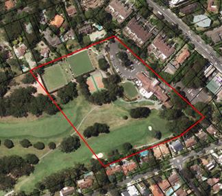
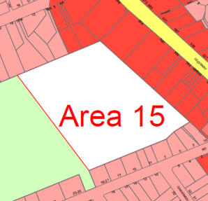
Location
and Context - Killara Golf Club - Deferred Area 15 (KLEP 2015)
Reason for the Planning Proposal
The applicant’s
justifications for the proposed amendments to the KLEP 2015 are as follows:
· there is a
growing worldwide trend of golf slowly losing popularity, especially amongst
younger people, with many golf clubs in Australia already experiencing
financial difficulty;
· Killara Golf
Club is currently in a strong financial position and wishes to maintain
this through good forward planning able to cater for the needs of a changing
local demography;
· the
Club sees as crucial to its future, the maintenance and continual improvement
of its golf course together with the provision of a wider offering of activities
and facilities for current and future Members; and
· through
the increased zoning, to ensure that future Boards and Members have options to
secure Club’s future including the major upgrade to the Clubhouse
facilities, enabling the Club to offer much greater functionality in a more
cost effective manner.
The Killara Golf Club proposal
seeks to maintain the KPSO residential status of the land with a partial
rezoning to a higher density as a means to enable long-term flexibility around
the use of the site to support and preserve the majority of the land as a golf
course and other related facilities. The Planning Proposal indicates that
should development of the site be found necessary at some future date to enable
the continued long-term operation of the Club, the Club will maintain the
existing golf provision through relocation of the facilities currently provided
on the Deferred Area, including the bowling greens and tennis courts.
The Planning Proposal
The Planning Proposal seeks to make the following amendments
to the KLEP 2015:
· rezone the
subject site from Residential 2(b) under the KPSO to a split zoning of
R2 (Low Density Residential) and R4 (High Density Residential);
· amend the
associated development standards to the R2 (Low Density Residential) and R4
(High Density Residential) land to be consistent with the KLEP 2015; and
· to amend the
heritage mapping and Schedule 5 - Environmental Heritage to delineate
and extend the Heritage Curtilage Area and the Heritage View Curtilage around
the Clubhouse Heritage Item.
These amendments to the KLEP 2015 are intended to:
· maintain the
Killara Golf Club’s flexibility on the use of the site;
· enable the
conservation of the heritage clubhouse and its curtilage; and
· to
facilitate future development to support and retain the long-term operation and
upkeep of the Club and its facilities, should the need arise.
Several studies form appendices to the Planning Proposal and
provide analyses and justifications for the Planning Proposal. The studies,
listed below, have been considered with comment and recommendations in the Table
of Amendments at Attachment A1.
· Detailed
Site Survey prepared by YSCO Geomatics;
· Killara Golf
Club Urban Design Study Dec 2016 – PMDL;
· Traffic
Report (Varga Traffic Planning);
· Conservation
Management Plan + Statement of Heritage Impact;
· Flora and
Fauna Assessment;
· Arborist
Report;
· Contamination
Report, SESL Australia; and
· Killara Golf
Club - Communications Outcomes Report, Elton Consulting.
A Planning Proposal is not a Development Application and
does not consider the specific detailed matters for consideration under section
79C of Environmental Planning and Assessment Act 1979. A Planning
Proposal relates only to an LEP amendment and the proposed amendments need to
be acceptable as an outcome on the site, regardless of the subsequent approval
or refusal of any future Development Application.
COMMENTS
A Planning Proposal must demonstrate the strategic merit of
the proposed amendments to a Local Environmental Plan. This Planning Proposal
has been assessed against the provisions of the Department of Planning and
Environment’s “A Guide to Preparing Planning Proposals” and
section 55 of the Environmental Planning and Assessment Act 1979.
Detailed assessment of the Planning Proposal and its
supporting studies has been conducted. In general the Planning Proposal is
supported conditional on the incorporation of all the recommended amendments
stipulated in this Council Report and in the Table of Amendments at Attachment
A1.
The following is an assessment of the key planning issues
regarding the amendments proposed in this Planning Proposal.
Zoning
As stated above, the subject site is currently zoned
Residential 2(b) under the KPSO enabling low density residential
development. The draft KLEP 2013 exhibited the land as RE2 Private
Recreation; however, following instruction from the Department of Planning
and Environment the site was deferred from KLEP 2015 and is known as
Deferred Area 15 in that LEP. This issue was not raised by the Club in submissions
to the exhibition of the Principal LEP at the time.
The Planning Proposal seeks to amend the zoning of the site
to:
· translate
the existing Residential 2(b) KPSO zoning to R2 (Low Density Residential) on
the majority of the site;
· rezone to R4
(High Density Residential) that portion of the site at the north-east of the
Deferred Area parcel.
It is understood that the motivation for Killara Golf Club
to rezone part of the site to R4 (High Density Residential) is to enable a
means of protecting and retaining the Golf Club and its associated facilities
into a future which is already experiencing a change in the traditional
recreational function of the sport.
The position to protect the longevity of the sport at this
location is supported as this recreational facility is important in the
long-term structure and historical fabric of the area.
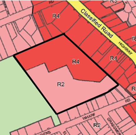
Planning Proposal
– proposed zoning
R2
(Low Density Residential) Zoning
The Planning Proposal retains a larger portion of the site
as R2 (Low Density Residential).
This is supported as the zoning has historically applied to
the land through the KPSO equivalent of Residential 2(b). Further, the
dwellings resulting from any future development of the site will not conflict
with the built form of the surrounding area which is predominantly single
dwellings (R2 (Low Density Residential) zone) located upslope from the Deferred
Area site.
R4
(High Density Residential) Zoning
The Planning Proposal incorporates an area of R4 (High
Density Residential) restricted to the north-east of the Deferred Area. The
location of the R4 (High Density Residential) zoning to that part of the site,
places any future high-density development mainly adjacent to existing areas of
similar R4 (High Density Residential) zoning fronting Pacific Highway and
Buckingham Road.
The proposal siting the R4 (High Density Residential)
component at this location is supported as the placement ensures no
overshadowing or impacts on solar access to adjacent properties, and will
result in limited impact on the golf course site itself with separation from
areas of biodiversity and heritage curtilages.
Conclusion
The split R2 (Low Density Residential) and R4 (High Density
Residential) zoning to the Deferred Area site is supported.
The amendments to the zoning boundaries, adjusted to
incorporate key trees into the heritage curtilage area is detailed in Table
of Amendments including at Appendix B Detailed Site Survey prepared by
YSCO Geomatics and Appendix C – Urban Design Study prepared by
PMDL and illustrated in the diagram below.

Recommended R2 (Low Density Residential) and R4 (High
Density Residential) Zone Boundaries
Heights
The Planning Proposal stipulates a height standard of 17.5m
to all the proposed R4 (High Density Residential) area; however, the PMDL
Urban Study attached to the Planning Proposal provides variations to the
heights within the R4 (High Density Residential) zoning.
The PMDL study indicates three height variations
within the R4 (High Density Residential) zoning labelled Area B, B1, B2
(discussed in detail in the Table of Amendments at Attachment A1).
The proposed heights are:
· Area B - a
maximum height level set by the Heritage Item Clubhouse;
· Area B1 - a
17.5m height enabling 5-storey development to the north-east of the site and on
the tennis court area;
· Area B2 - a
maximum RL109.810 height level enabling 4-5-storey development on the R4 (High
Density Residential) land adjacent to the R2 (Low Density Residential) area of
single dwellings fronting Buckingham Road.
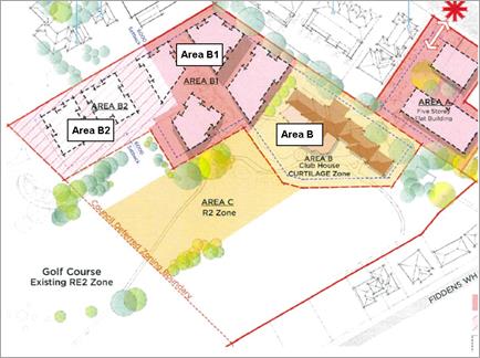
Planning Proposal – proposed height areas –
Area B, Area B1, Area B2
Topography
The boundary lines of the proposed Areas B1 and B2, with
their differing height standards is not supported.
As illustrated in the PMDL report and analysed in the
Table of Amendments at Attachment A1, the proposed height of Area
B1 on the tennis courts would enable a building with a greater height (RL
114.7) than the adjacent building (RL109.810) within Area B2 on the bowling
greens. This built form is not congruent with Council’s policy of
buildings stepping down in response to the sloping topography. Therefore it is
recommended that the boundary line between Area B1 and Area B2 be adjusted to
ensure the heights and built forms can better respond to the topography.
It is recommended that the RL109.500 apply to that part of
Area 1 located on and around the tennis court, and that this area be merged
into Area B2. This will give the additional advantage of the 5-storey element
being recessed from the wider views from the Clubhouse Heritage Item. See the
below diagram.
Views
Whilst the views from the Buckingham Road houses will change
should the site be developed in the future, it is acknowledged that the views
are not to the public domain, nor iconic, nor district views. The views are
landscape views across private property with no established propriety rights to
the neighbouring properties. For this reason views do not present sufficient
motive to dismiss consideration of rezoning to R4 (High Density Residential).
However, consideration of the amenity arising from the rezoning must be
addressed as the area directly adjacent to the single dwellings on Buckingham
Road creates an Interface Area.
Interface
Area B2 is classed as an interface site as it is directly
adjacent to R2 (Low Density Residential) land. As such, it is acknowledged that
there will be a change to the amenity (privacy and overlooking) of the
dwellings and their private open spaces should 5-storey buildings be permitted
adjacent to the 2-storey dwellings accessed from Buckingham Road.
Since Council has the position of providing an Interface
Area that acts as a buffer between low density R2 (Low Density Residential)
areas and high density R4 (High Density Residential) areas, it is important to
maintain consistency with that approach at this location.
An Interface Area may be provided through placing an R3
(Medium Density Residential) zoning with height limit of 11.5m (3-storey) in
between the R2 (Low Density Residential) 2-storey, and R4 (High Density
Residential) 5-storey zones; or, by placing R4 (High Density Residential)
zoning with height limit of 11.5m (3-storey) between the R2 (Low Density
Residential) height 9.5m-2 storey, and R4 (High Density Residential) 17.5m
– 5 storey zones.
Given the topography of the site, a lower height R4 (High
Density Residential) zoning to the interface area is preferred as it will limit
the footprint of the built structure. The footprint of R3 (Medium Density
Residential) development will be more widespread and reduce the ability to
provide view corridors and areas for large canopy tree planting around the new
development.
Use of Reduced Level (RL) Height Standard
To acknowledge the views that have benefited surrounding
properties albeit across private lands, and to ensure the proposed R4 (High
Density Residential) zone building heights maintain a relationship to the
existing balcony levels of the dwellings with R2 (Low Density Residential)
zoning on Buckingham Road adjacent to Area B2 (as provided in the PMDL
study attached to the Planning Proposal), it is recommended that the maximum
height permissible under the amended LEP be stipulated as a specific RL amount.
This will ensure that any future development that occurs in
front of the existing R2 (Low Density Residential) dwellings on Buckingham Road
will remain at a level that minimises impacts to those dwellings and is
congruent with Council’s approach to development on both topographically
sloping land and Interface Areas.
The PMDL study (discussed in Attachment A1) proposes
an RL109.810 to the B2 Area. A recommended reduction in this RL from the
proposed RL109.810 to RL109.500 will maintain the amenity to the dwellings at
8A, 14, 16, 22 Buckingham Road as it will retain height levels relative to
those dwellings. The reduction in the proposed RL will enable 3-story buildings
at the boundary with the dwellings (at the bowling greens), and a 4-storey
building further into the site at the lower level tennis court location.
Therefore, whilst the proposed height variations are
supported, a further reduction to Area B2 is recommended due to its status as
an Interface Area. This reduction to RL109.500 will limit the building heights
adjacent to the rear boundaries of the Buckingham Road dwellings. It will
ensure the proposed R4 (High Density Residential) development does not tower
over the neighbouring dwellings fronting Buckingham Road, and in tandem with
Council’s DCP controls of view corridors, 9m setbacks on such interface
sites, screening and landscaping requirements, will maintain privacy and
amenity to the rear of the dwellings and their gardens.
As a result of the recommended adjustment to boundaries for
zoning and differing heights to Areas B, B1, B2within the R4 (High Density
Residential) area, calculations are to be undertaken by the applicant to
establish the site FSRs based on the zoning and height areas recommended in
this Council report and in the Table of Amendments at Attachment A1.
The evidence and numerics of the FSR calculations must also be provided to
enable verification by Council.
Conclusion
The variation of height standards across the R4 (High
Density Residential) site is supported; however, a reduction in Height to Area
B2, classed as an Interface Area, will ensure that partial views and good
amenity, consistent with Interface Areas, is maintained to the neighbouring
single dwelling properties to Buckingham Road consistent with that afforded to
interface sites within the LGA.
The proposed mixture of height standards across the R4 (High
Density Residential) area will enable a variety of building heights and
corresponding FSR standards to be achieved appropriate to their location in the
Deferred Area. This will preserve amenity onsite and to adjacent properties.
The amendments to the height standards are detailed in Table
of Amendments including at Appendix B Detailed Site Survey prepared by
YSCO Geomatics and Appendix C – Urban Design Study prepared by
PMDL at Attachment A1 and illustrated in the diagram below
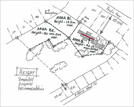
Recommended Boundaries for Height Variations
HERITAGE
The Clubhouse is a Heritage Item which under the KPSO has a
limited curtilage area around it. This Planning Proposal provides analysis of
the Item and its curtilage. Comment on these studies has been provided in the Table
of Amendments - Appendix E – Conservation Management Plan + Statement
of Heritage Impact at Attachment A1.
The CMP studies have resulted in a proposal that
seeks to ensure the long-term preservation of the Heritage Item through
adaptive reuse should it become necessary, and the establishment of two
Heritage Curtilage Areas protecting its setting: a Heritage Curtilage Area
directly around the Item, and a Heritage View Curtilage Area in front of the
building relating to views from the Item in a view corridor downslope across
the fairways.
Heritage
Item
The Killara Golf Course Clubhouse is identified as a local
Heritage Item under Schedule 7 of the KPSO and is located within the
proposed R4 (High Density Residential) area to the north of the site known as
Area B under the recommended Height diagram above.
The Planning Proposal seeks to retain the Clubhouse as a
Heritage Item with the option for its adaptive reuse and the formalisation of
its heritage curtilage area, including a new formalised area surrounding the
Clubhouse and a view curtilage (view corridor) to the main facade of the
building.
The Planning Proposal has looked at future options for the
Clubhouse, including a refurbishment of the existing building, or relocation of
the clubhouse facility to another location within the site and adaptive reuse
of the existing heritage listed building for high-end apartment living.
The R4 (High Density Residential) zoning may be perceived as
conflicting with the conservation of the Item. However, in this instance the R4
(High Density Residential) zoning is the zoning-through of a Heritage Item
which allows development in the vicinity of the item that does not impact on
the item’s significance, particularly with the recommended changes to the
zoning, height and curtilage boundaries, and allows for the adaptive reuse of
the building should it be necessary in the long-term.
Further, to mitigate against any future assumptions that R4
(High Density Residential) development is supported within the immediate
curtilage of the Heritage Item it is recommended the permissible Maximum
Building Height within the area identified in the CMP (page 74) as
Curtilage A, and identified in the Height map in the PMDL study and in
this Council Report as Area B, be limited to an RL equivalent to the main roof
ridgeline (running NE-SW) of the Clubhouse. This potentially permits adaptive
reuse of the Clubhouse while not supporting 5-storey development within the
curtilages of the Heritage Item. This RL is to be provided as stipulated in the
Table of Amendments including at Appendix B Detailed Site Survey
prepared by YSCO Geomatics and Appendix C – Urban Design Study
prepared by PMDL at Attachment A1.
In addition, the CMP refers to the item as Killara Golf
Course Clubhouse. The item name doesn’t fully describe the elements and
curtilage identified as significant. It is recommended to revise the Heritage
Item name in Schedule 5 to: Killara Golf Course Clubhouse including putting
green and fairway.
Heritage Curtilage Area and Heritage View Curtilage Area
The proposed curtilage for the Clubhouse, based on the
assessment CMP, is considered to be insufficient.
The nominated curtilage of the Heritage Item which includes
a significant view corridor has failed to include two groups of trees close to
the Clubhouse. Many of these trees have previously been assessed by Council in
the assessment of DA0147/11 as having significant aesthetic value to the
setting of the Heritage Item.
It is recommended to expand the mapped area for the Heritage
Item curtilages on the proposed Heritage Map within the Planning Proposal to
include the two groups of trees on the southern boundary of the proposed
Heritage Item (between the 1st and 18th holes) being H1
202-209, H18 160-164 and H1 188-200, extending the boundary of the Curtilage
Area and Visual Curtilage Area to the edge of the dripline of these trees
– also detailed in Table of Amendments including at Appendix B
Detailed Site Survey prepared by YSCO Geomatics and Appendix C –
Urban Design Study prepared by PMDL (Attachment A1).
Other Heritage considerations
The north-west corner of the proposed R4 (High Density
Residential) zone abuts an existing R2 (Low Density Residential) zoned area
which includes the Heritage Item I257 at 22 Buckingham Road. To have R4 (High
Density Residential) immediately adjacent to an R2 (Low Density Residential)
zoning creates an interface issue as discussed above in this Council Report. It
is Ku‑ring-gai Council’s practice to generally (where possible)
step down the built form bulk and scale through appropriate transitionary
zoning, or height/FSR standards within an interface site to reduce amenity
impacts such as overshadowing and loss of privacy that result from R4 (High
Density Residential) 5-storey buildings being adjacent to R2 (Low Density
Residential) 2-storey buildings.
Reducing the maximum building height of the site immediately
adjacent the 22 Buckingham Road Heritage Item from an RL109.810 to RL109.500
will ameliorate some of the impacts from having an incompatible zoning
immediately adjacent to the Heritage Item.
Conclusion
The retention and conservation of the Heritage Item via the R4
(High Density Residential) through-zoning with height and development standard
restrictions protecting the Item as recommended in this Council Report and the
Table of Amendments (Attachment A1) is supported.
The curtilages associated with the Item are also supported
conditional on the recommendation to expand the visual curtilage to include
significant trees on the boundary of the fairway as the trees contribute to
consolidating the fairways sense of place and facilitates the future
interpretation of its original use. Detail on the curtilage boundary lines may
be found in the Table of Amendments to the Statement of
Heritage Impact and detailed in Table of Amendments to Appendix
B – Detailed Site survey by YSCO Geomantics (Attachment A1).
Reduction of the height of the site known as Area B2 in the PMDL
Height map, and adjusted in the Height diagram above from RL109.810 to
RL109.500, will ameliorate some of the impacts to the 22 Buckingham Road
Heritage Item directly adjacent to the interface site.
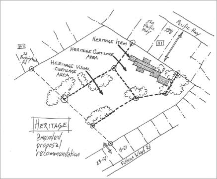
Recommended Boundaries for Heritage Curtilage and
Heritage View Curtilage
OTHER CONSIDERATIONS
Site specific Development Control Plan
Given the unusual nature of
this site, its “battleaxe” aspect, interface issues, topographical
features, heritage significance and ecological areas, it is recommended that
site specific provisions be prepared for inclusion in Council’s
comprehensive Development Control Plan (DCP) be prepared should a Gateway
Determination be issued for the public exhibition of the Planning Proposal.
This DCP amendment will be prepared by Council incorporating masterplan
principles discussed with the landowner with costs paid by the landowner and in
accordance Council’s Fees and Charges.
The DCP amendment would ensure consideration of: the
physical and visual amenity to adjacent low density dwellings including the
Heritage Items in the vicinity of the proposal; consideration of the Heritage
Item clubhouse and its curtilage and view corridor; consideration of new onsite
dwellings; and consideration of the users of the golf course. Consistent with
the current development controls in the DCP, the site specific DCP amendment
would reflect the landscape, screening, access, circulation, amenity and
setback requirements including the larger setback dimensions required on
Interface Areas adjacent to lower density zoning.
Traffic
Study
Whilst the access for all vehicles off Pacific Highway is
supported, consideration of further access off Fiddens wharf Road is
recommended. To this end, an assessment of impacts of a separate access point
from Fiddens Wharf Road for the R2 (Low Density Residential) zone at the
southern end of the Deferred Area site is required for inclusion into the Varga
traffic study. Refer to details in the Table of Amendments (Attachment
A1).
Contamination
Study
The Contamination Report by SESL conducted for this
Planning Proposal has limited the area of investigation to the carpark area
only; and, the study dismisses the requirement for consideration of
contamination and remediation consideration as part of this Planning Proposal.
This approach is not supported.
Contamination is a consideration for this site as it falls
under cl6 of SEPP 55, which requires contamination and remediation to be
considered in zoning or rezoning proposals involving residential purposes. This
Planning Proposal involves residential uses, moreover, the intensification of
the residential use to R4 (High Density Residential) will require extensive
excavation which warrants this investigation. In particular, the cl6(4)
references Table 1 of the Planning Guidelines which emphasises the
requirement to consider contamination and remediation for certain land uses
including horticultural activities (relating to the use of chemicals for
maintenance of the building greens and golf greens) and landfill (relating to
the built up landform to the building greens across the site). Further, the SESL
Report verifies these uses on pages 1 and 51:
“historically been used as a
golf course and has been filled to achieve the current landscape. This fill is
of unknown origin. Onsite activities involved in course maintenance include
pesticide and herbicide use.”
It is recommended that the SESL study investigates
the entire Deferred Area 15 site as detailed in the Table of Amendments
(Attachment A1).
SUMMARY OF
RECOMMENDED KEY CHANGES TO THE PLANNING PROPOSAL
The Planning Proposal is supported in principle as the
proposal presents sufficient planning grounds for proceeding with the
amendments to the KLEP 2015 and the progression of the Planning Proposal
for Gateway Determination, subject to the recommended changes presented in this
Council Report and the Table of Amendments at Attachment A1.
The key consideration is the reinstatement of the
residential use of the site under the KPSO and the ongoing retention of
social and recreational uses historically associated with this location,
particularly preserving the longevity of the recreational golfing facility in
uncertain economic and changing demographic times.
The key changes to the applicant’s Planning Proposal
are as follows:
1. Amend
the Planning Proposal as stated in the Table of Amendments at Attachment
A1 to ensure clear, correct and content consistent with Council’s
approach to land use planning is presented for Gateway Determination and for
public exhibition.
2. Amend
the Zoning Map boundary lines for the split R2 (Low Density Residential) and R4
(High Density Residential) zoning as required in this Council Report and the Table
of Amendments at Attachment A1and depicted in Figure 1 below.
Figure 1: Recommendation for zoning
amendments to the Planning Proposal
3. Amend
the Building Height Map boundary lines to include the following standards and
detail as required in this Council Report and the Table of Amendments (Attachment
A1) and depicted in Figure 2 below:
- R4
(High Density Residential) area with height of RL 109.500 from the corner
boundary point between 8A Buckingham Road and 6-8 Buckingham Road to the corner
point of the Heritage Curtilage Area and the Heritage Visual Curtilage lines
(referred to as Area B2 in this Council Report);
- R4
(High Density Residential) area with height of maximum 17.5m (referred to as
Area B1 in this Council Report);
- R4
(High Density Residential) area with height of maximum RL equivalent to the
main roof ridgeline of the Heritage Item Clubhouse running NW-SE (referred to
as Area B in this Council Report).
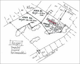
Figure 2: Recommendation for height
amendments to the Planning Proposal
4. Amend
the Heritage Map boundary lines to include the two heritage curtilage area
lines as per the Planning Proposal with the amendment stated below and as
required in this Council Report and the Table of Amendments (Attachment
A1), and depicted in Figure 3 below:
- Heritage
Visual Curtilage Area and Heritage Visual Curtilage Area (view corridor)
lines to include the two groups of trees on the southern boundary of the
proposed Heritage Item (between the 1st and 18th holes)
being H1 202-209, H18 160-164 and H1 188-200. Extend the boundary of the
Curtilage Area and Visual Curtilage Areas to the edge of the dripline of these
trees.
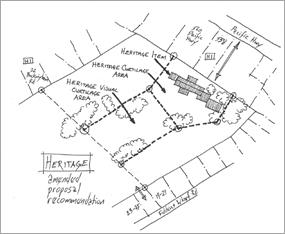
Figure 3: Recommendation for heritage
amendments to the Planning Proposal
5. Tabulate all numerics
relating to the R2 (Low Density Residential) and R4 (High Density Residential)
areas, including FSR calculations for each differing height area based on the
recommended maximum Heights for Area B, Area B1, Area B2. Include evidence and
numerics of the FSR calculations to enable verification by Council. Refer to
detailed requirements in this Council Report and the Table of Amendments (Attachment
A1).
6. Amend
the description of the Heritage Item for inclusion in KLEP 2015 Schedule 5 to
“Killara Golf Course Clubhouse including putting green and
fairway.”
7. Provide/assess
impacts of a separate access point from Fiddens Wharf Road for the R2 (Low
Density Residential) zone at the southern end of the site as required in this
Council Report and the Table of Amendments (Attachment A1).
8. Extend
the investigation area covered by the contamination report by SESL area
to cover all of the proposed R4 (High Density Residential) land within the
Deferred Area 15 and revise the statement to show that contamination and
remediation has been considered for the entire Deferred Area 15 site as
required in this Council Report and the Table of Amendments (Attachment
A1).
integrated planning
and reporting
Places, Spaces and
Infrastructure
|
Community Strategic
Plan Long Term Objective
|
Delivery Program
Term Achievement
|
Operational Plan
Task
|
|
P2.1 A robust planning
framework is in place to deliver quality design outcomes and maintain the
identity and character of Ku-ring-gai
|
Strategies, plans and
processes are in place to effectively manage the impact of new development
|
Continue to review existing
strategies and plans
|
Governance Matters
The process for the preparation and implementation of
Planning Proposals is governed by the provisions contained in the Environmental
Planning and Assessment Act 1979 and the Environmental Planning and
Assessment Regulation 2000.
Risk Management
This is a privately initiated Planning Proposal. Council
needs to determine its position on this Planning Proposal. Council risks damage
to its reputation if it does not undertake strategic land use planning in an
effective and timely manner.
Financial Considerations
This is a private Planning Proposal and Council’s Fees
and Charges have been applied to cover the Departmental costs of processing the
Planning Proposal. Should the proposal proceed to exhibition, advertising fees
will be sought from the applicant as per Council’s Fees and Charges.
Costs to develop the recommended site specific DCP controls upon Gateway
determination will be sought from the applicant in accordance with
Council’s Fees and Charges.
Social
Considerations
The Killara Golf Course had
submitted this Planning Proposal as a means of future proofing their land by
reinstating the residential uses on the site. This enables flexibility of the
land use into the future. The Club is committed to remaining in operation in
the long-term, continuing to provide the existing level of recreational uses
despite the global and national trends of diminishing interest in the sport of
golf.
Environmental Considerations
All aspects of the proposal with potential environmental
impacts have been considered in the preparation of this Council Report.
Assessment has included the investigation of riparian, biodiversity and
flora/fauna aspects relating to the site. The Planning Proposal will not impact
on the environmental aspects of the site. Any specific development that occurs
on the site as a result of the proposal will be considered in detail at the
development application stage.
Community
Consultation
Elton Consulting were engaged
by Killara Golf Club to undertake and report on a preliminary (non-statutory)
period of community consultation from 3 November 2016 to 24 November 2016.
Consultation was undertaken by the KGC to provide the community and relevant
stakeholders with an opportunity to comment on the Planning Proposal prior to
its finalisation and lodgement with Council.
If the Planning Proposal proceeds to a Gateway
Determination, the draft Planning Proposal will be formally publicly exhibited
by Council, in accordance with the requirements of the Gateway
Determination and the NSW Department of Planning Guide to Preparing Local
Environmental Plans.
Internal Consultation
Where relevant, internal consultation with other Departments
of Council has taken place for the preparation of this report. Staff
provided Councillors a presentation on the overall planning proposal and the
opportunity to ask any questions on Tuesday 13 June 2017.
Summary
The Killara Golf Club has submitted a Planning Proposal to
consider the zoning and development standards on a portion of their land known
as Deferred Area 15 under the KLEP 2015. The Planning Proposal seeks to
reinstate the existing KPSO residential zoning across the Deferred Area
with a split zoning of R2 (Low Density Residential) and R4 (High Density
Residential).
The motivation for Killara Golf Club to rezone part of the
site to R4 (High Density Residential) is to enable a means of protecting and
retaining the Golf Club and its associated facilities into a future which is
already experiencing a change in the traditional recreational function of the
sport. The position to protect the longevity of the sport at this location is
supported as this recreational facility is important in the long-term structure
and historical fabric of the area.
The proposed amendments address the conflicting concerns
around the proposal, namely the flexibility sought through the proposal that
will support the long term retention of the Killara Golf Club facilities into
the future, and the issues of interface impacts on neighbouring properties and
the protection of the Heritage Item and its curtilages.
The recommendation of this Council Report is to support the
proposal and proceed it to Gateway Determination subject to the Planning
Proposal being amended in accordance with this Council Report and the Table
of Amendments at Attachment A1.
|
Recommendation:
A. That the Planning Proposal be amended in
accordance with the recommendations in this Council Report and Table of
Amendments at Attachment A1.
B. That the Planning Proposal be forwarded to
the Department of Planning and Environment for a Gateway Determination in
accordance with section 56 of the Environmental Planning and
Assessment Act 1979.
C. That
delegation be given to the General Manager and Director of Strategy and
Environment to verify all amendments are in accordance with the
recommendations of this Council Report and Table of Amendments at Attachment
A1prior to forwarding to the Department of
Planning and Environment.
D. That
should a Gateway Determination be issued for public exhibition of the
Planning Proposal, site specific amendments to Council’s Comprehensive
Development Control Plan be prepared in accordance with Council’s
fees and charges, the details in this Council Report and the Table of
Amendments at Attachment A1 and be placed on public exhibition
concurrently with the Planning Proposal.
E. That
a Report be brought back to Council, as per any Gateway requirements,
following the exhibition of the Planning Proposal and site specific draft
Development Control Plan.
F. That
Council proceeds to make the Plan under delegated authority under Section 23
of the Environmental Planning and Assessment Act 1979.
G. That
the applicant be notified of Council’s Resolution.
|
|
Rathna Rana
Senior Urban Planner
|
Craige Wyse
Team Leader Urban Planning
|
|
Antony Fabbro
Manager Urban & Heritage Planning
|
Andrew Watson
Director Strategy & Environment
|
|
Attachments:
|
A1
|
Table
of Amendments
|
|
2017/150666
|
|
|
A2
|
Department
of Planning and Environment Letter to Council 4 March 2015
|
|
2017/147155
|
|
|
A3
|
Planning
Proposal
|
|
2017/144167
|
|
|
A4
|
Appendix
A Checklist of Consistency with Section 117 Directions and SEPPs
|
|
2017/144164
|
|
|
A5
|
Appendix
B Detailed Site Survey prepared by YSCO Geomatics
|
|
2017/144160
|
|
|
A6
|
Appendix
C Killara Golf Club Urban Design Study December 2016, PDML
|
|
2017/144158
|
|
|
A7
|
Appendix
D Killara Golf Club 556 Pacific Hwy Killara - Traffic and Parking Assessment
Report
|
|
2017/144156
|
|
|
A8
|
Appendix
E Statement of Heritage Impact and Conservation Management Plan December 2016
|
|
2017/144154
|
|
|
A9
|
Appendix
F Flora & Fauna Assessment – Planning Proposal –
Deferred Area 15 at Killara Golf Course & 552-554 Pacific Hwy Killara
|
|
2017/144150
|
|
|
A10
|
Appendix
G Preliminary Arboricultural Assessment – Planning Proposal
Deferred Area 15, May 2016
|
|
2017/144149
|
|
|
A11
|
Appendix
H Tier 1 Detailed Site Investigation Killara Golf Course 556 Pacific Hwy
Killara – SESL Australia
|
|
2017/144144
|
|
|
A12
|
Appendix
I Killara Golf Club Planning Proposal Consultation Outcomes Report, Elton
Consulting
|
|
2017/144141
|
|
|
A13
|
Appendix
J Information Checklist
|
|
2017/144136
|
|
Ordinary
Meeting of Council - 27 June 2017
|
GB.5 / 141
|
|
|
|
|
Item
GB.5
|
S06649
|
|
|
22 May 2017
|
Draft Revised Bush Fire Environmental
Assessment Code and Draft Planning for Bush Fire Protection 2017
EXECUTIVE
SUMMARY
|
purpose of report:
|
To seek
endorsement of the proposed contents of a Council submission to the NSW Rural
Fire Service (RFS) on the draft Revised Bush Fire Environmental Assessment
Code and supporting documents, and for Council to note that no submission
is to be put forward by Council in regards to draft Planning for Bush Fire
Protection 2017.
|
|
|
|
|
background:
|
The NSW RFS is currently inviting public submissions
on a draft Revised Bush Fire Environmental
Assessment Code and supporting documents in accordance with sections 100J
to 100N of the Rural Fires Act 1997, and a
draft Planning for Bush Fire Protection 2017.
|
|
|
|
|
comments:
|
This report outlines a number of
key concerns, implications and recommendations for inclusion in
Council’s submission on the draft Revised Bush Fire Environmental
Assessment Code and supporting documents, for consideration and
endorsement by Council.
No concerns have been raised
in regards to the Draft Planning for Bush Fire Protection 2017.
|
|
|
|
|
recommendation:
|
That Council endorses the
submission as provided within Attachment A1, on the Draft Bush Fire
Environmental Assessment Code and supporting documents.
That Council notes a submission in regards to the Draft
Planning for Bush Fire Protection 2017 will not be submitted.
That Council undertakes a
review of all relevant spatially identified land management agreements, for
provision to the RFS and that conditions relating to these agreements be
stored within an accessible location to enable provision of conditions within
3 working days.
|
Purpose of Report
To seek endorsement of the proposed contents of a Council
submission to the NSW Rural Fire Service (RFS) on the draft Revised Bush
Fire Environmental Assessment Code and supporting documents, and for
Council to note that no submission is to be put forward by Council in regards
to draft Planning for Bush Fire Protection 2017.
Background
The NSW Rural Fire Service has prepared a draft Revised
Bush Fire Environmental Assessment Code and a number of supporting
documents in accordance with sections 100J to 100N of the Rural Fires Act
1997, and a Draft Planning for Bush Fire Protection 2017. The NSW
RFS is currently inviting public submissions on these draft instruments until
Sunday, 25 June 2017. Ku‑ring-gai Council will be required to provide any
draft submissions by this date, but has been granted an extension to the
deadline and may provide a final submission no later than 5:00pm Sunday, 2 July
2017.
It should be noted that prior to the release of this draft,
the RFS have sought to engage Council and other land managers over a number of
years in the creation of the draft Revised Bush Fire
Environmental Assessment Code and the Bush Fire
Protection for Existing Development Guidelines (draft).
The Bush Fire Environmental Assessment Code 2006 (the
Code) is a streamlined environmental assessment process to
facilitate the approval of bush fire hazard reduction works. The draft
Revised Bush Fire Environmental Assessment Code is proposed to replace the
current version which has been in operation since 2006. The Code simplifies the
approval of bush fire hazard reduction works which would otherwise require
consideration of the full range of environmental approvals provided for by
other environmental legislation. The major changes to the existing Bush Fire
Environmental Assessment Code are the broadening of the scope of the Code
to include an approvals process for a range of hazard reduction works not
previously covered, and the inclusion of the supporting document Bush Fire
Protection for Existing Development Guidelines (draft). This report
outlines a number of key concerns, implications and recommendations for
inclusion in Council’s submission on the draft Revised Bush Fire
Environmental Assessment Code, for consideration and endorsement by
Council.
Planning for Bush Fire Protection provides the
development standards for bush fire prone areas in NSW. The Draft Planning
for Bush Fire Protection (PBP) 2017 will replace Planning for Bush Fire
Protection (PBP) 2006. Major changes within the Draft PBP 2017 are outlined
within Attachment A2; additionally:
· As for PBP
2006, the minimum APZ distances specified by draft PBP 2017 for new
development vary depending on the effective slope and vegetation formation
present. In most cases, there is a proposed increase in the minimum APZ
distance of between 1m and 12m for residential development and up to 19m for
SFPP development;
· The document
provides improved alignment and replicates sections of AS 3959-2009
(Construction of buildings in bushfire-prone areas) and ‘National
Association of Steel-Framed Housing Standard’ (NASH). For example:
o for Residential Infill
Development, the draft PBP 2017 has adopted a suite of additional measures over
and above AS 3959:2009 and the NASH standard;
o the Draft PBP 2017
replaces the site assessment methodology for determine the bush fire attack
level when determining the construction requirements for buildings in a
designated bush fire prone area;
· Additional
clarification has been provided to bushfire requirements for multi-storey
residential development and historic buildings;
· Provisions
relating to dual occupancy, multi-dwelling housing, secondary dwellings
(including detached granny flats) and boarding houses have been elaborated
upon, including:
o where an existing
dwelling within the subject site and a second building can otherwise comply
with the provisions of the Draft PBP 2017, it may be necessary to upgrade the
existing dwelling;
o where a secondary
dwelling could be considered as complying development providing it can achieve
BALLow, BAL-12.5, BAL-19 or BAL-29. A complying development is also required to
meet the access, water and landscaping requirements of Draft PBP 2017;
o as for the PBP
2006, unless assessed as complying development a bush fire safety authority
(BFSA) from the NSW RFS for subdivision on bush fire prone land under section
100B of the Rural Fires Act 1997 is required.
The document restructuring, simplifications and
clarifications have improved the documents usability. No significant concerns
have been raised during the internal consultation phase of preparing this
report and no recommendations are made for inclusion in a Council submission.
Comments
The following provides a summary of the key points and
recommendations, as they relate to the Ku-ring-gai area in response to the
draft Revised Bush Fire Environmental Assessment Code and supporting
documents released by the NSW RFS for public comment.
Draft Bush Fire Environmental Assessment Code
a) In preparing the draft Bush Fire Environmental
Assessment Code and supporting documents, the RFS has not met the
requirements of section 100J of the Rural Fires Act 1997 to have regard
for the principles of ecologically sustainable development.
The proposed inclusion
of an approval process for transport corridors, fire breaks, fire trails and
vehicle-accessible control lines is welcomed, as is the relocation of specific
conditions and standards to supporting documents so they can be more easily updated
to reflect future advances in best-practice guidelines.
It is considered that
broadening the scope of the Code to facilitate the approval of larger scale
recurring clearing works, such as the creation and maintenance of linear fire
breaks and Neighbourhood Safer Places as well as clearing on land adjacent to
Neighbourhood Safer Places, will result in serious and ongoing environmental
damage which cannot be adequately addressed by the streamlined Code. Other,
more rigorous environmental approval processes are available to facilitate
highly damaging works where they are necessary, and the Bush Fire
Environmental Assessment Code should only be applicable to relatively
low-impact works; those with small scale or short term negative impacts.
b) Section
2.6.1 (Certificates issued under 100F of the Rural Fires Act 1997) states
that “the conditions on a certificate must not be inconsistent with
any of the conditions of the following land management agreements, unless
mutually agreeable conditions are developed in consultation with the public
authority responsible for the agreement”.
However it is noted that a number
of the land management agreements listed within Section 2.6.1 expressly
permit the carrying out of hazard reduction works as a standard condition (i.e.
not an optional condition). In these cases there is concern that the
above restriction may not afford actual environmental protection to the areas
subject to those agreements.
It is requested that a clause be
included in the Bush Fire Environmental Assessment Code to clearly
articulate the requirement of issuing authorities to consider not just the
conditions of a land management agreement but the intent of that agreement and
the effect of proposed hazard reduction works on that land management
agreement. The presence of a land management agreement must be grounds to
either refuse an application for a Hazard Reduction Certificate (to potentially
be approved under a more rigorous process) or require alternative, less
environmentally damaging hazard reduction works.
c) To
better facilitate the control of weeds, it is requested that conditional
mechanical works be included as permissible works within Strategic Fire
Advantage Zones.
d) The
inclusion of an approval process for linear fire breaks is not supported, and
it is requested that this be removed from the Code. Clarification is sought
regarding the benefits of linear fire breaks over other less damaging works,
and it is suggested that the negative environmental impacts of these works
cannot be adequately addressed by a simplified environmental approval process.
e) The
inclusion of an approval process for the establishment of a Neighbourhood Safer
Place (NSP) is not supported, and it is requested that this be removed from the
Code. In regards to NSPs, the Code should apply only to maintaining those that
already exist.
f) Clarification
is sought on the extent of works permissible on land adjoining a NSP,
specifically the definition of the “external boundary” of an open
space NSP. It is suggested that no clearing should be permitted on land
adjoining an open space NSP and the Code should permit clearing on land
adjoining a building NSP only.
g) It
is noted that the requirement to prevent the spread of noxious or environmental
weeds is hindered by the prohibition of mechanical works in Strategic Fire
Advantage Zones. The proposed future inclusion of Fire and Weed Management
Guidelines is supported.
h) Information
is sought on the justification of a proposed reduction to the minimum fire interval
for Wet Sclerophyll Forest (Shrubby) vegetation from 25 years to 15 years.
Draft Bush Fire Protection for Existing Development
Guidelines
The draft Bush Fire
Protection for Existing Development Guidelines propose an approach to risk
treatments that is impractical to implement, and the principals of ecologically
sustainable development are not adequately applied.
a) There
is concern that the draft Bush Fire Protection for Existing Development
Guidelines place a disproportionate focus on separation distance and
reducing radiant heat exposure, while failing to adequately address the more
pertinent risk of ember attack or to promote the concept of shared
responsibility for bush fire risk management.
b) Proposed
separation distances are based on a radiant heat target of 19kW/m2.
It is suggested that a higher radiant heat target of 29kW/m2 be
adopted, and a greater emphasis be placed on building upgrades and homeowner
preparedness.
c) It
is requested that impediments to the ongoing maintenance of bush fire risk
treatments (e.g. steep slopes) be considered a trigger for the application of
alternative risk treatments.
d) It
is requested that a targeted community engagement activity be required as a
standard component of the acceptable approach to risk treatments.
e) It
is suggested that the RFS facilitate the regulation and enforcement of
compliance with the Building Best Practice Guide – Upgrading of
Existing Buildings.
f) It
is requested that the presence of high biodiversity value (e.g. threatened
species, endangered ecological communities, land management agreements,
biodiversity corridors, regionally significant species etc.) be considered a
trigger for the application of alternative risk treatments.
integrated planning and reporting
Community, People and Culture
|
Community Strategic
Plan Long Term Objective
|
Delivery Program
Term Achievement
|
Operational Plan
Task
|
|
An aware community able to prepare and respond to the risk
to life and property from emergency events.
|
Plans are developed in partnership with emergency service
agencies and key stakeholders and implemented.
|
Complete fire trail, fire
break and hazard reduction maintenance programs.
|
Governance Matters
It is important that Council comment on the draft Revised
Bush Fire Environmental Assessment Code and supporting documents to ensure
that administrative issues are addressed and best practice measures are
implemented.
Whilst the time frame requirements for issuing Hazard
Reduction Certificates have not changed, additional workloads may be
experienced for works affecting property subject to the following land
management agreements:
a) any
conservation agreement entered into under Division 12 of Part 4 of the National
Parks and Wildlife Act 1974;
b) any property
agreement entered into under Part 5 of the Native Vegetation Conservation
Act 1997;
c) any
Trust Agreement entered into under Part 3 of the Nature Conservation Trust
Act 2001;
d) any
property management plan approved by the Director-General of National Parks and
Wildlife under section 91 of the Threatened Species Conservation Act 1995;
e) any
Property Vegetation Plan agreement entered into under Part 4 of the Native
Vegetation Act 2003;
f) any
property subject to a Biobanking Agreement entered into under Part 7A of the Threatened
Species Conservation Act 1995;
g) any
Joint Management Agreement with another public authority under s.121 of the
Threatened Species Conservation Act 1995;
h) any
Conservation Agreement established under a section 88b Conveyancing Act 1919
instrument that requires the retention and management of vegetation for
conservation purposes or protection of environmental values on private lands
prepared;
i) any
agreement established under a section 88E(3) Conveyancing Act 1919
instrument by a prescribed authority that identifies and requires the retention
and management of vegetation;
j) land
subject to a Voluntary Planning Agreement between a planning authority and a
developer; and
k) any agreement entered into under legislation that replaces
the National Parks and Wildlife Act 1974, the Native Vegetation Act
2003, the Nature Conservation Trust Act 2001 or the Threatened
Species Conservation Act 1995 or associated regulations.
The draft code states that in
regards to issuing a Hazard Reduction Certificate under 100F of the Rural
Fires Act 1997:
“An
issuing authority is to consider whether the property is subject to any
applicable land management agreements that have been spatially identified by
the relevant public authority and provided to the NSW RFS by that public
authority.
The
appropriate public authority is to make available a copy of the relevant
conditions associated with any identified agreement within three working days
of a request by an issuing authority.”
Whilst it is assumed that The
Office of Environment and Heritage will be the public authority for the
majority of the land management agreements listed above, Council may be the
public authority for sum (e.g. Conservation Agreement established under a section
88b Conveyancing Act 1919, where Council is party to the agreement).
It is recommended that Council
undertake a review of all relevant land management agreements within the LGA
that have been spatially identified; for provision to the RFS; and that
conditions relating to these agreements are stored within an accessible
location to enable provision of condition within 3 working days.
Risk Management
The draft Revised Bush Fire Environmental Assessment Code
and supporting documents do not demonstrate a comprehensive risk management
strategy and may have implications surrounding the resourcing of strategic
hazard reduction works as identified in Council’s Bush Fire Risk
Management Plan.
Financial Considerations
The draft Revised Bush Fire Environmental Assessment Code
and supporting documents may have significant implications for Council budgets
and resourcing relating to maintenance, regulation and compliance.
For example, many residential properties and major buildings
within bushland-adjacent subdivisions in the Ku-ring-gai LGA, as in many other
areas of the state that were developed prior to the introduction of Planning
for Bush Fire Protection, provide very little distance separating privately
owned buildings and public land. Meaning that there are large stretches of
urban-bushland interface where the APZs required to meet the standards of Bush
Fire Protection for Existing Development will need to be constructed almost
entirely on land managed by Council or other public agencies. The construction
of these new APZs, as well as the expansion of existing APZs that do not meet
the proposed standards, will result a substantial increase in demand on land
managers, potentially diverting resources away from strategic hazard reduction
works. In many cases the works will simply not be feasible.
Social Considerations
It is important that Council comments on the Draft
Revised Bush Fire Environmental Assessment Code and supporting documents to
ensure that realistic and effective measures are introduced and/or promoted
which reduce the risks from bushfire to life and property.
Environmental Considerations
The draft Revised Bush Fire Environmental Assessment Code
and supporting documents will have implications for loss of canopy, endangered
ecological communities, threatened species, heritage, soil erosion and riparian
systems.
Council’s submission seeks to ensure that the code
seeks to align more strongly with the principles of ecologically sustainable
development and best practice measures which will reduce risk and conserve our
environment, biodiversity and local area values/amenity.
Community Consultation
This submission responds to the community vision of ‘Working
together as a community to protect and enhance our natural environment and
resources’ and the long term objectives of ‘a community
addressing and responding to the impacts of climate change and extreme weather
events’ and ‘an aware community able to prepare and respond
to the risk to life and property from emergency events’, in
Council’s Community Strategic Plan 2030, which is based on the results of
extensive community consultation and engagement.
Internal Consultation
Staff from Strategy and Environment, Operations, and
Development and Regulation were consulted on the draft Revised Bush Fire
Environmental Assessment Code and supporting documents, as well as the
draft Planning for Bush Fire Protection 2017, and have contributed to
this report and its associated submission.
Summary
The NSW Rural Fire Service
has prepared a draft Revised Bush Fire Environmental Assessment Code and
supporting documents, as well as a draft Planning for Bush Fire Protection
2017. The RFS is currently seeking public comment on these draft documents.
This report details the key concerns and implications for the Ku-ring-gai area,
and recommendations for inclusion in Council’s submission to the RFS on
the draft Revised Bush Fire Environmental Assessment Code and supporting
documents, for consideration and endorsement by Council. No concerns have been
raised or recommendations made in regards to the draft Planning for Bush
Fire Protection 2017.
|
Recommendation:
A. That
Council endorses the submission as provided within Attachment A1, on
the draft Bush Fire Environmental Assessment Code and
supporting documents.
B. That
Council notes a submission in regards to the draft Planning for
Bush Fire Protection 2017 will not be submitted.
C. That
Council undertakes a review of all relevant spatially identified land
management agreements, for provision to the RFS and that conditions relating
to these agreements be stored within an accessible location to enable
provision of conditions within 3 working days.
|
|
Heath Fitzsimmons
Technical Officer Bushfire
|
Penny Colyer
Team Leader - Natural Areas
|
|
Andrew Watson
Director Strategy & Environment
|
|
|
Attachments:
|
A1
|
Submission
to NSW RFS
|
|
2017/163707
|
|
|
A2
|
PBP
2006 to DRAFT PBP 2017 – What has changed
|
|
2017/164343
|
|
Ordinary
Meeting of Council - 27 June 2017
|
GB.6 / 149
|
|
|
|
|
Item
GB.6
|
FY00382/9
|
|
|
14 June 2017
|
Revised Delivery Program and Operational
Plan 2017-2018 - Post Exhibition
EXECUTIVE
SUMMARY
|
purpose of report:
|
For Council to adopt the revised Delivery Program 2013
– 2017 and Operational Plan 2017 – 2018, incorporating the
Budget, Capital Works Program, Statement of Revenue Policy and Fees and
Charges for 2017 – 2018.
|
|
|
|
|
background:
|
In December 2016 the Office of Local Government
advised councils with deferred elections that an additional Operational Plan
for the period 2017 – 2018 must be developed and adopted by 30 June
2017.
On 2 May 2017, Council considered a report on the
Revised Delivery Program 2013 – 2017 and draft Operational Plan 2017
– 2018, incorporating the budget, capital works program, statement of
revenue policy and fees and charges for 2017 – 2018. At that meeting
Council resolved to place the revised program and draft plan on public
exhibition for a minimum period of 28 days in accordance with Sections 404
and 405 of the Local Government Act, 1993.
|
|
|
|
|
comments:
|
The revised Delivery Program 2013 – 2017 and
draft Operational Plan 2017 – 2018 were exhibited for a period of 29
days from 5 May to 2 June 2017. Twelve (12) external and four (4) internal
written submissions were received as a result of the exhibition. Following a
review of the submissions minor amendments and corrections are proposed to
the operational plan and fees and charges.
|
|
|
|
|
recommendation:
|
That pursuant to Sections 404 and 405 of the Local
Government Act, 1993 Council adopts the revised Delivery Program 2013
– 2017 and Operational Plan 2017 – 2018 incorporating the Budget,
Capital Works Program, Statement of Revenue and Fees and Charges for 2017
– 2018.
|
Purpose of Report
For Council to adopt the revised Delivery Program 2013
– 2017 and Operational Plan 2017 – 2018, incorporating the Budget,
Capital Works Program, Statement of Revenue Policy and Fees and Charges for
2017 – 2018.
Background
In December 2016 the Office of Local Government advised
councils with deferred elections that an additional Operational Plan for the
period 2017 – 2018 must be developed and adopted by 30 June 2017.
On 2 May 2017, Council considered a report (GB.1) on the
Revised Delivery Program 2013 – 2017 and draft Operational Plan 2017
– 2018, incorporating the budget, capital works program, statement of
revenue policy and fees and charges for 2017 – 2018. At that meeting
Council unanimously resolved to place the revised program and draft plan on
public exhibition, with amendments, for a minimum period of 28 days in
accordance with Sections 404 and 405 of the Local Government Act, 1993
(Act), as follows:
A. That
the revised Delivery Program 2013-2017 and draft Operational Plan 2017-2018,
incorporating the Budget, Capital Works Program, Statement of Revenue Policy
and Fees and Charges for 2017-2018, be endorsed and placed on public exhibition
for a period of twenty-eight (28) days.
B. That
following public exhibition, a further report is submitted to Council to
consider any submissions, to adopt the revised Delivery Program 2013-2017 and
Operational Plan 2017-2018 including Fees and Charges 2017–2018.
Comments
On 25 June 2013 Council adopted a suite of documents that
form the Integrated Planning and Reporting Framework. This included the:
• Community
Strategic Plan;
• Delivery
Program & Operational Plan; and
• Resourcing
Strategy.
As required by the Office of Local Government this fifth
Operational Plan has been developed to facilitate the delivery of
Council’s current term achievements, contained in its revised Delivery
Program 2013 – 2017, while maintaining the key themes and any activities
not yet complete. The Plan contains the services, projects and tasks to be
undertaken by Council during the year supported by an annual budget and works
program.
The Delivery Program and new Operational Plan developed for
2017 - 2018 are presented in a single integrated document. Organisational
performance is measured through the progress or delivery of four year term
achievements and critical actions and one year tasks under each theme. In
addition performance indicators are included under each theme, to provide both
qualitative and quantitative information back to the community.
As required by the Act the document was placed on public
exhibition for a minimum period of twenty-eight (28) days to allow for
community feedback.
As required by legislation, the revised Delivery Program and
Operational Plan also contains the income (revenue) and budget for Council over
the coming year which supports the various services and projects to be
delivered.
integrated planning and reporting
Leadership and Governance
|
Community Strategic
Plan Long Term Objective
|
Delivery Program
Term Achievement
|
Operational Plan
Task
|
|
L3.1
The organisation is recognised and distinguished by its ethical
decision-making, efficient management, innovation and quality customer
service.
|
L3.1.1
Council’s integrity and operation effectiveness is
continually being improved through its leadership, decision-making and
policies.
|
L3.1.1.1.3
Prepare Integrated Planning and Reporting documents and
complete all statutory reporting required under the Local Government Act and
Integrated Planning and Reporting framework.
|
Governance Matters
The legislative requirements to prepare and exhibit the
revised Delivery Program 2013 - 2017 and draft Operational Plan 2017 - 2018
each year, incorporating the budget, capital works program, statement of
revenue policy and fees and charges for 2017 – 2018 is governed by
sections 404 and 405 of the Local Government Act, 1993.
It is the responsibility of Council to consider all
submissions made during the exhibition of the draft program and plan prior to
their adoption.
Risk Management
The structure and content of the revised Delivery Program
and draft Operational Plan comply with the requirements of the Local
Government Act, 1993. Council has a statutory obligation to prepare,
exhibit, consider feedback and adopt the revised Delivery Program and Operational
Plan, no later than 30 June each year.
Financial Considerations
Financial
summary
Ku-ring-gai Council is in a sound financial position. The
2017-18 budget provides for an operating surplus of $21 million after allowing
for the depreciation expense on Council’s $1.068 billion portfolio of
depreciable assets such as roads, footpaths, drains and buildings. If capital
grants and contributions are excluded, the operating result remains in surplus,
with a result of $1.5 million. This is consistent with Council’s long
term financial plan which provides a framework to achieve continued operating
surpluses.
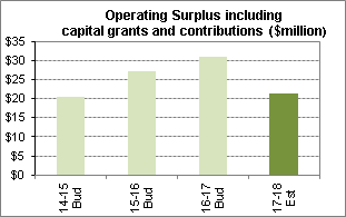
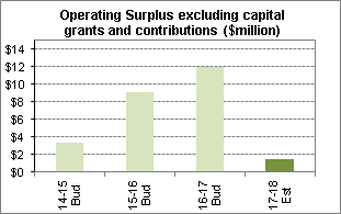
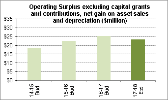
The Operating Surplus contributes
to Council’s capital works program. In 2017-18 the capital works program
is $53 million. Details of the capital works program for 2017-18 can be found
under separate Attachments.
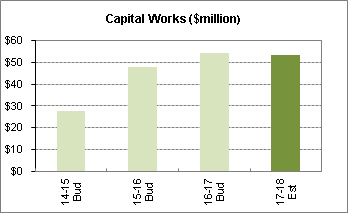
Council’s long term financial plan and budget ensures
that Council maintains adequate liquidity. This is demonstrated by the
Unrestricted Current Ratio, for which the industry benchmark of greater than
1.5:1 is considered to be “Satisfactory” and greater than 2:1 to be
“Good”. Council’s budget maintains a “Good”
Unrestricted Current Ratio that is greater than 2:1.
Council’s 2017-18
budget provides for loan capital repayment of $1.7 million. Council’s
debt peaked at $43.7 million in 2013-14 and is projected to be gradually repaid
over the period 2015-16 to 2022-23 from Council’s operating surplus and
asset sales.
Council collects s.94
contributions from developers to help pay for new infrastructure and facilities
for the growing population of the area. Some of the works to be undertaken in
the s.94 plan cater for the existing population and these works require a
co-contribution from Council’s general funds. The works programmed to be
undertaken over the next year are shown below:
Council’s total Rates
income is “pegged” by the State Government and approval must be
obtained for increases above this amount (known as Special Rates Variations).
In the 2017-18 budget the projected Rates income is $61.8 million. This amount
includes the permanent existing Special Rates Variations for Infrastructure and
the continuation of the Environmental Levy.
A summary of Council’s Funding Statement for the next
year 2017/18 is provided below. Years 2014/15 - 2016/17 are also provided as
they are part of the revised Delivery Program 2013-2017.

Budget
principles
Council’s budget for 2017-2018 is developed using the
10 Year Long Term Financial Plan (LTFP). The LTFP principles and financial
sustainability tests applied in developing next year’s budget and future
financial planning are outlined in Council’s Resourcing Strategy. In summary
these are:
1.
maximise funds available for projects to renew infrastructure;
2.
satisfy applied tests of financial sustainability; and
3.
a borrowing and loan repayment strategy.
The draft 2017-2018 budget has been developed to ensure that
the LTFP financial targets are met and maintained in the future.
Major assumptions of the
2017-2018 budget include:
· CPI
of 2.3% applied;
· the
Independent Pricing and Regulatory Tribunal (IPART) approved rate pegging
increase of 1.5%;
· no
price increase for domestic waste charges;
· fees
and charges increased by an average of 2.3%;
· interest on
investments estimated at 2.8%;
· employee
costs increase of 3.5%;
· capital
works and other major projects program of $53 million; and
· Section 94
revenue plus interest of $20.6 million transferred to externally restricted
reserves and expenditure of $31.9 million from these reserves;
Rating
structure 2017-2018
Each year the NSW Government approves a maximum percentage
increase in the total income a council can receive from rates, known as the
‘rate-peg’. The rate peg for 2017-2018 has been determined by IPART
at 1.5% and this percentage increase has been applied to Council’s rates.
Ordinary General Residential and Business Rates, plus the
special ‘Infrastructure – Primary Rate’ together represent
the total notional rates income of Council excluding the rates received from
the two special rate variations. The rates structure represented in the table
below divides this amount into the Ordinary Rates (59%) and
‘Infrastructure – Primary Rate’ (41%).
Under this rates structure, Council will grant a voluntary
pensioner rebate (in addition to the Statutory Rebate) of 8.5% of the total
rates and charges. This voluntary rebate will apply to pensioners who are
eligible for the Statutory Rebate.
Rates
structure including rate peg increase of 1.5%
The details of rates levied for
the 2017/18 will be as follows:
|
Type
|
Category
|
Rate in $
|
Min/Base
Amount
$
|
% of Revenue from Base for each rate
|
Yield
$
|
|
Ordinary
|
Residential
|
0.00064484
|
514
|
|
28,862,339
|
|
Ordinary
|
Business
|
0.00447545
|
514
|
|
4,247,621
|
|
Special
|
Infrastructure – Primary Rate
|
0.00029358
|
|
|
11,509,574
|
|
Special
|
Infrastructure – Primary Rate
|
|
268
|
49.98%
|
11,498,808
|
|
Special
|
Infrastructure - Special Rate Variation
|
0.00003661
|
|
|
1,435,188
|
|
Special
|
Infrastructure
- Special Rate
Variation
|
|
32
|
48.89%
|
1,372,992
|
|
Special
|
Environmental
– Special
Rate
Variation
|
0.00006984
|
|
|
2,737,977
|
Stormwater
management charge
The stormwater management
service charge for 2017-2018 is levied under Section 496A of the Local
Government Act 1993 (as amended).
The charges have been set in accordance with the Local
Government Amendment (Stormwater) Bill 2005 and for 2017-2018 are as follows:
Strata/Company titled residential home units:
$12.50 per unit
Other residential property: $25.00
per rateable property
Business
rateable property: $25.00
per 350 square metres of land area (a maximum charge of $1,500.00 applies to
land area greater than 21,000 square metres).
Strata/Company
titled business units: A
minimum of $5.00 or the relevant portion of the maximum annual charge that
would apply to the land subject to the strata scheme if it were a parcel of
land subject to the Business rateable property charge.
Waste
management charge – for business properties
The waste management charge for
2017-2018 is levied under Section 501 of the Local Government Act 1993
(as amended).
Council’s annual waste management charges include a
charge for waste management per business service provided. Upon request, a 120L
waste bin to be emptied weekly will be provided. In 2017/2018 this charge will
be $270 per service.
The charge for aged care/nursing
homes rated as business properties will be $270 per service. The service is:
· equivalent
of 120 litres of waste per service per week; and
· equivalent
of 120 litres of recycling per service per week.
Domestic
waste management charge
Sections 496 and 504 of the Local Government, Act 1993 (as
amended) require councils to make and levy an annual charge for the provision
of domestic waste (DWM) service for each parcel of rateable land for which the
service is available, ensure that the cost of providing the service is met by
the charge and that the charge is reasonable for the services provided. A
council cannot use income from its ordinary rate towards the cost of providing
DWM services.
Charges for 2017-2018 are
shown below:
|
Category
|
Charge
per Occupancy
|
Number
of Services
|
Estimated
Yield
|
|
Base Service
with Green waste
|
$455.00
|
26,392
|
$12,008,360
|
|
Base Service
without Green waste
|
$305.00
|
395
|
$120,475
|
|
Flat, Home Unit
|
$395.00
|
10,764
|
$4,251,780
|
|
Additional Green waste Bin
|
$150.00
|
3,202
|
$480,300
|
|
240L waste bin with Green waste
|
$655.00
|
4,827
|
$3,161,685
|
|
Additional 120L waste bin
|
$200.00
|
171
|
$34,200
|
|
Availability / Vacant Land
|
$180.00
|
216
|
$38,880
|
|
240L waste bin without Green waste
|
$505.00
|
28
|
$14,140
|
|
240L waste, flat home unit
|
$595.00
|
5
|
$2,975
|
|
Total
Yield
|
|
|
$20,112,795
|
Note: For
aged care/retirement villages rated as Residential Properties, charge is
applied per service as follows:
· base service
without green waste plus $152.50 (being 50%) for each additional service
–
· 1 x bed
self-care unit; and
· base service
without green waste plus $76.25 (being 25%) for each additional service –
· 1 x bed
fully serviced hostel room.
Note: For
aged care/retirement villages exempt from rating, charge is applied under
Section 496(2) per service as follows:
· base service
without green waste plus $152.50 (being 50%) for each additional service
–
· 1 x bed
self-care unit; and
· base service
without green waste plus $76.25 (being 25%) for each additional service –
· 1 x bed
fully serviced hostel room.
Fees and charges schedule for 2017 - 2018
The revised Delivery Program and draft Operational Plan
includes a range of proposed increases to current fees and charges in
2017-2018. Underlying these is the pricing methodology in relation to fees and
charges which are not prescribed by legislation. The pricing methodology seeks
to ensure Council recovers its costs in delivering of services, while also
allowing for fees and charges to be discounted, where appropriate, in
recognition of Council’s community service obligations.
Council’s Fees and Charges have been increased where
appropriate. Fees that have not been subject to an annual increase include
Statutory and Regulatory Fees, Section 94 Contributions and those where it was
not commercially viable to do so.
Changes to Fees & Charges post exhibition
Council has been advised of the
following changes to statutory rating fees which are set each year by the
Minister for Local Government:
Rates - Section 603 Certificate
Under section 603 of the LG Act,
Council issues a certificate as to the amount (if any) of rates and charges due
or payable to the council for a parcel of land. Section 603(2) states the
application must be accompanied by the approved fee. In accordance with the
approved methodology, the approved fee for 2017-18 is determined to be $80.
The previous year fee (2016-17) was $75.
Rates - Maximum Interest on Overdue Rates and
Charges
In accordance with section
566(3) of the LG Act, it has been determined that the maximum rate of interest
payable on overdue rates and charges for the 2017-2018 rating year will be 7.5%,
compared to 8% in 2016 - 2017.
Annual
Budget 2017 - 2018 – Changes to Operational and Capital Budget
Revision to Roads Program: A submission was received
in reference to the Roads Program for the Dumaresq and Moree Streets, Gordon
land acquisition for a new street (page 93 of exhibited document). The resident
has queried the $3,626,000 line item. The above project included budget for a
portion of the land acquisition which was already acquired in previous years.
The remainder of funds are to be allocated to construction only. The cost of
construction of the new road has been revised and is approximately $2,621,100
funded from S94 development contributions.
It is recommended that the Roads program for 2017 – 18
be amended to reduce the allocation for Dumaresq and Moree Streets, Gordon.
Rates Levied: Minor
changes have been made to the rate in the dollar as a result of additional
supplementary valuations received after finalising the Draft 2017 - 2018 Annual
Budget. The rates levied are listed under section “Rates
Structure including Rate Peg increase of 1.5% “in this report.
No other changes have been made to the total 2017- 2018
Budget since it was placed on public exhibition. Minor changes to the
budget will be reflected in the September Quarterly Budget Review.
Social Considerations
Integration of the Delivery Program and Operational Plan
with the Community Strategic Plan, including the same six (6) themes and term
achievements from that plan, ensures that the program and plan address social
justice principles and social issues in an integrated way, along with civic leadership,
environmental and economic issues as required by the Integrated Planning and
Reporting framework.
Environmental Considerations
The revised Delivery Program and Operational Plan, through
integration with the Community Strategic Plan, address both natural and built
environment issues in a comprehensive manner integrated with civic leadership,
social and economic issues as required by the Integrated Planning and Reporting
framework.
Community Consultation
The revised Delivery Program 2013 – 2017 and draft
Operational Plan 2017 – 2018, including draft Fees and Charges, were
publicly exhibited for 29 days from 5 May to 2 June 2017. Copies of the
exhibition documents were made available at Council’s Customer Service
Centre at Chambers and Council’s four (4) libraries as well as being
available on Council’s website.
Notification of the exhibition included a local newspaper
advertisement within Council’s dedicated Ku-ring-gai Focus section as
well as information on Council’s website homepage with direct links to a
dedicated page explaining the exhibition and documents.
Twelve (12) external and four (4) internal submissions were
received and are summarised in the tables below.
|
Submission
|
Issues raised
|
|
1. Resident
|
Request for Yarrara Road,
West Pymble to be resurfaced due to its poor existing condition.
|
|
Response:
Council uses a sophisticated Pavement Management System to
assess all road pavements within Ku-ring-gai. The assessment, which is
reviewed annually, takes into account existing pavement condition, traffic
loading and available funds. It enables Council to determine the most
cost effective pavement treatment and timing and develop a prioritised road
rehabilitation program.
Council is aware of the road condition of Yarrara Road.
Under Council’s draft five (5) year program, this road was initially
identified for inclusion in the 2017-2018 Road Rehabilitation program.
However, due to budgeting allocation the road was unable to be listed in the
Delivery Program and draft Operational Plan 2017 – 2018. It has
therefore not been included in the proposed 2017 – 2018 road program.
Recommendation
That the resident be informed that Yarrara Road, West
Pymble will be reviewed for inclusion in the 2018- 2019 Road Rehabilitation
program. This program is reviewed annually subject to available funding
and adoption by Council.
|
|
Submission
|
Issues raised
|
|
2. Resident
|
Submission seeking confirmation that Council will
investigate inclusion of a half court for basketball in its design planning
for Gordon Park, consistent with earlier Council advice.
|
|
Response:
At the meeting of 9 December 2014 Council resolved to
allocate up to $7000 from the Section 94 Reserve (2010 Contributions Plan
– Parks and Sporting Facilities South) in the 2015 first quarter budget
review for the immediate installation of a basketball half court at
Regimental Park, Killara.
As Regimental Park sits on top of a Sydney Water
reservoir, Council officers approached Sydney Water in early 2015 seeking in
principle support prior to Council spending money on geotechnical and
engineering reports. In principle approval was given in April 2015 and
footing details were forwarded to Sydney Water in June 2015. In August 2016
Sydney water requested further information and subsequently imposed a load
rating for the reservoir roof of 5.4Kpa. Council engineers calculated the
footing for the basketball hoop to be some three times more than the load
rating permitted by Sydney Water.
As Council was then unable to install the basketball hoop
at Regimental Park it is proposed to relocate the hoop to Gordon Recreation
Ground as part of the masterplanning and playground upgrade works. To date an
initial public survey has been carried out to inform the masterplan. The
development of the masterplan will take place over the first quarter of
2017-2018 and will include public consultation on the proposed facilities and
works. Following Council’s adoption of a masterplan it is
anticipated that works will commence late in the 2017-2018 financial year.
Recommendation
That the resident be advised in terms of the response
above.
|
|
Submission
|
Issues raised
|
|
3. President
of Roseville Park Tennis Club, Manager of Online Tennis
|
Seeking urgent inclusion of the construction of a new
clubhouse/tennis pavilion at Roseville Park in Council’s 2017 –
2018 Operational Plan for the following reasons:
· That the
replacement of the tennis pavilion, which was demolished over four years ago
does not include funding for in 2017 – 2018 Operational Plan.
· Roseville
Park tennis courts are one of the largest tennis court complexes in
Ku-ring-gai.
· The
demountable building and port-a loos provided by Council temporarily are
inadequate for the large number of patrons who use the tennis facilities.
This includes tennis club members, 461 juniors in the Online Tennis program
and other tennis players who use the facilities.
· There is
no access to hot water for tennis patrons.
· The club
is prepared to contribute to the financial cost of works and to seek grant
funding from other agencies once a DA is finalised.
|
|
Response:
In October 2013 a fallen tree branch damaged three
external wall panels and roofing to the existing tennis shelter at Roseville
Park. After risk assessments were conducted and reports identifying
asbestos, Council organised for the tennis shelter to be demolished. Due to
limited funding and heritage curtilage issues related to nearby Firs Cottage,
a replacement building was not considered suitable at the original location.
As a temporary arrangement, Council established a demountable building
(powered) to service the full time tennis coach (Online Tennis) and the
Roseville Park Tennis Club. Portable toilets (x2) were also set up onsite to
supplement the existing toilet facilities located at the nearby amenities
building at Roseville Park and the public toilets open in line with Firs
Cottage trading hours.
Council’s Section 94A Contributions Plan 2015 states
that whilst the Roseville Park Masterplan was adopted in 2015, the first
notional funding available in Council’s Long Term Financial Plan (LTFP)
was in 2017- 2018 where $570,000 had been allocated through the Infrastructure
and Facilities Reserve. At least $4M is required to implement most of the
Masterplan’s high priority items. However, it is acknowledged that a
replacement Tennis Pavilion with the provision of amenities would rank highly
in the priority order for the park.
The LTFP was predicated on a number of asset sales. These
asset sales rely on the reclassification of land by the NSW Government which
have been significantly delayed, deferred and in some cases rejected. Without
asset sales limited funding is available and as a result the project was not
included in the Draft Operational Plan. However, in the interim it is
proposed that $60,000 be allocated in the 2017-2018 financial year from S94A
for the design and public consultation for the tennis pavilion with amenities.
Allocation of these funds in the 2017–2018 budget are proposed as part
of Council’s September Quarterly Budget Review process.
It must be noted that until alternate funding is
identified or the NSW Government advances the reclassification proposals,
there are no funds available for the construction.
Recommendation
· That
Council include the design and consultation for the construction of a tennis
pavilion with amenities at Roseville Park in the 2017/2018 Operational Plan.
· That
Roseville Park Tennis Club and Online Tennis be advised of Council’s
response.
|
|
Submission
|
Issues raised
|
|
4. Member
of Roseville Park Tennis Club
|
Seeking Council’s urgent attention to replace the
tennis clubhouse building and facilities demolished over 5 years ago for the
reasons that the temporary port-a-loos and facilities provided by Council are
inadequate for all users of Roseville Park facilities as well as the
detrimental effect this has on tennis club membership.
|
|
Response:
See response provided to Submission 3 above.
Recommendation
· That
Council include the design and consultation for the construction of a tennis
pavilion with amenities at Roseville Park in the 2017/2018 Operational Plan.
· That the
club member be advised of Council’s response.
|
|
Submission
|
Issues raised
|
|
5.)
6.)
7. ) Northern Suburbs Football Association Inc.
|
Three separate submissions
were received from Northern Suburbs Football Association, the governing body
for football on Sydney’s North Shore, advising Council of its
support for the capital works included in Council’s draft 2017-2018 Operational
Plan which will assist its
15 NSFA clubs located in
the Ku-ring-gai LGA with combined 7000 members:
Norman Griffiths Oval,
West Pymble – confirming the NSFA’s support for
Council’s funding towards the development of the Oval in addition to
$125,000 of committed NSFA funds and $50,000 secured government funding.
Comenarra Playing Field,
Turramurra and George Christie Oval , Wahroonga - confirming the
NSFA’s support for Council’s funding towards the upgrade to
amenities at these locations.
Completion of the 200 space
carpark at the North Turramurra Recreation Area; Stage 4 works at Koola Park,
East Killara; Primula Park sportsfield upgrade and investigation of
upgrading Warrimoo Oval surface - confirming the NSFA’s support for
Council’s funding towards these projects.
|
|
Response: The submissions from Northern
Suburbs Football Association in support of the above proposed works are
noted.
Recommendation
That the Northern Suburbs Football Association be advised
that Council has received and noted its submissions in support of the above
stated capital works.
|
|
Submission
|
Issues raised
|
|
8. Northern Suburbs Football Association Inc.
|
Seeks Council’s co-contribution for a ZAPSTAND
automated external defibrillator to be located at North Turramurra Recreation
Area. The estimated running and maintenance cost is $8,000 + GST per annum of
which the association is seeking an annual 50% contribution from Council.
|
|
Response:
The NSFA submission follows discussions with Council
officers regarding the defibrillator proposal where they were advised that
Council does not currently have funding for this in the NTRA budget.
This defibrillator is designed as an externally accessible
unit and has recently been installed at Circular Quay. Preliminary
assessment suggests that the unit has merit based on the projected numbers of
patrons that will be utilising the three sportsfields and golf course within
the NTRA. The robust design may also overcome Council maintenance and
vandalism concerns with a previous proposal to install units in change
rooms.
Funding opportunities are presently being discussed with
the Association. This includes applying for a small equipment grant
under Council’s community grants program, which closes on July 2, as
well as seeking advice on state government funding opportunities.
Recommendation:
· That
Council officers continue to liaise with the Northern Suburbs
Football Association regarding the proposed defibrillator equipment at
the North Turramurra Recreation Area including security and maintenance
requirements and funding opportunities.
· That the
Association be advised in the above terms.
|
|
Submission
|
Issues raised
|
|
9. Resident
|
Recommends the following
priorities for funding as a result of the high number of new dwellings being
built in the Ku-ring-gai area:
Improve infrastructure
· Change
the existing Pacific Highway (from Roseville to Wahroonga) to three (3)
lanes, including T2 and T3 lanes and left/ right turning lanes.
· Make
all train stations accessible with lifts or ramps
· Increase
train and bus services
Provide more public
schools
· Increase
the number and capacity of local public schools to reduce the demand for
demountable buildings through higher buildings while maintaining valuable
outdoor areas
Dwelling lot size
· Reduce
the minimum residential lot size to 600-700m2 to allow for denser
housing and increase housing affordability whilst protecting the environment
through mandatory tree planting.
Town centres
· Replace
the east side of Gordon town centre (between the railway and Pacific Highway)
with mixed use 8-10 storey buildings
· Replace
Gordon Centre with a bigger centre.
|
|
Response:
Improve infrastructure
Council has been planning
for transport changes in targeted local centres in Ku-ring-gai for a number
of years, in conjunction with Roads and Maritime Services (RMS), Transport
for NSW and other transport stakeholders. A suite of traffic flow and intersection
changes have been proposed in Turramurra, Pymble, Gordon, Lindfield and
Roseville, and agreed to by RMS (in principle).
Traffic flow and
intersection changes in these centres include upgrades and improvements to
locations on the Pacific Highway in Ku-ring-gai. Ultimately though, traffic
management of the Pacific Highway is the responsibility of Roads and Maritime
Services, which is addressing traffic delays, managing congestion and
improving travel times on Sydney's major roads through its Pinch Points
Program.
Similarly, lift access to
train stations and additional train and bus services is the responsibility of
Transport for NSW, although Council works with and lobbies Transport for NSW
and other state agencies to seek opportunities for improvements to transport
infrastructure.
Provide more public
schools
As part of the North District planning process the Greater
Sydney Commission, NSW Education Department and Council are working closely
on meeting the demand for schools in the region.
Dwelling lot size
As part of the North District planning process Council
will be preparing a housing strategy for Ku-ring-gai local government area
looking at various options for increasing housing supply, housing choice and
affordability.
Local centre
Council has commenced a master planning process for Gordon
focusing on Council owned land within the Gordon local centre.
The master plan process will explore opportunities to work collaboratively
with major landowners to play a role as catalyst for the revitalisation and
activation of Gordon local centre. This would include wider benefits for the
community in terms of significant public domain works, community facilities
and civic space provision and vastly improved pedestrian connectivity. It
is anticipated that consultation with the community will occur in late 2017.
Recommendation
That the resident be advised in terms of the response
above.
|
Submission
|
Issues raised
|
|
10. Resident
|
Traffic management and
congestion when exiting the Wade Lane, Gordon car park onto Park Avenue,
Gordon and would like Council to consider options such as traffic signals.
|
|
Response:
The traffic issues associated with exiting the Gordon
train station (Wade Lane) carpark, particularly during peak times, are
noted. As part of the upcoming Gordon local centre masterplanning
process, Council will be reviewing traffic conditions in this precinct. At
this stage it is intended to consult with the community in late 2017.
Recommendation
That the resident be advised in terms of the response
above including the forthcoming review of traffic conditions and community
consultation for this precinct.
|
Submission
|
Issues raised
|
|
11. Resident
|
Concerns in relation to the
loss of existing carparking at the new Lindfield Hub site and likely
accessibility issues for older residents if they cannot drive to the precinct
and are required to walk, cycle or take public transport.
|
|
Response:
The Lindfield Village (Community) Hub is a redevelopment
project being undertaken by Council on Council owned land. The 1.3
hectare site will deliver a mixed use precinct and will include publicly
accessible parking within the development along with commuter parking and
additional on-street parking provision.
Recommendation
That the resident be advised in terms of the response
above.
|
Submission
|
Issues raised
|
|
12. Resident
|
This submission is in reference to the Roads Program for
the Dumaresq and Moree Streets, Gordon land acquisition for a new street
(page 93 of exhibited document). The submission queried the $3,626,000 line
item as the acquisition was completed in previous years.
|
|
Response:
This project incorrectly included a portion of the funding
associated with the land acquisition. The cost of construction of the new
road has been revised and the balance of funds allocated for construction is
approximately $2,621,100, from S94 development contributions.
Recommendation
· That the
Roads Program for 2017 – 18 be amended to reduce the allocation for
Dumaresq and Moree Streets, Gordon.
· That the
resident be advised in terms of the response above.
|
|
|
|
|
Internal Consultation
The development of the draft Operational Plan, incorporating
the budget, capital works program, statement of review policy and fees and
charges for 2017 – 2018 was undertaken in full consultation with all
departments across Council. Refinement to the draft documents, as a
result of ongoing review by staff and councillors during the public exhibition
period are proposed for inclusion. Minor revisions to tasks and the capital
works list are summarised below. Minor typographical and formatting errors
identified during the exhibition period have also been corrected.
Theme
|
Community, people and culture
|
|
Reference
|
Page 46
Term Achievement – C6.1.1
Council’s planning approach to the provision of
housing across Ku-ring-gai addresses the supply, choice and affordability
needs of the community.
Critical Action – C6.1.1.1
Investigate opportunities/locations to provide a range of
housing choices.
|
|
Objective/
Action
|
Proposed additional task
|
|
Add/Delete/Change
|
New task wording:
C6.1.1.1.3 - Prepare a Development Application for
the Council owned land at 259-271 Pacific Highway, Lindfield (known as the
Lindfield Library site) consistent with Council’s adopted master plan
and lodge the Development Application with Council.
|
|
Reason
|
Council is currently awaiting gazettal of the LEP
amendment by the Department of Planning and Environment which includes
reclassification of the site to operational land and rezoning. The proposed
Task will enable the next stage of planning for the site to be progressed
following gazettal.
|
Theme
|
Natural Environment
|
|
Reference
|
Page 48
Term Achievement - N1.1.2
Increased community action that benefits the
environment AND
Critical Action - N1.1.2.1
Development of environmental resources, tools and targeted
education programs for a range of user groups.
|
|
Objective/
Action
|
Two (2) additional tasks
|
|
Add/Delete/Change
|
New task wording:
N1.1.2.5 - Conduct a comprehensive consultation
program for Council’s Special Rate Variation application for the
permanent continuation of the Environmental Levy.
New task wording:
N1.1.2.6 - Prepare a Special Rate Variation
application under section 508(2) of the Local Government Act, 1993 for
the permanent continuation of the Environmental Levy.
|
|
Reason
|
At its meeting of 13 June 2017, Council resolved to
prepare a Special Rate Variation application to IPART under section 508(2) of
the Local Government Act 1993 for the permanent continuation of the
Environmental Levy and, as part of the application, to conduct extensive
community consultation to determine community support for the ongoing Levy to
fund environmental and sustainability programs and initiatives.
The additional tasks proposed for the 2017 -2018
Operational Plan enable Council’s resolution to be formally actioned.
|
Theme
|
Places, spaces and infrastructure
|
|
Reference
|
Page 58
Term Achievement - P7.1.2
Usage of existing community buildings and facilities is
optimised, AND
Critical Action - P7.1.2.4
Golf courses are professionally managed in line with
industry standards.
|
|
Objective/
Action
|
Minor wording changes to two (2) exhibited Operational
Plan Tasks and one (1) additional Task.
|
|
Add/Delete/Change
|
Minor changes to two (2) exhibited Operational Plan Tasks
to read as follows:
P7.1.2.4.1 – Continue to develop programs,
services and marketing the new North Turramurra course layout as part of
North Turramurra Recreation Area (NTRA) to existing and potential customers
with the support of the course contracted professional.
P7.1.2.4.2 – Golf Course professional
services are operating to meet customer and industry standards.
New task wording:
P7.1.2.4.3 - Manage the transition to Council
directly operating the ongoing professional services at Gordon Golf Course
pro-shop.
|
|
Reason
|
The wording changes are proposed to clarify
Council’s responsibilities and service expectations for these
facilities. The additional Task is proposed to reflect Council’s new
management of the Gordon Golf Course.
|
Theme
|
Leadership and governance AND capital works
program list
|
|
Reference
|
Councillor Berlioz sought clarification regarding the
following three (3) matters in the draft Operational Plan and Capital Works
program:
Page 73 - The Performance Indicator ‘Customer
requests actioned within agreed service delivery standard’ was not
included in the exhibited document.
Page 76 – A ‘Property Asset Divestment’
graph was not included in the exhibited document.
Page 89 – Project described as ‘Removal of
traffic signals at the intersection of Pacific Highway and Park Avenue,
Gordon.’
|
|
Reason
|
Councillor Berlioz received the following responses in
relation to the above queries:
· The
performance indicator was inadvertently omitted during the preparation of the
draft document and will be included in the final adopted Plan.
· Council’s
asset sales have been deferred to 2018/19 and future years and a
‘Property Asset Divestment’ graph is not required for this Plan.
· The $900
indicated against the project to remove traffic signals at the intersection
of Pacific Highway and Park Avenue, Gordon is a contribution towards the
ongoing transport planning study for Gordon local centre, with a particular
focus on the Gordon Cultural Hub project.
Responses to the above were noted by Councillor Berlioz.
|
Summary
The revised Delivery Program 2013 - 2017 and Operational
Plan 2017 – 2018, incorporating the budget, capital works program,
statement of revenue policy and fees and charges for 2017 – 2018 have
been prepared in accordance with the Local Government Act, 1993, and the
Integrated Planning and Reporting framework.
The minor changes proposed to the revised Delivery Program
and draft Operational Plan including the budget, capital works program and fees
and charges for 2017 - 2018, in the report, are not considered to have a
substantial or material change to the strategic direction and delivery of
Council’s services and projects. For this reason it is recommended that
Council adopt the revised documents without the need to re-exhibit.
|
Recommendation:
A. That
Council adopts the revised Delivery Program 2013 - 2017 and Operational Plan
2017 - 2018, incorporating the Budget, Capital Works
Program, Statement of Revenue Policy and Fees and Charges
for 2017 - 2018.
B. That
an ordinary rate in the dollar of $0.00064484 on the unimproved capital value
of all rateable land categorised as residential in the Council area be made
for the period of 1 July 2017 to 30 June 2018.
C. That
an ordinary rate in the dollar of $0.00447545 on the unimproved capital value
of all rateable land categorised as business in the Council area be made for
the period of 1 July 2016 to 30 June 2018.
D. That
the minimum ordinary rate for both residential and business be set at $514.00
for the period 1 July 2017 to 30 June 2018.
E. That
an infrastructure - primary rate in the dollar of $0.00029358 on the
unimproved capital value of all rateable land categorised as residential or
business in the Council area, with a $268 base amount be made for the period
of 1 July 2017 to 30 June 2018.
F. That
an infrastructure special rate in the dollar of $0.00003661 on the unimproved
capital value of all rateable land categorised as residential or business in
the Council area, with a $32 base amount be made for the period of 1 July
2017 to 30 June 2018.
G. That
an environmental special rate in the dollar of $0.00006984 on the unimproved
capital value of all rateable land categorised as residential or business in
the Council area, with a zero base amount, be made for the period of 1 July
2017 to 30 June 2018.
H. That
the voluntary pensioner rebate be granted to all eligible pensioners as a
flat percentage of 8.5% of total rates and charges in 2017 - 2018.
I. That
Council writes to all residents and groups that made submissions in relation
to the Revised 2013 - 2017 Delivery Program and draft Operational Plan 2017 -
2018 and respond to the authors with the outcomes.
|
|
Helen Lowndes
Integrated Planning Co-ordinator
|
Deborah Silva
Manager Integrated Planning, Property & Assets
|
|
Angela Apostol
Manager Finance
|
Andrew Watson
Director Strategy & Environment
|
|
David Marshall
Director Corporate
|
|
|
Ordinary
Meeting of Council - 27 June 2017
|
GB.7 / 167
|
|
|
|
|
Item
GB.7
|
S10973
|
|
|
13 June 2017
|
Public Roads within Major Projects Sites
EXECUTIVE
SUMMARY
|
purpose of report:
|
To seek Council approval to formally resolve the
status of land within the Lindfield Village Green and the Lindfield Community
Hub sites as public roads.
|
|
|
|
|
background:
|
On 6 September 2016 a report was submitted to Council
to formally resolve the status of land within the Lindfield Village Green and
the Lindfield Community Hub sites as public roads.
|
|
|
|
|
comments:
|
Council’s earlier resolutions are suitable for
the lands that are being compulsorily acquired under the Local Government
Act 1993, however, in relation to lands being acquired as roads
under the Roads Act 1993 new resolutions are required to ensure
statutory compliance.
|
|
|
|
|
recommendation:
|
That Council proceed with the compulsory acquisition
of land and roads as outlined in the report.
|
Purpose of Report
To seek Council approval to formally resolve the status of
land within the Lindfield Village Green and the Lindfield Community Hub sites
as public roads.
Background
Since 2013 Council has
considered reports on the revitalisation and master planning in the Lindfield
local centre involving two Council-owned sites. These sites are the Lindfield
Village Green and the Lindfield Community Hub.
A component of these earlier reports referred to the
closure, partial closure and compulsory acquisition of public roads within the
sites to effect site consolidation and deliver the masterplans.
On 21 April 2015, Council
considered a report on the compulsory acquisition of public roads to enable the
delivery of the Lindfield Village Green and the Lindfield Community Hub
projects. At which time Council unanimously resolved proceed with compulsory
acquisition of the unnamed public road for the purpose of creating the
Lindfield Village Green in accordance with the Land Acquisition (Just Terms
Compensation) Act 1991.
On 6 September 2016 a further report was submitted to
Council to formally resolve the status of land within the Lindfield Village
Green and the Lindfield Community Hub sites as public roads.
In preparing the compulsory acquisition and road opening
documentation a number of statutory inquiries have been completed which have
identified specific requirements to ensure the successful implementation of
Council’s previous decisions.
This report seeks to resolve the status of land within the
Lindfield Village Green and Lindfield Community Hub sites.
Comments
Lindfield
Community Hub
Council is the owner of all lands within the Lindfield
Community Hub site. The only remaining requirement for Council to fully
consolidate the site into one lot is the closure of the portion of Drovers Way
north of Beaconsfield Parade. This road is to be replaced with a new public
road along the western boundary of the site from Beaconsfield Parade through to
Bent Street (Attachment A1)
A requirement of the compulsory acquisition process is to
prepare a Plan of Acquisition for registration with the LPI NSW. The attached
Plan of Acquisition (Attachment A2) identifies Lots 1, 2 and 6 DP1226294 to be
compulsorily acquired.
Council’s earlier resolutions are suitable for the
lands that are being compulsorily acquired under the Local Government Act
1993, however, in relation to Lots 1 & 2 DP1226294 these lands
are being acquired as roads under the Roads Act 1993 and new resolutions
are required to ensure statutory compliance.
Lindfield Village Green
In order to deliver the
Lindfield Village Green, Council has resolved to consolidate various properties
owned by Council fronting Kochia Lane, Chapman Lane and Tryon Road and compulsorily
acquire part of “unnamed lane”.
A requirement of the compulsory acquisition process is to
prepare a Plan of Acquisition for registration with the LPI NSW. The attached
Plan of Acquisition (Attachment A3) identifies Lot 23 part of the
unnamed lane and Lot 21 DP1223433 to be compulsorily acquired.
At Council’s meeting of 6 September 2016 the
resolution to compulsorily acquire Lot 21 DP1223433 for a future public road
should have also included the specific resolution to make application to the
Minister and Governor under the Roads Act 1993.
As Lot 21 land is being acquired as road under the Roads
Act 1993 new resolutions are required to correct the omission and to ensure
statutory compliance.
integrated planning and reporting
Places, Spaces & Infrastructure
|
Community Strategic Plan Long Term Objective
|
Delivery Program
Term Achievement
|
Operational Plan
Task
|
|
Our centres offer a broad range of shops and services and
contain lively urban village spaces and p[place where people can live, work,
shop, meet and spend leisure time.
|
Plans to revitalise local centres are being progressively
implemented and achieve quality design outcomes in collaboration with key
agencies, landholders and the community
|
Implement a place management approach for the local centre
improvements to coordinate works and achieve quality outcomes
|
|
|
An improvement plan for Lindfield Centre is being
progressively implemented in collaboration with owners, businesses and state
agencies
|
Engage with relevant stakeholders to establish timing,
extent and partnership opportunities
|
|
|
|
Develop and finalise project scope
|
|
|
|
Maintain engagement with key stakeholders
|
Governance Matters
Compulsory acquisition is a statutory process and approval
by the Minister for Local Government and the Governor is required.
Council obtains its powers to compulsory acquire land and
road under the Local Government Act 1993 and the Roads Act 1993.
The process of acquiring the public roads by compulsory
acquisition is to be carried out in accordance with the Land Acquisition (Just
Terms Compensation) Act 1991.
Roads Act 1993
Section 10 Land held by RMS or by
councils
(1) RMS
or a council may, by notice published in the Gazette, dedicate any land held by
it (including land acquired by it under Division 1 of Part 12) as a public
road.
(2) On
the publication of the notice, the land is dedicated as a public road.
The
process of acquiring land for public road is carried out in accordance with
Section 177 Roads Act 1993;
177 Power to acquire land
generally
(1) The
Minister, RMS or a council may acquire land for any of the purposes of this
Act.
(2) Without
limiting subsection (1), the Minister, RMS or a council may acquire:
(a) land
that is to be made available for any public purpose for which it is reserved or
zoned under an environmental planning instrument, or
(b) land
that forms part of, or adjoins or lies in the vicinity of, other land proposed
to be acquired for the purpose of opening, widening or constructing a road or
road work.
(3) Without
limiting subsection (1), RMS may also acquire land that it proposes to declare
to be RMS development land.
178 Procedure for acquiring land
(1) Land
that is authorised to be acquired under this Division may be acquired by
agreement or by compulsory process in accordance with the Land Acquisition (Just
Terms Compensation) Act 1991.
(2)
A council may not give a proposed acquisition notice under the Land Acquisition (Just
Terms Compensation) Act 1991
without the approval of the Minister.
Local Government Act 1993
186 For what purposes may a
council acquire land?
(1) A
council may acquire land (including an interest in land) for the purpose of
exercising any of its functions.
(2) Without
limiting subsection (1), a council may acquire:
(a) land
that is to be made available for any public purpose for which it is reserved or
zoned under an environmental planning instrument, or
(b) land
which forms part of, or adjoins or lies in the vicinity of, other land proposed
to be acquired under this Part.
187 How does a council acquire
land?
(1) Land
that a council is authorised to acquire under this Part may be acquired by
agreement or by compulsory process in accordance with the Land Acquisition (Just
Terms Compensation) Act 1991.
(2) A
council may not give a proposed acquisition notice under the Land Acquisition (Just
Terms Compensation) Act 1991 without the approval of
the Minister.
As
previously advised to Council, the Guidelines for the Compulsory Acquisition
of Land by Councils (Guidelines) published by the then Department of Local
Government in June 2006 states at clause 1.27 that:
‘Compulsory acquisition should not be regarded as
an alternative method of closing public roads. Except in limited circumstances,
proposals to close roads are required to follow the procedures set out in
Division 1, Part 4 of the Roads Act 1993, including public consultation.
Examples of ‘limited circumstances’ include
where council proposes to widen, realign or alter the position of a public road
so as to exchange the unneeded parts (of that road) in compensation for other
land acquired for road purposes. To give this land in compensation, council
must have the landowner’s consent (section 44).’
Important
to note, the Guidelines are not guidelines adopted under s23A of the Local
Government Act 1993 which Council is obliged to consider when exercising
its functions. Also, there is nothing in the legislation which limits the
circumstances in which road closure can be affected through compulsory acquisition.
However,
in stating the above, discussions with staff from the OLG have indicated that
there is a strong nexus between the closure of the roads by compulsory
acquisition and the public purpose through the delivery of the Lindfield
Village Green and Lindfield Community Hub projects.
Council’s earlier resolutions to compulsorily acquire
the land confirmed that upon acquisition the land is to be classified Operational
land. This will enable the potential partnership with Transport for NSW
(TfNSW) to provide commuter car parking and other development opportunities
that may arise as a result of the expression of interest process.
Therefore to reinforce of Council’s previous decisions
a resolution has been included that the roads once closed are classified
Operational Land as required by the Local Government Act 1993.
Risk
Management
In the preparation of the compulsory acquisition application
to the Office of Local Government a number of statutory investigations are
required to be completed.
The Office of Local Government and the LPI NSW have advised
that a registered Plan of Acquisition is required to support each compulsory
acquisition application.
Resolving the status of lands within the Lindfield Village
Green and Lindfield Community Hub sites is imperative to progress the
compulsory acquisitions and ensure delivery of the projects.
Financial Considerations
There are nominal administrative costs to register Plans and
publish in the Government Gazette. These costs will be borne within existing
budget allocations.
Social Considerations
The delivery of the Lindfield Village Green and Lindfield
Community Hub projects are strongly supported by the community as evidenced
from the results of the community engagement and consultation.
Environmental Considerations
There are no environmental impacts associated with this
report.
Community Consultation
A number of consultation and engagement activities have been
undertaken with the community on the Lindfield revitalisation projects in
pursuit of achieving the best community outcomes. Particularly in
relation to site re-development, design concepts and facilities delivered and
the requirement to realign roads and road closures.
Consultation is planned for all stages of the development
process and an engagement strategy has been prepared by Council’s community
engagement and research planner for these projects.
Internal Consultation
Staff from Strategy & Environment have contributed to
the content of this report.
Summary
In order to deliver the Lindfield Community Hub and
Lindfield Village Green Council has resolved to develop various properties
owned by Council.
On 6 September 2016 a report was submitted to Council to
formally resolve the status of land within the Lindfield Village Green and the
Lindfield Community Hub sites as public roads.
In preparing the compulsory acquisition and road dedication
Plans, specific resolutions are required to ensure the successful
implementation of Council’s previous decisions. Therefore to reinforce
Council’s earlier decisions, a resolution has been included that the
roads once closed are classified as Operational Land as required by the
Local Government Act 1993.
This report seeks to resolve the status of land within the
Lindfield Village Green and Lindfield Community Hub sites and obtain a
comprehensive suite of all necessary resolutions to ensure statutory
compliance.
|
Recommendation:
In relation to the Lindfield Community Hub:
A. That
Council proceed to compulsorily acquire Lots 1 & 2 DP1226294 for a future
public road in accordance with Section 177 Roads Act 1993 and in accordance
with the Land Acquisition (Just Terms) Compensation Act 1991.
B. That
Council make an application to the Minister and Governor for approval to
acquire Lots 1 & 2 DP1226294 in accordance with Section 178/(2) Roads
Act 1993 and in accordance with the Land Acquisition (Just Terms)
Compensation Act 1991.
C. That
for the purposes of section 30 of the Land Acquisition (Just Terms)
Compensation Act 1991, the Council, as the owner of the land, agrees to
the land being acquired for compensation in the amount of $1.00.
D. That
Council proceed to compulsorily acquire Lot 6 DP1226294, being a portion of
Drovers Way, Lindfield, for the purpose of creating the Lindfield Community
Hub, in accordance with Sections 186 and 187 of the Local Government Act
1993 and in accordance with the Land Acquisition (Just Terms)
Compensation Act 1991.
E. That
Lot 6 DP1226294 is to be classified as Operational land.
F. That
Council make an application to the Minister and Governor for approval to
acquire Lot 6 DP 1226294 in accordance with Sections 186 and 187 of the Local
Government Act 1993 and in accordance with the Land Acquisition (Just
Terms) Compensation Act 1991.
G. That
for the purposes of section 30 of the Land Acquisition (Just Terms)
Compensation Act 1991, the Council, as the owner of the road, agrees to
the road being acquired for compensation in the amount of $1.00.
H. That
Council requests the Minister for Local Government approve a reduction in the
notification period from 90 days to 30 days.
I. That
Council delegate to the General Manager or his delegate the power to do
anything further as necessary to give effect to the compulsory acquisition
including obtaining any necessary approvals and publishing any necessary
notices in the Gazette
In accordance with Council’s resolution of 6
September 2016 in relation to the Lindfield Village Green:
J. That
Council proceed to compulsorily acquire Lot 21 DP 1223433 for a future public
road in accordance with Section 177 Roads Act 1993 and in accordance
with the Land Acquisition (Just Terms) Compensation Act 1991.
K. That
Council make an application to the Minister and Governor for approval to
acquire Lot 21 DP 1223433 in accordance with Section 178/(2) Roads Act
1993 and in accordance with the Land Acquisition (Just Terms)
Compensation Act 1991.
L. That
for the purposes of section 30 of the Land Acquisition (Just Terms)
Compensation Act 1991, the Council, as the owner of the land, agrees to
the road being acquired for the compensation in the amount of $1.00.
M. That
Council requests the Minister for Local Government approve a reduction in the
notification period from 90 days to 30 days.
N. That
Council proceed to compulsorily acquire Lot 23 DP1223433, being a portion of
the unnamed lane, Lindfield, for the purpose of creating the Lindfield
Village Green, in accordance with Sections 186 and 187 of the Local
Government Act 1993 and in accordance with the Land Acquisition (Just
Terms) Compensation Act 1991.
O. That
Lot 23 DP1223433 is to be classified as Operational land.
P. That
Council delegate to the General Manager or his delegate the power to do
anything further as necessary to give effect to the compulsory acquisition
including obtaining any necessary approvals and publishing any necessary
notices in the Gazette.
|
|
Deborah Silva
Manager Integrated Planning, Property & Assets
|
Andrew Watson
Director Strategy & Environment
|
|
Attachments:
|
A1
|
Lindfield
Community Hub road openings
|
|
2017/162190
|
|
|
A2
|
Lindfield
Community Hub Plan of Acquisition DP1226294
|
|
2017/162195
|
|
|
A3
|
Lindfield
Village Green Plan of Acquisition and Dedication of Public Road - A1
|
|
2016/236233
|
|
Ordinary
Meeting of Council - 27 June 2017
|
GB.8 / 175
|
|
|
|
|
Item
GB.8
|
S10468
|
|
|
26 May 2017
|
259-271 Pacific Highway, Lindfield -
Lindfield Library Site
EXECUTIVE
SUMMARY
|
purpose of report:
|
To seek the approval of Council to
prepare and lodge a Development Application for redevelopment of the existing
Lindfield Library Precinct at 259-271 Pacific Highway, Lindfield.
|
|
|
|
|
background:
|
At the
Ordinary Meeting of Council on 6 September 2016 Council resolved to adopt a
Planning Proposal to amend Ku‑ring-gai Local Environmental Plan
(Local Centres) 2012 to rezone and reclassify the land on the Lindfield
Library Precinct site.
Council
also resolved to continue to operate the community facilities currently
provided in the precinct until suitable alternative facilities are available.
|
|
|
|
|
comments:
|
If Council wishes to prepare and
lodge a Development Application (DA) for the Lindfield Library Precinct, and
achieves development consent, an approved DA will likely achieve an increase
of between 10 – 20 % in the sale value of the site. This estimate is
based on recent advice received from Council’s land valuation
consultant.
Further, if Council undertakes
this process, Council may be further assured of a high quality design outcome
as prescribed by community consultation held to date.
This report is not seeking approval to dispose of the
site. All current uses can continue until new premises are determined
for the current community buildings.
|
|
|
|
|
recommendation:
|
That Council grants
Owner’s Consent for the preparation and lodgement of a Development
Application (DA) at 259-271 Pacific Highway, Lindfield.
That Council continues to operate the community
facilities currently provided at 259-271 Pacific Highway, Lindfield until
suitable alternative facilities are available.
|
Purpose of Report
To seek the approval of Council to prepare and lodge a
Development Application for redevelopment of the existing Lindfield Library
Precinct at 259-271 Pacific Highway, Lindfield.
Background
At the Ordinary Council Meeting
of 6 September 2016 regarding Consideration of submissions to the exhibition
and Public Hearing of Planning Proposal to Rezone and Reclassify land at
259-271 Pacific Highway Lindfield, which was a detailed analysis of the
proposed changes to the site, Council resolved:
A. That Council adopts the Planning Proposal to amend
Ku-ring-gai Local Environmental Plan (Local Centres) 2012 to rezone Council
land at 259-271Pacific Highway, Lindfield and reclassify the land from
Community Land to Operational Land.
B. That the Planning Proposal be submitted to the Department of
Planning and Environment in accordance with Section 59 of the Environmental
Planning and Assessment Act 1979, and that the Greater Sydney Commission be
requested to make the plan.
C. That Council continues to operate the community facilities currently
provided in the Lindfield Library Precinct until suitable alternative
facilities are available.
D. That
those who made submissions be notified of Council’s decision.
Prior to this, in November 2014, Council resolved to
commence the reclassification process from Community to Operational land and
increase the maximum FSR from 1.3:1 to 2.0:1. At the same meeting Council
resolved to prepare built form options for their approval prior to placing it
on public exhibition. Subsequently, at its Ordinary meeting of Council on 28
July 2015 Council considered a further report on various built form options for
the site. Council adopted what was at the time Option 3 which allowed for
a maximum height of 7 storeys and an FSR of 2.0:1 along with the preparation of
an illustrated Master Plan of that option for public exhibition in conjunction
with the reclassification process. Council also resolved to vary the existing
planning proposal to incorporate the necessary planning provisions into the
KLEP (Local Centres) 2012 to facilitate the redevelopment of the site in
accordance with the adopted Master Plan design.
A Public Hearing on the reclassification of the site was
held on 6 June 2016 in accordance with Section 57(6) of the Environmental
Planning & Assessment Act 1979 and Section 29(1) of the Local
Government Act 1993. The Planning Proposal and supporting documents,
including the preferred Master Plan, has now been submitted to the Greater
Sydney Commission to make the changes to the KLE.
Site Description
The Lindfield Library Precinct
is legally described as lot 8 in DP 660564 and lots 1, 2 and 3 in
DP 212617 (refer Figure 1). The site has a total land area of
approximately 5,848m² and is the address for a number of Council services
and facilities including the:
· Lindfield
Branch Library (lot 8 in DP 660564);
· former
Arrunga Aged Care Self-Contained Units (fully leased) (lot 3 in DP 212617);
· former
Lindfield Seniors’ Centre (lot 2 in DP 212617);
· former
Lindfield Seniors’ Resource Centre (lot 8 in DP 660564);
· Ku-ring-gai
Youth Development Service (KYDS) (lot 8 in DP 660564);
· Lindfield
Community Centre tennis courts and sun shelter (lot 8 in DP 660564); and
· car
park and access road (lot 1 in DP 212617).
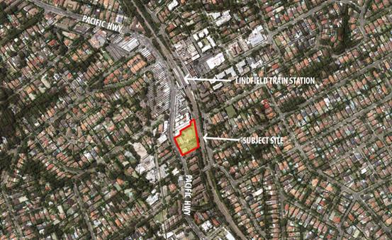
Figure 1 - Aerial view of the site in context within greater
Lindfield. Image from Geocortex (Air Photo 2014)
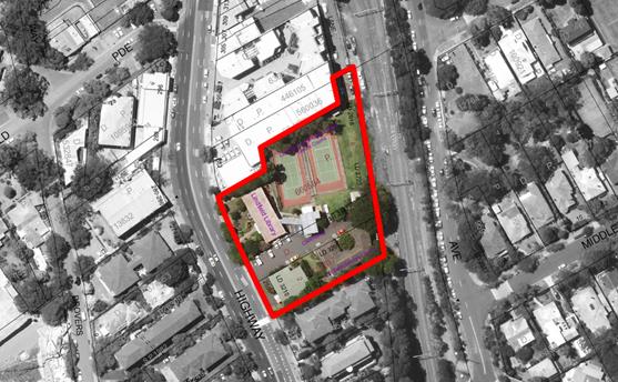
Figure 2 - Aerial view of the site
showing exiting uses and structures. Image from Geocortex (Air Photo 2014)
Master Plan
The master plan provides for
a mix of building heights ranging from 4-7 storeys. The proposed heights
on the site have been organised in a way to take advantage of the natural
topography and ensure impacts to the residential dwellings to the south are
mitigated. This includes a 6 storey built form along the Pacific Highway
frontage, consistent with the building height on the adjoining site to the
north, and 7 storeys along the lower rear portion of the site along the railway
line.
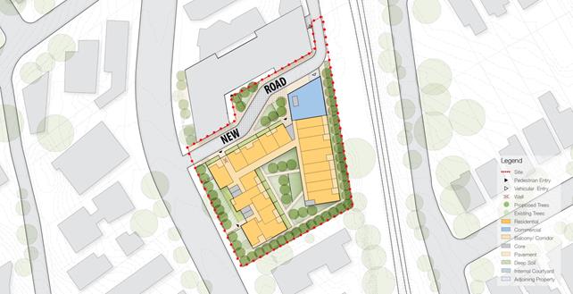
Figure 3 – Council’s adopted
master plan (ground floor plan). Image from Urban Design Study Report by SJB


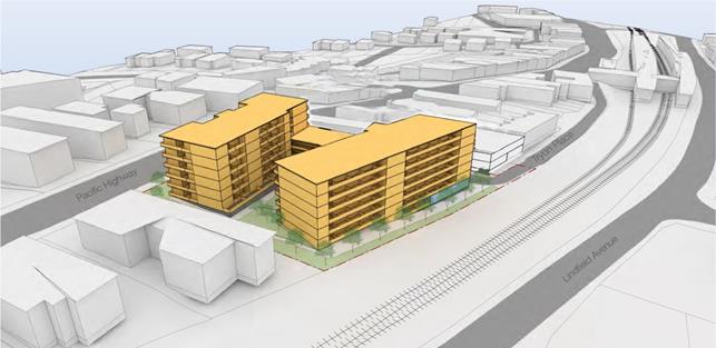
Figure 4 - Council’s adopted master
plan (Proposed built form - view from the south toward Lindfield station).
Image from Urban Design Study
Report by SJB
Provisions of community facilities in Lindfield
A significant amount of work has been undertaken to plan for
the future of Lindfield. This includes a Ku-ring-gai wide Community Facilities
Study and a Lindfield Community Facilities Study (Elton Consulting 2014).
The study considered the facility catchments, existing facility provision and
gaps, population growth and rates of provision. The study recommends that the
existing library and Seniors’ Centre facilities be replaced with new
facilities co-located in a community hub situated on the western side of
Lindfield with a total area of over 2,455sqm. This recommendation is based on
the fact that the current Lindfield Library and associated facilities are old,
outdated, no longer fit-for-purpose and not suitable for long term adaptation
and re-use due to their condition.
The concern regarding the matter of not selling the site or
ceasing operation of the existing community facilities on the site until the
new facilities are operational is a valid one. This issue was also acknowledged
by the Chairperson of the Public Hearing into the reclassification of the site.
The Public Hearing report recommends that Council should retain ownership of
the land and continue to operate the community facilities on it until suitable
alternative facilities are available for use by the local community.
Obtaining development consent does not require Council to
sell the land. The DA process, including tender for services, design
development and the assessment period, is anticipated to take 2 years. Works
approved as part of a development consent must be commenced within five years
from the date shown as the commencement date, unless otherwise stated. Council
can continue with the provision of community facilities on operational land and
only proceed to sale of the land at some stage in the future once replacement
facilities excluding the tennis courts have been provided.
Increased dwelling provision
A Plan for Growing Sydney was released by the current
NSW Department of Planning and Environment in December 2014 and is the current
NSW Government’s 20-year plan for the Sydney Metropolitan Area and
supersedes the previous Metropolitan Strategy. One of the three planning principles
guiding A Plan for Growing Sydney is: Principal 1 - “Increasing
housing choice around all centres through urban renewal in established areas”
The Planning Proposal is consistent with this principal as it will provide for
additional housing on an underdeveloped site within the Lindfield centre and in
close proximity to the Lindfield Railway Station.
Traffic
A microsimulation transport assessment of the road network
in the Lindfield local centre has been undertaken, taking into account the
cumulative impacts of expected development in the Lindfield local centre
including the proposals for the Library, Community Hub and Village Green sites.
Council and RMS continue with ongoing discussions regarding
proposed modifications to the Pacific Highway and surrounding roads in order to
facilitate acceptable functioning with the increased pressure from contemporary
development.
The Library site master plan incorporates a new one-way road
system with ingress from the Pacific Highway and egress at Tryon Place adjacent
to the Lindfield Station. By progressing the design/DA for the site,
Council will be able to manage the requirements of this new road within the
greater proposed and changing network.
Comments
Consultants have previously been
engaged to prepare, on behalf of Council, a number of studies to understand the
value of the site, including:
· Lindfield
Community Facilities Study;
· urban
design / architectural built form options; and
· advice
on market demand and financial feasibility including an assessment of the sale
price if the site were sold with or without an approved DA.
The results of these studies
have been previously reported to Council and the recommendations have been
supported.
In line with current planning
for the site, it will ultimately be sold to a developer. Developers would
be likely to factor in the time, resources, risk and general holding costs
associated with the preparation of and ultimately the achievement of development
consent. Council can thereby remove a substantial period of holding costs
by doing this work now. Risk and time have an impact on the amount of
profit that will result from a development; “de-risking” the site
will maximise the value of the site for the Ku-ring-gai community. See
financial implications further in this report.
This report is seeking to
maximise the value of council’s site through the achievement of
development consent whilst it is still in Council’s ownership.
integrated planning and reporting
Theme 3 - Places, Spaces and
Infrastructure
Theme 6 – Leadership and
Governance
|
Community Strategic
Plan Long Term Objective
|
Delivery Program
Term Achievement
|
Operational Plan
Task
|
|
A range of well planned,
clean and safe neighbourhoods and public spaces designed with a strong sense
of identity and place.
|
P4.1.1
Plans to revitalise local
centres are being progressively implemented and achieve quality design
outcomes in collaboration with key agencies, landholders and the community.
|
- Implement a place management approach for the local centre
improvements to coordinate works and achieve quality outcomes.
|
|
P4.1.4
An improvement plan for Lindfield centre is being
progressively implemented in collaboration with owners, businesses and state
agencies.
|
- Engage
with relevant stakeholders to establish timing, extent and partnership
opportunities.
- Develop
and finalise project scope.
- Maintain
engagement with the key stakeholders.
|
|
Ku-ring-gai is well led, managed and supported by ethical
organisations which
deliver projects and services to the community by
listening, advocating and responding to their needs.
|
L2.1.1
Council maintains and improves its long term financial
position and performance.
|
- Review
Long Term Financial Plan (LTFP) each year based on 10 year forecasts
- Undertake
quarterly reporting to Council on the financial performance of the
organisation.
- Assets
are identified for disposal to discharge the Services Relocation Loan by 2016
- 2017.
- Review
opportunities for sustainable and Assets equitable increases to
Council’s income supported by the community.
- Continue
to analyse opportunities to expand the revenue base of Council.
- Ensure
the commercial property portfolio provides market returns. Manager Integrated
Planning, Property
|
|
|
L2.1.4
Council has increased its commitment to infrastructure
asset management priorities.
|
- Identify
available funding sources in the LTFP and allocate to priority projects.
- Funding
strategies are developed and implemented in line with Council’s Assets
adopted Asset Management Strategy.
- Regularly
revise Council’s strategic asset management plans and integrate with
financial planning processes.
-
Continually improve the integrity of asset data and asset registers.
- Implement
asset management plans and progress improvement plans for each asset class.
- Implement
an integrated corporate asset management system for all asset classes.
|
Governance Matters
Section 45 of the Local Government
Act, 1993 prevents Council from selling; exchanging, or otherwise
disposing of Community classified land. This report is not seeking
approval to sell the property.
A Public Hearing on the reclassification of the site was
held on 6 June 2016 in accordance with Section 57(6) of the Environmental
Planning & Assessment Act.
The Planning Proposal and all supporting documents were
submitted to the Greater Sydney Planning Commission (GSPC) on 29 September
2016, including the preferred master plan. Changes to the Ku-ring-gai Local
Environmental Plan (Local Centres) 2012 to rezone and reclassify the land
from Community Land to Operational Land are expected to be made by the GSPC
shortly.
Risk Management
The main risk for Council in
undertaking the DA is that reclassification of the site may be rejected. If
this were to happen, any expenditure in the pursuit of the DA would not be
rewarded. However, this seems unlikely as the case for reclassification of this
site is different to other Council sites because:
· Council
has clearly articulated its intention to create a new community hub on the
western side of Lindfield local centre which will replace the existing
facilities with new, larger purpose-built facilities.
The submissions to the public
hearing have reiterated the above concerns and the Chairperson’s
recommendation includes the following-
It is appropriate for the land at 259-271 Pacific Highway,
Lindfield, to be reclassified as "operational land" under the terms
of the Local Government Act 1993.
However,
despite its reclassification, Council should retain ownership of the land and
continue to operate the community facilities on it until suitable alternative
facilities are available for use by the local community.
There are significant risks for
Council in relation to any decisions it makes regarding zoning,
reclassification, planning controls, and/or divestment for any of its town
centre sites. These risks are potential loss of revenue in the event a site is
sold with lesser development yield than might reasonably be expected under a
new regime of dwelling targets and where a purchaser subsequently comes back to
Council with a planning proposal for an uplift in controls, and/or that the
“opportunity” for greater dwelling production on key town centre
sites is simply lost by development at lesser height and density.
Financial Considerations
Valuation Analysis
Confidential Attachment A1
contains a valuation report for the site. This report highlights an
approximate $4.3M uplift in the market value of the site with development
approval as opposed to without development approval.
Therefore, it is proposed
that development approval be achieved prior to the sale of the site.
Currently, Council has allocated
some $120k for this project in S94 for 2017-18). Preparation of the DA
will involve Council running a tender for a multi-disciplinary consultancy to
complete the required documentation. Completion of this task including all
council staff, project management, consultants, statutory fees, and
contingencies is estimated to be an additional $900,000. The uplift in sale
price of the site with a DA is significantly more than the cost of preparing
the DA.
Funding
It is proposed to augment existing funding for the
preparation and lodgement of the DA through net proceeds from the rent received
from the 14 apartments currently leased on the site (Net approximately $190,000
p.a.) and from the remaining proceeds from the sale of 9 Havilah Lane
Lindfield, to be repaid upon divestment of the asset.
Social Considerations
It is noted that the Library and community meeting spaces
have provided important social functions since the 1950’s. These activities
will either be relocated to the Lindfield Community Hub in new contemporary
designed community spaces or other suitable alternative facilities. By taking
the project through the DA process, Council will have greater assurance that
the development outcome will achieve the communities’ expectations as
realised through the consultation process to date.
It must be noted that there are no plans to replace the
existing two tennis courts which are currently on the site.
Environmental Considerations
The DA will not result in any additional environmental
effects to those considered during the preparation of the draft Local Centres
LEP. Development of the design as required by the DA is seen as an opportunity
to further imbed sustainable and ‘best practice’ elements that
would not necessarily be part of an independent developers vision for the
site.
Due-diligence studies have been completed in relation to
geo-technical site conditions and any potential land contamination issues and
the site was found to be suitable for residential use.
Community Consultation
The Planning Proposal was exhibited in accordance with the
requirements of the Gateway Determination, the Environmental Planning and
Assessment Act 1979 (EP&A Act) and the relevant Department of Planning
Guidelines including A Guide to Preparing Local Environmental Plans and A
Guide to Preparing Planning Proposals as well as the Planning Practice Note
PN09-003 Classification and reclassification of public land through a local
environmental plan.
Prior to submitting the DA, the community will be engaged
and updated on all design developments. Once the DA is submitted, the
development proposal will be subject to public notification as is consistent
for all DA’s.
Internal Consultation
This report was prepared by the Strategy & Environment
Department. Consultation with staff from other Departments as well as other
stakeholders will occur where relevant depending on resolution of this report.
Summary
At the Ordinary Meeting of
Council on 6 September 2016 Council resolved to adopt the Planning Proposal to
amend Ku-ring-gai Local Environmental Plan (Local Centres) 2012 to rezone and
reclassify the land on the Lindfield Library Precinct site.
Council also resolved to
continue to operate the community facilities currently provided in the Precinct
until suitable alternative facilities are available.
In preparation for disposal of
the site and in order to maximise Council’s financial return, this report
seeks funding for the lodgement of a development application and land
owner’s consent to achieve this.
This will require a budget
allocation of $900,000.
|
Recommendation:
A. That
Council grants Landowner’s Consent for the lodgement of a Development
Application for Council land at 259-271 Pacific Highway, Lindfield.
B. That
additional funding for this process shall come from the net income received
from the rental of the residential units on the site and the proceeds from
the sale of 9 Havilah Lane, Lindfield.
C. That
the General Manger be given delegation to grant Owner’s Consent for all
necessary planning approval applications and associated documents.
|
|
Dean Payne
Project Leader
|
Bill Royal
Team Leader Urban Design
|
|
Ian Dreghorn
Manager Strategic Projects
|
Andrew Watson
Director Strategy & Environment
|
|
Attachments:
|
A1
|
Valuation
of Lindfield Library site
|
|
Confidential
|
|
Ordinary
Meeting of Council - 27 June 2017
|
GB.9 / 185
|
|
|
|
|
Item
GB.9
|
S11257
|
|
|
25 May 2017
|
Consideration of Submissions - Planning
Proposal to amend the KLEP 2015 for the rezoning of 21 Lorne Avenue, Killara
EXECUTIVE
SUMMARY
|
PURPOSE OF REPORT:
|
For Council to consider the submissions received in
response to the exhibition of the Planning Proposal to amend to the KLEP 2015
for the rezoning of 21 Lorne Avenue, Killara.
|
|
|
|
|
background:
|
The Planning Proposal was submitted to Council on
29 August 2016. Following the submission of additional information, the
review of the Planning Proposal formally commenced on 4 November 2016.
On 7 February 2017, Council resolved to forward the
Planning Proposal to the Department of Planning and Environment for a Gateway
Determination.
A Gateway Determination was received on 21 March 2017.
On 23 May 2017 Council considered this report and
resolved:
That the matter stands deferred and that
Council proceeds in the terms discussed.
|
|
|
|
|
comments:
|
The Planning Proposal was placed on public exhibition
from 6 April 2017 to 5 May 2017. The submissions received have been assessed
for Council’s consideration.
|
|
|
|
|
recommendation:
|
That Council adopts the Planning Proposal and makes
the plan under delegation.
|
Purpose of Report
For Council to consider the submissions received in response
to the exhibition of the Planning Proposal to amend to the KLEP 2015 for the
rezoning of 21 Lorne Avenue, Killara.
Background
Council
Meeting 23 May 2017
Council considered this report at the Council Meeting of 23
May 2017 and resolved:
That the matter stands deferred
and that Council proceeds in the terms discussed.
Following this resolution, the dwelling house on the subject
site, 21 Lorne Avenue, Killara, has been demolished under the provisions of a
Complying Development Certificate issued under Part 4A of the Environmental
Planning and Assessment Act 1979 on 1 December 2016.
This report is again referred to Council for the
consideration of the
submissions received in response to the exhibition of the Planning Proposal to
amend to the KLEP 2015 for the rezoning of 21 Lorne Avenue, Killara.
Planning
Proposal
The Planning Proposal for 21 Lorne Avenue, Killara was
submitted to Council on 29 August 2016. The Planning Proposal seeks to make the
following amendments to the KLEP 2015:
· rezone the
site from R2 Low Density Residential to R4 High Density Residential;
· amend the
Floor Space Ratio applying to the site from 0.3:1 to 1.3:1;
· amend the
Height of Building applying to the site from 9.5m to 17.5m; and
· amend the
Lot Size applying to the site from 840sqm to 1200sqm.
The Planning Proposal as submitted was incomplete. Following
the submission of additional documentation, the review of the Planning Proposal
formally commenced on 4 November 2016.
On 7 February 2017 Council considered a report on the
Planning Proposal and resolved:
A.
That the Planning Proposal to rezone 21 Lorne Avenue, Killara be sent to the
Department of Planning and Environment for a Gateway Determination.
B.
That prior to being sent for a Gateway Determination, the Planning Proposal be
amended by the applicant as outlined in the body of this report.
C.
That Council requests the plan-making delegation under Section 23 of the Environmental
Planning and Assessment Act 1979 for this Planning Proposal.
D.
That upon receipt of a Gateway Determination, the exhibition and consultation
process be carried out in accordance with the requirements of the Environmental
Planning and Assessment Act 1979 and the requirement of the Gateway
Determination.
E.
That a report be brought back to Council at the conclusion of the exhibition
period.
Gateway
Determination
The applicant amended the Planning Proposal in accordance
with Resolution B (above), as follows:
· Part 2 of
the Planning Proposal amended to detail the exact amendments sought to the KLEP
2015;
· Part 3 of
the Planning Proposal amended to identify and demonstrate consistency with
specific objectives and actions within A Plan for Growing Sydney, to
demonstrate consistency with the Draft North District Plan and to include
reference to the Urban Design Study as part of the justification and included
as an appendix; and
· mapping
amended to clearly identify the land to which the planning proposal applies.
The amended Planning Proposal was submitted to the
Department of Planning and Environment on 22 February 2017 requesting a Gateway
Determination. Council also requested the plan-making delegation in accordance
with Resolution C (above).
The Department of Planning and Environment issued a Gateway
Determination on 20 March 2017. The Department also issued authorisation for
Council to exercise delegation to make this plan. The Gateway Determination is
included at Attachment A1.
The Gateway Determination required a number of amendments to
the Planning Proposal prior to community consultation, as follows:
1. Prior
to community consultation, Council is to amend the planning proposal as
follows:
a. Amend
the planning proposal cover page to include Council’s logo and address
details to reflect Councils adoption of the proposal;
b. Identify
the exact amendments to the development standards in Part 2 of the planning
proposal (page 2);
c. Include
the findings of the Heritage Impact Statement in addressing Section 117
Direction 2.3 Heritage Conservation and remove the repeated paragraph in the
table on page 9;
d. Include
the relevant Section 117 Direction numbers in the table on page 13 of the
planning proposal;
e. Include
Council’s comments on traffic impacts from Councils Meeting Report in the
planning proposal;
f. Identify
an exhibition period of 28 days in Part 5 of the planning proposal and remove
the templates instructions (page 19); and
g. Include
the appropriate project timeline dates in Part 6 of the planning proposal (page
20).
The amended proposal is to be submitted to the Department
for information purposes.
Council amended the Planning Proposal as required by
Condition 1(a)-(g) of the Gateway Determination and submitted the amended
Planning Proposal to the Department of Planning and Environment on 28 March
2017 for information purposes.
Public Exhibition
The Planning Proposal was
placed on exhibition from 6 April 2017 – 5 May 2017, in accordance with
the conditions of the Gateway Determination.
The exhibition material included the amended Planning
Proposal (Attachment A2) and the following appendices:
· Appendix A
– Checklist of Consistency with Section 117 Directions and SEPPs (Attachment A3);
· Appendix B
– Heritage Impact Statement, Curio Projects (Attachment A4);
· Appendix C
– Yield Analysis, Giles Tribe Architects (Attachment A5);
· Appendix D
– Urban Design Study and Analysis (Attachment A6).
Comments
State
Agency Consultation
The Gateway Determination required consultation with the
following public authorities under Section 56(2)(d) of the Environmental
Planning & Assessment Act 1979:
· Office of
Environment and Heritage;
· Transport
for NSW;
· Transport
for NSW – Sydney Trains;
· Transport
for NSW – Roads and Maritime Services;
· Sydney
Water;
· Energy
Australia;
· Telstra.
The public authorities were provided with a copy of the
planning proposal and given 21 days to provide comment from the 28 March 2017.
Responses were received from Office of Environment and
Heritage (Planning Team), Office of Environment and Heritage (Heritage
Division), Roads and Maritime Services and Transport for NSW. Copies of the
responses are included at Attachment A7.
Office of
Environment and Heritage – Planning Team
The Office of Environment and Heritage Greater Sydney
Planning Team had no comments on the Planning Proposal. However, noted that the
Heritage Division may wish to comment separately.
Comment: The Planning Proposal was separately
referred to the Office of Environment and Heritage (Heritage Division) for
their comment on the planning proposal (see below).
Office of
Environment and Heritage – Heritage Division
The response from the Heritage Division notes that the
subject site is located on the northern side of Lorne Avenue, currently
existing on the site is a two storey residential dwelling house built c.1912.
The site is currently zoned R2 and the sites adjoining to the north, west and
east are zoned R4 allowing for high density residential development up to 5
storeys.
The response notes the history of the heritage listing on
the site, and the Perumal Murphy Alessi review of heritage status of heritage
interface sites impacted by adjoining high density zones.
The response also notes the Complying Development
Certificate issued on 1 December 2016 under Part 4 of the Environmental
Planning and Assessment Act 1979 for the demolition of the dwelling.
The response notes that the site is located in the vicinity
of locally listed heritage items I306 (20 Lorne Avenue), I305 (14 Lorne
Avenue), I304 (10 Lorne Avenue), I303 (8 Lorne Avenue) and I302 (6 Lorne
Avenue). The site is also located opposite HCA C24 Marian Street.
The Heritage Division considered that the proposal is
consistent with the current zoning and character of the northern sector of
Lorne Avenue, and is unlikely to have an additional unacceptable impact on the
heritage significance of the Marian Street Conservation Area.
Roads and
Maritime Services
The response from RMS raises no objections to the proposal
as the associated traffic generation and potential traffic impact to Pacific
Highway is relatively minor and does not require further detailed traffic
assessment and/or transport infrastructure upgrades to the Pacific
Highway/Lorne Avenue intersection.
Transport
for NSW
Transport for NSW reviewed the submitted information and has
no comment on the planning proposal.
Community
Submissions
A total of 12 submissions were received from the community
in response to the public exhibition of the planning proposal. A summary table
of the submissions received and Council comment in response is included at Attachment
A8.
The following are some of the key themes and matters raised
in the submissions and Council comment on those matters:
· Street
already overcrowded, enough high density in neighbourhood
Comment: In order to provide
for Sydney’s growing population and the State Government dwelling targets
– areas in Ku-ring-gai have been rezoned to allow for medium and high
density housing. These areas are generally located along the railway line and Pacific
Highway – close to public transport and existing infrastructure. The
rezoning of 21 Lorne Avenue to R4 High Density Residential is consistent with
the zoning of the surrounding properties.
The northern side of Lorne Avenue (except
for 21 Lorne Avenue) is already zoned R4 High Density Residential – and
sites have been redeveloped into 5 storey apartment blocks. The southern side
of Lorne Avenue is a Heritage Conservation Area, and contains a number of
heritage items – it is unlikely that the southern side of Lorne Avenue
will be redeveloped and will remain as low density in character.
· Rezoning
will impact on infrastructure such as water pressure, telecommunications,
sewage, stormwater, schools, parks, trains and roads. Already lack of
infrastructure and amenities failing to serve greatly increased population.
Comment: With regards to telecommunications, water
pressure and sewage, the planning proposal was forwarded to Sydney Water and to
Telstra under s56 of the EP&A Act 1979. No response has been
received from these agencies. Sydney Water may require their assets to be
adjusted to accommodate future development.
With regards to roads, the expected traffic
generation rate of 0.3 trips per dwelling (2-way) during the peak hour is equal
to approximately 24 trips, or roughly 1 trip every 2 minutes. Additional 24
trips in the peak hour are unlikely to have significant additional impact on
the surrounding road network. Council is monitoring traffic volumes in Lorne
Avenue to assess any effects from more recent high density residential
developments. The RMS has noted that the planning proposal would not require
any transport infrastructure upgrades to the Pacific Highway/Lorne Avenue
intersection.
The planning proposal was forwarded to
Sydney Trains under s56 of the EP&A Act 1979. No response was received.
For any future development approved on the
site, Council would levy a contribution from the developers towards the costs
of providing and augmenting local services and facilities that are required
because of their development.
· Traffic
and parking extremely busy in the street. People park in street to access
station and residents from units with multiple cars park on street. Rezoning
will result in additional cars parking on street and increase to traffic
congestion. Traffic numbers quoted in Council report are from 2015 –
there have been more units built since this time.
Comment: Council has undertaken updated traffic
volume and speed counts in Lorne Avenue.
|
Lorne Avenue,
Killara
|
2015
|
2017
|
|
Recorded 85% speed (average, 2-way)
|
54km/h
|
55km/h
|
|
am peak hour 2-way traffic volumes (8am-9am)
|
249 veh/hr
|
258 veh/hr
|
|
pm peak hour 2-way traffic volumes (5pm-6pm)
|
200 veh/hr
|
206 veh/hr
|
There is little change in the recorded 85% vehicle speeds.
Similarly, there is very little change in the morning and evening peak hour
traffic flows between 2015 and 2017, and the difference in the recorded results
over the 2 years could be considered to be within daily fluctuations.
The updated traffic volume and speed count indicates that
there has been no perceptible increases in morning and evening peak hour
traffic flows in Lorne Avenue between 2015 and 2017, and the cumulative impact
of the additional traffic generated by the planning proposal would not raise
the morning and evening peak hour traffic flows above the local road threshold
(300 veh/hr).
The expected traffic generation rate of 0.3
trips per dwelling (2-way) during the peak hour is equal to approximately 24
trips, or roughly 1 trip every 2 minutes. Additional 24 trips in the peak hour
is unlikely to have significant additional impact on the surrounding road
network. Council is monitoring traffic volumes in Lorne Avenue to assess any
effects from more recent high density residential developments.
Narrow sections of Culworth Avenue have
weekday am restrictions to minimize commuter parking and improve traffic flow
during the morning peak.
New kerb ramps and a pedestrian refuge is
being constructed in Culworth Avenue at the intersection with Lorne Avenue, to
improve pedestrian access to/from Killara railway station.
The recorded 85% speed in Lorne Avenue
(54km/h average, 2-way indicates the majority of vehicles travelling in Lorne
Avenue travel at around (or below) the sign posted speed limit of 50km/h. This
is a relatively good result for a straight length of local road.
The Ku-ring-gai DCP parking requirements
for high density residential developments within 400m of railway stations is
deemed to be adequate, and residents who choose to own more cars than car
spaces allocated to them and park on street would have to compete with
commuters or risk an infringement if parking in a time restricted zone.
Council staff are also developing a car
share vehicle policy. Car share provide alternatives to residents owning more
vehicles than they have allocated parking spaces on site, and therefore reduce
demand for on-street parking spaces.
· Development
will result in amenity impacts to neighbouring properties including
overshadowing, privacy and noise.
Comment: This is a planning proposal for the rezoning
of 21 Lorne Avenue to R4 and amendments to the development standards only, and
as such does not consider the detailed design matters. It is not a
Development Application for the construction of a building. These matters
(overshadowing, privacy and noise) would be assessed as part of the Development
Application process.
· 21
Lorne Avenue should not have been delisted. House has heritage significance and
should be re-listed as a heritage item.
Comment: Council
resolved to delist the property at 21 Lorne Avenue as part of the KLEP 2015.
The rationale for the delisting was based on the heritage assessment undertaken
by Perumal Murphy Alessi - Heritage Status and Context Review of 14 sites in
Ku-ring-gai (May 2006). This assessment recommended that the heritage
listing be removed from the property. The arguments for delisting of the site
were the impact of development on curtilage and setting.
The original boundary of the lot on which the house was
built was subdivided in 1958 to create 4 lots. This significantly reduced the
curtilage and resulted in visual encroachment on the site with very narrow
setback, particularly on the western side. Following the subdivision, the house
did retain significance as a garden setting was still in place and the
neighbouring properties did not exceed two storeys.
The opinion of the consultants and the Council interface
assessment concluded the curtilage would be impacted by future (and now some
existing) R4 development. The reduced curtilage as a result of the 1958
subdivision would now result in 5 storey neighbours on the up zoned sites,
surrounding the house on 3 sides. As a result of the lost setting and
diminished curtilage the house was removed from Council’s heritage list.
The Assessment of Significance by Perumal Murphy Alessi
Heritage Consultants is included as Attachment A9.
The Section 56 response from the Office of Environment and
Heritage – Heritage Division notes the history of the heritage listing on
the site, and the Perumal Murphy Alessi review of heritage status of heritage
interface sites impacted by adjoining high density zones.
The house at 21 Lorne Avenue, Killara has since been
demolished under the provisions of a Complying Development Certificate issued
under Part 4A of the Environmental Planning and Assessment Act 1979 on 1
December 2016.
· Development
will result in loss of environment and animals. Loss of trees.
Comment: This is a Planning Proposal and only
considers amendments to the Ku-ring-gai Local Environmental Plan 2015 –
it is not a development application and does give approval for the construction
of buildings or removal of trees and vegetation.
The impacts of any future development proposed the site on
the environment, including removal of trees and vegetation would be considered
through the Development Application process. It is noted that 21 Lorne Avenue
is not mapped as Biodiversity Significance under the KLEP 2015.
· Shortage
of local businesses in area – house should be rezoned to allow for
remodelling of house for a small business (e.g. convenience store, café,
hairdresser, doctor)
Comment: The proposed R4 High Density Residential
zone permits the following land uses which may support the development and use
of ‘small business’:
· child care
centres;
· neighbourhood
shops;
· shop top
housing;
· Home
businesses.
It is up to the land owner to put forward a development
application to Council. Each zone specifies a number of uses permitted within
that zone. Council cannot force a landowner to develop their site for a certain
purpose.
integrated planning and reporting
Places, Spaces and Infrastructure
|
Community Strategic
Plan Long Term Objective
|
Delivery Program
Term Achievement
|
Operational Plan
Task
|
|
P2.1 A robust planning framework is in place to deliver
quality design outcomes and maintain the identity and character of
Ku-ring-gai
|
Strategies, plans and processes are in place to
effectively manage the impact of new development
|
Continue to review existing strategies and plans
|
Governance Matters
The process for the preparation and implementation of
Planning Proposals is governed by the provisions contained in the Environmental
Planning and Assessment Act 1979 and the Environmental Planning and
Assessment Regulation 2000.
Council sought the plan-making delegation under Section 23
of the EP&A Act 1979 to finalise the planning proposal. In issuing the
Gateway Determination, the Department of Planning considered the nature of the
planning proposal and decided to issue authorisation to Council to exercise
delegation to make this plan.
Risk Management
This is a privately initiated planning proposal. Council
needs to determine its position on this Planning Proposal. Council risks damage
to its reputation if it does not undertake strategic land use planning in an
effective and timely manner.
Financial Considerations
The Planning Proposal was subject to the relevant
application fee under Council’s 2015/2016 Fees and Charges Schedule. The
Planning Proposal was also subject to a further fee following the issue of the
Gateway Determination for the advertisement of the Planning Proposal, in line
with Councils 2015/2016 Fees and Charges Schedule. The cost for the review,
assessment and advertisement of the Planning Proposal is covered by this fee.
Social Considerations
The site is well integrated with the surrounding public
transport and pedestrian routes. The site is located within close proximity to
the North Shore railway line and Killara Station. The increase in residential
density will have access to facilities shared by the local community.
Environmental Considerations
The site is not identified as having Biodiversity or
Riparian mapping under the KLEP 2015.
Community Consultation
The planning proposal was publically exhibited from 6 April
2017 to 5 May 2017 in accordance with the requirements of the Gateway
Determination. The public exhibition was also advertised in the North Shore
Times and on Councils website.
The exhibition material was available on Councils website,
and a hard copy was available at Customer Service.
All persons who made a formal submission were notified of
this matter being reported to Council on 23 May 2017 and 27 June 2017.
Internal Consultation
This report has been referred to relevant sections of
Council for comment.
Summary
The Planning Proposal seeks to make the following amendments
to the KLEP 2015:
· Rezone the
site from R2 Low Density Residential to R4 High Density Residential;
· Amend the
Floor Space Ratio applying to the site from 0.3:1 to 1.3:1;
· Amend the
Height of Building applying to the site from 9.5m to 17.5m;
· Amend the
Lot Size applying to the site from 840sqm to 1200sqm.
The Planning Proposal was publically exhibited from 6 April
2017 to 5 May 2017.
This report considers and assesses the submissions made in
response to the public exhibition of the planning proposal, from both the
community and from the relevant state agencies. The report recommends that the
Council adopt the planning proposal and makes the plan under delegation.
|
Recommendation:
A. That
Council adopts the Planning Proposal for the rezoning of 21 Lorne Avenue,
Killara;
B. That
Councils proceeds to make the Plan, under delegated authority issued by the
Department of Planning and Environment under Section 59(2) of the Environmental
Planning and Assessment Act 1979;
C. That
those who made submissions be notified of Council’s decision.
|
|
Alexandra Plumb
Urban Planner
|
Craige Wyse
Team Leader Urban Planning
|
|
Antony Fabbro
Manager Urban & Heritage Planning
|
Andrew Watson
Director Strategy & Environment
|
|
Attachments:
|
A1
|
Gateway
Determination - 21 Lorne Avenue Killara
|
|
2017/073140
|
|
|
A2
|
Planning
Proposal - 21 Lorne Avenue Killara - Amended as Per Gateway Determination
March 2017
|
|
2017/080825
|
|
|
A3
|
Appendix
A - s117 Directions and SEPPs
|
|
2017/128018
|
|
|
A4
|
Heritage
Impact Statement - 21 Lorne Avenue Killara
|
|
2016/305168
|
|
|
A5
|
Development
Yield Analysis
|
|
2016/284594
|
|
|
A6
|
Urban
Design Study and Analysis
|
|
2016/304798
|
|
|
A7
|
State
Agency Responses - 21 Lorne Avenue
|
|
2017/128029
|
|
|
A8
|
Submission
Summary Table
|
|
2017/128435
|
|
|
A9
|
Perumal
Murphy Alessi - 21 Lorne Avenue, Killara - Heritage Status and Context Review
of 14 Sites in Ku-ring-gai May 2006
|
|
2013/233256
|
|
Ordinary
Meeting of Council - 27 June 2017
|
GB.10 / 195
|
|
|
|
|
Item
GB.10
|
S11550
|
|
|
22 May 2017
|
Biodiversity Conservation Act and
regulation and Vegetation SEPP
EXECUTIVE
SUMMARY
|
purpose of report:
|
To seek Council’s endorsement
for two submissions to the NSW Government on the currently exhibited draft
Regulations and other key products which support the Government’s new Biodiversity
Conservation Act 2016 and Local Land Services Amendment Act 2016.
|
|
|
|
|
background:
|
The Biodiversity Conservation
Act 2016 (NSW) and the Local Land Services Amendment Act 2016
(NSW) were passed into law in November 2016.
The NSW Government has
released 13 draft documents and tools to implement the new Acts, including
regulations, codes and guidelines which are currently on public exhibition.
|
|
|
|
|
comments:
|
Ku-ring-gai Council made a
submission to the NSW Government during the exhibition period for the Biodiversity
Conservation Act 2016 and the Local Land Services Amendment Act 2016 and
held a community work shop on the biodiversity reform.
Many of the details relating to the functioning of the new
legislation are set out in the documents currently on exhibition and
fundamentally change the way development is assessed and how biodiversity is
protected across the state.
Staff have prepared two draft
submissions on the currently exhibited documents which provide comments
relating to; potential impact, identified strengths and recommendations for
improvements.
|
|
|
|
|
recommendation:
|
That Council endorses the two submissions to the NSW
Government on the currently exhibited documents related to biodiversity and
land management.
|
Purpose of Report
To seek
Council’s endorsement for two submissions to the NSW Government on the
currently exhibited draft Regulations and other key products which support the
Government’s new Biodiversity Conservation Act 2016 and Local
Land Services Amendment Act 2016.
Background
In 2014, the NSW Government
commissioned a review into the laws, policies and programs which managed,
conserved and regulated native vegetation, threatened species, and wildlife in
NSW. The guiding objective of the review was to establish a simpler,
streamlined and more effective legislation, able to:
· facilitate
the conservation of biological diversity;
· support
sustainable development; and
· reduce
red tape.
The pieces of legislation within
the scope of review were:
· the
Native Vegetation Act 2003;
· the
Threatened Species Conservation Act 1995;
· the
Nature Conservation Trust Act 2001; and
· Part
4 Divisions 11 through 13, Part 6A (insofar as it relates to native plants and
animals), and Parts 7 through 9 of the National Parks and Wildlife Act 1974,
as well as all associated regulations contained within those Acts.
In response to the review, the
NSW Biodiversity
Conservation Act 2016 (BC Act) and the Local Land Services Amendment Act 2016 (LLSA Act)
were passed into law in November 2016. On commencement, which is scheduled for
25 August 2017, the BC Act and LLSA Act will repeal and replace the Native
Vegetation Act 2003, the Threatened Species Conservation Act 1995
and the Nature Conservation Trust Act 2001.
The Government has released 13
draft documents and tools which support and implement the BC Act and LLSA Act.
These supporting documents are on public exhibition for a 6 week period ending
21 June 2017.
Council have prepared two separate
submissions, one covering the Explanation of Intended Effect for the State
Environmental Planning Policy (Vegetation) 2017 (Attachment A1) and a
separate submission for other key documents (Attachment A2), including:
· Draft Biodiversity Conservation Regulation 2017 (PDF),
and its supporting regulatory impact statement (PDF);
· Draft Environmental Planning and Assessment Amendment (Biodiversity
Conservation) Regulation 2017 (PDF);
· Biodiversity Assessment Method (BAM) (PDF) and BAM tool (Link);
· Accreditation Scheme for the Application of the Biodiversity Assessment
Method (PDF);
· Draft Sensitive Biodiversity Values Land Map (Link);
· Serious and irreversible impacts guidance (PDF);
· Offsets payment calculator (Excel) and User Manual (PDF).
Comments
The NSW State Government has
recently placed a number of environmental policy reforms on exhibition and
provided limited consultation periods to make quality submissions. The proposed
reform will have far reaching implications across a broad range of strategic
planning processes and development legislation. On 23 May 2017, Council
requested that the Premier extend the consultation period for the exhibited
documents by 4 weeks, however Council has not received a response.
The exhibited documents include
reforms to the regulation of many aspects of biodiversity, including:
· land
management and vegetation removal;
· ecologically
sustainable development, environmental impact assessment and offsetting;
· native
plants and animals including listing of threatened species, conservation
programs and funding;
· private
land conservation including an expanded biodiversity offset
scheme; and
· development
assessment under the Environmental Planning
and Assessment Act 1979 (EP&A Act).
The Biodiversity Conservation Regulations 2017 introduce
the Biodiversity Assessment Methodology (BAM) and expand the scope of the NSW
Biodiversity Offset Scheme. All applications under part 4 of the EP&A Act
which exceed specific thresholds will be required to utilise the BAM and where
necessary, secure offsets.
The Biodiversity Offset Scheme (BOS) may be triggered by
clearing size (e.g. over 0.25ha - over 2ha, depending on minimum lot size in
the LEP) or mapped sensitive areas (clearing of any size where the site is
mapped on the Sensitive Biodiversity Values Land Map) or by the test of
significance under section 7.2 of the BC Act. If a development meets the
threshold or is likely to have a significant impact, the BAM must be applied.
Biodiversity offsets scheme - land clearing threshold (part
7.2 (4) Biodiversity Conservation Regulation 2017 [NSW].
|
Minimum lot size of land
|
Area of clearing
|
|
Less than 1 hectare
|
0.25 hectare or more
|
|
Less than 40 hectares but not less than 1 hectare
|
0.5 hectare or more
|
|
Less than 1,000 hectares but not less than 40 hectares
|
1 hectare or more
|
|
1,000 hectares or more
|
2 hectares or more
|
Council’s draft submission details concerns with the
variation rules of offsetting, recommending a strengthening of the
like-for-like principles. Additionally, the draft submission raises concerns
with the regulations acceptance of Serious or Irreversible Impacts (SAII) and
recommends that provisions to effectively block proposals which will result in
SAII be strengthened.
The NSW Government is proposing to introduce a new State
Environmental Planning Policy (Vegetation) 2017 (Vegetation SEPP) to
support its land management and biodiversity, however, it is exhibiting an
Explanation of Intended Effect (Explanation) only. There is no draft SEPP
instrument on exhibition which makes it more difficult to comment as various
details regarding the statutory provisions for administration and
implementation of the proposed SEPP remain unknown. Council’s submission
requests the opportunity to comment on the full draft SEPP provisions prior to
it being finalised.
The new SEPP would assess proposals to clear native
vegetation in urban areas and Environment zones (E2, E3, E4) (E-zones)
state-wide. It would require clearing to be assessed using the Biodiversity
Assessment Method (BAM) or a local council’s Development Control Plan
(DCP) depending on the size and location of clearing. For clearing and
tree removal below the BOS threshold, local councils will continue to assess
applications via permits in their DCPs.
The SEPP proposes to repeal the standard LEP provisions that
give effect to tree protection orders in Council’s DCPs (clauses 5.9 and
5.9AA) with equivalent provisions to be incorporated into the new SEPP. The
intent is to continue to allow Councils to identify in their DCPs which
vegetation is protected and requires permits for removal.
Ku-ring-gai Council currently has robust tree and vegetation
protection provisions in its DCPs and any changes under the proposed SEPP that
would result in a weakening of these existing provis163ons should be opposed.
integrated planning and reporting
P2 - Managing Urban Change
|
Community Strategic
Plan Long Term Objective
|
Delivery Program
Term Achievement
|
Operational Plan
Task
|
|
P2.1 A robust planning framework is in place to deliver
quality design outcomes and maintain the identity and character of
Ku-ring-gai.
|
P2.1.1 Land use strategies, plans and processes are in
place to effectively manage the impact of new development.
|
Respond to State Government Planning initiatives and
reforms – including the new Planning Legislation.
|
Governance Matters
The BC Act and LLSA Act will repeal and replace the Threatened
Species Conservation Act 1995, the Native Vegetation Act 2003 and
the Nature Conservation Trust Act 2001. Further, SEPP (Vegetation) 2017,
will change the way trees are managed in the urban environment and replace
section 5.9 of the LEP.
The BC Act regulations including the draft guidance and
criteria to assist a decision maker to determine a serious and irreversible
impact (SAII) and will impact the way part 4 and 5 applications under the
EP&A Act 1979 will be determined.
Risk Management
Both submissions note that
Council has made submissions on numerous legislative reforms released by the
NSW State Government over the past 24 months. Whilst these individual bills,
amendments, codes, policies and guidelines have significant impacts on local
government wide issues and procedures, it is the cumulative impact of the
legislative reform which could potentially have catastrophic impacts on the
environment.
There is concern that the
overall impacts of the new legislative frameworks have not been sufficiently
considered in regards to the pressures on the environment and particularly in
regards to biodiversity. Council seeks reassurance from the NSW Government that
the cumulative impacts of the legislative reform have been considered and
request further information relating the quantification of potential impacts.
Financial Considerations
There is no direct investment
required.
Social Considerations
Council held a community
forum on the Biodiversity Conservation Bill and Local Land Services Amendment
Bill when they were on public exhibition in June 2016. The forum was very well
attended. Issues surrounding biodiversity protection are important to the
Ku-ring-gai community. The draft submission continues Council’s
involvement in the development of the legislative framework that will govern
biodiversity in the future.
Environmental Considerations
The new framework expands the
use of biodiversity offsetting in NSW, changes the way conservation is mandated
and funded and will impact biodiversity in Ku-ring-gai and across NSW. The
draft submission makes recommendations to improve protections for the unique
biodiversity of Ku-ring-gai whilst allowing Ecologically Sustainable
Development to proceed.
Community Consultation
Council have alerted the
community of the currently exhibited documents through social media and email.
Internal Consultation
During the preparation of the
two submissions, relevant staff were consulted and their feedback Incorporated.
Summary
The Biodiversity Conservation Act 2016 (NSW) and the
Local Land Services Amendment Act 2016 (NSW) were
passed into law in November 2016.
The NSW Government has released 13
draft documents and tools to implement the new Acts, including regulations,
codes and guidelines which are currently on public exhibition.
The exhibited documents include
reforms to the regulation of many aspects of biodiversity, native plants and
animals, private land conservation and ecologically sustainable development.
Council has prepared two draft submissions on the currently exhibited documents
which provide comments relating to; potential impact, identified strengths and
recommendations for improvements.
Council supports many of the
measures within the Biodiversity Conservation Regulations and supporting
documents, but raise a number of concerns detailed in the submission. These
include:
· weak
requirements for like-for-like offsetting;
· huge
reliance on self-assessable codes;
· an
apparent acceptance of extinctions and serious and irreversible impacts;
· limited
scope to nominate and declare Areas of Outstanding Biodiversity Value; and
· incomplete
mapping and supporting tools.
The new Vegetation SEPP
proposes to repeal the Standard LEP provisions that give effect to tree
protection orders in Council’s DCPs (clauses 5.9 and 5.9AA) with
equivalent provisions to be incorporated into the new SEPP. Ku-ring-gai Council
currently has robust tree and vegetation protection provisions in its DCPs and
any changes under the proposed SEPP that would result in a weakening of these
existing provisions should be opposed.
|
Recommendation:
A. That
Council endorses the two submissions to the NSW government on the currently
exhibited documents related to biodiversity and land management (Attachments
A1 and A2).
B. That
Council authorises the Director Strategy and Environment to amend
Council’s submission to improve clarity and strengthen arguments prior
to its issue.
|
|
Jacob Sife
Natural Areas Officer
|
Craige Wyse
Team Leader Urban Planning
|
|
Marnie Kikken
Manager Environment & Sustainability
|
Andrew Watson
Director Strategy & Environment
|
|
Attachments:
|
A1
|
Submission
on Explanation of Intended Effect for the State Environmental Planning Policy
(Vegetation) 2017
|
|
2017/165168
|
|
|
A2
|
Submission
on NSW biodiversity and land management reforms
|
|
2017/163388
|
|
Ordinary
Meeting of Council - 27 June 2017
|
GB.11 / 201
|
|
|
|
|
Item
GB.11
|
S10376-10
|
|
|
12 May 2017
|
Theatre Facilities in Ku-ring-gai -
Visioning and Feasibility Study
EXECUTIVE
SUMMARY
|
purpose of report:
|
This report sets out a process for Council to resolve
its intention for the future use of the Marian Street Theatre site and
theatre facilities in Ku-ring-gai generally.
|
|
|
|
|
background:
|
At the OMC of 28 February 2017 it was determined that
Council should resolve its intention for the future use of the Marian Street
Theatre site and theatre facilities in Ku‑ring-gai prior to determine
whether to proceed with the Save Marian Street Theatre fundraising
initiative. At the same meeting Council requested that a report be brought
back on the scope and indicative costs of undertaking a business case
assessing the available options for theatre in Ku-ring-gai.
|
|
|
|
|
comments:
|
This report will address Resolution A from OMC of
28 February 2017. As a first step, specialist consultants were engaged
to facilitate a workshop with Councillors to discuss how to progress the
decision-making process in relation to defining the need for live theatre
and/or a performance facility within the Ku-ring-gai LGA. The workshop was
held on Wednesday, 7 June 2017.
|
|
|
|
|
recommendation:
|
It is recommended that Council proceeds with a
Visioning and Feasibility Study for theatre in Ku-ring-gai prior to Council
determining whether to proceed with the Save Marian Street Theatre
fundraising initiative.
|
Purpose of Report
This report sets out a process for Council to resolve its
intention for the future use of the Marian Street Theatre site and theatre
facilities in Ku-ring-gai generally.
Background
On 20 September 2016, Council resolved to provide ‘in
principle’ support to a fundraising initiative proposed by a group called
the Save Marian Street Theatre Committee (SMSC).
Council subsequently received a Business Plan from the
Committee, dated 13 November 2016, proposing to raise funds for the
refurbishment of the theatre to enable it to be re-opened.
As part of the Business Plan, the Committee requested
funding from Council of $36,500 to set up the legal structure of the
organisation, determine more fully the costs of renovation, and carry out a
study to investigate funding sources.
On 6 December 2016 Council considered a report in relation
to the Committee’s proposal and resolved as follows:
A. That
Council engage an independent consultant to conduct a Probity and Risk Review
of the Save Marian Street Theatre Business Plan.
B. That
a report come to Council containing analysis of the SMSC Business Plan along
with recommendations and strategies from the independent Probity and Risk
Review.
C. That
the Probity report come back to Council by the end of February 2017.
Council subsequently appointed O’Connor Marsden to
conduct the independent probity and risk review. At the OMC of 28 February 2017
the results of an independent probity and risk review of the SMSC Business Plan
was reported to Council, at that meeting Council resolved as follows:
A. As per the
recommendations from the O’Connor Marsden probity and risk review, and
prior to Council determining whether to proceed with the Save Marian Street
Theatre fundraising initiative, Council should resolve its intention for the
future use of the Marian Street Theatre site and theatre facilities in
Ku-ring-gai.
B. In order to make an
informed decision, a business case be prepared assessing the available options
for theatre in Ku-ring-gai, including but not limited to those options
identified in the O’Connor Marsden report 9 February 2017, and a report
be brought to Council on the scope and indicative costs of undertaking the
recommended business case.
Councillor
Workshop
As a first step, specialist consultants were engaged to
facilitate a workshop with Councillors to discuss how to progress the
decision-making process in relation to defining the need for live theatre
and/or a performance facility within the Ku-ring-gai LGA. The workshop was held
on Wednesday, 7 June 2017. The objectives of the workshop were:
• For
Council to gain a better understanding of the process to be undertaken to
determine the need for Live Theatre and the financial implications;
• to
define what inputs are and where the current information gaps may be;
• to
agree what options that need to be interrogated;
• gain
a better understanding on what may be desirable location attributes;
• to
better understand the differences between a Theatre facility vs a
multi-function facility; and
• agree
a clear direction that will allow Council to make an informed decision
regarding the investment in future facilities.
A high-level summary of the workshop outcomes has been
provided in Attachment A1.
As an outcome of the workshop, the following steps were
identified as a way forward:
• undertake
a Visioning Workshop to define out Council’s collective vision on
“the Why?”
• tour
example facilities around Sydney;
• undertake
a feasibility study, incorporating a robust demand assessment / demographic
analysis and options assessment; and
• progress
this next project definition phase in order to inform the incoming Council post
the Council elections this year.
Comments
In order for Council to address Resolution A from OMC of 28
February 2017 it is recommended that a Visioning and Feasibility Study
be commenced to define the strategic intent; gather the relevant information;
and assess the key metrics of cost and benefits required for decision making.
It is estimated that the study will take twelve weeks to complete.
The main tasks of the study would be as follows:
Vision
Workshop
Hold a workshop with Councillors to determine the collective
vision for the provision of performing arts infrastructure within the
Ku-ring-gai LGA. This workshop will confirm the vision and strategic
objectives and inform the preliminary options to be investigated.
Facility
Tour
Visit a range of different types of facilities, including a
traditional drama theatre, flat floor / multi‑purpose venue and a
combination theatre and music auditorium. This tour will better inform
Council as to the different type of performance venue and provide focus for the
options that may be explored.
Preliminary
Options
Define some preliminary options that will address the vision
and the strategic objectives of Council which will in turn inform the research
/ data collection phase by providing the necessary scope definition for the
survey questionnaire.
Data Collection
Undertake a combination of
telephone survey and website survey tools to test the Community’s view;
define the key demographic profile; and test the demand for live performance
within the LGA. This may also include questions that will help define the
Community’s “willingness to pay” for these facilities either
through rates levies or other means. This information will be analysed and
synthesised with other survey information (particularly the Gordon Civic Hub
Needs Analysis) to provide a clear position on the Community’s needs and
the alignment with Council’s objectives.
Dilapidation
survey
Undertake a thorough and up-to-date dilapidation survey /
condition assessment for Marian Street Theatre (MST) in order to determine
required expenditure for the refurbishment of the existing facility to bring it
up to the latest code compliance.
Finalise
Options
Present findings to Council in order to inform the final
selection of the options to be interrogated under the feasibility assessment.
Functional
Area Analysis
Confirm the functional space requirements to meet the
defined need and prepare a “block and stack” analysis for the
Gordon Civic Hub site and proposed modifications to the MST site both in terms
of footprint and volume, if required to meet the functional / space
requirements.
High Level
Financial Analysis
The functional areas and architectural space planning
outcomes will provide the basis for the preparation of the inputs required for
the financial appraisal. The key metrics for the model will include:
• Operational
costs for all options, based on the preferred governance model;
• Revenue
from ticket sales and other revenue sources with input from Council staff;
• Capital
costs for each option;
• Life
cycles costs prepared by Council’s QS;
• Program
for the design and construction of each option;
• High
level risk register.
It is recommended as a first step to undertake a Visioning
and Feasibility Study. Once complete this study would be reported to
Council with a final recommendation (preferred option) for endorsement by
Council. The next step, once Council has adopted a preferred option, would be
preparation of a detailed business case. Once a business case has been
completed and endorsed by Council it would then be in a position to determine
whether to proceed with the Save Marian Street Theatre fundraising initiative.
integrated planning and reporting
Community, People and Culture
|
Community Strategic Plan
Long Term Objective
|
Delivery Program
Term Achievement
|
Operational Plan
Task
|
|
C1 - Community Wellbeing
|
C1.1 An equitable and
inclusive community that cares and provides for its members.
|
Our community facilities
are accessible and function as cultural hubs to attract a range of
users
|
|
C2 - Cultural Diversity and Creativity
|
C2.1 A harmonious community that respects, appreciates,
celebrates and learns from each other and values our evolving cultural
identity.
|
Ku-ring-gai's rich cultural diversity and creativity is
celebrated through programs and events.
|
|
C4 - Healthy Lifestyles
|
C4.1 A community that embraces healthier lifestyle choices
and practices.
|
A range of cultural, recreational and leisure facilities
and activities are available to encourage social interaction and stimulate
everyday wellbeing.
|
|
P8 Improving the standard of our infrastructure
|
P8.1 An improved standard of infrastructure
that meets the community’s service level standards and Council’s
obligations as the custodian of our community assets.
|
Our public infrastructure and assets are planned, managed
and funded to meet community expectations, defined levels of service and
address inter-generational equity.
|
|
|
|
Programs for infrastructure and asset maintenance
management are delivered in accordance with the adopted Asset Management
Strategy and Plans.
|
Governance Matters
An independent probity and risk review prepared by
O’Connor Marsden and reported to Council at the OMC of 28 February 2017 identified
a long standing inconsistent policy position in relation to the provision of
theatre facilities in the Ku-ring-gai local government area. The independent
review recommends Council resolve this inconsistency prior to proceeding with
fundraising to restore the Marian Street Theatre.
Risk Management
This report identifies a series of steps for Council to take
in order to manage the various risks and probity issues relating to the future
use of the Marian Street Theatre site and theatre facilities in Ku-ring-gai.
Financial Considerations
Council’s budget and long term financial plan do not
include provision for the upfront or ongoing expenditure related to the
provision of a theatre. The O’Connor Marsden report identified that
these asset management and financial risks should be considered by Council
before any decisions on fundraising initiatives are made.
Council has previously allocated funds to the Gordon
Cultural Hub (GCH) Master Planning project and it is felt appropriate that the
next steps (and associated reports) are paid for through this funding source.
Due to the fact that the two projects (GCH & MST) are interconnected and
with potentially overlapping elements, it is deemed appropriate to resolve such
things as spatial requirements prior to engaging design consultants for the GCH
master plan. Further, survey information garnered from this exercise is useful
as part of the community engagement required to inform the GCH master planning.
If Council is of mind to proceed with the first phase Visioning and
Feasibility Study as recommended in this report, funds will be allocated
from within the existing GCH project budget.
Social Considerations
Council
engaged consultants Straight Talk to undertake community engagement
based on what the community thinks the future
of live performance in Ku-ring-gai should be. The
Straight Talk report (August 2015) indicated strong support within the
community for live theatre in Ku-ring-gai.
Conclusions
from the Straight Talk community engagement included:
· Live theatre and performance is important. There is strong
support for live performance in Ku-ring-gai
· Most people attend live performance at least once or twice
a year and most people identify Art and Culture as important elements for a
community
· There is a high degree of awareness of the Marian Street
Theatre and most people have attended a performance there
· Most people believe they would attend live performances in
the LGA should they be available
Outlined earlier in the ‘next steps’ is a requirement for an updated survey to better define the
communities desires for Theatre and use base in Gordon.
Environmental Considerations
There are no direct environmental considerations associated
with this report.
Community Consultation
Community consultation conducted by Straight Talk in
2015, on live theatre in Ku-ring-gai, indicated a high level of support for
live theatre in Ku-ring-gai, and a high level of awareness of the Marian Street
Theatre in Killara. More community surveys are recommended as part of this
report. The findings would also be used as part of the community engagement
strategy moving forward with the GCH master planning project.
Internal Consultation
This matter has been discussed with the General Manager and
Directors.
A workshop was held with Councillors on Wednesday, 7 June
2017 to discuss how to progress the decision-making process in relation to
defining the need for live theatre and/or a performance facility within the
Ku-ring-gai LGA.
Summary
In order for Council to ultimately decide what to do with
the Marian Street Theatre site and theatre facilities in Ku-ring-gai generally,
it is recommended that a Visioning and Feasibility Study be commenced to
define the strategic intent; gather the relevant information; and assess the
key metrics of cost and benefits required for decision making.
Advice has been sought from external consultants who are
highly experienced advisors and project managers in the cultural, civic, arts
and heritage sectors. The recommended next steps include:
• Undertake
a Visioning Workshop to define out Council’s collective vision;
• tour
example facilities around Sydney;
• undertake
a feasibility study, incorporating a robust demand assessment / demographic
analysis and options assessment; and
• progress
the next project definition phase.
If Council wishes to proceed with a business case for Marian
Street Theatre, it is recommended that the above listed steps are carried out
first so as to form the basis of a meaningful business case.
|
Recommendation:
A. That
Council undertakes a Visioning and Feasibility Study as a first step
to resolving its intention for the future use of the Marian Street Theatre
site and theatre facilities in Ku-ring-gai.
B. That
the Visioning and Feasibility Study be reported back to Council with a
preferred option for endorsement by Council and as the basis for preparation
of a detailed business case.
|
|
Bill Royal
Team Leader Urban Design
|
Dean Payne
Project Leader
|
|
Andrew Watson
Director Strategy & Environment
|
|
|
Attachments:
|
A1
|
Report
- Ku-ring-gai theatre - Root Partnerships - Councillor Workshop outcomes
|
|
2017/162767
|
|
Ordinary
Meeting of Council - 27 June 2017
|
GB.12 / 208
|
|
|
|
|
Item
GB.12
|
S10973-4
|
|
|
8 June 2017
|
Lindfield Community Hub - update
EXECUTIVE
SUMMARY
|
purpose of report:
|
The purpose of this report is to update Council on the
development of the technical and design aspects of the master plan for the
Lindfield Community Hub (the Project).
|
|
|
|
|
background:
|
At the OMC of 6 October 2015, GB.10, Lindfield
Community Hub Update Report, Resolution E, Council adopted a schedule of
community infrastructure elements that define the mandatory requirements for
any bid arising from an EOI/Tender for the Project.
|
|
|
|
|
comments:
|
A comprehensive internal
consultation programme is being undertaken via Project Advisory Groups (PAGS)
to inform the development of a Project Technical Brief. In addition Council
has engaged a number of specialist consultants to provide advice on
requirements for elements of the project.
During the review process
aspects of Council’s mandatory requirements (with reference to
Resolution E from the OMC of 6 October 2015, GB.10) have been tested and
found to require minor amendments.
These minor amendments have
been addressed by Council’s urban designer team - SJB. The amendments
have been integrated into an updated Master Plan as per Attachment A1
– Adopted Lindfield Hub Master Plan – 1 June
2017.
|
|
|
|
|
recommendation:
|
That Council adopts minor changes to the mandatory
project requirements for the Lindfield Community Hub project.
|
Purpose of Report
The purpose of this report is to update Council on the
development of the technical and design aspects of the master plan for the
Lindfield Community Hub (the Project).
Background
At the OMC of 6 October 2015, GB.10, Lindfield Community Hub
Update Report, Council resolved (in part) the following:
E.
That Council adopts the following community infrastructure elements as
mandatory requirements for any bid arising from EOI to be considered as
conforming:
|
LINDFIELD COMMUNITY HUB
– PROJECT SCOPE/MANDATORY ELEMENTS
|
|
Category of works
|
Items of inclusion
|
Location and extent
|
Minimum requirements
|
Relevant guidelines and
controls
|
|
General
|
Mix
of residential, retail and commercial uses
|
_
|
_
|
_
|
|
Streetscape works
|
-New footpaths
-Underground power lines
-LED street lighting
-Street trees and tree grates
-Landscaping of verges
-Installation of street furniture such as benches,
litter bins and bike racks, on strategic locations
|
Bent Lane
Bent Street
Woodford Lane Beaconsfield
Parade
|
_
|
Ku-ring-gai Town Centres
Public Domain Plan, 2010
Ku-ring-gai Contributions
Plan, 2010
Council’s streetscape
technical manual
|
|
Road and transport works
|
-Road realignment
and
resurfacing
-Kerb and gutter realignment
|
Bent Lane
Woodford Lane
|
_
|
Ku-ring-gai Town Centres
Public Domain Plan , 2010
Ku-ring-gai Contributions
Plan, 2010
Lindfield Local Centre
Transport Network Model Study Report 2013-14
|
|
|
-Construction of new public street (realignment and
extension of Drovers Way)
-Formal closure of existing Drovers Way road reserve
|
Between Bent Street and
Beaconsfield Parade
|
_
|
Ku-ring-gai Town Centres
Public Domain Plan, 2010
Ku-ring-gai Contributions
Plan, 2010
Lindfield Local Centre
Transport Network Model Study Report 2013-14
|
|
|
-Construction of new kiss & ride zone
- Construction
of taxi rank with shelters and signage
|
Woodford Lane
|
_
|
Ku-ring-gai Contributions
Plan, 2010
|
|
|
-Modifications to traffic signals
|
Intersection of Pacific
Highway and Balfour Street/Havilah Road
|
_
|
Lindfield Local Centre Transport
Network Model Study Report 2013-14
|
|
|
-Installation of new traffic signals
|
Intersection of Beaconsfield
Parade and Pacific Highway
|
_
|
Lindfield Local Centre
Transport Network Model Study Report 2013-14
|
|
Public Domain Works
|
-Construction of new public park
-Construction of new urban plaza
|
Fronting Bent Street
|
Minimum size of consolidated
green open space 3,000m2
|
Ku-ring-gai Town Centres
Public Domain Plan, 2010
Ku-ring-gai Contributions
Plan, 2010
Design specifications as
provided by Council
|
|
|
-Construction of new pedestrian plaza on Bent Street
|
Within road reserve between
Bent Lane and Pacific Highway
|
|
Design specifications as
provided by Council
|
|
Community building
|
-Construction of a community hub building comprising
a café, new branch library, community centre and child care centre
with roof garden
|
Corner of Bent Street and
new street (realigned Drovers Way)
|
-Minimum size 2,950m2
-High design quality
- Iconic
|
Lindfield
Community Facilities Study, Elton consulting, 2013
Design
specifications as provided by Council
|
|
|
-Full internal fit-out of branch library (turn-key)
|
Level 1 of community hub
building
|
Minimum size 1,250 m2
|
Lindfield
Community Facilities Study, Elton consulting, 2013
Design
specifications as provided by Council
|
|
|
-Full internal fit-out of community centre (turn-key)
|
Level 2 of community hub
building
|
Minimum size 1,200 m2
|
Lindfield
Community Facilities Study, Elton consulting, 2013
Design
specifications as provided by Council
|
|
-Full internal fit-out of childcare centre (turn-key)
|
Level 3 of community hub
building
|
Minimum size 500 m2
with external roof top
garden area
|
Design
specifications as provided by Council
Council’s
DCP
|
|
Car parking
|
-Council car parking for community uses
|
Basement car park
|
Minimum of 55 spaces
|
Australian Standards and
Building Code of Australia
|
|
-Public parking (Commuter)
|
Basement car park
|
Minimum of 140 spaces
|
Australian Standards and
Building Code of Australia
|
|
-Council car parking (replacement of existing
at-grade spaces)
|
Basement car park
|
Minimum of 112 spaces
|
Australian Standards and
Building Code of Australia
|
|
-Private parking (retail and commercial)
|
Basement car park
|
_
|
Local Centres DCP, 2012
Lindfield Community Hub -
Site specific DCP
|
|
-Private parking (residential)
|
Basement car park
|
_
|
Local Centres DCP, 2012
Lindfield Community Hub -
Site specific DCP
|
|
Retail & Commercial
uses
|
-Supermarket
-Commercial & Retail (including supermarket)
|
Basement and ground level
|
Minimum supermarket size
3,000 m2
Maximum retail (including
supermarket) + commercial floor space 5,000m2
|
Local Centres DCP, 2012
Lindfield Community Hub -
Site specific DCP
|
At the OMC of 10 November 2015, GB.11, Resolution I, Council
resolved to revise and clarify one of the mandatory elements for the Lindfield
Community Hub as follows:
· Construction
of a new urban plaza with a minimum size of 900sqm; and
· the urban
plaza is to directly adjoin the proposed park and be accessible from Woodford
Lane.
Comments
Discussion on Masterplan Design
At the OMC of 6 October 2015,
GB.10, Lindfield Community Hub Update Report, Resolution E, Council resolved to
adopt a schedule of community infrastructure elements as mandatory requirements
for any bid arising from EOI to be considered as conforming. A further
amendment was made at the OMC of 10 November 2015, GB.11. These elements are
shown above in the Background section of this report.
A comprehensive internal consultation programme is being
undertaken via a number of Project Advisory Groups (PAGS) to inform the
development of a Technical Brief. This document describes the Lindfield
Community Hub Project requirements and is to be read and considered in
conjunction with the Request for EOI Document during the procurement process.
Figure 1 – Lindfield Community Hub Project
Governance Structure
There are a total of Seven (7) PAGs that have been
established, comprising staff across all departments of Council, they are as
follows:
· Design PAG
(Community Building);
· Design PAG
(Public Domain);
· Design PAG
(ESD/Sustainability);
· Services
Contracts PAG;
· Management
Systems PAG;
· Delivery
Experience, Capacity and Programming PAG;
· Financial
Capacity and Commercial Structure PAG.
Reference to the project governance diagram in Figure 1 show
that the PAGs report directly to the Tender Evaluation Committee which reports
directly to the Project Steering Committee comprising the General Manager and
Directors.
In addition to this Council has engaged a number of
specialist consultants to provide advice on technical requirements for elements
of the project:
· Sustainability
expert to advise delivery of sustainable outcomes consistent Ku-ring-gai
Council policies;
· Interior
designer to advise on design and fitout of the community building;
· Landscape
architect to advise on public domain design;
· Engineer to
provide advice on the design of building services eg lifts, HVAC etc.;
· Architect to
develop technical drawings and detailed studies;
· Land
surveyor to advise on stratum/strata subdivision; and
· Quantity
surveyor;
· Real Estate
advisors providing technical and commercial advice on delivery structures;
· Legal
advisers proving specialist legal advice on procurement and delivery frameworks.
During the review process aspects of Council’s
mandatory requirements (with reference to Resolution E from OMC of 6 October
2015, GB.10) have been tested and found to require minor amendments to meet
technical requirements. Table 2 describes the recommended change and the
reasons for the change.
These minor amendments have been addressed and the
amendments have been integrated into an updated Masterplan attached in Attachment
A1 – Adopted Lindfield Hub Masterplan - 1 June 2017.
Council is asked to adopt these minor amendments and subsequently the changes
to the Masterplan, in order to ensure the information provided within EOI and
Tender documentation reflects the most updated concept plans and demonstrates a
resolved, attractive and equitable proposal to the market.
Discussions
with Roads and Maritime Services (RMS)
At the same time Council, has
been consulting with RMS on the findings of the Lindfield Local Centre
Transport Network Model Study with a view to seeking concurrence from Roads and
Maritime Services (RMS).
Between 2013 and 2016, a
microsimulation transport network study was prepared by transport consultants PeopleTrans
for the Lindfield local centre. Included in the network model were the
transport impacts of Council’s three major projects in Lindfield
(Lindfield Village Green, Lindfield Community Hub and Lindfield Library site),
as well as expected retail, residential and office development under KLEP
(Local Centres) 2012.
A transport scheme was
recommended by PeopleTrans that would accommodate the expected transport
impacts, and submitted to Roads and Maritime Services (RMS) for approval in
late 2015. After nearly 12 months RMS responded to the scheme.
RMS agreed with majority of
scheme in principle, but noted due to the need for traffic signals at the
intersection Pacific Highway/Beaconsfield Parade, the existing pedestrian
signals or proposed traffic signals at the intersection of Pacific
Highway/Tryon Place would need to be removed (due to close proximity) and
replaced with a pedestrian bridge. Furthermore, RMS responded that a pedestrian
bridge must be installed at no cost to RMS, and ownership transferred to RMS after
construction costs are recovered (potentially through advertising).
The mandatory removal of the
existing mid-block pedestrian signals adjacent to Tryon Place and installation
of pedestrian bridge presented significant constraints to the Project and threatened
the Project’s viability by significantly impacting on outputs of the
business plan and creating significant delay to the Project (as discussed in
the confidential Council Report to the OMC of 28 February 2017).
Consequently Council submitted a revised
scheme for the Lindfield Local Centre (TMM1D-rev3) which identifies a new
location for mid-block pedestrian activated signals on Pacific Highway
that will meet RMS technical requirements/guidelines which specifically
addresses the following:
· see-through
effect of closely spaced intersections;
· single
Traffic Signal Controller for two closely spaced intersections; and
· storage
capacity between intersections.
Council’s revised model
provides calculations of the priority assessment score (based on the relevant
RMS Technical Direction) which results in a score of 37 for a pedestrian
bridge, which is a mid-range score. This indicates that there is not a pressing
need for a pedestrian bridge at this location. Analysis undertaken for Council
indicates that a pedestrian bridge is not a mandatory requirement for
successful road network operation, and should therefore be a desirable outcome
but not a compulsory requirement.
When assessing TMM1D-rev3, the
outcome of the operational assessment shows very similar or better performance
levels along the Pacific Highway in respect of travel time and intersection
operation, when compared to the originally proposed scheme (TMM1D).
Proposed
Amendments to Council’s Mandatory Requirements
As a result of work undertaken by the PAGs and discussions
with RMS a number of amendments to the masterplan are proposed, these are
discussed in Table 1 below.
|
CATEGORY
|
ADOPTED
MANDATORY REQUIREMENT
|
RECOMMENDED
CHANGE
|
REASON
FOR CHANGE
|
|
Road
and transport works
|
Modifications
to traffic signals:
- Intersection of
Pacific Highway and Balfour Street/Havilah Road.
|
Delete
requirement
|
These
works will be delivered as part of the Lindfield Village Green Project and
the requirement forms part of the current Development Application.
|
|
|
Insert new requirement
|
Include new mandatory requirement to
read:
-Relocate existing signalised pedestrian
crossing on the Pacific
Highway near the intersection with Tryon Place – final
location subject to RMS approval.
|
RMS has advised that the existing signals
in this location will not be supported due to the proximity to the proposed
traffic signals at the intersection of Pacific Highway and Beaconsfield
Parade and other technical requirements such as sight lines.
Council is currently working with RMS to
identify a new location for mid-block pedestrian activated signals on
Pacific Highway that will meet RMS technical requirements/guidelines.
The requirement to modify the existing
traffic signals on Tryon Place to accommodate one-way traffic should be
transferred to the development outcomes associated with the redevelopment of
the existing Library site at 265 - 271 Pacific Highway, Lindfield
|
|
|
Insert new requirement
|
Include new mandatory requirement to
read:
- Install new signalised pedestrian
signals on the Pacific Highway at a location approximately half way between
the intersections of Balfour Street and Beaconsfield Parade – final
location subject to RMS approval
|
Council has presented a revised scheme to
RMS, which proposes to relocate the mid-block pedestrian activated signals
on Pacific Highway to a location that will meet RMS technical
requirements/guidelines.
|
|
|
-Construction of new kiss & ride zone
- Construction of taxi rank with shelters
and signage
- Woodford Lane
|
Amend to read:
- Drovers Way and Woodford Lane
- Replace reference to ‘Kiss and
Ride’ with ‘Pick up / Drop off zone’
|
To capture opportunity for two locations
and wording clarification
|
|
Community building
|
Full internal fit-out of:
- branch library (turnkey); and
- community centre (turnkey).
|
Amend to read:
- Construction of a three level community hub
building as a ‘cold shell’ consistent with Council’s
Technical Brief.
- Community building to comprise library
facilities, community meeting rooms and halls and a child care centre
- Library and community component to be
owned and operated by Council
|
Recommend that Council’s mandatory
requirement be that the Project Partner is to deliver a ‘cold
shell’ and that Council design and deliver the internal fitout of the
community building.
This approach will ensure Council has
higher levels of control over the quality and design of the building fitout.
Internal consultation raised concerns
regarding delivery of the community building as turnkey (cold shell + fitout)
by a development partner. Stakeholders noted that Council will have very
little control of final fixtures and finishes.
Further research and meetings with staff
from other councils who have recently delivered new community buildings
supports the delivery of cold shell by development partner and fitout by
council.
|
|
|
Branch Library
- Level 1 of community hub building
Community centre
- Level 2 of community hub building
Child Care Centre
- Level 2 of community hub building
|
Amend to read:
- Community building to comprise library
facilities, community meeting rooms and halls and a child care centre
|
Recommend that Council’s mandatory
requirements are less specific as to the location of particular functions
within the community building.
Specialist consultant advice raised
concerns in relation to separating library functions from community
functions. Contemporary design of ‘community hubs’ mixes the
functions across a number of floors.
Further research and meetings with staff
from other councils who have recently delivered new community buildings
supports this flexible approach.
|
|
|
Child Care Centre
- Level 2 of community hub building
|
Amend to read:
- Child Care Centre to be owned by
Council and leased to a commercial child care operator
|
Internal consultation has determined that
Council intends to own the building but will not be the operator of a new
child care centre.
This approach reduces the capital and
operational costs for Council and enhances the overall project feasibility,
whilst reducing Council’s risk.
|
|
|
Full internal fit-out of childcare centre
(turn-key)
|
Amend to read:
- Delivery of a three level community hub
building as a ‘cold shell’ consistent with Council’s
Technical Brief.
|
Recommended that Council’s
mandatory requirement be that the Project Partner is to deliver a ‘cold
shell’ and that full internal fitout is to be delivered by the selected
child care operator.
|
|
Car Parking
|
Council car parking for community uses
- Minimum of 55 spaces
- Basement car park
|
Amend minimum requirements to read:
- As per requirements of RTA Guide to
Traffic Generating Developments - Parking Requirements for Retail (Shopping
Centres) (treated as Office/Medical use)
Amend mandatory requirement to read:
- Basement carpark and on-street car parking
|
The previously resolution specified 55
car spaces as per Local Centres DCP requirement but because the community
uses form part of a larger development containing a variety of uses
(including a significant proportion of retail and commercial), there are car
parking efficiencies associated with multi-purpose trips and non-conflicting
parking peaks within the development. Therefore, it is more appropriate to
rely on RTA Guide to Traffic Generating Developments – parking
requirements for shopping centres - whose parking rates factor in the
efficiencies. Providing the Local Centres DCP requirement for the individual
uses would likely result in duplication and therefore overprovision of car
parking. The Ku-ring-gai Parking Management Plan acknowledges that efficient
sharing of spaces across varying land uses can allow parking requirements to
be reduced (from Local Centres DCP requirements)
Further analysis has shown that in the
region of 90 car spaces could be provided on the streets within and around
the proposed development.
This approach will significantly reduce
the cost of car parking provision and enhance the feasibility of project.
On street parking is likely to be
supported by the community as it would provide greater convenience for
visitors.
|
|
|
Council car parking (replacement of
existing at-grade spaces)
-Minimum of 112 spaces
- Basement car park
|
Amend mandatory requirement to read:
- Basement carpark and on-street car
parking
|
|
|
-Public parking (Commuter) Basement car
park Minimum of 140 spaces
|
Amend to include:
- (delivery subject to TFNSW
funding)
- Specifications as provided by TFNSW
|
There is a high risk to the project if
TFNSW requirements are mandatory due to cost, timing and design constraints.
The preferred approach is to include them
within the EOI/tender as a desirable outcome.
|
|
|
-Private parking (retail and commercial)
|
Amend minimum requirements to read:
- As per requirements of RTA Guide to
Traffic Generating Developments - Parking Requirements for Retail (Shopping
Centres)
|
Since the retail and commercial uses form
part of a larger development containing a variety of uses (including a
significant proportion of retail and commercial), there are car parking
efficiencies associated with multi-purpose trips and non-conflicting parking
peaks within the development. Therefore, it is more appropriate to rely on
RTA Guide to Traffic Generating Developments – parking requirements for
shopping centres, whose parking rates factor in the efficiencies. Providing
the Local Centres DCP requirement for the individual uses would likely result
in a duplication and therefore overprovision of car parking.
The Ku-ring-gai Parking Management Plan
acknowledges that efficient sharing of spaces across varying land uses can
allow parking requirements to be reduced (from Local Centres DCP
requirements)
|
Table 1: Proposed Amendments to Council’s
Mandatory Requirements
(with reference to Resolution E from OMC of 6 October
2015, GB.10)
integrated planning and reporting
Places, Spaces and Infrastructure
- P4 Revitalisation of our centres
Community, People and Culture - C4
Healthy lifestyles
|
Community Strategic Plan Long Term Objective
|
Delivery Program
Term Achievement
|
Operational Plan
Task
|
|
A range of well planned, clean and safe neighbourhoods and
public spaces designed with a strong sense of identity and place.
|
P4.1.1
Plans to revitalise local centres are being progressively
implemented and achieve quality design outcomes in collaboration with key
agencies, landholders and the community.
P4.1.4
An improvement plan for Lindfield centre is being
progressively implemented in collaboration with owners, businesses and state agencies.
|
Implement a place management approach for the local centre
improvements to coordinate works and achieve quality outcomes.
Engage with relevant
stakeholders to establish timing, extent and partnership opportunities.
Undertake due diligence and
undertake project scope.
Identify and engage with the key stakeholders.
|
|
A healthy, safe, and diverse community that respects our
history, and celebrates our differences in a vibrant culture of learning.
|
C4.1.2
New and enhanced open space and recreational facilities
have been delivered to increase community use and enjoyment.
|
Undertake acquisitions for new parks.
Undertake assessment and identify locations for new parks
Complete the design for identified parks and include
design principles which facilitate passive recreation activities.
Construct parks at identified locations and include design
principles which facilitate passive recreation activities
|
Governance Matters
The full list of Council reports which pertain to the
Lindfield Community Hub project have been set out below for reference:
1. OMC
– 26 June 2012 – GB.9 - Council Car Park – Woodford Lane,
Lindfield – Reclassification
2. OMC
– 26 February 2013 – GB.16 - Woodford Lane, Lindfield Commuter Car
Park
3. OMC
– 28 May 2013 – GB.10 - Lindfield Community Hub and Commuter Car
Park – Next Steps
4. OMC
– 30 July 2013 – GB.5 – Proposed Reclassification of 1B
Beaconsfield Parade and 19 Drovers Way, Lindfield (Woodford Lane Car Park)
to Operational Land Following the Exhibition and Public Hearing Process
5. OMC
– 12 November 2013 – C.1 - Potential Property Acquisition –
Lindfield
6. OMC
- 10 December 2013 - GB.19 - Lindfield Village Green - Tryon Road - Project
Update
7. OMC
– 24 June 2014 – C.1 - Property Acquisition - Lindfield
8. OMC
– 9 September 2014 – GB.4 – Lindfield Community Hub –
Woodford Lane – Report on Progress
9. OMC
- 11 November 2014 – GB.7 – Lindfield Community Hub – Probity
Matters
10. OMC
– 25 November 2014 – GB.8 – Lindfield Community Hub –
Probity Management Plan
11. OMC
– 9 December 2014 – Tender No. RFT22/2014 – Lindfield
Community Hub – Tender For Consultants to Prepare Illustrative
Development Options and Master Plan
12. OMC
– 21 April 2015 – GB.5 – Compulsory Acquisition of Roads
– Lindfield
13. OMC
– 8 September 2015 – GB.9 – Lindfield Community Hub Preferred
Option
14. OMC
- 6 October 2015 – GB.10 – Lindfield Community Hub - Update Report
15. OMC
- 10 November 2015 – GB.11 - Lindfield Community Hub – Planning
Proposal and Site-Specific DCP
16. OMC
– 10 November 2015 – GB.9 - Lindfield Local Centre – Commuter
Car Parking
17. OMC
- 8 December 2015 – GB.8 – Lindfield Community Hub – Project
Delivery
18. OMC
- 19 July 2016 – C.2 – Update On Discussions With 2nd 3rd
Lindfield Scout Group at 1A Beaconsfield Parade, Lindfield
19. OMC
- 6 September 2016 – GB.9 - Consideration of Submissions - Planning
Proposal to Amend KLEP(LC) 2012 to Change the Zoning, Height, FSR at Woodford
Lane and Drovers Way, Lindfield - Lindfield Community Hub Site
20. OMC
- 6 September 2016 – GB.13 – Public Roads Within Lindfield Major
Project Sites
21. OMC
- 28 February 2017 – C.1 – Initial Assessment of Project Proposal
by the Office of Local Government
22. OMC
- 23 May 2017 – C.1 – Legal Advice for Procurement and Delivery
Options
Risk
Management
A Lindfield Community Hub
Risk Management Plan (RMP) has been prepared using the standards and procedures
set out in AS/NZ ISO 31000:2009 – Risk Management – Principals
and Guidelines, which was adopted by Council on 8 September
2015.
The RMP formed part of Council’s Stage 1 submission
which was submitted to the OLG on 18 August 2016 in accordance with NSW
Government’s PPP Guidelines and provided a framework for the
effective management of all levels of risk associated with the Lindfield
Community Hub Project.
However, Council officers have deemed it necessary to
re-evaluate the Risk Matrix (RM) and RMP giving due consideration to the
Council resolutions of OMC on 28 May 2017, which determined to proceed with the
procurement and delivery of the Project under Section 55 of the Local
Government Act and not to proceed with a Public Private Partnership as
described in Section 400 (C) and the alternative delivery options discussed
with Confidential Council Report. The Project delivery team, Council’s
responsible Risk Officer and the Project’s Financial Capacity and
Commercial Structure PAG have collaboratively revised these documents to
identify, evaluate and incorporate a risk within the context of the updated
Project parameters.
The revised RMP and RM will be reviewed by Council’s
external consultants (CBRE) as part of the engagement to prepare the Asset
Strategy. CBRE will be responsible for identifying and
overlaying risk, non-financial Council KPIs and operational challenges for each
of the alternative structuring option. A detailed risk assessment will be
provided within the report, identifying preferred strategic options and risk
mitigation strategies for Project implementation.
RMS Risk Issues:
Council has notified RMS of the commercial ramifications of
mandating the delivery of a pedestrian bridge and that the methods for
recouping capital expenditure outlined in the letter from RMS are not
considered viable. Particular areas of concerns and risk for Council have
ramifications over the following matters:
· Equitable
EOI process imposing a commercial disadvantage;
· significant
impact on the Projects business plan with unfunded capital expenditure; and
· creates
delay to the project which significant impact on the project delivery
program.
Financial Considerations
There are no direct financial considerations arising from
this report.
Social Considerations
The Lindfield Community Hub will
revitalise Lindfield by creating a vibrant community hub incorporating a new
branch library and community centre, town centre park, commuter and community
parking with other uses such as retail and residential spaces.
Environmental
Considerations
There are no direct
environmental considerations arising from this report.
Community Consultation
The amendments to Council’s adopted masterplan arising
from this report are minor in nature and therefore consultation has not been
undertaken.
Internal
Consultation
Prior to the OMC of 23 May
2017 Councillors were invited to a briefing on the legal advice on the
procurement and delivery options for the Lindfield Community Hub. During this
briefing, Councillors were advised of staffs’ intentions to report the
proposed amendments which are contained in this report. Furthermore,
Councillors were advised of staffs’ intentions to submit an Asset
Strategy for the Lindfield Hub project to Council which will provide a
framework for delivery structures and a financial evaluation of the options
presented.
As part of the 360 degree
internal stakeholder review process, a comprehensive internal consultation
programme is being undertaken via a number of Project Advisory Groups (PAGS) to
inform the development of a Technical Brief which will guide all outcomes of
the EOI and Tender process.
Seven (7) PAGs have been established; comprising staff
across all departments of Council, to date there have been roughly 50 meetings
across the PAGs, with over 700 comments recorded, considered and, where
appropriate, actioned. All of these commendations, suggestions and
comments made by colleagues have influenced the amendments incorporated into
the revised Masterplan. A record of these suggestions can be found on the
Lindfield Community Hub Amendment Register.
The Project Advisory Group members listed by job title are
as follows:
Design PAG
(Community Building)
- Team
Leader – Major Projects (Chair)
- Project
Leader
- Manager
Communities
- Manager
Library And Cultural Services
- Building
Asset Coordinator
- Senior
Urban Designer
- Manager,
IT
- Director
Community
- CDO
Disability Services
- Strategic
Assets Officer
- Specialist
External Consultant
Design PAG (Public Domain)
- Team
Leader – Major Projects (Chair)
- Project
Leader
- Environmental
Engineer
- Senior
Urban Designer
- Strategic
Transport Engineer
- Landscape
Planner
- Manager
Open Space Operations
- Strategic
Assets Officer
- Specialist
External Consultant
Design PAG
(ESD)
- Manager,
Urban & Heritage Planning (Chair)
- Project
Leader
- Senior
Sustainability Officer
- Manager,
Waste
- Environmental
Engineer
- Manager,
Waste
- Senior
Urban Planner
- Building
Assets Coordinator
- Water
Catchment
- Specialist
External Consultant
Contracts
PAG
- Project
Leader – Major Projects (Chair)
- Property
Program Coordinator
- Manager
Engineering Operations
- Building
Assets Coordinator
- Building
Contractor Supervisor
- Manager,
Records and Governance
- Specialist
External Consultant
Management
Systems PAG
- Manager,
Strategic Projects (Chair)
- Project
Leader
- Team
Leader, Corporate Risk & Assurance
- Compliance
Health & Building
- Manager,
Projects (Operations)
- Development
& Assessment Services Manager
- Specialist
External Consultant
Delivery
Experience, Capacity and Programming PAG
- Project
Leader – Major Projects (Chair)
- Project
Director
- Team
leader
- Manager,
Strategic Projects
- Manager,
Integrated Planning, Property & Assets
- Team
Leader, Urban Planning
- Specialist
External Consultant
Financial
Capacity and Commercial Structure PAG
- Manager,
Integrated Planning, Property & Assets (Chair)
- Project
Director
- Finance
Manager
- Project
Leader
- Team
Leader, Corporate Risk & Assurance
- Specialist
External Consultant
Summary
On 6 October 2015 Council resolved to adopt a schedule of
community infrastructure elements as mandatory requirements for the Lindfield
Community Hub.
Since that time Council has undertaken a 360 degree internal
stakeholder review process via a number of Project Advisory Groups (PAGS) to
inform the development of a Technical Brief which will guide all outcomes of
the EOI and Tender process. Seven (7) PAGs have been established; comprising
staff across all departments of Council. To date there have been roughly 50
meetings across the PAGs, with over 700 comments recorded. In addition to this
Council has engaged a number of specialist consultants to provide advice on
technical requirements for elements of the project.
At the same time Council, has
been consulting with RMS on the findings of the Lindfield Local Centre
Transport Network Model Study with a view to seeking concurrence from Roads and
Maritime Services (RMS).
As a result of work undertaken by the PAGs and discussions
with RMS a number of minor amendments to the master plan are proposed, the
amendments are discussed in this report.
It is recommended that Council adopts the amended Table in
Recommendation A below, which incorporates minor amendments to the
Lindfield Community Hub Project mandatory requirements (as resolved by Council
OMC of 6 October 2015, GB.10 and OMC 10 November 2015 GB.11). In addition, it
is recommended that Council adopts the amendments made to the Lindfield Hub
Master Plan as shown in Attachment A1 Adopted Lindfield Hub Master Plan –
1 June 2017.
|
Recommendation
A. That
Council adopts the following Table incorporating minor amendments to the
Lindfield Community Hub Project mandatory requirements (as resolved by
Council OMC of 6 October 2015, GB.10 and OMC 10 November 2015 GB.11):
|
LINDFIELD COMMUNITY HUB
– PROJECT SCOPE/MANDATORY ELEMENTS
|
|
Category of works
|
Items of inclusion
|
Location and extent
|
Minimum requirements
|
Relevant guidelines
and controls
|
|
General
|
Mix of residential, retail and commercial uses
|
_
|
_
|
- Council’s adopted master plan
|
|
Streetscape works
|
-New footpaths
-Underground power lines
-LED street lighting
-Street trees and tree grates
-Landscaping of verges
-Installation of street furniture such as benches,
litter bins and bike racks, on strategic locations
|
Bent Lane
Bent Street
Woodford Lane Beaconsfield
Parade
|
_
|
- Ku-ring-gai Town Centres Public Domain Plan, 2010
- Ku-ring-gai Contributions Plan, 2010
- Council’s streetscape technical manual
|
|
Road and transport
works
|
-Road realignment
and resurfacing
-Kerb and gutter realignment
|
Bent Lane
Woodford Lane
|
_
|
- Ku-ring-gai Town Centres Public Domain Plan ,
2010
- Ku-ring-gai Contributions Plan, 2010
- Lindfield Local Centre Transport Network Model
Study Report 2013-14
|
|
|
-Construction of new public street (realignment and
extension of Drovers Way)
-Formal closure of existing Drovers Way road
reserve
|
Between Bent Street and
Beaconsfield Parade
|
_
|
- Ku-ring-gai Town Centres Public Domain Plan, 2010
- Ku-ring-gai Contributions Plan, 2010
- Lindfield Local Centre Transport Network Model
Study Report 2013-14
|
|
|
-Construction of new ‘Pick up / Drop off
zone’
- Construction
of taxi rank with shelters and signage
|
Woodford Lane
and Drovers Way
|
_
|
- Ku-ring-gai Contributions Plan, 2010
|
|
|
-Relocate existing signalised pedestrian crossing
on the Pacific Highway near the intersection with Tryon Place
|
Pacific Highway
|
– final location subject to RMS approval
|
- RMS technical requirements / guidelines.
|
|
|
- Install new signalised pedestrian signals on the
Pacific Highway at a location approximately half way between the
intersections of Balfour Street and Beaconsfield Parade
|
Pacific Highway
|
– final location subject to RMS approval
|
- RMS technical requirements / guidelines.
|
|
|
-Installation of new traffic signals
|
Intersection of
Beaconsfield Parade and Pacific Highway
|
_
|
- Lindfield Local Centre Transport Network Model
Study Report 2013-14
|
|
Public Domain Works
|
-Construction of new public park
|
Fronting Bent Street
|
- Minimum size of consolidated green open space
3,000m2
|
- Ku-ring-gai Town Centres Public Domain Plan, 2010
- Ku-ring-gai Contributions Plan, 2010
- Design specifications as provided by Council
|
|
|
-Construction of new urban plaza
|
The urban plaza is to
directly adjoin the proposed park and be accessible from Woodford Lane
|
- Minimum size of 900sqm
|
- Design specifications as provided by Council
|
|
|
-Construction of new pedestrian plaza on Bent
Street
|
Within road reserve
between Bent Lane and Pacific Highway
|
-
|
- Design specifications as provided by Council
|
|
Community building
|
- Construction
of a three level community hub
building as a ‘cold shell’
consistent with Council’s Technical Brief.
- Community building to comprise library facilities, community meeting rooms and
halls, a child care centre and roof garden
|
Corner of Bent Street and
new street (realigned Drovers Way)
|
- Minimum size 2,950m2
- High design quality
- Iconic
|
- Lindfield Community Facilities Study, Elton consulting,
2013
- Design specifications as provided by Council
|
|
|
-Branch library
|
Community hub building
|
- Minimum size 1,250 m2
- To be owned and operated by Council
|
- Lindfield Community Facilities Study, Elton
consulting, 2013
- Design specifications as provided by Council
|
|
|
- Community centre
|
Community hub building
|
- Minimum size 1,200 m2
- To be owned and operated by Council
|
- Lindfield Community Facilities Study, Elton
consulting, 2013
- Design specifications as provided by Council
|
|
|
- Childcare centre
|
Community hub building
|
- Minimum size 500m2 with external roof
top garden area
- To be owned by Council and leased to a commercial
child care operator
|
- Design specifications as provided by Council
- Council’s DCP
|
|
Car parking
|
-Council car parking for community uses
|
Basement car park and on
street parking
|
- As per requirements of RTA Guide to Traffic
Generating Developments - Parking Requirements for Retail (Shopping
Centres) (to be treated as Office/Medical use)
|
- Australian Standards and Building Code of
Australia
|
|
|
-Public parking (Commuter)
|
Basement car park
|
- Minimum of 140 spaces
- delivery subject to TFNSW funding
|
- Specifications as provided by TFNSW
|
|
|
-Council car parking (replacement of existing at-grade
spaces)
|
Basement car park and on
street parking
|
- Minimum of 112 spaces
|
- Australian Standards and Building Code of
Australia
|
|
|
-Private parking (retail and commercial)
|
Basement car park
|
- As per requirements of RTA Guide to Traffic
Generating Developments - Parking Requirements for Retail (Shopping
Centres)
|
- Australian Standards and Building Code of
Australia
|
|
|
-Private parking (residential)
|
Basement car park
|
_
|
Local Centres DCP, 2012
Lindfield Community Hub - Site specific DCP
|
|
Retail & Commercial
uses
|
-Supermarket
-Commercial & Retail (including supermarket)
|
Basement and ground level
|
Minimum supermarket size 3,000 m2
Maximum retail (including supermarket) +
commercial floor space 5,000m2
|
Local Centres DCP, 2012
Lindfield Community Hub - Site specific DCP
|
B. That
Council adopts the amendments made to the Adopted Lindfield Hub Masterplan
– 1 June 2017 (Attachment A1).
|
|
Nicole Gerschel
Project Leader - Major Projects
|
Bill Royal
Team Leader Urban Design
|
|
Antony Fabbro
Manager Urban & Heritage Planning
|
Andrew Watson
Director Strategy & Environment
|
|
Attachments:
|
A1
|
Amendments
to Adopted Masterplan for Lindfield Hub - 1 June 2017
|
|
2017/149705
|
|
Ordinary
Meeting of Council - 27 June 2017
|
GB.13 / 226
|
|
|
|
|
Item
GB.13
|
S07533
|
|
|
27 April 2017
|
St Ives Village Green Master Plan - Angle
Parking Options
EXECUTIVE
SUMMARY
|
purpose of report:
|
To consider the various impacts and benefits of angle
parking scenarios around the perimeter of the St Ives Village Green and Cowan
Oval.
|
|
|
|
|
background:
|
In 2015 Council resolved
to undertake a comparative study of three parking scenarios on Memorial
Avenue and Cowan Road, St Ives.
|
|
|
|
|
comments:
|
This report provides an analysis of various parking
scenarios taking into account traffic impacts, safety, estimated costs and
the current parking management policies in place for this precinct.
|
|
|
|
|
recommendation:
|
That accessible parking, a loading zone and short stay
parking be introduced in the car park on the northern side of Village Green
Parade, and that short stay parking be introduced on the Memorial Avenue
frontage of St Ives Village Green and on the partially on the Cowan Road
frontage of Cowan Oval. Following this, incrementally implement the remaining
measures in the Parking Management Plan in Memorial Avenue and Cowan Road.
|
Purpose of Report
To consider the various impacts and benefits of angle
parking scenarios around the perimeter of the St Ives Village Green and Cowan
Oval.
Background
On 17 August 2015, Council adopted the following Notice of
Motion, entitled Angle Parking in St Ives Village Green:
A. A comparative study be
undertaken of three parking scenarios on Memorial Avenue and Cowan Road
(perpendicular parking, 60 degree angle parking and indented Parallel parking)
using updated traffic data to assess the safety factors and the potential
impacts on traffic flow.
B For each of the
three scenarios, the study should include:
· Concept drawings of required dimensions of car spaces and
width of manoeuvrability.
· An overlay demonstrating the square metreage of St Ives
Village Green and trees which will be lost.
· The yield or loss of car spaces compared with the
existing number available.
· For each option an estimate of cost.
C. A report comes back to
council within the first quarter of 2016.
Comments
Traffic
data
Under Council’s road hierarchy, the functional classification
of Memorial Avenue, St Ives is a collector road, while Cowan Road, St Ives is
classified as a local road.
The most recent traffic volume and speed counts in Memorial
Avenue (between Village Green Parade and Killeaton Street) and Cowan Road (between
Village Green Parade and Kanoona Avenue) were undertaken in July 2014 (previous
traffic counts undertaken in 2001/2007 are shown for comparison).
Latest
available traffic data
|
Location
Year
|
Average weekday traffic
(2-way)
|
Am peak hour traffic flows (8am-9am)
(2-way)
|
Pm peak hour traffic flows
(5pm-6pm)
(2-way)
|
Sat peak hour traffic flows
(2-way)
|
85% speeds (2-way)
|
|
Memorial Avenue
|
|
|
|
|
|
|
2007
|
7,645 vpd
|
|
|
|
58km/h
|
|
2014
|
8,820 vpd
|
N215+S430=
645 vph
|
N440+S265=
705 vph
|
N390+S395=
785 vph
|
54km/h
|
|
Cowan Road
|
|
|
|
|
|
|
2001
|
5,800 vpd
|
|
|
|
52km/h
|
|
2014
|
6,690 vpd
|
N130 +S315 =
445 vph
|
N255 +S190 =
445 vph
|
N275 +S285 =
560 vph
|
49km/h
|
The recorded traffic data shows an increase of approximately
1,200 vehicles per day (two-way) on Memorial Avenue over a 7 year period, and
an increase of approximately 900 vehicles per day (two-way) on Cowan Road over
a 13 year period.
Geometric
Design of On-Street Angle Parking
Australian Standards AS2890.5 – On-Street Parking
provides guidance for the geometric design of on-street parking spaces.
Parallel parking is the optimum layout where parking must be
provided and where street capacity must be kept to a maximum.
Angle parking can accommodate up to twice the number of
parking spaces as parallel parking but impacts on road capacity due to the
manoeuvring space required. Small angles provide the least amount of additional
spaces, while 90 degree angle parking provides the maximum. Australian
Standards suggest that changing from parallel parking to angle parking may
increase the crash rate and decrease traffic capacity, so angle parking should
be considered in conjunction with other measures to lessen potential adverse
effects.
Notwithstanding this, there are examples of existing
on-street angle parking in Ku-ring-gai (such as outside the Eastern Road shops
at Turramurra - 45 degree layout), where there have been no recorded crashes in
the last 5 years of available crash history, which indicates that this area of
angle parking is operating safely. This section of Eastern Road has recorded
average 2 way traffic volumes of 11,500 vehicles per day (in 2006) and a peak
hour southbound traffic volume (i.e adjacent to the angle parking) of
approximately 570 vehicles per hour. This is substantially higher than the
highest peak hour traffic volume recorded in Memorial Avenue and Cowan Road,
adjacent to the proposed angle parking.
In the comparative study (below), the impacts to open space
have been calculated from the boundary of the St Ives Village Green and Cowan
Oval, and are based on an angle parking layout where some encroachment into the
adjacent travel lane by a manoeuvring vehicle is tolerated. Australian
Standards AS2890.5 (On-Street Parking) suggests this is the appropriate layout
for Memorial Avenue and Cowan Road (based on traffic volumes in the adjacent
travel lane which are less than 800 vehicles per hour).
Given that in 2014 the highest hourly traffic flow in
Memorial Avenue (in the northbound lane/adjacent to the proposed angle parking)
was 440 vehicles per hour (and even less in Cowan Road), traffic volumes would
have to nearly double to reach the 800 vehicles per hour trigger for the
additional manoeuvring area. This is unlikely to occur, even with redevelopment
of the St Ives Shopping Village. Therefore, it is recommended to consider the
layout as shown in the attached concept sketches (see Attachment A1),
where some encroachment into the adjacent travel lane by a manoeuvring vehicle
is tolerated.
Results of
comparative study of various parking scenarios
Memorial
Avenue segment
|
Parking layout
|
Car spaces
|
Estimated Cost
|
Open space impacts
|
Traffic impacts
|
Accessible parking
implications
|
Other comments
|
|
Parallel
|
19
|
-
|
-
|
No change to existing
|
Minimal opportunities
|
Existing layout
|
|
Parallel –indented by
1.0m
|
16
|
$134,500 to lose 3 spaces)
|
Removal of 6 trees
|
May increase speed of
passing traffic
|
Improved opportunities for
accessible parking.
|
Due to sufficient road
width, indented parallel parking generally not required.
Reduced parking numbers
compared to existing layout
|
|
30 degree
|
20
|
$201,000
($201,000
For one additional space)
|
Removal of 6 trees
|
Can only be accessed from 1
direction (northbound).
Manoeuvring vehicles may
slow/impede through traffic.
|
Improved opportunities for
accessible parking.
|
|
|
45 degree
|
27
|
$246,000
($31,000 per
additional space)
|
58sqm
Removal of 6 trees
|
Can only be accessed from 1
direction (northbound).
Manoeuvring vehicles may
slow/impede through traffic.
|
Improved opportunities for
accessible parking.
|
|
|
60 degree
|
31
|
$291,000
($20,500 per additional
space)
|
181sqm
Removal of 6 trees
|
Can only be accessed from 1
direction (northbound).
Manoeuvring vehicles may
slow/impede through traffic.
|
Improved opportunities for
accessible parking.
|
|
|
90 degree
|
40
|
$325,000 ($15,500 per additional space)
|
248sqm
Removal of 7 trees
|
Can be accessed from both
directions.
Manoeuvring vehicles may
slow/impede through traffic.
|
Improved opportunities for
accessible parking.
|
Layout as indicated in St
Ives Village Green Master Plan.
|
Cowan Road segment
|
Parking layout
|
Car spaces
|
Estimated Cost
|
Open space impacts
|
Traffic impacts
|
Accessible parking implications
|
Other comments
|
|
Parallel
|
9
|
-
|
-
|
No change to existing
|
Minimal opportunities
|
Existing layout
|
|
Parallel – indented
by 0.5m
|
8
|
$97,000 to lose one space
|
-
|
May increase speed of
passing traffic
|
Improved opportunities for
accessible parking
|
Any intrusion into the
footpath area will likely require relocation of utilities (telecoms). This
has not been allowed for.
Reduced parking numbers
compared to existing layout
|
|
30 degree
|
11
|
$133,000 ($66,500 per space for 2 additional spaces).
|
31sqm
|
Can only be accessed from 1
direction (southbound).
Manoeuvring vehicles may
slow/impede through traffic.
|
Improved opportunities for
accessible parking.
|
Any intrusion into the
footpath area will likely require relocation of utilities (telecoms). This
has not been allowed for.
|
|
45 degree
|
12
|
$147,000 ($49,000 per additional space)
|
94sqm
|
Can only be accessed from 1
direction (southbound).
Manoeuvring vehicles may
slow/impede through traffic.
|
Improved opportunities for
accessible parking.
|
Any intrusion into the footpath
area will likely require relocation of utilities (telecoms). This has not
been allowed for.
|
|
60 degree
|
15
|
$172,000 ($28,700 per additional space)
|
154sqm
Removal of 3 trees
|
Can only be accessed from 1
direction (southbound).
Manoeuvring vehicles may
slow/impede through traffic.
|
Improved opportunities for
accessible parking.
|
Any intrusion into the
footpath area will likely require relocation of utilities (telecoms). This
has not been allowed for.
|
|
90 degree
|
18
|
$186,000 ($20,700 per additional space)
|
185sqm
Removal of 4 trees
|
Can be accessed from both
directions.
Manoeuvring vehicles may
slow/impede through traffic.
|
Improved opportunities for
accessible parking.
|
Layout as indicated in St
Ives Village Green Master Plan.
Any intrusion into the footpath
area will likely require relocation of utilities (telecoms). This has not
been allowed for.
|
In summary, as the angle of parking increases, the
additional spaces able to be provided increases, but so does the cost and the
impact to open space in St Ives Village Green and Cowan Oval. In terms of cost
effectiveness, the cost per space additional reduces as the angle of parking
increases.
If it is deemed that no encroachment into the adjacent
travel lane by a manoeuvring vehicle can be tolerated, then the area of open
space impacted and number of trees affected increases substantially. For
example, the open space impacts to the Memorial Avenue segment would increase
by around 300sqm and the Cowan Road segment would increase by approximately
150sqm. According to Australian Standards AS2890.5 (On-Street Parking), this
would be a requirement where the traffic volumes in the adjacent travel lane
exceed 800 vehicles per hour.
While angle parking in Cowan Road and Memorial Avenue may
present additional opportunities to provide accessible parking spaces, any new
accessible parking spaces would be remote from the users that require it.
Strategic
Context of Parking Management in the northern part of St Ives
In 2010, Council adopted the Ku-ring-gai Town Centres
Parking Management Plan (PMP). The PMP considers parking strategies in each of
the 6 town centres, particularly in relation to land uses, long/short term
parking, and parking for other modes of transport. Consideration is also given
to ways of managing the potential redevelopment of Council car parks in order
to minimise the impact due to the temporary loss of parking.
For this part of St Ives, considerations were the cumulative
parking demand/effect of the St Ives Shopping Village and the St Ives Village
Green, particularly on weekends during sports events.
Longer term parking strategies in the PMP include:
· 38
at-grade car parking spaces to be retained and redesigned at the eastern end of
Village Green Parade. Allocate 21 spaces on southern side as 1hr parking and
allocate 17 spaces on northern side as 2hr spaces. Restrictions to apply
weekdays and to 4pm on Saturdays;
· additional
43 short term spaces on Memorial Avenue including new 90 degree indented spaces
Village Green frontage*;
· additional
34 short term spaces on Cowan Road including new 90 degree indented spaces on
William Cowan Oval frontage*;
· redesign
existing Bus Stop on western side of Memorial Avenue with improved bus
accommodation, shelters and information;
· introduce
2hr parking restrictions on both sides of Memorial Avenue, generally between
Mona Vale Road and Killeaton Street, and to the eastern side of Cowan Road
generally between Village Green Parade and Kanoona Avenue. Restrictions to
apply weekdays and to 4pm on Saturdays; and
· introduce
2hr parking restrictions to the eastern side of Cowan Road, from Village Green
Parade and extending to Council’s car park frontage. Restrictions to
apply weekdays and to 4pm on Saturdays.
*The
parking numbers in the PMP pre-date the corresponding angle car parking spaces
allocated in the St Ives Village Green Masterplan.
St Ives
Village Green Master Plan
St Ives Village Green Landscape
Master Plan (adopted by Council in 2010) provides for angle parking in Memorial
Avenue and Cowan Road in accordance with the PMP, and expands further on the
use of the car park on the northern side of Village Green Parade (eastern end).
The adopted Master Plan envisages that this car park (currently signposted as
“staff parking”) shall provide a loading zone for the Hall,
accessible parking, and short stay parking for Village Green users.
The Development Application
lodged by St Ives Shopping Village for the proposed casual “Dining
Precinct” facing Village Green Parade proposes to provide additional
staff parking within a vacant block of land located on the Mona Vale Road
frontage of the site (on the western side of the Denley Lane). The site is
currently fenced off and does not form part of the existing shopping centre. 29
parking spaces will be provided within this car park and allocated to staff
parking. This would offset the 17 spaces mentioned above currently signposted as
staff parking.
Options
Scenarios involving indented
parallel parking are not recommended, as they result in a loss of car parking
spaces at a relatively high cost.
As the angle of parking
increases, the number of additional parking spaces able to be provided
increases, but so does the overall cost and the impact to open space in St Ives
Village Green and Cowan Oval.
The current accessible parking
and servicing needs of the community hall and of the proposed new recreation
area need to be considered, and the PMP and the St Ives Village Green Master
Plan both foreshadow the allocation of the spaces on northern side of Village
Green Parade (near Memorial Avenue) as 2hr spaces, and the St Ives Village
Green Master Plan also foreshadows that accessible parking and a loading zone
be provided in this area. This could be achieved in a short timeframe and at
low cost.
Similarly, alterations to the
existing unrestricted kerbside parking on the Cowan Road and Memorial Avenue
frontages St Ives Village Green and Cowan Oval could also be achieved in a
short timeframe and at low cost, and would provide additional short stay
parking opportunities for visitors and during periods of high demand, such as
weekends.
The suggested option is to
implement the following measures:
1. Provide 2 accessible parking spaces and 1 Loading Zone on
northern side of Village Green Parade (near Memorial Avenue). Signpost the
remainder of the parking spaces in this area (approximately 13 spaces) as 2hr
spaces (8.30am – 6pm Monday-Friday, and 8am - 4pm Saturday).
2. Signpost the western side of Memorial Avenue (between the
existing driveway entry to St Ives Village Green and the Bus Zone at the
northern end) as 2hr spaces (8.30am – 6pm Monday-Friday, and 8am - 4pm
Saturday) – approximately 20 spaces.
3. Signpost 9 spaces on the eastern side of Cowan Road (south
from the existing driveway entry to Cowan Oval) as 2hr spaces (8.30am –
6pm Monday-Friday, and 8am - 4pm Saturday).
These measures would provide
additional 42 short stay spaces with minimal impact and cost.
Should Council wish to proceed
with angle parking, updated traffic volume counts could be undertaken on Cowan
Road and Memorial Avenue to assess the current traffic flows in the lane
adjacent to the proposed angle parking. Subject to the traffic counts, angle
parking (and the remainder of the measures in the PMP) could be implemented to
coincide with the completion of Master Plan works at the St Ives Village Green
and Cowan Oval.
integrated planning and reporting
Access, Traffic and Transport
|
Community Strategic
Plan Long Term Objective
|
Delivery Program
Term Achievement
|
Operational Plan
Task
|
|
Road network safety and
efficiency are improved and traffic congestion is reduced.
|
Parking is managed to balance
the supply and demand of available parking spaces.
|
Implement the 10 year Traffic and Transport Program.
|
Governance Matters
The identification and management of parking for this matter
is covered by a range of Council policies including the Ku-ring-gai Town
Centres Parking Management Plan, St Ives Village Green Landscape Master Plan
and Councils KLEP 2012 (Local Centres) and associated DCP and the relevant
Australian Standards.
Risk Management
This report examines the various impacts and benefits of
angle parking scenarios around the perimeter of the St Ives Village Green. The
key risks have been addressed to ensure road network safety and efficiency is
improved where possible.
Financial Considerations
The cost of preparing this report is covered by the Strategy
Department Budget.
As angle parking in Cowan Road and Memorial Avenue was
foreshadowed in the St Ives Village Green Master Plan, any costs associated
with implementing the design scenarios would be drawn from the Ku-ring-gai
Contributions Plan 2010 (Local Sporting Facilities – North).
Interim low cost options involve introduction/alterations to
existing kerbside parking restrictions, which could be funded through the
traffic facilities budget.
Social Considerations
Effective management of parking in this precinct will assist
in long/short term parking and parking for other modes of transport.
The proposal would assist in managing parking supply and
demand during times of peak demand, such as weekends, providing improved access
to St Ives Village Green and Cowan Oval. Accessible parking spaces in the car
park in the northern side of Village Green Parade would provide much needed and
dignified access to the nearby community and recreation facilities.
Environmental Considerations
Effective management of parking in this precinct will assist
in long/short term parking and parking for other modes of transport.
The removal of trees as part of any angle parking scenario
would be offset on-site as part of the St Ives Village Green Master Plan
works. It should be noted though, that a number of existing trees affected by
angle parking scenarios are of low quality and have been impacted by overhead
power lines.
Community Consultation
There is no specific consultation required for this report.
Previous community consultation for this precinct has occurred under the
exhibition of the St Ives Village Green Landscape Master Plan and Councils KLEP
2012 (Local Centres) and the associated Development Control Plan.
Internal Consultation
Where relevant other Departments of Council have had input
into the preparation of this report.
Summary
On 17 August 2015, Council adopted the following Notice of
Motion to undertake a comparative study of angle parking scenarios on Memorial
Avenue and Cowan Road associated with the St Ives Village Green Master Plan.
The comparative study found that as the angle of parking
increased, the additional spaces able to be provided increased, but so did the
cost and the impact to open space in St Ives Village Green and Cowan Oval. In
terms of cost effectiveness, the cost per space additional reduced as the angle
of parking increases.
|
Recommendation:
A. To provide additional short stay parking opportunities
for visitors and during periods of high demand in the short-medium term, it
is recommended to:
1. Provide 2 accessible parking spaces and 1 Loading Zone
on northern side of Village Green Parade (near Memorial Avenue). Signpost the
remainder of the parking spaces in this area as 2hr spaces (8.30am –
6pm Monday-Friday, and 8am - 4pm Saturday).
2. Signpost the western side of Memorial Avenue (between
the existing driveway entry to St Ives Village Green and the Bus Zone at the
northern end) as 2hr spaces (8.30am – 6pm Monday-Friday, and 8am - 4pm
Saturday).
3. Signpost 9 spaces on the eastern side of Cowan Road
(south from the existing driveway entry to Cowan Oval) as 2hr spaces (8.30am
– 6pm Monday-Friday, and 8am - 4pm Saturday).
B. Following A. above, incrementally implement the
remaining measures identified in the Ku-ring-gai Parking Management Plan pertinent
to the area around St Ives Village Green and Cowan Oval.
C. Subject to traffic counts on Memorial Avenue and Cowan
Road, proceed with implementation of the angle parking proposals in line with
the completion of the St Ives Village Green Master Plan.
|
|
Joseph Piccoli
Strategic Traffic Engineer
|
Lino Querin
Landscape Planner
|
|
Antony Fabbro
Manager Urban & Heritage Planning
|
Andrew Watson
Director Strategy & Environment
|
|
Attachments:
|
A1
|
St
Ives Village Green Master Plan - angle parking options
|
|
2017/163108
|
|
Ordinary
Meeting of Council - 27 June 2017
|
GB.14 / 235
|
|
|
|
|
Item
GB.14
|
S08640/3
|
|
|
13 June 2017
|
NSW Department of Education
and Ku-ring-gai Council
Joint Use Project Proposals
EXECUTIVE
SUMMARY
|
purpose of report:
|
To advise Council of the status of discussions with
the NSW Department of Education on the Joint Use Project Proposals for
community use of school facilities at Ku-ring-gai High School and St Ives
High School and to seek “in-principle” support for the Joint Use
Project Proposals.
|
|
|
|
|
background:
|
Council previously adopted to enter into an
“in-principle” agreement with the NSW Department of Education for
the Lindfield Learning Village and based on the successful concepts and
agreements with other Councils.
The NSW Department of Education is looking at
expanding the program to other school upgrades.
|
|
|
|
|
comments:
|
The
proposals will allow for joint use of various facilities such as indoor
sports, sports courts, a hockey and grass field at Ku-ring-gai High School
and a synthetic football field at St Ives High School.
The
proposals will provide for additional sporting facilities and make better use
of sporting facilities in school grounds.
The
proposals do require capital contributions from Council and at this stage,
funding has not been allocated in the current or future Council budgets.
|
|
|
|
|
recommendation:
|
That Council advise the NSW Department of Education of
its “in-principle” support for the Joint Use Project Proposals
subject to further negotiations on funding, size and scale of the projects
and community consultation.
|
Purpose of Report
To advise Council of the status of discussions with the NSW
Department of Education on the Joint Use Project Proposals for community use of
school facilities at Ku-ring-gai High School and St Ives High School and to
seek “in-principle” support for the Joint Use Project Proposals.
Background
Council, at its meeting of 10 May 2016, adopted to enter
into an “in-principle” agreement with the NSW Department of
Education for the Lindfield Learning Village for community use of various
facilities on the site.
The NSW Department of Education has entered into Joint Use
Projects with other Councils throughout the state and is looking to expand the
program to other schools in the Ku-ring-gai area, those being Ku-ring-gai High
School and St Ives High School.
Comments
Attached
are copies of the Draft Joint Use
Project Proposals for Ku-ring-gai High School and St Ives High School and the
presentation material prepared by the Department of Education on the project
proposals for other Councils and what is proposed for Ku-ring-gai and St Ives
High Schools.
The
draft documentations are intended to provide surety for Council that
projects will proceed within clear model frameworks, demonstrated to have
applied to Joint Use Projects (JUPs) already undertaken with other NSW
Councils. These include:-
· Ballina Council
JUP for a 4-court indoor recreation/ performance centre
within Ballina High School.
· The Hills Council
JUPs for several projects, principally new synthetic
playing fields associated with primary schools.
· Willoughby Council
JUP for a new synthetic playing field at Chatswood High
School.
The
Draft Project Plans are not legally binding, but provides the basis for Council
and the NSW Department of Education to finalise details for the subsequent
formal Project Deed, Lease and Licence for each of the sites.
The
estimated timeframes for the two (2) projects, to be available for school and
public use, are:-
· Ku-ring-gai
High School Day 1 Term 1 2020
· St Ives High School Day
1 Term 1 2020
The
projects are intended to be funded in the 2017/18 and 2018/19 financial
years. The projects would be worked up to refined plans (DA). The
respective timing, scope and costings will be further clarified through this
process.
Council
would be a member of the Project Control Group (PCG) for each project.
The
proposals would allow for joint use of various facilities such as indoor
sports, sports courts, a hockey and grass field at Ku-ring-gai High School and
a synthetic football field at St Ives High School.
The
proposals will provide additional sporting facilities and make better use of
sporting facilities in school grounds.
The
proposals do require capital contributions from Council and at this stage,
funding has not been allocated in the current or future Council budgets.
Funding
can be obtained from the Development Contributions Plan for indoor sports.
Other sources of funding may be obtained through grants from various sporting
bodies such as Hockey NSW and Basketball NSW. Only preliminary discussions have
been held with these sporting bodies on potential funding.
The use
of these sites may also result in a review of the Masterplan of the St Ives
Showground as some of these facilities were proposed in the current Masterplan.
The Council contribution for each site is significant and
the size and scale of the facilities may need to be scaled down in order to
make the sites more viable. The works could also be staged over a number of
years.
integrated planning and reporting
P6.1.1 Places, Spaces and Infrastructure
|
Community Strategic
Plan Long Term Objective
|
Delivery Program
Term Achievement
|
Operational Plan
Task
|
|
Partnerships are established with community groups and
organisations to optimise the availability and sporting, recreation and
leisure facilities.
|
Engage with community partners to improve Council’s
sporting and recreational facilities.
|
Pursue improvement of sporting and recreational facilities
through partnerships, grant funding and other external funding opportunities.
|
Governance
Matters
Should Council wish to proceed with the public use of the
facilities, the NSW Department of Education will undertake all the planning and
procurement for the works required.
Risk
Management
At this stage, the ongoing operational costs of the facilities
have not been estimated. Further work is required to determine the estimated
difference between revenues and expenses.
Therefore, further negotiation is required for both capital
and operational costs associated with the joint use of the facilities.
Financial Considerations
No funding has been provided
in the Delivery Program for these works and the operational costs associated
with these facilities have not yet been calculated. The scale and size of the
works may need to be scaled down and built in stages to avoid the high initial
costs and Council’s contributions.
Further discussions will need
to be held with the various sporting groups to ascertain what funding may be
available from other sources.
Funding may also be available
from Council’s Contributions Plan should Council wish to review the St
Ives Showground Masterplan and redirect funds to these sites.
Social Considerations
The inclusion of community
use of the facilities will provide increased social and cultural venues for the
community and enable better utilisation of facilities.
However, further community
consultation is required on the establishment of these types of facilities at
the various sites.
Environmental Considerations
Environmental considerations
will be taken into account in the documentation and design of the various
upgrades to the facilities and the approval process.
Community Consultation
Further consultation is
required with the community on the intended use of these sites for community
use.
Further consultation is
required with sporting bodies and the intended future uses and possible sources
of funding.
Internal Consultation
Staff from Community,
Strategy and Environment and Operations has been involved in the discussions
and planning with the Department of Education representatives.
When further details are
known, staff from Finance will be consulted on the likely financial
implications associated with the joint use arrangement.
Summary
Council, at its meeting of 10 May 2016, adopted to enter
into an “in-principle” agreement with the NSW Department of
Education for the Lindfield Learning Village for the community use of various
facilities on the site.
The
proposals will allow for joint use of various facilities such as indoor sports,
sports courts, a hockey and grass field at Ku-ring-gai High School and a
synthetic football field at St Ives High School.
The
proposals will provide for additional sporting facilities and make better use
of sporting facilities in school grounds.
The
proposals do require capital contributions from Council and at this stage,
funding has not been allocated in the current or future Council budgets.
Funding
can be obtained from the Development Contributions Plan for indoor sports.
Other sources of funding may be obtained through grants from the various
sporting bodies such as Hockey NSW and Basketball NSW. Only preliminary
discussions have been held with these sporting bodies on the potential funding.
It is recommended that Council advise the NSW Department of
Education of its “in-principle” support for the Joint Use Project
Proposals subject to further negotiations on funding, size and scale of the
projects and community consultation.
|
Recommendation:
That Council advise the NSW
Department of Education of its “in-principle” support for the
Joint Use Project Proposals subject to further negotiations on funding, size
and scale of the projects and community consultation.
|
|
Greg Piconi
Director Operations
|
Janice Bevan
Director Community
|
|
Andrew Watson
Director Strategy & Environment
|
|
|
Attachments:
|
A1
|
Presentation
to Ku-ring-gai Council 13 December 2016
|
|
2017/162236
|
|
|
A2
|
DRAFT
Joint Use Project Proposal - Ku-ring-gai High School
|
|
2017/162251
|
|
|
A3
|
DRAFT
Joint Use Project Proposal - St Ives High School
|
|
2017/162248
|
|
Ordinary
Meeting of Council - 27 June 2017
|
GB.15 / 240
|
|
|
|
|
Item
GB.15
|
S08640/3
|
|
|
13 June 2017
|
Lindfield Learning Village
Updated Heads of Agreement
EXECUTIVE
SUMMARY
|
purpose of report:
|
To advise Council on the status of planning and
progression of the Heads of Agreement between Council and the NSW Department
of Education on the joint use agreement for the Lindfield Learning Village.
|
|
|
|
|
background:
|
Council considered a report on the Draft Heads of
Agreement at its meeting on 10 May 2016. Council resolved to advise the NSW
Department of Education of its “in-principle” agreement for
community use of various facilities on the site in accordance with the Draft
Heads of Agreement.
|
|
|
|
|
comments:
|
The NSW Department of Education has progressed its
assessment of the site with regard to the school’s needs and also the
implications for public use to comply with Building Code of Australia (BCA)
requirements.
|
|
|
|
|
recommendation:
|
That Council continue to negotiate with the NSW
Department of Education on the capital and operational costs associated with
public use of the facilities at the Lindfield Learning Village before
finalising the Heads of Agreement.
|
Purpose of Report
To advise Council on the status of planning and progression
of the Heads of Agreement between Council and the NSW Department of Education
on the joint use agreement for the Lindfield Learning Village.
Background
Council considered a report on the Draft Heads of Agreement
at its meeting on 10 May 2016. Council resolved to advise the Department of
Education of its “in-principle” agreement for community use of
various facilities on the site in accordance with the Draft Heads of Agreement.
Since the meeting, the NSW Department of Education has
engaged consultants to prepare reports and costings of the upgrade requirements
for each of the facilities to determine the cost of the works before
progressing with architectural and engineering drawings required to meet the
Building Code of Australia (BCA) requirements and other standards.
Comments
Attachment A1 is an update of the Draft Head
of Agreement document for various locations.
Attachment A2 is a cost report on the works required
to meet the current standards.
Essentially, the NSW Department of Education is seeking
contributions from Council for the works required for public access to the
various facilities. Some of the costs are mandatory while other works and
associated costs are desirable.
Based on the report, the cost to meet the current standards
for the Auditorium is $2,472,000 and NSW Department of Education is seeking
$178,000 from Council to allow for public use of the Auditorium to meet BCA
requirements. There are a number of other items included in the cost estimate
for desirable works.
The cost to upgrade the indoor sports facility is
$1,974,000. However, the NSW Department of Education is suggesting an
additional $455,000 is desirable to make the indoor centre more suitable for
public use.
Council has not provided any funding for the upgrading of
these facilities in the Delivery Program and Operational Plan for 2017/18. If
funding is to be provided by Council, it would need to review its proposed
budget for 2017/18 to allow for these works to proceed.
The reason why this item was not included in the Delivery
Program and Operational Plan for 2017/18 was due to Council being of the
understanding it would not be responsible for capital costs and only
responsible for operating costs based on Council managing the bookings and
revenue for the public use of the facilities.
The Department of Education has been advised that Council is
currently investigating options for live theatre in Ku-ring-gai, which may have
potential to influence the agreement with regard to the Auditorium.
Alternatively the upgrade of the Auditorium at UTS, for BCA requirements for
public use, could provide performance space for theatre groups like the Marian
Street Theatre for Young People and other cultural groups such as the
Ku-ring-gai Philharmonic Orchestra.
The upgrade of the indoor sports centre would allow for
basketball use in Ku-ring-gai where none exist at present. Potential funding
could be sought from Basketball NSW for any upgrade to the facility.
Further negotiations are now required with the NSW
Department of Education on the funding arrangements for both capital and
operational costs if Council still wishes to pursue the public use of these
facilities.
Council would also need to negotiate on the use of the
sporting field by the school as increased use of the field will reduce the
useful life of the synthetic turf field.
integrated planning and reporting
P6.1.1 Places, Spaces and Infrastructure
|
Community Strategic
Plan Long Term Objective
|
Delivery Program
Term Achievement
|
Operational Plan
Task
|
|
Partnerships are established with community groups and
organisations to optimise the availability and sporting, recreation and
leisure facilities.
|
Engage with community partners to improve Council’s
sporting and recreational facilities.
|
Pursue improvement of sporting and recreational facilities
through partnerships, grant funding and other external funding opportunities.
|
Governance Matters
Should Council wish to
proceed with the public use of the facilities, the NSW Department of Education
will undertake all the planning and procurement for works required.
Risk Management
At this stage, the ongoing
operational costs of the facilities have not been estimated. Further work is
required to determine the estimated difference between revenues and expenses.
Therefore, further negotiation is required for both capital and operational
costs associated with the joint use of the facilities.
Financial Considerations
The opening of the Lindfield
Learning Village is planned for 2019 subject to all works being completed. At
this stage, Council has not budgeted for any costs associated with the joint
use of the facilities.
When more details are
obtained for Council’s contribution towards capital and operational
costs, adjustments can then be made to Council’s budgets for future
years.
Social Considerations
The inclusion of community
use of the facilities will provide increased social and cultural venues for the
community and enable better utilisation of facilities.
However, further community
consultation is required on cultural facilities throughout Ku-ring-gai.
Environmental Considerations
Environmental considerations
will be taken into account in the documentation and design of the various
upgrades to the facilities.
Community Consultation
Further consultation is
required with the community on the location and type of cultural facilities
throughout the Council area.
Internal Consultation
Staff from Community,
Strategy and Environment and Operations has been involved in the discussions and
planning with the NSW Department of Education representatives.
When further details are
known, staff from Finance will be consulted on the likely financial
implications associated with the joint use arrangement.
Summary
Council considered a report on the Draft Heads of Agreement
at its meeting on 10 May 2016. Council resolved to advise the NSW Department of
Education of its “in-principle” agreement for community use of
various facilities on the site in accordance with the Draft Heads of Agreement.
Since the meeting, the NSW Department of Education has
engaged consultants to prepare reports and costings of the upgrade requirements
for each of the facilities to determine the cost of the works before
progressing with the architectural and engineering drawings required to meet
the BCA requirements and other standards.
Essentially, the NSW Department of Education is seeking
contribution from Council for the works required for public access to the
various facilities. Some of the costs are mandatory while other works and
associated costs are desirable.
Based on the report, the cost to meet the current standards
for the Auditorium is $2,472,000 and NSW Department of Education is seeking
$178,000 from Council to allow for public use of the Auditorium to meet BCA
requirements. There are a number of other items included in the cost estimate
for desirable works.
The cost to upgrade the indoor sports facility is
$1,974,000. However, the NSW Department of Education is suggesting an
additional $455,000 is desirable to make the indoor centre more suitable for
public use.
Further negotiations are now required with the NSW
Department of Education on the funding arrangements for both capital and
operational costs if Council still wishes to pursue the public use of these facilities.
|
Recommendation:
That Council continue to
negotiate with the NSW Department of Education on the capital and operational
costs associated with public use of the facilities at the Lindfield Learning
Village before finalising the Heads of Agreement.
|
|
Greg Piconi
Director Operations
|
Janice Bevan
Director Community
|
|
Andrew Watson
Director Strategy & Environment
|
|
|
Attachments:
|
A1
|
DRAFT
Joint Use Project Proposal Lindfield Learning Village
|
|
2017/162078
|
|
|
A2
|
Lindfield
K-12 School - Auditorium Gym Budget (Draft)
|
|
2017/162076
|
|
Ordinary
Meeting of Council - 27 June 2017
|
NM.1 / 244
|
|
|
|
|
Item
NM.1
|
S11074
|
|
|
19 June 2017
|
10
- 12 Newhaven Place, St Ives
Notice of Motion from Councillor
Berlioz dated 19 June 2017
In April 2016 residents of Newhaven Place were consulted and
advised by Council staff that Council was considering the divestment of the
public path between Newhaven Place and Link Road to allow the amalgamation of
two sites at 10 and 12 Newhaven Place to facilitate development by the owner of
the two sites. Residents were advised that the pathway would be relocated
on the boundary of the amalgamated site. This created an expectation that
Council would (a) retain a public pathway and that (b) the pathway would be
relocated on the boundary of the site not integrated with the future
development.
In May 2017 the developer of the site submitted a Letter of
Offer to enter into a VPA that does not relocate the pathway as previously
advised. This letter of offer was subject of GB5 at the Ordinary Meeting of
Council on 13 June 2017.
To complicate the matter there are three DAs currently
lodged for the site, delivering two different development proposals with
neither relocating the pathway as previously advised
For the sake of transparency and clarity, I move that all
property owners of Newhaven Place and all those that made submissions in regard
to relocation and divestment of the path be advised of:
1. The
status of the DAs for the site.
2. The
reasons for the inconsistency between the consultation and advice for
relocation of the path.
3. All
options available for the divestment and/ or retention of the public pathway in
its present location or relocated.
4. At
what step in the process of DAs, VPA and divestment of land will residents have
an opportunity to make submissions.
|
Recommendation:
That the above Notice of Motion as printed be adopted.
|
|
Councillor Christiane Berlioz
Councillor for St Ives Ward
|
|
|
Ordinary
Meeting of Council - 27 June 2017
|
NM.2 / 245
|
|
|
|
|
Item
NM.2
|
DA0418/15
|
|
|
19 June 2017
|
Proposed
aged care facility - 25, 25A, 27 Bushlands Avenue Gordon
Notice of Motion from Councillor
Malicki dated 19 June 2017
I move that Council makes a submission to the Northern
Sydney Planning Panel objecting to the proposal for the Bushlands Ave Aged Care
Facility.
The objection should use the grounds for refusal recommended
by Development Control staff and issues raised by residents but not yet
resolved as a basis for the submission.
|
Recommendation:
That the above Notice of Motion as printed be adopted.
|
|
Councillor Elaine Malicki
Councillor for Comenarra Ward
|
|