Ordinary
Meeting of Council
TO
BE HELD ON Tuesday, 22 August 2017 AT 7:00 pm
Level
3, Council Chamber
Agenda
** ** ** ** ** **
NOTE:
For Full Details, See Council’s Website –
www.kmc.nsw.gov.au
under the link to business papers
APOLOGIEs
DECLARATIONS OF INTEREST
Confirmation of Reports to be
Considered in Closed Meeting
NOTE:
That in
accordance with the provisions of Section 10 of the Local Government Act 1993,
all officers’ reports be released to the press and public, with the
exception of confidential attachment to the following General Business report:
GB.6 Extension of Flood Lights at
Golden Jubilee (front field) for Friday night competition
Attachment
A1: Notification letter, database of addressees and
submissions
In accordance
with 10(2)(a)
Address the Council
NOTE: Persons
who address the Council should be aware that their address will be tape
recorded.
Documents Circulated to Councillors
CONFIRMATION OF MINUTEs
Minutes of Ordinary
Meeting of Council 7
File:
S02131
Meeting held 8 August 2017
Minutes numbered 183 to 205
minutes from the Mayor
Petitions
GENERAL BUSINESS
i.
The Mayor to invite Councillors to
nominate any item(s) on the Agenda that they wish to have a site inspection.
ii.
The Mayor to invite Councillors to
nominate any item(s) on the Agenda that they wish to adopt in accordance with
the officer’s recommendation allowing for minor changes without debate.
GB.1 Sponsorship
Requests 2017-2018 59
File: S07597
To advise Council of the
sponsorship requests received under Council’s Sponsorship Policy for 2017
- 2018, and for Council to approve all sponsorship requests over $5,000.
Recommendation:
That Council approve all
sponsorship requests over $5,000 as outlined in this report.
GB.2 Analysis
of Land and Environment Court Costs - 4th Quarter 2016 to 2017 64
File: S05273
To report legal costs in relation
to development control matters in the Land and Environment Court for the
quarter ended 30 June 2017.
Recommendation:
That the analysis of Land and
Environment Court costs for the quarter ended 30 June 2017 be received and
noted.
GB.3 Investment
Report as at 31 July 2017 70
File: S05273
To present Council’s
investment portfolio performance for July 2017.
Recommendation:
That the summary of investments
performance for July 2017 be received and noted; and that the Certificate of
the Responsible Accounting Officer be noted and report adopted.
GB.4 3 Graham
Avenue, Pymble - Torrens title subdivision of one lot into two lots - (Heritage
Conservation Area) 78
File: DA0410/16
Ward: St
Ives
Applicant: Ian
Glendinning Planning P/L
Owner: Pride
International Investment P/L
Torrens title subdivision of one
lot into two lots - Heritage Conservation Area
Recommendation:
Approval
GB.5 Minutes of
the Flood Risk Management Committee 118
File: S10746
For Council
to consider and note the minutes of the Flood Risk Management Committee meeting
held on 11 July 2017.
Recommendation:
That Council
receives and notes the minutes of the Flood Risk Management Committee meeting
held on 11 July 2017.
GB.6 Extension
of Flood Lights at Golden Jubilee (front field) for Friday night competition 122
File: S10119
To amend the Sports Facilities
Plan of Management for the Ku‑ring-gai Stealers Baseball Club at
Golden Jubilee (Front Field) until 10.30pm only on Friday nights at Golden
Jubilee (Front Field) for the summer season from September 2017 to March 2018.
Recommendation:
The
recommendation is to seek a Council resolution to adopt the amendment as a
trial and a review to be taken at the close of 2017/18 summer season to
evaluate the trial lighting extension including community consultation.
GB.7 Report
following exhibition of catchment mapping amendment to Ku-ring-gai Contributions
Plan 2010 128
File: S05878
To report back following the
exhibition of a mapping amendment to the Ku-ring-gai Contributions Plan 2010
to ensure the catchment mapping boundaries accurately reflect all current
environmental planning instruments.
Recommendation:
That the amended map be adopted
and incorporated within the existing Ku-ring-gai Contributions Plan 2010
and that all statutory procedures be carried out.
GB.8 Ku-ring-gai
Council End of Term Report
2013-2017 134
File: S08909
To present to Council the End of
Term Report for the period 2013-2017.
Recommendation:
That Council receive and note the
End of Term Report for the period 2013-2017.
GB.9 Public
Roads within Major Projects Sites 138
File: S10973
To advise Council of the
requirements of the Land and Property NSW (“LPI NSW”) in relation
to the compulsory acquisition of Council owned land and road within the
Lindfield Community Hub site.
Recommendation:
That Council proceed with the
compulsory acquisition of land and road as outlined in the report.
Extra Reports Circulated to Meeting
Motions
of which due Notice has been given
NM.1 A Tribute
to Elaine Malicki 146
File: CY00455/5
Notice
of Motion from Councillor Berlioz dated 14 August 2017
Elaine Malicki has been an
independent councillor on Ku-ring-gai Council for 26 years and is its longest
serving Councillor. Her successful re-election for 6 terms since 1991 is a
testament to the confidence and regard with which she is held by her constituents
in Comenarra Ward.
I would like to pay tribute to
Elaine and her remarkable contribution to Ku-ring-gai and service to its
community. Her organisational skills, thorough knowledge of local government
process, hard work, courage, tenaciousness, resilience, assertiveness and
loyalty to Ku-ring-gai make her an outstanding Councillor.
Elaine has been
Mayor on three occasions including during the Centenary year, 2006. In 2013
Elaine was awarded the title of Emeritus Mayor by Local Government NSW, following
recognition from the Local Government and Shires Association for services to
Local Government in 2011, after 20 years of service to Ku-ring-gai. Turramurra
High School also recognized Elaine's contribution to the community by
awarding her Citizen of the Year. She has been the recipient of numerous
awards recognising her exceptional contribution to the community.
She has survived through
difficult times of change, never giving up the fight to preserve
Ku-ring-gai’s unique qualities. A strong advocate for environment,
sporting groups and the community she will be a great loss to Council.
Some of her most memorable
achievements that I am aware of are:
· her role
stopping a freeway corridor through Wahroonga,
· her
involvement and support to her community during the 1994 bushfires,
· her fight to
retain expanses of parkland in new urbanisation projects,
· her
remarkable fight over 16 years to stop rezoning in Avon Road.
Most significant in recent times
has been Elaine’s crucial role in opposing the State Government’s
forced amalgamation with other Councillors of the same view. She was right in
standing firm and never lost her nerve.
Elaine’s decision to not
recontest at this year’s elections has surprised and disappointed all
those who recognise that she is a stalwart of Ku-ring-gai. She is hanging up
her gloves. With her goes many years of history, experience and knowledge
so vital to important decision-making to maintain Ku-ring-gai values.
Elaine is very much appreciated for her political skills, public speaking and
debating and, for those privileged to know her well, her loyalty and
trustworthiness.
After a long career of service to
the community, we wish you many happy years of retirement ahead.
NM.2 St Ives
Village Green Arboretum and Sydney Turpentine Ironbark Forest 6
File: S02620
Notice of Motion from Councillor
Berlioz dated 14 August 2017
St Ives Village Green is the
distinguishing landmark that identifies St Ives. It has social and visual
significance at a local and district level. It is important to ensure the site
retains both its inherent and historic value.
The history of the site dates
back to prior to 1945 and its actual establishment in 1948. Plans included an
arboretum in the south eastern corner. A committee of residents started tree
planting in 1951 and for many years maintained these trees.
In this arboretum there are a
number of memorial plaques including one to William Cresswell O’Reilly,
the Tree Mayor, (1877–1954) from the Tree Lover’s League (1930-
1950’s). The tree that marked the site has been removed and not replaced.
I am concerned that this will be
a pattern with future works on the Green and the loss of more trees and the
slow loss of the significance of the original plantings and the people
associated with the Green.
I therefore move to maintain the
historical significance of the site, that:
A. Any
trees that are lost on St Ives Village Green in the Arboretum or Sydney
Turpentine forest must be replaced by a similar species so that there is no net
loss.
B. A
replacement tree must be planted at the memorial plaque to William Cresswell
O’Reilly, to replace the one removed last year.
BUSINESS WITHOUT NOTICE – SUBJECT TO CLAUSE 241 OF
GENERAL REGULATIONS
Questions Without Notice
Inspections Committee – SETTING OF TIME, DATE AND
RENDEZVOUS
** ** ** ** ** **
Minute Ku-ring-gai
Council Page
MINUTES
OF Ordinary Meeting of Council
HELD ON Tuesday, 8 August 2017
|
Present:
|
The Mayor, Councillor J Anderson (Chairperson)
Councillor E Malicki (Comenarra Ward)
Councillors C Szatow & D Citer (Gordon Ward)
Councillor D Ossip (St Ives Ward)
Councillor D Armstrong (Roseville Ward)
Councillor D McDonald (Wahroonga Ward)
|
|
|
|
|
Staff Present:
|
General Manager (John McKee)
Director Corporate (David Marshall)
Director Development & Regulation (Michael Miocic)
Acting Director Operations (Matthew Drago)
Director Community (Janice Bevan)
Acting Director Strategy & Environment (Antony Fabbro)
Corporate Lawyer (Jamie Taylor)
Manager Corporate Communications (Virginia Leafe)
Manager Integrated Planning, Property & Assets
(Deborah Silva)
Manager Records and Governance (Amber Moloney)
Minutes Secretary (Sigrid Banzer)
|
The Meeting
commenced at 7:05 pm
The Mayor offered
the Prayer
|
183
|
Apologies
File: S02194
Councillor Fornari-Orsmond tendered an apology for
non-attendance (illness) and requested leave of absence.
Councillor Pettett tendered an apology for non-attendance
(family matters) and requested leave of absence.
Councillor Berlioz tendered an apology for non-attendance
(illness) and requested leave of absence.
|
|
|
Resolved:
(Moved: Councillors McDonald/Armstrong)
That the apologies for Councillors Fornari-Orsmond, Pettet
and Berlioz be accepted and leave of absence granted.
CARRIED
UNANIMOUSLY
|
The General Manager advised that
an apology has been received from Director Strategy & Environment due to
illness, and Mr Fabbro and Ms Silva would be assisting in his absence.
DECLARATIONS
OF INTEREST
The Mayor
adverted to the necessity for Councillors and staff to declare a Pecuniary
Interest/Conflict of Interest in any item on the Business Paper.
No Interest
was declared.
|
184
|
CONFIRMATION
OF REPORTS TO BE CONSIDERED IN CLOSED MEETING
File: S02499/9
|
|
|
Resolved:
(Moved: Councillors McDonald/Szatow)
A. That in accordance with the provisions
of Section 10 of the Local Government Act 1993, all officers’ reports
be released to the press and public, with the exception of confidential
attachments to the following General Business reports:
GB.11 EOI
11-2017 Design Consultant Services
Attachment
A1: .......... EOI Tender Evaluation Report
In accordance with
s10a(2)(d)(iii)
Attachment
A2: ................... Tender Evaluation Plan
In accordance with
s10a(2)(d)(iii)
GB.12 RFT
10-2017 - Golden Grove Playground Upgrade
Attachment
A1: ................. List of Tenders received
In accordance with
s10a(2)(d)(iii)
Attachment
A2: ............... Tender Evaluation Panel's recommendation
In accordance with
s10a(2)(d)(iii)
Attachment
A3: Equifax Australasia Credit Ratings Pty Ltd financial assessment -
Tenderer D
In accordance with
s10a(2)(d)(iii)
Attachment
A4: Equifax Australasia Credit Ratings Pty Ltd financial assessment -
Tenderer G
In accordance with
s10a(2)(d)(iii)
GB.13 RFT
04-2017 - Open Space Grass Mowing Services Contract
Attachment
A1: ............... List of tenderers received
In accordance with
s10a(2)(d)(iii)
Attachment
A2: ............... Tender Evaluation Panel's assessment and
recommendation
In accordance with
s10a(2)(d)(iii)
Attachment
A3: Equifax Australasia Credit Ratings Pty Ltd Assessment - Tenderer B
In accordance with
s10a(2)(d)(iii)
Attachment
A4: Equifax Australasia Credit Ratings Pty Ltd Assessment - Tenderer A
In accordance with
s10a(2)(d)(iii)
GB.14 RFT
01-2017 - Tree Maintenance Services
Attachment
A1: .................. List of tenders received
In accordance with
s10a(2)(d)(iii)
Attachment
A2: ........ Tender Panel's assessment and recommendation
In accordance with
s10a(2)(d)(ii)
Attachment
A3: Equifax Australasia Credit Ratings Pty Ltd financial assessment -
Tenderer A
In accordance with
s10a(2)(d)(iii)
Attachment
A4: Equifax Australasia Credit Ratings Pty Ltd financial assessment -
Tenderer B
In accordance with
s10a(2)(d)(iii)
B. That in accordance with the provisions
of Section 10 of the Local Government Act 1993, all officers’ reports
be released to the press and public, with the exception of following
Confidential Reports and their attachments:
C.1 Potential
Closure and Sale of a Portion of Balfour Lane Lindfield
In accordance with s10a(2)(c)
C.2 Debt
Write off - Hire Fees
In accordance with s10a(2)(d)(ii)
C.3 Road
Link between Moree Street and Dumaresq Street - Draft Voluntary Planning
Agreement - Post Exhibition Report
In accordance with
s10a(2)(d)(i) and (ii)
CARRIED
UNANIMOUSLY
|
Address
the Council
The following members of the
public addressed Council on items not on the agenda:
J Harwood Endangered
bushland
G Reece Development
Application
Y Rathore Development
Application
DOCUMENTS
CIRCULATED TO COUNCILLORS
The Mayor adverted to the
documents circulated in the Councillors’ papers and advised that the
following matters would be dealt with at the appropriate time during the
meeting:
|
Councillor Agenda Information:
|
Refer
GB.3 DA0547/16 7 Wyeena
Place, North Wahroonga, Torrens Title Subdivision into two lots and ancillary
site works
Memorandum from Director Development and Regulation dated
7 August 2017 advising incorrect lot sizes associated with a superseded set
of plans, shown on page 90 of the Business Paper of the Ordinary Meeting of
Council dated 8 August 2017, under the heading Development Standards.
|
|
Confidential Councillor Agenda Information:
|
Refer C.3 Road
link between Moree Street and Dumaresq Street, Gordon Draft Voluntary
Planning Agreement – Post Exhibition Report
Memorandum from Director Strategy & Environment dated
4 August 2017 advising of a submission in respect of the exhibition of the
draft Voluntary Planning Agreement.
|
CONFIRMATION
OF MINUTEs
|
185
|
Minutes
of Ordinary Meeting of Council
File: S02131
|
|
|
Meeting held 18 July 2017
Minutes numbered 163 to 182
|
|
|
Resolved:
(Moved: Councillors Szatow/McDonald)
That Minutes numbered 163 to 182 circulated to Councillors
were taken as read and confirmed as an accurate record of the proceedings of
the Meeting.
CARRIED
UNANIMOUSLY
|
minutes
from the Mayor
|
186
|
Vale
Barry Eastment
File: CY00455/5
Vide: MM.1
|
|
|
It is my sad duty to inform my Councillor colleagues and
the Ku-ring-gai community of the passing of Barry Eastment, aged 86 years, a
longstanding resident of Killara.
Barry’s long association with Ku-ring-gai began with
his schooling at Barker College from 1938. He was a keen all-round sportsman,
excelling in swimming and high jumping for which he held the Barker College
record for many years. He was a member of the school’s rugby 1st
XV in 1948 and 1949 and the 1st XI cricket team from the age of
thirteen.
Cricket was Barry’s sporting passion. After leaving
school Barry played a total of six matches for the NSW 1st XI as a bowler,
taking 3 for 20 in one match and a total of 12 wickets for his state. He also
played in the NSW Colts XI in 1953 and 1954. He played with Gordon District
1st XI for several years until his knees let him down. After two operations
he continued his cricket with the I Zingari Cricket Club at Cremorne for some
44 years and bowled without a run-up, claiming some 2293 wickets – a
club record to this day. Barry toured overseas with the I Zingari Cricket
Club, which traces its lineage back to 1845.
Being the accomplished sportsman that he was, Barry took
up golf and was a member of Killara Golf Club for nearly 70 years. He was
also a keen competitive golfer at the illustrious Elanora Country Club,
winning several championships through the years, including the John Broadbent
Cup in 1973.
Barry worked in the family construction company, F.T.
Eastment & Sons, studying at Harvard Business College and the
Massachusetts Institute of Technology and rising to the position of managing
director by 1966. One of the Eastment buildings was Leslie Hall at Barker
College, officially opened in 1965 and further underlining Barry’s
legacy at the school. As one of ‘Leslie’s Men’ Barry
maintained a close involvement in the school until quite recently, and with
his wife, Margaret, enjoyed attending the Over 70s reunion functions.
Barry went on to develop the joinery side of the Eastment
business which he operated until his retirement in 1993. His interest and
understanding of timbers led to his making and restoring over 100 cricket
bats, including those for several Test players.
Barry’s love of woodworking naturally led him to
other like-minded residents who were involved in setting up
Ku-ring-gai’s ‘Men’s Shed’ over a decade ago.
The Men’s Shed was a group of retired tradesmen and professionals who
came together to share their enthusiasm for woodworking and in turn, created
a valuable social outlet for men in later life. Barry was part of the initial
group that established the Ku-ring-gai Shed at St Ives Showground.
He enjoyed the friendship and companionship of The Shed
where he could use and share his building and woodworking skills and in 2015
was awarded life membership in recognition of his contribution as a founding
member.
Former Shed members recall Barry as being ‘a
thorough gentleman, kind and considerate of others, with a pleasing smile and
a quick wit, cheeky repartee and wicked sense of humour’.
On a personal note, I have fond memories of Barry and
Margaret as our lovely next door neighbours of 30 years standing. Barry
designed his own home there in Killara, where he and Margaret raised their
daughters and continued to enjoy retirement. Barry leaves behind Margaret,
daughters Deborah, Joanne and Anna-Jane and their husbands, sister Christine
and eight grandchildren, two of whom are current students at Barker College.
On behalf of the Council, I express our deepest sympathies
upon the passing of this much-loved member of the Ku-ring-gai community. May
he rest in peace.
|
|
|
Resolved:
A. That
the Mayoral Minute be received and noted.
B. That
we stand for a minute’s silence to honour Barry Eastment.
C. That
the Mayor writes to Barry’s family and encloses a copy of this Mayoral
Minute
CARRIED
UNANIMOUSLY
|
GENERAL
BUSINESS
|
187
|
Ku-ring-gai
Community Groups Centre, 177 Rosedale Road St Ives - Various Licence Renewals
File: S07503
Vide: GB.1
|
|
|
For Council to approve granting licences to community
organisations currently occupying areas within the Ku-ring-gai Community
Groups Centre, 177 Rosedale Road, St Ives.
|
|
|
Resolved:
(Moved: Councillors McDonald/Armstrong)
A. That
licences at the St Ives Community Groups Centre be granted to the following
community organisations a period of five (5) years:
Room 1 Northern Sydney Central Service Office
Room 2 JewishCare
Rooms 3 & 6 Lorna Hodgkinson Sunshine Homes
Area 5 Hornsby
Ku-ring-gai Community College
B. That
Action for People with a Disability, Room 4, holdover under current
arrangements for up to 12 months, pending advice about their external funding
agreement. Once funding has been confirmed, that a licence corresponding with
the above terms be granted to Action for People with a Disability.
C. That,
under Section 47A of the Local Government Act, Council give public notice of
the proposed licences.
D. That
the Mayor and General Manager be authorised to execute all necessary licence
documents.
E. That
Council authorise the affixing of the Common Seal of Council to the licence
agreements.
CARRIED
UNANIMOUSLY
|
|
188
|
Mayoral
Donations for Financial Year 2016/2017
File: FY00275/10
Vide: GB.2
|
|
|
To advise Council of the Mayoral Donations made during the
2016/2017 financial year.
|
|
|
Resolved:
(Moved: Councillors McDonald/Armstrong)
That the report be received and noted.
CARRIED
UNANIMOUSLY
|
|
189
|
DA0547/16
- 7 Wyeena Close, North Wahroonga - Torrens Title Subdivision into Two Lots
File: DA0547/16
Vide: GB.3
|
|
|
Torrens Title Subdivision into two lots and ancillary site
works
|
|
|
Resolved:
(Moved: Councillors McDonald/Armstrong)
A. THAT Council, as the consent authority, being satisfied that the
proposed development will be in the public interest, grant deferred
development consent to DA0547/16 for the Torrens title subdivision of 7
Wyeena Close, North Wahroonga into 2 lots, including the construction of a
driveway, carport slab, pedestrian pathway and associated site landscaping.
Pursuant to Section 95(6) of the Environmental Planning and Assessment Act
1979. This consent lapses if the approved works are not physically commenced
within two (2) years from the date on which the consent becomes operable.
Schedule A - Deferred commencement term –
to be satisfied prior to the consent becoming operable
The following deferred commencement term must be
complied with to the satisfaction of Council within 24 months of the date of
issue this deferred commencement consent:
1. Drainage easement (deferred
commencement)
The applicant shall submit documentary evidence that the
property benefits from a registered drainage easement or easements over all
downstream properties as far as the public drainage system. This consent will
not operate until the documentary evidence has been submitted to and endorsed
by Council’s Development Engineer. This documentation must
include evidence that the easement has been registered with NSW land and
Property Information.
Reason: To
ensure that provision is made for stormwater drainage from the site in a
proper manner that protects adjoining properties.
Once the consent becomes operable, the conditions in
Schedule B will apply. Upon written receipt from Council that the
demonstrated condition in Schedule A has been satisfied, the following
conditions will apply:
Schedule B – Conditions of development consent
CONDITIONS THAT IDENTIFY APPROVED
PLANS:
1. Approved architectural plans
and documentation (new development)
The development must be carried out in accordance with the
following plans and documentation listed below and endorsed with
Council’s stamp, except where amended by other conditions of this
consent:
|
Plan no.
|
Drawn by
|
Dated
|
|
Sheet 1 of 1
|
John Richards Surveyors
|
21 September 2016
|
|
Fence Detail DA.201 Revision B
|
RJP Design
|
26/6/2017
|
|
GO170253 D1 Issue C
|
ACOR Consultants
|
4.07.17
|
|
GO170253 D2 Issue C
|
ACOR Consultants
|
4.07.17
|
|
GO170253 D3 Issue C
|
ACOR Consultants
|
4.07.17
|
|
GO170253 D4 Issue C
|
ACOR Consultants
|
4.07.17
|
|
GO170253 D5 Issue C
|
ACOR Consultants
|
4.07.17
|
|
GO170253 D6 Issue C
|
ACOR Consultants
|
4.07.17
|
|
L001 Revision A
|
Peta Gilliand Landscape Design
|
11/05/17
|
Reason: To
ensure that the development is in accordance with the determination.
2. Inconsistency between
documents
In the event of any inconsistency between conditions of
this consent and the drawings/documents referred to above, the conditions of
this consent prevail.
Reason: To
ensure that the development is in accordance with the determination.
3. Approved landscape plans
Landscape works shall be carried out in accordance with
the following landscape plan(s), listed below and endorsed with
Council’s stamp, except where amended by other conditions of this
consent:
|
Plan no.
|
Drawn by
|
Dated
|
|
L001 Revision A
|
Peta Gilliland Landscape Design
|
05/05/17
|
Reason: To
ensure that the development is in accordance with the determination.
4. No demolition of extra
fabric
Alterations to, and demolition of the existing building
shall be limited to that documented on the approved plans (by way of
notation). No approval is given or implied for removal and/or rebuilding of
any portion of the existing building which is shown to be retained.
Reason: To
ensure compliance with the development consent.
CONDITIONS TO BE SATISFIED PRIOR TO
DEMOLITION, EXCAVATION OR CONSTRUCTION:
5. Asbestos works
All work involving asbestos products and materials,
including asbestos-cement-sheeting (ie. Fibro), must be carried out in
accordance with the guidelines for asbestos work published by WorkCover
Authority of NSW.
Reason: To
ensure public safety.
6. Tree identification
Prior to works commencing the existing trees shall be
numbered in accordance with the arborists report and/or the approved
plans. Trees shall be clearly tagged with confirmation from the project
arborist that all marked trees correspond with those shown on the approved
plan.
Reason: To
protect existing trees during the construction phase.
7. Protection of garden feature
Prior to earthworks commencing, a temporary earth/rubble
ramp is to be placed over the existing sandstone walls within Lot 111 to
allow access for the proposed stormwater works. The earth/rubble ramp is to
extend from the eastern side of the approved carport slab down to the lower
section of the lot to the indicative dwelling footprint. The earth/rubble
ramp is to be a maximum width of 3 metres and shall not cover the pond.
Reason: To
ensure an acceptable heritage impact.
8. Notice of commencement
At least 48 hours prior to the commencement of any
development (including demolition, excavation, shoring or underpinning
works), a notice of commencement of building or subdivision work form and
appointment of the principal certifying authority form shall be submitted to
Council.
Reason: Statutory
requirement.
9. Notification of
builder’s details
Prior to the commencement of any
development or excavation works, the Principal Certifying Authority shall be
notified in writing of the name and contractor licence number of the
owner/builder intending to carry out the approved works.
Reason: Statutory
requirement.
10. Tree protection fencing excluding
structure
To preserve the following tree/s, no work shall commence
until the tree protection zone, excluding the area of the approved driveway
and carport slab shall be fenced off for the specified radius from the trunk
to prevent any activities, storage or the disposal of materials within the
fenced area. The fence/s shall be maintained intact until the
completion of all development work on site:
|
Tree/location
|
Radius in metres
|
|
Tree’s 4, 21, 22 & 23
/ Within Lot 110
Tree’s 1, 24, 25, 26, 27 & 47
/ Within lot 111
Tree’s 29, 30, 32 and 33
/ Within 92 Boundary Road
Tree’s 38, 39, 40 and 41
/ Within 12 Rutland Place
|
In accordance with the designated tree protection zones
indicated in the approved Arborist Report by Footprint Green Revision 2
dated 14/06/17
|
Reason: To
protect existing trees during the construction phase.
11. Tree protective fencing type galvanised
mesh
The tree protection fencing shall be constructed of
galvanised pipe at 2.4 metre spacing and connected by securely attached chain
mesh fencing to a minimum height of 1.8 metres in height prior to work
commencing.
Reason: To
protect existing trees during construction phase.
12. Tree protection signage
Prior to works commencing, tree protection signage is to
be attached to each tree protection zone, displayed in a prominent position
and the sign repeated at 10 metres intervals or closer where the fence
changes direction. Each sign shall contain in a clearly legible form, the
following information:
· Tree
protection zone/No access
· This
fence has been installed to prevent damage to the tree/s and their growing
environment both above and below ground
· The
name, address, and telephone number of the developer/builder and project arborist
Reason: To
protect existing trees during the construction phase.
13. Ground
protection - avoiding soil compaction
To preserve the following
tree/s no work shall commence until temporary measures to avoid root damage
and soil compaction is carried out in accordance with Section 4.5.3 (Figure
4) of AS4970-2009 within the specified area;
|
Tree/location
|
Area of protection
|
|
Tree’s 4, 21 & 23
/ Within Lot 110
Tree’s 1, 24, 25, 26 & 27
/ Within lot 111
Tree’s 29, 30, 32 and 33
/ Within 92 Boundary Road
|
Within the footprint of the approved driveway.
Note: the rumble boards are to be laid on a bed
of mulch 100mm deep
|
Reason: To
protect existing trees during the construction phase.
14. Tree protection measures inspection
Upon installation of the required tree protection
measures, an inspection of the site by the project arborist and/or the
Principal Certifying Authority is required to verify that tree protection
measures comply with all relevant conditions.
Reason: To
protect existing trees during the construction phase.
15. Construction waste management plan
Prior to the commencement of any works,
the Principal Certifying Authority shall be satisfied that a waste management
plan, prepared by a suitably qualified person, has been prepared in
accordance with Council’s Waste Management controls in the Ku-ring-gai
Development Control Plan.
The plan shall address all issues
identified in the DCP, including but not limited to: the estimated volume of
waste and method for disposal for the construction and operation phases of
the development.
Note: The plan
shall be provided to the Certifying Authority.
Reason: To
ensure appropriate management of construction waste.
CONDITIONS TO BE SATISFIED PRIOR TO
THE ISSUE OF THE CONSTRUCTION CERTIFICATE:
16. Project ecologist/bush regenerator
Prior to the issue of any Construction Certificate, a
Bushland Management Plan is to be prepared and submitted to and approved by
Certifying Authority for the management of the protection of the endangered
ecological community known as Sydney Turpentine Ironbark Forest. All STIF is
to be managed under the BMP. The BMP is to cover only areas beyond the
approved development.
The Bushland Management Plan shall address habitat values,
threats and ameliorative measures to ensure protection of the onsite Sydney
Turpentine Ironbark Forest within the existing and newly created lot.
The Bushland Management Plan must be prepared by an
appropriately qualified professional. The plan must be in accordance with the
Australian Association of Bush
Regenerators Guidelines or NSW TAFE Bush Regenerators
Certificate Course Guidelines. The primary objective of the plan is weed
management, re-vegetation/regeneration of the native vegetation and
supplementary native plantings for the benefit of the local flora and fauna.
The project ecologist/bush regenerator shall have a
minimum qualification of TAFE Certificate III in Bush Regeneration or
Conservation and Land Management - Natural Area Restoration. He/she shall have
at least 4 years experience in the management of native bushland in the
Sydney region. Details of the arborist including name, business name and
contact details shall be provided to the Principal Certifying Authority with
a copy to Council.
Reason: To
ensure the protection of existing biodiversity values of the site.
17. Nest boxes
Prior to works commencing, 4 nest boxes
comprising 2 small mammal/bird & 2 medium mammal/bird, shall be
installed within the retained trees within the site. The nest boxes shall be
constructed of durable wood material (marine ply) and installed at a minimum
height of 6 metres from the ground and positioned under the direction of a
qualified ecologist.
The qualified ecologist must hold an
Animal Ethics Permit from the Office of Environment & Heritage and a
wildlife licence under section 132C of the National Parks and Wildlife Act
1974 issued by the Office of Environment and Heritage.
Reason: To ensure protection of fauna species.
18. Amendments to the approved plans
The plans subject of the Construction Certificate shall be
amended as follows:
· The
slab (floor) for the indicative carport shall be constructed as part of the
subdivision works. Its dimensions and finished levels shall be as detailed on
drawing DA.201 Revision B, dated 27/06/2017, prepared by RJP Design. All
plans subject of the construction certificate shall be consistent with this
requirement. No approval is granted for the carport structure and is to be
subject to a separate application.
Reason: To
ensure an acceptable heritage impact.
19. Project arborist
A project arborist shall be commissioned prior to the
release of the Construction Certificate to ensure all tree protection
measures are carried out in accordance with the conditions of consent.
The project arborist shall have a minimum AQF Level 5
qualification with a minimum of 5 years experience. Details of the arborist
including name, business name and contact details shall be provided to the
Principal Certifying Authority with a copy to Council.
Reason: To
ensure the protection of existing trees.
20. Amendments to approved landscape plan
Prior to the issue of a Construction Certificate, the
Certifying Authority shall be satisfied that the approved landscape plans,
listed below and endorsed with Council’s stamp, have been amended in
accordance with the requirements of this condition as well as other
conditions of this consent:
|
Plan no.
|
Drawn by
|
Dated
|
|
L001 Revision A
|
Peta Gilliland Landscape Design
|
08/05/17
|
The above landscape plan(s) shall be amended as follows:
· All
landscape works within Lot 111 are to be deleted from the plan excluding the
works required under the Bushland Management Plan
Prior to the issue of the Construction Certificate, the
Certifying Authority shall be satisfied that the landscape plan has been
amended are required by this condition.
Note: An
amended plan, prepared by a landscape architect or qualified landscape
designer shall be submitted to the Certifying Authority.
Reason: To ensure adequate landscaping of the site.
21. Long service levy
In accordance with Section 109F(i) of the Environmental
Planning and Assessment Act a Construction Certificate shall not be issued
until any long service levy payable under Section 34 of the Building and
Construction Industry Long Service Payments Act 1986 (or where such levy is
payable by instalments, the first instalment of the levy) has been paid.
Council is authorised to accept payment. Where payment has been made
elsewhere, proof of payment is to be provided to Council.
Reason: Statutory
requirement.
22. Builder’s indemnity insurance
The applicant, builder, developer or
person who does the work on this development, must arrange builder’s
indemnity insurance and submit the certificate of insurance in accordance with
the requirements of Part 6 of the Home Building Act 1989 to the Certifying
Authority for endorsement of the plans accompanying the Construction
Certificate.
It is the responsibility of the
applicant, builder or developer to arrange the builder's indemnity insurance
for residential building work over the value of $20,000. The builder's
indemnity insurance does not apply to commercial or industrial building work
or to residential work valued at less than $20,000, nor to work undertaken by
persons holding an owner/builder's permit issued by the Department of Fair
Trading (unless the owner/builder's property is sold within 7 years of the
commencement of the work).
Reason: Statutory
requirement.
23. Excavation for services
Prior to the issue of the Construction Certificate, the
Principal Certifying Authority shall be satisfied that no proposed
underground services (ie: water, sewerage, drainage, gas or other service)
unless previously approved by conditions of consent, are located within the
canopy spread of any tree protected under Council’s Tree Preservation
Order, located on the subject allotment and adjoining allotments.
Alternatively if underground services must be located
within the canopy spread of any protected tree/s the plan shall be endorsed
by the project arborist outlining any tree protection measures required. A
plan detailing the routes of these services and trees protected under
Council’s Tree Preservation Order shall be submitted to the Principal
Certifying Authority.
Reason: To
ensure the protection of trees.
24. Landscape plan
Prior to the issue of the Construction Certificate, the
Principal Certifying Authority shall be satisfied that a landscape plan has
been completed in accordance with Council’s DA Guide, relevant development
control plans and the conditions of consent by a Landscape Architect or
qualified Landscape Designer.
Note: The
Landscape Plan must be submitted to the Principal Certifying Authority.
Reason: To
ensure adequate landscaping of the site.
25. Driveway crossing levels
Prior to issue of the Construction Certificate, driveway
and associated footpath levels for any new, reconstructed or extended
sections of driveway crossings between the property boundary and road
alignment must be obtained from Ku-ring-gai Council. Such levels are only
able to be issued by Council under the Roads Act 1993. All footpath
crossings, laybacks and driveways are to be constructed according to
Council's specifications "Construction of Gutter Crossings and Footpath
Crossings".
Specifications are issued with alignment levels after
completing the necessary application form at Customer Services and payment of
the assessment fee. When completing the request for driveway levels
application from Council, the applicant must attach a copy of the relevant
development application drawing which indicates the position and proposed
level of the proposed driveway at the boundary alignment.
This development consent is for works wholly within the
property. Development consent does not imply approval of footpath or driveway
levels, materials or location within the road reserve, regardless of whether
this information is shown on the development application plans. The grading
of such footpaths or driveways outside the property shall comply with
Council's standard requirements. The suitability of the grade of such
paths or driveways inside the property is the sole responsibility of the
applicant and the required alignment levels fixed by Council may impact upon
these levels.
The construction of footpaths and driveways outside the
property in materials other than those approved by Council is not permitted.
Reason: To
provide suitable vehicular access without disruption to pedestrian and
vehicular traffic.
26. Utility provider requirements
Prior to issue of the Construction Certificate, the
applicant must make contact with all relevant utility providers whose
services will be impacted upon by the development. A written copy of the
requirements of each provider, as determined necessary by the Certifying
Authority, must be obtained. All utility services or appropriate
conduits for the same must be provided by the developer in accordance with
the specifications of the utility providers.
Reason: To
ensure compliance with the requirements of relevant utility providers.
CONDITIONS TO BE SATISFIED PRIOR TO
THE ISSUE OF THE CONSTRUCTION CERTIFICATE OR PRIOR TO DEMOLITION, EXCAVATION
OR CONSTRUCTION (WHICHEVER COMES FIRST):
27. Infrastructure damage security bond and
inspection fee
To ensure that any damage to Council property as a result
of construction activity is rectified in a timely matter:
(a) All
work or activity undertaken pursuant to this development consent must be
undertaken in a manner to avoid damage to Council property and must not
jeopardise the safety of any person using or occupying the adjacent public
areas.
(b) The
applicant, builder, developer or any person acting in reliance on this
consent shall be responsible for making good any damage to Council property
and for the removal from Council property of any waste bin, building
materials, sediment, silt, or any other material or article.
(c) The
Infrastructure damage security bond and infrastructure inspection fee must be
paid to Council by the applicant prior to both the issue of the Construction
Certificate and the commencement of any earthworks or construction.
(d) In
consideration of payment of the infrastructure damage security bond and
infrastructure inspection fee, Council will undertake such inspections of
Council Property as Council considers necessary and will also undertake, on
behalf of the applicant, such restoration work to Council property, if any,
that Council considers necessary as a consequence of the development. The
provision of such restoration work by the Council does not absolve any person
of the responsibilities contained in (a) to (b) above. Restoration work to be
undertaken by Council referred to in this condition is limited to work that
can be undertaken by Council at a cost of not more than the Infrastructure
damage security bond payable pursuant to this condition.
(e) In
this condition:
“Council property”
includes any road, footway, footpath paving, kerbing, guttering, crossings,
street furniture, seats, letter bins, trees, shrubs, lawns, mounds, bushland,
and similar structures or features on any road or public road within the
meaning of the Local Government Act 1993 (NSW) or any public place; and
“Infrastructure damage
security bond and infrastructure inspection fee” means the
Infrastructure damage security bond and infrastructure inspection fee as
calculated in accordance with the Schedule of Fees & Charges adopted by
Council as at the date of payment and the cost of any inspections required by
the Council of Council property associated with this condition.
Reason:
To maintain public
infrastructure.
28. Section 94 development
contributions
This development is subject to a development contribution
calculated in accordance with Ku-ring-gai Contributions Plan 2010, being a
s94 Contributions Plan in effect under the Environmental Planning and
Assessment Act, as follows:
|
Key Community Infrastructure
|
Amount
|
|
Local recreation and cultural facilities; Local
social facilities
|
$ 3,036.54
|
|
Local parks and local sporting facilities
|
$ 24,039.35
|
|
Total:
|
$ 27,075.89
|
The contribution shall be paid to Council prior to the
issue of any Construction Certificate, Linen Plan, Certificate of Subdivision
or Occupation Certificate whichever comes first in accordance with
Ku-ring-gai Contributions Plan 2010.
The contributions specified above are subject to
indexation and may vary at the time of payment in accordance with Ku-ring-gai
Contributions Plan 2010 to reflect changes in the consumer price index and
housing price index. Prior to payment, please contact Council directly
to verify the current payable contributions.
Copies of Council’s Contribution Plans can be viewed
at Council Chambers, 818 Pacific Hwy Gordon or on Council’s website at
www.kmc.nsw.gov.au.
Contributions outside the designated centres may be
subject to a maximum contribution total in accordance with the s94E Direction
issued by the Minister for Planning dated 21 August 2012, for so long as it
remains legally in force. If the total amount above is an exact
multiple of $20,000 then the contributions calculated in accordance with
Ku-ring-gai Contributions Plan 2010 exceeded the maximum contribution payable
and have been capped. If the process of inflation carries the
contribution above over the maximum amount permitted by the s94E Direction
prior to payment, the amount will be limited at time of receipt. Please
contact Council to verify the total contributions payable prior to payment.
Reason: To
ensure the provision, extension or augmentation of the Key Community
Infrastructure identified in Ku-ring-gai Contributions Plan 2010 that will,
or is likely to be, required as a consequence of the development.
CONDITIONS TO BE SATISFIED DURING THE
DEMOLITION, EXCAVATION AND CONSTRUCTION PHASES:
29. Road opening permit
The opening of any footway, roadway, road
shoulder or any part of the road reserve shall not be carried out without a
road opening permit being obtained from Council (upon payment of the required
fee) beforehand.
Reason: Statutory requirement (Roads Act 1993 Section 138) and to maintain
the integrity of Council’s infrastructure.
30. Prescribed conditions
The applicant shall comply with any relevant prescribed
conditions of development consent under clause 98 of the Environmental
Planning and Assessment Regulation. For the purposes of section 80A (11) of
the Environmental Planning and Assessment Act, the following conditions are
prescribed in relation to a development consent for development that involves
any building work:
· the
work must be carried out in accordance with the requirements of the Building
Code of Australia
· in
the case of residential building work for which the Home Building Act 1989
requires there to be a contract of insurance in force in accordance with Part
6 of that Act, that such a contract of insurance is in force before any works
commence
· if
the development involves an excavation that extends below the level of the
base of the footings of a building, structure or work (including any
structure or work within a road or rail corridor) on adjoining land, the
person having the benefit of the development consent must, at the
person’s own expense:
(a) protect
and support the building, structure or work from possible damage from the
excavation, and
(b) where
necessary, underpin the building, structure or work to prevent any such
damage.
Reason: Statutory
requirement.
31. Hours of work
Demolition, construction work and deliveries of building
material and equipment must not take place outside the hours of 7.00am to
5.00pm Monday to Friday and 8.00am to 12 noon Saturday. No work and no
deliveries are to take place on Sundays and public holidays.
Excavation using machinery must be limited to between
7.00am and 5.00pm Monday to Friday, with a respite break of 45 minutes
between 12 noon and 1.00pm. No excavation using machinery is to occur
on Saturdays, Sundays or public holidays.
Where it is necessary for works to occur outside of these
hours (ie) placement of concrete for large floor areas on large residential/commercial
developments or where building processes require the use of oversized trucks
and/or cranes that are restricted by the RTA from travelling during daylight
hours to deliver, erect or remove machinery, tower cranes, pre-cast panels,
beams, tanks or service equipment to or from the site, approval for such
activities will be subject to the issue of an "outside of hours works
permit" from Council as well as notification of the surrounding
properties likely to be affected by the proposed works.
Note:
Failure to obtain a permit to work outside of the approved
hours will result in on the spot fines being issued.
Reason:
To ensure reasonable
standards of amenity for occupants of neighbouring properties.
32. Retention of garden features
The paths, curved sandstone walls and pond within Lots 110
and 111 are to be retained and preserved.
Reason: To
ensure an acceptable heritage impact
33. Approved plans to be on site
A copy of all approved and certified plans, specifications
and documents incorporating conditions of consent and certification
(including the Construction Certificate if required for the work) shall be
kept on site at all times during the demolition, excavation and construction
phases and must be readily available to any officer of Council or the
Principal Certifying Authority.
Reason: To
ensure that the development is in accordance with the determination.
34. Site notice
A site notice shall be erected on the site prior to any
work commencing and shall be displayed throughout the works period.
The site notice must:
· be
prominently displayed at the boundaries of the site for the purposes of
informing the public that unauthorised entry to the site is not permitted
· display
project details including, but not limited to the details of the builder,
Principal Certifying Authority and structural engineer
· be
durable and weatherproof
· display
the approved hours of work, the name of the site/project manager, the
responsible managing company (if any), its address and 24 hour contact phone
number for any inquiries, including construction/noise complaint are to be
displayed on the site notice
· be
mounted at eye level on the perimeter hoardings/fencing and is to state that
unauthorised entry to the site is not permitted
Reason: To
ensure public safety and public information.
35. Use of road or
footpath
During excavation, demolition and
construction phases, no building materials, plant or the like are to be
stored on the road or footpath without written approval being obtained from
Council beforehand. The pathway shall be kept in a clean, tidy and safe
condition during building operations. Council reserves the right, without
notice, to rectify any such breach and to charge the cost against the
applicant/owner/builder, as the case may be.
Reason: To
ensure safety and amenity of the area.
36. Recycling of building material
(general)
During demolition and construction, the Principal
Certifying Authority shall be satisfied that building materials suitable for
recycling have been forwarded to an appropriate registered business dealing
in recycling of materials. Materials to be recycled must be kept in good
order.
Reason: To
facilitate recycling of materials.
37. Road reserve safety
All public footways and roadways fronting and adjacent to
the site must be maintained in a safe condition at all times during the
course of the development works. Construction materials must not be stored in
the road reserve. A safe pedestrian circulation route and a pavement/route
free of trip hazards must be maintained at all times on or adjacent to any
public access ways fronting the construction site. Where public
infrastructure is damaged, repair works must be carried out when and as
directed by Council officers. Where pedestrian circulation is diverted on to
the roadway or verge areas, clear directional signage and protective
barricades must be installed in accordance with AS1742-3 (1996)
“Traffic Control Devices for Work on Roads”. If pedestrian
circulation is not satisfactorily maintained across the site frontage, and
action is not taken promptly to rectify the defects, Council may undertake
proceedings to stop work.
Reason: To
ensure safe public footways and roadways during construction.
38. Services
Where required, the adjustment or inclusion of any new
utility service facilities must be carried out by the applicant and in
accordance with the requirements of the relevant utility authority. These
works shall be at no cost to Council. It is the applicants’ full
responsibility to make contact with the relevant utility authorities to
ascertain the impacts of the proposal upon utility services (including water,
phone, gas and the like). Council accepts no responsibility for any matter
arising from its approval to this application involving any influence upon
utility services provided by another authority.
Reason: Provision
of utility services.
39. Erosion control
Temporary sediment and erosion control and measures are to
be installed prior to the commencement of any works on the site. These
measures must be maintained in working order during construction works up to
completion. All sediment traps must be cleared on a regular basis and after
each major storm and/or as directed by the Principal Certifying Authority and
Council officers.
Reason: To
protect the environment from erosion and sedimentation.
40. Sydney Water Section 73 Compliance
Certificate
The applicant must obtain a Section 73 Compliance
Certificate under the Sydney Water Act 1994. An application must
be made through an authorised Water Servicing CoOrdinator. The applicant is
to refer to “Your Business” section of Sydney Water’s web
site at www.sydneywater.com.au <http://www.sydneywater.com.au>
then the “e-develop” icon or telephone 13 20 92. Following
application a “Notice of Requirements” will detail water and
sewer extensions to be built and charges to be paid. Please make early
contact with the CoOrdinator, since building of water/sewer extensions can be
time consuming and may impact on other services and building, driveway or
landscape design.
Reason: Statutory
requirement.
41. Arborist’s report
The tree/s to be retained shall be inspected, monitored
and treated by a qualified arborist during and after completion of
development works to ensure their long term survival. Regular
inspections and documentation from the arborist to the Principal Certifying
Authority are required at the following times or phases of work:
|
Tree/Location
|
Time of inspection
|
|
Tree’s 4, 8, 12,
13, 21, 22 & 23
/ Within Lot 110
Tree’s 1, 24, 25, 26,
27, 47
/ Within lot 111
Tree’s 29, 30, 32 and
33
/ Within 92 Boundary Road
Tree’s 38, 39, 40 and
41
/ Within 12 Rutland Place
|
At the commencement of
earthworks on the site followed by 2 weekly inspections until the
completion of the approved driveway, carport slab and stormwater works on
the site
|
Reason: To
ensure protection of existing trees.
42. Treatment of tree roots
If tree roots are required to be severed for the purposes
of constructing the approved works, they shall be cut cleanly by hand, by an
experienced Arborist/Horticulturist with a minimum qualification of
Horticulture Certificate or Tree Surgery Certificate. All pruning works
shall be undertaken as specified in Australian Standard 4373-2007 - Pruning
of Amenity Trees.
Reason: To
protect existing trees.
43. Cutting of tree roots
No tree roots of 30mm or greater in diameter located
within the specified radius of the trunk/s of the following tree/s shall be
severed or injured in the process of any works during the construction
period. All pruning works shall be undertaken as specified in
Australian Standard 4373-2007 - Pruning of Amenity Trees:
|
Tree/Location
|
Radius from trunk
|
|
Tree’s 4, 8, 12, 13,
21, 22 & 23
/ Within Lot 110
Tree’s 1, 24, 25, 26,
27, 47
/ Within lot 111
Tree’s 29, 30, 32 and
33
/ Within 92 Boundary Road
Tree’s 38, 39, 40 and
41
/ Within 12 Rutland Place
|
Within the designated tree protection
zones indicated in the approved Arborist Report by Footprint Green Revision
2 dated 14/06/17
|
Reason: To
protect existing trees.
44. Approved tree works
Approval is given for the following works to be undertaken
to trees on the site:
|
Tree/Location
|
Approved tree works
|
|
T7 - Acer palmatum (Japanese Maple)
/ Within the new driveway footprint
|
Removal
|
|
T14 - Unknown species
/ Western side boundary within the access handle
for Lot 111
|
Removal
|
|
T15 - Acer palmatum (Japanese Maple)
/ Within the new driveway footprint
|
Removal
|
|
T16 - Acer palmatum (Japanese Maple)
/ Within the new driveway footprint
|
Removal
|
|
T28 - Syncarpia glomulifera (Turpentine)
/ Within the footprint of the carport slab
|
Removal
|
|
T31 - Pittosporum undulatum (Sweet Pittosporum)
/ Within the footprint of the carport slab
|
Removal
|
|
T48 - Brachychiton acerifolius (Flame Tree)
/ Within the indicative dwelling footprint on Lot
111
|
Removal
|
|
Tree’s 49, 50, 51, 52 & 53 - 5 x Malus
floribunda (Japanese Crab Apple) / Within the indicative dwelling
footprint on Lot 111
|
Removal
|
Removal or pruning of any other tree on the site is not
approved, excluding species exempt under Council’s Development Control
Plan.
Reason: To
ensure that the development is in accordance with the determination.
45. Hand excavation
All excavation within the specified radius of the trunk/s
of the following tree/s shall be hand dug:
|
Tree/Location
|
Radius from trunk
|
|
Tree’s 4, 21 & 23
/ Within Lot 110
Tree’s 1, 24, 25, 26
& 27
/ Within lot 111
Tree’s 29, 30, 32 and
33
/ Within 92 Boundary Road
Tree 38
/ Within 12 Rutland Place
|
Within the designated tree
protection zones indicated in the approved Arborist Report by Footprint
Green Revision 2 dated 14/06/17
|
Reason: To
protect existing trees.
46. No storage of materials beneath trees
No activities, storage or disposal of materials shall take
place beneath the canopy of any tree protected under Council's Tree
Preservation Order at any time.
Reason: To
protect existing trees.
47. Removal of refuse
All builders' refuse, spoil and/or material unsuitable for
use in landscape areas shall be removed from the site on completion of the
building works.
Reason: To
protect the environment.
48. Removal of noxious plants & weeds
All noxious and/or environmental weed species shall be
removed from the property by ecological sustainable practices prior to the
completion of subdivision works:
Reason: To
protect the environment.
49. On site retention of
waste dockets
All demolition, excavation and
construction waste dockets are to be retained on site, or at suitable
location, in order to confirm which facility received materials generated
from the site for recycling or disposal.
· Each
docket is to be an official receipt from a facility authorised to accept the
material type, for disposal or processing.
· This
information is to be made available at the request of an Authorised Officer
of Council.
Reason: To protect the environment.
CONDITIONS TO BE SATISFIED PRIOR TO
THE ISSUE OF A SUBDIVISION CERTIFICATE:
50. Completion of landscape works
Prior to the release of the Occupation Certificate, the
Principal Certifying Authority is to be satisfied that all landscape works,
including the removal of all noxious and/or environmental weed species, have
been undertaken in accordance with the approved plan(s) and conditions of
consent.
Reason: To
ensure that the landscape works are consistent with the development consent.
51. Vegetation management
Prior to the issue of the subdivision certificate, the
following works as detailed in the Bushland Management Plan are to be
implemented.
· All
weeding removal, weed techniques, environmental protection measures and
ongoing maintenance works are to be carried out in accordance with the BMP.
· All
noxious and environmental weeds are to be removed from the Sydney Turpentine
Ironbark Forest community within the site.
· All
works at all times within the Sydney Turpentine Ironbark Forest community are
to be conducted by a suitably qualified bush regenerator. The minimum
qualifications minimum qualifications and experience (for bush regenerator) are
a TAFE Certificate 2 in Bushland Regeneration and one year demonstrated
experience (for other personnel). In addition the site supervisor is to
be eligible for full professional membership of the Australian Association of
Bush Regenerators (AABR).
Documentary evidence shall be provided with the
application for the Subdivision Certificate the demonstrates that the above
requirements have been satisfied.
Reason: To
ensure the protection and enhancement of Sydney Turpentine Ironbark Forest
within the site.
52. Construction of driveway and stormwater
management works
Prior to the issue of the Subdivision Certificate, the
driveway and stormwater management works are to be completed in accordance
with the approved plans. A suitably qualified engineer is to provide
certification as to compliance with this condition.
Reason: To
provide suitable vehicular access and stormwater infrastructure to the new
lot.
53. Sydney Water Section 73 Compliance
Certificate
Prior to release of the linen plan/issue of the
subdivision certificate, the Section 73 Sydney Water compliance certificate which
refers to the subdivision application must be obtained and submitted to
the Council.
Reason: Statutory
requirement.
54. Requirements of public authorities for
connection to services
Prior to the issue of the Subdivision Certificate, the
Principal Certifying Authority shall be satisfied that the applicant has
complied with the requirements of any public authorities (e.g. Energy
Australia, Sydney Water, Telstra Australia, AGL, etc) in regard to the
connection, relocation and/or adjustment of the services affected by the
proposed subdivision. All costs related to the relocation, adjustment or
support of services are the responsibility of the applicant.
Note: Details
of compliance with the requirements of any relevant public authorities are to
be submitted to the Principal Certifying Authority.
Reason: To
ensure that services are available to the allotments of land.
55. Infrastructure repair - subdivision
works
Prior to issue of the Subdivision Certificate, any
infrastructure within the road reserve along the frontage of the subject site
or within close proximity, which has been damaged as a result of subdivision
works, must be fully repaired to the satisfaction of Council’s
Development Engineer and at no cost to Council.
Reason: To
protect public infrastructure.
56. Provision of services
Prior to issue of the Subdivision Certificate, separate
underground electricity and phone or appropriate conduits for the same, must
be provided to each allotment to the satisfaction of the utility provider. A
suitably qualified and experienced engineer or surveyor is to provide
certification that all new lots have ready underground access to the services
of electricity and phone. Alternatively, a letter from the relevant supply
authorities stating the same may be submitted to satisfy this condition.
Reason: Access
to public utilities.
57. Issue of Subdivision Certificate
The Subdivision Certificate must not be issued until all conditions
of development consent have been satisfied.
Reason: To
ensure that the development is completed prior to transfer of responsibility
for the site and development to another person.
58. Sydney Turpentine Ironbark Forest
protection - Section 88B instrument
Prior to release of the Subdivision Certificate, a
positive covenant and restriction on the use of land are to be created under
Section 88B of the Conveyancing Act 1919, burdening Lots with the requirement
to maintain the endangered ecological community Sydney Turpentine
Ironbark Forest community as identified in the approved Vegetation management
plan in perpetuity in accordance with the approved Vegetation management plan
Council is to be named as the authority to release, vary or modify the burdens.
Reason: To protect the Sydney Turpentine Ironbark Forest.
59. Submission of plans of subdivision
(Torrens Title)
For endorsement of the subdivision certificate, the
applicant shall submit an original plan of subdivision plus 6 copies,
suitable for endorsement by Council. The following details must be submitted
with the plan of subdivision and its copies:
a) the endorsement fee
current at the time of lodgement
b) the 88B instrument
plus 6 copies
c) all
surveyor’s and/or consulting engineers’ certification(s) required
under this subdivision
consent
d) The Section 73
(Sydney Water) Compliance Certificate for the subdivision.
e) Proof of payment of
S94 contribution
Council will check the consent conditions on the
subdivision. Failure to submit the required information will delay
endorsement of the linen plan and may require payment of rechecking fees. Plans
and copies of subdivision must not be folded. Council will not accept bonds
in lieu of completing subdivision works.
Reason: Statutory
requirement.
CONDITIONS TO BE SATISFIED AT ALL
TIMES:
60. Encroachment over burdens
At all times for the life of the approved development, no
part of any structure shall encroach over any easement and no loadings shall
be imposed to utilities within any easement unless approved by the owner(s)
appurtenant to the burden.
This development consent does not set aside or affect in
any way the exercise of any rights-at-law which may be conferred upon any
parties by the existence and/or terms of the grant of any easements or
rights-of-carriageway on or over the subject lot(s). It is the applicant’s
full responsibility to ensure that any rights-at-law are investigated and
upheld. Council accepts no responsibility whatsoever, at any time, for any
claim for any matter or thing arising from its approval to this application
involving any encroachment or other influence upon any easement or
right-of-carriageway.
The applicant’s attention is directed to the rights
of persons benefited by any easement or right-of-carriageway concerning the
entry and breaking up of a structure approved by this consent. In the event
that such a structure causes damage, blockage or other thing requiring
maintenance to infrastructure within the easement or right-of-carriageway, or
access is required to carry out maintenance, Council accepts no
responsibility in this regard.
Reason: To
ensure compliance with the development consent.
CARRIED
UNANIMOUSLY
|
|
190
|
36-38
Awatea Road, St Ives Chase - Torrens title subdivision of land from one lot
into two lots
File: DA0273/16
Vide: GB.4
|
|
|
Torrens title subdivision of land from one lot into two
lots
|
|
|
Resolved:
(Moved: Councillors McDonald/Armstrong)
A. THAT
the Council, as the consent authority, being satisfied that the proposed
development will be in the public interest, grant development consent to
DA0273/16 for Torrens title subdivision of one lot into two lots at 36-38
Awatea Road, St Ives Chase, subject to conditions. Pursuant to Section 95(2)
of the Environmental Planning and Assessment Act 1979, this consent lapses if
the approved works are not physically commenced within two years from the
date of the Notice of Determination.
Conditions
that identify approved plans:
1. Approved
architectural plans and documentation (new development)
The development must be
carried out in accordance with the following plans and documentation listed
below and endorsed with Council’s stamp, except where amended by other
conditions of this consent:
|
Plan no.
|
Drawn by
|
Dated
|
|
Site, Analysis &
Subdivision Plan - drawing number 01
|
G5 Studio
|
28/07/2017
|
|
Demolition Plan
|
G5 Studio
|
27/7/17
|
|
Document(s)
|
Dated
|
|
Bush fire risk assessment,
prepared by Control Line Consulting
|
21 November 2015
|
Reason: To
ensure that the development is in accordance with the determination.
2. Inconsistency
between documents
In the event of any
inconsistency between conditions of this consent and the drawings/documents
referred to above, the conditions of this consent prevail.
Reason: To
ensure that the development is in accordance with the determination.
Conditions
to be satisfied prior to demolition, excavation or construction:
3. Asbestos
works
All
work involving asbestos products and materials, including
asbestos-cement-sheeting (ie. Fibro), must be carried out in accordance with
the guidelines for asbestos work published by WorkCover Authority of NSW.
Reason: To
ensure public safety.
4. Notice
of commencement
At least 48 hours prior to the
commencement of any development (including demolition, excavation, shoring or
underpinning works), a notice of commencement of building or subdivision work
form and appointment of the principal certifying authority form shall be
submitted to Council.
Reason: Statutory
requirement.
5. Notification
of builder’s details
Prior to the commencement of any development or
excavation works, the Principal Certifying Authority shall be notified in
writing of the name and contractor licence number of the owner/builder
intending to carry out the approved works.
Reason: Statutory
requirement.
6. Sediment
controls
Prior to any
work commencing on site, sediment and erosion control measures shall be
installed along the contour immediately downslope of any future disturbed
areas.
The form of
the sediment controls to be installed on the site shall be determined by
reference to the Landcom manual ‘Managing Urban Stormwater: Soils and
Construction’. The erosion controls shall be maintained in an
operational condition until the development activities have been completed
and the site fully stabilised. Sediment shall be removed from the sediment
controls following each heavy or prolonged rainfall period.
Reason: To
preserve and enhance the natural environment.
7. Erosion
and drainage management
Earthworks
and/or demolition of any existing buildings shall not commence until an
erosion and sediment control plan is submitted to and approved by the
Principal Certifying Authority. The plan shall comply with the
guidelines set out in the NSW Department of Housing manual "Managing
Urban Stormwater: Soils and Construction" certificate. Erosion and sediment
control works shall be implemented in accordance with the erosion and
sediment control plan.
Reason: To
preserve and enhance the natural environment.
8. Construction
waste management plan
Prior to the
commencement of any works, the Principal Certifying Authority shall be
satisfied that a waste management plan, prepared by a suitably qualified
person, has been prepared in accordance with Council’s Waste Management
controls in the Ku-ring-gai Development Control Plan.
The plan
shall address all issues identified in the DCP, including but not limited to:
the estimated volume of waste and method for disposal for the construction
and operation phases of the development.
Note: The
plan shall be provided to the Certifying Authority.
Reason: To ensure
appropriate management of construction waste.
Conditions
to be satisfied prior to the issue of the construction certificate:
9. Long
service levy
In accordance with Section
109F(i) of the Environmental Planning and Assessment Act a Construction Certificate
shall not be issued until any long service levy payable under Section 34 of
the Building and Construction Industry Long Service Payments Act 1986 (or
where such levy is payable by instalments, the first instalment of the levy)
has been paid. Council is authorised to accept payment. Where payment has
been made elsewhere, proof of payment is to be provided to Council.
Reason: Statutory
requirement.
10. Builder’s
indemnity insurance
The
applicant, builder, developer or person who does the work on this
development, must arrange builder’s indemnity insurance and submit the
certificate of insurance in accordance with the requirements of Part 6 of the
Home Building Act 1989 to the Certifying Authority for endorsement of the
plans accompanying the Construction Certificate.
It is the
responsibility of the applicant, builder or developer to arrange the
builder's indemnity insurance for residential building work over the value of
$20,000. The builder's indemnity insurance does not apply to commercial or industrial
building work or to residential work valued at less than $20,000, nor to work
undertaken by persons holding an owner/builder's permit issued by the
Department of Fair Trading (unless the owner/builder's property is sold
within 7 years of the commencement of the work).
Reason: Statutory
requirement.
11. Excavation
for services
Prior
to the issue of the Construction Certificate, the Principal Certifying
Authority shall be satisfied that no proposed underground services (ie:
water, sewerage, drainage, gas or other service) unless previously approved
by conditions of consent, are located beneath the canopy of any tree
protected under Council’s Tree Preservation Order, located on the
subject allotment and adjoining allotments.
Note: A plan detailing the routes of these
services and trees protected under the Tree Preservation Order shall be
submitted to the Principal Certifying Authority.
Reason: To
ensure the protection of trees.
12. Energy
Australia requirements
Prior to issue of the Construction
Certificate, the applicant must contact Energy Australia regarding power
supply for the subject development. A written response detailing the full
requirements of Energy Australia (including any need for underground cabling,
substations or similar within or in the vicinity the development) shall be
submitted to the Principal Certifying Authority for approval prior to issue
of the Construction Certificate.
Any structures or other
requirements of Energy Australia shall be indicated on the plans issued with
the Construction Certificate, to the satisfaction of the Principal Certifying
Authority and Energy Australia. The requirements of Energy Australia must be
met in full prior to issue of the Occupation Certificate.
Reason: To
ensure compliance with the requirements of Energy Australia.
13. Utility
provider requirements
Prior to issue of the
Construction Certificate, the applicant must make contact with all relevant
utility providers whose services will be impacted upon by the development. A written
copy of the requirements of each provider, as determined necessary by the
Certifying Authority, must be obtained. All utility services or
appropriate conduits for the same must be provided by the developer in
accordance with the specifications of the utility providers.
Reason: To
ensure compliance with the requirements of relevant utility providers.
14. Building
plan approval (Sydney Water)
The approved plans must be
submitted to the Sydney Water Tap in™ online service to determine whether the
development will affect any Sydney Water sewer or water main, stormwater
drains and/or easement, and if further requirements need to be met.
The Sydney Water Tap in™ online self-service replaces our Quick Check
Agents as of 30 November 2015.
The
Tap in™ service provides 24/7 access to a range of
services, including:
· building
plan approvals
· connection
and disconnection approvals
· diagrams
· trade
waste approvals
· pressure
information
· water
meter installations
· pressure
boosting and pump approvals
· changes
to an existing service or asset, e.g. relocating or moving an asset.
Sydney Water’s Tap in™ online service is available at:
https://www.sydneywater.com.au/SW/plumbing-building-developing/building/sydney-water-tap-in/index.htm
Reason: To comply with Sydney Water requirements.
15. Section
73 Certificate (Sydney Water)
A Section 73 Compliance
Certificate under the Sydney Water Act 1994 must be obtained from Sydney
Water.
It is recommended that
applicant apply early for the certificate, as there may be water and sewer
pipes to be built and this can take some time. This can also impact on other
services and building, driveway or landscape design.
Application must be made
through an authorised Water Servicing Coordinator. For help either visit www.sydneywater.com.au > Plumbing,
building and developing > Developing > Land development or telephone 13
20 92.
If you require any further
information, please contact Lulu Huang of Growth Planning and Development on urbangrowth@sydneywater.com.au.
Reason: To comply with Sydney Water requirements.
Conditions
to be satisfied prior to the issue of the construction certificate or prior to demolition, excavation
or construction (whichever comes first):
16. Infrastructure
damage security bond and inspection fee
To ensure that any damage to
Council property as a result of construction activity is rectified in a
timely matter:
(a) All work or activity undertaken pursuant
to this development consent must be undertaken in a manner to avoid damage to
Council property and must not jeopardise the safety of any person using or
occupying the adjacent public areas.
(b) The applicant, builder, developer or
any person acting in reliance on this consent shall be responsible for making
good any damage to Council property and for the removal from Council property
of any waste bin, building materials, sediment, silt, or any other material
or article.
(c) The Infrastructure damage security
bond and infrastructure inspection fee must be paid to Council by the
applicant prior to both the issue of the Construction Certificate and the
commencement of any earthworks or construction.
(d) In consideration of payment of the
infrastructure damage security bond and infrastructure inspection fee,
Council will undertake such inspections of Council Property as Council
considers necessary and will also undertake, on behalf of the applicant, such
restoration work to Council property, if any, that Council considers
necessary as a consequence of the development. The provision of such
restoration work by the Council does not absolve any person of the
responsibilities contained in (a) to (b) above. Restoration work to be
undertaken by Council referred to in this condition is limited to work that
can be undertaken by Council at a cost of not more than the Infrastructure
damage security bond payable pursuant to this condition.
(e) In this condition:
“Council
property” includes any road, footway, footpath paving, kerbing,
guttering, crossings, street furniture, seats, letter bins, trees, shrubs,
lawns, mounds, bushland, and similar structures or features on any road or
public road within the meaning of the Local Government Act 1993 (NSW) or any
public place; and
“Infrastructure
damage security bond and infrastructure inspection fee” means the
Infrastructure damage security bond and infrastructure inspection fee as
calculated in accordance with the Schedule of Fees & Charges adopted by
Council as at the date of payment and the cost of any inspections required by
the Council of Council property associated with this condition.
Reason: To
maintain public infrastructure.
17. Section
94 development contributions - other than identified centres
This
development is subject to a development contribution calculated in accordance
with Ku-ring-gai Contributions Plan 2010, being a s94 Contributions Plan in
effect under the Environmental Planning and Assessment Act, as follows:
|
Key
Community Infrastructure
|
Amount
|
|
Local
recreation and cultural facilities; Local social facilities
|
$3,
036.54
|
|
Local
parks and local sporting facilities
|
$24,
039.35
|
|
Total:
|
$27,
075.89
|
The
contribution shall be paid to Council prior to the issue of any Construction
Certificate, Linen Plan, Certificate of Subdivision or Occupation Certificate
whichever comes first in accordance with Ku-ring-gai Contributions
Plan 2010.
The
contributions specified above are subject to indexation and may vary at the
time of payment in accordance with Ku-ring-gai Contributions Plan 2010 to
reflect changes in the consumer price index and housing price index.
Prior to payment, please contact Council directly to verify the current
payable contributions.
Copies
of Council’s Contribution Plans can be viewed at Council Chambers, 818
Pacific Hwy Gordon or on Council’s website at www.kmc.nsw.gov.au.
Contributions outside the
designated centres may be subject to a maximum contribution total in
accordance with the s94E Direction issued by the Minister for Planning dated
21 August 2012, for so long as it remains legally in force. If the
total amount above is an exact multiple of $20,000 then the contributions calculated
in accordance with Ku-ring-gai Contributions Plan 2010 exceeded the maximum
contribution payable and have been capped. If the process of inflation
carries the contribution above over the maximum amount permitted by the s94E
Direction prior to payment, the amount will be limited at time of
receipt. Please contact Council to verify the total contributions
payable prior to payment.
Reason: To ensure the provision, extension or augmentation of the
Key Community Infrastructure identified in Ku-ring-gai Contributions Plan
2010 that will, or is likely to be, required as a consequence of the
development.
Conditions
to be satisfied during the demolition, excavation and construction phases:
18. Road
opening permit
The opening of any footway, roadway, road
shoulder or any part of the road reserve shall not be carried out without a
road opening permit being obtained from Council (upon payment of the required
fee) beforehand.
Reason: Statutory requirement (Roads Act 1993 Section 138) and to maintain
the integrity of Council’s infrastructure.
19. Prescribed
conditions
The applicant shall comply
with any relevant prescribed conditions of development consent under clause
98 of the Environmental Planning and Assessment Regulation. For the purposes
of section 80A (11) of the Environmental Planning and Assessment Act, the following
conditions are prescribed in relation to a development consent for
development that involves any building work:
· the
work must be carried out in accordance with the requirements of the Building
Code of Australia
· in
the case of residential building work for which the Home Building Act 1989
requires there to be a contract of insurance in force in accordance with Part
6 of that Act, that such a contract of insurance is in force before any works
commence
· if
the development involves an excavation that extends below the level of the
base of the footings of a building, structure or work (including any
structure or work within a road or rail corridor) on adjoining land, the
person having the benefit of the development consent must, at the person’s
own expense:
(a) protect and support the building,
structure or work from possible damage from the excavation, and
(b) where necessary, underpin the
building, structure or work to prevent any such damage.
Reason: Statutory
requirement.
20. Hours
of work
Demolition, construction work
and deliveries of building material and equipment must not take place outside
the hours of 7.00am to 5.00pm Monday to Friday and 8.00am to 12 noon
Saturday. No work and no deliveries are to take place on Sundays and public
holidays.
Excavation using machinery
must be limited to between 7.00am and 5.00pm Monday to Friday, with a respite
break of 45 minutes between 12 noon and 1.00pm. No excavation using
machinery is to occur on Saturdays, Sundays or public holidays.
Where it is necessary for
works to occur outside of these hours (ie) placement of concrete for large
floor areas on large residential/commercial developments or where building
processes require the use of oversized trucks and/or cranes that are
restricted by the RTA from travelling during daylight hours to deliver, erect
or remove machinery, tower cranes, pre-cast panels, beams, tanks or service
equipment to or from the site, approval for such activities will be subject
to the issue of an "outside of hours works permit" from Council as
well as notification of the surrounding properties likely to be affected by
the proposed works.
Note: Failure to obtain a
permit to work outside of the approved hours will result in on the spot fines
being issued.
Reason: To ensure
reasonable standards of amenity for occupants of neighbouring properties.
21. Approved
plans to be on site
A
copy of all approved and certified plans, specifications and documents
incorporating conditions of consent and certification (including the
Construction Certificate if required for the work) shall be kept on site at
all times during the demolition, excavation and construction phases and must
be readily available to any officer of Council or the Principal Certifying
Authority.
Reason: To
ensure that the development is in accordance with the determination.
22. Statement
of compliance with Australian Standards
The demolition work shall
comply with the provisions of Australian Standard AS2601: 2001 The Demolition
of Structures. The work plans required by AS2601: 2001 shall be accompanied
by a written statement from a suitably qualified person that the proposal
contained in the work plan comply with the safety requirements of the
Standard. The work plan and the statement of compliance shall be submitted to
the satisfaction of the Principal Certifying Authority prior to the
commencement of any works.
Reason: To
ensure compliance with the Australian Standards.
23. Site
notice
A site notice shall be erected
on the site prior to any work commencing and shall be displayed throughout
the works period.
The site notice must:
· be
prominently displayed at the boundaries of the site for the purposes of
informing the public that unauthorised entry to the site is not permitted
· display
project details including, but not limited to the details of the builder,
Principal Certifying Authority and structural engineer
· be
durable and weatherproof
· display
the approved hours of work, the name of the site/project manager, the
responsible managing company (if any), its address and 24 hour contact phone
number for any inquiries, including construction/noise complaint are to be
displayed on the site notice
· be
mounted at eye level on the perimeter hoardings/fencing and is to state that
unauthorised entry to the site is not permitted
Reason: To
ensure public safety and public information.
24. Use
of road or footpath
During
excavation, demolition and construction phases, no building materials, plant
or the like are to be stored on the road or footpath without written approval
being obtained from Council beforehand. The pathway shall be kept in a
clean, tidy and safe condition during building operations. Council
reserves the right, without notice, to rectify any such breach and to charge
the cost against the applicant/owner/builder, as the case may be.
Reason: To
ensure safety and amenity of the area.
25. Toilet
facilities
During
excavation, demolition and construction phases, toilet facilities are to be
provided, on the work site, at the rate of one toilet for every 20 persons or
part of 20 persons employed at the site.
Reason: Statutory
requirement.
26. Protection
of public places
If the work
involved in the erection, demolition or construction of the development is
likely to cause pedestrian or vehicular traffic in a public place to be
obstructed or rendered inconvenient, or building involves the enclosure of a
public place, a hoarding or fence must be erected between the work site and
the public place.
If necessary,
a hoarding is to be erected, sufficient to prevent any substance from, or in
connection with, the work falling into the public place.
The work site
must be kept lit between sunset and sunrise if it is likely to be hazardous
to persons in the public place.
Any hoarding,
fence or awning is to be removed when the work has been completed.
Reason: To
protect public places.
27. Construction
signage
All construction signs must
comply with the following requirements:
· are
not to cover any mechanical ventilation inlet or outlet vent
· are
not illuminated, self-illuminated or flashing at any time
· are
located wholly within a property where construction is being undertaken
· refer
only to the business(es) undertaking the construction and/or the site at
which the construction is being undertaken
· are
restricted to one such sign per property
· do
not exceed 2.5m2
· are
removed within 14 days of the completion of all construction works
Reason: To
ensure compliance with Council's controls regarding signage.
28. Road
reserve safety
All public footways and
roadways fronting and adjacent to the site must be maintained in a safe
condition at all times during the course of the development works.
Construction materials must not be stored in the road reserve. A safe
pedestrian circulation route and a pavement/route free of trip hazards must
be maintained at all times on or adjacent to any public access ways fronting
the construction site. Where public infrastructure is damaged, repair
works must be carried out when and as directed by Council officers. Where
pedestrian circulation is diverted on to the roadway or verge areas, clear
directional signage and protective barricades must be installed in accordance
with AS1742-3 (1996) “Traffic Control Devices for Work on Roads”.
If pedestrian circulation is not satisfactorily maintained across the site
frontage, and action is not taken promptly to rectify the defects, Council
may undertake proceedings to stop work.
Reason: To
ensure safe public footways and roadways during construction.
29. Services
Where required, the adjustment
or inclusion of any new utility service facilities must be carried out by the
applicant and in accordance with the requirements of the relevant utility
authority. These works shall be at no cost to Council. It is the applicants’
full responsibility to make contact with the relevant utility authorities to
ascertain the impacts of the proposal upon utility services (including water,
phone, gas and the like). Council accepts no responsibility for any matter
arising from its approval to this application involving any influence upon
utility services provided by another authority.
Reason: Provision
of utility services.
30. Erosion
control
Temporary sediment and erosion
control and measures are to be installed prior to the commencement of any
works on the site. These measures must be maintained in working order during
construction works up to completion. All sediment traps must be cleared on a
regular basis and after each major storm and/or as directed by the Principal
Certifying Authority and Council officers.
Reason: To
protect the environment from erosion and sedimentation.
31. Cutting
of tree roots
No tree roots of 30mm or
greater in diameter located within the specified radius of the trunk/s of the
following tree/s shall be severed or injured in the process of any works
during the construction period. All pruning works shall be undertaken
as specified in Australian Standard 4373-2007 - Pruning of Amenity Trees:
|
Tree/Location
|
Radius from trunk
|
|
ANY tree protected by Council’s
Tree Preservation Policies
|
12 x trunk diameter
|
Reason: To
protect existing trees.
32. Approved
tree works
Approval is given for the
following works to be undertaken to trees on the site:
|
Tree/Location
|
Approved tree works
|
|
Bamboosa spp (Bamboo)
Site frontage
|
Removal
|
Removal or pruning of any
other tree on the site is not approved, excluding species exempt under
Council’s Tree Preservation Order.
Reason: To
ensure that the development is in accordance with the determination.
33. No
storage of materials beneath trees
No
activities, storage or disposal of materials shall take place beneath the
canopy of any tree protected under Council's Tree Preservation Order at any
time.
Reason: To
protect existing trees.
34. Removal
of refuse
All
builders' refuse, spoil and/or material unsuitable for use in landscape areas
shall be removed from the site on completion of the building works.
Reason: To
protect the environment.
35. On
site retention of waste dockets
All
demolition, excavation and construction waste dockets are to be retained on
site, or at suitable location, in order to confirm which facility received
materials generated from the site for recycling or disposal.
· Each
docket is to be an official receipt from a facility authorised to accept the
material type, for disposal or processing.
· This
information is to be made available at the request of an Authorised Officer
of Council.
Reason: To protect the environment.
Conditions
to be satisfied prior to the issue of a Subdivision certificate:
36. Demolition
works
All structures approved as part of the proposal to be
demolished must be demolished prior to the release of the subdivision
certificate.
Reason: To ensure no structures
overhang the newly created boundary for the orderly development of the land.
37. Sydney
Water Section 73 Compliance Certificate
Prior to release of the linen
plan/issue of the subdivision certificate, the Section 73 Sydney Water
compliance certificate which refers to the subdivision application
must be obtained and submitted to the Council.
Reason: Statutory
requirement.
38. Requirements
of public authorities for connection to services
Prior to the issue of the
Subdivision Certificate, the Principal Certifying Authority shall be
satisfied that the applicant has complied with the requirements of any public
authorities (e.g. Energy Australia, Sydney Water, Telstra Australia, AGL,
etc) in regard to the connection, relocation and/or adjustment of the
services affected by the proposed subdivision. All costs related to the
relocation, adjustment or support of services are the responsibility of the
applicant.
Note: Details of compliance
with the requirements of any relevant public authorities are to be submitted
to the Principal Certifying Authority.
Reason: To
ensure that services are available to the allotments of land.
39. Infrastructure
repair – subdivision works
Prior to issue of the Subdivision
Certificate, any infrastructure within the road reserve along the frontage of
the subject site or within close proximity, which has been damaged as a
result of subdivision works, must be fully repaired to the satisfaction of
Council’s Development Engineer and at no cost to Council.
Reason: To
protect public infrastructure.
40. Provision
of services
Prior to issue of the
Subdivision Certificate, separate underground electricity, gas and phone or
appropriate conduits for the same, must be provided to each allotment to the
satisfaction of the utility provider. A suitably qualified and experienced
engineer or surveyor is to provide certification that all new lots have ready
underground access to the services of electricity, gas and phone. Alternatively,
a letter from the relevant supply authorities stating the same may be
submitted to satisfy this condition.
Reason: Access
to public utilities.
41. Issue
of Subdivision Certificate
The Subdivision Certificate
must not be issued until all conditions of development consent have been
satisfied and an Final Certificate has been issued by the Principal
Certifying Authority.
Reason: To
ensure that the development is completed prior to transfer of responsibility
for the site and development to another person.
42. Submission
of 88b instrument
Prior to the issue of the
Subdivision Certificate, the applicant must submit an original instrument
under Section 88B of the Conveyancing Act with the plan of subdivision, plus
six (6) copies to Council. Ku-ring-gai Council must be named as the authority
whose consent is required to release, vary or modify the burdens.
Reason: To
create all required easements, rights-of-carriageway, positive covenants,
restrictions-on-use or other burdens/benefits as may be required.
43. Submission
of plans of subdivision (Torrens title)
For endorsement of the
subdivision certificate, the applicant shall submit an original plan of
subdivision plus 6 copies, suitable for endorsement by Council. The following
details must be submitted with the plan of subdivision and its copies:
a) the endorsement fee
current a the time of lodgement
b) the 88B instrument
plus 6 copies
c) all surveyor’s
and/or consulting engineers’ certification(s) required under this
subdivision consent
d) The Section 73
(Sydney Water) Compliance Certificate for the subdivision.
e) Proof of payment of
S94 contribution
Council will check the consent
conditions on the subdivision. Failure to submit the required information
will delay endorsement of the linen plan and may require payment of
rechecking fees. Plans and copies of subdivision must not be folded.
Council will not accept bonds in lieu of completing subdivision works.
Reason: Statutory
requirement.
44. General
easement/R.O.W. provision and certification
Prior to issue of the
Subdivision Certificate, a registered surveyor is to provide details to
Council that all physical structures are fully contained within the proposed
allotments or will be fully covered by the proposed burdens upon registration
of the final plan of subdivision. Alternatively, where the surveyor is
of the opinion that creation of burdens and benefits is not required, then
proof to this effect must be submitted to the Principal Certifying Authority.
Reason: To
ensure that all physical structures are fully contained within the proposed
allotments or will be fully covered by the proposed burdens upon registration
of the final plan of subdivision.
45. Compliance
with bush fire assessment, report and certificate
Prior to the issue of a
Subdivision Certificate, the Principal Certifying Authority shall be
satisfied that all recommendations listed in the bush fire risk assessment
and report below have been complied with:
|
Document
title
|
Prepared
by
|
Dated
|
|
Bushfire
Risk Assessment
|
Control
Line Consulting
|
21
November 2015
|
Reason: Statutory
requirement.
Conditions
to be satisfied prior to the issue of either an Occupation or Subdivision Certificate (which comes
first):
46. Decommissioning
of the existing on site waste water treatment system
Prior to the issue of the
subdivision certificate, certification is to be provided from a licensed
plumber that the existing on-site waste water treatment system has been decommissioned
and demolished in accordance with the following NSW Health requirements:
"Advisory Note 3 - Revised January 2017 - Destruction, Removal or
Reuse of Septic Tanks, Collection Wells, Aerated Wastewater Treatment Systems
(AWTS) and other Sewage Management Facilities (SMF)".
Reason: Public safety.
Conditions
to be satisfied at all times:
47. Asset
Protection Zones (NSW Rural Fire Service)
The intent
of measures is to provide sufficient space and maintain reduced fuel loads so
as to ensure radiant heat levels of buildings are below critical limits and
to prevent direct flame contact with a building. To achieve this, the
following conditions shall apply:
1. At the issue of subdivision
certificate and in perpetuity, each of the proposed lots shall be managed as
an inner protection area (IPA) (excluding the area with greater than 18
degrees down slope) as outlined within section 4.1.3 and Appendix 5 of
‘Planning for Bush Fire Protection 2006’ and the NSW Rural Fire
Service's document 'Standards for asset protection zones'.
Reason: To
comply with Rural Fire Service requirements.
CARRIED
UNANIMOUSLY
|
|
191
|
DCP
Amendment - Greenweb Mapping for Deferred Areas - Exhibition
File: S11507
Vide: GB.5
|
|
|
For Council to consider an amendment to the Ku-ring-gai
Development Control Plan to update the Greenweb Maps to incorporate the
Deferred Areas, for public exhibition.
|
|
|
Resolved:
(Moved: Councillors McDonald/Szatow)
A. That
Council endorses the draft amendment to Ku-ring-gai Development Control Plan
to incorporate the revised Greenweb Maps (Attachment A1) for public
exhibition.
B. That
the draft amended Ku-ring-gai Development Control Plan incorporating the
revised Greenweb maps be placed on exhibition in accordance with the
requirements of the Environmental Planning & Assessment Act 1979 and
Environmental Planning and Assessment Regulation 2000.
C. That
a report be brought back to Council following the public exhibition.
CARRIED
UNANIMOUSLY
|
|
192
|
Delivery
Program 2013-2017 and Operational Plan 2016-2017 Bi-annual Report
File: FY00382/9
Vide: GB.6
|
|
|
To report to Council on the progress of the Revised
Delivery Program 2013-2017 and Operational Plan 2016 -2017, for the period
January to June 2017.
|
|
|
Resolved:
(Moved: Councillors McDonald/Szatow)
That the report on the six (6) monthly progress review of
the Revised Delivery Program, 2013-2017 and Operational Plan 2016- 2017 for
the period of January 2017 to June 2017 be received and noted.
CARRIED
UNANIMOUSLY
|
|
193
|
Council
Submission Parliamentary Inquiry into Commuter Parking in NSW
File: S04035
Vide: GB.7
|
|
|
To have Council consider a submission on Commuter Parking
in NSW.
|
|
|
Resolved:
(Moved: Councillors McDonald/Szatow)
That Council endorses the submission on Commuter Parking
in NSW.
CARRIED
UNANIMOUSLY
|
|
194
|
Heritage
Home Grant Allocations 2017/18
File: S11080
Vide: GB.10
|
|
|
For Council to consider the recommendations from the
Heritage Reference Committee (HRC) regarding the allocation of the Heritage
Home Grants for 2017/18.
|
|
|
Resolved:
(Moved: Councillors McDonald/Szatow)
That Council approves the grant applications summarised in
Attachment A1 for the Heritage Home Fund 2017/18 under the conditions
outlined in the Heritage Home Fund guidelines, the requirements in the letter
of offer from Council and the additional conditions in Attachment A2.
CARRIED
UNANIMOUSLY
|
|
195
|
EOI
11-2017 Design Consultant Services
File: EOI11-2017
Vide: GB.11
|
|
|
To advise Council of the Expressions of Interest (EoI)
received for Expression of Interest no. EOI11-2017 Design Consultancy
Services and to seek approval to call selective tenders and/or quotations
from this pre-qualified panel of consultants as recommended in the Tender
Evaluation Panel shortlist attached to this report.
|
|
|
Resolved:
(Moved: Councillors McDonald/Armstrong)
A. That Council accept the submissions from the selected
applicants as set out in the Tender Evaluation Report (Confidential
attachment A1) to be part of a pre-qualified panel that will then be
given the opportunity to enter “Select tender” and
“quotation” processes, which will include financial bids, in
order to be awarded design consultancy projects.
B. That
all applicants be advised of Council’s decision in accordance with
Clause 178 of the Local Government Tendering Regulations.
CARRIED
UNANIMOUSLY
|
|
196
|
RFT
10-2017 - Golden Grove Playground Upgrade
File: S10917
Vide: GB.12
|
|
|
To consider the tenders received for the construction/
upgrade of the children’s playground at Golden Grove, Bicentennial
Park, and appoint the preferred tenderer.
|
|
|
Resolved:
(Moved: Councillors McDonald/Szatow)
A. That
Council accept the recommendation detailed in the confidential Attachment 1,
for the construction / upgrade of Golden Grove Playground, Bicentennial Park,
Lofberg Road, West Pymble NSW 2073.
B. That
the General Manager be delegated authority to execute all tender documents on
Council’s behalf in relation to the contract.
C. That
the Seal of Council be affixed to all necessary documents.
D. That
all tenderers be advised of Council’s decision in accordance with
Clause 178 of the Local Government Tendering Regulation.
CARRIED
UNANIMOUSLY
|
|
197
|
RFT
04-2017 - Open Space Grass Mowing Services Contract
File: S11421
Vide: GB.13
|
|
|
To consider the tenders received for the mowing of parks,
sportsfields, road reserves and laneways and appoint the preferred
tenderer.
|
|
|
Resolved:
(Moved: Councillors McDonald/Armstrong)
A. That
Council accept the recommendation detailed in confidential Attachment 1 for
the mowing of parks, sportsfields, road reserves and laneways in the
Ku-ring-gai Local Government Area.
B. That
the Mayor and General Manager be delegated authority to execute all tender
documents on Council’s behalf in relation to the contract.
C. That
the Seal of Council be affixed to all necessary documents.
D. That
all tenderers be advised of Council’s decision in accordance with
Clause 178 of the Local Government Tendering Regulation.
CARRIED
UNANIMOUSLY
|
|
198
|
RFT
01-2017 - Tree Maintenance Services
File: S11335
Vide: GB.14
|
|
|
To consider the tenders received for the maintenance of
public tree assets in the Ku-ring-gai Local Government Area.
|
|
|
Resolved:
(Moved: Councillors McDonald/Armstrong)
A. That
Council accept the tender submissions from Tenderer ‘A’ and
Tenderer ‘B’ to carry out the maintenance of street tree assets
in the Ku-ring-gai Local Government Area.
B. That
the Mayor and General Manager be delegated authority to execute all tender
documents on Council’s behalf in relation to the contract.
C. That
the Seal of Council be affixed to all necessary documents.
D. That
all tenderers be advised of Council’s decision in accordance with
Clause 178 of the Local Government Tendering Regulation.
CARRIED
UNANIMOUSLY
|
|
199
|
Council
Sponsorship Graffiti Removal Program 2017/2022
File: S05650
Vide: GB.15
|
|
|
To seek Council’s endorsement of a Memorandum of
Understanding to provide funding to Rotary Clubs of Ku-ring-gai for the
cleaning of graffiti from business and private property.
|
|
|
Resolved:
(Moved: Councillors McDonald/Szatow)
1. That
Council approve a Memorandum of Understanding between Ku-ring-gai Council and
Turramurra Rotary
2. That
funding of $12,000 annually be allocated from the Building Maintenance
recurrent Budget.
3. That
Council thank Turramurra Rotary for their assistance.
CARRIED
UNANIMOUSLY
|
|
200
|
At
Grade Parking St Ives Village Green
File: S07533
Vide: NM.1
|
|
|
Notice
of Motion from Councillor Berlioz dated 24 July 2017
Report deferred from Ordinary Meeting of Council 18 July
2017.
The plans for right angle carparking proposed in the SIVG
Masterplan will result in the loss of street trees and more importantly the
apparent loss of native vegetation on Cowan Road and a number of significant
trees on the Green along Memorial Avenue.
According to the Masterplan, the current pathway and verge
would be replaced by a pathway measuring 2.5 metres.
The replacement pathway would run parallel to the road to
replace the existing verge and pathway and the boundary of the Green would be
set back into the Green. It appears this will result in the removal of a
number of significant original trees in Memorial Avenue, in addition to
reducing the net area of Village Green by a around 300 sqm.
Along Cowan Road, the right angle carparking would require
the removal of native vegetation for the relocation of the pathway.
There is currently congestion and competition for
carparking in St Ives as the retail/commercial businesses adjacent the Green
have not provided adequate car-parking. There consequently exists a
shortfall of about 450 car spaces that is provided by council owned
carparks.
The 20 hectare site Village Green site was acquired in
1948 and a Committee of residents fund raised for the facilities on the Green
and started tree planting in 1953. At grade carparking is required to
service the users of the Green. However, it is unacceptable that St Ives
residents should pay for the car parking shortfall by retail /commercial
owners with the loss of significant green open space and vegetation on such a
significant open space. This is particularly objectionable when council plans
to dispose of the existing council at grade carparks.
I move that, to provide a compromise between
additional short stay parking opportunities and the need to maintain
some longer stay parking for visitors during periods of high demand in the
short-medium term, it is recommended to:
1. Provide 2 accessible
parking spaces and 1 Loading Zone on northern side of Village Green Parade
(near Memorial Avenue). Signpost the remainder of the parking spaces in this
area as 2 hr spaces (8.30 am – 6pm Monday-Friday,
and 8 am – 4 pm Saturday).
2. Signpost the western
side of Memorial Avenue (between the existing driveway entry to St Ives
Village Green and the Bus Zone at the northern end) as 4 hr spaces (8.30 am – 6pm Monday-Friday,
and 8 am – 4 pm
Saturday).
3. Signpost 9 spaces on
the eastern side of Cowan Road (south from the existing driveway entry to
Cowan Oval) as 4 hr spaces (8.30 am – 6pm Monday-Friday,
and 8 am – 4 pm
Saturday).
4. That a report be
brought back to Council after implementation of the above measures and timed parking
within the St Ives Shopping Village so that Council may consider the benefits
of timed parking prior to implementing any angle parking options on Memorial
Avenue and Cowan Road contemplated in the St Ives Village Masterplan.
5. If indented or angle
parking is proposed an overlay of the vegetation mapping on the plans for
right angle car parking on Cowan Road and Memorial Avenue be presented to
Council. These plans must include a scale drawing of the proposed relocated
pathways and adjusted boundary to the Village Green in addition to the
identification of all trees to be removed or which will be affected by
construction within their TPZ zone.
|
|
|
Resolved:
(Moved: Councillors McDonald/Szatow)
That the above Notice of Motion as printed be adopted.
CARRIED
UNANIMOUSLY
|
|
201
|
Potential
Closure and Sale of a Portion of Balfour Lane Lindfield
File: 88/06274/01
Vide: C.1
|
|
|
In accordance with the Local
Government Act 1993 and the Local Government (General) Regulation 2005,
in the opinion of the General Manager, the following business is of a kind as
referred to in section 10A(2)(c), of the Act, and should be dealt with in a
part of the meeting closed to the public.
Section 10A(2)(c) of the Act
permits the meeting to be closed to the public in respect of information that
would, if disclosed, confer a commercial advantage on a person with whom the
Council is conducting (or proposes to conduct) business.
The matter is classified
confidential because it deals with the proposed acquisition and/or disposal
of property.
It is not in the public
interest to release this information as it would prejudice Council’s
ability to acquire and/or dispose of the property on appropriate terms and
conditions.
Report by Manager Integrated Planning, Property &
Assets dated 28 July 2017
|
|
|
Resolved:
(Moved: Councillors McDonald/Armstrong)
A. That
the General Manager or his delegate continues commercial negotiations for the
potential divestment of a portion of Balfour Lane, Lindfield within the
valuation range discussed in the report.
B. That
a further report be submitted to Council detailing the outcomes of the
commercial negotiations.
C. That,
upon issuance of the Certificate of Title for the land known as Balfour Lane
is classified as Operational Land.
CARRIED
UNANIMOUSLY
|
|
202
|
Consideration
of submissions – Proposal for the creation of BioBanking sites within
Council owned or managed land in Ku-ring-gai
File: S11273
Vide: GB.8
|
|
|
For Council to adopt the Biodiversity
Banking and Offsets Scheme (BioBanking) as an ongoing biodiversity management
approach within Council owned or managed land classified as Community Land
under the Local Government Act 1993, following public exhibition.
The following members of the public addressed Council on
this item:
J Harwood
P Cooper
|
|
|
Resolved:
(Moved: Councillors Malicki/Szatow)
A. That
Council adopts the Biodiversity Banking and Offsets Scheme (BioBanking) as an
ongoing biodiversity management approach within Council owned or managed land
classified as Community Land under the Local Government Act 1993.
B. That
Council will maintain or increase its current funding levels for bushland
management (from both the Environmental Levy and Council's recurrent budget)
despite the use of BioBanking as an ongoing management tool.
CARRIED
UNANIMOUSLY
|
|
203
|
Expression
of Interest - NSW Government's Land Negotiation Program
File: S06258
Vide: GB.9
|
|
|
To advise Council of the Department of Industry - Lands
& Forestry’ call for expression of interests to participate in the
Land Negotiation Program.
|
|
|
Resolved:
(Moved: Councillors Malicki/Szatow)
A. That
Council staff write to the Metropolitan Local Aboriginal Land Council to
establish whether to submit a joint Expression of Interest for the Land
Negotiation Program.
B. That
subject to the Metropolitan Local Aboriginal Land Council advice, staff prepare
and submit an Expression of Interest to participate in the NSW
Government’s the Land Negotiation Program.
C. That
the submission include those Crown lands where Council is the existing Care,
Control, Manager and Reserve Trust Manager.
D. That
the submission include those Crown lands adjacent to Council owned land of
high ecological importance and/or leasehold interests.
E. That
a further report be brought back to Council prior to entering into any final
agreement under the Land Negotiation Program.
CARRIED
UNANIMOUSLY
|
Council resolved
itself into Closed Meeting
with the Press and Public Excluded to deal with the following item
after a Motion moved by Councillors Malicki and McDonald
was CARRIED UNANIMOUSLY
|
204
|
Debt
Write off - Hire Fees
File: S11243
Vide: C.2
|
|
|
In accordance with the Local
Government Act 1993 and the Local Government (General) Regulation 2005,
in the opinion of the General Manager, the following business is of a kind as
referred to in section 10A(2)(d)(ii), of the Act, and should be dealt with in
a part of the meeting closed to the public.
Section 10A(2)(d) of the Act
permits the meeting to be closed to the public for business relating to
commercial information of a confidential nature that would, if disclosed:
(i)
prejudice the commercial position of the person who supplied it, or
(ii)
confer a commercial advantage on a competitor of Council, or
(iii)
reveal a trade secret.
This matter is classified
confidential under section 10A(2)(d)(ii) because it would confer a commercial
advantage on a competitor of the Council.
Report by Director Community dated 20 June 2017
|
|
|
Resolved:
(Moved: Councillors Malicki/McDonald)
A. That
Council write-off a debt for the amount of $15,108 for Weber Bros Circus
& Logistics Pty Ltd, trading as the Moscow Circus, account number 1015125
and that this entity be banned from leasing Council property in the future,
unless all previous debts are paid.
B. That
a policy be developed and reported back to Council to ensure that any entity,
debtor or like debtor who is the subject of a write-off be banned from future
hiring.
CARRIED
UNANIMOUSLY
|
|
205
|
Road
Link between Moree Street and Dumaresq Street - Draft Voluntary Planning
Agreement - Post Exhibition Report
File: S08622/4
Vide: C.3
|
|
|
In accordance with the Local
Government Act 1993 and the Local Government (General) Regulation 2005,
in the opinion of the General Manager, the following business is of a kind as
referred to in sections 10A(2)(d)(i) & 10A(2)(d)(ii), of the Act, and
should be dealt with in a part of the meeting closed to the public.
Section 10A(2)(d) of the Act
permits the meeting to be closed to the public for business relating to
commercial information of a confidential nature that would, if disclosed:
(i) prejudice
the commercial position of the person who supplied it, or
(ii) confer
a commercial advantage on a competitor of Council, or
(iii) reveal
a trade secret.
This matter is classified
confidential under section 10A(2)(d)(i) because it deals with tenders.
Tender details, should they be revealed, may result in commercial
disadvantage to parties involved in the tender process. Some
information provided to Council by tenderers is provided on the basis that
Council will treat it as commercial in confidence.
It is not in the public
interest to reveal details of these tenders or the assessment process.
Tenderers have provided sensitive information about their operations in the
confidence that their details will not be made public by Council. The
practice of publication of sensitive information provided by tenderers could
result in the withholding of such information by tenderers and reduction in
the provision of information relevant to Council’s decision.
Section 10A(2)(d) of the Act
permits the meeting to be closed to the public for business relating to
commercial information of a confidential nature that would, if disclosed:
(iv)
prejudice the commercial position of the person who supplied it, or
(v)
confer a commercial advantage on a competitor of Council, or
(vi)
reveal a trade secret.
This matter is classified
confidential under section 10A(2)(d)(ii) because it would confer a commercial
advantage on a competitor of the Council.
Report by Manager Urban & Heritage Planning dated 19
July 2017
|
|
|
Resolved:
(Moved: Councillors Malicki/Szatow)
A. That,
subject to the finalisation of the refinement of an existing clause to cap
the exposure of Council to cost overruns to 110% of the agreed estimated cost
prior to commencement, (except in the case of a change of scope of the project
due to unforeseen technical issues as elsewhere provided for in the VPA as a
trigger for a revision of the agreed estimated cost), then the draft VPA relating
to the property at 29, 29A and 31 Moree Street, Gordon for the purposes of
delivering part of a road link adjoining that property and providing access
to it can be entered into.
B. That
in accordance with section 55(3)(i) of the Local Government Act 1993,
Council resolves not to call for tenders for the delivery of any part of the
road link between Dumaresq Street and Moree Street, Gordon that is to be
project managed and delivered in accordance with the proposed and current
Planning Agreements respectively because of the extenuating circumstances and
an unavailability of tenderers given that the economies of scale between the
delivery of the roadways concurrent with adjoining development can only be
achieved by that development, as a consequence of which a satisfactory result
would not be achieved by inviting tenders.
Reason
Because Moree Terraces Pty Ltd
is the entity with an interest in the adjoining land at 29, 29A and 31 Moree
Street that is the subject of DA0095/16, it is the only entity with the
capacity to co-ordinate access to the construction zone and the concurrent
delivery of the road with the adjoining development and that if a third party
were engaged to deliver the road unconnected to Moree Terraces Pty Ltd, the
cost would be greater due to the loss of economies of scale and the need to
co-ordinate construction.
C. That
the General Manager be given delegated authority to finalise the refinement
of the clauses to limiting the exposure of Council to increased costs beyond
the agreed estimated cost of the final construction drawings at commencement
. This should be in a manner that reflects the adjoining executed Planning
Agreement, but together with such clauses relating to the process for
varying the agreed estimated cost due to unforeseen circumstances or site
conditions as may also satisfy the developer (as to their protection against
unreasonable additional costs) to culminate in an agreement that is
considered reasonable by and for both parties.
D. That
the General Manager be given delegated authority to finalise of any terms of
the Planning Agreement with Moree Terraces Pty Ltd that do not or will not
affect the core intention of the contributions to be made under that
agreement to protect Council’s interests in the delivery of the future
public road.
E. That
in the event a cost capping mechanism with scope for variations based on key
triggers cannot be agreed, then the matter be further reported to Council
together with an alternative mechanism for road delivery.
CARRIED
UNANIMOUSLY
|
Council resolved
to return to Open Council
after a Motion moved by Councillors Szatow and McDonald
was CARRIED UNANIMOUSLY
The General Manager adverted to
the consideration of the matters referred to in the Minutes numbered 204 and
205, and to the resolution contained in such Minutes.
The Meeting closed
at 8.42 pm
The Minutes of the
Ordinary Meeting of Council held on 8 August 2017 (Pages 1 - 6) were confirmed
as a full and accurate record of proceedings on 22 August 2017.
__________________________ __________________________
General
Manager Mayor
/ Chairperson
|
Ordinary
Meeting of Council - 22 August 2017
|
GB.1 / 57
|
|
|
|
|
Item
GB.1
|
S07597
|
|
|
11 August 2017
|
Sponsorship Requests 2017-2018
EXECUTIVE
SUMMARY
|
purpose of report:
|
To advise Council of the sponsorship requests received
under Council’s Sponsorship Policy for 2017 - 2018, and for Council to
approve all sponsorship requests over $5,000.
|
|
|
|
|
background:
|
Council sponsors public and private sector activities
through direct funds and in-kind support according to Council’s
Sponsorship Policy.
In the 2016 - 2017 financial year Council sponsored a
number of organisations including Carols in the Park, Welcome Basket, the
Ku-ring-gai Arts Society, the St Ives Food and Wine Festival and the
Ku-ring-gai Chase Fun Run.
|
|
|
|
|
comments:
|
Council has recently undertaken an Expressions of
Interest process inviting submissions for sponsorship proposals for 2017 -
2018.
Requests for sponsorship for $103,600 have been
received. According to Council’s Sponsorship Policy all proposals
over $5,000 are to be approved by Council.
|
|
|
|
|
recommendation:
|
That Council
approve all sponsorship requests over $5,000 as outlined in this report.
|
Purpose of Report
To advise Council of the sponsorship requests received under
Council’s Sponsorship Policy for 2017 - 2018, and for Council to approve
all sponsorship requests over $5,000.
Background
Council sponsors a number of
public and private sector activities through direct funding and in-kind support
according to the Sponsorship Policy. In turn, sponsorships provide a range of
benefits to Council such as Council logos on promotional material, community
information stalls, signage, and recognition of Council sponsorship in speeches
and media releases.
The range of sponsorship is varied – some of the
organisations sponsored by Council include Carols in the Park, Ku-ring-gai
Chase Fun Run, and The Welcome Basket for new residents, Wahroonga Food and
Wine Festival and the Ku-ring-gai Philharmonic Orchestra.
Comments
As a result of the Expressions of Interest process, the
following requests for sponsorship were received for 2017/2018:
|
Organisation
|
Sponsorship amount
requested
|
|
|
|
|
Ku-ring-gai Art Society
|
$2,000
|
|
Killara Bowling Club
|
$991
|
|
Wahroonga Food and Wine Festival
|
$12,000
|
|
St Ives Food and Wine Festival (Sept 2018)
|
$8,100
|
|
The Welcome Basket
|
$5,500
|
|
Bobbin Head Cycle Classic
|
$5,000
|
|
Ku-ring-gai Chase Event
|
$5,000
|
|
Ku-ring-gai Philharmonic Orchestra
|
$28,000
|
|
Carols in the Park
|
$15,000
|
|
Lindfield Rotary Graffiti Removal Program
|
$2,000
|
|
Lindfield Rotary Graffiti Removal Program
|
$5,000
|
|
Bare Events Pty Ltd (Bare Creek Trail Run)
|
$5,000
|
|
United Nations Association of Australia Peace Program
|
$10,000
|
|
|
|
|
Total requests
|
$103,600
|
Due to the fact that the amount requested for sponsorship
exceeded the current budget of $70,000, it is proposed that a reduced amount be
offered to the following organisations requesting the highest sponsorship
dollars. It is recommended that:
· Carols in
the Park be reduced from $15,000 to $10,000
· The
Wahroonga Food and Wine Festival be reduced from $12,000 to $8,000
· The
Ku-ring-gai Philharmonic Orchestra be reduced from $28,000 to $25,000
It is also recommended that
the United Nations Association of Australia Peace Program be reduced from
10,000 to $3,500. At this stage additional work is required to understand if
this project is viable, as it involves Council finding a suitable location for
a 'Peace Park' as the site of the Peace Olive. This may require another report
to Council.
The Turramurra Rotary
Graffiti Removal Program is now funded from Operations budget, and the request
from St Ives Food and Wine Festival will be reassessed in the next financial
year.
integrated planning and reporting
Community
|
Community Strategic
Plan Long Term Objective
|
Delivery Program
Term Achievement
|
Operational Plan
Task
|
|
C2.1 A harmonious community that respects,
appreciates, celebrates and learns from each
other and values our evolving cultural identity.
|
Opportunities are identified, provided and promoted for
the community to share cultural experiences.
|
To stage events consistent with
Council’s Sponsorship policy.
|
Governance Matters
Sponsorship proposals comply
with Council’s Sponsorship and Donations Policy. Council is required to
approve all sponsorship requests over $5,000.
Risk Management
Prospective recipients will
need to address set criteria when applying for sponsorship, and will be
required to report on how sponsorship funds were spent.
Financial Considerations
Council has a budget of
$70,000 for sponsorship, and requests for sponsorship for 2017- 2018 total
$103,600.
According to Council’s
Sponsorship Policy, all requests over $5,000 are to be approved by Council
– these are:
|
The Welcome Basket
|
$5,500
|
|
Bare Events Pty Ltd (Bare
Creek Trail Run)
|
$5,000
|
|
Bobbin Head Cycle Classic
|
$5,000
|
|
Ku-ring-gai Chase Event
|
$5,000
|
|
Ku-ring-gai Philharmonic
Orchestra
|
$25,000
|
|
Carols in the Park
|
$10,000
|
|
Wahroonga Food and Wine
Festival
|
$8,000
|
|
Total
|
$63,500
|
Requests for less than $5,000
that have been approved by Council staff are as follows:
|
Ku-ring-gai Art Society
|
$2,000
|
|
Killara Bowling Club
|
$2,000
|
|
United Nations Association
of Australia Peace Program
|
$3,500
|
|
Total $6,491
|
$6,491
|
|
|
|
|
Total sponsorship for
2017- 2018
|
$69.991
|
Social Considerations
Many of the groups that have
requested sponsorship provide important social and cultural events, and raise
money for charities. Through sponsorship of these events Council is supporting organisations
to identify and promote opportunities for these shared experiences within the
community.
Environmental Considerations
There are no environmental
considerations associated with this report.
Community Consultation
Community Consultation is not
required for this report.
Internal Consultation
Internal consultation was
undertaken with Operations department.
Summary
Council has a budget of
$70,000 for sponsorship for 2017 - 2018. This year Council has received
requests for sponsorship that total $103,600. All requests have been satisfied
through the sponsorship budget this year, although the total amount requested
has been reduced for four (4) organisations and the Rotary graffiti removal
project will be funded from the Operations budget.
Council is required to
formally approve all sponsorship requests over $5,000. It is recommended that
Council support the following requests over $5,000:
· The Welcome
Basket $5,500
· Bare Events
Pty Ltd (Bare Creek Trail Run) $5,000
· Bobbin Head
Cycle Classic $5,000
· Ku-ring-gai
Chase Event $5,000
· Ku-ring-gai
Philharmonic Orchestra $25,000
· Carols in
the Park $10,000
· Wahroonga
Food and Wine Festival $8,000
|
Recommendation:
That Council approve the
following sponsorship requests for 2017-18:
· The
Welcome Basket $5,500
· Bare
Events Pty Ltd (Bare Creek Trail Run) $5,000
· Bobbin
Head Cycle Classic $5,000
· Ku-ring-gai
Chase Event $5,000
· Ku-ring-gai
Philharmonic Orchestra $25,000
· Carols
in the Park $10,000
· Wahroonga
Food and Wine Festival $8,000
|
|
Virginia Leafe
Manager Corporate Communications
|
Janice Bevan
Director Community
|
|
Ordinary
Meeting of Council - 22 August 2017
|
GB.2 / 61
|
|
|
|
|
Item
GB.2
|
S05273
|
|
|
11 August 2017
|
Analysis of Land and Environment Court
Costs - 4th Quarter 2016 to 2017
EXECUTIVE
SUMMARY
|
purpose of report:
|
To report legal costs in relation to development
control matters in the Land and Environment Court for the quarter ended 30
June 2017.
|
|
|
|
|
background:
|
A person may commence proceedings in the Land and
Environment Court in relation to a development application which has either
been refused by Council or is deemed to have been refused. An appeal
may also be commenced in relation to conditions of development consent and
the issue of building certificates and orders
|
|
|
|
|
comments:
|
For the year ended 30 June 2017, Council’s legal
and associated payments in relation to the Land and Environment Court were $
1,054,747. This compares with the original annual budget of $1,063,600 (and
the annual revised budget of $ 980,600).
|
|
|
|
|
recommendation:
|
That the analysis of Land and Environment Court costs
for the quarter ended 30 June 2017 be received and noted.
|
Purpose of Report
To report legal costs in relation to development control
matters in the Land and Environment Court for the quarter ended 30 June 2017.
Background
A
person may commence proceedings in the Land and Environment Court in relation
to a development application which has either been refused by Council or is
deemed to have been refused (a development application is deemed to have been
refused if it has not been determined within a period of 40 days or such longer
period that may be calculated in accordance with the Act). An appeal may also
be commenced in relation to conditions of development consent and the issue of
building certificates and orders. Council is a respondent to such
proceedings.
Comments
Appeals Lodged
In the year ended 30 June 2017, there were eight new appeals
lodged with the Land and Environment Court. The number of appeals
received in prior years is as follows:
|
Financial year
|
Number of appeals
received (whole year)
|
|
2012/2013
|
25
|
|
2013/2014
|
16
|
|
2014/2015
|
31
|
|
2015/2016
|
38
|
|
2016/2017 (as at 30
Jun 2017)
|
41
|
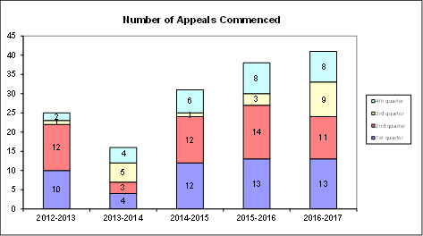
The appeals commenced during the year to 30 June 2017
concerned the following subject matters:
· residential
apartment buildings
· mixed use
development
· town houses
· tennis court
lighting
· modification
of existing development consent
costs
For the year ended 30 June 2017, Council incurred $1,054,747
on appeals and associated expenses in relation to Land & Environment Court
matters. This compares with the original annual budget of $1,063,600 (and the
annual revised budget of $980,600).
In addition to expenditure on appeals, a further amount of
$38,908 was spent in obtaining expert advice regarding development assessment
matters.
|
Land & Environment
Court Costs
2013/2014 - 2016/2017
|
|
Financial Year
|
Total
Costs
|
1st
quarter September
|
2nd
quarter December
|
3rd quarter March
|
4th quarter June
|
|
2013/2014*
(16 appeals lodged)
|
$481,043
|
$42,412
|
$124,001
|
$104,095
|
$210,535
|
|
2014/2015*
(31 appeals lodged)
|
$1,153,612
|
$186,803
|
$407,603
|
$194,103
|
$365,103
|
|
Financial Year
|
Total Costs
|
1st quarter September
|
2nd quarter December
|
3rd quarter March
|
4th quarter June
|
|
2015/2016
(38 appeals lodged)
|
$1,256,887
|
$264,263
|
$290,099
|
$303,122
|
$399,403
|
|
2016/2017
(41 appeals lodged)
|
$1,054,747
|
$202,574
|
$196,949
|
$285,681
|
$369,543
|
* Costs reported to Council in previous reports
As noted above, the number of
appeals in recently reported periods has been high compared to historical
averages. The number of appeals received by Council is a matter that does
not lie within the control of Council, however the main factor appears to have
been the amendment to the Environmental Planning and Assessment Act made
in 2013 which reduced the timeframe for lodgement of an appeal from twelve
months to six months. This has had the undesired effect of applicants for
more substantial and complex development proposals lodging appeals for no other
reason than as a mechanism to preserve early appeal rights.
Notwithstanding, Council’s overall success rate in appeals is high.
Costs recovered totalled $154,019
as at the end of the year to 30 June 2017. This compares favourably to
the original annual budget for costs recovered of $57,500 (and the annual
revised budget of $150,000).
SUMMARY BY WARD
A summary of the above Land & Environment Court costs by
Ward for the nine months to 30 June 2017 is shown in the following table:

Outcomes
At an early stage of each appeal,
Council as respondent, is required to file with the Court a Statement of Facts
and Contentions outlining the grounds which Council asserts as warranting
refusal of a development, or alternatively, that may be addressed by way of
conditions of consent.
In cases where issues raised by
Council are capable of resolution by the provision by the applicant of
additional information or amendment of the proposal, it is the Court’s
expectation that this should occur. The Court’s current practice of
listing appeals for a preliminary mediation conference before a Commissioner of
the Court pursuant to section 34 of the Land & Environment Court Act,
strongly encourages this.
In this context, any of three
outcomes can be regarded as favourable, namely:
1. If
the appeal is in relation to a deemed refusal of an application which, upon
assessment, is appropriate for approval: that the development is
determined by Council, allowing the appeal to be discontinued by the applicant
and avoiding as much as is practicable the incurring of unnecessary legal
costs;
2. If
the issues raised by Council are capable of resolution by the applicant
providing further information, or amending the proposal: that this
occurs, so that development consent should be granted, either by Council or the
Court;
3. If
the issues raised by Council are either not capable of resolution or the
applicant declines to take the steps that are necessary to resolve them:
that the appeal is either discontinued by the applicant, or dismissed (refused)
by the Court.
Eleven matters were concluded during the quarter. A
favourable outcome was achieved in nine of those matters.
· One matter
was discontinued by the applicant;
· One matter
was dismissed by the Court;
· Six matters
were resolved by agreement in accordance with an amended proposal;
· One matter
was resolved by agreement;
· Two matters
were upheld by the Court.
integrated planning and reporting
Leadership & Governance
|
Community Strategic Plan Long Term Objective
|
Delivery Program
Term Achievement
|
Operational Plan
Task
|
|
L2.1 Council rigorously manages its financial
resources and assets to maximise delivery of
services.
|
Achieve financial sustainability targets
identified in the Long Term Financial
Plan.
|
Undertake quarterly reporting to Council on the financial
performance of the
organisation.
|
Governance Matters
Under Section 428 of the Local
Government Act 1993, Council is required to report legal costs, and the outcome
of each case in its Annual Report.
Risk Management
Quarterly reporting of legal costs to Council together with
information about the number, character and outcomes of proceedings enable
ongoing oversight of this area of Council’s activity.
Financial Considerations
Land & Environment Court legal
costs form part of Council’s recurrent operating budget.
Social
Considerations
None undertaken or required.
Environmental
Considerations
None undertaken or required.
Community Consultation
None undertaken or required.
Internal Consultation
This report has been developed
with input from Council’s Corporate Lawyer, Director Corporate and
Director Development & Regulation.
Summary
For the year ended 30 June
20017, Council incurred $1,054,747 in relation to Land & Environment Court
appeals. The total amount expended for the year ended 2016/2017 was $1,054,747.
This compares with the original annual budget of $1,063,600 (and the annual
revised budget of $980,600).
|
Recommendation:
That the
analysis of Land and Environment Court costs for the year ended 30 June 2017
be received and noted.
|
|
Tony Ly
Financial Accounting Officer
|
Jamie Taylor
Corporate Lawyer
|
|
David Marshall
Director Corporate
|
Michael Miocic
Director Development & Regulation
|
|
Attachments:
|
A1
|
Individual
Case Summary June 2017 - Land and Environment Court Costs
|
|
2017/222691
|
|
Ordinary
Meeting of Council - 22 August 2017
|
GB.3 / 67
|
|
|
|
|
Item
GB.3
|
S05273
|
|
|
10 August 2017
|
Investment Report as at 31 July 2017
EXECUTIVE
SUMMARY
|
purpose of report:
|
To present Council’s investment portfolio performance
for July 2017.
|
|
|
|
|
background:
|
Council’s investments are reported monthly to
Council in accordance with the Local Government Act 1993, the Local
Government (General) Regulation 2005 and Council’s Investment Policy.
|
|
|
|
|
comments:
|
The net return on investments for the month of July
2017 was $379,000 against a budget of $331,000 giving a YTD favourable
variance of $48,000.
|
|
|
|
|
recommendation:
|
That the summary of investments performance for July
2017 be received and noted; and that the Certificate of the Responsible
Accounting Officer be noted and report adopted.
|
Purpose of Report
To present Council’s investment portfolio performance
for July 2017.
Background
Council’s investments are reported monthly to Council
in accordance with the Local Government Act 1993, the Local Government
(General) Regulation 2005 and Council’s Investment Policy.
Comments
Investment Portfolio Performance Snapshot
The table below provides the investments portfolio
performance against targets identified in Council’s Investment Policy as
well as other key performance indicators based on industry benchmarks.
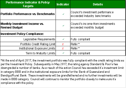
Cumulative
Investment Returns against Budget
The net return on investments for the month of July 2017 was
$379,000 against a budget of $331,000 giving a YTD favourable variance of
$48,000.
The total return on
investments for the month of July is provided below.

A comparison of the cumulative investment returns against
year to date budget is shown in the Chart below.
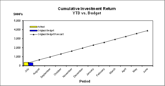
Cash Flow and Investment Movements
Council’s total cash and
investment portfolio at the end of July 2017 was $147,941,000, compared to
$144,280,000 at the end of June 2017, a net cash inflow of $3,661,000. The cash
inflow was mainly due S94 contributions.
One investment has matured
during the month of July 2017.

Investment Performance against Industry
Benchmarks
Overall during the month of July
the investment performance was well above the industry benchmark.
The
benchmark is specific to the type of investment and the details are provided
below.
· AusBond Bank Bill Index is used for all
Council’s investments
Table 1 - Investments Performance against Industry
Benchmarks

Table 2 below provides a summary
of all investments by type and performance during the month.
Attachment A1 provides
definitions in relation to different types of investments.
Table
2 - Investments Portfolio Summary during July 2017

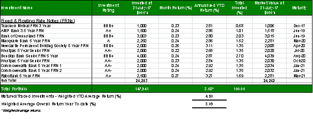
Investment by Credit
rating and Maturity Profile
The allocation of
Council’s investments by credit rating and the maturity profile are shown
below:
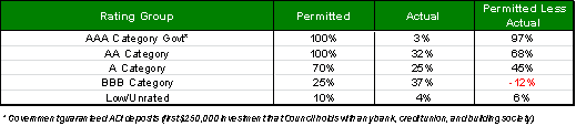
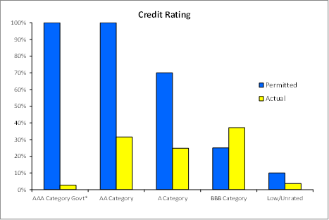
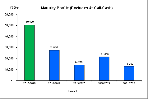
integrated planning and reporting
Leadership & Governance
|
Community Strategic Plan Long Term Objective
|
Delivery Program
Term Achievement
|
Operational Plan
Task
|
|
L2.1 Council rigorously manages its financial
resources and assets to maximise delivery of
services
|
Council maintains and improves its long term financial
position and performance
|
Continue to analyse opportunities to expand the revenue
base of Council
|
Governance Matters
Council’s investments are made in accordance with the
Local Government Act (1993), the Local Government (General) Regulation 2005 and
Council’s Investment Policy.
Section 212 of the Local Government (General) Regulation
2005 states:
(1) The
responsible accounting officer of a council:
(a) must
provide the council with a written report (setting out details of all money
that the council has invested under section 625 of the Act) to be presented:
(i) if
only one ordinary meeting of the council is held in a month, at that meeting,
or
(ii) if
more than one such meeting is held in a month, at whichever of those meetings
the council by resolution determines, and
(b) must
include in the report a certificate as to whether or not the investment has
been made in accordance with the Act, the regulations and the council’s
investment policies.
(2) The report must be made
up to the last day of the month immediately preceding the meeting.
Risk Management
Council manages the risk associated with investments by
diversifying the types of investment, credit quality, counterparty exposure and
term to maturity profile.
Council invests its funds in accordance with The Ministerial
Investment Order.
All investments are made with consideration of advice from
Council’s appointed investment advisor, CPG Research & Advisory.
Financial Considerations
The budget for interest on investments for the financial
year 2017/2018 is $3,890,700. Of this amount approximately $ $2,606,800 is
restricted for the benefit of future expenditure relating to development
contributions, $661,400 transferred to the internally restricted Infrastructure
& Facility Reserve, and the remainder of $622,500 is available for
operations.
Social
Considerations
Not applicable.
Environmental Considerations
Not applicable.
Community Consultation
None undertaken or required.
Internal Consultation
None undertaken or required.
Certification - Responsible Accounting Officer
I hereby certify that the investments listed in the attached
report have been made in accordance with Section 625 of the Local Government
Act 1993, clause 212 of the Local Government General Regulation 2005 and
Council’s Investment Policy.
Summary
As at 31
July 2017:
· Council’s
total cash and investment portfolio is $147,941,000.
· The
net return on investments for the financial year to July 2017 was $379,000
against a budget of $331,000, giving a YTD favourable variance of $48,000.
|
Recommendation:
A. That the
summary of investments and performance for July 2017 be received and noted.
B. That
the Certificate of the Responsible Accounting Officer be noted and the report
adopted.
|
|
Tony Ly
Financial Accounting Officer
|
Angela Apostol
Manager Finance
|
|
David Marshall
Director Corporate
|
|
|
Attachments:
|
A1
|
Investments
definitions specific to Council’s investment portfolio
|
|
2016/124274
|
|
Ordinary
Meeting of Council - 22 August 2017
|
GB.4 / 74
|
|
|
|
|
Item
GB.4
|
DA0410/16
|
|
|
11 July 2017
|
Summary
Sheet
|
Report title:
|
3 Graham Avenue,
Pymble - Torrens title subdivision of one lot into two lots - (Heritage
Conservation Area)
|
|
ITEM/AGENDA
NO:
|
GB.4
|
|
Application No:
|
|
|
Property Details:
|
3 Graham Avenue PYMBLE NSW 2073
Lot & DP No: Lot 2
DP 1205319 and Lot 3 DP 1205319
Site area (m2): 3,592m²
(excluding access handle)
Zoning:
R2 Low Density Residential
|
|
Ward:
|
St Ives
|
|
Proposal/Purpose:
|
Torrens title subdivision of one lot into two lots -
Heritage Conservation Area
|
|
Type of Consent:
|
Local
|
|
Applicant:
|
Ian Glendinning Planning P/L
|
|
Owner:
|
Pride International Investment P/L
|
|
Date Lodged:
|
05/09/2016
|
|
Recommendation:
|
Approval
|
Purpose of Report
To determine Development Application DA0410/16 that seeks
consent for the Torrens Title subdivision of one lot into two lots. The application
is reported to Council as it contains Blue Gum High Forest which is a
critically endangered ecological community.
integrated planning and reporting
|
Community Strategic Plan Long Term Objective
|
Delivery Program
Term Achievement
|
Operational Plan
Task
|
|
P2.1 A robust planning framework is in place to deliver
quality design outcomes and maintain the identity and character of
Ku-ring-gai.
|
Applications are assessed in accordance with State and
local plans.
|
Assessments are of a high quality, accurate and consider
all relevant legislative requirements.
|
History
DA History
Council’s
electronic database references the following Development Applications made with
respect to the subject site:
|
Development
Application No.
|
Proposal
|
Assessment
|
Date
of Determination
|
|
DA0538/13
|
Proposed boundary adjustment & land transfer (stage
1), construct access handle driveway, entry columns, gate, retaining walls
& associated landscaping (stage 2) - Heritage item. Amongst other things,
this application transferred what is now known as Lot 3 in DP 1205319 to the new owners from No. 29 Telegraph Road, which is a listed heritage item. As a
result, technically Lot 3 in DP 1205319 remains a listed heritage item given
it remains mapped under KLEP (Local Centres) 2012.
|
Approved
by the Land and Environment Court
|
1
September 2014
|
The Site
Site Description
The site
is known as 3 Graham Avenue, Pymble and is legally described as Lot 2 in DP
1205319. The property is located on the south-western side of Graham Avenue.
The site has an area of 3,592m² (excluding the access handle, Lot 3 in DP 1205319) and is slightly irregular in shape with a splayed southern boundary. The site has a
maximum width of 69.57m and an approximate depth of 27 metres. The site is vacant following the demolition of pre-existing structures, approved pursuant
to DA0416/14.
Access to the site from Graham
Avenue is via an access handle, identified as Lot 3 in DP 1205319. The access handle has an area of 376.6m² and is a listed heritage item, as it
was formerly part of No. 29 Telegraph Road.
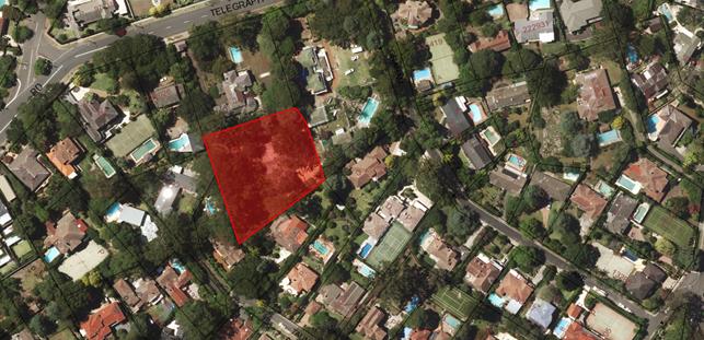 Figure
1: aerial image of the development site and surrounding properties
Figure
1: aerial image of the development site and surrounding properties
Surrounding Development
Surrounding development consists
of single and two storey residential dwellings sited on large landscaped
allotments.
The Proposal
Development consent is sought
for Torrens title subdivision of one allotment into two, being proposed Lots 10
and Lot 11. The development indices for the proposed subdivision are as
follows; all of which are exclusive of the area of Lot 3 in DP 1205319:
Lot
10:
- area
2108m²
- average
width 33.8m
- average length 63.9m
Lot 11:
- area 1484m²
- average width 27.9m
- average length 53.5m
Other works:
- stormwater drainage
- interallotment drainage
Consultation
Community
In accordance with Section A, Part 25 of the Ku-ring-gai Local
Centres DCP, owners of surrounding properties were given notice of the
application. In response, submissions
from the following were received:
1. Gary
Withers – 18 Taunton Street, Pymble
2. Peter
and Julie Hanlon – 19 Taunton Street, Pymble
3. Deirdre
Selby – 21 Taunton Street, Pymble
4. David
and Edwina Burns – 29 Telegraph Road, Pymble
5. Robyn
Gleeson – 31 Telegraph Road, Pymble
6. Nicholas
Willetts – PO Box 679, Lindfield
7. Brian
and Dell Burman – 21 Telegraph Road, Pymble
The submissions raised the
following issues:
Opposition to subdivision
Objection is raised to the proposed subdivision, as it is
likely that a future Development Application will seek consent to erect two
dwellings (one on each newly created lot).
Indicative building footprints have been included on the
subdivision plan for the purposes of determining whether the new lots are able
to accommodate a future dwelling house. A merit assessment concludes that the
new lots are able to accommodate new dwellings which would generally be
compliant with Council’s numerical controls. Furthermore, the development
site is zoned R2 Low Density Residential. Dwelling houses are a permissible
form of development within the zone and any future application would need to be
assessed on its planning merits.
Increased use of driveway
Concern is raised that the increased use of the existing
driveway of No. 3 Graham Avenue, as a result of two future dwellings, may
result in adverse noise impacts to the living area of No. 5 Graham Avenue. It
is considered that the increase in use will be minimal and as a consequence the
impact will not be significant, notwithstanding that this would be a matter to
be considered in the assessment of any future DA for dwelling houses.
Increased traffic along Graham Avenue
Concern is raised that the future addition of two new
dwellings will increase the traffic on Graham Avenue, which would be dangerous
and detrimental to the area.
Council’s Development Engineer has raised no
objections to the proposal. Any likely increase will be minimal and would not
have a significant impact.
Approved screening
Concern is raised that the approved landscape screening,
pursuant to DA0538/13, has not been maintained. This matter has been referred
to Council’s Compliance Unit for further action.
Heritage impacts
The objector states that new dwellings would result in
adverse impacts on Pymble’s significant historic and architectural
buildings. No new dwellings are proposed as part of this application and
any future Development Application will be assessed on their own merits. The
proposed subdivision was referred to Council’s Heritage Advisor who did
not raise any objection to the proposal.
Amenity impacts
The objector states that there are a number of issues
relating to the loss of amenity to No. 21 Telegraph Road, arising from the
proposed development and the future intention by the applicant to construct two
buildings, without providing adequate detail of the new buildings. The subject
application is for Torrens title subdivision only. Dwelling houses are not
proposed under this application.
The subdivision plan details the indicative building
footprints on both lots, which demonstrates that the new lots are of a size and
configuration that can support a single dwelling house in the future, capable
of satisfying Council’s relevant controls. Future dwellings are capable
of being designed to ensure reasonable levels of amenity are maintained to the
neighbouring properties, including to areas of private open space and habitable
rooms.
Loss of bushland and city views
The objector is concerned that the height of future
dwellings on the new lots may interrupt foreground local views and distant
views of Sydney’s CBD. Matters relating to view loss shall be assessed
against Council’s relevant controls should dwelling houses be proposed
under a future Development Application. Council’s Ecological Assessment
Officer has raised no concerns on the proposal subject to conditions to mitigate
any potential impacts. (Conditions 41 and 42).
Permissibility
The objector claims that No.
31 Telegraph Road, which is also within the HCA, was not allowed to be
subdivided. Accordingly, the permissibility of subdividing No. 3 Graham Avenue
is questioned.
Council’s records do not contain any evidence that a
DA for subdivision was lodged for 31 Telegraph Road.
No. 3 Graham Avenue is zoned R2 Low Residential Development,
within the Ku-ring-gai Local Environmental Plan (Local Centres) 2012. The proposed
development is defined as a Torrens title subdivision of one lot into two on
the subject site and is a permissible form of development under Clause 2.6 of
the KLEP (Local Centres) 2012.
Concerns for wildlife
The objector states that the proposed clearing of trees for
the subdivision will result in loss of habitat for wildlife. Council’s
Ecological Assessment Officer raised no concerns with the proposal, subject to Condition
4. Furthermore, there is no tree removal proposed as part of the subdivision.
The previous DA consent for demolition allowed for the removal of a
storm-damaged liquid Ambar. Moreover, the placement of the indicative building
footprints demonstrates that all 33 remaining trees may be kept.
Concerns for Blue Gum High Forest
The site contains Blue Gum High Forest (BGHF), a critically
endangered ecological community. The objector states that a future dwelling
will be in closer proximity to the BGHF, thus would impact this community.
An impact assessment (7-part test) has been prepared to
assess the ecological impacts of the development on the BGHF community.
Council’s Ecological Assessment Officer concludes that the development
will not have a significant adverse impact to the community and will not result
in the removal of any trees. The assessment of any future Development
Application for dwelling houses will also consider impacts to the BGHF.
Agreement for single dwelling
It is claimed that the owners of No. 29 Telegraph Road, a
State Listed heritage item, entered into an agreement with the owners of Lot 2
(the subject site) to allow them to use lots 2 and 3 for access to Taunton
Street. Part of the agreement also restricted future development to a single
dwelling on Lot 2. There is no evidence to support this claim, nevertheless, it
is a private matter, irrelevant to this application. The objector also claims
that the proposal of 2 dwellings is not considered appropriate for the
following reasons:
· driveway
is designed for single dwelling traffic
· safety
impacts to No. 29 Telegraph Road
· future
dwelling will be in closer proximity to boundary of No. 29 Telegraph Road
· closer
setback of new dwelling will compromise integrity of No. 29 Telegraph Road
The subject application is for the Torrens title subdivision
only. Council’s Development Engineer has not raised a concern relating to
driveway design or safety impacts. Any future development application for a
dwelling house or other permissible use, will be considered on its own merits.
Further, there does not appear to be any restrictions of this nature on the
title of Lot 3. Nevertheless, even if such restrictions were to exist, Clause
1.9A provisions suspend covenants agreement and instruments for the purposes of
enabling development to be carried out in accordance with the KLEP (Local
Centres) 2012.
Preservation criteria for No. 29 Telegraph Road
The submitter claims that placing a dwelling in closer
proximity to No. 29 Telegraph Road is inconsistent with Council’s strict
preservation criteria, which seeks to protect the State Listed Heritage Item.
The proposal is for the subdivision of one lot into two. No dwellings are
proposed under the subject application. The proposed subdivision has been
assessed by Council’s Heritage Advisor has not raised any objections the
proposal.
Unreliable Heritage Impact Statement (HIS)
The objector claims that the HIS contains inaccuracies and
errors.
Council’s Heritage Advisor has reviewed the proposal,
including all documents and information submitted with the application and
concludes that the subdivision will have minimal impacts on the HCA’s
significance and on the adjoining heritage item.
Stormwater management and overland water flows
The objector raises concern with regard to the stormwater
management for the proposed subdivision.
The applicant has provided adequate stormwater details,
which depict future inlet connections at the rear of proposed Lot 10 with an
interallotment drainage easement to be created. The plans also show 150mm high
kerb along the boundary to prevent overland flow, into No. 19 and 21 Taunton
Street. This will prevent any flooding of neighbouring properties.
Council’s Development Engineer has raised no objection to the proposal.
Easement access
The owners of No. 29 Telegraph Road state that they have
access to the easement which runs from the south western corner of Lot 2, to
Taunton Street and raise concern that the subject application has made no
reference to the objectors’ use of the easement.
Subdivision of Lot 2 will not extinguish any right of access
to an easement. An easement is a property right and any matters relating to the
use of the easement is a civil matter.
Tree impacts
The objector is concerned that the excavation for the
easement on 19 Taunton Street will impact on the roots of a Liquid Amber and a
Cedar tree. To avoid impacts, the applicant has proposed that all service
trenches, including those for stormwater pipe installation, be dug via
horizontal directional drilling under the supervision of a qualified arborist.
As a result, no concerns are raised by Council’s Landscape Assessment
Officer.
Removal of retaining walls and cut and fill
Concern is raised with regard to impacts associated with the
removal of retaining walls and cut and fill on the development. The only
physical works proposed under the subject application are for the construction
of interallotment drainage and services within the registered right of way over
No. 19 Taunton Street. These works are unlikely to result in any significant
impact in this regard. Nevertheless, Conditions 7, 8, 26 and 32 are
recommended to minimise any impacts from soil erosion, drainage management and
guarding excavations.
Within Council
Heritage
Council's Heritage Advisor
commented on the proposal as follows:
Heritage status
The access handle (Lot 3 in DP
1205319) is a heritage item and the overall site is located within the Park
Estate Heritage Conservation Area (C7) and adjoins items at No 21 & 23
Telegraph Road and is within the vicinity of several Heritage Items at:
- 2A, 4, 19, 17 & 31
Telegraph Road, and
- 9 Graham Avenue.
Clause (4) of the KLEP 2015
requires that before granting consent to the proposed works Council must
consider the effect of the works on the heritage item, nearby items or
conservation area concerned.
Statement of Significance
The following is taken from
Council’s inventory information for the HCA precinct:
Historical Significance:
The Park Estate HCA is of
historical significance as a late nineteenth century subdivision which retains
largely intact development from the Federation and Inter-war periods.
Aesthetic Significance:
The Park Estate HCA is
considered to be of high aesthetic significance for its fine collection of
substantial Federation and Inter-war housing, including fine examples of the
Federation Queen Anne, Federation Arts & Crafts, Inter-war Old English, Inter-war
Californian Bungalow, Inter-war Functionalist and Inter-war Georgian Revival
styles. The topography also adds to the area’s aesthetic
significance, as the land rises from Robert Pymble Park to the north, resulting
in the area’s houses overlooking the park. Houses on the even side
of Taunton Street overlook the houses in Park Crescent.
The following is from the
Heritage Council information on No 29 Telegraph Road:
The
Eric Pratten house is important as Griffin's largest domestic commission
in Australia. It was one of his last works before leaving Australia for India
and completed by his associate, Nicholls. It is one of three large Griffin
houses in Ku-ring-gai.
Griffin is one of the most
influential architects to work in Australia, coming here after his winning
design for Canberra. Griffin had a very prolific career in Australia, designing
a wide range of buildings from small shelters, houses, utilitarian buildings
such as incinerators, major buildings such as Newman College, whole suburbs and
towns. A noted characteristic of his work is a close connection with the
Australian landscape. His later work is influenced strongly by Steiner's
philosophies and the belief in anthrosophy.
Donald Lesley Johnson, in his
book 'The Architecture of Walter Burley Griffin', holds the view that this
house is a disappointment because it seems antithetical to the philosophies of
architecture, landscape design and planning Griffin formulated and practised
during his stay in Australia.
Aesthetic Significance:
The Eric Pratten house is
important as a large Griffin designed residence, which includes the house
within its garden setting. It is rare, as the majority of his residential
commissions in Australia are relatively small houses, typically one storey.
The house, formed from
carefully articulated sandstone masses with battered walls, angular prows and
deep reveals set beneath a series of sailing roofs in a re-interpretation of
the Wrightian Prairie house. The design elements of the house demonstrate
Griffin's ideas about spirituality influenced by Steiner and the concepts of
anthroposophy. The Eric Pratten house is designed at the high point of
Griffin's Steiner phase.
The house demonstrates a high
level of technical competence and excellence, particularly related to stone
construction in Australia during the 1930s.
Heritage management
document
A HIS has been submitted with the
application. It was prepared by an experienced heritage consultant.
It has considered the NSW Heritage Council guidelines for such a document but
has not considered the Ku-ring-gai DCP. It copies much of the listing
information for the place from the SHI database. It acknowledges that the
subject site was part of the extended garden of the heritage item at No 29
Telegraph Road, a substantial house designed by Griffin with a garden layout
attributed to Marion Mahoney.
The report concludes:
The proposed works in this
development application do not adversely affect the identified heritage
significance of any of the heritage listed properties that adjoin the subject
site, and in particular the State Heritage Item, “Coppins” or the
role of those places as contributing elements in the identified C7 Urban
Conservation Area. The application is similar to DA538/13 for a large single
dwelling on the allotment, previously approved by Ku-ring-gai Council as having
an acceptable impact. I would therefore recommend the heritage aspects of
the application be approved.
It should be noted that there are
errors in the heritage report. The previous application for a single
dwelling on the site (DA0538/13) was subject to a Land & Environment Court
approval, not a consent granted by Ku-ring-gai Council. The legal
curtilage of the SHR listing includes the access driveway through No 29
Telegraph Road to Graham Avenue. The nomination for the state listing of
the site was made by Ku-ring-gai Council, not the Griffin Society.
Background
This site was formerly associated
with the adjoining lot at No 29 Telegraph Road, a State heritage item.
This lot contained the tennis court for the item and a small cottage occupied
by the gardener. The lot was purchased shortly after construction of the
dwelling at No 29 Telegraph Road and it is understood that the house was
planned with the intention of acquiring the lot for its expanded garden.
The lot was never amalgamated although it was sold several times, it remained
in the same configuration.
In 2014, Council received an
application for removal of all structures on the site, construction of an
access handle on the southern end of the heritage item providing access to
Graham Avenue and a new large dwelling with pool and tennis court. The
application was approved by the Land & Environment Court and construction
of the access handle took place. Conditions were placed on the
application to ensure some of the elements associated with the heritage item
including the windmill and dog kennel would be relocated on the heritage lot.
Controls
The Ku-ring-gai Development
Control Plan 2015 Section 19C provides objectives and controls for development
within a Heritage Conservation Area. Section 19F provides objectives and
controls for development within the vicinity of a heritage item or HCA. A
portion of the development site (Lot 3 in DP 1205319) is a heritage item and the
overall site is within a HCA. The following objectives and controls are
relevant and apply to the application:
|
19A SUBDIVISION AND SITE CONSOLIDATION
|
|
19A.1 Subdivision and Site Consolidation within
a
HCA
Complies
|
|
1 Applications for subdivision and site consolidation
within an HCA is discouraged and will only be considered if the application:
i) will have no adverse affect on the significance of
the HCA;
ii) retains the typical block width characteristics and
historic subdivision pattern of the area, including rear lanes;
iii) the setting and curtilage of Heritage Items or
significant buildings in the vicinity, including important structures and
landscape elements, are retained;
iv) vistas and views to and from Heritage Items and
contributory properties, especially the principal elevations of buildings,
are not interrupted or obscured;
v) the landscape quality of the streetscape is retained;
vi) the contours and any natural features of the site
have been retained and respected;
vii) will not result in future development which will
adversely affect the significance, character or appearance of the HCA.
|
YES
NO
Partially
Partially
YES
NO
|
|
2
Subdivision or consolidation will not generally be permitted where the
setting or curtilage of any Heritage Items and contributory properties within
or adjoining the site, would be compromised.
|
YES
|
|
3
Applications for subdivision and site consolidation within an HCA will
require a curtilage assessment.
|
NO
|
|
19F DEVELOPMENT IN THE VICINITY OF HERITAGE ITEMS OR HERITAGE
CONSERVATION AREAS (HCAS)
|
|
19F.1 Local Character and Streetscape
|
|
General
1 All
development in the vicinity of a Heritage Item or HCA is to include a
Heritage Impact Statement.
|
YES
|
|
Views
|
|
4.
New development in the vicinity of a Heritage Item or HCA is to demonstrate
that it will not reduce or impair important views to and from the Heritage
Item from the public domain.
|
YES
|
|
19F.3 Gardens and Landscaping
|
|
Gardens, Setting and Curtilage
|
|
1 Development
in the vicinity of a Heritage Item or an HCA is to:
i) retain
original or significant landscape features associated with the Heritage Item
or HCA, or which contribute to its setting;
ii)
retain the established landscape character of the Heritage Item or HCA; and
iii)
include appropriate screen planting on side and rear boundaries.
|
YES
YES
YES
|
|
19F.4 Fencing
|
|
Fences on adjoining sites
|
|
2 No
metal panel fencing is to be constructed on any boundary of a Heritage Item.
|
YES
|
Comments
on DCP Controls
The following
is an assessment of the above non-compliances.
1
Applications for subdivision and site consolidation within an HCA are
discouraged and will only be considered if the application:
ii) retains
the typical block width characteristics and historic subdivision pattern of the
area, including rear lanes;
Response
“The
existing site is one lot with access to Lot 3 in DP 1205319. As proposed it is to be subdivided into three lots with a reduction in the
block width to accommodate the proposed new lots. The lot associated with
the driveway is not modified by this application and thus has no further
heritage impacts.”
iii) the
setting and curtilage of Heritage Items or significant buildings in the
vicinity, including important structures and landscape elements, are retained;
Response
“Historically
this site was associated with the property at No 21 Telegraph Road. The
property at No 21 was subdivided and the southern portion of the land acquired
by the property at No 29 in 1939. A tennis court and later a
gardener’s cottage were built on the lot. Although never
amalgamated with the subject site, the siting of the house at No 29 was planned
to take advantage of views over the lot and it forms part of its visual setting
and extended curtilage. From the Heritage Council information:
The house
was deliberately located with its back to the west, on a knoll at the corner
were the two original lots met. This was the only position allowing the
house and the rooms within to interact with all areas on the site, while taking
advantage of the views.
The former
tennis court and cottage are part of its visual setting and extended curtilage
although now alienated from it. Further subdivision of the site does not alter
the visual setting or historic connections to the adjoining heritage
items.”
iv) vistas
and views to and from Heritage Items and contributory properties, especially
the principal elevations of buildings, are not interrupted or obscured;
“It
is not possible to speculate on possible loss of views from the surrounding
heritage items at this stage as no buildings are proposed in this
application. However, the heritage items are sited on a ridge and enjoy
extensive views towards the south including the CBD, Sydney Harbour and as far
south as Malabar. Loss of those views could be potentially affected their
setting and significance. Nevertheless, there is no impact as a result of this
proposal.”
vi) the
contours and any natural features of the site have been retained and respected;
Response
“As
proposed, arboricultural report indicates no trees would need to be removed if
the future buildings were limited to the indicative footprints. The
existing cottage and remains of the tennis court would need to be removed if
two dwellings were constructed on the site. However, approval for their
removal was provided via DA 538/13. No concerns are raised in this
regard.”
vii) will
not result in future development which will adversely affect the significance,
character or appearance of the HCA.
Response
“At
this stage it is not possible to speculate on future development that might
occur on the site. Consideration of future development will need to be
made when a development application is made. The subject site does not
have a strong visual connection to the streetscape of Graham Avenue and no
visual presentation to Telegraph Road. As a result, no concerns are raised in
this regard.”
3
Applications for subdivision and site consolidation within an HCA will require
a curtilage assessment.
Response
“A
curtilage assessment of the site has not been provided. The heritage
report only refers to the curtilage of the State heritage item at No 29
Telegraph Road. The report claims the setting of the house includes the
original lot on which it was built, purchased by Eric Pratten in 1934 and
excludes the subject lot to the west which was part of a later expansion of the
site made in 1943. This is not accurate. The subdivision that
created the subject lot was approved in 1938 shortly after the house was
constructed (1936) and registered in 1939 (see attached DP plan). The
heritage item developed in various phases with the final construction phase
occurring in the 1960s with construction of the pool and pool facilities.
There were also changes to the house with a redesign of the stairs and more
recently replacement of the bathroom fittings and a very recent renovation of
the main house, garage and pool facilities.
A
subdivision occurred in 2015, which resulted in three lots, Lot 1, 2 &
3. Lot 1 containing the State item was slightly increased in size to
include a former access handle from Telegraph Road. Lot 2 is the subject
site and Lot 3 contains the driveway and gates only, providing access to the
subject site. This application is for subdivision of Lot 2 into two new
lots with vehicular access over Lot 3 and an existing ROW access to Taunton
Avenue over No 19 Taunton Avenue.”
As a result,
there are no significant works which would require a curtilage assessment.
Conclusion
While the subdivision
in itself has minimal impact on the heritage items and the HCA, a future
application for a building or buildings or further subdivision might impact on
the site. Nevertheless, it is conceivable that a future application could
also have acceptable impacts.
It is
considered that the subdivision of the site has minimal effects on the
significance of the HCA and heritage items and is acceptable.
No heritage
conditions are considered necessary.
Landscaping
Council's
Landscape and Tree Assessment Officer raised no objection to the proposal and
has recommended conditions to ensure trees are protected during the
installation of services (Conditions 9 – 13, 34 – 38).
Engineering
Council's Development Engineer commented
on the proposal, following the amended plans and information:
A Section 73
Certificate will have to be obtained prior to the issue of the Subdivision
Certificate, to confirm that each lot has its own water and sewer connection.
The applicant
has submitted the Deed of Agreement that allows for the retention of the
easement for access (pedestrian only) and an easement for drainage of
stormwater 1.5m wide. The terms have been checked and it provides sufficient
evidence that the required easement can be created. A deferred Commencement
Consent may be issued that requires evidence the site benefits from a drainage
easement before the consent is operational.
Water management
Revised service plans have been
received. Indicative building footprints have been
shown on the submitted plans enabling each lot to implement its own
water management system as part of any future residential development. The plan
depicts a stormwater pit with future inlet connections at the rear of proposed
Lot 2 with an interallotment drainage easement to be created over the right of
carriage way.
The easement consists of a 150mm
diameter pipe that will be conveyed by gravity to the kerb and gutter in
Taunton Street, which is acceptable. Given that the site is heavily constrained
with remnants of Blue Gum High Forest, the installation of the pipe will be via
directional drilling.
Council has
received photographic evidence from the downstream properties that shows the
drains within the cul-de-sac in Taunton Street overflowing in heavy rainfall
events, causing stormwater problems to the Taunton Street properties. An
amended stormwater design now depicts a 150mm high kerb along the boundary to
prevent overland flow onto No. 21 Taunton Street. This
will address the concerns of residents in Taunton Street. The
plans also show a stormwater discharge line from the proposed Lot 1 dwelling to
the existing stormwater discharge pit located within the as constructed right
of access, which is acceptable.
Vehicular access
An existing concrete driveway has
been constructed within Lot 3 and provides connection from Graham Avenue to
both lots. There is sufficient area within the site for turning areas to enable
vehicles to enter and exit the site in a forward direction.
Plan of subdivision
A preliminary plan of subdivision
has been submitted which is acceptable for DA purposes.
Conclusion
The proposal is acceptable,
subject to conditions.
Ecology
Council's Ecological Assessment
Officer commented on the proposal as follows:
The site contains Blue Gum High
Forest a Critically Endangered Ecological community listed under the Threatened
Species Conservation Act 1995. The BGHF is comprised of a canopy dominated
by Eucalyptus saligna (Sydney Blue Gum) & Syncarpia glomulifera
(Sydney Turpentine). One sub-canopy tree species Pittosporum undulatum
(Sweet Pittosporum) was also identified. The native vegetation within the site
which occurs primarily within the rear and along the western boundary of the
site has been mapped as an area of biodiversity significance under the KLEP
2015.
The proposed
development does not propose the removal of any of the characteristic trees
species of the onsite BGHF community.
An impact assessment (7-part
test) has been prepared to assess the ecological impacts of the development
upon the endangered onsite BGHF community in accordance with section 5a of the Environmental
Planning Assessment Act 1979. The conclusion of the impact assessment
is that the proposal will not have a significant impact. Council’s
Ecologist is in agreement with this conclusion.
Conclusion
The DA is
acceptable on ecological grounds, subject to conditions.
Statutory Provisions
State Environmental Planning Policy No. 55 -
Remediation of Land
The provisions of SEPP 55
require Council to consider the potential for a site to be contaminated. The
subject site has a history of residential use and as such, it is unlikely to
contain any contamination and further investigation is not warranted in this
case.
Sydney Regional
Environmental Planning Policy (Sydney Harbour Catchment) 2005
SREP 2005 applies to the site as the site is located in the
Sydney Harbour Catchment. The Planning Principles in Part 2 of the SREP must be
considered in the preparation of environmental planning instruments,
development control plans, environmental studies and master plans. The proposal
is not affected by the provisions of the SREP which relate to the assessment of
development applications as the site is not located in the Foreshores and
Waterways Area as defined by the Foreshores and Waterways Area Map.
Local Content (LEP, KPSO, etc)
Ku-ring-gai Local Environmental Plan (Local Centres) 2012
Zoning and permissibility:
The site is zoned R2 Low Density Residential. In accordance
with Clause 2.6 of the KLEP (Local Centres) 2012, the proposal for the torrens
title subdivision of one lot into two is permissible with consent. The proposed
development is consistent with the objectives of the R2 Low Density Residential
zone.
Part 4 Principal development standards:
Clause 4.1(4A) – Minimum subdivision lot size
In accordance with Clause 4.1 (4A), development consent must
not be granted for a subdivision of land in Zone R2 Low Density Residential, if
the subdivision would result in a lot that is less than 18 metres wide at 12
metres from the street frontage of the lot. The subject site does not have a
street frontage. Therefore this provision does not apply.
|
Development standard
|
Proposed
|
Complies
|
|
Height of buildings: 9.5m
|
Not proposed
|
N/A
|
|
Minimum
subdivision lot size: 930m²
|
Lot 10:
- excluding access handle: 2108m²
Lot 11:
- excluding access handle: 1484m²
|
YES
YES
|
Part 5 Miscellaneous
provisions
Clause 5.9 – Preservation of trees
or vegetation
The objective of this clause is to preserve
the amenity of the area, including biodiversity values, through the
preservation of trees and other vegetation. The proposed development does not
negatively impact upon any existing significant trees or vegetation.
Council’s Landscape Assessment Officer and Ecological Assessment Officer
are satisfied with the proposal in this regard.
Clause
5.10 – Heritage conservation
The subject site is located within the C7 Heritage
Conservation Area – C7 Park Estate Pymble and is adjacent to heritage
items No. 21 Telegraph Road, 29 Telegraph Road and in part contains a listing
for Lot 3, to be used as an access way to the site.
Council’s Heritage Advisor states that, due to the
location of the site and the relatively minor nature of the works, the proposed
subdivision has minimal and acceptable impact on the significance of the
Heritage Conservation Area and heritage items.
Part 6
Additional local provisions
Clause 6.1 – Earthworks
The proposed development will not restrict the existing or
future use of the site, adversely impact on neighbouring amenity, the quality
of the water table or disturb any known relics. Additionally, any excess fill
will be disposed of appropriately.
Clause 6.3 - Biodiversity protection
The objectives of clause 6.3 (biodiversity
protection) of the LEP are as follows:
a) protecting biological diversity of
native fauna and flora, and
b) protecting
the ecological processes necessary for their continued existence, and
c) encouraging
the recovery of threatened species, communities, populations and their
habitats, and
d) protecting,
restoring and enhancing biodiversity corridors.
The subject site is mapped as being located within
an area of biodiversity. The proposal is not considered to result in
significant adverse impacts to the diverse native fauna and flora. The proposal
meets the objectives of Council’s biodiversity protection controls and is
acceptable.
These provisions have been considered by
Council’s Ecological Assessment Officer, who is satisfied that the
proposed development is consistent with these provisions.
POLICY PROVISIONS
Ku-ring-gai Local Centres Development Control Plan
Section A
|
COMPLIANCE TABLE
|
|
Development control
|
Proposed
|
Complies
|
|
Part 3: Land Consolidation
and Subdivision
|
|
3A.1 Lot shape, orientation
and design
|
|
The lot shape, orientation and
design of consolidated and subdivided
lots is to demonstrate the
following:
i) Ability for the lot to
support the land use permitted under the
zoning;
ii) Protection of habitat and
distinctive environmental features
including:
-- Cliffs and rock
outcrops
-- Remnant bushland and
trees
-- Tree hollows
-- Natural watercourses
iii) Sharing of views;
iv) Avoiding the location of
development on steep lands;
v) Protection and enhancement
of the amenity, solar access, privacy, open space and views of the
neighbouring lots;
vi) Minimisation of impacts of
the development (including any asset protection zones required) on riparian
or Greenweb lands;
vii) Incorporation of the
principles of water sensitive urban design;
viii) Easements and servicing requirements;
ix) Vehicular, pedestrian and
bicycle access;
x) Respect for and conservation of cultural heritage including any Aboriginal
place or site of heritage significance; and
xi) Minimisation of the need for bush fire hazard reduction, while protecting
life and property.
|
Each allotment is of a size
and configuration that can support a single dwelling house in the future,
capable of complying with the relevant provisions, including built upon area,
private open space, landscaping areas and solar access. This is demonstrated
by orientation of the lots and indicative building footprints.
The site contains BGHF which
is being protected.
No works that result in an
impact.
The site is not characteristic
of having a steep slope.
The proposed lot shapes and
indicative building footprints demonstrate that existing amenity to
neighbouring lots is capable of being protected.
The proposed subdivision and
associated works do not affect any identified riparian or Greenweb lands.
The subdivision works enable the future development to incoporate water
sensitive urban design principles.
The required services are capable of being provided with regard to the
existing easement. This has been demonstrated to the satisfaction of
Council’s Development Engineer, subject to conditions.
Vehicular and pedestrian
access to the new lots is demonstrated in the application.
The proposal respects and
conserves heritage significance.
The site is not identified as
being bushfire prone land.
|
YES
YES
YES
YES
YES
YES
YES
YES
YES
YES
YES
|
|
The block width, dimension,
orientation and layout are to consider the existing subdivision pattern of
the locality.
|
The existing subdivision
pattern in the immediate vicinity of the site are irregular and do not adopt
a consistent shape or size.
Proposed Lots 10 and 11 have
block widths and dimensions consistent with battle-axe shaped lots in the
locality.
The proposed subdivision will
not affect the street address rhythm and spacing of built form.
|
YES
|
|
New lot/s created are to be
such that each lot with street frontage allows for the siting of a
development which will address the street.
|
The subject site does not have
a street frontage.
|
N/A
|
|
3A.3
Building footprint
|
|
Potential
building footprints are to be identified on the site plan of all
consolidation and subdivisions.
|
Indicative building footprints
have been included on the site plan for proposed Lot 10 and Lot 11. Both lots
could readily accommodate future development, consistent with the relevant
provisions of the LEP and DCP including but not limited to FSR, setbacks,
built upon area, private open space, landscaping areas and access
arrangements. The detail of an actual development on each lot is subject to
further refinement at the detailed planning stage and subject to assessment
as required in any future application.
|
YES
|
|
Building footprints are to be
located outside areas of ecological or heritage significance and to avoid the
loss of trees.
|
Complies
|
YES
|
|
The footprint is to be located
in an accessible and practical location, preferably with relatively flat
terrain, stable soil and geology.
|
The indicative building
footprints are sited in accessible and practical locations and on relatively
flat terrain. No geological or soil constraints are identified on the site.
|
YES
|
|
The building footprint must be
located and designed so as to allow useable open space that satisfies the
open space requirements of the particular development type.
|
Each lot is capable of
facilitating usable private open space of a minimum dimension of 5 metres and
area in excess of 50m2.
|
YES
|
|
The footprint is to be applied
in accordance with the minimum building setbacks.
|
The site areas and dimension
of Lot 10 and Lot 11 satisfy the requirements of the LEP and demonstrate that
the site is capable of supporting a building footprint consistent with the
requirements of the DCP, on each of these lots.
|
YES
|
|
Practical and suitable access
is to be provided from a public road to the building footprint.
|
Practical and suitable access
to the lots will be directly provided via the existing driveway located over
Lot 3. Council’s Development Engineer is satisfied with access
capabilities of the lots, subject to condition.
|
YES
|
|
The building footprint must be
located in accordance with the requirements in Part 24 of this DCP.
|
Council’s Development
Engineer is satisfied with the water management aspects of the proposal in
pursuant to Part 24 of the DCP, subject to conditions.
|
YES
|
|
3A.4 Trees and vegetation
|
|
Any subdivision or
consolidation proposal must demonstrate that the location and design of:
i) building footprints;
ii) access ways;
iii) roadways, including
perimeter roads or trails;
iv) services;
v) inter-allotment drainage
easements; and
vi) asset protection zones maximises the retention of, and minimises impacts
on existing significant trees and vegetation on or adjacent to the site.
|
The proposed subdivision has
been assessed by Council’s Landscape Assessment Officer and Ecologist
(refer to the above comments) and no objections were raised with respect to
potential impacts to trees and vegetation, subject to condition.
|
YES
|
|
Where a site is particularly
constrained a more detailed layout of the potential development may be
required.
|
The site is not considered to
be significantly constrained.
|
YES
|
|
Street trees are to be planted
where new roads are proposed or where the likely location of driveway
crossings will result in loss of existing street trees.
|
The proposal does not involve
a new road or the loss of any existing street trees. Prior consent has been
obtained to remove one existing tree on site.
|
YES
|
|
The canopy is to be capable of
being maintained at a minimum of 4.3 metres above the road surface to provide
clearance for larger vehicles.
|
Complies
|
YES
|
|
3A.5 Access
|
|
Each lot must provide access
from a constructed or dedicated public road. Where access is proposed to a
section of unconstructed public road, the newly created lot will need to
provide lawful, constructed access to Council’s satisfaction.
|
Each lot if readily accessible
from an existing constructed public road being Graham Avenue.
|
YES
|
|
The minimum width of an access
handle to a battle-axe allotment is 4.6 metres. This may be increased where
length, number of lots and or topography necessitate. Access to multiple
dwellings could require a wider access handle to accommodate passing bays.
|
>4.6m
|
YES
|
|
The maximum number of lots to
be served by a single access handle connected to a public road is 3 lots.
|
Complies (two lots)
|
YES
|
|
Access
for service vehicles, emergency vehicles and waste collection vehicles must
be available.
|
Access
for service vehicles, emergency vehicles and waste collection vehicles will
be available to each lot.
|
YES
|
|
Movement areas are to
incorporate convenient, obvious and safe pedestrian and bike links from the
lot to public transport services and local facilities.
|
Complies
|
YES
|
|
3A.6 Infrastructure
|
|
All lots shall be provided
services such as electricity, gas, town water supply, sewerage and
communications. Such services must be located underground where new road construction
occurs, and in bush fire prone lands.
|
Each lot will be provided with
the required services (water, sewer, electricity, gas and communications).
|
YES
|
|
Existing or planned allocation
of services and street trees must be identified on the plan.
|
The existing allocation of
services and street trees are identified on the plan.
|
YES
|
|
Water management facilities,
such as:
i) interallotment drainage for
low level lots;
ii) on site detention for new
roads and driveways;
iii) raingardens or
bioretention basins are to be provided as required by Part 24 of this DCP.
|
Water management facilities
are provided to the satisfaction of Council’s Development Engineer,
subject to conditions.
|
YES
|
Section
B
Part 18 – Biodiversity
The development site is mapped at having biodiversity
significance. This matter has been assessed by Council’s Ecological
Assessment Officer who concludes the proposal would not have a detrimental
impact in this regard.
Part 19 – Heritage items and Conservation Areas
Lot 3 which forms part of the subject site is heritage
listed. The site in its entirety is within the C7 Heritage Conservation Area
– C7 Park Estate Pymble. Adjoining properties, No. 21 and No. 29
Telegraph Road are heritage items. Council’s Heritage Advisor states
that, due to the location of the site and the minimal nature of physical works,
the proposed subdivision has no significant effects on the significance of the
Heritage Conservation Area and heritage items.
Section
C
Part 24 – Water
Management
Council’s Development
Engineer is satisfied that the proposed development will not result in a
significant detrimental impact contrary to the objectives of these provisions.
Part 25 – Notification
The
application was notified in accordance with the requirements of the DCP. The
submissions received have been considered.
Section 94 Plan
The development attracts a
section 94 contribution of $27,075.89,
which is required to be paid before the issue of the Construction Certificate (Condition
18).
Likely Impacts
The likely
impacts of the subdivision have been considered within this report and area
deemed to be acceptable, subject to conditions.
Suitability of the Site
The
site is considered to be suitable for the proposed development.
Public Interest
Approval
of the application is considered to be in the public interest.
Conclusion
Having regard to the provisions
of section 79C of the Environmental Planning and Assessment Act 1979, the
proposed development is considered to be satisfactory. Therefore, it is recommended
that the application be approved.
|
Recommendation:
A. THAT Council, as the consent authority, being satisfied
that the proposed development will be in the public interest, grant deferred
commencement development consent to DA0410/16 for Torrens title subdivision
of one lot into two lots on land at 3 Graham Avenue, Pymble. Pursuant
to Section 95(6) of the Environmental Planning and Assessment Act 1979, this
consent lapses if the approved works are not physically commenced within two
years from the date on which the consent becomes operable.
SCHEDULE
A - Deferred commencement term - to be satisfied prior to the consent
becoming operable
The following deferred
commencement term must be complied with to the satisfaction of Council within
24 months of the date of issue of this deferred commencement consent:
1. Drainage
easement (Deferred Commencement)
The applicant shall submit
documentary evidence that the property benefits from a registered drainage
easement or easements over all downstream properties as far as the public
drainage system. This consent will not operate until the documentary evidence
has been submitted to and approved by Council’s Development
Engineer. This documentation must include evidence that the easement
has been registered with NSW land and Property Information.
Reason: To
ensure that provision is made for stormwater drainage from the site in a
proper manner that protects adjoining properties.
Once the consent becomes operable,
the conditions in Schedule B will apply. Upon written receipt from Council
that the deferred commencement condition in Schedule A has been satisfied,
the following conditions will apply:
SCHEDULE B - Conditions
of development consent
Conditions
that identify approved plans:
1. Approved
plans and documentation
The development must be
carried out in accordance with the following plans and documentation listed
below and endorsed with Council’s stamp, except where amended by other
conditions of this consent:
|
Plan no.
|
Drawn by
|
Dated
|
|
GO150570
Dwg No. D1 - D5 all issue ‘D’
|
ACOR
Consultants Pty Ltd
|
14
June 2017
|
|
Subdivision Plan 01
|
Paul Meyer Design Pty Ltd
|
Feb 2016
|
Reason: To
ensure that the development is in accordance with the determination.
2. Inconsistency
between documents
In the event of any
inconsistency between conditions of this consent and the drawings/documents
referred to above, the conditions of this consent prevail.
Reason: To
ensure that the development is in accordance with the determination.
Conditions
to be satisfied prior to demolition, excavation or construction:
3. Asbestos
works
All
work involving asbestos products and materials, including
asbestos-cement-sheeting (ie. Fibro), must be carried out in accordance with
the guidelines for asbestos work published by WorkCover Authority of NSW.
Reason: To
ensure public safety.
4. Fauna protection
Prior to works commencing and/or tree removal works a
qualified ecologist shall investigate trees/vegetation for fauna
occupation.
Prior to the removal of tree/vegetation, an ecologist is
to install four nest boxes within close proximity to the area in which tree
removal is being undertaken. Two medium mammal box and 2 small bird/mammal
box are to be installed within indigenous trees to be retained within the
site. Nest boxes are to be installed at a height of greater than 5m and
positioned on the south-eastern side of trees.
The ecologist shall supervise the relocation of any fauna
found within the trees into the installed nest boxes in accordance with
appropriate licensing requirements.
The qualified ecologist must hold an Animal Ethics Permit
from the Department of Industry & Investment and a wildlife licence
under section 132C of the National Parks and Wildlife Act 1974 issued
by the Office of Environment & Heritage. Evidence of engagement of the
qualified ecologist and the required licensing must be provided to the
Private Certifying Authority with a copy to Council prior to the trees being
removed.
Reason: To
ensure the protection of fauna species.
5. Notice
of commencement
At least 48 hours prior to the
commencement of any development (including demolition, excavation, shoring or
underpinning works), a notice of commencement of building or subdivision work
form and appointment of the principal certifying authority form shall be
submitted to Council.
Reason: Statutory
requirement.
6. Notification
of builder’s details
Prior to the commencement of any development or
excavation works, the Principal Certifying Authority shall be notified in
writing of the name and contractor licence number of the owner/builder
intending to carry out the approved works.
Reason: Statutory
requirement.
7. Sediment
controls
Prior to any
work commencing on site, sediment and erosion control measures shall be
installed along the contour immediately downslope of any future disturbed
areas.
The form of
the sediment controls to be installed on the site shall be determined by
reference to the Landcom manual ‘Managing Urban Stormwater: Soils and
Construction’. The erosion controls shall be maintained in an
operational condition until the development activities have been completed
and the site fully stabilised. Sediment shall be removed from the sediment
controls following each heavy or prolonged rainfall period.
Reason: To
preserve and enhance the natural environment.
8. Erosion
and drainage management
Earthworks
and/or demolition of any existing buildings shall not commence until an
erosion and sediment control plan is submitted to and approved by the
Principal Certifying Authority. The plan shall comply with the
guidelines set out in the NSW Department of Housing manual "Managing
Urban Stormwater: Soils and Construction" certificate. Erosion and
sediment control works shall be implemented in accordance with the erosion
and sediment control plan.
Reason: To
preserve and enhance the natural environment.
9. Tree
protection fencing
To
preserve the following tree/s, no work shall commence until the area beneath
their canopy is fenced off at the specified radius from the trunk/s to
prevent any activities, storage or the disposal of materials within the
fenced area. The fence/s shall be maintained intact until the
completion of all demolition/building work on site.
|
Tree/Location
|
Radius
in metres
|
|
All
retained trees within proposed Lots 1 & 2
|
Tree
protective fencing is to be located as indicated on the Site Analysis Plan
by Paul Myer Design Pty Ltd drwg 02 Ref 15R977, dated 2/03/17
|
Reason: To
protect existing trees during the construction phase.
10. Tree
protective fencing type galvanised mesh
The
tree protection fencing shall be constructed of galvanised pipe at 2.4 metre
spacing and connected by securely attached chain mesh fencing to a minimum
height of 1.8 metres in height prior to work commencing.
Reason: To protect existing trees during construction phase.
11. Tree
protection signage
Prior to works commencing, tree protection signage is to
be attached to each tree protection zone, displayed in a prominent position
and the sign repeated at 10 metres intervals or closer where the fence
changes direction. Each sign shall contain in a clearly legible form,
the following information:
Tree protection zone.
· This fence has been installed to prevent
damage to the trees and their growing environment both above and below ground
and access is restricted.
· Any encroachment not previously approved
within the tree protection zone shall be the subject of an arborist's report.
· The arborist's report shall provide proof that
no other alternative is available.
· The Arborist's report shall be submitted to
the Principal Certifying Authority for further consultation with Council.
· The name, address, and telephone number of the
developer.
Reason: To
protect existing trees during the construction phase.
12. Tree
fencing inspection
Upon
installation of the required tree protection measures, an inspection of the
site by the Principal Certifying Authority is required to verify that tree
protection measures comply with all relevant conditions.
Reason: To
protect existing trees during the construction phase.
Conditions
to be satisfied prior to the issue of the construction certificate:
13. Project
arborist
A project Arborist shall be
commissioned prior to the release of the Construction Certificate to ensure
all tree protection measures are carried out in accordance with the conditions
of consent.
The project arborist shall
have a minimum AQF Level 5 qualification with a minimum of 5 years
experience. Details of the arborist including name, business name and contact
details shall be provided to the Principal Certifying Authority with a copy
to Council.
Reason: To
ensure the protection of existing trees.
14. Long
service levy
In accordance with Section
109F(i) of the Environmental Planning and Assessment Act a Construction
Certificate shall not be issued until any long service levy payable under
Section 34 of the Building and Construction Industry Long Service Payments
Act 1986 (or where such levy is payable by instalments, the first instalment
of the levy) has been paid. Council is authorised to accept payment. Where
payment has been made elsewhere, proof of payment is to be provided to
Council.
Reason: Statutory
requirement.
15. Builder’s
indemnity insurance
The
applicant, builder, developer or person who does the work on this
development, must arrange builder’s indemnity insurance and submit the
certificate of insurance in accordance with the requirements of Part 6 of the
Home Building Act 1989 to the Certifying Authority for endorsement of the
plans accompanying the Construction Certificate.
It is the
responsibility of the applicant, builder or developer to arrange the
builder's indemnity insurance for residential building work over the value of
$20,000. The builder's indemnity insurance does not apply to commercial or
industrial building work or to residential work valued at less than $20,000,
nor to work undertaken by persons holding an owner/builder's permit issued by
the Department of Fair Trading (unless the owner/builder's property is sold
within 7 years of the commencement of the work).
Reason: Statutory
requirement.
16. Excavation
for services
Prior
to the issue of the Construction Certificate, the Principal Certifying
Authority shall be satisfied that no proposed underground services (ie:
water, sewerage, drainage, gas or other service) unless previously approved
by conditions of consent, are located beneath the canopy of any tree
protected under Council’s Tree Preservation Order, located on the
subject allotment and adjoining allotments.
Note: A plan detailing the routes of these
services and trees protected under the Tree Preservation Order shall be
submitted to the Principal Certifying Authority.
Reason: To
ensure the protection of trees.
Conditions
to be satisfied prior to the issue of the construction certificate or prior to demolition, excavation
or construction (whichever comes first):
17. Infrastructure
damage security bond and inspection fee
To ensure that any damage to
Council property as a result of construction activity is rectified in a
timely matter:
(a) All work or activity undertaken
pursuant to this development consent must be undertaken in a manner to avoid
damage to Council property and must not jeopardise the safety of any person
using or occupying the adjacent public areas.
(b) The applicant, builder, developer or
any person acting in reliance on this consent shall be responsible for making
good any damage to Council property and for the removal from Council property
of any waste bin, building materials, sediment, silt, or any other material
or article.
(c) The Infrastructure damage security bond
and infrastructure inspection fee must be paid to Council by the applicant
prior to both the issue of the Construction Certificate and the commencement
of any earthworks or construction.
(d) In consideration of payment of the
infrastructure damage security bond and infrastructure inspection fee,
Council will undertake such inspections of Council Property as Council
considers necessary and will also undertake, on behalf of the applicant, such
restoration work to Council property, if any, that Council considers
necessary as a consequence of the development. The provision of such
restoration work by the Council does not absolve any person of the
responsibilities contained in (a) to (b) above. Restoration work to be
undertaken by Council referred to in this condition is limited to work that
can be undertaken by Council at a cost of not more than the Infrastructure
damage security bond payable pursuant to this condition.
(e) In this condition:
“Council
property” includes any road, footway, footpath paving, kerbing,
guttering, crossings, street furniture, seats, letter bins, trees, shrubs,
lawns, mounds, bushland, and similar structures or features on any road or
public road within the meaning of the Local Government Act 1993 (NSW) or any
public place; and
“Infrastructure
damage security bond and infrastructure inspection fee” means the
Infrastructure damage security bond and infrastructure inspection fee as
calculated in accordance with the Schedule of Fees & Charges adopted by
Council as at the date of payment and the cost of any inspections required by
the Council of Council property associated with this condition.
Reason: To maintain
public infrastructure.
18. Section
94 development contributions - other than identified centres
(For
DAs determined on or after 19 December 2010)
This
development is subject to a development contribution calculated in accordance
with Ku-ring-gai Contributions Plan 2010, being a s94 Contributions Plan in
effect under the Environmental Planning and Assessment Act, as follows:
|
Key
Community Infrastructure
|
Amount
|
|
Local
recreation and cultural facilities; Local social facilities
|
$3,036.54
|
|
Local
parks and local sporting facilities
|
$24,039.35
|
|
Total:
|
$27,075.89
|
The
contribution shall be paid to Council prior to the issue of any Construction
Certificate, Linen Plan, Certificate of Subdivision or Occupation Certificate
whichever comes first in accordance with Ku-ring-gai Contributions
Plan 2010.
The
contributions specified above are subject to indexation and may vary at the
time of payment in accordance with Ku-ring-gai Contributions Plan 2010 to
reflect changes in the consumer price index and housing price index.
Prior to payment, please contact Council directly to verify the current
payable contributions.
Copies
of Council’s Contribution Plans can be viewed at Council Chambers, 818
Pacific Hwy Gordon or on Council’s website at www.kmc.nsw.gov.au.
Contributions outside the
designated centres may be subject to a maximum contribution total in
accordance with the s94E Direction issued by the Minister for Planning dated
21 August 2012, for so long as it remains legally in force. If the
total amount above is an exact multiple of $20,000 then the contributions calculated
in accordance with Ku-ring-gai Contributions Plan 2010 exceeded the maximum
contribution payable and have been capped. If the process of inflation
carries the contribution above over the maximum amount permitted by the s94E
Direction prior to payment, the amount will be limited at time of
receipt. Please contact Council to verify the total contributions
payable prior to payment.
Reason: To ensure the provision, extension or augmentation of the
Key Community Infrastructure identified in Ku-ring-gai Contributions Plan
2010 that will, or is likely to be, required as a consequence of the
development.
Conditions
to be satisfied during the demolition, excavation and construction phases:
19. Road opening permit
The opening of any footway, roadway, road
shoulder or any part of the road reserve shall not be carried out without a
road opening permit being obtained from Council (upon payment of the required
fee) beforehand.
Reason: Statutory requirement (Roads Act 1993 Section 138) and to maintain
the integrity of Council’s infrastructure.
20. Prescribed
conditions
The applicant shall comply
with any relevant prescribed conditions of development consent under clause
98 of the Environmental Planning and Assessment Regulation. For the purposes
of section 80A (11) of the Environmental Planning and Assessment Act, the following
conditions are prescribed in relation to a development consent for
development that involves any building work:
· the
work must be carried out in accordance with the requirements of the Building
Code of Australia
· in
the case of residential building work for which the Home Building Act 1989
requires there to be a contract of insurance in force in accordance with Part
6 of that Act, that such a contract of insurance is in force before any works
commence
· if
the development involves an excavation that extends below the level of the
base of the footings of a building, structure or work (including any
structure or work within a road or rail corridor) on adjoining land, the
person having the benefit of the development consent must, at the person’s
own expense:
(a) protect and support the building,
structure or work from possible damage from the excavation, and
(b) where necessary, underpin the
building, structure or work to prevent any such damage.
Reason: Statutory
requirement.
21. Hours of
work
Demolition, construction work
and deliveries of building material and equipment must not take place outside
the hours of 7.00am to 5.00pm Monday to Friday and 8.00am to 12 noon
Saturday. No work and no deliveries are to take place on Sundays and public holidays.
Excavation using machinery
must be limited to between 7.00am and 5.00pm Monday to Friday, with a respite
break of 45 minutes between 12 noon and 1.00pm. No excavation using
machinery is to occur on Saturdays, Sundays or public holidays.
Where it is necessary for
works to occur outside of these hours (ie) placement of concrete for large
floor areas on large residential/commercial developments or where building
processes require the use of oversized trucks and/or cranes that are
restricted by the RTA from travelling during daylight hours to deliver, erect
or remove machinery, tower cranes, pre-cast panels, beams, tanks or service
equipment to or from the site, approval for such activities will be subject
to the issue of an "outside of hours works permit" from Council as
well as notification of the surrounding properties likely to be affected by
the proposed works.
Note: Failure to obtain a
permit to work outside of the approved hours will result in on the spot fines
being issued.
Reason: To ensure
reasonable standards of amenity for occupants of neighbouring properties.
22. Approved
plans to be on site
A
copy of all approved and certified plans, specifications and documents
incorporating conditions of consent and certification (including the Construction
Certificate if required for the work) shall be kept on site at all times
during the demolition, excavation and construction phases and must be readily
available to any officer of Council or the Principal Certifying Authority.
Reason: To
ensure that the development is in accordance with the determination.
23. Site notice
A site notice shall be erected
on the site prior to any work commencing and shall be displayed throughout
the works period.
The site notice must:
· be
prominently displayed at the boundaries of the site for the purposes of
informing the public that unauthorised entry to the site is not permitted
· display
project details including, but not limited to the details of the builder,
Principal Certifying Authority and structural engineer
· be
durable and weatherproof
· display
the approved hours of work, the name of the site/project manager, the
responsible managing company (if any), its address and 24 hour contact phone
number for any inquiries, including construction/noise complaint are to be
displayed on the site notice
· be
mounted at eye level on the perimeter hoardings/fencing and is to state that
unauthorised entry to the site is not permitted
Reason: To
ensure public safety and public information.
24. Dust
control
During excavation, demolition
and construction, adequate measures shall be taken to prevent dust from
affecting the amenity of the neighbourhood. The following measures must be
adopted:
· physical
barriers shall be erected at right angles to the prevailing wind direction or
shall be placed around or over dust sources to prevent wind or activity from
generating dust
· earthworks
and scheduling activities shall be managed to coincide with the next stage of
development to minimise the amount of time the site is left cut or exposed
· all
materials shall be stored or stockpiled at the best locations
· the
ground surface should be dampened slightly to prevent dust from becoming
airborne but should not be wet to the extent that run-off occurs
· all
vehicles carrying spoil or rubble to or from the site shall at all times be
covered to prevent the escape of dust
· all
equipment wheels shall be washed before exiting the site using manual or
automated sprayers and drive-through washing bays
· gates
shall be closed between vehicle movements and shall be fitted with shade
cloth
· cleaning
of footpaths and roadways shall be carried out daily
Reason: To
protect the environment and amenity of surrounding properties.
25. Use
of road or footpath
During
excavation, demolition and construction phases, no building materials, plant
or the like are to be stored on the road or footpath without written approval
being obtained from Council beforehand. The pathway shall be kept in a
clean, tidy and safe condition during building operations. Council
reserves the right, without notice, to rectify any such breach and to charge
the cost against the applicant/owner/builder, as the case may be.
Reason: To
ensure safety and amenity of the area.
26. Guarding
excavations
All
excavation, demolition and construction works shall be properly guarded and
protected with hoardings or fencing to prevent them from being dangerous to
life and property.
Reason: To
ensure public safety.
27. Toilet
facilities
During
excavation, demolition and construction phases, toilet facilities are to be
provided, on the work site, at the rate of one toilet for every 20 persons or
part of 20 persons employed at the site.
Reason: Statutory
requirement.
28. Protection
of public places
If the work
involved in the erection, demolition or construction of the development is
likely to cause pedestrian or vehicular traffic in a public place to be
obstructed or rendered inconvenient, or building involves the enclosure of a
public place, a hoarding or fence must be erected between the work site and
the public place.
If necessary,
a hoarding is to be erected, sufficient to prevent any substance from, or in
connection with, the work falling into the public place.
The work site
must be kept lit between sunset and sunrise if it is likely to be hazardous
to persons in the public place.
Any hoarding,
fence or awning is to be removed when the work has been completed.
Reason: To
protect public places.
29. Road
reserve safety
All public footways and
roadways fronting and adjacent to the site must be maintained in a safe
condition at all times during the course of the development works.
Construction materials must not be stored in the road reserve. A safe
pedestrian circulation route and a pavement/route free of trip hazards must
be maintained at all times on or adjacent to any public access ways fronting
the construction site. Where public infrastructure is damaged, repair
works must be carried out when and as directed by Council officers. Where
pedestrian circulation is diverted on to the roadway or verge areas, clear
directional signage and protective barricades must be installed in accordance
with AS1742-3 (1996) “Traffic Control Devices for Work on Roads”.
If pedestrian circulation is not satisfactorily maintained across the site
frontage, and action is not taken promptly to rectify the defects, Council
may undertake proceedings to stop work.
Reason: To
ensure safe public footways and roadways during construction.
30. Services
Where required, the adjustment
or inclusion of any new utility service facilities must be carried out by the
applicant and in accordance with the requirements of the relevant utility
authority. These works shall be at no cost to Council. It is the
applicants’ full responsibility to make contact with the relevant
utility authorities to ascertain the impacts of the proposal upon utility
services (including water, phone, gas and the like). Council accepts no
responsibility for any matter arising from its approval to this application
involving any influence upon utility services provided by another authority.
Reason: Provision
of utility services.
31. Erosion
control
Temporary sediment and erosion
control and measures are to be installed prior to the commencement of any
works on the site. These measures must be maintained in working order during
construction works up to completion. All sediment traps must be cleared on a
regular basis and after each major storm and/or as directed by the Principal
Certifying Authority and Council officers.
Reason: To
protect the environment from erosion and sedimentation.
32. Drainage to
drainage easement
Stormwater runoff from all new
impervious areas and subsoil drainage systems shall be piped and connected to
the piped Council drainage system within the site. Drainage line
connections to the system shall conform and comply with the relevant detail
in Council's Plan No82/024 ("Connections of Drainage Lines to Kerb and
R.C. Pipe") and in the Ku-ring-gai Development Control Plan.
Reason: To
protect the environment.
33. Sydney
Water Section 73 Compliance Certificate
The applicant must obtain a Section
73 Compliance Certificate under the Sydney Water Act 1994. An
application must be made through an authorised Water Servicing CoOrdinator.
The applicant is to refer to “Your Business” section of Sydney
Water’s web site at www.sydneywater.com.au
then the “e-develop” icon or telephone 13 20 92. Following
application a “Notice of Requirements” will detail water and
sewer extensions to be built and charges to be paid. Please make early
contact with the CoOrdinator, since building of water/sewer extensions can be
time consuming and may impact on other services and building, driveway or
landscape design.
Reason: Statutory
requirement.
34. Arborist’s
report
The
tree/s to be retained shall be inspected, monitored and treated by an
Arborist with a minimum qualification AQF 5 during and after completion of
development works to ensure their long term survival. Regular
inspections and documentation from the Project Arborist to the Principal
Certifying Authority are required at the following times or phases of work:
|
Tree/Location
|
Time
of inspection
|
|
Trees
retained within Lot 2
|
During
installation of storm water and sewer connections including location of
drill pits, installation of surface water deflection kerb within the TPZ of
trees retained.
|
Reason: To
ensure protection of existing trees.
35. Treatment
of tree roots
If
tree roots are required to be severed for the purposes of constructing the
approved works, they shall be cut cleanly by hand, by an experienced
Arborist/Horticulturist with a minimum qualification of Horticulture
Certificate or Tree Surgery Certificate. All pruning works shall be
undertaken as specified in Australian Standard 4373-2007 – Pruning of
Amenity Trees.
Reason: To
protect existing trees.
36. Cutting
of tree roots
No
tree roots of 50mm or greater in diameter located within the specified radius
of the trunk/s of the following tree/s shall be severed or injured in the
process of any works during the construction period. All pruning works
shall be undertaken as specified in Australian Standard 4373-2007 - Pruning
of Amenity Trees:
|
Tree/Location
|
Radius
from trunk
|
|
All
trees retained on lots 1 & 2
|
8m
|
Reason: To
protect existing trees.
37. Thrust
boring
Excavation
for the installation of any services within the specified radius of the
trunk/s of the following tree/s shall utilise the thrust boring method.
Thrust boring shall be carried out at least 600mm beneath natural ground
level to minimise damage to tree/s root system:
|
Tree/Location
|
Radius
from trunk
|
|
Tree
5 Eucalyptus saligna
|
8m
|
|
Tree
6 Eucalyptus saligna
|
10m
|
|
Tree
2 Eucalyptus saligna
|
10m
|
|
Tree
50 Eucalyptus pilualris
|
6m
|
|
Tree
53 Eucalyptus piluaris
|
8m
|
Reason: To
protect existing trees.
38. No
storage of materials beneath trees
No
activities, storage or disposal of materials shall take place beneath the
canopy of any tree protected under Council's Tree Preservation Order at any
time.
Reason: To
protect existing trees.
39. Removal
of refuse
All
builders' refuse, spoil and/or material unsuitable for use in landscape areas
shall be removed from the site on completion of the building works.
Reason: To
protect the environment.
40. On site retention of waste dockets
All
demolition, excavation and construction waste dockets are to be retained on
site, or at suitable location, in order to confirm which facility received
materials generated from the site for recycling or disposal.
· Each
docket is to be an official receipt from a facility authorised to accept the
material type, for disposal or processing.
· This
information is to be made available at the request of an Authorised Officer
of Council.
Reason: To protect the environment.
Conditions
to be satisfied prior to the issue of an Occupation Certificate:
41. Vegetation
Management Plan (VMP)
Prior to the release of the
Occupation Certificate the following works as outlined below as detailed
within the Vegetation Management Plan, prepared by Footprint Green,
dated 8th of February 2017, are to be completed.
· All
works detailed within the VMP pre-construction activities, plantings of
canopy trees/shrubs/groundcovers, weed control, revegetation, maintenance and
monitoring are to be carried out in accordance with the VMP.
· Planting
to be undertaken within the Blue Gum High Forest within the site are to be
species characteristic of Blue Gum High Forest in accordance with the
Vegetation Management Plan. All trees/plant
material to be planted is to be of local provenance sourced from parent
material within Ku-ring-gai or Hornsby LGA’s.
· All fencing as detailed within the VMP is to be installed
prior to works commencing.
· All
noxious and environmental weeds are to be removed from the Blue Gum High
Forest community within the site in accordance with the VMP.
· Planting to be undertaken within the Blue Gum High Forest
within the site are to be species characteristic of Blue Gum High Forest in
accordance with the Vegetation Management Plan. Plantings are to be sourced
locally within (10km) of the site.
· All
vegetation management actions as specified in the VMP shall be carried out by
suitably qualified and experienced bush regenerators. The minimum
qualifications and experience required for the bush regeneration contractor
are a TAFE Certificate 2 in Bushland Regeneration with two years demonstrated
experience (for site supervisor) and a TAFE Certificate 2 in Bushland
Regeneration with one year demonstrated experience (for other personnel). In
addition, the site supervisor is to be eligible for full professional membership
of the Australian Association of Bush Regenerators (AABR).
· VMP
monitoring works are to be undertaken by an engaged bushland restoration
contractors or a suitably qualified and experienced landscape architect,
horticulturist, bush regenerator or ecologist. The rehabilitation actions
identified in this VMP are to be monitored. Monitoring is to be undertaken
throughout the entire contract period. Monitoring and maintenance works are
to be undertaken for a minimum period of 5 years with 6 monthly reports are
to be provided to the Principal Certifying Authority and Copied to
Council’s Ecological Assessment Officer.
Reason: To ensure the
protection and enhancement of Blue Gum High Forest within the site.
42. Blue
Gum High Forest (Environmental
Protection Zone) - Section 88b
instrument
The Certifying Authority is to be provided with evidence
of the creation of a restriction on the use of land under Section 88B of the
Conveyancing Act 1919, burdening the following Blue Gum High Forest
(Environmental Protection Zone) of 954m2. The terms of restriction must state
that any excavation, soil level changes or construction works are prohibited
with the exception of works to be undertaken and outline in accordance with
the plan below.
|
Plan
no.
|
Prepared
by
|
Dated
|
|
VMP3.01
Rev 0.1
|
Footprint
Green
|
8th
February 2017
|
Reason: To ensure that Critically Endangered Blue Gum High Forest
(Environmental Protection Zone) is protected.
43. Certification
of drainage works
Prior to issue of the Occupation
Certificate, the Principal Certifying Authority is to be satisfied that:
· the
components of the new drainage system have been installed by a licensed
contractor in accordance with the National Plumbing and Drainage Code
AS3500.3 (2003) and the Building Code of Australia
· the
stormwater drainage works have been completed in accordance with the approved
Construction Certificate drainage plans and Ku-ring-gai DCP Part 24
Note: Evidence from the
plumbing contractor or a qualified civil/hydraulic engineer confirming
compliance with this control is to be provided to Council prior to the issue
of an Occupation Certificate.
Reason: To
protect the environment.
44. Infrastructure
repair
Prior to issue of the
Occupation Certificate, the Principal Certifying Authority must be satisfied
that any damaged public infrastructure caused as a result of construction
works (including damage caused by, but not limited to, delivery vehicles,
waste collection, contractors, sub-contractors, concrete vehicles) is fully
repaired to the satisfaction of Council Development Engineer and at no cost
to Council.
Reason: To
protect public infrastructure.
Conditions
to be satisfied prior to the issue of a Subdivision certificate:
45. Sydney
Water Section 73 Compliance Certificate
Prior to release of the linen
plan/issue of the subdivision certificate, the Section 73 Sydney Water
compliance certificate which refers to the subdivision application
must be obtained and submitted to the Council.
Reason: Statutory
requirement.
46. Requirements
of public authorities for connection to services
Prior to the issue of the
Subdivision Certificate, the Principal Certifying Authority shall be
satisfied that the applicant has complied with the requirements of any public
authorities (e.g. Energy Australia, Sydney Water, Telstra Australia, AGL,
etc) in regard to the connection, relocation and/or adjustment of the
services affected by the proposed subdivision. All costs related to the
relocation, adjustment or support of services are the responsibility of the
applicant.
Note: Details of compliance
with the requirements of any relevant public authorities are to be submitted
to the Principal Certifying Authority.
Reason: To
ensure that services are available to the allotments of land.
47. Infrastructure
repair – subdivision works
Prior to issue of the
Subdivision Certificate, any infrastructure within the road reserve along the
frontage of the subject site or within close proximity, which has been
damaged as a result of subdivision works, must be fully repaired to the
satisfaction of Council’s Development Engineer and at no cost to
Council.
Reason: To
protect public infrastructure.
48. Provision
of services
Prior to issue of the
Subdivision Certificate, separate underground electricity, gas and phone or
appropriate conduits for the same, must be provided to each allotment to the
satisfaction of the utility provider. A suitably qualified and experienced
engineer or surveyor is to provide certification that all new lots have ready
underground access to the services of electricity, gas and phone.
Alternatively, a letter from the relevant supply authorities stating the same
may be submitted to satisfy this condition.
Reason: Access
to public utilities.
49. Issue of
Subdivision Certificate
The Subdivision Certificate
must not be issued until all conditions of development consent have been
satisfied.
Reason: To
ensure that the development is completed prior to transfer of responsibility
for the site and development to another person.
50. Submission
of 88b instrument
Prior to the issue of the
Subdivision Certificate, the applicant must submit an original instrument
under Section 88B of the Conveyancing Act with the plan of subdivision, plus
six (6) copies to Council. Ku-ring-gai Council must be named as the authority
whose consent is required to release, vary or modify the burdens.
Reason: To
create all required easements, rights-of-carriageway, positive covenants,
restrictions-on-use or other burdens/benefits as may be required.
51. Submission
of plans of subdivision (Torrens title)
For endorsement of the
subdivision certificate, the applicant shall submit an original plan of
subdivision plus 6 copies, suitable for endorsement by Council. The following
details must be submitted with the plan of subdivision and its copies:
a) the endorsement fee
current a the time of lodgement
b) the 88B instrument
plus 6 copies
c) a copy of the
Occupation Certificate issued for DA0410/16
d) all surveyor’s
and/or consulting engineers’ certification(s) required under this
subdivision consent
e) The Section 73
(Sydney Water) Compliance Certificate for the subdivision.
f) Proof of
payment of S94 contribution
Council will check the consent
conditions on the subdivision. Failure to submit the required information
will delay endorsement of the linen plan and may require payment of
rechecking fees. Plans and copies of subdivision must not be folded.
Council will not accept bonds in lieu of completing subdivision works.
Reason: Statutory
requirement.
52. General
easement/R.O.W. provision and certification
Prior to issue of the
Subdivision Certificate, a registered surveyor is to provide details to
Council that all physical structures are fully contained within the proposed
allotments or will be fully covered by the proposed burdens upon registration
of the final plan of subdivision. Alternatively, where the surveyor is
of the opinion that creation of burdens and benefits is not required, then
proof to this effect must be submitted to the Principal Certifying Authority.
Reason: To
ensure that all physical structures are fully contained within the proposed
allotments or will be fully covered by the proposed burdens upon registration
of the final plan of subdivision.
|
|
Shanika Kappagoda
Development Assessment Officer
|
Shaun Garland
Team Leader Development Assessment Central
|
|
Corrie Swanepoel
Manager Development Assessment Services
|
Michael Miocic
Director Development & Regulation
|
|
Attachments:
|
A1
|
Location
Sketch
|
|
2017/206901
|
|
|
A2
|
Zoning
Sketch
|
|
2017/206900
|
|
|
A3
|
Stormwater
Plan
|
|
2017/206909
|
|
|
A4
|
Subdivision
plan
|
|
2016/245964
|
|
|
A5
|
Heritage
Impact Statement
|
|
2016/245957
|
|
Ordinary
Meeting of Council - 22 August 2017
|
GB.5 / 110
|
|
|
|
|
Item
GB.5
|
S10746
|
|
|
25 July 2017
|
Minutes of the Flood Risk Management
Committee
EXECUTIVE
SUMMARY
|
purpose of report:
|
For Council to consider and note
the minutes of the Flood Risk Management Committee meeting held on 11 July
2017.
|
|
|
|
|
background:
|
The Flood Risk Management
Committee, an advisory committee of Council, is an essential step in the NSW
Government’s floodplain risk management process, as per the NSW
Floodplain Development Manual (2005). The Flood Risk Management
Committee held its fifth meeting on the 11 July 2017.
|
|
|
|
|
comments:
|
At the meeting held on 11 July
2017 the Flood Risk Management Committee received four presentations
covering: progress on the Blackbutt Creek and Lovers Jump Creek Flood Risk
Management Studies and Plans being undertaken by consultants; work undertaken
on the Norman Griffiths Oval upgrade flood assessment and the proposed
mitigation options; and the dissemination of flood information by Council
through the incorporation of flood planning provisions within the Ku-ring-gai
Local Environmental Plan (KLEP) 2015 and relevant information on Section 149
Certificates.
|
|
|
|
|
recommendation:
|
That Council receives and notes
the minutes of the Flood Risk Management Committee meeting held on 11 July
2017.
|
Purpose of Report
For Council to consider and note
the minutes of the Flood Risk Management Committee meeting held on 11 July
2017.
Background
The Flood Risk Management
Committee, an advisory Committee of Council, is an essential step in the NSW
Government’s floodplain risk management process, as per the NSW Floodplain
development Manual (2005). The Committee is to oversee the development of
flood studies and flood risk management plans. The Ku-ring-gai Flood Risk
Management Committee held its fifth meeting on 11 July 2017. The meeting
minutes (Attachment A1) have not been distributed to members of the
Committee and will remain draft until confirmed at the next Committee meeting
scheduled for October 2017.
Comments
At the meeting held on 11 July
2017 the Flood Risk Management Committee received four presentations covering:
· progress
to date on the Blackbutt Creek Flood Risk Management Study and Plan being
undertaken by consultants GHD;
· information
on the success by Council in obtaining grant funds from the State Government to
undertake another Flood Risk Management Study and Plan for the
Lovers Jump Creek catchment, work to be undertaken and progress to date in
obtaining consultants;
· work
undertaken on the Norman Griffiths Oval upgrade flood assessment and the
proposed mitigation options; and
· the
dissemination of flood information by Council through the incorporation of
flood planning provisions within the Ku-ring-gai Local Environmental Plan
(KLEP) 2015 and relevant information on Section 149 Certificates.
integrated planning and reporting
Community, People and Culture
|
Community Strategic
Plan Long Term Objective
|
Delivery Program
Term Achievement
|
Operational Plan
Task
|
|
An aware community able to
prepare and respond to the risk to life and property from emergency events.
|
Plans are developed in
partnership with emergency service agencies and key stakeholders and
implemented.
|
Undertake floodplain risk
study
in consultation with
Floodplain
Risk Management Committee.
|
Governance Matters
The Flood Risk Management
Committee, with community, industry and government representation, acts as an
advisory committee to Council for the development of all flood studies and
flood risk management studies and plans.
Risk Management
The recent floods in various
parts of Australia and the heavy rain storms experienced in Sydney have
highlighted the importance of flood risk management and have raised public
awareness of the need for all councils to provide landowners with the best
possible information on the risk of flooding to their property.
Financial Considerations
The Committee is an Advisory
Committee and does not have the power to incur expenditure or to bind Council
to expenditure.
Social Considerations
Activities of the Committee may
have a number of implications for property owners and members of the community.
The results of flood studies and flood risk management plans can impact on
property values, insurance premiums, planning controls and future development
options.
Environmental Considerations
The NSW Floodplain Development
Manual (2005) clearly identifies the need for flood risk management to take
into account the principles of ecologically sustainable development and to
consider ways of “maintaining
and enhancing riverine and floodplain ecology in the development of floodplain
risk management plans” (section
1.1.2). The Terms of Reference for the Flood Risk Management Committee also
incorporates this principle.
Community Consultation
The Flood Risk Management
Committee is an Advisory Committee of Council and includes members from the
local community and relevant State agencies.
Internal Consultation
Council staff have been
nominated to attend the Committee meetings.
Summary
The Flood Risk Management
Committee held its fifth meeting on the 11 July 2017. The Committee received
four presentations covering progress on the Blackbutt Creek and Lovers Jump
Creek Flood Risk Management Studies and Plans; work undertaken on the Norman Griffiths
Oval upgrade flood assessment and the dissemination of flood information by
Council through the incorporation of flood planning provisions within the
Ku-ring-gai Local Environmental Plan (KLEP) 2015 and relevant information on
Section 149 Certificates.
|
Recommendation:
That
Council receives and notes the minutes of the Flood Risk Management Committee
meeting held on 11 July 2017.
|
|
Greg White
Water and Catchments
Program Leader
|
Marnie Kikken
Manager Environment
& Sustainability
|
|
Andrew Watson
Director Strategy &
Environment
|
|
|
Attachments:
|
A1
|
Flood Risk Management Committee
Minutes
|
|
2017/195094
|
|
Ordinary
Meeting of Council - 22 August 2017
|
GB.6 / 114
|
|
|
|
|
Item
GB.6
|
S10119
|
|
|
1 August 2017
|
Extension of Flood Lights at Golden
Jubilee (front field) for Friday night competition
EXECUTIVE
SUMMARY
|
purpose of report:
|
To amend the Sports Facilities
Plan of Management for the Ku‑ring-gai Stealers Baseball Club at
Golden Jubilee (Front Field) until 10.30pm only on Friday nights at Golden
Jubilee (Front Field) for the summer season from September 2017 to March
2018.
|
|
|
|
|
background:
|
The current Sports
Facilities Plan of Management was adopted on 20 April 2010 and has been
amended on 15 December 2015.
The current
policy allows floodlit access for organised sports training until 9:30pm
(9:40pm for pack up) Monday to Friday at all floodlit sportsgrounds with the
exception of the St Ives Showground which is until 10:00pm (10:10pm for pack
up).
Due to the
success of the club at the Division 1 level across ages U12, U14 and U16, the
Ku-ring-gai Stealers Baseball Club are seeking a Council resolution to trial
floodlights until 10.30pm only on Friday nights at Golden Jubilee (Front
Field) for the summer season from September 2017 to March 2018.
At the Ordinary Meeting of Council on 13 June 2017,
Council approved the placing on Public Exhibition a proposal to amend the Sports
Facilities Plan of Management to permit the Ku-ring-gai Stealers Baseball
Club to trial floodlights until 10.30pm only on Friday nights at Golden
Jubilee (Front Field) for the summer season from September 2017 to March
2018.
|
|
|
|
|
comments:
|
The
draft amendment to the Sports Facilities Plan of Management was on
public exhibition from Wednesday, 5 July 2017 to Wednesday, 2 August 2017. 74
local residents to Golden Jubilee Oval in Esk Street, Westbrook Avenue and
Huon Street, Wahroonga were sent a notification letter of which three (3)
residents have objected to the floodlight extension.
|
|
|
|
|
recommendation:
|
The recommendation is to seek a
Council resolution to adopt the amendment as a trial and a review to be taken
at the close of 2017/18 summer season to evaluate the trial lighting
extension including community consultation.
|
Purpose of Report
To amend the Sports Facilities Plan of Management for
the Ku‑ring-gai Stealers Baseball Club at Golden Jubilee (Front Field)
until 10.30pm only on Friday nights at Golden Jubilee (Front Field) for the
summer season from September 2017 to March 2018.
The hour extension on Fridays (9:30pm to 10:30pm) will allow
the Ku-ring-gai Stealers Baseball Club to meet the summer competition demands
of the Ryde Hawks Baseball League (RHBL).
Background
The Ku-ring-gai
Stealers Baseball Club is approaching their 40th anniversary in 2017
and a 500 member strong club provides the opportunity for
children and adults to play the games of Baseball and Softball. In particular,
the Ku-ring-gai Stealers Baseball Club has a strong player base within
the RHBL and fields teams in the Friday night U12, U14 and U16 division 1
summer competition every year.
The issue faced by the Ku-ring-gai Stealers Baseball Club is
that because the teams within the RHBL boundary extend from Five Dock to
Silverwater, Cherrybrook to Wahroonga, the travel times of teams getting to
play baseball at Golden Jubilee on a Friday night varies greatly and on
occasions, teams can arrive just before or later than the 6:00pm start time. As
it is imperative that players at this level warm up, the games are delayed and
impact on the start time of the following game at 8.00 pm which in turn places
pressure on this game finishing by 9:30pm when the floodlights are scheduled to
deactivate.
The Ku-ring-gai
Stealers Baseball Club endeavours to not schedule two senior games at once.
Playing senior games concurrently at either end of Golden Jubilee front field
creates a safety issue because of the distance that players hit the ball. The
Ku-ring-gai Stealers Baseball Club cannot run two senior games consecutively
(i.e. 6.00 pm and 8.00 pm) due to the current Sports Facilities Plan of
Management permitting floodlights until 9:30pm and as a result the club have
teams playing home games at other grounds outside the LGA.
The
current Sports Facilities Plan of Management was adopted on 20 April
2010 and has been amended on 15 December 2015. The current policy allows
floodlit access for organised sports training until 9:30pm (9:40pm for pack up)
Monday to Friday at all floodlit sportsgrounds with the exception of the St
Ives Showground which is until 10:00pm (10:10pm for pack up).
At the Ordinary
Meeting of Council on 13 June 2017, Council approved the placing on public
exhibition a proposal to amend the Sports Facilities Plan of Management
to permit the Ku-ring-gai Stealers Baseball Club to trial floodlights until
10.30pm only on Friday nights at Golden Jubilee (Front Field) for the summer
season from September 2017 to March 2018.
Comments
The draft amendment to the Sports Facilities Plan of
Management was publically exhibited from Wednesday, 5 July 2017 to
Wednesday, 2 August 2017. 74 local residents to Golden Jubilee Oval in Esk
Street, Westbrook Avenue and Huon Street, Wahroonga were sent a notification
letter of which three (3) residents have objected to the floodlight
extension. Refer to Confidential Attachment A1.
integrated planning and reporting
Places,
Spaces and Infrastructure
|
Community
Strategic Plan Long Term Objective
|
Delivery
Program
Term
Achievement
|
Operational
Plan
Task
|
|
Recreation, sporting and leisure facilities are available
to meet the community’s diverse and changing needs.
|
Partnerships are established with community groups and
organisations to optimise the availability and use of sporting, recreation
and leisure facilities.
|
Pursue improvement of sporting and recreational facilities
through partnerships, grant funding and other external funding opportunities.
|
Governance Matters
Under the Local Government Act, the
draft amendment has been exhibited for a minimum of 28 days for public comment.
This report to Council includes the comments received during
the public exhibition to seek a Council resolution to adopt the amendment.
Risk Management
Council is minimising the risk
to neighbouring residents by allowing the extension of the floodlights on a
trial basis only for 2017/18 summer season.
Council will then conduct a
review at the close of 2017/18 summer season to evaluate the trial lighting
extension including community consultation.
There is the possibility that
the floodlight extension on Fridays at Golden Jubilee for the Ku-ring-gai
Stealers Baseball Club may attract additional amendment requests from other
sportsground users. It should be noted that since the Sports Facilities Plan
of Management was adopted in 2010 there have been no requests to extend
floodlights at any Council sporting facility. The request from the Ku-ring-gai
Stealers Baseball Club is very specific to the facility, club and competition.
Financial Considerations
The financial impact of the public
exhibition process includes the cost of advertising the exhibition of the draft
amendment to the Sports Facilities Plan of Management. This is funded through the operational budget of the
Strategy and Environment Department.
Social Considerations
Golden Jubilee is a popular
location for both organised sport and the local community. The addition of
floodlights at both fields allows greater use of these facilities for on-field
sporting activities and informal community activities such as walking or
running.
The Ku-ring-gai Stealers
Baseball Club has visited 100 homes within close proximity to Golden Jubilee
requesting a response to a survey they have conducted. This early engagement is
representative of their social consideration of the local residents and their
imprint on the facility and what possible impact(s) this has.
The response from the three
(3) local residents share the opinion that the addition of an extra hour of
lights to 10.30pm will extend the issue surrounding traffic and noise generated
from Golden Jubilee. If the draft amendment is adopted, the Ku-ring-gai
Stealers Baseball Club will need to be mindful of this social impact and manage
traffic and noise accordingly.
Environmental Considerations
There are no
environmental considerations applicable to the extension of the floodlights at
Golden Jubilee front field.
Community Consultation
The Ku-ring-gai Stealers Baseball Club conducted a survey
amongst the residents near Golden Jubilee. The Club consulted with
Council’s Open Space, Sports and Recreation Planner regarding the survey
to ensure the questions were of a fair and unbiased nature.
100 homes were visited and 28 were willing to answer the
survey. The Club did revisit those homes that were unavailable during the first
visit and those that were unwilling to answer the survey were in the main,
positive about the Club and had no issue with the lights.
The results of the survey show a positive response from the
majority of residents to not only the Ku-ring-gai Stealers Baseball Club but
all users of Golden Jubilee.
As a club, the Ku-ring-gai Stealers Baseball Club have
engaged with the residents, listened to their concerns and applied for, on
their behalf, ‘No Parking’ signs to be installed to not only ease
traffic congestion and flow but to also improve pedestrian safety at the
entrance of Golden Jubilee via Esk Street, Wahroonga.
The draft amendment to the Sports
Facilities Plan of Management was on formal public exhibition from
Wednesday, 5 July 2017 to Wednesday, 2 August 2017. 74 local residents to
Golden Jubilee Oval in Esk Street, Westbrook Avenue and Huon Street, Wahroonga
were sent a notification letter of which three (3) residents have objected to
the floodlight extension.
Internal Consultation
Consultation has been undertaken
with the Strategy, Operations and Community directorates specifically for this
draft amendment to the Sports Facilities Plan of Management.
Summary
With the specific demands that apply to the Ku-ring-gai
Stealers Baseball Club and Friday night competition at Golden Jubilee during
the summer season, the club are seeking a resolution from Council to place a
draft amendment to the Sports Facilities Plan of Management for the
Ku-ring-gai Stealers Baseball Club at Golden Jubilee (Front Field).
The proposed extension of time from 9.30pm to 10.30pm
(10.40pm with pack up), will allow two senior games to be played and will avoid
the current timing limitations that are placed on the club.
If the draft amendment is adopted, the extension of the
floodlights will be on a trial basis for 2017/18 summer season with further
review taken into consideration with the local residents at the close of
2017/18 summer season.
|
Recommendation:
A. That Council adopts the amendment of the Sports Facilities Plan of Management to permit the
Ku-ring-gai Stealers Baseball Club to trial floodlights until 10.30pm only on
Friday nights at Golden Jubilee (Front Field) for the summer season from
September 2017 to March 2018.
B. That a review to be taken at the close of 2017/18 summer season to
evaluate the trial lighting extension including community consultation.
C. Post the
review of the trial season and consultation, a further report be submitted to
Council to determine if the amendment for the trial becomes a permanent
allocation or reverts back to the current Sports
Facilities Plan of Management.
|
|
Guy Thomas
Acting Open Space, Sports & Recreation Planner
|
Ian Dreghorn
Manager Strategic Projects
|
|
Andrew Watson
Director Strategy & Environment
|
|
|
Attachments:
|
A1
|
Notification
letter, database of addressees and submissions
|
|
Confidential
|
|
Ordinary
Meeting of Council - 22 August 2017
|
GB.7 / 120
|
|
|
|
|
Item
GB.7
|
S05878
|
|
|
19 July 2017
|
Report following exhibition of catchment
mapping amendment to Ku-ring-gai Contributions Plan 2010
EXECUTIVE
SUMMARY
|
purpose of report:
|
To report back following the exhibition of a mapping
amendment to the Ku-ring-gai Contributions Plan 2010 to ensure the
catchment mapping boundaries accurately reflect all current environmental
planning instruments.
|
|
|
|
|
background:
|
While the Contributions Plan has been in operation,
there have been various consequential amendments to the catchment mapping. To
ensure that the catchments are reflective of the development potential
permitted by the zoning, another amendment is now required. The recent
recommended spot rezoning of a single property resulted in a prospective
consolidated higher density redevelopment site of more than one property
being located in two catchment areas. This required a minor amendment
to ensure the catchment appropriately reflected the actual population demand
to be generated.
|
|
|
|
|
comments:
|
The draft amended catchment map was exhibited for
28 days in July and August 2017. The current adopted and in effect
Ku-ring-gai Contributions Plan 2010 was a supporting document to place
the exhibition in context.
|
|
|
|
|
recommendation:
|
That the amended map be adopted and incorporated
within the existing Ku-ring-gai Contributions Plan 2010 and that all
statutory procedures be carried out.
|
Purpose of Report
To report back following the exhibition of a mapping
amendment to the Ku-ring-gai Contributions Plan 2010 to ensure the
catchment mapping boundaries accurately reflect all current environmental
planning instruments.
Background
Ku-ring-gai Contributions Plan 2010 was an
amalgamation and refinement of two predecessor Contributions Plans known as the
Ku-ring-gai Section 94 Contributions Plan 2004-2009 Amendment Two and
the Ku-ring-gai Town Centres Contributions Plan 2008. It subsumed
these contributions plans and therefore covers the whole of the then envisaged
redevelopment phase from 2004 to 2031. It provides for infrastructure to
support intensive redevelopment in the Pacific Highway / Railway Corridor and
in St Ives and smaller scale development outside these higher density
zones.
Assessed as part of a NSW Government Review of Development
Contributions Plans, Ku‑ring-gai’s Contributions Plan (and its
predecessors) was considered to be ‘grandfathered’ meaning that it
was permitted a partial exemption from the threshold or ‘cap’ of
$20,000 ‘per dwelling authorised by the consent’, a cap which dates
from 2009 and which continues to apply in most urban areas of Sydney (including
the lower density areas of Ku-ring-gai outside the Pacific Highway/Railway
corridor and St Ives). The s94E Direction does limit the contributions
outside of the identified local centres as mapped in the Contributions Plan in
Ku-ring-gai, but the identified areas within the Local Centres are exempt from
limitation under that s94E Direction.
Comments
Adjustments
to Catchment Mapping
Over the period that the Ku-ring-gai Contributions Plan
2010 has been in operation, there have been several past minor but
consequential amendments to the catchment mapping to ensure that the catchments
are reflective of zoning development potential to match infrastructure funding
with the development that gives rise to that demand. Another minor
amendment is now required as a consequence of a spot rezoning.
Timing
The current contributions plan will commence a major review
phase parallel to the on-going release of data from the 2016 census.
Basic Community Profile Information was released on Tuesday, 27 June 2017 but
further releases including workforce data and journey-to-work data will
continue to be released over 2017/2018. The major review process will
also take place in association with other strategic planning processes that
will commence as part of the work of the Greater Sydney Commission, as more
detail of those proposals becomes known. However this will be a very
extensive review and will take many months to complete.
The amendment to the catchment map that is the subject of
this report cannot await the completion of that process.
Planning Proposal for the rezoning of 21 Lorne Avenue
Killara
At the OMC of 27 June 2017,
Council endorsed the Planning Proposal to rezone the former heritage property
at 21 Lorne Avenue Killara from R2 Low Density Residential to R4 High Density
Residential and to proceed under delegated authority. That rezoning was
gazetted on Friday, 4 August 2017 by publication in the NSW Government
Gazette.
Ku-ring-gai Contributions Plan 2010 levies different
contributions from higher density redevelopment located in the Pacific Highway
/ Northern Railway corridor and St Ives to support the provision of additional
infrastructure in the centres that supports this intensive redevelopment.
As part of the case made to the NSW Government, these local
centres received an exemption from the financial restriction that would
otherwise have been placed on these development contributions. Such a
limit would have severely compromised infrastructure delivery that was already
committed and Council was able to demonstrate that redevelopment activity was
on-going and not being quashed by the higher contributions in the centres.
These differential contributions and the exemption under the
s94E Direction only apply to higher density redevelopment sites, such as R3 and
R4 zones (and the former 2(d3) zones under the KPSO) and the residential
component of mixed use development but do not apply to lower density areas such
as R2 and E4 zones because the intensity of demand for additional local centre
infrastructure is not generated from low density sites.
The result of that policy situation is that 21 Lorne Avenue
Killara, being currently zoned R2, is not shown coloured on the relevant
catchment map in Ku-ring-gai Contributions Plan 2010.
That situation will create considerable difficulties when 21
Lorne Avenue, Killara becomes part of a consolidated redevelopment site with a
single development application with other sites that have been R4 for some years
and are already within the local centres catchment of the Contributions
Plan. This needs correcting urgently as a Development Application might
be lodged at any time after the gazettal of the rezoning.
The current and exhibited catchment maps being Figure 1.4
Pacific Highway: Gordon-Killara are attached at Attachment A1 and
Attachment A2 respectively.
The draft amendment to Figure 1.4 Pacific Highway:
Gordon-Killara (to reflect the rezoning of 21 Lorne Avenue Killara to
R4 High Density Residential) has been exhibited and it is recommended that it
be adopted and incorporated within Ku-ring-gai Contributions Plan 2010
replacing the current Figure 1.4. The amendment needs to be formally advertised
to bring it into effect.
integrated planning and reporting
Theme Three:
Places, Spaces and Infrastructure
|
Community
Strategic
Plan
Long Term Objective
|
Delivery Program
Term Achievement
|
Operational Plan
Task
|
|
P2.1 A robust planning framework
is in place to deliver
quality design outcomes and maintain the identity and character of Ku-ring-gai.
|
Strategies,
plans and processes are in place to
effectively manage the impact of new development.
|
P8.1.1.1.1.1-2
Ku-ring-gai Contributions Plan
2010 ensures new development
contributes towards the cost of delivering supporting
infrastructure.
|
Governance Matters
The proposed contributions catchment mapping update will
accurately reflect development potential on a future consolidated redevelopment
site by addressing a spot rezoning in a timely manner.
Risk Management
Contributions plans must be reasonable and defensible.
It would be inequitable to all contributing development and the people of
Ku-ring-gai to allow any significant development the potential to avoid
contributing its fair share of contributions due to a mapping anomaly.
Council has established an equitable distribution of payment for infrastructure
required by intensive new development.
The catchment mapping in the Contributions Plan needs to
fairly reflect its original intentions in respect of the equitable distribution
of infrastructure funding to those developments giving rise to the
demand. Not doing so undermines the integrity of the Contributions Plan
over time and introduces a risk that need not exist.
In the particular case of 21 Lorne Avenue Killara, the
subject property has recently been rezoned (effective 4 August 2017) and is
expected to be ultimately incorporated into a redevelopment site with other
properties that are already zoned for higher density development.
That means that most of that future consolidated
redevelopment site is already inside the Local Centres Catchment of
Gordon-Killara and currently subject to four categories of contributions which
are exempted from the s94E Direction that limits contributions outside the
centres.
Heritage properties are mostly zoned R2 Low Density
Residential or other low density zones such E4 Environmental living and are
excluded from the Local Centres because of their lack of redevelopment
potential. When a property loses its heritage status and is rezoned for a
higher redevelopment potential, it should be included within the catchment of
neighbouring higher density properties with comparable redevelopment potential.
Currently, 21 Lorne Avenue, Killara currently remains
excluded from the Gordon-Killara catchment. It is not appropriate to have
one development application for a future consolidated site be located in two
catchment areas as well as theoretically partially capped and partially
uncapped. This would result in an effectively unmanageable situation and
must be corrected as a matter of urgency.
Financial Considerations
Ku-ring-gai Contributions Plan 2010 includes separate
catchments areas for the higher density zones in and around the Local Centres
due primarily to the greater demand for infrastructure caused by more intensive
urban redevelopment. Low density areas outside the local centres are
another catchment. Updating the catchment maps to reflect the zonings and
development potential in all current planning regimes, serves to ensure that
all higher density development is levied for its fair share of the demand
generated and small scale permissible developments in low density zones are not
levied as if they were high density development.
The relatively minor change in the catchment to include a
single property is not considered likely to alter the core financial basis for
the Contributions Plan and is easily incorporated within the projects budgets
for the rolling programme of works delivery.
Social Considerations
The Ku-ring-gai Contributions Plan 2010 provides
essential funding for community facilities and infrastructure required to
support development in Ku-ring-gai. Some areas are experiencing greater
intensity of redevelopment than the rest of the LGA and are subject to higher
contributions rates to provide the additional supporting infrastructure.
Council cannot further subsidise a works program of this scale to a greater
extent than it is required to do so where facilities (such as community
facilities) meet the needs of existing residents as well as new
development. All contributing development must pay its fair share in
order to deliver this infrastructure. It is emphasised that Ku-ring-gai
adheres strictly to the rules of apportionment. Delivery of key
infrastructure such as new parks is very much underway.
Environmental Considerations
There are no additional environmental consequences arising
from the amended contributions plan catchment maps to reflect the environmental
planning instruments currently in effect. The environmental considerations
formed part of the original decision to rezone the land in question.
Community Consultation
The draft amended catchment map was exhibited for 28 days
from Friday, 21 July to Friday, 18 August 2017 inclusive. The
current adopted and in effect, Ku-ring-gai Contributions Plan 2010 was
provided as a supporting document to that exhibition. The exhibition was
advertised in the North Shore Times on Friday, 21 July 2017. At the time
of drafting this report, no submissions have been received. In the event any
submissions are received prior to the meeting, these will be circulated with a
covering memo responding to any issues raised.
It should be noted that other exhibitions of minor mapping
amendments to bring particular properties into line with gazetted planning
instruments, have also elicited no submissions.
This amendment to the Gordon-Killara catchment map is an
essential administrative matter to remove the anomaly of a consolidated
prospective redevelopment site being in two catchments and all the
consequential anomalies of assessment that incurs.
Internal Consultation
The Director of Development and Regulation was advised prior
to the exhibition that there would be consequential changes to the
contributions plan to address the recent rezoning.
Summary
It is recommended that Council adopt the amendment to the
catchment map as exhibited, advertise the amendment as required to bring it
into effect and observe all consequential administrative procedures.
|
Recommendation:
That the amended Figure 1.4 Pacific Highway:
Gordon-Killara Catchment Map be adopted and incorporated within the
existing Ku-ring-gai Contributions Plan 2010 to reflect the recent
amendment to Ku-ring-gai Local Environmental Plan 2015 gazetted on 4
August 2017 and that all statutory procedures be carried out.
|
|
Kate Paterson
Infrastructure Co-ordinator
|
Antony Fabbro
Manager Urban & Heritage Planning
|
|
Andrew Watson
Director Strategy & Environment
|
|
|
Attachments:
|
A1
|
Ku-ring-gai
Contributions Plan 2010 - 1.4 Gordon-Killara Catchment Map 2013 to Current
|
|
2017/178087
|
|
|
A2
|
Ku-ring-gai
Contributions Plan 2010 - 1.4 Gordon-Killara Catchment Map as exhibited
July-August 2017
|
|
2017/178082
|
|
Ordinary
Meeting of Council - 22 August 2017
|
GB.8 / 126
|
|
|
|
|
Item
GB.8
|
S08909
|
|
|
22 May 2017
|
Ku-ring-gai Council End of Term Report
2013-2017
EXECUTIVE
SUMMARY
|
purpose of report:
|
To present to Council the End of Term Report for the
period 2013-2017.
|
|
|
|
|
background:
|
Under the Local Government Act, 1993 and in
accordance with the Integrated Planning & Reporting framework, Council is
required to prepare an End of Term Report in the year of an ordinary
election.
The End of Term Report provides an overview of
Council’s achievements and challenges during the four year term in
relation to the implementation of the Community Strategic Plan.
|
|
|
|
|
comments:
|
The End of Term report measures Council’s
progress against the Community Strategic Plan, which was adopted in June
2013. The report provides a transparent insight into Council’s
implementation of the community’s long term aspirations as outlined in
the Community Strategic Plan.
|
|
|
|
|
recommendation:
|
That Council receive and note the End of Term Report
for the period 2013-2017.
|
Purpose of Report
To present to Council the End of Term Report for the period
2013-2017.
Background
Under the Local Government Act, 1993 and Integrated
Planning & Reporting requirements every four years Council is to prepare an
End of Term Report.
The End of Term Report provides an overview of
Council’s implementation of the Community Strategic Plan and its
effectiveness in achieving the community’s long term aspirations.
Ku-ring-gai Council adopted its Community Strategic Plan
2030; Our Community Our Future in June 2013. This Plan was prepared in
accordance with the Local Government Act, 1993 and the Integrated
Planning & Reporting framework, which was introduced in 2009.
The End of Term Report is presented at the final Ordinary
Meeting of Council for the outgoing Councillors prior to the September
elections. It is required to be submitted to the Minister for Local Government
as part of Council’s 2016/2017 Annual Report.
Comments
Each elected Council is required to adopt a four year
Delivery Program for its term of office. This ensures each elected Council
identifies strategies and key deliverables which will contribute to the
successful implementation of the community’s long term aspirations
outlined in the Community Strategic Plan.
The End of Term Report:
· summarises
the progress achieved towards delivering the community's vision outlined in the
Community Strategic Plan; and
· demonstrates
Councils performance and implementation effectiveness of developed strategies
from the Delivery Program.
Additionally, the report will be used to inform and assist
the newly elected Council to develop strategies and objectives for the next
four year Delivery Program to ensure that Council continues to progress the
community’s longer term objectives.
The report provides an overview of Council’s key
successes and challenges experienced during the term of July 2013 to June 2017
within the six themes of the Community Strategic Plan:
· Community,
People & Culture
· Natural
Environment
· Places,
Spaces and Infrastructure
· Access,
Traffic & Transport
· Local
Economy & Employment
· Leadership
& Governance
integrated planning and reporting
Leadership & Governance
|
Community Strategic
Plan Long Term Objective
|
Delivery Program
Term Achievement
|
Operational Plan
Task
|
|
L3.1
The organisation is recognised and distinguished by its
ethical decision-making, efficient management, innovation and quality
customer service.
|
L3.1.1
Council’s integrity and operating effectiveness is
continually being improved through its leadership, decision-making and
policies.
|
L3.1.1.1.2
Prepare Integrated Planning and Reporting documents and
complete all statutory reporting required under the Local Government Act 1993
and Integrated Planning and Reporting framework.
|
Governance Matters
In accordance with the Local Government Act, 1993 and
the Integrated Planning & Reporting framework, Councils are required to
prepare an End of Term Report detailing the progress of implementing the
adopted Community Strategic Plan. The Report must be presented at the final
Ordinary Meeting of Council for the outgoing Councillors.
The End of Term Report also addresses the quadruple bottom
line indicators of social, environmental, economic and civic leadership,
throughout the six themes.
The End of Term Report will be included in the 2016-2017
Annual Report as required for councils with local
government elections being held in September 2017.
Risk Management
There are no direct risk impacts in relation to this report.
However, risk in numerous forms, is addressed throughout the Community
Strategic Plan.
Financial Considerations
There are no direct financial considerations in relation to
this report. The Leadership and Governance theme contains a range of fiscal
results which have been delivered to the community to address the key issues
from the Community Strategic Plan.
Social Considerations
There are no direct social considerations in relation to
this report however all themes contain social elements as identified in the
adopted Community Strategic Plan. Key achievements and challenges Council
experienced in delivering outcomes to the community are included in the End of
Term Report.
Environmental Considerations
There are no direct environmental considerations in relation
to this report. The Natural Environment theme contains a range of environmental
outcomes which have been delivered to the community to address the key issues
from the Community Strategic Plan.
Community Consultation
Community consultation has not taken place for the
preparation of the report.
Under the Local Government Act, 1993 Council is
required to include the End of Term Report in the Annual Report for the period
2016/2017 as required for councils with local government elections being held
in September 2017.
Internal Consultation
Staff across all departments within Council have provided
progress reporting which has contributed to the preparation of the End of Term
Report.
Summary
Under the Local Government Act, 1993 Council is
required to prepare an End of Term Report which documents the progress made of
the adopted Community Strategic Plan. This End of Term Report (Attachment A1)
outlines Council’s key achievements and challenges experienced throughout
the term of Councillors.
The report outlines how Council has progressed the
objectives and goals of the community identified in the Community Strategic
Plan and fulfils requirements under the Local Government Act, 1993, the
Integrated Planning & Reporting framework.
|
Recommendation:
That Council receives and notes the End of Term Report for
the period 2013-2017.
|
|
Helen Lowndes
Integrated Planning Co-ordinator
|
Deborah Silva
Manager Integrated Planning, Property & Assets
|
|
Andrew Watson
Director Strategy & Environment
|
|
|
Attachments:
|
A1 ⇨ ⇨
|
Ku-ring-gai
Council End of Term Report
|
|
2017/223933
|
|
Ordinary
Meeting of Council - 22 August 2017
|
GB.9 / 130
|
|
|
|
|
Item
GB.9
|
S10973
|
|
|
14 August 2017
|
Public Roads within Major Projects Sites
EXECUTIVE
SUMMARY
|
purpose of report:
|
To advise Council of the requirements of the Land and
Property NSW (“LPI NSW”) in relation to the compulsory
acquisition of Council owned land and road within the Lindfield Community Hub
site.
|
|
|
|
|
background:
|
On 27 June 2017, Council considered a report on the
status of public roads within the Lindfield major projects sites.
|
|
|
|
|
comments:
|
This report seeks to formalise the requirements of the
LPI NSW through an appropriate resolution of Council in order to progress the
compulsory acquisition of land and road for the Lindfield Community Hub
project.
|
|
|
|
|
recommendation:
|
That Council proceed with the compulsory acquisition
of land and road as outlined in the report.
|
Purpose of Report
To advise Council of the requirements of the Land and
Property NSW (“LPI NSW”) in relation to the compulsory acquisition
of Council owned land and road within the Lindfield Community Hub site.
Background
On 27 June 2017, Council considered a report on the status
of public roads within the Lindfield major projects sites. A copy of the report
is attached (Attachment A1).
At the time and in relation to the Lindfield Community Hub
site Council unanimously resolved the following:
A. That Council
proceed to compulsorily acquire Lots 1 & 2 DP1226294 for a future public
road in accordance with Section 177 Roads Act 1993 and in accordance with the
Land Acquisition (Just Terms) Compensation Act 1991.
B. That Council
make an application to the Minister and Governor for approval to acquire Lots 1
& 2 DP1226294 in accordance with Section 178/(2) Roads Act 1993 and in accordance
with the Land Acquisition (Just Terms) Compensation Act 1991.
C. That for the
purposes of section 30 of the Land Acquisition (Just Terms) Compensation Act
1991, the Council, as the owner of the land, agrees to the land being acquired
for compensation in the amount of $1.00.
D. That Council
proceed to compulsorily acquire Lot 6 DP1226294, being a portion of Drovers
Way, Lindfield, for the purpose of creating the Lindfield Community Hub, in
accordance with Sections 186 and 187 of the Local Government Act 1993 and in
accordance with the Land Acquisition (Just Terms) Compensation Act 1991.
E. That Lot
6 DP1226294 is to be classified as Operational land.
F. That Council
make an application to the Minister and Governor for approval to acquire Lot 6
DP 1226294 in accordance with Sections 186 and 187 of the Local Government Act
1993 and in accordance with the Land Acquisition (Just Terms) Compensation Act
1991.
G. That for the
purposes of section 30 of the Land Acquisition (Just Terms) Compensation Act 1991,
the Council, as the owner of the road, agrees to the road being acquired for
compensation in the amount of $1.00.
H. That Council
requests the Minister for Local Government approve a reduction in the
notification period from 90 days to 30 days.
I. That
Council delegate to the General Manager or his delegate the power to do
anything further as necessary to give effect to the compulsory acquisition
including obtaining any necessary approvals and publishing any necessary
notices in the Gazette
Council staff in implementing the above resolution
instructed its surveyors to submit the Plan of Acquisition to the LPI NSW for
Lots 1, 2 and 6 DP1226294 (Attachment A2).
However upon lodgement the LPI NSW has advised
Council’s surveyor that two additional Lots are required to be created to
represent the remaining part Lots affected by the Plan.
This report seeks to formalise the requirements of the LPI
NSW through an appropriate resolution of Council in order to progress the
compulsory acquisition of land and road for the Lindfield Community Hub
project.
Comments
Council is the owner of all lands within the Lindfield
Community Hub site. The only remaining requirement for Council to fully
consolidate the site into one lot is the closure of the portion of Drovers Way
north of Beaconsfield Parade. This road is to be replaced with a new public
road along the western boundary of the site from Beaconsfield Parade through to
Bent Street
A requirement of the compulsory acquisition process is to
prepare a Plan of Acquisition for registration with the LPI NSW. The revised
Plan of Acquisition (Attachment A3) identifies Lots 1, 2, 6, 7 and 8
DP1226294 to be compulsorily acquired.
The difference between the original Plan and revised Plan is
that Lots 7 and 8 DP1226294 are required by LPI NSW to be created to deal with
residual Part lots 3 and 4.
integrated planning and reporting
Places, Spaces & Infrastructure
|
Community Strategic Plan Long Term Objective
|
Delivery Program
Term Achievement
|
Operational Plan
Task
|
|
Our centres offer a broad range of shops and services and
contain lively urban village spaces and place where people can live, work,
shop, meet and spend leisure time.
|
Plans to revitalise local centres are being progressively
implemented and achieve quality design outcomes in collaboration with key
agencies, landholders and the community
|
Implement a place management approach for the local centre
improvements to coordinate works and achieve quality outcomes
|
|
|
An improvement plan for Lindfield Centre is being progressively
implemented in collaboration with owners, businesses and state agencies
|
Engage with relevant stakeholders to establish timing,
extent and partnership opportunities
|
|
|
|
Develop and finalise project scope
|
|
|
|
Maintain engagement with key stakeholders
|
Governance Matters
Compulsory acquisition is a statutory process and approval
by the Minister for Local Government and the Governor is required.
Council obtains its powers to compulsory acquire land and
road under the Local Government Act 1993 and the Roads Act 1993.
The process of acquiring the public roads by compulsory
acquisition is to be carried out in accordance with the Land Acquisition
(Just Terms Compensation) Act 1991.
Roads Act 1993
Section 10 Land held by RMS or by
councils
(1) RMS
or a council may, by notice published in the Gazette, dedicate any land held by
it (including land acquired by it under Division 1 of Part 12) as a public
road.
(2) On
the publication of the notice, the land is dedicated as a public road.
The
process of acquiring land for public road is carried out in accordance with
Section 177 Roads Act 1993;
177 Power to acquire land
generally
(1) The
Minister, RMS or a council may acquire land for any of the purposes of this
Act.
(2) Without
limiting subsection (1), the Minister, RMS or a council may acquire:
(a) land
that is to be made available for any public purpose for which it is reserved or
zoned under an environmental planning instrument, or
(b) land
that forms part of, or adjoins or lies in the vicinity of, other land proposed
to be acquired for the purpose of opening, widening or constructing a road or
road work.
(3) Without
limiting subsection (1), RMS may also acquire land that it proposes to declare
to be RMS development land.
178 Procedure for acquiring land
(1) Land
that is authorised to be acquired under this Division may be acquired by
agreement or by compulsory process in accordance with the Land Acquisition (Just
Terms Compensation) Act 1991.
(2)
A council may not give a proposed acquisition notice under the Land Acquisition (Just
Terms Compensation) Act 1991
without the approval of the Minister.
Local Government Act 1993
186 For what purposes may a
council acquire land?
(1) A
council may acquire land (including an interest in land) for the purpose of
exercising any of its functions.
(2) Without
limiting subsection (1), a council may acquire:
(a) land
that is to be made available for any public purpose for which it is reserved or
zoned under an environmental planning instrument, or
(b) land
which forms part of, or adjoins or lies in the vicinity of, other land proposed
to be acquired under this Part.
187 How does a council acquire
land?
(1) Land
that a council is authorised to acquire under this Part may be acquired by
agreement or by compulsory process in accordance with the Land Acquisition (Just
Terms Compensation) Act 1991.
(2) A
council may not give a proposed acquisition notice under the Land Acquisition (Just
Terms Compensation) Act 1991 without the approval of
the Minister.
As
previously advised to Council, the Guidelines for the Compulsory Acquisition
of Land by Councils (Guidelines) published by the then Department of Local
Government in June 2006 states at clause 1.27 that:
‘Compulsory acquisition should not be regarded as
an alternative method of closing public roads. Except in limited circumstances,
proposals to close roads are required to follow the procedures set out in
Division 1, Part 4 of the Roads Act 1993, including public consultation.
Examples of ‘limited circumstances’ include
where council proposes to widen, realign or alter the position of a public road
so as to exchange the unneeded parts (of that road) in compensation for other
land acquired for road purposes. To give this land in compensation, council
must have the landowner’s consent (section 44).’
Important
to note, the Guidelines are not guidelines adopted under s23A of the Local
Government Act 1993 which Council is obliged to consider when exercising
its functions. Also, there is nothing in the legislation which limits the
circumstances in which road closure can be affected through compulsory
acquisition.
However,
in stating the above, discussions with staff from the OLG have indicated that
there is a strong nexus between the closure of the roads by compulsory
acquisition and the public purpose through the delivery of the Lindfield
Village Green and Lindfield Community Hub projects.
Council’s earlier resolutions to compulsorily acquire
the land confirmed that upon acquisition the land is to be classified Operational
land. This will enable the potential partnership with Transport for NSW
(TfNSW) to provide commuter car parking and other development opportunities
that may arise as a result of the expression of interest process.
Therefore to reinforce Council’s previous decisions a
resolution has been included that the roads once closed are classified
Operational Land as required by the Local Government Act 1993.
Risk Management
In the preparation of the compulsory acquisition application
to the Office of Local Government a number of statutory investigations are
required to be completed.
The Office of Local Government and the LPI NSW have advised
that a registered Plan of Acquisition is required to support each compulsory
acquisition application.
Resolving the status of lands within the Lindfield Village
Green and Lindfield Community Hub sites is imperative to progress the
compulsory acquisitions and ensure delivery of the projects.
Financial Considerations
There are nominal administrative costs to register Plans and
publish in the Government Gazette. These costs will be borne within
existing budget allocations.
Social Considerations
The delivery of the Lindfield Community Hub project is
strongly supported by the community as evidenced from the results of the
community engagement and consultation.
Environmental Considerations
There are no environmental impacts associated with this
report.
Community Consultation
A number of consultation and engagement activities have been
undertaken with the community on the Lindfield revitalisation projects in
pursuit of achieving the best community outcomes. Particularly in
relation to site re-development, design concepts and facilities delivered and
the requirement to realign roads and road closures.
Consultation is planned for all stages of the development
process and an engagement strategy has been prepared by Council’s community
engagement and research planner for these projects.
Internal Consultation
Council’s surveyor has advised that the LPI NSW will
not accept the earlier Plan of Acquisition as it did not address the residual
Part lots.
The Plan has now been emended as requested by the LPI
NSW.
Summary
In order to deliver the Lindfield Community Hub project
Council has resolved to develop various land and road owned by Council within
the site.
On 27 June 2017, a report was submitted to Council to
formally resolve the status of land and road within the Lindfield Village Green
and the Lindfield Community Hub sites.
Council staff in implementing the resolution instructed its
surveyors to submit the Plan of Acquisition to the LPI NSW for those lots
within the Lindfield Community Hub site for compulsory acquisition.
However, the LPI NSW rejected the original Acquisition Plan
as it did not address the residual part lots affected by the Plan. A revised
Acquisition Plan has now been prepared in line with the requirements of the LPI
NSW.
In preparation for the compulsory acquisition specific
resolutions are required to ensure the successful implementation of
Council’s previous decisions. Therefore to reinforce Council’s
earlier decisions, a resolution has been included that the road to be
compulsory acquired (Lot 6) is classified as Operational Land as required by the
Local Government Act 1993.
This report seeks to formalise the requirements of the LPI
NSW and to accurately identify the land allotments for compulsory acquisition
within the Lindfield Community Hub site through an appropriate resolution of
Council
|
Recommendation:
A. That Council proceeds
to compulsorily acquire Lots 1, 2, 7 & 8 DP1226294 for a future public
road in accordance with Section 177 Roads Act 1993 and in accordance with the
Land Acquisition (Just Terms) Compensation Act 1991.
B. That Council makes an
application to the Minister and Governor for approval to acquire Lots 1, 2, 7
& 8 DP1226294 in accordance with Section 178/(2) Roads Act 1993
and in accordance with the Land Acquisition (Just Terms) Compensation Act
1991.
C. That for the purposes
of section 30 of the Land Acquisition (Just Terms) Compensation Act 1991,
the Council, as the owner of the land, agrees to the land being acquired for
compensation in the amount of $1.00.
D. That Council proceeds
to compulsorily acquire Lot 6 DP1226294, being a portion of Drovers Way,
Lindfield, for the purpose of creating the Lindfield Community Hub, in
accordance with Sections 186 and 187 of the Local Government Act 1993
and in accordance with the Land Acquisition (Just Terms) Compensation Act
1991.
E. That Lot 6 DP1226294 is
to be classified as Operational land.
F. That Council
makes an application to the Minister and Governor for approval to acquire Lot
6 DP 1226294 in accordance with Sections 186 and 187 of the Local
Government Act 1993 and in accordance with the Land Acquisition (Just
Terms) Compensation Act 1991.
G. That for the purposes
of section 30 of the Land Acquisition (Just Terms) Compensation Act 1991,
the Council, as the owner of the road, agrees to the road being acquired for
compensation in the amount of $1.00.
H. That Council requests
the Minister for Local Government approve a reduction in the notification
period from 90 days to 30 days.
I. That Council
delegates to the General Manager or his delegate the power to do anything
further as necessary to give effect to the compulsory acquisition including
obtaining any necessary approvals and publishing any necessary notices in the
Gazette.
|
|
Deborah Silva
Manager Integrated
Planning, Property & Assets
|
Andrew Watson
Director Strategy &
Environment
|
|
Attachments:
|
A1
|
Report
- 27 June 2017
|
|
2017/223972
|
|
|
A2
|
Lindfield
Community Hub Plan of Acquisition DP1226294
|
|
2017/162195
|
|
|
A3
|
Amended
Acquisition Plan - DP1226294 Lindfield Community Hub Lands
|
|
2017/223048
|
|
Ordinary
Meeting of Council - 22 August 2017
|
NM.1 / 137
|
|
|
|
|
Item
NM.1
|
CY00455/5
|
|
|
14 August 2017
|
A
Tribute to Elaine Malicki
Notice of Motion from Councillor
Berlioz dated 14 August 2017
Elaine Malicki has been an independent councillor on
Ku-ring-gai Council for 26 years and is its longest serving Councillor. Her
successful re-election for 6 terms since 1991 is a testament to the confidence
and regard with which she is held by her constituents in Comenarra Ward.
I would like to pay tribute to Elaine and her remarkable
contribution to Ku-ring-gai and service to its community. Her organisational
skills, thorough knowledge of local government process, hard work, courage,
tenaciousness, resilience, assertiveness and loyalty to Ku-ring-gai make her an
outstanding Councillor.
Elaine has been Mayor on three occasions
including during the Centenary year, 2006. In 2013 Elaine was awarded the title
of Emeritus Mayor by Local Government NSW, following recognition from the Local
Government and Shires Association for services to Local Government in 2011,
after 20 years of service to Ku-ring-gai. Turramurra High School also
recognized Elaine's contribution to the community by awarding her Citizen of
the Year. She has been the recipient of numerous awards recognising her
exceptional contribution to the community.
She has survived through difficult times of change, never
giving up the fight to preserve Ku-ring-gai’s unique qualities. A strong
advocate for environment, sporting groups and the community she will be a great
loss to Council.
Some of her most memorable achievements that I am aware of
are:
· her role
stopping a freeway corridor through Wahroonga,
· her
involvement and support to her community during the 1994 bushfires,
· her fight to
retain expanses of parkland in new urbanisation projects,
· her
remarkable fight over 16 years to stop rezoning in Avon Road.
Most significant in recent times has been Elaine’s
crucial role in opposing the State Government’s forced amalgamation with
other Councillors of the same view. She was right in standing firm and never
lost her nerve.
Elaine’s decision to not recontest at this
year’s elections has surprised and disappointed all those who recognise
that she is a stalwart of Ku-ring-gai. She is hanging up her gloves. With
her goes many years of history, experience and knowledge so vital to important
decision-making to maintain Ku-ring-gai values. Elaine is very much
appreciated for her political skills, public speaking and debating and, for
those privileged to know her well, her loyalty and trustworthiness.
After a long career of service to the community, we wish you
many happy years of retirement ahead.
|
Recommendation:
That the above Notice of Motion as printed be adopted.
|
|
Councillor Christiane Berlioz
Councillor for St Ives Ward
|
|
|
Ordinary
Meeting of Council - 22 August 2017
|
NM.2 / 138
|
|
|
|
|
Item
NM.2
|
S02620
|
|
|
14 August 2017
|
St
Ives Village Green Arboretum and Sydney Turpentine Ironbark Forest
Notice of Motion from Councillor Berlioz
dated 14 August 2017
St Ives Village Green is the distinguishing landmark that
identifies St Ives. It has social and visual significance at a local and
district level. It is important to ensure the site retains both its inherent
and historic value.
The history of the site dates back to prior to 1945 and its
actual establishment in 1948. Plans included an arboretum in the south eastern
corner. A committee of residents started tree planting in 1951 and for many
years maintained these trees.
In this arboretum there are a number of memorial plaques
including one to William Cresswell O’Reilly, the Tree Mayor,
(1877–1954) from the Tree Lover’s League (1930- 1950’s). The
tree that marked the site has been removed and not replaced.
I am concerned that this will be a pattern with future works
on the Green and the loss of more trees and the slow loss of the significance
of the original plantings and the people associated with the Green.
I therefore move to maintain the historical significance of
the site, that:
A. Any
trees that are lost on St Ives Village Green in the Arboretum or Sydney
Turpentine forest must be replaced by a similar species so that there is no net
loss.
B. A
replacement tree must be planted at the memorial plaque to William Cresswell
O’Reilly, to replace the one removed last year.
|
Recommendation:
That the above Notice of Motion as printed be adopted.
|
|
Councillor Christiane Berlioz
Councillor for St Ives Ward
|
|