Ku-ring-gai
Traffic Committee
TO
BE HELD ON Friday, 18 May 2018 AT 9.00am
Ante
Room - Level 3
Agenda
** ** ** ** ** **
NOTE:
For Full Details, See Council’s Website –
www.kmc.nsw.gov.au
under the link to business papers
APOLOGIEs
DECLARATIONS OF INTEREST
CONFIRMATION OF MINUTEs
Minutes of Ku-ring-gai Traffic Committee
File: CY00022/9
Meeting held 20 November 2017
Minutes numbered KTC01 to KTC04
GENERAL BUSINESS
GB.1 General
Matter - Resident Permit Parking
File: S04515
To consider the feasibility of
introducing resident permit parking throughout the
Ku-ring-gai Council LGA.
Recommendation:
That Council engage independent
consultants to undertake a study to determine the feasibility of introducing
resident permit parking in Ku-ring-gai.
GB.2 General
Matter - South Warrawee Traffic Issues
File: TM12/10
Ward: Comenarra
Electorate:
Ku-ring-gai
To inform the Committee of
traffic issues in the south Warrawee area, actions taken to date and responses
to suggestions that have been put forward by residents.
Recommendation:
That the Committee note the
report.
GB.3 The
Comenarra Parkway, Wahroonga
File: TM11/10
Ward: Wahroonga
Electorate:
Ku-ring-gai
To consider the feasibility of
constructing a roundabout at the intersection of The Comenarra Parkway and
Browns Road, Wahroonga.
Recommendation:
That a roundabout not be
constructed at the intersection of The Comenarra Parkway and Browns Road,
Wahroonga.
GB.4 Lucinda
Avenue, Wahroonga
File: TM11/10
Ward: Comenarra
Electorate:
Ku-ring-gai
To inform the Traffic Committee
of an issue at the intersection of Lucinda Avenue and the Pacific Highway,
Wahroonga, actions taken to date and proposed further action.
Recommendation:
Rubber flaps or flexible bollards
should be installed along the two unbroken lane lines separating westbound
traffic on the Pacific Highway. Additional direction signs should be installed
to indicate that the desired path from Lucinda Avenue to the M1 Motorway is via
Pennant Hills Road.
GB.5 The Chase
Road, Turramurra
File: TM10/10
Ward: Wahroonga
Electorate:
Ku-ring-gai
Provide greater safety for
pedestrians on The Chase Road, Turramurra.
Recommendation:
That no further traffic calming
measures be considered in The Chase Road at its western end, and a footpath
along the northern side of The Chase Road be added to Council’s footpath
priority list..
GB.6 Turuga
Street, Turramurra
File: TM10/10
Ward: Wahroonga
Electorate:
Ku-ring-gai
To consider the installation of
‘4P 8.30am-6pm Mon-Fri’ restrictions.
Recommendation:
That ‘4P 8.30am-6pm
Mon-Fri’ be installed along part of Turuga Street.
GB.7 Cowan
Road, St Ives
File: TM9/10
Ward: St Ives
Electorate:
Davidson
To consider whether the
installation of a ‘No Parking’ zone outside No. 50 Cowan Road, St
Ives, in order to improve the visibility of approaching traffic when exiting
the property, could or should be approved as an acceptable departure from
Council’s ‘Traffic and Transport Policy’.
Recommendation:
That the Committee advise Council
as to whether the signposting of parking restrictions outside of No. 50 Cowan
Road, in order to improve traffic visibility when exiting the property, could
or should be approved as an acceptable departure from Council’s
‘Traffic and Transport Policy’.
GB.8 Horace
Street, Link Road and Stanley Street, St Ives
File: TM9/10
Ward: St Ives
Electorate:
Davidson
To advise on progress in addressing
complaints about pedestrian safety at and near the intersection of Horace
Street, Link Road and Stanley Street, St Ives.
Recommendation:
That progress in this matter be
noted.
General Discussion
** ** ** ** ** **
|
Ku-ring-gai
Traffic Committee - 18 May 2018
|
GB.1 / 5
|
|
|
|
|
Item
GB.1
|
S04515
|
|
|
18 April 2018
|
General Matter - Resident Permit Parking
EXECUTIVE
SUMMARY
|
purpose of report:
|
To consider the
feasibility of introducing resident permit parking throughout the Ku-ring-gai
Council LGA.
|
|
|
|
|
background:
|
It is current Council’s Traffic and Transport
policy that resident permit parking schemes not be introduced into
Ku-ring-gai.
|
|
|
|
|
comments:
|
The vast majority of properties within Ku-ring-gai
would not be eligible for resident parking permits according to the
requirements of the Roads & Maritime Services (RMS) ‘Permit Parking
Guidelines’.
|
|
|
|
|
recommendation:
|
That Council engage
independent consultants to undertake a study to determine the feasibility of
introducing resident permit parking in Ku-ring-gai.
|
Purpose of Report
To consider the feasibility of introducing resident permit
parking throughout the Ku-ring-gai Council LGA.
Background
Council receives occasional requests for resident permit
parking schemes to be introduced on local roads, particularly near rail
stations.
At present there are no resident permit parking schemes
within the Ku-ring-gai Council area. This is mainly because very few
residences would meet the eligibility criteria for resident permits, according
to the RMS Permit Parking Guidelines.
According to Council’s ‘Traffic & Transport
Policy’ 2015;
That unless Roads and Maritime
Services eligibility criteria change, resident parking schemes not be
introduced into Ku-ring-gai.
Comments
Resident permit parking schemes are a form of permit parking
used by many inner-metropolitan Councils with older dense development,
including North Sydney and Willoughby. On-street parking can be in high
demand, and properties are too small to accommodate vehicles on-site. In
such areas, residents do not have access to sufficient off-street parking.
It is important to note that the schemes in these Council areas
have been implemented in accordance with the RMS Permit Parking guidelines.
RMS guidelines for resident permit parking schemes allow for
a maximum of two resident parking permits per household, reducing by one permit
for each available on-street parking space. Most single dwelling
properties in Ku-ring-gai have sufficient space on-site to provide for parking
for more than one vehicle, and therefore few areas in Ku-ring-gai qualify for
such schemes. It should be noted that any on-site tandem parking arrangement
is counted as 2 parking spaces.
Higher density developments, including residential
developments must comply with the requirements of the Ku-ring-gai LEP (Local
Centres) 2012 or Council’s Car Parking Code to provide for on-site
resident and visitor parking requirements. These developments are assumed
by Council to provide adequately for the needs of their residents.
Council is therefore not obliged to provide additional on-street parking for
residents of those developments and will not issue parking permits to such
residents.
Some Sydney Councils which have resident permit parking
schemes, such as Willoughby, have introduced a policy of not providing permits
for multi-unit residential developments constructed after a certain date.
This is for the reasons outlined in the previous paragraph.
Council and State Government agencies aim to encourage
greater use of public transport and other alternate transport means, in order
to reduce dependency on private car use. While necessary in inner metropolitan
areas, and near larger CBD’s, resident parking schemes in less densely
populated areas such as Ku-ring-gai would encourage increased car ownership and
provide little incentive for people to use alternate forms of transport.
Given the congestion on roads within Ku-ring-gai, this is not considered to be
a sustainable practice.
There are three train stations (Gordon, Killara and
Lindfield), which are listed by the RMS as nominated train stations with
commuter parking. This means that any changes to parking restrictions
within 1km of these train stations cannot be considered by the Ku-ring-gai
Traffic Committee without the prior approval of the RMS. It is unlikely
that the RMS would approve resident permit parking schemes within 1 km of these
three stations, as it would discourage some commuters from using public
transport.
It is the view of Council’s Traffic Engineers that it
would not be feasible to introduce resident permit parking schemes within
Ku-ring-gai Council LGA. However, in the interests of transparency, it is
recommended that Council engage independent consultants to carry out a study to
determine the feasibility of introducing resident parking schemes in
Ku-ring-gai.
Governance
Matters
Managing resident permit parking schemes is a particularly
time consuming task for Council staff. Problems can occur when residents
move out of a property, and the new residents are unable to get a permit until
the previous permit holder’s permit has been cancelled. In some
Council areas which have resident permit parking schemes, residents have long
moved out of a residence in the area, but have still managed to continue to
receive permits.
Regular audits would need to be carried out to ensure that
the holders of the permits are actually eligible for them.
Financial
Considerations
Although resident permit parking schemes provide a small
amount of revenue to Council, this is more than offset by the administrative
costs of operating such schemes. New permits have to be printed and
distributed every 12 months, and new requests for permits need to be assessed
for eligibility by Council staff. These assessments would usually require
a site visit by Council staff to check the availability of on-site parking at
the address.
Community
Consultation
There has been no community
consultation about resident parking schemes at this stage. If resident
parking schemes were to be proposed at some stage, then affected residents
would be consulted for their views.
Summary
The vast majority of residences
within Ku-ring-gai would not be eligible for resident parking schemes,
according to the RMS Permit Parking Guidelines. Therefore it would be
difficult to justify the introduction of resident permit parking schemes in
Ku-ring-gai.
However in the interests of transparency,
it is recommended that Council engage an independent consultant to carry out a
study to determine the feasibility of introducing resident permit parking
schemes within Ku-ring-gai.
|
Recommendation:
That Council engage an
independent consultant to undertake a study to determine the feasibility of
introducing resident permit parking schemes in Ku-ring-gai.
|
|
Deva Thevaraja
Manager Traffic & Transport
|
George Bounassif
Director Operations
|
|
Ku-ring-gai
Traffic Committee - 18 May 2018
|
GB.2 / 9
|
|
|
|
|
Item
GB.2
|
TM12/10
|
|
|
23 April 2018
|
General Matter - South Warrawee Traffic
Issues
Ward: Comenarra
Electorate: Ku-ring-gai
EXECUTIVE
SUMMARY
|
purpose of report:
|
To inform the Committee of traffic issues in the south
Warrawee area, actions taken to date and responses to suggestions that have
been put forward by residents.
|
|
|
|
|
background:
|
Traffic congestion on the A1 Pacific Highway has led
to the use of residential streets as a ‘rat run’ between Kissing
Point Road, Turramurra and Fox Valley Road, Wahroonga. A local resident
has made several suggestions to address issues arising from the ‘rat
run’ traffic speeds and volumes.
|
|
|
|
|
comments:
|
Most of the resident’s suggestions are not
supported. However, one suggestion has already been implemented and
there is a case for detailed assessment of traffic speeds and speed reduction
measures in Roland Avenue.
|
|
|
|
|
recommendation:
|
That the Committee note the report.
|
Purpose of Report
To inform the Committee of traffic issues in the south
Warrawee area, actions taken to date and responses to suggestions that have
been put forward by residents.
Background
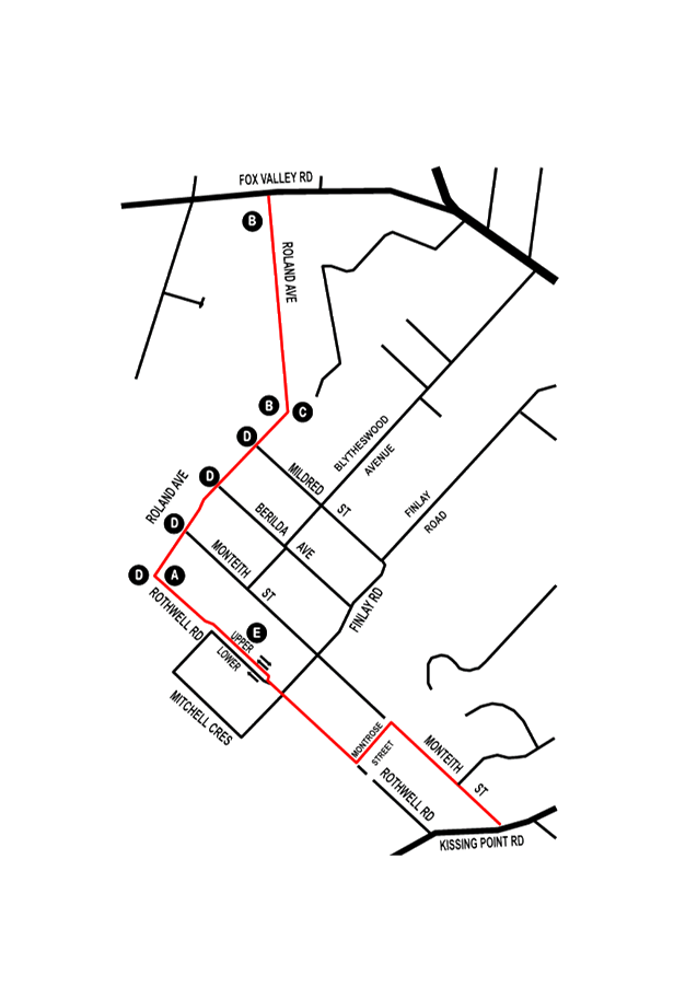
Attachment 1 shows in red a peak-period ‘rat
run’ between Kissing Point Road, Turramurra and Fox Valley Road,
Wahroonga that has developed in recent years. Drivers use this route
primarily to avoid traffic congestion on the Pacific Highway, particularly in
the evening peak period.
The ‘rat run’ follows suburban residential
streets that have serious deficiencies leading to safety risks.
Starting from the Kissing Point Road end, the route follows:
· Monteith Street
(16 per cent gradient);
· Montrose Street
(carrying two-way traffic but only 6.5 metres wide);
· Rothwell Road
between Montrose Street and Finlay Road (25 per cent gradient);
· Rothwell Road
between Finlay Road and Roland Avenue (partly dual carriageway, with the upper
carriageway carrying two-way traffic but only 4.5 metres wide); and
· Roland Avenue
(only 7 metres wide south of the bend and crest near Mildred Street; only 8
metres wide north of the bend/crest).
Traffic volumes in Monteith Street, near Kissing Point Road,
increased by six per cent between 2013 and 2016, to around 2,400 vehicles per
day. By contrast, traffic volumes in Roland Avenue near Fox Valley Road
have been stable, at around 2,990 vehicles per day in 2011 and 2016.
The 85th percentile traffic speed at the bottom
of the hill in Monteith Street, north-west of Kissing Point Road, has
consistently trended down from 60 km/h in 1996 to 54 km/h in 2016.
On the northern part of Roland Avenue, between its bend and
its junction with Fox Valley Road, traffic speeds have trended down in both
directions, but are significantly above the 50 km/h speed limit.
In the northbound direction (towards Fox Valley Road), the
85th percentile speed has dropped from 67 km/h in 2001 to 61 km/h in
2016. In the southbound direction (away from Fox Valley Road), the 85th
percentile speed has dropped from 69 km/h in 2001 to 63 km/h in 2016.
There is no long-term speed data for the southern part of
Roland Avenue, between the bend and Rothwell Road.
Along the ‘rat run’ route there have been twelve
reported crashes in the thirteen years since 2005. Seven of these were
single vehicles running off the road. Two involved a failure to give way
at a T-intersection and two were head-on crashes – one on the bend in
Roland Avenue and one at the intersection of Rothwell Avenue and Finlay
Road. The other was a runaway parked vehicle. Two of the crashes
involved a vehicle going down the 25 per cent gradient in Rothwell Road from
Finlay Road and unable to make the left turn into Montrose Street.
Comments
A local resident has put forward several suggestions to
address the issue of ‘rat run’ traffic speeds and volumes.
1. The
first suggestion is to permanently close Rothwell Road at Finlay Road, marked
‘A’ on the attached map.
This suggestion is not supported. The closure of
Rothwell Road at this point would severely restrict local residents in their
daily local travel, in particular reducing access to the Turramurra commercial
centre, Turramurra and Warrawee railway stations, Turramurra and Warrawee
Public Schools and Turramurra High School.
The closure of Rothwell Road at point ‘A’ would
also require all delivery vehicles serving residents on the steep hill between
Montrose Street and Finlay Avenue to make a three-point turn on a 25 per cent
gradient, with a potential risk of overturning.
In view of these considerations, Council is unwilling to ask
Roads & Maritime Services (RMS) to authorise the closure of Rothwell Road
at Roland Avenue.
2. The
second suggestion is to install speed humps, chicanes or speed cameras on
Roland Avenue, presumably between the points marked ‘B’ on the
attached map.
It is Council’s policy that no new speed humps be
installed, except as part of pedestrian (wombat) crossings near schools, and
Council has no authority to install or operate fixed or mobile speed cameras.
Chicanes in this area could be effective, but would reduce
on-street parking, could potentially conflict with the large number of
driveways to battle-axe allotments along Roland Avenue and could hinder the
passage of Route 573 buses and Route 8070 school buses.
For these reasons this suggestion is not supported at this
stage. However, because of the high speeds measured on Roland Avenue
north of the bend, and the lack of speed data for Roland Avenue south of the
bend, Council will investigate the traffic speeds in detail in both sections of
Roland Avenue and assess options for speed reduction.
3. The
third suggestion is to install rumble bars on the double dividing lines on the
bend in Roland Avenue, at the point marked ‘C’ on the attached map.
This has already been authorised under TDA 2/18. A
work order to install the rumble bars was issued to a contractor on 4 April
2018.
4. The
fourth suggestion was to install ‘Stop’ signs on all the roads
intersecting with Roland Avenue: Mildred Street, Berilda Street, Monteith
Street and Rothwell Road. These intersections are marked ‘D’
on the attached map.
Drivers turning out of these streets into Roland Avenue are
required to slow and (if necessary) stop to avoid collision with a vehicle in
Roland Avenue. Under Australian Standard AS1742.2, as adopted by Roads
& Maritime Services, a ‘Stop’ sign may only be used where there
are inadequate sight lines. Sight lines in these cases are more than the
30 metres required by the Standard.
Under the Standard, ‘Stop’ signs are intended to
allocate priority at an intersection. They are not intended to be a means
of controlling traffic speeds. For these reasons this suggestion is not
supported.
5. The
fifth suggestion is to make a section of Rothwell Road one way traffic from
Roland Avenue to Findlay Road.
This is primarily the 4.5 metre-wide two-way upper
carriageway. (The lower carriageway does not extend to Roland
Avenue).
Despite its narrow width, no crashes on the upper
carriageway have been reported in the 21 years since 1996. There also
appear to be no formal complaints in Council’s records management system
about safety risks in the upper carriageway due to its width.
On this basis, the suggestion is not supported.
Nevertheless, Council is aware of the need to regularly trim vegetation that
intrudes into the upper carriageway, so that it is not further narrowed.
Council is also aware of the need for drivers to approach
the upper carriageway at low speed. To this end Council proposed in 2017
(under TDA169/17) to install a ‘slow’ point at the eastern end of
the upper carriageway. This proposal was not supported by RMS and has
been abandoned.
Summary
A local resident has made several suggestions to address
traffic issues along the south Warrawee ‘rat run’ between Kissing
Point Road and Fox Valley Road. Most of the resident’s suggestions
are not supported. However, one suggestion has already been implemented
and there is a case for detailed assessment of traffic speeds and speed
reduction measures in Roland Avenue.
|
Recommendation:
A. That
Council not support the closure of Rothwell Road at Roland Avenue.
B. That
Council investigate traffic speeds in Roland Avenue in the straight section,
south of Fox valley Road, and recommend appropriate measures, if required.
C. That
Council note that rumble bars have already been approved on the bend in
Roland Avenue, north of Mildred Street.
D. That
Council not support the introduction of ‘Stop’ controls at the
intersections of Roland Avenue at Mildred Street/Berilda Avenue/Monteith
Street/Rothwell Road.
E. That
Council not support the introduction of one-way traffic flow in Rothwell Road
between Roland Avenue and Finlay Road.
F. That
Mr Francis Ricketts of Warrawee be informed of Council’s decision.
|
|
Deva Thevaraja
Manager Traffic & Transport
|
George Bounassif
Director Operations
|
|
Attachments:
|
A1 ⇩ ⇩
|
Plan
of 'rat run'
|
|
2018/125013
|
|
APPENDIX No: 1 - Plan of
'rat run'
|
|
Item No: GB.2
|
|
Ku-ring-gai
Traffic Committee - 18 May 2018
|
GB.3 / 14
|
|
|
|
|
Item
GB.3
|
TM11/10
|
The Comenarra Parkway, Wahroonga
Ward: Wahroonga
Electorate: Ku-ring-gai
EXECUTIVE
SUMMARY
|
purpose of report:
|
To consider the feasibility of constructing a
roundabout at the intersection of The Comenarra Parkway and Browns Road,
Wahroonga.
|
|
|
|
|
background:
|
The State Member for Ku-ring-gai has received
representations from a resident of Browns Road regarding concerns about the
intersection of The Comenarra Parkway and Browns Road. The resident has
requested that a roundabout be constructed at the intersection to slow
traffic, and allow better egress from Browns Road.
|
|
|
|
|
comments:
|
A roundabout is not considered to be feasible at the
intersection, as traffic would regularly queue through the roundabout during
peak periods.
|
|
|
|
|
recommendation:
|
That a roundabout not be constructed at the
intersection of The Comenarra Parkway and Browns Road, Wahroonga.
|
Purpose of Report
To consider the feasibility of constructing a roundabout at
the intersection of The Comenarra Parkway and Browns Road, Wahroonga.
Background
The State Member for Ku-ring-gai has received
representations from a resident of Browns Road regarding concerns about the
intersection of The Comenarra Parkway and Browns Road. The resident has
requested that a roundabout be constructed at the intersection to slow traffic,
and allow better egress from Browns Road.
The intersection of The Comenarra Parkway and Browns Road
has an unusual configuration. There is a straight exit only lane for
westbound motorists on The Comenarra Parkway to enter Browns Road. In
2017 a Give Way sign and lines were installed on this exit to slow traffic
entering Browns Road.
There is also a more conventional T-junction layout for
motorists turning right into Browns Road, and for motorists exiting Browns
Road.
During morning peak
periods, eastbound traffic on The Comenarra Parkway will frequently queue back
from Fox Valley Road beyond the intersection with Browns Road. These
queues frequently extend well into Thornleigh. In the evening peak
period, westbound traffic on The Comenarra Parkway often queues back from
Pennant Hills Road beyond the intersection with Browns Road.
When vehicles are
queued through the intersection, it prevents motorists from being able to exit
Browns Road. There are currently broken holding lines with adjacent
‘Do Not Queue Across Intersection’ signs in both directions on The
Comenarra Parkway, to discourage motorists from queuing through the
intersection.
The intersection of The
Comenarra Parkway and Fox Valley Road will soon be upgraded to improve safety
and increase the capacity of the intersection. It is a requirement that
as part of the works at the SAN Hospital site that the intersection be
upgraded. The intersection upgrade should reduce queuing and delays on
The Comenarra Parkway, which should in turn improve access to and from Browns
Road.
Comments
In order to reduce
queuing through the intersection, Council is proposing to mark broken holding
lines to delineate the end of the intersection area in both directions.
This will delineate the intersection more clearly, and provide greater
opportunities for motorists to exit Browns Road during peak times. This
matter is currently being considered by the voting members of the Ku-ring-gai
Traffic Committee.
Because of the queuing in both directions on The Comenarra
Parkway through this intersection, it would not be feasible to construct a
roundabout. Cars would be regularly queued through a roundabout at this
location, which would add to congestion and delays.
According to ‘Austroads Guide to Traffic Management
Part 8: Local Area Traffic Management’ section 7.2.6, it is inappropriate
to use roundabouts at the intersection of two roads of significantly different
traffic function (eg minor street and arterial road). Given the huge
difference in traffic volumes between The Comenarra Parkway and Browns Road,
this location would be inappropriate for a roundabout.
Council’s crash data shows that there have been no
recorded crashes at the intersection during the 5 year period to the end of
June 2017. Visibility to approaching vehicles in either direction when
turning out of Browns Road is excellent.
Summary
Given the lack of recorded crashes
at the intersection, it would be difficult to justify the need for changes to
the layout of the intersection.
A roundabout would not be feasible
as vehicles would regularly queue through it at peak times, thereby causing
further congestion and delays.
|
Recommendation:
That a roundabout not be
constructed at the intersection of The Comenarra Parkway and Browns Road,
Wahroonga.
|
|
Deva Thevaraja
Manager Traffic & Transport
|
George Bounassif
Director Operations
|
|
Ku-ring-gai
Traffic Committee - 18 May 2018
|
GB.4 / 17
|
|
|
|
|
Item
GB.4
|
TM11/10
|
Lucinda Avenue, Wahroonga
Ward: Comenarra
Electorate: Ku-ring-gai
EXECUTIVE
SUMMARY
|
purpose of report:
|
To inform the Traffic Committee of an issue at the
intersection of Lucinda Avenue and the Pacific Highway, Wahroonga, actions
taken to date and proposed further action.
|
|
|
|
|
background:
|
Some drivers turning left out of Lucinda Avenue onto
the Pacific Highway carry out an illegal manoeuvre, crossing over unbroken
lane lines and contrary to traffic signs, to turn onto the M1 Motorway
on-ramp. Residents claim that the use of this illegal path encourages
the use of Lucinda Avenue as an afternoon “rat run”, with
vehicles travelling at excessive speed in Lucinda Avenue and queueing back in
Lucinda Avenue from the Highway.
|
|
|
|
|
comments:
|
There is no evidence that traffic speeds in Lucinda
Avenue have increased in recent years, and no data on the length of vehicle
queues in Lucinda Avenue. However, it is likely that illegal manoeuvres
will continue, despite some reduction following changes to Google Maps’
advice to drivers. A physical barrier and changes to direction signage
are needed to permanently address residents’ concerns.
|
|
|
|
|
recommendation:
|
Rubber flaps or flexible bollards should be installed
along the two unbroken lane lines separating westbound traffic on the Pacific
Highway. Additional direction signs should be installed to indicate
that the desired path from Lucinda Avenue to the M1 Motorway is via Pennant
Hills Road.
|
Purpose of Report
To inform the Traffic Committee of an issue at the
intersection of Lucinda Avenue and the Pacific Highway, Wahroonga, actions
taken to date and proposed further action.
Background
The aerial photo in Attachment 1 shows the lane
arrangements and line marking at the junction of Lucinda Avenue, the Pacific
Highway and the M1 Motorway at Wahroonga.
Traffic turning left from Lucinda Avenue is prohibited by
signs and unbroken lane lines from moving into the right turn lanes on the
Highway, leading to the M1 Motorway on-ramp. Instead, drivers turning
left out of Lucinda Avenue and wishing to take the M1 are required to stay in
the left lane and go westwards to Pennant Hills Road, where they can make a
left turn, travel south and then access the M1 northbound via another
on-ramp.
On the western side of Lucinda Avenue there is a sign (white
lettering with a green background) advising drivers of the correct route onto
the M1, via Pennant Hills Road. RMS Traffic Emergency Patrol vehicles,
heading onto the M1 from the RMS base in Lucinda Avenue, are exempt from the
restriction. They are permitted to turn left out of Lucinda Avenue and
then cross the unbroken lane lines into the right turn lanes and onto the M1 on-ramp.
The issue of concern is that during the afternoon peak
period drivers use Lucinda Avenue as part of a “rat run” through
residential areas of Turramurra, Warrawee and Wahroonga, by-passing congestion
on the Pacific Highway. After traversing Lucinda Avenue, some drivers
turn left onto the Highway and then illegally cross the unbroken lane lines to
move into the right turn lanes giving access to the Motorway.
Residents of Lucinda Avenue claim that the use of this
illegal path onto the M1 promotes the use of Lucinda Avenue as an afternoon
“rat run”, with vehicles travelling at excessive speed in Lucinda
Avenue and queueing back in Lucinda Avenue from the Highway.
Comments
A history of the matter, based on Council records only,
shows that concerns about traffic flows at the intersection first came to
Council’s attention in December 2017, when a resident of Lucinda Avenue
sent a submission to the Minister for Roads about the issue. The
submission was that a direction sign at Lucinda Avenue was confusing and did
not properly direct Lucinda-to-M1 traffic onto the path via Pennant Hills
Road. Because the sign is in Lucinda Avenue, a Council road, the
submission was forwarded to Council for attention.
In December 2017 a resident of Roland Avenue, Warrawee,
complained that his street was part of the “rat run”, noting that
use of the “rat run” was encouraged by drivers being able to
illegally turn from Lucinda Avenue onto the M1 on-ramp (presumably thereby
saving time). In April 2018 he repeated his complaint, wanting the
illegal movement to be stopped.
In December 2017 a resident of Lucinda Avenue also
complained that queueing in Lucinda Avenue had been growing, especially over
the last five years. He stated that queueing back from the Highway
initially only occurred at very busy times, such as Christmas and New Year, but
was now occurring every day. He noted advice from a Highway Patrol
officer that Google Maps had been advising drivers that Lucinda Avenue was a
fast alternative to the Pacific Highway for traffic heading to the M1.
In February 2018 Council staff discussed with RMS
correspondence received by Council from a number of residents regarding
motorists making the illegal manoeuvre from Lucinda Avenue onto the M1. A
resident reported that the queue back from the Highway was up to about 750
metres on occasions, obstructing his trip home.
During the 2017-2018 Christmas/New Year period, NSW Police
and RMS carried out an enforcement exercise, deploying traffic cones to block
the illegal manoeuvre. At other times Police also booked several hundred
drivers.
At an on-site meeting in early March 2018, Council and RMS
staff discussed permanent options for preventing the illegal movements.
At the same time NSW Police advised that Google Maps had, at their request,
changed its software so that its mapping algorithm no longer had a direct link
between Lucinda Avenue and the M1 on-ramp. The Police said that this
appears to have been successful in reducing the illegal turn movements.
A common thread from this history is that increased use of
Lucinda Avenue as part of a “rat run” through Warrawee has been
encouraged by the ability of drivers to illegally turn from Lucinda Avenue into
the M1 on-ramp. (Council notes that Lucinda Avenue could also be used by
traffic from The Comenarra Parkway, using Fox Valley Road and Lucinda Avenue to
avoid congestion on Pennant Hills Road at Thornleigh. This possibility
has not been explored).
Nearly all complainants have asked that a solid median be
installed along the unbroken lane line between the kerbside lane and the second
lane on the southern side of the Pacific Highway. However, RMS has indicated
that, for traffic safety reasons, it cannot install a raised median between two
adjacent westbound lanes. Council notes that the undesirable path
involves crossing two unbroken lane lines, as can be seen in the
attachment.
Contrary to residents’ complaints, Council has found
that traffic speeds northbound in Lucinda Avenue in the evening peak
period have not increased in recent years. From rubber tube counts
carried out by Council about 350 metres south of the Highway, the 85th
percentile speed of northbound traffic between 5 pm and 7 pm was 58 km/h in
2009, 58 km/h in 2012 and 56 km/h in 2016. While the speeds have remained
constant, it is noted that they are consistently above the 50 km/h speed limit
in Lucinda Avenue.
As well as traffic speeds, residents have mentioned the
length of the vehicle queue back from the Highway in Lucinda
Avenue. There is no relevant data to allow this aspect to be
investigated.
Council has reviewed the signage in Lucinda Avenue requiring
traffic to turn left into the kerbside lane on the Highway and use that lane to
access the M1 via Pennant Hills Road.
Council considers the signage may be confusing and
counter-intuitive for drivers who do not know the area. They would expect
to be able to turn right onto the M1 on-ramp, like all other traffic on the Highway.
They may also not be aware that there is an on-ramp from Pennant Hills Road
southbound onto the M1 northbound.
The change to Google Maps may be effective in reducing the
incidence of offences by drivers who are guided by Google Maps. However, seasoned
“rat run” drivers may continue to offend, so the feasibility of
installing an acceptable physical barrier to prevent illegal manoeuvres has
been considered by Council.
The attached map shows some of the actions which
Council recommends should be taken to address these aspects.
First, Council proposes that rubber flaps or flexible
bollards be installed along the two unbroken lane lines. This would
replicate permanently the use of traffic cones by the Police and RMS last
Christmas to force traffic in the southern lanes, including vehicles that have
turned left out of Lucinda Avenue, to proceed to Pennant Hills Road.
Second, on the southern side of the Pacific Highway at
Pennant Hills Road there is a white-on-green direction sign with a left chevron
stating “Pennant Hills Road A28 Parramatta”. This sign
should be supplemented by a white-on-green direction sign with a left chevron
stating “To M1 Pacific Motorway Newcastle”. This will
reassure drivers that the counter-intuitive route they are following will
eventually take them to the M1.
Third, RMS should be asked to determine whether its Traffic
Emergency Patrol vehicles should continue to be allowed to cross over the
unbroken lane lines to access the M1 on-ramps. Requiring Traffic Emergency
Patrol vehicles to follow the path via Pennant Hills Road would allow signage
in Lucinda Avenue to be simplified and be more effective in guiding drivers.
Fourth, the current white-on-green direction sign on the
western side of Lucinda Avenue, directing Lucinda Avenue traffic to cross over
the M1 and access the M1 via the Pennant Hills Road on-ramp, should be replaced
by a second white-on-green direction sign with a left chevron, stating “To
M1 Pacific Motorway Newcastle”.
Fifth, NSW Police and RMS should be asked to monitor traffic
turning left out of Lucinda Avenue, to determine whether the changes to Google
Maps and the recommended treatments (rubber flaps/bollards and signage changes)
have been effective in directing traffic from Lucinda Avenue onto the M1 via
Pennant Hills Road.
Council should monitor the extent to which the proposed
changes reduce queueing back from the Highway in Lucinda Avenue.
Summary
Drivers turning left from Lucinda Avenue onto the Pacific
Highway need to be physically prevented from turning right onto the M1 Motorway
on-ramp. Signage in Lucinda Avenue and at Pennant Hills Road needs to be
altered or upgraded to provide clear directions for drivers wanting to go from
Lucinda Avenue to the M1 Motorway.
|
Recommendation:
A. That
RMS be asked to install rubber flaps or flexible bollards along the unbroken
lane lines separating westbound traffic lanes on the southern side of the
Pacific Highway, as shown in Attachment 1.
B. That
RMS be asked to install a white-on-green direction sign with a left chevron
stating “To M1 Pacific Motorway Newcastle” on southern
side of the Pacific Highway at Pennant Hills Road.
C. That
RMS be asked to determine whether its Traffic Emergency Patrol vehicles
should continue to be allowed to cross over the solid lane line from Lucinda
Avenue into the M1 on-ramp.
D. That
the current white-on-green direction sign on the western side of Lucinda
Avenue, directing Lucinda Avenue traffic to cross over the M1 and access the
M1 via the Pennant Hills Road on-ramp, be replaced by a white-on-green
direction sign with a left chevron, stating “To M1 Pacific Motorway
Newcastle”.
E. That
NSW Police and RMS monitor traffic turning left out of Lucinda Avenue, to
determine whether the recommended changes have been effective in directing
traffic from Lucinda Avenue onto the M1 via Pennant Hills Road. Also
that Council monitor the extent to which the recommended changes reduce
queueing back from the Highway in Lucinda Avenue at peak times.
|
|
Deva Thevaraja
Manager Traffic & Transport
|
George Bounassif
Director Operations
|
|
Attachments:
|
A1⇩
|
Aerial
photo of Pacific Highway, Wahroonga
|
|
2018/124997
|
|
APPENDIX No: 1 - Aerial
photo of Pacific Highway, Wahroonga
|
|
Item No: GB.4
|
|
Ku-ring-gai
Traffic Committee - 18 May 2018
|
GB.5 / 23
|
|
|
|
|
Item
GB.5
|
TM10/10
|
The Chase Road, Turramurra
Ward: Wahroonga
Electorate: Ku-ring-gai
EXECUTIVE
SUMMARY
|
purpose of report:
|
Provide greater safety for pedestrians on The Chase
Road, Turramurra.
|
|
|
|
|
background:
|
The State Member for Ku-ring-gai, on behalf of the
residents of the over 55 development at 20 The Chase Road, has requested that
Council investigate the feasibility of introducing further traffic calming on
The Chase Road.
It has also been requested that Council staff assess
whether it is more cost effective to introduce traffic calming measures, or
to construct a footpath along the northern side of The Chase Road.
|
|
|
|
|
comments:
|
It is not feasible to
introduce further traffic calming measures in The Chase Road. The
issues raised relate to pedestrian amenity, and the best way to resolve these
issues would be to construct a footpath along the northern side of The Chase
Road.
The northern side of The Chase Road will be added to
Council’s footpath priority list for future works. However it is
unclear when funding will be available for these works to be carried out.
|
|
|
|
|
recommendation:
|
That no further traffic calming measures be considered
in The Chase Road at its western end, and a footpath along the northern side
of The Chase Road be added to Council’s footpath priority list..
|
Purpose of Report
Provide greater safety for pedestrians on The Chase Road,
Turramurra.
Background
The State Member for Ku-ring-gai, on behalf of the residents
of #20 The Chase Road, has raised the issue that some elderly residents have
difficulty walking to the local shops in Eastern Road due to the lack of a
footpath along the northern side of The Chase Road. This means that some
elderly residents have to cross The Chase Road with their walking frames, and
then cross again at the intersection with Eastern Road to walk to the shops.
The State Member for Ku-ring-gai has requested that Council
investigate the feasibility of introducing further traffic calming measures on The
Chase Road. He has also requested that Council assess whether it is more
cost effective to construct a footpath along the northern side of The Chase
Road, or to introduce traffic calming measures.
The Chase Road is a Collector Road that is used by motorists
to connect Burns Road and Eastern Road. It is used to avoid traffic
congestion during peak periods on the Regional route of Junction Road, Eastern
Road and Burns Road (SR 2043).
Traffic counts were undertaken in The Chase Road in June
2015 between Eastern Road and Katina Street. The counts showed an average
of over 5300 vehicles per day travelled along The Chase Road.
There is a footpath along the southern side of The Chase
Road, however there is only a short section of footpath along the northern
side, near the intersection with Eastern Road. There are two over 55
developments at 20 and 22 The Chase Road, Turramurra, which were constructed
approximately 15 years ago. This may have pre-dated the current
conditions of SEPP Seniors Living, which requires that the development must
show that the site has accessible paths to bus stops.
Comments
There are existing traffic calming devices in The Chase
Road, including a flat-top speed hump outside #16. Council has a policy
of not installing new speed humps, except as part of raised pedestrian
crossings at schools and in shopping centres. This is because Council had
previously received complaints about noise generated by vehicles driving over
speed humps, and discomfort to drivers and passengers.
A possible option would be to construct a pedestrian refuge
at the intersection of Eastern Road and The Chase Road. However, the
residents of #20 and 22 would still have to cross The Chase Road further
down. Pedestrian volumes along this section of Eastern Road are also
relatively low. It would be more practical to construct a footpath along
the northern side of The Chase Road so pedestrians would not have to cross the
road twice to access the Eastern Road shops.
The issues raised by the residents of #20 The Chase Road
appear to relate to pedestrian amenity, and the introduction of further traffic
calming measures would do little to resolve these issues. If a footpath
was constructed along the northern side of The Chase Road, the residents of the
over 55 developments would not need to cross The Chase Road.
At present, Council will only consider constructing
footpaths on both sides of a road if it carries more than 5,000 vehicles per
day. Up until the last few years, traffic volumes in The Chase Road were below
this level. Therefore The Chase Road was not on Council’s footpath
priority list.
Now that traffic volumes have exceeded 5,000 vehicles per
day, The Chase Road has been added to the priority list. However it will
be assessed based on the same criteria as other paths on the list. At
this stage it is unclear when funding will be available for the footpath works
to be completed.
Summary
It is not feasible to introduce
further traffic calming measures in The Chase Road, as Council has a policy of not
installing new speed humps. The most logical solution to resolve the
issues raised by the residents of #20 The Chase Road would be to construct a
footpath along the northern side of The Chase Road.
The Chase Road has been added to
Council’s footpath priority list for future works.
|
Recommendation:
A. That
the construction of a footpath along the northern side of The Chase Road,
between property No.20 and Eastern Road, be added to Council’s footpath
priority list.
B. That
Council not consider additional traffic calming measures in The Chase Road
towards its western end.
|
|
Deva Thevaraja
Manager Traffic & Transport
|
George Bounassif
Director Operations
|
|
Ku-ring-gai
Traffic Committee - 18 May 2018
|
GB.6 / 26
|
|
|
|
|
Item
GB.6
|
TM10/10
|
|
|
18 April 2018
|
Turuga Street, Turramurra
Ward: Wahroonga
Electorate: Ku-ring-gai
EXECUTIVE
SUMMARY
|
purpose of report:
|
To consider the installation of ‘4P 8.30am-6pm
Mon-Fri’ restrictions.
|
|
|
|
|
background:
|
Council has been consulting with residents of Turuga
Street about the introduction of a short section of ‘4P 8.30am-6pm
Mon-Fri’ restrictions. However the majority of residents have
stated that they would like the restrictions along the entire street.
|
|
|
|
|
comments:
|
There is a need to cater for commuter parking, and
extensive 4P restrictions along the entire length of both sides of Turuga
Street would be under-utilised.
|
|
|
|
|
recommendation:
|
That ‘4P 8.30am-6pm Mon-Fri’ be installed
along part of Turuga Street.
|
Purpose of Report
To consider the installation of ‘4P 8.30am-6pm
Mon-Fri’ restrictions.
Background
In February 2018 Council introduced ‘No Parking
– Motor Vehicles Excepted’ restrictions along both sides of
Ku-ring-gai Avenue between Boomerang Street and Pacific Highway. This was
done to prevent a nearby resident from parking multiple trailers in Ku-ring-gai
Avenue. As predicted by Council staff, this has led to the resident
moving the trailers to adjacent streets, including Turuga Street.
Council has since received several complaints from residents
of Turuga Street about the trailers, and also about commuter parking in the
street. Residents have also complained about Turuga Street being used as
a rat-run during the morning peak period. Concerns were raised about the
difficulty residents have in reversing out of their driveways due to parked
vehicles restricting visibility, and the speed and volume of traffic using
Turuga Street.
Guide posts were installed along the frontage of #8 to
prevent parking. This was necessary as the frontage of this site has an
open drain which forces motorists to park further out into the roadway, thereby
reducing the travel lane width and creating problems for through traffic.
In March 2018 residents were consulted about the possible
introduction of ‘4P 8.30am-6pm Mon-Fri’ restrictions along a short
section of Turuga Street outside #10 & 12. The majority of residents
supported the idea in principle, but wanted the restrictions to extend along
the entire length of both sides of the street. Some of the residents also
requested resident parking permits.
Comments
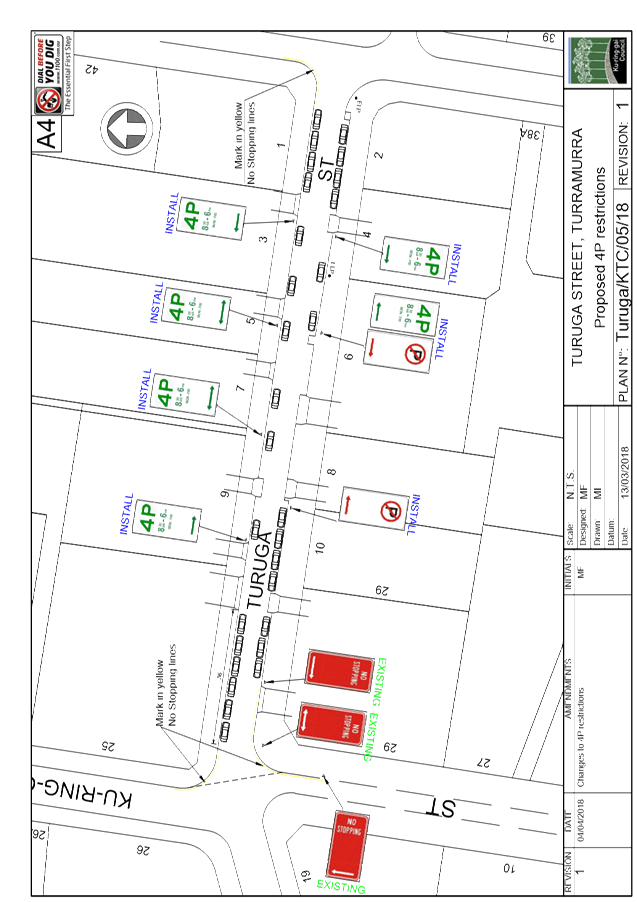
Turuga Street varies in width along its length. It is
approximately 10 metres wide at its eastern end, and 9 metres wide at its
western end. Turuga Street narrows to approximately 7.7 metres along the
frontage of #8, and hence this section of the street is only wide enough to
accommodate parking on one side.
The on-street parking at the western end of Turuga Street is
generally occupied all day by commuters who arrive early in the morning.
The eastern end of the street is mostly occupied during the day by commuters
who generally arrive a bit later. There are often some unoccupied spaces
at this end of the street during the middle part of the day, and very few cars
appeared to be parked in Warrangi Street. This would indicate that at
present, Turuga Street is at the outer edge of the extent of the commuter
parking for Turramurra station.
There is evidence to suggest that Turuga Street is used as a
rat-run during the morning peak period by motorists travelling from Pacific
Highway to Bobbin Head Road. Traffic counts taken in August 2017 show
that of the 839 vehicles per day that travelled east along Turuga Street,
nearly 40% of these traffic movements occurred between 7am and 9am. Between
8am and 9am, an average of 185 vehicles travelled east along Turuga
Street. While this figure is much higher than at other parts of the day,
it is well within the environmental capacity of the road, and is significantly
lower than many other local streets which are also used as rat-runs during
morning peak periods.
The 85th percentile speed was only 43km/h, which
is relatively low for a local street. These figures were consistent with
on-site observations by traffic staff, where it was noted that speeding did not
appear to be an issue.
In order to allow better visibility for motorists exiting
their driveways, it is proposed that ‘4P 8.30am-6pm Mon-Fri’
restrictions be installed along the northern side of Turuga Street, between the
driveways of #3 and #9. It is also proposed that a short section of
‘4P 8.30am-6pm Mon-Fri’ restrictions be installed along the
southern side of Turuga Street to the west of the driveway to #4. The
proposed changes are shown in Plan No. Turuga/KTC/05/18 (Attachment 1).
As this is a residential street, there is little demand for
short-term parking. However the 4P restrictions would provide parking
during the day for visitors and tradesmen. Although it should be noted
that parking is always available in adjacent Warrangi Street.
Under the proposal, there would be 4P restrictions for 15
parking spaces. While there would be 21 unrestricted parking spaces
available for commuters.
It is also proposed that “No Parking”
restrictions be installed along the southern side of Turuga Street outside #8
and part of #6, as this section of roadway is narrower than the rest of the
street.
Community
Consultation
As noted in the Background of this
report, Council has previously consulted with the residents regarding the
introduction of a short section of 4P restrictions outside #10-12 Turuga
Street. Most of the residents were in favour of the parking restrictions,
but wanted them to cover the entire street.
Summary
There would be a low demand for
short to medium term parking in Turuga Street. Therefore it would be
difficult to justify introducing 4P restrictions along the entire length of
both sides of Turuga Street, as it would be under-utilised. This would
also restrict the availability of commuter parking near Turramurra station.
In order to provide a balance
between the parking needs of local residents and commuters, it is proposed to
introduce some 4P restrictions in Turuga Street. The restrictions would
be located so as to reduce parking adjacent to driveways, thereby providing
better visibility for motorists exiting their driveways, particularly during
the am peak period.
|
Recommendation:
A. That
‘4P 8.30am-6pm Mon-Fri’ and ‘No Parking’ restrictions
be installed in Turuga Street as shown on Plan No. Turuga/KTC/05/18.
B. That
Council’s Team Leader Regulation be informed of Council’s
decision.
|
|
Deva Thevaraja
Manager Traffic & Transport
|
George Bounassif
Director Operations
|
|
Attachments:
|
A1 ⇩ ⇩
|
Plan
No. Turuga/KTC/05/18
|
|
2018/111480
|
|
APPENDIX No: 1 - Plan No.
Turuga/KTC/05/18
|
|
Item No: GB.6
|
|
Ku-ring-gai
Traffic Committee - 18 May 2018
|
GB.7 / 31
|
|
|
|
|
Item
GB.7
|
TM9/10
|
|
|
16 April 2018
|
Ward: St Ives
Electorate: Davidson
EXECUTIVE
SUMMARY
|
purpose of report:
|
To consider whether the installation of a ‘No
Parking’ zone outside No. 50 Cowan Road, St Ives, in order to improve
the visibility of approaching traffic when exiting the property, could or
should be approved as an acceptable departure from Council’s ‘Traffic
and Transport Policy’.
|
|
|
|
|
background:
|
The parking of vehicles outside of and next to No. 50
Cowan Road makes it difficult when exiting the property. A proposal to
install a painted island and pavement marking to address this issue has been
opposed by two representatives of the Ku-ring-gai Traffic Committee.
|
|
|
|
|
comments:
|
An option for addressing this issue by signposting
parking restrictions has been developed, but would be contrary to
Council’s ‘Traffic and Transport Policy’.
|
|
|
|
|
recommendation:
|
That the Committee advise Council as to whether the
signposting of parking restrictions outside of No. 50 Cowan Road, in order to
improve traffic visibility when exiting the property, could or should be
approved as an acceptable departure from Council’s ‘Traffic and
Transport Policy’.
|
Purpose of Report
To consider whether the installation of a ‘No
Parking’ zone outside No. 50 Cowan Road, St Ives, in order to improve the
visibility of approaching traffic when exiting the property, could or should be
approved as an acceptable departure from Council’s ‘Traffic and
Transport Policy’.
Background
The resident of 50 Cowan Road, St Ives, wrote to Council in
November 2017 about difficulties she and her family are experiencing when
driving out of their property when vehicles are parked on either side of their
driveway gates.
The resident stated they often have to creep out towards the
middle of Cowan Road in order to see any oncoming vehicles before being able to
turn onto the road. She stated that visibility is particularly made worse
by the parking of larger cars, 4WDs and trucks, and by the presence of a power
pole on the left-hand side of their driveway.
She stated that on some occasions the rear end of her car is
on the edge of the driveway before she was able to have a clear view of
oncoming traffic. She stated that she had almost been in collision with
oncoming cars on several occasions.
She asked that parking restrictions be installed in front of
the property to improve the visibility of approaching traffic.
Comments
Council investigated the complaint and reported its findings
and recommendations in report number TDA 202/17.
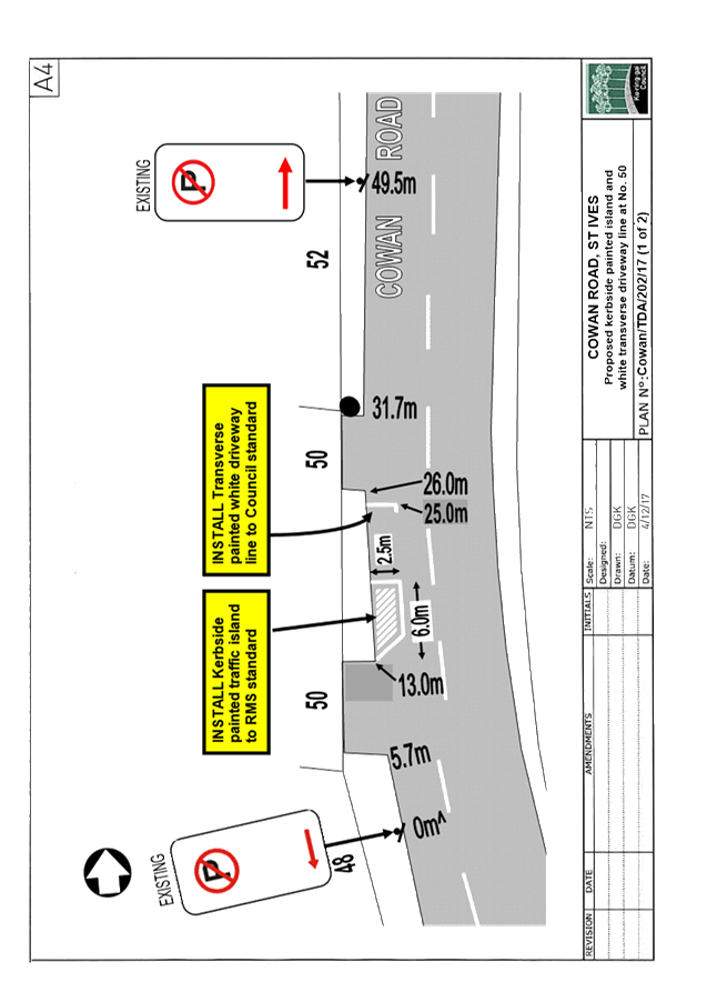
No. 50 has two connected driveways. This allows entry
to the property through one driveway in the forward direction and exit through
the other driveway also in the forward direction.
At the northernmost
driveway the footpath/nature strip is only one metre wide, with a power pole
embedded in the footpath. There is no nature strip, only a narrow
footpath, to provide a view for some distance along the street to the north or
to the south of the northernmost driveway. Site inspections confirmed
that when vehicles are parked near the northern driveway they can block the
view of approaching northbound and southbound traffic when exiting No. 50.
At the southernmost
driveway the view to the left, of approaching southbound traffic, is likewise
obstructed, but this driveway has a better view of northbound traffic
approaching on the right.
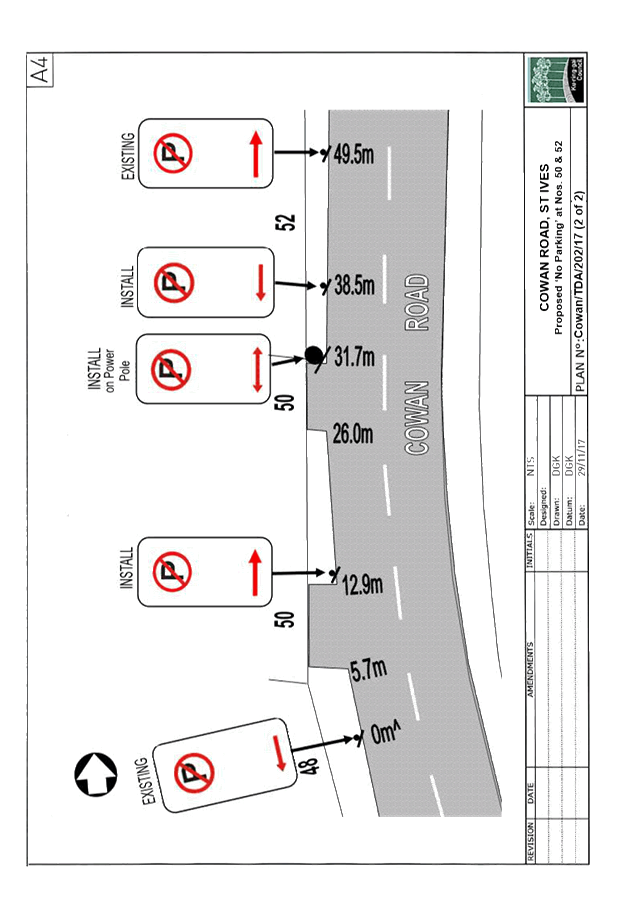
To address this issue,
but without adding more signs to the street, Council proposed to install a
kerbside painted traffic island and a transverse white driveway line outside
No. 50, as shown in Plan No. Cowan/TDA/202/17 (1 of 2) - Attachment 1.
Two members of the Traffic Committee - Roads & Maritime Services
(RMS) and the Representative of the Member for Davidson - disagreed with
Council’s proposal.
RMS said the proposed painted
island would force motorists travelling northbound to swerve towards oncoming
traffic when there are no cars parked on the approach to this section of
road. RMS said this treatment would also be inconsistent with the
rest of Cowan Road, and that consideration should be given to the installation
of either ‘No Parking’ or ‘No Stopping’ signs.
The Representative of the Member for
Davidson stated that he had visited the site and
reversed into the northern driveway to check the visibility on exit. He
stated that, while it is not easy, it is quite within the capabilities of even
a minimal standard driver to make either a left or right turn out of the
property.
An alternative option, along the lines suggested by RMS, is
shown in Plan No. Cowan/TDA/202/17 (2 of
2) – Attachment 2. This provides for the installation
of full-time ‘No Parking’ outside the property and for one parking
space to the north of the northern driveway.
The ‘No Parking’ option would meet the
resident’s concerns, but would be contrary to Council’s Traffic and
Transport Policy. The Policy states:
“One area of concern for
many residents is visibility when they are exiting their driveways when
vehicles are parked close to them. …..Council does not signpost
individual residential driveways with No Parking or No Stopping
Restrictions”.
The Committee is asked to consider whether the installation
of a ‘No Parking’ zone outside No. 50 Cowan Road, St Ives,
in order to improve the visibility of approaching traffic when exiting the
property, could or should be approved as an acceptable departure from
Council’s ‘Traffic and Transport Policy’.
Summary
The visibility of approaching
traffic when exiting No. 50 Cowan Road, St Ives, would be significantly
improved by the installation of parking restrictions across the frontage of the
property and for one parking space to the north of the property’s northern
driveway. However, this would be contrary to Council’s
‘Traffic and Transport Policy’.
The Committee is asked to discuss and advise on this matter,
and in particular whether an exception to the ‘Traffic and Transport
Policy’ could or should be made in the case of 50 Cowan Road.
|
Recommendation:
That the Committee advise Council as to whether the
signposting of parking restrictions outside No. 50 Cowan Road, in order to
improve traffic visibility when exiting the property, could or should be
approved as an acceptable departure from Council’s ‘Traffic and
Transport Policy’.
|
|
Deva Thevaraja
Manager Traffic & Transport
|
George Bounassif
Director Operations
|
|
Attachments:
|
A1⇩
|
Plan
No. Cowan/TDA/202/17 (1 of 2)
|
|
2018/124968
|
|
|
A2⇩
|
Plan
No. Cowan/TDA/202/17 (2 of 2)
|
|
2018/124987
|
|
APPENDIX No: 1 - Plan No.
Cowan/TDA/202/17 (1 of 2)
|
|
Item No: GB.7
|
|
APPENDIX
No: 2 - Plan
No. Cowan/TDA/202/17 (2 of 2)
|
|
Item No: GB.7
|
|
Ku-ring-gai
Traffic Committee - 18 May 2018
|
GB.8 / 36
|
|
|
|
|
Item
GB.8
|
TM9/10
|
|
|
16 April 2018
|
Horace Street, Link Road and Stanley
Street, St Ives
Ward: St Ives
Electorate: Davidson
EXECUTIVE
SUMMARY
|
purpose of report:
|
To advise on progress in addressing complaints about
pedestrian safety at and near the intersection of Horace Street, Link Road
and Stanley Street, St Ives.
|
|
|
|
|
background:
|
The Committee considered a report of this matter at
its meeting on 20 November 2017. At its meeting on 12 December 2017,
Council considered the Committee’s recommendation to assess the
feasibility of replacing the roundabout with traffic lights. Council
resolved to do so.
|
|
|
|
|
comments:
|
Quotations for assessing the feasibility of replacing
the roundabout with traffic lights, in terms of meeting Roads & Maritime
Services (RMS) criteria, have been sought from several consultants. A
preferred consultant has been appointed to undertake the study, and the
results are expected to be delivered by end of June 2018. The results
of the study will be referred to the following Traffic Committee meeting.
|
|
|
|
|
recommendation:
|
That progress in this matter be noted.
|
Purpose of Report
To advise on progress in addressing complaints about
pedestrian safety at and near the intersection of Horace Street, Link Road and Stanley
Street, St Ives.
Background
The Committee considered a report on this matter at its
meeting on 20 November 2017. The Committee recommended that Council carry
out an assessment to determine the feasibility of replacing the roundabout with
traffic lights, and submit the results, if warranted, to Roads & Maritime
Services (RMS) for its approval in principle.
At its meeting on 12 December 2017, Council considered the
Committee’s recommendation and resolved to carry out an assessment to
determine the feasibility of replacing the roundabout with traffic
lights.
RMS has set criteria which must be met at any location
proposed for new traffic signals. The criteria relates to factors such as
traffic and pedestrian volumes, road network considerations and crash
history.
Assessments of whether these criteria are met at Horace
Street/Link Road/Stanley Street will have to be carried out by consultants who
are experienced in this area, have appropriate network modelling capabilities
and are aware of the RMS requirements for such assessments.
Comments
Quotations for assessing the feasibility of replacing the
roundabout with traffic lights, in terms of meeting RMS criteria, have been
sought from several consultants. Quotations have been received from
four consultancies, and a preferred consultant has been appointed to undertake
this study. A report on this study is expected to be delivered by end of
June 2018.
It is expected to refer the study and its results to the
Committee at its following meeting.
Financial
Considerations
Funding for the consultant’s study is available within
the existing budget for Traffic and Transport. Council will seek funding
from RMS if the study recommends the replacement of existing roundabout with
traffic lights.
Internal
Consultation
Council’s Strategic Traffic Engineer has been advised
of this matter and will be tasked with seeking RMS funding if and when the
installation of traffic lights has been approved by RMS and Council.
Summary
The feasibility of replacing the roundabout at the
intersection of Horace Street/Link Road/Stanley Street with traffic lights, in
terms of the site meeting RMS criteria, will be assessed and known by the end
of June 2018.
|
Recommendation:
That Council note the progress being made on this issue.
|
|
Deva Thevaraja
Manager Traffic & Transport
|
George Bounassif
Director Operations
|