Minute Ku-ring-gai Council Page
MINUTES OF Ordinary Meeting of Council
HELD ON Tuesday, 20 August 2019
|
Present: |
The Mayor, Councillor J Anderson (Chairperson) Councillors J Pettett & C Clarke (Comenarra Ward) Councillors C Szatow & P Kelly (Gordon Ward) Councillors S Ngai (Roseville Ward) Councillors C Kay & M Smith (St Ives Ward) Councillors D Greenfield & C Spencer (Wahroonga Ward) |
|
|
|
|
Staff Present: |
General Manager (John McKee) Director Corporate (David Marshall) Director Development & Regulation (Michael Miocic) Director Operations (George Bounassif) Director Strategy & Environment (Andrew Watson) Director Community (Janice Bevan) Corporate Lawyer (Jamie Taylor) Manager Governance and Corporate Strategy (Michael Wearne) Acting Manager Records and Governance (Peter Doyle) Group Lead, Major Projects (Geoffrey Douglas) Manager Corporate Communications (Virginia Leafe) Governance Support Officer/ Minutes Secretary (Rebecca Srbinovska) Minutes Secretary (Sigrid Banzer) |
|
|
|
The Meeting commenced at 7.00pm
The Mayor offered the Prayer
The Mayor referred to the necessity for Councillors and staff to declare a Pecuniary Interest/Conflict of Interest in any item on the Business Paper.
Conflicts were declared by:
Councillor Sam Ngai declared a less than significant non-pecuniary conflict of interest with item GB16. He used to be a member of the KPMG Financial Modelling team twelve years ago, and he notes that their services were engaged in providing financial analysis for the Lindfield Village Hub. He has not been in contact with the KPMG Financial Modelling team since 2007, and he said he intends to remain in the chamber.
Councillor Christine Kay declared a less than significant non-pecuniary interest with item GB1. She is on the steering committee for the St Ives Food and Wine Festival. She said she will leave the chambers
Director Watson declared a significant non-pecuniary interest for GB16. Due to his specific statutory role in reporting a planning proposal to Council, he said he will leave the chambers so that he doesn’t listen to speakers.
DOCUMENTS CIRCULATED TO COUNCILLORS
The Mayor referred to the documents circulated in the Councillors’ papers and advised that the following matters would be dealt with at the appropriate time during the meeting:
|
Late Items: |
GB.17 - Local Government NSW Annual Conference 2019 - Proposed Motion - Report by Director Corporate dated 12 August 2019 |
Having previously declared a conflict of interest in the Council Sponsorships matter, Councillor Kay left the chamber.
|
File: FY00275/11 Vide: GB.1
|
|
|
|
To advise Council of the sponsorship requests received under Council’s Sponsorship Policy for 2019–2020 and for Council to approve all sponsorship requests over $5,000.
|
|
|
(Moved: Councillors Szatow/Smith)
THAT Council approves requests in excess of $5,000:
• Wahroonga Food & Wine Festival $8,000 • Welcome Basket $8,500 • Carols in the Park $10,000
CARRIED UNANIMOUSLY |
Councillor Kay returned to the Chamber after voting on GB.1. had concluded.
|
File: S03211 Vide: GB.9
|
|
|
|
To report on the proposal to name the new road in Gordon, “Hanson Way”.
|
|
|
(Moved: Councillors Szatow/Pettett)
A. That Council names the new road linking Dumaresq Street to Moree Street Gordon, “Hanson Way”. B. That a notice of the new road name be published in a local newspaper and the NSW Government Gazette. CARRIED UNANIMOUSLY |
Motions of which due Notice has been given
|
File: S06843 Vide: NM.1
|
|
|
|
Notice of Motion from Councillors Greenfield and Smith dated 2 August 2019
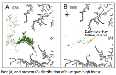
Since 1931 Ku-ring-gai Council has recognised the value of the BGHF and been protecting the BGHF reserves.
Even with the protection we can visibly see the reduction in the BGHF in the Turramurra / Pymble / Warrawee and Wahroonga areas. This valuable resource is critically endangered and on our watch we must take action to preserve and regenerate wherever possible before it is too late.
A bush regeneration program in Observatory Park, Pennant Hills over a 10 year period with cessation of mowing combined with weed removal has allowed a trebling of native species from 46 to 126 in 10 years. The emergence of many eucalypt saplings ensures the continued replenishment of the canopy. Mowing 6 times a year prevents the trees from developing and the shrub layer is sparse however reducing the interval to 6 months improved the native species regeneration.
What is Blue Gum High Forest
Blue gum high forest is a unique community of trees, shrubs, grasses and groundcovers that once covered large areas of the shale-capped ridge-tops of Sydney’s northern districts.
Why is it so important?
Blue gum high forest: · is a unique assembly of plants, from giant trees to tiny ground orchids and grasses · provides habitat and shelter for a range of native animals, including the grey-headed flying-fox and glossy black cockatoo, that are listed as threatened in the Threatened Species Conservation Act 1995 · is part of the distinctive landscape of the Sydney region, and is not found anywhere else in Australia · provides a living link to ancient Australia · contains trees that form hollows large enough to shelter animals such as the threatened powerful owl, parrots, possums and tiny insectivorous bats.
Today the invasion of weeds, nutrient-rich stormwater run-off, rubbish dumping, inappropriate fire regimes and mowing of plants are causing the forest to decline further.
Brief history of the St Ives forest
The St Ives blue gum high forest has a rich history
1867 - Thomas Brown purchased the land now known as Browns Forest. He chose not to develop it and willed it to his children (Blue Gum High Forest Group 2007).
1920 - The first Commissioner of Forests, Richard Dalrymple-Hay, purchased the forest for its historic interest and environmental educational purposes (Blue Gum High Forest Group 2007).
1931 - Ku-ring-gai Council, after a struggle with development proposals, purchased the land known as Browns Forest as a ’forest reserve for all time‘ (Blue Gum High Forest Group 2007).
1972 - Dalrymple–Hay was gazetted as a nature reserve (Department of Environment and Conservation 2004a).
1997 - Blue Gum High Forest has been gazetted as a critically endangered ecological community under the NSW Threatened Species Conservation Act 1995
2005 - Ku-ring-gai council unanimously agreed to allocate part-funding for the purchase of 100 – 102 Rosedale Road, St Ives, a Blue Gum High Forest area.
The Commonwealth Minister for Environment and Heritage listed the Blue Gum High Forest and the Turpentine Ironbark Forest in the Sydney Basin as critically endangered.
100 Rosedale Road was bought by the NSW Transport Infrastructure Development Corporation as an offset to compensate for 0.33 ha of Blue Gum High Forest destroyed as a result of upgrading Hornsby Railway Station and the property was transferred to the Department of Environment and Conservation.
2006 - Blue Gum High Forest St Ives was selected as a Threatened Species Demonstration Site. This endangered ecological community was the first of 11 sites within the Sydney Metropolitan Catchment Management Area chosen to showcase best practice management to ensure the long-term viability of threatened species, populations and/or ecological communities.
2007 - NSW Scientific Committee determined that the Blue Gum High Forest ecological community be listed as critically endangered, recognising the increased level of threat since it was listed as endangered in 1977 under the NSW Threatened Species Conservation Act.
102 Rosedale Road was purchased by Ku-ring-gai Council, assisted by $350,000 from the National Reserve System and over $72,000 in public donations.
References https://www.step.org.au/index.php/campaigns/blue-gum-high-forest
https://www.environment.nsw.gov.au/resources/threatenedspecies/08185tsdsbluegum.pdf
http://citeseerx.ist.psu.edu/viewdoc/download?doi=10.1.1.597.4230&rep=rep1&type=pdf
I, therefore, move that: A. A report be brought to Council documenting the progress of regeneration, current plans and future plans, including: a. what land has been put aside for regeneration b. what controls and protection are in place and can be put in place to ensure the protection for future generations c. education and support strategy for residents living near / alongside bushland previously BGHF by council to participate in the regeneration programs.
|
|
|
(Moved: Councillors Szatow/Greenfield)
That the above Notice of Motion as printed be adopted. CARRIED UNANIMOUSLY |
GENERAL BUSINESS
Having previously declared a conflict of interest in the LVH Planning Proposal matter, Director Watson left the chamber.
|
153 |
File: S12165-7 Vide: GB.16
|
|
|
To propose that Council endorse lodgement of a Planning Proposal seeking to amend the KLEP (LC) 2012 with respect to the height and Floor Space Ratio (FSR) provisions at the Lindfield Village Hub site. To provide Council with an overview of the intended effect and rationale for seeking the proposed amendments For Council to note the requirement to retain Lot 3 of DP 1226294 as part of the project site area.
|
|
|
(Moved: Councillors Szatow/ Greenfield)
A. That Council endorse preparation and lodgement of a Planning Proposal, in accordance with Section 3.33 of the Environmental Planning and Assessment Act 1979, seeking to amend the Ku-ring-gai LEP (Local Centres) 2012 as it applies to the Lindfield Village Hub site as follows:
i. With a height control of no higher than the highest building in Lindfield being 23 – 41 Lindfield Avenue (known as the Aqualand building) which equates to no more than a 9 storey building on the Lindfield Village Hub site, including a provision at Clause 4.3 to allow for roof top plant, lift overruns and rooftop communal open space (and associated structures) to be located above the proposed maximum height limits, where appropriate. ii. Amend the current additional permissible use provision at Clause 29 in Schedule 1 to allow development for the purpose of attached dwellings on the site, at the corner of Bent Street and Drovers Way, Lindfield.
B. That Council note the proposed amendment of Part 14E of the KDCP (LC) 2012 to reflect the Planning Proposal and the associated Urban Design Report and that this will remove reference to the current Lindfield Village Hub Masterplan. C. That Council note the requirement to retain Lot 3 of DP1226294 as part of the project site area. D. That Council note that the minimum areas (m2) to be provided for the following project components are as follows:
E. That all non-mandatory basement car spaces designated to offset existing spaces at Woodford Lane car park are removed from the project scope. F. That a funding strategy be developed to offset the anticipated reduction in revenue due to the reduction in proposed building heights. G. That Council authorise the General Manager to finalise the Planning Proposal on its behalf as landowner, in accordance with recommendations A-F, and to submit the Planning Proposal to the relevant Planning Authority (Council). AMENDMENT (Moved: Spencer/ Ngai)
Procedural Motion: (Moved: Councillor Clarke) That the Amendment be now put. The procedural motion was put and declared carried. CARRIED UNANIMOUSLY The Amendment was put and declared LOST.
For the Amendment: Councillors Ngai, Pettett, Spencer, Kelly
Against the Amendment: The Mayor, Councillor Anderson, Councillors Clarke, Greenfield, Szatow, Smith and Kay
SECOND AMENDMENT (Moved: Councillors Ngai/ Pettett) A. That Council endorse preparation and lodgement of a Planning Proposal, in accordance with Section 3.33 of the Environmental Planning and Assessment Act 1979, seeking to amend the Ku-ring-gai LEP (Local Centres) 2012 as it applies to the Lindfield Village Hub site as follows:
i. With a height control of no higher than the highest building in Lindfield being 23 – 41 Lindfield Avenue (known as the Aqualand building) which equates to no more than a 9 storey building on the Lindfield Village Hub site, including a provision at Clause 4.3 to allow for roof top plant, lift overruns and rooftop communal open space (and associated structures) to be located above the proposed maximum height limits, where appropriate. ii. Amend the current additional permissible use provision at Clause 29 in Schedule 1 to allow development for the purpose of attached dwellings on the site, at the corner of Bent Street and Drovers Way, Lindfield.
B. That Council note the proposed amendment of Part 14E of the KDCP (LC) 2012 to reflect the Planning Proposal and the associated Urban Design Report and that this will remove reference to the current Lindfield Village Hub Masterplan. C. That Council note the requirement to retain Lot 3 of DP1226294 as part of the project site area. D. That Council note that the minimum areas (m2) to be provided for the following project components are as follows:
E. That a funding strategy be developed to offset the anticipated reduction in revenue due to the reduction in proposed building heights. F. That Council authorise the General Manager to finalise the Planning Proposal on its behalf as landowner, in accordance with recommendations A-E, and to submit the Planning Proposal to the relevant Planning Authority (Council).
During discussion and debate on the Second Amendment, Councillors Kay and Greenfield left and returned to the Chamber.
The Second Amendment was put and CARRIED, with the Mayor using her casting vote. The Second Amendment now became the substantive Motion.
For the Amendment: The Mayor, Councillor Anderson, Councillors Ngai, Pettett, Spencer and Kay
Against the Amendment: Councillors
Clarke, Greenfield, Szatow, Smith and Kelly Councillors resumed debate on
the substantive Motion. THIRD AMENDMENT (Moved: Councillors Clarke/ Szatow) A. That Council endorse preparation and lodgement of a Planning Proposal, in accordance with Section 3.33 of the Environmental Planning and Assessment Act 1979, seeking to amend the Ku-ring-gai LEP (Local Centres) 2012 as it applies to the Lindfield Village Hub site as follows:
i. With a height control of no higher than the highest building in Lindfield being 23 – 41 Lindfield Avenue (known as the Aqualand building) which equates to no more than a 9 storey building on the Lindfield Village Hub site, including a provision at Clause 4.3 to allow for roof top plant, lift overruns and rooftop communal open space (and associated structures) to be located above the proposed maximum height limits, where appropriate. ii. Amend the current additional permissible use provision at Clause 29 in Schedule 1 to allow development for the purpose of attached dwellings on the site, at the corner of Bent Street and Drovers Way, Lindfield.
B. That Council note the proposed amendment of Part 14E of the KDCP (LC) 2012 to reflect the Planning Proposal and the associated Urban Design Report and that this will remove reference to the current Lindfield Village Hub Masterplan. C. That Council note the requirement to retain Lot 3 of DP1226294 as part of the project site area. D. That Council note that the minimum areas (m2) to be provided for the following project components are as follows:
E. That half of all non-mandatory basement car spaces designated to offset existing spaces at Woodford Lane car park are removed from the project scope. F. That a funding strategy be developed to offset the anticipated reduction in revenue due to the reduction in proposed building heights. G.
That Council authorise the General
Manager to finalise the Planning Proposal on its behalf as landowner, in accordance
with recommendations A-E, and to submit the Planning Proposal to the relevant
Planning Authority (Council). Procedural Motion: (Moved: Councillor Smith) That the Third Amendment be now put. The procedural motion was put and declared CARRIED. CARRIED UNANIMOUSLY The Third Amendment was put and declared LOST.
For the Amendment: Councillors Clarke, Greenfield, Szatow and Smith
Against the Amendment: The Mayor, Councillor Anderson, Councillors Ngai, Pettett, Spencer, Kelly and Kay
Councillors resumed debate on the substantive Motion.
FOURTH AMENDMENT (Moved: Councillors Spencer/ Pettett)
Procedural Motion: (Moved: Councillor Kelly) That the Fourth Amendment be now put. The procedural motion was put and declared CARRIED. CARRIED UNANIMOUSLY The Fourth Amendment was put and declared LOST.
For the Amendment: Councillors Spencer and Kelly
Against the Amendment: The Mayor, Councillor Anderson, Councillors Ngai, Clarke, Pettett, Greenfield, Szatow and Kay
Councillors resumed debate on the substantive Motion below. Resolved: A. That Council endorse preparation and lodgement of a Planning Proposal, in accordance with Section 3.33 of the Environmental Planning and Assessment Act 1979, seeking to amend the Ku-ring-gai LEP (Local Centres) 2012 as it applies to the Lindfield Village Hub site as follows:
i. With a height control of no higher than the highest building in Lindfield being 23 – 41 Lindfield Avenue (known as the Aqualand building) which equates to no more than a 9 storey building on the Lindfield Village Hub site, including a provision at Clause 4.3 to allow for roof top plant, lift overruns and rooftop communal open space (and associated structures) to be located above the proposed maximum height limits, where appropriate. ii. Amend the current additional permissible use provision at Clause 29 in Schedule 1 to allow development for the purpose of attached dwellings on the site, at the corner of Bent Street and Drovers Way, Lindfield.
B. That Council note the proposed amendment of Part 14E of the KDCP (LC) 2012 to reflect the Planning Proposal and the associated Urban Design Report and that this will remove reference to the current Lindfield Village Hub Masterplan. C. That Council note the requirement to retain Lot 3 of DP1226294 as part of the project site area. D. That Council note that the minimum areas (m2) to be provided for the following project components are as follows:
E. That a funding strategy be developed to offset the anticipated reduction in revenue due to the reduction in proposed building heights. F. That Council authorise the General Manager to finalise the Planning Proposal on its behalf as landowner, in accordance with recommendations A-E, and to submit the Planning Proposal to the relevant Planning Authority (Council).
For the Motion: The Mayor, Councillor Anderson, Councillors Ngai, Clarke, Greenfield, Szatow, Smith and Kay
Against the Motion: Councillors Pettett, Spencer and Kelly |
Director Watson returned to the Chamber after all debate and voting on GB.1 had concluded.
|
154 |
File: S06843 Vide: QN.1
|
|
|
Question from Councillor Greenfield dated 2 August 2019:
To the director
Would you please provide detail of Blue Gum High Forest in Turramurra / Pymble / Wahroonga and Warrawee areas referring to
1. Maps and detailing information on the volume / area of BGHF in the above areas in 1990, 2000, 2010 and today 2. The protection in place for the BGHF along the Pacific Highway Ridge. 3. What protection controls have been and are in place for the BGHF that have been successful in protecting the forest in 1990, 2000, 2010 and present. 4. What has contributed to the reduction in BGHF in 1990, 2000, 2010 and present.
ReSPONSE:
Response from Director Strategy & Environment:
1. Maps and detailing information on the volume / area of BHGF in the above areas in 1990, 2000, 2010 and today
Fine scale vegetation mapping for the Ku-ring-gai LGA (including the area of BGHF) is available for 2010, and is analysed in the report Mapping and Assessment of Key Vegetation Communities across the Ku-ring-gai Local Government Area – Volume 1: Technical report - November 2011 (available for purchase through fees and charges). Since then this mapping has been updated opportunistically and is currently available upon request, with the updated vegetation mapping soon to be available on Council’s website. Prior to 2010, vegetation mapping for the Ku-ring-gai LGA (including the area of BGHF) was predictive and covering broad areas and dates back to 2001 and is contained in the Native Vegetation Associations Web Map – KMC Predictive Vegetation (available upon request).
A further review of any historic mapping by Council or other agencies would be required in order to understand any other available mapping.
2. The protection in place for the BGHF along the Pacific Highway Ridge.
In addition to legislative protection under the Biodiversity Conservation Act 2016, Council’s LEPs and DCPs have included biodiversity controls protecting BGHF since 5 July 2013 when LEP 218 came into effect. Council manages a 99 hectare Biobanking site at Sheldon Forest, Rofe Park and Commenarra Creek Reserve, which protects BGHF in perpetuity. Council also invests Environmental Levy and general funds annually into its bushland restoration program, to restore a number of important reserves containing BGHF.
3. What protection controls have been and are in place for the BGHF that have been successful in protecting the forest in BGHF in 1990, 2000, 2010 and present.
In addition to legislative protection under the Biodiversity Conservation Act 2016, and previously under the Threatened Species Conservation Act 1995, Council’s LEPs and DCPs have included biodiversity controls protecting BGHF since 5 July 2013 when LEP 218 came into effect.
The success of these controls will in part be informed through updated vegetation and canopy mapping to be undertaken as part of an urban forest monitoring program in 2019/20. It should, however, be noted that the method of historic comparison (including the years selected for historical analysis) has not yet been determined. As such, whilst this monitoring program will enable an assessment of BHGF extent change, it may not provide a data comparison using the exact years 1990, 2000 and 2010.
A further review of controls to protect Ku-ring-gai’s urban forest and biodiversity (including BGHF) will be undertaken as part of the LEP / DCP updates planned to be completed by the end of 2022. This should include a review of relevant land and environment court cases.
4. What has contributed to the reduction in BGHF in 1990, 2000, 2010 and present.
Extensive logging in colonial years, later clearing to facilitate market gardening and post war suburban development has impacted the environment of Ku-ring-gai. Planning and land use activities have over a long period of time resulted in a significant decline in the extent of ecological communities, particularly those associated with the more fertile shale derived soils, such as Blue Gum High Forest. In addition, the pressures of urban tree management, with an aging tree population within urban areas; storm damage; and mitigation from bushfire hazard have contributed to the reduction in BGHF. Small-scale clearing associated with residential subdivision, road upgrading and the extension and maintenance of service easements etc. pose a threat of ongoing decline in the extent of the BGHF community. The influx of stormwater, which brings excessive moisture, pollutants and nutrients to the remnant forests from surrounding urban areas, is a significant ongoing threat to the ecological integrity of BGHF. This, together with the legacy of past disturbances and the abundance and dispersal of weed propagules from nearby urban areas, results in the invasion, establishment and spread of weeds. The influx of stormwater, pollutants and nutrients, and the invasion of weeds contribute to a very large reduction in the ecological function of the BGHF community.
To more clearly answer what has contributed to the reduction in BGHF in 1990, 2000, 2010 and present, further data and analysis would be required, particularly to more precisely understand past and current pressures upon Ku-ring-gai’s urban forest (including BGHF). This would include, for example, a review of trees removed due to risk, development trends / outcomes, severe weather events and legislative changes (eg. 10/50 Vegetation Clearing Code of Practice 2015). |
The Meeting closed at 9.12pm
The Minutes of the Ordinary Meeting of Council held on 20 August 2019 (Pages 1 - 23) were confirmed as a full and accurate record of proceedings on 17 September 2019.
__________________________ __________________________
General Manager Mayor / Chairperson