Ku-ring-gai
Traffic Committee
TO
BE HELD ON Thursday, 17 October 2019 AT 9.00am
Ante
Room - Level 3
Agenda
** ** ** ** ** **
NOTE:
For Full Details, See Council’s Website –
www.kmc.nsw.gov.au
under the link to business papers
APOLOGIEs
DECLARATIONS OF INTEREST
CONFIRMATION OF MINUTEs
Minutes of Ku-ring-gai Traffic Committee
File: CY00022/11
Meeting held 28 February 2019
Minutes numbered KTC01 to KTC10
GENERAL BUSINESS
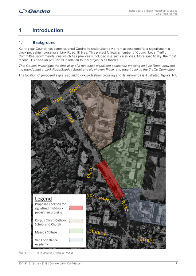
GB.1 LINK ROAD, ST IVES
File: TM9/11
Ward: St Ives
Electorate: Davidson
To consider the feasibility of
installing mid-block pedestrian signals on Link Road, between Stanley Street
and Newhaven Place.
Recommendation:
That it be noted that it is not
feasible to install mid-block pedestrian signals on Link Road.
GB.2 St Ives High
Pedestrian Activity Area
File: S02171
Ward: St Ives
Electorate: Davidson
To consider the introduction of a
40km/h High Pedestrian Activity Area in the vicinity of the St Ives Shopping
Centre.
Recommendation:
A. That
the proposed traffic calming measures and signposting and line marking in Cowan
Road, Memorial Avenue and Village Green Parade be installed as shown in the Concept
Plans.
B. That
detailed designs for the roundabout and slow point in Cowan Road, and the
pedestrian refuge in Memorial Avenue be submitted to RMS for approval.
GB.3 Lindfield Village
Green - On-street parking changes and traffic facilities
File: S12201
Ward: Roseville
Electorate: Davidson
To seek approval for on-street
parking changes and traffic facilities associated with the Lindfield Village
Green (LVG) project.
Recommendation:
That the proposed on-street
parking changes and traffic facilities associated with the Lindfield Village
Green project be approved, and that application be made to Transport for
NSW/Roads and Maritime Services for the road closure of part of Kochia Lane,
and for a Shared Zone in Chapman Lane.
General Discussion
** ** ** ** ** **
|
Ku-ring-gai
Traffic Committee - 17 October 2019
|
GB.1 / 3
|
|
|
|
|
Item
GB.1
|
TM9/11
|
Ward: St Ives
Electorate: Davidson
EXECUTIVE
SUMMARY
|
purpose of report:
|
To consider the
feasibility of installing mid-block pedestrian signals on Link Road, between
Stanley Street and Newhaven Place.
|
|
|
|
|
background:
|
Concerns have previously been raised about pedestrian
safety on Link Road.
At the Traffic Committee Meeting of 28 February 2019
it was recommended;
That Council investigate the feasibility of a
mid-block signalised pedestrian crossing on Link Road, between the roundabout
at Link Road/Stanley Street and Newhaven Place, and report back to the
Traffic Committee.
|
|
|
|
|
comments:
|
Council engaged traffic consultants Cardno to carry
out an assessment on the feasibility of installing mid-block pedestrian
signals on Link Road to the south of Newhaven Place. The study found
that the site did not meet the requirements of the RMS warrants in terms of
pedestrian volumes. It was also found that the minimum sight distance
requirements were not met.
|
|
|
|
|
recommendation:
|
That it be noted
that it is not feasible to install mid-block pedestrian signals on Link Road.
|
Purpose of Report
To consider the feasibility of installing mid-block
pedestrian signals on Link Road, between Stanley Street and Newhaven Place.
Background
There has been an extensive history, since
at least 2003, of complaints about the difficulty faced by pedestrians when
trying to cross roads at or near the roundabout at the intersection of Horace
Street, Link Road and Stanley Street, St Ives.
Council has investigated the feasibility of
installing pedestrian crossings and/or pedestrian refuges to address these
concerns. The installation of pedestrian crossings is not feasible
because the pedestrian volumes do not meet the minimum levels (warrants)
specified by RMS. Council concluded that the only way to address the
pedestrian safety issues was to replace the existing roundabout with traffic
signals. A preliminary assessment carried out by Council has revealed
that this intersection would meet the RMS warrant for traffic signals.
This matter was considered by
Council’s Traffic Committee at its Meeting on 20 November 2017, where it
was recommended:
That Council carry out an assessment of
the intersection of Horace Street, Link Road and Stanley Street, St Ives, at
Council’s expense, to determine the feasibility of replacing the
roundabout with traffic lights, and submit the results, if warranted, to RMS
for its approval in principle.
At the Council Meeting in December 2017 Council resolved to engage
a consultant to carry out an assessment of the intersection of Horace Street,
Link Road and Stanley Street, St Ives to determine the feasibility of replacing
the roundabout with traffic signals.
In May 2018 Council engaged traffic consultants to undertake
a traffic study to determine the feasibility of replacing the roundabout with
traffic signals. The study found that traffic signals would lead to
increased queue lengths and longer delays at the intersection. However,
the signalised intersection would still operate at a satisfactory standard, and
would improve safety for pedestrians.
This matter was considered by the Ku-ring-gai Traffic
Committee at its Meeting on 28 February 2019. The Committee considered
that replacing the roundabout with traffic signals was not a feasible option,
due to the high costs and increased delay times. The Committee
recommended:
That Council investigate the feasibility of a mid-block
signalised pedestrian crossing on Link Road, between the roundabout at Link Road/Stanley
Street and Newhaven Place, and report back to the Traffic Committee.
The Committee’s recommendation was approved by Council
at its Meeting on 26 March 2019.
Comments
In June 2019 Council engaged
traffic consultants Cardno to undertake a traffic study to determine the
feasibility of installing mid-block traffic signals on Link Road. The
report was completed in July 2019, and a copy of the report is attached.
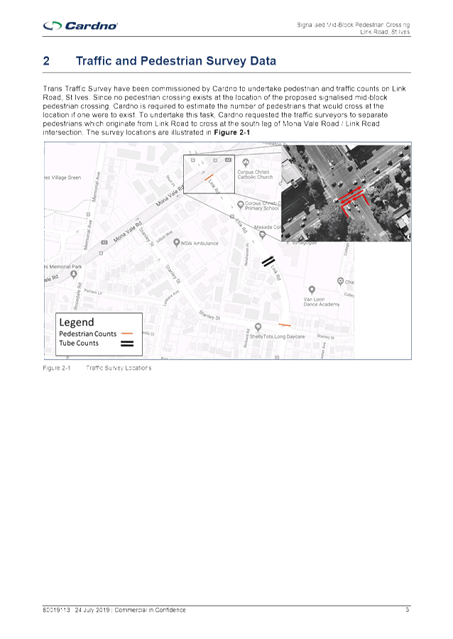
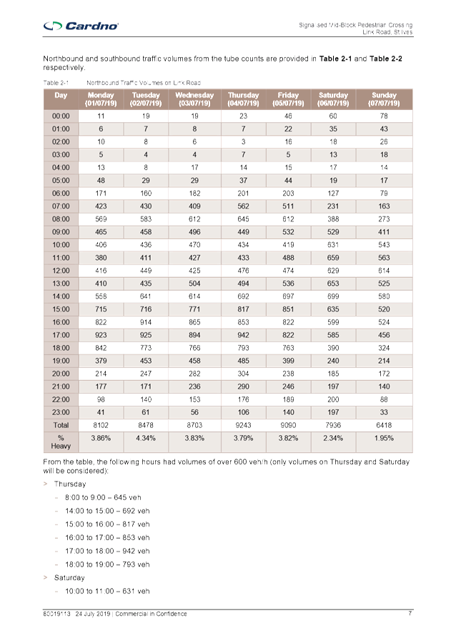
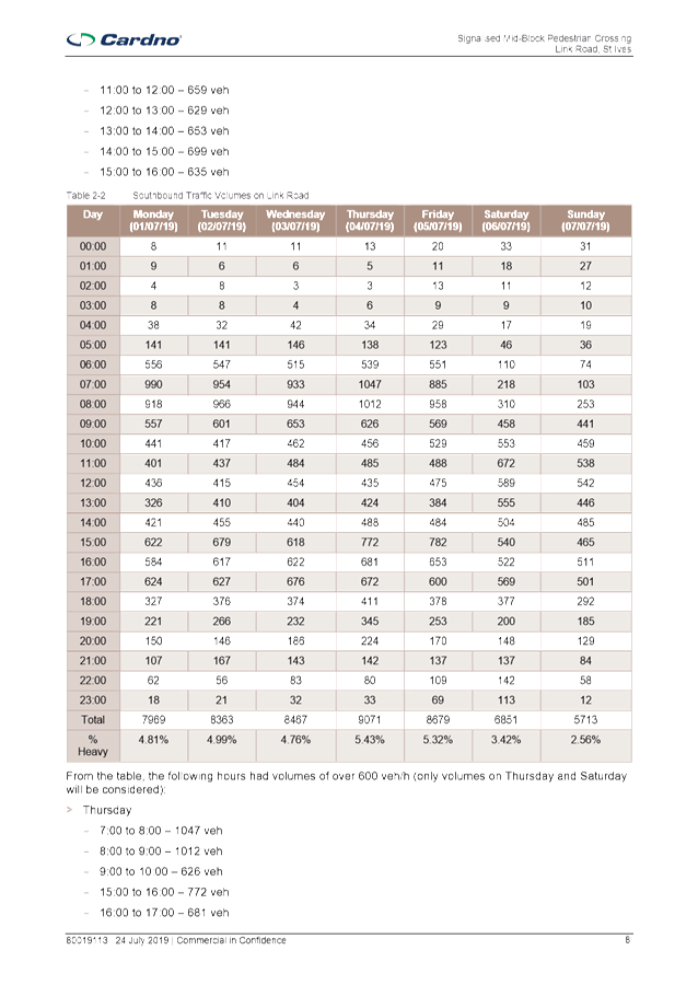
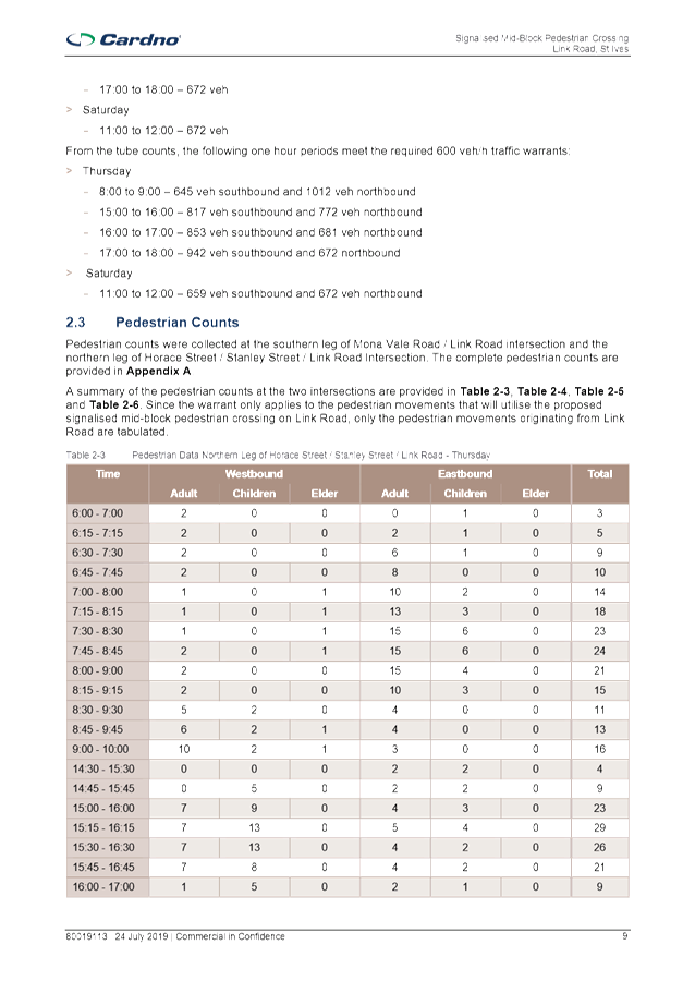
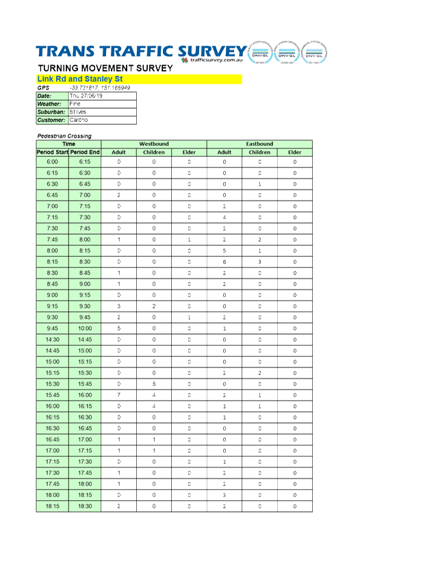
Cardno carried out a warrant
assessment at the site to determine whether pedestrian and traffic volumes were
sufficient to justify the installation of mid-block traffic signals.
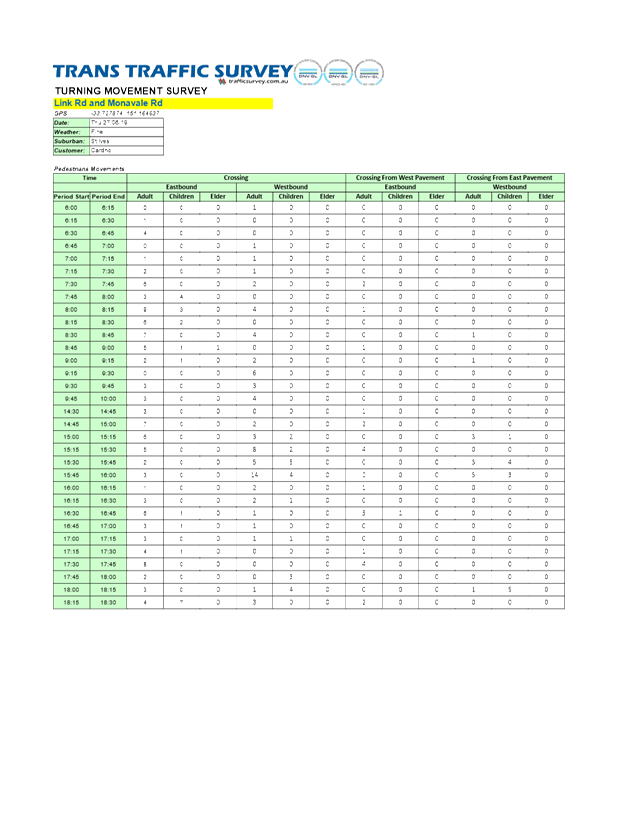
Traffic surveys were carried out on Link Road at Mona Vale Road and at Stanley
Street. Counts were not undertaken mid-block, as pedestrians do not currently
cross there, due to it being too dangerous.
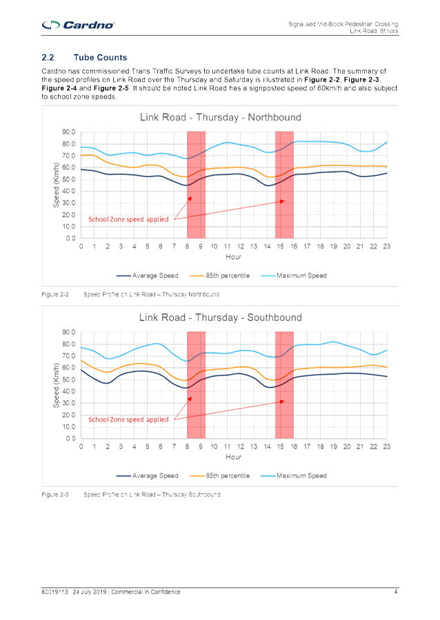
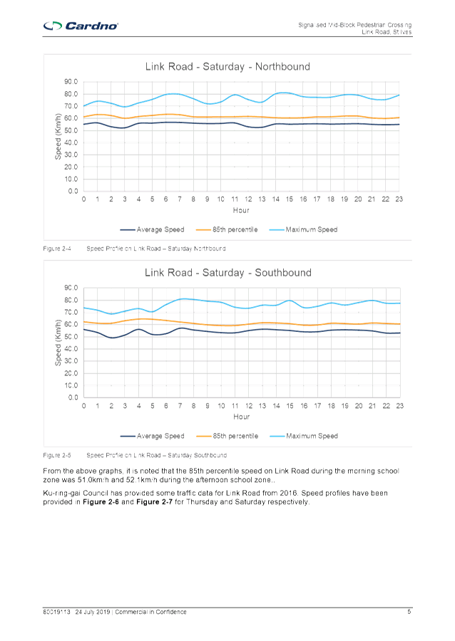
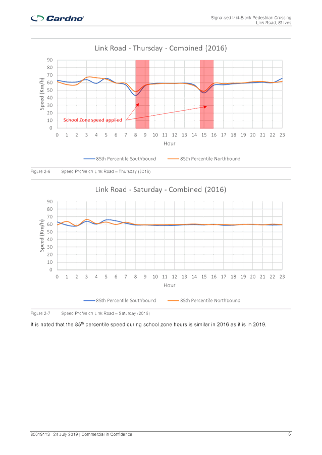
The surveys included 24 hour traffic speed and volume counts
at the 2 locations over a 7 day period. Pedestrian counts were carried
out on a Thursday between 6am and 10am, and between 2.30pm and 6.30pm.
Pedestrian counts were also carried out on a Saturday between 9am and 3pm.
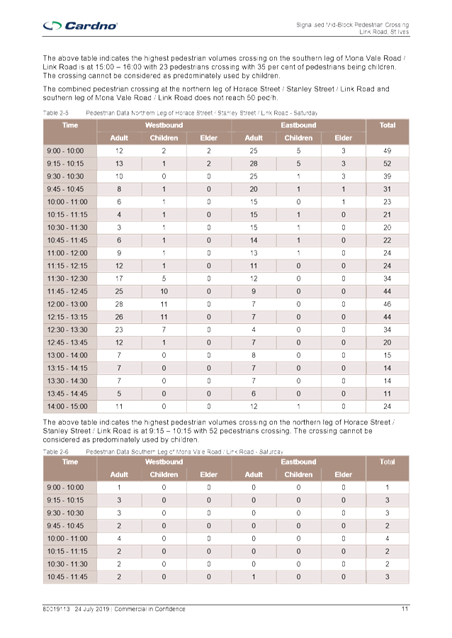
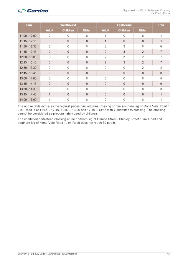
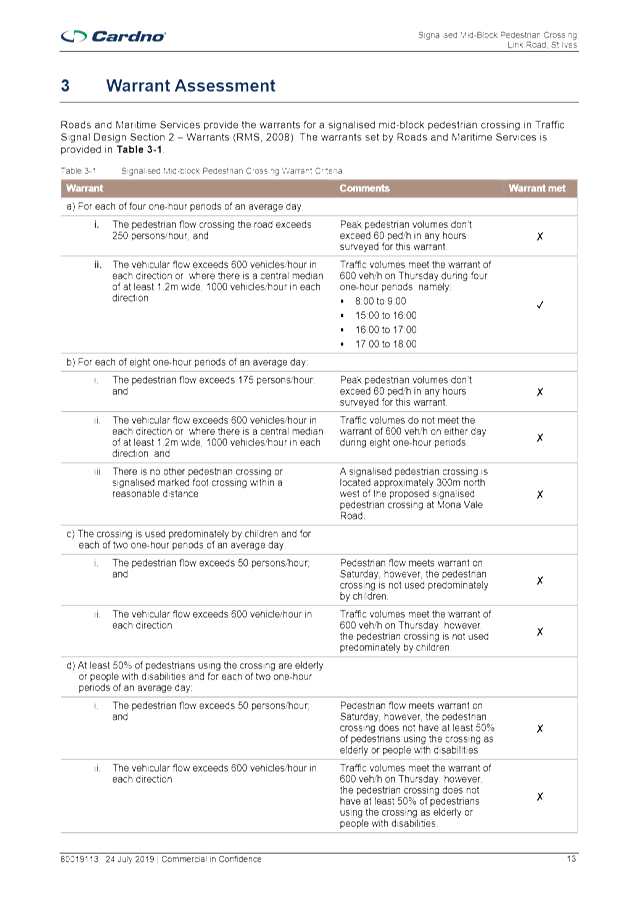
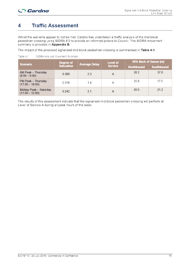
Table 3.1 of the Cardno report shows the warrant criteria
for a mid-block pedestrian crossing. The table shows that traffic volumes
meet the requirements of warrant (a) of 600 vehicles/hr on a weekday over 4 one
hour periods. However the pedestrian volumes are well below the amount
required to meet the warrant. None of the requirements of warrant (b)
were met.
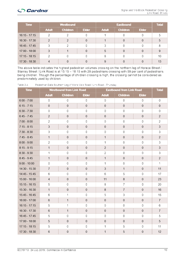
For warrants (c) and (d), the pedestrian warrants of 50
persons/hr were met on a Saturday, however the crossing was not predominantly
used by children or the elderly or disabled. Therefore the warrants were
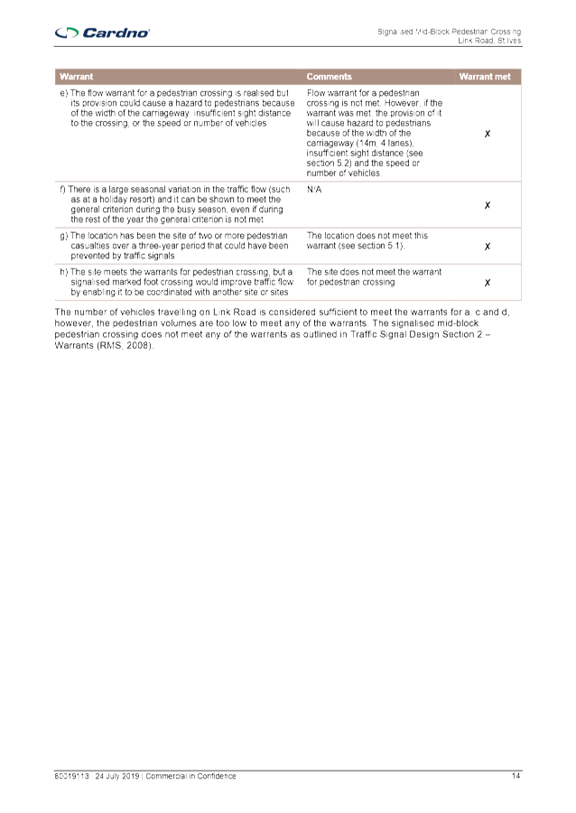
not met. The requirements of warrants (e) to (h) were also not met.
Therefore the signalised mid-block pedestrian crossing does not meet any of the
warrants as outlined in Traffic Signal Design Section 2 – Warrants
(RMS, 2008).
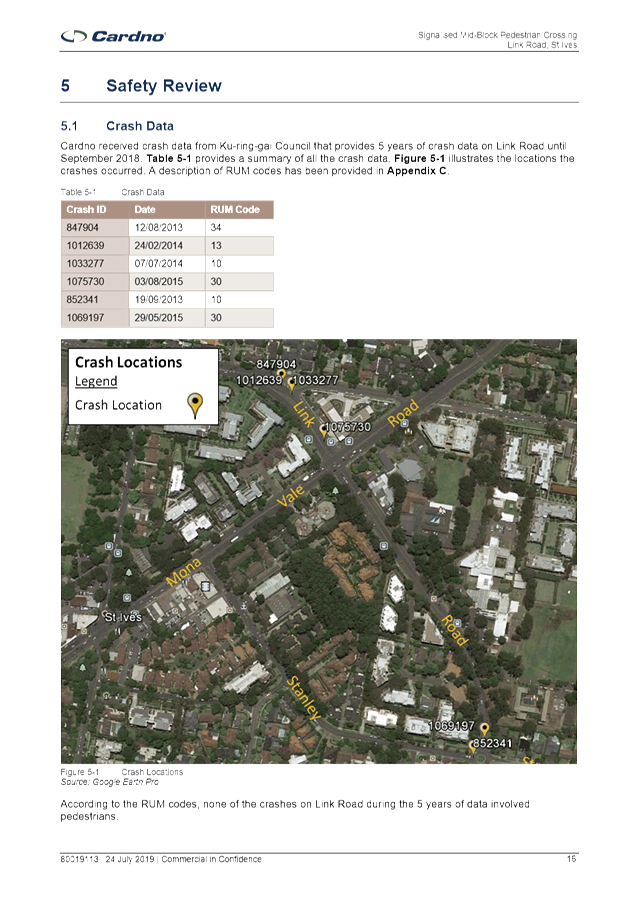
An analysis of the crash data shows that there have been 5
recorded crashes along Link Road during the 5 year period to the end of
September 2018. However none of these crashes involved pedestrians.
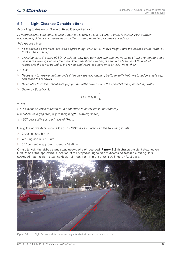
The report also considered whether there would be adequate
sight distance to install a mid-block pedestrian crossing on Link Road to the
south of Newhaven Place. A site to the north of Newhaven Place was not
considered feasible, due to its proximity to the signalised intersection at
Mona Vale Road. It was found that the sight distance did not meet the
minimum criteria outlined by Austroads Guide to Road Design Part 4A.
Summary
Council engaged traffic consultants Cardno to carry out an
assessment on the feasibility of installing mid-block traffic signals on Link
Road. The study found that the site did not meet the warrants as outlined
in Traffic Signal Design Section 2 – Warrants (RMS, 2008).
There have been no crashes involving pedestrians on Link
Road during the 5 year period to the end of September 2018.
Sight distances at the location of the proposed mid-block
signalised crossing do not meet the minimum criteria outlined by Austroads.
Therefore it would not be feasible to install mid-block
pedestrian signals on Link Road.
|
Recommendation:
That it be noted that it is not feasible to install
mid-block traffic signals on Link Road.
|
|
Michael Foskett
Team Leader Traffic
|
Deva Thevaraja
Manager Traffic & Transport
|
|
Attachments:
|
A1 ⇩ ⇩
|
Link
Road St Ives - Traffic Study
|
2019/217432
|
|
APPENDIX No: 1 - Link Road
St Ives - Traffic Study
|
|
Item No: GB.1
|


|
Ku-ring-gai
Traffic Committee - 17 October 2019
|
GB.2 / 47
|
|
|
|
|
Item
GB.2
|
S02171
|
St Ives High Pedestrian Activity Area
Ward: St Ives
Electorate: Davidson
EXECUTIVE
SUMMARY
|
purpose of report:
|
To consider the introduction of a 40km/h High
Pedestrian Activity Area in the vicinity of the St Ives Shopping Centre.
|
|
|
|
|
background:
|
Council has received funding from Roads and Maritime
Services (RMS) to introduce a 40km/h High Pedestrian Activity Area in the
area surrounding the St Ives Shopping Centre. In order for the 40km/h
speed limit to be self-regulating, it is proposed that traffic calming
devices be introduced on Cowan Road, Memorial Avenue and Village Green
Parade.
|
|
|
|
|
comments:
|
In order for the 40km/h speed limit to be
self-regulating, traffic calming measures will be introduced in Cowan Road,
Memorial Avenue and Village Green Parade.
|
|
|
|
|
recommendation:
|
A. That
the proposed traffic calming measures and signposting and line marking in
Cowan Road, Memorial Avenue and Village Green Parade be installed as shown in
the Concept Plans.
B. That detailed
designs for the roundabout and slow point in Cowan Road, and the pedestrian
refuge in Memorial Avenue be submitted to RMS for approval.
|
Purpose of Report
To consider the introduction of a 40km/h High Pedestrian
Activity Area in the vicinity of the St Ives Shopping Centre.
Background
In April 2018 Council staff met with
representatives from Roads and Maritime Services (RMS) to discuss the proposed
40km/h High Pedestrian Activity Area (HPAA) in the vicinity of the St Ives
Shopping District and Bus Interchange. At the Meeting it was established
that Council would undertake a traffic and pedestrian study, as well as counts
in this area. The traffic study and counts would be funded by the RMS.
The study area would include the St Ives
Shopping Centre and adjacent car parks, Denley Lane, Durham Avenue and the
roadway linking Cowan Road and Memorial Avenue. It would also include
Cowan Road, and Memorial Avenue south of Killeaton Street.
The St Ives Village Green area is due to be
upgraded by Council shortly. Council would like to improve pedestrian
connectivity throughout the area, and improve accessibility to St Ives Village
Green and the St Ives Shopping Centre.
In May 2018 Council engaged traffic
consultant TAR Technologies to prepare a traffic report for the proposed 40km/h
HPAA located at St Ives Shopping Centre and its bordering streets. The study
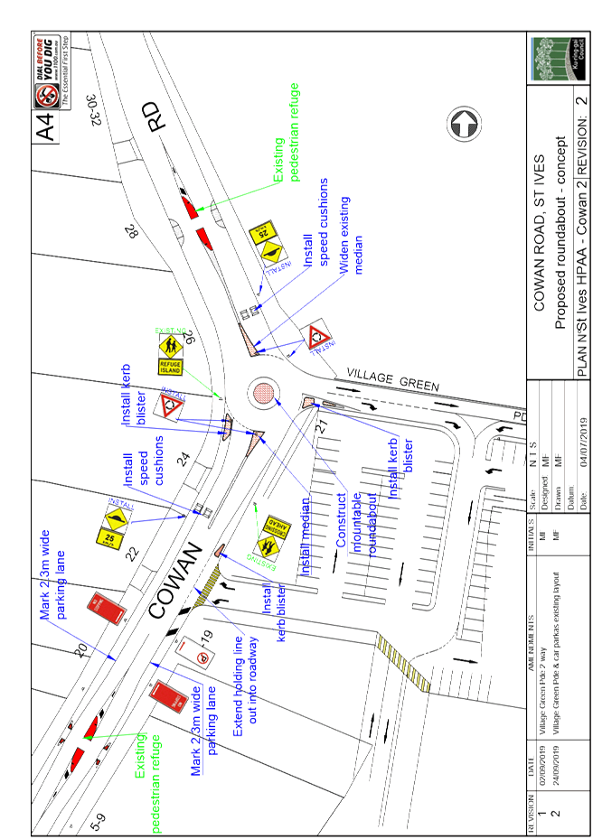
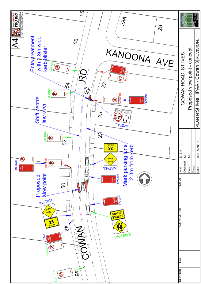
recommended that in Cowan Road, a roundabout be installed at the intersection
with Village Green Parade. It also recommended that slow points be
introduced outside Pymble Golf Club, and adjacent to William Cowan Oval.
This report was referred to RMS, who
responded that the proposed traffic calming measures in Cowan Road and Memorial
Avenue would not be sufficient to create a 40km/h self-enforcing low speed
environment. In February 2019 Council staff made amendments to the
proposed traffic calming measures in Cowan Road and Memorial Avenue, which the
RMS agreed to. Council then provided a cost estimate for the works of
$424,000 to RMS.
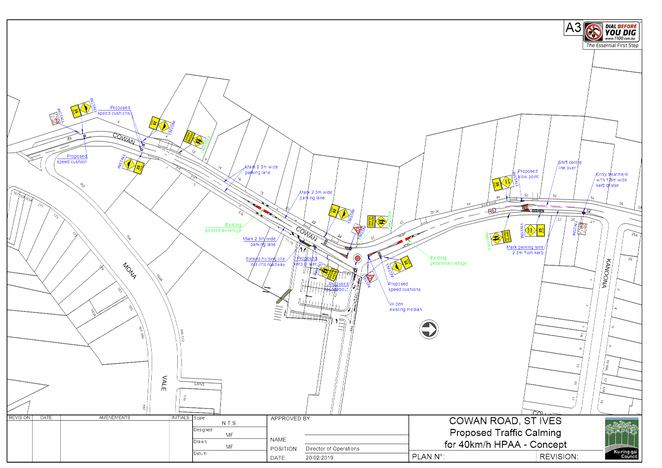
In May 2019, RMS wrote to Council advising
that Council had been successful in gaining funding of $424,000 for the St Ives
High Pedestrian Activity Area, subject to the works being completed by 30
June 2020.
Comments
In order for the 40km/h speed limit to be self-regulating,
traffic calming measures will be introduced in Cowan Road, Memorial Avenue and
Village Green Parade. The proposed traffic calming measures for Cowan
Road are shown in the attached Concept Plans, and include the following;
· Entry
treatment with kerb blister and ‘40 Area – High Pedestrian
Activity’ sign with 40 road marking south of Kanoona Avenue.
· 2-lane
angled slow point outside #50 Cowan Road. This device will slow traffic,
but will result in the loss of 3 on-street parking spaces on the eastern side
of Cowan Road.
· Marked
parking lane on the eastern side of Cowan Road between Kanoona Avenue and
approx. 25 metres south of proposed slow point. The parking lane will
effectively narrow the road width, leading to lower speeds. It will also
provide a safer area for parking.
· Shift
the road centre line towards the western kerb by up to 1 metre on either side
of the proposed slow point, to allow kerbside parking on the eastern side and
prevent parking on the western side.
· Roundabout
at the intersection with Village Green Parade to reduce speed and improve
safety at the bend. Through traffic on Cowan Road will be required to
give way to vehicles in the roundabout. Motorists turning right into
Village Green Parade will have right of way over southbound traffic on Cowan
Road.
Village
Green Parade is to remain one-way eastbound. During consultation, there
were some requests for traffic to be allowed to enter Cowan Road from Village
Green Parade. However larger delivery vehicles would be unable to
negotiate the narrow entry into Village Green Parade from Cowan Road if it was
reduced from 2 lanes down to 1.
· Speed
cushions on both Cowan Road approaches to the roundabout. It is currently
Council policy not to install any new speed humps in Ku-ring-gai.
However, Council’s Traffic & Transport Policy is currently being
reviewed. One of the changes being proposed for the Traffic &
Transport Policy is to allow speed cushions to be installed at approaches to
intersections, including roundabouts, to reduce speeds, as well as at mid-block
locations where there are no adjacent properties.
· Kerb
blister at entry to Village Green Parade to reduce crossing distance for
pedestrians.
· Kerb
blister adjacent to car park exit, which allows the holding line to be extended
out into the roadway. During consultation, some respondents commented on the
difficulty in seeing approaching traffic when entering Cowan Road from the car
park. Extending the holding line will improve visibility to approaching
traffic when exiting the car park. The reduced speeds on Cowan Road as a result
of the traffic calming devices should also make it easier and safer to exit the
car park.
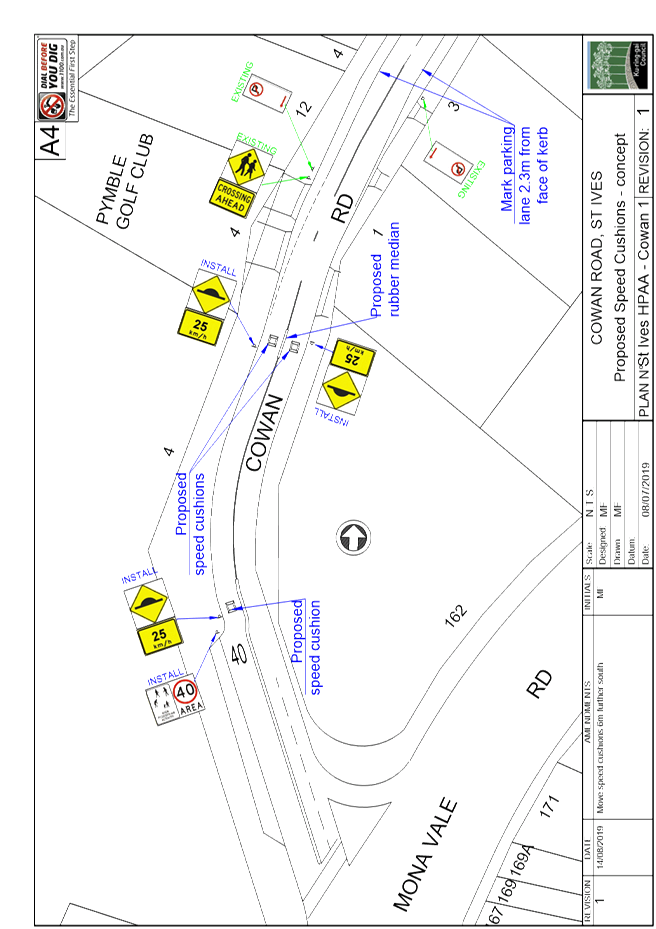
· Speed
cushions on both sides of the road just to the south of the golf course
entry. A rubber median is also proposed adjacent to the speed cushions,
which will prevent motorists crossing over the centre lines to avoid the speed
cushion.
· Speed
cushion on northbound lane and ‘40 Area – High Pedestrian
Activity’ sign with 40 road marking, approximately 50m north of Mona Vale
Road. It was not considered necessary to install a speed cushion on the
southbound lane, as these vehicles would be required to stop at the traffic
signals on most occasions.
· Mark
parking lanes on both sides of the road between the shopping centre car park
exit and the golf club exit. This will effectively narrow the road width,
thereby reducing traffic speeds. It will also provide a safer area for
parking.
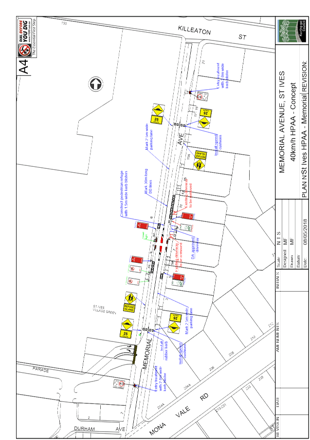
The proposed traffic calming
measures for Memorial Avenue are shown in the attached Concept Plans,
and include the following;
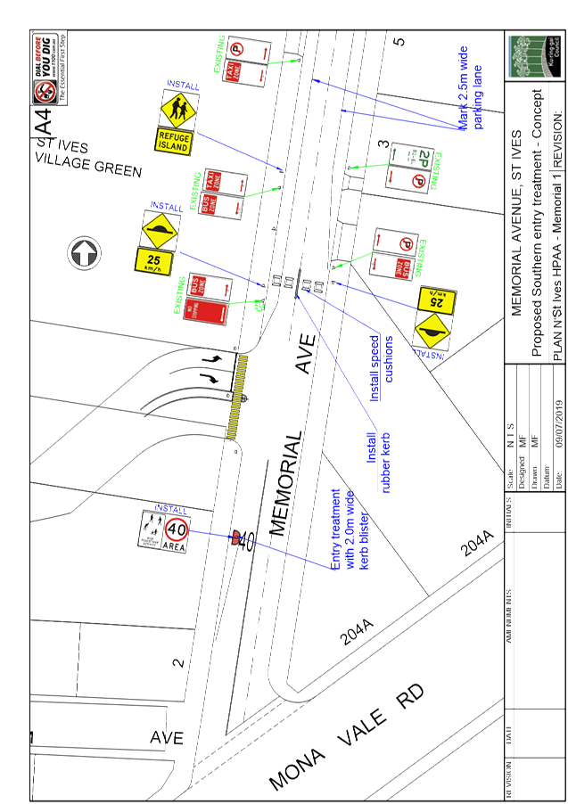
· Entry
treatment with kerb blister and ‘40 Area – High Pedestrian
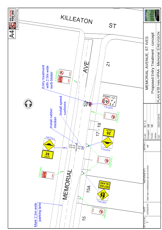
Activity’ sign with 40 road marking south of Killeaton Street.
· Speed
cushions on both sides of the road outside #17-19. Due to the extra width
of Memorial Avenue, it would be necessary to install 4 speed cushions at this
location to prevent motorists from driving around them. A rubber median
is also proposed to prevent motorists from crossing over the centre line to
avoid the speed cushions.
·
Memorial Avenue is on a bus route. However the speed
cushions are designed so that larger vehicles with wider axles, such as buses
can straddle them without having to drive over them.
· Mid-block
pedestrian refuge outside #7 Memorial Avenue, with 1.5 metre wide kerb blisters
on both sides. This will result in the loss of 10 on-street parking
spaces. However with the construction of several large apartment
complexes in Memorial Avenue and Sturt Place, there has been a significant
increase in the number of pedestrians crossing Memorial Avenue.
·
A count taken in June 2017 between 11am and 12pm on a weekday
showed that 64 pedestrians crossed Memorial Avenue between Village Green Parade
and Killeaton Street. Another count was taken in February 2018 which showed
that 33 pedestrians crossed between 8am and 9am, and 42 pedestrians crossed
between 4pm and 5pm. These figures would indicate that there is
sufficient pedestrian activity to justify the construction of a pedestrian
refuge.
· Speed
cushions on both sides of the road just to the north of Village Green Parade.
· Entry
treatment with kerb blister and ‘40 Area – High Pedestrian
Activity’ sign with 40 road marking south of Village Green Parade.
· A 2.5
metre wide parking lane on the western side of Memorial Avenue between Village
Green Parade and Killeaton Street. A 2.5 metre wide parking lane on the
eastern side of Memorial Avenue between #3 and #15. The parking lanes
will reduce the effective width of the roadway, thereby encouraging lower
speeds. It will also provide a safer area for parking.
The TAR report also recommended that a 10km/h shared zone be
introduced in Denley Lane and Durham Avenue. However, it is considered
that Denley Lane and Durham Avenue are unsuitable for a 10km/h Shared Zone.
This is because the traffic volumes are too high for a shared zone, and
pedestrian volumes are relatively low. There is also an existing footpath
along one side of Denley Lane.
Detailed plans of the roundabout, and the slow point in
Cowan Road, as well as the pedestrian refuge in Memorial Avenue, will be
provided to RMS for approval at a later date. The proposed measures will
reduce traffic speeds, and improve safety and amenity for motorists and
pedestrians.
Financial Considerations
The estimated cost to design
and construct the proposed traffic calming devices, and install signs and line
marking would be approximately $424,000. The RMS has agreed to provide
$424,000 in 100% funding for the works, provided they are completed by 30 June
2020.
Community
Consultation
Council consulted with the residents of Cowan Road and
Memorial Avenue regarding the proposed changes. Of the 35 respondents
from Cowan Road, 24 (69%) supported the proposed changes. Of the 20
respondents from Memorial Avenue, 15 (75%) supported the proposed
changes. This would indicate that the local residents are generally
supportive of the proposed changes.
Summary
Council has received 100% funding
from RMS to implement a 40km/h High Pedestrian Activity Area in St Ives.
In order for the 40km/h speed limit to be self-regulating, traffic calming
measures are proposed in Cowan Road, Memorial Avenue, Village Green Parade,
Denley Lane and Durham Avenue.
The proposed works need to be
completed by 30 June 2020 in order for Council to receive the funding.
|
Recommendation:
A. That
the proposed traffic calming measures and signposting and line marking in
Cowan Road, Memorial Avenue, Village Green Parade, Denley Lane and Durham
Avenue be installed as shown in the Concept Plans.
B. That
detailed designs for the roundabout and slow point in Cowan Road, and the
pedestrian refuge in Memorial Avenue be submitted to RMS for approval.
|
|
Michael Foskett
Team Leader Traffic
|
Deva Thevaraja
Manager Traffic & Transport
|
|
Attachments:
|
A1 ⇩ ⇩
|
High
Pedestrian Activity Area St Ives - Cowan Road - Overall Concept Plans
|
|
2019/303478
|
|
|
A2⇩
|
High
Pedestrian Activity Area St Ives - Memorial Avenue - Overall Concept Plans
|
|
2019/303492
|
|
APPENDIX No: 1 - High
Pedestrian Activity Area St Ives - Cowan Road - Overall Concept Plans
|
|
Item No: GB.2
|
|
APPENDIX No: 1 - High
Pedestrian Activity Area St Ives - Cowan Road - Overall Concept Plans
|
|
Item No: GB.2
|
|
APPENDIX No: 2 - High
Pedestrian Activity Area St Ives - Memorial Avenue - Overall Concept Plans
|
|
Item No: GB.2
|
|
Ku-ring-gai
Traffic Committee - 17 October 2019
|
GB.3 / 60
|
|
|
|
|
Item
GB.3
|
S12201
|
Lindfield Village Green - On-street
parking changes and traffic facilities
Ward: Roseville
Electorate: Davidson
EXECUTIVE
SUMMARY
|
purpose of report:
|
To seek approval for on-street parking changes and
traffic facilities associated with the Lindfield Village Green (LVG) project.
|
|
|
|
|
background:
|
As part of the conditions of consent, there is a
requirement to seek local traffic committee approval for various traffic and
parking changes to manage the parking impacts during construction, as well as
the ongoing operation of the Lindfield Village Green project.
|
|
|
|
|
comments:
|
The proposed on-street parking changes and traffic
facilities will provide alternative parking arrangements for local shoppers
and visitors during construction.
The closure of part of Kochia Lane would enable it to
be converted to a pedestrian and cycle link, and provide pedestrian/cycle
access and amenity between the LVG, 23-41 Lindfield Avenue (Aqualand site)
and shops fronting Lindfield Avenue. The implementation of a Shared Zone in
Chapman Lane is required to integrate Chapman Lane with the LVG project.
|
|
|
|
|
recommendation:
|
That the proposed on-street parking changes and
traffic facilities associated with the Lindfield Village Green project be
approved, and that application be made to Transport for NSW/Roads and
Maritime Services for the road closure of part of Kochia Lane, and for a
Shared Zone in Chapman Lane.
|
Purpose of Report
To seek approval for on-street parking changes and traffic
facilities associated with the Lindfield Village Green (LVG) project.
Background
The Lindfield Village Green (LVG) project will transform the
existing Council-owned at-grade car park at Tryon Road Lindfield into a new
public space. The Village Green will include a café or restaurant and a
public plaza as part of the urban open space. It is designed for social
gatherings and easy movement of pedestrian and cyclists to the train station,
and when complete, the Village Green may also host markets, outdoor cinema,
live music and other performances/events. The Village Green will also have
public toilets, dual lifts and stair access to 3 levels of basement car park
with a total of 241 car parking spaces (2 shopper/visitor car parking levels
and 1 commuter car parking level). Approval of the amended Development
Application was granted in August 2018. Construction is anticipated to begin
early 2020.
As part of the conditions of
consent, condition 19 states the following (relevant conditions only listed):
19 Approvals from the local traffic committee
Prior to
the release of the Construction Certificate, the applicant shall seek approval
from the
Local Traffic Committee for the following:
1. Removal
of on-street parking spaces in Milray Street necessary to allow an 11m
rigid truck
to turn into Kochia Lane, turning left from Milray Street
2. A
Construction Traffic Management Plan which specifies the maximisation of
temporary
provision of short term (no longer than 2 hours) parking in the vicinity
of the site
5. The
provision of a raised traffic calming device in Milray Street, north of Kochia
Lane to
discourage traffic turning left when exiting Kochia Lane.
Furthermore, an extract of condition
19 states the following, which is to be submitted prior to the commencement of
any works on site:
… the
plan shall develop measures to provide temporary alternative parking
arrangements (in close proximity to the site) for the existing on-site long
stay parking spaces connected
to Nos 1-21 Lindfield Avenue
which are accessed from Chapman Lane
The Lindfield Village Green project also proposes to close
Kochia Lane (between Lindfield Avenue and Havilah Lane) to vehicle traffic, and
to implement a Shared Zone in Chapman Lane.
As lead transport consultant for the LVG project, Cardno was
also engaged by the project team to develop strategies to satisfy the above
clauses in condition 19 of the consent conditions, and to develop a Traffic
Management Plan (TMP) for the Kochia Lane closure and the Chapman Lane Shared
Zone.
Comments
Removal
of on-street parking spaces in Milray Street to allow an 11m rigid truck to
turn left into Kochia Lane from Milray Street
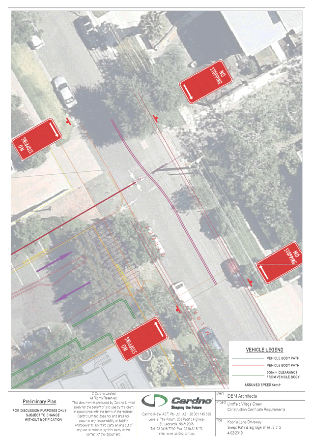
Cardno undertook a swept path
analysis to determine the extent of on-street parking removal required in
Milray Street to safely accommodate the swept path of a 11m large rigid truck
turning left from Milray Street into Kochia Lane. 11m large rigid trucks require
left turn access to Kochia Lane in order to access/service the mixed-use
developments at No. 23-41 Lindfield Avenue (“Aqualand”) and No.
43-47 Lindfield Avenue (“Lindfield Markets”).
The resulting parking changes
required to satisfy clause 1 of condition 19 are shown in Attachment A1,
and involve the following:
· Removal
of approximately 2 x 4P parking spaces on the western side of Milray Street,
just south of Kochia Lane (and replacing with No Stopping restrictions);
· Removal
of approximately 2 x unrestricted parking spaces eastern side of Milray Street,
just south of Kochia Lane (and replacing with No Stopping restrictions);
· Installation
of BB line marking.
The proposed changes would also
complement and integrate with the proposed raised platform at the intersection
of Milray Street Kochia Lane.
Temporary provision of short
term (no longer than 2 hours) parking in the vicinity
of the site
Construction of the LVG
project will result in the temporary removal of approximately 134 public
short-stay car parking spaces in the Tryon Road car park. The maximisation of
short stay parking is required surrounding the development site, to enable
shoppers and visitors to continue to be able to access the businesses and other
land uses in the eastern part of the Lindfield local centre that do not provide
on-site parking.
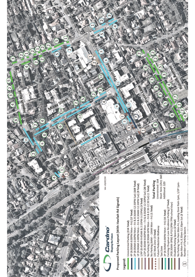
Attachment A2 shows the
proposed temporary parking layout, which would increase the quantity of 2
hour parking by approximately 130 spaces in the streets surrounding the LVG
project. The proposed changes also include provision for the following:
· 2
temporary on-street accessible spaces on the north-western side of Tryon Road,
adjacent to the Lindfield Executive Centre;
· 7
spaces on the south-eastern side of Tryon Road, temporarily allocated to the
residents/businesses at No.s 1-21 Lindfield Avenue with car spaces accessible
from Chapman Lane (see separate heading below);
· 3
spaces on the north-western side of Tryon Road, adjacent to the Tryon Road car
park/LVG site, for a Works Zone;
· A
part-time Loading Zone on the eastern side of Lindfield Avenue (just south of
Kochia Lane);
· Parking
clearances on Havilah Road (in proximity of Havilah Lane) to enable managed
alternate 2-way flow in Havilah Lane during construction.
Adding to short-stay parking
availability is over 100 retail/shopper parking spaces in the basements of the
“Aqualand” and “Lindfield Markets” mixed-use
developments. Inspections of the occupancy of the basement car parks at 12pm on
Tuesday 12 September showed that approximately 67 spaces were available.
The existing users of the
unrestricted kerbside spaces intended to be reallocated to 2hr parking are
likely to be either commuters, or employees that work in the Lindfield local
centre. Commuters parking in the affected area would either need to park
further away or travel to another train station during construction of the LVG.
Employees of the area would need to park further away, car pool or use alternative
modes of travel. During construction of the LVG, if demand for the temporary
on-street 2-hour parking spaces is lower than anticipated, its extent could be
reviewed to increase availability to commuters and employees.
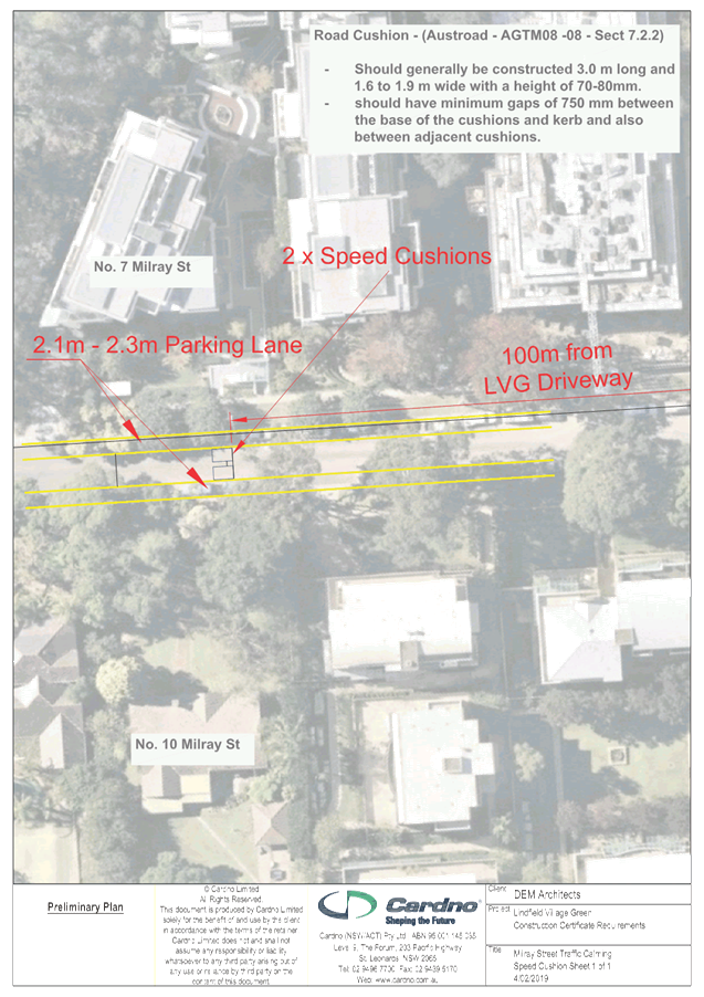
Raised traffic calming device
in Milray Street, north of Kochia Lane to discourage traffic turning left when
exiting Kochia Lane.
The need for this measure arose
from feedback during the public consultation associated with the development
applications in 2017 and 2018.
In response to clause 5 of
condition 19, it is proposed to install 2 speed cushions approximately 100m
north of the proposed LVG access point as shown in Attachment A3 (i.e.
outside No.10 Milray Street). Speed cushions are effective in providing traffic
calming, are relatively simple to install, do not impact on kerbside parking
(unlike other more substantial/formalised traffic calming treatments) and will
complement the proposed raised platform at the intersection of Milray Street
and Kochia Lane.
Temporary alternative parking
arrangements for the existing on-site long stay parking spaces connected to
No.s 1-21 Lindfield Avenue
The basement car park of the LVG effective extents under and
to the western edge of Chapman Lane. Excavation and construction of the
basement would result in impacts to vehicle access to the garages and car
spaces off Chapman Lane, which are connected to No.s 1-21 Lindfield Avenue.
Therefore, this condition requires that alternative provision be made while
access to the 7 garages/car spaces off Chapman Lane is not available.
The parking spaces considered to
be closest to the site that could be temporarily reallocated for No.s 1-21
Lindfield Avenue would be 7 spaces on the southern side of Tryon Road,
immediately west of the existing No Parking zone opposite Chapman Lane, as part
of the construction management for the project . The proposed mechanism for
restricting parking to the parking spaces connected to No.s 1-21 Lindfield
Avenue via “No Parking Authorised Vehicles Excepted”.
Under the Road Transport
(General) Regulation 2013, declared organisations (including local councils)
are parking authorities for their prescribed area of operations. Under
regulations, parking permits may be administered (by signage - authorised
vehicles) by way of NSW Road Rules 168 and 317 (park in a space in which no
parking is permitted other than for an authorised vehicle). This method is
considered suitable for the purpose of maintaining temporary parking for
affected car spaces at the rear of 1-21 Chapman Lane, as it prohibits parking
for all vehicles other than Authorised Vehicles, which would be specified on
the sign. Seven (7) temporary authorisations/permits would need to be issued by
Council, and users would need to display the permit in the vehicle to benefit.
Council’s Rangers have powers to enforce unauthorised use under the NSW
Road Rules.
Once works are completed, vehicle access to Chapman Lane
will be reinstated but primarily for access to No.s 1-21 Lindfield Avenue. Once
access to Chapman Lane is reinstated, the permits would expire, and the
kerbside parking in Tryon Road could be reinstated. As part of the LVG project,
it is proposed to implement a Shared Zone in Chapman Lane (see separate
comments below).
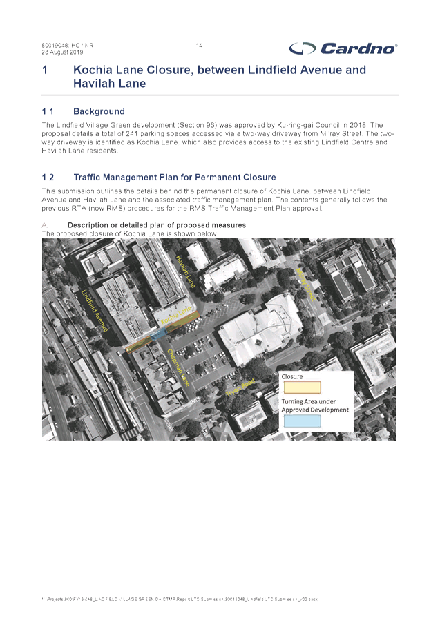
Closure of Kochia Lane (between Lindfield Avenue and
Havilah Lane) to motor vehicle traffic
To provide the quality of liveable urban open space desired
by Council at the LVG, the closure of Kochia Lane (between Lindfield Avenue and
Havilah Lane) to motor vehicle traffic is required. Kochia Lane is currently
One Way traffic between Lindfield Avenue and Chapman Lane, and two-way traffic
between Chapman Lane and Havilah Lane.
As part of the LVG project, Kochia Lane (between Lindfield
Avenue and Milray Street) will be converted to a pedestrian and cycle link, and
provide pedestrian/cycle access and amenity between the LVG, Aqualand site and
shops fronting Lindfield Avenue. Kochia Lane has a high Place function, and the
closure to enable improvement of that Place function is appropriate.
Road closures must be authorised by Transport for NSW/Roads
and Maritime Services as per the delegations under the Roads Act A. Traffic
Management Plan (TMP) for the road closure has been prepared by Cardno (see Attachment
A4) and a separate application to Transport for NSW/Roads and Maritime
Services will be made using the TMP prepared by Cardno.
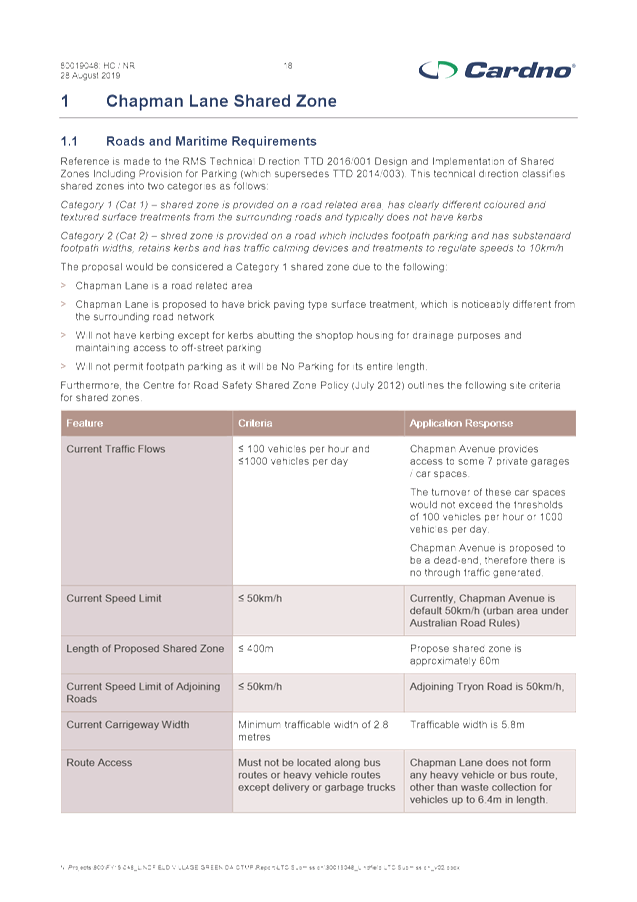
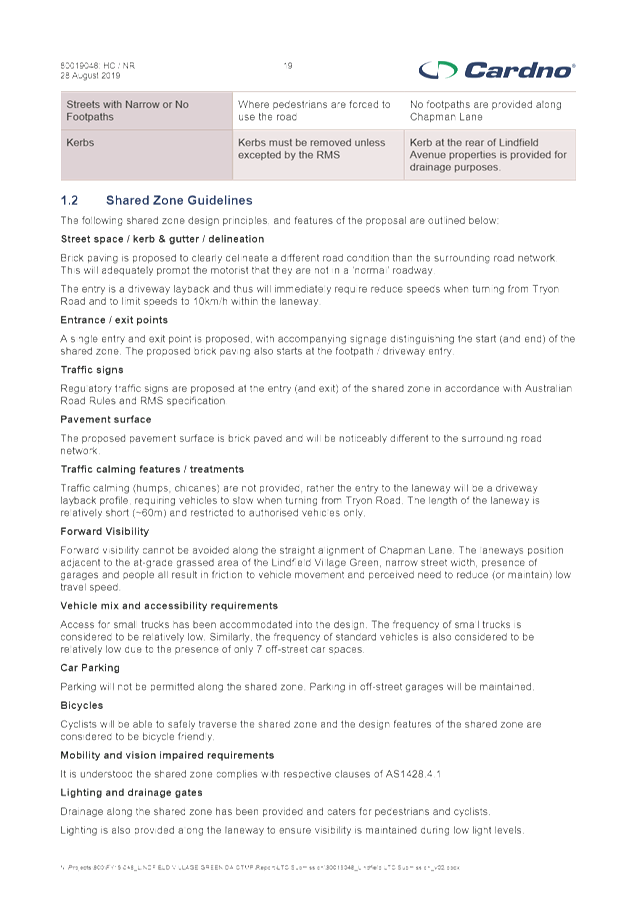
Chapman Lane Shared Zone
To integrate Chapman Lane with the LVG project, a Shared
Zone is proposed along the entire length of Chapman Lane.
Shared zones are defined under
Rule 24 in the NSW Road Rules (2008). A shared zone is a road or network of
roads or a road related area where space is shared safely by vehicles and
pedestrians and where pedestrian priority and quality of life take precedence
over ease of vehicle movement.
Shared zones employ a range of
regulatory and non-regulatory treatments to indicate a change in environment
and priority. A Category 1 (Cat 1) Shared Zone is proposed, with clearly
different coloured and textured surface treatments from surrounding roads, and
no kerbs. The maximum speed limit in shared zones is 10 km/h.
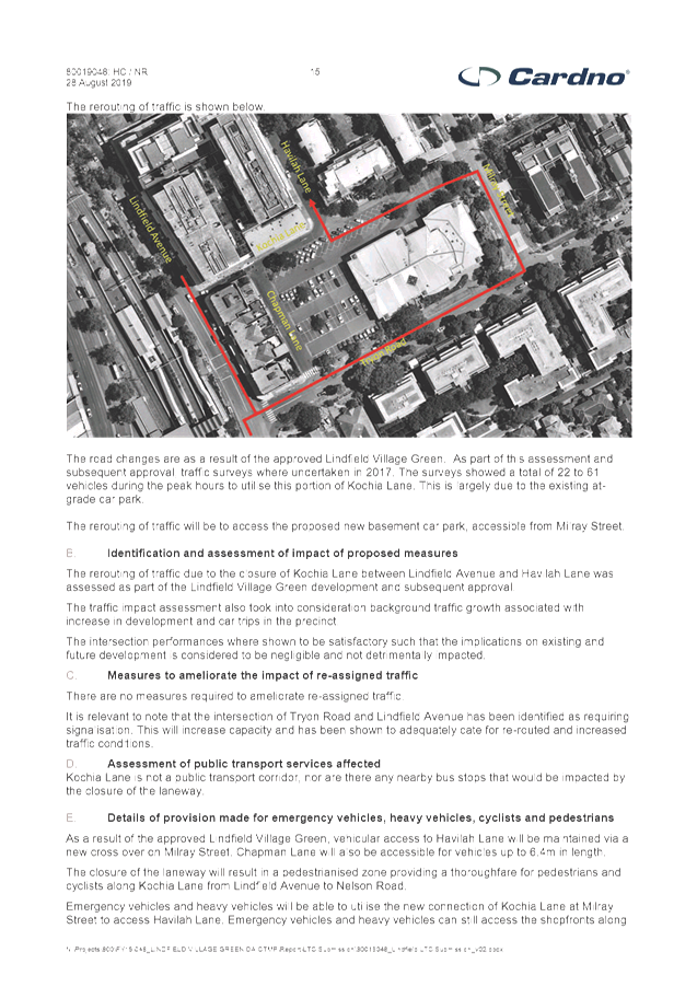
The proposed closure of Kochia Lane between Lindfield Avenue
and Havilah Lane (in conjunction with the undergrounding of the Tryon Road car
park) will have the effect of significantly reducing traffic volumes along
Chapman Lane, where its ultimate vehicle traffic role would only be to provide
vehicle access to the rear of No.s 1-21 Lindfield Avenue. This enables the road
space to be shared with pedestrians. As with Kochia Lane, Chapman Lane also has
a high Place function, and the implementation of a Shared Zone to enable
improvement of that Place function is an appropriate treatment.
Shared zone schemes must be authorised by Transport for
NSW/Roads and Maritime Services as per the delegations under the Roads Act. A
Traffic Management Plan (TMP) for the Shared Zone has been prepared by Cardno
(see Attachment A5) and a separate application will be made to Transport
for NSW/Roads and Maritime Services using the TMP prepared by Cardno.
Financial
Considerations
All the proposed temporary and permanent traffic facilities
form part of the LVG project, therefore the costs associated with their
installation (and removal, where relevant) will be borne by the project.
Community Consultation
Council
has worked closely with the Lindfield community in developing plans for the
Village Green. The community engagement undertaken since the project inception
in 2014 includes the following:
· Public
Exhibition Launch event in 2015;
· Village
Green Public Exhibition of 3 Concept Design Options, for the community to
select its preferred option. Activities included:
o Community Day: 21 March 2015;
o On-site mobile exhibition
space in the Tryon Road car park displaying three alternative preliminary
designs staffed by project management team;
o Flyers sent to over 8,000
residents in Lindfield, Roseville and Killara;
o 2 community workshops;
o Online engagement portal
– nearly 5,000 visitors.
· Face-to-face
stakeholder meetings and briefings with surrounding and local businesses and
building owners;
· Wider
public notification and consultation process associated with the
development applications in 2017 and 2018. Supporting documentation for the
development application included the development of proposed temporary
short-stay parking measures in the vicinity of the site.
As a result of community feedback and stakeholder meetings and
briefings with surrounding and local businesses and building owners, the
initial proposal has been refined to form this temporary parking proposal.
Similarly, the proposals for the Kochia Lane closure (to
vehicle traffic) and the Chapman Lane Shared Zone were widely exhibited as part
of the development application process, and issues raised during the exhibition
were addressed in the development application.
Residents and businesses within the area directly affected
by changes in this report were notified by letter that this report will be
considered by the Committee, along with a double-sided summary sheet explaining
the proposed changes.
Internal
Consultation
In the development of this report, there has been
collaboration between staff in Strategy and Environment (LVG Project Manager),
Operations, Development and Regulation, and Community (Communications)
Summary
As part of the conditions of
consent of the LVG, there is a requirement to seek local traffic committee
approval for various traffic and parking changes to manage the parking impacts
during construction, as well as the ongoing operation of the LVG project.
The proposed on-street parking changes
and traffic facilities will provide alternative parking arrangements for local
shoppers and visitors during construction.
The closure of part of Kochia Lane would enable it to be
converted to a pedestrian and cycle link, and provide pedestrian/cycle access
and amenity between the LVG, Aqualand site and shops fronting Lindfield Avenue.
The implementation of a Shared Zone in Chapman Lane is required to integrate
Chapman Lane with the LVG project.
|
Recommendation:
A. That the proposed
traffic facilities in Milray Street (at Kochia Lane) to accommodate heavy
vehicle movements into the LVG site be approved;
B. That the proposed
temporary parking layout in the streets surrounding the LVG be approved;
C. That 7 temporary
permits be issued (to the owners/users of parking spaces connected to No.s
1-21 Lindfield Avenue) for 7 “No Parking Authorised Vehicles
Excepted” spaces on the southern side of Tryon Road, while access to
Chapman Lane is not available;
D. That speed cushions
in Milray Street, north of Kochia Lane, be approved;
E. That a Traffic
Management Plan (TMP) for the closure of Kochia Lane (between Lindfield
Avenue and Havilah Lane) and a Shared Zone in Chapman Lane be submitted to
Transport for NSW/Roads and Maritime Services for approval.
F. That
residents and businesses within the area directly affected by changes in this
report be notified of Council’s decision.
|
|
Joseph Piccoli
Strategic Traffic Engineer
|
Deva Thevaraja
Manager Traffic & Transport
|
|
Attachments:
|
A1 ⇩ ⇩
|
Milray
Street at Kochia Lane - traffic facilities for service vehicle access to LVG
|
|
2019/299347
|
|
|
A2⇩
|
Plan
showing temporary provision of short stay parking and other parking changes
during LVG construction
|
|
2019/299348
|
|
|
A3⇩
|
Proposed
traffic calming device in Milray Street
|
|
2019/299349
|
|
|
A4⇩
|
Traffic
Management Plan - Closure of Kochia Lane
|
|
2019/299351
|
|
|
A5⇩
|
Traffic
Management Plan - Shared Zone in Chapman Lane
|
|
2019/299353
|
|
APPENDIX No: 1 - Milray
Street at Kochia Lane - traffic facilities for service vehicle access to LVG
|
|
Item No: GB.3
|
|
APPENDIX
No: 2 - Plan
showing temporary provision of short stay parking and other parking changes
during LVG construction
|
|
Item No: GB.3
|
|
APPENDIX
No: 3 - Proposed
traffic calming device in Milray Street
|
|
Item No: GB.3
|
|
APPENDIX
No: 4 - Traffic
Management Plan - Closure of Kochia Lane
|
|
Item No: GB.3
|
|
APPENDIX
No: 5 - Traffic
Management Plan - Shared Zone in Chapman Lane
|
|
Item No: GB.3
|